crc visualization meeting southern california tu
TRANSCRIPT

1
STATE OF CALIFORNIA
CITIZENS REDISTRICTING COMMISSION (CRC)
In the matter of: CRC VISUALIZATION MEETING
Southern California
TUESDAY, NOVEMBER 2, 2021
1:02 p.m.
Reported by:
Peter Petty

2
APPEARANCES
2021 Citizens Redistricting Commission:
Commissioners
Antonio Le Mons, Chair Trena Turner, Vice Chair Isra Ahmad, Commissioner Linda Akutagawa, Commissioner Jane Andersen, Commissioner Alicia Fernandez, Commissioner Neal Fornaciari, Commissioner J. Ray Kennedy, Commissioner Sara Sadhwani, Commissioner Patricia S. Sinay, Commissioner Derric Taylor, Commissioner Pedro Toledo, Commissioner Angela Vazquez, Commissioner Russell Yee, Commissioner Staff Alvaro E. Hernandez, Executive Director Ravindar Singh, Administrative Assistant Anthony Pane, Chief Counsel Marcy Kaplan, Outreach Manager Ashleigh Howick, Northern California Field Lead Contractors Technical Contractors Kristian Manoff, AV Technical Director/Comment Moderator Line Drawing Team Karin Mac Donald, Statewide Database Sivan Tratt Tamina Ramos Alon Jaime Clark VRA Counsel Strumwasser & Woocher David Becker Fredric Woocher

3
INDEX
AGENDA PAGE
Call to order 4
Establishment of Quorum 7
Housekeeping Rules 7
Welcome and Opening Remarks 8
Closed Session 8
Discussion and Review of Visualizations 9
Public Comment 154

4
1
2
3
4
5
6
7
8
9
10
11
12
13
14
15
16
17
18
19
20
21
22
23
24
25
P R O C E E D I N G S
Tuesday, November 2, 2021 1:02 p.m.
CHAIR LE MONS: Good afternoon and welcome to the
California Citizens Redistricting Commission's week of
November 2nd set of meetings to outline our
visualizations. I'd like to welcome everyone to
November.
And I'd first like to thank my Co-chair, Trena
Turner, for doing an outstanding job in my absence and
prepping me to be able to shine today. Thank you,
Commissioner Turner.
I also want to thank the staff for all the work
that's done in putting these meetings together.
So I do -- I want to turn the floor -- let me give
you a quick little overview of what to expect today and
then we'll do roll call. And we'll have a couple
announcements.
So we're going to be addressing assembly
visualizations today. That'll include the Central
Valley, Northern California, Bay Area, Central Coast, Los
Angeles, and Southern California. We are going to take
public comment later in the evening, after we've gone
through all of the assembly visualization.
So I know we had a pattern of doing public comment
toward the end of our bulk of meetings. We're going to

5
1
2
3
4
5
6
7
8
9
10
11
12
13
14
15
16
17
18
19
20
21
22
23
24
25
try doing it each day to give the public an opportunity,
particularly for those who may not be able to wait until
the end or their schedule doesn't permit.
So we hope that making that adjustment is going to
help the public's participation in a way that helps them
see that we hear them and we're working very hard to try
to respond to those requests as best we can in this very
complex and intricate process.
So we thank you. Keep the comments coming. And we
really do want to hear from you. And anything we can do
to help make the experience good for everyone is part of
one of our commitments and goals, as well.
So with that, I do want to turn it over to Andrew
for a moment. No, let me do roll call and then I'll turn
it over to Andrew. So who's going to do roll call for me
today?
ADMINISTRATIVE ASSISTANT SINGH: I will, Chair.
This is Rav.
CHAIR LE MONS: Hi Ravi. Yes, please. Take it
away.
ADMINISTRATIVE ASSISTANT SINGH: Thank you.
Commissioner Sinay.
COMMISSIONER SINAY: Here.
ADMINISTRATIVE ASSISTANT SINGH: Commissioner
Sadhwani.

6
1
2
3
4
5
6
7
8
9
10
11
12
13
14
15
16
17
18
19
20
21
22
23
24
25
COMMISSIONER SADHWANI: Here.
ADMINISTRATIVE ASSISTANT SINGH: Commissioner
Taylor.
COMMISSIONER TAYLOR: Present.
ADMINISTRATIVE ASSISTANT SINGH: Commissioner
Toledo.
COMMISSIONER TOLEDO: Here.
ADMINISTRATIVE ASSISTANT SINGH: Commissioner
Turner.
VICE CHAIR TURNER: Here.
ADMINISTRATIVE ASSISTANT SINGH: Commissioner
Vazquez.
COMMISSIONER VAZQUEZ: Here.
ADMINISTRATIVE ASSISTANT SINGH: Commissioner Yee.
COMMISSIONER YEE: Here.
ADMINISTRATIVE ASSISTANT SINGH: Commissioner Ahmad.
COMMISSIONER AHMAD: Here.
ADMINISTRATIVE ASSISTANT SINGH: Commissioner
Akutagawa.
COMMISSIONER AKUTAGAWA: Here.
ADMINISTRATIVE ASSISTANT SINGH: Commissioner
Andersen.
COMMISSIONER ANDERSEN: Here.
ADMINISTRATIVE ASSISTANT SINGH: Commissioner
Fernandez.

7
1
2
3
4
5
6
7
8
9
10
11
12
13
14
15
16
17
18
19
20
21
22
23
24
25
COMMISSIONER FERNANDEZ: Presente.
ADMINISTRATIVE ASSISTANT SINGH: Commissioner
Fornaciari.
COMMISSIONER FORNACIARI: Here.
ADMINISTRATIVE ASSISTANT SINGH: Commissioner
Kennedy.
COMMISSIONER KENNEDY: Here.
ADMINISTRATIVE ASSISTANT SINGH: And Commissioner Le
Mons.
CHAIR LE MONS: Here.
ADMINISTRATIVE ASSISTANT SINGH: You have a quorum,
chair.
CHAIR LE MONS: Thank you. Good thing I had one,
because I had started the meeting before the roll call.
So now, we'll get back on track here.
Andrew, let me turn over the floor to you for
announcements.
MR. DRESCHLER: Thank you, very much, Chair. Good
afternoon Commissioners. And I just wanted to do one
quick housekeeping item on our side. John will no longer
be mapping with us, but I'm very happy to introduce Sivan
Tratt, who has been working with us since April of when
we started this project. She's been largely behind the
scenes but working closely with Tamina, and Jaime, and
Kennedy, and Karin, of course, on a lot of different

8
1
2
3
4
5
6
7
8
9
10
11
12
13
14
15
16
17
18
19
20
21
22
23
24
25
parts of this project. She's also worked internally with
staff, Toni and Paul, on some of the mapping stuffing and
digital -- digitization of the COIs.
So yeah, I just wanted to -- very excited to have
her. She has a background in GIS and mapping. And I
will just turn it over for her to do a quick hello before
you get going.
MS. TRATT: Hello, Commissioners. Hello, Public of
California. I'm really excited to be here. As Andrew
said, my name is Sivan. I use she, her pronouns. I have
been working behind the scenes with John very closely
from the very beginning, doing a lot of work, like Andrew
mentioned, with COIs and digitization. So really excited
to bring those insights and experience to the forefront
with all of you. And I'm just really excited to be here.
And thank you for having me.
CHAIR LE MONS: Well, welcome, Sivan. We are happy
to have you. Thanks for joining the team.
I just want to remind the public that, during the
meeting, you can also submit comments. So just use our
comment form that's on our website. And we are tracking
those throughout the day. So feel free to, at any time
you'd like to submit a comment that -- through the form,
you can do so.
So with that, we're going to go into a brief closed

9
1
2
3
4
5
6
7
8
9
10
11
12
13
14
15
16
17
18
19
20
21
22
23
24
25
session. We should be back -- let me look here. I'd say
Kristian, first, has the link for the closed session been
sent out?
COMMENT MODERATOR: It sure has, Chair.
CHAIR LE MONS: Awesome. Okay. So everyone should
have that link.
So I'm anticipating we should be gone for about 30
minutes. If that changes, we will make sure that our
team updates the change on the website, so you'll know
when we're coming back. So expect us back around 1:30 --
let's say 1:30. Okay?
Any objections, do we need any more time than that,
team? No? Okay. Perfect. So we'll see you back here
around -- oh wait a minute, I'm sorry, it's 1:08 now, so
1:30 would not give us -- let's say 1:45. We'll see you
back here at 1:45. Thank you.
(Whereupon, a recess was held)
CHAIR LE MONS: Welcome back, everyone. Good
afternoon, California. Thank you for your patience. We
were in closed session under pending litigation
exception. I wanted to let you know that no action was
taken.
So now, we're going to move into the bulk of our
agenda for today, which is our visualizations. And so we
have a lot of terrain to cover. So let's get right to

10
1
2
3
4
5
6
7
8
9
10
11
12
13
14
15
16
17
18
19
20
21
22
23
24
25
it.
I'd like to turn the floor over to Karin -- Karin
MacDonald and our line drawing team.
MS. MAC DONALD: Thank you, so much, Chair Le Mons.
And thank you, very much, Commissioners for having us.
Before we get started, I just wanted to give you a brief
overview of what's been happening with respect to the
hand-offs in the various regions.
So what you're going to see today is going to, kind
of, resemble a gigantic clock that's working its way
around California, starting in Ventura. Tamina took
approximately, 40,000 people from Jaime, specifically
Moorpark. This then helped addressed several issues
identified along the coast, such as the split in
Southern -- Southern Santa Barbara that you wanted us to
address.
Heading north, Tamina, per commission direction,
took West Sacramento from Kennedy, who then took Elk
Grove in kind. And this was not an even exchange. And
it has left four North Bay districts slightly short of
population. And also the mappers are going to walk you
through all this. I just wanted to give you a big
overview of how this clock is rotating its way through
California.
The Bay Area districts are currently overpopulated a

11
1
2
3
4
5
6
7
8
9
10
11
12
13
14
15
16
17
18
19
20
21
22
23
24
25
little bit, so these deviations could be reduced by, for
example, adding a small portion of Contra Costa to a
Solano district if that is commission -- the Commission's
wish moving forward. And that would then, allow for
compliance with other Commissioner direction, such as
avoiding drawing Yolo North, for example.
Coming back south, as you recall, Tamina took 40,000
people for the Northern California pool from Jaime. And
that, in turn, allowed Ja -- allowed Kennedy to give
back, approximately, 50,000 people to Southern
California. So again, rotating things around.
Specifically, per Commission preference, this
allowed the Tulare Kern district to stop at the county
line and not cross over into San Bernadino.
Coming back around to Los Angeles -- to Los Angeles
and to the Orange County border, per commission
direction, we traded Cerritos and Artesia for La Habra.
And any of the remaining differences in the hand-offs
were balances that were -- that were using population
deviations.
All the other ripples were internal to the
individual line-drawer pools, which they are going to
detail during their presentations. And with that, that
is my basic overview of how the clock is moving right
now. And I would like to move things over to Kennedy to

12
1
2
3
4
5
6
7
8
9
10
11
12
13
14
15
16
17
18
19
20
21
22
23
24
25
start us off with the VRA areas in the Central Valley.
And I know that Mr. Becker is on with you also, so
perhaps we can start with Kennedy and with page number on
your handout --
CHAIR LE MONS: Karin?
MS. MAC DONALD: Yes, please?
CHAIR LE MONS: One moment. One moment, please.
MS. MAC DONALD: Yeah.
CHAIR LE MONS: I just want to check in with
Commissioner Sinay.
Did you have a question before we move into this,
Commission Sinay?
COMMISSIONER SINAY: Thank you, Commissioner Le
Mons. I just -- I just wanted to -- before we started
all of this, just kind of thinking through a few things.
You know -- you know, we've talked a little bit -- and I
just wanted to put it out there, you know, our obligation
to, kind of, really support VRA and look at -- you know,
now that we have more information and we're getting close
to live line-drawing -- just to really look at those --
the areas that we know are VRA, and not be shy if there
might be better ways to reflect the VRA areas and really
look at them as our anchors.
And as you said, I think it makes -- I -- I agree
that it makes sense to start in the Central Valley and

13
1
2
3
4
5
6
7
8
9
10
11
12
13
14
15
16
17
18
19
20
21
22
23
24
25
really get that well. When you look at the numbers and
the deviations, it's obvious that we need to kind of push
things out from the center outwards and up, and such.
And we've made -- you know, ideally we'd go from Central
Valley to L.A. to Imperial, Riverside, but I know we
can't do it that way.
But the last thing I wanted to say is that we've
created a few restrictions for ourselves throughout this
and I think it's time that we really question if they
make sense or you know, in our -- if they make sense in
our quest for fair and rep -- equal and fair
representation. Some of them seemed to make sense at the
time, but it may not now.
And so I -- a few of them were -- like the 210
corridor -- including all the ports, not crossing the
Golden Gate Bridge, keeping Sierras together, keeping
tribal land together, keeping coastal communities, and
specific regions not crossing county lines -- I think we
need to be more flexible so that we can get to a closer
deviation rate.
And so it's time to make some of those harder
decisions. And I just -- I just wanted to put that out
there. I mean, I wanted to ask, you know, Karin and the
team, and you all, my colleagues, if you all agree that
it's time to just, you know, take a deep breath and

14
1
2
3
4
5
6
7
8
9
10
11
12
13
14
15
16
17
18
19
20
21
22
23
24
25
sometimes make those harder decisions now?
CHAIR LE MONS: Thank you for that, Commissioner
Sinay.
So continue, please, Karin.
MS. MAC DONALD: Yes. Thank you, so much. And
thank you for that, Commissioner Sinay, also. I -- so I
would like to move it over to Kennedy. I would like to
say that I -- we were informed that you would like us to
inform you about who gave what piece of direction. We
were just told that that is something you would like to
do. So as far as the line-drawers can remember who
specifically gave a particular piece of direction, they
will be able to try and let you know that.
And perhaps if you remember if you gave that piece
of direction, please just feel free to collaborate with
us. We're not prepared for that comprehensively today,
but you know, we basically just write down the direction
but not necessarily where it came from. And then we
implement it, so we'll try to do that moving forward.
And please bear with us today.
CHAIR LE MONS: Karin?
MS. MAC DONALD: Yes.
CHAIR LE MONS: I'd like to make -- just cl -- make
a clarity.
MS. MAC DONALD: Uh-huh.

15
1
2
3
4
5
6
7
8
9
10
11
12
13
14
15
16
17
18
19
20
21
22
23
24
25
CHAIR LE MONS: If the line drawers could just speak
to as much of the why behind whatever instruction they
followed, they don't necessarily need to tie it to a
particular commissioner. It -- so they don't have to
remember who gave them the direction. It's just a matter
of, you know, this was the direction that was given, and
this is what -- how we were able to accomplish it.
MS. MAC DONALD: Okay.
CHAIR LE MONS: That would be sufficient enough.
MS. MAC DONALD: Okay, that sounds good.
CHAIR LE MONS: Thank you.
MS. MAC DONALD: Thank you very much for clarifying
that.
CHAIR LE MONS: You're welcome.
MS. MAC DONALD: And we will do our absolute best.
CHAIR LE MONS: Thank you.
MS. MAC DONALD: So with that, I will move it over
to Kennedy. Thank you.
MS. WILSON: Hello to the Commission. We will be
starting today with the redrawn VRA districts, which, as
an overview overall, I was told to try to keep the
districts more compact in size and start moving them out
more east to west instead of north and south.
And so we will begin on page 49, with West
Bakersfield -- and I'm going to zoom in here to show you
16
1
2
3
4
5
6
7
8
9
10
11
12
13
14
15
16
17
18
19
20
21
22
23
24
25
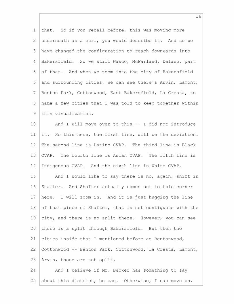
that. So if you recall before, this was moving more
underneath as a curl, you would describe it. And so we
have changed the configuration to reach downwards into
Bakersfield. So we still Wasco, McFarland, Delano, part
of that. And when we zoom into the city of Bakersfield
and surrounding cities, we can see there's Arvin, Lamont,
Benton Park, Cottonwood, East Bakersfield, La Cresta, to
name a few cities that I was told to keep together within
this visualization.
And I will move over to this -- I did not introduce
it. So this here, the first line, will be the deviation.
The second line is Latino CVAP. The third line is Black
CVAP. The fourth line is Asian CVAP. The fifth line is
Indigenous CVAP. And the sixth line is White CVAP.
And I would like to say there is no, again, shift in
Shafter. And Shafter actually comes out to this corner
here. I will zoom in. And it is just hugging the line
of that piece of Shafter, that is not contiguous with the
city, and there is no split there. However, you can see
there is a split through Bakersfield. But then the
cities inside that I mentioned before as Bentonwood,
Cottonwood -- Benton Park, Cottonwood, La Cresta, Lamont,
Arvin, those are not split.
And I believe if Mr. Becker has something to say
about this district, he can. Otherwise, I can move on.

17
1
2
3
4
5
6
7
8
9
10
11
12
13
14
15
16
17
18
19
20
21
22
23
24
25
MS. MAC DONALD: Also Kennedy, hold on for a second.
Chair Le Mons, is this sufficient information or
would you like to know a little bit more about this
particular district?
CHAIR LE MONS: Commissioners will ask as needed.
I -- it -- she -- Kennedy is doing a great job.
Thank you, Kennedy.
MS. WILSON: Thank you. You're welcome.
MS. MAC DONALD: Thank you.
CHAIR LE MONS: And Commissioners, feel free to
raise -- you know, raise your hand. You know to do that.
If you have some questions, just let me know.
But yeah, we're doing fine. Thank you so much for
checking in Karin.
All right.
MS. WILSON: And --
CHAIR LE MONS: Commissioner Sinay, did you have
some -- okay.
Go ahead, Kennedy.
MS. WILSON: Okay. So if nothing from Mr. Becker,
then I will move north.
And before the configuration we had was having Kings
with Fresno and Tulare on its own, with a little bit of
Kings in there, but this new configuration goes a more
east to west direction. Like, as keeping Kings whole and

18
1
2
3
4
5
6
7
8
9
10
11
12
13
14
15
16
17
18
19
20
21
22
23
24
25
then here, I'm going to zoom in so you can see the border
of Tulare, that's a part of there. So Porterville is in
there and is not split. Tulare is whole, not split.
However, Visalia does have a split in this northern
corner, here.
And as you can see, another concern we have is
keeping Visalia and Three Rivers together. And while
there is a split in this northern corner, you can see
that these two do reside in the same district to the
east.
And then we reach up into Fresno County, and Reedley
still has a split. Parlier is a part of this district,
as well. Orange Cove was a part of it before, it is no
longer. And then it reaches on the outskirts of Selma
and Kingsburg, not splitting either of those, as well.
And I will go ahead and read off the se -- again,
this is the deviation. Oh sorry, as I move my screen the
label moves, as well. So we have the deviation. Latino
CVAP, Black CVAP, Asian CVAP, Indigenous CVAP, and White
CVAP.
And just as a general overview, again, Kings County
is kept whole. It does reach into Fresno at this
southern border, splitting Reedley. It does split
Visalia a tiny bit to the north, again. And then the
other cities within Tulare are kept whole.

19
1
2
3
4
5
6
7
8
9
10
11
12
13
14
15
16
17
18
19
20
21
22
23
24
25
My apologies, this is on page 48.
And again, I will leave this time for Mr. Becker to
say something if he needs to, and if not, I will continue
to move to the next one.
And so --
MR. DRESCHLER: I'll just say in general, I -- when
you're moving on, I'll just let you know if I need to
chime in. I just -- in the districts that are in areas
that have been designated as -- as areas where Voting
Rights Act compliance is a strongly relevant
consideration, I just advise the commissioners, take a
particular note of the predominant minorities CVAP and
also the deviation at this stage, because we're getting
at the stage where the deviation is a -- is an indicator
about where certain populations can be either subtracted
or added to maintain well within the legal range of
deviation in these districts. So I think that's a really
important pointer right now.
MS. WILSON: Thank you for that.
And now, we are going to move on to West Fresno,
which is on page 47. Luckily, these are all next to each
other.
So for West Fresno, I'm going to zoom out so you can
see the entirety of it. And then, I will zoom in to get
a closer look into the city of Fresno and the other

20
1
2
3
4
5
6
7
8
9
10
11
12
13
14
15
16
17
18
19
20
21
22
23
24
25
cities below. But it does come up to the northern border
that it shares with Merced, and it takes Dos Palos.
And then we follow along the line here. The county
line is -- stays along the Kings County line and does not
go into our split there. And then I'm going to move into
Fresno -- of the City Fresno. And we were also told to
minimize splits in Fresno. So now we are down to two
splits of the city of Fresno.
We are able to keep Sunnyside, Southwest Fresno,
West Park, sou -- the north of the -- Northwest of the
99, which I'll turn on the streets so you can see where
that is, as well. And so this orange line goes down
here. That's the 99. And this community here is kept
intact. And then we have Old Fig Garden, as well, with
all of those.
And again, pointing out the deviation, Latino CVAP,
Black CVAP, Asian CVAP, Indigenous CVAP, and White CVAP.
And now we will move north to a fourth district,
which was not drawn before. And so this will be a new
configuration as far as VRA is concerned.
So here, we are able to keep the County of Merhed --
Merced almost except for that, Dos Palos area there,
which no city splits are there, they're just going to
Fresno. And I'm going to zoom into Madera. And you can
see the city of Madera has no splits. Madera Acres is in

21
1
2
3
4
5
6
7
8
9
10
11
12
13
14
15
16
17
18
19
20
21
22
23
24
25
here, as well as Fairmead and Chowchilla.
And then we move into Stanislaus, and we do have a
split of Modesto here at the bottom. I will zoom in so
you can see. It is a non-contiguous city, and it has
cities within it, as well. And so to grab in those
cities, it does require splitting the city of Merced.
However -- Modesto, my apologies.
And in doing that, we do split the bottom half.
However, we have Modesto and Turlock for the most part
kept together and no splits in Turlock.
And again, deviation, Latino CVAP, Black CVAP, Asian
CVAP, Indigenous CVAP, and White CVAP.
And that is the conclusion of the new VRA districts
I have drawn in the Central Valley.
CHAIR LE MONS: Does any commissioners have any
comments before we move to the -- Commissioner Turner?
VICE CHAIR TURNER: Mine will be very brief.
Thank you, Kennedy.
End of comment.
MS. WILSON: Oh.
CHAIR LE MONS: Thank you, Commission Turner.
Commissioner Sinay?
COMMISSIONER SINAY: Thank you. I just wanted to
make sure, on the West Fresno, where's that Fig -- Old
Fig Garden? I saw it for a second, but it didn't -- I

22
1
2
3
4
5
6
7
8
9
10
11
12
13
14
15
16
17
18
19
20
21
22
23
24
25
didn't see it on the actual print out.
VICE CHAIR TURNER: It's in with -- oh, go ahead.
COMMISSIONER SINAY: It's that little one -- it's
that little piece. Okay. Thank you.
MS. WILSON: Yes.
COMMISSIONER SINAY: I was just trying to -- it's
hard to --
MS. WILSON: And I can zoom in a little further
to ---
COMMISSIONER SINAY: No, no, that's fine. I was
just -- it kept coming up in our -- in our testimony, so
I was -- just wanted to be able to see it. But that --
we also had COI testimony that there is a strong APIA,
AMEMSA Community in West Fresno, and I just want to make
sure that we have looked at that -- those communities of
interest and make sure that when we're splitting up
Fresno that we are looking at the Punjabi, Sikh, that are
west of 99 and the Arabic-speaking communities, the
communities of interest we've gotten on those.
MS. WILSON: And I can take a look at that closer.
COMMISSIONER SINAY: Okay.
MS. WILSON: And I will also pull up this -- is the
freeway boundary line, as well. And nothing on the west
side of it is split. This --
COMMISSIONER SINAY: Okay.

23
1
2
3
4
5
6
7
8
9
10
11
12
13
14
15
16
17
18
19
20
21
22
23
24
25
MS. WILSON: -- line of the boundary actually is a
little bit before that side, but I will also continue to
look at that closer. And show you this is where the 99
is, as well.
COMMISSIONER SINAY: Okay. Perfect. Thank you. And
then also on that map -- I couldn't see it on our
visualization and I didn't do a Google map this time --
but is Fresno, city -- Sunnyside, Selma and Sanger, all
kind of together?
MS. WILSON: So Sunnyside, Selma, and Sanger make a
triangle here. They are all within the same
visualization that I've drawn.
COMMISSIONER SINAY: Okay. Great. Thank you. I
can -- I can -- I have a few on another one. I don't
know, Chair, if you'd like me just to step back so others
can step forward or if you want me to go through all of
them.
CHAIR LE MONS: Yes. Could you do that?
COMMISSIONER SINAY: Of course.
CHAIR LE MONS: And I'll come back.
Commissioner Kennedy?
COMMISSIONER KENNEDY: Thank you, Chair. Just a --
just a reminder -- and this is not so much on anything
very specific. But just to keep in mind the city area --
city spheres of influence when we're -- when we're

24
1
2
3
4
5
6
7
8
9
10
11
12
13
14
15
16
17
18
19
20
21
22
23
24
25
drawing lines.
I just checked the Fresno City Sphere of Influence,
and it may be necessary to adjust that northern boundary
out of the -- out of the purple into the green, just so
that we keep all of Fresno's designated sphere of
influence with the city rather than leaving a small part
of it outside. Thank you.
CHAIR LE MONS: Commissioner Andersen?
COMMISSIONER ANDERSEN: Thank you, Commissioner
Kennedy. That was one of my questions.
And the second one was, in Fresno, is our cut
line -- we've been hearing, you know, the separation line
is Shaw Avenue. And I was trying to find Shaw Avenue in
all the different visualizations, here, but I couldn't
quite find it. Have -- is that the line that we were
using?
MS. WILSON: This -- in previous visualizations,
yes. But in terms of trying to reach a number of C -
allowable CVAP and so forth, I did move it down slightly
in this visualization. And so East Shaw actually runs at
the top of where Old Fig Garden is across. And I had
looked at keeping it there, but as far as deviations went
and for CVAP, I did move it lower.
And of course, maybe that can be moved if moving
other things around, as well to (indiscernible).

25
1
2
3
4
5
6
7
8
9
10
11
12
13
14
15
16
17
18
19
20
21
22
23
24
25
COMMISSIONER: Yeah, I would like us to see that
because we did get -- I cannot recall -- if someone --
one of the commissioners recalls, what community is in
that area -- but I would hate to, kind of cut them in
half. That's why I would like to see that. And then we
can see if -- you know, that would obviously increase our
population a little bit. We might be able to pull it
from someplace else, with one of the negative populations
in the area.
So -- thank you.
CHAIR LE MONS: Commissioner Akutagawa?
COMMISSIONER AKUTAGAWA: Yeah, thank you,
Commissioner Andersen. I was going to ask that same
question because it's hard to see from some of the
visualizations where --
VICE CHAIR TURNER: Right.
COMMISSIONER AKUTAGAWA: -- what's included, and we
did hear quite a bit of testimony from many of the people
who called from Fresno stating that Shaw Avenue was a
cutoff. And on that note, I wanted to also ask Kennedy,
about the Hmong community, as well too. They are the
largest -- Fresno has the largest Hmong community in the
U.S., and I know that testimony that we got said that
they were concentrated in what is West Fresno, but they
are also -- have further spread out. And wanted to see
26
1
2
3
4
5
6
7
8
9
10
11
12
13
14
15
16
17
18
19
20
21
22
23
24
25
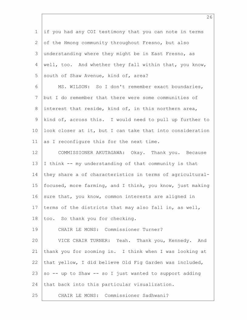
if you had any COI testimony that you can note in terms
of the Hmong community throughout Fresno, but also
understanding where they might be in East Fresno, as
well, too. And whether they fall within that, you know,
south of Shaw Avenue, kind of, area?
MS. WILSON: So I don't remember exact boundaries,
but I do remember that there were some communities of
interest that reside, kind of, in this northern area,
kind of, across this. I would need to pull up further to
look closer at it, but I can take that into consideration
as I reconfigure this for the next time.
COMMISSIONER AKUTAGAWA: Okay. Thank you. Because
I think -- my understanding of that community is that
they share a of characteristics in terms of agricultural-
focused, more farming, and I think, you know, just making
sure that, you know, common interests are aligned in
terms of the districts that may also fall in, as well,
too. So thank you for checking.
CHAIR LE MONS: Commissioner Turner?
VICE CHAIR TURNER: Yeah. Thank you, Kennedy. And
thank you for zooming in. I think when I was looking at
that yellow, I did believe Old Fig Garden was included,
so -- up to Shaw -- so I just wanted to support adding
that back into this particular visualization.
CHAIR LE MONS: Commissioner Sadhwani?

27
1
2
3
4
5
6
7
8
9
10
11
12
13
14
15
16
17
18
19
20
21
22
23
24
25
COMMISSIONER SADHWANI: Yep. I just wanted to add
in here, yes, I think we've definitely heard testimony
around Shaw. My only concern about that is overpacking
the -- this district. So that would be my only caveat to
that, is I think, yes, let's see what's possible. But
I do want to raise that as a place caution.
CHAIR LE MONS: Thank you.
Okay. I see no additional hands.
We're prepared to move forward, Karin.
COMMISSIONER SINAY: Wait --
MS. MAC DONALD: Yeah. I think this is -- we're now
going to go in the north-south on that side.
CHAIR LE MONS: I'm sorry.
MS. MAC DONALD: Kennedy --
CHAIR LE MONS: I'm sorry, Karin, to interrupt you.
In all fairness, I did tell Commissioner Sinay I would
come back to her.
Commissioner Sinay?
COMMISSIONER SINAY: Sorry about that. I just -- we
had just stayed in one area, and I was -- I wanted to
talk a little bit about -- it felt like some of the areas
had really high numbers of Latinos -- you know, CVAP.
And others still -- for instance, I was kind of surprised
in Stanislaus, which falls under the area that needs to
be VRA protection. It's split up a few times and it

28
1
2
3
4
5
6
7
8
9
10
11
12
13
14
15
16
17
18
19
20
21
22
23
24
25
didn't feel like -- I think only -- how many times is
Stanislaus -- the County of Stanislaus split up?
MS. WILSON: It is split twice. This red line --
sorry if that's confusing -- these are past assembly
district lines, we have up towards the north Riverbank
and Del Rio going north. And then this portion here of
that end of Modesto, kind of, to Diablo Grande, Newman,
here with Merced.
COMMISSIONER SINAY: Okay. And so on the second
one -- the one with Merced -- it's at -- it has, kind of,
a -- it is -- it has fallen under -- I guess, my question
was, I was -- I was looking at, is there a way to better
represent Stanislaus -- the communities of Stanislaus,
and one of my -- sorry, I've got all these notes. One of
them was looking at it with part -- let me see if I can
find exactly what my note was. All it -- oh, shouldn't
Stanislaus and East -- can Stanislaus and East
Stackton -- Stockton be put together, kind of, for a VRA
district?
MS. WILSON: I can take a look at that for you.
COMMISSIONER SINAY: And I know that we don't want
to split up Stockton too many times. But I just -- it
felt like some districts are over 55 percent CVAP and
then others are really low. And so I was just trying to
figure out how to represent the communities in Stanislaus
29
1
2
3
4
5
6
7
8
9
10
11
12
13
14
15
16
17
18
19
20
21
22
23
24
25
better, or differently.
CHAIR LE MONS: Thank you, Commissioner Sinay. Is
that your final comment? Thanks.
Karin, please continue.
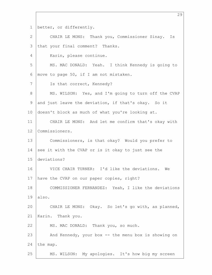
MS. MAC DONALD: Yeah. I think Kennedy is going to
move to page 50, if I am not mistaken.
Is that correct, Kennedy?
MS. WILSON: Yes, and I'm going to turn off the CVAP
and just leave the deviation, if that's okay. So it
doesn't block as much of what you're looking at.
CHAIR LE MONS: And let me confirm that's okay with
Commissioners.
Commissioners, is that okay? Would you prefer to
see it with the CVAP or is it okay to just see the
deviations?
VICE CHAIR TURNER: I'd like the deviations. We
have the CVAP on our paper copies, right?
COMMISSIONER FERNANDEZ: Yeah, I like the deviations
also.
CHAIR LE MONS: Okay. So let's go with, as planned,
Karin. Thank you.
MS. MAC DONALD: Thank you, so much.
And Kennedy, your box -- the menu box is showing on
the map.
MS. WILSON: My apologies. It's how big my screen

30
1
2
3
4
5
6
7
8
9
10
11
12
13
14
15
16
17
18
19
20
21
22
23
24
25
is and sometimes it does not cooperate. But -- there we
go. Now, I won't need to pull it up anymore.
CHAIR LE MONS: Commissioner Sinay, did you have
another comment? Okay. Your hand is still raised.
Thanks.
MS. WILSON: So now we will move on with the non-VRA
consideration districts.
And I'm going to move down south and start on page
50 with Tulare and Kern. And now the box is not showing
up. And if I could just have one moment to bring those
labels back up?
CHAIR LE MONS: Yeah, take your time.
MS. WILSON: And I'm almost done. I'm not sure what
happened, but I'm getting you back on track here.
CHAIR LE MONS: No worries.
MS. WILSON: Okay. There we go. That looks better.
So starting with Tulare Kern. Everything that we
have in Kern up here, again, not a split in Shafter.
What's left of Bakersfield, there's Rosedale, Oildale.
Down to the sides, we have Ford City, Taft, the Pine
Mountain Club, Lebec community. And again, this is on
page 50 if that was not clear.
And we do have, from the VRA district, the split.
So I just want to note where it's being split in
Bakersfield. We do have -- Bakersfield Country Club is
31
1
2
3
4
5
6
7
8
9
10
11
12
13
14
15
16
17
18
19
20
21
22
23
24
25
not included in the VRA. So it is here in this Tulare
Kern. And then Bear Valley Springs, Stallion Springs,
and Keene, those are going into the Antelope Valley due
to population. I'm trying to get this at a good
deviation.
And then, we have, Lake Isabella, Bodfish, that area
together. And then, Inyokern and Ridgecrest being kept
within Kern County and not with San Bernadino. And then
moving up to Tulare. We have, again as I mentioned,
this split in Visalia. But keeping the rest of Visalia,
Exeter, Lemon Cove, and Three Rivers together.
And so now that we've finished Tulare Kern, we are
going to move on to the Sierras, which, again, an
overview of this area was keeping Mono and Inyo to the
north. And by doing so, instead of keeping it with
Fresno, Kern, or Tulare for population, I was told to
give it population from the -- my thing is going slow --
Sierra, Nevada, Placer, El Dorado, Amador, Calaveras,
Tuolumne, Mariposa, Madera region. And Madera is cut off
at the foothills.
Like I've showed before, it does not include Madera.
Madera is on the other side. It comes and touches the
outside of that. And Tuolumne, Calaveras, and Mariposa
are all kept together in this visualization, as well.
And now, we will be moving on to page 46, which is

32
1
2
3
4
5
6
7
8
9
10
11
12
13
14
15
16
17
18
19
20
21
22
23
24
25
East Fresno. And I'm going to zoom in a bit closer for
us to see that here. And so -- again, I have showed we
cut down the splits that were in Fresno. There's on --
in the city of Fresno, there's only two. And this keeps
Northeast Fresno and Clovis together. Minkler, Auberry,
Big Creek, in keeping the east part of Fresno, all in one
district and not going into other counties. It's just
within Fresno for this visualization.
And now, we will be moving on to page 44. And we're
going to be moving north to Stanislaus. And so again,
with making this VRA district, it had to reach north into
Stanislaus from Merced to get the population and to get
the CVAP necessary. So that is why there is that split.
However, like I said, I kept Turlock and Modesto together
as much as possible. And as well as, reaching up into
San Joaquin, Manteca area, and Lathrop because this
needed that population from changing these VRA districts,
as well. And then Oakdale to Knights Ferry, all staying
within Stanislaus.
And then we are going to move on to page --
CHAIR LE MONS: Before you move to -- before you
move on, Kennedy -- Commissioner Turner?
VICE CHAIR TURNER: Yeah. Thank you, Chair.
Kennedy, I'd like to have you look at -- in this
particular Stanislaus visualization -- including
33
1
2
3
4
5
6
7
8
9
10
11
12
13
14
15
16
17
18
19
20
21
22
23
24
25
Riverbank and Escalon, and removing -- and leaving
Manteca and Lathrop, and San Joaquin. Ripon's okay.
Ripon, Salida, Riverbank, and maybe Escalon, if needed,
to replace that population.
MS. WILSON: And I will take a look at that. I'm
sorry.
CHAIR LE MONS: Thank you, Commissioner Turner.
Kennedy, you can continue.
MS. WILSON: Yes. And so now, we will move on to
Stockton, which is -- the city of Stockton is kept whole
and then paired with Mountain House and Tracy. French
Camp is in there. Mirada, which comes on the side of
Stockton actually, is with this Eastern part instead of
with the Stockton -- the city of Stockton.
And now, we will move north, again, to page 42.
This has South Sac and Stanislaus together. And again,
Riverbank down here in Stanislaus is going north.
Escalon, Farmington, Peters, Lockeford, Woodbridge, I'm
keeping all of these eastern farming communities of San
Joaquin together, and Lodi, as well, up to Elk Grove,
Florin, Vineyard and Wilton. And I know there was a
request to keep Elk Grove with Sacramento, however, as
far as population goes, that was not possible.
And to, kind of, make that possible, I think there
would need to be further splits within communities going

34
1
2
3
4
5
6
7
8
9
10
11
12
13
14
15
16
17
18
19
20
21
22
23
24
25
more north, so that we can -- as you can see it's
underpopulated in the north, so we would need to push it
north beyond, kind of, county boundaries to make sure
that the stuff could move north so that Elk Grove could
be with Sacramento. However, I do keep Elk Grove with
Florin in this visualization. And then Rosemont and
Mather and La Riviera are in this, as well.
CHAIR LE MONS: Commissioner Sinay?
COMMISSIONER SINAY: Thanks. I just have a quick
question on process. I think I -- earlier I had asked
the question -- in the past, we kind of went through it
in general, and then we, kind of, stopped and asked
questions about it. And now, I thought -- I thought we
had already gone through it. So I just want to know,
when is the right time to start asking questions on a
certain region? When will be stopping -- how -- yeah,
how is it being envisioned so that we don't keep
interrupting you all?
CHAIR LE MONS: So I was checking the cadence,
actually. So I've been, kind of, if I see some
(indiscernible) or depending on how quickly you react,
I've been managing it that way. If everybody's okay with
that, I'll continue to manage it that way. But if you
want to make a recommendation that you want to hold
questions until a certain point, I can entertain that,

35
1
2
3
4
5
6
7
8
9
10
11
12
13
14
15
16
17
18
19
20
21
22
23
24
25
as well.
COMMISSIONER SINAY: I actually like that we ask
questions when we're there because sometimes it's hard to
go back and remem -- you know, find all your notes and
stuff. I do have a comment back on Inyo. So we can do
that at the end, since we've already passed Inyo. And
I'll just get back in line for at the very end. But I
do -- I do like this -- this cadence, as you are calling
it.
CHAIR LE MONS: Okay.
And of course, if you -- Commissioners, if you want
to collect your questions, you can do that as well. I
want to make sure you get an opportunity to make whatever
comments that need to get made.
Okay. Commissioner Fernandez?
COMMISSIONER FERNANDEZ: Thank you, Chair.
Well, since we're going as we go, or commenting as
we go, yes, regarding this visualization that you have,
Kennedy, I'm sure that you already expected this comment
from me, but we need to keep Elk Grove, Vineyard, Florin,
and Rosemont associated with Sacramento. There's
communities of interest, both religion, transportation,
as well as culture that needs to stay together. And I do
have comments as we move further north so that should
hopefully help with some of the population issues.

36
1
2
3
4
5
6
7
8
9
10
11
12
13
14
15
16
17
18
19
20
21
22
23
24
25
And then I also -- what was my other comment -- then
my other comment was also back at Inyo at 52. So maybe
if we go there, Commissioner Sinay can join me with her
comment, as well. So that was page 52 that I'm referring
to.
MS. WILSON: Okay. And move back to the -- move
back to this one?
COMMISSIONER FERNANDEZ: Yes, thank you, so much.
MS. WILSON: The East California? Okay.
COMMISSIONER FERNANDEZ: Yeah. Thank you. And I --
as I've stated in the past, we need to see what we can do
the further north counties, probably from Amador up, are
very different than the Inyos. So I think as we started
this meeting -- and we're going to have to start making
difficult decisions. My recommendation -- one, would be
to keep the -- those other counties separated from Mono,
Inyo, Tuolumne, Mariposa. And maybe consider going into
some of the Fresno, Tulare to grab some of that -- the
population. Thanks.
CHAIR LE MONS: Commissioner Sinay?
COMMISSIONER SINAY: Thank you. Inyo is one of the
areas that has been covered under the potential VRA
areas. And so I would like to see us make an effort
to -- you know, I do think it needs to be separated from
the other Sierras. And we need to -- you know, before we

37
1
2
3
4
5
6
7
8
9
10
11
12
13
14
15
16
17
18
19
20
21
22
23
24
25
go to the far north, I really -- like Commissioner
Sadhwani said before, and we really need to look at the
Central Valley really well and not rush up to the north.
And make sure that we're starting to look at the zero
deviations because I think a lot of the -- in the past, I
would rath -- as I said earlier, I would have rather gone
from Central to San Bernadino to Riverside to Imperial to
San Diego because we keep going from north to south and
we keep pushing -- you know, making decisions that are
being pushed down. And now it's time we make decisions
and push things up because the deviations are not
working.
And -- it -- we need to make some tough decisions.
So I would like Inyo to see how we can connect it with
Tulare and other -- other communities so that it does
have an opportunity that the community -- you know, since
it is a VRA.
And then I would like us to start thinking about
what are some of our other thoughts on how to get the
deviations to zero in the Central Valley before we move
north.
CHAIR LE MONS: Commissioner Andersen?
COMMISSIONER ANDERSEN: Yeah, thank you. I was,
kind of, holding things a little bit back because I
wasn't expecting us to, kind of, answer as we go. And so

38
1
2
3
4
5
6
7
8
9
10
11
12
13
14
15
16
17
18
19
20
21
22
23
24
25
I do have some ideas, in terms of moving population.
I do just want to say, remember that's -- the Inyo
Mono, you know, that area -- I've said this a million
times -- but that is the community of interest. They
have been -- I believe the only reason Inyo is a VRA is
because of what county it was associated with, not that
Inyo, itself, is at all a VRA district.
COMMISSIONER SINAY: Could we get that confirmation
from our VRA counsel?
MR. DRESCHLER: I believe that's accurate. Let me
look at the -- let me look at the maps. Inyo doesn't, by
itself -- it happened to have been included in a district
that had some VRA considerations -- but the county,
itself, is not an area that raises any kind of
significant VRA concerns.
MS. WILSON: If I may, I turned on the previous
assembly districts. And as -- if you can see, what's
included with it are the parts of Tulare that I have
included with Keene.
MR. DRESCHLER: And that's why Inyo might have
appeared in some VRA analysis because of its inclusion in
this district, Assembly District 26, I believe it looks
like. But it does not -- Inyo County does not have the
population concentrations to rise to VRA consideration
otherwise.

39
1
2
3
4
5
6
7
8
9
10
11
12
13
14
15
16
17
18
19
20
21
22
23
24
25
COMMISSIONER ANDERSEN: Yeah. Thank you. And what
I'd -- what I'd like to do, rather than -- there -- some
of these areas, like -- actually, if we could go back to
the -- in terms of rearranging some of the numbers, I
think this is a very valid issue. And if we look at
Stanislaus again, it has -- it already has a plus four,
as does the Stockton where -- where the -- I'm sorry, and
then the -- actually, the upper Stan -- the Sac
Stanislaus, the 4.9 -- if we could move up there just a
little bit. Thank you.
I agree with Commissioner Fernandez about how we
have to rearrange that one to include it with Sacramento.
And I understand population is an issue, but how about if
we take out -- and it's not a lot of the population --
but Solano is a negative five. And that whole Terminus
area, close to -- close to -- before you hit Lodi through
Walnut Grove , that is all the Delta area that we were
talking about.
And I would propose pulling that section out of the
Stanislaus -- Sacramento, Stanislaus, even a little bit
more, like, if Galt -- I don't -- I would have to ask
Commissioner Fernandez her understanding of that area --
but putting that into that, sort of, Delta and Solano
areas -- the Solano area, which might, then, help
including Sacramento into the -- in terms of shifting our

40
1
2
3
4
5
6
7
8
9
10
11
12
13
14
15
16
17
18
19
20
21
22
23
24
25
population.
I just thought I'd bring that suggestion up. And so
Commissioner Fernandez might be able to essentially work
with that.
CHAIR LE MONS: Thank you, Commissioner Andersen.
Let me make a clarity point. So the cadence that I
was doing earlier was, a lot of it was clarity questions,
wanting to see things a little bigger, clarifying the
whys of how the visualization came to be. It wasn't so
much emphasized on direction.
So I'd like to distinguish the two. I'd like you to
continue to ask those questions as you -- as they come
up, because that is a nice flow of conversation. And
hopefully, it will help all commissioners take those
clarifying questions into consideration as they formulate
their direction.
And I ask that when we get to the point of giving
direction, that the direction is specific. It's time to
not be really general and have all these sort of
variations on, well, we could do this or do that, but
give a very specific direction. So I'm going to ask each
commissioner to be thinking about, as the discussion or
questions, or clarifying questions are being asked, how
does that inform the direction that they want to give,
and then give that direction when we get to that point.

41
1
2
3
4
5
6
7
8
9
10
11
12
13
14
15
16
17
18
19
20
21
22
23
24
25
So I'd just like to make that little bitty
distinction if you guys don't mind.
Okay. So with that, there's no hands.
Kennedy, let's continue.
MS. WILSON: Sounds good, Chair.
Next -- I believe we just did South Sac, Stanislaus
from where we left off. So now, we will be moving to
page 39, into Sacramento.
I'm going to zoom in so we can see that Sacramento
is whole, except for this part, here. So it's not whole,
but I'm going to turn on this Google Terrain to show you
that, here in North Sacramento, we have -- I'm moving
closer -- Del Paso Heights, which was a point of concern
for keeping that community together and is right here, as
I'm waving the hand around right under Dwight Eisenhower
freeway, and is kept whole. And is not split.
And we do have a split here, along this area, which
is -- I'm sorry, let me turn on the other streets
layer -- around down -- and this isn't a freeway, it's,
kind of, a waterway that goes down here. And that's
where we have that split going along. And then the rest
of Sacramento is all together -- I'm going to turn off
the streets layer.
And West Sacramento was taken out to be put with
Yolo. And then Fruitridge Pocket, Lemon Hill Parkway,

42
1
2
3
4
5
6
7
8
9
10
11
12
13
14
15
16
17
18
19
20
21
22
23
24
25
and Southeastern Sacramento are kept together in this
visualization.
Now, moving on to page 38. We have North Sacramento
County, which is here the blue -- let me center it here.
We have Rancho Cordova, Arden-Arcade, Carmichael kept
together. Of course, the Del Paso Heights I just
mentioned, Rio Linda, North Highlands, Foothill Farms,
Antelope, Fair Oaks, and Gold River kept together in this
visualization.
Now, continuing to move north, next, we have -- up
above this one in yellow -- West Placer. So I'm going to
move it down. So here we have Folsom, Orangevale, Citrus
Heights, and Elverta moving up with Roseville, Rocklin
and bringing back in Lincoln so that it's not separated
from Rocklin and Roseville for this visualization. And
Granite Bay and Loomis are separated. Due to direction,
I had to keep Sutter and Yuba together and move Butte
north, which I will go to next. But here, this is the
West Placer visualization.
Now, continuing to the visualization I was just
talking about, we're going to move to page 13. And it is
above us in green. I'm going to zoom out so we can see
the entirety of it.
Last time, I had a visualization that had Butte,
Sutter, and Colusa together, and I was told to move Butte

43
1
2
3
4
5
6
7
8
9
10
11
12
13
14
15
16
17
18
19
20
21
22
23
24
25
to the north and Colusa to the north. However, with
numbers and not splitting up any counties, that just
isn't possible. Butte does have a pretty large -- a
pretty large population. And so without including
Tehama, as well, you really can't get that Colusa up
there.
And then you still have to populate Sutter and Yuba
together. And I was told to take in Grass Valley from
Nevada. But that just doesn't do it, as well. You can
see I'm still at negative four.
And so I had to dip into Placer, where I took
Granite Bay, and Loomis, and Sheridan, Auburn and North
Auburn, and Placer, the Grass Valley area of Nevada,
Sutter and Yuba whole and kept together, and then Colusa,
Glenn, and Tehama in green.
And then lastly, we have the NorCal visualization,
which is on page 12, right after -- right before the
other one. And we have Siskiyou, Modoc, Shasta, Lassen,
Plumas, and Butte all kept together. And of course,
still part of the Karuk Tribe in Humboldt. So we have
cut out this northeastern corner that contains the Karuk
Tribe and keeps them whole with Siskiyou.
And that is the end of my presentation.
CHAIR LE MONS: Thank you, so much, Kennedy. So at
this time -- well, based on Kennedy's presentation, I'd

44
1
2
3
4
5
6
7
8
9
10
11
12
13
14
15
16
17
18
19
20
21
22
23
24
25
like commissioners to provide any direction that they
want to provide.
Commissioner Fernandez?
COMMISSIONER FERNANDEZ: Thank you, Chair.
Okay. Let's see. Kennedy, I already made comments
about El Dorado. And so if you could move down to 37,
38, and 39. That's the Sacramento areas. And
unfortunately, because most -- quite a few of these areas
are unincorporated, so I don't have the population
totals. So I'm going to have to do, like, guesstimates
in terms of moving things around. Oh, that's perfect.
So I already talked about Elk Grove, Vineyard, and
Rosemont to keep that. I'd like to keep Wilton in there,
as well, but if not, that's okay. That is more of a --
rural and they do have more commonalities with the
agriculture, farming communities that they're in. I
would -- I'm just responding to Commissioner Andersen
regarding Galt, and I forget what was down below. I
would leave that in that district. That would be my
recommendation.
I have recommendations for Solano when we get to
that. Yeah, I would leave that where it's at.
And in terms of trying to -- and keep Elk Grove in
there with Vineyard and Sacramento, because like I
mentioned earlier, we're breaking up some communities and

45
1
2
3
4
5
6
7
8
9
10
11
12
13
14
15
16
17
18
19
20
21
22
23
24
25
this is not a VRA area. So we can look at other issues
as transportation, or cultural, or education with some of
the commonality.
So I -- I'm trying to think of how we're going to
break up this little -- how we're going to try to make
room for Elk Grove, Vineyard, and Rosemont, and I don't
have all of the -- the populations, as I mentioned
earlier. So I'm going to have to leave it to you --
sorry, Kennedy -- in terms of how we can move things in
and out.
I think it's important to keep Sacramento together
as much as possible and all those communities. Oak Park,
I know one of their -- I'm glad they're together but they
also -- they also have commonality with the Vineyard and
Oak Grove, as well as Florin, specifically.
So do you need anything else from me, Kennedy?
MS. WILSON: No, that is helpful. And I just would
like to say that in terms of moving things around, I do
think it would start to split up things up here. And I
know that you don't understand what the populations are,
but --
COMMISSIONER FERNANDEZ: Right.
MS. WILSON: -- and I, you know, off the top of my
head, I'm clicking cities back and forth, I'm like, wow,
these are highly populated but then they all, you know,

46
1
2
3
4
5
6
7
8
9
10
11
12
13
14
15
16
17
18
19
20
21
22
23
24
25
from previous direction, want to stay together. But we
need to also just keep pushing population north, which
could mean some of these going farther up than you have
previously mentioned.
And if that is okay because you'd rather this here,
it would mean pushing things up that haven't been told to
be pushed up before. If that makes sense.
COMMISSIONER FERNANDEZ: Right, because you could
potentially push up, like, Lincoln with Auburn, and
Granite Bay. They do have some commonalities. And
with -- yeah, I think that would probably be preferable
at this point. But of course, I'll have to see what it
looks like. Sorry about that, Kennedy. Thank you.
CHAIR LE MONS: Thank you, Commissioner Fernandez.
Commissioner Kennedy?
COMMISSIONER KENNEDY: Thank you, Chair. I just
wanted to ask if it would be possible to -- or unless
there's a reason for splitting Visalia, if we could find
a way to make Visalia whole by compensating for that in
the area around Tulare City, Lindsay, and Porterville?
Finding a way to get the population you need for that --
for the Kings Tulare district, by expanding a little bit
around Tulare City, Lindsay, and Porterville so that
Visalia could be whole. Unless there's a reason --
particular reason that Visalia is split. Thank you.

47
1
2
3
4
5
6
7
8
9
10
11
12
13
14
15
16
17
18
19
20
21
22
23
24
25
CHAIR LE MONS: Thank you.
Commissioner Sinay?
COMMISSIONER SINAY: The Chair had asked us to give
specific instructions, so I wanted to go back to
Stanislaus and the -- Stanislaus and San Joaquin. And
the -- if you look at the -- how this area was drafted by
MALDEF'S report, they are Assembly District 23 on page
177, that gives a good idea of how -- how to create a
representative -- a VRA representative district in this
area. Obviously, that'll move some of the other things
around, but I think it's important that we get this --
get this right.
CHAIR LE MONS: Thank you, Commissioner.
Are there any closing direction or questions for
Kennedy before we move to another section of the
visualization?
Commissioner Akutagawa?
COMMISSIONER Akutagawa: Yeah, I just want to
perhaps, ask Kennedy, just to make sure I'm understanding
this correctly. I believe Stanislaus is cut up three
times?
MS. WILSON: Twice. Sorry. Again, once here to the
yellow. And then once with the orange. And it moves
into San Joaquin, but it's only split twice, the county.
COMMISSIONER AKUTAGAWA: Okay. So Riverbank is part

48
1
2
3
4
5
6
7
8
9
10
11
12
13
14
15
16
17
18
19
20
21
22
23
24
25
of Stanislaus, but that's the only other place that it's
cut?
MS. WILSON: Riverbank and Del Rio are moving north
but it -- that's the only -- they're cut in these two,
this kind of, wider orange-looking area and the yellow
area here.
COMMISSIONER AKUTAGAWA: Okay. So there -- so
basically, I mean, it's still three times, then? It's
not just -- because of where Modesto and Ceres is. And
then, that's one cut, right?
MS. WILSON: But -- yeah, that's one cut. And then
this is the other.
COMMISSIONER AKUTAGAWA: Yeah, so --
COMMISSIONER SINAY: I think three districts, that's
the -- yeah.
COMMISSIONER AKUTAGAWA: Three districts then.
Basically, there's three districts.
MS. WILSON: Oh okay. I thought you meant the city.
Okay. I was -- I mean the county -- I was confused by
what you were saying.
COMMISSIONER AKUTAGAWA: I'm sorry, I should have
been more clear. So yeah, so it is -- the county,
itself, is cut up three times. There's three --
MS. WILSON: Yeah.
COMMISSIONER: Okay. All right. Thank you. I just

49
1
2
3
4
5
6
7
8
9
10
11
12
13
14
15
16
17
18
19
20
21
22
23
24
25
wanted to make sure -- I guess -- I mean, just look --
given some of the other conversations that we've had in
terms of, perhaps, some of the movement that is going to
be needed to be done, is there a way to avoid splitting
the county more than once? Like you've done -- I think
you've done a fantastic job in terms of, you know, the --
kind of the lower part of the Central Valley where you've
managed -- instead of multiple -- you know, crossing
county lines three time -- two times, you know, you've
just managed to make it just one. Is there a way to do
something similar with Stanislaus? I know that we've
gotten COI testimony from them about feeling like they
just become like the -- the place where they just get
pulled for population and other things like that, and
perhaps, to minimize for Stanislaus if we can that
that --
CHAIR LE MONS: Commissioner Akutagawa, can I ask
you to give direction?
COMMISSIONER AKUTAGAWA: Yes, and that's my
question.
CHAIR LE MONS: If you're saying don't split it
twice or whatever, just please give that direction and
then they will attempt to do what's being asked, and let
us know otherwise.
COMMISSIONER AKUTAGAWA: Okay.

50
1
2
3
4
5
6
7
8
9
10
11
12
13
14
15
16
17
18
19
20
21
22
23
24
25
Kennedy, is -- what -- was what I was saying --
unless you just want me to make it a statement.
CHAIR LE MONS: Please make it a statement.
MS. WILSON: Oh -- yeah, sorry.
CHAIR LE MONS: I'm asking that you please make it a
statement. The direction should be direction and not
questions.
COMMISSIONER AKUTAGAWA: All right.
Kennedy, please split a county once. In this case,
specifically, Stanislaus, please just split it once.
CHAIR LE MONS: Thank you, Commissioner.
Commissioner Fornaciari?
COMMISSIONER FORNACIARI: Sorry, I just -- just --
have kind of a general question for the line drawers at
this point. I mean, it looks to me -- based on what
we've got going here, we're going to be pushing a
significant amount of population north up the Valley. I
mean, we've got 20 -- almost 25,000 people to push north
from Merced into Stanislaus, an additional 20,000 people
to push north, an additional 15,000 people to push north
from Stockton. So I mean, if we're -- I mean, depending
on how comfortable we are with deviation -- that's
something we haven't talked about.
I mean, if we're comfortable with the five percent
deviation for a good reason, then maybe the mappers don't

51
1
2
3
4
5
6
7
8
9
10
11
12
13
14
15
16
17
18
19
20
21
22
23
24
25
have to push so hard. But I think, you know we're giving
direction here that's moving population around fairly
significantly here. And I think, you know, as a
commission, we need to come to some agreement on what
deviation we're comfortable with and give some guidelines
on that.
Because, I mean, if we push towards zero, that's a
heck of a lot of people going north, assuming we're not
going to go east or west. And that's going to completely
change these maps. So you know, we're getting to a point
where we've got to settle on what these maps look like in
an architectural term -- you know, standpoint -- and to
make little tweaks.
So you know, I'd really like to see us get to a
point where we have some direction on deviation.
CHAIR LE MONS: Thank you, Commissioner Fornaciari.
Commissioner Sadhwani?
COMMISSIONER SADHWANI: Yeah, a couple things. I
think I agree with you, Commissioner Fornaciari, on
deviations. I think that's an important piece we need to
uplift.
I think we do have -- my understanding, and maybe if
counsel wants to weigh in on this or even the line-
drawing team -- I think we need to have a little more
flexibility on the assembly districts than we would on

52
1
2
3
4
5
6
7
8
9
10
11
12
13
14
15
16
17
18
19
20
21
22
23
24
25
the congressional districts, so getting -- recalling that
would be probably helpful. And I do agree with that
piece.
I want to take a closer look at Sacramento just to
better understand the direction that Commissioner
Fernandez is giving here because -- I -- I'm sorry, I'm
trying to keep up with the various pages and sometimes we
flip around, and I can't keep up. What is the -- what is
the population deviation in that pink district that's
just above that includes Sacramento?
MS. WILSON: 2. --
COMMISSIONER SADHWANI: That's already -- oh sorry,
go ahead.
MS. WILSON: Sorry, I was just repeating it to you.
I was just saying it's 2.10.
COMMISSIONER SADHWANI: Yeah. So we're already over
population there. And so -- I think -- and I'm just
trying to, again, wrap my head around it.
So Commissioner Fernandez, your perspective was
including Elk Grove, Florin, Vineyard into that district?
COMMISSIONER FERNANDEZ: Yes, correct. Those are
all Sacramento.
COMMISSIONER SADHWANI: And did you have thoughts
about what to remove?
COMMISSIONER FERNANDEZ: Yes and no. I directed --

53
1
2
3
4
5
6
7
8
9
10
11
12
13
14
15
16
17
18
19
20
21
22
23
24
25
because I don't know the numbers, that's the unfortunate
part --
COMMISSIONER SADHWANI: Right.
COMMISSIONER FERNANDEZ: -- because many of these
are not cities. So I don't have that information. So it
was pushing it a little bit north and then, possibly,
east, as well, into that VADECA and also into the West
Placer. Like the Antelope right now that is with
Sacramento and -- I mean, with the -- I can't -- I don't
know what the name of that one is.
COMMISSIONER SADHWANI: Got it.
COMMISSIONER FERNANDEZ: Right next to Elverta
because those are actually right next to each other.
COMMISSIONER SADHWANI: Okay. And can -- I'm so
sorry because I'm not super fam -- I'm not very familiar
with these neighborhoods. Where is Oak Park?
MS. WILSON: Sorry. I'm zooming in to --
COMMISSIONER SADHWANI: No, I appreciate that.
Thank you.
MS. WILSON: And the font is kind of tiny. It's
right underneath this --
COMMISSIONER SADHWANI: Oh. I got it.
MS. WILSON: -- above Fruit Ridge pocket. It's in
this area right here.
COMMISSIONER SADHWANI: Okay.

54
1
2
3
4
5
6
7
8
9
10
11
12
13
14
15
16
17
18
19
20
21
22
23
24
25
MS. WILSON: I'm circling around. Underneath the
50, right next to Curtis Park, right of the 99 here.
COMMISSIONER SADHWANI: Got it. Yeah, because I
think one of the big challenges I'm just trying to wrap
my head around here, is that we have a lot of COI
testimony from this region. If we were to put all of it
together, we're way over population, right?
So I hear you, Commissioner Fernandez, on the
Florin, Elk Grove, Lemon Hill. Definitely, we've had
that testimony. We've also had pieces on Lemon Hill and
Del Paso Heights. We've had -- keep Elk Grove with
Greenhaven because there's a shared levy system with the
Sacramento River.
And then we also have stuff from Equality
California, I believe, for the LGBTQ community looking
at -- I'm trying to pull up my notes on that one -- West
Sacramento with the city of Sacramento, including the
neighborhoods of Johnson, Business Park, Mansion Flats,
New Arab Park, Boulevard Park, Downtown Sacramento. I
don't know how we do all of that. Like, I don't know how
we keep all of those pieces together because this
configuration is already over. So I -- I would agree
with you, Commissioner Fernandez, in thinking about what
are our options here?
I'm wondering if -- if this pink piece, this

55
1
2
3
4
5
6
7
8
9
10
11
12
13
14
15
16
17
18
19
20
21
22
23
24
25
Sacramento district, is ultimately two districts or if
there's a different way, Kennedy, that you can think
about reconfiguring them to include -- so that we're
being responsive to a lot of different COI testimony. I
don't know where we're at with -- with where that would
put us in terms of population, but I wanted to uplift all
of those various, and to some extent, conflicting COIs.
CHAIR LE MONS: Thank you for that, Commissioner
Sadhwani.
Commissioner Sinay?
COMMISSIONER SINAY: Okay. For a second, there, I
blanked out on what I was -- where I was, sorry. Not
where -- anyway, I wanted to look at Silver Lake -- so
further south. There's -- so East Fresno is at negative
17.8 and -- or 17,000 people, I did it differently than
you all. It was easier for me to put the numbers.
And then, Tulare is over by 10,00 plus. So I was
wondering if you kep -- if you look at the VRA maps that
we were given, there's, kind of, a little -- I'll use
Commissioner Sadhwani's term, dallop -- dollop -- but
it's a different one, the Tulare dollop. And I was
trying to figure out if that was Silver Lake. And I
couldn't quite -- or sorry, Silver City. So I just
wanted to see if we -- if looking at the East Fresno and
the Tulare, that border up there, if we can make the

56
1
2
3
4
5
6
7
8
9
10
11
12
13
14
15
16
17
18
19
20
21
22
23
24
25
changes needed so that the deviations get a little closer
to zero.
CHAIR LE MONS: Commissioner Turner?
VICE CHAIR TURNER: Thank you, Chair. I lifted my
hand to say this earlier and put it down. But then
Commissioner Toledo brought it up. I really do want us
to talk about deviations because I think the deviations
are fine at four and five. And we've not had this
conversation. I think we're moving a lot and starting to
put COIs into areas that they don't belong and don't have
commonality and may not have to. I know population
equity or equality is like our top, you know, number one,
and we want to do that. But if there is an accepted
deviation, maybe we're trying to move things that just
now will be hodgepodge and won't even fit together.
When we were having conversations about the Central
Valley -- excuse me, that one little area we're talking
about -- and once we move to a different area, we move to
a different conversation. So I don't know about this
jumping.
But the conversation we were having, specifically,
around the San Joaquin and the Stockton area, and what
have you, I do know that the Manteca and some of those
areas that's been cut out, is very close to -- thank you,
Kennedy -- and MALDEF, I think cuts out Mountain House

57
1
2
3
4
5
6
7
8
9
10
11
12
13
14
15
16
17
18
19
20
21
22
23
24
25
and Tracy, which I'm not a fan of at all. I like the
visualizations the way that Kennedy currently has it.
And Manteca and Lathrop is very close and similar to
Stockton area, much more so than some of the, you know,
other in -- anyway, I just think it should, perhaps, be
included there.
I did like the idea of Terminus being, perhaps,
moved into one of the other areas if, indeed, that was
the same. And I wanted to name that Elk Grove is very
similar to Galt. You know, they -- Galt is up and
coming, lots of new home development building, et cetera,
which is just like the Elk Grove area, as far as
likeness.
So I think deviations would help in this
conversation. I think, for an assembly, we're starting
to move things that we don't need to move. When we had
the conversation to answer the question about Oak Park,
Oak Park is being cut off from some of the other areas
that I think we've heard similar COI around, Florin and
what have you.
And so again, Fruit Ridge Pocket, Lemon Hill, Oak --
you know, all of those particular areas -- and then have
them up and included with some of the other -- I think,
if you expand in that -- what's that, the north -- the
south part of that up top? What is that, north? I don't

58
1
2
3
4
5
6
7
8
9
10
11
12
13
14
15
16
17
18
19
20
21
22
23
24
25
know my direction.
MS. WILSON: Sorry.
VICE CHAIR TURNER: The top.
MS. WILSON: You tell me where and I'll go. I got
confused when you --
VICE CHAIR TURNER: Right where your hand is.
COMMISSIONER Fernandez: I think she's referring to
Natomas, probably. Yeah.
MS. WILSON: This is up -- oh sorry.
VICE CHAIR TURNER: Natomas?
MS. WILSON: Yes, correct.
VICE CHAIR TURNER: Yeah. And so I think
Sadhwani -- Commissioner Sadhwani was talking about,
perhaps, even looking at splitting the district and see
if we can pull in some other like parts. But Natomas is,
again, pretty different from Lemon Hill, Fruit Ridge,
Parkway, Oak Park, and some of those districts down
there, as well.
So sorry, Chair, I didn't have a direction other
than to see we need to start talking about deviations
because now I think we're just throwing things together
that aren't even similar in what they do.
CHAIR LE MONS: Thank you for that, Commissioner.
No, this is fantastic, actually. I think that
organically, we're getting to the place where I wanted

59
1
2
3
4
5
6
7
8
9
10
11
12
13
14
15
16
17
18
19
20
21
22
23
24
25
your directions to be specific because it's going to
trigger each other to say, well, wait a minute, why are
we doing that. And we've not done a lot of that. We've
just given the directions for new visualization. So I
think that this is a really good point. So there's about
four -- about three hands raised, we'll get those
comments. Be we're going to be coming up on a break at
4:15. So it might behoove us to have a discussion about
those deviations, particularly if we feel like that's
going to facilitate us moving through the rest of the
visualizations in a way and help commissioners frame
their direction in a way that's going to be more
satisfactory.
So let's take the three, four hands that are now
raised and any recommendations. I'd like to hear
recommendations from commissioners on addressing the
deviation issue.
Commission Toledo?
COMMISSIONER TOLEDO: To touch bases on what
Commissioner Turner said, I agree that the deviations --
that the deviations -- the range of deviations may not
be -- especially for the other assembly -- may be okay,
as long as they're keeping communities of interest
together. But I guess at some point, we're going to have
some communities that are not completely, you know --

60
1
2
3
4
5
6
7
8
9
10
11
12
13
14
15
16
17
18
19
20
21
22
23
24
25
districts are going to have some areas that are not
similar to the rest of the district. So we just have to
be -- in order to make all the maps work.
And then I had some specific directions, but that
was just my contribution towards this general
conversation.
CHAIR LE MONS: Continue with your specific
direction.
COMMISSIONER TOLEDO: So specifically, you're going
to have to do a deviation. On the Merced map, 1-1-0 --
the 45, the CVAP, I actually would like to see this CVAP
a little bit lower. If it -- and it's an if, because it
is a VRA district -- if we can get it -- if we can
increase the Latino CVAP a little bit more. 50.13 seems
a little low to me.
And so if there's a way to increase the CVAP by
reducing the deviation, we do have 23 -- we're over 23 --
by 23,000. So if there's a way to do that in a way that
preserves the community interests that are there, I'd
like to see that. Thank you.
CHAIR LE MONS: Thank you.
Commissioner Andersen?
COMMISSIONER ANDERSEN: Yeah, thank you. I --
again, on the assembly and the Senate, I have no trouble
whatsoever with deviations plus or minus five. I'd like

61
1
2
3
4
5
6
7
8
9
10
11
12
13
14
15
16
17
18
19
20
21
22
23
24
25
it like four seven, four eight possibly, you know, to
just give it a little comfort zone for when we really
slice and dice things. It's just that congressional
districts have to be plus or minus a couple of people.
But other than that, yes, because there are other
considerations. There's VRA, there's -- it -- just as
Commissioner Toledo was saying, and communities of
interest. And this is -- gives us our play. The only
thing I do think we have to keep -- be careful of if
it's -- if they're all plus four percent, then we got a
troub -- then we have an issue. So that's -- I just want
us to keep in mind that if that's high, this is low,
that'll work.
And then I actually wanted to play -- specific
directions going -- playing on what Commissioner Turner
was saying about -- actually, you can leave it Merced. I
agree with Commissioner Toledo on this one. But I'm
wondering -- I believe -- is that -- that Ceres right
there in the Stanislaus.
If Ceres comes out, does that -- and then we grab a
little more population, possibly a little more to
increase the Latina CVAP. I don't know if that's a
possibility. But that comes out, then going just a
little bit further north in the Stanislaus, that would
take population out of that.

62
1
2
3
4
5
6
7
8
9
10
11
12
13
14
15
16
17
18
19
20
21
22
23
24
25
And going to Manteca, I completely agree with
Commissioner Turner, and I'd like to take Manteca out of
the San Joaquin. So if we took that out of San Joaquin,
but Ceres went into the -- let's see -- I'm sorry. If we
take Manteca out of that VAD Stanislaus and then add
Ceres from the Merced district into the Stanislaus
district, would that maybe a trade which might help
population-wise. And it might be able to clear up all
three things. That's a -- that's what I wanted to -- if
Kennedy might be able to play around with that. Thank
you.
CHAIR LE MONS: Thank you, Commissioner.
Commissioner Kennedy?
COMMISSIONER KENNEDY: Thank you, Chair. Just in
response to Commissioner Fernandez, Elk Grove, Florin,
and Vineyard -- and that's not counting anything else
that she would like to add to the Sacramento district.
Elk Grove, Florin, and Vineyard amount to more than
272,000 people. That's 55 percent of target population
for an assembly district. So you know, I forget who else
said it, but I -- I just don't see that as realistic.
And just for colleagues, you know, the populations
of California cities, yes, are in the Playbook document.
If you need something for something that's not in a city,
the Census QuickFacts lookup provides statistics for all

63
1
2
3
4
5
6
7
8
9
10
11
12
13
14
15
16
17
18
19
20
21
22
23
24
25
states and counties, and for cities and towns with
population 5,000 or more.
So that's -- I was able to look up Vineyard and
Florin and get population counts for Vineyard and Florin,
which are CDPs, not incorporated cities. So the Census
QuickFacts look up facility is going to be very helpful,
and the fact that they have data for any Census
designated place with a population of 5,000 and more;
5,000 is roughly one percent of the target population for
the assembly districts. So it's a handy information
source for people who need it on the fly. Thank you.
CHAIR LE MONS: Thank you, Commissioner.
Commissioner Fornaciari?
COMMISSIONER FORNACIARI: Yes. So with regard to
deviation, let's see, I'm fine up to -- you know, the
"safe harbor," we've been told, is plus or minus five
percent, and I'm fine with that, in general. But I think
we need to also look at it in totality. Because if we
have five adjacent districts that are 5 percent over,
that's 25 percent of a district that we're shorting the
people of those -- of that area.
And so you know, I think -- you know, I think,
initially, these big swings are fine, but I think we
really need to understand the impact of it and
acknowledge and recognize what the impact of it may be.

64
1
2
3
4
5
6
7
8
9
10
11
12
13
14
15
16
17
18
19
20
21
22
23
24
25
That's all.
CHAIR LE MONS: Do you have a recommendation,
Commissioner Fornaciari?
COMMISSIONER FORNACIARI: No. Well, I just think
that, you know, once we get a little closer to being
comfortable with our maps, I think we need to just take a
look and see where we're at. You know, I mean, we've
got -- we've got this whole line of districts from
Stanislaus up through Sacramento that are all over. And
so you know, I think I begin to be uncomfortable if we --
we had a bunch of districts all together that were all
over, because we're -- we'll be underrepresenting those
folks.
So I don't have a specific recommendation other
than, just let's make sure that we take a look at it as
we go.
CHAIR LE MONS: Okay.
Commissioner Fernandez?
COMMISSIONER FERNANDEZ: Thank you. I -- yes, I was
looking at those deviations too. We must be on the same
subcommittee or something, finance.
And the way I was approaching it when I was
reviewing the information last night, is I was, kind of,
looking at it by area. Like L.A. As long as it balanced
out, they have the -- you know, they have the

65
1
2
3
4
5
6
7
8
9
10
11
12
13
14
15
16
17
18
19
20
21
22
23
24
25
representation. So that was, kind of, cutting up the
state to ensure that there wasn't, as Commissioner
Fornaciari said, you know, six neighboring districts and
they're all over, or they're all under -- maybe they're
overrepresented, right. So that's -- I was, kind of,
looking at it by area. You know, once you go to one area
to the next, make sure that there is fairly
representative as possible with districts. Thanks.
CHAIR LE MONS: Thank you.
Any additional comments on this before we move
forward? It sounds like people are ready to -- I mean,
I'm still feeling like there's a general guidepost as it
relates to deviation and something more specific can be
forthcoming. That's my read on the feedback I've heard
so far.
My recommendation will be to -- in -- and -- in your
giving your direction -- I keep emphasizing direction --
but to really think about the implications of the
direction that you're giving. And have all that
consideration set come into your direction prior to
giving it, because at this point, things are at a place
where you have to -- it's not just one or the other, as
some of the earlier visualizations focused on particular
things.
Now it is balancing a little bit more. So I just

66
1
2
3
4
5
6
7
8
9
10
11
12
13
14
15
16
17
18
19
20
21
22
23
24
25
encourage commissioners to do that as they think about
the direction they're going to give as we're starting to
narrow this down.
Commissioner Andersen?
COMMISSIONER ANDERSEN: Yeah, thank you, Chair. I
did have one other comment that, in terms of the
Sacramento area, and -- was -- I liked that Commissioner
Sadhwani brought up the fact of Natomas, which is up the
north part of that Sacramento area. That could go,
actually, into a district with what is east of it. The
North Highland, the Rio Linda, that section. So
essentially grab the area from Florin, Vineyard, Elk
Grove, looking at the downtown area of Sacramento. And
then is one district. And then the Natomas area north
and going east into that blue, is another district in
terms of, you know -- within this area, rearranging where
those district lines are a little bit, which might
actually help alleviate the communities of interest
issue. And also might help alleviate some of the
shifting population issue.
So I was -- I just wanted to uplift that -- agree
with Commissioner Sadhwani on that one. And thank you.
CHAIR LE MONS: Thank you.
Any other comments?
So we have about seven minutes before the break. So

67
1
2
3
4
5
6
7
8
9
10
11
12
13
14
15
16
17
18
19
20
21
22
23
24
25
we could either take our break early or we can move on.
MS. WILSON: May I ask a clarifying question?
CHAIR LE MONS: Absolutely, Kennedy.
MS. WILSON: So as far as the north goes, how --
I'm -- you didn't say much about it, so I'm not sure if
you like the way it was because with this shifting things
north, I do think that -- you know I was told to keep
Lincoln out, but maybe it's -- Lincoln has to go back in
or -- I just don't know if you like this and I wanted to
know as far as -- I don't want to come back with the same
thing if you don't like it, or if I can keep it roughly
the same, then that is something I would like to know?
CHAIR LE MONS: Thank you, Kennedy.
Commissioner Sinay.
COMMISSIONER SINAY: This kind of -- it connects a
little bit to what you were just asking Kennedy, as well
as the conversation on deviation. Plus or minus five
percent sounds great when we're talking about big cities,
but I was looking -- you know -- most of the Far North is
at negative. So it's -- you know -- and when you're
looking at the -- what plus or minus five percent is, in
some of those -- you know -- in some cases, it's almost
the size of a county -- you know, up here, but also, you
know, it is the size of cities. And so I'm not sure how
I feel about plus or minus five percent. I think it's --
68
1
2
3
4
5
6
7
8
9
10
11
12
13
14
15
16
17
18
19
20
21
22
23
24
25
it's -- I would rather see it be smaller than that for
the deviation. And maybe we get to a smaller size. But
I want us to really stop and think what does that mean up
in this area because, you know, right now, it feels like
it's easier just to say plus or minus five and go on to
something else versus really thinking through this area
and looking at and it and saying okay -- I mean, it's
this whole area except for the -- the North California is
all at negative.
CHAIR LE MONS: Okay. Thank you. Commissioner
Fernandez?
COMMISSIONER FERNANDEZ: Yes. Kennedy, if you were
referring to the NorCal Oaks -- the NorCal and Central,
I like how it's looking. How's that? Is that good
enough feedback? And I will -- I will say, as you move
into the more remote areas, if you try to get closer to
zero, you're going to really group some communities that
are physically far apart from each other because, as
Commissioner Kennedy said, the census information will
give you, I guess, incorporated areas of 5,000 or more.
I mean, that's -- I don't know if anything from the north
would pop up honestly. I know my town's not going to pop
up for sure. So I can see in the far, Far North, you
know, talking Tehama, Humboldt, Plumas, north, you may
have a higher negative deviation because it's really

69
1
2
3
4
5
6
7
8
9
10
11
12
13
14
15
16
17
18
19
20
21
22
23
24
25
difficult to try to grab some communities that really do
have some sort of similarities. Granted, at some point,
we have to make those decisions, but I'm just trying to
explain why you'd have some of the negative numbers.
CHAIR LE MONS: Thank you, Commissioner.
Karin?
MS. MAC DONALD: Yeah. And thank you, Chair Le
Mons. I -- I just wanted to highlight the fact that as,
you know, you narrow your deviations, you're going to
have more splits, obviously. And also that next -- next
week once we go into live line drawing, if you want to
work with us live on some of these tradeoffs and actually
move some population around, maybe just even ripple some
population from, you know, one area to the other, to
equalize the population, that is certainly something that
we can try to do. As I said to you last week, there has
not been a whole lot of time to work on these maps. And
you know, some of these deviations reflect that, but the
deviations also reflect your direction. And at this
point, we really haven't had that opportunity to really
go into the nitty gritty and the very small little
direction pools that result from the general
architectural changes. And again, that's what next week
is for. Thank you
CHAIR LE MONS: Thank you.

70
1
2
3
4
5
6
7
8
9
10
11
12
13
14
15
16
17
18
19
20
21
22
23
24
25
Commissioner Andersen?
COMMISSIONER ANDERSEN: Yeah, thank you, Karin, for
that because I was going to say that this -- these maps
really do, in many areas, reflect what we try to see,
which gives us the idea of, like, okay, now we can play
with that. And I -- just for Kennedy, on this, I do
appreciate your architecture on this area which you are
trying to do. I think you will get a little bit more
help as we get into what we want to do with Lake Sonoma,
Yolo -- that area -- in terms of there might be a little
few changes, which might give you a little better
direction. So there's more to come. Thank you.
CHAIR LE MONS: Thank you, Commissioner.
Commissioner Sinay.
COMMISSIONER SINAY: Thanks. I feel like I'm the
only one who's not quite getting this deviation question.
For me, if we say, okay, it's all right in the rural
areas to have negative deviation and the urban areas to
have positive, then we're saying that the urban areas are
under-represented, and the rural areas are over-
represented. I mean, at some point, if you have a
negative somewhere, you're going to have a positive
somewhere else. And therefore, I'm not okay saying,
well, you know, and these areas, they're rural. It's
okay to have that and we'll -- we'll make up for it in

71
1
2
3
4
5
6
7
8
9
10
11
12
13
14
15
16
17
18
19
20
21
22
23
24
25
the urban areas. That's part of the problem with
representation right now throughout. And -- and so I,
unless I'm totally not understanding deviation, which is
possible, I really think that we need to not say it's
okay in one area and not in another. But that we have to
be a little bit more consistent. Because earlier, we had
said, well, I was looking at LA, and if LA -- it -- you
know -- it all equals out, then I feel okay. But now,
I'm looking up at the Far North and yes it's all rural,
and it's not getting to zero. And I'm not okay with it.
And so I just -- I don't want us using different values.
I mean, I know we need to be flexible, but I don't think
we can use different values, especially when you think
about who the populations are in urban areas, and that a
lot of our VRA communities are in urban areas. I would
really like us to -- you know -- we need equal
representation and fair representation. That's why we
were put on this Commission.
CHAIR LE MONS: Thank you, Commissioner Sinay. And
you guys can ponder the comments. Commissioner Fernandez
and Karin, we'll come to you right after the break. It's
4:15. We will go on a 15-minute break, and we will be
back at 4:30.
(Whereupon, a recess was held from 4:15 until
4:30 p.m.)

72
1
2
3
4
5
6
7
8
9
10
11
12
13
14
15
16
17
18
19
20
21
22
23
24
25
CHAIR LE MONS: All right. Welcome back, everyone.
I hope you had a nice break. I'd like to pick up with
our feedback and questions from Commissioners. We left
off with Commissioner Fernandez.
Commissioner Fernandez, the floor is yours.
COMMISSIONER FERNANDEZ: Thank you, Chair. I just
wanted to respond to Commissioner Sinay. In no way did I
say that it was okay for the North Area to be lower. I
was explaining why it probably was. Because rest
assured, I will be looking at California by areas to make
sure that it does balance out, because that is the only
fair way to do it.
CHAIR LE MONS: Thank you.
And Karin, you had your hand raised before the
break.
MS. MAC DONALD: Yeah, thank you so much, Chair
Le Mons. I also wanted t -- to weigh in on that. There
is no policy to, you know, overpopulate one area or under
populate another area. This is basically just the way
it's worked out as we're following your direction based
on, you know, what you want to split or avoid splitting,
what you want to move where. So this is kind of where
those tough decisions that Commissioner Sinay was talking
about earlier may be coming in. Just basically, about
how to move that population. And you know, if you wanted

73
1
2
3
4
5
6
7
8
9
10
11
12
13
14
15
16
17
18
19
20
21
22
23
24
25
to move population into a particular area and ripple
that up, then that's going to require making some
decisions that you haven't made before. And again, we're
happy to do that with you next week, or if you'd like to
give direction now, of course you can do that also.
Thank you.
CHAIR LE MONS: Thank you.
So with that, if we don't have any additional
questions for this particular area, I'd like to move to
the next area.
Karin?
MS. MAC DONALD: Yes, thank you so much. So we will
be switching screens and we will be moving on to Tamina,
please. And I believe Tamina's going to -- if you'd like
to pull up your pages -- Tamina's going to start with
page number 55.
Tamina, is that correct?
MS. ALON: Correct. Good afternoon, Commissioners.
We will be starting with page 55, which is Bonsall.
CHAIR LE MONS: Okay. Feel free.
MS. ALON: Thank you. So Bonsall is the one VRA
consideration visualization that I have for my area.
This is the San Benito and Monterrey County area. I'll
turn on the county lines here. And you'll see the CVAP
that is posted here -- the first one is 51.10 percent
74
1
2
3
4
5
6
7
8
9
10
11
12
13
14
15
16
17
18
19
20
21
22
23
24
25
Latino CVAP, 1.80 percent Black CVAP, 7.64 percent Asian
CVAP, 0.75 percent Indigenous CVAP, and 37.74 percent
White CVAP. I will put up the existing District lines so
you can see the current District, which comes over here
and then south to the line of Monterrey County. And I
will invite Mr. Becker to please comment.
UNIDENTIFIED SPEAKER: And Tamina, would you be able
to pull up the deviation also, please? Thank you.
Commissioners, you just saw the mapping program
works because you could see them -- the menu box working.
This is usually what's happening in the background. So
this is how the deviations make it on a map.
Thank you, Tamina --
MR. BECKER: (Indiscernible) --
UNIDENTIFIED SPEAKER: -- (indiscernible).
MR. BECKER: Yeah, thank you, Tamina. I don't have
much -- much comment here. I would just point out
there -- this is at a negative 3.15 percent deviation
which gives you a little bit of ability to pull in
additional -- actually, a significant ability to pull in
additional population if you want to, to change the
configuration of this District. Obviously, this is an
attempt to build a Latino opportunity district consistent
with VRA considerations.
CHAIR LE MONS: Commissioner Fornaciari, did you

75
1
2
3
4
5
6
7
8
9
10
11
12
13
14
15
16
17
18
19
20
21
22
23
24
25
have a comment?
COMMISSIONER FORNACIARI: Yeah. Let's see. Last
time this came up, I asked about including the rest of
Salinas Valley down to King City. And you said you had
looked at it, but it brought the Latino CVAP down. Can
you let us know what that would wind up being if you --
if you did do that? I mean, it looks like we have some
room to add some folks. So if you Could do that and let
us know what the CVAP numbers would look like if you
added that. I would appreciate it.
MS. ALON: Would you like down to King City, or did
you want to go all the way -- how far south should I go?
COMMISSIONER FORNACIARI: Well, I was thinking King
City.
MS. ALON: King City? Okay. And is there a LCVAP
percentage you would not -- that you would like me not to
dip below?
COMMISSIONER FORNACIARI: I just would like to
understand what it would be and what the tradeoffs are.
MS. ALON: Okay.
COMMISSIONER FORNACIARI: Thank you.
MS. ALON: No problem.
MS. MAC DONALD: Would you like to move on,
Commissioner? So should we zoom out?
CHAIR LE MONS: Hold on one second please, Karin.

76
1
2
3
4
5
6
7
8
9
10
11
12
13
14
15
16
17
18
19
20
21
22
23
24
25
Commissioner Toledo?
COMMISSIONER TOLEDO: Yeah, just to piggyback on
Commissioner Fornaciari. If we could reduce -- if
there's a way to reduce the deviation closer to -- to
zero, and then -- or -- yeah, closer to zero, so that we
can get some of the farming communities in there and
raise the Latino CVAP. I wouldn't want to go below 51
percent. I would want to increase it.
MS. ALON: This is --
CHAIR LE MONS: Thank you.
MS. ALON: -- highest LCVAP that you're going to get
in this area, if you go down that area. You can go into
other areas, so outside of San Benito and Monterrey
County, if you wanted to explore other areas, we can
explore that. But unfortunately, any -- this is the
highest LCVAP that I could get in this area. Even
adding, subtracting population within the deviation
allocations.
COMMISSIONER TOLEDO: That would help.
MS. ALON: But I'm still happy to make the
visualization.
COMMISSIONER TOLEDO: And that's helpful. Thank
you.
CHAIR LE MONS: Commissioner Sinay?
COMMISSIONER SINAY: Thank you, Chair. I guess I
77
1
2
3
4
5
6
7
8
9
10
11
12
13
14
15
16
17
18
19
20
21
22
23
24
25
was looking at the Merced, West Fresno, and Bonsall. And
it -- because we had talked about Merced also being --
you know -- we would like to see Merced pull up -- be
pulled up a little bit as just -- as well as Bonsall.
And on the -- and you know, West Fresno and Tulare are
higher. I don't know if there's a way to kind of get the
CVAP a little -- you know -- just see -- explore ways
to get the CVAP a little higher on those. You know,
looking at the farming communities, I know that they're
different farming communities. I know that there are
some geographic boundaries. But if we can't -- if it
doesn't work to go south, then maybe looking at the ones
that are kind of over the deviation.
MS. ALON: Happy to do that.
CHAIR LE MONS: Commissioner Akutagawa?
COMMISSIONER AKUTAGAWA: Yeah, I'd like to see. If
you were to remove Morgan Hill, add Morgan Hill to Gatos
bank, one, would the removal of that -- you know --
increase the Latino CVAP? Also, is it an option, because
I noticed that the Merced visualization has a 4.78
percent, I guess, over deviation. And so is it an option
to pull in some of that? And so I'd like to see if by
increasing or taking in a part of Merced into that San
Ben -- or Bonsall deviation, if that would also, one,
bring in some additional population and also would it

78
1
2
3
4
5
6
7
8
9
10
11
12
13
14
15
16
17
18
19
20
21
22
23
24
25
increase the Latino CVAP? Thank you.
CHAIR LE MONS: Commissioner Andersen?
COMMISSIONER ANDERSEN: Yeah, thank you. Tamina,
could we actually -- that's a great spot right there.
Could we -- could you turn on the terrain layer, here?
Because I think that might give us an idea of what's
really possible or not. Thank you. And are there --
without getting into too much, can you get a little bit
more of the roads, or was that -- you know -- I'm looking
for, like, the next level down from -- just right now, we
have just the I-5s, you know -- yeah. Could -- are there
any roads that go from San Benito over into the valley?
And can we go a little closer?
COMMISSIONER FORNACIARI: 152 does --
COMMISSIONER ANDERSEN: Yeah --
COMMISSIONER FORNACIARI: But it's a little north.
COMMISSIONER ANDERSEN: Yeah, can you go up a little
north, please, to see -- to see that? Oh, thank you.
Thank you.
CHAIR LE MONS: Tamina, I'm sorry -- Tamina, are you
waiting on me?
MS. ALON: Yes, Chair.
CHAIR LE MONS: Oh, just continue. Yes, I'm sorry.
You may continue.
MS. ALON: I don't want to rush anybody. Okay.

79
1
2
3
4
5
6
7
8
9
10
11
12
13
14
15
16
17
18
19
20
21
22
23
24
25
Well, that is our one potential VRA consideration
District in this area. And so if you will give me a
second, I will change the labels, which you have seen me
do before. I apologize for that messy process. And you
can -- you can now --
COMMISSIONER ANDERSEN: Tamina --
MS. ALON: -- (indiscernible) --
COMMISSIONER ANDERSEN: Could I ask one quick thing
on this? I apologize I didn't ask before. Is all
Watsonville included in this VRA?
MS. ALON: Yes. All of Watsonville is included.
There are no city splits in this visualization.
COMMISSIONER ANDERSEN: Okay. And do we have -- you
know -- as we were saying, the outs -- like -- what is
Commissioner Kennedy's term for the areas around a
smaller city? Would that -- would that -- if you could
look into that unincorporated area up there, if any of
that's part of the greater Watsonville area to add into
this Bonsall, please. Thank you.
MS. ALON: I'm sorry. So you would like this
unincorporated area to be included --
COMMISSIONER ANDERSEN: Could --
MS. ALON: -- or that --
COMMISSIONER ANDERSEN: -- could you look --
MS. ALON: -- or looking --
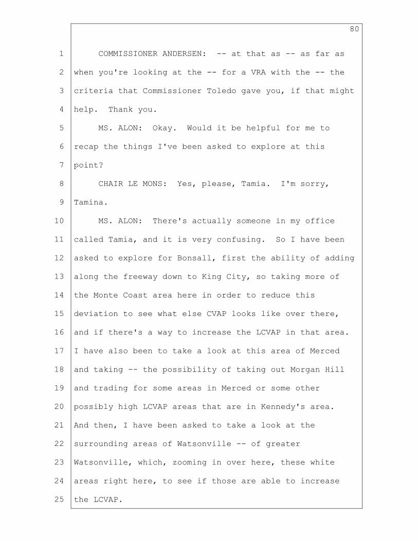
80
1
2
3
4
5
6
7
8
9
10
11
12
13
14
15
16
17
18
19
20
21
22
23
24
25
COMMISSIONER ANDERSEN: -- at that as -- as far as
when you're looking at the -- for a VRA with the -- the
criteria that Commissioner Toledo gave you, if that might
help. Thank you.
MS. ALON: Okay. Would it be helpful for me to
recap the things I've been asked to explore at this
point?
CHAIR LE MONS: Yes, please, Tamia. I'm sorry,
Tamina.
MS. ALON: There's actually someone in my office
called Tamia, and it is very confusing. So I have been
asked to explore for Bonsall, first the ability of adding
along the freeway down to King City, so taking more of
the Monte Coast area here in order to reduce this
deviation to see what else CVAP looks like over there,
and if there's a way to increase the LCVAP in that area.
I have also been to take a look at this area of Merced
and taking -- the possibility of taking out Morgan Hill
and trading for some areas in Merced or some other
possibly high LCVAP areas that are in Kennedy's area.
And then, I have been asked to take a look at the
surrounding areas of Watsonville -- of greater
Watsonville, which, zooming in over here, these white
areas right here, to see if those are able to increase
the LCVAP.

81
1
2
3
4
5
6
7
8
9
10
11
12
13
14
15
16
17
18
19
20
21
22
23
24
25
COMMISSIONER ANDERSEN: Could I just add, also that
Las Lomas area is not just Watsonville, but that
little -- that area right through there. If there's --
if that would help for that same criteria. Thank you.
MS. ALON: The Watsonville unincorporated areas and
coastal areas. No problem.
CHAIR LE MONS: Commissioner Akutagawa?
COMMISSIONER AKUTAGAWA: I just want to add
clarification for Tamina. My request to look at parts of
Merced to add to the Bonsall, that also is on top of what
Commissioner Fornaciari asked about trying to bring in
more of that farming communities down below -- up to King
City, he said.
MS. ALON: I'm doing those too. Thank you very
much.
CHAIR LE MONS: Commissioner Sadhwani?
COMMISSIONER SADHWANI: Yeah, I was just wondering
if we had received a number of communities of interest
testimonies from this area. I don't know if those are
loaded into this map. But it would be helpful for me to
see them. Places that are being referred to as Pajaro
Valley, Lompoc Valley, and Santa Clara Valley. I don't
actually know exactly where those regions are. But
I guess I'm just trying to understand if they are or are
not included in this visualization. My guess is they're
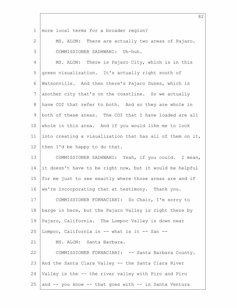
82
1
2
3
4
5
6
7
8
9
10
11
12
13
14
15
16
17
18
19
20
21
22
23
24
25
more local terms for a broader region?
MS. ALON: There are actually two areas of Pajaro.
COMMISSIONER SADHWANI: Uh-huh.
MS. ALON: There is Pajaro City, which is in this
green visualization. It's actually right south of
Watsonville. And then there's Pajaro Dunes, which is
another city that's on the coastline. So we actually
have COI that refer to both. And so they are whole in
both of these areas. The COI that I have loaded are all
whole in this area. And if you would like me to look
into creating a visualization that has all of them on it,
then I'd be happy to do that.
COMMISSIONER SADHWANI: Yeah, if you could. I mean,
it doesn't have to be right now, but it would be helpful
for me just to see exactly where those areas are and if
we're incorporating that at testimony. Thank you.
COMMISSIONER FORNACIARI: So Chair, I'm sorry to
barge in here, but the Pajaro Valley is right there by
Pajaro, California. The Lompoc Valley is down near
Lompoc, California in -- what is it -- San --
MS. ALON: Santa Barbara.
COMMISSIONER FORNACIARI: -- Santa Barbara County.
And the Santa Clara Valley -- the Santa Clara River
Valley is the -- the river valley with Piro and Piru
and -- you know -- that goes with -- in Santa Ventura

83
1
2
3
4
5
6
7
8
9
10
11
12
13
14
15
16
17
18
19
20
21
22
23
24
25
County.
MS. ALON: Got it. So those wouldn't be all be kept
together but that's what the -- in any case, that's what
the -- I'm looking at it as -- as something that's
suggesting keeping them together. But that -- that's a
really long area.
COMMISSIONER FORNACIARI: Right. They -- yeah --
MS. ALON: I --
COMMISSIONER FORNACIARI: -- they just -- those were
the three areas that (indiscernible) was focused on --
MS. ALON: Correct.
COMMISSIONER FORNACIARI: -- or the coast, yeah.
MS. ALON: Okay. Thanks so much, Neal.
CHAIR LE MONS: Commissioner Sinay?
COMMISSIONER SINAY: Looking at, again, this input
that we just received on this one from the public, the
first question -- and I know we haven't done Santa Cruz
yet, but is Santa Cruz split in three districts?
MS. ALON: Yes. I'll tell you where that split is.
We have the areas of Santa Cruz, which you directed to be
with the agricultural areas. So Interlaken,
Watsonville, Amesti, Freedom, and -- come on, label --
Aptos Hills-Larken Valley over here.
COMMISSIONER SINAY: Okay.
MS. ALON: And then, there were the coastal

84
1
2
3
4
5
6
7
8
9
10
11
12
13
14
15
16
17
18
19
20
21
22
23
24
25
communities, which you requested to keep with the coast
from Pleasure Point down through Rio del Mar, La Selva
Beach, and Pajaro Dunes --
COMMISSIONER SINAY: Okay. All right.
MS. ALON: And then, there are the inland areas that
you requested -- for example, Santa Cruz to stay with Los
Gatos, so the Highway 17 corridor over here.
COMMISSIONER SINAY: Okay. So that's a lot of
different districts for a small little place. But
this -- this public -- talking about Watsonville, you
know, they said that Watsonville and Salinas, Capitola,
Rio del Mar and La Selva actually will have a lot in --
in common be -- along with Santa Cruz because they're
building some transportation corridors in that area
altogether. So just -- just throwing in a little --
another way that people are looking at this area. Thank
you.
CHAIR LE MONS: Thank you, Commissioner.
Commissioner Turner?
VICE CHAIR TURNER: Thank you. I think the only
added point I wanted to add in, Tamina -- I like the
visualization and to understand the split. I do know
that Santa Cruz, Monterrey, down to Pajaro Dunes and what
have you -- they want it to be in one area. And very
similar in the -- you know -- who comes down as far as

85
1
2
3
4
5
6
7
8
9
10
11
12
13
14
15
16
17
18
19
20
21
22
23
24
25
all of the -- the visiting and the B&Bs and the coast and
all of those piece -- parts, they all seem to me to be
the same community. And the splits -- it is only sixty
some thousand people there, but it absolutely makes sense
in how it's split out. And it's supported by different
COI testimony that we've received.
CHAIR LE MONS: Okay. You can continue, Tamina.
MS. ALON: Thank you, Commissioners. That was very
helpful. We will return to our skinnier labels which
just have the deviation on them. And just to let you
know, we're going to walk through these in regions
because the different direction that I received last week
shifted a lot of things between different visualizations.
So we're going to do a little bit of an overview and then
talk about them altogether and then go through them
individually. Just a note before we start, that the
deviations in these particular visualizations reflect the
sizes of the cities that are in there. I tried not to
split cities and counties as much as possible per
direction. And so if there was a city that could be put
into the visualization, but then would overwhelm the
deviation and I'd need to split it, then instead, it
might have been kept out. So I'd be happy -- if you
would like to change a deviation -- to look into the
splitting of a particular city that you would like to

86
1
2
3
4
5
6
7
8
9
10
11
12
13
14
15
16
17
18
19
20
21
22
23
24
25
name. Happy to do that. But just wanted to let you know
that that was a little bit behind with the methodology I
was working on.
So the first region that we're going to look up here
is our North Coast area. And you -- we will start --
well, before I go to the page numbers, let me say that
the ripple effects that you're going to see that had
effects on the movement that we just talk -- or that we
just are going to look at today, can't -- come in a
couple different pieces. So first, they are this Coast
and Northern area, which kind of ripples through itself,
that we'll talk about. And what you talked about -- had
me look at last time -- was taking a look at moving Lake
in -- out of this North Coast District, trying to make
some wine area agricultural districts. Taking a look at
creating an area for the delta. And possibly a second
wine-ish area or second area of agricultural importance.
And so all of those rippled through these areas. And so
we will talk about each of those.
And then, the second area is really the East Bay.
And so the East Bay is from -- from the delta along here,
the waterway, to the Bay Area going down. And so all of
the districts' visualizations that are in this area had a
ripple effect on each other. The primary pieces around
here being the -- the Oakland piece -- keeping that

87
1
2
3
4
5
6
7
8
9
10
11
12
13
14
15
16
17
18
19
20
21
22
23
24
25
whole. Looking at the Delta District. And then, looking
at Tri-Valley. And those have all ripple effects on each
other down through really (indiscernible) Rock and coming
around the corner.
The third piece is starting in San Francisco and
coming down at -- through this area, the peninsula.
Whenever one of these are moved, another one will ripple
and move as well. So some of them, for example, you'll
see that the name might be a little off, and it might not
exactly encompass what's in it. And that's because
that's the name of what it was in the previous
visualizations. So you can follow along and say, well,
how did this District change over time? And you can take
a look at it and say, well, this -- you know -- this used
to have this in it and now it's the name, so I know that
it had something different.
And then, the last area that we're going to look
at -- because we've already looked at our Bonsall area,
is our South Coast. So taking a look at how the
population and ripple has affected Ventura, Santa
Barbara, San Luis Obispo, and Monterrey Counties.
So with that, I will go back up to the top. We are
going to start in the North Coast. And this is page 11.
The North Coast that barely fits on the screen here. So
we start with the North Coast, page 11. And the

88
1
2
3
4
5
6
7
8
9
10
11
12
13
14
15
16
17
18
19
20
21
22
23
24
25
difference between this and the previous North Coast
iteration -- we still have Del Norte, we still have
Humboldt, Mendocino, Trinity. We still have the little
Humboldt square taken out to the current tribal areas
together. We still our areas of Sonoma. But what was
changed in this iteration is, the Commission requested
that Lake be removed from this coastal area and moved
toward an inland area. And so Lake was taken out of this
visualization, and it was swapped down with the coastal
areas of Marin County.
This then has effect on the next one, which is the
(indiscernible), and this is page 16. So page 16 --
I'm sorry, I'm zooming out just so you can see what we
used to have. We used to have Vallejo and Benicia in
here. And I was instructed to take Vallejo and Benicia
out of this visualization. And so that was traded for
actually taking Lake back in and taking in the West
Sacramento area -- whoops. Zoom in over here -- right
over here. Of Yolo County. So this is the first of the
agricultural re -- agricultural slash wine slash growing
regions where you requested Lake to be with Napa. That
also incorporates some areas of Yolo that are highly
agricultural as well as areas east of the freeway, which
have been noted as the wine areas of Sonoma.
That then brings us to page 17. This is Solano.

89
1
2
3
4
5
6
7
8
9
10
11
12
13
14
15
16
17
18
19
20
21
22
23
24
25
What was requested here was that part of Yolo, at least,
be with Solano. And so those two are together in this
visualization. This is our Delta area visualization, so
we have the areas of the Sacramento Delta, Isleton, Rio
Vista in this area, as well as the lower part of Yolo.
And then, Solano County is actually whole in this
visualization now that it has Vallejo and Benicia back.
So this is -- Solano is whole in this area. Another
thing that is different in this area is that there was no
Elk Grove. Elk Grove has been taken out and returned to
Kennedy's areas. And that completes this Solano
visualization.
Which also affects this last one in our region,
which is Sono-Marin, and this is page 31. So I was
instructed a couple of different things for Sono-Marin.
One was take a look at the inland versus the coast when
it comes to Sonoma County. Really moving the inland
parts closer in with the wine and agricultural reason --
regions, and keeping the coastal areas together. And so
I was able to do that. I was also asked to look at
reducing the number of splits in Santa Rosa. You'll
recall there were a few splits in Santa Rosa in the last
visualization. This one keeps Santa Rosa whole,
including all of Santa Rosa's tiny little satellite
unincorp -- noncontiguous areas that are unattached over

90
1
2
3
4
5
6
7
8
9
10
11
12
13
14
15
16
17
18
19
20
21
22
23
24
25
here. That's what all of these little pieces are here.
So those are all little pieces of Santa Rosa. So Santa
Rosa is actually whole in this visualization. And with
Santa Rosa's large population, that's why we have a
smaller in geography district. But this comes down
through the more urban areas -- more city areas of Marin
County all the way down to Sausalito. This also allows
the Sonoma-Marin areas that COI testimony has put
together to be together in this visualization.
We're now going to move to the East Bay
visualizations. The East Bay visualizations started from
a priority list that I requested last time that we spoke
about. The first was to take a look at how much we could
keep open together. Unfortunately, Oakland is larger
than an assembly district, and so there had to be a split
in Oakland here. But taking a look at where Oakland was,
taking a look at this Delta area, and then, taking a look
at the 680 Corridor which leads down to the Tri-Valley.
And so that's what informed the construction of these
districts.
So we will start with East Bay, which is page 32.
So East Bay begins right south of Hercules, so this is
Pinole, California. This census block is water and is
attached to here for some reason. And we are coming down
through El Sobrante -- Tara Hills. The east and west

91
1
2
3
4
5
6
7
8
9
10
11
12
13
14
15
16
17
18
19
20
21
22
23
24
25
Richmond, north Richmond, San Pablo, El Cerrito, and
Knightsen -- sorry -- Kensington, all the way to the
county line. This encompasses the greater Richmond COI.
You also asked me to keep this -- this Highway 80
corridor together and to bring it down through Albany
Berkeley into Alameda County. And so we did that. We
created a -- a western district here which includes
Alameda, Berkeley, Emeryville, Piedmont, and communities
of Oakland, mindful not to split several communities of
interest that we have right up in this area of Oakland.
This is the Oakland -- oh, sorry. I keep forgetting
page numbers again. This is Oakland page 21. Actually,
let's do -- I'm sorry. Let's do 22 first. That's on my
list first. 22 is RODUBLIN. And the reason I want to do
this first is just to show you where this was
particularly cut off. We have a 1.59 percent deviation.
Unfortunately, we could not add in any of these cities
without going over the five percent. So that's why you
have this break here in West Contra Costa County. So
Hercules, Rodeo, Crockett, Port Costa, are going to join
the 680 Corridor that goes from Martinez and Vine Hill,
and then, comes south through the 680, including the
Lafayette Orinda Moraga area, keeping all the COIs in
this area intact. And then coming south Alamo, Danville,
San Ramon, and Dublin. Wanting to keep Pleasanton and

92
1
2
3
4
5
6
7
8
9
10
11
12
13
14
15
16
17
18
19
20
21
22
23
24
25
Livermore together with this whole area, but
unfortunately could not fit in the assembly district.
And so went ahead and stopped there instead of splitting
Pleasanton. We're actually pretty close to five percent
here. And then, there was direction not to go over the
Oakland Hills and to keep them with more of the Eastern
Con -- the -- mid -- sorry -- Central Contra Costa area.
And so those census areas were incorporated with this
visualization instead of with Oakland, in order to
preserve that Oakland Hill line.
Next, we will go to Oakland which is page 21.
Actually, I'm sorry. Red and red. Let's do east first.
They all touch each other and they all ripple through
each other, so I -- they all -- I want to talk about them
altogether. But let's do East Contra Costa first. This
is page 34. Just so I don't forget to go back to it.
And I love East Contra Costa. So East Contra Costa has a
long -- so here is the water line. This is the county
line for Contra Costa and the break between the Delta
area of the Solano District that is up here -- the Solano
visualization. So we are following Highway 4 from
Concord through Bay Point, Pittsburg, Antioch, all the
way to the county line. We're also following south all
the way through Byron, taking all the unincorporated more
rural areas of Contra Costa County down to the county
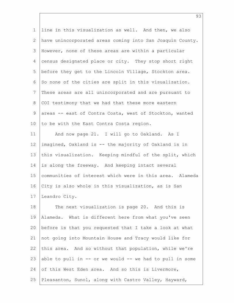
93
1
2
3
4
5
6
7
8
9
10
11
12
13
14
15
16
17
18
19
20
21
22
23
24
25
line in this visualization as well. And then, we also
have unincorporated areas coming into San Joaquin County.
However, none of these areas are within a particular
census designated place or city. They stop short right
before they get to the Lincoln Village, Stockton area.
So none of the cities are split in this visualization.
These areas are all unincorporated and are pursuant to
COI testimony that we had that these more eastern
areas -- east of Contra Costa, west of Stockton, wanted
to be with the East Contra Costa region.
And now page 21. I will go to Oakland. As I
imagined, Oakland is -- the majority of Oakland is in
this visualization. Keeping mindful of the split, which
is along the freeway. And keeping intact several
communities of interest which were in this area. Alameda
City is also whole in this visualization, as is San
Leandro City.
The next visualization is page 20. And this is
Alameda. What is different here from what you've seen
before is that you requested that I take a look at what
not going into Mountain House and Tracy would like for
this area. And so without that population, while we're
able to pull in -- or we would -- we had to pull in some
of this West Eden area. And so this is Livermore,
Pleasanton, Sunol, along with Castro Valley, Hayward,

94
1
2
3
4
5
6
7
8
9
10
11
12
13
14
15
16
17
18
19
20
21
22
23
24
25
parts of Union City, and the smaller unincorporated areas
which are all intact. I did try to do a Livermore,
Pleasanton, Dublin, up to San Ramon area, but then that
would split open further and break some of the COIs over
there as well as a few COIs in Contra Costa. So I
elected to keep it this way but happy to explore further
visualizations. So that's the effect of the Mountain
House Tracy move.
We will go down to Freemont, which is page 29. This
visualization has a split in Union City. This is purely
for population purposes. And has which -- because we got
through .57, if there's another line which you would
suggest for this to be split along, then happy look at
that. Currently, it is just following city streets
because there is -- oh, I'm sorry -- city streets and
there's one COI which kind of cuts off along here. But
if you would like me to explore other areas with that, I
have a little bit of deviation room for that. This takes
all of Fremont City including Newark, which is
incorporated. Takes Milpitas City and the Berryessa
area. There are a ton of COIs right in this area, and so
it keeps many of them together. I believe one comes down
a few blocks lower into Alum Rock that was not able to
kept there for population.
We'll go to page 24, which is Alum Rock. Sorry,

95
1
2
3
4
5
6
7
8
9
10
11
12
13
14
15
16
17
18
19
20
21
22
23
24
25
zooming out. There we go. Okay. So Alum Rock starts
with Alum Rock, which is right up here. It's a
neighborhood in San Jose. But as you can see, it
incorporates all of eastern Santa Clara County. So this
whole area here, which is lighter colored, is not part of
the City of San Jose. The darker colors are parts of the
City of San Jose, which has over a million people, and
has very little population in this. And so that's why
you're getting this shape as it is. Alum Rock keeps
intact several communities of interest in the downtown
area right along here, and the several neighborhoods of
San Jose including the downtown COI itself, the Japantown
COI and several others that were submitted. So those
were all put up. That's where this line between Fremont,
Alum Rock, (indiscernible) and Gatos bank came out of --
was really putting all those COIs up and trying to make
sure that we kept as many of them whole as possible. And
I think we actually kept most, if not all of them, whole.
So Alum Rock includes those neighborhoods of San Jose.
It doesn't go into any other cities. San Jose is split
for population.
Now we will go to Gatos bank which is page 23. Uh-
oh. Apologies. My screen just -- there we go. Okay.
So Gatos bank, I was instructed, this is -- Gatos bank,
it sits at the intersection of where the East Bay

96
1
2
3
4
5
6
7
8
9
10
11
12
13
14
15
16
17
18
19
20
21
22
23
24
25
community population ripples down to and where the
peninsula population ripples down to. So I'll talk a
little bit in a second about what that looks like and how
that's affected things. But it's really a -- it really
is where these two areas come together. And one of the
main things in this area that you'll see is that this is
the Santa Cruz area that we just looked at. Keeping that
Highway 17 corridor together, I was requested to take
Santa Cruz and Los Gatos and make sure that this Highway
17 corridor was together. And so I was able to do that.
And when the Commission was looking at this last week,
they were looking at it with the rest of the peninsula
area. So we're going to go up there. And they said --
and what I was instructed was, take a look at doing --
moving those two together, and in exchange, take a look
at the line up in Redwood City and see if you can move
that. So this actually rippled upward in order to try to
accommodate both of those directions. So starting in
Los -- Los Gatos and connecting that with Santa Cruz, we
are able to even the population out by taking out --
taking some areas of San Jose over here, again being
mindful of these COIs, and putting Campbell in with Palo
(indiscernible) District.
So now we're going to go up the peninsula to page
25. We'll start with East San Francisco. And the

97
1
2
3
4
5
6
7
8
9
10
11
12
13
14
15
16
17
18
19
20
21
22
23
24
25
direction that I had for East and West San Francisco. So
these maps are going to be on page 25 and 26, East San
Francisco and West San Francisco, and we can talk about
them together because the direction that I received
affects them both. And the direction that I received for
this area was to take a look at Seacliff and Presidio,
and move them over into the east side of -- Presidio
Heights, rather -- moving them east to make sure that The
Haight was with the Castro over here in the center,
moving west of Twin Peaks to the Western San Francisco
and moving Bernal Heights west into the Western San
Francisco. So that's changed this line where this area
is split in San Francisco. The neighborhoods here are
all intact, able to keep them whole, and so the lines
that you are seeing will reflect those neighborhood
boundary lines.
The southern part of West San Francisco remains the
same as you saw before. It has Daly City, Brisbane, and
Paloma and stops right before the South San Francisco
line.
Which brings us to page 27, which is SMATEO. If you
recall, the last time that we saw S Mateo, we had to stop
on the freeway over here -- a line. And there was
PALORED as a -- as a visualization district on the east
side, and then, we had a coastal area on the west side.

98
1
2
3
4
5
6
7
8
9
10
11
12
13
14
15
16
17
18
19
20
21
22
23
24
25
And I was instructed to -- instead of using that freeway
as the line, keep San Mateo with San Mateo, including the
coastal areas, and to shift the other districts south
accordingly. And so that was what was done for San --
this SMATEO District. And as you can see, that comes
south to the SMATEO County line -- the San Mateo County
line, sorry -- and stops short of incorporating all of
San Mateo County sheerly for population.
Next is page 28. And this is the PALORED District.
As I mentioned, this district used to be farther north,
and it shifted south when this population was moved out.
Remember, we grabbed some population over here in order
to put Los Gatos with Santa Cruz. We moved up San Mateo
in order to take in the more inland areas. And so this
visualization district has shifted south. And it was
actually very close to what the Commission directed. The
Commission said take a look in Redwood City, and that's
exactly where we came down to. So Redwood City is whole.
And this -- well, that's pretty much where the line ended
up being for population. And so this PALORED District
starts in the Emerald Hills, North Fair Oaks, Menlo Park
area, takes the rest of San Mateo County, and then, comes
over into the beginning of Santa Clara -- excuse me --
County, starting with Palo Alto and Stanford and Mountain
View, coming south and taking Saratoga and Campbell.

99
1
2
3
4
5
6
7
8
9
10
11
12
13
14
15
16
17
18
19
20
21
22
23
24
25
Next is page 30. And this is LEXSUNNY which is a
perfect example of what I said before about how some of
these are named for pieces that are no longer in them.
LEXSUNNY used to be Lexington to Sunnyvale. And per
Commission direction, we've moved some things around and
this no longer the configuration; however, Sunnyvale is
still intact in this District visualization along with
the COI of Sunnydale, Santa Clara, and Cupertino. We
also have the northern area of San Jose City. The areas
of Burbank and Fruitdale and some other areas of San Jose
and unincorporated areas of Santa Clara County. So
that's the Peninsula and the East Bay.
We will move down to the coast -- the mid-coast.
And in this case, the Monte Coast, which is on page 56.
And it requires me to zoom out a lot. Okay. So Monte
Coast, as you saw before, has Monterrey County, a piece
of the Santa Cruz County which we've already looked at,
which wanted to be with the coastal areas -- comes down
through Monterrey, except for the Salinas/Prunedale area
up in the north which has gone with the Latino
Agricultural District, and exploring down to King City,
as mentioned. The Monte Coast District goes down into
San Luis Obispo County and almost takes all of San Luis
Obispo County but stops short for population. The
request that was made last week, as I zoom in -- I
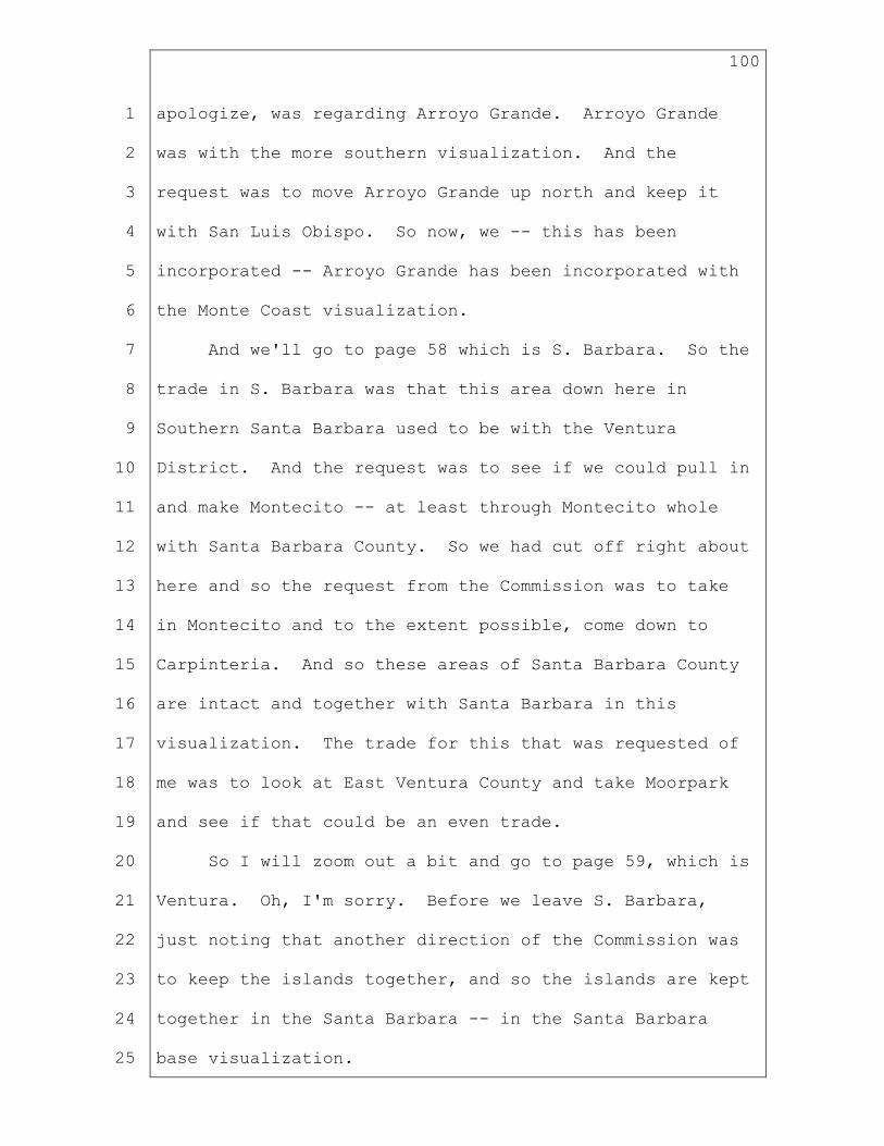
100
1
2
3
4
5
6
7
8
9
10
11
12
13
14
15
16
17
18
19
20
21
22
23
24
25
apologize, was regarding Arroyo Grande. Arroyo Grande
was with the more southern visualization. And the
request was to move Arroyo Grande up north and keep it
with San Luis Obispo. So now, we -- this has been
incorporated -- Arroyo Grande has been incorporated with
the Monte Coast visualization.
And we'll go to page 58 which is S. Barbara. So the
trade in S. Barbara was that this area down here in
Southern Santa Barbara used to be with the Ventura
District. And the request was to see if we could pull in
and make Montecito -- at least through Montecito whole
with Santa Barbara County. So we had cut off right about
here and so the request from the Commission was to take
in Montecito and to the extent possible, come down to
Carpinteria. And so these areas of Santa Barbara County
are intact and together with Santa Barbara in this
visualization. The trade for this that was requested of
me was to look at East Ventura County and take Moorpark
and see if that could be an even trade.
So I will zoom out a bit and go to page 59, which is
Ventura. Oh, I'm sorry. Before we leave S. Barbara,
just noting that another direction of the Commission was
to keep the islands together, and so the islands are kept
together in the Santa Barbara -- in the Santa Barbara
base visualization.

101
1
2
3
4
5
6
7
8
9
10
11
12
13
14
15
16
17
18
19
20
21
22
23
24
25
And now to Ventura. Still keeps Port Hueneme
through Piru COI together. The only thing that is
different here than what you saw last is the addition of
that Moorpark, which is what was needed to bring in
Montecito and those areas. I was told to use Moorpark
and possibly Somis. Somis I could bring in if you would
like to be -- to increase -- change the deviation a
little bit. But because I did not have to for that Santa
Barbara split to be fixed, it's -- it is there still in
Jamie's area. So currently, the only difference here is
this Moorpark.
And that is the end of my areas. And I'm happy to
answer any questions.
CHAIR LE MONS: Okay, thank you.
Commissioner Fernandez.
COMMISSIONER FERNANDEZ: Thank you, Chair.
Tamina, I'm going to take you back to 16 and 17.
What's that noise?
And that's the TEHANAPA and Solano area? Yeah,
right there is perfect. Thank you. And what I would
like to see is I would like to see all of Yolo County
included with Solano County, and then, the tradeoff --
which, I just realized someone had given you direction
last time to -- to keep Vallejo and Benicia in. I'd
actually like to move those out. So that -- if my

102
1
2
3
4
5
6
7
8
9
10
11
12
13
14
15
16
17
18
19
20
21
22
23
24
25
numbers are right, I believe it's pretty close in terms
of being even with the population.
CHAIR LE MONS: Thank you, Commissioner.
Commissioner Akutagawa?
COMMISSIONER AKUTAGAWA: Yeah.
Now, thank you for the visualization. I'd like to
go down to Ventura County right now. In seeing the
visualization, I would like to give direction to actually
remove Moorpark from this visualization. I know that we
received quite a bit of testimony that Simi Valley and
Moorpark should be kept together. And instead -- I know
that we're going to be getting to a place where we have
to split, so considering splitting Camarillo and --
and/or perhaps taking a portion of -- all Somis into
Ventura County.
Thank you.
CHAIR LE MONS: Thank you, Commissioner.
Commissioner Turner?
VICE CHAIR TURNER: Thank you.
And stay there. I'd like to ask a question of
Commissioner Akutagawa and then give direction depending
on the response. At this same visualization for both
Santa Barbara, and Ventura, I know we wanted to explore
having the island be all one so that it wasn't split.
I'm wondering if there was COI testimony -- outside of it

103
1
2
3
4
5
6
7
8
9
10
11
12
13
14
15
16
17
18
19
20
21
22
23
24
25
looking neat, I'm wondering about the population there
because we did learn -- I don't know if after the fact,
or the same time, that that Santa Barbara island is
actually two different counties. It's Santa Barbara and
Ventura County. And if that is the case, and if, indeed,
there was no specific COI to make it together, I'm
wondering if, Commissioner Akutagawa, if you feel it
would be okay if we keep them within their counties.
COMMISSIONER AKUTAGAWA: Yes. That -- I was
thinking about that too. I thought it might be better.
Yes, I agree with you.
VICE CHAIR TURNER: Okay.
So the -- the direction, Tamina, would be to keep
them within their counties -- the island down there
that's -- that we -- that we tried to make it nice.
We'll go ahead and reverse that. And then -- we good?
Okay. And then, I'd like to see -- Union City. Go back
to -- is that page 30? I can't read my own writing. So
in this area -- I still don't see Union City. Oh, okay.
Yeah. So I'm wondering here -- so we have Alameda --
ahead of it -- on top of it is over by three. And then
we have Fremont that's over. But then we have LEXSUNNY
underneath. Actually, what I was going to suggest is
going to make it worse. I was going to add in, look at
keeping Union City whole with Fremont. But you said the

104
1
2
3
4
5
6
7
8
9
10
11
12
13
14
15
16
17
18
19
20
21
22
23
24
25
numbers did not work for that? You're on mute, I think.
MS. ALON: Okay.
VICE CHAIR TURNER: Oh, there you go.
MS. ALON: Yeah --
VICE CHAIR TURNER: (Indiscernible) --
MS. ALON: -- I could split Fremont and add some of
this part area Fremont to Alameda.
VICE CHAIR TURNER: (Indiscernible) --
MS. ALON: No?
VICE CHAIR TURNER: I just wondered about the
splitting Union City when you did that. It -- was it a
COI? Because there are population types that just -- it
was -- typically, I see Fremont with Union City, but it
was split in the middle. And I know you did a good job
about saying COI testimony said this, but I didn't catch
it for this split and wondered about why you were
splitting Union City.
MS. ALON: Yes, we split Union City for population.
And I am currently looking for where I got the split
from. And that's why you see all the little COIs
flashing on and off. I'm sorry, I have hundreds of them,
which is why. But I'm happy to go back and explore where
that line is if you would like me to.
VICE CHAIR TURNER: Okay. I would. Thank you. And
then, the last one I had is on page 21, up in the East
105
1
2
3
4
5
6
7
8
9
10
11
12
13
14
15
16
17
18
19
20
21
22
23
24
25
Bay Area. And for this -- this is pretty -- this is
tricky to me, all the time. Because when I look at this,
I'm wondering about the split between Oakland and
Emeryville which they -- I mean, you don't even know when
you cross from one to the other. So that is just very
bizarre to me. And I would like for Oak -- for Emery --
man.
I would like for Oakland not to be split from
Emeryville. I don't have to have Piedmont into that same
area, because Piedmont, I think has a different kind of
feel to it. A different type of even -- yeah. I
think -- I think Piedmont COI's would -- would be okay
with not being with Oakland. I do think that we could
probably add it into Orinda area. And so we are -- go
ahead.
MS. ALON: If I may ask? So Emeryville is currently
together with this western half of Oakland. Would you
prefer it to be together with the eastern half of
Oakland? Piedmont is completely encompassed by Oakland.
This is --
VICE CHAIR TURNER: Oh, we got to take it, because
it's all together. Darn.
MS. ALON: All Oakland. So currently, Emeryville is
with this area of Oakland. If you would like me to
explore moving Emeryville to --

106
1
2
3
4
5
6
7
8
9
10
11
12
13
14
15
16
17
18
19
20
21
22
23
24
25
VICE CHAIR TURNER: Can you turn (indiscernible)
part of Oakland -- the Oakland part of Oakland -- see
that real quick for both Oakland and Emeryville -- or
both sides, East Bay and Oakland. I should call them by
their right names. Uh-huh. Oh shoot. I could have
probably went to my pages. I'm sorry, Tamina.
MS. ALON: It's okay. You're just testing me. It's
all good.
VICE CHAIR TURNER: Okay. 2.4, 6.04. And then --
18 -- 14 -- 15. No. 1. 15.49 -- 14 -- 18 -- 18 --
25 -- 23. Oh, okay. I'm going to leave it there, and
see if my commissioners want to -- if other commissioners
want to help me. Yeah, because I see six of one and a
half dozen of the other. I was hoping to not split
Oakland from Emeryville. But I also don't want to
alienate the rest of West Oakland as well. And it seems
like we're over. So we couldn't just make it all
together -- Emeryville, West Oakland, Oakland all
together. That would definitely take us over.
MS. ALON: We could definitely do in the other -- in
the other maps.
VICE CHAIR TURNER: Okay.
MS. ALON: But they unfortunately do not fit in
assembly.
VICE CHAIR TURNER: Oh, There's Commissioner Yee. I
107
1
2
3
4
5
6
7
8
9
10
11
12
13
14
15
16
17
18
19
20
21
22
23
24
25
didn't see earlier. Beautiful. Okay.
CHAIR LE MONS: Thank you, Commissioner.
Commissioner Andersen?
COMMISSIONER ANDERSEN: Oops. Thank you, Chair.
Actually, if we pop down to Ventura, again. Or, I might
just be able to say. Piggybacking on Commissioner
Akutagawa's, she said let's take Moorpark out. I believe
I'd like to actually have all of Camarillo in. This is
Moorpark out of -- yeah, taking Moorpark out of Ventura,
that district, and put all of Camarillo in. And I
understand that's going to change our even to molly.
It'll affect that by about 20,000. But I think there's
going to be more changes in the LA area which will take
care of that. So I would like to see that -- that's
Commissioner Akutagawa was saying maybe cut Camarillo. I
don't think we need to, and I'd like to say not to have
it cut right now.
And then, sorry, Tamina. Can we go back up to San
Francisco?
MS. ALON: Sure.
COMMISSIONER ANDERSEN: Thank you.
COMMISSIONER SINAY: Chair, can I ask a question?
CHAIR LE MONS: Sure.
COMMISSIONER SINAY: Can we stay in one area and ask
does anybody else have any comments in that area so we

108
1
2
3
4
5
6
7
8
9
10
11
12
13
14
15
16
17
18
19
20
21
22
23
24
25
can finish a conversation in one region and then move to
another region, because we're hopping around and it's
getting a little confusing?
CHAIR LE MONS: Sure.
COMMISSIONER ANDERSEN: Yeah. Did Patricia --
Commissioner Sinay mean, let's finish up with Ventura?
Because I can wait.
COMMISSIONER SINAY: Yeah, there's several people.
Yeah.
COMMISSIONER ANDERSEN: I will wait, Chair.
COMMISSIONER SINAY: Thank you. Sorry.
CHAIR LE MONS: Okay. Commissioner Toledo?
COMMISSIONER TOLEDO: I don't have a -- I wasn't
going to comment on Ventura. I was going to comment
on --
CHAIR LE MONS: Go on, and comment on what you were
going to comment.
COMMISSIONER TOLEDO: Thank you. So back to
Napa's -- to Yolo-Solano area. So I have been receiving
quite a bit of feedback that Napa, Yolo and Solano would
like to be kept together. So I'm fully in support of
Yolo and Solano being together. Not having Vallejo and
Benicia. And if there's population need, then pulling
from the agricultural aspects of Solano to the north. So
I've heard from -- we've received comments from -- and

109
1
2
3
4
5
6
7
8
9
10
11
12
13
14
15
16
17
18
19
20
21
22
23
24
25
it's publicly posted from St. Helena and from other
entities that would like to be part of that area.
That does mean that to the -- there would be
potential need for population for what's left of Lake
Napa, Santa Rosa area, and potentially pulling from Santa
Rosa. So that would be my comment for the Napa area.
And then just in terms of -- and I'll leave it at that
for Napa. Thank you.
CHAIR LE MONS: Okay. Commissioner Andersen, you
want to do anything while we're up north here?
COMMISSIONER ANDERSEN: Yes, I do. Thank you,
Chair. If we just stay in that area, what I would like
to do is I -- I agree with what Commissioner Toledo was
saying. And where does actual population come from?
I see the -- the NC coast is already -- it's a
negative 3. I would like to actually take more of the
South Marin. Put the population in there. I would cut
that right about Novato, and put the lower portion of
Sonoma-Marin, from Novato down, into the North Coast,
which I think has the population.
Then I would like to take from Sonoma-Marin, add
either -- if you could go in just a little bit please,
Tamina. If you could zoom in just a bit. Thank you. A
little bit north. Oops. Perfect.
We -- right now, we have -- I just -- this is where

110
1
2
3
4
5
6
7
8
9
10
11
12
13
14
15
16
17
18
19
20
21
22
23
24
25
I'm trying to go. I'm trying to add Sonoma Hot Springs,
that's with -- to Napa, because that is -- those are --
that's the heart of the wine country. So what I'm
wondering is, if I've cut the population out of Sonoma-
Marin and we go up and add -- is Santa Rosa already in
Sonoma-Marin? It is. Okay.
So then, I would -- I would like to -- I guess I'm
cutting up Sonoma-Marin quite frankly. I guess I'm
taking the bottom part out. And I'm putting the top
part, which is from above Novato to Sonoma -- to say,
below Santa Rosa, with the Napa -- TEHENAPA. And
depending on population, Santa Rosa will either go either
west or east. And then, going up the -- to Tehama to
TEHENAPA area. If --
MS. ALON: I got that. So Santa Rosa goes in with
Tehama-Napa, Yolo.
COMMISSIONER ANDERSEN: As -- as does that portion.
Essentially, we're cutting up --
MS. ALON: As does this --
COMMISSIONER ANDERSEN: Okay.
MS. ALON: So you just want to slice in half, and
move here and here?
COMMISSIONER ANDERSEN: I actually want to slice a
little bit further south. Yeah. Like slice it -- slice
it around -- around there. Either, like, depending on

111
1
2
3
4
5
6
7
8
9
10
11
12
13
14
15
16
17
18
19
20
21
22
23
24
25
population, maybe put all of Novato into the Sonoma-
Marin -- into the North Coast. From Novato down, put
that into North Coast. And then, create the other part
of Sonoma-Marin into the -- the TEHENAPA. See how these
are negative. I'm trying to kind of balance them out.
Keeping common interests. Which I'm trying to put more
the wine country, which is in Sonoma -- the Sonoma-Marin
in with the TEHENAPA wine country and then --
MS. ALON: Where are we going to repopulate Sonoma-
Marin from?
COMMISSIONER ANDERSEN: We're essentially kind of
taking it out, at this point.
MS. ALON: I can't do that.
COMMISSIONER ANDERSEN: And going up --
MS. ALON: It will overpopulate both of the other
districts.
COMMISSIONER ANDERSEN: Correct -- correct --
correct. But keep on going up north. And then,
adding -- taking possibly Lake, and putting it into the
Central North, Lake County.
MS. ALON: It would be putting in with Colusa.
COMMISSIONER ANDERSEN: Correct.
MS. ALON: And Butte.
COMMISSIONER ANDERSEN: Correct.
MS. ALON: Okay. Okay.

112
1
2
3
4
5
6
7
8
9
10
11
12
13
14
15
16
17
18
19
20
21
22
23
24
25
COMMISSIONER ANDERSEN: And seeing -- you see -- see
what I'm trying to do? I'm trying to shift that
population in that area, to balance them out. Does that
make sense to --
MS. ALON: Yes. I will definitely take a look.
COMMISSIONER ANDERSEN: Okay.
MS. ALON: I've not done it that way yet.
COMMISSIONER SINAY: Jane, are you trying --
MS. ALON: I will take a look at it.
COMMISSIONER SINAY: Are you trying to merge -- get
rid of one district in the north area so we can create
one somewhere else, or? We're just trying to figure out
what you're doing. Because it does feel like there's too
many districts up there. Because they'll all in
negatives. But we're just trying to figure out what --
COMMISSIONER ANDERSEN: A little bit.
COMMISSIONER SINAY: If we could know the big
picture, maybe the mappers can help you.
COMMISSIONER ANDERSEN: Yeah. And it is. Thank
you, Commissioner Sinay. It is. I'm trying to balance
those out, which actually might end up adding an area.
It's giving us an area for a district around Sacramento
is where I'm getting at. Is --
COMMISSIONER SINAY: All right. And then keeping
going.

113
1
2
3
4
5
6
7
8
9
10
11
12
13
14
15
16
17
18
19
20
21
22
23
24
25
COMMISSIONER ANDERSEN: Correct. I will in a
little bit. I'm going to pause right there.
CHAIR LE MONS: Thank you.
COMMISSIONER ANDERSEN: Because that's a long
direction.
CHAIR LE MONS: Thank you.
COMMISSIONER ANDERSEN: And I'd like to give someone
else a chance. Thank you.
CHAIR LE MONS: Thank you. Is there anyone else
that has a contribution to make to this area that we're
working on right now? And it's hard now, because --
okay.
Thank you, Commissioner Kennedy.
Commissioner Kennedy, and then Commissioner Sinay.
So hold on. I'm sorry. Commissioner Kennedy.
COMMISSIONER KENNEDY: Yeah. Okay.
CHAIR LE MONS: So hold on. I'm sorry, Commissioner
Kennedy. I'm going to go with Commissioner Yee first.
And -- because I want to try to -- because I know a lot
of people have been waiting, and I -- and they're in
order. And I'm trying to now keep track of who's been
waiting, et cetera. So I apologize, Commissioner
Kennedy.
Commissioner Yee.
COMMISSIONER YEE: Thank you, Chair. I'd like to go

114
1
2
3
4
5
6
7
8
9
10
11
12
13
14
15
16
17
18
19
20
21
22
23
24
25
back to the East Bay-Oakland border.
I'm okay with Emeryville staying where it is,
because it -- you know, although it does have connections
with Oakland, it also has connections with Berkeley. So
I think I could go either way. (Indiscernible) sitting
the border right below Piedmont there. I think they
talked about this last week. So I'm wondering if we can
come further southeast along 580 there. Kind of directly
below Piedmont.
Yes, full disclosure. This would change the --
where the district -- my neighborhood is in.
So that line that goes to the right. I mean, it
goes through a bunch of intact neighborhoods, as far as I
can tell. And I think it would be better to come down
580, more to the east. And then go up, I don't know,
maybe 35th Ave. or even farther south, Keller, or Golf
Links even, would make more sense to me. And that would
balance the two districts out with population a little
bit more too. So it's just a matter of what would be the
best balance point and how far to the east you would go.
But farther east than it is right now. Thank you.
CHAIR LE MONS: Thank you, Commissioner Yee.
Commissioner Sadhwani?
COMMISSIONER SADHWANI: Sorry, did you call on me?
Sorry.

115
1
2
3
4
5
6
7
8
9
10
11
12
13
14
15
16
17
18
19
20
21
22
23
24
25
CHAIR LE MONS: Yes.
COMMISSIONER SADHWANI: Oh, sorry about that.
CHAIR LE MONS: I did.
COMMISSIONER SADHWANI: My comment was about the
TEHENAPA piece that we were looking at. Commissioner
Toledo was giving some instruction, or direction, about
including some of those more agricultural parts of Yolo.
Was some of the -- some of the pieces that we have
lifted for Kennedy was around that part of West
Sacramento that's included in this district. I'm not
entirely certain what Commissioner Andersen's vision was
for removing that district and possibly putting one in
Sacramento. But I mean, if something like that works out
I mean, I think -- I'm thinking about taking West
Sacramento out of this more rural district, and keeping
it with some of the other COI's that we had received,
would make a whole lot of sense to me.
I don't have a sense of what the population
differential is between West Sac and -- and this rural
area that Commissioner Toledo had mentioned, I think
going down into Solano County. But I'd definitely like
to explore that. Thank you.
CHAIR LE MONS: Commissioner Kennedy?
COMMISSIONER KENNEDY: Thank you, Chair. Two
things. One, you know, we see negative sides, and we try

116
1
2
3
4
5
6
7
8
9
10
11
12
13
14
15
16
17
18
19
20
21
22
23
24
25
to find population but, you know, keep in mind, one
percent, if you see a negative one percent it's 5,000
people roughly. You know, if you see negative 4 percent,
that's 20,000 people. So a whole district is 500,000
people, not 20,000 people. So let's try to keep our math
in mind as we do this.
Second of all, I've said before and I'll continue to
say, if we look at the relief map, you will see Lake
County is very different from Colusa County. You know, I
could see a case being made to take the southern part of
Lake County, which is more heavily agricultural, and wine
based, and looping it with Napa. And the northern part
is perhaps a little more like Mendocino County. But, you
know, neither the north nor the south, is like Colusa
County. So I don't see that as a way to go. Thank you.
CHAIR LE MONS: So I just want to ask a question
there, because it seems as if we have some contradictory,
at least, positions, so I don't know if that affects how
Commissioner Andersen feels about the direction, or not.
I do want to ask that question.
Commissioner Andersen?
COMMISSIONER ANDERSEN: Yeah, thank you, Chair.
We have gone back and forth on this issue before
with Lake County. And I completely understand
Commissioner Kennedy's perspective on Lake County. And

117
1
2
3
4
5
6
7
8
9
10
11
12
13
14
15
16
17
18
19
20
21
22
23
24
25
what we are sort of grappling with before, which I
understand Tamina has been too, which is why we have
these districts the way they are. And I appreciate that
Tamina, thank you.
We are trying to sort of, let's put the wine
countries areas together -- being Lake also has wine.
Population wise, we just might not be able to do that.
And if it turns out that Lake should go up with Nor-
Coast, and it -- we change it a little bit that way, I am
agreeable. So I think that's a little bit that I would
say, let's have a quick look -- what the mappers can
actually come up with for us. So --
CHAIR LE MONS: Thank you, Commissioner.
COMMISSIONER ANDERSEN: I would lead the way. Thank
you.
CHAIR LE MONS: Commissioner Sinay?
COMMISSIONER SINAY: Thank you, Chair.
You know, as I was looking at the Bay Area last --
last week -- two days ago -- whenever we met last. We
were talking about anchors, and priorities in areas. And
I think that that's helpful for the mappers as well as
for us, in thinking about the story we're trying, you
know, the stories we're trying to tell.
It's not one story, but it's multiple stories. And
when I looked at the Bay Area and -- and the communities

118
1
2
3
4
5
6
7
8
9
10
11
12
13
14
15
16
17
18
19
20
21
22
23
24
25
of interest that we received, as well as the
conversations that we've had, I kind of came up with
some. And I was just curious if this was, you know,
just -- if others were seeing it the same way, or not.
But we really wanted to see in the -- in kind of the
East Bay, and North -- North Contra Costa just really
making sure that the working class is all put together.
And that includes bringing in Benicia and Vallejo where
needed. But that was just one thing that kept coming up,
both in our communities of interest as well as in our
conversations.
The East -- East Contra Costa, I think, that's more
of our suburban, professional, a little bit more rural.
But it's not as rural as some people are trying to say.
I mean, there's some really good shopping in that area
and stuff, you know. It's -- it -- I would just say
it's, you know, it's not as rural as I've heard some
people say.
And then, there -- we've received a lot of COI
testimony from different Asian communities, remembering
that the Asian communities are very diverse. And that,
in looking through the input, and looking where the maps
are right now, we have been able to create two -- two
Asian-opportunity communities for -- one in San Francisco
-- East San Francisco, and then one in the South Bay
119
1
2
3
4
5
6
7
8
9
10
11
12
13
14
15
16
17
18
19
20
21
22
23
24
25
Area. Yes. Santa Clara South Bay. And we say that
because Isra and I are always teasing -- sorry
Commissioner Ahmad and I are always saying remember that
there's three South Bays in California.
And then -- and then we had the rural coastal, and
then Silicon Valley. And there's others also as well in
there, but it is important that we, you know, for me at
least, that we know what our themes are, so that we don't
keep changing them around. Because I feel like we have
the conversation about working class, and East Bay and
North Contra -- and North Contra Costa. And then it kind
of got lost. We've also said, you know, it's really
important to keep the Tri-Valley together.
I mean we received a lot of community interest
around the Tri-Valley, being Dublin, Livermore,
Pleasanton, and San Ramon. And I think, if we remember
some of the other themes, we can move things around a
little bit.
And if, Chair, if you'd like, I can give some
suggestions on moving things around to keep within those
themes, or I can wait to see if there's additional
conversations on the questions I raised.
CHAIR LE MONS: That's your call, Commissioner.
COMMISSIONER SINAY: Well, I'll just finish this,
you know, and then others can. On the -- the RODUBLIN

120
1
2
3
4
5
6
7
8
9
10
11
12
13
14
15
16
17
18
19
20
21
22
23
24
25
(ph). Well, I think, I haven't been able to look at all
the visualizations. That's my homework for tonight. But
I believe, that -- the other visualizations, I've looked
at all these. We do have a Tri-Valley and other -- and
other areas together, correct? In some of our other
plans? Tamina?
MS. ALON: Yes, they are together in other plans,
I'm sorry.
COMMISSIONER SINAY: If, I mean, if it's possible to
bring them together in this one, it would be great.
My thought was to kind -- to move, you know,
Danville into East Contra Costa -- not Danville. Oh.
No, well Benicia, and Vallejo into -- into the North
Contra Costa. But, you know, to put it with Martinez.
But that, right now we don't have it going all the way
across the north. So that makes it a little different.
But I was thinking of Walnut Creek. Walnut Creek
moving over to East Contra Costa, and then to Dublin. I
didn't know -- that if the Tri-Valley made more sense
going south, you know, in the yellow, or staying in the
green. I know that East Contra Costa is at a negative
right now. And the green is at the very -- is a
bright -- is very close to five already. And that
Alameda is -- is close to that as well.
But I guess my -- my concern was kind of -- can you

121
1
2
3
4
5
6
7
8
9
10
11
12
13
14
15
16
17
18
19
20
21
22
23
24
25
go back up to the northern part? I'm just concerned here
in the north, that just Martinez, you know, if you put
Vallejo and Benicia, Martinez, Bay Point, Pittsburg,
Antioch. Those are more of our working class communities
that we were discussing earlier. And there might be a
few others. But I just feel like we've been kind of
mixing apples and oranges.
No, I mean there just different fruit that, you
know, because we're trying to do along the water there.
But there's different types of industry that are around
the waterways. So I'll just leave it at that for right
now and see what others are thinking.
CHAIR LE MONS: Thank you, Commissioner.
Commissioner Fernandez?
COMMISSIONER FERNANDEZ: Thank you, Chair.
Just quickly. Commissioner Sadhwani had mentioned
West Sacramento. I would prefer to keep it with Yolo. I
am warming to the idea of having it with Sacramento
and potentially keeping the rural parts of West
Sacramento with Yolo. So I just wanted to kind of throw
that out there. That I'm warming to it. So that it
Commissioner's Vazquez's term.
CHAIR LE MONS: Thank you.
Commissioner Akutagawa, is your hand raised? Well,
your hand is raised, but --
122
1
2
3
4
5
6
7
8
9
10
11
12
13
14
15
16
17
18
19
20
21
22
23
24
25
COMMISSIONER AKUTAGAWA: Yep, sorry about that. I
didn't realize I hadn't taken it down. Thank you.
CHAIR LE MONS: No worries. I just wanted to
confirm.
Are there any other questions or comments for
Tamina? Thank you so much, Tamina, for doing an
incredible job of presenting. We appreciate it.
And thanks to Kennedy as well.
Karen. Karin, we can continue.
MS. MAC DONALD: Thank you so much. This is
fantastic. I guess we're going to move on to Jaime now.
And Jaime are you ready? This was a very quick ending to
this presentation. So I just want to make sure that
Jaime's ready to go, which I'm sure she is. So just a
second, please before she -- so she has a moment to pull
up her map.
MS. CLARK: Yeah, thank you. Just a second.
CHAIR LE MONS: We are going to be -- while she's
doing that -- we are going to be taking a break in about
12 minutes. So we'll get started, and we'll pick up when
we come back. So, you can continue.
MS. CLARK: One more quick second while I just get
my notes in order here.
CHAIR LE MONS: Take your time, no worries.
MS. CLARK: Thank you all for your patience. And

123
1
2
3
4
5
6
7
8
9
10
11
12
13
14
15
16
17
18
19
20
21
22
23
24
25
to -- for you to prepare. I am going to start on page
67. Oh, I'm not quite sharing my screen yet. So sorry.
Here I go. And it should be shared now. I hope everyone
can see it.
MS. MAC DONALD: It's up, Jaime.
MS. CLARK: Okay. Great. And just before we get
into any of it I, based on last week's feedback, there
weren't any major structural changes to this assembly
visualization. So I'll be, you know, happy to walk you
through what differences there are and explain, you know,
why those differences occurred. There were some
instructions that I received that would, you know, split
the -- you know, by taking a certain city out or split a
different city or cell. So some of those things I will
just be able to note to you and maybe suggest that those
could be worked out in live line drawing, if there are
things the Commission would still like to explore. And
I'll be able to point those out to you specifically.
And I'm going to move in. It's page 67. And it
is -- this visualization called 5 Corridor. It includes
Montebello, Commerce, Vernon, Bell Gardens, Downey,
Norwalk. This is different from last time, in that
Vernon is included in this visualization, per Commission
request.
Additionally, there was a request to either add Pico

124
1
2
3
4
5
6
7
8
9
10
11
12
13
14
15
16
17
18
19
20
21
22
23
24
25
Rivera or Santa Fe Springs to this visualization. And
the purpose of that would have been to remove Artesia and
Cerritos. Those were included in this visualization last
time. As you can see, Artesia and Cerritos are removed.
And just in order to not split any of the aforementioned
cities, Montebello is included in this visualization.
And I don't know if Mr. Becker had anything to add?
MR. BECKER: Nope, I don't have anything to add.
Just with all of these, as usual, pay close attention to
the total primary minority CVAP, and the deviation. The
deviation is incredibly close to zero here. Very good.
MS. CLARK: Yeah, the deviation is .20 percent.
And next, we'll go to page 68. That is right next
door. It's this visualization called, sort of like 710
gateway. This was, created per Commission request, sort
of to have the -- some cities along 710 Corridor
intact -- or excuse me -- together in this visualization.
This visualization has a 4.99 percent deviation. It
includes Florence-Firestone areas just north of that, and
the city of Los Angeles. This is a neighborhood council
area called Central Alameda Neighborhood Council. Watts
is whole in this visualization that was accomplished in
part, based on the sort of city swaps that also included
this 5 corridor visualization. So it includes Florence-
Firestone, Watts, South Gate, Windwood, Paramount, sort
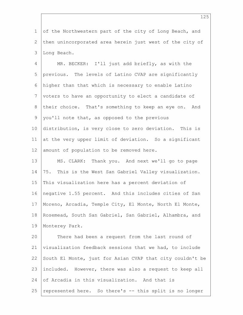
125
1
2
3
4
5
6
7
8
9
10
11
12
13
14
15
16
17
18
19
20
21
22
23
24
25
of the Northwestern part of the city of Long Beach, and
then unincorporated area herein just west of the city of
Long Beach.
MR. BECKER: I'll just add briefly, as with the
previous. The levels of Latino CVAP are significantly
higher than that which is necessary to enable Latino
voters to have an opportunity to elect a candidate of
their choice. That's something to keep an eye on. And
you'll note that, as opposed to the previous
distribution, is very close to zero deviation. This is
at the very upper limit of deviation. So a significant
amount of population to be removed here.
MS. CLARK: Thank you. And next we'll go to page
75. This is the West San Gabriel Valley visualization.
This visualization here has a percent deviation of
negative 1.55 percent. And this includes cities of San
Moreno, Arcadia, Temple City, El Monte, North El Monte,
Rosemead, South San Gabriel, San Gabriel, Alhambra, and
Monterey Park.
There had been a request from the last round of
visualization feedback sessions that we had, to include
South El Monte, just for Asian CVAP that city couldn't be
included. However, there was also a request to keep all
of Arcadia in this visualization. And that is
represented here. So there's -- this split is no longer
126
1
2
3
4
5
6
7
8
9
10
11
12
13
14
15
16
17
18
19
20
21
22
23
24
25
around 210. And Arcadia is whole and included in this
visualization.
And unless Mr. Becker has anything to add? It looks
like no, then we're going to move on to page 76.
Oh, I went the wrong way. Went in the wrong order.
All right. Here we go on page 76. It's the South
San Gabriel Valley visualization. So this includes -- it
has a 4.07 percent deviation. Includes Pico Rivera,
South El Monte, Avocado Heights, La Puente, most of the
city of Industry, Hacienda Heights, Whittier, La Habra
Heights, La Habra, East Whittier, La Mirada, South
Whittier, and Santa Fe Springs. And Industry is the only
city split. Oh, I'm sorry, Valinda also is split, I
believe. And that is for -- would be for population
purposes. And yep, again, it's a 4.07 percent deviation.
And next, we're going to move on to page 77. Let me
just check here. So next, on page 77, this is sort of
the East San Gabriel Valley visualization. It represents
a percent deviation of negative 2.3 percent. This
includes Glendora, Azusa, Duarte. The split here at
Duarte is at Angeles National Forest. It includes South
Monrovia Island, Mayflower Village, Irwindale, Baldwin
Park, West Puente Valley, West Covina, Covina, Charter
Oak, Glendora. If I missed that, at the very beginning.
And there was a request in this to perhaps remove

127
1
2
3
4
5
6
7
8
9
10
11
12
13
14
15
16
17
18
19
20
21
22
23
24
25
Azusa from this visualization. This is one of those
instances where it would cause -- to accomplish that
would cause a split somewhere, or would need just sort of
a population trade somewhere. And if there are not
suggestions as to, like, what to bring in, then this
is -- this is something we could really easily explore
during live line drawing next week.
And those are the visualizations that were created
in collaboration with your VRA team. I'm just going to
zoom out, so we can kind of see where they all are, and
how they all fit together.
CHAIR LE MONS: Great. So we're right on the lunch
hour. So that was perfect to get that segment done.
Commissioners can think about if they have any comments
or questions about it and present those after the dinner
break.
So we're going to, at this time, break for dinner.
And then we'll return at 6:45 to continue this process.
We're also going to be taking public comment this evening
as well. So everyone enjoy your dinner, and I look
forward to seeing you all back at 6:45.
(Whereupon, a recess was held)
CHAIR LE MONS: Hi. Welcome back, Commissioners.
Welcome back, California.
I wanted to -- before the break, I mentioned I would

128
1
2
3
4
5
6
7
8
9
10
11
12
13
14
15
16
17
18
19
20
21
22
23
24
25
lay out how we were going to proceed for the rest of the
evening.
So we were slated to go until about 7 on
visualizations and then move into public comment. I
think, because the way I understand it, Jaime outlined in
her opening presentation that there wasn't significant
changes in the Los Angeles VAP. So my thinking is, that
we could get through Los Angeles, which may take us to
close to 7:30. That should include commissioner
comments, et cetera. At which point we could move into
opening the lines for our public comment. So that's what
I'm thinking. And then that way, we can start our
Southern tomorrow, and kind of jockey the time a bit to
get a bit back on track. So we have a lot of ground to
cover. So why don't we try that. That's the plan.
We'll still open the lines.
I know people are probably queuing up. And we will
still close the lines at 8 o'clock. So people can
starting get in the queue now, if they like. We will
close the lines at 8 o'clock for getting in the queue for
public comment. And we will of course hear all the
public comment for anyone who has gotten in the queue by
8 p.m.
So let me repeat that. The lines are open. You can
get in the queue now. We will start taking public

129
1
2
3
4
5
6
7
8
9
10
11
12
13
14
15
16
17
18
19
20
21
22
23
24
25
comment around 7:30, at the very latest. My hope is that
we'll get through Los Angeles by then. And we may even
get done a little bit sooner, we'll see. But as soon as
we get done with Los Angeles, we'll move into public
comment. At the very minimum, it'll start at 7:30. We
will close the lines for queuing up at 8 p.m. And we
will hear from everyone that's in the queue.
And then again, let me also remind listeners, that
you can always present your feedback and comments via the
form at our website. And we are monitoring that
throughout the meeting. So that isn't something that we
get to later, or at some point in the future, we are
monitoring that real time. So feel free to take
advantage of that mechanism as well.
So with that, I'm going to hear from Commissioner
Kennedy, who had his hand raised before we left for
dinner. And then we'll go back to Jaime and continue
with Los Angeles visualizations.
And welcome, Katie, our Comment Moderator has joined
us. And we look forward to you doing your magic in a
little bit.
Commissioner Kennedy?
COMMISSIONER KENNEDY: Thank you, Chair.
Just on what Jaime had presented earlier. I wanted
to propose a small rotation that I think will leave us

130
1
2
3
4
5
6
7
8
9
10
11
12
13
14
15
16
17
18
19
20
21
22
23
24
25
net very close to where we started. If we move both
Rossmoor and Los Alamitos into the NOCC visualization,
that is approximately 21- or 22,000 people. And then, if
we take approximately that many from the northern part of
Long Beach and move it from the 710 gateway visualization
to the Harbor Gateway visualization, I think we've pretty
much addressed both the Harbor Gateway surplus as well
the NOCC. Anyway, I think we've addressed a number of
issues and not made ourselves any worse off, if that
makes sense.
Jaime does that make sense?
MS. CLARK: Thank you so much for that direction,
Commissioner Kennedy. And, I guess just a follow-up
question. And I know that you'll be giving Sivan
direction, it sounds like tomorrow. And just, what
population would you remove from this visualization if
we're adding Los Alamitos and Rossmoor into this
visualization? It's currently overpopulated.
COMMISSIONER KENNEDY: It's not -- sorry. It's not
NOC. It's NOCCC.
MS. CLARK: Oh. Thank you for that clarification.
Thank you so much. Yeah. That and -- that handoff that
you just outlined would -- yeah -- is certainly doable.
Thank you so much.
COMMISSIONER KENNEDY: Okay. Thanks.

131
1
2
3
4
5
6
7
8
9
10
11
12
13
14
15
16
17
18
19
20
21
22
23
24
25
Thank you, Chair.
CHAIR LE MONS: Thank you, Commissioner Kennedy.
Jaime, you can continue.
MS. CLARK: Thank you. So where we left off were
those visualizations that were created in collaboration
with your VRA team. And now we can just go through the
PowerPoint. I'm just going to go in the order that it's
presented in the PowerPoint. That begins on page 62.
And while you find -- or excuse me -- the PDF's. Pardon
me. And while you go to page 62 in the handout -- 62 of
the PDF, I'm going to make my way over there as well.
We are here in the East Ventura and Malibu area.
This visualization hasn't changed -- hasn't changed very
much, with the exception of moving Moorpark out and
adding it to the Ventura area. Didn't really get much
feedback, or any requests for this visualization. And so
that's why it is largely the same. And it was created
just based on previous Commission direction to have --
and to explore having the sort of Malibu, Calabasas,
Topanga area, with Pacific Palisades, and include that
with some of the East Ventura areas.
And I just noticed, during lunch I forgot to take
off -- to change the labels on this. So I'm going to
change those, so that you can see a little bit more
underneath here. So just one moment, please, while I do

132
1
2
3
4
5
6
7
8
9
10
11
12
13
14
15
16
17
18
19
20
21
22
23
24
25
that. Thank you for your patience.
And, Chair Le Mons, should I move on to the next
visualization?
CHAIR LE MONS: Yes, please.
MS. CLARK: Okay. Thank you so much. Next is page
63. It is this West Side visualization. Page 63 of the
handout. This visualization also hasn't changed much.
It was based on Commission -- previous Commission
direction to use 405 as a border here, on sort of the
West Side and Bay Areas, and Los Angeles, and also
includes Westwood Neighborhood Council, Westside
Neighborhood Council, Palms, West Los Angeles, Mar Vista,
Santa Monica, Van Nuys, Marina del Rey, Del Rey, and all
of Westchester. And this is a negative 2.97 percent
deviation.
And I'm going to move on to page 64. This
visualization also hasn't changed since the last time you
saw it. It includes El Segundo, Manhattan Beach, Hermosa
Beach, Redondo Beach, Lawndale and Gardena, Torrance,
Wilmette, Rolling Hills, Palos Verdes. All of those are
full and intact in this visualization. It has a percent
deviation of negative 1.81 percent.
And next is page 65 of the handout. It's right next
door here. It's the South LA visualization. This
represents 8 percent deviation of negative 1.27 percent.
133
1
2
3
4
5
6
7
8
9
10
11
12
13
14
15
16
17
18
19
20
21
22
23
24
25
It includes Willowbrook, West and East Rancho Dominguez,
Compton, the Harbor Gateway areas. The city of Los
Angeles. It includes Wilmington Neighborhood Council and
San Pedro. And this was created based on Commission
direction, to have the San Pedro areas you know,
connected north.
Moving to page 66.
VICE CHAIR TURNER: Jaime, before you move.
Chair?
CHAIR LE MONS: Yes. Go on, Commissioner Turner.
VICE CHAIR TURNER: Jaime, in this area. Is this
the visualization where we had Watts split before?
MS. CLARK: I'm going to zoom into Watts. It was
split before. And now it's whole and in the
visualization called 710 Gateway.
VICE CHAIR TURNER: Okay. Perfect. Thank you.
MS. CLARK: Thank you so much for that question.
And next page --
COMMISSIONER ANDERSEN: I'm sorry, Jaime.
Chair could -- one more clarification?
CHAIR LE MONS: Yes, Commissioner Andersen?
COMMISSIONER ANDERSEN: Thank you.
A little clarification? The little -- in this -- in
this particular one. That little kind of square that
goes up into Gardena. Gardena, is that also part of the

134
1
2
3
4
5
6
7
8
9
10
11
12
13
14
15
16
17
18
19
20
21
22
23
24
25
city or?
MS. CLARK: This follows the city boundary of the
city of Gardena.
COMMISSIONER ANDERSEN: Okay. Thank you.
MS. CLARK: Thank you so much for that question.
And next, let me find the handout one more time.
Page 66. Looking at this one called Harbor Gateway. The
names -- or the areas really do change. This includes
much of the city of Long Beach. It includes Rossmoor and
Los Alamitos, Hawaiian Gardens, Lakewood, and Signal
Hill. It also includes San Clemente Island and Catalina
Island. Per Commission direction, and again this hasn't
changed since you last saw it. This was based on
Commission direction from a couple weeks ago, to include
Los Alamitos, Rossmoor, Lakewood, Hawaiian Gardens, with
most of the city of Long Beach, and to include the
islands I just mentioned, with those areas, and -- yeah,
and the city of Long Beach is split here for population
purposes.
And next, I'm going to move to page 69 of the
handout. This is a visualization called 110, LA. It
also hasn't changed since you last saw it. It includes
sort of this line where I'm running my hand is the 110
highway and the city of Los Angeles. This includes
Westmont, Empowerment Congress Southeast, Canndu --
135
1
2
3
4
5
6
7
8
9
10
11
12
13
14
15
16
17
18
19
20
21
22
23
24
25
Canndu, Zapata King, South Central Neighborhood Council,
Jefferson Park areas. And this is a percent deviation of
3.65 percent.
Next, I'm going to page 70 in the handout. This
visualization also hasn't changed since you last saw it.
This is a .19 percent deviation. It includes P.I.C.O.
Neighborhood Council, Mid-City, West Adams, much of
Culver City, although Culver City is split around 405,
which is where the hand is waving right now. That
includes Ladera Heights, View Park, Empowerment Congress
West, Park Mesa, all of Inglewood, Lenox, West Athens --
West Athens, Hawthorne, and Del Aire. And again, it's a
.19 percent deviation.
Next, I move into page 71 in the handout.
VICE CHAIR TURNER: Jaime, before you move. I'm
trying to locate Gardena and Lawndale in that visual. Is
that -- is it in that map?
MS. CLARK: Gardena is in the South Bay visual
location.
VICE CHAIR TURNER: Okay. Then we won't move.
Yeah. Then --
MS. CLARK: And what was the other -- the other
cities, please?
VICE CHAIR TURNER: Yeah. You -- for Culver City,
you were pretty low deviation there, but we've split
136
1
2
3
4
5
6
7
8
9
10
11
12
13
14
15
16
17
18
19
20
21
22
23
24
25
Culver City there a little bit. I was wondering about --
MS. CLARK: So this -- the area Where the hand is
running. That's the part of Culver City that is slid
off. It's just a little bit. This shape here.
VICE CHAIR TURNER: Okay. So I'll guess I'll just
give direction. If we can keep Culver City whole unless
it's needed for something different. I'm looking at the
numbers. They seem pretty insignificant.
MS. CLARK: Thank you for that direction.
CHAIR LE MONS: Commissioner Vazquez?
COMMISSIONER VAZQUEZ: Yeah. I was just going to
comment that I used to live right around there. And
things really do shift quite a bit once you jump the 405.
It's similar, so I can see an argument. This might be
something we consider leaving open for live line drawing,
because we may need it for other pieces. So I'm again,
I'm open to it. But the 405 is a pretty bright-line
barrier through that whole area, in terms of communities
of interest.
CHAIR LE MONS: Commissioner Akutagawa?
COMMISSIONER AKUTAGAWA: Sure. Are we giving any
kind of specific direction now? My understanding is we
were going to wait. But if not, then I'd like to give
some direction to?
CHAIR LE MONS: Go on, give direction.

137
1
2
3
4
5
6
7
8
9
10
11
12
13
14
15
16
17
18
19
20
21
22
23
24
25
COMMISSIONER AKUTAGAWA: Okay. Well since we're on
this one. I was going to suggest removing Culver City
from this particular visualization. And what I wanted to
suggest on this particular one is, I wanted to add the
portion of Culver City that borders Palms, Mar -Vista,
and the Del Ray Neighborhood Councils. I think we're at
a point now where we do need to possibly look at
splitting some cities. That is -- that was one
suggestion. Because -- here's the other things, and they
kind of all -- kind of connect together.
If we move some of that Culver City population out
of the east of 405 visualization, what I wanted to see
is -- let me go down to that particular one. Okay. One
is -- sorry. I'm trying to look at it not on paper, but
on -- the South Bay one. Okay. Gardena. We did get
Communities of Interest testimony about the northern
portion of Gardena, particularly being -- having some --
some alignment with some of the other communities like,
Hawthorne, West Athens.
And so my thought was, I'd like to see if we can cut
Gardena, and move a portion of Gardena up into the east
of the 405 visualization there. Now actually, you know
what, I'm sorry. I'm going to go back to the Westside
one.
Going back to the Westside visualization. I notice
138
1
2
3
4
5
6
7
8
9
10
11
12
13
14
15
16
17
18
19
20
21
22
23
24
25
that Beverly Hills Neighborhood Council is included, I
believe. Oh no. Okay. No. I take that back. I'd like
to add the Beverly Hills Neighborhood Council to the West
Side visualization, and then move the Westchester/Playa
Neighborhood Council, to the South Bay. And then that
way then, we could actually move all of Gardena and
possibly even that unincorporated city that's between
Gardena and Lawndale. Perhaps we could move that to all
of the South LA visualization. My apologies. That one's
more clear.
MS. CLARK: South LA visualization?
COMMISSIONER AKUTAGAWA: Yes.
MS. CLARK: I'll try that. Thank you.
COMMISSIONER AKUTAGAWA: Okay. And I know that
I -- I did think this through. Let me go to the South LA
visualization. Because I know that that's the question
is, like, well if I do that, then what happens to South
LA? Okay. So -- okay. South LA -- if we move that
then, I think -- oh, shoot -- I think I got too many
notes here. Okay. Jaime --
CHAIR LE MONS: Okay. Do me a favor. Ms.
Akutagawa, review your notes. I'm going to go to
Commissioner Vazquez, and I'll come back to you.
COMMISSIONER AKUTAGAWA: Thank you.
CHAIR LE MONS: Uh-huh.

139
1
2
3
4
5
6
7
8
9
10
11
12
13
14
15
16
17
18
19
20
21
22
23
24
25
Commissioner Vazquez?
COMMISSIONER VAZQUEZ: Yes. Thank you. If we could
go to the VAD West Side. I like to add the Palms
Neighborhood Council, actually to the VAD east of 405.
That's mostly -- so the Palms Neighborhood Council, if we
add that to the visualization south of it. It's much
more in line with, I think, the rest of those
communities. It's largely apartments and working class,
and not quite aligned Communities of Interest with the
West of that West Side District where it currently lies.
Thank you.
CHAIR LE MONS: Commissioner Akutagawa?
COMMISSIONER AKUTAGAWA: Sorry. You can just skip
me. Let me take my hand down.
CHAIR LE MONS: Okay.
Continue, Jaime. You're on mute. Or I can't hear
you at least.
MS. CLARK: I'll Scoot closer.
CHAIR LE MONS: There you go.
MS. CLARK: Commissioner Vasquez, I believe that
adding this Palms Neighborhood Council area into -- or
out of the Westside visualization might make the Westside
visualization underpopulated. Right now, it's almost
negative 3 percent. Would you have a suggestion of where
to add population?

140
1
2
3
4
5
6
7
8
9
10
11
12
13
14
15
16
17
18
19
20
21
22
23
24
25
COMMISSIONER VAZQUEZ: I would go into -- since
we're already at -- I would go north.
MS. CLARK: Thank you so much.
COMMISSIONER VAZQUEZ: Yeah, into the Palisades
and --
MS. CLARK: Bel Air.
COMMISSIONER VAZQUEZ: Yeah. Palisades and Bel Air.
CHAIR LE MONS: Commissioner Sinay?
COMMISSIONER SINAY: Sorry to interrupt then. I
wanted -- well, that was the main thing I wanted to say,
was go to Bel Air. And we haven't talked about the
Hollywood area yet, right?
CHAIR LE MONS: No.
COMMISSIONER SINAY: Okay. Sorry. I'll come back
then.
CHAIR LE MONS: Karin. I'm sorry. Jaime, continue.
MS. CLARK: This is page 71 of the handout. This
includes South Robertson Neighborhood Council, Beverly
Hills, West Hollywood, Mid-City West, Greater Wilshire,
Koreatown, East Hollywood, and Hollywood Hills area. And
it says 8 percent deviation of negative .85 percent.
COMMISSIONER SADHWANI: Sorry about that. What page
did you say?
MS. CLARK: This is page 71.
COMMISSIONER SADHWANI: Great, thank you.

141
1
2
3
4
5
6
7
8
9
10
11
12
13
14
15
16
17
18
19
20
21
22
23
24
25
CHAIR LE MONS: Commissioner Sinay, did you want to
comment on this area?
COMMISSIONER SINAY: Thank you.
So in this one, we -- we split the LGBT COI. And I
wanted to see if we could move -- so here's
some thoughts. Is looking, you know, looking at --
Equality California's map that they -- yeah, they
submitted many of the congressional district's as is.
But, if we could add into the West Hollywood. And I will
have with -- I have some thoughts on how to take out.
But add Studio City.
I know Los Feliz, we've gone back and forth. And so
I'd be interested in hearing from those who know San --
San Diego -- know Los Angeles better if Los Feliz makes
sense with Hollywood and West Hollywood. Beverly Crest,
Silver Lake, yeah. So those would be -- so then, we
could pull out Beverly Hills. And I know we need to -- I
need to see all the numbers because we just moved Bel Air
going north. But you know, so kind of Beverly Hills --
that would leave Beverly Hills, South Robertson, and Mid-
City West, Greater Wilshire, Wilshire -- yeah, we'd kind
of have to find new homes for that.
But I wanted us just to be aware that we were
splitting a traditional COI in this -- in this area where
there are LGBT businesses and homes and centers.

142
1
2
3
4
5
6
7
8
9
10
11
12
13
14
15
16
17
18
19
20
21
22
23
24
25
CHAIR LE MONS: Thank you.
Continue, Jaime.
MS. CLARK: Thank you.
Next, looking at page 72. This COI was created
based on Commission direction to keep East Los Angeles,
Boyle Heights, Lincoln Heights, LA 32 through the El
Sereno area together with Downtown Los Angeles. This
includes the Chinatown, Little Tokyo COI's. It also
includes historic Filipinotown. That's how this has
changed as before it was split in our last visualization.
It includes Westlake areas and Pico Union Neighborhood
Counsel.
Next on page 73, moving north. This visualization
hasn't changed since you last saw it, with the exception
of this -- got to keep zooming out here -- with the
exception of this boundary that unites historic
Filipinotown, and the district to the south. But this
includes all of Glendale, Los Feliz, Silver Lake, Echo
Park, Glassell Park, Eagle Rock, and Highland Park, and
South Pasadena.
Next moving on to page 74 of the handouts. This
also, just based on Commission direction, hasn't changed
since the last time that we looked at these
visualizations, with the exception of this area of
Arcadia north of 210 is not included in the visualization

143
1
2
3
4
5
6
7
8
9
10
11
12
13
14
15
16
17
18
19
20
21
22
23
24
25
anymore. But it's really like a 210 corridor
visualization. It includes these same areas. And San
Bernadino County. Those are Wrightwood, Lytle Creek,
Northern, areas of Rancho Cucamonga, Upland, and San
Antonio Heights. It includes Claremont and San Dimas.
The part of Duarte that is in Angeles National
Forest. It includes Bradbury, Monrovia, Pasadena,
Altadena, out to La Crescenta.
CHAIR LE MONS: Commissioner Sinay?
COMMISSIONER SINAY: Thank you, Chair.
This is one of those areas we -- we have made some
changes in this. But I was interested Jaime, if we quit
thinking of the 210 corridor and connecting it to the --
the National Forest; have we given you enough leeway that
you don't have to keep it all connected? I see that
there's different districts now that are connected to the
forest. But are you -- do you -- or do you still need
more flexibility?
MS. CLARK: Do you mean to keep these cities with
the forest, or to have the forest other places? I'm
sorry, I don't understand your question.
COMMISSIONER SINAY: Well originally, we had said
keep the -- you know, the 210 and the -- you know, the
corridor all together. And we've slowly started, you
know, kind of pulling some communities out of there. We
144
1
2
3
4
5
6
7
8
9
10
11
12
13
14
15
16
17
18
19
20
21
22
23
24
25
had talked last time about maybe it's not -- you know, we
had gotten a call from the same group that we've gotten
several calls.
But saying maybe it's not one district, but you --
you look at it from north-south and split it, you know,
split it into different districts with the forest. I
just wanted to know if you -- I guess you don't feel that
the 210 corridor is sacred. I mean, that you can do what
you need to do -- to do -- to figure out other issues
that would -- other area -- COI's that we're bringing up.
And if I'm not making sense, don't worry.
COMMISSIONER SADHWANI: Can I jump in here?
CHAIR LE MONS: Oh, absolutely.
COMMISSIONER SADHWANI: Thank you. That made total
sense to me, Commissioner Sinay. Like, if we ultimately,
as we're making any small shifts in there -- in and
around other areas, if we need to break up this very long
210 corridor, that it's okay to do so, right? I -- if --
is that correct, Commissioner Sinay?
COMMISSIONER SINAY: Yes.
COMMISSIONER SADHWANI: Okay.
COMMISSIONER SINAY: I mean, I felt -- I feel like
it is --
COMMISSIONER SADHWANI: Right.
COMMISSIONER SINAY: But I wanted to see if -- I
145
1
2
3
4
5
6
7
8
9
10
11
12
13
14
15
16
17
18
19
20
21
22
23
24
25
didn't know if we all had agreed on that or not. I kind
of felt like we were hemming and hawing on that last
time. And so I guess that -- the question isn't so much
for Jaime, but for all of us, yes. All right.
COMMISSIONER SADHWANI: And I would agree with that.
I definitely agree with it.
CHAIR LE MONS: Commissioner Vasquez?
COMMISSIONER VAZQUEZ: You know -- never mind. I
was going to give direction, but I thought better of it.
CHAIR LE MONS: Okay. I appreciate that.
Continue, Jaime.
We can't hear you. Can't hear you, Jaime.
MS. CLARK: I'm muted. Yeah.
If we could please look at page 80. Moving to page
80 of the visualizations.
This visualization hasn't changed much since you
last saw it. It includes Bell Canyon, Hidden Hills, West
Hills, Canoga Park, Woodland Hills, Tarzana, Encino,
Sherman Oaks, Valley Village, Studio City, and Bel Air.
It does have a change in this northern area.
There was a -- there was direction to keep the
Poso -- or P-O-S-O- COI intact. That's this change here.
There's -- this is something that we could further
explore in live line drawing. There is different
definitions of how far north that goes. And it is

146
1
2
3
4
5
6
7
8
9
10
11
12
13
14
15
16
17
18
19
20
21
22
23
24
25
sometimes in conflict with COIs that are based in Van
Nuys itself. So there's a question as to whether it goes
to Oxnard Street or Califa Street. And right now, it's
generally at Califa Street. Oxnard is a little further
north.
Additionally, there was direction last time to look
at moving Bel Air so that the Mulholland Drive border
could be respected. We've heard a lot of testimony about
that being the cutoff for Mulholland -- excuse me for San
Fernando Valley as a whole.
And that change, it does -- would have bigger ripple
impact in the San Fernando Valley. I did hear more
information today about, like, not only where Bel Air
could go. But also some other changes to this area,
including potentially removing Studio City from this
area. So if -- if the Commission wants to see a
visualization with that, then all of these will be
changing. I'm happy to explore that and present
something to you with that next time.
CHAIR LE MONS: Commissioner Sinay?
COMMISSIONER SINAY: Jaime, we heard a lot of
testimony about Mulholland, and we keep getting more
testimony. And so I was just curious, when you said
there would be ripple effects, can you give a high level
what some of those effects may be?

147
1
2
3
4
5
6
7
8
9
10
11
12
13
14
15
16
17
18
19
20
21
22
23
24
25
MS. CLARK: Yeah. Absolutely. Thanks so much for
that question. So removing Bel Air would make this --
right now it's called SSFV. Visualization again, we're
looking at page 80 of the handout. That would -- that
would make this less than negative 5 percent deviation.
So then would need to pull from somewhere. This area,
which we haven't talked about yet, West San Fernando
Valley is also pretty close to negative 5 percent
deviation. There's also a lot of COI input about keeping
some of these areas together.
Additionally, this sort of Santa Clarita Valley
based district, there's COI input and Commission
direction to specifically keep these areas of San
Fernando Valley with Santa Clarita Valley. So their
individualization, as it is now, removing population from
this San Fern -- S -- South San Fernando Valley district
would just have different ripple effects, right?
Would -- there would just be a population trait here
ultimately, pulling population down, either from the East
San Fernando Valley or the Santa Clarita Valley
districts.
And I thought that -- that's something that
absolutely easy to explore in live line drawing and also
the -- I thought the Commission should -- should have,
you know, more discretion in choosing what areas would --
148
1
2
3
4
5
6
7
8
9
10
11
12
13
14
15
16
17
18
19
20
21
22
23
24
25
would be moved. Because these visualizations, I didn't
really get any feedback on, so I thought that maybe you
liked them how they are.
CHAIR LE MONS: Okay. Thank you, Jaime. You can
proceed.
MS. CLARK: Thank you so much.
Next is page 81 of the handout. This is WSFV, West
San Fernando Valley. The 405 runs right here. This
includes Reseda, Lake Balboa, North Hills, most of
Panorama City, North Hollywood areas, Greater Valley
Glenn Council, and most of Van Nuys, north of Califa
Street.
Next, I'm moving on to page 82 of the handout. And
this is the visualization ESFV, East San Fernando Valley.
This includes Sylmar, Mission Hills, most of Panorama
City, Arleta, Pacoima, the city of San Fernando, Sun
Valley, city of Burbank, Foothills District, Sunland-
Tujunga, and part of Angeles National Forest.
CHAIR LE MONS: Commissioner Sinay?
COMMISSIONER SINAY: Thank you, Chair.
Jaime, the San Fernando Valley business group. I
forgot their name. And they identified one of VRA
district focused on Latino majority. And I noticed that
on our West San Fernando Valley, we were, you know, we
were a 42, which isn't -- but did you explore that at all

149
1
2
3
4
5
6
7
8
9
10
11
12
13
14
15
16
17
18
19
20
21
22
23
24
25
to see if there was a potential majority/minority, if
there's an BRA district in this area?
MS. CLARK: This visualization that we're looking at
has Latino CVAP of 52.61 percent.
COMMISSIONER SINAY: Whoops. I was looking at the
wrong one then. Which one -- okay. Sorry, I was at 81.
Thank you.
CHAIR LE MONS: You can continue, Jaime.
MS. CLARK: Thank you so much.
I am -- next is page 84 of the handout. This
visualization includes these -- the following areas in
San Fernando Valley: Northridge, Granada Hills, Porter
Ranch, and Chatsworth.
And in Santa Clarita Valley, includes Santa Clarita,
Stevenson Ranch, Val Verde, and Castaic. This has a
percent deviation of negative 1.15 percent. This hasn't
changed since you last saw it.
And moving on to page 85 of the handout. This is
the last visualization I'll be presenting tonight. This
visualization is page 85 of the handout. It includes
Antelope Valley, and areas in Kern County that include
California City, Edwards Air Force Base, Mojave,
Rosamond.
And I'm going to zoom into this area just to show
detail. There was a change here. This includes the

150
1
2
3
4
5
6
7
8
9
10
11
12
13
14
15
16
17
18
19
20
21
22
23
24
25
Tehachapi and Mountain Meadows area. And now includes
Stallion Springs, Bear Vall -- Bear Valley Springs and
Keene. And these were included for population purposes,
working with Kennedy on this handoff area.
I'm just going to zoom back out to get a bigger
picture. This is .86 percent deviation.
CHAIR LE MONS: Thank you, Jaime.
Are there any -- Commissioner Sinay?
COMMISSIONER SINAY: Thank you. There's two --
the -- there's two visualizations in Los Angeles. The
north LA -- NLA, and a South San Gabriel Valley -- San
Gabriel Valley. In both of them, I would -- are pretty
high on the, you know, it's a -- it's a dense Latino
population. And I was wondering if we could look to see
if there's ways to spread the Latino -- the Latinos among
the districts around them, as well?
MS. CLARK: I will do my best to do that.
COMMISSIONER SINAY: Thank you, Jaime.
CHAIR LE MONS: Thank you, Jaime.
MS. CLARK: And if there are any specific ideas,
happy to hear about those too.
COMMISSIONER SINAY: Yeah, I'll look -- I'll look a
little bit more, and maybe be able to give you some ideas
tomorrow.
MS. CLARK: Okay. Thank you.

151
1
2
3
4
5
6
7
8
9
10
11
12
13
14
15
16
17
18
19
20
21
22
23
24
25
CHAIR LE MONS: Okay. So I do see some hands up. I
do want to note that it's 7:26. I will be going to
public comment at 7:30. So if your comment is germane to
today, feel free to stay in the queue and talk to the
Commissioners. If not, then tomorrow we'll have to pick
up your comments on the Los Angeles map, because we do
want to go to public comment at 7:30.
Commissioner Fernandez?
COMMISSIONER FERNANDEZ: Thank you, Chair.
Actually, just really quick. Just kind of
responding to Commissioner Sinay's comment about this
area. I was looking at that area as well. But it -- it
appears the surrounding districts are also high in Latino
CVAP. So I think it's going to be very challenging. So
it's -- I'm sure Jaime's up for the challenge. But it
just seems to be a heavily Latino populated area.
CHAIR LE MONS: Thank you.
Commissioner Akutagawa?
COMMISSIONER AKUTAGAWA: Yeah. Jaime, I'm just
curious. Because this could also have ripple effects
too. Looking at the South San Gabriel Valley, I know
it's a -- because it's in yellow, I'm assuming it's a VRA
district. But I just want to reiterate again, Hacienda
Heights, there's been lots of COI testimony that Hacienda
Heights, Rowland Heights and Diamond Bar should be

152
1
2
3
4
5
6
7
8
9
10
11
12
13
14
15
16
17
18
19
20
21
22
23
24
25
together. I will say that they -- their profile does not
match the profile of this current district. And I know
that this is going to have ripple effects too.
I think Sivan is the one that's now doing the Orange
County, LA, San Bernadino Area. Because that CNF
visualization, I think that one is probably one of the
oddest ones that I've seen, to be frank. So we don't
have to talk about that today. But I think there's going
to be ripple effects, if you move Hacienda Heights out.
CHAIR LE MONS: Thank you.
MS. CLARK: And I will look at it. Thank you.
CHAIR LE MONS: Commissioner Andersen?
COMMISSIONER ANDERSEN: Thank you. I agree, and I
like that we're looking at Hacienda Heights, Woodland
Heights area. This is back to the -- what Commissioner
Sinay said about the switching population a little bit
from the South San Gabriel Valley in the east, and
Gabriel Valley. What I'd like to see is, if possible, if
I guess is if La Puente went into the East South San
Gabriel Valley. And then Azusa could go up into the
forest one because, you know, that's the gateway -- it's
a gateway city for a million minorities -- those minority
programs into the Los Angeles Forest.
CHAIR LE MONS: Thank you. Commissioner Sadhwani?
COMMISSIONER SADHWANI: Thank you. Yes.
153
1
2
3
4
5
6
7
8
9
10
11
12
13
14
15
16
17
18
19
20
21
22
23
24
25
I actually -- we actually gave -- I think I gave the
test -- the direction last week around this region of
Hacienda Heights, Roland Heights, Diamond Bar, et cetera.
I think we just need greater synergy here between LA,
Orange County. I do think, to Commissioner Sinay's
point, if we can figure out a right -- I -- words are
escaping me at this time of night. The right --
architecture for that district, it might actually
alleviate some of the -- these other VRA districts that
look fairly packed.
The other area that I just wanted to go to really
quickly is, back in the -- the San Gabriel Valley, we had
received testimony from that region where it -- in Santa
Clarita, where it dips down into the San -- sorry, the
San Fernando Valley -- sorry, San Fernando. In San
Fernando currently, I think we're dipping into, like,
Chatsworth kind of areas, Porter Ranch. I believe we've
received some testimony here about that Santa Clarita's
more connect with Sylmar/Pacoima areas. But I think
that -- that can -- that hits into some of the VRA
considerations in the San Fernando Valley. So I wanted
to raise that. I think it's something worth looking at
and kind of playing around with to see what our options
might actually be in that area. Thank you.
CHAIR LE MONS: Thank you. Commissioner Vazquez,

154
1
2
3
4
5
6
7
8
9
10
11
12
13
14
15
16
17
18
19
20
21
22
23
24
25
you'll be our final comment for today on this before
going to public comment.
COMMISSIONER VAZQUEZ: Thank you. I actually
strongly, strongly disagree with Commissioner Andersen's
direction to move Azusa into that, sort of Forest Gateway
visualization.
I just, Azusa is just such a -- it's very much part
of the San Gabriel Valley, in terms of the communities
that are there. Particularly, the Latinx communities,
second and third generation Latinx in particular. Very
working class. The school district there serves kids
largely from below the 210. And just -- they're very
much connected to the San Gabriel Valley portions.
I know that they are also a gateway into the Forest.
But I think the folks who live and work there and go to
school there, very much identify with -- with those whom
they're currently district -- visualized with currently.
So I just -- I really disagree with that direction.
CHAIR LE MONS: Thank you for that.
So with that, I'm going to switch over to Katie. I
want to thank our callers for waiting patiently.
And let's get right to public comment, please,
Katie.
PUBLIC COMMENT MODERATOR: Thank you, Chair.
In order to maximize transparency and public

155
1
2
3
4
5
6
7
8
9
10
11
12
13
14
15
16
17
18
19
20
21
22
23
24
25
participation in our process, the Commissioners will be
taking public comment by phone. To call in, dial the
telephone number provided on the livestream feed. It is
877-853-5247.
When prompted, enter the meeting ID number provided
on the livestream feed. It is 845-9522-1762 for this
meeting. When prompted to enter a participant ID, simply
press the pound key.
Once you have dialed in, you will be placed in a
queue. To indicate you wish to comment, please press
star 9. This will raise your hand for the moderator.
When it is your turn to speak, you will hear a message
that says the host would like you to talk and to press
star 6 to speak.
If you would like to give your name, please state
and spell it for the record. You are not required to
provide your name to give public comment.
Please make sure to mute your computer or livestream
audio to prevent any feedback or distortion during your
call. Once you are waiting in the queue, be alert for
when it is your turn to speak. And please turn down,
again, turn down your livestream volume.
And we will be giving a warning at 30 seconds, and
15 seconds remaining, of the two-minute public comment
period.

156
1
2
3
4
5
6
7
8
9
10
11
12
13
14
15
16
17
18
19
20
21
22
23
24
25
We will be starting with caller with the last four,
0497, and up next after that will be caller 0645.
Caller 0497, if you will please follow the prompts
to unmute at this time by pressing star 6?
The floor is yours.
CALLER 0497: Hi, can you hear me?
PUBLIC COMMENT MODERATOR: We sure can.
CALLER 0497: Awesome. Thank you so much for taking
my comment. I'm a current -- I'm a resident of Chino
Hills. Chino Hills is in San Bernadino County. But
we've -- we have much more in common with North Orange
County than the rest of San Bernadino County. Chino
Hills and North Orange County, they have similar
interests and concerns, such as high price of housing,
traffic and infrastructure, and wild card issues.
We have unique problems, and I was disappointed to
see Chino Hills separated from North Orange County in the
most recent congressional lines. So let's keeps Chino
Hills, Brea, Yorba Linda, and Anaheim Hills together in
the next rendering. Thank you so much.
PUBLIC COMMENTER MODERATOR: Thank you. And right
now we will have caller 0645. And up next after that,
will be caller 1862.
Caller 0645, if you will please follow the prompts
to unmute, the floor is yours.

157
1
2
3
4
5
6
7
8
9
10
11
12
13
14
15
16
17
18
19
20
21
22
23
24
25
CALLER 0645: Hi. Yes, thank you for having us and
having so many meetings.
Yeah, so I -- I live in the 93550 area. I have a
rental in a 93535 area. And it is the Antelope Valley.
I -- I don't know if I'm seeing right or not, because I'm
only on a telephone. But I -- am I'm still seeing that
Lancaster -- parts of Lancaster is still not all together
with the Antelope Valley, and also Littlerock?
Because we all commute all over the Antelope Valley.
And then, we definitely commute to the Santa Clarita
Valley, so you got to keep those together. And then we
go into Simi Valley. So I hope I'm not seeing, like, the
San Fernando Valley with us, because they really kind of
have nothing to do with us. We -- we share the Santa
Clarita Valley and the San Fernando Valley; I think have
the Santa Susana Mountains separating them. But the
Santa Clarita Valley, and the Simi valley have pretty
much all the same common -- common, you know, the -- the
demographics, the common -- the wildfires, the -- we
share water, sheriff resources, the film industry,
mileage and -- and just on and on. There's a lot of
things that we share between the Antelope Valley and
Santa Clarita Valley. And then the Santa Clarita Valley
to the Simi Valley. So I just wanted to give that little
excerpt. And I appreciate you having us.

158
1
2
3
4
5
6
7
8
9
10
11
12
13
14
15
16
17
18
19
20
21
22
23
24
25
Okay. And then I don't know if you can answer the
questions that I had asked but, you know, where do I
listen for those answers?
CHAIR LE MONS: We -- we will take your feedback
into consideration, and note all of the points that
you're making. We're not looking at the map you're
referencing. So it's a little difficult to speak
directly to that right now. But we have captured your
feedback. And we'll make sure that it's incorporated.
Thank you.
PUBLIC COMMENT MODERATOR: Thank you so much. And
right now, we'll be going to caller 1862. And up next
after that will be caller 2146.
Caller 1862, if you will please follow the prompts
to unmute. The floor is yours.
Caller 1862, can you hear me?
CALLER 1862: Yes. Can you hear me?
PUBLIC COMMENT MODERATOR: We sure can. The floor
is yours.
CALLER 1862: Okay. My name is Denise Robertson
(ph). I live in the Central Valley. And I want to thank
the Commission for all of its hard work, and the efforts
you've put in to ensure the Central Valley is fairly
representative.
And I wanted to take the time to say, I feel like

159
1
2
3
4
5
6
7
8
9
10
11
12
13
14
15
16
17
18
19
20
21
22
23
24
25
you got it right for the senate and the assembly lines in
this weeks' visualization map. Specifically, the
assembly handout pages 42, 43, 44. And just please keep
on this direction, and keep our agricultural areas
intact. And that's all I have to say. Thank you.
PUBLIC COMMENT MODERATOR: Thank you so much.
And right now we will have caller 2146. And up next
after that will be caller 2668.
Caller 2146, if you will please follow the prompts
to unmute at this time by pressing star 6. The floor is
yours.
CALLER 2146: Thank you. Good evening
Commissioners. My name is Jeff Flores, president of the
Kern High School District, Board of Trustees. Just for
some context, our high school district is the largest
district in the State, with 42,000 students. And we have
a budget of 600,000,000. I myself represent a voting
rights district. We have a majority ethnic majority
district. And I'd like to make a few comments about VCD
Madera-Kern. To me the latest visualization does not
make sense. I believe they do a disservice to the Kern
constituency that we represent. Our district's been
navigating the pandemic. We've been dealing with
mandates, learning loss, keeping our students safe, and
many critical issues in education, and our district lines

160
1
2
3
4
5
6
7
8
9
10
11
12
13
14
15
16
17
18
19
20
21
22
23
24
25
represent -- and representation have given us effective
voices in Washington every step of the way. We don't
want to lose this structure.
Kern County is a unique community of interest with
industries in geography, like aerospace, energy, military
bases, and mining, and renewables, and logistics. We've
spent a hundred million dollars in career technical
education developing our future workforce and career
pathways, and I just feel that the proposed maps would
dilute the voices of Kern County residents by leaking
our -- by linking our county with Fresno, over two hours
away to the north, with dissimilar industries and
geographies. So I just urge the commission to keep this
in mind as maps are developed and adopted. Thank you so
much for the time to address your Commission.
PUBLIC COMMENT MODERATOR: Thank you so much.
And right now we will have caller 2668, then up next
after that will be caller 3028. Caller 2668, if you will
please follow the prompts to unmute at this time by
pressing star six. The floor is yours.
CALLER 2668: Hi, so I'm a first generation college
student at Cal State, Bakersfield. I think that the
Kern/Fresno district is too geographically diverse to
maintain equitable representation for all of our
community interests, and for that reason, I think that

161
1
2
3
4
5
6
7
8
9
10
11
12
13
14
15
16
17
18
19
20
21
22
23
24
25
Fresno and Kern should not be linked together. That's
all. Thank you.
PUBLIC COMMENT MODERATOR: Thank you so much.
Okay, now we will have caller 3028, and up next
after that will be caller 3220. Caller 3028, if you will
please follow the prompts to unmute at this time by
pressing star 6. The floor is yours. Go ahead, 3028.
Can you hear me?
CALLER 3028: Sorry. Hello, is it working?
PUBLIC COMMENT MODERATOR: Sure is. The floor is
yours.
CALLER 3028: All right. Thank you.
PUBLIC COMMENT MODERATOR: Uh-huh.
CALLER 3028: Hello. I'm a student at Bakersfield
College, born and raised in Bakersfield, and I don't
think that Fresno and Kern County should be in the same
district. The resulting district would be too large and
far too geographically diverse to feasibly be represented
as a single group. The people of Bakersfield have
different needs than the people of Fresno, and the two
districts should have separate representation. Thank
you.
PUBLIC COMMENT MODERATOR: Thank you so much.
And right now we will have caller 3220, and up next
after that will be caller 5410. Caller 3220, if you will
162
1
2
3
4
5
6
7
8
9
10
11
12
13
14
15
16
17
18
19
20
21
22
23
24
25
please follow the prompts to unmute at this time by
pressing star 6. The floor is yours.
CALLER 3220: MR. SAYLOR: Thank you. My name is
Don Saylor. I'm in -- I live in Yolo County, have been
here since 1987. I want to thank you all for your hard
work. It's been a pleasure to watch the Citizen
Commission going through this -- this puzzle.
You're making some amazing progress in terms of Yolo
County's interests, and I -- you know, been very
responsive to our concerns and comments. I want to
especially thank Commissioners Fernandez and Toledo for
their comments today. We see Yolo County as a community
of interest, as a county in whole, and we think that
moving Benicia and Vallejo to Tehama District and having
Yolo County be united in the Solano District makes a lot
of sense. I know for a fact that the cities of American
Canyon and -- South Napa would welcome Benicia and
Vallejo to the fold.
The splits of Yolo County that are depicted on page
17 are problematic for several reasons. One of them is
that it separates a neighborhood called "El Macero" from
the rest of Davis. El Macero is a part of the Davis
School District, it's served by the water and wastewater
system of the city of Davis. You can't get from El
Macero to Sacramento or to Napa or anywhere without going

163
1
2
3
4
5
6
7
8
9
10
11
12
13
14
15
16
17
18
19
20
21
22
23
24
25
through the city of Davis.
This -- this division of the county also -- also
splits the planning area -- the -- the general plan
planning area of the city of Davis, and it splits the
University of California, Davis campus area from the
built area to their agricultural space.
It's -- it also splits rural communities aligned by
the rural communities of Madison/Esparto from the areas
adjacent to them that are farm country, and it says it
right on the street line.
Thank you very much. I really appreciate the hard
work you're doing. I'd like you to keep Yolo whole --
Yolo whole, include -- included in the Solano assembly
district. Thank you.
PUBLIC COMMENT MODERATOR: Thank you so much.
And right now we will have caller 5410, and up next
after that will be caller 5454. Caller 5410, if you will
please follow the prompts to unmute at this time. And
the floor is yours. Hello, 5410? You were unmuted.
Caller 5410, if you will please press star 6 again, this
will unmute you. Awesome. You are unmuted. Can you --
CALLER 5410: Can you hear me?
PUBLIC COMMENT MODERATOR: -- hear me? Yes, we can.
CALLER 5410: Yes.
PUBLIC COMMENT MODERATOR: The floor is yours.

164
1
2
3
4
5
6
7
8
9
10
11
12
13
14
15
16
17
18
19
20
21
22
23
24
25
FEMALE SPEAKER 8: Okay. Thank you. Hi, so my name
is Carrie (ph.). I'm from the Central Valley, and
I've -- I've been following what -- what's been going on
for the last couple months for -- for a while now. And
first off, I just want to say that I feel like
Commissioner Turner and Andersen are correct and things
don't need to be moved. Stockton and East Stanislaus
County have nothing in common, and I feel like the
Central Valley needs to be kept together just for the --
the community of interest. And you know, Commissioner
Sinay's recommendation to tie East Stanislaus to Stockton
would just completely disenfranchise the -- East
Stanislaus from representation.
You know, I agree with Commissioner Turner that
Riverbank and Del Rio should be put back with Stanislaus
in order to keep community of interest whole. You know,
Stockton does not need to be tied to Stanislaus. And
again, I feel like by tying them together you're doing a
disservice and completely disfranchising the voters of
the Central Valley in this community, and it's -- you
know, it's something not a lot of us are very passionate
about, and I hope that's taken into consideration.
PUBLIC COMMENT MODERATOR: Thank you so much.
And right now we have caller 5454, and up next after
that will be caller 6278. Caller 5454, if you will

165
1
2
3
4
5
6
7
8
9
10
11
12
13
14
15
16
17
18
19
20
21
22
23
24
25
please follow the prompts to unmute at this time by
pressing star 6. The floor is yours.
CALLER 5454: Good evening. My name is Nikki
Nguyen, and I live in Garden Grove City. I want to thank
you for your time; I know it is not easy.
I'm asking you to keep Little Saigon in Orange
County whole and help to keep our families together. The
new map does not make any sense by adding Costa Mesa and
taking away Huntington Beach. Please keep Midway City,
Westminster, Garden Grove, Fountain Valley, Los Alamitos,
Huntington Beach, Seal Beach, and Rossmoor more together.
That is where my family, my children, and friends live
here. Our kids attended school here, our temple and
church is here, so a parent and where my children go from
Garden Grove to Huntington Beach for Vietnamese
(indiscernible) education. Our schools, churches,
medical doctors, and hospital that has Vietnamese
language available are all within this area. Please
don't split us apart. We would like to be able to have
representatives who will work and fight this for us.
Leaving us in (indiscernible) will just -- just lose us
our voice. And again, please keep Midway City,
Westminster, Garden Grove, Fountain Valley, Los Alamitos,
Huntington Beach, Seal Beach, and Rossmoor together.
Thank you so much for your time. Well, thank you so much
166
1
2
3
4
5
6
7
8
9
10
11
12
13
14
15
16
17
18
19
20
21
22
23
24
25
and God bless.
PUBLIC COMMENT MODERATOR: Thank you so much.
Right now we will go to caller 6278, and up next
after that will be caller 6491. Caller 6278, if you will
please follow the prompts to unmute at this time by
pressing star 6. The floor is yours.
CALLER 6278: Thank you. Thank you for your work, I
know this is not an easy task. I'm Laura Lee Martin
(ph.). My comments are regarding the Monterey Bay
region.
I've lived in Santa Cruz County for over thirty
years, and I'm distressed by the preliminary
visualizations that divide Santa Cruz County into several
parts and separate us from Monterey County. The images
radically change what previous districting efforts have
established, and the conclusions of the last
reapportionment commission and legislative bodies before
them. They all kept the integrity of Monterey Bay
together. It makes no sense to split our county from
Monterey County or to split Santa Cruz County into
disconnected regions.
The watershed in Monterey Bay is one contiguous
community of interest in one economic region. This is
easily demonstrated by school sports leagues, cultural
programs such as our symphony and theaters, economic and

167
1
2
3
4
5
6
7
8
9
10
11
12
13
14
15
16
17
18
19
20
21
22
23
24
25
professional associations, our specialty agricultural
industry, growing crops in our microclimates on the
coast, or academic institutions, and our world-class
marine research consortium that rings around Monterey
Bay.
The preliminary redistricting visualizations are
dividing significant communities of interest in ways
determinantal to our health and safety as well as our
cultural and economic links. Any adjustment to the
current districts -- assembly, congressional, and state
senate -- should move further east or south to
accommodate the population change. Moving inland from
the coast of Monterey Bay makes more sense than linking
us north to a major metropolitan district in Silicon
Valley and up to San Francisco.
Santa Cruz County residents who drive north to
Silicon Valley refer to this as going over the hill.
When disasters hit, we are literally isolated. I have
five reasons that I've submitted, but two that I want to
just mention here. One is the emergency response: our
firestorms, our earthquakes, our floods. We are
literally cut off from San Jose and anything north. Our
regions connect together, and our economic ties around
the crescent are world-class institutions. Thank you so
much.

168
1
2
3
4
5
6
7
8
9
10
11
12
13
14
15
16
17
18
19
20
21
22
23
24
25
My last comment is just that somebody commented
about the Highway 17 corridor linked to Los Gatos.
That's not a community of interest; it's a way for --
PUBLIC COMMENT MODERATOR: Thank you so much.
And right now we have caller 6491, and up next after
that will be caller 7883. Caller 6491, if you will
please follow the prompts to unmute at this time by
pressing star 6. The floor is yours.
CALLER 6491: Hi, good evening. My name is Emily
Ramos (ph.). As a lifelong community -- community member
of Highland Park, I think that it's important to keep
Northeast L.A. and other eastside communities together.
Our communities share many common interests, and we
believe we should be inside within the same congressional
district.
We believe that Eagle Rock should remain part of our
district as -- as well as parts of Highland Park,
continue to be together with Congressional District 14.
Thank you and have a good evening.
PUBLIC COMMENT MODERATOR: Thank you so much.
And right now we will have caller 7883, and up next
after that will be caller 8091. Caller 7883, if you will
please follow the prompts to unmute at this time by
pressing star 6. The floor is yours.
CALLER 7883: Thank you for having me today,
169
1
2
3
4
5
6
7
8
9
10
11
12
13
14
15
16
17
18
19
20
21
22
23
24
25
commissioners. My name is Jack (ph.), and I have lived
in Long Beach for the past two years. Long Beach is a
place that has something for everyone, especially from my
perspective as a member of the LGBTQ+ community.
I wanted to call in today to voice my deep concerns
about the most recent congressional visualizations that
include the city of Long Beach. These new visualizations
are disenfranchising the LGBTQ+ vote and voice. We have
made so much progress and this map puts us back. It's
not acceptable to our community.
Recently, Equality California presented to the
Commission and identified Long Beach as one of the most
populous communities in the state with a concentration of
LBGTQIA+ culture and gay-focused businesses and
residents. The most recent map splits our community down
the middle and disconnects our historically gay
neighborhood from our downtown and from Long Beach
communities to the north that also have many gay-friendly
businesses.
All -- all across our city, from the shoreline and
Retro Row, to downtown, and up to where I live on the
east side, we have businesses that represent our needs
and interests. I strongly support keeping our city in as
much of the same district as possible in the next
visualization, and I encourage the Commission to use the
170
1
2
3
4
5
6
7
8
9
10
11
12
13
14
15
16
17
18
19
20
21
22
23
24
25
Equality California map as a guide to unite our community
in our city.
Long Beach is a diverse community and one that --
that's closely knit, and that community collaboration and
culture has created an incredible sense of place which I
am proud to call home. I join my neighbors in asking the
Commission today to keep Long Beach together as the
previous Citizens Redistricting Commission has done so
that we keep our unique culture and identity intact.
Keeping us in a single district will allow us to organize
and ensure our rights as LGBT people are -- and that
we're respected and advocated for at all levels of
government. I know you have a lot of work ahead of you,
and I thank you for your service and for this opportunity
to speak.
PUBLIC COMMENT MODERATOR: Thank you so much.
Right now we have caller 8091, and up next after
that will be caller 9069. Caller 8091, if you will
please follow the prompts to unmute at this time by
pressing star 6. The floor is yours.
CALLER 8091: Hi, I'd like to first thank the
Commission for all their hard work and for hearing my
comment.
I'd just like the Commission to consider that
combining the two most populous agricultural communities
171
1
2
3
4
5
6
7
8
9
10
11
12
13
14
15
16
17
18
19
20
21
22
23
24
25
in the state that link the representation of farmers and
farm-working families, Fresno and Kern County should have
separate representation in the next visualization. Thank
you again.
PUBLIC COMMENT MODERATOR: Thank you so much.
And now we have caller 9069, and up next after that
will be caller 9745. And as a reminder to all of our
wonderful participants out there, the line will be
closing at 8 p.m.
Caller 9069, if you will please follow the prompts
to unmute at this time by pressing star 6. The floor is
yours.
CALLER 9069: Thank you so much. My name is Lisa
(ph.), and I live in Valencia. I'm a sixteen-year
resident and wish to state that I do not approve of Simi
Valley being part of Santa Clarita.
The city of Santa Clarita council members are bowing
to political pressure by advocating for placing Simi
Valley back in the district. Considering that the city
of Santa Clarita is knee-deep in litigation for its
refusal to abide by the California Voting Rights Act,
their input is inappropriate and irrelevant. The
Commission has worked hard to ensure voting rights are
fair and properly represent the community interests of
our city, and the current visualization map of Santa

172
1
2
3
4
5
6
7
8
9
10
11
12
13
14
15
16
17
18
19
20
21
22
23
24
25
Clarita demonstrates this, and I thank you very much for
your hard work.
Additionally, adding another city exceeds the
population requirements under the California
Constitution. As a registered voter in Santa Clarita, I
ask that the Commission take serious consideration of the
legal problems that the city of Santa Clarita is involved
as anything they have to say is stained by their refusal
to follow the California Voting Rights Act.
I want to thank you very much for all your hard work
and appreciate the time. Thank you.
PUBLIC COMMENT MODERATOR: Thank you so much.
And right now we will have caller 9745, and up next
after that will be caller 3496. Caller 9745, if you will
please follow the prompts to unmute at this time by
pressing star 6. The floor is yours.
CALLER 9745: Hi there. My name is Gail Pellerin,
and I served as the county clerk register of voters for
twenty-seven-and-a-half years before I retired this past
December. This is actually my fourth redistricting,
having worked for the state legislature in 1990.
First, I want to thank Karin Mac Donald and her
amazing female mappers and David Becker for serving as
experts on this very important democratic process.
I also want to thank the Commission for all your

173
1
2
3
4
5
6
7
8
9
10
11
12
13
14
15
16
17
18
19
20
21
22
23
24
25
hard work and for keeping Santa Cruz and Monterey
counties together at the senate level in your latest
visualization. And I want to express how important it is
to do the same thing for our assembly and congressional
districts. The Monterey Bay is a community of interest
on many levels: environmental, educational,
agricultural, and disaster awareness and prevention.
As a region, we share our commitment to preserve our
Monterey Bay. We share a watershed, we have shared
community-based organizations such as AMBAG and Central
Coast Community Energy. Our community colleges feed into
UCSC and CSUMB. We share experiences dealing with
disasters such as fires, flooding, drought, earthquakes,
and other impacts of climate change, and we are bound
together by our geography. Splitting our small, unique
county into three assembly districts is not in the best
interest of our residents and divides our communities of
interest.
I believe Commissioner Sinay questioned splitting up
our county as well this evening, so thank you for that.
I strongly urge you to take another look at Santa
Cruz and Monterey counties to preserve our (audio
interference) of interest when you release the draft maps
for the assembly and congressional district lines. Thank
you so much for your time.

174
1
2
3
4
5
6
7
8
9
10
11
12
13
14
15
16
17
18
19
20
21
22
23
24
25
PUBLIC COMMENT MODERATOR: Thank you so much.
And right now we will have caller 3496, and up next
after that will be caller 1270. Caller 3496, if you will
please follow the prompts to unmute at this time by
pressing star 6. The floor is yours.
CALLER 3496: Good evening, Commissioners. This is
Karen Goh, K-A-R-E-N G-O-H. I'm mayor of the city of the
Bakersfield. Thank you for the opportunity to speak.
As mayor of Bakersfield and a long-term resident of
Kern County, I believe that Kern and Fresno counties
should not be linked. The current visualization of
congressional lines combining Kern and Fresno do not take
into account our very different communities of interest.
The energy sector is a core industry in Kern County not
shared by Fresno County. The line should keep Kern's
vital community of interest together.
Bakersfield and Fresno/Clovis are the two largest
cities in the Central Valley. In fact, no other city is
close to their size until you go 200-plus miles north to
Stockton/Sacramento. It is possible to not split these
cities in a way that one member of congress represents a
large piece of each of these very distinct cities
separated by over 100 miles of highway. Commissioners
have made it clear that they don't want to split up
Sacramento or Stockton, so it certainly would make the
175
1
2
3
4
5
6
7
8
9
10
11
12
13
14
15
16
17
18
19
20
21
22
23
24
25
same sense to not split Bakersfield and to not split
Fresno/Clovis. I ask that you keep our communities of
interest together by not linking Kern and Fresno
counties. Thank you again for your willingness to
listen.
PUBLIC COMMENT MODERATOR: Thank you so much.
And at this time, we have caller 1270, and up next
after that will be caller 4828. Caller 1270, if you will
please follow the prompts to unmute at this time by
pressing star 6. The floor is yours.
CALLER 1270: Hi. Good evening, Commissioners.
Thank you for your time and thank you for the work that
you've put into these visualizations. As you have heard
several callers today saying that they have no
commonality with Stockton, I, however, am here to
advocate for -- please give us Stockton back. I'm
calling from Brentwood, I live in East Contra Costa, and
there is more commonality between the farmers in the
delta south of Mokelumne River than in the valley
districts of North Walnut Grove.
For decades, Antioch/Brentwood/Oakley has been the
(indiscernible) for shipping, fishing, and recreation
into Stockton. The sailors left and right of the delta
frequently travel back and forth through the area to
Stockton. There is less equestrian terrain or

176
1
2
3
4
5
6
7
8
9
10
11
12
13
14
15
16
17
18
19
20
21
22
23
24
25
constituency northwest of the Sacramento River than we
have south of the Mokelumne.
We also have no commonality with the cities in Yolo
County as far north as Rumsey -- I'm calling to -- and as
far as west as Orinda. This visualization of
VCD_CONCORDTR_1102 does not work for many reasons similar
to the pri -- previous callers have highlighted. We need
to keep these communities that rely on the San Joaquin
Delta together. Right now, the visualization that you
published today is -- is not manageable, and it has so
many different communities that have no commonality. And
there's no way to have a strong, healthy delta and keep
these communities intact with a common visualization. A
visualization from 10/27 called "East Contra Costa" was
perfect. If we could go back to that, we would all
really appreciate it. Thank you again for your time.
PUBLIC COMMENT MODERATOR: Thank you so much.
And now we have caller 4828, and up next after that
will be caller 2252. Caller 4828, if you will please
follow the prompts to unmute at this time by pressing
star 6. And one more time, caller with the last four --
4828, if you will please follow the prompts. The floor
is yours.
CALLER 4828: Hello?
PUBLIC COMMENT MODERATOR: Hello. The floor is

177
1
2
3
4
5
6
7
8
9
10
11
12
13
14
15
16
17
18
19
20
21
22
23
24
25
yours.
CALLER 4828: Good afternoon. My name is Jeremiah.
So the Commission's directions are great. San Gabriel
has been unified and so has Northeast with the exception
of Eagle Rock. Eagle Rock is part of the Northeast and
should unify with the rest of the congressional district.
Echo Park and Silver Lake share many common interests and
populations, and should be considered a community of
interest along Sunset Boulevard. They should be unified
with the Hollywood Congressional District. That's about
it. Thank you.
PUBLIC COMMENT MODERATOR: Thank you so much.
And right now we have caller 2252, and up next after
that will be caller 9316. Caller 2252, if you will
please follow the prompts to unmute at this time by
pressing star 6. The floor is yours. Caller 2252, if
you will please mute your livestream audio, and now,
again, press star 6 to unmute. The floor is yours.
CALLER 2252: (Spanish-speaking caller).
PUBLIC COMMENT MODERATOR: Thank you so much.
And right now we have caller 9316, and up next after
that will be caller 6654. Caller 9316, if you will
please follow the prompts to unmute at this time by
pressing star 6. The floor is yours.
CALLER 9316: Hi, I'm calling because -- I'm just

178
1
2
3
4
5
6
7
8
9
10
11
12
13
14
15
16
17
18
19
20
21
22
23
24
25
calling on behalf of the communities of Northeast Los
Angeles, and specifically Highland Park and Eagle Rock,
and I would like for those parts of Northeast Los Angeles
to stay unified with the rest of the congressional
district. The map seems to split them up into the two
different valleys: San Gabriel and San Fernando, and we
have nothing in common with those communities, and it
just seems a little unfair to the people living there
that you're trying to split them up like that.
You know, for the assembly visualizations, the
Northeast has been, you know, like I was saying, split
up, and there's a high -- there's still -- although you
may not believe -- a high population of Latino population
here in these communities, and you know, we're hopefully
opening -- wanting to create an -- an extra -- a seat for
our Latino population and continue the representation
that we're trying to cling on to. Thank you.
PUBLIC COMMENT MODERATOR: Thank you so much.
And right now we will have caller 6654, and up next
after that will be caller 2716. Caller 6654, if you will
please follow the prompts to unmute at this time by
pressing star 6. The floor is yours.
CALLER 6654: Hi, commissioners. Thank you for the
opportunity to provide feedback on today's
visualizations. My name is James Robinson, and I'm

179
1
2
3
4
5
6
7
8
9
10
11
12
13
14
15
16
17
18
19
20
21
22
23
24
25
calling from Long Beach as a long-time resident and a
business owner in the downtown area.
My community and I have been following the updates
from the Commission, we are very interested in keeping
our city together as much as possible. After seeing
today's congressional visual -- visualization, which tear
apart our downtown community from much of the city, and
I'd like to share my deep disappointment in these
renderings. We have been consistent in asking to stay as
intact as possible and many of our community members have
engaged in this process since the very beginning. Having
followed many of the meetings of this Commission, we do
not recall a single commissioner giving directions to
completely split our city. We also have not heard a
single Long Beach resident ask to split our city in any
way.
We ask that the Commission work to put us back
together in a single congressional district. We believe
asking to keep downtown Long Beach connected with the
rest of our coastline and the rest of our city is a
reasonable request that unites our residents, small and
large businesses, communities, and nonprofits. Downtown
Long Beach represents the core of the city and anchors so
much that happens at our university, CSULB, Long Beach
City College, and business organizations throughout our

180
1
2
3
4
5
6
7
8
9
10
11
12
13
14
15
16
17
18
19
20
21
22
23
24
25
community. Please restore the Long Beach map to the way
things were before today's visualizations. Thank you for
hearing our calls in the past, and thank you for your
work this week.
PUBLIC COMMENT MODERATOR: Thank you so much.
And right now we have caller 2716, and up next after
that will be caller 7175. Caller 2716, if you will
please follow the prompts to unmute at this time by
pressing star 6. The floor is yours.
CALLER 2716: Hello, my name is Connie Ramirez. I
am from Merced County, Senate District 12.
Based on the current visualization presented, this
is not reflective of what we would like to see. It is
analogous to the previous redistricting. It dispreserves
(sic) Latino voting power for both sides of the coastal
range from Merced County and Monterey County. This map
and the map surrounding it makes sure that seats in the
Central Valley that are reasonably expected to be Latino
won't be reduced; right now it's two, and these maps keep
it that way. Thank you very much.
If they get split up, they get lumped in with other
areas and leave the power that they have when kept
together. Thank you so much for your time and
consideration, it's been a long night. So thank you.
PUBLIC COMMENT MODERATOR: Thank you so much.

181
1
2
3
4
5
6
7
8
9
10
11
12
13
14
15
16
17
18
19
20
21
22
23
24
25
And right now I'm going to caller 7175, and up next
after that will be caller 2638. Caller 7175, if you will
please follow the prompts to unmute at this time by
pressing star 6. The floor is yours.
CALLER 7175: Hello there. Thank you,
commissioners. This is Jeremy Payne with Equality
California, the nation's largest statewide lesbian, gay,
bisexual, transgender, and queer civil rights
organization, LGBTQ+.
I am here to bring attention to an assembly district
down in San Diego where, over the last decade, LGBTQ+ San
Diegans in Assembly District 70 have been able to
repeatedly elect candidates of choice, two of whom went
on to make history when they were elected to higher
offices. But in the current batch of visual --
visualizations for this general area, they have removed
South Park, Golden Hill, and downtown San Diego from the
historic LGBTQ+ communities in San Diego that surround
Balboa Park; those include the Mission Hills, the Bankers
Hill, the Hillcrest, University Heights, North Park,
South Park, Normal Heights. And then the downtown San
Diego region, including Little Italy, the Gaslamp
District, add the regions to Golden Hill.
And as this is done, it dilutes the LGBTQ+
community's power to elect candidates of choice, and for

182
1
2
3
4
5
6
7
8
9
10
11
12
13
14
15
16
17
18
19
20
21
22
23
24
25
the LGBTQ+ communities, these neighborhoods have served
as major building blocks of community organizing and
leadership, as I've shared in my previous presentation.
And these neighborhoods have a long history of voting
(indiscernible) to elect candidates of choice, as I
mentioned at the beginning of my public comment.
Quite simply, I'd ask that you please do not remove
the residents of South Park, Golden Hill, and downtown
San Diego from the greater LGBTQ+ community of San Diego.
It is paramount that the LGBTQ+ community kept together
as much as possible.
I recognize that this may be require -- this may
require some cutting in other areas in the visualization
to kind of make room for those residents, and I would
urge the Commission to remove some of the northern end of
the visualization which shares far less in common with
the historic LGBTQ+ communities that I mentioned before.
Thank you so much for all your work, and look forward to
seeing the draft map in the coming weeks.
PUBLIC COMMENT MODERATOR: Thank you so much.
And right now we will have caller 2638. If you will
please follow the prompts to unmute at this time by
pressing star 6. The floor is yours.
CALLER 2638: Hi, this is Bill (ph.) (audio
interference). I'm calling from Oakhurst. I represent

183
1
2
3
4
5
6
7
8
9
10
11
12
13
14
15
16
17
18
19
20
21
22
23
24
25
Mountain (audio interference. We're a group of loosely
affiliated folks that represent the -- the portions of --
of Fresno County and Madera County. And we're happy to
see that the map has changed, but we're not (audio
interference) represented by a member of the -- of the
group (audio interference) that's up -- up towards
Sacramento that you have down now into Fresno.
So what we're concerned about is the -- the
communities of Oakhurst and -- have nothing to do with --
with what's going down in -- in Kern County. And also,
we're in the Central County (audio interference)
Mountains, whereas this part of the district that we're
in is in the Southern California coastal range, and we're
in the Central California Eastern range near Mammoth
Mountain and Yosemite. There's no community of interest
between our two communities. We do our shopping and our
medical care is in -- in Madera. In Clovis and Fresno we
have nothing to do with -- with Kern.
What's interesting in (indiscernible) presentations
earlier is we're seeing on four visualizations in the
Central Valley combined for nearly a hundred (audio
interference). (Audio interference) after ours failed so
miserably in drawing these numbers so low. And what
they're trying to accomplish, it looks to me, based on
the first vis -- visualization. Now the second

184
1
2
3
4
5
6
7
8
9
10
11
12
13
14
15
16
17
18
19
20
21
22
23
24
25
visualizations, there's lots of games being played. The
reality is in the past we were represented by a member of
congress from Fresno/Clovis area that we could go and
visit. For the last ten, twenty years, we've had to go
to -- all the way up to Sacramento. That doesn't make
sense. It'd be very simple to -- to adjust districts, to
increase the populations on all these floor seats to make
them more whole -- and more compact, and we'd hope that
you would do that. Thank you.
PUBLIC COMMENT MODERATOR: Thank you so much.
And Chair, at this time, we are up against a break.
CHAIR LE MONS: Okay, we will go on and take our
break now.
And callers, we'll be back at 8:29 to continue
public comment.
(Whereupon, a recess was held)
CHAIR LE MONS: We want to thank the 220 commenters
that sent in comments via form throughout to date --
throughout the day today and encourage people to continue
to do so. With that, Katie, let's get back to public
comment. Thank you so much.
PUBLIC COMMENT MODERATOR: Thank you, Chair.
Caller 8050 will be the first, and after that will
be caller 9744. Caller 8050, if you will please follow
the prompts to unmute at this time by pressing star 6.

185
1
2
3
4
5
6
7
8
9
10
11
12
13
14
15
16
17
18
19
20
21
22
23
24
25
The floor is yours.
CALLER 8050: Good evening, commissioners. My name
is Noel Hacegaba, and I'm calling to represent the Port
of Long Beach tonight.
First of all, thank you for the opportunity to share
the disappointment with this week's congressional
visualization. The Port of Long Beach has consistently
shared how important it is to keep Long Beach whole.
This week's congressional map separates a downtown and
west side of Long Beach where our port is located for
much of the city. As an organization that is rooted in
our community but works across the city, I cannot
overemphasize how important it is to keep the city of
Long Beach together. Our port, for as long as I can
remember, has never -- I mean, never -- been separated
from the Long Beach coast. It would be devastating for
building community support and partnerships.
We're also very mindful of goods movement, shipping,
and the way that these impact the local community. That
is why we partner with Cal State University, Long Beach
on the east side of the city on curriculum and have a
robust internship program for local students, too.
So I urge you to please keep Long Beach together
just as the independent Commission did so ten years ago.
We are grateful the State Assembly and the senate vis --

186
1
2
3
4
5
6
7
8
9
10
11
12
13
14
15
16
17
18
19
20
21
22
23
24
25
visualizations kept Long Beach mostly together. Please
look to those maps as models for remapping our
congressional lines. Congress is vital to our port and
our ability to build a world-class port together, so I
urge you again not to separate us from our coastline.
Please keep Long Beach together. Again, thank you for
your time and your service on this Commission.
PUBLIC COMMENT MODERATOR: Thank you so much.
Up next will be caller 9744, and up after that will
be caller 0073. Caller 9744, if you will please follow
the prompts to unmute at this time by pressing star 6.
The floor is yours.
CALLER 9744: Hi, thank you, good evening. Thank
you for taking comments. My name is Ann Moore (ph.). I
live in the city of Hesperia. I wanted to thank you for
hearing from our community today.
I also want to thank you for keeping San Bernardino
County/High Desert mostly whole at the assembly, senate,
and congressional level. Although, I will be honest, I'm
not thrilled to see us grouped with L.A. County at the
senate level. A lot of folks who live up here have felt
that, over the years, we're the redheaded stepchild
whenever we get lumped in with L.A. County. This has
happened a lot over the years, and usually they split up
us -- split us up as well. So I wanted to call and urge
187
1
2
3
4
5
6
7
8
9
10
11
12
13
14
15
16
17
18
19
20
21
22
23
24
25
the Commission to not repeat history, and keep us
together and separate us from the Antelope Valley. Thank
you so much for your time, and have a good evening.
PUBLIC COMMENT MODERATOR: Thank you so much.
And right now, we will have caller 0073, and up next
after that will be caller 7994. Caller 0073, if you will
please follow the prompts to unmute at this time. The
floor is yours.
CALLER 0073: Hi, commissioners. My name is Mike Ai
with Equality California, the nation's largest statewide
LGBTQ+ civil rights organization. I'm calling to ask the
LGBTQ+ community's interest in the Coachella Valley be
kept together.
LGBTQ+ community of interest in the Coachella Valley
is large, vibrant, united both physically by the urban
and geographic landscape of the Coachella Valley, and
culturally by the flourishing number of LGBTQ+ businesses
and organizations in the valley that are frequented by
members of our community. They also have a clear,
consistent history of electing candidates of choice, both
LGBTQ+ leaders and allies who are responsive to the
community at the federal, state, and local levels.
We recognize that there are VA -- VRA issues that
keep the entire valley from being united, but we ask the
Commission do everything possible to keep the valley

188
1
2
3
4
5
6
7
8
9
10
11
12
13
14
15
16
17
18
19
20
21
22
23
24
25
together. We think this visualization does a good job of
teaching -- keeping the Coachella together, but it also
notably has a 7.85 percent deviation as a result of
the -- as a result of pulling in the large spots of San
Bernardino County to the north.
As you look to reduce the geographic and population
size of this visualization, we urge you to remove areas
of -- from the north rather than splitting the Coachella
Valley any further than it already is. It is paramount
that our LGBTQ+ communities can be kept together. Thank
you so much.
PUBLIC COMMENT MODERATOR: Thank you so much.
And right now we will have caller 7994, and up next
after that will be caller 0793. Caller 7994, if you will
please follow the prompts to unmute at this time by
pressing star 6. The floor is yours.
CALLER 7994: My name is Tom Edmonds, E-D-M-O-N-D-S,
and I'm calling regarding the Central Valley. We did not
want to be part of -- I live in Bakersfield, and we don't
want to be part of Fresno. It's two hours from where we
are, and in certain times of the year we have tule fog
that would make it extremely dangerous for the
representatives to cover the region. Two hours driving
in tule fog on Highway 99 is not a fun thing.
And the cities are totally different. The only

189
1
2
3
4
5
6
7
8
9
10
11
12
13
14
15
16
17
18
19
20
21
22
23
24
25
thing we have in common with Fresno is that we're both
agricultural regions; so we don't need to have our
representations skewed. Thank you very much for your
work, and I appreciate the consideration. Thank you very
much. Have a good night.
PUBLIC COMMENT MODERATOR: Thank you so much.
And right now we will have caller 0793, and up next
after that will be caller 7296. Caller 7 -- caller 0793,
if you will please follow the prompts to unmute at this
time by pressing star 6. The floor is yours.
CALLER 0793: Good evening, commissioners. My name
is Kimberly (ph.), and I live in Pinon Hills; it's a
rural community in the San Bernardino County High Desert
where I refer to it as where the Mojave meets the
mountains.
So currently, our Assembly member is from Antelope
Valley, while our neighbors in Phelan have a Victor
Valley Assembly member. I really wanted to thank you for
keeping us in San Bernardino County in the new assembly
and congressional maps. While Pinon Hills on the county
border, we really don't share anything with Antelope
Valley. I appreciate that we will have the same Assembly
member with our neighbors moving forward since we're so
similar.
We don't ever go to the Antelope Valley. Our only

190
1
2
3
4
5
6
7
8
9
10
11
12
13
14
15
16
17
18
19
20
21
22
23
24
25
way to get there is by driving on Highway 138, which is a
two-lane road; it's very dangerous; lots of deaths, lots
of accidents. My neighbors and I all travel into
Hesperia and Victorville when we need anything we can't
get in town, and it just doesn't make sense to have a
representative so far to the west in Antelope Valley. So
I appreciate you recognizing this in these maps.
Please continue the good work of keeping our
community in San Bernardino County and not in L.A. Thank
you for your time.
PUBLIC COMMENT MODERATOR: Thank you so much.
And right now we have caller 7296, and up next after
that will be caller 4205. Caller 7296, if you will
please follow the prompts to unmute at this time by
pressing star 6. The floor is yours.
CALLER 7296: Good evening. This is Deanna Kitamura
with Asian Americans Advancing Justice - Asian Law
Caucus, and also with the AAPI and AMEMSA State
Redistricting Commission. Thank you for making a lot of
good changes.
In the South Bay, I've mentioned before that there's
a long, existing Japanese American COI in South Gardena
that goes down through Torrance. I heard one
commissioner this evening give instructions to separate
all of Gardena from Torrance at the assembly level.
191
1
2
3
4
5
6
7
8
9
10
11
12
13
14
15
16
17
18
19
20
21
22
23
24
25
Please do not do that. It is also split at the senate
level. An easy fix is to cut Gardena just above Marine.
We worked out this split with The Black Hub.
Next, I want to go to the San Gabriel Valley. There
are a lot of issues with how the Asian American COI in
East San Ga -- San Gabriel Valley is treated. I
appreciate hearing commissioners trying to keep the COI
whole and fixing it so that it's not with March Air Force
Base in Temescal Valley in Riverside County. I want to
point out that at the senate level, the COI -- COI is
drawn in with cities in South Orange County. While East
SUB (ph.) has some similarities with Chino Hills and
maybe with some North OC cities, it does not have
similarities with South OC.
The API COI in West San Gabriel Valley in the senate
visualization -- visualization is drawn in a gateway
city's district. The API COI in West San Gabriel Valley
should be in a West San Gabriel-Valley based district.
For metro L.A., my colleague has sent shape files
for all the Asian American neighborhoods as defined by
community members. The community's definition
of Koreatown is cut in all three visualizations. The
Chinatown's community's definition of Chinatown is cut in
the assembly visualization.
I heard commissioners ask about the Punjabi and

192
1
2
3
4
5
6
7
8
9
10
11
12
13
14
15
16
17
18
19
20
21
22
23
24
25
Hmong COIs in Fresno. They are split. My colleague will
be sending you shape files for those COIs and more
details later. Thank you so much. Bye.
PUBLIC COMMENT MODERATOR: Thank you.
And right now we have caller 4205, and up next after
that will be caller 8013. Caller 4205, if you will
please follow the prompts to unmute at this time by
pressing star 6. The floor is yours.
CALLER 4205: Thank you, commissioners. The
petition for (audio interference) exception of Eagle
Rock. Eagle Rock is (audio interference) and it's
unified with the rest of the congressional district.
Echo Park and Silver Lake (audio interference) very
common interest in operations and serve community of
interest on (audio interference). (Audio interference).
Again, I repeat, Eagle Rock (audio interference). Thank
you so much, and have a good evening.
PUBLIC COMMENT MODERATOR: Thank you so much.
And right now we will have caller 8013, and up next
after that will be caller 8226. Caller 8013, if you will
please follow the prompts to unmute at this time by
pressing star 6. The floor is yours.
CALLER 8013: Yeah, hello, I'm from -- I'm from
Stockton; I've lived here about fifteen years. And I
want everybody to know Stockton has to be kept whole. I

193
1
2
3
4
5
6
7
8
9
10
11
12
13
14
15
16
17
18
19
20
21
22
23
24
25
don't like these comments about Stockton not being whole.
We've been cut up too much over the years, it's time for
our community of Stockton -- we're a big city, we need to
be stay -- we need to be kept together. Thank you.
PUBLIC COMMENT MODERATOR: Thank you so much.
Right now we have caller 8226, and up next after
that will be caller 8499. Caller 8226, if you will
please follow the prompts to unmute at this time by
pressing star 6. The floor is yours.
CALLER 8226: Hi, I'm a thirteen-year resident of
what I think is the best that California has to offer, a
city with diversity, culture, and grittiness; that's
Oakland, California. I'm a former teacher in Oakland, a
board member on nonprofits, and a volunteer in my
neighborhood. And I'm calling to draw your attention to
two visualizations tonight: the East Bay and Oakland.
You know, sometimes the loudest voices are the ones
that tell you to change things, but I'd like to thank the
leaders in the Commission who have listened to Oaklanders
who have -- who have actually supported these great
visual -- visualizations. There are a few key components
that I appreciate. First of all, you've kept together
the bay waterfront and the 8 -- 80 and 880 corridors,
which are very important. Second, our each -- our East
Bay regional parks are what bring us together as East
194
1
2
3
4
5
6
7
8
9
10
11
12
13
14
15
16
17
18
19
20
21
22
23
24
25
Bayers. What we don't have much in common with is those
who are across bridges and through tunnels.
We -- we like to keep our East Bay and Oakland
community together. Ten years ago the -- the Commission
did a great job of -- of setting up this community of
interest, and I want to support that going forward.
Thank you for your service.
PUBLIC COMMENT MODERATOR: Thank you so much.
Right now we have caller 8499, and up next after
that will be caller 5428. Caller 8499, if you will
please follow the prompts to unmute at this time by
pressing star 6. The floor is yours.
CALLER 8499: Hi. Yeah, our cultural communities of
interest in Kern and Fresno counties are not
(indiscernible) and cannot be well represented in the
same district. That is all. Thank you.
PUBLIC COMMENT MODERATOR: Thank you so much.
And right now we will have caller 5428, and up next
after that will be caller 0816. Caller 5428, if you will
please follow the prompts to unmute at this time by
pressing star 6. The floor is yours. Caller 5428, can
you hear me? Might want to double-check and make sure
that your phone is not on mute as you are unmuted in the
meeting. Now you are muted. Caller 5428, if you will
again follow the prompts to unmute by pressing star 6.

195
1
2
3
4
5
6
7
8
9
10
11
12
13
14
15
16
17
18
19
20
21
22
23
24
25
There you are. The floor is yours.
CALLER 5428: All right, finally. Thank you,
commissioners, for spending your night with all of us.
As -- I want to speak to VCD_NORTHCONT. As a
forty -- as forty-five-year residents of Concord, we've
seen at least four versions of this congressional map.
I'm calling to thank you for this version, this
visualization; it contains the energy sector in the Bay
Area: five refineries, and the communities most impacted
by that industry. As this industry transitions to
greener production, it's important for the citizens and
the representatives to guide them. To have one
congressman who picks up the refinery in Benecia and
represents the whole industry gives us a member of
congress who's familiar with the jobs and the community
members that hold them. Thank you for keeping this
important sector of our economy whole.
PUBLIC COMMENT MODERATOR: Thank you so much.
Right now we have caller 0816, and up next after
that will be caller 4397. Caller 0816, if you will
please follow the prompts to unmute at this time by
pressing star 6. The floor is yours.
CALLER 0816: Hi. Thank you, commissioners. My
name is Susan, and I'm calling from Long Beach. I'd
like to join others who have reached out to the

196
1
2
3
4
5
6
7
8
9
10
11
12
13
14
15
16
17
18
19
20
21
22
23
24
25
Commission today and express my frustration with the most
recent maps that have been released of visuals in Long
Beach congressional district.
For this entire redistricting process, my community
and I have been incredibly consistent about asking this
Commission to keep us together. We think that this is a
reasonable request for a city of our size, and it is
supported by businesses, residents, and community groups
of every kind across Long Beach. This is why it felt,
frankly, baffling to see this visualization as it is run
aligned right down the middle of our city. This border
makes no sense for our neighborhoods or residents. And
more importantly, it deprives us of our wish to be kept
whole.
I also have no memory of anyone on this Commission
requesting we be split in half. In fact, most of you
have spoken in support of keeping Long Beach together;
something I want to thank you for. Please restore the
Long Beach maps to the way you had them previously
visualized, with our city whole. Please do not support
visualizations that split the Long Beach. Thank you.
PUBLIC COMMENT MODERATOR: Thank you so much.
And right now we have caller 4397, and up next after
that will be caller 329 -- 3290. Caller 4397, if you
will please follow the prompts to unmute at this time by

197
1
2
3
4
5
6
7
8
9
10
11
12
13
14
15
16
17
18
19
20
21
22
23
24
25
pressing star 6. The floor is yours.
CALLER 4397: Hello. I want to thank you for the
opportunity to share my thoughts. I'm a lifelong
resident of the city of Clovis in Fresno County, and I
was surprised to see that the current visualization has
one representative covering an area that spans from
beneath Kern County all the way up to Ork -- Oakhurst.
That's a large geographical area prohibit an effective
representation in my community of interest.
One member of congress has not represented
Bakersfield and Fresno and Clovis in over fifty years
because Fresno and Clovis have distinct issues and
situations that are very different from those in
Bakersfield and Kern County. Clovis is two and a half
hours away from Bakersfield, and it would be very
difficult for citizens in our area to get to their
representative if it was all the way in Bakersfield. And
I think that Clovis and Fresno should be drawn into a
district with communities that are more similar to us,
like maybe parts of Madera County. Drawing more compact
districts that don't span hundreds of miles is something
that I would request that the Commission could do, and it
should be done.
PUBLIC COMMENT MODERATOR: Thank you so much.
And right now we will have caller 3290, and up next

198
1
2
3
4
5
6
7
8
9
10
11
12
13
14
15
16
17
18
19
20
21
22
23
24
25
after that will be caller 5600. Caller 3290, if you will
please follow the prompts to unmute at this time by
pressing star 6. The floor is yours.
CALLER 3290: Good evening, commissioners. My
name's Samantha Mehlinger. I'm calling in from Long
Beach where I've been a lifelong resident, and I'm
calling to oppose the congressional maps that were up for
discussion this evening.
My community and I have been following this process
very closely throughout, and many of us have called over
the months to make sure that Long Beach was kept
together, and we would really like to respectfully ask
that the Commission not support the maps that would break
us into multiple districts. We've been consistent in
expressing this desire and concern, and we probably
have -- have the largest community engagement of any city
in the state. On top of this, we don't remember a single
commissioner giving any direction to split us in half, so
we were all pretty shocked to see those maps today.
And I've just appreciated hearing so many of my
fellow community members speaking about the similar
concerns, and -- I'm -- I'm glad that you've listened to
us up until this point, but we really think keeping Long
Beach together is a reasonable request, and that it's
universally supported across our community. It unites

199
1
2
3
4
5
6
7
8
9
10
11
12
13
14
15
16
17
18
19
20
21
22
23
24
25
residents from every neighborhood in our city, our
business community, nonprofits, civil rights groups, and
other community-based organizations. Most of us have
called and written in to show that we are united in this
request. We, again, please ask you to please restore the
Long Beach maps to the way that they were before. We
need to be kept together. Thank you for recognizing our
comments from earlier, and please keep our city whole.
Thank you.
PUBLIC COMMENT MODERATOR: Thank you so much.
And right now we have caller 5600, and up next after
that will be caller 5658. Caller 5600, please follow the
prompts to unmute at this time by pressing star 6. The
floor is yours.
CALLER 5600: Good evening, commissioners. My name
is Herlinda Chico. I am a long-time Long Beach resident,
and -- and I'm very proud to serve as vice president of
the Long Beach Community College District Board of
Trustees.
I'm calling to express my deep concern with the
fourth round of visualization the 2020 Citizens
Redistricting Commission released earlier this week.
Long Beach City College is one district with two college
campuses. These maps propose -- propose to put each of
our Long Beach Community College campuses in different

200
1
2
3
4
5
6
7
8
9
10
11
12
13
14
15
16
17
18
19
20
21
22
23
24
25
congressional districts. With all the great work that
we've been doing at the college around equity, justice,
and inclusion, this proposal to split our college
district will not ser -- serve our students well. Our
campuses must be kept together in this redistricting
process to ensure we can work with our congressional
representative to support federal grants that will expand
opportunities for student success.
Over the past several months our students, community
members, and board members, including myself, have called
in to voice our preference for Long Beach to be kept as
whole as possible in our state and federal legislative
districts. Please do not dismiss our voices. We know
our community, and this would be very detrimental to it.
Long Beach City College is the fifth largest single
college district out of the 116 colleges in the statewide
system. We are nationally recognized -- we are a
nationally recognized institution of higher education
within the California Community Colleges system, and we
maintain a hyper local focus and work closely to bring
students in from the greater Long Beach area. We rely on
your -- our ability to organize with our state and
federal partners to fund some of our most important
programs, including the Long Beach College Promise, our
economic and workforce development programs, and our

201
1
2
3
4
5
6
7
8
9
10
11
12
13
14
15
16
17
18
19
20
21
22
23
24
25
career pathway program. I urge --
PUBLIC COMMENT MODERATOR: Thank you so much.
And right now we have caller 5658, and up next after
that will be caller 8885. Caller 5658, if you will
please follow the prompts to unmute at this time by
pressing star 6. The floor is yours.
CALLER 5658: Hey, good afternoon, commissioners.
My name is Danny; I'm calling in from Long Beach. I just
want to say thank you for being so patient and listening
to all of us and putting in the effort tonight to review
all this and also listen to all of us. So thank you.
With that being said, I do want to express,
truthfully, my disappointment in the congressional maps
that were released late last night. Our community has
been consistently asking to stay together as a city, and
we've been encouraged that Commission staff has
summarized their feedback as such, and I think we've even
heard commissioners support us as well. It seemed to me
that we were on the same page, which is why that
congressional map that we were looking at this week feels
like it really came out of left field. I'm not sure
where this came from, but it doesn't represent our
community, it doesn't represent Long Beach, so we ask
that you please restore the Long Beach maps to the way
things were before. It's important that Long Beach is

202
1
2
3
4
5
6
7
8
9
10
11
12
13
14
15
16
17
18
19
20
21
22
23
24
25
kept together; it's important to all of us as a
community. Thank you very much for listening.
PUBLIC COMMENT MODERATOR: Thank you so much.
And right now we have caller 8885, and up next after
that will be caller 6688. Caller 8885, if you will
please follow the prompts to unmute at this time by
pressing star 6. The floor is yours.
CALLER 8885: Hi, I just want to thank you guys for
your continued work on these maps. My name is Gavin; I'm
a resident of Fresno, born and raised.
Again, you guys have done a tremendous job,
especially on the assembly maps in the San Joaquin Valley
released this week. They look really good particularly
in the city of Fresno. In these maps, you anchored a VRA
district in the city of Fresno, which is, you know, what
the commissioners urged last week during the overview of
the last visualizations. Unfortunately, the
congressional maps don't reflect the same logic and fail
to -- fail to incorporate the changes that commissioners
recommended.
Now, as the assembly maps reflect, the city of
Fresno should be split into two different congressional
districts with the VRA district anchored in the city of
Fresno; that includes the city of Fresno south of Shaw
and west of that -- west of the 99 in a separate district

203
1
2
3
4
5
6
7
8
9
10
11
12
13
14
15
16
17
18
19
20
21
22
23
24
25
that includes Northeast Fresno. This ensures that the
Latino communities of south of Shaw and west of 99 are
represented together in one district.
The current congressional maps split the city of
Fresno into three districts instead of two. This will
dilute the Latino community in Fresno and prevent them
from electing a candidate of their choice. This likely
does not meet the VRA obligations the Commission is
required to follow.
Commissioner Kennedy last week asked for a Fresno-
based VRA district that did not go beyond Fresno, Madera,
and Merced, which was not accomplished in
these congressional maps.
Commissioner Fornaciari asked for a Southwest
Fresno-based VRA seat, which was also not entirely
accomplished in these congressional maps.
Commissioner Sadhwani last week said that the
Commission needs to untie the knot in the Central Valley,
and I think she is absolutely correct.
Again, the Commission should apply the same logic to
the congressional seats as they did with the assembly
seats as it relates to the city of Fresno and the Latino
community. Thank you so much.
PUBLIC COMMENT MODERATOR: Thank you.
And now we have caller 6688, and up next after that

204
1
2
3
4
5
6
7
8
9
10
11
12
13
14
15
16
17
18
19
20
21
22
23
24
25
will be caller 8037. Caller 6688, if you will please
follow the prompts to unmute at this time by pressing
star 6. The floor is yours.
CALLER 6688: Thank you. My name is Stacy Fortner,
and I'm calling regarding the Santa Clarita/Antelope
Valley congressional visualization.
The very first caller of the night made some very
patently wrong statements, and I felt like I needed to
correct the record. I'm a member -- or I was a member of
the Groundwater Sustainability Advisory Committee, so I
know where our water goes, and it doesn't go anywhere
near Simi; so we don't share any waterways with Simi.
Our river flows west to Fillmore and then into Ventura,
so it never makes it across the Santa Susana Mountains
and drops into Simi.
Next, we don't have any shared transportation with
Simi because that would mean crossing county lines and
bus systems just don't do that; it just simply doesn't
exist. Most of the Santa Clarita commuters go into Los
Angeles, not Simi. And even to get to Simi, we have to
go through the San Fernando Valley to get on another
freeway to take us to Simi.
The next thing I wanted to mention was the city of
Santa Clarita has spent over 600,000 dollars of taxpayer
money, willfully divine California CVRA, themselves, so

205
1
2
3
4
5
6
7
8
9
10
11
12
13
14
15
16
17
18
19
20
21
22
23
24
25
anything that they would have to say about districting
should be highly scrutinized because they don't follow it
themselves. And -- and why they would send a letter in
July supporting one map, and -- and then in October
sending another letter supporting another map that
includes Simi Valley, should be suspect to political
involvement and -- and political pressure from
the California GOP.
I would really sincerely hope that you take into
consideration that we've made mistakes on these districts
in the past, and I would really like to see some
corrections made in the future. We have a good map.
The maps that we see now are -- they're -- we like the
map now. We do not want Simi Valley as part of our
district. We share --
PUBLIC COMMENT MODERATOR: Thank you so much.
And right now we have caller 8037, and up next after
that will be caller 7952. Caller 8037, if you will
please follow the prompts to unmute at this time by
pressing star 6. The floor is yours.
CALLER 8037: Thank you for allowing us to call in
today, commissioners. We're eager to provide feedback on
your most recent visualizations.
I live in Long Beach, I work in the tourism
industry, my name is Courtney Russell. Over the past

206
1
2
3
4
5
6
7
8
9
10
11
12
13
14
15
16
17
18
19
20
21
22
23
24
25
several months, my neighbors and I have been calling in,
participating in the process, sending visualization
feedback to explain why our diverse, inclusive city is a
unique community of interest. Seeing today's
visualization would split our community in -- in two
honestly brought great concern. The way the map has been
drawn in this visualization sets us back to before the
first independent redistricting commission united most of
our city.
The current maps have allowed us to make great
progress in community building, electing representatives
that reflect our experiences and interests, and overall
has led to huge improvement for our city, specifically in
the tourism and business community. Each year, thousands
of people flock to our city to experience the food, the
shoreline, the festivals, the events that are hosted all
around the city. Our tourism bureau works to promote
these attractions not just for the downtown area, but you
know, for the whole city of Long Beach.
I'm asking that you please restore the Long Beach
maps to the way things were before today's visualization.
Our east side and west side communities work closely
together to build a strong economy, con -- shoreline;
they're strengthened by those who come to visit. I
appreciate the opportunity to provide my feedback, and I

207
1
2
3
4
5
6
7
8
9
10
11
12
13
14
15
16
17
18
19
20
21
22
23
24
25
want to thank you. Have a good evening.
PUBLIC COMMENT MODERATOR: Thank you so much.
And right now we have caller 7952, and up next after
that will be caller 3879. Caller 7952, if you will
please follow the prompts to unmute at this time by
pressing star 6. The floor is yours.
CALLER 7952: Hi, my name is Jennifer Kumiyama, and
I'm calling from the city of Long Beach. I want to thank
the Commission for the chance to speak today.
I think it's really important for this independent
Commission to keep Long Beach together; I saw that in the
early draft visualization, but I'm not sure why the one
we're looking at changed this week. As someone with a
disability, I rely on public transportation to get
around, and something that I don't think has been looked
enough throughout the redistricting process are the ways
that transit impact communities of interest like mine.
Long Beach transit (audio interference) my own city,
but also communities in the greater Long Beach area, like
Signal Hill, Lakewood, and Bellflower. These are places
that we are literally connected to through public
transit, and that people like me travel between each day.
As you consider -- as you continue to look at
visualizations for our area, please keep Long Beach
together. Thank you all again for your hard work and for
208
1
2
3
4
5
6
7
8
9
10
11
12
13
14
15
16
17
18
19
20
21
22
23
24
25
listening to community feedback like mine.
PUBLIC COMMENT MODERATOR: Thank you so much.
And right now we have caller 3879, and up next after
that will be caller 4062. Caller 3879, if you will
please follow the prompts to unmute at this time by
pressing star 6. The floor is yours.
CALLER 3879: Good evening, commissioners and staff.
My name is Colleen Cecil, and I'm the executive director
of Butte County Farm Bureau.
I know the Commission has been inundated with
comments online, so I wanted to call in just to highlight
a letter that our farm bureau submitted that was also
signed by our neighboring farm bureaus in Yuba, Sutter,
Colusa, and Tehama counties. The letter lays out several
of the reasons why Yuba, Sutter, Butte, Colusa, and
Tehama should be mapped together. These counties make up
the northern Sacramento Valley.
Our area is essentially a bowl-shaped valley rich in
water and agriculture. We're surrounded by mountains to
the east and west, and share much more in common with the
flatlands than we do with the mountain communities. For
the most part, the new maps respect the connections our
regions share. We appreciate the Commission listening to
our feedback about keeping our rural (indiscernible)
counties together. Only the assembly map separates Butte

209
1
2
3
4
5
6
7
8
9
10
11
12
13
14
15
16
17
18
19
20
21
22
23
24
25
County away from other counties nearby, and we're hoping
this can be changed before the maps are final.
Butte County agriculture works hand in hand with
Yuba and Sutter. We share the same concerns with water,
flood control, land use, and economic development. It's
common for Butte County farmers to cross county lines
working the land in Yuba or Sutter. Also, Butte County
is where Lake Oroville is located. When Stow Lake
collapsed in 2017, it was Butte, Yuba, and Sutter
counties that were forced to evacuate along the Feather
River. Separating our counties would hurt efforts to
hold the Department of Water Resources accountable and
keep a disaster like this from happening again.
I hope that the commissioners will take the time to
read our north state farm bureau letter. The north
Sacramento Valley needs to be united and have
representation that will prioritize these issues outlined
in this letter. Please keep Butte County -- please keep
Butte together with other rural (indiscernible) counties
like Yuba and Sutter. Thank you for your time this
evening, your work, and your consideration.
PUBLIC COMMENT MODERATOR: Thank you so much.
And right now we have caller 4062, and up next after
that will be caller 6836. Caller 4062, if you will
please follow the prompts to unmute at this time by

210
1
2
3
4
5
6
7
8
9
10
11
12
13
14
15
16
17
18
19
20
21
22
23
24
25
pressing star 6. The floor is yours.
CALLER 4062: Thank you for hearing my comment. I
live in Clovis, California; my name is Dave.
I've been here for about twenty years or so and
looking at the -- the mapping of this district, it goes
all the way from Madera down to the bottom tip of Kern
County. I think the -- the issue I -- I can see with
this is these two areas are very different; they have
extremely different needs. I mean, the agricultural is
a -- a major industry up here in -- in the Fresno area
and -- and Tulare. And I know there is agriculture in
Kern County as well, but they also have a large energy
industry down there dealing with oil and -- and things of
that nature, and they also have desert communities.
I feel that the district is going to be so large
that it is not going to be adequately represented.
Either one of us, the people on the north or the people
on the south, will not be served well by how this is
drawn out right now, I mean, it's -- it's easily over a
hundred miles long. It'd be hard to get a hold of your
rep, possibly, it just -- and there's just too many
things going on, too many different needs to be able to
have one person serve all those needs for both of those
areas very well.
I don't even know if we would be able to elect a rep

211
1
2
3
4
5
6
7
8
9
10
11
12
13
14
15
16
17
18
19
20
21
22
23
24
25
from our region if this were the case, if this would go
into effect. So I can understand the concern from people
of both areas -- both from Kern and -- and eastern Fresno
County and Tulare. Thank you.
PUBLIC COMMENT MODERATOR: Thank you so much.
And right now we will have caller 6836, and up next
after that will be caller 5404.
I'd like to invite the following callers to please
press star 9 to raise your hand so that I know that you'd
like to give comment this evening. This caller with the
last four 0232, caller 0866, caller 4047, caller 4346,
caller 4527, caller 4678, caller 5833, and caller 6443,
you -- none of you have made comment this evening. If
you wish to make comment, please press star 9. This will
help me in my job.
Caller 6836, if you will please follow the prompts
to unmute at this time by pressing star 6. The floor is
yours.
CALLER 6836: Hello?
PUBLIC COMMENT MODERATOR: Hello.
CALLER 6836: Hi. Fresno and Kern counties need to
be separate districts. Kern County has a heavy
agricultural industry with farmers and farmworkers who
need to have their voices represented; having Fresno in
the same district would dilute that voice. I'm asking

212
1
2
3
4
5
6
7
8
9
10
11
12
13
14
15
16
17
18
19
20
21
22
23
24
25
the Commission to take this into account when drawing the
districts in Kern County. My family works in
agriculture, so these issues are close to my heart.
Thank you.
PUBLIC COMMENT MODERATOR: Thank you so much.
And right now we will have caller 5404, and up next
after that will be caller 7548. Caller 5404, if you will
please follow the prompts to unmute at this time by
pressing star 6. The floor is yours.
CALLER 5404: Hello, my name is Tim Collins. I'm a
lifelong resident of Bakersfield in Kern County, and I
also have concerns about the district reaching all the
way up into Fresno and into Madera even in those cities
in Fresno County. I think there's a lot of differences
in industry and communities here that would not be well
represented with that large of a district. I would urge
the Commission to reconsider those lines. Thanks.
PUBLIC COMMENT MODERATOR: Thank you so much.
And right now we've got caller 7548, and up next
after that will be caller 4340. Caller 7548, if you will
please follow the prompts to unmute at this time by
pressing star 6. The floor is yours. And one more time,
caller with the last four 7548, if you will please follow
the prompts to unmute by pressing star 6. Caller 7548,
please do not hang up, but you may have a connectivity

213
1
2
3
4
5
6
7
8
9
10
11
12
13
14
15
16
17
18
19
20
21
22
23
24
25
issue at this moment in time. I will come back to you.
Right now we will have caller 4340, and up next
after that will be caller 0232. Caller 4340, if you will
please follow the prompts to unmute at this time by
pressing star 6. The floor is yours.
CALLER 4340: Thank you. My name is Kate Laddish,
that's K-A-T-E L-A-D-D-I-S-H. I live in the Yolo County
city of Winters, right along the county line with Solano
County and down the road from Napa. The greater Winters
area is in both the coast range and Central Valley
region, and our community members are in Yolo, Salano,
and the Lake Berryessa region of Napa County.
First, thank you so much to commissioners, line
drawers, and all of the staff for your ongoing work.
This undertaking is both enormous and enormously
important, and I really appreciate you taking public
input on board and incorporating it in your discussions
in the visualizations process.
The Commission has received public input about
keeping Yolo County whole and requests to recognize our
shared communities of interest by grouping Yolo and
Solano together in districts rather than grouping with
Yolo with counties reaching far -- to the far northern
portions of -- of Cen -- the Central Valley. Focusing on
the assembly visualizations for Yolo County, I appreciate

214
1
2
3
4
5
6
7
8
9
10
11
12
13
14
15
16
17
18
19
20
21
22
23
24
25
that the Yolo and Solano portions of the Winters area are
shown in the same district, and that all of the Yolo
County parts of the Winters community are now shown in
one district.
However, I'm quite concerned that Yolo County is
squeezed into two districts, VAD_SOLANO_1102 and VAD_ --
I don't know how I'll pronounce this -- TE --
TEHENAPA_1102. There are four incorporated cities in
Yolo County: Winters, Davis, Woodland, and West
Sacramento. The current visualizations show all of those
cities except Winters in one district together. We're
the smallest city of the four, and leaving us out of a
district with the other cities doesn't recognize how
deeply interconnected our county is. The current
visual -- visualizations also shave parts of Davis off
and the -- the delta portions of our county where
Clarksburg is from the rest of the county.
Yolo County is a community of interest and the
current assembly visualizations could expand to
include all of Yolo County, and that would be a good way
of manifesting that. And then I look forward to the next
couple days with the senate and congressional lines. And
thank you so much for your ongoing work.
PUBLIC COMMENT MODERATOR: Thank you so much.
And right now we have caller 0232, and up next after

215
1
2
3
4
5
6
7
8
9
10
11
12
13
14
15
16
17
18
19
20
21
22
23
24
25
that will be caller 0866. Caller 0232, if you will
please follow the prompts to unmute at this time by
pressing star 6. The floor is yours.
CALLER 0232: Hi, my name is Lori Aguillar (ph.),
and I'm a Long Beach community member. I was looking at
the maps that were released today and I'm not sure what
happened with the congressional map. The congressional
map does not represent Long Beach at all. Long Beach is
a big city with many unique neighborhoods, but no matter
where you go in the greater Long Beach area, there's an
element of urban coastalness to us.
We have been consistent in asking to stay as intact
as possible and have probably had the largest community
engagement of any city in the state. Please do not split
us in half. We used to be gerrymandered like that and we
don't want it to happen again. Long Beach needs to be
kept together, and it benefits our businesses, our art
groups, and our communities. Please keep Long Beach
together. Thank you very much for your time.
PUBLIC COMMENT MODERATOR: Thank you so much.
And right now we will have caller 0866, and up next
after that will be caller 4678. Caller 0866, if you will
please follow the prompts to unmute at this time by
pressing star 6. The floor is yours.
CALLER 0866: Thank you so much. I will make this

216
1
2
3
4
5
6
7
8
9
10
11
12
13
14
15
16
17
18
19
20
21
22
23
24
25
very brief. I am from Kings County, and I called, I
think it was last week, to talk about the assembly maps,
and I want to thank you for listening. Kings County in
the -- the latest visualization has been kept full, and
we are also with a portion of Tulare County that we would
share interests with. I really appreciate the fact that
you did listen. We did not need to be put in a -- in a
district that went all the way up into Merced. And
that -- the map right now, as it stands, with all of
Kings County plus the rural parts of Tulare County is
probably quite fair. Thank you very much.
PUBLIC COMMENT MODERATOR: Thank you so much.
And right now we have caller 4678, and up next after
that will be caller 5833. Caller 4678, if you will
please follow the prompts to unmute at this time by
pressing star 6. The floor is yours.
CALLER 4678: Hello, my name is Joel Block. I'm a
resident of Rossmoor, adjacent to Long Beach. I called
several weeks ago. At that time, the visualization
showed that Rossmoor and Los Alamitos were going to be in
the same congressional district with all of Long Beach.
We've been in the same congressional district with
Long Beach for the last ten years. I'm surprised to see
that the Commission has decided to take us out of a
congressional district with Long Beach and put Rossmoor
217
1
2
3
4
5
6
7
8
9
10
11
12
13
14
15
16
17
18
19
20
21
22
23
24
25
and Los Alamitos in a gerrymandered district which
creates a -- a big arc going through Cypress, Buena Park,
Fullerton, Placentia, Yorba Linda, Brea, Anaheim, Villa
Park.
What's surprising is that I know there was an
opposition to including Rossmoor and Los Alamitos with
Long Beach, but the result -- what I see is happening is
that you decided to divide up Long Beach and create a
gerrymandered district, which is very, very similar to
the last district that we were in that was determined by
politicians. Your mission is not to be better
politicians than the politicians were. The political
pressure that is on you now should not change the common
sense, the original determination to include all of Long
Beach as one district and include Rossmoor and Los
Alamitos with them; that's our community of interest.
Thank you.
PUBLIC COMMENT MODERATOR: Thank you so much.
And right now we have caller 5833, and up next after
that will be caller 4346. Caller 5833, if you will
please follow the prompts to unmute at this time by
pressing star 6.
MR. CAMPOS: Hello?
PUBLIC COMMENT MODERATOR: The floor is yours.
Hello?

218
1
2
3
4
5
6
7
8
9
10
11
12
13
14
15
16
17
18
19
20
21
22
23
24
25
CALLER 5833: Hi, yes, my name is Joel Campos (ph.).
I'm from Stanislaus County, Modesto, and as a fellow
geographer, I'd just like to say that the mappers are
doing an amazing job, and so -- I'm a -- I'm a map nerd,
and so I love this stuff. But hey, I want to say a
couple things.
First, if you guys could please go back to the
congressional assembly districts from October 27th. I've
talked to many folks in Stanislaus, those are what we're
asking for; these ones that just came out are horrible;
and we would just ask if you could do that. We
understand that you guys need to do a lot of things in
the Fresno area to not split Fresno so many times, but we
don't think that affects Stanislaus County, so we don't
think you need to change Stanislaus County. So please go
back to the October 27th maps, especially -- specifically
for congress and assembly.
And specifically, assembly, in the state legislature
no one that represents Stanislaus County lives in
Stanislaus County, and so we have no representation in
the state; they live in San Joaquin or Merced or even
Monterrey County in Salinas. So we need representation
in the state here in Stanislaus County. So that's why
it's important to go back to those assembly maps from
October 27th and the congressional districts from that

219
1
2
3
4
5
6
7
8
9
10
11
12
13
14
15
16
17
18
19
20
21
22
23
24
25
time.
Also, I'm going to say something crazy that you guys
are hearing tonight, but I'm just -- and I might get some
flack from a lot of people, but look if (indiscernible)
needs population, you know, just go up the watershed, go
to the eastern Sierra/Nevada counties. Tuolumne and
Calaveras, I'm sure those folks would rather go with
Stanislaus County, which is our neighbor than go with
Roseville. And I'm sure Mariposa and Madera mountain
areas and Fresno mountain areas would rather go to Clovis
and Madera and North Fresno than Kern County. So we know
we want to keep those mountain counties together --
PUBLIC COMMENT MODERATOR: Thank you so much.
And right now we'll have caller 4346, and up next
after that will be caller 4527. I'd like to invite
caller 4047 and caller 6443 to please press star 9, as
you have not spoke this evening.
And caller 7548, if you will please press star 9 so
we can retry that connectivity issue.
Caller 4346, if you will please follow the prompts
to unmute at this time by pressing star 6. The floor is
yours.
CALLER 4346: Hi, good evening. My name is Lisa
(ph.), and I have been a Cypress resident nearly my
entire adult life. I feel very closely aligned with Long

220
1
2
3
4
5
6
7
8
9
10
11
12
13
14
15
16
17
18
19
20
21
22
23
24
25
Beach. Both my daughters live in Long Beach, and I go
there often; lately, it's to take care of my grandkids.
In fact, I was just there today. Sometimes my son-in-
law, who lives in Long Beach but works in Cypress, drives
the kids to my house so that my husband and I can watch
the kids together there. Even though I raised my family
in Cypress, I will go to Long Beach for competitive
swimming events.
There -- there's confusion in our city that
(indiscernible) started by some group who are telling
people that Cypress, Los Alamitos, and Rossmoor will
leave Orange County if we are in the same congressional
districts as Long Beach. I have told them that that's
not true. Cypress, Rossmoor, and Los Alamitos are
already in congressional districts with Long Beach. Long
Beach and Cypress have always connected in my life. For
me, my family, the two cities were connected when I was
raising my kids, and now they are still connected as my
kids are raising their kids. Please keep these two cities
together for real working families. This is how our
community actually connects. Thank you.
PUBLIC COMMENT MODERATOR: Thank you so much.
And right now we have caller 4527, and up next after
that we will give caller 4047 an opportunity. Caller
4527, if you will please follow the prompts to unmute at
221
1
2
3
4
5
6
7
8
9
10
11
12
13
14
15
16
17
18
19
20
21
22
23
24
25
this time by pressing star 6. The floor is yours.
CALLER 4527: (Audio interference) --
PUBLIC COMMENT MODERATOR: Caller 45 -- oh, the
floor is yours.
CALLER 4527: Thank you. Good evening,
commissioners. First off, my name is Tammy (ph.), and
I've lived in Stanislaus County for thirty years. I'd
like to thank you, I know it's been a long day, so I will
keep mine brief and to the point.
So basically, I feel like you guys have -- have got
it right verbally for San Joaquin and -- and Stanislaus.
These are great communities of -- of interest and
representation. If any cases are made to the assembly
maps in these counties, they should be small because you
guys got the community of interest right for the most
part.
I heard earlier a commissioner say Stockton should
be put in Stanislaus, and I just don't think that should
happen at all. We don't have communities of interest
that are similar. And I also feel that Riverbank and Del
Rio -- they're just a big part of -- of Stanislaus, and I
just -- they -- they need to be on the map. Other than
that, I hope you guys have a great evening, and thank you
for listening to me and taking my call.
PUBLIC COMMENT MODERATOR: Thank you so much.

222
1
2
3
4
5
6
7
8
9
10
11
12
13
14
15
16
17
18
19
20
21
22
23
24
25
And right now we'll be going to caller 4047, and
after that we will be giving caller 6443 an opportunity.
Caller 4047, if you will please follow the prompts
to unmute at this time by pressing star 6 if you wish to
give comment. The floor is yours.
CALLER 4047: Great, thank you so much. I've just
listened all day, and I listened last week in the other
meetings. My hats off to you folks. I'm learning so
much.
The assembly map for our district is
VAD_ANTELOPE_1102, and I just want to thank you for it.
You have us in the right place. The senate map -- so in
the assembly, you have us with our neighbors to the
north, in the senate map you have us with our neighbors
to the east, and in congressional map you have us with
our neighbors to the south, and so I think you've managed
(indiscernible) choice really well. So thank you so much
for hanging in there. Goodnight.
PUBLIC COMMENT MODERATOR: Thank you so much.
At this time we -- we will be going to caller 6443,
and we will then be -- after that we would be giving
caller 7548 one last opportunity.
Caller 6443, if you will please follow the prompts
to unmute at this time by pressing star 6 if you wish to
give comment this evening. And one last time, caller

223
1
2
3
4
5
6
7
8
9
10
11
12
13
14
15
16
17
18
19
20
21
22
23
24
25
6443, as you did not raise your hand, we'd like to just
invite you one more time to press star six if you wish to
unmute. All right.
At this time, we will go back to caller 7548, as
they had -- did have their hand raised earlier and could
not seem to unmute. Caller 7548, if you could possibly
be able to get through this time, that would be
wonderful, by pressing star 6.
I apologize, caller 7548 I am unclear as to other
than connectivity. Please reach out to the Commission in
the various other ways.
And at this time, Chair, that is everyone in the
queue.
CHAIR LE MONS: Thank you, Katie. Thank you for
doing a tremendous job.
Also, thank you to all of the callers that have
called in this evening with your feedback. We really
appreciate it. We'll be continuing to take feedback over
the next couple days as well; this worked out great.
Thank you to all the commissioners for hanging in.
And you all have a good evening, and we will see
everyone -- we'll be recessing until tomorrow at 11
o'clock. Goodnight, everyone.
(Recessed at 8:04 p.m.)

224
1
2
3
4
5
6
7
8
9
10
11
12
13
14
15
16
17
18
19
20
21
22
23
24
25
CERTIFICATE OF TRANSCRIBER
I do hereby certify that the testimony in
the foregoing hearing was taken at the time and place
therein stated; that the testimony of said witnesses were
reported by me, a certified electronic court reporter and
a disinterested person, and was under my supervision
thereafter transcribed into typewriting.
And I further certify that I am not of
counsel or attorney for either or any of the parties to
said hearing nor in any way interested in the outcome of
the cause named in said caption.
I certify that the foregoing is a correct
transcript, to the best of my ability, from the
electronic sound recording of the proceedings in the
above-entitled matter.
IN WITNESS WHEREOF, I have hereunto set my
hand this 13th day of November, 2021.
___________________________
KLANCIE GARREL