combined preliminary and detailed site investigation - epa
TRANSCRIPT

Creative Thinking | Better Environments gwe.co.nz
ŌMĀHU
COMBINED PRELIMINARY AND
DETAILED SITE INVESTIGATION
224 Great South Road
Greenlane, Auckland
CENTAURI MANAGEMENT LIMITED September 2021 | V1

224 Great South Road, Greenlane, Auckland
Ōmāhu | Combined Preliminary and Detailed Site Investigation
Final - Approved for Issue
i
DOCUMENT CONTROL RECORD
Client: Centauri Management Limited
Project Location: 224 Great South Road, Greenlane, Auckland
Job Number: J3217
Document: Ōmāhu | Combined Preliminary and Detailed Site Investigation
Version: V1
Document Status: Final - Approved for Issue
Date: September 2021
Prepared by:
Emily Collings, Environmental Engineer
Reviewed by:
David Slack, Principal Environmental Scientist
Approved by:
Emma Trembath, Technical Director – Environment and Contaminated Land
Filename: W:\Active Projects\COM\Omahu Apartment Development-J2852_J3217\06-
Contam\04-Reports\02_PSI-DSI (Sep 2021)\RENV01v1 FINAL-Ōmāhu-Combined
PSI-DSI.docx
GWE Consulting Engineers
Ground Floor Oceanbridge House 25 Anzac Street Takapuna Auckland 0622
PO Box 32 311 Devonport Auckland 0624
COPYRIGHT: The concepts and information contained in this document are the property of GWE Consulting Ltd. Use or copying of this document
in whole or in part without the written permission of GWE constitutes an infringement of copyright.

224 Great South Road, Greenlane, Auckland
Ōmāhu | Combined Preliminary and Detailed Site Investigation
Final - Approved for Issue
ii
DOCUMENT STATUS
STATUS DATE DETAILS AUTHORS CHECKED APPROVED
DRAFT 27/09/2021 FIRST ISSUE EJC & DS ET CC
FINAL 07/10/2021 RENV01v1 EJC & DS ET CC
224 Great South Road, Greenlane, Auckland
Ōmāhu | Combined Preliminary and Detailed Site Investigation
Final - Approved for Issue
iii
TABLE OF CONTENTS
1 INTRODUCTION ................................................................................................................. 1
1.1 Preface.................................................................................................................................................................... 1
1.2 Proposed Development .................................................................................................................................. 2
1.3 Investigation Objective .................................................................................................................................... 2
1.4 Scope of Works................................................................................................................................................... 2
1.5 Investigation Framework ................................................................................................................................. 3
1.6 Report Certification ........................................................................................................................................... 3
2 PRELIMINARY SITE INVESTIGATION ................................................................................ 4
2.1 Site and Environmental Setting .................................................................................................................... 4
2.1.1 Site Identification ............................................................................................................................................... 4
2.1.2 Site Description................................................................................................................................................... 4
2.1.3 Surrounding Landuse ....................................................................................................................................... 5
2.1.4 Environmental Setting ...................................................................................................................................... 5
2.1.5 Underground Utilities ....................................................................................................................................... 6
2.2 Historical Information Review ....................................................................................................................... 6
2.2.1 Historical Aerial Photography Review ........................................................................................................ 6
2.2.2 Certificates of Title ............................................................................................................................................. 7
2.2.3 Property File Review ......................................................................................................................................... 7
2.2.4 Auckland Council Site Contamination Enquiry ....................................................................................... 7
2.2.5 Summary of Previous Environmental Investigations ............................................................................ 8
2.3 Site Walkover ....................................................................................................................................................... 9
2.4 Key Findings ....................................................................................................................................................... 10
2.4.1 Site Development History ............................................................................................................................. 10
2.4.2 Summary of HAIL Activity ............................................................................................................................. 10
2.4.3 Areas of Potential Concern .......................................................................................................................... 11
3 DETAILED SITE INVESTIGATION ..................................................................................... 12
3.1 Investigation Rationale .................................................................................................................................. 12
3.2 Investigation Methodology ......................................................................................................................... 12
3.3 Investigation Results ....................................................................................................................................... 13
3.3.1 Adopted Acceptance Criteria ...................................................................................................................... 13
3.3.2 Waste Acceptance Classes ........................................................................................................................... 14
3.3.3 Field Observations ........................................................................................................................................... 14
3.3.4 Soil Analytical Results ..................................................................................................................................... 15
3.3.5 Quality Assurance and Quality Control ................................................................................................... 15

224 Great South Road, Greenlane, Auckland
Ōmāhu | Combined Preliminary and Detailed Site Investigation
Final - Approved for Issue
iv
4 TIER 1 RISK ASSESSMENT ............................................................................................... 16
4.1 Discussion of Analytical Results ................................................................................................................. 16
4.1.1 Zone A (Great South Road) .......................................................................................................................... 16
4.1.2 Zone B (Ōmāhu Road) ................................................................................................................................... 16
4.2 Conceptual Site Model Summary .............................................................................................................. 17
4.3 Exposure Pathway Assessment ................................................................................................................... 17
5 MATERIAL DISPOSAL AND REUSE CONSIDERATIONS ................................................. 20
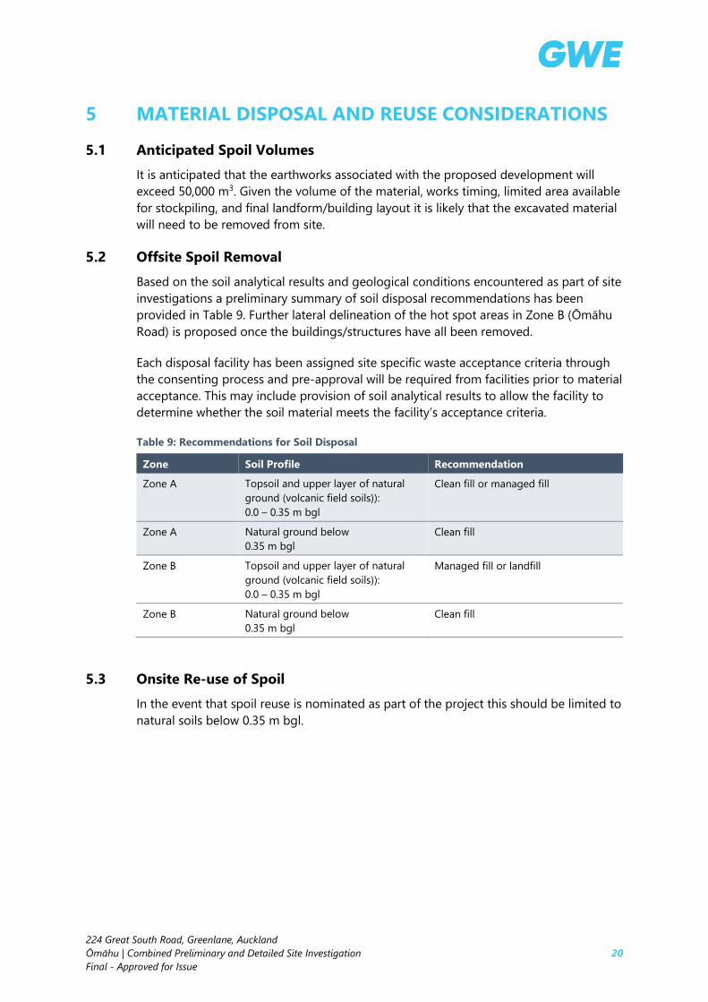
5.1 Anticipated Spoil Volumes ........................................................................................................................... 20
5.2 Offsite Spoil Removal ..................................................................................................................................... 20
5.3 Onsite Re-use of Spoil ................................................................................................................................... 20
6 REGULATORY ASSESSMENT (CONTAMINATED LAND) ............................................... 21
6.1 NES-CS Regulations ........................................................................................................................................ 21
6.1.1 NES-CS Applicability ....................................................................................................................................... 21
6.1.2 NES-CS Activity Assessment ........................................................................................................................ 21
6.2 Auckland Unitary Plan Operative in Part ................................................................................................ 22
7 SUMMARY AND RECOMMENDATIONS ......................................................................... 23
8 REFERENCES ...................................................................................................................... 24
9 LIMITATIONS .................................................................................................................... 25
APPENDICES
APPENDIX A Detailed Site Investigation Contents Checklist
APPENDIX B Figures
APPENDIX C Analytical Results and 95% UCL Calculations
APPENDIX D Historical Aerial Photography Review
APPENDIX E Certificates of Title Summary
APPENDIX F Asbestos Demolition Survey Summary
APPENDIX G Machine Borehole and Sampling Logs
APPENDIX H Laboratory Documentation
APPENDIX I Waste Acceptance Definitions
APPENDIX J Quality Assurance and Quality Control (QA/QC)

224 Great South Road, Greenlane, Auckland
Ōmāhu | Combined Preliminary and Detailed Site Investigation
Final - Approved for Issue
v
LIST OF FIGURES
Figure 1: Site Location Plan ........................................................................................................................................... 1
LIST OF TABLES
Table 1: Site Details Summary ...................................................................................................................................... 4
Table 2: Summary of Surrounding Landuse Activity ............................................................................................ 5
Table 3: Environmental Setting .................................................................................................................................... 5
Table 4: Summary of HAIL Categories ..................................................................................................................... 10
Table 5: Sample Analysis .............................................................................................................................................. 13
Table 6: Adopted Acceptance Criteria ..................................................................................................................... 14
Table 7: 95% UCL Calculations ................................................................................................................................... 16
Table 8: Exposure Pathway Assessment ................................................................................................................. 18
Table 9: Recommendations for Soil Disposal ....................................................................................................... 20
Table 10: Applicability of the NES-CS ...................................................................................................................... 21
Table 11: NES-CS Permitted Activity Assessment ............................................................................................... 22
224 Great South Road, Greenlane, Auckland
Ōmāhu | Combined Preliminary and Detailed Site Investigation
Final - Approved for Issue
1
1 INTRODUCTION
1.1 Preface
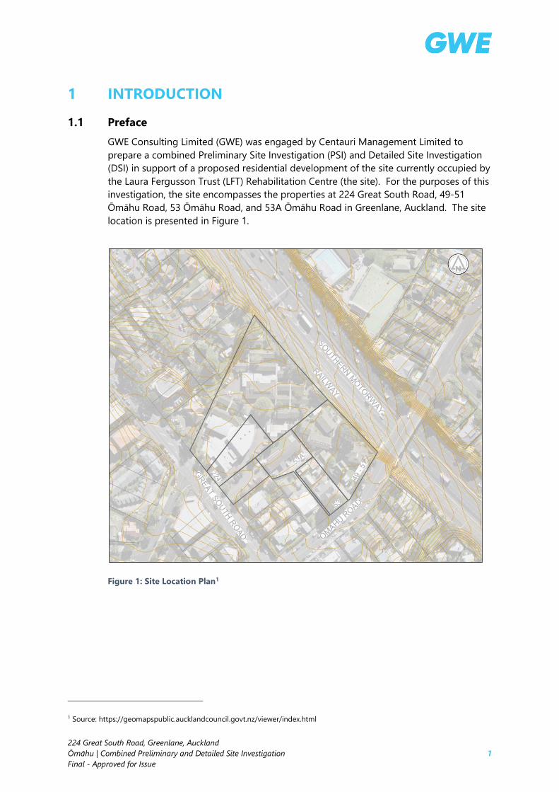
GWE Consulting Limited (GWE) was engaged by Centauri Management Limited to
prepare a combined Preliminary Site Investigation (PSI) and Detailed Site Investigation
(DSI) in support of a proposed residential development of the site currently occupied by
the Laura Fergusson Trust (LFT) Rehabilitation Centre (the site). For the purposes of this
investigation, the site encompasses the properties at 224 Great South Road, 49-51
Ōmāhu Road, 53 Ōmāhu Road, and 53A Ōmāhu Road in Greenlane, Auckland. The site
location is presented in Figure 1.
Figure 1: Site Location Plan1
1 Source: https://geomapspublic.aucklandcouncil.govt.nz/viewer/index.html
224 Great South Road, Greenlane, Auckland
Ōmāhu | Combined Preliminary and Detailed Site Investigation
Final - Approved for Issue
2
1.2 Proposed Development
A series of architectural plans prepared by Warren and Mahoney2 have been provided,
indicating the location and extent of the proposed development at the site. The
drawings include site plans, floor plans and elevations (SK-001 to SK-008).
Based on these plans, GWE understands that all existing buildings and site features that
comprise the LFT Rehabilitation Centre are to be demolished and removed.
The proposed development will comprise seven medium-rise residential apartment
buildings (buildings A to G), approximately three to six stories high. The residential
development will also incorporate commercial/hospitality areas and be constructed
around a central park and two pocket parks, all interconnected by laneways and mews.
The main pedestrian and service vehicle entrance will be via Great South Road.
The development will be constructed over a large, single-level basement carpark,
approximately 1 hectare (ha) in size. The proposed basement floor level is RL
75.15-76.3, approximately 3.7–3.85 m below the proposed ground floor level. Access to
the basement carpark will be via Ōmāhu Road.
Earthworks associated with basement formation is likely to exceed a cut volume of
50,000 m3. Given the volume of the material, works timing, limited area available for
stockpiling, and final landform/building layout it is likely that the excavated material will
need to be removed from site.
1.3 Investigation Objective
The key objective of the investigation was to complete a PSI-DSI in support of the
development resource consent application.
Recommendations are to be provide with respect to:
• Off-site soil disposal and materials reuse.
• Contaminated land resource consent requirements.
1.4 Scope of Works
The following scope of works were completed to achieve the investigation objective:
• Review of available desktop study information at the time of writing, including:
- Historical and current aerial photography.
- Available geological mapping.
- Certificates of Title (CoT).
- Previous environmental reporting which included Auckland Council (AC)
contaminated land records and property file information.
- Information pertaining to the site provided by the client.
• Completion of a site investigation, including:
2 Warren and Mahoney, Ōmāhu, Job No. 9242.

224 Great South Road, Greenlane, Auckland
Ōmāhu | Combined Preliminary and Detailed Site Investigation
Final - Approved for Issue
3
- Site walkover.
- Collection of soil samples during advancement of machine drilled boreholes
for laboratory analysis of contaminants of potential concern including heavy
metals, organochlorine pesticides (OCP), polycyclic aromatic hydrocarbons
(PAH), and asbestos.
• Preparation of this combined PSI-DSI report.
1.5 Investigation Framework
The PSI-DSI has been developed in general accordance with the following guidelines:
• Ministry for the Environment (MfE), Contaminated Land Management Guidelines
(CLMG) No. 1: Reporting on Contaminated Sites in New Zealand (MfE, revised
2021).
• MfE, CLMG No. 5 Site Investigation and Analysis of Soils (MfE, revised 2021).
• Resource Management (National Environmental Standard for Assessing and
Managing Contaminants in Soil to Protect Human Health) Regulations 2011 (the
NES-CS).
• Building Research Advisory Council New Zealand (BRANZ), New Zealand Guidelines
for Managing and Assessing Asbestos in Soil (2017).
This PSI-DSI report has been prepared in generally accordance with the DSI table of
contents guide outlined in the CLMG No 1. A copy of the table of contents guide is
provided in Appendix A.
1.6 Report Certification
This report has been certified by a GWE Suitably Qualified and Experienced Practitioner
(SQEP) with relevant experience and qualifications defined by the NES:CS Users’ Guide3.
3 Ministry for the Environment, Users’ Guide National Environmental Standard for Assessing and Managing Contaminants in Soil
to Protect Human Health, April 2012.

224 Great South Road, Greenlane, Auckland
Ōmāhu | Combined Preliminary and Detailed Site Investigation
Final - Approved for Issue
4
2 PRELIMINARY SITE INVESTIGATION
2.1 Site and Environmental Setting
2.1.1 Site Identification
The site comprises four property titles and is irregular in plan shape. The total land area
is approximately 14,686 m2 (1.47 ha). The site is zoned Residential - Terrace Housing and
Apartment Building Zone under the Auckland Unitary Plan Operative in Part (AUP).
Specific site details are summarised in Table 1.
Table 1: Site Details Summary
Attribute Details
224 Great South Road, Greenlane, Auckland
Legal description Lot 1 DP 146628, Lot 4 Deeds Reg 308, Lot 5 Deeds Reg 308
Certificate of Title (CoT) number NA87B/952, NA513/265, NA513/268
Coordinates (NZTM) E1759302, N5916468
Current site area 9,235 m2
49-51 Ōmāhu Road, Greenlane, Auckland
Legal description Lot 2 DP 146628
Certificate of Title (CoT) number NA87B/953
Coordinates (NZTM) E1759386, N5916423
Current site area 3,213 m2
53 Ōmāhu Road, Greenlane, Auckland
Legal description Lot 2 DP 53665
Certificate of Title (CoT) number NA14D/216
Coordinates (NZTM) E1759367, N5916398
Current site area 981 m2
53A Ōmāhu Road, Greenlane, Auckland
Legal description Lot 3 DP 53665
Certificate of Title (CoT) number NA14D/217
Coordinates (NZTM) E1759337, N5916424
Current site area 1,257 m2
2.1.2 Site Description
The site comprises the LFT rehabilitation centre, with treatment facilities, residential
living units, respite care, gym, indoor pool, and car parking. However, the centre closed
in March 2020 and is currently only utilised for patient care in two on-site structures.

224 Great South Road, Greenlane, Auckland
Ōmāhu | Combined Preliminary and Detailed Site Investigation
Final - Approved for Issue
5
2.1.3 Surrounding Landuse
A summary of the landuse surrounding the site is provide in Table 2.
Table 2: Summary of Surrounding Landuse Activity
Direction Surrounding Landuse
North-east A railway line is present directly adjacent to the north-eastern site boundary,
beyond which is the Southern Motorway.
East Ōmāhu Road with residential properties beyond.
South Residential properties. During the site walkover (refer to Section 3.9) the
adjacent property at 232 Great South Road is vacant (the former dwelling
has been removed).
South-west Great South Road with commercial and residential properties beyond.
North/north-west Residential properties.
2.1.4 Environmental Setting
Table 3 presents a summary of the site’s environmental setting.
Table 3: Environmental Setting
Item Description
Topography The site topography is generally flat (RL 80) with a slight increase in elevation
towards the railway on the north-eastern site boundary.
A stormwater overland flow path is noted on the AC’s online GeoMaps to
flow along the south-eastern property boundary at 224 Great South Road in
a south-west direction towards Great South Road.
Geology Mapped Geology: GNS Geology Maps4 indicates the geology at the site and
surrounding land to be Auckland Basalts tuff (Kerikeri Volcanic Group) of
Auckland Volcanic Field. The geology is described as ‘lithic tuff, comprising
comminuted pre-volcanic materials with basaltic fragments, and
unconsolidated ash and lapilli deposits.’
Site Investigations: Geotechnical investigations were undertaken at the site
in 20195 and 20216. Shallow materials comprised either topsoil to 0.2 m
below ground level (bgl), with some underlying fill up to 1.2 m bgl in the
southern portion of 224 Great South Road or hardstand (asphalt/concrete)
generally underlain by gravely basecourse fill to 0.5 m bgl. The shallow
materials were underlain by Auckland Volcanic Field soils (silty clay and clayey
silt with trace basaltic gravel) up to 4.1 m bgl (layer thickness between 0.7
and 2.8 m). Beneath the volcanic soils were alluvial silts and clays of the
Puketoka Formation, underlain by East Coast Bays Formation (ECBF)
comprising predominantly silty clay with layers of clayey silt and silty sand
becoming extremely weak to very weak siltstone and sandstone with depth.
Hydrogeology Previous site investigations encountered groundwater at approximately 2.8 to
3.6 m bgl under summertime conditions.
4 GNS Science Geology Web Maps accessed via: https://data.gns.cri.nz/geology/ 5 ENGEO Limited, 2019. Due Diligence Geotechnical Investigation, 224 Great South Road, Remuera, Auckland (report ref.
15627.000.000_02), dated 11 January 2019. 6 GWE Consulting Limited, 2021. Geotechnical Investigation Report, Ōmāhu Apartments. 224 Great South Road, Greenlane,
Auckland (draft report).

224 Great South Road, Greenlane, Auckland
Ōmāhu | Combined Preliminary and Detailed Site Investigation
Final - Approved for Issue
6
Item Description
Sensitive
Ecological
Receptors
As indicated by AC GeoMaps, the site is located within the Ellerslie
stormwater catchment. The receiving environment is the Waiatarua Reserve,
approximately 2.9 kilometres (km) to the east of the site and is the nearest
sensitive ecological receptor.
2.1.5 Underground Utilities
The site is served by and contains reticulated services including stormwater, wastewater
and water supply infrastructure:
• On-site stormwater lines comprise 150, 225, 300, and 375 mm diameter gravity
concrete pipes. There are numerous catchpits and stormwater manholes around the
site.
• The on-site wastewater line comprises 150 and 225 mm diameter gravity vitrified
clay (VC) pipe, installed in July 1917. The services are at a depth of approximately
4 m bgl at the on-site manhole. There are wastewater manholes across the site.
The VC pipe is to be replaced as part of the development of the site.
• The site is connected to the WaterCare reticulated water supply network. Water
supply enters the site at various locations (224 Great South Road, 53 Ōmāhu Road
and 53A Ōmāhu Road). AC GeoMaps and Watercare GIS viewer, identify the
100 mm diameter water supply pipe entering 224 Great South Road to be asbestos
cement (AC). Other pipes are mapped to be 20 mm diameter polyethylene (PE).
A fibre optic cable is present along the eastern site boundary with the railway line.
High voltage power supply enters the site and is controlled at the service room onsite.
A medium pressure gas line is present, visible entering the site on the eastern site
corner.
2.2 Historical Information Review
2.2.1 Historical Aerial Photography Review
A review of available historical aerial photography was undertaken and an annotated
planning map from circa 1931 was sourced and interpreted as part of the review. A
detailed summary and copies of the aerial photography and planning map are provided
in Appendix D.
It appears that the site was originally a mix of residential and horticultural (1931 through
1967) landuse. The horticultural activity appears limited to the northern section of 224
Great South Road and likely included a nursery, sheds, minor storage and greenhouses.
The site was developed for its current landuse, the LFT Rehabilitation Centre, from 1965.
Between 1965 and 2001 the site was expanded upon with new buildings and facilities
developed. Since 2001, no major changes have been visible at the site.

224 Great South Road, Greenlane, Auckland
Ōmāhu | Combined Preliminary and Detailed Site Investigation
Final - Approved for Issue
7
2.2.2 Certificates of Title
A summary of all historic CoT reviewed is presented in Appendix E.
The land has been subdivided and amalgamated over time and the site has been owned
and leased by multiple parties.
The original site owner (titles issued in 1928) was The Dilworth Trust Board (DTB), a
body corporate under the provisions of ‘The Religious Charitable and Educational Trust
Board Incorporation Act, 1884’. The DTB leased the land to multiple parties between
approximately 1917 and 1996. The occupations of the parties are not always noted on
the historic leases, however of those that are listed, there are none which relate to
activities on the MfE Hazardous Activities and Industries List (HAIL). Most lessees are
private individuals (except for Challis Properties Limited), until the LFT begin
commenced activity at the site in 1965. LTF purchased all four titles between 1983 and
2012 (53A Ōmāhu Road).
During the period of horticulture on the north of 224 Great South Road (approximately
1931 through1967), the site was owned by Norman Gloag Smith; no occupation is listed
on the CoT. A web search of his name returned online Cenotaph records likely to be the
same Norman Gloag Smith. His training and enlistment in 1942 and 1943 state
Nurseryman/Civilian.
2.2.3 Property File Review
Property files were not obtained as part of this investigation. A property file review is
summarised from the previous environmental investigation at the site (ENGEO Limited
(ENGEO), 2019).
The property file lists a number of building consents and permits. Key findings of
property file review include:
• The site was developed for residential purposes, as early as 1921.
• Construction of the majority of the buildings onsite was completed pre-1980,
therefore asbestos and lead-based paint may be present within the structure and
potentially in a degrading state or having been subject to maintenance.
• The file did not contain an asbestos register.
• The LFT have had a presence at the site since 1965 (leased initially) and began
building the commercial rehabilitation facility on 224 Great South Road in 1968.
2.2.4 Auckland Council Site Contamination Enquiry
An AC Site Contamination Enquiry was made as part of the previous environmental
investigation at the site (ENGEO, 2019). AC Natural Resources and Specialist Input Unit
provided information for the site regarding contamination information (22 November
2018).
No pollution incident files were available. No air discharge, industrial/trade process, or
contaminated site discharge consents were recorded against properties at the site, or at
immediately adjacent properties (200 m radius).

224 Great South Road, Greenlane, Auckland
Ōmāhu | Combined Preliminary and Detailed Site Investigation
Final - Approved for Issue
8
Two bores are located within a 200 m radius of the site. One bore was drilled pre 1987
and the other, on Patey Street, was used for geotechnical purposes.
The records reviewed as part of the Site Contamination Enquiry did not identify
individual horticultural sites in the region, however it was noted that there is a possibility
that horticultural activities may have occurred at the site.
2.2.5 Summary of Previous Environmental Investigations
Asbestos Demolition Surveys (ENGEO, 2018)
ENGEO carried out thirteen Asbestos Demolition Surveys7 for buildings at the site. As
part of this PSI-DSI, GWE were provided with one survey in full (CNU and 53a) and the
remainder were missing appendices, including laboratory results and condition
descriptions of the material.
The scope of the surveys were inspections of all buildings at the site, including all
accessible internal, external, sub-floor and roof spaces. Suspected asbestos containing
material (ACM) was sampled where accessible.
Externally, asbestos was identified in soffits, cement base sheeting, bituminous roof
material, fuse boards and an external hot water cylinder at the site. All identified
asbestos was determined to be of low risk (which included consideration of material
type, condition, whether it is sealed or not, and potential for disturbance). A summary
of the exterior asbestos identified in the ENGEO Asbestos Demolition Surveys is
provided in Appendix F.
Combined PSI and DSI Report (ENGEO, 2019)
In December 2018, ENGEO undertook a soil sampling investigation at the site as part of
a combined PSI-DSI8. The desktop information review identified the horticultural
landuse in the northern portion of 224 Great South Road, as well as the general age of
the site buildings with the potential for ACM and lead based paint to be present.
As part of the DSI, 46 samples were collected from across the entire site adjacent to
buildings and analysed for lead and asbestos (semi-quantitative). Eight additional
samples were also collected from within the former horticultural area, analysed for
heavy metals and OCPs. All samples were collected from shallow depths (topsoil)
between 0.0 and 0.05 m bgl. The location of the samples is presented on Drawing 701
in Appendix B.
The analytical results have been tabulated (refer to Table C1 in Appendix C) and
compared to the relevant soil quality acceptance criteria adopted as part of the current
investigation based on the proposed residential landuse (refer to Section 3.3). In
summary:
7 ENGEO Limited, 2018. Asbestos Demolition Survey reports prepared for Laura Fergusson Trust, issued 6 December 2018
(report references: 15627.000.000). Thirteen reports were issued each covering different buildings at the site. The reports can be
made available on request. 8 ENGEO Limited, 2019. Combined Preliminary and Detailed Site Investigation, 224 Great South Road, Greenland, Auckland,
dated 7 February 2019 (Report reference: 15627.000.000_04). The report can be made available on request.

224 Great South Road, Greenlane, Auckland
Ōmāhu | Combined Preliminary and Detailed Site Investigation
Final - Approved for Issue
9
• Concentrations of lead were recorded above the upper Background Range in the
majority of samples analysed from the site. Nine exceedances of the AC PA Criteria
for lead were recorded. Elevated concentrations of lead were recorded adjacent to
the older dwellings within the former residential properties at 49 to 51 and
53 Ōmāhu Road, with seven exceedances of the NES-CS (maximum recorded
concentration was 3,700 mg/kg).
• Arsenic was recorded at concentrations slightly above the upper Background Range
in three of the eight samples collected within the former horticultural area.
• Nickel was recorded at a concentration slightly above the AC PA Criteria in one soil
sample.
• OCPs were recorded below the laboratory limit of reporting (LOR) within the former
horticultural area, with the exception of endosulfan I which was recorded at low
concentrations marginally above the LOR in five of the eight samples. The
recorded concentration of endosulfan I was orders of magnitude below the
adopted human health criteria.
• Asbestos was detected in three surface soil samples adjacent to the buildings
within the former residential properties at 49 to 51, and 53A Ōmāhu Road. Of
these, two samples recorded asbestos concentrations above the BRANZ Guidelines.
No sampling of deeper soils was undertaken so the vertical extent of the contamination
was undefined by the investigation. In addition, further lateral delineation of lead and
asbestos impact adjacent to the older buildings was not completed.
2.3 Site Walkover
A site walkover was completed by a GWE Environmental Engineer on 9 August 2021.
GWE was given access to the entire site area. The walkover focused on exterior spaces
only. Site walkover observations are summarised as follows:
• The site comprised the former LFT head office and rehabilitation centre with
carparking, residential living, respite care, gym, and pool.
• The main LTF building, comprising administration, treatment rooms, gym and
indoor pool, is positioned on the west of 224 Great South Road. The rest of the site
is largely occupied by residential units, with paths in between and interspersed
small-scale gardens and green spaces.
- Residential units are predominantly made from brick and timber.
- Two larger buildings (likely the residential dwellings built in the 1920’s) located
on the east of the site (at 49 to 51 and 53 Ōmāhu Road) are of timber
construction with deteriorating, flaking paint visible.
- Gardens around the site include raised beds (some with railway sleepers),
garden bed covered with shell, rose garden, fruit trees, and lawns.
- Citrus and olive trees were noted onsite. Olive trees were located on the north
of the site, within the area of former plant nursery area and may be remnants
of the former landuse. The citrus trees are located on the east of the site
(outside area of former horticulture).

224 Great South Road, Greenlane, Auckland
Ōmāhu | Combined Preliminary and Detailed Site Investigation
Final - Approved for Issue
10
• A large percentage of the site’s surface cover is impervious comprising roofs,
concrete, asphalt, stone, paving, brick, tiles, and some gravel.
• A large timber pole retaining wall is present on the north-eastern site corner,
adjacent to the railway. A block retaining wall is present on the north-western site
boundary.
• A small stockpile of inert materials (tiles, bricks, etc.) was noted in the north of the
site.
• There was no storage of hazardous materials noted at the site.
2.4 Key Findings
2.4.1 Site Development History
The site was originally developed for residential purposes as early as 1921, with
horticultural landuse (plant nursery) also undertaken in the north-eastern portion of the
property at 224 Great South Road from at least the early 1930s until 1968.
From the mid-1960’s the site underwent extensive development for the LFT
rehabilitation centre. The property at 224 Great South Road became the main complex
with the residential properties at 49 to 51 Ōmāhu Road, 53 Ōmāhu Road, and
53A Ōmāhu Road adapted and modified over the years.
2.4.2 Summary of HAIL Activity
Based on the results of the PSI, refer to Table 4 for a summary of HAIL categories
pertinent to the site.
Table 4: Summary of HAIL Categories
Property Area of Potential Concern HAIL Category
224 Great South Road Former horticultural area.
Pre-1970 buildings.
A10 - Persistent pesticide bulk storage
or use including sport turfs, market
gardens, orchards, glass houses or
spray sheds.
224 Great South Road Stormwater overland flow
path.
Pre-1970 buildings.
I - Any other land that has been subject
to the intentional or accidental release
of a hazardous substances in sufficient
quantity that it could be a risk to
human health or the environment.
49 to 51 Ōmāhu Road,
53 Ōmāhu Road,
53A Ōmāhu Road
Pre-1970 buildings.
Near previously identified lead
and asbestos exceedances of
human health criteria.
E1 – Asbestos products manufacture or
disposal including sites with buildings
containing asbestos products known to
be in a deteriorated condition.
I - Any other land that has been subject
to the intentional or accidental release
of a hazardous substances in sufficient
quantity that it could be a risk to
human health or the environment.

224 Great South Road, Greenlane, Auckland
Ōmāhu | Combined Preliminary and Detailed Site Investigation
Final - Approved for Issue
11
2.4.3 Areas of Potential Concern
Based on the results of the PSI the site has been divided into two areas of potential
concern (refer to Drawing 701 in Appendix B):
• Zone A (Great South Road), incorporating the property at 224 Great South Road,
which includes the former horticultural area. Key contaminants of concern include
heavy metals.
• Zone B (Ōmāhu Road), incorporating the properties at 49 to 51, 53, and
53A Ōmāhu Road. These properties were originally residential landuse
commencing in the 1920’s and the original dwellings are still present on-site. Key
contaminants of concern include heavy metals and asbestos in soil.
224 Great South Road, Greenlane, Auckland
Ōmāhu | Combined Preliminary and Detailed Site Investigation
Final - Approved for Issue
12
3 DETAILED SITE INVESTIGATION
3.1 Investigation Rationale
Based on the information review completed as part of the PSI it is evident that shallow
soils at the site have been impacted as a consequence of historical landuse activity.
Contaminants of concern include heavy metals (including lead) and asbestos.
The purpose of the GWE DSI was to confirm soil contaminant concentrations at depth
(commensurate with proposed basement excavation works).
Between 11 and 16 August 2021, six machine drilled boreholes (MH1 through MH6)
were advanced across the general site area. Refer to Drawing 701 in Appendix B, and
Table 5 for a summary of sample locations and rationale.
3.2 Investigation Methodology
Prior to intrusive works underground service identification was undertaken on
9 August 2021 by Underground Service Locators, using ground penetrating radar (GPR)
and a cable avoidance tool (CAT).
During the advancement of the boreholes environmental soil samples were collected by
GWE staff members as detailed below:
• Observed geology was recorded, with soil type classification and descriptions based
on the New Zealand Geotechnical Society Soil and Rock Guidelines (2005). A copy
of the borehole logs is provided in Appendix G.
• A total of twenty-nine soil samples were collected across all investigation locations.
Samples were collected at approximately 0.5 m intervals. A copy of the sample log
is provided in Appendix G.
• Duplicate samples for quality assurance/quality control purposes were collected in
accordance with CLMG No. 5.
• Samples were placed directly into laboratory supplied containers and stored on ice
in a chilled container while onsite and during transit to R J Hill Laboratories Limited
(Hill Laboratories).
• Samples were transported to Hill Laboratories under standard chain of custody
(CoC) procedures. A copy of the CoC is provided in Appendix H.
• To prevent cross contamination, a new pair of disposable nitrile gloves were used
for each soil sample collected.
• Selected soil samples (10 individual samples and one duplicate) were analysed.
Samples not analysed were kept on hold cold by Hill Laboratories. Table 5
summarises the selected sample analysis for a range of contaminants of potential
concern.
• The samples collected from 0.5 and 0.6 m bgl from each borehole were analysed
initially, followed four by deeper samples, up to 2.0 m bgl, to confirm findings.

224 Great South Road, Greenlane, Auckland
Ōmāhu | Combined Preliminary and Detailed Site Investigation
Final - Approved for Issue
13
All analysed samples were within the Auckland Volcanic Field soils, except one
sample (MH1(1.5)) which was collected within alluvial silts and clays of the Puketoka
Formation (non-volcanic soil background range).
• Spoil generated during the intrusive works was kept in core boxes to form part of
geotechnical analysis (reported under a separate cover).
Table 5: Sample Analysis
Borehole
ID
Hole
Depth
Sample Depths Analysed
Samples
Laboratory Analysis
MH1 19.5 m 0.5 m, 1.0 m, 1.5 m,
2.0 m, 3.0 m
MH01, 0.5 Heavy metals, OCPs, PAHs, asbestos.
MH01, 1.5 Heavy metals.
MH2 15 m 0.5 m, 1.0 m, 1.5 m,
2.0 m, 3.0 m
MH02, 0.5 Heavy metals, OCPs, PAHs, asbestos.
MH02, 2.0 Heavy metals.
MH3 15 m 0.5 m (+QC), 1.0 m,
2.0 m, 3.0 m
MH03, 0.5 Heavy metals, OCPs, PAHs, asbestos.
MH03, QC Heavy metals.
MH4 16.5 m 0.6 m, 1.0 m, 1.5 m,
2.0 m, 3.0 m
MH04, 0.6 Heavy metals, OCPs, PAHs, asbestos.
MH04, 1.0 Heavy metals, PAHs.
MH5 15 m 0.1 m (+QC), 0.5 m,
1.0 m, 2.0 m, 3.0 m
MH05, 0.5 Heavy metals, OCPs, PAHs, asbestos.
MH05, 2.0 Heavy metals.
MH6 13.5 m 0.5 m, 1.0 m, 1.5 m,
2.0 m, 3.0 m
MH06, 0.5 Heavy metals, OCPs, PAHs, asbestos.
Note: QC = Quality control sample, OCPs = organochlorine pesticides, PAHs = polycyclic aromatic
hydrocarbons.
3.3 Investigation Results
3.3.1 Adopted Acceptance Criteria
The adopted acceptance criteria for soil quality results have been selected in accordance
with the hierarchy defined by MfE CLMG No.2 Contaminated Land Management
Guidelines (MfE, 2003, revised 2011) and are summarised in Table 6.

224 Great South Road, Greenlane, Auckland
Ōmāhu | Combined Preliminary and Detailed Site Investigation
Final - Approved for Issue
14
Table 6: Adopted Acceptance Criteria
Regulations/Guidelines Scenario
Resource Management Act (National
Environmental Standard (NES) for Assessing and
Managing Contaminants in Soil to Protect
Human Health) Regulations, 2011. Hereinafter
referred to as the NES-CS.
Soil contaminant standards for health (SCS) for
high-density residential landuse.
National Environmental Protection (Assessment
of Site Contamination) Measure (Australian
Government, 1999 (revised 2013). Hereinafter
referred to as the NEPM-HIL.
Soil Health Investigation Level for high-density
residential landuse (Residential B) for endosulfan
which is not included in the NES-CS but has
previously been recorded above laboratory
limits of reporting.
Building Research Advisory Council New
Zealand (BRANZ), New Zealand Guidelines for
Assessing and Managing Asbestos in Soil (2017).
Hereinafter referred to as the BRANZ Guidelines.
Soil guideline values for asbestos (w/w) for high-
density residential landuse.
Auckland Unitary Plan Operative in Part (AUP)
(Auckland Council, 2016), Permitted Activity Soil
Acceptance Criteria (Table E30.6.1.4.1).
Hereinafter referred to as the AC PA Criteria
Applies to any site.
AUP (Auckland Council, 2016), Background
Ranges of Trace Elements in Auckland Soils
sourced from Table 3 of TP153:2001 Background
Concentrations of Inorganic Elements in Soils
from the Auckland Region (Table E30.6.1.4.2).
Hereinafter referred to as the Background
Ranges.
Volcanic range soil.
3.3.2 Waste Acceptance Classes
In addition to human health risk assessment criteria, waste acceptance criteria were also
considered for the off-site disposal of excavated material associated with the proposed
development. The criteria adopted for the waste classification is generally based on the
waste acceptance classes as defined by the AUPOiP (2021) and WasteMINZ (2016).
These fall into three categories; clean fill, managed fill, and landfill (contaminated). Full
definitions are provided in Appendix I.
3.3.3 Field Observations
The following is a summary of relevant field observations noted during machine
borehole advancement/soil sampling:
• No visual evidence of contamination (i.e., staining, anthropogenic materials) was
observed during borehole advancement.
• No olfactory evidence of contamination was noted throughout the investigation.

224 Great South Road, Greenlane, Auckland
Ōmāhu | Combined Preliminary and Detailed Site Investigation
Final - Approved for Issue
15
• Ground conditions encountered during the intrusive investigations generally
comprised hardstand (asphalt/concrete) at surface, followed by gravelly fill,
overlying natural Auckland Volcanic Field soils (silty clay and clayey silt with trace
basaltic gravel) up to 4.1 m bgl (layer thickness between 0.7 and 2.8 m). Beneath
the volcanic soils were alluvial silts and clays of the Puketoka Formation, underlain
by ECBF comprising predominantly silty clay with layers of clayey silt and silty sand
becoming extremely weak to very weak siltstone and sandstone with depth.
Machine borehole logs are included in Appendix F.
3.3.4 Soil Analytical Results
Analytical results from the DSI are presented in Table C1 in Appendix C, along with the
previous analytical results from samples collected in 2018. Laboratory results and CoC
information are presented in Appendix H. Discussion with respect to the ENGEO 2018
results is provided in Section 3.5.1. Discussion with respect to GWE DSI results is
provided below:
• No exceedances of the NES-CS, NEPM-HIL, BRANZ Guidelines, or Background
Ranges were recorded in the samples collected from depths (≥0.5 m bgl).
• Asbestos was not detected in any of the samples.
• OCPs and polycyclic aromatic hydrocarbons (PAHs) were all recorded below
laboratory LOR in all samples, except detections of three individual PAH
compounds marginally above LOR in one sample (MH04, 0.6).
• Two minor exceedances of the AC PA Criteria for nickel were recorded (109 and
111 mg/kg compared to the criteria value of 105 mg/kg). However, the samples
were collected from within the volcanic soil layer and therefore concentrations were
within the expected Background Range for such soils.
Additionally, the 95% upper confidence limit of the mean was calculated for nickel
in natural ground and the suggested value was 77.4 mg/kg, which is below the AC
PA Criteria (refer to Appendix C for the calculation summary).
3.3.5 Quality Assurance and Quality Control
Refer to Appendix J for a summary of the QA/QC results for the GWE DSI, which
includes the relative percentage difference (RPD) tables for duplicate samples analysed.
The data validation procedure used in the assessment of the field and laboratory QA/QC
data indicated that the reported analytical results are representative of soil quality at the
sample locations and that the overall quality of the analytical data produced is
acceptably reliable for the purpose of this investigation.

224 Great South Road, Greenlane, Auckland
Ōmāhu | Combined Preliminary and Detailed Site Investigation
Final - Approved for Issue
16
4 TIER 1 RISK ASSESSMENT
4.1 Discussion of Analytical Results
Two soil investigations have been completed, one by ENGEO in 2018 and one by GWE
in 2021. The ENGEO investigation focussed on the shallow soil profile (topsoil), and the
GWE investigation focussed on the deeper soil profile commensurate with the basement
excavation for the site redevelopment. The following subsections discuss these results
in a holistic fashion.
4.1.1 Zone A (Great South Road)
Shallow soil samples collected from this zone:
• Recorded exceedances of the Background Ranges for lead, the AC PA Criteria for
nickel, and both the Background Ranges and AC PA Criteria for arsenic.
• The 95% upper confidence limit of the mean was calculated for lead, nickel and
arsenic results collected from this Zone (refer Table 7). Lead and arsenic
concentrations returned values in excess of the Background Range (marginal for
arsenic). Nickel returned a value below the AC PA Criteria.
• Recorded concentrations of OCPs at very low levels and orders of magnitude below
relevant human health criteria.
Deeper soil samples collected from this zone are commensurate with the Background
Range and not considered to have been impacted.
Table 7: 95% UCL Calculations
Analyte Number
of
Samples
Minimum
Recorded
Concentration
(mg/kg)
Maximum
Recorded
Concentration
(mg/kg)
95% Upper
Confidence
Limit
(mg/kg)
Background
Range
(mg/kg)*
AC Pa
Criteria
(mg/kg)*
Arsenic 10 5.47 16 13.6 12 100
Lead 33 16 370 145.1 65 250
Nickel 8 5 130 104.2 320 105
Note: *Refer to Table 6 for adopted acceptance criteria.
4.1.2 Zone B (Ōmāhu Road)
Shallow soil samples collected from this zone recorded elevated concentrations of lead
which exceeded the NES-CS adjacent to older residential buildings. Exceedances of the
BRANZ Guidelines were also recorded for asbestos in soil. Further delineation of heavy
metal and asbestos contamination is required within this zone (hotspot delineation).
However, due to the presence of building structures this delineation is recommended
for completion post demolition. Detail with respect to this delineation sampling is
included in the project Remedial Action Plan reported under separate cover.
Deeper soil samples collected from this zone are commensurate with the Background
Range and not considered to have been impacted.

224 Great South Road, Greenlane, Auckland
Ōmāhu | Combined Preliminary and Detailed Site Investigation
Final - Approved for Issue
17
4.2 Conceptual Site Model Summary
Based on the review of historic information, including historic soil analytical data, and
the results of the GWE DSI a basic conceptual site model (CSM) has been developed for
the site. In summary:
• The site was developed for residential landuse in the 1920’s, with horticultural
activities (plant nursery) undertaken in the northern portion of the property at
224 Great South Road.
• The commencement of nursery operations is unknown but appears to have been
undertaken since at least the early 1930s and continued until 1968. The nursery
operations included some structures, with the possibility of greenhouses being
present.
• In the mid 1960’s, construction of the existing LFT rehabilitation facility began, with
the main facility complex constructed at 224 Great South Road from 1968. The
properties at 49 to 53 Ōmāhu Road were progressively developed as part of the LFT
facility from the early 1970’s onwards.
• Site ground conditions generally comprise a hardstand/gravel basecourse fill layer
to 0.5 m bgl or a 0.2 m thick topsoil layer, with some underlying fill up to 1.2 m bgl
in the southern portion of 224 Great South Road. Underlying the topsoil/fill layers
are Auckland Volcanic Field soils (silty clay and clayey silt with trace basaltic gravel)
to 2.8 m in thickness. Beneath the volcanic soils are alluvial silts and clays, underlain
by ECBF soils (primarily silty clay) .
• Groundwater has been encountered between approximately 2.8 to 3.6 m bgl under
summertime conditions (generally within the volcanic soil layer).
• Shallow soil materials (topsoil) across the site have been impacted as a
consequence of historical landuse activity. However, significant lead and asbestos
in soil impact is limited to soil materials adjacent to older former residential
buildings within Zone B (Ōmāhu Road).
• The results for the deeper soils underlying the topsoil/hardstand across the site
indicate these soils are representative of natural conditions and not impacted by
historical landuse activities.
4.3 Exposure Pathway Assessment
An exposure pathway refers to the way a receptor can come into contact with a
hazardous substance. There are three basic exposure pathways: inhalation, ingestion, or
direct contact. The degree or extent of exposure is determined by measuring the
amount of the hazardous substance at the point of exposure.
Table 8 presents an exposure pathway assessment based on our understanding of the
CSM and consideration of the proposed residential development which will involve the
excavation and removal of significant soil volumes from the site in order to provide for a
basement carpark.

224 Great South Road, Greenlane, Auckland
Ōmāhu | Combined Preliminary and Detailed Site Investigation
Final - Approved for Issue
18
Based on shallow soil analytical results collected from the site several potentially
complete exposure pathways exist. However, it is considered that these can be
adequately managed and mitigated through the implementation of institutional
controls during development.
Table 8: Exposure Pathway Assessment
Potential
Contaminant
Source
Potential
Pathways
Potential
Receptors
Exposure Pathway
Assessment
Discussion
Impacted
surface soil
materials
(lead and
asbestos)
Soil ingestion
Dermal
contact
Inhalation of
contaminated
dust
(including
asbestos
fibres)
Future land
users
(residential)
Potentially
Complete
Exceedances of NES-CS
health derived soil
contaminant standard for
lead and BRANZ
Guidelines for asbestos
have been recorded in
surface soils within Zone B.
Without removal, the
surface soils may present a
health risk to residential
land users. Provision for
target soil removal is
included in the project
specific Remedial Action
Plan (RAP) reported under
separate cover.
Construction
workers
Potentially
Complete
During the proposed
ground disturbance works
site workers and adjacent
land users may be
exposed to impacted soil
dust and asbestos fibres. A
project RAP has been
prepared to mitigate this
risk. The plan will outline
soil management
procedures to ensure the
exposure pathway is
mitigated.
Adjacent
land users
Potentially
Complete
Soil erosion
during
development
Stormwater
water runoff
Receiving
environment
via overland
flow paths or
reticulated
stormwater
networks
Potentially
Complete
Exceedances of AC PA
Criteria have been
recorded in surface soils. A
project RAP has been
prepared to mitigate this
risk. The plan will outline
soil management
procedures to ensure the
exposure pathway is
mitigated.
Leaching/
migration of
contaminants
Surrounding
environment,
including
groundwater
Incomplete There is no evidence to
suggest that soil
contamination at the site
extends to depth and may
present a risk to
groundwater resources.

224 Great South Road, Greenlane, Auckland
Ōmāhu | Combined Preliminary and Detailed Site Investigation
Final - Approved for Issue
19
Potential
Contaminant
Source
Potential
Pathways
Potential
Receptors
Exposure Pathway
Assessment
Discussion
Off-site
material
disposal site
Potentially
Complete
The disposal site
excavated materials should
be to a licensed facility
authorised to accept such
materials. The project RAP
includes provisions to
manage this risk pathway.
Note: A complete or potentially complete pathway indicates there is a definitive or potential link through
all four exposure pathway elements; contaminant source → contaminant transport mechanism → point
where a receptor can come in contact with contaminant → route contaminant can enter receptor. An
incomplete pathway indicates a part of the link between contaminant source and a receptor does not
exist and no exposure risk is present.
224 Great South Road, Greenlane, Auckland
Ōmāhu | Combined Preliminary and Detailed Site Investigation
Final - Approved for Issue
20
5 MATERIAL DISPOSAL AND REUSE CONSIDERATIONS
5.1 Anticipated Spoil Volumes
It is anticipated that the earthworks associated with the proposed development will
exceed 50,000 m3. Given the volume of the material, works timing, limited area available
for stockpiling, and final landform/building layout it is likely that the excavated material
will need to be removed from site.
5.2 Offsite Spoil Removal
Based on the soil analytical results and geological conditions encountered as part of site
investigations a preliminary summary of soil disposal recommendations has been
provided in Table 9. Further lateral delineation of the hot spot areas in Zone B (Ōmāhu
Road) is proposed once the buildings/structures have all been removed.
Each disposal facility has been assigned site specific waste acceptance criteria through
the consenting process and pre-approval will be required from facilities prior to material
acceptance. This may include provision of soil analytical results to allow the facility to
determine whether the soil material meets the facility’s acceptance criteria.
Table 9: Recommendations for Soil Disposal
Zone Soil Profile Recommendation
Zone A Topsoil and upper layer of natural
ground (volcanic field soils)):
0.0 – 0.35 m bgl
Clean fill or managed fill
Zone A Natural ground below
0.35 m bgl
Clean fill
Zone B Topsoil and upper layer of natural
ground (volcanic field soils)):
0.0 – 0.35 m bgl
Managed fill or landfill
Zone B Natural ground below
0.35 m bgl
Clean fill
5.3 Onsite Re-use of Spoil
In the event that spoil reuse is nominated as part of the project this should be limited to
natural soils below 0.35 m bgl.

224 Great South Road, Greenlane, Auckland
Ōmāhu | Combined Preliminary and Detailed Site Investigation
Final - Approved for Issue
21
6 REGULATORY ASSESSMENT (CONTAMINATED LAND)
To support the proposed development consideration will be needed as to contaminated
land resource consent requirements. A summary of applicable contaminated land
resource consent regulations and rules is provided below.
6.1 NES-CS Regulations
The NES-CS Regulations outline nationally consistent planning controls appropriate for
assessing and managing contaminants in soil in relation to human health. The NES-CS
prevails over the rules within District Plans, except where the rules permit or restrict
effects that are not dealt with in the NES-CS.
6.1.1 NES-CS Applicability
As per NES-CS regulation 5, the NES-CS is applicable when specific activities are
undertaken on a piece of land where a landuse activity described in the HAIL has or is
more likely than not to have occurred. An assessment of the applicability of the NES-CS
is provided in Table 10.
Table 10: Applicability of the NES-CS
NES-CS Assessment Criteria Applicability to the Site
Is/has an activity described by the HAIL currently being undertaken on
the piece of land to which this application applies?
Yes, refer Section 2.4.2
(Category A10, E1 and I)
Is it more likely than not that an activity described on the HAIL is
being or has been undertaken on the piece of land to which this
application applies?
Yes, as above
If Yes to any of the above, the NES-CS applies if any of the following five activities are to be
undertaken:
Propose to undertake removal or replacement of a fuel storage
system (or parts of it)?
No.
Propose to undertake soil sampling? No.
Propose to undertake soil disturbance? Yes
Propose to undertake subdivision of land? No
Propose to undertake change of land-use? Yes
6.1.2 NES-CS Activity Assessment
The permitted activity conditions for the relevant activities related to the proposed
development at the site (the piece of land) are summarised in Table 11.
The proposed development does not meet the Permitted Activity provisions of the
NES-CS. As such, the proposed development requires a NES-CS resource consent as a
Restricted Discretionary Activity (Regulation 10).

224 Great South Road, Greenlane, Auckland
Ōmāhu | Combined Preliminary and Detailed Site Investigation
Final - Approved for Issue
22
Table 11: NES-CS Permitted Activity Assessment
Soil Disturbance: NES-CS Permitted Activity Conditions - Regulation 8(3)
A Implementation of controls to minimise exposure of humans to mobilised contaminants.
B The soil must be reinstated to an erosion free state within one month of completing the land
disturbance.
C The volume of the disturbance of the piece of land must be no more than 25 m3 per 500 m2.
Based on a site area of 1.469 ha the permitted volume of soil disturbance is 735 m3. The volume
of ground disturbance as part of the proposed development is anticipated to exceed 50,000 m3,
as such the proposed works do not meet the permitted activity limits.
D The volume of soil removed from the piece of land must be no more than 5 m3 per 500 m2
(unless it is for laboratory testing).
Based on a site area of 1.469 ha the permitted volume of soil removal is 147 m3. The volume of
ground disturbance as part of the proposed development is anticipated to exceed 40,000 m3, as
such the proposed works do not meet the permitted activity limits.
E Soil taken away must be disposed of at an appropriately licensed facility.
F The duration of land disturbance must be no longer than two months.
It is likely the duration of the ground disturbance works will be longer than two months, as such
the proposed works do not meet the permitted activity limits.
G The integrity of a structure designed to contain contaminated soil or other contaminated
materials must not be compromised.
Subdividing or Changing Landuse: NES-CS Permitted Activity Conditions - Regulation 8(4)
A A preliminary site investigation of the land or piece of land must exist.
B The preliminary site investigation report must state that it is highly unlikely that there will be a
risk to human health if the activity is done to the piece of land.
Based on the findings of this PSI-DSI contaminants in surface soils are above applicable human
health standards for lead and asbestos, as such the proposed development does not meet the
permitted activity limits.
6.2 Auckland Unitary Plan Operative in Part
The AUP sets out rules for the discharge of contaminants during disturbance of
contaminated soil and for ongoing discharge of contaminants from land containing
contaminants under Section E30.
To meet permitted activity conditions the volume of contaminated soil disturbed must
not exceed 200 m3. Additionally, concentrations of soil contaminants must not exceed
the contaminant standards outlined in Section E30.6.1.4.
Given the soil analytical results indicate concentrations of contaminants (lead and
asbestos) are above the AUP PA Criteria in Zone B, and the proposed volumes of soil
disturbance are greater than 200 m3, the proposed development would require resource
consent as a Controlled Activity under AUP rule 30.6.2.1.

224 Great South Road, Greenlane, Auckland
Ōmāhu | Combined Preliminary and Detailed Site Investigation
Final - Approved for Issue
23
7 SUMMARY AND RECOMMENDATIONS
It is understood that Centauri Management Limited are currently proposing to develop
the site for residential purposes, incorporating some commercial/hospitality areas.
A combined PSI-DSI was completed in support of the development resource consent
application.
A summary of the PSI-DSI findings is presented below:
• The site was originally developed for residential purposes as early as 1921, with
horticultural landuse (plant nursery) also undertaken in the north-eastern portion of
the property at 224 Great South Road from at least the early 1930s until 1968.
• From the mid-1960’s the site underwent extensive development for the LFT
rehabilitation centre. The property at 224 Great South Road became the main
complex with the residential properties at 49 to 51 Ōmāhu Road, 53 Ōmāhu Road,
and 53A Ōmāhu Road adapted and modified over the years.
• HAIL categories associated with historical site activities include A10, E1, and I.
• Shallow soil materials (topsoil) across the site have been impacted as a
consequence of historical landuse activity. However, significant lead and asbestos
in soil impact is limited to soil materials adjacent to older former residential
buildings within Zone B (Ōmāhu Road).
• The results for the deeper soils underlying the topsoil/hardstand across the site
indicate these soils are representative of natural conditions and not impacted by
historical landuse activities.
• Based on shallow soil analytical results collected from the site several potentially
complete exposure pathways exist. However, it is considered that these can be
adequately managed and mitigated through the implementation of the project RAP
(reported under separate cover).
• Shallow soil materials excavated and removed from the site can be disposed as
clean fill/managed fill (Zone A) or landfill (Zone B). Additional delineation within
Zone B is proposed as part of the RAP. The intention of this sampling would be to
minimise the volume of shallow soil material disposed to landfill.
• Deeper soil materials excavated and removed from the site can be disposed as
clean fill.
• Deeper soil materials can be reused within the development as required.
• A NES-CS Restricted Discretionary consent (Regulation 10) and AUP consent
(Rule 30.6.2.1) is required to be sought in support of the development.

224 Great South Road, Greenlane, Auckland
Ōmāhu | Combined Preliminary and Detailed Site Investigation
Final - Approved for Issue
24
8 REFERENCES
Auckland Council, 2016 (Updated 10 September 2021). Auckland Unitary Plan Operative
in Part.
Building Research Advisory Council New Zealand, 2017. New Zealand Guidelines for
Managing and Assessing Asbestos in Soil (referred to as BRANZ Guidelines).
ENGEO Limited, 2018. Asbestos Demolition Survey reports, issued 6 December 2018 (ref:
15627.000.000). Thirteen separate reports covering different buildings at the site: CNU
and 53a; Dining and Recreation Centre; Green House; Maintenance Workshop; Rehab
Centre; Residential Units 1-12, L2, 46; Residential Units 13-25; Residential Units 26-33;
Residential units 34-43, L3; Unit 44 (OT Kitchen) and Unit 45; White House; Wood
Workshop; MCR Farrell.
ENGEO Limited, 2019. Due Diligence Geotechnical Investigation, 224 Great South Road,
Remuera, Auckland (report ref. 15627.000.000_02), dated 11 January 2019.
ENGEO Limited, 2019. Combined Preliminary and Detailed Site Investigation, 224 Great
South Road, Greenland, Auckland (Ref. 15627.000.000_04), dated 7 February 2019.
Ministry for the Environment, 2001 (revised 2021). Contaminated Land Management
Guidelines No. 1. Reporting on Contaminated Sites in New Zealand.
Ministry for the Environment, 2003 (revised 2011). Contaminated Land Management
Guidelines No. 2. Hierarchy and Application in New Zealand of Environmental Guideline
Values.
Ministry for the Environment, 2004 (revised 2021). Contaminated Land Management
Guidelines No. 5. Site Investigation and Analysis of Soils.
Ministry for the Environment, 2011. Methodology for Deriving Standards for
Contaminants in Soil to Protect Human Health.
Ministry for the Environment, 2011. Resource Management Act (National Environmental
Standard for Assessing and Managing Contaminants in Soil to Protect Human Health)
Regulations, 2011.
Ministry for the Environment, 2012. User’s Guide, National Environmental Standard for
Assessing and Managing Contaminants in Soil to Protect Human Health.
National Environment Protection Council (Australia), 1999 (revised 2013). National
Environmental Protection (Assessment of Site Contamination) Measure. Schedule B1:
Guideline on Investigation Levels for Soil and Groundwater (2011).
New Zealand Geotechnical Society Incorporated, 2005. Field Description of Soil and
Rock – Guideline for the Field Classification and Description of Soil and Rock for
Engineering Purposes.
Waste Management Institute New Zealand (WasteMINZ), 2016. Technical Guidelines for
Disposal to Land, published April 2016.

224 Great South Road, Greenlane, Auckland
Ōmāhu | Combined Preliminary and Detailed Site Investigation
Final - Approved for Issue
25
9 LIMITATIONS
This report has been prepared for the sole benefit of Centauri Management Limited (as
our Client), and their appointed representatives, according to their instructions, for the
specific objectives described herein.
This report is not to be relied upon or used out of context by any other party for any
other objective without reference to GWE Consulting Limited (GWE). The reliance by
other parties on the information or opinions contained in the report shall, without prior
review and agreement in writing, be at such parties’ sole risk.
GWE has relied on information provided by the Centauri Management Limited and by
third parties to produce this document and arrive at its conclusions. GWE has not
verified information provided (unless specifically noted otherwise) and we assume no
responsibility and make no representations with respect to the adequacy, accuracy or
completeness of such information. No responsibility is assumed for inaccuracies in
reporting by the information providers.
From a technical perspective, the subsurface environment at any site may present
substantial uncertainty. It is a heterogeneous, complex environment, in which small
subsurface features or changes in geologic conditions can have substantial impacts on
water, gas, and chemical movement. Uncertainties may also affect source
characterisation, assessment of chemical fate and transport in the environment,
assessment of exposure risks and health effects, and remedial action performance.

224 Great South Road, Greenlane, Auckland
Ōmāhu | Combined Preliminary and Detailed Site Investigation
Final - Approved for Issue
APPENDIX A
DETAILED SITE INVESTIGATION CONTENTS CHECKLIST
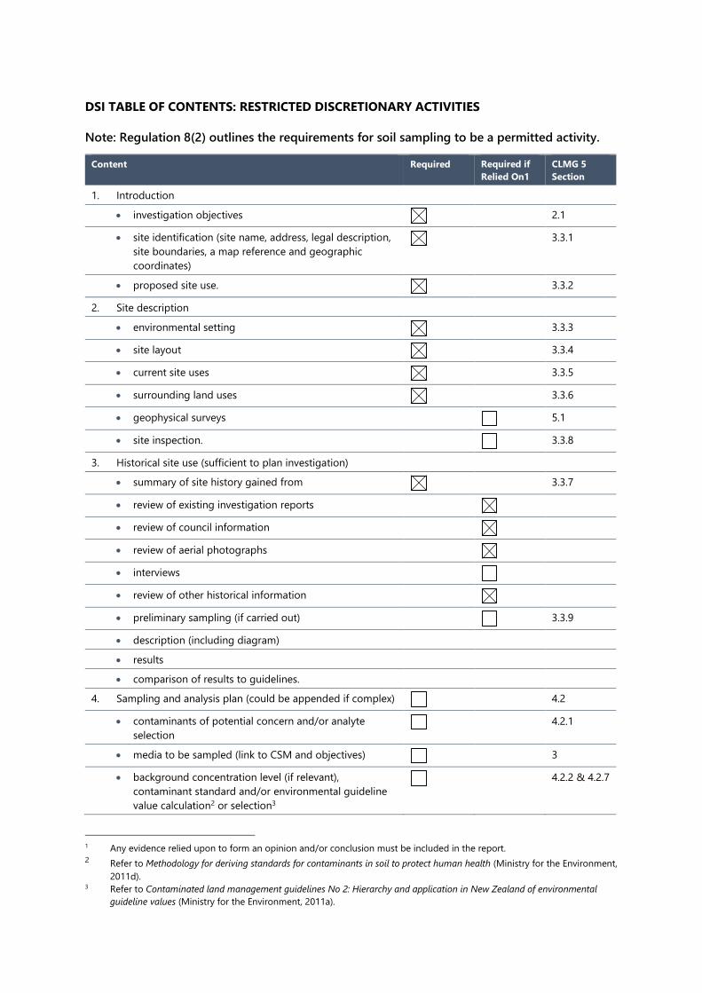
DSI TABLE OF CONTENTS: RESTRICTED DISCRETIONARY ACTIVITIES
Note: Regulation 8(2) outlines the requirements for soil sampling to be a permitted activity.
Content Required Required if
Relied On1
CLMG 5
Section
1. Introduction
• investigation objectives 2.1
• site identification (site name, address, legal description,
site boundaries, a map reference and geographic
coordinates)
3.3.1
• proposed site use. 3.3.2
2. Site description
• environmental setting 3.3.3
• site layout 3.3.4
• current site uses 3.3.5
• surrounding land uses 3.3.6
• geophysical surveys 5.1
• site inspection. 3.3.8
3. Historical site use (sufficient to plan investigation)
• summary of site history gained from 3.3.7
• review of existing investigation reports
• review of council information
• review of aerial photographs
• interviews
• review of other historical information
• preliminary sampling (if carried out) 3.3.9
• description (including diagram)
• results
• comparison of results to guidelines.
4. Sampling and analysis plan (could be appended if complex) 4.2
• contaminants of potential concern and/or analyte
selection 4.2.1
• media to be sampled (link to CSM and objectives) 3
• background concentration level (if relevant),
contaminant standard and/or environmental guideline
value calculation2 or selection3
4.2.2 & 4.2.7
1 Any evidence relied upon to form an opinion and/or conclusion must be included in the report. 2 Refer to Methodology for deriving standards for contaminants in soil to protect human health (Ministry for the Environment,
2011d). 3 Refer to Contaminated land management guidelines No 2: Hierarchy and application in New Zealand of environmental
guideline values (Ministry for the Environment, 2011a).

Content Required Required if
Relied On1
CLMG 5
Section
• sampling design (e.g., targeted or systematic sampling) 4.2.3
• number of samples including justification for number
selected and potential limitations of methodology
adopted in the context of investigation objectives
4.2.4
• sample depth 4.2.5
• composite sampling including number of sub-samples
per sample
4.2.6
• background sampling methodology 4.2.7
• sampling techniques 4.2.8
• field screening techniques 5.4
• quality assurance and quality control. 4.3
5. Sampling results
• summary of works undertaken with rationale for any
departure from, or addition to, sampling and analysis
plan
• field observations (e.g., staining, odour, soil
characteristics) 5.2.1
• evaluation of analytical laboratory results with
comparison to background concentration levels (if
relevant), contaminant standards and/or environmental
guideline values
7
• evaluation of field screening results with comparison to
background concentration levels (if relevant),
contaminant standards and/or environmental guideline
values
• results of field and laboratory sample quality
assurance/quality control
• statistical analysis of results.
6. Disposal documentation
• the transport, disposal and tracking of soil and other
materials taken away in the course of the activity –
regulation 10(3))(e).
7. Risk assessment
• conceptual site model 3
• evaluate the probability contamination exists on the site 3.3.11
• characterise the source through adequate delineation of
contamination horizontally and vertically and
assessment of contaminant concentrations
• identify and characterise potential pathways and
receptors for each exposure area through relevant site
properties (e.g., assessment of geology, hydrogeology,
building construction, site use)
• determine the likelihood the contamination poses a risk
to identified receptors including potential receptors
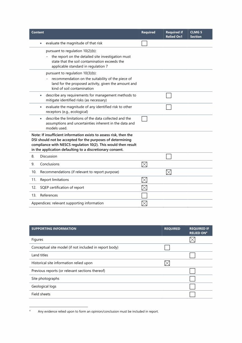
Content Required Required if
Relied On1
CLMG 5
Section
• evaluate the magnitude of that risk
pursuant to regulation 10(2)(b):
- the report on the detailed site investigation must
state that the soil contamination exceeds the
applicable standard in regulation 7
pursuant to regulation 10(3)(b):
- recommendation on the suitability of the piece of
land for the proposed activity, given the amount and
kind of soil contamination
• describe any requirements for management methods to
mitigate identified risks (as necessary)
• evaluate the magnitude of any identified risk to other
receptors (e.g., ecological)
• describe the limitations of the data collected and the
assumptions and uncertainties inherent in the data and
models used.
Note: If insufficient information exists to assess risk, then the
DSI should not be accepted for the purposes of determining
compliance with NESCS regulation 10(2). This would then result
in the application defaulting to a discretionary consent.
8. Discussion
9. Conclusions
10. Recommendations (if relevant to report purpose)
11. Report limitations
12. SQEP certification of report
13. References
Appendices: relevant supporting information
SUPPORTING INFORMATION REQUIRED REQUIRED IF
RELIED ON4
Figures
Conceptual site model (if not included in report body)
Land titles
Historical site information relied upon
Previous reports (or relevant sections thereof)
Site photographs
Geological logs
Field sheets
4 Any evidence relied upon to form an opinion/conclusion must be included in report.

SUPPORTING INFORMATION REQUIRED REQUIRED IF
RELIED ON4
Sampling and analysis plan (if not included in body)
Summary tables of sampling results
Laboratory reports and chain of custody documentation
Calibration information for any field screening instruments used
Statistical calculations eg, ProUCL inputs and outputs
Soil cuttings and purge water disposal documentation
Remedial action plan – regulation 10(3)(c)
Site validation report– regulation 10(3)(d)
Ongoing site management plan – regulation 10(3)(c)
Statement of qualification as an SQEP

224 Great South Road, Greenlane, Auckland
Ōmāhu | Combined Preliminary and Detailed Site Investigation
Final - Approved for Issue
APPENDIX B
FIGURES

OMAHU ROAD
GREAT SOUTH ROAD
SOUTHERN MOTORWAY
RAILWAY
224
53
49 -
51
MH4
MH6
MH5
MH2
MH1
SS2
SS4
SS3
SS1
SS5
SS6
SS7SS46
SS41 SS35
SS37SS38
SS39
SS40
SS42
SS34
SS33
SS45
SS44
SS31
SS32
SS28SS25
SS27
SS23
SS26
SS22SS24
SS43SS8
SS10
SS11
SS12SS13
SS14 SS15
SS18
SS17
SS19 SS20
SS21
SS16
SS36
SS9
HS08HS03
HS01
HS06
HS07
HS05
HS04
HS02
SS30
SS29MH3
53A
NOTES:
1. DRAWING IS BASED ON DATA FROMAUCKLAND COUNCIL GEOMAPS (ACCESSED:15/09/2021).
2. ENGEO SAMPLES ARE INDICATIVE ONLY(ENGEO PROJECT NO.: 15627.000.000, DATEDDEC-18).
3. DO NOT SCALE FROM THIS DRAWING.
SAMPLING LOCATION PLAN
1:750
J3217 701 0
m0 25m 50m
A3 SCALE = 1 : 750
20m15m10m5m
LEGEND
ENGEO SOIL SAMPLES (2018)- FORMER HORTICULTURAL AREA
- OCPs AND METALS- GENERAL SITE - ASBESTOS AND
LEAD
THIS DRAWING AND DESIGN REMAINS THE PROPERTY OF, AND MAY NOT BEREPRODUCED OR ALTERED WITHOUT THE WRITTEN PERMISSION OF, GWECONSULTING LTD. NO LIABILITY SHALL BE ACCEPTED FOR UNAUTHORISED
USE OF THIS DRAWING. DO NOT SCALE FROM THIS DRAWING.
Plot D
ate : 0
4:22 p
m, 21
Sep 2
021
GWE CONSULTING ENGINEERSGRD FLOOR OCEANBRIDGE HOUSE
25 ANZAC STREET TAKAPUNAAUCKLAND 0622P:+64 9 445 8338www.gwe.co.nz
Filen
ame :
W:\A
ctive
Proje
cts\C
OM\O
mahu
Apart
ment
Deve
lopme
nt-J2
852_
J3217
\08-D
rawing
s\01-C
AD\0
1-DW
G\J28
52 - C
L - DW
G - 7
00.dw
g
TITLE:
SCALE:
PROJECT No: REV
A3
DRAWING No:
PLOT STATUS:
APPROX. LOCATION OF GWE SAMPLESAT DEPTH USING MACHINE BORE (2021)
SS1
HS01
MH1
ZONE A
ZONE B
SITE BOUNDARY
CLIENT NAME
CENTAURI MANAGEMENT LTD
PROJECT:224 GREAT SOUTH ROAD
GREENLANE
AUCKLAND

W
OMAHU ROAD
GREAT SOUTH ROAD
SOUTHERN MOTORWAY
RAILWAY
224
53
49 -
51
MH4
MH6
MH5
MH2
MH1
SS2
SS4
SS3
SS1
SS5
SS6
SS7SS46
SS41 SS35
SS37SS38
SS39
SS40
SS42
SS34
SS33
SS45
SS44
SS31
SS32
SS28SS25
SS23
SS26
SS22SS24
SS43
SS9
SS10
SS11 SS15
SS19
SS21
SS36
HS03
HS06
HS07SS30
SS29MH3
HS01
HS04
HS05
HS02
HS08
53A
SS27
SS13
SS14
SS17SS16
SS12
SS18
*SS20*SS8*
NOTES:
1. DRAWING IS BASED ON DATA FROMAUCKLAND COUNCIL GEOMAPS (ACCESSED:15/09/2021).
2. ENGEO SAMPLES ARE INDICATIVE ONLY(ENGEO PROJECT NO.: 15627.000.000, DATEDDEC-18).
3. DO NOT SCALE FROM THIS DRAWING.
NES-CS AND BRANZEXCEEDANCES
1:750
J3217 702 0
m0 25m 50m
A3 SCALE = 1 : 750
20m15m10m5m
LEGEND
THIS DRAWING AND DESIGN REMAINS THE PROPERTY OF, AND MAY NOT BEREPRODUCED OR ALTERED WITHOUT THE WRITTEN PERMISSION OF, GWECONSULTING LTD. NO LIABILITY SHALL BE ACCEPTED FOR UNAUTHORISED
USE OF THIS DRAWING. DO NOT SCALE FROM THIS DRAWING.
Plot D
ate : 0
4:22 p
m, 21
Sep 2
021
GWE CONSULTING ENGINEERSGRD FLOOR OCEANBRIDGE HOUSE
25 ANZAC STREET TAKAPUNAAUCKLAND 0622P:+64 9 445 8338www.gwe.co.nz
Filen
ame :
W:\A
ctive
Proje
cts\C
OM\O
mahu
Apart
ment
Deve
lopme
nt-J2
852_
J3217
\08-D
rawing
s\01-C
AD\0
1-DW
G\J28
52 - C
L - DW
G - 7
00.dw
g
PROJECT:
TITLE:
SCALE:
PROJECT No: REV
A3
DRAWING No:
PLOT STATUS:
NES-CS EXCEEDANCE (LEAD)
BRANZ EXCEEDANCE (ASBESTOS) *ASBESTOS DETECTED
224 GREAT SOUTH ROAD
GREENLANE
AUCKLAND
CLIENT NAME:
CENTAURI MANAGEMENT LTD

224 Great South Road, Greenlane, Auckland
Ōmāhu | Combined Preliminary and Detailed Site Investigation
Final - Approved for Issue
APPENDIX C
ANALYTICAL RESULTS AND 95% UCL CALCULATIONS

Ōmāhu: 224 Great South Road, Greenlane, Auckland
Combined PSI-DSI 2021
Table C1:
Soil Analytical Results (2018 and 2021)
Ars
en
ic
Cad
miu
m
Ch
rom
ium
(to
tal)
Co
pp
er
Lead
Merc
ury
(in
org
an
ic)
Nic
kel
Zin
c
Ald
rin
Die
ldri
n
To
tal
DD
T#
En
do
sulf
an
I
Ben
zo
(a)a
nth
racen
e
Ben
zo
[b]f
luo
ran
then
e +
Ben
zo
[j]f
luo
ran
then
e
Ben
zo
(k)f
luo
ran
then
e
Ben
zo
(a)p
yre
ne
Ch
ryse
ne
Dib
en
z(a
,h)a
nth
racen
e
Flu
ora
nth
en
e
Ind
en
o(1
,2,3
-c,d
)pyre
ne
Ben
zo
[a]p
yre
ne
Eq
uiv
ale
ncy
Asb
est
os
Pre
sen
ce /
Ab
sen
ce
Fri
ab
le A
sbest
os
/
Asb
est
os
Fin
es
(%w
/w)
Asb
est
os
Co
nta
inin
g
Mate
rials
(%
w/w
)
12 0.65 125 90 65 0.45 320 1,160 - - - - - - - - - - - - - - - -
100 7.5 400 325 250 0.75 105 400 - - 12 - - - - - - - - - 20 - - -
45 230 1,500 >10,000 500 1,000 - - 45 45 240 - - - - - - - - - 24 - - -
- - - - - - 900 60,000 - - - 460 - - - - - - - - - - - -
- - - - - - - - - - - - - - - - - - - - - - 0.001 -
- - - - - - - - - - - - - - - - - - - - - - - 0.04
Area of the
SiteSampler
Sample
Reference
Sample
Date
Laboratory
Sample
Reference
Sample
Depth
(m bgl)
HS01 6-Dec-2018 K18-De07178 0.0-0.05 12 < 0.4 80 42 87 0.1 88 160 < 0.01 < 0.01 < 0.06 < 0.01 - - - - - - - - - - - -
HS02 6-Dec-2018 K18-De07179 0.0-0.05 5.7 < 0.4 93 41 75 0.1 130 110 < 0.01 < 0.01 < 0.06 < 0.01 - - - - - - - - - - - -
HS03 6-Dec-2018 K18-De07180 0.0-0.05 13 < 0.4 88 62 360 0.2 90 180 < 0.01 < 0.01 < 0.06 0.03 - - - - - - - - - - - -
HS04 6-Dec-2018 K18-De07181 0.0-0.05 8.5 < 0.4 85 40 100 0.1 100 140 < 0.01 < 0.01 < 0.06 0.02 - - - - - - - - - - - -
HS05 6-Dec-2018 K18-De07182 0.0-0.05 11 < 0.4 71 41 91 0.2 79 170 < 0.01 < 0.01 < 0.06 0.02 - - - - - - - - - - - -
HS06 6-Dec-2018 K18-De07183 0.0-0.05 9.2 < 0.4 30 18 19 < 0.1 15 80 < 0.01 < 0.01 < 0.06 < 0.01 - - - - - - - - - - - -
HS07 6-Dec-2018 K18-De07184 0.0-0.05 15 < 0.4 78 43 90 0.2 76 190 < 0.01 < 0.01 < 0.06 0.02 - - - - - - - - - - - -
HS08 6-Dec-2018 K18-De07185 0.0-0.05 16 < 0.4 83 43 230 0.1 83 210 < 0.01 < 0.01 < 0.06 0.03 - - - - - - - - - - - -
SS1 6-Dec-2018 K18-De07186 0.0-0.05 - - - - 27 - - - - - - - - - - - - - - - - Not detected < 0.001 < 0.001
SS2 6-Dec-2018 K18-De07187 0.0-0.05 - - - - 30 - - - - - - - - - - - - - - - - Not detected < 0.001 < 0.001
SS3 6-Dec-2018 K18-De07188 0.0-0.05 - - - - 47 - - - - - - - - - - - - - - - - Not detected < 0.001 < 0.001
SS4 6-Dec-2018 K18-De07189 0.0-0.05 - - - - 27 - - - - - - - - - - - - - - - - Not detected < 0.001 < 0.001
SS5 6-Dec-2018 K18-De07190 0.0-0.05 - - - - 100 - - - - - - - - - - - - - - - - Not detected < 0.001 < 0.001
SS6 6-Dec-2018 K18-De07191 0.0-0.05 - - - - 130 - - - - - - - - - - - - - - - - Not detected < 0.001 < 0.001
SS7 6-Dec-2018 K18-De07192 0.0-0.05 - - - - 130 - - - - - - - - - - - - - - - - Not detected < 0.001 < 0.001
SS28 6-Dec-2018 K18-De07213 0.0-0.05 - - - - 82 - - - - - - - - - - - - - - - - Not detected < 0.001 < 0.001
SS29 6-Dec-2018 K18-De07214 0.0-0.05 - - - - 120 - - - - - - - - - - - - - - - - Not detected < 0.001 < 0.001
SS30 6-Dec-2018 K18-De07215 0.0-0.05 - - - - 110 - - - - - - - - - - - - - - - - Not detected < 0.001 < 0.001
SS31 6-Dec-2018 K18-De07216 0.0-0.05 - - - - 94 - - - - - - - - - - - - - - - - Not detected < 0.001 < 0.001
SS32 6-Dec-2018 K18-De07217 0.0-0.05 - - - - 57 - - - - - - - - - - - - - - - - Not detected < 0.001 < 0.001
SS33 6-Dec-2018 K18-De07218 0.0-0.05 - - - - 93 - - - - - - - - - - - - - - - - Not detected < 0.001 < 0.001
SS34 6-Dec-2018 K18-De07219 0.0-0.05 - - - - 16 - - - - - - - - - - - - - - - - Not detected < 0.001 < 0.001
SS35 6-Dec-2018 K18-De07220 0.0-0.05 - - - - 64 - - - - - - - - - - - - - - - - Not detected < 0.001 < 0.001
SS36 6-Dec-2018 K18-De07221 0.0-0.05 - - - - 38 - - - - - - - - - - - - - - - - Not detected < 0.001 < 0.001
SS37 6-Dec-2018 K18-De07222 0.0-0.05 - - - - 250 - - - - - - - - - - - - - - - - Not detected < 0.001 < 0.001
SS38 6-Dec-2018 K18-De07223 0.0-0.05 - - - - 150 - - - - - - - - - - - - - - - - Not detected < 0.001 < 0.001
SS39 6-Dec-2018 K18-De07224 0.0-0.05 - - - - 370 - - - - - - - - - - - - - - - - Not detected < 0.001 < 0.001
SS40 6-Dec-2018 K18-De07225 0.0-0.05 - - - - 160 - - - - - - - - - - - - - - - - Not detected < 0.001 < 0.001
SS41 6-Dec-2018 K18-De07226 0.0-0.05 - - - - 200 - - - - - - - - - - - - - - - - Not detected < 0.001 < 0.001
SS42 6-Dec-2018 K18-De07227 0.0-0.05 - - - - 140 - - - - - - - - - - - - - - - - Not detected < 0.001 < 0.001
SS44 6-Dec-2018 K18-De07229 0.0-0.05 - - - - 120 - - - - - - - - - - - - - - - - Not detected < 0.001 < 0.001
SS45 6-Dec-2018 K18-De07230 0.0-0.05 - - - - 150 - - - - - - - - - - - - - - - - Not detected < 0.001 < 0.001
SS46 6-Dec-2018 K18-De07231 0.0-0.05 - - - - 190 - - - - - - - - - - - - - - - - Not detected < 0.001 < 0.001
MH01, 0.5 9-Sep-2021 2679253_1 0.5 2 < 0.1 44 16 7.8 < 0.1 31 42 < 0.016 < 0.016 < 0.1 < 0.016 < 0.016 < 0.016 < 0.016 < 0.016 < 0.016 < 0.016 < 0.016 < 0.016 < 0.04 Not detected < 0.001 < 0.001
MH01, 1.5 9-Sep-2021 2679253_3 1.5 < 0.1 53 18 6.5 5 0.11 26 23 - - - - - - - - - - - - - - - -
MH02, 0.5 9-Sep-2021 2679253_6 0.5 2 < 0.1 56 19 7.7 < 0.1 51 69 < 0.014 < 0.014 < 0.09 < 0.014 < 0.014 < 0.014 < 0.014 < 0.014 < 0.014 < 0.014 < 0.014 < 0.014 < 0.04 Not detected < 0.001 < 0.001
MH02, 2.0 9-Sep-2021 2679253_9 2.0 0.11 32 31 6.2 3 < 0.1 52 82 - - - - - - - - - - - - - - - -
MH03, 0.5 9-Sep-2021 2679253_21 0.5 < 2 < 0.1 56 26 7.7 < 0.1 51 67 < 0.014 < 0.014 < 0.09 < 0.014 < 0.014 < 0.014 < 0.014 < 0.014 < 0.014 < 0.014 < 0.014 < 0.014 < 0.04 Not detected < 0.001 < 0.001
MH04, 0.6 9-Sep-2021 2679253_11 0.6 < 2 < 0.1 45 29 13.3 < 0.1 68 66 < 0.014 < 0.014 < 0.09 < 0.014 < 0.014 < 0.014 < 0.014 0.017 < 0.014 < 0.014 0.025 < 0.014 < 0.04 Not detected < 0.001 < 0.001
MH04, 1.0 9-Sep-2021 2679253_12 1.0 < 0.1 57 32 15.7 2 < 0.1 109 92 - - - - < 0.014 < 0.014 < 0.014 < 0.014 < 0.014 < 0.014 < 0.014 < 0.014 < 0.04 - - -
Table continued on page 2
High-Density Residential
ACM (bonded) (% w/w)
High-Density Residential
GWE
ENGEO
Organochlorine Pesticides* Polycyclic Aromatic Hydrocarbons^ Asbestos
Volcanic Soils
Upper Range
Zone A
(224 Great
South Road)
BRANZ Guidelines6
Auckland Permitted Activity Soil Acceptance Criteria2
Background Concentrations1
NES SCS (health)3
NEPM4
High-Density Residential5
FA and/or AF (% w/w)
All site Users
Adopted Acceptance Criteria
Heavy Metals
Page 1 of 2

Ōmāhu: 224 Great South Road, Greenlane, Auckland
Combined PSI-DSI 2021
Table C1:
Soil Analytical Results (2018 and 2021)
Ars
en
ic
Cad
miu
m
Ch
rom
ium
(to
tal)
Co
pp
er
Lead
Merc
ury
(in
org
an
ic)
Nic
kel
Zin
c
Ald
rin
Die
ldri
n
To
tal
DD
T#
En
do
sulf
an
I
Ben
zo
(a)a
nth
racen
e
Ben
zo
[b]f
luo
ran
then
e +
Ben
zo
[j]f
luo
ran
then
e
Ben
zo
(k)f
luo
ran
then
e
Ben
zo
(a)p
yre
ne
Ch
ryse
ne
Dib
en
z(a
,h)a
nth
racen
e
Flu
ora
nth
en
e
Ind
en
o(1
,2,3
-c,d
)pyre
ne
Ben
zo
[a]p
yre
ne
Eq
uiv
ale
ncy
Asb
est
os
Pre
sen
ce /
Ab
sen
ce
Fri
ab
le A
sbest
os
/
Asb
est
os
Fin
es
(%w
/w)
Asb
est
os
Co
nta
inin
g
Mate
rials
(%
w/w
)
12 0.65 125 90 65 0.45 320 1,160 - - - - - - - - - - - - - - - -
100 7.5 400 325 250 0.75 105 400 - - 12 - - - - - - - - - 20 - - -
45 230 1,500 >10,000 500 1,000 - - 45 45 240 - - - - - - - - - 24 - - -
- - - - - - 900 60,000 - - - 460 - - - - - - - - - - - -
- - - - - - - - - - - - - - - - - - - - - - 0.001 -
- - - - - - - - - - - - - - - - - - - - - - - 0.04
Area of the
Site
Sample
Reference
Sample
Date
Laboratory
Sample
Reference
Sample
Depth
(m bgl)
SS8 6-Dec-2018 K18-De07193 0.0-0.05 - - - - 120 - - - - - - - - - - - - - - - - Detected 0.0015 < 0.001
SS9 6-Dec-2018 K18-De07194 0.0-0.05 - - - - 150 - - - - - - - - - - - - - - - - Not detected < 0.001 < 0.001
SS10 6-Dec-2018 K18-De07195 0.0-0.05 - - - - 230 - - - - - - - - - - - - - - - - Not detected < 0.001 < 0.001
SS11 6-Dec-2018 K18-De07196 0.0-0.05 - - - - 57 - - - - - - - - - - - - - - - - Not detected < 0.001 < 0.001
SS12 6-Dec-2018 K18-De07197 0.0-0.05 - - - - 3,700 - - - - - - - - - - - - - - - - Not detected < 0.001 < 0.001
SS13 6-Dec-2018 K18-De07198 0.0-0.05 - - - - 1,100 - - - - - - - - - - - - - - - - Not detected < 0.001 < 0.001
SS14 6-Dec-2018 K18-De07199 0.0-0.05 - - - - 1,800 - - - - - - - - - - - - - - - - Not detected < 0.001 < 0.001
SS15 6-Dec-2018 K18-De07200 0.0-0.05 - - - - 210 - - - - - - - - - - - - - - - - Not detected < 0.001 < 0.001
SS16 6-Dec-2018 K18-De07201 0.0-0.05 - - - - 2,100 - - - - - - - - - - - - - - - - Not detected < 0.001 < 0.001
SS17 6-Dec-2018 K18-De07202 0.0-0.05 - - - - 840 - - - - - - - - - - - - - - - - Not detected < 0.001 < 0.001
SS18 6-Dec-2018 K18-De07203 0.0-0.05 - - - - 1,100 - - - - - - - - - - - - - - - - Detected 0.00047 < 0.001
SS19 6-Dec-2018 K18-De07204 0.0-0.05 - - - - 96 - - - - - - - - - - - - - - - - Not detected < 0.001 < 0.001
SS20 6-Dec-2018 K18-De07205 0.0-0.05 - - - - 100 - - - - - - - - - - - - - - - - Detected < 0.001 0.24
SS21 6-Dec-2018 K18-De07206 0.0-0.05 - - - - 110 - - - - - - - - - - - - - - - - Not detected < 0.001 < 0.001
SS22 6-Dec-2018 K18-De07207 0.0-0.05 - - - - 150 - - - - - - - - - - - - - - - - Not detected < 0.001 < 0.001
SS23 6-Dec-2018 K18-De07208 0.0-0.05 - - - - 120 - - - - - - - - - - - - - - - - Not detected < 0.001 < 0.001
SS24 6-Dec-2018 K18-De07209 0.0-0.05 - - - - 73 - - - - - - - - - - - - - - - - Not detected < 0.001 < 0.001
SS25 6-Dec-2018 K18-De07210 0.0-0.05 - - - - 210 - - - - - - - - - - - - - - - - Not detected < 0.001 < 0.001
SS26 6-Dec-2018 K18-De07211 0.0-0.05 - - - - 140 - - - - - - - - - - - - - - - - Not detected < 0.001 < 0.001
SS27 6-Dec-2018 K18-De07212 0.0-0.05 - - - - 830 - - - - - - - - - - - - - - - - Not detected < 0.001 < 0.001
SS43 6-Dec-2018 K18-De07228 0.0-0.05 - - - - 56 - - - - - - - - - - - - - - - - Not detected < 0.001 < 0.001
MH05, 0.5 9-Sep-2021 2679253_25 0.5 2 0.1 75 17 13.5 0.15 73 68 < 0.016 < 0.016 < 0.1 < 0.016 < 0.016 < 0.016 < 0.016 < 0.016 < 0.016 < 0.016 < 0.016 < 0.016 < 0.04 Not detected < 0.001 < 0.001
MH05, 2.0 9-Sep-2021 2679253_27 2.0 0.15 36 28 5.7 < 2 < 0.1 111 87 - - - - - - - - - - - - - - - -
MH06, 0.5 9-Sep-2021 2679253_16 0.5 < 2 < 0.1 12 7 4.9 < 0.1 8 6 < 0.014 < 0.014 < 0.09 < 0.014 < 0.014 < 0.014 < 0.014 < 0.014 < 0.014 < 0.014 < 0.014 < 0.014 < 0.04 Not detected < 0.001 < 0.001
NOTES:
* Only selected organochlorine pesticides have been presented, based on compounds with relevant soil quality guideline values or those recorded above laboratory limits of reporting. Refer to laboratory reports in Appendix H for full analytical results.
^ Only PAH compounds used to calculate benzo(a)pyrene potency equivalency factor (PEF) concentrations have been shown (refer to Ministry for the Environment, 2011. Methodology for Deriving Standards for Contaminants in Soil. Table 40). Refer to laboratory reports in Appendix H for full results (almost all were below laboratory limits of reporting).
# Total DDT includes the sum of DDT, DDD, and DDE.
All units measured in mg/kg unless otherwise stated.
m bgl - metres below ground level
- Sample not analysed for compound and/no criteria adopted.
Bolded and/or coloured text represents exceedances of adopted acceptance criteria.
1) Auckland Regional Council, 2001. Technical Publication Background Concentrations of inorganic elements in soils from the Auckland Region. Table 3, Volcanic Range (Auckland Background Concentrations).
2) Auckland Council Unitary Plan Operative in part, 2016 (updated 10 September 2021). Values taken from Table E30.6.1.4.1 Permitted Activity Soil Acceptance Criteria.
3) Ministry for the Environment, 2012. User's Guide National Environmental Standard for Assessing and Managing Contaminants in Soil to Protect Human Health. Values taken from Appendix B Soil Contaminant Standards, Table B2 and B3.
4) Australian Government, 1999 (revised 2013). National Environment Protection (Assessment of Site Contamination) Measure (NEPM).
5) Health Investigation Level (HIL) values for soil taken from Schedule B1, Guideline on Investigation Levels for Soil and Groundwater, Table 1A(1). Only values for contaminants recorded above laboratory LOR and which are not included as part of the NES SCS have been shown.
6) Building Research Advisory Council New Zealand, 2017. New Zealand Guidelines for Managing and Assessing Asbestos in Soil (referred to as BRANZ Guidelines).
Asbestos
Background Concentrations1
Volcanic Soils
Upper Range
Auckland Permitted Activity Soil Acceptance Criteria2
Organochlorine Pesticides* Polycyclic Aromatic Hydrocarbons^
GWE
Zone B
(Ōmāhu Road
Properties)
ENGEO
Adopted Acceptance Criteria
Heavy Metals
NES SCS (health)3 High-Density Residential
NEPM4
High-Density Residential5
BRANZ Guidelines6
FA and/or AF (% w/w)
All site Users
ACM (bonded) (% w/w)
High-Density Residential
Page 2 of 2
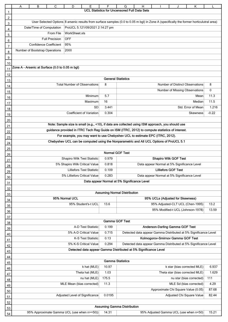
1
2
3
4
5
6
7
8
9
10
11
12
13
14
15
16
17
18
19
20
21
22
23
24
25
26
27
28
29
30
31
32
33
34
35
36
37
38
39
40
41
42
43
44
45
46
47
48
49
50
51
52
53
54
A B C D E F G H I J K L
From File WorkSheet.xls
Full Precision OFF
Confidence Coefficient 95%
UCL Statistics for Uncensored Full Data Sets
User Selected Options 8 arsenic results from surface samples (0.0 to 0.05 m bgl) in Zone A (specifically the former horticulutral area)
Date/Time of Computation ProUCL 5.121/09/2021 2:14:27 pm
General Statistics
Total Number of Observations 8 Number of Distinct Observations 8
Number of Bootstrap Operations 2000
Zone A - Arsenic at Surface (0.0 to 0.05 m bgl)
Maximum 16 Median 11.5
SD 3.441 Std. Error of Mean 1.216
Number of Missing Observations 0
Minimum 5.7 Mean 11.3
Note: Sample size is small (e.g., <10), if data are collected using ISM approach, you should use
guidance provided in ITRC Tech Reg Guide on ISM (ITRC, 2012) to compute statistics of interest.
For example, you may want to use Chebyshev UCL to estimate EPC (ITRC, 2012).
Chebyshev UCL can be computed using the Nonparametric and All UCL Options of ProUCL 5.1
Coefficient of Variation 0.304 Skewness -0.22
Lilliefors Test Statistic 0.109 Lilliefors GOF Test
5% Lilliefors Critical Value 0.283 Data appear Normal at 5% Significance Level
Normal GOF Test
Shapiro Wilk Test Statistic 0.979 Shapiro Wilk GOF Test
5% Shapiro Wilk Critical Value 0.818 Data appear Normal at 5% Significance Level
95% Student's-t UCL 13.6 95% Adjusted-CLT UCL (Chen-1995) 13.2
95% Modified-t UCL (Johnson-1978) 13.59
Data appear Normal at 5% Significance Level
Assuming Normal Distribution
95% Normal UCL 95% UCLs (Adjusted for Skewness)
5% A-D Critical Value 0.715 Detected data appear Gamma Distributed at 5% Significance Level
K-S Test Statistic 0.13 Kolmogorov-Smirnov Gamma GOF Test
Gamma GOF Test
A-D Test Statistic 0.199 Anderson-Darling Gamma GOF Test
Gamma Statistics
k hat (MLE) 10.97 k star (bias corrected MLE) 6.937
5% K-S Critical Value 0.294 Detected data appear Gamma Distributed at 5% Significance Level
Detected data appear Gamma Distributed at 5% Significance Level
MLE Mean (bias corrected) 11.3 MLE Sd (bias corrected) 4.29
Approximate Chi Square Value (0.05) 87.68
Theta hat (MLE) 1.03 Theta star (bias corrected MLE) 1.629
nu hat (MLE) 175.5 nu star (bias corrected) 111
Assuming Gamma Distribution
95% Approximate Gamma UCL (use when n>=50)) 14.31 95% Adjusted Gamma UCL (use when n<50) 15.21
Adjusted Level of Significance 0.0195 Adjusted Chi Square Value 82.44

55
56
57
58
59
60
61
62
63
64
65
66
67
68
69
70
71
72
73
74
75
76
77
78
79
80
81
82
83
84
85
86
87
88
89
90
91
92
93
A B C D E F G H I J K L
5% Shapiro Wilk Critical Value 0.818 Data appear Lognormal at 5% Significance Level
Lilliefors Test Statistic 0.148 Lilliefors Lognormal GOF Test
Lognormal GOF Test
Shapiro Wilk Test Statistic 0.945 Shapiro Wilk Lognormal GOF Test
Lognormal Statistics
Minimum of Logged Data 1.74 Mean of logged Data 2.379
5% Lilliefors Critical Value 0.283 Data appear Lognormal at 5% Significance Level
Data appear Lognormal at 5% Significance Level
Assuming Lognormal Distribution
95% H-UCL 14.95 90% Chebyshev (MVUE) UCL 15.42
Maximum of Logged Data 2.773 SD of logged Data 0.338
Nonparametric Distribution Free UCL Statistics
Data appear to follow a Discernible Distribution at 5% Significance Level
Nonparametric Distribution Free UCLs
95% Chebyshev (MVUE) UCL 17.27 97.5% Chebyshev (MVUE) UCL 19.84
99% Chebyshev (MVUE) UCL 24.89
95% Hall's Bootstrap UCL 13.38 95% Percentile Bootstrap UCL 13.06
95% BCA Bootstrap UCL 13.13
95% CLT UCL 13.3 95% Jackknife UCL 13.6
95% Standard Bootstrap UCL 13.19 95% Bootstrap-t UCL 13.61
Suggested UCL to Use
95% Student's-t UCL 13.6
90% Chebyshev(Mean, Sd) UCL 14.95 95% Chebyshev(Mean, Sd) UCL 16.6
97.5% Chebyshev(Mean, Sd) UCL 18.9 99% Chebyshev(Mean, Sd) UCL 23.4
Note: For highly negatively-skewed data, confidence limits (e.g., Chen, Johnson, Lognormal, and Gamma) may not be
reliable. Chen's and Johnson's methods provide adjustments for positvely skewed data sets.
Note: Suggestions regarding the selection of a 95% UCL are provided to help the user to select the most appropriate 95% UCL.
Recommendations are based upon data size, data distribution, and skewness.
These recommendations are based upon the results of the simulation studies summarized in Singh, Maichle, and Lee (2006).
However, simulations results will not cover all Real World data sets; for additional insight the user may want to consult a statistician.
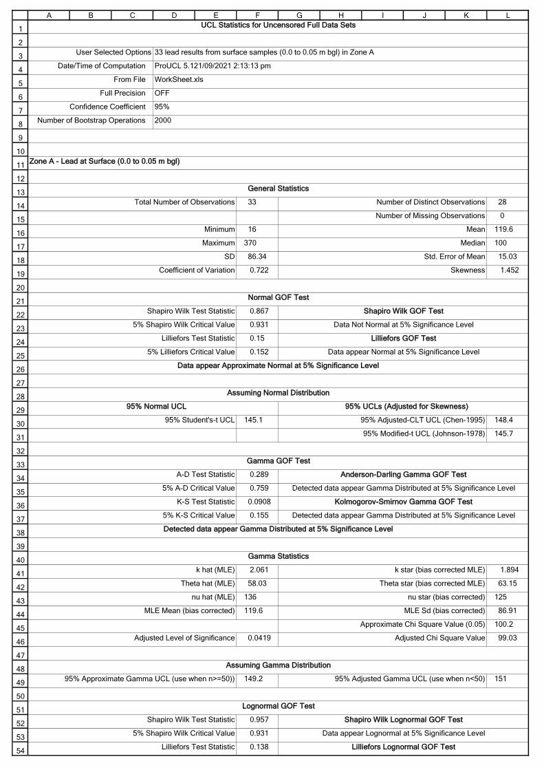
1
2
3
4
5
6
7
8
9
10
11
12
13
14
15
16
17
18
19
20
21
22
23
24
25
26
27
28
29
30
31
32
33
34
35
36
37
38
39
40
41
42
43
44
45
46
47
48
49
50
51
52
53
54
A B C D E F G H I J K L
5% Shapiro Wilk Critical Value 0.931 Data appear Lognormal at 5% Significance Level
Lilliefors Test Statistic 0.138 Lilliefors Lognormal GOF Test
Lognormal GOF Test
Shapiro Wilk Test Statistic 0.957 Shapiro Wilk Lognormal GOF Test
Assuming Gamma Distribution
95% Approximate Gamma UCL (use when n>=50)) 149.2 95% Adjusted Gamma UCL (use when n<50) 151
Adjusted Level of Significance 0.0419 Adjusted Chi Square Value 99.03
MLE Mean (bias corrected) 119.6 MLE Sd (bias corrected) 86.91
Approximate Chi Square Value (0.05) 100.2
Theta hat (MLE) 58.03 Theta star (bias corrected MLE) 63.15
nu hat (MLE) 136 nu star (bias corrected) 125
Gamma Statistics
k hat (MLE) 2.061 k star (bias corrected MLE) 1.894
5% K-S Critical Value 0.155 Detected data appear Gamma Distributed at 5% Significance Level
Detected data appear Gamma Distributed at 5% Significance Level
5% A-D Critical Value 0.759 Detected data appear Gamma Distributed at 5% Significance Level
K-S Test Statistic 0.0908 Kolmogorov-Smirnov Gamma GOF Test
Gamma GOF Test
A-D Test Statistic 0.289 Anderson-Darling Gamma GOF Test
95% Student's-t UCL 145.1 95% Adjusted-CLT UCL (Chen-1995) 148.4
95% Modified-t UCL (Johnson-1978) 145.7
Data appear Approximate Normal at 5% Significance Level
Assuming Normal Distribution
95% Normal UCL 95% UCLs (Adjusted for Skewness)
Lilliefors Test Statistic 0.15 Lilliefors GOF Test
5% Lilliefors Critical Value 0.152 Data appear Normal at 5% Significance Level
Normal GOF Test
Shapiro Wilk Test Statistic 0.867 Shapiro Wilk GOF Test
5% Shapiro Wilk Critical Value 0.931 Data Not Normal at 5% Significance Level
Coefficient of Variation 0.722 Skewness 1.452
Maximum 370 Median 100
SD 86.34 Std. Error of Mean 15.03
Number of Missing Observations 0
Minimum 16 Mean 119.6
General Statistics
Total Number of Observations 33 Number of Distinct Observations 28
Number of Bootstrap Operations 2000
Zone A - Lead at Surface (0.0 to 0.05 m bgl)
From File WorkSheet.xls
Full Precision OFF
Confidence Coefficient 95%
UCL Statistics for Uncensored Full Data Sets
User Selected Options 33 lead results from surface samples (0.0 to 0.05 m bgl) in Zone A
Date/Time of Computation ProUCL 5.121/09/2021 2:13:13 pm

55
56
57
58
59
60
61
62
63
64
65
66
67
68
69
70
71
72
73
74
75
76
77
78
79
80
81
82
83
84
85
86
87
88
A B C D E F G H I J K L
Recommendations are based upon data size, data distribution, and skewness.
These recommendations are based upon the results of the simulation studies summarized in Singh, Maichle, and Lee (2006).
However, simulations results will not cover all Real World data sets; for additional insight the user may want to consult a statistician.
When a data set follows an approximate (e.g., normal) distribution passing one of the GOF test
When applicable, it is suggested to use a UCL based upon a distribution (e.g., gamma) passing both GOF tests in ProUCL
Note: Suggestions regarding the selection of a 95% UCL are provided to help the user to select the most appropriate 95% UCL.
Suggested UCL to Use
95% Student's-t UCL 145.1
90% Chebyshev(Mean, Sd) UCL 164.7 95% Chebyshev(Mean, Sd) UCL 185.1
97.5% Chebyshev(Mean, Sd) UCL 213.5 99% Chebyshev(Mean, Sd) UCL 269.2
95% Hall's Bootstrap UCL 155.7 95% Percentile Bootstrap UCL 144.2
95% BCA Bootstrap UCL 147.8
95% CLT UCL 144.3 95% Jackknife UCL 145.1
95% Standard Bootstrap UCL 144.4 95% Bootstrap-t UCL 149.3
Nonparametric Distribution Free UCL Statistics
Data appear to follow a Discernible Distribution at 5% Significance Level
Nonparametric Distribution Free UCLs
95% Chebyshev (MVUE) UCL 204.6 97.5% Chebyshev (MVUE) UCL 239.6
99% Chebyshev (MVUE) UCL 308.4
Assuming Lognormal Distribution
95% H-UCL 169.5 90% Chebyshev (MVUE) UCL 179.3
Maximum of Logged Data 5.914 SD of logged Data 0.783
Lognormal Statistics
Minimum of Logged Data 2.773 Mean of logged Data 4.522
5% Lilliefors Critical Value 0.152 Data appear Lognormal at 5% Significance Level
Data appear Lognormal at 5% Significance Level

1
2
3
4
5
6
7
8
9
10
11
12
13
14
15
16
17
18
19
20
21
22
23
24
25
26
27
28
29
30
31
32
33
34
35
36
37
38
39
40
41
42
43
44
45
46
47
48
49
50
51
52
53
54
A B C D E F G H I J K L
Assuming Gamma Distribution
95% Approximate Gamma UCL (use when n>=50)) 123.7 95% Adjusted Gamma UCL (use when n<50) 137.6
Adjusted Level of Significance 0.0195 Adjusted Chi Square Value 24.9
MLE Mean (bias corrected) 82.63 MLE Sd (bias corrected) 51.32
Approximate Chi Square Value (0.05) 27.71
Theta hat (MLE) 20.58 Theta star (bias corrected MLE) 31.87
nu hat (MLE) 64.23 nu star (bias corrected) 41.48
Gamma Statistics
k hat (MLE) 4.014 k star (bias corrected MLE) 2.592
5% K-S Critical Value 0.295 Data Not Gamma Distributed at 5% Significance Level
Data Not Gamma Distributed at 5% Significance Level
5% A-D Critical Value 0.719 Data Not Gamma Distributed at 5% Significance Level
K-S Test Statistic 0.376 Kolmogorov-Smirnov Gamma GOF Test
Gamma GOF Test
A-D Test Statistic 1.079 Anderson-Darling Gamma GOF Test
95% Student's-t UCL 104.2 95% Adjusted-CLT UCL (Chen-1995) 96.51
95% Modified-t UCL (Johnson-1978) 103.4
Data appear Approximate Normal at 5% Significance Level
Assuming Normal Distribution
95% Normal UCL 95% UCLs (Adjusted for Skewness)
Lilliefors Test Statistic 0.294 Lilliefors GOF Test
5% Lilliefors Critical Value 0.283 Data Not Normal at 5% Significance Level
Normal GOF Test
Shapiro Wilk Test Statistic 0.868 Shapiro Wilk GOF Test
5% Shapiro Wilk Critical Value 0.818 Data appear Normal at 5% Significance Level
Note: Sample size is small (e.g., <10), if data are collected using ISM approach, you should use
guidance provided in ITRC Tech Reg Guide on ISM (ITRC, 2012) to compute statistics of interest.
For example, you may want to use Chebyshev UCL to estimate EPC (ITRC, 2012).
Chebyshev UCL can be computed using the Nonparametric and All UCL Options of ProUCL 5.1
Coefficient of Variation 0.39 Skewness -1.126
Maximum 130 Median 85.5
SD 32.2 Std. Error of Mean 11.39
Number of Missing Observations 0
Minimum 15 Mean 82.63
General Statistics
Total Number of Observations 8 Number of Distinct Observations 8
Number of Bootstrap Operations 2000
Zone A - Nickel at Surface (0.0 to 0.05 m bgl)
From File WorkSheet.xls
Full Precision OFF
Confidence Coefficient 95%
UCL Statistics for Uncensored Full Data Sets
User Selected Options 8 nickel results from surface samples (0.0 to 0.05 m bgl) in Zone A (specifically the former horticulutral area)
Date/Time of Computation ProUCL 5.120/09/2021 12:39:51 am

55
56
57
58
59
60
61
62
63
64
65
66
67
68
69
70
71
72
73
74
75
76
77
78
79
80
81
82
83
84
85
86
87
88
89
90
91
92
93
94
95
96
A B C D E F G H I J K L
reliable. Chen's and Johnson's methods provide adjustments for positvely skewed data sets.
Recommendations are based upon data size, data distribution, and skewness.
These recommendations are based upon the results of the simulation studies summarized in Singh, Maichle, and Lee (2006).
However, simulations results will not cover all Real World data sets; for additional insight the user may want to consult a statistician.
Note: For highly negatively-skewed data, confidence limits (e.g., Chen, Johnson, Lognormal, and Gamma) may not be
When a data set follows an approximate (e.g., normal) distribution passing one of the GOF test
When applicable, it is suggested to use a UCL based upon a distribution (e.g., gamma) passing both GOF tests in ProUCL
Note: Suggestions regarding the selection of a 95% UCL are provided to help the user to select the most appropriate 95% UCL.
Suggested UCL to Use
95% Student's-t UCL 104.2
90% Chebyshev(Mean, Sd) UCL 116.8 95% Chebyshev(Mean, Sd) UCL 132.3
97.5% Chebyshev(Mean, Sd) UCL 153.7 99% Chebyshev(Mean, Sd) UCL 195.9
95% Hall's Bootstrap UCL 99.16 95% Percentile Bootstrap UCL 98.75
95% BCA Bootstrap UCL 96.63
95% CLT UCL 101.4 95% Jackknife UCL 104.2
95% Standard Bootstrap UCL 100.4 95% Bootstrap-t UCL 99.05
Nonparametric Distribution Free UCL Statistics
Data appear to follow a Discernible Distribution at 5% Significance Level
Nonparametric Distribution Free UCLs
95% Chebyshev (MVUE) UCL 177.5 97.5% Chebyshev (MVUE) UCL 216.5
99% Chebyshev (MVUE) UCL 293.1
Assuming Lognormal Distribution
95% H-UCL 174.4 90% Chebyshev (MVUE) UCL 149.4
Maximum of Logged Data 4.868 SD of logged Data 0.659
Lognormal Statistics
Minimum of Logged Data 2.708 Mean of logged Data 4.285
5% Lilliefors Critical Value 0.283 Data Not Lognormal at 5% Significance Level
Data Not Lognormal at 5% Significance Level
5% Shapiro Wilk Critical Value 0.818 Data Not Lognormal at 5% Significance Level
Lilliefors Test Statistic 0.403 Lilliefors Lognormal GOF Test
Lognormal GOF Test
Shapiro Wilk Test Statistic 0.663 Shapiro Wilk Lognormal GOF Test

1
2
3
4
5
6
7
8
9
10
11
12
13
14
15
16
17
18
19
20
21
22
23
24
25
26
27
28
29
30
31
32
33
34
35
36
37
38
39
40
41
42
43
44
45
46
47
48
49
50
51
52
53
54
A B C D E F G H I J K L
From File WorkSheet.xls
Full Precision OFF
Confidence Coefficient 95%
UCL Statistics for Uncensored Full Data Sets
User Selected Options 10 nickel results from natural soils (≥0.5 m bgl) across the site
Date/Time of Computation ProUCL 5.120/09/2021 10:01:00 am
General Statistics
Total Number of Observations 10 Number of Distinct Observations 9
Number of Bootstrap Operations 2000
Nickel - Natural Ground
Maximum 111 Median 51.5
SD 33.54 Std. Error of Mean 10.61
Number of Missing Observations 0
Minimum 8 Mean 58
Normal GOF Test
Shapiro Wilk Test Statistic 0.94 Shapiro Wilk GOF Test
5% Shapiro Wilk Critical Value 0.842 Data appear Normal at 5% Significance Level
Coefficient of Variation 0.578 Skewness 0.396
Data appear Normal at 5% Significance Level
Assuming Normal Distribution
95% Normal UCL 95% UCLs (Adjusted for Skewness)
Lilliefors Test Statistic 0.171 Lilliefors GOF Test
5% Lilliefors Critical Value 0.262 Data appear Normal at 5% Significance Level
Gamma GOF Test
A-D Test Statistic 0.308 Anderson-Darling Gamma GOF Test
95% Student's-t UCL 77.44 95% Adjusted-CLT UCL (Chen-1995) 76.86
95% Modified-t UCL (Johnson-1978) 77.66
5% K-S Critical Value 0.269 Detected data appear Gamma Distributed at 5% Significance Level
Detected data appear Gamma Distributed at 5% Significance Level
5% A-D Critical Value 0.734 Detected data appear Gamma Distributed at 5% Significance Level
K-S Test Statistic 0.205 Kolmogorov-Smirnov Gamma GOF Test
Theta hat (MLE) 22.95 Theta star (bias corrected MLE) 31.6
nu hat (MLE) 50.54 nu star (bias corrected) 36.71
Gamma Statistics
k hat (MLE) 2.527 k star (bias corrected MLE) 1.836
Adjusted Level of Significance 0.0267 Adjusted Chi Square Value 22.06
MLE Mean (bias corrected) 58 MLE Sd (bias corrected) 42.81
Approximate Chi Square Value (0.05) 23.84
Lognormal GOF Test
Shapiro Wilk Test Statistic 0.887 Shapiro Wilk Lognormal GOF Test
Assuming Gamma Distribution
95% Approximate Gamma UCL (use when n>=50)) 89.31 95% Adjusted Gamma UCL (use when n<50) 96.55
5% Shapiro Wilk Critical Value 0.842 Data appear Lognormal at 5% Significance Level
Lilliefors Test Statistic 0.242 Lilliefors Lognormal GOF Test

55
56
57
58
59
60
61
62
63
64
65
66
67
68
69
70
71
72
73
74
75
76
77
78
79
80
81
82
83
84
85
A B C D E F G H I J K L
5% Lilliefors Critical Value 0.262 Data appear Lognormal at 5% Significance Level
Data appear Lognormal at 5% Significance Level
Maximum of Logged Data 4.71 SD of logged Data 0.779
Lognormal Statistics
Minimum of Logged Data 2.079 Mean of logged Data 3.85
95% Chebyshev (MVUE) UCL 129.5 97.5% Chebyshev (MVUE) UCL 159.1
99% Chebyshev (MVUE) UCL 217
Assuming Lognormal Distribution
95% H-UCL 127.3 90% Chebyshev (MVUE) UCL 108.3
95% CLT UCL 75.44 95% Jackknife UCL 77.44
95% Standard Bootstrap UCL 74.24 95% Bootstrap-t UCL 81.9
Nonparametric Distribution Free UCL Statistics
Data appear to follow a Discernible Distribution at 5% Significance Level
Nonparametric Distribution Free UCLs
90% Chebyshev(Mean, Sd) UCL 89.82 95% Chebyshev(Mean, Sd) UCL 104.2
97.5% Chebyshev(Mean, Sd) UCL 124.2 99% Chebyshev(Mean, Sd) UCL 163.5
95% Hall's Bootstrap UCL 82.71 95% Percentile Bootstrap UCL 75.5
95% BCA Bootstrap UCL 74
Note: Suggestions regarding the selection of a 95% UCL are provided to help the user to select the most appropriate 95% UCL.
Recommendations are based upon data size, data distribution, and skewness.
These recommendations are based upon the results of the simulation studies summarized in Singh, Maichle, and Lee (2006).
However, simulations results will not cover all Real World data sets; for additional insight the user may want to consult a statistician.
Suggested UCL to Use
95% Student's-t UCL 77.44

224 Great South Road, Greenlane, Auckland
Ōmāhu | Combined Preliminary and Detailed Site Investigation
Final - Approved for Issue
APPENDIX D
HISTORICAL AERIAL PHOTOGRAPHY REVIEW

Summary of Aerial Photography
Date Source
Site
Within 500m off site 224 Great South Road 49-51 Omahu Road 53 Omahu Road 53A Omahu Road
1931 Planning
Map
The property contains 5 titles. Northern
half of property is listed as ''Nursery''
(horticulture), the south west of the
property is developed with three dwellings
bordering Great South Road. The three
dwellings are noted as wood-built.
The property
contains two titles,
each with a wood-
built property.
The property
contains a one
story residence,
made of wood.
Forms part of other
properties (not
subdivided yet).
Great South Road and Omahu Road
are formed. The trainline borders the
north east of the site. Remuera
Station is present to the north west of
the site. To the north east, Remuera
Tennis Courts, a hockey ground and
private residences are present.
1940 (April) Retrolens The three dwellings have small sheds and
designated gardens, separated with
hedges. Two large and one small shed are
located on the north of the property. The
north of the property appears to be
grassed paddock.
Developed with two
dwellings. The north
west of the property
has a grassed lawn
and shed/container/
lean-to present.
Developed with
one dwelling,
small shed and
gardens.
The property is
undeveloped and forms
the garden of other
properties. It contains
trees and grass.
To the south west of the site, there
are mixed commercial and residential
properties.
1955, 1957,
1958, 1959,
1961
Retrolens
and Auckland
Council
GeoMaps
The entire north of the property contains
horticultural land use. The centre of the
property has some minor storage of items.
Greenhouses or similar have been added
to the north east of the large sheds.
Dwellings remain to the south west.
No major changes
visible.
The shed has been
added to.
No major changes
visible.
No major changes visible.
1967
(December)
Retrolens Horticulture and shed remain on the north
of the property. The middle dwelling has
been extended.
No major changes
visible.
No major changes
visible.
The property has been
created as a title and is
developed with a LFT
building in the centre of
the site. A shed/carport
has also been built.
The Southern motorway has been
built to the north east of the site,
beyond the railway line, this has taken
land from the north. A new overpass
has been built on Omahu Road.
1972, 1977,
1979
Retrolens The property has been developed as the
LFT. It contains numerous buildings/units.
In 1977 another
building has been
added at the site.
The shed/garage
has been extended
at the property.
No major changes
visible.
No major changes visible.
1996 Auckland
Council
GeoMaps
Two of the original dwellings have been
removed and the LFT Head office building
has been added to the south west of the
property.
No major changes
visible.
No major changes
visible.
No major changes
visible.
No major changes visible.
2001 Auckland
Council
GeoMaps
The final original dwelling at the site has
been removed and a carpark built.
Two additional
buildings have been
added to the site.
No major changes
visible.
No major changes
visible.
No major changes visible.
2003/2004, 2005, 2006, 2007, 2008, 2009, 2010-2011, 2012, 2013, 2014, 2015, 2016, 2017, 2018, 2019 (Auckland Council GeoMaps and Google Earth Pro) - No major changes visible.
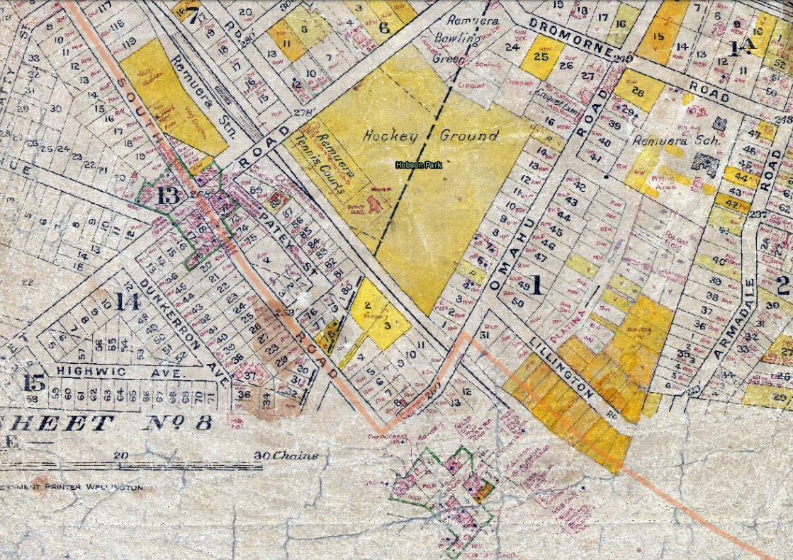

OMAHU APARTMENT
DEVELOPMENT
HISTORIC AERIALS1940 - RETROLENS
1:1500
J3217 100 0
URBAN RESORT
75m 100m
A3 SCALE = 1 : 1500
50m0m 10m
LEGEND
THIS DRAWING AND DESIGN REMAINS THE PROPERTY OF, AND MAY NOT BEREPRODUCED OR ALTERED WITHOUT THE WRITTEN PERMISSION OF, GWECONSULTING LTD. NO LIABILITY SHALL BE ACCEPTED FOR UNAUTHORISED
USE OF THIS DRAWING. DO NOT SCALE FROM THIS DRAWING.
Plot D
ate : 1
0:35 a
m, 03
Aug 2
021
GWE CONSULTING ENGINEERSGRD FLOOR OCEANBRIDGE HOUSE
25 ANZAC STREET TAKAPUNAAUCKLAND 0622P:+64 9 445 8338www.gwe.co.nz
Filen
ame :
W:\A
ctive
Proje
cts\C
OM\O
mahu
Apart
ment
Deve
lopme
nt-J2
852\
08-D
rawing
s\01-C
AD\0
1-DW
G\Hi
storic
Aeria
ls.dw
g
PROJECT:
TITLE:
SCALE:
PROJECT No: REV
A3
CLIENT NAME:
DRAWING No:
PLOT STATUS:
SITE BOUNDARY (APPROX.)
1940 - RETROLENSNOTES:
1. IMAGE SOURCED FROMRETROLENS HISTORICAL IMAGERESOURCE.
2. SITE BOUNDARIES AREAPPROXIMATE.
3. DO NOT SCALE FROM THISDRAWING.

OMAHU APARTMENT
DEVELOPMENT
HISTORIC AERIALS1955 - RETROLENS
1:1500
J3217 100 0
URBAN RESORT
75m 100m
A3 SCALE = 1 : 1500
50m0m 10m
LEGEND
THIS DRAWING AND DESIGN REMAINS THE PROPERTY OF, AND MAY NOT BEREPRODUCED OR ALTERED WITHOUT THE WRITTEN PERMISSION OF, GWECONSULTING LTD. NO LIABILITY SHALL BE ACCEPTED FOR UNAUTHORISED
USE OF THIS DRAWING. DO NOT SCALE FROM THIS DRAWING.
Plot D
ate : 1
0:35 a
m, 03
Aug 2
021
GWE CONSULTING ENGINEERSGRD FLOOR OCEANBRIDGE HOUSE
25 ANZAC STREET TAKAPUNAAUCKLAND 0622P:+64 9 445 8338www.gwe.co.nz
Filen
ame :
W:\A
ctive
Proje
cts\C
OM\O
mahu
Apart
ment
Deve
lopme
nt-J2
852\
08-D
rawing
s\01-C
AD\0
1-DW
G\Hi
storic
Aeria
ls.dw
g
PROJECT:
TITLE:
SCALE:
PROJECT No: REV
A3
CLIENT NAME:
DRAWING No:
PLOT STATUS:
SITE BOUNDARY (APPROX.)
1955 - RETROLENSNOTES:
1. IMAGE SOURCED FROMRETROLENS HISTORICAL IMAGERESOURCE.
2. SITE BOUNDARIES AREAPPROXIMATE.
3. DO NOT SCALE FROM THISDRAWING.

OMAHU APARTMENT
DEVELOPMENT
HISTORIC AERIALS1957 - RETROLENS
1:1500
J3217 100 0
URBAN RESORT
75m 100m
A3 SCALE = 1 : 1500
50m0m 10m
LEGEND
THIS DRAWING AND DESIGN REMAINS THE PROPERTY OF, AND MAY NOT BEREPRODUCED OR ALTERED WITHOUT THE WRITTEN PERMISSION OF, GWECONSULTING LTD. NO LIABILITY SHALL BE ACCEPTED FOR UNAUTHORISED
USE OF THIS DRAWING. DO NOT SCALE FROM THIS DRAWING.
Plot D
ate : 1
0:35 a
m, 03
Aug 2
021
GWE CONSULTING ENGINEERSGRD FLOOR OCEANBRIDGE HOUSE
25 ANZAC STREET TAKAPUNAAUCKLAND 0622P:+64 9 445 8338www.gwe.co.nz
Filen
ame :
W:\A
ctive
Proje
cts\C
OM\O
mahu
Apart
ment
Deve
lopme
nt-J2
852\
08-D
rawing
s\01-C
AD\0
1-DW
G\Hi
storic
Aeria
ls.dw
g
PROJECT:
TITLE:
SCALE:
PROJECT No: REV
A3
CLIENT NAME:
DRAWING No:
PLOT STATUS:
SITE BOUNDARY (APPROX.)
1957 - RETROLENSNOTES:
1. IMAGE SOURCED FROMRETROLENS HISTORICAL IMAGERESOURCE.
2. SITE BOUNDARIES AREAPPROXIMATE.
3. DO NOT SCALE FROM THISDRAWING.

OMAHU APARTMENT
DEVELOPMENT
HISTORIC AERIALS1958 - RETROLENS
1:1500
J3217 100 0
URBAN RESORT
75m 100m
A3 SCALE = 1 : 1500
50m0m 10m
LEGEND
THIS DRAWING AND DESIGN REMAINS THE PROPERTY OF, AND MAY NOT BEREPRODUCED OR ALTERED WITHOUT THE WRITTEN PERMISSION OF, GWECONSULTING LTD. NO LIABILITY SHALL BE ACCEPTED FOR UNAUTHORISED
USE OF THIS DRAWING. DO NOT SCALE FROM THIS DRAWING.
Plot D
ate : 1
0:35 a
m, 03
Aug 2
021
GWE CONSULTING ENGINEERSGRD FLOOR OCEANBRIDGE HOUSE
25 ANZAC STREET TAKAPUNAAUCKLAND 0622P:+64 9 445 8338www.gwe.co.nz
Filen
ame :
W:\A
ctive
Proje
cts\C
OM\O
mahu
Apart
ment
Deve
lopme
nt-J2
852\
08-D
rawing
s\01-C
AD\0
1-DW
G\Hi
storic
Aeria
ls.dw
g
PROJECT:
TITLE:
SCALE:
PROJECT No: REV
A3
CLIENT NAME:
DRAWING No:
PLOT STATUS:
SITE BOUNDARY (APPROX.)
1958 - RETROLENSNOTES:
1. IMAGE SOURCED FROMRETROLENS HISTORICAL IMAGERESOURCE.
2. SITE BOUNDARIES AREAPPROXIMATE.
3. DO NOT SCALE FROM THISDRAWING.

OMAHU APARTMENT
DEVELOPMENT
HISTORIC AERIALS1959 - AUCKLAND COUNCILGEOMAPS
1:1500
J3217 100 0
URBAN RESORT
75m 100m
A3 SCALE = 1 : 1500
50m0m 10m
LEGEND
THIS DRAWING AND DESIGN REMAINS THE PROPERTY OF, AND MAY NOT BEREPRODUCED OR ALTERED WITHOUT THE WRITTEN PERMISSION OF, GWECONSULTING LTD. NO LIABILITY SHALL BE ACCEPTED FOR UNAUTHORISED
USE OF THIS DRAWING. DO NOT SCALE FROM THIS DRAWING.
Plot D
ate : 1
0:35 a
m, 03
Aug 2
021
GWE CONSULTING ENGINEERSGRD FLOOR OCEANBRIDGE HOUSE
25 ANZAC STREET TAKAPUNAAUCKLAND 0622P:+64 9 445 8338www.gwe.co.nz
Filen
ame :
W:\A
ctive
Proje
cts\C
OM\O
mahu
Apart
ment
Deve
lopme
nt-J2
852\
08-D
rawing
s\01-C
AD\0
1-DW
G\Hi
storic
Aeria
ls.dw
g
PROJECT:
TITLE:
SCALE:
PROJECT No: REV
A3
CLIENT NAME:
DRAWING No:
PLOT STATUS:
SITE BOUNDARY (APPROX.)
1959 - AUCKLANDCOUNCIL GEOMAPS
NOTES:1. IMAGE SOURCED FROM
AUCKLAND COUNCIL GEOMAPS.2. SITE BOUNDARIES ARE
APPROXIMATE.3. DO NOT SCALE FROM THIS
DRAWING.

OMAHU APARTMENT
DEVELOPMENT
HISTORIC AERIALS1961 - RETROLENS
1:1500
J3217 100 0
URBAN RESORT
75m 100m
A3 SCALE = 1 : 1500
50m0m 10m
LEGEND
THIS DRAWING AND DESIGN REMAINS THE PROPERTY OF, AND MAY NOT BEREPRODUCED OR ALTERED WITHOUT THE WRITTEN PERMISSION OF, GWECONSULTING LTD. NO LIABILITY SHALL BE ACCEPTED FOR UNAUTHORISED
USE OF THIS DRAWING. DO NOT SCALE FROM THIS DRAWING.
Plot D
ate : 1
0:35 a
m, 03
Aug 2
021
GWE CONSULTING ENGINEERSGRD FLOOR OCEANBRIDGE HOUSE
25 ANZAC STREET TAKAPUNAAUCKLAND 0622P:+64 9 445 8338www.gwe.co.nz
Filen
ame :
W:\A
ctive
Proje
cts\C
OM\O
mahu
Apart
ment
Deve
lopme
nt-J2
852\
08-D
rawing
s\01-C
AD\0
1-DW
G\Hi
storic
Aeria
ls.dw
g
PROJECT:
TITLE:
SCALE:
PROJECT No: REV
A3
CLIENT NAME:
DRAWING No:
PLOT STATUS:
SITE BOUNDARY (APPROX.)
1961 - RETROLENSNOTES:
1. IMAGE SOURCED FROMRETROLENS HISTORICAL IMAGERESOURCE.
2. SITE BOUNDARIES AREAPPROXIMATE.
3. DO NOT SCALE FROM THISDRAWING.

OMAHU APARTMENT
DEVELOPMENT
HISTORIC AERIALS1967 - RETROLENS
1:1500
J3217 100 0
URBAN RESORT
75m 100m
A3 SCALE = 1 : 1500
50m0m 10m
LEGEND
THIS DRAWING AND DESIGN REMAINS THE PROPERTY OF, AND MAY NOT BEREPRODUCED OR ALTERED WITHOUT THE WRITTEN PERMISSION OF, GWECONSULTING LTD. NO LIABILITY SHALL BE ACCEPTED FOR UNAUTHORISED
USE OF THIS DRAWING. DO NOT SCALE FROM THIS DRAWING.
Plot D
ate : 1
0:36 a
m, 03
Aug 2
021
GWE CONSULTING ENGINEERSGRD FLOOR OCEANBRIDGE HOUSE
25 ANZAC STREET TAKAPUNAAUCKLAND 0622P:+64 9 445 8338www.gwe.co.nz
Filen
ame :
W:\A
ctive
Proje
cts\C
OM\O
mahu
Apart
ment
Deve
lopme
nt-J2
852\
08-D
rawing
s\01-C
AD\0
1-DW
G\Hi
storic
Aeria
ls.dw
g
PROJECT:
TITLE:
SCALE:
PROJECT No: REV
A3
CLIENT NAME:
DRAWING No:
PLOT STATUS:
SITE BOUNDARY (APPROX.)
1967 - RETROLENSNOTES:
1. IMAGE SOURCED FROMRETROLENS HISTORICAL IMAGERESOURCE.
2. SITE BOUNDARIES AREAPPROXIMATE.
3. DO NOT SCALE FROM THISDRAWING.

OMAHU APARTMENT
DEVELOPMENT
HISTORIC AERIALS1972 - RETROLENS
1:1500
J3217 100 0
URBAN RESORT
75m 100m
A3 SCALE = 1 : 1500
50m0m 10m
LEGEND
THIS DRAWING AND DESIGN REMAINS THE PROPERTY OF, AND MAY NOT BEREPRODUCED OR ALTERED WITHOUT THE WRITTEN PERMISSION OF, GWECONSULTING LTD. NO LIABILITY SHALL BE ACCEPTED FOR UNAUTHORISED
USE OF THIS DRAWING. DO NOT SCALE FROM THIS DRAWING.
Plot D
ate : 1
0:36 a
m, 03
Aug 2
021
GWE CONSULTING ENGINEERSGRD FLOOR OCEANBRIDGE HOUSE
25 ANZAC STREET TAKAPUNAAUCKLAND 0622P:+64 9 445 8338www.gwe.co.nz
Filen
ame :
W:\A
ctive
Proje
cts\C
OM\O
mahu
Apart
ment
Deve
lopme
nt-J2
852\
08-D
rawing
s\01-C
AD\0
1-DW
G\Hi
storic
Aeria
ls.dw
g
PROJECT:
TITLE:
SCALE:
PROJECT No: REV
A3
CLIENT NAME:
DRAWING No:
PLOT STATUS:
SITE BOUNDARY (APPROX.)
1972 - RETROLENSNOTES:
1. IMAGE SOURCED FROMRETROLENS HISTORICAL IMAGERESOURCE.
2. SITE BOUNDARIES AREAPPROXIMATE.
3. DO NOT SCALE FROM THISDRAWING.

OMAHU APARTMENT
DEVELOPMENT
HISTORIC AERIALS1977 - RETROLENS
1:1500
J3217 100 0
URBAN RESORT
75m 100m
A3 SCALE = 1 : 1500
50m0m 10m
LEGEND
THIS DRAWING AND DESIGN REMAINS THE PROPERTY OF, AND MAY NOT BEREPRODUCED OR ALTERED WITHOUT THE WRITTEN PERMISSION OF, GWECONSULTING LTD. NO LIABILITY SHALL BE ACCEPTED FOR UNAUTHORISED
USE OF THIS DRAWING. DO NOT SCALE FROM THIS DRAWING.
Plot D
ate : 1
0:36 a
m, 03
Aug 2
021
GWE CONSULTING ENGINEERSGRD FLOOR OCEANBRIDGE HOUSE
25 ANZAC STREET TAKAPUNAAUCKLAND 0622P:+64 9 445 8338www.gwe.co.nz
Filen
ame :
W:\A
ctive
Proje
cts\C
OM\O
mahu
Apart
ment
Deve
lopme
nt-J2
852\
08-D
rawing
s\01-C
AD\0
1-DW
G\Hi
storic
Aeria
ls.dw
g
PROJECT:
TITLE:
SCALE:
PROJECT No: REV
A3
CLIENT NAME:
DRAWING No:
PLOT STATUS:
SITE BOUNDARY (APPROX.)
1977 - RETROLENSNOTES:
1. IMAGE SOURCED FROMRETROLENS HISTORICAL IMAGERESOURCE.
2. SITE BOUNDARIES AREAPPROXIMATE.
3. DO NOT SCALE FROM THISDRAWING.

OMAHU APARTMENT
DEVELOPMENT
HISTORIC AERIALS1979 - RETROLENS
1:1500
J3217 100 0
URBAN RESORT
75m 100m
A3 SCALE = 1 : 1500
50m0m 10m
LEGEND
THIS DRAWING AND DESIGN REMAINS THE PROPERTY OF, AND MAY NOT BEREPRODUCED OR ALTERED WITHOUT THE WRITTEN PERMISSION OF, GWECONSULTING LTD. NO LIABILITY SHALL BE ACCEPTED FOR UNAUTHORISED
USE OF THIS DRAWING. DO NOT SCALE FROM THIS DRAWING.
Plot D
ate : 1
0:36 a
m, 03
Aug 2
021
GWE CONSULTING ENGINEERSGRD FLOOR OCEANBRIDGE HOUSE
25 ANZAC STREET TAKAPUNAAUCKLAND 0622P:+64 9 445 8338www.gwe.co.nz
Filen
ame :
W:\A
ctive
Proje
cts\C
OM\O
mahu
Apart
ment
Deve
lopme
nt-J2
852\
08-D
rawing
s\01-C
AD\0
1-DW
G\Hi
storic
Aeria
ls.dw
g
PROJECT:
TITLE:
SCALE:
PROJECT No: REV
A3
CLIENT NAME:
DRAWING No:
PLOT STATUS:
SITE BOUNDARY (APPROX.)
1979 - RETROLENSNOTES:
1. IMAGE SOURCED FROMRETROLENS HISTORICAL IMAGERESOURCE.
2. SITE BOUNDARIES AREAPPROXIMATE.
3. DO NOT SCALE FROM THISDRAWING.

OMAHU APARTMENT
DEVELOPMENT
HISTORIC AERIALS1996 - AUCKLAND COUNCILGEOMAPS
1:1500
J3217 100 0
URBAN RESORT
75m 100m
A3 SCALE = 1 : 1500
50m0m 10m
LEGEND
THIS DRAWING AND DESIGN REMAINS THE PROPERTY OF, AND MAY NOT BEREPRODUCED OR ALTERED WITHOUT THE WRITTEN PERMISSION OF, GWECONSULTING LTD. NO LIABILITY SHALL BE ACCEPTED FOR UNAUTHORISED
USE OF THIS DRAWING. DO NOT SCALE FROM THIS DRAWING.
Plot D
ate : 1
0:36 a
m, 03
Aug 2
021
GWE CONSULTING ENGINEERSGRD FLOOR OCEANBRIDGE HOUSE
25 ANZAC STREET TAKAPUNAAUCKLAND 0622P:+64 9 445 8338www.gwe.co.nz
Filen
ame :
W:\A
ctive
Proje
cts\C
OM\O
mahu
Apart
ment
Deve
lopme
nt-J2
852\
08-D
rawing
s\01-C
AD\0
1-DW
G\Hi
storic
Aeria
ls.dw
g
PROJECT:
TITLE:
SCALE:
PROJECT No: REV
A3
CLIENT NAME:
DRAWING No:
PLOT STATUS:
SITE BOUNDARY (APPROX.)
1996 - AUCKLANDCOUNCIL GEOMAPS
NOTES:1. IMAGE SOURCED FROM
AUCKLAND COUNCIL GEOMAPS.2. SITE BOUNDARIES ARE
APPROXIMATE.3. DO NOT SCALE FROM THIS
DRAWING.

OMAHU APARTMENT
DEVELOPMENT
HISTORIC AERIALS2001 - AUCKLAND COUNCILGEOMAPS
1:1500
J3217 100 0
URBAN RESORT
75m 100m
A3 SCALE = 1 : 1500
50m0m 10m
LEGEND
THIS DRAWING AND DESIGN REMAINS THE PROPERTY OF, AND MAY NOT BEREPRODUCED OR ALTERED WITHOUT THE WRITTEN PERMISSION OF, GWECONSULTING LTD. NO LIABILITY SHALL BE ACCEPTED FOR UNAUTHORISED
USE OF THIS DRAWING. DO NOT SCALE FROM THIS DRAWING.
Plot D
ate : 1
0:36 a
m, 03
Aug 2
021
GWE CONSULTING ENGINEERSGRD FLOOR OCEANBRIDGE HOUSE
25 ANZAC STREET TAKAPUNAAUCKLAND 0622P:+64 9 445 8338www.gwe.co.nz
Filen
ame :
W:\A
ctive
Proje
cts\C
OM\O
mahu
Apart
ment
Deve
lopme
nt-J2
852\
08-D
rawing
s\01-C
AD\0
1-DW
G\Hi
storic
Aeria
ls.dw
g
PROJECT:
TITLE:
SCALE:
PROJECT No: REV
A3
CLIENT NAME:
DRAWING No:
PLOT STATUS:
SITE BOUNDARY (APPROX.)
2001 - AUCKLANDCOUNCIL GEOMAPS
NOTES:1. IMAGE SOURCED FROM
AUCKLAND COUNCIL GEOMAPS.2. SITE BOUNDARIES ARE
APPROXIMATE.3. DO NOT SCALE FROM THIS
DRAWING.

OMAHU APARTMENT
DEVELOPMENT
HISTORIC AERIALS2003 - 2004 - AUCKLANDCOUNCIL GEOMAPS
1:1500
J3217 100 0
URBAN RESORT
75m 100m
A3 SCALE = 1 : 1500
50m0m 10m
LEGEND
THIS DRAWING AND DESIGN REMAINS THE PROPERTY OF, AND MAY NOT BEREPRODUCED OR ALTERED WITHOUT THE WRITTEN PERMISSION OF, GWECONSULTING LTD. NO LIABILITY SHALL BE ACCEPTED FOR UNAUTHORISED
USE OF THIS DRAWING. DO NOT SCALE FROM THIS DRAWING.
Plot D
ate : 1
0:36 a
m, 03
Aug 2
021
GWE CONSULTING ENGINEERSGRD FLOOR OCEANBRIDGE HOUSE
25 ANZAC STREET TAKAPUNAAUCKLAND 0622P:+64 9 445 8338www.gwe.co.nz
Filen
ame :
W:\A
ctive
Proje
cts\C
OM\O
mahu
Apart
ment
Deve
lopme
nt-J2
852\
08-D
rawing
s\01-C
AD\0
1-DW
G\Hi
storic
Aeria
ls.dw
g
PROJECT:
TITLE:
SCALE:
PROJECT No: REV
A3
CLIENT NAME:
DRAWING No:
PLOT STATUS:
SITE BOUNDARY (APPROX.)
2003 - 2004 -AUCKLAND COUNCIL
GEOMAPSNOTES:
1. IMAGE SOURCED FROMAUCKLAND COUNCIL GEOMAPS.
2. SITE BOUNDARIES AREAPPROXIMATE.
3. DO NOT SCALE FROM THISDRAWING.
OMAHU APARTMENT
DEVELOPMENT
HISTORIC AERIALS2005 - GOOGLE EARTH PRO
1:1500
J3217 100 0
URBAN RESORT
75m 100m
A3 SCALE = 1 : 1500
50m0m 10m
LEGEND
THIS DRAWING AND DESIGN REMAINS THE PROPERTY OF, AND MAY NOT BEREPRODUCED OR ALTERED WITHOUT THE WRITTEN PERMISSION OF, GWECONSULTING LTD. NO LIABILITY SHALL BE ACCEPTED FOR UNAUTHORISED
USE OF THIS DRAWING. DO NOT SCALE FROM THIS DRAWING.
Plot D
ate : 1
0:36 a
m, 03
Aug 2
021
GWE CONSULTING ENGINEERSGRD FLOOR OCEANBRIDGE HOUSE
25 ANZAC STREET TAKAPUNAAUCKLAND 0622P:+64 9 445 8338www.gwe.co.nz
Filen
ame :
W:\A
ctive
Proje
cts\C
OM\O
mahu
Apart
ment
Deve
lopme
nt-J2
852\
08-D
rawing
s\01-C
AD\0
1-DW
G\Hi
storic
Aeria
ls.dw
g
PROJECT:
TITLE:
SCALE:
PROJECT No: REV
A3
CLIENT NAME:
DRAWING No:
PLOT STATUS:
SITE BOUNDARY (APPROX.)
2005 - GOOGLEEARTH PRO
NOTES:1. IMAGE SOURCED FROM
AUCKLAND COUNCIL GEOMAPS.2. SITE BOUNDARIES ARE
APPROXIMATE.3. DO NOT SCALE FROM THIS
DRAWING.

OMAHU APARTMENT
DEVELOPMENT
HISTORIC AERIALS2006 - AUCKLAND COUNCILGEOMAPS
1:1500
J3217 100 0
URBAN RESORT
75m 100m
A3 SCALE = 1 : 1500
50m0m 10m
LEGEND
THIS DRAWING AND DESIGN REMAINS THE PROPERTY OF, AND MAY NOT BEREPRODUCED OR ALTERED WITHOUT THE WRITTEN PERMISSION OF, GWECONSULTING LTD. NO LIABILITY SHALL BE ACCEPTED FOR UNAUTHORISED
USE OF THIS DRAWING. DO NOT SCALE FROM THIS DRAWING.
Plot D
ate : 1
0:36 a
m, 03
Aug 2
021
GWE CONSULTING ENGINEERSGRD FLOOR OCEANBRIDGE HOUSE
25 ANZAC STREET TAKAPUNAAUCKLAND 0622P:+64 9 445 8338www.gwe.co.nz
Filen
ame :
W:\A
ctive
Proje
cts\C
OM\O
mahu
Apart
ment
Deve
lopme
nt-J2
852\
08-D
rawing
s\01-C
AD\0
1-DW
G\Hi
storic
Aeria
ls.dw
g
PROJECT:
TITLE:
SCALE:
PROJECT No: REV
A3
CLIENT NAME:
DRAWING No:
PLOT STATUS:
SITE BOUNDARY (APPROX.)
2006 - AUCKLANDCOUNCIL GEOMAPS
NOTES:1. IMAGE SOURCED FROM
AUCKLAND COUNCIL GEOMAPS.2. SITE BOUNDARIES ARE
APPROXIMATE.3. DO NOT SCALE FROM THIS
DRAWING.

OMAHU APARTMENT
DEVELOPMENT
HISTORIC AERIALS2007 - GOOGLE EARTH PRO
1:1500
J3217 100 0
URBAN RESORT
75m 100m
A3 SCALE = 1 : 1500
50m0m 10m
LEGEND
THIS DRAWING AND DESIGN REMAINS THE PROPERTY OF, AND MAY NOT BEREPRODUCED OR ALTERED WITHOUT THE WRITTEN PERMISSION OF, GWECONSULTING LTD. NO LIABILITY SHALL BE ACCEPTED FOR UNAUTHORISED
USE OF THIS DRAWING. DO NOT SCALE FROM THIS DRAWING.
Plot D
ate : 1
0:36 a
m, 03
Aug 2
021
GWE CONSULTING ENGINEERSGRD FLOOR OCEANBRIDGE HOUSE
25 ANZAC STREET TAKAPUNAAUCKLAND 0622P:+64 9 445 8338www.gwe.co.nz
Filen
ame :
W:\A
ctive
Proje
cts\C
OM\O
mahu
Apart
ment
Deve
lopme
nt-J2
852\
08-D
rawing
s\01-C
AD\0
1-DW
G\Hi
storic
Aeria
ls.dw
g
PROJECT:
TITLE:
SCALE:
PROJECT No: REV
A3
CLIENT NAME:
DRAWING No:
PLOT STATUS:
SITE BOUNDARY (APPROX.)
2007 - GOOGLEEARTH PRO
NOTES:1. IMAGE SOURCED FROM
AUCKLAND COUNCIL GEOMAPS.2. SITE BOUNDARIES ARE
APPROXIMATE.3. DO NOT SCALE FROM THIS
DRAWING.

OMAHU APARTMENT
DEVELOPMENT
HISTORIC AERIALS2008 - AUCKLAND COUNCILGEOMAPS
1:1500
J3217 100 0
URBAN RESORT
75m 100m
A3 SCALE = 1 : 1500
50m0m 10m
LEGEND
THIS DRAWING AND DESIGN REMAINS THE PROPERTY OF, AND MAY NOT BEREPRODUCED OR ALTERED WITHOUT THE WRITTEN PERMISSION OF, GWECONSULTING LTD. NO LIABILITY SHALL BE ACCEPTED FOR UNAUTHORISED
USE OF THIS DRAWING. DO NOT SCALE FROM THIS DRAWING.
Plot D
ate : 1
0:36 a
m, 03
Aug 2
021
GWE CONSULTING ENGINEERSGRD FLOOR OCEANBRIDGE HOUSE
25 ANZAC STREET TAKAPUNAAUCKLAND 0622P:+64 9 445 8338www.gwe.co.nz
Filen
ame :
W:\A
ctive
Proje
cts\C
OM\O
mahu
Apart
ment
Deve
lopme
nt-J2
852\
08-D
rawing
s\01-C
AD\0
1-DW
G\Hi
storic
Aeria
ls.dw
g
PROJECT:
TITLE:
SCALE:
PROJECT No: REV
A3
CLIENT NAME:
DRAWING No:
PLOT STATUS:
SITE BOUNDARY (APPROX.)
2008 - AUCKLANDCOUNCIL GEOMAPS
NOTES:1. IMAGE SOURCED FROM
AUCKLAND COUNCIL GEOMAPS.2. SITE BOUNDARIES ARE
APPROXIMATE.3. DO NOT SCALE FROM THIS
DRAWING.

OMAHU APARTMENT
DEVELOPMENT
HISTORIC AERIALS2009 - GOOGLE EARTH PRO
1:1500
J3217 100 0
URBAN RESORT
75m 100m
A3 SCALE = 1 : 1500
50m0m 10m
LEGEND
THIS DRAWING AND DESIGN REMAINS THE PROPERTY OF, AND MAY NOT BEREPRODUCED OR ALTERED WITHOUT THE WRITTEN PERMISSION OF, GWECONSULTING LTD. NO LIABILITY SHALL BE ACCEPTED FOR UNAUTHORISED
USE OF THIS DRAWING. DO NOT SCALE FROM THIS DRAWING.
Plot D
ate : 1
0:36 a
m, 03
Aug 2
021
GWE CONSULTING ENGINEERSGRD FLOOR OCEANBRIDGE HOUSE
25 ANZAC STREET TAKAPUNAAUCKLAND 0622P:+64 9 445 8338www.gwe.co.nz
Filen
ame :
W:\A
ctive
Proje
cts\C
OM\O
mahu
Apart
ment
Deve
lopme
nt-J2
852\
08-D
rawing
s\01-C
AD\0
1-DW
G\Hi
storic
Aeria
ls.dw
g
PROJECT:
TITLE:
SCALE:
PROJECT No: REV
A3
CLIENT NAME:
DRAWING No:
PLOT STATUS:
SITE BOUNDARY (APPROX.)
2009 - GOOGLEEARTH PRO
NOTES:1. IMAGE SOURCED FROM
AUCKLAND COUNCIL GEOMAPS.2. SITE BOUNDARIES ARE
APPROXIMATE.3. DO NOT SCALE FROM THIS
DRAWING.

OMAHU APARTMENT
DEVELOPMENT
HISTORIC AERIALS2010 - 2011 - AUCKLANDCOUNCIL GEOMAPS
1:1500
J3217 100 0
URBAN RESORT
75m 100m
A3 SCALE = 1 : 1500
50m0m 10m
LEGEND
THIS DRAWING AND DESIGN REMAINS THE PROPERTY OF, AND MAY NOT BEREPRODUCED OR ALTERED WITHOUT THE WRITTEN PERMISSION OF, GWECONSULTING LTD. NO LIABILITY SHALL BE ACCEPTED FOR UNAUTHORISED
USE OF THIS DRAWING. DO NOT SCALE FROM THIS DRAWING.
Plot D
ate : 1
0:36 a
m, 03
Aug 2
021
GWE CONSULTING ENGINEERSGRD FLOOR OCEANBRIDGE HOUSE
25 ANZAC STREET TAKAPUNAAUCKLAND 0622P:+64 9 445 8338www.gwe.co.nz
Filen
ame :
W:\A
ctive
Proje
cts\C
OM\O
mahu
Apart
ment
Deve
lopme
nt-J2
852\
08-D
rawing
s\01-C
AD\0
1-DW
G\Hi
storic
Aeria
ls.dw
g
PROJECT:
TITLE:
SCALE:
PROJECT No: REV
A3
CLIENT NAME:
DRAWING No:
PLOT STATUS:
SITE BOUNDARY (APPROX.)
2010 - 2011 -AUCKLAND COUNCIL
GEOMAPSNOTES:
1. IMAGE SOURCED FROMAUCKLAND COUNCIL GEOMAPS.
2. SITE BOUNDARIES AREAPPROXIMATE.
3. DO NOT SCALE FROM THISDRAWING.

OMAHU APARTMENT
DEVELOPMENT
HISTORIC AERIALS2012 - GOOGLE EARTH PRO
1:1500
J3217 100 0
URBAN RESORT
75m 100m
A3 SCALE = 1 : 1500
50m0m 10m
LEGEND
THIS DRAWING AND DESIGN REMAINS THE PROPERTY OF, AND MAY NOT BEREPRODUCED OR ALTERED WITHOUT THE WRITTEN PERMISSION OF, GWECONSULTING LTD. NO LIABILITY SHALL BE ACCEPTED FOR UNAUTHORISED
USE OF THIS DRAWING. DO NOT SCALE FROM THIS DRAWING.
Plot D
ate : 1
0:36 a
m, 03
Aug 2
021
GWE CONSULTING ENGINEERSGRD FLOOR OCEANBRIDGE HOUSE
25 ANZAC STREET TAKAPUNAAUCKLAND 0622P:+64 9 445 8338www.gwe.co.nz
Filen
ame :
W:\A
ctive
Proje
cts\C
OM\O
mahu
Apart
ment
Deve
lopme
nt-J2
852\
08-D
rawing
s\01-C
AD\0
1-DW
G\Hi
storic
Aeria
ls.dw
g
PROJECT:
TITLE:
SCALE:
PROJECT No: REV
A3
CLIENT NAME:
DRAWING No:
PLOT STATUS:
SITE BOUNDARY (APPROX.)
2012 - GOOGLEEARTH PRO
NOTES:1. IMAGE SOURCED FROM
AUCKLAND COUNCIL GEOMAPS.2. SITE BOUNDARIES ARE
APPROXIMATE.3. DO NOT SCALE FROM THIS
DRAWING.

OMAHU APARTMENT
DEVELOPMENT
HISTORIC AERIALS2013 - GOOGLE EARTH PRO
1:1500
J3217 100 0
URBAN RESORT
75m 100m
A3 SCALE = 1 : 1500
50m0m 10m
LEGEND
THIS DRAWING AND DESIGN REMAINS THE PROPERTY OF, AND MAY NOT BEREPRODUCED OR ALTERED WITHOUT THE WRITTEN PERMISSION OF, GWECONSULTING LTD. NO LIABILITY SHALL BE ACCEPTED FOR UNAUTHORISED
USE OF THIS DRAWING. DO NOT SCALE FROM THIS DRAWING.
Plot D
ate : 1
0:36 a
m, 03
Aug 2
021
GWE CONSULTING ENGINEERSGRD FLOOR OCEANBRIDGE HOUSE
25 ANZAC STREET TAKAPUNAAUCKLAND 0622P:+64 9 445 8338www.gwe.co.nz
Filen
ame :
W:\A
ctive
Proje
cts\C
OM\O
mahu
Apart
ment
Deve
lopme
nt-J2
852\
08-D
rawing
s\01-C
AD\0
1-DW
G\Hi
storic
Aeria
ls.dw
g
PROJECT:
TITLE:
SCALE:
PROJECT No: REV
A3
CLIENT NAME:
DRAWING No:
PLOT STATUS:
SITE BOUNDARY (APPROX.)
2013 - GOOGLEEARTH PRO
NOTES:1. IMAGE SOURCED FROM
AUCKLAND COUNCIL GEOMAPS.2. SITE BOUNDARIES ARE
APPROXIMATE.3. DO NOT SCALE FROM THIS
DRAWING.

OMAHU APARTMENT
DEVELOPMENT
HISTORIC AERIALS2014 - GOOGLE EARTH PRO
1:1500
J3217 100 0
URBAN RESORT
75m 100m
A3 SCALE = 1 : 1500
50m0m 10m
LEGEND
THIS DRAWING AND DESIGN REMAINS THE PROPERTY OF, AND MAY NOT BEREPRODUCED OR ALTERED WITHOUT THE WRITTEN PERMISSION OF, GWECONSULTING LTD. NO LIABILITY SHALL BE ACCEPTED FOR UNAUTHORISED
USE OF THIS DRAWING. DO NOT SCALE FROM THIS DRAWING.
Plot D
ate : 1
0:36 a
m, 03
Aug 2
021
GWE CONSULTING ENGINEERSGRD FLOOR OCEANBRIDGE HOUSE
25 ANZAC STREET TAKAPUNAAUCKLAND 0622P:+64 9 445 8338www.gwe.co.nz
Filen
ame :
W:\A
ctive
Proje
cts\C
OM\O
mahu
Apart
ment
Deve
lopme
nt-J2
852\
08-D
rawing
s\01-C
AD\0
1-DW
G\Hi
storic
Aeria
ls.dw
g
PROJECT:
TITLE:
SCALE:
PROJECT No: REV
A3
CLIENT NAME:
DRAWING No:
PLOT STATUS:
SITE BOUNDARY (APPROX.)
2014 - GOOGLEEARTH PRO
NOTES:1. IMAGE SOURCED FROM
AUCKLAND COUNCIL GEOMAPS.2. SITE BOUNDARIES ARE
APPROXIMATE.3. DO NOT SCALE FROM THIS
DRAWING.

OMAHU APARTMENT
DEVELOPMENT
HISTORIC AERIALS2015 - GOOGLE EARTH PRO
1:1500
J3217 100 0
URBAN RESORT
75m 100m
A3 SCALE = 1 : 1500
50m0m 10m
LEGEND
THIS DRAWING AND DESIGN REMAINS THE PROPERTY OF, AND MAY NOT BEREPRODUCED OR ALTERED WITHOUT THE WRITTEN PERMISSION OF, GWECONSULTING LTD. NO LIABILITY SHALL BE ACCEPTED FOR UNAUTHORISED
USE OF THIS DRAWING. DO NOT SCALE FROM THIS DRAWING.
Plot D
ate : 1
0:36 a
m, 03
Aug 2
021
GWE CONSULTING ENGINEERSGRD FLOOR OCEANBRIDGE HOUSE
25 ANZAC STREET TAKAPUNAAUCKLAND 0622P:+64 9 445 8338www.gwe.co.nz
Filen
ame :
W:\A
ctive
Proje
cts\C
OM\O
mahu
Apart
ment
Deve
lopme
nt-J2
852\
08-D
rawing
s\01-C
AD\0
1-DW
G\Hi
storic
Aeria
ls.dw
g
PROJECT:
TITLE:
SCALE:
PROJECT No: REV
A3
CLIENT NAME:
DRAWING No:
PLOT STATUS:
SITE BOUNDARY (APPROX.)
2015 - GOOGLEEARTH PRO
NOTES:1. IMAGE SOURCED FROM
AUCKLAND COUNCIL GEOMAPS.2. SITE BOUNDARIES ARE
APPROXIMATE.3. DO NOT SCALE FROM THIS
DRAWING.

OMAHU APARTMENT
DEVELOPMENT
HISTORIC AERIALS2016 - GOOGLE EARTH PRO
1:1500
J3217 100 0
URBAN RESORT
75m 100m
A3 SCALE = 1 : 1500
50m0m 10m
LEGEND
THIS DRAWING AND DESIGN REMAINS THE PROPERTY OF, AND MAY NOT BEREPRODUCED OR ALTERED WITHOUT THE WRITTEN PERMISSION OF, GWECONSULTING LTD. NO LIABILITY SHALL BE ACCEPTED FOR UNAUTHORISED
USE OF THIS DRAWING. DO NOT SCALE FROM THIS DRAWING.
Plot D
ate : 1
0:36 a
m, 03
Aug 2
021
GWE CONSULTING ENGINEERSGRD FLOOR OCEANBRIDGE HOUSE
25 ANZAC STREET TAKAPUNAAUCKLAND 0622P:+64 9 445 8338www.gwe.co.nz
Filen
ame :
W:\A
ctive
Proje
cts\C
OM\O
mahu
Apart
ment
Deve
lopme
nt-J2
852\
08-D
rawing
s\01-C
AD\0
1-DW
G\Hi
storic
Aeria
ls.dw
g
PROJECT:
TITLE:
SCALE:
PROJECT No: REV
A3
CLIENT NAME:
DRAWING No:
PLOT STATUS:
SITE BOUNDARY (APPROX.)
2016 - GOOGLEEARTH PRO
NOTES:1. IMAGE SOURCED FROM
AUCKLAND COUNCIL GEOMAPS.2. SITE BOUNDARIES ARE
APPROXIMATE.3. DO NOT SCALE FROM THIS
DRAWING.

OMAHU APARTMENT
DEVELOPMENT
HISTORIC AERIALS2017 - AUCKLAND COUNCILGEOMAPS
1:1500
J3217 100 0
URBAN RESORT
75m 100m
A3 SCALE = 1 : 1500
50m0m 10m
LEGEND
THIS DRAWING AND DESIGN REMAINS THE PROPERTY OF, AND MAY NOT BEREPRODUCED OR ALTERED WITHOUT THE WRITTEN PERMISSION OF, GWECONSULTING LTD. NO LIABILITY SHALL BE ACCEPTED FOR UNAUTHORISED
USE OF THIS DRAWING. DO NOT SCALE FROM THIS DRAWING.
Plot D
ate : 1
0:36 a
m, 03
Aug 2
021
GWE CONSULTING ENGINEERSGRD FLOOR OCEANBRIDGE HOUSE
25 ANZAC STREET TAKAPUNAAUCKLAND 0622P:+64 9 445 8338www.gwe.co.nz
Filen
ame :
W:\A
ctive
Proje
cts\C
OM\O
mahu
Apart
ment
Deve
lopme
nt-J2
852\
08-D
rawing
s\01-C
AD\0
1-DW
G\Hi
storic
Aeria
ls.dw
g
PROJECT:
TITLE:
SCALE:
PROJECT No: REV
A3
CLIENT NAME:
DRAWING No:
PLOT STATUS:
SITE BOUNDARY (APPROX.)
2017 - AUCKLANDCOUNCIL GEOMAPS
NOTES:1. IMAGE SOURCED FROM
AUCKLAND COUNCIL GEOMAPS.2. SITE BOUNDARIES ARE
APPROXIMATE.3. DO NOT SCALE FROM THIS
DRAWING.

OMAHU APARTMENT
DEVELOPMENT
HISTORIC AERIALS2018 - GOOGLE EARTH PRO
1:1500
J3217 100 0
URBAN RESORT
75m 100m
A3 SCALE = 1 : 1500
50m0m 10m
LEGEND
THIS DRAWING AND DESIGN REMAINS THE PROPERTY OF, AND MAY NOT BEREPRODUCED OR ALTERED WITHOUT THE WRITTEN PERMISSION OF, GWECONSULTING LTD. NO LIABILITY SHALL BE ACCEPTED FOR UNAUTHORISED
USE OF THIS DRAWING. DO NOT SCALE FROM THIS DRAWING.
Plot D
ate : 1
0:36 a
m, 03
Aug 2
021
GWE CONSULTING ENGINEERSGRD FLOOR OCEANBRIDGE HOUSE
25 ANZAC STREET TAKAPUNAAUCKLAND 0622P:+64 9 445 8338www.gwe.co.nz
Filen
ame :
W:\A
ctive
Proje
cts\C
OM\O
mahu
Apart
ment
Deve
lopme
nt-J2
852\
08-D
rawing
s\01-C
AD\0
1-DW
G\Hi
storic
Aeria
ls.dw
g
PROJECT:
TITLE:
SCALE:
PROJECT No: REV
A3
CLIENT NAME:
DRAWING No:
PLOT STATUS:
SITE BOUNDARY (APPROX.)
2018 - GOOGLEEARTH PRO
NOTES:1. IMAGE SOURCED FROM
AUCKLAND COUNCIL GEOMAPS.2. SITE BOUNDARIES ARE
APPROXIMATE.3. DO NOT SCALE FROM THIS
DRAWING.

OMAHU APARTMENT
DEVELOPMENT
HISTORIC AERIALS2019 - GOOGLE EARTH PRO
1:1500
J3217 100 0
URBAN RESORT
75m 100m
A3 SCALE = 1 : 1500
50m0m 10m
LEGEND
THIS DRAWING AND DESIGN REMAINS THE PROPERTY OF, AND MAY NOT BEREPRODUCED OR ALTERED WITHOUT THE WRITTEN PERMISSION OF, GWECONSULTING LTD. NO LIABILITY SHALL BE ACCEPTED FOR UNAUTHORISED
USE OF THIS DRAWING. DO NOT SCALE FROM THIS DRAWING.
Plot D
ate : 1
0:36 a
m, 03
Aug 2
021
GWE CONSULTING ENGINEERSGRD FLOOR OCEANBRIDGE HOUSE
25 ANZAC STREET TAKAPUNAAUCKLAND 0622P:+64 9 445 8338www.gwe.co.nz
Filen
ame :
W:\A
ctive
Proje
cts\C
OM\O
mahu
Apart
ment
Deve
lopme
nt-J2
852\
08-D
rawing
s\01-C
AD\0
1-DW
G\Hi
storic
Aeria
ls.dw
g
PROJECT:
TITLE:
SCALE:
PROJECT No: REV
A3
CLIENT NAME:
DRAWING No:
PLOT STATUS:
SITE BOUNDARY (APPROX.)
2019 - GOOGLEEARTH PRO
NOTES:1. IMAGE SOURCED FROM
AUCKLAND COUNCIL GEOMAPS.2. SITE BOUNDARIES ARE
APPROXIMATE.3. DO NOT SCALE FROM THIS
DRAWING.

224 Great South Road, Greenlane, Auckland
Ōmāhu | Combined Preliminary and Detailed Site Investigation
Final - Approved for Issue
APPENDIX E
CERTIFICATES OF TITLE SUMMARY

Great South Road, Remuera, Auckland
Omahu Apartment Development | Preliminary Site Investigation
Draft – For Comment
CT IDENTIFIER: DETAILS:
NA513/149
issued 30-10-1928
1,294 m2
First owner: The Dilworth Trust Board (a body corporate under the provisions of ‘The Religious
Charitable and Educational Trust Board Incorporation Act, 1884’).
31-3-1917 Lease to Eliza Hall, Sarah Anna Jane Hall and Isabella Stevenson Hall for 50 years
11-2-1941 Transmission of Lease to Sarah Anna Jane Hall and Isabella Stevenson Hall
26-5-1942 Transmission of Lease to Sarah Anna Jane Hall
1-11-1946 Lease to Sarah Anna Jane Hall for 21 years from 31-3-1946
26-5-1950 Transmission of Lease to The New Zealand Insurance Company Limited
26-5-1950 Transfer of Lease to Jeanette Margaret Stevenson Hall (Auckland)
18-10-1962 Transfer of Lease to Geoffrey Harry Davis
23-1-1970 Transfer of Lease to Laura Fergusson Trust Board Incorporated
4-7-1977 Transfer of Lease to Auckland Branch of the Laura Fergusson Trust Board Incorporated
11-11-1983 Transfer to Auckland Branch of the Laura Fergusson Trust Board Incorporated
20-1-1992 Cancelled to NA87B/953
NA513/195
issued 29-11-1928
1,597 m2
First owner: The Dilworth Trust Board
30-9-1920 Lease to Herbert Frederick Owen Twigden for 50 years
Undated Assignment of Lease to Llewellyn Carlaw Miller
7-10-1936 Lease to Llewellyn Carlaw Miller for 21 years from 30-9-1936
5-10-1938 Lease to Frances Ethel Marion Galway (married to Roger Boswell Gibb, Invercargill architect)
24-02-1943 Lease to Isobel Mary Eleanor Galway (married to Ian McKenzie Chambers, Hamilton Public
accountant)
3-8-1943 Transfer of Lease to Alexander Allan
25-11-1957 Lease to Alexander Allan for 21 years from 30-7-1957
12-11-1958 Transmission of Lease to Hans McDonald Allan (executor)
11-04-1980 Lease to John Alexander Allan (Auckland Sales Representative) for 21 years from 30-9-
1978
06-07-1982 Transfer of Lease to Laura Fergusson Trust Board Incorporated
26-8-1983 Correction of Name to Auckland Branch of the Laura Fergusson Trust Incorporated
11-11-1983 Transfer to Auckland Branch of the Laura Fergusson Trust Incorporated
20-1-1992 Cancelled to NA87B/953
NA513/203
issued 29-11-1928
First owner: The Dilworth Trust Board
30-9-1921 Lease to John Millar for 50 years
10-7-1952 Transmission of Lease to James Millar (Auckland, retired) and Harold Ensor (Auckland
Solicitor)
10-7-1952 Transfer of Lease to Charlotte Louisa Millar
9-5-1958 Lease to Charlotte Louisa Millar for 13 years 6 months from 30-3-1958
5-6-1958 Transfer of Lease to John Bruce Wilson (Papakura Army Officer)
4-11-1964 Cancelled to NA4D/271
NA513/197
issued 29-11-1928
First owner: The Dilworth Trust Board
(undated) Lease to Andrew Galbraith Johnstone for 50 years from 1-12-1929
(undated) Assignment of Lease to Winifred Bertha MacShane
2-3-1939 Lease to Frederick Stuart Hall for 21 years from 30-11-1938
3-2-1959 Lease to Robert Leslie Redwood (Auckland) for 21 years from 30-11-1959
4-11-1964 Cancelled to NA4D/271
NA513/275
issued 11-12-1928
Lot 1
1,515 m2
First owner: The Dilworth Trust Board
31-12-1926 Lease to James Percy Evans for 50 years
11-09-1959 Transfer of lease to Clifford Oswald Bates (Auckland Builder) and Maigely Kate Bates (wife)
14-03-1963 Transfer of lease to David Derwent Wingrove
02-08-1963 Transfer of lease to Walter Brkan (Auckland Shop Assistant)
25-11-1976 cancelled to NA35A/751
NA513/265
issued 11-12-1928
Pt 224 Great South
Road
First owner: The Dilworth Trust Board
20-11-1925 Lease to James Percy Evans for 50 years
Undated (approx.1925-1928) Lease to Robert Bunn Scott and Marguerite Augustine Scott
19-3-1957 Transmission of Lease to Dorothy Winifred Friederickson (Remuera executor)

Great South Road, Remuera, Auckland
Omahu Apartment Development | Preliminary Site Investigation
Draft – For Comment
CT IDENTIFIER: DETAILS:
Lot 4 Deeds S116
1,496 m2
29-7-1960 Transfer of Lease to John William Robinson (St. Heliers Bay Contractor)
9-5-1961 Lease to John William Robinson for 15 years from 20-11-1961
23-8-1961 Transfer of Lease to Henry Charles Bethune (Auckland Medical Practitioner)
24-11-1961 Transfer of Lease to Challis Properties Limited
5-5-1976 Lease to Challis Properties Limited for 21 years from 20-11-1975
26-8-1992 Transfer of Lease to Auckland Branch Laura Fergusson Trust Incorporated
24-8-1995 Transfer to Auckland Branch Laura Fergusson Trust Incorporated
5-3-1996 Change of name to The Laura Fergusson Trust for Disabled Persons - Auckland Branch
Incorporated
NA513/268
issued 11-12-1928
Pt 224 Great South
Road
Lot 5 Deeds 308
822 m2
First owner: The Dilworth Trust Board
31-8-1925 Lease to James Percy Evans for 50 years
Undated Transfer of Lease to Laura Beatrice Watson
11-12-1928 Caveat by the District Land Registrar
6-2-1929 Transfer of Lease to James Percy Evans
26-10-1934 Transfer of Lease to Julia Mary Reed
4-10-1940 Transfer of Lease to Katherine Eliza Clinkard (wife of Alfred Edwin Clinkard of Auckland
‘Leedsman’)
19-9-1955 Lease to Katherine Eliza Clinkard for 20 years from 31-8-1955
27-6-1958 Transfer of Lease to Hilda Lavinia Vincent
23-3-1973 Transfer of Lease to Challis Properties Limited
4-11-1975 Lease in substitution of Lease to Challis Properties Limited for 21 years from 31-08-1975
26-8-1992 Transfer of Lease to Auckland Branch Laura Fergusson Trust Incorporated
24-8-1995 Transfer to Auckland Branch Laura Fergusson Trust Incorporated
5-3-1996 Change of name to The Laura Fergusson Trust for Disabled Persons – Auckland Branch
Incorporated
2-5-2005 Change of Name to The Laura Fergusson Trust for Disabled Persons (Auckland) Incorporated
12-3-2019 Correction of name to Laura Fergusson Trust Incorporated
NA513/293
issued 14-12-1928
Lots 2 and 3 DP
S116
First owner: The Dilworth Trust Board
31-1-1938 Lease to Norman Gloag Smith for 21 years
18-12-1958 Lease to Norman Gloag Smith for 21 years from 31-1-1959
16-12-1965 Lease to Norman Gloag Smith for 16 years from 31-1-1964
25-6-1968 Transfer of Lease to Laura Fergusson Trust Board
6-2-1969 Cancelled to NA15C/1110
NA588/90
issued 2-6-1936
First owner: His Majesty the King
27-9-1973 cancelled to NA26C/528
NA4D/271
issued 4-11-1964
3,225 m2
First owner: The Dilworth Trust Board
4-11-1964 Lease of Lot 1 DP 53665 to John Bruce Wilson for 7 years 6 months from 30-3-1964
4-11-1964 Lease of Lot 2 DP 53665 to Robert Leslie Redwood for 16 years 6 months from 30-5-1964
4-11-1964 Lease of Lot 3 DP 53665 to John Bruce Wilson and Robert Leslie Redwood for 7 years 6
months from 30-3-1964
6-11-1964 Transfer of Lot 2 Lease to Lurline Diana Goldring
9-11-1964 Transfer of Lot 1 Lease to Edith Frances Minnitt
9-11-1964 Transfer of Lot 3 Lease to John Bruce Wilson
Undated (approx. 1965) Transfer of Lot 3 Lease to Alfred Henry Lindon Maddaford
21-6-1966 Transfer of Lot 3 Lease to Colin Strachan and Evon Anita May Strachan
5-7-1966 Transfer of Lot 1 Lease to Terence Frank Cook (Auckland Company Representative) and Betty
Margaret Cook (wife)
18-5-1967 Transfer of Lot 2 Lease to Levienne Annabelle Carroll (married woman)
10-5-1968 Transfer of Lot 3 Lease to Braebur Properties Limited
31-5-1968 Cancelled to NA41D/215, NA41D/216 and NA41D/217
NA14D/217
issued 31-5-1968
First owner: The Dilworth Trust Board
4-11-1964 Lease to Braebur Properties Limited for 7 years 6 months commencing 30-3-1964
3-6-1970 Transfer of Lease to Margaret Cheryl Gilbert (married woman)

Great South Road, Remuera, Auckland
Omahu Apartment Development | Preliminary Site Investigation
Draft – For Comment
CT IDENTIFIER: DETAILS:
53A Omahu Road
Lot 3 DP 53665
1,257 m2
23-8-1971 Lease to Margaret Cheryl Gilbert for 21 years from 30-9-1971
11-8-1975 Lease of Flat 1 DP 59970 and 1/3 share fee simple to Keith Scott Caldwell and Margaret
Hazel Caldwell for balance of term of 23-8-1971 lease from 12-6-1975
11-8-1975 Lease of Flat 2 DP 59970 and 1/3 share fee simple to Donald Francis Archer and Roseanne
Mary Archer for balance of term of 23-8-1971 lease from 12-6-1975
11-8-1975 Lease of Flat 3 DP 59970 and 1/3 share fee simple to Anne Greig for balance of term of 23-
8-1971 lease from 12-6-1975
23-12-1993 Lease of Flat 1 DP 59970 and 1/3 share fee simple to Keith Scott Caldwell and Margaret
Hazel Caldwell for 21 years from 30-9-1992
23-12-1993 Lease of Flat 2 DP 59970 and 1/3 share fee simple to Donald Francis Archer and Roseanne
Mary Archer for 21 years from 30-9-1992
23-12-1993 Lease of Flat 3 DP 59970 and 1/3 share fee simple to Anne Greig for 21 years from 30-9-
1992
17-1-2012 Transfer to Laura Fergusson Trust Incorporated
19-2-2019 Departmental Dealing deleting Flat 1, 2, 3 DP 59970 leases*
* Note: from the Guaranteed Search of NA14D/217 that it is now a fee-simple title, following the lease surrenders and the departmental dealing deleting lease
memorials re Flats 1, 2 and 3 DP 59970
NA14D/216
issued 31-5-1968
53 Omahu Road
Lot 2 DP 53665
981 m2
First owner: The Dilworth Trust Board
4-11-1964 Lease to Levienne Anabelle Carroll for 16 years 6 months commencing 30-5-1964
6-4-1973 Transfer of Lease to Peter Graeme Thompson and Shirley Evelyn Thompson
24-11-1980 Renewal of Lease for 21 years from 30-11-1980
13-3-1981 Transfer of Lease to Pamela McDonald
22-3-1984 Transfer of Lease to Bruno Giovanni Cettina (Retail manager) and Jennifer Anne Cettina
(wife)
25-1-1995 Lease to Bruno Giovanni Cettina and Jennifer Anne Cettina for 7 years 6 months from 1-6-
1994
11-3-1996 Transfer of Lease to The Laura Fergusson Trust for Disabled Person – Auckland Branch
Incorporated
7-2-2002 Transfer to the Laura Fergusson Trust for Disabled Persons (Auckland) Incorporated
NA15C/1110
issued 6-2-1969
Lot 1 DP 60239
1,885 m2
First owner: The Dilworth Trust Board
16-12-1965 Lease to Laura Fergusson Trust Board for 16 years from 31-1-1964
25-11-1976 title cancelled to NA35A/751
NA26C/528
issued 27-9-1973
First owner: Her Majesty the Queen for Railway Purposes
05-09-1989 cancelled to 75D/490
20-1-1992 Transfer of part to be included in NA87B/952 and NA87B/953 to Laura Fergusson Trust
Incorporated
13-04-1992 cancelled to 89B/347
NA35A/751
issued 25-1-1976
First owner: The Dilworth Trust Board
28-7-1959 Lease to Walter Brkan for 21 years from 30-6-1959
16-12-1965 Lease to Laura Fergusson Trust Board Incorporated for 16 years
04-04-1977 Lease to Laura Fergusson Trust Board Incorporated
01-09-1976 Lease to Auckland Branch of the Laura Fergusson Trust Board Incorporated for a term of
three years eight months
29-09-1980 Lease in substitution to Auckland Branch of the Laura Fergusson Trust Board Incorporated
for a term of 21 years
11-04-1984 Transfer to Auckland Branch of the Laura Fergusson Trust Board Incorporated
20-01-1992 cancelled to 87B/952
NA87B/953
issued 20-1-1992
49-51 Omahu
Road
Lot 2 DP 146628
3,213 m2
First owner: Auckland Branch of the Laura Fergusson Trust Incorporated
5-3-1996 Change of name to The Laura Fergusson Trust for Disabled Persons – Auckland Branch
Incorporated
2-5-2005 Change of name to The Laura Fergusson Trust for Disabled Persons (Auckland) Incorporated
12-3-2019 Correction of name to The Laura Fergusson Trust Incorporated

Great South Road, Remuera, Auckland
Omahu Apartment Development | Preliminary Site Investigation
Draft – For Comment
CT IDENTIFIER: DETAILS:
NA87B/952
issued 21-1-1992
Pt 224 Great South
Road
Lot 1 DP 146628
6,918 m2
First owner: Auckland Branch of the Laura Fergusson Trust Board Incorporated
5-3-1996 Change of name to The Laura Fergusson Trust for Disabled persons – Auckland Branch
Incorporated
2-5-2005 Change of name to The Laura Fergusson Trust for Disabled Persons (Auckland) Incorporated
12-3-2019 Correction of name to The Laura Fergusson Trust Incorporated

224 Great South Road, Greenlane, Auckland
Ōmāhu | Combined Preliminary and Detailed Site Investigation
Final - Approved for Issue
APPENDIX F
ASBESTOS DEMOLITION SURVEY SUMMARY

APPENDIX F – ENGEO 2018 ASBESTOS DEMOLITION SURVEY SUMMARY
TITLE ITEM LOCATION CONDITION QUANTITY ASBESTOS TYPE* ENGEO RECOMMENDATION
224 Great South Road Soffits Along roofline of Residential Units 1-33, L2,
46 and Dining and Rec. centre
- 313 m2 - Removal
Cement base
sheeting
Unit 46 ceiling - 0.5 m2 - Removal
Below roof tiles at Residential Units 1-33,
L2, 46
- 28 m2 - Removal
To soffits and canopy ceilings at Residential
Units 13-25 and Dining and Rec. centre
- 160 m2 - Removal
Roof voids at Units 13, 19 and 24 - 30 m2 - Removal
Bituminous
material
Unit 46 canopy roof - 14 m2 - Removal
Fuse boards Serving Residential Units 1-33, L2, 46 - 1.25 m2 - Removal
49-51 Omahu Road Soffits Along roofline of Units 44 and 45 - 20 m2 - Removal
Cement base
sheeting
Below roof tiles at Units 44 and 45 - 2 m2 - Removal
Bituminous
material
Canopy roofs at Residential Units 33-43, L3 - 60 m2 - Removal
Fuse board Wall of Unit 44 - 0.1 m2 - Removal
53 Omahu Road - - - - - -
53A Omahu Road Hot water
cylinder
Timber enclosure to east of 53a unit Good condition 1 Crocidolite (and
Chrysotile)
Removal
Soffits
Along roofline and south entry ceiling of
CNU building
Low damages 20 m2 Crocidolite Removal
* The ENGEO survey does not identify if the asbestos is friable or non-friable in nature.

224 Great South Road, Greenlane, Auckland
Ōmāhu | Combined Preliminary and Detailed Site Investigation
Final - Approved for Issue
APPENDIX G
MACHINE BOREHOLE AND SAMPLING LOGS

Sampling Date(s):
J3217
Omahu Apartments
Personnel: EJC
Sample No. Depth (m) Sample Location Soil Description Geology
Surface
Conditions
Evidence of
Contamination
MH1 (0.5) 0.5-0.6
Auckland
Volcanic
Field
No visual or olfactory
evidence.
MH1 (1.0) 1.00
Auckland
Volcanic
Field
No visual or olfactory
evidence.
MH1 (1.5) 1.50Puketoka
Formation
No visual or olfactory
evidence.
MH1 (2.0) 2.00Puketoka
Formation
No visual or olfactory
evidence.
MH1 (3.0) 3.00Puketoka
Formation
No visual or olfactory
evidence.
MH2 (0.5) 0.5-0.6
Auckland
Volcanic
Field
No visual or olfactory
evidence.
MH2 (1.0) 1.00
Auckland
Volcanic
Field
No visual or olfactory
evidence.
MH2 (1.5) 1.50
Auckland
Volcanic
Field
No visual or olfactory
evidence.
MH2 (2.0) 2.00
Auckland
Volcanic
Field
No visual or olfactory
evidence.
MH2 (3.0) 3.00Puketoka
Formation
No visual or olfactory
evidence.
MH3 (0.5) 0.5-0.6
Auckland
Volcanic
Field
No visual or olfactory
evidence.
MH3 (QC) 0.5-0.6
Auckland
Volcanic
Field
No visual or olfactory
evidence.
MH3 (1.0) 1.00
Auckland
Volcanic
Field
No visual or olfactory
evidence.
MH3 (2.0) 2.00Puketoka
Formation
No visual or olfactory
evidence.
MH3 (3.0) 3.00Puketoka
Formation
No visual or olfactory
evidence.
11, 13, 16 August 2021
Silty CLAY; light brown mottled orange.
Inferred firm to stiff; high plasticity; moist to wet.
Silty CLAY; light grey mottled brown. Inferred firm to stiff;
high plasticity; moist to wet.
Clayey SILT; light brown mottled orange. Firm; high
plasticity; moist.
Silty organic CLAY; dark grey. Soft; high plasticity; wet.
224 Great South Road,
within former
horticultural area and
near existing buildings
on site (pre-2000).
Clayey SILT; light brown mottled orange. Firm; high
plasticity; moist.
Ashphalt
Clayey SILT; light brown mottled orange. Firm; high
plasticity; moist. Thin bed of cemented SAND (30 mm);
reddish brown.
Silty CLAY (laminated); bluish grey mottled brownish orange.
Inferred firm; moderate to high plasticity; moist; rootlet
inclusions.
Clayey sandy (medium to coarse) SILT; bluish grey mottled
orange. Stiff; low plasticity; moist.
224 Great South Road,
within former
horticultural area and
near existing buildings
on site (pre-2000).
Clayey SILT, with minor gravel (fine); brownish orange with
brown bands. Inferred stiff; low plasticity; moist.
Ashphalt
SILT, with some clay and sand (fine), with gravel (fine);
brownish orange with brown bands. Inferred firm; low
plasticity; moist.
Sandy (coarse), gravelly (fine to medium) SILT; brownish
orange with brown bands. Stiff; low plasticity; moist.
Silty organic CLAY; dark grey. Stiff; high plasticity; wet.
Project No.:
Project Location:
Sample Logs
224 Great South Road,
within former
horticultural area and
near existing buildings
on site (pre-2000).
Silty CLAY; brownish orange and grey with occasional dark
brown streaks. Inferred stiff; moderate plasticity; moist;
rootlet inclusions.
Ashphalt
Silty CLAY; brownish orange and grey with occasional dark
brown streaks. Inferred firm; moderate plasticity; moist;
rootlet inclusions.
Silty CLAY (laminated); bluish grey mottled brownish orange.
Stiff; moderate to high plasticity; moist; rootlet inclusions.
Page 1 of 2

Sample No. Depth (m) Sample Location Soil Description Geology
Surface
Conditions
Evidence of
Contamination
MH4 (0.6) 0.6-0.7
Auckland
Volcanic
Field
No visual or olfactory
evidence.
MH4 (1.0) 1.00
Auckland
Volcanic
Field
No visual or olfactory
evidence.
MH4 (1.5) 1.50
Auckland
Volcanic
Field
No visual or olfactory
evidence.
MH4 (2.0) 2.00
Auckland
Volcanic
Field
No visual or olfactory
evidence.
MH4 (3.0) 3.00Puketoka
Formation
No visual or olfactory
evidence.
MH5 (0.1) 0.10
Auckland
Volcanic
Field
No visual or olfactory
evidence.
MH5 (QC) 0.10
Auckland
Volcanic
Field
No visual or olfactory
evidence.
MH5 (0.5) 0.50
Auckland
Volcanic
Field
No visual or olfactory
evidence.
MH5 (1.0) 1.00
Auckland
Volcanic
Field
No visual or olfactory
evidence.
MH5 (2.0) 2.00
Auckland
Volcanic
Field
No visual or olfactory
evidence.
MH5 (3.0) 3.00Puketoka
Formation
No visual or olfactory
evidence.
MH6 (0.5) 0.5-0.6
Auckland
Volcanic
Field
No visual or olfactory
evidence.
MH6 (1.0) 1.00
Auckland
Volcanic
Field
No visual or olfactory
evidence.
MH6 (1.5) 1.50Auckland
Volcanic
Field
No visual or olfactory
evidence.
MH6 (2.0) 2.00
Auckland
Volcanic
Field
No visual or olfactory
evidence.
MH6 (3.0) 3.00Puketoka
Formation
No visual or olfactory
evidence.
Silty CLAY; brownish orange, brown, occasionally grey and
black. Inferred very stiff; moderate plasticity; moist; thin
bands (< 20 mm) of cemented sand; dark orange to red.
Clayey organic SILT; dark grey and black. Firm; moderate
plasticity; moist to wet.
SILT, with some sand (fine to coarse); minor clay; dark
brown/grey. Firm to stiff; moist to wet; low plasticity;
occasional rootlets.Silty CLAY; grey, mottled orange, brownish orange, brown
and greenish brown. Stiff to very stiff; moist; high plasticity;
minor fabric staining and organics.
Concrete
Sample Logs
224 Great South Road,
within former
horticultural area and
near existing buildings
on site (pre-2000).
Silty CLAY, with minor gravel (fine); brownish orange, brown,
occasionally grey and black. Inferred stiff; moderate
plasticity; moist.
Ashphalt
Silty CLAY; brownish orange, brown, occasionally grey and
black. Inferred very stiff; moderate plasticity; moist; thin
bands (< 20 mm) of cemented sand; dark orange to red.
Silty CLAY; brown. Firm; high plasticity; moist to wet.
Silty CLAY; brown. Firm; high plasticity; moist to wet.
224 Great South Road,
within stormwater
overland flow path and
near existing buildings
on site (pre-2000).
Basaltic Lapilli/Tuff; Highly to Completely Weathered: SAND
& GRAVELS; dark grey. Loose; dry; non-plastic; Sand,
medium to coarse; Gravel, fine to coarse, subangular to
angular; occasional vesicular.
Ashphalt
Silty CLAY; brownish orange, mottled light grey and orange.
Stiff to very stiff; moist; high plasticity; occasional silt
pockets; fine rootlets.
Clayey SILT, with coarse silt to medium sand, and intermixed
gravels; dark grey, reddish brown, brownish red and
brownish orange. Very stiff; moist; moderate plasticity;
occasional rootlets and organics.
Silty CLAY; orange brown. Firm; high plasticity; moist to wet.
Clayey SILT, with minor gravel (fine); brownish orange,
brown, occasionally grey and black. Inferred stiff; low
plasticity; moist.
Silty CLAY; thin bed (< 10 mm) of GRAVELS (fine to coarse);
light brown mottled orange. Firm; high plasticity; moist to
wet.
Silty CLAY; with some gravel (fine to coarse); brown. Firm;
high plasticity; moist to wet.
Silty CLAY; grey mottled brown. Firm to stiff; high plasticity;
moist to wet.
53A Omahu Road, near
exsiting buildings on
site (pre-2000) with
positive identification
of Asbestos on the
exterior.
Near ENGEO identified
Lead NES SCS
exceedances.
Page 2 of 2

Genera
ted w
ith C
OR
E-G
S b
y G
ero
c -
Mach
ine D
rille
d B
ore
hole
Log -
8/0
9/2
021 1
1:3
9:3
1 a
m
Installation
Co
re R
eco
very
(%)
RQ
D(%
)
Dep
th (
m)
MACHINE DRILLED BOREHOLE LOG
Dri
llin
g M
eth
od
Gro
un
dw
ate
r
Urban ResortClient: Coordinates:
MH01No.:
GEOLOGICAL INTERPRETATION
SOIL:
Str
ati
gra
ph
y
FR
SW
MW
HW
EW
Gra
ph
ic L
og
Fraction, colour, structure, strength, moisture, bedding, plasticity, sensitivity,additional.
ROCK:Weathering, colour, fabric, rock name, strength, discontinuities, additional.
Weath
eri
ng
SP
T
J3217Job No.:
1 of 4Sheet:
11/08/2021Date:
Project: 224 Great South Road, Greenlane, Auckland. Surface Conditions: Reduced Level:
Sh
ear
Str
en
gth
(kP
a)
Near level; ashphalt.
Barr
el T
yp
e
Observations / Comments:11/08/2021
Date Started:
11/08/2021Date Finished:
DCN DrillingDriller:
KMLogged By:
1253Shear Vane No.:
Trailer-mounted.Type of Rig:
WATERDrilling Fluid:
Casing Depth:6.00m
FIL
LP
uke
toka
Form
atio
n
ASHPHALT.
GRAVEL(fine to coarse, sub-angular, basalt), in a sandy SILT (coarse)matrix; dark brown, black, grey and occasionally reddish brown.Non-plastic; moist.
Silty CLAY; brownish orange and grey with occasional dark brown streaks.Inferred stiff; moderate plasticity; moist; rootlet inclusions.
Silty CLAY (laminated); bluish grey mottled brownish orange.Stiff; moderate to high plasticity; moist; rootlet inclusions.
Clayey sandy (medium to coarse) SILT; bluish grey mottled orange.Stiff; low plasticity; moist.
Silty organic CLAY; grey.Firm; moderate to high plasticity; moist; laminated.
Silty CLAY; grey and orange.Firm; high plasticity; moist; laminated.
Silty CLAY; light grey.Firm to stiff; high plasticity; moist; laminated.
1
2
3
4
5
100 -
100 -
100 -
100 -
0.7m: Becomes interbedded with clayey SILT, with trace gravel (fine); dark orangeand light grey, speckled black (gravels).Inferred stiff; low plasticity; moist.
1.0m: Inferred firm.
2.0m: Inferred firm.
3.3m: Becomes dark greenish grey and brownish orange.Inferred soft.
4.0m: Becomes dark grey; decomposing wood fragments (20 - 100 mm).
4.4m: Inferred soft.
5.2m: Inferred stiff.
DCN DrillingTrailer-mounted.
OPEN
Rota
ry C
ore
d87 / -1253
63 / 131253
24 / 61253
1, 0 / 1, 1,2, 1N=5
0, 1 / 1, 1,1, 1N=4
0, 0 / 0, 0,1, 1N=2
WATER
OP
EN
6
Not M
easu
red
Auck
land V
olc
anic
Fie
ld
79.85 m RL

Genera
ted w
ith C
OR
E-G
S b
y G
ero
c -
Mach
ine D
rille
d B
ore
hole
Log -
8/0
9/2
021 1
1:3
9:3
1 a
m
Installation
Co
re R
eco
very
(%)
RQ
D(%
)
Dep
th (
m)
MACHINE DRILLED BOREHOLE LOG
Dri
llin
g M
eth
od
Gro
un
dw
ate
r
Urban ResortClient: Coordinates:
MH01No.:
GEOLOGICAL INTERPRETATION
SOIL:
Str
ati
gra
ph
y
FR
SW
MW
HW
EW
Gra
ph
ic L
og
Fraction, colour, structure, strength, moisture, bedding, plasticity, sensitivity,additional.
ROCK:Weathering, colour, fabric, rock name, strength, discontinuities, additional.
Weath
eri
ng
SP
T
J3217Job No.:
2 of 4Sheet:
11/08/2021Date:
Project: 224 Great South Road, Greenlane, Auckland. Surface Conditions: Reduced Level:
Sh
ear
Str
en
gth
(kP
a)
Near level; ashphalt.
Barr
el T
yp
e
Observations / Comments:11/08/2021
Date Started:
11/08/2021Date Finished:
DCN DrillingDriller:
KMLogged By:
1253Shear Vane No.:
Trailer-mounted.Type of Rig:
WATERDrilling Fluid:
Casing Depth:6.00m
[CONT] Silty CLAY; light grey.Firm to stiff; high plasticity; moist; laminated.
Clayey SILT; light grey mottled orange and brown.Stiff; moderate plasticity; moist; laminated.
Silty CLAY; dark grey and dark brown, occasionally streaked black (organics).
Stiff; high plasticity; moist; wood fragment inclusions (fine, < 20 mm).
6
7
8
9
10
100 -
100 -
100 -
100 -
100 -
6.0m: Becomes light grey, occasionally mottled orange and brown.
7.5m: Occasional black streaks (organics).
8.4m: Becomes orange mottled grey.
8.7m: Becomes dark grey occasionally mottled orange.
9.0m: Becomes light grey and light brown.
9.6m: Organic content (black streaks) decreasing with depth. No more woodfragment inclusions.
10.0m: Becomes orange and light grey.
10.5m: Becomes light grey, occasionally mottled orange.
Rota
ry C
ore
d
68 / 321253
82 / 291253
68 / 401253
77 / 291253
1, 1 / 1, 1,2, 3N=7
1, 1 / 1, 1,1, 2N=5
1, 1 / 1, 1,2, 3N=7
1, 1 / 1, 1,2, 2N=6
OP
EN
Not M
easu
red
Puke
toka
Form
atio
n
79.85 m RL

Genera
ted w
ith C
OR
E-G
S b
y G
ero
c -
Mach
ine D
rille
d B
ore
hole
Log -
8/0
9/2
021 1
1:3
9:3
1 a
m
Installation
Co
re R
eco
very
(%)
RQ
D(%
)
Dep
th (
m)
MACHINE DRILLED BOREHOLE LOG
Dri
llin
g M
eth
od
Gro
un
dw
ate
r
Urban ResortClient: Coordinates:
MH01No.:
GEOLOGICAL INTERPRETATION
SOIL:
Str
ati
gra
ph
y
FR
SW
MW
HW
EW
Gra
ph
ic L
og
Fraction, colour, structure, strength, moisture, bedding, plasticity, sensitivity,additional.
ROCK:Weathering, colour, fabric, rock name, strength, discontinuities, additional.
Weath
eri
ng
SP
T
J3217Job No.:
3 of 4Sheet:
11/08/2021Date:
Project: 224 Great South Road, Greenlane, Auckland. Surface Conditions: Reduced Level:
Sh
ear
Str
en
gth
(kP
a)
Near level; ashphalt.
Barr
el T
yp
e
Observations / Comments:11/08/2021
Date Started:
11/08/2021Date Finished:
DCN DrillingDriller:
KMLogged By:
1253Shear Vane No.:
Trailer-mounted.Type of Rig:
WATERDrilling Fluid:
Casing Depth:6.00m
[CONT] Silty CLAY; dark grey and dark brown, occasionally streaked black(organics).Stiff; high plasticity; moist; wood fragment inclusions (fine, < 20 mm).
Completely weathered sandy SILT, with some clay; dark grey.Stiff to very stiff; low plasticity; moist.
Highly weathered East Coast Bays Formation (Mwe); interbeddedSANDSTONE and SILTSTONE; dark grey.Thin to moderately thick bedded, sub-horizontal to gently inclined; weak.J1: at 14.60 to E.O.H.: sub-horizontal; undulating and rough; very narrow;moderately widely spaced; sandy infill.J2: at 17.40 m; very steeply inclined; undulating and smooth; very narrow;widely spaced; sandy infill.
12
13
14
15
16
100 -
100 -
87 33
80 60
11.7m: Becomes light grey and orange.
12.5m: Becomes interbedded with completely weathered silty SAND, with some clay;dark grey.Stiff to very stiff; low plasticity; moist.
CW
HW
Rota
ry C
ore
dR
ota
ry C
ore
d
64 / 231253
UTP1253
UTP1253
1, 1 / 1, 2,3, 3N=9
3, 5 / 7, 7,9, 11N=34
4, 7 / 9, 10,10, 11N=40
21, 29 for65mm
OP
EN
HQ
3
Not M
easu
red
East
Coast
Bays
Form
atio
nP
uke
toka
Form
atio
n
79.85 m RL

Genera
ted w
ith C
OR
E-G
S b
y G
ero
c -
Mach
ine D
rille
d B
ore
hole
Log -
8/0
9/2
021 1
1:3
9:3
1 a
m
Installation
Co
re R
eco
very
(%)
RQ
D(%
)
Dep
th (
m)
MACHINE DRILLED BOREHOLE LOG
Dri
llin
g M
eth
od
Gro
un
dw
ate
r
Urban ResortClient: Coordinates:
MH01No.:
GEOLOGICAL INTERPRETATION
SOIL:
Str
ati
gra
ph
y
FR
SW
MW
HW
EW
Gra
ph
ic L
og
Fraction, colour, structure, strength, moisture, bedding, plasticity, sensitivity,additional.
ROCK:Weathering, colour, fabric, rock name, strength, discontinuities, additional.
Weath
eri
ng
SP
T
J3217Job No.:
4 of 4Sheet:
11/08/2021Date:
Project: 224 Great South Road, Greenlane, Auckland. Surface Conditions: Reduced Level:
Sh
ear
Str
en
gth
(kP
a)
Near level; ashphalt.
Barr
el T
yp
e
Observations / Comments:11/08/2021
Date Started:
11/08/2021Date Finished:
DCN DrillingDriller:
KMLogged By:
1253Shear Vane No.:
Trailer-mounted.Type of Rig:
WATERDrilling Fluid:
Casing Depth:6.00m
[CONT] Highly weathered East Coast Bays Formation (Mwe); interbeddedSANDSTONE and SILTSTONE; dark grey.Thin to moderately thick bedded, sub-horizontal to gently inclined; weak.J1: at 14.60 to E.O.H.: sub-horizontal; undulating and rough; very narrow;moderately widely spaced; sandy infill.J2: at 17.40 m; very steeply inclined; undulating and smooth; very narrow;widely spaced; sandy infill.
EOH: 19.50m
17
18
19
20
21
77 70
90 68
17.2m - 17.3m: Highly fractured zone; gravel (fine to coarse, sub-angular).
17.3m - 17.5m: Thin black bands of SANDSTONE (10 mm).
18.8m - 18.9m: Thin black bands of SANDSTONE (10 mm).
HWR
ota
ry C
ore
d
UTP1253
UTP1253
UTP1253
N=50 for0mm
24, 26 for55mm
N=50 for0mm
28, 22 for45mm
N=50 for0mm
HQ
3
Not M
easu
red
East
Coast
Bays
Form
atio
n
79.85 m RL

MACHINE DRILLED BOREHOLE LOG
Job No.:
J3217
No.:
MH01
Sheet:
1 of 4
Client:
Urban Resort
Coordinates: Date:
11/08/2021
Project: 224 Great South Road, Greenlane, Auckland. Surface Conditions:
Near level; asphalt.
Reduced level:
79.85 m
From 0.00 to 2.65 m below the ground level
From 2.65 to 5.80 m below the ground level

MACHINE DRILLED BOREHOLE LOG
Job No.:
J3217
No.:
MH01
Sheet:
2 of 4
Client:
Urban Resort
Coordinates: Date:
11/08/2021
Project: 224 Great South Road, Greenlane, Auckland. Surface Conditions:
Near level; asphalt.
Reduced level: 79.85 m
From 5.8 to 8.7 m below the ground level
From 8.7 to 11.75 m below the ground level

MACHINE DRILLED BOREHOLE LOG
Job No.:
J3217
No.:
MH01
Sheet:
3 of 4
Client:
Urban Resort
Coordinates: Date:
11/08/2021
Project: 224 Great South Road, Greenlane, Auckland. Surface Conditions:
Near level; asphalt.
Reduced level:
79.85 m
From 11.75 to 14.7 m below the ground level
From 14.7 to 18.2 m below the ground level

MACHINE DRILLED BOREHOLE LOG
Job No.:
J3217
No.:
MH01
Sheet:
4 of 4
Client:
Urban Resort
Coordinates: Date:
11/08/2021
Project: 224 Great South Road, Greenlane, Auckland. Surface Conditions:
Near level; asphalt.
Reduced level:
79.85 m
From 18.2 to 19.5 m below the ground level

Genera
ted w
ith C
OR
E-G
S b
y G
ero
c -
Mach
ine D
rille
d B
ore
hole
Log -
8/0
9/2
021 1
1:3
9:1
6 a
m
Installation
Co
re R
eco
very
(%)
RQ
D(%
)
Dep
th (
m)
MACHINE DRILLED BOREHOLE LOG
Dri
llin
g M
eth
od
Gro
un
dw
ate
r
Urban ResortClient: Coordinates:
MH02No.:
GEOLOGICAL INTERPRETATION
SOIL:
Str
ati
gra
ph
y
FR
SW
MW
HW
EW
Gra
ph
ic L
og
Fraction, colour, structure, strength, moisture, bedding, plasticity, sensitivity,additional.
ROCK:Weathering, colour, fabric, rock name, strength, discontinuities, additional.
Weath
eri
ng
SP
T
J3217Job No.:
1 of 3Sheet:
11/08/2021Date:
Project: 224 Great South Road, Greenlane, Auckland. Surface Conditions: Reduced Level:
Sh
ear
Str
en
gth
(kP
a)
Near level; ashphalt.
Barr
el T
yp
e
Observations / Comments:11/08/2021
Date Started:
13/08/2021Date Finished:
DCN DrillingDriller:
KMLogged By:
1253Shear Vane No.:
Trailer-mounted.Type of Rig:
WATERDrilling Fluid:
Casing Depth:7.50m
FIL
L
ASHPHALT.
GRAVEL(fine to coarse, sub-angular, basalt), in a sandy SILT (coarse)matrix; dark grey and black, occasionally brown.Non-plastic; moist.
Clayey SILT, with minor gravel (fine); brownish orange with brown bands.Inferred stiff; low plasticity; moist.
SILT, with some clay and sand (fine), with minor gravel (fine); brownishorange with brown bands.Inferred stiff; low plasticity; moist.
Sandy (coarse), gravelly (fine to medium) SILT; brownish orange with brownbands.Stiff; low plasticity; moist.
Silty organic CLAY; dark grey.Stiff; high plasticity; wet.
Silty CLAY; grey mottled orange.Inferred stiff; high plasticity; moist.
1
2
3
4
5
100 -
100 -
77 -
100 -
0.6m: Inferred stiff.
0.9m: Inferred firm.
1.0m - 1.1m: Gravel content increases.
1.3m: Inferred firm.
2.2m - 2.3m: SAND (medium).Inferred loose.
2.4m: Organic content decreasing with depth.Inferred soft.
2.7m: Inferred stiff.
4.1m: Inferred stiff.
4.4m: Occasional pink streaks.Inferred firm to stiff.
5.1m: Inferred soft.
5.4m: Becomes orange mottled grey.
DCN DrillingTrailer-mounted.
Open
Rota
ry C
ore
d
84 / 161253
52 / 101253
58 / 161253
1, 0 / 1, 1,2, 3N=7
0, 1 / 1, 1,1, 1N=4
1, 1 / 1, 1,1, 1N=4
WATER
Open
7.5
Not M
easu
red
Puke
toka
Form
atio
nA
uck
land V
olc
anic
Fie
ld
79.09 m RL
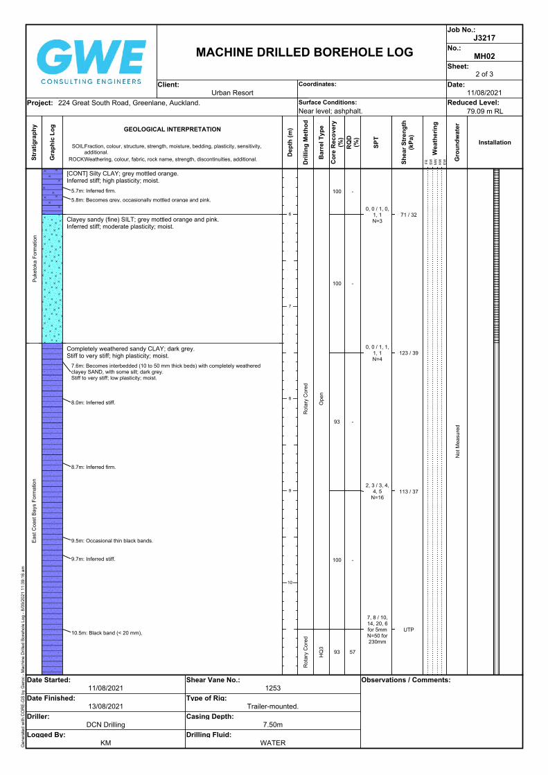
Genera
ted w
ith C
OR
E-G
S b
y G
ero
c -
Mach
ine D
rille
d B
ore
hole
Log -
8/0
9/2
021 1
1:3
9:1
6 a
m
Installation
Co
re R
eco
very
(%)
RQ
D(%
)
Dep
th (
m)
MACHINE DRILLED BOREHOLE LOG
Dri
llin
g M
eth
od
Gro
un
dw
ate
r
Urban ResortClient: Coordinates:
MH02No.:
GEOLOGICAL INTERPRETATION
SOIL:
Str
ati
gra
ph
y
FR
SW
MW
HW
EW
Gra
ph
ic L
og
Fraction, colour, structure, strength, moisture, bedding, plasticity, sensitivity,additional.
ROCK:Weathering, colour, fabric, rock name, strength, discontinuities, additional.
Weath
eri
ng
SP
T
J3217Job No.:
2 of 3Sheet:
11/08/2021Date:
Project: 224 Great South Road, Greenlane, Auckland. Surface Conditions: Reduced Level:
Sh
ear
Str
en
gth
(kP
a)
Near level; ashphalt.
Barr
el T
yp
e
Observations / Comments:11/08/2021
Date Started:
13/08/2021Date Finished:
DCN DrillingDriller:
KMLogged By:
1253Shear Vane No.:
Trailer-mounted.Type of Rig:
WATERDrilling Fluid:
Casing Depth:7.50m
[CONT] Silty CLAY; grey mottled orange.Inferred stiff; high plasticity; moist.
Clayey sandy (fine) SILT; grey mottled orange and pink.Inferred stiff; moderate plasticity; moist.
Completely weathered sandy CLAY; dark grey.Stiff to very stiff; high plasticity; moist.
6
7
8
9
10
100 -
100 -
93 -
100 -
93 57
5.7m: Inferred firm.
5.8m: Becomes grey, occasionally mottled orange and pink.
7.6m: Becomes interbedded (10 to 50 mm thick beds) with completely weatheredclayey SAND, with some silt; dark grey.Stiff to very stiff; low plasticity; moist.
8.0m: Inferred stiff.
8.7m: Inferred firm.
9.5m: Occasional thin black bands.
9.7m: Inferred stiff.
10.5m: Black band (< 20 mm),
Rota
ry C
ore
dR
ota
ry C
ore
d
71 / 321253
123 / 391253
113 / 371253
UTP1253
0, 0 / 1, 0,1, 1N=3
0, 0 / 1, 1,1, 1N=4
2, 3 / 3, 4,4, 5
N=16
7, 8 / 10,14, 20, 6for 5mmN=50 for230mm
Open
HQ
3
Not M
easu
red
East
Coast
Bays
Form
atio
nP
uke
toka
Form
atio
n
79.09 m RL

Genera
ted w
ith C
OR
E-G
S b
y G
ero
c -
Mach
ine D
rille
d B
ore
hole
Log -
8/0
9/2
021 1
1:3
9:1
6 a
m
Installation
Co
re R
eco
very
(%)
RQ
D(%
)
Dep
th (
m)
MACHINE DRILLED BOREHOLE LOG
Dri
llin
g M
eth
od
Gro
un
dw
ate
r
Urban ResortClient: Coordinates:
MH02No.:
GEOLOGICAL INTERPRETATION
SOIL:
Str
ati
gra
ph
y
FR
SW
MW
HW
EW
Gra
ph
ic L
og
Fraction, colour, structure, strength, moisture, bedding, plasticity, sensitivity,additional.
ROCK:Weathering, colour, fabric, rock name, strength, discontinuities, additional.
Weath
eri
ng
SP
T
J3217Job No.:
3 of 3Sheet:
11/08/2021Date:
Project: 224 Great South Road, Greenlane, Auckland. Surface Conditions: Reduced Level:
Sh
ear
Str
en
gth
(kP
a)
Near level; ashphalt.
Barr
el T
yp
e
Observations / Comments:11/08/2021
Date Started:
13/08/2021Date Finished:
DCN DrillingDriller:
KMLogged By:
1253Shear Vane No.:
Trailer-mounted.Type of Rig:
WATERDrilling Fluid:
Casing Depth:7.50m
Highly weathered East Coast Bays Formation (Mwe); interbeddedSANDSTONE and SILTSTONE; dark grey.Thin to moderately thick bedded, sub-horizontal to gently inclined; weak.J1: at 11.45 m to E.O.H.: sub-horizontal; undulating and rough; very narrow;closely spaced; sandy infill.J2: at 13.80 m; very steeply inclined; undulating and rough; narrow; sandyinfill.
EOH: 15.00m
12
13
14
15
16
93 57
93 88
83 73
11.9m: Thin black bands of SANDSTONE (10 mm).
13.9m: Thin black bands of SANDSTONE (20 mm).
Rota
ry C
ore
d
UTP1253
UTP1253
UTP1253
22, 28 for45mm
N=50 for0mm
27, 23 for25mm
N=50 for0mm
26, 24 for30mm
N=50 for0mm
HQ
3
Not M
easu
red
East
Coast
Bays
Form
atio
n
79.09 m RL

MACHINE DRILLED BOREHOLE LOG
Job No.:
J3217
No.:
MH02
Sheet:
1 of 3
Client:
Urban Resort
Coordinates: Date:
11/08/2021
Project: 224 Great South Road, Greenlane, Auckland. Surface Conditions:
Near level; asphalt.
Reduced level:
79.09 m
From 0.00 to 2.5 m below the ground level
From 2.5 to 5.9 m below the ground level

MACHINE DRILLED BOREHOLE LOG
Job No.:
J3217
No.:
MH02
Sheet:
2 of 3
Client:
Urban Resort
Coordinates: Date:
13/08/2021
Project: 224 Great South Road, Greenlane, Auckland. Surface Conditions:
Near level; asphalt.
Reduced level: 79.09 m
From 5.9 to 8.75 m below the ground level
From 8.75 to 11.5 m below the ground level

MACHINE DRILLED BOREHOLE LOG
Job No.:
J3217
No.:
MH02
Sheet:
3 of 3
Client:
Urban Resort
Coordinates: Date:
13/08/2021
Project: 224 Great South Road, Greenlane, Auckland. Surface Conditions:
Near level; asphalt.
Reduced level:
79.09 m
From 11.5 to 14.7 m below the ground level
From 14.7 to 15 m below the ground level

Genera
ted w
ith C
OR
E-G
S b
y G
ero
c -
Mach
ine D
rille
d B
ore
hole
Log -
8/0
9/2
021 1
1:3
8:2
7 a
m
Installation
Co
re R
eco
very
(%)
RQ
D(%
)
Dep
th (
m)
MACHINE DRILLED BOREHOLE LOG
Dri
llin
g M
eth
od
Gro
un
dw
ate
r
Urban ResortClient: Coordinates:
MH03No.:
GEOLOGICAL INTERPRETATION
SOIL:
Str
ati
gra
ph
y
FR
SW
MW
HW
EW
Gra
ph
ic L
og
Fraction, colour, structure, strength, moisture, bedding, plasticity, sensitivity,additional.
ROCK:Weathering, colour, fabric, rock name, strength, discontinuities, additional.
Weath
eri
ng
SP
T
J3217Job No.:
1 of 3Sheet:
16/08/2021Date:
Project: 224 Great South Road, Greenlane, Auckland. Surface Conditions: Reduced Level:
Sh
ear
Str
en
gth
(kP
a)
Near level; ashphalt.
Barr
el T
yp
e
Observations / Comments:16/08/2021
Date Started:
16/08/2021Date Finished:
DCN DrillingDriller:
EJCLogged By:
715401Shear Vane No.:
Tractor-mounted.Type of Rig:
WATERDrilling Fluid:
Casing Depth:0.00m
FIL
L
ASHPHALT.
Sandy GRAVEL (fine to coarse, angular to sub-angular, basalt).
Clayey SILT; light brown mottled orange.Firm; high plasticity; moist.
Silty SAND; greyish brown.Firm; moist to wet; friable.
Silty CLAY; light brown mottled orange.Inferred firm to stiff; high plasticity; moist to wet.
1
2
3
4
5
100 -
100 -
100 -
100 -
85 -
79 -
0.6m - 0.8m: Becomes, with some sand; reddish brown.Three beds of very thin (10 mm) cemented SAND.
1.0m: Thin bed of cemented SAND (30 mm); reddish brown.
1.4m: One cobble-sized fragment of SANDSTONE.
1.9m: Very thin bed (10 mm) of cemented SAND.
2.4m: Becomes brown.
2.5m: Becomes brown mottled grey.
3.0m: Becomes light grey mottled brown.
5.0m: Becomes light brown mottled grey.5.2m: Very thin bed (10 mm) of silty SAND; brown.
DCN DrillingTractor-mounted.
Open
Rota
ry C
ore
d
49 / 23715401
1, 0 / 0, 0,0, 0N=0
1, 0 / 1, 1,1, 1N=4
0, 0 / 0, 1,1, 1N=3
WATER
Open
Not M
easu
red
Puke
toka
Form
atio
nA
uck
land V
olc
anic
Fie
ld
79.16 m RL

Genera
ted w
ith C
OR
E-G
S b
y G
ero
c -
Mach
ine D
rille
d B
ore
hole
Log -
8/0
9/2
021 1
1:3
8:2
7 a
m
Installation
Co
re R
eco
very
(%)
RQ
D(%
)
Dep
th (
m)
MACHINE DRILLED BOREHOLE LOG
Dri
llin
g M
eth
od
Gro
un
dw
ate
r
Urban ResortClient: Coordinates:
MH03No.:
GEOLOGICAL INTERPRETATION
SOIL:
Str
ati
gra
ph
y
FR
SW
MW
HW
EW
Gra
ph
ic L
og
Fraction, colour, structure, strength, moisture, bedding, plasticity, sensitivity,additional.
ROCK:Weathering, colour, fabric, rock name, strength, discontinuities, additional.
Weath
eri
ng
SP
T
J3217Job No.:
2 of 3Sheet:
16/08/2021Date:
Project: 224 Great South Road, Greenlane, Auckland. Surface Conditions: Reduced Level:
Sh
ear
Str
en
gth
(kP
a)
Near level; ashphalt.
Barr
el T
yp
e
Observations / Comments:16/08/2021
Date Started:
16/08/2021Date Finished:
DCN DrillingDriller:
EJCLogged By:
715401Shear Vane No.:
Tractor-mounted.Type of Rig:
WATERDrilling Fluid:
Casing Depth:0.00m
Clayey SILT, with some sand; grey.Firm, high plasticity; moist to wet.
Highly weathered East Coast Bays Formation (Mwe); interbeddedSANDSTONE and SILTSTONE, with very thin beds of black carbonaceousfossilised wood; light grey.Moderately thick to thickly bedded (0.5 - 1.10 m), fine grained; weak.J1: sub-horizontal; stepped and rough; very closely to closely spaced; dustingof dark grey fine sand and fossilised wood fragments.J2: gently inclined; undulating and rough; extremely closely spaced; dustingof grey, sandy SILT.
6
7
8
9
10
79 -
42 -
100 -
86 82
70 64
75 69
5.7m - 6.5m: Becomes wet.
6.5m: Becomes inferred very stiff.
Rota
ry C
ore
dR
ota
ry C
ore
d
35 / 217154010, 1 / 1, 2,
4, 4N=11
4, 13 / 23,27 for65mm
N=50 for290mm
5, 9 / 11,12, 13, 17
N=50
12, 27 / 23for 30mmN=50 for255mm
Open
HQ
3
Not M
easu
redE
ast
Coast
Bays
Form
atio
n
79.16 m RL

Genera
ted w
ith C
OR
E-G
S b
y G
ero
c -
Mach
ine D
rille
d B
ore
hole
Log -
8/0
9/2
021 1
1:3
8:2
7 a
m
Installation
Co
re R
eco
very
(%)
RQ
D(%
)
Dep
th (
m)
MACHINE DRILLED BOREHOLE LOG
Dri
llin
g M
eth
od
Gro
un
dw
ate
r
Urban ResortClient: Coordinates:
MH03No.:
GEOLOGICAL INTERPRETATION
SOIL:
Str
ati
gra
ph
y
FR
SW
MW
HW
EW
Gra
ph
ic L
og
Fraction, colour, structure, strength, moisture, bedding, plasticity, sensitivity,additional.
ROCK:Weathering, colour, fabric, rock name, strength, discontinuities, additional.
Weath
eri
ng
SP
T
J3217Job No.:
3 of 3Sheet:
16/08/2021Date:
Project: 224 Great South Road, Greenlane, Auckland. Surface Conditions: Reduced Level:
Sh
ear
Str
en
gth
(kP
a)
Near level; ashphalt.
Barr
el T
yp
e
Observations / Comments:16/08/2021
Date Started:
16/08/2021Date Finished:
DCN DrillingDriller:
EJCLogged By:
715401Shear Vane No.:
Tractor-mounted.Type of Rig:
WATERDrilling Fluid:
Casing Depth:0.00m
[CONT] Highly weathered East Coast Bays Formation (Mwe); interbeddedSANDSTONE and SILTSTONE, with very thin beds of black carbonaceousfossilised wood; light grey.Moderately thick to thickly bedded (0.5 - 1.10 m), fine grained; weak.J1: sub-horizontal; stepped and rough; very closely to closely spaced; dustingof dark grey fine sand and fossilised wood fragments.J2: gently inclined; undulating and rough; extremely closely spaced; dustingof grey, sandy SILT.
EOH: 15.00m
12
13
14
15
16
75 69
87 87
90 82
12.5m: J1 becomes widely spaced.
13.8m: J2 becomes very steeply inclined; undulating and rough; moderately widelyspaced; with a dusting of SAND (fine).
13.9m - 14.4m: Becomes very weak.
Rota
ry C
ore
d
12, 52N=50
10, 50 for55mm
N=50 for230mm
10, 12 / 15,14, 17, 24
N=50
HQ
3
Not M
easu
red
East
Coast
Bays
Form
atio
n
79.16 m RL
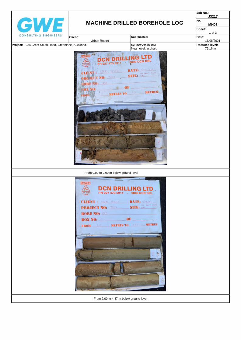
MACHINE DRILLED BOREHOLE LOG
Job No.:
J3217
No.:
MH03
Sheet:
1 of 3
Client:
Urban Resort
Coordinates:
Date:
16/08/2021
Project: 224 Great South Road, Greenlane, Auckland. Surface Conditions:
Near level; asphalt.
Reduced level:
79.16 m
From 0.00 to 2.00 m below ground level
From 2.00 to 4.47 m below ground level

MACHINE DRILLED BOREHOLE LOG
Job No.:
J3217
No.:
MH03
Sheet:
2 of 3
Client:
Urban Resort
Coordinates:
Date:
16/08/2021
Project: 224 Great South Road, Greenlane, Auckland. Surface Conditions:
Near level; asphalt.
Reduced level:
79.16 m
From 4.47 to 7.15 m below ground level
From 7.15 to 10.80 m below ground level

MACHINE DRILLED BOREHOLE LOG
Job No.:
J3217
No.:
MH03
Sheet:
3 of 3
Client:
Urban Resort
Coordinates:
Date:
16/08/2021
Project: 224 Great South Road, Greenlane, Auckland. Surface Conditions:
Near level; asphalt.
Reduced level:
79.16 m
From 10.80 to 14.40 m below ground level
From 14.40 to 15.0 m below ground level

Genera
ted w
ith C
OR
E-G
S b
y G
ero
c -
Mach
ine D
rille
d B
ore
hole
Log -
8/0
9/2
021 1
1:3
8:5
5 a
m
Installation
Co
re R
eco
very
(%)
RQ
D(%
)
Dep
th (
m)
MACHINE DRILLED BOREHOLE LOG
Dri
llin
g M
eth
od
Gro
un
dw
ate
r
Urban ResortClient: Coordinates:
MH04No.:
GEOLOGICAL INTERPRETATION
SOIL:
Str
ati
gra
ph
y
FR
SW
MW
HW
EW
Gra
ph
ic L
og
Fraction, colour, structure, strength, moisture, bedding, plasticity, sensitivity,additional.
ROCK:Weathering, colour, fabric, rock name, strength, discontinuities, additional.
Weath
eri
ng
SP
T
J3217Job No.:
1 of 3Sheet:
13/08/2021Date:
Project: 224 Great South Road, Greenlane, Auckland. Surface Conditions: Reduced Level:
Sh
ear
Str
en
gth
(kP
a)
Near level; ashphalt.
Barr
el T
yp
e
Observations / Comments:13/08/2021
Date Started:
16/08/2021Date Finished:
DCN DrillingDriller:
KMLogged By:
1253Shear Vane No.:
Trailer-mounted.Type of Rig:
WATERDrilling Fluid:
Casing Depth:4.50m
FIL
L
ASHPHALT.
GRAVEL(fine to coarse, sub-angular, basalt), in a silty matrix; grey.Non-plastic; moist.
Silty CLAY, with minor gravel (fine); brownish orange, brown, occasionallygrey and black.Inferred stiff; moderate plasticity; moist.
Clayey SILT, with minor gravel (fine); brownish orange, brown, occasionallygrey and black.Inferred stiff; low plasticity; moist.
Silty CLAY; brownish orange, brown, occasionally grey and black.Inferred stiff; moderate plasticity; moist; thin bands (< 20 mm) of cementedsand; dark orange to red.
Sandy (fine) gravelly (fine) SILT, with some clay; light brown, with red andblack specks (gravels).Inferred stiff; low plasticity; moist.
Clayey organic SILT; dark grey and black.Firm; moderate plasticity; moist to wet.
Silty CLAY; bluish grey mottled orange.Inferred firm to stiff; high plasticity; moist.
Silty organic CLAY; bluish green speckled orange and white.Stiff; high plasticity; moist.
1
2
3
4
5
100 -
100 -
83 -
90 -
1.4m:Inferred very stiff.
2.5m - 2.9m: Thin beds (< 20 mm) of cemented sand (fine); dark orange to red.
3.0m: Organic content decreasing.
3.7m: Inferred stiff.
5.0m: Inferred firm.
5.3m: Becomes grey, streaked black (organics).
5.5m: Decomposing wood.
DCN DrillingTrailer-mounted.
Open
Rota
ry C
ore
dUTP1253
35 / 31253
90 / 451253
1, 2 / 2, 2,2, 2N=8
0, 0 / 1, 0,1, 1N=3
0, 0 / 1, 1,1, 1N=4
WATER
Open
4.5
Not M
easu
red
Puke
toka
Form
ation
Auck
land V
olc
anic
Fie
ld
78.85 m RL

Genera
ted w
ith C
OR
E-G
S b
y G
ero
c -
Mach
ine D
rille
d B
ore
hole
Log -
8/0
9/2
021 1
1:3
8:5
5 a
m
Installation
Co
re R
eco
very
(%)
RQ
D(%
)
Dep
th (
m)
MACHINE DRILLED BOREHOLE LOG
Dri
llin
g M
eth
od
Gro
un
dw
ate
r
Urban ResortClient: Coordinates:
MH04No.:
GEOLOGICAL INTERPRETATION
SOIL:
Str
ati
gra
ph
y
FR
SW
MW
HW
EW
Gra
ph
ic L
og
Fraction, colour, structure, strength, moisture, bedding, plasticity, sensitivity,additional.
ROCK:Weathering, colour, fabric, rock name, strength, discontinuities, additional.
Weath
eri
ng
SP
T
J3217Job No.:
2 of 3Sheet:
13/08/2021Date:
Project: 224 Great South Road, Greenlane, Auckland. Surface Conditions: Reduced Level:
Sh
ear
Str
en
gth
(kP
a)
Near level; ashphalt.
Barr
el T
yp
e
Observations / Comments:13/08/2021
Date Started:
16/08/2021Date Finished:
DCN DrillingDriller:
KMLogged By:
1253Shear Vane No.:
Trailer-mounted.Type of Rig:
WATERDrilling Fluid:
Casing Depth:4.50m
[CONT] Silty organic CLAY; bluish green speckled orange and white.Stiff; high plasticity; moist.
Silty CLAY; light grey, with occasional black (organic) and brown streaks.Stiff; high plasticity; moist.
Clayey sandy (fine) SILT; grey with black and brown bands (approx. 10 - 20mm thick).Stiff; moderate plasticity; moist.
Silty SAND, with some clay; grey.Inferred medium dense; low plasticity; moist.PP = 2.0.
Silty CLAY; grey.Inferred stiff; high plasticity; moist.
6
7
8
9
10
90 -
100 -
100 -
100 -
100 -
5.6m: Inferred soft.5.7m - 5.8m: PEAT (FIBROUS).5.9m - 6.0m: WOOD, partially decomposed.
6.6m: Inferred firm.
7.1m - 7.2m: Silty organic CLAY; blue and black with orange streak; rootletinclusions.
7.3m: Inferred soft.
7.5m: Rootlet inclusions.
8.1m: Rootlet inclusions and decomposing wood fragment (approx. 50 mm length, 30mm width).
8.4m: Inferred soft.
8.5m: Becomes grey mottled orange and black; rootlet inclusions.
10.1m: Inferred very stiff.
10.3m - 10.5m: Silty SAND, with some clay; grey.Inferred medium dense; low plasticity; moist.
Rota
ry C
ore
d
77 / 01253
84 / 391253
52 / 191253
UTP1253
1, 0 / 1, 0,1, 1N=3
0, 0 / 0, 1,1, 1N=3
1, 2 / 2, 2,2, 2N=8
3, 4 / 5, 5,5, 8
N=23
Open
Not M
easu
red
Puke
toka
Form
atio
n
78.85 m RL

Genera
ted w
ith C
OR
E-G
S b
y G
ero
c -
Mach
ine D
rille
d B
ore
hole
Log -
8/0
9/2
021 1
1:3
8:5
5 a
m
Installation
Co
re R
eco
very
(%)
RQ
D(%
)
Dep
th (
m)
MACHINE DRILLED BOREHOLE LOG
Dri
llin
g M
eth
od
Gro
un
dw
ate
r
Urban ResortClient: Coordinates:
MH04No.:
GEOLOGICAL INTERPRETATION
SOIL:
Str
ati
gra
ph
y
FR
SW
MW
HW
EW
Gra
ph
ic L
og
Fraction, colour, structure, strength, moisture, bedding, plasticity, sensitivity,additional.
ROCK:Weathering, colour, fabric, rock name, strength, discontinuities, additional.
Weath
eri
ng
SP
T
J3217Job No.:
3 of 3Sheet:
13/08/2021Date:
Project: 224 Great South Road, Greenlane, Auckland. Surface Conditions: Reduced Level:
Sh
ear
Str
en
gth
(kP
a)
Near level; ashphalt.
Barr
el T
yp
e
Observations / Comments:13/08/2021
Date Started:
16/08/2021Date Finished:
DCN DrillingDriller:
KMLogged By:
1253Shear Vane No.:
Trailer-mounted.Type of Rig:
WATERDrilling Fluid:
Casing Depth:4.50m
[CONT] Silty CLAY; grey.Inferred stiff; high plasticity; moist.
Organic SAND (fine to medium); grey and black.Non-plastic; moist; decomposing wood fragments.
Highly weathered East Coast Bays Formation (Mwe); interbeddedSANDSTONE and SILTSTONE; dark grey.Thin to moderately thick bedded, sub-horizontal to gently inclined; weak.J1: at 13.35 to E.O.H.: sub-horizontal; undulating and rough; very narrow;closely spaced; sandy infill.
EOH: 16.50m
12
13
14
15
16
100 -
100 63
80 67
83 73
11.0m - 11.2m: Silty SAND, with some clay; grey.Inferred medium dense; low plasticity; moist.
11.2m: Becomes dark grey.
12.0m: Becomes SAND (no organic inclusions).
13.4m: Thin black bands of SANDSTONE (10 mm).
HW
Rota
ry C
ore
dR
ota
ry C
ore
d
UTP1253
UTP1253
UTP1253
UTP1253
9, 12 / 22,26, 2 for
5mmN=50 for230mm
25, 25 for45mmN=50
27, 23 for35mmN=50
21, 29 for65mmN=50
Open
HQ
3
Not M
easu
red
East
Coast
Bays
Form
atio
nP
uke
toka
Form
atio
n
78.85 m RL

MACHINE DRILLED BOREHOLE LOG
Job No.:
J3217
No.:
MH04
Sheet:
1 of 3
Client:
Urban Resort
Coordinates: Date:
13/08/2021
Project: 224 Great South Road, Greenlane, Auckland. Surface Conditions:
Near level; asphalt.
Reduced level:
78.85 m
From 0.00 to 2.55 m below the ground level
From 2.55 to 5.65 m below the ground level

MACHINE DRILLED BOREHOLE LOG
Job No.:
J3217
No.:
MH04
Sheet:
2 of 3
Client:
Urban Resort
Coordinates: Date:
16/08/2021
Project: 224 Great South Road, Greenlane, Auckland. Surface Conditions:
Near level; asphalt.
Reduced level: 78.85 m
From 5.65 to 8.55 m below the ground level
From 8.55 to 11.5 m below the ground level

MACHINE DRILLED BOREHOLE LOG
Job No.:
J3217
No.:
MH04
Sheet:
3 of 3
Client:
Urban Resort
Coordinates: Date:
16/08/2021
Project: 224 Great South Road, Greenlane, Auckland. Surface Conditions:
Near level; asphalt.
Reduced level:
78.85 m
From 11.5 to 15.0 m below the ground level
From 15.0 to 16.5 m below the ground level

Genera
ted w
ith C
OR
E-G
S b
y G
ero
c -
Mach
ine D
rille
d B
ore
hole
Log -
8/0
9/2
021 1
1:3
8:4
6 a
m
Installation
Co
re R
eco
very
(%)
RQ
D(%
)
Dep
th (
m)
MACHINE DRILLED BOREHOLE LOG
Dri
llin
g M
eth
od
Gro
un
dw
ate
r
Urban ResortClient: Coordinates:
MH05No.:
GEOLOGICAL INTERPRETATION
SOIL:
Str
ati
gra
ph
y
FR
SW
MW
HW
EW
Gra
ph
ic L
og
Fraction, colour, structure, strength, moisture, bedding, plasticity, sensitivity,additional.
ROCK:Weathering, colour, fabric, rock name, strength, discontinuities, additional.
Weath
eri
ng
SP
T
J3217Job No.:
1 of 3Sheet:
16/08/2021Date:
Project: 224 Great South Road, Greenlane, Auckland. Surface Conditions: Reduced Level:
Sh
ear
Str
en
gth
(kP
a)
Near level; concrete.
Barr
el T
yp
e
Observations / Comments:16/08/2021
Date Started:
17/08/2021Date Finished:
DCN DrillingDriller:
EJCLogged By:
715401Shear Vane No.:
Tractor-mounted.Type of Rig:
WATERDrilling Fluid:
Casing Depth:7.50m
FIL
L
CONCRETE.
Silty CLAY; brown.Firm; high plasticity; moist to wet.
Silty CLAY; greyish brown.Firm to stiff; high plasticity; moist to wet.
1
2
3
4
5
84 -
84 -
94 -
85 -
83 -
76 -
0.5m: Becomes orange brown.
1.0m: A thin bed (< 10 mm) of GRAVELS (fine to coarse) then becomes light brownmottled orange.
1.6m: Becomes silty CLAY, with some gravel (fine to coarse); brown.
2.3m: Becomes orange.
2.7m: A thin bed (< 10 mm) of GRAVEL (fine to coarse) and black carbonaceousfossilised wood.
3.0m: Becomes grey mottled brown.
4.0m: Becomes light grey mottled brown.
DCN DrillingTractor-mounted.
Open
Rota
ry C
ore
d
152 / 49715401
49 / 9715401
61 / 3715401
61 / 27715401
1, 1 / 4, 5,6, 8
N=23
1, 0 / 0, 0,1, 1N=2
WATER
Open
Not M
easu
red
Puke
toka
Form
atio
nA
uck
land V
olc
anic
Fie
ld
78.98 m RL

Genera
ted w
ith C
OR
E-G
S b
y G
ero
c -
Mach
ine D
rille
d B
ore
hole
Log -
8/0
9/2
021 1
1:3
8:4
6 a
m
Installation
Co
re R
eco
very
(%)
RQ
D(%
)
Dep
th (
m)
MACHINE DRILLED BOREHOLE LOG
Dri
llin
g M
eth
od
Gro
un
dw
ate
r
Urban ResortClient: Coordinates:
MH05No.:
GEOLOGICAL INTERPRETATION
SOIL:
Str
ati
gra
ph
y
FR
SW
MW
HW
EW
Gra
ph
ic L
og
Fraction, colour, structure, strength, moisture, bedding, plasticity, sensitivity,additional.
ROCK:Weathering, colour, fabric, rock name, strength, discontinuities, additional.
Weath
eri
ng
SP
T
J3217Job No.:
2 of 3Sheet:
16/08/2021Date:
Project: 224 Great South Road, Greenlane, Auckland. Surface Conditions: Reduced Level:
Sh
ear
Str
en
gth
(kP
a)
Near level; concrete.
Barr
el T
yp
e
Observations / Comments:16/08/2021
Date Started:
17/08/2021Date Finished:
DCN DrillingDriller:
EJCLogged By:
715401Shear Vane No.:
Tractor-mounted.Type of Rig:
WATERDrilling Fluid:
Casing Depth:7.50m
Pu p [CONT] Silty CLAY; greyish brown.
Firm to stiff; high plasticity; moist to wet.
Clayey SILT, with some sand; light grey mottled orange and brown.Stiff; high plasticity; moist to wet.
Highly weathered East Coast Bays Formation (Mwe); interbeddedSANDSTONE and SILTSTONE; grey.Very thin to thickly bedded (0.06 - 0.90 m), fine grained; weak.J1: sub-horizontal to gently inclined; undulating and smooth to rough;moderately wide to widely spaced (0.3 to 0.85 m).
6
7
8
9
10
76 -
73 -
70 62
85 75
84 83
6.0m: Becomes dark grey.
6.2m: Becomes completely weathered; very stiff.
9.5m - 9.6m: J1 becomes very closely spaced.
Rota
ry C
ore
dR
ota
ry C
ore
d
37 / 67154011, 0 / 1, 1,
1, 2N=5
7, 12 / 30,20 for20mm
N=50 for245mm
17, 52N=50
18, 54N=50
Open
HQ
3
Not M
easu
redEast
Coast
Bays
Form
atio
n
78.98 m RL

Genera
ted w
ith C
OR
E-G
S b
y G
ero
c -
Mach
ine D
rille
d B
ore
hole
Log -
8/0
9/2
021 1
1:3
8:4
6 a
m
Installation
Co
re R
eco
very
(%)
RQ
D(%
)
Dep
th (
m)
MACHINE DRILLED BOREHOLE LOG
Dri
llin
g M
eth
od
Gro
un
dw
ate
r
Urban ResortClient: Coordinates:
MH05No.:
GEOLOGICAL INTERPRETATION
SOIL:
Str
ati
gra
ph
y
FR
SW
MW
HW
EW
Gra
ph
ic L
og
Fraction, colour, structure, strength, moisture, bedding, plasticity, sensitivity,additional.
ROCK:Weathering, colour, fabric, rock name, strength, discontinuities, additional.
Weath
eri
ng
SP
T
J3217Job No.:
3 of 3Sheet:
16/08/2021Date:
Project: 224 Great South Road, Greenlane, Auckland. Surface Conditions: Reduced Level:
Sh
ear
Str
en
gth
(kP
a)
Near level; concrete.
Barr
el T
yp
e
Observations / Comments:16/08/2021
Date Started:
17/08/2021Date Finished:
DCN DrillingDriller:
EJCLogged By:
715401Shear Vane No.:
Tractor-mounted.Type of Rig:
WATERDrilling Fluid:
Casing Depth:7.50m
[CONT] Highly weathered East Coast Bays Formation (Mwe); interbeddedSANDSTONE and SILTSTONE; grey.Very thin to thickly bedded (0.06 - 0.90 m), fine grained; weak.J1: sub-horizontal to gently inclined; undulating and smooth to rough;moderately wide to widely spaced (0.3 to 0.85 m).
EOH: 15.00m
12
13
14
15
16
84 83
88 81
80 45
11.9m: J2: gently inclined; undulating and slickenslided; with a dustung of light greySAND (fine).
12.8m: J1 becomes closely spaced and open; very thin beds (< 20 mm) of cementedlight grey SANDSTONE and black carbonaceous fossilised wood.
14.9m - 15.0m: J3: sub-vertical; planar and rough; narrow (< 6 mm).
Rota
ry C
ore
d
36, 14 for10mmN=50
30, 20 for25mmN=50
50 for60mmN=50
HQ
3
Not M
easu
red
East
Coast
Bays
Form
atio
n
78.98 m RL
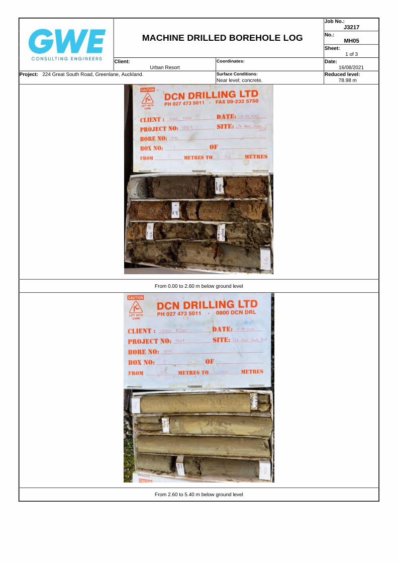
MACHINE DRILLED BOREHOLE LOG
Job No.:
J3217
No.:
MH05
Sheet:
1 of 3
Client:
Urban Resort
Coordinates:
Date:
16/08/2021
Project: 224 Great South Road, Greenlane, Auckland. Surface Conditions:
Near level; concrete.
Reduced level:
78.98 m
From 0.00 to 2.60 m below ground level
From 2.60 to 5.40 m below ground level

MACHINE DRILLED BOREHOLE LOG
Job No.:
J3217
No.:
MH05=5 Sheet:
2 of 3
Client:
Urban Resort
Coordinates:
Date:
16/08/2021
Project: 224 Great South Road, Greenlane, Auckland. Surface Conditions:
Near level; concrete.
Reduced level:
78.98 m
From 5.40 to 7.50 m below ground level
From 7.50 to 11.50 m below ground level

MACHINE DRILLED BOREHOLE LOG
Job No.:
J3217
No.:
MH05
Sheet:
3 of 3
Client:
Urban Resort
Coordinates:
Date:
16/08/2021
Project: 224 Great South Road, Greenlane, Auckland. Surface Conditions:
Near level; concrete.
Reduced level:
78.98 m
From 11.50 to 14.80 m below ground level
From 14.80 to 15.0 m below ground level

Genera
ted w
ith C
OR
E-G
S b
y G
ero
c -
Mach
ine D
rille
d B
ore
hole
Log -
8/0
9/2
021 1
1:3
7:4
8 a
m
Installation
Co
re R
eco
very
(%)
RQ
D(%
)
Dep
th (
m)
MACHINE DRILLED BOREHOLE LOG
Dri
llin
g M
eth
od
Gro
un
dw
ate
r
Urban ResortClient: Coordinates:
MH06No.:
GEOLOGICAL INTERPRETATION
SOIL:
Str
ati
gra
ph
y
FR
SW
MW
HW
EW
Gra
ph
ic L
og
Fraction, colour, structure, strength, moisture, bedding, plasticity, sensitivity,additional.
ROCK:Weathering, colour, fabric, rock name, strength, discontinuities, additional.
Weath
eri
ng
SP
T
J3217Job No.:
1 of 3Sheet:
16/08/2021Date:
Project: 224 Great South Road, Greenlane, Auckland. Surface Conditions: Reduced Level:
Sh
ear
Str
en
gth
(kP
a)
Near-level; ashphalt.
Barr
el T
yp
e
Observations / Comments:16/08/2021
Date Started:
17/08/2021Date Finished:
DCN DrillingDriller:
MSLogged By:
1253Shear Vane No.:
Trailer Mounted RigType of Rig:
WATERDrilling Fluid:
Casing Depth:7.50m
FIL
L
ASHPHALT.
Basaltic Lapilli/Tuff; Highly to Completely Weathered: SAND & GRAVELS;dark grey.Loose; dry; non-plastic; Sand, medium to coarse; Gravel, fine to coarse, sub-angular to angular; occasional vesicular.
Silty CLAY; brownish orange, mottled light grey and orange.Stiff to very stiff; moist; high plasticity; occasional silt pockets; fine rootlets.
Clayey SILT, with coarse silt to medium sand, and intermixed gravels; darkgrey, reddish brown, brownish red and brownish orange.Very stiff; moist; moderate plasticity; occasional rootlets and organics.
Silty CLAY; grey, mottled orange, brownish orange, brown and greenishbrown.Stiff to very stiff; moist; high plasticity; minor fabric staining and organics.
1
2
3
4
5
100 -
70 -
100 -
0 -
100 -
100 -
100 -
2.0m: Becomes SILT, some sand (fine to coarse), minor clay; dark brown/grey.Firm to stiff; moist to wet; low plasticity; occasional rootlets.
2.5m: Becomes very stiff to hard.
3.5m: Inferred stiff.
4.0m: Inferred stiff.
4.5m: Becomes clayey SILT; moderate plasticity.
HW
DCN DrillingTrailer Mounted Rig
MSHQT3
Rota
ry C
ore
d
113 / 551253
139 / 361253
UTP1253
77 / 191253
1, 1 / 2, 2,2, 2N=8
1, 0 / 0, 0,0, 0N=0
0, 0 / 1, 0,1, 1N=3
WATER
HQ
T3
7.5
Not M
easu
red
Puke
toka
Form
ation
Auck
land V
olc
anic
Fie
ld
78.36 m RL

Genera
ted w
ith C
OR
E-G
S b
y G
ero
c -
Mach
ine D
rille
d B
ore
hole
Log -
8/0
9/2
021 1
1:3
7:4
8 a
m
Installation
Co
re R
eco
very
(%)
RQ
D(%
)
Dep
th (
m)
MACHINE DRILLED BOREHOLE LOG
Dri
llin
g M
eth
od
Gro
un
dw
ate
r
Urban ResortClient: Coordinates:
MH06No.:
GEOLOGICAL INTERPRETATION
SOIL:
Str
ati
gra
ph
y
FR
SW
MW
HW
EW
Gra
ph
ic L
og
Fraction, colour, structure, strength, moisture, bedding, plasticity, sensitivity,additional.
ROCK:Weathering, colour, fabric, rock name, strength, discontinuities, additional.
Weath
eri
ng
SP
T
J3217Job No.:
2 of 3Sheet:
16/08/2021Date:
Project: 224 Great South Road, Greenlane, Auckland. Surface Conditions: Reduced Level:
Sh
ear
Str
en
gth
(kP
a)
Near-level; ashphalt.
Barr
el T
yp
e
Observations / Comments:16/08/2021
Date Started:
17/08/2021Date Finished:
DCN DrillingDriller:
MSLogged By:
1253Shear Vane No.:
Trailer Mounted RigType of Rig:
WATERDrilling Fluid:
Casing Depth:7.50m
Pup
[CONT] Silty CLAY; grey, mottled orange, brownish orange, brown andgreenish brown.Stiff to very stiff; moist; high plasticity; minor fabric staining and organics.
Residual soil: Inter-layered sandy SILT & laminated clayey SILT; dark grey.Very stiff to hard; moist; low plasticity to moderate plasticity.
Slightly Weathered; Interbedded SANDSTONE & MUDSTONE; dark grey;weak.Moderately thin to moderately thick bedding; sub-horizontal bedding;occasional very thin beds of plant remains.D1: Widely spaced; undulating & rough; very steeply inclined; narrow (8.2-13.0 m).D2: Moderately widely spaced; undulating & rough; sub-horizontal to gentlyinclined; narrow (9.5-13.2 m).
6
7
8
9
10
100 -
100 -
100 -
100 -
100 -
100 -
100 50
100 -
100 50
5.5m: Becomes moist to wet; trace fine sand.
5.8m: Brownish orange mottling.
6.7m: Becomes completely weathered.
EW
SW
Rota
ry C
ore
d
29 / 61253
UTP1253
0, 1 / 1, 2,2, 2N=7
4, 6 / 8, 10,12, 17N=47
19, 31 for70mmN=50
25, 25 for65mmN=50
HQ
T3
Not M
easu
red
East
Coast
Bays
Form
atio
n
78.36 m RL

Genera
ted w
ith C
OR
E-G
S b
y G
ero
c -
Mach
ine D
rille
d B
ore
hole
Log -
8/0
9/2
021 1
1:3
7:4
8 a
m
Installation
Co
re R
eco
very
(%)
RQ
D(%
)
Dep
th (
m)
MACHINE DRILLED BOREHOLE LOG
Dri
llin
g M
eth
od
Gro
un
dw
ate
r
Urban ResortClient: Coordinates:
MH06No.:
GEOLOGICAL INTERPRETATION
SOIL:
Str
ati
gra
ph
y
FR
SW
MW
HW
EW
Gra
ph
ic L
og
Fraction, colour, structure, strength, moisture, bedding, plasticity, sensitivity,additional.
ROCK:Weathering, colour, fabric, rock name, strength, discontinuities, additional.
Weath
eri
ng
SP
T
J3217Job No.:
3 of 3Sheet:
16/08/2021Date:
Project: 224 Great South Road, Greenlane, Auckland. Surface Conditions: Reduced Level:
Sh
ear
Str
en
gth
(kP
a)
Near-level; ashphalt.
Barr
el T
yp
e
Observations / Comments:16/08/2021
Date Started:
17/08/2021Date Finished:
DCN DrillingDriller:
MSLogged By:
1253Shear Vane No.:
Trailer Mounted RigType of Rig:
WATERDrilling Fluid:
Casing Depth:7.50m
East
Coast
Bays
Form
atio
n
[CONT] Slightly Weathered; Interbedded SANDSTONE & MUDSTONE; darkgrey; weak.Moderately thin to moderately thick bedding; sub-horizontal bedding;occasional very thin beds of plant remains.J1: Widely spaced; undulating & rough; very steeply inclined; narrow (8.2-13.0 m).J2: Moderately widely spaced; undulating & rough; sub-horizontal to gentlyinclined; narrow (9.5-13.2 m).
EOH: 13.50m
12
13
14
15
16
100 50
100 -
100 50
12.0m: Discontinuity/Joint spacing increases.
SW
Rota
ry C
ore
d
29, 21 for65mmN=50
22, 28 for70mmN=50
HQ
T3
Not M
easu
red
78.36 m RL

MACHINE DRILLED BOREHOLE LOG
Job No.:
J3217
No.:
MH06
Sheet:
1 of 3
Client:
Urban Resort
Coordinates: Date:
16/08/2021
Project: 224 Great South Road, Greenlane, Auckland. Surface Conditions:
Near level; asphalt.
Reduced level:
78.36 m
From 0.00 to 2.6 m below the ground level
From 2.6 to 5.75 m below the ground level

MACHINE DRILLED BOREHOLE LOG
Job No.:
J3217
No.:
MH06
Sheet:
2 of 3
Client:
Urban Resort
Coordinates: Date:
16/08/2021
Project: 224 Great South Road, Greenlane, Auckland. Surface Conditions:
Near level; asphalt.
Reduced level: 78.36 m
From 5.75 to 8.6 m below the ground level
From 8.6 to 12.0 m below the ground level

MACHINE DRILLED BOREHOLE LOG
Job No.:
J3217
No.:
MH06
Sheet:
3 of 3
Client:
Urban Resort
Coordinates: Date:
16/08/2021
Project: 224 Great South Road, Greenlane, Auckland. Surface Conditions:
Near level; asphalt.
Reduced level:
78.36 m
From 12.0 to 13.5 m below the ground level

Genera
ted w
ith C
OR
E-G
S b
y G
ero
c -
Mach
ine D
rille
d B
ore
hole
Log -
8/0
9/2
021 1
1:3
7:5
8 a
m
Installation
Co
re R
eco
very
(%)
RQ
D(%
)
Dep
th (
m)
MACHINE DRILLED BOREHOLE LOG
Dri
llin
g M
eth
od
Gro
un
dw
ate
r
Urban ResortClient: Coordinates:
MH07No.:
GEOLOGICAL INTERPRETATION
SOIL:
Str
ati
gra
ph
y
FR
SW
MW
HW
EW
Gra
ph
ic L
og
Fraction, colour, structure, strength, moisture, bedding, plasticity, sensitivity,additional.
ROCK:Weathering, colour, fabric, rock name, strength, discontinuities, additional.
Weath
eri
ng
SP
T
J3217Job No.:
1 of 3Sheet:
17/08/2021Date:
Project: 224 Great South Road, Greenlane, Auckland. Surface Conditions: Reduced Level:
Sh
ear
Str
en
gth
(kP
a)
Near level; ashphalt.
Barr
el T
yp
e
Observations / Comments:17/08/2021
Date Started:
17/08/2021Date Finished:
DCN DrillingDriller:
EJCLogged By:
715401Shear Vane No.:
Tractor-mounted.Type of Rig:
WATERDrilling Fluid:
Casing Depth:7.50m
FIL
LA
VF
ASHPHALT.
GRAVEL (fine, sub-angular, basalt).
Silty CLAY, with some sand and gravel (fine to coarse); brownish orangemottled brown.Firm to stiff; high plasticity; moist to wet.
Silty CLAY; orange brown mottled orange.Firm to stiff; high plasticity; moist.
Clayey sandy SILT; grey mottled dark grey and orange.Soft; low plasticity; moist to wet.
1
2
3
4
5
44 -
100 -
100 -
15 -
72 -
67 -
0.6m: Becomes orange brown.
0.7m: Becomes brown with orange mottles.
1.0m: Becomes greyish brown mottled orange.
1.5m: Becomes orange mottled grey and black.
3.0m: Becomes grey mottled orange and red.
3.9m - 4.1m: Trace SAND (fine); orange.
4.4m: Becomes orange mottled pink.
4.5m: Becomes orange mottled grey.
DCN DrillingTractor-mounted.
Open
Rota
ry C
ore
d52 / 0715401
1, 1 / 1, 1,1, 2N=5
1, 1 / 1, 1,2, 2N=6
0, 0 / 0, 1,1, 2N=4
WATER
Open
Not M
easu
red
Puke
toka
Form
atio
n
80.63 m RL

Genera
ted w
ith C
OR
E-G
S b
y G
ero
c -
Mach
ine D
rille
d B
ore
hole
Log -
8/0
9/2
021 1
1:3
7:5
8 a
m
Installation
Co
re R
eco
very
(%)
RQ
D(%
)
Dep
th (
m)
MACHINE DRILLED BOREHOLE LOG
Dri
llin
g M
eth
od
Gro
un
dw
ate
r
Urban ResortClient: Coordinates:
MH07No.:
GEOLOGICAL INTERPRETATION
SOIL:
Str
ati
gra
ph
y
FR
SW
MW
HW
EW
Gra
ph
ic L
og
Fraction, colour, structure, strength, moisture, bedding, plasticity, sensitivity,additional.
ROCK:Weathering, colour, fabric, rock name, strength, discontinuities, additional.
Weath
eri
ng
SP
T
J3217Job No.:
2 of 3Sheet:
17/08/2021Date:
Project: 224 Great South Road, Greenlane, Auckland. Surface Conditions: Reduced Level:
Sh
ear
Str
en
gth
(kP
a)
Near level; ashphalt.
Barr
el T
yp
e
Observations / Comments:17/08/2021
Date Started:
17/08/2021Date Finished:
DCN DrillingDriller:
EJCLogged By:
715401Shear Vane No.:
Tractor-mounted.Type of Rig:
WATERDrilling Fluid:
Casing Depth:7.50m
Pup
[CONT] Clayey sandy SILT; grey mottled dark grey and orange.Soft; low plasticity; moist to wet.
Clayey sandy SILT; dark grey.Soft to firm; low plasticity; moist to wet.
Highly weathered East Coast Bays Formation (Mwe); interbeddedSANDSTONE and SILTSTONE, with occasional very thin to moderately thinbeds of black carbonaceous fossilised wood; grey.Very thin to thcikly bedded; fine grained; weak.J1: sub-horizontal to gently inclined; stepped and rough; closely tomoderately widely spaced (0.09 - 0.25 m); moderately narrow to moderatelywide; infilled with sand.J2: sub-vertical; planar and rough; very widely spaced (2.6 m); narrow to verynarrow; infilled with sand (fine).
6
7
8
9
10
67 -
23 -
63 40
95 70
87 66
5.8m: Becomes orange.
8.5m - 8.6m: J1 is extremely closely spaced (< 20 mm).
CW
HW
Rota
ry C
ore
dR
ota
ry C
ore
d
1, 2 / 2, 2,4, 4
N=12
4, 5 / 11,17, 21, 24
N=50
25, 25 for10mmN=50
17, 33 for65mmN=50
Open
HQ
3
Not M
easu
red
East
Coast
Bays
Form
atio
n
80.63 m RL

Genera
ted w
ith C
OR
E-G
S b
y G
ero
c -
Mach
ine D
rille
d B
ore
hole
Log -
8/0
9/2
021 1
1:3
7:5
8 a
m
Installation
Co
re R
eco
very
(%)
RQ
D(%
)
Dep
th (
m)
MACHINE DRILLED BOREHOLE LOG
Dri
llin
g M
eth
od
Gro
un
dw
ate
r
Urban ResortClient: Coordinates:
MH07No.:
GEOLOGICAL INTERPRETATION
SOIL:
Str
ati
gra
ph
y
FR
SW
MW
HW
EW
Gra
ph
ic L
og
Fraction, colour, structure, strength, moisture, bedding, plasticity, sensitivity,additional.
ROCK:Weathering, colour, fabric, rock name, strength, discontinuities, additional.
Weath
eri
ng
SP
T
J3217Job No.:
3 of 3Sheet:
17/08/2021Date:
Project: 224 Great South Road, Greenlane, Auckland. Surface Conditions: Reduced Level:
Sh
ear
Str
en
gth
(kP
a)
Near level; ashphalt.
Barr
el T
yp
e
Observations / Comments:17/08/2021
Date Started:
17/08/2021Date Finished:
DCN DrillingDriller:
EJCLogged By:
715401Shear Vane No.:
Tractor-mounted.Type of Rig:
WATERDrilling Fluid:
Casing Depth:7.50m
[CONT] Highly weathered East Coast Bays Formation (Mwe); interbeddedSANDSTONE and SILTSTONE, with occasional very thin to moderately thinbeds of black carbonaceous fossilised wood; grey.Very thin to thcikly bedded; fine grained; weak.J1: sub-horizontal to gently inclined; stepped and rough; closely tomoderately widely spaced (0.09 - 0.25 m); moderately narrow to moderatelywide; infilled with sand.J2: sub-vertical; planar and rough; very widely spaced (2.6 m); narrow to verynarrow; infilled with sand (fine).
EOH: 15.00m
12
13
14
15
16
87 66
90 68
85 82
13.1m - 13.5m: J1 is extremely closely spaced (< 20 mm).
HW
Rota
ry C
ore
d
10, 25 / 30N=50
17, 33 for60mmN=50
27, 23 for25mmN=50
HQ
3
Not M
easu
red
East
Coast
Bays
Form
atio
n
80.63 m RL
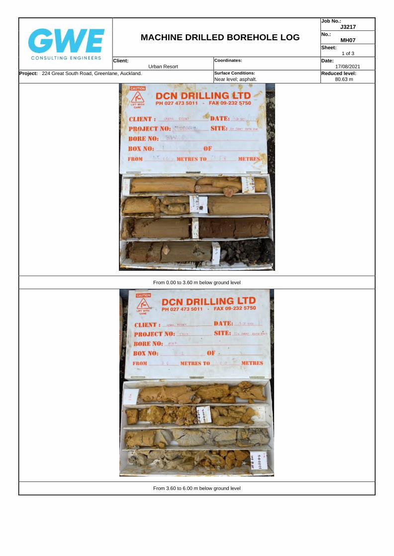
MACHINE DRILLED BOREHOLE LOG
Job No.:
J3217
No.:
MH07
Sheet:
1 of 3
Client:
Urban Resort
Coordinates:
Date:
17/08/2021
Project: 224 Great South Road, Greenlane, Auckland. Surface Conditions:
Near level; asphalt.
Reduced level:
80.63 m
From 0.00 to 3.60 m below ground level
From 3.60 to 6.00 m below ground level

MACHINE DRILLED BOREHOLE LOG
Job No.:
J3217
No.:
MH07=5 Sheet:
2 of 3
Client:
Urban Resort
Coordinates:
Date:
17/08/2021
Project: 224 Great South Road, Greenlane, Auckland. Surface Conditions:
Near level; asphalt.
Reduced level:
80.63 m
From 6.00 to 10.30 m below ground level
From 10.30 to 13.50 m below ground level
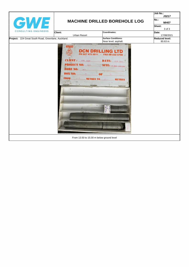
MACHINE DRILLED BOREHOLE LOG
Job No.:
J3217
No.:
MH07
Sheet:
3 of 3
Client:
Urban Resort
Coordinates:
Date:
17/08/2021
Project: 224 Great South Road, Greenlane, Auckland. Surface Conditions:
Near level; asphalt.
Reduced level:
80.63 m
From 13.50 to 15.00 m below ground level

Genera
ted w
ith C
OR
E-G
S b
y G
ero
c -
Mach
ine D
rille
d B
ore
hole
Log -
8/0
9/2
021 1
1:3
8:1
7 a
m
Installation
Co
re R
eco
very
(%)
RQ
D(%
)
Dep
th (
m)
MACHINE DRILLED BOREHOLE LOG
Dri
llin
g M
eth
od
Gro
un
dw
ate
r
Urban ResortClient: Coordinates:
MH08No.:
GEOLOGICAL INTERPRETATION
SOIL:
Str
ati
gra
ph
y
FR
SW
MW
HW
EW
Gra
ph
ic L
og
Fraction, colour, structure, strength, moisture, bedding, plasticity, sensitivity,additional.
ROCK:Weathering, colour, fabric, rock name, strength, discontinuities, additional.
Weath
eri
ng
SP
T
J3217Job No.:
1 of 3Sheet:
17/08/2021Date:
Project: 224 Great South Road, Greenlane, Auckland. Surface Conditions: Reduced Level:
Sh
ear
Str
en
gth
(kP
a)
Near level; concrete.
Barr
el T
yp
e
Observations / Comments:17/08/2021
Date Started:
17/08/2021Date Finished:
DCN DrillingDriller:
MSLogged By:
1253Shear Vane No.:
Trailer Mounted RigType of Rig:
WATERDrilling Fluid:
Casing Depth:7.50m
FIL
LA
uck
land V
olc
anic
Fie
ld
Hydro excavation; assumed surface fill (concrete) into natural ground (AVFsoils).
Silty CLAY, with pockets of silt and fine to medium sand; grey, mottled brown,orange and red.Stiff; moist; high plasticity.
Partially welded TUFF & LAPILLI; SAND, some gravels, trace silt; darkreddish brown, mottled red and grey.Hard (or very weak rock); moist; low plasticity; sand, fine to coarse.
Gravelly SAND, minor silt; dark grey.Firm; wet; non-plastic; dilatant.
Organic CLAY, with PEAT; dark grey/brown and black.Firm; moist to wet; high plasticity.
Silty CLAY, mottled minor fibrous peat; brownish orange, grey, mottled blackand greenish grey.Firm to stiff; moist; high plasticity.
1
2
3
4
5
0 -
0 -
50 -
50 -
45 -
30 -
60 -
2.7m: Becomes some silt; dark grey, greenish grey and brown.
5.0m: Inferred firm.
DCN DrillingTrailer Mounted Rig
MSOpen
Rota
ry C
ore
UTP1253
32 / 81253
1, 1 / 1, 1,1, 1N=4
2, 3 / 3, 1,1, 1N=5
1, 1 / 1, 2,2, 2N=7
WATER
Open
7.5
Not M
easu
red
Puke
toka
Form
atio
n
78.14 m RL

Genera
ted w
ith C
OR
E-G
S b
y G
ero
c -
Mach
ine D
rille
d B
ore
hole
Log -
8/0
9/2
021 1
1:3
8:1
7 a
m
Installation
Co
re R
eco
very
(%)
RQ
D(%
)
Dep
th (
m)
MACHINE DRILLED BOREHOLE LOG
Dri
llin
g M
eth
od
Gro
un
dw
ate
r
Urban ResortClient: Coordinates:
MH08No.:
GEOLOGICAL INTERPRETATION
SOIL:
Str
ati
gra
ph
y
FR
SW
MW
HW
EW
Gra
ph
ic L
og
Fraction, colour, structure, strength, moisture, bedding, plasticity, sensitivity,additional.
ROCK:Weathering, colour, fabric, rock name, strength, discontinuities, additional.
Weath
eri
ng
SP
T
J3217Job No.:
2 of 3Sheet:
17/08/2021Date:
Project: 224 Great South Road, Greenlane, Auckland. Surface Conditions: Reduced Level:
Sh
ear
Str
en
gth
(kP
a)
Near level; concrete.
Barr
el T
yp
e
Observations / Comments:17/08/2021
Date Started:
17/08/2021Date Finished:
DCN DrillingDriller:
MSLogged By:
1253Shear Vane No.:
Trailer Mounted RigType of Rig:
WATERDrilling Fluid:
Casing Depth:7.50m
[CONT] Silty CLAY, mottled minor fibrous peat; brownish orange, grey,mottled black and greenish grey.Firm to stiff; moist; high plasticity.
Clayey SILT, minor sand, and occasional gravels; grey, brown, mottledgreenish grey and brown.Firm to stiff; moist; low plasticity.
Residual soil; inter-layered Sandy SILT & laminated clayey SILT; dark grey.Very stiff to hard; moist; low to moderate plasticity.
Highly Weathered; Interbedded SANDSTONE & MUDSTONE; dark grey;very weak.Thin bedding; sub-horizontal bedding.J1: Widely spaced; undulating & rough; gently inclined; narrow.
Moderately Weathered; Interbedded SANDSTONE & MUDSTONE; darkgrey; very weak.Moderately thin to moderately thick bedding; sub-horizontal bedding;occasional very thin beds of plant remains; widely spaced; sub-horizontal.J1: Widely spaced; undulating & rough; gently inclined; narrow.
6
7
8
9
10
60 -
100 -
100 -
80 -
80 -
100 0
100 20
100 60
100 50
6.5m: Inferred soft.
8.0m: Becomes completely weathered.
EW
HW
MW
Rota
ry C
ore
Rota
ry C
ore
45 / 131253
40 / 61253
UTP1253
0, 0 / 1, 0,1, 1N=3
1, 2 / 3, 5,5, 7
N=20
7, 14 / 22,28 for70mm
N=50 for295mm
21, 32 for70mmN=50
Open
HQ
T3
Not M
easu
red
Puke
toka
Form
atio
nE
ast
Coast
Bays
Form
atio
n
78.14 m RL

Genera
ted w
ith C
OR
E-G
S b
y G
ero
c -
Mach
ine D
rille
d B
ore
hole
Log -
8/0
9/2
021 1
1:3
8:1
7 a
m
Installation
Co
re R
eco
very
(%)
RQ
D(%
)
Dep
th (
m)
MACHINE DRILLED BOREHOLE LOG
Dri
llin
g M
eth
od
Gro
un
dw
ate
r
Urban ResortClient: Coordinates:
MH08No.:
GEOLOGICAL INTERPRETATION
SOIL:
Str
ati
gra
ph
y
FR
SW
MW
HW
EW
Gra
ph
ic L
og
Fraction, colour, structure, strength, moisture, bedding, plasticity, sensitivity,additional.
ROCK:Weathering, colour, fabric, rock name, strength, discontinuities, additional.
Weath
eri
ng
SP
T
J3217Job No.:
3 of 3Sheet:
17/08/2021Date:
Project: 224 Great South Road, Greenlane, Auckland. Surface Conditions:
78.14 m RLReduced Level:
Sh
ear
Str
en
gth
(kP
a)
Near level; concrete.
Barr
el T
yp
e
Observations / Comments:17/08/2021
Date Started:
17/08/2021Date Finished:
DCN DrillingDriller:
MSLogged By:
1253Shear Vane No.:
Trailer Mounted RigType of Rig:
WATERDrilling Fluid:
Casing Depth:7.50m
[CONT] Moderately Weathered; Interbedded SANDSTONE & MUDSTONE;dark grey; very weak.Moderately thin to moderately thick bedding; sub-horizontal bedding;occasional very thin beds of plant remains; widely spaced; sub-horizontal.J1: Widely spaced; undulating & rough; gently inclined; narrow.
EOH: 15.00m
12
13
14
15
16
100 50
100 50
100 50
100 50
100 50
MW
Not M
easu
red
Rota
ry C
ore
30, 20 for35mmN=50
22, 28 for70mmN=50
28, 22 for25mmN=50
HQ
T3
East
Coast
Bays
Form
atio
n

MACHINE DRILLED BOREHOLE LOG
Job No.:
J3217
No.:
MH08
Sheet:
1 of 2
Client:
Urban Resort
Coordinates:
Date:
17/08/2021
Project: 224 Great South Road, Greenlane, Auckland. Surface Conditions:
Near level; concrete.
Reduced level:
78.14 m
From 1.50 to 5.30 m below ground level
From 5.30 to 8.60 m below ground level

MACHINE DRILLED BOREHOLE LOG
Job No.:
J3217
No.:
MH08=5 Sheet:
2 of 2
Client:
Urban Resort
Coordinates:
Date:
17/08/2021
Project: 224 Great South Road, Greenlane, Auckland. Surface Conditions:
Near level; concrete.
Reduced level:
78.14 m
From 8.60 to 11.90 m below ground level
No core photo
From 11.90 to 15.00 m below ground level
224 Great South Road, Greenlane, Auckland
Ōmāhu | Combined Preliminary and Detailed Site Investigation
Final - Approved for Issue
APPENDIX H
LABORATORY DOCUMENTATION
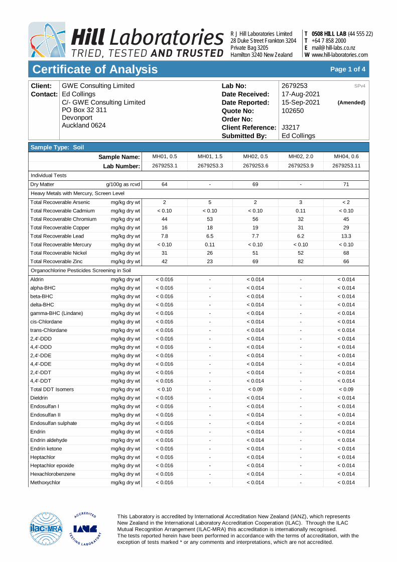
R J Hill Laboratories Limited28 Duke Street Frankton 3204Private Bag 3205Hamilton 3240 New Zealand
0508 HILL LAB (44 555 22)+64 7 858 [email protected]
TTEW
This Laboratory is accredited by International Accreditation New Zealand (IANZ), which representsNew Zealand in the International Laboratory Accreditation Cooperation (ILAC). Through the ILACMutual Recognition Arrangement (ILAC-MRA) this accreditation is internationally recognised.The tests reported herein have been performed in accordance with the terms of accreditation, with theexception of tests marked * or any comments and interpretations, which are not accredited.
Certificate of Analysis Page 1 of 4
Client:Contact: Ed Collings
C/- GWE Consulting LimitedPO Box 32 311DevonportAuckland 0624
GWE Consulting Limited Lab No:Date Received:Date Reported:Quote No:Order No:Client Reference:Submitted By:
267925317-Aug-202115-Sep-2021102650
J3217Ed Collings
SPv4
(Amended)
Sample Type: SoilSample Name:
Lab Number:MH01, 0.5 MH01, 1.5 MH02, 2.0 MH04, 0.6
2679253.1 2679253.3 2679253.6 2679253.9 2679253.11
MH02, 0.5
Individual Tests
g/100g as rcvd 64 - 69 - 71Dry Matter
Heavy Metals with Mercury, Screen Level
mg/kg dry wt 2 5 2 3 < 2Total Recoverable Arsenicmg/kg dry wt < 0.10 < 0.10 < 0.10 0.11 < 0.10Total Recoverable Cadmiummg/kg dry wt 44 53 56 32 45Total Recoverable Chromiummg/kg dry wt 16 18 19 31 29Total Recoverable Coppermg/kg dry wt 7.8 6.5 7.7 6.2 13.3Total Recoverable Leadmg/kg dry wt < 0.10 0.11 < 0.10 < 0.10 < 0.10Total Recoverable Mercurymg/kg dry wt 31 26 51 52 68Total Recoverable Nickelmg/kg dry wt 42 23 69 82 66Total Recoverable Zinc
Organochlorine Pesticides Screening in Soil
mg/kg dry wt < 0.016 - < 0.014 - < 0.014Aldrinmg/kg dry wt < 0.016 - < 0.014 - < 0.014alpha-BHCmg/kg dry wt < 0.016 - < 0.014 - < 0.014beta-BHCmg/kg dry wt < 0.016 - < 0.014 - < 0.014delta-BHCmg/kg dry wt < 0.016 - < 0.014 - < 0.014gamma-BHC (Lindane)mg/kg dry wt < 0.016 - < 0.014 - < 0.014cis-Chlordanemg/kg dry wt < 0.016 - < 0.014 - < 0.014trans-Chlordanemg/kg dry wt < 0.016 - < 0.014 - < 0.0142,4'-DDDmg/kg dry wt < 0.016 - < 0.014 - < 0.0144,4'-DDDmg/kg dry wt < 0.016 - < 0.014 - < 0.0142,4'-DDEmg/kg dry wt < 0.016 - < 0.014 - < 0.0144,4'-DDEmg/kg dry wt < 0.016 - < 0.014 - < 0.0142,4'-DDTmg/kg dry wt < 0.016 - < 0.014 - < 0.0144,4'-DDTmg/kg dry wt < 0.10 - < 0.09 - < 0.09Total DDT Isomersmg/kg dry wt < 0.016 - < 0.014 - < 0.014Dieldrinmg/kg dry wt < 0.016 - < 0.014 - < 0.014Endosulfan Img/kg dry wt < 0.016 - < 0.014 - < 0.014Endosulfan IImg/kg dry wt < 0.016 - < 0.014 - < 0.014Endosulfan sulphatemg/kg dry wt < 0.016 - < 0.014 - < 0.014Endrinmg/kg dry wt < 0.016 - < 0.014 - < 0.014Endrin aldehydemg/kg dry wt < 0.016 - < 0.014 - < 0.014Endrin ketonemg/kg dry wt < 0.016 - < 0.014 - < 0.014Heptachlormg/kg dry wt < 0.016 - < 0.014 - < 0.014Heptachlor epoxidemg/kg dry wt < 0.016 - < 0.014 - < 0.014Hexachlorobenzenemg/kg dry wt < 0.016 - < 0.014 - < 0.014Methoxychlor

Sample Type: SoilSample Name:
Lab Number:MH01, 0.5 MH01, 1.5 MH02, 2.0 MH04, 0.6
2679253.1 2679253.3 2679253.6 2679253.9 2679253.11
MH02, 0.5
Polycyclic Aromatic Hydrocarbons Screening in Soil*
mg/kg dry wt < 0.4 - < 0.4 - < 0.4Total of Reported PAHs in Soilmg/kg dry wt < 0.016 - < 0.014 - < 0.0141-Methylnaphthalenemg/kg dry wt < 0.016 - < 0.014 - < 0.0142-Methylnaphthalenemg/kg dry wt < 0.016 - < 0.014 - < 0.014Acenaphthylenemg/kg dry wt < 0.016 - < 0.014 - < 0.014Acenaphthenemg/kg dry wt < 0.016 - < 0.014 - < 0.014Anthracenemg/kg dry wt < 0.016 - < 0.014 - < 0.014Benzo[a]anthracenemg/kg dry wt < 0.016 - < 0.014 - 0.017Benzo[a]pyrene (BAP)mg/kg dry wt < 0.04 - < 0.04 - < 0.04Benzo[a]pyrene Potency
Equivalency Factor (PEF) NES*mg/kg dry wt < 0.04 - < 0.04 - < 0.04Benzo[a]pyrene Toxic
Equivalence (TEF)*mg/kg dry wt < 0.016 - < 0.014 - < 0.014Benzo[b]fluoranthene + Benzo[j]
fluoranthenemg/kg dry wt < 0.016 - < 0.014 - < 0.014Benzo[e]pyrenemg/kg dry wt < 0.016 - < 0.014 - < 0.014Benzo[g,h,i]perylenemg/kg dry wt < 0.016 - < 0.014 - < 0.014Benzo[k]fluoranthenemg/kg dry wt < 0.016 - < 0.014 - < 0.014Chrysenemg/kg dry wt < 0.016 - < 0.014 - < 0.014Dibenzo[a,h]anthracenemg/kg dry wt < 0.016 - < 0.014 - 0.025Fluoranthenemg/kg dry wt < 0.016 - < 0.014 - < 0.014Fluorenemg/kg dry wt < 0.016 - < 0.014 - < 0.014Indeno(1,2,3-c,d)pyrenemg/kg dry wt < 0.08 - < 0.07 - < 0.07Naphthalenemg/kg dry wt < 0.016 - < 0.014 - < 0.014Perylenemg/kg dry wt < 0.016 - < 0.014 - < 0.014Phenanthrenemg/kg dry wt < 0.016 - < 0.014 - 0.026Pyrene
Sample Name:Lab Number:
MH04, 1.0 MH06, 0.5 MH05, 0.5 MH05, 2.0
2679253.12 2679253.16 2679253.21 2679253.25 2679253.27
MH03, 0.5
Individual Tests
g/100g as rcvd 71 71 71 63 -Dry MatterHeavy Metals with Mercury, Screen Level
mg/kg dry wt 2 < 2 < 2 2 < 2Total Recoverable Arsenicmg/kg dry wt < 0.10 < 0.10 < 0.10 0.10 0.15Total Recoverable Cadmiummg/kg dry wt 57 12 56 75 36Total Recoverable Chromiummg/kg dry wt 32 7 26 17 28Total Recoverable Coppermg/kg dry wt 15.7 4.9 7.7 13.5 5.7Total Recoverable Leadmg/kg dry wt < 0.10 < 0.10 < 0.10 0.15 < 0.10Total Recoverable Mercurymg/kg dry wt 109 8 51 73 111Total Recoverable Nickelmg/kg dry wt 92 6 67 68 87Total Recoverable Zinc
Organochlorine Pesticides Screening in Soil
mg/kg dry wt - < 0.014 < 0.014 < 0.016 -Aldrinmg/kg dry wt - < 0.014 < 0.014 < 0.016 -alpha-BHCmg/kg dry wt - < 0.014 < 0.014 < 0.016 -beta-BHCmg/kg dry wt - < 0.014 < 0.014 < 0.016 -delta-BHCmg/kg dry wt - < 0.014 < 0.014 < 0.016 -gamma-BHC (Lindane)mg/kg dry wt - < 0.014 < 0.014 < 0.016 -cis-Chlordanemg/kg dry wt - < 0.014 < 0.014 < 0.016 -trans-Chlordanemg/kg dry wt - < 0.014 < 0.014 < 0.016 -2,4'-DDDmg/kg dry wt - < 0.014 < 0.014 < 0.016 -4,4'-DDDmg/kg dry wt - < 0.014 < 0.014 < 0.016 -2,4'-DDEmg/kg dry wt - < 0.014 < 0.014 < 0.016 -4,4'-DDEmg/kg dry wt - < 0.014 < 0.014 < 0.016 -2,4'-DDTmg/kg dry wt - < 0.014 < 0.014 < 0.016 -4,4'-DDTmg/kg dry wt - < 0.09 < 0.09 < 0.10 -Total DDT Isomersmg/kg dry wt - < 0.014 < 0.014 < 0.016 -Dieldrin
Lab No: 2679253-SPv4 Hill Laboratories Page 2 of 4

Sample Type: SoilSample Name:
Lab Number:MH04, 1.0 MH06, 0.5 MH05, 0.5 MH05, 2.0
2679253.12 2679253.16 2679253.21 2679253.25 2679253.27
MH03, 0.5
Organochlorine Pesticides Screening in Soil
mg/kg dry wt - < 0.014 < 0.014 < 0.016 -Endosulfan Img/kg dry wt - < 0.014 < 0.014 < 0.016 -Endosulfan IImg/kg dry wt - < 0.014 < 0.014 < 0.016 -Endosulfan sulphatemg/kg dry wt - < 0.014 < 0.014 < 0.016 -Endrinmg/kg dry wt - < 0.014 < 0.014 < 0.016 -Endrin aldehydemg/kg dry wt - < 0.014 < 0.014 < 0.016 -Endrin ketonemg/kg dry wt - < 0.014 < 0.014 < 0.016 -Heptachlormg/kg dry wt - < 0.014 < 0.014 < 0.016 -Heptachlor epoxidemg/kg dry wt - < 0.014 < 0.014 < 0.016 -Hexachlorobenzenemg/kg dry wt - < 0.014 < 0.014 < 0.016 -Methoxychlor
Polycyclic Aromatic Hydrocarbons Screening in Soil*
mg/kg dry wt < 0.4 < 0.4 < 0.4 < 0.4 -Total of Reported PAHs in Soilmg/kg dry wt < 0.014 < 0.014 < 0.014 < 0.016 -1-Methylnaphthalenemg/kg dry wt < 0.014 < 0.014 < 0.014 < 0.016 -2-Methylnaphthalenemg/kg dry wt < 0.014 < 0.014 < 0.014 < 0.016 -Acenaphthylenemg/kg dry wt < 0.014 < 0.014 < 0.014 < 0.016 -Acenaphthenemg/kg dry wt < 0.014 < 0.014 < 0.014 < 0.016 -Anthracenemg/kg dry wt < 0.014 < 0.014 < 0.014 < 0.016 -Benzo[a]anthracenemg/kg dry wt < 0.014 < 0.014 < 0.014 < 0.016 -Benzo[a]pyrene (BAP)mg/kg dry wt < 0.04 < 0.04 < 0.04 < 0.04 -Benzo[a]pyrene Potency
Equivalency Factor (PEF) NES*mg/kg dry wt < 0.04 < 0.04 < 0.04 < 0.04 -Benzo[a]pyrene Toxic
Equivalence (TEF)*mg/kg dry wt < 0.014 < 0.014 < 0.014 < 0.016 -Benzo[b]fluoranthene + Benzo[j]
fluoranthenemg/kg dry wt < 0.014 < 0.014 < 0.014 < 0.016 -Benzo[e]pyrenemg/kg dry wt < 0.014 < 0.014 < 0.014 < 0.016 -Benzo[g,h,i]perylenemg/kg dry wt < 0.014 < 0.014 < 0.014 < 0.016 -Benzo[k]fluoranthenemg/kg dry wt < 0.014 < 0.014 < 0.014 < 0.016 -Chrysenemg/kg dry wt < 0.014 < 0.014 < 0.014 < 0.016 -Dibenzo[a,h]anthracenemg/kg dry wt < 0.014 < 0.014 < 0.014 < 0.016 -Fluoranthenemg/kg dry wt < 0.014 < 0.014 < 0.014 < 0.016 -Fluorenemg/kg dry wt < 0.014 < 0.014 < 0.014 < 0.016 -Indeno(1,2,3-c,d)pyrenemg/kg dry wt < 0.07 < 0.07 < 0.07 < 0.08 -Naphthalenemg/kg dry wt < 0.014 < 0.014 < 0.014 < 0.016 -Perylenemg/kg dry wt < 0.014 < 0.014 < 0.014 < 0.016 -Phenanthrenemg/kg dry wt < 0.014 < 0.014 < 0.014 < 0.016 -Pyrene
Sample Name:Lab Number:
MH3 (QC)
2679253.30
Heavy Metals with Mercury, Screen Level
mg/kg dry wt < 2 - - - -Total Recoverable Arsenicmg/kg dry wt < 0.10 - - - -Total Recoverable Cadmiummg/kg dry wt 54 - - - -Total Recoverable Chromiummg/kg dry wt 25 - - - -Total Recoverable Coppermg/kg dry wt 7.5 - - - -Total Recoverable Leadmg/kg dry wt 0.15 - - - -Total Recoverable Mercurymg/kg dry wt 55 - - - -Total Recoverable Nickelmg/kg dry wt 65 - - - -Total Recoverable Zinc
Lab No: 2679253-SPv4 Hill Laboratories Page 3 of 4
Analyst's CommentsAmended Report: This certificate of analysis replaces report '2679253-SPv3' issued on 31-Aug-2021 at 4:13 pm.Reason for amendment: Metals testing added.

The following table(s) gives a brief description of the methods used to conduct the analyses for this job. The detection limits given below are those attainable in a relatively simple matrix.Detection limits may be higher for individual samples should insufficient sample be available, or if the matrix requires that dilutions be performed during analysis. A detection limit rangeindicates the lowest and highest detection limits in the associated suite of analytes. A full listing of compounds and detection limits are available from the laboratory upon request.Unless otherwise indicated, analyses were performed at Hill Laboratories, 28 Duke Street, Frankton, Hamilton 3204.
Summary of Methods
Sample Type: SoilTest Method Description Default Detection Limit Sample No
1, 3, 6, 9,11-12, 16,21, 25, 27,
30
Environmental Solids Sample Drying* Air dried at 35°CUsed for sample preparation.May contain a residual moisture content of 2-5%.
-
1, 6, 11-12,16, 21, 25
Total of Reported PAHs in Soil Sonication extraction, GC-MS analysis. In-house based on USEPA 8270.
0.03 mg/kg dry wt
1, 3, 6, 9,11-12, 16,21, 25, 27,
30
Heavy Metals with Mercury, ScreenLevel
Dried sample, < 2mm fraction. Nitric/Hydrochloric aciddigestion US EPA 200.2. Complies with NES Regulations. ICP-MS screen level, interference removal by Kinetic EnergyDiscrimination if required.
0.10 - 4 mg/kg dry wt
1, 6, 11, 16,21, 25
Organochlorine Pesticides Screening inSoil
Sonication extraction, GC-ECD analysis. Tested on as receivedsample. In-house based on US EPA 8081.
0.010 - 0.06 mg/kg dry wt
1, 6, 11-12,16, 21, 25
Polycyclic Aromatic HydrocarbonsScreening in Soil*
Sonication extraction, GC-MS analysis. Tested on as receivedsample. In-house based on US EPA 8270.
0.002 - 0.05 mg/kg dry wt
1, 6, 11-12,16, 21, 25
Dry Matter (Env) Dried at 103°C for 4-22hr (removes 3-5% more water than airdry) , gravimetry. (Free water removed before analysis, non-soilobjects such as sticks, leaves, grass and stones also removed).US EPA 3550.
0.10 g/100g as rcvd
1, 6, 11-12,16, 21, 25
Benzo[a]pyrene Potency EquivalencyFactor (PEF) NES*
BaP Potency Equivalence calculated from; Benzo(a)anthracenex 0.1 + Benzo(b)fluoranthene x 0.1 + Benzo(j)fluoranthene x 0.1+ Benzo(k)fluoranthene x 0.1 + Benzo(a)pyrene x 1.0 +Chrysene x 0.01 + Dibenzo(a,h)anthracene x 1.0 + Fluoranthenex 0.01 + Indeno(1,2,3-c,d)pyrene x 0.1. Ministry for theEnvironment. 2011. Methodology for Deriving Standards forContaminants in Soil to Protect Human Health. Wellington:Ministry for the Environment.
0.002 mg/kg dry wt
1, 6, 11-12,16, 21, 25
Benzo[a]pyrene Toxic Equivalence(TEF)*
Benzo[a]pyrene Toxic Equivalence (TEF) calculated from;Benzo[a]pyrene x 1.0 + Benzo(a)anthracene x 0.1 + Benzo(b)fluoranthene x 0.1 + Benzo(k)fluoranthene x 0.1 + Chrysene x0.01 + Dibenzo(a,h)anthracene x 1.0 + Indeno(1,2,3-c,d)pyrenex 0.1. Guidelines for assessing and managing contaminatedgasworks sites in New Zealand (GMG) (MfE, 1997).
0.002 mg/kg dry wt
Lab No: 2679253-SPv4 Hill Laboratories Page 4 of 4
Ara Heron BSc (Tech)Client Services Manager - Environmental
These samples were collected by yourselves (or your agent) and analysed as received at the laboratory.
Testing was completed between 24-Aug-2021 and 15-Sep-2021. For completion dates of individual analyses please contact the laboratory.
Samples are held at the laboratory after reporting for a length of time based on the stability of the samples and analytes being tested (considering anypreservation used), and the storage space available. Once the storage period is completed, the samples are discarded unless otherwise agreed withthe customer. Extended storage times may incur additional charges.
This certificate of analysis must not be reproduced, except in full, without the written consent of the signatory.
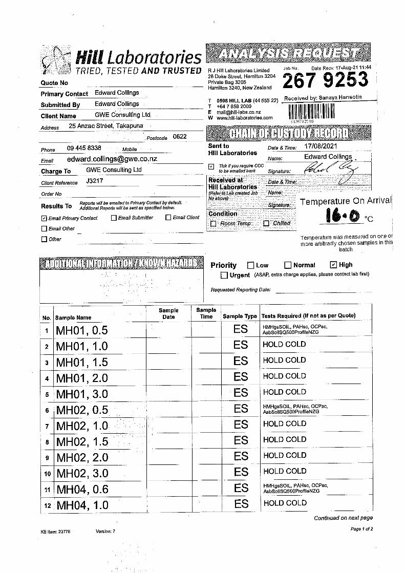


Job Information Summary Page 1 of 2
Client:
Contact: Ed Collings
C/- GWE Consulting Limited
PO Box 32 311
Devonport
Auckland 0624
GWE Consulting Limited Lab No:
Date Registered:Priority:
Quote No:
Order No:Client Reference:
Submitted By:
2679253
18-Aug-2021 11:59 amHigh
102650
J3217
Ed Collings
Charge To: GWE Consulting Limited
R J Hill Laboratories Limited28 Duke Street Frankton 3204
Private Bag 3205
Hamilton 3240 New Zealand
0508 HILL LAB (44 555 22)+64 7 858 2000
www.hill-laboratories.com
TT
E
W
Add. Client Ref:
Target Date: 15-Sep-2021 4:30 pm
No Sample Name Sample Type Containers Tests Requested
Samples
1 MH01, 0.5 Soil GSoil300, PSoil250 Heavy Metals with Mercury, Screen Level; Organochlorine Pesticides Screening in Soil; Polycyclic Aromatic Hydrocarbons Screening in Soil
2 MH01, 1.0 Soil GSoil300, PSoil250 Hold Cold
3 MH01, 1.5 Soil GSoil300, PSoil250 Heavy Metals with Mercury, Screen Level
4 MH01, 2.0 Soil GSoil300, PSoil250 Hold Cold
5 MH01, 3.0 Soil GSoil300, PSoil250 Hold Cold
6 MH02, 0.5 Soil GSoil300, PSoil250 Heavy Metals with Mercury, Screen Level; Organochlorine Pesticides Screening in Soil; Polycyclic Aromatic Hydrocarbons Screening in Soil
7 MH02, 1.0 Soil GSoil300, PSoil250 Hold Cold
8 MH02, 1.5 Soil GSoil300, PSoil250 Hold Cold
9 MH02, 2.0 Soil GSoil300, PSoil250 Heavy Metals with Mercury, Screen Level
10 MH02, 3.0 Soil GSoil300, PSoil250 Hold Cold
11 MH04, 0.6 Soil GSoil300, PSoil250 Heavy Metals with Mercury, Screen Level; Organochlorine Pesticides Screening in Soil; Polycyclic Aromatic Hydrocarbons Screening in Soil
12 MH04, 1.0 Soil GSoil300, PSoil250 Heavy Metals with Mercury, Screen Level; Polycyclic Aromatic Hydrocarbons Screening in Soil
13 MH04, 1.5 Soil GSoil300, PSoil250 Hold Cold
14 MH04, 2.0 Soil GSoil300, PSoil250 Hold Cold
15 MH04, 3.0 Soil GSoil300, PSoil250 Hold Cold
16 MH06, 0.5 Soil GSoil300, PSoil250 Heavy Metals with Mercury, Screen Level; Organochlorine Pesticides Screening in Soil; Polycyclic Aromatic Hydrocarbons Screening in Soil
17 MH06, 1.0 Soil GSoil300, PSoil250 Hold Cold
18 MH06, 1.5 Soil GSoil300, PSoil250 Hold Cold
19 MH06, 2.0 Soil GSoil300, PSoil250 Hold Cold
20 MH06, 3.0 Soil GSoil300, PSoil250 Hold Cold
21 MH03, 0.5 Soil GSoil300, PSoil250 Heavy Metals with Mercury, Screen Level; Organochlorine Pesticides Screening in Soil; Polycyclic Aromatic Hydrocarbons Screening in Soil
22 MH03, 1.0 Soil GSoil300, PSoil250 Hold Cold
23 MH03, 2.0 Soil GSoil300, PSoil250 Hold Cold
24 MH03, 3.0 Soil GSoil300, PSoil250 Hold Cold
25 MH05, 0.5 Soil GSoil300, PSoil250 Heavy Metals with Mercury, Screen Level; Organochlorine Pesticides Screening in Soil; Polycyclic Aromatic Hydrocarbons Screening in Soil
26 MH05, 1.0 Soil GSoil300, PSoil250 Hold Cold
27 MH05, 2.0 Soil GSoil300, PSoil250 Heavy Metals with Mercury, Screen Level
28 MH05, 3.0 Soil GSoil300, PSoil250 Hold Cold
29 MH05 (0.1) Soil GSoil300, PSoil250 Hold Cold
Lab No: 2679253 Hill Laboratories Page 1 of 2

No Sample Name Sample Type Containers Tests Requested
Samples
30 MH3 (QC) Soil GSoil300 Heavy Metals with Mercury, Screen Level
31 MH5 (QC) Soil GSoil300 Hold Cold
Lab No: 2679253 Hill Laboratories Page 2 of 2
The following table(s) gives a brief description of the methods used to conduct the analyses for this job. The detection limits given below are those attainable in a relatively simple matrix.Detection limits may be higher for individual samples should insufficient sample be available, or if the matrix requires that dilutions be performed during analysis. A detection limit rangeindicates the lowest and highest detection limits in the associated suite of analytes. A full listing of compounds and detection limits are available from the laboratory upon request.Unless otherwise indicated, analyses were performed at Hill Laboratories, 28 Duke Street, Frankton, Hamilton 3204.
Summary of Methods
Sample Type: Soil
Test Method Description Default Detection Limit Sample No
1, 3, 6, 9,11-12, 16,21, 25, 27,
30
Environmental Solids Sample Drying Air dried at 35°CUsed for sample preparation.May contain a residual moisture content of 2-5%.
-
1, 6, 11-12,16, 21, 25
Total of Reported PAHs in Soil Sonication extraction, GC-MS analysis. In-house based on US EPA 8270.
0.03 mg/kg dry wt
1, 3, 6, 9,11-12, 16,21, 25, 27,
30
Heavy Metals with Mercury, Screen Level
Dried sample, < 2mm fraction. Nitric/Hydrochloric acid digestion US EPA 200.2. Complies with NES Regulations. ICP-MS screen level, interference removal by Kinetic Energy Discrimination if required.
0.10 - 4 mg/kg dry wt
1, 6, 11, 16,21, 25
Organochlorine Pesticides Screening in Soil
Sonication extraction, GC-ECD analysis. Tested on as received sample. In-house based on US EPA 8081.
0.010 - 0.06 mg/kg dry wt
1, 6, 11-12,16, 21, 25
Polycyclic Aromatic Hydrocarbons Screening in Soil
Sonication extraction, GC-MS analysis. Tested on as received sample. In-house based on US EPA 8270.
0.002 - 0.05 mg/kg dry wt
1, 6, 11-12,16, 21, 25
Dry Matter (Env) Dried at 103°C for 4-22hr (removes 3-5% more water than air dry) , gravimetry. (Free water removed before analysis, non-soil objects such as sticks, leaves, grass and stones also removed). US EPA 3550.
0.10 g/100g as rcvd
1, 6, 11-12,16, 21, 25
Benzo[a]pyrene Potency Equivalency Factor (PEF) NES
BaP Potency Equivalence calculated from; Benzo(a)anthracene x 0.1 + Benzo(b)fluoranthene x 0.1 + Benzo(j)fluoranthene x 0.1 + Benzo(k)fluoranthene x 0.1 + Benzo(a)pyrene x 1.0 + Chrysene x 0.01 + Dibenzo(a,h)anthracene x 1.0 + Fluoranthene x 0.01 + Indeno(1,2,3-c,d)pyrene x 0.1. Ministry for the Environment. 2011. Methodology for Deriving Standards for Contaminants in Soil to Protect Human Health. Wellington: Ministry for the Environment.
0.002 mg/kg dry wt
1, 6, 11-12,16, 21, 25
Benzo[a]pyrene Toxic Equivalence (TEF)
Benzo[a]pyrene Toxic Equivalence (TEF) calculated from; Benzo[a]pyrene x 1.0 + Benzo(a)anthracene x 0.1 + Benzo(b)fluoranthene x 0.1 + Benzo(k)fluoranthene x 0.1 + Chrysene x 0.01 + Dibenzo(a,h)anthracene x 1.0 + Indeno(1,2,3-c,d)pyrene x 0.1. Guidelines for assessing and managing contaminated gasworks sites in New Zealand (GMG) (MfE, 1997).
0.002 mg/kg dry wt

R J Hill Laboratories LimitedGround Fl, 28 Heather StreetParnellAuckland 1052 New Zealand
0508 HILL LAB (44 555 22)+64 7 858 [email protected]
TTEW
This Laboratory is accredited by International Accreditation New Zealand (IANZ), which representsNew Zealand in the International Laboratory Accreditation Cooperation (ILAC). Through the ILACMutual Recognition Arrangement (ILAC-MRA) this accreditation is internationally recognised.The tests reported herein have been performed in accordance with the terms of accreditation, with theexception of tests marked * or any comments and interpretations, which are not accredited.
Certificate of Analysis Page 1 of 3
Client:Contact: Ed Collings
C/- GWE Consulting LimitedPO Box 32 311DevonportAuckland 0624
GWE Consulting Limited Lab No:Date Received:Date Reported:Quote No:Order No:Client Reference:Submitted By:
267944317-Aug-202101-Sep-2021102650
J3217Ed Collings
A2Pv1
Sample Type: SoilSample Name:
Lab Number:
MH01, 0.511-Aug-2021
MH02, 0.513-Aug-2021
MH06, 0.517-Aug-2021
MH03, 0.516-Aug-2021
2679443.1 2679443.2 2679443.3 2679443.4 2679443.5
MH04, 0.6
Asbestos NOTdetected.
Asbestos NOTdetected.
Asbestos NOTdetected.
Asbestos NOTdetected.
Asbestos NOTdetected.
Asbestos Presence / Absence
- - - - -Description of Asbestos Form% w/w < 0.001 < 0.001 < 0.001 < 0.001 < 0.001Asbestos in ACM as % of Total
Sample*% w/w < 0.001 < 0.001 < 0.001 < 0.001 < 0.001Combined Fibrous Asbestos +
Asbestos Fines as % of Total Sample*% w/w < 0.001 < 0.001 < 0.001 < 0.001 < 0.001Asbestos as Fibrous Asbestos as % of
Total Sample*% w/w < 0.001 < 0.001 < 0.001 < 0.001 < 0.001Asbestos as Asbestos Fines as % of
Total Sample*g 557.2 424.7 493.2 477.0 770.6As Received Weightg 413.8 299.8 368.2 360.1 623.0Dry Weight
% 26 29 25 25 19Moisture
g dry wt 16.3 < 0.1 < 0.1 < 0.1 23.4Sample Fraction >10mm*g dry wt 122.9 85.3 83.8 141.4 232.3Sample Fraction <10mm to >2mm*g dry wt 273.3 213.6 283.8 217.8 366.8Sample Fraction <2mm*g dry wt 50.2 50.3 50.8 50.1 50.9<2mm Subsample Weight*g dry wt < 0.00001 < 0.00001 < 0.00001 < 0.00001 < 0.00001Weight of Asbestos in ACM (Non-
Friable)g dry wt < 0.00001 < 0.00001 < 0.00001 < 0.00001 < 0.00001Weight of Asbestos as Fibrous
Asbestos (Friable)*g dry wt < 0.00001 < 0.00001 < 0.00001 < 0.00001 < 0.00001Weight of Asbestos as Asbestos
Fines (Friable)*
Sample Name:
Lab Number:
MH05, 0.517-Aug-20212679443.6
Asbestos NOTdetected.
- - - -Asbestos Presence / Absence
- - - - -Description of Asbestos Form% w/w < 0.001 - - - -Asbestos in ACM as % of Total
Sample*% w/w < 0.001 - - - -Combined Fibrous Asbestos +
Asbestos Fines as % of Total Sample*% w/w < 0.001 - - - -Asbestos as Fibrous Asbestos as % of
Total Sample*% w/w < 0.001 - - - -Asbestos as Asbestos Fines as % of
Total Sample*g 738.0 - - - -As Received Weightg 524.3 - - - -Dry Weight
% 29 - - - -Moisture
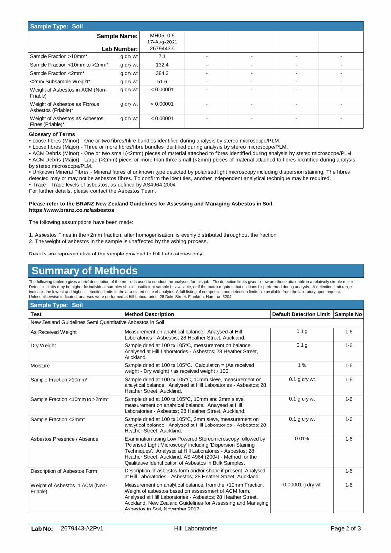
Sample Type: SoilSample Name:
Lab Number:
MH05, 0.517-Aug-20212679443.6
g dry wt 7.1 - - - -Sample Fraction >10mm*g dry wt 132.4 - - - -Sample Fraction <10mm to >2mm*g dry wt 384.3 - - - -Sample Fraction <2mm*g dry wt 51.6 - - - -<2mm Subsample Weight*g dry wt < 0.00001 - - - -Weight of Asbestos in ACM (Non-
Friable)g dry wt < 0.00001 - - - -Weight of Asbestos as Fibrous
Asbestos (Friable)*g dry wt < 0.00001 - - - -Weight of Asbestos as Asbestos
Fines (Friable)*
Glossary of Terms• Loose fibres (Minor) - One or two fibres/fibre bundles identified during analysis by stereo microscope/PLM.• Loose fibres (Major) - Three or more fibres/fibre bundles identified during analysis by stereo microscope/PLM.• ACM Debris (Minor) - One or two small (<2mm) pieces of material attached to fibres identified during analysis by stereo microscope/PLM.• ACM Debris (Major) - Large (>2mm) piece, or more than three small (<2mm) pieces of material attached to fibres identified during analysisby stereo microscope/PLM.• Unknown Mineral Fibres - Mineral fibres of unknown type detected by polarised light microscopy including dispersion staining. The fibresdetected may or may not be asbestos fibres. To confirm the identities, another independent analytical technique may be required.• Trace - Trace levels of asbestos, as defined by AS4964-2004.For further details, please contact the Asbestos Team.
Please refer to the BRANZ New Zealand Guidelines for Assessing and Managing Asbestos in Soil.https://www.branz.co.nz/asbestos
The following assumptions have been made:
1. Asbestos Fines in the <2mm fraction, after homogenisation, is evenly distributed throughout the fraction2. The weight of asbestos in the sample is unaffected by the ashing process.
Results are representative of the sample provided to Hill Laboratories only.
Lab No: 2679443-A2Pv1 Hill Laboratories Page 2 of 3
The following table(s) gives a brief description of the methods used to conduct the analyses for this job. The detection limits given below are those attainable in a relatively simple matrix.Detection limits may be higher for individual samples should insufficient sample be available, or if the matrix requires that dilutions be performed during analysis. A detection limit rangeindicates the lowest and highest detection limits in the associated suite of analytes. A full listing of compounds and detection limits are available from the laboratory upon request.Unless otherwise indicated, analyses were performed at Hill Laboratories, 28 Duke Street, Frankton, Hamilton 3204.
Summary of Methods
Sample Type: SoilTest Method Description Default Detection Limit Sample NoNew Zealand Guidelines Semi Quantitative Asbestos in Soil
1-6As Received Weight Measurement on analytical balance. Analysed at HillLaboratories - Asbestos; 28 Heather Street, Auckland.
0.1 g
1-6Dry Weight Sample dried at 100 to 105°C, measurement on balance.Analysed at Hill Laboratories - Asbestos; 28 Heather Street,Auckland.
0.1 g
1-6Moisture Sample dried at 100 to 105°C. Calculation = (As receivedweight - Dry weight) / as received weight x 100.
1 %
1-6Sample Fraction >10mm* Sample dried at 100 to 105°C, 10mm sieve, measurement onanalytical balance. Analysed at Hill Laboratories - Asbestos; 28Heather Street, Auckland.
0.1 g dry wt
1-6Sample Fraction <10mm to >2mm* Sample dried at 100 to 105°C, 10mm and 2mm sieve,measurement on analytical balance. Analysed at HillLaboratories - Asbestos; 28 Heather Street, Auckland.
0.1 g dry wt
1-6Sample Fraction <2mm* Sample dried at 100 to 105°C, 2mm sieve, measurement onanalytical balance. Analysed at Hill Laboratories - Asbestos; 28Heather Street, Auckland.
0.1 g dry wt
1-6Asbestos Presence / Absence Examination using Low Powered Stereomicroscopy followed by'Polarised Light Microscopy' including 'Dispersion StainingTechniques'. Analysed at Hill Laboratories - Asbestos; 28Heather Street, Auckland. AS 4964 (2004) - Method for theQualitative Identification of Asbestos in Bulk Samples.
0.01%
1-6Description of Asbestos Form Description of asbestos form and/or shape if present. Analysedat Hill Laboratories - Asbestos; 28 Heather Street, Auckland.
-
1-6Weight of Asbestos in ACM (Non-Friable)
Measurement on analytical balance, from the >10mm Fraction.Weight of asbestos based on assessment of ACM form.Analysed at Hill Laboratories - Asbestos; 28 Heather Street,Auckland. New Zealand Guidelines for Assessing and ManagingAsbestos in Soil, November 2017.
0.00001 g dry wt

Sample Type: SoilTest Method Description Default Detection Limit Sample No
1-6Asbestos in ACM as % of TotalSample*
Calculated from weight of asbestos in ACM and sample dryweight. New Zealand Guidelines for Assessing and ManagingAsbestos in Soil, November 2017.
0.001 % w/w
1-6Weight of Asbestos as FibrousAsbestos (Friable)*
Measurement on analytical balance, from the >10mm Fraction.Analysed at Hill Laboratories - Asbestos; 28 Heather Street,Auckland. New Zealand Guidelines for Assessing and ManagingAsbestos in Soil, November 2017.
0.00001 g dry wt
1-6Asbestos as Fibrous Asbestos as % ofTotal Sample*
Calculated from weight of fibrous asbestos and sample dryweight. New Zealand Guidelines for Assessing and ManagingAsbestos in Soil, November 2017.
0.001 % w/w
1-6Weight of Asbestos as Asbestos Fines(Friable)*
Measurement on analytical balance, from the <10mm Fractions.Analysed at Hill Laboratories - Asbestos; 28 Heather Street,Auckland. New Zealand Guidelines for Assessing and ManagingAsbestos in Soil, November 2017.
0.00001 g dry wt
1-6Asbestos as Asbestos Fines as % ofTotal Sample*
Calculated from weight of asbestos fines and sample dry weight.New Zealand Guidelines for Assessing and Managing Asbestosin Soil, November 2017.
0.001 % w/w
1-6Combined Fibrous Asbestos +Asbestos Fines as % of Total Sample*
Calculated from weight of fibrous asbestos plus asbestos finesand sample dry weight. New Zealand Guidelines for Assessingand Managing Asbestos in Soil, November 2017.
0.001 % w/w
Lab No: 2679443-A2Pv1 Hill Laboratories Page 3 of 3
Ashleigh TealSection Manager - Asbestos
These samples were collected by yourselves (or your agent) and analysed as received at the laboratory.
Testing was completed on 01-Sep-2021. For completion dates of individual analyses please contact the laboratory.
Samples are held at the laboratory after reporting for a length of time based on the stability of the samples and analytes being tested (considering anypreservation used), and the storage space available. Once the storage period is completed, the samples are discarded unless otherwise agreed withthe customer. Extended storage times may incur additional charges.
This certificate of analysis must not be reproduced, except in full, without the written consent of the signatory.


Job Information Summary Page 1 of 2
Client:
Contact: Ed Collings
C/- GWE Consulting Limited
PO Box 32 311
Devonport
Auckland 0624
GWE Consulting Limited Lab No:
Date Registered:Priority:
Quote No:
Order No:Client Reference:
Submitted By:
2679443
17-Aug-2021 2:13 pmHigh
102650
J3217
Ed Collings
Charge To: GWE Consulting Limited
R J Hill Laboratories Limited28 Duke Street Frankton 3204
Private Bag 3205
Hamilton 3240 New Zealand
0508 HILL LAB (44 555 22)+64 7 858 2000
www.hill-laboratories.com
TT
E
W
Add. Client Ref:
Target Date: 24-Aug-2021 4:30 pm
No Sample Name Sample Type Containers Tests Requested
Samples
1 MH01, 0.5 11-Aug-2021 Soil PSoil500Asb New Zealand Guidelines Semi Quantitative Asbestos in Soil
2 MH02, 0.5 13-Aug-2021 Soil PSoil500Asb New Zealand Guidelines Semi Quantitative Asbestos in Soil
3 MH04, 0.6 Soil PSoil500Asb New Zealand Guidelines Semi Quantitative Asbestos in Soil
4 MH06, 0.5 17-Aug-2021 Soil PSoil500Asb New Zealand Guidelines Semi Quantitative Asbestos in Soil
5 MH03, 0.5 16-Aug-2021 Soil PSoil500Asb New Zealand Guidelines Semi Quantitative Asbestos in Soil
6 MH05, 0.5 17-Aug-2021 Soil PSoil500Asb New Zealand Guidelines Semi Quantitative Asbestos in Soil
Lab No: 2679443 Hill Laboratories Page 1 of 2
The following table(s) gives a brief description of the methods used to conduct the analyses for this job. The detection limits given below are those attainable in a relatively simple matrix.Detection limits may be higher for individual samples should insufficient sample be available, or if the matrix requires that dilutions be performed during analysis. A detection limit rangeindicates the lowest and highest detection limits in the associated suite of analytes. A full listing of compounds and detection limits are available from the laboratory upon request.Unless otherwise indicated, analyses were performed at Hill Laboratories, 28 Duke Street, Frankton, Hamilton 3204.
Summary of Methods
Sample Type: Soil
Test Method Description Default Detection Limit Sample No
New Zealand Guidelines Semi Quantitative Asbestos in Soil
1-6As Received Weight Measurement on analytical balance. Analysed at Hill Laboratories - Asbestos; 28 Heather Street, Auckland.
0.1 g
1-6Dry Weight Sample dried at 100 to 105°C, measurement on balance. Analysed at Hill Laboratories - Asbestos; 28 Heather Street, Auckland.
0.1 g
1-6Moisture Sample dried at 100 to 105°C. Calculation = (As received weight - Dry weight) / as received weight x 100.
1 %
1-6Sample Fraction >10mm Sample dried at 100 to 105°C, 10mm sieve, measurement on analytical balance. Analysed at Hill Laboratories - Asbestos; 28 Heather Street, Auckland.
0.1 g dry wt
1-6Sample Fraction <10mm to >2mm Sample dried at 100 to 105°C, 10mm and 2mm sieve, measurement on analytical balance. Analysed at Hill Laboratories - Asbestos; 28 Heather Street, Auckland.
0.1 g dry wt
1-6Sample Fraction <2mm Sample dried at 100 to 105°C, 2mm sieve, measurement on analytical balance. Analysed at Hill Laboratories - Asbestos; 28 Heather Street, Auckland.
0.1 g dry wt
1-6Asbestos Presence / Absence Examination using Low Powered Stereomicroscopy followed by 'Polarised Light Microscopy' including 'Dispersion Staining Techniques'. Analysed at Hill Laboratories - Asbestos; 28 Heather Street, Auckland. AS 4964 (2004) - Method for the Qualitative Identification of Asbestos in Bulk Samples.
0.01%
1-6Description of Asbestos Form Description of asbestos form and/or shape if present. Analysed at Hill Laboratories - Asbestos; 28 Heather Street, Auckland.
-

Sample Type: Soil
Test Method Description Default Detection Limit Sample No
1-6Weight of Asbestos in ACM (Non-Friable)
Measurement on analytical balance, from the >10mm Fraction. Weight of asbestos based on assessment of ACM form. Analysed at Hill Laboratories - Asbestos; 28 Heather Street, Auckland. New Zealand Guidelines for Assessing and Managing Asbestos in Soil, November 2017.
0.00001 g dry wt
1-6Asbestos in ACM as % of Total Sample
Calculated from weight of asbestos in ACM and sample dry weight. New Zealand Guidelines for Assessing and Managing Asbestos in Soil, November 2017.
0.001 % w/w
1-6Weight of Asbestos as Fibrous Asbestos (Friable)
Measurement on analytical balance, from the >10mm Fraction. Analysed at Hill Laboratories - Asbestos; 28 Heather Street, Auckland. New Zealand Guidelines for Assessing and Managing Asbestos in Soil, November 2017.
0.00001 g dry wt
1-6Asbestos as Fibrous Asbestos as % of Total Sample
Calculated from weight of fibrous asbestos and sample dry weight. New Zealand Guidelines for Assessing and Managing Asbestos in Soil, November 2017.
0.001 % w/w
1-6Weight of Asbestos as Asbestos Fines (Friable)
Measurement on analytical balance, from the <10mm Fractions. Analysed at Hill Laboratories - Asbestos; 28 Heather Street, Auckland. New Zealand Guidelines for Assessing and Managing Asbestos in Soil, November 2017.
0.00001 g dry wt
1-6Asbestos as Asbestos Fines as % of Total Sample
Calculated from weight of asbestos fines and sample dry weight. New Zealand Guidelines for Assessing and Managing Asbestos in Soil, November 2017.
0.001 % w/w
1-6Combined Fibrous Asbestos + Asbestos Fines as % of Total Sample
Calculated from weight of fibrous asbestos plus asbestos fines and sample dry weight. New Zealand Guidelines for Assessing and Managing Asbestos in Soil, November 2017.
0.001 % w/w
Lab No: 2679443 Hill Laboratories Page 2 of 2


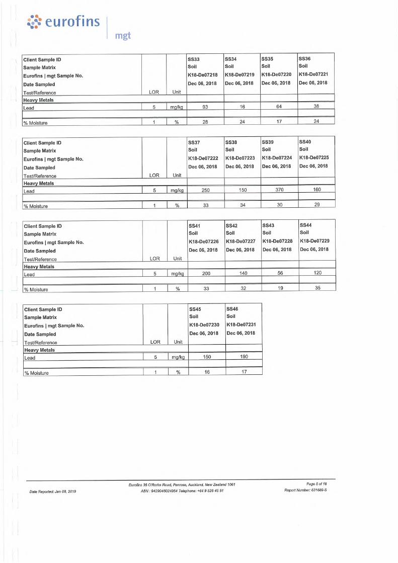


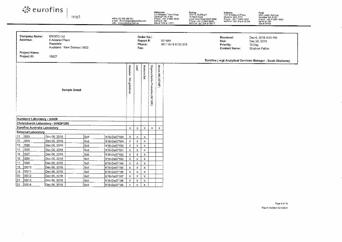


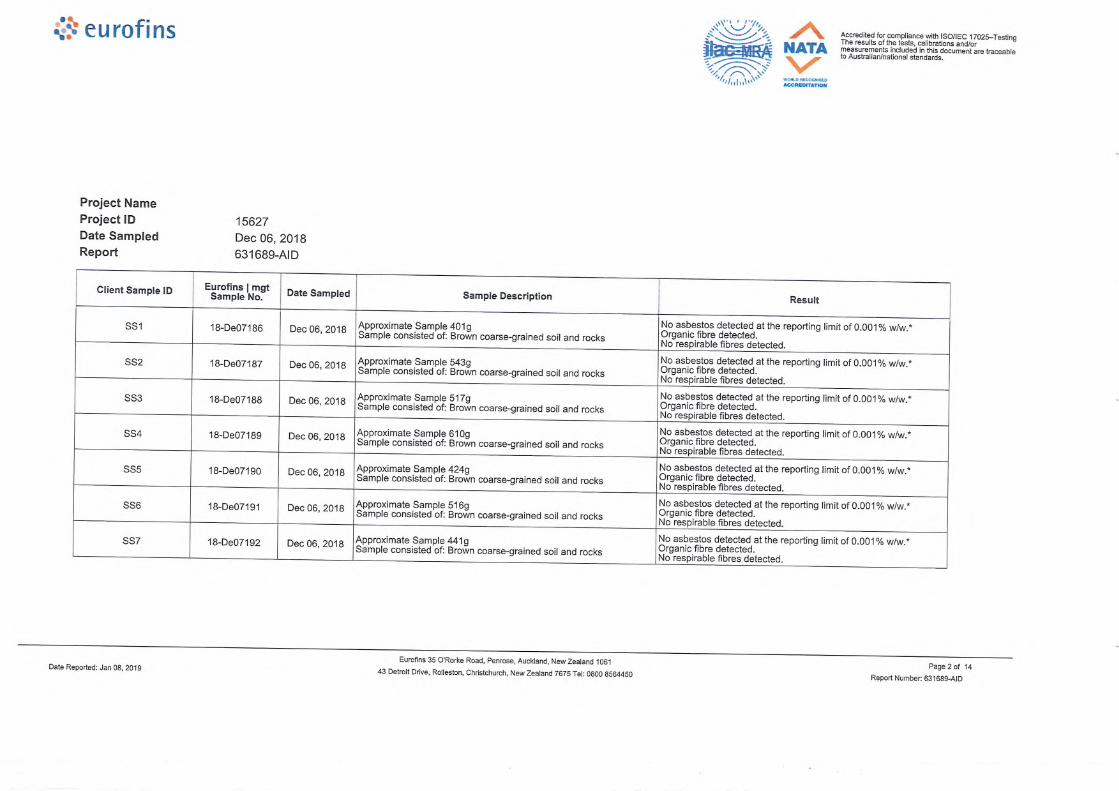


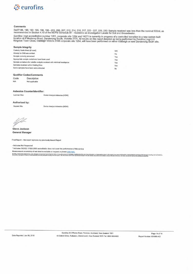


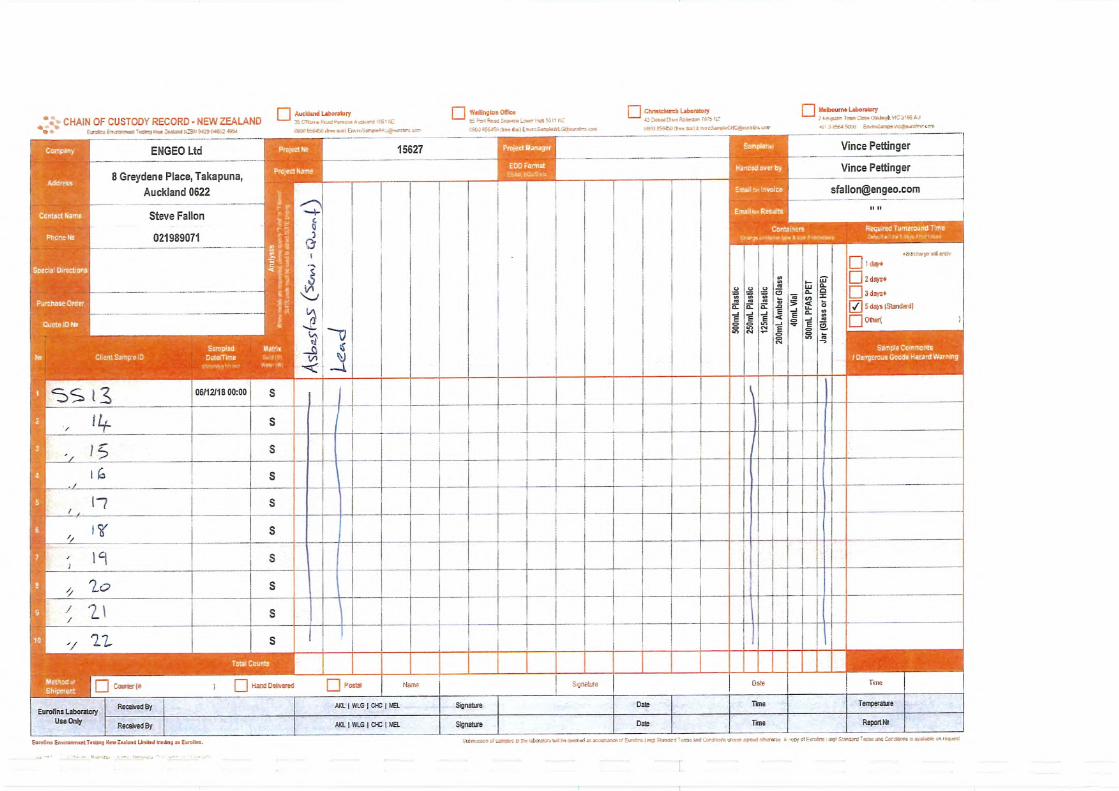


224 Great South Road, Greenlane, Auckland
Ōmāhu | Combined Preliminary and Detailed Site Investigation
Final - Approved for Issue
APPENDIX I
WASTE ACCEPTANCE DEFINITIONS

APPENDIX I – FILL DEFINITIONS
The criteria adopted for the waste classification is generally based on the waste acceptance
classes as defined by the AUPOiP (2021) and WasteMINZ (2016). These fall into three categories;
cleanfill, managed fill, and landfill (contaminated), as defined below.
Table iv: AUPOiP Fill Definitions
FILL TYPE DEFINITION
Cleanfill Material: Means natural material such as clay, gravel, sand, soil and rock which has been
excavated or quarried from areas that are not contaminated with manufactured chemicals or
chemical residues as a result of industrial, commercial, mining or agricultural activities.
Excludes:
• hazardous substances and material (such as municipal solid waste) likely to create
leachate by means of biological breakdown;
• product and materials derived from hazardous waste treatment, stabilisation and
disposal practices;
• materials such as medical and veterinary waste, asbestos, and radioactive substances;
• soil and fill material which contain any trace element specified in Table E30.6.1.4.2 at a
concentration greater than the background concentration in Auckland soils specified;
• sulfidic ores and soils;
• combustible components;
• more than 5% by volume of inert manufactured materials (e.g. concrete, brick, tiles); and
• more than 2% by volume of attached biodegradable material (e.g. vegetation).
Facility: Facility where cleanfill material is accepted for deposit. Excludes:
• storage and use of cleanfill material within an earthworks site for the purpose of
engineering contours for specific activities;
• placement of cleanfill material associated with road construction and road maintenance
activities; and
• onsite storage and use of overburden or aggregate by-product that is cleanfill material
associated with mineral extraction activities.
Managed Fill Material: Managed fill material is:
• contaminated soil and other contaminated materials;
• natural materials such as clay, gravel, sand, soil, rock; or
• inert manufactured materials such as concrete and brick: and
That does not contain:
• hazardous substances or materials (such as municipal solid waste) likely to create
• leachate by means of biological breakdown;
• products or materials derived from hazardous waste treatment stabilisation or disposal
practices;
• materials such as medical and veterinary waste, asbestos, or radioactive substances;
• combustible components; or
• more than 2 per cent by volume of incidental or attached biodegradable materials (e.g.
vegetation).
Facility: Facility where managed fill material is accepted for deposit.
Landfill
(Contaminated)
Material: -
Facility: Facility where household, commercial, municipal, industrial and hazardous, or
industrial waste is accepted for disposal.

Table v: WasteMINZ Fill Definitions
FILL TYPE DEFINITION
Cleanfill Material: Virgin excavated natural materials (VENM) such as clay, soil and
rock that are free of:
• combustible, putrescible, degradable or leachable components;
• hazardous substances or materials (such as municipal solid waste) likely to create
leachate by means of biological breakdown;
• products or materials derived from hazardous waste treatment, stabilisation or disposal
practices;
• materials such as medical and veterinary waste, asbestos, or radioactive substances that
may present a risk to human health if excavated;
• contaminated soil and other contaminated materials; and
• liquid waste.
When discharged to the environment, clean fill material will not have a detectable effect
relative to the background.
Facility: A Class 5 landfill. Accepts only clean fill material, including clean excavated natural
materials.
Managed Fill Material: Predominantly clean fill material and controlled fill material that may also contain
material with contaminant concentrations in excess of controlled fill limits where site specific
management controls are in place to manage discharges to the environment.
Facility: A Class 3 landfill. Accepts only clean fill material, controlled fill material and managed
fill material.
Landfill
(Contaminated)
Material: Soil from contaminated land as defined in the Resource Management Act 1991
(RMA).
Facility: A waste disposal site used for the controlled deposit of solid wastes onto or into land.

224 Great South Road, Greenlane, Auckland
Ōmāhu | Combined Preliminary and Detailed Site Investigation
Final - Approved for Issue
APPENDIX J
QUALITY ASSURANCE AND QUALITY CONTROL (QA/QC)

APPENDIX J – QUALITY ASSURANCE AND QUALITY CONTROL RESULTS
The data validation procedure employed in the assessment of the field and laboratory QA/QC has
indicated that the reported analytical results are representative of conditions at the sample
locations and that the overall quality of the analytical data produced is acceptably reliable for the
purpose of this investigation.
Soil Sampling Investigation
Field Quality QA/QC requirements and Data Quality Objectives for the soil sampling investigation
are summarised in the tables below.
Table i: Field Quality Control
FIELD CONTROL REQUIREMENTS SUMMARY OF WORKS COMPLETED
Use of standard operating procedures for
sampling.
GWE standard operating procedures were followed.
Use new pair of disposable nitrile gloves for
each soil sample collected.
A new pair of disposable nitrile gloves was used for each soil
sample collected.
Decontamination of field equipment. N/A
Use of laboratory prepared and supplied
sampling containers appropriate for each
contaminant investigated.
Laboratory prepared sampling containers, supplied by Hill
Laboratories, were used for sample collection.
Use of appropriate sample Chain of Custody
(CoC) documentation.
Laboratory supplied CoC documentation was used. A copy
of the CoC is presented in Appendix H.
Collection of one duplicate soil sample for
every ten soil samples collected.
Laboratory duplicate analysis was carried out on one soil
sample meeting the
Table ii: Data Quality Objectives
DATA QUALITY OBJECTIVE SUMMARY OF WORKS COMPLETED
Samples submitted for TPH, VOC and PAH
analysis are to be received at the laboratory at
a temperature below 15 ºC.
Samples were received at the laboratory at a temperature of
16ºC (refer to Appendix H) – one or more arbitrarily chosen
samples. While the recorded temperature on receipt of the
samples by the lab was 1 degree over the target
temperature it is not considered that this would have had a
significant impact on the analytical results or the conclusions
drawn in this investigation.
Samples to be analysed within acceptable
holding times for the contaminant of potential
concern. The maximum acceptable sample
holding times for organic analyses are 14 days
and 30 days for inorganic analysis.
Samples were analysed within acceptable holding times.
Samples to be appropriately preserved and
handled by the laboratory.
Samples were appropriately preserved and handled by Hill
Laboratories. No analyst comments were provided on the
laboratory reports.
Laboratory limits of reporting (LOR) are to be
less than the adopted acceptance criteria for
the project.
The laboratory LOR for contaminants of concern for the
project are less than the acceptance criteria.
Relative percentage difference (RPD) values
recorded for the duplicate soil samples are to
be less than 50%.
RPD values ranged between 0 and 40%. Refer relative
percentage difference (RPD) results table below.

Table iii: Relative Percentage Difference (RPD) Results
LAB NUMBER RFD ACCEPTANCE DUPLICATE
MH03, 0.5 MH3 (QC) RPD
Arsenic 50% 2 2 0%
Cadmium 50% 0.1 0.1 0%
Chromium (total) 50% 56 54 3.64%
Copper 50% 26 25 3.92%
Lead 50% 7.7 7.5 2.63%
Mercury (inorganic) 50% <0.1 0.15 40%
Nickel 50% 51 55 7.55%
Zinc 50% 67 65 3.03%