climate change triggered sedimentation and progressive tectonic uplift in a coupled piedmont–axial...
TRANSCRIPT

Climate change triggered sedimentation 1033
Copyright © 2007 John Wiley & Sons, Ltd. Earth Surf. Process. Landforms 33, 1033–1046 (2008)DOI: 10.1002/esp
Earth Surface Processes and LandformsEarth Surf. Process. Landforms 33, 1033–1046 (2008)Published online 13 September 2007 in Wiley InterScience(www.interscience.wiley.com) DOI: 10.1002/esp.1600
Climate change triggered sedimentation andprogressive tectonic uplift in a coupled piedmont–axial system: Cuyama Valley, California, USAStephen B. DeLong1* Jon D. Pelletier1 and Lee J. Arnold2
1 University of Arizona, Department of Geosciences, 1040 E 4th Street, Tucson, AZ, 85721, USA2 Oxford Luminescence Research Group, School of Geography and the Environment, University of Oxford, Mansfield Rd,Oxford OX1 3TB, UK
AbstractChannels on the north-facing piedmont of the Sierra Madre range in Cuyama Valley,California have alternated between three process regimes during the late Quaternary: (1)vertical incision into piedmont alluvium and older sedimentary deposits; (2) lateral erosion;and (3) sediment accumulation. The state of the piedmont system at a given time hasbeen controlled by upstream sediment flux, regional tectonic uplift and incision of the axialCuyama River.
To better understand the timing and to attempt to interpret causes of past geomorphologicalprocesses on the Sierra Madre piedmont, we mapped the surficial geology and dated alluvialdeposits using radiocarbon, cosmogenic and optical dating methods. Four primary episodesof sedimentation have occurred since ca. 100 ka, culminating in the most recent period ofextensive piedmont sedimentation between 30 and 20 ka. Fill terraces in Cuyama Valleyformed by piedmont sediment accumulation followed by vertical incision and lateral erosionare fairly planar and often mantle strath bedrock surfaces. Their vertical spatial arrange-ment is a record of progressive regional tectonic uplift and concomitant axial Cuyama Riverchannel incision migrating up tributary piedmont channels. Subparallel longitudinal terraceprofiles which have a linear age–elevation relationship indicate that multiple episodes ofclimatically controlled sedimentation overprints ~1 m kyr−−−−−1 of regional uplift affecting theCuyama River and its tributaries.
Sedimentation was probably a result of increased precipitation that caused saturationlandsliding in steep catchments. It is possible that increased precipitation during the LastGlacial Maximum was caused by both continental-scale circulation pattern reorganizationand increased Pacific storm frequency and intensity caused by ‘early warming’ of nearbyPacific Ocean surface waters. Older episodes of piedmont sedimentation are difficult tocorrelate with specific climate regimes, but may correlate with previous periods of increasedprecipitation. Copyright © 2007 John Wiley & Sons, Ltd.
Keywords: Piedmont; Quaternary climate; sedimentation; tectonics; Cuyama Valley
*Correspondence to: S. B.DeLong, Arizona State University,School of Earth and SpaceExploration, Bateman PhysicalSciences Center F-wing, Room686, Tempe, AZ, 85287, USA.E-mail: [email protected]
Received 27 February 2007;Revised 10 July 2007;Accepted 12 July 2007
Introduction
Suites of inset piedmont fill terraces in arid regions are records of episodic sedimentation caused by changes inupstream sediment and water flux. Pedimentation and strath terrace formation by lateral fluvial erosion can occur whenchannel sediment flux is insufficient to trigger major alluviation, but high enough to prevent vertical incision into thechannel bed (Hancock and Anderson, 2002). Variable climate is widely understood as a cause of episodic piedmontsedimentation (and intervening fluvial entrenchment and lateral erosion). Where past climates have acted on separatecatchments in similar ways, these flights of fill terraces are often assumed to be age-equivalent (Ritter et al., 1995).
The primary models of piedmont response to variation in climate in the southwestern USA (California, Arizonaand Nevada) generally can be characterized by process-response and to some extent, geography. In Arizona and theMojave Desert, sedimentation during the Pleistocene–Holocene transition is widely thought to be a result of climate

1034 S. B. DeLong, J. D. Pelletier and L. J. Arnold
Copyright © 2007 John Wiley & Sons, Ltd. Earth Surf. Process. Landforms 33, 1033–1046 (2008)DOI: 10.1002/esp
change from cool and wet to warm and dry. This caused vegetation density to decrease and hillslope surface character-istics to change in lower and middle elevations. These changes were perhaps associated with concomitant increasedmonsoon storm intensity. These and other factors led to increased hillslope sediment delivery to channels and sedi-ment accumulation on piedmont alluvial fans (Wells et al., 1987; Bull, 1991; Reheis et al., 1996, McDonald et al.,2003). This also occurred in at least one semi-humid south facing drainage basin in the Transverse Ranges ofCalifornia (Weldon, 1986). On some Great Basin desert piedmonts, sedimentation was caused by peak aridity duringthe Holocene; although this secondary fan aggradation was often a result of fan-head entrenchment rather thanincreased primary sediment delivery from basin hillslopes (Harvey et al., 1999; Ritter et al., 2000). In the CentralValley of California, Last Glacial Maximum (LGM) alluviation occurred as a direct result of catchment erosion byalpine glaciers in the Sierra Nevada (Weissmann et al., 2002). These three models of climate-controlled sedimentationare, in general, the most widely discussed in the southwestern USA.
To date, studies have indicated that alluviation during the LGM in non-glaciated basins in the southwestern USA asbeen confined to small, high-elevation catchments in southern California, perhaps caused by increased periglacialhillslope erosion (Bull, 1991). Part of the motivation of this study was to evaluate the possibility of large-scale LGMalluviation in southern California in order to add to the models of piedmont sedimentation in the southwestern USA,and to attempt to better constrain the geographical distribution of the dominant triggers of episodic late Quaternarypiedmont sedimentation. Our limited understanding of the spatial distribution of the diverse causes of piedmontsedimentation has limited our ability to put forth predictive conceptual models for the timing of alluvial episodes indiverse settings. Geochronology in coarse-grained alluvial environments over the relevant timescales is difficult. Thishas led to the possibility of application of conceptual models of piedmont development to diverse settings in whichthey may not be appropriate.
Furthermore, we were motivated by the ongoing effort to understand the relative roles of tectonics and climate inpiedmont landform development. Strath surfaces are subplanar bedrock platforms formed by lateral fluvial erosionduring times of relatively constant fluvial base level. When incised, abandoned and preserved as a sequence of pairedterraces above the modern channel, they are generally thought to be evidence of the fluvial response to progressivetectonic uplift (Bull, 1990). These tectonic landforms are generally mantled with only a thin veneer of fluvial sediments.In locations (such as the Sierra Madre piedmont in this study) that have buried strath bedrock surfaces and thickalluvial fills, discerning between tectonic and climate-controlled processes can be difficult.
Downstream base-level changes may lead to spatial or temporal signatures that replace or superpose climaticsignatures in areas where axial-fluvial, marine or lacustrine systems interact with piedmonts, or regional or fault-specific uplift is occurring (Harvey and Wells, 2003). In order to (1) better understand the causes of episodic alluviationin various regions, and (2) to expand our understanding of how regional uplift and an incising axial channel affect thetiming and topographic configuration of piedmont alluvial surfaces, we mapped, described and dated Quaternarydeposits in Cuyama Valley, California.
Setting of Piedmont Alluvial Deposits in Cuyama Valley
Cuyama Valley is a reverse-fault bounded structural valley at the northwest end of the western Transverse Ranges insouthern California (Figure 1). Cool, moist winters and hot, dry summers characterize the modern climate. Theprecipitation regime is strongly Mediterranean. On the valley floor, the mean annual temperature is 14 °C and themean annual precipitation is 15 cm. The mean annual precipitation increases with elevation locally, and the meanannual temperature decreases with elevation. The valley is located adjacent to the ‘Big Bend’ section of the SanAndreas Fault, and is part of a region that is experiencing ongoing but spatially complex uplift (White, 1992; Atwaterand Stock, 1998). Much of the piedmont on the north-facing flank of the Sierra Madre Range consists of extensive lateQuaternary depositional alluvial surfaces. The Sierra Madre Range has an elevation range of 800–2000 m. Vegetationon mountain slopes is dense oak–juniper chaparral, with stands of pine at high elevations. Vegetation on the fansurfaces is dominantly open grassland, which may have had more oak and juniper prior to modern grazing practices.
Quaternary Geology of Cuyama Valley
Tectonic settingCuyama Valley sits at the intersection of the southern Coast Ranges and Western Transverse Ranges. During theQuaternary, tectonics have largely been driven by accommodation of transpressional forces along the ‘Big Bend’ of

Climate change triggered sedimentation 1035
Copyright © 2007 John Wiley & Sons, Ltd. Earth Surf. Process. Landforms 33, 1033–1046 (2008)DOI: 10.1002/esp
Figure 1. Study location on LANDSAT image with generalized tectonic setting. Inset shows location of study area in southernCalifornia. This figure is available in colour online at www.interscience.wiley.com/journal/espl
the San Andreas Fault system to the east. These tectonic forces have manifested themselves locally via progressive con-traction of the Cuyama structural basin. The Caliente Range that forms the northern margin of the Cuyama Valley is afold and thrust belt that may have initiated as recently as 0·5–0·2 Ma (White, 1992; Ellis et al., 1993) and shows evidencefor fault interaction with piedmont deposits in our study area, suggesting ongoing contraction through the past 0·1 Myr.
1036 S. B. DeLong, J. D. Pelletier and L. J. Arnold
Copyright © 2007 John Wiley & Sons, Ltd. Earth Surf. Process. Landforms 33, 1033–1046 (2008)DOI: 10.1002/esp
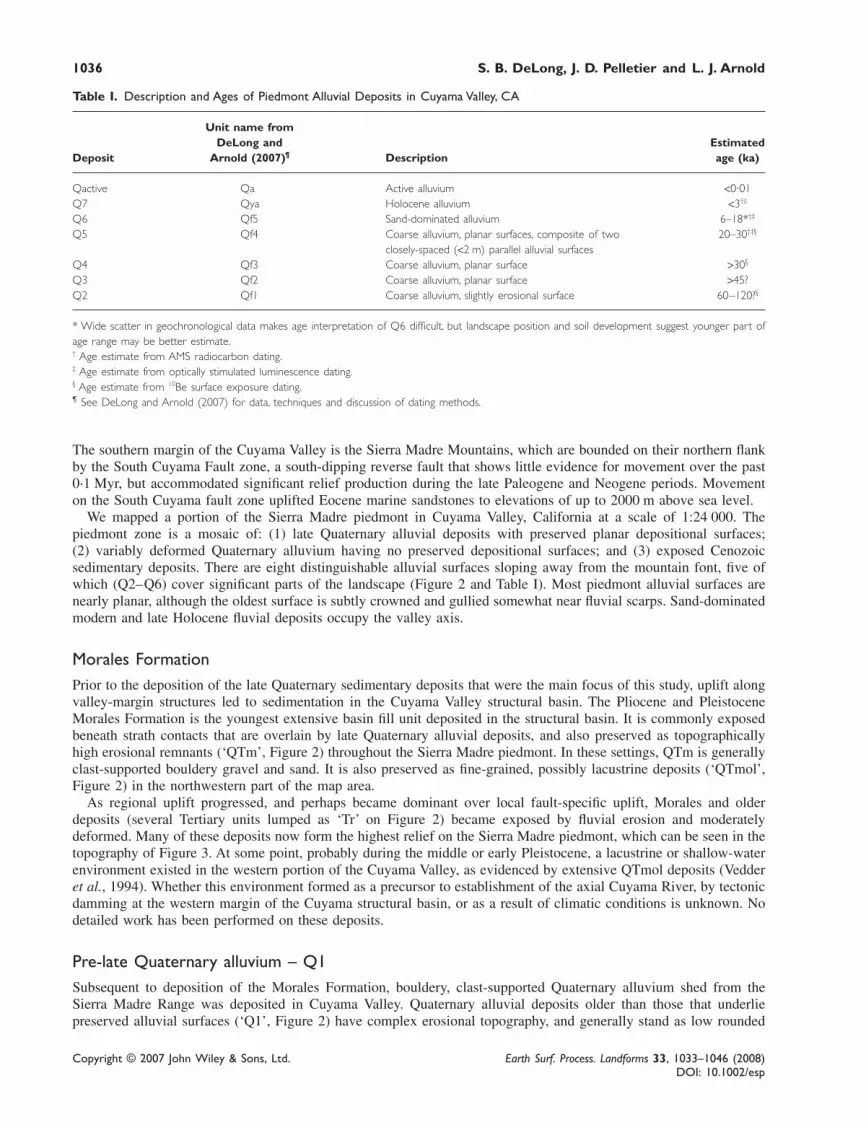
Table I. Description and Ages of Piedmont Alluvial Deposits in Cuyama Valley, CA
Unit name fromDeLong and Estimated
Deposit Arnold (2007)¶ Description age (ka)
Qactive Qa Active alluvium <0·01Q7 Qya Holocene alluvium <3†‡
Q6 Qf5 Sand-dominated alluvium 6–18*†‡
Q5 Qf4 Coarse alluvium, planar surfaces, composite of two 20–30†‡§
closely-spaced (<2 m) parallel alluvial surfacesQ4 Qf3 Coarse alluvium, planar surface >30§
Q3 Qf2 Coarse alluvium, planar surface >45?Q2 Qf1 Coarse alluvium, slightly erosional surface 60–120?§
* Wide scatter in geochronological data makes age interpretation of Q6 difficult, but landscape position and soil development suggest younger part ofage range may be better estimate.† Age estimate from AMS radiocarbon dating.‡ Age estimate from optically stimulated luminescence dating.§ Age estimate from 10Be surface exposure dating.¶ See DeLong and Arnold (2007) for data, techniques and discussion of dating methods.
The southern margin of the Cuyama Valley is the Sierra Madre Mountains, which are bounded on their northern flankby the South Cuyama Fault zone, a south-dipping reverse fault that shows little evidence for movement over the past0·1 Myr, but accommodated significant relief production during the late Paleogene and Neogene periods. Movementon the South Cuyama fault zone uplifted Eocene marine sandstones to elevations of up to 2000 m above sea level.
We mapped a portion of the Sierra Madre piedmont in Cuyama Valley, California at a scale of 1:24 000. Thepiedmont zone is a mosaic of: (1) late Quaternary alluvial deposits with preserved planar depositional surfaces;(2) variably deformed Quaternary alluvium having no preserved depositional surfaces; and (3) exposed Cenozoicsedimentary deposits. There are eight distinguishable alluvial surfaces sloping away from the mountain font, five ofwhich (Q2–Q6) cover significant parts of the landscape (Figure 2 and Table I). Most piedmont alluvial surfaces arenearly planar, although the oldest surface is subtly crowned and gullied somewhat near fluvial scarps. Sand-dominatedmodern and late Holocene fluvial deposits occupy the valley axis.
Morales FormationPrior to the deposition of the late Quaternary sedimentary deposits that were the main focus of this study, uplift alongvalley-margin structures led to sedimentation in the Cuyama Valley structural basin. The Pliocene and PleistoceneMorales Formation is the youngest extensive basin fill unit deposited in the structural basin. It is commonly exposedbeneath strath contacts that are overlain by late Quaternary alluvial deposits, and also preserved as topographicallyhigh erosional remnants (‘QTm’, Figure 2) throughout the Sierra Madre piedmont. In these settings, QTm is generallyclast-supported bouldery gravel and sand. It is also preserved as fine-grained, possibly lacustrine deposits (‘QTmol’,Figure 2) in the northwestern part of the map area.
As regional uplift progressed, and perhaps became dominant over local fault-specific uplift, Morales and olderdeposits (several Tertiary units lumped as ‘Tr’ on Figure 2) became exposed by fluvial erosion and moderatelydeformed. Many of these deposits now form the highest relief on the Sierra Madre piedmont, which can be seen in thetopography of Figure 3. At some point, probably during the middle or early Pleistocene, a lacustrine or shallow-waterenvironment existed in the western portion of the Cuyama Valley, as evidenced by extensive QTmol deposits (Vedderet al., 1994). Whether this environment formed as a precursor to establishment of the axial Cuyama River, by tectonicdamming at the western margin of the Cuyama structural basin, or as a result of climatic conditions is unknown. Nodetailed work has been performed on these deposits.
Pre-late Quaternary alluvium – Q1Subsequent to deposition of the Morales Formation, bouldery, clast-supported Quaternary alluvium shed from theSierra Madre Range was deposited in Cuyama Valley. Quaternary alluvial deposits older than those that underliepreserved alluvial surfaces (‘Q1’, Figure 2) have complex erosional topography, and generally stand as low rounded

Climate change triggered sedimentation 1037
Copyright © 2007 John Wiley & Sons, Ltd. Earth Surf. Process. Landforms 33, 1033–1046 (2008)DOI: 10.1002/esp
Figure 2. Generalized surficial geology of study area in southern California. Surficial geologic map units area as follows: Qactive,active channels and floodplains; Qyp, Holocene palustrine deposits; Q7, late Holocene alluvial deposits; Q6–Q2, see Table I;Q1, Quaternary alluvium, undifferentiated, lacking depositional surfaces; Qls, landslide deposits; QTmol, fine-grained (lacustrine?)Morales Formation; QTm, coarse-grained Morales Formation; Tr, Pre-Pliocene bedrock, undifferentiated.
1038 S. B. DeLong, J. D. Pelletier and L. J. Arnold
Copyright © 2007 John Wiley & Sons, Ltd. Earth Surf. Process. Landforms 33, 1033–1046 (2008)DOI: 10.1002/esp
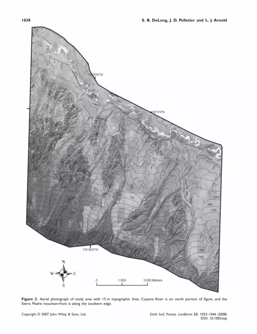
Figure 3. Aerial photograph of study area with 15 m topographic lines. Cuyama River is on north portion of figure, and theSierra Madre mountain-front is along the southern edge.
Climate change triggered sedimentation 1039
Copyright © 2007 John Wiley & Sons, Ltd. Earth Surf. Process. Landforms 33, 1033–1046 (2008)DOI: 10.1002/esp
hills above the late Quaternary terraces. Vedder and Reppening (1975) and Vedder et al. (1994) measured minordeformation of these deposits, indicating that deformation was occurring within the Cuyama structural basin into theQuaternary. The Q1 deposits are often difficult to distinguish from the coarse facies of the Morales Formation.
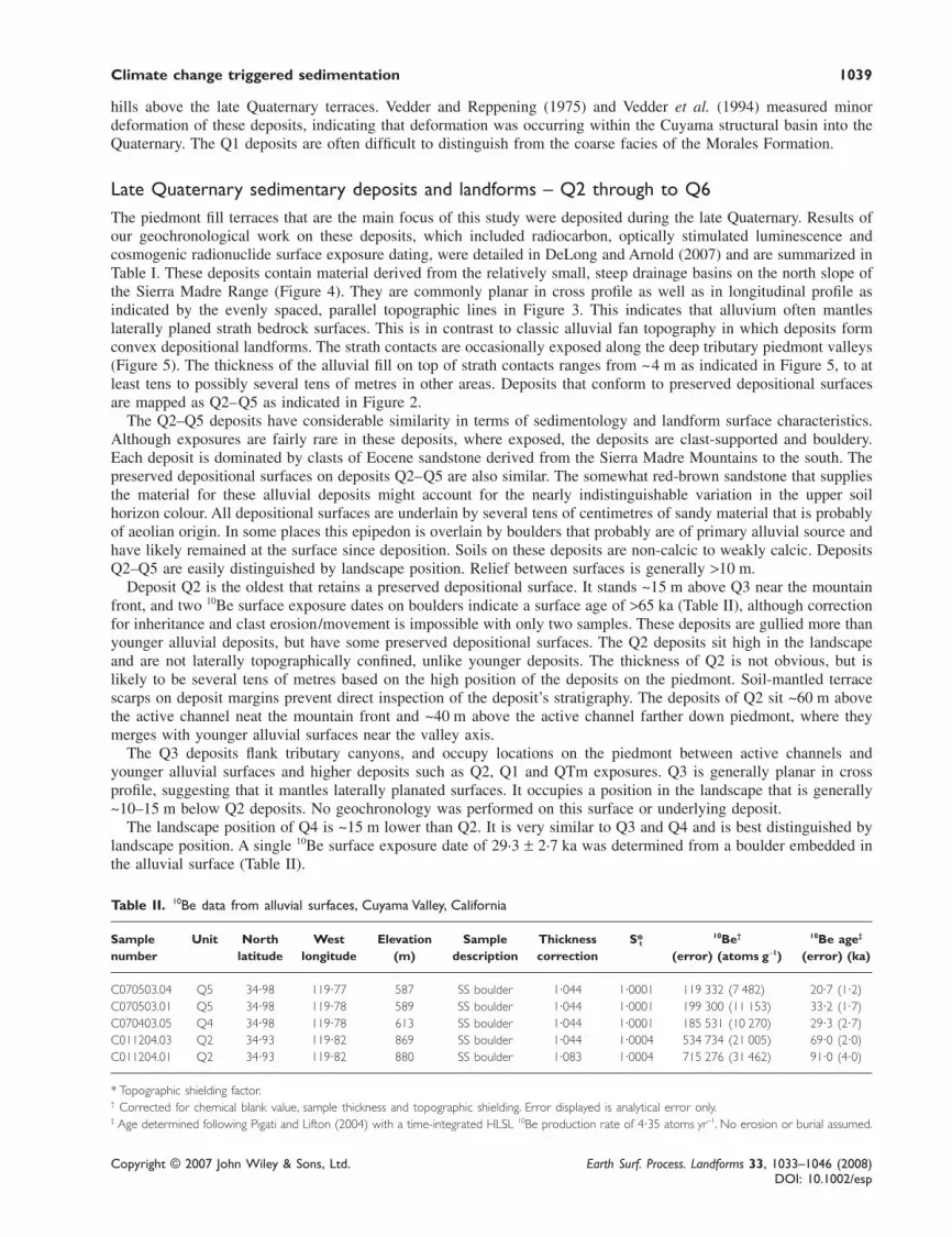
Late Quaternary sedimentary deposits and landforms – Q2 through to Q6The piedmont fill terraces that are the main focus of this study were deposited during the late Quaternary. Results ofour geochronological work on these deposits, which included radiocarbon, optically stimulated luminescence andcosmogenic radionuclide surface exposure dating, were detailed in DeLong and Arnold (2007) and are summarized inTable I. These deposits contain material derived from the relatively small, steep drainage basins on the north slope ofthe Sierra Madre Range (Figure 4). They are commonly planar in cross profile as well as in longitudinal profile asindicated by the evenly spaced, parallel topographic lines in Figure 3. This indicates that alluvium often mantleslaterally planed strath bedrock surfaces. This is in contrast to classic alluvial fan topography in which deposits formconvex depositional landforms. The strath contacts are occasionally exposed along the deep tributary piedmont valleys(Figure 5). The thickness of the alluvial fill on top of strath contacts ranges from ~4 m as indicated in Figure 5, to atleast tens to possibly several tens of metres in other areas. Deposits that conform to preserved depositional surfacesare mapped as Q2–Q5 as indicated in Figure 2.
The Q2–Q5 deposits have considerable similarity in terms of sedimentology and landform surface characteristics.Although exposures are fairly rare in these deposits, where exposed, the deposits are clast-supported and bouldery.Each deposit is dominated by clasts of Eocene sandstone derived from the Sierra Madre Mountains to the south. Thepreserved depositional surfaces on deposits Q2–Q5 are also similar. The somewhat red-brown sandstone that suppliesthe material for these alluvial deposits might account for the nearly indistinguishable variation in the upper soilhorizon colour. All depositional surfaces are underlain by several tens of centimetres of sandy material that is probablyof aeolian origin. In some places this epipedon is overlain by boulders that probably are of primary alluvial source andhave likely remained at the surface since deposition. Soils on these deposits are non-calcic to weakly calcic. DepositsQ2–Q5 are easily distinguished by landscape position. Relief between surfaces is generally >10 m.
Deposit Q2 is the oldest that retains a preserved depositional surface. It stands ~15 m above Q3 near the mountainfront, and two 10Be surface exposure dates on boulders indicate a surface age of >65 ka (Table II), although correctionfor inheritance and clast erosion/movement is impossible with only two samples. These deposits are gullied more thanyounger alluvial deposits, but have some preserved depositional surfaces. The Q2 deposits sit high in the landscapeand are not laterally topographically confined, unlike younger deposits. The thickness of Q2 is not obvious, but islikely to be several tens of metres based on the high position of the deposits on the piedmont. Soil-mantled terracescarps on deposit margins prevent direct inspection of the deposit’s stratigraphy. The deposits of Q2 sit ~60 m abovethe active channel neat the mountain front and ~40 m above the active channel farther down piedmont, where theymerges with younger alluvial surfaces near the valley axis.
The Q3 deposits flank tributary canyons, and occupy locations on the piedmont between active channels andyounger alluvial surfaces and higher deposits such as Q2, Q1 and QTm exposures. Q3 is generally planar in crossprofile, suggesting that it mantles laterally planated surfaces. It occupies a position in the landscape that is generally~10–15 m below Q2 deposits. No geochronology was performed on this surface or underlying deposit.
The landscape position of Q4 is ~15 m lower than Q2. It is very similar to Q3 and Q4 and is best distinguished bylandscape position. A single 10Be surface exposure date of 29·3 ± 2·7 ka was determined from a boulder embedded inthe alluvial surface (Table II).
Table II. 10Be data from alluvial surfaces, Cuyama Valley, California
Sample Unit North West Elevation Sample Thickness S t*10Be† 10Be age‡
number latitude longitude (m) description correction (error) (atoms g−1) (error) (ka)
C070503.04 Q5 34·98 119·77 587 SS boulder 1·044 1·0001 119 332 (7 482) 20·7 (1·2)C070503.01 Q5 34·98 119·78 589 SS boulder 1·044 1·0001 199 300 (11 153) 33·2 (1·7)C070403.05 Q4 34·98 119·78 613 SS boulder 1·044 1·0001 185 531 (10 270) 29·3 (2·7)C011204.03 Q2 34·93 119·82 869 SS boulder 1·044 1·0004 534 734 (21 005) 69·0 (2·0)C011204.01 Q2 34·93 119·82 880 SS boulder 1·083 1·0004 715 276 (31 462) 91·0 (4·0)
* Topographic shielding factor.† Corrected for chemical blank value, sample thickness and topographic shielding. Error displayed is analytical error only.‡ Age determined following Pigati and Lifton (2004) with a time-integrated HLSL 10Be production rate of 4·35 atoms yr−1. No erosion or burial assumed.

1040 S. B. DeLong, J. D. Pelletier and L. J. Arnold
Copyright © 2007 John Wiley & Sons, Ltd. Earth Surf. Process. Landforms 33, 1033–1046 (2008)DOI: 10.1002/esp
Figure 4. Shaded relief of study area from 30 m digital elevation model. Cross-hatched areas on bedrock highlands are landslidesas mapped by Vedder and Reppening (1975).
Climate change triggered sedimentation 1041
Copyright © 2007 John Wiley & Sons, Ltd. Earth Surf. Process. Landforms 33, 1033–1046 (2008)DOI: 10.1002/esp
Figure 5. View looking downstream along Aliso Canyon. Note contact between Q5 and underlying Morales Formation. Note thatMorales Formation is also preserved as relatively high landform in middle ground. Approximately 24 m of post-Q5 alluvial andbedrock incision has occurred. This figure is available in colour online at www.interscience.wiley.com/journal/espl
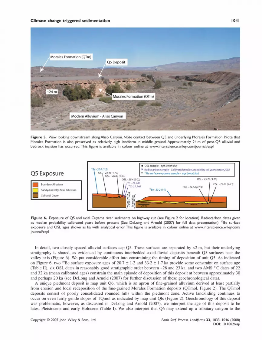
Figure 6. Exposure of Q5 and axial Cuyama river sediments on highway cut (see Figure 2 for location). Radiocarbon dates givenas median probability calibrated years before present (See DeLong and Arnold (2007) for full data presentation). 10Be surfaceexposure and OSL ages shown as ka with analytical error. This figure is available in colour online at www.interscience.wiley.com/journal/espl
In detail, two closely spaced alluvial surfaces cap Q5. These surfaces are separated by <2 m, but their underlyingstratigraphy is shared, as evidenced by continuous interbedded axial-fluvial deposits beneath Q5 surfaces near thevalley axis (Figure 6). We put considerable effort into constraining the timing of deposition of unit Q5. As indicatedon Figure 6, two 10Be surface exposure ages of 20·7 ± 1·2 and 33·2 ± 1·7 ka provide some constraint on surface age(Table II), six OSL dates in reasonably good stratigraphic order between ~28 and 23 ka, and two AMS 14C dates of 22and 32 ka (mean calibrated ages) constrain the main episode of deposition of this deposit at between approximately 30and perhaps 20 ka (see DeLong and Arnold (2007) for further discussion of these geochronological data).
A unique piedmont deposit is map unit Q6, which is an apron of fine-grained alluvium derived at least partiallyfrom erosion and local redeposition of the fine-grained Morales Formation deposits (QTmol, Figure 2). The QTmoldeposits consist of poorly consolidated rounded hills within the piedmont zone. Active landsliding continues tooccur on even fairly gentle slopes of TQmol as indicated by map unit Qls (Figure 2). Geochronology of this depositwas problematic, however, as discussed in DeLong and Arnold (2007), we interpret the age of this deposit to belatest Pleistocene and early Holocene (Table I). We also interpret that Q6 may extend up a tributary canyon to the

1042 S. B. DeLong, J. D. Pelletier and L. J. Arnold
Copyright © 2007 John Wiley & Sons, Ltd. Earth Surf. Process. Landforms 33, 1033–1046 (2008)DOI: 10.1002/esp
mountain-front as seen in the western part of Figure 2. This precludes a piedmont source for all this material. Itappears that sediment flux from piedmont sources (Qtmol) remained high enough through the latest part of thePleistocene that no major incision occurred along that tributary canyon, even in upstream areas. Relief from themodern channel to Q6 near the Sierra Madre mountain front is negligible, indicating that since the late Pleistocene,very little fluvial incision has occurred.
The Sierra Madre mountain-front reverse fault (South Cuyama fault zone, Figure 1) does not appear to offset anyof the late Pleistocene planar surfaces that cover its trace (Vedder and Reppening, 1975), suggesting that distinctmountain-front uplift did not occur over the timescale of piedmont development examined in this study. On the northside of the Cuyama Valley, the Caliente Range is the topographic expression of a Quaternary fold-thrust belt (Elliset al., 1993). The leading thrust of this fold-thrust belt, the Whiterock thrust (Figure 1), does interact with the SierraMadre piedmont, offsetting Q2 and possibly Q3 deposits. The Whiterock fault probably has little impact on thepiedmont development over the timescale discussed in this paper.
Alluvial Surface Profiles
Unlike most piedmonts in stable tectonic settings, piedmont deposits in Cuyama Valley generally mantle strathbedrock contacts, indicating that both episodic alluviation and ongoing tectonic uplift is occurring. In stable tectonicsettings, alluvial surface longitudinal profiles tend to converge in the downstream direction because base level hasremained stable or oscillated in lacustrine or marine settings (Harvey, 2002). In settings in which secondary fanaggradation and fan-head entrenchment has occurred, younger fan profiles are higher than older surfaces distal from amid-fan intersection point. The slope of terrace surfaces is largely a function of sediment flux and texture because fanssteepen to transport coarser or increased volumes of material. Sediment flux and texture are at least partially controlledby hillslope processes and climate (Harvey et al., 1999; Ritter et al., 2000).
Figure 7 illustrates end-member hypotheses for alluvial surface profile arrangement in response to both stable andfluctuating sediment supply/size and base level. In Cuyama Valley, the terraces have subparallel and vertically offsetlongitudinal profiles; older surfaces are higher than younger surfaces and have slightly steeper profiles (Figure 8). Anotable exception is the profile of the Q6 deposits that are sourced primarily from relatively steep, loose hillslopeswithin the piedmont zone, leading to development of a short, steep profile.
The amount of relief from the projection of Q2–Q5 surfaces to the valley axis (in metres) is very similar tothe differences in estimated age between the surfaces (in thousands of years), suggesting that the piedmontchannels respond episodically to the ongoing incision of the axial channel at a rate of ~1 m kyr−1. The extensive lateHolocene valley fill and wide tributary canyons (Figure 3) are testament to the intermittent nature of this incision,but the estimated rate is generally consistent with estimates of vertical tectonic rates of 0·5 to 2 m kyr−1 in theCoast Ranges (Merritts and Bull, 1989; Page et al., 1998; Ducea et al., 2003). Base level on the Cuyama River isset by the bedrock canyon ~40 km to the west of our study area in the southern Coast Ranges. Our estimates ofchannel incision rates suggest that the Cuyama River is nearly in equilibrium with tectonic uplift rates over the lateQuaternary.
Figure 7. Schematic representations of alluvial surface profiles in response to differing base level and sediment-flux/texturescenarios. End-member hypothesis #1 is a generalization of terrace suites common in tectonically inactive regions where piedmontdevelopment is largely a response to fluctuating upstream sediment flux and texture. End-member hypothesis #2 follows Mackin’s(1948) concept of the graded stream response to downcutting.

Climate change triggered sedimentation 1043
Copyright © 2007 John Wiley & Sons, Ltd. Earth Surf. Process. Landforms 33, 1033–1046 (2008)DOI: 10.1002/esp
Climatic and Tectonic Implications
The record of episodic sedimentation in Cuyama Valley has some distinguishing characteristics when compared withother regional records. There are five distinct and spatially extensive deposits younger than ~100 ka, one of which(Q5) is, in detail, two closely spaced geomorphological surfaces capping nearly identical stratigraphy (as indicated bylateral continuity of axial Cuyama River deposits below tributary alluvium). The relatively large number of episodesof piedmont sedimentation raises the possibility that the multiple alluvial terrace surfaces do not record uniqueclimate-change-induced alluvial events. Rather, fan aggradation may have been punctuated by episodic incision causedby downstream-forced incision even as sediment flux remained high, leading to preservation of several terracesurfaces.
Additionally, timing of alluvial episodes in Cuyama Valley is out of phase with many other records in the USASouthwest. In Cuyama Valley, piedmont sedimentation occurred between 18 and 30 ka, during full glacial and the leadup to full glacial climates. This timing was confirmed by three geochronological methods (DeLong and Arnold, 2007).During at least part of this time, aggradation on the main-stem Cuyama River occurred, as evidenced by interbeddedaxial-fluvial material within Q5 deposits (DeLong and Arnold, 2007). This axial aggradation may have led toincreased piedmont sediment storage due to backfilling of tributary valleys, but most likely tributary sedimentationwas primarily a function of upstream drainage basin sediment flux. If aggradation of the axial Cuyama River forcedpiedmont backfilling, we would probably see piedmont fills that thinned upstream over a relatively short distance. Thepiedmont fills along Cuyama River tributaries are extensive all the way up to the mountain front, indicating thatupstream sediment supply was the primary control.
While out of phase with many other records in non-glaciated basins, the timing of piedmont sedimentation is notunique in the USA Southwest. In California’s Central Valley, erosion by valley glaciers in the Sierra Nevada moun-tains increased sediment delivery to alluvial fans during the LGM (Weissmann et al., 2002). Although timing of LGMsedimentation may have been similar in Cuyama Valley, the lack of LGM glaciers in the Sierra Madre Range requiresa different explanation for increased drainage basin sediment production during the LGM. The steep, north-facingslopes of the Sierra Madre Range are currently covered in thick chaparral vegetation, so unlike desert mountains, anychange in vegetation cover at the end of the Pleistocene probably had minimal effect on slope erosion.
Recent compelling data indicate that sea-surface temperature in the nearby Pacific Ocean began to warm signifi-cantly before global glacial conditions eased (Herbert et al., 2001). This observation is supported by the isotopicsignature of precipitation recorded by Devil’s Hole vein calcite well east of Cuyama Valley (Winograd et al., 2006).
Figure 8. Alluvial surface profiles generated using field Total Station and 10-meter DEM analysis. Horizontal axis is distance fromcentreline of modern Cuyama River channel in direction of maximum surface slope. Vertical axis is distance above elevation ofCuyama River channel at same location. All profiles except Q6 are from terrace suite flanking Aliso Canyon. Q6 profile is fromnorthwestern portion of Figure 1 map area, and relatively the high slope is likely related to the observation that the Q6sedimentation was caused by local erosion of piedmont exposure of poorly indurated Morales Formation. The arrangement ofterrace profiles is suggestive of our ‘mixed’ hypothesis from Figure 2, with vertically offset profiles at the valley axis, and steeperolder surfaces.

1044 S. B. DeLong, J. D. Pelletier and L. J. Arnold
Copyright © 2007 John Wiley & Sons, Ltd. Earth Surf. Process. Landforms 33, 1033–1046 (2008)DOI: 10.1002/esp
Furthermore, according to palaeocirculation pattern reconstructions such as those detailed by Harvey et al. (1999),the western Transverse Ranges experienced cooler temperatures and, due to southward migration of the jet stream,increased precipitation from the Pacific during full-glacial conditions. The combination of increased precipitation, andthe possibility of increased storm frequency and/or intensity during the LGM in southern California due to increasedPacific sea-surface temperatures may have been primary causes of increased sedimentation.
There are at least two processes by which increased precipitation may lead to increased sediment flux fromlandslide-dominated catchments. Increased pore pressure at depth due to increased penetration of the wetting frontduring high-precipitation events may lead to deeper-seated landslides and therefore higher sediment flux. This processmay be analogous to short-term increases in precipitation-threshold slope failures that are common on steep slopes insouthern California during modern El Niño conditions (Gabet and Dunne, 2002). A second possibility is that long-term increased hillslope weathering rates due to increased soil and regolith moisture leads to increased sediment flux.This second process assumes that the rate-limiting process in landslide-dominated drainage basin sediment flux is nothillslope stability, but rather bedrock weathering rates. In this scenario, increased precipitation and associated vegeta-tion cover lead to increased weathering rates regardless of the hillslope stability. Although both processes may beimportant, the latter hypothesis may better explain long-term increases in drainage basin sediment flux such as isrecorded in the Quaternary deposits of Cuyama Valley, because the duration of the increased sediment delivery mustrequire an increase in bedrock weathering rates. The common palaeolandslide deposits preserved on the slopes of theSierra Madre (visible in Figure 4) are evidence that landslides have been the dominant process by which sediment ismoved from hillslopes on the Sierra Madre range.
The Pleistocene to Holocene climate change appears to have had different effects on distinct parts of the SierraMadre piedmont. Along Aliso Canyon and other major Cuyama River tributary valleys, entrenchment occurred after~20 ka and no record of sediment storage since that time exists until the late-Holocene channel and adjacent floodplainformation. This erosion-dominated regime was probably caused by increased slope stability and diminished sedimentflux, causing the channels to erode into their beds, possibly complemented by a transient response to regional upliftthat was not accommodated while sediment supply was high during the previous aggradational regime. In contrast, thewestern part of the map area (Figure 2) contains extensive deposits of fine-grained, possibly lacustrine (Vedder andReppening, 1975) Morales Formation within the piedmont. There, local fan and tributary aggradation occurred after18 ka. These Q6 deposits appear to contain significant reworked Morales Formation (QTmol) material. The Q6alluvium is dark-brown, and dominated by fine silts and sands that appear to have been derived from the fine-grainedQTmol deposits just upslope. If LGM oak–juniper scrub vegetation existed on the Morales Formation within thepiedmont zone and disappeared as climate changed after the LGM, the nearly unconsolidated QTmol material wouldhave been readily eroded and redeposited as local alluvial aprons, even as the major tributaries draining the SierraMadre Range elsewhere eroded further into the piedmont.
Determining the history of pre-LGM process on the Sierra Madre piedmont is slightly more problematic due to lessprecision in the geochronologic data from older deposits (DeLong and Arnold, 2007). Piedmont morphology stronglysuggests that a substantial amount of lateral fluvial erosion occurred prior to the LGM sedimentation. The spatiallyextensive Qf4 deposits not only record high sediment flux, but their width is an indication of the amount of lateralerosion that occurred prior to ~30 ka.
Map units Q3 and Q4 were deposited prior to 30 ka, and are somewhat limited in their spatial scale. This may be afunction of the limited increase in sediment supply during deposition, or perhaps is further indication that the lateralerosion that occurred prior to deposition of Q5 removed much of the older deposits.
Map unit Q2 is a record of extensive deposition that has the morphology of a classic alluvial fan; it stands above theadjacent landscape and is spatially extensive, indicating a high sedimentation rate and lateral migration of the aggradingchannel. It does not appear to only occupy space created by earlier pedimentation, but rather aggraded above existingpiedmont topography.
The simplest interpretation of these earlier deposits is that, by analogy with Q5 sedimentation during the LGMmarine isotope stage 2 (MIS 2), Q2 was deposited during the MIS 6 stadial. The Q3 and Q4 deposits are lessobviously correlative with a specific climate regime. One or both of them may correlate with the MIS 4 stadial, butour geochronology is not precise enough to state this with confidence. These interpretations are simply an extra-polation of our hypothesis for climatic triggering of Q5 deposition to earlier episodes of piedmont alluviation.The pedimentation and vertical fluvial incision that occurred between periods of sedimentation, by extension of ourhypothesis, may correlate with prior interstadials during times of relatively lower hillslope sediment flux. The incisionsince deposition of Q5 is fairly dramatic – up to 25 m along the tributary piedmont valleys. This might be in part dueto the large amplitude of climate variation since the LGM, but may also represent a transient response to the back-ground tectonic uplift – only when the major LGM sedimentation pulse waned could the axial system and tributariesrespond to tens of thousands of years of regional uplift.
Climate change triggered sedimentation 1045
Copyright © 2007 John Wiley & Sons, Ltd. Earth Surf. Process. Landforms 33, 1033–1046 (2008)DOI: 10.1002/esp
Conclusions
Leading models of causes of episodic Quaternary piedmont sedimentation in the southwestern USA include wet to dryclimate shifts coupled with increased storm intensity, peak aridity causing fan-head entrenchment and secondary fanaggradation, and glacial erosion in high-elevation catchments. The coupled Sierra Madre–Cuyama River piedmont–axial system in Cuyama Valley, CA differs in its spatial and temporal characteristics, and does not fit well intocurrently favoured conceptual models of piedmont evolution. The preservation of at least five alluvial deposits youngerthan ~100 ka suggest that either drainage basins in the Sierra Madre range were particularly sensitive to cyclic climatefluctuation, or cut-and-fill cycles on the piedmont were in response to both upstream sediment supply and downstreamincision driven by the axial system. Widespread sedimentation on the Sierra Madre piedmont in Cuyama Valley duringthe Last Glacial Maximum was most likely caused by increased saturation-driven hillslope failure and sedimenttransfer to the piedmont during a period of increased precipitation related to circulation pattern shifts and quitepossibly enhanced by ‘early warming’ of Pacific sea surface waters of the nearby California coast during the LGM.Earlier episodes of sedimentation are possibly related to periods of increased precipitation, but our age control onthose sedimentary deposits is not precise enough to state this with confidence.
The Sierra Madre piedmont not only has recorded periods of increased hillslope sediment supply, but also hasrecorded response to ongoing regional tectonic uplift. As uplift occurs, the axial Cuyama River has responded byincising into bedrock and alluvium, and transmitting channel incision up tributary valleys. Fluctuation in sedimentsupply has caused this incision to be episodic. The subparallel and offset nature of the surface profiles of piedmontterraces suggest that Cuyama River incision forced piedmont channel incision at a rate or ~1 m kyr−1 over the lateQuaternary, consistent with other regional estimates of uplift rate. During periods in which neither significant sedimentaccumulation nor channel incision were occurring, channels on the Sierra Madre piedmont eroded laterally, formingstrath surfaces on which the relatively thick and widespread sedimentation was accommodated.
The Pleistocene to Holocene transition was a time of alluvial fan aggradation in some other southwestern piedmontsettings. On the Sierra Madre range, it was a time of relative stability on the north-facing, chaparral-covered slopes.Local sedimentation during the Pleistocene–Holocene transition occurred only locally in a part of the Sierra Madrepiedmont where material was sourced from the now barren slopes of unconsolidated, unstable, possibly lacustrinefacies of the Morales Formation. Our findings suggest further studies of piedmonts in diverse climatic and tectonicregimes in the southwestern USA are warranted, and caution must be used when applying widely accepted models ofpiedmont evolution beyond the regions in which they have been thoroughly tested without careful geochronologicalwork.
AcknowledgementsThis work was supported by a USGS EDMAP grant, NSF EAR-0309518 to JP, the USGS Southern California Areal MappingProject (especially D. Morton, J. Matti, and J. Sutter), funding from ChevronTexaco, and the University of Arizona Department ofGeosciences. Thanks to the people of Cuyama Valley, especially J. Kelley and A. Steinbach, for access to private lands. Thanks toA. Moore, M. Grace, and J. Morrison for field assistance. Earlier versions of this manuscript has benefited greatly from carefulreview by E. Keller, M. Eppes and A. Harvey and an anonymous reviewer.
References
Atwater T, Stock J. 1998. Pacific–North America plate tectonics of the Neogene southwestern United States; an update. In Integrated Earthand Environmental Evolution of the Southwestern United States; The Clarence A. Hall, Jr. Volume, Ernst WG, Nelson CA (eds).Bellwether Publishing: Columbia, MD; 393–420.
Bull WB. 1990. Stream-terrace genesis: implications for soil development. Geomorphology 3: 351–367.Bull WB. 1991. Geomorphic Responses to Climatic Change. Oxford University Press: Oxford.DeLong SB, Arnold LJ. 2007. Dating alluvial deposits with optically-stimulated luminescence, AMS 14C and cosmogenic techniques,
Western Transverse Ranges, California, USA. Quaternary Geochronology 2: 129–136. DOI: 10.1016/j.quageo.2006.03.012Ducea M, House MA, Kidder S. 2003. Late Cenozoic denudation and uplift rates in the Santa Lucia Mountains, California. Geology 31:
139–142.Ellis BJ, Levi S, Yeats RS. 1993. Magnetic stratigraphy of the Morales formation: Late Neogene clockwise rotation and compression in the
Cuyama Basin, California coast ranges. Tectonics 12: 1170–1179.Gabet EJ, Dunne T. 2002. Landslides on coastal sage-scrub and grassland hillslopes in a severe El Niño winter: the effects of vegetation
conversion on sediment delivery. Geological Society of America Bulletin 114: 983–990.Hancock GS, Anderson RS. 2002. Numerical modeling of fluvial terrace formation in response to oscillating climate. Geological Society of
America Bulletin 114(9): 1131–1142.

1046 S. B. DeLong, J. D. Pelletier and L. J. Arnold
Copyright © 2007 John Wiley & Sons, Ltd. Earth Surf. Process. Landforms 33, 1033–1046 (2008)DOI: 10.1002/esp
Harvey AM. 2002. The role of base-level change in the dissection of alluvial fans: case studies from southwest Spain and Nevada.Geomorphology 45: 67–87.
Harvey AM, Wells SG. 2003. Late Quaternary variations in alluvial fan sedimentologic and geomorphic processes, Soda Lake basin, easternMojave Desert, California. In Paleoenvironments and Paleohydrology of the Mojave and Southern Great Basin Deserts, Enzel Y,Wells SG, Lancaster N (eds). Special Paper 368, Geological Society of America: Boulder, Colorado; 207–230.
Harvey AM, Wigand PE, Wells SG. 1999. Response of alluvial fan system to the late Pleistocene to Holocene climatic transition: contrastsbetween the margins of pluvial Lakes Lahontan and Mojave, Nevada and California, USA. Catena 36: 255–281.
Herbert TD, Schuffert JD, Andreasen D et al. 2001. Collapse of the California current during glacial maxima linked to climate change onland. Science 293: 71–76.
Merritts D, Bull WB. 1989. Interpreting Quaternary uplift rates at the Mendocino triple junction, northern California, from uplifted marineterraces. Geology 17: 1020–1024.
Mackin JH. 1948. Concept of the graded river. Geological Society of America Bulletin 59: 463–511.McDonald EV, McFadden LD, Wells SG. 2003. Regional response of alluvial fans to the Pleistocene-Holocene climatic transition, Mojave
Desert, California. In Paleoenvironments and Paleohydrology of the Mojave and Southern Great Basin Deserts, Enzel Y, Wells SG,Lancaster N (eds). Special Paper 368, Geological Society of America: Boulder, Colorado; 197–206.
Page BM, Coleman RG, Thompson GA. 1998. OVERVIEW: Late Cenozoic tectonics of the central and southern Coast Ranges of Califor-nia. Geological Society of America Bulletin 110: 846–876.
Pigati JS, Lifton NA. 2004. Geomagnetic effects on time-integrated cosmogenic nuclide production with emphasis on in situ 14C and 10Be.Earth and Planetary Science Letters 226(1–2): 193–205.
Reheis MC, Slate JL, Throckmorton CK, McGeehin JP, Sarna-Wojcicki AM, Dengler L. 1996. Late Quaternary sedimentation on the LeidyCreek fan, Nevada–California: geomorphic responses to climate change. Basin Research 12: 279–299.
Ritter JB, Miller JR, Enzel Y, Wells SG. 1995. Reconciling the roles of tectonism and climate in Quaternary alluvial fan evolution. Geology23: 245–248.
Ritter JB, Miller JR, Husek-Wulforst J. 2000. Environmental controls on the evolution of alluvial fans in Buena Vista Valley, North CentralNevada, during late Quaternary time. Geomorphology 36: 63–87.
Vedder JG, Reppening CA. 1975. Geologic Map of the Cuyama and New Cuyama Quadrangles, San Luis Obispo and Santa BarbaraCounties, California. Map I-876, scale 1:24 000, Miscellaneous Investigations, U.S. Geological Survey.
Vedder JG, Howell DG, McLean H. 1994. Preliminary geologic map of Bates Canyon and part of Peak Mountain quadrangles, California,scale 1:24 000. U.S. Geological Survey Open-File Report 94–128.
Weissmann GS, Mount JF, Fogg GE. 2002. Glacially driven cycles in accommodation space and sequence stratigraphy of a stream-dominated alluvial fan, Central Valley, California. Journal of Sedimentary Research 72: 240–251.
Weldon RJ. 1986. Late Cenozoic geology of Cajon Pass; implications for tectonics and sedimentation along the San Andreas fault. PhDthesis, California Institute of Technology: Pasadena.
Wells SG, McFadden LD, Dohrenwend JC. 1987. Influence of late Quaternary climatic change on geomorphic and pedogenic processes ona desert piedmont, eastern Mojave Desert, California. Quaternary Research 27: 130–146.
White LA. 1992. Thermal and unroofing history of the Western Transverse Ranges, California: results from apatite fission trackthermochronology. PhD thesis, University of Texas: Austin.
Winograd IJ, Landwehr JM, Coplen TB et al. 2006. Devils Hole, Nevada, δ18O record extended to the mid-Holocene. Quaternary Research66: 202–212.