charlotte gateway station - cats bus operational assessment
TRANSCRIPT
CHARLOTTE GATEWAY STATIONCATS BUS OPERATIONAL ASSESSMENT
Suubmmitted by:
in asssociation wwiitth:
APRIL 2011APAPRIRILL 20201111
CHARLOTTE GATEWAY STATION
CATS BUS OPERATIONAL ASSESSMENT
TABLE OF CONTENTS
1.1 CATS Services within Uptown..................................................................................................................................1 1.2 Ridership Projections at CGS................................................................................................................................ 10 1.3 Implementation Scenario Approach.......................................................................................................................10 1.4 CGS Background...................................................................................................................................................10
2.1 Considerations in Development of CATS Service Framework with CGS Implementation Scenario.......................112.1.1 Local Routes............................................................................................................................................112.1.2 Express Routes.......................................................................................................................................12
2.2 Identifi cation of Bay Requirements.........................................................................................................................12
3.1 Framework Prior to Operating of Red Line to Gateway (Sc #1).............................................................................133.1.1 Framework with Blue-Line Extension Only Implementation Scenario......................................................14
3.2 Framework with Red Line-Only Implementation Scenario (Sc #2)........................................................................ 14 3.3 Framework with Red Line and Blue Line Extension Implementation Scenario (Sc #3)................................. ........18 3.4 Framework with North Corridor and Trade Streetcar Extension to CGS (Sc #4)................................................... 21 3.5 Framework with North Corridor, Blue Line Extension and Trade Streetcar Extension to CGS (Sc #5)............... ...25 3.6 Framework with All Planned Uptown Transit Services in 2030 Transit Plan (Sc #6).............................................. 28 3.7 Summary of Implementation Scenarios..................................................................................................................31
4.1 Off-Street Bus Bays............................................................................................................................................... 32 4.2 On-Street Bus Bays............................................................................................................................................... 32 4.3 Bus Layover Facilities.............................................................................................................................................33 4.4 Other Facilities Required for CATS Operations......................................................................................................33
5.1 Bus Circulation.......................................................................................................................................................35 5.2 Auto Circulation......................................................................................................................................................37 5.3 Pedestrian Circulation............................................................................................................................................37 5.4 Other Circulation Considerations for Further Study............................................................................................... 37
6.1 Tier I Attributes.......................................................................................................................................................38 6.2 Tier II Attributes......................................................................................................................................................38 6.3 Tier III Attributes.....................................................................................................................................................39 6.4 CATS Design Specifi cations.................................................................................................................................. 39
CHARLOTTE GATEWAY STATION
CATS BUS OPERATIONAL ASSESSMENT
Table 1: Framework Properties at CGS with Implementation Scenario #2.........................................................................................16Table 2: Transfer Patterns with Implementation Scenario #2..............................................................................................................16Table 3: Framework Properties at CGS with Implementation Scenario #3.........................................................................................21Table 4: Transfer Patterns with Implementation Scenario #3..............................................................................................................21Table 5: Framework Properties at CGS with Implementation Scenario #4 .........................................................................................24Table 6: Transfer Patterns with Implementation Scenario #4..............................................................................................................24Table 7: Framework Properties at CGS with Implementation Scenario #5.........................................................................................27Table 8: Transfer Patterns with Implementation Scenario #5..............................................................................................................27Table 9: Framework Properties at CGS with Implementation Scenario #6 .........................................................................................30Table 10: Transfer Patterns with Implementation Scenario #6............................................................................................................30Table 11: Bus Activity at Transit Hubs by Implementation Scenario.....................................................................................................31
Figure 1: Existing Uptown Transit Routes (Local Bus Routes)..............................................................................................................2Figure 2: Existing Uptown Transit Routes (Express Bus Routes)..........................................................................................................3Figure 3: Future Uptown BRT and Fixed Guideway Services...............................................................................................................4Figure 4: Average Daily Boardings by Stop (First Ward).......................................................................................................................6Figure 5: Average Daily Boardings by Stop (Second Ward)................................................................................................................. 7Figure 6: Average Daily Boardings by Stop (Third Ward)................................................................................................................... ..8Figure 7: Average Daily Boardings by Stop (Fourth Ward)...................................................................................................................9Figure 8: Implementation Scenario #1 Transit Network ......................................................................................................................15Figure 9: Implementation Scenario #2 Transit Network ......................................................................................................................17Figure 10: Implementation Scenario #3 Transit Network.....................................................................................................................20Figure 11: Implementation Scenario #4 Transit Network......................................................................................................................23Figure 12: Implementation Scenario #5 Transit Network......................................................................................................................26Figure 13: Implementation Scenario #6 Transit Network.....................................................................................................................29Figure 14: Bus Access Volumes to CGS (Implementation Scenario #3)............................................................................................ 36Figure 15: Typical Sawtooth Bus Bay Confi guration............................................................................................................................39
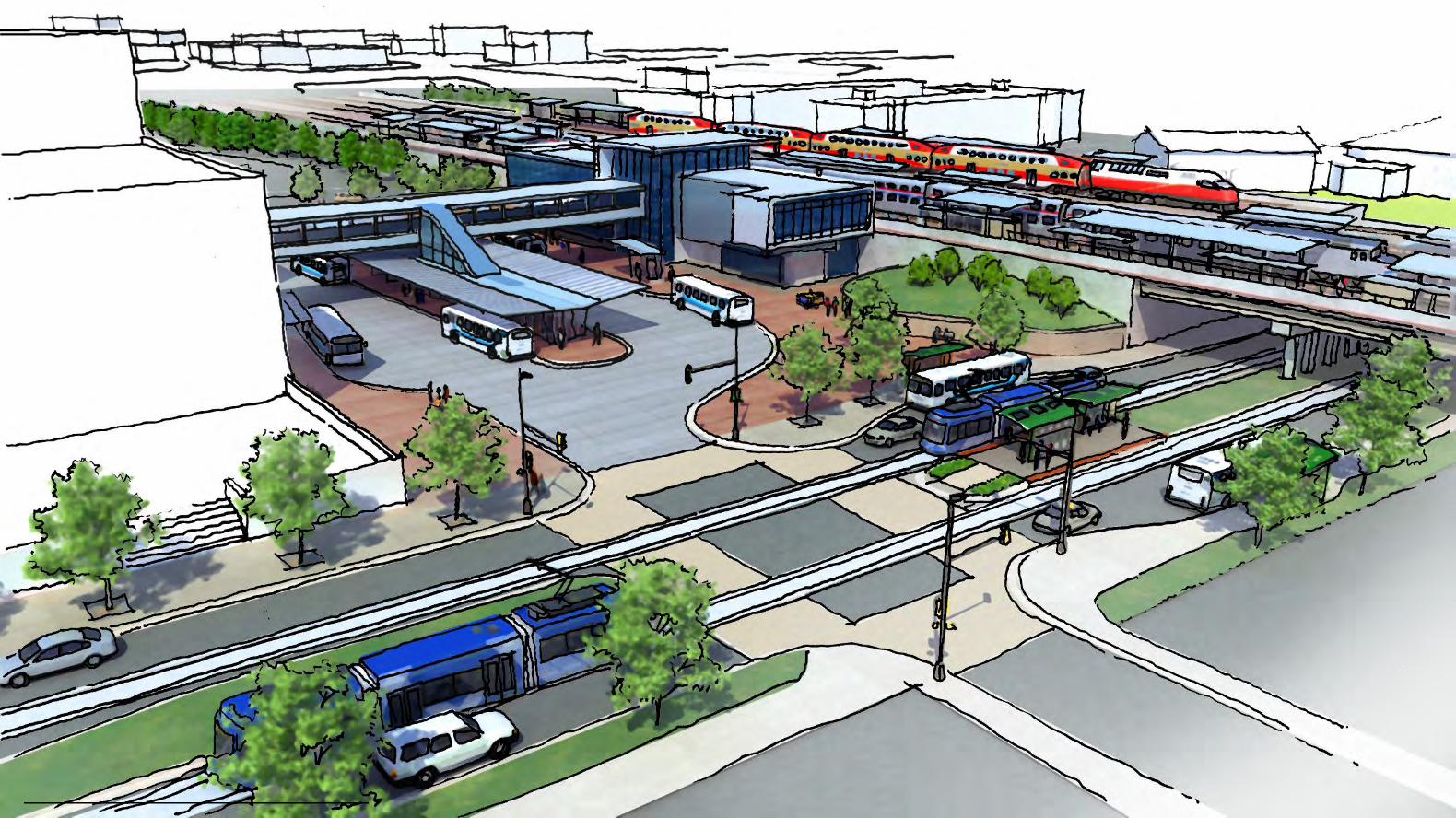
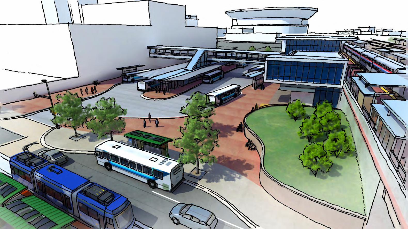
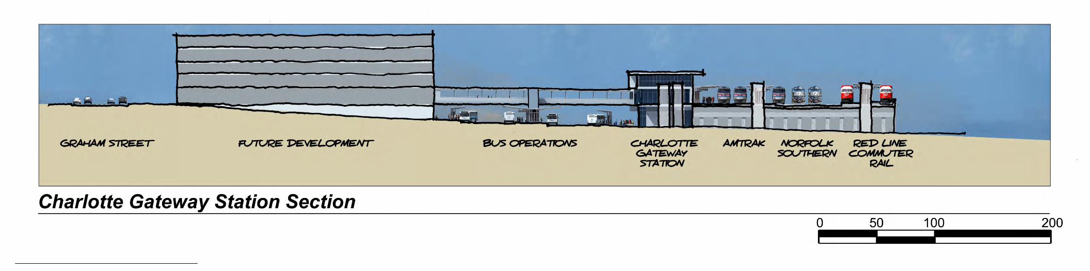
APPENDIX A – EXAMPLE MULTIMODAL TRANSIT STATIONSAPPENDIX B – CHARLOTTE GATEWAY STATION CONCEPTUAL RENDERINGS
CHARLOTTE GATEWAY STATION
CATS BUS OPERATIONAL ASSESSMENT
1
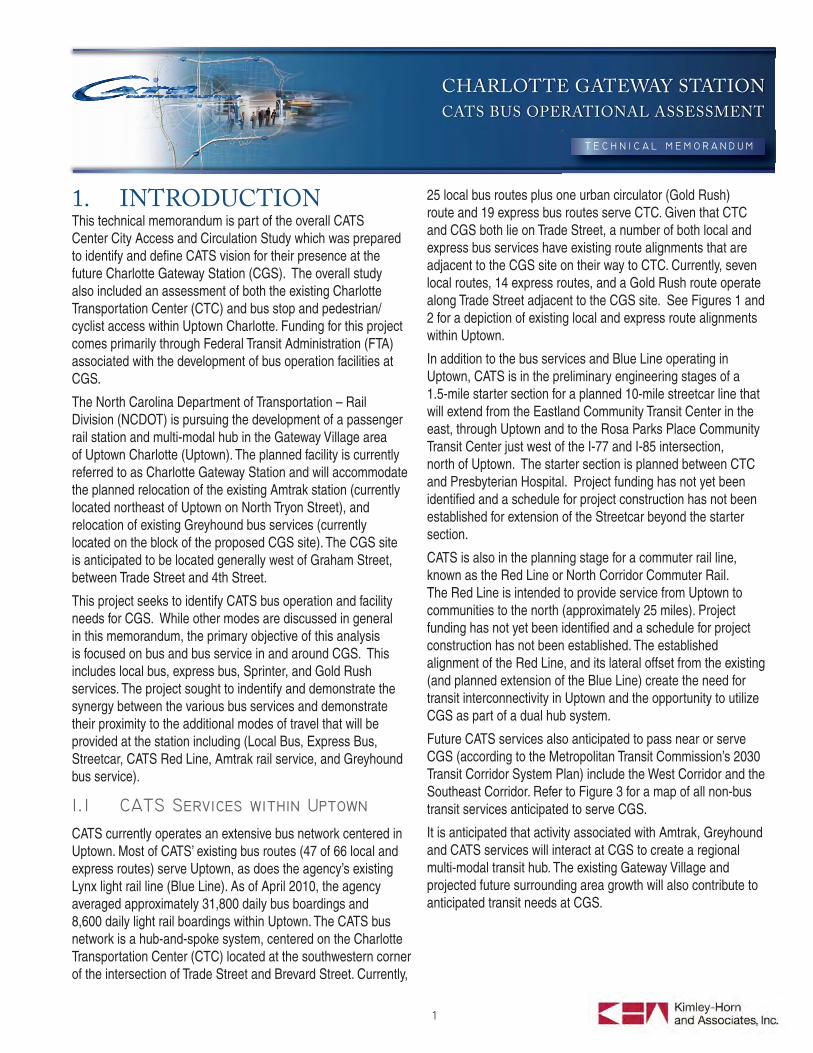
1. INTRODUCTIONThis technical memorandum is part of the overall CATS Center City Access and Circulation Study which was prepared to identify and defi ne CATS vision for their presence at the future Charlotte Gateway Station (CGS). The overall study also included an assessment of both the existing Charlotte Transportation Center (CTC) and bus stop and pedestrian/cyclist access within Uptown Charlotte. Funding for this project comes primarily through Federal Transit Administration (FTA) associated with the development of bus operation facilities at CGS.
The North Carolina Department of Transportation – Rail Division (NCDOT) is pursuing the development of a passenger rail station and multi-modal hub in the Gateway Village area of Uptown Charlotte (Uptown). The planned facility is currently referred to as Charlotte Gateway Station and will accommodate the planned relocation of the existing Amtrak station (currently located northeast of Uptown on North Tryon Street), and relocation of existing Greyhound bus services (currently located on the block of the proposed CGS site). The CGS site is anticipated to be located generally west of Graham Street, between Trade Street and 4th Street.
This project seeks to identify CATS bus operation and facility needs for CGS. While other modes are discussed in general in this memorandum, the primary objective of this analysis is focused on bus and bus service in and around CGS. This includes local bus, express bus, Sprinter, and Gold Rush services. The project sought to indentify and demonstrate the synergy between the various bus services and demonstrate their proximity to the additional modes of travel that will be provided at the station including (Local Bus, Express Bus, Streetcar, CATS Red Line, Amtrak rail service, and Greyhound bus service).
CATS currently operates an extensive bus network centered in Uptown. Most of CATS’ existing bus routes (47 of 66 local and express routes) serve Uptown, as does the agency’s existing Lynx light rail line (Blue Line). As of April 2010, the agency averaged approximately 31,800 daily bus boardings and 8,600 daily light rail boardings within Uptown. The CATS bus network is a hub-and-spoke system, centered on the Charlotte Transportation Center (CTC) located at the southwestern corner of the intersection of Trade Street and Brevard Street. Currently,
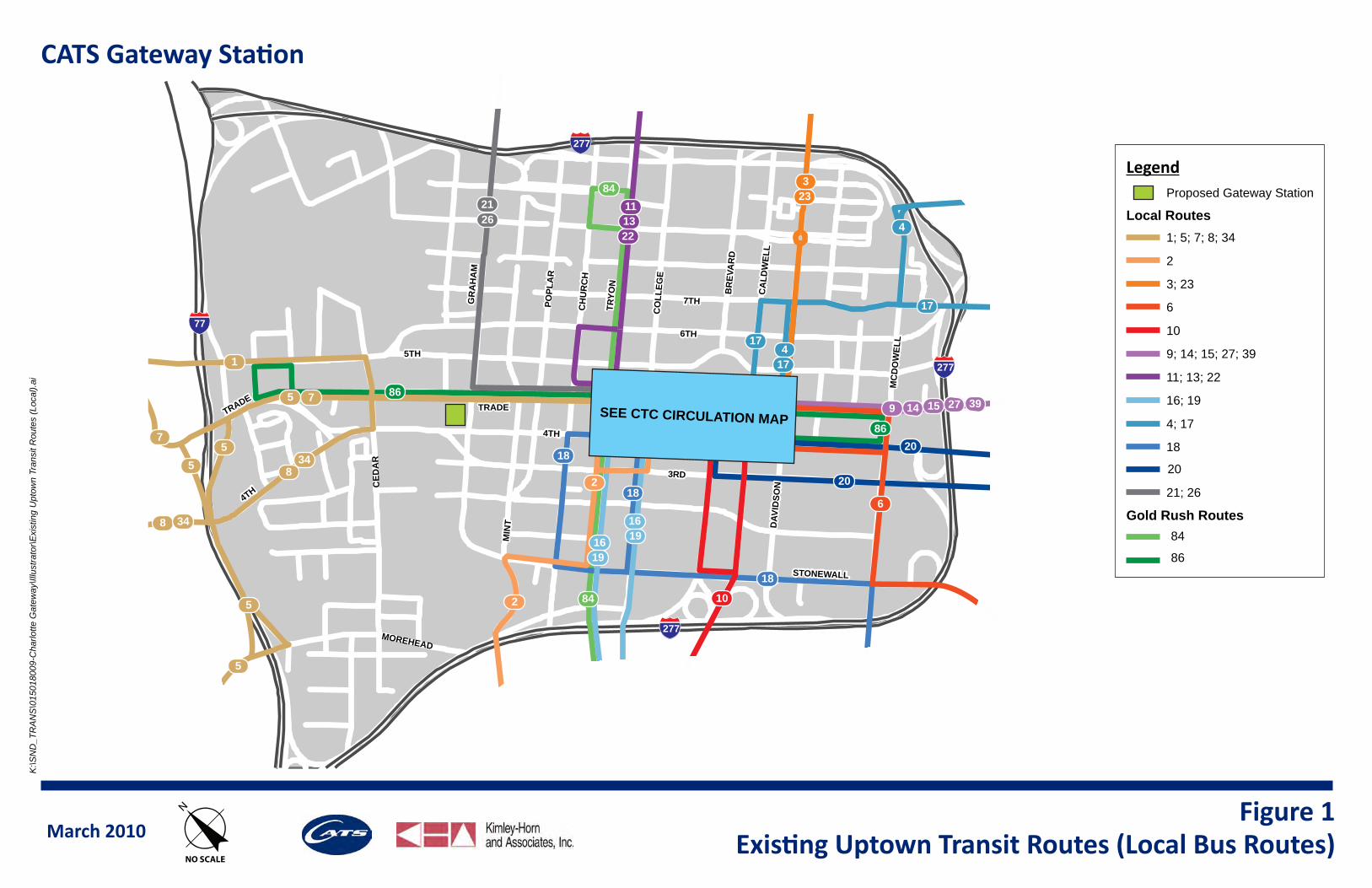
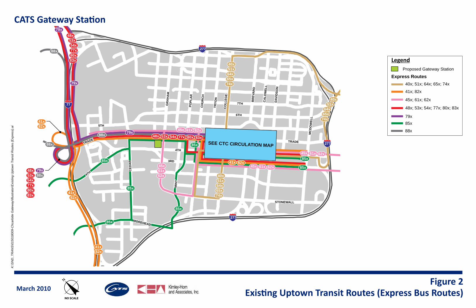
25 local bus routes plus one urban circulator (Gold Rush) route and 19 express bus routes serve CTC. Given that CTC and CGS both lie on Trade Street, a number of both local and express bus services have existing route alignments that are adjacent to the CGS site on their way to CTC. Currently, seven local routes, 14 express routes, and a Gold Rush route operate along Trade Street adjacent to the CGS site. See Figures 1 and 2 for a depiction of existing local and express route alignments within Uptown.
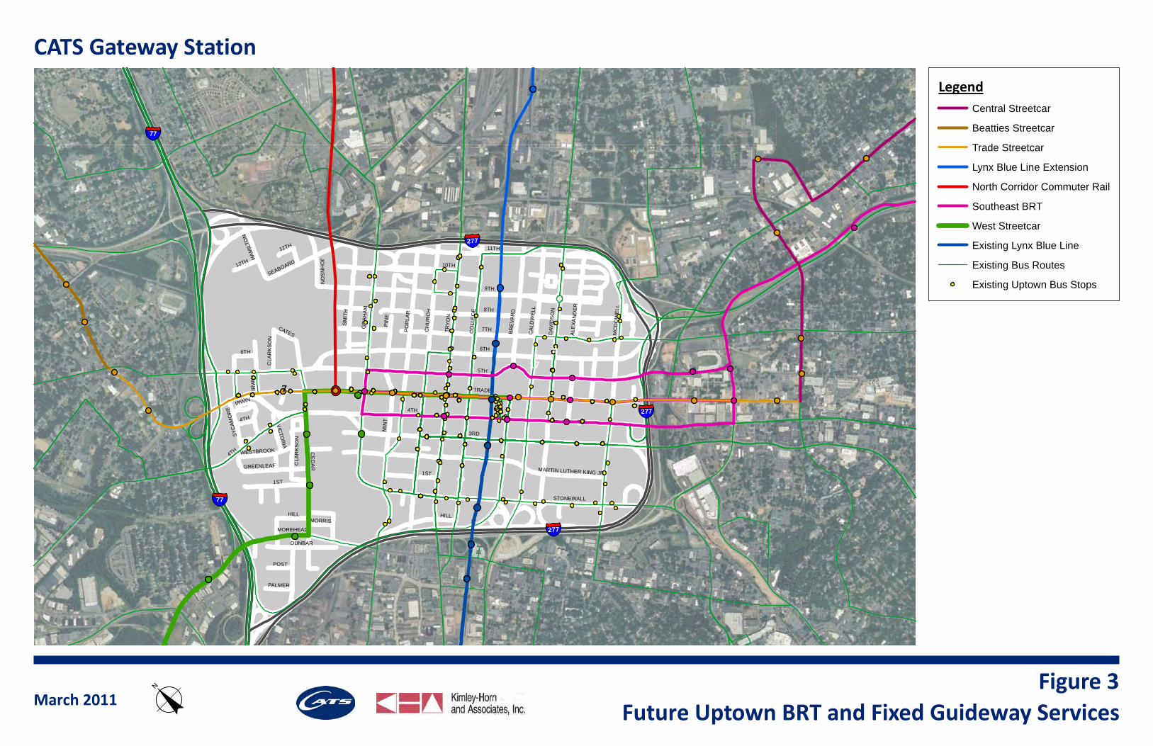
In addition to the bus services and Blue Line operating in Uptown, CATS is in the preliminary engineering stages of a 1.5-mile starter section for a planned 10-mile streetcar line that will extend from the Eastland Community Transit Center in the east, through Uptown and to the Rosa Parks Place Community Transit Center just west of the I-77 and I-85 intersection, north of Uptown. The starter section is planned between CTC and Presbyterian Hospital. Project funding has not yet been identifi ed and a schedule for project construction has not been established for extension of the Streetcar beyond the starter section.
CATS is also in the planning stage for a commuter rail line, known as the Red Line or North Corridor Commuter Rail. The Red Line is intended to provide service from Uptown to communities to the north (approximately 25 miles). Project funding has not yet been identifi ed and a schedule for project construction has not been established. The established alignment of the Red Line, and its lateral offset from the existing (and planned extension of the Blue Line) create the need for transit interconnectivity in Uptown and the opportunity to utilize CGS as part of a dual hub system.
Future CATS services also anticipated to pass near or serve CGS (according to the Metropolitan Transit Commission’s 2030 Transit Corridor System Plan) include the West Corridor and the Southeast Corridor. Refer to Figure 3 for a map of all non-bus transit services anticipated to serve CGS.
It is anticipated that activity associated with Amtrak, Greyhound and CATS services will interact at CGS to create a regional multi-modal transit hub. The existing Gateway Village and projected future surrounding area growth will also contribute to anticipated transit needs at CGS.
SEE CTC CIRCULATION MAP
4TH
6TH
TRADE
TRYO
N
CH
UR
CH
CO
LLEG
E
MIN
T
GR
AH
AM
CA
LDW
ELL
MC
DO
WEL
L
DAV
IDSO
N
3RD
4TH
BR
EVA
RD
STONEWALL
7TH
TRADE
5TH
CED
AR
MOREHEAD
POPL
AR
POPL
AR
2126
84
221311
233
4
417
17
39279 14 15
6
2
1619
10
18
86
1
834
5
75
17
5
5
8 34
5
84
1619
18
18
867
2
20
20
CATS Gateway Station
March 2010 Existing Uptown Transit Routes (Local Bus Routes)Figure 1
K:\S
ND
_TR
AN
S\0
1501
8009
-Cha
rlotte
Gat
eway
\Illu
stra
tor\E
xist
ing
Upt
own
Tran
sit R
oute
s (L
ocal
).ai
oNO SCALE
20
LegendProposed Gateway Station
Local Routes1; 5; 7; 8; 34
2
3; 23
6
10
9; 14; 15; 27; 39
11; 13; 22
16; 19
4; 17
18
21; 26
Gold Rush Routes84
86
277
77
277
277
4TH
6TH
TRADE
TRYO
N
CH
UR
CH
CO
LLEG
E
MIN
T
GR
AH
AM
CA
LDW
ELL
MC
DO
WEL
L
DAV
IDSO
N
3RD
4TH
BR
EVA
RD
STONEWALL
7TH
TRADE
5THC
EDA
R
MOREHEADMOREHEAD
CED
AR
POPL
AR
POPL
AR
SEE CTC CIRCULATION MAP
82x41x
82x41x
40x
74x65x64x51x
40x
74x65x64x51x
40x
74x65x64x
51x
53x54x
88x
88x
85x
85x
85x
85x
85x
85x
79x
79x
48x 80x77x54x53x 83x
62x61x45x
62x61x45x
62x61x45x
85x
K:\S
ND
_TR
AN
S\0
1501
8009
-Chc
arlo
tte G
atew
ay\Il
lust
rato
r\Exi
stin
g U
ptow
n Tr
ansi
t Rou
tes
(Exp
ress
).ai
41x82x
48x
83x80x77x
53x54x
79x62x61x45x
79x
88x
48x
80x77x
83x
88x
82x41x
CATS Gateway Station
March 2010 o Existing Uptown Transit Routes (Express Bus Routes)Figure 2
NO SCALE
Legend
Express Routes40x; 51x; 64x; 65x; 74x
85x
45x; 61x; 62x
79x
41x; 82x
48x; 53x; 54x; 77x; 80x; 83x
88x
Proposed Gateway Station
277
77
277
277
5TH
4TH
6TH
TRADE
9TH
TRY
ON
11TH
CH
UR
CH
CE
DA
R
CO
LLE
GE
MIN
T
GR
AH
AM
CA
LDW
ELL
PO
PLA
R
MC
DO
WE
LL
DAV
IDS
ON
1ST
3RD
4TH
SM
ITH
MARTIN LUTHER KING JR
MOREHEAD
IRW
IN
SEABOARD
STONEWALL
DUNBAR
HILL
HAM
ILTO
N
GREENLEAF
JOH
NS
ON
12TH
POST
WESTBROOK
VICTO
RIA
CATES
CLA
RK
SO
N
PALMER
MORRIS
6TH
7TH
ALE
XA
ND
ER
IRWIN
4TH
BRE
VAR
DHILL
PIN
E
8TH
CLA
RK
SO
N
1ST
10TH
12TH
SYC
AMO
RE
17
7
4
§̈¦277
§̈¦277
§̈¦277
§̈¦77
§̈¦77
CATS Gateway Station
LegendCentral Streetcar
Beatties Streetcar
Trade Streetcar
Lynx Blue Line Extension
North Corridor Commuter Rail
Southeast BRT
West Streetcar
Existing Lynx Blue Line
Existing Bus Routes
Existing Uptown Bus Stops
March 2011Future Uptown BRT and Fixed Guideway Serviceso
Figure 3
CHARLOTTE GATEWAY STATION
CATS BUS OPERATIONAL ASSESSMENT
5
In order to evaluate how to best integrate CGS into the CATS network, existing system operations within Uptown were analyzed. Ridership patterns were assessed at the system and route level. Locations of boardings were identifi ed, as were transit levels of service throughout Uptown. A few general system trends for existing services were found to be of critical importance when considering the integration of CGS into the bus network. These trends are detailed in the Uptown CATS System Trends Memo, (Kimley-Horn and Associates, Inc., February 17, 2011), and summarized below:
Of the approximately 31,800 daily bus boardings within Uptown, approximately 28,900 are on local routes and 2,900 are on express routes. This emphasizes the importance of local routes when considering resource allocation within the route network.
There is a slightly greater number of bus trips made heading out of Uptown than bus trips heading into Uptown. A reverse trend is experienced on Lynx, with more inbound than outbound ridership. This indicates a tendency by some riders to use multiple transit modes over the course of their daily round trip.
A full 28 percent of the boardings and alightings in Uptown, excluding the free Gold Rush service, are either on Routes 7, 9, or 11. These three routes currently operate at peak frequencies of ten minutes or less. No other bus routes within the CATS system operate at this level of peak period frequency. No other route individually contributes 5 percent or more of total boardings and alightings in Uptown. This emphasizes the importance of these three routes and their critical role within any signifi cant CATS service framework at CGS.
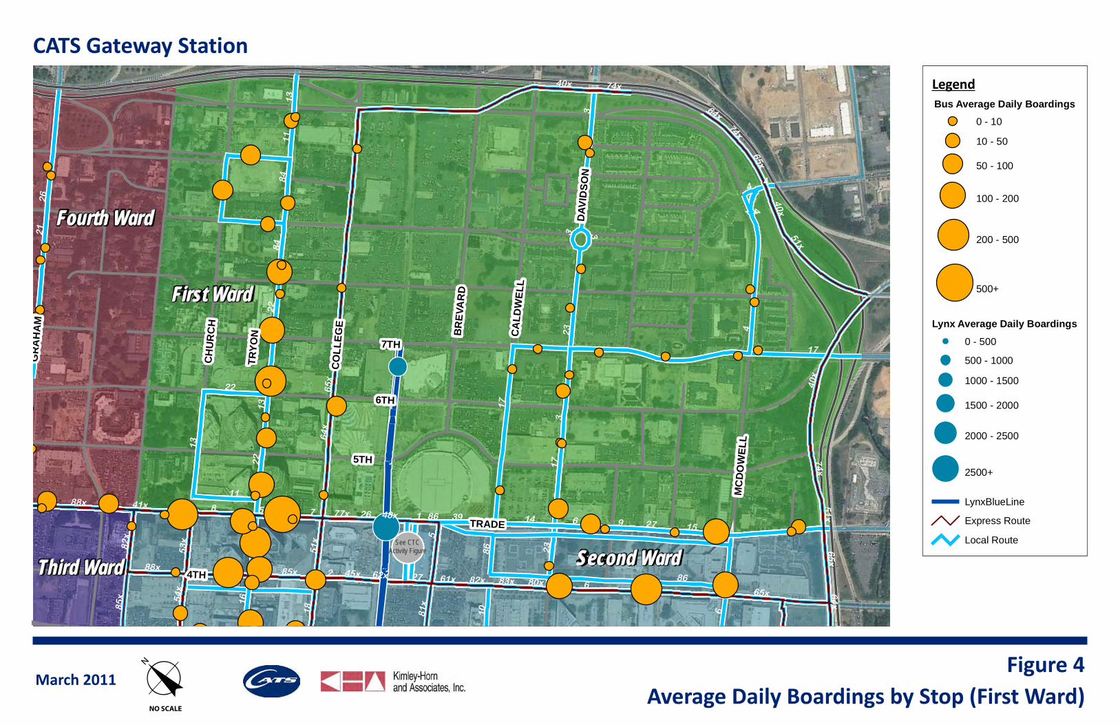
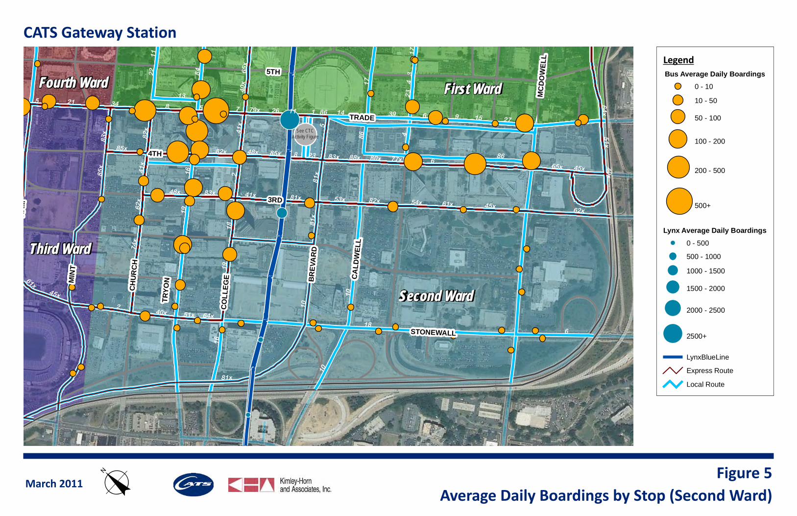
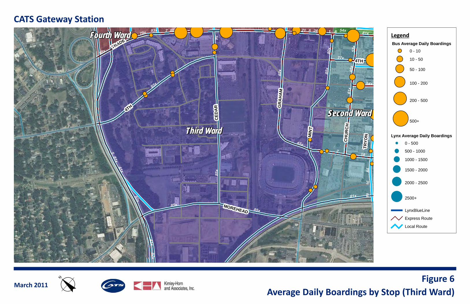
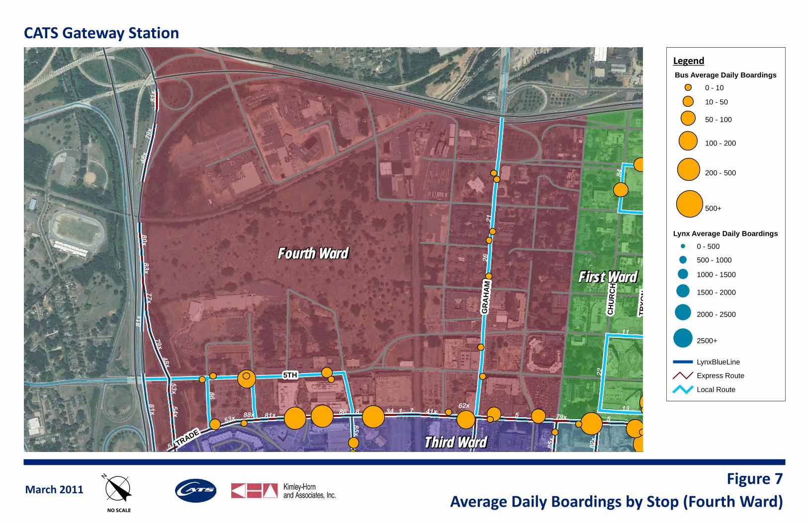
Ridership in Uptown is clustered at CTC, Trade and Tryon Streets, the Charlotte-Mecklenburg Government Center along Davidson Street, and Johnson & Wales University near Cedar Street. While there were some other well-utilized stops along Trade Street and Tryon Street, the remainder of stops within Uptown had fewer than 50 daily boardings per stop. There are a limited number of existing boardings at stops around the proposed CGS area. This is of particular interest when considering CATS’ role at CGS prior to start of service on the Red Line. Current boardings by stop in Uptown are shown for each quadrant of Uptown in Figures 4 through 7.
CTC is the most heavily utilized transit stop by far, with approximately 24,600 daily bus boardings. This accounts
for approximately 74 percent of the total daily bus system boardings within Uptown. In addition, CTC is the location for approximately 2/3 of transfers within the system. This emphasizes the need for a seamless connection between CGS and CTC.
The Gold Rush is the most heavily utilized transit travel mode within Uptown by a substantial margin. The two Gold Rush routes combine for approximately 3,600 daily boardings, a considerable number given their limited length. This shows strong demand for trip-making within Uptown via transit, at least at a free price point, and indicates the strong ridership demand likely to be experienced by Gold Rush or a similar type service at CGS upon provision of regional train service at this facility.
Trade Street is a heavily utilized transit corridor for both local and express routes. These routes combine to result in high frequency service on Trade Street. Based on data provided by CATS operations staff, a segment of Trade Street, around Poplar Street, has 99 buses (total of both directions) during the peak hour of service. This has partially resulted in Trade Street having the lowest average travel speed of the major east-west corridors through Uptown, based on recently completed travel time runs. The addition of streetcar vehicles to existing mixed-fl ow lanes will further stress the private and transit vehicular capacity on Trade Street. Therefore, strategic assignment of bus service on Trade Street would be benefi cial to avoid system ineffi ciencies associated with excess supply and low travel speed on the corridor.
The travel demand forecast model is projecting a more than three-fold increase in trips within the Uptown area over the next 25 years. While trips to and from Uptown are forecast for considerable growth between now and 2035, the share of trips that are generated and remain in Uptown is projected to increase even more signifi cantly. These factors indicate a strong potential for transit travel demand growth within the Uptown area.
Existing load factors were examined to identify routes with passenger demand greater than their seating capacity at their current headways. For routes with an average load factor well over one during the peak hour, it was projected that headways may be reduced in the future. This will impact bus bay quantity requirements at CGS because as frequency increases, the demand for bay resources will increase.
6TH
TRADE
TRYO
N
CH
UR
CH
GR
AH
AM
CA
LDW
ELL
MC
DO
WEL
L
DAV
IDSO
N
3RD
4TH
7TH
BR
EVA
RD
GR
AH
AM
DW
ELL
DW
ELL
AR
DA
RD
CO
LLEG
E
H
5TH
See CTCActivity Figure
First WardFirst Ward
Second WardSecond Ward
Fourth WardFourth Ward
Third WardThird Ward
91
4
6
3
8 7 86
45x 61x62x
5
23
84
51x
64x
65x
74x40x
27 15143926
85x83x82x 80x
88x48x77x
41x
53x
22
1113
17
21
81x54
x
2
18
16
10
65x
82x
27
4
6
88x
85x
4
5
22
22
6
3
23
84
40x
4
17
65x
51x
51x
65x
64x
26
13
74x
86
17
11
74x
13
3 64x
40x
3
86
CATS Gateway Station
LegendBus Average Daily Boardings
0 - 10
10 - 50
50 - 100
100 - 200
200 - 500
500+
Lynx Average Daily Boardings
0 - 500
500 - 1000
1000 - 1500
1500 - 2000
2000 - 2500
2500+
LynxBlueLine
Express Route
Local Route
March 2011Average Daily Boardings by Stop (First Ward)
Figure 4oNO SCALE
6TH
TRADE
TRC
CO
LLEG
EMIN
T
G
MC
DO
WEL
L
3RD
4TH
GR
AH
AM
STONEWALL
CA
LDW
ELL
CA
LDW
ELL
BR
EVA
RD
BR
EVA
RD
CO
CH
UR
CH
5TH
TRYO
N
See CTCActivity Figure
Second WardSecond Ward
First WardFirst Ward
Third WardThird Ward
Fourth WardFourth Ward
19
2
6
78
18
84
86
45x61x62x
5 2615 27
3914
53x 54x
82x83x
85x80x88x 77x
48x
41x
51x
64x
65x 40x
74x
1916
81x
3
34
4
21
10
79x
17
11
13
2223
86
65x
85x
1185x
2
19
81x
82x
82x
48x
41x
83x
8
83x
5
5
17
81x
86
18
40x
16
4
45x
41x
6
10
23
40x
62x
64x51x
10
81x
6
45x
61x
CATS Gateway Station
LegendBus Average Daily Boardings
0 - 10
10 - 50
50 - 100
100 - 200
200 - 500
500+
Lynx Average Daily Boardings
0 - 500
500 - 1000
1000 - 1500
1500 - 2000
2000 - 2500
2500+
LynxBlueLine
Express Route
Local Route
March 2011Average Daily Boardings by Stop (Second Ward)
Figure 5o
4TH
CO
LLEG
EMIN
T
3RD
4TH
TRADE
5TH
GR
AH
AM
CED
AR
BR
EVA
RD
BR
EVA
RD
CH
UR
CH
5TH
TRYO
N
MOREHEAD
See CTCActivity Figure
Third WardThird Ward
Second WardSecond Ward
Fourth WardFourth Ward 87 5 1
34
86
2
81x79x
41x
54x
53x
88x
83x
80x
82x
77x
48x
85x
62x
18
61x
45x
21 26
1619
84
54x
81x
82x
41x
85x
41x
581x
85x
85x
85x
CATS Gateway Station
LegendBus Average Daily Boardings
0 - 10
10 - 50
50 - 100
100 - 200
200 - 500
500+
Lynx Average Daily Boardings
0 - 500
500 - 1000
1000 - 1500
1500 - 2000
2000 - 2500
2500+
LynxBlueLine
Express Route
Local Route
March 2011Average Daily Boardings by Stop (Third Ward)
Figure 6o
6TH
TRA
TRYO
N
CH
UR
CH
GR
AH
AM
3RD
4TH
7TH
BR
EVA
RD
TRADE
5TH
AM
CO
LLEG
E
5TH
See CTCActivity Figure
Fourth WardFourth WardFirst WardFirst Ward
Third WardThird Ward
1 75886
2621
81x 79x41x
53x
54x 3488x
82x
80x
83x
48x
77x
62x
85x
13
11
22
84
48x
85x
86
79x
79x
81x
81x
81x
5
5
53x
CATS Gateway Station
LegendBus Average Daily Boardings
0 - 10
10 - 50
50 - 100
100 - 200
200 - 500
500+
Lynx Average Daily Boardings
0 - 500
500 - 1000
1000 - 1500
1500 - 2000
2000 - 2500
2500+
LynxBlueLine
Express Route
Local Route
March 2011Average Daily Boardings by Stop (Fourth Ward)
Figure 7oNO SCALE
CHARLOTTE GATEWAY STATION
CATS BUS OPERATIONAL ASSESSMENT
10
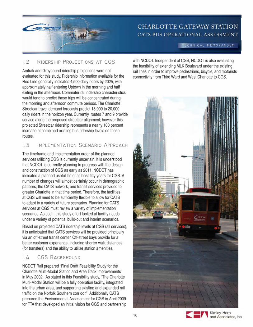
Amtrak and Greyhound ridership projections were not evaluated for this study. Ridership information available for the Red Line generally indicates 4,500 daily riders by 2025, with approximately half entering Uptown in the morning and half exiting in the afternoon. Commuter rail ridership characteristics would tend to predict these trips will be concentrated during the morning and afternoon commute periods. The Charlotte Streetcar travel demand forecasts predict 15,000 to 20,000 daily riders in the horizon year. Currently, routes 7 and 9 provide service along the proposed streetcar alignment; however this projected Streetcar ridership represents a nearly 100 percent increase of combined existing bus ridership levels on those routes.
The timeframe and implementation order of the planned services utilizing CGS is currently uncertain. It is understood that NCDOT is currently planning to progress with the design and construction of CGS as early as 2011. NCDOT has indicated a planned useful life of at least fi fty years for CGS. A number of changes will almost certainly occur in demographic patterns, the CATS network, and transit services provided to greater Charlotte in that time period. Therefore, the facilities at CGS will need to be suffi ciently fl exible to allow for CATS to adapt to a variety of future scenarios. Planning for CATS services at CGS must review a variety of implementation scenarios. As such, this study effort looked at facility needs under a variety of potential build-out and interim scenarios.
Based on projected CATS ridership levels at CGS (all services), it is anticipated that CATS services will be provided principally via an off-street transit center. Off-street bays provide for a better customer experience, including shorter walk distances (for transfers) and the ability to utilize station amenities.
NCDOT Rail prepared “Final Draft Feasibility Study for the Charlotte Multi-Modal Station and Area Track Improvements” in May 2002. As stated in this Feasibility study, “The Charlotte Multi-Modal Station will be a fully operation facility, integrated into the urban area, and supporting existing and expanded rail traffi c on the Norfolk Southern corridor.” Additionally CATS prepared the Environmental Assessment for CGS in April 2009 for FTA that developed an initial vision for CGS and partnership
with NCDOT. Independent of CGS, NCDOT is also evaluating the feasibility of extending MLK Boulevard under the existing rail lines in order to improve pedestrians, bicycle, and motorists connectivity from Third Ward and West Charlotte to CGS.
CHARLOTTE GATEWAY STATION
CATS BUS OPERATIONAL ASSESSMENT
11
2. METHODOLOGY FOR DETERMINING CATS’ FACILITY NEEDS AT CGS
In order to identify CATS facility needs at CGS, an operating plan was developed to account for projected route alignments and service frequencies. While CATS may not implement this specifi c operating plan, it represents a feasible and reasonably expected route structure that could occur for this base set of assumptions. This operating plan represents a likely scenario that considers the trade-off between providing a high level of service and the corresponding demand for operating resources. It does not utilize the most, nor the least, conceivable demand for CATS facilities at CGS. With the considerable uncertainty surrounding opening dates and implementation chronology of projects within the 2030 Transit Plan, a variety of fi xed-route implementation scenarios were considered. For each implementation scenario, a reasonable service framework was developed. The service frameworks then were analyzed to determine the CATS footprint at CGS.
The fi xed-route projects considered in the short-term timeframe in various combinations are:
The Blue Line Extension,
The Streetcar Starter Segment, and
The Red Line.
The projects considered in the medium-term timeframe is:
The westward expansion of the Streetcar Starter Segment.
The Long-term projects considered include:
The West Cooridor,
Full implementation of the Charlotte Streetcar, and
The Silver Line in the Southeast Corridor.
CGS provides the opportunity to develop a new transit facility to supplement CTC and simultaneously integrate the CATS transit network with planned commuter and regional rail services. The connection between these two transit hubs will be a critical element for CATS system operations, as well as an important factor in creating a seamless customer experience. Initially,
this connection is anticipated to be made through frequent bus service. While the Gold Rush currently is fare free, all other routes connecting the Gateway Village area to CTC require a fare. Various strategies should be explored upon refi nement of an operating plan under any of the implementation scenarios to help facilitate passenger trips between CGS and CTC. These strategies may include free fare zones, expanded shuttle service, and/or the re-branding of buses linking the two hubs. The principle improvement of this link will come with extension of the Charlotte Streetcar. The Streetcar will greatly increase transit capacity on the link between CGS and CTC. It also will provide unique fare structure opportunities given its likely use of a proof of payment system. This would help facilitate creation of a free fare zone, which has some signifi cant enforcement obstacles with a bus-only link between the two facilities.
For each implementation scenario, the alignment of each route currently entering Uptown (including both local and express routes) was examined to determine a potential routing scenario that would most effi ciently serve CATS customers. A number of elements were considered when evaluating route alignments including:
Facilitating transfers between critical bus pairs,
Maintaining or enhancing service to ridership generators in Uptown, and
Optimizing vehicle-hours to make the most effi cient use of resources.
CATS provided a draft version of the Blue Line Extension Bus/Rail Integration Plan as part of this effort. The proposed route modifi cations were reviewed and incorporated into this analysis in implementation scenarios that included the Blue Line Extension. It should be noted that the Integration Plan is still in draft form at this time and subject to change pending further analysis and Metropolitan Transit Commission review.
Existing system trends were considered when developing the service framework under each implementation scenario. Local and express routes each have different operating properties that educated the identifi ed frameworks.
2.1.1 Local Routes
For local routes, the current CATS system principally utilizes transfers at CTC. In order to avoid, or minimize, an increase in transfers as a result of the integration of CGS; consideration was given in each scenario to limiting the number of double
CHARLOTTE GATEWAY STATION
CATS BUS OPERATIONAL ASSESSMENT
12
transfers. Double transfers reduce the desirability of the transit system for passengers and may increase bus dwell time, resulting in increased operating costs. Given the current fare structure and the free transfer policy, this would not likely be offset by an increase in fares.
For ridership convenience, the minimization of double transfers is a key element when considering any operational change. Each scenario sought to minimize these double transfers by evaluating key transfer pairs in the system as a whole, as well as transfer relationships for each individual route. Routes where a sizeable portion of ridership involved transfers are proposed to access both CTC and CGS, avoiding double transfers. Elimination of potential double transfers in all scenarios is not feasible without introducing cost and resource requirement increases in order to operate all routes at both CTC and CGS. The impact to vehicle-miles traveled and bus running time would be signifi cant. Traffi c conditions would also be substantially impacted on both Trade Street and 4th Street with this type of operating condition. By terminating select routes at CGS, CATS would achieve operating effi ciencies, improve travel speed on Trade Street and 4th Street, and free up the resources needed to serve the signifi cant number of projected riders anticipated to enter Uptown via CGS.
2.1.2 Express Routes
CATS express routes operate with a different set of characteristics than local routes. Transfer volumes are much lower and activity within Uptown is less centered on CTC. Boardings and alightings at bus stops at the front door of major employment centers represent a much greater proportion of ridership for express buses than local routes within Uptown. Additionally, express bus service only operates in the peak travel direction in each peak period (except for two routes).
The express bus network is likely to be reconfi gured over time with implementation of some of the planned fi xed guideway transit services. In particular, several routes operate within the corridor planned to be served by the Red Line and the Southeast Corridor. Therefore, the express bus routing framework was re-evaluated as part of this project to identify any opportunities for optimization in terms of ridership and eliminating system redundancy.
It is assumed in all implementation scenarios that a number of express buses will shift from accessing Uptown via I-77 and Trade Street, to I-277 and Tryon Street. A few express buses
likely would utilize CGS as a terminus point to turn around, or layover if necessary. And for those routes that continue to operate on Trade Street, an on-street stop would be provided at CGS. Given the associated time impact to bus riders and the operating cost impact for the additional travel time, it is not anticipated that it would be benefi cial for inbound express bus routes from the north and west to enter the transit center within CGS on their way into Uptown. Therefore, there are minimal bus bay needs anticipated at CGS for express buses.
The number of bays required during each implementation scenario was determined by the number of routes accessing the off-street bus bays at CGS and the headways of those routes. Given that CGS is the terminus for several long routes, signifi cant schedule variance is anticipated for many of the inbound routes by the time they reach the station. Therefore, the ability to schedule multiple routes to a single bay is constrained and diffi cult to coordinate. By using fl exible bay assignments, that concern is marginally alleviated, but care must be made to avoid over-assigning a segment of loading area and forcing fully loaded buses to wait in a queue for the bus in the last stretch of curb along a fl exible bay row to depart. A slightly conservative quantifi cation of bay needs based on headways was assumed. This provides some degree of buffer for the long-term forecast growth in the Charlotte-Mecklenburg metropolitan area, and associated increase in ridership and decrease in headways. In general, routes with headways of less than 15 minutes were assumed to require their own bay. Routes with headways of between 15 minutes and 25 minutes, inclusive, were assumed to share a bay with another route. Routes with headways of greater than 25 minutes were assumed to share a bay with two other routes. One exception was made for terminating express bus routes, which only will need to pick-up or drop-off passengers before likely dead-heading to the maintenance/storage yard. The three express routes anticipated to terminate at CGS likely will share a single bay.
It must be emphasized that the bay requirements identifi ed in this report only account for existing routes, except for one identifi ed route in Scenarios #3 - #6. Except for that one proposed route in those scenarios, this report does not assume expansion of services into or circulators through Uptown. CATS should consider incorporating a buffer in the number of bays needed to allow for future expansion of services over the projected lifetime of CGS.
CHARLOTTE GATEWAY STATION
CATS BUS OPERATIONAL ASSESSMENT
13
3. BUS FRAMEWORK BY IMPLEMENTATION SCENARIORoute-by-route alignment maps were prepared for the implementation scenario considered most likely for a short-term or near-term horizon. In this scenario (Scenario #3), Blue Line Extension, Red Line, and the Streetcar Starter Segment are assumed to have been implemented. While this particular scenario was considered one of the more likely scenarios to occur at some point during operation of the CGS, it also represents the scenario with the most facilities needs for CATS at CGS, as calculated based on the analysis discussed below. The route alignment maps, included in the Example Operational Scenario for Operating Dual Hub Systems (Example Operational Scenario), also note where the route alignment would be modifi ed or eliminated given an alternate implementation scenario analyzed in this report. These maps are prepared for each local and express route that currently serves Uptown and include information on each route such as existing boardings, boardings in Uptown, transfers within Uptown, and routes that generate at least 25 daily transfers. This information was utilized to develop the route alignments for all implementation scenarios. Some routes, clearly identifi ed on the individual route fi gures, no longer would enter Uptown in certain implementation scenarios. For routes that are anticipated to serve CGS, existing and projected headways are provided as well.
The area planned to be re-developed as CGS currently is served by seven local CATS bus routes. In addition, Greyhound’s Charlotte station is located on the site of the planned CGS. The seven CATS routes that currently serve the CGS area are Routes 1, 5, 7, 8, 21, 26, and 34. Five of the seven local routes operate on Trade Street east of Cedar Street, while the other two (Routes 21 and 26) access the area via Graham Street before turning east onto Trade Street. In addition, Gold Rush Route 86 operates on Trade Street adjacent to CGS. Given the lack of signifi cant land use density in the portion of the Gateway Village area east of the rail tracks, CATS bus stops in that area are under-utilized with little to no ridership. The parcels surrounding CGS currently are used
primarily as surface parking lots for businesses located in the central business district core area. CATS currently experiences notable boarding activity associated with Johnson & Wales University, located to the west of the CGS site along Trade Street.
While the North Corridor is anticipated to serve CGS in the near-term, one implementation scenario includes NCDOT constructing CGS initially to serve just Amtrak (and potentially Greyhound), should North Corridor not be constructed to coincide with the opening of CGS. In this scenario, is it feasible to consider that off-street bus bays will be available to CATS prior to operation of the Red Line.
Accounting for CATS’ limited existing ridership activity in the CGS vicinity and Amtrak’s relatively small existing daily ridership, should CATS utilize these bays, nearly all passenger activity would be driven by bus transfers. While terminating some routes at CGS would result in operating cost savings for those routes, in order to avoid a signifi cant number of double transfers in the system, CATS would need to extend a number of routes from CTC to CGS. This likely would offset the operating savings associated with terminating some routes at CGS. With the limited regional transit services at CGS in this scenario, providing enhanced bus service at CGS would not substantially increase non-transfer boardings. Considering both the lack of operating cost savings and ridership growth in this scenario, there is little incentive for CATS to develop a signifi cant presence at CGS prior to the addition of commuter-focused transit services at the station.
CATS may be able to make some use of layover facilities at CGS, particularly for express bus routes that currently terminate to the west of CGS, including Routes 45x, 61x, and 62x. CATS may also benefi t from using some layover facilities for local routes that currently layover just outside of CTC. While shifting the layover location for these local routes would result in longer deadhead travel, it would help to address the current excess demand for layover facilities around CTC. Future development on the CTC block will also diminish the available space for transit and layover operations. Outside of these identifi ed layover needs, it is not anticipated that CATS would need off-street facilities at CGS in this implementation scenario. Existing routes would continue to stop on-street at CGS. Ridership at these stops may marginally increase with the addition of Amtrak service, but that increase is not anticipated to be signifi cant enough to result in the need for additional facilities or increased service levels.
CHARLOTTE GATEWAY STATION
CATS BUS OPERATIONAL ASSESSMENT
14
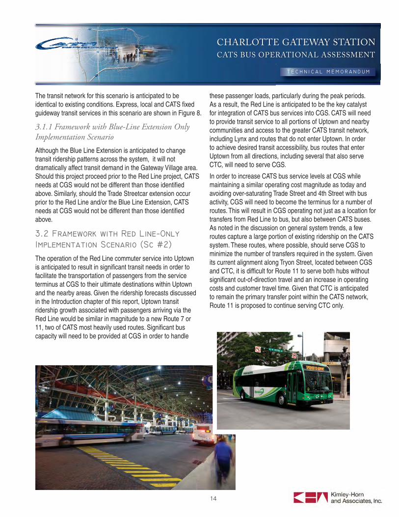
The transit network for this scenario is anticipated to be identical to existing conditions. Express, local and CATS fi xed guideway transit services in this scenario are shown in Figure 8.
3.1.1 Framework with Blue-Line Extension Only Implementation Scenario
Although the Blue Line Extension is anticipated to change transit ridership patterns across the system, it will not dramatically affect transit demand in the Gateway Village area. Should this project proceed prior to the Red Line project, CATS needs at CGS would not be different than those identifi ed above. Similarly, should the Trade Streetcar extension occur prior to the Red Line and/or the Blue Line Extension, CATS needs at CGS would not be different than those identifi ed above.
The operation of the Red Line commuter service into Uptown is anticipated to result in signifi cant transit needs in order to facilitate the transportation of passengers from the service terminus at CGS to their ultimate destinations within Uptown and the nearby areas. Given the ridership forecasts discussed in the Introduction chapter of this report, Uptown transit ridership growth associated with passengers arriving via the Red Line would be similar in magnitude to a new Route 7 or 11, two of CATS most heavily used routes. Signifi cant bus capacity will need to be provided at CGS in order to handle
these passenger loads, particularly during the peak periods. As a result, the Red Line is anticipated to be the key catalyst for integration of CATS bus services into CGS. CATS will need to provide transit service to all portions of Uptown and nearby communities and access to the greater CATS transit network, including Lynx and routes that do not enter Uptown. In order to achieve desired transit accessibility, bus routes that enter Uptown from all directions, including several that also serve CTC, will need to serve CGS.
In order to increase CATS bus service levels at CGS while maintaining a similar operating cost magnitude as today and avoiding over-saturating Trade Street and 4th Street with bus activity, CGS will need to become the terminus for a number of routes. This will result in CGS operating not just as a location for transfers from Red Line to bus, but also between CATS buses. As noted in the discussion on general system trends, a few routes capture a large portion of existing ridership on the CATS system. These routes, where possible, should serve CGS to minimize the number of transfers required in the system. Given its current alignment along Tryon Street, located between CGS and CTC, it is diffi cult for Route 11 to serve both hubs without signifi cant out-of-direction travel and an increase in operating costs and customer travel time. Given that CTC is anticipated to remain the primary transfer point within the CATS network, Route 11 is proposed to continue serving CTC only.
5TH
4TH
6TH
TRADE
9TH
TRY
ON
11TH
CH
UR
CH
CE
DA
R
CO
LLE
GE
MIN
T
GR
AH
AM
CA
LDW
ELL
PO
PLA
R
MC
DO
WE
LL
DAV
IDS
ON
1ST
3RD
SM
ITH
MARTIN LUTHER KING JR
4TH
MOREHEAD
IRW
IN
SEABOARD
STONEWALL
DUNBAR
HILL
HAM
ILTO
N
GREENLEAF
JOH
NS
ON
12TH
POST
WESTBROOK
VICTO
RIA
CATESC
LAR
KS
ON
PALMER
MORRIS
6TH
7TH
ALE
XA
ND
ER
IRWIN
4TH
BRE
VAR
D
HILL
PIN
E
8TH
CLA
RK
SO
N
1ST
10TH
12TH
SYC
AMO
RE
!"#$277
!"#$277
!"#$277
!"#$77
(/21
(/74
(/74
UV16
CATS Gateway Station
LegendLocal Routes & Goldrush
Express Routes
Ex. Blue Line Alignment
Ex. Blue Line Stop
Charlotte Transportation Center
Proposed Gateway Station
Local Routes at CTC:
Local Routes at CGS:
Bus Bays at CGS:
25
7
On-Street Only
March 2011Implementation Scenario #1 Transit Networko
Figure 8
CHARLOTTE GATEWAY STATION
CATS BUS OPERATIONAL ASSESSMENT
16
This is likely to result in a few double transfers in the system. This number can be minimized by extending local routes that interact heavily with Route 11 to CTC instead of terminating them at CGS. This condition can be re-evaluated in other implementation scenarios where there is a stronger transit connection between CGS and CTC, and Route 11 is converted to an extension of the Blue Line.
In conjunction with the introduction of the Red Line, express routes that operate within the proposed Red Line corridor will either be eliminated to offset commuter rail operating costs or converted to feeder services, providing service from residential communities to commuter rail stations. Either way, these routes no longer are anticipated to provide service into Uptown. Therefore, these routes would no longer require bays at CTC or CGS. Routes 77x and 83x are anticipated to be eliminated with the provision of the Red Line as they essentially operate in the same corridor. Routes 48x, 53x, and 54x may still operate into Uptown or may be converted into feeder routes to one of the proposed Red Line stations. As discussed in the previous chapter, even if these express routes still serve Uptown, the routes would access Uptown via Church Street and Tryon Street as opposed to Trade Street, and therefore would not require facilities at CGS. Since Red Line service is planned for the peak-period only, no local routes are assumed to be modifi ed by the provision of the service.
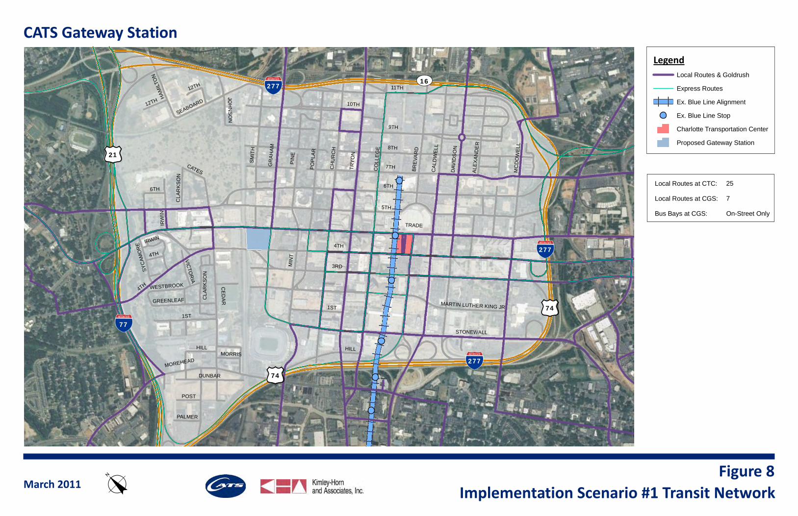
The transit services network in this implementation scenario is shown as Figure 9. This implementation scenario is anticipated to have the properties identifi ed in Table 1, focusing on facility needs and circulation at CGS:
Table 1: Framework Properties at CGS with Implementation Scenario #2
Routes Entering CGS Transit Center
1, 2, 5, 7, 8, 9, 10, 13, 15, 18, 21, 23, 26, 27, 34, 45x, 61x, 62x
Routes Serving CGS On-Street 85x, 88x, 86
Entering Buses Per Hour 87
On-Street Buses Per Hour 14
Off-Street Bays at CGS 13
Layover Buses per Hour at CGS 42
On-street bus bays are anticipated for express routes entering Uptown from the west and for Gold Rush. Route 85x is on 4th Street. Routes 86 and 88x are on Trade Street.
With this framework, there would be a shift in a number of transfers from CTC to CGS. In addition, some passengers may choose to transfer at an alternate location within Uptown outside CTC and CGS since it likely would shorten their total trip time and trip distance. While they would not be required to do so, it is assumed that they will to minimize travel time. Based on travel behavior noted in the existing CATS system, passengers are likely to transfer outside of CTC if it will provide travel time savings, particularly when transferring to a high-frequency route. In each framework, an attempt was made to minimize the number of double transfers. As discussed earlier, some double transfer activity is a by-product of any CGS-service scenario where associated operating cost increases are minimized. The amount of double transfers is inversely correlated to operating cost impacts. The scenario could be tweaked to reduce the number of double transfers, resulting in an increase in operating cost.
Table 2 documents transfer types and locations in the system under this framework.
Table 2: Transfer Patterns with Implementation Scenario #2
Transfer Type
Single 86%
1 Rail & 1 Bus 6%
Double (both via Rail) 0%
Double (both via Bus) 8%
Transfer Location
CTC 70%
CGS 35%
Other (Uptown) 3%
Other (Outside of Uptown) 3%Notes: Percentages don’t add up to 100% since some transfers occur at multiple locations. Table only accounts for transfers between routes currently serving Uptown.

5TH
4TH
6TH
TRADE
9TH
TRY
ON
11TH
CH
UR
CH
CE
DA
R
CO
LLE
GE
MIN
T
GR
AH
AM
CA
LDW
ELL
PO
PLA
R
MC
DO
WE
LL
DAV
IDS
ON
1ST
3RD
SM
ITH
MARTIN LUTHER KING JR
4TH
MOREHEAD
IRW
IN
SEABOARD
STONEWALL
DUNBAR
HILL
HAM
ILTO
N
GREENLEAF
JOH
NS
ON
12TH
POST
WESTBROOK
VICTO
RIA
CATESC
LAR
KS
ON
PALMER
MORRIS
6TH
7TH
ALE
XA
ND
ER
IRWIN
4TH
BRE
VAR
D
HILL
PIN
E
8TH
CLA
RK
SO
N
1ST
10TH
12TH
SYC
AMO
RE
!"#$277
!"#$277
!"#$277
!"#$77
(/21
(/74
(/74
UV16
CATS Gateway Station
LegendLocal Routes & Goldrush
Express Routes
Ex. Blue Line Alignment
Ex. Blue Line Stop
North Corridor
Charlotte Transportation Center
Proposed Gateway Station
Local Routes at CTC:
Local Routes at CGS:
Off-Street Bus Bays at CGS:
19
14
13
May 2011Implementation Scenario #2 Transit Networko
Figure 9
CHARLOTTE GATEWAY STATION
CATS BUS OPERATIONAL ASSESSMENT
18
In this scenario, the Red Line is operational and the Blue Line Extension has been constructed northeast of Uptown to at least the University of North Carolina at Charlotte campus. This scenario may also include the Streetcar Starter Segment. Given the very short nature of this initial streetcar phase, it is not anticipated to signifi cantly modify the existing bus network. It may have some impact on bus circulation to and from CTC given accompanying turn restrictions to/from Trade Street, but this does not impact CGS operations or bay requirements. The Streetcar Starter Segment may result in a modifi cation of Gold Rush Route 86, but the streetcar would not extend west of CTC in this scenario. For purposes of this analysis, it is assumed that Route 86 would continue to operate and provide service from CGS to the core business area and CTC along Trade Street.
This scenario is anticipated to be the most likely near-term scenario since these projects are farthest along in their planning and engineering stages, although neither currently has guaranteed funding. As such, the route alignments associated with this scenario are depicted in the Example Operational Scenario route information sheets. The Example Operational Scenario indicates the route alignments under this scenario, as well as their relationship to the planned fi xed guideway services. As indicated by the Blue Line Extension Bus/Rail Integration plan, some routes no longer would enter Uptown with this implementation scenario. Route 11, which generally follows the proposed Blue Line Extension alignment, is currently proposed to be converted into a feeder route between one of the Blue Line Extension stations and the Tryon Street Corridor. Additionally, some routes would be re-routed to provide enhanced transit service on under-served roadways within Uptown, maintaining a terminus at either CTC or CGS and a connection at a new or existing Blue Line station to facilitate transfers.
Similar to the previous scenario, some existing express routes would be modifi ed or eliminated with the provision of the Red Line service. The removal of these routes from Uptown is noted on the appropriate route information sheet in the Example Operational Scenario binder. For routes that do serve CGS, either in this scenario or in another scenario, information regarding the existing and projected headways are included,
as well as whether that route would terminate or layover at CGS. This information is critical for identifying bus bay needs at CGS. Additional commentary is provided on the route information sheets should the alignment be dependent on the implementation scenario. This information also is discussed in this report under each implementation scenario framework chapter.
Currently, circulation via transit is limited within Uptown. While Trade Street and Tryon Street currently have a number of bus services, including the free Gold Rush service, there is very limited service on any other corridor. In comparison to CTC, which is located near the center of the core business district and therefore provides walk access to much of Uptown, CGS is located near the western end of the city and does not provide the same level of walk access from the majority of Uptown. As the Gateway Village area is developed, enhanced transit service will be needed to provide access to employment areas and activity centers within Uptown. Additionally, as transit services are added to CGS, the existing and planned residential, commercial, and tourist-catering communities of Uptown will desire access to these transit services. Accessing uses not immediately around CTC would require multiple transfers with the current bus network, which would be very undesirable to the customer given the generally short distance of the trip. In this case, transit would be very uncompetitive with the auto.
By providing a circulator service, most of Uptown can be brought within a single seat ride of CGS. Additionally, the Gold Rush service may not be able to handle the increased demand for transfer activity between CGS and CTC. This circulator provides an opportunity for additional frequency between the two transit hubs. The other use for an Uptown circulator/shuttle would be to connect to bus routes that are terminated just outside of Uptown at Blue Line Extension stations. This would reduce the number of transfers and signifi cantly reduce travel time from these routes to CGS. Whether this service would operate for free like Gold Rush or have an associated fare is inconsequential for the purposes of facility needs at CGS and can be determined at a later time. The alignment for Route 87 is shown on a route information sheet in the Example Operational Scenario binder. While an alignment is proposed for this route, it essentially serves as a catch-all for an Uptown circulator that would accompany either intensifi cation of development along the periphery of Uptown or termination of certain routes outside of CTC. Route 87 would terminate at CGS, and therefore would have an associated bay requirement. Given
CHARLOTTE GATEWAY STATION
CATS BUS OPERATIONAL ASSESSMENT
19
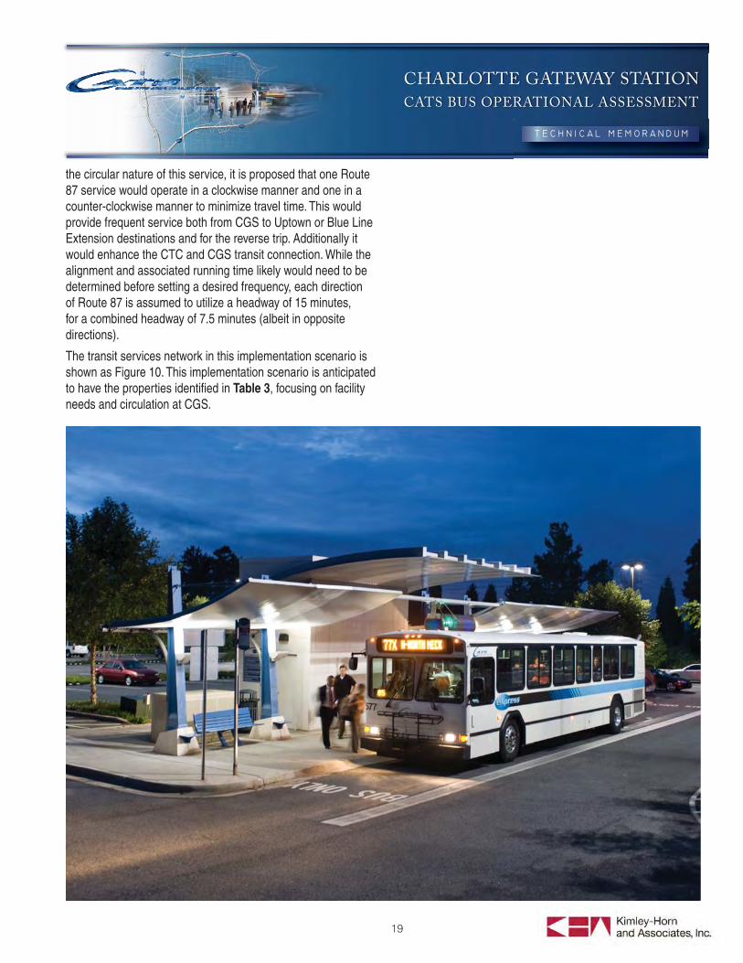
the circular nature of this service, it is proposed that one Route 87 service would operate in a clockwise manner and one in a counter-clockwise manner to minimize travel time. This would provide frequent service both from CGS to Uptown or Blue Line Extension destinations and for the reverse trip. Additionally it would enhance the CTC and CGS transit connection. While the alignment and associated running time likely would need to be determined before setting a desired frequency, each direction of Route 87 is assumed to utilize a headway of 15 minutes, for a combined headway of 7.5 minutes (albeit in opposite directions).
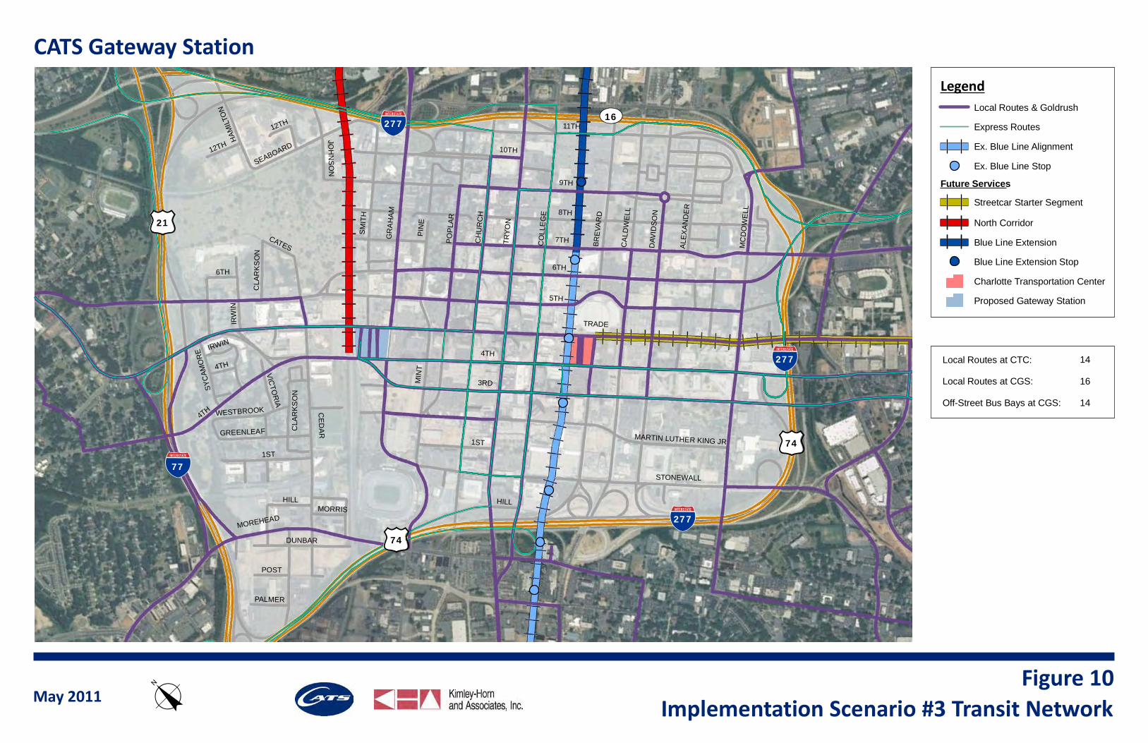
The transit services network in this implementation scenario is shown as Figure 10. This implementation scenario is anticipated to have the properties identifi ed in Table 3, focusing on facility needs and circulation at CGS.
5TH
4TH
6TH
TRADE
9TH
TRYO
N
11TH
CH
UR
CH
CE
DA
R
CO
LLE
GE
MIN
T
GR
AH
AM
CAL
DW
ELL
POPL
AR
MC
DO
WE
LL
DAV
IDSO
N
1ST
3RD
SMIT
H
MARTIN LUTHER KING JR
4TH
MOREHEAD
IRW
IN
SEABOARD
STONEWALL
DUNBAR
HILL
HAM
ILTO
N
GREENLEAF
JOH
NS
ON
12TH
POST
WESTBROOK
VICTO
RIA
CATESC
LAR
KS
ON
PALMER
MORRIS
6TH
7TH
ALEX
AND
ER
IRWIN
4TH
BREV
ARD
HILL
PIN
E
8TH
CLA
RK
SO
N
1ST
10TH
12TH
SYC
AMO
RE
!"#$277
!"#$277
!"#$277
!"#$77
(/21
(/74
(/74
UV16
CATS Gateway StationLegend
Local Routes & Goldrush
Express Routes
Ex. Blue Line Alignment
Ex. Blue Line Stop
Future ServicesStreetcar Starter Segment
North Corridor
Blue Line Extension
Blue Line Extension Stop
Charlotte Transportation Center
Proposed Gateway Station
Local Routes at CTC:
Local Routes at CGS:
Off-Street Bus Bays at CGS:
14
16
14
May 2011 Implementation Scenario #3 Transit NetworkoFigure 10
CHARLOTTE GATEWAY STATION
CATS BUS OPERATIONAL ASSESSMENT
21
Table 3: Framework Properties at CGS with Implementation Scenario #3
Routes Entering CGS Transit Center
1, 2, 5, 7, 8, 9, 10, 11, 13, 15, 18, 21, 22, 26, 27, 34, 87, 45x, 61x, 62x
Routes Serving CGS On-Street 85x, 88x, 86
Entering Buses Per Hour 98
On-Street Buses Per Hour 14
Off-Street Bays at CGS 14
Layover Buses per Hour at CGS 53
On-street bus bays are anticipated for express routes entering Uptown from the west and for Gold Rush. Route 85x is on 4th Street. Routes 86 and 88x are on Trade Street.
With this framework, there would be a shift in transfer patterns within the CATS network. Route 11 is one of the main transfer routes within the CATS system, with over 1,400 daily bus transfers to the route along its entire extent. In this scenario, many of these trips would instead be made on the Blue Line extension. This will to provide a higher level of service for customers due to improved on-time performance, additional amenities, and, potentially, reduced travel time associated with the Blue Line Extension. It also will result in an increase in transfers that occur outside of Uptown, as an increased number of local and community routes are terminated outside of Uptown at Blue Line Extension stations. This certainly will increase the number of double transfers in the system, as passengers of the routes projected to terminate outside of Uptown will need a transfer from bus to rail in order to reach CTC. This is similar to the customer experience on Route 12 today, which terminates near the Carson Boulevard LRT station. In order to reduce the number of double transfers, a circulator/shuttle-identifi ed as Route 87 for purposes of this report-is suggested, as discussed above. This will allow for some optimization of the operating budget through the shortening of existing routes, while still maintaining a strong customer experience by limiting the number of double transfers.
Table 4 documents transfer types and locations in the system under this framework.
Table 4: Transfer Patterns with Implementation Scenario #3
Transfer Type
Single 84%
1 Rail & 1 Bus 6%
Double (both via Rail) 2%
Double (both via Bus) 7%
Transfer Location
CTC 69%
CGS 34%
Other (Uptown) 3%
Other (Outside of Uptown) 5%Notes: Percentages don’t add up to 100% since some transfers occur at multiple locations. Only accounts for transfers between routes currently serving Uptown
This scenario is an alternative to the scenario analyzed in the previous section. In this projection, the Trade Streetcar Extension occurs prior to the Blue Line Extension. Note that this does not include the Central Streetcar Extension, which is only analyzed in Scenario #6. The extension of the Trade Streetcar in the west to at least CGS results in a signifi cant change to the operation of the CATS network in Uptown, particularly in regard to the relationship between CGS and CTC. The provision of a fi xed rail connection between the two hubs signifi cantly improves their interaction and would help facilitate transfers between services at each facility, as discussed in Chapter 2.1. The enhanced link between CGS and CTC provided by the Trade Streetcar Extension would allow for the termination of additional local routes at CGS, compared to the scenarios examined above. This would provide operational savings that could be dedicated to the operation of the streetcar service. While the termination of these additional routes may result in a modest increase in double transfers, the impact to the customer can be minimized through frequent streetcar service and/or timed transfers. High-transfer bus routes would continue to serve both CGS and CTC, even with provision of the Trade Streetcar Extension, to limit the number of double transfers
CHARLOTTE GATEWAY STATION
CATS BUS OPERATIONAL ASSESSMENT
22
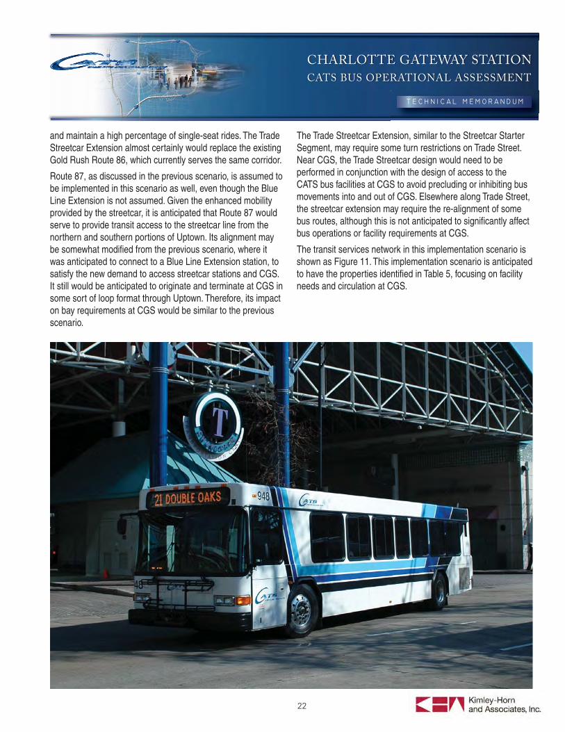
and maintain a high percentage of single-seat rides. The Trade Streetcar Extension almost certainly would replace the existing Gold Rush Route 86, which currently serves the same corridor.
Route 87, as discussed in the previous scenario, is assumed to be implemented in this scenario as well, even though the Blue Line Extension is not assumed. Given the enhanced mobility provided by the streetcar, it is anticipated that Route 87 would serve to provide transit access to the streetcar line from the northern and southern portions of Uptown. Its alignment may be somewhat modifi ed from the previous scenario, where it was anticipated to connect to a Blue Line Extension station, to satisfy the new demand to access streetcar stations and CGS. It still would be anticipated to originate and terminate at CGS in some sort of loop format through Uptown. Therefore, its impact on bay requirements at CGS would be similar to the previous scenario.
The Trade Streetcar Extension, similar to the Streetcar Starter Segment, may require some turn restrictions on Trade Street. Near CGS, the Trade Streetcar design would need to be performed in conjunction with the design of access to the CATS bus facilities at CGS to avoid precluding or inhibiting bus movements into and out of CGS. Elsewhere along Trade Street, the streetcar extension may require the re-alignment of some bus routes, although this is not anticipated to signifi cantly affect bus operations or facility requirements at CGS.
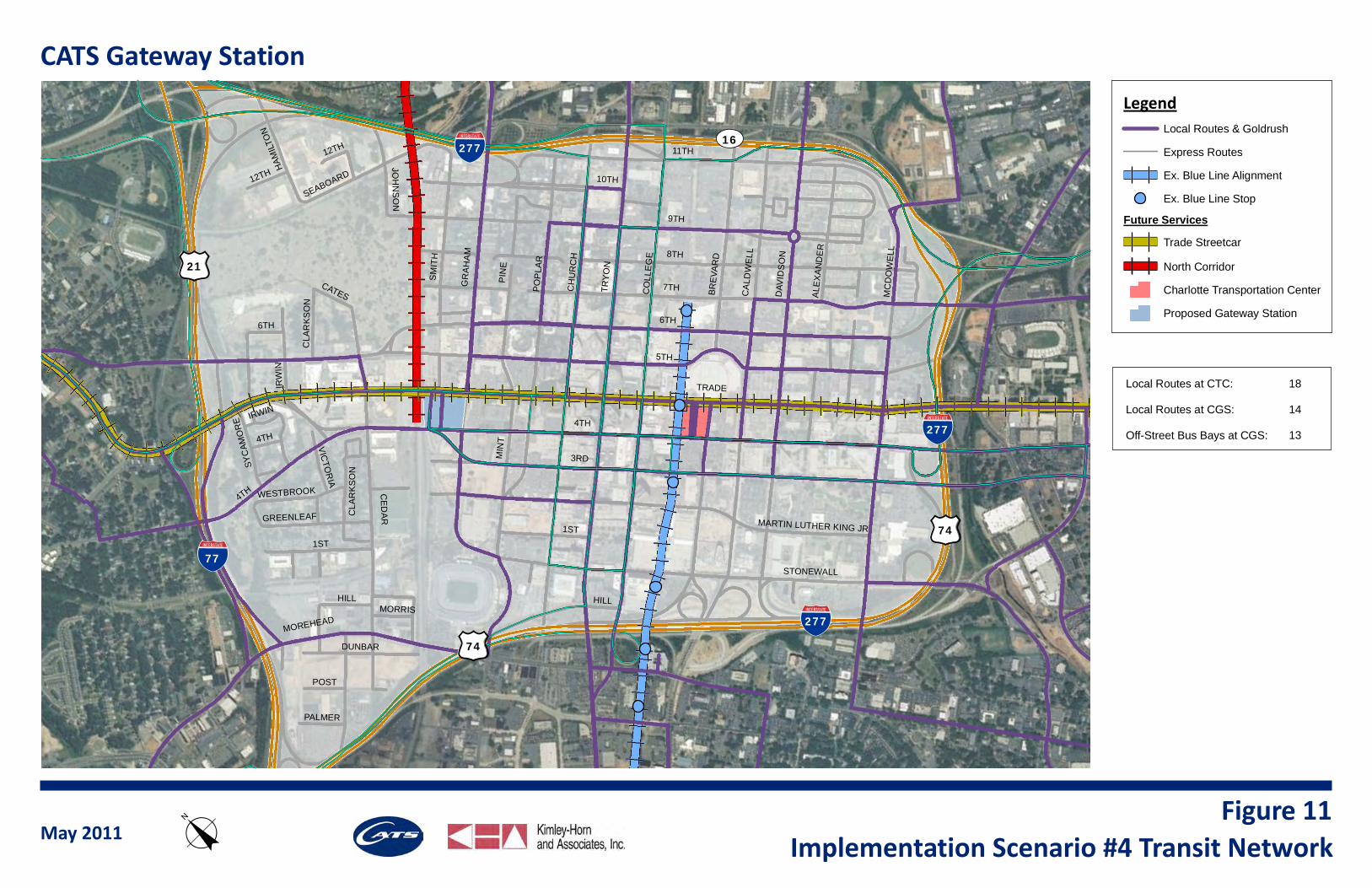
The transit services network in this implementation scenario is shown as Figure 11. This implementation scenario is anticipated to have the properties identifi ed in Table 5, focusing on facility needs and circulation at CGS.
5TH
4TH
6TH
TRADE
9TH
TRY
ON
11TH
CH
UR
CH
CE
DA
R
CO
LLE
GE
MIN
T
GR
AH
AM
CA
LDW
ELL
PO
PLA
R
MC
DO
WE
LL
DAV
IDS
ON
1ST
3RD
SM
ITH
MARTIN LUTHER KING JR
4TH
MOREHEAD
IRW
IN
SEABOARD
STONEWALL
DUNBAR
HILL
HAM
ILTO
N
GREENLEAF
JOH
NS
ON
12TH
POST
WESTBROOK
VICTO
RIA
CATESC
LAR
KS
ON
PALMER
MORRIS
6TH
7TH
ALE
XA
ND
ER
IRWIN
4TH
BRE
VAR
D
HILL
PIN
E
8TH
CLA
RK
SO
N
1ST
10TH
12TH
SYC
AMO
RE
!"#$277
!"#$277
!"#$277
!"#$77
(/21
(/74
(/74
UV16
CATS Gateway Station
LegendLocal Routes & Goldrush
Express Routes
Ex. Blue Line Alignment
Ex. Blue Line Stop
Future Services
Trade Streetcar
North Corridor
Charlotte Transportation Center
Proposed Gateway Station
Local Routes at CTC:
Local Routes at CGS:
Off-Street Bus Bays at CGS:
18
14
13
May 2011Implementation Scenario #4 Transit Networko
Figure 11
CHARLOTTE GATEWAY STATION
CATS BUS OPERATIONAL ASSESSMENT
24
Table 5: Framework Properties at CGS with Implementation Scenario #4
Routes Entering CGS Transit Center
1, 2, 5, 7, 8, 9, 10, 13, 15, 18, 21, 26, 27, 34, 87, 45x, 61x, 62x
Routes Serving CGS On-Street 85x, 88x
Entering Buses Per Hour 85
On-Street Buses Per Hour 6
Off-Street Bays at CGS 13
Layover Buses per Hour at CGS 52
On-street bus bays are anticipated for express routes entering Uptown from the west. Route 85x is on 4th Street and Routes 88x is on Trade Street.
As mentioned above, the number of double transfers would increase somewhat in this scenario, although they would be offset by the enhanced connection between CTC and CGS. The Trade Streetcar would potentially minimize transfer wait time and rider confusion for passengers wishing to travel between the two transit hubs. In fact, it is not anticipated that there would be any double transfers within Uptown entirely via bus. All double transfers would occur via one bus and one rail (in most cases, streetcar) transfer. Additional bus routes could be extended between CTC and CGS to minimize these double transfers, although this would increase congestion on the streetcar corridor and would require additional operating resources.
Table 6 documents transfer types and locations in the system under this framework.
Table 6: Transfer Patterns with Implementation Scenario #4
Transfer Type
Single 76%
1 Rail & 1 Bus 24%
Double (both via Rail) 0%
Double (both via Bus) 0%
Transfer Location
CTC 70%
CGS 45%
Other (Uptown) 3%
Other (Outside of Uptown) 5%Notes: Percentages don’t add up to 100% since some transfers occur at multiple locations. Table only accounts for transfers between routes currently serving Uptown
CHARLOTTE GATEWAY STATION
CATS BUS OPERATIONAL ASSESSMENT
25
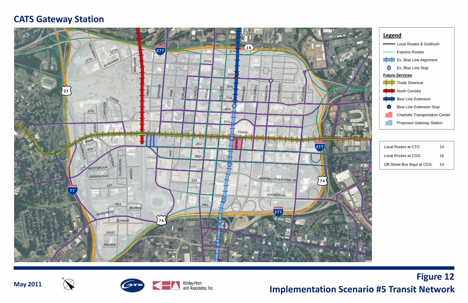
This scenario is most likely to occur subsequent to either Scenario #3 or Scenario #4, and in some ways refl ects a combination of the framework assumed in those two scenarios. This refl ects completion of the CATS 2030 Transit Plan projects with extensive in-progress or completed planning efforts. Under this scenario, Uptown would be served by two perpendicular fi xed guideway transit services. The approximate north-south Lynx Blue Line would extend through the middle of Uptown, with a new station near 9th Street supplementing the four existing Uptown stations. The approximate east-west Trade Streetcar would extend through the middle of Uptown along Trade Street, with seven stations planned within Uptown, including one at CTC, part of the Streetcar Starter Segment, and one at CGS, between Graham Street and the rail corridor. The Trade Streetcar Extension almost certainly would replace the existing Gold Rush Route 86, which serves the same corridor. In addition, the Red Line would provide commuter service from the northern service area into Uptown during peak periods. The existing bus network would be modifi ed from existing conditions to avoid redundancy with the enhanced rail network and to better serve the rail stations and dual transit hubs.
High-ridership routes that currently facilitate a large number of transfers would serve both CGS and CTC. It is assumed that these routes, such as Routes 7 and 9, would continue to serve Uptown and not terminate at either end of the Trade Streetcar to maintain provision of single-seat rides for most passengers and to facilitate transfers. Other than these high-ridership routes, routes from the west generally would terminate at CGS, and routes from the east generally would terminate at CTC. Routes from the south would serve either CGS or CTC, but would only serve one of the two stations in order to avoid operating cost increases associated with adding vehicle-miles and service hours. Additionally, some routes would be re-routed to provide enhanced transit service on under-served roadways within Uptown, maintaining a terminus at either CTC or CGS and a direct transfer connection to a Blue Line station. Several express routes would no longer serve Uptown, instead connecting as feeder services to the Red Line or Blue Line. Those that continue to serve Uptown primarily would serve the core business district and CTC, given minimal anticipated interaction with the regional transit services proposed at CGS.
CGS could be used as a potential layover point for certain express buses from the south or east.
While several routes are removed from Uptown in conjunction with the provision of the fi xed guideway services, only one new route is proposed. Route 87, also proposed in Scenarios #3 and #4, would serve as an Uptown circulator/shuttle. It would improve transit access for the portions of Uptown not immediately served by one of the fi xed guideway services or heavily the served Trade Street and Tryon Street bus corridors. This route also would reduce transfers for Uptown passengers not along the Trade Street Corridor by allowing for a single-seat ride to access CGS. The exact alignment of this route is purely speculative, as is the fare structure, but given the services in this implementation scenario, it is anticipated to provide signifi cant value. Its value would be further enhanced if Uptown continues to increase in density, as is projected by the regional land use forecast. It should be noted that even with projections of signifi cant land use intensifi cation and anticipated growths in CATS ridership/mode share associated with new fi xed guideway transit services, only one new bus route is proposed. CATS may want to consider providing additional bays to allow for a service growth in conjunction with the projected growth in regional population and ridership, which is discussed in the implementation opportunities chapter.
The transit services network in this implementation scenario is shown as Figure 12. This implementation scenario is anticipated to have the properties identifi ed in Table 7, focusing on facility needs and circulation at CGS.
5TH
4TH
6TH
TRADE
9TH
TRY
ON
11TH
CH
UR
CH
CE
DA
R
CO
LLE
GE
MIN
T
GR
AH
AM
CA
LDW
ELL
PO
PLA
R
MC
DO
WE
LL
DAV
IDS
ON
1ST
3RD
SM
ITH
MARTIN LUTHER KING JR
4TH
MOREHEAD
IRW
IN
SEABOARD
STONEWALL
DUNBAR
HILL
HAM
ILTO
N
GREENLEAF
JOH
NS
ON
12TH
POST
WESTBROOK
VICTO
RIA
CATESC
LAR
KS
ON
PALMER
MORRIS
6TH
7TH
ALE
XA
ND
ER
IRWIN
4TH
BRE
VAR
D
HILL
PIN
E
8TH
CLA
RK
SO
N
1ST
10TH
12TH
SYC
AMO
RE
!"#$277
!"#$277
!"#$277
!"#$77
(/21
(/74
(/74
UV16
CATS Gateway Station
LegendLocal Routes & Goldrush
Express Routes
Ex. Blue Line Alignment
Ex. Blue Line Stop
Future Services
Trade Streetcar
North Corridor
Blue Line Extension
Blue Line Extension Stop
Charlotte Transportation Center
Proposed Gateway Station
Local Routes at CTC:
Local Routes at CGS:
Off-Street Bus Bays at CGS:
14
16
14
May 2011Implementation Scenario #5 Transit Networko
Figure 12
CHARLOTTE GATEWAY STATION
CATS BUS OPERATIONAL ASSESSMENT
27
Table 7: Framework Properties at CGS with Implementation Scenario #5
Routes Entering CGS Transit Center
1, 2, 5, 7, 8, 9, 10, 11, 13, 15, 18, 21, 22, 26, 27, 34, 87, 45x, 61x, 62x
Routes Serving CGS On-Street 85x, 88x
Entering Buses Per Hour 92
On-Street Buses Per Hour 6
Off-Street Bays at CGS 14
Layover Buses per Hour at CGS 55
On-street bus bays are anticipated for express routes entering Uptown from the west. Route 85x is on 4th Street and Routes 88x is on Trade Street.
As noted in the previous scenario, the number of double transfers increases as routes are shortened and replaced by fi xed guideway services. However, transfer wait time and inconvenience to the customer are anticipated to be reduced given the increased frequency and reliability of these services. In addition, the proof of payment system allows for a more seamless transfer process than is required with a double transfer via bus.
Table 8 documents transfer types and locations in the system under this framework.
Table 8: Transfer Patterns with Implementation Scenario #5
Transfer Type
Single 77%
1 Rail & 1 Bus 17%
Double (both via Rail) 6%
Double (both via Bus) 0%
Transfer Location
CTC 66%
CGS 44%
Other (Uptown) 3%
Other (Outside of Uptown) 5%Notes: Percentages don’t add up to 100% since some transfers occur at multiple locations. Table only accounts for transfers between routes currently serving Uptown
CHARLOTTE GATEWAY STATION
CATS BUS OPERATIONAL ASSESSMENT
28
This scenario assumes full build-out of the 2030 Transit Plan. Major transit investments included in this scenario are the Red Line, the Blue Line Extension, the Trade Streetcar, the West Streetcar, the Beatties Streetcar, the Central Streetcar, and the Southeast BRT (Silver Line). These projects are anticipated to result in signifi cant changes to the CATS bus network. It is assumed that Route 7 would partially be converted into the Beatties and Trade Streetcars. Given that Route 7 currently extends well past the planned extension of the Beatties Streetcar, it is anticipated that a modifi ed version of the existing Route 7 would continue to serve Uptown. This route likely would have a somewhat lower frequency and ridership than the existing Route 7 as many riders would shift to the streetcar. Route 9 would be converted to the Central and Trade Streetcars. The Route 5 Airport Sprinter service would be converted to the West Streetcar. A number of express routes, such as Route 64x, would be converted to the Southeast BRT. For the Southeast BRT, it is anticipated that other express routes in the corridor, including Routes 51x and 65x would be considered for conversion into feeder or community service to the BRT or Central Streetcar to avoid excessive system redundancy. The existing local or express bus route in each of the cases identifi ed above may be converted to a feeder or shuttle service, but will no longer serve Uptown.
These route reconfi gurations may substantially reduce bus operating expenditures, allowing for a re-allocation of a portion of the necessary operating dollars to run the fi xed guideway or BRT services. It also would reduce the bus bay requirements at CGS and at CTC as some buses would be replaced by rail vehicles running within roadway right-of-way. This would require enhancement or provision of new on-street stations, while somewhat reducing the number of off-street bays required. The reduction in the number of off-street bays may be offset by an increase in the number of shuttles, feeder routes, or circulators providing local access to the major transit hubs. At the transit hubs, special care would need to be made to ensure a seamless connection between off-street bays and the streetcar, light rail, or BRT services. This interaction needs to be fully considered when designing CGS to ensure a seamless pedestrian connection between the regional rail services at CGS, the off-street bus bays that will serve a number of bus
routes, and the on-street fi xed guideway and/or BRT stations.
The provision of a number of high-frequency, fi xed guideway transit routes into Uptown is likely to increase the number of transfers outside of Uptown as passengers use feeder and shuttle routes to access various stations. Within Uptown, these fi xed guideway routes focus passenger activity at transit hubs, including CTC and CGS. Uptown circulators may be critical to provide access to various employment and activity centers within Uptown from the transit hubs served by the planned high-ridership, high-frequency services. These circulators do not necessarily need to enter transit hubs such as CGS or CTC, but need to facilitate multi-modal transfers and have layover locations. Therefore, it may be benefi cial to establish dedicated bays or on-street curb space for shuttles/circulators within these transit hubs. Consideration should be provided for these circulator routes when developing the CGS layout.
The transit services network under this implementation scenario is shown as Figure 13. This implementation scenario is anticipated to have the properties identifi ed in Table 9, focusing on facility needs and circulation at CGS.
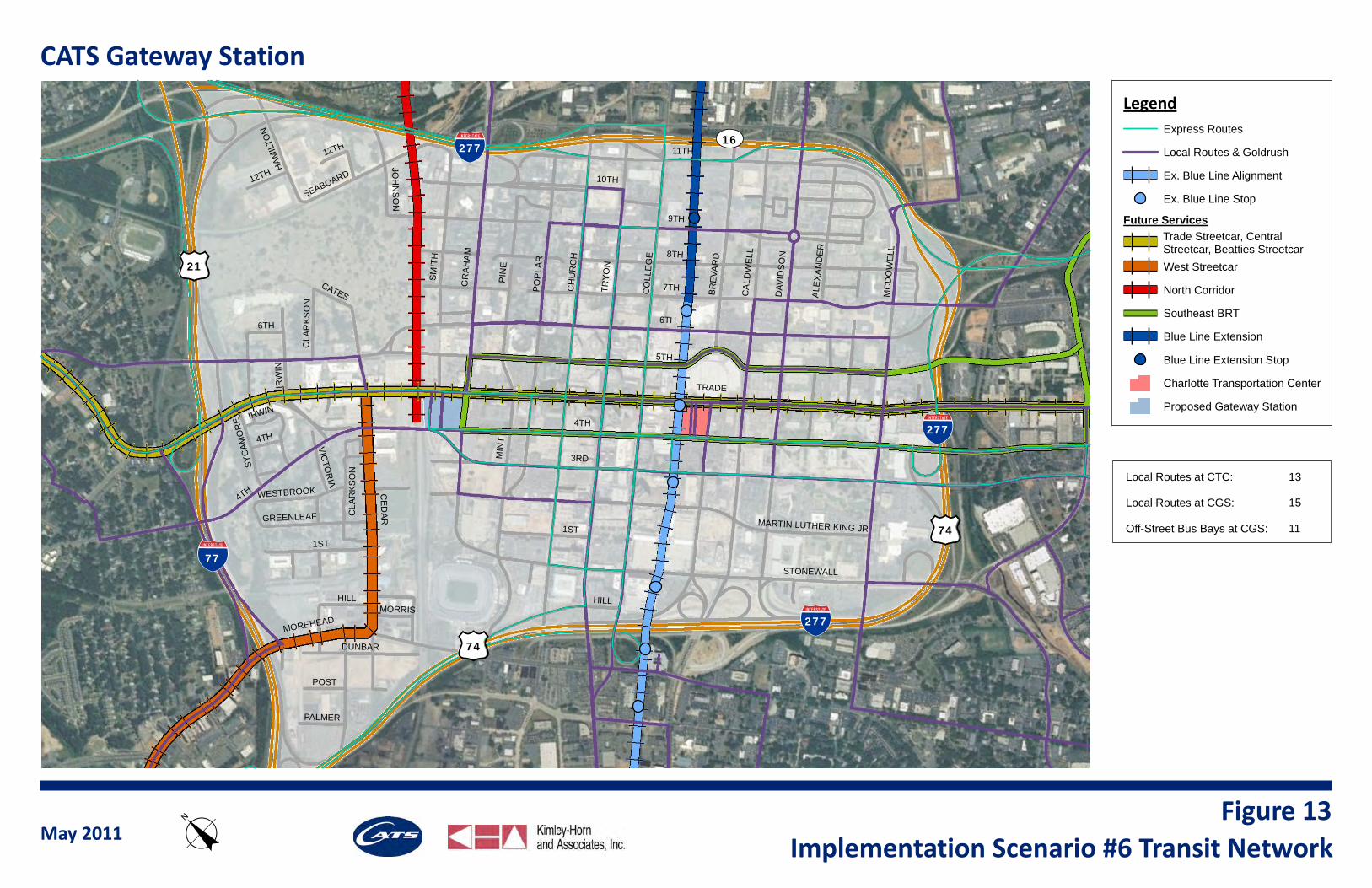
5TH
4TH
6TH
TRADE
9TH
TRY
ON
11TH
CH
UR
CH
CE
DA
R
CO
LLE
GE
MIN
T
GR
AH
AM
CA
LDW
ELL
PO
PLA
R
MC
DO
WE
LL
DAV
IDS
ON
1ST
3RD
SM
ITH
MARTIN LUTHER KING JR
4TH
MOREHEAD
IRW
IN
SEABOARD
STONEWALL
DUNBAR
HILL
HAM
ILTO
N
GREENLEAF
JOH
NS
ON
12TH
POST
WESTBROOK
VICTO
RIA
CATESC
LAR
KS
ON
PALMER
MORRIS
6TH
7TH
ALE
XA
ND
ER
IRWIN
4TH
BRE
VAR
D
HILL
PIN
E
8TH
CLA
RK
SO
N
1ST
10TH
12TH
SYC
AMO
RE
!"#$277
!"#$277
!"#$277
!"#$77
(/21
(/74
(/74
UV16
CATS Gateway Station
May 2011Implementation Scenario #6 Transit Networko
LegendExpress Routes
Local Routes & Goldrush
Ex. Blue Line Alignment
Ex. Blue Line Stop
Future Services
West Streetcar
North Corridor
Southeast BRT
Blue Line Extension
Blue Line Extension Stop
Charlotte Transportation Center
Proposed Gateway Station
Local Routes at CTC:
Local Routes at CGS:
Off-Street Bus Bays at CGS:
13
15
11
Trade Streetcar, CentralStreetcar, Beatties Streetcar
Figure 13
CHARLOTTE GATEWAY STATION
CATS BUS OPERATIONAL ASSESSMENT
30
Table 9: Framework Properties at CGS with Implementation Scenario #6
Routes Entering CGS Transit Center
1, 2, 7, 8, 10, 11, 13, 15, 18, 21, 22, 26, 27, 34, 87, 45x, 61x, 62x, SE BRT
Routes Serving CGS On-Street 85x, 88x
Entering Buses Per Hour 79
On-Street Buses Per Hour 6
Off-Street Bays at CGS 11
Layover Buses per Hour at CGS 40
On-street bus bays are anticipated for express routes entering Uptown from the west. Route 85x is on 4th Street and Routes 88x is on Trade Street. They are not anticipated to be replaced by any planned fi xed guideway services.
Table 10 documents transfer types and locations in the system under this framework.
Table 10: Transfer Patterns with Implementation Scenario #6
Transfer Type
Single 79%
1 Rail & 1 Bus 15%
Double (both via Rail) 6%
Double (both via Bus) 0%
Transfer Location
CTC 67%
CGS 42%
Other (Uptown) 3%
Other (Outside of Uptown) 5%Notes: Percentages don’t add up to 100% since some transfers occur at multiple locations. Table only accounts for transfers between routes currently serving Uptown
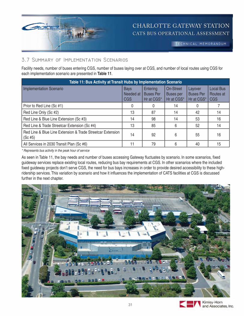
CHARLOTTE GATEWAY STATION
CATS BUS OPERATIONAL ASSESSMENT
31
Facility needs, number of buses entering CGS, number of buses laying over at CGS, and number of local routes using CGS for each implementation scenario are presented in Table 11.
Table 11: Bus Activity at Transit Hubs by Implementation Scenario
Implementation Scenario Bays Needed at CGS
Entering Buses Per Hr at CGS*
On-Street Buses per Hr at CGS*
Layover Buses Per Hr at CGS*
Local Bus Routes at CGS
Prior to Red Line (Sc #1) 0 0 14 0 7
Red Line Only (Sc #2) 13 87 14 42 14
Red Line & Blue Line Extension (Sc #3) 14 98 14 53 16
Red Line & Trade Streetcar Extension (Sc #4) 13 85 6 52 14
Red Line & Blue Line Extension & Trade Streetcar Extension (Sc #5)
14 92 6 55 16
All Services in 2030 Transit Plan (Sc #6) 11 79 6 40 15* Represents bus activity in the peak hour of service
As seen in Table 11, the bay needs and number of buses accessing Gateway fl uctuates by scenario. In some scenarios, fi xed guideway services replace existing local routes, reducing bus bay requirements at CGS. In other scenarios where the included fi xed guideway projects don’t serve CGS, the need for bus bays increases in order to provide desired accessibility to these high-ridership services. This variation by scenario and how it infl uences the implementation of CATS facilities at CGS is discussed further in the next chapter.
CHARLOTTE GATEWAY STATION
CATS BUS OPERATIONAL ASSESSMENT
32
4. OVERVIEW OF CATS FACILITY NEEDS AT CGSThis chapter identifi es CATS’ bus operations facility needs at CGS, both in terms of direct facilities required to operate the bus service and corollary facilities associated with providing that service.
As discussed in Chapter 3, CATS will require a number of off-street bus bays at CGS in order to provide multi-modal connections to the rail services at CGS and facilitate transfer activity. The number of bus bays varies by implementation scenario. Without the Red Line or implementation of Amtrak rail services, it is not anticipated that CATS will require off-street facilities at CGS. However, with the Red Line, the required number of off-street bus bays varies from 11 to 14, depending on the implementation scenario. The maximum number of off-street bays needed, 14, would occur in the implementation scenario where Red Line and Blue Line Extension have been constructed, but the full 2030 Transit Plan has not. The minimum number of required bays, 11, would occur with full build-out of the 2030 Transit Plan. However, this does not account for any future CATS bus routes, except for one circulator that has been incorporated in several scenarios. In addition, these scenarios only assume an increase in bus frequency for a few select routes, based on existing load factors. Given the projected population growth in the Charlotte-Mecklenburg metropolitan area, there is tremendous opportunity for transit ridership growth. In order to effectively serve CGS over the entirety of its anticipated life, it is recommended that CATS incorporate a buffer or conservative surplus in the number of bays to be provided at CGS to allow for future system growth.
While surplus bays potentially would be available as the long-term horizon streetcar projects are constructed and replace existing bus routes, if only 14 bays are constructed, there would be no buffer in the number of bays to allow for increased frequency on existing routes or new routes in Scenarios #3 or #5. Scenario #4 would have a buffer of only one bay with the provision of 14 bays at CGS. Therefore, it is recommended that CGS incorporate 15 off-street bays for CATS use at CGS. This way, at least one bay would be provided as a buffer for the growth in service or re-alignment of routes in all implementation scenarios. Prior to system growth requiring utilization of all of the provided bays, CATS would have the opportunity to use
surplus bays as layover facilities. It should be noted that this bay calculation assumes that some routes would share bus bays. If CATS wished to avoid having completely unused bays prior to growth of the system, alternative bay assignments could be developed.
The system frameworks developed in Chapter 3 represent potential operations of the system under a variety of baseline assumptions. One of the assumptions is that the benefi ts of consolidated transfer activity within an off-street facility would outweigh the travel time penalty associated with diverting buses into an off-street transit facility. Alternatively, CATS could maintain stops for a number of their through bus routes traveling to/from CTC, on either Trade Street or 4th Street. This would require more on-street curb space than was identifi ed in the previous chapter for just two express routes and one Gold Rush route. In order to maintain operational fl exibility, it is suggested that on-street curb space adjacent to the CATS bus transit facility be dedicated to bus activity. If CATS wanted to keep the high-frequency, high-ridership through routes such as Routes 5 (“Sprinter”) and 7 on-street, suffi cient on-street curb space should be provided for multiple buses, given the projected headways associated with each route. This curb space should be located so as to minimize pedestrian walking distance between the on-street bus stops and the off-street bus bays, as well as the CGS commuter rail and Amtrak services. Any on-street bus stops located along westbound Trade Street should be located in close proximity to a signalized pedestrian crossing of Trade Street. Several local and express bus routes are anticipated to use 4th Street to travel west from CTC on their way out of Uptown. In order to avoid signifi cant out-of-direction travel and bus congestion on Trade Street, it is suggested to provide on-street bays for these routes along 4th Street.
Additionally, this analysis assumes re-routing of express buses generally from Trade Street to Tryon Street. If all routes are not re-routed in this manner, additional on-street curb space would be required along both 4th Street and Trade Street in order to avoid an express bus over-crowding condition similar to what was observed at CTC during peak periods.
In summary, on-street bus bays would be required for CATS operations on both Trade Street and, to a lesser extent, 4th Street. These bays should be in close proximity to the off-street bus bays, the commuter rail and Amtrak services, and a signalized street crossing. In order to maintain operational
CHARLOTTE GATEWAY STATION
CATS BUS OPERATIONAL ASSESSMENT
33
fl exibility, it is estimated that suffi cient on-street curb space should be provided for three full buses and one shuttle bus along each direction of Trade Street between the rail corridor and Graham Street, and for two buses along each direction of 4th Street. These on-street stops would have a fl exible bay confi guration to allow for the most effi cient utilization of urban-level intensity curb space. However, it is suggested to dedicate the identifi ed shuttle bay on Trade Street to shuttles only to improve passenger wayfi nding and avoid vehicle confl icts between the different types of bus and future streetcar services.
As identifi ed in Table 11, demand for bus layover/recovery within or in the immediate vicinity of CGS is signifi cant. The implementation scenarios consistently require layover/recovery accommodation for approximately 50 buses in the peak hour. The bus layover volumes in Table 11 do not include express routes, since the express routes terminating at CGS only operate in the peak direction during the peak period and would likely return to the yard to layover. While not all layover/recovery must occur within CGS, accommodating this need in close proximity to the off-street bus bays within CGS is likely to reduce operating cost and improve operating fl exibility and effi ciency. In addition, by providing layover facilities in close proximity to or within, CGS, CATS can optimize use of driver relief/comfort areas at CGS.
In order to precisely calculate layover facility needs with CATS, the operating characteristics of each route and system work rules must be analyzed in detail, both of which are likely to change over the lifetime of CGS. Therefore, based on existing bus cycle times and schedules, a 10-minute layover per bus is assumed. For layovers longer than this time period, buses could relocate to a different facility. Assuming a 10-minute layover/recovery per bus, layover facilities for simultaneous layover of up to nine buses should be provided within or in close proximity to CGS. This layover space also will likely be utilized by staged backup buses. Given the number of routes anticipated to originate/terminate at CGS, CATS may want to keep spare vehicles on hand, as they do at CTC. Whether space for all nine buses is provided within the off-street transit center or at another nearby location can be determined upon further development of the CGS site plan, although CATS operations would benefi t from provision of all of these spaces within CGS. It is recommended that at least half of the layover bays, or curb space for fi ve buses, be provided immediately adjacent to or
within the transit center. (Note: consider providing text noting that as a two-hub system is implemented over time and grows in intensity of use, that managing layover and recovery times for center city services may require more intensive supervisory management and would likely be dynamic as opposed to fi xed in order to respond to changing center city conditions/events).
To support the operational service needs at CGS, CATS will require facility space within the overall bus operations area. A general description of some of the key ancillary services and their required facility requirements is provided below:
Driver break room/comfort stations – CGS is envisioned to operate as a layover and transfer/connection hub within the CATS system and will require suffi cient space allocation for the inclusion of driver break rooms and comfort stations. Based on the current conditions at CTC, we have learned that adequate allowance needs to be provided based on the overall volume and frequency of the anticipated bus routes in the build-out condition. CTC’s comfort station space currently is undersized based on the volume of buses that it serves. Space planning and architectural design will be necessary in order to quantify this space. It is assumed the bulk of this activity will occur within the context of any master development scenario planning and design process.
Restrooms – It is assumed that shared public restrooms will be incorporated into Charlotte Gateway Station as part of the overall development. Note that CATS assumes its passengers will have access to public restrooms provided as a part of the larger Charlotte Gateway Station development. (Refer to Chapter 6 for additional information).
Accommodation for CATS Personnel – As part of the overall CGS planning efforts, space planning for the ancillary services for CATS will be a vital part of the overall design process for the station. Below is a preliminary list of the space needs for CATS business operations. Actual sizing of these spaces will be performed during the design phase of the station.
a. Supervisory/control room accommodation
b. Security ,control room and detainment area (may be consolidated into a central security space for all service modes if all entities agree, otherwise CATS
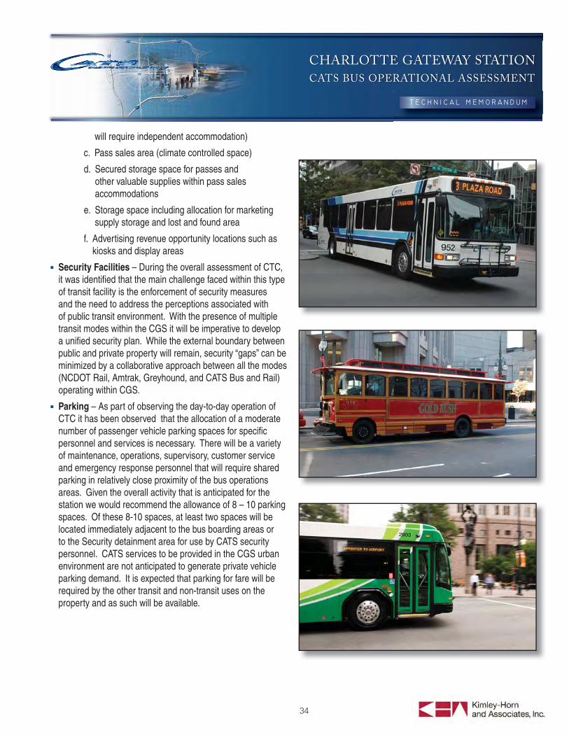
CHARLOTTE GATEWAY STATION
CATS BUS OPERATIONAL ASSESSMENT
34
will require independent accommodation)
c. Pass sales area (climate controlled space)
d. Secured storage space for passes and other valuable supplies within pass sales accommodations
e. Storage space including allocation for marketing supply storage and lost and found area
f. Advertising revenue opportunity locations such as kiosks and display areas
Security Facilities – During the overall assessment of CTC, it was identifi ed that the main challenge faced within this type of transit facility is the enforcement of security measures and the need to address the perceptions associated with of public transit environment. With the presence of multiple transit modes within the CGS it will be imperative to develop a unifi ed security plan. While the external boundary between public and private property will remain, security “gaps” can be minimized by a collaborative approach between all the modes (NCDOT Rail, Amtrak, Greyhound, and CATS Bus and Rail) operating within CGS.
Parking – As part of observing the day-to-day operation of CTC it has been observed that the allocation of a moderate number of passenger vehicle parking spaces for specifi c personnel and services is necessary. There will be a variety of maintenance, operations, supervisory, customer service and emergency response personnel that will require shared parking in relatively close proximity of the bus operations areas. Given the overall activity that is anticipated for the station we would recommend the allowance of 8 – 10 parking spaces. Of these 8-10 spaces, at least two spaces will be located immediately adjacent to the bus boarding areas or to the Security detainment area for use by CATS security personnel. CATS services to be provided in the CGS urban environment are not anticipated to generate private vehicle parking demand. It is expected that parking for fare will be required by the other transit and non-transit uses on the property and as such will be available.
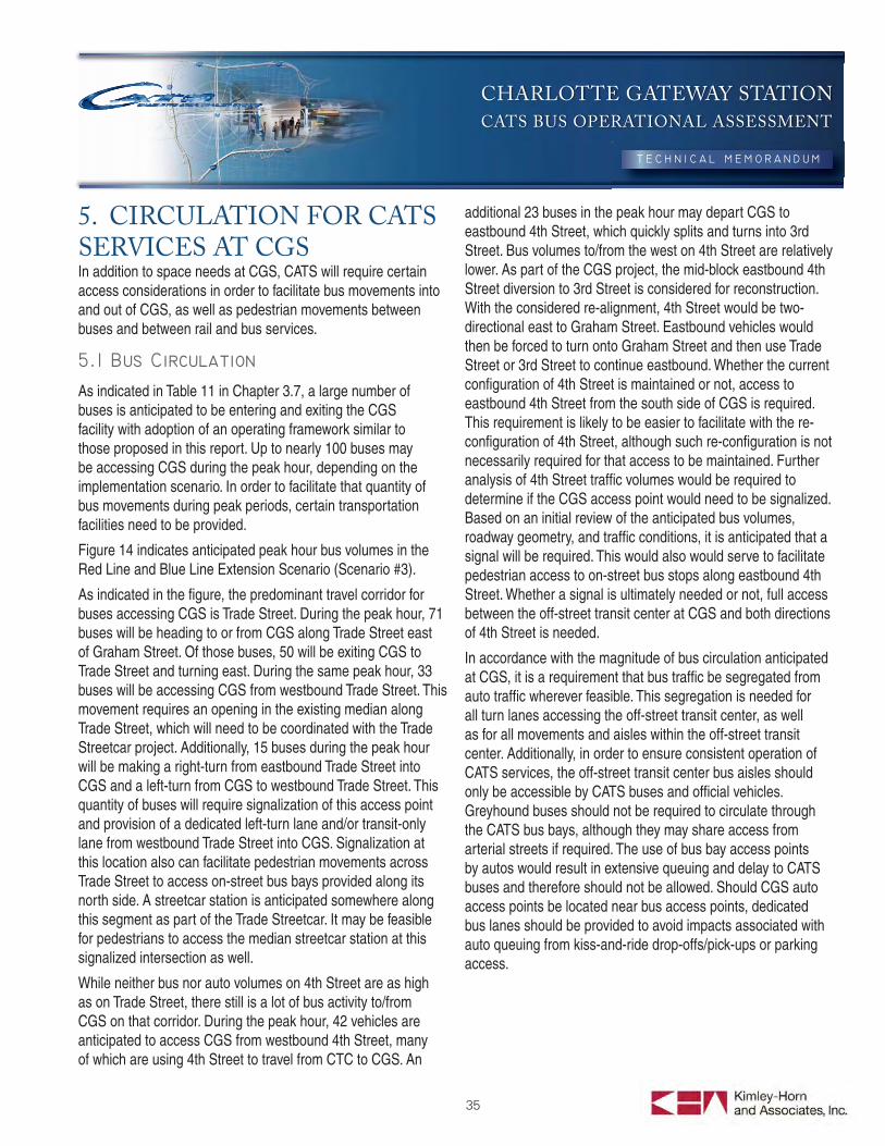
CHARLOTTE GATEWAY STATION
CATS BUS OPERATIONAL ASSESSMENT
35
5. CIRCULATION FOR CATS SERVICES AT CGSIn addition to space needs at CGS, CATS will require certain access considerations in order to facilitate bus movements into and out of CGS, as well as pedestrian movements between buses and between rail and bus services.
As indicated in Table 11 in Chapter 3.7, a large number of buses is anticipated to be entering and exiting the CGS facility with adoption of an operating framework similar to those proposed in this report. Up to nearly 100 buses may be accessing CGS during the peak hour, depending on the implementation scenario. In order to facilitate that quantity of bus movements during peak periods, certain transportation facilities need to be provided.
Figure 14 indicates anticipated peak hour bus volumes in the Red Line and Blue Line Extension Scenario (Scenario #3).
As indicated in the fi gure, the predominant travel corridor for buses accessing CGS is Trade Street. During the peak hour, 71 buses will be heading to or from CGS along Trade Street east of Graham Street. Of those buses, 50 will be exiting CGS to Trade Street and turning east. During the same peak hour, 33 buses will be accessing CGS from westbound Trade Street. This movement requires an opening in the existing median along Trade Street, which will need to be coordinated with the Trade Streetcar project. Additionally, 15 buses during the peak hour will be making a right-turn from eastbound Trade Street into CGS and a left-turn from CGS to westbound Trade Street. This quantity of buses will require signalization of this access point and provision of a dedicated left-turn lane and/or transit-only lane from westbound Trade Street into CGS. Signalization at this location also can facilitate pedestrian movements across Trade Street to access on-street bus bays provided along its north side. A streetcar station is anticipated somewhere along this segment as part of the Trade Streetcar. It may be feasible for pedestrians to access the median streetcar station at this signalized intersection as well.
While neither bus nor auto volumes on 4th Street are as high as on Trade Street, there still is a lot of bus activity to/from CGS on that corridor. During the peak hour, 42 vehicles are anticipated to access CGS from westbound 4th Street, many of which are using 4th Street to travel from CTC to CGS. An
additional 23 buses in the peak hour may depart CGS to eastbound 4th Street, which quickly splits and turns into 3rd Street. Bus volumes to/from the west on 4th Street are relatively lower. As part of the CGS project, the mid-block eastbound 4th Street diversion to 3rd Street is considered for reconstruction. With the considered re-alignment, 4th Street would be two-directional east to Graham Street. Eastbound vehicles would then be forced to turn onto Graham Street and then use Trade Street or 3rd Street to continue eastbound. Whether the current confi guration of 4th Street is maintained or not, access to eastbound 4th Street from the south side of CGS is required. This requirement is likely to be easier to facilitate with the re-confi guration of 4th Street, although such re-confi guration is not necessarily required for that access to be maintained. Further analysis of 4th Street traffi c volumes would be required to determine if the CGS access point would need to be signalized. Based on an initial review of the anticipated bus volumes, roadway geometry, and traffi c conditions, it is anticipated that a signal will be required. This would also would serve to facilitate pedestrian access to on-street bus stops along eastbound 4th Street. Whether a signal is ultimately needed or not, full access between the off-street transit center at CGS and both directions of 4th Street is needed.
In accordance with the magnitude of bus circulation anticipated at CGS, it is a requirement that bus traffi c be segregated from auto traffi c wherever feasible. This segregation is needed for all turn lanes accessing the off-street transit center, as well as for all movements and aisles within the off-street transit center. Additionally, in order to ensure consistent operation of CATS services, the off-street transit center bus aisles should only be accessible by CATS buses and offi cial vehicles. Greyhound buses should not be required to circulate through the CATS bus bays, although they may share access from arterial streets if required. The use of bus bay access points by autos would result in extensive queuing and delay to CATS buses and therefore should not be allowed. Should CGS auto access points be located near bus access points, dedicated bus lanes should be provided to avoid impacts associated with auto queuing from kiss-and-ride drop-offs/pick-ups or parking access.
3RD3RD
TRADETRADE
4TH4TH
5TH5TH
GR
AH
AM
GR
AH
AM
CED
AR
CED
AR
CH
UR
CH
CH
UR
CH
POPL
AR
POPL
AR
MIN
TM
INT
WIL
KES
WIL
KES
TRADETRADE
4TH4TH
5TH5TH
3RD3RD
TRADETRADE
4TH4TH
5TH5TH
GR
AH
AM
GR
AH
AM
CED
AR
CED
AR
CH
UR
CH
CH
UR
CH
POPL
AR
POPL
AR
MIN
TM
INT
WIL
KES
WIL
KES
TRADETRADE
4TH4TH
5TH5TH
2113
11
22
22
11
26
23
9
1586
1
34
775
8
2
10
18
27
5
10
9
1523
27
87
87
8622
22
2788x
85x
88x
85x
85x
85x
1
34
34
71
88x
88x
45x 62x61x
45x 62x61x
10
38
33
21
87A
87B
LegendProposed Gateway Station
Number of
Buses/ Hour/ DirectionLocal Routes
1 .......................
2 .......................
5, 7 ...................
8, 34 .................
9, 15 .................
10 .....................
11 .....................
13, 21, 26 .........
18 .....................
22 .....................
27 .....................
87A/B ...............
Gold Rush Routes
86 ......................
Fixed Guideway ServicesRed Line (Commuter Rail)
Express Routes
45x, 61x, 62x ....
85x ....................
88x ....................
3
2
6, 6
5, 3
8, 4
5
3
3, 2, 3
2
2
4
8
3, 3, 3
3
3
5
Buses/ HourBuses
Buses/ HourBuses
Buses/ HourBuses
x
CATS Gateway Station
May 2011Bus Access Volumes to CGS (Implementation Scenario #3)
Figure 14o
K:\S
ND
_TR
AN
S\0
1501
8009
-Cha
rlotte
Gat
eway
\Illu
stra
tor\B
us A
cces
s Vo
lum
es to
CG
S (I
mpl
emen
tatio
n S
cena
rio #
3).a
i
NO SCALE
4615
22
8 40
15
23
3855
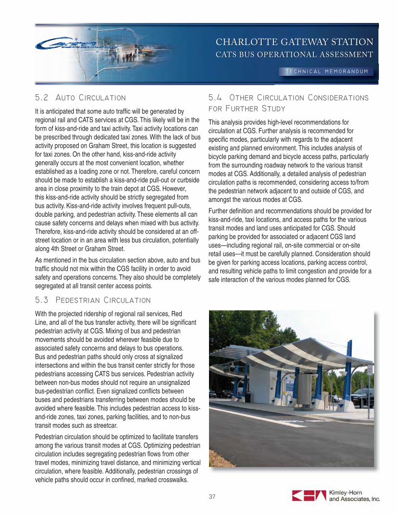
CHARLOTTE GATEWAY STATION
CATS BUS OPERATIONAL ASSESSMENT
37
It is anticipated that some auto traffi c will be generated by regional rail and CATS services at CGS. This likely will be in the form of kiss-and-ride and taxi activity. Taxi activity locations can be prescribed through dedicated taxi zones. With the lack of bus activity proposed on Graham Street, this location is suggested for taxi zones. On the other hand, kiss-and-ride activity generally occurs at the most convenient location, whether established as a loading zone or not. Therefore, careful concern should be made to establish a kiss-and-ride pull-out or curbside area in close proximity to the train depot at CGS. However, this kiss-and-ride activity should be strictly segregated from bus activity. Kiss-and-ride activity involves frequent pull-outs, double parking, and pedestrian activity. These elements all can cause safety concerns and delays when mixed with bus activity. Therefore, kiss-and-ride activity should be considered at an off-street location or in an area with less bus circulation, potentially along 4th Street or Graham Street.
As mentioned in the bus circulation section above, auto and bus traffi c should not mix within the CGS facility in order to avoid safety and operations concerns. They also should be completely segregated at all transit center access points.
With the projected ridership of regional rail services, Red Line, and all of the bus transfer activity, there will be signifi cant pedestrian activity at CGS. Mixing of bus and pedestrian movements should be avoided wherever feasible due to associated safety concerns and delays to bus operations. Bus and pedestrian paths should only cross at signalized intersections and within the bus transit center strictly for those pedestrians accessing CATS bus services. Pedestrian activity between non-bus modes should not require an unsignalized bus-pedestrian confl ict. Even signalized confl icts between buses and pedestrians transferring between modes should be avoided where feasible. This includes pedestrian access to kiss-and-ride zones, taxi zones, parking facilities, and to non-bus transit modes such as streetcar.
Pedestrian circulation should be optimized to facilitate transfers among the various transit modes at CGS. Optimizing pedestrian circulation includes segregating pedestrian fl ows from other travel modes, minimizing travel distance, and minimizing vertical circulation, where feasible. Additionally, pedestrian crossings of vehicle paths should occur in confi ned, marked crosswalks.
This analysis provides high-level recommendations for circulation at CGS. Further analysis is recommended for specifi c modes, particularly with regards to the adjacent existing and planned environment. This includes analysis of bicycle parking demand and bicycle access paths, particularly from the surrounding roadway network to the various transit modes at CGS. Additionally, a detailed analysis of pedestrian circulation paths is recommended, considering access to/from the pedestrian network adjacent to and outside of CGS, and amongst the various modes at CGS.
Further defi nition and recommendations should be provided for kiss-and-ride, taxi locations, and access paths for the various transit modes and land uses anticipated for CGS. Should parking be provided for associated or adjacent CGS land uses—including regional rail, on-site commercial or on-site retail uses—it must be carefully planned. Consideration should be given for parking access locations, parking access control, and resulting vehicle paths to limit congestion and provide for a safe interaction of the various modes planned for CGS.
CHARLOTTE GATEWAY STATION
CATS BUS OPERATIONAL ASSESSMENT
38
6. CATS CGS BUS FACILITY ATTRIBUTESIn order to help facilitate the successful integration of CATS bus services into Gateway Station, CATS has assembled the following outline of key attributes to describe their needs and priorities for the facility. These attributes provide clarifi cation and direction on the elements needed for CATS to successfully operate at the station. As provided here, these guidelines are not intended to be a complete or comprehensive list of requirements but rather a description of some of the major elements that will affect the fi nal design process. There is an assumption that CATS will be a part of multidisciplinary team of stakeholders as any master development plan is developed and implemented. The Station Attributes have been divided into three tiers based on their overall relevance and topic. For the purposes of this chapter, Annex Block shall refer to the block west of 4th Street, Station Block as the block bounded by 4th and Trade Streets, and Polk Block as the block to the east of Trade Street (all three of which are north of Graham Street). The tier breakdown is as follows:
TIER I Attributes: CATS Facility Requirements – This tier provides the list of elements that are required based on CATS operations and use of their portion of the station.
TIER II Attributes: Desired Elements – This tier provides a list of elements that are preferred to be included in station. Items within this list are provided in ranking priority to provide fl exibility in the development of the block.
TIER III Attributes: CATS Facility Restrictions – This tier provides limitations and restrictions for the overall design to help discourage elements that would confl ict or negatively affect CATS use of the facility.
CATS on-street and off-street bays shall be located adjacent to and within the main block respectively. No CATS services shall be located on either the Annex or Polk blocks.
CATS services shall be separate and distinct but adjacent to the other uses on the block. CATS bus circulation movements within the off-street portion of the facility shall be independent and protected from that of passenger vehicles (with the exception of CATS/Security vehicles)
A minimum of 12 active bus bays shall be provided in a consolidated off-street facility. A minimum of three bays for
full buses and one-bay for a shuttle bus be provided on-street along each direction of Trade Street between the rail tracks and Graham Street. A minimum of two bays for full buses be provided on-street along each direction of 4th Street between the rail tracks and Graham Street.
Curb space for a minimum of fi ve holding (layover/recovery) buses shall be provided at CGS off-street in close proximity and easily accessible from the off-street active bus bay facility.
CATS customer and driver/personnel services shall be centralized and integrated with passenger boarding areas;
Pedestrian mobility and connectivity between modes should be facilitated to the greatest extent possible
- Walk distance is to be minimized
- Controlled pedestrian crossings are to be provided on 4th and Trade Streets
- Adequate wayfi nding and signage is to be incorporated into the station design
Pedestrian access is to be granted from all three road frontages (4th, Trade, and Graham Streets) and shall be allowed from the north side of the rail tracks via pedestrian bridges and/or tunnels
The CATS bus facility portion of Charlotte Gateway Station is to be visible and identifi able to area sidewalk passers-by and vice versa
Bus access shall be provided from both 4th and Trade Streets
At least one of the bus operation driveways shall be provided as a signalized full movement intersection (at Trade Street entrance)
Passenger drop-off zones (“Kiss & Ride Facility”) shall be provided on or adjacent to the station block
CATS shall have independent driver/operator break facilities and comfort stations, including staff restrooms
CATS customers shall have access to any public restrooms provided within the larger Charlotte Gateway Station master development
CATS bus boarding areas are to include “signature” canopies providing a maximum of passenger weather protection while balancing the need for providing the security of visibility both into and from the boarding areas subterranean.
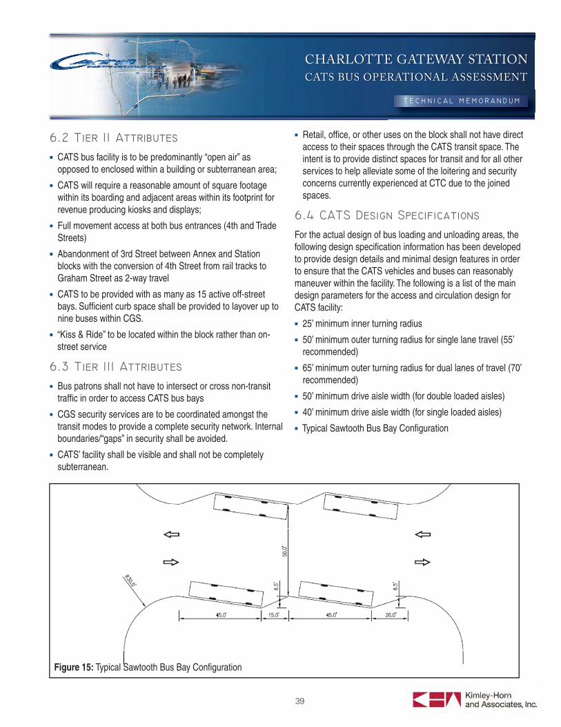
CHARLOTTE GATEWAY STATION
CATS BUS OPERATIONAL ASSESSMENT
39
CATS bus facility is to be predominantly “open air” as opposed to enclosed within a building or subterranean area;
CATS will require a reasonable amount of square footage within its boarding and adjacent areas within its footprint for revenue producing kiosks and displays;
Full movement access at both bus entrances (4th and Trade Streets)
Abandonment of 3rd Street between Annex and Station blocks with the conversion of 4th Street from rail tracks to Graham Street as 2-way travel
CATS to be provided with as many as 15 active off-street bays. Suffi cient curb space shall be provided to layover up to nine buses within CGS.
“Kiss & Ride” to be located within the block rather than on-street service
Bus patrons shall not have to intersect or cross non-transit traffi c in order to access CATS bus bays
CGS security services are to be coordinated amongst the transit modes to provide a complete security network. Internal boundaries/“gaps” in security shall be avoided.
CATS’ facility shall be visible and shall not be completely subterranean.
Retail, offi ce, or other uses on the block shall not have direct access to their spaces through the CATS transit space. The intent is to provide distinct spaces for transit and for all other services to help alleviate some of the loitering and security concerns currently experienced at CTC due to the joined spaces.
For the actual design of bus loading and unloading areas, the following design specifi cation information has been developed to provide design details and minimal design features in order to ensure that the CATS vehicles and buses can reasonably maneuver within the facility. The following is a list of the main design parameters for the access and circulation design for CATS facility:
25’ minimum inner turning radius
50’ minimum outer turning radius for single lane travel (55’ recommended)
65’ minimum outer turning radius for dual lanes of travel (70’ recommended)
50’ minimum drive aisle width (for double loaded aisles)
40’ minimum drive aisle width (for single loaded aisles)
Typical Sawtooth Bus Bay Confi guration
Figure 15: Typical Sawtooth Bus Bay Confi guration
CHARLOTTE GATEWAY STATIONCATS BUS OPERATIONAL ASSESSMENT
Appendix A
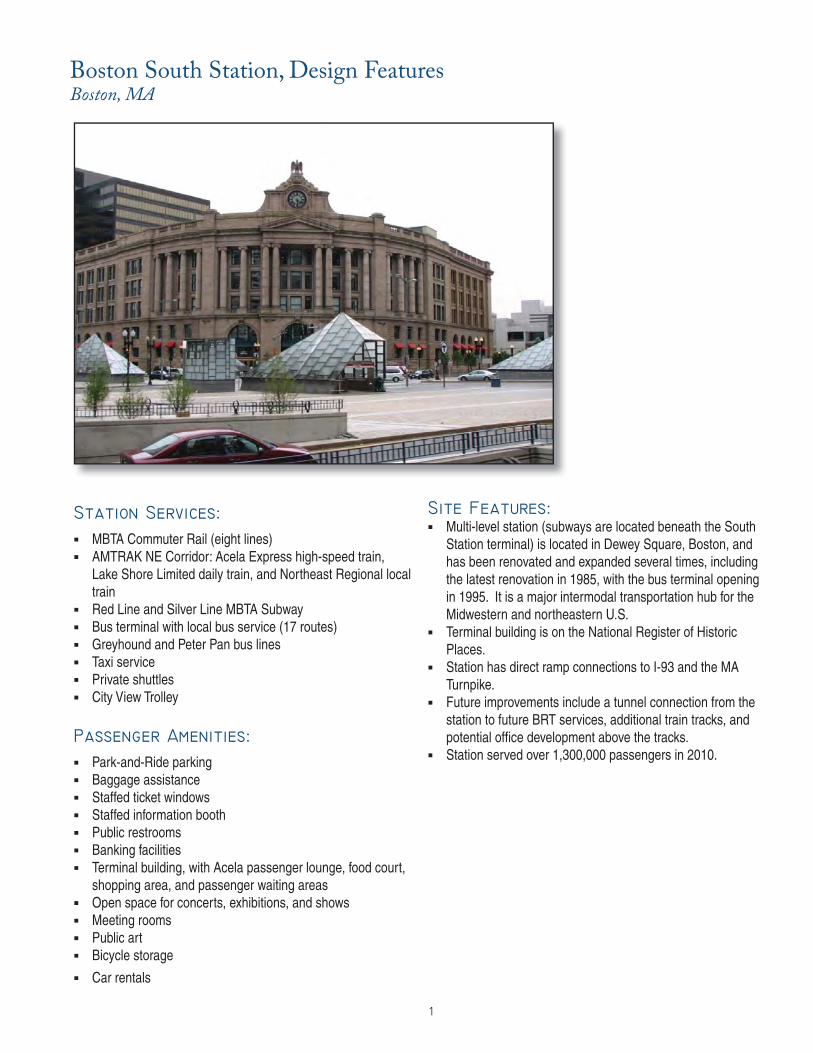
1
MBTA Commuter Rail (eight lines) AMTRAK NE Corridor: Acela Express high-speed train,
Lake Shore Limited daily train, and Northeast Regional local train
Red Line and Silver Line MBTA Subway Bus terminal with local bus service (17 routes) Greyhound and Peter Pan bus lines Taxi service Private shuttles City View Trolley
Park-and-Ride parking Baggage assistance Staffed ticket windows Staffed information booth Public restrooms Banking facilities Terminal building, with Acela passenger lounge, food court,
shopping area, and passenger waiting areas Open space for concerts, exhibitions, and shows Meeting rooms Public art Bicycle storage Car rentals
Multi-level station (subways are located beneath the South
Station terminal) is located in Dewey Square, Boston, and has been renovated and expanded several times, including the latest renovation in 1985, with the bus terminal opening in 1995. It is a major intermodal transportation hub for the Midwestern and northeastern U.S.
Terminal building is on the National Register of Historic Places.
Station has direct ramp connections to I-93 and the MA Turnpike.
Future improvements include a tunnel connection from the station to future BRT services, additional train tracks, and potential offi ce development above the tracks.
Station served over 1,300,000 passengers in 2010.
Boston South Station, Design FeaturesBoston, MA
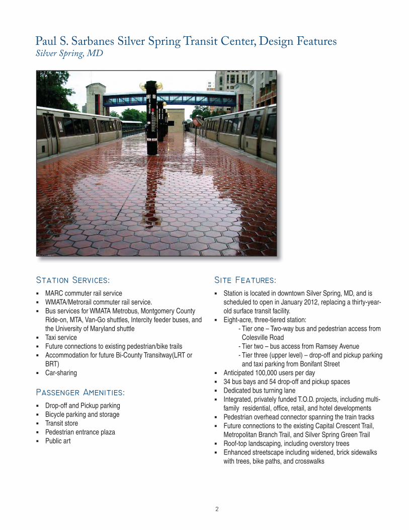
2
MARC commuter rail service WMATA/Metrorail commuter rail service. Bus services for WMATA Metrobus, Montgomery County
Ride-on, MTA, Van-Go shuttles, Intercity feeder buses, and the University of Maryland shuttle
Taxi service Future connections to existing pedestrian/bike trails Accommodation for future Bi-County Transitway(LRT or
BRT) Car-sharing
Drop-off and Pickup parking Bicycle parking and storage Transit store Pedestrian entrance plaza Public art
Station is located in downtown Silver Spring, MD, and is
scheduled to open in January 2012, replacing a thirty-year-old surface transit facility.
Eight-acre, three-tiered station: - Tier one – Two-way bus and pedestrian access from
Colesville Road - Tier two – bus access from Ramsey Avenue - Tier three (upper level) – drop-off and pickup parking
and taxi parking from Bonifant Street Anticipated 100,000 users per day 34 bus bays and 54 drop-off and pickup spaces Dedicated bus turning lane Integrated, privately funded T.O.D. projects, including multi-
family residential, offi ce, retail, and hotel developments Pedestrian overhead connector spanning the train tracks Future connections to the existing Capital Crescent Trail,
Metropolitan Branch Trail, and Silver Spring Green Trail Roof-top landscaping, including overstory trees Enhanced streetscape including widened, brick sidewalks
with trees, bike paths, and crosswalks
Paul S. Sarbanes Silver Spring Transit Center, Design FeaturesSilver Spring, MD
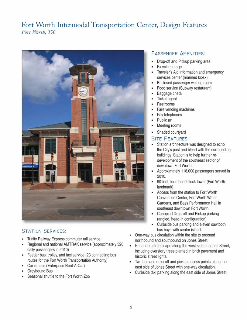
3
Trinity Railway Express commuter rail service Regional and national AMTRAK service (approximately 320
daily passengers in 2010) Feeder bus, trolley, and taxi service (23 connecting bus
routes for the Fort Worth Transportation Authority) Car rentals (Enterprise Rent-A-Car) Greyhound Bus Seasonal shuttle to the Fort Worth Zoo
Drop-off and Pickup parking area Bicycle storage Traveler’s Aid information and emergency
services center (manned kiosk) Enclosed passenger waiting room Food service (Subway restaurant) Baggage check Ticket agent Restrooms Fare vending machines Pay telephones Public art Meeting rooms Shaded courtyard
Station architecture was designed to echo
the City’s past and blend with the surrounding buildings. Station is to help further re-development of the southeast sector of downtown Fort Worth.
Approximately 118,000 passengers served in 2010.
90-foot, four-faced clock tower (Fort Worth landmark).
Access from the station to Fort Worth Convention Center, Fort Worth Water Gardens, and Bass Performance Hall in southeast downtown Fort Worth.
Canopied Drop-off and Pickup parking (angled, head-in confi guration).
Curbside bus parking and eleven sawtooth bus bays with center island.
One-way bus circulation within the site to proceed northbound and southbound on Jones Street.
Enhanced streetscape along the west side of Jones Street, including overstory trees planted in brick pavement and historic street lights.
Two bus and drop-off and pickup access points along the east side of Jones Street with one-way circulation.
Curbside taxi parking along the east side of Jones Street.
Fort Worth Intermodal Transportation Center, Design FeaturesFort Worth, TX
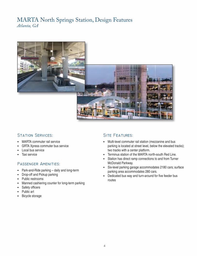
4
MARTA commuter rail service GRTA Xpress commuter bus service Local bus service Taxi service
Park-and-Ride parking – daily and long-term Drop-off and Pickup parking Public restrooms Manned cashiering counter for long-term parking Safety offi cers Public art Bicycle storage
Multi-level commuter rail station (mezzanine and bus
parking is located at street level, below the elevated tracks); two tracks with a center platform.
Terminus station of the MARTA north-south Red Line. Station has direct ramp connections to and from Turner
McDonald Parkway. Six-level parking garage accommodates 2180 cars; surface
parking area accommodates 280 cars. Dedicated bus way and turn-around for fi ve feeder bus
routes
MARTA North Springs Station, Design FeaturesAtlanta, GA
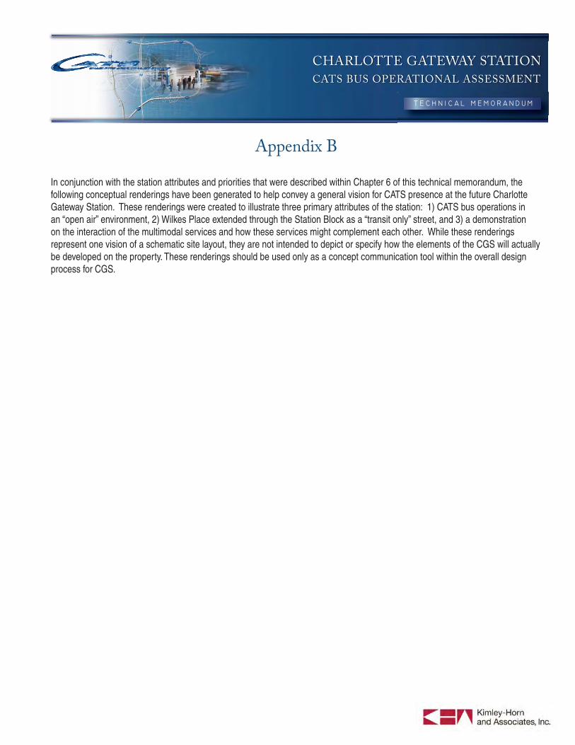
CHARLOTTE GATEWAY STATION
CATS BUS OPERATIONAL ASSESSMENT
Appendix B
In conjunction with the station attributes and priorities that were described within Chapter 6 of this technical memorandum, the following conceptual renderings have been generated to help convey a general vision for CATS presence at the future Charlotte Gateway Station. These renderings were created to illustrate three primary attributes of the station: 1) CATS bus operations in an “open air” environment, 2) Wilkes Place extended through the Station Block as a “transit only” street, and 3) a demonstration on the interaction of the multimodal services and how these services might complement each other. While these renderings represent one vision of a schematic site layout, they are not intended to depict or specify how the elements of the CGS will actually be developed on the property. These renderings should be used only as a concept communication tool within the overall design process for CGS.