chapter one - academic journals
TRANSCRIPT
Vol. 7(3), pp. 25-34, August 2016
DOI: 10.5897/IJSTER2016.0355
Article Number: 3CF5D1F60192
ISSN 2141-6559
Copyright © 2016
Author(s) retain the copyright of this article
http://www.academicjournals.org/IJSTER
International Journal of Science and Technology
Educational Research
Full Length Research Paper
Developing education-based management system using geo-spatial analysis for selected secondary
schools in Ilorin West Local Government Area, Kwara State, Nigeria
Abiodun Daniel Olabode1* and Gbenga Oluwafemi2
Department of Geography and Planning Sciences, Adekunle Ajasin University Akungba-Akoko, Ondo, Nigeria.
Received 27 April, 2016; Accepted 10 August, 2016
In Nigeria, management of education-based system is still subject to manual method in most of the public secondary schools. This study, however, develops Education Management Information System (EMIS) using Geographic Information System to provide accurate, relevant and up-to-date information on spatial basis. The study further identifies spatial related information that includes; staff strength, student enrollment, school status and location of secondary schools in Ilorin West Local Government Area, Ilorin, Kwara State. The primary data for this study were sourced through Global Positioning System (GPS) that identified the spatial reference points of the secondary schools, while the use of interview schedule was employed to ask basic questions from the principal officers in the secondary schools. Secondary data include administrative map and road map of Kwara State. Arcview 3.3 was used for data analysis, where all the attributes of the secondary schools were linked to the spatial data. Results show that; (i) GPS identified eighteen secondary schools concentrated at the core centre of the study area, (ii) 80% of the schools are situated very close to the roads, which is an indication of easy accessibility, (iii) school status ranged between boarding and day with overall staff strength ranging between 41and 93, and total number of students ranging between 787 and 1982. The study concludes that Geographic Information System (GIS) is a sufficient tool for gathering and disseminating information at will. It is therefore recommended that regular updating of the GIS database through integration of education-based data will help in proper coordination of education sector and other related organization. Key words: Geographic Information System (GIS), school, education, Global Positioning System (GPS).
INTRODUCTION According to Osokoya (1984), the word education is derived from a Latin word “EDUCARE” meaning to bring
*Corresponding author. E-mail: [email protected]. Tel: +2347060871571.
Authors agree that this article remain permanently open access under the terms of the Creative Commons Attribution
License 4.0 International License
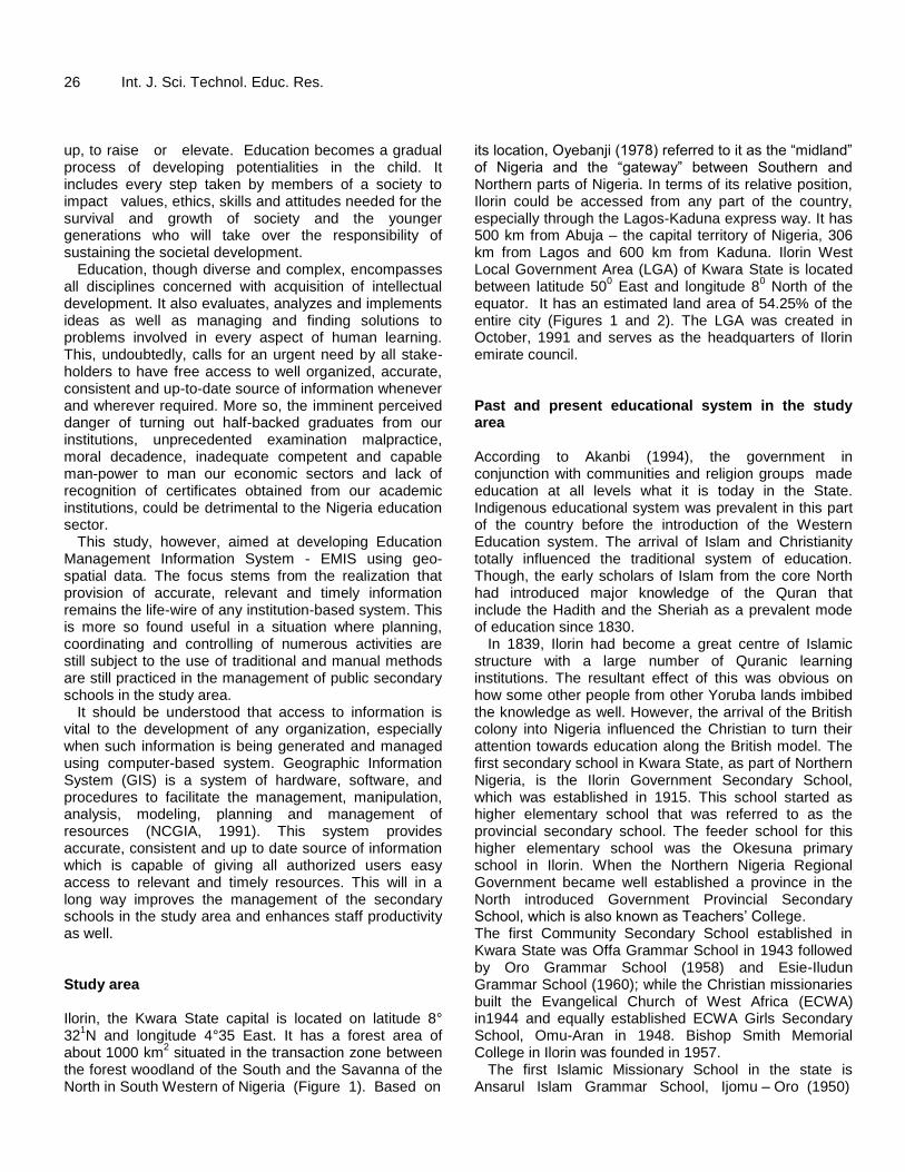
26 Int. J. Sci. Technol. Educ. Res. up, to raise or elevate. Education becomes a gradual process of developing potentialities in the child. It includes every step taken by members of a society to impact values, ethics, skills and attitudes needed for the survival and growth of society and the younger generations who will take over the responsibility of sustaining the societal development.
Education, though diverse and complex, encompasses all disciplines concerned with acquisition of intellectual development. It also evaluates, analyzes and implements ideas as well as managing and finding solutions to problems involved in every aspect of human learning. This, undoubtedly, calls for an urgent need by all stake-holders to have free access to well organized, accurate, consistent and up-to-date source of information whenever and wherever required. More so, the imminent perceived danger of turning out half-backed graduates from our institutions, unprecedented examination malpractice, moral decadence, inadequate competent and capable man-power to man our economic sectors and lack of recognition of certificates obtained from our academic institutions, could be detrimental to the Nigeria education sector.
This study, however, aimed at developing Education Management Information System - EMIS using geo-spatial data. The focus stems from the realization that provision of accurate, relevant and timely information remains the life-wire of any institution-based system. This is more so found useful in a situation where planning, coordinating and controlling of numerous activities are still subject to the use of traditional and manual methods are still practiced in the management of public secondary schools in the study area.
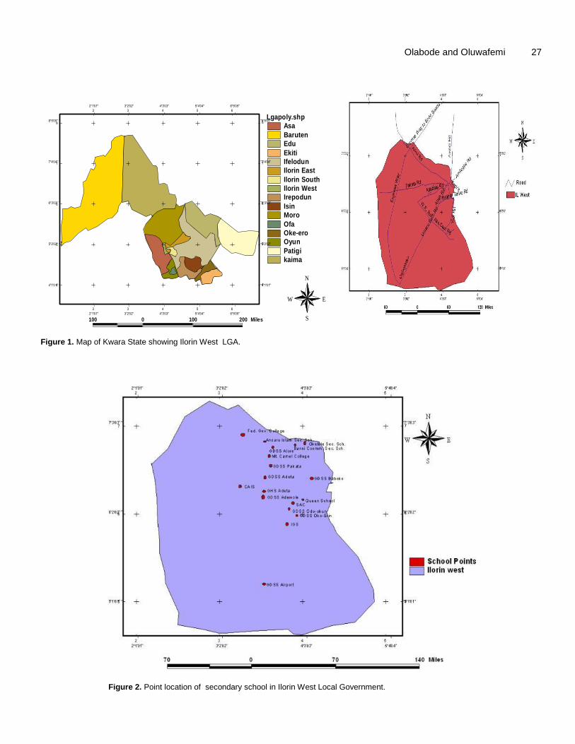
It should be understood that access to information is vital to the development of any organization, especially when such information is being generated and managed using computer-based system. Geographic Information System (GIS) is a system of hardware, software, and procedures to facilitate the management, manipulation, analysis, modeling, planning and management of resources (NCGIA, 1991). This system provides accurate, consistent and up to date source of information which is capable of giving all authorized users easy access to relevant and timely resources. This will in a long way improves the management of the secondary schools in the study area and enhances staff productivity as well. Study area Ilorin, the Kwara State capital is located on latitude 8° 32
1N and longitude 4°35 East. It has a forest area of
about 1000 km2 situated in the transaction zone between
the forest woodland of the South and the Savanna of the North in South Western of Nigeria (Figure 1). Based on
its location, Oyebanji (1978) referred to it as the “midland” of Nigeria and the “gateway” between Southern and Northern parts of Nigeria. In terms of its relative position, Ilorin could be accessed from any part of the country, especially through the Lagos-Kaduna express way. It has 500 km from Abuja – the capital territory of Nigeria, 306 km from Lagos and 600 km from Kaduna. Ilorin West Local Government Area (LGA) of Kwara State is located between latitude 50
0 East and longitude 8
0 North of the
equator. It has an estimated land area of 54.25% of the entire city (Figures 1 and 2). The LGA was created in October, 1991 and serves as the headquarters of Ilorin emirate council. Past and present educational system in the study area According to Akanbi (1994), the government in conjunction with communities and religion groups made education at all levels what it is today in the State. Indigenous educational system was prevalent in this part of the country before the introduction of the Western Education system. The arrival of Islam and Christianity totally influenced the traditional system of education. Though, the early scholars of Islam from the core North had introduced major knowledge of the Quran that include the Hadith and the Sheriah as a prevalent mode of education since 1830.
In 1839, Ilorin had become a great centre of Islamic structure with a large number of Quranic learning institutions. The resultant effect of this was obvious on how some other people from other Yoruba lands imbibed the knowledge as well. However, the arrival of the British colony into Nigeria influenced the Christian to turn their attention towards education along the British model. The first secondary school in Kwara State, as part of Northern Nigeria, is the Ilorin Government Secondary School, which was established in 1915. This school started as higher elementary school that was referred to as the provincial secondary school. The feeder school for this higher elementary school was the Okesuna primary school in Ilorin. When the Northern Nigeria Regional Government became well established a province in the North introduced Government Provincial Secondary School, which is also known as Teachers’ College. The first Community Secondary School established in Kwara State was Offa Grammar School in 1943 followed by Oro Grammar School (1958) and Esie-Iludun Grammar School (1960); while the Christian missionaries built the Evangelical Church of West Africa (ECWA) in1944 and equally established ECWA Girls Secondary School, Omu-Aran in 1948. Bishop Smith Memorial College in Ilorin was founded in 1957.
The first Islamic Missionary School in the state is Ansarul Islam Grammar School, Ijomu – Oro (1950)
Olabode and Oluwafemi 27
Lgapoly.shp
Asa
Baruten
Edu
Ekiti
Ifelodun
Ilorin East
Ilorin South
Ilorin West
Irepodun
Isin
Moro
Ofa
Oke-ero
Oyun
Patigi
kaima
100 0 100 200 Miles
N
EW
S
KWARA STATE MAP SHOWING ALL THE LGAs
4°1'01" 4°1'01"
5°2'02" 5°2'02"
6°3'03" 6°3'03"
7°4'04" 7°4'04"
8°5'05" 8°5'05"
2°1'01"
2°1'01"
3°2'02"
3°2'02"
4°3'03"
4°3'03"
5°4'04"
5°4'04"
6°5'05"
6°5'05"
2
2
3
3
4
4
5
5
6
6
4 4
5 5
6 6
7 7
8 8
Figure 1. Map of Kwara State showing Ilorin West LGA.
Figure 2. Point location of secondary school in Ilorin West Local Government.
28 Int. J. Sci. Technol. Educ. Res. followed by Ansarul Islam Secondary School, Ilorin (1971), Muslim Council College, Babaloma (1972), which were orchestrated through the establishment of Kwara State Teaching Service Commission in 1972 (Adesina, 1977). The Northern Nigeria regional government sited a Teacher College in Ilorin in 1953 and Queen Elizabeth Girls’ Secondary School was established in 1956. After the Nigerian independence of 1960, several communities’ secondary schools emerged between 1960 and 1979. In 1980 and 1990, communities and government collaborated in establishing a day secondary school system under the supervision of Kwara State Education Management Board (KWSEMB) that also managed primary education techniques in the state.
In 1990, Kwara State established unity secondary schools which operated a boarding system and also separated secondary schools tagged “science schools”. The Unity Schools are on boarding basis while the science schools are expected to give room mostly for science students from junior secondary sections. LITERATURE REVIEW Education-based information system According to the Centre for Educational Performance and Information at Michigan (CEPI, 2000), Educational Information System and Management (EISM) is referred to as a Data Warehouse System used by schools to submit data to the state and used for educational performance & information that will combine data storage and reporting. This will further serve as samples for all Michigan Educational Data. The data are organized into five core data sets that include, Simple Record, Student Data, Staff Data, Student Assessment Data, School Infrastructure Data, School Personnel Data and Financial Data with the school code master, directory of schools and general school information. As noted by Aepam (2003), (EISM) is a system of data collection, storage, retrieval, processing and dissemination of relevant information that specifically designed for use by the decision makers and administrators to plan and administer education Information System and management more efficiently and effectively.
Developing a sub-national, non-formal Education Management Information System could be a long journey task since most countries in the developing world are still lacking systems that can properly monitor the formal education. In response to this, efforts are on-going by the UNESCO (2008) to develop an easy-to-use methodology for setting-up-a non-formal education management information system (al-fe-mis). This system responds to the demand for a practical and internationally applicable approach to Non-Formal Education mapping, monitoring and evaluation which is adaptable to local contexts and
information needs. Relevance of GIS in education system Geographic Information System (GIS) provides a technology and method to analyze spatial data, or information about the earth. The earth’s climate, natural hazard, population, geology, vegetation, soils, land use and other phenomena about the earth can be analyzed using computerized maps, aerial photographs, satellite imageries, database and graphics in a GIS, which helps in understanding patterns, linkages and trends about our planet.
Since the 1960s, GIS has quietly transformed decision-making through investigation in government and industry by bringing digital spatial data sets and geographic analysis to desktop computers. Geographic information science includes Geographical Information Systems as well as the discipline of geography (examining the patterns of the earth’s people and physical environment), cartography (mapmaking), geology (the science of measuring and surveying the earth), and remote sensing (studying the earth from space).
GIS is integrated into education in three major ways at the elementary, secondary, and university levels. Firstly, teaching about GIS dominates at the community, college and university levels, where courses in methods and theory of GIS are taught in geography, engineering, business, environmental studies, geology and in other disciplines. Secondly, teaching of GIS is emphasized at the elementary and secondary levels, where GIS is used to teach concepts and skills in earth science, geography, chemistry, biological science, history and mathematics. GIS is used as essential research in all institutions of higher education in geography, demography, and geology. Students using GIS in their curriculum are studying phenomena from local to global scale. For example, students in Los Angelis map and analyze the ethnic make up of neighborhood city over time. Vermont middle school students used GIS technology as science journals and photographs to determine the origin and ecological relationship of a local pond to the community. Finally, North Carolina students used GIS to study the history and development of the African American communist in their city.
The U.S. Labor Secretary’s Commission on Achieving Necessary Skills is (SCANS) stated that the most effective way to teach skills is “in context” (U.S. Dept. of Labor 1991). Implementing GIS into the curriculum may encourage students to examine data from a variety of fields. Based on the publication of the Geography Education Standards Project (1994), Social Studies (National Research Council 1996) and technology (International Society for Technology in Education, 2000), educators nationwide have been progressing towards a
model of instruction that emphasize a hand on, interdisciplinary, research based learning experience. Database design and creation Odedare (2003) while observing the importance of a database system states that; a database allows for speedy retrieval; updating and compactness of data, data sharing is also achieved, drudgery is removed and orderly access and removal of unnecessary delay in the database. The advantages that accrue from having a centralizing control of the data as reason for using a database are: smooth data sharing, quick data retriever, reduction of data redundancy, security measure, avoidance of inconsistency maintenance of integrity. A database is described as a self-describing collection of integrated records that models the users’ reality. For GIS however, a special kind of database with spatial components is what is required and this is what is referred to as Spatial Database. The development of a spatial database is required in GIS for a wide range of reasons including reducing data duplication, ensuring data standardization and for efficient way of representing geographic data in the user’s perspectives.
Spatial database is the heart of any GIS operation that allows the system to meet up with the geographic information needs of planners, policy and decision makers. The information needs met by a well-designed spatial database helps in achieving reliable information storage and retrieval at will, up-to-date and well define functions of updating information, as well as the provision of analytical functions which allow (spatial) query and reality modeling or simulations.
MATERIALS AND METHODS
Both primary and secondary data were employed in this study. The primary data were sourced using Global Positioning System that identified the spatial reference points of the secondary schools. The coordinates were taken on the basis of geographic projection, which are degrees, minutes and seconds and hereafter converted into Universal Traverse Mercator (UTM) for easy manipulation by using a device referred to as geographic calculator. The use of interview schedule is part of researcher’s efforts through which basic questions that include staff strength, students’ enrollment, and school principal were asked from the principal officers in the secondary schools. Purposeful method of data collection was adopted to target the entire eighteen Secondary Schools in the study area.
Aside this, secondary data obtained include; administrative map and road map of Kwara State were as well used in this study. The map of Ilorin West Local Government Area was extracted and digitalized from the 1.50,000 topographical map of Kwara State (Ministry of Land and Survey, 2008). This was hand traced with a computer mouse to collect the coordinate of spatial features. An electronic scanning device was also used to convert map lines and points into digital map, which made it possible to specify their
Olabode and Oluwafemi 29
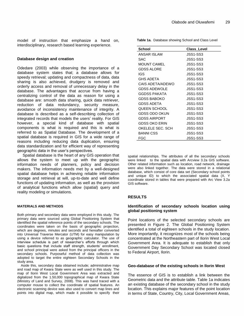
Table 1a. Database showing School and Class Level
School Class_Level
ANSAR ISLAM JSS1-SS3
SAC JSS1-SS3
MOUNT CAMEL JSS1-SS3
GDSS ALORE JSS1-SS3
IGS JSS1-SS3
GHS ADETA JSS1-SS3
CAIS ADETA/ADEWO JSS1-SS3
GDSS ADEWOLE JSS1-SS3
GGDSS PAKATA JSS1-SS3
GDSS BABOKO JSS1-SS3
GDSS ADETA JSS1-SS3
QUEEN SCHOOL JSS1-SS3
GDSS ODO OKUN JSS1-SS3
GDSS AIRPORT JSS1-SS3
GDSS OKO ERIN JSS1-SS3
OKELELE SEC. SCH JSS1-SS3
BANNI CSS JSS1-SS3
FGC JSS1-SS3
spatial relationships. The attributes of all the secondary schools were linked to the spatial data with Arcview 3.2a GIS software. Other related information such as location, road network, drainage were also linked together. The data were stored in a relational database, which consist of core data set (Secondary school points and unique ID) to which the associated spatial data (X, Y coordinate stored in tables that were prepared with Arc View 3.2a GIS software. RESULTS Identification of secondary schools location using global positioning system Point locations of the selected secondary schools are presented in Figure 2. The Global Positioning System identified a total of eighteen schools in the study location. More importantly, it recognizes most of the schools being concentrated at the Northeastern part of Ilorin West Local Government Area. It is adequate to establish that only Government Day Secondary School was located closed to Federal Airport, Ilorin. Geo-database of the existing schools in Ilorin West The essence of GIS is to establish a link between the Geometric data and the attribute table. Table 1a indicates an existing database of the secondary school in the study location. This explains major features of the point location in terms of State, Country, City, Local Government Areas,
30 Int. J. Sci. Technol. Educ. Res.
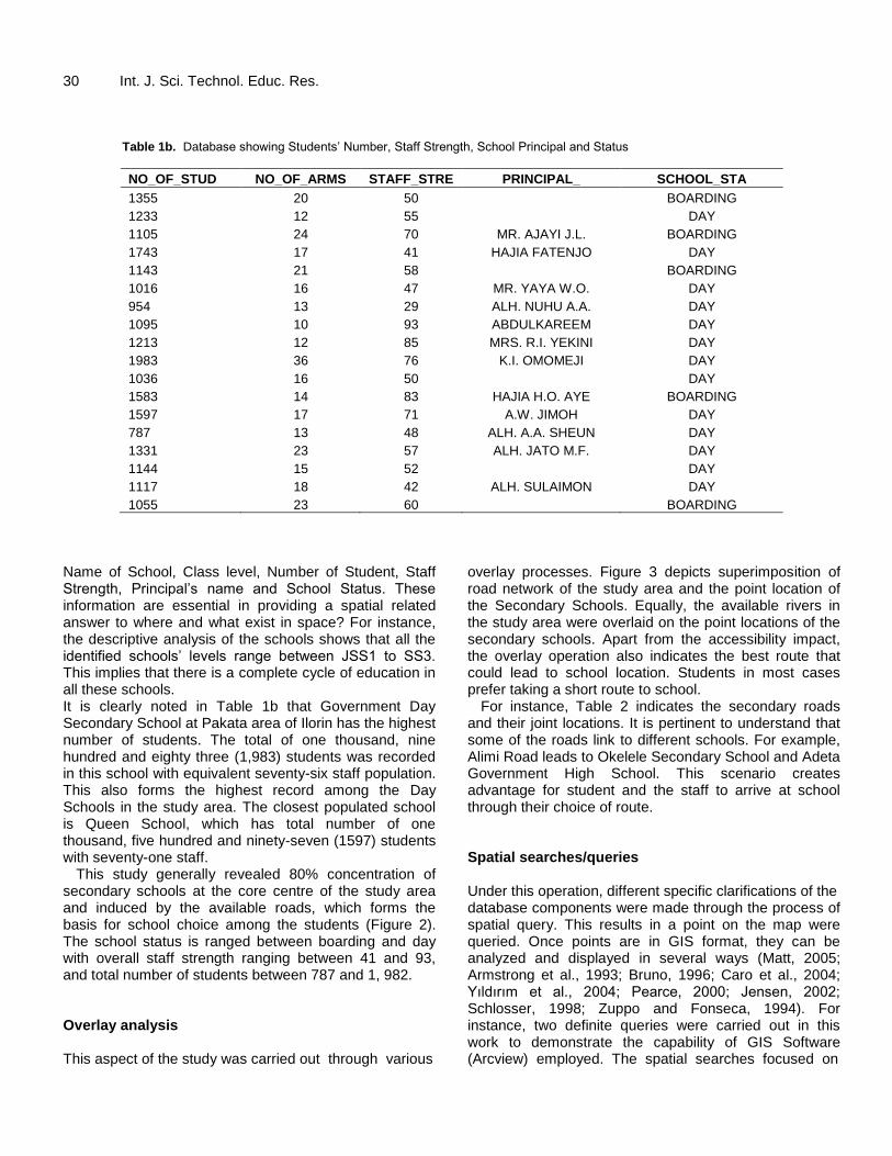
Table 1b. Database showing Students’ Number, Staff Strength, School Principal and Status
NO_OF_STUD NO_OF_ARMS STAFF_STRE PRINCIPAL_ SCHOOL_STA
1355 20 50 BOARDING
1233 12 55 DAY
1105 24 70 MR. AJAYI J.L. BOARDING
1743 17 41 HAJIA FATENJO DAY
1143 21 58 BOARDING
1016 16 47 MR. YAYA W.O. DAY
954 13 29 ALH. NUHU A.A. DAY
1095 10 93 ABDULKAREEM DAY
1213 12 85 MRS. R.I. YEKINI DAY
1983 36 76 K.I. OMOMEJI DAY
1036 16 50 DAY
1583 14 83 HAJIA H.O. AYE BOARDING
1597 17 71 A.W. JIMOH DAY
787 13 48 ALH. A.A. SHEUN DAY
1331 23 57 ALH. JATO M.F. DAY
1144 15 52 DAY
1117 18 42 ALH. SULAIMON DAY
1055 23 60 BOARDING
Name of School, Class level, Number of Student, Staff Strength, Principal’s name and School Status. These information are essential in providing a spatial related answer to where and what exist in space? For instance, the descriptive analysis of the schools shows that all the identified schools’ levels range between JSS1 to SS3. This implies that there is a complete cycle of education in all these schools. It is clearly noted in Table 1b that Government Day Secondary School at Pakata area of Ilorin has the highest number of students. The total of one thousand, nine hundred and eighty three (1,983) students was recorded in this school with equivalent seventy-six staff population. This also forms the highest record among the Day Schools in the study area. The closest populated school is Queen School, which has total number of one thousand, five hundred and ninety-seven (1597) students with seventy-one staff.
This study generally revealed 80% concentration of secondary schools at the core centre of the study area and induced by the available roads, which forms the basis for school choice among the students (Figure 2). The school status is ranged between boarding and day with overall staff strength ranging between 41 and 93, and total number of students between 787 and 1, 982. Overlay analysis This aspect of the study was carried out through various
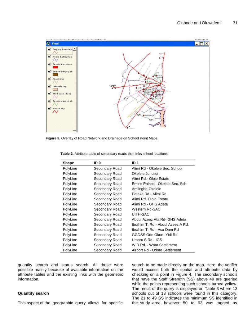
overlay processes. Figure 3 depicts superimposition of road network of the study area and the point location of the Secondary Schools. Equally, the available rivers in the study area were overlaid on the point locations of the secondary schools. Apart from the accessibility impact, the overlay operation also indicates the best route that could lead to school location. Students in most cases prefer taking a short route to school.
For instance, Table 2 indicates the secondary roads and their joint locations. It is pertinent to understand that some of the roads link to different schools. For example, Alimi Road leads to Okelele Secondary School and Adeta Government High School. This scenario creates advantage for student and the staff to arrive at school through their choice of route. Spatial searches/queries Under this operation, different specific clarifications of the database components were made through the process of spatial query. This results in a point on the map were queried. Once points are in GIS format, they can be analyzed and displayed in several ways (Matt, 2005; Armstrong et al., 1993; Bruno, 1996; Caro et al., 2004; Yıldırım et al., 2004; Pearce, 2000; Jensen, 2002; Schlosser, 1998; Zuppo and Fonseca, 1994). For instance, two definite queries were carried out in this work to demonstrate the capability of GIS Software (Arcview) employed. The spatial searches focused on
Olabode and Oluwafemi 31
Figure 3. Overlay of Road Network and Drainage on School Point Maps.
Table 2. Attribute table of secondary roads that links school locations
Shape ID 0 ID 1
PolyLine Secondary Road Alimi Rd - Okelele Sec. School
PolyLine Secondary Road Okelele Junction
PolyLine Secondary Road Alimi Rd.- Oloje Estate
PolyLine Secondary Road Emir’s Palace - Okelele Sec. Sch
PolyLine Secondary Road Amilegbe-Okelele
PolyLine Secondary Road Pataka Rd.- Alimi Rd.
PolyLine Secondary Road Alimi Rd. Oloje Estate
PolyLine Secondary Road Alimi Rd.- GHS Adeta
PolyLine Secondary Road Western Rd-SAC
PolyLine Secondary Road UITH-SAC
PolyLine Secondary Road Abdul Azeez Ata Rd- GHS Adeta
PolyLine Secondary Road Ibrahim T. Rd - Abdul Azeez A Rd.
PolyLine Secondary Road Ibrahim T. Rd - Asa Dam Rd
PolyLine Secondary Road GGDSS Odo Okun- Yidi Rd
PolyLine Secondary Road Umaru S Rd - IGS
PolyLine Secondary Road W.R Rd. - Wara Settlement
PolyLine Secondary Road Airport Rd - Odore Settlement
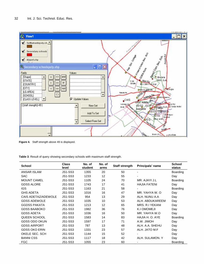
quantity search and status search. All these were possible mainly because of available information on the attribute tables and the existing links with the geometric information. Quantity search This aspect of the geographic query allows for specific
search to be made directly on the map. Here, the verifier would access both the spatial and attribute data by checking on a point in Figure 4. The secondary schools that have the Staff Strength (SS) above 49 are queried while the points representing such schools turned yellow. The result of the query is displayed on Table 3 where 13 schools out of 18 schools were found in this category. The 21 to 49 SS indicates the minimum SS identified in the study area, however, 50 to 93 was tagged as
32 Int. J. Sci. Technol. Educ. Res.
Figure 4. Staff strength above 49 is displayed.
Table 3. Result of query showing secondary schools with maximum staff strength.
School Class level
No. of student
No. of arms
Staff strength Principals’ name School status
ANSAR ISLAM JS1-SS3 1355 20 50 - Boarding
SAC JS1-SS3 1233 12 55 - Day
MOUNT CAMEL JS1-SS3 1105 24 70 MR. AJAYI J.L Boarding
GDSS ALORE JS1-SS3 1743 17 41 HAJIA FATENI Day
IGS JS1-SS3 1163 21 58 - Boarding
GHS ADETA JS1-SS3 1016 16 47 MR. YAHYA W. O Day
CAIS ADETAZ/ADEWOLE JS1-SS3 954 13 29 ALH. NUNU A.A Day
GDSS ADEWOLE JS1-SS3 1035 10 53 ALH. ABDUKAREEM Day
GGDSS PAKATA JS1-SS3 1213 12 65 MRS. R.I YEKANI Day
GDSS BAABOKO JS1-SS3 1982 36 76 K.I OMOMEJI Day
GDSS ADETA JS1-SS3 1036 16 50 MR. YAHYA W.O Day
QUEEN SCHOOL JS1-SS3 1583 14 83 HAJIA H. O. AYE Boarding
GDSS ODO OKUN JS1-SS3 1597 17 71 A.W. JIMOH Day
GDSS AIRPORT JS1-SS3 787 13 48 ALH. A.A. SHEHU Day
GDSS OKO ERIN JS1-SS3 1331 23 57 ALH. JATO M.F Day
OKELE SEC. SCH JS1-SS3 1144 15 52 - Day
BANNI CSS JS1-SS3 1117 18 42 ALH. SULAMON. Y Day
FGC JS1-SS3 1055 23 60 - Boarding
Olabode and Oluwafemi 33
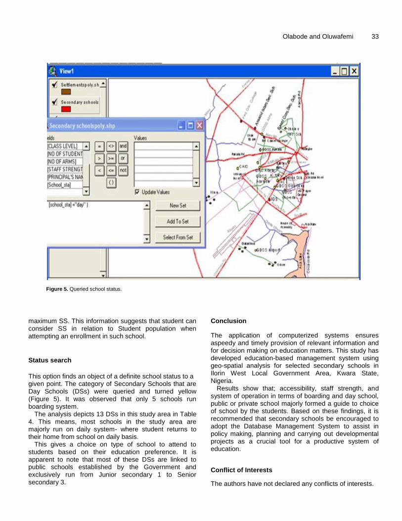
Figure 5. Queried school status.
maximum SS. This information suggests that student can consider SS in relation to Student population when attempting an enrollment in such school.
Status search
This option finds an object of a definite school status to a given point. The category of Secondary Schools that are Day Schools (DSs) were queried and turned yellow (Figure 5). It was observed that only 5 schools run boarding system.
The analysis depicts 13 DSs in this study area in Table 4. This means, most schools in the study area are majorly run on daily system- where student returns to their home from school on daily basis.
This gives a choice on type of school to attend to students based on their education preference. It is apparent to note that most of these DSs are linked to public schools established by the Government and exclusively run from Junior secondary 1 to Senior secondary 3.
Conclusion
The application of computerized systems ensures aspeedy and timely provision of relevant information and for decision making on education matters. This study has developed education-based management system using geo-spatial analysis for selected secondary schools in Ilorin West Local Government Area, Kwara State, Nigeria.
Results show that; accessibility, staff strength, and system of operation in terms of boarding and day school, public or private school majorly formed a guide to choice of school by the students. Based on these findings, it is recommended that secondary schools be encouraged to adopt the Database Management System to assist in policy making, planning and carrying out developmental projects as a crucial tool for a productive system of education.
Conflict of Interests
The authors have not declared any conflicts of interests.
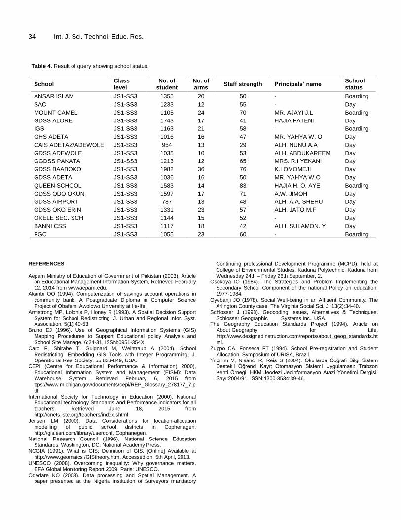
34 Int. J. Sci. Technol. Educ. Res. Table 4. Result of query showing school status.
School Class level
No. of student
No. of arms
Staff strength Principals’ name School status
ANSAR ISLAM JS1-SS3 1355 20 50 - Boarding
SAC JS1-SS3 1233 12 55 - Day
MOUNT CAMEL JS1-SS3 1105 24 70 MR. AJAYI J.L Boarding
GDSS ALORE JS1-SS3 1743 17 41 HAJIA FATENI Day
IGS JS1-SS3 1163 21 58 - Boarding
GHS ADETA JS1-SS3 1016 16 47 MR. YAHYA W. O Day
CAIS ADETAZ/ADEWOLE JS1-SS3 954 13 29 ALH. NUNU A.A Day
GDSS ADEWOLE JS1-SS3 1035 10 53 ALH. ABDUKAREEM Day
GGDSS PAKATA JS1-SS3 1213 12 65 MRS. R.I YEKANI Day
GDSS BAABOKO JS1-SS3 1982 36 76 K.I OMOMEJI Day
GDSS ADETA JS1-SS3 1036 16 50 MR. YAHYA W.O Day
QUEEN SCHOOL JS1-SS3 1583 14 83 HAJIA H. O. AYE Boarding
GDSS ODO OKUN JS1-SS3 1597 17 71 A.W. JIMOH Day
GDSS AIRPORT JS1-SS3 787 13 48 ALH. A.A. SHEHU Day
GDSS OKO ERIN JS1-SS3 1331 23 57 ALH. JATO M.F Day
OKELE SEC. SCH JS1-SS3 1144 15 52 - Day
BANNI CSS JS1-SS3 1117 18 42 ALH. SULAMON. Y Day
FGC JS1-SS3 1055 23 60 - Boarding
REFERENCES Aepam Ministry of Education of Government of Pakistan (2003), Article
on Educational Management Information System, Retrieved February 12, 2014 from wwwaepam.edu.
Akanbi OO (1994). Computerization of savings account operations in community bank. A Postgraduate Diploma in Computer Science Project of Obafemi Awolowo University at Ile-Ife.
Armstrong MP, Lolonis P, Honey R (1993). A Spatial Decision Support System for School Redistricting, J. Urban and Regional Infor. Syst. Association, 5(1):40-53.
Bruno EJ (1996). Use of Geographical Information Systems (GIS) Mapping Procedures to Support Educational policy Analysis and School Site Manage. 6:24-31, ISSN:0951-354X.
Caro F, Shirabe T, Guignard M, Weintraub A (2004). School Redistricting: Embedding GIS Tools with Integer Programming, J. Operational Res. Society, 55:836-849, USA.
CEPI (Centre for Educational Performance & Information) 2000), Educational Information System and Management (EISM): Data Warehouse System. Retrieved February 6, 2015 from ttps://www.michigan.gov/documents/cepi/REP_Glossary_278177_7.pdf
International Society for Technology in Education (2000). National Educational technology Standards and Performance indicators for all teachers. Retrieved June 18, 2015 from http://cnets.iste.org/teachers/index.shtml.
Jensen LM (2000). Data Considerations for location-allocation modelling of public school districts in Cophenagen, http://gis.esri.com/library/userconf, Cophanegen.
National Research Council (1996). National Science Education Standards, Washington, DC: National Academy Press.
NCGIA (1991). What is GIS: Definition of GIS. [Online] Available at http://www.geomaics /GIStheory.htm, Accessed on, 5th April, 2013.
UNESCO (2008). Overcoming inequality: Why governance matters. EFA Global Monitoring Report 2009. Paris: UNESCO.
Odedare KO (2003). Data processing and Spatial Management. A paper presented at the Nigeria Institution of Surveyors mandatory
Continuing professional Development Programme (MCPD), held at College of Environmental Studies, Kaduna Polytechnic, Kaduna from Wednesday 24th – Friday 26th September, 2.
Osokoya IO (1984). The Strategies and Problem Implementing the Secondary School Component of the national Policy on education, 1977-1984.
Oyebanji JO (1978). Social Well-being in an Affluent Community: The Arlington County case. The Virginia Social Sci. J. 13(2):34-40.
Schlosser J (1998). Geocoding Issues, Alternatives & Techniques, Schlosser Geographic Systems Inc., USA.
The Geography Education Standards Project (1994). Article on About Geography for Life, http://www.designedinstruction.com/reports/about_geog_standards.html.
Zuppo CA, Fonseca FT (1994). School Pre-registration and Student Allocation, Symposium of URISA, Brazil.
Yıldırım V, Nisanci R, Reis S (2004). Okullarda Coğrafi Bilgi Sistem Destekli Öğrenci Kayıt Otomasyon Sistemi Uygulaması: Trabzon Kenti Örneği, HKM Jeodezi Jeoinformasyon Arazi Yönetimi Dergisi, Sayı:2004/91, ISSN:1300-3534:39-46.