"bsassimsar - dtic
TRANSCRIPT
;c?7?-'<n "^"«OHT DOCUMENTATION
PAGE
1. REPORT NO. J. Raooienf t Accaasion No.
S. Rcoon Oat*
*. T-H* •«<» SUMIII. ^ay 1994 P, Phase I Archaeological Survey of the Proposed Hunting Area 57 -^ Rehab Tract on the Fort Knox Military Reservation, Hardin County, ^n-r-ni-lrv ' Kentucky, 7. *vir«ort»l
Pamela A- Sftwiiart 9. »trtormtnc Or«i«K»«on Nam« wo AdOrai«
Directorate of Public Works ATTN: ATZK-PWE (ARCH) U S. Army Armor Center and Fort Knox Fort Knox, KY 40121-5000
B. Partocmint Orjamxation Ram. No.
10. *Toiaet/Ta*k/Wor« Unit No.
11. CsntrvcKO or Grant(G) No.
(0 DACW65-93-D-0039 and DABT23-93-C-0093
13. Typ« o« Raoon & Parted Cov«r*o
(Feb.-May 1994) li. Snnunni Orfanixatton Nama anO Addr«*»
Directorate of Public Works ATTN: ATZK-PWE (ARCH) U.S. Army Armor Center and Fort Knox ^ F^ «nQX- ^ 40121-5000 -mu.iunmt fr-r^ ^ ^r^nratP ot Public i
:s. suep..m."t.ry NO». Employees in Cultural Resource .-januy„Ma ■.■,__ Associates, Inc., 9607 Vtorks are OTtsnde.contractors rt»J gr «£«££*£«£ESfarProgr^ of
• 16. Ab«tr»et tUrniC 200 wore»)
in February and April 1994 the Fort Knox Staff Archeolo- gist and Assistant StSff Archeologist conduct;f a Phase I archeoloqical survey of an area proposed for rehabilitation " SSnSng Area 57/on the Fort Knox Military R-nervation Hardin County, Kentucky. The survey resulted m the record ing of one archeological site, 15Hd4yi.
Site 15Hd491 is a late nineteenth to early twentieth century farmstead. The site has been completely destroyed by military training activities, and is not eligible for tne National Registe?. No additional archeological work « recommended for 15Hd491. It is recommended that the instalia tion be permitted to conduct the rehabilitation activities
as proposed.
17. Ooeumant Anaiytn ». Oaaenotor»
B. Idantlfiari/Ooari-Enoad Itrml
»
Archaeology Hardin County, Kentucky Fort Knox, Kentucky
DT1G QüilLIx'if lECPSOTHD 5
Mill Creek, Kentucky Salt River, Kentucky
c. COSATI n.ld/Crouo
IS. AvailaOfiitv Stattmant
Release Unlimited
19. Sacunry Cla»» <Th.» Rcoonl
Unclassified ,,rv Cl^tm. CThim P»l«>
I 21. No. e>< Pit
(29 (iv + 25)
"bsassimsar 12. Prlea
(St* ANSl-£39.1gl
OPTIONAL FOR« 177. <*-"> (Formerly NT1S-35) Dioinmfni of Cc""""**
A Phase I Archeological Survey of the Proposed Hunting Area 57 Rehab Tract
on the Fort Knox Military Reservation, Hardin County, Kentucky
by Pamela A. Schenian Staff Archeologist
May 1994
Pamela A. Schenian Staff Archeologist
and Project Principal Investigator
Directorate of Public Works, Fort Knox, Kentucky 40121-5000
19941202 168
ABSTRACT
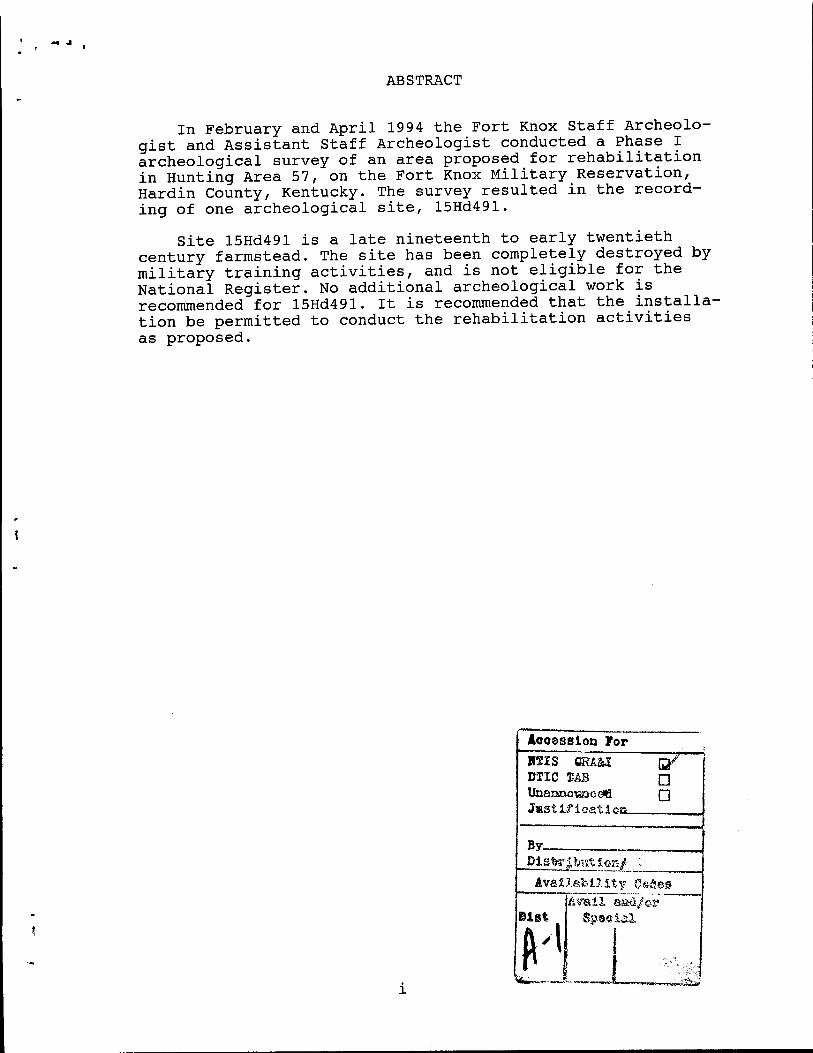
In February and April 1994 the Fort Knox Staff Archeolo- gist and Assistant Staff Archeologist conducted a Phase I archeological survey of an area proposed for rehabilitation in Hunting Area 57, on the Fort Knox Military Reservation, Hardin County, Kentucky. The survey resulted in the record- ing of one archeological site, 15Hd491.
Site 15Hd491 is a late nineteenth to early twentieth century farmstead. The site has been completely destroyed by military training activities, and is not eligible for the National Register. No additional archeological work is recommended for 15Hd491. It is recommended that the installa- tion be permitted to conduct the rehabilitation activities as proposed.
Accession For H2IS GRA&I Q/ DTIC T-Ä3 Q Unanaoyzice*} Q J»stLficatioss ,
By_
Availability C«äe» Avail aaä/er Spseial
MANAGEMENT SUMMARY
In accordance with Executive Order 11593 and other applicable federal laws and regulations, a Phase I archeo- logical study was conducted of an area proposed for land rehabilitation in Hunting Area 57 on the Fort Knox Military Reservation, Hardin County, Kentucky. One archeological site, 15Hd491, a historic farmstead, was recorded in the pro- ject area. The site is not eligible for the National Regis- ter and no additional archeological work is recommended at the site. It is recommended that the installation be per- mitted to conduct the land rehabilitation as proposed.
11
TABLE OF CONTENTS
Page
Abstract . ^ Management Summary . ^ Table of Contents iii List of Figures 1J-| I. introduction . * II. Environmental Setting 4
III. Previous Research 5
IV. Survey Predictions 9 V. Field Methods 10
VI. Materials Recovered H VII. Cultural Resources 12
VIII.Conclusions and Recommendations 14 References Cited 15
Appendix A. Resume of Principal Investigator 20 Appendix B. Map Location, Site Plan, and
Representative Soil Profile of 15Hd491 ... 22
LIST OF FIGURES
Page
Figure 1. Location of Proposed Rehab Area 2
Figure 2. Proposed Rehab Area 3
Figure B-l. Location of 15Hd491 23
Figure B-2. Plan View of 15Hd491 24
Figure B-3. Representative Soil Profile at 15Hd491 ... 25
in
I. INTRODUCTION
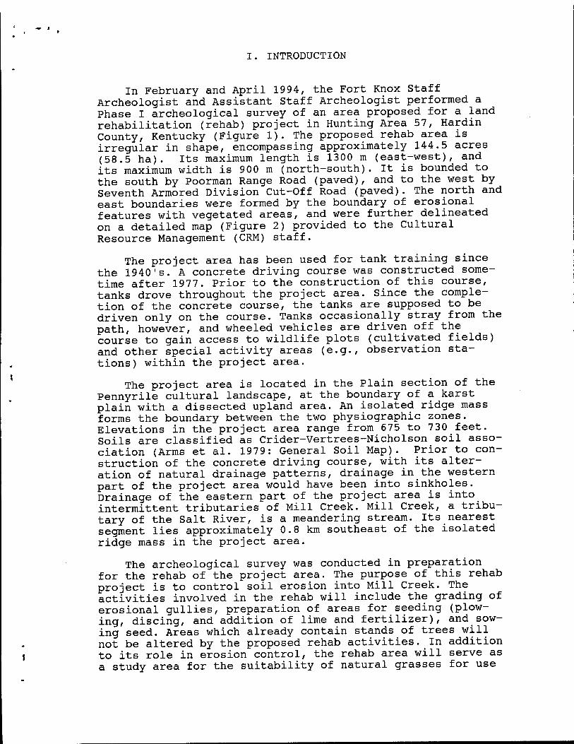
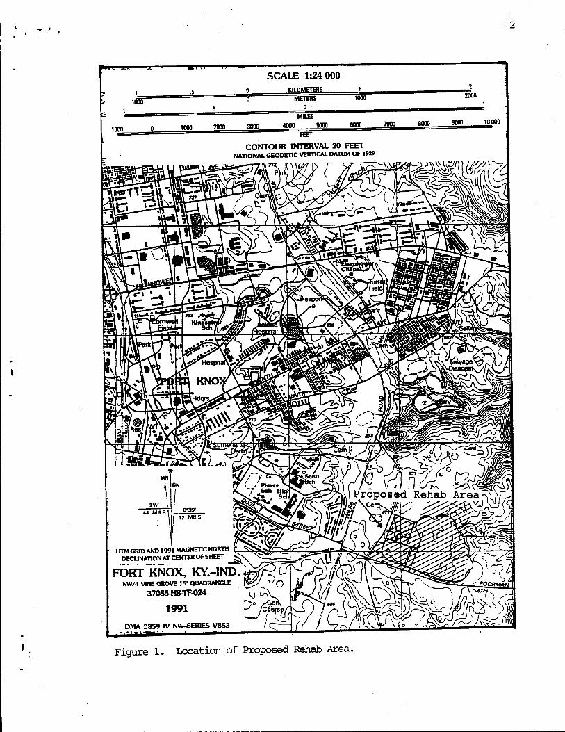
In February and April 1994, the Fort Knox Staff Archeologist and Assistant Staff Archeologist performed a Phase I archeological survey of an area proposed for a land rehabilitation (rehab) project in Hunting Area 57, Hardin County, Kentucky (Figure 1). The proposed rehab area is irregular in shape, encompassing approximately 144.5 acres (58.5 ha). Its maximum length is 1300 m (east-west), and its maximum width is 900 m (north-south). It is bounded to the south by Poorman Range Road (paved), and to the west by Seventh Armored Division Cut-Off Road (paved). The north and east boundaries were formed by the boundary of erosional features with vegetated areas, and were further delineated on a detailed map (Figure 2) provided to the Cultural Resource Management (CRM) staff.
The project area has been used for tank training since the 1940's. A concrete driving course was constructed some- time after 1977. Prior to the construction of this course, tanks drove throughout the project area. Since the comple- tion of the concrete course, the tanks are supposed to be driven only on the course. Tanks occasionally stray from the path, however, and wheeled vehicles are driven off the course to gain access to wildlife plots (cultivated fields) and other special activity areas (e.g., observation sta- tions) within the project area.
The project area is located in the Plain section of the Pennyrile cultural landscape, at the boundary of a karst plain with a dissected upland area. An isolated ridge mass forms the boundary between the two physiographic zones. Elevations in the project area range from 675 to 730 feet. Soils are classified as Crider-Vertrees-Nicholson soil asso- ciation (Arms et al. 1979: General Soil Map). Prior to con- struction of the concrete driving course, with its alter- ation of natural drainage patterns, drainage in the western part of the project area would have been into sinkholes. Drainage of the eastern part of the project area is into intermittent tributaries of Mill Creek. Mill Creek, a tribu- tary of the Salt River, is a meandering stream. Its nearest segment lies approximately 0.8 km southeast of the isolated ridge mass in the project area.
The archeological survey was conducted in preparation for the rehab of the project area. The purpose of this rehab project is to control soil erosion into Mill Creek. The activities involved in the rehab will include the grading of erosional gullies, preparation of areas for seeding (plow- ing, discing, and addition of lime and fertilizer), and_sow- ing seed. Areas which already contain stands of trees will not be altered by the proposed rehab activities. In addition to its role in erosion control, the rehab area will serve as a study area for the suitability of natural grasses for use
Nil ^ l A ■ III >■>
SCALE 1:24 000 0 KILOMETERS
1000
CONTOUR INTERVAL 20 FEET NATIONAL GEODETIC VERTICAL DATUM OF 1929
UTM GRID AND 1991 MAGNETIC NORTH DECUNATIONATCENTEROFSHEET g^S
FORT KNOX, KY.-IND. NW/4 VINE GROVE 15' QUADRANGLE
3708SH8-TF-O24 Q
1991 ^°
DMA 3859 IV NW-SERIES V853
Figure 1. Location of Proposed Rehab Area.
in rehab projects and the effect of increased availability_ of natural grasses on wild species habitats. The archeologi- cal survey and literature review were required to comply with the National Environmental Protection Act, or NEPA, (Public Law 91-190), the Historic Preservation Act of 1966, as amended (Public Law 89-665), the Archaeological Resources Protection Act of 1979 (Public Law 96-95), Presidential Executive Order 11593, and Army Regulation 420-40.
During July and August, 1993, the Fort Knox Staff Archeologist obtained copies of all the documents necessary to perform Phase I literature searches for the installation (e.g., state site forms, updated quad sheets marked with survey and site locations, reports of previous investiga- tions on or near the installation, and historical maps). All documents necessary to perform Phase I literature searches for the installation are present at the CRM Branch, Direc- torate of Public Works (DPW), Fort Knox. No file check therefore was made with the Office of State Archaeology and the Kentucky Heritage Council specifically for this project.
The project area was surveyed on February 7 and 15 and April 18 and 19, 1994. The crew could remain in the project area only a few hours each survey day, due to the tank training schedule. A total of 19.5 person hours were spent in the survey of the proposed rehab area. The artifacts collected in this survey and the documentation of this pro- ject will be curated at the University of Louisville Program of Archaeology, on a "permanent loan" basis, under contract number DABT 23-93-C-0093, for curatorial and technical sup- port (copy of contract on file, DPW, Fort Knox, Kentucky). Duplicate copies of the documentation will be stored at DPW, U.S. Army Armor Center and Fort Knox, Fort Knox, Kentucky.
II. ENVIRONMENTAL SETTING
O'Malley et al. (1980) presented a detailed description of the setting and environmental background of the Fort Knox base as a whole. This section will concentrate on the char- acteristics of the project area.
The proposed rehab area is located in the Mississippian Plateau physiographic region of Kentucky (McGrain and Cur- rens 1978:35). The project area lies at the boundary of a karst plain and a dissected upland area. An isolated ridge mass forms the boundary between the two physiographic zones. Elevations in the project area range from 675 to 730 feet.
Soils in the project area belong to the Crider-Vertrees- Nicholson soil association (Arms et al. 1979: General Soil Map). Soils in the Crider-Vertrees-Nicholson soil associa- tion are described as "nearly level to sloping, deep, well drained and moderately well drained soils on broad ridges
and side slopes; and deep, well drained, sloping to steep soils on narrow ridges and hillsides" (Arms et al. 1979: General Soil Map). The soil type in the majority of the pro- ject area is Vertrees silty clay loam. Smaller areas of Nicholson silt loam are also present.
The construction of the concrete driving course has altered natural drainage patterns substantially. Prior to its construction, drainage in the western part of the pro- ject area would have been into sinkholes. East of the iso- lated ridge mass, drainage is into intermittent tributaries of Mill Creek, a tributary of the Salt River. Mill Creek is a meandering stream, and its nearest segment lies approxi- mately 0.8 km southeast of the isolated ridge mass in the project area.
Tank training off of a concrete course typically leaves small islands of vegetation, surrounded by broad expanses which are deeply eroded, deflated, and devoid of vegetation. Since the construction of the concrete course, and curtail- ment of most vehicle traffic off the course, many of the former denuded areas have been reseeded in grasses and/or have been naturally revegetated with grasses, herbaceous plants, and saplings. The Fish and Wildlife Branch also maintains several wildlife plots in the project area. Wild- life plots are small cultivated fields which are planted in corn and other crops to provide food for wildlife.
Most of the project area has been previously disturbed by the tank training activities prior to the construction of the concrete course. Most of the area immediately adjoining Poorman Range Road and east of the concrete course was dis- turbed by borrowing activities for installation construction projects a number of years ago.
III. PREVIOUS RESEARCH
A number of CRM projects have been conducted on the Fort Knox military reservation. Numerous projects also have been conducted in the portions of Bullitt, Meade, and Hardin Counties outside the military reservation, according to the state archeological bibliography and updates. O'Malley et al. (1980) provide an in-depth discussion of research in the project counties through 1979, and Schenian (1991) and Sche- nian and Mocas (1992) provide a summary of the research which has taken place since the O'Malley et al. (1980) study was completed. This section will focus on the projects which have been conducted on the military reservation and within the vicinity of the current project area.
There are 112 Hunting Areas on the Fort Knox installa- tion, plus an approximately 10,000 acre cantonment area and a small amount of acreage which lies outside the cantonment
area or any hunting area. O'Malley et al. (1980) surveyed approximately one-quarter of each of the 9 6 hunting areas which did not contain grenade ranges. O'Malley et al. (1980) recorded 415 sites (15Bu295 through 15Bu410, 15Hdl09 through 15Hd294, and 15Mdl03 through 15Md242). Some of these sites were recorded outside the official survey areas, and were discovered while gaining access to the selected survey areas from the closest access road. Some of the sites are isolated finds. O'Malley et al. (1980) did not evaluate the National Register status of the sites inspected in a manner which meets the current standards, although opinions are offered on many of the site forms and in an appendix of the report of investigations. The purpose of the O'Malley et al. (1980) study was to provide a prelimi- nary inventory of portions of the installation and to develop a database for the predictive modeling of site loca- tions on the installation, and not to evaluate sites for a task-specific construction project.
Holmberg (1991) prepared an archival study on the four mill sites (15Mdl64, 15Mdl76, 15Mdl85, and Grahamton) recorded by O'Malley et al. (1980) in the Meade county sec- tion of the base. Holmberg's (1991) study includes an appendix (Ball 1991a) delimiting a scope of services for the testing of the mill sites. This testing is scheduled to be performed in 1994 and 1995 through a Legacy grant.
A number of projects have been conducted in conjunction with proposed timber harvests. Bush et al. (1988) revisited 15BU319 and recorded sites 15Hd438 through 15Hd446 and 15Bu485 through 15Bu491 in their survey of timber areas in Hunting Areas 41, 42, and 52. Myers (1990) surveyed 287 acres in Hunting Area 95, recording 15Bu495 through 15Bu502, and describing modern house and garbage dump sites. Mueller (1991) surveyed 270 acres in Hunting Area 1, revisiting 15Mdll, 15Mdl52, and 15Mdl59, and recording 15Md322 through 15Md325, two historic cemeteries, five prehistoric isolated finds, and three modern structures. Schenian and Mocas (1992) surveyed 600 acres and attempted to relocate and flag previously recorded sites in an additional 300 acres. Their project areas consisted of 14 timber parcels located in Hunting Areas 13, 74, 76, 77, 78, 81 through 84, and 88 through 90. This survey resulted in the recording of sites 15Hd462, 15Hd463, 15Hd464, 15Md326, and one isolated find, and the revisiting of 15Hdl40. Attempts were made to relo- cate 15Hdl8, 15Hdll3, and 15Hdl39, but were unsuccessful. Ruple (1992a) revisited sites 15Mdl52, 15Mdl53, and 15Md322 in Hunting Area 1. Ruple (1992b) revisited sites 15Hdl84, 15Hdl86, and 15Hd249, and made an unsuccessful attempt to relocate 15Hd248, in order to flag avoidance boundaries around the sites in Hunting Area 90 in preparation for log- ging activities in conjunction with the clearing of the Highway 313 easement. Ruple (1993a) surveyed all 813 acres comprising Hunting Area 4 in preparation for timber harvests in scattered parcels within the Hunting Area.
The improvement of facilities on the Fort Knox installa- tion has resulted in several CRM studies. Sorensen and Ison (1979) surveyed a proposed telephone building expansion site and access road in the cantonment area, recording no sites. Sussenbach (1990) surveyed three weather radar installation sites, in Hunting Area 23, discovering one prehistoric iso- lated find. Ruple (1993b) surveyed approximately 10 acres in the cantonment area for a shoreline maintenance project, encountering no sites. Mocas (1993) reported on the exami- nation of approximately 165 acres in and around a proposed landfill and borrow area, which located no sites in the highly disturbed area. Mocas (1994a) surveyed a proposed sports complex project area in the cantonment, encountering no archeological sites. Schenian and Mocas (1994) recorded 15Hd488 in the survey of a borrow pit proposed for use in the improvement of the Cedar Creek airstrip.
The development, expansion, or improvement of training areas has resulted in a number of CRM studies. Driskell and O'Malley (1979) surveyed the Wilcox Gunnery Range, recording sites 15BU393 through 15Bu397. Schenian (1991) surveyed 116 acres in portions of Hunting Areas 17, 30, and 41, in con- junction with the Fort Dix realignment, re-examining 15Bu303, and recording 15Bu492, 15Hd459, and two prehistoric isolated finds. Hemberger (1991) also surveyed approxi- mately 405 acres in seven construction sites in Hunting Areas 17, 24, 31, 32, 34, and 54, in conjunction with the Fort Dix realignment. This study resulted in the recording of 15Hd461 and 15Bu504, the revisiting of 15Bu299 and 15Bu385, and the unsuccessful attempt to relocate previously recorded site 15Hd274. Hemberger (1991) surveyed a total of 12 6 acres in four proposed construction areas in the Yano Tank Range, in Hunting Area 93, recording 15Hd460, revisit- ing 15Hdl78, 15Hdl82, and 15Hd282, and unsuccessfully attempting to relocate previously recorded site 15Hd283. Hemberger (1992) surveyed a 7.5 acre borrow area in Hunting Area 24, proposed to be used for the consolidation and improvement of two training ranges, and encountered no sites. Schenian (1994) and Mocas (1994c) surveyed borrow pits for berm repair on the Yano Range, recording no sites in the former study and sites 15Bu524 through 15Bu527 in the latter.
In conjunction with land sales, Ball (1987) surveyed approximately 19 6 acres in the Bullitt County portion of Fort Knox, recording sites 15Bu479 through 15Bu481and describing one post-1950, or modern, house foundation._ Ball (1991b) also surveyed a 19 acre tract near Radcliff prior to disposal of the tract, recording two historic/modern trash dumps which were not assigned state site numbers. Hale (1981) surveyed the Otter Creek Park, recording 15Md243 through 15Md303. Portions of Otter Creek Park, now owned by the City of Louisville, were once part of the Fort Knox mil- itary installation, but were disposed of in the 1970's.
Road construction and improvements have resulted in a number of CRM projects on the military reservation. McGraw (197 6) surveyed the proposed U.S. 60 bridge and approaches near Otter Creek park, encountering no sites in a 2.35 mile long corridor which passes through Hunting Areas 7 through 9 and 11 and 12. Fiegal (1982) surveyed the Radcliff Indus- trial Park access road, including land in Hunting Area 15 as well as off the installation. He recorded 15Hd403 and 15Hd404 off the installation, and revisited 15Hd215 and 15Hd272 on the installation. Webb and Brockington (1986) surveyed the 4.75 mile long Kentucky Highway 1638 realign- ment corridor, which included portions of Hunting Areas 5 and 7 through 10. They revisited sites 15Mdl7 6, and 15Mdl82 through 15Mdl85, and recorded 15Md306, 15Md307, and 15Md309. Sites 15Mdl76, 15Mdl82, 15Mdl83, and 15Md307 were all parts of the former town of Garnettsville. The latter three sites were tested (Wheaton 1982), but 15Mdl76 was not tested because it fell outside the 1638 realignment easement. DiBlasi (1986) surveyed 14 alternative alignments of the approximately 20 km (12.4 miles) long Kentucky Highway 313 corridor, which includes portions of Hunting Areas 80 through 83 and 90, as well as land outside the installation. A total of 27 sites (15Hd406-15Hd430 outside the installa- tion, and 15Hdl35, 15Hdl84, 15Hdl86, 15Hd248, 15Hd249, 15Hd253, 15Hd431, and 15Hd432 on the installation), some previously recorded, were located in the survey corridor. Hixon (1992) tested 15Hd423 and 15Hd426, and archeologists from Wilbur Smith Associates tested six sites on the instal- lation, including 15Hd249 and 15Hd253 (Fenton 1993: personal communication to Schenian). A recent survey of proposed bor- row pits for the Cedar Creek-Yano Road improvements (Mocas 1994b) resulted in the recording of 15Hd489 and 15Hd490, the revisiting of 15Hdl20 and 15Hdl21, and the unsuccessful attempt to relocate 15Hd246.
In addition to the CRM projects, several sites have been recorded on the military reservation in non-CRM contexts. Funkhouser and Webb (1932) published a catalog of archeolog- ical sites in the state, with the information gained pri- marily through correspondence with amateur archeologists, collectors, and local historians, and included the descrip- tion of two sites now on the military reservation. These are 15MdlO, a mound group on Indian Hill, and 15Mdll, a mound near the mouth of Otter Creek (Funkhouser and Webb 1932:281). Jerry Hoehler collected materials (now at the University of Louisville Program of Archaeology) from sites 15BU251, 15Bu292, and 15Bu293, probably in the 1950"s. The wife of a soldier stationed at Fort Knox partially excavated 15Hd273, a mound in Hunting Area 6, in 1955 (Anonymous 1955). Lee Hanson recorded 15Hdl7 and 15Hdl8, while attend- ing ROTC training camp at Fort Knox in 19 61 (Hanson 19 61a, 1961b; Dr. R. Berle Clay 1991: personal communication).
Of greatest relevance to the current survey are the O'Malley et al. (1980) survey areas nearest the project area — approximately 182 acres in the northwest quarter of Hunt- ing Area (HA) 57, approximately 213 acres in the center of HA 58, approximately 206 acres in the northwest quarter of HA 61, and approximately 222 acres in HA 72. No sites were recorded in the area surveyed in HA 72, one site (15Hdl34) was recorded in HA 57, two sites (15Hd247 and 15Hd257) were recorded in HA 61, and five sites (15Hdl75 and 15Hdl65- 15Hdl68) in HA 58. Four of the eight sites are historic (15Hd257 and 15Hd266-15Hd268), one is prehistoric (15Hdl75), one has both prehistoric and historic components (15Hdl34), and two are limestone mounds (15Hd247 and 15Hd265) of inde- terminate cultural-temporal affiliation. Site 15Hdl34 is the nearest to the project area, lying approximately 0.3 km north of the northernmost project boundary. All of the other sites mentioned in this paragraph are 1.0 km or more dis- tant. No archeological sites or standing structures listed on or eligible for listing on the National Register of His- toric Places are located in or immediately adjacent to the current project area.
IV. SURVEY PREDICTIONS
Based on previous archeological research in the area, the history of settlement, and the environmental setting of the project area, the following results were expected:
1) Relatively level upland areas overlooking sources of flowing water, such as the ridge in the center of the project area, are high potential areas for the location of prehistoric and historic sites.
2) Although not acquired until the 1940's, the his- toric property boundaries and structure locations for most of the project area are depicted on the 1919 acquisition maps. One farmstead, the Thomas Goldsmith farmstead, was located in the project area, and a second, the James Bennett farmstead was located at or just outside the northeast cor- ner of the project area. Portions of other farms were encompassed by the project area, but no structures associated with these were in existence in 1919. It was expected that evidence of the Goldsmith farmstead, possibly the Bennett farmstead, and possibly some post-1919 structures may be found.
3) The O'Malley et al. (1980) study recorded few sites in the portions of HA 57 and adjoining hunting areas surveyed. Whether this reflects sparse occupation of this area by prehistoric and historic peoples, the degree of surface distur-
10
bance by military activities, or a combination of these is unknown, but a low site density is expected for the project area.
4) The project area has been used for tank training since the 1940's, so it was expected that, if a site were present in the project area, it would be partially or completely destroyed.
V. FIELD METHODS
The majority of the project area lies within a tank driving course. Although the project area has been used for tank training since the 1940's, the concrete course was not constructed until sometime after 1977, since it does not appear on Fort Knox Special maps at that time. Within the boundaries of the course, the project area consists of dis- joint unpaved areas. Prior to the construction of the con- crete course, these disjoint areas had been subject to tank training, but since construction, tanks have been confined to the concrete course, allowing vegetation to take hold in most areas.
Ground surface visibility was highly variable within the boundaries of the concrete course. Many areas had short, sparse grass, with approximately 50 to 100 percent ground surface visibility. Limited areas had dense vegetation, consisting of tall grasses and briars, with zero percent ground surface visibility. These densely vegetated areas also were deeply rutted and had areas of standing water, which precluded shovel testing. The densely vegetated areas with standing water were less than 20 m long in any direc- tion, so did not comprise large amounts of acreage which could not be adequately inspected. The top of the isolated ridge mass was in variably dense grass, with numerous open patches, and limestone bedrock outcrops. Ground surface visibility varied from zero to 100 percent, but averaged 50 to 75 percent. Isolated stands of large trees were present within the boundary of the tank course and to the north of it. These had some leaf cover and vines, but there were numerous tire ruts, animal trails, and other open areas, to give 30 to 50 percent ground surface visibility. The por- tion of the project area to the north of the tank course had sparse to moderately dense grass, but most of the area had 75 to 100 percent ground surface visibility. Several wild- life food plots were located within the boundaries of the concrete course and to the north of it. Some of these had been plowed in the fall of 1993. With the exception of lim- ited low stubble, there were no crops in the plots at the time of survey, and ground surface visibility was 100 per- cent. The portion of the project area to the east of the tank course was generally devoid of vegetation with the exception of two stands of large trees. Most of this area
11
had been borrowed to a depth of 1 to 3 m below ground sur- face a number of years ago and had deep erosional gullies. Ground surface visibility was 100 percent in and near the borrowed areas. The limited vegetated areas adjacent to the borrow pit had highly disturbed surfaces and areas of stand- ing water.
The ground surface of the entire rehab area was walked in transects spaced at 10 m intervals. Because the densely vegetated areas were limited in dimension and usually coin- cided with deeply rutted areas with standing water, no shovel testing was done in the project area, except at the one archeological site discovered.
Following the discovery of artifacts at the former Tho- mas Goldsmith farmstead, the site was walked at 5 m inter- vals until no additional materials were recovered for a dis- tance of 20 m within a transect. Two shovel tests were exca- vated on the site. Each shovel test was approximately 30 cm square and excavated to subsoil. The fill from the shovel tests was a dense clay, which was too wet to screen. The fill was trowel sorted for cultural materials prior to back- filling. The shovel tests had heavily disturbed soil pro- files. It had been intended to excavated additional shovel tests at the site, but between the February and April vis- its, a piece of heavy machinery with tracks had run over the densely vegetated portion of the site on the narrower sec- tion of the ridge top, turning over the soil and revealing that there was less than 10 cm of soil (humic, topsoil, and/or subsoil together) above the limestone bedrock. No artifacts or other evidence of cultural deposits were observed on the turned over soil, and the soil was too com- pact to shovel probe. The thinness of the soil zone above the bedrock suggested an extremely low potential for undisy turbed cultural deposits on the site. Figures B-l and B-2 in Appendix B depict the location and plan view of the site, and Figure B-3 illustrates a representative soil profile of the shovel tests excavated on the site.
VI. MATERIALS RECOVERED
The following paragraphs summarize the artifact typolo- gies used in the sorting and analysis of the artifacts. The total number of artifacts in each artifact class recovered from 15Hd491 are also discussed in this section. The his- toric artifacts were analyzed by the Fort Knox lab assis- tants at the Program of Archeology, University of Louis- ville, using Maples (1991) and under the supervision of Philip J. DiBlasi, Staff Archeologist, Program of Archeology.
South (1977:95-96) defined a system of artifact classi- fication based on function. Under South's system, ceramics
12
and curved glass are kitchen group artifacts, and the metal item could be either an architectural group or miscellaneous group artifact, depending on the function of the complete item. All of the historic artifacts were recovered from the site surface.
Ceramics
Historic ceramics may be divided into coarse earthen- ware, stoneware, ironstone, porcelain, semi-porcelain, and refined earthenware. Coarse and refined earthenware have the most porous paste, stoneware and ironstone have less porous paste, and semi-porcelain and porcelain have the least porous paste. Each of these broad categories are further divided into more specific types based on paste texture and color, glaze characteristics, and decoration (Maples 1991). Only stoneware sherds were recovered from 15Hd491.
Stoneware. Two stoneware sherds were recovered from 15Hd491. Both are from crocks.
Glass
Glass artifacts include flat glass (e.g., windows or mirrors), curved glass (e.g., bottles), and other artifacts (e.g., buttons). One piece of amethyst curved glass was recovered from 15Hd491. It is the side of a shallow pressed glass bowl, and both the rim and base are present. Solarized amethyst pressed glass dates from ca. 1880 to 1914 (Newman 1970) .
Metal Item
One rusted metal item was recovered from 15Hd491. It is possibly a terminal post from a wet cell battery, or else a component of an early electrical system (DiBlasi 1994: per- sonal communication). It probably dates to the first two decades of the twentieth century.
VII. CULTURAL RESOURCES
15Hd491
Site 15Hd491 is located at an elevation of 720 feet on a knoll at the south end of an isolated ridge mass located at the boundary of a karst plain and dissected uplands (Figures B-l and B-2). The site was the Thomas Goldsmith farm in 1919, but was owned by Thelma Smith at the time of Army acguisition in the 1940"s.
13
A total of four historic artifacts were found over a 30 m wide by 70 m long, or 2100 m2, area, on the top and upper slopes of the ridge, primarily in erosional gullies. Addi- tional glass and metal objects were observed, but appeared to be of post-1940 military origin. The sparsity of arti- facts dating to the historic component may be a result of the razing of the house following Army acquisition, combined with severe erosion, and the crushing of materials by the movement of tanks across the site.
No deed search was done for this site; however, the small artifact collection fits well with what is known about the Goldsmith family from cemetery and census records. Tho- mas T. Goldsmith was born in 1860 (McDowell 1975:149), and grew up in the east-central portion of Hardin County (Dear- dorff 1983:40). Thomas married Ellawee W. Wooldridge (born 1860) sometime after 1880. Ellawee died in 1926 (McDowell 1975:149). Thomas and Ellawee are buried in the Wooldridge cemetery (McDowell 1975:149), located approximately 8 km northeast of the Goldsmith farmstead. No death date is pre- sent on Thomas' headstone, suggesting he died without heirs. No Goldsmith children are buried in the Wooldridge cemetery or are mentioned elsewhere in McDowell (1975), and compari- son of the 1919 and 1940's Army acquisition maps shows that the Goldsmith farmstead was divided sometime between these two dates, probably following Thomas' death. This division of the farm also suggests that there were no heirs. It is possible that Thelma Smith, who bought the 90 acre section of the Goldsmith farm which included the homestead, never actually lived there.
Shovel tests yielded no artifacts and had disturbed soil profiles (Figure B-3). No structural ruins were observed, and a former farm pond indicated on a 1950 topo map no longer exists. Limestone bedrock outcrops in several places on the ridge tops and slopes.
The site is located in an area which has been used for military training exercises for decades. The movement of tanks and other vehicles on the ridge slopes has caused severe erosion. A large pit (a former bunker?) had been dug in a portion of the site near an old oak tree which cer- tainly dates to the time of the Goldsmith occupation. The pit is now filled with sandbags and gravel.
Site 15Hd491 is not eligible for the National Register. The site has been destroyed by military training activities and the movement of heavy machinery. No areas of intact top- soil were located, and the artifacts were recovered in eroded contexts on the ridge slopes and site surface. There was no evidence of structural ruins, garbage dumps, or potential intact cultural features.
14
VIII. CONCLUSIONS AND RECOMMENDATIONS
The survey of the Hunting Area 57 rehab area resulted in the recording of one archeological site, 15Hd491, a late nineteenth to early twentieth century farmstead. The site is not eligible for the National Register, and no additional archeological work is recommended for 15Hd491.
Field inspection revealed that most of the project area had been heavily disturbed by off-course tank training, con- struction of the concrete course, other military training activities, and borrowing. It is not clear if the low site density is due to the heavy previous disturbance or if they actually reflect prehistoric and historic settlement pat- terns. Previous research in this hunting area and adjoining areas (O'Malley et al. 1980) also found a low site density.
The extreme northeast extension of this project area touches the extreme southeast corner of the O'Malley et al. (1980) project area in Hunting Area 57. One or both of these studies should have encountered evidence of the James Ben- nett farmstead, depicted on the 1919 acguisition maps. Nei- ther project encountered evidence of the farmstead, although there is a slight chance it lies to the west of the area inspected in the current study. This suggests that no evi- dence of the Bennett farmstead was preserved in the archeo- logical record.
In the remote possibility that archeological materials_ are discovered during earthmoving activities all activity in the vicinity of the finds must cease and the State Historic Preservation Officer (502-564-6661) and the DPW Cultural Resource Management Branch (502-624-6581) should be con- tacted, so a representative of those agencies may evaluate the materials. If human remains, regardless of age or cul- tural affiliation, are discovered, all activity in the vicinity of the remains must cease immediately, and the state medical examiner (502-564-4545) and the appropriate local law enforcement agency (Fort Knox Law Enforcement Com- mand, 502-624-6852) must be contacted, as stipulated in KRS 72.020.

15
REFERENCES CITED
Anonymous 1955 Knox Indian Mound Yields Many Relics, Spurring
Explorers. Louisville Times, p. unknown. October 27, 1955. Article on file, Directorate of Public Works, Fort Knox, Kentucky.
Arms, Fred S., Michael J. Mitchell, Frank C. Watts, and Byron L. Wilson
1979 Soil Survey of Hardin and Larue Counties. Kentucky. U.S. Department of Agriculture, Washington, D.C.
Ball, Donald B. 1987 A Cultural Resources Reconnaissance of 195.53 Acres
of Excess Property at Fort Knox, Bullitt County, Kentucky. U.S. Army Engineer District, Louisville.
1991a Supplemental Appendix: Recommendations for the Archaeological Assessment of Four Nineteenth Century Industrial Sites at Fort Knox, Kentucky. In Histor- ical Report on Four Mill Sites on the Fort Knox Mil- itary Reservation, Meade County. Kentucky by James J. Holmberg. U.S. Army Corps of Engineers, Louis- ville District.
1991b Archaeological Reconnaissance of a Proposed 19 Acre Disposal Tract at Fort Knox, Hardin County, Ken- tucky. U.S. Army Engineer District, Louisville.
Bush, David R., Mark A. Kollecker, Jare Cardinal, and Renea Martello
1988 A Cultural Resource Investigation of Timber Areas 41, 42 and 52 within the Fort Knox Military Reserva- tion in Bullitt and Hardin Counties, Kentucky. David R. Bush, Eastlake, Ohio.
Deardorff, Jennie 1983 1870 Census of Hardin County, Kentucky. McDowell
Publications, Utica, Kentucky.
DiBlasi, Philip J. 1986 A Cultural Resource Management Reconnaissance of the
Vine Grove/Radcliff to Interstate 65 Connector in Hardin County, Kentucky. Archaeological Survey, University of Louisville, Louisville.
Driskell, Boyce, and Nancy O'Malley 1979 An Archaeological Survey and Assessment of Areas to
be Modified at the Wilcox Gunnery Range, Fort Knox, Kentucky. Archeology Report No. 15, Department of Anthropology, University of Kentucky, Lexington.
16
Fiegal, Kurt H. 1982 An Archaeological Survey of the Radcliff Industrial
Park Access Road, Radcliff, Kentucky. Kentucky Department of Transportation, Frankfort.
Funkhouser, William D., and William S. Webb 1932 Archaeological Survey of Kentucky. Reports in
Anthropology and Archaeology Vol. 2. University of Kentucky, Lexington.
Hale, John R. 1981 A Survey of Archaeological Sites in Otter Creek
Park, Meade County, Kentucky. Toward a Research and Management Design: Cultural Resources Studies in the Falls Region of Kentucky, Volume II. University of Louisville, Archeological Survey, Louisville.
Hanson, Lee 1961a 15Hdl7 Site Form. Copy on file at the Office of
State Archaeology, University of Kentucky, Lexing- ton, Kentucky.
1961b 15Hdl8 Site Form. Copy on file at the Office of State Archaeology, University of Kentucky, Lexing- ton, Kentucky.
Hemberger, Jan Marie 1991a An Archaeological Reconnaissance of Proposed Con-
struction Sites on Yano Tank Range, Fort Knox Mili- tary Reservation, Hardin County, Kentucky. U.S. Army Engineer District, Louisville.
1991b An Archaeological Reconnaissance and Assessment of Proposed Construction Sites for Fort Dix Realign- ment, Fort Knox Military Reservation, Bullitt and Hardin Counties, Kentucky. U.S. Army Engineer Dis- trict, Louisville.
1992 An Archaeological Reconnaissance of a Proposed 7.5 Acre Borrow Area Adjacent to the Morgan/Dripping Springs Ranges at the Fort Knox Military Reserva- tion, Hardin County, Kentucky. U.S. Army Engineer District, Louisville.
Hixon, James Lee 1992 Phase II Archaeological Assessment of 15Hd423 and
15Hd426, Radcliff to Interstate 65 Connector, Ken- tucky 313, Hardin County, Kentucky. Kentucky Department of Transportation, Frankfort.
Holmberg, James J. 1991 Historical Report on Four Mill Sites on Fort Knox
Military Reservation, Meade County, Kentucky. U.S. Army Corps of Engineers, Louisville.
17
Maples, Trina 1991 Procedures for Cataloguing Historic Materials. 1991
Update. Program of Archeology, University of Louis- ville, Louisville.
McDowell, Sam 1975 Fort Knox Cemeteries in Bullitt. Hardin, and Meade
Counties, Kentucky. Sam McDowell, Richland, Indiana.
McGrain, Preston, and James C. Currens 1978 Topography of Kentucky. Kentucky Geological Survey
Series X. Special Publication 25. University of Kentucky, Lexington.
McGraw, Betty J. 1976 An Archeological Survey of the Proposed Meade County
U.S. 60 Bridge and Approaches at Otter Creek Pro- ject. Department of Transportation, Frankfort.
Mocas, Stephen T. 1993 A Phase I Archeological Survey of a Proposed Con-
struction/Demolition Debris Landfill and Borrow Pit on the Fort Knox Military Reservation, Hardin County, Kentucky. Directorate of Public Works, Fort Knox.
1994a A Phase I Archeological Survey of a Proposed Sports Complex Area on the Fort Knox Military Reservation, Hardin County, Kentucky. Directorate of Public Works, Fort Knox.
1994b A Phase I Archeological Survey of a Proposed Borrow Pit for the Cedar Creek-Yano Road Improvements on the Fort Knox Military Reservation, Hardin County, Kentucky. Directorate of Public Works, Fort Knox.
1994c A Phase I Archaeological Survey of Two Proposed Borrow Areas on the Yano Range, Fort Knox Military Reservation, Bullitt County, Kentucky. Directorate of Public Works, Fort Knox.
Mueller, Bradley M. 1991 A Phase I Cultural Resource Survey of Ca. 270 Acres
in the Western Portion of Hunting Area 1, Fort Knox Military Reservation, Meade County, Kentucky. Mur- ray State University, Murray.
Myers, Jeffery A. 1990 A Cultural Resources Reconnaissance of 287 Acres in
the Central Portion of Hunting Area 95, Fort Knox, Bullitt County, Kentucky. Archeology Service Center, Murray State University, Murray.
18
Newman, Stell T. 1970 A Dating Key for Post-Eighteenth Century Bottles.
Historical Archaeology 4:70-75.
O'Malley, Nancy, Boyce Driskell, Julie Riesenweber, and Richard Levy
1980 Stage I Archaeological Investigations at Fort Knox, Kentucky. Archeoloaical Report No. 16, Department of Anthropology, University of Kentucky, Lexington.
Ruple, Steven D. 1992a Report of a Surface Examination of Four Archaeologi-
cal Sites in Hunting Area 90, Fort Knox, Hardin County, Kentucky. Directorate of Engineering and Housing, Fort Knox, Kentucky.
1992b Report of an Examination of Three Archaeological Sites in Hunting Area 1, Fort Knox, Kentucky. Direc- torate of Engineering and Housing, Fort Knox, Ken- tucky.
1993b An Archaeological Survey of Hunting Area 4, Fort Knox, Hardin and Meade Counties, Kentucky. Direc- torate of Engineering and Housing, Fort Knox, Ken- tucky.
1993b Report of an Archeological Survey of a Proposed Shoreline Maintenance Project at Dickerson Lake, Fort Knox, Kentucky. Directorate of Engineering and Housing, Fort Knox, Kentucky.
Schenian, Pamela A. 1991 A Phase I Archeological Survey of Hunting Areas 17,
30 and 41, Fort Knox Military Reservation, Bullitt and Hardin Counties, Kentucky. Murray State Univer- sity, Murray.
1993 A Phase I Archeological Survey of Six Proposed Spoil Areas for the Highway 313 Road Construction on the Fort Knox Military Reservation, Hardin County, Ken- tucky. Directorate of Public Works, Fort Knox.
1994 A Phase I Archeological Survey of a Proposed Borrow Pit at Target 10-Alpha on the Yano Range on the Fort Knox Military Reservation, Hardin County, Kentucky. Directorate of Public Works, Fort Knox.
Schenian, Pamela A., and Stephen T. Mocas 1992 A Phase I Archeological Survey of ca. 600 Acres and
Site Flagging in ca. 300 Acres in Various Timber Areas on the Fort Knox Military Reservation, Hardin and Meade Counties, Kentucky. Murray State Univer- sity, Murray.
19
1993 A Phase I Archeological Survey of ca. 330 Acres in Various Rehab Areas on the Fort Knox Military Reser- vation, Hardin and Meade Counties, Kentucky. Direc- torate of Public Works, Fort Knox.
1994 A Phase I Archeological Survey of the Proposed Cedar Creek Airstrip Borrow Area on the Fort Knox Military Reservation, Hardin County, Kentucky. Directorate of Public Works, Fort Knox.
Sorensen, Jerrel H., and Cecil R. Ison 1979 A Cultural Resource Reconnaissance of the Proposed
South Central Bell Building Expansion and Access Road Construction, Fort Knox, Kentucky. Archeologi- cal Report No. 17, Department of Anthropology, Uni- versity of Kentucky
South, Stanley 1977 Method and Theory in Historical Archeology. Academic
Press, New York.
Sussenbach, Tom 1990 Archaeological Report: Negative Find/Isolated Finds
Survey: Weather Radar Installation. Program for Cultural Resource Assessment, University of Ken- tucky , Lexington.
United States Geological Survey 1991 Fort Knox, Kentucky-Indiana, 7.5 Minute Topographic
Quadrangle.
Webb, Paul A., and Paul E. Brockington, Jr. 1986 Final Report: An Archaeological Survey of Areas
Potentially Impacted by Reconstruction of State Highway 1638, Meade County, Kentucky, revised and edited by Patrick H. Garrow. Garrow & Associates, Atlanta.
Wheaton, Thomas R., Jr. 1987 Archaeological Testing at Garnettsville, Kentucky.
Kentucky Highway 1638 Alignment. Garrow & Associ- ates, Atlanta.
* / *
APPENDIX A.
RESUMES OF KEY PERSONNEL
20
* I t 21
Pamela A. Schenian Staff Archeologist and Project Principal Investigator
Office Address: Directorate of Public Works ATTN: ATZK-DPW (Schenian) U.S. Army Armor Center and Fort Knox Fort Knox, Kentucky 40121-5000
Phone: (502) 624-6581
Date and Place of Birth: January 1, 1959; Waukesha, WI.
Present Position: J.M. Waller & Associates/Fort Knox Staff Archeologist and Cultural Resource Manager
Education: A.B.D. in Anthropology, Northwestern University, 1984. M.A. in Anthropology, Northwestern University, 1982. A.B. in Anthropology, Bryn Mawr College, 1980.
Previous Employment: Senior Staff Archeologist, Archeology Service Center,
Department of Sociology, Anthropology, and Social Work, Mur- ray State University, Murray, KY, November 1991-June 1993; Staff Archeologist, November 1983-November 1991.
Southern Illinois University, Carbondale, IL: Field Technician, November-December 1985, September-October 1984.
Illinois State Museum Society, Springfield, IL: Field Assistant II (Supervisor), summer 1983; Field Technician, summer 1981. .
Center for American Archeology, Kampsville, IL: Field Technician, summer 1982.
Department of Anthropology, Northwestern University, Evanston, IL: Teaching Assistant, 1981-82 academic year.
Great Lakes Archeological Research Center, Milwaukee, WI: Field Technician, summer 1979.
Field Research Experience: Field experience on prehistoric and historic archeologi-
cal projects in the states of Illinois, Indiana, Kentucky, New Jersey, South Dakota, Tennessee, and Wisconsin, 1979- present.
Professional Publications, Reports, Papers and Manu- scripts : 86 CRM contract reports on projects in Indiana, Kentucky,
and Tennessee. 1 Homocide site excavation contract report prepared in lieu
of court testimony in Illinois. 7 Papers presented at professional conferences. 5 Publications, 1 in press. Doctoral candidacy gualifying paper: "A Theory of Individ-
ual Style Variation for Archeological Studies". Manuscript submitted in partial fulfillment of the M.A._
reguirements: "Models of Environmental-Cultural Relation- ships: Testing with Archeological Evidence".
APPENDIX B.
MAP LOCATION, SITE PLAN, AND REPRESENTATIVE SOIL PROFILE OF 15Hd491
22