board of elections - orange county, nc
TRANSCRIPT
BOARD OF ELECTIONS
As a county where a majority of our voters cast their ballots during the One Stop Early Voting period, we
want to use this opportunity to make sure that our precincts are drawn in a way that provides the most
convenient experience for our voters while optimizing use of public resources. We want to make sure that
changes are beneficial without being overly disruptive. We are committed to conducting this process in an
open, transparent way, and hope to hear the thoughts of as many stakeholders throughout the county as
possible to ensure all voices are heard.
Jamie Cox, Chair of the Orange County Board of Elections
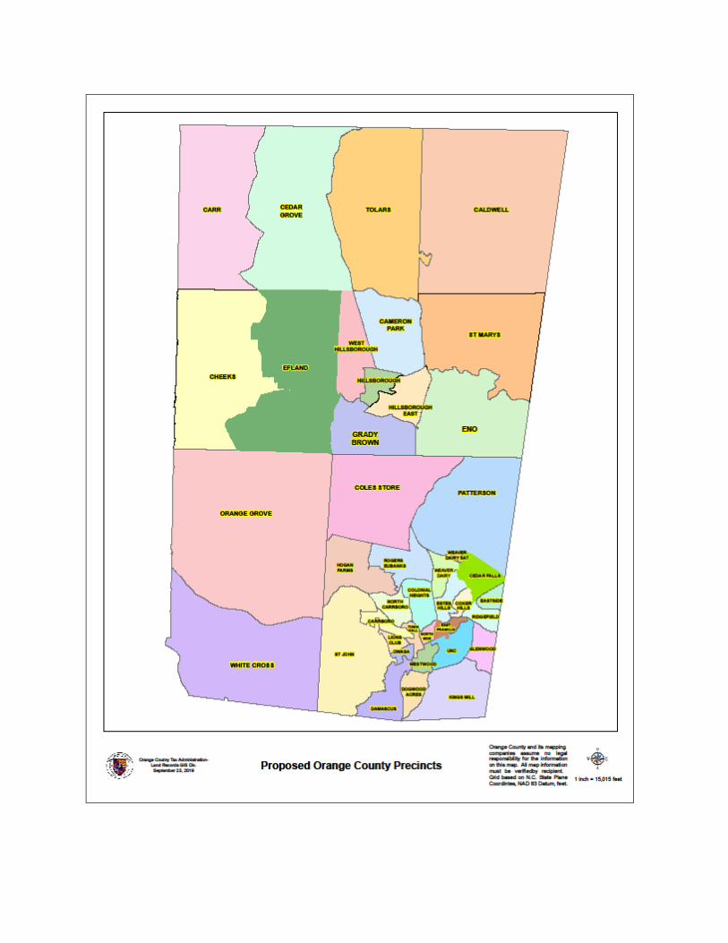
At a meeting of the Orange County Board of Elections on August 6, 2019, Rachel Boyce Raper, Director,
and Carlton McKee, GIS Specialist, presented the Board with staff recommendations for precinct
boundary alterations. Declining in-person, Election Day voter turnout due to an increased use of early
voting, coupled with persistent concerns found at several precincts provided the basis for staff to
recommend precinct mergers. Precincts recommended to be merged are Booker Creek and Cedar Falls;
East Franklin and Battle Park; Lincoln and Westwood; and County Club, Glenwood, and Mason Farms.
Staff also identified areas to create precincts to address growth due to booming development in the
Rogers Road and Eubanks area, the area east of Hillsborough, and the City of Mebane area.
The Board directed staff to solicit community feedback on the proposed precinct changes by sending the
proposals to the county party chairs, creating a public comment portal on the Orange County Board of
Elections webpage allowing public comment through noon on September 6, and holding a special
meeting allowing for in-person public comment.
A webpage went live to inform the public of the proposed precinct boundary alterations and accept online
public comment on August 9, 2019. The considerations, voter turnout data, satellite images of voting
locations, maps, and an online comment portal was provided for each proposed precinct alteration. Thirty-
eight comments were submitted through the online public comment portal. These comments are included
in this report.
On August 29, 2019, the Board of Elections hosted a public forum at elections headquarters. The Board
was present to accept public comment and staff was on hand to answer questions. Present to address the
Board were Gerry Cohen, Evelyn M. Poole-Kober, John B. Gaither, Alana Edwards, Felix Peng, Thomas
Ellis, Nick Battaile, Kala Mitchell, and Kenneth Woods. Many members of the audience also spoke and
asked questions during this meeting. The comments on the precinct boundary alterations were positive
with the exception of the recommendation to split the Cheeks precinct. Many of the speakers specifically
addressed the need to merge Country Club, Greenwood, and Mason Farm precincts to create a precinct
contiguous of UNC campus housing. Included in this report is a letter of support for the UNC precinct
from the University of North Carolina at Chapel Hill Undergraduate Student Government.
On September 9, 2019, the Orange County Board of Elections passed a resolution requesting precinct
boundary alterations based on staff input and feedback received from the community. The split of the
Cheeks precinct was not included in this proposal based on community feedback. Details of the requested
precinct alterations, public comments received via the public comment portal, a letter of support for the
UNC precinct, and ways we will notify affected voters are below.
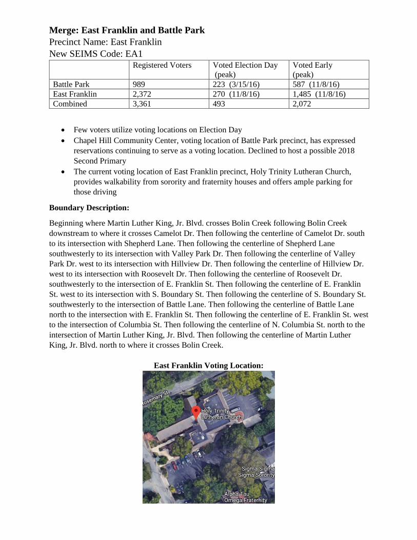
Merge: East Franklin and Battle Park
Precinct Name: East Franklin
New SEIMS Code: EA1
Registered Voters Voted Election Day
(peak)
Voted Early
(peak)
Battle Park 989 223 (3/15/16) 587 (11/8/16)
East Franklin 2,372 270 (11/8/16) 1,485 (11/8/16)
Combined 3,361 493 2,072
Few voters utilize voting locations on Election Day
Chapel Hill Community Center, voting location of Battle Park precinct, has expressed
reservations continuing to serve as a voting location. Declined to host a possible 2018
Second Primary
The current voting location of East Franklin precinct, Holy Trinity Lutheran Church,
provides walkability from sorority and fraternity houses and offers ample parking for
those driving
Boundary Description:
Beginning where Martin Luther King, Jr. Blvd. crosses Bolin Creek following Bolin Creek
downstream to where it crosses Camelot Dr. Then following the centerline of Camelot Dr. south
to its intersection with Shepherd Lane. Then following the centerline of Shepherd Lane
southwesterly to its intersection with Valley Park Dr. Then following the centerline of Valley
Park Dr. west to its intersection with Hillview Dr. Then following the centerline of Hillview Dr.
west to its intersection with Roosevelt Dr. Then following the centerline of Roosevelt Dr.
southwesterly to the intersection of E. Franklin St. Then following the centerline of E. Franklin
St. west to its intersection with S. Boundary St. Then following the centerline of S. Boundary St.
southwesterly to the intersection of Battle Lane. Then following the centerline of Battle Lane
north to the intersection with E. Franklin St. Then following the centerline of E. Franklin St. west
to the intersection of Columbia St. Then following the centerline of N. Columbia St. north to the
intersection of Martin Luther King, Jr. Blvd. Then following the centerline of Martin Luther
King, Jr. Blvd. north to where it crosses Bolin Creek.
East Franklin Voting Location:
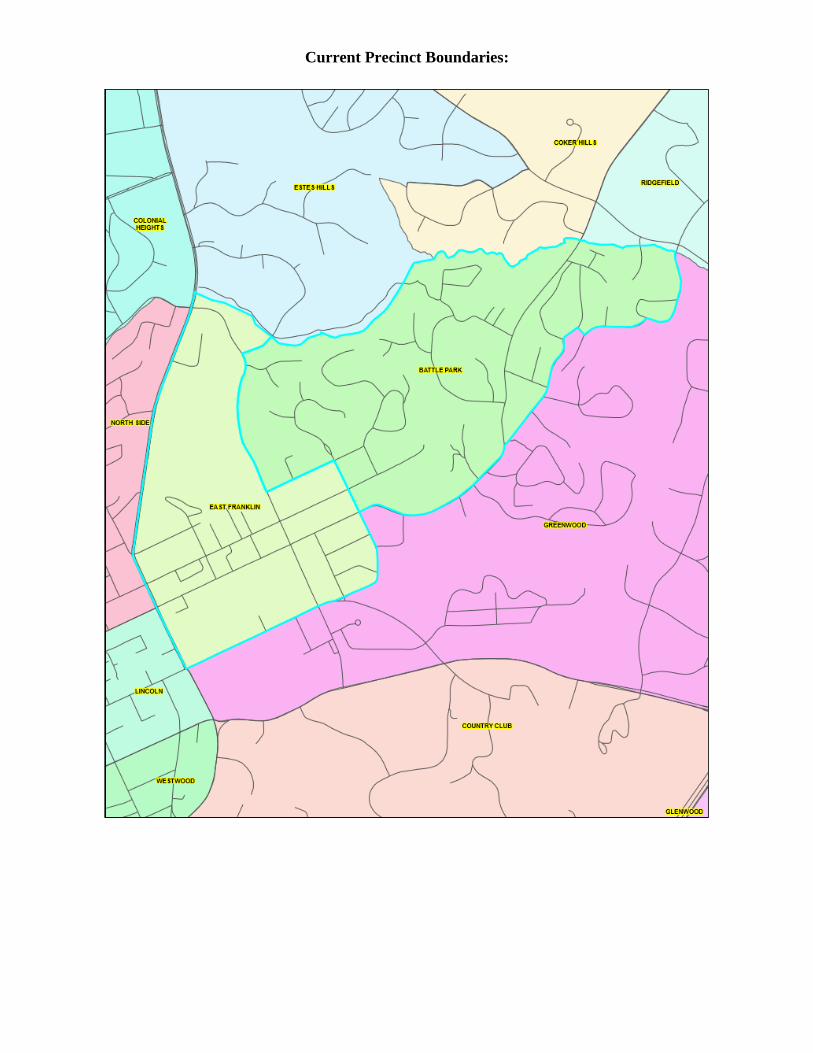
Current Precinct Boundaries:
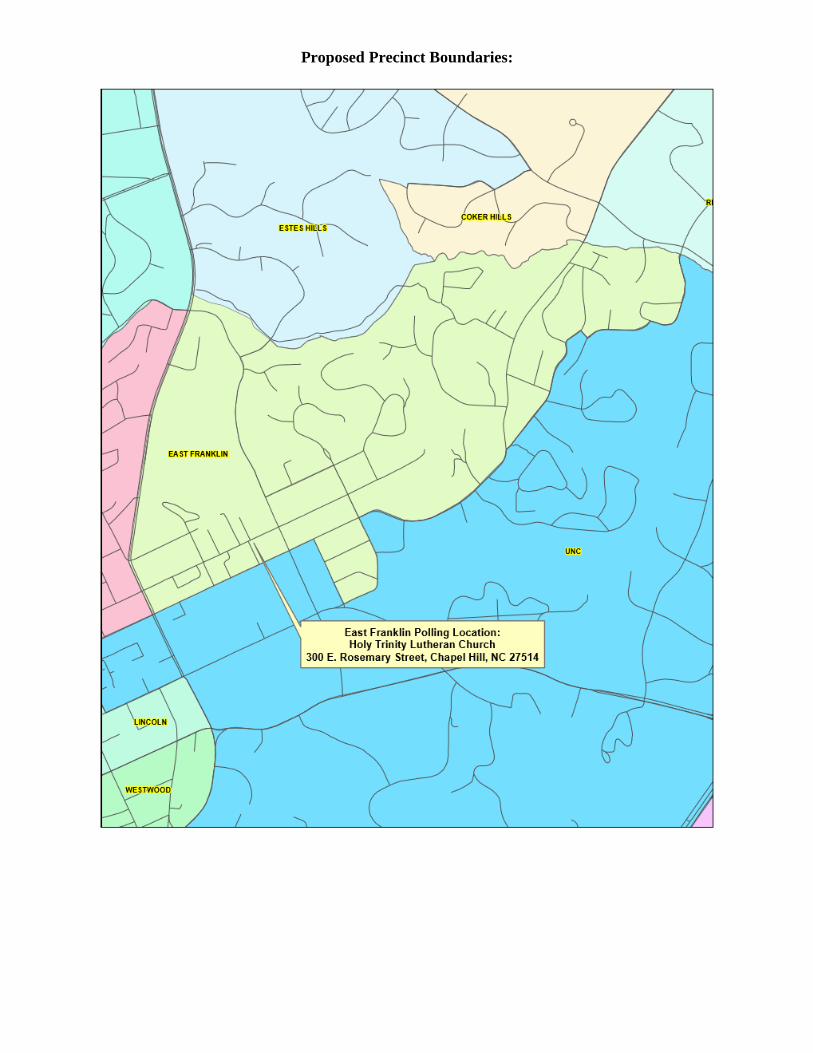
Proposed Precinct Boundaries:
Merge: Lincoln and Westwood
Precinct Name: Westwood
New SEIMS Code: WW1
Registered
Voters
Voted Election Day
(peak)
Voted Early
(peak)
Election Day
Transfers
Lincoln 1,746 325 (11/8/16) 1,360 (11/8/16) 47
Westwood 1,734 338 (3/15/16) 941 (11/8/16) 42
Combined 3,480 663 2,301 89
Few voters utilize voting locations on Election Day
The current voting location of Westwood precinct, Frank Porter Graham School, offers
ample parking
Complaints about parking at Lincoln precinct, the Lincoln General Administration
building, are persistent on Election Day
Both precincts have a high transfer rate, anecdotally between precincts
Boundary Description:
Beginning at the intersection of S. Merritt Mill Rd. and W. Franklin St. follow the centerline of
W. Franklin St. east to its intersection with Mallette St. Then following the centerline of Mallette
St. south to its intersection with W. Cameron Ave. Then following the centerline of W. Cameron
Ave. east to its intersection with S. Columbia St. Then following the centerline of S. Columba St.
south to its intersection with Culbreth Rd. Then following the centerline of Culbreth Rd. westerly
to its intersection with a census block boundary line that runs along the unnamed creek that flows
in a northerly direction between Westbury Dr. and University Commons into Morgan Creek.
Then following Morgan Creek upstream to its crossing with Smith Level Rd. Then following the
centerline of Smith Level Rd. north to its intersection with S. Merritt Mill Rd. Then following
the centerline of S. Merritt Mill Rd. easterly to a census block boundary that runs north and
northeasterly between 802 and 800 S. Merritt Mill Rd., the property lines of Public Storage and
Chapel Hill-Carrboro City Schools., along the Roberston Bike Path, then following the north
property lines of the residences along the north side of Knolls St. and Crest Dr. to S. Merritt Mill
Rd. Then following the centerline of S. Merritt Mill Rd. to its intersection with W. Franklin St.
Westwood Voting Location:
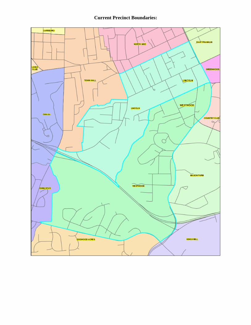
Current Precinct Boundaries:
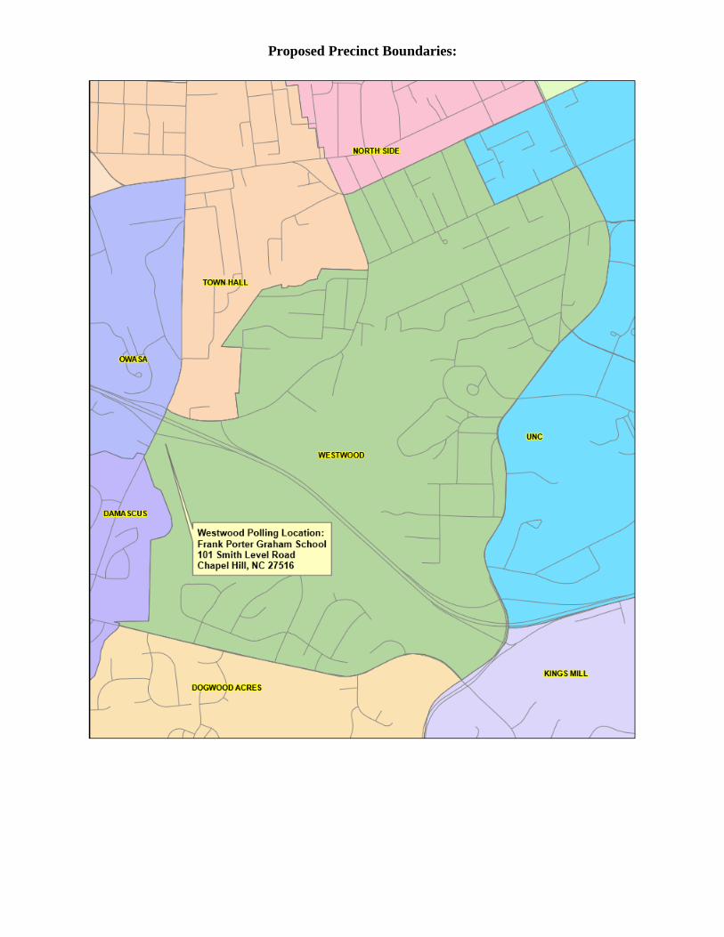
Proposed Precinct Boundaries:
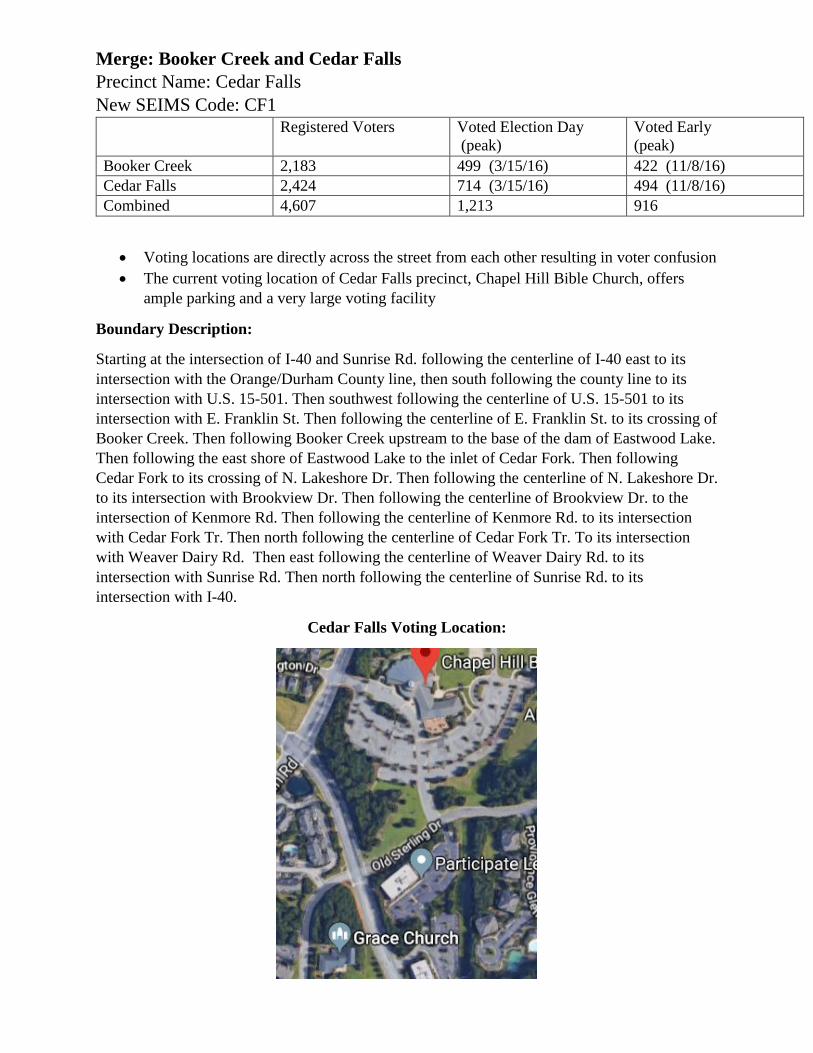
Merge: Booker Creek and Cedar Falls
Precinct Name: Cedar Falls
New SEIMS Code: CF1
Registered Voters Voted Election Day
(peak)
Voted Early
(peak)
Booker Creek 2,183 499 (3/15/16) 422 (11/8/16)
Cedar Falls 2,424 714 (3/15/16) 494 (11/8/16)
Combined 4,607 1,213 916
Voting locations are directly across the street from each other resulting in voter confusion
The current voting location of Cedar Falls precinct, Chapel Hill Bible Church, offers
ample parking and a very large voting facility
Boundary Description:
Starting at the intersection of I-40 and Sunrise Rd. following the centerline of I-40 east to its
intersection with the Orange/Durham County line, then south following the county line to its
intersection with U.S. 15-501. Then southwest following the centerline of U.S. 15-501 to its
intersection with E. Franklin St. Then following the centerline of E. Franklin St. to its crossing of
Booker Creek. Then following Booker Creek upstream to the base of the dam of Eastwood Lake.
Then following the east shore of Eastwood Lake to the inlet of Cedar Fork. Then following
Cedar Fork to its crossing of N. Lakeshore Dr. Then following the centerline of N. Lakeshore Dr.
to its intersection with Brookview Dr. Then following the centerline of Brookview Dr. to the
intersection of Kenmore Rd. Then following the centerline of Kenmore Rd. to its intersection
with Cedar Fork Tr. Then north following the centerline of Cedar Fork Tr. To its intersection
with Weaver Dairy Rd. Then east following the centerline of Weaver Dairy Rd. to its
intersection with Sunrise Rd. Then north following the centerline of Sunrise Rd. to its
intersection with I-40.
Cedar Falls Voting Location:
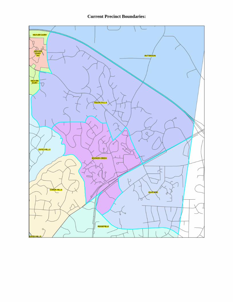
Current Precinct Boundaries:
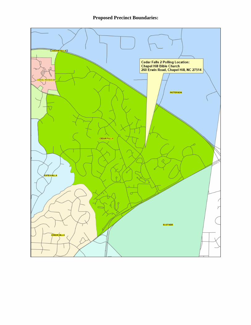
Proposed Precinct Boundaries:
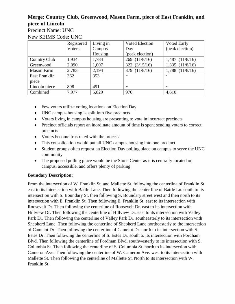
Merge: Country Club, Greenwood, Mason Farm, piece of East Franklin, and
piece of Lincoln
Precinct Name: UNC
New SEIMS Code: UNC
Registered
Voters
Living in
Campus
Housing
Voted Election
Day
(peak election)
Voted Early
(peak election)
Country Club 1,934 1,784 269 (11/8/16) 1,487 (11/8/16)
Greenwood 2,090 1,007 322 (3/15/16) 1,335 (11/8/16)
Mason Farm 2,783 2,194 379 (11/8/16) 1,788 (11/8/16)
East Franklin
piece
362 353 ~ ~
Lincoln piece 808 491 ~ ~
Combined 7,977 5,829 970 4,610
Few voters utilize voting locations on Election Day
UNC campus housing is split into five precincts
Voters living in campus housing are presenting to vote in incorrect precincts
Precinct officials report an inordinate amount of time is spent sending voters to correct
precincts
Voters become frustrated with the process
This consolidation would put all UNC campus housing into one precinct
Student groups often request an Election Day polling place on campus to serve the UNC
community
The proposed polling place would be the Stone Center as it is centrally located on
campus, accessible, and offers plenty of parking
Boundary Description:
From the intersection of W. Franklin St. and Mallette St. following the centerline of Franklin St.
east to its intersection with Battle Lane. Then following the center line of Battle Ln. south to its
intersection with S. Boundary St. then following S. Boundary street west and then north to its
intersection with E. Franklin St. Then following E. Franklin St. east to its intersection with
Roosevelt Dr. Then following the centerline of Roosevelt Dr. east to its intersection with
Hillview Dr. Then following the centerline of Hillview Dr. east to its intersection with Valley
Park Dr. Then following the centerline of Valley Park Dr. southeasterly to its intersection with
Shepherd Lane. Then following the centerline of Shepherd Lane northeasterly to the intersection
of Camelot Dr. Then following the centerline of Camelot Dr. north to its intersection with S.
Estes Dr. Then following the centerline of S. Estes Dr. south to its intersection with Fordham
Blvd. Then following the centerline of Fordham Blvd. southwesterly to its intersection with S.
Columbia St. Then following the centerline of S. Columbia St. north to its intersection with
Cameron Ave. Then following the centerline of W. Cameron Ave. west to its intersection with
Mallette St. Then following the centerline of Mallette St. North to its intersection with W.
Franklin St.
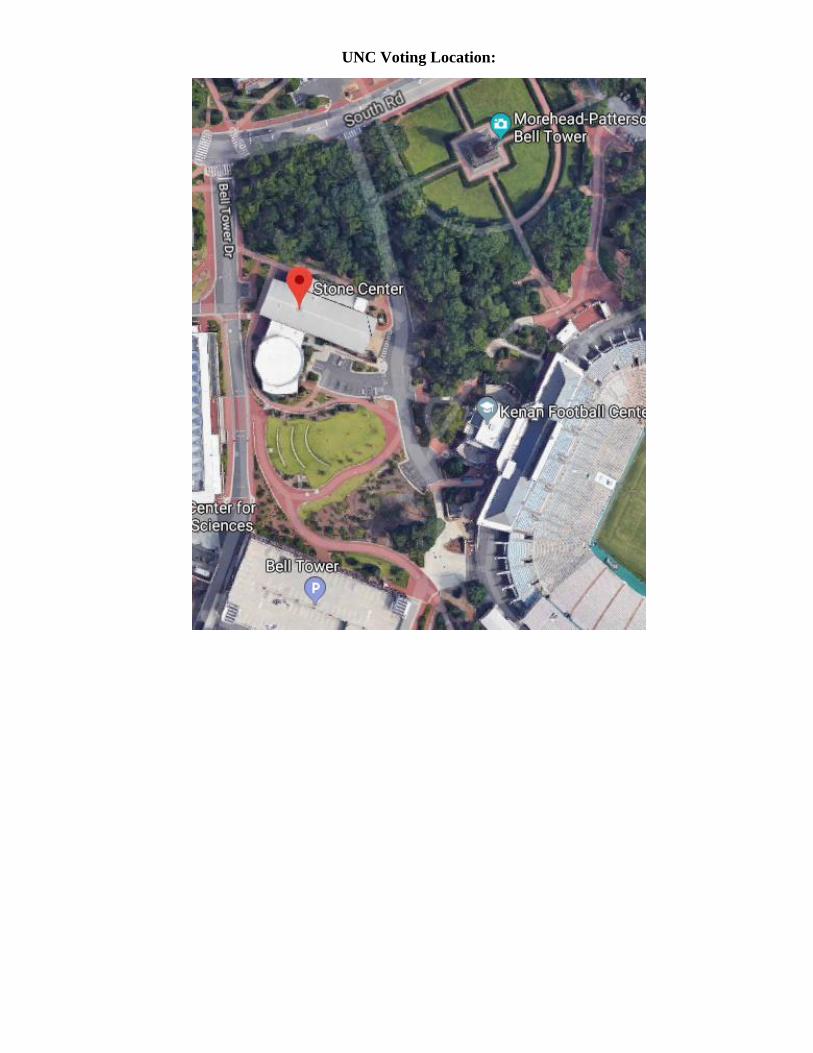
UNC Voting Location:
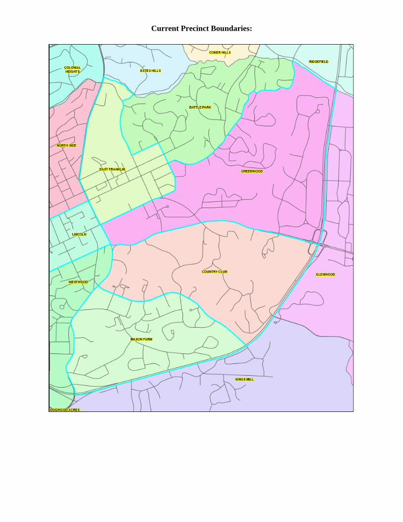
Current Precinct Boundaries:
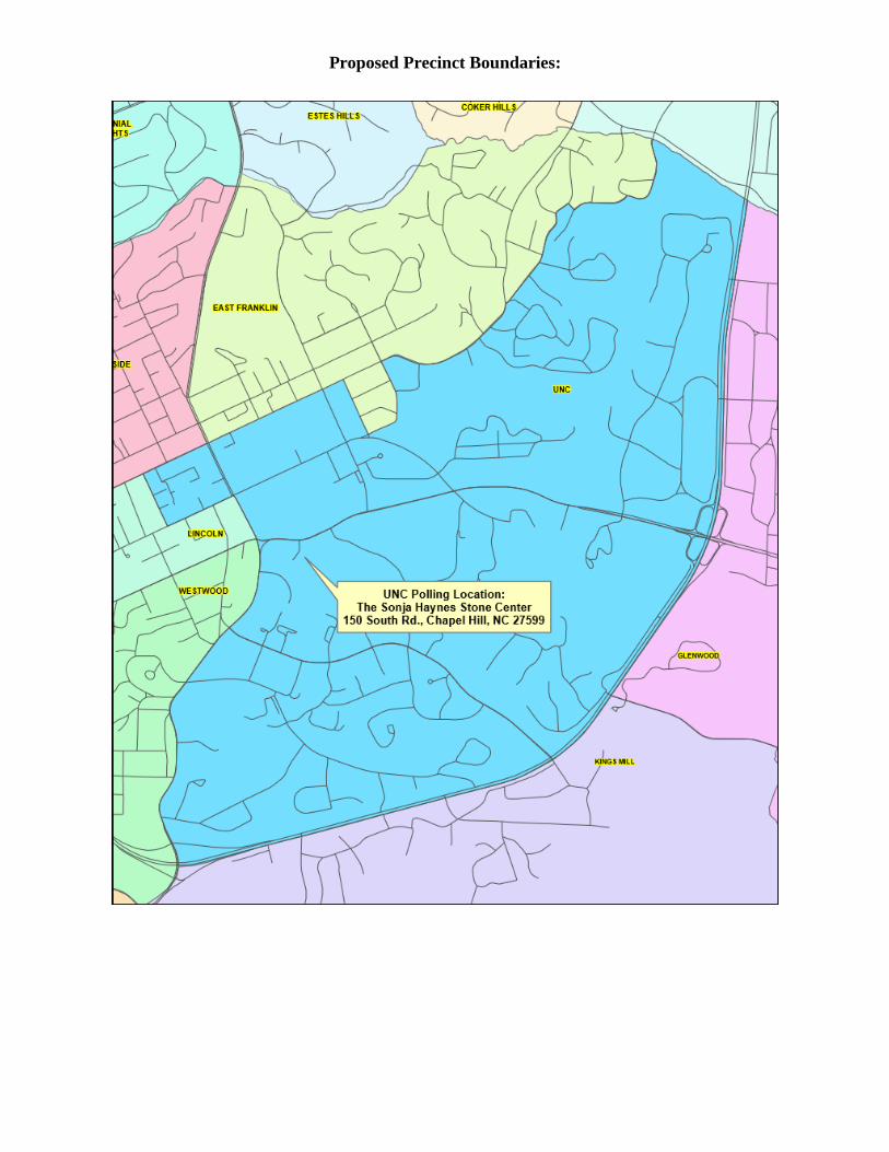
Proposed Precinct Boundaries:
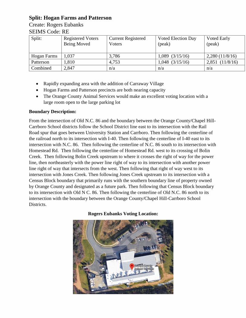
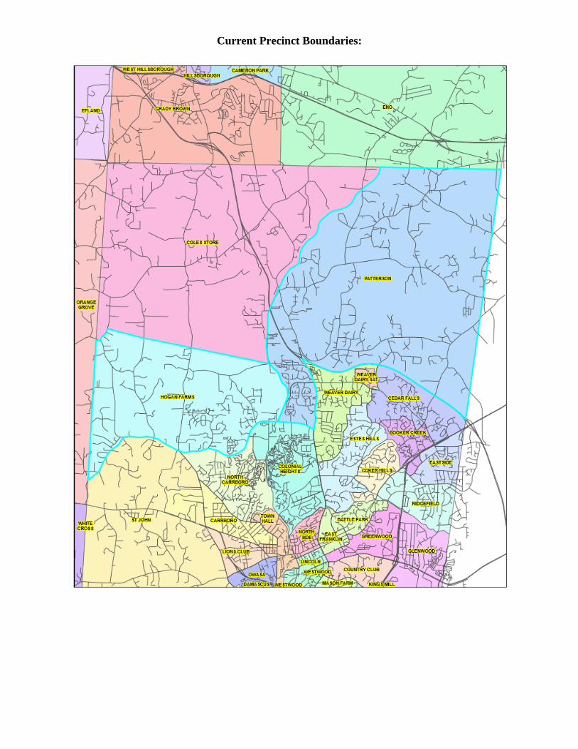
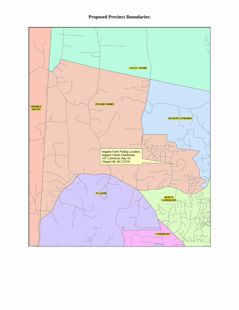
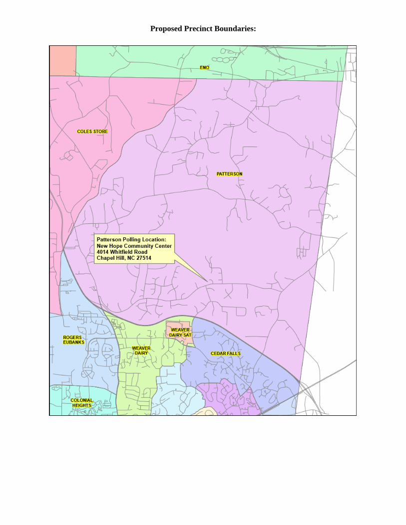
Split: Hogan Farms and Patterson
Create: Rogers Eubanks
SEIMS Code: RE
Split: Registered Voters
Being Moved
Current Registered
Voters
Voted Election Day
(peak)
Voted Early
(peak)
Hogan Farms 1,037 3,786 1,089 (3/15/16) 2,280 (11/8/16)
Patterson 1,810 4,753 1,048 (3/15/16) 2,851 (11/8/16)
Combined 2,847 n/a n/a n/a
Rapidly expanding area with the addition of Carraway Village
Hogan Farms and Patterson precincts are both nearing capacity
The Orange County Animal Services would make an excellent voting location with a
large room open to the large parking lot
Boundary Description:
From the intersection of Old N.C. 86 and the boundary between the Orange County/Chapel Hill-
Carrboro School districts follow the School District line east to its intersection with the Rail
Road spur that goes between University Station and Carrboro. Then following the centerline of
the railroad north to its intersection with I-40. Then following the centerline of I-40 east to its
intersection with N.C. 86. Then following the centerline of N.C. 86 south to its intersection with
Homestead Rd. Then following the centerline of Homestead Rd. west to its crossing of Bolin
Creek. Then following Bolin Creek upstream to where it crosses the right of way for the power
line, then northeasterly with the power line right of way to its intersection with another power
line right of way that intersects from the west. Then following that right of way west to its
intersection with Jones Creek. Then following Jones Creek upstream to its intersection with a
Census Block boundary that primarily runs with the southern boundary line of property owned
by Orange County and designated as a future park. Then following that Census Block boundary
to its intersection with Old N C. 86. Then following the centerline of Old N.C. 86 north to its
intersection with the boundary between the Orange County/Chapel Hill-Carrboro School
Districts.
Rogers Eubanks Voting Location:
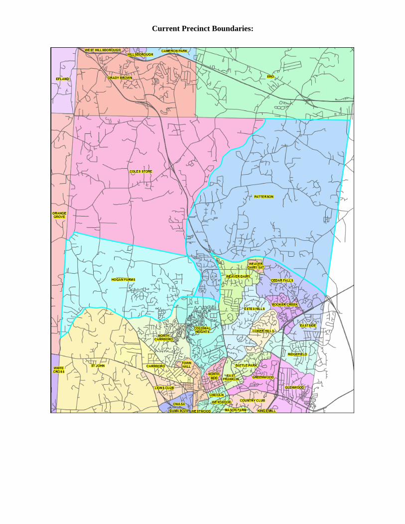
Current Precinct Boundaries:
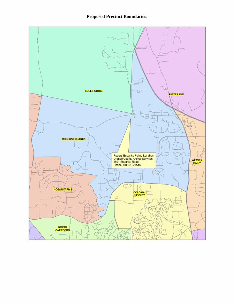
Proposed Precinct Boundaries:
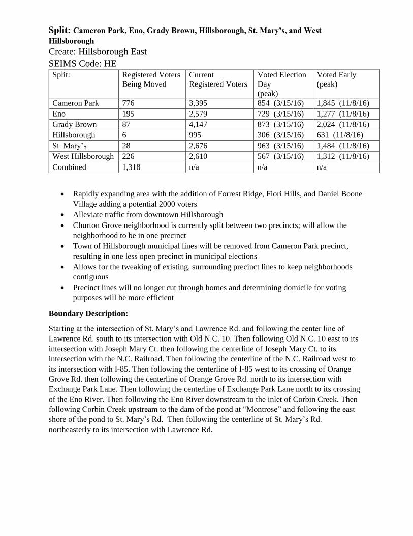
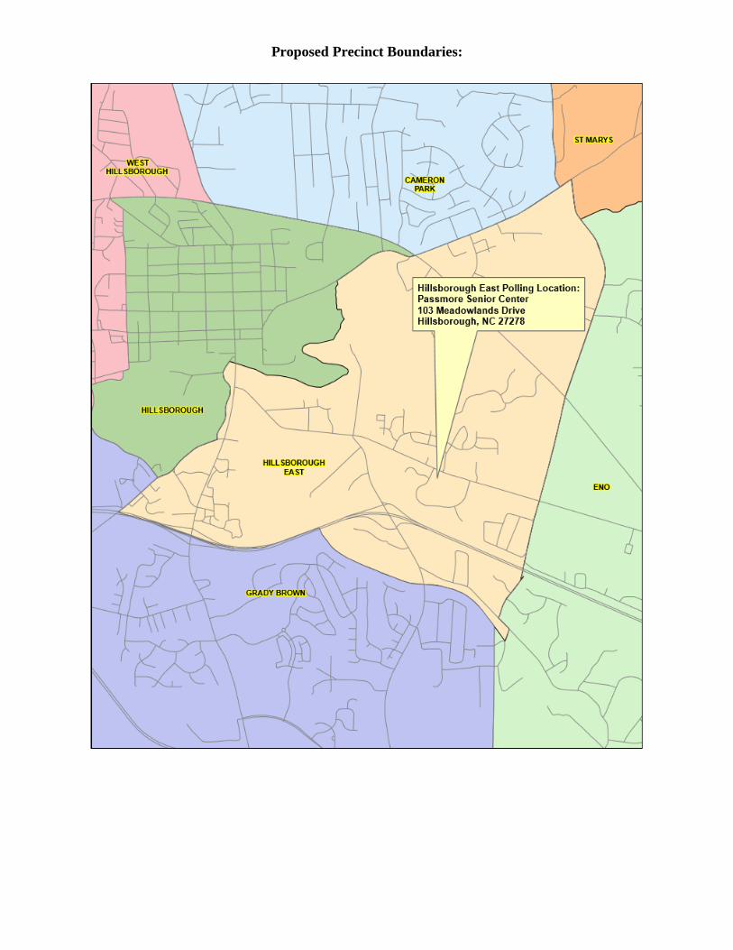
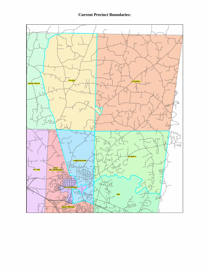
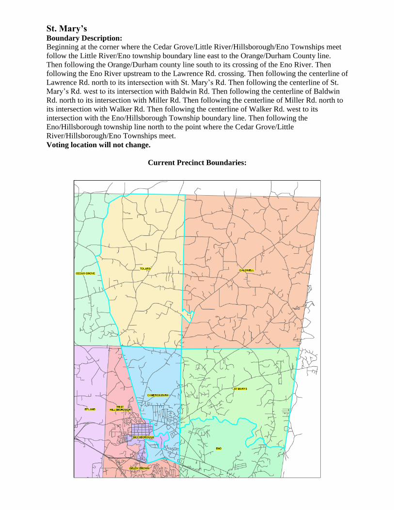
Split: Cameron Park, Eno, Grady Brown, Hillsborough, St. Mary’s, and West
Hillsborough
Create: Hillsborough East
SEIMS Code: HE
Split: Registered Voters
Being Moved
Current
Registered Voters
Voted Election
Day
(peak)
Voted Early
(peak)
Cameron Park 776 3,395 854 (3/15/16) 1,845 (11/8/16)
Eno 195 2,579 729 (3/15/16) 1,277 (11/8/16)
Grady Brown 87 4,147 873 (3/15/16) 2,024 (11/8/16)
Hillsborough 6 995 306 (3/15/16) 631 (11/8/16)
St. Mary’s 28 2,676 963 (3/15/16) 1,484 (11/8/16)
West Hillsborough 226 2,610 567 (3/15/16) 1,312 (11/8/16)
Combined 1,318 n/a n/a n/a
Rapidly expanding area with the addition of Forrest Ridge, Fiori Hills, and Daniel Boone
Village adding a potential 2000 voters
Alleviate traffic from downtown Hillsborough
Churton Grove neighborhood is currently split between two precincts; will allow the
neighborhood to be in one precinct
Town of Hillsborough municipal lines will be removed from Cameron Park precinct,
resulting in one less open precinct in municipal elections
Allows for the tweaking of existing, surrounding precinct lines to keep neighborhoods
contiguous
Precinct lines will no longer cut through homes and determining domicile for voting
purposes will be more efficient
Boundary Description:
Starting at the intersection of St. Mary’s and Lawrence Rd. and following the center line of
Lawrence Rd. south to its intersection with Old N.C. 10. Then following Old N.C. 10 east to its
intersection with Joseph Mary Ct. then following the centerline of Joseph Mary Ct. to its
intersection with the N.C. Railroad. Then following the centerline of the N.C. Railroad west to
its intersection with I-85. Then following the centerline of I-85 west to its crossing of Orange
Grove Rd. then following the centerline of Orange Grove Rd. north to its intersection with
Exchange Park Lane. Then following the centerline of Exchange Park Lane north to its crossing
of the Eno River. Then following the Eno River downstream to the inlet of Corbin Creek. Then
following Corbin Creek upstream to the dam of the pond at “Montrose” and following the east
shore of the pond to St. Mary’s Rd. Then following the centerline of St. Mary’s Rd.
northeasterly to its intersection with Lawrence Rd.
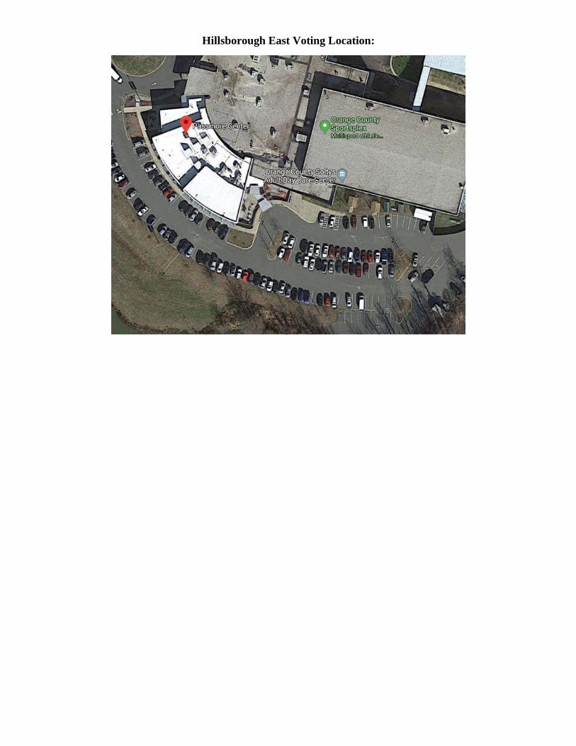
Hillsborough East Voting Location:
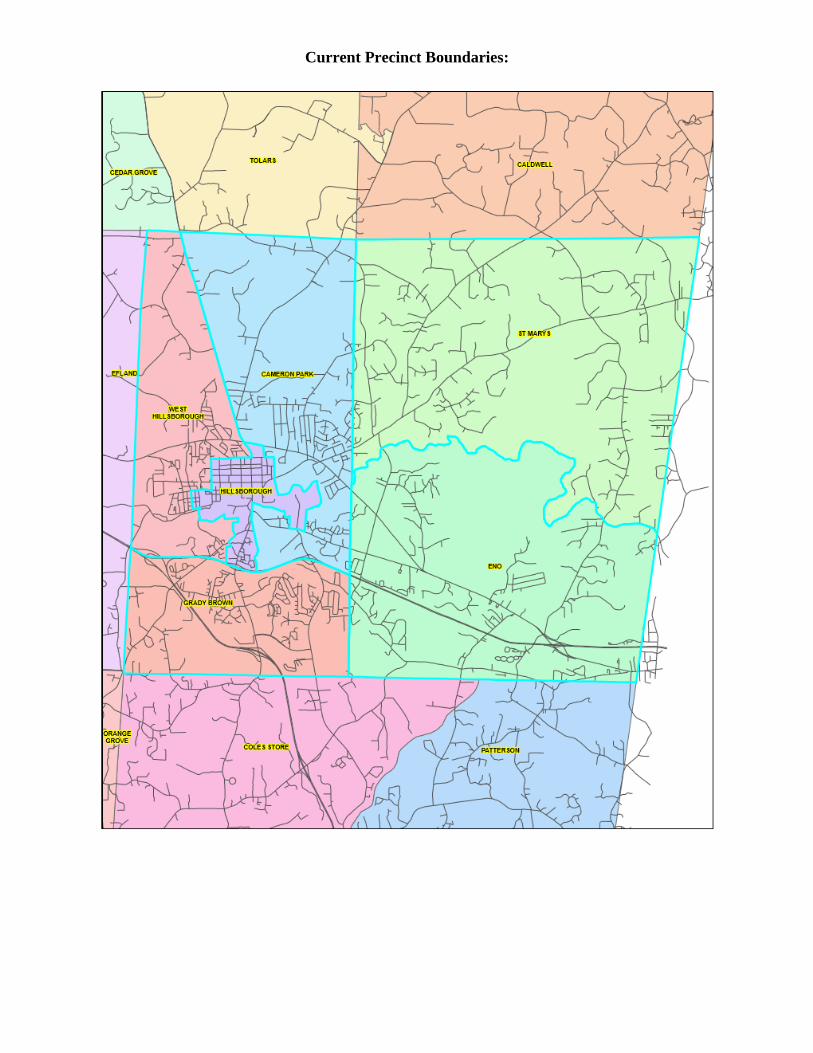
Current Precinct Boundaries:
Proposed Precinct Boundaries:
Other Proposed Precinct Boundary Alterations:
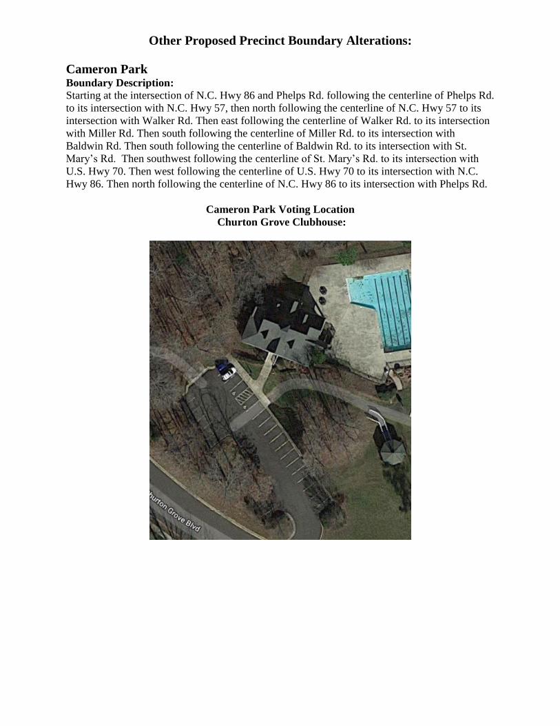
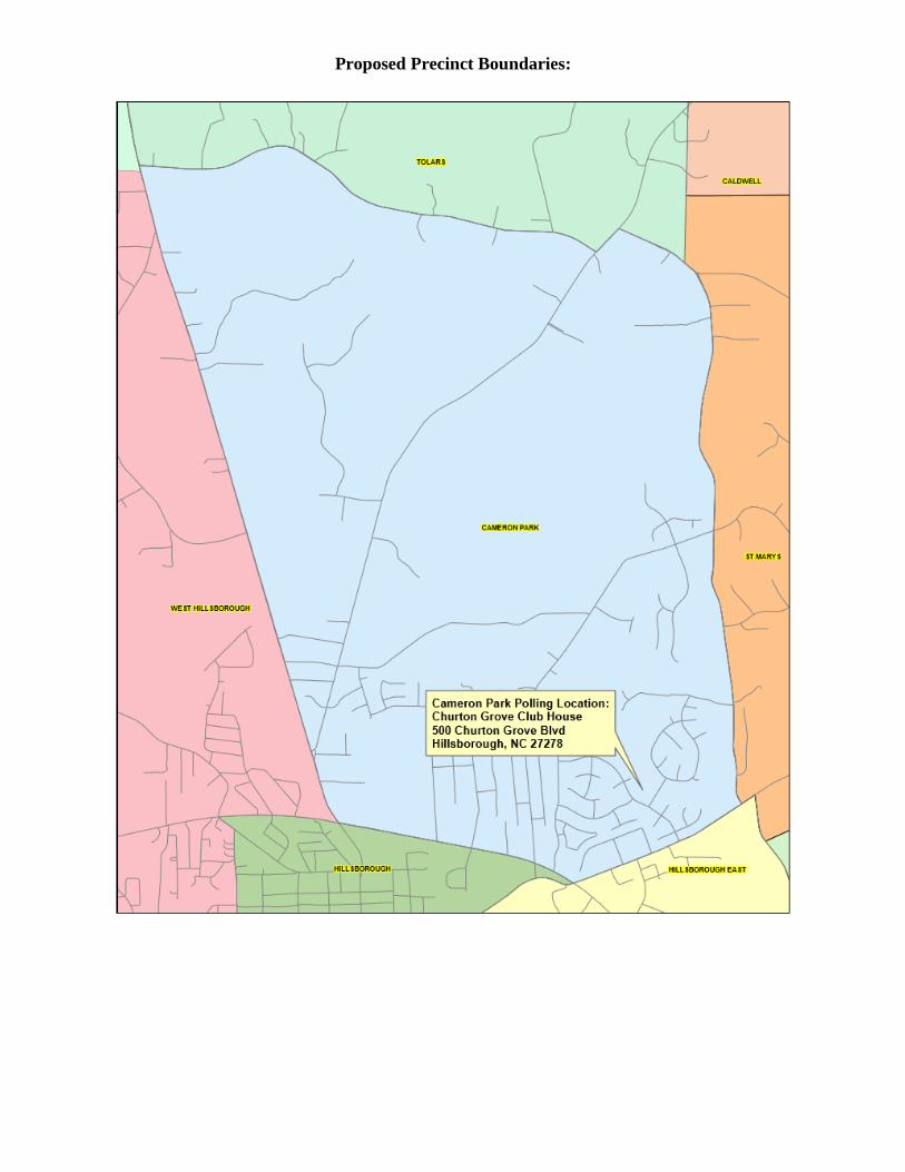
Cameron Park Boundary Description:
Starting at the intersection of N.C. Hwy 86 and Phelps Rd. following the centerline of Phelps Rd.
to its intersection with N.C. Hwy 57, then north following the centerline of N.C. Hwy 57 to its
intersection with Walker Rd. Then east following the centerline of Walker Rd. to its intersection
with Miller Rd. Then south following the centerline of Miller Rd. to its intersection with
Baldwin Rd. Then south following the centerline of Baldwin Rd. to its intersection with St.
Mary’s Rd. Then southwest following the centerline of St. Mary’s Rd. to its intersection with
U.S. Hwy 70. Then west following the centerline of U.S. Hwy 70 to its intersection with N.C.
Hwy 86. Then north following the centerline of N.C. Hwy 86 to its intersection with Phelps Rd.
Cameron Park Voting Location
Churton Grove Clubhouse:
Current Precinct Boundaries:
Proposed Precinct Boundaries:
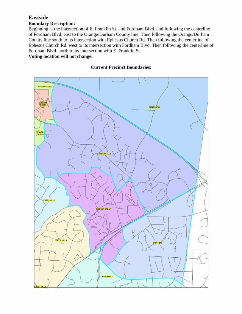
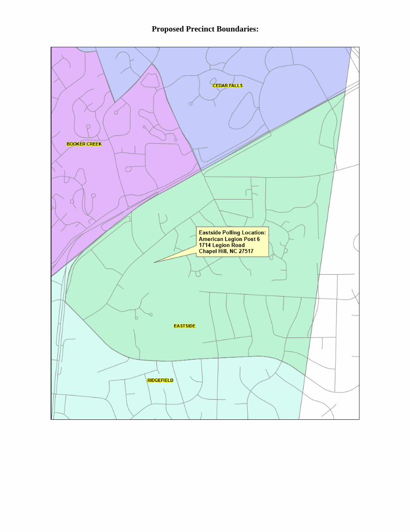
Eastside Boundary Description: Beginning at the intersection of E. Franklin St. and Fordham Blvd. and following the centerline
of Fordham Blvd. east to the Orange/Durham County line. Then following the Orange/Durham
County line south to its intersection with Ephesus Church Rd. Then following the centerline of
Ephesus Church Rd. west to its intersection with Fordham Blvd. Then following the centerline of
Fordham Blvd. north to its intersection with E. Franklin St.
Voting location will not change.
Current Precinct Boundaries:
Proposed Precinct Boundaries:
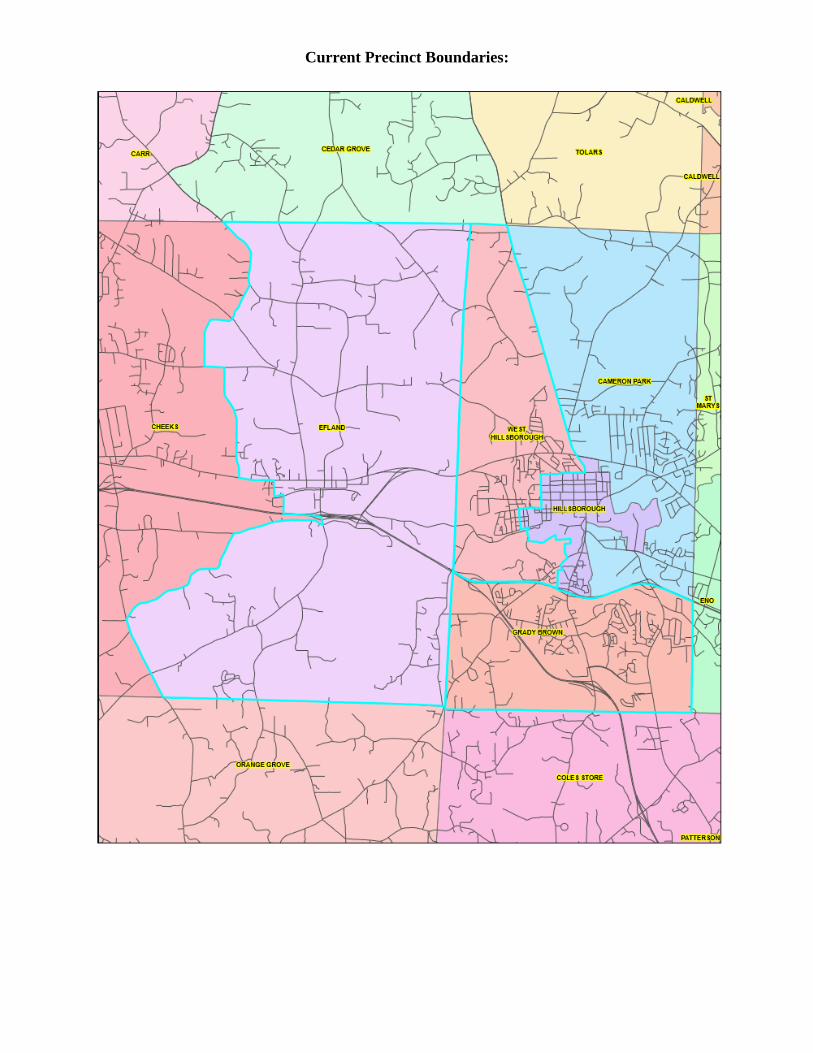
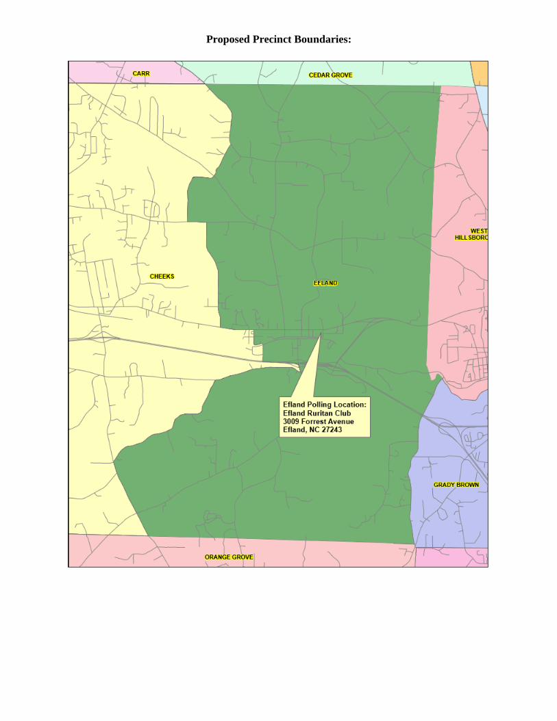
Efland Boundary Description:
Beginning at the intersection of Harmony Church Rd. and the Cheeks/Cedar Grove Township
boundary line follow the boundary line east to its intersection with the Cheeks/Hillsborough
Township boundary line. Then follow the Cheeks/Hillsborough Township line south to its
intersection with the Eno River. Then following the Eno River downstream (and through Ben
Johnston Lake) to its crossing of Dimmocks Mill Rd. Then following the centerline of
Dimmocks Mill Rd. south to its intersection with the Cheeks/Bingham Township boundary line.
Then following the Cheeks/Bingham Township line west to its intersection with Buckhorn Rd.
Then following the centerline of Buckhorn Rd. north to its intersection with Bushy Cook Rd.
Then following the centerline of Bushy Cook Rd. northeasterly to its intersection with West Ten
Rd. Then following the centerline of West Ten Rd. east to its intersection with Mt. Willing Rd.
Then following the centerline of Mt. Willing Rd. north to its intersection with I-40/85. Then
following the centerline of I-40/85 west to the intersection of its right of way with the southern
terminus of Gaines Chapel Rd. Then following the centerline of Gaines Chapel Rd. north to its
intersection with U. S. Hwy. 70. Then following the centerline of U. S. 70 west to its intersection
with Richmond Rd. Then following the centerline of Richmond Rd. north to its intersection with
Lebanon Rd. Then following the centerline of Lebanon Rd. west to its intersection with Ira Rd.
Then following the centerline of Ira Rd. north to its intersection with Harmony Church Rd. Then
following the centerline of Harmony Church Rd. north to its intersection with the Cheeks/Cedar
Grove Township boundary line.
Voting location will not change.
Current Precinct Boundaries:
Proposed Precinct Boundaries:
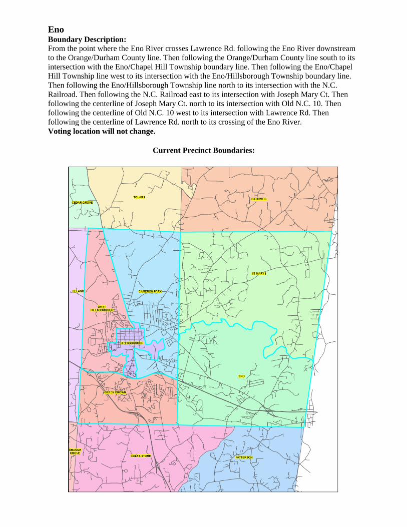
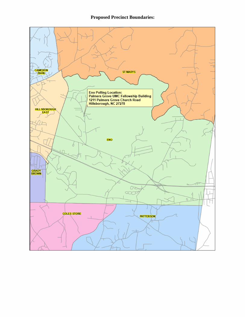
Eno Boundary Description: From the point where the Eno River crosses Lawrence Rd. following the Eno River downstream
to the Orange/Durham County line. Then following the Orange/Durham County line south to its
intersection with the Eno/Chapel Hill Township boundary line. Then following the Eno/Chapel
Hill Township line west to its intersection with the Eno/Hillsborough Township boundary line.
Then following the Eno/Hillsborough Township line north to its intersection with the N.C.
Railroad. Then following the N.C. Railroad east to its intersection with Joseph Mary Ct. Then
following the centerline of Joseph Mary Ct. north to its intersection with Old N.C. 10. Then
following the centerline of Old N.C. 10 west to its intersection with Lawrence Rd. Then
following the centerline of Lawrence Rd. north to its crossing of the Eno River.
Voting location will not change.
Current Precinct Boundaries:
Proposed Precinct Boundaries:
Grady Brown Boundary Description:
Beginning at the crossing of Dimmocks Mill Rd. and the Eno River follow the Eno River
downstream to its crossing with Eno Mountain Rd. The following the center line of Eno
Mountain Rd. east to its intersection with Orange Grove Rd. Then following the centerline of
Orange Grove Rd south to its intersection with I-85. Then following the centerline of I-85 north
to its crossing of the N. C. Rail Road. Then following the N. C. Rail Road east to its intersection
with the Hillsborough/Eno Township boundary line. Then following the Hillsborough/Eno
Township line south to its intersection with the Hillsborough/Chapel Hill Township line. Then
following the Hillsborough/Chapel Hill Township line west to its intersection with the road
intersection of Orange Gove Rd. and Dimmocks Mill Rd. Then following the centerline of
Dimmocks Mill Rd. north to its crossing of the Eno River.
Voting location will not change.
Current Precinct Boundaries:
Proposed Precinct Boundaries:
Hillsborough Boundary Description:
Beginning at the intersection of Revere Rd. and U.S. 70, following the centerline of U.S. 70 east
to its intersection with St. Mary’s Rd. Then following the centerline of St. Mary’s Rd. west to
where it crosses Corbin Creek just upstream from the “Montrose” pond. Then following Corbin
Creek south (around the east side of “Montrose” pond) to its outlet into the Eno River. Then
following the Eno River upstream to its crossing by Exchange Park Lane. Then following the
centerline of Exchange Park Lane south to its intersection with Orange Grove Rd. Then
following the centerline of Orange Grove Rd. south to its intersection with Eno Mtn. Rd. Then
following the centerline of Eno Mtn. Rd. northwesterly to its intersection with Dimmocks Mill
Rd. Then following the centerline of Dimmocks Mill Rd. east to its intersection with Eno
St. Then following the centerline of Eno St. east to its intersection with S. Nash St. Then
following the centerline of Nash St. north to its intersection with Revere Rd. Then following the
centerline of Revere Rd. northwesterly to U.S. 70.
Current Precinct Boundaries:
Proposed Precinct Boundaries:
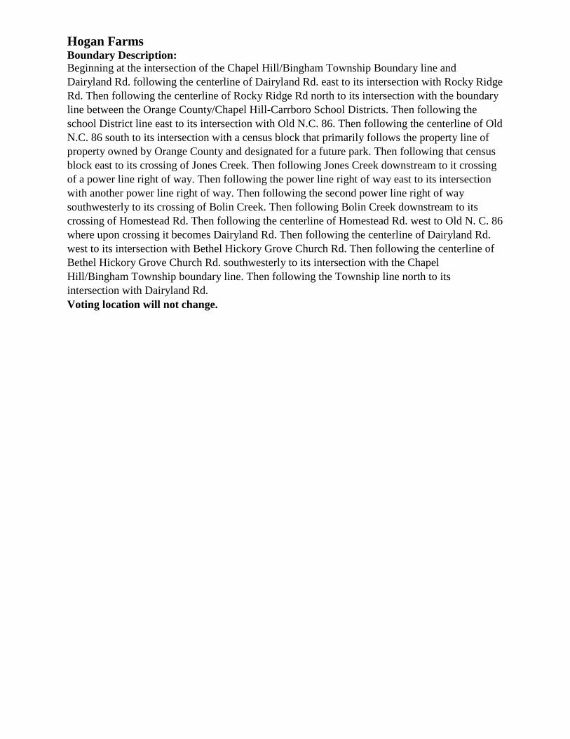
Hogan Farms Boundary Description:
Beginning at the intersection of the Chapel Hill/Bingham Township Boundary line and
Dairyland Rd. following the centerline of Dairyland Rd. east to its intersection with Rocky Ridge
Rd. Then following the centerline of Rocky Ridge Rd north to its intersection with the boundary
line between the Orange County/Chapel Hill-Carrboro School Districts. Then following the
school District line east to its intersection with Old N.C. 86. Then following the centerline of Old
N.C. 86 south to its intersection with a census block that primarily follows the property line of
property owned by Orange County and designated for a future park. Then following that census
block east to its crossing of Jones Creek. Then following Jones Creek downstream to it crossing
of a power line right of way. Then following the power line right of way east to its intersection
with another power line right of way. Then following the second power line right of way
southwesterly to its crossing of Bolin Creek. Then following Bolin Creek downstream to its
crossing of Homestead Rd. Then following the centerline of Homestead Rd. west to Old N. C. 86
where upon crossing it becomes Dairyland Rd. Then following the centerline of Dairyland Rd.
west to its intersection with Bethel Hickory Grove Church Rd. Then following the centerline of
Bethel Hickory Grove Church Rd. southwesterly to its intersection with the Chapel
Hill/Bingham Township boundary line. Then following the Township line north to its
intersection with Dairyland Rd.
Voting location will not change.
Current Precinct Boundaries:
Proposed Precinct Boundaries:
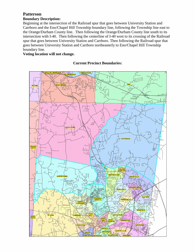
Patterson Boundary Description:
Beginning at the intersection of the Railroad spur that goes between University Station and
Carrboro and the Eno/Chapel Hill Township boundary line, following the Township line east to
the Orange/Durham County line. Then following the Orange/Durham County line south to its
intersection with I-40. Then following the centerline of I-40 west to its crossing of the Railroad
spur that goes between University Station and Carrboro. Then following the Railroad spur that
goes between University Station and Carrboro northeasterly to Eno/Chapel Hill Township
boundary line.
Voting location will not change.
Current Precinct Boundaries:
Proposed Precinct Boundaries:
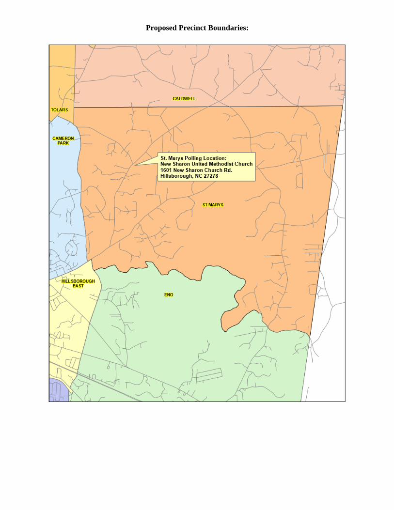
St. Mary’s Boundary Description: Beginning at the corner where the Cedar Grove/Little River/Hillsborough/Eno Townships meet
follow the Little River/Eno township boundary line east to the Orange/Durham County line.
Then following the Orange/Durham county line south to its crossing of the Eno River. Then
following the Eno River upstream to the Lawrence Rd. crossing. Then following the centerline of
Lawrence Rd. north to its intersection with St. Mary’s Rd. Then following the centerline of St.
Mary’s Rd. west to its intersection with Baldwin Rd. Then following the centerline of Baldwin
Rd. north to its intersection with Miller Rd. Then following the centerline of Miller Rd. north to
its intersection with Walker Rd. Then following the centerline of Walker Rd. west to its
intersection with the Eno/Hillsborough Township boundary line. Then following the
Eno/Hillsborough township line north to the point where the Cedar Grove/Little
River/Hillsborough/Eno Townships meet.
Voting location will not change.
Current Precinct Boundaries:
Proposed Precinct Boundaries:
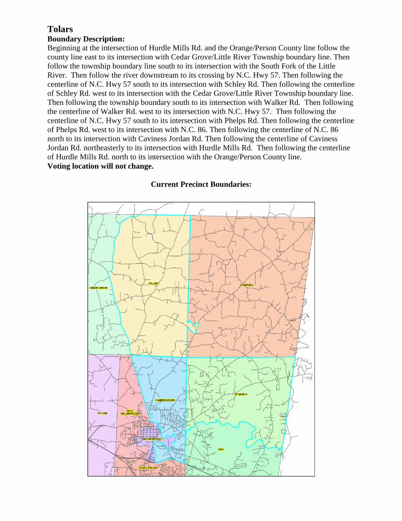
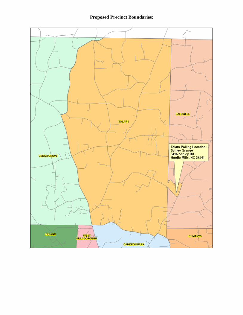
Tolars Boundary Description:
Beginning at the intersection of Hurdle Mills Rd. and the Orange/Person County line follow the
county line east to its intersection with Cedar Grove/Little River Township boundary line. Then
follow the township boundary line south to its intersection with the South Fork of the Little
River. Then follow the river downstream to its crossing by N.C. Hwy 57. Then following the
centerline of N.C. Hwy 57 south to its intersection with Schley Rd. Then following the centerline
of Schley Rd. west to its intersection with the Cedar Grove/Little River Township boundary line.
Then following the township boundary south to its intersection with Walker Rd. Then following
the centerline of Walker Rd. west to its intersection with N.C. Hwy 57. Then following the
centerline of N.C. Hwy 57 south to its intersection with Phelps Rd. Then following the centerline
of Phelps Rd. west to its intersection with N.C. 86. Then following the centerline of N.C. 86
north to its intersection with Caviness Jordan Rd. Then following the centerline of Caviness
Jordan Rd. northeasterly to its intersection with Hurdle Mills Rd. Then following the centerline
of Hurdle Mills Rd. north to its intersection with the Orange/Person County line.
Voting location will not change.
Current Precinct Boundaries:
Proposed Precinct Boundaries:
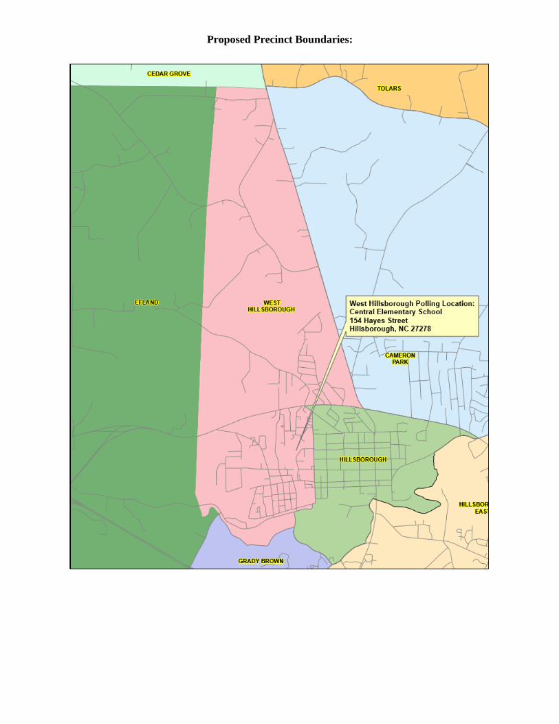
West Hillsborough Boundary Description: From the point where the Hillsborough/Cheeks Township boundary line meets the
Hillsborough/Cedar Grove Township boundary line follow the Hillsborough/Cedar Grove line
east to its intersection with N.C. Hwy 86. Then following the centerline of N.C. Hwy 86 south to
its intersection with U.S. Hwy 70. Then following the centerline of U.S. 70 west to its
intersection with Revere Rd. Then following the centerline of Revere Rd. southeast to its
intersection with Nash St. Then following the centerline of Nash St. south to its intersection with
Eno St. Then following the centerline of Eno St. west to its intersection with Dimmocks Mill Rd.
Then following the centerline of Dimmocks Mill Rd. west to its intersection with Allison St.
Then following the centerline of Allison St. south to its crossing of the Eno River. Then
following the Eno River upstream to its intersection with the Hillsborough/Cheeks Township
boundary line. Then following the Hillsborough/Cheeks Township line north to the point where
it meets the Hillsborough/Cedar Grove Township boundary line.
Voting location will not change.
Current Precinct Boundaries:
Proposed Precinct Boundaries:
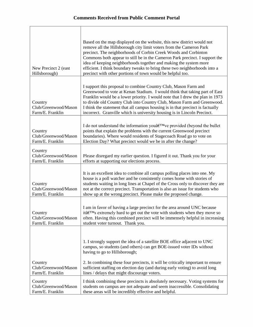
Comments Received from Public Comment Portal
New Precinct 2 (east
Hillsborough)
Based on the map displayed on the website, this new district would not
remove all the Hillsborough city limit voters from the Cameron Park
precinct. The neighborhoods of Corbin Creek Woods and Corbinton
Commons both appear to still be in the Cameron Park precinct. I support the
idea of keeping neighborhoods together and making the system more
efficient. I think boundary tweaks to bring these two neighborhoods into a
precinct with other portions of town would be helpful too.
Country
Club/Greenwood/Mason
Farm/E. Franklin
I support this proposal to combine Country Club, Mason Farm and
Greenwood to vote at Kenan Stadium. I would think that taking part of East
Franklin would be a lower priority. I would note that I drew the plan in 1973
to divide old Country Club into Country Club, Mason Farm and Greenwood.
I think the statement that all campus housing is in that precinct is factually
incorrect. Granville which is university housing is in Lincoln Precinct.
Country
Club/Greenwood/Mason
Farm/E. Franklin
I do not understand the information you’ve provided (beyond the bullet
points that explain the problems with the current Greenwood precinct
boundaries). Where would residents of Stagecoach Road go to vote on
Election Day? What precinct would we be in after the change?
Country
Club/Greenwood/Mason
Farm/E. Franklin
Please disregard my earlier question. I figured it out. Thank you for your
efforts at supporting our elections process.
Country
Club/Greenwood/Mason
Farm/E. Franklin
It is an excellent idea to combine all campus polling places into one. My
house is a poll watcher and he consistently comes home with stories of
students waiting in long lines at Chapel of the Cross only to discover they are
not at the correct precinct. Transportation is also an issue for students who
show up at the wrong precinct. Please make the proposed change.
Country
Club/Greenwood/Mason
Farm/E. Franklin
I am in favor of having a large precinct for the area around UNC because
it’s extremely hard to get out the vote with students when they move so
often. Having this combined precinct will be immensely helpful in increasing
student voter turnout. Thank you.
Country
Club/Greenwood/Mason
Farm/E. Franklin
1. I strongly support the idea of a satellite BOE office adjacent to UNC
campus, so students (and others) can get BOE-issued voter IDs without
having to go to Hillsborough;
2. In combining these four precincts, it will be critically important to ensure
sufficient staffing on election day (and during early voting) to avoid long
lines / delays that might discourage voters.
Country
Club/Greenwood/Mason
Farm/E. Franklin
I think combining these precincts is absolutely necessary. Voting systems for
students on campus are not adequate and seem inaccessible. Consolidating
these areas will be incredibly effective and helpful.

East Franklin/Battle Park
There should be a polling place for our community of students to engage in
the democratic process on their campus and together with fellow students.
Students conceive of the campus as one geographically unitary community of
students. Therefore it makes sense to service this community with a polling
place on the community’s home land and not have the students have to
leave in order to vote. It would be boon for students’ experience of
democracy to witness people going to vote more conspicuously than they do
(if they do at all) when voting takes place off campus. The conspicuity of
voting on campus will encourage more student voting in the elections while
they live on campus and perhaps in elections beyond their college years.
Make the campus one precinct and provide the students with a polling place
on their campus.
General comments
I know it's not on here but it would be great to have a voting site at the Cedar
Grove Community Center for northern orange folks.
General comments
Until Districts are not allowed to meddle in each other elections, all you are
doing is shuffling the chairs on a sinking ship.
When D1 has nearly a 2.5:1 population advantage over D2.... meaning ALL
of D2 could vote for one person and have their choice overidden by the vote
of D1.
Added to the problem is the unconstitutional nature of having unequal
member districts running concurrently in the off years. See Stephenson V
Bartlett
The entire reason districts were drawn was to allow rural voters some
autonomy from Chapel Hill but a last second change in selecting Voting
procedure C as allowed by the state, put all control back into the hands of
Chapel Hill (D1)
See Orange County Local Files for more information.
D1 should have been cut and assembled with a portion of D2 to create 3
proportionally populated districts.
Playing with precinct lines is moot.
General comments
I live off Crossroads Church Cemetery Road. Most of the houses off this road
vote at New Grady Brown elementary school which is about 2 miles away.
There are a few houses at the end of the neighborhood who are in a different
precinct Cole Stores and need to vote at Union Grove United Methodist
Church which is about 5 miles away. It would be nice if the all the residents
in the entire neighborhood were in the same precinct and voted at New Grady
Brown school. I might add that going past New Grady Brown School is in
our normal commute route. Union Grove Church is way out of the way.
General comments
Regarding the description of the Proposed Changes to Eastside Precinct, the
written description is in incorrect. It currently states, "Beginning at the
intersection of E. Franklin St. and Fordham Blvd. and following the center
line of Fordham Blvd. west to the Orange/Durham County line." It should
read ". . . following the center line of Fordham Blvd. EAST to the
Orange/Durham County line." Steve Mullinix, Democrat Chair of Eastside
Precinct
General comments
Until and unless the issue of gerrymandering in Orange County is addressed
changing or adding precincts are a waste of time, effort and tax dollars.
Until we have seven districts, commissioners elected from those districts who
live in that district. Voted on by only the voters in that district. This is the
only true way to have accurate representation of all citizens of Orange
County.
End 149 years of single party rule in Orange County
General comments
While I cannot attend the meeting this evening, I did go to an informational
meeting Monday evening. I want first to express my appreciation for the
thoughtful and thorough job done in designing the precinct changes. In
particular, the new campus precinct is excellent. It will much improve the
voting process for students, with many fewer going to the wrong polling
place.
I would urge an adjustment to this precinct. The northeast corner of Lincoln
is almost entirely students living in Granville Towers, Carolina Square, and
fraternity court. Some of these students might find the proposed Frank Porter
Graham polling place inconvenient to access. It seems more natural to have
these corner absorbed into the new campus precinct.
Lastly, without a good suggestion for a solution, I hope the polling place for
the New Precinct 1 will be found that is more accessible by the Rogers Road
community than the one shown on the posted map.
Thanks for your time and good work!
General comments
please get us a district office down in Southern Orange county. It's a long
drive to Hillsborough.
General comments
Love the idea of all student residents living on UNC campus can vote in one
location and on campus!
General comments
I strongly support adding a BOE satellite in the southern part of the county so
that those needing to obtain an id for voting do not need to go to
Hillsborough. Traveling to Hillsborough may be an obstacle for many and
will decrease the numbers eligible to easily vote.
General comments
Please establish a voter ID station in southern Orange County. That is where
the highest concentration of voters live. Thank you for taking comments!
General comments
I am urging the Orange County Board of Elections to establish a satellite
office in southern Orange County to process voter ID cards.
Presently, voters can only obtain ID at the main office in Hillsborough, and
we are asking that a southern location be made a priority, especially since
UNC student ID has not been approved for the 2020 election, and population
concentration for the county is in the southern part of the county. We need a
voter ID machine there.
General comments
Please set up a satellite office in southern Orange County to process voter ID
cards. Many residents of the southern end of the county do not have
transportation available for the trip to Hillsborough.
General comments
I am asking for the Orange County Board of Elections to create a satellite
office in southern Orange County to process voter ID cards. With the large
population in the southern part of county, and the hardship of some people to
get to the Hillsborough office, a satellite office would make getting voter ID
easier for a greater number of people.
General comments
I urge the Board of Elections to create a satellite office in southern Orange to
process voter ID cards before the 2020 election. Make this as easy as possible
for people! Thank you.
General comments
Please do establish a satellite office in southern Orange County to process
voter ID cards. This will be essential to voter registration and turnout in
future elections.
General comments
There should be a satellite office in Chapel Hill or Carrboro where people
can obtain voter ID cards. The county's population is concentrated in the
southern part of the county and there are not strong public transit options to
get to the Board of Elections.
General comments
We need to have a satellite office in southern Orange County for obtaining
voter ID, it is difficult for many people to get to Hillsborough.
General comments
I want to urge the Orange County Board of Elections to establish a satellite
office in southern Orange County to process voter ID cards to maximize
voter participation.
General comments
The proposed precinct changes appear to be a solution looking for a problem.
After several years of watching polls during elections, there have not seemed
to be sufficient reasons for creating confusion and incurring the cost in
rearranging the precincts. Just because the state board of elections 'invites'
you to make changes does not mean they are needed.
There is a much more important issue on which you should be concentrating.
Correcting that issue would reduce the numbers being used in your precinct
analysis. The following information is from the Judicial Watch Election
Integrity Project Citizens Guide for 2020.
Every two years the U.S. Election Assistance Commission (EAC) issues a
report on individual state compliance with the National Voter Registration
Act (NVRA) of 1993 which was passed by a Democrat controlled Congress
and signed into law by President Bill Clinton. Section 8 of that act requires
states to make a reasonable effort to clean up the registration rolls by
eliminating those who have moved away or died.
In 2016, a comparison of the EAC data with the Census Bureau's American
Community Survey (ACS) was conducted by a professional demographer.
The ACS data counts all individuals age of 18 and over that presumably
would be eligible to register to vote. Orange County, NC was identified as
having 113,201 persons age 18 and over but 116,791 registered voters in the
November 16 election. While 3,590 voters in excess of living persons may
seem small, it is apparently just the tip of the iceberg because of the inherent
assumption that every 18 and over person is eligible to register and would
actually register.
In 2018, 19 foreign nationals were charged in North Carolina for voting,
including some that had voted in multiple elections. I do not know if any
were in Orange County but clearly there is a problem.
I firmly believe that the voter registration rolls in Orange County need to be
cleaned up before any precinct changes are made which will only confuse the
fundamental issue further. Also, the county Board of Elections must comply
with Section 8 of the National Voter Registration Act and keep the voter
registration rolls current and regularly report to the public on that status.
General comments
I am writing to urge the board to establish a satellite office in southern
Orange County to process voter ID cards. Our democracy depends on eligible
citizens exercising their responsibility to vote. Please support our ability to
fulfill that responsibility by making it easier for all eligible voters to get the
identification we need.
Lincoln/Westwood
We need a place for UNC students to obtain acceptable voter ID nearer to
campus. Hillsborough is too far away for many to go. This is a very
important matter of voter rights. UNC ID is not accepted fir vioing.
New Precinct 1 (Rogers
Road area)
Hello, I just heard about the new proposed district. If I understand correctly,
it will split the Tallyho Ln neighborhood right down the middle. I do not
believe this to be a good idea. The Tallyho community is a unified area and
splitting down the middle seems arbitrary and a negative. As a resident on
Staffield Ln (off Tallyho), I would ask the BOCC to look at alternatives that
do not split Tallyho so drastically.
New Precinct 1 (Rogers
Road area)
I live at the end of Tally Ho Trail off of Rogers Road in the Fox Meadow
subdivision (this subdivision consists of approximately 90 households).
There is one mile+ long street in and out of the neighborhood - and this street
is the only access to the neighborhood. If I am reading the map of the new
Rogers Road/Eubanks Precinct correctly, it looks like the precinct boundaries
go down the middle of the street, such that half of the neighborhood would
stay in the HF Precinct and half would go in the new Rogers Road/Eubanks
Precinct. If so, I think it would be very confusing to persons living in this
neighborhood to be split into two precincts. The entire neighborhood
identifies as Fox Meadow and goes in and out on Tallyho Trail. I think it
would be best to keep the neighborhood in the same precinct (either one
would be fine). Thank you for this opportunity to comment.
New Precinct 1 (Rogers
Road area)
I just took a look at the New Precinct 1 Rogers and Eubanks Road Map and
would like to bring to your attention that the RENA Center is not a good
place to use as a voting precinct. The space is great, but the parking and
navigating through the neighborhood would be an issue. There is only one
road in and out of the neighborhood. Parking or even driving through the
neighborhood is currently a problem, especially during school days. Believe
it or not there are seven school buses that navigate through the neighborhood
two times during each day of the week, not to mention the occasional activity
bus. Traffic is often paralyzed and bottle necked at the corner of Edgar and
Purefoy on a daily basis. Please feel free to come out and see for yourself on
any school morning beginning at 7:15 am and again in the afternoon
beginning at 2:30pm. Thank you for your consideration.
New Precinct 2 (east
Hillsborough)
I studied the new precinct 2 map and want to be clear that BAYCOURT in
Beckett's Ridge is not involved in the new precinct 2. That would be a
separation from the whole neighborhood. Maybe the yellow line was just a
bit thick?
Thank you,
New Precinct 2 (east
Hillsborough)
I hope you will be able to address Mr. Woods concerns about Cheeks
changes. Rachel, it was great that you came over to him after the meeting. I
do hope they will focus their efforts on early voting. Now to the new "east
Hillsborough precinct." I live on E Union Street. Our entire neighborhood
refers to itself as "the Cameron Park Neighborhood." That's how we appear
on Next Door and how we refer to ourselves for neighborhood picnics and
our Aging in Community organization. Therefore, I hope that the precinct
further south will retain the Cameron Park name to avoid confusion and the
northern part of the new precinct get a new name. Thanks for the forum and
all the work that goes into this issue.
New Precinct 3 (city of
Mebane)
I would recommend enlarging the boundaries of this precinct to include
Royal Oak Lane and the surrounding area. The reason for this is the
developments of North East Village and Village at Havenstone which are
approved and at least one of which has been platted. I will try to bring maps
to the meeting, but in the interest of creating a Mebane precinct that contains
Mebane voters it would make sense to ensure these, likely soon to be built,
neighborhoods are included.
New Precinct 3 (city of
Mebane)
I also realized the Bowman village development is pending approval it has
houses on each side of Bowman Rd. East of "The Meadows" development.
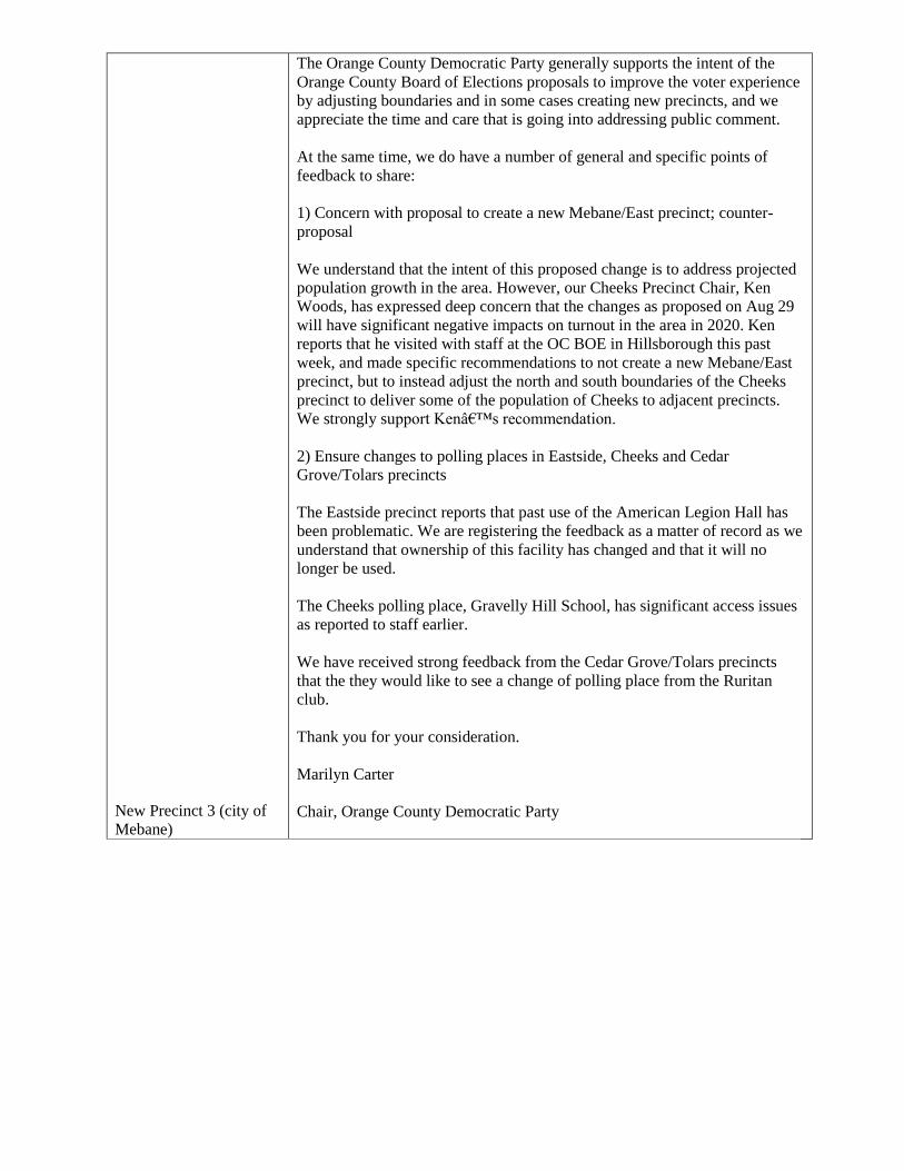
New Precinct 3 (city of
Mebane)
The Orange County Democratic Party generally supports the intent of the
Orange County Board of Elections proposals to improve the voter experience
by adjusting boundaries and in some cases creating new precincts, and we
appreciate the time and care that is going into addressing public comment.
At the same time, we do have a number of general and specific points of
feedback to share:
1) Concern with proposal to create a new Mebane/East precinct; counter-
proposal
We understand that the intent of this proposed change is to address projected
population growth in the area. However, our Cheeks Precinct Chair, Ken
Woods, has expressed deep concern that the changes as proposed on Aug 29
will have significant negative impacts on turnout in the area in 2020. Ken
reports that he visited with staff at the OC BOE in Hillsborough this past
week, and made specific recommendations to not create a new Mebane/East
precinct, but to instead adjust the north and south boundaries of the Cheeks
precinct to deliver some of the population of Cheeks to adjacent precincts.
We strongly support Ken’s recommendation.
2) Ensure changes to polling places in Eastside, Cheeks and Cedar
Grove/Tolars precincts
The Eastside precinct reports that past use of the American Legion Hall has
been problematic. We are registering the feedback as a matter of record as we
understand that ownership of this facility has changed and that it will no
longer be used.
The Cheeks polling place, Gravelly Hill School, has significant access issues
as reported to staff earlier.
We have received strong feedback from the Cedar Grove/Tolars precincts
that the they would like to see a change of polling place from the Ruritan
club.
Thank you for your consideration.
Marilyn Carter
Chair, Orange County Democratic Party
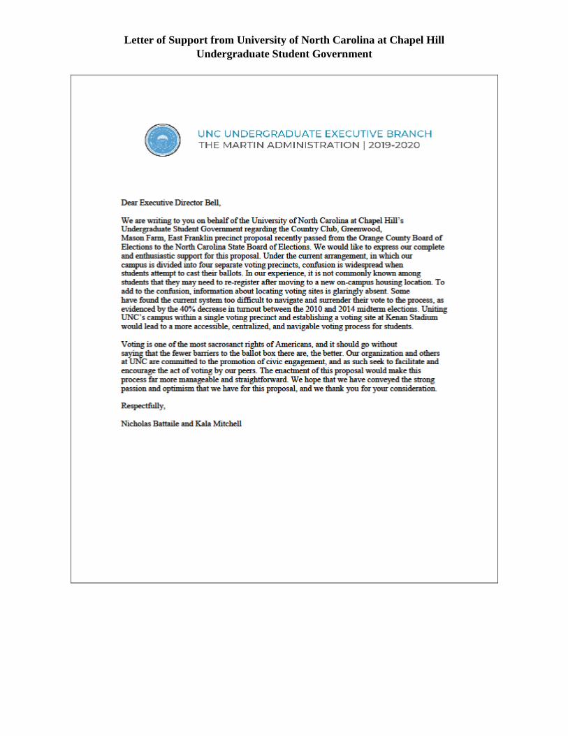
Letter of Support from University of North Carolina at Chapel Hill
Undergraduate Student Government

Precinct Change Public Awareness Campaign:
Voters will be alerted to precinct changes including, but not limited to, the following ways:
Voter Cards – Bright, “biohazard” orange verification cards will be sent to all affected voters
Newspaper Ads – Ads will be placed in area newspapers alerting voters of the changes
Website – The website of the Board of Elections will have tabs dedicated to each precinct change
with details, satellite images of voting locations, and maps available
Public Awareness Campaign – In conjunction with the community relations department, there
will be a public awareness campaign addressing precinct changes. This campaign will use social
media, broadcast media, and print media to alert voters of the changes to precincts.
UNC Public Policy Capstone Program – A proposal has been submitted to the Department of
Public Policy at UNC to collaborate with senior public policy majors to address the most
effective ways local governments disseminate important information across multi-cultural and multi-
generational constituencies. Our office will know by January 10, 2020 if our project is being assigned to a
team in the Capstone program.