blackmoor gate functional servicing report
TRANSCRIPT

BLACKMOOR GATE FUNCTIONAL SERVICING REPORT
STRAW HAT RESTORATION
CONFIDENTIAL
PROJECT NO.: 171-16446-00
DATE: MAY 2018
WSP
SUITE 101
1450, 1ST AVENUE WEST
OWEN SOUND, ON, CANADA N4K 6W2
T: +1 519 376-7612
F: +1 519 376-8008
WSP.COM
BLACKMOOR GATE FUNCTIONAL SERVICING REPORT Project No. 171-16446-00 STRAW HAT RESTORATION
WSP
Page ii
S I G N A T U R E S
PREPARED BY
Katherine Hemstock, EIT
REVIEWED BY
Chris Wilson, P. Eng.
Team Lead – Municipal Infrastructure
This report was prepared by WSP Canada Inc. for the account of STRAW HAT RESTORATION, in accordance
with the professional services agreement. The disclosure of any information contained in this report is the sole
responsibility of the intended recipient. The material in it reflects WSP Canada Inc.’s best judgement in light of the
information available to it at the time of preparation. Any use which a third party makes of this report, or any
reliance on or decisions to be made based on it, are the responsibility of such third parties. WSP Canada Inc. accepts
no responsibility for damages, if any, suffered by any third party as a result of decisions made or actions based on
this report. This limitations statement is considered part of this report.
The original of the technology-based document sent herewith has been authenticated and will be retained by WSP
for a minimum of ten years. Since the file transmitted is now out of WSP’s control and its integrity can no longer be
ensured, no guarantee may be given with regards to any modifications made to this document.
BLACKMOOR GATE SERVICING BRIEF Project No. 171-16446-00 STRAW HAT RESTORATION
WSP
Page iii
TABLE OF CONTENTS
1 INTRODUCTION ............................................. 1
2 PROPERTY DESCRIPTION ........................... 2
3 PROPOSED DEVELOPMENT AND SERVICE
POPULATION ................................................. 3
4 EXISTING SITE SERVICE .............................. 5
4.1 ROADWAYS ................................................................... 5
4.1.1 HURONTARIO STREET......................................................................... 5
4.1.2 CAMPBELL STREET .............................................................................. 5
4.1.3 FINDLAY DRIVE ..................................................................................... 5
4.2 SANITARY SEWER SERVICE ....................................... 5
4.3 STORM SEWER SERVICE ............................................ 6
4.3.1 EXISTING SERVICES ............................................................................ 6
4.3.2 EXISTING LAND-USE AND DRAINAGE .............................................. 6
4.3.3 RAINFALL INFORMATION .................................................................... 6
4.3.4 ALLOWABLE FLOW RATES ................................................................. 8
4.4 WATER SERVICE .......................................................... 8
4.5 TOWN SERVICING PLANS ........................................... 9
4.6 UTILITIES SERVICING ................................................... 9
5 PROPOSED SITE SERVICING .................... 10
5.1 SANITARY SEWER SERVICING ................................. 10
5.2 STORM WATER MANAGEMENT AND SERVICING .. 11
5.2.1 DESIGN CRITERIA ............................................................................... 11
5.2.2 GENERAL .............................................................................................. 11
5.2.3 WATER QUALITY ................................................................................. 13
5.2.4 WATER QUANTITY .............................................................................. 14
5.2.5 WATER BALANCE ............................................................................... 14
5.3 WATER SERVICING .................................................... 14

BLACKMOOR GATE FUNCTIONAL SERVICING REPORT Project No. 171-16446-00 STRAW HAT RESTORATION
WSP
Page iv
5.4 UTILITY SERVICING .................................................... 15
6 PRELIMINARY GRADING ............................ 16
7 CONCLUSIONS AND RECOMMENDATIONS
...................................................................... 17

BLACKMOOR GATE FUNCTIONAL SERVICING REPORT Project No. 171-16446-00 STRAW HAT RESTORATION
WSP
Page v
TABLES
TABLE 1: TOWN OF COLLINGWOOD RAINFALL PARAMETERS ....................................................... 8
TABLE 2: PRE-DEVELOPMENT PEAK FLOW RATE CALCULATIONS (BASED ON TD= 10 MINUTES AND C=0.32) .......................................................... 8
TABLE 3: PROPOSED LAND-USE AREA BREAKDOWN .. 13 TABLE 4: SUBCATCHMENT RUNOFF COEFFICIENTS .... 13
FIGURES
FIGURE 1: CONCEPT SKETCH ... ………………...4 FIGURE 2: PRE-DEVELOPMENT CATCHMENT
AREA ................................................... 7 FIGURE 3: PROPOSED CONDITIONS ............... 12
APPENDICES
A EXISTING LEGAL SURVEY
B EXISTING SERVICES
C PROPOSED SANITARY SEWER SERVICING
D PROPOSED STORM SEWER SERVICING
E PROPOSED WATER SERVICING
F PROPOSED UTILITIES SERVICING
G PRELIMINARY SITE GRADING

BLACKMOOR GATE FUNCTIONAL SERVICING REPORT Project No. 171-16446-00 STRAW HAT RESTORATION
WSP
Page 1
1 INTRODUCTION WSP Canada Inc. has been engaged by Straw Hat Restoration to undertake the following Functional Servicing
Report to review municipal services available, and to present the preliminary servicing design for the proposed
Blackmoor Gate residential infill development in Collingwood, Ontario. Further, the Functional Servicing Report
identifies in general, the availability and/or inadequacies of such services for the proposed residential development
of the existing 1.71 ha parcel.

BLACKMOOR GATE FUNCTIONAL SERVICING REPORT Project No. 171-16446-00 STRAW HAT RESTORATION
WSP
Page 2
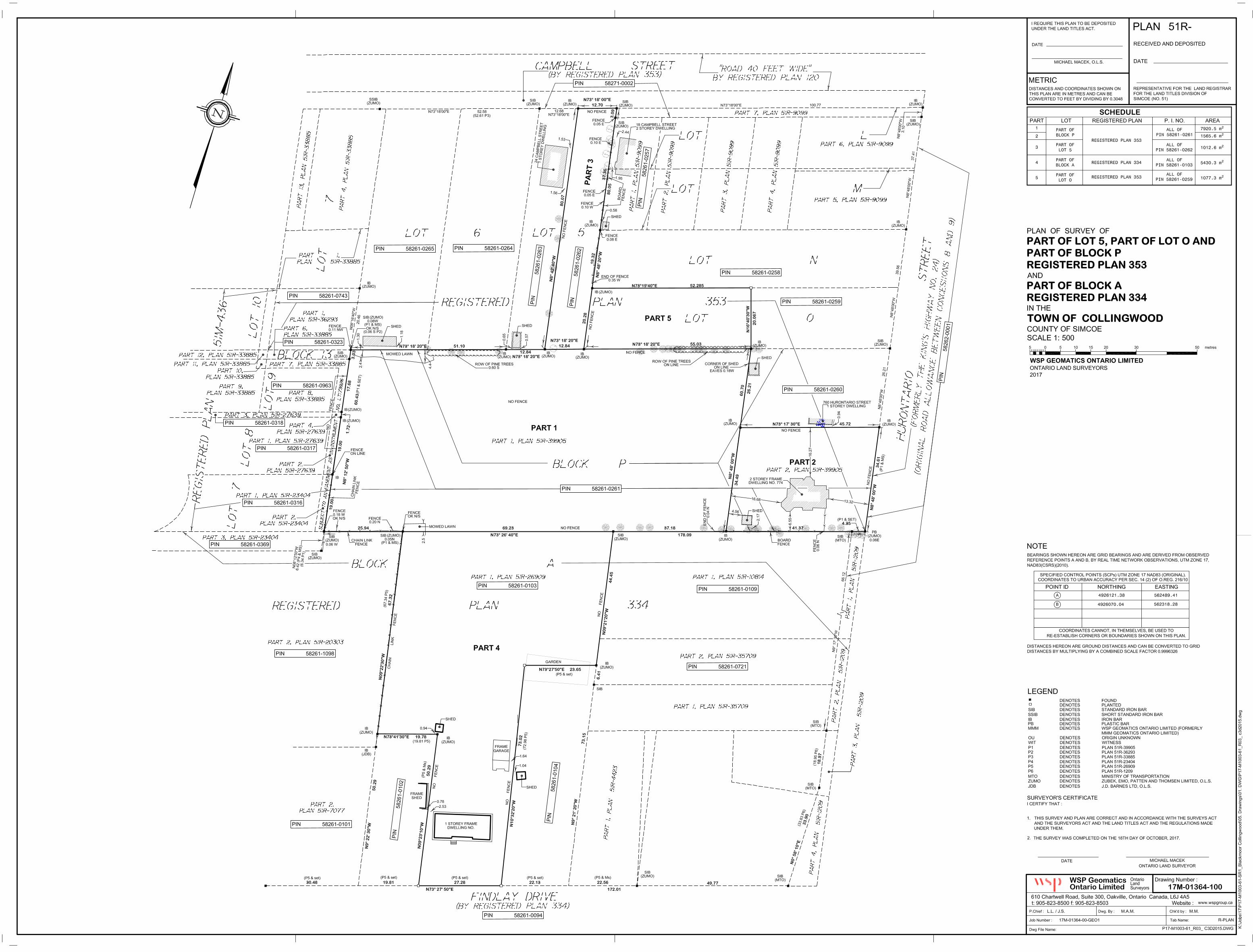
2 PROPERTY DESCRIPTION The proposed Blackmoor Gate residential development is comprised of three (3) existing properties; 774 Hurontario
Street, 33 Findlay Drive, and 750 Hurontario Street. These three properties encompass part of Lot 5, Lot O, and
Block P (registered plan 353) and part of Block A (registered plan 334) in the Town of Collingwood (Simcoe
County). The draft plan of survey of the existing properties can be found in Appendix A.
The subject properties have a collective area of 1.71 ha, and the following frontages:
Hurontario Street (between Campbell Street and Findlay Drive) – 34.61 m
Campbell Street (between Hurontario Street and Maple Street) – 12.70 m
Findlay Drive (between Hurontario Street and– 27.28 m
The existing site ground profile gently slopes in a northwesterly direction and consists of a mix of grassy, overgrown
brush, and treed areas. Two (2) existing homes are located on the property, one with frontage on Hurontario Street
and another with frontage on Findlay Drive.

BLACKMOOR GATE FUNCTIONAL SERVICING REPORT Project No. 171-16446-00 STRAW HAT RESTORATION
WSP
Page 3
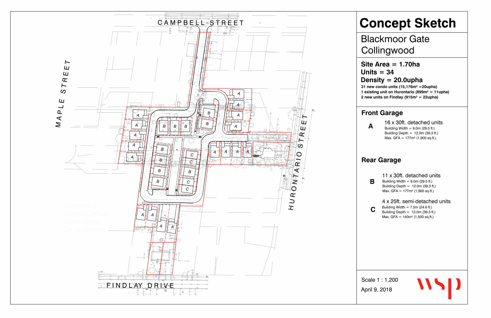
3 PROPOSED DEVELOPMENT AND
SERVICE POPULATION It is proposed that the full parcel be used for single family residential through development of thirty-four (34) units
including four (4) new semi-detached units, twenty-nine (29) new detached units (including two freehold units), and
one (1) existing detached residence to remain at 774 Hurontario Street. The two (2) freehold units are proposed to
access by private entrance to Findlay Drive, the existing unit is proposed to maintain its current access to
Hurontario, and the remaining thirty-one units are proposed to access to Campbell Street from a proposed new
roadway. The Concept Sketch in Figure 1(attached) illustrates the proposed configuration for the development
including the units and proposed roadway.
Total Proposed Service Population (excluding two (2) freehold lots on Findlay Drive and current house to
remain on Hurontario Street):
31 units @ 2.9 p/u = 90 persons
Where population density = 2.9 persons/unit
WV
WV
WV
M A
P L
E
S T
R E
E T
F I N D L AY D R I V E
C A M P B E L L S T R E E T
ElementarySchool CatholicNotre-Dame-De-La-Huronie
H U
R O
N T
A R
I O
S T
R E
E T
WV
WV
N73° 18' 20"E 55.03N73° 18' 20"E 51.10N73° 18' 20"E
12.84
N8
° 4
8' 2
0"W
80
.05
N8
° 4
2' 4
0"W
80
.07
N73° 18' 00"E12.70
N8
° 4
8' 0
0"W
60
.70
N73° 17' 30"E 45.72
N73° 26' 40"E 178.09
N8
° 4
8' 0
0"W
34
.61
N8
° 1
2' 5
0"W
60
.43
34
.49
26
.21
41.374.35
37.1869.2325.94
20
.28
19
.32
37
.36
3.0
9
3.0
3
17
.68
1.7
2
19
.00
19
.00
0.94
2.17
1.56
1.53
1.95
0.57
0.6
5
1.1
8
1.3
0
2.44
0.0
6 N
N73° 18' 20"E12.84
FE
NC
E
0.0
4 N
EN
D O
F F
EN
CE
2.5
4.4
2.4
N0°
58'
10"
E
33.9
0
49.77
22.5622.13
27.28
19.81
30.48
N73° 27' 50"E
172.01
18
.97
N9
° 2
1' 2
0"W
73
.15
6.4
1
N9
° 2
2' 3
0"W
50
.29
A
A
A
A
A
A A
A
A A A A
B
BBBB
B
B
BB
B C
C
C
C
A
A
A
A
A
Blackmoor GateCollingwood
April 9, 2018
Scale 1 : 1,200
Concept Sketch
16 x 30ft. detached unitsBuilding Width = 9.0m (29.5 ft.)Building Depth = 12.0m (39.3 ft.)Max. GFA = 177m² (1,900 sq.ft.)
Front Garage
Rear Garage
11 x 30ft. detached unitsBuilding Width = 9.0m (29.5 ft.)Building Depth = 12.0m (39.3 ft.)Max. GFA = 177m² (1,900 sq.ft.)
4 x 25ft. semi-detached unitsBuilding Width = 7.5m (24.6 ft.)Building Depth = 12.0m (39.3 ft.)Max. GFA = 140m² (1,500 sq.ft.)
Site Area = 1.70haUnits = 34Density = 20.0upha31 new condo units (15,176m² =20upha)1 existing unit on Hurontario (899m² = 11upha)2 new units on Findlay (915m² = 22upha)
A
B
C

BLACKMOOR GATE FUNCTIONAL SERVICING REPORT Project No. 171-16446-00 STRAW HAT RESTORATION
WSP
Page 5
4 EXISTING SITE SERVICE
4.1 ROADWAYS
4.1.1 HURONTARIO STREET
Hurontario Street serves as a primary public roadway in the Town of Collingwood. It is classified as an arterial road
and constructed as an undivided 2 lane paved facility with an urban cross section. The roadway has concrete
sidewalk on the west side of the right of way, and curb, gutter and municipal services.
4.1.2 CAMPBELL STREET
Campbell Street serves as a public roadway in the Town of Collingwood. It is classified as a local road, and
constructed as an undivided 2 lane paved facility with a semi-urban cross section. The roadway has concrete
sidewalk on the north side of the right of way, water main, and sanitary sewer services. There are no curbs, gutters,
or storm sewers currently in place.
4.1.3 FINDLAY DRIVE
Findlay Drive serves as a public roadway in the Town of Collingwood. It is classified as a local road and constructed
as an undivided 2 lane paved facility with an urban cross section. The roadway has concrete sidewalk on the north
side of the right of way, and curb, gutter and municipal services.
4.2 SANITARY SEWER SERVICE
HURONTARIO STREET
Hurontario Street has an existing 375 mm diameter trunk sanitary sewer at the frontage of the proposed
development. This sewer increases to a 450 mm diameter sewer at the Campbell Street intersection and continues
north. The existing home at 774 Hurontario Street is serviced by lateral connection to this trunk sanitary sewer.
CAMPBELL STREET
Campbell Street has an existing 200 mm diameter sanitary sewer at the frontage of the proposed development. This
sewer connects to the 250 mm diameter trunk sewer on Maple Street at their intersection and continues north along
Maple Street.
FINDLAY DRIVE
Findlay Drive has an existing 375 mm diameter sanitary sewer at the frontage of the proposed development. This
sewer connects to the 350 mm dia. sewer on Hurontario Street and continues north along Hurontario Street. The
existing home at 33 Findlay Drive is serviced by lateral connection to this sanitary sewer.

BLACKMOOR GATE FUNCTIONAL SERVICING REPORT Project No. 171-16446-00 STRAW HAT RESTORATION
WSP
Page 6
4.3 STORM SEWER SERVICE
4.3.1 EXISTING SERVICES
HURONTARIO STREET
Hurontario Street has an existing 525 mm diameter storm sewer adjacent to the proposed development. This storm
sewer flows north on Hurontario Street to an outlet ditch of unknown capacity.
CAMPBELL STREET
Campbell Street does not currently have a storm sewer adjacent to the proposed development. There is an existing
storm sewer on Maple Street, which collects drainage from Campbell Street via a catchbasin located at the northeast
quadrant of the intersection.
FINDLAY DRIVE
Findlay Drive has an existing 375 mm diameter storm sewer adjacent to the proposed development. This sewer
connects to a 500 mm dia. sewer on Hurontario Street, which increases to a 525 mm diameter and continues north
along Hurontario Street to an existing outlet channel.
4.3.2 EXISTING LAND-USE AND DRAINAGE
The subject property is a 1.71 ha parcel of land comprising three (3) existing residential lots at 774 Hurontario
Street, 750 Hurontario Street and 33 Findlay Drive. Under pre-development conditions, the subject site consists of
97% pervious surfaces, and has an estimated runoff coefficient of 0.32.
Existing drainage patterns for the site were determined based on topographic survey information. The pre-
development catchment areas are as illustrated in Figure 2 (attached).
4.3.3 RAINFALL INFORMATION
The rainfall intensity for the site was calculated using the following equation:
𝐼 = [𝐴
(𝑇𝑑 + 𝐶)𝐵]
Where:
I = rainfall intensity (mm/hr)
Td = storm duration (minutes)
A, B, C = IDF parameters for each return period (see below)
The parameters (A, B and C) recommended for use by the Town of Collingwood Development Standards (Standard
110, 2003) are summarized below in Table 1.
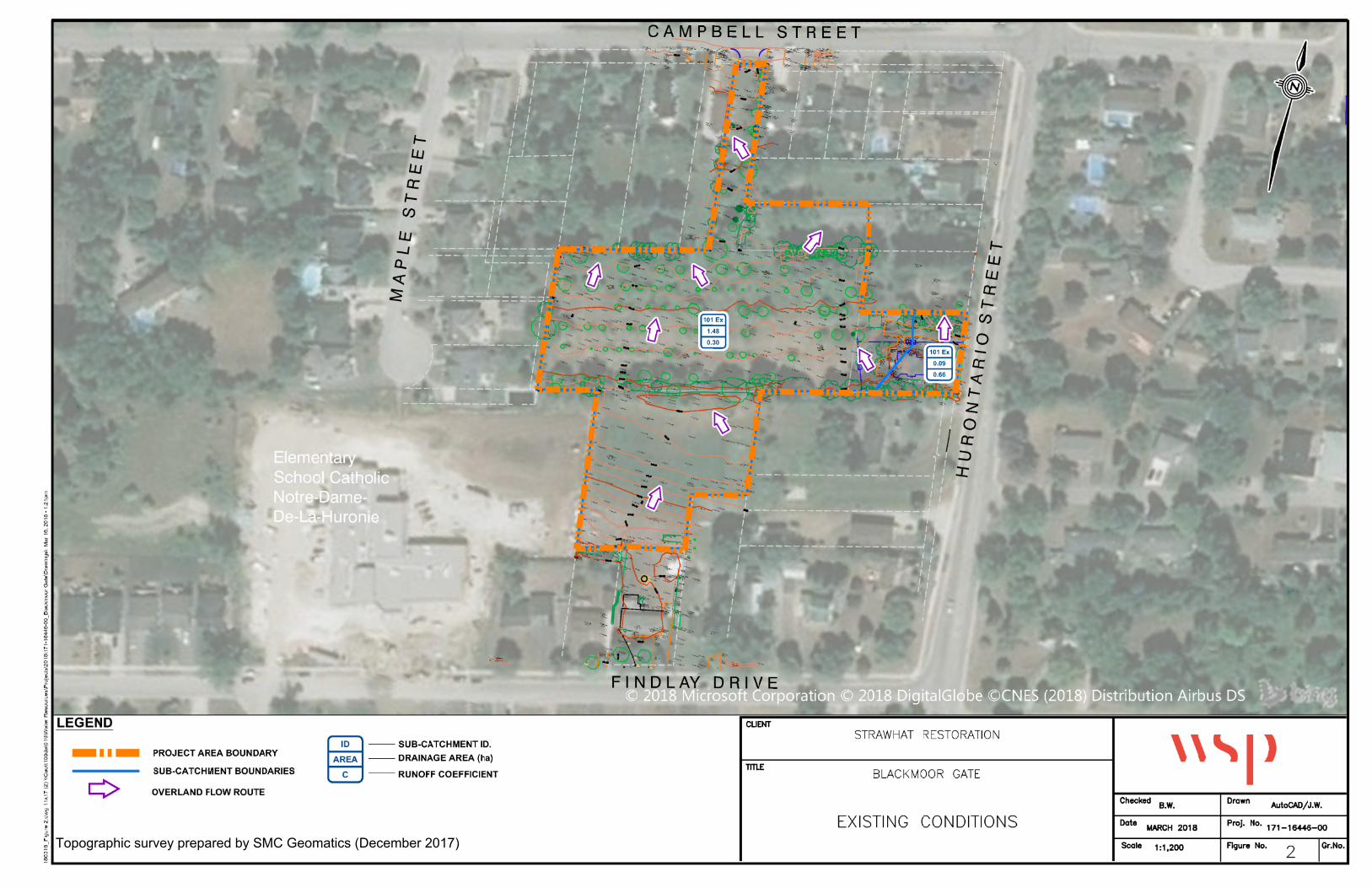
Topographic survey prepared by SMC Geomatics (December 2017)


BLACKMOOR GATE FUNCTIONAL SERVICING REPORT Project No. 171-16446-00 STRAW HAT RESTORATION
WSP
Page 8
Table 1: Town of Collingwood Rainfall Parameters
RETURN
PERIOD
(YEARS)
2 5 10 25 50 100
A 807.4 1135.4 1387.0 1676.2 1973.1 2193.1
B 0.828 0.841 0.852 0.858 0.868 0.871
C 6.750 7.500 7.970 8.300 9.000 9.040
4.3.4 ALLOWABLE FLOW RATES
Relevant policies from the Town of Collingwood and the Nottawasaga Valley Conservation Authority (NVCA)
require the post-development discharge rate from the site to match pre-development flows for the 2- to 100-year
storm events and safe conveyance of the Regulatory Flow through the site. However, a conservative approach has
been taken to control the 100-year post-development flow to the 2-year pre-development flow as runoff from the site
is proposed be discharging to a municipal storm sewer.
Rational method was used to calculate the peak flow rates for the site in the pre-development conditions summarized
in Table 2. Detailed calculations are provided in Appendix B.
Table 2: Pre-Development Peak Flow Rate Calculations (Based on Td= 10 minutes and C=0.32)
RETURN PERIOD
(Years)
RAINFALL INTENSITY, I
(mm/hour)
PEAK FLOW RATE
(L/sec)
2 78.3 113
5 102.3 147
10 118.4 170
25 138.4 199
50 153.2 221
100 168.4 243
4.4 WATER SERVICE
HURONTARIO STREET
Presently, there is a 300 mm diameter trunk watermain servicing Hurontario Street. The existing home to remain on
Hurontario Street has a 19 mm diameter service to this system.
CAMPBELL STREET
Presently, there is a 200 mm diameter watermain servicing Campbell Street.
FINDLAY DRIVE
Presently, there is a 450 mm diameter watermain servicing Findlay Drive. The existing home on Findlay Drive has a
19 mm diameter service to this system.

BLACKMOOR GATE FUNCTIONAL SERVICING REPORT Project No. 171-16446-00 STRAW HAT RESTORATION
WSP
Page 9
4.5 TOWN SERVICING PLANS
The following is a list of existing servicing plans for the previously described services that have been provided by
the Town’s Engineering Services Department. The existing servicing plans have been included in Appendix B.
DESCRIPTION ID NO.
Town of Collingwood, Sanitary Sewer Renewal Program (2008)
Plan and Profile – Maple Street PP-70 & PP-71
Town of Collingwood, Maple Street Drainage Improvements (2017)
Storm Drainage Plan STM-1
Town of Collingwood, South Collingwood Servicing (2006)
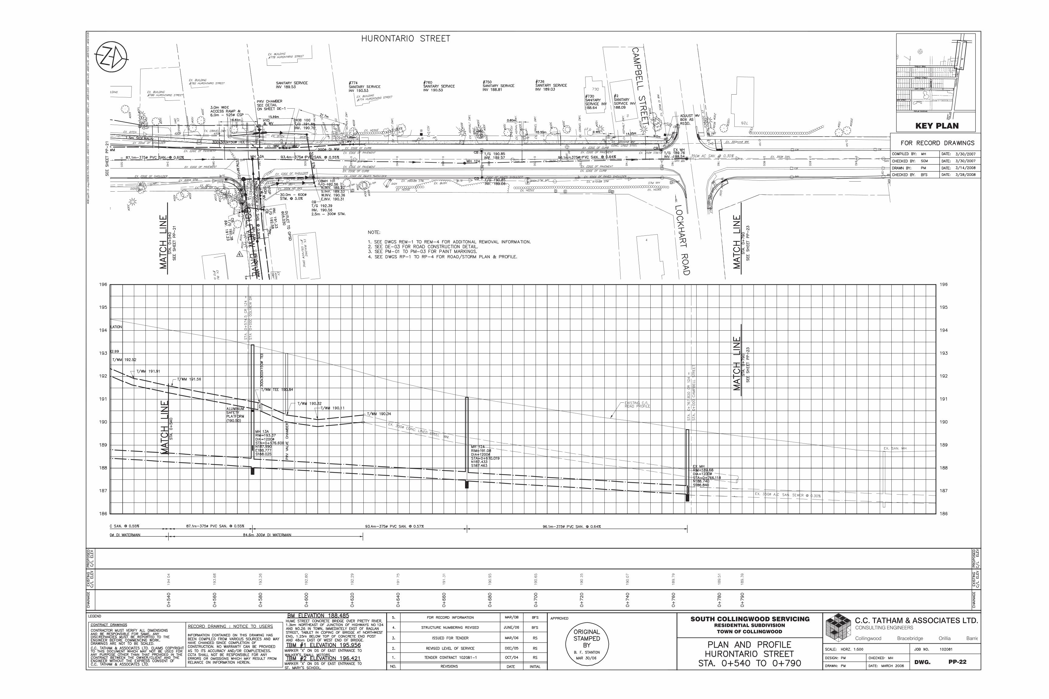
Plan and Profile – Hurontario Street PP-20-23
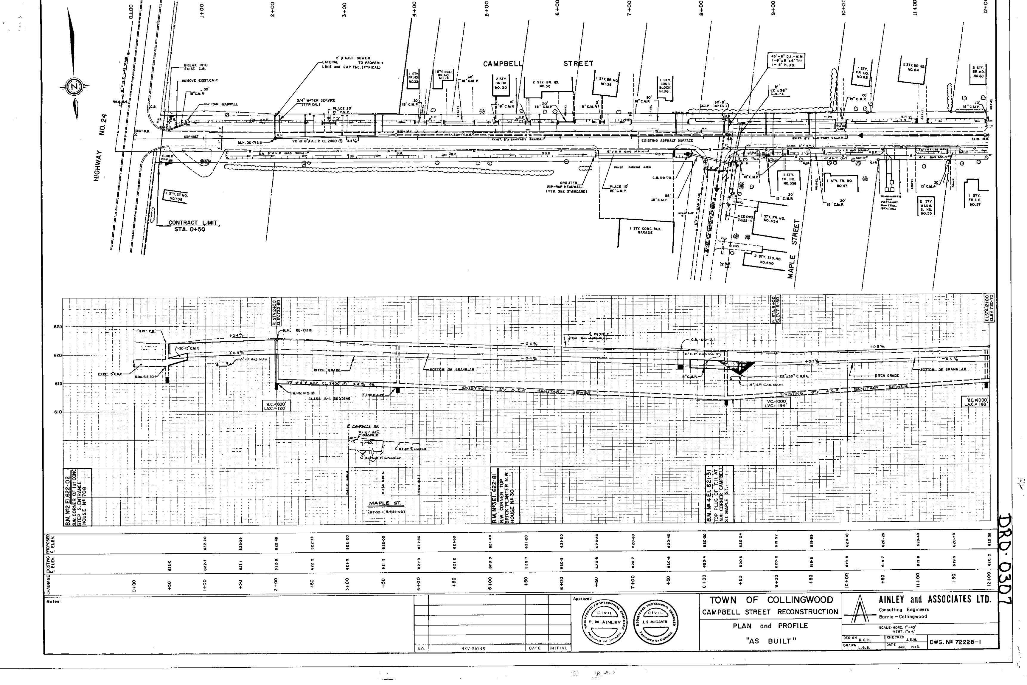
Town of Collingwood, Campbell Street Reconstruction (1973)
Plan and Profile – Campbell Streel 72228-1
Town of Collingwood, Hurontario Street Road Widening (1973)
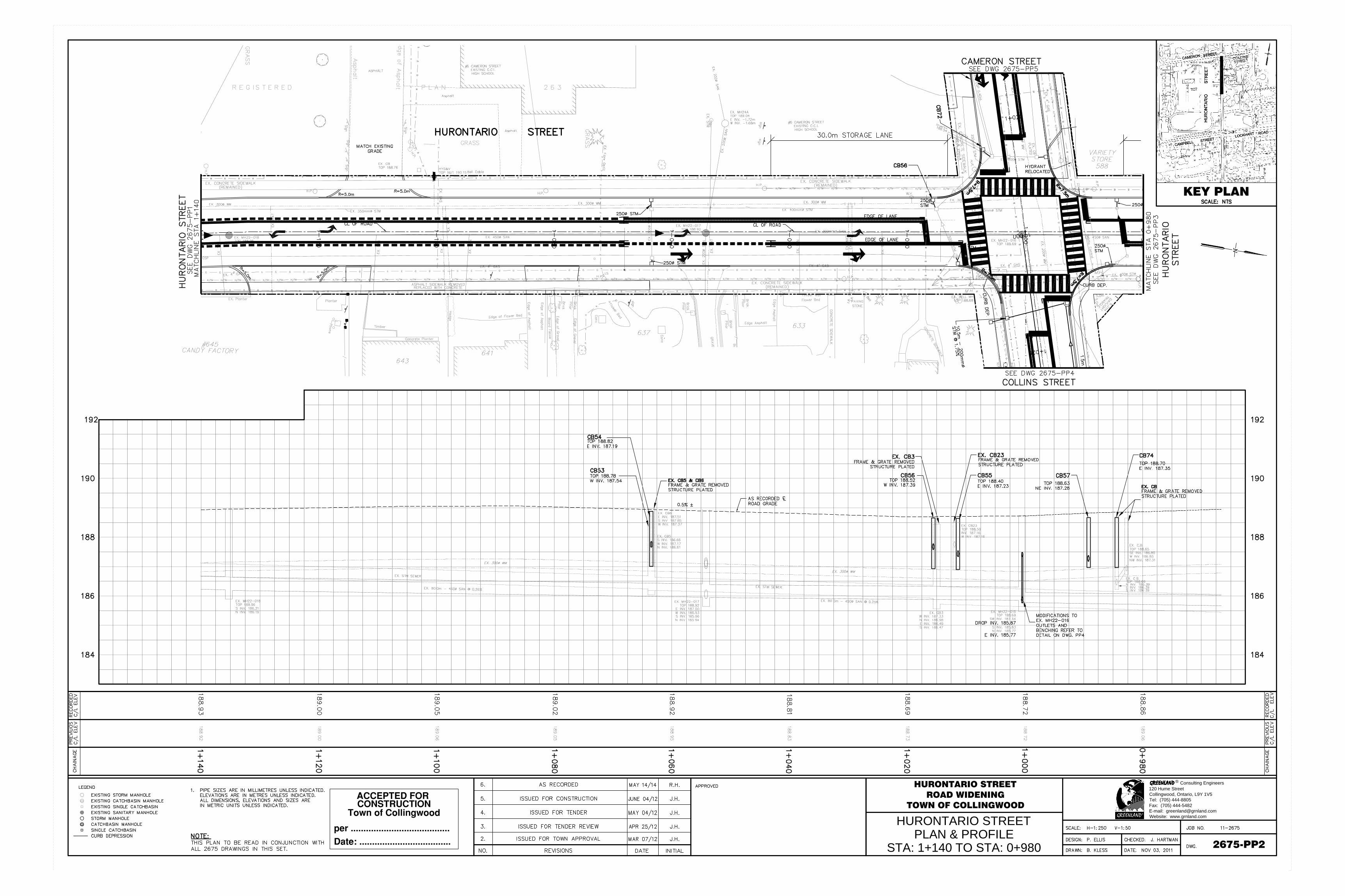
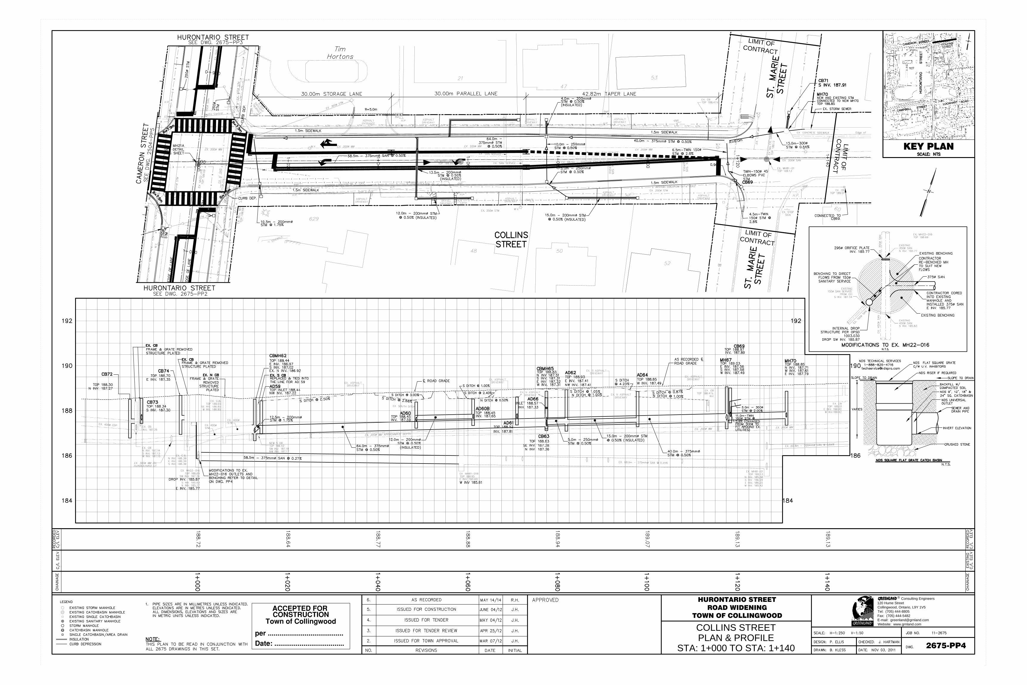
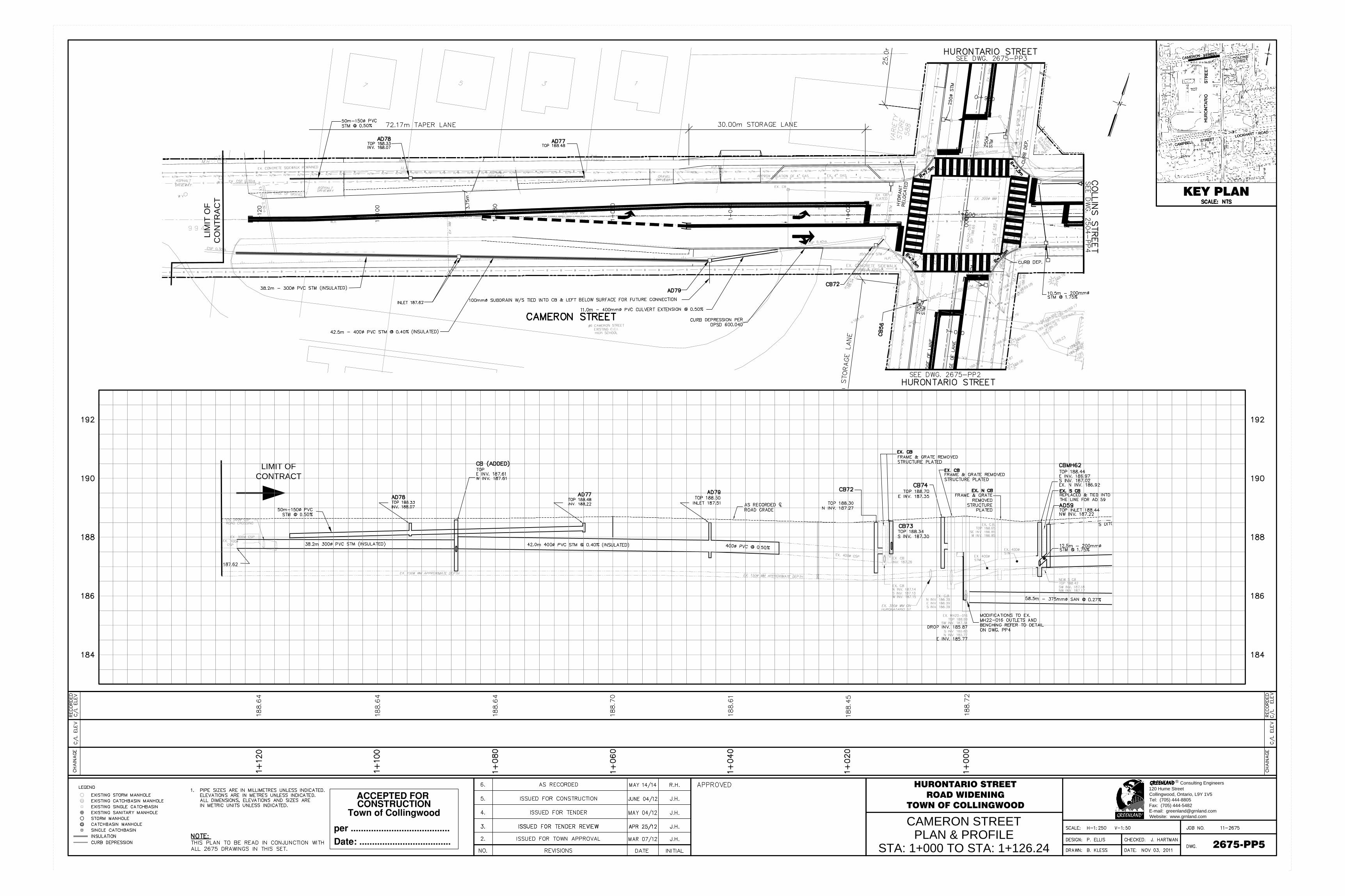
Plan and Profile – Hurontario Street 2675-PP1-5
4.6 UTILITIES SERVICING
Collus Power Stream Corp., Enbridge, Bell and Rogers Cable currently have services in the existing right-of-ways
adjacent to the Blackmoor Gate site.

BLACKMOOR GATE FUNCTIONAL SERVICING REPORT Project No. 171-16446-00 STRAW HAT RESTORATION
WSP
Page 10
5 PROPOSED SITE SERVICING
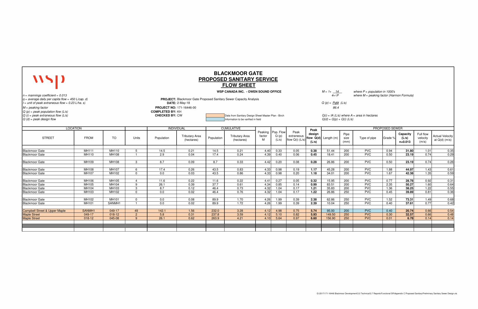
5.1 SANITARY SEWER SERVICING
It is proposed that the 34 unit development be serviced by the Birch Street sanitary catchment. The existing home at
774 Hurontario Street is proposed to remain post development and maintain its current lateral connection on
Hurontario Street. The two (2) proposed units with frontage on Findlay Drive are proposed to each connect via new
lateral connections to the existing sewer on Findlay Drive.
The remaining 31 lots of the proposed subdivision are to be serviced by new sanitary sewers outletting to the Town
of Collingwood’s existing sanitary sewer system on Campbell Street. The preliminary servicing plan and
accompanying flow sheet can be found in Appendix C.
The Blackmoor Gate sanitary sewer is proposed to be constructed of 200mm to 250 mm diameter PVC DR 35 sewer
pipe with rubber gasketed connections and will have a minimum grade of 0.4%.
All sewer construction and pipe bedding shall conform to Town of Collingwood and OPSS standards for sanitary
sewer construction.
Service connections, complete with prefabricated tees, are proposed to be constructed using PVC SDR 28 sewer
pipe with a diameter of 125 mm installed at 2.0% minimum grade. Design flows were calculated on the assumption
of 2.9 persons per unit and an average daily per capita flow of 450 L/d. The peaking factor was calculated using the
Harmon Formula.
Peak Flow = 𝑀𝑄𝑃
86.4 + 𝐼𝐴
Where: Q = 450 L/cap/day
M = Peak Flow Factor “Harmon” = 1 +14
4+𝑃0.5 = 4.25
P = Population/1000 = 31 ∗ 2.91000⁄ = 0.089
I = 0.23 L/ha. (extraneous flow)
A = Area (site) = (1.71 ha.)
Therefore, Peak Flow = 4.25∗450∗0.089
86.4+ 0.23 ∗ 1.71
= 1.97 + 0.39
= 2.36 L/s
Design flows are based on the assumption that maintenance hole openings are located in the center line of the
roadway and do not occur in extreme sags in the roadway where ponding may occur. In addition, the above also
assumes that no roof or foundation drains will be connected to sanitary sewers, there will be adequate inspection and
testing during the construction of public sewers and private connections, and a routine inspection and maintenance
programme will be undertaken by the operating authority to ensure that a water-tight sewer system is maintained.
BLACKMOOR GATE FUNCTIONAL SERVICING REPORT Project No. 171-16446-00 STRAW HAT RESTORATION
WSP
Page 11
The proposed sewer was reviewed in terms of capacity. A Manning “n” value of 0.013 was used in the design of the
sewers as per the Town of Collingwood Development Standards, which should adequately reflects the PVC DR 35
smooth walled pipe proposed.
5.2 STORM WATER MANAGEMENT AND SERVICING
5.2.1 DESIGN CRITERIA
The anticipated SWM design criteria for the project, from each of the applicable sources, are detailed below.
TOWN OF COLLINGWOOD DESIGN STANDARDS (2002)
Water Quality- controls are to be implemented on applications in accordance with the applicable Master
Drainage or Sub watershed Plan or site specific plan. A sub watershed plan for Black Ask Creek has been
prepared by the NVCA in association with the Town of Collingwood et al. In the absence of an established
plan the MOE- SWM Practices, Planning and Design Manual should be used.
During consultation discussions with Town staff it is also understood that capacity of the receiving storm drainage
system is a concern, and therefore control of peak flow rates will be necessary to ensure post-development
conditions do not exacerbate downstream issues. On this basis it is proposed that post-development peak runoff rates
for all events up to the 100-year storm are controlled to the pre-development 2-year storm or capacity of the
receiving system.
NOTTAWASAGA VALLEY CONSERVATION AUTHORITY STORMWATER TECHNICAL GUIDE (2013)
Stormwater Quantity- control post-development flows to pre-development levels for the 2- to 100-year
storm events and safe conveyance of the Regulatory flow through the site.
Stormwater Quality- enhanced level of protection as per the latest MOE SWMPDM is required (80% TSS
Removal).
Water Balance- for significant groundwater recharge areas and highly vulnerable aquifers, site-specific
water balance analyses are required.
5.2.2 GENERAL
The proposed Blackmoor Gate post-development condition details are shown in Figure 3 including land uses and
estimated stormwater sub-catchments.
Vehicular access to the site is proposed to be provided by new roadway from Campbell Street. A single discharge
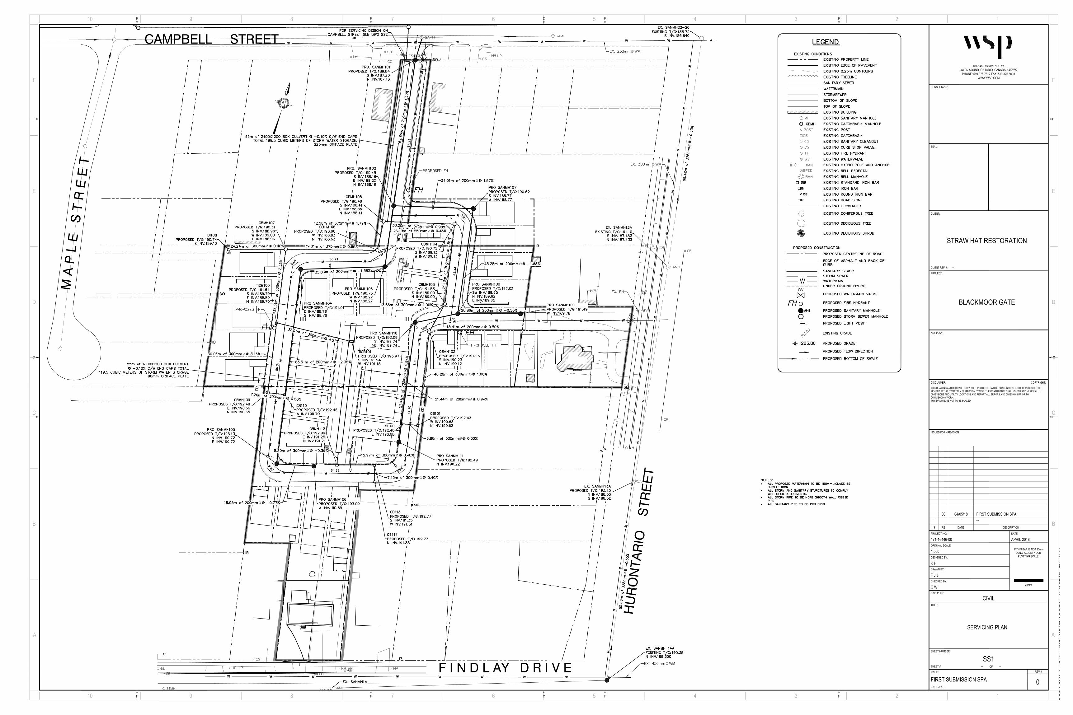
point is proposed at Campbell Street. It is proposed that a new storm sewer is installed on Campbell Street,
connecting to the existing storm sewer on Maple Street to accommodate discharge from the site. The preliminary
layout of the proposed new storm sewer on Campbell Street can be found in Appendix D.
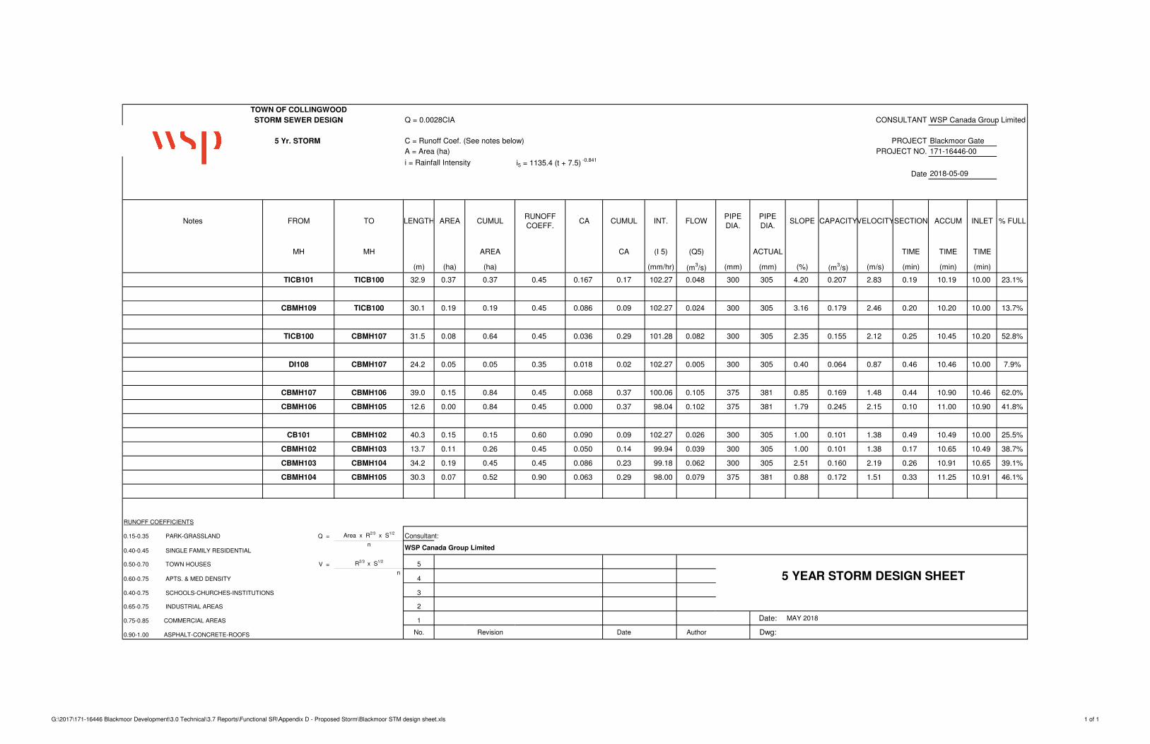
The Blackmoor Gate storm sewer is proposed to be constructed of 300mm to 375 mm diameter HDPE smooth wall
ribbed pipe with a minimum grade of 0.4%.
All storm sewer construction and pipe bedding shall conform to Town of Collingwood and OPSS standards for
storm sewer construction.
The onsite storm sewer servicing plan and flow design sheet can be found in Appendix D.
An estimated area breakdown for the new site layout (concept plan) is provided in Table 3 below.


BLACKMOOR GATE FUNCTIONAL SERVICING REPORT Project No. 171-16446-00 STRAW HAT RESTORATION
WSP
Page 13
Table 3: Proposed Land-Use Area Breakdown
LAND-USE AREA (M2) % COVERAGE
RUNOFF
COEFFICIENT
Controlled Drainage Areas (Catchment Area: 101)
Impervious Roof 2532 16% 0.9
Walkways and Driveways (Permeable Pavers) 951 6% 0.6*
Asphalt 3986 25% 0.9
Soft-landscaping 5015 31% 0.3
Controlled Drainage Areas (Catchment Area: 102)
Impervious Roof 1606 10% 0.9
Walkways and Driveways (Permeable Pavers) 1177 7% 0.6*
Asphalt 503 3% 0.9
Soft-landscaping 414 3% 0.3
TOTALS 16,183 100%
*Runoff coefficient is reduced due to expected use of permeable pavers (Unilock Ecolock product or similar)
In addition, the weighted runoff coefficients for each subcatchment have been tabulated below (Table 4).
Table 4: Subcatchment Runoff Coefficients
CATCHMENT ID AREA (m2) WEIGHTED RUNOFF COEFFICIENT
101 Controlled
12,483 0.64
102 3,700 0.74
To meet stormwater management objectives, as defined by the design criteria outlined in section 5.2.1, the following
components have been proposed:
Permeable pavement for walkways and driveways
Raised planter beds – from pre-consultation document
Underground storage (provided by concrete box culvets)
OGS unit
The application and sizing of these proposed stormwater management facilities is outlined in the following sections.
5.2.3 WATER QUALITY
As noted previously, a single outlet location at Campbell Street is proposed for this site and runoff will be released
through orifice control of an oversized pipe. A suitably sized oil and grit separator (OGS) unit is proposed to achieve
minimum 80% TSS removal (“Enhanced” level, per development criteria) for runoff from the at-grade parking and
asphalt areas.
BLACKMOOR GATE FUNCTIONAL SERVICING REPORT Project No. 171-16446-00 STRAW HAT RESTORATION
WSP
Page 14
It is assumed that runoff from the proposed rooftop areas, walkways and pervious areas will be free of typical
sediment-generating activities and therefore runoff will leave them effectively unchanged, and can be considered
clean for the purposes of water quality assessment.
Refer to the Stormwater Management Report, prepared by WSP Canada Inc. dated May 9, 2018 for further details
on the OGS sizing.
5.2.4 WATER QUANTITY
As noted in section 4.3.4, the target discharge rate to the municipal sewer system from the site is 113 l/sec. This is
equivalent to the peak runoff rate under pre-development conditions during a 2-year design storm event.
In post-development conditions, it is proposed that water quantity control for the site will be provided by two box
culverts with orifice control on the outlet. The proposed design features are indicated below:
MAIN STORAGE- CAMPBELL STREET OUTLET
2400 mm x 1200 mm Box Culvert (69 m length)
6 Manholes Assumed
0.1% slope assumed
Orifice control plate- 225 mm diameter- to be installed at the invert of the downstream end
COMMON AREA STORAGE
1800 mm x 1200 mm Box Culvert (55 m length)
0.1% slope assumed
Orifice control plate- 90 mm diameter- to be installed at the invert of the downstream end
The modified rational method was used to determine the storage required to control the post-development flows to
the allowable release rate. Refer to the Stormwater Management Report for detailed calculations.
5.2.5 WATER BALANCE
Based on review of NVCA online mapping, it has been determined that the proposed site is not within a significant
groundwater recharge area or highly vulnerable aquifer and therefore a site-specific water balance analysis is not
required (see map in Appendix D).
5.3 WATER SERVICING
Water servicing for the proposed subdivision is proposed to be accomplished by making connection to existing
water services on Campbell Street and Hurontario Street, with looping of the watermain through the proposed
Blackmoor Gate development. The proposed watermain layout is shown on the servicing plan found in Appendix E.
Water supply design has two (2) components; supply demand flow and fire protection flow at minimum pressure
requirements.
Following the Town’s Development Standards, the proposed development’s water demand has been calculated as
follows:
Maximum Day Flow required for the 31 units:

BLACKMOOR GATE FUNCTIONAL SERVICING REPORT Project No. 171-16446-00 STRAW HAT RESTORATION
WSP
Page 15
QMax Day = 𝑄∗𝑃∗2.0
86.4 =
450∗0.089∗2.75
86.4 = 0.93 L/s
Where: Q=450litres/capita/day, and P=population/1000, Maximum Daily Demand Factor= 2.0
Peak Hour Flow:
QPeak Hour = 𝑄∗𝑃∗4.5
86.4 =
450∗0.089∗4.5
86.4 2.086 L/s
Where: Q=450litres/capita/day, and P=population/1000, Peak Hourly Demand Factor= 4.5
Fire Flow Requirements based on a single worst-case lot:
Fire Flows Qfire = 150 L/s
Storage Requirements (for 1.75 hours) = 945 m3
Fire flow calculations have been completed in accordance with the current issue of the Fire Underwriters Survey
publication Water Supply for Public Fire Protection. Detailed fire flow calculations can be found in Appendix E.
As per the Town of Collingwood’s standards and current applicable MOECC regulatory standards:
• The maximum sustained operating pressure shall not exceed 700 kPa and not fall below 275 kPa
• The maximum static pressure shall not exceed 550 kPa
The 31 proposed units of Blackmoor Gate are proposed to be serviced by a 150 mm diameter class 52 ductile iron
pipe, making connection to the existing Hurontario Street and Campbell Street watermains, with looping through the
development. The existing watermain on Hurontario Street is a 300 mm diameter ductile iron pipe, and the existing
watermain on Campbell Street is a 200 mm diameter ductile iron watermain.
The existing unit on Hurontario is proposed to maintain its current 19 mm service connection to Hurontario Street.
The two (2) single detached units with frontage on Findlay Drive are proposed to be serviced by two (2) new service
connections to the existing 450 mm trunk watermain on Findlay drive. The existing unit’s current connection is
proposed to be removed following the turn off and disconnection at the curb stop completed by the Town’s Water
Department.
Proposed service connections shall be 20 mm diameter type K copper pipe and terminate at the property line,
centered across the frontage. Fittings will be mechanical joint ductile iron with Rolmac gripper ring in accordance
with the Town of Collingwood’s current Development Standards.
The minimum cover on all proposed watermains, water services and hydrant leads will be 1.7 m. Watermains and
services across roadways will be backfilled with approved granular materials and thoroughly compacted in
appropriate layers. Thrust blocks or restrained joints and anchored tees (to Town satisfaction) corresponding to
OPSD 1103.010 and 1103.020 will be constructed where the pipe is placed in undisturbed native soils, where the
minimum soil bearing capacity exceeds 200 kPa, or where soil conditions are suspected to be inadequate.
The hydrant spacing along street lines in the subdivision will not exceed 90 m. There are two (2) proposed fire
hydrants required as shown on the servicing plan found in Appendix E. An existing hydrant on Hurontario Street is
located on the north side of the proposed developments Hurontario Street frontage.
5.4 UTILITY SERVICING
Existing Collus Power, gas, telephone and cable utilities perimeter the lot to provide services for the proposed
development. However, access and any upgrade/improvements will need to be determined by the utility providers
during the detailed design stage.
The preliminary streetlighting (LED luminaries) layout and photometric design have been completed to Town of
Collingwood standards. The proposed Lighting Plan for the development can be found in Appendix F.

BLACKMOOR GATE FUNCTIONAL SERVICING REPORT Project No. 171-16446-00 STRAW HAT RESTORATION
WSP
Page 16
6 PRELIMINARY GRADING A preliminary grading plan has been prepared and can be found in Appendix G. The preliminary grading design is
based on a number of parameters including the required 0.5 m separation from the groundwater table to the
underside of basement slab, minimum cover on all proposed services, and the existing perimeter grades. The
minimum grade of the proposed roads is 0.5% per the Town of Collingwood Design Standards.

BLACKMOOR GATE FUNCTIONAL SERVICING REPORT Project No. 171-16446-00 STRAW HAT RESTORATION
WSP
Page 17
7 CONCLUSIONS AND
RECOMMENDATIONS Based on the foregoing, the following is concluded regarding the proposed residential development.
1. Existing public roadway access is available to the site, subject to entrance access construction to the
Town’s standards and approval.
2. Storm Water Management including onsite storage, grading, and drainage shall be designed/completed in
accordance with Town Development Standards and approvals and necessary agency approvals shall be
obtained.
3. The storm sewer on Maple Street has the available capacity to accept post development flows not
exceeding the pre-development flows at the 2 year storm from the proposed development.
4. An OGS unit (suitably sized Stormceptor unit, or equivalent) is proposed downstream of the orifice
control for the Campbell Street outlet to meet MOE Enhanced treatment standards (80% TSS removal).
5. Controlled runoff on site is proposed to be directed to a storm sewer network with two box culverts
having a minimum combined storage volume of 359 m3. Outflow from the common area storage culvert
is proposed to be controlled by a 90 mm orifice plate, and the main storage culvert controlled by a
225mm diameter orifice plate in order to satisfy equivalent maximum pre-development release rate of
113 l/sec for all events up to and including the 100-year return period.
6. A preliminary analysis of the required grade raise to accommodate the underground storage network was
undertaken, establishing the proposed profile of the new roadway will not pose conflict with the existing
profile of Campbell Street. The site grading plan will be finalized prior to further reporting and design.
7. The sanitary sewer on Campbell Street has the available capacity to provide service for the proposed 31
new units of the development. The proposed sewer shall be designed/completed in accordance with
Town Engineering Standards and approvals and necessary agency approvals shall be obtained.
8. The new watermain within the development is proposed to connect on Hurontario Street and Campbell
Street to service 31 new units of the development satisfying residential and fire flows. The watermain on
Findlay Drive is proposed to service the two new units with frontage on Findlay Drive. All site proposed
water mains and service connections and shall be constructed to Town Standards and in accordance with
current applicable MOECC requirements.
9. Utility companies will be notified of the proposed development to confirm servicing requirements and
planning for plant upgrades, if necessary, to provide such servicing to the site.
10. That a meeting with Town officials should be scheduled for discussions regarding the content of this
Functional Servicing Report, feasibility, and direction prior to completion more detailed design,
engineering submissions, and final reporting, to meet their approval prior to this development
proceeding.


APPENDIX
A EXISTING
LEGAL SURVEY

APPENDIX
B EXISTING
SERVICES

Project:Blackmoor Gate
No.:171-16446-00
By:JW
Date:5/8/2018
Page:
Checked:1
Subject:
SWM Calculations - Allowable Release Rate
Calculation of existing runoff rate is undertaken using the Rational Method:
Where: Q = peak flow rate (litres/second)
C = runoff coefficient
i = rainfall intensity (mm/hour)
A = catchment area (hectares)
Site Area, A 16,183 m2
Site Area, A 1.62 hectares
Runoff Coefficient, C 0.32
Where: A, B, C = regression constants for each return period (Standard 110)
i = rainfall intensity (mm/hour)
Td = storm duration (minutes) 10 minutes
Return Period (Years) 2 5 10 25 50 100
A 807.4 1,135.4 1,387.0 1,676.2 1,973.1 2,193.1
B 0.828 0.841 0.852 0.858 0.868 0.871
C 6.750 7.500 7.970 8.300 9.000 9.040
T (mins) 10 10 10 10 10 10
I (mm/hr) 78.3 102.3 118.4 138.4 153.2 168.4
Q (litres/sec) 113 147 170 199 221 243
Q (m3/sec) 0.113 0.147 0.170 0.199 0.221 0.243
Rainfall intensity calculated using the Town of Collingwood IDF parameters (Town of Collingwood
Development Standards, 2003):
� ��
�� � � �
� 2.78���

PP-71
KEY PLAN
DWG.
Bracebridge
CONSULTING ENGINEERSC.C. TATHAM & ASSOCIATES LTD.
Collingwood BarrieOrillia
TOWN OF COLLINGWOODSANITARY SEWER RENEWAL PROGRAM
PHASE 1- CONTRACT 4

PP-70
KEY PLAN
DWG.
Bracebridge
CONSULTING ENGINEERSC.C. TATHAM & ASSOCIATES LTD.
Collingwood BarrieOrillia
TOWN OF COLLINGWOODSANITARY SEWER RENEWAL PROGRAM
PHASE 1- CONTRACT 4


PP-20
KEY PLAN
DWG.
SOUTH COLLINGWOOD SERVICINGRESIDENTIAL SUBDIVISIONTOWN OF COLLINGWOOD
Bracebridge
CONSULTING ENGINEERSC.C. TATHAM & ASSOCIATES LTD.
Collingwood BarrieOrillia
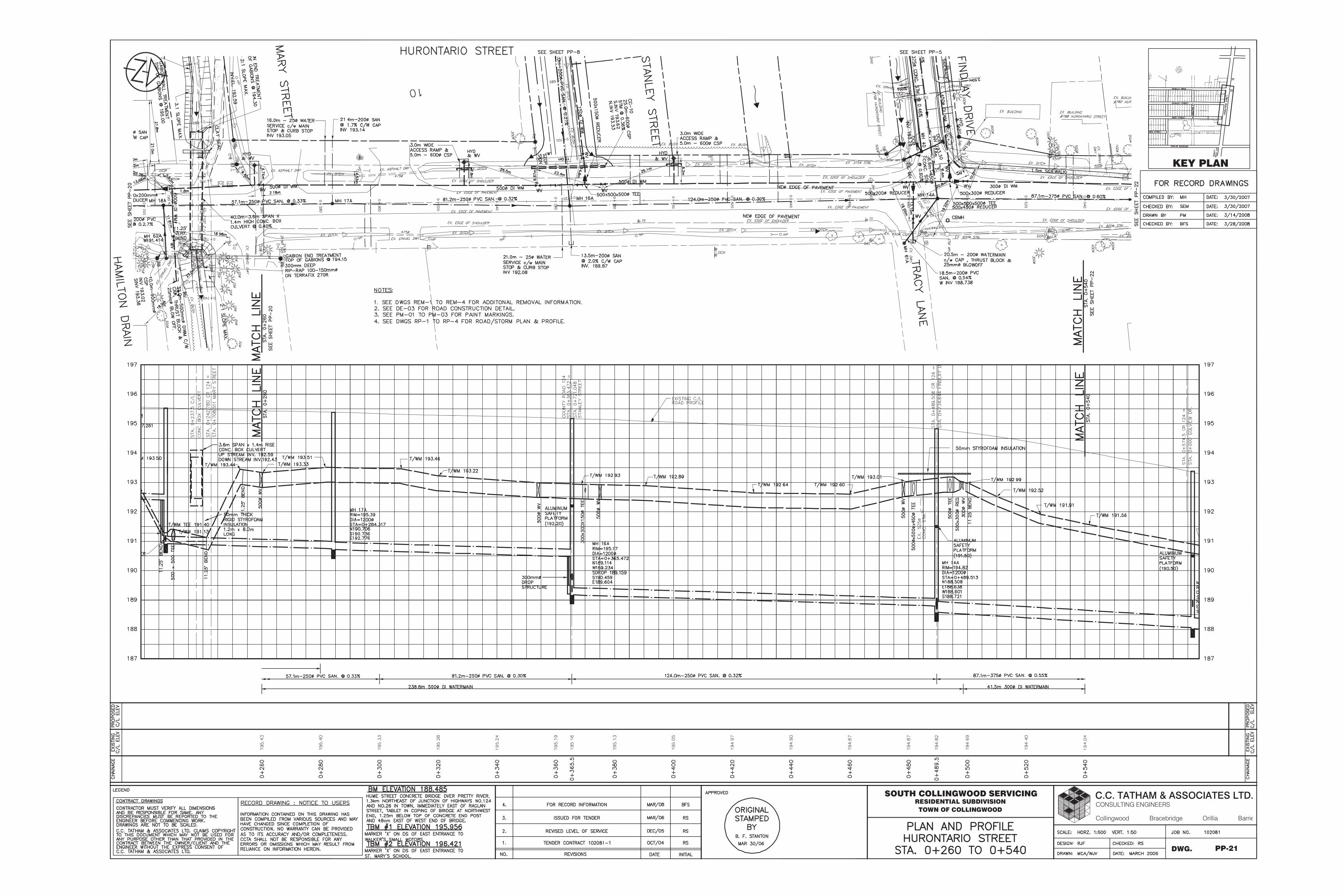
PP-21
KEY PLAN
DWG.
SOUTH COLLINGWOOD SERVICINGRESIDENTIAL SUBDIVISIONTOWN OF COLLINGWOOD
Bracebridge
CONSULTING ENGINEERSC.C. TATHAM & ASSOCIATES LTD.
Collingwood BarrieOrillia
PP-22
KEY PLAN
DWG.
SOUTH COLLINGWOOD SERVICINGRESIDENTIAL SUBDIVISIONTOWN OF COLLINGWOOD
Bracebridge
CONSULTING ENGINEERSC.C. TATHAM & ASSOCIATES LTD.
Collingwood BarrieOrillia
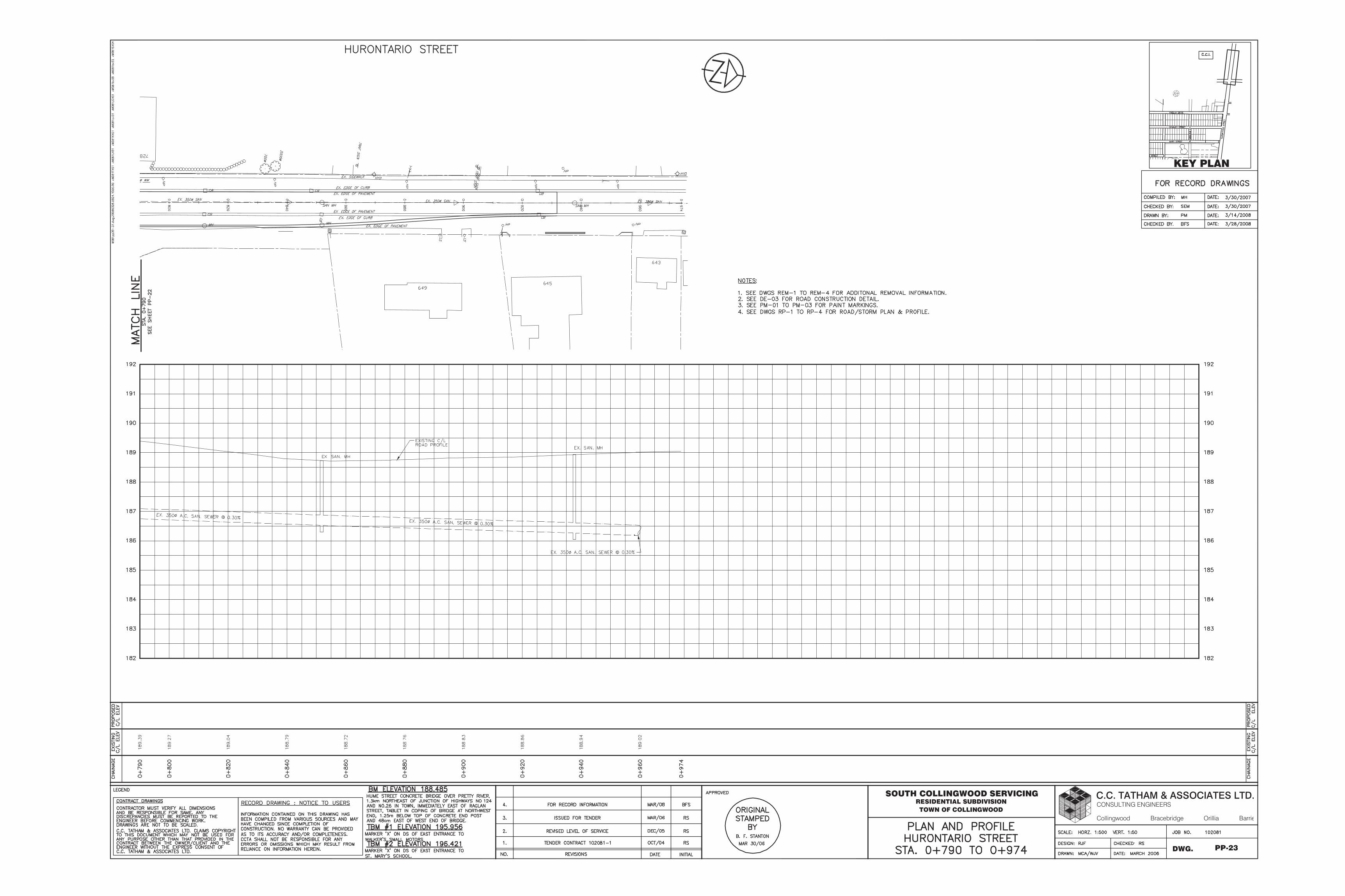
PP-23
KEY PLAN
DWG.
SOUTH COLLINGWOOD SERVICINGRESIDENTIAL SUBDIVISIONTOWN OF COLLINGWOOD
Bracebridge
CONSULTING ENGINEERSC.C. TATHAM & ASSOCIATES LTD.
Collingwood BarrieOrillia
2675-PP2
KEY PLAN
HURONTARIO STREETROAD WIDENING
TOWN OF COLLINGWOOD
120 Hume Street
Collingwood, Ontario, L9Y 1V5
Tel: (705) 444-8805
Fax: (705) 444-5482
E-mail: [email protected]
Website: www.grnland.com
Consulting Engineers
HURONTARIO STREET
PLAN & PROFILE
STA: 1+140 TO STA: 0+980
C
O
LLIN
S
S
T
R
E
E
T

LIM
IT
O
F
CO
NT
RA
CT
HURONTARIO STREETROAD WIDENING
TOWN OF COLLINGWOOD
2675-PP3
120 Hume Street
Collingwood, Ontario, L9Y 1V5
Tel: (705) 444-8805
Fax: (705) 444-5482
E-mail: [email protected]
Website: www.grnland.com
Consulting Engineers
HURONTARIO STREET
PLAN & PROFILE
STA: 0+980 TO STA: 0+895
KEY PLAN
C
O
LLIN
S
S
T
R
E
E
T
B
LIM
IT
O
F
C
O
N
TR
AC
T
LIM
IT
O
F
C
O
N
T
R
A
C
T
LIM
IT
O
F
C
O
N
T
R
A
C
T
2675-PP4
COLLINS STREET
PLAN & PROFILE
STA: 1+000 TO STA: 1+140
KEY PLANKEY PLAN
C
O
LLIN
S
S
T
R
E
E
T
120 Hume Street
Collingwood, Ontario, L9Y 1V5
Tel: (705) 444-8805
Fax: (705) 444-5482
E-mail: [email protected]
Website: www.grnland.com
Consulting EngineersHURONTARIO STREETROAD WIDENING
TOWN OF COLLINGWOOD
LIMIT OF
CONTRACT
LIM
IT
O
F
CO
NT
RA
CT
2675-PP5
120 Hume Street
Collingwood, Ontario, L9Y 1V5
Tel: (705) 444-8805
Fax: (705) 444-5482
E-mail: [email protected]
Website: www.grnland.com
Consulting Engineers
CAMERON STREET
PLAN & PROFILE
STA: 1+000 TO STA: 1+126.24
KEY PLAN
C
O
LLIN
S
S
T
R
E
E
T
KEY PLAN
HURONTARIO STREETROAD WIDENING
TOWN OF COLLINGWOOD

P
1
B
C
LIMIT OF
CONTRACT
HURONTARIO STREETROAD WIDENING
TOWN OF COLLINGWOOD
2675-PP1
120 Hume Street
Collingwood, Ontario, L9Y 1V5
Tel: (705) 444-8805
Fax: (705) 444-5482
E-mail: [email protected]
Website: www.grnland.com
Consulting Engineers
HURONTARIO STREET
PLAN & PROFILE
STA: 1+306.63 TO STA: 1+140
KEY PLAN
C
O
LLIN
S
S
T
R
E
E
T

APPENDIX
C PROPOSED
SANITARY
SEWER
SERVICING
ElementarySchool Catholic Notre-Dame-De-La-Huronie
WTV
WTV
HU
RO
NTA
RIO
S
TRE
ET
CAMPBELL STREET
WV
WV
86
.95
13.88
30.71
3.01
86
.31
2.67 54.55 2.98
41
.70
8.8
5
42
.44
3.93
∅ WM
∅ WM
∅ WM
M A
P L
E
S T
R E
E T
F I N D L AY D R I V E
7.99
9.40
∅
∅
∅
∅
∅
∅
∅
∅
∅
∅
∅
∅
∅
∅
∅
∅
∅
∅
∅
∅
∅
∅
∅
∅
∅ ∅
∅
∅
WV
G:\20
17\17
1-16
446 B
lackm
oor D
evelo
pmen
t\6.0
Dwg\6
.2 Ci
vil\17
1-16
446-
00-3
D-4.d
wg M
ay 09
, 201
8-2:1
3pm
BY:(t
yler.ja
hnke
)
REV #
C F
C
C F
C
A
E
F
C
D
B
1235 4678910
1235 4678910
A
E
F
C
D
B
FFF
P
FFF
F
F
SEAL:
CONSULTANT:
CLIENT:
PROJECT:
CLIENT REF. #:
DISCLAIMER: COPYRIGHT:
ISSUED FOR - REVISION:
DESCRIPTIONDATEREIS
KEY PLAN:
ISSUE:
DATE OF:
ORIGINAL SCALE:
CHECKED BY:
DRAWN BY:
SHEET #: OF
TITLE:
DISCIPLINE:
25mm
IF THIS BAR IS NOT 25mmLONG, ADJUST YOUR
PLOTTING SCALE.
PROJECT NO: DATE:
SHEET NUMBER:
DESIGNED BY:
THIS DRAWING AND DESIGN IS COPYRIGHT PROTECTED WHICH SHALL NOT BE USED, REPRODUCED ORREVISED WITHOUT WRITTEN PERMISSION BY WSP. THE CONTRACTOR SHALL CHECK AND VERIFY ALLDIMENSIONS AND UTILITY LOCATIONS AND REPORT ALL ERRORS AND OMISSIONS PRIOR TOCOMMENCING WORK.THIS DRAWING IS NOT TO BE SCALED.
F
F
101-1450 1st AVENUE W.OWEN SOUND, ONTARIO, CANADA N4K6W2
PHONE: 519-376-7612 FAX: 519-376-8008WWW.WSP.COM
STRAW HAT RESTORATION
BLACKMOOR GATE
--
171-16446-00 APRIL 2018
FIRST SUBMISSION SPA--
0
- - --00 04/05/18 FIRST SUBMISSION SPA
1:500
K H
T J J
C W
CIVIL
SERVICING PLAN
SS1-- --
· ∅
·
·
·
M = 1+ 14 where P = population in 1000's
n = mannings coefficient = 0.013 4+√P where M = peaking factor (Harmon Formula)
q = average daily per capita flow = 450 L/cap. d) PROJECT: Blackmoor Gate Proposed Sanitary Sewer Capacity Analysis
I = unit of peak extraneous flow = 0.23 L/ha. s) DATE: 2-May-18 Q (p) = PqM (L/s)
M = peaking factor PROJECT NO: 171-16446-00 86.4
Q (p) = peak population flow (L/s) COMPLETED BY: KH
Q (i) = peak extraneous flow (L/s) CHECKED BY: CW Data from Sanitary Design Sheet Master Plan - Birch Q(i) = IA (L/s) where A = area in hectares
Q (d) = peak design flow Information to be varified in field Q(d) = Q(p) + Q(i) (L/s)
STREET FROM TO Units PopulationTributary Area
(hectares)Population
Tributary Area
(hectares)Length (m)
Pipe
size
(mm)
Type of pipe Grade %
Capacity
(L/s)
n=0.013
Full flow
velocity
(m/s)
Actual Velocity
at Q(d) (m/s)
Blackmoor Gate MH111 MH110 5 14.5 0.21 14.5 0.21 4.40 0.33 0.05 0.38 51.44 200 PVC 0.94 31.80 1.01 0.35
Blackmoor Gate MH110 MH108 1 2.9 0.04 17.4 0.24 4.39 0.40 0.06 0.45 18.41 200 PVC 0.50 23.19 0.74 0.29
Blackmoor Gate MH109 MH108 3 8.7 0.09 8.7 0.33 4.42 0.20 0.08 0.28 26.86 200 PVC 0.50 23.19 0.74 0.26
Blackmoor Gate MH108 MH107 6 17.4 0.26 43.5 0.83 4.33 0.98 0.19 1.17 45.28 200 PVC 1.88 44.97 1.43 0.61
Blackmoor Gate MH107 MH102 0 0.0 0.03 43.5 0.86 4.33 0.98 0.20 1.18 34.01 200 PVC 1.67 42.38 1.35 0.59
Blackmoor Gate MH106 MH105 4 11.6 0.22 11.6 0.22 4.41 0.27 0.05 0.32 15.95 200 PVC 0.77 28.78 0.92 0.31
Blackmoor Gate MH105 MH104 9 26.1 0.39 37.7 0.61 4.34 0.85 0.14 0.99 83.51 200 PVC 2.35 50.27 1.60 0.64
Blackmoor Gate MH104 MH103 3 8.7 0.12 46.4 0.73 4.32 1.04 0.17 1.21 35.83 200 PVC 1.36 38.25 1.22 0.55
Blackmoor Gate MH103 MH102 0 0.0 0.02 46.4 0.76 4.32 1.04 0.17 1.22 26.86 250 PVC 0.45 39.89 0.81 0.36
Blackmoor Gate MH102 MH101 0 0.0 0.08 89.9 1.70 4.26 1.99 0.39 2.38 62.86 250 PVC 1.52 73.31 1.49 0.68
Blackmoor Gate MH101 SANMH1 1 0.0 0.02 89.9 1.72 4.26 1.99 0.39 2.39 10.04 250 PVC 0.40 37.61 0.77 0.42
Campbell Street & Upper Maple SANMH1 049-17 49 142.1 1.56 232.0 3.28 4.12 4.98 0.75 5.74 95.00 200 PVC 0.40 20.74 0.66 0.54
Maple Street 049-17 018-12 2 5.8 0.31 237.8 3.59 4.12 5.10 0.82 5.93 149.50 250 PVC 0.30 32.57 0.66 0.48
Maple Street 018-12 045-08 9 26.1 0.62 263.9 4.21 4.10 5.64 0.97 6.60 156.90 250 PVC 0.01 6.78 0.14 0.14
INDIVIDUAL CUMULATIVE
Peaking
factor
M
Pop. Flow
Q (p)
(L/s)
WSP CANADA INC. - OWEN SOUND OFFICE
PROPOSED SANITARY SERVICE FLOW SHEET
BLACKMOOR GATE
Peak
extraneous
flow Q(i) (L/s)
Peak
design
flow Q(d)
(L/s)
PROPOSED SEWERLOCATION
G:\2017\171-16446 Blackmoor Development\3.0 Technical\3.7 Reports\Functional SR\Appendix C Proposed Sanitary\Preliminary Sanitary Sewer Design.xls


APPENDIX
D PROPOSED
STORM SEWER
SERVICING

Collingwood Collegiate Institute
CAMPBELL STREETWV
86
.95
∅ WM
M A
P L
E
S T
R E
E T
Collingwood Collegiate Institute
∅
∅
∅ ∅
MA
PLE
STR
EE
T
∅
∅
∅
WV
G:\20
17\17
1-16
446 B
lackm
oor D
evelo
pmen
t\6.0
Dwg\6
.2 Ci
vil\17
1-16
446-
00-3
D-4.d
wg M
ay 04
, 201
8-2:5
5pm
BY:(t
yler.ja
hnke
)
REV #
C F
C
C F
C
A
E
F
C
D
B
1235 4678910
1235 4678910
A
E
F
C
D
B
FFF
P
FFF
F
F
SEAL:
CONSULTANT:
CLIENT:
PROJECT:
CLIENT REF. #:
DISCLAIMER: COPYRIGHT:
ISSUED FOR - REVISION:
DESCRIPTIONDATEREIS
KEY PLAN:
ISSUE:
DATE OF:
ORIGINAL SCALE:
CHECKED BY:
DRAWN BY:
SHEET #: OF
TITLE:
DISCIPLINE:
25mm
IF THIS BAR IS NOT 25mmLONG, ADJUST YOUR
PLOTTING SCALE.
PROJECT NO: DATE:
SHEET NUMBER:
DESIGNED BY:
THIS DRAWING AND DESIGN IS COPYRIGHT PROTECTED WHICH SHALL NOT BE USED, REPRODUCED ORREVISED WITHOUT WRITTEN PERMISSION BY WSP. THE CONTRACTOR SHALL CHECK AND VERIFY ALLDIMENSIONS AND UTILITY LOCATIONS AND REPORT ALL ERRORS AND OMISSIONS PRIOR TOCOMMENCING WORK.THIS DRAWING IS NOT TO BE SCALED.
F
F
101-1450 1st AVENUE W.OWEN SOUND, ONTARIO, CANADA N4K6W2
PHONE: 519-376-7612 FAX: 519-376-8008WWW.WSP.COM
STRAW HAT RESTORATION
BLACKMOOR GATE
--
171-16446-00 APRIL 2018
FIRST SUBMISSION SPA--
0
- - --00 04/05/18 FIRST SUBMISSION SPA
1:500
K H
T J J
C W
CIVIL
SERVICING PLAN
SS2-- --

ElementarySchool Catholic Notre-Dame-De-La-Huronie
WTV
WTV
HU
RO
NTA
RIO
S
TRE
ET
CAMPBELL STREET
WV
WV
86
.95
13.88
30.71
3.01
86
.31
2.67 54.55 2.98
41
.70
8.8
5
42
.44
3.93
∅ WM
∅ WM
∅ WM
M A
P L
E
S T
R E
E T
F I N D L AY D R I V E
7.99
9.40
∅
∅
∅
∅
∅
∅
∅
∅
∅
∅
∅
∅
∅
∅
∅
∅
∅
∅
∅
∅
∅
∅
∅
∅
∅ ∅
∅
∅
WV
G:\20
17\17
1-16
446 B
lackm
oor D
evelo
pmen
t\6.0
Dwg\6
.2 Ci
vil\17
1-16
446-
00-3
D-4.d
wg M
ay 09
, 201
8-2:1
3pm
BY:(t
yler.ja
hnke
)
REV #
C F
C
C F
C
A
E
F
C
D
B
1235 4678910
1235 4678910
A
E
F
C
D
B
FFF
P
FFF
F
F
SEAL:
CONSULTANT:
CLIENT:
PROJECT:
CLIENT REF. #:
DISCLAIMER: COPYRIGHT:
ISSUED FOR - REVISION:
DESCRIPTIONDATEREIS
KEY PLAN:
ISSUE:
DATE OF:
ORIGINAL SCALE:
CHECKED BY:
DRAWN BY:
SHEET #: OF
TITLE:
DISCIPLINE:
25mm
IF THIS BAR IS NOT 25mmLONG, ADJUST YOUR
PLOTTING SCALE.
PROJECT NO: DATE:
SHEET NUMBER:
DESIGNED BY:
THIS DRAWING AND DESIGN IS COPYRIGHT PROTECTED WHICH SHALL NOT BE USED, REPRODUCED ORREVISED WITHOUT WRITTEN PERMISSION BY WSP. THE CONTRACTOR SHALL CHECK AND VERIFY ALLDIMENSIONS AND UTILITY LOCATIONS AND REPORT ALL ERRORS AND OMISSIONS PRIOR TOCOMMENCING WORK.THIS DRAWING IS NOT TO BE SCALED.
F
F
101-1450 1st AVENUE W.OWEN SOUND, ONTARIO, CANADA N4K6W2
PHONE: 519-376-7612 FAX: 519-376-8008WWW.WSP.COM
STRAW HAT RESTORATION
BLACKMOOR GATE
--
171-16446-00 APRIL 2018
FIRST SUBMISSION SPA--
0
- - --00 04/05/18 FIRST SUBMISSION SPA
1:500
K H
T J J
C W
CIVIL
SERVICING PLAN
SS1-- --
· ∅
·
·
·
TOWN OF COLLINGWOOD
STORM SEWER DESIGN Q = 0.0028CIA CONSULTANT WSP Canada Group Limited
5 Yr. STORM C = Runoff Coef. (See notes below) PROJECT Blackmoor Gate
A = Area (ha) PROJECT NO. 171-16446-00
i = Rainfall Intensity i5 = 1135.4 (t + 7.5) -0.841
Date
Notes FROM TO LENGTH AREA CUMULRUNOFF
COEFF.CA CUMUL INT. FLOW
PIPE
DIA.
PIPE
DIA.SLOPE CAPACITYVELOCITYSECTION ACCUM INLET % FULL
MH MH AREA CA (I 5) (Q5) ACTUAL TIME TIME TIME
(m) (ha) (ha) (mm/hr) (m3/s) (mm) (mm) (%) (m
3/s) (m/s) (min) (min) (min)
TICB101 TICB100 32.9 0.37 0.37 0.45 0.167 0.17 102.27 0.048 300 305 4.20 0.207 2.83 0.19 10.19 10.00 23.1%
CBMH109 TICB100 30.1 0.19 0.19 0.45 0.086 0.09 102.27 0.024 300 305 3.16 0.179 2.46 0.20 10.20 10.00 13.7%
TICB100 CBMH107 31.5 0.08 0.64 0.45 0.036 0.29 101.28 0.082 300 305 2.35 0.155 2.12 0.25 10.45 10.20 52.8%
DI108 CBMH107 24.2 0.05 0.05 0.35 0.018 0.02 102.27 0.005 300 305 0.40 0.064 0.87 0.46 10.46 10.00 7.9%
CBMH107 CBMH106 39.0 0.15 0.84 0.45 0.068 0.37 100.06 0.105 375 381 0.85 0.169 1.48 0.44 10.90 10.46 62.0%
CBMH106 CBMH105 12.6 0.00 0.84 0.45 0.000 0.37 98.04 0.102 375 381 1.79 0.245 2.15 0.10 11.00 10.90 41.8%
CB101 CBMH102 40.3 0.15 0.15 0.60 0.090 0.09 102.27 0.026 300 305 1.00 0.101 1.38 0.49 10.49 10.00 25.5%
CBMH102 CBMH103 13.7 0.11 0.26 0.45 0.050 0.14 99.94 0.039 300 305 1.00 0.101 1.38 0.17 10.65 10.49 38.7%
CBMH103 CBMH104 34.2 0.19 0.45 0.45 0.086 0.23 99.18 0.062 300 305 2.51 0.160 2.19 0.26 10.91 10.65 39.1%
CBMH104 CBMH105 30.3 0.07 0.52 0.90 0.063 0.29 98.00 0.079 375 381 0.88 0.172 1.51 0.33 11.25 10.91 46.1%
RUNOFF COEFFICIENTS
0.15-0.35 PARK-GRASSLAND Q = Area x R2/3
x S1/2
Consultant:
0.40-0.45 SINGLE FAMILY RESIDENTIALn
WSP Canada Group Limited
0.50-0.70 TOWN HOUSES V = R2/3
x S1/2
5
0.60-0.75 APTS. & MED DENSITYn
4
0.40-0.75 SCHOOLS-CHURCHES-INSTITUTIONS 3
0.65-0.75 INDUSTRIAL AREAS 2
0.75-0.85 COMMERCIAL AREAS 1 Date: MAY 2018
0.90-1.00 ASPHALT-CONCRETE-ROOFS No. Revision Date Author Dwg:
2018-05-09
5 YEAR STORM DESIGN SHEET
G:\2017\171-16446 Blackmoor Development\3.0 Technical\3.7 Reports\Functional SR\Appendix D - Proposed Storm\Blackmoor STM design sheet.xls 1 of 1

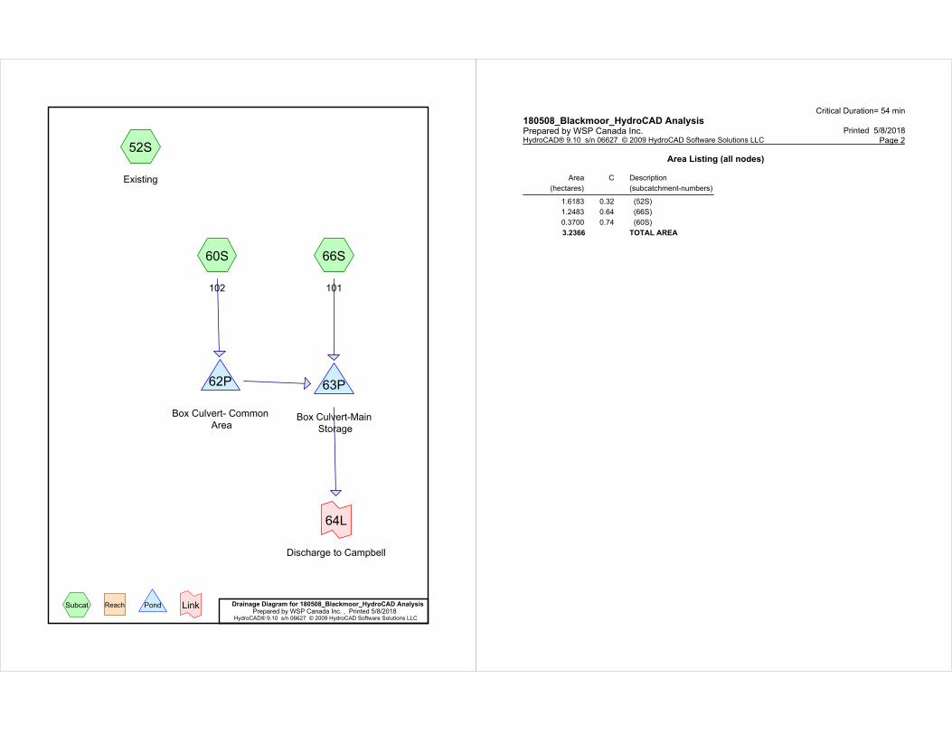
52S
Existing
60S
102
66S
101
62P
Box Culvert- Common
Area
63P
Box Culvert-Main
Storage
64L
Discharge to Campbell
Drainage Diagram for 180508_Blackmoor_HydroCAD AnalysisPrepared by WSP Canada Inc. , Printed 5/8/2018
HydroCAD® 9.10 s/n 06627 © 2009 HydroCAD Software Solutions LLC
Subcat Reach Pond Link
Critical Duration= 32 min
180508_Blackmoor_HydroCAD Analysis Printed 5/8/2018Prepared by WSP Canada Inc.
Page 2HydroCAD® 9.10 s/n 06627 © 2009 HydroCAD Software Solutions LLC
Area Listing (all nodes)
Area
(hectares)
C Description
(subcatchment-numbers)
1.6183 0.32 (52S)
1.2483 0.64 (66S)
0.3700 0.74 (60S)
3.2366 TOTAL AREA
Critical Duration= 32 min
180508_Blackmoor_HydroCAD Analysis Printed 5/8/2018Prepared by WSP Canada Inc.
Page 3HydroCAD® 9.10 s/n 06627 © 2009 HydroCAD Software Solutions LLC
Soil Listing (all nodes)
Area
(hectares)
Soil
Group
Subcatchment
Numbers
0.0000 HSG A
0.0000 HSG B
0.0000 HSG C
0.0000 HSG D
3.2366 Other 52S, 60S, 66S
3.2366 TOTAL AREA
Critical Duration= 32 minCollingwood 100-Year Duration=32 min, Inten=86.3 mm/hr180508_Blackmoor_HydroCAD An
Printed 5/8/2018Prepared by WSP Canada Inc. Page 4HydroCAD® 9.10 s/n 06627 © 2009 HydroCAD Software Solutions LLC
Time span=0.00-3.00 hrs, dt=0.01 hrs, 301 pointsRunoff by Rational method, Rise/Fall=1.0/1.0 xTc
Reach routing by Stor-Ind+Trans method - Pond routing by Stor-Ind method
Runoff Area=16,183.0 m² 0.00% Impervious Runoff Depth=15 mmSubcatchment 52S: Existing Tc=10.0 min C=0.32 Runoff=0.1241 m³/s 0.238 Ml
Runoff Area=0.3700 ha 0.00% Impervious Runoff Depth=34 mmSubcatchment 60S: 102 Tc=10.0 min C=0.74 Runoff=0.0656 m³/s 0.126 Ml
Runoff Area=12,483.0 m² 0.00% Impervious Runoff Depth=29 mmSubcatchment 66S: 101 Tc=10.0 min C=0.64 Runoff=0.1915 m³/s 0.368 Ml
Peak Elev=192.199 m Storage=0.100 Ml Inflow=0.0656 m³/s 0.126 MlPond 62P: Box Culvert- Common Outflow=0.0167 m³/s 0.115 Ml
Peak Elev=189.826 m Storage=0.228 Ml Inflow=0.2071 m³/s 0.483 MlPond 63P: Box Culvert-Main Storage Outflow=0.1100 m³/s 0.471 Ml
Inflow=0.1100 m³/s 0.471 MlLink 64L: Discharge to Campbell Primary=0.1100 m³/s 0.471 Ml
Total Runoff Area = 3.2366 ha Runoff Volume = 0.732 Ml Average Runoff Depth = 23 mm100.00% Pervious = 3.2366 ha 0.00% Impervious = 0.0000 ha
Critical Duration= 32 minCollingwood 100-Year Duration=32 min, Inten=86.3 mm/hr180508_Blackmoor_HydroCAD An
Printed 5/8/2018Prepared by WSP Canada Inc. Page 5HydroCAD® 9.10 s/n 06627 © 2009 HydroCAD Software Solutions LLC
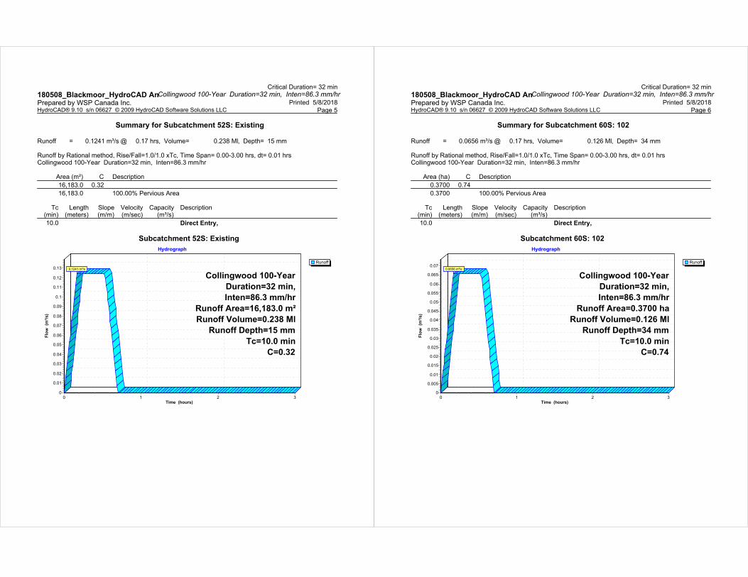
Summary for Subcatchment 52S: Existing
Runoff = 0.1241 m³/s @ 0.17 hrs, Volume= 0.238 Ml, Depth= 15 mm
Runoff by Rational method, Rise/Fall=1.0/1.0 xTc, Time Span= 0.00-3.00 hrs, dt= 0.01 hrsCollingwood 100-Year Duration=32 min, Inten=86.3 mm/hr
Area (m²) C Description
16,183.0 0.32
16,183.0 100.00% Pervious Area
Tc Length Slope Velocity Capacity Description(min) (meters) (m/m) (m/sec) (m³/s)
10.0 Direct Entry,
Subcatchment 52S: Existing
Runoff
Hydrograph
Time (hours)3210
Flo
w
(m³/
s)
0.13
0.12
0.11
0.1
0.09
0.08
0.07
0.06
0.05
0.04
0.03
0.02
0.01
0
Collingwood 100-Year
Duration=32 min,
Inten=86.3 mm/hr
Runoff Area=16,183.0 m²
Runoff Volume=0.238 Ml
Runoff Depth=15 mm
Tc=10.0 min
C=0.32
0.1241 m³/s
Critical Duration= 32 minCollingwood 100-Year Duration=32 min, Inten=86.3 mm/hr180508_Blackmoor_HydroCAD An
Printed 5/8/2018Prepared by WSP Canada Inc. Page 6HydroCAD® 9.10 s/n 06627 © 2009 HydroCAD Software Solutions LLC
Summary for Subcatchment 60S: 102
Runoff = 0.0656 m³/s @ 0.17 hrs, Volume= 0.126 Ml, Depth= 34 mm
Runoff by Rational method, Rise/Fall=1.0/1.0 xTc, Time Span= 0.00-3.00 hrs, dt= 0.01 hrsCollingwood 100-Year Duration=32 min, Inten=86.3 mm/hr
Area (ha) C Description
0.3700 0.74
0.3700 100.00% Pervious Area
Tc Length Slope Velocity Capacity Description(min) (meters) (m/m) (m/sec) (m³/s)
10.0 Direct Entry,
Subcatchment 60S: 102
Runoff
Hydrograph
Time (hours)3210
Flo
w
(m³/
s)
0.07
0.065
0.06
0.055
0.05
0.045
0.04
0.035
0.03
0.025
0.02
0.015
0.01
0.005
0
Collingwood 100-Year
Duration=32 min,
Inten=86.3 mm/hr
Runoff Area=0.3700 ha
Runoff Volume=0.126 Ml
Runoff Depth=34 mm
Tc=10.0 min
C=0.74
0.0656 m³/s

Critical Duration= 32 minCollingwood 100-Year Duration=32 min, Inten=86.3 mm/hr180508_Blackmoor_HydroCAD An
Printed 5/8/2018Prepared by WSP Canada Inc. Page 7HydroCAD® 9.10 s/n 06627 © 2009 HydroCAD Software Solutions LLC
Summary for Subcatchment 66S: 101
Runoff = 0.1915 m³/s @ 0.17 hrs, Volume= 0.368 Ml, Depth= 29 mm
Runoff by Rational method, Rise/Fall=1.0/1.0 xTc, Time Span= 0.00-3.00 hrs, dt= 0.01 hrsCollingwood 100-Year Duration=32 min, Inten=86.3 mm/hr
Area (m²) C Description
12,483.0 0.64
12,483.0 100.00% Pervious Area
Tc Length Slope Velocity Capacity Description(min) (meters) (m/m) (m/sec) (m³/s)
10.0 Direct Entry,
Subcatchment 66S: 101
Runoff
Hydrograph
Time (hours)3210
Flo
w
(m³/
s)
0.21
0.2
0.19
0.18
0.17
0.16
0.15
0.14
0.13
0.12
0.11
0.1
0.09
0.08
0.07
0.06
0.05
0.04
0.03
0.02
0.01
0
Collingwood 100-Year
Duration=32 min,
Inten=86.3 mm/hr
Runoff Area=12,483.0 m²
Runoff Volume=0.368 Ml
Runoff Depth=29 mm
Tc=10.0 min
C=0.64
0.1915 m³/s
Critical Duration= 32 minCollingwood 100-Year Duration=32 min, Inten=86.3 mm/hr180508_Blackmoor_HydroCAD An
Printed 5/8/2018Prepared by WSP Canada Inc. Page 8HydroCAD® 9.10 s/n 06627 © 2009 HydroCAD Software Solutions LLC
Summary for Pond 62P: Box Culvert- Common Area
Inflow Area = 0.3700 ha, 0.00% Impervious, Inflow Depth = 34 mm for 100-Year eventInflow = 0.0656 m³/s @ 0.17 hrs, Volume= 0.126 MlOutflow = 0.0167 m³/s @ 0.66 hrs, Volume= 0.115 Ml, Atten= 75%, Lag= 29.3 minPrimary = 0.0167 m³/s @ 0.66 hrs, Volume= 0.115 Ml
Routing by Stor-Ind method, Time Span= 0.00-3.00 hrs, dt= 0.01 hrsPeak Elev= 192.199 m @ 0.66 hrs Surf.Area= 0.0100 ha Storage= 0.100 Ml
Plug-Flow detention time= 61.7 min calculated for 0.115 Ml (91% of inflow)Center-of-Mass det. time= 60.5 min ( 81.5 - 21.0 )
Volume Invert Avail.Storage Storage Description
#1 191.180 m 0.120 Ml 1,800 mmW x 1,200 mmH x 55.34 mL Pipe Storage S= 0.0005 m/m
Device Routing Invert Outlet Devices
#1 Primary 191.180 m 90 mm Vert. Orifice/Grate C= 0.600
Primary OutFlow Max=0.0167 m³/s @ 0.66 hrs HW=192.199 m TW=191.080 m (Fixed TW Elev= 191.080 m)1=Orifice/Grate (Orifice Controls 0.0167 m³/s @ 2.62 m/s)
Pond 62P: Box Culvert- Common Area
InflowPrimary
Hydrograph
Time (hours)3210
Flo
w
(m³/
s)
0.07
0.065
0.06
0.055
0.05
0.045
0.04
0.035
0.03
0.025
0.02
0.015
0.01
0.005
0
Inflow Area=0.3700 ha
Peak Elev=192.199 m
Storage=0.100 Ml
0.0656 m³/s
0.0167 m³/s
Critical Duration= 32 minCollingwood 100-Year Duration=32 min, Inten=86.3 mm/hr180508_Blackmoor_HydroCAD An
Printed 5/8/2018Prepared by WSP Canada Inc. Page 9HydroCAD® 9.10 s/n 06627 © 2009 HydroCAD Software Solutions LLC
Summary for Pond 63P: Box Culvert-Main Storage
Inflow Area = 1.6183 ha, 0.00% Impervious, Inflow Depth > 30 mm for 100-Year eventInflow = 0.2071 m³/s @ 0.53 hrs, Volume= 0.483 MlOutflow = 0.1100 m³/s @ 0.62 hrs, Volume= 0.471 Ml, Atten= 47%, Lag= 5.3 minPrimary = 0.1100 m³/s @ 0.62 hrs, Volume= 0.471 Ml
Routing by Stor-Ind method, Time Span= 0.00-3.00 hrs, dt= 0.01 hrsPeak Elev= 189.826 m @ 0.62 hrs Surf.Area= 0.0193 ha Storage= 0.228 Ml
Plug-Flow detention time= 26.9 min calculated for 0.469 Ml (97% of inflow)Center-of-Mass det. time= 23.6 min ( 59.0 - 35.4 )
Volume Invert Avail.Storage Storage Description
#1 188.630 m 0.199 Ml 2,400 mmW x 1,200 mmH x 69.00 mL Pipe Storage S= 0.0005 m/m#2 188.630 m 0.041 Ml 2.40 mD x 1.50 mH Vertical Cone/Cylinder x 6
0.239 Ml Total Available Storage
Device Routing Invert Outlet Devices
#1 Primary 188.630 m 225 mm Vert. Orifice/Grate C= 0.600
Primary OutFlow Max=0.1100 m³/s @ 0.62 hrs HW=189.826 m (Free Discharge)1=Orifice/Grate (Orifice Controls 0.1100 m³/s @ 2.77 m/s)
Pond 63P: Box Culvert-Main Storage
InflowPrimary
Hydrograph
Time (hours)3210
Flo
w
(m³/
s)
0.23
0.22
0.21
0.2
0.19
0.18
0.17
0.16
0.15
0.14
0.13
0.12
0.11
0.1
0.09
0.08
0.07
0.06
0.05
0.04
0.03
0.02
0.01
0
Inflow Area=1.6183 ha
Peak Elev=189.826 m
Storage=0.228 Ml
0.2071 m³/s
0.1100 m³/s
Critical Duration= 32 minCollingwood 100-Year Duration=32 min, Inten=86.3 mm/hr180508_Blackmoor_HydroCAD An
Printed 5/8/2018Prepared by WSP Canada Inc. Page 10HydroCAD® 9.10 s/n 06627 © 2009 HydroCAD Software Solutions LLC
Summary for Link 64L: Discharge to Campbell
Inflow Area = 1.6183 ha, 0.00% Impervious, Inflow Depth > 29 mm for 100-Year eventInflow = 0.1100 m³/s @ 0.62 hrs, Volume= 0.471 MlPrimary = 0.1100 m³/s @ 0.62 hrs, Volume= 0.471 Ml, Atten= 0%, Lag= 0.0 min
Primary outflow = Inflow, Time Span= 0.00-3.00 hrs, dt= 0.01 hrs
Link 64L: Discharge to Campbell
InflowPrimary
Hydrograph
Time (hours)3210
Flo
w
(m³/
s)
0.12
0.115
0.11
0.105
0.1
0.095
0.09
0.085
0.08
0.075
0.07
0.065
0.06
0.055
0.05
0.045
0.04
0.035
0.03
0.025
0.02
0.015
0.01
0.005
0
Inflow Area=1.6183 ha0.1100 m³/s
0.1100 m³/s
52S
Existing
60S
102
66S
101
62P
Box Culvert- Common
Area
63P
Box Culvert-Main
Storage
64L
Discharge to Campbell
Drainage Diagram for 180508_Blackmoor_HydroCAD AnalysisPrepared by WSP Canada Inc. , Printed 5/8/2018
HydroCAD® 9.10 s/n 06627 © 2009 HydroCAD Software Solutions LLC
Subcat Reach Pond Link
Critical Duration= 54 min
180508_Blackmoor_HydroCAD Analysis Printed 5/8/2018Prepared by WSP Canada Inc.
Page 2HydroCAD® 9.10 s/n 06627 © 2009 HydroCAD Software Solutions LLC
Area Listing (all nodes)
Area
(hectares)
C Description
(subcatchment-numbers)
1.6183 0.32 (52S)
1.2483 0.64 (66S)
0.3700 0.74 (60S)
3.2366 TOTAL AREA

Critical Duration= 54 min
180508_Blackmoor_HydroCAD Analysis Printed 5/8/2018Prepared by WSP Canada Inc.
Page 3HydroCAD® 9.10 s/n 06627 © 2009 HydroCAD Software Solutions LLC
Soil Listing (all nodes)
Area
(hectares)
Soil
Group
Subcatchment
Numbers
0.0000 HSG A
0.0000 HSG B
0.0000 HSG C
0.0000 HSG D
3.2366 Other 52S, 60S, 66S
3.2366 TOTAL AREA
Critical Duration= 54 minCollingwood 100-Year Duration=54 min, Inten=59.4 mm/hr180508_Blackmoor_HydroCAD An
Printed 5/8/2018Prepared by WSP Canada Inc. Page 4HydroCAD® 9.10 s/n 06627 © 2009 HydroCAD Software Solutions LLC
Time span=0.00-3.00 hrs, dt=0.01 hrs, 301 pointsRunoff by Rational method, Rise/Fall=1.0/1.0 xTc
Reach routing by Stor-Ind+Trans method - Pond routing by Stor-Ind method
Runoff Area=16,183.0 m² 0.00% Impervious Runoff Depth=17 mmSubcatchment 52S: Existing Tc=10.0 min C=0.32 Runoff=0.0854 m³/s 0.277 Ml
Runoff Area=0.3700 ha 0.00% Impervious Runoff Depth=40 mmSubcatchment 60S: 102 Tc=10.0 min C=0.74 Runoff=0.0452 m³/s 0.146 Ml
Runoff Area=12,483.0 m² 0.00% Impervious Runoff Depth=34 mmSubcatchment 66S: 101 Tc=10.0 min C=0.64 Runoff=0.1318 m³/s 0.427 Ml
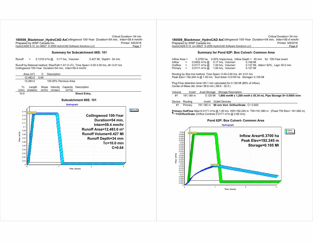
Peak Elev=192.245 m Storage=0.105 Ml Inflow=0.0452 m³/s 0.146 MlPond 62P: Box Culvert- Common Outflow=0.0171 m³/s 0.127 Ml
Peak Elev=189.740 m Storage=0.211 Ml Inflow=0.1484 m³/s 0.554 MlPond 63P: Box Culvert-Main Storage Outflow=0.1055 m³/s 0.539 Ml
Inflow=0.1055 m³/s 0.539 MlLink 64L: Discharge to Campbell Primary=0.1055 m³/s 0.539 Ml
Total Runoff Area = 3.2366 ha Runoff Volume = 0.850 Ml Average Runoff Depth = 26 mm100.00% Pervious = 3.2366 ha 0.00% Impervious = 0.0000 ha
Critical Duration= 54 minCollingwood 100-Year Duration=54 min, Inten=59.4 mm/hr180508_Blackmoor_HydroCAD An
Printed 5/8/2018Prepared by WSP Canada Inc. Page 5HydroCAD® 9.10 s/n 06627 © 2009 HydroCAD Software Solutions LLC
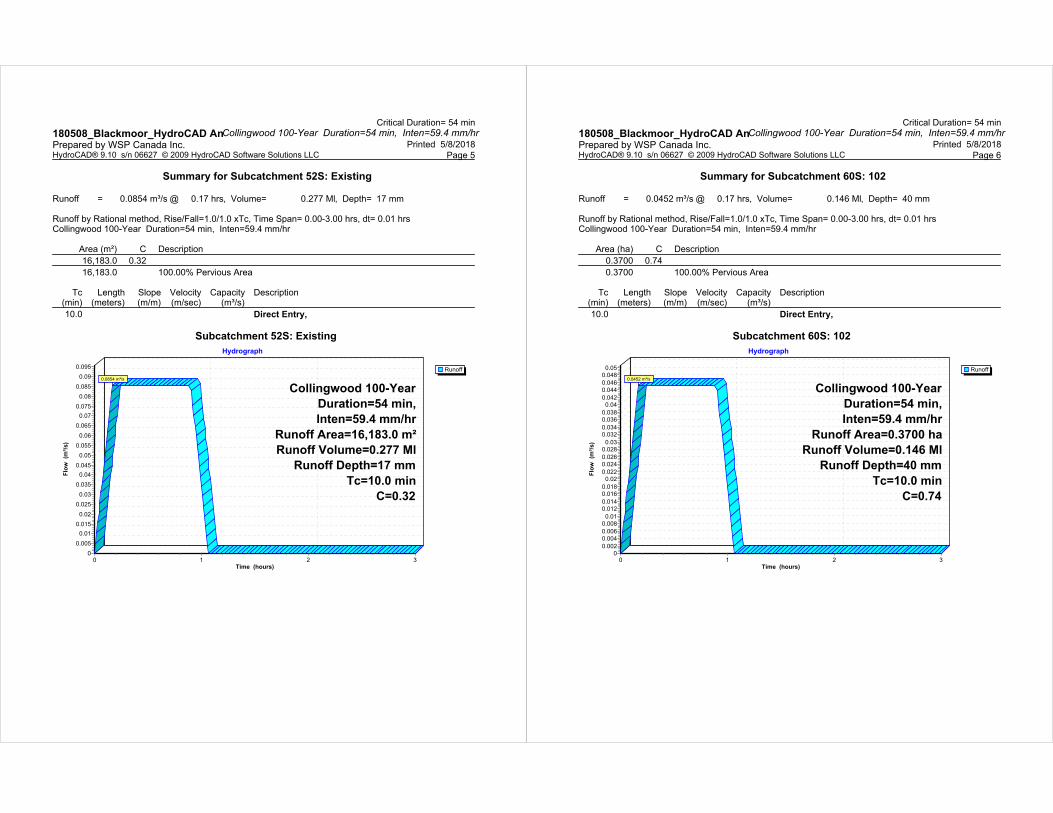
Summary for Subcatchment 52S: Existing
Runoff = 0.0854 m³/s @ 0.17 hrs, Volume= 0.277 Ml, Depth= 17 mm
Runoff by Rational method, Rise/Fall=1.0/1.0 xTc, Time Span= 0.00-3.00 hrs, dt= 0.01 hrsCollingwood 100-Year Duration=54 min, Inten=59.4 mm/hr
Area (m²) C Description
16,183.0 0.32
16,183.0 100.00% Pervious Area
Tc Length Slope Velocity Capacity Description(min) (meters) (m/m) (m/sec) (m³/s)
10.0 Direct Entry,
Subcatchment 52S: Existing
Runoff
Hydrograph
Time (hours)3210
Flo
w
(m³/
s)
0.095
0.09
0.085
0.08
0.075
0.07
0.065
0.06
0.055
0.05
0.045
0.04
0.035
0.03
0.025
0.02
0.015
0.01
0.005
0
Collingwood 100-Year
Duration=54 min,
Inten=59.4 mm/hr
Runoff Area=16,183.0 m²
Runoff Volume=0.277 Ml
Runoff Depth=17 mm
Tc=10.0 min
C=0.32
0.0854 m³/s
Critical Duration= 54 minCollingwood 100-Year Duration=54 min, Inten=59.4 mm/hr180508_Blackmoor_HydroCAD An
Printed 5/8/2018Prepared by WSP Canada Inc. Page 6HydroCAD® 9.10 s/n 06627 © 2009 HydroCAD Software Solutions LLC
Summary for Subcatchment 60S: 102
Runoff = 0.0452 m³/s @ 0.17 hrs, Volume= 0.146 Ml, Depth= 40 mm
Runoff by Rational method, Rise/Fall=1.0/1.0 xTc, Time Span= 0.00-3.00 hrs, dt= 0.01 hrsCollingwood 100-Year Duration=54 min, Inten=59.4 mm/hr
Area (ha) C Description
0.3700 0.74
0.3700 100.00% Pervious Area
Tc Length Slope Velocity Capacity Description(min) (meters) (m/m) (m/sec) (m³/s)
10.0 Direct Entry,
Subcatchment 60S: 102
Runoff
Hydrograph
Time (hours)3210
Flo
w
(m³/
s)
0.05
0.048
0.046
0.044
0.042
0.04
0.038
0.036
0.034
0.032
0.03
0.028
0.026
0.024
0.022
0.02
0.018
0.016
0.014
0.012
0.01
0.008
0.006
0.004
0.002
0
Collingwood 100-Year
Duration=54 min,
Inten=59.4 mm/hr
Runoff Area=0.3700 ha
Runoff Volume=0.146 Ml
Runoff Depth=40 mm
Tc=10.0 min
C=0.74
0.0452 m³/s
Critical Duration= 54 minCollingwood 100-Year Duration=54 min, Inten=59.4 mm/hr180508_Blackmoor_HydroCAD An
Printed 5/8/2018Prepared by WSP Canada Inc. Page 7HydroCAD® 9.10 s/n 06627 © 2009 HydroCAD Software Solutions LLC
Summary for Subcatchment 66S: 101
Runoff = 0.1318 m³/s @ 0.17 hrs, Volume= 0.427 Ml, Depth= 34 mm
Runoff by Rational method, Rise/Fall=1.0/1.0 xTc, Time Span= 0.00-3.00 hrs, dt= 0.01 hrsCollingwood 100-Year Duration=54 min, Inten=59.4 mm/hr
Area (m²) C Description
12,483.0 0.64
12,483.0 100.00% Pervious Area
Tc Length Slope Velocity Capacity Description(min) (meters) (m/m) (m/sec) (m³/s)
10.0 Direct Entry,
Subcatchment 66S: 101
Runoff
Hydrograph
Time (hours)3210
Flo
w
(m³/
s)
0.14
0.13
0.12
0.11
0.1
0.09
0.08
0.07
0.06
0.05
0.04
0.03
0.02
0.01
0
Collingwood 100-Year
Duration=54 min,
Inten=59.4 mm/hr
Runoff Area=12,483.0 m²
Runoff Volume=0.427 Ml
Runoff Depth=34 mm
Tc=10.0 min
C=0.64
0.1318 m³/s
Critical Duration= 54 minCollingwood 100-Year Duration=54 min, Inten=59.4 mm/hr180508_Blackmoor_HydroCAD An
Printed 5/8/2018Prepared by WSP Canada Inc. Page 8HydroCAD® 9.10 s/n 06627 © 2009 HydroCAD Software Solutions LLC
Summary for Pond 62P: Box Culvert- Common Area
Inflow Area = 0.3700 ha, 0.00% Impervious, Inflow Depth = 40 mm for 100-Year eventInflow = 0.0452 m³/s @ 0.17 hrs, Volume= 0.146 MlOutflow = 0.0171 m³/s @ 1.00 hrs, Volume= 0.127 Ml, Atten= 62%, Lag= 50.0 minPrimary = 0.0171 m³/s @ 1.00 hrs, Volume= 0.127 Ml
Routing by Stor-Ind method, Time Span= 0.00-3.00 hrs, dt= 0.01 hrsPeak Elev= 192.245 m @ 1.00 hrs Surf.Area= 0.0100 ha Storage= 0.105 Ml
Plug-Flow detention time= 60.1 min calculated for 0.126 Ml (86% of inflow)Center-of-Mass det. time= 56.6 min ( 88.6 - 32.0 )
Volume Invert Avail.Storage Storage Description
#1 191.180 m 0.120 Ml 1,800 mmW x 1,200 mmH x 55.34 mL Pipe Storage S= 0.0005 m/m
Device Routing Invert Outlet Devices
#1 Primary 191.180 m 90 mm Vert. Orifice/Grate C= 0.600
Primary OutFlow Max=0.0171 m³/s @ 1.00 hrs HW=192.245 m TW=191.080 m (Fixed TW Elev= 191.080 m)1=Orifice/Grate (Orifice Controls 0.0171 m³/s @ 2.68 m/s)
Pond 62P: Box Culvert- Common Area
InflowPrimary
Hydrograph
Time (hours)3210
Flo
w
(m³/
s)
0.05
0.048
0.046
0.0440.042
0.04
0.038
0.036
0.034
0.032
0.03
0.028
0.026
0.024
0.022
0.02
0.018
0.0160.014
0.012
0.01
0.008
0.006
0.004
0.002
0
Inflow Area=0.3700 ha
Peak Elev=192.245 m
Storage=0.105 Ml
0.0452 m³/s
0.0171 m³/s
Critical Duration= 54 minCollingwood 100-Year Duration=54 min, Inten=59.4 mm/hr180508_Blackmoor_HydroCAD An
Printed 5/8/2018Prepared by WSP Canada Inc. Page 9HydroCAD® 9.10 s/n 06627 © 2009 HydroCAD Software Solutions LLC
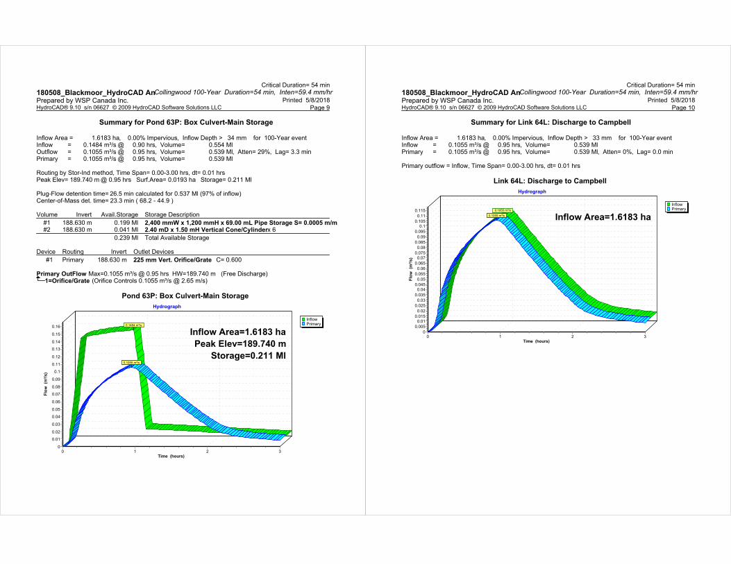
Summary for Pond 63P: Box Culvert-Main Storage
Inflow Area = 1.6183 ha, 0.00% Impervious, Inflow Depth > 34 mm for 100-Year eventInflow = 0.1484 m³/s @ 0.90 hrs, Volume= 0.554 MlOutflow = 0.1055 m³/s @ 0.95 hrs, Volume= 0.539 Ml, Atten= 29%, Lag= 3.3 minPrimary = 0.1055 m³/s @ 0.95 hrs, Volume= 0.539 Ml
Routing by Stor-Ind method, Time Span= 0.00-3.00 hrs, dt= 0.01 hrsPeak Elev= 189.740 m @ 0.95 hrs Surf.Area= 0.0193 ha Storage= 0.211 Ml
Plug-Flow detention time= 26.5 min calculated for 0.537 Ml (97% of inflow)Center-of-Mass det. time= 23.3 min ( 68.2 - 44.9 )
Volume Invert Avail.Storage Storage Description
#1 188.630 m 0.199 Ml 2,400 mmW x 1,200 mmH x 69.00 mL Pipe Storage S= 0.0005 m/m#2 188.630 m 0.041 Ml 2.40 mD x 1.50 mH Vertical Cone/Cylinder x 6
0.239 Ml Total Available Storage
Device Routing Invert Outlet Devices
#1 Primary 188.630 m 225 mm Vert. Orifice/Grate C= 0.600
Primary OutFlow Max=0.1055 m³/s @ 0.95 hrs HW=189.740 m (Free Discharge)1=Orifice/Grate (Orifice Controls 0.1055 m³/s @ 2.65 m/s)
Pond 63P: Box Culvert-Main Storage
InflowPrimary
Hydrograph
Time (hours)3210
Flo
w
(m³/
s)
0.16
0.15
0.14
0.13
0.12
0.11
0.1
0.09
0.08
0.07
0.06
0.05
0.04
0.03
0.02
0.01
0
Inflow Area=1.6183 ha
Peak Elev=189.740 m
Storage=0.211 Ml
0.1484 m³/s
0.1055 m³/s
Critical Duration= 54 minCollingwood 100-Year Duration=54 min, Inten=59.4 mm/hr180508_Blackmoor_HydroCAD An
Printed 5/8/2018Prepared by WSP Canada Inc. Page 10HydroCAD® 9.10 s/n 06627 © 2009 HydroCAD Software Solutions LLC
Summary for Link 64L: Discharge to Campbell
Inflow Area = 1.6183 ha, 0.00% Impervious, Inflow Depth > 33 mm for 100-Year eventInflow = 0.1055 m³/s @ 0.95 hrs, Volume= 0.539 MlPrimary = 0.1055 m³/s @ 0.95 hrs, Volume= 0.539 Ml, Atten= 0%, Lag= 0.0 min
Primary outflow = Inflow, Time Span= 0.00-3.00 hrs, dt= 0.01 hrs
Link 64L: Discharge to Campbell
InflowPrimary
Hydrograph
Time (hours)3210
Flo
w
(m³/
s)
0.115
0.11
0.105
0.1
0.095
0.09
0.085
0.08
0.075
0.07
0.065
0.06
0.055
0.05
0.045
0.04
0.035
0.03
0.025
0.02
0.015
0.01
0.005
0
Inflow Area=1.6183 ha0.1055 m³/s
0.1055 m³/s

NVCA Source Water ProtectionVulnerability Mapping


Product Overview Quality Permeable Ground Reinforcement
X30 | Bloxx | E40 | E50
20 YEARwarranty

ECORASTER® E40 | E50Quality permeable ground reinforcement
Type: Dimensions: Material: Wall thick-ness: Load: Solubility: Compressive
strength: Weight per piece: Weight per m² | 10.76 ft²:
E50Heavy Duty
330 x 330 x 50 mm • 12.99 x 12.99 x 1.97 " 100% recycled
Polyethylene (LDPE)
5 mm • 0.1968 "
up to 800 t/m²
(depen-ding on � ll type)
resistant to acids, al-kalis, alcohol, oil and petrol (de-icing salt, ammonia, acid rain,
etc.)
up to 20t point axle load
(DIN 1072)
1,06 kg • 2.34 lbs 9,55 kg • 21.05 lbs
E40Allround
330 x 330 x 40 mm •12.99 x 12.99 x 1.57 "
3,6 mm • 0.14 "
0,58 kg • 1.27 lbs 5,22 kg • 11.50 lbs
High quality permeable ground reinforcement.E40 Allround and E50 Heavy-Duty.
Your Benefi ts:
Easy to install:
easy and quick installation (up to 100 m²| 1,076 ft²/h per person)
high resilience (up to 800 t/m²)
low maintenance
installation without heavy construction equipment
no edging needed
permeable ground reinforcement
low transport and handling costs
versatile applicable, accessories available
weatherproof and unbreakable
Safety interlocking, 36 notches per m²
UV-resistant and frostproof
immediately green area (ECORASTER® Green, pre-greened)
20 year warranty
„Made in Germany“ (TÜV Nord)
it‘s
DONE!Step 1
LAYStep 2
CUTStep 3
FILL
20 YEARwarranty

ECORASTER® Bloxx, unpack, snap together, and drop the blocks in. No need to tuckpoint the joints!
Bloxx elements connecttogether in seconds!
Thermal expansion is compensated by the expansion elements
Be Creative! ECORASTER® Bloxx � ts into the ECORASTER® system.
ECORASTER® BloxxWith integrated „no-clogging“ drainage
Get paved areas with less e� orts - permeable!Safe money, time and maintenance.
Easy to install:
Type: Dimensions: Material: Paver colors: Solubility: Compressive strength: Weight per m²:
Bloxx 330 x 330 x 50 mm • 12.99 x 12.99 x 1.97“
100% recycled P o l y e t h y l e n e
(LDPE)
red, white, dark grey and
light grey
resistant to acids, alkalis, alcohol, oil and petrol (de-icing salt, ammonia, acid
rain, etc.)
up to 20t point axle load
(DIN 1072)
approx. 85 kg • 187.39 lbs
(incl. pavers)
How it works:
Fully accessible!!!
Bloxx Paver Elements, replaceable without loosening the cluster (e.g. exchange dirty paver)
Bloxx Concrete Element
Substructure, water-bearing bed
Clogg-free dain system
ECORASTER Bloxx
Unique safety interlocking,NO bumps, NO trip hazards!
Clogging? Not possible!
Colorful: Dark grey, light grey, red, white... combine as u like.
Safety Locking System High in� ltration rate Quick Installation Low maintenance

A heavy duty linking grid system that allows you to buildstronger hardscapes by stabilizing the base material.
Your Benefi ts:
Easy to install:
ECORASTER® X30Hardscape Base Stabilizing System
» Heavy Duty Base Stabilization» Permeable Base Stabilization
» Permeable Interlock Concrete Paving Installation » Interlock Driveway Base Support
Type: Dimensions: Material: Wall thickness: Load up to: Solubility: Compressive
strength:W e i g h t per piece:
Weight per m² | 10.76 ft²:
X30Base Stabilizer
330 x 330 x 30 mm • 12.99 x 12.99 x 1.18“
100% recycled Polyethylene
(LDPE)
0.2 in 23 t/ft² (un� lled)
75 t/ft² (� lled)
resistant to acids, alkalis, alcohol, oil and petrol (de-icing salt, ammonia, acid
rain, etc.)
up to 20t point axle load
(DIN 1072)
0,77 kg • 1.7 lbs
6,93 kg • 15.3 lbs
Vegetation Layer
Filter Cloth Wrapped Excavation
HPB Joint80mm Paver
12“
Compacted Sub-Soil
3/4“ Clear Sharp Gravel
Perm Edge
HPB Bedding Layer
ECORASTER® X30
3“
2“
10“
» Up to 50% base reduction in excavation
» Up to 30% labour cost savings
» Wider pin-point load dispersal
» Reduced warrantee call-backs from shifting and sinking
» Reduced risk of poor sub-base compaction
» Sustainable, e� cient, and pro� table!
Questions? Give us a call:
+1-800-495-5517 (Toll Free)
Applications:

20 YEARwarrantyECORASTER® Application
GREEN / MICROGREEN MINERAL Bloxx
vegetated gravel � lled paved
Load
Ü Roads and paths used only for pedestrians and bicycles may use this
E40alternative: S50
E40alternative: S50
Paths, walkways and similar applications, as well as car parking
E40alternative: E50 or
S50
E40alternative: E50
Roads, road shoulders and parking lots used for all types of vehicles
E50E50*
alternative:ECORASTER® STONE
9
*6
Areas used with high point axle loading e.g. warehousing (forklifts and trucks), truck parking lots, bus parking, helicopter landing pads.
---E50*
alternative:ECORASTER® STONE
Installed and unfi lled, the ECORASTER® system can be driven on with heavy wheeled vehicles (EN 124 / D400 | except Bloxx).
*with
3/8
“ - 3
/4“ i
nche
s cov
erin
g-ov
er
Please note: Please read the manual/ check our website for more information!
1m² = 10.764 ft²
Point axle loading up to 20 t/m², DIN 1072:1985
UV-resistant, certi� ed DIN EN 60068-2-5
Heavy-duty, tried and tested DIN EN 124:2011
Environmentally safe, tested OECD 202:2004
Factory warranty: 20 years from purchase date (private use)
NATO certi� ed E50 - MOD / 9330-99-858-1406
TÜV CERT
TÜV Nord „Made in Germany“
Certi� cates and Approvals
Specifications
Sustainable and cost-saving
FXD$
AccessoriesPURUS o� er accessories for ECORASTER® ground reinforcement systems, including hinge and curve adaptors as well as parking markers.
AccessoriesPURUS o� er accessories for ECORASTER® ground reinforcement systems, including hinge and curve adaptors as well as parking markers.
Safety interlocking system
Deploy without expansion joints
E� ective safety snap connections are quick and easy to install.
Not a� ected by temperature variations due to the integral expansion elements.
Installed and un� lled, the ECORASTER® system can be driven on with heavy wheeled vehicles (class D 400, excl. Bloxx)

PURUS North America Inc. | 1790 Avenue Road Unit A | Toronto, ON | M5M 3Z1Tollfree: +1 800 495 55 17 | [email protected]
ECORASTER® is a PURUS PLASTICS GmbH brand.Subject to change without prior notice. E. & O. E.
Developing sustainable solutions fora permeable ground reinforcement.a permeable ground reinforcement.
German engineering – installed worldwide.Questions? Please give us a call:
Version Av1_2015
20 YEARwarranty

APPENDIX
E PROPOSED
WATER
SERVICING

ElementarySchool Catholic Notre-Dame-De-La-Huronie
WTV
WTV
HU
RO
NTA
RIO
S
TRE
ET
CAMPBELL STREET
WV
WV
86
.95
13.88
30.71
3.01
86
.31
2.67 54.55 2.98
41
.70
8.8
5
42
.44
3.93
∅ WM
∅ WM
∅ WM
M A
P L
E
S T
R E
E T
F I N D L AY D R I V E
7.99
9.40
∅
∅
∅
∅
∅
∅
∅
∅
∅
∅
∅
∅
∅
∅
∅
∅
∅
∅
∅
∅
∅
∅
∅
∅
∅ ∅
∅
∅
WV
G:\20
17\17
1-16
446 B
lackm
oor D
evelo
pmen
t\6.0
Dwg\6
.2 Ci
vil\17
1-16
446-
00-3
D-4.d
wg M
ay 09
, 201
8-2:1
3pm
BY:(t
yler.ja
hnke
)
REV #
C F
C
C F
C
A
E
F
C
D
B
1235 4678910
1235 4678910
A
E
F
C
D
B
FFF
P
FFF
F
F
SEAL:
CONSULTANT:
CLIENT:
PROJECT:
CLIENT REF. #:
DISCLAIMER: COPYRIGHT:
ISSUED FOR - REVISION:
DESCRIPTIONDATEREIS
KEY PLAN:
ISSUE:
DATE OF:
ORIGINAL SCALE:
CHECKED BY:
DRAWN BY:
SHEET #: OF
TITLE:
DISCIPLINE:
25mm
IF THIS BAR IS NOT 25mmLONG, ADJUST YOUR
PLOTTING SCALE.
PROJECT NO: DATE:
SHEET NUMBER:
DESIGNED BY:
THIS DRAWING AND DESIGN IS COPYRIGHT PROTECTED WHICH SHALL NOT BE USED, REPRODUCED ORREVISED WITHOUT WRITTEN PERMISSION BY WSP. THE CONTRACTOR SHALL CHECK AND VERIFY ALLDIMENSIONS AND UTILITY LOCATIONS AND REPORT ALL ERRORS AND OMISSIONS PRIOR TOCOMMENCING WORK.THIS DRAWING IS NOT TO BE SCALED.
F
F
101-1450 1st AVENUE W.OWEN SOUND, ONTARIO, CANADA N4K6W2
PHONE: 519-376-7612 FAX: 519-376-8008WWW.WSP.COM
STRAW HAT RESTORATION
BLACKMOOR GATE
--
171-16446-00 APRIL 2018
FIRST SUBMISSION SPA--
0
- - --00 04/05/18 FIRST SUBMISSION SPA
1:500
K H
T J J
C W
CIVIL
SERVICING PLAN
SS1-- --
· ∅
·
·
·
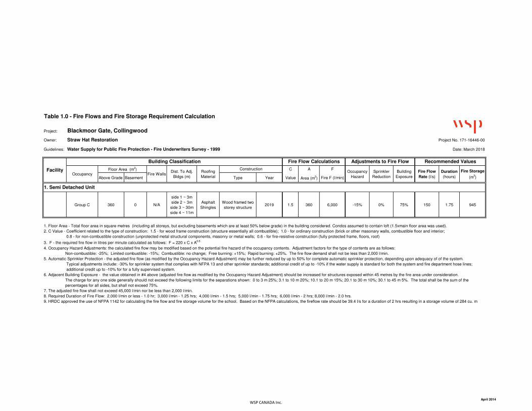
Table 1.0 - Fire Flows and Fire Storage Requirement Calculation
Project: Blackmoor Gate, Collingwood
Owner: Straw Hat Restoration Project No. 171-16446-00
Guidelines: Water Supply for Public Fire Protection - Fire Underwriters Survey - 1999 Date: March 2018
C A F
Above Grade Basement Type Year Value Area (m2) Fire F (l/min)
Group C 360 0 N/A
side 1 ~ 3m
side 2 ~ 3m
side 3 ~ 30m
side 4 ~ 11m
Asphalt
Shingles
Wood framed two
storey structure 2019 1.5 360 6,000 -15% 0% 75% 150 1.75 945
1. Floor Area - Total floor area in square metres (including all storeys, but excluding basements which are at least 50% below grade) in the building considered. Condos assumed to contain loft (1.5xmain floor area was used).
2. C Value - Coefficient related to the type of construction: 1.5 - for wood frame construction (structure essentially all combustible); 1.0 - for ordinary construction (brick or other masonary walls, combustible floor and interior;
0.8 - for non-combustible construction (unprotected metal structural components, masonry or metal walls; 0.6 - for fire-resistive construction (fully protected frame, floors, roof)
3. F - the required fire flow in litres per minute calculated as follows: F = 220 x C x A0.5
4. Occupancy Hazard Adjustments: the calculated fire flow may be modified based on the potential fire hazard of the occupancy contents. Adjustment factors for the type of contents are as follows:
Non-combustible: -25%; Limited combustible: -15%; Combustible: no change; Free burning: +15%; Rapid burning: +25%. The fire flow demand shall not be less than 2,000 l/min.
5. Automatic Sprinkler Protection - the adjusted fire flow (as modified by the Occupancy Hazard Adjustment) may be further reduced by up to 50% for complete automatic sprinkler protection, depending upon adequacy of of the system.
Typical adjustments include: -30% for sprinkler system that complies with NFPA 13 and other sprinkler standards; additional credit of up to -10% if the water supply is standard for both the system and fire department hose lines;
additional credit up to -10% for for a fully supervised system.
6. Adjacent Building Exposure - the value obtained in #4 above (adjusted fire flow as modified by the Occupancy Hazard Adjustment) should be increased for structures exposed within 45 metres by the fire area under consideration.
The charge for any one side generally should not exceed the following limits for the separations shown: 0 to 3 m 25%; 3.1 to 10 m 20%; 10.1 to 20 m 15%; 20.1 to 30 m 10%; 30.1 to 45 m 5%. The total shall be the sum of the
percentages for all sides, but shall not exceed 75%.
7. The adjusted fire flow shall not exceed 45,000 l/min nor be less than 2,000 l/min.
8. Required Duration of Fire Flow: 2,000 l/min or less - 1.0 hr; 3,000 l/min - 1.25 hrs; 4,000 l/min - 1.5 hrs; 5,000 l/min - 1.75 hrs; 6,000 l/min - 2 hrs; 8,000 l/min - 2.0 hrs.
9. HRDC approved the use of NFPA 1142 for calculating the fire flow and fire storage volume for the school. Based on the NFPA calculations, the fireflow rate should be 39.4 l/s for a duration of 2 hrs resulting in a storage volume of 284 cu. m
OccupancyFloor Area (m
2)
Fire WallsDist. To Adj.
Bldgs (m)
Roofing
Material
Fire Storage
(m3)
1. Semi Detached Unit
ConstructionOccupancy
Hazard
Sprinkler
Reduction
Building
Exposure
Fire Flow
Rate (l/s)
Duration
(hours)
Facility
Building Classification Fire Flow Calculations Adjustments to Fire Flow Recommended Values
WSP CANADA Inc.April 2014


APPENDIX
F PROPOSED
UTILITIES
SERVICING

M A
P L
E
S T
R E
E T
Elementary
School Catholic Notre-Dame-
De-La-Huronie
Collingwood Collegiate Institute
HU
RO
NTA
RIO
S
TRE
ET
CAMPBELL STREET
N73°19'40"E
52.285
N16°40'30"W
20
.06
7
N09°21'20"W
44
.45
N73°27'50"E23.65
N10°32'20"W
73
.02
50
.29
N73°41'30"E19.78
N09°22'30"W
67
.32
WV
WV
87
.49
11.0
8
30.71
3.01
86
.31
2.67
54.55
2.98
41
.70
8.8
5
42
.44
3.93
M A
P L
E
S T
R E
E T
Collingwood Collegiate Institute
A
A
A
A
A
A A
A
A A A A
B
BBBB
B
B
BB
BC
C
C
C
A
A
A
A
A
9.19
90.92
ROAD
1
ROAD 2
ROAD
3
ROAD
9
ROAD
5
ROAD
8
ROAD 4
ROAD 7
ROAD 6
STREET LIGHTING POWER PEDESTAL (ES-1) c/w POWER BREAKER + METER.PEDESTAL SHALL BE MODEL SLM422 FROM PSI SOLUTION INC. THEPEDESTAL SHALL BE COMPLETE WITH METER. THE METER SHALL FACE THEPROPERTY SIDE.
PAD & METER MOUNTED SINGLE PHASE 240/120 VOLT SECONDARYTRANSFORMER c/w CONCRETE BASE. TRANSFORMER AND METER BYCOLLUS POWERSTREAM. BASE TO BE SUPPLIED BY CONTRACTOR.
LED STREET LIGHT MOUNTED ON A 8.5m POLE - DIRECT BURIED (OPSD2225.010) WITH 1.8m ALUMINUM TAPERED ELLIPTICAL DAVIT ARM (OPSD2420.010) APPROVED MANUFACTURER FIXTURES:CREE RSW SERIES SMALL, TYPE II MEDIUM, 27.9 WATTSPHILIPS ROADSTAR SERIES, TYPE II MEDIUM, 27.0 WATTSAMERICAN ELECTRIC ATB0 SERIES, TYPE III SHORT, 37 WATTS
53mm (2.0in) TYPE 2 DUCT/CONDUIT c/w 3#10+GND (OR AS SHOWN), CSAAPPROVED FOR DIRECT BURIAL. CABLE SHALL BE COPPER.
CENTERLINE OF TRENCH TO BE LOCATED 3.75M FROM PROPERTY LINEAS PER TYPICAL SECTION ON PAGE C1-7.
STREET LIGHTING POWER PEDESTAL
THE STREET LIGHTING POWER BREAKER SHALL BE ENCLOSED IN ANEEMAC TYPE 4 ENCLOSURE AND MOUNTED ON A 150X150MMX3.0MGALVANIZED STEEL POST (OESC TABLE 102) WHERE SHOWN ON THEDRAWINGS AT A MOUNTING HEIGHT OF APPROXIMATELY 1.5M ABOVEGRADE AND BURIAL DEPTH OF 1.5M.
THE CIRCUIT BREAKER ENCLOSURE SHALL BE TYPE 316, STAINLESSSTEEL, SIZE 12" X 10" X 5" DEEP (305 X 254 X 127MM), COMPLETE WITHCONTINUOUS STAINLESS STEEL HINGED COVER SECURED WITHSTAINLESS STEEL CLAMPS AND TAMPERPROOF SCREWS, HASP FORPAD-LOCKING, MOUNTING LUGS AND REMOVABLE INNER PANEL,HAMMOND PART NO. 1414 N4 PHSS K OR APPROVED EQUIVALENT.
THE CIRCUIT BREAKER SHALL BE 15 AMPERE, 240 VOLT, 2 POLE 18 KAI.C., THERMAL MAGNETIC, FPE CAT. NO. CE2015 E4 OR APPROVEDEQUIVALENT. THE CIRCUIT BREAKER SHALL BE MOUNTED SECURELYON THE INNER PANEL OF THE ABOVE ENCLOSURE.
THE ENCLOSURE SHALL BE MOUNTED SECURELY ON THE POST, WHERESHOWN ON THE DRAWING BOLTED TO POST WITH GALVANIZED (2-1/2"ØX REQUIRED LENGTH BOLTS). INSTALL A 50MM RIGID PVC CONDUITFROM THE BOTTOM OF THE ENCLOSURE TO 900MM BELOW GRADE FORTHE INCOMING STREET LIGHTING CABLE FROM THE TRANSFORMER TOTHE LINE SIDE OF THE BREAKER AND INSTALL 2 - 53MM CONDUITSFROM THE BOTTOM OF THE ENCLOSURE TO 900MM BELOW GRADE FORTHE CONDUCTORS FROM THE BREAKER TO THE STREET LIGHTINGPOLE BASE HAND HOLES AS SHOWN ON THE DRAWING. ENSURE THATALL DOOR CLAMPS ARE SECURED AND THE ENCLOSURE IS PADLOCKEDAFTER ENERGIZATION.
THE STREET LIGHTING CONDUIT SHALL BE LOCATED WHERE SHOWNAND AS SHOWN ON THE COLLUS POWERSTREAM DRAWINGS AND TOTHE APPROVAL OF COLLUS POWERSTREAM. IN THE JOINT USE UTILITYTRENCHES.
POWER FEED FROM COLLUS POWERSTREAM TRANSFORMER TOBREAKER PEDESTAL, ALL TO COLLUS POWERSTREAM APPROVAL.(3-#3/0+#6GND, 53C)
12Arch D-BLG, \\mmm\common.MIS\Drawings\Electrical\data\2018\171-16446-00 Blackmoor\171-16446-00 N1.dwg, 27/04/2018 3:53:00 PM
--
0
STREET LIGHTING LAYOUT
ELECTRICAL
1:500
G.WALPER
G.WALPER
A
E
F
C
D
B
35 4678910
1235 4678910
A
E
F
C
D
B
SEAL:
CONSULTANT - SUB-CONSULTANT:
CLIENT:
PROJECT:
CLIENT REF. #:
DISCLAIMER: COPYRIGHT:
ISSUED FOR - REVISION:
DESCRIPTIONDATERV.IS.
KEY PLAN:
ISSUE:
DATE OF:
ORIGINAL SCALE:
CHECKED BY:
DRAWN BY:
RV. #SHEET #: OF
TITLE:
DISCIPLINE:
PROJECT NO: DATE:
SHEET NUMBER:
DESIGNED BY:
THIS DRAWING AND DESIGN IS COPYRIGHT PROTECTED WHICH SHALL NOT BE USED, REPRODUCED ORREVISED WITHOUT WRITTEN PERMISSION BY WSP GROUP. THE CONTRACTOR SHALL CHECK AND VERIFYALL DIMENSIONS AND UTILITY LOCATIONS AND REPORT ALL ERRORS AND OMISSIONS PRIOR TOCOMMENCING WORK.THIS DRAWING IS NOT TO BE SCALED.
THE POSITION OF POLE LINES, CONDUITS, WATERMAINS, SEWERS AND OTHER UNDERGROUND ANDOVERGROUND UTILITIES AND STRUCTURES IS NOT NECESSARILY SHOWN ON THE CONTRACTDRAWINGS, AND, WHERE SHOWN, THE ACCURACY OF THE POSITION OF SUCH UTILITIES ANDSTRUCTURES IS NOT GUARANTEED. BEFORE STARTING WORK, THE CONTRACTOR SHALL INFORMHIMSELF OF THE EXACT LOCATION OF ALL SUCH UTILITIES AND STRUCTURES, AND SHALL ASSUME ALLLIABILITY FOR DAMAGE TO THEM.
CAUTION :
25mm
IF THIS BAR IS NOT 25mmLONG, ADJUST YOUR
PLOTTING SCALE.
wsp.comt: 905.882.1100Thornhill, ON Canada L3T 0A1100 Commerce Valley Dr. West,
FIRST SUBMISSION SPA
STRAW HAT RESTORATION
131-25444-00
BLACKMOOR GATE
171-16446-00 MAY 2018
P
T
1 MAY. 2018 FIRST SUBMISSION SPA
Calculation SummaryLabel Avg Max Min Avg/Min Max/Min LVRatioRoad_1_Illuminance 4.59 9.7 1.9 2.42 5.11 N.A.Road_1_Luminance 0.24 0.4 0.1 2.40 4.00 0.21
Road_2_Illuminance 4.78 8.6 2.4 1.99 3.58 N.A.Road_2_Luminance 0.24 0.4 0.1 2.40 4.00 0.04
Road_3_Illuminance 5.81 10.0 2.8 2.08 3.57 N.A.Road_3_Luminance 0.28 0.5 0.1 2.80 5.00 0.29
Road_4_Illuminance 5.10 8.9 1.5 3.40 5.93 N.A.Road_4_Luminance 0.24 0.4 0.2 1.20 2.00 0.04
Road_5_Illuminance 5.43 9.6 1.5 3.62 6.40 N.A.Road_5_Luminance 0.23 0.4 0.1 2.30 4.00 0.04
Road_6_Illuminance 4.86 7.9 2.3 2.11 3.43 N.A.Road_6_Luminance 0.20 0.3 0.1 2.00 3.00 0.15
Road_7_Illuminance 5.72 7.9 3.7 1.55 2.14 N.A.Road_7_Luminance 0.23 0.3 0.2 1.15 1.50
Road_8_Illuminance 4.43 7.7 1.9 2.33 4.05 N.A.Road_8_Luminance 0.18 0.4 0.1 1.80 4.00
Road_9_Illuminance 4.46 7.4 2.2 2.03 3.36 N.A.Road_9_Luminance 0.19 0.3 0.1 1.90 3.00 0.11
Illuminance Overall 5.06 10.0 1.5 3.37 6.67Luminance Overall 0.23 0.5 0.1 2.30 5.00
-
-
N.A.N.A.
A) ILLUMINATION CALCULATIONS AS PER RP-8-00 USING LEDLUMINAIRES. THE FOLLOWING CRITERIA WAS USED BASED ON THECLASSIFICATION OF THE ROADWAY AS LOCAL WITH LOW PEDESTRIANVOLUME:
AVERAGE MAINTAINED ILLUMINANCE = 4 LUX; AVERAGE /MINIMUM RATIO = 6:1 OR BETTER
B) ONLY ILLUMINATION CALCULATIONS WERE CONSIDERED FOR THEDESIGN OF THE ROADWAY LIGHTING. LUMINANCE CALCULATIONS ARESHOWN FOR REFERENCE ONLY, AS THE STRAIGHT ROAD SEGMENTSARE TO SHORT TO PRODUCE ACCURATE RESULTS. FOR REFERENCE,THE LUMINANCE CRITERIA HAD THEY BEEN CONSIDERED WOULD BEBASED ON RP-8-14 AND THE CLASSIFICATION OF THE ROADWAY ASLOCAL WITH LOW PEDESTRIAN VOLUME:
AVERAGE MAINTAINED LUMINANCE = 0.3 CD/M2;AVERAGE /MINIMUM RATIO = 6:1 OR BETTER;MAXIMUM /MINIMUM RATIO = 10:1;VEILING LUMINANCE RATIO = 0.4 OR BETTER
LIGHTING CALCULATION GRID AREA

APPENDIX
G PRELIMINARY
SITE GRADING

ElementarySchool Catholic Notre-Dame-De-La-Huronie
WTV
WTV
HU
RO
NTA
RIO
S
TRE
ET
CAMPBELL STREET
M A
P L
E
S T
R E
E T
F I N D L AY D R I V E
WV
G:\20
17\17
1-16
446 B
lackm
oor D
evelo
pmen
t\6.0
Dwg\6
.2 Ci
vil\17
1-16
446-
00-3
D-4.d
wg M
ay 04
, 201
8-2:5
4pm
BY:(t
yler.ja
hnke
)
REV #
C F
C
C F
C
A
E
F
C
D
B
1235 4678910
1235 4678910
A
E
F
C
D
B
FFF
P
FFF
F
F
SEAL:
CONSULTANT:
CLIENT:
PROJECT:
CLIENT REF. #:
DISCLAIMER: COPYRIGHT:
ISSUED FOR - REVISION:
DESCRIPTIONDATEREIS
KEY PLAN:
ISSUE:
DATE OF:
ORIGINAL SCALE:
CHECKED BY:
DRAWN BY:
SHEET #: OF
TITLE:
DISCIPLINE:
25mm
IF THIS BAR IS NOT 25mmLONG, ADJUST YOUR
PLOTTING SCALE.
PROJECT NO: DATE:
SHEET NUMBER:
DESIGNED BY:
THIS DRAWING AND DESIGN IS COPYRIGHT PROTECTED WHICH SHALL NOT BE USED, REPRODUCED ORREVISED WITHOUT WRITTEN PERMISSION BY WSP. THE CONTRACTOR SHALL CHECK AND VERIFY ALLDIMENSIONS AND UTILITY LOCATIONS AND REPORT ALL ERRORS AND OMISSIONS PRIOR TOCOMMENCING WORK.THIS DRAWING IS NOT TO BE SCALED.
F
F
101-1450 1st AVENUE W.OWEN SOUND, ONTARIO, CANADA N4K6W2
PHONE: 519-376-7612 FAX: 519-376-8008WWW.WSP.COM
STRAW HAT RESTORATION
BLACKMOOR GATE
--
171-16446-00 APRIL 2018
FIRST SUBMISSION SPA--
0
- - --
1:500
K H
T J J
C W
CIVIL
SITE GRADING AND DRAINAGE PLAN
SG1-- --
00 04/05/18 FIRST SUBMISSION SPA