bishop 2012 war ditches pcas ci
TRANSCRIPT

Proceedings of the Cambridge Antiquarian Society CI pp.
War Ditches is a large enclosure, lying on a spur of the Gog Magog hills to the south of Cambridge. Much of this originally circular monument was destroyed by chalk quar-rying in the late 19th to mid 20th centuries, during which time a series of excavations was conducted, largely under the auspices of the Cambridge Antiquarian Society. Had the monument survived intact, it would undoubtedly have acquired scheduled status as one of the county’s key prehis-toric monuments. Emergency archaeological work in 2009 was necessitated by ground works relating to the opening of the site to the public as a nature reserve. Excavation of a single large slot through the surviving ditch, in the area most at risk, was supplemented by test pits and auger surveys. Relatively large and well stratified finds and environmental assem-blages were found which, allied with radiocarbon dating, have enabled the first accurate dating of the ditch infill se-quence. It is now clear that the monument was constructed at the end of the 5th century BC or the beginning of the 4th century BC only to be destroyed before completion or shortly thereafter. The site was then abandoned until reoc-cupation in the middle of the 1st century BC. Final infill-ing of the upper part of the ditch probably occurred in the second half of the 1st century AD.
Introduction
During the summer of 2008 children playing within the East Pit, Cherry Hinton (Fig. 1, TL 484 555) discov-ered the legs and feet of a human burial, along with animal bones and Romano-British pottery, high up in the south-eastern corner of the quarry. Subsequent visits by members of the Cambridge Antiquarian Society (CAS), Oxford Archaeology East (OA East) and the parish archaeological warden (Michelle Bullivant) led to the recovery of further finds from the same location. Archaeological deposits along the top of the quarry edge were identified as surviving fills of a remnant of the War Ditches. Before this ‘rediscovery’ the ring ditch was con-sidered to be ‘all but … quarried away’ (Evans and Knight 2002, 48). A series of excavations spanning some 70 years had previously taken place, the results
being published in the Proceedings of the Cambridge Antiquarian Society (PCAS). These are reviewed below in relation to the recent findings. The Wildlife Trust’s plans to open the East Pit as a nature reserve entailed significant landscaping at the quarry edge, including the area of the surviving monument. Since the Trust were unaware of the ar-chaeological potential of the site, no provision for ar-chaeological works existed within their budget and funding was therefore agreed with English Heritage for a targeted rescue excavation; this was conducted by Oxford Archaeology East between April and June 2009. This article is designed as a synthesis of the exca-vated findings and is supplemented by the full ana-lytical report which can be freely accessed at http://library.thehumanjourney.net/view/subjects/UK-Iron-Age.html.
A History of Excavation
War Ditches lies in a prominent position at c. 46m OD on a spur of the Gog Magog hills, with command-ing views over the Cam valley and into the fens (Fig. 2). It holds an excellent vantage point over much of southern Cambridgeshire, with clear sight-lines to the contemporary Iron Age fort at Wandlebury to the south-east, to the contour fort at Borough Hill, Sawston to the south-west and to Arbury Camp to the north-west. The first record of archaeological discoveries at War Ditches, which are located in Figs 3 and 4, came during excavation of the reservoir on Lime Kiln Hill in 1854. The Cambridge Chronicle reported the discovery of up to nine skeletons and noted that ‘several of them were of large size, and were evidently the remains of men who reached to a greater height than ordinary men in the present day’ (Filby 1995). Nearly 40 years later another skeleton was discovered in a new quarry pit opened by Messrs. Crawley and Tebbutt in 1893. This was reported to Professor Thomas McKenny Hughes, a very active member of the CAS who, with the help of Society members, embarked on an archaeological ex-
War Ditches, Cherry Hinton: Revisiting an Iron Age Hillfort
Alexandra Pickstone and Richard Mortimer
with Rachel Ballantyne, Barry Bishop, Christopher Bronk Ramsey, Matt Brudenell, Gordon Cook, Nina Crummy, Natasha Dodwell, Chris Faine, Alice Lyons, Peter
Marshall, John Meadows and Elizabeth C. Stafford. Illustrations by Gillian Greer
Proceedings of the Cambridge Antiquarian Society CI pp. 31–59.
Alexandra Pickstone and Richard Mortimer32
Figure 1. Location of War Ditches.

War Ditches, Cherry Hinton: Revisiting an Iron Age Hillfort 33
cavation in the area of ‘Tebbutt’s Pit’. A large ditch was identified, thought at the time to be one of the great East Anglian linear dykes. The name ‘War Ditches’ appears to have originated at this date (Hughes et al. 1894, 319). Although the ditch’s function remained un-certain, its infilling was accurately recorded: the ditch ‘got gradually filled up by natural operations during more than one long period, judging by the growth of humus at successive levels, but it must have also been filled in artificially on at least two occasions by throwing back the chalk which had been dug out of it’ (Hughes et al. 1894, 318; see Figs 3 & 4). During these preliminary excavations, Hughes dis-covered five skeletons, seemingly laid into the ditch (Fig. 5, No. 1). Spurred on by the initial findings it was proposed that the CAS should undertake systematic excavations under the direction of Professor Hughes and with the help of the newly formed Cambridge University Digging Club. In a short article Hughes stated ‘Since my last report (Feb. 3) the course of the great fosse has been quite straight, pointing towards the centre of the reservoir, but now it is beginning to curve around to the east.’ (Hughes 1902a, 234). Continued excavations in the same year confirmed its circular nature and by the time of Hughes’ sec-ond more lengthy report (1902b) the monument was being compared to the ringworks at Wandlebury and Arbury: ‘We found that the fosse curved stead-ily round as if to pass under the Reservoir…It also enabled us to estimate the size and position of our earthwork on the assumption that it was circular, like Ring Hill, Wandlebury and Arbury. This assump-tion proved to be correct, and even with my spud I verified the line of the fosse through Caius Chalk-pit’ (Hughes 1902b). Hughes concluded that ‘…we had a deep circular fosse excavated in the chalk by pre-Roman people who had little pottery…The material thrown out of the fosse was heaped up on the inside to form a vallum. The crumble from the sides of the neglected ditch filled the bottom to a depth of four feet more or less’ (Hughes 1902b, 480). He reported that there then followed an episode in which numer-ous skeletons were ‘thrown’ into the ditch. The ditch was subsequently filled ‘… by the accumulation of vegetable mould, by debris purposely thrown in and accidentally crumbling down the sides, by the refuse of people who occupied the fosse from time to time’ (Hughes 1902b, 481). Hughes identified problems with dating some of the material but concluded that the pottery was made in ‘Romano-English’ times. Four more skeletons were found outside the ditch during quarrying between 1907 and 1911 which were deemed to be pre-Roman in date (Walker 1908, 267, fig. 1; PCAS 1912, 5). In 1913 the CAS appealed for further excavation to be carried out at War Ditches as it had been: ‘explored only partially; at least two-thirds of the circle of the camp remains untouched, as well as the cemetery belonging to this pre-Roman settlement’ (PCAS 1913, 5). The Cambridge Digging Club were subsequently awarded a grant of £5 ‘to assist in the expenses of exploring the War Ditches’ (PCAS 1917, 4). By 1939 the quarry was advancing at a rapid rate
and the monument was at risk of being completely de-stroyed. The then Director of Excavations at the CAS, Mr T.C. Lethbridge, began excavating in the summer of 1939 with the assistance of Cambridge University staff and undergraduates. Two large trenches were opened, one to the east of Caius Pit, sited over Hughes’ projected circle of the ring ditch and the other to the west between two sections previously excavated by Hughes. The western trench found the ditch as ex-pected and showed a similar infill sequence to that recorded in Hughes’ adjacent slots. Here, however, Lethbridge was the first to conclusively interpret the layer of skeletons towards the base of the ditch, which included a charred torso, as the result of a massacre. The eastern trench did not contain any traces of the ring ditch leading Lethbridge to conclude that ‘what remains is either an unfinished work or something of a different character’ (Lethbridge 1949, 118). Excavation at the site intensified in the early 1950s and 60s but throughout this period the reporting of the findings became sporadic and in some cases in-consistent. The work of K.D.M Dauncy (Birmingham University) and C.H Houlder (Cambridge University Archaeological Field Club; CUAFC) identified the entrance to the ring monument and the overlying 2nd- to 4th-century AD settlement. The settlement evidence was published by D.A. White (1964a) but the report excluded the numerous segments excavated by Dauncy and Houlder along the north-eastern part of the ring work to the extent that White’s publication (1964b, 13, fig.3) shows an insert of the settlement site over the area which they had investigated. The Cambridge University Museum of Archaeology and Anthropology (CUMAA) hold the field notes from the 1949–1951 seasons which give detailed descrip-tions of the entrance and the excavated segments of the ditch: the entrance ‘was at the E. side, marked by a gap 48ft. wide in the main ditch, which was here turned out at right angles, in the form of two par-allel ditches about 15ft. wide; they can be traced for 20 ft. to the modern hedge, but beyond this nothing is visible’ (CUMAA, CUAFC Records Box 31 G03/7/3: 2). The excavated segments had the same infill se-quence as previously recorded but there were nota-ble differences in the form of the ditch itself. Here it was considerably narrower and shallower with the ditch terminal formed by two parallel cuts leaving a large central baulk (CUMAA, CUAFC Records Box 31 G03/7/3). This potentially unfinished part of the ditch (Fig. 4, Section 7) had a W-shaped profile 6.1m wide, but was only 2.4m deep at its deepest point and indicated ‘large rubble’ as its primary fill. Some of the other sections (see Fig. 4, Section 6) also had – unlike the completed parts of the ditch – large rubble blocks dumped directly back into their bases with no evidence for any weathering having taken place. The evidence combines to suggest that the monument had been destroyed before completion. A large semi-circular feature to the east of the ring ditch (White 1962, 13, fig.3; located in Fig. 3) is de-scribed in a series of ‘Extracts from correspondence with L. Barfield’ as ‘A very unusual depression in the

Alexandra Pickstone and Richard Mortimer34
chalk; only part has been uncovered by bulldozing. It is approx. 3 ft. deep at its deepest point. The brown earth filling only produced a few sherds of Roman pottery near the surface. It is interesting to note that at the nearest point to it the main ditch narrows con-siderably as if it [i.e. the ditch] had been dug later’ (CUMAA, Box 32 G03/7/6: 30.viii.58 F.). It is occasionally difficult to differentiate between the works of Dauncy, Houlder, Barfield and White from the archive and published material available. However, following Dr Lawrence Barfield’s death in July 2009 his field notes and archive were handed to OA East. They show the positions of three further sections through the ditch and its entranceway (Fig. 3). The advancing quarry had truncated much of the ditch and in the case of Section I had exposed skeletal remains within the ditch fill (Fig. 5, No. 7). In 1961/2 White excavated two sections through the ring ditch, one directly to the south of the current excavations and the other on the southern arm of the entrance-way. The ditch sections demonstrated the consistent
pattern of the infill sequence and also the variation in size between the main ditch (3.5m deep x 5m wide) and the entrance (2m deep x 3m wide). Human skele-tal remains were recovered from the lower fills of both the sections (Fig. 5, Nos 8 and 9). White also reported upon an area to the south-west, within the enclosure corner, where up to nine apparently Early Iron Age pits covered an area of 40m in length and 10m wide. These were to be the last excavations at War Ditches for nearly half a century, until the spring of 2009. Table 1 summarises the location and nature of the human remains recovered that correspond to the destruction of the monument (Fig. 5). The reporting from previous interventions is often sketchy but the table provides an overview from both published and archived data.
War Ditches and the Wider Landscape
Despite the fact that the monuments at Wandlebury and Arbury have been subject to a number of in-
Figure 2. War Ditches and surrounding sites.
War Ditches, Cherry Hinton: Revisiting an Iron Age Hillfort 35
vestigations over the years, they remain enigmatic. Wandlebury lies just 2.5 km to the south-east of War Ditches and is positioned on the top of the chalk ridge of the Gog Magog Hills at c. 78m OD (Fig. 2). It consisted of an outer ring measuring c. 330m across constructed in the 5th century BC, with a much later (1st century BC) internal ditch and rampart which reduced the diameter to c. 218m (French 2004, 15). Wandlebury begs interpretation as a defensive struc-ture with its substantial banks and ditches but is placed well away from the north-eastern scarp face of the hill which would have provided the more natu-ral, defensive site. Its ditches would have been most visible from the southern, south-eastern and south-western sides leading French (2004) to suggest that the monument may have been linked culturally or tribally to the chalk downland to the south. Arbury Camp sits on the edge of the Cam flood-plain, 7 km to the north-west, at 14m OD. Its obvious similarities to War Ditches and Wandlebury lie in its circular form (c. 275m diameter) and its large ditch with an entranceway at the east. However, it is the ringwork’s lowland location, its age and its lack of contemporary settlement that mark it out as differ-ent, and this difference leads to questions over the function of such monuments. Arbury appears to be perhaps shorter lived and of a later date than the oth-
ers, having been in use somewhere between the 4th and 2nd centuries BC (Evans and Knight 2002, 44). Borough Hill at Sawston, 6km directly to the south of War Ditches is the only true contour fort in the area, occupying a strategic location on a prominent chalk rise (24m OD) on the east bank of the Cam and above the river crossing at Whittlesford. The fort is roughly D-shaped and has double and triple ramparts with ditches up to 6m deep enclosing an area of around 7ha. It appears to have been constructed in the 5th or 4th centuries BC and to have contained contemporary occupation which may have continued through to the later Romano-British period (Mortimer 2001). These four ‘hillforts’, including War Ditches, sit within an area of just 12.5km north to south and 2.75km west to east, and were all initially in use be-tween the 5th and 3rd centuries BC. War Ditches was by far the smallest of the monuments (Table 2).
Table 2. Comparison of local hillfort sizes.
Site War Ditches Wandlebury Arbury Borough Hill,
SawstonDiameter (c. m) 150 330 275 260 x 370m
Enclosed area (c. ha)
1.75 6.25 5 7
No. Date Excavator & Publication Location Human Skeletal Remains
1 1893 Hughes Pub. 1894 and 1902b Segment I
Five nearly complete skeletons lain in the ditch. (perhaps those reported in 1902b? ) and an isolated skull.2 adult male, 2 young females, 1 ‘aged’ female‘they showed no traces of violence, it is probable that they died a natural death.’ (Hughes 1894, )
2 1901 Hughes Pub.1902a Segment I
One skeleton found in the extension to Segment I‘it appeared to have suffered rough treatment..the skull was gone and the legs doubled back on the body’
3 1901 Hughes Pub. 1902b Segment II
A number of skeletons. ‘bodies of young and old of both sexes’.‘we clearly established the fact that some of the bodies had been dismembered’
4 1939 Lethbridge Pub. 1949
Between Caius and Tebbutt’s Pits
A charred human torso ‘the head arms and legs were charred off.’ Also charred skull fragments and another skull ?female.
5 1951 Houlder (CUAFC) unpublished Cutting A1 NE side An isolated human tibia with cut marks
6 1951 Houlder (CAFG) unpublished Cutting D1 One female (?EU 1.3.213 in the Leverhulme Centre catalogue), a
human skull with ‘the frontal missing’ and a human femur
7 1956 Barfield(CAFG) unpublished Cutting I Two disarticulated skeletons (?EU 1.3.211, ?EU 1.3.212), one
skull
8 1961 White Pub. 1962
Directly to the south of 2009 excavation
Adult male, 20-25 years old, complete. Lay on his back with left arm over right shoulder and right arm lying across the chest. Both legs drawn up with knees together (EU 1.3.246)
9 1961 WhitePub. 1962 Entrance ditch Adult female, 30 years old. (EU 1.3.243)
10 1961 WhitePub. 1962
Southwest part of Caius pit (recovered by mechanical grab)
Adult female, 20 years old. (EU 1.3.245)
11 2009 Pickstone and Mortimer Left adult fibula shaft
Table 1. Human skeletal remains recovered from the Early Iron Age ‘destruction’ layer at War Ditches. The location of each observation appears in Fig. 5.

Alexandra Pickstone and Richard Mortimer36
Figure 3. Previous interventions with Pickstone and Mortimer 2009.

War Ditches, Cherry Hinton: Revisiting an Iron Age Hillfort 37
The Excavation
Methodology
The field investigations of 2009 comprised the excava-tion of a single large section of the ditch, six 1m square test pits, a geophysical survey and an auger survey (Fig. 6). An area above the surviving ditch measur-ing 9m by 6m was de-turfed by hand and what lit-tle topsoil remained was removed (the area had been stripped of topsoil and subsoil prior to quarrying in the early 1960s). The upper, compacted and relatively sterile chalk rubble fill was excavated as a single con-text whilst all subsequent fills were divided into a chequerboard of 1m square spits for finds retrieval. The spits were either 0.1m or 0.2m deep depending on the fill type and the size of the chalk rubble. All spits were assigned a unique number linked to their rel-evant context (fill), and all contexts were assigned to a fill group, representing an archaeologically recognis-able event. Each context was sampled (40 litres maxi-mum) for the retrieval of environmental evidence. Given the extremely precipitous character of the site when excavation commenced, work was conduct-
ed with the team wearing safety harnesses. Access to the ditch was made via a scaffold tower from the base of the quarry (Fig. 7). The test pits were placed both inside and outside of the ring ditch to ascertain the levels of preserva-tion of buried soils as well as to identify any surviv-ing features. The auger survey sought to determine whether possible archaeological deposits visible in the chalk cliff were in fact the remains of the ring ditch or other features.
Site Phasing
Excavation revealed a well stratified sequence of fills spanning the period from c. 400 BC to c. AD 80 (Figs 8–10). Material from the test pits and other observa-tions was assigned to Group 0. The ditch fills were grouped by event, each being radiocarbon dated. The radiocarbon results presented in italics below are based on the posterior density estimates or modelled dates detailed by Meadows et al. in later text. Pottery from the Early Iron Age fills dates to c. 600–300 BC, although refinement has been possible through scien-tific dating. The Iron Age reoccupation phase appears to start at around 50 BC (Group 5), largely on the basis
Figure 4. Sections recorded from previous interventions compared with Pickstone and Mortimer 2009.

Alexandra Pickstone and Richard Mortimer38
Figure 5. Location of human skeletal remains.
War Ditches, Cherry Hinton: Revisiting an Iron Age Hillfort 39
of the pottery, while the modelled radiocarbon dates indicate that this occurred in 245–110 cal BC indicat-ing an anomaly. The date of Groups 6–7 given below is based on the pottery evidence, while the final infill-ing (Group 8) dates to c. cal AD 55–150 (68% probabil-ity) on the basis of the modelled radiocarbon dating, but can be refined to c. AD 50–80 on the basis of the pottery.
Early Iron AgeGroup 1: Construction and initial weathering/infilling, 455–
390 cal BC (68% probability)Group 2/3: Bank destruction, 405–380/465–385 cal BC (95%
probability)Group 4: Abandonment c. 380 to 50 BC
Later Iron Age to Early RomanGroup 5: Later Iron Age reoccupation, c. 50 BC Group 6/7: Continued settlement, c. 50 BC to AD 50 Group 8: Final infilling and levelling, c. AD 50–80
The groups are illustrated in Fig. 8, with contexts being indicated in Fig. 9.
Early Iron Age
Internal featuresTest pitting along the southern edge of the quarry revealed a single feature inside the ring monument itself (TP 2, Fig. 6). This possible pit was 0.8m wide and 0.34m deep, and contained two fills, the upper-most of which contained 38 sherds (0.313kg) of Early Iron Age pottery including a single sherd of ‘Chinnor-Wandlebury’ style fineware.
Figure 6. Location of excavated segments and test pits.

Alexandra Pickstone and Richard Mortimer40
Monument construction and initial use: 455–390 cal BC (68% probability) The excavated ring ditch measured 4m deep and c. 6m wide, with very steep sides; the base of the ditch was flat and narrow measuring 1.2m across, creating an almost V-shaped cut into the natural chalk (Figs 8–10). The infill sequence indicates that the bank would have been above the inner, western ditch edge. The sides of the ditch were rough and fractured, partly as a result of their original excavation and partly due to the effects of weathering; representing this process were six primary fills (Group 1) consisting of poorly sorted layers containing at least 70% chalk fragments in varying quantities of chalky silt. These accumu-lated to a total depth of c. 0.75m at the centre of the ditch and 1.1m on the eastern side. A very small finds assemblage was recovered toward the base of the fill, including eight sherds of Early Iron Age pottery, 417g of animal bone (chiefly a single horse jaw) and 15 pieces of struck flint. The horse jawbone was found close to the ditch base, on the interface between fills 266/267 and 264 (Fig. 9); radiocarbon dating returned a date of 495–385 cal. BC (SUERC-30936, at 95% con-fidence). The derivation of the small number of finds within these early fills must be considered. The mate-rial could have come from earlier features which had eroded and weathered, from the original land surface through which the ditch was cut, or from the occupa-tion of the area during the monument’s construction and initial use.
Monument destruction/levelling: 405–380/465–385 cal BC (95% probability) Above the basal fills was a clear change in the char-acter of infilling, representing the rampart’s rapid de-struction and levelling. Twelve thin, lens-like fills lay on the western, bank side of the ditch (Group 2) – the proportion of large chalk fragments within these fills was noticeably low, with a corresponding increase in small chalk fragments, silt and pea grit. Some of the lenses were darker and soil-rich, while others consist-ed of fine chalky silt – the former deposits had the ap-pearance of turf but were unconsolidated, suggesting an origin as loose soil run-off rather than soil growth. These lenses interleaved with the more substantial fills of Group 3 which comprised dumps of chalk rubble (up to 90% of the fill), in loose silty matrices with frequent voids and medium to large charcoal fragments. The rubble consisted of medium to very large chalk fragments suggesting that the fill was not the result of weathering but was a deliberate backfill-ing episode in which part of the bank material had been redeposited into the ditch. The interleaving of the two fill groups would have occurred as the large fragments of chalk rubble rolled or were thrown into the centre of the ditch, whilst the lighter turf and soils were caught on the edge. Charcoal fragments found within the Group 3 fills could suggest a burnt structure, perhaps associated with the rampart. Similar evidence has been recorded in most of the earlier ditch observations, demonstrat-ing a destructive event that was monument-wide. A single adult fibula shaft was recovered from these fills: most of the human remains found in previous investigations came from this level (Fig. 5, Table 1). Few finds came from these fills, suggesting that little domestic waste was being produced at the site, or at least entering the ditch, during this period. A total of 125 sherds of pottery came from Groups 1–3 with an average sherd weight of 5g. The articulating foot bones of a sheep from context 263 (Group 2) were radiocarbon dated and gave a mean weighted date of 405–380 cal. BC at 95% confidence (OxA-23231, OxA-23232, SUERC-30935).
Abandonment: c. 380–50BC Six fills (Group 4) were recorded infilling the hol-low created by the redeposited bank at the ditch’s eastern edge. They consisted of small to medium-sized chalk rubble in relatively dense silty chalk ma-trices and were interspersed with possible in situ turf lines. The total depth of these deposits was between 0.85m on the eastern edge and 0.2m on the truncated western edge; they gradually levelled up the uneven slope of the ditch fill left by the slighting of the bank. An assemblage of 210 sherds of pottery weighing just over 1kg, 3.5kg of animal bone, 1.6kg of burnt flint and 93 struck flints were recovered from these fills, nearly twice the weight of pottery and seven times the weight of bone recovered from the preceding fills (in Groups 1–3). There was, however, still a dearth of domestic or craft waste such as fired clay, loom weights or quern stones. Most of the finds may re-
40
Figure 7. The excavated ditch viewed from the south.

War Ditches, Cherry Hinton: Revisiting an Iron Age Hillfort 41
sult from the long period of time it took for these fills to form; gradual erosion of the ditch edges and the subsequent inclusion of surface scatter material may account for the entire assemblage.
Later Iron Age and Early Roman
Later Iron Age reoccupation: c. 50 BCA single darker, somewhat siltier fill with frequent chalk fragments and pea grit inclusions represented the later Iron Age reoccupation of the monument (Group 5); the start of this activity is dated by pottery to c. 50 BC. It had a maximum thickness of 0.3m and contained 430 sherds (3.33kg) of Late pre-Roman Iron Age pottery, 2.3 kg of fired clay and 3.4kg of animal bone. Much of the animal bone was spread along the
length of ditch within a single layer, perhaps repre-senting an episode of disposal. Bones of both sheep and cow were radiocarbon dated, returning results of 95 cal BC – cal AD 30 (OxA-23230, 95% confidence) and 120 cal BC – cal AD 30 (SUERC-30933, 95% confidence) respectively.
The settlement evidence: c. 50 BC – AD 50 Subsequent fills also date to the Late Pre-Roman Iron Age to Early Roman period, closely dated by pottery to c. 50 BC to AD 50. The composition of fill 95 (Group 6) was nearly 100% small to medium chalk rubble compared to the siltier matrix of preceding fills, al-though it was relatively finds-rich with 421 sherds (4kg) of pottery, 1kg of fired clay and 1.6kg of animal bone. Fill 52 (Group 7) which was up to 0.4m thick
Figure 8. Sections 1 and 2.

Alexandra Pickstone and Richard Mortimer42
Figure 9. Section 1, showing contexts by fill group.
Figure 10. Section 1.
War Ditches, Cherry Hinton: Revisiting an Iron Age Hillfort 43
was similar in composition to fill 95 in Group 6 albeit slightly darker, more charcoal-rich and with a higher frequency of larger chalk pieces. The most obvious difference between the two was the vast increase in the quantities of finds from the later fill; over 20kg of pottery (2,703 sherds), 6.4kg of fired clay and 8kg of animal bone were recovered. A small unurned cre-mation was also cut into this layer, as was, presum-ably, the inhumation found by the children at the top of the slope; a bone from this skeleton was radiocar-bon dated to 35 cal BC–cal AD 65 at 95% confidence (OxA-23233).
The final infilling: c. AD 50 –AD 80Four chalk rubble deposits filled the upper 0.7m of the ditch (Group 8). The size of the chalk pieces suggests a second deliberate episode of backfilling, probably utilising the remainder of the bank inside the monu-ment, since very few finds came from these fills and many of them were residual. A total of six fragments of Early Iron Age pottery and 49 sherds of Late Iron Age to Early Roman pottery came from the group. Two samples from a small area of ashy charcoal were sent for radiocarbon dating and showed that the charcoal had been incorporated into the chalk at or before the construction/destruction phase and was residual within this context; the tightest date was ob-tained by dating one sample twice, giving a weighted mean date of 520–395 cal BC at 95% confidence (OxA-23234, OxA-23235).
Finds and Environmental Evidence
Introduction
Finds are quantified by fill group in Table 3. The artefactual and ecofactual evidence is summarised below, with full details by fill group being available in the downloadable report.
Table 3. Finds quantification by group
Group Pottery (kg)
Fired Clay (kg)
Animal Bone (kg)
Burnt Flint (kg)
Struck Flint (no.)
1 0.052 0.417 152/3 0.578 0.435 0.057 254 1.024 0.030 3.542 1.598 935 3.330 2.296 3.468 296 3.959 1.016 1.638 0.110 77 20.310 6.357 8.080 0.366 438 0.616 0.004 0.059 3
Total 29.869 9.703 17.639 2.131 215
Struck and Burnt Flint Barry Bishop
Most of the assemblage of 226 pieces of struck flint came from ditch fills, although four pieces came from Test Pit 2 and seven others were unstratified, giving
a total stratified assemblage of 215 items. There was a small number of residual recorticated and abraded pieces, but the remainder of the assemblage appears to be of Iron Age date and broadly contemporary with the ditch’s infilling. The characteristics of flintwork-ing during this period have been much discussed (Young and Humphrey 1999; Humphrey 2003; 2004; 2007) with the result that Iron Age flintworking has been identified as a research priority (Haselgrove et al. 2001). Definition of the specific typological and tech-nological changes in struck flint industries through the late 2nd and the 1st millennia BC remains poorly understood, meaning that the sealed and dated as-semblage from War Ditches is of some significance. The raw material is typical of flint nodules from the New Pit Chalk Formation, which outcrops c. 1km to the south-east. Similar flint is likely to be present within remnants of glacial till and can be found as ‘erratics’ in the local topsoil. No flint was encountered in the chalk sides of the ditch, nor observed in the quarry faces. The struck assemblage is technologically homo-geneous, consisting of a very simple flake and core industry. Flakes account for nearly a third of the as-semblage with flake fragments contributing a fur-ther 15%. The lack of micro-debitage suggests that the material was dumped into the ditch rather than knapped in situ. The recovered flakes are variable in shape and size, tending to be small but thick; they average around 30mm in both length and breadth and 9mm in width. Their small size reflects both the limitations of the raw materials and a lack of flak-ing skill. Hard hammer percussion appears to have been exclusively used. A small proportion of flakes provide macroscopic evidence for light utilisation, in the form of unifacial or bifacial spalling that prob-ably arose from cutting or scraping soft to moderately hard materials (Tringham et al. 1974). Cores were very simply reduced, some having been utilised as heavy duty scrapers, or for chopping or boring. Conchoidal chunks formed the largest single category of struck flint. Most are fragments of cores that disintegrated during reduction due to the presence of thermal faults. Many of these have sharp edges and again may have been used for tasks such as cutting or scraping. Burnt flint (2.14kg) was present throughout much of the ditch’s profile. Some of the assemblage may have been residual, but the bulk of it is probably as-sociated with activity occurring in the vicinity of the ditch during its infilling. Flintworking was clearly being undertaken at the site during the Early Iron Age and appears to have continued into the Late Iron Age. The quantities pre-sent in the excavated portion of the ditch suggest that a great quantity of flintwork was made and used at the monument. Varying degrees of competency in flint tool production are apparent; none of it was very skilfully reduced and it is unlikely to have been made by skilled workers. No formal tools were produced; rather, the objective of flint reduction appears to have been the production of either sharp or steeply angled

Alexandra Pickstone and Richard Mortimer44
edges on pieces of flint for tasks such as cutting, chop-ping, whittling and scraping. The flintwork from War Ditches conforms to the pattern of slowly decreasing elaboration in flintwork-ing techniques that, in broad terms, can be traced from the Mesolithic and into the Bronze Age (Ford et al. 1984; Ford 1987; Pitts 1978a; 1978b; Pitts and Jacobi 1979). A key feature of many of these studies is the observation that flakes tend to become broader over time, indicating a diminution of skill in producing pieces with long useful working-edges. The War Ditches material certainly conforms to this pattern as can be seen in a comparison with a sample of dated assemblages as given in Pitts (1978b, 194) and as modified from Pitts and Jacobi (1979, 166) (Table 4). Included in this table is the substantial assemblage from Sawston Police Station that has been dated to the Late Bronze Age. This site is located less than 4km to the south of War Ditches and the flint assemblage used similarly flawed raw materials, which allows the technological aspects to be more accurately com-pared. Overall, these two assemblages are remark-ably similar, the main differences being a greater percentage of conchoidal chunks and a small reduc-tion in the proportion of flakes amongst the material from War Ditches.
Early Iron Age potteryMatt Brudenell
The investigations yielded 440 sherds of Early Iron Age pottery (2359g): two pieces of residual Early Bronze Age pottery (14g, one possibly Beaker) were also recovered. The assemblage primarily derived from the ditch fills (the majority from Groups 1–4), with small quantities being recovered from Test Pit 2. Overall, the material is dominated by highly fragmented sherds, the assemblage as a whole hav-ing a low mean sherd weight (MSW) of just 5.4g. Radiocarbon determination suggests that the earliest pottery was deposited during the mid 5th to early 4th century BC, equating to the closing stages of the Early Iron Age. The assemblage can therefore be regarded as one of the most securely and ‘tightly’ dated groups of Early Iron Age pottery from Cambridgeshire. A diverse range of pottery fabrics was encountered,
with 21 Early Iron Age fabric types being distin-guished, belonging to eight main groups. By weight, around two thirds of the pottery (63%) was tempered with burnt flint and sand, whilst the remaining third was shared amongst ‘minor’ fabric groups with sand with flint (10%), flint (6%), sand (6%), shelly limestone and flint (6%), shell (5%), sand with flint, grog and limestone (4%), and flint and quartzite (<1%). This range and frequency of fabrics is best paralleled at Wandlebury, where 57% of the pottery is recorded as flint-tempered (Webley 2005, 39). Burnt flint and sand tempered fabrics tend to typify Early Iron Age as-semblages in southern and western Cambridgeshire, although the relative frequencies of other ‘minor’ fabric groups are generally more variable. The clays and tempering agents required to produce the War Ditches Early Iron Age pottery were all available within the local landscape. Petrological analysis of nine thin-sectioned sherds submitted from this group revealed that all the raw materials could have been procured relatively close to the site (see Lyons, below). As with all Late Bronze Age and Early Iron Age pottery assemblages, the ceramics divide into bur-nished finewares and un-burnished coarsewares (Barrett 1980). Some 58 sherds were identified as being burnished, polished or carefully smoothed (326g; 13.8% by weight, or 13.2% by sherd count). As is usual, this form of surface treatment was most prevalent on sandy wares, and those vessels made with well-sorted and finely crushed inclusions. Few vessel profiles could be reconstructed and only five vessels were assigned to form (48 sherds, 353g), including three coarseware shouldered jars and two hemispherical bowls: one a fineware, one a coarseware. Based on the minimum number of dif-ferent identifiable rims and bases, the assemblage is estimated to contain fragments of at least 38 differ-ent vessels (26 different rims – EVE 0.50; 12 different bases – EVE 1.18). The ten coarseware bases included in this number all have simple flat feet (where surviv-ing), whilst the two fineware examples are of pedes-tal form. The latter are chronologically significant as they do not appear in the ceramic repertoire before 600 BC (Hodson 1962, 142; Barrett 1978, 286–287). Most of the rims have flat or rounded lips; some of which are slightly expanded or rounded externally and/or
Narrow blades Blades Narrow flakes Flakes Broad flakesB/L <0.2 0.21–0.4 0.41–0.6 0.61–0.8 0.81–1.0 1.0+Pitts 1978, 194E. Meso 2 43 27 13 6.5 9L. Meso 0.5 15.5 30.5 22 14.5 17E. Neo 0 11 33 27.5 14.5 13L. Neo 0 4 21.5 29 20 25.5Chalcolithic 0 2.5 15 24 24 35Bronze Age 0 3.5 14.5 23 23 35.5Sawston 0 0.8 8.8 20.8 24.4 45.2War Ditches 0 0 6.0 11.9 26.9 55.2
Table 4. Complete flake breadth(B)/length(L) ratios compared with those recorded by Pitts (1978) and at Sawston Police Station. Presented as percentages of the total assemblage.

War Ditches, Cherry Hinton: Revisiting an Iron Age Hillfort 45
internally, with the two fineware examples being more carefully moulded. Though none of the form-assigned vessels are ornamented, 33 decorated sherds were identified (227g). The un-burnished coarsewares are ornamented on the rim-top, exterior rim-edge, shoulder, or less commonly, the neck or body. These zones are adorned by single rows of either fingertip/nail marks or tooled impressions; eight of the 18 dif-ferent coarseware rims being decorated. Noteworthy are two unusual, but residual decorated sherds (refit-ting) from context 77 (Group 7) (25g, fabric QFGCH1), adorned by a series of pin-prick like impressed dots. The sherds have a rim/lip, and appear to belong to ladle or crude coarseware spoon, which is hard to par-allel. It is certainly unlike the unpublished examples from Linton or Exning, Suffolk (Brudenell forthcom-ing), and may in fact prove to be Early Bronze Age. Evidence for vessel use was identified in the form of limescale (interior of one sherd, 16g) and thin carbonised residues adhering to sherd surfaces (15 sherds, 145g). The latter were classified as traces of sooting: five on sherd exterior surfaces, eight on sherd interiors, and two on rim-tops. Three carbonised resi-dues adhering to the interior of Iron Age pottery from Groups 2 and 5 were submitted for radiocarbon dat-ing (see Meadows et al. below). The radiocarbon determinations have refined the dating of the Early Iron Age ceramics, which could only be placed in a broad chronological bracket be-tween c. 600–350 BC on typological grounds alone (Brudenell 2010). More importantly, owing to the petrological analysis, we can be much more certain about where the clays and tempering agents used in the pottery derive from. This is particularly signifi-cant, as it is the first time since the Fengate Project (Pryor 1984, 134) that thin-section analysis has been conducted on sherds of Early Iron Age ceramic from Cambridgeshire. Here the results suggest that raw materials were all potentially collected from the local landscape. The exact location of these procurement sites is unknown, but several sources appear to have been used, judging by the variations in the shelly limestone fabrics. That said, many of the materials needed for potting could have been exposed and ob-tained along the Cam Valley and its tributaries to the west and north-west, where the watercourses would have cut into the varied deposits flanking their route. Only six of the burnished fineware sherds are or-namented (72g); three with horizontal grooves/fur-rows; one with a cordon; one with a row of closely spaced dimples, and one with an incised double chevron. The chevron motif is particularly character-istic of fineware ceramics belonging to the ‘Chinnor-Wandlebury’ style group (Cunliffe 2005, 101–102), and is prevalent in a number of assemblages across the Chilterns and southern Cambridgeshire, including local examples at Wandlebury (Hartley 1957, 16, fig. 7, no. 9; Webley 2005, 42, fig. 2, no. 9), Trumpington Park and Ride/Meadows (Brudenell and Dickens 2007; Brudenell forthcoming), the Addenbrooke’s Link Road Site 1 (Brudenell 2007) and the Milton Landfill Site (Brudenell and Philips 2008). Also significant is a
single residual sherd of red ‘haematite’ coated pottery recovered from fill 5 (Group 7; 1g). Haematite-coated ceramics are regularly encountered in Early Iron Age assemblages in Wessex, parts of the Thames valley and Kent, but are rare in Eastern England, suggest-ing they were probably non-local imports obtained through exchange networks linked back to southern Britain. The only sites from Cambridgeshire, Norfolk, and Suffolk thus far known to yield such wares are War Ditches, Wandlebury (Cambs; Hill 2003), Fordham (Cambs.; Braddock and Hill forthcoming), Exning (Suffolk; unpublished), Snettisham (Norfolk; unpublished), Aylsham (Norfolk; unpublished) and Darmsden (Suffolk; Cunliffe 1968). All but the last two are located on a line approximating to the path of the Icknield Way, suggesting that this may have been the route along which material was exchanged.
Late Pre-Roman Iron Age and Early Roman PotteryAlice Lyons
Late Iron Age to Early Roman pottery constituting 3617 sherds, weighing 27.223kg, with an estimated vessel equivalent (EVE) of c. 25 vessels was recovered from the surviving section of the encircling ditch (largely from Groups 5–8, the majority coming from fills assigned to Group 7). The material is severely abraded with a MSW of only c. 7.5g; despite this, some evidence for wear and use survives. Since most of the assemblage consists of body and base sherds only, the Estimated Vessel Equivalent (EVE: based on rim measurement) is severely under representative; the minimum vessel count is significantly higher at c. 500 vessels. Most of the pottery consists of latest Iron Age and Early Roman locally produced reduced ware jars and bowls (often cordoned and carinated), many of which are certainly contemporary within the Transitional Romanising period (between the Iron Age and Roman). Small amounts of imported Gaulish grey ware beakers and Terra Rubra dishes were also found, as were single fragments of a South Gaulish samian dish (Dr18) and the foot from a Spanish olive oil amphora (Dr20). In the latest deposits fine wares thought to have been produced at the nearby kilns at Cherry Hinton were also found. The assemblage is remarkable in that much of it appears to have been deposited within a relatively short period of time be-tween 50 BC and AD 50 and as such is one of the most closely dated pre-conquest assemblages excavated in south Cambridgeshire. Carbonised residues adher-ing to a Late pre-Roman Iron Age vessel and an Early Roman Horningsea-type jar were submitted for ra-diocarbon dating (see Meadows et al. below). The majority of the assemblage consists largely of handmade (and to a lesser extent wheelmade) locally produced utilitarian reduced ware jars and bowls (Thompson 1982, type B-1), which were usually ei-ther undecorated or externally burnished, although some were decorated with fine combed lines. Most frequent within these reduced wares are quartz- tem-pered fabrics, although grog as the main temper was also common, while flint-tempered clays and clay

Alexandra Pickstone and Richard Mortimer46
with naturally occurring fossilised shell were also used to a lesser extent. Diagnostic vessel-types are poorly represented al-though in the quartz- and grog-tempered fabrics sev-eral examples were identified, including a handmade reduced ware wide-mouthed bowl with a rippled shoulder and a domestic copy of a Gaulish butt beaker (Thompson 1982, 507–528). In addition to these vessels were two examples of carinated wide mouthed cups (Thompson 1982, E1–2) in both handmade and wheel-made versions and a related although squatter and less distinctly carinated wheelmade form (Thompson 1982, E2–1). The latter vessel was particularly intrigu-ing as the different joining fragments of the cup were quite different colours, suggesting they had under-gone varying post-use processes (one was burnt) be-fore they were deposited within the same context. It is also noteworthy that several vessels in this group show signs of adaptation and secondary use: one has a post-firing hole drilled in the neck, others have had post-firing holes drilled in the base. It is interesting that all the adapted vessels are wheelmade – perhaps the method of manufacture meant they were strong enough to withstand secondary working. While no flint-tempered vessel types could be identified, all of the fossilised shell-tempered fab-ric sherds could be assigned to one specific form, a globular lid-seated jar (Thompson 1982, type C5-1) in use from the Late Iron Age with little change. The external surfaces of these pots are commonly marked with smoke and are thought to have been primarily used as cooking pots. These vessels can be handmade or wheelmade, although the wheelmade versions are frequently decorated with a fine horizontal rilling. Small amounts of proto (pre-industrialised) grey wares were also found – within this group of material wheelmade technology is clearly more widely used as 56% (by weight) were made in this way. Most are undecorated, although many have an exterior bur-nish, while combed motifs also appear. Combed dec-orative techniques are known to have been a trait of the pottery previously identified as being produced at the War Ditches site (Webley with Anderson 2008, 69), so its presence here may be significant. Most of the handmade material can be assigned to the undi-agnostic wide mouthed jar/bowl category, although storage jars were also found. The wheel made ves-sels are mostly utilitarian jar/bowl forms, although a handmade carinated cup and a necked bowl were also found. Another grey ware sub-group is distinc-tive and is primarily tempered with grog, this clay mix having been used exclusively to produce wheel-made jars and Gaulish-type platters. Several grey ware fragments are quite fine with oxidised burnished surfaces additionally decorated with fine rouletting. This fabric seems to be very closely associated with the butt beaker form and may indeed be fragments of imported Gaulish (Tomber and Dore 1998, 74) vessels, although some indigenous copies were also present. Other fine grey wares have similar surface treatment but are decorated with ‘arcs’ or ‘zig-zags’ depicted in red paint. Vessels decorated
with similar red paint designs were also found at the Hutchinson Site at Addenbrooke’s (Webley with Anderson 2008, 71) and may have been produced in Colchester before the Boudican revolt (AD 61–65). The white ware material includes a small amount of a quartz-rich gritty fabric found as undiagnostic jar/flagon body sherds, consistent with domestically produced Verulamium white wares (Tomber and Dore 1998, 154). The white ware material that can-not be assigned to a manufacturing source includes several beakers. Medium mouthed jar sherds are the most common form. Included here are several body and base sherds that are consistent with Gaulish amphora-class flagons (Tomber and Dore 1998, 93). A single piece (a foot) from a Spanish DR20 amphora (Tyers 1996, 87–89) was also found. Several sherds of Gallia-Belgica Terra Rubra (Tomber and Dore 1998, 17–21) platters were recov-ered (Tyers 1996, 162, fig 198). Of the two samples sent for thin-section analysis from this stratigraphic group, one was a genuine import; the other was a local (unsourced) copy. Fine wares were found in small quantities. Of par-ticular interest are the fine red ware sherds that are distinctively decorated with a barbotine red slip ‘ring and dot’ motif. This is similar to vessels found at War Ditches previously (Evans et al. 2008, 103, fig, 1) and may well have been produced at the early (AD 55–90) fineware production centre at Cherry Hinton (Evans 1990), located only a short distance away. Also wor-thy of note – because it was the only piece found – is a single sherd of South Gaulish La Graufesenque sa-mian from a Dr18 type platter (Tyers 1996, 109, fig 93), which dates between AD 50–110. That so little samian was recovered is a real indicator that the majority of this deposit was laid down before this material be-came a common import (even to rural areas) in the third quarter of the 1st century AD (Tyers 1996, 56). It is noteworthy that the War Ditches’ assemblage is largely utilitarian in character; tablewares are rare, as are specialist products. No tazzas (a carinated cup form) were recovered and only one pedestal urn (Thompson 1982, 33). This dearth may indicate that the assemblage largely post-dated the period when these vessel types were most prolific (early-to-mid 1st century AD), or rather that the settlement was not of sufficient status to use these impressive ves-sels. Single sherds only of Spanish olive oil amphora and South Gaulish samian were found, which again might reflect status, as well as the chronology of the site and cultural choices, while mortaria (Romanised mixing bowls) (Tyers 1996, 116–135) are totally absent from the assemblage. Different ceramic wares were not always available (samian supply is known to have fluctuated during the 1st century; Tyers 1996, 56), meaning that the absence in an assemblage of any traded ware can be an indicator of disturbed trade conditions rather than consumer choice and/or sta-tus. Moreover, many (particularly the wheelmade sherds) had been adapted for a secondary purpose ei-ther as a drainers (?possibly steamers), spindlewhorls or as lids – which shows a society willing, or having,

War Ditches, Cherry Hinton: Revisiting an Iron Age Hillfort 47
to improvise by using the materials available to them. Establishing the status of those who deposited this material is not a straightforward process. These people had the resources to produce and use large amounts of household ceramic wares, with some (lim-ited) access to both domestic and international im-ports from the wider Roman Empire. They were not without the means to benefit from trade but perhaps did not choose (for economic or cultural reasons) to invest much of their surplus in certain ceramic goods or the consumables which they contained. It can be said, however, that the pattern of pottery production and use recorded at War Ditches appears typical for this distinctive transitional period in the small area of southern Cambridgeshire in which is was located.
Ceramic PetrologyAlice Lyons
The War Ditches lie on the edge of the Upper Cretaceous Holywell nodular (shelly) chalk forma-tion in an area that has been heavily quarried in re-cent times. To the north is the narrow Zig Zag (grey) chalk band which joins the West Marly chalk forma-tion, within which are limestone layers and beneath which are the glauconitic Cambridge Greensands. This geology overlies Gault clay deposits that are suitable for pottery production and would have been available from the river valleys where water erosion would have revealed suitable deposits. The nearest natural outcrops of Gault clay (away from the river valleys) occur 3km to the north and the north-west (British Geological Survey 2002). Flint nodules may also have been retrieved from the river valleys or from glacial deposits on top of the Gog Magog Hills 1km to the south south-west. The ceramic assemblage can be loosely grouped into calciferous lime-rich fabrics, (including fossil-ised shell) and quartz-based fabrics, although varia-tions within these groups demonstrate that there are several different (mostly local) clay sources, and pos-sibly production centres, represented here. The local geology could have provided the raw materials for the majority of the pottery, the distance falling well within our understanding of the distances potters were prepared to travel to collect clay: a c. 7km radius can be considered local (Arnold 1985; Morris 1996). There is considerable variety in the levels of clay preparation at War Ditches (within both the hand-made and wheelmade sherds) indicating that dif-ferent potters were at work, with differing interest (or skill levels) in how well the clay was prepared. The sherds containing glauconite belong to both the handmade and wheelmade fabrics. This contrasts with findings at Wardy Hill (Williams 2003) in the north of the region (where glauconite was associated with wheel made products only), probably reflecting the proximity of the Greensand deposits and the high levels of local pottery found here. Grog (previously fired clay deliberately broken and introduced into the clay by the potter) was in use, both in the Iron Age and Early Roman fabrics, but in
none was grog the sole temper. Sometimes only a few pieces were included and it appears to have become a ‘socially embedded’ practice. All the grog pieces con-tain similar material (quartz, quartz and flint) to the clay matrix in which they were found, demonstrating a certain level of continuity of production method. Some of the Proto grey ware fabrics can be com-pared with clays used at local kilns sites (such as Addenbrooke’s (Webley with Anderson 2008 (Fabric K)) or Greenhouse Farm (Gibson and Lucas 2002 (Fabric OX2)) and may have been prepared there. At least one kiln, however, has been found within the War Ditches perimeter (White 1964, 5; see below). Analysis of the Terra Rubra fabrics suggests that both genuine and local copies were in use.
Fired Clay Alice Lyons
Most of the assemblage of fired clay came from de-posits assigned to the transitional period. Of partic-ular interest are a number of plate fragments: these are solid (unperforated) with fumed surfaces that are between 31 and 35mm thick and have a curved outer edge. They are all made from the sandier fabrics (Fabrics 2, 3 and 4) and are consistent with the port-able or temporary kiln floor plates that were used as kiln furniture in the Late pre-Roman Iron Age and Early Roman period (Swan 1984, 64–65). At least one pottery kiln has previously been identified at War Ditches (Evans et al. 2008, 102–106) and it is possible that these plates are associated with that kiln or oth-ers yet to be located (Swan 1984, 61).
MetalworkNina Crummy
Fill 107 (Group 5) yielded a one-piece Colchester brooch, dating to c. AD 10–50. These are a Catuvellanian/Trinovantian type and were made in considerable numbers; at Verulamium and Camulodunum, they are the principal type present before the conquest (Hull forthcoming, Type 90; Stead and Rigby 1986, 112; Niblett 2006, figs 9–10; Hawkes and Hull 1947, 308–10). A proto-Rosette brooch from fill 52 (Group 7) is an imported type that is rare in Britain. This form is the forerunner of the Rosette or Thistle brooch and is gen-erally considered to be Augustan, although Feugère has suggested a revised dating (1985, 269). A date-range of 30 BC to AD 30 is offered by Hattatt (1987). Most of the British examples are from the eastern re-gion: those closest in form to the War Ditches brooch come from Camulodunum in Essex, Braughing and Skeleton Green in Hertfordshire (two), and Bradwell in Norfolk (Hull forthcoming, Type 25A-B; Mackreth 1981, fig. 70, 41; Hattatt 1987, 31).
Human Remains Natasha Dodwell
The surviving articulated elements of the burial found by children in 2008 included both left and right tibiae,

Alexandra Pickstone and Richard Mortimer48
fibulae, and patellae and most of the bones from both feet. The distal halves of both femora were also re-covered. The upper part of the body probably eroded out from the quarry face. All of the skeletal elements were extremely well preserved and very gracile. No traces of the epiphyseal line of fusion were observed on the limb bones indicating that this individual was over the age of 18 or 20 years when he/she died. No pathological lesions were observed. During excavation of the ditch in 2009 a disarticu-lated left adult fibula shaft was recovered from fill 259 (Group 2). A cremation burial was identified in fill 89 (Group 7). Only 215g of cremated adult bone was recovered with the majority (87.9%) being >10mm (the largest fragment was 89.4mm). All body parts are represented, and the burnt bone is predominantly a buff white colour indicative of complete oxidisation.
Faunal RemainsChris Faine
A total of 19.600kg of faunal material came from the excavation, yielding 653 ‘countable’ bones. Of the total group, 17.639kg came from stratified deposits. The assemblage is dominated by the domestic mam-mals, with cattle and sheep/goat being the most prev-alent taxa. Cattle dominate the Early Iron Age assemblage, with by far the largest group being recovered from the Group 4 fills: 42% of the countable bones in Group 4 were cattle, with 28% pig and 17% sheep/goat. Only one dog bone fragment was recovered from the Early Iron Age sample in the form of a fragmentary maxilla and the only evidence for wild mammal is a portion of red deer antler from context 157 (Group 4). Numerous small mammal and amphibian remains came from environmental samples, the majority clearly being intrusive. The cattle assemblage consisted mainly of forelimb elements, along with loose teeth, cranial fragments and lower limb elements. Whilst some tibia fragments were recovered, hind limbs are somewhat under-represented. Epiphyseal fusion data suggests the majority of animals were around 3–3.5 years of age at death; no neonatal elements or ageable mandi-bles were recovered. The Late Iron Age to Early Roman phases (Groups 5–8) show a reversal with sheep/goat remains most prevalent, followed by cattle and with very few pig bones. The sheep/goat assemblage shows a wide va-riety of body parts, albeit with a greater ratio of hind limb to forelimb elements. Epiphyseal fusion data suggests the majority of the animals were around 2.5–3.5 years of age at death, with a single mandi-ble being recovered from an animal around 1–2 years of age. Juvenile remains were recorded in three con-texts. Cattle body part distribution shows a much greater instance of hind limb elements than did the Early Iron Age assemblage, the latter perhaps being a result of the varying sample sizes rather than dif-fering husbandry strategies. Epiphyseal fusion data again suggests that the majority of animals were around 3–3.5 years of age at death, with two man-
dibles being recovered from animals aged around 1.5–2.5 and 2.5–3.5 years respectively. Two measur-able metapodia from fills 50 and 112 (Groups 7 and 5) came from animals with withers heights of 1.09 and 1.3m. Metrical and morphological analysis (after Grigson 1982) suggests that the elements derived from a steer and bull respectively. A number of horse bones (Number of Identified Specimens (NISP): 14) were recovered along with dog teeth, cranial and mandible fragments (NISP: 11). Whilst faunal remains had been recovered from earlier work on the site (Phillipson 1963), little pub-lished data is available to add to the information presented here. Other comparable sites in the area such as Wandlebury (French 2004), Arbury Camp (Evans and Knight 2002) and Wardy Hill (Davis 2003) were the subject of much larger areas of excavation which included surrounding features aside from the earthworks themselves. This provided greater un-derstanding of land use and settlement activity than is available at War Ditches, which has implications when comparing assemblages. Despite these limita-tions several conclusions can tentatively be drawn about animal husbandry at the War Ditches. Both cat-tle and sheep body part distribution suggest the pres-ence of whole carcasses (if not live animals) especially during the later Iron Age phases, and most of these remains are from young adult animals suggesting ex-ploitation for meat. There is evidence for the presence of juvenile sheep if not necessarily on-site breeding. Any questions of further exploitation for secondary products (i.e. dairying) remain unanswered due to the lack of ageable mandibles and sexable elements in particular. Unusually for the Late Iron Age, pig re-mains are scarce (Hambleton 1999). Settlement in the wider landscape of the War Ditches is well attested (Hinman 1998; Evans et al. 2008) and it is possible that the domestic mammal as-semblage found in the ditch fills represents livestock brought from the surrounding area or managed in or near the ringwork itself. There is no evidence of spe-cialised husbandry, in contrast to sites such as Wardy Hill which shows clear evidence of breeding of cattle, sheep/goat and pigs (Davis 2003). The lack of ageable elements prevents further analysis of possible sea-sonal use of the area.
Charred Environmental RemainsRachel Ballantyne
Charred plant assemblages of differing character were recovered from all fill levels within the ditch. Samples from Group 1 and 2 fills and those in the mid/lower part of Group 3 contain no charred plant remains other than fine wood charcoal, and indi-cate very rapid infilling. The upper fills from Group 3 and lower fills from Group 4 are charcoal-rich; the charred wild plant seeds and mollusc shells in fills 206 and 208 (Group 3) almost certainly repre-sent in situ charring, interpreted as a possible de-struction event. Seeds of medick/clover (Trifolium/Medicago sp.), buttercups (Ranunculus acris/bulbosus/

War Ditches, Cherry Hinton: Revisiting an Iron Age Hillfort 49
repens), meadow-grass (Poa sp.) and ribwort plan-tain (Plantago lanceolata) are all consistent with open grassland, as are most of the charred and uncharred molluscs (Stafford, below). Single charred seeds of fat hen/orache (Atriplex/Chenopodium sp.) and brambles (Rubus subgen. Rubus) in context 208 may represent plants colonising disturbed soils. Plants of damp to wet ground occur in very low numbers, with two types of sedge seed (Carex spp.) and rushes (Juncus sp). The free-draining chalk bedrock and elevated lo-cation of the ring monument suggests these plants are probably a gathered wetland resource such as thatching, strewing material or animal fodder (cf. Friday and Harvey 1997). Whilst such low numbers of charred seeds require cautious interpretation, some of the Group 1–3 mollusc types noted by Stafford (below) also suggest the presence of gathered wet-land plants. The charred plant remains, when viewed in conjunction with charred and uncharred molluscs, reveal that the ring ditch was open grassland at the time of the destruction event. The central Group 4 fills again contained only very low amounts of comminuted wood charcoal but the upper/mid fills included low amounts of grain, chaff and wild seeds very similar to overlying Group 5 fills. As some items may have moved down the po-rous chalk rubble matrix, the upper samples have not been pursued further. The Late Iron Age reoccupation fills (Group 5) con-tain moderate quantities of hulled wheat and barley grain with occasional chaff items. Cereal types are spelt wheat (Triticum spelta) and hulled 6-rowed bar-ley (Hordeum vulgare). Wild seeds are numerous and dominated by types associated with open grassland and disturbed soils. Many are arable types, nota-bly chickweed (Stellaria media), fat hen (Chenopodium album), orache (Atriplex patula/prostrata), oats (Avena sp.) and rye brome (Bromus secalinus). Of these, chick-weed, fat hen and orache are all indicators of nutrient-rich soil, which is consistent with the chalk downland and could further indicate a form of manuring. Many of the other wild seeds are grassland types that could be found on the margins of arable land or perhaps as weeds of fallow land within a rotation system; clover (Trifolium sp.), meadow-grasses (Poa sp.) and cat’s-tail (Phleum sp.). Small numbers of wetland seeds must represent resources brought to the ring monument, as they could not grow on the free-draining chalk hill-side. Great fen-sedge (Cladium mariscus) and black bog-rush (Schoenus nigricans) are both associated in Cambridgeshire with base-rich fen peats, particularly along springs and watercourses of the chalk down-land (Perring et al. 1964). The Early Roman contexts (Group 7) again contain spelt and emmer wheat, confirmed by chaff frag-ments, with moderate amounts of hulled wheat and barley grains. Occasional hulled and twisted barley grains again suggest the hulled 6-rowed variety. No other domesticated food plants are present. The many wild seeds are dominated by types as-sociated with open grassland and disturbed soils,
including indicators of both nutrient-rich and nutri-ent-poor soils. There are slight differences in compo-sition between Groups 5 and 7; brome grass and fat hen are no longer represented, and instead there are seeds of goosegrass (Galium aparine), fescues (Festuca sp.) and clover/medicks (Trifolium/Medicago sp.). Many types occur as single seeds, of which stinging nettle (Urtica dioica) indicates nutrient-rich soils, fairy flax (Linum catharticum) indicates calcareous grassland and field madder (Sherardia arvensis) arable land or disturbed soil. Domestic activities, notably the later stage pro-cessing of hulled wheats and barley, are only repre-sented in the reoccupation fills. The range of cereals and arable weeds is consistent with many other later Iron Age/conquest settlements in Cambridgeshire, although the gathered wetland plants only compare well to the nearby Hutchinson site, Addenbrooke’s (Roberts 2008). Overall, the plant remains reveal that this ring monument occupied a strategic location in terms of ecology, as well as topography; on a prom-ontory of open, probably farmed, chalk downland above a small spring-fed wetland.
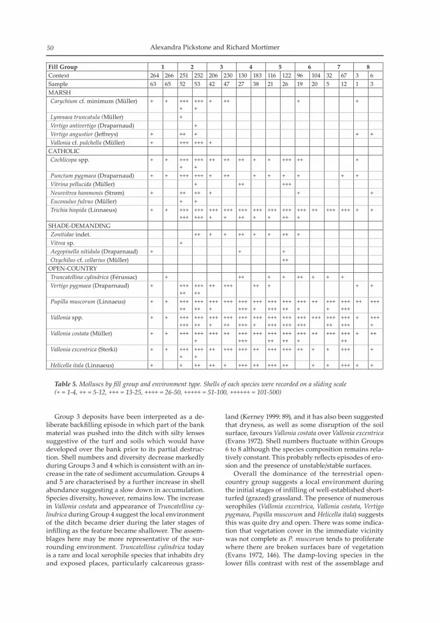
Land SnailsElizabeth C. Stafford
Overall 21 individual species of mollusca were re-corded (Table 5), with modern contamination evident in most samples. Shell was most abundant in Group 2 (up to c. 550 per litre) and some of the Group 4 and 5 samples (up to c. 650 per litre). Shell abundance is sig-nificantly lower in the Group 1 and Group 8 deposits. Shell numbers are very low in the basal samples from contexts 264 and 266 (Group 1), probably reflect-ing the rapid rate of accumulation of chalk rubble in the base of the feature immediately after it was cut. Shell abundance and species diversity rapidly in-creased in the lower secondary fills (Group 2, contexts 251 and 252) suggesting some stabilisation of the fea-ture edges. The base of the ditch itself may have pro-vided a more mesic (moderately moist) environment and this is reflected in the small shade-demanding and catholic component. Trichia hispida can become very abundant in the base of features where condi-tions are slightly more humid. The hygrophilous (damp or wet-loving) group of species in the lower fills appear to be out of place with rest of the assemblage and may represent shells brought to the site attached to vegetation collected from a wetland environment. It seems less likely the ditch would have held standing water given the low numbers, geology, elevated location and the absence of other taxa usually associated with such conditions. The species identified usually inhabit environments such as damp grassland found on floodplain marsh or fen. The rare species Vertigo angustior is a notable record, although it was probably more widespread in the past, inhabiting open wet base-rich meadows. Vertigo antivertigo is a species restricted to lowland wetlands, fens and reed swamps and it avoids places where water levels fluctuate (Kerney 1999, 92–101).
Alexandra Pickstone and Richard Mortimer50
Group 3 deposits have been interpreted as a de-liberate backfilling episode in which part of the bank material was pushed into the ditch with silty lenses suggestive of the turf and soils which would have developed over the bank prior to its partial destruc-tion. Shell numbers and diversity decrease markedly during Groups 3 and 4 which is consistent with an in-crease in the rate of sediment accumulation. Groups 4 and 5 are characterised by a further increase in shell abundance suggesting a slow down in accumulation. Species diversity, however, remains low. The increase in Vallonia costata and appearance of Truncatellina cy-lindrica during Group 4 suggest the local environment of the ditch became drier during the later stages of infilling as the feature became shallower. The assem-blages here may be more representative of the sur-rounding environment. Truncatellina cylindrica today is a rare and local xerophile species that inhabits dry and exposed places, particularly calcareous grass-
land (Kerney 1999: 89), and it has also been suggested that dryness, as well as some disruption of the soil surface, favours Vallonia costata over Vallonia excentrica (Evans 1972). Shell numbers fluctuate within Groups 6 to 8 although the species composition remains rela-tively constant. This probably reflects episodes of ero-sion and the presence of unstable/stable surfaces. Overall the dominance of the terrestrial open-country group suggests a local environment during the initial stages of infilling of well-established short-turfed (grazed) grassland. The presence of numerous xerophiles (Vallonia excentrica, Vallonia costata, Vertigo pygmaea, Pupilla muscorum and Helicella itala) suggests this was quite dry and open. There was some indica-tion that vegetation cover in the immediate vicinity was not complete as P. muscorum tends to proliferate where there are broken surfaces bare of vegetation (Evans 1972, 146). The damp-loving species in the lower fills contrast with rest of the assemblage and
Fill Group 1 2 3 4 5 6 7 8Context 264 266 251 252 206 230 130 183 116 122 96 104 32 67 3 6Sample 63 65 52 53 42 47 27 38 21 26 19 20 5 12 1 3MARSHCarychium cf. minimum (Müller) + + +++
++++ +
+ ++ + +
Lymnaea truncatula (Müller) +Vertigo antivertigo (Draparnaud) +Vertigo angustior (Jeffreys) + ++ + + +Vallonia cf. pulchella (Müller) + +++ +++ +
CATHOLICCochlicopa spp. + + +++
+++++
++ ++ ++ + + +++ ++ +
Punctum pygmaea (Draparnaud) + + +++ +++ + ++ + + + + + +Vitrina pellucida (Müller) + ++ +++Nesovitrea hammonis (Strøm) + ++ ++ + + +Euconulus fulvus (Müller) + +Trichia hispida (Linnaeus) + + +++
+++++++++
++++
++++
+++++
++++
++++
+++++
++++
++ +++ +++ + +
SHADE-DEMANDINGZonitidae indet. ++ + + ++ + + ++ +Vitrea sp. +Aegopinella nitidula (Draparnaud) + + +Oxychilus cf. cellarius (Müller) ++
OPEN-COUNTRYTruncatellina cylindrica (Férussac) + ++ + + ++ + + +Vertigo pygmaea (Draparnaud) + +++
+++++++
++ +++ ++ + + +
Pupilla muscorum (Linnaeus) + + +++++
+++++
++++
+++ ++++++
++++
++++++
+++++
++++
++ ++++
++++++
++ +++
Vallonia spp. + + ++++++
+++++
++++
+++++
++++++
++++
++++++
++++++
++++++
+++ +++++
++++++
+ ++++
Vallonia costata (Müller) + + +++ ++++
+++ ++ ++++++
+++ +++++
+++++
++++
++ +++ +++++
+ ++
Vallonia excentrica (Sterki) + + ++++
++++
++ +++ +++ ++ +++ +++ ++ + + +++ +
Helicella itala (Linnaeus) + + ++ ++ + +++ ++ +++ ++ + + +++ + +
Table 5. Molluscs by fill group and environment type. Shells of each species were recorded on a sliding scale (+ = 1-4, ++ = 5-12, +++ = 13-25, ++++ = 26-50, +++++ = 51-100, ++++++ = 101-500)

War Ditches, Cherry Hinton: Revisiting an Iron Age Hillfort 51
may represent shells brought to the site attached to vegetation collected from a wetland environment.
Radiocarbon DatingJohn Meadows, Christopher Bronk Ramsey, Gordon Cook and Peter Marshall
Sixteen AMS radiocarbon measurements were ob-tained on 13 single entity (Ashmore 1999) samples, of animal and human bone, charcoal, and carbon-ised residues adhering to the interior of ceramic
sherds, from the Scottish Universities Environmental Research Centre (SUERC) and the Oxford Radiocarbon Accelerator Unit (OxA). The radiocar-bon results (Table 6) are quoted in accordance with the international standard known as the Trondheim convention (Stuiver and Kra 1986). They are conven-tional radiocarbon ages (Stuiver and Polach 1977). The calibrations of the results, relating the radio-carbon measurements directly to calendar dates, are given in Table 6 and in outline in Fig. 11. All have been calculated using the calibration curve of Reimer
Figure 11. Probability distributions of radiocarbon dates from War Ditches. Each distribution represents the relative probability that an event occurs at a particular time. For each radiocarbon date, two distributions have been plotted: one in outline which is the result of simple radiocarbon calibration, and a solid one based on the chronological model used. The other distributions correspond to aspects of the model. For example, the distribution ‘Boundary start’ is the estimate for when construction of the ditch started. Measurements followed by a ? have been excluded from the model. The large square brackets down the left-hand side of the diagram and the OxCal keywords define the overall model exactly.

Alexandra Pickstone and Richard Mortimer52
Laboratory number Group Sample number Material dated Radiocarbon
age (BP)Weighted
Mean
Calendar date(95%
confidence)
Posterior Density Estimate
(95% probability)
SUERC-30936 1 CAMWAD09/265
Animal bone, horse mandible (not articulated) from primary fill of ditch; context 265.
2340 ± 35 480–370 cal BC
495-385 cal BC
OxA-X-2386-28 2 CAMWAD09/270
Carbonised residue adhering to the interior of sherd. One of six wall sherds from an Early Iron Age flint and sand tempered jar, including three clear conjoins from context 270.
2390 ± 40 740–390 cal BC
465-385 cal BC
OxA-23231 2 CAMWAD09/263
Animal bone, sheep/goat calcaneum (articulating with phalanges) from context 263.
2310 ± 30
2318 ± 18 BP (T’=1.3; ν=2; T’(5%)=6.0; Ward and Wilson 1978)
405–380 cal BC
405-380 cal BC
OxA-23232 2299 ± 30SUERC-30935 2345 ± 30
SUERC-30934 4/5 CAMWAD09/133/134
Animal bone, humerus of articulated juvenile pig from context 133.
2140 ± 35 360–50 cal BC
230-55 cal BC
OxA-23230 5 CAMWAD09/107/105a
Animal bone, articulating sheep femur and epiphyseal plate (epiphyseal plate sampled) from context (107). This was a well stratified dump of animal bone spread along the length of the excavated segment with 3.33kg of pottery.
2011 ± 28 90 cal BC– cal AD 60
95 cal BC-cal AD 30
SUERC-30933 5 CAMWAD09/107/105b
Animal bone, articulating cow pelvic bone and femoral head (femur sampled) from context 107.
2025 ± 35 160–50 cal BC
155-135 (2%) or
120 cal BC-cal AD 30
SUERC-30941 5 CAMWAD09/107/108
Carbonised residue adhering to the interior of base sherd fragment of an Iron Age reduced ware handmade jar/bowl from context 107.
2140 ± 35 360–50 cal BC
190-45 cal BC
Table 6. Radiocarbon results (continued below). ν = degrees of freedom.

War Ditches, Cherry Hinton: Revisiting an Iron Age Hillfort 53
Laboratory number Group Sample number Material dated Radiocarbon
age (BP)Weighted
Mean
Calendar date(95%
confidence)
Posterior Density Estimate
(95% probability)
OxA-X-2386-32 5 CAMWAD09/107/109
Carbonised residue adhering to the interior of base sherd of an Iron Age reduced ware handmade bowl/jar from context 107. The sample was recovered from a different spit to sample CAMWAD09/107/108.
2370 ± 40 710–380 cal BC -
OxA-23233 6–8 CAMWAD09/601
Human bone, left calcaneus, from articulated lower limbs of skeleton. The upper part of the skeleton was truncated by the quarry and the lower part discovered by children. Its context is unstratified (601) but from layer groups 6-8.
2013 ± 29 90 cal BC– cal AD 60
35 cal BC-cal AD 65
OxA-23148 6 CAMWAD09/95/101
Carbonised residue adhering to the interior of sherd. One perforated Early Roman Horningsea-type ware handmade jar sherd, from 27 sherds in context 95 attributed to the same vessel.
2141 ± 26 350–90 cal BC -
SUERC-30937 7 CAMWAD09/5/9
Carbonised residue adhering to the interior on single sherd of Late pre-Roman Iron Age sandy coarse ware jar/bowl base; one of three conjoining pieces of a base from context 5.
1895 ± 30 cal AD 50–220 cal AD 1-135
SUERC-30942 8 CAMWAD09/4 Acer
Charcoal, Acer sp. single fragment from context 4. Context 4 was a sub-circular area containing charcoal & burnt grain sandwiched between fills 3 and 6.
2420 ± 30 750–390 cal BC -
OxA-23234 8 CAMWAD09/ PrunusCharcoal, Prunus sp. single fragment from context 4.
2388 ± 29
2390 ± 21 BP (T’=1.3; ν=2; T’(5%)=6.0; Ward and Wilson 1978)
520–395 cal BC -
OxA-23235 2392 ± 29
Table 6. Radiocarbon results, continued.

Alexandra Pickstone and Richard Mortimer54
et al. (2009) and the computer program OxCal v4.1 (Bronk Ramsey 2009). The calibrated date ranges (95% confidence) in plain type in the table have been cal-culated according to the maximum intercept method (Stuiver and Reimer 1986) and are quoted in the form recommended by Mook (1986). The ranges quoted in italics are posterior density estimates derived from mathematical modelling of archaeological problems (Bayliss et al. 2007). All other ranges are derived from the probability method (Stuiver and Reimer 1993). A Bayesian approach (Buck et al. 1996) in which the calibrated radiocarbon dates are combined with the relative dating of the samples given by the strati-graphic sequence of ditch fills (see Table 6) has been used for the interpretation of the ditch’s chronol-ogy. The model (Fig. 11) shows good agreement be-tween the radiocarbon dates and the stratigraphy (Amodel=93%) (although see note in relation to sci-entific and pottery dates in earlier text) and provides an estimate for the digging of the ditch of 575–385 cal BC (95% probability; Boundary start) and probably 455–390 cal BC (68% probability). The initial weather-ing of the exposed chalk sides of the ditch (Group 1) and subsequent infilling (Groups 2 and 3) by destruc-tion of the bank appears to have been a very rapid process that took 1–30 years (68% probability). Following a period of abandonment (Group 4) that probably lasted 120–270 years (68% probability) re-oc-cupation occurred in 330 cal BC–cal AD 70 (95% proba-bility; Boundary re-occupation) and probably 245–110 cal BC (68% probability). The final infilling of the ditch occurred in cal AD 5–225 (95% probability; Boundary end) and probably cal AD 55–150 (68% probability). Samples of pottery with traces of residues from Groups 2 and 5–7 were examined. The carbonaceous fractions extracted physically and chemically from the inside of the sherds are assumed to represent organic-rich food remains, and thus should date the last use of the vessel in question. However, in this case two of the five dated carbonised residues (OxA-X-2386-32 and OxA-23148) are clearly much too old for the pottery types in question. OxA-X-2386-32 had a very low % carbon yield following pre-treatment and the laboratory advised caution in the interpretation of the result. For OxA-23148 the inadvertent sampling of the clay fabric that may contain appreciable amounts of ‘old’ carbon even after firing (Nakamura et al. 2001) may provide an explanation for the discrepancy.
Discussion
Pre-Monument Settlement?
The Early Iron Age storage pits recorded by White within the monument in the 1960s, along with the single pit excavated in the recent work, are charac-teristic of settlement at this period and could equally date to a pre-monument phase or to the immediate occupation of the monument itself. At Wandlebury an extensive and apparently unenclosed Early Iron
Age settlement existed on the hilltop (French 2004), although the limited evidence at War Ditches does not suggest the presence of substantial settlement here. The relatively small number of sherds, and the level of attrition, would suggest that the material is secondary in its context and could represent a gen-eral scatter of surface material in the area created ei-ther prior to or during the monument’s construction. This scatter must have been widespread, however, with Early Iron Age material recovered from most the excavated ditch segments. A crucial factor at War Ditches is that it is an exposed and dry place with the main water source being the chalk springs at the bottom of the hill to the north-west. The chalk upland would perhaps have been better used for grazing or arable land than for settlement.
Monument Construction, Use and Function
The catalyst behind construction of the War Ditches may have been local social tensions. Very little is known of the peoples or boundaries of the region in the Early to Middle Iron Age, although the con-struction of so many defensive and/or communal sites such as War Ditches, Wandlebury (French 2004) and Sawston (Mortimer 2001) within such a limited geographical area could suggest that it was a time of shifting boundaries and allegiances producing inter-tribal conflicts. The causes of these tensions remain supposition, but may have included increasing popu-lation resulting in pressure on farming land or per-haps an influx of peoples from the continent. Previous interventions confirm that War Ditches was broadly circular, with an entranceway at the east measuring some 13m across. Ditches set out at right angles to the entrance created a causeway leading to the monument, the full length of which has not been revealed. The main enclosing ditch was on average 6m wide and 4m deep, but at and around the eastern entrance was found to be significantly narrower and shallower. It is estimated that six to seven thousand cubic metres of chalk would have been excavated from the ditch to form the internal bank or rampart; there may also have been a smaller counterscarp bank, but the infill sequence indicates that the main bank was internal. Very little was found within the ditch fills to aid interpretations of construction meth-ods, although some of the environmental evidence from the lower fills may provide clues about the ram-part’s construction. Small amounts of sedge were as-sociated with the bank’s destruction, along with large numbers of aquatic snail species that probably lived on the plant. These species must have been brought to the site from the nearest sedge fen down the hill to the north. It is possible that, in what may have been a substantially cleared landscape, timber was scarce and that sedge could have been layered between the rubble of the rampart to bind and stabilise it. Two main functions are normally attributed to hillforts and ring monuments: as defensive structures and/or defended settlements or as locations for trade, religion, politics and gatherings/celebrations. Such

War Ditches, Cherry Hinton: Revisiting an Iron Age Hillfort 55
monuments may have had wide ranging uses, pro-viding a focus of social cohesion in troubled times. Considerable organisation would be necessary to construct such a monument, indicating that its initia-tors were able to command significant influence and/or control over the surrounding populace. Both the War Ditches location and its general morphology suggest a defensive function, although the limited finds and environmental assemblage, to-gether with the relatively small size of the area en-closed, suggest that it was not a defended settlement. As the ditch approaches the eastern entranceway it becomes markedly narrower and shallower, remain-ing so throughout the flanking entrance ditches. In a defended site the weakest point will generally be the entranceway(s) and the earthworks here would be expected to be amongst the most effective. The excavations of the 1950s and 60s, however, attest to the potentially unfinished nature of the ditch, at and around the entranceway which suggests that the monument was destroyed before becoming firmly es-tablished.
Monument Destruction
A potentially violent end to the monument has been suggested since the earliest archaeological interven-tions: its short life was first identified from what ap-peared to be the ‘unfinished nature’ of parts of the ring ditch. In at least two of the earlier excavated seg-ments a central baulk of chalk remained upstanding; others were recorded as shallow and having been excavated in ‘an irregular system of steps’ (White 1964a, 10). These would appear to represent unfin-ished parts of the ditch where excavation had sud-denly ceased. Some of these sections had large rubble blocks as their primary fill, with no evidence for any earlier weathering having taken place. Since the first excavations at the end of the 19th century most of the excavated segments have contained this thick rubble layer, consisting of the original upcast bank material which had been pushed back into the ditch, above an initial weathering fill. This does not appear to have been a case of the monument going out of use and gradually eroding: the displacement of the bank was clearly a rapid and uniform event. Large pieces of charcoal have also been recovered from within the rubble matrix at all points around the ditch circuit, suggesting a significant burning event prior to or at the time of this infilling. The charcoal may represent the remains of the timbers and other organic materi-als used in the bank’s construction. Radiocarbon dat-ing now confirms that this took place before or soon after its completion. The nature of the monument’s destruction is clear-ly demonstrated by the human remains, occasionally burnt and/or disarticulated, that have been recovered consistently from the level of the bank’s destruction. The greatest numbers of articulated or semi-articu-lated individuals were found along the heavily inves-tigated western side. Taken as a whole, the evidence suggests that large numbers of people were interred
within the ditch at the time of its rapid infilling. The violence which may have occurred at the War Ditches did not go unnoticed by its earliest excava-tors, although Hughes (1902b) remained uncertain as to ‘whether we have traces of a massacre or of a time when the residents used the neglected fosse to throw their dead into’. He failed to identify the ‘fires’ or epi-sodes of burning as a destructive event but was led by a suggestion that the fires had been used for cooking, even though they extended for 4m or more along the lower level of the ditch. The massacre theory was ce-mented by Lethbridge (1949) with the discovery of the charred torso and the presence of charcoal mixed in with the bank material which was interpreted as the destruction of the rampart. Cut marks were also ob-served on some of the bones (Cutting A1 – CUAFC re-cords Box 31 G03/7/3; CUMAA). It is difficult to argue against the interpretation of a violent destruction event, even with the modern archaeologist’s wider knowledge of the ‘burial’ practices of the Early Iron Age and recent trends in thinking which have tended to suggest that hillforts were not necessarily central places nor related to defence at all (Hill 1995). The findings at War Ditches, however, resonate with those recently made at the hillfort of Fin Cop, Derbyshire, where ‘the martial nature of the site and the violent end implied by the discovery of the corpse [and oth-ers recently found] stands as a corrective to the paci-fication of these monuments, and the Iron Age groups who inhabited them, in the academic literature of the past decade or so’ (Waddington 2010, 56). Following its destruction, the War Ditches ring-work appears to have been abandoned for some con-siderable time: no cultural material was recovered from the Middle or Later Iron Age (until c. 50 BC) suggesting a period of abandonment of around 300 years. The accumulation of material which built up above the displaced bank material (Group 4) comes from the gradual infilling and erosion of the ditch. There is no evidence that the area became scrub or woodland and it was presumably still grazed over this period. While there is a relative abundance of artefactual material in these fills, it is of a consistent date, type and character as the assemblages recov-ered from the earlier fills, suggesting the gradual in-corporation of surface material into the ditch.
Reoccupation
Reoccupation of the War Ditches occurred c. 50 BC, on the basis of recovered pottery. The upper ditch fills contained debris from the period between approxi-mately 50 BC to AD 50–80, after which the ditch was deliberately and completely, infilled. The correspond-ing fills demonstrate the initial reoccupation (Group 5), a small-scale period of change, perhaps a minor levelling or ‘tidying’ of the bank area (Group 6) and the main period of settlement activity in the environs (Group 7). When these settlers arrived, the site would have been a turf-covered earthwork with a small, prob-ably wide, bank and a ditch of up to 1.4m deep. The

Alexandra Pickstone and Richard Mortimer56
limited area within the ring ditch could suggest that the new settlement was established both within and outside the monument, disregarding rather than deliberately utilising the ring ditch itself; there was certainly no attempt to recut or remake the monu-ment as a defensive structure. Spatial analysis of the finds assemblage and the nature of the fill sequence suggest that material was probably entering the ditch from both sides at this time. The large and reasonably varied finds assemblage contains significant quanti-ties of domestic waste, in clear contrast to the Early Iron Age material. The presence of quernstones and kiln debris demonstrate that both domestic and semi-industrial activities were occurring on the site. The remaining hollow of the ditch (although not utilised as such in the area of the 2009 excavations) was else-where used as a sheltered working area, for fires, a kiln and further burials. A ‘Belgic pit’ dating to c. 20 BC – AD 40 was identified in the 1950s along the line of the ditch to the north of the 2009 excavation and appears to be one of the few known features (exclud-ing the kilns and potentially contemporary burials) relating to the Later Iron Age settlement. During the latter half of the 1st century AD the final 0.7m depth of the ditch hollow was deliberately backfilled with the remnants of the bank. It is dif-ficult to gauge the precise date for the final infilling of the feature, but the pottery assemblage suggests it occurred between 50 and 80AD. Cambridge lay on the border of Icenian lands and the eradication of the last vestiges of such a prominent hillfort was perhaps linked to a reaction to the Boudican revolt of AD 61–65. Open area excavations carried out by White and others (between 1949–51) close to the entrance of the ring ditch revealed large posthole structures and field systems associated with a 2nd- to 4th-century AD farmstead, following the final infilling of the ditch. This settlement completely disregarded the position of the ring ditch, with later ditches cutting straight across it.
Conclusions
The objectives of the recent excavations at the War Ditches were effectively threefold: to excavate and re-cord that part of the monument most threatened by the remedial works in the quarry and in doing so to utilise modern archaeological techniques unavailable to earlier excavators; to attempt to answer the ques-tions around the monument’s potential antecedents, its construction and demise; to integrate the results with a review of the findings of past excavators. The first objective has been an unqualified success, since the precise nature of modern excavation and record-ing techniques have produced the most detailed pic-ture of the ditch and its infilling thus far; radiocarbon dating has successfully enabled those phases of the ditch not well-dated by pottery to be precisely dated. This in turn assists with the research objective of fur-thering understanding of Iron Age chronology.
Another key objective was to clarify the date of the monument’s construction, whether it had signifi-cantly earlier origins, as suggested by Lethbridge and others, or was simply an earlier Iron Age construct. The nature and rapidity of the monument’s demise was also questionable. Antiquarian interpretations had cleaved to violence, war and massacre in relation to the skeletons, fires and rubble they recorded in the ditch, interpretations that in recent decades the aca-demic literature has tended to deny, stressing instead the atypical nature of Iron Age mortuary practices. In this instance, however, a cataclysmic event does seem to have occurred at the site. The developmental sequence at the War Ditches appears to have been relatively simple: the monu-ment was constructed in the late 5th to early 4th cen-tury BC and was largely destroyed, with some loss of life, towards the end of its construction period. The site was then abandoned, half infilled in an area of open grassland for c. 300 years until reoccupied, as a farmstead, around the middle of the 1st century BC. This occupation continued through into the second half of the 1st century AD when the upper part of the ditch was filled in and the site levelled. Occupation continued into the 2nd century AD and beyond but with no further evidence of material having entered the ditch, even the in situ burial that came from the upper levels of the ditch in 2008, the discovery that brought about the excavation, dates to 35 cal BC – cal AD 65 (95% probability). A limited number Early Iron Age sites have been excavated in the region and few have been precisely dated: Wandlebury itself has only been broadly as-signed a possible construction date in the 5th to 4th centuries BC, reworked in the 1st century BC. One major contribution of the War Ditches project is that it has given the construction and destruction of an Early Iron Age hillfort an accurate date for the first time: 455–390 cal BC (68% probability). At present none of the similar, contemporary sites have been ac-curately dated in the area; Arbury Camp has been dated to the Middle Iron Age and further afield both Stonea Camp (Potter and Jackson 1982) and Borough Fen (Malim and McKenna 1994) are likely to be of similar or later date; a large hilltop ditch at Exning to the east of War Ditches, has been dated to the 8th or early 7th centuries BC (Jo Caruth, pers. comm.). The results from War Ditches only serve to highlight that the political and cultural landscape of the area at this time is neither well dated nor well understood, but they offer a starting point for further investigation and discussion. Perhaps the overriding result of the excavation has been that the use of modern techniques and ap-proaches serve both to confirm many of observations of past excavators and to add considerable layers of detail to these earlier findings.

War Ditches, Cherry Hinton: Revisiting an Iron Age Hillfort 57
Acknowledgements
The authors would like to thank English Heritage for funding the project, and in particular Jonathan Last and Helen Keeley for their support. The Wildlife Trust are warmly thanked for their funding, their help throughout and their continued interest and en-thusiasm: particular thanks are due to Laura Watson and Martin Baker. Thanks are due to Mark Hinman and Michelle Bullivant for sharing their unrivalled local knowledge, and to Carenza Lewis and Nick James of the CAS for their support. The site was ex-cavated by the authors and by Nick Gilmour, Graeme Clarke and Ross Lilley. Louise Bush provided survey support. Elizabeth Popescu edited and prepared the article for publication.
Cambridge Antiquarian Society is grateful to English Heritage for a grant towards the publica-tion of this paper.
Bibliography
Arnold, D, 1985 Ceramic Theory and Cultural Process. Cambridge: Cambridge University Press (CUP)
Ashmore, P, 1999 ‘Radiocarbon dating: avoiding errors by avoiding mixed samples’, Antiquity, 73, 124–30
Barrett, J, 1978 The EPRIA prehistoric pottery. In JD Hedges and DG Buckley, Excavations at a Neolithic causewayed enclosure, Orsett, Essex, 1975, 268–88. Proceedings of the Prehistoric Society (Proc. Prehist. Soc.) 44
Barrett, J, 1980 The pottery of the later Bronze Age in low-land England. Proc. Prehist. Soc. 46, 297–319
Bayliss, A, Bronk Ramsey, C, van der Plicht, J, and Whittle, A, 2007 ‘Bradshaw and Bayes: towards a timetable for the Neolithic’, Cambridge Journal of Archaeology. 17.1, supplement, 1–28
British Geological Survey 2002, Sheet 205 Saffron Walden. England and Wales Sheet 205 Solid and Drift Geology. 1:50,000 Nottingham: BGS
Braddock, P, and Hill, JD, Forthcoming. Using and Depositing Pots in Earlier Iron Age Cambridgeshire: A report on the Prehistoric Pottery from Landwade Road, Fordham, Cambridgeshire
Bronk Ramsey, C, 2009 ‘Bayesian analysis of radiocarbon dates’, Radiocarbon, 51, 337–60
Brudenell, M, Forthcoming ‘The Iron Age pottery’ in A Lyons, Cambridge Park and Rides (working title), East Anglian Archaeology (E. Anglian Archaeol.)
Brudenell, M, 2007 ‘Prehistoric pottery’, in N. Armour, The Addenbrooke’s Access Road, Glebe Farm, Trumpington, Cambridge. The 2007 Investigations: Site 1, 2, 5 and 6. Cambridge Archaeology Unit (CAU) Report 802 (un-published)
Brudenell, M, 2010 ‘The Early Iron Age Pottery’, in A Pickstone and R Mortimer, The excavation of a remnant of the Iron Age Ring Monument ‘War Ditches’ at The East Pit, Lime Kiln Road, Cherry Hinton, Cambridge. Post Excavation Assessment and Updated Project Design. OAE Report 1174 (unpublished)
Brudenell, M, and Dickens, A, 2007 Trumpington Meadows, Cambridge. An Archaeological Evaluation of a Bronze Age, Iron Age and Romano-British Riverside Landscape. CAU Report 753
Brudenell, M, and Phillips, T, 2008 Later Prehistoric Pottery from the Milton Landfill Site. Interim report for OAE (unpublished)
Buck, CE, Cavanagh, WG, and Litton, CD, 1996 Bayesian Approach to Interpreting Archaeological Data. Chichester: Wiley
Cunliffe, B, 1968 Early pre-Roman Iron Age communities in eastern England, Antiquaries Journal. 48, 175–91
Cunliffe, B, 2005 Iron Age communities in Britain: an account of England, Scotland and Wales from the seventh century BC until the Roman Conquest (fourth edition). London: Routledge
Davis, S, 2003 ‘Animal Bone’, in Evans C., Power and island communities: excavations at the Wardy Hill ringwork, Coveney, Ely. E. Anglian Archaeol. 103. Cambridge: CAU
Evans, C, and Knight, M, 2002 ‘A great circle: investiga-tions at Arbury Camp’, Proceedings of the Cambridge Antiquarian Society (PCAS) XCI, 39
Evans, C, Mackay, D, and Webley, L, 2008 Borderlands. The Archaeology of the Addenbrooke’s Environs, South Cambridge, CAU Landscapes Archives: New Archaeologies of the Cambridge Region (1). Oxford: Oxbow
Evans JG 1972 Land snails in archaeology. London: Seminar Press
Evans, J, 1990 ‘The Cherry Hinton finewares’, Journal of Roman Pottery Studies 3, 18–29
Feugère, M, 1985 ‘Les fibules en Gaule Méridionale de la Conquête à la Fin du Ve Siècle après Jésu-Christ’, Revue Archéologique de Narbonnaise Supplement 12 (Paris)
Filby. E, 1995 Cherry Hinton Chronicle 1751–1899 (Privately published)
Ford, S, 1987 Chronological and Functional Aspects of Flint Assemblages. In AG Brown and MR Edmonds (Ed.) Lithic Analysis and Later Prehistory: Some Problems and Approaches. British Archaeological Report (Brit. Archaeol. Rep.) British Series (Brit. Ser.) 162. Oxford: BAR)
Ford, S, Bradley, R, Hawkes, J and Fisher, P, 1984 ‘Flint-Working in the Metal Age’, Oxford J. Archaeol. 3, 157–173
French, C, 2004 ‘Evaluation survey and excavation at Wandlebury ringwork, Cambridgeshire, 1994–7’, PCAS 93, 15–65
Friday, LE, and Harvey, HJ, 1997 ‘Sedge, litter and droves’, in L Friday (ed.) Wicken Fen: The making of a wetland na-ture reserve Colchester: Harley Books, 60–81
Gibson, D, and Lucas, G, 2002 ‘Pre-Flavian kilns at Greenhouse Farm and the social context of early Roman pottery production in Cambridgeshire’, Britannia 33, 95–128
Grigson, C, 1982 ‘Sex and age determination of some bones and teeth of domestic cattle: a review of the litera-ture’, in B Wilson, C Grigson and S Payne (eds) Ageing and sexing animal bones from archaeological sites. Brit. Archaeol. Rep. Brit. Ser. 199 Oxford: BAR
Hambleton, E, 1999 Animal Husbandry Regimes in Iron Age Britain, Brit. Archaeol. Rep. Brit. Ser. 282
Hartley, BR, 1957 ‘The Wandlebury Iron Age hillfort: Excavations of 1955–6’, PCAS 50, 1–27
Haselgrove, C, Armit, I, Champion, T, Creighton, J, Gwilt, A, Hill, JD, Hunter, F and Woodward, A, 2001 Understanding the Iron Age: an agenda for action. Iron Age Research Seminar / Council of the Prehistoric Society
Hattatt, RA, 1987 Brooches of antiquity Oxford: Oxbow BooksHawkes, CFC, and Hull, MR, 1947 Camulodunum first
report on the excavations at Colchester, 1930–1939, Society of Antiquaries of London Research Report. 14 Oxford,

Alexandra Pickstone and Richard Mortimer58
University PressHill, JD, 2003 ‘The pottery: a re-assessment’, in C French,
Wandlebury Ringwork, Cambridgeshire, 1994–7: Evaluation survey and excavation. Cambridge Archaeological Unit Report 533 (unpublished)
Hill, JD, 1995 ‘How should we study Iron Age societies and hillforts? A contextual study from southern England’, in JD Hill and CG Cumberbatch (eds.), Different Iron Ages: Studies on the Iron Age in Temperate Europe, 45–46. Brit. Archaeol. Rep,. Brit Ser. 602 Oxford: BAR
Hinman, M, 1998 Prehistoric Remains Adjacent to Babraham Road, Cambridge. An Archaeological Evaluation. CCC AFU Report No. 147 (unpublished)
Hodson, R, 1962 ‘Some pottery from Eastbourne, the ‘Marnians’ and the pre-Roman Iron Age in southern England’, Proc. Prehist. Soc., 28 140–155
Hughes, TM, Macalister, A, and Duckworth, WHL, 1895 ‘On a Newly Discovered Dyke at Cherry Hinton’, PCAS VIII (Old Series), 317–330
Hughes, TM, 1902a ‘Excavations in the War Ditches, Near Cherry Hinton’, PCAS X (Old Series), 234–237
Hughes, TM, 1902b ‘The War Ditches, Near Cherry Hinton, Cambridge’, PCAS X (Old Series), 452–4
Hull, MR, forthcoming Brooches in pre-Roman and Roman Britain, edited by GM Simpson, N Crummy and B Blance, 81
Humphrey, J, 2003 ‘The Utilization and Technology of Flint in the British Iron Age’, in J Humphrey (ed.) Re-searching the Iron Age: selected papers from the proceedings of the Iron Age research student seminars, 1999 and 2000, 17–23. Leicester Archaeology Monograph 11
Humphrey, J, 2004 Iron Age Flint Utilisation in Central and Southern Britain: the last Stone Age? An Integrated Theoretical and Empirical Study. Unpublished Ph.D Thesis. University of Leicester
Humphrey, J, 2007 ‘Simple Tools for Tough Tasks or Tough Tools for Simple tasks? Analysis and Experiment in Iron Age Flint Utilisation’, in C Haselgrove and R Pope (eds.) The Earlier Iron Age in Britain and the near Continent, 144–159 Oxford: Oxbow Books
Kerney, MP, 1999 Atlas of land and freshwater molluscs of Britain and Ireland. Colchester: Harley
Lethbridge, TC, 1949 ‘Further Excavations At The War Ditches’, PCAS 42, 117
Mackreth, D, 1981 ‘The brooches’ in CR Partridge, Skeleton Green: a late Iron Age and Romano-British site, Britannia Monograph 2 (London), 130–43
Malim T, and McKenna R, 1994 Borough Fen Ring-work: Iron Age Fort Newborough, Fenland Research 8
Mook, WG, 1986 ‘Business meeting: recommendations/resolutions adopted by the twelfth International Radiocarbon Conference’, Radiocarbon, 28, 799
Morris, EL, 1996 ‘Iron Age artefact production and ex-change’ in TC Champion and JR Collis (eds), The Iron Age in Britain and Ireland: Recent Trends. Sheffield: University of Sheffield, 41–65
Mortimer, R 2001, The Hillfort at Borough Hill, Sawston: An Archaeological Watching Brief. CAU Rep. 203 (unpub-lished)
Nakamura, T, Taniguchi, Y, Tsuji, S, and Oda, H, 2001 ‘Radiocarbon dating of charred residues on the earliest pottery in Japan’, Radiocarbon, 43, 1129–38
Niblett, R, 2006 ‘From Verlamion to Verulamium’ in P Ottaway (ed.), A victory celebration: papers on the ar-chaeology of Colchester and Late Iron Age-Roman Britain presented to Philip Crummy Colchester: Colchester Archaeology Trust, 19–26
PCAS 1912 ‘Annual Report Monday 16th October 1911’,
PCAS XVI (Old Series), X New Series, 5PCAS 1913 ‘Annual Report: Appendix I’, PCAS XVII (Old
Series), XI New Series, 5PCAS 1917 ‘Report of the Council, 1914–1915’, PCAS XX
(Old Series), XIV New Series 4, 4Perring FG, Sell PD, and S.M. Walters SM. With a sec-
tion on Bryophyta, by Whitehouse HLK 1964 A flora of Cambridgeshire, Cambridge: Cambridge University Press
Phillipson, DW, 1964 ‘Faunal report’, in DA White., Excavations at the War Ditches, Cherry Hinton, 1961–2, PCAS 29
Pitts, MW, 1978a ‘On the Shape of Waste Flakes as an Index of Technological Change in Lithic Industries’, Journal of Archaeological Science (JAS). 5, 17–37
Pitts, MW, 1978b ‘Towards an Understanding of Flint Industries in Post-Glacial England’, Bulletin of the Institute of Archaeology 15, 179–197
Pitts, MW, and Jacobi, RM, 1979 ‘Some Aspects of Change in Flakes Stone Industries of the Mesolithic and Neolithic in Southern Britain’, JAS 6, 163–177
Potter, TW, and Jackson RPJ,1982 ‘The Roman Site of Stonea, Cambridgeshire’, Antiquity 56 (217), 111–120
Pryor, F, 1984 Excavation at Fengate, Peterborough, England: The Fourth Report. (Northampton/Toronto: Northamptonshire Archaeology Society Monograph 2/ Royal Ontario Museum Archaeology Monograph 7)
Reimer, PJ, Baillie, MG., Bard, E, Bayliss, A, Beck, JW, Blackwell, PG, Bronk Ramsey, C, Buck, CE, Burr, GS, Edwards, RL, Friedrich, M, Grootes, PM, Guilderson, TP, Hajdas, I, Heaton, TJ, Hogg, AG, Hughen, KA, Kaiser, KF, Kromer, B, McCormac, G, Manning, S, Reimer, RW, Remmele, S, Richards, DA, Southon, JR, Talamo, S, Taylor, FW, Turney, CSM, van der Plicht, J, and Weyhenmeyer, CE, 2009 ‘INTCAL09 and MARINE09 radiocarbon age calibration curves, 0–50,000 years cal BP’, Radiocarbon, 51, 1111–50
Roberts, K, 2008 ‘Environmental bulk samples’, in C. Evans, D Mackay and L Webley, Borderlands: The ar-chaeology of the Addenbrooke’s Environs, South Cambridge. Cambridge: CAU, 110–122
Stead, IM and Rigby, V, 1986 Baldock, the excavation of a Roman and pre-Roman settlement, 1968–72, Britannia Monograph 7 (London)
Stuiver, M and Kra, RS, 1986 ‘Editorial comment’, Radiocarbon, 28(2B), ii
Stuiver, M, and Polach, HA, 1977 ‘Reporting of 14C data’, Radiocarbon, 19, 355–63
Stuiver, M, and Reimer, PJ, 1986 ‘A computer program for radiocarbon age calculation’, Radiocarbon, 28, 1022–30
Stuiver, M, and Reimer, PJ, 1993 ‘Extended 14C data base and revised CALIB 3.0 14C age calibration program’, Radiocarbon, 35, 215–30
Swan, VG, 1984 The Pottery Kilns of Roman Britain, Royal Commission on Historical Monuments, Supplementary Series 5. London: HMSO
Thompson, I, 1982 Grog-tempered ‘Belgic’ Pottery of South-eastern England, Brit. Archaeol. Rep. Brit. Ser. 108
Tomber, R and Dore, J, 1998 The National Roman Fabric reference collection, A Handbook, Museum of London Archaeological Service Monograph 2
Tringham, R, Cooper, G, Odell, G, Voytek, B and Whitman, A, 1974 ‘Experimentation in the Formation of Edge Damage: a new approach to lithic analysis’ Journal of Field Archaeology 1, 171–196
Tyers, P, 1996 Roman Pottery in Britain. London: BatsfordWaddington, C, 2010 Fin Cop Excavation Archive Report for
2009, ARS Ltd Report No. 2010/13 (unpublished)
War Ditches, Cherry Hinton: Revisiting an Iron Age Hillfort 59
Walker, FG, 1908 ‘Skeletons Recently Found At The ‘War Ditches’, Cherry Hinton’, PCAS 12, 267–273
Ward GK and Wilson SR 1978 Procedures for comparing and combining radiocarbon age-determinations – Critique Archaeometry 20, (Feb) 19–31
Webley, L, 2005 ‘Evaluation survey and excavation at Wandlebury Ringwork, Cambridgeshire, 1994–7: part II, the Iron Age pottery’, PCAS 94, 39–46
Webley, L, with Anderson, K, 2008 ‘Late Iron Age and Roman Pottery’ in C Evans with D Mackay and L Webley, Borderlands. The Archaeology of the Addenbrooke’s Environs, South Cambridge. Cambridge: CAU, 63–75
White, DA, 1964a, ‘Excavations At The War Ditches, Cherry Hinton, 1961–62’ PCAS 56, 9–29
White, DA, 1964b ‘Excavations at the War Ditches, Cherry Hinton, 1949–51’, PCAS 56, 30–41
Williams, DW, 2003 ‘Petrology’ in Evans, C, in Power and Island Communities: Excavations at the Wardy Hill Ringwork, Coveney, Ely, E. Anglian Archaeol. 103, 169–170
Young, R, and Humphrey, J, 1999 ‘Flint Use in England after the Bronze Age: time for a re-evaluation?’, Proc. Prehist. Soc. 65, 231–242

60