bayowa et al (3) - african journals online
TRANSCRIPT
Ife Journal of Science vol. 16, no. 3 (2014)
INTEGRATION OF HYDROGEOPHYSICAL AND REMOTE SENSING DATA IN THE ASSESSMENT OF GROUNDWATER POTENTIAL OF THE BASEMENT COMPLEX TERRAIN OF EKITI STATE, SOUTHWESTERN NIGERIA.
1 2 3 4Bayowa O.G., Olorunfemi M.O., Akinluyi F.O., and Ademilua O.L1Department of Earth Sciences, Ladoke Akintola University of Technology, Ogbomoso, Nigeria.
2Department of Geology, Obafemi Awolowo University, Ile-Ife, Nigeria.3Department of Remote Sensing and GIS, Federal University of Technology, Akure, Nigeria.
4Department of Geology, Ekiti State University, Ado-Ekiti, Nigeria.Corresponding Author E-mail:[email protected]; [email protected]
(Received: 8th August, 2014; Accepted: 12th August, 2014)
Hydrogeophysical investigation as well as analyses of hydrogeomorphological, geologic/hydrogeologic, electrical resistivity and borehole data had been carried out in the Basement Complex terrain of Ekiti State, Southwestern Nigeria. This was with a view to classifying the area into different groundwater potential zones. The VES interpretation results were used for aquifer identification; aquifer geoelectric parameter determination and for the calculation of the overburden coefficient of anisotropy. Hydrogeomorphological, lineament density, lineament intersection density and overburden coefficient of anisotropy thematic maps were produced and integrated for the classification of the study area into different groundwater potential zones. The reliability of the groundwater potential map was checked with the existing groundwater yield data. The weathered and fractured basement constituted the main aquifer units. The groundwater yields of boreholes located within quartzitic rocks had a mean of 1.56 l/s while the mean groundwater yield from metasediment (schist) was 1.14 l/s. The study area was characterized into five different groundwater potential zones which were very low, low, moderate, high and very high. Ijelu-Ekiti, Ayede, Ipao, Ikole, Oye. Ayegbaju, Ofale-Ijero and Omuo-Ekiti were classified as very low groundwater potential areas while low groundwater potential was established in Ijesa-Isu, Iludofin, Iyemero, Esure, Otun, Osi, Iropora, Ifaki, Ikun, Ijero, Ado, Emure and Ise/Orun. Igbara-Odo, Ilawe, Ikogosi, Ido, Ipole-Iloro, Ipere, Ayetoro, Ikoro, Ifisin, Ilogbo, Isinbode, Erinmope and Iwaro fall within moderate groundwater potential zones. High groundwater potential was recorded in Ijan, Okemesi, Aramoko, Ilemeso, Ikere, Etisun and Itawure. Efon-Alaaye and Ilumoba fall within very high groundwater potential zone. The groundwater potential of Ekiti State is generally of very low–moderate level rating. There were however few areas with high to very high groundwater potential.
Keywords: Basement Complex, Hydrogeophysics, Remote Sensing, Groundwater Potential, Ekiti State.
ABSTRACT
353
INTRODUCTIONThere has been a progressive increase in the population of Ekiti State with the attendant increase in the demand for potable water for both domestic and industrial usages. The gross inadequacy of public water supply has made groundwater development through hand dug wells and boreholes inevitable. However, the success of groundwater development programme is predicated on good understanding of the geomorphological, geological, hydrogeological and geophysical characteristics of the basement complex terrain. These characteristics are required for the assessment of the groundwater potential. Groundwater investigation is therefore often multidisciplinary in approach and could involve terrain analysis, geology/hydrogeology, remote sensing and geophysics. Olorunfemi et al., (1991) investigated the relationship between electrical
anisotropy and groundwater yield in the basement complex area of the southwestern Nigeria. Their findings include amongst others that the groundwater yield generally increases with increase in the overburden coefficient of anisotropy. Teme and Oni (1991) used remote sensing techniques to detect groundwater flow in fractured media in hard rock terrain. They used aerial photographs and radar imageries to adequately locate and delineate the extent and frequency of these fractured systems thus making it possible for the siting of productive boreholes at approximately predetermined localities within the basement areas. Mohammed (1992) carried out a geophysical investigation for groundwater development at the Federal University of technology, Akure.His conclusion was that deep weathered zones and fractured or brecciated basement which are characterized by relatively low
Bayowa et al.: Integration of Hydrogeophysical and Remote Sensing Data in the Assessment of Groundwater354
resistivity values constitute the main aquifer unit in the area. Salem (1999) submitted that fluid transmissivity (layer thickness x permeability) and electric transverse resistance (layer thickness x resistivity) are important parameters in groundwater and hydrocarbon exploration. The determination of these parameters provides a good knowledge of the potential of porous media, because they relate fluid flow to electric current conduction in terms of layer thickness, permeability and resistivity. The author established a direct relationship between fluid transmissivity and the electric transverse resistance, with coefficients of correlation of 0.99 (for aquifers) and 0.94 (for reservoirs) and suggested that an increase in both parameters indicate presence of zones of high fluid potential within the aquifers and the reservoirs. Ademilua (1997) attempted to classify both Ondo and Ekiti States into different groundwater potential zones but was constrained by few VES data points as well as limited sampled localities. Hence, the groundwater potential map produced by the researcher could not have been representative. A preliminary assessment of the groundwater potential based on terrain and satellite imagery analyses had been undertaken by Bayowa et al., 2014b. There is therefore the need for detailed assessment of the groundwater potential using i n t e g r a t e d h y d r o g e o m o r p h o l o g i c a l , ,geological/hydrogeological (involving recent satellite imageries covering state) and geophysical data acquired across the state.
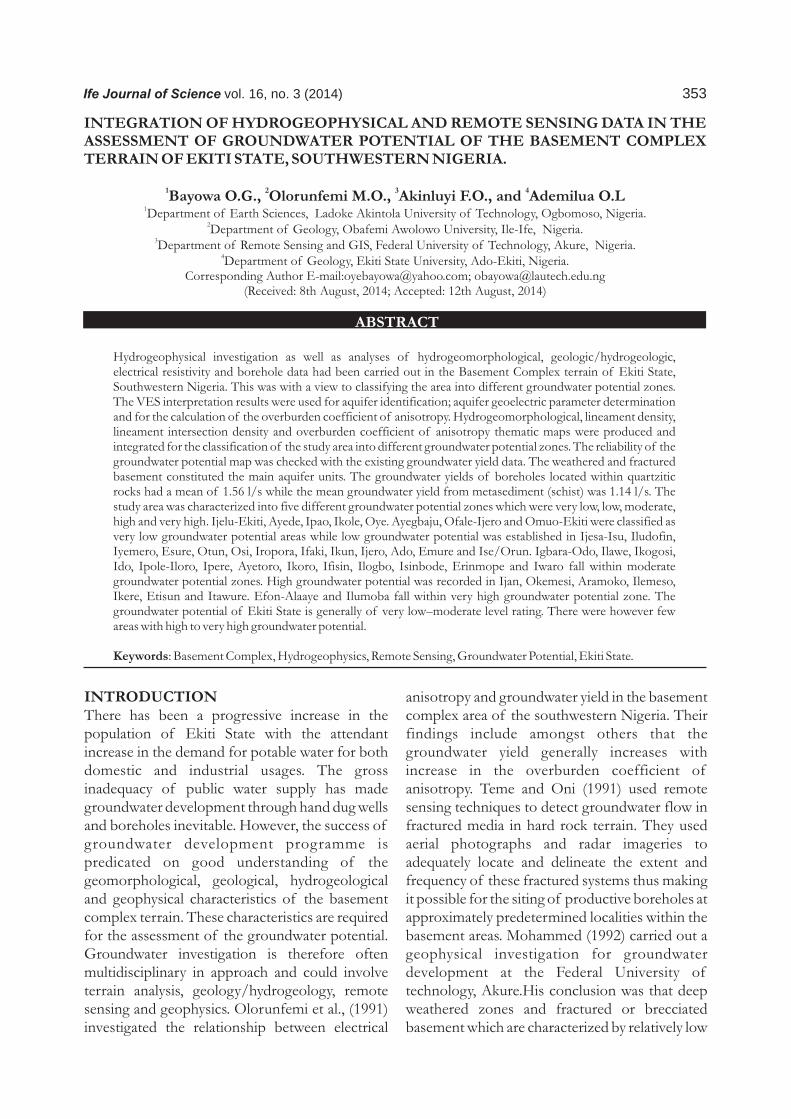
The Study Area The study area lies within Latitudes 7º 15' 00" and 8º 10' 00" North of the Equator and Longitudes 4º 45' 00" and 5º 50' 00" East of the Greenwich Meridian. Ekiti State has 16 Local Government Areas (Figure 1). Some of the major towns in Ekiti-State include Ado-Ekiti, Efon-Alaaye, Aramoko, Ikole, Ikere, Ijero, Ise, Otun, Ido, Emure, Ifaki, Iyin, Igede, Ilawe, Ode, Oye, Omuo, Ilupeju, Ikoro, Igogo, Iye, Ijesa-Isu, Ayedun, Okemesi, Igbara-Odo, etc. Its capital is located at Ado-Ekiti.
Physiographically, the state is composed of hilly terrain and Plains with isolated hill locks. According to http://ekitinigeria.net, the area is
mainly an upland zone rising over 250 metres above the sea level and has a rhythmically undulating surface. The area enjoys tropical climate with high rainfall of up to 1600 mm and is characterized by two distinct seasons (Ayoade 1988). These are the rainy season (April-October) and the dry season (November-March).
o o Temperature ranges between 21 and 28 C. The mean monthly relative humidity is less than 70%. The South-Westernly wind and the North-East Trade wind blows during the rainy and dry ( H a r m a t t a n ) s e a s o n r e s p e c t i v e l y (http://ekitinigeria.net). The vegetation of the area is the rain forest type. Tropical forest exists in the south. This is characterized by dense evergreen forest of tall trees with thick vegetation. However, Guinea Savannah occupies the northern periphery (http://ekitinigeria.net).
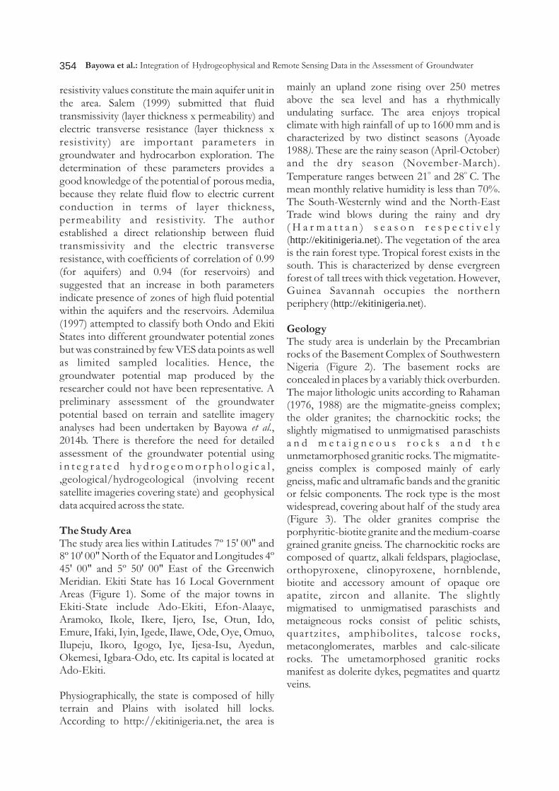
GeologyThe study area is underlain by the Precambrian rocks of the Basement Complex of Southwestern Nigeria (Figure 2). The basement rocks are concealed in places by a variably thick overburden. The major lithologic units according to Rahaman (1976, 1988) are the migmatite-gneiss complex; the older granites; the charnockitic rocks; the slightly migmatised to unmigmatised paraschists a n d m e t a i g n e o u s r o c k s a n d t h e unmetamorphosed granitic rocks. The migmatite-gneiss complex is composed mainly of early gneiss, mafic and ultramafic bands and the granitic or felsic components. The rock type is the most widespread, covering about half of the study area (Figure 3). The older granites comprise the porphyritic-biotite granite and the medium-coarse grained granite gneiss. The charnockitic rocks are composed of quartz, alkali feldspars, plagioclase, orthopyroxene, clinopyroxene, hornblende, biotite and accessory amount of opaque ore apatite, zircon and allanite. The slightly migmatised to unmigmatised paraschists and metaigneous rocks consist of pelitic schists, quartzites, amphibolites, talcose rocks, metaconglomerates, marbles and calc-silicate rocks. The umetamorphosed granitic rocks manifest as dolerite dykes, pegmatites and quartz veins.
355
Figure 1: Map of Ekiti State showing the Local Government Areas. (Digitized from Administrative Map of Ekiti State, 2000).
Figure 2: Geological Map of Nigeria (Digitized from Ajibade and Umeji, 1989)
Bayowa et al.: Integration of Hydrogeophysical and Remote Sensing Data in the Assessment of Groundwater
356
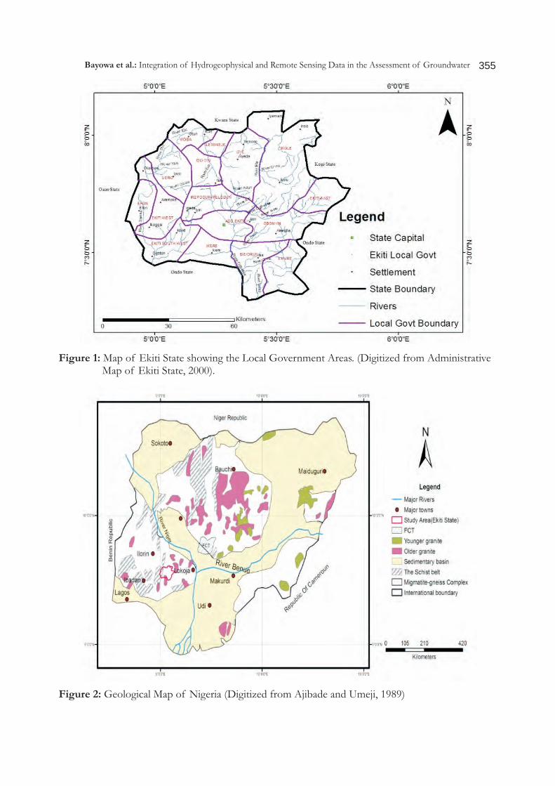
HydrogeologyThe hydrogeology of an area is controlled by such factors as geology, structures and climate of an area (Ademilua, 1997). This is because the geological formations underlying the area and the structures determine the types of aquifer and the means of recharging them while the climate determines the amount and rate of recharge of the aquifer (Mailu, 1987; Lewis, 1987; Shemang, 1990). The hydrogeology of an area is considered under two aspects: (i) surface water and (ii) groundwater. The major surface waters in the study area are rivers Ogbese, Osun, Oni, Osse and Ero and their tributaries (Figure 3). The water below the watertable is generally called the groundwater. Groundwater is contained in pore spaces of sediments and in weathered and fractured basement columns (Bayowa et al. (2014a). Wells dug close to the river normally contain groundwater at shallow depths Shemang (1990). However, the water table falls progressively throughout the dry season. Generally, the closer a well is to the river channel, the smaller the fall. This lowering of the water table is mainly controlled by subsurface movement
of water into larger river valleys. Within the weathered zone, discontinuous water table occurs and water level shows marked seasonal fluctuations (Dan-Hassan, 1993). The highest groundwater yield in basement terrains is found in areas where thick overburden overlies fractured zones (Olorunniwo and Olorunfemi, 1987; Olorunfemi. and Fasuyi, 1993). MethodologyBorehole logs and other ancillary information in the study area were secured from various archives and reputable drillers. Parametric Vertical Electrical Sounding (VES) were carried out on the forty (40) existing boreholes, using the Schlumberger electrode array. The VES data were interpreted quantitatively by partial curve matching and 1-D computer assisted forward modelling. The overburden coefficient of anisotropy (ë) was calculated for all the parametric VES points to the drilled boreholes and related to the borehole yield. The hydrogeomorphological, lineament density, lineament intersection density and the coefficients of anisotropy thematic maps were integrated for the classification of the study
Figure 3: Geologic Map of Ekiti-State (Digitized from Ademilua, 1997)
Bayowa et al.: Integration of Hydrogeophysical and Remote Sensing Data in the Assessment of Groundwater
357
area into groundwater potential zones. Borehole yield data were used to validate the final groundwater potential map.
RESULTS AND DISCUSSION
Relationship between Groundwater Yield, Geology, Lineament and Lineament Density.Borehole yield values obtained in the study area ranged between 0.1 l/s and 4.1 l/s. Five (5) different aquifer combinations which include the weathered, weathered/partly weathered/fractured (unconfined), weathered/fractured (confined), weathered/fractured(unconfined)/fractured (confined) and fractured(confined) aquifer systems were identified from the analysis of the borehole completion records. The overburden thickness for areas underlain by charnockite is between 2.6 m and 41.6 m with a mean value of 22.1 m while for areas underlain by metamorphic rocks, the range is between 0.9 m and 71.1 m with a mean value of 36 m. The borehole depths for areas underlain by charnockite range from 19 m to 48 m with an average value of 33.5 m. while for areas underlain by metamorphic rocks, the range is between 21 m and 35 m with a mean of 28 m.
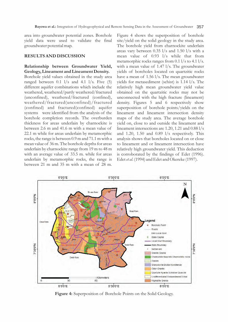
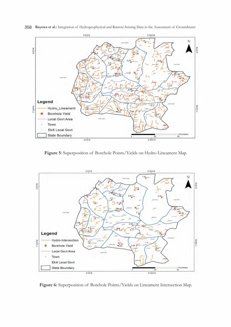
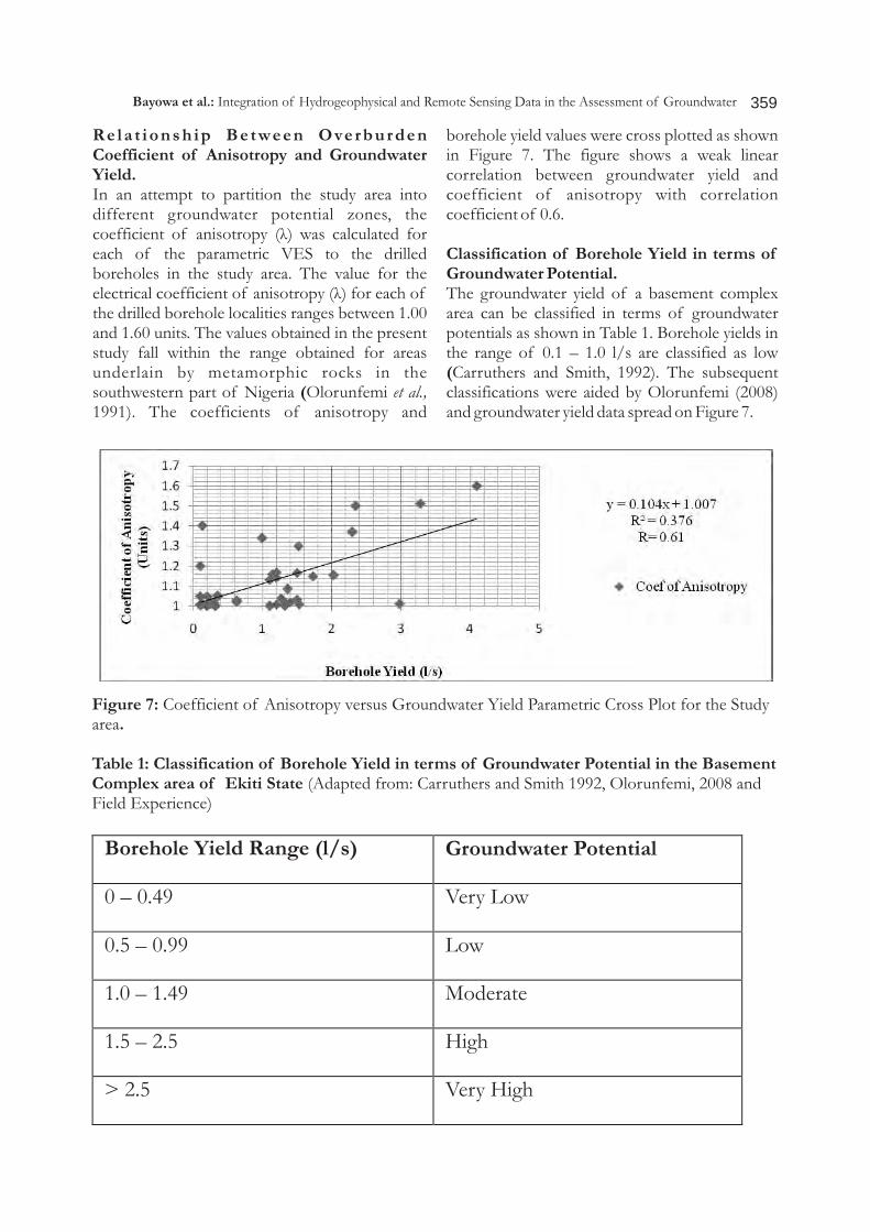
Figure 4 shows the superposition of borehole site/yield on the solid geology in the study area. The borehole yield from charnockite underlain areas vary between 0.35 l/s and 1.50 l/s with a mean value of 0.93 l/s while that from metamorphic rocks ranges from 0.1 l/s to 4.1 l/s. with a mean value of 1.47 l/s. The groundwater yields of boreholes located on quartzitic rocks have a mean of 1.56 l/s. The mean groundwater yields for metasediment (schist) is 1.14 l/s. The relatively high mean groundwater yield value obtained on the quartzitic rocks may not be unconnected with the high fracture (lineament) density. Figures 5 and 6 respectively show superposition of borehole points/yields on the lineament and lineament intersection density maps of the study area. The average borehole yield on, close to and outside the lineament and lineament intersections are 1.20, 1.21 and 0.88 l/s and 1.20, 1.50 and 0.89 l/s respectively. This analysis shows that boreholes located on or close to lineament and or lineament intersection have relatively high groundwater yield. This deduction is corroborated by the findings of Edet (1996). Edet et al. (1994) and Edet and Okereke (1997).
Figure 4: Superposition of Borehole Points on the Solid Geology.
Bayowa et al.: Integration of Hydrogeophysical and Remote Sensing Data in the Assessment of Groundwater
358
Figure 5: Superposition of Borehole Points/Yields on Hydro-Lineament Map.
Figure 6: Superposition of Borehole Points/Yields on Lineament Intersection Map.
Bayowa et al.: Integration of Hydrogeophysical and Remote Sensing Data in the Assessment of Groundwater
359
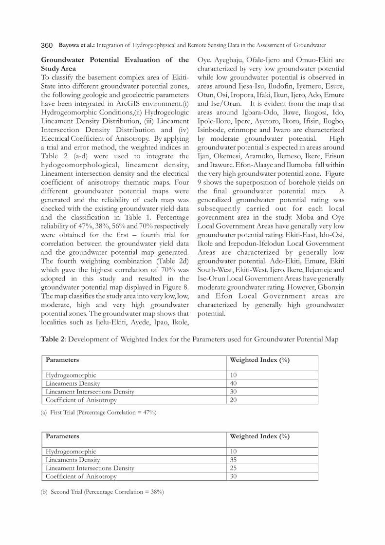
Rela t ionsh ip Be tween Overburden Coefficient of Anisotropy and Groundwater Yield.In an attempt to partition the study area into different groundwater potential zones, the coefficient of anisotropy (ë) was calculated for each of the parametric VES to the drilled boreholes in the study area. The value for the electrical coefficient of anisotropy (ë) for each of the drilled borehole localities ranges between 1.00 and 1.60 units. The values obtained in the present study fall within the range obtained for areas underlain by metamorphic rocks in the southwestern part of Nigeria (Olorunfemi et al., 1991). The coefficients of anisotropy and
borehole yield values were cross plotted as shown in Figure 7. The figure shows a weak linear correlation between groundwater yield and coefficient of anisotropy with correlation coefficient of 0.6.
Classification of Borehole Yield in terms of Groundwater Potential.The groundwater yield of a basement complex area can be classified in terms of groundwater potentials as shown in Table 1. Borehole yields in the range of 0.1 – 1.0 l/s are classified as low (Carruthers and Smith, 1992). The subsequent classifications were aided by Olorunfemi (2008) and groundwater yield data spread on Figure 7.
Figure 7: Coefficient of Anisotropy versus Groundwater Yield Parametric Cross Plot for the Study area.
Table 1: Classification of Borehole Yield in terms of Groundwater Potential in the Basement Complex area of Ekiti State (Adapted from: Carruthers and Smith 1992, Olorunfemi, 2008 and Field Experience)
Borehole Yield Range (l/s) Groundwater Potential
0 – 0.49 Very Low
0.5 – 0.99 Low
1.0 – 1.49 Moderate
1.5 – 2.5 High
> 2.5 Very High
Bayowa et al.: Integration of Hydrogeophysical and Remote Sensing Data in the Assessment of Groundwater
360
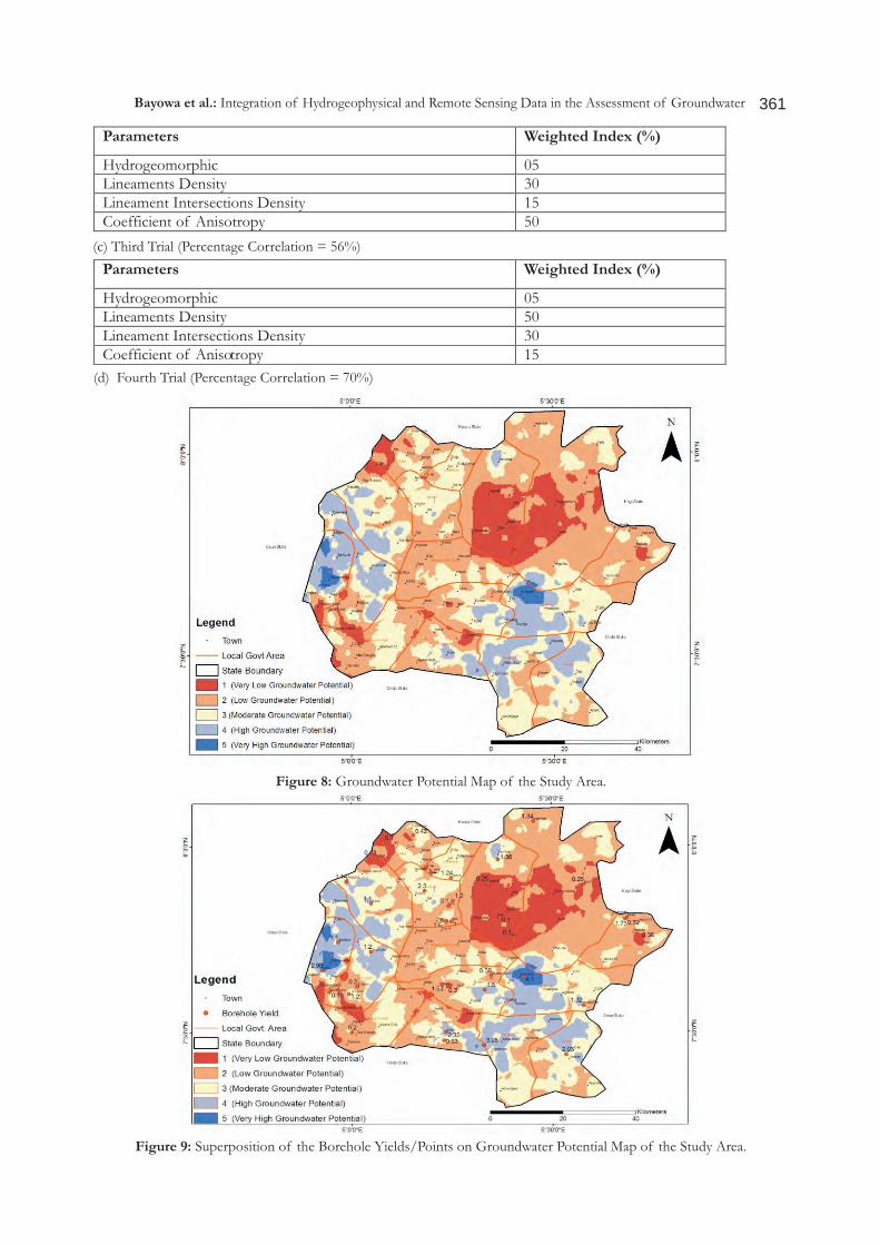
Groundwater Potential Evaluation of the Study AreaTo classify the basement complex area of Ekiti-State into different groundwater potential zones, the following geologic and geoelectric parameters have been integrated in ArcGIS environment.(i) Hydrogeomorphic Conditions,(ii) Hydrogeologic Lineament Density Distribution, (iii) Lineament Intersection Density Distribution and (iv) Electrical Coefficient of Anisotropy. By applying a trial and error method, the weighted indices in Table 2 (a-d) were used to integrate the hydogeomorphological, lineament density, Lineament intersection density and the electrical coefficient of anisotropy thematic maps. Four different groundwater potential maps were generated and the reliability of each map was checked with the existing groundwater yield data and the classification in Table 1. Percentage reliability of 47%, 38%, 56% and 70% respectively were obtained for the first – fourth trial for correlation between the groundwater yield data and the groundwater potential map generated. The fourth weighting combination (Table 2d) which gave the highest correlation of 70% was adopted in this study and resulted in the groundwater potential map displayed in Figure 8. The map classifies the study area into very low, low, moderate, high and very high groundwater potential zones. The groundwater map shows that localities such as Ijelu-Ekiti, Ayede, Ipao, Ikole,
Oye. Ayegbaju, Ofale-Ijero and Omuo-Ekiti are characterized by very low groundwater potential while low groundwater potential is observed in areas around Ijesa-Isu, Iludofin, Iyemero, Esure, Otun, Osi, Iropora, Ifaki, Ikun, Ijero, Ado, Emure and Ise/Orun. It is evident from the map that areas around Igbara-Odo, Ilawe, Ikogosi, Ido, Ipole-Iloro, Ipere, Ayetoro, Ikoro, Ifisin, Ilogbo, Isinbode, erinmope and Iwaro are characterized by moderate groundwater potential. High groundwater potential is expected in areas around Ijan, Okemesi, Aramoko, Ilemeso, Ikere, Etisun and Itawure. Efon-Alaaye and Ilumoba fall within the very high groundwater potential zone. Figure 9 shows the superposition of borehole yields on the final groundwater potential map. A generalized groundwater potential rating was subsequently carried out for each local government area in the study. Moba and Oye Local Government Areas have generally very low groundwater potential rating. Ekiti-East, Ido-Osi, Ikole and Irepodun-Ifelodun Local Government Areas are characterized by generally low groundwater potential. Ado-Ekiti, Emure, Ekiti South-West, Ekiti-West, Ijero, Ikere, Ilejemeje and Ise-Orun Local Government Areas have generally moderate groundwater rating. However, Gbonyin and Efon Local Government areas are characterized by generally high groundwater potential.
Table 2: Development of Weighted Index for the Parameters used for Groundwater Potential Map
Parameters Weighted Index (%)
Hydrogeomorphic 10 Lineaments Density 40 Lineament Intersections Density 30 Coefficient of Anisotropy 20
Parameters Weighted Index (%)
Hydrogeomorphic 10 Lineaments Density 35 Lineament Intersections Density 25 Coefficient of Anisotropy 30
(a) First Trial (Percentage Correlation = 47%)
(b) Second Trial (Percentage Correlation = 38%)
Bayowa et al.: Integration of Hydrogeophysical and Remote Sensing Data in the Assessment of Groundwater
361
Parameters Weighted Index (%)
Hydrogeomorphic 05 Lineaments Density 30 Lineament Intersections Density 15 Coefficient of Anisotropy 50
(c) Third Trial (Percentage Correlation = 56%)
Parameters Weighted Index (%)
Hydrogeomorphic 05 Lineaments Density 50 Lineament Intersections Density 30 Coefficient of Anisotropy 15
(d) Fourth Trial (Percentage Correlation = 70%)
Figure 8: Groundwater Potential Map of the Study Area.
Figure 9: Superposition of the Borehole Yields/Points on Groundwater Potential Map of the Study Area.
Bayowa et al.: Integration of Hydrogeophysical and Remote Sensing Data in the Assessment of Groundwater
362
Limitation of Groundwater Potential MapThe groundwater potential map gives a regional over view of the groundwater potential of the basement complex area of Ekiti State. The heterogeneous and discontinuous nature of basement aquifers makes local variation possible.
CONCLUSIONSThe groundwater potential map shows that the study area can be classified into five different groundwater potential zones which are very low, low, moderate, high and very high. Ijelu-Ekiti, Ayede, Ipao, Ikole, Oye. Ayegbaju, Ofale-Ijero and Omuo-Ekiti are located within the very low groundwater potential zone. Low groundwater potential zone covers areas such as Ijesa-Isu, Iludofin, Iyemero, Esure, Otun, Osi, Iropora, Ifaki, Ikun, Ijero, Ado, Emure and Ise/Orun. Igbara-Odo, Ilawe, Ikogosi, Ido, Ipole-Iloro, Ipere, Ayetoro, Ikoro, Ifisin, Ilogbo, Isinbode, Erinmope and Iwaro are located within moderate groundwater potential zone. Ijan, Ilumoba, Okemesi, Efon-Alaaye, Aramoko, Ilemeso, Ikere, Etisun and Itawure fall within the high to very high potential zone. Moba and Oye Local Government Areas are located within very low groundwater potential. Ekiti-East, Ido-Osi, Ikole and Irepodun-Ifelodun Local Government Areas are characterized by generally low groundwater potential. Ado-Ekiti, Emure, Ekiti South-West, Ekiti-West, Ijero, Ikere, Ilejemeje and Ise-Orun Local Government Areas have generally moderate groundwater potential rating. However, Gbonyin and Efon Local Government areas are characterized by generally high to very high groundwater potential. The study however concluded that the groundwater potential of Ekiti State is generally of very low – moderate level rating. There are however few areas with high to very high groundwater potential.
REFERENCESAdemilua, O. L. 1997. A Geoelectric and Geologic
Evaluation of Groundwater potential of Ekiti and Ondo States, Southwestern, Nigeria. Unpublished M.Sc.Thesis, Dept. of Geology, Obafemi Awolowo University, Ile-Ife, Nigeria. pp. 1- 67.
Aj ibade, A.C. and Umeji , A.C. 1989. Precambrian Geology of Nigeria. GSN, pp. 11-41.
Ayoade J. O. 1988. Tropical hydrology and water Resources. Macmillan Publishers Ltd, London and Basingstoke, pp. 5-7, Siting Boreholes. Groundwater 26, 54-63
Bayowa G. O. Olorunfemi M. O. and Ademilua O. L. 2014a. A Geoelectric Assessment and Classification of the aquifer systems in a Typical Basement Complex Terrain: Case study of Ekiti State, Southwestsern Nigeria. Research Journal in Engineering and Applied Sciences 3 (1) 55- 60.
Bayowa O. G., Olorunfemi, M. O., Akinluyi, F. O., and Ademilua, O. L. 2014b. A Preliminary Assessment of the Groundwater Potential of Ekiti State, Southwestern Nigeria, using Terrain and Satellite Imagery Analyses. In Press.
Carruthers, A.M. and Smith, I.F. 1992. The use of ground Electrical Methods for siting Water Supply boreholes in shallow Crystalline Basement Terrains. In: Wright, E.P and Burgess, W.G. (eds.), The hydrogeology of crystalline Basement Aquifers in Africa. Special Publication 66, Geological Society London. pp. 183-230.
Dan-Hassan , M. A. 1993 . Combined Electromagnetic and Electrical Resistivity Survey for Groundwater development in North Central part of Kaduna State. Unpubli. M.Sc. Thesis, Geology Department, Obafemi Awolowo University, Ile-Ife, Nigeria. pp. 1 – 107.
Edet, A. E. 1996. Evaluation of Borehole Sites Based on Airphoto Derived Parameters. Bulletin of International Association o f Engineering Geology. 54, 71-76.
Edet, A. E. and Okereke, C. S. 1997. Assessment of Hydrological conditions in Basement Aquifers of the Precambrian Oban Massif, Southwestern Nigeria. Journal of Applied Geophysics 36 : 195-204.
Edet, A. E., Teme, S. C., Okereke, C. S. and Esu, E. O. 1994. Lineament Analysis for G r o u n d w a t e r E x p l o r a t i o n i n Precambrian Oban massif and Obudu plateau. Southeastern Nigeria. Journal of Mining and Geology. 30(1): 87 -95.
Lewis, M. A. 1987. The analysis of Borehole yields from Basement Aquifers. Proceedings of the Basement Aquifer Workshop, 15 – 24 June, 1987, Zimbabwe,
Bayowa et al.: Integration of Hydrogeophysical and Remote Sensing Data in the Assessment of Groundwater
363
Commonwealth Science Council CSC (89) WMR – 13, TP 273.
Mailu, G. M. 1987. Hydrogeology of the Metamorphic Region of the Athi Drainage Area. Kenya. Proceedings of the basement aquifer workshops, 15 – 24 June, 1987, Zimbabwe. Commonwealth Science Council, CSC (89) WMR – 13, TP, 273.
Mohammed, M. ,Z 1992 . Geophys ica l Inve s t i g a t i on fo r Groundwa te r Development at the Federal University of Technology Campus, Akure. Unpublished. M.Tech. Thesis, Federal University of Tech. Akure. pp. 1 – 203.
Olorunfemi, M. O. 2008. Voyage on the skin of the Earth: A Geophysical Experience. An Inaugural Lecture delivered at the Obafemi Awolowo University, Ile-Ife,
thNigeria, Tuesday, 11 March, 2008, Inaugural Lecture series 211, Obafemi Awolowo University Press Ltd; Ile-Ife. Nigeria. pp. 1-2.
Olorunfemi, M. O., Olarewaju, V. O. and Alade, O. 1991. On the Electrical Anisotropy and Groundwater yield in a Basement Complex area of Southwestern Nigeria. Journal of African Earth Sciences. 12(3): 467 – 472
Olorunfemi, M. O. and Fasuyi, S. A. 1993. Aquifer Types and the geoelectric/Hydrogeologic Characteristics of Part of the Central Basement Terrain of Nigeria (Niger State). Journal of African Earth Sciences 16(3):309 – 317.
Olorunniwo, M. A. and Olorunfemi, M. O. 1987. Geophys i ca l Inves t i g a t ions fo r Groundwater in Precambrian Terrains: a case study from Ikare, Southwestern Nigeria. Journal of African Earth Sciences, 6(6): 787 – 796
Rahaman, M. A. 1976. Review of the Basement Geology of Southwestern Nigeria. In Geology of Nigeria. Elizabeth publishing Company, Nigeria. pp. 23 -33.
Rahaman, M. A. 1988. Recent advances in the study of the Basement Complex of Nigeria. In Oluyide et.al. (eds) Precambrian Geology of Nigeria, Publication. Geological Survey of Nigeria, Kaduna, pp. 157-163.
Salem, H. S. 1999. Determination of fluid Transmissivity and Electric Transverse Resistance for shallow Aquifers and Deep Reservoirs from Surface and Well-Log Electric Measurements. Hydrology and Earth System Sciences, 3(3): 421 – 427.
Shemang, E.M. 1990. Electrical Depth Soundings at selected well sites within the Kubani River basin, Zaria, Nigeria. Unpublished M.Sc. Thesis, A.B.U. Zaria. pp.108.
Teme, S.C. and Oni, S.F. 1991. “Delineation of Groundwater flow in Fractured Media through Remote Sensing Techniques to detect Groundwater flow in Fractured Mediain Hard Rock Terrains, some Nigeria cases”. Journal of African Earth Sciences (12)3: 461-466. .
Bayowa et al.: Integration of Hydrogeophysical and Remote Sensing Data in the Assessment of Groundwater