bangladesh economic zones authority (beza)
TRANSCRIPT

1
Private Investment and Digital Entrepreneurship (PRIDE) Project
Bangladesh Economic Zones Authority (BEZA)
Environmental and Social Assessment (ESA)
Package No. BEZA S-135
Final Report
Appendices to ESA Report Vol II
January 2020
Pub
lic D
iscl
osur
e A
utho
rized
Pub
lic D
iscl
osur
e A
utho
rized
Pub
lic D
iscl
osur
e A
utho
rized
Pub
lic D
iscl
osur
e A
utho
rized

2
Appendix D: Assessment of Air Quality and Water Quality
1.1 Air Quality
Introduction
The BSMSN area will generate huge traffic after full development both for passenger and goods. There
will be wide range of vehicles such as two and three axle/ multi axle trucks, bus, car, two-wheeler etc.
These type of transportation system are major contributors to air pollution as these emit harmful
pollutants which has adverse impact on environment. It is difficult to project air pollution as because
pollutant enters the air by different amounts at different times and also varies with places. It is
expected that air pollutants which might be discharged by the operations of tenant in the industrial
and logistic area would be well controlled and managed by the tenants. For indicative assessment of
air quality of the project area, projection has been done for some pollutants due to vehicle emission
only.
Forecast Area
The areas examined to forecast is the project area (Zone 2A and 2B of BSMSN) shown in the Figure 1-
1. The project area is about 1450 acres. At present, it is observed that the concentration of some
pollutants such as SO2, NOX, CO, PM2.5, PM10 and SPM are below the allowable limit as per DoE standard
(Bangladesh). All the surveyed data are given in the baseline data collection section of main report.
Forecast Period
Air quality will be forecasted for the operation phase when all the tenants in the project area will start
their operation. It is expected that by the year 2040, the BSMSN area will be fully developed and
operative. There are different phases of this project where air quality may be deteriorated significantly
due to construction issues and other factors. Impact of air pollution is expected to be limited because
construction vehicles will be little by the year 2040.
Forecast Method
The air quality due to vehicle emissions have been calculated is based on the rapid assessment manual
of WHO (1993). Five (05) tracing substance such as SPM, PM10, PM2.5, SOX, NOX and CO have been
measured at baseline condition. Five (05) tracing substance such as Dust, SOX, NOX, CO and VOC have
been predicted based on the guidelines of WHO.
The emission factor of two-wheeler, car, microbus, mass transport-bus and tucks is shown in the Table
1-1.

3
Table 1-1: Emission Factor for Different Types of Vehicle
SL
Parameter
Emission factor (g/km)
Two-Wheeler
Car Micro
Bus/CNG
Mass Transpor
t-Bus
Heavy Truck
(Gasoline)
Heavy Truck
(Diesel)
Medium Truck
Light Commer
cial Vehicle (LPG)
1 Dust 0 0.05 0.05 0.9 0.6 1.3 0.9 0
2 SO2 0.77 1.725 1.725 6.11 3.35 6.1 4.15 0
3 NO2 0.3 1.83 1.83 13.9 7.5 19.8 14.4 2.75
4 CO 20 1.29 1.29 2.1 50 3.1 2.9 1.15
5 VOC 3 0.17 0.17 1.7 3.5 2.4 0.8 1.03
Source: WHO (1993)
Freight and Passenger Traffic
The freight volume has been estimated by multiplying project area, industrial land use factor and
number of truck trips per hectare. It is found from BSMSN master plan that the industrial land use is
taken about 54% of the total project area. It is difficult to predict traffic production and attraction
from an economic zone. According to BSMSN master plan, the number of truck trips per hectare would
be around 8 trucks by the year 2040. Therefore, the freight (truck trip nos.) value is 2536 by the year
2040. The freight no. is sub-divided into heavy truck trip, medium truck trip and light truck trip. This is
shown in Table 1-2.
Table 1-2: Truck Trip Number by the Year 2040
Truck Type Freight (Total Truck Trip Number) Percentage (%) Trip No.
Heavy Truck
2536
40 1014
Medium Truck 30 761
Light Commercial Vehicle 30 761
The trips nos. of two-wheeler, car, IPT (microbus/ CNG) and mass transport (bus) for 2040 is shown in
Table 1-3.
Table 1-3: Passenger Traffic Trip Number by the Year 2040
Vehicle Type Trip Number
Two-wheeler 489
Car 326
IPT (microbus/ CNG) 1222
Mass transport (bus) 1222
Source: BEZA (2019b)

4
Trip Distribution
All the trips generated by trucks, two-wheeler, car, IPT (microbus/ CNG) and mass transport (bus) are
considered to be through two roads i.e. Access Road 1 (Sheikh Hasina Avenue) and Access Road 2
(through Zoararganj and Takerhat). The alignment of this road is shown in Figure 1-1.
Figure 1-1: Access Road Alignment
The length of the Access Road 1 (Sheikh Hasina Avenue) & Access Road 2 (through Zoararganj and
Takerhat) are about 19.9 and 26.5 km respectively. It is assumed that 80% of vehicle will move through
Access Road 1 (Sheikh Hasina Avenue) & 20% of vehicle will move through Access Road 2 (through
Zoararganj and Takerhat) as access road is the main access to BSMSN area.
The nos. of trips through Access Road 1 (Sheikh Hasina Avenue) and Access Road 2 (through Zoararganj
and Takerhat) are shown in Table 1-4.
Table 1-4: Trip No. through Access route 1 & Access route 2 by the Year 2040
Types Trip No.
Access route 1 (Sheikh Hasina Avenue)
Access route 2 (Zorarganj-Takerhat)
Two-Wheeler 391 98
Car 261 65
Micro Bus/CNG 978 244
Mass Transport-Bus 978 244
Heavy Truck 39 10
Medium Truck 29 7
Light Commercial Vehicle 29 7

5
Forecast Result
The pollution loading has been calculated by multiplying nos. of trips made by each vehicle type,
length of access route and emission factor for each vehicle types. The pollution loading is shown in
Table 1-5 and Table1-6.

6
Table 1-5: Pollution Loading through Access route 1 by the Year 2040
Sl. Parameter
Pollution loading (Kg/day)
Two-Wheeler Car Micro
Bus/CNG Mass
Transport-Bus Heavy Truck (Gasoline)
Heavy Truck (Diesel)
Medium Truck
Light Commercial
Vehicle (LPG) Total
1 Dust 0 6 23 420 2 19 13 0 484
2 SO2 143 215 806 2854 13 91 58 0 4180
3 NO2 56 228 855 6492 28 297 202 39 8197
4 CO 3737 161 603 981 187 46 41 16 5771
5 VOC 560 21 79 794 13 36 11 14 1530
Table 1-6: Pollution Loading through Access route 2 by the Year 2040
Sl.
Parameter
Pollution loading (kg/day)
Two-Wheeler Car Micro
Bus/CNG Mass
Transport-Bus Heavy Truck (Gasoline)
Heavy Truck (Diesel)
Medium Truck
Light Commercial
Vehicle (LPG) Total
1 Dust 0 2 8 140 1 6 4 0 161
2 SO2 48 72 268 950 4 30 19 0 1391
3 NO2 19 76 285 2161 9 99 67 13 2729
4 CO 1244 53 201 327 62 15 14 5 1921
5 VOC 187 7 26 264 4 12 4 5 509

7
Forecasting Pollutants Dispersion
The Air Resources Laboratory’s (ARL’s) HYbrid Single-Particle Lagrangian Integrated Trajectory
(HYSPLIT) model is used extensively for atmospheric transport and dispersion of pollutants and various
materials. This tool explains how, when, and where potentially harmful materials are atmospherically
transported, dispersed, and deposited (Stein et al., 2015). The interactive web through the ARL READY
system, this model can be run. This web version has some limitations due to computational complicity
(Rolph et al., 2017).
In this model, location of point source, time and pollutant loading has to be provided as input data. In
this model pollution loading is given as a point source though in practical it has a spatial and temporal
distribution. There are other assumptions (Rolph et al., 2017) to produce this dispersion map which
needs to be considered carefully during the modelling. The following dispersion maps (Figure 1-2 to
Figure 1-5) show an indicative idea of dispersion of pollutants.
Figure 1-2: Dust Dispersion in Dry Season

8
Figure 1-3: Dust Dispersion in Wet Season
Figure 1-4: CO Dispersion in Dry Season

9
Figure 1-5: CO Dispersion in Wet Season
1.2 Water Quality
Introduction
The storm water, domestic wastewater, and industrial wastewater will fall into Bay of Bengal through
Ichakhali khal. Projection of water quality due to water discharge into the receiving water body
(Ichakhali Khal) has been done.
Forecast Area
The areas examined to forecast is the project area (Zone 2A and 2B of BSMSN). The project area is
about 1450 acres.
Forecast Period
Water quality will be forecasted for the operation phase (2040) when all the tenants in the project
area will start their operation.
Forecast Method
The quality and quantity of industrial wastewater discharged from the industrial area during the
operation phase was estimated based on:
i) estimated water supply capacity for the industrial area
ii) estimated quality of treated effluent from the industrial area

10
The environmental impact of the industrial wastewater on the Ichakhali khal was predicted by using a
complete mixing model, as shown in the following formula:
C = (𝐂𝟏 𝐗 𝐐𝟏) + (𝐂𝟐 𝐗 𝐐𝟐)
𝐂𝟏+𝐂𝟐
where, C (mg/L): Concentration of pollutant in the Ichakhali khal after complete mixing with wastewater
C1 (mg/L): Concentration of pollutant in the Ichakhali khal at the forecast point before mixing
C2 (mg/L): Concentration of pollutant in the wastewater before mixing
Q1 (m3/s): Flow rate of the Ichakhali khal at the forecast point before mixing
Q2 (m3/s): Flow rate of wastewater discharge before mixing
Wastewater Generation
As mentioned above, the project area has an area of 1450 acres. Water supply requirement for the
project area is about 100 MLD.
Wastewater amount was estimated based on the water supply volume. Wastewater yield ratio to
water supply was assumed as 80%. Therefore, maximum wastewater amount generated from the
industrial area would be about 80 MLD.
The tentative target value of effluent water quality discharged to the surrounding water bodies is set
to 40 mg/l (DoE requirement).
Development of Hydrological and Hydraulic Model
Mathematical model is a tool, which is widely used for planning and design of project infrastructures
considering the interactive responses of other project components or other projects. Mathematical
model available at IWM is based on tools developed by DHI, and is under continuous up-gradation as
well as verification. There are a number of modules included in DHI tool, among which two modules
has been used in carrying out modelling (BEZA,2019a) which include: Rainfall-Runoff (MIKE11 RR) for
hydrological modelling and one dimensional hydrodynamic (MIKE 11 HD) for hydraulic modelling.
The advantages of MIKE11 modelling systems are:
1. Accurate hydraulic description in rivers/channels which behave pre-dominantly one-
dimensional.
2. It requires less computational time i.e. less CPU time
3. East to overview and comprehend results
4. Can modelled many different and complicated structures
5. Other problems such as water quality, sedimentation, flood forecasting can be addressed with
the same model.
1.2.6.1 Development of Hydrological Model
In MIKE 11 software package, NAM module has been used to develop the hydrological model. The
MIKE11 NAM is a lumped conceptual model which simulates the overland, interflow, and base flow
components as a function of the moisture contents in four storages. The NAM module can either be

11
applied independently or used to represent one or more contributing catchments that generate lateral
inflows to a river network. In this manner it is possible to treat a single catchment or a large river basin
containing numerous catchments and a complex network of rivers and channels within the same
modelling framework.
The existing South East Regional Model (SERM) available in IWM has been truncated and used for
developing BSMSN model for simulating the main river system: Feni River, Muhuri River, Selonia River
and Little Feni River. The catchments used to simulate the rainfall-runoff of the catchments for the
main rivers are stated in Table 2-1.
Table 2-1: SERM Catchments Used to Develop BSMSN Model
Name of the catchment Area (km2) Name of the catchment Area (km2)
SE-05 1 SE-29 404
SE-06 186 SE-30 301
SE-12 88.32 SE-31 607
SE-15 150 SE-32 645
SE-16 131 SE-36 124.59
SE-27 131
For detail modelling of the khal system in and around the BSMSN study area, four major catchments
have been identified and delineated based on DEM. The four catchment are:
(i) Ichakhali khal catchment,
(ii) Bamonsundor khal catchment,
(iii) Saherkhali khal catchment, and
(iv) Domkhali khal catchment.
The catchments areas are generated from the contribution of the major khal along with its tributaries.
These major catchments further divided into sub- catchments to assess the run-off pattern of the
khals.
The Hydrological Model has been developed using the rainfall and evapotranspiration data collected
from BWDB.
The generated catchments have been characterized and classified according to the surface terrain,
land cover dynamics (slope, vegetation, obstruction etc.) and run-off flow pattern.
Ichakhali khal catchment
The catchment area of Ichakhali khal catchment is about 86 km2. The Ichakhali khal receives water
from Feni reservoir site for irrigation purpose. Barmai Chhara and its distribtaries convey water to
Ichakhali khal extending to eastern hills. There are some other local khals which contribute to Ichakhali
khal and they all together make the Ichakhali system. It is divided into 10 sub-catchments which are
Barmi, Dakhin Tajpur, Dawkhali, Ichakhali, Ichakhali dn, Ichamoti, Irarchara, Kata, Mn Drainage-1 and
West Ichakhali. The elevation of this catchment varies from 2.7-158 mPWD.
Bamonsundor khal catchment
The catchment area of Bamonsundor khal catchment is about 129 km2. Mohamaya Khal, Mithanala
Rajapur khal and Khontakata khal are the major tributaries of Bamon Sundar khal and make the Bamon

12
Sundar khal system. These tributaries and some other local minor khals convey water from eastern
hills to Bamon Sundar khal. It is divided into 10 sub-catchments which are Bamon Sundor, Daborkhali
Reg Catch, Durgapur kata chhara, Gopinathpur, Khontakata, Mithanala Rajapur, Mohamaya Khal,
Mohamaya Reservoir, Omar Ali and Roypur-Gopalpur. The elevation of this catchment varies from 1.2-
258 mPWD.
Hydrological Model Calibration
Parameters of NAM have been calibrated against the observed discharge data near the outlet of the
catchments. Discharge data have been collected from Parsuram on the Muhuri River and Kaliarchari
on the Feni River respectively. Simulated runoff data show good match with the observe discharge
data mainly in dry season (Figure 2.1 and Figure 2.2). Observed monsoon pick data is not available for
both stations so pick runoff can’t be compared but the available monsoon discharge data also show
good match with the simulated runoff.
Figure 2.1: Calibration plot against discharge at Parsuram on the Muhuri River
Figure 2.2: Calibration plot of against discharge at Kaliarchari on the Feni River

13
1.2.6.2 Development of Hydraulic Model
In MIKE 11 software package, hydrodynamic module (HD) has been used to develop the hydraulic model. The MIKE 11 HD module uses an implicit, finite difference scheme for the computation of
unsteady flows in rivers and estuaries. The module can describe sub-critical as well as supercritical
flow conditions through a numerical scheme which adapts according to the local flow conditions (in
time and space). The output of MIKE11 NAM model has been used as input of MIKE11 HD model. The
internal khal network has been incorporated with the truncate South-east Region Model (SERM) to
develop BSMSN HD model after field data collection and processing. The river/khal network of the
BSMSN model is given in Figure 2.3.
Figure 2.3: River network for BSMSN model

14
Hydraulic Model Calibration
The Hydraulic model has been calibrated based on observed water level. The calibration has been
done at Dhumghat on Feni River and u/s of Feni Reservoir. The following Figure 2.4 shows water level
calibration plot at u/s of Feni Reservoir.
Figure 2.4: Water level calibration plot u/s of Feni Reservoir
Dependable Flow for Ichakhali Khal
Monthly and seasonal dependable flow based on model simulation data of Ichakhali khal is given in
Table 2-2. It is observed that in wet season 80% & 50% dependable flow is about 0.7 m3/s and 2.2 m3/s
respectively while in dry season 80% & 50% dependable flow is only about 0.7 m3/s and 11.9 m3/s
respectively in Ichakhali khal. It is observed that is dry season the 50% dependable flow is more than
monsoon flow. This is because, in dry season the gates of Muhuri Regulator become closed and
Ichakhali khal get water from this river. But in monsoon the gates are opened and the khal get very
little water from Feni River.
Table 2-2: Dependable flow for Ichakhali Khal
Period Dependable flow (m3/s)
80% 50% Dry (Dec-Feb) 0.7 11.9
Wet (Jun-Oct) 0.7 2.2
Jan 12.0 19.8
Feb 7.2 14.2
Mar 4.9 10.5
Apr 5.1 11.5
May 0.1 0.3
Jun 0.4 2.5
Jul 1.1 3.8
Aug 0.0 17.7
Sep 0.9 2.1
Oct 0.5 1.3
Nov 0.2 0.5
Dec 3.3 13.5
15
Source: BEZA (2019a)
Present Pollutant Concentration
BOD5 was selected as the representative indicators for evaluating the impact on the environment since
this parameter are the most basic parameters of concern for the environment as well as the main
pollutants discharged from the industrial area.
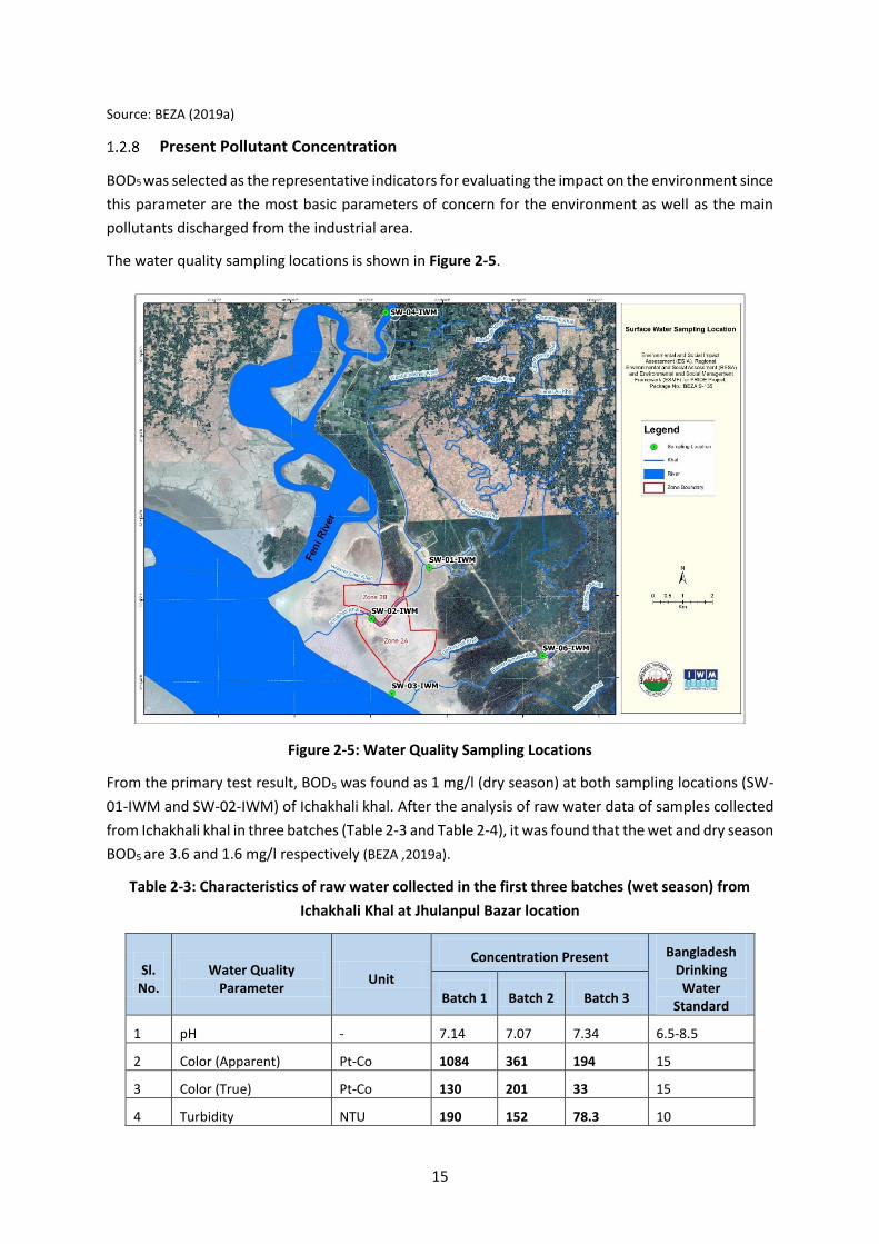
The water quality sampling locations is shown in Figure 2-5.
Figure 2-5: Water Quality Sampling Locations
From the primary test result, BOD5 was found as 1 mg/l (dry season) at both sampling locations (SW-
01-IWM and SW-02-IWM) of Ichakhali khal. After the analysis of raw water data of samples collected
from Ichakhali khal in three batches (Table 2-3 and Table 2-4), it was found that the wet and dry season
BOD5 are 3.6 and 1.6 mg/l respectively (BEZA ,2019a).
Table 2-3: Characteristics of raw water collected in the first three batches (wet season) from
Ichakhali Khal at Jhulanpul Bazar location
Sl. No.
Water Quality Parameter
Unit
Concentration Present Bangladesh Drinking Water
Standard Batch 1 Batch 2 Batch 3
1 pH - 7.14 7.07 7.34 6.5-8.5
2 Color (Apparent) Pt-Co 1084 361 194 15
3 Color (True) Pt-Co 130 201 33 15
4 Turbidity NTU 190 152 78.3 10

16
Sl. No.
Water Quality Parameter
Unit
Concentration Present Bangladesh Drinking Water
Standard Batch 1 Batch 2 Batch 3
5 Total Dissolved Solids (TDS)
mg/L 75 71 133 1000
6 Iron (Fe) mg/L 3.2 4.8 2 0.3-1.0
7 Total Coliform (TC) CFU/100 mL 26000 TNTC TNTC 0
8 Fecal Coliform (FC) CFU/100 mL 17400 TNTC TNTC 0
9 Electrical Conductivity (EC) at 25oC
µS/cm 113 136 247 --
10 Dissolved Oxygen (DO) mg/L 5.95 5.31 5.48 6
11 Ammonia (NH3-N) mg/L 0.55 0.8 1.48 --
12 Total Suspended Solids (TSS)
mg/L 153 119 97 10
13 Temperature oC 29.6 29.5 27.7 20-30
14 Chemical Oxygen Demand (COD)
mg/L 10 11 13 4
15 Biochemical Oxygen Demand (BOD5)
mg/L 2.8 2.8 3.6 0.2
16 Chlorophyll-a µg/L 3.7 5.1 0 --
Source: BEZA (2019a)
Table 2-4: Characteristics of raw water collected in the dry season (Batch 4, 5, and 6) from
Ichakhali Khal at Jhulonpul Bazar location.
Sl. No.
Water Quality Parameter
Unit
Concentration Present Bangladesh Drinking Water
Standard Batch 4 Batch 5 Batch 6
1 pH - -- 7.26 7.49 6.5-8.5
2 Color (Apparent) Pt-Co -- 150 197 15
3 Color (True) Pt-Co -- 64 122 15
4 Turbidity NTU -- 26.3 39.2 10
5 Total Dissolved Solids (TDS)
mg/L -- 129 136 1000
6 Iron (Fe) mg/L -- 0.70 1.28 0.3-1.0
7 Total Coliform (TC) CFU/100 mL -- TNTC TNTC 0
8 Fecal Coliform (FC) CFU/100 mL -- TNTC TNTC 0
9 Electrical Conductivity (EC) at 25oC
µS/cm -- 221 216 --
10 Dissolved Oxygen (DO) mg/L -- 4.44 4.18 6
11 Ammonia (NH3-N) mg/L -- 0.38 0.35 --

17
Sl. No.
Water Quality Parameter
Unit
Concentration Present Bangladesh Drinking Water
Standard Batch 4 Batch 5 Batch 6
12 Total Suspended Solids (TSS)
mg/L -- 27 32 10
13 Temperature oC -- 22.1 28.8 20-30
14 Chemical Oxygen Demand (COD)
mg/L -- 7 5 4
15 Biochemical Oxygen Demand (BOD5)
mg/L -- 1 1.6 0.2
16 Chlorophyll-a µg/L -- 0.9 6.8 --
Source: BEZA (2019a)
Forecast Result
The BOD5 concentration (2040) after complete mixing of Ichakhali khal water and wastewater of Zone
2A and 2B is given in Table 2-5 and Table 2-6. It is evident that the BOD concentration in flow of
Ichakhali Khal will increase to 23-24 mg/l even after the treatment of wastewater to allowable limit of
40 mg/l. The concentration is way above the limit of BOD in river water for fish of 6 mg/l and for
irrigation of 10 mg/l.
Table 2-5: BOD5 Concentration after Complete Mixing (2040) in Ichakhali Khal for 80% Dependable
flow (m3/s)
Period Flow in
Ichakhali Khal (m3/s)
Present BOD
Conc. in Ichakhali
Khal (mg/l)
Wastewater Flow (m3/s)
Wastewater BOD Conc.
(mg/l)
Flow after complete
Mixing (2040) (m3/s)
BOD Conc. after
complete Mixing (2040) (mg/l)
Dry (Dec-Feb) 0.7 1 0.935 40 1.64 23.30
Wet (Jun-Oct) 0.7 3.6 0.935 40 1.64 24.42
Average 0.7 2.3 0.935 40 1.64 23.86
Table 2-6: BOD5 Concentration after complete Mixing (2040) in Ichakhali Khal for 50% Dependable
flow (m3/s)
Period
Flow in Ichakhali
Khal (m3/s)
Present BOD
Conc. in Ichakhali
Khal (mg/l)
Wastewater Flow (m3/s)
Wastewater BOD Conc.
(mg/l)
Flow after complete
Mixing (2040) (m3/s)
BOD Conc. after
complete Mixing (2040) (mg/l)
Dry (Dec-Feb) 11.9 1 0.935 40 12.84 3.84
Wet (Jun-Oct) 2.2 3.6 0.935 40 3.14 14.46

18
Average 7.05 2.3 0.935 40 7.99 9.15

19
References for Appendix D
Yanmar Japan Thilawa Development Ltd. (2016), Thilawa Special Economic Zone
Development Project (Zone B)
BEZA (2019a), Draft Final Report on Detail Study on Total Water Demand & Water Availability
Assessment for BSMSN, Institute of Water Modelling (IWM)
WHO (1993), Assessment of Sources of Air, Water and Land Pollution
BEZA (2019b), Development Program and Transport Assessment for BSMSN, Sheltech
Stein, A.F., Draxler, R.R, Rolph, G.D., Stunder, B.J.B., Cohen, M.D., and Ngan, F., (2015). NOAA's
HYSPLIT atmospheric transport and dispersion modeling system, Bull. Amer. Meteor. Soc., 96,
2059-2077, http://dx.doi.org/10.1175/BAMS-D-14-00110.1
Rolph, G., Stein, A., and Stunder, B., (2017). Real-time Environmental Applications and Display
System: READY. Environmental Modelling & Software, 95, 210-228,
https://doi.org/10.1016/j.envsoft.2017.06.025

20
Appendix E: Associated Facilities Screening Form
Table: Identification of Potential / Likely Associated Facilities for ______________ Project
Notes:
1. For an activity to become an associated facility, all of the above criteria need to be fulfilled.
2. Few other facilities may be found meeting the criteria of Associated Facilities which will be
put in the table as soon as relevant.
Infrastruc
ture
Descript
ion
Direc
tly
relat
ed to
Proje
ct
Contempora
neous
Necess
ary for
the
project
to be
viable
Would
NOT be
construc
ted
without
PRIDE
project
Associa
ted
Facility
as per
ESF
defn.?
Implemen
ting
Agency
Stat
us
Rema
rks

21
Appendix F: Traffic Management Plan
1.1 Objective of the Plan
The objective of this plan is to provide guidance for management of traffic during construction and
operation phase. This plan should be followed for management and smooth flow of the traffic and to
prevent the accidents during construction and operation phase of the project.
1.2 Current scenario of traffic in project area
At present project site is accessible through non-motorable Embankment constructed as
boundary/dike for Mirsarai EZ-I. A single lane road is being constructed on this Embankment for
Mirsarai EZ site I. For Mirsarai EZ-II, it is proposed to widen the road to double lane to accommodate
the traffic from EZ-II. This road will connect site to N1 (Dhaka Chittagong Highway) through Abu Torab
Road. The road is proposed to be widened in future by GoB.
Traffic is increasing every year on this N-1. Bi-directional traffic volume on the highway in 2009 was
recorded to be 56, 32,798 whereas it was 32, 06,277 in 2006. Average traffic growth rate of 21.03% is
estimated as per the study carried out by BUET. Thus at present traffic with this growth rate at this
highway is expected to be 5,75,12,557. The highway is now being expanded from 2 lanes to 4 lanes
which has improved the traffic condition drastically and has reduced travel time between the two
cities (Dhaka & Chittagong).
1.3 Roles and Responsibility
EHS cell head, environmental & safety officers along with traffic Marshals will be responsible for safe
traffic operation during the construction and operation phase of the project. Roles and responsibility
is defined below.
Table 1: Roles and responsibility for traffic management
Activity Responsibility and Supervision
Construction Phase
Managing hours of vehicle movement carrying material and debris (non-peak hours), designating the route & marking the ways
Environment and safety officers & EHS cell head
Provision of boards and signage for guiding the way and instruction for speed limits, no honking & safe driving practice along the access road and haulage roads
Environment and safety officers & EHS cell head
Provision of self-defensive training to rivers Environment and safety officers & EHS cell head
Provision of traffic management training to traffic marshals
Environment and safety officers & EHS cell head
Checking the records of the vehicles enter and left from the register kept at entry gate
Environment and safety officers & EHS cell head
Ensuring vehicles and pedestrians are following the designated paths
Traffic Marshals & Environment and safety officers
Minimizing the vehicular movements within the site Traffic Marshals & Environment and safety officers

22
Activity Responsibility and Supervision
Ensuring parking of the vehicle and construction equipment at designated place
Traffic Marshals & Environment and safety officers
Turning vehicle, sign and no honking at site Traffic Marshals & Environment and safety officers
Ensuring all vehicles entering the premises carry PUC Traffic Marshals & Environment and safety officers
Operation Phase
Survey of vehicles on the access road to the project to know the traffic count and the condition of the road
Environment and safety officers
Ensuring the signage are provided everywhere for safe driving practices, speed limits, directions
Environment and safety officers
Ensuring the parking lots are being used for parking and no parking is being undertaken at unauthorized location
Traffic Marshals & Environment and safety officers
Checking entry and exit register of the vehicles Traffic Marshals & Environment and safety officers
Ensuring all vehicles entering the premises carry PUC Traffic Marshals & Environment and safety officers
1.4 Traffic Control Devices
Traffic control device used to regulate the traffic in Road Construction Zones include
Road sign
Delineators
Barricades
Cones
Pylons
Pavement marking
Audio visual flash lights
Electric rope lights
Suggested plan for designing signage at minimum sightline distance is given below
Average speed (km/hr)
Distance of first sign in advance of the first channelizing device (m)
Size of Warning Sign (mm)
Minimum no of signs in advance of the hazard
Under 50 100 600 3
51-60 100-300 750 3
61-80 120-300 900 3/4
81-100 300-500 1200 4
Over 100 1000 1200-1500 4

23
1.5 Dress code and necessary qualification of Flagmen
Flagmen are required for guiding and maintaining the flow of the traffic. Flagmen should have some
minimum qualification and should be mentally alert and good in physical condition. Dress code of the
flagmen should be as follows
Yellow helmet with green reflective sticker fixed around and reflective jacket along with hand
signaling devices such as flags/batten Lights/sign paddles.
Flagman shall stop the traffic for a short while whenever required (e.g. For entry and exit of
construction equipment in to work zone)
Flagman should be positioned in a place where he is clearly visible to approaching traffic and
at a sufficient distance to enable the drivers to respond for his flagging instructions.
A flagman never leaves his post until properly relieved
The standard distance shall be maintained at 60 – 100 m but can be altered depending upon
the approach speed and site conditions. In urban areas this distance shall be taken as 20 m to
50 m.
1.6 Traffic Management for Construction Phase
Construction equipment and vehicle expected at the site majorly includes Road rollers, graders,
compactors, excavators (back hoe), hydra/loading truck, transit mixers, crane, dumpers and trucks.
Following things will be checked for every equipment and vehicle and driver
Valid Driving license
PUC Certificate
Maintaining speed limits (10 kmph within site and 15-20 kmph outside site)
Vehicle fitness (brakes, mirrors, lights, wind screen, indicators, horns, exhaust, tyres etc.)
Parking of vehicle to be undertaken at authorized location and for authorized vehicle
Following of designated path by the vehicle within the site
Fastening of Seat belt for the driver and the person sitting in the front seat of a vehicle is a
must. Drivers of cranes, fork lift trucks and similar vehicles are exempted from this
requirement of the seat belt. If seat belt is available in the back seat, this must be used
No overtaking of any vehicle is permitted inside & outside of construction site. However heavy
vehicles like crane, tractors, dumpers and others can be overtaken with proper warnings,
signals and considering the movement of the traffic nearby.
Use horn to warn the nearby traffic judiciously. It is desirable to blow horn in 2 or 3 small
blasts instead of one full blast so that traffic ahead may not panic and lead to an accident.
Condition of the horn should be perfect and can be checked as an item of daily checklist. Every
vehicle must have a reversing horn.
No speed breakers within the site but rumble strips will be provided to check the speed
No driver noted consuming alcohol, drugs, sleeping pills, anti histamins and other item will be
allowed within the site
Drivers should be given self-defense training from time to time which should focus on do’s
and don’ts for the drivers like regarding alertness, awareness, driving during bad weather
conditions & night time and safety guidelines.

24
Apart from the above checklist items, a system of permit should be developed at construction site.
The vehicle should be given permit to enter within the site only if it meets the following requirement
All the vehicles entering the site should be in good condition which is ensured by security
department
Any vehicle entering the site shall undergo necessary security check as per security
requirements and will be issued a vehicle access permit
All permanent vehicles, which are required toplyin the site regularly, are issued a VAP for
specific period decided by the security department.
All temporary vehicles also will be issued VAP as per security guidelines
The vehicle access permit should be visibly displayed on the windshield
All vehicles involved in the excavation and/or demolition process and departing the property
with demolition materials, spoil or loose matter must have their loads fully covered before
entering the public roadway
The vehicle entering in the site can be inspected by the environment and safety officer
1.7 Special guidelines for heavy construction equipment and vehicles
All the heavy vehicles like cranes, trucks, tractors and others should be run in a safe manner so other
traffic is not exposed to any accidental hazard.
Proper warning signals like a flag of red cloth and lights on all the sides of the vehicle to guide
nearby traffic.
All cranes above75 tones capacity should be protected in the front as well as back to guide
the traffic on the road.
Speed should be maximum 10 km/ph and at turning proper care should be taken
Vehicle entry permits to be raised for entry into sites.
The driver of heavy vehicle must report to the security guard at the entry gate. The guard shall
check the necessary details and if satisfied, then allows the entry. These checks however shall
not relieve the driver from his responsibilities of meeting other legal provisions that may cover
the transportation of such vehicles.
Cargo on trucks and trailers should be properly secured so that they should not fall out from
truck / trailer. No material should protrude out of truck, which can cause injury or damage to
property
Whenever a crane is moving from one place to another, the boom or jib must be hooked onto
the crane's body. When not in use, all cranes must be parked in a safe manner
1.8 Pedestrian Safety
Pedestrians are exposed to many dangers on the road and have become victims of many accidents.
On a road, the maximum danger is to the pedestrian. The following are some basic rules to be
complied with by pedestrians and traffic managers at site for avoiding any accident.
Traffic marshals and flagmen at site should ensure that pedestrian always walk on the edge of
the road, marked by white line or on the designated routes only and keep vehicles off from
pedestrian walkway

25
If no marking, walk single file on the extreme edge of the road facing the oncoming traffic, so
that you can keep a watchful eye on the traffic and not get hit from behind.
Keep your eyes on pot holes and other obstacles in your way.
While crossing the road use zebra crossing wherever available. If a zebra crossing is not
available, choose a safe point where traffic is clearly visible on both sides. Never cross at a
blind curve.
At an intersection, never try to cross diagonally.
1.9 Traffic Management for Operation Phase
It is anticipated traffic of app. 600 PCU will increase after project development. Thus it is required to
manage the traffic to prevent congestion and the accidents on access roads and in internal roads.
Following should be done for managing the traffic
Position of flagmen at required locations like entry/exit, turns, diversions etc.
It should be ensured that signage is provided adequately regarding directions, speed limits,
diversions, turns etc.
Speed on access roads and internal roads should be 10-15 kmph
Vehicle entering the site should be checked for fitness and availability of PUC prior entering
the site by traffic marshal/environment or safety officers
Use of horn should be prohibited at the site
Parking area should be kept free always and no vehicle should be allowed to park on road
Every industry should provide dedicated loading and unloading area to prevent parking of
vehicle on road
Checklist for vehicle entering the site should be maintained
Accident in case, if it occurs should be recorded and reported in monthly, SHE reports

26
APPENDIX G: WASTE MANAGEMENT PLAN
1.1 Introduction
All project generated wastes will need to be managed and disposed of in a manner to prevent potential
impacts on the environment and risks to human health. A Waste Management Plan (WMP) for the
proposed project has been developed by following the World Bank’s Environmental Social Standard
(ESS-3).
1.2 Objectives
The construction and operation of the proposed project will generate various type of waste which will
need appropriate collection, transportation, primary treatment, and disposal. Hence, to serve the
purpose, a Waste Management Plan has been formulated to demonstrate:
Inventory of waste in different type of categories like garbage, rubbish, hazardous, waste etc.;
Keep the site in a clean and tidy state to reduce the attraction of pest species, impacts on the
local environment and negative impacts on visual amenity; and
The suggestion of options for waste handling and disposal during construction and operation
phase of the project
1.3 Scope
This plan shall be applicable to the contractor engaged by BEZA for the construction phase of the
proposed project. The elements of the plan will be directly implemented by the contractors hired by
the BEZA. All of the work will be monitored by the EHS officer of the BEZA.
1.4 Roles and Responsibilities
Site Supervisor of Contractor
Site Supervisor will be responsible for the following activities:
Management of onsite waste generation associated with construction works to help avoid
excessive generation where practicable;
Keeping of all records of waste type which are construction waste and debris, hazardous
waste;
Liaison with government approved vendors for disposal of hazardous waste generated;
To have authorization for hazardous waste generation and storage granted by the
government in place.
EHS Manager of Contractor
The following responsibilities are entrusted to the EHS Manager:
Demarcation of area within the project area for keeping of segregated wastes;
Labelling of the drums containing hazardous wastes like used oil;
Maintaining of receipts for hazardous waste management records;
Notifying the Site Supervisor of any activity that may generate a large amount of waste to
allow appropriate controls to be put in place to manage waste generated;

27
EHS Manager of BEZA
EHS officer of BEZA will cross check the assigned responsibilities of Supervision and EHS of contractor.
1.5 Waste Types and Quantities Generated
All waste generated from the project will be categorized as either non-hazardous or hazardous
following an assessment of the hazard potentials of the material, in line with local and national
requirements.
Construction Phase
The waste will generate from construction activities like site clearing, leveling etc. Other categories of
waste will be produced daily and comprise of the following:
Dredged material;
Soil waste;
Food waste from kitchen premises of labour camps;
Construction debris; and
Sewage from temporary toilets;
The construction and decommissioning phases will require the use of hazardous materials such as
diesel or petrol to supply the fuel equipment and vehicles and maintain equipment. The following
hazardous wastes will also be produced from construction activities.
Oily rags;
Used oil and oil filters - from generators or vehicle maintenance; and
Scrap and packaging material
Operation Phase
Operations and maintenance of the on-site infrastructures of EZ are not expected to generate any
significant amount of waste until start the industrial operation at EZ. Thus, operation of onsite facilities
will only generate organic waste like Food waste from kitchen premises, Sewage from toilets etc.
However, operation of EZ with industry can produce following hazardous waste
Fuel requirements like greasing, transformer oil etc.
Used oil; and
Industrial untreated effluent
1.6 Selection of Disposal Sites
To manage the generated waste from both phases a designated place need to be selected. The
locations of Disposal sites have to be selected such that:
Disposal sites are located at least 1000 m away from sensitive locations like settlements, water
body, notified forest areas, wildlife/bird/dolphin sanctuaries or any other sensitive locations.
Disposal sites shall not contaminate any water sources, rivers, sea etc. so the site should be
located away from water body and disposal site should be lined properly to prevent infiltration
of water.

28
Public perception about the location of debris disposal site has to be obtained before finalizing
the location.
Permission from the village/local community is to be obtained for the Disposal site selected.
Environment Engineer of PMC and Executive Engineer of Contract Management Unit must
approve the Plan before commencement of work.
1.7 Waste Handling, Management, and Disposal
Construction Phase
All wastes produced from the project activities on site will be temporarily stored in designated waste
storage areas. All wastes that cannot be reused or recycled will be collected by approved waste
contractors and transferred to an appropriately licensed waste management facility for treatment and
disposal. Following steps will be taken to manage the waste generated during construction phase:
Fuel will be stored on-site in temporary aboveground storage tanks and will be stored in a
locked container within a fenced and secure temporary staging area;
Trucks and construction vehicles will be serviced off-site;
The Contractor will at all times ensure that the entire existing canal and drains within and
adjacent to the site are kept safe and free from any debris.
While disposing debris / waste material, the Contractor will take into account the wind
direction and location of settlements to ensure against any dust problems.
All concrete mixing be undertaken on impermeable plastic lining to prevent contamination of
the soils and surrounding areas;
Food waste and other refuse are to be adequately deposited in sealable containers and
removed from the kitchen frequently to avoid accumulation;
The use, storage, transport and disposal of hazardous materials used for the project will be
carried out in accordance with all applicable regulations;
All hazardous waste to be disposed of off to government approved vendors;
Material Safety Data Sheets for all applicable materials present on site will be readily available
to onsite personnel;
All construction debris will be placed in appropriate on-site storage containers and
periodically disposed of by a licensed waste contractor;
The construction contractor will remove refuse collected from the designated waste storage
areas at the site at least once a week and
Empty fuel containers will also be stored at a secured area designated for scrap and sold to
authorized vendors. All packaging material will also be collected at the storage area and sold
to scrap dealers
Contractor should display the board at disposal site stating the name of project, usage of the
site and type of debris being disposed.
A guard shall be kept at disposal site to prevent any unauthorized disposal of waste at the
debris disposal site

29
Disposal of Dredged Material
Dredging shall be carried out in the sea for obtaining sand for filling the land. Dredged sand should be
as per the requirement only. Excess dredged material shall not be disposed off near the shore or along
the Ichakhali canal. Dredged material should be tested for toxicity prior usage for filling purpose. No
dredging should be carried out during spawning period of Hilsa (September to October) and should
strictly be avoided during 15-24 October which is peak season for Hilsa spawning (Fifth National Report
of Bangladesh to the Convention on Biological Diversity, DoE, MoEF, GoB).
1.8 Record Keeping
Site approved by site engineer only can be used as disposal site. Record of all such site should be
maintained along with the area of disposal site, type & quantity of material disposed daily and capacity
of disposal site.
1.9 Guidelines for Rehabilitation of Disposal Sites
The dumpsites filled only up to the ground level could be rehabilitated as per guidelines below and to
be decided by the Engineer and the supervision consultant.
The dumpsites have to be suitably rehabilitated by planting local species of shrubs and other
plants. Local species of trees has also to be planted so that the landscape is coherent and is in
harmony with its various components.
In cases where a dumpsite is near to the local village community settlements, it could be
converted into a play field by spreading the dump material evenly on the ground. Such
playground could be made coherent with the landscape by planting trees all along the
periphery of the playground.
Closure of the disposal site should be up to the satisfactory level of site engineer
1.10 Penalties
Stringent action & penalties should be imposed off on contractor for dumping of materials in locations
other than the pre-identified locations. Grievance Redressed mechanism should be in place for taking
note and action on such complaints.

30
Appendices H: Ecological Baseline
1.1 Livestock & Poultry
Figure 0-1: Photographs Showing Livestock & Poultry in the area
31
1.2 Fish and Shrimp Species Recorded in the Feni River Estuary
Table 1: Fish and Shrimp Species Recorded in the Feni River Estuary
Family Scientific Name Local Name Habitat Climate
Ambassidae Chanda nama Chanda Benthopelagic Freshwater brakish
Tropical
Stolephorus sp. Mola Benthopelagic Freshwater brakish
Tropical
Anguillidae Anguila sp. Kuicha Marine, brakish Tropical
Alpheidae Alpheaus spp. (Rafinesque, l8l5)
Alphaed shrimp Marine, brakish Tropical
Bagridae Mystus gulio(Hamilton, l822)
Guilla Demarsal, anadromous, freshwater, brakish
Tropical
Clupeidae Tenualosa toil (Valenciennes, l847)
Illish Marine, freshwater, Brakish, Pelagic- neritic, anadromous
Subtropical
Cynoglossidae Cynoglossus lingua Kukur jeeb Demarsal, amphidromus, Freshwater, brakish, marine
Tropical
Cyprinidae Puntius ticto Tit punti Benthopelagic, Freshwater, Tropical
Engrualidae Coila ramkorati (Hamilton, 1822)
Alua Pelagic- neritic, amphidromus, brakish, Marine
Tropical
Gobiidae Apocryptus bato (Hamilton, 1822)
Chiring Demarsal, Amphidromus, freshwater, brakish, Marine
Tropical
Pseudapocryptes lanceolatus (Bloch- Schneider,1801)
Goby Amphidromus, freshwater, brakish, Marine
Subtropical
Odontamblyopus rubicundus (Hamilton, 1822)
Raja Cheoa Marine brackish, benthopelagic, amphidromous
Subtropical
Oxyurichthys microlepis Nunabaila Marine brackish, Tropical
Leucosiidae Matuta victor (fabricus,1781)
Kakra Marine brackish, Tropical
Mugilidae Mugil cephalus (Linnaeus,1758)
Bata Benthopelagic Amphidromus, freshwater, brakish, marine
Subtropical
Mastacembelida e
Mastacembelus armatus Baim Marine, Brackish, Freshwater Subtropical
Polynemidae Polynemus peradiseus (Linnaeus, 1758)
Taposi Marine, freshwater, brackish, demersal, amphidromous
Tropical
Sciaenidae Johnius belangerii (Cuvier, 1830)
Poa Demarsal amphidromus brakish, marine
Tropical
Taenioididae Trypauchen vagina Lal cheoa Marine brackish, benthopelagic, amphidromous
Subtropical
Pangassius pangassius Pangass Freshwater, brakish, Subtropical
Palaemonidae Macrobrachium rosenbergii Goldachingry Fresh water, Esturine water Subtropical
Macrobrachium villisimanus Dimuaicha Brackish, Tropical
Peneaidae Penaeus monodon Bagda chingri Marine brakish Subtropical
Parapenaeopsis sculptelies Boro chama Marine, brakish Tropical
Matapenaeus monoceros Horina chingri Marine, brakish Tropical
Parapenaeopsis stylifera Marine, brakish Subtropical
Palaemonidae Exopalaemon stylifera Marine, brakish Subtropical
Macrobrachium mirabile Marine, brakish Subtropical
Portunidie Scylla serrata Kakra Subtropical

32
1.3 Trees species observed beside access roads of the project area
Table -1: List of road site planted tree species
Species Name Local Name Family
Acacia moniliformes Akashmoni Leguminosae
Areca catechu Supari Palmae
Avecenia alba/ Avicennia Marinavierh Baen Aviceniaceae
Azadirachta indica Neem Meliaceae
Carica papaya Pepey Caricaceae
Cocos nucifera Narikel Palmae
Excoecaria agallocha Gewa Euphorbiaceae
Herritiera fomes Sundari Sterculiaceae
Mangifera indica Aam Anacardiaceae
Manilkara zapota Safeda Zapotaceae
Phoenix sylvestris Khejur Palmae
Psidium guajava Peyara Myrtaceae
Sonneratia apetala Kewda/Keora Lyrthaceae
Spondius pinnata Amra Anacardiaceae
Swietenia mehagoni Mehogani Meliaceae
Syzygium cumini Jaam Myrtaceae
Syzygium samarengense Jamrul Myrtaceae
Tamarindus indica Tentul Leguminosae
Terminalia catapa Kathbadam Combrataceae
Tectonia grandis Teak Lamiaceae
Gmelina arborea Gamari Verbenaceae
Brassica juncea Raisharisha Brassicaceae
Olea europaea Olives Oleaceae
Terminalia bellirica Bohera Combretaceae
Terminalia chebula Horitoki Combretaceae
Phyllanthus emblica Amla Phyllanthaceae
Protium serratum Gutgutiya Burseraceae
Propospis cineraria Jand Fabaceae
Casuarina equisetifolia Jhao Ghas Casuarinaceae
Albizia lebbeck Koroi Fabaceae
Delonix regia Krishnachura Fabaceae

33
Species Name Local Name Family
Leucaena leucocephala Ipil Ipil Fabaceae
Carissa carandas Karamcha tree Apocynaceae
Artocarpus heterophyllus Jack fruit Moraceae
Polyalthia longifolia Pseudo Ashoka Annonaceae
Musa parasisiaca Banana Musaceae
Garuga pinnat Bhadi Burseraceae
Abelmoschus esculentu Bhendi Malvaceae
Erythrina indica Mandar Fabaceae
Acacia mangium Mangiam Fabaceae
Dalbergia sissoo Sheeshu Fabaceae
Lawsonia inermis Kat Mehndi Lythraceae
Swietenia mahagony Mahagony Meliaceae
Arundinaria Cane Ghas Poaceae
Samanea saman Rain Tree Fabaceae
Zizyphus mauritiana Boroi Rhamnaceae
Calotropis Calotropis Apocynaceae
Ceriops decandra Gora Rhizophoraceae
Litchi chinensis Litchi Sapindaceae
Ficus benjamina Dumur Moraceae
Citrus maxima/Citrus grandis Jambura Rutaceae
Mimosa pudica Lazzabati Fabaceae
Pinus densiflora Pine Pinaceae
Excoecaria agallocha Gewa Euphorbiaceae
Nypa fruticans Golpata Arecaceae
Heritiera littoralis Sundri Lauraceae
Source: Field Visit

34

35
Figure -2: Photographs Showing road site planted tree species
1.4 Buffer Zone: Ecological Assessment
Agro-Ecological Zones within the Project Area
The physiographic unit of the project is: Chattogram Coastal Plain (AEZ# 23), sub-regions are Piedmont
Plains and River Flood plain (23a) and Young Tidal Floodplain(23b) with general soil type Non-
Calcareous Grey Floodplain Soils(non-saline) in both of the sub-region soils. The soil texture in both of
the sub-region soils is loamy. The landscape of the area-comprised of mainly medium high land to high
land. The soil type pre-dominates with Non-Calcareous Grey floodplain soils(no-saline). The Agro-
ecological zones of Bangladesh are demonstrated in Figure -3.
Farming Practice
Agriculture
Farmers practice agriculture in this region for 3 seasons, i.e. Rabi, Kharif I and Kharif II. Source of
irrigation in this region are storm water are rain water harvesting ponds, ground water, khals/canal
etc. Major crops of the region are paddy, betel leaf, betel nut, potato, corn, turmeric, tea, peanut,
mustard, patol (heap), brinjal, ginger, cucumber and other vegetables.
Aquaculture
During the 1960s, coastal aquaculture in the Chattogram region was normally a function of salt
production. During the monsoon season, some salt producers would utilize their salt pans mainly for
subsistence fishing but also occasionally to supplement their income through the sale of the shrimp
and finfish surplus. With the increase of demand and price, this practice gained increased acceptance
in the region. Harvesting of tiger shrimp is most practiced due to its demand.
Aquaculture is practiced extensively around the EZ site. Govt. has initiated various aquaculture
programs to harvest fishes especially Ruhi, Catla and Korps near the EZ site for providing the livelihood
to the people in Mirsarai. Fising is being done intensively in River Feni and Sea. Fishing is done in
Ichakhali Channel and Bamkn Sundar Channel during high tides and monsoon season.

36
Shrimps culture (Bagda and Golda) is also practiced in large scale. The culture period was typically
four months for Bagda and six to seven months for Golda. Varieties of feeds such as cooked rice,
fishmeal, oilcake and snail muscle are used for shrimp culture. Shrimp culture in the area is affected
by some viral disease which attacks shrimp culture and are responsible for the great loss of shrimp
in this area. Mud crabs are also collected by people from the mudflats area, i.e. forest and along the
canals.
Source: BEZA (Nov 2016 a)
Figure -3: Agro-Ecological Zones of Bangladesh
Cropping Pattern and Intensity
Major portion of the land within study area is under agriculture. Agriculture land comprise of fallow
and agriculture land areas, seasonal gher and aquaculture ponds. There are three cropping
seasons, i.e. Kharif-I, Kharif-II and Rabi. Major agriculture pattern in study area is Fallow-T.Aman
(Local), local vegetables & fruits and B. Aus. Major crops of each cropping season are given in Table 2.
37
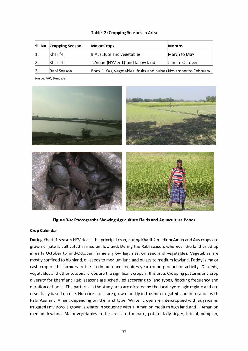
Table -2: Cropping Seasons in Area
Sl. No. Cropping Season Major Crops Months
1. Kharif-I B.Aus, Jute and vegetables March to May
2. Kharif-II T.Aman (HYV & L) and fallow land June to October
3. Rabi Season Boro (HYV), vegetables, fruits and pulses November to February
Source: FAO, Bangladesh
Figure 0-4: Photographs Showing Agriculture Fields and Aquaculture Ponds
Crop Calendar
During Kharif 1 season HYV rice is the principal crop, during Kharif 2 medium Aman and Aus crops are
grown or jute is cultivated in medium lowland. During the Rabi season, wherever the land dried up
in early October to mid-October, farmers grow legumes, oil seed and vegetables. Vegetables are
mostly confined to highland, oil seeds to medium land and pulses to medium lowland. Paddy is major
cash crop of the farmers in the study area and requires year-round production activity. Oilseeds,
vegetables and other seasonal crops are the significant crops in this area. Cropping patterns and crop
diversity for kharif and Rabi seasons are scheduled according to land types, flooding frequency and
duration of floods. The patterns in the study area are dictated by the local hydrologic regime and are
essentially based on rice. Non-rice crops are grown mostly in the non-irrigated land in rotation with
Rabi Aus and Aman, depending on the land type. Winter crops are intercropped with sugarcane.
Irrigated HYV Boro is grown is winter in sequence with T. Aman on medium high land and T. Aman on
medium lowland. Major vegetables in the area are tomoato, potato, lady finger, brinjal, pumpkin,

38
cabbage, cauliflower, radish, sweet potato, jackfruit etc. Legumes grown are arhar, masor, keshari
and moong dal.
Cropped Area
As per the land use land cover study of 10 km radius of the project site, approx. 29.3% of the area is
covered under agriculture land& aquaculture ponds. No agriculture land area will be used for
development of EZ.
Crop Production, Damage and Constraints of Crop Production
Farmers of Chattogram district produce food crops, cash crops, fruits, vegetables, livestock and
poultry, fish, timber and fuel wood. Majority of household also have poultry, livestock and produce
poultry and livestock produce for daily consumption and selling.
Major constraints of agriculture in the study area is availability of arable land, crop damage, seasonal
flooding of land, water logging, soil salinity and availability of high quality seeds and fertilizers.
Crop damage is reported to occur during focused group discussions due to both excess and scanty
rainfall. Pre- monsoon and post-monsoon drainage congestion limits crop production. In monsoon
season, the duration of water logging thus limiting the crop choice.
Common Flora and Fauna in buffer zone
10 km radius area around EZ site majorly comprises of agricultural/aquaculture land followed by
water bodies. Flora and fauna in the study area is given below. Ramgarh reserve forest & Mahamaya
forest are other zones rich in bio-diversity but are not within 10 kms radius of EZ site.
Terrestrial Flora in Buffer Zone
There are no major forests apart from Domkhali forest, Bamon Sundar forest & Moghadia forest
occurs within 10 km radius area of EZ site. Flora in the study area majorly comprises of the trees
which were found along the access road and are given in the table above. Apart from the trees
mentioned in the above table trees existing in study area are: Deodara (Cedrus deodara), yellow bell
(Tecoma stans), Hibiscus (Hibiscus rosa sinensis), Chikrashi (Chukrasia tabularis), Telsur (Butea
monosperma), Jarul (Lagerstroemia speciosa), Kadam (Neolamarckia cadamba), Dhakijam (Syzygium
grande), Davana (Artemisia pallens), Lotkon (Baccaurea ramiflora), money plant (Epipremnum
aureum), Toon (Toona ciliate), Bokain (Melia azedarach) and Banyan (Ficus benghalensis).
Photographs of flora of buffer zone aregiven below in Figure-5. Varied variety of vegetation occurs
along the Ichakhali and Bamon Sundar canal in study area. This vegetation is both naturally occurring
and planted by forest department. Golpata is planted all along the Bamon Sundar canal by Forest
Department, Mirsarai.
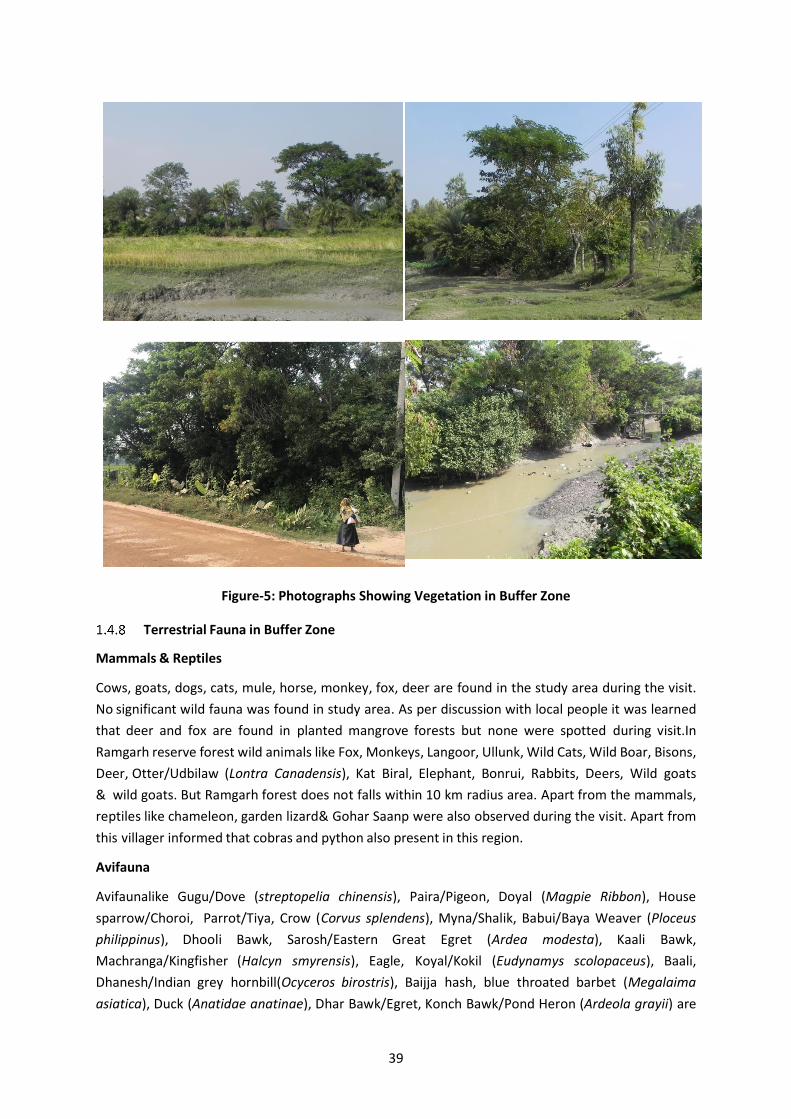
39
Figure-5: Photographs Showing Vegetation in Buffer Zone
Terrestrial Fauna in Buffer Zone
Mammals & Reptiles
Cows, goats, dogs, cats, mule, horse, monkey, fox, deer are found in the study area during the visit.
No significant wild fauna was found in study area. As per discussion with local people it was learned
that deer and fox are found in planted mangrove forests but none were spotted during visit.In
Ramgarh reserve forest wild animals like Fox, Monkeys, Langoor, Ullunk, Wild Cats, Wild Boar, Bisons,
Deer, Otter/Udbilaw (Lontra Canadensis), Kat Biral, Elephant, Bonrui, Rabbits, Deers, Wild goats
& wild goats. But Ramgarh forest does not falls within 10 km radius area. Apart from the mammals,
reptiles like chameleon, garden lizard& Gohar Saanp were also observed during the visit. Apart from
this villager informed that cobras and python also present in this region.
Avifauna
Avifaunalike Gugu/Dove (streptopelia chinensis), Paira/Pigeon, Doyal (Magpie Ribbon), House
sparrow/Choroi, Parrot/Tiya, Crow (Corvus splendens), Myna/Shalik, Babui/Baya Weaver (Ploceus
philippinus), Dhooli Bawk, Sarosh/Eastern Great Egret (Ardea modesta), Kaali Bawk,
Machranga/Kingfisher (Halcyn smyrensis), Eagle, Koyal/Kokil (Eudynamys scolopaceus), Baali,
Dhanesh/Indian grey hornbill(Ocyceros birostris), Baijja hash, blue throated barbet (Megalaima
asiatica), Duck (Anatidae anatinae), Dhar Bawk/Egret, Konch Bawk/Pond Heron (Ardeola grayii) are

40
found in the study area. Photographs of the birds observed in the study area are given in Figure-6.
Some aquatic birds like Northern Pintail, etc. were also seen during visit.

41
Figure-6: Photographs Showing Birds in the Study Area
Butterfly
Presence of butterfly was found in the settlement areas, fields, road side plantation and at bank of
river. Some of the common butterfly of the Chattogram region are Gaudy Baron, Golden Browning,
Leopard Lace, Clipper, Common Batwing, Common Gem, Orchid, Yellow Hellen etc.
RET Species
As per ecological assessment, no rare, endangered or threatened species are present at the site
and in buffer area. None of the species recorded are listed in Red book of IUCN.
Aquatic Ecology in Buffer Zone
Feni River
Fisheries of Feni River and Estuary
Consultation was carried with the fishermen in study area to gain knowledge about the fish species
in canals, River Feni, Khals, Beels, ponds etc. Fish species in Feni River Estuary system is discussed and
detailed in Fisheries section given above in this chapter. Fish species occurring in Canals & ponds are:
Golda chingri, Bagda chingri, Chiring, Pangash fish, Coral fish, Promphet fish, Catla Catla, Ruhi, Hilsa,
Bata fish, Gulla, Pua, Riksha, Lorka, Senuwa, Loitta, Nylotika, Mud crabs, Holona, mrigal, silv er carp,
gras carp, karpio, barbs (putis), Chitol, Folai, catfish (Tengra, Singi, Magur, Boal, Pungus), Snakehead
(Shol, Taki), bele etc.
As per a joint study carried out by group of experts from Bangladesh and India (Ahsan et al., 2014)
as mentioned in Fifth National Report on Bangladesh to the Convention on Biological Diversity,
Estuary area of Feni River in Mirsarai is one of potential spawning zone of Hilsa (Tenualosa islisha)
fish. Spawning season of Hilsa fish is September to October. However, the peak time of spawning is
for 11 days (15-24 October). Thus any activity having potential to affect aquatic fauna like dredging
of sand should not be undertaken during this period as it may affect spawning activity of Hilsa.
Planktons of Feni River and Estuary

42
Planktons which occurs in waters of River Feni are of following genus: Spirogyra, Zygnema, Volvox,
Pediastrum, Anabaena, Desmidium, Gonatozygon, Mougeotia and Microcystis and the zooplankton
genera were, Asplanchna, Notholca, Daphnia, Filinia and Cyclops. Crustacean larvae (Nauplii) are also
found in river water
Bay of Bengal (Sea)
A study carried out by NGO YPSA (Shipbreaking Activities in Bangladesh and collision of Marine
Biodiversityby Prabal Barua) is available for Sandwip which is app. 18 from EZ (Zone 2A & 2B) site. As
per the study the ecological diversity in this section of sea is given below
Planktons
Major phytoplanktons in these waters are Aanabena, Clostratrum, Coscinodiscus, Euglena&Zygnema.
Out of these Aanabena (30.41%) dominates during monsoon and Coscinodiscus (97.5%) dominates
during post monsoon. Abundance of the phytoplanktons in the area is 411 cells/l in monsoon season
and 190 cells / l in post monsoon season. Major zoo-planktons in these waters areCalanoida,
Cyclopedia, Sagitta, Lucifer, Zoea, Acetes shrimp & Cladocera. Out of these Calanoida, Cylpclpedia,
Sagitta and Zoea dominates during monsoon and Calanoida, Acetes shrimp, Lucifer, Cladocera and
Zoea during post monsoon.
Among the macro benthos Amphipod, Polychaete, Nemertina, Fish egg, Cladocera, Calanoida and
Polychaete are found. Out of these presence of Amphipod, Polychaete, Nemertina, Fish egg dominates
during the monsoon and Cladocera, Nemertina, Calanoida and Polychaetedominates in the post
monsoon season. Abundance of the macro benthos can be thus said to be 368.28 ind./ m3 in monsoon
season and 14204.41 ind./m3 in post monsoon season.
Fisheries
Some of the commercially important fishes of these waters majorly include Indian salmon (Polynemus
indicus) commonly known as Lakhua; grouper (Epinephelus lanceolatus) known as bole coral; Long
jew fish (Otolithoides brunneus) locally known as lombu fish; spanish mackerel (Cybium guttatum)
known as maitta; butter fish (Psenes indicus); River shad (Tenualusa ilisha); Jwelled shad (Ilisha filigera)
locally known as choikka; mango fish (Polynemus paradysius) known as ‘Hriska Machh’; silver pomfret
(Stromateus chinensis); bombay duck (Herpodon nehereus); mullet (Mugil cephalus); Sea bass/Bhetki
(Lates calcarifer) and Anchovy(Coilia dussumeri; Coilia ramkorati; Setipinna taty); mud skipper/Baila
(Gobius melanosoma, G. Sadanundio); Koiputi match (Anodontostoma chacunda); Kata mach (Arius
thalassinus), Lahmuri mach (Carangoides malbaricus); Dora mach (Apocryptes serperaster) and Lakkha
(Polynemus indicus). Major marine fishing grounds and marine reserves in the Bay of Bengal are
shown in Figure 0-7.

43
Source: Ecosystem Health and Management of Pollution in the Bay of Bengal (BFRI)
Figure 0-7: Fishing Grounds and marine reserves in Bay of Bengal
Coral Reefs
Coral reefs are not expected to occur in this region of sea. St. Martin’s Island is the only coral reef
island in Bangladesh, locally known as Jinjiradwip (Institute of Marine Sciences, University of
Chattogram, Bangladesh). Little information is available on Bangladesh’s Off-shore coral presence.
Off-shore corals are reported to be present around St. Martin’s Island area only.

44
APPENDIX I: SAMPLE GRIEVANCE REGISTRATION FORM
Grievance Form : Bangladesh Economic Zones Authority
Grievance reference number (to be completed by Project):
Contact details (may be submitted anonymously)
Name (s):
Address:
Telephone:
Email:
How would you prefer to be contacted (check one)
By mail/post:
☐
By phone:
☐
By email
☐
Preferred language ☐ Bangla ☐ English
Provide details of your grievance. Please describe the problem, who it happened to, when and where it happened, how many times, etc. Describe in as much detail as possible.
What is your suggested resolution for the grievance, if you have one? Is there something you would like BEZA or another party/person to do to solve the problem?
How have you submitted this form to the project?
Website
☐
☐
By hand
☐
In person
☐
By telephone
☐
Other (specify)
☐
Who filled out this form (If not the person named above)?
Name and contact details:
Signature
Name of BEZA official assigned responsibility
Resolved or referred to GRC1?
☐ Resolved ☐ Referred If referred, date:
Resolved referred to GRC2? ☐ Resolved ☐ Referred If referred, date:
Completion
Final resolution (briefly describe)
Short description Accepted? (Y/N)
Acknowledgement signature
1st proposed solution
2nd proposed solution
3rd proposed solution

45
APPENDIX J: GREEN BELT DEVELOPMENT PLAN
1.1 Introduction
No tree cutting is proposed to be undertaken as per the current proposal of the EZ development. It is
proposed to develop green buffer along the periphery and along the canal. The plantation in the green
buffer should be carried out in accordance to the following guidelines.
1.2 Pattern of the Green Belt
A green belt of width 30 m is suggested to be developed all along the boundary of EZ and along
Ichakhali channel. 6 rows of plantation can be planted in this buffer. Native plantation of the region
should be planted. The green belt should consist of herbs, shrubs, short-medium height trees and tall
trees. First two rows should be planted with herbs and shrubs. Next two rows should be short to
medium heighted trees and last two rows should be planted with tall trees. Space of 1X1 m should be
kept for planting herbs, space of 3X 3 m should be kept for planting shrubs and small heighted trees
and space of 5X 5 m should be kept for planting medium and tall trees. The pits are then filled with
earth, sand, silt and manure in pre-determined proportions. Saplings planted in such pits are watered
liberally during dry months. The pits are to be filled with earth, sand, silt and manure in pre-
determined proportions. Saplings planted in such pits are watered liberally during dry months.
1.3 Selection of Tree Species
The Project involve movement of vehicle for transportation of material Thus emissions like particulate
matter, SO2, NOx & CO shall be generated at site. Also there is potential of generation of coal dust
while unloading the materials at stock piles. Thus the plantation species tolerant to these pollutants
and mitigate these from air shall be planted. Species selecting criteria is given below:
1. Native species including Mangroves 2. Tolerant to expected pollutants at site 3. Longer duration of foliage 4. Freely exposed foliage (adequate height of crown, openness of foliage,
big leaves, small stomata apertures, stomata well exposed) 5. Leaves supported on firm petioles
1.4 Recommended Plant species
Based on nature of pollutants following tree species are recommended to be planted
Species Name Local Name Family
Acacia moniliformes Akashmoni Leguminosae
Areca catechu Supari Palmae
Avecenia alba/ Avicennia Marinavierh Baen Aviceniaceae
Azadirachta indica Neem Meliaceae
Carica papaya Pepey Caricaceae
Cocos nucifera Narikel Palmae
Excoecaria agallocha Gewa Euphorbiaceae

46
Species Name Local Name Family
Herritiera fomes Sundari Sterculiaceae
Mangifera indica Aam Anacardiaceae
Manilkara zapota Safeda Zapotaceae
Phoenix sylvestris Khejur Palmae
Psidium guajava Peyara Myrtaceae
Sonneratia apetala Kewda/Keora Lyrthaceae
Spondius pinnata Amra Anacardiaceae
Swietenia mehagoni Mehogani Meliaceae
Syzygium cumini Jaam Myrtaceae
Syzygium samarengense Jamrul Myrtaceae
Tamarindus indica Tentul Leguminosae
Terminalia catapa Kathbadam Combrataceae
Tectonia grandis Teak Lamiaceae
Gmelina arborea Gamari Verbenaceae
Brassica juncea Raisharisha Brassicaceae
Olea europaea Olives Oleaceae
Terminalia bellirica Bohera Combretaceae
Terminalia chebula Horitoki Combretaceae
Phyllanthus emblica Amla Phyllanthaceae
Protium serratum Gutgutiya Burseraceae
Propospis cineraria Jand Fabaceae
Casuarina equisetifolia Jhao Ghas Casuarinaceae
Albizia lebbeck Koroi Fabaceae
Delonix regia Krishnachura Fabaceae
Leucaena leucocephala Ipil Ipil Fabaceae
Carissa carandas Karamcha tree Apocynaceae
Artocarpus heterophyllus Jack fruit Moraceae
Polyalthia longifolia Pseudo Ashoka Annonaceae
Musa parasisiaca Banana Musaceae
Garuga pinnat Bhadi Burseraceae
Abelmoschus esculentu Bhendi Malvaceae
Erythrina indica Mandar Fabaceae
Acacia mangium Mangiam Fabaceae
Dalbergia sissoo Sheeshu Fabaceae
Lawsonia inermis Kat Mehndi Lythraceae
Swietenia mahagony Mahagony Meliaceae
Arundinaria Cane Ghas Poaceae

47
Species Name Local Name Family
Samanea saman Rain Tree Fabaceae
Zizyphus mauritiana Boroi Rhamnaceae
Calotropis Calotropis Apocynaceae
Ceriops decandra Gora Rhizophoraceae
Litchi chinensis Litchi Sapindaceae
Ficus benjamina Dumur Moraceae
Citrus maxima/Citrus grandis Jambura Rutaceae
Mimosa pudica Lazzabati Fabaceae
Pinus densiflora Pine Pinaceae
Excoecaria agallocha Gewa Euphorbiaceae
Nypa fruticans Golpata Arecaceae
Heritiera littoralis Sundri Lauraceae
1.5 Plantation Methodology
Components of green belts on roadside fence should be both absorbers of gases as well as of dust
particles, including even lead particulates. Thus the choice of plants should include pollution tolerant
shrubs of height 1 to 1.5 m and trees of 3 to 5m. The intermixing of trees and shrubs should be such
that the foliage area density in vertical is almost uniform. For effective removal of pollutants, it is
necessary that (i) plants should grow under conditions of adequate nutrient supply, (ii) absence of
water stress and (iii) plants are well exposed to atmospheric conditions (light & breeze).
Multiple rows of green belt shall be developed. Green belt should be pyramidal in shape. Plantation
pattern shall be kept as given below:
Short trees and tall shrubs shall be planted as first row (from road) followed by tall tree plantation which will be followed by another row of medium and small trees and tall shrubs.
Planting of trees should be in appropriate encircling rows, each rows alternating the previous one to prevent further fanning and horizontal pollution dispersion;
Since tree trunks are normally devoid of foliage, it would be appropriate to have small shrubs in front and in between the tree spaces;
The open areas between the process installations where trees cannot be planted should be covered with lawn grasses for effective trapping and absorptions of air pollutants.
Fast growing trees with thick canopy and perennial foliage should be selected so that the effective tree height with envisaged objective will be attained in minimum span of time
1.6 Time of Plantation
Plantation of the tree sapling should be done only after the first shower during the rainy season. The
best time for plantation is after 15 days from the day of first shower during rainy season.
48
1.7 Protection of Tree saplings
Circular tree guard should be placed after the plantation of the saplings for the protection of these
young plants from the ravages of cattle, sheep and goat and other animals. If tree saplings died or
damage occur after placing the circular tree guard, timely replacements of damaged plant and
thereafter care is important.
1.8 After Care & Monitoring
The growing plants are cared at least for the first two years under favourable conditions of climate
and irrigation. Nutrients in pits are supplemented and the juveniles provided protection.
Thinning shall start after the stand is 3-4 years old and repeated every 4 years until the stand is 15
years old. Between 15-25 years old, thinning should be conducted every 5 years and after 25 years
old, thinning shall be done after every 10 years. When the canopy closes, at about 6 years, 30-40% of
the stems shall be thinned to selectively remove suppressed, diseased and badly formed trees.
Periodic assessment shall be carried for survivability of the trees. Minimum 70% survival rate shall be
achieved.
1.9 Records Keeping & Reporting
The following records shall be maintained:
Record of Tree plantation
Record of Survivability rate
Inspection shall be carried out at site to know the survival rate of the plantation. The tree plantation
and survivability report shall be prepared every six monthly.
1.10 Responsibility
Compensatory plantation shall be carried out by forest department. Survival rate of plantation shall
be inspected of the by BEZA. Plantation within the terminal/jetty/lock site shall be carried out by BEZA
and shall be monitored by BEZA.

49
APPENDIX K: TEMPORARY DRAINAGE MANAGEMENT PLAN
Project activity/ Impact source
Environmental Impact Mitigation Measures/ Management Guidelines
Excavation and earthworks and construction yards
Lack of proper drainage for rainwater/liquid waste or wastewater owing to the construction activities harms environment in terms of water and soil contamination and mosquito growth.
The Contractor shall
Prepare a program for prevent/avoid standing waters, which PMU will verify in advance and confirm during implementation.
Provide alternative drainage for rainwater if the construction works/earth-fillings cut the established drainage line.
Establish local drainage line with appropriate silt collector and silt screen for rainwater or wastewater connecting to the existing established drainage lines already there
Rehabilitate road drainage structures immediately if damaged by contractors’ road transports.
Build new drainage lines as appropriate and required for wastewater from construction yards connecting to the available nearby recipient water bodies. Ensure wastewater quality conforms to the relevant standards provided by DoE, before it being discharged into the recipient water bodies.
Ensure the internal roads/hard surfaces in the construction yards/construction camps that generate storm water drainage to accommodate high runoff during downpour and that there is no stagnant water in the area at the end of the downpour.
Construct wide drains instead of deep drains to avoid sand deposition in the drains that require frequent cleaning.
Provide appropriate silt collector and silt screen at the inlet and manholes and periodically clean the drainage system to avoid drainage congestion.
Protect natural slopes of drainage channels to ensure adequate storm water drains.
Regularly inspect and maintain all drainage channels to assess and alleviate any drainage congestion problem.
Reduce infiltration of contaminated drainage through storm water management design.
Ponding of water Health hazards due to mosquito breeding.
Do not allow ponding of water especially near the waste storage areas and construction and labor camps.
Discard all the storage containers that are capable of storing of water, after use or store them in inverted position.

50

51
Appendices L: Photographs of Stakeholder consultation meetings and FGDs
KII with UNO, Mirsarai Upazila, 6-11-2019
KII with SUFO, Mirsarai Upazila, 6-11-2019
KII with Forest Range Officer of Mirsarai Upazila, 6-11-2019
KII with ULO, Mirsarai Upazila, 6-11-2019
KII with Upazila Agriculture Officer, Mirsarai, 6-11-2019
KII with Social Welfare Officer, Mirsarai, 6-11-2019

52
KII with Upazila Engineer, Mirsarai, 6-11-2019
Figure 1: Key Informants Interview (KII) with Upazila Officers, Mirsarai
Focus Group Discussion with local stakeholders at Ichakhali Switch Gate, 9no Ward of 6no Ichakhali Union, 06-11-2019
Public consultation with local stakeholders at Jolodas Para , Dhomkhali, 8no Ward, 16no Shaherkhali Union, 07-11-19
Focus Group Discussion with local stakeholders at Bangla Bazar, 9 no Ward of 6no Ichakhali Union, 07-11-19
Group Discussion with local stakeholders at Abu Torab Bazar of 11no Moghadia Union, 05-11-19

53
Public consultation Discussion with local stakeholders at Chorshorot, 9no Ward of 06 Ichakhali Union, 07-11-19
Focus Group Discussion with local stakeholders at Beribadh Chorshorot, 9no Ward of 6 Ichakhali Union, 07-11-19
Focus Group Discussion with local stakeholders at Moghadia Absar Chouwdury High School of 11no Moghadia Union, 05-11-19
Walk in interview with local stakeholders at 5no Ward of 11no Moghadia Union, 07-11-19
Group Discussion with local stakeholders at Chorshorot, 9no Ward of 06 Ichakhali Union, 07-11-19
Group Discussion with local stakeholders at Moghadia Anjuman Nesa Govt. Primary School of 11no Moghadia Union, 05-11-19
Figure 2: Public consultations, FGDs, group discussions & walk in interviews with the stakeholders

54
Appendices M: List of Industries in Zone 2A and 2B
SL. No. Name of Industry Type of Industry Allotted Plot Size
ZONE 2A
1 ACI Ltd Food Processing 99.9
2 Administration Administration 3.6
3 Alif Embroidery Village Ltd Textile & Garments 10.1
4 Allotted Allotted Plots 37.1
5 Aman Spining Mills Ltd. Textile & Garments 30.2
6 Arab Bangladesh foods Ltd. Food Processing 10
7 Aust-Bangla (JV) Accessories Industries Ltd Other 10.1
8 BDCom Online Ltd. Electronics 10
9 BEZA BEZA 0.8
10 BSA Fashion Ltd Textile & Garments 24.8
11 BTCL Utilities 0.6
12 CETP CETP 20.9
13 Commercial Commercial 0.6
14 Energy & Power Energy & Power 2.3
15 Energypac Power Generation Company Ltd. Energy & Power 29.1
16 Eonmetall International Ltd Steel & Steel Product
10
17 Eurasia Food Precessing Ltd Food Processing 10
18 Fakhruddin Textile Textile & Garments 50.2
19 Fawn International Energy & Power 25.1
20 Gas-1 Ltd Energy & Power 25
21 Green Green 1.3
22 Green Health Ltd Pharmaceutical 10
23 Hamko Corporation Ltd Battery 10
24 Integra Apparels (Bangladesh) Ltd. Textile & Garments 10.2
25 Jahangir Stainless Steel Ltd. Steel & Steel Product
10
26 Jamuna Spacetech Jv. Ltd Energy & Power 40
27 Juhana Textile Ltd. Textile & Garments 10
28 Maheen Dizayn Etiket (BD) Ltd. Textile & Garments 10
29 Merchant Melbourne Pte Ltd Food Processing 9.9
30 Nafa Apparels Ltd+Aswad Composite Mills Ltd. Textile & Garments 70.2
31 Overseas Marketing Corporation (Pvt) Ltd Textile & Garments 19.6

55
SL. No. Name of Industry Type of Industry Allotted Plot Size
32 Quality Fashion Wear Ltd Textile & Garments 10
33 Raquef Apparels Washing and Packaging Industry Textile & Garments 30.3
34 Ratools Apparels Ltd Textile & Garments 10
35 REB Utilities 2.5
36 Religious Religious 0.9
37 Reserved for BEZA BEZA 10
38 Reservoir Reservoir 0.5
39 Reza Fashion Ltd Textile & Garments 10
40 Road Road 94.9
41 Security Security 5
42 Surjin Tech Co. Ltd Utilities 1.9
43 Textile & Garments Textile & Garments 5
44 Unallotted Unallotted 117.2
45 Utilities Utilities 5
46 Well Composite Knite Ltd.(Sanji Textile) Textile & Garments 20
ZONE 2B
1 Adila Apparels Textile & Garments 1
2 Advance World Limited Textile & Garments 1.1
3 Afrah Dresses Ltd. Textile & Garments 2
4 Al-Ittefaq Textile Ltd. Textile & Garments 1
5 Alps Apparels Ltd. Textile & Garments 3
6 Apparel Gallery Limited Textile & Garments 33
7 ARL Dresses Limited Textile & Garments 2
8 Artistic Design Limited Textile & Garments 34
9 Avant Garments Limited Textile & Garments 5
10 Babylon Casualwear Limited Textile & Garments 5
11 Babylon Garments Limited Textile & Garments 5
12 BEZA BEZA 21.6
13 BLP Warm Fashion Ltd. Textile & Garments 1
14 CETP CETP 5
15 Charm Fashion Textile & Garments 5
16 Chowdhury Fashion Wear Limited Textile & Garments 2
17 Clifton Apparels Limited Textile & Garments 5
18 Clifton Cotton Mills Limited Textile & Garments 5
19 Columbia Apparels Ltd. Textile & Garments 6.1

56
SL. No. Name of Industry Type of Industry Allotted Plot Size
20 Columbia Garments Ltd. Textile & Garments 6.1
21 Cotton Dyeing & Finishing Mills Ltd. Textile & Garments 2
22 Cotton Line (BD) Ltd. Textile & Garments 2
23 Denim Fashions Ltd. Textile & Garments 2
24 EH Fabrics Ltd. Textile & Garments 2
25 Energypac Fashions Ltd. Textile & Garments 3
26 Epyllion Style Limited Textile & Garments 20
27 Eva Sweater Ltd. Textile & Garments 3
28 Farseeing Knit Composite Ltd. Textile & Garments 2
29 Fountain Garments Manufacturing Ltd. Textile & Garments 3
30 Four H Fashion Limited Textile & Garments 5
31 Garments Home (Pvt.) Ltd. Textile & Garments 1
32 Genesis Fashions Ltd. Textile & Garments 8
33 Global Shirt Limited Textile & Garments 20.1
34 Graphics Textile Limited Textile & Garments 10
35 Green Green 18.6
36 Image Garments Ltd. Textile & Garments 2
37 Impressive Knit Composite Textile & Garments 2
38 Integra Apparel (BD) Limited Textile & Garments 10.1
39 Karim Textiles Limited Textile & Garments 5
40 Kay Garments Limited Textile & Garments 1
41 M/S ARL Apparels Limited Textile & Garments 3
42 Madina Garments Limited Textile & Garments 1
43 Majumder Garments Limited Textile & Garments 5.1
44 Mansheen Co (BD) Ltd. Textile & Garments 1
45 Mars Sportswear Limited Textile & Garments 10.1
46 Mellow Fashion Limited Textile & Garments 1
47 Mens Fashion Limited Textile & Garments 20
48 Musk Trousers Ltd. Textile & Garments 1
49 Pacific Cotton Ltd. Textile & Garments 2
50 Posh Garments Ltd. Textile & Garments 3
51 Progressive Apparels Ind. Ltd Textile & Garments 1
52 R.O Textile Mills (Pvt) Ltd. Textile & Garments 3
53 RDM Apparels Ltd. Textile & Garments 6.1
54 RNSCO Sweaters Limited Textile & Garments 1

57
SL. No. Name of Industry Type of Industry Allotted Plot Size
55 Road Road 53.5
56 RR Fashion Ltd. Textile & Garments 1
57 SAMS Attire Ltd. Textile & Garments 2
58 SF Denim Apparels Limited Textile & Garments 5.1
59 Shamser Apparels Ltd. Textile & Garments 1
60 Shamser Rezia Fashion Ltd. Textile & Garments 1.1
61 SQ Celsious Limited Textile & Garments 10
62 S-six Fashions (Pvt.) Ltd Textile & Garments 1
63 Sterling Denims Limited Textile & Garments 30
64 Tafof Apparels Ltd. Textile & Garments 2
65 TBH Fashion Tex (Pvt.) Ltd. Textile & Garments 1
66 That's it Sports Wear Ltd Textile & Garments 33
67 Top Star Fashions Limited Textile & Garments 1
68 Towel Tex Ltd. Textile & Garments 1
69 Tusuka Jeans Ltd. Textile & Garments 2
70 Tusuka Trousers Limited Textile & Garments 4.1
71 Unigears Limited Textile & Garments 15
72 Uranus Apparels Ltd. Textile & Garments 2
73 Vancot Limited Textile & Garments 5
74 Visual Knitwears Limited Textile & Garments 3.9
75 W. Apparels Textile & Garments 6
76 Well Fashion Limited Textile & Garments 2