at the transition from late medieval to early modern: the archaeology of three wrecks from turkey:...
TRANSCRIPT
At the Transition from Late Medieval to Early Modern: theArchaeology of Three Wrecks from Turkey
Jeffrey G. RoyalArchaeological Director, RPM Nautical Foundation, 7009 Shrimp Road, Old Island Harbor #3, Key West, FL33040, USA
John M. McManamon, SJDepartment of History, Loyola University Chicago, Chicago, IL 60660, USA
During surveys in the Rhodian Straits in 2005–06, the staff of the RPM Nautical Foundation discovered three deepwater wreckswhich reflect elements of the transition from late medieval to early modern seafaring. The assemblages, and their plotting onsite-plans generated from photographic evidence, point to the finding of a small oared warship equipped with wrought-ironcarriage- and swivel-guns, a small coasting vessel armed with wrought-iron swivel-guns, and a larger merchantman equippedwith cast-iron carriage-guns. While the features of the smaller vessels do not identify their country of origin, those of the largermerchantman have good parallels with known English wrecks.
© 2009 The Authors
Key words: shipwreck, Turkey, England, ordnance, Rhodian Straits, Late Medieval—Early Modern.
Winds blowing down from Rodos channel strike withgreat force here and thus immediately after sighting thismountain, one should proceed at a distance of thirty orforty miles from the shore (Piri Reis, Kitab-ı Bahriye, inÖkte, 1988, vol. 2: 525).
During the summers of 2005 and 2006, RPMNautical Foundation (RPMNF) conducted asurvey along the Bozburun Peninsula of
south-western Turkey, on the Turkish side of theStraits of Rhodes. With the generous permission andactive co-operation of the Turkish Ministry of Cultureand Tourism and the Department of UnderwaterArchaeology, the survey resulted in the discovery of 14wreck-sites, of which five are from the modern era. Ofthe nine historic wrecks, three date to the transitionalperiod from late medieval to early modern, c.1450–1600. Moreover, all three wrecks were probablyequipped for combat, given the weapons found at eachsite. To find a high percentage of armed vessels from anarrow historical period clustered along the samestretch of Turkish coastline within the Rhodian Straitsinvites an analysis of the coastal geography and stra-tegic context of those Straits, as well as the specificnature and assemblage of each site. Although two ofthe wreck-sites (TK05–AB and TK05–AH) have beenpreviously reported, and the third (TK06–AD)described in a preliminary report (Royal, 2006; 2008a),it is appropriate, for a variety of reasons, to offer
scholars a review of the first two wrecks, together withnew comparative material, and a full description of thethird, as the extensive assemblage of site TK06–ADhas not yet been published systematically. The cluster-ing of the three vessels in space and time is significant.The similarities and differences in their assemblages,especially as regards guns and anchors, are notable.The reactions of other scholars to those notices haveled to a detailed re-examination of the evidence and awider exploration of relevant parallels.
MethodologyThe survey was conducted by two of RPMNF’sresearch vessels, the 33-m Hercules and the 9-m Juno.Each vessel has a multi-beam echo-sounder: the systemon the Hercules was effective for archaeological surveyto a depth of 120 m, while that on the Juno was effectiveto 45 m. Accordingly, the Juno covered areas from thecoastline to the 45-m contour, and the Hercules the areabetween the 40- and 100-m contours. The designedoverlap between each vessel’s coverage ensured that nogaps occurred when merging the two data-sets. Extend-ing from shore roughly to the 80-m contour, the pointreached within the time limits of the survey, the entiresurvey encompassed an area measuring c.140 km2.
The system used on the Juno featured a side-mountedReson Seabat 8125 multi-beam echo-sounder. This
The International Journal of Nautical Archaeology (2010) 39.2: 327–344doi: 10.1111/j.1095-9270.2009.00252.x
© 2009 The Authors. Journal Compilation © 2009 The Nautical Archaeology Society.Published by Blackwell Publishing Ltd. 9600 Garsington Road, Oxford OX4 2DQ, UK and 350 Main Street, Malden, MA 02148, USA.
single-head unit emits 240 beams at a maximum rate of40 per second, operates on a frequency of 455 kHz, andhas a swath coverage of 120°. At depths up to 45 m, thedata has a resolution of a few centimetres. Remotesensing with the Hercules was conducted with ahull-mounted multi-beam echo-sounder, model typeEM3002D from Kongsberg Maritime division. Thisemploys two transducer heads fixed to the underside ofthe research vessel, emitting upwards of 500 beams at amaximum rate of 40 per second. Its multiple frequencies(293, 300, and 307 kHz), and ability to control angularcoverage dynamically, result in a practical depth reso-lution of 10 cm. After multi-beam data was collectedand processed, it was reviewed as three-dimensionalmodels which allow the visualization and editing of eachindividual beam. Likely anomalies were examined inthis manner and assessed for either association withgeological formations or characteristics consistent withshipwreck sites. Those meeting the latter criteria wereplotted on an electronic chart, which made it possible tonavigate both the research vessel and an ROV equippedwith a transponder to each anomaly.
During verification, the forward-scanning sonarfixed to the ROV facilitated locating anomalies, andalso examined for random objects in the area surround-ing an anomaly or site. After locating an anomaly, thestaff conducted a visual investigation, using the ROV’svideo camera. Although the sites lie below a safe depthfor air diving, careful video and still photographyallowed the drafting of preliminary site-plans. Further-more, the visual documentation permitted identifica-tion of individual objects, once any light sedimentcovering the objects was dusted away. As the TurkishMinistry of Culture had made no provision for theremoval of artefacts, and the local museums had notdetermined where to store retrieved objects, theRPMNF team raised no artefacts from the sites.
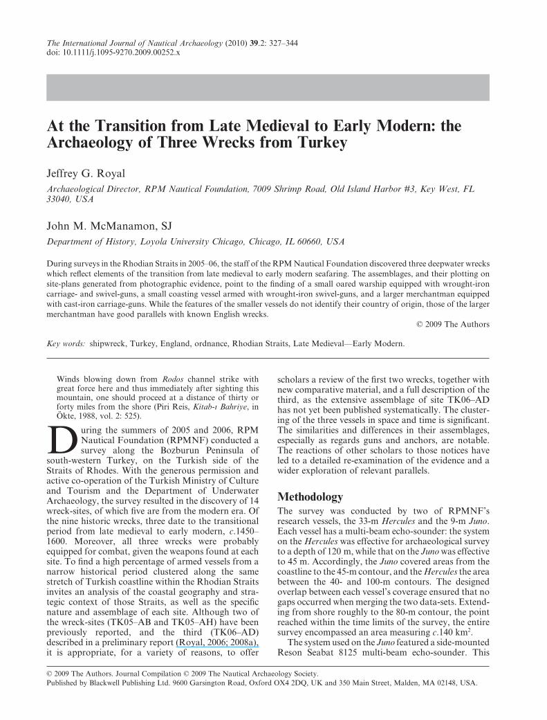
Coastal geography of the areaThe survey area spanned c.37 km along the Bozburunpeninsula, from Kadirga Burun in the north-east to thebay of Bozuk Bükü at its south-western end (Fig. 1).Almost the entire coastline in the survey area featuressteep slopes and cliffs that descend into the sea to adepth of 30–50 m. At the base of these cliffs the sandysea-bed extends out with a moderate gradient. Alongthis stretch of coastline mariners also regularly encoun-ter rock-formations lying just beneath the surface, andsmall islands obstructing their passage, both of whichare serious hazards for vessels sailing close to shore(Pryor, 1995: 216). The survey area contains two largebays, Bozuk Bükü, site of ancient Loryma, and SerçeLimanı, site of two shipwrecks excavated by the Insti-tute of Nautical Archaeology in the 1970s and ’80s(Bass et al., 2004; Bass, 2006; Pulak, 2006). The coast-lines of the mainland and nearby islands are pock-marked by safe and concealed anchorages. In the latterpart of the 15th century, the western end of the straits
between Turkey and Rhodes, where the Aegean meetsthe Mediterranean, took on increased strategic impor-tance, as witnessed by the frequency of armed conflictthere.
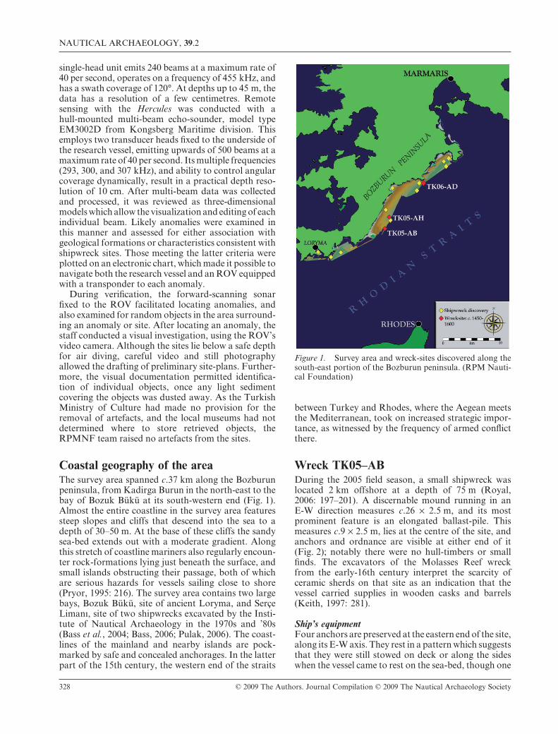
Wreck TK05–ABDuring the 2005 field season, a small shipwreck waslocated 2 km offshore at a depth of 75 m (Royal,2006: 197–201). A discernable mound running in anE-W direction measures c.26 ¥ 2.5 m, and its mostprominent feature is an elongated ballast-pile. Thismeasures c.9 ¥ 2.5 m, lies at the centre of the site, andanchors and ordnance are visible at either end of it(Fig. 2); notably there were no hull-timbers or smallfinds. The excavators of the Molasses Reef wreckfrom the early-16th century interpret the scarcity ofceramic sherds on that site as an indication that thevessel carried supplies in wooden casks and barrels(Keith, 1997: 281).
Ship’s equipmentFour anchors are preserved at the eastern end of the site,along its E-W axis. They rest in a pattern which suggeststhat they were still stowed on deck or along the sideswhen the vessel came to rest on the sea-bed, though one
Figure 1. Survey area and wreck-sites discovered along thesouth-east portion of the Bozburun peninsula. (RPM Nauti-cal Foundation)
NAUTICAL ARCHAEOLOGY, 39.2
328 © 2009 The Authors. Journal Compilation © 2009 The Nautical Archaeology Society
has its crown shifted slightly out of its presumedstowage position. All four anchors share several identi-cal characteristics: they have 0.5-m-long arms weldedinto an open crescent shape, a small protrusion beyondthe arms at the crown, triangular flukes, a rectangulareye at the end, and a rounded shank c.2 m long. One ofthe anchors has its ring, and two appear to have theremains of chain associated with the anchors or perhapsthe rigging. A photograph of artefacts recovered in 1967from the 16th-century Highborn Cay wreck in theBahamas also shows lengths of chain, at least one ofwhich is attached to an anchor’s ring (Keith, 1988: 58;1997: 192). Archaeologists working at the Padre Islandsite identified chains found there as securing the shroudsand stays (Arnold and Weddle, 1978: 234). Since theanchors appear in a stowed position, the eastern portionof the wreck is probably the vessel’s bow. The same areaof the site also has a rod-shaped object c.2 m long, witha diameter close to that of the anchor shanks. It has 8–10loop handles running along its length, fixed alternatelyon opposing sides, and each loop handle has a barrunning down its centre. We do not believe that thisobject was part of the vessel’s armament, but rather anunidentified piece of ship’s equipment. The only objectnow visible which may have belonged to the crew isshaped like a bucket, with a thin wall and little sign ofcorrosion, suggesting that it was manufactured fromcopper or a copper-alloy; the object may be intrusive.
OrdnanceAt least three guns remain on the wreck-site, eachexhibiting the reinforcement hoops characteristic ofwrought-iron construction. One largely-intact gun sitsat the eastern edge of the ballast-pile near the bow; thisgun has the largest barrel diameter of the three atc.20 cm, and appears to have settled as its two constitu-ent pieces: the breech-block and the barrel. Two otherguns are situated several metres to the west of the
ballast-pile and have barrels about half the diameter ofthe large gun; both may have their breech-blocks lyingnearby. The north-western gun is broken in two piecesand appears to have its mounting assembly, a forkedswivel used to attach the weapon to the gunwale.
The large gun at the bow to the east is of sufficientsize to have served as a centreline gun, mounted at avessel’s bow and aimed forward without the capabilityof rotation independent of the vessel’s manoeuvres.The pair of smaller guns to the west are probablyswivel-guns, which were typically used to rake enemydecks or repel boarders. They are forged from stavesand hoops with no evidence of tillers. According toRobert Smith’s proposed classification, they wouldprobably be serpentines (1995: 104–06). Nonetheless,Smith’s classification may need further refinement.Whereas he suggests that all the swivel-guns fromIberian wrecks in the New World are forged from asingle piece of iron, and labels that type a ‘base’ of twosizes, Keith and Smith documented the 15 swivel-guns(versos) on the Molasses Reef wreck as being of threesizes. Swivel-guns are distinguished by the way they aremounted, not the way in which they are loaded(Howard, 1986–87: 49–55; Keith, 1988: 60; Simmons,1988: 29–30; Smith, 1993: 159; Smith, 1995: 106–07;Royal, 2006: 198; pers. comm. Hocker, 2007).
All the Mediterranean sea-powers had their ownnames for such small wrought-iron pieces; forexample, the Ottomans labelled them prangıs orsakalozes (Ágoston, 2005a: 86–8), the Spanish fal-conetes, versos, or esmeriles, the Portuguese falcões orberços, and the Italians falconetti, bombardelle, ormoschetti (Guilmartin, 1974: 159–62, 295–303; Smith,1993: 153–4; Bicheno, 2005: 81–3). Moreover, themovement of gunfounders and the trade in weaponsassured a broader exchange of both manufacturingtechnology and actual guns than most governmentswished to see, and which they often sought to
Figure 2. Preliminary plan and photos of site TK05–AB. (J. Royal)
J. G. ROYAL & J. M. McMANAMON, SJ: THE ARCHAEOLOGY OF THREE WRECKS FROM TURKEY
© 2009 The Authors. Journal Compilation © 2009 The Nautical Archaeology Society 329
prevent. Despite a bewildering array of often impre-cise names, the wrought-iron guns of the WesternEuropeans and Ottomans corresponded to a largedegree (Lane, 1973: 356–8; Cipolla, 1980: 90–103;Ágoston, 2005a: 16–21, 42–64, 192–3, 197; Ágoston,2005b: 106–07, 119–20). Without knowing the cul-tural origins of this particular vessel, it is futile toassign a definitive name to either of the gun types.
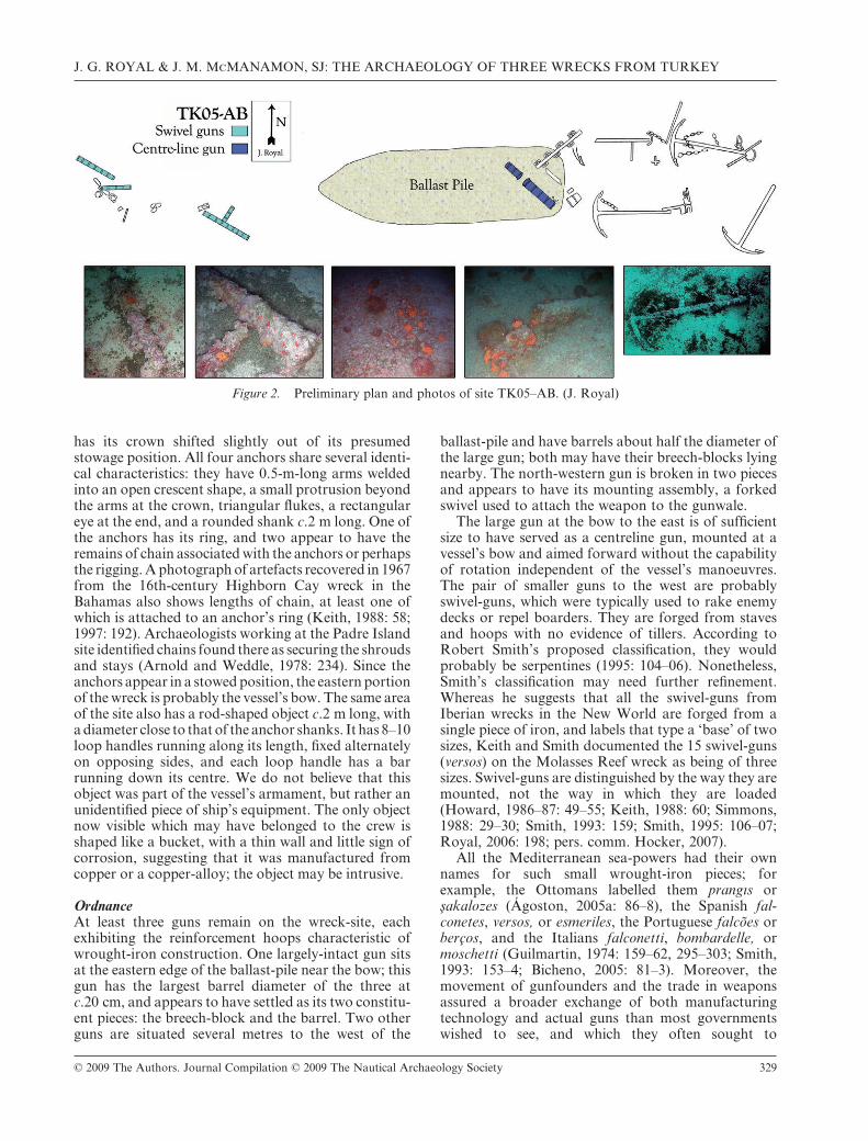
Wreck TK05–AHA second wreck was located a few hundred metres tothe north-east of wreck TK05–AB at a depth of 81 m(Royal, 2006: 201–06). The main body of the sitecovers an area c.10 ¥ 4 m and is oriented NE–SW;however, numerous items from the vessel are strewnto the east (Fig. 3). An ovoid ballast-pile of smoothrocks, c.6.0 ¥ 2.5 m, forms the centre of the site andhas pottery and tile fragments scattered throughout.The distribution of artefacts, and marks on the sea-bed, indicate that Turkish sponge fishermen, usingtheir peculiarly-effective wheeled devices called kon-gavas, have probably dragged the site from roughlyNW to SE. However, this disturbance to the site didnot compromise its integrity.
Ship’s equipmentThe remains of several anchors lie at the north-eastern section of the ballast-pile. Two of them have arounded cruciform shape, while the third has a morecrescent shape and arms that turn up more sharply attheir flukes. Although it is difficult to be certain, con-cretions lying near the ends of both arms of the
crescent-shaped anchor suggest that they were largeand palm-shaped. Two rings protruding from thesand north of these three anchors match the shape ofthe single attached anchor-ring, and may thereforeindicate two additional anchors buried in the sand.Given the positions of ballast and anchors, the south-western portion of the site comprises the vessel’s sternand the north-eastern its bow. Each of the threeanchors has its crown oriented towards the north-east, or forward, and two of the anchors lie acrossone another, so they were probably stowed on deckor in a forward hold. In either case they were stowedwhen the vessel sank.
Ship’s timbersThe south-western edge of the ballast-pile has a timberrunning roughly perpendicular to its long axis, whichcomes to a point at its north-eastern end due to break-age and/or erosion. This fragment and others nearbyhave the shape and dimensions consistent with plank-ing or ceiling. Timber remains continue to the south-west of the ballast-pile; one long timber extends fromthe westernmost area of the site to the north-westernedge of the ballast-pile. This timber is probably asection of a strake and has two possible framing ele-ments running perpendicular to it, one of which islocated at the terminus of the ballast-pile. Given theexposed timbers and amount of overburden, there is ahigh probability of significant hull remains on this site.
Crew’s equipment or cargoCeramics on the site include storage jars, tiles, andnumerous sherds, many located within the ballast-pile,
Figure 3. Preliminary plan and photos of site TK05–AH. (J. Royal)
NAUTICAL ARCHAEOLOGY, 39.2
330 © 2009 The Authors. Journal Compilation © 2009 The Nautical Archaeology Society
with a concentration at the pile’s western sector whichextends further west beyond the edge of the pile. Theadditional presence of tiles in this location is consistentwith a ship’s galley, which was usually located aft.Sherds from breakage during sinking generally settlebetween whole objects before sand and silt cover thewreck. By contrast, post-depositional breakage resultsin sherds spread on top of the sand and ballast, and itis this which probably explains the majority of thesherds visible on this site. The upper portion of aceramic vessel, apparently without handles, is locatedon the opposite side of the pile together with otherlarge pieces. This ship appears to have come to rest onits starboard side; hence, sherds that lie to the southand east of the remains probably indicate spilling onimpact, exacerbated by post-depositional damage fromdragging.
OrdnanceOrdnance on this site comprised the remains of four orfive small guns, most of which now lie in the easternand southern sections of the ballast-pile. One example,however, lies amid the timber remains of the presumedstern to the south-west. Each of the guns has a consis-tent barrel diameter and large reinforcement hoopscharacteristic of wrought-iron construction. Noneappears preserved for its full length, but the remainsindicate that the guns were c.1.5–2 m long and had abarrel diameter of c.10 cm. These lengths and the smalldiameter of the barrels suggest that they were swivel-guns, armament increasingly useful on merchantvessels during this period. For example, the Cattewaterwreck, dated to the early-16th century, was an armedmerchantman of c.186–282 tons burden, which carriedthree wrought-iron swivel-guns mounted in woodenstocks. The best-preserved was 1.25 m long and had anoutside diameter at the muzzle of c.7 cm (Redknap,1984: 39, 49–63; Redknap, 1997). The remains of the
swivel-gun at the stern of this vessel display muzzle-hoops and perhaps portions of its forked mountingassembly nearby. Similar elements of an apparentmounting assembly are located to the south-east of themiddle of the ballast-pile. Although there has been ashifting of ordnance during and after deposition, itappears that swivel-guns were mounted at the bow andstern and along the gunwales amidships. Once again,without knowing the cultural identity of the vessel, it isinappropriate to assign names to these guns.
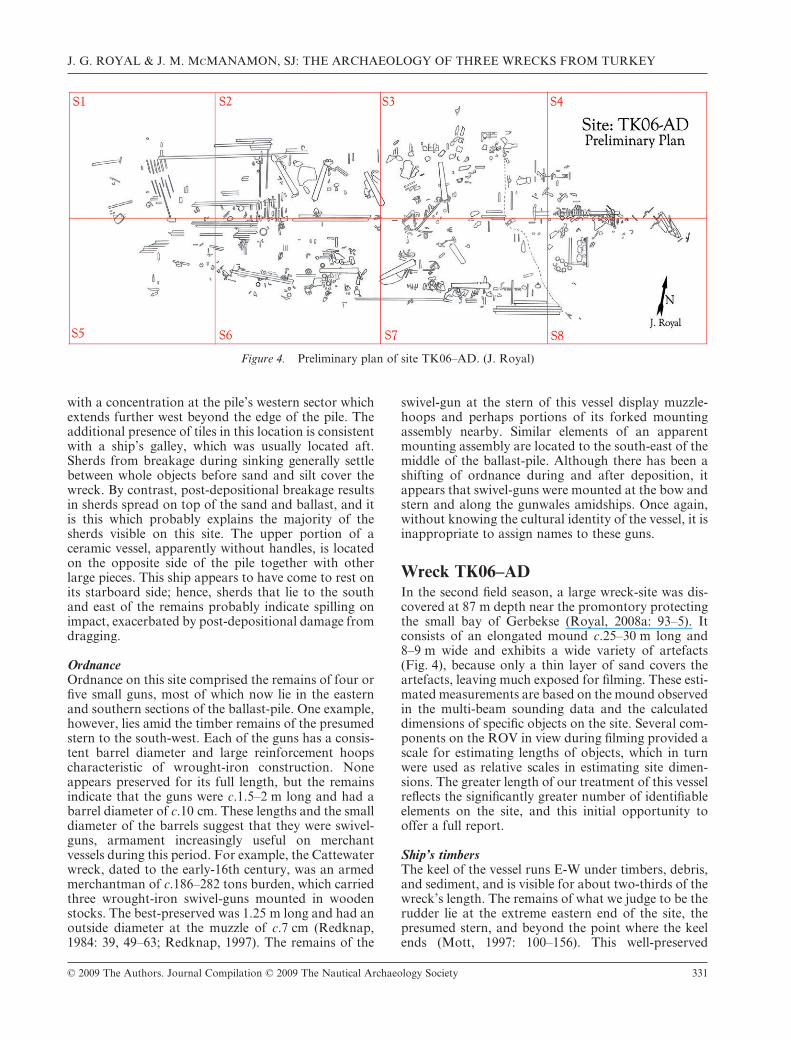
Wreck TK06–ADIn the second field season, a large wreck-site was dis-covered at 87 m depth near the promontory protectingthe small bay of Gerbekse (Royal, 2008a: 93–5). Itconsists of an elongated mound c.25–30 m long and8–9 m wide and exhibits a wide variety of artefacts(Fig. 4), because only a thin layer of sand covers theartefacts, leaving much exposed for filming. These esti-mated measurements are based on the mound observedin the multi-beam sounding data and the calculateddimensions of specific objects on the site. Several com-ponents on the ROV in view during filming provided ascale for estimating lengths of objects, which in turnwere used as relative scales in estimating site dimen-sions. The greater length of our treatment of this vesselreflects the significantly greater number of identifiableelements on the site, and this initial opportunity tooffer a full report.
Ship’s timbersThe keel of the vessel runs E-W under timbers, debris,and sediment, and is visible for about two-thirds of thewreck’s length. The remains of what we judge to be therudder lie at the extreme eastern end of the site, thepresumed stern, and beyond the point where the keelends (Mott, 1997: 100–156). This well-preserved
Figure 4. Preliminary plan of site TK06–AD. (J. Royal)
J. G. ROYAL & J. M. McMANAMON, SJ: THE ARCHAEOLOGY OF THREE WRECKS FROM TURKEY
© 2009 The Authors. Journal Compilation © 2009 The Nautical Archaeology Society 331
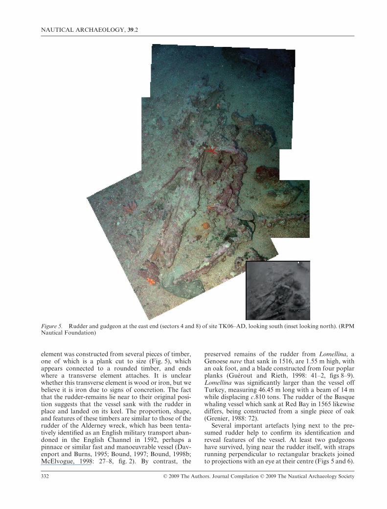
element was constructed from several pieces of timber,one of which is a plank cut to size (Fig. 5), whichappears connected to a rounded timber, and endswhere a transverse element attaches. It is unclearwhether this transverse element is wood or iron, but webelieve it is iron due to signs of concretion. The factthat the rudder-remains lie near to their original posi-tion suggests that the vessel sank with the rudder inplace and landed on its keel. The proportion, shape,and features of these timbers are similar to those of therudder of the Alderney wreck, which has been tenta-tively identified as an English military transport aban-doned in the English Channel in 1592, perhaps apinnace or similar fast and manoeuvrable vessel (Dav-enport and Burns, 1995; Bound, 1997; Bound, 1998b;McElvogue, 1998: 27–8, fig. 2). By contrast, the
preserved remains of the rudder from Lomellina, aGenoese nave that sank in 1516, are 1.55 m high, withan oak foot, and a blade constructed from four poplarplanks (Guérout and Rieth, 1998: 41–2, figs 8–9).Lomellina was significantly larger than the vessel offTurkey, measuring 46.45 m long with a beam of 14 mwhile displacing c.810 tons. The rudder of the Basquewhaling vessel which sank at Red Bay in 1565 likewisediffers, being constructed from a single piece of oak(Grenier, 1988: 72).
Several important artefacts lying next to the pre-sumed rudder help to confirm its identification andreveal features of the vessel. At least two gudgeonshave survived, lying near the rudder itself, with strapsrunning perpendicular to rectangular brackets joinedto projections with an eye at their centre (Figs 5 and 6).
Figure 5. Rudder and gudgeon at the east end (sectors 4 and 8) of site TK06–AD, looking south (inset looking north). (RPMNautical Foundation)
NAUTICAL ARCHAEOLOGY, 39.2
332 © 2009 The Authors. Journal Compilation © 2009 The Nautical Archaeology Society
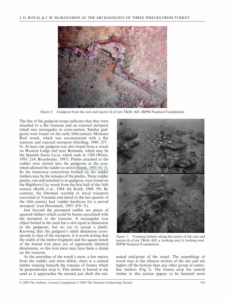
The line of the gudgeon straps indicates that they wereattached to a flat transom and an external sternpostwhich was rectangular in cross-section. Similar gud-geons were found on the early-16th-century MolassesReef wreck, which was reconstructed with a flattransom and exposed sternpost (Oertling, 1989: 237–9). At least one gudgeon was also found from a wreckon Western Ledge reef near Bermuda, which may bethe Spanish Santa Lucia, which sank in 1584 (Watts,1993: 214; Broadwater, 1997). Pintles attached to therudder were slotted into the gudgeons at the eyes,which allowed the rudder to swivel (Smith, 1993: 91–3).So the transverse concretions formed on the ruddertimbers may be the remains of the pintles. Three rudderpintles, one still attached to its gudgeon, were found onthe Highborn Cay wreck from the first half of the 16thcentury (Keith et al., 1984: 64; Keith, 1988: 59). Bycontrast, the Ottoman warship or naval transportexcavated at Yassıada and dated to the last quarter ofthe 16th century had ‘rudder hardware for a curvedsternpost’ (van Doorninck, 1997: 470–71).
Just beyond the presumed rudder are pieces ofsquared timbers which could be beams associated withthe sternpost or the transom. A rectangular ironobject buried in the sand has a slot equal in dimensionto the gudgeons, but no eye to accept a pintle.Knowing that the gudgeon’s sided dimension corre-sponds to that of the sternpost, it is worth noting thatthe width of the timber fragment and the square notchof the buried iron piece are of apparently identicaldimensions, so this iron piece may have been a clampon the transom.
At the centreline of the wreck’s stern, a few metresfrom the rudder and stern debris, there is a centraltimber running beneath the remains of frames whichlie perpendicular atop it. This timber is buried in thesand as it approaches the mound just abaft the esti-
mated mid-point of the vessel. The assemblage ofwood rises at the aftmost section of the site and sitshigher off the bottom than any other group of centre-line timbers (Fig. 7). The frames atop the centraltimber in this section appear to be fastened more
Figure 6. Gudgeon from the east end (sector 4) of site TK06–AD. (RPM Nautical Foundation)
Figure 7. Framing timbers along the centre of the east end(sector 4) of site TK06–AD: a, looking east; b, looking west.(RPM Nautical Foundation)
J. G. ROYAL & J. M. McMANAMON, SJ: THE ARCHAEOLOGY OF THREE WRECKS FROM TURKEY
© 2009 The Authors. Journal Compilation © 2009 The Nautical Archaeology Society 333
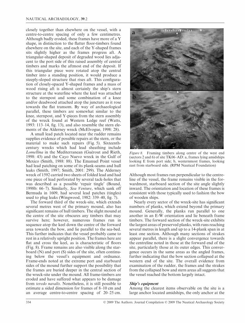
closely together than elsewhere on the vessel, with acentre-to-centre spacing of only a few centimetres.Although badly eroded, these frames have more of a Yshape, in distinction to the flatter floor-timbers foundelsewhere on the site, and each of the Y-shaped framessits slightly higher as the frames progress aft. Atriangular-shaped deposit of degraded wood lies adja-cent to the port side of this raised assembly of centraltimbers and marks the aftmost end of the deposit. Ifthis triangular piece were rotated atop the centraltimber into a standing position, it would produce asteeply-sloped structure that rises aft. This configura-tion of closely-spaced Y-shaped frames and a mass ofwood rising aft is almost certainly the ship’s sternstructure at the waterline where the keel was attachedto the sternpost and some combination of a kneeand/or deadwood attached atop the juncture as it rosetowards the flat transom. By way of archaeologicalparallel, these timbers are somewhat similar to theknee, sternpost, and Y-pieces from the stern assemblyof the wreck found at Western Ledge reef (Watts,1993: 113–14, fig. 13), and also resemble the stern ele-ments of the Alderney wreck (McElvogue, 1998: 28).
A small lead patch located near the rudder remainssupplies evidence of possible repairs at the stern, or thematerial to make such repairs (Fig. 5). Sixteenth-century wrecks which had lead sheathing includeLomellina in the Mediterranean (Guérout and Rieth,1998: 43) and the Cayo Nuevo wreck in the Gulf ofMexico (Smith, 1988: 88). The Emanuel Point vesselhad lead patching on some of its plank-seams and hullleaks (Smith, 1997; Smith, 2001: 299). The Alderneywreck of 1592 carried two sheets of folded lead and hadone piece of lead perforated by several tack-holes thatwas described as a possible ‘repair tingle’ (Bound,1998b: 66–7). Similarly, Sea Venture, which sank offBermuda in 1609, had several lead patches (tingles)used to plug leaks (Wingwood, 1982: 339–40, fig. 7).
The forward third of the wreck-site, which extendsseveral metres west of the primary mound, also hassignificant remains of hull timbers. The slight mound atthe centre of the site obscures any timbers that maysurvive here; however, numerous frames run insequence atop the keel down the centre of the forwardarea towards the bow, and lie parallel to the sea-bed.This further indicates that the vessel probably came torest in a relatively upright position. The frames here areflat and cross the keel, as is characteristic of floors(Fig. 8). Frame remains are also visible along the star-board (N) and port (S) sides of the site, often continu-ing below the vessel’s equipment and ordnance.Frame-ends noted at the extreme port and starboardsides of the mound further support the possibility thatthe frames are buried deeper in the central section ofthe wreck-site under the mound. All frame-timbers areeroded and have suffered what appears to be damagefrom teredo navalis. Nonetheless, it is still possible toestimate a sided dimension for frames of 8–10 cm andan average centre-to-centre spacing of 20–25 cm.
Although most frames run perpendicular to the centre-line of the vessel, the frame remains visible in the for-wardmost, starboard section of the site angle slightlyinward. The orientation and location of these frames isconsistent with those typically used to fashion the bowof wooden ships.
Nearly every sector of the wreck-site has significantnumbers of planks, which extend beyond the primarymound. Generally, the planks run parallel to oneanother in an E-W orientation and lie beneath frametimbers. The forward section of the wreck-site exhibitsthe largest areas of preserved planks, with runs reachingseveral metres in length and up to a 14-plank span in atleast one section. Although many sections of strakesappear parallel, there is a slight convergence towardsthe centreline noted in those at the forward end of thesite, particularly those at its outer edges. This conver-gence occurs in the same areas as the angled frames,further indicating that the bow section collapsed at thewestern end of the site. The overall evidence fromexamination of the rudder, the frames and the strakesfrom the collapsed bow and stern areas all suggests thatthe vessel reached the bottom largely intact.
Ship’s equipmentAmong the clearest items observable on the site is alarge anchor located amidships, the only anchor at the
Figure 8. Framing timbers along centre of the west end(sectors 2 and 6) of site TK06–AD: a, frames lying amidshipslooking E from port side; b, westernmost frames, lookingeast from starboard side. (RPM Nautical Foundation)
NAUTICAL ARCHAEOLOGY, 39.2
334 © 2009 The Authors. Journal Compilation © 2009 The Nautical Archaeology Society
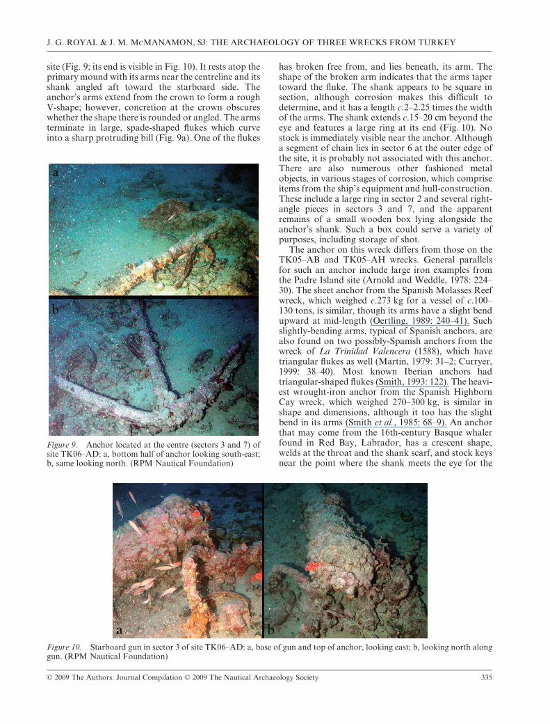
site (Fig. 9; its end is visible in Fig. 10). It rests atop theprimary mound with its arms near the centreline and itsshank angled aft toward the starboard side. Theanchor’s arms extend from the crown to form a roughV-shape; however, concretion at the crown obscureswhether the shape there is rounded or angled. The armsterminate in large, spade-shaped flukes which curveinto a sharp protruding bill (Fig. 9a). One of the flukes
has broken free from, and lies beneath, its arm. Theshape of the broken arm indicates that the arms tapertoward the fluke. The shank appears to be square insection, although corrosion makes this difficult todetermine, and it has a length c.2–2.25 times the widthof the arms. The shank extends c.15–20 cm beyond theeye and features a large ring at its end (Fig. 10). Nostock is immediately visible near the anchor. Althougha segment of chain lies in sector 6 at the outer edge ofthe site, it is probably not associated with this anchor.There are also numerous other fashioned metalobjects, in various stages of corrosion, which compriseitems from the ship’s equipment and hull-construction.These include a large ring in sector 2 and several right-angle pieces in sectors 3 and 7, and the apparentremains of a small wooden box lying alongside theanchor’s shank. Such a box could serve a variety ofpurposes, including storage of shot.
The anchor on this wreck differs from those on theTK05–AB and TK05–AH wrecks. General parallelsfor such an anchor include large iron examples fromthe Padre Island site (Arnold and Weddle, 1978: 224–30). The sheet anchor from the Spanish Molasses Reefwreck, which weighed c.273 kg for a vessel of c.100–130 tons, is similar, though its arms have a slight bendupward at mid-length (Oertling, 1989: 240–41). Suchslightly-bending arms, typical of Spanish anchors, arealso found on two possibly-Spanish anchors from thewreck of La Trinidad Valencera (1588), which havetriangular flukes as well (Martin, 1979: 31–2; Curryer,1999: 38–40). Most known Iberian anchors hadtriangular-shaped flukes (Smith, 1993: 122). The heavi-est wrought-iron anchor from the Spanish HighbornCay wreck, which weighed 270–300 kg, is similar inshape and dimensions, although it too has the slightbend in its arms (Smith et al., 1985: 68–9). An anchorthat may come from the 16th-century Basque whalerfound in Red Bay, Labrador, has a crescent shape,welds at the throat and the shank scarf, and stock keysnear the point where the shank meets the eye for the
Figure 9. Anchor located at the centre (sectors 3 and 7) ofsite TK06–AD: a, bottom half of anchor looking south-east;b, same looking north. (RPM Nautical Foundation)
Figure 10. Starboard gun in sector 3 of site TK06–AD: a, base of gun and top of anchor, looking east; b, looking north alonggun. (RPM Nautical Foundation)
J. G. ROYAL & J. M. McMANAMON, SJ: THE ARCHAEOLOGY OF THREE WRECKS FROM TURKEY
© 2009 The Authors. Journal Compilation © 2009 The Nautical Archaeology Society 335
ring. The smith flattened one side of the arm to receivethe fluke (Light, 1990: 310–11).
V-shaped hook anchors appear in some Venetianillustrations as early as the 13th and 14th centuries. Ananchor in a sketch by Jacopo Bellini (c.1400–1470) hasa large ring, rounded shaft and large flukes, but thearms are more rounded than the V-shaped arms onthis site. Likewise, the arms of the anchor in VittoreCarpaccio’s Life of Ursula dated to 1490–96 are muchflatter in their angle. Other iconographic examplesinclude the somewhat crescent-shaped anchor on akaraka sailing in the Rhodes channel and the anchorsof another karaka shown sailing off Sardinia in PiriReis, the anchors on the sailing vessels of unknownorigin in the engravings made after drawings by PieterBruegel the elder, and the göke and galleass in thebook of Kâtip Çelebi (Ökte, 1988: vol. 2, 532, vol. 3,1144; Orenstein, 2001: 204–07, fig. 93 no. 85, 213–16,nos. 89, 92–4; Güleryüz, 2004: 42, 58, pls I-C, VII-C).Depictions of Ottoman anchors, though infrequent,generally show anchors with triangular flukes. Thestraight arms, long shank, and palm-shaped flukes ofthe anchor on the TK06–AD site better match anEnglish long anchor. Around 1540, English anchorswere changing from curved to straight arms, with thearms initially at an angle of approximately 40° to theshaft. The demands for anchors of greater dimensionsfor use on the larger ships being constructed led to achange in manufacturing design. By 1600 the angle ofthe arms had widened to c.60° (Curryer, 1999: 41). Theanchor on this site, however, has arms angled closer to45°.
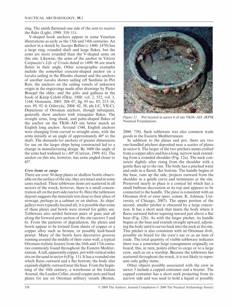
Crew items or cargoThere are over 30 deep plates or shallow bowls observ-able on the surface of the site; they are intact and in somecases stacked. These tableware items are scattered in allsectors of the wreck; however, there is a small concen-tration aft on the port side (sector 8). Here the tablewaredeposit suggests the materials rest close to their place ofstowage, perhaps in a cabinet or on shelves. As ships’galleys were typically located aft, it is possible that someof these plates and bowls were stowed for galley use.Tableware also settled between pairs of guns and allalong the forward port section of the site (sectors 5 and6). From the patterns of degradation, the plates andbowls appear to be formed from sheets of copper or acopper alloy such as bronze, or possibly lead-basedpewter. Many of the bowls have decorative groovesrunning around the middle of their outer wall, a typicalOttoman stylistic feature from the 16th and 17th centu-ries commonly found throughout the Eastern Mediter-ranean. A tall, apparently copper, pot with vertical sidessits on the sand in sector 6 (Fig. 11). It has a rounded rimwhich flares outward and a flat bottom; the body alsoexpands slightly outward near the base. From the begin-ning of the 16th century, a warehouse at the GalataArsenal, the Leaden Cellar, stored copper pots and leadplates for use on Ottoman military vessels (Bostan,
2000: 738). Such tableware was also common tradegoods in the Eastern Mediterranean.
In addition to the plates and pot, there are twoone-handled pitchers deposited near a scatter of platesin sector 6. The larger of the two pitchers seems craftedfrom a copper alloy and has a long, narrow neck extend-ing from a rounded shoulder (Fig. 12a). The neck con-stricts slightly after rising from the shoulder with agentle flare up to the rim. The body has a pinched waistand ends in a flared, flat bottom. The handle begins atthe base, runs up the side, projects outward from theshoulder in a gentle curve and terminates at the rim.Preserved nearly in place is a conical lid which has asmall bulbous decoration at its top and appears to beconnected to the handle. The piece is consistent with anOttoman ibrik or ewer (pers. comm. K. Johnsen, Uni-versity of Chicago, 2007). The upper portion of thesecond, smaller pitcher is obscured by a large concre-tion. It has a short neck that meets the body where itflares outward before tapering inward just above a flatbase (Fig. 12b). As with the larger pitcher, its handlebegins at the base and extends straight upward, adjoin-ing the body until it curves back into the neck at the rim.This pitcher is also consistent with an Ottoman ibrik,possibly on board for the crew’s use or as an item oftrade. The total quantity of visible tableware indicatesthere was a somewhat large consignment originally onboard; this, in turn, points either to cargo or to a largecrew, such as on a warship. Because the tableware liesscattered throughout the wreck, it is not likely to repre-sent only galley items.
Other objects possibly associated with the crew insector 3 include a capped container and a brazier. Thecapped container has a short neck projecting from itsnarrow side and was used to hold a liquid or possibly
Figure 11. Pot located in sector 6 of site TK06–AD. (RPMNautical Foundation)
NAUTICAL ARCHAEOLOGY, 39.2
336 © 2009 The Authors. Journal Compilation © 2009 The Nautical Archaeology Society

to hold powder for firearms. Three distinct pieces of acopper or bronze brazier lie within a 2-m area (pers.comm. C. Pulak, 2007); these include a base (Fig. 13a),pan (Fig. 13b), and lid (Fig. 13c). The configuration ofthe three pieces is conspicuous, for the base sits belowthe bottom of the pan, and the lid sits just above thepan. The base is a metal cylinder whose rim projectsfrom the sand and reveals a pair of holes on oppositesides. Nearby, the apparently-intact pan flares outfrom a narrow, ribbed cylinder that fits on the base toform a bowl. One of its two omega-shaped ring handlesis clearly visible where it attaches to the outer edge ofthe pan’s rim. This configuration of the rotating handleand the bowl shape reduced the risk of accidentalburning or spillage when lifting. The brazier’s lid has atubular shape and tapers outward toward the top.Although damaged at both ends, it appears to have aspout or handle projecting upwards from its widestportion. For centuries, charcoal braziers comprised abasic cooking technology on round ships. While cru-sading in 1254, King Louis IX of France assigned hisaide, Joinville, to make nightly rounds in order toassure that passengers and crew had extinguished allbrazier fires except for one in the hold, from which the
others would be re-lit (Pryor, 1994: 76). Braziers werefound on Vasa from the early-17th century (Ceder-lund, 2006: 376, 378, fig. 13–32) and as late as theearly-19th century on a Black Sea merchantman exca-vated at Kitten in Bulgaria (pers. comm. KroumBatchvarov, 2007). Having found only a single pot andbrazier on a site with minimal sand cover and a largenumber of objects visible, we infer that the vessel had arelatively small crew. That means that it was probablynot a warship, and therefore some of the tablewarecomprised cargo for trade.
Sectors 1 and 2 each have a single damaged ceramiccontainer, used either to transport goods or to storeprovisions. The containers have short necks androunded bodies with no apparent handles, typical ofsuch period wares in the Mediterranean, so they arealmost certainly associated with the wreck. A largebody-sherd of a ceramic container, located in sector 8,has a small handle and appears to have been a tallcontainer. To date, no parallels have been found for thisfragment. There are several clearly-intrusive ceramicitems. For example, a partial Rhodian or Koanamphora and an Agora G199 amphora that dates to the1st-early-4th century AD lie at the outermost edge of
Figure 12. Two pitchers in sector 6 of site TK06–AD: a, larger ibrik located inboard of gun; b, small ibrik located outboardof gun. (RPM Nautical Foundation)
Figure 13. Three pieces of a brazier in sector 3 of site TK06–AD; a, base; b, pan; c, lid. (RPM Nautical Foundation)
J. G. ROYAL & J. M. McMANAMON, SJ: THE ARCHAEOLOGY OF THREE WRECKS FROM TURKEY
© 2009 The Authors. Journal Compilation © 2009 The Nautical Archaeology Society 337
the site in sector 3. Such items were probably draggedover the wreck-site and eventually dumped when thenets snagged on protrusions.
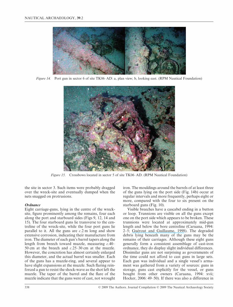
OrdnanceEight carriage-guns, lying in the centre of the wreck-site, figure prominently among the remains, four eachalong the port and starboard sides (Figs 9, 12, 14 and15). The four starboard guns lie transverse to the cen-treline of the wreck-site, while the four port guns lieparallel to it. All the guns are c.2 m long and showextensive corrosion, indicating their manufacture fromiron. The diameter of each gun’s barrel tapers along thelength from breech toward muzzle, measuring c.40–50 cm at the breech and c.25–30 cm at the muzzle.However, the concretion has almost certainly enlargedthis diameter, and the actual barrel was smaller. Eachof the guns has a muzzle-ring, and several appear tohave slight expansions at the muzzle. Such flaring rein-forced a gun to resist the shock-wave as the shot left themuzzle. The taper of the barrel and the flare of themuzzle indicate that the guns were of cast, not wrought
iron. The mouldings around the barrels of at least threeof the guns lying on the port side (Fig. 14b) occur atregular intervals and more frequently, perhaps eight ormore, compared with the four to six present on thestarboard guns (Fig. 10).
Visible breeches have a cascabel ending in a buttonor loop. Trunnions are visible on all the guns exceptone on the port side which appears to be broken. Thesetrunnions were located at approximately mid-gunlength and below the bore centreline (Caruana, 1994:2–5; Guérout and Guillaume, 1998). The degradeddebris lying beneath many of the guns may be theremains of their carriages. Although these eight gunsgenerally form a consistent assemblage of cast-ironordnance, they do display slight individual differences.Dissimilar guns are not surprising as governments ofthe time could not afford to cast guns in large sets.Each gun was individual and a single vessel’s arma-ment was gathered from a variety of sources: guns instorage, guns cast explicitly for the vessel, or gunsbought from other owners (Caruana, 1994: xvii;Hocker, 2006: 49–50). If there was also a difference in
Figure 14. Port gun in sector 6 of site TK06–AD: a, plan view; b, looking east. (RPM Nautical Foundation)
Figure 15. Crossbows located in sector 5 of site TK06–AD. (RPM Nautical Foundation)
NAUTICAL ARCHAEOLOGY, 39.2
338 © 2009 The Authors. Journal Compilation © 2009 The Nautical Archaeology Society
the bores of the port and starboard guns on this vessel,similar guns were probably deployed on each side inorder to facilitate the distribution of shot.
Although it is unclear exactly how many gunsthe vessel carried, the eight visible guns may well be theentire complement. No other guns were located in theimmediate area surrounding the wreck-site, nor wereany likely anomalies detected in a 40-m radius onsweeps that also used the ROV’s forward-scanningsonar. Even though a hull the size of the site-remainscould accommodate additional guns, there is no evi-dence that the vessel was so armed, and the number ofguns present appears adequate for the vessel’s size.What is perhaps unusual is that, although smaller gunscommonly complemented larger pieces on armedvessels, no smaller guns like the swivel-guns on theother two wrecks were located.
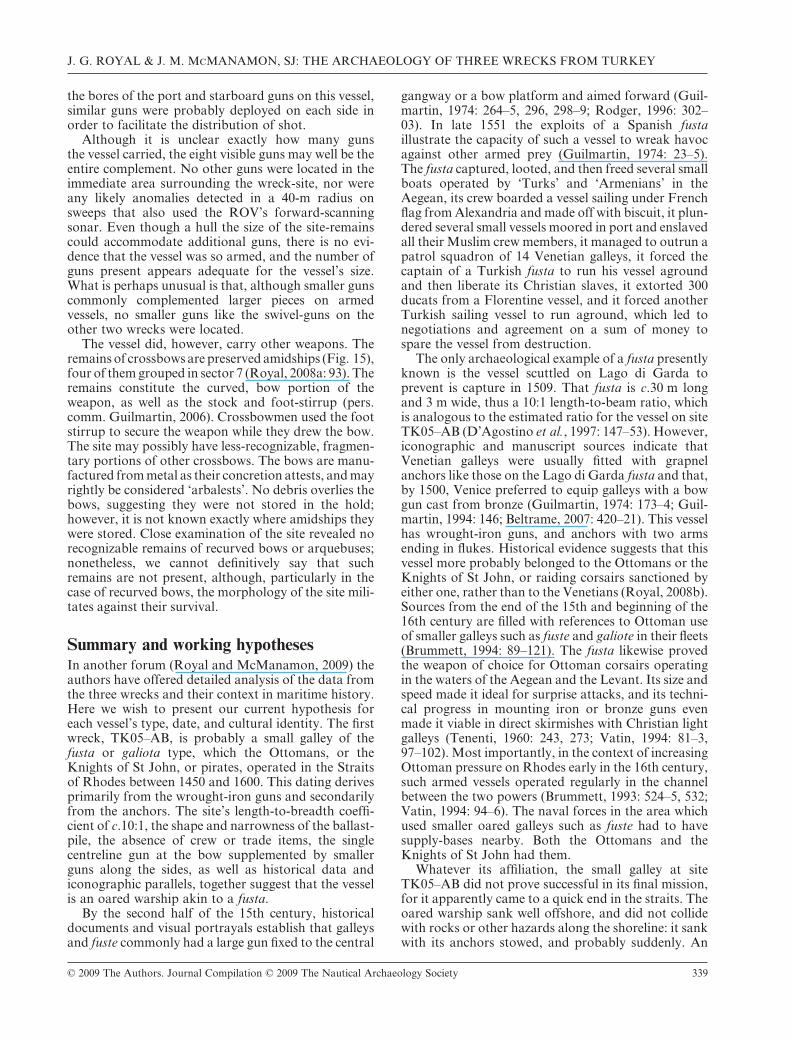
The vessel did, however, carry other weapons. Theremains of crossbows are preserved amidships (Fig. 15),four of them grouped in sector 7 (Royal, 2008a: 93). Theremains constitute the curved, bow portion of theweapon, as well as the stock and foot-stirrup (pers.comm. Guilmartin, 2006). Crossbowmen used the footstirrup to secure the weapon while they drew the bow.The site may possibly have less-recognizable, fragmen-tary portions of other crossbows. The bows are manu-factured from metal as their concretion attests, and mayrightly be considered ‘arbalests’. No debris overlies thebows, suggesting they were not stored in the hold;however, it is not known exactly where amidships theywere stored. Close examination of the site revealed norecognizable remains of recurved bows or arquebuses;nonetheless, we cannot definitively say that suchremains are not present, although, particularly in thecase of recurved bows, the morphology of the site mili-tates against their survival.
Summary and working hypothesesIn another forum (Royal and McManamon, 2009) theauthors have offered detailed analysis of the data fromthe three wrecks and their context in maritime history.Here we wish to present our current hypothesis foreach vessel’s type, date, and cultural identity. The firstwreck, TK05–AB, is probably a small galley of thefusta or galiota type, which the Ottomans, or theKnights of St John, or pirates, operated in the Straitsof Rhodes between 1450 and 1600. This dating derivesprimarily from the wrought-iron guns and secondarilyfrom the anchors. The site’s length-to-breadth coeffi-cient of c.10:1, the shape and narrowness of the ballast-pile, the absence of crew or trade items, the singlecentreline gun at the bow supplemented by smallerguns along the sides, as well as historical data andiconographic parallels, together suggest that the vesselis an oared warship akin to a fusta.
By the second half of the 15th century, historicaldocuments and visual portrayals establish that galleysand fuste commonly had a large gun fixed to the central
gangway or a bow platform and aimed forward (Guil-martin, 1974: 264–5, 296, 298–9; Rodger, 1996: 302–03). In late 1551 the exploits of a Spanish fustaillustrate the capacity of such a vessel to wreak havocagainst other armed prey (Guilmartin, 1974: 23–5).The fusta captured, looted, and then freed several smallboats operated by ‘Turks’ and ‘Armenians’ in theAegean, its crew boarded a vessel sailing under Frenchflag from Alexandria and made off with biscuit, it plun-dered several small vessels moored in port and enslavedall their Muslim crew members, it managed to outrun apatrol squadron of 14 Venetian galleys, it forced thecaptain of a Turkish fusta to run his vessel agroundand then liberate its Christian slaves, it extorted 300ducats from a Florentine vessel, and it forced anotherTurkish sailing vessel to run aground, which led tonegotiations and agreement on a sum of money tospare the vessel from destruction.
The only archaeological example of a fusta presentlyknown is the vessel scuttled on Lago di Garda toprevent is capture in 1509. That fusta is c.30 m longand 3 m wide, thus a 10:1 length-to-beam ratio, whichis analogous to the estimated ratio for the vessel on siteTK05–AB (D’Agostino et al., 1997: 147–53). However,iconographic and manuscript sources indicate thatVenetian galleys were usually fitted with grapnelanchors like those on the Lago di Garda fusta and that,by 1500, Venice preferred to equip galleys with a bowgun cast from bronze (Guilmartin, 1974: 173–4; Guil-martin, 1994: 146; Beltrame, 2007: 420–21). This vesselhas wrought-iron guns, and anchors with two armsending in flukes. Historical evidence suggests that thisvessel more probably belonged to the Ottomans or theKnights of St John, or raiding corsairs sanctioned byeither one, rather than to the Venetians (Royal, 2008b).Sources from the end of the 15th and beginning of the16th century are filled with references to Ottoman useof smaller galleys such as fuste and galiote in their fleets(Brummett, 1994: 89–121). The fusta likewise provedthe weapon of choice for Ottoman corsairs operatingin the waters of the Aegean and the Levant. Its size andspeed made it ideal for surprise attacks, and its techni-cal progress in mounting iron or bronze guns evenmade it viable in direct skirmishes with Christian lightgalleys (Tenenti, 1960: 243, 273; Vatin, 1994: 81–3,97–102). Most importantly, in the context of increasingOttoman pressure on Rhodes early in the 16th century,such armed vessels operated regularly in the channelbetween the two powers (Brummett, 1993: 524–5, 532;Vatin, 1994: 94–6). The naval forces in the area whichused smaller oared galleys such as fuste had to havesupply-bases nearby. Both the Ottomans and theKnights of St John had them.
Whatever its affiliation, the small galley at siteTK05–AB did not prove successful in its final mission,for it apparently came to a quick end in the straits. Theoared warship sank well offshore, and did not collidewith rocks or other hazards along the shoreline: it sankwith its anchors stowed, and probably suddenly. An
J. G. ROYAL & J. M. McMANAMON, SJ: THE ARCHAEOLOGY OF THREE WRECKS FROM TURKEY
© 2009 The Authors. Journal Compilation © 2009 The Nautical Archaeology Society 339
unpredictable storm or unexpected wave energy are themore likely possibilities. High seas would prove espe-cially dangerous to an oared vessel with low freeboard.It is also possible that a larger enemy vessel or fleet fellupon this small galley and sank it in a skirmish. None-theless, tactics of the time dictated the capture, not thesinking of a warship. Whatever the cause of sinking, awarship is rare in the archaeological record. Wreckedwar-galleys were not pressed down as far into thebottom sediment and, even when armed with wrought-iron guns and weighted with ballast, they lie exposed todamage from current and tidal action, marine organ-isms, or human disturbance. Hence, this small vesseloffers a modest contribution to our understanding ofMediterranean naval warfare toward the end of ‘theage of the galley’ (Bound, 1995; Gardiner and Morri-son, 1995; Bound, 1998a; Glete 2000: 93–111; Mott,2003; Rodger, 2003).
The second wreck, TK05–AH, was probably a smallcoasting merchantman of unknown nationality operat-ing in the same period from c.1450–1600. The datingagain derives primarily from the wrought-iron guns,and to a lesser extent the anchors and visible pottery.The extent of the site indicates a low length-to-beamcoefficient typically associated with merchant vessels,an inference supported by the quantity of ceramic finds.Calculating a minimum of 3–5 anchors on the site andconsidering the overall size of the ballast-pile, this wasprobably a small vessel about 15–20 m long. Spain andVenice led the way in arming their merchantmen, andthe Genoese and Ottomans soon followed. By 1500,supply transports armed with guns were common allover the Mediterranean, and small swivel-guns becamepractically standard equipment on Mediterranean mer-chantmen (DeVries, 1998: 390–91). The fact that theguns are of wrought-iron does not exclude a date in thesecond half of the 16th century. Compared to cast-bronze guns, wrought-iron ones offered a savings in thecosts of manufacture or purchase. That added to theirshelf-life. This merchantman carried only anti-personnel swivel-guns to deter pirates from boardingand dissuade galleys from pursuit.
For period and size, the best archaeological parallelfor this vessel is the 16th-century Contarina II vessel,c.20.5 m long and 6.3 m wide. This vessel had a hullbuilt of oak, frames joined with iron bolts, andthrough-beams fastened to stringer and wale by dove-tail scarfs (Occioni-Bonaffons and Gregoretti, 1901:35–8; Bonino, 1978: 18–21). The view of Venice attrib-uted to Jacopo de’ Barbari from c.1500 has visual par-allels to Contarina II in the double-ended round shipswith lateen sails moored in the lagoon (Nance, 1955:290; Howard, 1997). Taking into consideration thecontinuities of shipbuilding philosophy in the Mediter-ranean, the Culip VI wreck at c.16 m long and 4 mwide, and the Contarina I wreck at c.21 m long and5.2 m wide, both from c.1300, may also provide helpfulparallels (Bonino, 1978: 13–15; Pujol, 1989; Palouet al., 1992; Pryor, 1994: 62–3; Steffy, 1994: 91–3;
Rieth, 1996: 149–64; Palou et al., 1998; Martin, 2001:149–54, 208–09; Castro et al., 2008: 353–5). All thearchaeological parallels are examples of popular coast-ing vessels which had a long history in the Mediterra-nean (Balard, 1994: 135–8).
Like wreck TK05–AB, this vessel did not sink afterhitting the shoreline. It did sink suddenly, given thepresence of several anchors on the site. Perhaps thecrew was unable to manoeuvre away from an enemywarship or to ride out inclement weather and reachsafety. This armed merchantman illustrates that allsuch vessels had to protect themselves when tradinggoods or transporting supplies in an area of the Medi-terranean infested with armed galleys. At least in stra-tegic terms, the two wrecks are related. The smalleroared warship a few hundred metres distant representsthe broader conflictual reality that led Mediterraneanmerchants to arm their small coasting vessels withwrought-iron swivel-guns. A sudden disturbance of theweather remains the most likely cause of the merchant-man’s demise. If, a less likely possibility, another vesseldid sink this one, this is further proof that its comple-ment of ordnance was inadequate for fully-fledgedbattle.
The third wreck, TK06–AD, was probably an armedmerchantman with a flat transom stern and displacingin the range of 200–300 tons (Black, 2002: 167). Wesuspect that the vessel came from England and oper-ated some time between c.1560 and c.1590, based pri-marily on a complement of weapons which includescast-iron guns and metal crossbows. Until the early-17th century, England dominated the manufacture ofcast-iron guns (Cipolla, 1965: 36–64; Guilmartin, 1974:175; Cipolla, 1980: 286–7; Guilmartin, 1994: 149–50;Glete, 2000: 23; Black, 2002: 175), while late in the 16thcentury the English publicly debated the wisdom ofusing bows in warfare (Esper, 1965; McNeill, 1982:91–5; Borman, 1997; Phillips, 1999). The length-to-breadth coefficient of c.4:1 implies a slightly-elongatedcargo vessel. The single brazier, and the limitednumber of guns and personal weapons, all pointtoward a small crew capable of handling a merchantvessel of these dimensions. The fact that pottery,sherds, and tableware of types common to theOttoman Empire, lie scattered throughout the site sug-gests that the vessel carried some of those items astrade goods. The working hypothesis of an Englishmerchant vessel of the Elizabethan era helps explainthe lack of a large mound of ballast-stones typical ofthe wreck assemblage of most other 16th-century mer-chantmen, particularly armed Iberian vessels inEurope and the Americas (Martin, 1975: 57–97; Keithet al., 1984: 46, 48–51, figs. 3, 4, 6; Smith et al., 1985:69–71; Oertling, 1989: 241; Smith, 2001: 295–6).English vessels of the era, by contrast, often employedshingle ballast dug from local beaches (Adams, 1985:279–84; Nelson, 2001: 51–2, 101, 115).
Archaeological parallels for the ordnance, theanchor, the ballast and the construction of the hull are
NAUTICAL ARCHAEOLOGY, 39.2
340 © 2009 The Authors. Journal Compilation © 2009 The Nautical Archaeology Society
predominantly English. However, the Cavoli wreck, aCatalan vessel dated c.1425–50, supplies early archaeo-logical evidence for the transition from bows to firearmson armed merchantmen. It carried 8 wrought-ironcarriage-guns, several smaller swivel-guns, shot, cross-bows, swords, and musket balls (Martin-Bueno, 1992;1998). The best parallels, however, for the cast-ironcarriage-guns are English. At Western Ledge reef offBermuda, archaeologists catalogued seven pieces ofiron ordnance, including two wrought-iron swivel-gunsand two cast-iron carriage-guns. One of the latter wasmanufactured in England and inscribed with a date of1577. This gun is 2.04 m long, and it has its trunnions0.93 m along the barrel from the cascabel, a bore thatmeasures 0.05 m in diameter at the muzzle, and a firstand second reinforce, suggesting that it was cast forcorned powder (Watts, 1993: 115–18). Another cast-iron gun found off Bermuda near Sea Venture, wreckedin 1609, was identified as a minion. The gun was foundabout 7.62 m from the vessel’s keel, perhaps after jetti-son, is c.2.5 m long and has features similar to those ofthe 1577 gun from Western Ledge reef. An inscriptionon the gun found near Sea Venture indicates that themaker was Richard Phillips and that the gun was there-fore of English manufacture (Wingwood, 1982: 335,fig. 2, 339). The Alderney wreck of 1592 had only cast-iron guns, 8–10 in total, manufactured in England andcapable of handling the same shot. A recovered examplemeasures 2.13 m long and weighs over 710 kg (Daven-port and Burns, 1995: 30–40; Bound, 1998b; AlderneyElizabethan Wreck, 2008). That vessel had no cross-bows or longbows but did carry 45 muskets of bothmatchlock and wheel-lock type, incendiary grenades,and edged weapons. At least one of the heavymatchlock muskets was for use on board, given that ithas a pintle on the underside of its stock (Guilmartin,1974: 146–9; Davenport and Burns, 1995: 34–5; Bound,1997: 25; Bound, 1998b: 68–77, fig. 14).
The straight arms, long shank, palm-shaped flukesand arms set at an angle of c.45° to the shank all suggestthat the anchor on the site is of the English long-anchortype. The absence of ballast-stones and the probable useof shingle ballast have parallels in the English SeaVenture, which sank in 1609, and had shingle as itsprimary ballast material. Shingle ballast readily washesaway in dynamic underwater conditions. The probableEnglish wreck off Alderney was notable for lacking alarge pile of ballast, though a reconstruction of thevessel indicates that it would have needed heavy ballast(Bound, 1998b: 81; Roberts, 1998: 35–6). The structuralfeatures of the hull, finally, have good English parallels.
The limited number of guns and their placement suggesta vessel with a single deck and a raised, narrow stern.The Y-shaped frames atop substantial deadwood at thestern are characteristic of a high transom structure. Thistransom was flat with an external sternpost as indicatedby the gudgeons that held a straight rudder. The gunswere placed along the sides of the hull amidships, ratherthan at the extremities. The wrecks at Western Ledgereef and Alderney from the last quarter of the 16thcentury have somewhat similar arrangements. TheAlderney vessel was probably a Channel merchantmanacting as a transport in support of English navaloperations—its 8 or more cast-iron guns were mountedfor a broadside (Watts, 1993: 113–14, fig. 13; Bound,1997; Alderney Elizabethan Wreck).
The conditions on the site supply clues as to why thisvessel came to rest at the bottom of the Straits ofRhodes. The presence of a single large anchor amid-ships, the absence of any other anchors on the site, andthe probable clearing inboard of the port-side gunssuggest that the crew deployed their service anchorsand tried to close the gunports before the vessel sank.The only anchor found on this site may even have beena spare, and the crew ran out of time to deploy it.Alternatively, as the detached fluke suggests, theanchor may have been broken, and, in that case, thecrew had stowed it in the hold. The positions ofthe guns also provide clues to the sinking process. Aprudent master operating in the waters of the EasternMediterranean, frequented as it was by enemy vessels,corsairs, and pirates, would probably have the vessel’sguns prepared for action. Tudor and Elizabethanvessels may well have secured their guns outboard andmanoeuvred the vessel to aim them effectively(Konstam, 1988: 19–20; Rodger, 1996: 311–14). Theabsence of most anchors undercuts a theory of surpriseattack and rapid sinking. More likely, the crew notedthat a storm was about to break and started to clear theguns lashed outboard and secure their gunports. Theyonly partially completed their task, on the port side,before the vessel sank. Factoring in the maritimetopography, the most likely scenario would see thecrew struggling with foul weather but failing to preventthe vessel from rolling in the wind or, more probably,from striking the nearby point. Stormy weather orrunning aground, circumstances that at first allowedthe crew to deploy most anchors, ultimately caused thevessel to sink. On the way to the bottom, the vesselre-stabilized itself, landed rather softly on its keel, andthen heeled to port where the freed guns rolled underthe rail.
AcknowledgmentsWe would like to express our thanks to Loyola University Chicago and the Centre for Medieval and Renaissance Studies atUCLA for helping to fund our research. To our good friend, Dr Fred Hocker, for his expert guidance on issues of substanceand terminology, we are most indebted. A special thanks also to Dr Cemal Pulak whose particular insight and wealth ofknowledge is always generously shared.
J. G. ROYAL & J. M. McMANAMON, SJ: THE ARCHAEOLOGY OF THREE WRECKS FROM TURKEY
© 2009 The Authors. Journal Compilation © 2009 The Nautical Archaeology Society 341

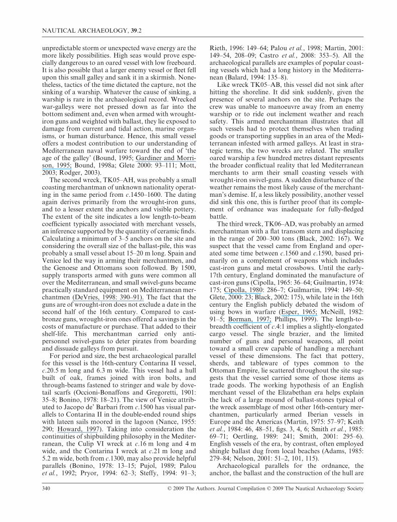
ReferencesAdams, J., 1985, Sea Venture: A Second Interim Report—Part 1, IJNA 14.4: 275–99.Ágoston, G., 2005a, Guns for the Sultan: Military Power and the Weapons Industry in the Ottoman Empire. Cambridge.Ágoston, G., 2005b, Behind the Turkish War Machine: Gunpowder Technology and War Industry in the Ottoman Empire,
1450–1700, in B. Steele and T. Darland (eds), The Heirs of Archimedes: Science and the Art of War through the Age ofEnlightenment, 101–33. Cambridge MA.
Alderney Elizabethan Wreck, Alderney Maritime Trust http://www.alderneywreck.com/, updated 2008, accessed March 2008.Arnold, J. B. III, and Weddle, R., 1978, The Nautical Archeology of Padre Island: The Spanish Shipwrecks of 1554. New York,
San Francisco and London.Balard, M., 1994, Coastal Shipping and Navigation in the Mediterranean, in R. Gardiner and R. W. Unger (eds), Cogs,
Caravels, and Galleons: The Sailing Ship 1000–1650, 131–8. London.Bass, G., 2006, Solving a Million-Piece Jigsaw Puzzle: Serçe Limanı, Turkey, in G. Bass (ed.), Beneath the Seven Seas:
Adventures with the Institute of Nautical Archaeology, 106–17. London.Bass, G., Matthews, S., Steffy, J. R., and van Doorninck, F. H., Jr, 2004, Serçe Limanı: An Eleventh-Century Shipwreck. College
Station TX.Beltrame, C., 2007, The Discovery of a Medieval Galley in Turkey?: A Review, IJNA 36.2, 420–22.Bicheno, H., 2005, Crescent and Cross: The Battle of Lepanto 1571. London.Black, J., 2002, European Warfare 1494–1660. London and New York.Bonino, M., 1978, Lateen-rigged Medieval Ships: New Evidence from Wrecks in the Po Delta (Italy) and Notes on Pictorial and
Other Documents, IJNA 7.1, 9–28.Borman, T., 1997, Untying the Knot? The Survival of the Anglo-Dutch Alliance, 1587–97, European History Quarterly 27,
307–37.Bostan, I., 2000, Ottoman Maritime Arsenals and Shipbuilding Technology in the 16th and 17th Centuries, in K. Çiçek (ed.),
The Great Ottoman-Turkish Civilisation. Vol. 3, Philosophy, Science, and Institutions, 735–44. Ankara.Bound, M. (ed.), 1995, The Archaeology of Ships of War. Oswestry UK.Bound, M., 1997, The Alderney Wreck, in J. Delgado (ed.), Encyclopedia of Underwater and Maritime Archaeology, 25. New
Haven.Bound, M. (ed.), 1998a, Excavating Ships of War. Oswestry UK.Bound, M., 1998b, A Wreck off Alderney from the Late Elizabethan Period, in M. Bound (ed.), Excavating Ships of War, 64–83.
Oswestry UK.Broadwater, J., 1997, Santa Lucia, in J. Delgado (ed.), Encyclopedia of Underwater and Maritime Archaeology, 359. New Haven.Brummett, P., 1993, The Overrated Adversary: Rhodes and Ottoman Naval Power, Historical Journal 36.3, 517–41.Brummett, P., 1994, Ottoman Seapower and Levantine Diplomacy in the Age of Discovery. Albany NY.Caruana, A., 1994, The History of English Sea Ordnance 1523–1875. Vol. 1, 1523–1715: The Age of Evolution. Rotherfield UK.Castro, F., Fonseca, N., Vacas, T., and Ciciliot, F., 2008, A Quantitative Look at Mediterranean Lateen- and Square-Rigged
Ships (Part 1), IJNA 37.2, 347–59.Cederlund, C., 2006, The Hold, in F. Hocker (ed.), Vasa I: The Archaeology of a Swedish Warship of 1628, 356–79. Stockholm.Cipolla, C., 1965 (repr. 1985), Guns, Sails, and Empires: Technological Innovation and the Early Phases of European Expansion
1400–1700. Manhattan KS.Cipolla, C., 1980, Before the Industrial Revolution: European Society and Economy, 1000–1700. 2nd edn, New York and London.Curryer, B., 1999, Anchors: An Illustrated History. Annapolis MD.D’Agostino, M., Bondioli, M., and Fozzati, L., 1997, Lago di Garda, Lazise (VR), Relitto di nave lunga veneziana: Il relazione
preliminare, Archeologia Medievale 24, 147–53.Davenport, T. and Burns, R., 1995, A 16th Century Wreck off the Island of Alderney, in M. Bound (ed.), The Archaeology of
Ships of War, 30–40. Oswestry UK.DeVries, K., 1998, The Effectiveness of Fifteenth-Century Shipboard Artillery, Mariner’s Mirror 84, 388–99.Esper, T., 1965, The Replacement of the Longbow by Firearms in the English Army, Technology and Culture 6, 382–93.Gardiner, R. and Morrison, J. (eds), 1995, The Age of the Galley: Mediterranean Oared Vessels since Pre-Classical Times.
London.Glete, J., 2000, Warfare at Sea, 1500–1650: Maritime Conflicts and the Transformation of Europe. London and New York.Grenier, R., 1988, Basque Whalers in the New World: The Red Bay Wrecks, in G. Bass (ed.), Ships and Shipwrecks of the
Americas: A History Based on Underwater Archaeology, 69–84. London.Guérout, M. and Guillaume, M., 1998, The ‘Loup Garou’ Bronze Gun from Martinica, IJNA 27.2, 150–59.Guérout, M. and Rieth, É., 1998, The Wreck of the Lomellina at Villefranche sur Mer, 1516, in M. Bound (ed.), Excavating
Ships of War, 38–50. Oswestry UK.Guilmartin, J. Jr, 1974, Gunpowder and Galleys: Changing Technology and Mediterranean Warfare at Sea in the Sixteenth
Century. Cambridge.Guilmartin, J. Jr, 1994, Guns and Gunnery, in R. Gardiner and R. Unger (eds), Cogs, Caravels, and Galleons: The Sailing Ship
1000–1650, 139–50. London.Güleryüz, A., 2004, Kadırgadan Kalyona Osmanlıda Yelken: Mikyas-ı Sefain (Ottoman Sailing Ships from Galleys to Galleons
and Particulars of Ships and Their Equipment). Istanbul.Hocker, F., 2006, Catastrophe, in F. Hocker (ed.), Vasa I: The Archaeology of a Swedish Warship of 1628, 36–60. Stockholm.Howard, D., 1997, Venice as a Dolphin: Further Investigations into Jacopo de’ Barbari’s View, Artibus et Historiae 18, 101–11.
NAUTICAL ARCHAEOLOGY, 39.2
342 © 2009 The Authors. Journal Compilation © 2009 The Nautical Archaeology Society
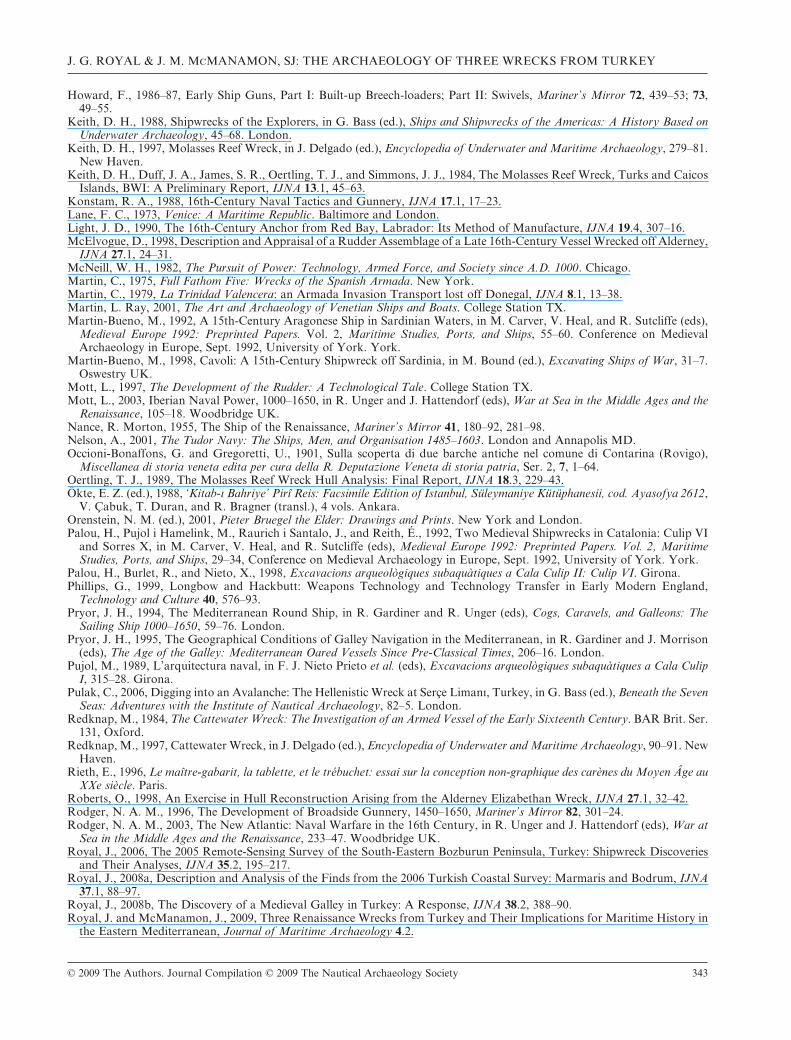
Howard, F., 1986–87, Early Ship Guns, Part I: Built-up Breech-loaders; Part II: Swivels, Mariner’s Mirror 72, 439–53; 73,49–55.
Keith, D. H., 1988, Shipwrecks of the Explorers, in G. Bass (ed.), Ships and Shipwrecks of the Americas: A History Based onUnderwater Archaeology, 45–68. London.
Keith, D. H., 1997, Molasses Reef Wreck, in J. Delgado (ed.), Encyclopedia of Underwater and Maritime Archaeology, 279–81.New Haven.
Keith, D. H., Duff, J. A., James, S. R., Oertling, T. J., and Simmons, J. J., 1984, The Molasses Reef Wreck, Turks and CaicosIslands, BWI: A Preliminary Report, IJNA 13.1, 45–63.
Konstam, R. A., 1988, 16th-Century Naval Tactics and Gunnery, IJNA 17.1, 17–23.Lane, F. C., 1973, Venice: A Maritime Republic. Baltimore and London.Light, J. D., 1990, The 16th-Century Anchor from Red Bay, Labrador: Its Method of Manufacture, IJNA 19.4, 307–16.McElvogue, D., 1998, Description and Appraisal of a Rudder Assemblage of a Late 16th-Century Vessel Wrecked off Alderney,
IJNA 27.1, 24–31.McNeill, W. H., 1982, The Pursuit of Power: Technology, Armed Force, and Society since A.D. 1000. Chicago.Martin, C., 1975, Full Fathom Five: Wrecks of the Spanish Armada. New York.Martin, C., 1979, La Trinidad Valencera: an Armada Invasion Transport lost off Donegal, IJNA 8.1, 13–38.Martin, L. Ray, 2001, The Art and Archaeology of Venetian Ships and Boats. College Station TX.Martin-Bueno, M., 1992, A 15th-Century Aragonese Ship in Sardinian Waters, in M. Carver, V. Heal, and R. Sutcliffe (eds),
Medieval Europe 1992: Preprinted Papers. Vol. 2, Maritime Studies, Ports, and Ships, 55–60. Conference on MedievalArchaeology in Europe, Sept. 1992, University of York. York.
Martin-Bueno, M., 1998, Cavoli: A 15th-Century Shipwreck off Sardinia, in M. Bound (ed.), Excavating Ships of War, 31–7.Oswestry UK.
Mott, L., 1997, The Development of the Rudder: A Technological Tale. College Station TX.Mott, L., 2003, Iberian Naval Power, 1000–1650, in R. Unger and J. Hattendorf (eds), War at Sea in the Middle Ages and the
Renaissance, 105–18. Woodbridge UK.Nance, R. Morton, 1955, The Ship of the Renaissance, Mariner’s Mirror 41, 180–92, 281–98.Nelson, A., 2001, The Tudor Navy: The Ships, Men, and Organisation 1485–1603. London and Annapolis MD.Occioni-Bonaffons, G. and Gregoretti, U., 1901, Sulla scoperta di due barche antiche nel comune di Contarina (Rovigo),
Miscellanea di storia veneta edita per cura della R. Deputazione Veneta di storia patria, Ser. 2, 7, 1–64.Oertling, T. J., 1989, The Molasses Reef Wreck Hull Analysis: Final Report, IJNA 18.3, 229–43.Ökte, E. Z. (ed.), 1988, ‘Kitab-ı Bahriye’ Pirî Reis: Facsimile Edition of Istanbul, Süleymaniye Kütüphanesii, cod. Ayasofya 2612,
V. Çabuk, T. Duran, and R. Bragner (transl.), 4 vols. Ankara.Orenstein, N. M. (ed.), 2001, Pieter Bruegel the Elder: Drawings and Prints. New York and London.Palou, H., Pujol i Hamelink, M., Raurich i Santalo, J., and Reith, É., 1992, Two Medieval Shipwrecks in Catalonia: Culip VI
and Sorres X, in M. Carver, V. Heal, and R. Sutcliffe (eds), Medieval Europe 1992: Preprinted Papers. Vol. 2, MaritimeStudies, Ports, and Ships, 29–34, Conference on Medieval Archaeology in Europe, Sept. 1992, University of York. York.
Palou, H., Burlet, R., and Nieto, X., 1998, Excavacions arqueològiques subaquàtiques a Cala Culip II: Culip VI. Girona.Phillips, G., 1999, Longbow and Hackbutt: Weapons Technology and Technology Transfer in Early Modern England,
Technology and Culture 40, 576–93.Pryor, J. H., 1994, The Mediterranean Round Ship, in R. Gardiner and R. Unger (eds), Cogs, Caravels, and Galleons: The
Sailing Ship 1000–1650, 59–76. London.Pryor, J. H., 1995, The Geographical Conditions of Galley Navigation in the Mediterranean, in R. Gardiner and J. Morrison
(eds), The Age of the Galley: Mediterranean Oared Vessels Since Pre-Classical Times, 206–16. London.Pujol, M., 1989, L’arquitectura naval, in F. J. Nieto Prieto et al. (eds), Excavacions arqueològiques subaquàtiques a Cala Culip
I, 315–28. Girona.Pulak, C., 2006, Digging into an Avalanche: The Hellenistic Wreck at Serçe Limanı, Turkey, in G. Bass (ed.), Beneath the Seven
Seas: Adventures with the Institute of Nautical Archaeology, 82–5. London.Redknap, M., 1984, The Cattewater Wreck: The Investigation of an Armed Vessel of the Early Sixteenth Century. BAR Brit. Ser.
131, Oxford.Redknap, M., 1997, Cattewater Wreck, in J. Delgado (ed.), Encyclopedia of Underwater and Maritime Archaeology, 90–91. New
Haven.Rieth, E., 1996, Le maître-gabarit, la tablette, et le trébuchet: essai sur la conception non-graphique des carènes du Moyen Âge au
XXe siècle. Paris.Roberts, O., 1998, An Exercise in Hull Reconstruction Arising from the Alderney Elizabethan Wreck, IJNA 27.1, 32–42.Rodger, N. A. M., 1996, The Development of Broadside Gunnery, 1450–1650, Mariner’s Mirror 82, 301–24.Rodger, N. A. M., 2003, The New Atlantic: Naval Warfare in the 16th Century, in R. Unger and J. Hattendorf (eds), War at
Sea in the Middle Ages and the Renaissance, 233–47. Woodbridge UK.Royal, J., 2006, The 2005 Remote-Sensing Survey of the South-Eastern Bozburun Peninsula, Turkey: Shipwreck Discoveries
and Their Analyses, IJNA 35.2, 195–217.Royal, J., 2008a, Description and Analysis of the Finds from the 2006 Turkish Coastal Survey: Marmaris and Bodrum, IJNA
37.1, 88–97.Royal, J., 2008b, The Discovery of a Medieval Galley in Turkey: A Response, IJNA 38.2, 388–90.Royal, J. and McManamon, J., 2009, Three Renaissance Wrecks from Turkey and Their Implications for Maritime History in
the Eastern Mediterranean, Journal of Maritime Archaeology 4.2.
J. G. ROYAL & J. M. McMANAMON, SJ: THE ARCHAEOLOGY OF THREE WRECKS FROM TURKEY
© 2009 The Authors. Journal Compilation © 2009 The Nautical Archaeology Society 343
Simmons, J. J., 1988, Wrought-Iron Ordnance: Revealing Discoveries from the New World, IJNA 17.1, 25–34.Smith, R. C., 1988, Treasure Ships of the Spanish Main: The Iberian-American Maritime Empires, in G. Bass (ed.), Ships and
Shipwrecks of the Americas: A History Based on Underwater Archaeology, 85–106. London.Smith, R. C., 1993, Vanguard of Empire: Ships of Exploration in the Age of Columbus. Oxford.Smith, R. C., 1997, Emanuel Point Ship, in J. Delgado (ed.), Encyclopedia of Underwater and Maritime Archaeology, 140–41.
New Haven.Smith, R. C., 2001, The Emanuel Point Ship: A 16th-Century Vessel of Spanish Colonization, in F. Alves et al. (eds),
International Symposium on Archaeology of Medieval and Modern Ships of Iberian-Atlantic Tradition. Hull Remains, Manu-scripts, and Ethnographic Sources: A Comparative Approach, 295–300, http://www.ipa.min-cultura.pt/pubs/TA/18, accessed 9May 2008.
Smith, R. C., Keith, D. H., and Lakey, D., 1985, The Highborn Cay Wreck: Further Exploration of a 16th-Century BahamanShipwreck, IJNA 14.1, 63–72.
Smith, R. D., 1995, Wrought-Iron Swivel-guns, in M. Bound (ed.), The Archaeology of Ships of War, 104–13. Oswestry UK.Steffy, J. R., 1994, Wooden Shipbuilding and the Interpretation of Shipwrecks. College Station TX.Tenenti, A., 1960, I corsari in Mediterraneo all’inizio del Cinquecento, Rivista storica italiana 72, 234–87.van Doorninck, F. H. Jr, 1997, Yassı Ada Wrecks, in J. Delgado (ed.), Encyclopedia of Underwater and Maritime Archaeology,
469–71. New Haven.Vatin, N., 1994, L’Ordre de Saint-Jean-de-Jérusalem, l’Empire ottoman, et la Méditerranée orientale entre les deux sièges de
Rhodes (1480–1522). Paris.Watts, G. P., 1993, The Western Ledge Reef Wreck: A Preliminary Report on Investigation of the Remains of a 16th-Century
Shipwreck in Bermuda, IJNA 22.2, 103–24.Wingwood, A. J., 1982, Sea Venture: An Interim Report on an Early 17th-Century Shipwreck Lost in 1609, IJNA 11.4, 333–47.
NAUTICAL ARCHAEOLOGY, 39.2
344 © 2009 The Authors. Journal Compilation © 2009 The Nautical Archaeology Society