arth quick
TRANSCRIPT

Basic of Seismology and Seismic Hazard Assessment Chapter 1 Global Seismicity
European School of Advanced Studies in Reduction of Seismic R.Giuliani 1.2
ROSE School
W1: Basics of Seismology and Seismic Hazard Assessment
PART I – Roberta Giuliani
Chapter 1
Global Seismicity
Academic Year 2005 Pavia, February 17th – March 11th

Basic of Seismology and Seismic Hazard Assessment Chapter 1 Global Seismicity
European School of Advanced Studies in Reduction of Seismic R.Giuliani 1.3
1. CONTRIBUTION OF SEISMICITY TO GLOBAL TECTONICS THEORY...................................................... 4
1.1 EARTHQUAKE DISTRIBUTION .................................................................................................................................... 41.2 OCEANIC RIDGES ...................................................................................................................................................... 51.3 ISLAND ARCS ............................................................................................................................................................ 51.4 COLLISION ZONES – OROGENS.................................................................................................................................. 61.5 SEISMICITY OF THE SAN FRANCISCO BAY AREA ....................................................................................................... 81.6 DEPTH OF EARTHQUAKES ....................................................................................................................................... 101.7 CONTINENTAL TECTONICS ...................................................................................................................................... 11
Aegean Sea.............................................................................................................................................................. 121.8 SEISMOGENIC LAYER .............................................................................................................................................. 15

Basic of Seismology and Seismic Hazard Assessment Chapter 1 Global Seismicity
European School of Advanced Studies in Reduction of Seismic R.Giuliani 1.4
1. CONTRIBUTION OF SEISMICITY TO GLOBAL TECTONICSTHEORY
The understanding of the Earth internal structure is linked to the study of recorded seismic wavesgenerated by earthquakes around the world. This chapter presents a global pattern of seismicity thatconstitutes the input seismological data used, together with other geophysical information, to inferthe internal structure of the Earth. The distribution of earthquakes is necessary to understand the theory of plate tectonics, thatrepresents, at the moment, the best theoretical model of interpretation of the whole Earth dynamicsand therefore an explanation of the origin of most of the earthquakes.
1.1 Earthquake distribution
The term seismicity is used to describe the geography of earthquakes, particularly their distribution,frequency and energy relationships with surface features. The mapping of earthquake distribution play a key role in the theory of plate tectonics. It can benoticed that the global seismicity is located along belts of tectonic activity drawing the mainlithospheric plates boundaries.The properties of seismic waves allow the source location to be determined since the wavespropagate through the Earth with velocities controlled by the material properties. Observations of arrival times of seismic waves together with the model of velocity structure of theEarth contribute to the location of the earthquakes.
Fig. 1. 1.1 Map of global shallow seismicity (depths less than 70 km), in 1963-1988, magnitudegreater than 5 (courtesy of National Earthquake Information Center USGS)

Basic of Seismology and Seismic Hazard Assessment Chapter 1 Global Seismicity
European School of Advanced Studies in Reduction of Seismic R.Giuliani 1.5
The first global seismographic network started operation in 1962 (WWSSN - World-WideStandardised Network, Murphy 1966) and form then it became possible to compute sourcemechanisms and to infer the geometry and amount of seismic deformation. Evident zones of seismic activity separate large oceanic and continental regions.
1.2 Oceanic ridges
The figure1.2 sketches out the oceanic ridge location. Seismically active ridges of the Atlantic andIndian oceans meet south Africa and the mid-Indian ridge circles below Australia to connect withEast Pacific ridge, which extends eastward toward Central America and into the Gulf of California.The geological unrest that prevails throughout this global ridge system is evidenced by: mountainpeaks and deep rift valleys, volcanic eruptions and earthquake that originating along these ridgesoften occurring in “swarms” (many hundreds of shocks are concentrated in a small area in a shorttime (Sharma, 1986).
Fig. 1. 2 Oceanic ridges
1.3 Island arcs
Dense concentrations of earthquakes centres also coincide with beautiful symmetrical island arcs,all also volcano-rich, such as those of the Pacific and the eastern Caribbean. Another example ofthese island chains is the Aleutian arc, swinging westward from Alaska toward Kamchatka.Southward the islands of Japan form an arc that extends southward to the island of the Marianas.
From Indonesia to the south Pacific, a number of seismically active arcs drape around Australiawith the Tonga-Kermadec trench as its eastern border.
Area of the Great Alaska Earthquake of 1964 in figure 1.3. It is shown the seismicity of the areathat is distributed on a rather narrow belt and the volcanoes distribution (triangles in figure).

Basic of Seismology and Seismic Hazard Assessment Chapter 1 Global Seismicity
European School of Advanced Studies in Reduction of Seismic R.Giuliani 1.6
Fig. 1. 3 Great Alaska earthquake of 1964.
1.4 Collision zones – Orogens
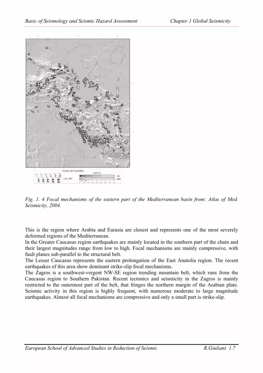
Note the long trans-Asiatic zone of high seismicity running approximately east-west from Burmathrough the Himalaya Mountains and central Asia to the Caucasus Mountains and theMediterranean Sea. In figure 1.4 the Caucasus region, composed of several tectonic elements isrepresented as well as its seismicity. Different kind of focal mechanisms are showed in this area.
Basic of Seismology and Seismic Hazard Assessment Chapter 1 Global Seismicity
European School of Advanced Studies in Reduction of Seismic R.Giuliani 1.7
Fig. 1. 4 Focal mechanisms of the eastern part of the Mediterranean basin from: Atlas of Med.Seismicity, 2004.
This is the region where Arabia and Eurasia are closest and represents one of the most severelydeformed regions of the Mediterranean. In the Greater Caucasus region earthquakes are mainly located in the southern part of the chain andtheir largest magnitudes range from low to high. Focal mechanisms are mainly compressive, withfault planes sub-parallel to the structural belt. The Lesser Caucasus represents the eastern prolongation of the East Anatolia region. The recentearthquakes of this area show dominant strike-slip focal mechanisms.The Zagros is a southwest-vergent NW-SE region trending mountain belt, which runs from theCaucasus region to Southern Pakistan. Recent tectonics and seismicity in the Zagros is mainlyrestricted to the outermost part of the belt, that fringes the northern margin of the Arabian plate.Seismic activity in this region is highly frequent, with numerous moderate to large magnitudeearthquakes. Almost all focal mechanisms are compressive and only a small part is strike-slip.
Basic of Seismology and Seismic Hazard Assessment Chapter 1 Global Seismicity
European School of Advanced Studies in Reduction of Seismic R.Giuliani 1.8
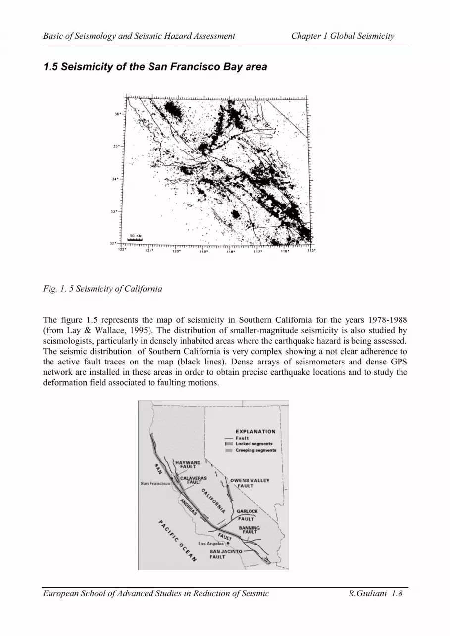
1.5 Seismicity of the San Francisco Bay area
Fig. 1. 5 Seismicity of California
The figure 1.5 represents the map of seismicity in Southern California for the years 1978-1988(from Lay & Wallace, 1995). The distribution of smaller-magnitude seismicity is also studied byseismologists, particularly in densely inhabited areas where the earthquake hazard is being assessed.The seismic distribution of Southern California is very complex showing a not clear adherence tothe active fault traces on the map (black lines). Dense arrays of seismometers and dense GPSnetwork are installed in these areas in order to obtain precise earthquake locations and to study thedeformation field associated to faulting motions.

Basic of Seismology and Seismic Hazard Assessment Chapter 1 Global Seismicity
European School of Advanced Studies in Reduction of Seismic R.Giuliani 1.9
Fig. 1. 6 San Andreas Fault System; note that it is not a single fault plane but it is composed of acombination of different faults.Note that if we use just the short-term seismicity pattern (10 years time range in this case) to locatefaults in this region, we may fail to identify the major fault that produces the largest earthquakes,the San Andreas fault, because it has few small events. The need to assess large-earthquake hazardleads global seismologists to look at the historic record of large earthquakes around the world overlonger periods of time.
Fig. 1. 7 Global seismicity
At a first sight to a global seismicity map, we will notice the evident not uniform distribution ofearthquakes around the world. Generally most of the seismicity occurs along rather narrow bands that defines areas where theearthquake occurrence is much more rare.
Fig. 1. 8 Map of active volcanoes and plate boundaries (from USGS web site).

Basic of Seismology and Seismic Hazard Assessment Chapter 1 Global Seismicity
European School of Advanced Studies in Reduction of Seismic R.Giuliani 1.10
This distribution of earthquakes is supposed to be the direct expression of the interaction of acertain number of lithosphere plates as we will see in detail in the chapter concerning PlateTectonics. More in detail we can distinguish an inter-plate seismicity that occur along the tectonic plateboundaries from an intra-plate seismicity. The first kind of earthquakes are the effect of the motionand the interaction between adjacent plates, while the second kind is a diffuse seismicity that spreadall over the Earth surface within the plate boundaries.The seismicity of mid-oceanic ridges (see chapter on “plate tectonics”) doesn’t affect populatedareas, but together with the instrumental records of the whole world seismicity, represents a veryuseful tool to study the internal structure of the Earth and the dynamics that causes the globalpattern of earthquakes and volcanoes.An almost continuous distribution of earthquakes could be followed around the Pacific Ocean,along the western coasts of South, Central and North America, along the Kurile islands, theAleutian arc, Japan, Indonesia and the Philippines, Papua New Guinea and New Zealand. This areais called the “ring of fire” and it is characterized by the presence of many active volcanoes.Another region of intense and high energy seismicity is the so-called “collision zone” that exhibits adiffuse seismicity. This zone extends from Azores island in the Atlantic Ocean across theMediterranean Sea, northern Africa, Italy, Greece and Turkey, Middle East, towards Iran, Pakistan,northern India, Nepal and China.Other two major zones of seismicity are a clear band of earthquake activity that follows the RedSea and continues southwards through East Africa and another band of seismicity that can be tracedalong the line of the Caribbean islands from Trinidad in the south northwards to Hispaniola, thenwestwards between southern Cuba and Jamaica before crossing Central America throughGuatemala. These bands of seismicity are of great interest as far as their occurrence is located in or close tohighly intense populated areas.
1.6 Depth of earthquakes
The earthquakes could be classified from the point of view of their depth distribution. Shallowearthquakes exhibits a depth minor than 70 km, while deep earthquakes have depth greater than 70km (between 300 and 700 km of depth). Deep earthquakes, that are much less frequent than shallow earthquakes, occur in areas that have aparticular tectonic meaning: within downwelling portions of oceanic plate that is sinking into themantle. They are mostly present along the circum Pacific belt in correspondence to the back-arcmarginal basins.
Fig. 1. 9 Subduction zone

Basic of Seismology and Seismic Hazard Assessment Chapter 1 Global Seismicity
European School of Advanced Studies in Reduction of Seismic R.Giuliani 1.11
A plot of these deep hypocentres on a section perpendicular to the island arcs shows a “plane”dipping with an angle that varies between 30° and 70° under the islands. This plane is called “Benjoff plane”. Its thickness varies from 25 km (Tonga) to more than 100 km(Japan).This plane is interpreted by the model of plate tectonics as lithospheric plate subducted when twoplates converge (see convergent boundaries in Plate Tectonics chapter).
1.7 Continental tectonics
Continental tectonics is not plate tectonics. The essential tenet of plate tectonics is that the interiorsof the plates are rigid and that deformation is restricted to plate boundaries (Jackson, 2001). In the oceans this principle works well. Earthquakes are usually confined to narrow zones whereplate boundaries are effectively single faults on which the long-term rate and direction of slip areentirely determined by the relative motion of the bounding plates.
Fig. 1. 10 Mediterranean seismicity: diffuse seismicity. (Atlas of Med. Seismicity, 2004).
The seismic moment tensor is a complete description of the earthquake size and source geometry.The Centroid Moment Tensor (CMT) is a reliable method for calculating moment tensors(Dziewonski et al., 1981; Dziewonski and Woodhouse, 1983; Dziewonski et al., 2000) based onfitting long period surface waves and ideally suited to study global seismicity. The Alpine Mediterranean region, shown in figure 1.10, is characterized by complex activetectonics, connected to the convergence between Africa and Eurasia, but also to the motion ofseveral microplates, producing a wide range of tectonic regimes. Seismicity in the Mediterraneanarea is rather diffuse, in may areas characterized by moderate energy release. Moderate-magnitudeevents are therefore particularly important because more widely spread than the relatively fewlarger-magnitude earthquakes.
Basic of Seismology and Seismic Hazard Assessment Chapter 1 Global Seismicity
European School of Advanced Studies in Reduction of Seismic R.Giuliani 1.12
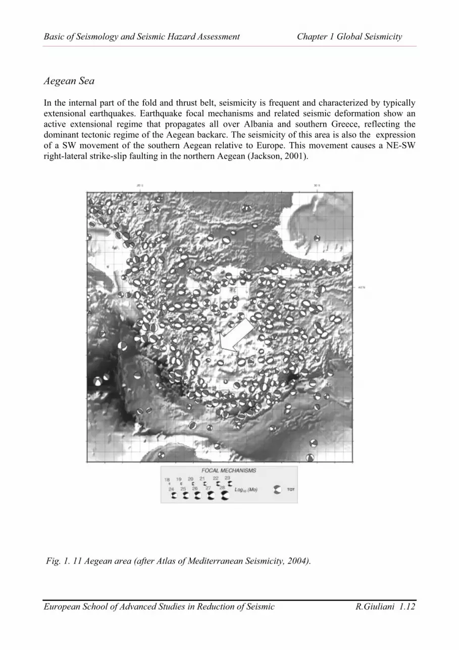
Aegean Sea
In the internal part of the fold and thrust belt, seismicity is frequent and characterized by typicallyextensional earthquakes. Earthquake focal mechanisms and related seismic deformation show anactive extensional regime that propagates all over Albania and southern Greece, reflecting thedominant tectonic regime of the Aegean backarc. The seismicity of this area is also the expressionof a SW movement of the southern Aegean relative to Europe. This movement causes a NE-SWright-lateral strike-slip faulting in the northern Aegean (Jackson, 2001).
Fig. 1. 11 Aegean area (after Atlas of Mediterranean Seismicity, 2004).

Basic of Seismology and Seismic Hazard Assessment Chapter 1 Global Seismicity
European School of Advanced Studies in Reduction of Seismic R.Giuliani 1.13
Although the earthquakes in the Mediterranean and Middle East are caused by the northwardmotion of Africa and Arabia relative to Eurasia, it is clear that they are not confined to a singlefault, and so deformation in that region cannot be described simply by the relative motion of themajor plates.
For example Greece is part of a broad deforming zone containing many active faults that separatesthe rigid parts of the African and Eurasia. Almost as soon as plate tectonics model was formulated,it was clear that a different language of framework was needed to describe the deformation of thecontinents.
Within the broad deforming belts on the continents some large, flat, aseismic regions such as centralTurkey, central Iran and the Tarim Basin in China appear to be rigid and can usefully be thought ofas “microplates”.
Fig. 1.12 Eastern Mediterranean area (after Atlas of Mediterranean Seismicity, 2004)

Basic of Seismology and Seismic Hazard Assessment Chapter 1 Global Seismicity
European School of Advanced Studies in Reduction of Seismic R.Giuliani 1.14
On the continents earthquakes are usually distributed over zones hundreds of kilometres wide.Deformation in continental areas cannot be described simply by the relative motion of the majorplates.
Fig. 1.13 (after Jackson, 2001)
Continents are the areas where most people live and where most engineered structures are erected.In these areas the faults are easily accessible for study.
Continental faults are studied using:
• space-based geodetic investigations• geological and structural-geological surveys• surface geomorphological features (also with satellite imagery).
The above mentioned techniques used to infer deformation field are described in detail in a chapterconcerning active tectonics and paleoseismology.These investigations together with seismological analysis give a great deal of information about theorientation, size and slip on a fault underground (Jackson, 2001).

Basic of Seismology and Seismic Hazard Assessment Chapter 1 Global Seismicity
European School of Advanced Studies in Reduction of Seismic R.Giuliani 1.15
In most continental areas it is more convenient to describe the overall characteristics of activedeformation by a velocity field, rather than by the relative motions of rigid blocks (England &Jackson, 1989).
The velocity field can be estimated:• directly from GPS measurements• from spatial variations in strain rates estimated from seismicity• from fault slip rates
Fig. 1.14 Seismicity and velocity field for East Mediterranean area (from Jackson, 2001)
At length scales much larger than the thickness of the seismogenic upper crust (10-20 km), it ispossible to describe active deformation as a continuous velocity field, often assumed to representthe average deformation of the whole lithosphere.
Continental areas deform by:
• Seismogenic layer - (typically 10-20 km) deforms by faulting• Lower thicker layer - (typically 80-100 km) deforms by more distributed creep
1.8 Seismogenic layer
In most continental areas earthquakes are confined to the upper crust and the lower continentalcrust is virtually aseismic (Chen & Molnar, 1983). This pattern is usually interpreted in terms of atemperature-related rheology in which localised stick-slip frictional behaviour on faults in the uppercrust is replaced in the lower crust by creep processes in more distributed ductile shear zones.

Basic of Seismology and Seismic Hazard Assessment Chapter 1 Global Seismicity
European School of Advanced Studies in Reduction of Seismic R.Giuliani 1.16
The lithosphere consists of two parts with markedly different rheological properties, one brittle and the other ductile:
• schizosphere for the brittle region• plastosphere for the ductile region
Under the low temperature and pressure conditions of the Earth’s upper lithosphere, silicate rocksresponds to large strains by brittle fracture. The mechanism of brittle behavior is by propagation ofcracks (Jackson, 2001; Scholz, 1990)..
Fig. 1.15 (from Scholz, 1990)
Fig. 1.16 (after Jackson, 2001)

Basic of Seismology and Seismic Hazard Assessment Chapter 1 Global Seismicity
European School of Advanced Studies in Reduction of Seismic R.Giuliani 1.17
The thickness of the seismogenic upper crust is tipically 10-20 km and imposes a scale on allstructural observations. Large faults are those with dimensions comparable to that thickness and may rupture the entirelayer in earthquakes. Small faults are those that can be accomodated completely within the seimogenic layer (Jackson,2001).
Fig. 1.17 (after Jackson, 2001)