argentine space assets - core
TRANSCRIPT
NPS ARCHIVE1997.09OYARZABAL, X.
NAVAL POSTGRADUATE SCHOOLMonterey, California
THESIS
ARGENTINE SPACE ASSETS
by
Xavier Pablo A. Oyarzabal
September, 1997
Thesis Advisor:
Second Reader:
Jeff Jenncr
Thomas Betterton
Thesis09826
Approved for public release; distribution is unlimited.

?m LIBRARY^GRADUATE SCHOOL
sY CA 833435101
REPORT DOCUMENTATION PAGE Form Approved
OMB No 0704-
0188
Public reporting burden for this collection of information is estimated to average 1 hour per response, including the time for reviewing
instruction, searching existing data sources, gathering and maintaining the data needed, and completing and reviewing the collection of
information. Send comments regarding this burden estimate or any other aspect of this collection of information, including suggestions for
reducing this burden, to Washington headquarters Services, Directorate for Information Operations and Reports, 1215 Jefferson Davis
Highway, Suite 1204, Arlington, VA 22202-4302, and to the Office of Management and Budget, Paperwork Reduction Project (0704-0188
University ) Washington DC 20503.
1. AGENCY USE ONLY (Leave blank) 2. REPORT Fighting DATE
September 1997
3. REPORT TYPE AND DATES COVEREDMaster" s Thesis
4. TITLE AND SUBTITLE
ARGENTINE SPACE ASSETS
6. AUTHOR(S)
Oyarzabal, Xavier Pablo A.
5. FUNDING NUMBERS
7. PERFORMING ORGANIZATION NAME(S) AND ADDRESS(ES)
Naval Postgraduate School
Monterey, CA 93943-5000
8. PERFORMINGORGANIZATION REPORTNUMBER
9. SPONSORING / MONITORING AGENCY NAME(S) AND ADDRESS(ES)10. SPONSORING /
MONITORING AGENCYREPORT NUMBER
11. SUPPLEMENTARY NOTES
The views expressed in this thesis are those of the author and do not reflect the official policy or position of the
Department of Defense or the U.S. Government.
12a. DISTRIBUTION / AVAILABILITY STATEMENT
Approved for public release; distribution is unlimited.
12b. DISTRIBUTION CODE
13. ABSTRACT (maximum 200 words)
This thesis is an attempt to define how some of the commercial space assets already in use or under
development could be useful to the Argentine Navy as tools for better accomplishment of their basic missions.
Research efforts involved investigating part of what is available on the international market and some space
related international laws and policies that may represent limits for military use of civilian assets. Basically
divided in two main areas , communications and remote sensing, this thesis covers the basics ofGEO and LEOcommunication satellites and provides an overview of what could be expected from commercial remote sensmg
systems. Through examples, the feasibility of usmg civilian space assets in the military is demonstrated. Finally,
an objective analysis is made to define the best approach to improve Argentine Navy space capabilities.
14. SUBJECT TERMSLow Earth Orbit Satellites, Geostationary Satellites, ORBCOMM, RemoteSensing, SPOT, SeaWifs.
15. NUMBEROF PAGES275
16. PRICECODE
17. SECURITY CLASSIFICATIONOF REPORTUnclassified
18. SECURITY CLASSIFICATIONOF THIS PAGEUnclassified
19. SECURITY CLASSIFICATIONOF ABSTRACTUnclassified
20.
LIMITATIONOFABSTRACT
UL
NSN 7540-01-280-5500 Standard Form 298 (Rev. 2-89)
Prescribed by ANSI Std. 239-18

Approved for public release; distribution is unlimited
ARGENTINE SPACE ASSETS
Xavier Pablo A. Oyarzabal
Lieutenant Commander, Argentine Navy
Argentine Naval Academy, 1 98
1
Submitted in partial fulfillment of the
requirements for the degree of
MASTER OF SCIENCE IN SPACE SYSTEMS OPERATIONS
from the
NAVAL POSTGRADUATE SCHOOLSeptember 1997

ABSTRACT
This thesis is an attempt to define how some of the commercial space assets
already in use or development could be useful for the Argentine Navy as a tool for better
accomplishment of their basic missions Research efforts involved investigating part of
what is available on the international market and some international laws or policies
referred to space that may represent limits for military use of civilian assets. Basically
divided in two main areas , communications and remote sensing, this thesis cover the
basics ofGEO and LEO communication satellites, and provides an overview of what
could be expected from commercial remote sensing systems. Through examples, the
feasibility of using civilian space assets in the military is demonstrated. Finally, an objective
analysis is made to define the best approach to improve Argentine Navy space
capabilities.

VI
OX LIBRARYTGRADUATE SCHOOL
i CA 93943-5101
TABLE OF CONTENTS
I. INTRODUCTION 1
II. MISSIONS AND REQUIREMENTS 7
A. BACKGROUND..... 7
B. GENERAL MISSION STATEMENT 11
1. Mission Statement #1 14
2. Mission Statement #2 14
C. CONSTRAINTS 14
1. Constraint # 1: Limited Funding 15
2. Constrain 2 No action in space matters can be taken that is contrary to the
National Policies 18
3. Constraint #3 No action can be taken that is contrary to International
Space Law 20
III. COMMUNICATION SATELLITES IN GEOSTATIONARY ORBIT 27
A. INTRODUCTION 27
B. GEOSTATIONARY SATELLITES 28
C. WHAT CIVILIAN SPACE COMMUNICATION SYSTEMS IN GEO COULD
BE AVAILABLES FOR ARGENTINE NAVY NOW AND IN THE NEAR
FUTURE? 32
D. HOW CAN THE ARGENTINE NAVY USE COMMERCIAL GEO
SATELLITES TO SUPPORT NAVAL OPERATIONS? 33
1. Requirements 33
Vll
2. INMARSAT 39
3. INTELSAT 42
4. Challenge Athena as an Example of Implementation 47
5. Legal concerns in the use of INTELSAT and INMARSAT with military
purposes 51
6. Argentine Implementation 54
E. BENEFITS AND DISADVANTAGES OF USING GEO COMMERCIAL
SATELLITES 57
1. Benefits 57
2. Disadvantages 60
F. SUMMARY 62
IV. COMMUNICATION SATELLITES IN LOW EARTH ORBIT (LEO) 63
A. INTRODUCTION 63
B. LOW EARTH ORBIT SATELLITES 64
C. WHAT CIVILIAN SPACE COMMUNICATION BIG LEO'S SYSTEMS
COULD BE AVAILABLE FOR ARGENTINE IN THE FUTURE? 67
1. IRIDIUM 67
2. GLOBALSTAR 72
3. TELEDESIC 76
4. Probable Availability 81
D. MILITARY APPLICATIONS 82
1. Benefits 83
2. Disadvantages 85
E. SUMMARY 86
Mil
V. ORBITAL COMMUNICATIONS CORPORATION (ORBCOMM)
DIGITAL DATA COMMUNICATION AND POSITION SYSTEM 89
A. INTRODUCTION 89
B. BACKGROUND 90
C. SYSTEM ARCHITECTURE 92
1. Space Segment 92
2. Ground Segment 96
3. Subscriber Terminal (Users Terminal) 98
D. CAPABILITIES 100
1. Digital Data Communication 100
2. Position Determination 105
E. APPLICATIONS 106
1. Commercial Applications 106
2. Military Applications 108
3. Possible Argentine Navy Applications Ill
F. BENEFITS AND DISADVANTAGES 114
1. Benefits 114
2. Disadvantages 1 16
G. FINAL CONSIDERATIONS 118
VI. MILITARY APPLICATION OF COMMERCIAL IMAGERY SYSTEMS 121
A. INTRODUCTION 121
B. PARAMETERS TO CONSIDER IN THE USE OF CIVILIAN REMOTE
SENSED DATA 125
1. Spatial Resolution 125
IX
2. Spectral Resolution 126
3. Timeliness 126
C. MILITARY APPLICATIONS [OTA- ISC-558, 1993] 130
1. Military Operations 130
2. Reconnaissance 131
3. Arms Control 131
4. Mapping, Charting and Geodesy 132
D. INTERNATIONAL REGULATIONS 132
E. BENEFITS AND DISADVANTAGES OF USING COMMERCIAL REMOTE
SENSING 136
1. Benefits 136
2. Disadvantages 138
F. EXISTING COMMERCIAL SYSTEMS - OVERVIEW 139
1. LANDSAT Series 141
2. Resurs Series 143
3. Almaz 144
4. SPOT 145
5. Dong Fang Hong Series 145
6. Japanese Earth Remote Sensing Satellite (JERS-1) 146
7. Indian Resources Satellite Series (IRS-1A /1B/1C/P2) 147
8. European Remote Sensing Satellite ERS-1 /2 148
9. CANADIAN RADARSAT 149
VII. SPOT IMAGERY 151
A. INTRODUCTION 151
B. BACKGROUND 151
C. SYSTEM CHARACTERISTICS 153
1. Space segment 153
2. Ground Segment 156
D. OBTAINING DATA 158
E. POSSIBLE ARGENTINE NAVY APPLICATIONS 161
1. Mission Planing 161
2. Military Analysis 162
3. Surveillance 162
F. SPOT FEATURES 162
1. Standardized Products 162
2. Stored Data Available 164
3. Sensor Tilt Capability 164
4. Along Track Scanner 164
5. Cost 165
6. French Ownership 166
7. World-wide Availability 166
VIII. SEA VIEWING WIDE FIELD OF VIEW SENSOR (SEAWIFS) 169
A. INTRODUCTION 169
B. SYSTEM ARCHITECTURE 171
1. Space Segment 171
2. SeaWifs Data Processing System 176
C. SEAWIFS DATA MANAGEMENT 177
D. SEAWIFS APPLICATIONS 180
1. Research Applications 180
2. Commercial Applications 182
XI
3. Operational Applications 182
E. POSSIBLE USES OF SEAWIFS DATA BY THE ARGENTINE NAVY 183
1. Fishing Control 184
2. Mining Operations 185
3. Coastal Special Operations 185
4. Landing Operations 185
5. Submarine Operations 185
F. BENEFITS AND DISADVANTAGES OF USING SEAWIFS DATA WITH
RESEARCH PURPOSES 186
1. Benefits 186
2. Disadvantages 187
G. THE NEXT STEP ABOUT USING SEAWIFS DATA 188
IX. CONCLUSIONS AND FINDINGS 191
A. CONCLUSIONS 191
1. Use of space is definitely beneficial to the Argentine Navy 191
2. Space assets are expensive 192
3. Space assets are available 193
4. Space use requires understanding 193
5. Under certain circumstances, use of space for military purposes is acceptedl94
6. The United States is increasing military use of commercial space assets 195
7. Space is commercially attractive 195
8. Space assets rapidly become obsolete 195
B. SELECTION CRITERIA 196
1. Operational Concept 197
2. Criteria 198
3. Analysis 202
Ml
X. RECOMMENDATIONS 213
A. RECAPITULATION 213
B. GENERAL STEPS TO IMPROVE ARGENTINE NAVY SPACE
CAPABILITY 214
1. Define Argentine Navy Space Objectives 214
2. Emphasize Argentine Navy Interest in U.S. Space Cooperation 215
3. Define technical direction and investment 216
4. Space awareness 216
5. Inter-service cooperation 218
C. PRACTICAL STEPS TO IMPROVE ARGENTINE NAVY SPACE
CAPABILITY 218
l.SeaWifs 218
2. ORBCOMM 218
3. Remote Sensing Imagery 219
4. Network Development 220
APPENDICES
A. ARGENTINE NAVY UNITS 221
B. THE NATIONAL SPACE PLAN 225
LIST OF REFERENCES 247
INITIAL DISTRIBUTION LIST 257
Xlll

ACKNOWLEDGMENTS
I want to express my recognition to Jeff Jenner, my thesis advisor, for his most
valuable teaching and his will in making my job more useful and enjoyable.
To Admiral Thomas Betterton for helping me with his experienced point of view
and clarifying ideas.
To my mother, who since my young years encouraged me to pursue this
fascinating carrier.
Above all, I want to thanks Marta, my wife and mother of our five children, for
being indefatigable and supporting mate, for being kind and unwavering, but mainly for
teaching me the secret of not to worry about the things we can not change.
Finally, to my kids, source of all motivations, Pablo, Xavier, Nicolas, Matias and
Ignacio.
xiv

ACKNOWLEDGMENTS
I want to express my recognition to JeffJenner, my thesis advisor, for his most
valuable teaching and his will in making my job more useful and enjoyable.
To Admiral Thomas Betterton for helping me with his experienced point of view
and clarifying ideas.
To my mother, who since my young years encouraged me to pursue this
fascinating carrier.
Above all, I want to thanks Marta, my wife and mother of our five children, for
being indefatigable and supporting mate, for being kind and unwavering, but mainly for
teaching me the secret of not to worry about the things we can not change.
Finally, to my kids, source of all motivations, Pablo, Xavier, Nicolas, Matias and
Ignacio.
XV

XVI
I. INTRODUCTION
The Argentine Navy can increase its use of satellite services to more efficiently and
effectively accomplish its missions. Its current use of space is limited to commercial
communications satellites on rare occasions such as remote deployments. Although this
sounds strange to many people who live in a country in which high technology, such as
satellites, nuclear power, computers, are commonplace, Argentina in general, and the
Navy in particular, are years behind the developed countries in space issues. I will not
attempt to explain why this is so. The reasons and philosophy for this situation were
explained by retired Argentine Navy Captain Nestor Antonio Dominguez in his book
Satelites (Tomo 2) [Dominguez, 1991].
He was very effective in opening people's minds and worked hard to make
politicians and top navy officers understand that space was a very powerful tool that could
benefit the whole country. His effort contributed significantly to the establishment of a
clear Argentine Space Policy, and at least a few of our achievements in space were
because of him.
My goal is to determine how the Argentine Navy can best use space technology,
given the current national policies and international constraints, under the most critical
budget restrictions, and at a time when apparently every civilian space program is looking
for institutional support. Many institutions are beginning to believe that some civilian
space programs are good enough for some military applications. Since the end of the
Second World War, military forces have first developed technology then later released it
for civilian applications. Recently, the former United States Secretary of Defense, William
Perry encouraged his military organizations to use civilian devices and manufactured
components to develop new military technology. The programs that did it saved two-
thirds of the cost of using components designed specifically for the military [Perry, 1996].
CHALLENGE ATHENA, which used INTELSAT satellites for specific types of
communications, was a good example of using civilian space assets for military purposes
[Shaw, 1995].
The Argentine Navy should also be able to use civilian space assets to satisfy
defense requirements. This is not only true for Argentina but should also be true for most
Nations willing to support a peaceful world. I will try to figure out which space assets the
Argentine Navy can get and how much it would cost to use them to meet specific
Argentine Navy requirements.
Among the possible space asset applications, there are four which, generally
speaking, can fulfill the needs of most of the world's navies: navigation, meteorology,
communications and remote sensing. Because they are all closely related to human needs,
they represent tremendous commercial possibilities in open markets. It is virtually
impossible to keep their use exclusively within the military or confined to a limited number
of U.S. allies. For example, the Global Positioning System (GPS), which was created for
military purposes, is also very useful for commercial navigation, and it represents a
significant contribution to the safety of ocean travel. It is not the space asset in itself, but
the way in which it is used that makes it useful for military purposes.
Looking at recent global events, which have been characterized by the political and
commercial opening of the former Soviet Union nations, we can easily understand why
technology that was restricted just a few years ago is now widely available, and all
countries are now encouraged to use it. Military as well as civilian space programs are
starting to be considered as a potential vehicle for international cooperation in the near
future. As Dr. Ken Chow (Deputy Manager for Lockheed Martin Missiles and Space)
said in a recent speech, "cost is a driving factor and the defense budget of every western
nation will be under pressure." [Chow, 1997]
In reality, no country is free of budget restrictions, and no program can be
developed for use by a select few, so the decision to share technology and costs is a
desirable one. Probably, only nations who have clearly defined military space intentions
can take part in programs like the international MILSATCOM (Such as England, France
and Germany), and to have defined intentions requires an understanding at the highest
levels of the implications of using space assets.
Why are space assets so valuable to military organizations? Just thinking for a
moment about the evolution of the operational manuals in the Argentine Navy, most of
them are derived from U.S. publications containing allied doctrine.1
I can remember how
different warfare concepts have developed through the years. Today, the current training
of our officers involves sophisticated tactics in Antisubmarine Warfare, Antiair Warfare,
Antisurface Warfare, Electronic Warfare, and Amphibious Warfare. In the future, I
believe we will need to include Space Warfare aspects in our preparation.
1
Refer to publications such as Allied Tactical Procedures (ATP -1 Vol 1 and ATP -1 Vol 2 ) and Naval
Warfare Procedures series.
The U.S. Navy created The Naval Space Command in 1983, which provides efficient
support to the naval warfighter throughout the world. Space assets have been a part of all
U.S. military activities since the time of Corona, the first spy satellite developed by U.S.
[Brown, 1996], However, space is absolutely critical to the U.S. military today. The
Persian GulfWar showed us that space capabilities are driving the new conceptions about
war. Just as airspace control has always been one of the most important factors in a
battle, space control is now critical to any operation that involves U.S. forces. As in other
theaters of conflict, the combatant able to deny the use of the military benefits that space
assets provide to his adversary can have a distinct advantage [Lee, 1994].
The most critical tactical aspects of a battle can be greatly improved by using the
appropriate space system. Reliable, jam-resistant communications with a wider spectrum
of frequencies and data transmission capability can be the best way to transmit the
information obtained from remote sensors to the right person quickly enough to support
decision making. Imagery from remote sensors can be complemented by appropriate
meteorological information from satellites and referenced to an accurate location from the
space-based Global Positioning System. The end result of this process might be a few
commands sent to the guidance system of the next waiting missile. In other words, space
capabilities provide information dominance to the user who has it, relative to the user
who does not.
I will not promote the idea that Argentine needs something similar to the U.S.
space structure; the comparison could never be reasonable. Space is valuable to the
United States military because of its mission, objectives, operational theaters and the size
of its forces. Also, what is good for the U.S. might not be cost-effect for Argentine.
Nevertheless, we can learn from the U.S. example. It is understandable that the U.S.
military requires significant space capabilities as well as control over those services, so it
spends more than ten billion dollars a year just on space. Small countries cannot invest
this kind of money in such systems, so the best approach may be to learn how to use what
already exists, if it is available.
Argentina is now conducting small experiments in space. One example is the
Satelite de Aplicaciones Cientificas (SAC -B) dedicated to studying space phenomena,
including solar flares, gamma ray bursts, diffuse cosmic X-ray and energetic neutral atoms
[Space News, 1996], Argentina is also using some civilian space assets to support general
meteorology and civil and military navigation. It is using civilian satellite communications
on a commercial basis, and some provinces are starting to buy remotely sensed imagery to
support regional development [Paige, 1996].
Finally, it may be difficult to share some spaceborne remote sensing or military
communications systems, but, in today's world, when the most nations are willing to live in
peace, arms races and space races are just not feasible.

II. MISSIONS AND REQUIREMENTS
A. BACKGROUND
The Argentine Navy is one of the three forces established in accordance with the
Argentine Constitution [Constitucion, 1994]. Its main objective is to contribute to the
national defense in order to protect and warrant the national interests by means of
appropriate sea control. To accomplish this mission, the Argentine Navy operates surface
ships, airplanes, terrestrial units (Marine Corps) and submarines (Appendix A). The
vastness of the Argentine maritime littoral extension and the claim of sovereignty to the
Exclusive Economic Zone (EEZ)1
is a driving factor in developing requirements for space
capabilities.
Since 1989, Argentine foreign policies have been clearly formulated to be
consistent with those of the western allied countries. Our participation in the Gulf War
and our continued contribution to the United Nations Peacekeeping Forces and
Humanitarian Aid Forces (Kuwait, Croacia, Chipre, Haiti, Angola, Somalia) introduced a
new mission that demanded structural changes and required a new operational concept.
The Navy must now be ready to cooperate with international forces in the most distant
theaters. The Air Force and Army are also involved in a general transformation to satisfy
new National requirements. Domestically, Argentina has been working hard to resolve
remaining border disputes with neighboring countries to reduce the possibility of conflicts,
1 EEZ is a zone extending two hundred miles from the coastline in which a number of nations, including
Argentina, have made claims to exercise sovereign rights over the resources within the /one.
7
and it is heavily negotiating with United Kingdom to finally resolve the Malvinas dispute.2
The Armed Forces also has a responsibility to society to perform essential community
services. Surplus military capabilities and technologies can sometimes be used to satisfy
civilian needs. The Naval Transportation Service, for example, provides transportation to
remote, isolated regions in the southern part of the country. Mapping activity is a
government responsibility and is better achieved by the Army on land regions, by the Navy
for nautical charts, and by the Air Force for aeronautical charts. Therefore, the basic
missions of Argentine Navy can be summarized as:
-National Defense
-Maritime Traffic Control
-Peace Keeping Operations
-Humanitarian Aid Operations
-Search and Rescue
-Civic Action"
-Ecosystem Protection
-Disaster Prevention
-Disaster Control
-Mapping and charting
Recommended books related to Malvinas issue:
Signals of War: the Falklands Conflict of 1982 by Lawrence Freedman and Virginia
Gamba-Stonehouse [1991].
The Sovereignty Dispute Over the Falkland( Malvinas) Islands by Low ell S.
Gustafson[1988].
3Civic Action means all kind of activities developed by the Navy in order to promote the commonwealth
of the citizens under special circunstances. For example, the use of a Patrol boat or a Navy helicopter to
evacuate a sick person living in an isolated cattle ranch in Tierra del Fuego.
8
-Signals and Buoy Maintenance.
-Other missions established by the Government.
These missions have normally been assigned to the Argentine Navy because of the
capability of its people, who rely primarily on self-confidence, imagination, creativity,
courage and intuition, rather than on technology. The Navy uses relatively old- fashioned
methods and procedures, so it encounters the old-fashioned problems, which it is able to
solve (for example, exploration, ship identification, and target designation are
accomplished without any satellite information). At the other extreme, the American
Navy relies on technology and its people are fairly insecure without it. Technology played
a key role in the Coalition Forces victory during the Persian Gulf War [Perry, 1991].
During the Malvinas War, the courage and decisiveness of Argentine naval personnel was
the dominant factor in the success of some attacks against the British units. However, the
War also proved that this courage and decisiveness was not enough to defeat an adversary
with overwhelming technological superiority.
The last generation of battleships acquired by the Argentine Navy after the
Malvinas War are slowly aging, while computer and data transmission technologies are
rapidly advancing. Having civilian technology that is better, faster, cheaper, and more
capable of supporting military needs, it seems unfair not to use it.
4This could include anti-narcotic intervention, if it were mandated by the Congress.
?During the Malvinas War. most of the Argentine Destroyers were Sumner Class (first commissioned in
1945), and Fletcher Class (first commissioned in 1943) used during the Second War along with weapons
and electronic systems of that time. The most recent acquisition of the Argentine Navy is represented by
P3 exploration airplanes not longer used by the US.
9
One of the problems the Argentine navy experienced while participating in
Operation Desert Storm was receiving all the information distributed by the Allied
Command in a timely manner. The Americans also experienced this problem to some
extent, but they are already working on a solution to improve the capability of sending
large volumes of information [Shaw, 1995]. The fundamental problem we are facing now
is the need for information. We must answer questions about the enemy (and our own
forces) quickly and precisely: What are the forces doing9 Where are they? When were
they there9 In what condition are they9 The delay or absence of the answers is what we in
the military are trying to avoid.
How can space technology help avoid some of the operational problems that the
Argentine Navy has experienced in the past? The ongoing technological revolution cannot
be ignored. It represents to the military forces a new challenge, and success or failure will
depend on rapid adaptation to new scenarios and tools. We can significantly improve de
technology-related decision process by understanding that improving military
technological capabilities is much more than simply buying the latest model ship, plane or
weapon the day before the war starts.
Defining space mission requirements is never an easy task, but with one objective
and a few constraints, it will be easier to figure out what system can satisfy those
requirements, as opposed to trying to bridge the technology gap from nothing to
everything, with unknown budget and constraints. In my analysis. I will focus on two
specific missions which I believe have the greatest potential for improvement:
communications and remote sensing.
10
B. GENERAL MISSION STATEMENT
Because the basic missions assigned to the Argentine Navy require coverage of
large areas in regional theaters, force projection beyond our borders, and rapid response in
critical situations, the Argentine Navy needs to improve its Command, Communications,
Control and Information system (CI) capabilities, in order to contribute to national and
international interests. Space technology can help with this.
This mission statement is too diverse to find a single product that can satisfy the
needs of all its elements. First, the expression "CI capabilities" requires more detail.
In March of 1995, Paul G. Kaminski, discussed the U.S. C 3I system during a briefing to
the Research and Development Congressional Subcommittee entitled, "Investing in
Tomorrow's Technology Today":
Command, control, communications and systems are vital elements
in successfully conducting the potential missions and operations of a post
-Cold War future. Advances in technology and changes in military
doctrine require that our CI systems undergo continual modernization.
Accordingly, modernization remains a priorityfor our CI programs even
under the fiscal constraints facing the Department. To this end we are
continuing to move ahead with the modernization efforts needed to ensure
that our C'l systems provide the secure information capabilities needed by
warfighters and other command authorities to effectively and successfully
prosecute missions anywhere in the world.
Kaminsky noted other examples. He said that " Battlefield Combat Identification"
helps to avoid fratricide casualties and that "Army digitization of the battlefield" helps to
get more concentration of power in specific areas. This last concept should be associated
with the ability of weapons to respond to digitized information so that by using the
11
battlefield digitization, it will be possible to send digitized data to direct weapons to the
target. [Kaminski, 1995]
William J. Perry, when teaching at Stanford University in 1991, analyzed first the
concepts that Kaminski was reinforcing:6
Command, Control, Communications and Intelligence gives any field
commander what the military calls "situation awareness. " In Desert Storm,
coalition battlefield commanders gained a remarkable awareness of the situation
on the battlefield...
Basically, this awareness meant that they new where the enemy, the friendly forces and
their own forces were located and what they were doing. [Perry, 1991]
The U.S. Navy is already developing a doctrine for C4I (Command, Control,
Communications, Computers and Intelligence), so other navies should at least consider
ways to approximate it. Naval C 4I includes information systems, and equipment, software,
and an infrastructure that enables command authorities to make better decisions.
The four basic functions of C 4I are, collecting, processing, disseminating, and protecting
the information. Space systems are an important part of C4I, because they play a key role
in linking widely dispersed, forward deployed naval forces with each other. Specific C I
activities include: collecting the information with remote sensors; processing the
information by software able to geolocate, enhance, enlarge, correct and present the
information in an understandable format, and disseminating and protecting the information
using the most convenient communication channels (ones which have less probability of
6 From 1993 to 1997 William J. Perry was US Secretary of Defense. Paul G. Kanunsky was
Undersecretary of Defense .
12
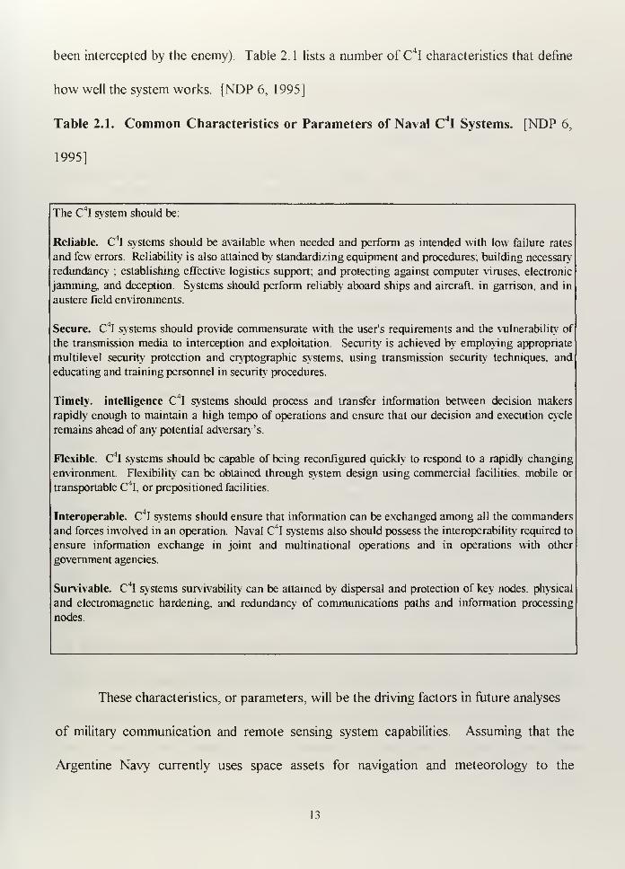
been intercepted by the enemy). Table 2. 1 lists a number of C4I characteristics that define
how well the system works. [NDP 6, 1995]
Table 2.1. Common Characteristics or Parameters of Naval C4I Systems. [NDP 6,
1995]
The C I system should be:
Reliable. C4I systems should be available when needed and perform as intended with low failure rates
and few errors. Reliability is also attained by standardizing equipment and procedures, building necessary
redundancy ; establishing effective logistics support; and protecting against computer viruses, electronic
jamming, and deception. Systems should perform reliably aboard ships and aircraft, in garrison, and in
austere field environments.
Secure. C4I systems should provide commensurate with the user's requirements and the vulnerability of
the transmission media to interception and exploitation. Security is achieved by employing appropriate
multilevel security protection and cryptographic systems, using transmission security techniques, and
educating and training personnel in security procedures.
Timely, intelligence C4I systems should process and transfer information between decision makers
rapidly enough to maintain a high tempo of operations and ensure that our decision and execution cycle
remains ahead of any potential adversary's.
Flexible. C4I systems should be capable of being reconfigured quickly to respond to a rapidly changing
environment. Flexibility can be obtained through system design using commercial facilities, mobile or
transportable C 4I, or prepositioned facilities.
Interoperable. C4I systems should ensure that information can be exchanged among all the commanders
and forces involved in an operation. Naval C4I systems also should possess the interoperability required to
ensure information exchange in joint and multinational operations and in operations with other
government agencies.
Survivable. C 41 systems survivability can be attained by dispersal and protection of key nodes, physical
and electromagnetic hardening, and redundancy of communications paths and information processing
nodes.
These characteristics, or parameters, will be the driving factors in future analyses
of military communication and remote sensing system capabilities. Assuming that the
Argentine Navy currently uses space assets for navigation and meteorology to the
13
maximum extent desirable, it is possible to break my General Mission Statement into two
important elements:
1. Mission Statement #1
The Argentine Navy needs a satellite communication systems to better accomplish
its basic missions, because the evolution of military actions has shown that Argentina is
now engaged in more global missions that require global communications and systems that
are compatible with U.S. and allied countries. Satellites are more consistent with the
characteristics ofC4I mentioned above (Table 2 1).
2. Mission Statement #2
The Argentine Navy needs access to remotely sensed data, along with the human
and technical tools to process it into information that will help the Navy accomplish its
basic missions, because the evolution of military actions has shown that satellite remote
sensing provides useful information to support C4I functions.
C. CONSTRAINTS
Argentina currently has no money allocated for military space development, so any
funding would have to come from budgets of existing programs. Allocations for space
assets would have to be incorporated into other programs, such as communications or
oceanography, or by direct commitment of funds from the Government's budget, which
would involve building support through convincing arguments. Any proposed project
would have to satisfy the following requirements to have at least a small probability of
being funded:
14
-Be initially inexpensive, in order to minimize initial opposition.
-Be applicable to a short term solution of an existing problem, in order to make it
more attractive.
-Have a high benefit to cost ratio.
-Contribute to Argentine foreign policies, because it is in this area that politicians
are more interested in military services.
1. Constraint # 1: Limited Funding
Argentine space research started in 1958 under close U.S. tutelage. Argentina
launched its first sounding rocket in 1961. Throughout the 1960's, the Argentine Space
Program was considered the most advanced in the Third World. In late 1970, an
Argentine Castor rocket lifted a 50 kg instrument package to an altitude of 500 Km.
Within two years, however, the entire program came to halt, largely to liberate money and
skilled personnel for other endeavors, including tactical missile programs and the
blossoming nuclear power program. [Papp and Mclntyre 1987]
Obviously, the lack of political continuity and the absence of a clear understanding
of the significance of space, along with regional problems like subversion and terrorism,
contributed to delays and disruptions in the Argentine space programs for years. In 1990,
an Academic Commission, created to promote space issues, acknowledged the
significance of space in modern life, briefed to the Congress Commission first and then to
the Argentine President, Dr. Carlos Saul Menem, about the importance of space. As a
result, the C.N. I.E.7National Commission of Space Investigation (created by Decreto
C.N.I.E. Comision Nacional de Investigation Espacial (Spanish).
15

PEN Nrol873, Jun 18, 1962) was replaced by C.O.N.A.E.9National Commission of
Space Activities (created by Decreto PEN Nro 995/91) which answers directly to the
President.
The next significant decision affecting the future of Argentine space was to award
Argentine's orbital position in geosyncrhonous orbit to the international consortium
NAHUELSAT, for 24 years starting in 1997. Argentina made its first reservation of a
position in geosyncronus orbit in February 1985, and the International
Telecommunications Union (ITU) gave its authorization to use it in June of the same year.
The rules established by ITU specified that the satellite must be in place within six years.
But by 1990, seven different projects were undertaken with no results. The ITU issued
two extensions, the last of which expired in June 1994. The Argentine Government had
no money for such a demanding development program, so it had two options: give up the
orbital space or allow commercial companies to undertake the project and presumably
keep some benefits reserved for the Government. The last option was adopted and that is
how NAHUELSAT came through [Dominguez, 1991]
Regarding the decision to develop NAHUEL satellites, Mr. Everett J. Santos,
director of the Corporation Financier International, said, "The NAHUELSAT project
shows the government strategy of using privatization like an instrument to modernize
telecommunications in Argentina... [and] ... benefit the regional economy" [ Perea, 1994].
sDecreto PEN: Spanish denomination for decree signed by the president for which Congress approval is
not necessary.9C.O.N.A.E. Comision Nacional de Actividades Espaciales (Spanish).
16
Argentina launched its first communications satellite, Nahuel 1 to geosynchronous
orbit aboard Ariane 4 on January 30, 1997. The second, Nahuel 2, is scheduled for launch
at the beginning of 1998. The satellite will operate in the Ku band,10
mainly relaying TV
signals with 1 80 channels. It can simultaneously relay up to 1 8,000 phone calls and data
transmission.
The Nahuelsat consortium (telecommunication company) is composed of Daimler-
Benz Aerospace, which has an 11% investment; Aerospatiale (France), 10%; Alenia
Spazio (Italy), 10%; A.N.T.E.L.(Uruguay), 6.5%; Banco de la Provincia
Group(Argentina), 11.5%, BISA (Argentina), 11.5%; International Finance Corporation
5%; Lampebank International (Luxembourg), 11.5%, Publicom S.A. (Argentina), 5.75%;
and Richefore Satellite Holding Co. (Jersey, Chanell Island), 17.5% [Daimler-Benz
Aerospace, 1996].
The composition of the consortium and the particular characteristics of the satellite
(the number of TV channels and phone signals) clearly show that commercial interests
were sufficient to move the participants. However, the success of this government
decision will be measured through the quality of new services provided to the population
[Clarin 02-01-97].
Another important point is that just as neither national desire, community need, nor
technological or scientific interest has justified the big commitment of funds necessary to
achieve an entirely Argentine Communications Satellite, there is no need to ask for an
exclusively military satellite program, especially at the present time. Hence the first goal,
10 Ku is a microwave band just above 10 Ghz. The range of interest for fixed satellite services is between
11 to 14.5 Ghz.
17
and the best way to acquire some space capability, will be to find the lowest cost option to
respond to whatever course of action Argentina takes in the direction of the space.
2. Constraint #2: No action in space matters can be taken that is
contrary to the National Policies.
Similar to space decisions in other countries, Argentina is moving forward in space
issues because of political support over the past six years. The CONAE developed The
National Space Plan (Appendix B), which is a government-approved policy instrument
that established the general objectives of space issues to be performed in the short-,
medium-, and long- term. The Plan does not address military objectives, probably because
the government wanted to keep all of its decisions and strategies in full accordance with
international treaties. The inclusion of military objectives could be misinterpreted and
might interfere with international cooperation.
The driving factor in present Argentine space activities is the development of
capabilities to contribute to scientific programs and commercial activities that might yield
economic benefits. Most of the areas of application considered in The Plan can contribute
to Navy objectives by providing new capabilities to be used for better and less expensive
solutions to the wide range of Navy requirements: [The National Space Plan, 1996]
1) Telecommunications.
2) Use ofglobalpositioning systems.
3) Prevention, evaluation and follow-up of natural and anthropogenic-
disasters.
4) Monitoring and usage ofnatural resources.
18
5) Remote detection and control ofindustrialparameters.
6) Cartography.
7) Supervision and quantification ofagricultural and forestry production.
8) Fishing, exploitation and sun>eillance of coastal and oceanic resources.
9) Studies on environmental quality, degradation and contamination.
10) Local and global meteorological studies.
11) Utilization ofsoil and underground resources.
12) Design of new methods for development management and
administration at a regional scale.
13) Global change.
What makes most of the application areas different from the Navy's needs is the
way in which the final product of space systems could be used. The Navy needs space
systems to support various military operations. This does not necessarily mean war
operations, or aggression. Rather, these needs support peace, hence support global
interests. As we demonstrated by our small (but domestically significant) contribution to
the coalition forces during the Persian Gulf War, Argentine ships used space assets
(primarily Inmarsat) and this use contributed to our mission.
Using space assets, Argentina and other countries can be better prepared to
participate in combined exercises, being able to speak the same military language and
understand the same basic codes and pieces of information. This uould make it easier to
build military coalitions when needed.
19
3. Constraint #3: No action can be taken that is contrary to
International Space Law
The International Space Law is a very important group of international agreements
that are mostly, but not fully recognized by all nations. They were mainly developed to
prevent inappropriate application of international laws in similar ways as they were applied
on Earth, so that they did not adversely affect the normal development, investigation and
use of space.
As soon as nations and private companies became involved with space, they raised
certain legal issues and questions that needed to be answered in order to prevent potential
problems. Could nations claim space and divide it into zones, like we do with air space9
Could people establish boundaries in space by projecting the boundaries of terrestrial
territories into space? Could some nation claim the ownership of the moon or planets9
Who would be responsible for the damage caused by an object that reentered the
atmosphere after being launched into space9 Could some nation put dangerous material
like radioactive trash into space?
Nations tried to solve potential problems by making the appropriate treaties and
agreements, some of which where just unilateral agreements and others that involved most
of the world's nations. The United Nations made many of these agreements immediately
after the 1957 launch of Sputnik, the first Soviet Satellite. Between 1967 and 1975, the
four most significant agreements were ratified by many countries: [Nathan Goldman,
1987] [OTA-ISS-604, 1994]
20
The Outer Space Treaty (J 967) established the idea that space should be
used to benefit all countries and that no one could claim sovereignty on
space.
The Rescue and Return ofAstronauts and Space Ohjects(1968) stated that
the country in which a spacecraft eventually crashed had to make the
maximum possible effort in all rescue activities.
The Convention on Liability (1972) stated that every country has
jurisdiction over the objects that they put into space, whether launched by
the government or private companies.
The Registration Treaty(1975) stated that all objects sent to the outer
space must be registered with the UN.
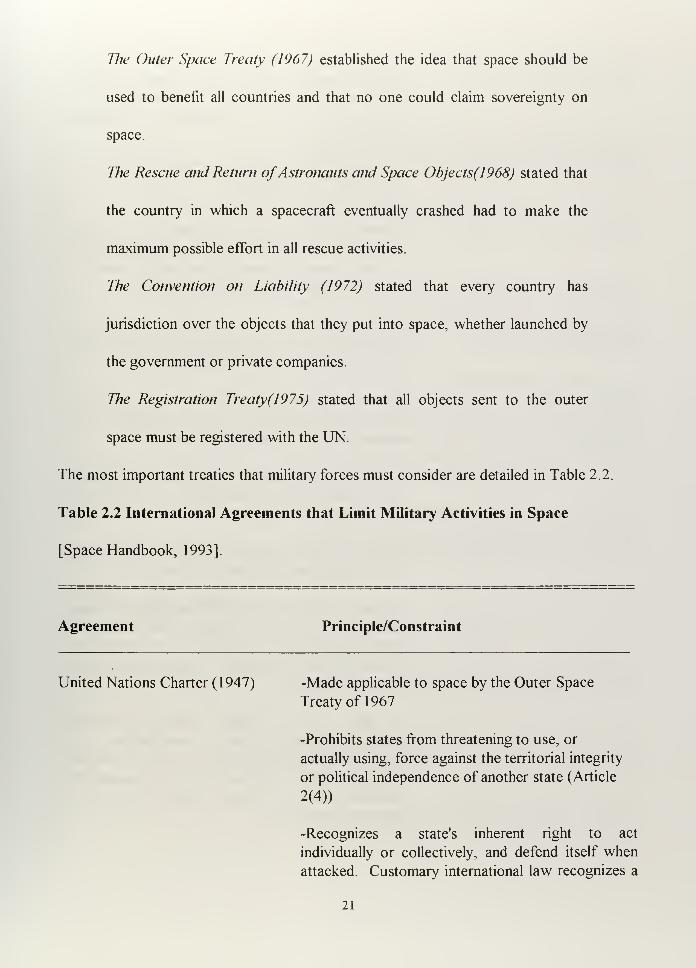
The most important treaties that military forces must consider are detailed in Table 2.2.
Table 2.2 International Agreements that Limit Military Activities in Space
[Space Handbook, 1993].
Agreement Principle/Constraint
United Nations Charter (1947) -Made applicable to space by the Outer Space
Treaty of 1967
-Prohibits states from threatening to use, or
actually using, force against the territorial integrity
or political independence of another state (Article
2(4))
-Recognizes a state's inherent right to act
individually or collectively, and defend itself when
attacked Customary international law recognizes a
21
broader right to self-defense, one that does not
require a state to wait until it is actually attacked
before responding. This right to act preemptively is
known as the right of anticipatory self-defense
(Article 51)
Limited Test Ban Treaty (1963) -Bans nuclear weapons tests in the atmosphere, in
outer space, and underwater
-States may not conduct nuclear tests or other
nuclear explosions (i.e., peaceful nuclear explosions)
in outer space or assist or encourage others to
conduct such tests or explosions (Article 1
)
Outer Space Treaty ( 1 967) -Outer space, including the moon and other celestial
bodies, is free for use by all states (Article I)
-Outer space and celestial bodies are not subject to
national appropriation by claim of sovereignty, use,
occupation, or other means (Article II)
-Space activities shall be conducted in accordance
with international law, including the UN Charter
(Article III)
-The moon and other celestial bodies are to be used
exclusively for peaceful purposes (.Article IV)
-Nuclear weapons and other weapons of mass
destruction (such as chemical and biological
weapons) may not be placed in orbit, installed on
celestial bodies, or stationed in space in any other
manner (Article IV)
-A state may not conduct military maneuvers;
establish military bases. fortifications, or
installations; or test any type of weapon on celestial
Nuclear bodies. Use of military personnel for
scientific research or other peaceful purpose is
permitted (Article IV)
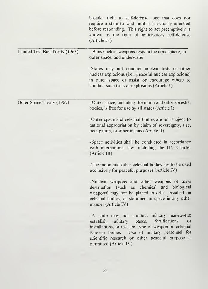
22
-States are responsible for governmental and private
space activities and must supervise and regulate
private activities (Article IV)
-States are intentionally liable for damage to another
state (and its citizens) caused by its space objects
(including privately owned ones) (Article VII)
-States retain jurisdiction and control over space
objects while they are in space or on celestial bodies
(Article VII)
-States must conduct international consultations
before proceeding with activities that would cause
potentially harmful inference with activities of other
parties (Article IX)
-States must carry out their use and exploration of
space in such a way as to avoid harmful
contamination of outer space the Moon, and other
celestial bodies, as well as to avoid the introduction
of extraterrestrial matter that could adversely affect
the environment of the Earth (Article IX)
-Stations, installations, equipment, and space
vehicles on the Moon and other celestial bodies are
open to inspection by other countries on a basis of
reciprocity.
Antiballistic Missile (ABM)Treaty (1972) -Between the U.S. and USSR
-Prohibits development, testing, or deployment of
space-based ABM systems or components (Article
V)
-Prohibits deployment of ABM systems or
components except as authorized in the treaty
(Article I)
-Prohibits interference with the national technical
means a party uses to verify compliance with the
treaty (Article XII)
23
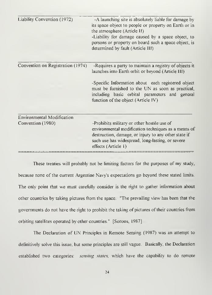
Liability Convention (1972) -A launching site is absolutely liable for damage by
its space object to people or property on Earth or in
the atmosphere (Article II)
-Liability for damage caused by a space object, to
persons or property on board such a space object, is
determined by fault (Article III)
Convention on Registration (1974) -Requires a party to maintain a registry of objects it
launches into Earth orbit or beyond (Article III)
-Specific Information about each registered object
must be furnished to the UN as soon as practical,
including basic orbital parameters and general
function of the object (Article IV)
Environmental Modification
Convention (1980) -Prohibits military or other hostile use of
environmental modification techniques as a means of
destruction, damage, or injury to any other state if
such use has widespread, long-lasting, or severe
effects (Article 1
)
These treaties will probably not be limiting factors for the purposes of my study,
because none of the current Argentine Navy's expectations go beyond these stated limits.
The only point that we must carefully consider is the right to gather information about
other countries by taking pictures from the space. "The prevailing view has been that the
governments do not have the right to prohibit the taking of pictures of their countries from
orbiting satellites operated by other countries." [Soroos, 1987]
The Declaration of UN Principles in Remote Sensing (1987) was an attempt to
definitively solve this issue, but some principles are still vague. Basically, the Declaration
established two categories: sensing states, which have the capability to do remote
24
sensing, and sensed stales, which are the observed states. The Declaration tried to set up
the obligation of the sensing states to cooperate with the sensed states by providing the
obtained information about the observed state(s) at a reasonable and non-discriminatory
cost, as well as the equivalent information about the sensing state, when requested, at
reasonable cost. In other words, the law is trying to prevent harmful use of the remote
sensing resources. [OTA-ISS-604, 1994]
It is important to remember that the acceptance of satellite reconnaissance as a
legitimate "national technical means of verification" by the superpowers was nothing more
than a legal way to justify their space activities [Soroos, 1987].
Aside from considerations about the legality of the actions, we can credit remote
sensing activities (for example during the Cuban Missile Crisis and The Persian Gulf War)
with saving lives and keeping the world powers in equilibrium.
Finally, we need to accept that space assets are part of the systems that military
forces can use to protect their countries and maintain the world's balance of power. Space
assets can be integrated with weapons, sensors, communication systems, data bases, and
computers. The acquisition of space assets should be considered in a similar manner as
other military supplies. With the huge expansion that space systems are undergoing, the
number of systems offered in the commercial area will notably increase before the year
2000. The prices should correspondingly decrease and make the products more
competitive. Today, the worldwide distribution of military duties places many demands
for upgrades on those forces that want to be part of the new global community. Such
25

participation requires the capability to be linked and the capability to be informed, which is
also a requirement for self defense and military cooperation with other countries.
26
III. COMMUNICATION SATELLITES IN GEOSTATIONARY
ORBIT
A. INTRODUCTION
Because communication has played one of the most important roles in the history
of the humankind, it is only natural that the entire world would exploit any opportunity to
get more and better communications. Satellites and computers have contributed to this
technological expansion. Satellite communication is one of the most important and
profitable commercial applications of space technology. [Wheelon, 1989]
For the past thirty years, Geostationary (GEO) satellites have dominated the
communications area. Although the former Soviet Union (F.S.U.) used Low Earth Orbit
satellites for communication purposes (Cosmos and Molniya series), the closed policies of
this nation did not allow us to know the reasons why, nor did they reveal the advantages
or problems the F.S.U. had with this technology.
Since the beginning of the 1990's, the achievement of better technological
capabilities and the saturation of the Geostationary orbit, along with the establishment of
new needs (more bandwidth, less time delay, lower cost), made the idea of Low Earth
Orbit (LEO) constellations attractive. Many LEO communication programs are already
27
under development,1
though none of those currently proposed will be able to completely
replace the services provided by GEO satellites .
Although conceived to be used commercially, military forces have used civilian
GEO communication systems to support their operations. One example was the use of
INMARSAT during the Persian Gulf War. Since commercial companies discovered how
much business military customers could provide, they have created special packages of
services to make their products more attracted to military customers.
B. GEOSTATIONARY SATELLITES
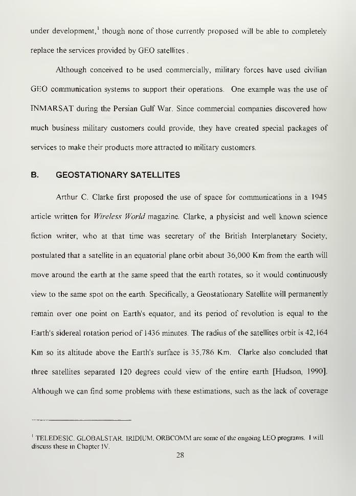
Arthur C. Clarke first proposed the use of space for communications in a 1945
article written for Wireless World magazine. Clarke, a physicist and well known science
fiction writer, who at that time was secretary of the British Interplanetary Society,
postulated that a satellite in an equatorial plane orbit about 36,000 Km from the earth will
move around the earth at the same speed that the earth rotates, so it would continuously
view to the same spot on the earth. Specifically, a Geostationary Satellite will permanently
remain over one point on Earth's equator, and its period of revolution is equal to the
Earth's sidereal rotation period of 1436 minutes. The radius of the satellites orbit is 42,164
Km so its altitude above the Earth's surface is 35,786 Km. Clarke also concluded that
three satellites separated 120 degrees could view of the entire earth [Hudson, 1990].
Although we can find some problems with these estimations, such as the lack of coverage
1 TELEDESIC GLOBALSTAR. IRIDIUM. ORBCOMM are some of the ongoing LEO programs. I will
discuss these in Chapter IV.
28
at the poles or the North-South and East-West drift of the satellite positions relative to the
earth, Clark's basic concept was the driving force behind Geostationary satellite evolution.
[Larson and Wertz, 1995]
The question that naturally arises at this point is how much of Argentina
will a Geostationary Satellite located at the equatorial plane actually cover. "Coverage" is
defined as the ability of the satellite to communicate with a ground station. To answer this
question, I will first present some basic definitions: [Larson and Wertz, 1995]
Subsatellite point (SSP): the projection of satellite position over the
Earth's surface.
Access Area (AA): the total area that the satellite antenna "sees" at any
moment .
Field of view (FOV) or "Footprint": the instantaneous region on the
ground being covered. This is driven by the antenna design. In this
particular example, we will consider omnidirectional antennas, so we have
no restrictions on FOV due to the antenna design.
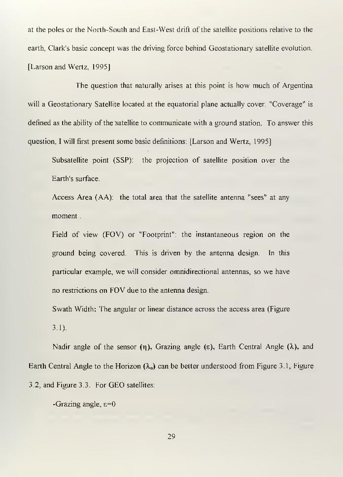
Swath Width: The angular or linear distance across the access area (Figure
3.1).
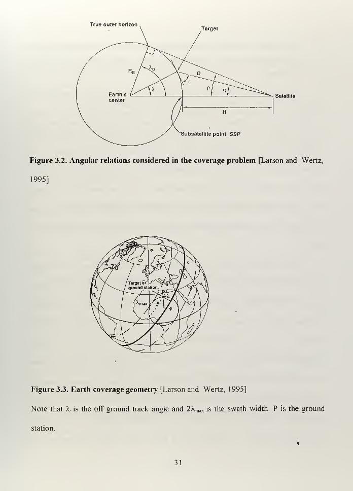
Nadir angle of the sensor (t|), Grazing angle (e), Earth Central Angle (A.), and
Earth Central Angle to the Horizon (A, ) can be better understood from Figure 3.1, Figure
3.2, and Figure 3.3. For GEO satellites:
-Grazing angle, e=0
29
-Altittude above the Earth's surface, H=3 5,786 Km
-Radius of the Earth, RE= 6378 Km
-Swath Width= 2 Xmax
-Sinr|=cosE/(l+H/RE)=l/l+35786/6378=0. 151266 so r|=8.7 Degrees
-A,max= 90-ti-s = 90-8.7= 81.3 degrees
This value tells us that geometrical constraints limit coverage from the equator to
81.3 degrees North or South. Considering the Argentina boundaries are 74 ° W and 52°
W, geostationary satellites located from about 7 °E to 133°W can provide the required
East-West coverage. Physics keeps us from doing anything about the lack of polar
coverage, but we can manage the GEO position that favors our needs, though this is
becoming increasingly difficult because GEO is actually crowded over the Atlantic
Region.2
spacecraft
Figure 3.1. Access Area and Footprint [Larson and Wertz, 1995]
The same segment of GEO seems to be the most appropriate for North and South America, so as the
number ofGEO satellites increases, the probability of getting an optimal position for a new satellite
decreases.
30
True outer horizonTarget
Satellite
Subsatellite point, SSP
Figure 3.2. Angular relations considered in the coverage problem [Larson and Wertz,
1995]
Figure 3.3. Earth coverage geometry [Larson and Wertz, 1995]
Note that X is the off ground track angle and IXm^ is the swath width. P is the ground
station.
31
C. WHAT CIVILIAN SPACE COMMUNICATION SYSTEMS IN GEO COULD
BE AVAILABLE FOR ARGENTINE NAVY NOW AND IN THE NEAR
FUTURE?
Since the beginning of space commercialization, when INTELSAT I was launched
in 1965, the geosynchronous orbit has developed in such way that today it is very difficult
to get a position for a satellite in some critical areas. More than 114 communication
satellites are now in geosynchronous orbit, excluding those designed exclusively with
military purposes. More than 400 have been launched into space since 1964, and today
the world is launching about twenty-five every year (twenty-nine during 1996). In some
cases, there is no more than one degree of separation between two adjacent satellites.
For example, Spacenet 2 (S2) is located at 69° 00' W and Brazilsat B2 is located at 70°00'
W.
The countries that currently have satellites in geostationary orbit are the United
States, the former Soviet Union, France, Japan, China, India, Luxembourg, Canada,
Mexico, Thailand, Brazil, Turkey, Germany, Israel, Sweden, Spain, United Arab Emirates,
Australia, Malaysia, South Korea, United Kingdom, Italy, Sweden, Hong Kong and
Argentina. Although INTELSAT had the commercial monopoly on satellite
communications during the early 1960's and 1970's, the increasing demand for services
and the international open sky policies, which encouraged the use of space with peaceful
purposes, contributed to the development of a new industry. Military and civil needs also
contributed to the growth of this industry and to independent ownership of GEO satellites
by individual countries. Countries that are sole owners of GEO satellites are not
32
necessarily "space capable," some of them just had the money to pay prime contractors to
build satellites and the legislation and marketing structure to make profit after the services
were established.
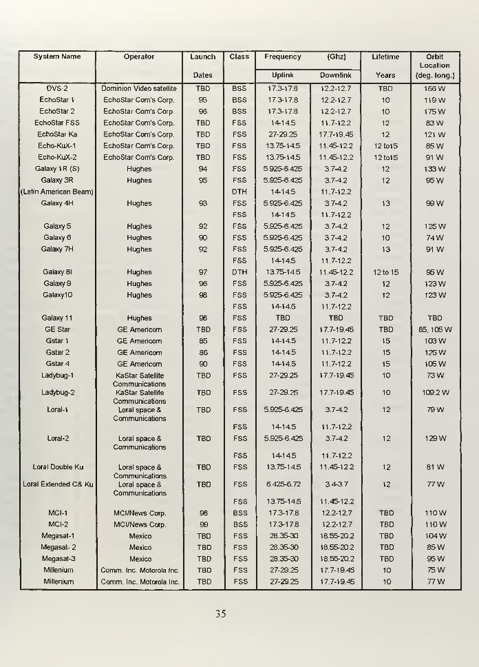
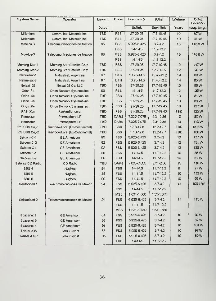
Today, twelve organizations operate forty communication satellites that serve
North and South America. There are another twenty-three satellites under construction
and six new operators waiting to join the list. Table 3.1 summarizes the existing satellites
that provide communication services to North and South America, along with those
planned for the near future.
D. HOW CAN THE ARGENTINE NAVY USE COMMERCIAL GEO
SATELLITES TO SUPPORT NAVAL OPERATIONS?
1. Requirements
Communications required to support the Argentine Navy C 3I structure are not
fundamentally different from those required by the U.S. Navy, but the scale may be
significantly different.
Our basic operational communication requirements are:
-Naval telecommunications supporting a battle group. That means short-range
communications between the battle group members (tactical communications).
-Long-range communications between shore commands and battle groups.
-Strategic submarine communications between the submarine authority and
deployed submarines.
33
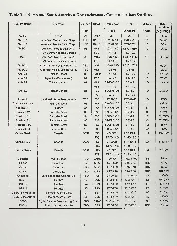
Table 3.1. North and South American Geosynchronous Communications Satellites.
System Name Operator Launch
Date
Class Frequency (Ghz) Lifetime
Years
Orbit
Location
(deg. long.)Uplink Downlink
ACTS NASA 93 Exp.* 30 20 6 100WAMRC1 American Mobile Radio Corp. TBD DARS 6.525-6.725 2.31-2.36 10 99WAMRC2 American Mobile Radio Corp. TBD DARS 6.525-6.725 2.31-2.36 10 103WAMSC-1 American Mobile Satellite & 95 MSS 1.631-1.66 1 .530-1 .559 10 101 W
TMI Communications Canada FSS 14-14.5 11.7-12.2
Msat 1 American Mobile Satellite & 96 MSS 1.631-1.66 1 .530-1 .559 10 106.5W
TMI Communications Canada FSS 14-14.5 11.7-12.2
AMSC-2 American Mobile Satellite Corp. TBD MSS 1.6161.626 1.515-1.525 62WAMSC-3 American Mobile Satellite Corp TBD MSS L&Ku L&Ku 139W
Anik C1 Telesat Canada 85 Feeder 14-14.5 11.7-12.2 10 114.9W
Anik C2 Argentina (Paracomsat) 82 FSS 14-14.5 11 7-12.2 10 72WAnik E1 Telesat Canada 91 FSS
FSS
5.925-6.425
14-14.5
3.7-4.2
11.7-12.2
10 111.1 W
Anik E2 Telesat Canada 91 FSS
FSS
5.925-6425
14-14.5
3.7-4.2
11.7-12.2
10 107.3W
Astrolink Lockheed Martin Telecommun. TBD FSS 27-29.25 17.7-1945 10 97WAurora 2 Satcom GE Americom 91 FSS 5.925-6.425 3 7-4.2 12 139W
Brasilsat A1 Hughes 85 FSS 5.925-6 425 3.7-4.2 8 79 WBrasilsat A2 Embratel Brasil 86 FSS 5.925-6425 3.7-4.2 8 92WBrasilsat B1 Embratel Brasil 94 FSS 5.925-6 425 3.7-4.2 12 70, 65 WBrasilsat B2 Embratel Brasil 95 FSS 5.925-6 425 3 7-4.2 12 70, 65WBrasilsat B3A Embratel Brasil 97 FSS 5.925-6 425 3 7-4.2 12 65WBrasilsat B4 Embratel Brasil 98 FSS 5.925-6 425 3 7-4.2 12 65WCansat KA-1 Canada 2000 FSS
FSS
27-29.25
13.75-145
177-1945
11 45-12.2
20 107.3W
Cansat KA-2 Canada 2000 FSS
FSS
27-29 25
13.75-14.5
177-1945
11 45-12.2
20 111.1 W
Cansat KA-3 Canada 2000 FSS
FSS
27-29 25
13.75-145
177-1945
11 45-12 2
20 118W
Caribstar WorldSpace TBD DARS 20-30 1 462-1 492 TBD 75W
Celsat Celsat, inc. TBD MSS 1.97-1 99 2 16-2 18 TBD 78 WCelsat Celsat, inc TBD MSS 1 97-1 99 2 16-218 TBD 89WCelsat Celsat.inc TBD MSS 1.97-1 99 2 16-2 18 TBD 109.2W
Cyberstar Loral space and Comm's Ltd. TBD FSS 27-29 25 177-1945 12 115W
DBS-1 Hughes 93 BSS 173-178 12 2-12 7 12 101 .2WDBS-2 Hughes 94 BSS 17.3-17 8 122-127 12 100.7WDBS-3 Hughes 95 BSS 173-178 122-127 12 157W
DBSC (EchoStar 3) EchoStar Corn's Corp. 97 BSS 173-178 122-127 10 61 5WDBSC (EchoStar 4) EchoStar Corn's Corp. 98 BSS 173-178 122 127 10 175W
DSBC Digital Satellite Broadcasting Corp. TBD DARS 7 025-7 075 2 31-2 36 15 101 WDVS-1 Dominion Video satellite TBD BSS 173-178 122-127 TBD 61 .5W
System Name Operator Launch
Dates
Class Frequency (Ghz) Lifetime
Years
Orbit
Location
(deg. long.)Uplink Downlink
DVS-2 Dominion Video satellite TBD BSS 17.3-17.8 12.2-12.7 TBD 166WEchoStar 1 EchoStar Corn's Corp. 95 BSS 17.3-17.8 12.2-12.7 10 119WEchoStar 2 EchoStar Corn's Corp. 96 BSS 17.3-17.8 12.2-12.7 10 175W
EchoStar FSS EchoStar Corn's Corp. TBD FSS 14-14.5 11.7-12.2 12 83WEchoStar Ka EchoStar Corn's Corp. TBD FSS 27-29.25 17.7-19 45 12 121 WEcho-KuX-1 EchoStar Corn's Corp. TBD FSS 13.75-14.5 11.45-12.2 12to15 85WEcho-KuX-2 EchoStar Corn's Corp. TBD FSS 13.75-14.5 11.45-12.2 12to15 91 WGalaxy 1 R (S) Hughes 94 FSS 5.925-6.425 3.7-4.2 12 133WGalaxy 3R Hughes 95 FSS 5.925-6.425 3.7-4.2 12 95W
(Latin American Beam) DTH 14-14 5 11.7-12.2
Galaxy 4H Hughes 93 FSS
FSS
5.925-6.425
14-14.5
3.7-4.2
11.7-12.2
13 99W
Galaxy 5 Hughes 92 FSS 5.925-6.425 3.7-4.2 12 125WGalaxy 6 Hughes 90 FSS 5.925-6.425 3.7-4.2 10 74WGalaxy 7H Hughes 92 FSS
FSS
5.925-6425
14-14.5
3.7-4.2
11.7-12.2
13 91 W
Galaxy 81 Hughes 97 DTH 13.75-14.5 11.45-12.2 12 to 15 95WGalaxy 9 Hughes 96 FSS 5.925-6.425 3.7-4.2 12 123WGalaxylO Hughes 98 FSS
FSS
5.925-6.425
14-14.5
3.7-4.2
11.7-12.2
12 123W
Galaxy 1
1
Hughes 98 FSS TBD TBD TBD TBD
GE Star GE Americom TBD FSS 27-29.25 17.7-19.45 TBD 85, 105WGstar 1 GE Americom 85 FSS 14-14.5 11.7-12.2 15 103WGstar 2 GE Americom 86 FSS 14-14.5 11 7-12.2 15 125WGstar 4 GE Americom 90 FSS 14-14.5 11.7-12.2 15 105W
Ladybug-1
Ladybug-2
Loral-1
KaStar Satellite
Communications
KaStar Satellite
Communications
Loral space &Communications
TBD
TBD
TBD
FSS
FSS
FSS
FSS
27-29.25
27-29.25
5.925-6.425
14-14.5
17.7-19.45
17.7-19.45
3.7-4.2
11.7-12.2
10
10
12
73W
109.2W
79W
Loral-2 Loral space &Communications
TBD FSS
FSS
5.925-6.425
14-14.5
3.7-4.2
11.7-12.2
12 129W
Loral Double Ku
Loral Extended C& Ku
Loral space &Communications
Loral space &Communications
TBD
TBD
FSS
FSS
FSS
13.75-14.5
6.425-6.72
13.75-14.5
11.45-12.2
3.43.7
11.45-12.2
12
12
81 W
77W
MCI-1 MCI/News Corp. 98 BSS 17.3-17.8 12.2-12.7 TBD nowMCI-2 MCI/News Corp. 99 BSS 17.3-17.8 12.2-12.7 TBD now
Megasat-1 Mexico TBD FSS 28.35-30 18.55-20.2 TBD 104WMegasat- 2 Mexico TBD FSS 28.35-30 18.55-20.2 TBD 85WMegasat-3 Mexico TBD FSS 28.35-30 18.55-20.2 TBD 95WMillenium Comm Inc. Motorola Inc. TBD FSS 27-29 25 17.7-19.45 10 75WMillenium Comm. Inc. Motorola Inc. TBD FSS 27-29.25 17.7-19.45 10 77W
35
System Name Operator Launch
Dates
Class Frequency (Ghz) Lifetime
Years
Orbit
Location
(deg. long.)Uplink Downlink
Millenium Comm Inc. Motorola Inc. TBD FSS 27-29.25 17.7-1945 10 87WMillenium Comm. Inc Motorola Inc. TBD FSS 27-29.25 17.7-1945 10 91 WMorelos B Telecomunicaciones de Mexico 85 FSS
FSS
5.925-6.425
14-14.5
3.7-4.2
11.7-12.2
13 116.8W
Morelos-3 Telecomunicaciones de Mexico 98 FSS
FSS
5.925-6.425
14-14.5
3.7-4.2
11.7-12.2
13 116.8W
Morning Star-1 Morning Star Satellite Corp. TBD FSS 27-29.25 17.7-19.45 12 147WMorning Star-2 Morning Star Satellite Corp. TBD FSS 27-29.25 12.2-12.5 12 147WNahuelsat-1 Nahuelsat, Argentina 97 DTH 13.75-14.5 11.45-12.2 14 80WNahuelsat-2 Nahuelsat, Argentina 97 DTH 13.75-14.5 11.45-12.2 14 85WNetsat 28 Netsat 28 Co. LLC TBD FSS 27-29.25 17.7-1945 10 95WOrion-F4 Orion Network Systems inc. 99 FSS 14-14.5 11.7-12.2 12 135W
Orion Ka Orion Network Systems inc. TBD FSS 27-29.25 17.7-19.45 13 81 WOrion Ka Orion Network Systems inc. TBD FSS 27-29.25 17.7-19.45 13 89WOrion Ka Orion Network Systems inc. TBD FSS 27-29.25 17.7-19.45 13 127W
PAS (Ka) PanAmSat corp. TBD FSS 27-29.25 17.7-19.45 TBD 125W
Primostar Primosphere LP TBD DARS 7.025-7.075 2.31-2.36 10 80WPrimostar Primosphere LP TBD DARS 7.025-7.075 2.31-2.36 10 110W
R/L DBS Co,-1 Rainbow/Loral (Ex-Continental) TBD BSS 17.3-17.8 12.2-12.7 TBD 61 .5WR/L DBS Co,-2 Rainbow/Loral (Ex-Continental) TBD BSS 17.3-17.8 12.2-12.7 TBD 166W
Satcom C-1 GE Americom 90 FSS 5.925-6.425 3.7-4.2 10 137WSatcom C-3 GE Americom 92 FSS 5.925-6.425 3.7-4.2 12 131 WSatcom C4 GE Americom 92 FSS 5.925-6.425 3.7-4.2 12 135W
Satcom K-1 GE Americom 85 FSS 14-14.5 11 7-12.2 10 85WSatcom K-2 GE Americom 86 FSS 14-14.5 11.7-12.2 10 81 W
Satellite CD Radio CD Radio TBD DARS 7.035-7.055 2.31-2.36 15 110W
SBS4 Hughes 84 FSS 14-14.5 11.7-12.2 9 77W
SBS5 Hughes 88 FSS 14-145 11.7-12.2 10 123W
SBS6 Hughes 90 FSS 14-14.5 11.7-12.2 10 95W
Solidaridad 1 Telecomunicaciones de Mexico 94 FSS
FSS
MSS
5.925-6.425
14-14.5
1.631-1.660
3.7-4.2
11.7-12.2
1.53-1.555
14 109.1 W
Solidaridad 2 Telecomunicaciones de Mexico 94 FSS
FSS
MSS
5.925-6.425
14-14.5
1.631-1.660
3.7-4.2
11.7-12.2
1.53-1.555
14 113W
Spacenet 2 GE Americom 84 FSS 5.925-6.425 37-4.2 10 69W
Spacenet 3 GE Americom 88 FSS 5.925-6.425 3.7-4.2 10 87WSpacenet 4 GE Americom 91 FSS 5.925-6.425 3.7-4.2 10 101 WTelstar 303 Loral Skynet 85 FSS 5.925-6.425 3.7-4.2 10 97WTelstar 402R Loral Skynet 95 FSS
FSS
5.925-6.425
14-14.5
37-42
11.7-12.2
10 89W
36
System Name Operator Launch
Dates
Class Frequency (Ghz) Lifetime
Years
Orbit
Location
(deg. long.)Uplink Downlink
Telstar 5 Loral Skynet 97 FSS 5.925-6.425 3 7-4.2 15 97WTelstar 6 Loral Skynet 98 FSS 5.925-6.425 3.7-4.2 15 93WTelstar 7 Loral Skynet 99 FSS 5.925-6.425 3.7-4.2 15 69WTempo Tempo Satellite inc. 97 BSS 17.3-17.8 12.2-12.7 10 119W
Tempo Tempo Satellite inc. 97 BSS 17.3-17.8 12.2-12.7 10 166W
USSB U.S. SatelliteBroadcasting 93 BSS 17.3-17.8 12.2-12.7 TBD 101 WUSSB U.S. SatelliteBroadcasting TBD BSS 17.3-17.8 12.2-12.7 TBD 110W
USSB U.S. SatelliteBroadcasting TBD BSS 17.3-17.8 12.2-127 TBD 148W
VisionStar Visionstar Inc. TBD FSS 27-29.25 17.7-19.45 12 113W
VoiceSpan AT&T TBD FSS 27-29.25 17.7-19.45 12 93WVoiceSpan AT&T TBD FSS 27-29.25 17.7-19.45 12 103W
*Abbreviations:
BSS-Broadcasting Satellite Service
DARS-Digital Audio Radio service
DTH- Direct-to-home (TV)
Exp-Experimental
FSS-Fixed Satellite Services
MSS- Mobile Satellite Services
TBD-To be determined
Definitions:
Uplink frequencies are used to transmit signals from Earth stations to the satellite. Downlink
frequencies are used by the satellite to retransmit signals back to Earth.
Source: Space News. March 3-9. 1997
37
Ultra High Frequency (UHF) and High Frequency (HF) circuits provide most of
the U.S. Navy's tactical communications. It supports Command and Control functions,
dissemination and distribution of sensor data, and control of combat and weapon systems.
The range established by the U.S. Navy for this type of communications is 220 nautical
miles. To allow these UHF ranges military satellites are used. This tactical conception is
based in the U.S. weapon's range and defensive capability. [Kim, 1995]
Although Argentine Navy tactical communications range is less than 1 1 nautical
miles, ships operating beyond the horizon still require HF systems to communicate. We
would like to use UHF frequencies all the time because they are more difficult to be
listened by third parties, unless they were close enough to be shot, but we have to suffer
the absence of military communication satellites.
Argentine Navy long-range communications are normally limited to the South
Atlantic Ocean, and the distances involved are 500 miles or less, rather than the 400 to
6000 nautical miles considered by the U.S. Navy.
In the particular case of Argentine ships deployed as a part of an international
force, communication with Argentine Navy shore commands is basically administrative,
and INMARSAT has, until now, been the most appropriate way to achieve it. In these
situations, tactical communication with international forces has been more complicated
and has sometimes required special equipment provided by the U.S. Navy.
For the U.S. Navy, which has a variety of technical means to establish secure
tactical and long-range communications, commercial satellites would only be appropriate
38
for backup or administrative functions. In our case, not having military satellites implies
that the only way to add a new capability,such as a satellite link, is to use what already
exists
Suppose the hypothetical situation in which the Officer in Tactical Command
(OTC) needs to change the orders to the units deployed just 200 nautical miles from the
flag ship. In this situation, the U.S. Navy communications officer probably uses a UHF
circuit supported by one of the different FLSATCOM or LEASAT satellites, keeping an
HF circuit as a backup. The Argentine communications officer must use an HF circuit,
with another HF circuit as a backup. Could a commercial GEO satellite be a feasible
alternative to increase our tactical capability? If it were feasible, should this new band be
used instead of, or as a backup to the primary FIF circuit?
I will consider INTELSAT and INMARSAT a representative examples of satellite
systems that the Argentine Navy can use for military purposes, because Argentina is
already using these systems, though not for tactical communications, and because both of
them have been used before in military operations (for example, during and after the
Persian Gulf War). Moreover, I think that the different series of INTELSAT and
INMARSAT are representative of their classes and, in both cases we can find the essential
capabilities found in most other GEO satellites offered in the commercial market.
2. INMARSAT
From 1972 to 1979, the Intergovernmental Maritime Organization (IMO), began a
project to create an international maritime satellite system. In 1979, twenty-six nations
39
established the initial agreements and created the International Maritime Satellite
Organization (INMARSAT). In 1982 INMARSAT introduced a new capability for
marine communications by providing satellite voice service. The first standard terminals,
known as Standard-A (INMARSAT-A), were expensive and so was the service. In fact,
the cost is still so high that the system must be used sparingly, compared to standard
telephone systems. When installed on a warship, INMARSAT requires special
considerations. The electronic organization of the ship can be altered by this new system
and sometimes there is no room for a new antenna. In the past two decades, it was the
only service able to provide global coverage, including the most isolated areas and the
middle of the oceans. [Lodge, 1991] Today, INMARSAT has evolved in order to satisfy
the new markets and customer needs and to prepare for the competition from proposed
LEO satellites, which promise coverage of the entire globe.
INMARSAT is comprised of four segments: Satellites, which can be owned or
leased; Coast Earth Stations (CES), which are operated by INMARSAT owners and
deployed around the world; Ship Earth Stations (SES), which are owned and operated by
ship-owners; and the Primary Control Facility for Tracking Telemetry and Control
(TT&C), located in London, England. The only part that users can control is the SES.
There are many types of Ship Earth Stations to choose from:
-INMARSAT-A: Having a one meter diameter parabolic antenna and a medium
size terminal, it is capable of providing facsimile and data transmission up to 9.6 Kbps,
along with one analog voice channel, which can also be used as a single 56 Kbps data rate
40
channel. The complete INMARSAT-A terminal can be carried in one or two suitcases.
During the Persian Gulf War, a variety participants, including Kuwaiti resistance fighters,
CNN crews, U.S. forces and others used more than 150 "one suitcase" INMARSAT-A.
These terminals were also used to transmit electronic photos at a 56 Kbps data rate.
[Comparetto, 1993]
-INMARSAT-B: The digital successor of INMARSAT-A. The terminal is similar
to INMARSAT-A, but improved. It is able to provide direct-dial telephone, facsimile, and
TELEX. Data can be sent at 64 Kbps synchronous High Speed Data (HSD), or at 9.6
Kbps asynchronous standard.
-INMARSAT-C: This terminal can store and forward digital data (electronic mail,
TELEX and packet-switched data networks) at a rate of 600 bps but will not provide
voice communication. The terminal fits in a suitcase and requires a hemispheric non-
pointing antenna, about a half meter in diameter. [Comparetto, 1993]
-INMARSAT-M: This version is designed for a high degree of commonality with
the INMARSAT-B system in order to minimize mobile equipment cost and make the best
possible use of the satellite channel resources and land earth stations hardware.
INMARSAT-M terminals are smaller than INMARSAT-A and INMARSAT-B terminals,
in some cases smaller than a briefcase. The terminal requires a half meter diameter
parabolic antenna and demands less bandwidth and satellite power. It can provide facsimile
" The physical layer typically operates at 9.6 Kbps. Each character consists of eight bits transmitted
asynchronously (with start and stop bits). This results in an overhead of 25% without using a parity bit.
and 45% using a parity bit. Synchronous transmission uses special frames and considerably reduces the
overhead.
41
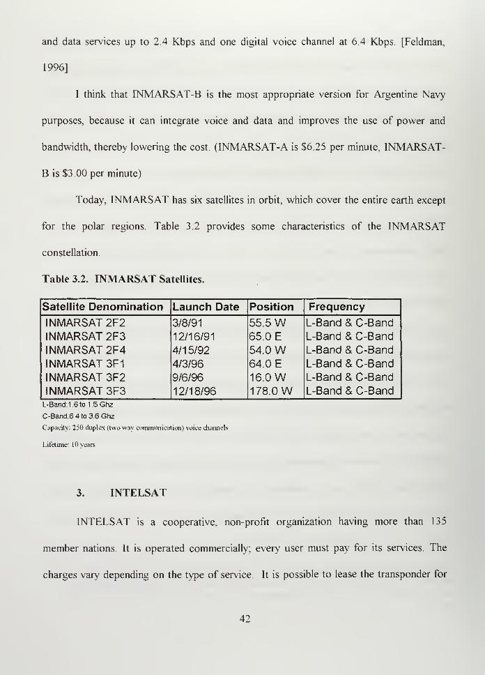
and data services up to 2.4 Kbps and one digital voice channel at 6.4 Kbps. [Feldman,
1996]
I think that INMARSAT-B is the most appropriate version for Argentine Navy
purposes, because it can integrate voice and data and improves the use of power and
bandwidth, thereby lowering the cost. (INMARSAT-A is $6.25 per minute, INMARSAT-
IS is $3.00 per minute)
Today, INMARSAT has six satellites in orbit, which cover the entire earth except
for the polar regions. Table 3.2 provides some characteristics of the INMARSAT
constellation.
Table 3.2. INMARSAT Satellites.
Satellite Denomination Launch Date Position Frequency
INMARSAT 2F2 3/8/91 55.5 W L-Band & C-Band
INMARSAT 2F3 12/16/91 65.0 E L-Band & C-Band
INMARSAT 2F4 4/15/92 54.0 W L-Band & C-Band
INMARSAT 3F1 4/3/96 64.0 E L-Band & C-Band
INMARSAT 3F2 9/6/96 16.0 W L-Band & C-Band
INMARSAT 3F3 12/18/96 178.0 W L-Band & C-BandL-Band: 1 6to1.5Ghz
C-Band.6 4 to 3.6 Ghz
Capacity. 250 duplex (two way communication) voice channels
Lifetime: 10 vears
3. INTELSAT
INTELSAT is a cooperative, non-profit organization having more than 135
member nations. It is operated commercially; every user must pay for its services. The
charges vary depending on the type of service. It is possible to lease the transponder for
42
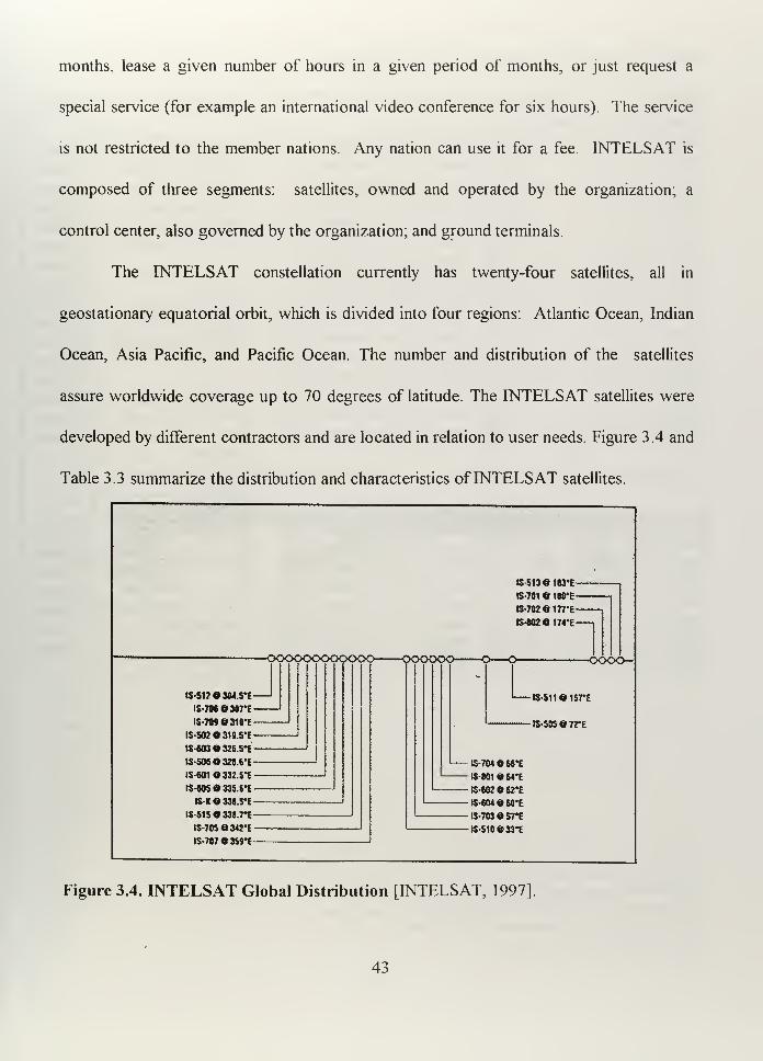
months, lease a given number of hours in a given period of months, or just request a
special service (for example an international video conference for six hours). The service
is not restricted to the member nations. Any nation can use it for a fee. INTELSAT is
composed of three segments: satellites, owned and operated by the organization, a
control center, also governed by the organization; and ground terminals.
The INTELSAT constellation currently has twenty-four satellites, all in
geostationary equatorial orbit, which is divided into four regions: Atlantic Ocean, Indian
Ocean, Asia Pacific, and Pacific Ocean. The number and distribution of the satellites
assure worldwide coverage up to 70 degrees of latitude. The INTELSAT satellites were
developed by different contractors and are located in relation to user needs. Figure 3.4 and
Table 3.3 summarize the distribution and characteristics ofINTELSAT satellites.
tS513ei83*E
B-70l«18fl*E-
B-702ei77'£-
B-«Bei74*E-
-oooooooooooo oooooo o—-o-
tS-S12©304S-£~
is-706 ©sort
-
is-roesio'E-
IS-502O319.5*E-
B-6D3«3Z5.5*E~
is-sosoaa.CE-
ISG01O332.S*E-
IS-W5 33S.S*E -
IS-KG338.5-E
l$-515«338.7*E-
IS-70Sej4J*E-
IS-707«3S9*E-
-oooo-
B-511«157t
rS-505»7rE
$-7W»66*E
IS-B01«64*E
S-«02»K*£ts-cueorE
IS-78J05rE
B-510»M*E
Figure 3.4. INTELSAT Global Distribution [INTELSAT, 1997]
43
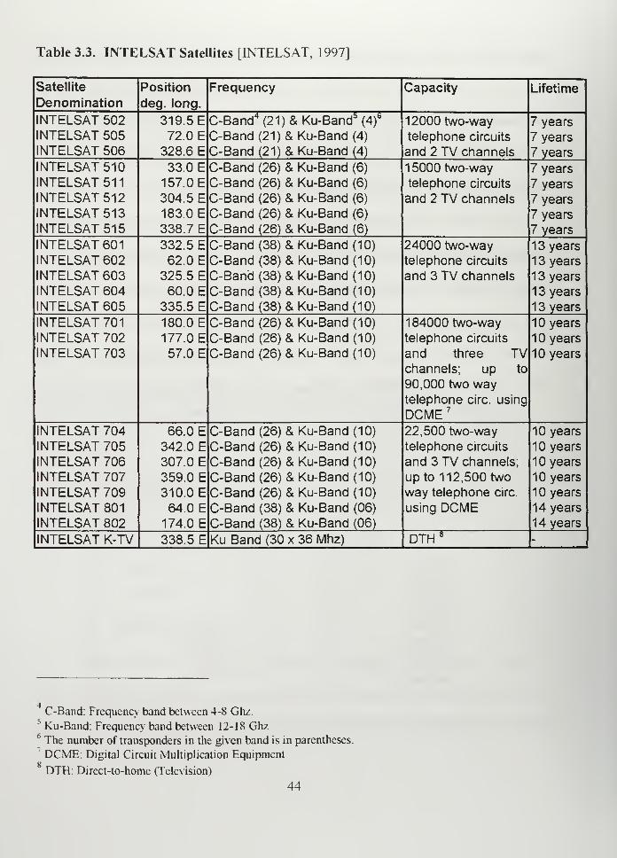
Table 3.3. INTELSAT Satellites [INTELSAT, 1997]
Satellite
DenominationPosition
deg. long.
Frequency Capacity Lifetime
INTELSAT 502INTELSAT 505INTELSAT 506
319.5 E72.0 E
328.6 E
C-Band4(21) & Ku-Band
5(4)
6
C-Band(21)&Ku-Band (4)
C-Band (21) & Ku-Band (4)
12000 two-way
telephone circuits
and 2 TV channels
7 years
7 years
7 years
INTELSAT 510INTELSAT 511
INTELSAT 512INTELSAT 513INTELSAT 515
33.0 E157.0 E304.5 E183.0 E338.7 E
C-Band (26) & Ku-Band (6)
C-Band (26) & Ku-Band (6)
C-Band (26) & Ku-Band (6)
C-Band (26) & Ku-Band (6)
C-Band (26) & Ku-Band (6)
1 5000 two-way
telephone circuits
and 2 TV channels
7 years
7 years
7 years
7 years
7 years
INTELSAT 601
INTELSAT 602INTELSAT 603INTELSAT 604INTELSAT 605
332.5 E62.0 E
325.5 E60.0 E
335.5 E
C-Band (38) & Ku-Band (10)
C-Band (38) & Ku-Band (10)
C-Band (38) & Ku-Band (10)
C-Band (38) & Ku-Band (10)
C-Band (38) & Ku-Band (10)
24000 two-waytelephone circuits
and 3 TV channels
1 3 years
1 3 years
1 3 years
13 years
13 years
INTELSAT 701
INTELSAT 702INTELSAT 703
180.0 E177.0 E57.0 E
C-Band (26) & Ku-Band (10)
C-Band (26) & Ku-Band (10)
C-Band (26) & Ku-Band (10)
184000 two-way
telephone circuits
and three TVchannels; up to
90,000 two waytelephone circ. using
DCME 7
10 years
10 years
10 years
INTELSAT 704INTELSAT 705INTELSAT 706INTELSAT 707INTELSAT 709INTELSAT 801
INTELSAT 802
66.0 E342.0 E307.0 E359.0 E
310.0 E64.0 E
174.0 E
C-Band (26) & Ku-Band (10)
C-Band (26) & Ku-Band (10)
C-Band (26) & Ku-Band (10)
C-Band (26) & Ku-Band (10)
C-Band (26) & Ku-Band (10)
C-Band (38) & Ku-Band (06)
C-Band (38) & Ku-Band (06)
22,500 two-waytelephone circuits
and 3 TV channels;
up to 112,500 two
way telephone circ.
using DCME
1 years
10 years
10 years
10 years
10 years
14 years
14 years
INTELSAT K-TV 338.5 E Ku Band (30 x 36 Mhz) DTH 8-
C-Band: Frequency band between 4-8 Ghz.s
Ku-Band: Frequency' band between 12-18 Ghz6The number of transponders in the given band is in parentheses.
7 DCME: Digital Circuit Multiplication EquipmentgDTH: Direct-to-home (Television)
44
INTELSAT uses six Telemetry, Tracking and Control (TT&C) stations located around
the world, which are all connected to the INTELSAT Operations Center in Washington
DC. [Zoppa, 1994]. INTELSAT provides telephony, data transfer, facsimile, television
and teleconferencing. The required antennas are about 3.5 to 18 m in diameter and use
international Standards A, B or C.
Standard A was used with a large antenna ( 1 5 to 1 8 m in diameter) because the
ground segment had to receive low power signals from the satellite. The "A" terminals are
medium or high capacity, with at least 24 voice circuits each. The operational frequency is
C-Band.
Standard B arrived when technology enabled satellites to have more radiated
power, so the ground stations are smaller than those used for Standard A. The objective
was to provide lower cost terminals. Of course, the simple terminals have reduced
capacity (less than 24 voice circuits). The antenna varies from 10 to 12 meters in
diameter.
Standard C first came with INTELSAT V. This Standard operates in the Ku band,
and it is only used by Nations with large (high capacity and many circuits) communication
requirements. Some Standard C terminals use dual antennas separated by 1 to 20 miles
in order to overcome rain degradation, which is significant at Ku-Band frequencies. The
antenna varies from 1 2 to 15 meters in diameter.
None of the antennas just mentioned can be used on board ships They were
designed to point toward a GEO satellite and transmit with high power. The
45
implementation of the Challenge Athena Program, which used an 2.4 meter diameter
antenna aboard the USS George Washington, revolutionized the U.S. Navy
communications by allowing high data rate communications (voice, data and video)
through the INTELSAT satellites. From the military point of view, the use of civilian
assets with tactical or operational purposes is, at first, difficult to visualize. Security
prejudices normally arises in the minds of our Commander Officers because they think that
everyone is listening in on public systems. In fact, INTELSAT communications can be
intercepted as easily as HF communications.
From the beginning, the Challenge Athena program, which I will explain later,
changed the U.S. Navy thinking about civilian satellite communications, and the Navy is
now looking for more such successful and economic methods of communication.
It would be virtually impossible to develop a dedicated Argentine Military Satellite
Program. It would cost at least 300 million dollars. Political conditions are not favorable
for committing that amount of money to a program that surely would not be a high
priority for politicians. INTELSAT (and others) leases space segment capacity in
bandwidth increments of 9, 18, 36, 54 or 72 Mhz. In some cases, when available, the user
can buy a transponder instead of leasing bandwidth. This provides an interesting option,
because the purchaser owns the transponder, which allows unlimited use of the entire
transponder instead of just a portion, though INTELSAT provides satellite control and
maintenance. [Comparetto, 1993]
46
Argentina is ranked seventh among 139 countries that have invested in
INTELSAT (with an investment 2.990119 %, of which 2.346509 % belongs to the
"Comision Nacional de Telecomunicaciones" and the rest to small companies). We
already have more than thirty-six INTELSAT Earth stations and the provision of all
INTELSAT commercial services, so we can consider using the commercial technology to
support our military structure. Of course, it would not be easy to implement. The U.S.
Navy is just now establishing the concept.
4 Challenge Athena as an Example of Implementation [Shaw, 1995].
U.S. Chief ofNaval Operations (CNO) Special Project Challenge Athena (CA) is a
good example of using civilian satellite communications technology for military purposes.
However, we must realize that U.S. Navy's global communication objectives are different
from ours. CA was created to fulfill specific naval operational requirements. During the
Desert Storm and Desert Shield Operations (1990-1991), the U.S. Navy found that it had
trouble sending large volumes of information to ships at sea in a timely manner. For
example, some printed information that could have helped the U.S. Ranger (CV-61) was
stored in Saudi Arabia, waiting for higher priority messages to be delivered. The Ranger
received the information after the cease fire. The Navy realized it needed to increase its
high data rate communications capability, because existing military satellites (for example,
the Defense Satellite Communications System) were unable to satisfy all its needs.
Challenge Athena was started in 1991 by Lieutenant Commander John Hearing in
his Naval Postgraduate School (NPS) thesis On Target-Imagery Support to Strike
47
Warfare. He studied the problem of establishing high data rate communications to
deployed Navy ships for the transmission of digital imagery. Because the military satellites
available at that time did not have the capacity to support the required data rate, he
concentrated his attention on commercial satellites.
While working in the Space Systems Division as a member of the Chief of Naval
Operations staff, he convinced the other members to use commercial satellites to fulfill
requirements not achievable with the bandwidth restrictions of existing military systems.
The program began as Challenge Athena Phase I, which demonstrated the feasibility of
using civilian satellites to provide a simplex link to an aircraft carrier.9
The test was successfully implemented on the USS George Washington during
August, September and October of 1992. The installation consisted of an off-the-shelf
small aperture antenna, commercial satellite communications transceivers, and U.S.
national imagery dissemination equipment (Prototype Joint Service Intelligence Processing
System (JSIPS-N) and a National Input Segment (NTS) imagery processor) The aircraft
carrier sent requirements to the supporting shore station and received the appropriate
information in a timely manner and in sufficient quality to satisfy the end users In a paper
Challenge Athena: The Complete Ticket At The Table of Jointness. describing CA
operation, the author, LCDR James J. Shaw said:
QSimplex: One way communication, only one can talk at a time
48
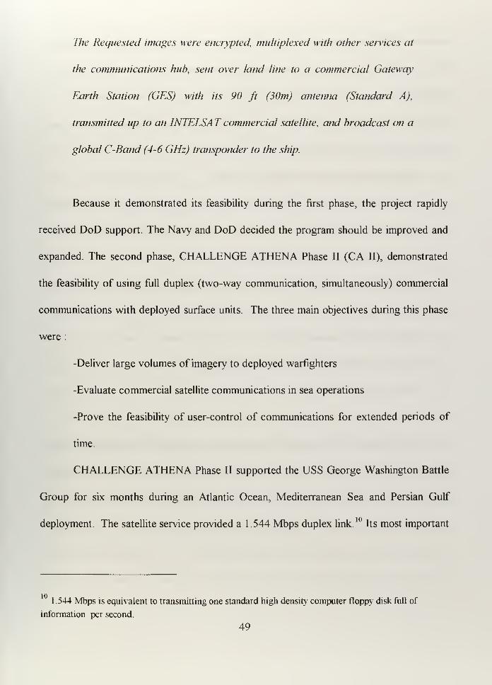
The Requested images were encrypted, multiplexed with other services at
the communications hub, sent over land line to a commercial Gateway
Earth Station (GES) with its 90 ft (30m) antenna (Standard A),
transmitted up to an INTELSA T commercial satellite, and broadcast on a
global C-Band (4-6 GHz) transponder to the ship.
Because it demonstrated its feasibility during the first phase, the project rapidly
received DoD support. The Navy and DoD decided the program should be improved and
expanded The second phase, CHALLENGE ATHENA Phase II (CA II), demonstrated
the feasibility of using full duplex (two-way communication, simultaneously) commercial
communications with deployed surface units. The three main objectives during this phase
were :
-Deliver large volumes of imagery to deployed warfighters
-Evaluate commercial satellite communications in sea operations
-Prove the feasibility of user-control of communications for extended periods of
time.
CHALLENGE ATHENA Phase II supported the USS George Washington Battle
Group for six months during an Atlantic Ocean, Mediterranean Sea and Persian Gulf
deployment. The satellite service provided a 1.544 Mbps duplex link.10
Its most important
1.544 Mbps is equivalent to transmitting one standard high density computer floppy disk full of
information per second.
49
feature was that it integrated military and civil communications, and the ship had control
of the multiplexing equipment, so the ship operators could configure onboard and shore
multiplexers, mix and match services, prioritize services and allocate bandwidth as a
function of requirements. The staff of the USS George Washington labeled this
demonstration a resounding success.
CHALLENGE ATHENA Phase II provided:
-Intelligence information with a high data rate of 1.544 Mbps, which allowed to
support U.S. imagery dissemination systems. Today some weapons can locate and
strike their targets using this information.
-Multiple-line telephone connectivity, for official business and personnel
communications.
-Video Teleconferencing (VTC)
-Video Teletraining (VTT) for remote training.
-Video Telemedicine(VTmed)
The Challenge Athena Phase III will continue improving the capability to extend
commercial wide-band satellite communications to deployed forces. Its goal is to expand
this capability to the major possible number of ships including cruisers and destroyers.
50
5. Legal concerns in the use of INTELSAT and INMARSAT for military
purposes [Comparetto, 1993].
INTELSAT and INMARSAT are similar in that both provide services established
by international treaties, both are carried out by international organizations and both are
based on the criteria that communications should be available to all nations. For this
reason, the organizations have restrictions on using them for military purposes. Gary
Comparetto, a communication specialist from The Mitre Corporation, made an interesting
study named On the use of INTELSA T and INMARSA T to support DoD communication
requirements. In one part of his study, he analyzed how restricted the systems were. It
showed that restrictions were not clear enough to avoid being interpreted by the users in
the convenient way. This study also showed how the U.S. military agencies found legal
support for using these systems extensively. It seems clear to me that the U.S. has set a
precedent for other nations to use commercial communication satellites for military
purposes.
Comparetto, in his study of INTELSAT, remarked that the only place in which
military applications are mentioned in the INTELSAT Agreement is in Article III, the part
that talks about the space segment. The agreement says: "[INTELSAT satellites] also
can be utilized for the purpose of specialized telecommunications services, either
international or domestic, other than for military purposes." Later, he defines specialized
communication services as "... telecommunication services which can be provided by
satellite, other than those defined in paragraph (k) of this article, including but not limited
51
to, radio navigation services, broadcasting satellite services for reception by the general
public, space research services, meteorological services, and earth resource services..."
Comparetto explained that "specialized communication services" require special
hardware that normally is supported by the same satellite bus, but functions separately
from the rest of payload. Because INTELSAT does not offer such a service, there is no
problem in using the standard transponders, no matter how they are used
Summarizing this point, the U.S. interpretation is that the only restriction is to use
"specialized communication services." INTELSAT does not have "specialized
communication services," so there is no restriction at all.
With respect to INMARSAT, the situation is more difficult to interpret. The
clause in Article 3(3) of the INMARSAT Convention says "The organization shall act
exclusively for peaceful purposes." This expression has had different and controversial
interpretations. In a letter from Dr. Von Noorden, legal advisor for INMARSAT (1987),
to COMSAT, after some evaluation of the Convention Interpretations, he concludes:
1. It is consistent with the INMARSAT Convention Article 3(3) for
INMARSAT to commission Ship Earth Station (SES) on warships and
naval auxiliary vessels, and
2. If the vessel becomes involved in any armed conflict, the SES should
only be usedfor distress and safety communications and other purposes
recognized by international humanitarian law.
The point of view supported by the U.S. Navy is different.
52
In January of 1991, the Deputy Assistant Judge Advocate General of the Navy responded
to a CNO request about INMARSAT:
We conclude that U.S. Na\y units may use INMARSAT terminals in
support of armed conflict consistent with the UNSC fUnited Nations
Security Council] resolutions enacted during the current Middle East
crisis.
At that time, the U.S. Navy interpreted "peaceful purposes" as:
This term [i.e., peaceful purposes] is not defined and its negotiating
history does not suggest a specific meaning. Under such a reading,
'peaceful purposes' should be given the meaning that has been accorded
under the law relating to outer space activities. Under such a reading
'peaceful purposes' does not exclude military activities so long as those
activities are consistent with the United Nations (UN) Charter.
The clearest example is that the United Kingdom used Ship Earth Stations during
Malvinas War and Iraq used them during the Iran-Iraq War. No mechanism was used to
enforce the INMARSAT Convention. Another fact is that during Desert Storm
Operation, the Coalition Naval and ground forces used more than 150 INMARSAT
terminals. In the future, the U.S. Air Force and Army will be interested in other services
recently implemented by INMARSAT.
6. Argentine Implementation
From a technical point of view, both INMARSAT (L Band) or INTELSAT (C and
Ku Bands), as demonstrated, are feasible to be used by the Argentine Navy. Although,
installing 2.4 meter diameter antennas on Argentine ships could be difficult, if not
impossible. Challenge Athena was ideally suited to a navy that continuously conducts
worldwide operations with thousands of people working at sea for long periods of time
(normally more than six months), frequent telemedicine needs, personal needs,
requirements for large amounts of information transfer, and weapons that take advantage
of this information. U.S. naval operations require billions of dollars per year, not only for
maintenance and operating costs, but also for the research and development of the
programs created to improve warfighting capability
The Argentine Navy is basically directed to provide national defense and take part
in international missions. We must limit our consideration to a modest communication
infrastructure based on commercial satellites, or on a single commercial satellite in the
appropriated GEO position. I believe that one leased transponder can provide enough
bandwidth to satisfy the Argentine Navy demand and contribute to satisfying
requirements of other branches of the military forces.
CHALLENGE ATHENA combined a portion of the military architecture with
commercial satellites. Messages were encrypted at each end of the communications link;
bulk encryption of the entire circuit was not used We would need to add compatible
54
encryption devices in the same manner, if we wanted to take full advantage of commercial
systems.
Cost is the limiting factor for the Argentine Navy. Although a concept based on
CHALLENGE ATHENA Phase II would be cheaper than other candidate systems, it still
cost $3.5 Million during the six month period of operation on the USS George
Washington. The U.S. Navy saved million of dollars by using this system instead of
INMARSAT. During the six month deployment, Naval personnel made 17,400 hours of
official telephone calls, which would have cost $6,525 million dollars using
INMARSAT. 11I believe that this amount is much more than we need to operate the
Argentine Navy fleet for an entire year. For our Navy this cost is significant, and we need
to study in detail the real cost-benefit of implementing a system like CA II.
Table 3.4 shows comparative costs for the CA II, with respect to INMARSAT.
There are some data missing from this table. We know the cost of INMARSAT services
($6.25 /min. or 65.0 cents/KB), because it is publicly advertised, but we must accept the
given cost of CA II (0.3 cents/KB) without knowing exactly how it was computed. Keep
in mind that this low cost per minute is only valid for the scale ofCA II operations.
From the installation point of view, INMARSAT appears more reasonable because
it can be used by either big or small ships. The 1 meter diameter INMARSAT antenna is
less limiting than the 2.4 meter diameter INTELSAT antenna. The cost of an
INMARSAT-A terminal ranges from $30,000 to $55,000, but the cost of an
11Note that 17.400 hours of official calls in 180 days represents an average of four telephone lines
working continuously (180 davs x 24 hours/day- telephone line x 4 telephone lines= 17,280 hours).
55
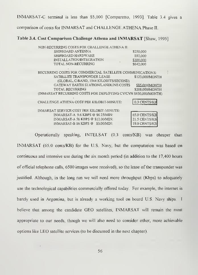
INMARSAT-C terminal is less than $5,000 [Comparetto, 1993]. Table 3.4 gives a
comparison of costs for INMARSAT and CHALLENGE ATHENA Phase II.
Table 3.4. Cost Comparison Challenge Athena and INMARSAT [Shaw, 1995]
NON-RECURRING COSTS FOR CHALLENGE ATHENA II:
SHIPBOARD ANTENNA $250,000
SHIPBOARD HARDWARE $92,000
INSTALLATION/INTEGRATION $300.000
TOTAL NON-RECURRING $642,000
RECURRING COSTS FOR COMMERCIAL SATELLITE COMMUNICATIONS:SATELLITE TRANSPONDER LEASE $123,000/MONTH(GLOBAL, C-BAND, 1544 KILOBITS/SECOND)
GATEWAY EARTH STATION/LANDLINE COSTS $85.000/MONTHTOTAL RECURRING $208,000/MONTH
(INMARSAT RECURRING COSTS FOR DEPLOYING CV/CVN $130,000/MONTH)
CHALLENGE ATHENA COST PER KILOBIT-MINUTE:
INMARSAT SERVICE COST PER KILOBIT-MINUTE:INMARSAT-A 9.6 KBPS @ $6.25/MIN
INMARSAT-A 56 KBPS @ $12.00/MIN
INMARSAT-B 16 KBPS @ $3.00/MIN
0.3 CENTS/KB
65.0 CENTS/KB21.5 CENTS/KB19.0 CENTS/KB
Operationally speaking, INTELSAT (0.3 cents/KB) was cheaper than
INMARSAT (65.0 cents/KB) for the U.S. Navy, but the computation was based on
continuous and intensive use during the six month period (in addition to the 1 7,400 hours
of official telephone calls, 6500 images were received), so the lease of the transponder was
justified. Although, in the long run we will need more throughput (Kbps) to adequately
use the technological capabilities commercially offered today. For example, the internet is
barely used in Argentina, but is already a working tool on board U.S. Navy ships I
believe that among the candidate GEO satellites, INMARSAT will remain the most
appropriate to our needs, though we will also need to consider other, more achievable
options like LEO satellite services (to be discussed in the next chapter).
56
E. BENEFITS AND DISADVANTAGES OF USING GEO COMMERCIAL
SATELLITES
1
.
Benefits
a. Reduced cost
GEO satellite systems are already established, so we don't need to spend
significant amounts of money on research and development. We can buy what we need
and use it, which means that the Argentine Navy will only need to buy the ship terminals
and lease the satellite circuits. Even with implementation and training costs, the option
will be always cheaper than developing a dedicated GEO satellite military system
ourselves.
b. Increasing Capability
We can achieve interesting new capabilities, which would be very useful
when operational needs demand more exchange of information or when traditional
communication channels are saturated or unable to provide service Commercial C, Ku
and L bands could supplement our military communications structure This capabilities
include :
-High data rate transmission. INTELSAT can provide data rate of 1.544 Mbps,
INMARSAT can provide up to 56 Kbps.12
1.544 Mbps can be seen as the transmission of one 31
:
computer flopp> disk full of information per
second. Using INMARSAT it will take 26 seconds to transmit it.
57
-Video Conference. This feature can considerably increase our the CT/C4I
capability. No other satellite system has been able to provide it until now.
-Telephone connectivity. INMARSAT already provides telephone services, but
INTELSAT may provide a better service with less recurring costs.
c. Experience
Before developing the first Fleet Satellite Communication
(FLEETSATCOM) constellation, the U.S. Navy gained experience using "Gapfiller," a
UHF transponder added to the MARISAT satellite. Similarly, our Navy could use
commercial circuits to gain experience about how to better use satellites for
communications.
d. Coverage
Only one satellite could provide coverage to the entire anticipated area of
operation. Figure 3.5 shows how the coverage can be from Argentina to the coast of
South Africa. The elevation angle (mentioned as 5 "Degree Elevation and 18 Degree
Elevation" in the figure) is the angle formed between the horizon of the ground station and
the satellite line of sight. The attenuation that the signal suffers through its path is strong
function of the elevation angle. A rain cell exists as an atmospheric volume which is wider
than it is high therefore, low elevation angles force the radio signal to pass through a
58
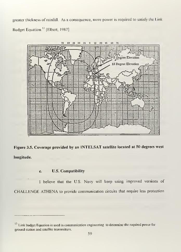
greater thickness of rainfall. As a consequence, more power is required to satisfy the Link
Budget Equation.13
[Elbert, 1987]
76 60 46 30 16 IS SO 46 GO 76
Figure 3.5. Coverage provided by an INTELSAT satellite located at 50 degrees west
longitude.
e. U.S. Compatibility
I believe that the U.S. Navy will keep using improved versions of
CHALLENGE ATHENA to provide communication circuits that require less protection
13Link budget Equation is used in communication engineering to determine the required power for
ground station and satellite transmitters.
59
than those used for tactical purposes, so it could eventually be the appropriate technical
means to be administratively linked during International Operations.
2. Disadvantages
a. Reliability
Because GEO commercial satellites have a commercial architecture, they
do not have anti-jamming capability. Commercial satellites do not have countermeasures,
so their signals can be affected by even low power jammers.
b. Security
The ship terminals have a high probability of detection and interception, so
they are vulnerable to undesired monitoring. Encryption systems on each end of the
communications may improve this situation somewhat.
c. Interference
C-band is especially more susceptible to electromagnetic interference from
other combat systems, which could be a very important factor when all of our capabilities
are needed and some particular equipment must be turned off to allow communications
equipment to operate. Apparently, the H.M.S. Sheffield experienced this interference
when it failed to pick up the Exocet missile that finally sunk it [Zoppa. 1994]
Communications in Ku-Band frequencies are extremely vulnerable to ram attenuation.
60
d. Antenna location
The antennas installed on board ships require stabilization in order to
continuously track the GEO satellites. Where to install a new on board antenna is always a
challenge to the engineer. Installing either an INMARSAT antenna or a stabilized 2.4 m
diameter INTELSAT antenna in medium size ships is a big problem; shadow areas and
ship-generated interferences must be carefully considered.
e. Time required
The formal administrative process to lease or buy a transponder requires
significant time depending on the requirements. The U.S. government can lease a
transponder in as little as 20 days. However, the standard procedure to purchase an
INTELSAT transponder takes about 230 days assuming that one is available.
Transponders are normally leased or purchased five to seven years in advance, so the
decision to establish a system centered around a leased or purchased transponder should
be made with these lead time in mind.
f. Availability
When leasing time on a transponder or just a portion of the transponder,
we must compete with civilian users. Our request should be made in advance and it is not
certain that the circuits will be available. To avoid this problem, at least one dedicated
transponder would be needed. To reduce cost, it could be shared with other Argentine
military forces or government agencies.
61
F. SUMMARY
Geostationary satellites can be used by the Argentine Navy to increase
communication capabilities. The existing technology can provide the required equipment,
and the satellites are available in the necessary quantity, along with the orbital positions to
satisfy our needs. As was demonstrated during the Persian Gulf War, no legal issues were
raised regarding the use of commercial satellites for military purposes. The GEO satellite
systems could be used in place of HF circuits for tactical purposes taking some
precautions to reduce its vulnerability and remembering that HF circuits are also
vulnerable.
We will need to conduct testing before attempting to answer the question of
whether HF circuits should be used as the primary or backup communication system,
when using a commercial system. It appears that no commercial space system can fulfill
all of our requirements. In the particular case of the U.S. Navy, after the exploitation and
use of military satellite systems (UHF-SHF-EHF) that relegated the HF circuits to a
backup function, they reconsidered the use of improved HF circuits pointing to anti-jamm,
low probability of intercept, and higher data rate capabilities, as a primary system. [Kim,
1995]
62
IV. COMMUNICATION SATELLITES IN LOW EARTH ORBIT (LEO)
A. INTRODUCTION
Historically, the first satellites launched to the space were located in low earth
orbits. At that time, the serious limitations established by the launch vehicles justified it.
When the first INTELSAT satellite was launched in 1965, the domination of satellite
communications by GEO satellites really began. Today, GEO satellites are prevalent in
the communications arena, but new ideas are advancing. The need for improvements,
particularly in the area of mobile satellite communications (which INMARSAT dominated
since the 1980's); the ongoing saturation of the geostationary orbit; the need for cost
reduction in the final product (cost of the user equipment and cost per minute of use); and
the technological advances made by the satellite developers are some of the reasons why
Low Earth Orbit Satellites (LEO's) are gaining a place in communications.
In 1992, the World Administrative Radio Conference (WARC-92) on the
International Telecommunications Union (ITU) considered the issue of frequency
allocation for non-GEO satellites. The WARC-92 assigned the 1610-1626.6 Mhz (L-
Band) and 2483.5- 2500 Mhz (S-Band) slots to big LEO services on worldwide basis.
Small LEO's were restricted to VHF/UHF bands below 1 Ghz. The main difference
between big and small LEO's is that small LEO's are unable to transmit voice because of
the narrow bandwidth, so these systems are limited to data transmission services, while big
LEO's can provide voice, data, and more. [Ananasso, 1995]
63
Among the big LEO's, I will briefly talk about some of the programs I consider to
be the most representative: Iridium, Globalstar and Teledesic. However, there are other
similar programs under development. ORBCOMM is the leader among small LEO's. I
will devote the next chapter to a description ofORBCOMM
B. LOW EARTH ORBIT SATELLITES
In Low Earth Orbit (LEO), the satellite's altitude is lower than 6000 Km. (a period
of less than 225 minutes). Usually, LEO satellites are placed at altitudes between 500 Km
and 2000 Km. If the altitude is lower (with a period less than 95 minutes), the upper
atmosphere produces considerable drag, making it difficult to maintain orbit. If the
altitude is higher than 2000 Km, radiation from the Van Allen Belt affects the electronics.
Also, the higher the orbit, the higher the cost to achieve it. However, a higher orbit
expands the ground coverage area.
While a GEO satellite is continuosly in view of the earth station, a ground station
can only view a LEO satellite for about 10 to 20 minutes per orbit. To assure continuous
coverage, a constellation of satellites is required such that when one satellite is setting
over the earth station horizon another is rising. Table 4 1 provides some parameters of
low Earth orbits which form the basis for building a constellation. Altitude is measured
from the surface of the earth, and the orbit is considered circular, so the radii of apogee
and perigee are the same. Note that when altitude increases, the period increases, and the
number of revolutions per day decreases. The time in view increases with altitude, as does
64
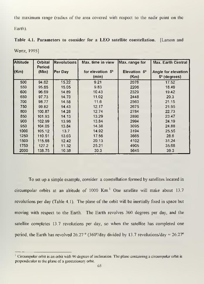
the maximum range (radius of the area covered with respect to the nadir point on the
Earth).
Table 4.1. Parameters to consider for a LEO satellite constellation. [Larson and
Wertz, 1995]
Altitude Orbital
Period
Revolutions Max. time in view Max. range for Max. Earth Central
(Km) (Min) Per Day for elevation 5° Elevation 5° Angle for elevation
(min) (Km) 5° (degrees)
500 94.62 15.22 9.21 2078 17.52
550 95.65 15.05 9.83 2206 18.49
600 96.69 14.89 10.43 2329 19.42
650 97.73 14.73 11.02 2448 20.3
700 98.77 14.58 11.6 2563 21.15
750 99.82 14.43 12.17 2675 21.95
800 100.87 14.28 12.74 2784 22.73
850 101.93 14.13 13.29 2890 23.47
900 102.99 13.98 13.84 2994 24.19
950 104.05 13.84 14.38 3095 24.88
1000 105.12 13.7 14.92 3194 25.55
1250 110.51 13.03 17.56 3665 28.6
1500 115.98 12.42 20.13 4102 31.24
1750 127.2 11.32 25.21 4905 35.68
2000 138.75 10.38 30.3 5645 39.3
To set up a simple example, consider a constellation formed by satellites located in
circumpolar orbits at an altitude of 1000 Km. 1 One satellite will make about 13.7
revolutions per day (Table 4.1) The plane of the orbit will be inertially fixed in space but
moving with respect to the Earth The Earth revolves 360 degrees per day, and the
satellite completes 13.7 revolutions per day, so when the satellite has completed one
period, the Earth has revolved 26.27 ° (3607day divided by 13.7 revolutions/day = 26.27°
Circumpolar orbit is an orbit with 90 degrees of inclination. The plane containing a circumpolar orbit is
perpendicular to the plane of a geostationary orbit.
65
of Earth rotation per orbit completed by a satellite). For the chosen altitude, the maximum
Earth Central Angle A^x (Figure 3.1) is 25.55 degrees for 5° of elevation Remember that
Swath Width= 2 A™x [Chapter III], so for this case the swath width will be 5 1 . 1 ° for 5° of
elevation. If we wanted continuous coverage at the Equator, we would need the number
of satellites resulting from dividing 360 ° by the swath width of each satellite, so
360751.1°/satellite = 7.04 satellites. If we can distribute the appropriate number of
satellites in each orbital plane, we can have one satellite on view at the equator in one side
and other in the opposite side, so each orbital plane will be able to provide two satellites
on view simultaneously and continuously. To avoid more complications, I assume we
would like to have some overlapping, so we need eight satellites on view at the equator
each time. Four orbital planes can provide that. The time in view is about 12.64 minutes
for each satellite with respect to any ground station, so if the period is about 105 minutes,
we will need 105 minutes/12.64 minutes/satellite on view = 8.3 satellites on view (8 or 9
depending on how we adjust other technical factors). In conclusion, in order to have
continuous global coverage using this configuration and these assumptions, we will need a
constellation composed of nine satellites in each of four orbital planes. Note that near the
poles, individual satellite coverage will overlap unnecessarily. One of the points to
consider is what kind of coverage is required. For example, changing the inclination
makes it possible to maximize coverage at lower latitudes where the population and
demand is concentrated, rather than near the poles, where the population density is low.
66
C. WHAT CIVILIAN SPACE COMMUNICATION BIG LEO'S SYSTEMSCOULD BE AVAILABLE FOR ARGENTINE IN THE FUTURE?
1. IRIDIUM
a. Background
Between 1987 and 1990, Motorola developed a new satellite system to
provide continuous telephone service around the globe. The original concept was to
establish a LEO satellite constellation of seventy-seven satellites ("Iridium" was chosen
because the atomic number of Iridium is seventy-seven). Later, the constellation was
modified to include only sixty-six satellites, but the system name remained the same. In
January 1995, the FCC granted the Iridium system license for construction and operation
in the U.S. Intended to provide a wireless personal communications network, the system
will cover a wide range of services like voice, data, facsimile and paging with worldwide
coverage. One of the important characteristics is that the Iridium system uses L-Band
frequencies with Time Division Multiple Access (TDMA) and Frequency Division
Multiple Access (FDMA), and the terminals will allow the user to connect to it using the
local existing cellular telephone network. [Maine, 1995]
b. System architecture
The system is composed of a space segment, a ground segment and
subscriber terminals.
(1) Space Segment. The space segment is comprised of sixty-six
LEO satellites positioned in six near-polar orbital planes with eleven satellites each plane.
Satellites in the first and last plane are counter-rotating. The separation between these
67
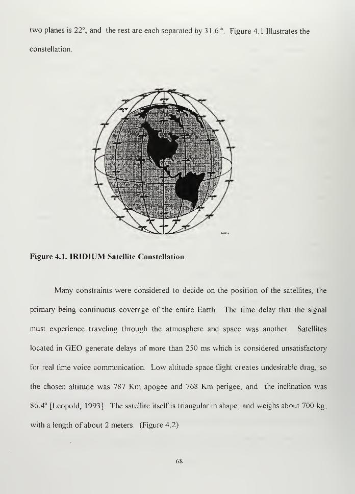
two planes is 22°, and the rest are each separated by 3 1 .6 °. Figure 4. 1 Illustrates the
constellation.
Figure 4.1. IRIDIUM Satellite Constellation
Many constraints were considered to decide on the position of the satellites, the
primary being continuous coverage of the entire Earth. The time delay that the signal
must experience traveling through the atmosphere and space was another. Satellites
located in GEO generate delays of more than 250 ms which is considered unsatisfactory'
for real time voice communication Low altitude space flight creates undesirable drag, so
the chosen altitude was 787 Km apogee and 768 Km perigee, and the inclination was
86.4° [Leopold, 1993]. The satellite itself is triangular in shape, and weighs about 700 kg,
with a length of about 2 meters (Figure 4.2)
68
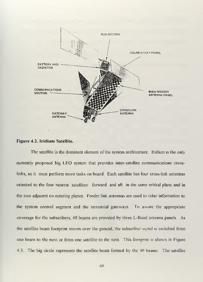
BUS SECTION
BATTERY ANDRADIATOR
COMMUNICATIONSSECTION
GATEWAYANTENNA
SOLAR ARRAY PANEL
CROSSLINKANTENNA
MAIN MISSIONANTENNA PANEL
Figure 4.2. Iridium Satellite.
The satellite is the dominant element of the system architecture. Iridium is the only
currently proposed big LEO system that provides inter-satellite communications cross-
links, so it must perform more tasks on board. Each satellite has four cross-link antennas
oriented to the four nearest satellites: forward and aft in the same orbital plane and in
the two adjacent co-rotating planes. Feeder link antennas are used to relay information to
the system control segment and the terrestrial gateways To assure the appropriate
coverage for the subscribers, 48 beams are provided by three L-Band antenna panels. As
the satellite beam footprint moves over the ground, the subscriber signal is switched from
one beam to the next or from one satellite to the next. This footprint is shown in Figure
4.3. The big circle represents the satellite beam formed by the 4S beams The satellite
69
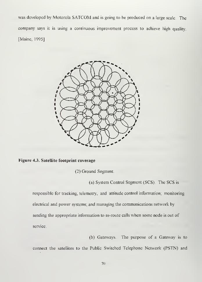
was developed by Motorola SATCOM and is going to be produced on a large scale. The
company says it is using a continuous improvement process to achieve high quality.
[Maine, 1995]
Figure 4.3. Satellite footprint coverage
(2) Ground Segment.
(a) System Control Segment (SCS). The SCS is
responsible for tracking, telemetry, and attitude control information; monitoring
electrical and power systems; and managing the communications network by
sending the appropriate information to re-route calls when some node is out of
service.
(b) Gateways The purpose of a Gateway is to
connect the satellites to the Public Switched Telephone Network (PSTN) and
70
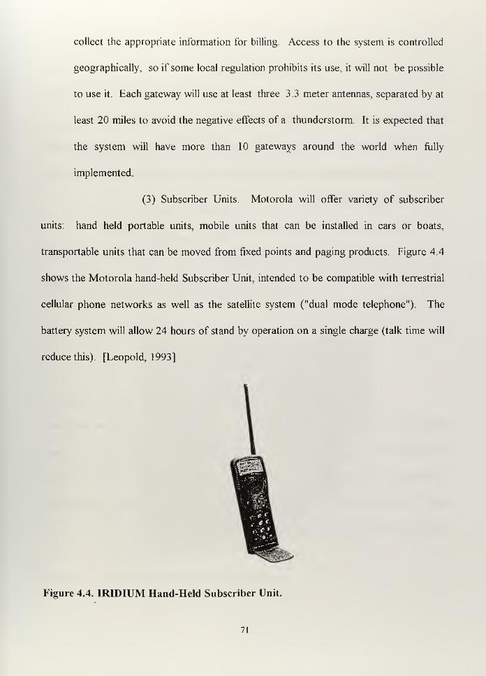
collect the appropriate information for billing. Access to the system is controlled
geographically, so if some local regulation prohibits its use, it will not be possible
to use it. Each gateway will use at least three 3.3 meter antennas, separated by at
least 20 miles to avoid the negative effects of a thunderstorm. It is expected that
the system will have more than 10 gateways around the world when fully
implemented.
(3) Subscriber Units. Motorola will offer variety of subscriber
units: hand held portable units, mobile units that can be installed in cars or boats,
transportable units that can be moved from fixed points and paging products. Figure 4.4
shows the Motorola hand-held Subscriber Unit, intended to be compatible with terrestrial
cellular phone networks as well as the satellite system ("dual mode telephone"). The
battery system will allow 24 hours of stand by operation on a single charge (talk time will
reduce this). [Leopold, 1993]
Figure 4.4. IRIDIUM Hand-Held Subscriber Unit.
71
c. Capabilities
The IRIDIUM configuration provides:
-Voice capability using dual mode telephones with high quality transmission,
reduced time delays, and world-wide coverage. Access to the system is based on
TDMA and FDMA to maximize the use of the frequency spectrum The digitized
voice is transmitted at a rate of 4800 bps. The phone terminal requires low power
and a low profile antenna.
-Paging capability, compatible with most of the existing paging devices.
-FAX capability, through the subscriber units, with a data rate of 2400 bps.
Subscriber units will have a built-in data port for interface with an external
facsimile machine. [Maine, 1995]
2. GLOBALSTAR
a. Background
GLOBALSTAR combines satellites and existing cellular systems to
provide personal communication services (PCS) to areas in which traditional telephone
systems are not economical. Each subscriber will have a unique number that he or she can
be reached at wherever he or she is (in the office, in the car. at sea. at home or in rural
areas). A small, inexpensive communicator allows the subscriber to be connected for
services like voice, data, facsimile, message and position location
72
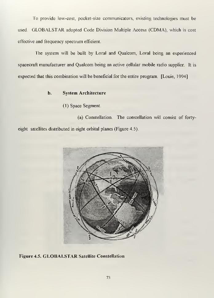
To provide low-cost, pocket-size communicators, existing technologies must be
used. GLOBALSTAR adopted Code Division Multiple Access (CDMA), which is cost
effective and frequency spectrum efficient.
The system will be built by Loral and Qualcom, Loral being an experienced
spacecraft manufacturer and Qualcom being an active cellular mobile radio supplier. It is
expected that this combination will be beneficial for the entire program. [Louie, 1 994]
b. System Architecture
(1) Space Segment.
(a) Constellation. The constellation will consist of forty-
eight satellites distributed in eight orbital planes (Figure 4.5).
Figure 4.5. GLOBALSTAR Satellite Constellation
73
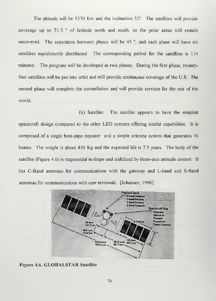
The altitude will be 1370 Km and the inclination 52°. The satellites will provide
coverage up to 71.5 ° of latitude north and south, so the polar areas will remain
uncovered. The separation between planes will be 45 °, and each plane will have six
satellites equidistantly distributed. The corresponding period for the satellites is 1 14
minutes. The program will be developed in two phases. During the first phase, twenty-
four satellites will be put into orbit and will provide continuous coverage of the U.S. The
second phase will complete the constellation and will provide services for the rest of the
world.
(b) Satellite. The satellite appears to have the simplest
spacecraft design compared to the other LEO systems offering similar capabilities. It is
composed of a single bent-pipe repeater and a simple antenna system that generates 16
beams. The weight is about 450 Kg and the expected life is 7.5 years. The body of the
satellite (Figure 4.6) is trapezoidal in shape and stabilized by three-axis attitude control It
has C-Band antennas for communications with the gateway and L-band and S-Band
antennas for communications with user terminals. [Johansen, 1996]
Pw>»dDfedr '.HffiMriBu.nn n in iiiiHii
S-tMrfTtMUftil
C-tai*lltcc«Hw
C*fcMrf?nimiiSpacaciah 6t»
SuiK««re
Electrical
/C ,' . ^"-v^ TfccnwJ
Figure 4.6. GLOBALSTAR Satellite
74
(2)Ground Segment
(a) Gateways. The main function of the gateway is to
handle the interface between the GLOBALSTAR Network and the Public Switched
Telephony Network (PSTN). Each gateway will communicate with three satellites
simultaneously and will be able to determine the position of the user terminal to an
accuracy of 100 to 300 meters without an additional GPS receiver in the terminal handset.
(b) Network Control Center. The NCC is responsible for
managing GLOBALSTAR services: billing, channel allocation, registration, verification
and message services. Initially, one NCC will handle cellular systems in the US, and there
will be other NCC's distributed world wide as the system expands.
(3) User Terminals. There will be three classes of GLOBALSTAR
terminals. Hand-held terminals will be pocket-size, and easily transportable. They could
be connected to either the terrestrial cellular phone network or satellite network, and they
will provide the geographic location of the user. Mobile terminals will have the same
capabilities as hand-held terminals but would be a little larger and could be installed in cars
or trucks. Finally, fixed terminals will only operate with GLOBALSTAR system.
c. Capability and Frequencies
The coverage excludes the high latitudes, but in the most populated areas,
there will be more than one satellite available. The system works using Code Division
Multiple Access (CDMA), which allows the user to carry the same personal
communicator anywhere. All communications will be processed on the ground by the
gateway station, so it will not have inter-satellite links. That means that in the middle of
75
the ocean, although satellites may be in view of the user terminal, it will not be possible to
communicate if the nearest gateway is out of range of those satellites.
The frequency plan is:
Terminal to satellite: L-Band (1610- 1626.5 Mhz)
Satellite to terminal: S-Band (2483.5-2500 Mhz)
Gateway to satellite: C-Band (5091-5250 Mhz)
Satellite to gateway: C-Band (6875-7055 Mhz)
Although the WARC-92 had allocated the 1885-2025 Mhz and 2110- 2200 Mhz
bands for world-wide use in Future Public Land Mobile Telecommunications Systems
(FPLMTS), it specified that this allocation will start in the year 2005 outside the U.S.
The U.S. is already using the 2 Ghz frequencies proposed for PCS, so the rule approved
by the FCC is that the licensed PCS operators will have to negotiate with the incumbent
users and compensate them when they move to other bands. [Louie, 1994]
Each single beam will support up to 2000 channels without interference, but the
satellite power limits raise this number to 2400 channels of 1.25 Mhz. The bit rate varies
from 2400 bps to 9600 bps, and the voice is digitized and encoded to provide high quality.
3. TELEDESIC [Sturza, 1994] [TELEDESIC Corporation, 1997]
a. Background
At the end of another edition of the World Administrative Radio
Conference (WARC-95), Teledesic corporation promised that a $9 billion dollar LEO
satellite communication system would be operating by 2001. The most important
76
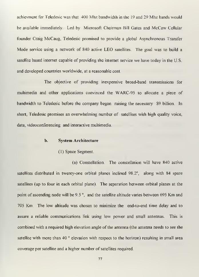
achievment for Teledesic was that 400 Mhz bandwidth in the 19 and 29 Mhz bands would
be available immediately. Led by Microsoft Chairman Bill Gates and McCaw Cellular
founder Craig McCaug, Teledesic promised to provide a global Asynchronous Transfer
Mode service using a network of 840 active LEO satellites. The goal was to build a
satellite based internet capable of providing the internet service we have today in the U.S.
and developed countries worldwide, at a reasonable cost.
The objective of providing inexpensive broad-band transmissions for
multimedia and other applications convinced the WARC-95 to allocate a piece of
bandwidth to Teledesic before the company began raising the necessary $9 billion. In
short, Teledesic promises an overwhelming number of satellites with high quality voice,
data, videoconferencing and interactive multimedia.
b. System Architecture
(1) Space Segment.
(a) Constellation. The constellation will have 840 active
satellites distributed in twenty-one orbital planes inclined 98.2°, along with 84 spare
satellites (up to four in each orbital plane). The separation between orbital planes at the
point of ascending node will be 9.5 °, and the satellite altitude varies between 695 Km and
705 Km. The low altitude was chosen to minimize the end-to-end time delay and to
assure a reliable communications link using low power and small antennas. This is
combined with a required high elevation angle of the antenna (the antenna needs to see the
satellite with more than 40 ° elevation with respect to the horizon) resulting in small area
coverage per satellite and a higher number of satellites required.
77
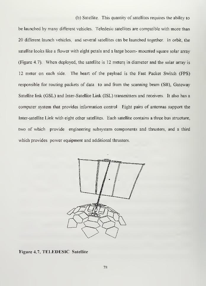
(b) Satellite. This quantity of satellites requires the ability to
be launched by many different vehicles. Teledesic satellites are compatible with more than
20 different launch vehicles, and several satellites can be launched together. In orbit, the
satellite looks like a flower with eight petals and a large boom- mounted square solar array
(Figure 4.7). When deployed, the satellite is 12 meters in diameter and the solar array is
12 meter on each side. The heart of the payload is the Fast Packet Switch (FPS)
responsible for routing packets of data to and from the scanning beam (SB), Gateway
Satellite link (GSL) and Inter-Satellite Link (ISL) transmitters and receivers. It also has a
computer system that provides information control. Eight pairs of antennas support the
Inter-satellite Link with eight other satellites. Each satellite contains a three bus structure,
two of which provide engineering subsystem components and thrusters, and a third
which provides power equipment and additional thrusters.
Figure 4.7. TELEDESIC Satellite
78
(2) Ground Segment. The ground segment will be composed of
GigaLink terminals, Network Operations and Control Centers (NOCCs) and Constellation
Operation and Control Centers(COCCs).
(a) GigaLink terminals. They will provide gateway
connection from the satellite to internet and to Teledesic support and data base systems,
including NOCCs and COCCs, as well as to privately owned networks. Each satellite will
be able to support up to sixteen GigaLink terminals within its service area. Each
GigaLink terminal will operate at the rate of 155.52 Mbps and multiples of this rate up to
1.244 Gbps. The required antenna for this terminal will be about 28 cm to 1.6 meters in
diameter, and the required transmit power from 1 to 49 watts.
(b) Network Operations and Control Center. Comprised of
database systems, the NOCCs will be responsible for network administration and control,
billing, troubleshooting, call routing data, authentication and encryption keys.
(c) Constellation Operations Control Centers. Designed to
operate with a high degree of autonomy, it will be responsible for monitoring satellite
health and uplinking maintenance commands. The initial constellation will include a
number of spares, but periodical launches will be scheduled to replace the satellites that go
out of service.
(3) Users Terminal. Standard terminals will be of stationary and
transportable configurations, operating at multiples of 16 Kbps up to 2.048 Mbps (128
channels of 16 Kbps). The antennas would be from 16 cm to 1.8 meters in diameter and
79
the required power from .01 Watts to 4.7 Watts. All of the communication links will
transport data and voice at a fixed length of 5 1 2 bit packets.
c. Capability
The Teledesic system plans to offer capabilities found today only in
advanced terrestrial networks. Voice, data and video based in Asynchronous Transfer
Mode (ATM) technology.2The company says that it will market these services at
reasonable prices, although we don't know exactly what "reasonable" means. As main
features, we can mention:
- Ka band frequency, uplink 30 Ghz, downlink 20 Ghz.
- Capable of providing services to 20 million subscriber terminals with a peak load
of more than 2 million.
-95% of earth surface coverage and 100% of the population. Up to 72° north or
south latitude, twenty-four hours a day. In the higher latitudes (more than 72°)
the coverage is available but only at certain times of the day.
-Supported by the 16 Kbps basic channel, which may enable the system to meet
"network quality standards" [Sturza, 1994] The bit error rate (BER) expected is
less than 10"9.
2 ATM technology is designed to provide high bandwidth. A typical connection between a computer and
an ATM switch operates at speed of 100 Mbps or faster. The connection between a computer and an ATMswitch is supported by a pair of optical fibers [Comer. 1996].
80
- Capable of supporting from 16 Kbps to T-l (1.544 Mbps), E-l (2.048 Mbps),
OC-3 (155.52 Mbps) and OC-24 (1.24416 Gbps) standards, which means that
the system can support many different users/
4. Probable Availability
It is difficult to determine exactly how many of the systems just described we will
be able to use in Argentina. Most of them are advertised as providing global coverage,
but at the moment, there are barriers to starting operations either locally or
internationally. Protective legislation or the demand of tax payments to operate them can
raise the cost and make them less attractive than existing systems.
Although Iridium and GLOBALSTAR expect to start offering services in 1998,
we do not know how long we will need to wait to be able to use them. As I mention
before, the frequency allocation established by the WARC-92 will not begin until January
2005. Most of the systems promise full coverage for the U.S. from the beginning, which
implies that the rest of the world may need to wait.
The systems work through the ground stations, so the cost will most likely depend
on the number of customers, and the companies will probably concentrate their efforts in
places were the demand is higher, like Southeast Asia and Europe Using the Teledesic
case as an example, the program is still unfunded and is showing the first delays, originally
promising services for the year 2001, but now talking about 2002 Considering what
3T-l. E-l. OC-3. and OC-24 are different types of wire used in networks, diflercnualcd basically by
their bandwidth capability.
81
happened with other commercial projects and the magnitude of the Teledisc program,4
I
do not think that we can expect to have any service before the year 2005. The starting
point for the other systems is also uncertain.
D. MILITARY APPLICATIONS
As I mentioned in Chapter III, the need for satellite communications is driven by
the need to improve our CT/C4I capabilities. The U.S. Navy is looking for ways to
increase data transmission capability. If they can relieve some military satellites of being
used for administrative traffic, they will be able to use them more effectively for
operational traffic.
The incorporation of satellite communications into the Argentine CT architecture
means the addition of more capabilities. How well this capability would be used with
tactical or administrative purposes is something that needs to be experienced on the
battlefield taking into account the limitations and condition of our theater of operations.
A good example was the use of commercial portable GPS equipment by the Coalition
Forces during the Persian Gulf War. Warfighters from all branches of the service solved
their location problem, a big problem in a desert, using commercial GPS receivers.
The Coallition Forces answered the question of whether or not commercial
communications systems can be used for military purposes in the Gulf War by increasing
the number of INMARSAT stations installed on board warships during that year
4For example, the ORBCOMM project, clearly less ambitious than Teledesic. promised to have twenty -
six satellites operating by 1995. but onlv the first two for testing have been launched.
82
1. Benefits
a. No system development required
The system will be commercially available, so the main requirement will be
the subscription to the service, the acceptance of the fee, and the user terminal acquisition.
However, we can not forget that training, testing and operating protocol development
must be achieved as in any other system.
b. No special installation required
Most of the commercial satellite communication systems are designed to
provide services to the end user, basically oriented toward hand-held terminals or lap-top
computers. The only system in which some particular new technology will be probably
necessary is Teledesic. Asynchronous Transfer Mode (ATM) technology is not
sufficiently standardized, but at the speed with which computers and communications are
advancing, we can expect that the equipment that uses it will soon be available.
c. Mobility
The user terminals offered are easily transportable, with low power
requirements, so they can provide useful communications for troops in transit. If we use
Teledesic, we should expect to be able to connect a lap-top computer to the terminal and
receive high data rate data and video anywhere.
83
d. Public Switch Telephone Network Compatible
Like INMARSAT, most of the services I mentioned can provide
communications between units deployed in remote areas and their original commands
through the PSTN.
e. Low Cost
The estimated costs in the U.S. are about $750 for a Globalstar Terminal
and $2000 to $3000 for an Iridium terminal. The monthly fee could be similar to a normal
cellular telephone fee. In the U.S., a monthly subscription to Globalstar would cost about
$8 to $ 10 plus $0.30 per minute plus $ 0. 10 for connecting long distance calls. Motorola
expects to charge $3 a minute. Teledesic expects to charge a fee comparable to that for
similar services provided by terrestrial networks. [Haralambos, 1 996]
f. Coverage
The Iridium system will provide global coverage, so it could be used near
the poles, which would include Antarctic bases. GLOBALSTAR will cover up to 74°
latitude North and South and Teledesic up to 72 ° latitude North and South Note that
only Iridium will avoid the coverage limitation that currently exists with INMARSAT.
g. Timely availability
It is expected that the link could be established \shen required so users
would experience a very small delay under normal circumstances
84
h. Flexibility
A combination of these systems can provide the flexibility required for
military operations. This will require particular rules and alternative communication plans.
2. Disadvantages
a. Reliability
All of the proposed systems will be operated by foreign (non-Argentine)
companies. Although Argentina can own a ground station and partially control the
service, the ultimate control will be outside of our country.
GLOBALSTAR, which was designed to use CDMA, offers some
protection against jamming, but the other systems can be very vulnerable to hostile
jamming. The point favoring the reliability is the number of satellites. If something
happens to one satellite, the entire system will still operate. One important consideration
is that the entire system is built to serve a large number of worldwide users, and any action
against the system could affect more than the hostile user. This action could generate
more international problems than temporary local benefits.
b. Security
Commercial systems are designed to provide some kind of security to
prevent an intruder from using someone's account Also, commercial companies require
protection for their message content, so some form of commercial encryption should be
85
available. However, the best encryption systems are still vulnerable to a technologically
sophisticated listener.
c. Interoperability
Because different system developers will be using different voice coding
algorithms, and there are no standards yet defined, one type of terminal (say, Teledesic)
may not be able to communicate directly with other type (say, Globalstar).
d. Priority
Access to the systems will be based in general on the three known modes,
TDM, FDM and CDM. The system will be shared with commercial users, so it is possible
that in crowded areas at particular times military communications may be delayed
awaiting the corresponding slot, unless some priority was established. This will, of
course, increase the cost of the service. Nevertheless, the expected delays should not be
of considerable magnitude.
E. SUMMARY
Argentine military forces, and the Navy in particular, could use Low Earth Orbit
satellites in the future. Exactly when the systems will be available to our country is not
yet defined. However, once the satellites are in orbit, the companies will try to sell their
products to the greatest number of clients. What should our policy be with respect to
these products? First we need to recognize that although they have tactical limitations,
the systems promise services that can increase our communications capacity considerably.
86

I believe that we should use leased systems to start learning how to improve our
capabilities based on tangible needs and limitations.
87

88
V. ORBITAL COMMUNICATIONS CORPORATION (ORBCOMM)DIGITAL DATA COMMUNICATION AND POSITION SYSTEM
A. INTRODUCTION
The ORBCOMM digital data communication and position determination system
was conceived as a commercial system with world-wide coverage, able to provide only
data and message communications, similar to alphanumeric paging and electronic mail, at
a low data rate (2400-4800 bps). It also has many military applications. The ORBCOMM
system will use a constellation of twenty-six to thirty-six small spacecraft in Low-Earth
Orbit (LEO) combined with the appropriate terrestrial stations and small, inexpensive user
terminals.
The system is based on a "store and forward" principle, but is designed in such a
way that it can provide near real time message transfer over the most crowded latitudes.
The ORBCOMM user will be able to transmit and receive messages, control and
monitor distant equipment, and collect data using hand-held Subscriber Communicators
(SC's). The user can send a query from an operational center or with their own personal
SC to check the status of an asset or to program the asset to send data about a specific
event. A message transmitted from an SC and received by the satellite is relayed down to
a regional Gateway Earth Station (GES), then directed to the Network Control Center
(NCC) using land-lines or Very Small Aperture Terminals (VSAT).1
The NCC determines
the validity of the message and location of the recipient, then routes the message back to
Very Small Aperture Terminal (VSAT) is a type of inexpensive earth station that takes advantage ofnew digital technology and can
reduce the physical dimensions and power ofthe ground station.
89
the GES and relays it through the satellite, which sends it down to the SC's receiver. The
NCC can also receive and transmit messages from terrestrial networks through X.400 and
X.25 gateways. The NCC is designed to translate messages from widely used electronic
mail systems, such as Microsoft Mail, into X.400 messages for transmission to and from
ORBCOMM SC's [Reut, 1995]
I chose ORBCOMM as an example, because it is the first in its class, the most
advanced, and, although I believe it has considerable limitations, its services will probably
be offered to the Argentine Navy in the future.
B. BACKGROUND
In February 1990, Orbital Communications Corporation (ORBCOMM), a
subsidiary of Orbital Sciences Corporation (OSC), applied to the United States Federal
Communications Commission (FCC) for permission to create a new LEO satellite system
for mobile communications. In March 1992, the FCC granted ORBCOMM an
experimental license to operate two satellites and up to 1,000 user terminals (Subscriber
Terminals)[Aguerrevere, 1996]
In January 1993, the FCC allocated the frequencies of 137-138 Mhz down link and
148 - 150.05 Mhz up link for ORBCOMM mobile satellite services.
In 1993, an international alliance made between Orbital Science and Teleglobe
(Canada), one of the biggest telecommunications company on the world, provided all
funding for the project. In 1994, ORBCOMM received the final approval for the
construction and operation of the constellation, composed of its thirty-six communication
satellites The ITU licensed GE Starsys, ORBCOMM's competitor, in 1995 [Hara, 1994].
90
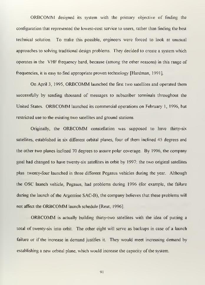
ORBCOMM designed its system with the primary objective of finding the
configuration that represented the lowest-cost service to users, rather than finding the best
technical solution. To make this possible, engineers were forced to look at unusual
approaches to solving traditional design problems. They decided to create a system which
operates in the VHF frequency band, because (among the other reasons) in this range of
frequencies, it is easy to find appropriate proven technology [Hardman, 1 99 1 ]
.
On April 3, 1995, ORBCOMM launched the first two satellites and operated them
successfully by sending thousand of messages to subscriber terminals throughout the
United States. ORBCOMM launched its commercial operations on February 1, 1996, but
restricted use to the existing two satellites and ground stations.
Originally, the ORBCOMM constellation was supposed to have thirty-six
satellites, established in six different orbital planes, four of them inclined 45 degrees and
the other two planes inclined 70 degrees to assure polar coverage. By 1 996, the company
goal had changed to have twenty-six satellites in orbit by 1997: the two original satellites
plus twenty-four launched in three different Pegasus vehicles during the year. Although
the OSC launch vehicle, Pegasus, had problems during 1996 (for example, the failure
during the launch of the Argentine SAC-B), the company believes that these problems will
not affect the ORBCOMM launch schedule [Reut, 1996].
ORBCOMM is actually building thirty-two satellites with the idea of putting a
total of twenty-six into orbit. The other eight will serve as backups in case of a launch
failure or if the increase in demand justifies it. They would meet increasing demand by
establishing a new orbital plane, which would increase the capacity of the system.
91
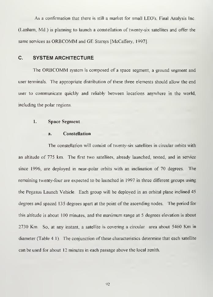
As a confirmation that there is still a market for small LEO's, Final Analysis Inc.
(Lanham, Md.) is planning to launch a constellation of twenty-six satellites and offer the
same services as ORBCOMM and GE Starsys [McCaffery, 1997].
C. SYSTEM ARCHITECTURE
The ORBCOMM system is composed of a space segment, a ground segment and
user terminals. The appropriate distribution of these three elements should allow the end
user to communicate quickly and reliably between locations anywhere in the world,
including the polar regions.
1. Space Segment
a. Constellation
The constellation will consist of twenty-six satellites in circular orbits with
an altitude of 775 km. The first two satellites, already launched, tested, and in service
since 1996, are deployed in near-polar orbits with an inclination of 70 degrees. The
remaining twenty-four are expected to be launched in 1 997 in three different groups using
the Pegasus Launch Vehicle. Each group will be deployed in an orbital plane inclined 45
degrees and spaced 135 degrees apart at the point of the ascending nodes. The period for
this altitude is about 100 minutes, and the maximum range at 5 degrees elevation is about
2730 Km. So, at any instant, a satellite is covering a circular area about 5460 Km in
diameter (Table 4. 1 ). The conjunction of these characteristics determine that each satellite
can be used for about 12 minutes in each passage above the local zenith
92
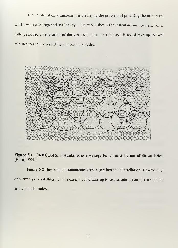
The constellation arrangement is the key to the problem of providing the maximum
world-wide coverage and availability. Figure 5.1 shows the instantaneous coverage for a
fully deployed constellation of thirty-six satellites. In this case, it could take up to two
minutes to acquire a satellite at medium latitudes.
Figure 5.1. ORBCOMM instantaneous coverage for a constellation of 36 satellites
[Hara, 1994].
Figure 5.2 shows the instantaneous coverage when the constellation is formed by
only twenty-six satellites. In this case, it could take up to ten minutes to acquire a satellite
at medium latitudes.
93
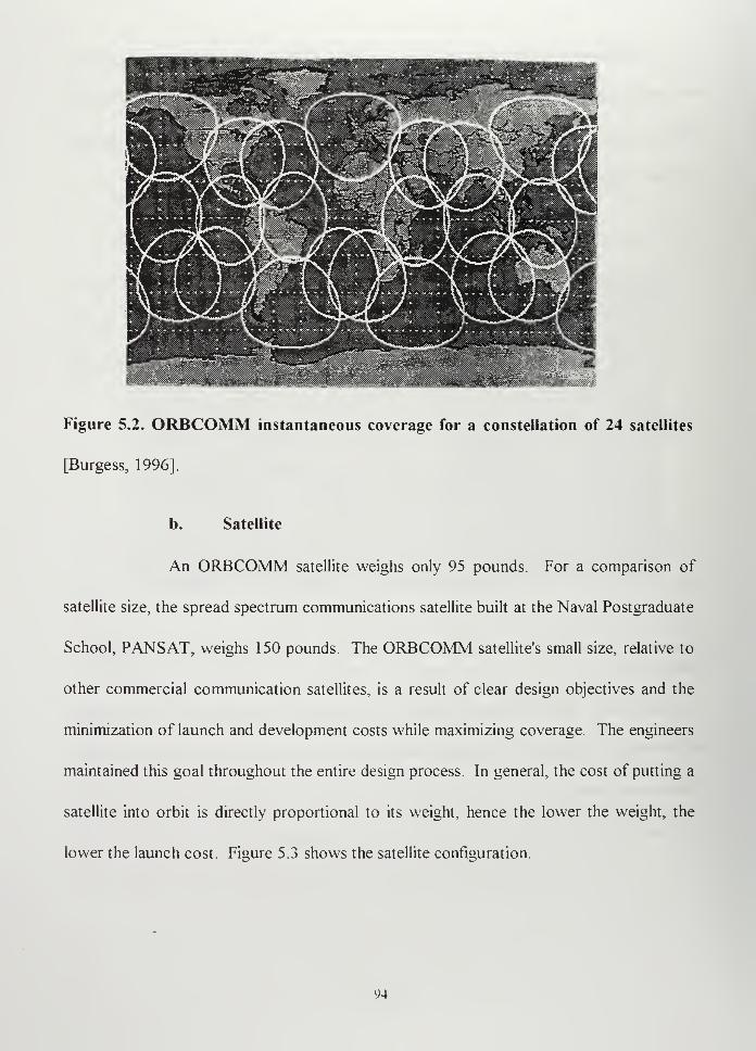
Figure 5.2. ORBCOMM instantaneous coverage for a constellation of 24 satellites
[Burgess, 1996].
b. Satellite
An ORBCOMM satellite weighs only 95 pounds. For a comparison of
satellite size, the spread spectrum communications satellite built at the Naval Postgraduate
School, PANSAT, weighs 150 pounds. The ORBCOMM satellite's small size, relative to
other commercial communication satellites, is a result of clear design objectives and the
minimization of launch and development costs while maximizing coverage. The engineers
maintained this goal throughout the entire design process. In general, the cost of putting a
satellite into orbit is directly proportional to its weight, hence the lower the weight, the
lower the launch cost. Figure 5.3 shows the satellite configuration.
94
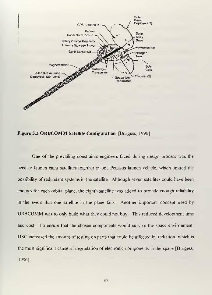
GPS Antenna (<t)
Battery
Subscriber Receiver
.
Battery Charge Regulator
Antenna Stowage Trough
SolarPanelDeployed (2)
Solar
Array
Dnve
Avionics Box
Magnetometer
VHF/UHF Antenna
Deployed (129" Long) Subscriber ^Thrusler (2)
Transmitter
Figure 5.3 ORBCOMM Satellite Configuration [Burgess, 1996]
One of the prevailing constraints engineers faced during design process was the
need to launch eight satellites together in one Pegasus launch vehicle, which limited the
possibility of redundant systems in the satellite. Although seven satellites could have been
enough for each orbital plane, the eighth satellite was added to provide enough reliability
in the event that one satellite in the plane fails. Another important concept used by
ORBCOMM was to only build what they could not buy. This reduced development time
and cost. To ensure that the chosen components would survive the space environment,
OSC increased the amount of testing on parts that could be affected b\ radiation, which is
the most significant cause of degradation of electronic components in the space [Burgess,
1996].
95
2. Ground Segment
The Ground Segment is comprised of Network Control Center (NCC), Satellite
Control Center (SCC) and Gateway Earth Station (GES). This segment contains most of
the system intelligence (the brain). On larger, more expensive systems, much of this
would be on the satellite. The advantage of keeping most of the intelligence on the
ground is that it allows the satellite be smaller, but the disadvantage is that each message
must be directed through both the GES and NCC. The satellite is unable to direct a
message by itself, even if it has both the sender and the receiver in view.
a. Network Control Center (NCC)
The Network Control Center provides message routing and customer
services, which includes customer monitoring and billing. It is owned and operated by
ORBCOMM in the U.S. and by each licensee abroad. The NCC will route the messages
according to their addresses using Transmission Control Protocol and Internet Protocol
(TCP/IP)[Comer, 1997]. The NCC is connected to the GES by leased lines, the public
data network, or Very Small Aperture Terminals (VSAT). A country having a license to
operate the ORBCOMM system may have an NCC and as many GES's as necessary to
provide entire coverage in near real time. For example, in the US, one NCC and four
GES's are enough.
b. Satellite Control Center
The Satellite Control Center (SCC) is located near the main NCC in Dulles,
Virginia, US. It is the only place from which the satellites can be commanded and the
96
telemetry of the satellite subsystems monitored. As the satellites come into view of the
U.S. GES, the system initiates an automated "State-of-Health" check. If no problems are
detected, the system will store the telemetry data. If problems or malfunctions are found,
the SCC operator will take the necessary corrective actions to get it back to normal
operation. Telemetry from other NCC's could be received and relayed to the U.S. NCC,
but ORBCOMM does not anticipate solving major problems when the satellite is not in
view of the U.S. SCC [Yarbrough, 1995].
c. Gateway Earth Station
The Gateway Earth Station (GES) provides the link between the ground
segment and the space segment. The GES's are unattended, and they communicate with
the visible satellite just uplinking or downlinking the messages in accordance with the
orders received through the NCC. Through these orders, the NCC indicates which
satellite should be tracked by the GES. The basic functions of the GES are:
-Acquire and track satellites based on orbital parameters received from the NCC
-Transmit to and receive messages from the satellites
-Transmit to and receive messages from the NCC
-Monitor status of local GES hardware and software
-Monitor the system level performance of the satellite linked to the NCC.
Each GES has two steerable high-gain VHF antennas that track satellites as they
cross the sky. The GES transmits to the satellite 56.7 Kbps in the 148.0-150.05 MHz
range at 500 watts. The GES receives a 3 watt transmission from the satellite in the
97
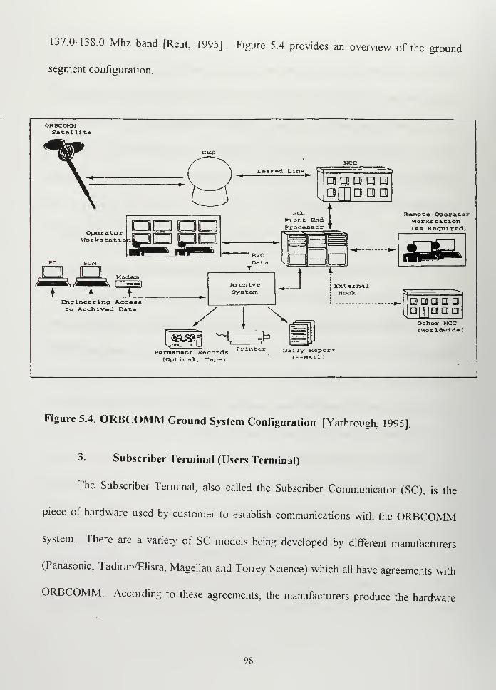
137.0-138 Mhz band [Reut, 1995]. Figure 5.4 provides an overview of the ground
segment configuration.
ORBCOMMSatel lite
Leased Line
aaaooa a
OperatorWorks tat i<
OQQQpapaill ilk
—
secFtonProc
c tt End I
essor T
rnB/OData
E3
LZZJ
ModemdpEngineer lng Acceceto Archived Data
ArchiveSystem
ExternalHook
J-
Permanent Records P* int« Daily Report(Optical, Tape) (E-Mail)
Remote OperatorWorkstation(As Required)
QOUQQafTjqggOther NCC(Worldwide!
Figure 5.4 ORBCOMM Ground System Configuration [Yarbrough, 1995]
3. Subscriber Terminal (Users Terminal)
The Subscriber Terminal, also called the Subscriber Communicator (SC), is the
piece of hardware used by customer to establish communications with the ORBCOMM
system. There are a variety of SC models being developed by different manufacturers
(Panasonic, Tadiran/Elisra, Magellan and Torrey Science) which all have agreements with
ORBCOMM. According to these agreements, the manufacturers produce the hardware
98
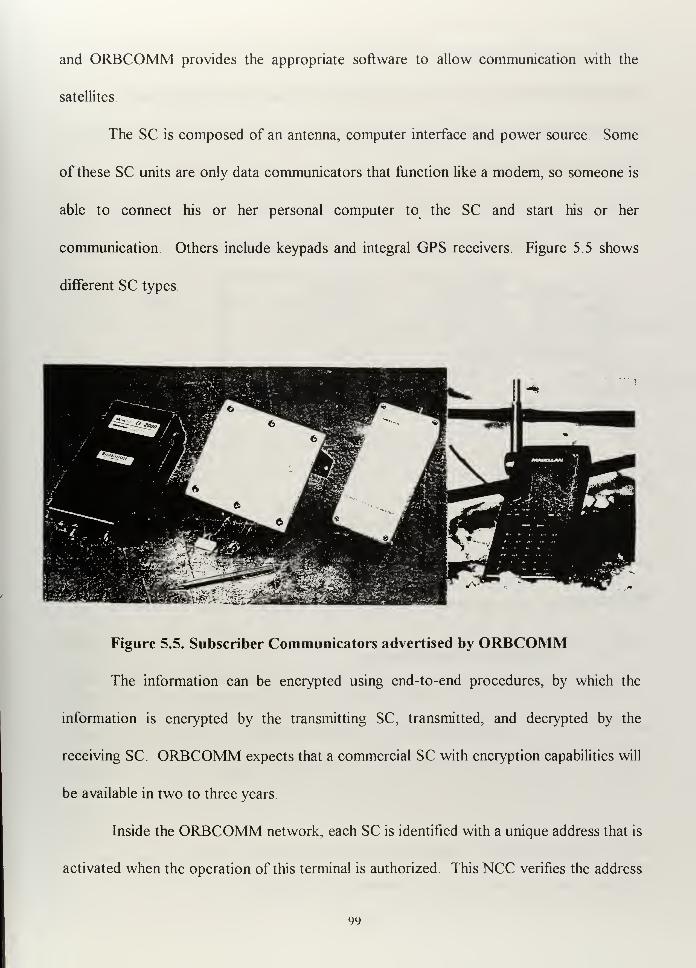
and ORBCOMM provides the appropriate software to allow communication with the
satellites.
The SC is composed of an antenna, computer interface and power source. Some
of these SC units are only data communicators that function like a modem, so someone is
able to connect his or her personal computer to the SC and start his or her
communication. Others include keypads and integral GPS receivers. Figure 5.5 shows
different SC types.
Figure 5.5. Subscriber Communicators advertised by ORBCOMM
The information can be encrypted using end-to-end procedures, by which the
information is encrypted by the transmitting SC, transmitted, and decrypted by the
receiving SC. ORBCOMM expects that a commercial SC with encryption capabilities will
be available in two to three years.
Inside the ORBCOMM network, each SC is identified with a unique address that is
activated when the operation of this terminal is authorized. This NCC verifies the address
99
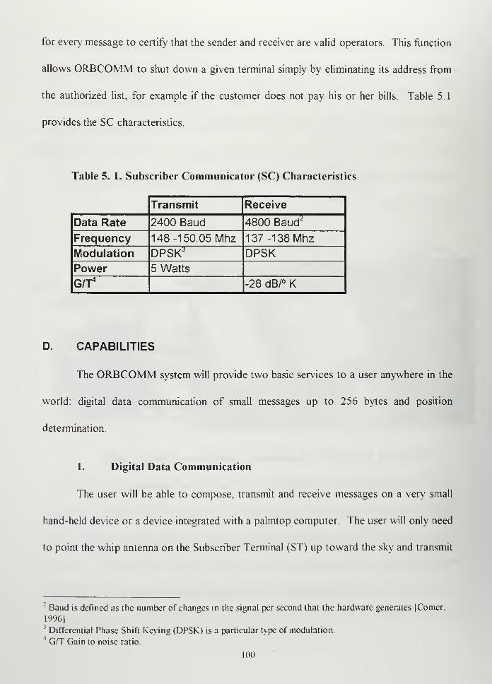
for every message to certify that the sender and receiver are valid operators. This function
allows ORBCOMM to shut down a given terminal simply by eliminating its address from
the authorized list, for example if the customer does not pay his or her bills. Table 5.1
provides the SC characteristics.
Table 5. 1. Subscriber Communicator (SC) Characteristics
Transmit Receive
Data Rate 2400 Baud 4800 Baud2
Frequency 148 -150.05 Mhz 137 -138 Mhz
Modulation DPSK3 DPSKPower 5 Watts
G/T4
-28 dB/° K
D. CAPABILITIES
The ORBCOMM system will provide two basic services to a user anywhere in the
world: digital data communication of small messages up to 256 bytes and position
determination.
1. Digital Data Communication
The user will be able to compose, transmit and receive messages on a very small
hand-held device or a device integrated with a palmtop computer. The user will only need
to point the whip antenna on the Subscriber Terminal (ST) up toward the sky and transmit
:Baud is defined as the number of changes in the signal per second that the hardware generates |Comer.
1996]3Differential Phase Shift Keying (DPSK) is a particular type of modulation
4G/T Gain to noise ratio.
100
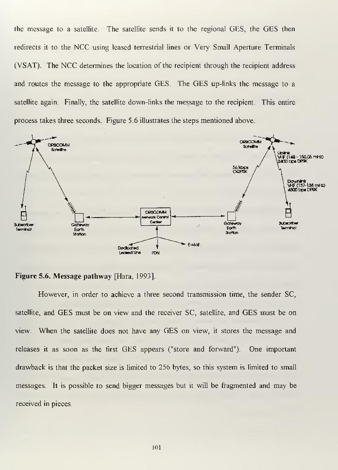
the message to a satellite. The satellite sends it to the regional GES, the GES then
redirects it to the NCC using leased terrestrial lines or Very Small Aperture Terminals
(VSAT). The NCC determines the location of the recipient through the recipient address
and routes the message to the appropriate GES. The GES up-links the message to a
satellite again. Finally, the satellite down-links the message to the recipient. This entire
process takes three seconds. Figure 5.6 illustrates the steps mentioned above.
Dodcot«dlaawdUne PON
owjc^of^wNatvwak Oortrd
Cantori
/ i
1'
~~~^*-E-Mol
up**Vff (148-1 S0.Q6mrt0
bp«DPSK
DowninkVHF(137-lMrrWD4300 bp. DP6K
GatoWO* SUbtcrbar
Eorih 1«<TT*¥Jl
Station
Figure 5.6. Message pathway [Hara, 1993]
However, in order to achieve a three second transmission time, the sender SC,
satellite, and GES must be on view and the receiver SC, satellite, and GES must be on
view. When the satellite does not have any GES on view, it stores the message and
releases it as soon as the first GES appears ("store and forward"). One important
drawback is that the packet size is limited to 256 bytes, so this system is limited to small
messages. It is possible to send bigger messages but it will be fragmented and may be
received in pieces.
101
At least fifty-two satellites would be needed in the constellation to provide true
real-time operation. ORBCOMM rejected this option as economically infeasible. Instead,
the system provides what can be considered "near real-time": a wait of no more than five
to ten minutes for satellite acquisition. The constellation of twenty-six meets those
requirements [Burgess, 1996].
The military user must be concerned about the entire delay time, or the time from
the moment the sender is ready to transmit a message to the moment the recipient actually
gets the message. This may vary from three seconds, when the conditions are optimal, to
many hours when the subscriber does not have the satellite in view and the satellite does
not have any GES in view.
Although ORBCOMM does not clearly define how the time required to get at least
one satellite in view is computed, the value of ten minutes can be adopted as a maximum
reasonable value. Todd Hara, ORBCOMM Senior Engineer, wrote in 1994 (referring to
the thirty-six satellite constellation): "The satellite constellation is key to providing the
following system performance objectives:
95% availability of spacecraft above 5 degrees elevation to the horizon
99% of outages (satellite not in view) less than 5 minutes
95% of outages (satellite not in view) less than 2 minutes "[Hara, 1994].
The same year, in another paper, Hara wrote: "With a constellation of thirty-six
LEO satellites and terrestrial facilities, the U.S. user will have a satellite in view
continuously over 95 % of the time and will have to wait less than two minutes the rest of
the time." [Hara, 1994]
102
In 1995, Anton B. Reut, ORBCOMM Director Government Services, and Todd
Hara wrote (referring to the thirty-six satellite constellation): "The system is designed to
meet the following system performance objectives in the temperate climate zones in both
the Northern and the Southern hemispheres:
98% availability of spacecraft above 5 degrees elevation to the horizon.
99% of outages (satellite not in view) less than 5 minutes
98% of outages (satellite not in view) less than 2 minutes " [Reut, 1995].
Though the statistical values presented by the company are somewhat inconsistent,
the graphic representation of satellite coverage for twenty-four satellites at a given instant
(Figure 5.2) shows that at medium latitudes, the probability of having at least one satellite
on view is high. Therefore, an assumption of 95 % availability appears to be reasonable.
From this point on, I will assume that the worst case condition is when the user
must wait ten minutes to get a satellite on view. So, the sender SC may have to wait as
long as ten minutes to acquire a satellite (uplink). After the message passes through the
NCC and GES, it may take the receiver SC up to ten minutes to acquire a satellite
(downlink). So, although rare, it could take as long as twenty minutes to send a message
through the system. This significant time delay would be more common where there is not
a GES in the operations area.
Suppose the message sent from some part of the South Atlantic Ocean, maybe 400
nautical miles east of Puerto Belgrano,5reaches the satellite but there are not a GES on
view. The satellite stores this message until it is able to see a GES. We do not know
^ Puerto Belgrano: The Argentine Navy's most important base, located close to Bahia Blanca. Buenos
Aires.
103
exactly how much time this will take. Let us assume thirty minutes.6Then, the message is
directed to an NCC and redirected to the satellite and GES nearest to the receiver. The
amount of time required to deliver the message to the receiver will depend on how far the
nearest satellite must travel to be in view of the GES. If we define ten minutes as "near
real-time," this system may not provide even near real-time to some users.
Analyzing again the instantaneous coverage at a given moment for twenty-four
satellites (Figure 5.2) we can see how one satellite is covering all of Argentina, Chile, the
Atlantic Ocean and the Pacific Ocean. Remember that the coverage circle diameter is
about 5460 Km (2948 nautical miles) and the Argentine Navy operations area normally
will not exceed 400 nm from shore. With my assumptions stated above, it is possible that
a deployed ship might wait ten minutes to acquire a satellite, but when the satellite is
acquired it would most likely be on view of the GES located in a central region of
Argentina (assuming we have a GES) and in view of the receiver, so we would not expect
the delay to exceed ten minutes. Depending on what kind of application we hope to
satisfy, ten minutes may or may not be acceptable. A ship can send a tactical message to a
deployed unit using ORBCOMM in less time than the required to set up a new HF circuit,
but it cannot entirely replace the tactical circuit. If we only considered electronic mail,
administrative messages, and distant assets control (like navigation buoys), two, three or
more hours delay might be acceptable.7
6Thirty minutes is reasonable, considering the satellite will found an appropriate ground station in North
America.
The consideration of more than a satellite period ( 100 minutes) for the time elapsed from when the
message is sent until it is received, is based on the assumption that only the U.S. GES already exists. So.
it may happen that the satellite must wait more than one orbit to pass again over the U.S. GES. Having
the appropriate number of GES's distributed throughout the world will alleviate this problem
104
Having a GES in our country would not be sufficient to use the system for military
purposes. We would also need a regional NCC to make the system more reliable for two
reasons, physical security and information security. Under critical situations we need to
reduce the risk of third party country managing our messages and our system. However,
although having a regional NCC and our own GES will provide more flexibility, the
ultimate control will always belong to ORBCOMM USA.
2. Position Determination
Position determination of an SC will be accomplished using the Global Positioning
System (GPS). The GPS receiver on the satellite allows the satellite to calculate its
precise position, and acquire precise time information. Using precise time and position
information received from the satellite, the user terminal can calculate its own position
using the Doppler frequency shift measurement technique. This calculated position
(within 500 meters) can be relayed through a satellite (or alternative measurements can be
performed on board the satellite at the expense of increasing the traffic loading), giving the
user's position to the NCC.
The system also allows each SC to determine its position with more precision by
using an integral GPS receiver and communicate this position to the NCC through the
satellite and GES [Hardman, 1991]. Of course, this configuration is more expensive.
In summary, ORBCOMM is a commercial system designed to provide:
-Two way non-voice messages with world-wide coverage
-Monitoring and control of remote assets
-Collection of data from hand-held subscriber communicators
105
It could be useful for many military applications that do not require voice transmission It
is reliable enough to provide simple communications for remote areas, including oceans
Further, because the entire system was conceived and developed to satisfy commercial
requirements at reasonable prices, the cost of using it may be acceptable
E. APPLICATIONS
In order to figure out how Argentine Navy can take advantage of the ORBCOMM
system I first looked at some commercial applications that the system was designed for.
1. Commercial Applications
In general, the company advertises different applications like emergency towing
systems, emergency medical communications, boxcar and container monitoring, stolen
property recovery, trucking monitoring, animal tracking, remote access monitoring,
personal business, communications for the impaired, customs and law enforcement. The
follow are a few examples:
a. Transportation
The integration of GPS with the communications system provides a useful
tool for transportation management. Security and efficiency can be considerably increased
by using this system. The SC can be installed in each of the desired trucks, containers,
boats or whatever someone wants to keep track of. Appropriately programmed, this SC
will send either position or status at a previously scheduled time (daily, weekly, hourly) or
when requested. If something happened to the vehicle, or we just wanted to know how
106
many empty containers were in a distant warehouse, we could get this information simply
by asking the system.
b. Remote Monitoring capability
The SC attached to the appropriate sensor can provide the information
necessary to take actions that can avoid bigger problems. For example, it can be used to
control the flow of oil or gas on pipelines in remote areas, monitor water level of a river to
provide a warning of flooding or drought and measure contaminant levels to protect the
environment.
c. Safety communications
Under certain circumstances, ORBCOMM could be the most effective
way to send a message safely and reliably while limiting the number of listeners.
Sometimes the open voice circuits are not desired or the propagation conditions do not
allow normal communications. Emergency situations in remote areas can require this
service.
d. Commercial and Personal Communications
Some companies can use the system as a way to transmit short messages to
their agents located in remote locations. The system can be used as two-way, point-to-
multipoint and multipoint-to-point communications covering a wide area Although
cellular phones are more common in cities, there is still a gap in coverage in remote
regions.
107
2. Military Applications
ORBCOMM noticed early the "dual-use" policy developed by the U.S.
Department of Defense (DoD) as part of the civil-military integration after the Persian
Gulf War. The company studied some applications to tempt the U.S. military forces.
Press information released by the company said that in 1995 the ORBCOMM
system was "successfully" tested by the U.S. Army. About 1500 messages were
transmitted between six different locations during a two week exercise. The system was
used to request data from DoD's Global Broadcast System and to confirm its reception.
The Army also used it to communicate between two secure communications facilities and
to geolocate vehicles [Pizzimenti, 12/09/96] The word "successfully," in this case must
be carefully scrutinized, for the company means that the system worked within the
expected parameters and accomplished what they expected it to. However, I am not able
to determine how useful this system was to the users. I have no information indicating
that the Army or any other military force is using the system other than in that particular
exercise.
ORBCOMM developed military applications that include remote asset monitoring,
logistics tracking, search and rescue operations, and two way messaging and paging. I
think that in same cases, ORBCOMM could be a powerful military tool. It can be either
used as a complementary system or used as primary system when deploying personnel in
remote areas or frontier locations. Figure 5.7 illustrates ORBCOMM's military
applications.
108
Downed
Figure 5.7. Military applications
a. Mission Applications
The ORBCOMM system can provide geolocation with the accuracy of 500
meters based on a combination of Doppler frequency shift provided by the satellite and the
satellite's on-board GPS receiver. If it is needed, an optional GPS receiver in the SC can
provide higher accuracy (100 meters). This information can be used to keep track of
military assets deployed in the battlefield at distant points from the command center.
Because the SC is small enough to carry in an attache, and the required power is
achievable with portable batteries, the system is flexible enough to be used in any
operational theater. Other advertised applications include: [Reut, 1995]
-Tracking the positions of logistics items throughout shipment
109
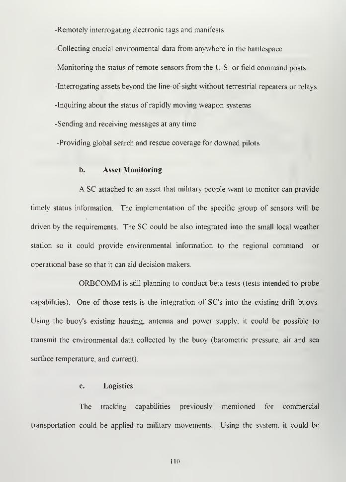
-Remotely interrogating electronic tags and manifests
-Collecting crucial environmental data from anywhere in the battlespace
-Monitoring the status of remote sensors from the U.S. or field command posts
-Interrogating assets beyond the line-of-sight without terrestrial repeaters or relays
-Inquiring about the status of rapidly moving weapon systems
-Sending and receiving messages at any time
-Providing global search and rescue coverage for downed pilots
b. Asset Monitoring
A SC attached to an asset that military people want to monitor can provide
timely status information. The implementation of the specific group of sensors will be
driven by the requirements. The SC could be also integrated into the small local weather
station so it could provide environmental information to the regional command or
operational base so that it can aid decision makers.
ORBCOMM is still planning to conduct beta tests (tests intended to probe
capabilities). One of those tests is the integration of SC's into the existing drift buoys.
Using the buoy's existing housing, antenna and power supply, it could be possible to
transmit the environmental data collected by the buoy (barometric pressure, air and sea
surface temperature, and current).
c. Logistics
The tracking capabilities previously mentioned for commercial
transportation could be applied to military movements Using the system, it could be
no
possible to know exactly where our supplies are and promptly detect when something has
altered our plan. Also, if we are awaiting a critical spare part coming from a distant
location, we could track it throughout the entire trip to be sure it does not get delayed or
sent to the wrong place.
ORBCOMM is planing various tests in order to satisfy potential military
requirements. One of them is directed toward tracking and monitoring the location and
status of people, supplies and weapons systems. From the point of view of the
Commanding Officer, who has a force deployed in distant areas, it could solve one of the
basic questions: Where is my personnel and material and how are they doing?
ORBCOMM is still developing the system and exploring applications. Any military user
considering the use of this system should establish their own needs and determine the
specific limitations of the system.
3. Possible Argentine Navy Applications
a. Maritime Traffic Control
One of the basic missions assigned to Navy ships at sea is maritime traffic
control. The traffic information is compiled by the Maritime Traffic Control Command
based on the daily position messages the ships at sea must send. By using ORBCOMM
SC's these messages could be automated and increased in frequency, if necessary. For big
ships, the approximate cost of 1,000 dollars for the equipment and small monthly fee can
be an insignificant expenditure. For small boats or cruisers it could be a desirable
alternative to have a communication system, although limited, to communicate with a Cost
ill
Guard for emergencies or for sending special request when out of range of normal VHF
radios
One of the problems detected in controlling fishing ships is that they
protect their position to avoid saturation when they find a productive area, which creates
difficulties for meteorological warnings and search and rescue actions. Using the
ORBCOMM system, the owner of the company can safely receive the position and status
of its ships and the authorities can maintain control of the situation.
b. Small boats operations security
There could be an operational scenario in which we have to send a small
boat on a silent mission. If the capital ship is unable to wait until the end of the mission
and the people must be recovered by another ship. A hand-held SC can provide additional
security to the crew of the small boat and appropriate feedback to the Commander Officer
so that he can recover his people at the right time in the right place.
c. Search and rescue
The SC on board a damaged ship or plane can send and emergency
message at the last second that provides the last accurate GPS position, thereby
simplifying the search and rescue operations. On board a lifeboat, it can provide much
more help than other systems we had before, enabling survivors to send not only their
position but also the condition of the injured people Medical units can be dispatched
immediately and the psychological health of the crew can be keep stabilized while waiting
112
to be rescued. A pilot who is downed over hostile territory would have a higher
probability of surviving and being rescued.
d. Ship to ship administrative and limited tactical messages
Sometimes small administrative or tactical messages are needed and the
propagation conditions of the radio signal turns this need for communication into a
vulnerability. Unjustified repetitions can be avoided by using the ORBCOMM system.
We can reduce our broadcast time and thereby reduce the probability of being detected
and monitored. Remembering that VHF is line-of-sight (LOS) and cannot propagate
beyond the horizon, the probability of interception of the sender message is reduced, but
the probability of the interception of the satellite relayed message is increased, though
encryption can reduce this somewhat.
e. Maritime signals control and maintenance
A secondary duty assigned to some Navy units is the control and
maintenance of maritime signals. In some remote regions the monitoring capability can
help keep track of lighthouses or buoy status.
f. Oceanography
The U.S. Naval Research Laboratory at Stennis Space Center will use the
ORBCOMM system in conjunction with the ANAVSQ-6 class of Navy Mini Buoys.
These buoys are deployed in remote areas and can provide meteorological information on
a regular basis or by request. Similar devices can be designed to be attached to remote
n:
sensors that can keep yearly track of the environmental changes, for example, in the
Antarctic.
g. Battlefield tactical messages
Depending on the friendly and enemy forces deployed and the urgency of
the action, the system can also provide a method of communication that is much less
vulnerable to interception than conventional open circuits.
h. Peace Mission Communications
The portable, cheaper, world-wide coverage SC's can link small deployed
forces with their home command. Also, a detached ship can use it to significantly reduce
the cost of its administrative messages. The cost of the INMARSAT system to send one
minute fax is around six dollars, and the ORBCOMM advertised cost is about one dollar
per message of 256 bytes.
F. BENEFITS AND DISADVANTAGES
1. Benefits
a. No development is required
We can use ORBCOMM services without having to develop the satellite
system and the associated equipment. We can acquire ORBCOMM services on a
commercial basis at the same prices as civilian customers
114
b. Non-LOS communication
From a tactical point of view, there is a powerful element to be considered.
The system can provide non-LOS communications. Other satellite systems require the
deployment of more complicated antennas to establish communications. Traditional HF
requires more radiated power and is easily detected.
c. Small equipment required
The SC is the only equipment required to operate the system. It is small,
cheap, portable, and water resistant, so it could be use on board a small boat or by Marine
Corp Units.
d. Competitive commercial product
Different manufacturers are developing compatible terminals so the
competition may make the product better and future prices cheaper. The available SC's
can be acquired for $ 700 to $1,000, depending on the final configuration. ORBCOMM is
a profit-driven organization interested in selling its product, so virtually any operation or
configuration can be acceptable, if it represents money for the company.
e. Communications may be encrypted
The security of the system can be increased by using traditional encryption
systems.
115
f. Low power required
The SC only requires five watts, which makes it portable and low in power
consumption.
g. Priority may be assigned
The NCC classifies the messages in four different priorities, so military
messages could be given priority over other civilian users of the same system.
h. Robustness and redundancy
Robustness and redundancy of the system is accomplished by the large
number of satellites, so the failure of one satellite would not significantly affect the
performance of the system.
2. Disadvantages
a. No real time
It is not real time For some applications, like electronic mail, this would
not be considered a drawback.
b. Non-voice system
It is by design a non-voice system.
c. Very controlled network
It is a very controlled network. It does not matter where the sender and
receiver are when generating messages. The sender and receiver can be very close to each
other, but the message must travel through the GES and NCC During this process, the
116
address and the position of the sender and receiver are computed in order to determine the
route the message must follow, so the position of a ship sending a message will be known
by NCC. If we had our own NCC, this will probably not be a problem, because we may
restrict the access to this information. However, ifjust happened that the GES directs the
message to other nation's NCC, accurate vital information can be provided to the
hypothetical enemy. How this situation may happen needs to be figured out in advance
and it will probably depend on the NCC locations distributed around the world. This
problem can be avoided having our own NCC and GES. It also creates so much
dependence on the ground segment, which is vulnerable to intentional damage.
d. ORBCOMM may shut down the service unilaterally
The service can be shut down by ORBCOMM unilaterally. Although this
action could hurt the company, under international conflict situations, ORBCOMM, being
an American corporation, will probably respond to the U.S. Government pressures.
Under the existing conditions, keeping in mind that our policies are
intended to strengthen the North-South relations, and our missions are more closely
related with the United Nations interests than ever, the possible shut down is highly
improbable, but must be considered. ORBCOMM can deny access to a particular address
as we mentioned before and also has the capability to deny the appropriate codes to an
NCC, hence closing its operation. By contrast, the owner of GPS (the U.S. Military) is
unable to control the receivers, so the only way to deny information to an undesired user is
by modifying the satellite information, which affects all users, friendly or otherwise.
117
e. Low transmission rate and limited capability
It has a very low transmission rate (transmission 2400 bps; reception 4800
bps). Total transmission capability is 61,000 fifty byte messages per hour, and the normal
message should be no longer than 256 bytes. If it is larger it must be split into packets,
which are sent through the network separately.
f. Non-established in Argentina
Argentina does not have an ORBCOMM sales representative nor does it
have an NCC or GES. The representative in Argentina and Uruguay (ORBCOMM del
Sur) is no longer affiliated with the company. However, to minimize local legal problems,
ORBCOMM Global, LP. (Responsible for the international business) has signed
agreements with different communication companies from other nations to act as resellers
of its services. Hence, different ORBCOMM subsidiaries were created to provide services
to different countries, but this is still an ongoing process. ORBCOMM is interested in the
Argentine market and is looking for another serious communication company to manage
the region, so we may expect that as the system grows we will have a civilian company
operating ORBCOMM in our region
G. FINAL CONSIDERATIONS
The basic capabilities of the ORBCOMM could be exploited by the Argentine
Navy on a commercial basis. As I mentioned in Chapter II, the contribution of space
assets to the military field is directed to improve CI/CI capability. Can this system
contribute to improve CT/C4I architecture of the Argentine Navy9 The answer is yes. We
118
can see in the U.S. forces that the entire C4I is not build around a single, dedicated military
system but around many different systems capable of satisfying diverse requirements.
During the Gulf War, U.S. forces realized that the dedicated military satellite systems were
unable to manage the vast information needs. After that, the use of commercial systems
by the military drastically increased and civil-military integration began to emerge.
For our case, we can assume that ORBCOMM non-voice communications can
complement our basic structure, but could never be considered a primary tactical system.
Adequately implemented, the ORBCOMM system could satisfy many applications and can
provide good help to the Argentine Navy basic missions. Nevertheless, we will always
need to consider alternative ways to do the same thing.
Like other civilian systems, ORBCOMM is not prepared to support aggressive
actions that can be conducted during war time (it is vulnerable to jamming and ground
segment dependent). ORBCOMM is more appropriate for logistic support or peace-time
deployments than for tactical operations in the battlefield.
119

120
VI. MILITARY APPLICATION OF COMMERCIAL IMAGERYSYSTEMS
A. INTRODUCTION
As it was recognized with the release of Corona Program information,1
the
observation of the earth from space was of much interest during the Cold War era.
Photographs from the first manned space missions stimulated the intelligence community's
interest. These photographs also stimulated commercial and scientific interest. The
scientific community looked forward to studying what could have only been possible to
learn from space. The first civilian space remote sensing program was Earth Resources
Technology Satellites (ERTS). Initiated in 1967, the ERTS resulted in a planned sequence
of six satellites. After the second successful launch, it was renamed by NASA as the
LANDSAT program (to distinguish it from the planned Seasat oceanographic satellite
program). [Lillesand and Kiefer, 1994]
The Open Skies2policies went along with the development of what evolved into
LANDSAT. Although initially classified, imagery from the LANDSAT program was
approved for general release to the public and became the most powerful tool at that time
for earth studies. In spite of its primitive technology and limited capabilities and
resolution, relative to what we have today, it gained global acceptance, and fourteen
1
Corona was the first American spy satellite developed during the government of Eisenhower (1952-
1960) [Brugiom. 1996],2The "Open Skies" principle means there would be nondiscriminatory access to data collected anywhere
in the world jLillesand and Kiefer. 1994].
121
countries, including Argentina," obtained licenses to build LANDSAT ground stations,
making it the first commercial imagery in the world.
The decision for sell LANDSAT imagery was based on three factors. First, the
scientific community's demand for imagery had increased over the years. The earliest data
obtained from photographic cameras mounted on balloons was improved with the advent
of the airplane. The accumulation of archives allowed scientists to document surface
features and their changes. They discovered the importance of having more information
and the capability to assemble assembling different data sets in order to provide
information to diverse fields like agriculture (vegetation and crops health), mining, and oil
explorations.
Second, selling LANDSAT data gave the U.S. a way to reduce cost and increase
capacity. Because the satellite did not have on-board storage capacity, the only way to get
information about a particular area was through a ground station in close proximity to the
area of interest. Areas not having a ground station within about 3000 Km could not be
imaged. By sharing LANDSAT data, the U.S. could get access to the information
obtained by ground stations located in other countries.
Third, and probably the most important, was the ability of the US to maintain
control of the information. The information could be denied simply commanding the
sensor off from the main control station. Of course, this would affect all users, friendly or
otherwise. [Lee, 1994]
1
The Argentine ground station was deactivated in 1985 for economic reasons Our users now buy
images directly from LANDSAT, SPOT and the Soviet Systems |Donunguc/. 1<> 1>1
1
122
The commercialization of French Systeme Pour VObservation de la Terre (SPOT)
Imagery, starting in 1989, marked the end of the U.S. monopoly. The U.S. is no longer
the only owner of commercial space capabilities and technology. The other major player,
Russia, who had remote sensing systems for years, and who had never disputed American
leadership in remote sensing, is completely changing its policies. It is trying to convert its
military programs to commercial ones.
First of all, we must recognize the sensitive and highly classified nature of space-
based military and intelligence collection systems. But, what happens when a similar
system developed by a civilian organization is able to provide the same or better
capabilities without restrictions?
It is important to understand that with recent advances in space technology and
computer processing systems, remote sensing information is getting more easily obtainable
and understandable. SPOT Image Corporation, for example, openly advertises the
intelligence gathering and military utility of SPOT imagery. The company recommends
different applications in that area and also recommends the appropriate software for better
use of this imagery. [Paige, 1996]
The initiation of international competition in remote sensing products accelerated
development of the field. The satellite remote sensing industry has grown significantly
since 1960. 1994 estimates established the market at $275 million with the expectation of
reaching $2 billion by the year 2000. Thirty-six commercial remote sensing satellites are
planed for launch from 1997 to the year 2009. [Deans, 1996]
123
I believe the Argentine Navy should start seriously considering the use of
commercial remote sensing imagery, because remote sensing imagery have many
applications that can help our Navy to accomplish its basic missions (mission planning,
trafficability, navigation, weather, intelligence, mapping). Further:
-We are not yet capable of getting our own military remote sensing assets
-Commercial remote sensing proved very useful during the Gulf War. During
the Desert Storm, U.S. military remote sensing systems were not enough to satisfy
all allied needs. Commercial remote sensors like SPOT and LANDSAT were
used, and better resolutions could have been used, if available
-It is better to have something with limitations than nothing at all. At this point I
consider that commercial remote sensing is better than nothing.
-It is available, and as well as we can use it against our hypothetical enemies, they
can use against us.
-It is a tool that more advanced military countries like the U.S. are using on a daily
basis. If we are willing to cooperate and take part in international missions, for
example, peace keeping or anti-narcotic operations, we need to at least understand
what they are doing.
Today, the conditions to start using commercial remote sensing in the Argentine
Navy are better than they have ever been. The global commercial remote sensing industry
is experiencing competition that is making its products cheaper and better. Argentine
international policies are characterized by a clear alignment with the U.S. and its allies.
Continuous military participation in peace keeping missions has permitted the achievement
124
of international recognition. Proof of that is that an Argentine Army General is today
commanding a peace keeping mission in Chipre, which is integrated with Great Britain and
Argentine soldiers [Clarin, 1997]. These reasons will play in our favor, if some voice were
lifted against us with respect to a particular remote sensing application.
B. PARAMETERS TO CONSIDER IN THE USE OF CIVILIAN REMOTESENSED DATA
To understand the military applications of the civilian systems, it is necessary to
keep in mind the parameters that make the remote sensing imagery useful. These
parameters are spatial resolution, spectral resolution and timeliness.
1. Spatial Resolution
Spatial resolution is the minimum size of an object on the ground that the sensor
can distinguish. For example, a satellite having ten meter resolution will not be able to
distinguish an object that has a characteristic dimension of less than ten meters. Spatial
resolution determines the satellite's ability to accomplish tasks such as detection, general
and precise identification, description and technical analysis. Table 6.1 provides detail
about which resolutions are needed to accomplish these tasks for different targets.
It is interesting to notice that one meter resolution is almost good enough to
provide precise identification for most of the targets that represents valuable tactical
information. This kind of resolution will probably be commercially available in a couple of
years, but other parameters need to be considered before assuming that it will be tactically
valuable.
125
2. Spectral Resolution
Spectral resolution is the ability to discriminate fine spectral differences. Objects
of interest usually radiate or reflect different values of energy at different wavelengths. By
using several spectral bands in the observation of the same object, it is possible to
recognize some features that are not visible in a normal panchromatic (what the human
eyes sees) photograph. For example, healthy vegetation can be clearly distinguished from
dead or stressed vegetation using near infrared wavelengths (.8 - 1.1 um), which are
beyond the range of human vision Healthy vegetation, while appearing green in
conventional color photographs, will appear in red hues in color infrared photographs
because of the elevated near-IR reflectance from the mesophilic tissue of the leaves.
Stressed vegetation also appears green in conventional color photographs, but appears
pink in near-IR photographs. Dead vegetation appears yellow in conventional color
photographs, but appears white in near-IR photographs Table 6.2 shows the spectral
bands on SPOT and LANDSAT satellites, along with some of their applications.
3. Timeliness
This parameter is probably the most difficult to improve when using commercial
imagery. It depends on three factors: revisit frequency, which is the time it takes the
satellite to pass over the same point twice; imagery processing time; and image delivery
time.
126
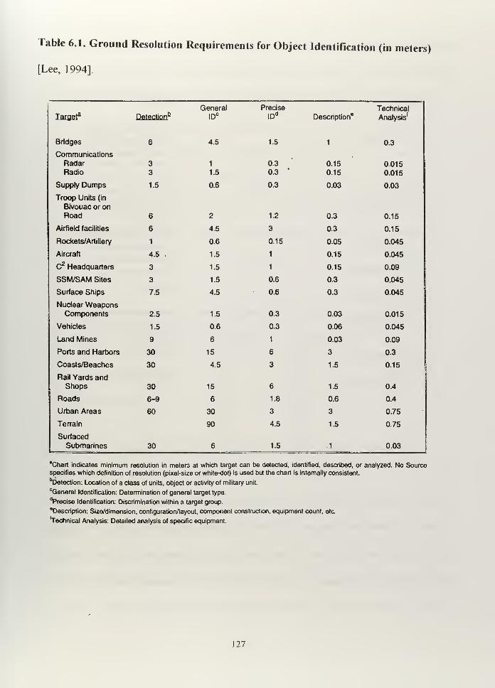
Table 6.1. Ground Resolution Requirements for Object Identification (in meters)
[Lee, 1994].
Submarines 30 1.5 1 0.03
Iaigej Detection6General
IDC
Precise
IDd
Description8
Technical
Analysis'
Bridges 6 4.5 1.5 1 0.3
CommunicationsRadarRadio
33
1
1.5
0.3
0.3v
0.15
0.15
0.015
0.015
Supply Dumps 1.5 0.6 0.3 0.03 0.03
Troop Units (in
Bivouac or onRoad 6 2 1.2 0.3 0.15
Airfield facilities 6 4.5 3 0.3 0.15
Rockets/Artillery 1 0.6 0.15 0.05 0.045
Aircraft 4.5 . 1.5 1 0.15 0.045
C2 Headquarters 3 1.5 1 0.15 0.09
SSM/SAM Sites 3 1.5 0.6 0.3 0.045
Surface Ships 7.5 4.5 0.6 0.3 0.045
Nuclear WeaponsComponents 2.5 1.5 0.3 0.03 0.015
Vehicles 1.5 0.6 0.3 0.06 0.045
Land Mines 9 6 1 0.03 0.09
Ports and Harbors 30 15 6 3 0.3
Coasts/Beaches 30 4.5 3 1.5 0.15
Rail Yards andShops 30 15 6 1.5 0.4
Roads 6-9 6 1.8 0.6 0.4
Urban Areas 60 30 3 3 0.75
Terrain 90 4.5 1.5 0.75
Surfaced_ _
"Chart indicates minimum resolution in meters at which target can be detected, identified, described, or analyzed. No Sourcespecifies which definition of resolution (pixel-size or white-dot) is used but the chart is internally consistent.
bDetection: Location of a class of units, object or activity of military unit.
cGeneral Identification: Determination of general target type.
"Precise Identification: Discrimination within a target group.
description: Size/dimension, configuration/layout, component construction, equipment count, etc.
"Technical Analysis: Detailed analysis of specific equipment.
127
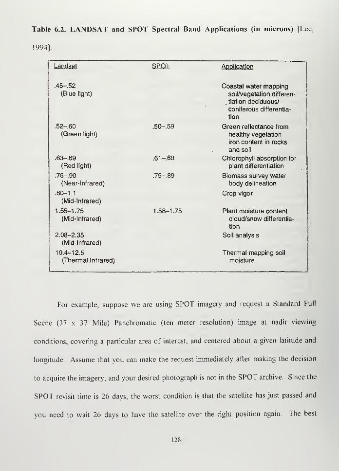
Table 6.2. LANDSAT and SPOT Spectral Band Applications (in microns) [Lee,
1994].
Landsat SPOT Application
.45-52
(Blue light)
Coastal water mappingsoil/vegetation differen-
, tiation deciduous/
coniferous differentia-
tion
.52-.60
(Green light)
.50-.59 Green reflectance from
healthy vegetation
iron content in rocks
and soil
.63-.69
(Red light)
.61 -.68 Chlorophyll absorption for
plant differentiation
.76-90
(Near-Infrared)
.79-.89 Biomass survey water
body delineation
.80-1.1
(Mid-Infrared)
Crop vigor
1.55-1.75
(Mid-Infrared)
1.58-1.75 Plant moisture content
cloud/snow differentia-
tion
2.08-2.35
(Mid-Infrared)
Soil analysis
10.4-12.5
(Thermal Infrared)
Thermal mapping soil
moisture
For example, suppose we are using SPOT imagery and request a Standard Full
Scene (37 x 37 Mile) Panchromatic (ten meter resolution) image at nadir viewing
conditions, covering a particular area of interest, and centered about a given latitude and
longitude. Assume that you can make the request immediately after making the decision
to acquire the imagery, and your desired photograph is not in the SPOT archive. Since the
SPOT revisit time is 26 days, the worst condition is that the satellite has just passed and
you need to wait 26 days to have the satellite over the right position again. The best
128
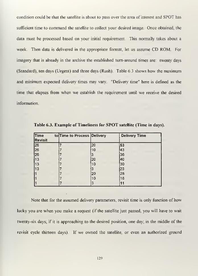
condition could be that the satellite is about to pass over the area of interest and SPOT has
sufficient time to command the satellite to collect your desired image. Once obtained, the
data must be processed based on your initial requirement. This normally takes about a
week. Then data is delivered in the appropriate format, let us assume CD ROM. For
imagery that is already in the archive the established turn-around times are: twenty days
(Standard), ten days (Urgent) and three days (Rush). Table 6.3 shows how the maximum
and minimum expected delivery times may vary. "Delivery time" here is defined as the
time that elapses from when we establish the requirement until we receive the desired
information.
Table 6.3. Example of Timeliness for SPOT satellite (Time in days).
Time to Time to Process Delivery Delivery TimeRevisit
26 7 20 53
26 7 10 43
26 7 3 36
13 7 20 40
13 7 10 30
13 7 3 23
1 7 20 28
1 7 10 18
1 7 3 11
Note that for the assumed delivery parameters, revisit time is only function of how
lucky you are when you make a request (if the satellite just passed, you will have to wait
twenty-six days; if it is approaching to the desired position, one day; in the middle of the
revisit cycle thirteen days). If we owned the satellite, or even an authorized ground
129
station, we may decrease the required time to process and deliver the imagery, but we can
do nothing about revisit time.
C. MILITARY APPLICATIONS [OTA- ISC-558, 1993]
1. Military Operations
Although the U.S. DoD has been buying LANDSAT and SPOT imagery for years,
it was during the Gulf War that the public and the politicians realized how important this
capability was. The international embargo against Iraq denied the use of SPOT imagery to
Sadam Hussain, which Iraqi forces had used to invade Kuwait. On the other hand, the
Coalition Forces used LANDSAT and SPOT imagery to create a variety of maps of the
desert. Also, LANDSAT and SPOT imagery was used to create maps of Bosnia,
which were used for mission planning in delivery of food and medical support.
One clear example of how this information can be used is the product developed
by Cambridge Research Associates called PowerScene™ Power Scene™ is a computer
simulator that allows the user to recreate, at the resolution of the provided information, a
three dimensional model of a desired area, so a pilot can go through it in a flight simulator
and see and learn point by point, feature by feature, meter by meter, the path to the target,
from the beginning to the end of the mission, with accurate precision. Such a tool
provides a huge difference in training and planning. Before flying the mission the pilot can
"fly" it as many times as he needs on the computer, recognizing the weaknesses of the
enemy and having an accurate assessment about dangerous areas and effective ranges of
enemy weapons. [Pentecost, 1996]
130
2. Reconnaissance
The basic concept that resolution is the limiting factor of what can be obtained
from the space imagery is not as true as seems. Skilled interpretation combined with the
use of information obtained by other means can add more value to the imagery [Brugioni,
1996]. In other words, the difference between useful information from reconnaissance
satellites and useless imagery is a trained interpreter.
The chief problem in reconnaissance is the time we need to wait between two
passes over the same point. For example, LANDSAT satellites pass over a given place
along the equator once every sixteen days, and SPOT once every twenty-six. In addition,
it takes about two weeks for SPOT to process the information and send it to the customer.
From the military point of view, we need the information as soon as possible, and two
weeks is unacceptable in some cases. Processing and delivery could be shortened by
having an authorized ground station in our country. Directional capability of some sensors
(for example, SPOT cross-track imaging) reduces time between visits, allowing revisit
times at targets of interest every 1 to 4 days.
3. Arms Control
Where nuclear weapons are developed, stored or tested, some characteristics can
be observed from the space. For example, the need of large amounts of water to cool the
nuclear plants, specially cleared roads with progressive curvatures to allow transportation
in and out, or an unusual number of workers in an isolated area Politicians need this
131
information to activate the mechanisms to enforce international treaties or to take
preventive actions. [OTA-BP-ISS-168, 1995]
4. Mapping, Charting and Geodesy
Maps and charts usually require more precision when they are going to be used by
the military. Simulations can only be as accurate as the map measurements. Although we
speculate that military satellites are able to provide better resolution than commercial
satellites (probably less than one meter), merging civilian and military information can save
time and money. It is convenient to remember that the U.S. has automated weapons
which need to be accurately guided, so an accurate the target position becomes very
important.
D. INTERNATIONAL REGULATIONS
Can we use civilian space assets for military purposes9 What are the limits for a
nation that wishes to use space remote sensing?
We already know that the U.S. and Russia developed remote sensing capabilities
to spy on each other during the Cold War, and we can speculate about how big or small
this capability currently is. We also have an idea about what other countries like China are
doing to gather intelligence from the space [Lee, 1994]. This activity was normally
denied, and the international agreements made by the spy satellite owner countries were
directed to allow the use of these space assets. For example, invoking the need for
"National Technical Means" to verify nuclear arms control treaties.
132
The use of commercial remote sensing in the intelligence arena is relatively new
and is open to the most nations. The U.S. Land Remote Sensing Commercialization Act
of 1984 established LANDSAT commercialization on a non-discriminatory basis.
The United Nations Principles Relating to Remote Sensing of the Earth from Space ("The
Principles") are contained in a 1986 resolution adopted by the U.N. General Assembly. As
a resolution. The Principles are not legally binding but do provide the basis for a
multilateral treaty. This resolution is based on the Outer Space Treaty 1967, the
Registration Convention of 1976, and the Liability Convention of 1972. The points that
The Principles reinforce are:
-Celestial bodies and outer space are the "province of all mankind," and the
exploration and use of space should benefit all nations.
-International cooperation is encouraged.
-Nations can claim damages caused by space assets belonging to other nations.
-Every launch must be registered with the U.N.
-The U.N. Secretary-General's role now includes being informed of U.S. remote
sensing activities and the U.S. must make relevant information available to other
nations upon request.
-"Sensing States" operate remote sensing systems, and "sensed states" are the ones
whose territory is observed.
-Data obtained by sensing states should be available to the sensed state on a non-
discriminatory basis.
-Sensing states are obligated to avoid harm to sensed states.
133
The 1986 U.N. principles on remote sensing express an international ideal for the
use of remote sensing, although observers disagree about how these principles should be
interpreted. The Principles embody the view that outer space is a resource for all
humanity and should be used for the general benefit of all nations. [OTA-ISS-604, 1994]
In general, the resolution addressed the basic aspects of using remote sensing. It is
important to note that all uses were considered from the scientific and technological point
of view, but military applications were not expressly forbidden. Until this point, only
classified military programs were considered useful for military purposes, and nobody but
the involved nations knew about them. Probably just a few considered at that time the
possibility of using civilian remote sensing for military purposes The only unclassified
remote sensing (RS) program (LANDSAT) was not good enough to satisfy more than
broad strategic military requirements, and SPOT was just starting as an experimental
program. I believe that the introduction of SPOT imagery in the international market
really broke down the U.S. dominance and facilitated access to space information for
many nations unable to develop their own capabilities. Today. Russia is offering five
meter resolution from Resurs satellites (film canister), and India offers RS information to
the market at competitive prices. When someone buys imagery, they do not have to
mention the reason why the information is required. If it were, the true intention could be
masked. Table 6.4 shows the relationships between civilian and military applications.
Legally speaking, we can see that there are different national regulations with
respect to selling remote sensing imagery to other countries For example, the Clinton
Administration established a regulatory process for civilian companies trying to obtain
134
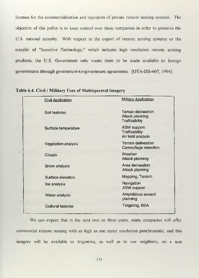
licenses for the commercialization and operation of private remote sensing systems. The
objective of this policy is to keep control over these companies in order to preserve the
U.S. national security. With respect to the export of remote sensing systems or the
transfer of "Sensitive Technology," which includes high resolution remote sensing
products, the U.S. Government only wants them to be made available to foreign
governments through government-to-government agreements. [OTA-ISS-607, 1994]
Table 6.4. Civil / Military Uses of Multispectral Imagery
Civil Application Military Application
Soil features Terrain delineation
Attack planning
Trafficability
Surface temperature ASW support
Trafficability
Air field analysis
Vegetation analysis Terrain delineation
Camouflage detection
Clouds WeatherAttack planning
Snow analysis Area delineation
Attack planning
Surface elevation Mapping, Tercom
Ice analysis Navigation
ASW support
Water analysis Amphibious assault
planning
Cultural features Targeting, BDA
We can expect that in the next two or three years, many companies will offer
commercial remote sensing with as high as one meter resolution panchromatic, and this
imagery will be available to Argentina, as well as to our neighbors, on a non
135
discriminatory basis, but always under the ultimate control of the nation providing the
imagery.
In summary, I want to point out two important concepts:
-The first concept is a fundamental truth of international law: If an act is not
specifically prohibited, then it is permitted. International law implicitly permits
military support activities such as satellite remote sensing, navigation,
communications, and meteorology.
-The second concept is that, in most instances, treaties are designed to regulate
activities between the signatories during peacetime only. Unless the international
agreement clearly states that its provisions are designed to apply or to become
operative during hostilities, they must presume that armed conflict will result in the
suspension or termination of the treaty's provisions.
E. BENEFITS AND DISADVANTAGES OF USING COMMERCIAL REMOTESENSING
1. Benefits
a. Reduced Cost
Although not cheap, considering that the average price of just one 60x60
Km picture could be about $3000, it is less expensive than developing the entire system
to provide similar capability. To offer a perspective, the LANDSAT 7 (expected to be
launched in 1998) DoD budget was about 460 million dollars from 1992 to 1997, plus 2
million dollars in annual operational costs.
136
The Argentine Republic covers about 2,800,000 Km2, and each SPOT
standard picture (60x60 Km) covers 3600 Km2, so 780 pictures would be required to
cover the entire country. Assume that we need two complete sets of pictures in a five
year period. So, 1560 pictures at 3,000 dollars each would cost 4,680,000 dollars. This is
less than 1.5 % of the cost of the LANDSAT 7 system. The Argentine Navy's
hypothetical needs define an area limited to a littoral strip about 3300 Km length and 120
Km wide (over land), or 396,000 Km2. One hundred and ten pictures could be enough to
satisfy a basic requirement (approximated 330,000 dollars).
b. Capability
From the military point of view, considering our present lack of remote
sensing capability, we can acquire a very useful new one by using remote sensing
information to support military operations in different ways. Mission planing,
reconnaissance, mapping, charting and geodesy, prevention and evaluation of disasters,
and trafficability.
c. Experience
Ifwe decided to build or buy our own remote sensing system, we must first
understand what is really useful, what requirements the system would be able to satisfy,
what the minimum acceptable performance would be, and how this advanced technology
is used. By the initial acquisition of commercial remotely sensed imagery (panchromatic
and multispectral) and the appropriate software, we can start learning and gaining
137
experience before developing or buying systems we do not need or that we do not know
how to use.
d. Waiting Time
It will take more time for our country to put a one meter resolution sensor
in space than to buy the amount of pictures needed to fulfill our possible requirements.
Just as we can buy panchromatic imagery with ten meter resolution today, we will be able
to buy panchromatic imagery with one meter resolution in a couple of years.
e. Compatibility with allied nations
The use of commercial remote sensing in the military is seriously being
considered for nations that already have significant remote sensing capability. Civilian
remote sensing systems satisfied some U.S. military needs in the Persian Gulf War, which
is probably why the U.S. government wants to have civilian companies making money and
able to satisfy U.S. military needs when required. Hence, if the Argentine Navy is able to
understand the same remote sensing principles and practices as the U.S., we will be better
prepared to work together, as well as with other allied nations.
2. Disadvantages
a. Availability
By using imported commercial imagery, we can not be sure the information
will be available when needed, so we must assume that it would not be available in near
real time. It will depend on what type of military requirement we have to satisfy in order
to say whether or not two-week-old information is useful.
138
b. Reliability
The issue of whether or not the image can be altered by a third person
needs to be considered, especially if we want to use this information during crisis
situations. How can I be sure that a certain picture was acquired at the stated period of
time and not a year or month ago? For example Israel started its space program in 1988
as a sign of discontent with the U.S., suspecting that U.S. withheld satellite imagery prior
the Yom Kippur War.
c. Dependence
The buyer must always depend on the imagery provider's national policies.
Without being an owner, the U.S. used SPOT information against Iraq, while the same
information was denied to Iraqi forces France of course was part of The Coalition.
d. Security
On a nondiscriminatory basis, a nation can buy information about its
neighbors and vice versa, so the information flow is unrestricted. Although the
confidentiality of the buyer should be protected, it is not possible assure that it will
happen.
F. EXISTING COMMERCIAL SYSTEMS - OVERVIEW
In addition to the U.S. and Russia, only a few countries have developed
capabilities in the remote sensing area, some of them for military purposes, others for
scientific or commercial purposes. In RS, it is very difficult to perfectly define whether the
conception of the system was military, civil or both. The current leader in commercial
139
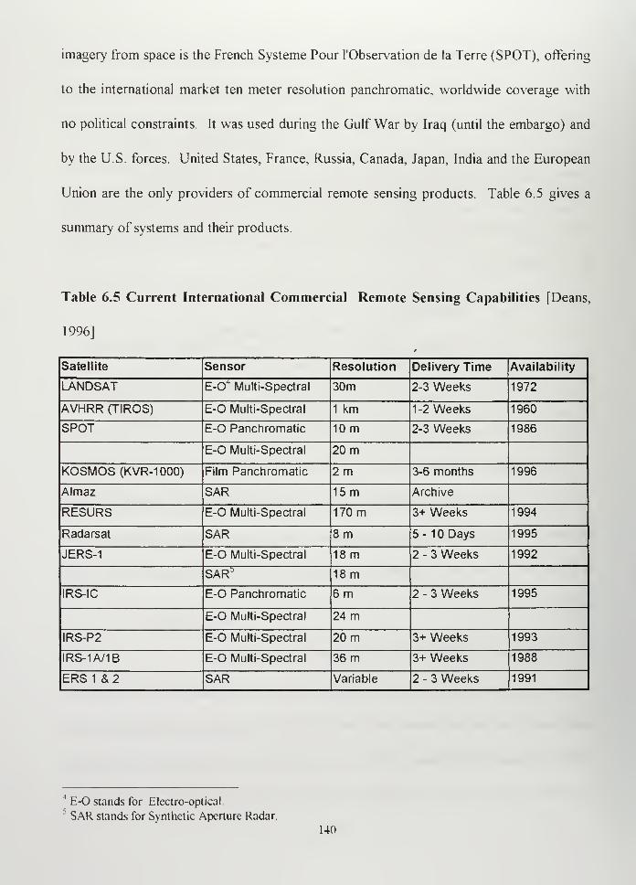
imagery from space is the French Systeme Pour l'Observation de la Terre (SPOT), offering
to the international market ten meter resolution panchromatic, worldwide coverage with
no political constraints. It was used during the Gulf War by Iraq (until the embargo) and
by the U.S. forces. United States, France, Russia, Canada, Japan, India and the European
Union are the only providers of commercial remote sensing products. Table 6.5 gives a
summary of systems and their products.
Table 6.5 Current International Commercial Remote Sensing Capabilities [Deans,
1996]
Satellite Sensor Resolution Delivery Time Availability
LANDSAT E-O4Multi-Spectral 30m 2-3 Weeks 1972
AVHRR (TIROS) E-O Multi-Spectral 1 km 1-2 Weeks 1960
SPOT E-0 Panchromatic 10m 2-3 Weeks 1986
E-O Multi-Spectral 20 m
KOSMOS(KVR-IOOO) Film Panchromatic 2m 3-6 months 1996
Almaz SAR 15m Archive
RESURS E-O Multi-Spectral 170 m 3+ Weeks 1994
Radarsat SAR 8 m 5-10 Days 1995
JERS-1 E-O Multi-Spectral 18m 2 - 3 Weeks 1992
SAR" 18m
IRS-IC E-O Panchromatic 6 m 2 - 3 Weeks 1995
E-O Multi-Spectral 24 m
IRS-P2 E-O Multi-Spectral 20 m 3+ Weeks 1993
IRS-1A/1B E-O Multi-Spectral 36 m 3+ Weeks 1988
ERS 1 & 2 SAR Variable 2 - 3 Weeks 1991
1
E-O stands for Electro-optical5 SAR stands for Synthetic Aperture Radar.
140
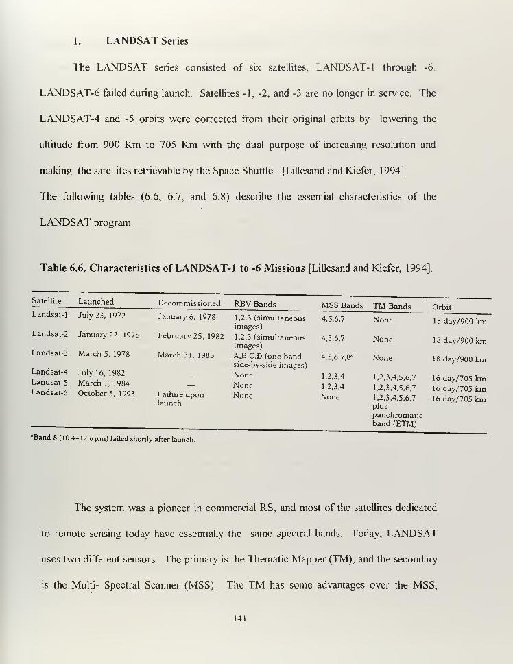
1. LANDSAT Series
The LANDSAT series consisted of six satellites, LANDSAT- 1 through -6.
LANDSAT-6 failed during launch. Satellites -1, -2, and -3 are no longer in service. The
LANDSAT-4 and -5 orbits were corrected from their original orbits by lowering the
altitude from 900 Km to 705 Km with the dual purpose of increasing resolution and
making the satellites retrievable by the Space Shuttle. [Lillesand and Kiefer, 1994]
The following tables (6.6, 6.7, and 6.8) describe the essential characteristics of the
LANDSAT program.
Table 6.6. Characteristics of LANDSAT- 1 to -6 Missions [Lillesand and Kiefer, 1994]
Satellite Launched
July 23, 1972
Decommissioned RBV Bands MSS Bands TM Bands OrbitLandsat-1 January 6, 1978 1,2,3 (simultaneous
images)4,5,6,7 None 18 day/900 km
Landsat-2 January 22, 1975 February 25, 1982 1,2,3 (simultaneousimages)
4,5,6,7 None 18 day/900 kmLandsat-3 March 5, 1978 March 31, 1983 A,B,C,D (one-band
side-by-side images)4,5,6,7,8" None 18 day/900 km
Landsat-4
Landsat-5
Landsat-6
July 16, 1982
March 1, 1984
October 5, 1993 Failure uponlaunch
NoneNoneNone
1,2,3,4
1,2,3,4
None
1,2,3,4,5,6,7
1,2,3,4,5,6,7
1,2,3,4,5,6,7
plus
panchromaticband (ETM)
16 day/705 km16 day/705 km16 day/705 km
"Band 8 (10.4-12.6 p.m) failed shortly after launch.
The system was a pioneer in commercial RS, and most of the satellites dedicated
to remote sensing today have essentially the same spectral bands. Today, LANDSAT
uses two different sensors The primary is the Thematic Mapper (TM), and the secondary
is the Multi- Spectral Scanner (MSS). The TM has some advantages over the MSS,
141
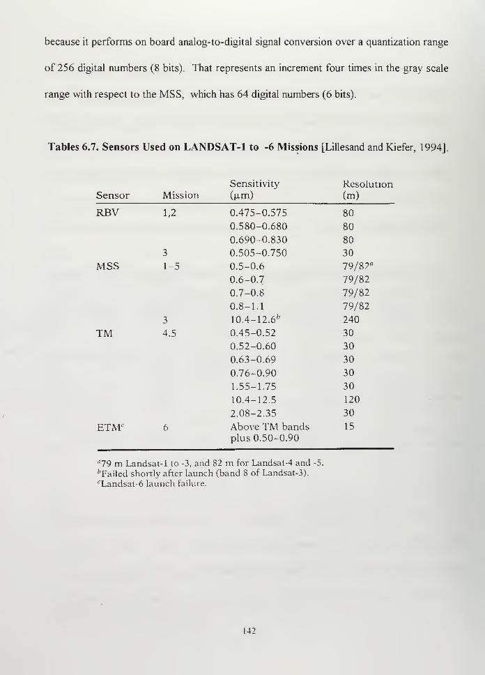
because it performs on board analog-to-digital signal conversion over a quantization range
of 256 digital numbers (8 bits). That represents an increment four times in the gray scale
range with respect to the MSS, which has 64 digital numbers (6 bits).
Tables 6.7. Sensors Used on LANDSAT-1 to -6 Missions [Lillesand and Kiefer, 1994]
Sensitivity Resolution
Sensor Mission (u-m) (m)
RBV 1,2 0.475-0.575 80
0.580-0.680 80
0.690-0.830 80
3 0.505-0.750 30
MSS 1-5 0.5-0.6 79/87°
0.6-0.7 79/82
0.7-0.8 79/82
0.8-1.1 79/82
3 10.4-12.6 fc 240
TM 4.5 0.45-0.52 30
0.52-0.60 30
0.63-0.69 30
0.76-0.90 30
1.55-1.75 30
10.4-12.5 120
2.08-2.35 30
ETMr 6 Above TM bandsplus 0.50-0.90
15
a19 m Landsat-1 to -3, and 82 m for Landsat-4 and -5.
^Failed shortly after launch (band 8 of Landsat-3).cLandsat-6 launch failure.
142
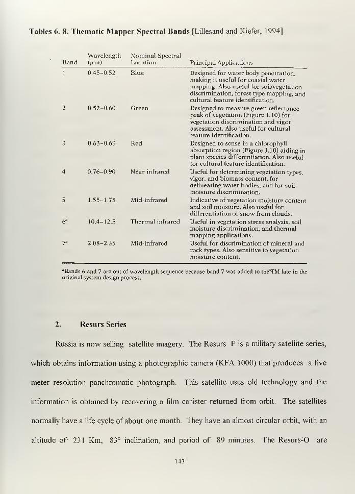
Tables 6. 8. Thematic Mapper Spectral Bands [Lillesand and Kiefer, 1994]
Wavelength Nominal Spectral
Band (jim) Location Principal Applications
1
6*
0.45-0.52
0.52-0.60
0.63-0.69
0.76-0.90
1.55-1.75
10.4-12.5
2.08-2.35
Bk
Green
Red
Near infrared
Mid-infrared
Thermal infrared
Mid-infrared
Designed for water body penetration,
making it useful for coastal watermapping. Also useful for soil/vegetation
discrimination, forest type mapping, andcultural feature identification.
Designed to measure green reflectance
peak of vegetation (Figure 1.10) for
vegetation discrimination and vigor
assessment. Also useful for cultural
feature identification.
Designed to sense in a chlorophyll
absorption region (Figure 1.10) aiding in
plant species differentiation. Also useful
for cultural feature identification.
Useful for determining vegetation types,
vigor, and biomass content, for
delineating water bodies, and for soil
moisture discrimination.
Indicative of vegetation moisture contentand soil moisture. Also useful -for
differentiation of snow from clouds.
Useful in vegetation stress analysis, soil
moisture discrimination, and thermalmapping applications.
Useful for discrimination of mineral androck types. Also sensitive to vegetation
moisture content.
flBands 6 and 7 are out of wavelength sequence because band 7 was added to theTM late in the
original system design process.
2. Resurs Series
Russia is now selling satellite imagery. The Resurs F is a military satellite series,
which obtains information using a photographic camera (KFA 1 000) that produces a five
meter resolution panchromatic photograph. This satellite uses old technology and the
information is obtained by recovering a film canister returned from orbit. The satellites
normally have a life cycle of about one month. They have an almost circular orbit, with an
altitude of 231 Km, 83° inclination, and period of 89 minutes. The Resurs-0 are
143
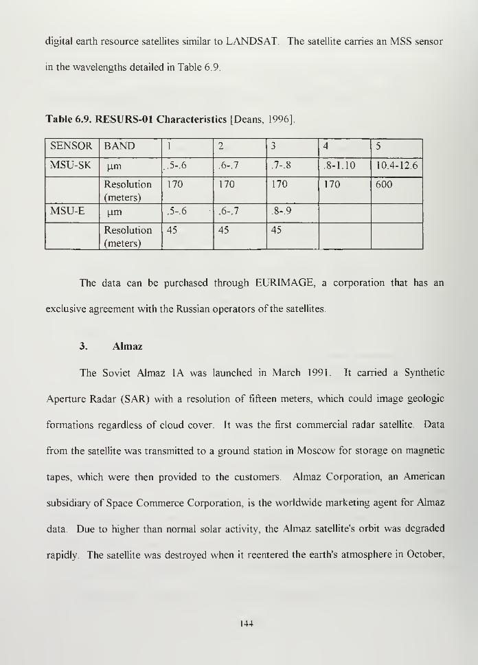
digital earth resource satellites similar to LANDSAT. The satellite carries an MSS sensor
in the wavelengths detailed in Table 6.9.
Table 6.9. RESURS-01 Characteristics [Deans, 1996]
SENSOR BAND 1 2->
j 4 5
MSU-SK u.m .5-. 6 .6-1 7-.8 .8-1.10 10.4-12.6
Resolution
(meters)
170 170 170 170 600
MSU-E u.m .5-.
6
.6-.
7
.8-9
Resolution
(meters)
45 45 45
The data can be purchased through EURIMAGE, a corporation that has an
exclusive agreement with the Russian operators of the satellites.
3. Almaz
The Soviet Almaz 1A was launched in March 1991. It carried a Synthetic
Aperture Radar (SAR) with a resolution of fifteen meters, which could image geologic
formations regardless of cloud cover. It was the first commercial radar satellite. Data
from the satellite was transmitted to a ground station in Moscow for storage on magnetic
tapes, which were then provided to the customers. Almaz Corporation, an American
subsidiary of Space Commerce Corporation, is the worldwide marketing agent for Almaz
data. Due to higher than normal solar activity, the Almaz satellite's orbit was degraded
rapidly The satellite was destroyed when it reentered the earth's atmosphere in October,
144
1992. Although Russia has announced that it intends to place another Almaz satellite into
orbit, though no date was confirmed. [US Army Space Reference Text, 1993]
4. SPOT
The program started in 1978, and SPOT-1 was launched in 1986, using an Ariane
vehicle. The orbit of the first three SPOT satellites was exactly the same: circular near
polar sun synchronous with a 98.7° inclination. It crosses the equator at 10:30 AM local
time on the north- south passage. Although the pattern is repeated every twenty-six days,
it has the advantage that the sensor can be reoriented, allowing the satellite to reimage
selected ground areas within 1 to 4 days. The sensors on SPOT are two High Resolution
Visible (HRV) imaging systems aided by magnetic tape recorders. Both of the HRV's
produce panchromatic ten meter resolution imagery and multispectral color infrared
twenty meter resolution imagery. The company is looking forward to the launch of SPOT
4 in the near future and the reactivation of SPOT 1 , because the total system capacity has
been reduced due to a SPOT 3 failure.
5. Dong Fang Hong Series
Another country having remote sensing capability is China. The FSW-2 and -3
series, Fanhui Shi Weixing or "Dong Fang Hong" (DFH) uses recoverable film canisters.
DFH 43 was launched in October 1996, and its orbit decayed on November 4, 1996.
Though it has not been advertised, experts speculate that the resolution is better than
eighty meters. China also has a LANDSAT ground station. The perigee altitude was 172
145
Km, apogee altitude 335 Km, inclination 63° and period 89.5 minutes. The launch vehicle
was a Long March 2D. [Lee, James G., 1994]
6. Japanese Earth Remote Sensing Satellite (JERS-1)
JERS-1 was launched in February 1992. It is in a sun synchronous orbit, with an
altitude of 570 Km, 98° inclination, 96 minutes period and revisit period 44 days. It
crosses the Equator on the descending node at 10:30 to 1 1: 00 AM local time.
It has optical sensors (OPS) and Synthetic Aperture Radar (SAR), both with
eighteen meter resolution and a swath width of 75 Km. OPS can observe in seven spectral
bands (visible to IR) and has stereoscopic capability. The launch vehicle was H-I (2-
stage). The satellite had some problems deploying its SAR antenna after launch, but these
were subsequently solved [Satellites & Sensors, 1997] The data is not available
commercially yet, but it will possibly be available in the future Although Japan has
developed launch vehicle capabilities in the past, Japan agreed not to sell them
commercially to other nations in exchange for rocket technology received from U.S.
NASDA's newest space launcher, H-II, is entirely a Japanese design, so Japan will be free
to market it internationally. The H-II will have the capability to put 9.080 Kg in LEO and
3,600 in GEO [Lee, James G, 1994]
The applications of this satellite cover the areas of agriculture, fishery, forestry,
disaster protection, coastal monitoring and environmental monitoring The sensor
characteristics are showed in Table 6. 10.
146
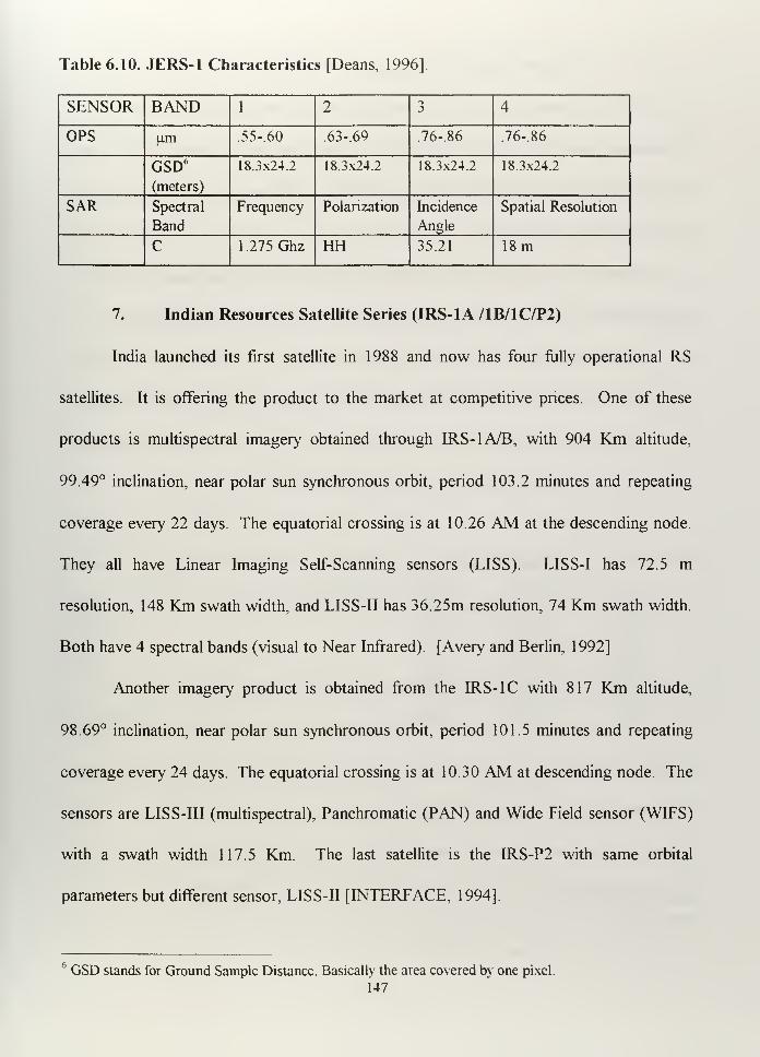
Table 6.10. JERS-1 Characteristics [Deans, 1996]
SENSOR BAND 1 25
4
OPS urn .55-60 .63-.69 .76-86 .76-86
GSD6
(meters)
18.3x24.2 18.3x24.2 18.3x24.2 18.3x24.2
SAR Spectral
Band
Frequency Polarization Incidence
Angle
Spatial Resolution
C 1.275 Ghz HH 35.21 18m
7. Indian Resources Satellite Series (IRS-1A /1B/1C/P2)
India launched its first satellite in 1988 and now has four fully operational RS
satellites. It is offering the product to the market at competitive prices. One of these
products is multispectral imagery obtained through IRS-1A/B, with 904 Km altitude,
99.49° inclination, near polar sun synchronous orbit, period 103.2 minutes and repeating
coverage every 22 days. The equatorial crossing is at 10.26 AM at the descending node.
They all have Linear Imaging Self-Scanning sensors (LISS). LISS-I has 72.5 m
resolution, 148 Km swath width, and LISS-II has 36.25m resolution, 74 Km swath width.
Both have 4 spectral bands (visual to Near Infrared). [Avery and Berlin, 1992]
Another imagery product is obtained from the IRS-1C with 817 Km altitude,
98.69° inclination, near polar sun synchronous orbit, period 101.5 minutes and repeating
coverage every 24 days. The equatorial crossing is at 10.30 AM at descending node. The
sensors are LISS-III (multispectral), Panchromatic (PAN) and Wide Field sensor (WIFS)
with a swath width 117.5 Km. The last satellite is the IRS-P2 with same orbital
parameters but different sensor, LISS-II [INTERFACE, 1994].
GSD stands for Ground Sample Distance. Basically the area covered by one pixel.
147
8. European Remote Sensing Satellite ERS-1 /2
The European Remote Sensing Satellite ERS-1 was launched in 1991 to a sun-
synchronous near-polar orbit, altitude of 777 km, inclination 98.5°, period 100.5 minutes
and recurrent periods of 3 days, 35 days or 176 days, depending on the operating mode
[ERS-1 Data Book, 1991].
The ERS-2 was launched on 1995, in a similar sun-synchronous near-polar as
ERS-1, altitude of 785 km and inclination 98.5°. Both satellites are almost identical.
The satellite payload has the following instruments:
-Active Microwave Instrument (AMI) which consists of two separate radars, a
Synthetic Aperture Radar and a Wind Scatterometer. These enable three modes of
operation: Image Mode, Wave Mode and Wind Mode.
-Radar Altimeter.
-Along Track Scanning Radiometer (ATSR)
-Precise Range and Range-rate Equipment (PRARE).
-Laser Retroreflector.
-Global Ozone Monitoring Experiment (GOME); on ERS-2 only
The capability of the ERS includes the observation of atmospheric and surface
properties (direction of the wave motion, surface wind vector, sea surface elevation, sea-
surface temperature, monitoring of dynamic coastal processes, and detection of land usage
changes) independently of time or weather [MWF products, USER Manual, 1991] [ERS-1
User Handbook, 1991].
148
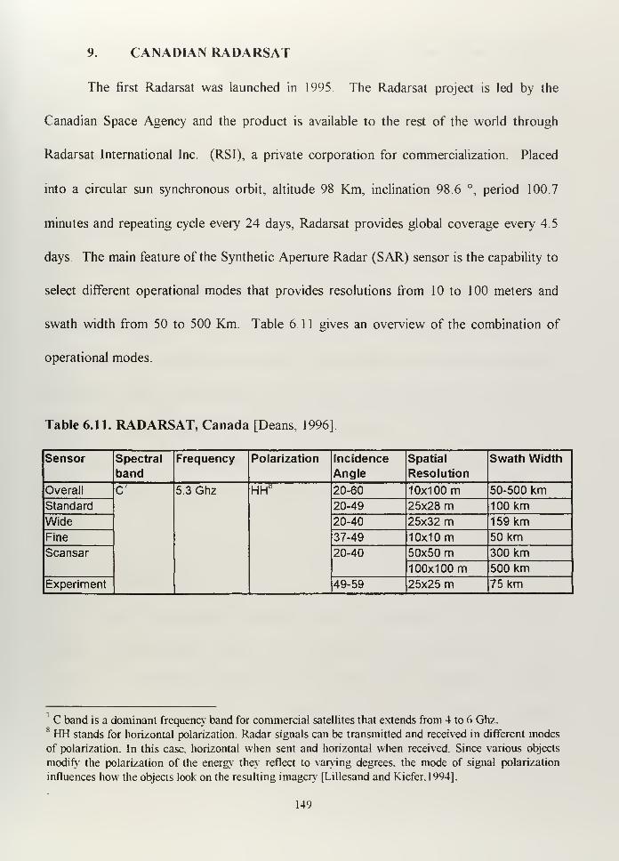
9. CANADIAN RADARSAT
The first Radarsat was launched in 1995. The Radarsat project is led by the
Canadian Space Agency and the product is available to the rest of the world through
Radarsat International Inc. (RSI), a private corporation for commercialization. Placed
into a circular sun synchronous orbit, altitude 98 Km, inclination 98.6 °, period 100.7
minutes and repeating cycle every 24 days, Radarsat provides global coverage every 4.5
days. The main feature of the Synthetic Aperture Radar (SAR) sensor is the capability to
select different operational modes that provides resolutions from 10 to 100 meters and
swath width from 50 to 500 Km. Table 6. 1 1 gives an overview of the combination of
operational modes.
Table 6.11. RADARSAT, Canada [Deans, 1996]
Sensor Spectral
bandFrequency Polarization Incidence
Angle
Spatial
Resolution
Swath Width
Overall C 5.3 Ghz HH a 20-60 1 0x1 00 m 50-500 kmStandard 20-49 25x28 m 100 kmWide 20-40 25x32 m 159 kmFine 37-49 1 0x1 m 50 kmScansar 20-40 50x50 m 300 km
100x100 m 500 kmExperiment 49-59 25x25 m 75 km
' C band is a dominant frequency band for commercial satellites that extends from 4 to 6 Ghz.8 HH stands for horizontal polarization. Radar signals can be transmitted and received in different modes
of polarization. In this case, horizontal when sent and horizontal when received. Since various objects
modify the polarization of the energy they reflect to varying degrees, the mode of signal polarization
influences how the objects look on the resulting imagery [Lillesand and Kiefer.1994].
149

Designed to fulfill Canadian requirements, it is the most advanced SAR in orbit. Canada is
covered by clouds most of time, so the cloud penetration capability of the SAR plays a key
role allowing all weather imaging capability. The system is used for ice and ship detection,
disaster monitoring, geological exploration, Arctic surveillance, Antarctic ice mapping and
environmental monitoring.
150
VII. SPOT IMAGERY
A. INTRODUCTION
Imagery obtained from SPOT satellites has been, along with LANDSAT imagery,
one of the most used around the world during the last decade. SPOT Imagery
demonstrated not only excellent capabilities for commercial purposes but also for military
ones. The introduction of remotely sensed imagery having panchromatic (PAN) ten meter
resolution and color infrared having twenty meter resolution into the international market
was a revolutionary action in such a politically sensitive industry as remote sensing.
Although used before by the military (for example to gather intelligence about
Soviet laser facilities at Sary Shagan [Lee, 1994]), it was during the Persian Gulf War
when SPOT military capability was certainly demonstrated.
The objective of this chapter, using SPOT imagery as an example, is to show how
the Argentine Navy could take advantage of the available commercial remotely sensed
imagery.
B. BACKGROUND
The SPOT satellite Earth Observation System was designed by the Centre National
d'Etudes Spatiales(CNES), France, and developed with the participation of the
governments of Sweden and Belgium as well as the private participation of several
European banks and corporations. The SPOT system consists of a series of spacecraft
and ground facilities for satellite control and programming, image production and
151
distribution.
SPOT satellites have been operational since 1986. The first satellite, SPOT 1, was
launched on February 22, 1986, and was withdrawn from active service on December 31,
1990. The second, SPOT 2, was launched on January 22, 1990, and SPOT 3 on
September 26, 1993. The SPOT 3 ended its service on November 14, 1996, due to an
attitude control failure. SPOT 3 will be followed by SPOT 4, which is scheduled for
launching in late 1997. Engineering for SPOT 5 has begun so that the satellite can be
launched in 2001 to ensure service continuity.
SPOT provides commercial remote sensing products worldwide through a global
network of control centers, receiving stations, processing centers, and data distributors.
The Centre National d'Etudes Spatiales (CNES) owns and operates the SPOT satellite
system while worldwide commercial data distribution is conducted by private companies
(SPOT IMAGE Corporation in the United States, SPOT IMAGE in France and
SATIMAGE in Sweden). Aerospacio has represented SPOT IMAGE in Argentina since
1989
The spatial resolution of ten meters has been the best offered commercially for
years. As a consequence of the future availability of having better resolution by the year
2000 (two or three meters instead of the five meters expected for SPOT 5), SPOT
IMAGE Corporation, which already has the commercial structure for selling imagery
worldwide, is positioning itself to become a reseller of other providers. For example,
European Radar Satellite (ERS) imagery has already been commercialized in North
America through SPOT IMAGE Corporation
152
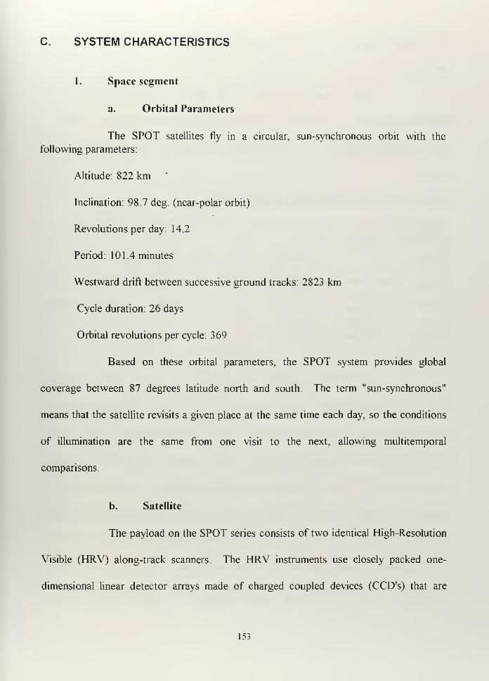
C. SYSTEM CHARACTERISTICS
1. Space segment
a. Orbital Parameters
The SPOT satellites fly in a circular, sun-synchronous orbit with the
following parameters:
Altitude: 822 km
Inclination: 98.7 deg. (near-polar orbit)
Revolutions per day: 14.2
Period: 101.4 minutes
Westward drift between successive ground tracks: 2823 km
Cycle duration: 26 days
Orbital revolutions per cycle: 369
Based on these orbital parameters, the SPOT system provides global
coverage between 87 degrees latitude north and south. The term "sun-synchronous"
means that the satellite revisits a given place at the same time each day, so the conditions
of illumination are the same from one visit to the next, allowing multitemporal
comparisons.
b. Satellite
The payload on the SPOT series consists of two identical High-Resolution
Visible (HRV) along-track scanners. The HRV instruments use closely packed one-
dimensional linear detector arrays made of charged coupled devices (CCD's) that are
153
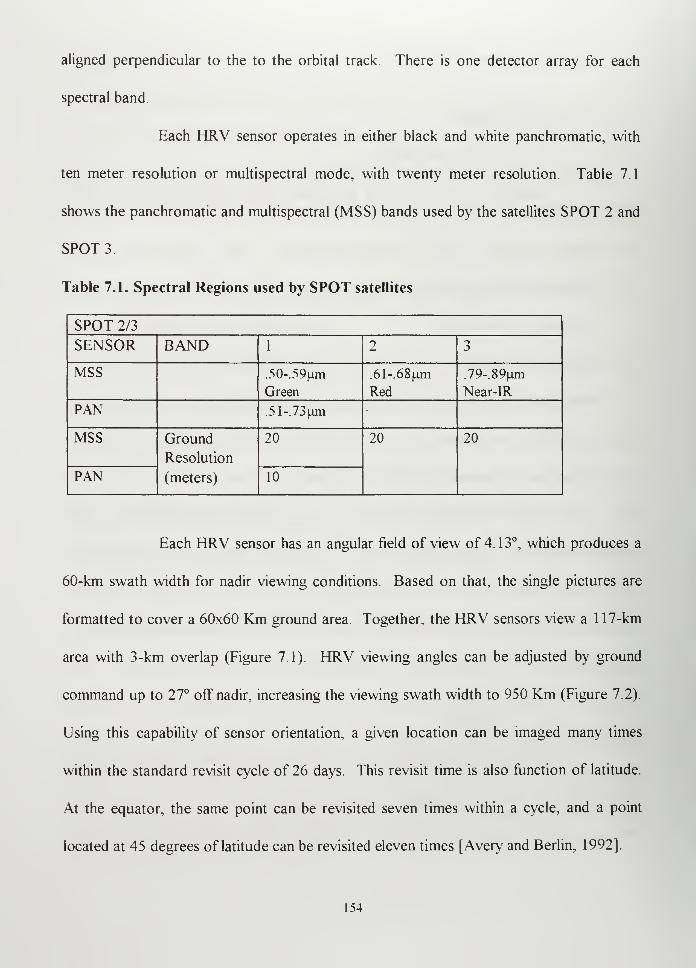
aligned perpendicular to the to the orbital track. There is one detector array for each
spectral band.
Each HRV sensor operates in either black and white panchromatic, with
ten meter resolution or multispectral mode, with twenty meter resolution. Table 7.1
shows the panchromatic and multispectral (MSS) bands used by the satellites SPOT 2 and
SPOT 3
Table 7.1. Spectral Regions used by SPOT satellites
SPOT 2/3
SENSOR BAND 1 2 3
MSS .50-.59um
Green
61-.68nm
Red
79-.89um
Near-IR
PAN 51-.73um
MSS Ground
Resolution
(meters)
20 20 20
PAN 10
Each HRV sensor has an angular field of view of 4.13°, which produces a
60-km swath width for nadir viewing conditions. Based on that, the single pictures are
formatted to cover a 60x60 Km ground area. Together, the HRV sensors view a 1 17-km
area with 3-km overlap (Figure 7.1). HRV viewing angles can be adjusted by ground
command up to 27° off nadir, increasing the viewing swath width to 950 Km (Figure 7.2).
Using this capability of sensor orientation, a given location can be imaged many times
within the standard revisit cycle of 26 days. This revisit time is also function of latitude
At the equator, the same point can be revisited seven times within a cycle, and a point
located at 45 degrees of latitude can be revisited eleven times [Avery and Berlin. 1992].
154
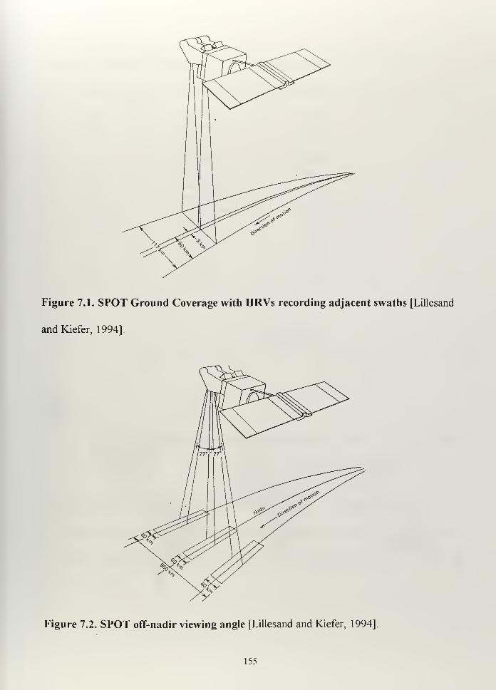
Figure 7.1. SPOT Ground Coverage with HRVs recording adjacent swaths [Lillesand
andKiefer, 1994].
Figure 7.2. SPOT off-nadir viewing angle [Lillesand and Kiefer, 1994].
155
This off nadir viewing capability also provides stereoscopic image pairs of a given
ground area (Figure 7.3).
Pass on first coverage day Pass on second coverage day
Figure 7.3. SPOT stereoscopic imaging capability [Lillesand and Kiefer, 1994].
2. Ground Segment
The ground segment is comprised of two main receiving stations, one in Toulouse,
France, and the other in Kiruna, Sweden, and fourteen direct receiving stations Table 7.2
and Figure 7.4 show the global ground station distribution and communication coverage.
156
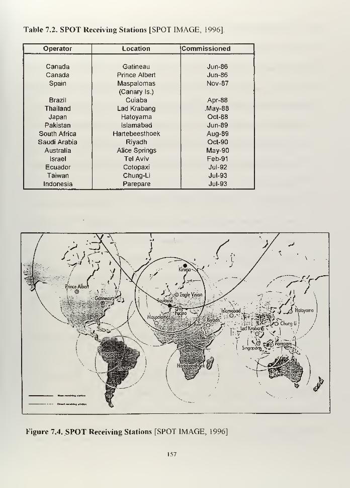
Table 7.2. SPOT Receiving Stations [SPOT IMAGE, 1996]
Operator Location Commissioned
Canada Gatineau Jun-86
Canada Prince Albert Jun-86
Spain Maspalomas
(Canary Is.)
Nov-87
Brazil Cuiaba Apr-88
Thailand Lad Krabang .May-88
Japan Hatoyama Oct-88
Pakistan Islamabad Jun-89
South Africa Hartebeesthoek Aug-89
Saudi Arabia Riyadh Oct-90
Australia Alice Springs May-90
Israel Tel Aviv Feb-91
Ecuador Cotopaxi Jul-92
Taiwan Chung-Li Jul-93
Indonesia Parepare Jul-93
t
-1 : Islamabad •'
. "i-^Td^ Hatoyama|
fl3SU?». *' ... l_Jv ' -r-^*. T i .'
Main racaMni t*ttoa
Direct r»c*Mrtc iUU«
Figure 7.4. SPOT Receiving Stations [SPOT IMAGE, 1996]
157
D. OBTAINING DATA
SPOT data can be obtained in two different ways: real-time and recorded. Real
time data is received when the satellite is in view of a receiving station and recorded data
obtained when a satellite is not in view of any ground station. Image data can be stored
on an on-board tape recorder and downlinked when in range of a ground receiving station.
Basically, four different situations can happen with respect to data acquisition:
- The satellite is within range of a Direct Receiving Station (DRS), so imagery can
be down-linked in real-time, provided both satellite and DRS are suitably
programmed.
- The satellite is not within range of a SPOT DRS. Programmed acquisitions are
executed and the image data stored on the on-board recorders. The maximum
storage capability is 22 minutes of imagery for SPOT 2 and SPOT 4.
- The satellite is within range of a main receiving station (Kiruna or Toulouse). It
can thus be programmed either to down-link image data in real-time or play back
the on-board recorders and transmit image data recorded earlier during the same
orbital revolution.
- The rest of the time, the satellite is on standby ready to acquire imagery in
accordance with uplinked commands.
Once obtained, data is processed and distributed commercially in accordance with
particular agreements, depending on the nations and institutions. The normal time to get a
desired image is about three weeks from the moment of submitting the initial request. The
satellite provides raw data, which is then processed to make it understandable to the user.
158
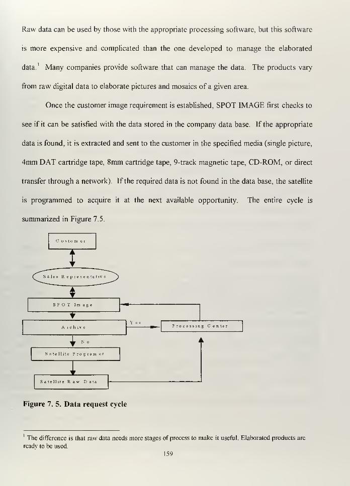
Raw data can be used by those with the appropriate processing software, but this software
is more expensive and complicated than the one developed to manage the elaborated
data. Many companies provide software that can manage the data. The products vary
from raw digital data to elaborate pictures and mosaics of a given area.
Once the customer image requirement is established, SPOT IMAGE first checks to
see if it can be satisfied with the data stored in the company data base. If the appropriate
data is found, it is extracted and sent to the customer in the specified media (single picture,
4mm DAT cartridge tape, 8mm cartridge tape, 9-track magnetic tape, CD-ROM, or direct
transfer through a network). If the required data is not found in the data base, the satellite
is programmed to acquire it at the next available opportunity. The entire cycle is
summarized in Figure 7.5
(, ustom er
Sales R epresentatn
ASPOT Image
¥
A r c h l v e
Y esProcessing Center
N o
Satellite Program er
1Satellite Raw Data
Figure 7. 5. Data request cycle
The difference is that raw data needs more stages of process to make it useful. Elaborated products are
ready to be used.
159
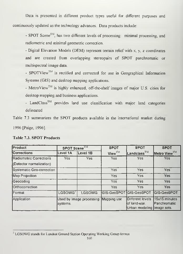
Data is presented in different product types useful for different purposes and
continuously updated as the technology advances. Data products include:
- SPOT Scene , has two different levels of processing: minimal processing, and
radiometric and minimal geometric correction.
- Digital Elevation Models (DEM) represent terrain relief with x, y, z coordinates
and are created from overlapping stereopairs of SPOT panchromatic or
multispectral image data.
- SPOTView is rectified and corrected for use in Geographical Information
Systems (GIS) and desktop mapping applications.
- MetroView™ is highly enhanced, off-the-shelf images of major U.S. cities for
desktop mapping and business applications.
- LandClass provides land use classification with major land categories
delineated
Table 7.3 summarizes the SPOT products available in the international market during
1996 [Paige, 1996].
Table 7.3. SPOT Products
Product SPOT Scene™ SPOT... TNIView
SPOT
Landclass
SPOT
Metro View™Corrections Level 1A Level 1B
Radiometric Corrections
(Detector normalization)
Yes Yes Yes Yes Yes
Systematic Geo-correction Yes Yes Yes
Map Projection Yes Yes Yes
Geocoding Yes Yes Yes
Orthocorrection Yes Yes Yes
Format LGSOWG' LGSOWG GIS-GeoSPOT GIS-GeoSPOT GIS-GeoSPOT
Application Used by Image processing
systems.
Mapping use Different levels
of land-use.
Urban modeling
15x15 minutes
Panchromatic
image sets.
LGSOWG stands for Landsat Ground Station Operating Working Group formal
160
E. POSSIBLE ARGENTINE NAVY APPLICATIONS
Besides a number of civilian and government SPOT remote sensing applications,
some of which are similar to duties assigned to the Argentine Navy (flood control and
emergency preparedness, monitoring of coastal processes, and coastal mapping used in
managing oil spill situations), there are specific military-proven applications for the
system.
1. Mission Planing
Using Digital Elevation Models and the appropriate software, it is possible to have
a mission planning system capable of providing accurate information about the terrain in a
given region. Depending on the resolution of available imagery (in this case, I assume ten
meters), it is possible to reconstruct a distant scenario and use it for planning and
rehearsal. During the Persian Gulf War, coalition forces used SPOT data to build a
variety of maps of the desert. Today, U.S. pilots are using SPOT data in three-
dimensional flying simulators. [Pentecost, 1996] Although SPOT is not the only data used
in these simulators, SPOT data played an important role in building the U.S. data base. In
1995, the U.S. Air Force publicly acknowledged using Virtual Reality Systems for
planning and rehearsal of the operations in Bosnia. They used PowerScene , a computer
system which created a three-dimensional image of every square inch of Bosnia.
PowerScene™ was manufactured by Cambridge Research Associates of McLean Virginia,
and is commercially available. Although mainly conceived to help pilots, it also can be
used in general mission planning [The Washington Post, 1995].
161
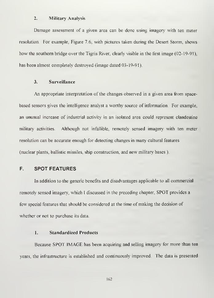
2. Military Analysis
Damage assessment of a given area can be done using imagery with ten meter
resolution For example, Figure 7.6, with pictures taken during the Desert Storm, shows
how the southern bridge over the Tigris River, clearly visible in the first image (02-19-91),
has been almost completely destroyed (image dated 03-19-91).
3. Surveillance
An appropriate interpretation of the changes observed in a given area from space-
based sensors gives the intelligence analyst a worthy source of information. For example,
an unusual increase of industrial activity in an isolated area could represent clandestine
military activities. Although not infallible, remotely sensed imagery with ten meter
resolution can be accurate enough for detecting changes in many cultural features
(nuclear plants, ballistic missiles, ship construction, and new military bases ).
F. SPOT FEATURES
In addition to the generic benefits and disadvantages applicable to all commercial
remotely sensed imagery, which I discussed in the preceding chapter, SPOT provides a
few special features that should be considered at the time of making the decision of
whether or not to purchase its data.
1. Standardized Products
Because SPOT IMAGE has been acquiring and selling imagery for more than ten
years, the infrastructure is established and continuously improved. The data is presented
162
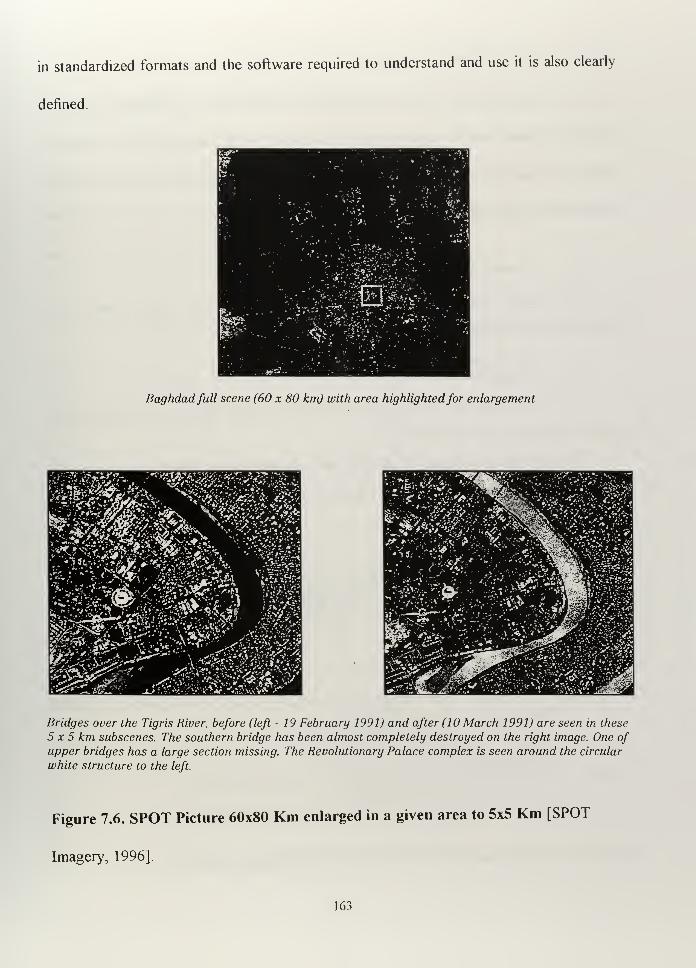
in standardized formats and the software required to understand and use it is also clearly
defined.
Baghdadfull scene (60 x 80 km) with area highlightedfor enlargement
Bridges over the Tigris River, before (left - 19 February 1991) and after (10 March 1991) are seen in these
5x5 km subscenes. The southern bridge has been almost completely destroyed on the right image. One ofupper bridges has a large section missing. The Revolutionary Palace complex is seen around the circular
white structure to the left.
Figure 7.6. SPOT Picture 60x80 Km enlarged in a given area to 5x5 Km [SPOT
Imagery, 1996].
163
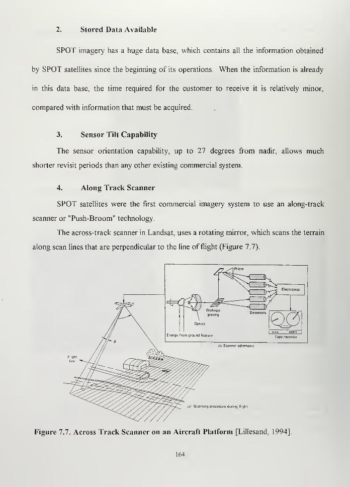
2. Stored Data Available
SPOT imagery has a huge data base, which contains all the information obtained
by SPOT satellites since the beginning of its operations. When the information is already
in this data base, the time required for the customer to receive it is relatively minor,
compared with information that must be acquired.
3. Sensor Tilt Capability
The sensor orientation capability, up to 27 degrees from nadir, allows much
shorter revisit periods than any other existing commercial system.
4. Along Track Scanner
SPOT satellites were the first commercial imagery system to use an along-track
scanner or "Push-Broom" technology.
The across-track scanner in Landsat, uses a rotating mirror, which scans the terrain
along scan lines that are perpendicular to the line of flight (Figure 7.7).
Optics
Energy from ground feature
"TWNDT2
Electronics
grating
ooo OO00
Tape recorder
lb) Scanner schematic
Flight
line
ia) Scanning procedure during flight
Figure 7.7. Across Track Scanner on an Aircraft Platform [Lillesand, 1994]
164
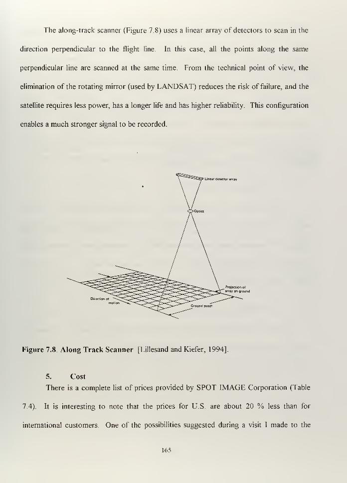
The along-track scanner (Figure 7.8) uses a linear array of detectors to scan in the
direction perpendicular to the flight line. In this case, all the points along the same
perpendicular line are scanned at the same time. From the technical point of view, the
elimination of the rotating mirror (used by LANDSAT) reduces the risk of failure, and the
satellite requires less power, has a longer life and has higher reliability. This configuration
enables a much stronger signal to be recorded.
Linear detector array
Direction of
Projection of
array on ground
Figure 7.8. Along Track Scanner [Lillesand and Kiefer, 1994].
5. Cost
There is a complete list of prices provided by SPOT IMAGE Corporation (Table
7.4). It is interesting to note that the prices for U.S. are about 20 % less than for
international customers. One of the possibilities suggested during a visit I made to the
165
SPOT IMAGE Corporation in Reston, Virginia, in 1996, was that the acquisition of
imagery could be made through the U.S. National Imagery and Mapping Agency (NIMA).
At first look, this procedure could be feasible, because there is an agreement established
between the NIMA and Servicio de Hidrografia Naval of Argentina (SHN) concerning
nautical cartography and geodesy. This agreement, clearly defines and contemplates the
cooperation points and limitations. Though, I consider it outside of the scope of my
study, I recommend that the legal aspects should be be considered before making a
decision to purchase SPOT IMAGERY through this way.
6. French Ownership
This particular feature can be defined as an advantage from the point of view that
we, the Argentine Navy, used to do business with the France (ships, airplanes and
missiles). On the other hand, it is clear that SPOT is a company that will respond to its
own interests in situations of military crisis, which means that will be very sensitive to
pressures from the French and U.S. governments.
7. World-wide Availability
Almost every nation can get access to the same SPOT information, so it creates
the risk that its resources can be used by potential adversaries.
166
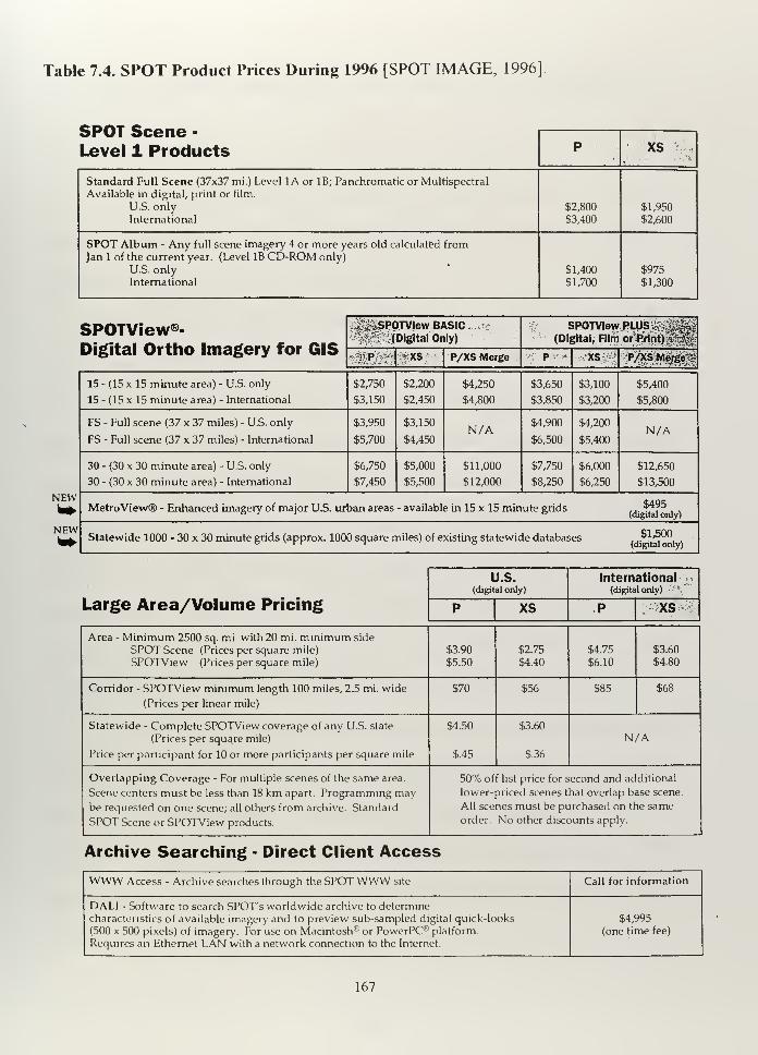
Table 7.4. SPOT Product Prices During 1996 [SPOT IMAGE, 1996]
SPOT Scene -
Level 1 Products P XS• -> .
•'.•
.
>.
Standard Full Scene (37x37 mi.) Level 1A or IB; Panchromatic or Multispectral
Available in digital, print or film.
U.S. onlyInternational
$2,800
$3,400
$1,950
$2,600
SPOT Album - Any full scene imagery 4 or more years old calculated from
Jan 1 of the current year. (Level IB CD-ROM only)
U.S. onlyInternational
$1,400
$1,700
$975
$1,300
SPOTView®- -4i^SP0TVIew BASIC^fe .[Digital Only)
SPOTView PLUS.^j$ij|( Digital, Film orPJlnt) § [ |
:
isigiicii \Jt uiu imagcriy iui uio-:^P.?r £xs P/XS Merge * pv,* *S
'
:;P/XS; Merged
15 - (15 x 15 minute area) - U.S. only
15 - (15 x 15 minute area) - International
$2,750
$3,150
$2,200
$2,450
$4,250
$4,800
$3,650
$3,850
$3,100
$3,200
$5,400
$5,800
FS - Full scene (37 x 37 miles) - U.S. only
FS - Full scene (37 x 37 miles) - International
$3,950
$5,700
$3,150
$4,450N/A $4,900
$6,500
$4,200
$5,400N/A
30 - (30 x 30 minute area) - U.S. only
30 - (30 x 30 minute area) - International
$6,750
$7,450
$5,000
$5,500
$11,000
$12,000
$7,750
$8,250
$6,000
$6,250
$12,650
$13,500
NEWMetroView® - Enhanced imagery of major U.S. urban areas - available in 15 x 15 minute grids ... ?*?
NEWStatewide 1000 - 30 x 30 minute grids (approx. 1000 square miles) of existing statewide databases m i i
U.S.(digital only)
International '_•
(digital only)
Large Area/Volume Pricing P XS P \>xs \
'
Area - Minimum 2500 sq. mi. with 20 mi. minimum side
SPOT Scene (Prices per square mile)
SPOTView (Prices per square mile)
$3.90
$5.50
$2.75
$4.40
$4.75
$6.10
$3.60
$4.80
Corridor - SPOTView minimum length 100 miles, 2.5 mi. wide
(Prices per linear mile)
$70 $56 $85 $68
Statewide - Complete SPOTView coverage of any U.S. state
(Prices per square mile)
Price per participant for 10 or more participants per square mile
$4.50
$.45
$3.60
$.36
N/A
Overlapping Coverage - For multiple scenes of the same area.
Scene centers must be less than 18 km apart. Programming maybe requested on one scene; all others from archive. Standard
SPOT Scene or SPOTView products.
50% off list price for second and additional
lower-priced scenes that overlap base scene.
All scenes must be purchased on the same
order. No other discounts apply.
Archive Searching - Direct Client Access
WWW Access - Archive searches through the SPOT WWW site Call for information
DALI - Software to search SPOT'S worldwide archive to determinecharacteristics of available imagery and to preview sub-sampled digital quick-looks
(500 x 500 pixels) of imagery. For use on Macintosh* or PowerPC® platform.
Requires an Ethernet LAN with a network connection to the Internet.
$4,995
(one time fee)
167

los
VIII. SEA VIEWING WIDE FIELD OF VIEW SENSOR (SEAWIFS)
A. INTRODUCTION
The Sea-viewing Wide Field-of-view Sensor (SeaWifs) program is an improved
version of the Coastal Zonal Color Scanner (CZCS), which flew on board the Nimbus 7
satellite from the fall of 1978 to the summer of 1986.
SeaWifs will allow mapping of ocean color of the entire oceans for a period of five
years. Ocean color is function of the concentration of phytoplankton and other pigments
in the water. The purpose of SeaWifs is to examine factors that affect global change.
Because of the role of Phytoplankton in the global carbon cycle, data obtained from
SeaWifs will be used to asses the ocean's role in the global carbon cycle as well as other
biogeochemical cycles. SeaWifs data will be used to help elucidate the magnitude and
variability of the annual cycle of primary production by marine phytoplankton and to
determine the distribution and timing of spring blooms. SeaWifs data will also help to
visualize the dynamics of the ocean and coastal currents, the physics of mixing, and the
relationships between ocean physics and large-scale patterns of productivity.
SeaWifs is a part of the Earth Probes Initiative within the National Aeronautics and
Space Administration (NASA), which directs its attention to satellites with short lead time
and simple launch requirements. SeaWifs was successfully launched on a Pegasus XL
vehicle on August 1, 1997 and reached its final orbit on September 3 [Ray, 1997].
SeaWifs is part of the SeaStar satellite, developed by Orbital Sciences Corporation (OSC).
Orbital Sciences Corporation is a prime contractor, and the program represents for NASA
169
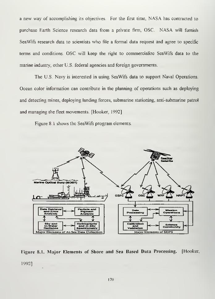
a new way of accomplishing its objectives. For the first time, NASA has contracted to
purchase Earth Science research data from a private firm, OSC. NASA will furnish
SeaWifs research data to scientists who file a formal data request and agree to specific
terms and conditions. OSC will keep the right to commercialize SeaWifs data to the
marine industry, other U.S. federal agencies and foreign governments.
The U.S. Navy is interested in using SeaWifs data to support Naval Operations.
Ocean color information can contribute in the planning of operations such as deploying
and detecting mines, deploying landing forces, submarine stationing, anti-submarine patrol
and managing the fleet movements. [Hooker, 1992]
Figure 8. 1 shows the SeaWifs program elements.
XJ5-
Marine Optical Buoy (MOBY)
^&$JmsRData Rotrtaval Partlclsand
PlgmantAnalysisAnalyst*
> A_ f> ' * *Sfcy and Hydrography
and in SMu1ladlano*
Major Elements of At-Sea Data Collection
* * M
Ar ^ Jl
Validation Community
Major Elements of SPPS
Figure 8.1. Major Elements of Shore and Sea Based Data Processing. [Hooker,
1992]
[70
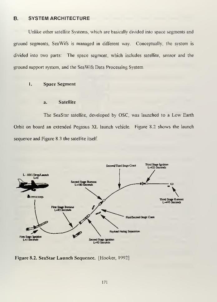
B. SYSTEM ARCHITECTURE
Unlike other satellite Systems, which are basically divided into space segments and
ground segments, SeaWifs is managed in different way. Conceptually, the system is
divided into two parts: The space segment, which includes satellite, sensor and the
ground support system, and the SeaWifs Data Processing System.
1. Space Segment
a. Satellite
The SeaStar satellite, developed by OSC, was launched to a Low Earth
Orbit on board an extended Pegasus XL launch vehicle. Figure 8.2 shows the launch
sequence and Figure 8.3 the satellite itself.
SecondmurdStageCoast TOJJ-glgg.
L 101 1 Drop/Launch
L+fl
Second Stage BurnoutL+ 180 Seconds J-
\Third Sage Burnout
1X95 Seconds
Fast/Second Stage Coast
Payload Faring Separation
First Stan Ignition
L+5 Seconds Second Stage Ignition
L+95 Seconds
Figure 8.2. SeaStar Launch Sequence. [Hooker, 1992]
171
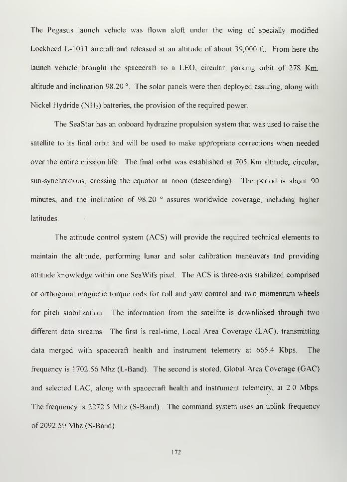
The Pegasus launch vehicle was flown aloft under the wing of specially modified
Lockheed L-1011 aircraft and released at an altitude of about 39,000 ft. From here the
launch vehicle brought the spacecraft to a LEO, circular, parking orbit of 278 Km.
altitude and inclination 98.20 °. The solar panels were then deployed assuring, along with
Nickel Hydride (NH2) batteries, the provision of the required power.
The SeaStar has an onboard hydrazine propulsion system that was used to raise the
satellite to its final orbit and will be used to make appropriate corrections when needed
over the entire mission life. The final orbit was established at 705 Km altitude, circular,
sun-synchronous, crossing the equator at noon (descending). The period is about 90
minutes, and the inclination of 98.20 ° assures worldwide coverage, including higher
latitudes.
The attitude control system (ACS) will provide the required technical elements to
maintain the altitude, performing lunar and solar calibration maneuvers and providing
attitude knowledge within one SeaWifs pixel. The ACS is three-axis stabilized comprised
or orthogonal magnetic torque rods for roll and yaw control and two momentum wheels
for pitch stabilization. The information from the satellite is downlinked through two
different data streams The first is real-time, Local Area Coverage (LAC), transmitting
data merged with spacecraft health and instrument telemetry at 665 4 Kbps. The
frequency is 1702.56 Mhz (L-Band). The second is stored. Global Area Coverage (GAC)
and selected LAC, along with spacecraft health and instrument telemetry, at 2 Mbps.
The frequency is 2272.5 Mhz (S-Band). The command system uses an uplink frequency
of2092.59Mhz(S-Band).
172
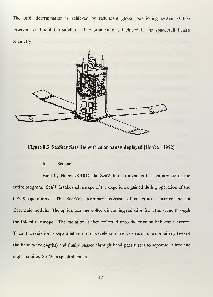
The orbit determination is achieved by redundant global positioning system (GPS)
receivers on board the satellite. The orbit state is included in the spacecraft health
telemetry.
Figure 8.3. SeaStar Satellite with solar panels deployed [Hooker, 1992]
b. Sensor
Built by Huges /SBRC, the SeaWifs instrument is the centerpiece of the
entire program. SeaWifs takes advantage of the experience gained during operation of the
CZCS operations. The SeaWifs instrument consists of an optical scanner and an
electronic module. The optical scanner collects incoming radiation from the scene through
the folded telescope. The radiation is then reflected onto the rotating half-angle mirror.
Then, the radiation is separated into four wavelength intervals (each one containing two of
the band wavelengths) and finally passed through band pass filters to separate it into the
eight required SeaWifs spectral bands.
173
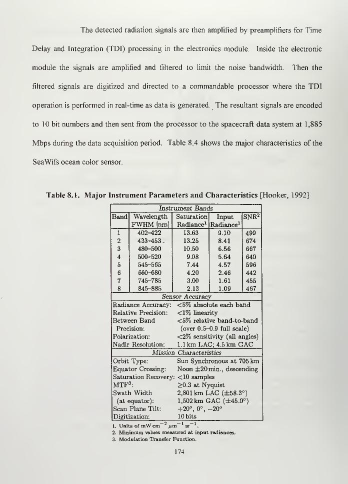
The detected radiation signals are then amplified by preamplifiers for Time
Delay and Integration (TDI) processing in the electronics module. Inside the electronic
module the signals are amplified and filtered to limit the noise bandwidth Then the
filtered signals are digitized and directed to a commandable processor where the TDI
operation is performed in real-time as data is generated. The resultant signals are encoded
to 10 bit numbers and then sent from the processor to the spacecraft data system at 1,885
Mbps during the data acquisition period. Table 8.4 shows the major characteristics of the
SeaWifs ocean color sensor.
Table 8.1. Major Instrument Parameters and Characteristics [Hooker, 1992]
Instrument BancIs
Band Wavelength Saturation Input SNR2
FWHMfnml Radiance 1 Radiance 1
1 402-422 13.63 9.10 499
2 433-453
.
13.25 8.41 674
3 480-500 10.50 6.56 667
4 500-520 9.08 5.64 640
5 545-565 7.44 4.57 596
6 660-680 4.20 2.46 442
7 745-785 3.00 1.61 455
8 845-885 2.13 1.09 467
Sensor Accuracy
Radiance Accuracy: <5% absolute each band
Relative Precision: <1% linearity
Between Band <5% relative band-to-band
Precision: (over 0.5-0.9 full scale)
Polarization: <2% sensitivity (all angles)
Nadir Resolution: 1.1km LAC; 4.5 km GACMission Characteristics
Orbit Type: Sun Synchronous at 705 kmEquator Crossing: Noon ±20min., descending
Saturation Recovery : <10 samples
MTF3: >0.3 at Nyquist
Swath Width 2,801 km LAC (±58.3°)
(at equator): 1,502 km GAC (±45.0°)
Scan Plane Tilt: +20° , 0°, -20°
Digitization: 10 bitso 1 1
1. Units of mW cm /im sr .
2. Minimum values measured at input radiances.
3. Modulation Transfer Function.
174
c. Ground Support System
The ground segment serves three functions: spacecraft control, data
delivery to NASA Goddard Space Flight Center (GSFC), and data delivery to commercial
users. The first and third functions are the sole responsibility of OSC, the second is
supported by different stations. The stations involved in the SeaStar Ground Support
System are: Spacecraft Operation Center (SOC), GSFC High Resolution Picture
Transmission (HRPT), NASA Wallops Flight Facility (WFF) HRPT, and NASA-approved
HRPT facilities.
(1) Spacecraft Operation Center. The SeaStar Spacecraft
Operation Center (SOC) is an OSC facility located in the Washington, DC area. The SOC
has a fully steerable five meter antenna, PC-based tracking computer, and redundant
receivers and demodulators for both the 2.0 Mbps S-Band GAC and LAC stored data
transmission, and 665 Kbps L-Band direct broadcast FfRPT LAC telemetry data stream.
Redundant telemetry/command consoles provide telemetry processing and command
capability. The SOC also contains commercial science data processing and product
generation facilities. Although OSC will operate the SOC, the SeaWifs Project Office
(SPO) at NASA will define recording times, sensor tilt angle, recorded data transmission
times and calibration events, within limits of safe operation, and it will forward these
parameters to the SOC. The SOC will be manned during the noon pass but it will function
automatically during the midnight pass.
(2) NASA Goddard Space Flight Center High Resolution Picture
Transmission. The ground station located at GSFC has a mission to acquire the direct
175
broadcast data. This HRPT ground station consists of a prime computer system with two
backup systems. The primary antenna is an eight foot perforated parabolic antenna
dedicated to the capture of SeaWifs HRPT data. The backup antenna is the one used for
the search and rescue satellite (SARSAT), and it will be available to SeaWifs when it is
not needed for SARSAT.
(3) NASA Wallops Flight Facility High Resolution Picture
Transmission. Wallops Flight Facility HRPT is designed for the acquisition of the
recorded data. The primary antenna is a nine meter autotrack. The backup antenna is a
7.5 meters receive-only autotrack that is available on a non-interference basis with the
Wallops launch range. The recorded data will be transmitted to the SeaWifs Data
Processing System (SDPS) at GSFC where the data will be stored in a computer
addressable file on disk.
(4) NASA Approved High Resolution Picture Transmission.
Approved HRPT are all the stations authorized by NASA to receive LAC data These
HRPT stations will collect the 1.13 Km resolution data over surrounding areas.
2. SeaWifs Data Processing System
The major elements of SeaWifs Data Processing System are:
a. Data Processing
This element receives raw science data and generates the global ocean
color data products, which will be provided to the GSFC Distributed Active Archive
Center (DAAC) for archiving and distribution.
176
b. Calibration and Validation
This element is responsible for data quality analysis of SeaWifs products.
It generates analysis reports and is responsible for establishing and updating calibration
procedures for SeaWifs data. Its main goal is to determine the degree to which the
commercially procured ocean color data fulfills the contractually stated NASA
requirements.
c. Software Support
This element is responsible for programming assistance and data base
support, software updates, software integration, software testing and software
configuration management.
d. Mission Operations
This element serves as the single point-of-contact for OSC and the GSFC
HRPT station to communicate, coordinate, schedule, and report any problems.
In summary, the authorized HRPT's get the data and store it in order to satisfy
requirements. Requirements can be originated by authorized researchers to whom the
information is sent in accordance with a NASA agreement or commercial users to whom
the data is sent in accordance with OSC commercial agreements. Eventually, researchers
can get operational data by asking special permission ofNASA.
C. SEAWIFS DATA MANAGEMENT
The type of mission SeaWifs was developed for (monitoring the color of the entire
ocean) along with the research-commercial combination established between NASA and
177
OSC, makes the management of data one of the most important issues. The sensor and
mission operations are designed to meet NASA research requirements In order to satisfy
OSC commercial requirements, there is a general embargo period of two weeks for
distribution of research data by NASA and five years before the data is transferred to the
public domain. However, there are three exceptions to the embargo period:
- Field experiments requiring data for ship positioning
- Instrument calibration and validation activities
- Demonstrations to prove feasibility for operational use
The interesting point for scientists is that access throughout NASA will be
permitted for research purposes. To get this access, scientists must establish a project and
obtain NASA's permission. Once they get NASA's approval, they must sign an agreement
stating that the data will be used only for research purposes. The data is provided by
NASA at basically no cost through the internet or at the minimum cost through other
media (CD room, magnetic tape, etc.).
SeaWifs produces two types of science data, LAC with a ground resolution of
1.13 Km and GAC data with a resolution of 4.5 Km. Direct broadcast LAC will be
received by all the real-time Ground Stations (NASA-approved HRPT) around the world.
Recorded LAC data for pre-selected areas and all GAC data will be received at the WFF
and forwarded to the SDPS at GFSC. SDPS will receive data, manage it, catalog it,
archive it, generate products, ensure distribution, schedule missions, support software
updates and provide technical training.
178
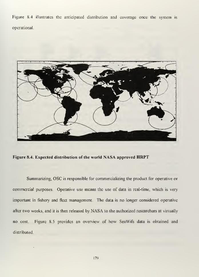
Figure 8.4 illustrates the anticipated distribution and coverage once the system is
operational.
Figure 8.4. Expected distribution of the world NASA approved HRPT
Summarizing, OSC is responsible for commercializing the product for operative or
commercial purposes. Operative use means the use of data in real-time, which is very
important in fishery and fleet management. The data is no longer considered operative
after two weeks, and it is then released by NASA to the authorized researchers at virtually
no cost. Figure 8.5 provides an overview of how SeaWifs data is obtained and
distributed.
179
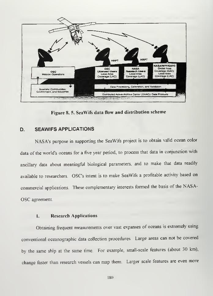
^v
Scientific CommunrtJes.Government, and Jndustnes
Figure 8. 5. SeaWifs data flow and distribution scheme
D. SEAWIFS APPLICATIONS
NASA's purpose in supporting the SeaWifs project is to obtain valid ocean color
data of the world's oceans for a five year period, to process that data in conjunction with
ancillary data about meaningful biological parameters, and to make that data readily
available to researchers. OSC's intent is to make SeaWifs a profitable activity based on
commercial applications. These complementary interests formed the basis of the NASA-
OSC agreement.
1. Research Applications
Obtaining frequent measurements over vast expanses of oceans is extremely using
conventional oceanographic data collection procedures. Large areas can not be covered
by the same ship at the same time. For example, small-scale features (about 30 km),
change faster than research vessels can map them. Larger scale features are even more
180
difficult to map. SeaWifs can get more data in one orbit than one ship can get in ten years,
and this argument is powerful enough to consider its use. Of course, the spatial
resolution, spectral resolution and delivery time restrictions inherent in current satellite
systems place some limits on measurements that can be made. Also, satellite sensors have
the obvious disadvantage of not being in physical contact with the ocean However, in the
1 960's, measurements from aircraft and ships proved that ocean color measurements from
satellite-based sensors provide a powerful tool for understanding oceanic biological and
physical processes.
The satellite sensors used for ocean color measurement measure the spectrum of
sunlight reflected from the ocean's waters. The radiance reflected from the ocean in the
visible wavelength region (0.4-0.7u,m) depends on the concentration of chlorophyll,
sediments and dissolved materials from terrestrial and inland sources. The open waters
usually appear deep blue, because they contain very little phytoplankton or other
substances When we move toward shore, nutrients increase and the water turns green as
the chlorophyll increases(chlorophyll has a pigment that reflect green light and absorbs
other colors). Hence, the concentration of phytoplankton can be estimated from the
measure of chlorophyll concentration. With the presence of sediments and dissolved
materials, the color approaches yellow-brown and sometimes red These suspended
substances generate what is known as turbidity, or decreased water clarity, which
represents an important parameter for military applications
Using appropriate algorithms, the amount of chlorophyll and other pigments can
be determined and hence the ocean characteristics established dunnu different seasons.
181
Many scientific contributions can be obtained from the analysis of chlorophyll
concentration and seasonal displacements (for example, the relation between pigments and
primary productivity and pigments and El Nino Southern Oscillation).
2. Commercial Applications
Data provided on ocean color is very useful for the fishing industry.
Phytoplankton is the principal source of organic matter that sustains the marine chain
food. Normally the fish population is located where the nutrients are, so having accurate
nutrient information improves catch efficiency. SeaWifs data will also be useful in
determining ocean organic pollution, fronts, eddies and ocean current features. This
information could be useful for marine transportation, offshore oil and gas exploration and
extraction, ocean mining and value added products such as fishery aids charts.
3. Operational Applications
The National Oceanic and Atmospheric Administration (NOAA), identified the
following as potential operational uses of SeaWifs data: Ocean dumping monitoring,
noxious algae blooms and red tides, regional characterization, habitat assessment, flow
visualization, and oil spill trajectory analysis. SeaWifs data can also support naval
operations in much the same way that it supports fleet management. One example is the
identification of current boundaries, as in the case of a Loop Current in the summer:
[Hooker, 1992]
The observed ocean color signals integrates over the upperfew to tens of
meters of the water column. This allowsfor slight differences in the bio-
182
optical characteristics in underlying waters of the loop current and
coastal waters to he readily distinguishable from each other with satellite
color observations at times when the upper centimeters of surface waters
are thermally homogeneous.
E. POSSIBLE USES OF SEAWIFS DATA BY THE ARGENTINE NAVY
The SeaWifs data will be available on a commercial basis through OSC once the
system established and declared operational. Before acquiring data, the Argentine Navy
should study and define how this data can be used to satisfy operational requirements or to
support naval operations.
One way to make appropriate use of the SeaWifs data obtained in real-time is by
having an adequate and proven algorithm that could relate local meteorological patterns to
the local ocean color observations. Scientists are developing such algorithms all over the
world with different objectives. For example, one of the most general and ambitious
projects is the SeaWifs Study of Climate, Ocean Productivity, and Environmental Change
This propose project attempts to use SeaWifs data to address.
-The role and significance of oceanic biological processes in climate control.
-The ecological and environmental change at the land sea boundary.
-The diffuse attenuation coefficients, mixed layer depths, ocean physical processes,
bio-optical signatures as tracers of water motions, spatial heterogeneity, upwelling
and frontal dynamics.
183
- the role of biology in models of the climate system., which include ocean
atmosphere interactions.
This project, used as an example to show how broad SeaWifs data can be used,
involves the cooperation of different centers (Ocean Marine Exchange (OMEX), Natural
Environment Research Council (NERC), British Antarctic Survey (BAS), and others).
The final objective is to link in situ measurements,1
algorithm development, image
validation, and exploitation of SeaWifs data. [Hooker, 1993]
It is very important to note that all these projects are quite demanding in terms of
effort, in situ data collection, and ocean measurements, which could take years to obtain
and verify. Projects like this are surely justified as long term scientific endeavors but not
from the military point of view, if we expect to immediately and entirely satisfy our local
requirements.
Which Argentine Navy needs could ocean color data satisfy In the long term, the
seasonal study of the ocean color patterns can help us make better decisions when planing
naval operations, in particular:
1. Fishing Control
Knowing where the phytoplankton is, we can increase our surveillance of specific
areas based on the presumption that illegal fishing ships will be around those areas
Knowing where to send our aircraft patrols or our ships can save us considerably time and
money. There are other more accurate methods of determining where and when
1
In situ means that the measurement is made with the device in contact with the object being studied, as
opposed to a remote measurement of reflected or emitted electromagnetic cncrg\
184
unauthorized ships are operating (for example, Radarsat). However, if we don't have
Radarsat ocean color data used for seasonal prediction can be a good tool for planning.
2. Mining Operations
Ocean color measurement provides an indication of not only the chlorophyll
concentration but other pigments as well. Turbidity of the water can play a key role in
defining the best place to establish a particular type of mine field. For example, if I know
the depth at which a submerged object can be seen from the air I can use this to my
advantage. In the case of defensive mine field, I can collect enough information without
needing a ocean color data, but when planning an offensive mine field, color data could be
the best available information.
3. Coastal Special Operations
If I want to send a commando group ashore in a particular protected area, I will
always try to choose the place in which natural features can help me. Ocean color
information, especially turbidity must be considered.
4. Landing Operations
Not only ocean color itself, but the association of ocean color with currents and
tides can help again at the point of planning and executing the operation.
5. Submarine Operations
Whether or not to station a submarine in a particular area, based mainly on tactical
and strategic factors, is a decision in which ocean color can help.
185
Ifwe can acquire the capability to know ocean color of particular areas of interest,
it could become an important element in decision making. We can get near real-time data
from OSC or from our own ground station.
However, I want to be clear that in my opinion, ocean color itself, even if used
appropriately, will only make a small contribution to Argentine Naval Operations We
need to understand that the U.S. Navy has been working on developing empirical models
to predict ocean phenomena (currents, waves, wind stress, etc.) since the 1930's,
compiling huge amounts of information, performing thousand of predictions, verifying
these predictions and improving the algorithm's coefficients when needed. So they are
now probably ready to make better predictions based in satellite observations, from which
ocean color will be just one factor. Because of the lack of experience we have in this field,
I believe our goal should be to either get involved in projects that use SeaWifs data by
committing our own oceanography expertise or promote this involvement to civilian
scientists working in universities or advanced studies centers.
F. BENEFITS AND DISADVANTAGES OF USING SEAWIFS DATA WITHRESEARCH PURPOSES
1. Benefits
-We can use SeaWifs data for research without having to make a significant
investment. A personal computer with internet capabilities could be enough to get
186
started. As usual, the better the technology, the better the product, keeping in
mind that there is no particular urgent need that must be satisfied.
- Being involved in an international project led by NASA could be for our Navy
the beginning of active participation in the field of oceanography from space and a
worthwhile learning experience.
-This participation can help us in better understand space capabilities before
deciding whether or not to buy data for operational use.
-Our involvement in such a project can create new space opportunities at the
national and international levels.
-SeaWifs could provide a practical way to prepare Navy people for the future use
of space assets.
-SeaWifs could help fulfill specific national oceanographic needs.
2. Disadvantages
- A SeaWifs demonstration project will require the commitment of at least one
expert dedicated almost exclusively to the study of the relationship between ocean
color and oceanographic phenomena.
- It will take time to reach some conclusions about the local phenomena associated
with ocean color. Once obtained, the data should be analyzed, adequately
processed and evaluated, and compared with in situ observations.
-It will require in situ measurements, which normally requires time from dedicated
research ships and ships of opportunity. The information provided by SeaWifs
data will not be conclusive in any way, if its not compared with corroborating
187
measurements of the real phenomena that occurred at approximately the same
time.
G. THE NEXT STEP ABOUT USING SEAWIFS DATA
After learning how to manage SeaWifs non operational data, we should better be
able to figure out whether or not this data will be useful for military operations. Assuming
the decision is that we need to have ocean color data, then we will have at least two
options:
-The installation of a ground station (a NASA approved HRPT). The
requirements for this type of station are established by NASA as a function of capabilities
for data storage and distribution (broadcasting) to the authorized users. Basically, these
stations receive the data as planned by the NASA mission center and distribute this data
when required. The cost of this station may vary, but can be estimated at $100,000 plus
yearly maintenance and software upgrade (around $5000). They could also be moved on
board oceanographic ships to support real-time observations. The process established to
make sure that only authorized users can access the data is that NASA approved HRPT
stations are authorized to receive broadcast LAC data by NASA. These stations will also
be committed to distribution of data only to authorized users. Normally, this authorization
will be for the retrospective use, meaning decryption codes will be provided at least 14
days after reception. LAC data will have to be recorded for later decryption. In addition
to GSFC LAC facility, up to 12 stations at any given time my be licensed by NASA for
188
near real-time support for specific periods of time and purposes, and may receive the
decryption codes in advance. [Feldman, 1996]
-The second option will be to buy data directly from OSC. This data will most
likely be initially obtained and provided by the nearest approved HRPT, and OSC will
provide the decryption codes in advance.
Whether or not we have an approved HRPT, to get data in near real-time for
operational purposes, we must make an agreement with OSC. The only real need for a
ground station is that the satellite can store all GAC data and a small selected amount
LAC data which is downloaded at WFF, so the stored information will normally be about
4.5 Km resolution. All the information obtained through the approved HRPT is LAC so a
resolution of 1 . 1 Km can be achieved.
The Argentine Naval Hydrographic Service, which is dedicated to conduct
operative studies as well as scientific oceanographic research, would probably take
advantage of this facility by performing projects related to shallow water oceanography
without significant cost and with considerable benefits. Shallow waters would be of
particular interest of the U.S. Navy, so it could also be possible to get cooperation from
U.S. research centers involved in such studies.
Working with SeaWifs data could be a learning experience for the researchers
involved on the project and the starting point to understand how satellites can contribute
to Argentine oceanography. Based on our maritime heritage it would be a very useful
contribution to the study of our coastal features, ocean circulation, seasonal nutrient
displacements and other oceanographic studies.
189

190
IX. CONCLUSIONS AND FINDINGS
A. CONCLUSIONS
From this relatively brief study of satellite communications and remote sensing, I
can draw several conclutions about the potential value of space assets to the Argentine
Navy.
1. Use of space is definitely beneficial to the Argentine Navy
I analyzed, with more or less detail, different possibilities of using space in the
Argentine Navy. Space assets are able to support a wide variety of military activities.
Spatial resolution of remote sensors is increasing and relatively high resolution imagery is
becoming commercially available, though low resolution imagery also has significant
military utility. Useful communication bandwidth is increasing, and computers and
technology provide the tools for transmission of large amounts of data, voice and video.
Commercial satellite communication systems like Teledesic promise a satellite-
based internet and Iridium a full duplex voice capability. The use of satellite
communications and remote sensing by military forces is no longer an exclusive capability
of the few powerful nations. The technology is in the market, the information is in the
market, and all nations (civil and military people) can get it and use it.
// is convenient for the Argentine Na\y to take advantage of the space assets we
can obtain today, in order to prepare for using the space assets we may need tomorrow.
191
2. Space assets are expensive
Cost is an important factor to consider. In general, the more powerful the satellite,
the more expensive it will be. Typical cost to put a satellite in LEO ranges from $150
million to 2 billion,1
and GEO ranges from $250 million to $2.5 billion [Wertz, 1996].
These values effectively eliminate consideration of exclusive Argentine Navy satellite
programs.
For example, in the case of ORBCOMM, the projected cost for the entire program
plus one year of operation was about $376 million. Assume that we buy one hundred SC's
at the expensive price of $2,000 each and consider we pay an average $2,400 annually for
each SC as a fee for using it. The total cost for five years of operation (ORBCOMM
satellite's lifetime) will be $1.4 million, which is about 1/300 the cost of the total system.
Another example can be taken from CHALLENGE ATHENA experience. The
cost of the six month operation during CA II was $3.5 million. In ten years of continuous
operation, the Argentine Navy (using exactly the same system as the U.S. Navy did) could
spend as much as $ 70.0 million. The cost of one GEO satellite could be $280.0 millon,
so a CHALLENGE ATHENA type approach could give us comparable satellite capability
for about one fourth the cost of developing our own system.
Of course these two examples are based on certain assumptions that must be
carefully considered when drawing conclutions from my analysis. To get a more objective
determination of what the best option would be from and economic standpoint (building.
1
This cost estimate includes research, development, spacecraft launch, and operations during the
satellite's lifetime.
192
buying, or leasing), I performed a sensitivity analysis, which will be at the end of this
chapter
3. Space assets are available
There is considerable diversity among space assets already available and those that
will be available before the year 2000. Any country or military force interested in using
space can find good opportunities for implementation in the international market at
reasonable prices. Software, hardware, processed and unprocessed data, and new and old
imagery can be acquired. Sometimes, when taking part in international projects, data can
be obtained at little or no cost.
4. Space use requires understanding
Effective use of space requires significant skills and training. Space
communications seems more understandable because commercial companies are now
introducing some of the concepts in our daily routines. Direct Home Television and Very
Small Satellite Antennas are becoming part of our daily life However, proper
interpretation of SPOT imagery or the combination of pictures taken at different times and
by different sensors requires trained people and sophisticated computer aids Developing
competence in these disciplines requires significant time and effort, it is not possible to
create experts in a couple of weeks.
193
5. Under certain circumstances, use of space for military purposes is
accepted
The space-capable nations (first, second and third tier)2have been developing
military applications for space assets since the launch of Sputnik in 1957. International
treaties attempted to establish limits and ensure the normal development of space activities
with peaceful purposes. However, treaties do not cover all aspects of space use. When
can the military use civilian space assets with military purposes9 Sometimes you can and
sometimes you can not, depending on the side you are on. The U.S. use of civilian space
assets during the Persian Gulf War encountered opposition from Iraqi allies and the use of
the same assets by Iraqi forces encountered opposition from U.S. allies. Finally, the
Coalition Forces used the same SPOT imagery that was denied to Iraq under the terms of
the trade embargo.
Today, part of the U.S. Navy's communication systems is based on civilian
satellites (for example CHALLENGE ATHENA is supported by INTELSAT satellites).
Most of the world's navies already have INMARSAT systems installed on board their
battleships, surely with the expectation of using it when needed, in peacetime or during
war.
During wartime, the possibility of shutting down the services provided during
peace time must be contemplated when selecting a space-based system controlled by a
foreign country.
~ First Tier: United States . Russia
Second Tier: France. Great Britain, China. Japan . India and Israel
Third Tier: Brazil. Italy. Australia. Thailand South Africa. Canada. Iran. Iraq and Pakistan.
ILee. 1994|
194
6. The United States is increasing military use of commercial space assets
During the Persian Gulf War, U.S. military forces realized how important the
contribution made by civilian space assets was. Today, the U.S. military is increasing
considerably its use of civilian space assets. Technological advances in the commercial
area produced more powerful satellites and associated ground systems, allowing the
military to use some of those assets reliably and safely. Civil-military integration policies
contributed to the development of military capabilities that use civilian technology.
7. Space is commercially attractive
The number of companies and countries interested in developing space programs
have been increasing considerably as the world is realizing the advantages of using space
assets. International policies are promoting new investments. Remotely sensed imagery
helped provide security during the 1996 Olympics in Atlanta. It is also used to monitor
the rain-forest evolution in the Amazon, to assess fisheries and pollution, and to monitor
Nuclear proliferation. Global communications is now primarily through satellites. Most
satellite services are available to anyone who is able to pay for them.
8. Space assets rapidly become obsolete
Satellite systems make extensive use of computer software and hardware. As
computer technology evolves, satellites need to be updated in order to provide the same
capabilities that can be found on earth. Satellites are designed to have a lifetime that can
vary from two years (such as PANSAT)[Severson, 1995] to about seventeen years (such
as INTELSAT VIII series)[Discover INTELSAT, 1997]. The design and construction of
195
a space system also takes time. For example, the High Energy Transient Experiment
(HETE), for which some preliminary design studies began in 1991 [Martel, 1996], was
launched late in 1996, two years past the initial scheduled launch (1994). Assuming that
we are designing a payload, we are using a well known bus and launch vehicle, we are
using the latest computer technology for our payload and our hypothetical satellite has an
average lifetime of ten years, surely, the computer components will be clearly obsolete
halfway through its lifetime. In the HETE example, we can not assume that designers
waited until the day before launch to set up the computer system, so the truly recent
technology was not on board. In the particular case of SPOT 2, which is still in use, the
recording capability was the best obtainable at the time it was built. It does not mean the
satellite is useless, but this sensitive part, can and will be improved in the new SPOT
satellites. [Paige, 1996]
B. SELECTION CRITERIA
If space is a useful tool to improve our military capability, we must find the best
approach to integrating space assets into our military forces.
I intend to find this "best approach" in the most objective way
To do that, I am going to use a method presented during the International Conference on
Engineering Design (ICED 81), in Rome, Italy, in 1981 [Pugh. 1981] The method
basically consists of establishing all possible operational concepts (approaches) for the
existing problem and a given number of criteria against which the approaches will be
evaluated. Assuming one of the operational concepts as "the best" or "datum," we
196
establish a comparative analysis against the others, for each criteria, to see if they are
better (+), worse (-), or the same (S).
At the end of these subjective comparisons, we will have a numerical value of pluses,
minuses and "sames" that provides a relative comparison to a decision maker.
1. Operational Concept
"Concept" is defined in this case as a possible action we can adopt to achieve space
capability in the areas of communication and remote sensing. From my point of view,
there are four concepts that can be adopted:
a. Buy or lease service
This means buying or leasing a transponder from a particular satellite,
national or international, for communications, or buying imagery from commercial
remotely sensed data providers.
b. Bus plus standard technology based on requirements
This means the construction of an Argentine owned satellite by a third
party who already has the bus and adding the sensors we require. The same company may
also be responsible for the launch vehicle.
c. National Development
This assumes the entire system is developed by Argentina based on our
own technological capability. We must assume that we will use a foreign launch vehicle.
197
d. No New Changes
This is the concept for which we decide not to use any more space assets
than we are already using.
2. Criteria
Criteria is the parameters that will be affected by choosing a particular concept. In
my example, I will consider that all the parameters have the same weight (importance), but
this assumption is rather simplistic and subject to change. Of course, this would also
change the final result. The parameters I believe we should care about are:
a. Cost
Cost could be a dominant factor, if we decide to weigh the parameters.
The lower the cost, the better the option.
b. Time required to implement
The shorter the time required to implement, the better the option.
c. Capability
Capability refers to what we can do with the system. The more functions
we can perform, the better the option.
d. Reliability
The system should be available when needed and perform as intended.
(Table 2.1)
[98
e. Security
The system should reduce vulnerability to interception and exploitation.
(Table 2.1)
f. Timeliness
The sooner we can use the system when required, the better the option.
This point should not be confused with time required to implement. Time required to
implement means the time from the decision for use a particular asset (for example SPOT
imagery) until its use becomes operational.
Timely means the specifying the application requirement to delivery of the final
product. For example, obtaining imagery from a hypothetical Argentine-owned satellite,
should take less time than buying SPOT imagery.
g. Flexibility
Flexibility refers to the capability of satisfying different missions. For
example, it is very difficult to combine the instruments that satisfy the need for both
remote sensing and communications in the same satellite. So, to have flexibility to support
different types of missions, different satellites are usually required. In our case, I assume
that leasing different services will provide more flexibility than developing only one class
of satellite.
199
h. Interoperatibility
Interoperatibility refers to its ease of integration with other Argentine
military forces and foreign forces.
i. Survivability
Survivability refers to its ability to work in the anticipated operating
environment and its resistance to intentional aggression. Environmental "aggression"
means the natural factors that can affect space assets, such as solar radiation and
meteorites. Intentional aggression is the damages that can be caused by third party
involved directly or indirectly in a given conflict against Argentina. For example, having
our own satellite, in case of regional conflict, a hypothetical enemy can take all kind of
measures against our satellite. If we are using a satellite belonging to a neutral country,
the hypothetical enemy will have a strong incentive to avoid taking aggressive measures
against the satellite.
j. Accomplishment of the objectives
This refers to the number Argentine Navy basic missions the concept can
contribute to, and how well the concept can do it/
k. Risk
The technological and economical risk of choosing one particular option.
1
The Argentine Navy basic missions were defined in Chapter II
200
1. International Cooperation
This criteria assumes that international cooperation can help us develop our
space programs. It does not mean that other countries will do our work for us. Rather, it
means that by developing some kind of joint projects, we can get more technical support
than by doing things ourselves.
m. International Laws
We want to respect all international treaties. The closer we are to the
spirit of international treaties (whether or not Argentina has signed them), the better is the
option.
n. Preferences
This refers to things that from my point of view would be preferred by the
Argentine Navy.
o. International Policies
Independent of the international treaties, there are the national policies of
the space systems owners, with respect to sharing space technology with foreign
countries[OTA-ISS-607, 1994]. These policies are mainly based on keeping ultimate
control over the space assets. The more independent we can stay, the better is the option.
Having defined the concepts and criteria, I will now develop the methodology to
rank the concepts that best satisfy the criteria.
201
3. Analysis
a. First Iteration - Buying or Leasing
In the first iteration we assume that buying or leasing will probably turn out
to be the best option, so we compare all the other options to that. The minus sign (-)
means that for this criteria the option is worse, the plus sign (+) means that the option is
better than buying or leasing, and the letter "S" means that it is the same as buying or
leasing.
The way of thinking to consider one concept better or worst is briefly described
for the numbered criterias.
1
.
Doing nothing will be cheaper but does not provide any benefits. We need to be careful
with this type of indicator. For the same service, Bus plus Standard (B+S) or National
Development (ND) will cost more than buying or leasing. Basically to justify such a
development we need to be able to use the entire capability of the space system, which
may not be the case.
2. Ifwe decided to buy or lease the services that are already available, it will take less time
than ordering the construction of a new satellite or building up for a national development
effort.
3. In the buying or leasing case, although we need to accept what is offered, we have a
wide array of choices. In the B+S and ND cases, we will probably be able to achieve
more capability in one particular aspect.
4. Having a system we can control in all its phases will provide us with more independence
than leased services will. Hence, it does not matter if the rest of the world likes us or not.
202
We will be able to use our system during crisis periods as well as during peace time.
However, we need to recognize that the leader nations probably will have Anti-Satellite
Weapon Systems, so if the decision of shut down an hypothetical Argentine satellite were
supported by the international community, someone may be able to do this job. Such
action will involve more compromise by the involved nations and is likely improbable if the
satellite is being used to support regional military operations that only affect regional
interests. For example, Israel decided to built its own system, because the military leaders
did not feel confident with the support provided by the U.S. during the Yon Kippur War.
[Lee, 1994]
5. Military systems are designed to support hostile war environments, so the protection
mechanisms make military systems more secure than commercial ones. Nevertheless, the
use of satellites in business requires some protection that can be exploited by the military.
6. If we own the system, we can use when we want. However, we need to worry about
the capabilities of the satellite we own.
7. Either a single B+S or a single ND would be less flexible than the corresponding leased
system.
8. B+S can be assumed compatible in technology and operation with foreign systems, if
required. ND should be based on our own technology and may or may not be
compatible.
9. The environment will be the same, but our own satellite could be more vulnerable to
possible external actions during crisis situations than a leased service, because few
countries would attempt a destructive action against a neutral country's satellite.
203
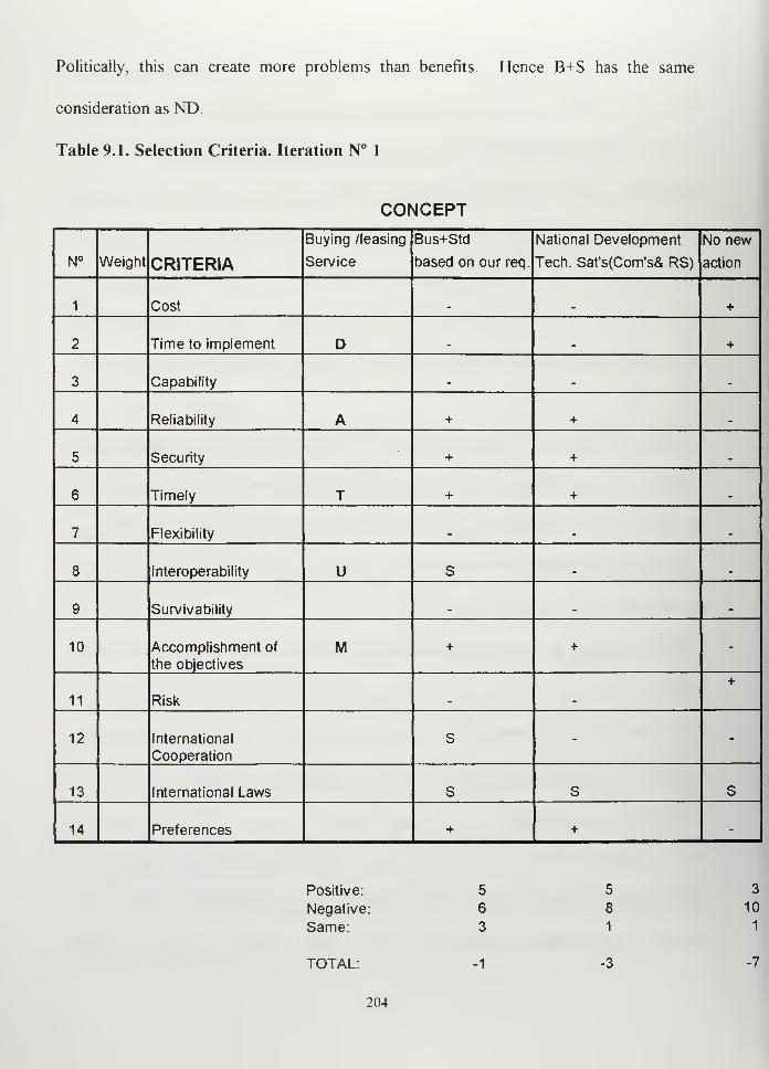
Politically, this can create more problems than benefits. Hence B+S has the same
consideration as ND.
Table 9.1. Selection Criteria. Iteration N° 1
CONCEPT
N° Weight CRITERIA
Buying /leasing
Service
Bus+Std
based on our req.
National Development
Tech. Sat's(Com's& RS)
No new
action
1 Cost _ . +
2 Time to implement D _ . +
3 Capability _ .
4 Reliability A + +
5 Security + +
6 Timely T + + .
7 Flexibility . . .
8 Interoperability U S .
9 Survivability m
10 Accomplishment of
the objectives
M + + -
11 Risk
+
12 International
Cooperation
s - -
13 International Laws s S S
14 Preferences + + -
Positive: 5 5
Negative: 6 8
Same: 3 1
TOTAL: -3
204
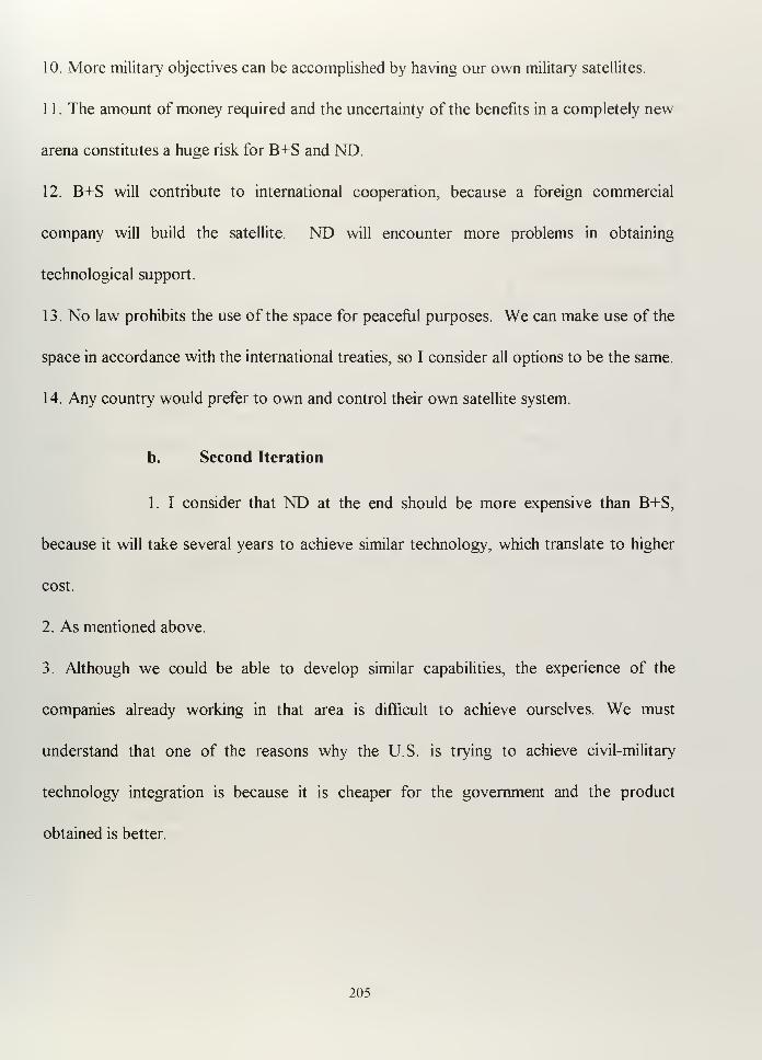
10. More military objectives can be accomplished by having our own military satellites.
1 1
.
The amount of money required and the uncertainty of the benefits in a completely new
arena constitutes a huge risk for B+S and ND
12. B+S will contribute to international cooperation, because a foreign commercial
company will build the satellite. ND will encounter more problems in obtaining
technological support.
13. No law prohibits the use of the space for peaceful purposes. We can make use of the
space in accordance with the international treaties, so I consider all options to be the same.
14. Any country would prefer to own and control their own satellite system.
b. Second Iteration
1. I consider that ND at the end should be more expensive than B+S,
because it will take several years to achieve similar technology, which translate to higher
cost.
2. As mentioned above.
3. Although we could be able to develop similar capabilities, the experience of the
companies already working in that area is difficult to achieve ourselves. We must
understand that one of the reasons why the U.S. is trying to achieve civil-military
technology integration is because it is cheaper for the government and the product
obtained is better.
205
4. Once the system is deployed, the reliability should be the same. However, considering
the technological point of view, more advanced and mature technology like B+S case
should be better with respect to ND.
5, 6 and 7. Depending on the design ND could be similar than B+S.
8. ND will be probably less compatible than standard technology.
9. Same as in table 9. 1 .•
10. Designed under similar requirements, B+S and ND will satisfy similar objectives or
missions.
1 1
.
ND implies more risk as a consequence of work in a relatively new field.
12. When talking about satellite development for military purposes not much cooperation
can be expected from foreign countries.
13. Same as in table 9.1.
14. Our preference should be to be able to develop and operate our own systems.
206

Table 9.2. Selection Criteria. Iteration N° 2
CONCEPT
N° Weight CRITERIA
Buying /leasing
Service
Bus+Std
based on our req.
National Development
Tech. Sat's(Com's& RS)
No new
action
1 Cost + _ +
2 Time to implement + D _ +
3 Capability + _ _
4 Reliability . A _ _
5 Security . S _
6 Timely . T S _
7 Flexibility + S .
8 Interoperability S U _ .
9 Survivability + _ _
10 Accomplishment of
the objectives
- M s -
11 Risk + _
+
12 International
Cooperation
s - -
13 International Laws s s s
14 Preferences - + -
Positive:
Negative:
Same:
3
10
1
TOTAL: +1
207
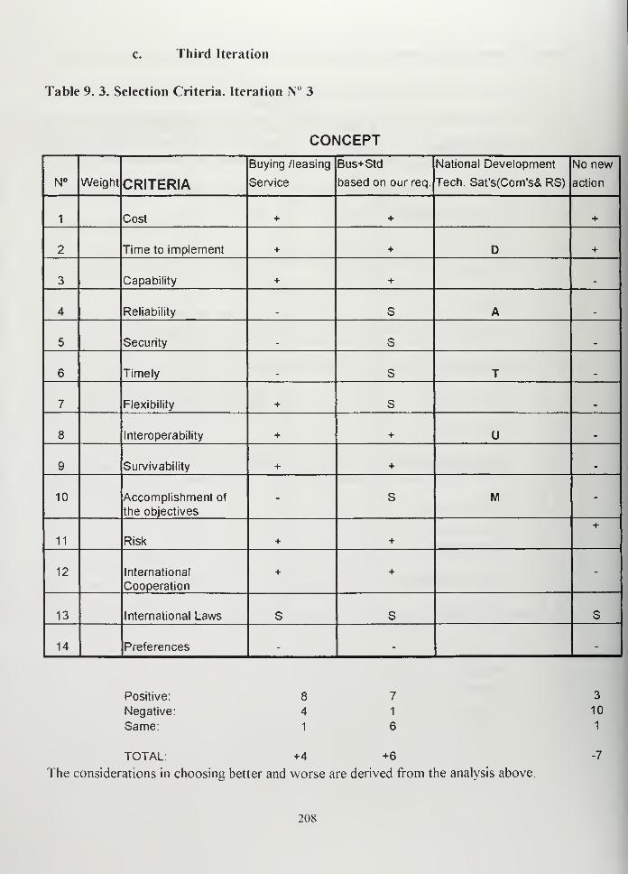
c. Third Iteration
Table 9. 3. Selection Criteria. Iteration N° 3
CONCEPT
N° Weight CRITERIA
Buying /leasing
Service
Bus+Std
based on our req.
National Development
Tech. Sat's(Com's& RS)
No new
action
1 Cost + + +
2 Time to implement + + D +
3 Capability + + .
4 Reliability . S A .
5 Security . S .
6 Timely . S T .
7 Flexibility + S .
8 Interoperability + + U _
9 Survivability + + m
10 Accomplishment of
the objectives
- s M -
11 Risk + +
+
12 International
Cooperation
+ + -
13 International Laws S s S
14 Preferences - - -
Positive:
Negative:
Same:
TOTAL: +4 +6
The considerations in choosing better and worse are derived from the analysis above.
3
10
1
-7
208
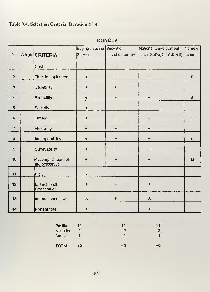
Table 9.4. Selection Criteria. Iteration N° 4
CONCEPT
N° Weight CRITERIA
Buying /leasing
Service
Bus+Std
based on our req.
National Development
Tech. Sat's(Com's& RS)
No new
action
1 Cost . .
2 Time to implement + + + D
3 Capability + + +
4 Reliability + + + A
5 Security + + +
6 Timely + + + T
7 Flexibility + + +
8 Interoperability + + + U
9 Survivability + + +
10 Accomplishment of
the objectives
+ + + M
11 Risk _ _
12 International
Cooperation
+ + +
13 International Laws S S S
14 Preferences + + +
Positive: 1
1
Negative: 2
Same: 1
1 11
2 2
1 1
TOTAL: +9 +9 +9
209
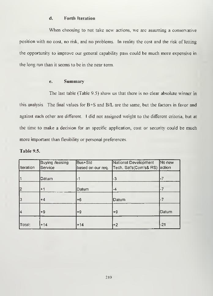
d. Forth Iteration
When choosing to not take new actions, we are assuming a conservative
position with no cost, no risk, and no problems. In reality the cost and the risk of letting
the opportunity to improve our general capability pass could be much more expensive in
the long run than it seems to be in the near term.
e. Summary
The last table (Table 9.5) show us that there is no clear absolute winner in
this analysis. The final values for B+S and B/L are the same, but the factors in favor and
against each other are different. I did not assigned weight to the different criteria, but at
the time to make a decision for an specific application, cost or security could be much
more important than flexibility or personal preferences.
Table 9.5.
Iteration
Buying /leasing
Service
Bus+Std
based on our req.
National Development
Tech. Sat's(Com's& RS)
No newaction
1 Datum -1 -3 -7
2 +1 Datum -4 -7
3 +4 +6 Datum -7
4 +9 +9 +9 Datum
Total: +14 +14 +2 -21
210
What it is clear from my point of view is that the option of not trying to use the
space will be the worst. Although we can avoid taking a risk, we surely will be falling
behind in technology, and it will take much more time for our navy to catch up from this
situation.
This analysis attempted to make objective the point of view what was initially
subjective. The concept selection criteria provides, in my opinion the appropriate tools to
do that.
211

212
X. RECOMMENDATIONS
A. RECAPITULATION
Throughout the preceding chapters I presented a number of different space-related
issues. I started by determining the Argentine Navy Missions and Requirements (Chapter
II). Using this requirements as a guidelines, I focused my attention on commercial
communications and remote sensing. I dedicated the third and fourth chapters to the
importance of GEO and LEO satellites, some of which are already on the market and
some of which are coming in the future. In my search, I emphasized the use of civilian
communication satellites in the military, because I considered it to be the best way to
achieve capabilities we do not have. Considering that the U.S. space requirement assets
are different from ours, I used the U.S. examples of civilian applications as a proof of their
feasibility. I abounded in diversity of topics and technical data to illustrate how expansive
the subject of satellite communications is and how much interest there is in it. I chose the
ORBCOMM system (Chapter V) to provide a more detailed example of one possible use
of civilian communication satellites in our navy.
With similar criteria, I entered into the area of remote sensing (Chapter VI) and
discussed the possible military applications and presented what we can get today. I chose
SPOT (Chapter VII), the commercial remote sensing leader, and SeaWifs (Chapter VIII),
a satellite dedicate to ocean measures, to show how civilian remote sensing assets can be
used for military purposes. In the preceding chapter, along with my findings and
conclusions, I presented in the most objective manner the reasons why I consider that the
213
use of commercial space assets is the best way, or maybe the only way, for the Argentine
Navy to continue using space. In this chapter, I want to conclude my study with a plan to
keep the Argentine Navy current with respect to deriving benefits from using space assets.
B. GENERAL STEPS TO IMPROVE ARGENTINE NAVY SPACECAPABILITY
1. Define Argentine Navy Space Objectives
As we saw in Chapter II, Argentina already has a National Space Plan that serves
as the focal point for national space development. As a military force, we need to develop
clear and achievable Navy Space Objectives. In same aspects, our goals are very close to
the National Space Plan. In others, military needs are not taken into account, so we must
develop our own resources to satisfy them. I started my thesis defining what I consider to
be the Argentine Navy needs (page 14) in a broad sense. Still, I must emphasize that the
Argentine Navy must determine exactly what level of tactical support it requires to
accomplish its missions. I also think that we need to separate our smaller goals from our
larger national goals. Through examples, I demonstrated that space assets are useful for
many military applications. The next step is to define which of these applications the
Argentine Navy really wants to take advantage of and how much it is willing to pay.
Independently of the provider, the Argentine Navy will be consumer of space
products, so we need to maximize our capability and minimize our cost. To do that, I
believe that the Argentine Navy must assume an aggressive, but realistic Navy Space
policy; aggressive in terms of trying to use whatever it can to increase operational space
capabilities, and realistic in terms of expecting no more than we can afford (but no less).
214
Of course, it would be the best if the Argentine Navy requirements can be satisfied by
space systems that Argentina owns or controls, but we move ahead as much as possible in
the direction of satisfying our need until these national means are available.
2. Emphasize Argentine Navy Interest in U.S. Space Cooperation
I believe that one of our goals should be to obtain U.S. cooperation in space.
Although space is a sensitive issue, military programs are classified, and it is difficult to
share certain space-based resources with international partners, there are some areas in
which it could be convenient for the U.S. to have allied countries prepared to carry out
basic activities in space. For example, if Argentine military forces were involved in a
combined drug trafficking control, which may include Navy ships, Marine Corps or Naval
Aircraft, the appropriate and timely distribution of imagery obtained by U.S. systems can
contribute significantly to this mission, which would benefit both countries. It would be
convenient to clearly establish Argentine Navy space-related requirements in cooperation
with the U.S. Navy.
Since 1990, the Argentine Navy has had an agreement of mutual cooperation
between the former Defense Mapping Agency (now called the National Imagery and
Mapping Agency (NIMA) and the Servicio de Hidrografia Naval, oriented to cartographic
and geodesic purposes. I consider it convenient to reinforce these agreements, after an
analysis of what may have changed from 1990 to the present.
215
3. Define technical direction and investment
Once we determine what we want, we must go out and get it. There is technology
available that could be reasonably applied to virtually all of our needs, but we must make
the right choices, which is probably the most difficult part of the process. As intelligent
consumers we need to let the commercial companies know what we are interested in and
see what they can do for us and at what prices. With the recent proliferation of
commercial companies involved in space business, we must expect that the prices will
continue to fall and the quality of the services to improve.
The acquisition process is never easy. If we expect more than the basic services
from a given product, we will have to pay for the product itself as well as for the cost of
integrating it into our operations. Before committing our valuable resources to any
project, we must test whenever possible to see if it really satisfies our requirements and
evaluate its limitations and capabilities. One important consideration is that there are more
commercial and military products available than we see in the normal course of our daily
operations, so we must make the effort to search for products that may better satisfy our
needs.
4. Space awareness
Space is a relatively new subject in the Argentine Navy. To take full advantage of
space we must educate key personnel This education should be divided into different
areas. As the reader probably appreciates, the weakness of this thesis resides in the
216
impossibility of covering this topic with more breadth. The same will happen if we try to
assign all space responsibilities to the same person
How should we assign specializations to space personnel? At the officer level,
university preparation is mandatory. Without having a reference to compare it to, that the
masters degree programs developed at Naval Postgraduate School in Space System
Operations and Space Systems Engineering provide the appropriate level of technical
preparation to understand the problems of space from a naval point of view. At lower, but
more specialized levels, the study of space should be divided into remote sensing and
communications. Remote sensing should be sub-divided into operational intelligence and
meteorology. The Communications area should be sub-divided into communication
systems and navigation systems. However, the final goal must be the integration of the
sub-divisions to support the C°I/C4I structure.
Where can we prepare our personnel? This work should be done both inside and
outside of our navy using all available resources. Commercial companies provide training
on particular systems as part of a selling the product. Another way may be to establish
agreements with university, government, or civilian users of space systems.
It is important to impress upon Argentine Navy officers the importance of space in
the military. It is necessary to include space issues at different levels of our Naval
education, and to offer our young officers incentives to pursue their interest in space as a
way to facilitate their understanding of ongoing technological developments.
217

5. Inter-service cooperation
The need for use of space is not only a Navy problem. Given a number of
similarities between the Army and Marine Corps, or between Air Force and Naval
Aviation, what could be useful for one branch of the forces could be useful for the
another. Because space is expensive, combining the efforts of two or more Argentine
military forces can be one way to reduce costs and increase benefits.
C. PRACTICAL STEPS TO IMPROVE ARGENTINE NAVY SPACECAPABILITY
1. SeaWifs
It may be possible to encourage a couple of specialists from the Servicio de
Hidrografia Naval to develop a scientific project compatible with Argentine Navy and
NASA goals. This action can be very positive and provide the benefits mentioned in
Chapter VIII. Data collected for scientific purposes may be acquired under the terms
established by NASA in its "Dear Colleague" letter.x
I recommend this as a first step rather
than applying for a HRPT ground station, which could be the second if it were considered
really justified.
2. ORBCOMM
It would be convenient to establish an official contact with ORBCOMM U.S. I
believe that the system can provide interesting applications. However, before making any
important decision, or before any commitment of money, we need to test applications of
the system in our operational theater to determine the effect of its limitations on our
Administrative form to apply for the use of SeaWifs data on a scientific basis. [Feldman. 1996)
218
operations. Because it is a commercial system, we need to take advantage of its
commercial characteristics by investing as a normal user. We should not yet consider
Joint ventures. We are not going to use it before the entire constellation is set up, and I
do not think that the system deserves more than a minimum investment. It could be easy
and inexpensive to install at least one Subscriber Communicator on board of our Frigate
A.R.A. "LIBERTAD" to test its features
3. Remote Sensing Imagery
We should procure the hardware and software required to create a Navy
Geographic Information System (GIS) to be used for operational purposes. GIS is a
computer system capable of assembling, storing, manipulating, and displaying
geographically referenced information. GIS can use information from many different
sources like maps, aerial photography and satellite images. With a GIS, we would be
better able to manage our existing data base and integrate new data into it.
Another interesting alternative may be the acquisition of simulators to be used in
training and mission planing. One of the systems that may be studied is the one I
mentioned before, PowerScene.™ PowerScene™ is a three dimensional flight simulator
and reproduces geographic areas as a function of the resolution of the imagery data
installed in the data base. Before making any investment, it is necessary to clearly
define which information is going to feed the system, how is going to be obtained and the
compatibility of the data format with the software selected to manage it
219
4. Network Development
I strongly consider, that in order to understand how space assets could contribute
to our C3I/C
4I structure, we need first to fully understand the limitations of the terrestrial
based communication systems. Computer networks, a relatively new technological issue
in Argentina, are mandatory when preparing for using data from future space based
systems. Teledesic for example, when ready, will provide a space based internet with
inter-linked satellites and the ability to reach remote, isolated areas. This system may be
useful for deployed ships or forces in operation.
220
APPENDIX A
ARGENTINE NAVY UNITS
SURFACE UNITSDestroyer A R A "Hercules"
Destroyer A.R.A "Santisima Trinidad"
Destroyer A.R.A. "Almirante Brown"
Destroyer A.R.A. "La Argentina"
Destroyer A.R.A"Heroina"
Destroyer A.R.A. "Sarandi"
Frigate A.R.A. "Drummond"
Frigate A.R.A. "Guerrico"
Frigate A.R.A. "Granville"
Frigate A.R.A. "Espora"
Frigate A.R.A. "Rosales"
Frigate A.R.A. "Spiro"
Frigate A.R.A. "Parker"
Frigate A.R.A. "Robinson" (in construction)
Frigate A.R.A. "Gomez Roca" (in construction)
Minesweeper A.R.A. "Neuquen"
Minesweeper A.R.A. "Rio Negro"
Minehunter A.R.A. "Chaco"
Minehunter A.R.A. "Formosa"
Patrol Craft A.R.A. "Murature"
Patrol Craft A.R.A. "King"
Patrol Boat A.R.A. "Baradero"
Patrol Boat A.R.A. "Barranquera"
Patrol Boat A.R.A. "Clorinda"
Patrol Boat A.R.A. "Conception del Uruguay"
Patrol Boat A.R.A. "Zurubi"
Fast Patrol Boat A.R.A. "Intrepida"
Fast Patrol Boat A.R.A. "Indomita"
AUXILIARY SHIPS
Patrol Boat A.R.A. "Irigoyen"
Patrol Boat A.R.A. "Teniente Olivieri"
Patrol Boat A.R.A. "Gurruchaga"
Patrol Boat A.R.A. "Alferez Sobral"
Patrol Boat A.R.A. "Somellera"
Patrol Boat A.R.A. "Suboficial Castillo"
Transport A.R.A. "Canal de Beagle"
Transport A.R.A. "Bahia San Bias"
221
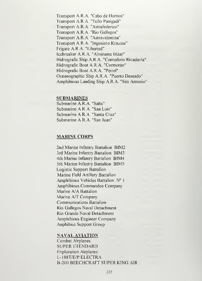
Transport A.R.A "Cabo de Homos"Transport A.R.A. "Tulio Panigadi"
Transport A.R.A. "Astrafederico"
Transport A.R.A. "Rio Gallegos"
Transport A.R.A. "Astravalentina"
Transport A.R.A. "Ingeniero Krausse"
Frigate A.R.A. "Libertad"
Icebreaker A.R.A. "Almirante Irizar"
Hidrografic Ship A.R.A. "Comodoro Rivadavia"
Hidrografic Boat A.R.A. "Cormoran"
Hidrografic Boat A.R.A. "Petrel"
Oceanographic Ship A.R.A. "Puerto Deseado"
Amphibious Landing Ship A.R.A. "San Antonio"
SUBMARINESSubmarine A.R.A. "Salta"
Submarine A.R.A. "San Luis"
Submarine A.R.A. "Santa Cruz"
Submarine A.R.A. "San Juan"
MARINE CORPS
2nd Marine Infantry Battalion BIM23rd Marine Infantry Battalion BIM34th Marine Infantry Battalion BIM45th Marine Infantry Battalion BIM5Logistic Support Battalion
Marine Field Artillery Battalion
Amphibious Vehicles Battalion N° 1
Amphibious Commandos Company
Marine A/A Battalion
Marine A/T CompanyCommunications Battalion
Rio Gallegos Naval Detachment
Rio Grande Naval Detachment
Amphibious Engineer Company
Anphibius Support Group
NAVAL AVIATIONCombat Airplanes
SUPER ETENDARDExploration Airplanes:
L-188T/E/PELECTRAB-200 BEECHCRAFT SUPER KING AIR
222
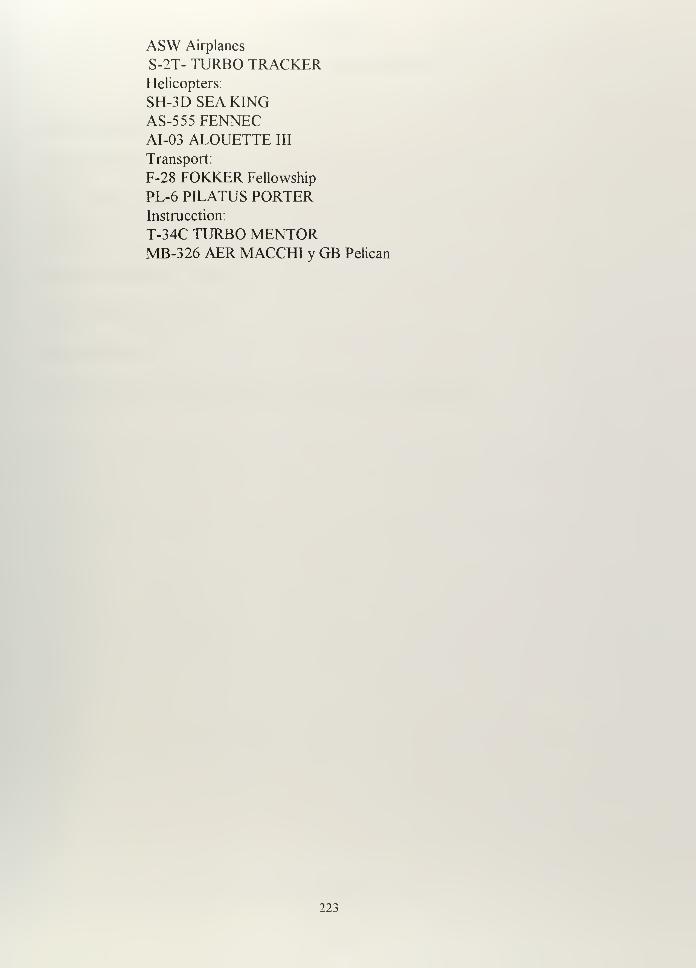
ASW Airplanes
S-2T- TURBO TRACKERHelicopters:
SH-3D SEA KINGAS-555 FENNECAI-03 ALOUETTE III
Transport:
F-28 FOKKER Fellowship
PL-6 PILATUS PORTERInstruction:
T-34C TURBO MENTORMB-326 AER MACCHI y GB Pelican
223

224
APPENDIX B
THE NATIONAL SPACE PLAN '
Table of Contents
1. Introduction
2. Conceptual Framework
3. Policies
4. Scheduled Space Activities
5. Performance ofCONAE
6. Main Objectives
7. Methodology for periodical reviews of the National Space plan
1
Refereed to the Argentine Space Plan called The National Space plan
225
1. INTRODUCTION
Argentina may be labeled as a "space country", considering that it features as one of the countries that
makes and will make intensive use of the products from space science and technology. This occurs
because:
• It covers an extensive geographical territory, ranging from the tropic to the pole.
• Economic activities in Argentina are strongly influenced by extensive primary exports (agricultural,
fishing, forestry and mining products, plus hydrocarbons).
• Its society has a development level that requires everyday use and exchange of detailed and
quantitative data on its own structure and economy.
• The distinctive distribution of its population demands an intensive use of telecommunications.
• Its large productive areas are vulnerable to natural and anthropogenic catastrophes.
• The regional and international links and commitments undertaken by the nation will oblige it to
generate and use goods and services deriving from space science and technology.
From the above points, it arises that, in view of its own conditions, Argentina is making and will makeuse of products derived from space science and technology and, consequently, a definition is to be madeon how to have access to them in the future. Considering its level of technical and economic
development, its projection towards becoming a producer and an active user of such technology appears
as logical. An "active consumer" of goods with a high technological content is understood as that having
the necessary technical capacity, when purchasing, to exert influence upon the conceptual definitions and
the advantages of what is being purchased. Any other strategy would not only mean misusing the
important national patrimony in inventive and well trained human resources, but would also place the
country in the unfavorable condition of exchanging primary products by other with a high added value,
thus creating a weak situation in terms of commercial exchange.
226
2. CONCEPTUAL FRAMEWORK
The produce of space activities
Primarily, the social benefits deriving from space activities result from two products:
• The data generated by space applications and the means for its transmission.
• The means for exploration and for the peaceful use of ultraterrestrial space.
The various phases in space activities sense, collect, transmit, store and process data of highly different
nature. This is why, presently, space activities are also generators of hardware and software means for the
performance of such tasks.
The important participation of space technology in telecommunications is an example of this fact.
Additionally, the contribution of data detected by remote sensors is to be taken into account. Both its
volume and quality, as well as the areas that will require its use, tend to grow and diversify in the near
future.
Once data is delivered to society, it gains added value as it is systematized and prepared for its use in
everyday decision-making by the government or by the production sectors. Society houses a large
number of enterprises -uwhich may well be called "information companies"-u that perform these tasks,
both processing data and enhancing them in different ways.
The set of steps encompassing space data generation, transmission, processing and use is called "Space
Information Cycle" (SIC). Along this cycle, space activities operate either as use promoters or as
suppliers or consumers of both the data itself and the means for its production, transmission, elaboration
and storage.
Humanity is presently facing problems in making its own subsistence compatible with the planet by
attaining equilibrium among its seas, its atmosphere and its reserves of natural resources. Growing
industrial, agricultural and mining activities worldwide have raised serious concern with regard to a
tentative alteration of geophysical balance in the atmosphere and the oceans that might result in a global
heating of the planet. In addition to these processes, highly significant threats are arising concerning
contamination and the loss of biodiversity. The SIC has already proved to be an unreplaceable element
for designing strategies for the supervision and control of these processes with such enormous social and
economic impact. In this field, an analysis must be made of the alternatives offered by space and by space
technology towards reaching structural solutions to the anthropogenic threats affecting the Earth's
environment.
The second important product of space technology is a means for exploring and exploiting ultraterrestrial
space. This means will definitely play a leading role in the long term. To a good extent, spacecraft is
presently a contribution to the SIC, since it is used in locating, in space, the means needed for data
sensoring and transmission. In the long term, this means for exploration and exploitation of ultraterrestrial
space will become an independent resource of peaceful use, constituting an additional environment where
humanity will be able to develop diverse activities. The extreme vacuum, the absence of gravity and the
existence of radiations, which are shielded by atmosphere on the Earth's surface, make space appear as an
adequate and uniquely-featured environment for facing certain undertakings, such as the production of
materials or chemical compounds, or even power generation.
227
Scientific programs
Space activities demand significant intellectual investment. Profiting from the data collected by means of
space technology resources, the development of space communication systems or the access to and use of
the ultraterrestrial space for other purposes require process formulation and development and the
management of data obtained through scientific methods or within the framework of scientific research
projects.
Technological progress in the space field occurs everyday and is constantly providing new alternatives for
the use and exploitation of ultraterrestrial space. This technological development is bi-directionally
related to several scientific fields. It does not only allow for further basic research; on the other hand, it
does also allow for scientific projects that are readily applicable'to economically meaningful technological
applications and developments that produce a relevant impact upon production sectors.
Within this context, space activities must be kept closely linked to research and development teams,
involving the promotion ofthese activities as a part of their ordinaryprograms, in the understanding
that the resources appliedfor their execution constitute an investment whose return is part of the
producefrom space activities.
Areas for application of space activities
Argentina is already using some of the links in the SIC. Satellite telecommunications are already a fact,
while several sectors are regularly using remote sensed data. Satellite telecommunications are used
commercially in the provision of telephone services through switchboard networks and of television
services. Highly sophisticated computer networks and other requirements in the field of data transmission
lead to foresee an extension of the present horizon in telecommunication services, for which space
technology has much to offer. The main user of remote sensed data is the public sector. These
applications are aimed to expand through the execution of environmental control and surveillance
programs. The following are the sectors of economical activity on which the SIC has a most significant
effect:
1) Telecommunications.
2) Use of global positioning systems.
3) Prevention, evaluation and follow-up of natural and anthropogenic disasters.
4) Monitoring and usage of natural resources
5) Remote detection and control of industrial parameters
6) Cartography and cadastre.
7) Supervision and quantification of agricultural and forestry production.
8) Fishing, exploitation and surveillance of coastal and oceanic resources.
9) Studies on environmental quality, degradation and contamination.
228
10) Local and global meteorological studies.
11) Utilization of soil and underground resources.
12) Design of new methods for development management and administration at a regional scale.
13) Global change.
Sustenance and economic benefits of space activities
The assessment of the benefits deriving from an innovative activity does not constitute a problem solved
beyond any controversies, especially for economies such as our country's. However, studies have been
performed aimed at considering them as medium- and long-term investments, thus estimating an internal
return rate associated to research and development activities, innovation and related services. On the
basis of these estimations, it may be stated that a space program in Argentina is not only potentially
sustainable by the local economy; it may also result in significant benefits, as far as it is undertaken within
certain patterns.
There are three ways in which space activities may be considered in order tojustify a public investment
program in thisfield. They may be analyzed: a) as managers andpromoters ofdevelopment issues that
are transferable to commercial activities; b) as research, development and innovation tasks; and, c) as
directproducers ofcommercially valuable goods and services.
Space activities have proved to be a setting for the development and full growth of new technological
concepts that, in a further stage, when adopted by the production sectors in society, have born the rigor
of a free and competitive market. The telecommunication systems based on artificial satellites are the best
example of this, after going through a stage of experimental development, they were assimilated by the
companies providing such services and these companies were the ones taking care of the diffusion and
application of this new technological concept. The present trend in this field is that, in the short and
medium term, the promotion of advanced matters in this technology must remain within governmental
agencies, while development work related to the optimization and service expansion is left in the hands of
the private sector. Service is presently aimed at giving priority to satellite voice and data
telecommunications, a field in which CONAE's responsibility is limited to the offer of services as a "space
architect" (selection of design and engineering options). Contrarily, CONAE shall have to develop
technologies associated to other non-massive data transmission services involving economic significance
and social relevance (education, safety, isolated human settlements, maintenance of extensive networks
such as gas pipelines, high-voltage lines, etc.).
There is an area in which space activities have proved to be a fertile means for the development ofnewtechnologies with a considerable commercial impact: that of the global positioning systems, which will
play a leading role in the assistance to and control of air, sea and land transportation. This technology is
aimed at acquiring commercial importance in the very near future. .
The benefits deriving from space activities in research, development and innovation are indirect. Whenconsidered as such, space activities may be deemed on an equal footing with basic scientific work. Anassessment of the secondary economic effects of activities of this kind was performed by the European
Center for Nuclear Research (CERN). This Center is the international laboratory of excellence in physics
and in theoretical and experimental research, considered as the most important in Europe.
229
The following factors were taken into account for the quantification of effects:
• Suppliers qualification and development.
• Innovation among supplier industries.
• New product development.
• Quality improvements.
• Creation of demand for new products.
The studies performed proved that there is a factor of significant benefit, which is directly attributable to
the effort performed in trying to comply with the contracts made with the CERN.
A similar study was carried out by the NASA concerning the Apollo project. In this case, technical
matters are supplemented by the diffusion of new management concepts that were applied in this project.
The assessments did also show a benefit factor that resulted to be even higher than that obtained by the
CERN.
These data cannot be transferred without any modification to the Argentine situation, considering that
their global usefulness depends on the degree of applicability of the development projects in the local
industrial and economic media. Considering the early stage of development of our Space Program, this
information must be taken as an indication of the potential benefits obtainable from activities in this field,
as far as it is properly linked with the supplier industries.
Space activities are also producers of goods and services with a commercial value. If telecommunications,
already analyzed as from another viewpoint, are excluded, mention must be made of remote sensing
activities. Nowadays, the major segment of demand in our country is the public sector. Although this fact
is not expected to change drastically in the near future, it may be foreseen that, in the medium term, some
areas of the data obtained by remote sensors will go into a commercial stage and will be handled
somehow as satellite communication systems are managed today. Meanwhile, this market should
consolidate in our society through the creation of an independent entrepreneurial sector highly specialized
in the use of these means. Thus, it would produce a simultaneous benefit to society through the diffusion
involved in the use of such data. These facts being taken into account, consideration must be given to a
first promotion stage, which will require support to this activity from the public sector and, at the same
time, a stimulation of private participation in any possible way.
The areas whose profiles show a most direct economic impact in the short and medium term are:
• The follow-up and quantification of agricultural and forestry production.
• The follow-up and surveillance of fishing activities.
• The supervision of floods and natural disasters.
• The evaluation and survey of soil and underground exploitation works.
230
• The monitoring and supervision of environmental problems.
Additionally, there are other secondary markets connected with remote sensing that, due to the early
phase of their use in the country, are hard to estimate:
• The market of geographical data systems and their related data bases (Applied Data Systems,
ADS).
• Global climatic reporting and forecasting.
• The market of special sensors.
In addition to constituting a valuable base of general information, the use of teledetected data in
agricultural exploitations may give way to more accurate forecasts of future harvests, to a better control
of promotion loans and of tax collection, and to a better use of subsidies on natural disasters. As an
example, it may be mentioned that, when correlated with climatic factors, a detailed historical data base
on agricultural production should serve as a basis for a market of agricultural insurances, an activity that
is now practically non-existent.
In the fishing area, the use of satellite data may result in more effective campaigns and in fuel savings due
to the satellite positioning of areas of high fishing density. Appropriate satellite data is also indispensable
for the surveillance and control of fishing licenses concerning operations in the Argentine Sea and for the
supervision of over-exploitation of fishing resources. Remote sensing in the mining field would contribute
with significant savings in exploration campaigns.
231
3. POLICIES, JURIDICAL MATTERS AND INTERNATIONAL RELATIONS
The National Space Program is to be understood as a major national project. The actions aimed at
attaining its goals imply direct or indirect participation by an endless number ofhuman teams from the
production areas, the government, the academic sector and the national Science and Technology system.
The explicit incorporation of the various sectors mentioned above, involved in specific commitments, is
expected to occur as actions start being implemented. In other words: the objective is that the National
Space Program be one of the national projects allowing for the concentration of means and resources and
for the confluence of diverse human resources towards its accomplishment.
Bases
The development of space technologies to be envisaged within the framework of the National Space
Program shall produce the maximum and most immediate social and economic return. This can be
attained by focusing efforts towards its use in:
• Contributing to education and to improving the population 's quality of life, particularly in distant
and marginal areas.
• Creating netv capabilities and sources ofemployment at industries producing goods with a high
added value.
• Obtaining advantagesfor the localproduction system, thus allowing for the insertion of our
industry into a highly competitive international market.
• Promoting new businesses that allow for an expansion of the national production scope.
The most suitable way to attain such goals is the application of a strategy involving the concentration of
efforts and specialization, through the identification of well- defined objectives and of attractive
technological and commercial spots, where an international level of excellence and of originality can
be reached and maintained.
The Space Program must be considered as apart and continuation ofthe effortsfor technological
development already performed in our country. As from its very start point, it must profit of an
important threshold of scientific and technological knowledge and undertakings already gained through
the activities performed by the former CNTE (National Commission of Space Research) and by other
local scientific and technological institutions, such as INTA (National Institute of Agricultural
Technology), INTI (National Institute of Industrial Technology), CONICET (National Council of
Scientific and Technical Research), CNEA (National Atomic Energy Commission), universities and other
agencies. The Space Program must be supported by a flexible research and development infrastructure
optimizing CONAE's infrastructure and by the use of resources assigned to space activities. For such
purpose, it must be interactive with whichever public and private institutions and work teams are deemed
necessary, by means of a flexible organization that may be adapted correspondingly with the progress
attained
Guidelines
• Offering society a complete cycle of space data, promoting their best utilization.
232
• Developing space technologies for environmental protection.
• Promoting the use of space technology for social, production, scientific and educational purposes.
• Developing light satellites for remote sensing, scientific use and communications, supplementing
the available international offer and responding to specific national demands.
• Promoting actions supplementing those in the private sector concerning initiatives with a high
technological and innovation content, or the use, diffusion and utilization of space data.
• Encouraging the training and qualification of human resources and of organizations contributing to
and participating in the Space Program.
• Assisting in promoting national participation and initiatives aimed at enhancing the tasks of
international forums where juridical regulations related to space activities are discussed and
prepared.
• Promoting international cooperation actions, looking forward Argentine participation in
multinational cooperation programs converging with the local long-term policies.
• Favoring joint international actions and programs with shared goals that contribute to regional
integration within the framework ofMERCOSUR.
• Complying with the legal mandate of being present and of contributing with the technical and
scientific elements needed for shaping coordinate and joint actions with other State agencies.
Juridical matters and international relations
International cooperation is a key issue as far as space technology is concerned. Argentina has already
had a lengthy and active cooperation with Brazil, France, Germany, Italy and the United States, and is
presently planning joint projects with Denmark, Spain and other countries. CONAE shall encourage these
cooperation lines, as far as they converge with the development work scheduled in the National Space
Program and involve concrete projects aimed at well- defined goals. Any initiatives or proposals for
international cooperation implying diversification of efforts shall be considered by CONAE as of
secondary importance.
CONAE will place special emphasis in strengthening regional cooperation in space matters. It will look
forward to expanding the goals and to optimizing the tasks scheduled in the present Program,
encouraging active cooperation within the framework ofMERCOSUR. It will promote the use of
supplementary infrastructural resources and development means in the region, schedule the performance
of mutual assistance actions, contemplate supplementary development work and explore the possibilities
for the performance ofjoint space missions.
With its own actions and as far as it converges with its objectives, CONAE will support the initiative for
research on the Global Change, which is presently acquiring institutional and international-cooperation
dimensions, with the IGBP (International Geosphere Biosphere Program) and other institutions. This
research work would demand a highly significant effort in the space field and is of interest for a rational
management of renewable natural resources and of the region's biodiversity, as well as for forecasting
233

social and economic changes that may affect the country and the hemisphere.
234
4. SCHEDULED SPACE ACTIVITIES
The main areas of space activity foreseen in Argentina involve both scientific/technological research workand applications.
These scientific and technological projects will allow for attaining progress in the preparation and
management of space missions, as well as in the design of satellites and of on- board instrumentation.
Likewise, this activity will allow for consolidating international cooperation links in the space field.
Application activities will be primarily devoted to a remote sensing program and to telecommunication
matters supplementing the local and international offer in data, voice and television communications.
Activities in remote sensing include both the reception and distribution of images from international
systems and our own image generation within the optical range (visible and infrared) and microwaves,
appropriate for the local requirements and of a great social relevance.
As a part of the land infrastructure, provisions are being made for the installation of a Multi- purpose
Ground Station aimed at satisfying both remote sensing and radioastronomy demands.
Concerning the production of our own images and data, provisions have been made for the development
of satellite systems to be compatible with the scientific and technological research work, through the line
of light satellites SAC (Satellite for Scientific Applications).
Similarly, an attempt will be made to develop conceptual parameters leading to the design of sensors fit
for solving unsolved problems or for obtaining new types of economically valuable data.
The development of satellite systems involves both the design of chambers and sensors and that of
computation instruments required for receiving, storing and processing the data produced, thus
integrating the main links of the SIC. The use of the infrared spectrum is relevant for the measurement of
(soil and water) surface temperatures and for diverse agrometeorological and oceanographical
applications, as well as for environmental monitoring (forest fires and volcanic activity). With regard to
the visible optical range, the medium term trends in the international arena involve an increase in the
number of spectral observation channels, so as to make it more specific and versatile to various
applications, which has been contemplated in the third SAC satellite. Finally, as a long-term development
objective, studies are to be performed on laser applications in space.
In the short term, the remote sensing program will be supplemented with observations in the microwave
range by means of a radar. This is an important method, since it allows for capturing images regardless
the solar light on the site and the meteorological conditions, since it goes through the clouds. This is
particularly relevant for the monitoring of the Argentine Sea, the Province of Tierra del Fuego and the
Antarctic Sector, which are systematically covered by thick cloud layers. Radar observation can also be
used for soil studies (particularly for soil humidity measurements), a subject in which FNTA has a long
and valuable experience. Microwave range observations are obviously applicable in matters related to the
national agricultural production and to the monitoring of fishing in the South Atlantic.
The microwave observation program is a start point for the analysis and development of alternatives to
the low-consumption radar, a major condition if the best use is to be made of the experience gained with
the SAC line of light satellites. This observation program shall be carried out with the SAOCOM satellite
family series (Satellites for Observation and Communications). In the latter, the radar's useful load shall
235
be shared with that in communications, as described below.
The applications foreseen in the field of communications are aimed at solving deficiencies in extensive
areas of the country as far as communication elements are concerned. An adequate use of space
communication technologies may allow for solving many of the problems being suffered in rural
environments and schools, in remote police stations and in distant hospitals and health- care centers. They
are also applicable for the maintenance of extensive power distribution networks and gas and oil
pipelines. This service must be aimed specifically at data transmission, electronic mail, connections with
isolated settlements, links with low-cost land platforms for the collection, control and recording of the
most diverse types of data, such as agrometeorological, environmental, hydrological and industrial
application data. These matters are marginal for the telecommunications market in private hands, but they
are considerably significant as from strategic, economic and social standpoints. Simultaneously,
economically-sustainable innovative technological development projects may be carried out in this area.
The latter shall be installed on SAOCOM type satellites.
The orbiting of satellites foreseen in previous programs shall be performed using the services of access to
ultraterrestrial space available on the basis of international cooperation agreements or by means of
contracts undersigned with suppliers of these services. Provisions have been made for reaching other uses
of ultraterrestrial space. A long-term project involves the development of per se means, or preferably in
cooperation, for access to space with new generation spacecraft. In this field, work will only be started
with the exploration of conceptual alternatives, with provisions for some partial performances within the
first decade in the next century.
236
5. PERFORMANCE OF CONAE
Organization
The performance ofCONAE shall be organized in the form ofprojects and activities within a matrix
structure in which activities are formed as columns in the matrix, while projects represent the horizontal
lines in the same. Both activities and projects will be redefined periodically, in a dynamic manner, thus
regarding some as finished and starting other.
Each project is understood as encompassing a set of actions involving a start point and as finished when a
definite goal is attained at a given time. Every project will have its own schedule, budget and financing.
Considering that each one of them may give way to or require one or more activities, their budgets must
contemplate the contribution required for the coverage of their share in the fixed costs involved in
maintaining the institution's regular activities.
Activities represent actions of a technical or administrative type that are performed either temporarily or
regularly, without a definite completion date. Activities do also include regular technical services and the
performance of study, research and development programs that serve as a support to projects.
It is worth, here, introducing the concept of "mission", involving all the tasks undertaken in connection
with a given incursion into ultraterrestrial space. As a general rule, reference will be made to missions
associated to satellites, this concept including feasibility studies and design, as well as their construction,
launching and further operation. It also includes all the tasks performed for their utilization in the
scientific arena or for remote sensing and communication applications. As it may be seen, a mission
involves both projects and activities. Excluding exceptions, this concept shall not imply any budgetary
consequences, since it is introduced for the single purpose of facilitating control over management in the
execution of the Plan.
Courses of action
The projects and activities defined above constitute a scheduled program of actions to be faced by
CONAE. For planning, discussion and analysis purposes, they will be considered as encompassed in five
courses of actions, thus associating each one ofthem to an equal number ofbroad segments in space
activities, as follows:
A) Land infrastructure.
B) Satellite systems.
C) Data systems.
D) Access to space.
E) Institutional development and basic tasks.
A - Land infrastructure
This course of action contains all the tasks performed by CONAE with regard to ground stations for
follow-up, telemetry and control of Earth links with satellites or spacecraft, laboratories for integration,
237
tests and simulations and testing tables for satellite or spacecraft subsystems.
On an immediate basis, this chapter includes the laboratories to be installed in the "Teofilo M. Tabanera"
Space Center at Falda del Carmen, Province of Cordoba, and the telemetry and control systems for the
follow-up of the satellites to be launched. It also comprises the performance of a feasibility study and the
startup of the facilities recommended for obtaining CONAE's own data or that offered internationally
(LANDSAT, SPOT, etc.), as well as for radioastronomical observations.
B - Satellite systems
This course of action includes all satellite missions, including the construction of satellites and platforms
or space stations, as well as their subsystems for control, power generation, sensoring, communications,
etc.
Considering the experience gained in projecting and building satellites, Argentina may face a successful
program of light satellites, ofup to a half ton, for scientific, teledetection, communication and other
purposes. In our country, there are presently specific requirements in the areas of remote sensing and
telecommunications that will not be satisfied by the systems offered internationally and that may be
conveniently covered by our own light satellites.
On an immediate basis, missions will be performed with mixed-purpose satellites: for remote sensing and
scientific research. Further on, this framework will be expanded to include satellites for microwave
observation and communications (SAOCOM).
C - Data systems
This item comprises all the actions aimed at collecting, receiving, transmitting and storing data originated
by space systems, including the development and operation of hardware and software systems, of
computer networks and of data centers.
Both public agencies and private enterprises in our country have gained considerable experience in
communication and computer network technology, as well as in the best use of images and of satellite
data. Consequently, our country may well face development work concerning communications software
and hardware, systems for data base management, systems on geographically-referenced applied data,
systems for computer-aided design and manufacturing and event software for highly diverse types of
engineering calculations. These are elements by which space activities may transfer its benefits to society,
since they contain a great multiplying effect, allow for an easy capitalization of efforts and imply
moderate investment costs.
On an immediate basis, this course of action shall emphasize the expansion of the service rendered by the
Regional Center of Satellite Data (CREDAS) and the development of software concerning geographical
data and image processing and simulation.
D - Access to space
Any actions performed towards allowing access to space by the various satellites included in the Space
Program are included herewith. Stages such as feasibility studies, development, use and exploitation of
spacecraft are contemplated, which allow for the exploration and best use of ultraterrestrial space.
238
This development work shall be carried out within the framework of full transparency and contemplating
the possibilities offered by international cooperation programs, in accordance with Argentine policies on
non-proliferation and with the international commitments assumed by our country in this matter.
On an immediate basis, the possibility of using the local experience in conceptual engineering for the
development of a new generation spacecraft shall be evaluated. Such spacecraft should be useful for
supplementing previous undertakings concerning light satellites and should demonstrate to be
economically feasible, so as to progress towards a prototype within the first decade in the next century. Aconstant follow-up of the international market in this sector shall allow to assess the best opportunities
for the concentration of material and human resources in these matters of the Space Program.
Any future undertakings regarding access to space shall be in agreement with the guidelines under which
CONAE was created; that is, rejecting any military offensive use of space activities.
E - Institutional development and basic tasks
This course of action involves all the actions faced with regard to relations with other national and
foreign institutions for the promotion, diffusion and utilization of space techniques and means or for
project development in collaboration or with international cooperation. CONAE's tasks related to the
training of human resources, through its Institute for Advanced Space Studies "Mario Gulich" and other
educational activities are also included under this item and, especially, its contributions to distant
education programs.
Also comprised in this course of action are the research and development activities to be performed with
teams and laboratories of the Science and Technology System.
Development of human resources
The performance of training activities for human resources, aiming at satisfying the demand emerging
from the actions scheduled in the Space Program, is considered as essential. In order to undertake these
tasks, CONAE shall promote the development of its Institute for Advanced Space Studies "Mario
Gulich", so as to transform it into an interdisciplinary center for the teaching of space sciences and of
other related areas of knowledge.'^ v
The Institute will operate within the "Teofilo M. Tabanera" Space Center, at Falda del Carmen, Province
of Cordoba, providing courses specially tailored for satisfying CONAE's needs, as well as those of
companies involved in space activities. These courses will also be made available to students who are not
directly associated with CONAE or with enterprises in this field. The Institute shall be given the juridical
form considered as most appropriate in order to attain maximum self-financing.
CONAE's modi operandi
CONAE will approach its tasks through active links with entrepreneurial, public and private sectors and
with research, technological development and teaching organizations. By means of these relations, it will
use its best means for procuring the necessary complementation without increasing its permanent staff
and its fixed expenditures. CONAE's role will be that of an agency taking care of planning, qualification,
technical referencing, contracting, promoting and controlling.
Although maintaining certain features as an executor, CONAE will encourage performance by third
239
parties and will give preference to its role as a promoter of technological development, instead of
participating in the granting of services or in everyday management or regular operation of facilities and
equipment. Also, particular emphasis will be placed on the promotion of activities resulting in the
technical qualification of human resources, suppliers and enterprises.
During all the time, CONAE shall preserve the necessary technical capacity required for establishing the
basic definitions and the conceptual engineering of its programs underway. Basic and detailed engineering
may be performed jointly by its personnel and ad hoc contractors. CONAE shall not develop any
fabrication structure but, contrarily, it will retain a capacity for contract supervision and follow-up, as
well as for controlling the acceptation and verification of quality and fabrication standards. Except for
those cases in which particular standards are established, it will promote the creation of consortiums
among users and operators, whose commitment shall be the utilization and operation of the space systems
developed.
The above statements apply particularly to the field of telecommunications, which is nowadays the most
significant segment among space activities. Within this field, CONAE shall try to offer its services as a
"space architect", cooperating in the formulation of conceptual definitions and providing assistance in the
selection of technological options, in the qualification and selection of suppliers and in contracting the
space segments of the various projects. The role as a space architect excludes the further operation ofthe
systems or the rendering of any regular services.
CONAE' s projects and activities are aimed at realizing the successive missions of the Space Program,
each one of them in connection with the satellites planned for the SAC and SAOCOM series. Each one of
the missions shall coincide with the achievement of successive landmarks of the Space Program and shall
have its own strict timetable of tasks and research and development work. Besides, they shall not only be
connected to a definite goal that will be useful for national development, but mean a growing commandof certain technological elements considered as particularly significant.
CONAE shall promote research and technological development programs, as far as they:
• Contribute to the creation or consolidation of an infrastructure of data and services by which space
activities result to be profitable because of their social or economic impact.
• Are direct contributors to the technological development involved in the Space Program; and,
• Contribute to the enhancement of the advanced teaching staff dedicated to the generation of human
resources for space activities.
Depending on the circumstances, CONAE shall promote research and development projects and activities
by establishing a system for announcing opportunities for the performance of research and development
contracts with institutions, researchers and technologists of the national scientific system, with tentative
participation of companies from the production sector
CONAE shall plan these research and development activities by framing them under the following
subjects, which will be conveniently segregated as programs and subprograms:
• Subject # 1: Propagation and interactions of electromagnetic radiation.
• Subject # 2: Physics and chemistry of the atmosphere and the oceans
240
• Subject # 3: Materials science and solid-state physics.
• Subject # 4: Applied mathematics and computation.
• Subject # 5: Solar-terrestrial physics and astrophysics.
• Subject # 6: Solid ground geophysics.
• Subject # 7: Space and microelectronics engineering and instrumentation.
• Subject # 8: Juridical, social, ecological and environmental studies.
• Subject # 9: The economics of space technology and business development.
241
6. MAIN OBJECTIVES
This section includes a listing of the general objectives for the tasks underway and for those to be
performed in the short, medium and long term. Each one of the objectives is segregated into the main
tasks, for which the most important and concurrent missions and actions are listed. They have been
classified under the five courses of action defined above, while no mention is made of intermediate stages
that will have to be fulfilled in every case.
The goals and tasks mentioned in the following sections must be considered as a basic sequence of
actions aimed at complying with the main objectives of the Space Program. Should the conditions make it
advisable, such goals and tasks may also be considered as the basis on which the objectives of the Space
Program could be expanded to include other collateral undertakings that may both respect and
supplement the achievements implicit therein.
Tasks underway (1995-1996)
General objective of the tasks underway (period 1995-1996):
Development and procurement of the means for the collection of space information
A) Land infrastructure:
1
)
Multipurpose ground station for the collection of satellite data and radioastronomical information.
2) Ground stations for satellite follow-up, telemetry and control and for signal reception.
3) Installation of a laboratory for integration and tests at the "Teofilo M. Tabanera" Space Center.
4) Restoration of facilities at Falda del Carmen (Prov. of Cordoba).
5) Development of compact ground stations.
B) Satellite systems:
1) Performance of the SAC-B Mission.
2) Preparation of the SAC-C Mission.
3) Conceptual development of a low-power radar satellite (SAOCOM 1).
4) Conceptual development of a satellite communications system (SAOCOM 2).
5) Conceptual feasibility of systems for modular satellite engineering (SAOCOM 1).
6) Development of orbit control systems (all missions)
C) Data systems and usage:
1) Development for the definition and usage of geographically referenced data bases (AIS).
242
2) Development of software for the simulation, capturing and processing of the available satellite data
with SAC-B and SAC-C at the Regional Center of Satellite Data (CREDAS) .
3) Expansion of the services rendered by CREDAS .
D) Access to space:
1) Analysis of conceptual alternatives on new generation spacecraft.
E) Institutional development and basic tasks:
1) Organization of the Institute for Advanced Space Studies "Mario Gulich".
2) Organization of a system for announcing opportunities, research contracting and performance control.
3) Research and development programs on:
• Earth validation of satellite sensors (Subjects 5 and 7).
• Valuation of the available data (Subject 4).
• Topics on materials science (Subject 3).
• Computation, systems and applied mathematics (Subject 4).
• Economics in space technology (Subject 9).
• New uses of space. Regulations in force, risks and consequences (Subject 8).
4) Coordination of actions and promotion of satellite data user groups.
5) Priority activities related to regional and international cooperation.
6) Library and documentation.
Short term (1997-2000)
Objectives in the short term (period 1997-2000):
Improvement of quality in available space data
A) Land infrastructure:
1) Building of compact ground stations.
2) Expansion of ground stations for follow-up, telemetry and control to assist in new space missions.
3) Operation of multipurpose ground station.
243
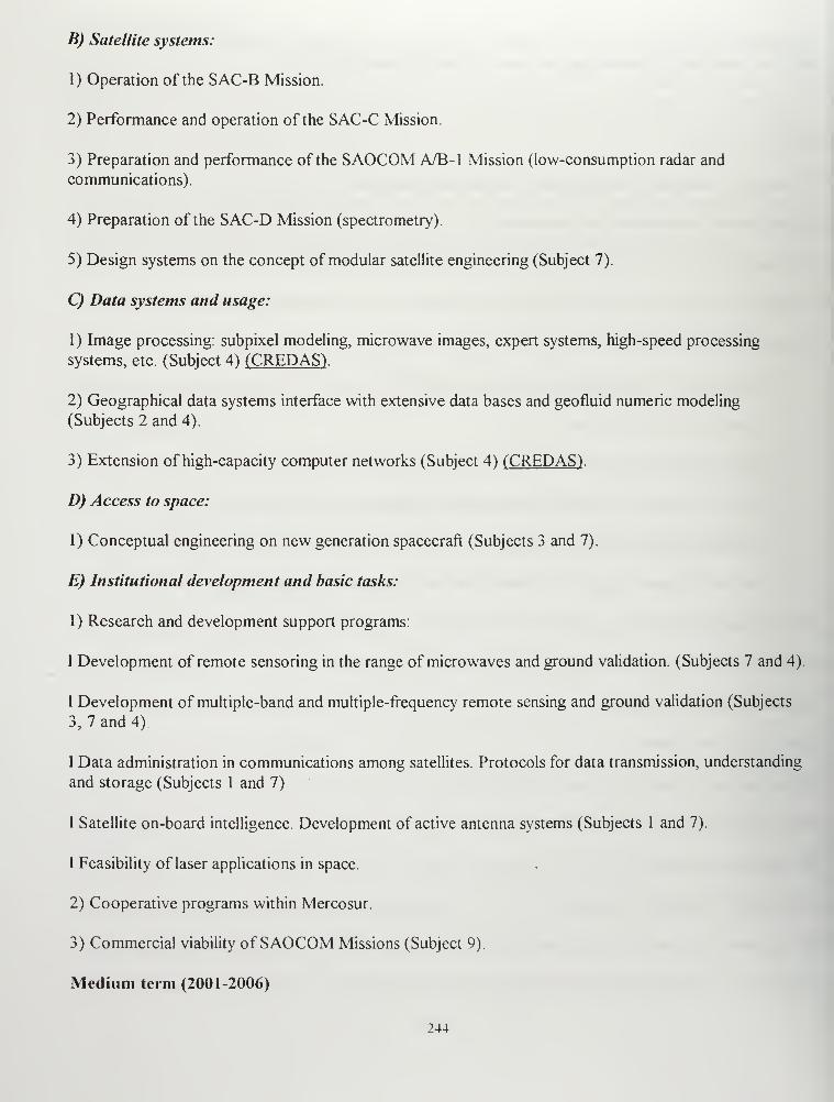
B) Satellite systems:
1) Operation of the SAC-B Mission.
2) Performance and operation of the SAC-C Mission.
3) Preparation and performance of the SAOCOM A/B-l Mission (low-consumption radar and
communications).
4) Preparation of the SAC-D Mission (spectrometry).
5) Design systems on the concept of modular satellite engineering (Subject 7).
C) Data systems and usage:
1) Image processing: subpixel modeling, microwave images, expert systems, high-speed processing
systems, etc. (Subject 4) (CREDASV
2) Geographical data systems interface with extensive data bases and geofluid numeric modeling
(Subjects 2 and 4).
3) Extension of high-capacity computer networks (Subject 4) (CREDAS) .
D) Access to space:
1) Conceptual engineering on new generation spacecraft (Subjects 3 and 7).
E) Institutional development and basic tasks:
1) Research and development support programs:
I Development of remote sensoring in the range of microwaves and ground validation. (Subjects 7 and 4).
I Development of multiple-band and multiple-frequency remote sensing and ground validation (Subjects
3, 7 and 4).
1 Data administration in communications among satellites. Protocols for data transmission, understanding
and storage (Subjects 1 and 7).
I Satellite on-board intelligence. Development of active antenna systems (Subjects 1 and 7).
1 Feasibility of laser applications in space.
2) Cooperative programs within Mercosur.
3) Commercial viability of SAOCOM Missions (Subject 9).
Medium term (2001-2006)
244
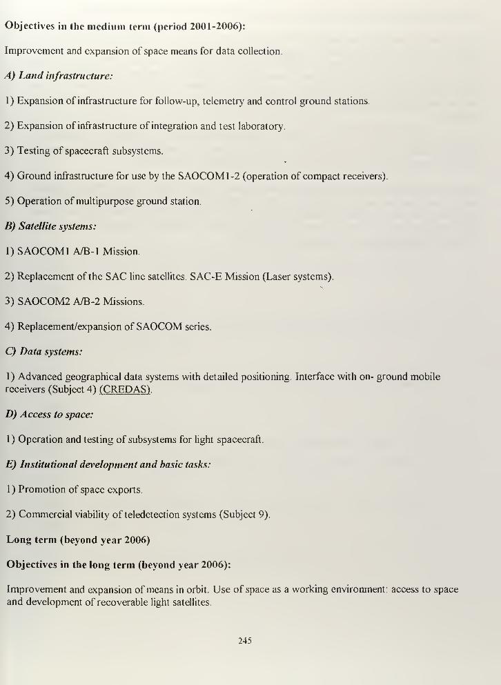
Objectives in the medium term (period 2001-2006):
Improvement and expansion of space means for data collection.
A) Land infrastructure:
1) Expansion of infrastructure for follow-up, telemetry and control ground stations.
2) Expansion of infrastructure of integration and test laboratory.
3) Testing of spacecraft subsystems.
4) Ground infrastructure for use by the SAOCOM1-2 (operation of compact receivers).
5) Operation of multipurpose ground station.
B) Satellite systems:
1) SAOCOM1 A/B-l Mission.
2) Replacement of the SAC line satellites. SAC-E Mission (Laser systems).
3) SAOCOM2 A/B-2 Missions.
4) Replacement/expansion ofSAOCOM series.
C) Data systems:
1) Advanced geographical data systems with detailed positioning. Interface with on- ground mobile
receivers (Subject 4) (CREDASV
D) Access to space:
1) Operation and testing of subsystems for light spacecraft.
E) Institutional development and basic tasks:
1) Promotion of space exports.
2) Commercial viability of teledetection systems (Subject 9).
Long term (beyond year 2006)
Objectives in the long term (beyond year 2006):
Improvement and expansion of means in orbit. Use of space as a working environment: access to space
and development of recoverable light satellites.
245
7. METHODOLOGY FOR PERIODICAL REVIEWS OF THE SPACE PROGRAM
The Argentine Space Program shall be reviewed every two years and its scope shall be extended for twoadditional years, so that a horizon of at least one decade shall always be available. In every occasion, it
shall be tailored to the actual economic possibilities in the country and to the progress made during the
last two years. For such updating, future missions shall be evaluated and defined, while adding or
removing appropriate missions. Especially, worldwide advancement in space technology shall be takeninto account, as well as the state of the art and the progress attained in the cooperative programsperformed.
CONAE shall also apply an auditing system for its technical activities. For such purpose, a technical
committee shall be appointed in every case, including at least three extensively well-known external
specialists in the field of space activities, either from Argentina or from abroad.
Although, periodically, a detailed managerial control must be made of the Program, overall evaluations
shall be performed all the time through the level of progress attained in the performance of the missionsscheduled in the same. This is so, because each one ofthem corresponds with a major landmark in the
progressive acquisition of the SIC technologies and they must be scheduled throughout time, so that theefforts performed in previous missions can be capitalized.
246
LIST OF REFERENCES
Aguerrevere, Santiago E., Sistemas de Satelites de Orbita Baja Terrestre que operan en
Frecuenciaspor Debajo de I Ghz. Paper in Spanish obtained from ORBCOMM USA
during personal visit, Dulles, VA, December 1996.
Anannaso Fulvio and Francesco Delli Priscoli. Issues on the evolution towards satellite
personal networks. Nuova Telespazio-Via Tiburtina965, Roma, Italy, 1995.
Avery, Thomas E. and Graydon Lennis Berlin. Fundamentals ofRemote Sensing and
Airphoto Interpretation. Fifth Edition. Macmillan Publishing Company, New York, NY,
1992.
Brown Stuart F. Publicaciones, "Corona Revealed-America's First SPY SATELLITE".
Popular Science, December, 1996.
Brugioni, Dino A. "The Art and Science of Photoreconnaissance" in: Scientific American.
March 1996.
Burgess, Gregg E., ORBCOMM. Section contribution: Reducing Space Mission Cost.
James R. Wertz and Wiley JLarson (editors). Microcosm Press, Torrance, CA 1996.
Chow, Ken. MILSATCOM Seminar. Naval Postgraduate School, Monterey, California.
January 16, 1997.
Clarin, Newspaper. Buenos Aires, Argentina Ed. 02-01-97.
247
Comparetto, Gary M.On the use ofIntelsat and Global Inmarsat to support DOD
communications requirements. The MITRE Corporation, 1259 Lake Plaza Drive,
Colorado Springs, IEEE files, 1993.
Constitucion de la Nacion Argentina, Parte Segunda, Titulo Primero, Seccion Segunda:
Del Poder Ejecutivo, Capitulo Tercero: Atribuciones del Poder Ejecutivo, Articulo 99.
Inciso 14. Aug 1994.
Daimler -Benz Aerospace, Space Systems Press released, 1996.
Deans, Karl D. and Joseph R. Wessling, The commercial Remote Sensing Handbook. AA
4830 Class Paper, Naval Postgraduate School, Monterey, CA, 1997.
Department of the Army. US Army Space Reference Text. Space Division, US Army
Training and Doctrine Command, Fort Monroe, Virginia 23651-5000, 1993
Discover INTELSAT/Satellites : The INTELSAT broadcasting 5-6-7-8 Satellites,
WWW, 1997.
Dominguez, Nestor A, Satelites II. Instituto de Publicaciones Navales, Buenos Aires,
Argentina, 1991.
Eisele, Anne, "Argentine -NASA Spacecraft Prepared for Launch"/// Space News.
October 28, 1996
Etkin.V, K. Litovchenko, A. Ivanov, P. Shirokov, W. Alpers, A Wilde, C Bruning.
COMPARISON OF KRS-I AND ALMAZ-1 SAR OCEAN WA VE IMAGING, IEEE files
1997.
248
Feldman, Howard R. INMARSATS NEWASYNCHRONOUS DATA SERVICES. Satellite
Systems for Mobile Communications and Navigation, 13- 15th May 1996, Conference
Publication No 424 IEE, 1996.
Francois Martel. Reducing Space Mission Costs, Chapter 11.4,HETE Larson, Wiley J.
and James R. Wertz (editors), Torrance, California: Microcosm,Inc, 1996.
Fred J. Severson. An Overview of the petite Amateur Navy Satellite 1 (PANSAT)
Project. Thesis, Naval Postgraduate School, Monterey, CA, December 1995.
G E. Hardman, Engineering ORBCOMM: A Digital satellite Communications System
Exploiting A Range ofModern Technologies. Orbital Sciences Corporation, Dulles, VA,
1991.
Gene C. Feldman, personal interview about international posibilities if using SeaWifs
data. NASA Goddard Space Flight Center, Greenbelt, Maryland, November 1996.
Hara Todd, ORBCOMMPCS Available Now!. IEEE Archive, Orbital Sciences
Corporation, Dulles, VA, 1995.
Hara Todd, ORBCOMM, Low Earth Mobile Satellite Communication System. Submited
to Telecomunications Conference (TCC-94), IEEE Archive, Orbital Sciences Corporation,
Dulles, VA, 1994.
Hara Todd, ORBCOMM, Low Earth Mobile Satellite Communication System. US Armed
Forces Applications. IEEE Archive, Orbital Sciences Corporation, Dulles, VA, 1993.
249
Haralambos Stelianos, The Use of Commercial Low Earth Orbit Satellite Systems to
Support DoD Communications. Thesis, Naval Postgraduate School, Monterey, CA,
December, 1996.
Hudson E. Heather, Communication Satellites, Their Development and Impact. The Free
Press, A Division Of Macmillan, Inc., New York, NY, 1990
INTERFACE, volume 5 No 1, Jan -Mar 1994, source to IRS- Platforms/Satellites.
WWW, 1997.
James R. Wertz. Reducing Space Mission Costs, Chapter, Introduction Torrance,
California: Microcosm,Inc, 1996.
JERS Japan Earth Resources Satellite, NASDA, Mitsubishi, Japan Satellites & Sensors,
WWW, 1997.
Kim, John C and Eugen I. Muehldorf, Na\>al Shipboard Communications Systems.
Prentice Hall PTR, Englewood Cliffs, New Jersey, 1995
Klaus G. Johannsen. Mobile P-Senice Satellite System Comparison. International
Journal of Satellite Communications, Vol 13, 453-471. 1995.
Larson, Wiley J. and James R. Wertz (editors). Space Mission Analysis and Design.
Torrance, California: Microcosm,Inc, 1992.
Lee, James G., Counterespace Operationsfor Information Dominance. School of
Advanced Airpower Studies, Air University, 1994.
250
Lillesand, Thomas M. and Ralph W. Kiefer. Remote Sensing And Image Interpretation,
Third Edition. John Wiley & Sons,inc, New York, NY, 1994.
Lodge, John H. Mobile Satellite Communications Systems: Toward Personal
Communications. IEEE Communications Magazine, November 1991
Maine Kris, Carrie Devieux and Pete Swan. Overview ofIRIDIUM Satellite Network
Motorola Satellite Communications Division. 2501 S. Price Road, Chandler, AZ, 1995.L ., * —'}
Mark A. Sturza. The Teledesic satellite System. Teledesic Corporation. Paper extracted
from IEEE National Telesystems Conference, 1994.
Marvin S. Soroos, Chapter 8, Papp Daniel S. And John R. Mclntyre, International Space
Policy. Quorum Books, New York City, New York, 1987.
Ming Louie Worldwide Integration ofsatellite PC Sand Terrestrial Systems Globalstar:
LEO Satellites with CDMA. Globalstar LP. Paper extracted from IEEE file, 1994.
MWF products- User Manual. Ref: C2-MUT-W-02-IF. Chapter 2 ERS Missions
Overview, 1991.
Nathan Goldman, Chapter 9, Papp Daniel S. And John R. Mclntyre, International Space
Policy. Quorum Books, New York City, New York, 1987.
NDP 6- Na\>al Doctrine Publication 6- Naval Command and Control, Department of the
Navy, Office of the Chief of Naval Operations, Washington, DC, 1995.
NSP, Plan Nacional Espacial, ( The National Space Plan), CONAE, Buenos Aires,
Argentina, updated 1996.
251
Paige, Linda G , Account Manager -Defense, SPOT IMAGE CORPORATION Preston
White Drive ,Reston Virginia. Personal Interview, Dec. 1996.
Papp Daniel S. And John R. Mclntyre, International Space Policy. Quorum Books,
New York City, New York, 1987.
Parker, Alan, ORBCOMM Signs Service License Agreements for Europe Africa and
Southeast Asia Regions. ORBCOMM current news, on line 12-09-96.
Paul G. Kaminski, Undersecretary of Defense for acquisition and technology, to the
Research and Development Subcommitee,House National Security Commitee, Defense
Issues, march 1995.
Pentecost, Thomas L. Senior Associate, CAMBRIDGE RESEARCH ASSOCIATES.
McLean, Virginia 22102. Personal Interview, December 1996.
Perea, Mauricio, La CFI Invierte En La Empresa Encargada De Las Comumcaciones
Por Satelite En Argentina. Corporacion Financiera International, Comunicado de Prensa
Nro. 95/15, August 1994.
Perry, William. Keynote address at the American Institute of Aeronautics and
Astronautics Missile Conference. Naval Postgraduate School, Monterey, California
Decembers, 1996.
Perry, William J., Desert Storm And Deterrence. Standford University, Standford,
California, 1991.
252
Pizzimenti, Bob, OKBCOMM Succesfully Debut in U.S. Department ofDefense's
Operational Demostration. ORBCOMM current news, on line 12-09-96.
Priest, Dana. For Bosnia Pilots, Virtual Reality is Reality. Washington Post, Washington,
DC, December 1, 1995.
Ray, Justin. "Pegasus Rocket Launches Enviromental Monitoring Satellite" in: Florida
Today. August 1, 1997.
Raymond J. Leopold and Ann Miller. The IRIDIUM Communication System. Motorola
Satellite Communications. 2501 S. Price Road, Chandler, AZ communication, 1993.
Reut, Anton B.,Remote Monitoring ofMilitary Assets Ussing Commercial Leo to
Satellites. IEEE Archive, Orbital Sciences Corporation, Dulles, VA, 1995.
Richard McCaffery, Final Analysis Seeks $60 Million for Constellation. Space. News 23,
March 3-9, 1997.
Shaw, James J., Christopher A. Williams, John D. Hearing ,Challenge Athena: The
Complete Ticket At The Table Of Jointness . AIAA 1995 Space Programs and
Technollogies, Conference, Huntsville September 26-28, AL, 1995.
Space Handbook, A War Fighter's Guide to Space,Volume One. Prepared by Maj
Michael J. Muolo, Air University Air Command and Staff College. Air University Press,
Maxwell AFB, Alabama, December 1993.
Stanford B. Hookerthe ,Wayne E. Esaias, Gene C. Hooker Feldman, Science Watson W.
Gregg, and Charles R.McClain, SeaWifs Technical Report Series, Volume I, An
253
Overview ofSeaWifs and Ocean Color. NASA Goddard Space Flight Center, Greenbelt,
Maryland, 1992.
Stanford B,Wayne E. Esaias, and Lisa A. Rexrode, SeaWifs Technical Report Series,
Volume 8, Proceedings ofFirst SeaWifs Team Meeting. NASA Goddard Space Flight
Center, Greenbelt, Maryland, March 1 993
.
Teledesic Corporation. Information released in WWW. Teledesic.com., 1997.
Terry Alfriend, Former Space System Academic Group at N.P.S. and TENCAP Chair.
Notes curse:Introduction To Space,NPS, Monterey, CA, 1996.
The European Remote Sensing Satellite -ERS-1 Data book. Written by members of
European Space agency (ESA) Directorate. April, 1991.
The Satellite Encyclopedia, Tag's Broadcasting Services, 1997 (On line)
U.S. Congress, Office of Technology Assessment, Civilian Satellite Remote Sensing:
A
Strategic Aproach, OTA-ISS-607. Washington DC. : U.S. Government Printing Office,
September 1994.
U.S. Congress, Office of Technology Assessment, Civilian Satellite Remote Sensing:A
Strategic Aproach, OTA-ISS-607. Appendix F: Clinton Administration Policy on
Remote Sensing Licensing and Exports. Washington DC. :U.S. Government Printing
Office, September 1994.
U.S. Congress, Office of Technology Assessment, Remotely Sensed Data: Technology,
Management, and Markets, OTA-IS S-604. Washington DC. U.S. Government
Printing Office, September 1994.
254
U.S. Congress, Office of Technology Assessment, The Future Use ofRemote Sensing
From Space : Civilian Satellites and Ap/ications, OTA-ISC-558. Washington DC. U.S.
Government Printing Office, July 1 993
.
U.S. Congress, Office of Technology Assessment, Environmental Monitoring For
Nuclear Safeguard, OTA-BP-ISS-168. Washington DC. : U.S. Government Printing
Office, September 1995.
Wheloon Albert D., Space policy: How Technology and Public Policy Intersect. Working
Paper Number 5. Program in Sdience, Technology, and Society. Massachusetts Institute
of Technology. Cambridge, Massachusetts, 1989.
Yarbrough, Patrick G, ORBCOMM Constellation Operations Approach. IEEE Archive,
Orbital Sciences Corporation, Dulles, VA, 1995.
Zoppa Robert J. THE FUTURE USE OF DSCS AND COMMERCIAL SATELLITES
IN THE U.S. NAVY. Thesis, Naval Postgraduate School, Monterey, CA, September
1994.
255

256
INITIAL DISTRIBUTION LIST
1. Defense Technical Information Center 2
8725 John J. Kingman Rd., Ste 0944
Ft. Belvoir, Virginia 22060-6218
2. Dudley Knox Library 2
Naval postgraduate School
411 DyerRd.
Monterey, California 93943 -5 1 1
3
.
Professor Jeff Jenner 1
NASA Code XAOOStennis Space Center
Mississippi, MS 39529
4. Rear Admiral, USN (RET.) 1
Thomas C. Betterton
Space Systems Academic Group
Naval postgraduate School
Monterey, California 93943-5101
5. Chairman, Code SP 1
Space Systems Academic Group
Naval postgraduate School
Monterey, California 93943
6. Capitan de Navio (RE) 1
Nestor Antonio Dominguez
Juramento 5099
Buenos Aires, Capital Federal - 1431
Argentina
7. Argentine Naval Commission 1
630 Indiana Avenue NWWashington, DC. 20004-2989
Argentine Naval Commission
Attn: Comando de Operaciones Navales
630 Indiana Avenue NWWashington, D.C. 20004-2989
257
9. Argentine Naval Commission
Attn: Comando de la Flota de Mar
630 Indiana Avenue NWWashington, D.C. 20004-2989
10. Argentine Naval Commission
Attn: Direccion General de Instruction Naval
630 Indiana Avenue NWWashington, DC 20004-2989
1 1. Argentine Naval Commission
Attn: Escuela de Guerra Naval
630 Indiana Avenue NWWashington, DC. 20004-2989
12. Argentine Naval Commission
Attn: Servicio de Comunicaciones Navales
630 Indiana Avenue NWWashington, DC. 20004-2989
13. Argentine Naval Commission
Attn: CC Xavier Oyarzabal
630 Indiana Avenue NWWashington, D.C. 20004-2989
258

!0X LIBRARYTGRAOUATE SCHOOL
1 CA 939433101

DUDLEY KNOX LIBRARY
3 2768 00339089 9