archaeological survey of the chesapeake bay - vcr lter
TRANSCRIPT
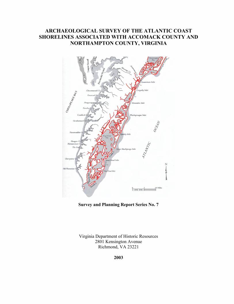
ARCHAEOLOGICAL SURVEY OF THE ATLANTIC COAST SHORELINES ASSOCIATED WITH ACCOMACK COUNTY AND
NORTHAMPTON COUNTY, VIRGINIA
Survey and Planning Report Series No. 7
Virginia Department of Historic Resources 2801 Kensington Avenue
Richmond, VA 23221
2003
ii
ARCHAEOLOGICAL SURVEY OF THE ATLANTIC COAST SHORELINES ASSOCIATED WITH ACCOMACK COUNTY AND
NORTHAMPTON COUNTY, VIRGINIA
Virginia Department of Historic Resources Survey and Planning Report Series No. 7
Author: Darrin L. Lowery
Chesapeake Bay Watershed Archaeological Research Foundation 5264 Blackwalnut Point Road, P.O. Box 180
Tilghman, MD 21671
2003
iii
ABSTRACT
This report summarizes the results of an archaeological survey conducted along
the Atlantic shorelines of both Accomack County and Northampton County, Virginia.
Accomack and Northampton Counties represent the southernmost extension of the
Delmarva Peninsula. The study area encompasses all of the lands adjacent to the Atlantic
Ocean and shorelines associated with the back barrier island bays. A shoreline survey
was conducted along the Atlantic Ocean to gauge the erosion threat to the archaeological
resources situated along the shoreline. Archaeological sites along shorelines are
subjected to numerous natural processes which hinder site visibility and limit
archaeological interpretations. Summaries of these natural processes are presented in this
report.
The primary goal of the project was to locate, identify, and record any
archaeological sites or remains along the Atlantic seashore that are threatened by
shoreline erosion. The project also served as a test of a prehistoric site
predictive/settlement model that has been utilized during other archaeological surveys
along the Chesapeake Bay shorelines and within the interior sections of the Delmarva
Peninsula. The prehistoric site predictive/settlement model is presented in detail using
archaeological examples from Maryland and Virginia’s Eastern Shore. The settlement
model does not attempt to deduce, determine, or suggest any aspects relative to site
function. The model suggests only site locations and cultural chronologies. Predicted
site locations and the predicted cultural chronologies were established prior to the
fieldwork. The fieldwork tested these predictions. The project suggested that the
iv
predictive/settlement model has a 95% accuracy level. Modifications to the model were
made to take into account the unique barrier island ecological settings of the Atlantic
seashore. With these modifications, it is suggested that more accurate site predictions
could be formulated.
As a “double-blind” test, the actual locations and cultural chronologies associated
with previously recognized and recorded sites were not collected prior to the completion
of the survey. By not knowing the previous site data, the present shoreline survey would
help assess and gauge the accuracy of the previous single “one-time” archaeological
survey data. The survey methodology would also gauge and assess the dynamics
associated with archaeological sites in coastal settings and how coastal environments
influence archaeological survey data. The previous archaeological site data associated
with the shoreline study area are presented in the report and compared with the new site
information found at the five sites relocated during the present study. The results suggest
coastal environments and the natural processes associated with these environments
greatly influence the data gleaned from single “one-time” archaeological shoreline
surveys.
In conjunction with testing the inability of single “one-time” archaeological site
data, three archaeological sites found during the study were subjected to several site
reexaminations. These reexaminations clearly indicate that in coastal environments
archaeological sites should be reexamined and eroded archaeological remains should be
collected to accurately assess the cultural chronologies expressed at any given locality.
Therefore, chronological interpretations about individual sites can be made with a higher
level of accuracy. Site functional interpretations can only be assessed after excavations
v
are conducted. Suggestions to alleviate the interpretive limitation problems associated
with archaeological resources in coastal settings are also presented.
The present survey located and documented 44 archaeological sites, which span
13,000 years of the region’s prehistory and history. Of these, 39 archaeological sites had
not been previously recorded. Recognizing the interpretive limitations associated with
sites in coastal settings, a cultural synthesis of the site data cannot be constructed at this
time. Data are presented that show a correlation between higher levels of fetch-related
shoreline and larger more diagnostic shoreline-related archaeological site assemblages.
Suggestions are presented as a means to alleviate the limitations associated with future
interpretive cultural synthesis summaries.
The Virginia Eastern Shore Atlantic shoreline survey has functioned mainly as a
supplementary guide to cultural resource managers and future researchers. The report
acts as a supplemental summary of the research methodologies presented in Lowery’s
(2001) survey of the Chesapeake Bay shorelines. The project suggests that natural
processes, not cultural processes, are a major influence in coastal environments.
Unfortunately, the degree of site significance and erosional threat cannot be accurately
evaluated at this time. Even so, information are presented that can be combined with
short-term meteorological data and provide researchers with an assessment of the past
daily fetch-related erosion history specific to unique shoreline settings associated with
each documented site. The report concludes with suggestions for future research.
vi
ACKNOWLEDGEMENTS A project of this nature involves the cooperation of many individuals, institutions,
and agencies. The Virginia Department of Historic Resources’ Threatened Sites Program
funded the Virginia Eastern Shore survey. Mr. David Hazzard of the Virginia
Department of Historic Resources was a major contributor to this project and helped with
the success of the final report. The grant was processed through the Chesapeake Bay
Watershed Archaeological Research Foundation. The help and assistance of Mr. Norman
K. Brady and Mr. David R. Thompson, executive directors associated with Chesapeake
Bay Watershed Archaeological Research Foundation, is greatly appreciated.
Numerous people helped and contributed to the project. I would like to thank Mr.
Mike Owens, a fellow graduate student, for being involved with the project. Mike
provided helpful insight and was involved in the fieldwork. Mr. Norman K. Brady
contributed many weekends of his time and the use of his powerboat while conducting
the survey. Mr. David Thompson and Mr. Michael Middleton contributed their volunteer
efforts to the survey. Mr. Ralph Eshelman contributed one week of valuable field
assistance to the project. Mr. Eshelman also provided information relative to the region’s
fossiliferous geologic deposits. Mr. Joseph McAvoy and Mrs. Lynn McAvoy also
contributed their years of accumulated expertise to the success of the final report. I
would also like to thank all of the residents of the Virginia Eastern Shore for their kind
hospitality. I would like to acknowledge and thank all of the previous archaeologists and
researchers that have worked on the Virginia Eastern Shore. It was their effort that
provided me with important comparative data. I would like to thank all of my family
vii
members being patient and providing assistance during this and all of my previous work.
Finally, I would like to acknowledge my father for taking me to my first eroding
archaeological shoreline site. Over the years, I have come to the conclusion that a lot of
the ideas about shoreline sites my father and I took for granted, others had never
contemplated. This project was an attempt to document some of these ideas so that
others could benefit.
viii
TABLE OF CONTENTS
Page
ABSTRACT……………………………………………………………………………...iii
ACKNOWLEDGEMENTS………………………………………………………………vi
LIST OF TABLES………………………………………………………………………...x LIST OF FIGURES………………………………………………………………………xi
PART I: Archaeological Survey Background Data……………………………….……...1 Introduction………………………………………………………………………..1 Research Design…………………………………………………………………...8 Previous Archaeological Work in Accomack and Northampton Counties……...13
Geological and Paleoclimatological Overview of the Atlantic Seashore Study Area……………………………………………………………………….15 Current Physiographic Overview of Virginia’s Eastern Shore…………………..34 Cultural, Historical, and Archaeological Overview……………………………...38 Paleoindian Period……………………………………………………….38 Early Archaic Period……………………………………………………..51 Middle Archaic Period…………………………………………………...55 Late Archaic Period……………………………………………………...58 Early Woodland Period…………………………………………………..63 Middle Woodland Period………………………………………………...71 Late Woodland Period…………………………………………………...77 Contact Period……………………………………………………………80 Historic Period…………………………………………………………...83
ix
PART II: Changing Landscapes, Changing Climates, and Changing Prehistoric Human Settlement Patterns: A Development of a Delmarva Peninsula Prehistoric Site Prediction Model…………………………………………………………………………………...101 Overview………………………………………………………………………..101 Marine Transgression…………………………………………………...102 Aeolian Processes………………………………………………………105 Climatic and Ecological Changes………………………………………113 Additional Site Predictability Factors…………………………………..117
Predictive Site Model For The Delmarva Peninsula……………………………124 Point Focus Settlement Pattern…………………………………………128 Cove Focus Settlement Pattern…………………………………………131 Converging Stream Focus Settlement Pattern………………………….133 Springhead Focus Settlement Pattern…………………………………..135 Interior Stream Focus Settlement Pattern………………………………137 Sand Ridge Focus Settlement Pattern…………………………………..139 Bay Basin Focus Settlement Pattern……………………………………142 Estuarine Wetland Focus Settlement Pattern…………………………...151 Rivershore Focus Settlement Pattern…………………………………...159 Final Statements Relative to the Prehistoric Site Prediction Model and Its Application to Virginia’s Eastern Shore Atlantic Coast………………………..161
PART III: Results of the Atlantic Coast Shoreline Archaeological Survey in Acommack County and Northampton County, Virginia…………………………………………….176
Archaeological Site Summaries………………………………………………...177
Survey Results and Interpretation of the Survey Results……………………….209
A Test of the Site Prediction Model……………………………………………233
x
PART IV: Summary and Conclusions…………………………………………………250 REFERENCES CITED…………………………………………………………………262 APPENDIX……………………………………………………………………………..285
LIST OF TABLES
Table Page 1.1. Summary of the Paleoclimatic History of the Region…………………………...28 1.2. Late Quaternary Pollen and Plant Macro-Fossil Summary for Virginia’s Eastern
Shore Coastal Bight (after Finkelstein and Kearney 1988; Oertel et al. 1989: Table 2)…………………………………………………………………………..32
A.1 Previously Recorded Virginia Eastern Shore Atlantic Coast Archaeological
Sites……………………………………………………………………………..286 A.2 Archaeological Sites Recorded During the Virginia Eastern Shore Atlantic Coast Survey…………………………………………………………………………..288 A.3 Comments About Archaeological Sites Previously Recorded Along the Virginia Atlantic Coast…………………………………………………………………...290 A.4 A Comparison Between the Previously Recorded Site Chronological Data and the Data Documented During the 2001 Survey…………………………………….292 A.5 Shoreline Erosion Assessments for the Virginia Eastern Shore Atlantic Coast
Archaeological Sites Recorded During the 2001 Survey………………………293 A.6 Summary of the Fetch Related Erosion Processes Impacting the Archaeological
Sites Recorded During the 2001 Survey………………………………………..294 A.7 Prehistoric Lithic Artifact Summary for the Virginia Eastern Shore Atlantic
Coastal Archaeological Sites Recorded During the 2001 Survey……………...295 A.8 Cultural Chronologies Defined by Multiple Site Examinations for Selected
Atlantic Coastal Archaeological Sites Recorded During the 2001 Survey……..296 A.9 Prediction Model Summary for the Archaeological Sites Recorded During the
2001 Atlantic Coast Survey…………………………………………………….297
xi
LIST OF FIGURES
Figure Page 1.1. The Atlantic Coast Study Area of Virginia’s Eastern Shore……………………...6
1.2. General Locations of the Previously Recorded Archaeological Sites within the Atlantic Coastal Study Area……………………………………………………...16
1.3. Geological Base Map Image……………………………………………………..17 1.4. The Late Pliocene Landscape……………………………………………………18 1.5. Initial Early Pleistocene Landscape……………………………………………...20 1.6. Early to Middle Pleistocene Landscape………………………………………….21 1.7. Middle Pleistocene Landscape…………………………………………….……..22 1.8. Middle to Late Pleistocene Landscape…………………………………….…….23 1.9. The Location of the Chincoteague Macro-Watershed (modified Oertel and Foyle
1994: Figure 6.11)……………………………………………………………….25 1.10. The Distribution of Virginia Barrier Island Types and the Associated Sediment
Depositional Settings.………………………………………………………..…..27 1.11. A Salt-Evaporating House (see Wharton 1973)………………………….………88 1.12. A Section of the 1845 Survey From Cape Henlopen to Indian River (United States
Coastal Survey Chart T-226)…………………………………………………….89 1.13. Augustine Herrman’s 1670 Map of Virginia and Maryland Showing the Virginia
Eastern Shore………………………………………………………………….…95 1.14. Robert Alexander’s 1781 Map of the Delmarva Peninsula Showing Virginia’s
Eastern Shore………………………………………………………………….…98 1.15. Robert Aitken’s 1776 Map of the Maritime Parts of Virginia Showing Virginia
Eastern Shore’s Coastal Islands……………………………………………….…99 1.16. A Section of the 1852 Map Entitled A Chart of the Chesapeake and Delaware
Bays Illustrating Virginia Eastern Shore’s Barrier Islands……………………..100
xii
2.1. 9,000 Years of Ecological Changes to the Maddox Island Area of Somerset County, Maryland Associated with Sea Level Changes………………………..103
2.2. Horizontal Displacement of Paleoshorelines Associated With Marine
Transgression…………………………………………………………………...106 2.3. Simulated Dune Fields (after Werner, 1995)…………………………….……..108 2.4. Aeolian Landforms (i.e., Barchans) in Queen Anne’s County, Maryland……..110 2.5. Aeolian Landforms (i.e., Transverse Ridges) in Somerset County,
Maryland………………………………………………………………………..110 2.6. Aeolian Landforms (i.e., Linear Ridges and Furrows) in Talbot County,
Maryland………………………………………………………………………..111 2.7. Aeolian Landforms (i.e., Star-like Dunes) in Caroline County, Maryland……..111 2.8. Recent Aeolian Landforms in Northampton County, Virginia…………………113 2.9. Hemlock Forest…………………………………………………………………118 2.10. Oak and Hickory Forest………………………………………………………...118 2.11. Uniform Well-Drained Upland Area in Queen Anne’s County, Maryland…….121 2.12. Uniform Poorly-Drained Upland Area in Queen Anne’s County, Maryland…..122 2.13. Archaeological Sites Located on Small Well-Drained Ridges in Queen Anne’s
County, Maryland………………………………………………………………125 2.14. Archaeological Site Located on a Large Well-Drained Bay Basin in Somerset
County, Maryland………………………………………………………………126 2.15. Artifact Assemblage From 18SO146………………………………….………..126 2.16. An Archaeological Site Reflecting a Point Focus Settlement Pattern on Kent
Island in Queen Anne’s County, Maryland…………………………………….129 2.17. An Archaeological Site Reflecting a Point Focus Settlement Pattern on the
Chester River in Queen Anne’s County, Maryland…………………………….131 2.18. Archaeological Sites Reflecting a Cove Focus Settlement Pattern on Kent Island
in Queen Anne’s County, Maryland……………………………………………133
xiii
2.19. An Archaeological Site Reflecting a Converging Stream Focus Settlement Pattern in Interior Queen Anne’s County, Maryland…………………………………...134
2.20. An Archaeological Site Reflecting a Springhead Focus Settlement Pattern on Kent
Island in Queen Anne’s County, Maryland…………………………………….136 2.21. Archaeological Sites Reflecting an Interior Stream Focus Settlement Pattern in
Interior Queen Anne’s County, Maryland……………………………………...139 2.22. Archaeological Site Reflecting a Sand Ridge Focus Settlement Pattern in Interior
Queen Anne’s County, Maryland………………………………………………141 2.23. Manokin Bay Basin in Somerset County, Maryland…………………………...145 2.24. Savanna Lake Bay Basin in Dorchester County, Maryland…………….……...147 2.25. Rumbley-Frenchtown Bay Basin in Somerset County, Maryland……………...148 2.26. Halfmoon Island Bay Basin in Accomack County, Virginia…………………...150 2.27. Sea Level Rise and Its Impact to a Pre-Existing Hummock at 18QU413, in
Queen Anne’s County, Maryland………………………………………………153 2.28. Eroding Prehistoric Cultural Features at 18QU413………………………….…154 2.29. Marsh Plants in Northampton County, Virginia, that Delineate 44NH223…….155 2.30. Marsh Plants in Northampton County, Virginia, that Delineate 44NH470…….156 2.31. Marsh Plants Adjacent to Upshur Bay, Virginia, that are Associated with Storm
Surge Activity…………………………………………………………………..156 2.32. Archaeological Site Reflecting an Estuarine Wetland Focus Settlement Pattern in
Coastal Queen Anne’s County, Maryland………………………………….…..158 2.33. Archaeological Site Reflecting an Estuarine Wetland Focus Settlement Pattern in
Coastal Somerset County, Maryland……………………………………….…..158 2.34. Archaeological Site Reflecting a Rivershore Focus Settlement Pattern in Coastal
Queen Anne’s County, Maryland………………………………………………160 2.35. Shoreline Exposure at 44NH435 along Savage Neck, Virginia……….…….…164 2.36. Area in Dorchester County, Maryland, Covered by a Thick Mantle of Tidal
Marsh…………………………………………………………………………...164
xiv
2.37. Submerged Areas Within the Chesapeake Bay in Western Talbot and Dorchester Counties, Maryland……………………………………………………….…….165
2.38. Submerged Areas on the Continental Shelf Near the Norfolk Canyon………...165 2.39. 44NH466 at High Tide……………………………………………………….…166 2.40. 44NH466 at Low Tide……………………………………………………….…167 2.41. A Non-Erosive Shoreline……………………………………………….………169 2.42. A Shoreline Profile Indicative of a Landscape Covered by a Thick Tidal Marsh
Deposit………………………………………………………………………….170 2.43. Tidal Marsh Shoreline with an Exposed Tree Stump…………………………..170 2.44. A Sample Archaeological Site Prediction Map Developed For Accomack and
Northampton Counties’ Atlantic Seashore………………………………….….175 3.1. Archaeological Sites Discovered During the 2001 Atlantic Coast Shoreline
Survey…………………………………………………………………………..210 3.2. Fiddler Crab Damage to 44NH468……………………………………………..214 3.3. Fiddler Crab Damage to 44NH469……………………………………………..215 3.4. Muskrat Damage to an Archaeological Site on Maryland’s Eastern Shore…….215 3.5. A Small Section of the 1852 T-509 Survey Showing Fisherman’s Island.…….218 3.6. The 1852 Boundary of Fisherman’s Island Superimposed Over the 1990
Fisherman’s Island Landmass…………………………………………………..219 3.7. Hypothetical Image Explaining the Redepostional Processes Resulting in
Prehistoric Cultural Debris on Modern Barrier Islands………………………...221 3.8. Archaeological Site Found During Field Examination of Bank Profile….…….236 3.9. Predicted Archaeological Site Based on Discolorations Within the Tidal Wetlands
and the Linear Orientation of the Associated Drainages……………………….236 3.10. Predicted Barrier Island Focus Woodland Period Archaeological Sites……….239 3.11. Eroded Old Forested Barrier Island Landscape That Revealed Late Woodland-Era
Diagnostic Artifacts…………………………………………………………….240
xv
3.12. Changes to the Southeastern Atlantic Coastline of Northampton County, Virginia,
Since the Glacial Maximum…………………………………………………….242 3.13. Hypothetical Image of the Ecologic and Geologic Changes for a Small Portion of
the Magothy Bay, Mockhorn Island, and South Bay Area……………………..243 3.14. Prehistoric Settlement Patterns on the Landscape Circa 1,000 Years Ago…….245 3.15. Prehistoric Settlement Patterns on the Landscape Circa 3,000 Years Ago…….245 3.16. Prehistoric Settlement Patterns on the Landscape Circa 5,000 Years Ago…….245 3.17. Prehistoric Settlement Patterns on the Landscape Circa 10,000 Years Ago…...246 4.1. Shoreline Erosion, Seasonal Wind & Wave Directions, and Artifact Movement
Along Coastlines………………………………………………………………..252 4.2. Redeposition of Ancient Cultural Materials onto Younger Landscapes……….254 4.3. Differential Fetch Related Erosion Processes Impacting an Eroding
Archaeological Site……………………………………………………………..261
1
PART I: Archaeological Survey Background Data
Introduction
In the early spring of 2001, the principal investigator was contacted by Mr. David
Hazzard of the Virginia Department of Historic Resources about the feasibility of
conducting an archaeologically related shoreline survey of the Atlantic coast of both
Accomack and Northampton Counties along Virginia’s Eastern Shore. The Atlantic
coast project would be a follow-up study, the result of several suggestions for future
research proposed by Lowery (2001: 201) after completing a similar study along the
Chesapeake Bay side. The shoreline survey was initiated in an attempt to document the
archaeological sites being threatened by shoreline erosion along the Atlantic coastal
portions of both Accomack and Northampton Counties. One of the goals of the project
was to analyze shoreline processes and their impacts on cultural resources. Another goal
was geared towards the recognition of archaeological sites associated with shoreline
settings. The final goal was oriented towards assessing how natural processes impact
archaeological interpretations. The shoreline survey would be an attempt to record site
data for archaeological researchers, cultural resource managers, and the general public.
Mr. David Hazzard of the Virginia Department of Historic Resources acted as the
monitor for the project and provided connections, support, and information throughout
the duration of the project. Mr. Norman K. Brady and Mr. David R. Thompson, who are
directors of the Chesapeake Bay Watershed Archaeological Research Foundation,
provided equipment and field support during the project. Mr. Michael C. Owens, Mr.
Ralph Eshelman, and Mr. Michael Middleton provided additional field support during the
2
project. The Virginia Department of Historic Resources’ Threatened Sites Program
provided funding for the survey.
The extent of linear shoreline exposures associated with the study area was
extensive but consisted of only a narrow section of periodically submerged terrain
between the mean high tide mark and mean low tide mark. The previous experience of
the principal investigator (Lowery 1992a, 1992b, 1993a, 1993b, 1994, 1995b, 1995c,
1996, 1997, 1999, and 2001) in conducting similar surveys along the shorelines of
Maryland’s and Virginia’s Eastern Shore provided the experience for dealing with such
dynamic environments.
The Virginia Eastern Shore encompasses a large portion of the Delmarva
Peninsula (see Figure 1.1). The region has a documented cultural history that
encompasses the past 13,000 years (Custer 1989; Dent 1995; Rountree and Davidson
1997; and Wittkofski 1982 and 1988). Archaeological surveys in the region have also
documented numerous prehistoric sites. Recognizing some of the threats impacting
archaeological resources along eroding shorelines, the survey attempted to document the
sites only along the Atlantic coast section of the Virginia Eastern Shore. No interior
tilled fields or forested areas were examined during the project.
The shoreline survey fieldwork began in the summer of 2001 and continued into
the fall and early winter of 2001. The entire shoreline between the Maryland line and the
mouth of the Chesapeake Bay was examined for eroding sites. All of the shorelines
associated with the barrier islands, the tributaries, and the watersheds draining into the
Atlantic were also examined. Rather than research the records for the previously
recorded site locations prior to the fieldwork, the data associated with the previously
3
recorded sites were not researched until the survey had been completed. In not knowing
the previous site data, the survey methods were consistent with the previous study
conducted along the Chesapeake Bay shorelines of Accomack and Northampton Counties
(Lowery 2001). By not researching the known site records prior to the fieldwork, the
survey would not be biased towards relocating these sites even under the worst visual
conditions. Like the early work (ibid), the Atlantic survey was “blind” to the previously
recorded site locations and “blind” to the documented cultural chronologies recorded for
these sites. The present survey would serve as a “double-blind” test to see if the
previously recorded sites could be relocated and the known cultural chronologies for each
site could be redocumented. It was deduced that the ability of the fieldwork to detect the
presence or absence of the previously recorded sites would be a way to gauge the
dynamics associated with coastal environmental settings. By gauging how coastal
environments influence what you see and what you do not see in the archaeological
record, the survey would quantify the limitations of “one-time” archaeological surveys.
At the conclusion of the fieldwork, the project located and documented 44 archaeological
sites distributed along the Atlantic coastline and the back barrier island bays of both
Accomack and Northampton Counties. Archival research after the completion of the
project indicated that only five of the 49 previously recorded ocean-side sites in both
counties were relocated during fieldwork as a result of this project. As such, the current
project located and recorded 39 “new” or previously unrecorded sites along Virginia’s
Atlantic seashore. The following report attempts to verify the site data associated with
the documented sites, summarize the factors affecting shoreline erosion, detail the
concerns relative to regional shoreline erosion and its impact on the region’s
4
archaeological sites, and evaluate the problems associated with archaeological
assessments of regional survey data.
Unlike the previous study conducted along the Chesapeake Bay (Lowery 2001),
the present study describes the prehistoric site prediction and settlement model developed
by Lowery (1997) from archaeological data within Maryland’s coastal areas. In defining
Lowery’s model, real sites and site locations are used to illustrate prehistoric settlement
and site prediction patterns. In essence, the summary presented in this report is far more
detailed than the earlier presentations of Lowery’s model for the Delmarva coastal plain.
The site prediction model was used during the project prior to conducting the fieldwork.
The report attempts to illustrate the accuracy of Lowery’s model for the coastal plain. In
sum, the project was a test of the prehistoric site prediction and settlement model
developed by Lowery (1997). At the completion of the survey, it was discovered that
Lowery’s model located 95% of the 44 sites discovered during the project. The two
prehistoric sites not located using the prehistoric site prediction and settlement model
were both situated on barrier islands. The inability to predict prehistoric components on
barrier islands is not surprising considering Lowery’s model was developed via long-term
site survey data within the Chesapeake Bay. For the unfamiliar, coastal barrier islands do
not occur within the Chesapeake Bay. Therefore, the work resulting from this report
proposes an additional prehistoric site settlement pattern (i.e., the Barrier Island Focus) to
be added to the nine previously described settlement types defined by Lowery (1997).
The project not only tested a prehistoric site prediction and settlement model, but it
provided data that suggest the model should be modified slightly to include ecological
settings unique to the Atlantic seashore.
5
The report is organized into various sections. An overview of the research design
is presented and the previous archaeological work relative to the study area is
summarized. All of the previously recorded shoreline site data for the study area are
presented in a table (see Table A.1). A summary of the geology, the modern
physiographic setting, and the paleoclimatic changes to the Virginia Eastern Shore study
area is presented. An overview of the regional prehistory and history is also summarized.
Within the report, a detailed overview of Lowery’s prehistoric settlement and site
prediction model is offered. The results of the fieldwork and the survey are presented.
The report also provides individual site overviews relative to the archaeological sites
discovered during the project. Within the fieldwork summary, the report presents an
overview of the previous archaeological sites not identified as a result of the current
fieldwork. The report compares the present chronological summaries for the five
relocated site with the previously documented chronological data. Archaeological site
erosion data are presented and data are summarized relative to how shoreline erosion
influences the archaeological interpretations of regional archaeological information. Like
previous archaeological surveys in coastal areas, it is suggested that natural factors are
the primary variables influencing what we see and do not see in the archaeological
record. Nowhere is this better illustrated than Virginia’s Atlantic seashore. Finally, the
current prehistoric site data that resulted from this survey are summarized relative to
Lowery’s (1997) prehistoric site settlement and prediction model.
The summary and conclusions section of the report offers an overview of the
goals of the project and indicates whether these goals were achieved. The conclusion
section highlights some of the interpretive limitations associated with limited “one-time”
6
surveys. As a final discussion, the report highlights some suggestions for future research
and how the shoreline survey can be used as a “stepping-stone” for addressing the
interpretive limitations associated with the present study.
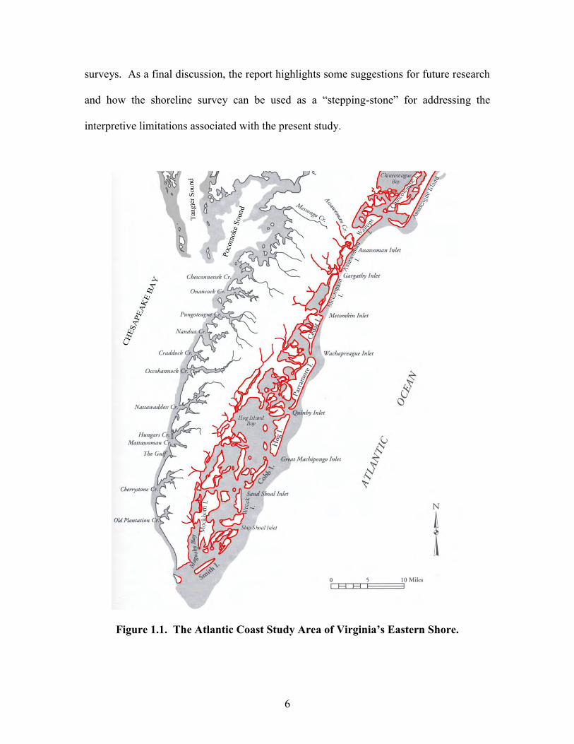
Figure 1.1. The Atlantic Coast Study Area of Virginia’s Eastern Shore.
7
The report has one appendix; the appendix consists of a series of tables presenting
various aspects associated with the project. The tables in this appendix present
summaries of the previous archaeological site information for the study area and
summaries of the archaeological site information gleaned from the present project. They
also summarize and assess the erosion observed at all of the newly discovered sites, as
well as, present data on the previously recorded sites in both counties and address
concerns relative to their observed presence or absence during the project. In respect to
the five relocated sites, one of the tables in the appendix compares the previous site
information to the site information gleaned during this project. These comparisons
should help illustrate some of the inadequacies of “one-time” survey data. Lastly, the
remaining tables in Appendix A provide specific information about the fetch-related
erosion processes impacting individual sites, a summary of prehistoric artifact density
observed at all of the prehistoric sites found during the project, an overview of the
chronological data from specific sites that were reexamined during the project, and a
summary of the archaeological site data relative to Lowery’s (1997) prehistoric
settlement model. The standard Virginia site data forms completed as a result of this
project are on file at the Virginia Department of Historic Resources in Richmond. All of
the site collections and the photographic record resulting from the project are also on file
at the Virginia Department of Historic Resources in Richmond.
The survey data provide information associated with 44 archaeological sites.
Thirty-nine of the sites had not been previously documented with the Virginia
Department of Historic Resources. Six of the newly recorded archaeological sites and
two of the five relocated archaeological sites are associated with Accomack County.
8
Thirty-three of the newly recorded archaeological sites and three of the five relocated
archaeological sites are associated with Northampton County. The cultural components
observed at all of the sites discovered during this project span the past 13,000 years of the
regions prehistory. Combined with the previous survey data for the Chesapeake
shorelines of Accomack and Northampton Counties (Lowery 2001), we can accurately
state that 24 hours a day and seven days a week 152 archaeological sites along Viriginia’s
Eastern Shore are being threatened by shoreline erosion. Indeed these are some of the
most threatened cultural resources in the Middle Atlantic region.
Research Design
The purpose of the project was to survey, locate, and assess the archaeological
resources along the Atlantic side of Virginia’s Eastern Shore. The objective was to locate
known sites and to search for new sites along the shorelines. Observations and
documentation were made on all sites regarding their current condition, new information
available (on the basis of artifacts or features observed), and threats that have in the past,
are currently, or may in the near future have deleterious effects on them. The tasks and
goals defined prior to the project included:
1. Assess the existing records of archaeological sites in Accomack County
consistent with earlier studies completed in Northampton County (see
Underwood and Stuck 1999). Tables were to be completed for known sites
identifying sites by time period and by type/function. A figure was also to be
created to indicate the frequency of sites along major drainages.
2. Conduct a comprehensive archaeological survey to include all shorelines
along the Atlantic side of Virginia’s Eastern Shore from Cape Charles to the
9
Maryland border. In addition to the survey of the shoreline fronting the
Atlantic Ocean, all-major drainages emptying into the back barrier island bays
will be examined for a minimum distance of 500 meters along both banks to
the extent these banks are threatened by erosion. Topographic U.S.G.S. 7.5
minute quadrangles and U.S.D.A soil maps will be used during the survey.
3. Document known and newly discovered sites along the shore on standard
Virginia site data forms. Provide all relevant information toward determining
site time period, type/function, and size/boundaries. Information shall include
types and number of artifacts observed or recovered. Also, state perceived or
real threats to these sites and their severity. Information shall be recorded on
Virginia Department of Historical Resources site inventory forms. Create a
photographic 35mm slide record of sites, significant features exposed in the
eroding shorelines, and samples of artifacts recovered. Photographic slides
illustrating threats should also be included. Diagnostic artifacts will be
labeled, and all artifacts bagged and boxed by site number.
4. Prepare recommendations based on site significance, which necessitates a
cultural historical synthesis as background. Prepare recommendations based
on site threat.
The shoreline survey methods utilized during the project were based on Lowery’s
previous shoreline survey work (1992a, 1992b, 1993a, 1993b, 1995b, 1996, 1997, 1999,
and 2001) conducted along the eroding shorelines of Maryland’s and Virginia’s Eastern
Shore. The shoreline survey methods involve an assessment of whether a particular
shoreline is erosive, non-erosive, or accreting. Most shorelines were examined through
10
the use of a kayak. Kayaks provide the surveyor with the ability to examine shoreline
conditions closely, and they also allow the surveyor to work in shallow water. Kayaks
also permit the collection of cultural material from the shallow waters that are
immediately adjacent to a particular shoreline. Most of the distant offshore barrier
islands and any additional inaccessible shorelines were examined via the use of a
powerboat.
All of the shorelines within the study area were categorized as erosive or non-
erosive based on field observations. Some shorelines were deemed inadequate for
extensive archaeological examination. Generally, the tributary headwater areas on the
mainland flowing into the Atlantic were clogged with historic era agricultural run-off
sediment. These settings are non-erosive accretion areas that were deemed inadequate to
conduct an archaeological examination for eroding shoreline sites. Shorelines with
gradually sloping upland banks fringed by sand that has been stabilized by saltmarsh
cordgrass were also deemed as non-erosive. Most inland tributary shorelines that had
thick deposits of barren coastal sand extending from below mean low water to the inland
areas above extreme high tide were also deemed as non-erosive. Upland shorelines that
had steep bank profiles with exposed sub-soil were deemed as erosive. Low tidal marsh
shorelines that had steep bank profiles with exposed organic layers and sub-soil below
mean low water were also deemed as erosive. Low tidal marsh shorelines that had steep
bank profiles with exposed organic layers and no visible sub-soil below mean low water
were deemed as accretional. The barrier island shorelines facing the mainland were also
deemed as accretional. The barrier island coasts adjacent to the Atlantic Ocean have
dynamic shorelines with a mix of accretional areas and heavily eroded areas. Only
11
erosive shorelines were extensively examined for exposed or eroded archaeological
resources. These eroded shorelines were walked and the bank profiles were inspected for
exposed features. An examination of the bank-cuts would permit the documentation of
any exposed culturally related archaeological features, associated soil types, and regional
geologic landforms. The survey methods would also involve examination of all
associated shoreline sediments and the redeposited debris adjacent to each eroded
shoreline. The eroded sediments were also scanned for redeposited cultural artifacts.
Redeposited cultural materials are typically located in shallow depressions, around tree
roots and other barriers, at the base of bank cuts, on top of the modern shoreline land
surface, and distributed as debris “bands” based on tidal changes and storm activity. The
remaining non-erosive shorelines were closely inspected from the kayaks used during the
survey. The shoreline sediments adjacent to these non-erosive areas were also inspected
from kayaks for any evidence of redeposited cultural material. All shorelines were
examined during maximum low tide to facilitate the greatest level of shoreline exposure.
Survey methods would involve an examination of associated bank-cuts adjacent
to each eroded shoreline. Throughout the project, United States Department of
Agriculture soil maps for Accomack and Northampton Counties were utilized as a
general basis for assessing potential landforms, geologic features, and soils that may have
prehistoric and historic cultural components. Prior to conducting the fieldwork an
assessment of site potential and site prediction localities were based on site predictive
models developed by the author for Maryland’s Eastern Shore (Lowery 1997: 26-42).
The published soil maps, historic maps, aerial photographs, topographic maps, and
satellite images of the study area were utilized for assessing potential archaeological site
12
areas and predicting site localities prior to the fieldwork. Rather than conduct archival
research about the location of previously recorded sites in the region prior to the shoreline
survey, the principal investigator decided to assess the archaeological sites along the
shorelines of Accomack and Northampton Counties without site location data and site
chronological data. By conducting the shoreline survey without prior site location and
chronological data, the present survey would be a test of Lowery’s (ibid.) site predictive
model. The present survey would also test the validity of one-time “blitzkrieg” survey
techniques so frequently employed to amass regional site location data. It was assumed
that the principal investigator may or may not find all or most of the previously recorded
sites in the region. It was also suggested that the sites missed during the survey would
provide important data relative to site destruction and the dynamics of site reburial in
coastal settings. These data would be valuable for addressing threatened sites as well as
addressing the problems with one-time archaeological surveys.
All shorelines were examined, and any evidence for an eroded archaeological site
was documented. General descriptive summaries of each site were documented, and the
conditions of all of the sites were noted. Diagnostic artifacts associated with each site
were collected, bagged, and labeled. Photographs (i.e., 35mm slides) were taken during
the project. Most of the sites were photographed, and strategic non-culturally related
sections of the shoreline were also photographed. The photographic images attempted to
document site erosion, the dynamics of coastal processes, various field conditions, and
assess coastal environments.
The survey began during the summer of 2001 and continued through the fall and
early winter. All site data forms were completed and filed with the Virginia Department
13
of Historic Resources in December 2001. A draft report was completed in mid-February
2002. The final report, which was completed in June 2002, presents a background
overview of the study area, the results of the survey and suggestions for future research.
Several topical themes were presented in the final report, which discuss the additional
research issues that were a “spin-off” of the survey. The topics in the final report relate
to testing a regional site prediction model, recount the natural processes effecting
shoreline sites, describe the visibility of archaeological sites in coastal and terrestrial
settings, and present an overview about how the interplay of natural variables greatly
impact archaeological interpretations of the past.
Previous Archaeological Work in Accomack and Northampton Counties
The study area for the present survey was focused only along the coastal
shorelines of both Accomack and Northampton Counties. Accomack County has a total
of approximately 542 officially documented archaeological sites recorded in the Archives
of the Virginia Department of Historic Resources in Richmond. Northampton County
has a total of approximately 439 officially documented archaeological sites recorded at
this same institution. Of the 981 archaeological sites documented for the Virginia
Eastern Shore, 40 previously recorded sites in Accomack County and nine previously
recorded sites in Northampton County were noted within the shoreline study area. The
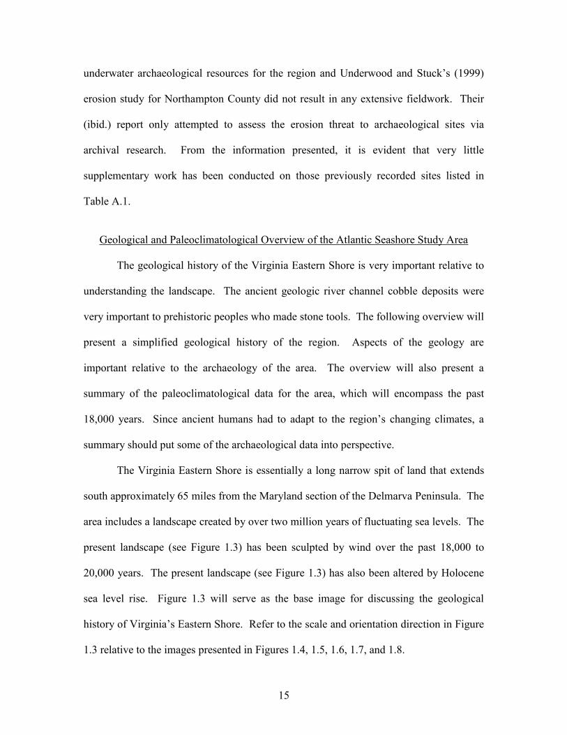
data for these sites are presented in Table A.1. Figure 1.2 roughly plots the locations of
the sites listed in Table A.1. The total of sites noted in Northampton and Accomack
Counties within the Atlantic coastal zone included all archaeological sites that were
plotted adjacent to the shoreline and within 100 meters of the shoreline. The sites listed
in Table A.1 are considered to be within the study area and located along or immediately
14
adjacent to the Atlantic shorelines or the back barrier island bay and tributary shorelines.
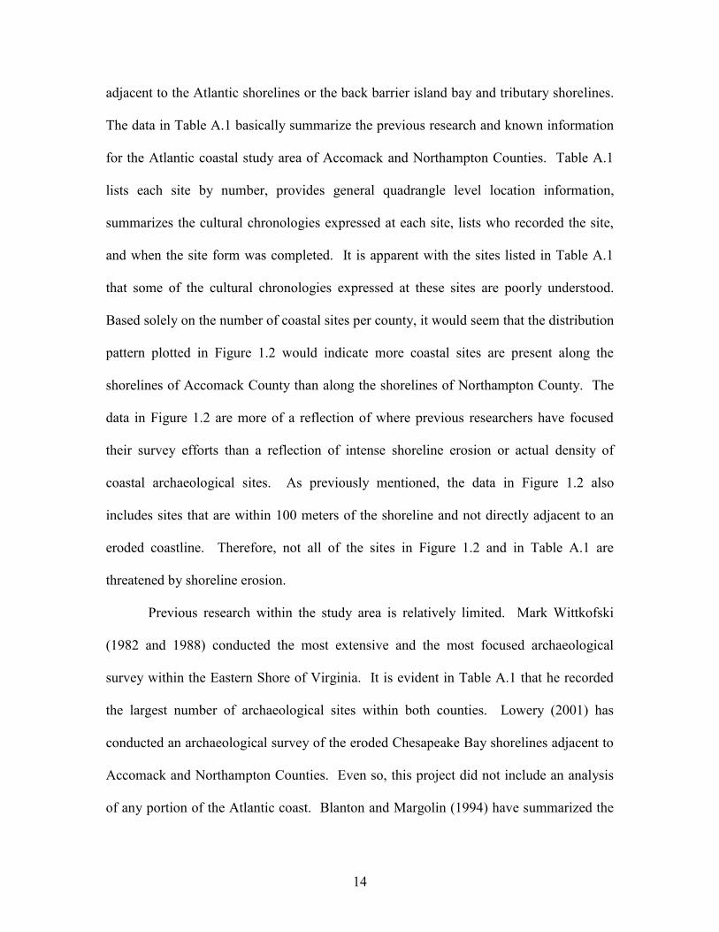
The data in Table A.1 basically summarize the previous research and known information
for the Atlantic coastal study area of Accomack and Northampton Counties. Table A.1
lists each site by number, provides general quadrangle level location information,
summarizes the cultural chronologies expressed at each site, lists who recorded the site,
and when the site form was completed. It is apparent with the sites listed in Table A.1
that some of the cultural chronologies expressed at these sites are poorly understood.
Based solely on the number of coastal sites per county, it would seem that the distribution
pattern plotted in Figure 1.2 would indicate more coastal sites are present along the
shorelines of Accomack County than along the shorelines of Northampton County. The
data in Figure 1.2 are more of a reflection of where previous researchers have focused
their survey efforts than a reflection of intense shoreline erosion or actual density of
coastal archaeological sites. As previously mentioned, the data in Figure 1.2 also
includes sites that are within 100 meters of the shoreline and not directly adjacent to an
eroded coastline. Therefore, not all of the sites in Figure 1.2 and in Table A.1 are
threatened by shoreline erosion.
Previous research within the study area is relatively limited. Mark Wittkofski
(1982 and 1988) conducted the most extensive and the most focused archaeological
survey within the Eastern Shore of Virginia. It is evident in Table A.1 that he recorded
the largest number of archaeological sites within both counties. Lowery (2001) has
conducted an archaeological survey of the eroded Chesapeake Bay shorelines adjacent to
Accomack and Northampton Counties. Even so, this project did not include an analysis
of any portion of the Atlantic coast. Blanton and Margolin (1994) have summarized the
15
underwater archaeological resources for the region and Underwood and Stuck’s (1999)
erosion study for Northampton County did not result in any extensive fieldwork. Their
(ibid.) report only attempted to assess the erosion threat to archaeological sites via
archival research. From the information presented, it is evident that very little
supplementary work has been conducted on those previously recorded sites listed in
Table A.1.
Geological and Paleoclimatological Overview of the Atlantic Seashore Study Area
The geological history of the Virginia Eastern Shore is very important relative to
understanding the landscape. The ancient geologic river channel cobble deposits were
very important to prehistoric peoples who made stone tools. The following overview will
present a simplified geological history of the region. Aspects of the geology are
important relative to the archaeology of the area. The overview will also present a
summary of the paleoclimatological data for the area, which will encompass the past
18,000 years. Since ancient humans had to adapt to the region’s changing climates, a
summary should put some of the archaeological data into perspective.
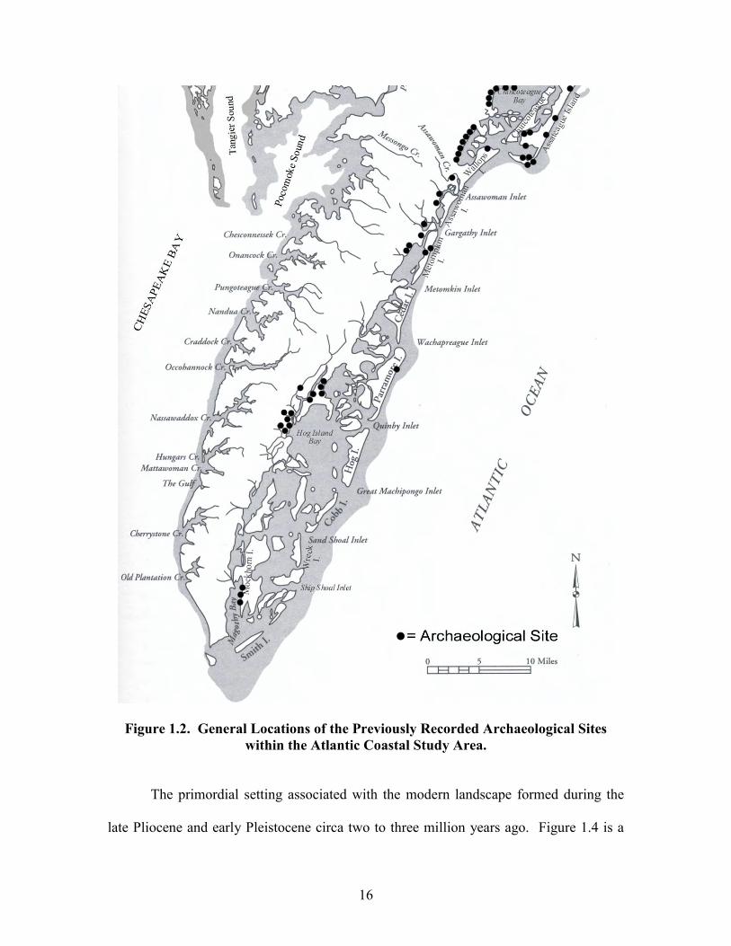
The Virginia Eastern Shore is essentially a long narrow spit of land that extends
south approximately 65 miles from the Maryland section of the Delmarva Peninsula. The
area includes a landscape created by over two million years of fluctuating sea levels. The
present landscape (see Figure 1.3) has been sculpted by wind over the past 18,000 to
20,000 years. The present landscape (see Figure 1.3) has also been altered by Holocene
sea level rise. Figure 1.3 will serve as the base image for discussing the geological
history of Virginia’s Eastern Shore. Refer to the scale and orientation direction in Figure
1.3 relative to the images presented in Figures 1.4, 1.5, 1.6, 1.7, and 1.8.
16
Figure 1.2. General Locations of the Previously Recorded Archaeological Sites within the Atlantic Coastal Study Area.
The primordial setting associated with the modern landscape formed during the
late Pliocene and early Pleistocene circa two to three million years ago. Figure 1.4 is a
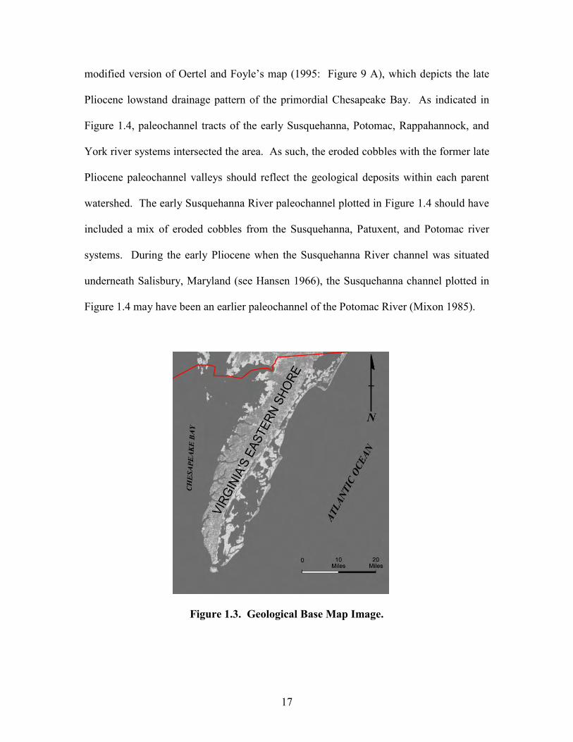
17
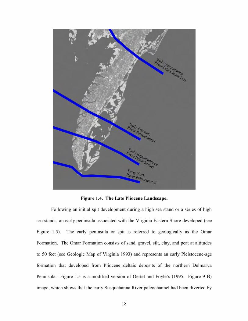
modified version of Oertel and Foyle’s map (1995: Figure 9 A), which depicts the late
Pliocene lowstand drainage pattern of the primordial Chesapeake Bay. As indicated in
Figure 1.4, paleochannel tracts of the early Susquehanna, Potomac, Rappahannock, and
York river systems intersected the area. As such, the eroded cobbles with the former late
Pliocene paleochannel valleys should reflect the geological deposits within each parent
watershed. The early Susquehanna River paleochannel plotted in Figure 1.4 should have
included a mix of eroded cobbles from the Susquehanna, Patuxent, and Potomac river
systems. During the early Pliocene when the Susquehanna River channel was situated
underneath Salisbury, Maryland (see Hansen 1966), the Susquehanna channel plotted in
Figure 1.4 may have been an earlier paleochannel of the Potomac River (Mixon 1985).
Figure 1.3. Geological Base Map Image.
18
Figure 1.4. The Late Pliocene Landscape.
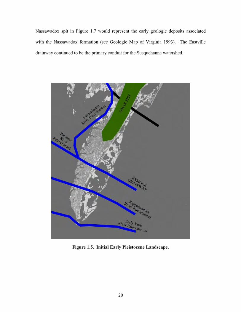
Following an initial spit development during a high sea stand or a series of high
sea stands, an early peninsula associated with the Virginia Eastern Shore developed (see
Figure 1.5). The early peninsula or spit is referred to geologically as the Omar
Formation. The Omar Formation consists of sand, gravel, silt, clay, and peat at altitudes
to 50 feet (see Geologic Map of Virginia 1993) and represents an early Pleistocene-age
formation that developed from Pliocene deltaic deposits of the northern Delmarva
Peninsula. Figure 1.5 is a modified version of Oertel and Foyle’s (1995: Figure 9 B)
image, which shows that the early Susquehanna River paleochannel had been diverted by
19
the formation of the Omar spit. The former Susquehanna drainway to the Atlantic Ocean
was abandoned and the Susquehanna and Potomac watersheds were joined as one macro-
watershed drainage basin. During this period, the Exmore channel recorded by Kerhin et
al. (1996: Figure 2) was the primary drainway of the Potomac and Susquehanna River
system. Oertel and Foyle (1995) have suggested the region resembled the landscape
illustrated in Figure 1.5 during isotopic stage 12 or 14.
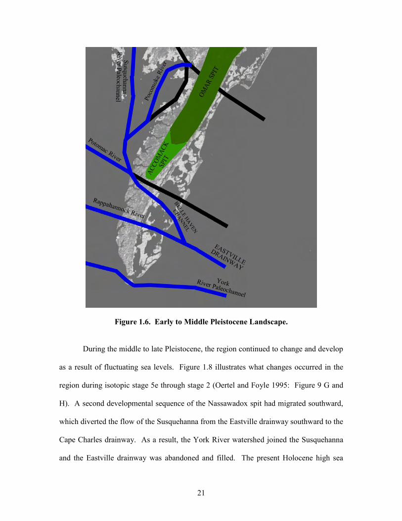
After subsequent high sea stands, the drainage systems and the Virginia Eastern
Shore landmass continue to change and develop. Figure 1.6 illustrates what the region
resembled during isotopic stage 10 (Oertel and Foyle 1995: Figure 9 D). In Figure 6, the
Susquehanna River channel has shifted its main channel westward (see Kerhin et al.
1996: Figure 2). The Accomack spit, which is an extension of the ancient Omar spit,
developed and it diverted the Susquehanna River channel further south. The Exmore
drainway was abandoned, inactive, and filled with sediment. The Belle Haven channel
described by Oertel and Foyle (1995) connected the Susquehanna River system with the
Rappahannock River. The Susquehanna and Rappahannock macro-watershed emptied
into the Atlantic Ocean through the Eastville drainway (see Kerhin et al. 1996).
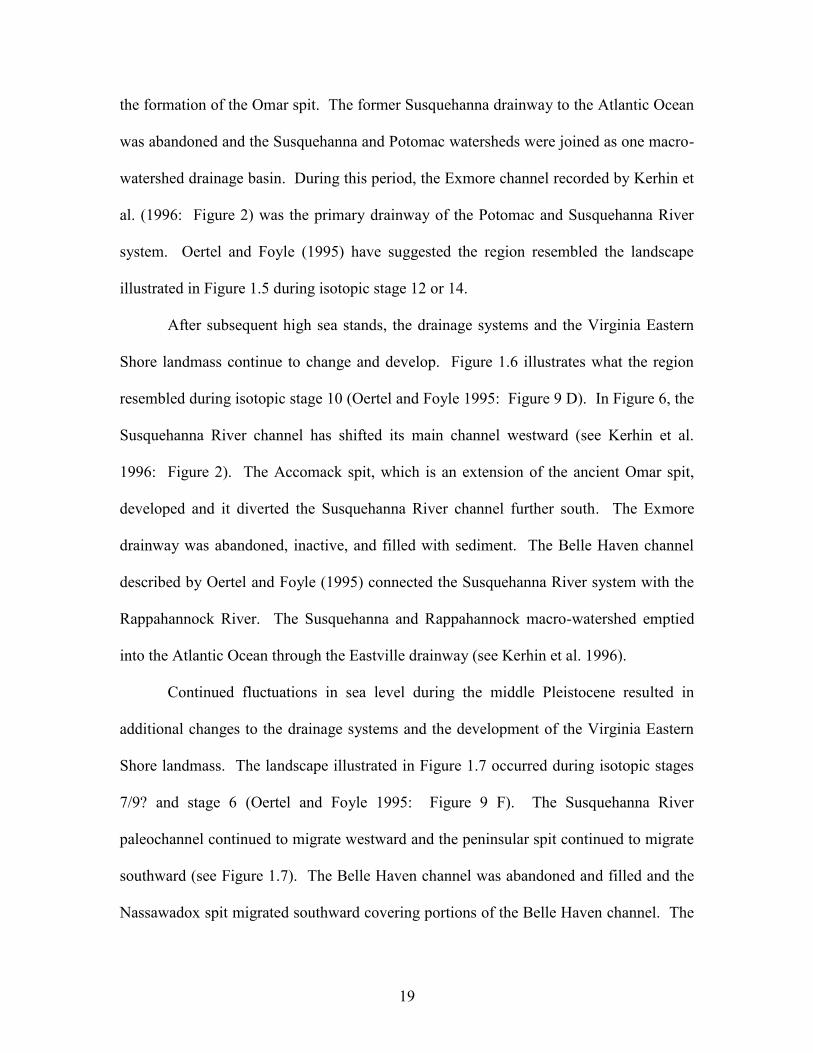
Continued fluctuations in sea level during the middle Pleistocene resulted in
additional changes to the drainage systems and the development of the Virginia Eastern
Shore landmass. The landscape illustrated in Figure 1.7 occurred during isotopic stages
7/9? and stage 6 (Oertel and Foyle 1995: Figure 9 F). The Susquehanna River
paleochannel continued to migrate westward and the peninsular spit continued to migrate
southward (see Figure 1.7). The Belle Haven channel was abandoned and filled and the
Nassawadox spit migrated southward covering portions of the Belle Haven channel. The
20
Nassawadox spit in Figure 1.7 would represent the early geologic deposits associated
with the Nassawadox formation (see Geologic Map of Virginia 1993). The Eastville
drainway continued to be the primary conduit for the Susquehanna watershed.
Figure 1.5. Initial Early Pleistocene Landscape.
21
Figure 1.6. Early to Middle Pleistocene Landscape.
During the middle to late Pleistocene, the region continued to change and develop
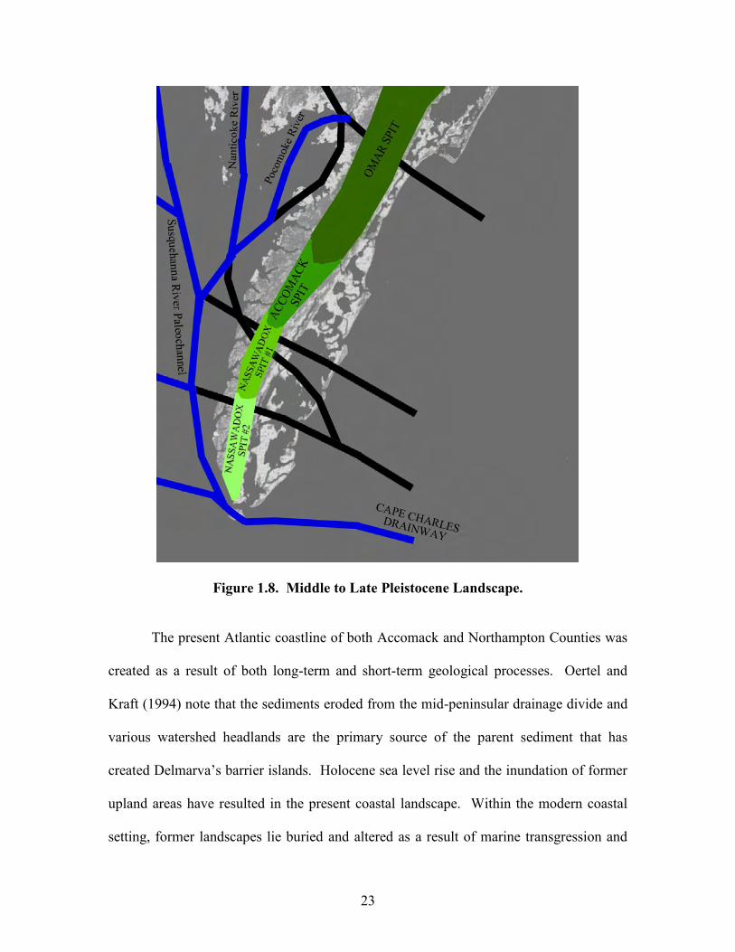
as a result of fluctuating sea levels. Figure 1.8 illustrates what changes occurred in the
region during isotopic stage 5e through stage 2 (Oertel and Foyle 1995: Figure 9 G and
H). A second developmental sequence of the Nassawadox spit had migrated southward,
which diverted the flow of the Susquehanna from the Eastville drainway southward to the
Cape Charles drainway. As a result, the York River watershed joined the Susquehanna
and the Eastville drainway was abandoned and filled. The present Holocene high sea
22
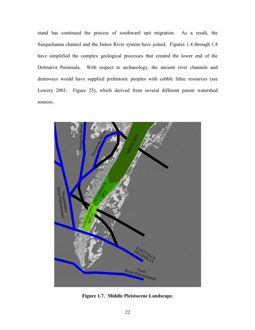
stand has continued the process of southward spit migration. As a result, the
Susquehanna channel and the James River system have joined. Figures 1.4 through 1.8
have simplified the complex geological processes that created the lower end of the
Delmarva Peninsula. With respect to archaeology, the ancient river channels and
drainways would have supplied prehistoric peoples with cobble lithic resources (see
Lowery 2001: Figure 25), which derived from several different parent watershed
sources.
Figure 1.7. Middle Pleistocene Landscape.
23
Figure 1.8. Middle to Late Pleistocene Landscape.
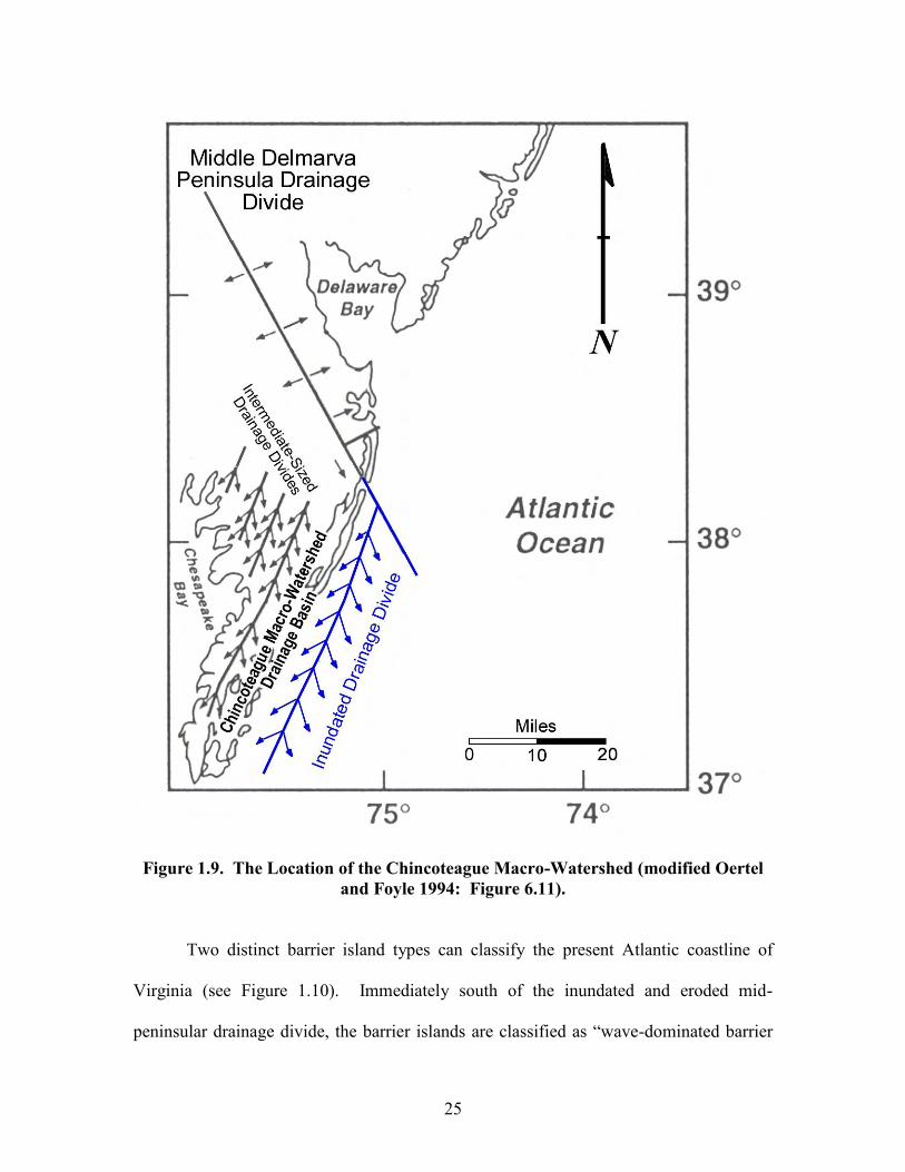
The present Atlantic coastline of both Accomack and Northampton Counties was
created as a result of both long-term and short-term geological processes. Oertel and
Kraft (1994) note that the sediments eroded from the mid-peninsular drainage divide and
various watershed headlands are the primary source of the parent sediment that has
created Delmarva’s barrier islands. Holocene sea level rise and the inundation of former
upland areas have resulted in the present coastal landscape. Within the modern coastal
setting, former landscapes lie buried and altered as a result of marine transgression and
24
coastal sediment accretion. For example, Oertel and Kraft (ibid: 222) note that the
coastal plain adjacent to Assateague Island has a drainage pattern that is distinctly
different from the northern headland regions of the Delmarva Peninsula coastal
compartment. They show (ibid.) that the intermediate-sized watersheds of the Pocomoke,
Wicomico, Nanticoke, and Choptank Rivers are spaced approximately 20 kilometers
apart and are oriented parallel to the coastal trend of the Atlantic Ocean (see Figure 1.9).
The Pocomoke, Wicomico, Nanticoke, and Choptank river systems drain into the
Chesapeake Bay. The Chincoteague watershed (ibid: Figure 6.10) is the seawardmost
system, which has been partially flooded during Holocene transgression. The headwaters
of the Chincoteague watershed are located immediately north of Snug Harbor, Maryland
on Sinepuxent Neck. The western divide of the partially flooded Chincoteague
watershed has survived Holocene marine transgression and is represented by the Atlantic-
Chesapeake watershed divide that extends down the length of Accomack and
Northampton Counties (see Figure 1.9). The partially submerged first-order and second-
order streams along Virginia’s coastline have produced the irregular mainland shoreline
behind the coastal barrier island lagoons. As such, during the Late Pleistocene, Early
Holocene, and Middle Holocene, the present shoreline associated with Virginia’s Atlantic
mainland coast was part of the Chincoteague macro-watershed. Middle to Late Holocene
marine transgression breached the eastern flanks of this watershed and flooded the former
river valley. Even so, a few isolated eastern terrace remnants of the Chincoteague macro-
watershed have survived Late Holocene inundation (see Finkelstein and Kearney 1988;
and Shideler et al. 1984).
25
Figure 1.9. The Location of the Chincoteague Macro-Watershed (modified Oertel and Foyle 1994: Figure 6.11).
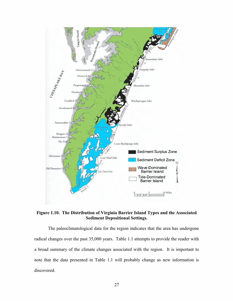
Two distinct barrier island types can classify the present Atlantic coastline of
Virginia (see Figure 1.10). Immediately south of the inundated and eroded mid-
peninsular drainage divide, the barrier islands are classified as “wave-dominated barrier
26
islands”. The wave-dominated barrier island chain also extends north of the inundated
mid-peninsular divide. With respect to Virginia, this chain extends from the Maryland-
Virginia border south to the end of Assateague Island. Numerous inlets do not interrupt
the coastline of Virginia’s wave dominated barrier islands, and littoral processes are the
primary means of coastal sediment movement. From Wallops Island south to
Fisherman’s Island, Virginia’s coast can be classified as a “tide-dominated” barrier island
chain. Within this area, numerous inlets occur and tidal action is the primary means of
coastal sediment movement. Chincoteague and Pope Islands, which are situated behind
Assateague Island, are different from the wave-dominated coastline situated east of them.
Chincoteague and Pope Islands represent former tide-dominated barrier islands that have
been overrun by the wave actions and littoral processes that formed Assateague Island
(see Oertel and Kraft 1994: Figure 6.13).
It is evident in the images presented relative to the post-Pliocene geologic history
of the Atlantic coast of Accomack and Northampton Counties that the region has
undergone radical changes over the past two to three million years. Our discussion has
focused on the impacts to the region as a result of marine transgression and marine
regression events. Even so, we should not negate the impact aeolian processes had on the
region. A quick examination of the present barrier islands indicate that they have had
their sediments worked and reworked, deposited and redeposited as a result of aeolian
processes. Geologically, the Virginia Eastern Shore is a landscape sculpted by the action
of wind and water.
27
Figure 1.10. The Distribution of Virginia Barrier Island Types and the Associated Sediment Depositional Settings.
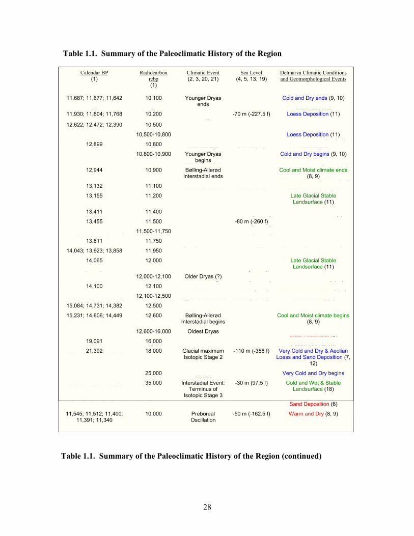
The paleoclimatological data for the region indicates that the area has undergone
radical changes over the past 35,000 years. Table 1.1 attempts to provide the reader with
a broad summary of the climate changes associated with the region. It is important to
note that the data presented in Table 1.1 will probably change as new information is
discovered.
28
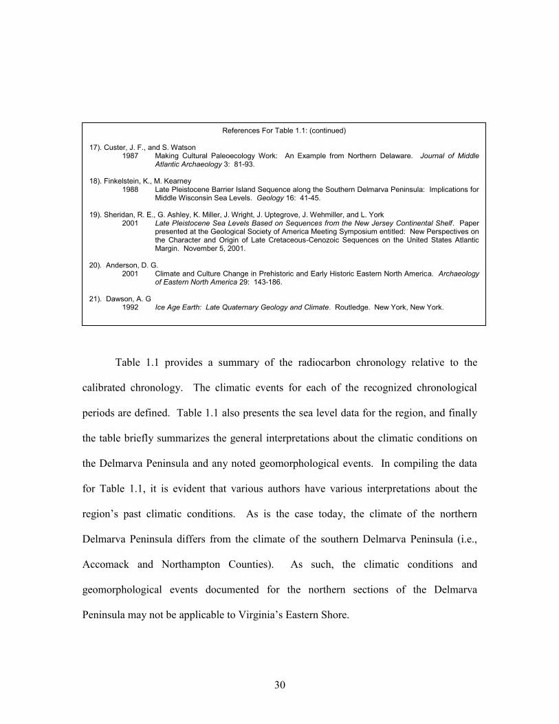
Table 1.1. Summary of the Paleoclimatic History of the Region
Table 1.1. Summary of the Paleoclimatic History of the Region (continued)
Calendar BP (1)
Radiocarbon rcbp (1)
Climatic Event (2, 3, 20, 21)
Sea Level (4, 5, 13, 19)
Delmarva Climatic Conditions and Geomorphological Events
Modern 0 Warming Proposed
50 0 Warm and Wet
Little Ice Age ends Cold ends
298 250
357 “Jamestown Drought” (14)
524 500 Little Ice Age begins
-.33 m (1 f) Cold begins
Medieval Warm ends
Warm and Dry ends
929 1000 Aeolian Sand Deposition (15)
Medieval Warm begins
-1 m (3.25 f) Warm and Dry begins
1388, 1358, 1354 1500 Sub-Atlantic Warm and Wet (7)
1948, 1936, 1934 2000 -1.25 m (-4.06 f) Wet and Colder ends (8)
-1.75 m (-5.68 f)
2710, 2629, 2617, 2562, 2542, 2518
2500 -2.25 m (-7.31 f)
3208, 3179, 3169 3000 Sub-Boreal ends -4 m (-13 f) Wet and Colder begins (8)
Brief Warming Period (16)
4500, 4490, 4440 4000 -6 m (-19.5 f)
5728 5000 Sub-Boreal begins -8.5 m (-27.62 f) Dominant Warm/Dry (17)
Atlantic -9.25 m (-30 f) Warm Wetter Climate (8, 9)
6850, 6838, 6825, 6824, 6800, 6764
6000 Hypsithermal ends -10 m (-32.5 f) Warm and Dry (9)
Interior Basins Seasonally Dry (8)
7820, 7807, 7792 7000 Hypsithermal -15 m (-48.75 f) Aeolian Deflation & Aeolian Sand Deposition (6)
7400 Colder and Dry (9)
8986; 8874; 8825; 8819 8,000 -24 m (-78 f) Aeolian Deflation & Aeolian Sand Deposition (6)
10,189 9,000 Hypsithermal begins
-38 m (-123.5 f) “Delmarva Desert Period” (7)
10,736; 10,708; 10,702 9,500 Boreal Cold Episode (20)
11,254; 11,253; 11,234 9,900 Aeolian Deflation & Aeolian Sand Deposition (6)
11,545; 11,512; 11,400; 11,391; 11,340
10,000 Preboreal Oscillation
-50 m (-162.5 f) Warm and Dry (8, 9)
Calendar BP (1)
Radiocarbon rcbp (1)
Climatic Event (2, 3, 20, 21)
Sea Level (4, 5, 13, 19)
Delmarva Climatic Conditions and Geomorphological Events
11,687; 11,677; 11,642 10,100 Younger Dryas ends
Cold and Dry ends (9, 10)
11,930; 11,804; 11,768 10,200 -70 m (-227.5 f) Loess Deposition (11)
12,622; 12,472; 12,390 10,500
10,500-10,800 Loess Deposition (11)
12,899 10,800
10,800-10,900 Younger Dryas begins
Cold and Dry begins (9, 10)
12,944 10,900 Bølling-Allerød Interstadial ends
Cool and Moist climate ends (8, 9)
13,132 11,100
13,155 11,200 Late Glacial Stable Landsurface (11)
13,411 11,400
13,455 11,500 -80 m (-260 f)
11,500-11,750
13,811 11,750
14,043; 13,923; 13,858 11,950
14,065 12,000 Late Glacial Stable Landsurface (11)
12,000-12,100 Older Dryas (?)
14,100 12,100
12,100-12,500
15,084; 14,731; 14,382 12,500
15,231; 14,606; 14,449 12,600 Bølling-Allerød Interstadial begins
Cool and Moist climate begins (8, 9)
12,600-16,000 Oldest Dryas
19,091 16,000
21,392 18,000 Glacial maximum Isotopic Stage 2
-110 m (-358 f) Very Cold and Dry & Aeolian Loess and Sand Deposition (7,
12)
25,000 Very Cold and Dry begins
35,000 Interstadial Event: Terminus of
Isotopic Stage 3
-30 m (97.5 f) Cold and Wet & Stable Landsurface (18)
29
References For Table 1.1: 1). Stuiver, Minze, Paula J. Reimer, Edouard Bard, J. Warren Beck, G. S. Burr, Konrad A. Hughen, Bernd Kromer, Gerry McCormac, Johannes van der Plicht, and Marco Spurk
1998 INTCAL98 Radiocarbon Age Calibration, 24,000–0 cal BP. Radiocarbon 40(3). 2). Wohlfarth, Barbara
1996 The Chronology of the Last Termination: A Review of Radiocarbon-dated, High-resolution Terrestrial Stratigraphies. Quaternary Science Review 15: 267-284.
3). Cronin, Thomas M.
1999 Principles of Paleoclimatology. Columbia University Press, New York. 4). Colman, S. M., J. P. Halka, and C. H. Hobbs
1991 Patterns and Rates of Sediment Accumulation in the Chesapeake During the Holocene Rise in Sea Level. Contribution Number 1668 of the Virginia Institute of Marine Science.
5). Colman, S. M. and R. B. Mixon
1987 The Record of Major Quaternary Sea-Level Changes in a Large Coastal Plain Estuary, Chesapeake Bay, Eastern United States. Palaeogeography, Palaeoclimatology, Palaeoecology 68: 99-116.
6). Markewich, H. W., and W. Markewich
1994 An Overview of Pleistocene and Holocene Inland Dunes in Georgia and the Carolinas: Morphology, Distribution, Age, and Paleoclimate. U.S. Geological Survey Bulletin 2069. Washington, D.C.
7). Millis, H., J. Gunn, and G. Pasternack
2000 Archaeological and Geomorphological Reconnaissance at the Blackwater National Wildlife Refuge, Dorchester County, Maryland. U.S. Fish and Wildlife Service. Hadley, Massachusetts.
8). Kellogg, D. C., and J. F. Custer (ed.)
1994 Paleoenvironmental Studies of the State Route 1 Corridor: Contexts for Prehistoric Settlement, New Castle and Kent Counties, Delaware. Delaware Department of Transportation Archaeology Series No. 114. Dover, Delaware.
9). McWeeny, L., and D. C. Kellogg
2001 Early and Middle Holocene Climate Changes and Subsistence Patterns Along the Eastern Coast of North America. Archaeology of Eastern North America 29: 187-212.
10). Taylor, K. C., G. W. Lamorey, G. A. Doyle, R. B. Alley, P. M. Grootes, P. A. Mayewski, J. W. White, and L. K. Barlow
1993 The ‘Flickering Switch’ of Late Pleistocene Climate Change. Nature 361: 432-436. 11). Foss, J. E., D. S. Fanning, F. P. Miller, and D. P. Wagner
1978 Loess Deposits of the Eastern Shore of Maryland. Soil Science Society of America Journal 42(2): 329-334.
12). Rea, D. K.
1994 The Paleoclimatic Record Provided by Eolian Deposition in the Deep Sea: The Geologic History of Wind. Reviews of Geophysics 32: 159-195.
13). Kearney, Michael S.
1996 Sea-Level Change During the Last Thousand Years in Chesapeake Bay. Journal of Coastal Research 12 (4): 977-983.
14). Stahle, D. W., M. K. Cleaveland, D. B. Blanton, M. D. Therrell, and D. A. Gay
1998. The Lost Colony and Jamestown Droughts. Science 280:564-567. 15). Cline, W. J., G. W. Monaghan, and D. R. Haynes
2001 Archaeological and Geological Evaluation at Butler’s Bluff, Northampton County, Virginia. Paper prepared by the William and Mary Center for Archaeological Research, Williamsburg, Virginia.
16). Fiedel, S. J.
2001 What Happened in the Early Woodland? Archaeology of Eastern North America 29: 101-142.
30
Table 1.1 provides a summary of the radiocarbon chronology relative to the
calibrated chronology. The climatic events for each of the recognized chronological
periods are defined. Table 1.1 also presents the sea level data for the region, and finally
the table briefly summarizes the general interpretations about the climatic conditions on
the Delmarva Peninsula and any noted geomorphological events. In compiling the data
for Table 1.1, it is evident that various authors have various interpretations about the
region’s past climatic conditions. As is the case today, the climate of the northern
Delmarva Peninsula differs from the climate of the southern Delmarva Peninsula (i.e.,
Accomack and Northampton Counties). As such, the climatic conditions and
geomorphological events documented for the northern sections of the Delmarva
Peninsula may not be applicable to Virginia’s Eastern Shore.
References For Table 1.1: (continued) 17). Custer, J. F., and S. Watson
1987 Making Cultural Paleoecology Work: An Example from Northern Delaware. Journal of Middle Atlantic Archaeology 3: 81-93.
18). Finkelstein, K., M. Kearney
1988 Late Pleistocene Barrier Island Sequence along the Southern Delmarva Peninsula: Implications for Middle Wisconsin Sea Levels. Geology 16: 41-45.
19). Sheridan, R. E., G. Ashley, K. Miller, J. Wright, J. Uptegrove, J. Wehmiller, and L. York
2001 Late Pleistocene Sea Levels Based on Sequences from the New Jersey Continental Shelf. Paper presented at the Geological Society of America Meeting Symposium entitled: New Perspectives on the Character and Origin of Late Cretaceous-Cenozoic Sequences on the United States Atlantic Margin. November 5, 2001.
20). Anderson, D. G.
2001 Climate and Culture Change in Prehistoric and Early Historic Eastern North America. Archaeology of Eastern North America 29: 143-186.
21). Dawson, A. G 1992 Ice Age Earth: Late Quaternary Geology and Climate. Routledge. New York, New York.
31
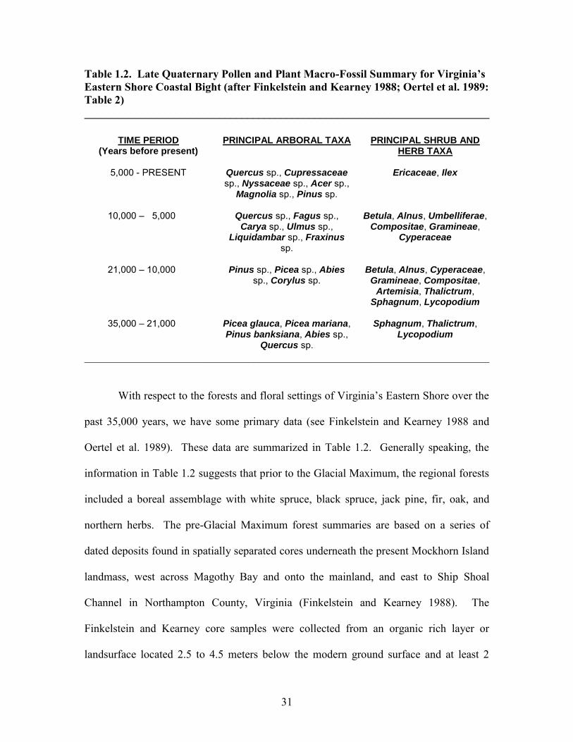
Table 1.2. Late Quaternary Pollen and Plant Macro-Fossil Summary for Virginia’s Eastern Shore Coastal Bight (after Finkelstein and Kearney 1988; Oertel et al. 1989: Table 2) ________________________________________________________________________
________________________________________________________________________
With respect to the forests and floral settings of Virginia’s Eastern Shore over the
past 35,000 years, we have some primary data (see Finkelstein and Kearney 1988 and
Oertel et al. 1989). These data are summarized in Table 1.2. Generally speaking, the
information in Table 1.2 suggests that prior to the Glacial Maximum, the regional forests
included a boreal assemblage with white spruce, black spruce, jack pine, fir, oak, and
northern herbs. The pre-Glacial Maximum forest summaries are based on a series of
dated deposits found in spatially separated cores underneath the present Mockhorn Island
landmass, west across Magothy Bay and onto the mainland, and east to Ship Shoal
Channel in Northampton County, Virginia (Finkelstein and Kearney 1988). The
Finkelstein and Kearney core samples were collected from an organic rich layer or
landsurface located 2.5 to 4.5 meters below the modern ground surface and at least 2
TIME PERIOD (Years before present)
PRINCIPAL ARBORAL TAXA PRINCIPAL SHRUB AND HERB TAXA
5,000 - PRESENT Quercus sp., Cupressaceae
sp., Nyssaceae sp., Acer sp., Magnolia sp., Pinus sp.
Ericaceae, Ilex
10,000 – 5,000 Quercus sp., Fagus sp.,
Carya sp., Ulmus sp., Liquidambar sp., Fraxinus
sp.
Betula, Alnus, Umbelliferae, Compositae, Gramineae,
Cyperaceae
21,000 – 10,000 Pinus sp., Picea sp., Abies
sp., Corylus sp. Betula, Alnus, Cyperaceae,
Gramineae, Compositae, Artemisia, Thalictrum,
Sphagnum, Lycopodium
35,000 – 21,000 Picea glauca, Picea mariana, Pinus banksiana, Abies sp.,
Quercus sp.
Sphagnum, Thalictrum, Lycopodium
32
meters below present sea level (ibid). The boreal organics within this layer provided 10
radiometric dates between 23,000 to 33,000 radiocarbon years B.P. A similar dated pre-
Glacial Maximum organic-rich landsurface has recently been reported for the Butler’s
Bluff area immediately west of Mockhorn Island (Cline et al. 2001). The Butler’s Bluff
dated landsurface, which is topographically higher than Mockhorn Island, is
approximately 2 meters above modern sea level. Based on the presence of dinoflagellate
cysts and foraminifera remains found above the dated organic layer, Finklestein and
Kearney (1988) believed that the dated Mockhorn Island 23,000 to 33,000 year old
organic landsurface may have been buried underneath a transgressional marine barrier
island deposit associated with the Middle Wisconsin Isotopic Stage 3 interstadial (see
Shideler et al. 1984: Figure 6). Given the current Middle Wisconsin Isotopic Stage 3
interstadial sea level data (see Table 1.1), Middle Atlantic sea levels were 20 to 30 meters
below present 55,000 to 35,000 years ago. For Finklestein and Kearney’s (1988)
assertion to be correct, the present landsurface would have to be topographically 65 to 90
feet lower 23,000 to 33,000 years ago for the area to be at or below documented Middle
Wisconsin sea levels. Given the minimal amount of isostatic changes over the past
35,000 years for the Delmarva Peninsula, it is suggested that the geological stratum
situated above the buried Mockhorn Island landsurface represent Glacial Maximum
aeolian sand deposits that have been bioturbated during the Late Holocene by coastal
organisms. The bioturbative processes in coastal areas (see Lowery 2001) could have
introduced modern dinoflagellate cysts and foraminifera remains to the stratum overlying
the buried organic-rich boreal landsurface. The dinoflagellate cysts and foraminifera
remains could have also been introduced into the overlying strata via aeolian erosion and
33
redeposition of older marine deposits. As a result, these micro-marine fossils were
incorporated into younger non-marine geologic strata. Wah (2001) has seen similar
micro-marine fossils incorporated within the Late Pleistocene-age loess deposits on
Maryland’s Eastern Shore. Like Finklestein and Kearney, Cline et al. (2001) interpreted
the materials situated above the 33,000 year-old lower paleosol near Butler’s Bluff as
representative of a shallow marine environment, but offered no supportive data. On the
Virginia Eastern Shore, it would seem geologically and paleoclimatically impossible to
have a synchronically dated regional organic rich landsurface with boreal taxa buried
below shallow marine sediments that are younger than 25,000 to 35,000 year old.
Generally speaking, the floral data in Table 1.2 suggest a marked transition from a
boreal glacial forest setting to forests dominated by oak, beech, hickory, elm, sweet gum,
and ash during the Early to Middle Holocene. During the Middle to Late Holocene, oak,
cedar, black gum, maple, magnolia, and pine dominated the forests of Virginia’s Eastern
Shore. The changes to the forest and plant community over this duration would be an
expression of the climatic changes documented for the area.
Current Physiographic Overview of Virginia’s Eastern Shore
Accomack County is the easternmost part of the Commonwealth of Virginia.
Like Northampton County, Accomack is wedged between the Chesapeake Bay and the
Atlantic Ocean. In respect to land area, Accomack County encompasses 386,400 acres,
or 604 square miles (Peacock and Edmonds 1994). Geologically, Accomack County’s
surface soils are documented as Pleistocene and Holocene age soils (Geologic Map of
Virginia 1993). Peacock and Edmonds (1994) indicate that the soil types documented in
the county include Arapahoe mucky loam (AhA), Arapahoe-Melfa complex (AmA),
34
Assateague fine sand (AtD), Beaches (BeB), Bojac soils (BhB, BkA, and BoA), Camocca
fine sand (CaA), Chincoteague silt loam (ChA), Dragston fine sandy loam (DrA),
Fisherman fine sand (FhB), Fisherman-Assateague complex (FmD), Fisherman-Camocca
complex (FrB), Magotha fine sandy loam (MaA), Melfa-Hobucken complex (McA),
Molena soils (MoB, and MoD), Munden sandy loam (MuA), Nimmo sandy loam (NmA),
Polawana mucky sandy loam (PoA), and Seabrook loamy fine sand (SeA).
The geologic formations associated with the county include the Omar formation,
the Kent Island formation, the Wachapreague formation, the Occohannock member, the
Butlers Bluff member, and Joynes Neck sands (ibid.). Generally, sands with some gravel
dominate these geologic formations. Peacock and Edmonds (1994: 2) and Cobb and
Smith (1989: 1-2) indicate that the climate of both Accomack and Northampton Counties
is mild in winter and hot and humid in summer. Even so, both counties are subject to
frequent steady storms in winter, fall, and spring (Peacock and Edwards, ibid.; and Cobb
and Smith, ibid.). Although both counties are north of the usual track of hurricanes and
tropical storms, the region has experienced several severe storm events in the past (Pielke
1990: Appendix A). The offshore salinity environments along the Atlantic side of
Accomack and Northampton Counties would be classified as seasonal polyhaline (18-30
ppt) to euhaline (above 30 ppt), which would suggest that the region would have a true
Atlantic marine environment (White 1989: Figure 3). White’s (ibid: 133-159) work
suggests that the region would include a variety of high salinity adapted plants, fishes,
mollusks, birds, and land animals in the region of modern Accomack County.
Northampton County encompasses 227,300 acres, or 325 square miles (Cobb and
Smith 1989). Geologically, Northampton County’s surface soils are documented as
35
Pleistocene and Holocene age soils (Geologic Map of Virginia 1993). According to
Cobb and Smith (1989), the soil types documented in the county include Assateague soils
(AsE, and AtD), Beaches (BeB), Bojac soils (BhB, BkA, and BoA), Camocca fine sand
(CaA), Chincoteague silt loam (ChA), Dragston fine sandy loam (DrA), Fisherman fine
sand (FhB), Fisherman-Assateague complex (FmD), Fisherman-Camocca complex (FrB),
Magotha fine sandy loam (MaA), Molena loamy sand (MoD), Munden sandy loam
(MuA), Nimmo sandy loam (NmA), Polawana mucky sandy loam (PoA), and Seabrook
loamy fine sand (SeA). The major soil differences between Accomack and Northampton
Counties relates to the fact that no Arapahoe mucky loam (AhA), Arapahoe-Melfa
complex (AmA), and Melfa-Hobucken complex (McA) soils are documented in
Northampton County. Not surprisingly, these soil types are associated with large
Chesapeake Bay related tidal marsh settings, which Northampton County is lacking. The
Pleistocene and Holocene-age geologic formations associated with Northampton
County’s soils include the Omar formation, the Kent Island formation, the Wachapreague
formation, the Occohannock member, the Butlers Bluff member, and Joynes Neck sands
(ibid.). Sands with some gravel dominate these geologic formations. Younger geologic
formations are more prevalent in Northampton County than in Accomack.
The modern environmental diversity of both Accomack and Northampton
Counties is expressed on land and in the waters adjacent to the region’s shorelines. The
region is dominated by sandy soils. As a result, drought tolerant plant species were
observed in both counties’ forests. Prickly pear cactus (Opuntia compressa), black
cherry (Prunus serotina), and Virginia pine (Pinus virginiana) were observed within
interior forested areas. In southern Northampton County, live oak (Quercus virginiana)
36
was observed in a few of the sandy-wooded areas. Associated with these plant species,
the traditional array of pines (Pinus taeda, and Pinus serotina), and oaks (Quercus alba,
Quercus stellata, Quercus bicolor, Quercus prinus, Quercus michauxii, Quercus falcata,
and Quercus phellos) were present. Also observed were American holly (Ilex opaca) and
red cedar (Juniperus virginiana). Yaupon (Ilex vomitoria) was only noted on Mockhorn
Island off the coast of southeastern Northampton County. In respect to the marine
environments, the region is dominated by Atlantic Ocean high salinity regimes. In the
offshore areas and within the tributaries, virtually every mollusk species defined by
Lippson and Lippson (1974: 35-41) for the Chesapeake Bay was observed. Extensive
beds of the American oyster (Crassostrea virginica) were noted within the back barrier
lagoons. Hard clams (Mercenaria mercenaria), Atlantic ribbed mussels (Geukensia
demissa), Bay scallops (Aequipecten irradians), knobbed whelks (Busycon carica),
lightning whelks (Busycon contrarium), and channeled whelks (Busycon canaliculatum)
were also noted living within the back barrier island lagoons. In reference to fish species,
it is assumed that all or most of the species defined by Murdy, Birdsong, and Musick
(1997) could be found within the offshore areas and within the tributaries associated with
the Atlantic portion of Virginia’s Eastern Shore. Of particular note, several species of sea
turtles and large cartilaginous fish species (i.e., sharks, rays, and skates) are common in
the back barrier island lagoons. Numerous sea turtles, several large sharks (i.e., the bull
shark and the great hammerhead), and numerous rays (i.e., the spiny butterfly ray and the
Southern stingray) were observed during the fieldwork.
The resident population listed in the 1997 census data includes 45,100 people
within the study area (Eastern Shore of Virginia Economic Development Commission,
37
n.d.). Of the total population, 32,300 individuals live in Accomack County and 12,800
reside in Northampton County (ibid.). The dominant businesses are associated with the
agriculture and poultry industries (ibid; Peacock and Edmonds 1994; and Cobb and Smith
1989). The region is well suited for both industries. With productive soils (Peacock and
Edmonds 1994; and Cobb and Smith 1989), a high annual level of precipitation, and a
moderate climate (Eastern Shore of Virginia Economic Development Commission, n.d.),
the Virginia Eastern Shore has the essential elements needed for both the agriculture and
poultry industries.
Cultural, Historical, and Archaeological Overview
The Chesapeake Bay and Delmarva Peninsula represent a large geographic region
of the Atlantic coastal area and the Middle Atlantic region. The terrestrial and marine-
coastal environments within this broad region were very diverse over the entire region’s
prehistory. Prehistoric human adaptations probably varied at any given point in time over
the macro-Delmarva region. Therefore, the following prehistoric overview represents a
general framework for assessing the region’s past. It can be assumed there were unique
adaptations within the region that are not expressed in this overview. The lack of
acknowledgement of these ancient adaptations in the following overview is an expression
of the lack of focused intra-regional research. As additional focused research is
conducted within the Delmarva region, the following overview will have to be modified
to accommodate this new data.
Paleoindian Period The Paleoindian period is the first diagnostic cultural episode in the Western
Hemisphere. Traditionally, the Paleoindian period is represented by several types of
38
distinctive fluted projectile points. The earliest uncontested evidence of people in North
America has been radiometrically dated to roughly 11,500 to 10,000 radiocarbon years
B.P. Recently, Fiedel (1999: 95-115) has presented data that suggests Clovis-age sites,
which are circa 11,500 to 10,800 radiocarbon years B.P., are older than archaeologists
previously thought. Clovis-age radiometric dates, when calibrated, are in essence 13,500
to 12,800 calendar years old (ibid. Figure 6).
Archaeological sites with cultural components older than Clovis have been
reported in the Western Hemisphere (see Dillehay 1997). In the Middle Atlantic region
of the United States, archaeological sites with radiometrically dated cultural levels
situated stratigraphically below Clovis cultural levels have also been reported (see
McAvoy and McAvoy 1997). Additional pre-Clovis sites have been reported for the
Middle Atlantic region (see Adovasio 1983: 6-12 and 1993: 199-218). Some researchers
(Stanford 1998 and personal communication: 6/17/99) believe that the Clovis culture
developed out of a pre-Clovis population situated somewhere in the southeastern portion
of the United States. The dense numbers of fluted Clovis-style points and the diverse
types of fluted points found in the Southeast (see Anderson and Faught 1998: 163-187;
and Anderson, Faught, and Gillam 1998) are presented as two lines of evidence
supporting a southeastern origin of the Clovis culture. Stanford (ibid.) believes that the
archaeological evidence found by Adovasio (1993: 199-218) at Meadowcroft
Rockshelter, by McAvoy and McAvoy (1997) at Cactus Hill, and recent discoveries at
the Topper site provide evidence for a pre-Clovis population in the Eastern United States.
Various researchers (Stanford 1997, 1998, and personal communication: 6/17/99; Bruce
Bradley, personal communication: 11/24/98; and Boldurian and Cotter 1999: 117-123)
39
have suggested the pre-Clovis and Clovis populations found in the Eastern United States
have similarities to the Solutrean culture of Europe. Stanford (1997, 1998, and personal
communication: 6/17/99) has suggested that people may have crossed the North Atlantic
during the Late Pleistocene. The Solutrean-like technologies associated with the pre-
Clovis sites in the eastern United States may represent the archaeological expression of
the Solutrean influences across the Atlantic from Western Europe (ibid.). In a recent
overview by Dixon (1999), he argues that the initial colonization of the Americas
occurred along the west coast of North America during the Late Pleistocene. The
traditional “ice-free corridor” model for the initial colonization of the Americas seems
unlikely. Geologic evidence (Stanford 1998, and personal communication: 6/17/99) has
indicated that the “ice-free corridor” was not “ice-free” at the time the areas south of the
Laurentide and Cordilleran ice sheets were already colonized.
The data associated with the pre-Clovis/Clovis debate is highly controversial and
always changing. This topic is discussed because it does have relevance to the coastal
portions of the Middle Atlantic region. If the work at Cactus Hill indicates cultures were
in the Middle Atlantic region before Clovis and if Stanford’s arguments are accurate, then
the coastal areas of New Jersey, Delaware, Maryland, and Virginia may have some pre-
Clovis archaeological data. It is also arguable that the “diagnostic” pre-Clovis artifacts
found at Cactus Hill (McAvoy and McAvoy 1997: Figure 5.42 and 5.65) or
Meadowcroft Rockshelter (Adovasio 1983: Figure 1; and 1993: Figures 3, 4, 5, 6, and 8)
would not be recognized as “pre-Clovis” if they were found in surface contexts.
In the Middle Atlantic region, the types of diagnostic Paleoindian projectile points
found as surface manifestations and within excavated contexts include the Clovis point,
40
the Cumberland/Barnes point (cf. Wright and Roosa 1966; Roosa 1977; Storck and Bitter
1989: 176; and Deller 1989: 200-203), the Crowfield point (cf. Deller and Ellis 1984:
41-71), the Hardaway-Dalton point, and the Hardaway Side-Notched point (Coe 1964).
Examples resembling the Suwannee/Simpson-style fluted point (see Daniel and
Wisenbaker 1987: 44-54) typically found in the Southeast and the Debert-style fluted
point (see MacDonald 1985: 70-77) typically found in the Northeast have been observed
in regional assemblages. Given the fact that Fiedel (1999: 95-115) has presented data
which suggest that the Paleoindian period is older and lasted longer than previously
thought, the range of variation in fluted point styles in any given region may be important
to document and recognize. Even so, until these “distinctive” Paleoindian point types are
found in good excavated contexts, regional archaeologists can only speculate what the
variation in Paleoindian projectile points actually mean.
The Clovis-type projectile point is the earliest recognized Paleoindian period
projectile point and the most common type of fluted point found on the Delmarva
Peninsula (Brown 1979). Brown’s work did not discern the range of fluted point styles
that were previously mentioned. Her chronology only defined three types: Clovis, Mid-
Paleo, and Dalton-Hardaway. Others (Custer 1984a, 1996) have employed the same
Paleoindian projectile point chronology. The Paleoindian point chronology employed by
Brown and Custer is based on excavations associated with the Flint Run area (Gardner
and Verry 1979). Gardner and Verry (1979) define the Mid-Paleo point type as small,
more finely made, thinner, and finely fluted. Small “Mid-Paleo” fluted point preform
was also found stratigraphically above Clovis points at the Flint Run sites (ibid: Figure
4I). Collins and Kay (1999: 46-50) note that very small points manufactured at a
41
diminutive scale are associated with Clovis age sites. The range of fluting styles, preform
preparation, and post-fluting retouch suggests more diversity in regional Paleoindian
fluted projectile points than has been recognized. The range of variation is apparent even
in the Clovis and Mid-Paleo categories defined by Brown (1979) and Custer (1984a and
1996). It could be argued that some of the points defined by Brown on the Delmarva
Peninsula as Mid-Paleo point types (Brown 1979: #3, #42, #52, #55, and #62) are indeed
“small” Clovis points. “Small” Clovis points are a distinct part of the Clovis tool kit (see
Collins and Kay 1999: 46-50; Graham et al. 1981: Figure 2; Haury et al. 1959: Figure
12; and Hester 1972: Figure 89). It is arguable that some of the points defined by
Brown on the Delmarva Peninsula as Clovis point types (1979: #21, #69, and #70) are
indeed Cumberland/Barnes style points (see Storck 1997). The fluted point types defined
by Brown (1979) may need to be revised or re-categorized to reflect the new research
outside the Middle Atlantic area.
The Clovis point is a pan-regional projectile point type that occurs in diverse
environmental contexts over the entire North American continent. Kellogg and Custer
(1994) provide an environmental overview of the Paleoindian period. In the Middle
Atlantic, sea levels were significantly lower because a large portion of the earth’s ocean
water was locked up in the Laurentide and Cordilleran ice sheets. Estimates indicate that
the sea levels around the world were approximately 76 to 60 meters (250 to 195 feet)
below the present level. Numerous species of Pleistocene megafauna roamed the
continent (Graham and Mead 1987). Evidence indicates that in the eastern portions of
the North American continent, woodland fauna included the musk ox, the mammoth, the
mastodon, the moose, the peccary, the white-tailed deer, the caribou, the elk, and the
42
giant beaver (Carbone 1976: 67). Whether the Middle Atlantic region Paleoindian
groups utilized and hunted Pleistocene megafauna (i.e., mastodon and mammoth) is open
to speculation. Dent (1995: 128 and 142) notes that floral (i.e., nuts, seeds, and berries)
and aquatic (i.e., fish and shellfish) remains have been found at two sites in the East (i.e.,
Dust Cave and Shawnee Minisink). Even so, Dust Cave is not a Clovis site (see Driskell
1996: 315-330). Therefore, the only site within the Middle Atlantic region with reliable
Clovis subsistence data would be the Shawnee Minisink site (McNett 1985). Does the
generalized Clovis menu excavated at the Shawnee Minisink site represent the Clovis
menu for every Paleoindian in the Middle Atlantic region? Given the ecological diversity
in the modern Middle Atlantic region, one would assume that the ecological diversity
during the Late Pleistocene was equally complex. I would argue that the environmental
summaries for the region (i.e., Kellogg and Custer 1994) are too general and tend to focus
on the metaphorical “forest” rather than the uniqueness of the individual “trees”. In other
words, micro-environments were more important to prehistoric peoples than the general
macro-environment. Unfortunately, traditional techniques of paleoecological
reconstruction would negate the unique micro-environments for the Paleoindian period of
the Middle Atlantic region.
Numerous Clovis period kill sites have been discovered in the western portion of
the United States. At these kill sites, human artifacts have been found in association with
extinct fauna, such as the mammoth. An excellent summary of the faunal remains from
the more important kill sites is presented in an article by Graham and Mead (1987: 382-
383). Evidence from the western Clovis kill sites indicates that mammoth and bison were
frequent prey species (Graham and Mead 1987: 382-383; Bonnichsen et al. 1987: 408).
43
In the eastern portion of the United States, very few sites have produced faunal remains
in association with Clovis artifacts. The Kimmswick site in eastern Missouri has
produced Clovis projectile points in association with several mastodons and a giant sloth
(Graham and Mead; ibid.). In the Northeast, the Hiscock site in western New York has
produced three fluted Clovis-style projectile points in association with mastodon remains
and the remains of other mammals (Gramly and Funk 1990: 16). Gramly and Funk
(ibid.) suggest that the mastodon carcasses found at the Hiscock site may have been
scavenged and not actually hunted by Paleoindians. Several tantalizing Paleoindian sites
in Florida have produced fluted lanceolate points in contexts with Late Pleistocene faunal
remains (Dunbar 1991: 198-211). Recently, Tankersley and Redmond (2000: 42-46)
have reported Clovis stone and bone tools in association with several flat-headed
peccaries and giant beaver from Sheriden Cave in Ohio. The archaeological evidence
from the East suggests Paleoindian subsistence may have been partially based on
Pleistocene megafauna (Gramly and Funk 1990: 16). At the Shawnee-Minisink site in
the upper Delaware Valley, carbonized plant food and fish remains have been found
within a Paleoindian hearth (McNett and McMillan 1974; McNett et al. 1975; 1977;
Kauffman and Dent 1982). Evidence from the Shawnee-Minisink site indicates that a
portion of the Paleoindian diet was based on gathered resources. Even though sites on
the Delmarva Peninsula have produced no food remains within a Paleoindian context, it
can be assumed that similar hunted and gathered resources may have been utilized by the
local Paleoindian inhabitants.
Researchers would probably argue against my assertion that local Clovis peoples
may have hunted Pleistocene megafauna. It is arguable that within the modern terrestrial
44
coastal plain, preservation factors have greatly impacted the expression of Pleistocene
megafauna remains. Very few Pleistocene mammal remains have been found on the
coastal plain of the Delmarva Peninsula. One record indicates that in 1866, a workman
uncovered the remains of a woolly mammoth (Mammuthus primigenius) and the remains
of a southern mammoth (Mammuthus columbi) on Oxford Neck in Talbot County,
Maryland (Preston 1983: 19). According to the documented record (Clark et al. 1906:
157, 164, 165, 167, and 170), portions of the skull, teeth, and tusks from the mammoths
were discovered on Oxford Neck along with the remains of elk, white-tailed deer, box
turtle, and snapping turtle. Unfortunately, the Oxford Neck Pleistocene fossils have not
been dated. Recently, mastodon remains (Mammut americanum: one tusk fragment, one
DP4 fragment, and one molar fragment), a mammoth tooth (Mammuthus sp.: one molar
fragment), horse remains (Equus sp.: several molars), an elk tooth (Cervus elaphus: one
lower M1 or M2), several bison teeth (Bison sp.: two lower M3s, one lower P2 or P3,
and two other fragmentary teeth), a tapir molar (Tapirus veroensis), a giant beaver tooth
(Castoroides ohioensis: lower P4), and a coyote molar (Canis lantrans) were found
associated with a buried pond strata that revealed carbonized plant materials dated to
17,820 +/- 170 years B.P. (AA-3870). The Late Pleistocene mammal remains mentioned
above were found on Tilghman Island in Talbot County near the mouth of the Choptank
River (Lowery 1999). Ralph Eshelman (personal communication: 10/12/01) identified
the Pleistocene vertebrate remains found at the Tilghman Island locality. Buried pond
and lake sediments are considered to be great places for vertebrate fossil preservation.
Even so, it is important to recognize that the megafauna remains from the Tilghman
Island locality included only teeth and enamel. Therefore, it is arguable that poor Late
45
Pleistocene vertebrate fossil preservation in the Middle Atlantic region has greatly
impacted the archaeological expression of Clovis subsistence. Even so, the vertebrate
remains from the Tilghman Island locality do provide some valuable data relative to the
types of Late Pleistocene animal species living on the Delmarva Peninsula during the last
glacial maximum. It is important to note that Pleistocene megafaunal remains have also
been discovered offshore on the continental shelf adjacent to the Delmarva Peninsula
(Edwards and Merrill 1977: 9). Eshelman and Grady (1986) have provided data relative
to Late Pleistocene vertebrate remains found on the continental shelf off of Virginia’s
eastern shore and remains found as redeposited materials along the barrier islands of
Accomack County, Virginia. The vertebrate remains found off of Virginia’s eastern
shore and along the barrier islands (see Eshelman and Grady 1986) include giant beaver
(Castoroides ohioensis), mastodon (Mammut americanum), and woolly mammoth
(Mammuthus primigenius). Other Pleistocene vertebrate species found on the barrier
islands of Virginia’s eastern shore include numerous Atlantic walrus (Odobenus
rosmarus), Columbian mammoth (Mammuthus columbi), elk (Cervus elaphus), horse
(Equus sp.), bison (Bison sp.), white-tailed deer (Odocoileus virginianus), Eastern box
turtle (Terrapene carolina), and dire wolf (Canis dirus). Demonstrating Paleoindian
exploitation of the various megafaunal species noted within the region may never occur.
Even so, it is important to note that roughly contemporaneous megafauna remains have
been found on the Delmarva Peninsula.
Tool kits associated with Paleoindian sites in the Middle Atlantic region can vary
from being highly curated to showing little evidence of reuse or resharpening. The Paw
Paw Cove Paleoindian site complex in Talbot County, Maryland, has produced artifacts,
46
which are very small and have multiple working edges (Lowery 1989a: 143-164; 1989b).
The Paw Paw Cove assemblage reflects a high degree of tool curation. In contrast, the
Meekins Neck Paleoindian site complex in Dorchester County, Maryland, has produced
an assemblage of virtually unresharpened Clovis points and several large single purpose
flake tools (Lowery and Phillips 1994: 29-36). This assemblage seems to be a pristine
Clovis assemblage based on large cryptocrystalline cobbles and which reflects very little
tool curation (ibid.). The degree of tool curation at sites on the Delmarva Peninsula was
originally associated with the distance a site is located from the primary lithic outcrop
(see Lowery 1992c). At that time, Lowery (1992c) believed the farther a group traveled
on its migratory pattern and the longer a group stayed away from the primary lithic
resources, the more curated a tool kit would have become. Based on earlier observations,
a cyclical movement pattern was proposed for prehistoric groups during the Paleoindian
and Early Archaic periods (Custer 1990: 108-109; Lowery 1989a: 161-162; Lowery and
Custer 1990: 111-114). It was thought that a cyclical movement pattern would explain
the diversity and variation seen in the tool kits from Paleoindian and Early Archaic sites
on the peninsula (Lowery and Custer 1990: 102-114).
Custer (1984a) has reported a Paleoindian preference for high-quality
cryptocrystalline materials at sites on the Delmarva Peninsula. Lowery (1989a, 1989b,
and 1992c) also indicates a preference for high quality cryptocrystalline materials; but
non-cryptocrystalline materials, such as orthoquartzite, ironstone, and quartzite, are also
present in local Paleoindian assemblages. The majority of the Paleoindian assemblage
from the Higgins site (Ebright 1992) was made from locally available non-
cryptocrystalline materials. Twenty-five percent of the cultural diagnostics from the
47
Clovis levels at the Cactus Hill site were manufacture from quartz and quartzite
(McAvoy and McAvoy 1997: Table 7.1). In the Northeast, some researchers have
suggested that Paleoindians were “addicted” to primary cryptocrystalline materials. The
assertion that Paleoindians only used primary quarry-related stone to make tools is
commonly noted in the published record. For example, Deller (1989: 209) notes
“…Paleoindians relied almost exclusively on chert from bedrock sources for their raw
material supplies rather than exploiting materials from secondary sources such as tills and
stream beds.” Statements such as this have only fostered misconceptions about local
Paleoindian lifeways. Even Ebright (1992: 243-244, 254-255, and 411) suggests that
some of the tools and the waste debris associated with the Paleoindian levels at the
Higgins site in Maryland are similar to cherts from the Normanskill formation in New
York, jaspers from quarries near Fleetwood, Pennsylvania, and chalcedonies from the
Williamson quarry site near Dinwiddie, Virginia. Using Ebright’s (ibid.) data one could
argue that Paleoindians in the Middle Atlantic were very mobile and traveled to these
distant quarries or traded with other contemporaneous groups and acquired “exotic” non-
local primary lithic materials. The diversity of lithic materials within the local secondary
cobble outcrops of the coastal plain can easily explain the few exotic materials found in
prehistoric assemblages. Lowery (2000 and 2002) has demonstrated that “exotic” cherts,
jaspers, and chalcedonies can be found within the local cobble outcrops of the Middle
Atlantic Coastal Plain. Some of these local secondary cobble materials can resemble
cryptocrystalline materials from distant primary outcrops. Ebright’s focus (1992: 243-
244, 254-255, and 411) on the “exotic” or “non-local” materials from the Paleoindian
levels at the Higgins site is surprising considering that the diagnostic Clovis points and
48
over 90% of the assemblage from the site are made of locally available quartz. Ebright
even acknowledges (ibid: 243) that one of the quartz Clovis-related bifaces exhibits
cortex. Lowery’s (2000 and 2002) work on the Delmarva Peninsula suggests that
regional Clovis groups utilized locally available secondary cobble sources and most of
the coastal plain primary lithic resources to manufacture their tool kits. Lowery (ibid.)
would suggest that Clovis groups within the coastal plain were not traveling long
distances to acquire bedrock materials for their tool kits. Joseph McAvoy’s work
(personal communication: 3/27/00) in Virginia implies the same pattern. In other words,
McAvoy (ibid.) and Lowery (2000 and 2002) suggest that Clovis groups were local, had
entrenched settlement patterns, and had restricted mobility patterns. The high density of
Paleoindian diagnostic projectile points on the Delmarva Peninsula (see Lowery 1999,
2000, and 2002) and in southern Virginia (McAvoy 1992) would indicate that the coastal
areas of Maryland, Delaware, and Virginia supported a large population of early
Paleoindian peoples. As such, Lowery (2000) and McAvoy’s (personal communication:
3/27/00) observations about Clovis age settlement and mobility patterns would have
definite ramifications relative to the arguments related to pre-Clovis occupations within
the Middle Atlantic region.
A variety of Paleoindian sites have been recorded on the Delmarva Peninsula and
around the Chesapeake Bay (Dent 1995). Only one site on Maryland’s portion of the
Delmarva Peninsula has revealed sub-surface living floors and possible features (Lowery
1992c and 2002). The Higgins site (Ebright 1992) represents the only other site in
Maryland with excavated sub-surface living floors and possible features. The types of
Paleoindian sites in the Chesapeake and Delaware Coastal Plains include base camps,
49
hunting/procurement sites, secondary cobble quarry reduction sites, and isolated point
finds. The differences between the forms of Paleoindian sites are based on the size and
diversity of the tool assemblages found at each site. Unfortunately, the Paw Paw Cove
site (Lowery 1992c) and the Higgins site (Ebright 1992) represent the only excavated
Paleoindian sites in Maryland. It would be hard to assess the functional implications of
sites that have produced surface fluted point finds without focused excavation (Lowery
1999). Given the degree of marine transgression over the past 13,000 years, we can only
speculate that the present terrestrial archaeological record of the Delmarva Peninsula
represents only a small percentage of the actual number and various types of Paleoindian
sites (see Lowery 2002).
With respect to the types of ecological settings that have survived sea level rise,
Paleoindian sites have been found associated with the poorly drained soils around spring
fed interior wetlands, the coastal plain terraces adjacent to freshwater interior streams,
and the confluences of freshwater streams (Ebright 1992; Lowery 1997: 26-35).
Paleoindian sites in Maryland have not been found around the poorly drained,
precipitation and aquifer fed “Carolina Bay” or “Bay/Basin” wetlands (Custer and
Bachman 1986: 1-10). Jack Cresson (personal communication: 3/25/00) indicates that
Paleoindian sites have been found associated with “Bay/Basin” features in the New
Jersey Coastal Plain. Sassaman (1996: Figure 4.11) indicates that Paleoindians along the
South Carolina Coastal Plain utilized “Carolina Bay” wetlands. Lowery’s work (1989b,
1992b, and 1992c) associated with the Paw Paw Cove site has revealed archaeological
components situated within a poorly drained soils adjacent to a spring fed wetland.
McAvoy’s (personal communication: 6/30/99) recent work at the Williamson
50
Paleoindian site in Virginia has revealed archaeological components situated within a
poorly drained spring fed swamp. The presence of regional Clovis-age archaeological
components within and around poorly drained spring fed wetlands may represent a
regional settlement adaptation to the documented Clovis-age drought (see Dunbar 1991:
185-213; Gramly 1999: 32; Haynes 1991: 438-450, 1993: 219-236, and 1999; Laub and
Haynes 1998; and Willig 1991: 91-118). All of the present Paleoindian sites on the
Delmarva Peninsula would represent interior upland settings during the Late Pleistocene.
Even so, Paleoindian sites that reflect coastal adaptations and estuarine/coastal settlement
patterns may exist on the former shoreline margins situated on the continental shelf
(Lowery 2002).
Early Archaic Period Following the extinction of the Late Pleistocene fauna and the establishment of
new environmental conditions, the human populations in the eastern United States began
to adapt to a Holocene setting. Sea levels began to rise significantly as the ice sheets
retreated. Between 10,000 and 9,000 radiocarbon years ago, changes have been observed
in the archaeological record. Numerous Early Archaic sites have been found on the
Delmarva Peninsula (see Custer 1986: 45-64; Lowery 1992a, 1992b, 1993b, 1994,
1995b, 1995c, 1996, and 1997; and Lowery and Custer 1990). Early Archaic sites have
been found associated with the well-drained soils around spring fed interior wetlands,
upland coastal plain terraces adjacent to interior streams, and the confluences of
freshwater streams (Lowery 1997: 26-35). Contrary to Custer and Bachman’s earlier
studies (1986: 1-10), Early Archaic age components have been found associated with the
well-drained circular ridges surrounding “Carolina Bays” or “Bay/Basins” (see Lowery
51
1997: 26-35). Early Archaic sites with coastal adaptations and estuarine settlement
patterns may exist, but these sites would presently be inundated (ibid.).
During the Early Archaic period a hunting and gathering lifestyle persisted.
Unlike the Paleoindian period, a cyclical movement pattern has been proposed for the
Early Archaic period (Lowery and Custer 1990). It is during the Early Archaic period
that local groups seem to be extensively utilizing non-local primary cherts, chalcedonies,
and jaspers. Stone tools and projectile points without any cobble cortex that resemble
“Iron Hill” jasper have been observed in Early Archaic assemblages as far south as
Watt’s Island, Virginia. “Period specific” sites have provided the best data relative to
lithic utilization patterns. Both buried sites and surface sites can have “period specific”
cultural affiliations. “Period specific” sites are those sites that have produced diagnostic
projectile points associated with only one or a few related prehistoric periods. The
limited number of diagnostic projectile points found at “period specific” sites suggest that
the undiagnostic portion of the site’s assemblage should be roughly the same age.
Diagnostic Early Archaic projectile points and flake tool assemblages found at “period
specific” archaeological sites suggest that cobble resources were also utilized. Even so,
cobble utilization during the Early Archaic period is a minor component of the Early
Archaic lithic reduction strategy. Varying degrees of lithic tool curation have been
observed at several sites across the peninsula.
The Crane Point site (18TA221a), which is one of the largest Early Archaic
assemblages reported within the Chesapeake coastal plain, provides the basis for many of
the interpretations about the Early Archaic period on the Delmarva Peninsula. At the
Crane Point site, numerous sidescrapers and endscrapers indicate that animals were
52
butchered and processed at the site (Lowery and Custer 1990). The Crane Point site and
other local Early Archaic Coastal Plain sites have produced rare and specialized flake
tools that are more frequently documented at Early Archaic sites in South Carolina,
Georgia, Florida, Alabama, and Mississippi. At least eight Waller knives (Geiger and
Brown 1983; Goodyear, Michie, and Charles 1989; Lauro 1982; McGahey 1996; Purdy
and Beach 1980; Purdy 1981; and Waller 1971) and six Edgefield scrapers (Goodyear,
Michie, and Purdy 1980; Lauro 1982; Michie 1968 and 1972; and Purdy and Beach
1980) have been observed in local Delmarva Peninsula collections associated with sites
which have produced diagnostic Late Paleoindian and Early Archaic projectile points.
These rare and specialized flake tools may indicate cultural affiliations between the Early
Archaic groups on the Delmarva Peninsula and coastal plain groups in the Southeast.
Grinding slabs, milling stones, and nutting stones indicate that plant resources were also
processed at the Crane Point site (Lowery and Custer 1990). Other artifacts from the
Crane Point site suggest that more diverse domestic activities were performed at regional
Early Archaic sites. Large chipped stone adzes suggest that wooden items were
manufactured, hematite lumps and red ochre stained grinding slabs indicate the use of
pigments, and wedges and drills suggest that wood and bone items were manufactured.
The tool assemblages from regional Early Archaic sites indicate a hunting and gathering
lifestyle.
Even though researchers (Anderson and Sassaman 1996) have suggested both
Paleoindian and Early Archaic groups practiced similar lifestyles, the Early Archaic
occupants of the Delmarva area began to incorporate new technologies (i.e., chipped
stone adzes, and plant processing tools) and practice different lithic reduction strategies
53
(i.e., cyclical use of non-local primary lithic materials). During the Early Archaic period,
projectile point styles also changed. Serrated and corner notched projectile points such as
the Palmer, Charleston, Lost Lake, Decatur, Amos, Fort Nottoway/Thebes, and Kirk
types are frequently found at Early Archaic sites on the Delmarva Peninsula. The
changes in projectile points may represent a combination of non-local and local stylistic
and functional influences. Data from the Delmarva Peninsula suggest that extensive
trade in rhyolite or direct exploitation of the rhyolite quarries may have started during the
latter portion of the Early Archaic period (Custer 1986: 45-64). Custer (1986) notes that
dense numbers of rhyolite artifacts appear within local Early Archaic assemblages. The
presence of rhyolite would suggest direct acquisition and/or trade and exchange in non-
local materials.
Unlike the Paleoindian period, some subsistence data is available for the Early
Archaic period of the Delmarva Peninsula. A hearth feature from the Crane Point site
contained hickory nut, butternut, acorn, amaranth, and chenopodium (Lowery and Custer
1990). The Early Archaic levels at the Cactus Hill site in Virginia have also revealed
hearths with oak and hickory remains (McAvoy and McAvoy 1997: Appendix D). The
Early Archaic hearths at Cactus Hill site have been dated between 9,790 +/- 200
radiocarbon years B.P. to 8,800 +/- 120 radiocarbon years B.P. (Ibid). Therefore, one can
suggest that a generalized foraging pattern with extensive utilization of plant resources is
indicated by some of the Early Archaic age sites in the Chesapeake Bay and the
surrounding region (McAvoy and McAvoy 1997; Dent 1995). Even so, Stanzeski (1998:
42-43) has reported a series of Early Archaic age cremation burials at the West Creek site
in southern coastal New Jersey. A date of 9850 +/- 160 radiocarbon years B.P. was
54
recorded for the cremation burials at the West Creek site and the burials included Kirk
corner-notched points along with a few scrapers (Ibid.). The presence of a designated
Early Archaic-age cemetery would indicate that some Early Archaic peoples in the
Middle Atlantic region had well-defined territories. Without context, it could be argued
that the West Creek burial assemblages would have been interpreted as domestic
occupation debris. As such, Early Archaic burial and mortuary sites within the Middle
Atlantic region may be more common than the archaeological literature has portrayed.
All of the present Early Archaic terrestrial sites on the Delmarva Peninsula would
represent interior upland settings during the Early Holocene. Even so, Early Archaic
sites that reflect coastal adaptations and estuarine/coastal settlement patterns may exist on
the former shoreline margins situated on the continental shelf and within the deeper
portions of the Chesapeake Bay. Recent studies (see Cronin 2000: Table 6.1) have
indicated that a few oyster beds had already been established along the margins of the
deep channels associated with a diminutive Early Holocene Chesapeake Bay at the mouth
of the Potomac River circa 9,670 to 9,350 radiocarbon years B.P.
Middle Archaic Period The Middle Archaic period (9,000 - 6,000 years B.P.) is one of the most poorly
understood periods during the Delmarva Peninsula’s prehistory. It is generally accepted
that a hunting and gathering lifestyle persisted during the Middle Archaic period.
Environmental change during the Atlantic episode created extensive interior wetland
settings. Sea levels continued to rise (Colman, Halka, and Hobbs 1991), but were still
significantly lower than the present. Pollen evidence indicates an oak-hemlock forest at
the onset of the Atlantic episode (cf. Custer and Mellin 1989: 4-6; and Kellogg and
55
Custer 1994). Numerous surface manifestations associated with the more diagnostic
Middle Archaic projectile points (i.e., MacCorkle, St. Albans, and LeCroy bifurcated
points) have been found on the Delmarva Peninsula. Middle Archaic sites have been
documented associated with the well-drained soils around “Carolina Bays”, spring-fed
interior wetlands, upland coastal plain terraces adjacent to interior streams, and the
confluences of freshwater streams (Lowery 1997: 26-35). Middle Archaic coastal
adaptations and estuarine settlement patterns may exist but these sites would presently be
inundated.
Between 9,000 and 8,000 years ago several distinctive projectile point types were
being manufactured. The types include MacCorkle, St. Albans, and LeCroy (Broyles
1971). These early Middle Archaic types are easily recognizable because of their unique
forms. From 8,000 to 6,000 years ago several projectile point styles were being
manufactured that may not be as diagnostic or easily recognizable to the researcher.
These styles include Stanly, Neville, Morrow Mountain, and the Guilford types of
projectile points. Stewart (1998a), Stewart and Cavallo (1991), and Katz (2000) have
recently reported triangular points from the deeply buried Middle Archaic-age levels at
Abbott Farm and elsewhere. The scarcity of circa 8,000- to 6,000-year-old Middle
Archaic sites may not be because of low population densities but because of the lack of
recognizable diagnostics (Jay Custer, personal communication: 8/20/92). Several of the
Middle Archaic projectile point styles resemble later projectile point types and this may
cause confusion.
Data from the Delmarva Peninsula suggests trade in rhyolite or direct exploitation
of the rhyolite quarries continued during the Middle Archaic period. Rhyolite, a
56
distinctive non-local lithic material, appears with some regularity on the Delmarva
Peninsula in Middle Archaic bifurcated point contexts (Stewart 1984b: 26; Custer 1989:
139). The closest source of rhyolite is located in western Maryland and in central
Pennsylvania. The presence of rhyolite on the Delmarva Peninsula during the Middle
Archaic period would indicate either direct procurement of rhyolite by native Delmarva
Peninsula groups or contact and trade with groups in areas where rhyolite outcrops.
Until stratified Middle Archaic sites are excavated on the Delmarva Peninsula,
very little can be said about the tool kit variation associated with the region’s Middle
Archaic cultures. In areas outside of the Delmarva Peninsula other researchers have data
relative to the tool kit variability during the Middle Archaic. Stewart and Cavallo (1991)
discuss Middle Archaic tool kit variability for the Delaware Valley. Chapman (1973 and
1975) presents Middle Archaic tool kit data from excavated contexts in the southeastern
United States. Within the Choptank River watershed, a single component Middle
Archaic site has been located that may provide some data relative to Middle Archaic tool
kit variability. A site (Lowery 1999) recorded during the Choptank River collection
study (i.e., 18DO279 east) offers the best glimpse into the regional Middle Archaic tool
kit. The shoreline assemblage from 18DO279 (east) suggests that regional groups had a
micro-tool technology based on the bi-polar reduction of small pebbles and cobbles. The
types of tools found at 18DO279 (east) indicate that regional groups had tool kits which
included endscrapers, sidescrapers, spokeshaves, gravers, drills, bi-polar cores, micro-
blade cores (?), utilized flakes, small bifaces, bifurcated projectile points, hammerstones,
abraders, hematite, stone mortars, and ground stone adzes. The chipped stone tool
assemblage from 18DO279 (east) suggests that flake tools, bifaces, and projectile points
57
were manufactured from bi-polar flakes. Some plant processing tools (i.e., a stone
mortar) are present in the assemblage from 18DO279 (east). The tool kit from 18DO279
(east) is almost identical to the excavated tool kit recovered by Chapman (1975) at the
Rose Island site. Subsistence data are completely absent from local Delmarva Peninsula
sites, but it can be assumed that part of the diet consisted of plant foods similar to those,
which were found at the Crane Point site (Lowery and Custer 1990). Outside of the
Delmarva area, Egloff and McAvoy (1990: 70) have reported subsistence remains from
the Middle Archaic levels at the Slade site in Virginia. The Slade site produced a hearth
containing carbonized hickory hulls dated to 8,300 +/- 110 radiocarbon years B.P. These
subsistence materials were associated with a Middle Archaic bifurcate point component.
The Slade site has also revealed some evidence relative to patterns of regional social
organization. Egloff and McAvoy (1990: 70) reported a poorly preserved Middle
Archaic cremation burial at the Slade site in Virginia. The cremation burial at the Slade
site was found in association with MacCorkle-like or St. Albans points and a ground
stone adz (Ibid.). Unlike the Early Archaic West Creek cemetery in New Jersey (see
Stanzeski 1998: 42-43), the Slade site revealed only a single cremation burial. Lacking
context, it could be argued that the Slade site burial assemblage would have been
interpreted as domestic occupation debris. As such, Middle Archaic burial and mortuary
sites within the Middle Atlantic region may be more common than the archaeological
literature has portrayed. Future work may help resolve some of the numerous
unanswered questions about the Middle Archaic period on the Delmarva Peninsula.
58
Late Archaic Period The Late Archaic period (6,000 - 3,000 years B.P.) is a period of continued
environmental and cultural change. The environmental conditions during the sub-boreal
episode indicate a warm and dry period with xeric forests and grasslands (Custer and
Mellin 1989: 4-7; Kellogg and Custer 1994). By the end of the Late Archaic period the
rate of sea level rise began to slow (see Colman, Halka, and Hobbs 1991). During the
Late Archaic period, the archaeological record suggests that the Chesapeake Bay
estuarine environment had established itself within the modern confines of the drowned
watershed. Oysters, clams, and other shellfish had populated the middle and upper
reaches of the Chesapeake Bay. The environmental changes had an effect on the native
populations of the region. Custer (1989) has recognized two cultural complexes: the
Clyde Farm complex (5,000 - 3,000 years B.P.) and the Barker’s Landing complex (4,000
- 3,000 years B.P.) on the Delmarva Peninsula during the Late Archaic period. Both
complexes reflect a focus on anadromous fish species and the established estuarine
environments.
The technological aspects of each of these complexes are also very similar. Large
broad blade knives, stemmed projectile points, steatite bowls, and early ceramics
technologies are associated with regional Late Archaic-period sites. The primary
difference between the Clyde Farm and Barker’s Landing complexes is related to the use
of non-local lithic materials. At Clyde Farm complex sites, the stone tool assemblages
tend to be manufactured from local lithic materials acquired from regional cobble
outcrops and silicified or iron cemented local geologic strata. Cobble chert, jasper,
quartz, and quartzite are the most common lithic materials found within Clyde Farm
59
complex assemblages. Ironstone, which is found within the geologic layers of the coastal
plain, is also found at Clyde Farm complex sites. Silicified Miocene sandstone has also
been observed within regional Late Archaic assemblages (Lowery 1998).
Custer (1982) has noted that based on the evidence provided by the Barker’s
Landing complex sites on the Peninsula, incipient ranked societies may have developed.
The Barker’s Landing complex appeared within the region around 4,000 years ago. The
artifacts associated with the Barker’s Landing complex are virtually identical to those
found at Clyde Farm complex sites. The marked differences between the Barker’s
Landing and Clyde Farm complexes are the types of lithic materials utilized to
manufacture stone tools. At Barker’s Landing sites, non-local lithic materials were used
to manufacture knives and projectile points. On the Delaware Bay side of the peninsula,
Late Archaic-age stone tools tend to be manufactured out of argillite. Argillite is a lithic
material that outcrops in the Delaware River valley, portions of New Jersey, and
Pennsylvania. The argillite in regional assemblages is presumed to have derived from
primary quarries outside of the region. Even so, large argillite boulders have been found
within the cobble outcrops of the Delmarva Peninsula. On the Chesapeake Bay side of
the peninsula, stone tools tend to be manufactured out of rhyolite, a lithic material, which
outcrops in western Maryland and central Pennsylvania. Custer (1989: 226) indicates
that caches of argillite have been located at large Barker’s Landing sites in Delaware.
Most notable are the caches found at the Coverdale and Kiunk Ditch sites (Custer 1989:
230). Interestingly, the caches found in Delaware tend to include primary or early stage
bifaces. Several caches associated with the Late Archaic Barker’s Landing complex have
also been found on the Chesapeake Bay side of the peninsula. A cache of nine crescent
60
slate bannerstones and nine quartzite broadspears was found along the eroding shoreline
at 18DO380 along the Honga River in Dorchester County, Maryland. Several caches of
complete bannerstones made of slate, chlorite, and porphyritic granite have been found
associated with human remains at 18KE298 along the Chester River in Kent County,
Maryland. The assemblage from 18KE298 also included numerous large bifaces made of
rhyolite, silicified sandstone, ironstone, quartz, and quartzite. The context of the exotic
assemblages from 18KE298 is unfortunate. Waterman using hydraulic clam dredges
unearthed the items in approximately 15 to 20 feet of water. It is assumed that 18KE298
represents an inundated late Middle or early Late Archaic-era cemetery. Some of the
Chesapeake coastal plain caches have bifaces manufactured exclusively from rhyolite.
Unlike the early stage argillite bifaces found in Delaware, the bifaces found along the
Chesapeake consist of large secondary or late stage bifaces. Most notable is the cache
found at the northern multi-component section of 18TA221b (Lowery 1992b: 24-25, and
1995d). Some of the Chesapeake coastal plain caches also tend to have red ochre or
powdered hematite in association with them. Hematite paintstones have been found at
some Barker’s Landing complex sites on the Chesapeake Bay. Copper has also been
found at some of the Late Archaic sites along the Chesapeake Bay. Jordan (1906: 34-38)
illustrates a large twelve-inch copper spear point found near the Still Pond area of Kent
County, Maryland. A copper “hoe” or “spud” has also been reported from the same area
(ibid.). The copper spear pictured in Jordan’s article is virtually identical to the Late
Archaic “Old Copper Culture” items illustrated by Griffin (1983: 252-253, and Figure
7.1j) and Wittry (1957: Figure 1F). Additionally, two large “Old Copper Culture” style
spear points and a copper-tanged crescent knife were found at 18KE29, which is also
61
near Still Pond. These items are similar to some of the “Old Copper Culture” specimens
from Wisconsin as well (see Wittry 1957: Figure 1E and Figure 2F).
The lithic data provided by the Barker’s Landing sites on the peninsula indicate
the presence of extensive trade and exchange or direct procurement in rhyolite, argillite,
hematite, steatite, and copper. The presence of caches of artifacts made of non-local
lithic materials has suggested to some researchers that these items served a sociotechnic
function (Custer 1989: 230). Custer (1989: 230) also believes that the caches represent
the emergence of a new type of symbol of social status. The combination of intensified
food production, population growth, sedentary lifestyle, and the evidence of caches tend
to indicate the presence of incipient ranked societies during the Barker’s Landing
complex (Custer 1982). The Barker’s Landing complex would seem to denote the
beginning of a high level of social complexity that was to culminate during the Early and
Middle Woodland periods.
During the latter portions of the Barker’s Landing complex, archaeological data
indicate that shellfish, such as oysters, began to be exploited by the native inhabitants. At
the Martingham site, Custer and Lowery (n.d.) excavated a strata containing a thin shell
midden, rhyolite broadspears, and steatite vessel fragments. The Martingham site is
located on the Miles River, a tributary of Eastern Bay. The Martingham site represents
the earliest evidence that suggests humans within the region were exploiting shellfish
resources. By 3,000 years ago, the middle and upper portions of the Chesapeake Bay
must have supported a shellfish population. Even though the terrestrial record indicates
that coastal resources were exploited, the interior portion of the Delmarva Peninsula also
has a significant archaeological record associated with the Late Archaic period (see

62
Lowery 1999: Figure 34). Therefore, one can assume that interior hunted and gathered
resources were also very important to the regions prehistoric peoples. During the Late
Archaic period, archaeological site settings reflect all of the nine settlement patterns
defined by Lowery (1997: 26-35). The nine settlement pattern types include settings on
points of land, around coves, at stream confluences, around springs, along terraces
adjacent to interior streams, on well-drained sand ridges, around bay-basin features, on
knolls surrounded by estuarine wetlands, and adjacent to estuarine rivers.
Early Woodland Period The regional Early Woodland period (3,000 - 2,300 years B.P., see Dent 1995:
221) climates were important. Sea level continued to rise, but at a much slower rate. The
marine environment of the Chesapeake Bay became firmly established. Extensive
shellfish beds had developed, and the marine environment became conducive to
spawning fish (Custer 1988: 125). Stability of temperature and salinity conditions and
the location of the brackishwater limits far upstream would have pushed spawning
anadromous fish farther inland (Custer 1984b). Custer (1988: 125) notes that the coastal
resources would have been richer, more predictable, and more extensively distributed
than ever before. The terrestrial environmental record shows evidence of colder and
wetter conditions during the Early Woodland period (Kellogg and Custer 1994: 98).
The Early Woodland period is characterized by the appearance of ceramic
technologies. During the Late Archaic period, regional groups utilized stone bowls.
Steatite bowls had to be brought or traded into the region from quarries located outside of
the coastal plain (Brown n.d.; Ward and Custer 1988: 33-49). During the initial portion
of the Early Woodland period or terminal Late Archaic period, regional groups began to

63
manufacture ceramic vessels. Several experimental ceramic types occur regionally
(Custer 1989: 168-171). The regional terminal Late Archaic and Early Woodland
ceramics include Marcey Creek, Ware Plain, Dames Quarter, Selden Island, Accokeek,
Wolfe Neck, Popes Creek, Coulbourn, Nassawango, and Wilgus types. Ceramic
technologies alleviated the burden of transporting heavy and fragile stone bowls.
Ceramics permitted cooking directly over a fire (see Hulton 1984: Plate 44). Unlike
stone bowls, ceramic vessels could be easily manufactured and replaced if damaged via
the use of local clays. Various ceramic vessel types continued to be utilized throughout
the entire Woodland period.
During the Early Woodland period (3,000 - 2,300 years B.P.), two cultural
complexes have been identified on the Delmarva Peninsula (see Custer 1989). The
Wolfe Neck complex is a distinctive Delmarva Peninsula cultural complex (Custer 1989:
253-256). Diagnostic artifacts associated with the Wolfe Neck complex include Wolfe
Neck and Accokeek ceramics (Custer 1989: 171, 176) and their distribution indicates
that Wolfe Neck sites occur throughout the Delmarva Peninsula (Custer 1989: 250).
Subsistence data indicate that marine resources were heavily utilized during the time
associated with the Wolfe Neck complex. Griffith and Artusy (1977: 5) note that
periwinkle, mussels, clams, and oysters were utilized by the inhabitants of the Wolfe
Neck site (75-D-10) in Delaware. Custer (1989: 255) speculates that as estuarine
environments changed during the Early Woodland period, Wolfe Neck complex micro-
band base camps moved to maximize the exploitation of the marine environment. The
Wolfe Neck complex has settlement-subsistence systems that are similar to those noted
for the preceding Clyde Farm complex (Custer: ibid.). Custer (1989: 256) has argued
64
the presence of extensive shell middens during the Wolfe Neck complex is indicative of
the processes of subsistence intensification that began during the Clyde Farm complex.
Within the Chesapeake Bay, it would seem that shellfish intensification and utilization
should have started prior to the Early Woodland period.
Within the central portion of the Delmarva Peninsula, higher levels of social
complexity developed during the Early Woodland period. By 2,500 years B.P., the
Delmarva Adena complex was firmly established on the Delmarva Peninsula. With
radiometric dates indicating that the site is roughly 2,750 to 2,500 years old, the
Nassawango site (18WO23) along the Pocomoke River in Maryland represents the
earliest dated Delmarva Adena site in the region (see Custer 1989: Appendix II). The
Delmarva Adena complex is expressed locally via exotic grave good and human burial
associations. Three regional Adena-related burial sites have been excavated (DeValinger
1970; Ford 1976; Thomas 1970, 1976; and Wise 1974). Other regional Adena-related
cemeteries have been discovered but not professionally excavated. Even the excavated
cemeteries have only been minimally analyzed and published. The Delmarva Adena
complex is regionally represented by salvaged cemetery assemblages, minimally
excavated and published cemetery data, excavated living sites, and isolated surface finds.
The Delmarva Adena complex seems to be an interesting mix of exotic non-local
and local items. Radiometric dates associated with the various local Delmarva Adena
cemeteries indicate that the complex spans a long period of time (Custer et al. 1990:
Figure 36). Based on radiometric data (ibid.), the Delmarva Adena complex is associated
with a time interval between 2,750 years B.P. and 1,300 years B.P. Clearly, the
Delmarva Adena complex is associated with both the Early and Middle Woodland
65
periods. The span of time associated with the Delmarva Adena complex may explain the
interesting mix of exotic non-local and local items. The roughly 1,400-year time span
may also explain the bizarre and somewhat inconsistent non-Adena burial assemblages.
For example, copper beads and pendants were the principle exotic artifacts included in
the Nassawango site (18WO23) burial assemblage. Like the “Old Copper Culture”
artifacts found near Still Pond, Maryland, the early date associated with the Nassawango
site may suggest the site’s assemblage is more closely linked to the pre-Adena peoples
that occupied the Great Lakes area. In contrast, the Frederica site (7K-F-2) is one of the
youngest Delmarva Adena cemeteries with radiometric dates indicating that it is roughly
1,500 to 1,700 years old (Custer et al., 1990: Figure 36). The Frederica site assemblage
included a variety of exotic items. A large Ross barbed biface, fragments of mica, pearls,
a polished cannel coal point or blade, two large copper breastplates, and a large stemmed
biface made of Knife River chalcedony were found at the site. These exotic artifacts
would indicate that the Frederica cemetery is more Hopewellian than Adena (see Seeman
1979 and Tomak 1994: Figure 42 and 43). A few examples of Hopewellian type
artifacts have also been observed within the burial assemblages found at Sandy Hill
(18DO30) in Maryland. Therefore, the Delmarva Adena complex is an interesting mix of
exotic burial items that are in some ways expressive of “classic” Adena, but are also
expressive of earlier and later Ohio Valley and Great Lakes prehistoric cultures.
Both Gardner (1982) and Custer (1982, 1987) suggest that during the Delmarva
Adena complex is a rudimentary “big-man” social organization with ranked kin groups
that appeared within the central portion of the peninsula. Exotic items from the Ohio
Adena culture were being traded into the Delmarva Peninsula (see Stewart 1989). These
66
exotic items are found at Delmarva Adena sites. The variety of exotic trade items
sometimes included large flint bifaces, stone tube pipes, gorgets, pendants, stone paint
cups, copper beads, copper breastplates, cut sheet mica ornaments, pearls, boatstones, and
birdstones (e.g., Ford 1976). Typically, the exotic trade items from the Ohio Valley are
deposited in mortuary contexts on the Delmarva Peninsula. Caches and isolated finds of
Adena artifacts have been found associated with regional habitation sites as well (e.g.,
Custer, Stiner, and Watson 1986; Lowery 1995a). The Delmarva Adena complex
mortuary sites have some of the largest accumulations of Adena-related items outside of
the Ohio Valley heartland.
Delmarva Adena mortuary sites have been found within both watersheds of the
Delaware and Chesapeake coastal plains. Custer (1989: 265-266) has proposed a
ranking system for Delmarva Adena mortuary sites based on the size of the site and the
quantity of Adena-related artifacts found at each site. Major mortuary sites typically are
large and have numerous Adena-related artifacts in association with distinctive mortuary
ceremonialism (Custer ibid.). Custer (ibid.) refers to these sites as major mortuary
exchange centers. The major Delmarva Adena mortuary exchange centers would include
the Sandy Hill site (Ford 1976), the St. Jones site (Thomas 1976), and the Frederica site
(Thomas 1970). Custer (1989: 265) refers to small Delmarva Adena mortuary sites as
minor mortuary exchange centers. Minor mortuary exchange centers typically have small
accumulations of only a few different Adena related artifacts in association with
distinctive mortuary ceremonialism (Custer, ibid.). The minor Delmarva Adena mortuary
exchange centers include the Nassawango site (Wise 1974), the Killens Pond site
(Thomas 1970), the West River site (Ford 1976), the Miles River site (Lowery 1989c),
67
18QU54 (Lowery 1992a), and the recently discovered Sonntag-Whorl site in St. Mary’s
County, Maryland along the Potomac River. Isolated utilized and damaged Adena
artifacts have also been recorded at habitation sites on the Delmarva Peninsula (see
Lowery 1995a). Clearly, the most spectacular cultural remains have been found at the
various mortuary sites located around the Chesapeake Bay. The spectacular non-local
Adena-related artifacts found at mortuary sites overshadows the fact that “less
spectacular” locally made artifacts also occur in mortuary contexts. The locally made
artifacts are equally important components of the Delmarva Adena complex. Ford (1976:
78) refers to a cache of 24 heavily burned, lanceolate, straight based points from the
Sandy Hill site along the south side of Choptank River. Ford (ibid.) noted that he could
not identify the type of lithic material represented in this cache. An examination of this
cache (Lowery 1998) indicates these artifacts are made of Miocene silicified fossiliferous
sandstone that is weathered and heavily ochre stained. Large primary outcroppings of
Miocene sandstone are presently inundated at the mouth of the Choptank River (Lowery,
ibid.). Mr. F. P. Williamson (personal communication: 10/21/99) commented that the
cache of locally made bifaces were found in association with exotic non-local Ohio
Adena artifacts at the Sandy Hill site.
At Delmarva Adena mortuary sites, a variety of burial treatments have been
noted. Cremations are frequently noted and intentionally “killed” or mutilated artifacts
associated with certain burials suggest status differentiation. Differential distributions of
grave treatments and grave goods within cemeteries suggest the existence of ascribed
status categories that crosscut age and sex (Custer 1988: 127). Lowery (1995a), in a
study of isolated Adena artifacts, observed that “classic” Adena type blades or knives
68
show no utilization scars. Some of the large Adena blades or bifaces do show signs of
isolated ridge wear along the high portions of each face. The isolated ridge wear would
suggest the bifaces were carried long distances or pulled in and out of a sheath-like bag
many times. Lowery (1995a) observed some Adena bifaces altered to local biface styles
(i.e., Fox Creek or Selby Bay forms). It is suggested that some blades or knives were
utilized as functional tools only when they were accidentally broken or damaged by their
owners. The recycling of some broken Adena bifaces is indicated by transverse medial
fractured basal edges observed on several Fox Creek or Selby Bay points made of Flint
Ridge materials. Therefore, the distal portions of damaged Adena bifaces seemed to be
converted into local point styles and these points were utilized. The basal portions of
some broken Adena bifaces were also recycled in an attempt to maintain the original
form (ibid.). Several small Flint Ridge Robbins-like points indicate this assertion by the
presence of marked or “crude” flaking patterns along their distal ends. Most of the
recycled basal sections, once resalvaged, were utilized as functional tools. Lowery (ibid.)
concludes that the unaltered large biface forms were viewed by local native groups as
status symbols and included as burial items. Once the form was altered, the social and
cultural value of the artifact was greatly devalued or reduced (ibid.) and these highly
altered points are frequently found at habitation sites.
It is also suggested that a large percentage of the exotic bifaces within Delmarva
Adena mortuary sites were traded into the region in a leaf-shaped form. Some of the data
would indicate that the stems or hafting elements were added to the leaf-blades by local
prehistoric peoples. This would explain some of the bizarre and non-Adena-like forms
found at most Delmarva Peninsula sites (see Ford 1976: Figure 14b, c, d, e, and f; Figure
69
16b, c, and f; Figure 18c-e, i, l, and m-n). The diversity of hafting styles represented in
Delmarva Adena assemblages far exceeds the range of hafting styles expressed at
“classic” Adena sites in the Ohio Valley. For example, compare the Delmarva Adena
bifaces illustrated in Ford (1976: Figures 3, 6, 12, 13, 14, 15, 16, 17, 18, and 19) and
Thomas (1976: Figures 4, 5, and 6) with the examples excavated by Dragoo (1963:
Plates 38, 39, and 40). Patina differences have been observed near the hafting elements
on some of the Delmarva Adena stemmed blades and a few specimens also show the
initial stages of creating a stem or hafting element (see Thomas 1976: Figure 6-upper
left). As such, the exotic Ohio Valley leaf blade forms may have provided the base
outline for the locally diverse and bizarre combinations of non-Adena and Adena-like
hafting elements found at mortuary sites here on the Delmarva Peninsula. This assertion
could explain the chronologically mixed variety of early (i.e., Adena “beaver-tailed”
blades), middle (i.e., Cresap blades), and late (i.e., Robbins blades) Ohio Adena traits
found within single component Delmarva Adena burial features. Several alternate
explanations could also explain the chronological mix. The practice of hoarding
cherished heirlooms over long periods of time could explain the contemporaneous
association of early through late Adena materials at regional burial sites. The long-term
acquisition and trade in items gained through the practice of prehistoric “artifact
collecting” could also explain the unusual chronological mix.
Delmarva Adena living sites have been discovered within the Chesapeake and
Delaware Coastal Plains. Living sites typically have a few items manufactured out of
exotic Ohio Valley lithic materials. But, generally a majority of the stone artifacts are
manufactured out of local lithic materials. Ceramic remains, such as Coulbourn ware,
70
Nassawango ware, and Wilgus ware, can also indicate the presence of a Delmarva Adena
living site. The only excavated living site is the Wilgus site, which is located on a
tributary of Indian River in Delaware. Remains from the midden areas of the site indicate
the use of a wide variety of food resources. Marine resources, such as oysters, clams, and
freshwater fish; terrestrial faunal resources, such as deer, turtles, and birds; and plant
resources, such as amaranth and chenopodium were discovered within the midden
features (Custer, Stiner, and Watson 1983). The Delmarva Adena complex represents a
continued intensification of subsistence focused around the freshwater/saltwater marine
resources associated with the Chesapeake and Delaware Bays. The intensification begins
during the Early Woodland Wolfe Neck complex and extends into the Middle Woodland
with the late Delmarva Adena complex. The settings of prehistoric sites during the entire
Early Woodland period reflect all of the nine settlement patterns defined by Lowery
(1997: 26-35).
Middle Woodland Period During the Middle Woodland period (roughly 2,300 - 1,000 years B.P., see Dent
1995: 221) two cultural complexes appeared on the Delmarva Peninsula. The
environmental evidence indicates the occurrence of warm and dry conditions. Kellogg
and Custer (1994: 98) note that after 2,000 years B.P. a dry interval occurred.
Geomorphological evidence and soil analysis (Curry and Custer 1982; Custer and
Watson 1987; Ward and Bachman 1987) suggest that stream flow patterns changed,
aeolian erosion and deposition occurred, and minor and ephemeral streams were drying
during this time. Sea levels had virtually stabilized by the Middle Woodland period and a
common subsistence theme is a focus on especially productive estuarine and riverine
71
environments (Custer 1988: 128). By 1,800 years B.P. a fissioning of communities is
apparent on the Delmarva Peninsula, along with a disappearance of mortuary
ceremonialism and extensive trade (ibid.).
The Carey/Late Carey complex (1,800 - 1,000 years B.P.) is one of the regional
Middle Woodland cultural complexes. Diagnostic artifacts associated with Carey/Late
Carey complex include Fox Creek points or knives, and Mockley ceramics. Sites
associated with the Carey/Late Carey complex occur at numerous locations on the
Delmarva Peninsula. Sites were situated at strategic locations along the entire length of
the major drainages of both the Chesapeake and Delaware Coastal Plains. Carey/Late
Carey complex sites tend to be focused around estuarine and riverine resources. Regional
Middle Woodland archaeological site settings reflect all of the nine settlement patterns
defined by Lowery (1997: 26-35).
During the Carey/Late Carey complex, trade and exchange in lithic materials
continued. Early or primary stage bifaces and late or secondary stage bifaces were traded
into the Delmarva Peninsula. The early and late stage bifaces were manufactured out of
rhyolite (see Stewart 1984a and 1987), argillite, Pennsylvania jasper, Normanskill chert,
and small quantities of Onondaga chert. The lithic material that was traded into the
Chesapeake and Delaware drainages seems to have been for utilitarian purposes only.
Carey/Late Carey complex caches of bifaces seem to have functioned primarily as
utilitarian lithic reserves. The caches are typically associated with base camps (Lowery
1992b). The Carey/Late Carey complex caches are typically not associated with human
burials. Cached bifaces are do not seem to be intentionally “killed” or mutilated, and red
ochre has never been observed within a Fox Creek or Petalas blade biface cache.
72
Therefore, unlike the Delmarva Adena caches, the Carey/Late Carey complex caches did
not serve as symbols of status or wealth. The caches were primarily sources of lithic
material with which knives, projectile points, and other tools could be manufactured. At
some regional Carey/Late Carey complex sites, rhyolite flake debris associated with the
reduction of early and late stage bifaces can be extensive (Lowery 1992b: 26).
Custer (1989) has suggested that the evidence provided by the Carey/Late Carey
complex indicates a decline in social complexity. Even so, rhyolite, jasper, and
Normanskill chert Fox Creek points and Petalas or Fox Creek bifaces have been found
within some of the late Delmarva Adena complex burial caches. A few rhyolite Fox
Creek bifaces found at the highly disturbed Frederica site (7K-F-2) are heavily stained
with copper, which would suggest that they were included with Delmarva Adena burials.
The Miles River site (Lowery 1989c) is a Delmarva Adena cremation burial. Aside from
the exotic Ohio Valley items, the assemblage from the Mile River site included a killed
jasper Fox Creek point and several fire-damaged Normanskill chert Petalas or Fox Creek
blades. The Sandy Hill site (18DO30) also produced copper stained Fox Creek points
and bifaces presumably associated with the Delmarva Adena materials. Also, some of
the recycled Delmarva Adena blades are altered to a form that resembles a Fox Creek- or
Selby Bay-style point. As such, it is suggested that some of the late Delmarva Adena
cemeteries are expressions of early Carey complex mortuary practices. Some radiometric
ages for the late Delmarva Adena mortuary sites (Custer et al. 1990) easily overlap with
the radiometric ages associated with some of the sites that have produced Carey complex
Mockley ceramics (Potter 1993: 64). The contemporaneous overlap of the two cultural
complexes may explain the association of Mockley ceramics with the Delmarva Adena
73
complex habitation materials excavated at the Wilgus site (see Custer, Stiner, and Watson
1983).
Subsistence evidence for the Carey/Late Carey complex indicates a continued
focus on estuarine or riverine resources. Sites along the Chesapeake Bay and its
associated tributaries typically have massive shell middens and numerous shell-filled pit
features. The sites with large shellfish refuse are typically situated adjacent to the rich
estuarine environments associated with the Chesapeake Bay and its tributaries. Even
though some settlements seem to resemble large single occupations, excavations at the
Carey Farm site in Delaware suggest that they represent seasonal reoccupations of the
same site (Jay Custer, personal communication: 8/17/95). Diagnostic Carey/Late Carey
complex artifacts, such as Fox Creek-type knives or projectile points and Mockley
ceramics, have been found in association with other food remains within oyster midden
features. At the Carey Farm site, deer, beaver, turtle, dog, muskrat, turkey, woodchuck,
and hickory nuts were found within shellfish refuse features (Custer 1989: 277). At the
Martingham habitation site, oysters, soft-shell clams, periwinkle, elk, and deer remains
were found within a refuse filled pit-house (Custer and Lowery: n.d.). At 18QU256,
Lowery (1993a) recovered oysters, soft-shell clams, razor clams, periwinkle, and deer
from a midden that was deposited within a marsh. Along the Virginia Eastern Shore,
Lowery (2001: Table 3) has reported oysters, hard clams, periwinkles, whelks, mussels,
and bay scallops from various Woodland-age refuse features. The refuse debris
associated with regional Middle Woodland sites indicates a marine subsistence focus.
Even so, other hunted and gathered resources also seemed to supplement the human diet.
74
By 1,300 years B.P., the Webb complex appeared on the Delmarva Peninsula.
Webb complex sites are not common. Several Webb complex sites have been found
along the Atlantic seashore, within the broad estuarine rivers of the Chesapeake, on large
hummocks surrounded by broad tidal marshes, and along the narrow brackish water
rivers associated with the Delmarva region. Smaller sites have been found near the
interior freshwater wetlands associated with the Delmarva Peninsula interfluve areas.
Diagnostic remains associated with Webb complex sites include Jack’s Reef
projectile points, large pentagonal bifaces or Webb blades, Hell Island ceramics, bone
artifacts, and platform pipes. At least three mortuary Webb complex sites have been
recorded on the Delmarva Peninsula. The Riverton site (18WI5) has produced platform
pipes, large pentagonal bifaces, pendants, and an array of both large and small Jack’s
Reef projectile points in association with mortuary remains (Jackson 1954; William
Yates, personal communication: 3/20/92). The Oxford site (18TA3), which was analyzed
by Custer and Doms (1984), produced two large pentagonal bifaces, a platform pipe, and
many more Webb complex artifacts. Recent discoveries at the Oxford site have revealed
a mortuary component with associated large pentagonal or triangular bifaces, Jack’s Reef
projectile points, an antler billet, and Dentalium shell beads.
Of all of the Webb Complex mortuary sites on the Delmarva Peninsula, the Island
Field site has produced the most data about the culture (Custer et al. 1990). The Island
Field site, like both the Riverton and Oxford sites, has close ties to the cultures of the
eastern Great Lakes region (Custer et al. 1990: 201-207). Custer et al. (ibid.) observed
that the evidence from the Island Field site suggests that the society was egalitarian.
Even though the society that established the Island Field site was probably egalitarian,
75
there may have been a few individuals who held special status positions within the
society (Custer et al. 1990: 192). A majority of the items found within the caches are
utilitarian artifacts and do not indicate a socially stratified society (Custer et al. ibid.).
The items, such as the various flint knapping tools, found at Island Field tend to be
typical of grave goods associated with an egalitarian group rather than a complex society
(Custer et al. ibid.).
The physical anthropological data from the Delaware coastal plain indicate that
during the Webb complex the society practiced a hunting and gathering lifestyle with
some reliance on horticulture (Custer et al. 1990: 199). At the Oxford site, numerous
shell-filled pit features have been observed eroding from the shoreline. Some of the
shell-pit features have revealed diagnostic Webb complex artifacts (i.e., Jack’s Reef
projectile points). The evidence from the pit features found eroding from the Oxford site
suggests that hunting and gathering may have formed the basic subsistence strategy on
the Chesapeake portion of the Delmarva Peninsula.
The diagnostic traits of the Webb complex seem to show links with sites within
the eastern Great Lakes region (Custer et al. 1990: 207). Diagnostic Webb complex
artifacts also suggest ties to the Northeast. Jack’s Reef points, bone artifacts, and
platform pipes have been found at cemetery sites in central and western New York and
southern Ontario (Ritchie 1980: 228-268). Custer et al. (1990) indicates that the Webb
complex may represent an Algonquian migration from the eastern Great Lakes into the
Delmarva area between 1,500 and 1,300 years B.P. A migration into the region would
also explain the cultural links between the Webb complex and the Algonquian cultures of
the Great Lakes region.
76
Late Woodland Period The Late Woodland period (1,000 - 400 years B.P.) marks some drastic changes
for human populations on the Delmarva Peninsula. During the Late Woodland period,
the environmental conditions were essentially modern in character (see Custer and Mellin
1989: 4-7). Regional Late Woodland archaeological site settings reflect the entire nine
settlement pattern types defined by Lowery (1997: 26-35).
Custer (1988: 131) has noted at least two forms of subsistence strategies for the
Late Woodland period in the Middle Atlantic region. In some areas of the Middle
Atlantic region, maize agriculture made its appearance by 1,000 years B.P. Sedentism is
generally associated with the adoption of maize agriculture. Even so, the archaeological
evidence from the Delmarva Peninsula indicates that maize agriculture did not locally
play a major role in Late Woodland subsistence. Custer (1988: 131) observed that in the
Delaware Coastal Plain some semi-sedentary villages are present with poorly developed
maize agriculture and a coastal resource subsistence pattern. Recently, residues adhering
to some fragments of Late Woodland prehistoric ceramics found at the Holland Point site
(18DO220) on the Choptank River were tested for maize (Michael Stewart, personal
communication: 5/20/99). The results of the tests suggested that maize residue was not
present on any of the ceramics tested (ibid.) Even though bone and organics were well
preserved, Walker (personal communication: 7/6/00) has not found macro-botanical
cultigen remains from the inundated midden at the Holland Point site. Therefore, various
archaeological data associated with the Delmarva Peninsula suggests that some of the
Late Woodland inhabitants did not practice extensive maize agriculture (ibid.). Presently,
it is not know how significant maize agriculture was to Maryland Coastal Plain groups.
77
In general, Late Woodland subsistence patterns in the northern Delmarva Peninsula and
within the Choptank River watershed seem to be focused on a mixed shellfish diet, an
exploitation of fish resources, a utilization of wild plant foods, and a series of hunted
faunal resources. The regional Late Woodland diet may also have been supplemented
with some maize agriculture. Rountree and Davidson (1997) indicate that corn was in
use by the regional groups along the Virginia Eastern Shore at the time of European
contact. With respect to the Virginia Eastern Shore, Lowery (2001) noted that extensive
shell middens or shell refuse features were not discovered at coastal sites within
Accomack and Northampton Counties that revealed diagnostic Late Woodland artifacts.
Interestingly, Lowery (ibid) also commented that the same settings expressed by the
Virginia sites would have produced copious amounts of midden debris if similar site
settings were found along the Chesapeake shorelines of Maryland. As such, a rough
comparison between the Late Woodland Chesapeake Bay sites of Virginia and Maryland
would indicate that there is a marked difference in resource utilization. The resource
differences may indicate that the peoples along the Virginia Eastern Shore practiced
agriculture throughout the Late Woodland period, whereas the cultures along Maryland’s
Eastern Shore may have practiced a hunting and gathering lifestyle until European
contact. Obviously, more research needs to be focused on variations in local subsistence
patterns during the Late Woodland period.
After the Middle Woodland period ended, long distance trade and exchange
declined. The trade in rhyolite and argillite, which was so prevalent during the
Carey/Late Carey complex, did not continue into the Late Woodland period. The
breakdown in the trade and exchange of rhyolite and argillite coincides with an observed
78
decrease in the procurement of these lithic materials at the quarry sites (Stewart 1984a,
1984b, and 1989). Within the Delmarva Peninsula, stone tools and bifaces are almost
exclusively manufactured out of local cobble materials during the Late Woodland period.
Limited trade and exchange of soapstone pipes may have occurred, but they have
extremely spotty distributions and generally occur in Late Woodland burial contexts
(Stewart 1989: 63). The disruption of trade and exchange in lithic materials occurred
prior to 1,000 years B.P. in the Chesapeake and Delaware Coastal Plains. It has been
suggested that during the late Middle Woodland period a migration into the peninsula
area by groups from the eastern Great Lakes region may have disrupted the trade
networks (Custer 1989: 310). Therefore, the social disruption associated with the
appearance of the Webb complex may have marked an end to the exchange of rhyolite
and argillite.
Associated with the regional Late Woodland period are several cultural traits that
may not have been practiced by earlier groups. One of these traits relates to a “new”
hunting technology. After 1,000 years B.P., the Native American inhabitants of the
Delmarva Peninsula manufactured predominately triangular projectile points. Custer
(1989: 301) notes that the appearance of triangular projectile points indicates the
introduction of the bow and arrow into the Middle Atlantic region. The bow and arrow
does not appear in the archaeological record of the Arctic until after 4,500 years B.P.
(Harp 1983: 134). Therefore, it is assumed that the bow and arrow were only recently
introduced into the region.
During the Late Woodland period, various diagnostic Late Woodland ceramic
types are associated with the Chesapeake and Delaware Coastal Plains. Also, during the
79
Late Woodland period large mass graves or “ossuaries” have been observed (see Mercer
1897). Recently, Curry (1999) has provided an excellent summary of the Late Woodland
aboriginal ossuaries in Maryland. Unlike the Early and Middle Woodland cemeteries
found on the Delmarva Peninsula, “ossuaries” typically contain only human remains and
lack “exotic” grave goods (see Curry 1999). Several ossuaries have been reported on the
Delmarva Peninsula (Mercer 1897; Curry 1999; Richard B. Hughes, personal
communication: 9/22/92; and Jay F. Custer, personal communication: 8/20/92).
Ossuaries are also present on the Virginia Eastern Shore (David Hazzard, personal
communication: 1/24/00).
Along the Virginia Eastern Shore, Rountree and Davidson (1997: 26-27) indicate
that socially complex societies had developed during the Late Woodland period. The
Eastern Shore chiefdoms may have been limited to the Virginia portion of the Delmarva
Peninsula. Custer (1989: 330-331) indicates that increases in sociocultural complexity
did not occur in the lower Delaware Bay during the Late Woodland period. Custer’s
(ibid.) views may also apply to the Late Woodland groups along Maryland’s portion of
the Eastern Shore.
Contact Period Previous researchers (see Kraft 1989) have highlighted the first explorations into
the Middle Atlantic region. The first-known written account of the European landfall on
the Delmarva Peninsula occurred in 1524. In 1524, a French explorer, Giovanni da
Verrazzano landed at a place he named “Arcadia” (Kraft 1989: 7). According to Kraft
(ibid.), “Arcadia” is probably present-day Accomack County, Virginia or Worcester
County, Maryland. In his travels within the Delmarva Peninsula, Verrazzano and his
80
crew may have explored the headwaters of the Pocomoke River. Records indicate that
his group traded with the local natives. Because Verrazzano and his crew very well may
have explored the area, made contact, and traded with the natives of “Arcadia”, 1524
represents the first likely documented European contact on the Delmarva Peninsula.
Even though earlier undocumented interactions between Europeans and Native
Americans may have occurred, the Verrazzano exploration denotes the beginning of the
contact period. The initial contact in one portion of the Chesapeake Bay coincides with
continued Late Woodland lifestyles in other portions of the watershed. Early contact
with the Native American groups of the Chesapeake Bay continued into the late 16th
century. On October 15, 1565, the Spanish governor, Pedro Menendez de Aviles wrote
Philip II regarding the inhabitants of the Bay of Santa Maria (Chesapeake Bay) and his
plans to occupy the area (Kraft 1989: 9).
By 1570, the Spanish had established a mission on the west shore at the foot of
the Chesapeake Bay (Kraft 1989: 11). The success of the Spanish mission was short
lived. On February 9, 1571, the Chiskiacs attacked the mission and killed the Jesuit
missionaries (ibid.). The Spanish avenged the massacre of the Jesuits in August 1572,
when they attacked the Chiskiacs and killed eight of the suspected murderers (ibid.).
Even though contact among Native Americans and Europeans occurred in the
Middle Atlantic region during the 16th century, it is believed that very few archaeological
sites with “diagnostic” early contact period artifacts would be associated with the initial
period of European contact. A majority of the Native American contact sites would tend
to be associated with the 17th century fur trade era. On the Delmarva Peninsula, contact
sites from the 17th century are scarce. The few possible candidates for 17th century
81
contact sites within the upper portion of the Delmarva Peninsula include 7NC-E-42 (see
Custer and Watson 1985), the Arrowhead Farm site (Custer, Jehle, Ward, Watson, and
Mensack, 1986), the Locust Neck site (McNamara 1985), the Chicone site (Virginia
Busby, personal communication: 10/18/95), the Indiantown Farm site (Lowery 1993b:
47), and 18QU292 (Lowery 1992a). The William and Mary Center for Archaeological
Research (1999) has reported some 17th century trade beads and red terra cotta pipe
fragments within aboriginal refuse features at the Thomas Wharf site (i.e., 44NH1) along
the Atlantic coast of Northampton County, Virginia. In the Middle Atlantic region, one
aboriginal site has been discovered that has European items associated with a late 16th
century date. The Schultz site in Lancaster County, Pennsylvania is the earliest site in the
Susquehannock sequence of cultural development along the lower Susquehanna River
(Kent 1989: 19-21). Scraps of cut-brass and brass spiral earrings from the site indicate
either contact with Europeans or contact with groups who had early interactions with
Europeans between A.D. 1575 - 1600 (Kent ibid.). Middle 17th century through early
18th century deeds and land patents from the Delmarva region occasionally record
evidence about Native American bridges and roads (Mayre 1934). Based on the evidence
from the Middle Atlantic region (see Potter 1993: 161), it is suggested that the Contact
period began circa 1525 and may have continued into the 17th century.
The utilization of agricultural resources by native groups increased during the
period following European contact. As Europeans claimed portions of the Delmarva
Peninsula and set up trading posts and residences, the demand for land and “Indian” corn
by Europeans increased. As a result, native groups were forced into smaller territories
and became more sedentary. The sedentary groups recorded by Europeans during the
82
mid to late 17th century relied much more on maize agriculture. Maize provided a stable
food source for groups who could no longer move into European occupied areas (Thomas
Davidson, personal communication: 3/15/92; Rountree and Davidson 1997). Maize also
provided native groups with a commodity, which could be traded for European goods
(ibid.).
Historic Period In respect to the history of the Virginia Eastern Shore, the details are much more
regionally specific. Many volumes have been published which highlight aspects of the
local history (see Wise 1911; Whitelaw 1951; Hatch 1957; Turman 1964). Each one of
these volumes covers the history of the Virginia Eastern Shore in great detail. The reader
is advised to seek out these references for more in-depth data relative to the subject.
Given the large volume of data, rewriting the history of both Accomack and Northampton
Counties would not do justice to the individuals, places, and the factors involved. The
reader will also note that in the detailed historical volumes mentioned (see Wise 1911;
Whitelaw 1951; Hatch 1957; Turman 1964) selective individual interpretations of the
past are evident. The authors of each of these volumes emphasized certain individual
aspects of the past and de-emphasized other aspects. As a result, neither of the historical
volumes represents a holistic all-encompassing view of the history associated with the
Virginia Eastern Shore. Future researchers and archaeologists are advised to conduct an
analysis of the primary historical resources of the region, when focusing on an individual
property, residence, place, or archaeological site. In keeping with the previous research
conducted by Underwood and Stuck (1999), the history of the region can be categorized
under several chronological headings. These headings are listed below and provide a
83
chronological framework for Virginia’s history. Much in the same fashion as the
previously discussed prehistoric chronology, the historic framework represents
recognized spans of chronological time. Obviously, the historic chronological periods
have more documented details than the prehistoric periods previously discussed. From
earliest to most recent the chronological periods are the: SETTLEMENT TO SOCIETY
(1607-1750) period, COLONY TO NATION (1750-1789) period, EARLY NATIONAL
(1789-1830) period, ANTEBELLUM (1830-1860) period, CIVIL WAR (1861-1865)
period, RECONSTRUCTION AND GROWTH (1865-1914) period, and WORLD WAR I
TO THE PRESENT (1914-2000) period (see Underwood and Stuck 1999). Architectural,
political, economic, and industrial events help to define these recognized historic
chronological periods. Rather than present a bunch of disjointed historical facts that
highlight certain “specific” historical aspects while negating others, the summary
presented below is only a bare framework of the region’s history.
Like the Jamestown settlement, the Virginia Eastern Shore has a very long
English history. Prior to the English, other nationalities may have explored the region.
In 1524 a French explorer, Giovanni da Verrazzano, landed at a place he named
“Arcadia” (Kraft 1989: 7). Kraft (ibid.) believes that “Arcadia” is probably present-day
Accomack County, Virginia, or Worcester County, Maryland. Wise (1911: 4), evidently
privy to additional data, suggests that Verrazzano landed 10 miles north of Cape Charles.
If Wise’s (ibid.) assessment is accurate, the Virginia Eastern Shore was clearly one of the
earliest European landing sites in North America. By 1603, there was a second attempt
to land on the Virginia Eastern Shore by an Englishman. On July 29, 1603, Bartholomew
Gilbert anchored a bark of fifty tons a mile off the Eastern Shore of Virginia (ibid.). In
84
need of water and fuel, a group including Gilbert landed on the shore. Indians attacked
the group killing Gilbert and one of the landing crew (ibid.). Clearly, other explorers had
seen the region, which would later become Virginia’s Eastern Shore. John White’s 1585
map of the region (Hulton 1984: Plate 59) shows a point or peninsula north of the
entrance to the Chesapeake Bay. The point or peninsula would represent the southern
extension of Northampton County. White’s map (Hulton 1984: Plate 60) also denotes
some native villages along the southern end of Northampton County.
By 1608, the Virginia Eastern Shore had been surveyed by John Smith. The
results of Smith’s survey were published in his famous and often reproduced 1612 “Map
of Virginia.” Smith’s map is very generalized. Even so, it provides a better view of the
Virginia Eastern Shore than White’s 1585 map. Smith illustrates only a few small
tributaries along the Eastern Shore peninsula. His map does document the presence of
two Indian villages. One village is identified as Accowmack and it was located near the
southern end of the peninsula. The second village is identified as Accohanock and it was
located somewhere near the present Occohannock Creek. Underwood and Stuck (1999:
7) speculate that the Accowmack village was located near Cape Charles possibly along
Sanderson Point and associated with Cherrystone Inlet. Turner and Opperman (2000)
are attempting to document the exact locations of both sites along the Virginia Eastern
Shore.
Wise (1911: 58-67) and Rountree and Davidson (1997) provide an overview of
the native peoples and the territories of the Indian groups along the Virginia Eastern
Shore. With respect to the native peoples along the Atlantic seashore, Wise’s data (ibid.)
provides a simple overview. Along the northern extremity of Virginia’s Atlantic
85
seashore were the Chincoteagues. Wise (ibid.) states that Parahokes was “king” of the
Chincoteagues and their settlements were along Chincoteague Bay and Chincoteague
Island in Accomack County. Wise also notes (ibid.) that the Indians who inhabited this
region were more affiliated with the native peoples of Maryland than their neighbors
along the lower Virginia peninsula. A group of peoples referred too as the Kickotanks
were located near the present day Kegotank Bay, which is situated behind Assawoman
Island in Accomack County. Awascecencas was “king” of the Kickotanks. Native
peoples referred to as the Matompkins were located near Metompkin Bay and
Metompkin Island in Accomack County. Matom was “king” of the Matompkins.
Another group of seaside native peoples were referred to as the Matchateagues.
Conantesminoc was “king” of the Matchateagues and the group may have been situated
near Cedar Island and on Burton’s Bay in Accomack County. Wise (ibid.) suggests that
the largest seaside group of peoples were the Matchipungoes. Matchipungo settlements
extended along the coast from the modern town of Wachapreague in Accomack County
south to Hog Island along the Atlantic seashore of Northampton County (ibid.).
Matchipungo settlements may have also been located along the Machipungo River and
near the Great Machipungo Inlet. The southern-most seaside group of native peoples was
the Magothas. Wise (ibid.) mentions that the Gingaskins have several branches or
outlying families. One of the families was a small band believed to be the Magothas on
Magothy Bay in Northampton County, Virginia. Wise (ibid.) notes that the seaside
Indians conducted a regular mint of shell money. He states that the Matchipungoes were
famous for the manufacture of roanoke or rawrenoke. With respect to the seaside groups,
Wise suggests that these peoples were “very poor” (ibid: 60), and “lazy fisherman and
86
huntsmen” (ibid: 64). He states that “the wealth of these poor seaside savages was all in
nature’s storehouse and they lived on fish, oysters, and clams”. A Euro-centric early 20th
century view of native lifestyles is blatantly evident by Wise’s statements. Even so, he
also notes that along the seaside, beaver, deer, bears, wolves, wildcats, and small game
were plentiful and regularly hunted. The comments by Wise (ibid.) describing the
subsistence patterns practiced by native seaside peoples may indicate that small hunting
and gathering bands lived on the barrier islands, back bays, and within the marshes of
Virginia’s Atlantic seashore. The hunting and gathering lifestyle practiced by groups
along the Atlantic seashore seems to have differed from the agricultural lifestyle
practiced by peoples living along the mainland of Virginia’s peninsula.
The first documented settlement or use of the region by Englishmen occurred in
1614 when the Virginia Company sent Lt. William Craddock to the Eastern Shore to
purchase land from the Indians to provide salt and fish for the Jamestown settlement. By
1616 “Dale’s Gift” had been established near Old Plantation Creek (Wise 1911: 22).
Salt was extracted by boiling the briny saltwater of the region (see Figure 1.11). Turman
(1964: 8) provides an overview of the salt extracting process. The importance of salt
early on in Virginia’s history revolved around the colony’s ability to salt and preserve
fish for long-term storage and transport to England (Wharton 1973: 19). As such, the
barrier islands along Northampton and Accomack Counties provided a base for extracting
sea salt. Obviously, the value of sea salt continued throughout Delmarva Peninsula’s
history. An 1845 survey of the Cape Henlopen area on the Atlantic coast of Delaware
plots an active salt works still in use (see Figure 1.12).
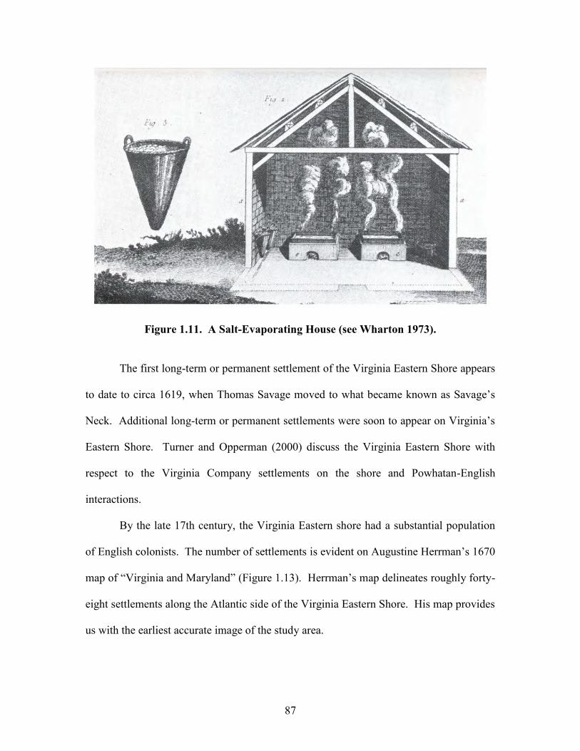
87
Figure 1.11. A Salt-Evaporating House (see Wharton 1973).
The first long-term or permanent settlement of the Virginia Eastern Shore appears
to date to circa 1619, when Thomas Savage moved to what became known as Savage’s
Neck. Additional long-term or permanent settlements were soon to appear on Virginia’s
Eastern Shore. Turner and Opperman (2000) discuss the Virginia Eastern Shore with
respect to the Virginia Company settlements on the shore and Powhatan-English
interactions.
By the late 17th century, the Virginia Eastern shore had a substantial population
of English colonists. The number of settlements is evident on Augustine Herrman’s 1670
map of “Virginia and Maryland” (Figure 1.13). Herrman’s map delineates roughly forty-
eight settlements along the Atlantic side of the Virginia Eastern Shore. His map provides
us with the earliest accurate image of the study area.
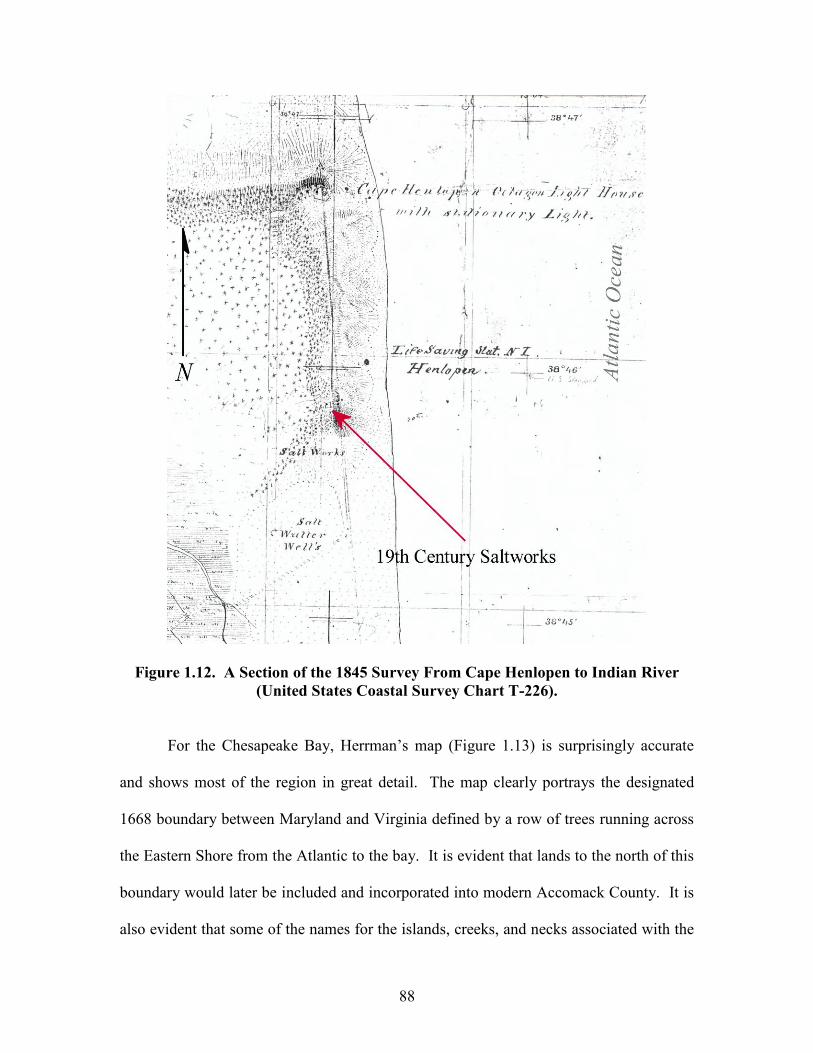
88
Figure 1.12. A Section of the 1845 Survey From Cape Henlopen to Indian River (United States Coastal Survey Chart T-226).
For the Chesapeake Bay, Herrman’s map (Figure 1.13) is surprisingly accurate
and shows most of the region in great detail. The map clearly portrays the designated
1668 boundary between Maryland and Virginia defined by a row of trees running across
the Eastern Shore from the Atlantic to the bay. It is evident that lands to the north of this
boundary would later be included and incorporated into modern Accomack County. It is
also evident that some of the names for the islands, creeks, and necks associated with the
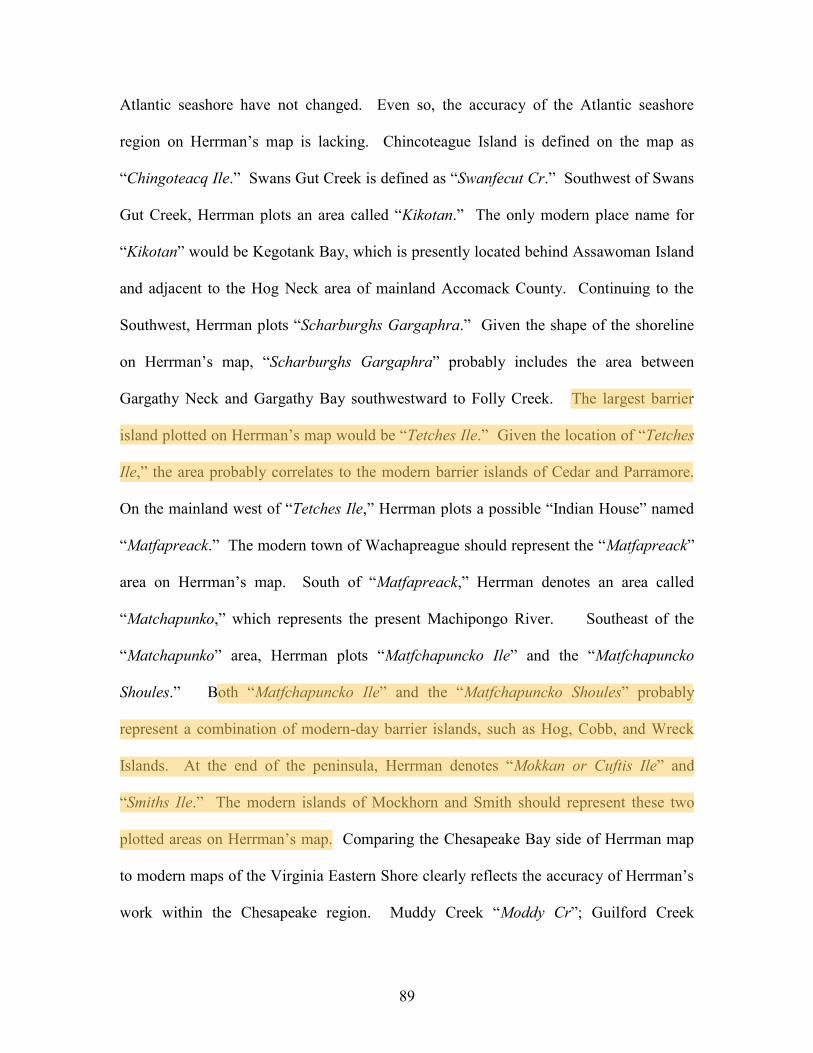
89
Atlantic seashore have not changed. Even so, the accuracy of the Atlantic seashore
region on Herrman’s map is lacking. Chincoteague Island is defined on the map as
“Chingoteacq Ile.” Swans Gut Creek is defined as “Swanfecut Cr.” Southwest of Swans
Gut Creek, Herrman plots an area called “Kikotan.” The only modern place name for
“Kikotan” would be Kegotank Bay, which is presently located behind Assawoman Island
and adjacent to the Hog Neck area of mainland Accomack County. Continuing to the
Southwest, Herrman plots “Scharburghs Gargaphra.” Given the shape of the shoreline
on Herrman’s map, “Scharburghs Gargaphra” probably includes the area between
Gargathy Neck and Gargathy Bay southwestward to Folly Creek. The largest barrier
island plotted on Herrman’s map would be “Tetches Ile.” Given the location of “Tetches
Ile,” the area probably correlates to the modern barrier islands of Cedar and Parramore.
On the mainland west of “Tetches Ile,” Herrman plots a possible “Indian House” named
“Matfapreack.” The modern town of Wachapreague should represent the “Matfapreack”
area on Herrman’s map. South of “Matfapreack,” Herrman denotes an area called
“Matchapunko,” which represents the present Machipongo River. Southeast of the
“Matchapunko” area, Herrman plots “Matfchapuncko Ile” and the “Matfchapuncko
Shoules.” Both “Matfchapuncko Ile” and the “Matfchapuncko Shoules” probably
represent a combination of modern-day barrier islands, such as Hog, Cobb, and Wreck
Islands. At the end of the peninsula, Herrman denotes “Mokkan or Cuftis Ile” and
“Smiths Ile.” The modern islands of Mockhorn and Smith should represent these two
plotted areas on Herrman’s map. Comparing the Chesapeake Bay side of Herrman map
to modern maps of the Virginia Eastern Shore clearly reflects the accuracy of Herrman’s
work within the Chesapeake region. Muddy Creek “Moddy Cr”; Guilford Creek
90
“Gildfore”; Watts Island “Wats Ile”; Chesconessex Creek “Chissonossick”; Onancock
Creek “Onankok”; Nandua Creek “Nantue”; Craddock Creek “Craddick”; Occohannock
Creek “Accahanock”; Nassawadox Creek “Nasswatticx”; Hungars Creek “Hungars”;
Savage Neck “Savith Neck”; Cherrystone Inlet “Cherriston”; Kings Creek “Kings Cr”;
and Old Plantation Creek “Old Plantat Cr” are defined in their proper position and
location. The varying degrees of accuracy between the Atlantic coastal side and the
Chesapeake shoreline side of Herrman’s map may be associated with several factors.
One could argue that, like today, the Atlantic seashore inlets and the areas near and
behind the barrier islands where hazardous for navigation in the 17th century. As such,
Herrman did not attempt to accurately survey this area.
Another explanation for avoiding the Virginia’s Atlantic seashore in the 17th
century is highlighted by Wise (1911: 185-187). He notes (ibid.) that pirates occupied
the seaside islands for many years. Pirates, such as Captain Kidd and Blackbeard,
frequented the area. For example, Thomas Wellman notified Governor Nicholson in
1699 that Matthew Scarburgh had recently met persons who had been visiting one of
Captain Kidd’s ships (ibid.). In 1688, the danger at the hands of the pirates was so great
that the council ordered one Gilbert Moore to patrol the seaside of the peninsula (ibid.).
In October of 1699, Colonel Custis reported that a pirate ship had anchored between
Smith’s and Mockhorn Islands and a band of twelve well-armed men landed and shot
many hogs and cattle, which they carried off to their vessel. The level of pirate activity
along the seaside of Virginia may relate to the fact that Edward Teach (i.e., Blackbeard)
is said to have hailed from Accomack County, Virginia (ibid.). Wise (1911: 187) notes
that the Teach family lived on Virginia’s Eastern Shore. He reports a Mrs. Mary Teach
91
and her husband from Accomack, County. Interestingly, Herrman plots “Tetches Ile”
along Virginia’s seaside in 1670. Later surveys refer to “Tetches Ile” as “Teaches” or
“Teaches Island.” As such, the lack of accuracy evident in Herrman’s map for the
Atlantic seashore of Accomack and Northampton Counties in 1670 may be the result of
hazardous pirate activity. Subsequent maps of the Atlantic seashore of Accomack and
Northampton Counties show the barrier islands in more detail and provide more data
about the region (see Figure 1.14, Figure 1.15, and Figure 1.16).
In 1663, Virginia’s Eastern Shore was divided into two counties: Accomac and
Northampton. Representatives of both counties were present at the House of Burgesses’
session held on September 10, 1663 (Wise 1911: 166). The division line established
between the two counties initiated grievances among the peoples Northampton County.
Feeling cheated out of land, the people of Northampton were upset that Accomack
County’s territory was twice as large as Northampton’s (ibid: 172). Initially, court for
the “new” county of Accomack was held at the tavern of John Cole in Pungoteague (ibid:
175-176). By 1680 a court was to be constructed at Onancock. Onancock was the seat of
Accomack until 1786, when a courthouse was constructed in the “new” town of Accomac
or Drummondtown (ibid: 233). The first courthouse of Northampton County was
established at Town Fields on the north side of Kings Creek (Turman 1964: 66). In
1677, the people of the northern part of Northampton County petitioned for a new
centrally located courthouse. By 1690, a new Northampton County courthouse had been
constructed in Eastville. The roads into the Virginia Eastern Shore from Snow Hill,
Maryland, intersect the towns with courthouses. In 1781, Accomack County’s
courthouse was located at Onancock and Northampton’s courthouse was still located in
92
Eastville. Robert Alexander’s map (Figure 1.14) shows a primary road intersecting the
towns on the shore with courthouses and a secondary highway extends to the east of the
main road to an undesignated town. The undesignated town may be the site of Accomack
County’s new courthouse in the town of Accomac or Drummondtown.
During the 17th, 18th, and 19th centuries, the northern boundary between
Virginia’s Eastern Shore and Maryland was contested. The controversies about this
boundary began in the mid to late 17th century when Edmund Scarburgh of Accomack
County contended that the boundary between Maryland and Virginia was actually
defined by the Wicomico River (Torrence 1973). By the mid to late 17th century,
Somerset County in Maryland included those lands between the modern Pocomoke River
and the modern Wicomico River. The supposed confusion about the boundary was
associated with John Smith’s 1612 map of “Virginia”. Smith plotted two prominent
localities whose locations were disputed during the mid to late 17th century and 19th
century. The boundary between Maryland and Virginia on the Delmarva Peninsula was
established by “Watkins poynt” east to the “Wighco flu.” Considering the inaccuracies of
Smith’s 1612 map, controversies about the boundary were bound to occur. Lord
Baltimore’s charter only vaguely drew a southern boundary from where the Potomac
River discharges into the Chesapeake Bay “and from thence, by the shortest line, as far as
the promontory of place called Watkins’ Poynt, [and then by] a right line drawn from the
promontory or head of land called Watkins’ Point, beside the Bay aforesaid, situate near
the river of Wighco, on the west as far as the great ocean on the eastern coast” (Report
and Journal of Proceedings of the Joint Commissioners 1874: 219-220). By the mid to
late 17th century, the “Wighco flu” had been renamed the Pocomoke River. A small river
93
not on Smith’s map and twenty miles farther north in Maryland had been named the
Wicomico River. “Watkins’ Poynt” remained somewhere along Tangier or Pocomoke
Sound. Edmund Scarburgh in an attempt to gain more lands for Virginia contended that
the Wicomico River was Smith’s “Wighco flu,” not the Pocomoke (Torrence 1973).
Scarburgh’s claim would mean that most of the areas in Maryland defined as Somerset
County were actually part of Accomack County, Virginia. In the mid 19th century, the
actual location of Watkins’ Point was questioned. Lieutenant N. Micher and John de la
Camp’s 1860 map of the “Southern Boundary of Maryland” contended that Smith’s 1608
Watkins’ Point locality was situated on the south end of Jane’s Island in Somerset County
(Papenfuse and Coale 1982: Figure 135). Even so, the western boundary line at the
mouth of Pocomoke Sound in Micher and Camp’s 1860 map suggested that all of Smith
Island belonged to Maryland. The eastern boundary line along the Pocomoke River in
Micher and Camp’s map firmly established the modern boundary. The arbitration of
1877 decided on a broken western boundary line that gave some of Smith Island to
Virginia and some to Maryland (ibid: 118). It is ironic that the English had settled the
Virginia Eastern Shore for almost 400 years, but its political boundary was not
established until roughly 125 years ago.
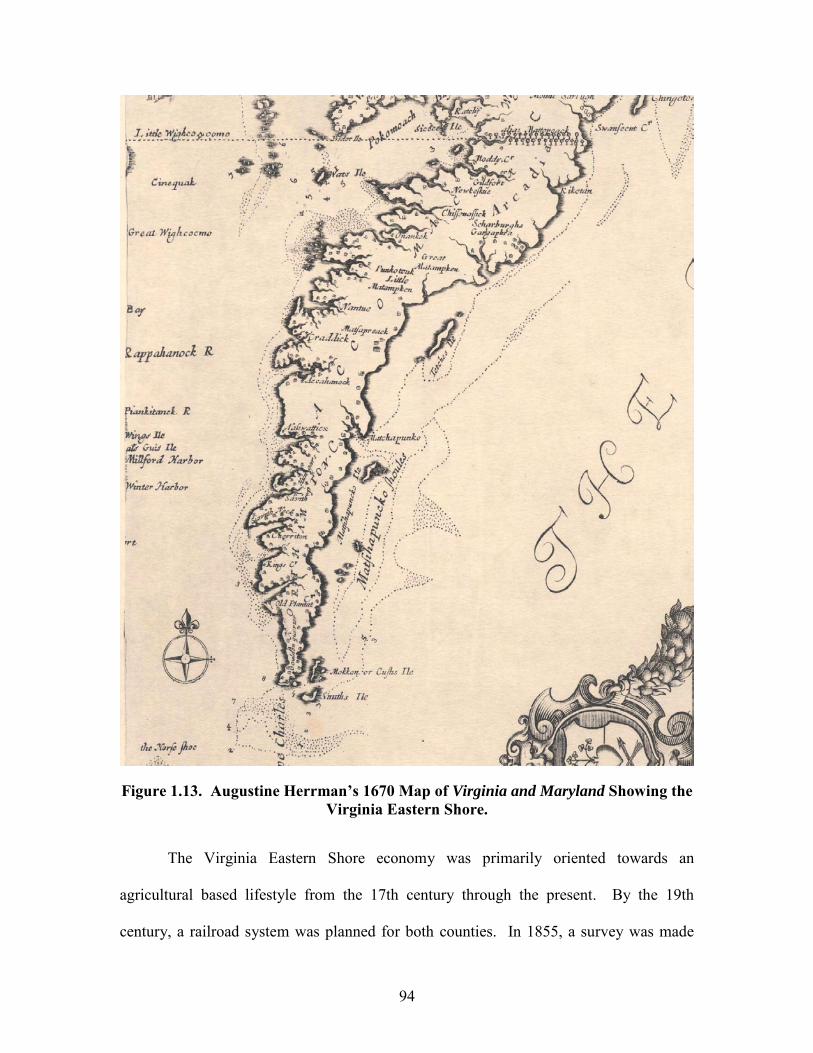
94
Figure 1.13. Augustine Herrman’s 1670 Map of Virginia and Maryland Showing the Virginia Eastern Shore.
The Virginia Eastern Shore economy was primarily oriented towards an
agricultural based lifestyle from the 17th century through the present. By the 19th
century, a railroad system was planned for both counties. In 1855, a survey was made

95
through the Virginia Eastern Shore for a rail line from Snow Hill, Maryland, to Eastville
(Turman 1964: 179). It was not until 1884 that the railroad line was constructed and
operating. The railroad was completed as part of the New York, Philadelphia, and
Norfolk line to the town of Cape Charles in early May 1884 (Turman 1964: 199;
Whitelaw 1951: 43). Steamer services were also established by the late 19th century.
Improved long-distance transport increased the demand and production of regionally
perishable seafood products and shifted farming towards “truck crops”. By the late 19th
and 20th centuries, industry and tourism were part of the Virginia Eastern Shore lifestyle.
The completion of the 17.6 mile-long Chesapeake Bay Bridge Tunnel in the late 20th
century made transport to mainland Virginia very easy. As a result, steamboat and ferry
transport pretty much ceased after the construction of the bridge-tunnel. Ferry transport
continues to destination points such as Tangier Island and Smith Island in northwestern
Accomack County. The tourism industry has increased within the region. Sportfishing
and the demand for vacation homes have also increased. Labor-intensive agriculture,
which dominates both Accomack’s and Northampton’s entire 400-year history, remains a
significant part of the modern Eastern Shore lifestyle.
The Virginia Eastern Shore was at one time the frontier of the English-speaking
New World. As time passed, the frontier boundary obviously shifted westward. Relative
to the New World, the Virginia Eastern Shore region as a whole experienced numerous
firsts. The water associated with the Pocomoke River and the Pocomoke Sound interface
was the location of the first naval engagement between English speaking peoples on the
waters of North America. In 1635, a naval battle between the Maryland colony and a
Virginian named William Claiborne occurred at this location (Hopkins 1991: 3). The
96
first dramatic performance in the New World was held at Folkes Tavern in Pungoteague
(Turman 1964: 66). On August 27, 1665, three local men presented a play called “The
Bear and the Cub” at the tavern (ibid.). It is evident that the region maintains a rich
historic heritage. Unfortunately, within the confines of this report only certain aspects of
the past can be highlighted. The previous historic summary is a brief attempt to highlight
when Europeans first explored the Virginia Eastern Shore, when the English first settled
the region, how regional names have remained constant over the entire history, when
political institutions within the region were defined, how the boundaries between
Maryland were established, and how transportation influenced the area. The historian,
reader, researcher, and interested layperson should refer to Wise (1911), Whitelaw
(1951), Hatch (1957), and Turman (1964) for more specific aspects of both Northampton
and Accomack County histories.
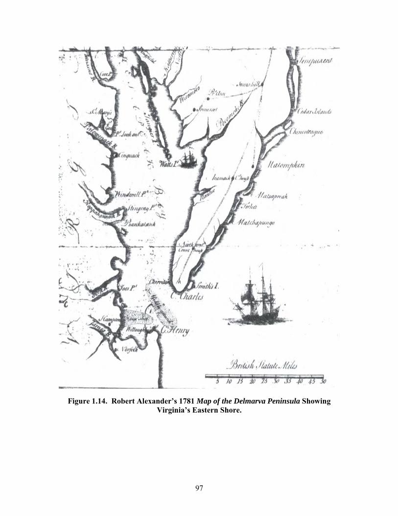
97
Figure 1.14. Robert Alexander’s 1781 Map of the Delmarva Peninsula Showing Virginia’s Eastern Shore.
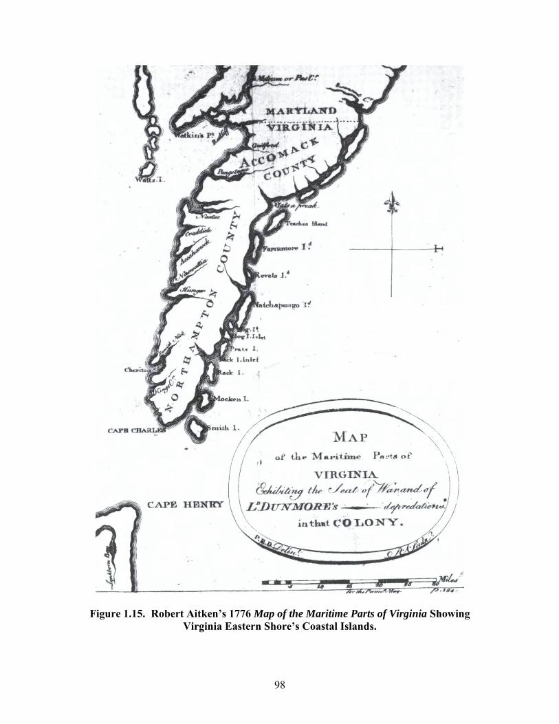
98
Figure 1.15. Robert Aitken’s 1776 Map of the Maritime Parts of Virginia Showing Virginia Eastern Shore’s Coastal Islands.
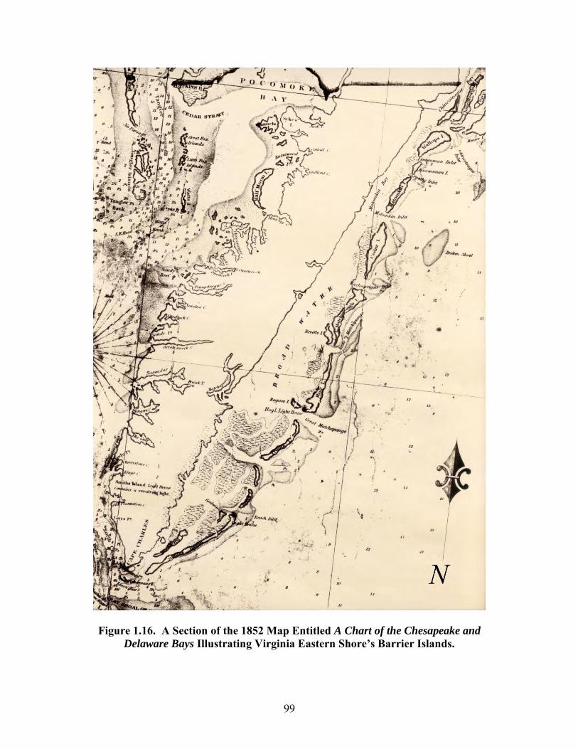
99
Figure 1.16. A Section of the 1852 Map Entitled A Chart of the Chesapeake and
Delaware Bays Illustrating Virginia Eastern Shore’s Barrier Islands.
100
PART II: Changing Landscapes, Changing Climates, and Changing Prehistoric Human Settlement Patterns: A Development of a Delmarva Peninsula Prehistoric Site
Prediction Model
Overview
Within the coastal areas of the Delmarva Peninsula, the changes that have
occurred over the past 13,000 years have had a marked impact on prehistoric human
settlement patterns. Landscapes in the Delmarva region have primarily changed as a
result of marine transgression (i.e., coastal inundation), aeolian processes, and changes in
the climate. The changes in the climate can be linked to resultant changes in the
terrestrial, riverine, and marine resources in the Chesapeake Bay and Atlantic Coast area.
The interaction of these three variables has resulted in alterations to the region’s
topography, the soil permeability, and the region’s ecology. It is important to understand
how the cultural preferences for a suitable occupation site are influenced by these
variables at one moment in time. It is also important to understand how natural variables
(i.e., marine transgression, coastal inundation, aeolian processes, and climatic changes)
have impacted the cultural preferences for occupation sites over long periods of time.
Here in the Chesapeake Bay region, archaeological site predictive models must take into
account the synchronic and diachronic natural processes that have influenced the
prehistoric peoples who lived in the region.
Lowery (1997) has proposed a site predictive model for Maryland’s Eastern
Shore. Before highlighting aspects of Lowery’s model (ibid.), it is important to discuss
the various natural and cultural factors associated with his prehistoric site prediction
model. One factor relative to prehistoric site predictability in the region relates to the
changes associated with the wetland types, riverine settings, and estuarine
101
microenvironments in an area over the entire prehistoric past. The Delmarva Peninsula
has undergone radical changes relative to the wetland types, riverine settings, and
estuarine microenvironments over the past 13,000 years of human occupation. In some
areas, ancient interior freshwater wetlands are presently coastal tidal marshes.
Freshwater streams have been converted into broad estuarine drowned rivers (see Figure
2.1). In some areas, ancient upland settings are now adjacent to the Chesapeake Bay.
The changes noted in the regional wetlands, rivers, and estuaries are the result of marine
transgression (i.e., coastal inundation). To understand the wetland, riverine, and
estuarine environmental changes in a particular region and their relationship to an
archaeological site or group of sites, the researcher will need to understand the rates of
documented sea level rise and coastal shoreline erosion. The researcher will also have to
understand how sea level rise and coastal shoreline erosion influenced prehistoric
settlement patterns in the past and how these variables influence the present-day
expression of the archaeological record.
Marine Transgression:
The following discussion will highlight how marine transgression has influenced
prehistoric settlement patterns in the past and how sea level rise has influenced the
present-day expression of the archaeological record. The Chesapeake Bay encompasses a
former river valley that has been drowned or inundated as a result of Late Pleistocene and
Holocene marine transgression. Over the past 18,000 years regional sea levels have risen
roughly 110 meters (Dent 1995: 83-85). The Middle Atlantic coast and the Chesapeake
Bay were inundated as a result of the sea level rise (see Figure 2.2). Figure 2.2 illustrates
a relative image of the slope of the continental shelf adjacent to the Middle Atlantic
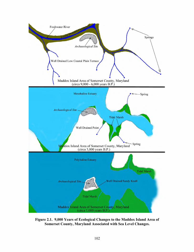
102
Figure 2.1. 9,000 Years of Ecological Changes to the Maddox Island Area of Somerset County, Maryland Associated with Sea Level Changes.
103
coastline. The image illustrates the various paleoshoreline locations along the coast from
roughly 18,000 calendar years B.P. to roughly 8,800 calendar years B.P. The 18,000
cybp shoreline would represent the pre-Clovis coastline. The 13,500 cybp shoreline
would represent the Paleoindian-age Clovis coastline. The 10,500 and 10,000 cybp
shorelines would both represent Early Archaic-age coastlines. Finally, the 8,800 cybp
shoreline would represent the Middle Archaic-age coastline. The figure illustrates that
prehistoric settlement patterns along the coast of the Middle Atlantic and within the
Chesapeake Bay would have been influenced by marine transgression. If Middle Atlantic
Paleoindian, Early Archaic, and Middle Archaic groups utilized coastal resources as they
did in other areas of the Northeast (see Chalifoux 1999, Lavin 1988, and Sanger 1988),
coastal archaeological sites would have been displaced horizontally across the landscape
as sea levels rose over these cultural periods. In the Middle Atlantic region, all of the
Paleoindian, Early Archaic, and Middle Archaic coastal sites would be inundated off of
the Atlantic Coast and within the deeper areas of the Chesapeake Bay. With respect to
the present archaeological record of the Delmarva Peninsula and the Chesapeake Bay
region, all of the Paleoindian, Early Archaic, and Middle Archaic sites presently above
water would represent interior adaptation upland sites, not coastal adaptation sites. For
example, the Middle Archaic site (circa 9,000 to 6,000 years B.P.) recorded for the
Maddox Island area of Somerset County, Maryland, in Figure 2.1 would represent a
prehistoric settlement preference for an interior setting. The Middle Archaic site in
Figure 2.1 would have been situated in a well-drained upland adjacent to the floodplains
associated with the confluence of two freshwater streams or rivers. The artifact
assemblage associated with the Middle Archaic component in Figure 2.1 includes a
104
single diagnostic projectile point. In contrast, the Late Woodland site (circa 1,000 years
B.P.) in Figure 2.1 recorded for the Maddox Island area of Somerset County, Maryland,
would represent a prehistoric settlement preference for an estuarine coastal environment.
The Late Woodland site in Figure 2.1 would have been situated on a well-drained sandy
“hummock” surrounded by a broad tidal marsh and adjacent to an estuarine body of
water. The artifact assemblage associated with the Late Woodland component includes a
40-acre shell midden, numerous fragments of Late Woodland ceramics, and copious
amounts of diagnostic lithic artifacts. Late Pleistocene and Holocene marine
transgression not only influenced where prehistoric peoples could live across the
landscape, but it also influenced the archaeological record associated with these
landscapes. Over the 9,000-year period of occupation at the Maddox Island sites (i.e.,
18SO20 and 18SO240) coastal inundation has greatly impacted the earlier riverine
environmental setting and altered it to an estuarine setting. Compared to the dense Late
Woodland cultural debris, the Middle Archaic component at the Maddox Island sites is
relatively trivial. Most, if not all, of the present multi-component coastal sites around the
Chesapeake Bay have had major alterations to their respective prehistoric environmental
and ecological settings. Future underwater research within the inundated portions of the
Chesapeake Bay will help quantify how sea level rise has impacted the present-day
expression of the archaeological record.
Aeolian Processes:
The following discussion will highlight how aeolian processes have influenced
prehistoric settlement patterns in the past and how aeolian processes have influenced the
present-day expression of the archaeological record. Lowery (2001: 153-160) has
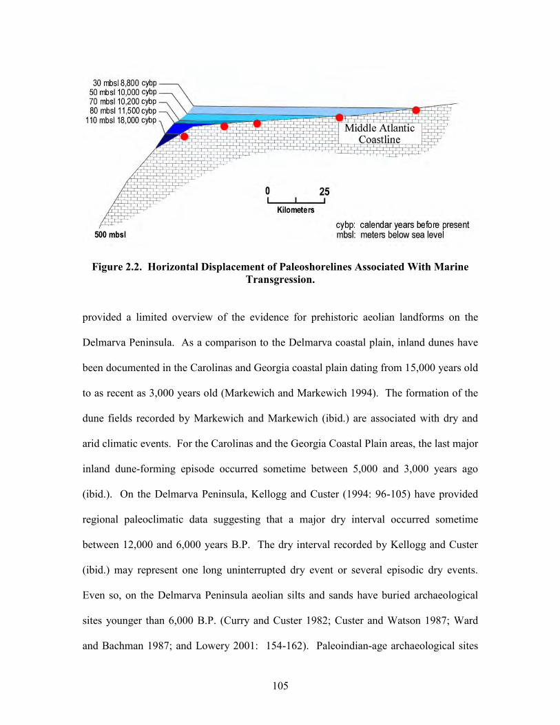
105
Figure 2.2. Horizontal Displacement of Paleoshorelines Associated With Marine Transgression.
provided a limited overview of the evidence for prehistoric aeolian landforms on the
Delmarva Peninsula. As a comparison to the Delmarva coastal plain, inland dunes have
been documented in the Carolinas and Georgia coastal plain dating from 15,000 years old
to as recent as 3,000 years old (Markewich and Markewich 1994). The formation of the
dune fields recorded by Markewich and Markewich (ibid.) are associated with dry and
arid climatic events. For the Carolinas and the Georgia Coastal Plain areas, the last major
inland dune-forming episode occurred sometime between 5,000 and 3,000 years ago
(ibid.). On the Delmarva Peninsula, Kellogg and Custer (1994: 96-105) have provided
regional paleoclimatic data suggesting that a major dry interval occurred sometime
between 12,000 and 6,000 years B.P. The dry interval recorded by Kellogg and Custer
(ibid.) may represent one long uninterrupted dry event or several episodic dry events.
Even so, on the Delmarva Peninsula aeolian silts and sands have buried archaeological
sites younger than 6,000 B.P. (Curry and Custer 1982; Custer and Watson 1987; Ward
and Bachman 1987; and Lowery 2001: 154-162). Paleoindian-age archaeological sites
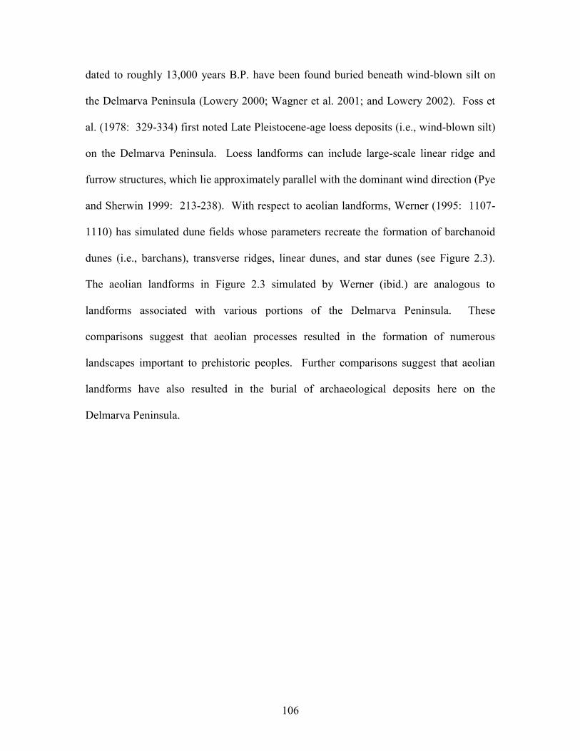
106
dated to roughly 13,000 years B.P. have been found buried beneath wind-blown silt on
the Delmarva Peninsula (Lowery 2000; Wagner et al. 2001; and Lowery 2002). Foss et
al. (1978: 329-334) first noted Late Pleistocene-age loess deposits (i.e., wind-blown silt)
on the Delmarva Peninsula. Loess landforms can include large-scale linear ridge and
furrow structures, which lie approximately parallel with the dominant wind direction (Pye
and Sherwin 1999: 213-238). With respect to aeolian landforms, Werner (1995: 1107-
1110) has simulated dune fields whose parameters recreate the formation of barchanoid
dunes (i.e., barchans), transverse ridges, linear dunes, and star dunes (see Figure 2.3).
The aeolian landforms in Figure 2.3 simulated by Werner (ibid.) are analogous to
landforms associated with various portions of the Delmarva Peninsula. These
comparisons suggest that aeolian processes resulted in the formation of numerous
landscapes important to prehistoric peoples. Further comparisons suggest that aeolian
landforms have also resulted in the burial of archaeological deposits here on the
Delmarva Peninsula.
107
Figure 2.3. Simulated Dune Fields (after Werner, 1995).
The simulated aeolian landforms in Figure 2.3 have analogous landforms in
virtually every county on Maryland’s Eastern Shore, the counties in Delaware, and the
counties on the Virginia Eastern Shore, as well. For example, the barchans illustrated in
Figure 2.3A are similar to the landforms in Figure 2.4 associated with Queen Anne’s
County, Maryland. The landforms in Figure 2.4 are also similar to the coastal surface
pans caused by the deflation of coastal sediments (see Goudie 1999: 173-175). Both
barchans and pans are associated with aeolian processes. The light-colored areas in
Figure 2.4 include soils that are sandy loams or almost pure sand. With respect to Figure
2.4, northwest winds are presently the dominant wind direction for this region. The
transverse ridges illustrated in Figure 2.3B are virtually identical to the landforms in
108
Figure 2.5 associated with Somerset County, Maryland. The transverse ridges in Figure
2.5 include landforms that are perpendicular to the present prevailing northwesterly wind
directions. Because of marine transgression, the transverse ridges are presently
associated with a coastal environment and surrounded by tidal marsh. In the past, the
area in Figure 2.5 would have been in an upland setting. The linear ridges or dunes
illustrated in Figure 2.3C are virtually identical to the landforms in Figure 2.6 associated
with Talbot County, Maryland. The linear ridges in Figure 2.6 are parallel to the present
prevailing northwesterly wind directions. Because of Holocene marine transgression, the
troughs between the ridges are partially drowned and include tidal marshes and small
estuarine creeks. The linear ridges in Figure 2.6 are landforms associated with a Younger
Dryas-age loess deposition event here on the Delmarva Peninsula (Lowery 2002). The
linear loess ridge and furrow structures lie parallel with the dominant wind direction
associated with the period of deposition (see Pye and Sherwin 1999: 225; and Leger
1990). Like the area in Figure 2.5, the landscape illustrated in Figure 2.6 was in the past
associated with an upland environment. Finally, the star dunes illustrated in Figure 2.3D
are very similar to the star-like landforms in Figure 2.7 associated with Caroline County,
Maryland. The light-colored areas in Figure 2.7 include very sandy well-drained soils.
From the comparison between the images in Figures 2.4, 2.5, 2.6, and 2.7 and the aeolian
landforms in Figure 2.3, it is apparent that aeolian processes have reworked the surface
sediments along the Delmarva Peninsula at some time in the past. Future work should
help refine the chronologies of the various regional dry and arid paleoclimatic events and
how these events may have impacted prehistoric human groups and shaped the landscape.
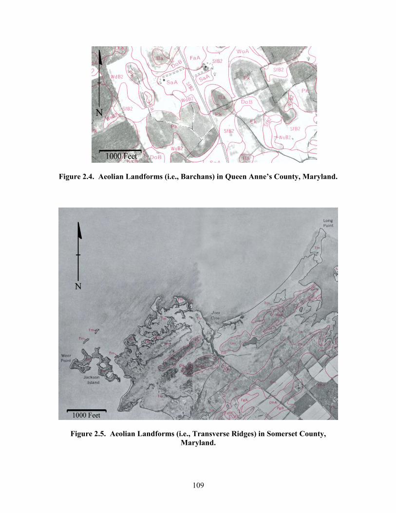
109
Figure 2.4. Aeolian Landforms (i.e., Barchans) in Queen Anne’s County, Maryland.
Figure 2.5. Aeolian Landforms (i.e., Transverse Ridges) in Somerset County, Maryland.
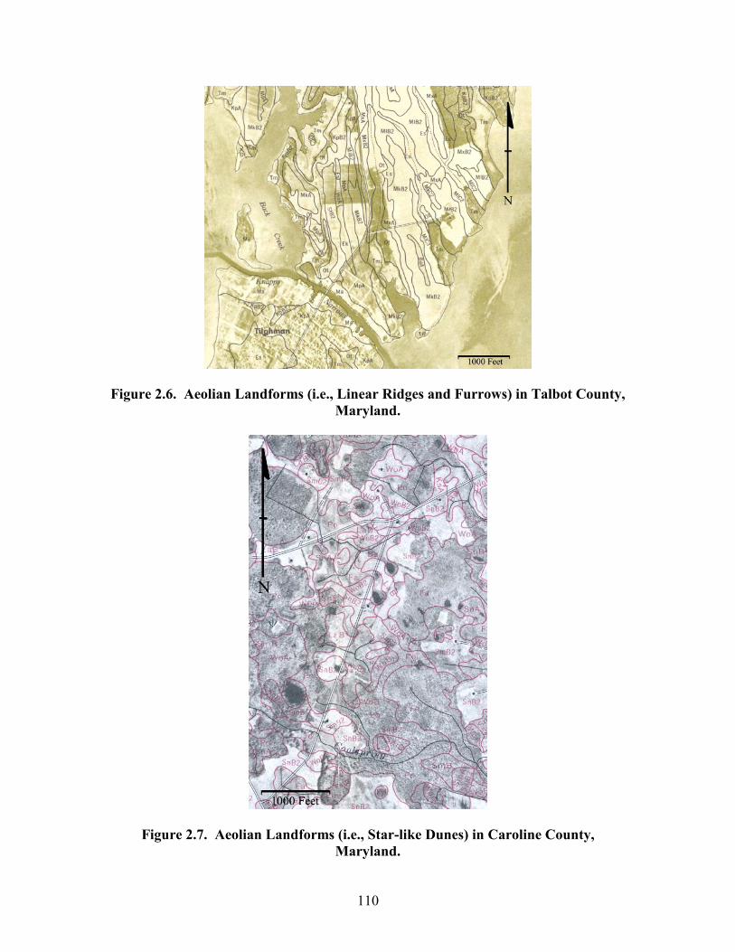
110
Figure 2.6. Aeolian Landforms (i.e., Linear Ridges and Furrows) in Talbot County, Maryland.
Figure 2.7. Aeolian Landforms (i.e., Star-like Dunes) in Caroline County, Maryland.
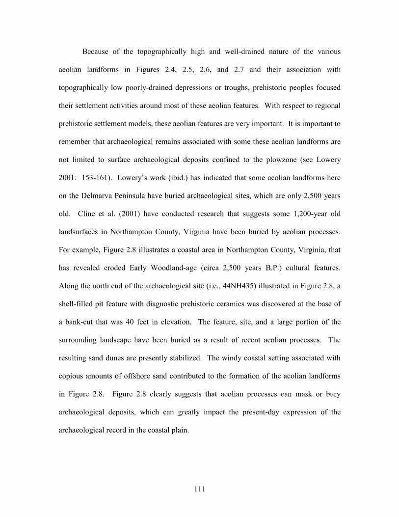
111
Because of the topographically high and well-drained nature of the various
aeolian landforms in Figures 2.4, 2.5, 2.6, and 2.7 and their association with
topographically low poorly-drained depressions or troughs, prehistoric peoples focused
their settlement activities around most of these aeolian features. With respect to regional
prehistoric settlement models, these aeolian features are very important. It is important to
remember that archaeological remains associated with some these aeolian landforms are
not limited to surface archaeological deposits confined to the plowzone (see Lowery
2001: 153-161). Lowery’s work (ibid.) has indicated that some aeolian landforms here
on the Delmarva Peninsula have buried archaeological sites, which are only 2,500 years
old. Cline et al. (2001) have conducted research that suggests some 1,200-year old
landsurfaces in Northampton County, Virginia have been buried by aeolian processes.
For example, Figure 2.8 illustrates a coastal area in Northampton County, Virginia, that
has revealed eroded Early Woodland-age (circa 2,500 years B.P.) cultural features.
Along the north end of the archaeological site (i.e., 44NH435) illustrated in Figure 2.8, a
shell-filled pit feature with diagnostic prehistoric ceramics was discovered at the base of
a bank-cut that was 40 feet in elevation. The feature, site, and a large portion of the
surrounding landscape have been buried as a result of recent aeolian processes. The
resulting sand dunes are presently stabilized. The windy coastal setting associated with
copious amounts of offshore sand contributed to the formation of the aeolian landforms
in Figure 2.8. Figure 2.8 clearly suggests that aeolian processes can mask or bury
archaeological deposits, which can greatly impact the present-day expression of the
archaeological record in the coastal plain.
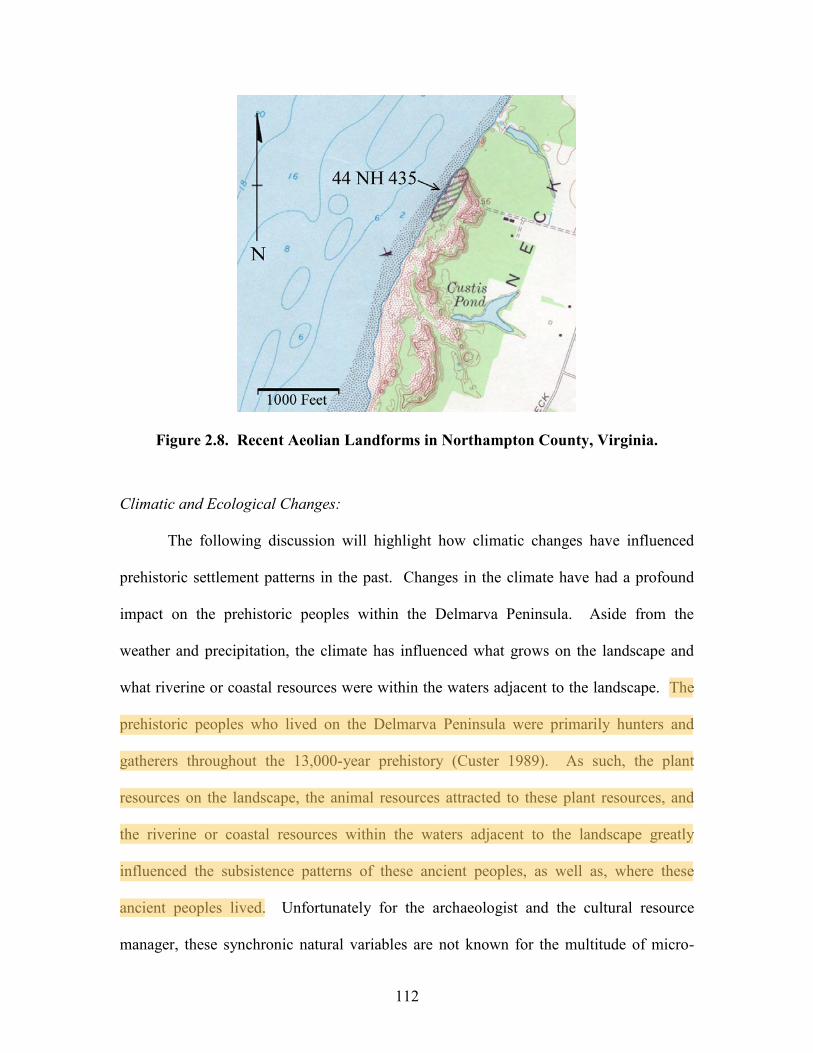
112
Figure 2.8. Recent Aeolian Landforms in Northampton County, Virginia.
Climatic and Ecological Changes:
The following discussion will highlight how climatic changes have influenced
prehistoric settlement patterns in the past. Changes in the climate have had a profound
impact on the prehistoric peoples within the Delmarva Peninsula. Aside from the
weather and precipitation, the climate has influenced what grows on the landscape and
what riverine or coastal resources were within the waters adjacent to the landscape. The
prehistoric peoples who lived on the Delmarva Peninsula were primarily hunters and
gatherers throughout the 13,000-year prehistory (Custer 1989). As such, the plant
resources on the landscape, the animal resources attracted to these plant resources, and
the riverine or coastal resources within the waters adjacent to the landscape greatly
influenced the subsistence patterns of these ancient peoples, as well as, where these
ancient peoples lived. Unfortunately for the archaeologist and the cultural resource
manager, these synchronic natural variables are not known for the multitude of micro-
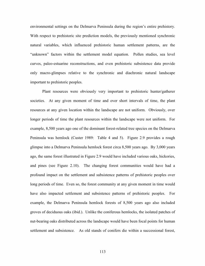
113
environmental settings on the Delmarva Peninsula during the region’s entire prehistory.
With respect to prehistoric site prediction models, the previously mentioned synchronic
natural variables, which influenced prehistoric human settlement patterns, are the
“unknown” factors within the settlement model equation. Pollen studies, sea level
curves, paleo-estuarine reconstructions, and even prehistoric subsistence data provide
only macro-glimpses relative to the synchronic and diachronic natural landscape
important to prehistoric peoples.
Plant resources were obviously very important to prehistoric hunter/gatherer
societies. At any given moment of time and over short intervals of time, the plant
resources at any given location within the landscape are not uniform. Obviously, over
longer periods of time the plant resources within the landscape were not uniform. For
example, 8,500 years ago one of the dominant forest-related tree species on the Delmarva
Peninsula was hemlock (Custer 1989: Table 4 and 5). Figure 2.9 provides a rough
glimpse into a Delmarva Peninsula hemlock forest circa 8,500 years ago. By 3,000 years
ago, the same forest illustrated in Figure 2.9 would have included various oaks, hickories,
and pines (see Figure 2.10). The changing forest communities would have had a
profound impact on the settlement and subsistence patterns of prehistoric peoples over
long periods of time. Even so, the forest community at any given moment in time would
have also impacted settlement and subsistence patterns of prehistoric peoples. For
example, the Delmarva Peninsula hemlock forests of 8,500 years ago also included
groves of deciduous oaks (ibid.). Unlike the coniferous hemlocks, the isolated patches of
nut-bearing oaks distributed across the landscape would have been focal points for human
settlement and subsistence. As old stands of conifers die within a successional forest,
114
they are replaced by deciduous elements. Conversely, as old stands of deciduous trees
die, they are replaced by coniferous elements. Even if the climate 8,500 years ago did
not change, the isolated deciduous oak groves (i.e., human subsistence/settlement focal
points) distributed across the landscape would eventually change within a successional
forest to coniferous stands of trees. As such, the human subsistence/settlement focal
points across the Delmarva Peninsula would always be changing. The successional
changes within the forests would obviously have a major impact on the settlement and
subsistence patterns of prehistoric peoples. With respect to the settlement and
subsistence patterns, the impacts may be reflected in the region’s 8,500-year-old
archaeological record. Within areas on the Delmarva Peninsula like those illustrated in
Figure 2.7, diagnostic 8,500-year-old projectile points have been found scattered across
virtually every sandy landform. The scattered distribution of cultural diagnostics across
virtually every sandy ridge, knob, or knoll probably reflects the successional forest
changes and the impacts these changes had on human settlement and subsistence patterns.
Clearly, the ancient forest and plant communities and the animals these floral settings
attracted had a major influence on prehistoric human societies. Unfortunately, the
number of floral microenvironments available to prehistoric peoples within any given
portion of the Delmarva Peninsula is infinite and it would be virtually impossible to
gauge the microenvironmental variability for any particular area throughout it’s entire
prehistory.
Like the plant resources, marine resources were very important to prehistoric
hunter/gatherer societies. At any given moment of time whether over short intervals or
long periods of time, the marine resources adjacent to any given shoreline within the
115
Chesapeake Bay are not uniform. As the marine transgression associated with the
Holocene occurred, former dry upland landscapes became habitable inundated landscapes
for certain species of shellfish. Shellfish, such as the oyster (Crassostrea virginica), were
important food sources for prehistoric peoples in the Chesapeake Bay. Even so, oysters
are not and were not uniformly distributed within the Chesapeake Bay. As a result, the
prehistoric oyster processing sites were also not uniformly distributed around the
Chesapeake Bay. The earliest oysters in the Chesapeake Bay have been dated between
10,000 and 10,310 calendar years B.P. (Cronin 2000). These early oyster samples were
collected in the waters off of the mouth of the Potomac River within a sub-bottom core at
a depth of 78 feet below the modern bay surface (ibid.). The establishment of oyster beds
is influenced by several habitat variables. Oysters prefer an offshore environment with a
mean salinity of 7 to 8 parts per thousand or greater, water depths between 8 to 25 feet,
and they also prefer a soft mud coated bottom (see Brooks 1996: 83; and Lippson 1973).
Oyster predation factors associated with oyster drills (Urosalpinx cinerea and Eupleura
caudate) severely impact oyster populations in areas that have offshore environments
with a mean salinity greater than 18 to 20 parts per thousand (Lippson 1973). Also,
oysters do not prefer rapidly changing sandy bottoms (Brooks 1996: 83). As such, the
habitat variables of oysters greatly impact where prehistoric humans around the
Chesapeake Bay could have exploited these valuable marine resources. As marine
transgression during the Holocene occurred, sub-bottom conditions around the bay
changed radically. For example, along the Chesapeake Bay shorelines adjacent to
Accomack and Northampton Counties in Virginia, Late Holocene sea level rise has
inundated Pleistocene-age geological sand deposits. The late prehistoric offshore
116
salinities adjacent to both Accomack and Northampton Counties would have been
comparable to the modern salinities. The modern salinity ranges along the Chesapeake
side of Accomack and Northampton Counties are between 15 and 29 parts per thousand.
Because of the wind-wave activities and the fetch in these areas, most of the offshore
environments adjacent to the bay are subjected to sub-bottom scouring or erosion and
sediment redeposition. Given the rapidly changing sandy bottom conditions and the high
oyster predation salinity environments, late prehistoric oyster middens and oyster refuse
features should be rare at archaeological sites associated with the Chesapeake Bay in both
Accomack and Northampton Counties. Lowery’s (2001: 144-152) marine subsistence
data for the prehistoric middens and refuse sites documented along the Chesapeake Bay
section of Virginia’s Eastern Shore supports this observation. Clearly, the marine
environments and the coastal resources in these settings had a major influence on
prehistoric human societies. The infinite number of offshore marine microenvironments
available to prehistoric peoples within any given portion of the Chesapeake Bay
watershed is virtually impossible to assess accurately over the duration of the region’s
entire prehistory.
Additional Site Predictability Factors:
Another factor relative to prehistoric site predictability on the Delmarva Peninsula relates
to the frequency of similar settings surrounding a particular study area and the ecological
diversity of the study area. For the most part, the Delmarva Peninsula includes a mix of
ecological and environmental settings. Even so, there are large sections of the Delmarva
region that show sedimentological, topographic, and ecological uniformity. The
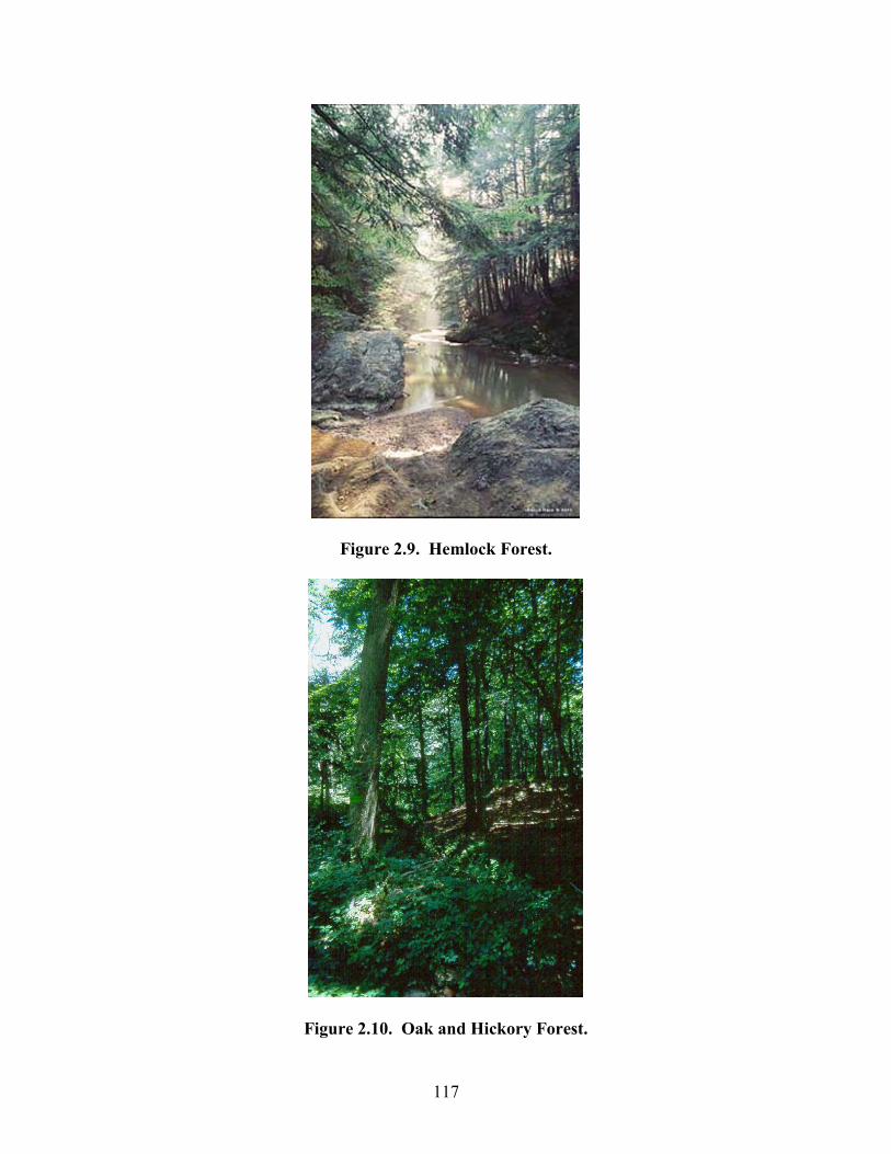
117
Figure 2.9. Hemlock Forest.
Figure 2.10. Oak and Hickory Forest.
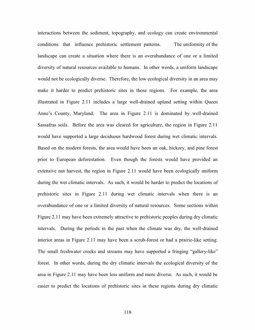
118
interactions between the sediment, topography, and ecology can create environmental
conditions that influence prehistoric settlement patterns. The uniformity of the
landscape can create a situation where there is an overabundance of one or a limited
diversity of natural resources available to humans. In other words, a uniform landscape
would not be ecologically diverse. Therefore, the low ecological diversity in an area may
make it harder to predict prehistoric sites in those regions. For example, the area
illustrated in Figure 2.11 includes a large well-drained upland setting within Queen
Anne’s County, Maryland. The area in Figure 2.11 is dominated by well-drained
Sassafras soils. Before the area was cleared for agriculture, the region in Figure 2.11
would have supported a large deciduous hardwood forest during wet climatic intervals.
Based on the modern forests, the area would have been an oak, hickory, and pine forest
prior to European deforestation. Even though the forests would have provided an
extensive nut harvest, the region in Figure 2.11 would have been ecologically uniform
during the wet climatic intervals. As such, it would be harder to predict the locations of
prehistoric sites in Figure 2.11 during wet climatic intervals when there is an
overabundance of one or a limited diversity of natural resources. Some sections within
Figure 2.11 may have been extremely attractive to prehistoric peoples during dry climatic
intervals. During the periods in the past when the climate was dry, the well-drained
interior areas in Figure 2.11 may have been a scrub-forest or had a prairie-like setting.
The small freshwater creeks and streams may have supported a fringing “gallery-like”
forest. In other words, during the dry climatic intervals the ecological diversity of the
area in Figure 2.11 may have been less uniform and more diverse. As such, it would be
easier to predict the locations of prehistoric sites in these regions during dry climatic
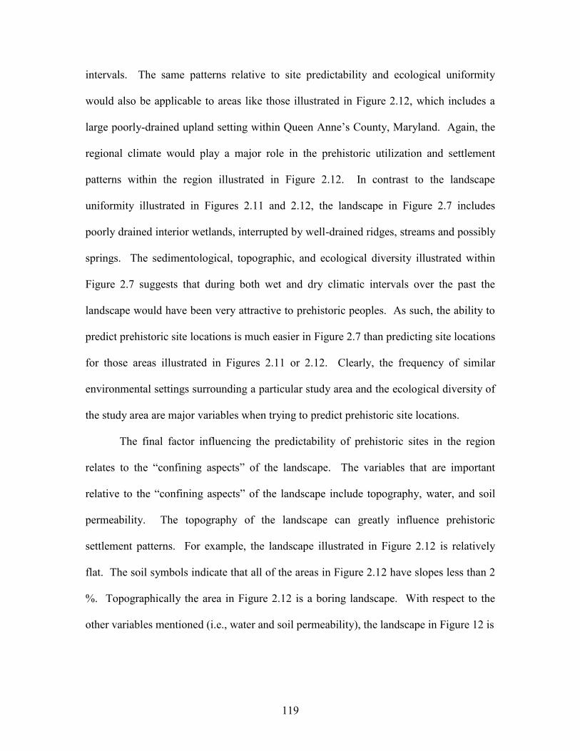
119
intervals. The same patterns relative to site predictability and ecological uniformity
would also be applicable to areas like those illustrated in Figure 2.12, which includes a
large poorly-drained upland setting within Queen Anne’s County, Maryland. Again, the
regional climate would play a major role in the prehistoric utilization and settlement
patterns within the region illustrated in Figure 2.12. In contrast to the landscape
uniformity illustrated in Figures 2.11 and 2.12, the landscape in Figure 2.7 includes
poorly drained interior wetlands, interrupted by well-drained ridges, streams and possibly
springs. The sedimentological, topographic, and ecological diversity illustrated within
Figure 2.7 suggests that during both wet and dry climatic intervals over the past the
landscape would have been very attractive to prehistoric peoples. As such, the ability to
predict prehistoric site locations is much easier in Figure 2.7 than predicting site locations
for those areas illustrated in Figures 2.11 or 2.12. Clearly, the frequency of similar
environmental settings surrounding a particular study area and the ecological diversity of
the study area are major variables when trying to predict prehistoric site locations.
The final factor influencing the predictability of prehistoric sites in the region
relates to the “confining aspects” of the landscape. The variables that are important
relative to the “confining aspects” of the landscape include topography, water, and soil
permeability. The topography of the landscape can greatly influence prehistoric
settlement patterns. For example, the landscape illustrated in Figure 2.12 is relatively
flat. The soil symbols indicate that all of the areas in Figure 2.12 have slopes less than 2
%. Topographically the area in Figure 2.12 is a boring landscape. With respect to the
other variables mentioned (i.e., water and soil permeability), the landscape in Figure 12 is
120
Figure 2.11. Uniform Well-Drained Upland Area in Queen Anne’s County, Maryland.
dominated by poorly drained soils. These poorly drained soils would have supported a
large topographically featureless interior wetland during wet climatic periods. Because
of the lack of “confining aspects” relative to the landscape in Figure 2.12, the region
would have a low probability for prehistoric sites. In contrast, areas on the Delmarva
Peninsula with poorly drained flat landscapes interrupted by topographically noticeable
well-drained ridges, or knolls reflect the interactions between all of the “confining
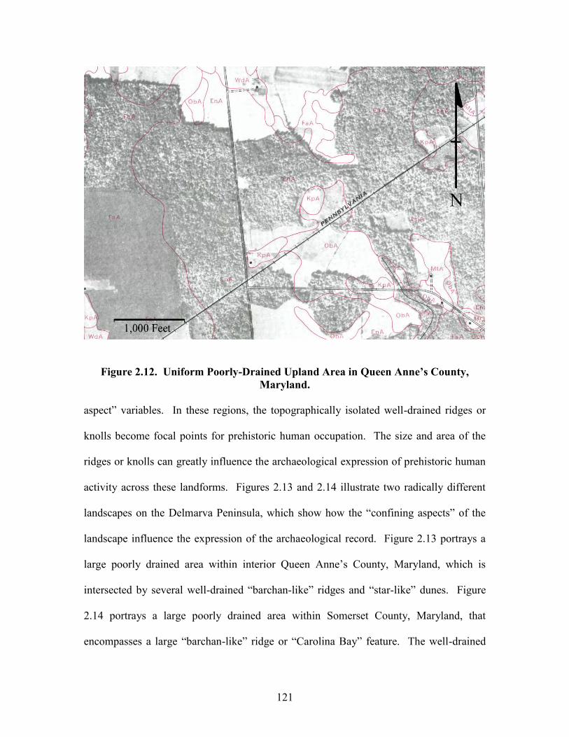
121
Figure 2.12. Uniform Poorly-Drained Upland Area in Queen Anne’s County,
Maryland.
aspect” variables. In these regions, the topographically isolated well-drained ridges or
knolls become focal points for prehistoric human occupation. The size and area of the
ridges or knolls can greatly influence the archaeological expression of prehistoric human
activity across these landforms. Figures 2.13 and 2.14 illustrate two radically different
landscapes on the Delmarva Peninsula, which show how the “confining aspects” of the
landscape influence the expression of the archaeological record. Figure 2.13 portrays a
large poorly drained area within interior Queen Anne’s County, Maryland, which is
intersected by several well-drained “barchan-like” ridges and “star-like” dunes. Figure
2.14 portrays a large poorly drained area within Somerset County, Maryland, that
encompasses a large “barchan-like” ridge or “Carolina Bay” feature. The well-drained
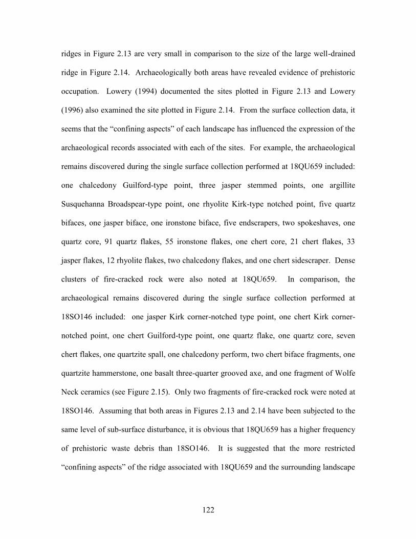
122
ridges in Figure 2.13 are very small in comparison to the size of the large well-drained
ridge in Figure 2.14. Archaeologically both areas have revealed evidence of prehistoric
occupation. Lowery (1994) documented the sites plotted in Figure 2.13 and Lowery
(1996) also examined the site plotted in Figure 2.14. From the surface collection data, it
seems that the “confining aspects” of each landscape has influenced the expression of the
archaeological records associated with each of the sites. For example, the archaeological
remains discovered during the single surface collection performed at 18QU659 included:
one chalcedony Guilford-type point, three jasper stemmed points, one argillite
Susquehanna Broadspear-type point, one rhyolite Kirk-type notched point, five quartz
bifaces, one jasper biface, one ironstone biface, five endscrapers, two spokeshaves, one
quartz core, 91 quartz flakes, 55 ironstone flakes, one chert core, 21 chert flakes, 33
jasper flakes, 12 rhyolite flakes, two chalcedony flakes, and one chert sidescraper. Dense
clusters of fire-cracked rock were also noted at 18QU659. In comparison, the
archaeological remains discovered during the single surface collection performed at
18SO146 included: one jasper Kirk corner-notched type point, one chert Kirk corner-
notched point, one chert Guilford-type point, one quartz flake, one quartz core, seven
chert flakes, one quartzite spall, one chalcedony perform, two chert biface fragments, one
quartzite hammerstone, one basalt three-quarter grooved axe, and one fragment of Wolfe
Neck ceramics (see Figure 2.15). Only two fragments of fire-cracked rock were noted at
18SO146. Assuming that both areas in Figures 2.13 and 2.14 have been subjected to the
same level of sub-surface disturbance, it is obvious that 18QU659 has a higher frequency
of prehistoric waste debris than 18SO146. It is suggested that the more restricted
“confining aspects” of the ridge associated with 18QU659 and the surrounding landscape
123
influenced the archaeological visibility of the site. In comparison, the broader landscape
associated with the ridge that encompasses 18SO146 resulted in a lower frequency of
archaeological waste debris. The example presented above suggests that if a
prehistorically attractive landform was broad and open, the prehistoric occupation sites
tended to be only approximately reoccupied on subsequent visits, resulting in a thin
scatter of artifacts over a wide area. The prehistoric assemblage from 18SO146 would
reflect this pattern. If, on the other hand, the landform is very narrow, restricted, or
confining, then the spatial restraints force a return to more nearly the same location
during each subsequent visit resulting in a smaller site with a higher density of artifacts.
The prehistoric assemblage from 18QU659 would reflect this pattern. Mato and Gunn
(n.d.: A31-32) have made similar observations about sites in the Southeast. Here on the
Delmarva Peninsula, topography, water, and soil permeability are the “confining aspects”
that influence prehistoric settlement patterns and archaeological site visibility. Holocene
marine transgression and coastal inundation can also be considered a “confining aspect”
variable.
Predictive Site Model For The Delmarva Peninsula
There are several primary aspects chosen as the criteria for defining potential site
locations. These criteria include:
1). Soil type (i.e., well drained, poorly drained, sandy, silty).
2). Slope (i.e., low slope or steep slope).
3). Proximity to water (i.e., poorly drained areas, streams, creeks).
4). Type of water (i.e., fresh, brackish, or saline).
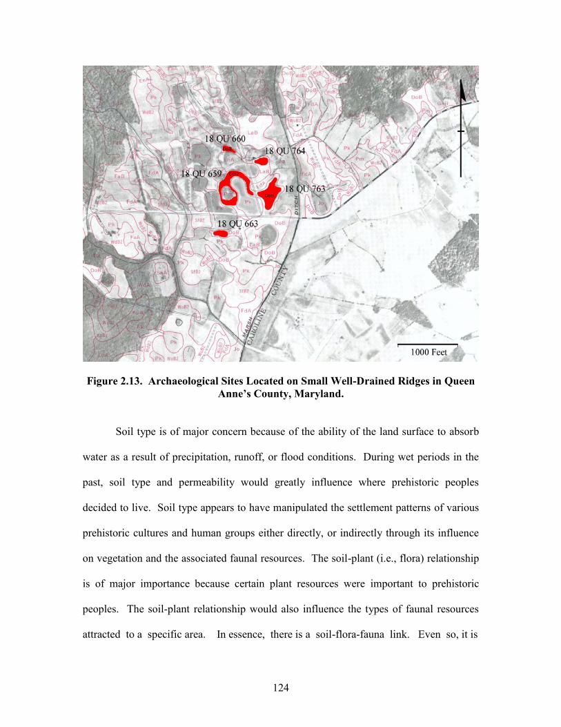
124
Figure 2.13. Archaeological Sites Located on Small Well-Drained Ridges in Queen Anne’s County, Maryland.
Soil type is of major concern because of the ability of the land surface to absorb
water as a result of precipitation, runoff, or flood conditions. During wet periods in the
past, soil type and permeability would greatly influence where prehistoric peoples
decided to live. Soil type appears to have manipulated the settlement patterns of various
prehistoric cultures and human groups either directly, or indirectly through its influence
on vegetation and the associated faunal resources. The soil-plant (i.e., flora) relationship
is of major importance because certain plant resources were important to prehistoric
peoples. The soil-plant relationship would also influence the types of faunal resources
attracted to a specific area. In essence, there is a soil-flora-fauna link. Even so, it is
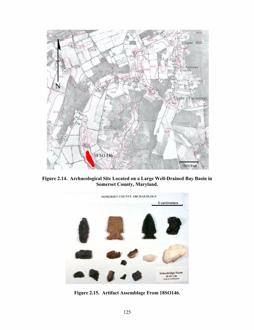
125
Figure 2.14. Archaeological Site Located on a Large Well-Drained Bay Basin in Somerset County, Maryland.
Figure 2.15. Artifact Assemblage From 18SO146.
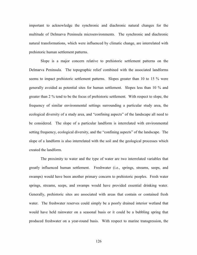
126
important to acknowledge the synchronic and diachronic natural changes for the
multitude of Delmarva Peninsula microenvironments. The synchronic and diachronic
natural transformations, which were influenced by climatic change, are interrelated with
prehistoric human settlement patterns.
Slope is a major concern relative to prehistoric settlement patterns on the
Delmarva Peninsula. The topographic relief combined with the associated landforms
seems to impact prehistoric settlement patterns. Slopes greater than 10 to 15 % were
generally avoided as potential sites for human settlement. Slopes less than 10 % and
greater than 2 % tend to be the focus of prehistoric settlement. With respect to slope, the
frequency of similar environmental settings surrounding a particular study area, the
ecological diversity of a study area, and “confining aspects” of the landscape all need to
be considered. The slope of a particular landform is interrelated with environmental
setting frequency, ecological diversity, and the “confining aspects” of the landscape. The
slope of a landform is also interrelated with the soil and the geological processes which
created the landform.
The proximity to water and the type of water are two interrelated variables that
greatly influenced human settlement. Freshwater (i.e., springs, streams, seeps, and
swamps) would have been another primary concern to prehistoric peoples. Fresh water
springs, streams, seeps, and swamps would have provided essential drinking water.
Generally, prehistoric sites are associated with areas that contain or contained fresh
water. The freshwater reserves could simply be a poorly drained interior wetland that
would have held rainwater on a seasonal basis or it could be a bubbling spring that
produced freshwater on a year-round basis. With respect to marine transgression, the
127
associated water adjacent to an area (i.e., fresh, brackish, saline) would have also
influenced the types of resources available to prehistoric peoples. Along the Atlantic
Coast, marine transgression has transformed ancient freshwater landscapes into brackish
and saline environments. Therefore, it is important to understand how the synchronic and
diachronic natural changes to water resources within an area influenced prehistoric
settlement patterns.
With all of the various settlement variables in mind, Lowery (1997) has
developed a settlement pattern model for the Delmarva Peninsula. The nine prehistoric
settlement patterns types defined by Lowery (1997) are summarized below. Actual
archaeological site examples are provided to illustrate each settlement pattern type.
Examples are also presented which illustrate how Late Pleistocene and Holocene coastal
inundation and climatic change have impacted the prehistoric settlement “interest” or
“focus” on a particular landscape.
Point Focus Settlement Pattern:
Point focus settlements are generally located on points of well-drained land
surrounded by broad tidal rivers, creeks, or estuaries. Brackish or saline resources are
typically located near the shoals adjacent to the shoreline. Broad or fringing tidal
marshes are usually adjacent to the shoreline. Point focus settlements can be found in
both the high and low coastal plain resource zones. In the high coastal zone areas, point
settlements generally have high topographic relief and fringing tidal marshes. In the low
coastal zone areas, point settlements have low topographic relief and broad tidal marshes.
Because the low coastal areas have been greatly affected by sea level rise, some point
focus settlements have been partially inundated. These sites are generally broad tidal
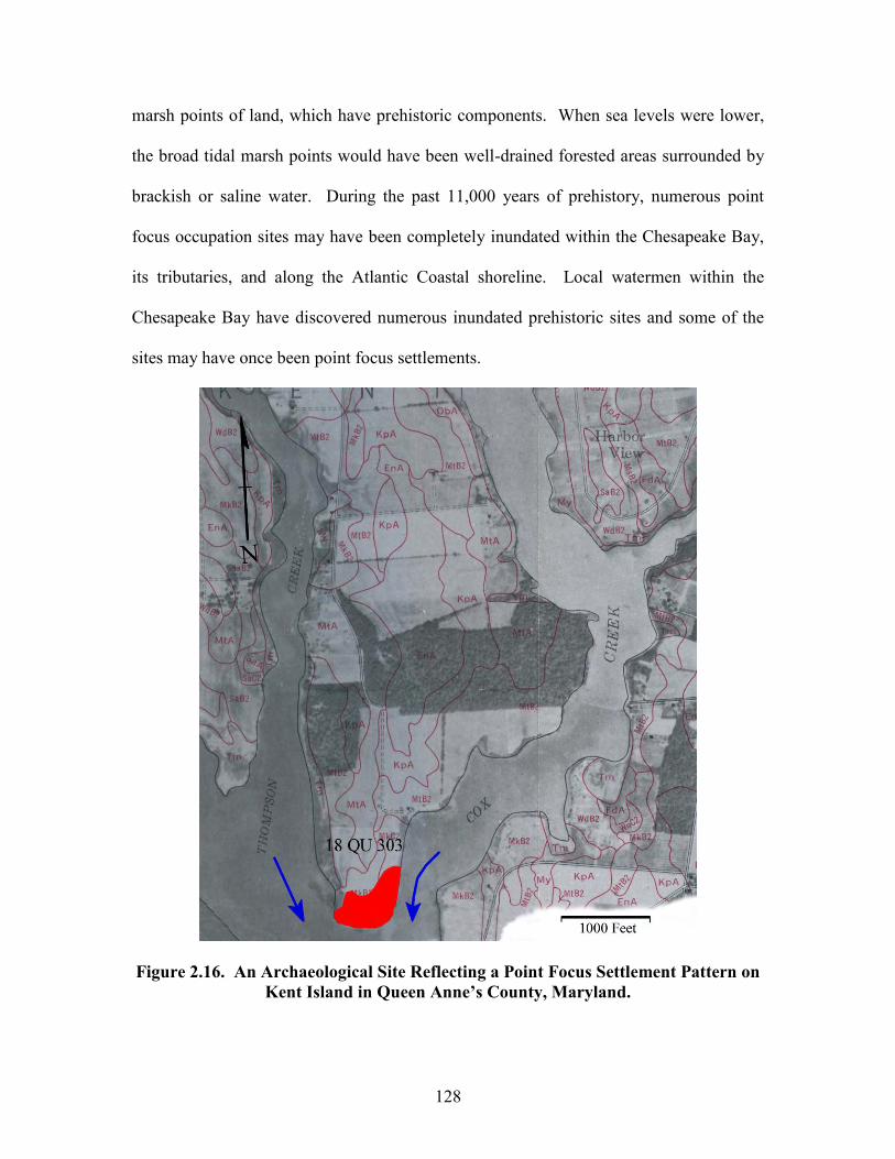
128
marsh points of land, which have prehistoric components. When sea levels were lower,
the broad tidal marsh points would have been well-drained forested areas surrounded by
brackish or saline water. During the past 11,000 years of prehistory, numerous point
focus occupation sites may have been completely inundated within the Chesapeake Bay,
its tributaries, and along the Atlantic Coastal shoreline. Local watermen within the
Chesapeake Bay have discovered numerous inundated prehistoric sites and some of the
sites may have once been point focus settlements.
Figure 2.16. An Archaeological Site Reflecting a Point Focus Settlement Pattern on Kent Island in Queen Anne’s County, Maryland.
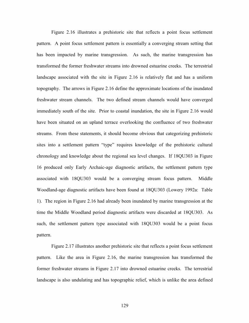
129
Figure 2.16 illustrates a prehistoric site that reflects a point focus settlement
pattern. A point focus settlement pattern is essentially a converging stream setting that
has been impacted by marine transgression. As such, the marine transgression has
transformed the former freshwater streams into drowned estuarine creeks. The terrestrial
landscape associated with the site in Figure 2.16 is relatively flat and has a uniform
topography. The arrows in Figure 2.16 define the approximate locations of the inundated
freshwater stream channels. The two defined stream channels would have converged
immediately south of the site. Prior to coastal inundation, the site in Figure 2.16 would
have been situated on an upland terrace overlooking the confluence of two freshwater
streams. From these statements, it should become obvious that categorizing prehistoric
sites into a settlement pattern “type” requires knowledge of the prehistoric cultural
chronology and knowledge about the regional sea level changes. If 18QU303 in Figure
16 produced only Early Archaic-age diagnostic artifacts, the settlement pattern type
associated with 18QU303 would be a converging stream focus pattern. Middle
Woodland-age diagnostic artifacts have been found at 18QU303 (Lowery 1992a: Table
1). The region in Figure 2.16 had already been inundated by marine transgression at the
time the Middle Woodland period diagnostic artifacts were discarded at 18QU303. As
such, the settlement pattern type associated with 18QU303 would be a point focus
pattern.
Figure 2.17 illustrates another prehistoric site that reflects a point focus settlement
pattern. Like the area in Figure 2.16, the marine transgression has transformed the
former freshwater streams in Figure 2.17 into drowned estuarine creeks. The terrestrial
landscape is also undulating and has topographic relief, which is unlike the area defined
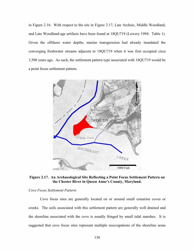
130
in Figure 2.16. With respect to the site in Figure 2.17, Late Archaic, Middle Woodland,
and Late Woodland-age artifacts have been found at 18QU719 (Lowery 1994: Table 1).
Given the offshore water depths, marine transgression had already inundated the
converging freshwater streams adjacent to 18QU719 when it was first occupied circa
3,500 years ago. As such, the settlement pattern type associated with 18QU719 would be
a point focus settlement pattern.
Figure 2.17. An Archaeological Site Reflecting a Point Focus Settlement Pattern on the Chester River in Queen Anne’s County, Maryland.
Cove Focus Settlement Pattern:
Cove focus sites are generally located on or around small estuarine coves or
creeks. The soils associated with this settlement pattern are generally well drained and
the shoreline associated with the cove is usually fringed by small tidal marshes. It is
suggested that cove focus sites represent multiple reoccupations of the shoreline areas
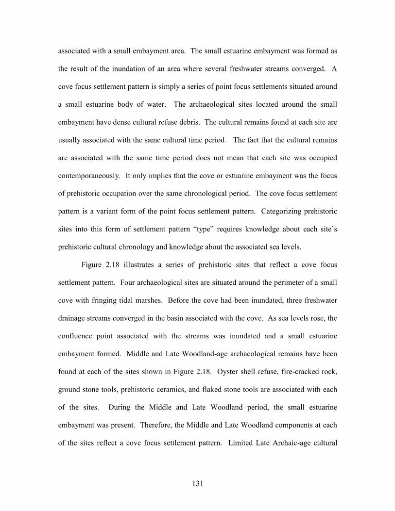
131
associated with a small embayment area. The small estuarine embayment was formed as
the result of the inundation of an area where several freshwater streams converged. A
cove focus settlement pattern is simply a series of point focus settlements situated around
a small estuarine body of water. The archaeological sites located around the small
embayment have dense cultural refuse debris. The cultural remains found at each site are
usually associated with the same cultural time period. The fact that the cultural remains
are associated with the same time period does not mean that each site was occupied
contemporaneously. It only implies that the cove or estuarine embayment was the focus
of prehistoric occupation over the same chronological period. The cove focus settlement
pattern is a variant form of the point focus settlement pattern. Categorizing prehistoric
sites into this form of settlement pattern “type” requires knowledge about each site’s
prehistoric cultural chronology and knowledge about the associated sea levels.
Figure 2.18 illustrates a series of prehistoric sites that reflect a cove focus
settlement pattern. Four archaeological sites are situated around the perimeter of a small
cove with fringing tidal marshes. Before the cove had been inundated, three freshwater
drainage streams converged in the basin associated with the cove. As sea levels rose, the
confluence point associated with the streams was inundated and a small estuarine
embayment formed. Middle and Late Woodland-age archaeological remains have been
found at each of the sites shown in Figure 2.18. Oyster shell refuse, fire-cracked rock,
ground stone tools, prehistoric ceramics, and flaked stone tools are associated with each
of the sites. During the Middle and Late Woodland period, the small estuarine
embayment was present. Therefore, the Middle and Late Woodland components at each
of the sites reflect a cove focus settlement pattern. Limited Late Archaic-age cultural
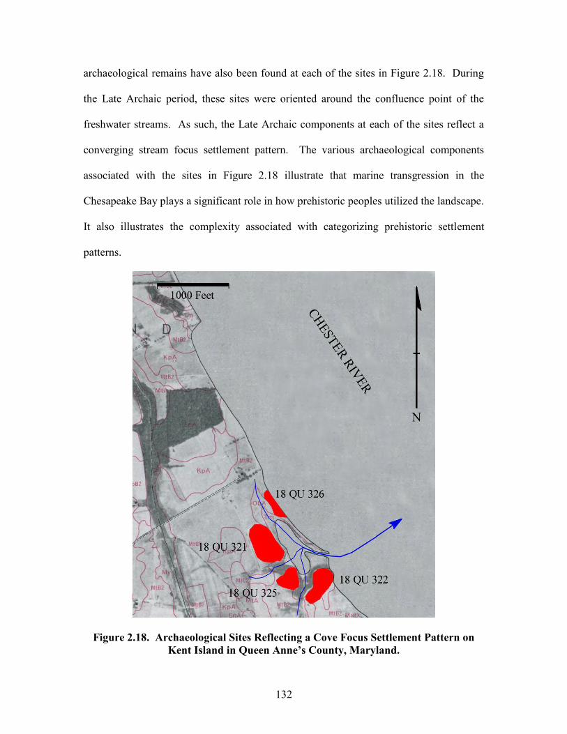
132
archaeological remains have also been found at each of the sites in Figure 2.18. During
the Late Archaic period, these sites were oriented around the confluence point of the
freshwater streams. As such, the Late Archaic components at each of the sites reflect a
converging stream focus settlement pattern. The various archaeological components
associated with the sites in Figure 2.18 illustrate that marine transgression in the
Chesapeake Bay plays a significant role in how prehistoric peoples utilized the landscape.
It also illustrates the complexity associated with categorizing prehistoric settlement
patterns.
Figure 2.18. Archaeological Sites Reflecting a Cove Focus Settlement Pattern on Kent Island in Queen Anne’s County, Maryland.
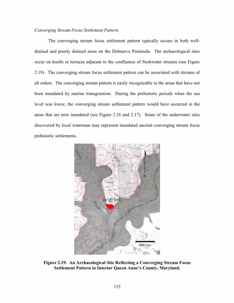
133
Converging Stream Focus Settlement Pattern:
The converging stream focus settlement pattern typically occurs in both well-
drained and poorly drained areas on the Delmarva Peninsula. The archaeological sites
occur on knolls or terraces adjacent to the confluence of freshwater streams (see Figure
2.19). The converging stream focus settlement pattern can be associated with streams of
all orders. The converging stream pattern is easily recognizable in the areas that have not
been inundated by marine transgression. During the prehistoric periods when the sea
level was lower, the converging stream settlement pattern would have occurred in the
areas that are now inundated (see Figure 2.16 and 2.17). Some of the underwater sites
discovered by local waterman may represent inundated ancient converging stream focus
prehistoric settlements.
Figure 2.19. An Archaeological Site Reflecting a Converging Stream Focus Settlement Pattern in Interior Queen Anne’s County, Maryland.
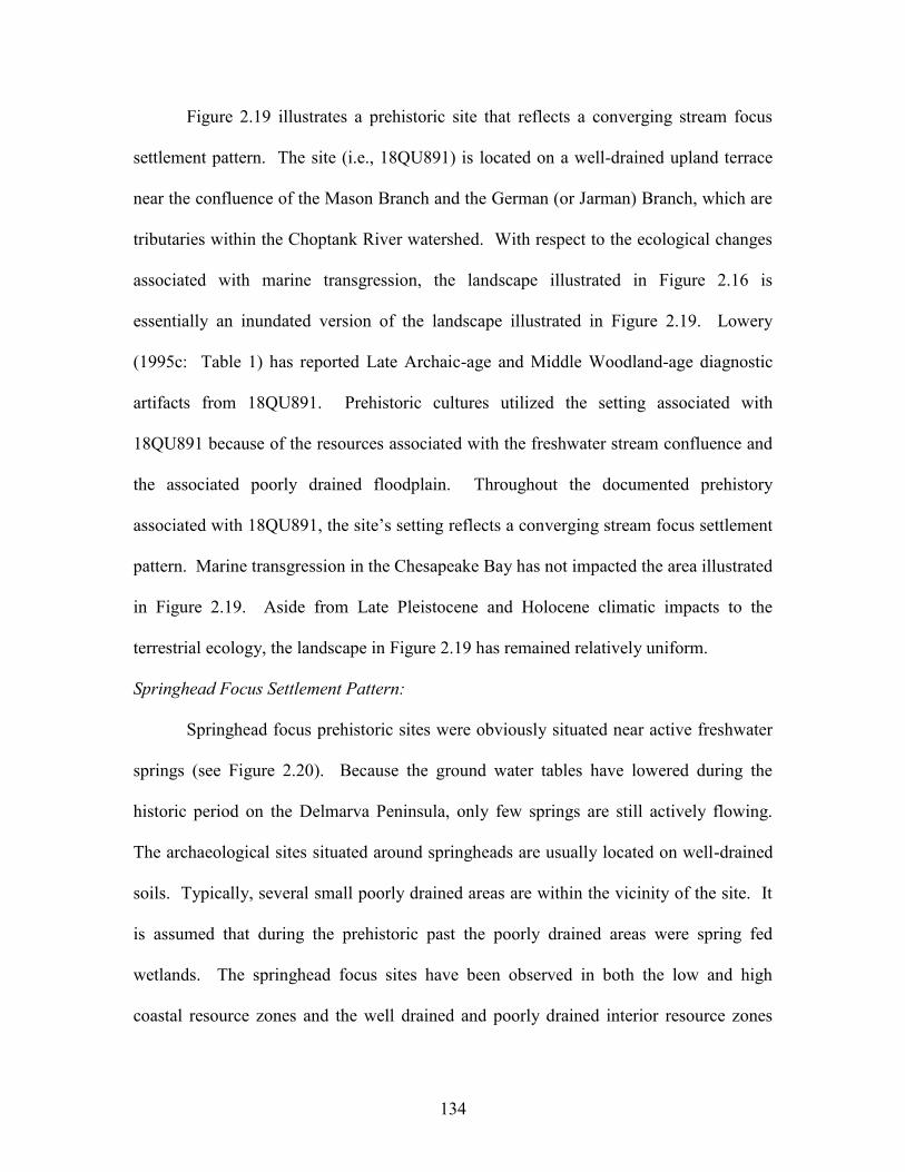
134
Figure 2.19 illustrates a prehistoric site that reflects a converging stream focus
settlement pattern. The site (i.e., 18QU891) is located on a well-drained upland terrace
near the confluence of the Mason Branch and the German (or Jarman) Branch, which are
tributaries within the Choptank River watershed. With respect to the ecological changes
associated with marine transgression, the landscape illustrated in Figure 2.16 is
essentially an inundated version of the landscape illustrated in Figure 2.19. Lowery
(1995c: Table 1) has reported Late Archaic-age and Middle Woodland-age diagnostic
artifacts from 18QU891. Prehistoric cultures utilized the setting associated with
18QU891 because of the resources associated with the freshwater stream confluence and
the associated poorly drained floodplain. Throughout the documented prehistory
associated with 18QU891, the site’s setting reflects a converging stream focus settlement
pattern. Marine transgression in the Chesapeake Bay has not impacted the area illustrated
in Figure 2.19. Aside from Late Pleistocene and Holocene climatic impacts to the
terrestrial ecology, the landscape in Figure 2.19 has remained relatively uniform.
Springhead Focus Settlement Pattern:
Springhead focus prehistoric sites were obviously situated near active freshwater
springs (see Figure 2.20). Because the ground water tables have lowered during the
historic period on the Delmarva Peninsula, only few springs are still actively flowing.
The archaeological sites situated around springheads are usually located on well-drained
soils. Typically, several small poorly drained areas are within the vicinity of the site. It
is assumed that during the prehistoric past the poorly drained areas were spring fed
wetlands. The springhead focus sites have been observed in both the low and high
coastal resource zones and the well drained and poorly drained interior resource zones
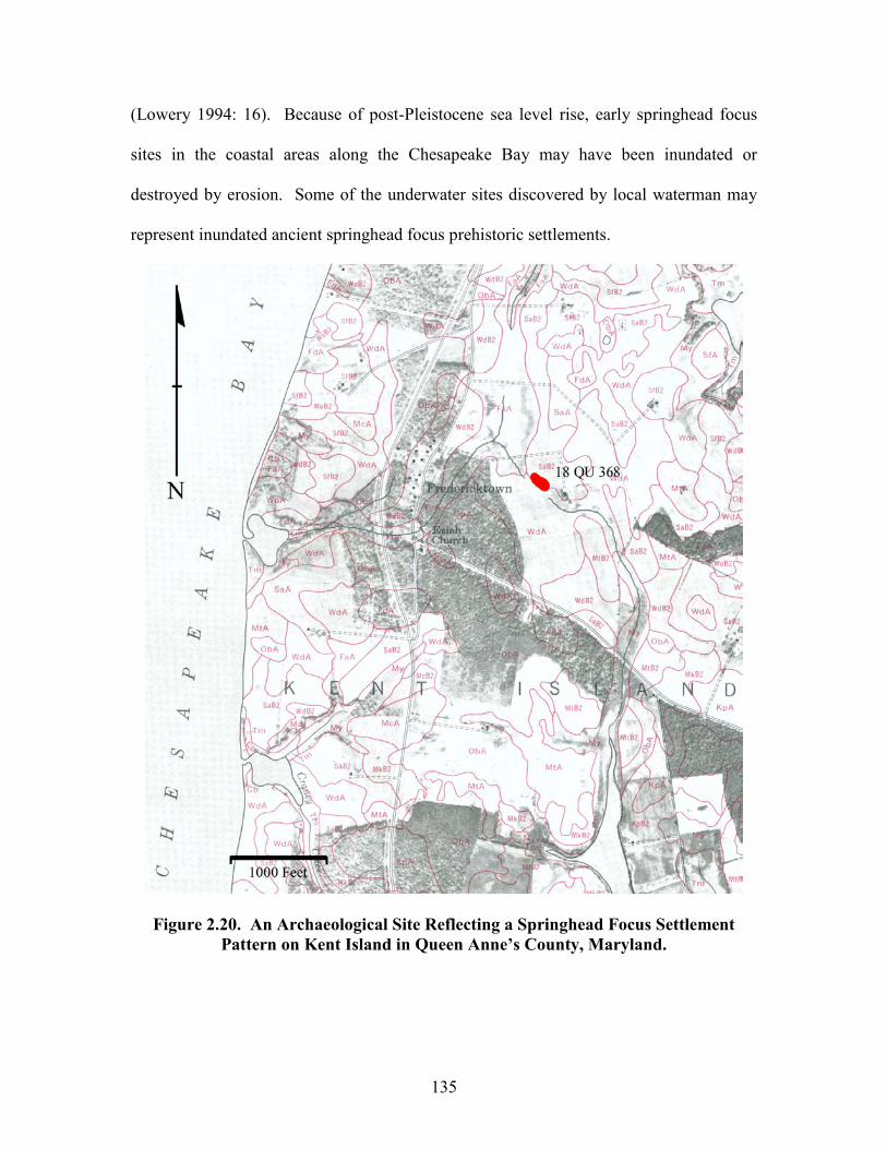
135
(Lowery 1994: 16). Because of post-Pleistocene sea level rise, early springhead focus
sites in the coastal areas along the Chesapeake Bay may have been inundated or
destroyed by erosion. Some of the underwater sites discovered by local waterman may
represent inundated ancient springhead focus prehistoric settlements.
Figure 2.20. An Archaeological Site Reflecting a Springhead Focus Settlement Pattern on Kent Island in Queen Anne’s County, Maryland.
136
Figure 2.20 illustrates a prehistoric site that reflects a springhead focus settlement
pattern. It (i.e., 18QU368) is located on well-drained knoll near two springs. The site in
Figure 2.20 is also located at the drainage divide between the Eastern Bay watershed to
the east and the Chesapeake Bay watershed to the west. Large areas with poorly-drained
soils are within the vicinity of the site. Some of these poorly-drained areas are presently
tilled and other sections remain forested. Historically, the springs near the site were
active. The springs are presently inactive because the water table has been lowered via
modern population uses of the regional aquifer. Late Archaic-age and Late Woodland-
age archaeological components have been found at the site (Lowery 1992a: Table 1).
Prehistoric cultures utilized the setting associated with 18QU368 because of the resources
associated with the springs, the well-drained knoll, and the poorly drained spring-fed
wetlands. Throughout the documented prehistory associated with 18QU368, the site’s
setting reflects a springhead focus settlement pattern. Marine transgression in the
Chesapeake Bay has not directly impacted the site illustrated in Figure 2.20. Aside from
Late Pleistocene and Holocene climatic impacts to the terrestrial ecology, the immediate
landscape associated with the site in Figure 2.20 has remained relatively uniform. Even
so, marine transgression has impacted those areas 2,500 feet west and 3,500 feet east of
the site.
Interior Stream Focus Settlement Pattern:
Interior stream focus sites occur on well-drained ridges along the upper terraces
adjacent to freshwater drainage streams. Depending on the associated landform, the
archaeological sites are usually parallel to the stream flow. Poorly drained depressions or
small interior wetlands are sometimes close to a particular site. The poorly drained
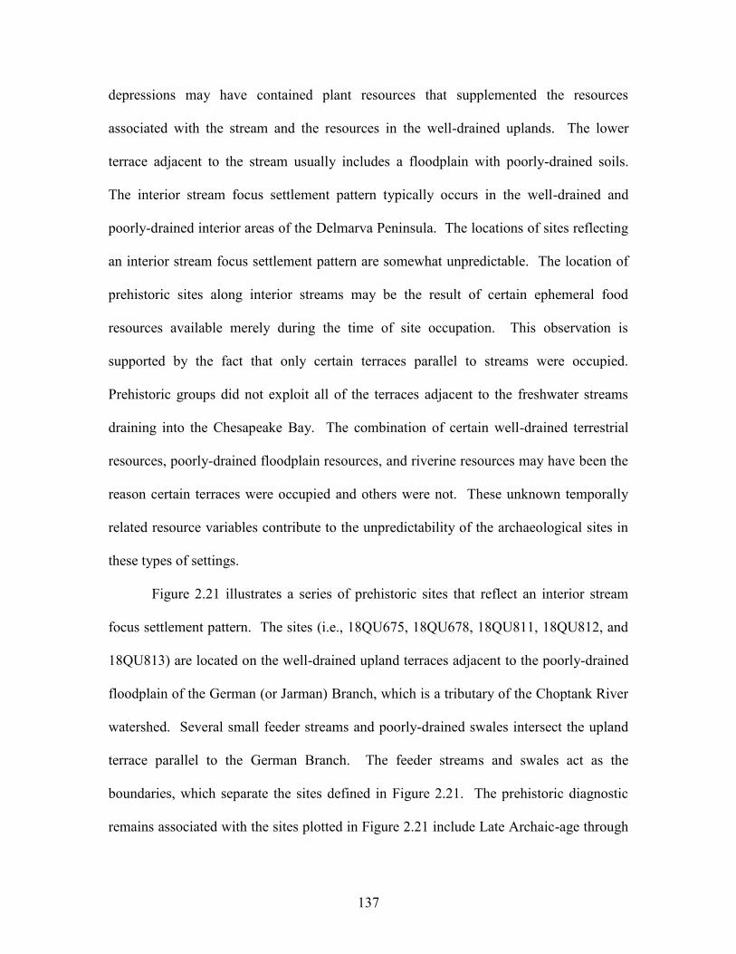
137
depressions may have contained plant resources that supplemented the resources
associated with the stream and the resources in the well-drained uplands. The lower
terrace adjacent to the stream usually includes a floodplain with poorly-drained soils.
The interior stream focus settlement pattern typically occurs in the well-drained and
poorly-drained interior areas of the Delmarva Peninsula. The locations of sites reflecting
an interior stream focus settlement pattern are somewhat unpredictable. The location of
prehistoric sites along interior streams may be the result of certain ephemeral food
resources available merely during the time of site occupation. This observation is
supported by the fact that only certain terraces parallel to streams were occupied.
Prehistoric groups did not exploit all of the terraces adjacent to the freshwater streams
draining into the Chesapeake Bay. The combination of certain well-drained terrestrial
resources, poorly-drained floodplain resources, and riverine resources may have been the
reason certain terraces were occupied and others were not. These unknown temporally
related resource variables contribute to the unpredictability of the archaeological sites in
these types of settings.
Figure 2.21 illustrates a series of prehistoric sites that reflect an interior stream
focus settlement pattern. The sites (i.e., 18QU675, 18QU678, 18QU811, 18QU812, and
18QU813) are located on the well-drained upland terraces adjacent to the poorly-drained
floodplain of the German (or Jarman) Branch, which is a tributary of the Choptank River
watershed. Several small feeder streams and poorly-drained swales intersect the upland
terrace parallel to the German Branch. The feeder streams and swales act as the
boundaries, which separate the sites defined in Figure 2.21. The prehistoric diagnostic
remains associated with the sites plotted in Figure 2.21 include Late Archaic-age through
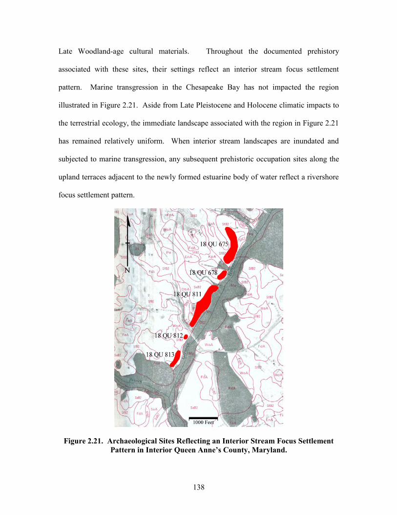
138
Late Woodland-age cultural materials. Throughout the documented prehistory
associated with these sites, their settings reflect an interior stream focus settlement
pattern. Marine transgression in the Chesapeake Bay has not impacted the region
illustrated in Figure 2.21. Aside from Late Pleistocene and Holocene climatic impacts to
the terrestrial ecology, the immediate landscape associated with the region in Figure 2.21
has remained relatively uniform. When interior stream landscapes are inundated and
subjected to marine transgression, any subsequent prehistoric occupation sites along the
upland terraces adjacent to the newly formed estuarine body of water reflect a rivershore
focus settlement pattern.
Figure 2.21. Archaeological Sites Reflecting an Interior Stream Focus Settlement Pattern in Interior Queen Anne’s County, Maryland.
139
Sand Ridge Focus Settlement Pattern:
Sand ridge focus settlement pattern prehistoric archaeological sites typically occur
on transverse or parallel sandy ridges. Archaeological sites on dome-like sandy ridges
associated with the Delmarva Peninsula reflect a sand ridge focus settlement pattern, as
well. The linear ridges consist of excessively well-drained or well-drained sandy soils
surrounded by poorly drained loamy soils. Along the drainage divides and within the
interior of the Delmarva Peninsula, broad areas of poorly drained soils (i.e., Pocomoke,
Fallsington, Portsmouth, Elkton, Othello, Munden, and Nimmo loams) are present. The
topographically noticeable sand ridges, which interrupt the flat contour of the poorly
drained areas, are composed of well-drained sandy soils (i.e., Downer, Sassafras,
Woodstown, Bojac, and Molena sands). During various prehistoric periods, the poorly
drained areas held water and created a vast series of interior freshwater wetlands. Within
the freshwater wetland areas, the sand ridges were dry, topographically elevated, land-
locked islands. The well-drained transverse and parallel ridges served as prehistoric
occupation sites. As marine transgression inundated interior uplands, some of the poorly
drained freshwater areas were flooded and converted to tidal marsh environments. The
well-drained ridges, which intersect the tidal marsh areas and estuarine creeks, continued
to be occupied by prehistoric peoples. But, the wetland resources had changed from
freshwater to saltwater. Under these circumstances, marine transgression converted a
prehistoric sand ridge focus settlement area to an estuarine wetland focus settlement area.
As defined, the sand ridge focus prehistoric settlement pattern is only associated with
freshwater wetland settings.
140
Figure 2.22. Archaeological Site Reflecting a Sand Ridge Focus Settlement Pattern in Interior Queen Anne’s County, Maryland.
Figure 2.22 illustrates a prehistoric site that reflects a sand ridge focus settlement
pattern. Lowery (1995c: Table 1) indicated that 18QU800 has revealed diagnostic
artifacts associated with the Early Archaic, Middle Archaic, Late Archaic, Early
Woodland, and Late Woodland periods. Numerous Early Archaic corner-notched points
and Middle Archaic bifurcated points are included in the artifact assemblage from the
site. It is situated on a well-drained ridge surrounded by a topographically low interior
freshwater wetland. The site is also situated at the drainage divide boundary between the
Chester, Choptank, and Wye Rivers. The region in Figure 2.22 has not been impacted by
marine transgression. In contrast, the transverse ridges illustrated in Figure 2.5 have been
impacted by marine transgression. The pre-inundation prehistoric sites located on the
141
transverse ridges in Figure 2.5 would reflect a sand ridge focus settlement pattern. The
post-inundation prehistoric components in Figure 2.5 would reflect an estuarine wetland
focus pattern. Again, it is very important to understand the prehistoric changes to the
landscape associated with a particular setting before archaeological sites are assessed
relative to the defined settlement pattern types.
Bay Basin Focus Settlement Pattern:
A bay basin focus settlement pattern is reflected at archaeological sites located on
the well-drained sandy rims of shallow poorly drained depressions. The semi-circular
ridges consist of excessively well-drained or well-drained sandy soils surrounded by
poorly drained soils. Bay basins are typically found along the drainage divides and
within the interior portions of the Delmarva Peninsula. The poorly drained soils within
the depressions and surrounding the ridges include loamy soils (i.e., Pocomoke,
Fallsington, Portsmouth, Elkton, Othello, Munden, and Nimmo loams). The
topographically noticeable semi-circular sand ridges are composed of well-drained sandy
soils (i.e., Downer, Sassafras, Woodstown, Bojac, and Molena sands). During various
prehistoric periods, the poorly drained areas held water and created a vast series of
interior freshwater wetlands. Within the freshwater wetland areas, the bay basin ridges
were dry, topographically elevated, land-locked islands. The well-drained semi-circular
ridges served as prehistoric occupation sites. As marine transgression inundated interior
uplands, some of the poorly drained freshwater areas were flooded and converted to tidal
marsh environments. The well-drained semi-circular ridges, which intersect the tidal
marsh areas and estuarine creeks, continued to be occupied by prehistoric peoples. Even
so, the wetland resources had changed from freshwater to saltwater. Under these
142
circumstances, marine transgression converted a prehistoric bay basin focus settlement
area to an estuarine wetland focus settlement area. As defined, the bay basin focus
prehistoric settlement pattern is only associated with freshwater wetland settings.
The bay basins (a.k.a., Carolina Bays or Delmarva Bays) on the lower portion of
the Delmarva Peninsula are extremely large and can be over a mile in diameter (see
Figure 2.14). In contrast, the bay basins in Kent, Caroline, and Queen Anne’s Counties
are relatively small (see 18QU659 in Figure 2.13). During the survey of the upper
Chester River, Kavanagh (1979) found several small poorly drained depressions
surrounded by large areas of well-drained soils. Kavanagh (ibid.) did not locate
archaeological components situated around the edges of the small depressions. The
poorly drained depressions located by Kavanagh (Ibid.) may have formed as a result of
aeolian erosion or deflation (see Goudie 1999: 176-178). It is suggested that the lack of
cultural material around these poorly drained deflation basins is associated with the
extensive areas of well-drained soils surrounding these features. Unlike the deflation
basins, extensive areas of poorly drained soils usually surround the semi-circular well-
drained depositional ridges of bay basins. As such, the rims surrounding the bay basins
would have been the only well-drained uplands in the region. In essence, the well-
drained rims were focal points for human settlement. In contrast, the extensive well-
drained areas surrounding the poorly drained deflational landforms reported by Kavanagh
(1979) would not have focused or confined human settlement.
Various researchers have reported archaeological sites situated around poorly
drained depressions (Bonfiglio and Cresson 1978; Custer 1983; Custer 1989; Custer and
Bachman 1986; and Lowery 1993b). Cultural diagnostics associated with virtually every
143
prehistoric period have been found associated with the Delmarva Peninsula bay basins.
Lowery (1999: 68-69, and Table 12) provides an overview of the diagnostic artifacts
found around a series of bay basins associated with the Hughes Complex near Felton,
Delaware. Based on Lowery’s (Ibid.) data, bay basin ridges adjacent to springs have
produced diagnostic Paleoindian projectile points. Whereas, bay basin ridges associated
with precipitation fed wetlands have produced Early Archaic through Late Woodland
cultural material. Custer and Bachman (1986: 1-10) have indicated that the human
utilization of bay basin features begins circa 9,500 years ago and peaks around 4,000
years ago. Like Lowery, Sassaman (1996: 78-79) has suggested that Paleoindians, as
well as later peoples, utilized some of the coastal plain bay basin features within South
Carolina. The patterns of prehistoric human settlement around the Delmarva bay basins
are virtually identical to the prehistoric settlement patterns observed around the “prairie
potholes” of central Illinois (see Hanft, n.d.). With respect to prehistoric settlement, it is
important to differentiate whether the poorly drained freshwater wetland areas associated
with a particular bay basin are aquifer (i.e., spring) fed, precipitation fed, or both. It is
also important to acknowledge the proximity of a particular bay basin to aquifer fed
streams. These water resource variables were important to humans throughout
prehistory. The presence or absence of human activity around particular bay basins
linked to any or all of the various water resource variables would suggest something
about how dry paleoclimatic periods influenced regional human settlement patterns.
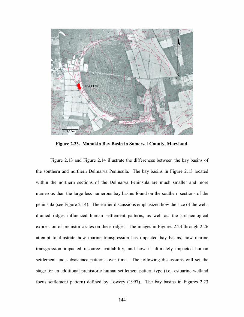
144
Figure 2.23. Manokin Bay Basin in Somerset County, Maryland.
Figure 2.13 and Figure 2.14 illustrate the differences between the bay basins of
the southern and northern Delmarva Peninsula. The bay basins in Figure 2.13 located
within the northern sections of the Delmarva Peninsula are much smaller and more
numerous than the large less numerous bay basins found on the southern sections of the
peninsula (see Figure 2.14). The earlier discussions emphasized how the size of the well-
drained ridges influenced human settlement patterns, as well as, the archaeological
expression of prehistoric sites on these ridges. The images in Figures 2.23 through 2.26
attempt to illustrate how marine transgression has impacted bay basins, how marine
transgression impacted resource availability, and how it ultimately impacted human
settlement and subsistence patterns over time. The following discussions will set the
stage for an additional prehistoric human settlement pattern type (i.e., estuarine wetland
focus settlement pattern) defined by Lowery (1997). The bay basins in Figures 2.23
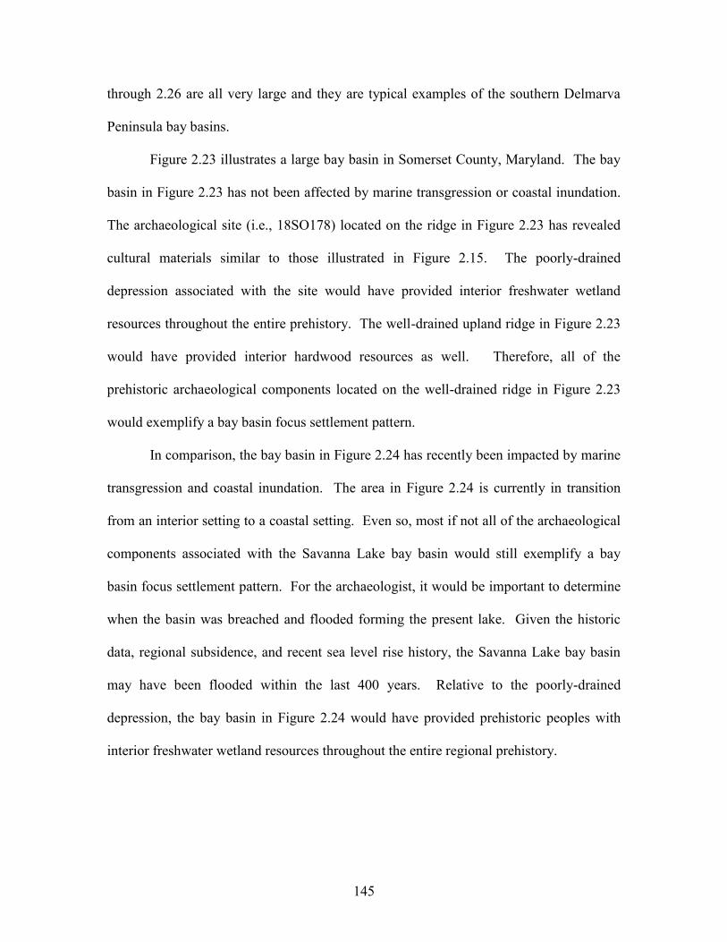
145
through 2.26 are all very large and they are typical examples of the southern Delmarva
Peninsula bay basins.
Figure 2.23 illustrates a large bay basin in Somerset County, Maryland. The bay
basin in Figure 2.23 has not been affected by marine transgression or coastal inundation.
The archaeological site (i.e., 18SO178) located on the ridge in Figure 2.23 has revealed
cultural materials similar to those illustrated in Figure 2.15. The poorly-drained
depression associated with the site would have provided interior freshwater wetland
resources throughout the entire prehistory. The well-drained upland ridge in Figure 2.23
would have provided interior hardwood resources as well. Therefore, all of the
prehistoric archaeological components located on the well-drained ridge in Figure 2.23
would exemplify a bay basin focus settlement pattern.
In comparison, the bay basin in Figure 2.24 has recently been impacted by marine
transgression and coastal inundation. The area in Figure 2.24 is currently in transition
from an interior setting to a coastal setting. Even so, most if not all of the archaeological
components associated with the Savanna Lake bay basin would still exemplify a bay
basin focus settlement pattern. For the archaeologist, it would be important to determine
when the basin was breached and flooded forming the present lake. Given the historic
data, regional subsidence, and recent sea level rise history, the Savanna Lake bay basin
may have been flooded within the last 400 years. Relative to the poorly-drained
depression, the bay basin in Figure 2.24 would have provided prehistoric peoples with
interior freshwater wetland resources throughout the entire regional prehistory.
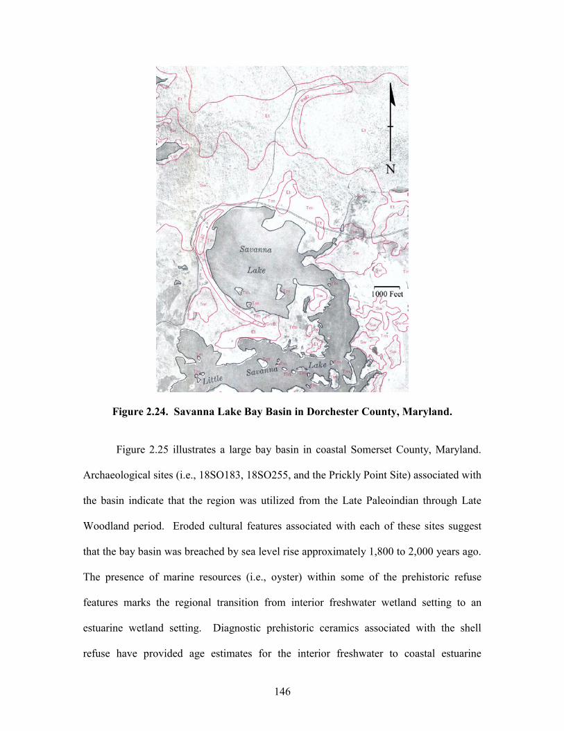
146
Figure 2.24. Savanna Lake Bay Basin in Dorchester County, Maryland.
Figure 2.25 illustrates a large bay basin in coastal Somerset County, Maryland.
Archaeological sites (i.e., 18SO183, 18SO255, and the Prickly Point Site) associated with
the basin indicate that the region was utilized from the Late Paleoindian through Late
Woodland period. Eroded cultural features associated with each of these sites suggest
that the bay basin was breached by sea level rise approximately 1,800 to 2,000 years ago.
The presence of marine resources (i.e., oyster) within some of the prehistoric refuse
features marks the regional transition from interior freshwater wetland setting to an
estuarine wetland setting. Diagnostic prehistoric ceramics associated with the shell
refuse have provided age estimates for the interior freshwater to coastal estuarine

147
environmental and ecological transition. The archaeological remains related to the
Rumbley-Frenchtown bay basin indicate that prior to 2,000 years ago the prehistoric
settlements are expressive of the bay basin focus settlement pattern. After 2,000 years
ago, coastal inundation transformed the region into a series of broad tidal marshes
intersected by estuarine creeks. Middle to Late Woodland-age prehistoric settlements on
the well-drained “hummock-like” ridges in Figure 2.25 would represent an estuarine
wetland focus settlement pattern.
Figure 2.25. Rumbley-Frenchtown Bay Basin in Somerset County, Maryland.
Like the Rumbley-Frenchtown bay basin, the Halfmoon Island bay basin (see
Figure 2.26) in Accomack County, Virginia, has also been impacted by marine
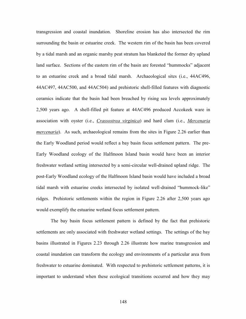
148
transgression and coastal inundation. Shoreline erosion has also intersected the rim
surrounding the basin or estuarine creek. The western rim of the basin has been covered
by a tidal marsh and an organic marshy peat stratum has blanketed the former dry upland
land surface. Sections of the eastern rim of the basin are forested “hummocks” adjacent
to an estuarine creek and a broad tidal marsh. Archaeological sites (i.e., 44AC496,
44AC497, 44AC500, and 44AC504) and prehistoric shell-filled features with diagnostic
ceramics indicate that the basin had been breached by rising sea levels approximately
2,500 years ago. A shell-filled pit feature at 44AC496 produced Accokeek ware in
association with oyster (i.e., Crassostrea virginica) and hard clam (i.e., Mercenaria
mercenaria). As such, archaeological remains from the sites in Figure 2.26 earlier than
the Early Woodland period would reflect a bay basin focus settlement pattern. The pre-
Early Woodland ecology of the Halfmoon Island basin would have been an interior
freshwater wetland setting intersected by a semi-circular well-drained upland ridge. The
post-Early Woodland ecology of the Halfmoon Island basin would have included a broad
tidal marsh with estuarine creeks intersected by isolated well-drained “hummock-like”
ridges. Prehistoric settlements within the region in Figure 2.26 after 2,500 years ago
would exemplify the estuarine wetland focus settlement pattern.
The bay basin focus settlement pattern is defined by the fact that prehistoric
settlements are only associated with freshwater wetland settings. The settings of the bay
basins illustrated in Figures 2.23 through 2.26 illustrate how marine transgression and
coastal inundation can transform the ecology and environments of a particular area from
freshwater to estuarine dominated. With respected to prehistoric settlement patterns, it is
important to understand when these ecological transitions occurred and how they may
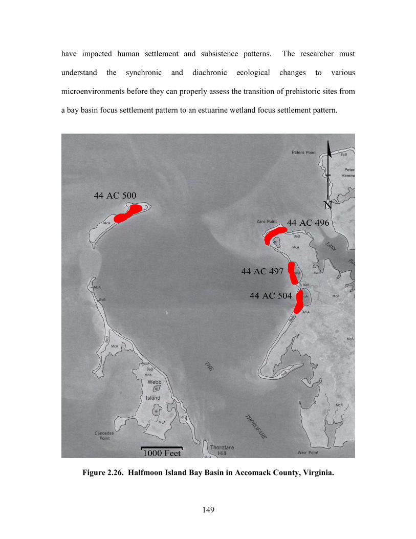
149
have impacted human settlement and subsistence patterns. The researcher must
understand the synchronic and diachronic ecological changes to various
microenvironments before they can properly assess the transition of prehistoric sites from
a bay basin focus settlement pattern to an estuarine wetland focus settlement pattern.
Figure 2.26. Halfmoon Island Bay Basin in Accomack County, Virginia.
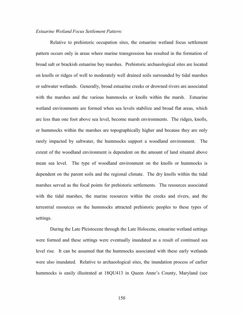
150
Estuarine Wetland Focus Settlement Pattern:
Relative to prehistoric occupation sites, the estuarine wetland focus settlement
pattern occurs only in areas where marine transgression has resulted in the formation of
broad salt or brackish estuarine bay marshes. Prehistoric archaeological sites are located
on knolls or ridges of well to moderately well drained soils surrounded by tidal marshes
or saltwater wetlands. Generally, broad estuarine creeks or drowned rivers are associated
with the marshes and the various hummocks or knolls within the marsh. Estuarine
wetland environments are formed when sea levels stabilize and broad flat areas, which
are less than one foot above sea level, become marsh environments. The ridges, knolls,
or hummocks within the marshes are topographically higher and because they are only
rarely impacted by saltwater, the hummocks support a woodland environment. The
extent of the woodland environment is dependent on the amount of land situated above
mean sea level. The type of woodland environment on the knolls or hummocks is
dependent on the parent soils and the regional climate. The dry knolls within the tidal
marshes served as the focal points for prehistoric settlements. The resources associated
with the tidal marshes, the marine resources within the creeks and rivers, and the
terrestrial resources on the hummocks attracted prehistoric peoples to these types of
settings.
During the Late Pleistocene through the Late Holocene, estuarine wetland settings
were formed and these settings were eventually inundated as a result of continued sea
level rise. It can be assumed that the hummocks associated with these early wetlands
were also inundated. Relative to archaeological sites, the inundation process of earlier
hummocks is easily illustrated at 18QU413 in Queen Anne’s County, Maryland (see
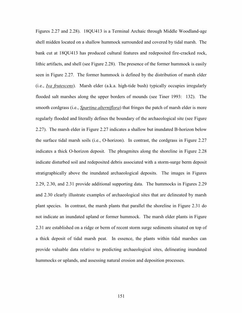
151
Figures 2.27 and 2.28). 18QU413 is a Terminal Archaic through Middle Woodland-age
shell midden located on a shallow hummock surrounded and covered by tidal marsh. The
bank cut at 18QU413 has produced cultural features and redeposited fire-cracked rock,
lithic artifacts, and shell (see Figure 2.28). The presence of the former hummock is easily
seen in Figure 2.27. The former hummock is defined by the distribution of marsh elder
(i.e., Iva frutescens). Marsh elder (a.k.a. high-tide bush) typically occupies irregularly
flooded salt marshes along the upper borders of mounds (see Tiner 1993: 132). The
smooth cordgrass (i.e., Spartina alterniflora) that fringes the patch of marsh elder is more
regularly flooded and literally defines the boundary of the archaeological site (see Figure
2.27). The marsh elder in Figure 2.27 indicates a shallow but inundated B-horizon below
the surface tidal marsh soils (i.e., O-horizon). In contrast, the cordgrass in Figure 2.27
indicates a thick O-horizon deposit. The phragmites along the shoreline in Figure 2.28
indicate disturbed soil and redeposited debris associated with a storm-surge berm deposit
stratigraphically above the inundated archaeological deposits. The images in Figures
2.29, 2.30, and 2.31 provide additional supporting data. The hummocks in Figures 2.29
and 2.30 clearly illustrate examples of archaeological sites that are delineated by marsh
plant species. In contrast, the marsh plants that parallel the shoreline in Figure 2.31 do
not indicate an inundated upland or former hummock. The marsh elder plants in Figure
2.31 are established on a ridge or berm of recent storm surge sediments situated on top of
a thick deposit of tidal marsh peat. In essence, the plants within tidal marshes can
provide valuable data relative to predicting archaeological sites, delineating inundated
hummocks or uplands, and assessing natural erosion and deposition processes.
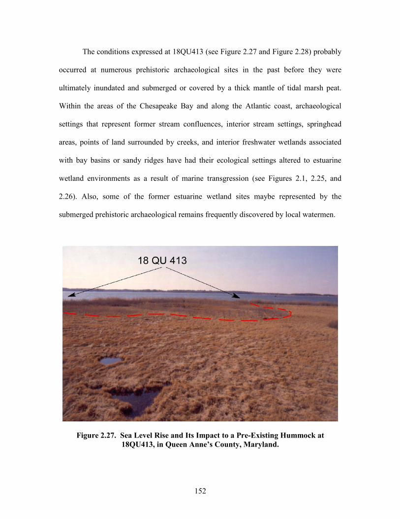
152
The conditions expressed at 18QU413 (see Figure 2.27 and Figure 2.28) probably
occurred at numerous prehistoric archaeological sites in the past before they were
ultimately inundated and submerged or covered by a thick mantle of tidal marsh peat.
Within the areas of the Chesapeake Bay and along the Atlantic coast, archaeological
settings that represent former stream confluences, interior stream settings, springhead
areas, points of land surrounded by creeks, and interior freshwater wetlands associated
with bay basins or sandy ridges have had their ecological settings altered to estuarine
wetland environments as a result of marine transgression (see Figures 2.1, 2.25, and
2.26). Also, some of the former estuarine wetland sites maybe represented by the
submerged prehistoric archaeological remains frequently discovered by local watermen.
Figure 2.27. Sea Level Rise and Its Impact to a Pre-Existing Hummock at 18QU413, in Queen Anne’s County, Maryland.
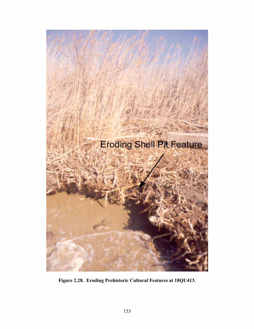
153
Figure 2.28. Eroding Prehistoric Cultural Features at 18QU413.

154
Figure 2.29. Marsh Plants in Northampton County, Virginia, that Delineate 44NH223.

155
Figure 2.30. Marsh Plants in Northampton County, Virginia, that Delineate 44NH470.
Figure 2.31. Marsh Plants Adjacent to Upshur Bay, Virginia, that are Associated with Storm Surge Activity.
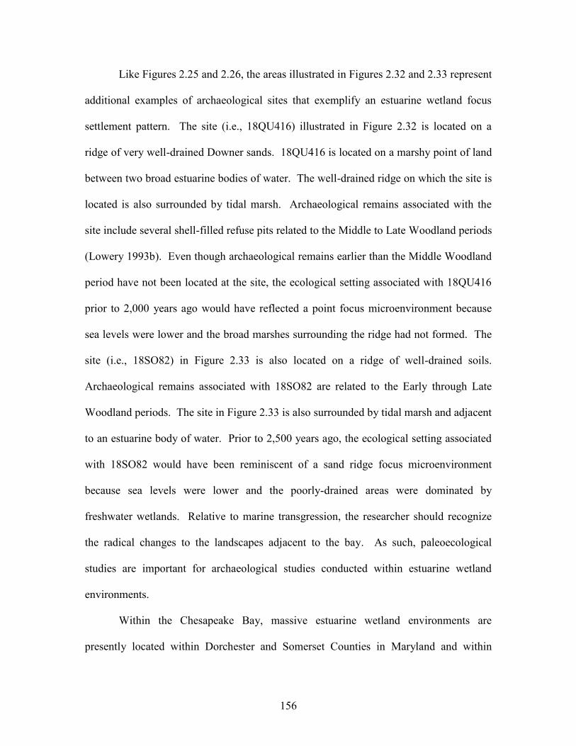
156
Like Figures 2.25 and 2.26, the areas illustrated in Figures 2.32 and 2.33 represent
additional examples of archaeological sites that exemplify an estuarine wetland focus
settlement pattern. The site (i.e., 18QU416) illustrated in Figure 2.32 is located on a
ridge of very well-drained Downer sands. 18QU416 is located on a marshy point of land
between two broad estuarine bodies of water. The well-drained ridge on which the site is
located is also surrounded by tidal marsh. Archaeological remains associated with the
site include several shell-filled refuse pits related to the Middle to Late Woodland periods
(Lowery 1993b). Even though archaeological remains earlier than the Middle Woodland
period have not been located at the site, the ecological setting associated with 18QU416
prior to 2,000 years ago would have reflected a point focus microenvironment because
sea levels were lower and the broad marshes surrounding the ridge had not formed. The
site (i.e., 18SO82) in Figure 2.33 is also located on a ridge of well-drained soils.
Archaeological remains associated with 18SO82 are related to the Early through Late
Woodland periods. The site in Figure 2.33 is also surrounded by tidal marsh and adjacent
to an estuarine body of water. Prior to 2,500 years ago, the ecological setting associated
with 18SO82 would have been reminiscent of a sand ridge focus microenvironment
because sea levels were lower and the poorly-drained areas were dominated by
freshwater wetlands. Relative to marine transgression, the researcher should recognize
the radical changes to the landscapes adjacent to the bay. As such, paleoecological
studies are important for archaeological studies conducted within estuarine wetland
environments.
Within the Chesapeake Bay, massive estuarine wetland environments are
presently located within Dorchester and Somerset Counties in Maryland and within
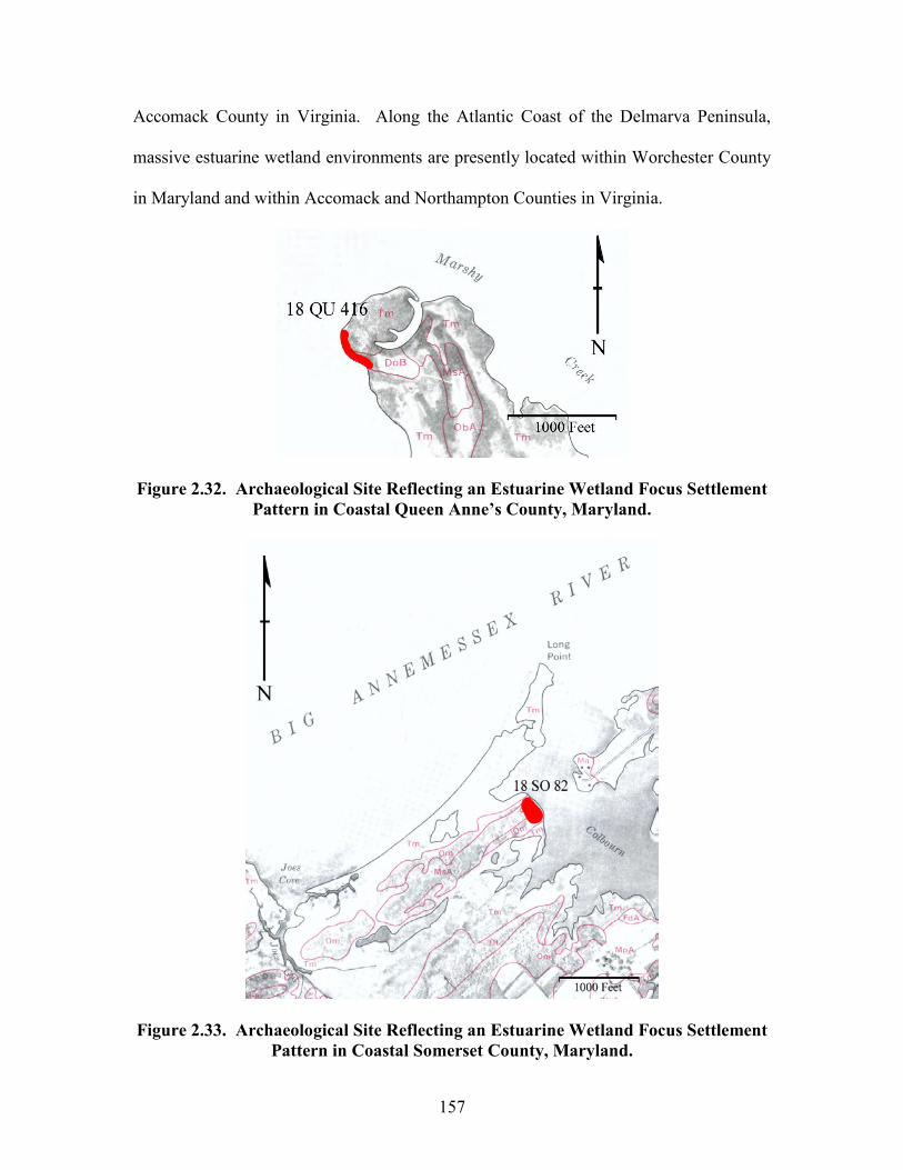
157
Accomack County in Virginia. Along the Atlantic Coast of the Delmarva Peninsula,
massive estuarine wetland environments are presently located within Worchester County
in Maryland and within Accomack and Northampton Counties in Virginia.
Figure 2.32. Archaeological Site Reflecting an Estuarine Wetland Focus Settlement Pattern in Coastal Queen Anne’s County, Maryland.
Figure 2.33. Archaeological Site Reflecting an Estuarine Wetland Focus Settlement Pattern in Coastal Somerset County, Maryland.
158
Rivershore Focus Settlement Pattern:
Rivershore focus sites are located along the topographically elevated sections of
the major tributaries, which empty into the Chesapeake Bay. Typically, archaeological
sites occur along the dry upland areas parallel to the main channel of the various drowned
tributaries. Small streams, which are generally perpendicular to the drowned river valley,
drain the interior and provide a conduit for freshwater spring or precipitation runoff. The
environmental setting reflected by the rivershore focus settlement pattern is essentially an
interior stream setting (see Figure 2.21) that has been impacted by marine transgression.
With reference to Figure 2.21, the freshwater stream channel, floodplain, and the lower
portions of the stream valley become submerged as a result of sea level rise. Marine
transgression over time ultimately changes the entire ecology of the former freshwater
streams and rivers. As such, the former low terraces associated with the ancient
freshwater stream channel are submerged or inundated by brackish water or salt water.
The inundated terraces form shallow shelves located adjacent to and paralleling the
shoreline. Tidal marshes develop along the low areas adjacent to the shoreline and in
areas where sediment accretion occurs. Prehistoric occupation sites that reflect the
rivershore focus pattern are typically located on the well-drained upper terraces, which
have escaped coastal inundation.
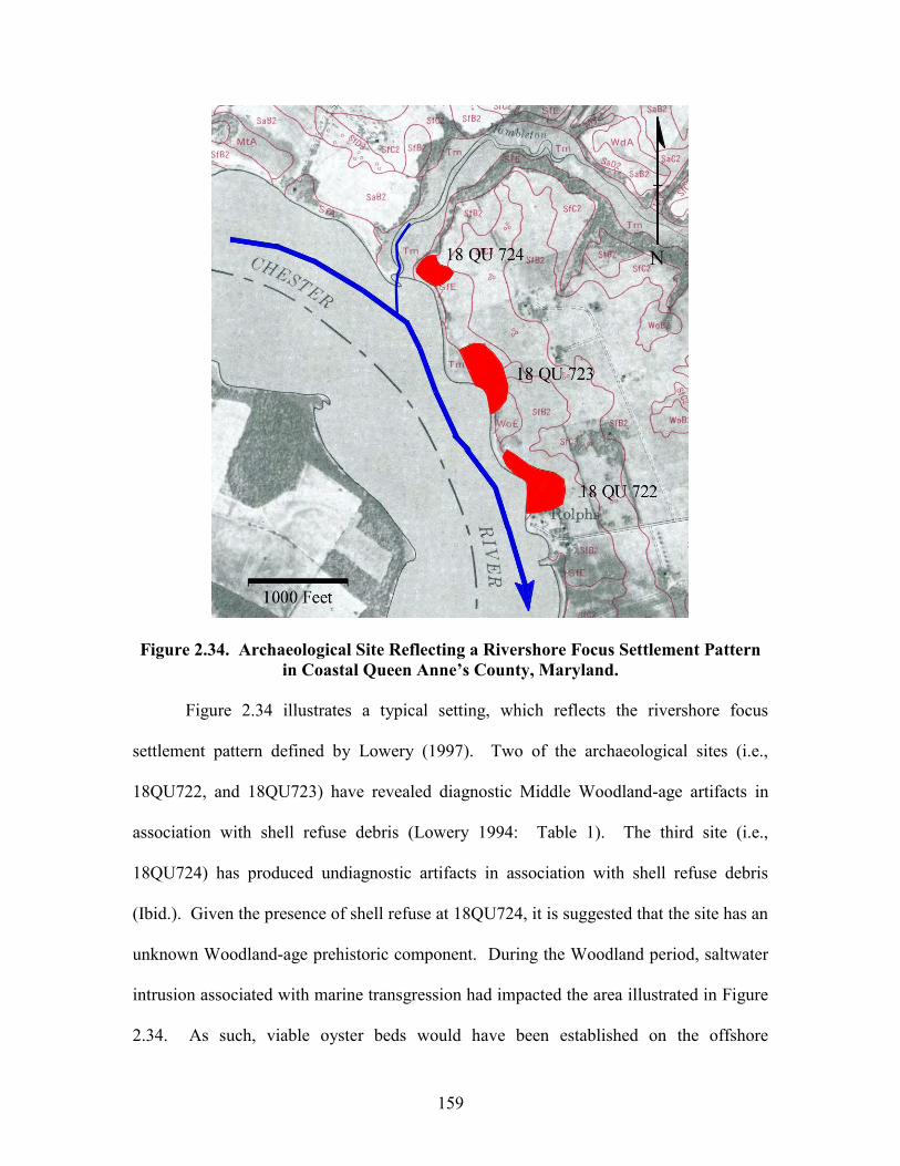
159
Figure 2.34. Archaeological Site Reflecting a Rivershore Focus Settlement Pattern in Coastal Queen Anne’s County, Maryland.
Figure 2.34 illustrates a typical setting, which reflects the rivershore focus
settlement pattern defined by Lowery (1997). Two of the archaeological sites (i.e.,
18QU722, and 18QU723) have revealed diagnostic Middle Woodland-age artifacts in
association with shell refuse debris (Lowery 1994: Table 1). The third site (i.e.,
18QU724) has produced undiagnostic artifacts in association with shell refuse debris
(Ibid.). Given the presence of shell refuse at 18QU724, it is suggested that the site has an
unknown Woodland-age prehistoric component. During the Woodland period, saltwater
intrusion associated with marine transgression had impacted the area illustrated in Figure
2.34. As such, viable oyster beds would have been established on the offshore
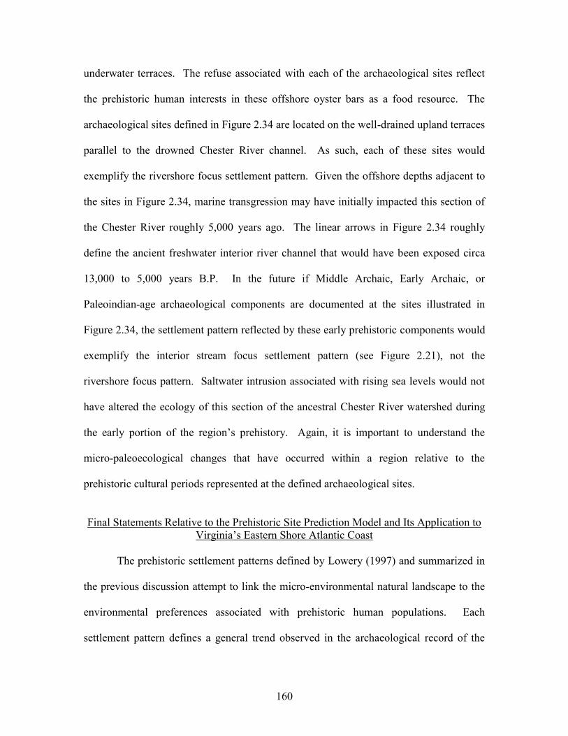
160
underwater terraces. The refuse associated with each of the archaeological sites reflect
the prehistoric human interests in these offshore oyster bars as a food resource. The
archaeological sites defined in Figure 2.34 are located on the well-drained upland terraces
parallel to the drowned Chester River channel. As such, each of these sites would
exemplify the rivershore focus settlement pattern. Given the offshore depths adjacent to
the sites in Figure 2.34, marine transgression may have initially impacted this section of
the Chester River roughly 5,000 years ago. The linear arrows in Figure 2.34 roughly
define the ancient freshwater interior river channel that would have been exposed circa
13,000 to 5,000 years B.P. In the future if Middle Archaic, Early Archaic, or
Paleoindian-age archaeological components are documented at the sites illustrated in
Figure 2.34, the settlement pattern reflected by these early prehistoric components would
exemplify the interior stream focus settlement pattern (see Figure 2.21), not the
rivershore focus pattern. Saltwater intrusion associated with rising sea levels would not
have altered the ecology of this section of the ancestral Chester River watershed during
the early portion of the region’s prehistory. Again, it is important to understand the
micro-paleoecological changes that have occurred within a region relative to the
prehistoric cultural periods represented at the defined archaeological sites.
Final Statements Relative to the Prehistoric Site Prediction Model and Its Application to
Virginia’s Eastern Shore Atlantic Coast The prehistoric settlement patterns defined by Lowery (1997) and summarized in
the previous discussion attempt to link the micro-environmental natural landscape to the
environmental preferences associated with prehistoric human populations. Each
settlement pattern defines a general trend observed in the archaeological record of the
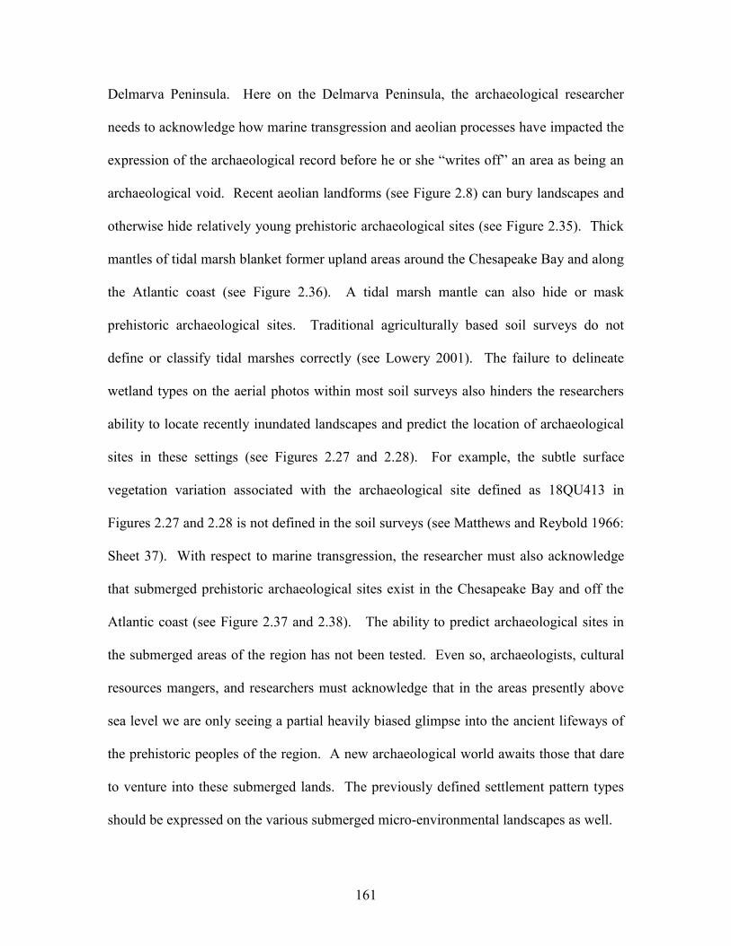
161
Delmarva Peninsula. Here on the Delmarva Peninsula, the archaeological researcher
needs to acknowledge how marine transgression and aeolian processes have impacted the
expression of the archaeological record before he or she “writes off” an area as being an
archaeological void. Recent aeolian landforms (see Figure 2.8) can bury landscapes and
otherwise hide relatively young prehistoric archaeological sites (see Figure 2.35). Thick
mantles of tidal marsh blanket former upland areas around the Chesapeake Bay and along
the Atlantic coast (see Figure 2.36). A tidal marsh mantle can also hide or mask
prehistoric archaeological sites. Traditional agriculturally based soil surveys do not
define or classify tidal marshes correctly (see Lowery 2001). The failure to delineate
wetland types on the aerial photos within most soil surveys also hinders the researchers
ability to locate recently inundated landscapes and predict the location of archaeological
sites in these settings (see Figures 2.27 and 2.28). For example, the subtle surface
vegetation variation associated with the archaeological site defined as 18QU413 in
Figures 2.27 and 2.28 is not defined in the soil surveys (see Matthews and Reybold 1966:
Sheet 37). With respect to marine transgression, the researcher must also acknowledge
that submerged prehistoric archaeological sites exist in the Chesapeake Bay and off the
Atlantic coast (see Figure 2.37 and 2.38). The ability to predict archaeological sites in
the submerged areas of the region has not been tested. Even so, archaeologists, cultural
resources mangers, and researchers must acknowledge that in the areas presently above
sea level we are only seeing a partial heavily biased glimpse into the ancient lifeways of
the prehistoric peoples of the region. A new archaeological world awaits those that dare
to venture into these submerged lands. The previously defined settlement pattern types
should be expressed on the various submerged micro-environmental landscapes as well.
162
When conducting archaeological surveys in coastal areas and along shorelines,
the field conditions can greatly impact one’s ability to test the site prediction model. For
example, the images illustrated in Figures 2.39 and 2.40 show the same section of
shoreline impacted by daily tides. 44NH466 or the Bog Gut Ridge site (see Figures 2.39
and 2.40) in Northampton County, Virginia is situated on a linear hummock. The site has
been eroded by the tidal action of a deep estuarine channel that is adjacent to the site.
Given the site’s setting, the ridge landform surrounded by a large tidal marsh would
reflect an estuarine wetland type setting during the later prehistoric periods. Therefore,
the site would seem to be a high probability area for a late prehistoric archaeological site.
When the Bog Gut Ridge area was not impacted by the influx of coastal waters, the site
may have been a well-drained sand ridge adjacent to a freshwater stream and extensive
areas of poorly-drained interior wetlands. Therefore, the site would also seem to be a
high probability area for an earlier prehistoric sand ridge oriented prehistoric site. Figure
2.39 shows the Bog Gut Ridge site in Northampton County, Virginia, at high tide. Figure
2.40 shows the same area at low tide. At high tide, the presence of an archaeological site
is not evident. The low tide image (Figure 2.40) shows a cluster of fire-cracked rocks
encrusted with modern oysters. When conducting a shoreline survey to test a site
prediction model, prehistoric lithic debris and other cultural diagnostics are best located
during periods of maximum low tide. Given the constraints of marine transgression, low
tidal circumstances are expressive of the best archaeological visibility conditions.
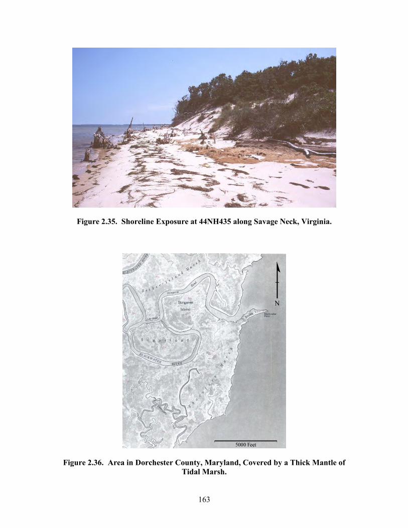
163
Figure 2.35. Shoreline Exposure at 44NH435 along Savage Neck, Virginia.
Figure 2.36. Area in Dorchester County, Maryland, Covered by a Thick Mantle of Tidal Marsh.
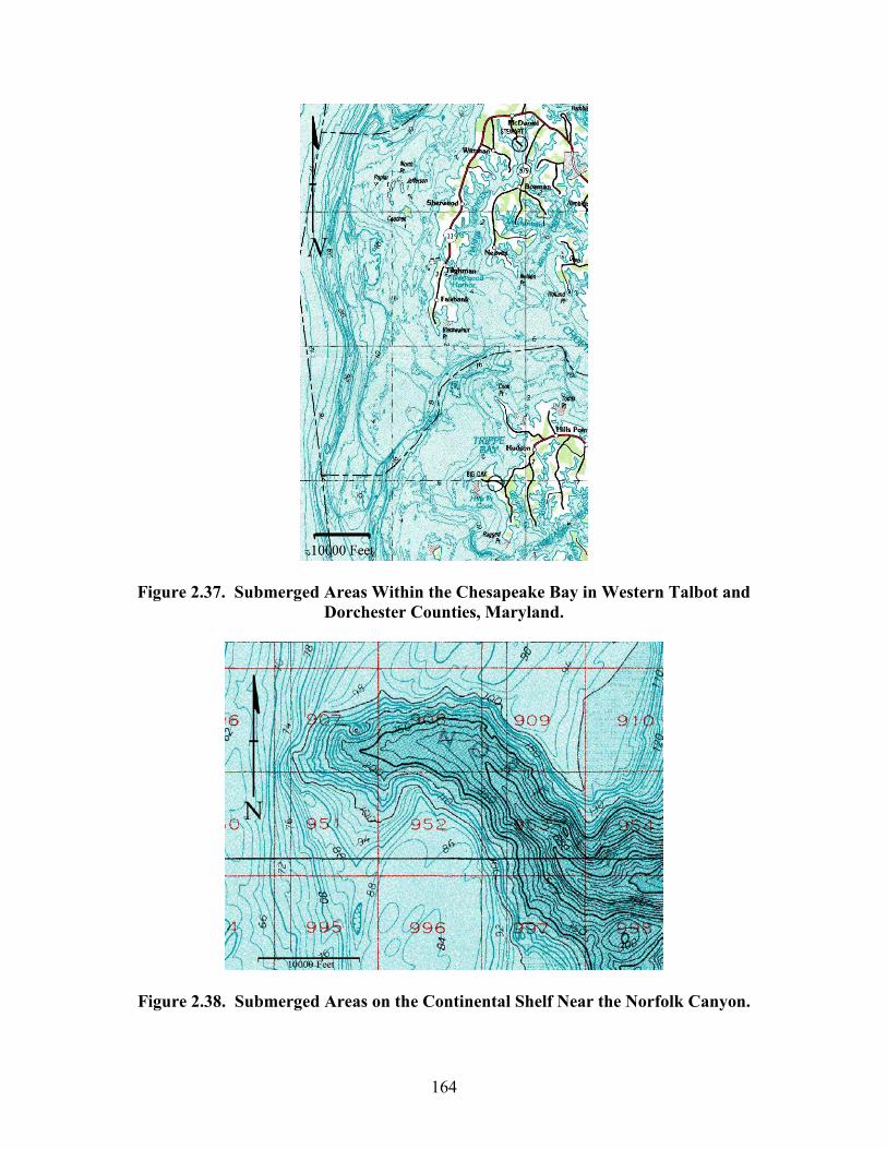
164
Figure 2.37. Submerged Areas Within the Chesapeake Bay in Western Talbot and Dorchester Counties, Maryland.
Figure 2.38. Submerged Areas on the Continental Shelf Near the Norfolk Canyon.
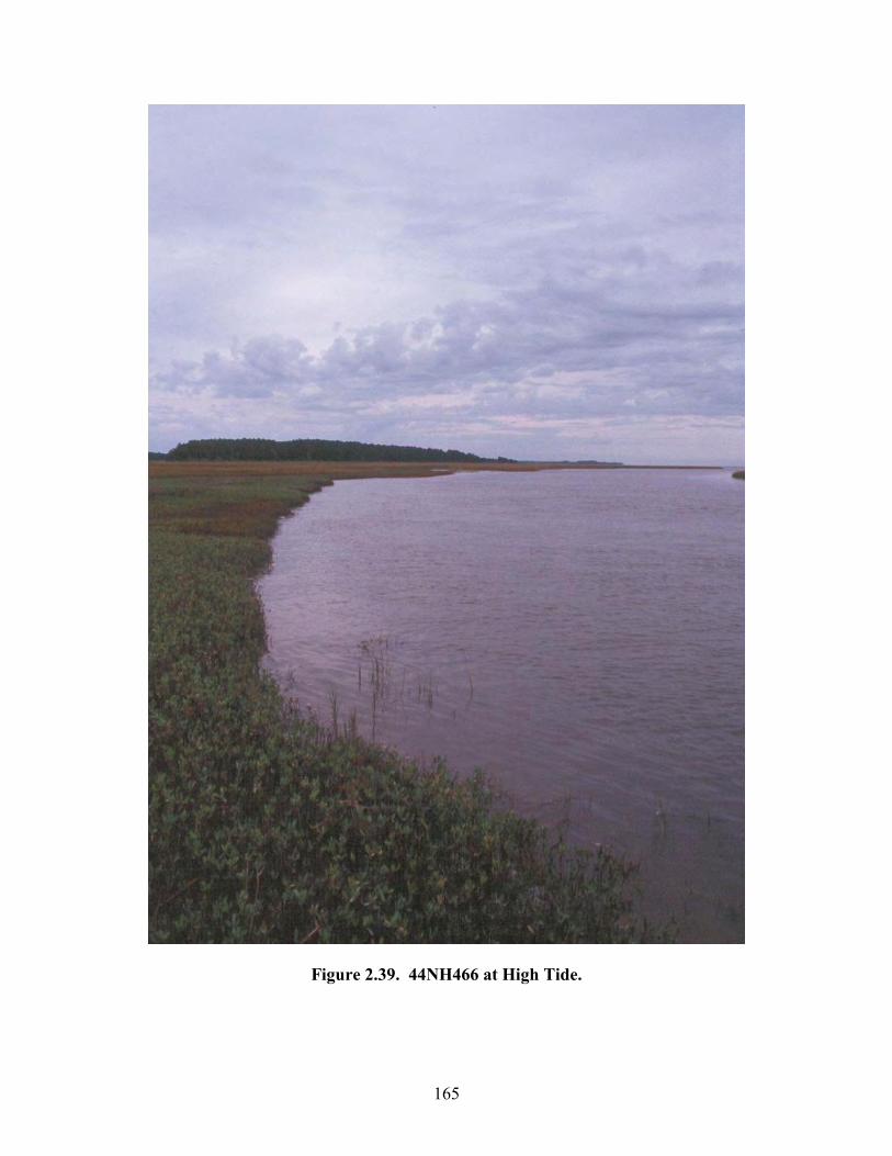
165
Figure 2.39. 44NH466 at High Tide.
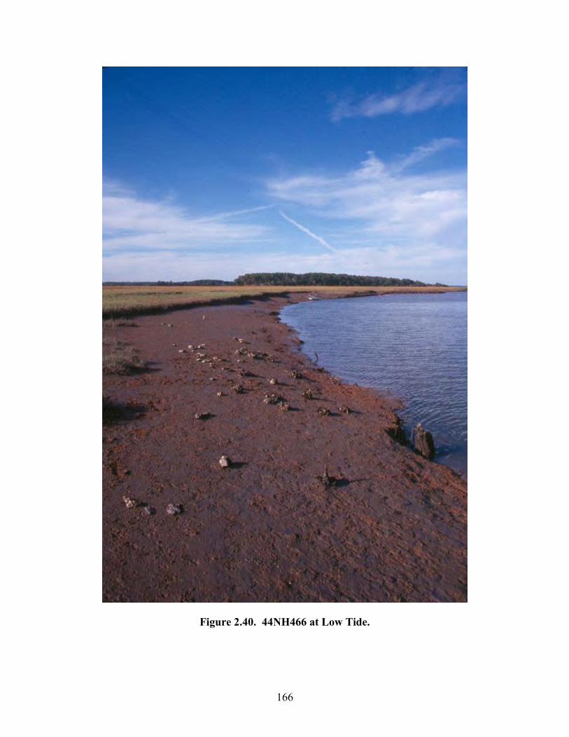
166
Figure 2.40. 44NH466 at Low Tide.
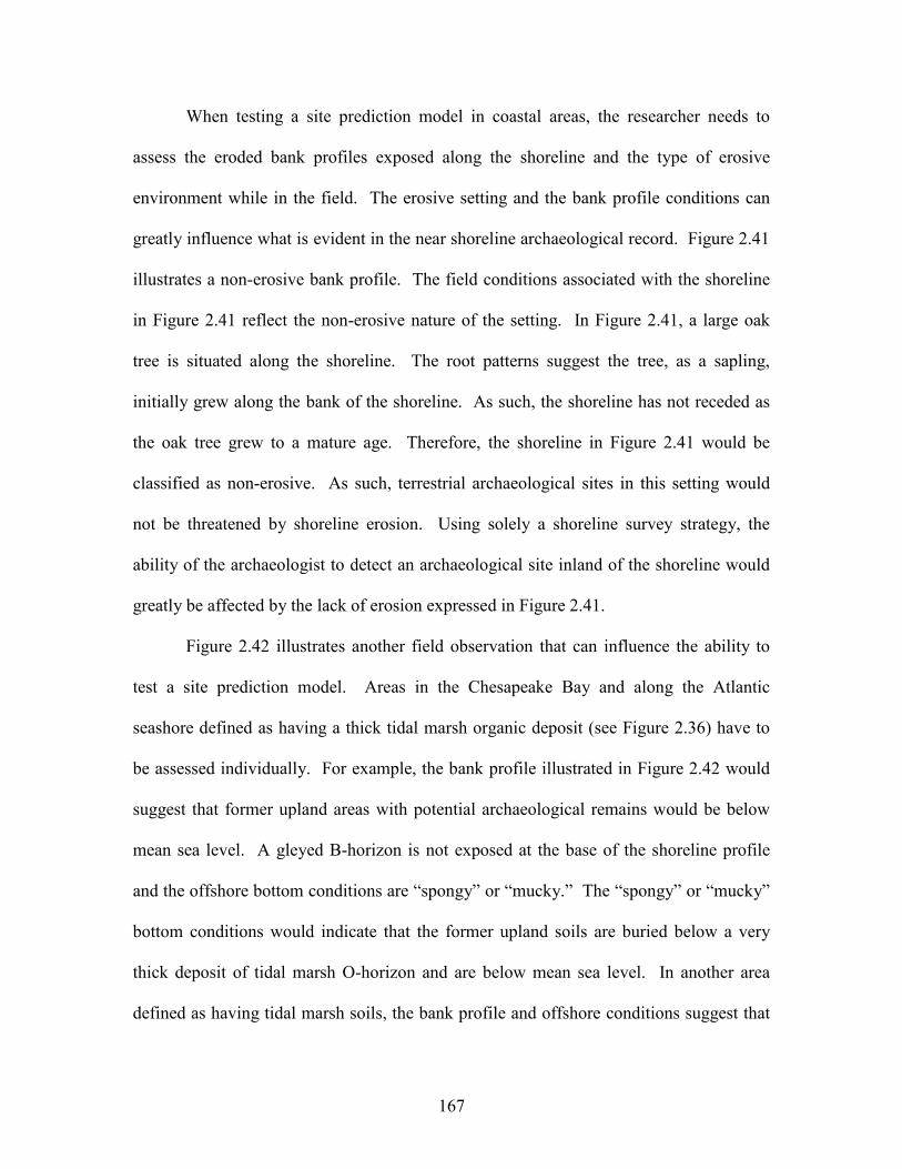
167
When testing a site prediction model in coastal areas, the researcher needs to
assess the eroded bank profiles exposed along the shoreline and the type of erosive
environment while in the field. The erosive setting and the bank profile conditions can
greatly influence what is evident in the near shoreline archaeological record. Figure 2.41
illustrates a non-erosive bank profile. The field conditions associated with the shoreline
in Figure 2.41 reflect the non-erosive nature of the setting. In Figure 2.41, a large oak
tree is situated along the shoreline. The root patterns suggest the tree, as a sapling,
initially grew along the bank of the shoreline. As such, the shoreline has not receded as
the oak tree grew to a mature age. Therefore, the shoreline in Figure 2.41 would be
classified as non-erosive. As such, terrestrial archaeological sites in this setting would
not be threatened by shoreline erosion. Using solely a shoreline survey strategy, the
ability of the archaeologist to detect an archaeological site inland of the shoreline would
greatly be affected by the lack of erosion expressed in Figure 2.41.
Figure 2.42 illustrates another field observation that can influence the ability to
test a site prediction model. Areas in the Chesapeake Bay and along the Atlantic
seashore defined as having a thick tidal marsh organic deposit (see Figure 2.36) have to
be assessed individually. For example, the bank profile illustrated in Figure 2.42 would
suggest that former upland areas with potential archaeological remains would be below
mean sea level. A gleyed B-horizon is not exposed at the base of the shoreline profile
and the offshore bottom conditions are “spongy” or “mucky.” The “spongy” or “mucky”
bottom conditions would indicate that the former upland soils are buried below a very
thick deposit of tidal marsh O-horizon and are below mean sea level. In another area
defined as having tidal marsh soils, the bank profile and offshore conditions suggest that
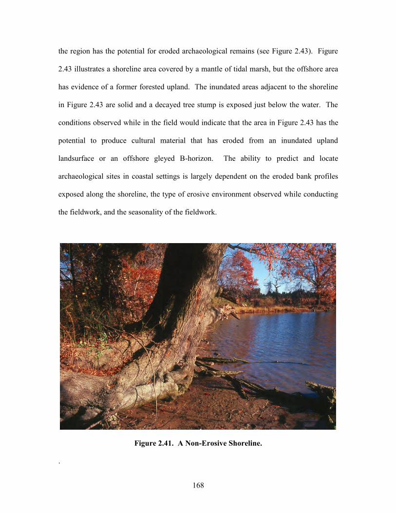
168
the region has the potential for eroded archaeological remains (see Figure 2.43). Figure
2.43 illustrates a shoreline area covered by a mantle of tidal marsh, but the offshore area
has evidence of a former forested upland. The inundated areas adjacent to the shoreline
in Figure 2.43 are solid and a decayed tree stump is exposed just below the water. The
conditions observed while in the field would indicate that the area in Figure 2.43 has the
potential to produce cultural material that has eroded from an inundated upland
landsurface or an offshore gleyed B-horizon. The ability to predict and locate
archaeological sites in coastal settings is largely dependent on the eroded bank profiles
exposed along the shoreline, the type of erosive environment observed while conducting
the fieldwork, and the seasonality of the fieldwork.
Figure 2.41. A Non-Erosive Shoreline.
.
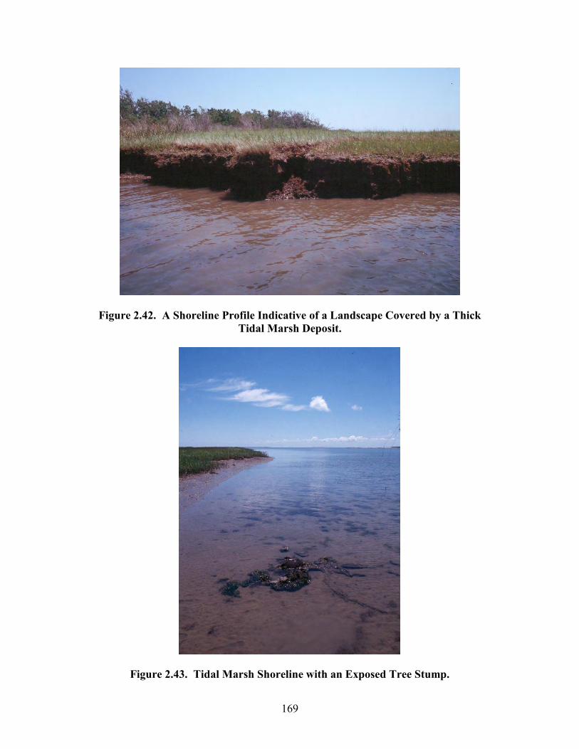
169
Figure 2.42. A Shoreline Profile Indicative of a Landscape Covered by a Thick Tidal Marsh Deposit.
Figure 2.43. Tidal Marsh Shoreline with an Exposed Tree Stump.
170
In applying the site prediction model to the Atlantic seashore of Accomack and
Northampton Counties, the published soil surveys for each county (Peacock and
Edmonds 1994; and Cobb and Smith 1989) were examined and assessed prior to the
fieldwork. Based on Figures 2.4, 2.5, 2.6, 2.7, 2.11, 2.12, 2.13, 2.14, 2.16, 2.17, 2.18,
2.20, 2.21, 2.22, 2.23, 2.24, 2.25, 2.26, 2.32, 2.33, 2.34, and 2.36, it is evident that the
soil surveys provide a basis for predicting potential site locations. The plates included in
Peacock and Edmonds (1994) and within Cobb and Smith (1989) provided the foundation
for assessing shoreline areas and delineating potential archaeological sites using the site
prediction model. With each soil survey plate associated with the Atlantic seashore,
potential site areas were delineated. Areas with an extremely high probability for
archaeological sites were delineated and marked as red zones. Areas with a high
probability for archaeological sites were delineated and marked as yellow zones. Areas
with a moderate probability for archaeological sites were delineated and marked as green
zones and areas with low or no probability for archaeological sites were not marked. The
probabilities for prehistoric sites were defined based on the variables presented for each
type of settlement model, an understanding of the region’s geological history, and an
appreciation of coastal and other natural processes. Figure 2.44 illustrates a sample site
prediction model map that was developed prior to the fieldwork. Of course, it is evident
in Figure 2.44 that only a few of the potential site areas are subjected to shoreline erosion.
Even though all shorelines along the Atlantic Coast were examined, the site prediction
model could only be tested at those potential site areas that are or may be eroded via wind
and wave activity, boating activity, coastal bioturbation processes, or tidal action. Even
171
so, the shoreline survey would be testing a small aspect of the site prediction model under
the constraints of numerous natural coastal processes that could limit site visibility.
Finally, the settlement types defined in the previous predictive model summary do
not take into account the terrestrial and offshore floral and faunal variables that should
have influenced the settlement patterns of prehistoric peoples. The synchronic micro-
environmental flora and fauna of a region played a major role influencing where humans
lived on the landscape. Traditional methods to reconstruct ancient environments
typically provide macro-environmental overviews. But, it is argued that the
microenvironment was central to prehistoric hunter-gatherer settlement patterns. As
such, the defined settlement pattern types provide only a generalized diachronic glimpse
into those landscapes that typically provided attractive micro-environmental settings for
humans. Even though the settlement model has its limitations, the model can provide
various levels of probability for prehistoric sites in a general region (see Figure 2.44).
Before gauging levels of probability, the researcher should also take into account the
surrounding landscape and landforms. The researcher should also continue to examine
those areas with “low” or “minimal” probability for prehistoric archaeological sites.
Additional settlement patterns or unknown cultural landscapes may emerge.
When developing a prehistoric site prediction or settlement model, the frequency
of similar environmental settings surrounding a particular study area, the ecological
diversity of the study area, and “confining aspects” of the landscape all need to be
considered. The synchronic and diachronic natural variables for the multitude of
Delmarva Peninsula microenvironments also need to be recognized as the significant
factors influencing human settlement patterns. The link between the climatic and the
172
resulting terrestrial, riverine, and estuarine ecological changes would also need to be
assessed on a site-by-site basis. All of these prehistoric site prediction and site settlement
model variables need to be addressed. In addressing the variables mentioned above,
future archaeological research needs to focus on the systematic excavation of prehistoric
sites of all time periods and in all ecological settings, including underwater sites. Future
archaeological research also needs to focus on the systematic survey of areas with limited
or no prehistoric site data. Figure 2.1 illustrates how the proposed settlement patterns are
linked to environmental factors. The 9,000 to 6,000-year-old occupation documented at
18SO20 and 18SO240 would exemplify a “converging stream focus settlement pattern.”
The 3,000-year-old prehistoric component at the same sites would represent a “point
focus settlement pattern” and the 1,000-year-old component would embody an “estuarine
wetland focus settlement pattern.” Research that develops a better understanding of the
regional geomorphology, the natural site formation processes, and the changes to
terrestrial landscapes is extremely essential. These are some of the “weak links” in the
archaeological “chain.”
Lowery’s (1997) model for prehistoric human settlement and the model described
in this summary only attempts to locate prehistoric sites based on the factors that would
have impacted humans. Some of these factors include water resources, soils, topography,
marine transgression, and aeolian processes. The reader may notice that lithic resources,
essential for stone tool manufacture, were not mentioned in this entire summary. The
cobble lithic resources of the Delmarva Peninsula are probably the only variable
important to prehistoric peoples that have a remotely uniform distribution across the
landscape (see Lowery 2002). Unlike lithic outcrops, water and food on Delmarva
173
Peninsula are not uniformly distributed across the landscape. As such, variables such as
water resources, soils, topography, marine transgression, and aeolian processes seemed to
play a major role in prehistoric human settlement patterns. The model presented in this
summary should be tested against future survey and excavation data. Its validity should
continually be subjected to scientific scrutiny. During the Chesapeake Bay shoreline
survey associated with Accomack and Northampton Counties, Virginia, (see Lowery
2001) the previous archaeological site prediction model was employed with success.
Therefore, the same archaeological site prediction model was employed while conducting
the present Atlantic seashore survey of Accomack and Northampton Counties.
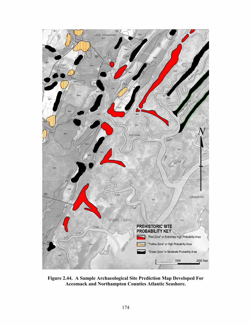
174
Figure 2.44. A Sample Archaeological Site Prediction Map Developed For Accomack and Northampton Counties Atlantic Seashore.
175
PART III: Results of the Atlantic Coast Shoreline Archaeological Survey in Acommack County
and Northampton County, Virginia. The archaeological survey of eroded shorelines along Virginia’s Eastern Shore
Atlantic seashore began in July 2001. All shorelines associated with coastal barrier
islands, back barrier island bays, inlets, and tidal channels were examined for evidence of
eroding prehistoric or historic archaeological sites. By the end of October 2001, all of the
areas along the Atlantic coast of Accomack and Northampton Counties had been
surveyed for eroded archaeological sites. The survey was conducted using kayaks and a
small powerboat as archaeological survey vehicles. The kayaks provided access to the
numerous shallow bays, creeks, and tidal channels that are virtually inaccessible by
powerboat. The powerboat provided access to the coastal barrier islands and all
shorelines deemed too distant to paddle via a kayak. Given the extreme tidal fluctuations
along the Atlantic coast, kayaks were the best means to access most shorelines. Several
experienced volunteer assistants helped conduct the survey. At the completion of the
survey 44 archaeological sites have been discovered as a result of the shoreline analysis.
The following discussion highlights the data associated with the sites discovered during
the survey, and it summarizes the current survey data compared to the previously
documented site data. The discussion also defines the erosive processes impacting each
site discovered during the survey and it highlights the limitations associated with site
assessment in coastal environments.
A standard Virginia Department of Historic Resources site inventory form was
completed for each of the 44 sites discovered during the shoreline survey of Accomack
and Northampton Counties Atlantic coast. These site data forms are on file in the
176
archives at the Virginia Department of Historic Resources. The following summaries
represent brief overviews and discussions about each site discovered during the project.
The site summaries are organized alphabetically based on the designated site name. The
site name and the official site numbers correlate to the various tables listed in the
appendix. As such, researchers, cultural resource managers, and historians should be able
to glean information from the summaries as well as the tables in the appendix. Exact site
locations are plotted within the site inventory forms on file in Richmond.
Archaeological Site Summaries
Site Name: Bog Gut Ridge
Site Number: 44NH466 Description: The Bog Gut Ridge site has revealed evidence of an unknown prehistoric archaeological component. During the single visit to the area, the site produced a limited assemblage of undiagnostic flaked stone artifacts and fire-cracked rock. The assemblage collected from the site included one quartz point fragment with an impact fracture, one chert cobble biface fragment, two unifacial endscrapers (1 chert and 1 jasper), two bifacial endscrapers (1 jasper and 1 chalcedony), and one fragment of fire-cracked rock. The cultural strata are below a mantle of tidal marsh soils. Present data suggest that the site may have a limited prehistoric occupation. Fire-cracked rock was noted, but lithic debitage was limited. The visibility of the eroded lithic artifacts is hindered by accreted mud and silt. The shoreline also has newly established marsh grasses. Continual examination of the shoreline may eventually provide more data relative to the cultural chronologies present at the site. The site represents a former topographic ridge that has only recently been inundated and covered by a mantle of tidal marsh peat. The drainage patterns east and west of the site suggest that the site is associated with a ridge. The shoreline seems to be an eroded lateral exposure of the former ridge. A sub-soil B-horizon and a few old tree stumps were noted below the tidal marsh peat. The limited cultural material may also suggest that the site has intact deposits immediately west of the shoreline exposure. Artifacts eroded from the shoreline would easily fall into the deep channel adjacent to the site and be inaccessible to continued shoreline survey. Most important, a rock-lined hearth was exposed along the shoreline. The exposed rocks associated with the feature are now covered with living oysters. Shoreline erosion at the site is primarily linked to extremely strong tidal currents and boating activity. Fetch is not a major factor relative to the shoreline erosion associated with the site. Occasional extreme high tide storm surge wave activity could also impact the site. The erosion at the site would seem to be very mild or less than .5 feet per year.
177
Site Name: Burton’s Shore Site Number: 44AC543 Description: The Burton’s Shore site has revealed evidence of an unknown prehistoric archaeological component. During the single visit to the area, the site produced a limited assemblage of undiagnostic flaked stone artifacts and fire-cracked rock. The assemblage collected at the site included one distal end or a quartzite point, two quartzite flakes, and one fragment of fire-cracked rock. The shoreline is partially covered by brick, cement, and rip-rap. Present data suggest that the site may have a limited occupation. Fire-cracked rock was noted, but lithic debitage was limited. The visibility of the eroded lithic artifacts is hindered by accreted sand and erosion control debris. The shoreline also has newly established marsh grasses. Future examination of the shoreline may eventually provide more data relative to the cultural chronologies present at the site. Given the easy access to the site, the limited cultural material may suggest that the area is collected. It may also indicate that the cultural deposits have only recently been eroded from the shoreline and the site has intact deposits within the interior sections landward of the shoreline. A fair quantity of modern debris associated with a landing situated on the south end of the site is distributed along the shoreline. The orientation of the site would suggest that the shoreline could only be eroded via wave activity from the northeast, east, and southeast. Given the exposure, fetch is the primary factor relative to shoreline erosion at the site. Therefore, hurricanes and northeasterly coastal storms would be the major meteorological events impacting the site. The erosion at the site would seem to be very mild or less than .5 feet per year. Site Name: Castle Ridge #1 Site Number: 44NH468 Description: The Castle Ridge #1 site has revealed evidence of an unknown prehistoric archaeological component. During the single visit to the area, the site produced a limited assemblage of undiagnostic flaked stone artifacts. The assemblage collected at the site included one chalcedony biface or point fragment, one jasper cobble preform or point fragment, and one jasper cobble endscraper. The cultural strata are below a mantle of tidal marsh soils. Present data suggest that the site may have a limited occupation. Fire-cracked rock was noted, but lithic debitage was absent. The visibility of the lithic artifacts is determined by bioturbative activities. The openings to fiddler crab dens were examined. Cultural artifacts found at the openings of the dens were collected. The area is also frequently flooded. Excavation on the ridge may be the only method to provide more data relative to the cultural chronologies present at the site. Even so, the integrity may be greatly impacted by fiddler crab bioturbation. The site represents a former topographic ridge that has only recently been inundated and covered by a mantle of tidal marsh peat. The drainage patterns east and west of the site suggest that the site is associated with a ridge. A few old tree stumps were noted on top of the ridge associated with glasswort. The ridge is defined by the boundary of the glasswort and the surrounding spartina. The distribution of glasswort was used to define the site boundary. Future work may prove that the sites on Castle Ridge and Fowling Point Ridge may indeed be one large macro-site, as opposed to separate micro-sites. Presently, the site is not eroded. The major threat to cultural features and any intact deposits at the site would be the bioturbative activities associated with fiddler crabs.
178
Site Name: Castle Ridge #2 Site Number: 44NH469 Description: The Castle Ridge #2 site has revealed evidence of a possible Late Woodland prehistoric archaeological component. During the single visit to the area, the site produced a limited assemblage of diagnostic flaked stone artifacts. The assemblage included one jasper triangular point, two jasper unifacial endscrapers, and one chert unifacial stemmed endscraper, which is made from bi-polar flake. The cultural strata are below a mantle of tidal marsh soils. Present data suggest that the site may have a limited occupation. Fire-cracked rock was noted, but lithic debitage was absent. The visibility of the eroded lithic artifacts is hindered by accreted mud and silt. The shoreline also has newly established marsh grasses. Continual examination of the shoreline may eventually provide more data relative to the cultural chronologies present at the site. The site represents a former topographic ridge that has only recently been inundated and covered by a mantle of tidal marsh peat. The drainage patterns east and west of the site suggest that the site is associated with a ridge. The shoreline seems to be an eroded western lateral exposure of the ridge. A sub-soil B-horizon and a few old tree stumps were noted below the tidal marsh peat. The limited cultural material may indicate that the site has intact deposits on the east of the shoreline exposure. The jasper triangular point was found embedded within the eroded bank profile. Given the depth of the channel adjacent to the site, artifacts eroded from the shoreline would easily fall into the deep channel adjacent to the site and be inaccessible to shoreline archaeological surveys. As such, the limited assemblage found at the site, should not be expressive of the actual density of prehistoric occupation. Shoreline erosion at the site is primarily linked to extremely strong tidal currents and boating activity. Fetch is not a major factor relative to the shoreline erosion associated with the site. Occasional extreme high tide storm surge wave activity could also impact the site. The erosion at the site would seem to be very mild or less than .5 feet per year. Site Name: Castle Ridge #3 Site Number: 44NH470 Description: The Castle Ridge #3 site has revealed evidence of a Late Archaic prehistoric archaeological component. During the single visit to the area, the site produced only a very small assemblage of flaked stone artifacts. The assemblage collected from the site included one chert Lamoka-like point. It is important to note that some very small fragments of fire-cracked rock were observed but not collected. The cultural strata are below a mantle of tidal marsh soils. Present data suggest that the site may have a limited occupation. Fire-cracked rock was noted, but lithic debitage was absent. The visibility of the lithic artifacts is determined by bioturbative activities. The openings to fiddler crab dens were examined. Only the flaked stone cultural artifacts found at the openings of the dens were collected. The area is also frequently flooded. Excavation on the ridge may be the only method to provide more data relative to the cultural chronologies present at the site. Even so, the integrity may be greatly impacted by fiddler crab bioturbation. The site represents a former topographic ridge that has only recently been inundated and covered by a mantle of tidal marsh peat. The drainage patterns east and west of the site suggest that the site is associated with a ridge. A few old tree stumps were noted on top of the ridge associated with glasswort. The ridge is
179
defined by the boundary of the glasswort and the surrounding spartina. The distribution of glasswort was used to define the site boundary. Future work may prove that the sites on Castle Ridge and Fowling Point Ridge may indeed be one large macro-site, as opposed to separate micro-sites. Presently, the site is not eroded. The major threat to cultural features and any intact deposits at the site would be the bioturbative activities associated with fiddler crabs. Site Name: Dunton Cove Site Number: 44NH461 Description: The Dunton Cove site has revealed evidence of Early Archaic, Middle Archaic, Late Archaic, Early Woodland (?), and Middle Woodland prehistoric archaeological components. The assemblage collected during the single visit to the site included two chert Palmer points, five large stemmed points (1 quartz, 1 chert, 1 argillite, 2 schist), one thermally damaged jasper Susquehanna broadspear, one chert generalized notched point, five Fox Creek points (3 rhyolite, 2 argillite), one chert preform, nine flake tools (3 quartzite, 5 chert, 1 chalcedony), one quartzite flaked gouge, one jasper endscraper, 61 flakes (38 quartzite, 11 quartz, 9 chert, 1 jasper, 2 basalt), one large quartzite biface, one hammerstone, one basalt core, and two fragments of fire-cracked rock. The cultural strata are below a mantle of tidal marsh soils. It seems that the site may have an extensive occupation. Fire-cracked rock and lithic debitage were noted. The visibility of the eroded lithic artifacts is greatly hindered by the tidal sand and modern shell debris. The shoreline also has newly established marsh grasses. Continual examination of the shoreline may eventually provide more data relative to the cultural chronologies present at the site. Before the area was inundated, the Magothy channel (part of the Chinocteague macro-watershed) would have emptied directly into the ancestral Susquehanna River watershed approximately three miles southeast of the site. During lower sea stands, the site would have been situated on an upper terrace west of the Magothy channel and north of the confluence point where the Chincoteague macro-watershed meets the Susquehanna River. Given the offshore sub-bottom channels, the site may represent a former stream confluence point that was inundated and converted to a point of land surrounded by an estuarine body of water. Continued sea level rise has covered the site with a mantle of tidal marsh peat. A gleyed sub-soil B-horizon and a few old tree stumps were noted below the tidal marsh peat. The site may also have intact deposits immediately west of the shoreline exposure. The orientation of the site would indicate that the shoreline could only be eroded via wave activity from the northeast, east, and southeast. Given the exposure, fetch is the primary factor relative to shoreline erosion at the site. Therefore, hurricanes and northeasterly coastal storms would be the major meteorological events impacting the site. The erosion at the site would seem to be mild or less than 1 foot per year. Site Name: Fowling Point Ridge
Site Number: 44NH471 Description: The Fowling Point Ridge site has revealed evidence of a Late Archaic prehistoric archaeological component. During the single visit to the area, the site produced a limited assemblage of diagnostic and undiagnostic flaked stone artifacts with fire-cracked rock. The assemblage collected during the single visit included one
180
fragment of a basalt ground stone gouge, one quartz stemmed point, and one quartzite hammerstone. A few fragments of fire-cracked rock were noted within the bank cut or shoreline exposure. The cultural strata are below a mantle of tidal marsh soils. The gouge was found below an 8- to 10-inch tidal marsh O-horizon and exposed in-situ within the sub-surface gleyed B-horizon at low tide. Present data suggest that the site may have a limited occupation. Fire-cracked rock was noted, but lithic debitage was absent. The lack of debitage may be the result of the site’s proximity to a deep navigable waterway. Also, the visibility of the eroded lithic artifacts is hindered by accreted mud and silt on the north and south end of the shoreline exposure. The shoreline also has newly established marsh grasses, which would impact visibility. Continual examination of the shoreline may eventually provide more data relative to the cultural chronologies present at the site. The site represents a former topographic ridge that has only recently been inundated and covered by a mantle of tidal marsh peat. The ridge extends inland and a small hummock with glasswort, marsh elder, and remnant tree stumps is evident. Also, the drainage patterns east and west of the site suggest that the site is the terminal end of a long ridge. The shoreline seems to be an eroded western lateral exposure of the ridge. A few old tree stumps were noted below the tidal marsh peat. The limited cultural material along the shoreline may also suggest that the site has intact deposits to the east and north of the shoreline exposure. Artifacts eroded from the shoreline would easily fall into the deep channel adjacent to the site and be inaccessible to continued shoreline survey. Shoreline erosion at the site is primarily linked to extremely strong tidal currents and boating activity. Fetch is not a major factor relative to the shoreline erosion associated with the site. Occasional extreme high tide storm surge wave activity could also impact the site. The erosion at the site would seem to be very mild or less than .5 feet per year. Site Name: Jones Cove Site Number: 44NH462 Description: The Jones Cove site has revealed evidence of Late Archaic and Middle Woodland prehistoric archaeological components. The assemblage collected during the single visit to the site included one quartzite Lehigh/Snook Kill Broadspear, one rhyolite Fox Creek stemmed point, one quartzite preform or biface, two hammerstones (1 quartzite, 1 basalt), one basalt adze bit fragment, one shale bi-pitted mortar, four quartzite flakes or spalls, and three quartz flakes or spalls. Fire-cracked rock was observed along the shoreline. Artifacts along the shoreline were covered with numerous living oyster spat. Intact components are located below the tidal marsh and fire-cracked rock was observed within the bank profile. The bi-pitted mortar found at the site has two distinctive small depressions on one face and one large shallow depression on the opposite face. The two small depressions correlate quite well with the beak or umbo areas at the hinge of a medium to large hard shell clam (Mercenaria mercenaria). The bi-pitted mortar may have been used to support and stand a hard clam vertically on its hinge area, while a large hammerstone was used to break open the clam for meat extraction. The large basalt hammerstone found at the site has an unusual battered surface. Unlike traditional hammerstones, the basalt hammerstone's battered surface is grooved and recessed. The basalt hammerstone may have been used to break or bust open hard clams for meat extraction. The speculation about the function of the unusual bi-pitted mortar
181
and the hammerstone is based primarily on the highly fragmentary nature of the hard clam shells observed at some regional shell middens along the Chesapeake Bay side of Northampton County (i.e., 44NH429 and 44NH8). Even so, it is important to note that no shell-filled pits, shell lenses, or shell middens were observed at the Jones Cove site. These features may now be inundated offshore, located back from the shoreline and buried below the tidal marsh, or they may not be present at the site. A gleyed sub-soil B-horizon and a few old tree stumps were noted below the tidal marsh peat. The site may also have intact deposits immediately west of the shoreline exposure. Before the area was inundated, the Magothy channel (part of the Chinocteague macro-watershed) would have emptied directly into the ancestral Susquehanna River watershed approximately 1 mile southeast of the site. The orientation of the site would indicate that the shoreline could only be eroded via wave activity from the northeast, east, and southeast. Given the exposure, fetch is the primary factor relative to shoreline erosion at the site. Therefore, hurricanes and northeasterly coastal storms would be the major meteorological events impacting the site. The erosion at the site would seem to be mild or less than one foot per year. Site Name: Landing Shore Site Number: 44NH460 Description: The Landing Shore site has revealed evidence of Late Archaic prehistoric archaeological component and an 18th century historic component. The assemblage collected during the single visit to the site included two quartz Poplar Island-like points, one rhyolite point distal fragment, three quartzite flakes, one quartz flake, one basalt blocky spall, one large blocky piece of gunflint, one gunflint spall, one flake-type gunflint, and one fragment of a tin-glazed redware vessel. The prehistoric cultural strata are below a mantle of tidal marsh soils. It seems that has a limited prehistoric occupation. Fire-cracked rock and lithic debitage were scarce. The visibility of the eroded lithic artifacts is greatly hindered by the tidal sand. The shoreline also has newly established marsh grasses. Continual examination of the shoreline may eventually provide more data relative to the cultural chronologies present at the site. Before the area was inundated, the Magothy channel (part of the Chinocteague macro-watershed) would have emptied directly into the ancestral Susquehanna River watershed approximately 2 miles southeast of the site. During lower sea stands, the site would have been situated on an upper terrace west of the main channel and north of the confluence point where the Chincoteague macro-watershed met the Susquehanna River. The site seems to have Late Archaic and 18th century components. The historic components may also represent an ephemeral use of the area (i.e., waterfowl hunting). Continued sea level rise has covered the prehistoric site with a mantle of tidal marsh peat. A gleyed B-horizon and a few old tree stumps were noted below the tidal marsh peat. The site may also have intact deposits immediately west of the shoreline exposure. The orientation of the site would indicate that the shoreline could only be eroded via wave activity from the northeast, and east. Given the exposure, fetch is the primary factor relative to shoreline erosion at the site. Therefore, hurricanes and northeasterly coastal storms would be the major meteorological events impacting the site. The erosion at the site would seem to be mild or less than 1 foot per year.
182
Site Name: Lower Ridge Site Number: 44NH442 Description: The Lower Ridge site has revealed evidence of Paleoindian, Early Archaic, and Middle Archaic to Late Archaic prehistoric archaeological components. The site was examined two times and all artifacts exposed on the shoreline were collected. The assemblage collected during the first visit to the site on 10/13/01 included one red-orange chalcedony Clovis point basal fragment, one very large quartzite Palmer/Charleston corner-notched point, one serrated quartz possible Early Archaic point distal fragment, one quartzite Morrow Mountain point, one quartz point fragment, five chert bi-polar cores, three heavily burned chert cobbles, one unburned chert cobble, one jasper flake with cobble cortex, one jasper flake endscraper, one chert cobble flake endscraper, one large quartzite flake or spall, one quartzite flake without cobble cortex, one quartz flake without cobble cortex, one quartzite hammerstone, and one fragment of fire-cracked rock. The assemblage collected during the second visit to the site on 11/23/01 included nine battered and burned jasper cobbles, seven battered and burned chert cobbles, two small chert bi-polar core nuclei, three jasper flakes without cobble cortex, one burned biface fragment or flake tool that seems to be Iron Hill jasper or Cecil County black flint. The Lower Ridge site has obviously produced a wide range of prehistoric artifacts. Numerous burned cobbles and limited accumulations of fire-cracked rock were noted. Debitage is relatively scarce. The visibility of the eroded lithic artifacts is greatly hindered by tidal sand and modern shell debris. The shoreline also has newly established marsh grasses. Continual examination of the shoreline did provide more data relative to the cultural chronologies present at the site. Before the area was inundated, the offshore region was a tributary of the Magothy Bay macro-river channel, which emptied directly into the ancestral Susquehanna River watershed approximately 3.5 miles southwest of the site. The site would have been situated on an upper terrace west of the tributary. Some of the modern tidal drainages adjacent to the site may have been springheads before being inundated. Even though I had predicted the area would produce prehistoric material and occupational debris, our attempts to access this shoreline by water was greatly limited by numerous hazards. After four failed attempts, we managed to access the shoreline on 10/13/01. The site's location was given away by the presence of wetland plants that are generally adapted to slightly elevated tidal marsh settings (i.e., former ridges or former hummocks). These plants (glasswort and marsh elder) indicated that an upland "B" horizon was situated below a thin mantle of tidal marsh O-horizon. Given the modern setting of the site, the region resembles a flat tidal marsh plain. The ecological setting of the area would have been radically different in the past. The attractiveness of the region resulted in the site being occupied primarily during the region’s early prehistory. Obviously, the ecological attractiveness to prehistoric peoples has changed dramatically over the entire duration. The suggested inundated upland associated with a possible springhead and a geologically defined major freshwater tributary of the Chincoteague macro-watershed would have made the region very attractive to early prehistoric peoples. With respect to later prehistoric peoples, the former upland would have been a forested ridge or hummock adjacent to a broad shallow saltwater bay. Based on the lack of Woodland period artifacts, the site seems to have been a less attractive setting during the later periods in prehistory. Unlike typical eroded coastal sites, the shoreline does not have a steep or marked bank cut. The slight terrestrial ridge gradually slopes offshore to
183
a broad shallow inundated shelf. As such, it is suggested that archaeological materials are being scoured by periodic wave activity and the dislodged artifacts are being translocated on top of the modern marsh. Therefore, intact early prehistoric components should be located offshore and within the terrestrial ridge. The south end of the site represents an accretional tidal marsh environment. The orientation of the site would indicate that the shoreline could only be scoured via wave activity from the northeast and the east. Given the exposure, fetch is the primary factor relative to shoreline erosion at the site. Therefore, hurricanes and northeasterly coastal storms would be the major meteorological events impacting the site. The erosion at the site would seem to be mild or less than 1 foot per year. Site Name: Middle Ridge Site Number: 44NH441 Description: The Middle Ridge site has revealed evidence of Paleoindian, Early Archaic, Middle Archaic, Late Archaic, Early Woodland, Middle Woodland, and Late Woodland prehistoric archaeological components. The site was examined four times and all artifacts exposed on the shoreline were collected. The assemblage collected during the first visit to the site on 10/13/01 included one small jasper Clovis point, one thin jasper lanceolate preform (possible Paleoindian), one chalcedony Kirk corner-notched point (w/beveled blade edges), one quartz Pequea point, two chert biface or point fragments, one quartz biface or point fragment, four jasper flakes (3 w/cortex; 1 wo/cortex; 1 utilized), six chert flakes (3 w/cortex; 3 wo/cortex; 2 utilized), 21 quartz flakes (17 w/cortex; 4 wo/cortex), four quartzite flakes (1 w/cortex; 3 wo/cortex), two argillite biface thinning flakes, three rhyolite biface thinning flakes, one chalcedony flake w/cortex, two crystal quartz flakes wo/cortex, two basalt flakes w/cortex, one sandstone hammerstone, one jasper bi-polar core, two chert bi-polar cores, one quartz bi-polar core and six fragments of fire-cracked rock. The assemblage collected during the second visit to the site on 10/21/01 included two quartz Piney Island stemmed points, one quartz lanceolate point (type unknown), one broken jasper Jack's Reef pentagonal point (lateral edge fragment), two broken jasper Jack's Reef pentagonal corner notched points, one basal portion of an argillite Fox Creek point, four unknown fragmentary points (1 chert, 1 quartzite, 1 argillite, 1 weathered chalcedony), one pebble chert cobble preform, 33 jasper flakes (12 w/cortex; 21 wo/cortex; 6 utilized), seven chert flakes (5 w/cortex; 2 wo/cortex; 2 utilized), one quartzite flake wo/cortex, 13 quartz flakes (5 w/cortex; 8 wo/cortex; 7 utilized), four chalcedony flakes (2 w/cortex; 2 wo/cortex; 2 utilized), two basalt flakes (1 w/cortex), one flake of olive green chert (Normanskill chert?), one argillite flake, four rhyolite flakes, one spall of Williamson or Cattail Creek chalcedony, three chert bi-polar cores, one quartz bi-polar core, one shale gorget preform (2 holes started), one possible shale gorget fragment, and one badly broken basalt ground stone tool. The assemblage collected during the third visit to the site on 11/23/01 included one quartzite Morrow Mountain/Lehigh or Snook Kill-type point, one quartzite Poplar Island point, two Orient Fishtail points (1 jasper, 1 chert), one chert generalized notched point, two jasper triangular points, six unknown broken points (2 quartzite, 1 argillite, 1 chert, 2 jasper), one chert drill, one chert preform, 43 chert flakes (20 w/cortex; 23 wo/cortex; 5 utilized), 88 jasper flakes (28 w/cortex; 60 wo/cortex; 5 utilized), 16 quartz flakes (9 w/cortex; 7 wo/cortex), 15 quartzite flakes (2 w/cortex, 13 wo/cortex; 1 utilized), five
184
chalcedony flakes (2 w/cortex; 3 wo/cortex), three basalt flakes w/cortex, 15 rhyolite flakes, 11 argillite flakes, one jasper bi-polar core, three chert bi-polar cores, two chalcedony bi-polar cores, one small elongated basalt hammerstone, one fragment of bone, one small sliver of shell tempered ware (Mockley or Townsend). The assemblage collected during the forth visit to the site on 12/02/01 included one jasper Fox Creek point, one chert Raccoon side-notched point (serrated), two "Tear Drop" points (1 chert, 1 quartzite), one jasper Jack's Reef pentagonal point, four fragmentary or broken points (2 chert, 2 jasper), three fragments of bone, 54 jasper flakes (21 w/cortex; 33 wo/cortex; 8 utilized), 21 chert flakes (15 w/cortex; 6 wo/cortex), five quartz flakes (4 w/cortex; 1 wo/cortex; 1 utilized), three chalcedony flakes w/cortex (1 utilized), seven rhyolite flakes, five argillite flakes, eight quartzite flakes (5 w/cortex; 3 wo/cortex), and two steatite bowl fragments. The Middle Ridge site has obviously produced a wide range and dense accumulation of prehistoric artifacts. Large accumulations of fire-cracked rock and debitage were noted. The visibility of the eroded lithic artifacts is greatly hindered by tidal sand and modern shell debris. The shoreline also has newly established marsh grasses. Continual examination of the shoreline did provide more data relative to the cultural chronologies present at the site. Before the area was inundated, the offshore region was a tributary of the Magothy Bay macro-river channel, which emptied directly into the ancestral Susquehanna River watershed approximately 3.5 miles southwest of the site. The site would have been situated on an upper terrace west of the tributary. Some of the modern tidal drainages adjacent to the site may have been springheads before being inundated. Even though I had predicted the area would produce prehistoric material and occupational debris, our attempts to access this shoreline by water was greatly limited by numerous hazards. After four failed attempts, we managed to access the shoreline on 10/13/01. The site's location was given away by the presence of wetland plants that are generally adapted to slightly elevated tidal marsh settings (i.e., former ridges or former hummocks). These plants (glasswort and marsh elder) indicated that an upland "B" horizon was situated below a thin mantle of tidal marsh O-horizon. Given the modern setting of the site, the region resembles a flat tidal marsh plain. The ecological setting of the area would have been radically different in the past. The attractiveness of the region resulted in the site being occupied throughout the entire region’s prehistory. Obviously, the ecological attractiveness to prehistoric peoples has changed dramatically over the entire duration. The suggested inundated upland associated with a possible springhead and a geologically defined major freshwater tributary of the Chincoteague macro-watershed would have made the region very attractive to early prehistoric peoples. With respect to later prehistoric peoples, the former upland would have been a forested ridge or hummock adjacent to a broad shallow saltwater bay. Unlike typical eroded coastal sites, the shoreline does not have a steep or marked bank cut. The slight terrestrial ridge gradually slopes offshore to a broad shallow inundated shelf. As such, it is suggested that archaeological materials are being scoured by periodic wave activity and the dislodged artifacts are being translocated on top of the modern marsh. Therefore, intact early prehistoric components should be located offshore and later prehistoric components should be associated with the upper sections of the terrestrial ridge. The orientation of the site would indicate that the shoreline could only be scoured via wave activity from the northeast, east, and southeast. Given the exposure, fetch is the primary factor relative to shoreline erosion at the site. Therefore, hurricanes and northeasterly coastal storms
185
would be the major meteorological events impacting the site. The erosion at the site would seem to be mild or less than 1 foot per year. Site Name: Mockhorn Island #1 Site Number: 44NH445 Description: The Mockhorn Island #1 site has revealed evidence of Paleoindian prehistoric archaeological components. The assemblage collected during the two visits to the site included one small highly resharpened Williamson Chalcedony Clovis point (Joe McAvoy, pers. com. 11/29/01), one distal portion of a chalcedony Clovis (???) point, 45 quartzite flakes, 20 quartz flakes, one chert flake, three basalt flakes, one flake of Williamson chalcedony (Joe McAvoy, pers. com. 11/29/01), one flake of Mitchell (???) chalcedony (Joe McAvoy, pers. com. 11/29/01), one jasper cobble biface, one jasper bi-polar core, and one chert bi-polar core. A cobble outcrop is located near Mockhorn Island. It seems that the site may have been a secondary cobble quarry reduction locality, where cobbles deposited along the ancient Magothy Bay paleochannel (former mouth of the Chincoteague Macro-watershed) were exploited by prehistoric peoples. The visibility of the eroded lithic artifacts is greatly hindered by the tidal sand. The site has a dense scatter of prehistorically altered lithic debris. The lithic identifications relative to the Williamson and Mitchell chalcedony were based on visual comparisons with lithic samples from these quarries. The lithic identifications were confirmed by Mr. Joseph McAvoy and Mrs. Lynn McAvoy based on their knowledge of these two Paleoindian quarry sites. The McAvoys indicated that the point and the flake are the eastern-most examples of Paleoindian artifacts made of Williamson or Cattail Creek chalcedony. The site is approximately 65 miles east of the Williamson site. Continual examination of the shoreline may eventually provide more data relative to the cultural chronologies present at the site. Given the setting, later cultural materials may eventually be discovered at the site. During the Late Pleistocene, the Chincoteague macro-river channel (presently Magothy Bay) would have emptied directly into the ancestral Susquehanna River watershed less than 2 miles southeast of the site. The site would have been situated on an upper terrace east of the Chincoteague macro-river channel and near the confluence of these two major watersheds. During the Late Pleistocene, the old landscape and confluence point associated with Mockhorn Island would have been only 45 miles west of the glacial Atlantic seashore. The orientation of the site would indicate that the shoreline could only be eroded via wave activity from the northwest, southwest, and west. Given the exposure, fetch is the primary factor relative to shoreline erosion at the site. Therefore, high-pressure frontal systems, the transition to low-pressure weather systems, and thunderstorm events would be the major meteorological events impacting the site. The erosion at the site would seem to be mild or less than 1 foot per year. Site Name: Mockhorn Island #2 Site Number: 44NH446 Description: The Mockhorn Island #2 site has revealed evidence of Middle through Late Archaic prehistoric archaeological components along with an historic 18th century component. The assemblage collected during the single visit to the site included one quartzite Morrow Mountain or Keons-Crispin point, one quartzite biface, one silicified mudstone point fragment, 26 quartzite flakes, 10 quartz flakes, one chert endscraper,
186
three basalt flakes, two chalcedony cobble bifaces, one jasper cobble flake tool, three large quartzite flake tools, one basalt hammerstone, one heavily weathered glauconitic sandstone biface (possible primary Eocene material), one fragment of tin-glazed redware, and one fragment of manganese mottled ware. Fire-cracked rock was observed at the site, but samples were not collected. A cobble outcrop is located near the Mockhorn Island #2 site. It seems that the site may have been a secondary cobble quarry reduction locality, where cobbles deposited along the ancient paleochannel under Magothy Bay were exploited by prehistoric peoples. The visibility of the eroded lithic artifacts is greatly hindered by the tidal sand. The site has a dense scatter of prehistoric lithic debris. The historic material is very limited. Continual examination of the shoreline may eventually provide more data relative to the cultural chronologies present at the site. Additional cultural materials may eventually be discovered. Before the area was inundated, the Chincoteague macro-river channel (presently Magothy Bay) would have emptied directly into the ancestral Susquehanna River watershed less than 2 miles southeast of the site. The site would have been situated on an upper terrace east of the Magothy Bay macro-river channel and near the confluence of these two major watersheds. The orientation of the site would indicate that the shoreline could only be eroded via wave activity from the northwest, southwest, and west. Given the exposure, fetch is the primary factor relative to shoreline erosion at the site. Therefore, high-pressure frontal systems, the transition to low-pressure weather systems, and thunderstorm events would be the major meteorological events impacting the site. The erosion at the site would seem to be mild or less than 1 foot per year. Site Name: Mockhorn Island #3 Site Number: 44NH447 Description: The Mockhorn Island #3 site has revealed evidence of an unknown prehistoric archaeological component. The assemblage collected during the single visit to the site included five quartzite flakes, three quartz flakes, and one large quartzite teshoa-like scraper. It seems that the site may have had a limited occupation. Fire-cracked rock was noted, but lithic debris was limited. The visibility of the eroded lithic artifacts is greatly hindered by the tidal sand. The shoreline also has newly established marsh grasses. Continual examination of the shoreline may eventually provide more data relative to the cultural chronologies present at the site. Before the area was inundated, the Chincoteague macro-river channel (presently under Magothy Bay) would have emptied directly into the ancestral Susquehanna River watershed approximately 2 miles southeast of the site. The site would have been situated on an upper terrace east of the Chincoteague macro-river channel and near the confluence of these two major watersheds. During the late prehistory of the region, the inundation of the river channel associated with Holocene marine transgression would have given the region its modern ecological and environmental character. The orientation of the site would indicate that the shoreline could only be eroded via wave activity from the northwest, southwest, and west. Given the exposure, fetch is the primary factor relative to shoreline erosion at the site. Therefore, high-pressure frontal systems, the transition to low-pressure weather systems, and thunderstorm events would be the major meteorological events impacting the site. The erosion at the site would seem to be mild or less than 1 foot per year.
187
Site Name: Mockhorn Island #4 Site Number: 44NH448 Description: The Mockhorn Island #4 site has revealed evidence of an Early Woodland prehistoric archaeological component. The assemblage collected during the single visit to the site included one jasper "tear drop"-type point, one large quartzite endscraper, three quartzite flakes, 11 quartz flakes, and one chalcedony flake. It seems that the site may have had a limited occupation. Fire-cracked rock was noted, but lithic debris was limited. The visibility of the eroded lithic artifacts is greatly hindered by the tidal sand. The shoreline also has newly established marsh grasses. Continual examination of the shoreline may eventually provide more data relative to the cultural chronologies present at the site. Before the area was inundated, the Chincoteague macro-river channel (presently under Magothy Bay) would have emptied directly into the ancestral Susquehanna River watershed approximately 2 miles southeast of the site. The site would have been situated on an upper terrace east of the Chincoteague macro-river channel and near the confluence of these two major watersheds. During the late prehistory of the region, the inundation of the river channel associated with Holocene marine transgression would have given the region its modern ecological and environmental character. The orientation of the site would indicate that the shoreline could only be eroded via wave activity from the northwest, southwest, and west. Given the exposure, fetch is the primary factor relative to shoreline erosion at the site. Therefore, high-pressure frontal systems, the transition to low-pressure weather systems, and thunderstorm events would be the major meteorological events impacting the site. The erosion at the site would seem to be mild or less than 1 foot per year. Site Name: Mockhorn Island #5 Site Number: 44NH449 Description: The Mockhorn Island #5 site has revealed evidence of a Late Woodland prehistoric archaeological component. The assemblage collected during the single visit to the site included two fragments of Townsend ware, one jasper endscraper, one quartz core, three quartzite flakes, nine quartz flakes, two cobble chalcedony flakes, two cobble jasper flakes, one thermally damaged chert flake, one quartzite hammerstone, one basalt hammerstone, and two fragments of fire-cracked rock. It seems that the site may have had a limited occupation. Fire-cracked rock was noted, but lithic debris was limited. The visibility of the eroded lithic artifacts is greatly hindered by the tidal sand. The shoreline also has newly established marsh grasses. Continual examination of the shoreline may eventually provide more data relative to the cultural chronologies present at the site. Before the area was inundated, the Chincoteague macro-river channel (presently under Magothy Bay) would have emptied directly into the ancestral Susquehanna River watershed approximately 2 miles southeast of the site. The site would have been situated on an upper terrace east of the Chincoteague macro-river channel and near the confluence of these two major watersheds. During the late prehistory of the region, the inundation of the river channel associated with Holocene marine transgression would have given the region its modern ecological and environmental character. The orientation of the site would indicate that the shoreline could only be eroded via wave activity from the northwest, southwest, and west. Given the exposure, fetch is the primary factor relative to shoreline erosion at the site. Therefore, high-pressure frontal systems, the transition to
188
low-pressure weather systems, and thunderstorm events would be the major meteorological events impacting the site. The erosion at the site would seem to be mild or less than 1 foot per year. Site Name: Mockhorn Island #6 (a.k.a., Gray Well Site) Site Number: 44NH450 Description: The Mockhorn Island #6 site has revealed evidence of an unknown prehistoric archaeological component and evidence of a 17th and 18th century archaeological component. The assemblage collected during the single visit to the site included one quartz (possible triangular type point) preform, two quartzite flakes, two quartz flakes, one chert utilized flake, one fragment of fire-cracked rock, one fragment of sgrafitto, one fragment of Westerwald, two fragments of green wine bottles, one fragment of tin-glazed redware, three gunflint cores or blocky spalls, and one fragment of bone. On the basis of the prehistoric assemblage, it seems that the Mockhorn Island #6 site may have had a limited occupation. Fire-cracked rock was noted, but lithic debris was limited. The visibility of the shoreline area is greatly hindered by the tidal sand. The shoreline also has newly established marsh grasses. Continual examination of the shoreline may eventually provide more data relative to the cultural chronologies present at the site. The historic component consists of a barrel-well feature, which is exposed at low tide. Around the feature and within the exposed area inside the well, 17th and 18th cultural artifacts were exposed. Given the plotted location for 44NH331 (a 19th century barrel-well recorded by K. Egloff) and the plotted location of 44NH233 (a 17th and 18th century site recorded by K. Egloff), the barrel-well associated with the Mockhorn Island #6 site is farther south and seems to be a newly exposed feature that may be associated with the cultural components documented at 44NH233. The orientation of the site would indicate that the shoreline could only be eroded via wave activity from the northwest, southwest, and west. Given the exposure, fetch is the primary factor relative to shoreline erosion at the site. Therefore, high-pressure frontal systems, the transition to low-pressure weather systems, and thunderstorm events would be the major meteorological events impacting the site. The erosion at the site would seem to be mild or less than 1 foot per year. Site Name: Mockhorn Island #7 Site Number: 44NH234 Description: The Mockhorn Island #7 site has revealed evidence of Late Archaic, Early Woodland, and Middle Woodland prehistoric archaeological components. The assemblage collected during the first visit to the site on 8/9/01 included one fragment of steatite bowl, one fragment of Mockley ware (with mending hole), one chert Raccoon side-notched point, 33 quartz flakes, 47 quartzite flakes, one quartzite chopper, one rhyolite flake, two chert flakes, one basalt flake, and one chalcedony flake. The 9/6/01 assemblage included one argillite core, one silicified green rhyolite bi-polar core, one quartzite endscraper, 23 quartzite flakes, 12 quartz flakes, one ironstone flake, and two jasper flakes. The 10/13/01 assemblage included one silicified mudstone "tear drop"-type point, one possible chert triangular point preform, two chert flakes, one jasper flake, one chalcedony flake, 11 quartzite flakes, five quartz flakes, three quartzite bi-polar core nuclei, and two quartz bi-polar core nuclei. It seems that the site may have had a dense
189
occupation. Fire-cracked rock was noted and lithic debris was extensive. The visibility of the eroded lithic artifacts is greatly hindered by the tidal sand and newly established marsh grasses. Continual examination of the shoreline may eventually provide more data relative to the cultural chronologies present at the site. Before the area was inundated, the Chincoteague watershed macro-river channel (presently Magothy Bay) would have emptied directly into the ancestral Susquehanna River watershed approximately 2 miles southeast of the site. The site would have been situated on an upper terrace east of the Chincoteague macro-river channel and near the confluence of these two major watersheds. It seems that the cobble material within the fluvial river channel deposits and the documented cobble outcrops located near the site provided prehistoric peoples with the lithic material to manufacture stone tools. Based on the debitage, the site seems to have been a secondary cobble quarry reduction locality. The orientation of the site would indicate that the shoreline could only be eroded via wave activity from the northwest, southwest, and west. Given the exposure, fetch is the primary factor relative to shoreline erosion at the site. Therefore, high-pressure frontal systems, the transition to low-pressure weather systems, and thunderstorm events would be the major meteorological events impacting the site. The erosion at the site would seem to be mild or less than 1 foot per year. Site Name: Mockhorn Island #8 Site Number: 44NH233 Description: The Mockhorn Island #8 site has revealed evidence of Middle Archaic prehistoric archaeological components and evidence of an 18th or 19th century archaeological component. The assemblage collected during the 7/31/01 visit to the site included one fragment of tin-glazed redware, two fragments of manganese mottled ware, one damaged quartz point, five quartz flakes, 19 quartzite flakes, five quartzite bi-polar core nuclei, three chert flakes, and one chalcedony flaked cobble. The 9/6/01 assemblage included one chert Stanly stemmed point, one quartzite preform, one quartzite flake, and one quartz flake. It seems that the site may have had a limited occupation. Fire-cracked rock and limited lithic debris were noted. The visibility of the eroded lithic artifacts is greatly hindered by the tidal sand and the newly established marsh grasses. Continual examination of the shoreline may eventually provide more data relative to the cultural chronologies present at the site. Before the area was inundated, the Chincoteague watershed macro-river channel (presently Magothy Bay) would have emptied directly into the ancestral Susquehanna River watershed approximately 2 miles southeast of the site. The site would have been situated on an upper terrace east of the Chincoteague macro-river channel and near the confluence of these two major watersheds. It seems that the cobble material within the fluvial river channel deposits and the documented cobble outcrops located near the site may have provided prehistoric peoples with the lithic material to manufacture stone tools. The orientation of the site would indicate that the shoreline could only be eroded via wave activity from the northwest, southwest, and west. Given the exposure, fetch is the primary factor relative to shoreline erosion at the site. Therefore, high-pressure frontal systems, the transition to low-pressure weather systems, and thunderstorm events would be the major meteorological events impacting the site. The erosion at the site would seem to be mild or less than 1 foot per year.
190
Site Name: Mockhorn Island #9 Site Number: 44NH451 Description: The Mockhorn Island #9 site has revealed evidence of an unknown prehistoric archaeological component. The assemblage collected during the single visit to the site included one quartz blade-flake core, one chert flake tool, one chert bi-polar core, two chert flakes, one jasper flake, 28 quartzite flakes, nine quartz flakes, and one basalt flake. It seems that the site may have had a limited occupation. Fire-cracked rock was noted, but lithic debris was limited. The visibility of the eroded lithic artifacts is greatly hindered by the tidal sand and newly established marsh grasses. Continual examination of the shoreline may eventually provide more data relative to the cultural chronologies present at the site. Before the area was inundated, the Chincoteague macro-river channel (presently under Magothy Bay) would have emptied directly into the ancestral Susquehanna River watershed approximately 2 miles southeast of the site. The site would have been situated on an upper terrace east of the Chincoteague macro-river channel and near the confluence of these two major watersheds. During the late prehistory of the region, the inundation of the river channel associated with Holocene marine transgression would have given the region its modern ecological and environmental character. The orientation of the site would indicate that the shoreline could only be eroded via wave activity from the northwest, southwest, and west. Given the exposure, fetch is the primary factor relative to shoreline erosion at the site. Therefore, high-pressure frontal systems, the transition to low-pressure weather systems, and thunderstorm events would be the major meteorological events impacting the site. The erosion at the site would seem to be mild or less than 1 foot per year. Site Name: Mockhorn Island #10 Site Number: 44NH452 Description: The Mockhorn Island #10 site has revealed evidence of a Late Archaic prehistoric archaeological component. The assemblage collected during the single visit to the site included one quartzite Lackawaxen stemmed point, one quartzite biface fragment, one quartzite flake, and one chert flake. It seems that the site may have had a limited occupation. Fire-cracked rock was noted, but lithic debitage was limited. The visibility of the eroded lithic artifacts is greatly hindered by the tidal sand and newly established marsh grasses. Continual examination of the shoreline may eventually provide more data relative to the cultural chronologies present at the site. Before the area was inundated, the Chincoteague macro-river channel (presently under Magothy Bay) would have emptied directly into the ancestral Susquehanna River watershed approximately 2 miles southeast of the site. The site would have been situated on an upper terrace east of the Chincoteague macro-river channel and near the confluence of these two major watersheds. During the late prehistory of the region, the inundation of the river channel associated with Holocene marine transgression would have given the region its modern ecological and environmental character. The orientation of the site would indicate that the shoreline could only be eroded via wave activity from the northwest, southwest, and west. Given the exposure, fetch is the primary factor relative to shoreline erosion at the site. Therefore, high-pressure frontal systems, the transition to low-pressure weather systems, and thunderstorm events would be the major
191
meteorological events impacting the site. The erosion at the site would seem to be mild or less than 1 foot per year. Site Name: Mockhorn Island #11 Site Number: 44NH453 Description: The Mockhorn Island #11 site has revealed evidence of an unknown prehistoric archaeological component. The assemblage collected during the single visit to the site included one basalt pestle fragment, six quartzite flakes, one quartz flake, four burned chert cobbles, and two basalt flakes. It seems that the site may have had a limited occupation. Fire-cracked rock was noted, but lithic debris was limited. The visibility of the eroded lithic artifacts is greatly hindered by the tidal sand and newly established marsh grasses. Continual examination of the shoreline may eventually provide more data relative to the cultural chronologies present at the site. Before the area was inundated, the Chincoteague macro-river channel (presently under Magothy Bay) would have emptied directly into the ancestral Susquehanna River watershed approximately 2 miles southeast of the site. The site would have been situated on an upper terrace east of the Chincoteague macro-river channel and near the confluence of these two major watersheds. During the late prehistory of the region, the inundation of the river channel associated with Holocene marine transgression would have given the region its modern ecological and environmental character. The orientation of the site would indicate that the shoreline could only be eroded via wave activity from the northwest, southwest, and west. Given the exposure, fetch is the primary factor relative to shoreline erosion at the site. Therefore, high-pressure frontal systems, the transition to low-pressure weather systems, and thunderstorm events would be the major meteorological events impacting the site. The erosion at the site would seem to be mild or less than 1 foot per year. Site Name: Mockhorn Island #12 Site Number: 44NH454 Description: The Mockhorn Island #12 site has revealed evidence of an unknown prehistoric archaeological component. The assemblage collected during the single visit to the site included one chert biface fragment, five chert flakes, one chert flake tool, and one quartzite hammerstone. All of the artifacts are manganese stained and the biface fragment seems to have been a finished lateral edge or basal area of a highly refined point. The staining would suggest that the cultural levels are inundated and below the marsh. It seems that the site may have had a limited occupation. A dense cluster of fire-cracked rock was noted and the artifacts were found around the cluster. The visibility of the eroded lithic artifacts is greatly hindered by the tidal sand and marsh grasses. Continual examination of the shoreline may eventually provide more data relative to the cultural chronologies present at the site. Before the area was inundated, the Chincoteague macro-river channel (presently Magothy Bay) would have emptied directly into the ancestral Susquehanna River watershed approximately .75 miles south of the site. The site would have been situated on an upper terrace east of the Magothy Bay macro-river channel and near the confluence of these two major watersheds. A tributary of the Chincoteague macro-watershed, which was oriented in the direction of South Bay, would have been located immediately east of Mockhorn Point. As such, the site would have been located at a stream confluence point during the earlier prehistoric periods. As sea
192
levels rose, the site would have been located on a point of land surrounded by an estuarine creek to the east and Magothy Bay to the west. The site was clearly forested in the past. Tree stumps are located at the base of the tidal marsh along with the cultural features and artifacts. During the late prehistory of the region, the inundation of the river channel associated with Holocene marine transgression would have given the region its modern ecological and environmental character. The orientation of the site would indicate that the shoreline could only be eroded via wave activity from the northwest, southwest, and west. Given the exposure, fetch is the primary factor relative to shoreline erosion at the site. Therefore, high-pressure frontal systems, the transition to low-pressure weather systems, and thunderstorm events would be the major meteorological events impacting the site. The erosion at the site would seem to be mild or less than 1 foot per year. Site Name: Mockhorn Island #13 Site Number: 44NH455 Description: The Mockhorn Island #13 site has revealed evidence of an unknown prehistoric archaeological component with limited debris suggestive of a contact (?), 17th or 18th century component. The assemblage collected during the single visit to the site included one large quartzite biface fragment, one beveled unifacial quartz scraper, four chert flakes, three quartzite flakes or spalls, two chert cobble cores, two quartzite hammerstones, and one wedge-shaped (or clactonian) gunflint. All of the artifacts are manganese stained. The staining would suggest that the cultural levels are inundated and below the marsh. It seems that the site may have had a limited occupation. A limited quantity of fire-cracked rock was noted. The visibility of the eroded lithic artifacts is greatly hindered by the tidal sand and marsh grasses. Continual examination of the shoreline may eventually provide more data relative to the cultural chronologies present at the site. The only historic era artifact found at the site is the gunflint. The gunflint may indicate a possible contact era component or a 17th or 18th century European component. Historically, the setting would have been a great waterfowl-hunting locality for both native peoples, as well as, European settlers. Perhaps the gunflint represents the expression of a limited or ephemeral waterfowl-hunting site. Before the area was inundated, the Chincoteague macro-river channel (presently Magothy Bay) would have emptied directly into the ancestral Susquehanna River watershed approximately .5 miles south of the site. The site would have been situated on an upper terrace east of the Magothy Bay macro-river channel and near the confluence of these two major watersheds. A tributary of the Chincoteague macro-watershed, which was oriented in the direction of South Bay, would have been located immediately east of Mockhorn Point. As such, the site would have been located at a stream confluence point during the earlier prehistoric periods. As sea levels rose, the site would have been located on a point of land surrounded by an estuarine creek to the east and Magothy Bay to the west. The site was clearly forested in the past. Tree stumps are located at the base of the tidal marsh along with the cultural features and artifacts. During the late prehistory of the region, the inundation of the river channel associated with Holocene marine transgression would have given the region its modern ecological and environmental character. The orientation of the site would indicate that the shoreline could only be eroded via wave activity from the northwest, southwest, west, southeast, and east. Given the exposure,
193
fetch is the primary factor relative to shoreline erosion at the site. Therefore, high-pressure frontal systems, the transition to low-pressure weather systems, thunderstorm activity, hurricanes, and tropical storms would be the major meteorological events impacting the site. Extreme high tide storm surges would also impact the site. The erosion at the site would seem to be moderate or between 1 and 3 feet per year. Site Name: Mockhorn Island #14 Site Number: 44NH456 Description: The Mockhorn Island #14 site has revealed evidence of a Middle and possible Late Woodland prehistoric archaeological component. The assemblage collected during the single visit to the site included one rhyolite Fox Creek point, one jasper triangular point, one quartz stemmed point, one rhyolite point fragment, one burned chalcedony point, one quartzite cobble scraper, one quartzite bi-polar core, one quartzite flake, one quartz flake, and two chert utilized blade-like flakes. The site seems to have a Middle Woodland component and possibly a Late Woodland component. Lacking Late Woodland ceramics, the triangular point alone is not necessarily indicative of a Late Woodland occupation. Future work may prove that Archaic-age components may also be associated with the site, as well. Current data would suggest that the site might have had a limited occupation. Fire-cracked rock was noted. The visibility of the eroded lithic artifacts is greatly hindered by the tidal sand and the newly established marsh grasses. Continual examination of the shoreline may eventually provide more data relative to the cultural chronologies present at the site. Before the area was inundated, the Chincoteague watershed macro-river channel (presently Magothy Bay) would have emptied directly into the ancestral Susquehanna River watershed approximately 3 miles southeast of the site. The site would have been situated on an upper terrace east of the Chincoteague macro-river channel and north of the confluence of these two major watersheds. The orientation of the site would indicate that the shoreline could only be eroded via wave activity from the northwest, southwest, and west. Given the exposure, fetch is the primary factor relative to shoreline erosion at the site. Therefore, high-pressure frontal systems, the transition to low-pressure weather systems, and thunderstorm events would be the major meteorological events impacting the site. The erosion at the site would seem to be mild or less than 1 foot per year. Site Name: Mosquito Creek Site Number: 44AC546 Description: The Mosquito Creek site has revealed evidence of a possible Woodland prehistoric archaeological component along with evidence of a 19th and 20th century occupation. The assemblage collected during the single visit to the site included two conjoining jasper flakes, two heated jasper flakes with cobble cortex, one chert core, six fragments of hard clam (Mercenaria mercenaria), four fragments of oyster (Crassostrea virginica), three animal bones, one fragment of slate, one fragment of fire-cracked rock, and two fragments of 19th century redware. The two conjoining jasper flakes show evidence of bi-polar reduction and they both have possible primary quarry rind on their flake surfaces. The site consists of a small section of eroded bank associated with a large hummock. Within the bank profile, several shell pit features were observed along with isolated lenses of shell. The dominant shell species from the site included hard clam
194
(approximately 60%) with oyster being second (approximately 40%). A small cluster of jasper flakes was observed eroding from the bank profile. Shell and bone were associated with the flakes. A limited cluster of brick and ceramics were associated with several small pilings. Based on the prehistoric shell refuse, the assemblage from the site suggests that the hummock has a prehistoric (Woodland period) component and 19th and 20th century components. Earlier non-midden prehistoric components may eventually be discovered at the site. Archaeological testing may help resolve questions about the cultural chronology present at the site and the site's true dimensions. Waves generated via boating activity along the creek are the greatest threat to the site. Rare extreme high tide storm surges and the associated wave activity may also impact the site. The erosion at the site would seem to be very mild or less than .5 feet per year. Site Name: North Assawoman Island
Site Number: 44AC544 Description: The North Assawoman Island site has revealed evidence of an unknown prehistoric archaeological component. During the single visit to the area, the site produced a limited assemblage of undiagnostic flaked stone artifacts and fire-cracked rock. The assemblage collected from the site included two quartzite hammerstones, one early stage quartzite biface, and two quartzite spalls. Additional hammerstones were noted along the shoreline but not collected. All of the artifacts are heavily water tumbled. The artifacts seemed to be eroded from some offshore deposit and wave activity seems to be redepositing them on the modern beach surface. As such, the defined boundary of the site would be a secondary redeposition locality and not a primary eroding site. Along the beach, numerous silicified chert-like or silicified mudstone marine deposits or nodules were noted. The chert-like material can be flaked and the fossils within the material seemed to be Pliocene in age. When broken, several of the nodules exhibited quartz crystal development. A geologic exposure of this material would definitely be located somewhere offshore. Prehistoric peoples may have used this material to manufacture stone tools. No evidence for the prehistoric utilization (i.e., bifaces, projectile points, and debitage) of this material was discovered at the site. Given the wave activity, abrasion, and redepostion patterns, the shoreline conditions would not necessarily be conducive to finding any prehistoric utilization of this material. Assawoman Inlet, which defines the northern boundary of the site, is no longer open or active. Presently, tidal inlet down cutting is not occurring. Therefore, it is suggested that tidal processes are no longer eroding ancient buried upland deposits underneath the barrier island. Even so, the former inlet may have scoured and eroded cultural materials from these ancient landsurfaces when the inlet was active. As such, some of the prehistoric items found during the survey may have been exposed as a result of the former tidal inlet. The erosion along this section of Virginia’s barrier island chain varies greatly. Some sections of the shoreline would seem to be experiencing severe erosion (i.e., greater than 3 feet per year) in some areas, moderate erosion (i.e., between 1 and 3 feet per year) in some areas, mild erosion (i.e., less than 1 foot per year) in some areas, and other sections would seem to express sediment accretion. Northeasterly, easterly, southeasterly, and southerly coastal wind directions would impact the site. The erosion variation along the barrier island is greatly dependant on long-term littoral drift and coastal storm events.
195
Site Name: North Cedar Island
Site Number: 44AC547 Description: The North Cedar Island site has revealed evidence of a Late Woodland prehistoric archaeological component and an 18th century historic archaeological component. During the single visit to the area, the site produced one fragment of an 18th century wine bottleneck (w/preserved wood cork), one fragment of Townsend ware, and one large basalt flake tool. Several hammerstones and fragments of fire-cracked rock were noted, but not collected. The site consists of a dense scatter of offshore shell debris. Within the non-cultural shell debris, fire-cracked rock and hammerstones can be discovered. The cultural materials collected at the site probably represent items eroded from offshore and redeposited on top of the modern barrier island. As such, the defined boundary of the site would be a secondary redeposition locality and not a primary eroding site. Numerous exposures of tidal marsh peat were observed at the site. These would indicate that the island is subjected to transgressive overwash. As such, former "back bay" marshes are now being subjected to erosion via the Atlantic Ocean. Early prehistoric cultural deposits would be below the Holocene tidal marsh peat. The defined boundary of the site is only estimated. Future work may help resolve questions about the site. Along the beach, numerous silicified chert-like or silicified mudstone marine deposits or nodules were noted. The chert-like material can be flaked and the fossils within the material seemed to be Pliocene in age. When broken, several of the nodules exhibited quartz crystal development. A geologic exposure of this material would definitely be located somewhere offshore. Prehistoric peoples may have used this material to manufacture stone tools. No evidence for the prehistoric utilization (i.e., bifaces, projectile points, and debitage) of this material was discovered at the site. Given the wave activity, abrasion, and redepostion patterns, the shoreline conditions would not necessarily be conducive to finding any prehistoric utilization of this material. Metompkin Inlet, which defines the northern boundary of the site, is open and active. Therefore, tidal inlet down cutting would be occurring. Inlet tidal processes could also be eroding ancient buried upland deposits underneath the barrier island. The inlet currents may be scouring and eroding cultural materials from offshore ancient landsurfaces. As such, some of the prehistoric items found during the survey may have been exposed as a result of tidal inlet erosion. The erosion along this section of Virginia’s barrier island chain varies greatly. Some sections of the shoreline would seem to be experiencing severe erosion (i.e., greater than 3 feet per year) in some areas, moderate erosion (i.e., between 1 and 3 feet per year) in some areas, mild erosion (i.e., less than 1 foot per year) in some areas, and other sections would seem to express sediment accretion. Northeasterly, easterly, southeasterly, and southerly coastal wind directions would impact the site. The erosion variation along the barrier island is greatly dependent on long-term littoral drift, inlet activity, and coastal storm events. Site Name: North Hammock
Site Number: 44NH54 Description: The North Hammock site has revealed evidence of Late Archaic and possible Early Woodland prehistoric archaeological components. During the single visit to the area, the site produced one argillite broadspear point, one quartz bi-pointed or “tear drop” point, one cobble preform fragment, three chert cobble endscrapers, one
196
chalcedony flake, one quartzite spall, and one quartzite fragment of fire-cracked rock. The cultural strata are below a mantle of tidal marsh soils. Present data suggest that the site may have a limited occupation. Fire-cracked rock was noted, but lithic debitage was limited. The visibility of the eroded lithic artifacts is greatly hindered by the tidal sand. The shoreline also has newly established marsh grasses. Continual examination of the shoreline may eventually provide more data relative to the cultural chronologies present at the site. The site represents a former topographic ridge that has only recently been inundated and covered by a mantle of tidal marsh peat. The drainage patterns east and west of the site suggest that the site is associated with a ridge. The shoreline seems to be an eroded cross-sectional exposure of the ridge. A gleyed B-horizon and a few old tree stumps were noted below the tidal marsh peat. The limited cultural material may also suggest that the site has intact deposits immediately west of the shoreline exposure. Artifacts eroded from the shoreline would easily fall into the deep channel adjacent to the site and be inaccessible to continued shoreline survey. As such, the limited assemblage found at the site, should not be expressive of the actual density of prehistoric occupation. Shoreline erosion at the site is primarily linked to extremely strong tidal currents and boating activity. Fetch is only a major factor relative to shoreline erosion when the wind direction is from the northeast. Occasional extreme high tide storm surge wave activity could also impact the site. The erosion at the site would seem to be very mild or less than .5 feet per year. Site Name: North Metompkin Island
Site Number: 44AC545 Description: The North Metompkin Island site has revealed evidence of a 17th or 18th century historic archaeological component. During the single visit to the area, the site revealed Dutch yellow bricks, glazed red bricks, and unglazed red bricks. The bricks were scattered along the beach. Only one fragment of Dutch yellow brick was collected because it was the sole example with mortar still adhering to the surface. The maximum thickness of the brick is 3.54 centimeters. The width of the brick is 7.41 centimeters. The length could not be established because of the fragmentary nature of the specimen. No brick features, clusters, or patterns were observed. The lack of features may indicate the cultural deposits may have already been destroyed by erosion and the dynamic nature of the barrier islands. It is also possible that the brick may have been eroded from some architectural feature that is presently obscured by the sand beach. Given the setting (i.e., a coastal barrier island), the site may represent the remains of a 17th or 18th century saltworks. Future research may help resolve any questions about the site and it's function. Gargathy Inlet, which defines the northern boundary of the site, is open and active. Therefore, tidal inlet down cutting would be occurring. Inlet tidal processes could also be eroding or destroying archaeological remains associated with the barrier island. The inlet currents may be scouring and eroding cultural materials from former “back bay” marsh landsurfaces. The tidal marsh peat exposed along the Atlantic seashore represents these former “back bay” marsh landsurfaces and they may represent the historic landsurface associated with the 17th and 18th brick. Also, some the historic items found during the survey may have been exposed as a result of tidal inlet erosion. The artifacts could have also eroded from some offshore deposit and the wave activity might be redepositing them on the modern beach surface. With respect to the site, the
197
defined boundary would be a secondary redeposition locality and not a site with primary eroding features. The erosion along this section of Virginia’s barrier island chain varies greatly. Some sections of the shoreline would seem to be experiencing severe erosion (i.e., greater than 3 feet per year) in some areas, moderate erosion (i.e., between 1 and 3 feet per year) in some areas, mild erosion (i.e., less than 1 foot per year) in some areas, and other sections would seem to express sediment accretion. Northeasterly, easterly, southeasterly, and southerly coastal wind directions would impact the site. The erosion variation along the barrier island is greatly dependant on long-term littoral drift, inlet activity, and coastal storm events. Site Name: North Mockhorn Island Site Number: 44NH457 Description: The North Mockhorn Island site has revealed evidence of Paleoindian, Early Archaic, Middle Archaic, and Late Archaic prehistoric archaeological components. The assemblage collected during the single visit to the site included one thermally damaged chert Clovis point fragment, one quartz Amos corner-notched point, one quartz St. Albans bifurcated point (with impact fracture and damage to one basal lobe), one jasper cobble flake endscraper, one quartzite Morrow Mountain/Koens Crispin point, one quartz Lackawaxan stemmed point, and one fragment of fire-cracked rock. The cultural strata are below a mantle of tidal marsh soils. It seems that the site may have a limited occupation. Fire-cracked rock was noted, but lithic debitage was absent. The visibility of the eroded lithic artifacts is greatly hindered by the tidal sand and newly established marsh grasses. Continual examination of the shoreline may eventually provide more data relative to the cultural chronologies present at the site. Before the area was inundated, the Mockhorn channel (part of the Chinocteague macro-watershed) would have emptied directly into the ancestral Susquehanna River watershed approximately 7 miles south of the site. During lower sea stands, the site would have been situated on an upper terrace east of the Mockhorn channel, which was part of the Chincoteague macro-watershed river channel. The site seems to have Paleoindian, Early and Middle to Late Archaic components. The fluted point is small and thermally damaged. It is also stained dark gray because of the manganese associated with a wet inundated upland environment. The endscraper is made from a flake derived from a cobble and is not stained. The site may represent a former topographic ridge that has only recently been inundated and covered by a mantle of tidal marsh peat. The drainage patterns east and west of the site suggest that the site is associated with a ridge. The shoreline may be an eroded cross-sectional exposure of the ridge. A gleyed B-horizon and a few old tree stumps were noted below the tidal marsh peat. The limited cultural material may also suggest that the site has intact deposits immediately south of the shoreline exposure. A cluster of small chert, quartz, and basalt cobbles and pebbles are associated with the site. The orientation of the site would indicate that the shoreline could only be eroded via wave activity from the north, northwest, and west. Therefore, high-pressure frontal systems would be the major meteorological events impacting the site. Given the exposure, boating activity and tidal current activity are the primary factors relative to shoreline erosion at the site. The erosion at the site would seem to be very mild or less than .5 feet per year.
198
Site Name: North Stringers Ditch Site Number: 44NH443 Description: The North Stringers Ditch site has revealed evidence of Late Archaic, Early Woodland, Middle Woodland, and possible Late Woodland prehistoric archaeological components. The assemblage collected during the single visit to the site included four stemmed points (1 argillite, 1 chalcedony, 1 chert, and 1 schist), two quartz “tear drop” points, two jasper generalized notched points, four triangular points (3 jasper, and 1 quartzite), 13 unknown broken points (4 jasper, 4 quartz, 2 chert, 1 argillite, 1 rhyolite, and 1 schist), and one jasper preform or biface. The North Stringers Ditch site produced a wide range of prehistoric artifacts. A limited amount of fire-cracked rock was noted. The visibility of the eroded lithic artifacts is greatly hindered by the tidal sand. The shoreline also has newly established marsh grasses. Continual examination of the shoreline may eventually provide more data relative to the cultural chronologies present at the site. Before the area was inundated, the Chincoteague macro-river watershed would have emptied directly into the ancestral Susquehanna River watershed approximately 4 miles southeast of the site. The site would have been situated on an upper terrace east of the Chincoteague macro-river channel (now Magothy Bay) and near the confluence of these two major watersheds. The site seems to have Late Archaic through Middle Woodland components and possibly a Late Woodland component. Lacking Late Woodland ceramics, the triangular points alone are not necessarily indicative of a Late Woodland occupation. Given the exposure, fetch is the primary factor relative to shoreline erosion at the site. Therefore, high-pressure frontal systems, the transition to low-pressure weather systems, and thunderstorm events would be the major meteorological events impacting the site. Northwesterly, westerly, and southwesterly wind and wave activities impact the site. The erosion at the site would seem to be mild or less than 1 foot per year. Site Name: Parting Creek Ridge
Site Number: 44NH472 Description: The Parting Creek Ridge site has revealed evidence of an unknown prehistoric archaeological component. During the single visit to the area, the site produced a limited assemblage of undiagnostic flaked stone artifacts and fire-cracked rock. The assemblage collected from the site included three jasper cobble endscrapers. The cultural strata are below a mantle of tidal marsh soils. Present data suggest that the site may have a limited occupation. Fire-cracked rock was noted, but lithic debitage was absent. The visibility of the eroded lithic artifacts is hindered by accreted mud and silt. The shoreline also has newly established marsh grasses, which impacted surface visibility. Continual examination of the shoreline may eventually provide more data relative to the cultural chronologies present at the site. The site represents a former topographic ridge that has only recently been inundated and covered by a mantle of tidal marsh peat. The drainage patterns east and west of the site suggest that the site is associated with a ridge. The shoreline profile represents an eroded northern terminus of a ridge landform. A B-horizon and a few old tree stumps were noted below the tidal marsh peat. Some of the cultural material was found at the openings to fiddler crab dens. Therefore, fiddler crab bioturbation processes have impacted the site. The limited cultural material may also suggest that the site has intact deposits within the interior
199
sections of the ridge. Over the long-term, artifacts eroded from the shoreline would easily fall into the deep channel adjacent to the site and be inaccessible to terrestrial or shoreline related archaeological surveys. As such, the assemblage collected from the site may not represent a long-term accumulation of eroded cultural debris. Waves generated via boating activity along the creek are the greatest threat to the site. As far as shoreline related erosion is concerned, northwesterly wind directions would also impact the site. Finally, rare extreme high tide storm surges and the associated wave activity may also impact the site. The erosion at the site would seem to be mild or less than 1 foot per year. Site Name: Red Bank Creek
Site Number: 44NH465 Description: The Red Bank Creek site has revealed evidence of an unknown historic archaeological component. During the single visit to the area, the site revealed cultural material along the shoreline. The cultural strata are below a mantle of tidal marsh soils and only exposed at low tide. Several large clusters of cobbles (now covered by oysters) were found adjacent to the marsh. Within the bank profile, some brick and cobbles were noted. The cobbles may be ballast dumps and the brick may also be ballast. A few exposed wooden posts may be associated with a landing or wharf. No diagnostic ceramics, glass, or metal artifacts could be located. Even so, it would seem that the area might be associated with a maritime or boat-related activity. Material eroded from the shoreline would easily fall into the deep channel adjacent to the site and be inaccessible to continued shoreline survey. Underwater archaeological surveys may help determine the age of the site and the exposed materials. As far as shoreline erosion is concerned, the site does not seem to be heavily eroded. Waves generated via boating activity along the creek are the greatest threat to the site. Rare extreme high tide storm surges and the associated wave activity may also impact the site. The erosion at the site would seem to be very mild or less than .5 feet per year. Site Name: Red Hill Site Number: 44AC44 Description: The Red Hill site has revealed evidence of an unknown prehistoric occupation. Given the presence of shell refuse, the site may have a possible Woodland period prehistoric archaeological component. Shell samples associated with oyster and hard shell clam were collected from the eroding midden. Fire-cracked rock was noted along the shoreline, but was not collected. The Red Hill site includes an exposed prehistoric shell midden, which encompasses a large bluff. Within the midden, oyster (i.e., Crassostrea virginica) is the dominant species. Even so, minor amounts of hard clam (i.e., Mercenaria mercenaria) are present. The midden (approx. 8 -12 inches thick) extends along the entire shoreline, but thins to the north. Some fragments of fire-cracked rock were noted along the shoreline. No diagnostic prehistoric artifacts were found at the site during the survey. Given the lack of historic debris, it is assumed that the site has a prehistoric (Woodland period) component. Earlier non-midden prehistoric components may eventually be discovered at the site. Archaeological testing may help resolve questions about the cultural chronology present at the site and the site's true dimensions. Easterly and southeasterly wind and wave activities have the greatest impact on the site. Given the exposure, fetch is the primary factor relative to shoreline erosion at the site.
200
Therefore, hurricanes, tropical storms, and coastal storms would be the major meteorological events impacting the site. The erosion at the site would seem to be mild or less than 1 foot per year. Site Name: Sandy Point Site Number: 44NH463 Description: The Sandy Point site has revealed evidence of Middle Archaic, Late Archaic, Early Woodland, and possible Late Woodland prehistoric archaeological components. A Contact era component may also be associated with the site. During the single visit to the area, the site produced two Morrow Mountain/Koens Crispin points (1 quartzite and 1 quartz), one chert Susquehanna broadspear-like point, one quartzite “tear drop” point, one chalcedony triangular point, one bi-polar flaked gunflint, two chert endscrapers, two sidescrapers (1 chert, 1 chalcedony), one jasper drill/awl, one quartz biface fragment, four quartz flakes, three quartzite flakes or spalls, one basalt flake, one chert flake, and one unifacially and unilaterally flaked cobble. The cultural strata are below a mantle of tidal marsh soils. Present data suggest that the site may have a limited occupation. Fire-cracked rock was noted, but lithic debitage was limited. The visibility of the eroded lithic artifacts is greatly hindered by the tidal sand and newly established marsh grasses. Continual examination of the shoreline may eventually provide more data relative to the cultural chronologies present at the site. The site represents a former topographic ridge that has only recently been inundated and covered by a mantle of tidal marsh peat. The drainage patterns east and west of the site suggest that the site is associated with a ridge. The shoreline seems to be an eroded cross-sectional exposure of the ridge. A gleyed B-horizon and a few old tree stumps were noted below the tidal marsh peat. The limited cultural material may also suggest that the site has intact deposits immediately south of the shoreline exposure. Whether the site has Late Woodland- and/or a Contact-era components is speculative. The triangular point may be earlier than the typical Late Woodland association. The bi-polar flaked gunflint is manufactured from gunflint material, but the manufacturing technique seems to be more indicative of Native lithic technology than European gunflint technologies. Even so, the gunflint may represent an expediently manufactured locally made Historic era piece. The site would be an excellent spot for historic era waterfowl hunting. Northwesterly, northeasterly, and easterly wind and wave activities have the greatest impact on the site. Given the exposure, fetch is the primary factor relative to shoreline erosion at the site. Therefore, high-pressure frontal systems, hurricanes, tropical storms, and coastal storms would be the major meteorological events impacting the site. Rare extreme high tide storm surges and the associated wave activity should also impact the site. The offshore shallow bars and mudflats help alleviate the wave activity along the shoreline. As such, the erosion rate at the site would seem to be mild or less than 1 foot per year. Site Name: Sinnickson Site Number: 44AC8 Description: The Sinnickson site has revealed evidence of a Middle Woodland prehistoric occupation with the potential for other unknown prehistoric components. An historic 20th century component is also present at the site. Given the presence of shell refuse, the site may have additional Woodland period prehistoric archaeological
201
components. During the single visit to the area, the site produced one fragment of Mockley Ware, two fragments of fire-cracked rock, two hard shell clam fragments, one oyster shell, and one small fragment of brick. The shells collected were only samples of the species associated with the refuse material. The Sinnickson site consists of a shell midden exposed within the upper 6 to 8 inches of the bank profile. Within the midden, hard shell clam (i.e., Mercenaria mercenaria) dominates the refuse. Minor amounts of oyster (i.e., Crassostrea virginica) were noted. A few 20th century bottles and ceramics were observed but not collected. A few fragments of brick were also noted. Fire-cracked rock was also noted along the shore. Aside from the Middle Woodland component, the site may have earlier and later prehistoric components. Earlier non-midden prehistoric components may eventually be discovered at the site. Archaeological testing may help resolve questions about the cultural chronology present at the site and the site's true dimensions. Easterly and southeasterly wind and wave activities have the greatest impact on the site. Given the exposure, fetch is the primary factor relative to shoreline erosion at the site. Therefore, hurricanes, tropical storms, and coastal storms would be the major meteorological events impacting the site. The erosion at the site would seem to be mild or less than 1 foot per year. Site Name: Skidmore Island Site Number: 44NH458 Description: The Skidmore Island site has revealed evidence of Early Archaic, Middle Archaic and Late Archaic prehistoric archaeological components. Clearly, Skidmore Island may contain additional cultural components. The assemblage collected during the two visits to the site included one quartzite Kirk serrated stemmed point, one quartzite Morrow Mountain point basal fragment, two quartzite Late Archaic Lehigh/Snook Kill broadspear fragments, one large quartzite lanceolate biface, two quartzite biface fragments, one quartz core, five quartzite flakes or spalls, two quartz flakes or spalls, one argillite flake, one jasper cobble preform, one jasper core, five jasper cobble flakes, one chert cobble core, three chert cobble flakes, one chert stemmed point, and one fragment of fire-cracked rock. Some dredge spoils are located on portions of the island and may have buried cultural deposits. A cobble outcrop is located along the shoreline at the site. Unfortunately, seasonal changes in the offshore sand limit the amount of exposed cobbles. It seems that the site may have been a secondary cobble quarry locality, where prehistoric peoples exploited lithic resources deposited along the ancient Chincoteague macro-river paleochannel. The cobbles were probably eroded from the earlier Exmore, Belle Haven, and Eastville paleochannel systems to the north. The ancient Chincoteague macro-river watershed intersects these earlier paleochannel deposits and the Skidmore Island site is situated near the confluence point where the Late Pleistocene Chincoteague macro-river would have met the ancestral Susquehanna River. During the Late Pleistocene, the confluence point would have been less than 1 mile southeast of Skidmore Island. The cobbles include large quartzite, quartz, and chalcedony cobbles with smaller jasper and chert cobbles. The visibility of the eroded lithic artifacts is greatly hindered by the tidal sand. During the first visit to the site, three small areas with heavy lithic debris were exposed. During the second visit, only one small area with heavy lithic debris was exposed. During the second visit, five of the points or bifaces found at the site were discovered in the small 10 feet by 25 feet exposure. Clearly, the site has a dense scatter
202
of prehistorically altered lithic debris. Continual examination of the shoreline may eventually provide more data relative to the cultural chronologies present at the site. On the Delmarva Peninsula, the Skidmore Island site represents the southern-most terrestrial cobble outcrop exposure on the peninsula. Given the exposure, fetch is the primary factor relative to shoreline erosion at the site. Westerly, northwesterly, northerly, northeasterly, and easterly wind and wave activities have the greatest impact on the site. Therefore, high-pressure frontal systems, hurricanes, tropical storms, and coastal storms would be the major meteorological events impacting the site. Rare extreme high tide storm surges and the associated wave activity should also impact the site. The offshore shallow bars help alleviate some of the wave activity along the shoreline and the seasonal redeposition of sand can also act as a natural barrier impeding further erosion. Even so, the shoreline area has steep bank cuts and offshore remains suggest that former island forests have been eroded. As such, the erosion rate at the site would seem to be moderate to heavy or averaging one foot to greater than 3 feet per year. Site Name: South Bog Gut Ridge
Site Number: 44NH467 Description: The South Bog Gut Ridge site has revealed evidence of a Late Archaic prehistoric archaeological component. During the single visit to the area, the site revealed a limited assemblage of flaked stone artifacts along with fire-cracked rock. The assemblage collected from the site included one argillite Lehigh/Snook Kill broadspear fragment, two argillite stemmed point fragments, two argillite point distal fragments, and one Miocene "Calvert formation" silicified sandstone biface fragment. The cultural strata are below a mantle of tidal marsh soils. Present data suggest that the site may have a limited prehistoric occupation. Fire-cracked rock was noted, but lithic debitage was limited. The visibility of the eroded lithic artifacts is hindered by accreted mud and silt. The shoreline also has newly established marsh grasses. Continual examination of the shoreline may eventually provide more data relative to the cultural chronologies present at the site. The site represents a former topographic ridge that has only recently been inundated and covered by a mantle of tidal marsh peat. The drainage patterns east and west of the site suggest that the site is associated with a ridge. The shoreline, which revealed the cultural material, seems to be an eroded lateral exposure of the former ridge. A sub-soil B-horizon and a few old tree stumps were noted below the tidal marsh peat. The limited cultural material may also suggest that the site has intact deposits within the ridge. It is also important to note that artifacts eroded from the shoreline would easily fall into the deep channel adjacent to the site and be inaccessible to continued shoreline survey. Shoreline erosion at the site is primarily linked to extremely strong tidal currents. Fetch is not a major factor relative to the shoreline erosion associated with the site. Occasional extreme high tide storm surge wave activity could also impact the site. The erosion at the site would seem to be almost imperceptible over a short-term period. Most of the shorelines near the site are accretional. Site Name: South Cushman’s Landing Site Number: 44NH459 Description: The South Cushman’s Landing site has revealed evidence of unknown prehistoric archaeological component along with 17th century to 18th century historic
203
components. The assemblage collected during the single visit to the site included one fragment of Dutch yellow brick, one fragment of red brick, one fragment of North Devon gravel- tempered ware, one gunflint core, one gunflint nodule, one large quartzite bifacial thinning flake, one quartz cobble scraper, one quartz cobble flake, one small quartzite flake, and one quartz cobble spall. Fire-cracked rock and brick were observed along the shoreline. No observable historic features were noted in the bank profile. A few fragments of fire-cracked rock were noted in the gleyed B-horizon below the tidal marsh. Numerous small fragments of Dutch yellow brick and red brick were observed. Several small wooden pilings were noted offshore. The small pilings observed at the site may be the remnants of a pier or the foundation of an earlier duck blind. A modern duck blind is located on the southern end of the site. Eroded fragments of fire-cracked rock with dense coatings of oyster spat were also noted along the shoreline. Presently, the site seems to have both a 17th-18th century historic occupation and an unknown prehistoric component. Future work at the site should provide more chronological data relative to the site. The site may have intact deposits immediately west of the shoreline exposure. The orientation of the site would indicate that the shoreline could only be eroded via wave activity from the northeast, east, and southeast. Given the exposure, fetch is the primary factor relative to shoreline erosion at the site. Therefore, hurricanes, tropical storms, and other coastal storms would be the major meteorological events impacting the site. Extreme high tide storm surge wave activity would also impact the site. The erosion at the site would seem to be mild or less than 1 foot per year. Site Name: South Hammock
Site Number: 44NH464 Description: The South Hammock site has revealed evidence of possible Late Archaic and Early Woodland prehistoric archaeological components. During the single visit to the area, the site produced one jasper cobble stemmed point, and one chert cobble “tear drop” point. The artifacts were found adjacent to the shoreline within a shallow depression containing eroded coarse fraction sediments (i.e., pebbles). It is assumed that the artifacts eroded from cultural strata are below a mantle of tidal marsh soils adjacent to the depression. Present data suggest that the site may have a limited occupation. Fire-cracked rock was limited and lithic debitage was absent. The visibility of the eroded lithic artifacts is greatly hindered by the tidal sand. The marsh area also contains dense marsh grasses, which may hinder visibility. Because of the depth of the channel adjacent to the site, the shoreline could only be examined from a kayak. The steep shoreline and deep channel did not provide a good landing. As such, artifacts eroded from the shoreline would easily fall into the deep channel adjacent to the site and be inaccessible to continued shoreline survey. Therefore, the limited number of diagnostic cultural remains found at the site should not be expressive of the density of site utilization. The limited cultural material may indicate that the site has intact deposits immediately north and east of the shoreline exposure. Continual examination of the offshore depressions near the shoreline may eventually provide more data relative to the cultural chronologies present at the site. The site represents a former topographic ridge that has only recently been inundated and covered by a mantle of tidal marsh peat. The drainage patterns east and west of the site suggest that the site is associated with a ridge. The shoreline seems to be an eroded cross-sectional exposure of the ridge. A gleyed B-horizon and a few old
204
tree stumps were noted below the tidal marsh peat. Shoreline erosion at the site is primarily linked to extremely strong tidal currents and limited boating activity. Fetch is not a major factor relative to the shoreline erosion associated with the site. Occasional extreme high tide storm surge wave activity could also impact the site. The erosion at the site would seem to be very mild or less than .5 foot per year. Site Name: South Stringers Ditch Site Number: 44NH444 Description: The South Stringers Ditch site has revealed evidence of Middle Archaic, Late Archaic, Early Woodland, Middle Woodland, and possible Late Woodland prehistoric archaeological components. The assemblage collected during the single visit to the site included one chalcedony Stanly stemmed point, one schist Poplar Island point, one small chert Lamoka-like point, one chert Orient fishtail point, one rhyolite Orient fishtail point, three quartz “tear drop” points, one chert “tear drop” point, one rhyolite Fox Creek point basal fragment, one argillite Fox Creek point basal fragment, two fragmentary chert triangular points, 11 unknown broken points (5 jasper, 3 quartz, 2 chert, 1 chalcedony), and eight tools or preforms (4 chert, 2 jasper, 1 quartz, 1 rhyolite). The South Stringers Ditch site produced a wide range of prehistoric artifacts. A limited amount of fire-cracked rock was noted. The visibility of the eroded lithic artifacts is greatly hindered by the tidal sand. The shoreline also has newly established marsh grasses. Continual examination of the shoreline may eventually provide more data relative to the cultural chronologies present at the site. Before the area was inundated, the Chincoteague macro-river watershed would have emptied directly into the ancestral Susquehanna River watershed approximately 4 miles southeast of the site. The site would have been situated on an upper terrace east of the Chincoteague macro-river channel (now Magothy Bay) and near the confluence of these two major watersheds. The site seems to have Middle Archaic through Middle Woodland components and possibly a Late Woodland component. Lacking Late Woodland ceramics, the triangular points alone are not necessarily indicative of a Late Woodland occupation. Given the exposure, fetch is the primary factor relative to shoreline erosion at the site. Therefore, high-pressure frontal systems, the transition to low-pressure weather systems, and thunderstorm events would be the major meteorological events impacting the site. Northwesterly, westerly, and southwesterly wind and wave activities impact the site. The erosion at the site would seem to be mild or less than 1 foot per year. Site Name: Upper Ridge Site Number: 44NH440 Description: The Upper Ridge site has revealed evidence of Paleoindian, Early Archaic, Middle Archaic, Late Archaic, Early Woodland, Middle Woodland, and Late Woodland prehistoric archaeological components. A possible Contact era component may also be located at the site. The site was examined four times, and all artifacts exposed on the shoreline were collected. The assemblage collected during the first visit to the site on 10/13/01 included one quartz serrated Early Archaic point fragment, one quartzite Morrow Mountain-like point, one quartz Piney Island point, one chert biface fragment, two jasper point fragments, one quartz point fragment, one quartzite preform, one jasper
205
cobble biface tool (possible scraper), one bi-pitted basalt hammerstone, 30 jasper flakes (13 w/cortex; 17 wo/cortex; 11 utilized), 17 chert flakes (8 w/cortex; 9 wo/cortex; 6 utilized), 18 quartz flakes (10 w/cortex; 8 wo/cortex; 4 utilized), three quartzite flakes (1 w/cortex; 2 wo/cortex), four argillite biface thinning flakes, four rhyolite biface thinning flakes, three basalt flakes without cortex, one chalcedony flake with cortex, one crystal quartz flake without cortex, one jasper bi-polar core, one chert bi-polar core, and two quartz bi-polar cores. The assemblage collected during the second visit to the site on 10/21/01 included one quartzite Amos corner-notched point, one quartzite Decatur point fragment, one quartzite Kirk stemmed point fragment, one jasper Stanly stemmed point, two quartzite Morrow Mountain-like points, one quartzite Poplar Island type point, four quartzite Piney Island type points, three Orient Fishtail points (1 quartzite, 1 chert, 1 jasper), five Pequea type points (2 quartz, 1 rhyolite, 1 jasper), two quartzite Rossville or Piscataway type points, six "tear drop" type points (1 siltstone, 2 quartz, 2 chert, 1 jasper), seven Fox Creek Points (4 rhyolite, 3 argillite), one argillite Petalas or Fox Creek blade, two Potts-like points (1 quartzite, 1 jasper), three Jack's Reef pentagonal points (1 chalcedony, 2 jasper), one quartz generalized notched point, two triangular points (1 jasper, 1 quartzite), 17 fragmentary points (3 chert, 2 jasper, 2 ironstone, 3 quartz, 7 quartzite), 13 preforms (4 quartz, 4 chert, 3 quartzite, 1 ironstone, 1 chalcedony), 32 jasper flakes (19 w/cortex; 13 wo/cortex; 10 utilized), 16 chert flakes (14 w/cortex; 2 wo/cortex; 2 utilized), 14 quartzite flakes (10 w/cortex; 4 wo/cortex; 2 utilized), 25 quartz flakes (19 w/cortex; 6 wo/cortex; 1 utilized), four chalcedony flakes (2 w/cortex; 2 wo/cortex; 1 utilized), two basalt flakes (1 w/cortex), two argillite flakes, four rhyolite flakes, two slate flakes (1 utilized), 16 chert bi-polar cores, seven jasper bi-polar cores, one quartzite bi-polar core, five quartz bi-polar cores, two chalcedony bi-polar cores, two large quartzite cobble "teshoa" knives, one banded quartzite sidescraper, one shale cobble sidescraper, two drilled pendants (1 slate, 1 shale), one possible granite gorget (w/tally marks), three possible gorget/pendant fragments (2 shale, 1 slate), one "tie-on" polished slate bannerstone, one sandstone abrader, two quartzite pitted hammerstones, one basalt notched netweight, one broken basalt 3/4 grooved axe preform, 39 fragments of Accokeek cord-marked ware, 22 fragments of Mockley cord impressed ware, five fragments of Hell Island cord impressed ware, one fragment of Hell Island fabric impressed, 26 fragments of Townsend cord marked, one fragment of Townsend fabric impressed, one fragment of bone, and one large lump of charcoal that had eroded from a pit feature. Also, two fragments of Mockley ware collected at the site have crushed scallop shell temper. The assemblage collected during the third visit to the site on 11/23/01 included one jasper Amos corner notched point, two bifurcated points (1 quartz, 1 chert), one quartzite Poplar Island type point, 10 stemmed points (3 quartzite, 3 chert, 2 jasper, 1 chalcedony, 1 quartz), one chert Orient fishtail point, five chert generalized notched points, five Piscataway-like points (2 quartz, 2 chert, 1 quartzite), five quartzite Potts points, one green possible Normanskill chert Petalas or Fox Creek blade fragment, one possible Upper Mercer Chert blade fragment, six Fox Creek points (3 argillite, 2 rhyolite, 1 quartzite), one jasper Jack's Reef pentagonal corner-notched point, two jasper Jack's Reef pentagonal points, 11 triangular points (4 jasper, 4 chert, 2 quartzite, 1 quartz), one clactonian style gunflint, 16 fragmentary points (5 quartzite, 5 chert, 4 quartz, 1 jasper, 1 argillite), 12 preforms (2 jasper, 3 quartz, 4 quartzite, 1 chert, 1 chalcedony, 1 basalt), 245 jasper flakes (68 w/cortex; 177 wo/cortex; 12 utilized), 108
206
chert flakes (47 w/cortex; 61 wo/cortex; 8 utilized), 66 quartz flakes (39 w/cortex; 27 wo/cortex; 3 utilized), 17 quartzite flakes (9 w/cortex, 8 wo/cortex; 1 utilized), 21 chalcedony flakes (14 w/cortex; 7 wo/cortex), eight basalt flakes with cortex, 36 rhyolite flakes, 23 argillite flakes, 19 jasper bi-polar cores, 11 chert bi-polar cores, two quartz bi-polar cores, two chalcedony bi-polar cores, one tri-pitted basalt hammerstone, one sandstone gorget fragment, five basalt possible gorget/pendant fragments, one fragment of polished slate, one broken basalt celt, one basalt 3/4 grooved axe preform, one sandstone hammerstone, two basalt burnishers or abraders, one flaked basalt slab, four fragments of fire-cracked rock, three fragments of bone, two fragments of Accokeek cord-marked ware, three fragments of Mockley net-impressed (one fragment with scallop shell temper), one fragment of Hell Island cord impressed, and one fragment of Hell Island fabric impressed. The assemblage collected during the fourth visit to the site on 12/02/01 included one large mottled chert Clovis point, one basalt Morrow Mountain-like point, one quartzite Orient Fishtail point, six fragmentary points (1 basalt, 1 argillite, 2 chert, 1 jasper, 1 quartzite), 51 jasper flakes (24 w/cortex; 27 wo/cortex; 1 utilized), 18 chert flakes (7 w/cortex; 11 wo/cortex; 1 utilized), 6 quartz flakes (4 w/cortex; 2 wo/cortex), three chalcedony flakes w/cortex, four rhyolite flakes, four argillite flakes, two quartzite flakes (1 w/cortex; 1 wo/cortex), one slate flake with cortex, one basalt cobble core, five fragments of fire-cracked rock, two jasper bi-polar cores, two fragments of bone, 19 fragments of Accokeek cord-marked ware, 23 fragments of Mockley cord-impressed ware, four fragments of Hell Island cord-marked ware, and five fragments of Townsend cord-marked ware. The Upper Ridge site has obviously produced a wide range and dense accumulation of prehistoric artifacts. Large accumulations of fire-cracked rock and debitage were noted. The visibility of the eroded lithic artifacts is greatly hindered by tidal sand and modern shell debris. The shoreline also has newly established marsh grasses. Continual examination of the shoreline did provide more data relative to the cultural chronologies present at the site. Before the area was inundated, the offshore region was a tributary of the ancient Chincoteague macro-river channel (now Magothy Bay), which emptied directly into the ancestral Susquehanna River watershed approximately 3.5 miles southwest of the site. The site would have been situated on an upper terrace west of the tributary. A modern tidal drainage along the northern edge of the site may have been a freshwater stream with an associated springhead before being inundated. The site's location was given away by the presence of wetland plants that are generally adapted to slightly elevated tidal marsh settings (i.e., former ridges or former hummocks). These plants (glasswort and marsh elder) indicated that an upland "B" horizon was situated below a thin mantle of tidal marsh O-horizon. Given the modern setting of the site, the region resembles a flat tidal marsh plain. The ecological setting of the area would have been radically different in the past. The attractiveness of the region resulted in the site being occupied throughout the entire region’s prehistory. Obviously, the ecological attractiveness to prehistoric peoples has changed dramatically over the entire duration of its occupation. The suggested inundated upland associated with a possible springhead and a geologically defined major freshwater tributary of the Chincoteague macro-watershed would have made the region very attractive to early prehistoric peoples. With respect to later prehistoric peoples, the former upland would have been a forested ridge or hummock adjacent to a broad shallow saltwater bay. Unlike typical eroded coastal sites, the shoreline does not have a steep or marked bank
207
cut. The slight terrestrial ridge gradually slopes offshore to a broad shallow inundated shelf. As such, it is suggested that archaeological materials are being scoured by periodic wave activity and the dislodged artifacts are being translocated on top of the modern marsh. Therefore, intact early prehistoric components should be located offshore and later prehistoric components should be associated with the upper sections of the terrestrial ridge. The orientation of the site would indicate that the shoreline could only be scoured via wave activity from the northeast, east, and southeast. Given the exposure, fetch is the primary factor relative to shoreline erosion at the site. Therefore, hurricanes, tropical storms and other coastal storms would be the major meteorological events impacting the site. Extreme high tide storm surge wave activity would also impact the site. The erosion at the site would seem to be mild or less than 1 foot per year. Site Name: Upshur Bay Landing Site Number: 44AC548 Description: The Upshur Bay Landing site has revealed evidence of a possible late 19th or 20th century historic component. The site seems to be a small abandoned landing area. The site includes an exposed area with dense oyster and clamshells, small wooden pilings, and brick. No diagnostic cultural artifacts were noted. Several lumps of heavily corroded iron objects would suggest that the site might be a 19th or early 20th century landing. The dense shell may indicate that the site is associated with the seafood industry. The orientation of the site would indicate that the shoreline could only be eroded via wave activity from the northeast, east, and southeast. Given the exposure, fetch is the primary factor relative to shoreline erosion at the site. Therefore, hurricanes, tropical storms, and other coastal storms would be the major meteorological events impacting the site. Extreme high tide storm surge wave activity would also impact the site. The erosion at the site would seem to be mild or less than 1 foot per year.
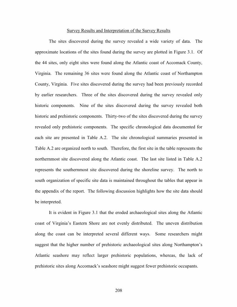
208
Survey Results and Interpretation of the Survey Results
The sites discovered during the survey revealed a wide variety of data. The
approximate locations of the sites found during the survey are plotted in Figure 3.1. Of
the 44 sites, only eight sites were found along the Atlantic coast of Accomack County,
Virginia. The remaining 36 sites were found along the Atlantic coast of Northampton
County, Virginia. Five sites discovered during the survey had been previously recorded
by earlier researchers. Three of the sites discovered during the survey revealed only
historic components. Nine of the sites discovered during the survey revealed both
historic and prehistoric components. Thirty-two of the sites discovered during the survey
revealed only prehistoric components. The specific chronological data documented for
each site are presented in Table A.2. The site chronological summaries presented in
Table A.2 are organized north to south. Therefore, the first site in the table represents the
northernmost site discovered along the Atlantic coast. The last site listed in Table A.2
represents the southernmost site discovered during the shoreline survey. The north to
south organization of specific site data is maintained throughout the tables that appear in
the appendix of the report. The following discussion highlights how the site data should
be interpreted.
It is evident in Figure 3.1 that the eroded archaeological sites along the Atlantic
coast of Virginia’s Eastern Shore are not evenly distributed. The uneven distribution
along the coast can be interpreted several different ways. Some researchers might
suggest that the higher number of prehistoric archaeological sites along Northampton’s
Atlantic seashore may reflect larger prehistoric populations, whereas, the lack of
prehistoric sites along Accomack’s seashore might suggest fewer prehistoric occupants.
209
Figure 3.1. Archaeological Sites Discovered During the 2001 Atlantic Coast Shoreline Survey.
210
Before archaeologists make such grandiose interpretations, they should heed the
geological variables associated with barrier islands and the back barrier lagoon settings.
As previously mentioned, the barrier islands adjacent to Accomack and Northampton
Counties from Wallops Island to Smith Island are classified as “tide dominated” island
systems (see Oertel and Kraft 1994: 207-232). Along the northern Accomack coastline
from Wallops Island to Parramore Island, the back barrier areas are marsh filled. Nichols
(1989) describes the northern back barrier lagoons as “surplus” areas. That is to say, the
sediment supply in these regions has exceeded the volumetric capacity of the lagoon. As
such, the northern back barrier areas are dominated by marsh intersected by small,
narrow, and deep tidal channels. In contrast, the back barrier areas south of Parramore
Island are described as “open water” lagoons. Nichols (1989) indicates that the southern
lagoons would be called “deficit” areas because the volumetric capacity of the lagoon
exceeds the sediment supply. As Oertel and Kraft (1994) indicate, the origin of the
sediment surplus within the northern tide dominated lagoons is not fully understood. An
examination of the coastline might explain why the northern tide dominated barrier island
systems have a sediment surplus and the southern systems have a sediment deficit. Groot
et al. (1990) have reported both Pliocene and early Pleistocene-age estuarine and
estuarine/lagoonal deposits under the modern barrier islands and offshore of Accomack’s
Atlantic seashore. Reworked forms of these ancient estuarine/lagoonal deposits are
expressed by the fossiliferous silicified mudstone noted along Wallops, Assawoman,
Metompkin, and Cedar Islands. Coastal reworking of the ancient silt dominated
estuarine/lagoonal deposits may explain the sediment surplus noted for the modern
lagoons situated behind the northern tide dominated barrier island systems. In contrast,
211
reworked silicified mudstone was not observed along the barrier islands south of
Parramore Island. As such, the lack of reworked ancient estuarine and lagoonal silt may
explain the sediment deficit noted for the modern lagoons situated behind the southern
tide dominated barrier islands. Therefore, the areas behind the southern tide dominated
barrier island systems have more open or broad bodies of water. With respect to
archaeology, the sediment surplus along Accomack’s Atlantic coast and within the
modern back barrier areas would most likely explain the lack of documented
archaeological sites in that region. The northern tide dominated barrier island systems
essentially represent accretional environments. In contrast, the open or broad bodies of
water noted for the southern tide dominated barrier island systems in Northampton
County would be more conducive to fetch-related erosion. The potential for fetch-related
erosion is greater in Northampton County and therefore the setting would be more
conducive to expose archaeological sites. It would seem that the uneven distribution of
archaeological sites along Virginia’s Atlantic seashore is a by-product of local geology,
how coastal processes are reworking sediments, and how these reworked sediments are
deposited.
Other variables can also influence the regional expression of the archaeological
record. These variables are closely associated with the local geology, the coastal
reworking of sediments, and the depositional variables associated with sediment
redeposition. Table A.5 in the appendix summarizes the type of erosion associated with
each site discovered during the survey. The table also provides an erosion assessment
(i.e., very mild, mild, moderate, and heavy) of the shorelines associated with each site.
Again the sites listed in Table A.5 are oriented north to south. With respect to the types
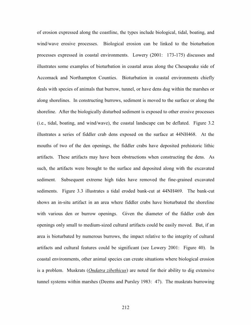
212
of erosion expressed along the coastline, the types include biological, tidal, boating, and
wind/wave erosive processes. Biological erosion can be linked to the bioturbation
processes expressed in coastal environments. Lowery (2001: 173-175) discusses and
illustrates some examples of bioturbation in coastal areas along the Chesapeake side of
Accomack and Northampton Counties. Bioturbation in coastal environments chiefly
deals with species of animals that burrow, tunnel, or have dens dug within the marshes or
along shorelines. In constructing burrows, sediment is moved to the surface or along the
shoreline. After the biologically disturbed sediment is exposed to other erosive processes
(i.e., tidal, boating, and wind/wave), the coastal landscape can be deflated. Figure 3.2
illustrates a series of fiddler crab dens exposed on the surface at 44NH468. At the
mouths of two of the den openings, the fiddler crabs have deposited prehistoric lithic
artifacts. These artifacts may have been obstructions when constructing the dens. As
such, the artifacts were brought to the surface and deposited along with the excavated
sediment. Subsequent extreme high tides have removed the fine-grained excavated
sediments. Figure 3.3 illustrates a tidal eroded bank-cut at 44NH469. The bank-cut
shows an in-situ artifact in an area where fiddler crabs have bioturbated the shoreline
with various den or burrow openings. Given the diameter of the fiddler crab den
openings only small to medium-sized cultural artifacts could be easily moved. But, if an
area is bioturbated by numerous burrows, the impact relative to the integrity of cultural
artifacts and cultural features could be significant (see Lowery 2001: Figure 40). In
coastal environments, other animal species can create situations where biological erosion
is a problem. Muskrats (Ondatra zibethicus) are noted for their ability to dig extensive
tunnel systems within marshes (Deems and Pursley 1983: 47). The muskrats burrowing
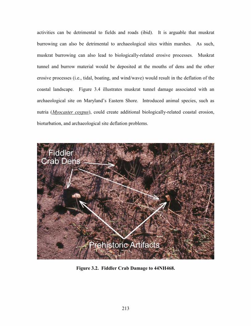
213
activities can be detrimental to fields and roads (ibid). It is arguable that muskrat
burrowing can also be detrimental to archaeological sites within marshes. As such,
muskrat burrowing can also lead to biologically-related erosive processes. Muskrat
tunnel and burrow material would be deposited at the mouths of dens and the other
erosive processes (i.e., tidal, boating, and wind/wave) would result in the deflation of the
coastal landscape. Figure 3.4 illustrates muskrat tunnel damage associated with an
archaeological site on Maryland’s Eastern Shore. Introduced animal species, such as
nutria (Myocaster coypus), could create additional biologically-related coastal erosion,
bioturbation, and archaeological site deflation problems.
Figure 3.2. Fiddler Crab Damage to 44NH468.
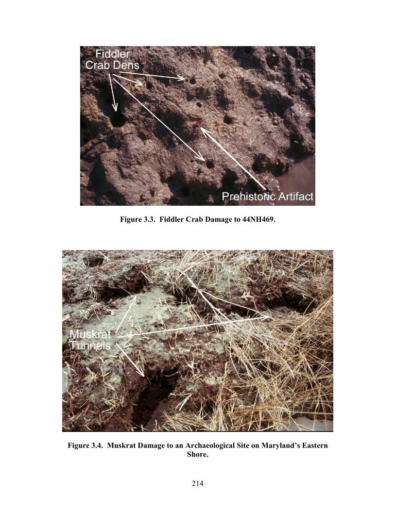
214
Figure 3.3. Fiddler Crab Damage to 44NH469.
Figure 3.4. Muskrat Damage to an Archaeological Site on Maryland’s Eastern Shore.
215
Because of the extreme tidal fluctuations along the Atlantic coast of Accomack
and Northampton Counties, tidal erosion with respect to coastal archaeological sites is a
problem. Figures 2.39 and 2.40 illustrate how tidal erosion has impacted 44NH466. The
archaeological deposits exposed along the shoreline are scoured daily by the tidal ebb and
flood processes. A deep tidal channel adjacent to the site and the extremely high current
velocities are the primary tidal variables eroding 44NH466. If not documented
immediately, cultural material eroded from the shoreline will eventually end up within
the deep channel adjacent to the site. Underwater high-energy currents will eventually
redeposit the cultural materials throughout the deep channel. If accessible, the
distribution of the cultural materials within the high-energy tidal channels would not
reflect the actual boundaries of the parent site.
Some sites found during the Atlantic coast survey are eroded via boating
activities. The unfortunate proximity of a particular site to a major conduit for human-
related boating is the primary variable associated with boat-related erosion. The boat
erosion process is generated by the wake created by the vessels as the speed past the
shoreline. The final erosion process is wind/wave or fetch-related. Lowery (2001: 38-
51) provides an overview of variables associated with fetch-related shoreline erosion.
Put simple, the orientation of an archaeological site relative to an open body of water and
the resultant wind energy over this body of water will cause shoreline erosion. As
Lowery (ibid) indicates, other variables such as offshore water depths, parent shoreline
sediment, shoreline topography, and the seasonal wind directions will greatly influence
the degree of fetch-related shoreline erosion. Even so, Table A.5 summarizes the types
of shoreline erosion impacting the sites found during the Atlantic coast survey. It is
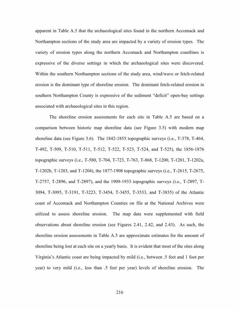
216
apparent in Table A.5 that the archaeological sites found in the northern Accomack and
Northampton sections of the study area are impacted by a variety of erosion types. The
variety of erosion types along the northern Accomack and Northampton coastlines is
expressive of the diverse settings in which the archaeological sites were discovered.
Within the southern Northampton sections of the study area, wind/wave or fetch-related
erosion is the dominant type of shoreline erosion. The dominant fetch-related erosion in
southern Northampton County is expressive of the sediment “deficit” open-bay settings
associated with archaeological sites in this region.
The shoreline erosion assessments for each site in Table A.5 are based on a
comparison between historic map shoreline data (see Figure 3.5) with modern map
shoreline data (see Figure 3.6). The 1842-1855 topographic surveys (i.e., T-378, T-464,
T-492, T-509, T-510, T-511, T-512, T-522, T-523, T-524, and T-525), the 1856-1876
topographic surveys (i.e., T-580, T-704, T-723, T-763, T-868, T-1200, T-1201, T-1202a,
T-1202b, T-1203, and T-1204), the 1877-1908 topographic surveys (i.e., T-2615, T-2675,
T-2757, T-2896, and T-2897), and the 1909-1933 topographic surveys (i.e., T-2897, T-
3094, T-3095, T-3191, T-3223, T-3454, T-3455, T-3533, and T-3835) of the Atlantic
coast of Accomack and Northampton Counties on file at the National Archives were
utilized to assess shoreline erosion. The map data were supplemented with field
observations about shoreline erosion (see Figures 2.41, 2.42, and 2.43). As such, the
shoreline erosion assessments in Table A.5 are approximate estimates for the amount of
shoreline being lost at each site on a yearly basis. It is evident that most of the sites along
Virginia’s Atlantic coast are being impacted by mild (i.e., between .5 feet and 1 foot per
year) to very mild (i.e., less than .5 feet per year) levels of shoreline erosion. The
217
minimal degree of shoreline erosion is largely due to the fact that most of the sites
discovered during the survey are located within the back-barrier areas and not along the
Atlantic seashore. The scarcity of ancient terrestrial sites along the Atlantic seashore is
expressive of the relatively recent geologic formations associated with the present barrier
islands.
Figure 3.5. A Small Section of the 1852 T-509 Survey Showing Fisherman’s Island.
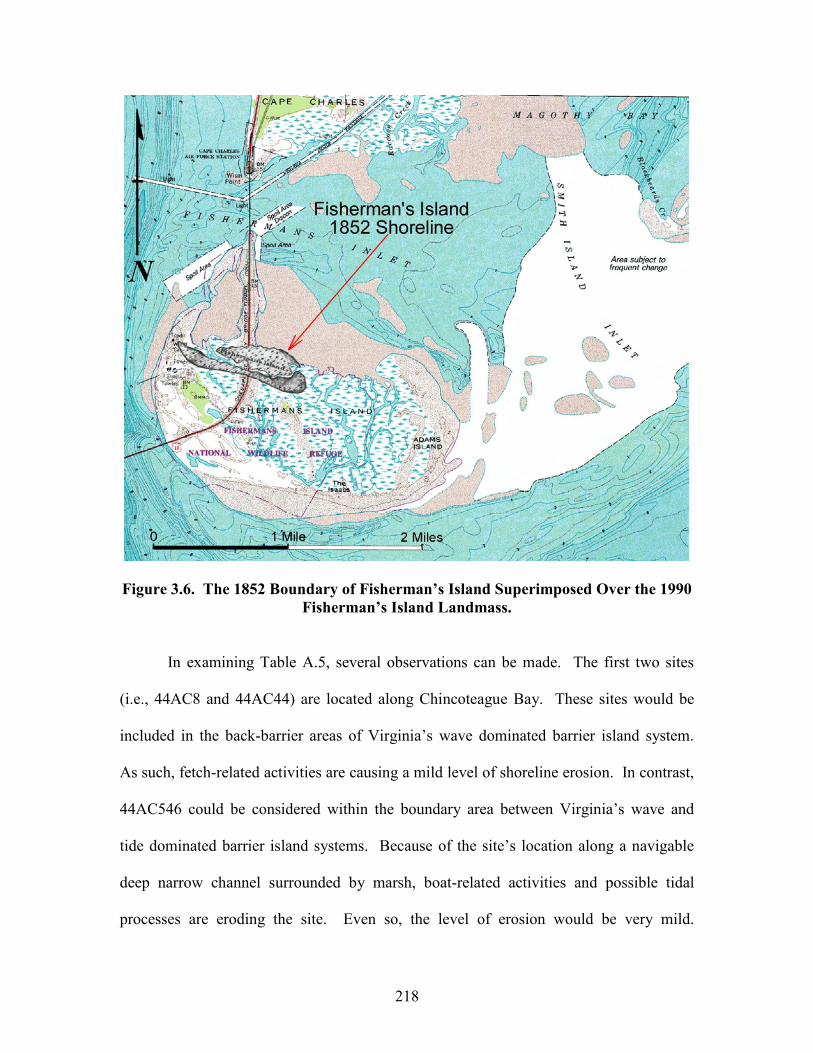
218
Figure 3.6. The 1852 Boundary of Fisherman’s Island Superimposed Over the 1990 Fisherman’s Island Landmass.
In examining Table A.5, several observations can be made. The first two sites
(i.e., 44AC8 and 44AC44) are located along Chincoteague Bay. These sites would be
included in the back-barrier areas of Virginia’s wave dominated barrier island system.
As such, fetch-related activities are causing a mild level of shoreline erosion. In contrast,
44AC546 could be considered within the boundary area between Virginia’s wave and
tide dominated barrier island systems. Because of the site’s location along a navigable
deep narrow channel surrounded by marsh, boat-related activities and possible tidal
processes are eroding the site. Even so, the level of erosion would be very mild.
219
44AC544, 44AC545, and 44AC547 are the only sites discovered during the project that
are directly along the Atlantic seashore. Two of the sites have revealed historic
components. The historic components probably represent terrestrial sites that have been
impacted by littoral processes associated with transgressive barrier island activities. Two
of the sites have revealed prehistoric components. Given the relatively recent age
associated with the footprint of these barrier islands, the prehistoric materials found at
these sites probably represent redepositional localities, as opposed to intact eroding
prehistoric archaeological sites. Figure 3.7 is an idealized image of the terrestrial and
offshore settings associated with 44AC544 and 44AC547. Both sites are situated south
of major tidal inlets or former inlet locations. The long-term littoral movement of
sediments along Virginia’s seashore is from the north to the south. The prevailing wave
activities impacting the shorelines at each site are from the northeast, east, and southeast.
As such, it is speculated that the prehistoric materials found at each site eroded from
some offshore inundated landscape as a result of ebb tidal inlet down cutting and current
movement. The littoral processes would act on the dislodged prehistoric artifacts as if
they were coastal sediments. As such, the dislodged prehistoric artifacts would move
progressively south of the inlet opening. Onshore wave activity combined with flood
tidal processes would ultimately redeposit the prehistoric artifacts along the shoreline of
the modern barrier island. As such, the prehistoric components documented at 44AC544
and 44AC547 would essentially represent redepositional localities and not “true” intact
terrestrial archaeological sites. Even so, the sites may indeed have intact prehistoric
underwater strata. But, underwater archaeological surveys would have to be conducted to
accurately plot the site locations. The Early Archaic, Middle Archaic, and Late Archaic
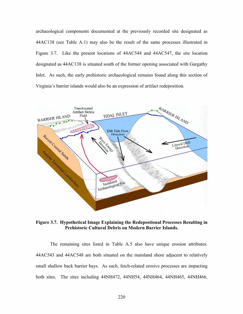
220
archaeological components documented at the previously recorded site designated as
44AC138 (see Table A.1) may also be the result of the same processes illustrated in
Figure 3.7. Like the present locations of 44AC544 and 44AC547, the site location
designated as 44AC138 is situated south of the former opening associated with Gargathy
Inlet. As such, the early prehistoric archaeological remains found along this section of
Virginia’s barrier islands would also be an expression of artifact redeposition.
Figure 3.7. Hypothetical Image Explaining the Redepostional Processes Resulting in Prehistoric Cultural Debris on Modern Barrier Islands.
The remaining sites listed in Table A.5 also have unique erosion attributes.
44AC543 and 44AC548 are both situated on the mainland shore adjacent to relatively
small shallow back barrier bays. As such, fetch-related erosive processes are impacting
both sites. The sites including 44NH472, 44NH54, 44NH464, 44NH465, 44NH466,
221
44NH469, 44NH467, 44NH471, and 44NH457 are primarily impacted by tidal and/or
boat-related shoreline erosion. All of these nine sites are located adjacent to deep narrow
tidal channels surrounded by tidal marsh. The tidal channels also serve as navigable
waterways for boat-related activities. Two of the sites listed in Table A.5 (i.e., 44NH470
and 44NH468) are impacted by biological erosion associated with bioturbation processes.
At both sites fiddler crab burrowing activities have exposed prehistoric cultural material
(see Figure 3.2). In a north to south transect along the coast within Virginia Eastern
Shore’s tide dominated barrier island system, 44NH463 is the first archaeological site
associated with Virginia’s large sediment “deficit” open-bay settings. The site is adjacent
to Hog Island Bay, which is a broad shallow back barrier island bay intersected by
numerous tidal drain channels. Hog Island Bay is approximately 8 miles wide and 6
miles long. Therefore, 44NH463 would be impacted by wind/wave or fetch-related
shoreline erosion activities. All of the remaining sites listed in Table A.5 (i.e., 44NH443
south to 44NH458) are south of Hog Island Bay. As such, these sites would also be
associated with large sediment “deficit” open-bay settings. Like 44NH463, these sites
would also be impacted primarily by wind/wave or fetch-related shoreline erosion.
To quantify the potential degree of wind/wave or fetch-related shoreline erosion
impacting each site, Table A.6 was created to illustrate the unique fetch aspects
associated with each eroding shoreline archaeological site. Table A.6 lists only those
archaeological sites found during the survey that are impacted by fetch-related erosion.
Again, the sites are organized in a north to south arrangement. One section of the table
defines the impacting wind directions associated with each site. Defining the wind
directions that could impact each site is important relative to shoreline erosion. For
222
example, if an archaeological site were situated on the east side of a large island, the site
would not be impacted by shoreline erosion associated with westerly winds. In essence,
the site on the east side of the island would be protected by the landmass of the island
from westerly wind-related shoreline erosion. Even so, the site’s location along the
eastern shore of the island would suggest that it could be impacted by easterly wind-
related shoreline erosion. As such, the section in Table A.6 that defines the potential
winds that could impact each site should provide researchers with information relative to
the unique shoreline settings associated with the sites impacted by fetch-related erosion.
Table A.6 also has a section that defines the maximum wind/wave fetch that could
impact each shoreline site found during the survey. In other words, the maximum fetch is
the maximum distance wind could travel across a body of water without any terrestrial or
land obstruction. It should be obvious that a landmass obstruction would interrupt the
resultant fetch-related wave energy that could impact a potential shoreline, as well as, an
eroding archaeological site. Within the maximum fetch section, the maximum fetch
distance is given in miles and the compass wind direction associated with the maximum
fetch distance is also noted. For example, at the previously mentioned eroding site along
the east side of a large island, it was stated that the site could only be impacted by fetch-
related erosion associated with easterly winds. In this example, the body of water
situated east of the eroding archaeological site would have varying fetch-related impacts
on the site. The varying fetch-related impacts are associated with the unique orientation
of the archaeological site relative to the dimensions and orientation of the body of water.
Even though easterly winds would impact the hypothetical eroding site on the east side of
the island; a northeast wind and the associated waves may travel across 9 miles of
223
unobstructed water before hitting the shoreline associated with the site. Whereas, an east
wind would travel across 2 miles of water and a southeast wind would travel across only
1 mile of water before the resultant waves associated with each wind direction would
impact and potentially erode the hypothetical site. As such, the maximum fetch distance
associated with the hypothetical site would be 9 miles and the direction would be linked
to winds originating from the northeast.
Table A.6 also defines the associated bodies of water adjacent to each site found
during the survey. As previously mentioned, three of the sites (i.e., 44AC544, 44AC545,
and 44AC547) are located on the Atlantic Ocean south of tidal inlets or former locations
of tidal inlets. The bodies of water adjacent to these three sites would be defined as
ocean and inlet. It was stated earlier that 44NH463 is located adjacent to Hog Island Bay.
The body of water associated with 44NH463 would be defined as a bay. It should be
obvious in this section of Table A.6 that only two sites (i.e., 44NH54 and 44NH457) are
defined as being adjacent to both deep tidal channels and broad open bays. Even though
both 44NH54 and 44NH457 could be impacted by fetch-related shoreline erosion, their
proximity to active deep tidal channels would influence the degree of fetch-related
erosion. As previously mentioned, fetch-related erosion processes are related to the
distance wind could travel across a body of water without any terrestrial or land
obstruction. High velocity currents within active tidal channels would have the same
effect on destroying the wave energy associated with fetch as a terrestrial land
obstruction. If the surface current activity in these channels is not in the same direction
as the any of the potential impacting wind directions, the generated fetch-related waves
would exhaust their wave energy and crest before impacting the shoreline site. As such,
224
the high velocity tidal channels adjacent to each site negate the potential fetch-related
shoreline erosion processes suggested for both 44NH54 and 44NH457. It is obvious that
the associated bodies of water adjacent to each site found during the survey are important
in understanding the potential degree of fetch-related shoreline erosion.
Both Table A.5 and Table A.6 can help quantify the erosion threats to each site
discovered during the project. As such, cultural resource managers will be able to assess
the various impacts to each site. With respect to Table A.5, it is hard to quantify the
degree of biological, tidal, and boat-related impacts to the archaeological sites found
during the project. Even so, the orientation of the sites in Table A.5 suggests that
biological, tidal, and boat-related processes are more apparent at the sites found in
Accomack and northern Northampton Counties. It is also apparent in Table A.5 that
fetch-related processes are more apparent at the sites along Northampton County’s
central and southern Atlantic coast. Unlike biological, tidal, and boat-related erosion
processes, Table A.6 attempts to quantify the degree of fetch-related erosion associated
with each site. With Table A.6, researchers and cultural resource managers can acquire
long-term weather data for the region and quantify the number of potential erosion days
associated with each site. For example, the data presented in Table A.6 would indicate
that the archaeological site designated as 44NH233 has a maximum fetch distance of
approximately four miles as a result of southwesterly winds. As such, researchers and
cultural resource managers could assess the seasonality of southwesterly winds along
Virginia’s Eastern Shore, define the seasonal frequency of southwesterly winds, and
document the number of potential southwesterly wind erosion days for the past 30 years
of recorded weather data. Even so, cultural resources managers should be cautious of
225
such gross generalizations. With respect to 44NH233, southwesterly winds are more
common along Virgina’s Eastern Shore during the summer months. Even though the
fetch erosion impact to 44NH233 is potentially greater with southwesterly winds, the
season with the highest frequency and longer duration of southwesterly winds introduces
additional shoreline erosion variables. During the summer months, a dense cover of sub-
aquatic vegetation occurs offshore of 44NH233. The carpet of sub-aquatic vegetation
during the summer months would disrupt the potential fetch-related wave energy that
could erode the shoreline at 44NH233. During the winter months, the lack of sub-aquatic
vegetation exposes the shoreline at 44NH233 to greater levels of shoreline erosion. But,
the frequency and duration of southwesterly winds in the region during the winter months
is less. During the winter months, northwesterly winds are more frequent and have a
longer duration. The northwesterly fetch distance at 44NH233 is approximately 2 miles.
Even though the northwesterly fetch distance is less, the summertime offshore variables
associated with the site would suggest that the northwesterly winds during the winter
months have a greater impact relative to the erosion evident at 44NH233. Therefore,
even the data presented in Table A.6 needs to be assessed on a site-by-site basis relative
to various non-climatic seasonal site variables.
It is suggested that the erosion data presented in Table A.5 is important in
understanding the density of artifacts found during the survey. When comparing the
erosive processes in Table A.5 to the prehistoric lithic summary presented in Table A.7, a
pattern emerges. Again, the sites found during the survey are listed in both tables with a
north to south orientation. It is evident that at the sites impacted by biological, tidal, and
boat-related erosion, the resulting lithic assemblages found at each site are limited. Of
226
course, some researchers will point out that 44AC8 and 44AC44 are impacted by fetch-
related erosion processes and the resulting lithic assemblages found at each of these sites
are trivial. The lack of shoreline survey related assemblage density from these two sites
is the result of other variables. As Table A.6 points out, the wind directions that could
impact both 44AC8 and 44AC44 are primarily easterly and southeasterly winds. These
wind directions are associated primarily with tropical storms and hurricanes. These
weather events, though devastating, are relatively infrequent. Also, the eroded landward
topographic relief associated with both 44AC8 and 44AC44 is much greater than any
other site found along Virginia’s Atlantic seashore. For example, the eroded bank
exposure at 44AC44 is 20 feet or more along some sections. The eroded bank profile at
44AC8 is 10 feet or more along some sections. Therefore, for every linear foot of
shoreline erosion, 25 cubic feet of sediment at 44AC44 is deposited along the shoreline
as a result of the retreating terrestrial landmass. Therefore, the lack of prehistoric lithic
artifacts at both sites is primarily due to over-sedimentation of the shoreline as a result of
the eroded landward topography. The lack of dense numbers of prehistoric artifacts at
both 44AC544 and 44AC547 along Accomack’s Atlantic shoreline is also due to
sediment enrichment associated with the sandy coastal geology typical of barrier islands.
In essence, the first archaeological site in a north to south transect along the coast to be
exposed to fetch-related processes, lack sediment enrichment, and have a low
topographic relief would be 44NH463. Unlike 44AC543 and 44AC548, the site
designated as 44NH463 is within the back barrier areas that are tide dominated and
adjacent to a broad shallow bay classified as a sediment “deficit” region. Interestingly,
44NH463 is the northernmost eroded site along Virginia’s Atlantic seashore that
227
produced a significant number of prehistoric lithic artifacts. A comparison between the
data presented in Table A.5 and the data presented in Table A.7 will indicate that the sites
impacted by fetch-related erosion reveal larger shoreline assemblages. It is also evident
that at the sites south of 44NH457 the artifact assemblages collected during the survey
are substantially larger. As indicated before, the sites in central and southern
Northampton County are adjacent to large open bays and have greater fetch distances.
Therefore, the prehistoric lithic assemblage data collected at each site (see Table A.7) is
largely an expression of natural erosion processes and not a reflection of prehistoric
cultural processes.
The prehistoric lithic data presented in Table A.7 does provide some information
relative to prehistoric cultural patterns. The lithic material types defined in Table A.7 are
arranged from the most frequent lithic type found during the survey in the left-hand
column to the least most frequent type in the right-hand column. The generalizations
about the data in Table A.7 are limited. Jasper, quartzite, chert, and quartz are the most
frequent lithic materials found at prehistoric sites along Virginia’s Atlantic coast. It is
therefore, not surprising that these common lithic materials are frequently found within
local cobble outcrops. It is obvious in Table A.7 that prehistoric peoples on Virginia’s
Eastern Shore utilized non-local lithic materials, such as rhyolite, argillite, and steatite
(see Lowery 2001: Table A.8). Even so, the density of these non-local lithic materials at
any particular site has to be assessed under the scrutiny of the individual erosion variables
unique to each site (see Table A.5 and Table A.6). Therefore, it is suggested that the
density of the lithic artifacts found at each site is largely an expression of natural
processes. For example, some researcher may interpret the non-local rhyolite assemblage
228
from 44NH440 as evidence of an archaeological site that served as a focal point for
prehistoric trade and exchange. The same researcher may overlook the single rhyolite
artifact found at 44NH443. The difference in these two site assemblages (i.e., 44NH440
and 44NH443) with respect to the density of non-local lithic materials may simply be an
expression of the erosion histories associated with each site or linked to the seasonality of
shoreline examination. As such, further investigations at archaeological sites with
limited or small documented prehistoric assemblages may indeed prove that these
localities are more significant archaeologically. Therefore, I would argue that the
assemblage data presented in Table A.7 should be used but not abused by researchers and
cultural resource managers.
It is suggested that the seasonality and the shoreline conditions observed at each
site could influence the chronological data gleaned during a single shoreline examination.
To illustrate the problems of site interpretation based on single shoreline examinations,
several sites during the survey were selected for periodic shoreline reexaminations.
44NH440, 44NH441, and 44NH234 were examined several times and the assemblages
collected along the shoreline during each visit were labeled and bagged separately. As
such, the periodic assemblages would illustrate the limitations of one-time shoreline
surveys. Table A.8 was created to illustrate the results of the chronological data gleaned
via multiple shoreline reexaminations. The specific assemblages found at each of these
three sites during each examination are listed in the individual site summaries.
Therefore, researchers will be able to see how the chronological data in Table A.8 were
created. With the artifact tallies in the site summaries, researchers will also be able to see
how lithic density and frequency data are impacted by single one-time shoreline
229
examinations. With respect to the sites listed in Table A.8, 44NH440 has revealed
chronological data that suggest the site was utilized by prehistoric peoples throughout the
region’s documented prehistory. If only 44NH440 was examined once, the
archaeological information associated with the site would have suggested that the site had
an Early Archaic component, a possible Middle Archaic component, and a Late Archaic
component. The same can be said about the initial examination of 44NH441. The first
shoreline examination of 44NH441 revealed evidence that the site was occupied by
prehistoric peoples during the Paleoindian, the Early Archaic, and the Late Archaic
periods. After four shoreline examinations, the assemblage data suggested that the site
was occupied throughout the region’s documented prehistory. Finally, the assemblage
data documented at 44NH234 also highlights the value of multiple shoreline
reexaminations. The first examination of 44NH234’s shoreline suggested that the site
was occupied during the Late Archaic and Middle Woodland periods. The second
examination of the same shoreline revealed no chronological data. The third examination
suggested that 44NH234 also has Early Woodland and possible Late Woodland
archaeological components. When compared to the previous chronological data recorded
for 44NH234 (see Table A.1), the researcher and cultural resource manager will have a
better grasp of the prehistoric components associated with this site.
In keeping with the survey methodology conducted during the survey along the
Chesapeake Bay shoreline of Accomack and Northampton Counties, the principal
investigator decided to assess the archaeological sites along the shorelines of Accomack
and Northampton Counties without previously recorded site location data. It was felt that
pre-survey archival research relative to the location of previously recorded sites in the
230
region would bias the fieldwork and bias the ability to test Lowery’s (1997) site
prediction model. By conducting the shoreline survey without prior site location data, the
present survey would be a test of Lowery’s (ibid.) site predictive model along the
Atlantic coast. As such, the chronological data presented in Table A.1 and the previously
recorded site location data were not compiled until November 29, 2001, which was
approximately one month after the fieldwork had been completed. Based on the
information on file at the Virginia Department of Historic Resources, the 49 sites listed in
Table A.1 were within 100 meters of coastal waters along the Atlantic seashore. Table
A.3 summarizes the results of the blind survey along the Atlantic seashore. Only five of
the 49 sites listed in Table A.1 were relocated. Even so, the majority of the sites listed in
Table A.1 were not adjacent to the shoreline or were not impacted by shoreline erosion
(see comments in Table A.3). Some of the shorelines associated with the sites listed in
Table A.1 had been bulkheaded, were deemed accretional, or were blanketed by a mantle
of sand. Based on the absence of site location data and the dynamic nature along the
barrier island, it is believed that the littoral movement of sand and the resulting erosive
processes had destroyed a few of the previously recorded sites listed in Table A.3.
In reference to the Atlantic shoreline survey, the discussion questions the
interpretive value of the chronological data, which resulted from the project. The
problems are clearly illustrated in Table A.4. The present survey relocated and
reexamined five sites that had been previously documented. A comparison between the
earlier documented chronological data and the current chronological data for each of
these reexamined sites clearly illustrates the disadvantages of single shoreline collection
information. Based on the data listed in Table A.4, some of the recent survey work failed
231
to document the same chronological summaries defined by the earlier surveys. For
example, see the 1973 and 1976 survey data for 44AC8 and compare it to the 2001
survey data for the same site. Some of the recent survey work mimicked the same
chronological summaries defined by earlier surveys. For example, see the 1976 survey
data for 44AC44 and compare it to the 2001 survey data for the same site. For the
remaining three sites listed in Table A.4, the current survey data refined or supplemented
the previously recorded chronological summaries. As such, the current survey was not
only blind to the locations of previously recorded archaeological sites, but it was blind to
the chronological data associated with the previously recorded sites. The current survey
tested a site prediction model, and it also highlighted the limited interpretive value of
single or one-time archaeological survey site information.
The interpretation of the survey results presented in the archaeological site
summaries, Figure 3.1, Table A.2, and Table A.7 are hard to assess given the variable
natural processes that are unique to each site discovered during the project (see Table A.5
and Table A.6). Given the numerous unique natural variables and the copious number of
“unknowns” relative to the archaeological sites found during the project, it is suggested
that the current survey should set the stage for individual site follow-up studies. Only
after follow-up studies are conducted on a site-by-site basis could researchers and cultural
resource managers quantify some of the unique natural variables impacting each site and
define some of the “unknowns” associated with each site. When and if these follow-up
studies are conducted, the interpretive value of the sites found during this survey will
finally become clear.
232
A Test of the Site Prediction Model
As Figure 2.44 illustrates, the survey of the Atlantic coast of Accomack and
Northampton Counties served as a case to illustrate and test the accuracy of Lowery’s
(1997) prehistoric site prediction model. The same site prediction model was used while
conducting the survey of Chesapeake portion of Virginia’s Eastern Shore (Lowery 2001).
Even so, it was only briefly mentioned in the Chesapeake report. As such, it was felt that
the survey of the Atlantic coast would represent a situation where the model could be
presented and the results of the test be quantified within the final report. It is important to
note that when testing the model, the researcher utilized published geological information
outside the realm of archaeology (see Chen et al. 1995; Finkelstein and Kearney 1988;
Foyle and Oertel 1992; Kearney 1996; Morton and Donaldson 1973; Oertel and Foyle
1995; Oertel et al. 1989; Oertel and Kraft 1994; Sheridan et al. 2001; and Shideler et al.
1984) to understand some of the radical changes to Virginia Eastern Shore’s Atlantic
coastline. As presented in Part II, the prehistoric site prediction model is highly
dependant on understanding the changes to any landscape from the Late Plesitocene
through Late Holocene. With respect to the Delmarva Peninsula, it is arguable that the
Atlantic coastline has undergone the greatest level of change in comparison to the
Chesapeake Bay side of the peninsula. Both the Chesapeake and Atlantic sides of the
peninsula have been drowned by sea level rise and buried by sediment accretion. Even
so, the Atlantic side seems to have had a higher degree of impact from both processes.
As such, the present form of Virginia’s Atlantic coast differs greatly from the coastline
prehistoric peoples had access to over the past 13,000 years.
233
Table A.9 summarizes the site data relative to the site prediction model presented
in Part II of this report. In examining the data presented in the table, researchers and
cultural resource managers will note that the model is flexible. The model is flexible
enough to suggest that an archaeological site may have multiple ecological settings
throughout prehistory. For example, an archaeological site may be located on a well-
drained linear ridge surrounded by poorly-drained freshwater wetland during the
Paleoindian through Archaic periods. Over this same period of time, a portion of the
same landform is situated adjacent to a freshwater stream. As such, the site during the
Paleoindian through Archaic periods would reflect a Sand Ridge Focus settlement
pattern, as well as, an Interior Stream Focus settlement pattern. Obviously, climatic
conditions, regional hydrology, and precipitation over this period of time would influence
which type of settlement pattern focus was of primary interest to the prehistoric
inhabitants of the site. Meanwhile, when the region adjacent to the site is inundated
during the Late Holocene, the site on the well-drained ridge would reflect an Estuarine
Wetland Focus settlement pattern during latter portions of the Woodland period. Even
so, the data in Table A.9 assumes that ancient landscapes can be reconstructed based on
limited survey data, previous geological studies, and field observations. The data in
Table A.9 may eventually need to be revised as individual site specific studies are
conducted.
With the exception of the prehistoric sites located on the barrier islands, all of the
prehistoric site locations were predicted prior to actual site examinations. Seven of the
archaeological sites listed in Table A.9 were not located via the published soil map data
(see Cobb and Smith 1989 and Peacock and Edmonds 1994). These seven sites were not
234
predicted using the soil maps because of the limitations associated with the plotted soil
types (Figure 3.8) and the lack of documented shallow inundated uplands (see Figure
2.43). Even so, some of the aerial images included within soil surveys (see Figure 3.9)
hinted that former upland landscapes were present even though the soil surveys had not
plotted a soil type change. The linearity of some of the creeks and tidal drainage systems
hinted towards shallow inundated ridge-like uplands (see Figure 3.9). As such,
archaeological site locations could be predicted in the shallow inundated former upland
areas where the soil survey data suggested archaeological remains should not occur.
Figure 3.9 is an excellent example of an area in which the soil survey data suggested
archaeological remains should not occur. The area associated with this particular section
of shoreline is classified as Chincoteague soils (i.e., ChA). In the region, Chincoteague
soils are associated with salt marshes. Meanwhile, the linear discolorations in the aerial
photographs suggest a slightly elevated former upland ridge. The linear drainage pattern
adjacent to the area in Figure 3.9 also suggested a former upland ridge. As such, an
archaeological site was predicted along this section of shoreline. The fieldwork revealed
the presence of an archaeological site and the area was later designated as archaeological
site 44NH463.
Figure 3.8 defines an archaeological site that was not predicted using the soil map
data. Even so, the linear orientation of the two tidal drainages suggested the possibility
for an archaeological site. Fieldwork and an examination of the exposed bank profile
indicated that the area was indeed a former upland ridge that had a thick organic covering
of a tidal marsh O-horizon. As such, discolorations associated with changes in marsh
vegetation were less apparent in the aerial photographs.
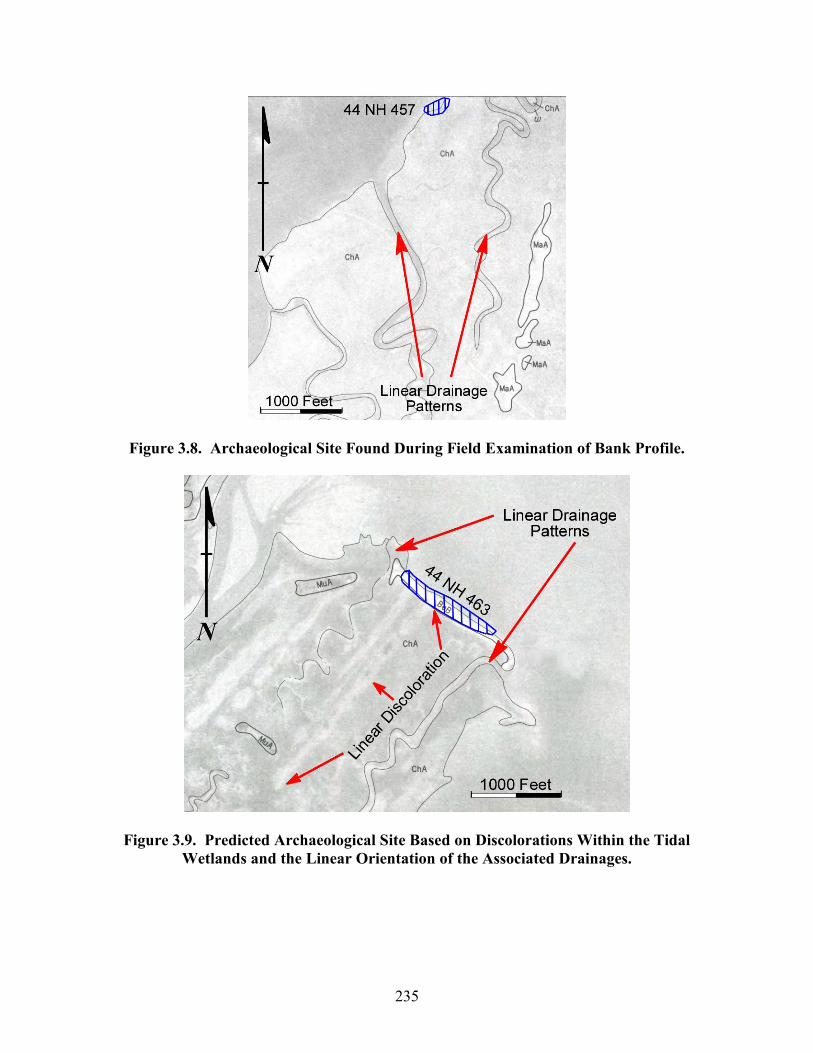
235
Figure 3.8. Archaeological Site Found During Field Examination of Bank Profile.
Figure 3.9. Predicted Archaeological Site Based on Discolorations Within the Tidal Wetlands and the Linear Orientation of the Associated Drainages.
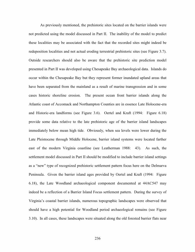
236
As previously mentioned, the prehistoric sites located on the barrier islands were
not predicted using the model discussed in Part II. The inability of the model to predict
these localities may be associated with the fact that the recorded sites might indeed be
redeposition localities and not actual eroding terrestrial prehistoric sites (see Figure 3.7).
Outside researchers should also be aware that the prehistoric site prediction model
presented in Part II was developed using Chesapeake Bay archaeological data. Islands do
occur within the Chesapeake Bay but they represent former inundated upland areas that
have been separated from the mainland as a result of marine transgression and in some
cases historic shoreline erosion. The present ocean front barrier islands along the
Atlantic coast of Accomack and Northampton Counties are in essence Late Holocene-era
and Historic-era landforms (see Figure 3.6). Oertel and Kraft (1994: Figure 6.18)
provide some data relative to the late prehistoric age of the barrier island landscapes
immediately below mean high tide. Obviously, when sea levels were lower during the
Late Pleistocene through Middle Holocene, barrier island systems were located farther
east of the modern Virginia coastline (see Leatherman 1988: 43). As such, the
settlement model discussed in Part II should be modified to include barrier island settings
as a “new” type of recognized prehistoric settlement pattern focus here on the Delmarva
Peninsula. Given the barrier island ages provided by Oertel and Kraft (1994: Figure
6.18), the Late Woodland archaeological component documented at 44AC547 may
indeed be a reflection of a Barrier Island Focus settlement pattern. During the survey of
Virginia’s coastal barrier islands, numerous topographic landscapes were observed that
should have a high potential for Woodland period archaeological remains (see Figure
3.10). In all cases, these landscapes were situated along the old forested barrier flats near
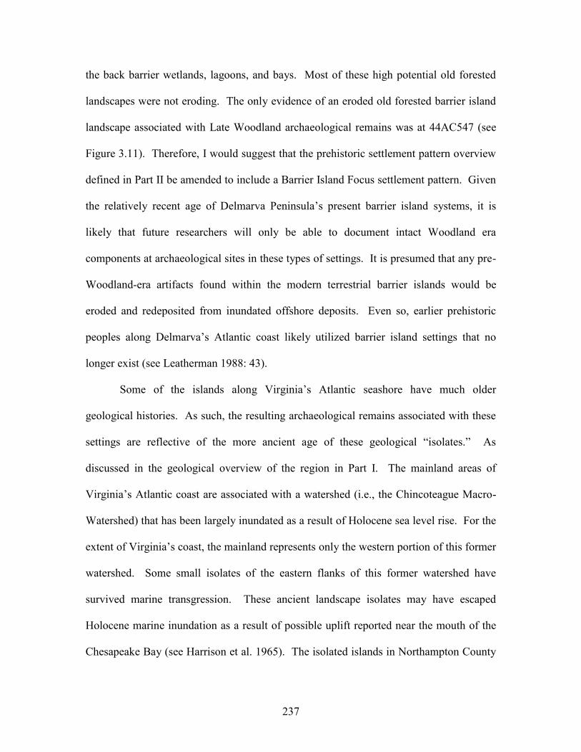
237
the back barrier wetlands, lagoons, and bays. Most of these high potential old forested
landscapes were not eroding. The only evidence of an eroded old forested barrier island
landscape associated with Late Woodland archaeological remains was at 44AC547 (see
Figure 3.11). Therefore, I would suggest that the prehistoric settlement pattern overview
defined in Part II be amended to include a Barrier Island Focus settlement pattern. Given
the relatively recent age of Delmarva Peninsula’s present barrier island systems, it is
likely that future researchers will only be able to document intact Woodland era
components at archaeological sites in these types of settings. It is presumed that any pre-
Woodland-era artifacts found within the modern terrestrial barrier islands would be
eroded and redeposited from inundated offshore deposits. Even so, earlier prehistoric
peoples along Delmarva’s Atlantic coast likely utilized barrier island settings that no
longer exist (see Leatherman 1988: 43).
Some of the islands along Virginia’s Atlantic seashore have much older
geological histories. As such, the resulting archaeological remains associated with these
settings are reflective of the more ancient age of these geological “isolates.” As
discussed in the geological overview of the region in Part I. The mainland areas of
Virginia’s Atlantic coast are associated with a watershed (i.e., the Chincoteague Macro-
Watershed) that has been largely inundated as a result of Holocene sea level rise. For the
extent of Virginia’s coast, the mainland represents only the western portion of this former
watershed. Some small isolates of the eastern flanks of this former watershed have
survived marine transgression. These ancient landscape isolates may have escaped
Holocene marine inundation as a result of possible uplift reported near the mouth of the
Chesapeake Bay (see Harrison et al. 1965). The isolated islands in Northampton County
238
with much older geological histories include Mockhorn Island and Skidmore Island, also
known as Long Point Island (see Finkelstein and Kearney 1988, Foyle and Oertel 1992,
and Shideler et al. 1984). Neither Mockhorn Island nor Skidmore Island would be
considered “classic” barrier islands (see Leatherman 1988). They are both located within
the back barrier bay region and lack “classic” coastal beach formations and coastal dunes.
As such, the resulting early archaeological record associated with these two islands has
little to do with the modern ecological setting. In testing the archaeological site
prediction model, it is important to understand the historic changes to the landscape. The
Mockhorn Island, Skidmore Island, and Magothy Bay areas are perfect test sites to
understand some of the radical changes that have occurred over the past 18,000 years and
how these changes have influenced what we see in the archaeological record.
Figure 3.10. Predicted Barrier Island Focus Woodland Period Archaeological Sites.
239
Figure 3.11. Eroded Old Forested Barrier Island Landscape That Revealed Late Woodland-Era Diagnostic Artifacts.
Figure 3.12 illustrates the Mockhorn Island, Skidmore Island, and Magothy Bay
areas as they appear today. Superimposed over the modern map of the region are the
Late Pleistocene drainage systems based on published geological information (see
Finkelstein and Kearney 1988: Figures 1 and 2; Foyle and Oertel 1992; and Shideler et
al. 1984). It is obvious in Figure 3.12 that the region has undergone some radical
geological changes, as well as ecological changes over the past 18,000 years. In
employing the settlement model in Part II, the geological and ecological changes are
important variables relative to prehistoric settlement patterns. Before testing the site
prediction model in the region illustrated in Figure 3.12, the principal investigator
predicted numerous prehistoric sites with cultural chronologies that would be expressive
of the region’s entire prehistory. As the principal investigator, I would refer any skeptics
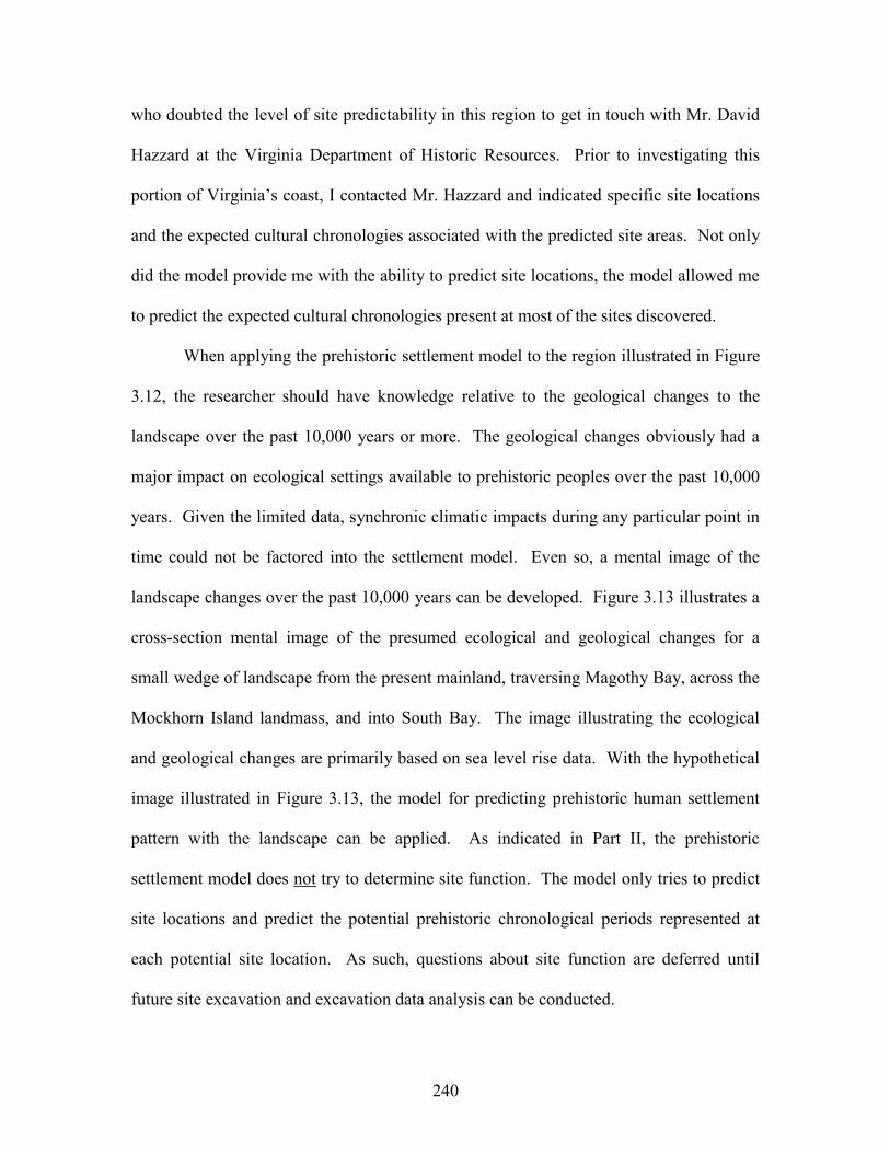
240
who doubted the level of site predictability in this region to get in touch with Mr. David
Hazzard at the Virginia Department of Historic Resources. Prior to investigating this
portion of Virginia’s coast, I contacted Mr. Hazzard and indicated specific site locations
and the expected cultural chronologies associated with the predicted site areas. Not only
did the model provide me with the ability to predict site locations, the model allowed me
to predict the expected cultural chronologies present at most of the sites discovered.
When applying the prehistoric settlement model to the region illustrated in Figure
3.12, the researcher should have knowledge relative to the geological changes to the
landscape over the past 10,000 years or more. The geological changes obviously had a
major impact on ecological settings available to prehistoric peoples over the past 10,000
years. Given the limited data, synchronic climatic impacts during any particular point in
time could not be factored into the settlement model. Even so, a mental image of the
landscape changes over the past 10,000 years can be developed. Figure 3.13 illustrates a
cross-section mental image of the presumed ecological and geological changes for a
small wedge of landscape from the present mainland, traversing Magothy Bay, across the
Mockhorn Island landmass, and into South Bay. The image illustrating the ecological
and geological changes are primarily based on sea level rise data. With the hypothetical
image illustrated in Figure 3.13, the model for predicting prehistoric human settlement
pattern with the landscape can be applied. As indicated in Part II, the prehistoric
settlement model does not try to determine site function. The model only tries to predict
site locations and predict the potential prehistoric chronological periods represented at
each potential site location. As such, questions about site function are deferred until
future site excavation and excavation data analysis can be conducted.
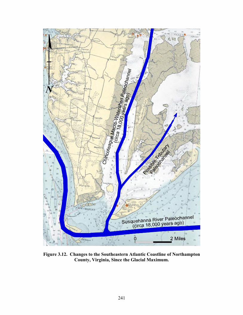
241
Figure 3.12. Changes to the Southeastern Atlantic Coastline of Northampton County, Virginia, Since the Glacial Maximum.
242
Figure 3.13. Hypothetical Image of the Ecologic and Geologic Changes for a Small Portion of the Magothy Bay, Mockhorn Island, and South Bay Area.
243
The hypothetical ecological and geological changes to the landscape illustrated in
Figure 3.13 will be assessed under the auspices of the prehistoric settlement model. It is
believed that these assessments will help future researchers in applying the settlement
model to similar coastal settings. Individually, Figures 3.14 through 3.17 illustrate
enlargements of the hypothetical synchronic changes that have occurred with the
Magothy Bay, Mockhorn Island, and the South Bay area over the past 10,000 years.
Collectively, the images in Figures 3.14 through 3.17 represent a diachronic image of
these changes. With respect to Figures 3.14 through 3.17, the hypothetical prehistoric
utilization of the region has been inserted into these invented landscapes. The prehistoric
settlement patterns within these images relate to the settlement patterns defined in Part II.
As such, Figure 3.14 through Figure 3.17 should provide researchers and cultural
resource managers with an idea about how ancient landscapes in coastal areas and the
human settlement patterns within these landscapes should be viewed. These hypothetic
images should provide outsiders with a basic overview relative to the application of the
prehistoric settlement model in real world situations. These images should also provide
outsiders with an idea about the model’s ability to predict site locations and the cultural
chronologies associated with individual site locations.
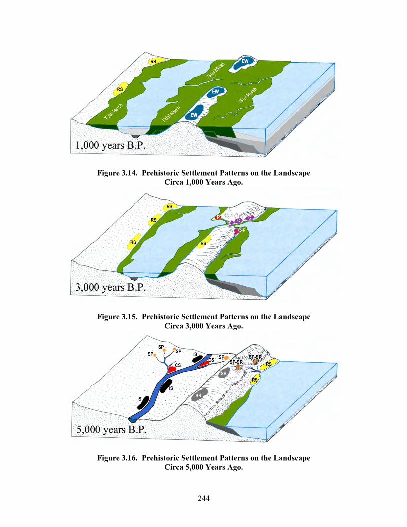
244
Figure 3.14. Prehistoric Settlement Patterns on the Landscape Circa 1,000 Years Ago.
Figure 3.15. Prehistoric Settlement Patterns on the Landscape Circa 3,000 Years Ago.
Figure 3.16. Prehistoric Settlement Patterns on the Landscape Circa 5,000 Years Ago.
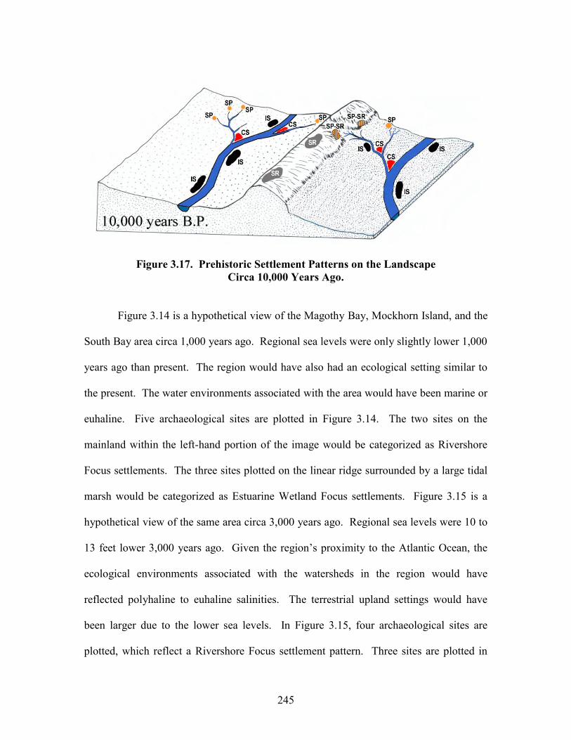
245
Figure 3.17. Prehistoric Settlement Patterns on the Landscape Circa 10,000 Years Ago.
Figure 3.14 is a hypothetical view of the Magothy Bay, Mockhorn Island, and the
South Bay area circa 1,000 years ago. Regional sea levels were only slightly lower 1,000
years ago than present. The region would have also had an ecological setting similar to
the present. The water environments associated with the area would have been marine or
euhaline. Five archaeological sites are plotted in Figure 3.14. The two sites on the
mainland within the left-hand portion of the image would be categorized as Rivershore
Focus settlements. The three sites plotted on the linear ridge surrounded by a large tidal
marsh would be categorized as Estuarine Wetland Focus settlements. Figure 3.15 is a
hypothetical view of the same area circa 3,000 years ago. Regional sea levels were 10 to
13 feet lower 3,000 years ago. Given the region’s proximity to the Atlantic Ocean, the
ecological environments associated with the watersheds in the region would have
reflected polyhaline to euhaline salinities. The terrestrial upland settings would have
been larger due to the lower sea levels. In Figure 3.15, four archaeological sites are
plotted, which reflect a Rivershore Focus settlement pattern. Three sites are plotted in
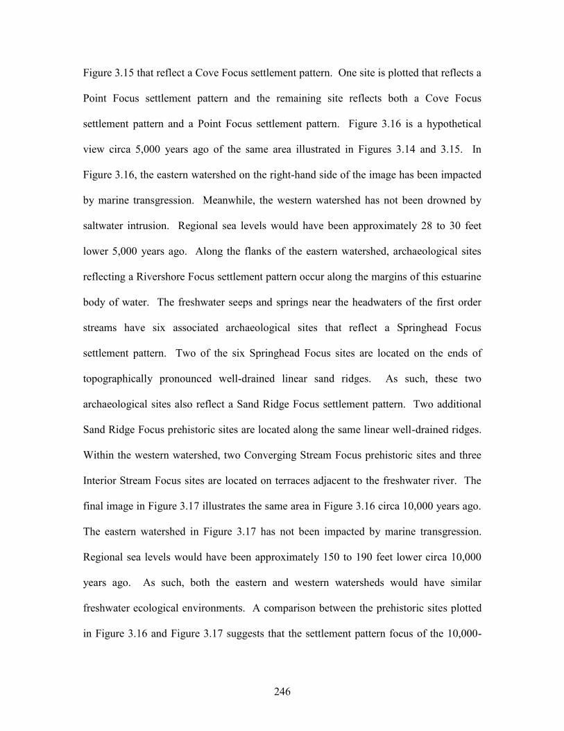
246
Figure 3.15 that reflect a Cove Focus settlement pattern. One site is plotted that reflects a
Point Focus settlement pattern and the remaining site reflects both a Cove Focus
settlement pattern and a Point Focus settlement pattern. Figure 3.16 is a hypothetical
view circa 5,000 years ago of the same area illustrated in Figures 3.14 and 3.15. In
Figure 3.16, the eastern watershed on the right-hand side of the image has been impacted
by marine transgression. Meanwhile, the western watershed has not been drowned by
saltwater intrusion. Regional sea levels would have been approximately 28 to 30 feet
lower 5,000 years ago. Along the flanks of the eastern watershed, archaeological sites
reflecting a Rivershore Focus settlement pattern occur along the margins of this estuarine
body of water. The freshwater seeps and springs near the headwaters of the first order
streams have six associated archaeological sites that reflect a Springhead Focus
settlement pattern. Two of the six Springhead Focus sites are located on the ends of
topographically pronounced well-drained linear sand ridges. As such, these two
archaeological sites also reflect a Sand Ridge Focus settlement pattern. Two additional
Sand Ridge Focus prehistoric sites are located along the same linear well-drained ridges.
Within the western watershed, two Converging Stream Focus prehistoric sites and three
Interior Stream Focus sites are located on terraces adjacent to the freshwater river. The
final image in Figure 3.17 illustrates the same area in Figure 3.16 circa 10,000 years ago.
The eastern watershed in Figure 3.17 has not been impacted by marine transgression.
Regional sea levels would have been approximately 150 to 190 feet lower circa 10,000
years ago. As such, both the eastern and western watersheds would have similar
freshwater ecological environments. A comparison between the prehistoric sites plotted
in Figure 3.16 and Figure 3.17 suggests that the settlement pattern focus of the 10,000-
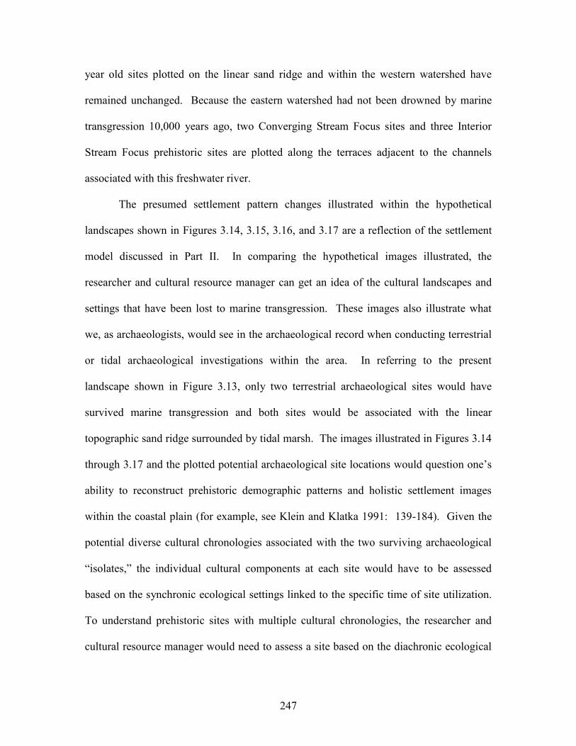
247
year old sites plotted on the linear sand ridge and within the western watershed have
remained unchanged. Because the eastern watershed had not been drowned by marine
transgression 10,000 years ago, two Converging Stream Focus sites and three Interior
Stream Focus prehistoric sites are plotted along the terraces adjacent to the channels
associated with this freshwater river.
The presumed settlement pattern changes illustrated within the hypothetical
landscapes shown in Figures 3.14, 3.15, 3.16, and 3.17 are a reflection of the settlement
model discussed in Part II. In comparing the hypothetical images illustrated, the
researcher and cultural resource manager can get an idea of the cultural landscapes and
settings that have been lost to marine transgression. These images also illustrate what
we, as archaeologists, would see in the archaeological record when conducting terrestrial
or tidal archaeological investigations within the area. In referring to the present
landscape shown in Figure 3.13, only two terrestrial archaeological sites would have
survived marine transgression and both sites would be associated with the linear
topographic sand ridge surrounded by tidal marsh. The images illustrated in Figures 3.14
through 3.17 and the plotted potential archaeological site locations would question one’s
ability to reconstruct prehistoric demographic patterns and holistic settlement images
within the coastal plain (for example, see Klein and Klatka 1991: 139-184). Given the
potential diverse cultural chronologies associated with the two surviving archaeological
“isolates,” the individual cultural components at each site would have to be assessed
based on the synchronic ecological settings linked to the specific time of site utilization.
To understand prehistoric sites with multiple cultural chronologies, the researcher and
cultural resource manager would need to assess a site based on the diachronic ecological
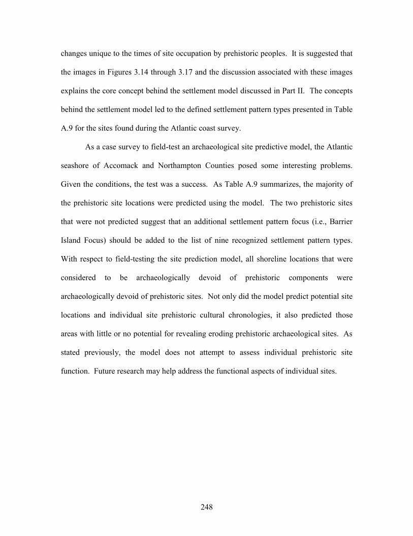
248
changes unique to the times of site occupation by prehistoric peoples. It is suggested that
the images in Figures 3.14 through 3.17 and the discussion associated with these images
explains the core concept behind the settlement model discussed in Part II. The concepts
behind the settlement model led to the defined settlement pattern types presented in Table
A.9 for the sites found during the Atlantic coast survey.
As a case survey to field-test an archaeological site predictive model, the Atlantic
seashore of Accomack and Northampton Counties posed some interesting problems.
Given the conditions, the test was a success. As Table A.9 summarizes, the majority of
the prehistoric site locations were predicted using the model. The two prehistoric sites
that were not predicted suggest that an additional settlement pattern focus (i.e., Barrier
Island Focus) should be added to the list of nine recognized settlement pattern types.
With respect to field-testing the site prediction model, all shoreline locations that were
considered to be archaeologically devoid of prehistoric components were
archaeologically devoid of prehistoric sites. Not only did the model predict potential site
locations and individual site prehistoric cultural chronologies, it also predicted those
areas with little or no potential for revealing eroding prehistoric archaeological sites. As
stated previously, the model does not attempt to assess individual prehistoric site
function. Future research may help address the functional aspects of individual sites.
249
PART IV: Summary and Conclusions.
The shoreline survey of the Atlantic seashore of the Virginia Eastern Shore
produced 44 archaeological sites. These sites span the past 13,000 years of human
occupation of the Middle Atlantic region. The survey also attempted to gauge the ability
of Lowery’s (1997) site prediction model to locate archaeological sites along the Atlantic
seashore. The results of the project created a database for future research, and it also
established various criteria for conducting archaeological fieldwork in coastal settings.
There were several tasks associated with the project. All of the tasks were
completed. This report summarizes the tasks associated with the project, any
observations, and the results. The project concluded that in coastal settings shoreline
erosion and marine transgression are influencing what we, as archaeologists, are seeing in
the archaeological record. In coastal settings, the “significance” of an archaeological site
could not be based on a single site visit analysis. In coastal settings, the cultural
chronologies associated with an archaeological site could not be based on a single site
visit analysis. Given the focus on shoreline related erosion, the real or actual dimensions
of each site also could not be determined.
This report attempts to gauge some of the archaeologically related problems
facing researchers here on the Delmarva Peninsula. In coastal settings, it is important to
understand the natural variables impacting the entire archaeological record as well as
individual archaeological sites. Like the survey conducted along the Chesapeake Bay
shorelines of Accomack and Northampton Counties (Lowery 2001), the current project
and the report were oriented towards these objectives. Figure 4.1 illustrates one of the
250
problems facing archaeologists, researchers, and cultural resource managers relative to
archaeological sites in coastal settings. In Figure 4.1, two hypothetical eroding
archaeological sites are plotted along a shoreline. One site (i.e., SITE “A”) is roughly
parallel to the wind and wave direction and the second site (i.e., SITE “B”) is somewhat
perpendicular to the onshore wind and wave direction. When artifacts are eroded from an
archaeological site adjacent to a shoreline, the wave actions act upon the cultural items
differently depending on the orientation of the site relative to the impacting wind and
wave energies. At Site “A” in Figure 4.1, the light artifacts (i.e., debitage and projectile
points) are moved along the shoreline away from the parent eroding archaeological site.
The heavy artifacts (i.e., fire-cracked rock and ground stone items) are moved but their
point of deposition along the shoreline roughly approximates the eroding site. It should
be noted that in certain coastal settings, heavy wave energies could move even some of
the largest and heaviest cultural artifacts. At Site “B” in Figure 4.1, the orientation of the
site relative to the wind and wave energy results in minimal artifact movement along the
shoreline. In sum, the image in Figure 4.1 suggests that actual eroding terrestrial
archaeological site dimensions need to be assessed on an individual site basis. As
artifacts become intermixed with beach sediments and impacted by coastal processes, the
artifacts act as coastal sediments and their distribution along the shoreline is an
expression of natural, not cultural, processes.
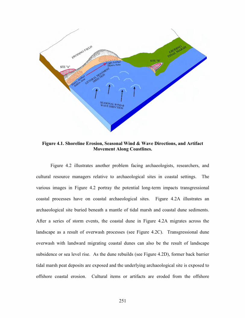
251
Figure 4.1. Shoreline Erosion, Seasonal Wind & Wave Directions, and Artifact Movement Along Coastlines.
Figure 4.2 illustrates another problem facing archaeologists, researchers, and
cultural resource managers relative to archaeological sites in coastal settings. The
various images in Figure 4.2 portray the potential long-term impacts transgressional
coastal processes have on coastal archaeological sites. Figure 4.2A illustrates an
archaeological site buried beneath a mantle of tidal marsh and coastal dune sediments.
After a series of storm events, the coastal dune in Figure 4.2A migrates across the
landscape as a result of overwash processes (see Figure 4.2C). Transgressional dune
overwash with landward migrating coastal dunes can also be the result of landscape
subsidence or sea level rise. As the dune rebuilds (see Figure 4.2D), former back barrier
tidal marsh peat deposits are exposed and the underlying archaeological site is exposed to
offshore coastal erosion. Cultural items or artifacts are eroded from the offshore
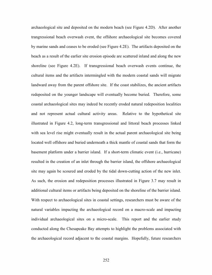
252
archaeological site and deposited on the modern beach (see Figure 4.2D). After another
trangressional beach overwash event, the offshore archaeological site becomes covered
by marine sands and ceases to be eroded (see Figure 4.2E). The artifacts deposited on the
beach as a result of the earlier site erosion episode are scattered inland and along the new
shoreline (see Figure 4.2E). If transgressional beach overwash events continue, the
cultural items and the artifacts intermingled with the modern coastal sands will migrate
landward away from the parent offshore site. If the coast stabilizes, the ancient artifacts
redeposited on the younger landscape will eventually become buried. Therefore, some
coastal archaeological sites may indeed be recently eroded natural redeposition localities
and not represent actual cultural activity areas. Relative to the hypothetical site
illustrated in Figure 4.2, long-term transgressional and littoral beach processes linked
with sea level rise might eventually result in the actual parent archaeological site being
located well offshore and buried underneath a thick mantle of coastal sands that form the
basement platform under a barrier island. If a short-term climatic event (i.e., hurricane)
resulted in the creation of an inlet through the barrier island, the offshore archaeological
site may again be scoured and eroded by the tidal down-cutting action of the new inlet.
As such, the erosion and redeposition processes illustrated in Figure 3.7 may result in
additional cultural items or artifacts being deposited on the shoreline of the barrier island.
With respect to archaeological sites in coastal settings, researchers must be aware of the
natural variables impacting the archaeological record on a macro-scale and impacting
individual archaeological sites on a micro-scale. This report and the earlier study
conducted along the Chesapeake Bay attempts to highlight the problems associated with
the archaeological record adjacent to the coastal margins. Hopefully, future researchers
253
will take these problems into consideration before, during, and after they conduct a
similar project on the Delmarva Peninsula or within the Middle Atlantic region.
Figure 4.2. Redeposition of Ancient Cultural Materials onto Younger Landscapes.
254
At the completion of the project, the data resulted in several conclusions. Even
though the project located 44 eroding archaeological sites, assessments about these sites
(i.e., function, size, level of integrity, significance, and cultural chronology) cannot be
accurately determined. It was also concluded that limited one-time surveys are very
inadequate ways to address archaeological site assessment concerns. Limited one-time
surveys can locate archaeological sites. Even so, it is feared that a percentage of the real
number of sites in the study area were missed as a result of adverse field conditions.
Given the dynamics associated with the archaeological remains found along
shorelines and the ephemeral nature of these remains, I would advise that archaeologists
immediately collect any site data that are available. Unlike archaeological sites found in
agriculturally tilled fields, the integrity of the archaeological deposits along shorelines is
threatened year-round. The spatial patterning of the eroded cultural material along
eroded shorelines is not a reflection of cultural processes. It is a reflection of natural
processes. Viewing the archaeological data associated with shoreline sites, as a future
“bank” of information that can be utilized at one’s leisure is a mistake. Given the rates of
shoreline erosion, the dynamic changes to the offshore and onshore areas, and the natural
processes removing and moving artifacts along the shoreline, the long-term neglect of
shoreline sites will only result in a loss of archaeological information. Unlike
archaeological sites in agricultural settings, I would suggest that shoreline sites be
regularly collected for site data and “vacuum-cleaned” of cultural material. These data
should also be maintained at a common repository for future research.
With respect to eroding shoreline sites, “some data are better than no data at all.”
From my personal experience relative to eroding sites along the shorelines of Maryland’s
255
Chesapeake Bay, there are a few truly amazing sites that have completely succumbed to
shoreline erosion. As we speak, the only expressions of these grand sites are a few
barnacle-encrusted artifacts being tumbled under the bay alongside 20th century boating
debris and other modern garbage. The artifacts lack integrity and the sites that produced
these artifacts have long since washed away. In other words, the contextual integrity of
each parent archaeological site has been destroyed because of erosion. Fortunately for
the Commonwealth of Virginia, the Threatened Sites Program within the Virginia
Department of Historic Resources has begun the principle process (e.g. site survey and
identification), which addresses shoreline erosion impacts relative to archaeological
resources. This survey like all other initial archaeological surveys should be viewed as a
“stepping stone” to future endeavors.
Clearly future research is needed on the Virginia Eastern Shore to provide cultural
resource managers and research archaeologists with better techniques to properly manage
the region’s cultural resources. As it stands, the present project has created a database of
individual localities where cultural material was observed eroding from the shoreline.
What do these localities mean? Unfortunately, the present information cannot answer
this question. Below are listed some potential future research projects that would help to
provide some answers to this question and put the individual archaeological sites along
the Atlantic seashore into a regional perspective. The list of suggestions for future
research includes:
1. To better understand the archaeological sites recorded on the Atlantic seashore
and the previous study on the Chesapeake Bay, a multi-year systematic field
survey should be conducted within the agricultural lands of the Virginia portion of
256
the Delmarva Peninsula. Similar projects have been conducted within Maryland
(Lowery 1992a, 1993a, 1993b, 1994, 1995c, 1996, and 1997). These
archaeological surveys systematically examined almost 50,000 acres of
agriculturally tilled areas and documented over 1,000 archaeological sites.
2. If multi-year systematic field surveys are planned, a site predictive model for the
interior areas of Accomack and Northampton Counties should be developed prior
to the fieldwork. The predictive models for the interior areas should be based on
the predictive model presented and tested in this survey. As such, the
applicability of the prehistoric settlement model will again be subjected to the
rigors of field-testing.
3. A region along Virginia’s Atlantic coast that revealed “significant” eroding
archaeological sites should be selected for focused archaeological testing. Given
the fact that Mockhorn Island, produced several “significant” archaeological sites,
it is suggested that it be selected as the focused area for selective archaeological
testing. Mockhorn Island, a wildlife management area under the control of the
Virginia Department of Game and Inland Fisheries, encompasses 7,642 acres.
Under the long-term goals defined by the Department of Game and Inland
Fisheries (see www.state.va.us/mrc/fr1030), the agency wants to develop long-
term research and monitoring plans. Archaeological studies were listed as one of
these plans. Given the fact that the archaeological sites on Mockhorn Island were
documented as a result of a state-funded survey, the region would seem to be the
perfect locality to deal with “significant” threatened state-owned archaeological
sites. Testing at these sites should help to quantify some of the variables
257
impacting the region’s archaeological record and more accurately identify the
cultural chronologies represented at sites along the Atlantic coast. Cultural
resource managers would have a better means to assess how coastal sites are
being impacted by these variables (i.e., shoreline erosion, redeposition,
inundation, bioturbation, aeolian processes, and coastal dune formations).
4. A supplementary project should be geared towards assessing the potential for late
prehistoric archaeological sites situated on the old forested barrier island ridges.
As illustrated in Figure 3.10, several locations were observed that would seem to
have a high potential for Late Woodland-era archaeological sites. Given the field
conditions, these areas did not provide the surface visibility to accurately assess
the archaeology, if any archaeological remains were present.
5. Exposed bank cuts and on-site soil profiles should be examined and recorded. As
a result, chronostratigraphic patterns associated with the regional archaeological
record may emerge.
6. Finally and most importantly, a program along the Virginia Eastern Shore should
be established addressing the continued multi-year/multi-seasonal re-
examinations of the eroding coastal sites. One-time shoreline surveys cannot
provide much data about eroding archaeological sites. Multi-year/multi-seasonal
site re-examinations would help address the degree of site erosion threat, the
degree of site significance, aspects about site-specific seasonal erosion processes,
variations in the redepositional processes along individual shorelines, and help to
resolve questions about the cultural chronologies associated with each site. If all
or most of the eroding archaeological sites will not be subjected to future
258
intensive archaeological investigations, multi-year/multi-seasonal re-examinations
will provide valuable data. Over time, continued erosion may completely
consume the existing intact shoreline-related archaeological remains associated
with each site. The program will basically be a periodic “check-up” of each
threatened site. Erosion threats to “significant” features associated with each
eroding site could also be addressed immediately. Otherwise, the lack of future
site re-examinations would neglect each archaeological site and subject its future
to the whims of nature.
The Atlantic seashore survey was conducted as a result of the suggestions
proposed in the earlier Chesapeake Bay survey (Lowery 2001). Unlike speculation or
general comments from local informants about shoreline erosion (see Underwood and
Stuck 1999: 25-26), the erosion threats to archaeological resources for both the
Chesapeake Bay shorelines and the Atlantic seashore can now be quantified. It is clearly
evident that fetch-related shoreline erosion is more severe along the Chesapeake Bay
shorelines of Accomack and Northampton Counties (see Lowery 2001: Table A.4) than
along the Atlantic seashore (see Table A.5). Erosion via tidal action was not evident
along the Chesapeake shorelines. Given the extreme tidal fluctuations along the Atlantic
seashore, tidal erosion is more evident. Boat-related erosion or erosion as a result of
anthropogenic processes is also more evident along the Atlantic seashore. Biological
erosion via bioturbation processes seems to be uniformly present along both the Atlantic
and Chesapeake shorelines of Virginia’s Eastern Shore. With respect to the present
survey, I believe the data are more apparent relative to how natural processes are
influencing what we see in the archaeological record. By comparing the types and degree
259
of erosion in Table A.5 with the resulting artifact assemblages in Table A.7 a pattern
seems to emerge. The pattern simply suggests that consistent fetch-related erosion
impacting coastal archaeological sites typically results in larger artifact assemblages and
more detailed cultural chronologies. Because of the unique shoreline variables associated
each individual site, the fetch-related erosion processes are not uniform (see Figure 4.3
and Table A.6). It is obvious that these unique shoreline variables would also influence
the size of a site’s artifact assemblage and its recognized cultural chronologies. As such,
an accurate determination of site function under these conditions is unreasonable (see
Underwood and Stuck 1999: Table 3) and futile. Determinations about prehistoric trade
and exchange patterns, prehistoric demographic patterns, and period specific prehistoric
site distribution patterns are also questionable based on the natural biases associated with
coastal site data. The Atlantic seashore survey did provide data relative to specific
archaeological site localities that need to be subjected to follow-up investigations. The
Atlantic seashore survey did quantify the shoreline erosion threat to the region’s sites.
The Atlantic seashore survey did provide a field test of a site predictive model and the
survey did provide data about 39 previously unrecorded archaeological sites. From a
“reflexive” perspective the shoreline survey of both Accomack and Northampton
Counties has provided some data. As mentioned in the Chesapeake Bay shoreline
survey, “the data that resulted from this project are only as good as how cultural resource
managers, research archaeologists, and the general public use it.” Relative to the Virginia
Eastern Shore, it is truly a landmass sculpted by wind and water. With several hundreds
of miles of shoreline, it is imperative that individuals recognize that wind and water are
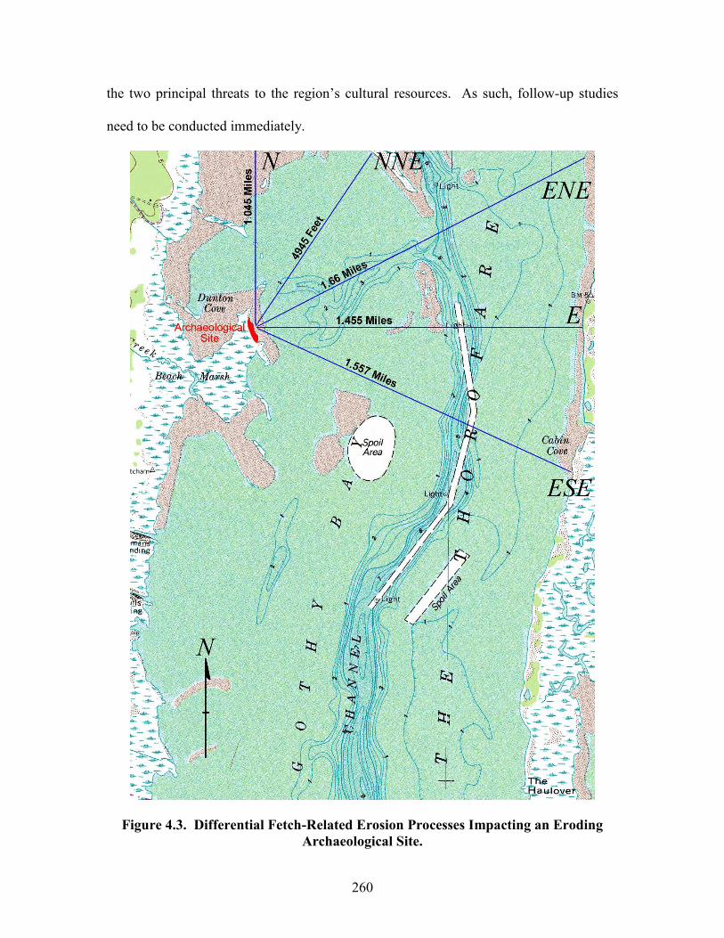
260
the two principal threats to the region’s cultural resources. As such, follow-up studies
need to be conducted immediately.
Figure 4.3. Differential Fetch-Related Erosion Processes Impacting an Eroding Archaeological Site.
261
REFERENCES CITED
Adovasio, J. M. 1983 A Perspective from Meadowcroft Rockshelter. Archaeology of Eastern
North America 11: 6-12.
1993 The Ones that Will Not Go Away: A Biased View of Pre-Clovis Populations in the New World. In From Kostenki to Clovis: Upper Paleolithic-Paleoindian Adaptations, edited by Olga Soffer and N. D. Praslov, pp. 199-218. Plenum Press, New York and London.
Anderson, David G., and Michael K. Faught
1998 The Distribution of Fluted Paleoindian Projectile Points: Update 1998. Archaeology of Eastern North America 26: 163-188.
Anderson, David G., Michael K. Faught, and J. Christopher Gillam
1998 Paleoindian Site/Artifact Distributions Viewed from a Very Large Scale: Evidence and Implications. (See web site<http://www.adp.fsu.edu/saa98.html>).
Anderson, David G., and Kenneth E. Sassaman
1996 The Paleoindian and Early Archaic Southeast. University of Alabama Press, Tuscaloosa and London.
Blanton, Dennis B., and Samuel G. Margolin
1994 An Assessment of Virginia’s Underwater Cultural Resources. Virginia Department of Historic Resources Survey and Planning Report Series No. 3. Richmond, Virginia.
Boldurian, Anthony T., and John L. Cotter
1999 Clovis Revisited: New Perspectives on Paleoindian Adaptations from Blackwater Draw, New Mexico. The University Museum, University of Pennsylvania. Philadelphia, Pennsylvania.
Bonfiglio, A., and J. H. Cresson
1978 Aboriginal Cultural Adaptation and Exploitation of Periglacial Features in Southern New Jersey. Paper presented at the annual meeting of the Middle Atlantic Archaeologica Conference, Rehoboth Beach, Delaware.
Bonnichsen, Robson, Dennis Stanford, and James Fastook
1987 Environmental Change and Developmental History of Human Adaptive Patterns; The Paleoindian Case. In North America and Adjacent Oceans During the Last Deglaciation, Vol. K-3, edited by W. F. Ruddiman and H. E. Wright, Jr., pp. 403-424. The Geological Society of America, Boulder, Colorado.
262
Bradley, Bruce 1998 Archaeologist. Personal Communication: 11/24/98. Brooks, W. K.
1996 The Oyster. The Johns Hopkins University Press, Baltimore and London.
Broyles, B. J. 1971 Second Preliminary Report: The St. Albans Site, Kanawha County, West
Virginia. West Virginia Geological and Economic Survey, Report of Archaeological Investigations 3. Morgantown, West Virginia.
Brown, Lois
1979 Fluted Projectile Points in Maryland. Manuscript on file at the Maryland Historical Trust. Crownsville, Maryland.
n.d. Soapstone quarries of Maryland. Manuscript on file at the Maryland
Historical Trust, Crownsville, Maryland. Busby, Virginia
1995 Archaeologist. Personal Communication: 10/18/95. Carbone, V. A.
1976 Environment and Prehistory in the Shenandoah Valley. Ph. D. dissertation, The Catholic University of America, Washington, D.C.
Chalifoux, E.
1999 Late Paleoindian Occupation in a Coastal Environment: A Perspective From La Martre (Gaspe Peninsula). Northeastern Anthropology 57: 69-79.
Chapman, Jefferson
1973 The Icehouse Bottom Site (40MR23). Report of Investigations 13. Department of Anthropology, University of Tennessee, Knoxville.
1975 The Rose Island Site and the Bifurcate Point Tradition. Report of
Investigations 14. Department of Anthropology, University of Tennessee, Knoxville.
Chen, Z. Q., C. H. Hobbs, J. F. Wehmiller, and S. M. Kimball
1995 Late Quaternary Paleochannel Systems on the Continental Shelf, South of the Chesapeake Bay Entrance. Journal of Coastal Research 11(3): 605-614.
263
Clark, W. B., F. A. Lucas, O. P. Hay, E. H. Sellards, E. O. Ulrich, and A. Hollick 1906 Systematic Paleontology of the Pleistocene Deposits of Maryland. In
Pliocene and Pleistocene. Maryland Geological Survey. The Johns Hopkins Press, Baltimore, Maryland.
Cline, W. J., G. W. Monaghan, and D. R. Hayes
2001 Archaeological and Geological Evaluation at Butler’s Bluff, Northampton County, Virginia. William and Mary Center for Archaeological Research, Williamsburg, Virginia.
Cobb, P. R., and D. W. Smith
1989 Soil Survey of Northampton County, Virginia. United States Department of Agriculture Soil Conservation Service. Washington, D. C.
Coe, J. L.
1964 The Formative Cultures of the Carolina Piedmont. Transactions of the American Philosophical Society 54.
Collins, Michael B., and Marvin Kay
1999 Clovis Blade Technology: A Comparative Study of the Kevin Davis Cache. University of Texas Press, Austin, Texas.
Colman, S. M., J. P. Halka, and C. H. Hobbs
1991 Patterns and Rates of Sediment Accumulation in the Chesapeake During the Holocene Rise in Sea Level. Contribution Number 1668 of the Virginia Institute of Marine Science.
Cresson, Jack
2000 Archaeologist. Personal Communication: 3/25/00. Cronin, T. M. (editor)
2000 Initial Report on IMAGES V Cruise of the Marion-Dufresne to the Chesapeake Bay June 20-22, 1999, U.S. Geological Survey Open-File Report 00-306. U.S. Department of the Interior, U.S. Geological Survey. Reston, Virginia. Curry, Dennis C.
1999 Feast of the Dead: Aboriginal Ossuaries in Maryland. Archaeological Society of Maryland Inc. and the Maryland Historical Trust. Myersville and Crownsville, Maryland.
Curry, D. C., and J. F. Custer
1982 Holocene Climatic Change in the Middle Atlantic Area: Preliminary Observations from Archaeological Sites. North American Archaeologist 3(4): 275-285.
264
Custer, J. F. 1982 A Reconsideration of the Middle Woodland Cultures of the Upper
Delmarva Peninsula. In Practicing Environmental Archaeology: Methods and Interpretations, edited by R. Moeller, pp. 29-38. Occasional Papers of the American Indian Archaeological Institute No. 3. Washington, Connecticut.
1983 A Management Plan for the Archaeological Resources of the Upper
Delmarva Region of Maryland. Maryland Historical Trust Manuscript Series No. 31. Crownsville, Maryland.
1984a An Analysis of Fluted Points and Paleoindian Site Locations from the
Delmarva Peninsula. Bulletin of the Archaeological Society of Delaware 16.
1984b Paleoecology of the Late Archaic: Exchange and Adaptation.
Pennsylvania Archaeologist 55 (3-4): 19-37.
1986 Analysis of Early Holocene Projectile Points and Site Locations from the Delmarva Peninsula. Archaeology of Eastern North America 14: 45-64.
1987 New Perspectives on the Delmarva Adena Complex. Midcontinental
Journal of Archaeology 12: 33-54.
1988 Coastal Adaptations in the Middle Atlantic Region. Archaeology of Eastern North America 16: 121-136.
1989 Prehistoric Cultures of the Delmarva Peninsula: An Archaeological
Study. University of Delaware Press, Newark, Delaware.
1990 Early and Middle Archaic Cultures of Virginia: Cultural Change and Continuity. In Early and Middle Archaic Research in Virginia: A Synthesis, edited by Theodore R. Reinhart and Mary Ellen N. Hodges, pp. 1-60. Archaeological Society of Virginia Special Publication No. 22. Richmond, Virginia.
1992 Archaeologist. University of Delaware; Newark, Delaware. Personal
Communication: 8/20/92.
1995 Archaeologist. University of Delaware; Newark, Delaware. Personal Communication: 8/17/95.
1996 A Guide to Prehistoric Arrowheads and Spear Points of Delaware. Center
for Archaeological Research, University of Delaware. Newark, Delaware.
265
Custer, J. F., and D. C. Bachman 1986 Prehistoric Use of Bay/Basin Features on the Delmarva Peninsula.
Southeastern Archaeology 5(1): 1-10. Custer, Jay F., and Keith R. Doms
1984 Analysis of Surface Collections from the Oxford Site (18TA3), Talbot County, Maryland. Maryland Archaeology 20 (1): 11-17.
Custer, Jay F., and Darrin L. Lowery n.d. Archaeological Excavations at the Martingham Habitation Site, Talbot
County, Maryland. Manuscript in preparation. Custer, Jay F., P. Jehle, H. H. Ward, S. C. Watson, and C. Mensack
1986 Archaeological Test Excavations at the Arrowhead Farm Complex, Kent County, Maryland. Maryland Archaeology 22(2): 20-32.
Custer, Jay F., and Glen R. Mellin
1989 Archaeological Survey in Southwestern Delaware, 1987-1988. Bulletin of the Archaeological Society of Delaware 26: 1-68.
Custer, Jay F., Karen R. Rosenberg, Glen Mellin, and Arthur Washburn
1990 A Re-examination of the Island Field Site (7K-F-17), Kent County, Delaware. Archaeology of Eastern North America 18: 145-212.
Custer, Jay F., M. C. Stiner, and S. Watson
1983 Excavations at the Wilgus Site (7S-D-21). Bulletin of the Archaeological Society of Delaware 15.
Custer, J. F., and S. Watson
1985 Archaeological Investigations at 7NC-E-42, A Contact-Period Site in New Castle County, Delaware. Journal of Middle Atlantic Archaeology 1: 97-116.
1987 Making Cultural Paleoecology Work: An Example from Northern
Delaware. Journal of Middle Atlantic Archaeology 3: 81-94. Daniel, I. Randolph, and Michael Wisenbaker
1987 Harney Flats: A Florida Paleoindian Site. Baywood Publishing Company, Farmingdale, New York.
Davidson, Tom 1992 Archaeologist. Personal Communication: 3/15/92. Deems, E. F. and D. Pursley
1983 North American Furbearers: A Contemporary Reference. International Association of Fish and Wildlife Agencies and the Maryland Department of Natural Resources-Wildlife Administration.
266
Deller, D. Brian 1989 Interpretation of Chert Type Variation in Paleoindian Industries,
Southwestern Ontario. In Eastern Paleoindian Lithic Resource Use, edited by Christopher Ellis and Jonathan Lothrop. Westview Press, Boulder, San Francisco, & London.
Deller, D. Brian, and C. J. Ellis
1984 Crowfield: A Preliminary Report on a Probable Paleoindian Cremation in Southwestern Ontario. Archaeology of Eastern North America 12: 41-71.
Dent, R. J.
1995 Chesapeake Prehistory: Old Traditions, New Directions. Interdisciplinary Contributions to Archaeology. Plenum Press, New York and London.
DeValinger, L.
1970 Report on the Excavation of the St. Jones River Site Near Lebanon, Delaware. Delaware State Museum Series Bulletin No. 3, Dover, Delaware.
Dillehay, Thomas D.
1997 Monte Verde, A Late Pleistocene Settlement in Chile, Volume 2, The Archaeological Context and Interpretation. Smithsonian Institution Press, Washington, D.C.
Dixon, James E.
1999 Bones, Boats, and Bison: Archaeology and the First Colonization of Western North America. University of New Mexico Press, Albuquerque.
Dragoo, Don W.
1963 Mounds for the Dead: An Analysis of the Adena Culture. Volume 37, Annals of the Carnegie Museum. Pittsburgh, Pennsylvania.
Driskell, Boyce N.
1996 Stratified Late Pleistocene and Early Holocene Deposits at Dust Cave, Northwestern Alabama, In The Paleoindian and Early Archaic Southeast, edited by David G. Anderson and Kenneth E. Sassaman, pp. 315-330. The University of Alabama Press, Tuscaloosa and London.
Dunbar, James S.
1991 Resource Orientation of Clovis and Suwannee Age Paleoindian Sites in Florida. In Clovis: Origins and Adaptations, edited by Robson Bonnichsen and Karen Turnmire, pp. 175-213. Center for the Study of the First Americans, Oregon State University, Corvallis, Oregon.
Eastern Shore of Virginia Economic Development Commission n.d. Eastern Shore of Virginia Regional Profile. Accomac, Virginia.
267
Ebright, Carol. V. 1992 Early Native American Prehistory on the Maryland Western Shore:
Archaeological Investigations at the Higgins Site, Vols. 1-3. Maryland State Highway Administration and Department of Natural Resources, Baltimore.
Edwards, R. L., and A. S. Merrill
1977 A Reconstruction of the Continental Shelf Areas of Eastern North America for the Times 9500 B.P. and 12,500 B.P. Archaeology of Eastern North America 5: 1-43.
Egloff, K. T., and J. M. McAvoy
1990 Chronology of Virginia’s Early and Middle Archaic Periods. In Early and Middle Archaic Research in Virginia, edited by Theodore R. Reinhart and Mary Ellen Hodges, pp. 61-80. Archaeological Society of Virginia, Courtland, Virginia.
Eshelman, R.
2001 Paleontologist. Eshelman and Associates, Lusby, Maryland. Personal Communication: 10/12/01.
Eshelman, R., and F. Grady
1986 Quaternary Vertebrate Localities of Virginia and Their Avian and Mammalian Fauna. In The Quaternary of Virginia: A Symposium Volume, edited by J. N. McDonald and S. O. Bird. Virginia Division of Mineral Resources Publication 75: 43-70.
Fiedel, S. J.
1999 Older Than We Thought: Implications of Corrected Dates for Paleoindians. American Antiquity, 64 (1): 95-115.
Finkelstein, K. and M. Kearney
1988 Late Pleistocene Barrier-Island Sequence along the Southern Delmarva Peninsula: Implications for Middle Wisconsin Sea Levels. Geology 16: 41-45.
Ford, T. Latimer.
1976 Adena Sites on the Chesapeake Bay. Archaeology of Eastern North America 4: 89-110.
Foss, J. E., D. S. Fanning, F. P. Miller, and D. P. Wagner
1978 Loess Deposits of the Eastern Shore of Maryland. Soil Science Society of America Journal 42(2): 329-334.
268
Foyle, A. M., and G. Oertel 1992 Seismic Stratigraphy and Coastal Drainage Patterns in the Quaternary
Section of the Delmarva Peninsula, Virginia, USA. Sedimentary Geology 80: 261-277.
Gardner, William M.
1982 Early and Middle Woodland in the Middle Atlantic: An Overview. In Practicing Environmental Archaeology: Methods and Interpretations, edited by R. Moeller, pp. 53-87. Occasional Papers of the American Indian Archaeological Institute No. 3. Washington, Connecticut.
Gardner, William M., and Robert A. Verry
1979 Typology and Chronology of Fluted Points from the Flint Run Area. Pennsylvania Archaeologist 49 (1-2): 13-46.
Geiger, Carey L., and Ted Brown
1983 Waller Hafted Knives from Southeast Mississippi. Mississippi Archaeology 18(1): 3-13.
Geologic Map of Virginia
1993 Geologic Map of Virginia. Virginia Division of Mineral Resources, scale 1:500,000.
Goodyear, Albert C. III, James L. Michie, and Tommy Charles
1989 The Earliest South Carolinians: The Paleoindian Occupation of South Carolina. Occasional Papers 2. Archaeological Society of South Carolina, Columbia.
Goodyear, Albert C. III, James L. Michie, and Barbara Purdy
1980 The Edgefield Scraper: A Distributional Study of an Early Archaic Stone Tool from the Southeastern U.S. Paper presented at the Annual Meeting of the Southeastern Archaeological Conference. New Orleans.
Goudie, A. S.
1999 Wind Erosional Landforms: Yardangs and Pans. In Aeolian Environments, Sediments, & Landforms, edited by Andrew S. Goudie, Ian Livingstone, and Stephen Stokes, pp. 167-180. John Wiley & Sons, Inc, New York.
Graham, Russell W., C. Vance Haynes, Donald Lee Johnson, and Marvin Kay
1981 Kimmswick: A Clovis-Mastodon Association in Eastern Missouri. Science 213 (4): 1115-1116.
269
Graham, Russell W., and Jim Mead
1987 Environmental Fluctuations and Evolution of Mammalian Faunas During the Last Deglaciation in North America. In North America and Adjacent Oceans During the Last Deglaciation, The Geology of North America, Vol. K-3, edited by W. F. Ruddiman and H. E. Wright, Jr., pp. 371-402. The Geological Society of America, Boulder, Colorado.
Gramly, Richard M.
1999 The Lamb Site: A Pioneering Clovis Encampment. Persimmon Press, Kenmore, New York.
Gramly, Richard M., and Robert E. Funk
1990 What is Known and Not Known about the Human Occupation of the Northeastern United States Until 10,000 B. P. Archaeology of Eastern North America 18: 5-32.
Griffin, James B.
1983 The Midlands. In Ancient North Americans, edited by Jesse D. Jennings, pp. 243-301. W. H. Freeman and Company, New York.
Griffith, D. R., and R. E. Artusy
1977 Middle Woodland Ceramics from Wolfe Neck, Sussex County, Delaware. The Archeolog 28(1): 1-29.
Groot, J. J., K. W. Ramsey, J. F. Wehmiller
1990 Ages of the Bethany, Beaverdam, and Omar Formations of Southern Delaware. Delaware Geological Survey, Report of Investigations No. 47. Newark, Delaware.
Hanft, M.
n.d. Prairie Potholes. See website: http://server3005.freeyellow.com/marksrelics/glacial.html
Hansen, H. J.
1966 Pleistocene Stratigraphy of the Salisbury Area, Maryland and Its Relation to the Lower Eastern Shore: A Subsurface Approach. Maryland Geological Survey Report of Investigations Number 2. Baltimore, Maryland.
Harp, Elmer, Jr.
1983 Pioneer Cultures of the Sub-Arctic and the Arctic. In Ancient North Americans, edited by Jesse D. Jennings. W. H. Freeman and Company, New York.
270
Harrison, W., R. Malloy, G, Rusnak, and J. Teresmae
1965 Possible Late Pleistocene Uplift, Chesapeake Bay Entrance. Journal of Geology 73: 201-229.
Hatch, Charles E., Jr.
1957 The First Seventeen Years: Virginia, 1607-1624. University Press of Virginia, Charlottesville.
Haury, Emil W., E. B. Sayles, and William W. Wasley
1959 The Lehner Mammoth Site, Southeastern Arizona. American Antiquity 25 (1): 2-30.
Haynes, C. Vance
1991 Geoarchaeological and Paleohydrological Evidence for a Clovis-age Drought in North America and Its Bearing on Extinction. Quaternary Research 35: 438-450.
1993 Clovis-Folsom Geochronology and Climatic Change. In From Kostenki to
Clovis: Upper Paleolithic -Paleoindian Adaptations, edited by Olga Soffer and N. D. Praslov, pp. 219-236. Plenum Press, New York and London.
1999 Clovis, Climate Change, and Extinction. Paper presented at the Clovis
and Beyond Conference, October 28-31, 1999. Santa Fe, New Mexico. (See web site: <http://www.clovisandbeyond.org/clovisabst.html>).
Hazzard, David
2000 Archaeologist. Virginia Department of Historic Resources, Portsmouth, Virginia. Personal Communication: 1/24/00.
Hester, James J.
1972 Blackwater Locality No. 1: A Stratified Early Man Site in Eastern New Mexico. Fort Burgwin Research Center, Publication No. 8. Ranchos de Taos, New Mexico.
Hopkins, Fred
1991 Opportunity, Accomplishment, and Betrayal: Saga of William Claiborne’s 17th-Century Settlement in the Upper Chesapeake. In Underwater Archaeology Proceedings from the Society for Historical Archaeology Conference, edited by John D. Broadwater, pp. 2-5. The Society for Historical Archaeology, Richmond, Virginia.
Hughes, Richard B.
1992 Archaeologist. Maryland Historical Trust, Crownsville, Maryland. Personal Communication: 9/22/92.
271
Hulton, Paul
1984 America 1585: The Complete Drawings of John White. The University of North Carolina Press and British Museum Publications, Chapel Hill, North Carolina.
Jackson, R. W. 1954 The Sandy Hill Mound Site. Archeolog 9(2): 1-9. Jordan, F.
1906 Aboriginal Fishing Stations on the Coast of the Middle Atlantic States. Philadelphia, Pennsylvania.
Katz, Gregory M.
2000 Archaic Period Triangular Bifaces in the Middle Atlantic Region: Technological and Functional Considerations. Unpublished Anthropology Masters Thesis. Temple University. Philadelphia, Pennsylvania.
Kauffman, B. E., and R. J. Dent
1982 Preliminary Flora and Fauna Recovery and Analysis at the Shawnee-Minisink Site (36 MR 43). In Practicing Environmental Archaeology: Methods and Interpretations, edited by R. Moeller, pp.7-12. Occasional Papers of the American Indian Archaeological Institute No. 3. Washington, Connecticut.
Kavanagh, M.
1979 Archaeological Reconnaissance of Proposed Channel Improvements in the Upper Chester Watershed, Kent and Queen Anne’s Counties, Maryland. Maryland Geological Survey File Report No. 147. Baltimore, Maryland.
Kearney, M. S.
1996 Sea Level Change During the Last Thousand Years in Chesapeake Bay. Journal of Coastal Research 12(4): 977-983.
Kellogg, Douglas C., and Jay F. Custer
1994 Paleoenvironmental Studies of the State Route 1 Corridor: Contexts for Prehistoric Settlement, New Castle and Kent Counties, Delaware. Delaware Department of Transportation Archaeology Series No. 114. Dover, Delaware.
Kent, Barry C.
1989 Susquehanna’s Indians. Pennsylvania Historical and Museum Commission Anthropology Series 6. Harrisburg, Pennsylvania.
272
Kerhin, R., J. Halka, J. Hill, D. Wells, R. Conkwright, L. Hennessee, W. Panageotou, and M. J. Park
1996 The Maryland Geological Survey’s Contributions to the Geology of Chesapeake Bay. In Studies in Maryland Geology-In Commemoration of the Centennial of the Maryland Geological Survey, Special Publication No. 3, edited by David Brezinski and James Reger, pp. 57-69. Baltimore, Maryland.
Klein, M. J., and T. Klatka
1991 Late Archaic and Early Woodland Demography and Settlement Patterns. In Late Archaic and Early Woodland Research in Virginia: A Synthesis, edited by Theodore R. Reinhart and Mary Ellen Hodges, pp. 139-183. Archeological Society of Virginia, Courtland, Virginia.
Kraft, Herbert C.
1989 Sixteenth and Seventeenth Century Indian/White Trade Relations in the Middle Atlantic and Northeast Regions. Archaeology of Eastern North America 17: 1-30.
Laub, Richard S., and Gary Haynes
1998 Fluted Points, Mastodons, and Evidence of a Late Pleistocene Drought at the Hiscock Site, Western New York State. Current Research in the Pleistocene 15: 32-34.
Lauro, James T.
1982 The Edgefield Scraper and Waller Knife: Early Archaic Tools from the Pearl River Drainage, Central Mississippi. Journal of Alabama Archaeology 28 (2): 147-153.
Lavin, L.
1988 Coastal Adaptations in Southern New England and Southern New York. Archaeology of Eastern North America 16: 101-120.
Leatherman, S. P.
1988 Barrier Island Handbook. Coastal Publication Series, Laboratory for Coastal Research. College Park, Maryland.
Lippson, A. J.
1973 The Chesapeake Bay in Maryland: An Atlas of Natural Resources. The Johns Hopkins University Press, Baltimore and London.
Lippson, A. J., and R. L. Lippson
1974 Life in the Chesapeake Bay: An Illustrated Guide to Fishes, Invertebrates, and Plants of Bays and Inlets from Cape Cod to Cape Hatteras. Johns Hopkins University Press, Baltimore, Maryland.
273
Lowery, D. L. 1989a The Paw Paw Cove Paleoindian Site Complex, Talbot County, Maryland.
Archaeology of Eastern North America 17: 143-163.
1989b The Paw Paw Cove Paleoindian Site Complex. Abstracts of the North American Collections from The First World Summit Conference on the Peopling of the Americas, edited by John Tomenchuk and Robson Bonnichsen, p. 30. Center for the Study of the First Americans. Orono, Maine.
1989c Recent Discoveries Relating to the Delmarva Adena Complex: An
Analysis of the Miles River Adena Site. The Chesopien 27(3): 2-10. 1992a The 1992 Archaeological Survey of Kent Island. Manuscript on file at the
Maryland Historical Trust. Crownsville, Maryland.
1992b The Distribution and Function of Prehistoric Sites Within the Lower Bay Hundred District, Talbot County, Maryland. Journal of Middle Atlantic Archaeology 8: 11-40.
1992c Excavations at the Paw Paw Cove Paleoindian Site, FY 1992. Manuscript
on file at the University of Delaware Center for Archaeological Research. Newark, Delaware.
1993a A Supplementary Report of the 1992 Archaeological Survey of Kent
Island. Manuscript on file at the Maryland Historical Trust. Crownsville, Maryland.
1993b Archaeological Survey of the Chester River, the Wye River, and the
Prospect Bay Drainages, Queen Anne’s County, Maryland. Manuscript on file at the Maryland Historical Trust. Crownsville, Maryland.
1994 Archaeological Survey of Interior Queen Anne’s County, Maryland.
Manuscript on file at the Maryland Historical Trust. Crownsville, Maryland.
1995a The Distribution of Isolated Adena Related Artifacts within Maryland’s
Portion of the Delmarva Peninsula. Manuscript on file at the Maryland Historical Trust. Crownsville, Maryland.
1995b An Archaeological Survey of the Little Choptank River Drainage within
Dorchester County, Maryland. Manuscript on file at the Maryland Historical Trust. Crownsville, Maryland.

274
Lowery, D. L. (continued) 1995c A Supplementary Archaeological Survey of Interior Queen Anne’s
County, Maryland. Manuscript on file at the Maryland Historical Trust. Crownsville, Maryland.
1995d The Amy’s Marsh Broadspear Cache and Its Implications for the Barker’s
Landing Complex on Maryland’s Eastern Shore. Maryland Archaeology 31(1 & 2): 1-7.
1996 Archaeological Survey Work on Maryland’s Eastern Shore During the
1996 Field Season. Manuscript on file at the Maryland Historical Trust. Crownsville, Maryland.
1997 Archaeological Survey Work on Maryland’s Eastern Shore During the
1997 Field Season. Manuscript on file at the Maryland Historical Trust. Crownsville, Maryland.
1998 Using Ancient Shellfish to Process Contemporaneous Shellfish: Native
American Use of Miocene Silicified Fossiliferous Sandstone in the Middle Atlantic Coastal Plain. Paper Presented at the 65th Annual Meeting of Eastern States Archaeological Federation. Wilkes-Barre, Pennsylvania.
1999 Choptank River Watershed Artifact Collection Study. Manuscript on file
at the Maryland Historical Trust. Crownsville, Maryland.
2000 The Paleoindian Period of the Central Delmarva Peninsula: What Do The Data Suggest?. Paper Presented at the 30th Annual Meeting of the Middle Atlantic Archaeological Conference. Ocean City, Maryland.
2001 Archaeological Survey of the Chesapeake Bay Shorelines Associated With
Accomack County and Northampton County, Virginia. Virginia Department of Historic Resources, Survey and Planning Report Series, No. 6. Portsmouth, Virginia.
2002 A Time of Dust: Archaeological and Geomorphological Investigation at
the Paw Paw Cove Paleo-Indian Site Complex in Talbot County, Maryland. Manuscript prepared by the Chesapeake Bay Watershed Archaeological Research Foundation for the Maryland Historical Trust. Crownsville, Maryland.
Lowery, Darrin L., and Jay F. Custer
1990 Crane Point: An Early Archaic Site in Maryland. Journal of Middle Atlantic Archaeology 6: 75-120.
275
Lowery, Darrin L., and Thomas Phillips 1994 The Meekins Neck Paleoindian Site Complex, Dorchester County,
Maryland: A Development of a Paleoindian Settlement Model for the Delmarva Peninsula. Maryland Archaeology 30(2): 29-36.
MacDonald, George F.
1985 Debert: A Paleoindian Site in Central Nova Scotia. Persimmon Press, Buffalo, New York.
Markewich, H. W., and W. Markewich
1994 An Overview of Pleistocene and Holocene Inland Dunes in Georgia and the Carolinas: Morphology, Distribution, Age, and Paleoclimate. United States Geological Survey Bulletin 2069. Reston, Virginia.
Matthews, E. D.
1964 Soil Survey: Caroline County, Maryland. United States Department of Agriculture Soil Conservation Service. Washington, D. C.
Matthews, E. D., and W. U. Reybold III
1966 Soil Survey: Queen Anne’s County, Maryland. United States Department of Agriculture Soil Conservation Service. Washington, D. C.
Mayre, William B.
1934 A Map of Indian Bridges in Virginia, Maryland, and Delaware. Map on file at the Maryland Historical Trust. Crownsville, Maryland.
McAvoy, Joseph M.
1992 Nottoway River Survey Part-I: Clovis Settlement Patterns. Archeological Society of Virginia Special Publication Number 28. Richmond, Virginia.
1999 Archaeologist. Nottoway River Survey, Richmond, Virginia. Personal
Communication: 6/30/99.
2000 Archaeologist. Nottoway River Survey, Richmond, Virginia. Personal Communication: 3/27/00.
McAvoy, Joseph M., and Lynn D. McAvoy
1997 Archaeological Investigations of Site 44SX202, Cactus Hill, Sussex County, Virginia. Virginia Department of Historic Resources Research Report Series No. 8. Richmond, Virginia.
McGahey, Samuel O.
1996 Paleoindian and Early Archaic Data from Mississippi. In The Paleoindian and Early Archaic Southeast, edited by David G. Anderson and Kenneth E. Sassaman. The University of Alabama Press, Tuscaloosa and London.
276
McNamara, Joseph M. 1985 Excavations on Locust Neck: The Search for the Historic Indian
Settlement in the Choptank Indian Reservation. Journal of Middle Atlantic Archaeology 1: 87-96.
McNett, Charles W., Jr. (editor)
1985 Shawnee Minisink. Academic Press, Orlando. McNett, C. W., and B. McMillan
1974 Preliminary Report on the Initial Season of the Upper Delaware Valley Early Man Project. Manuscript on file, Department of Anthropology, American University, Washington, D. C.
McNett, C. W., B. McMillan, and S. B. Marshall
1977 The Shawnee-Minisink Site. Annals of the New York Academy of Sciences 288: 282-296.
McNett, C. W., S. B. Marshall, and E. McDowell
1975 Second Season of the Upper Delaware Early Man Project. Manuscript on file, Department of Anthropology, American University. Washington, D. C.
Mercer, H. C.
1897 Exploration of an Indian Ossuary on the Choptank River, Dorchester County, Maryland. In Researches Upon the Antiquity of Man in the Delaware Valley and the Eastern United States, edited by H. C. Mercer, pp. 87-97. University of Pennsylvania Series in Philology, Literature, and Archaeology, Vol. VI. Boston, Mass.
Michie, James L. 1968 The Edgefield Scraper. The Chesopiean 6: 30-31.
1972 The Edgefield Scraper: A Tool of Inferred Antiquity and Use. South Carolina Antiquities 4: 1-10.
Mixon, R. B.
1985 Stratigraphic and Geographic Framework of Upper Cenozoic Deposits in the Southern Delmarva Peninsula, Virginia and Maryland. U. S. Geological Survey Professional Paper 1067-G. United States Geological Survey. Reston, Virginia.
Morton, R. A., and A. C. Donaldson
1973 Sediment Distribution and Evolution of Tidal Deltas Along a Tide-Dominated Shoreline, Wachapreague, Virginia. Sedimentary Geology 10: 285-299.
277
Murdy, E. O., R. S. Birdsong, and J. A. Musick 1997 Fishes of Chesapeake Bay. Smithsonian Institution Press, Washington
and London. Nichols, M. M.
1989 Sediment Accumulation Rates and Relative Sea-Level Rise in Lagoons. Marine Geology 88: 201-219.
Oertel, G. F., and A. M. Foyle
1995 Drainage Displacement by Sea-Level Fluctuation at the Outer Margin of the Chesapeake Seaway. Journal of Coastal Research 11(3): 583-604.
Oertel, G. F., M. Kearney, S. Leatherman, and H. J. Woo
1989 Anatomy of a Barrier Platform: Outer Barrier Lagoon, Southern Delmarva Peninsula, Virginia. Marine Geology 88: 303-318.
Oertel, G. F., and J. C. Kraft
1994 New Jersey and Delmarva Barrier Islands. In Geology of Holocene Barrier Island Systems, edited by Richard A. Davis, pp. 204-232. Springer-Verlag. Berlin.
Papenfuse, Edward C., and Joseph M. Coale III
1982 Atlas of Historical Maps of Maryland, 1608-1908. The Johns Hopkins University Press, Baltimore, Maryland.
Peacock, C. D., and W. J. Edmonds
1994 Soil Survey of Accomack County, Virginia. United States Department of Agriculture Soil Conservation Service. Washington, D. C.
Pielke, Roger A. 1990 The Hurricane. Routledge, London and New York. Potter, Stephen R.
1993 Commoners, Tribute, and Chiefs: The Development of Algonquian Culture in the Potomac Valley. University Press of Virginia, Charlottesville and London.
Preston, Dickson J. 1983 Talbot County: A History. Tidewater Publishers, Centreville, Maryland. Purdy, Barbara
1981 Florida’s Prehistoric Stone Technology. University of Florida Press, Gainesville, Florida.
278
Purdy, Barbara, and Laurie M. Beach 1980 The Chipped Stone Tool Industry of Florida’s Preceramic Archaic.
Archaeology of Eastern North America, 8: 105-124. Pye, K., and D. Sherwin
1999 Loess. In Aeolian Environments, Sediments, & Landforms, edited by Andrew S. Goudie, Ian Livingstone, and Stephen Stokes. John Wiley & Sons, Inc. New York.
Report and Journal of Proceedings of the Joint Commissioners
1874 Report and Journal of Proceedings of the Joint Commissioners to Adjust the Boundary Line of the States of Maryland and Virginia. Annapolis, Maryland.
Reybold, W. U.
1970 Soil Survey: Talbot County, Maryland. United States Department of Agriculture Soil Conservation Service. Washington, D. C.
Ritchie, William A.
1980 The Archaeology of New York State: Revised Edition. Harbor Hill Books, New York.
Roosa, W. B.
1977 Great Lakes Paleo-Indian, The Parkhill Site, Ontario. In Amerinds and Their Paleoenvironments in Northeastern North America, edited by W. Newman and B. Salwen, pp. 349-354. Annals of the New York Academy of Sciences 288.
Rountree, Helen C., and Thomas E. Davidson
1997 Eastern Shore Indians of Virginia and Maryland. University Press of Virginia, Charlottesville and London.
Sanger, D.
1988 Maritime Adaptations in the Gulf of Maine. Archaeology of Eastern North America 16: 101-120.
Sassaman, K. E.
1996 Early Archaic Settlement in the South Carolina Coastal Plain, In The Paleoindian and Early Archaic Southeast, edited by David G. Anderson and Kenneth E. Sassaman, pp. 58-83. The University of Alabama Press, Tuscaloosa and London.
Seeman, Mark F.
1980 The Hopewell Interaction Sphere: The Evidence For Interregional Trade and Structural Complexity. Prehistory Research Series 5(2), Indiana Historical Society. Indianapolis, Indiana.
279
Sheridan, R. E., G. M. Ashley, K. G. Miller, J. D. Wright, J. Uptegrove, J. Wehmiller, and L. York
2001 Late Pleistocene Sea Levels Based on Sequences from the New Jersey Continental Shelf. Paper presented at the Geological Society of America Annual Meeting, November 5, 2001.
Shideler, G. L., J. C. Ludwick, G. F. Oertel, and K. Finkelstein
1984 Quaternary Stratigraphic Evolution of the Southern Delmarva Peninsula Coastal Zone, Cape Charles, Virginia. Geological Society of America Bulletin 95: 489-502.
Stanford, Dennis
1997 Northern Clans, Northern Traces-Journeys in the Ancient Circumpolar World: Interview with Smithsonian Paleo Anthropologist Dennis Stanford. (See web site <http://nmnhwww.si.edu/arctic/html/dennis_stanford.html>).
1998 The First Americans: A New Perspective. Paper presented at the 33rd
Annual Spring Symposium on Maryland Archaeology, April 18, 1998. Crownsville,Maryland.
1999 Archaeologist. Smithsonian Institution, Washington, D.C. Personal
Communication: 6/17/99. Stanzeski, A.
1998 Four Paleoindian and Early Archaic Sites in Southern New Jersey. Archaeology of Eastern North America 26: 41-54.
Stewart, R. M.
1984a Archaeologically Significant Characteristics of Maryland and Pennsylvania Metarhyolites. In Prehistoric Lithic Exchange Systems in the Middle Atlantic Region, edited by J. F. Custer, pp. 2-14. University of Delaware Center for Archaeological Research Monograph 3. Newark, Delaware.
1984b South Mountain (Meta) Rhyolite: A Perspective on Prehistoric Trade and
Exchange in the Middle Atlantic Region. In Prehistoric Lithic Exchange Systems in the Middle Atlantic Region, edited by J. F. Custer, pp. 14-44. University of Delaware Center for Archaeological Research Monograph 3. Newark, Delaware.
1987 Rhyolite Quarry and Quarry-Related Sites in Maryland and Pennsylvania.
Archaeology of Eastern North America 15: 47-58.
1989 Trade and Exchange in Middle Atlantic Prehistory. Archaeology of Eastern North America 17: 47-78.
280
Stewart, R. M. (continued) 1998a Archaic Triangles at the Abbot Farm National Landmark: Typological
Implications for Prehistoric Studies in the Middle Atlantic Region. Paper accompanying an artifact exhibit at the annual meeting of the Middle Atlantic Archaeological Conference, April 1998. Cape May, New Jersey.
1998b Archaeologist. Temple University, Philadelphia, Pennsylvania. Personal
Communication: 4/5/98. 1999 Archaeologist. Temple University, Philadelphia, Pennsylvania. Personal
Communication: 5/20/99. Stewart, R. Michael, and John A. Cavallo
1991 Delaware Valley Middle Archaic. Journal of Middle Atlantic Archaeology 7: 19-42.
Storck, Peter L.
1997 The Fisher Site: Archaeological, Geological and Paleobotanical Studies at an Early Man Paleoindian Site in Southern Ontario, Canada. University of Michigan Memoirs of the Museum of Anthropology No. 30. Ann Arbor, Michigan.
Storck, Peter L., and Peter von Bitter
1989 The Geological Age and Occurrence of Fossil Hill Formation Chert: Implications for Early Paleoindian Settlement Patterns. In Eastern Paleoindian Lithic Resource Use, edited by Christopher Ellis and Jonathan Lothrop, pp. 165-220. Westview Press, Boulder, San Francisco, & London.
Tankersley, Kenneth, and Brian G. Redmond 2000 Ice Age Ohio. Archaeology 53(6): 42-46. Thomas, Ronald
1970 Adena Influence in the Middle Atlantic Coast. In Adena: The Seeking of an Identity, edited by B. K. Swartz, pp. 56-87. Ball State University, Muncie, Indiana.
1976 A Re-evaluation of the St. Jones River Site. Archaeology of Eastern
North America 4: 89-110. Tiner, R. W.
1992 Field Guide to Coastal Wetland Plants of the Southeastern United States. The University of Massachusetts Press, Amherst.
281
Tomak, C. H. 1994 The Mount Vernon Site: A Remarkable Hopewell Mound in Posey
County, Indiana. Archaeology of Eastern North America 22: 1-46. Torrence, Clayton
1973 Old Somerset on the Eastern Shore of Maryland: A Study in Foundations and Founders. Regional Publishing Company. Baltimore, Maryland.
Turman, Nora M.
1964 The Eastern Shore of Virginia: 1603-1964. The Eastern Shore News. Onancock, Virginia.
Turner, E. Randolph, and Antony F. Opperman
2000 Searching for Virginia Company Period Sites: An Assessment of Surviving Archaeological Manifestations of Powhatan-English Interactions, A.D. 1607-1624. Draft report on file at Virginia Department of Historic Resources. Richmond, Virginia.
Underwood, J. R., and K. E. Stuck
1999 An Assessment of Archaeological Sites Threatened By Erosion on Virginia’s Eastern Shore. William and Mary Center for Archaeological Research. Prepared for the Virginia Department of Historic Resources. Richmond, Virginia.
United States Coastal Survey
1845 Cape Henlopen to Indian River Chart T-226. Map on file at the National Archives, College Park, Maryland.
Wagner, D. P., D. L. Lowery, J. E. Foss and J. S. Wah.
2001 A Time of Dust: Paleoindians and Loess on the Eastern Shore of Maryland. In Abstracts, Mid-Atlantic Archaeological Conference, Ocean City, Maryland, p. 22-23. March 23-25, 2001.
Wah, J. S.
2001 Soil Scientist. University of Maryland, College Park, Maryland. Personal Communication: 4/27/01.
Walker, Jesse
2000 Archaeologist. Temple University, Philadelphia, Pennsylvania. Personal Communication: 7/6/00.
Waller, Ben I. 1971 Hafted Flake Knives. Florida Anthropologist 24: 173-174.
282
Ward, Henry H., and Dave C. Bachman 1987 Aeolian Burial of Woodland Sites on the Delaware Coastal Plain. Journal
of Middle Atlantic Archaeology 3: 103-110. Ward, Henry H., and Jay F. Custer
1988 Steatite Quarries of Northeastern Maryland and Southeastern Pennsylvania: An Analysis of Quarry Technology. Pennsylvania Archaeologist 58(2): 33-49.
Werner, B. T.
1995 Eolian Dunes: Computer Simulations and Attractor Interpretation. Geology 23(1): 1107-1110.
Wharton, James
1973 The Bounty of the Chesapeake Fishing in Colonial Virginia. The University Press of Virginia, Charlottesville, Virginia.
White, C. P.
1989 Chesapeake Bay: A Field Guide. Tidewater Publishers, Centreville, Maryland.
White, E. A.
1982 Soil Survey of Kent County, Maryland. United States Department of Agriculture Soil Conservation Service. Washington, D. C.
Whitelaw, Ralph T.
1951 Virginia’s Eastern Shore: A History of Northampton and Accomack Counties. Virginia Historical Society, Richmond.
William and Mary Center for Archaeological Research
1999 A Study of the First People of the Eastern Shore: Archaeological Evaluation of the Thomas Wharf Site (44NH1), Northampton County, Virginia. The Nature Conservancy Virginia Coast Reserve.
Williamson, F. P. 1999 Avocational Archaeologist. Personal Communication: 10/21/99. Willig, Judith A.
1991 Clovis Technology and Adaptation in Far Western North America: Regional Pattern and Environmental Context. In Clovis Origins and Adaptations, edited by Robson Bonnichsen and Karen Turnmire, pp. 91-118. Center for the Study of the First Americans, Oregon State University, Corvallis, Oregon.
283
Wise, Cara L. 1974 The Nassawango Adena Site. Eastern States Archaeological Federation
Bulletin 33. Wise, Jennings C.
1911 Ye Kingdome of Accawmacke or the Eastern Shore of Virginia in the Seventeenth Century. The Bell Book and Stationary Company. Richmond, Virginia.
Wittkofski, J. Mark
1982 A Summary of Cultural Resources and Environmental Variables of the Virginia Eastern Shore. Quarterly Bulletin of the Archeological Society of Virginia 37 (1): 1-9.
1988 An Archaeological Study of the Eastern Shore of Virginia. Master Thesis,
Department of Anthropology, College of William and Mary, Williamsburg, Virginia.
Wittry, Warren L.
1957 A Preliminary Study of the Old Copper Complex. The Old Copper Culture, edited by Robert Ritzenthaler. Wisconsin Archaeologist 38(4): 204-221.
Wright, Henry T., and W. B. Roosa
1965 The Barnes Site: A Fluted Point Assemblage from the Great Lakes Region. American Antiquity 31: 850-860.
Yates, William 1992 Avocational Archaeologist. Personal Communication: 3/20/92.

284
APPENDIX
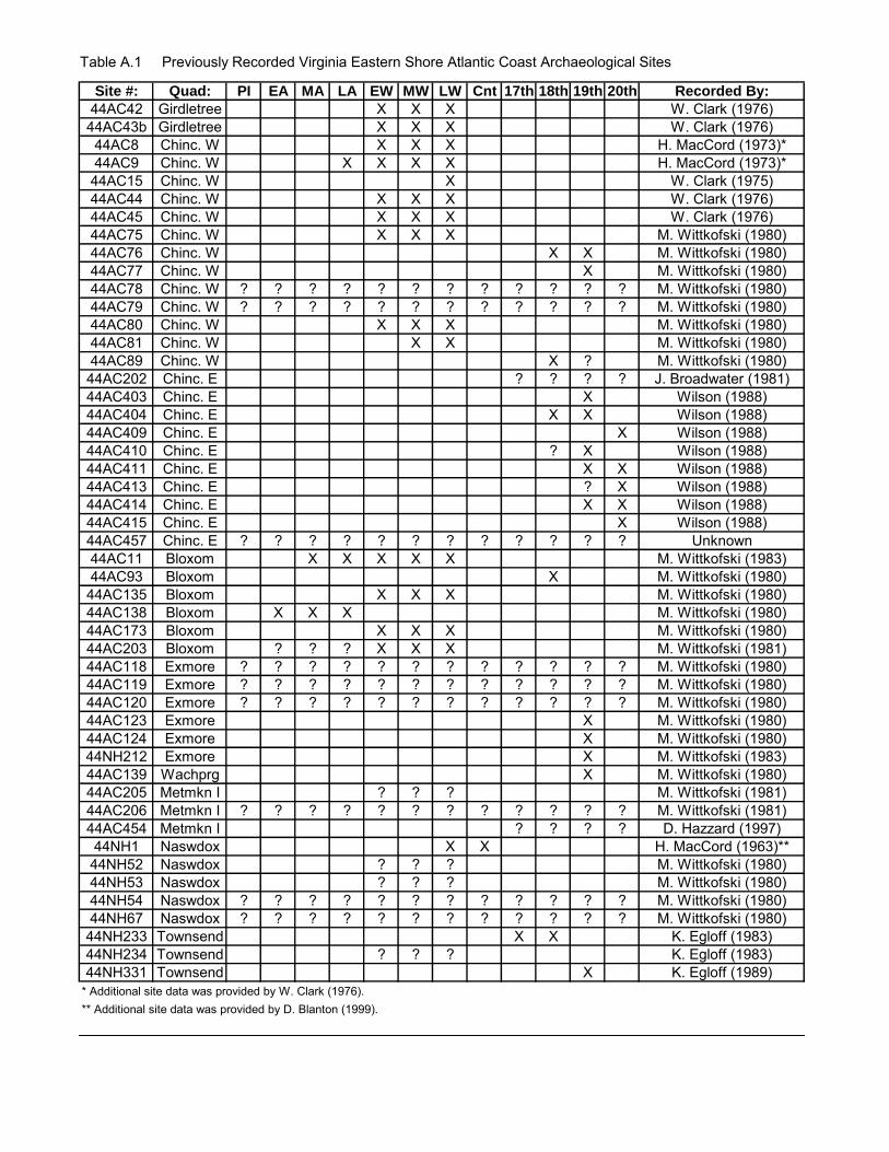
Table A.1 Previously Recorded Virginia Eastern Shore Atlantic Coast Archaeological Sites
Site #: Quad: PI EA MA LA EW MW LW Cnt 17th 18th 19th 20th Recorded By:
44AC42 Girdletree X X X W. Clark (1976)44AC43b Girdletree X X X W. Clark (1976)44AC8 Chinc. W X X X H. MacCord (1973)*44AC9 Chinc. W X X X X H. MacCord (1973)*44AC15 Chinc. W X W. Clark (1975)44AC44 Chinc. W X X X W. Clark (1976)44AC45 Chinc. W X X X W. Clark (1976)44AC75 Chinc. W X X X M. Wittkofski (1980)44AC76 Chinc. W X X M. Wittkofski (1980)44AC77 Chinc. W X M. Wittkofski (1980)44AC78 Chinc. W ? ? ? ? ? ? ? ? ? ? ? ? M. Wittkofski (1980)44AC79 Chinc. W ? ? ? ? ? ? ? ? ? ? ? ? M. Wittkofski (1980)44AC80 Chinc. W X X X M. Wittkofski (1980)44AC81 Chinc. W X X M. Wittkofski (1980)44AC89 Chinc. W X ? M. Wittkofski (1980)44AC202 Chinc. E ? ? ? ? J. Broadwater (1981)44AC403 Chinc. E X Wilson (1988)44AC404 Chinc. E X X Wilson (1988)44AC409 Chinc. E X Wilson (1988)44AC410 Chinc. E ? X Wilson (1988)44AC411 Chinc. E X X Wilson (1988)44AC413 Chinc. E ? X Wilson (1988)44AC414 Chinc. E X X Wilson (1988)44AC415 Chinc. E X Wilson (1988)44AC457 Chinc. E ? ? ? ? ? ? ? ? ? ? ? ? Unknown44AC11 Bloxom X X X X X M. Wittkofski (1983)44AC93 Bloxom X M. Wittkofski (1980)44AC135 Bloxom X X X M. Wittkofski (1980)44AC138 Bloxom X X X M. Wittkofski (1980)44AC173 Bloxom X X X M. Wittkofski (1980)44AC203 Bloxom ? ? ? X X X M. Wittkofski (1981)44AC118 Exmore ? ? ? ? ? ? ? ? ? ? ? ? M. Wittkofski (1980)44AC119 Exmore ? ? ? ? ? ? ? ? ? ? ? ? M. Wittkofski (1980)44AC120 Exmore ? ? ? ? ? ? ? ? ? ? ? ? M. Wittkofski (1980)44AC123 Exmore X M. Wittkofski (1980)44AC124 Exmore X M. Wittkofski (1980)44NH212 Exmore X M. Wittkofski (1983)44AC139 Wachprg X M. Wittkofski (1980)44AC205 Metmkn I ? ? ? M. Wittkofski (1981)44AC206 Metmkn I ? ? ? ? ? ? ? ? ? ? ? ? M. Wittkofski (1981)44AC454 Metmkn I ? ? ? ? D. Hazzard (1997)44NH1 Naswdox X X H. MacCord (1963)**44NH52 Naswdox ? ? ? M. Wittkofski (1980)44NH53 Naswdox ? ? ? M. Wittkofski (1980)44NH54 Naswdox ? ? ? ? ? ? ? ? ? ? ? ? M. Wittkofski (1980)44NH67 Naswdox ? ? ? ? ? ? ? ? ? ? ? ? M. Wittkofski (1980)44NH233 Townsend X X K. Egloff (1983)44NH234 Townsend ? ? ? K. Egloff (1983)44NH331 Townsend X K. Egloff (1989)
* Additional site data was provided by W. Clark (1976).** Additional site data was provided by D. Blanton (1999).
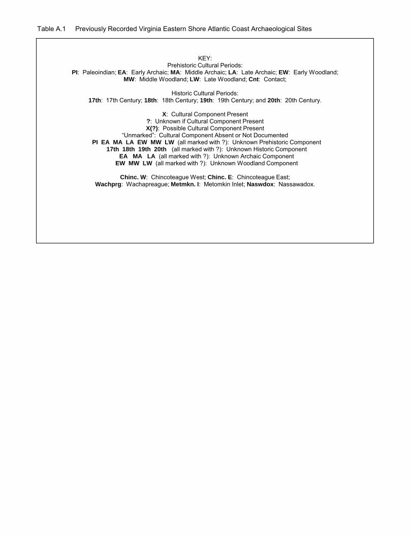
Table A.1 Previously Recorded Virginia Eastern Shore Atlantic Coast Archaeological Sites
KEY: Prehistoric Cultural Periods:
PI: Paleoindian; EA: Early Archaic; MA: Middle Archaic; LA: Late Archaic; EW: Early Woodland; MW: Middle Woodland; LW: Late Woodland; Cnt: Contact;
Historic Cultural Periods:
17th: 17th Century; 18th: 18th Century; 19th: 19th Century; and 20th: 20th Century.
X: Cultural Component Present ?: Unknown if Cultural Component Present X(?): Possible Cultural Component Present
“Unmarked”: Cultural Component Absent or Not Documented PI EA MA LA EW MW LW (all marked with ?): Unknown Prehistoric Component
17th 18th 19th 20th (all marked with ?): Unknown Historic Component EA MA LA (all marked with ?): Unknown Archaic Component
EW MW LW (all marked with ?): Unknown Woodland Component
Chinc. W: Chincoteague West; Chinc. E: Chincoteague East; Wachprg: Wachapreague; Metmkn. I: Metomkin Inlet; Naswdox: Nassawadox.
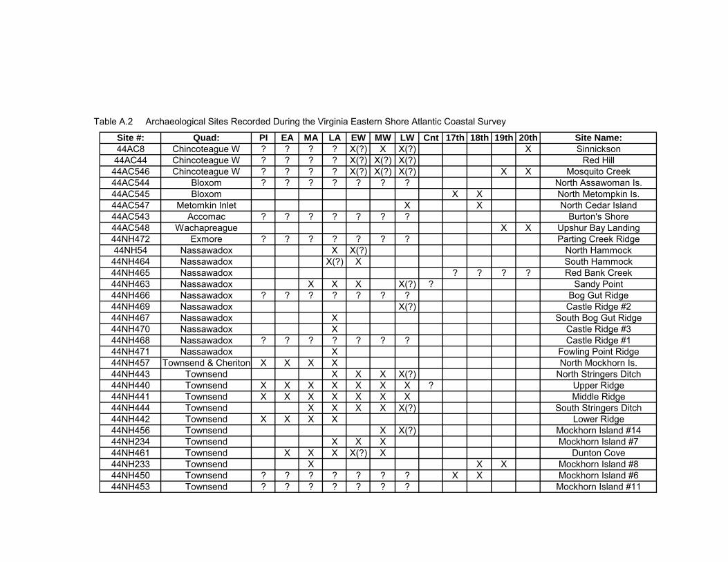
Table A.2 Archaeological Sites Recorded During the Virginia Eastern Shore Atlantic Coastal Survey
Site #: Quad: PI EA MA LA EW MW LW Cnt 17th 18th 19th 20th Site Name:
44AC8 Chincoteague W ? ? ? ? X(?) X X(?) X Sinnickson44AC44 Chincoteague W ? ? ? ? X(?) X(?) X(?) Red Hill44AC546 Chincoteague W ? ? ? ? X(?) X(?) X(?) X X Mosquito Creek44AC544 Bloxom ? ? ? ? ? ? ? North Assawoman Is.44AC545 Bloxom X X North Metompkin Is.44AC547 Metomkin Inlet X X North Cedar Island44AC543 Accomac ? ? ? ? ? ? ? Burton's Shore44AC548 Wachapreague X X Upshur Bay Landing44NH472 Exmore ? ? ? ? ? ? ? Parting Creek Ridge44NH54 Nassawadox X X(?) North Hammock44NH464 Nassawadox X(?) X South Hammock44NH465 Nassawadox ? ? ? ? Red Bank Creek44NH463 Nassawadox X X X X(?) ? Sandy Point44NH466 Nassawadox ? ? ? ? ? ? ? Bog Gut Ridge44NH469 Nassawadox X(?) Castle Ridge #244NH467 Nassawadox X South Bog Gut Ridge44NH470 Nassawadox X Castle Ridge #344NH468 Nassawadox ? ? ? ? ? ? ? Castle Ridge #144NH471 Nassawadox X Fowling Point Ridge44NH457 Townsend & Cheriton X X X X North Mockhorn Is.44NH443 Townsend X X X X(?) North Stringers Ditch44NH440 Townsend X X X X X X X ? Upper Ridge44NH441 Townsend X X X X X X X Middle Ridge44NH444 Townsend X X X X X(?) South Stringers Ditch44NH442 Townsend X X X X Lower Ridge44NH456 Townsend X X(?) Mockhorn Island #1444NH234 Townsend X X X Mockhorn Island #744NH461 Townsend X X X X(?) X Dunton Cove44NH233 Townsend X X X Mockhorn Island #844NH450 Townsend ? ? ? ? ? ? ? X X Mockhorn Island #644NH453 Townsend ? ? ? ? ? ? ? Mockhorn Island #11
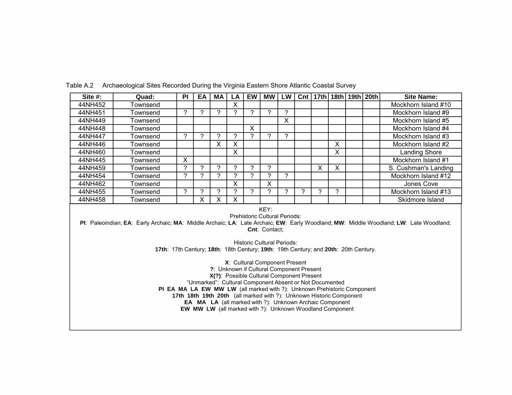
Table A.2 Archaeological Sites Recorded During the Virginia Eastern Shore Atlantic Coastal Survey
Site #: Quad: PI EA MA LA EW MW LW Cnt 17th 18th 19th 20th Site Name:
44NH452 Townsend X Mockhorn Island #1044NH451 Townsend ? ? ? ? ? ? ? Mockhorn Island #944NH449 Townsend X Mockhorn Island #544NH448 Townsend X Mockhorn Island #444NH447 Townsend ? ? ? ? ? ? ? Mockhorn Island #344NH446 Townsend X X X Mockhorn Island #244NH460 Townsend X X Landing Shore44NH445 Townsend X Mockhorn Island #144NH459 Townsend ? ? ? ? ? ? X X S. Cushman's Landing44NH454 Townsend ? ? ? ? ? ? ? Mockhorn Island #1244NH462 Townsend X X Jones Cove44NH455 Townsend ? ? ? ? ? ? ? ? ? ? Mockhorn Island #1344NH458 Townsend X X X Skidmore Island
KEY: Prehistoric Cultural Periods:
PI: Paleoindian; EA: Early Archaic; MA: Middle Archaic; LA: Late Archaic; EW: Early Woodland; MW: Middle Woodland; LW: Late Woodland; Cnt: Contact;
Historic Cultural Periods:
17th: 17th Century; 18th: 18th Century; 19th: 19th Century; and 20th: 20th Century.
X: Cultural Component Present ?: Unknown if Cultural Component Present X(?): Possible Cultural Component Present
“Unmarked”: Cultural Component Absent or Not Documented PI EA MA LA EW MW LW (all marked with ?): Unknown Prehistoric Component
17th 18th 19th 20th (all marked with ?): Unknown Historic Component EA MA LA (all marked with ?): Unknown Archaic Component
EW MW LW (all marked with ?): Unknown Woodland Component
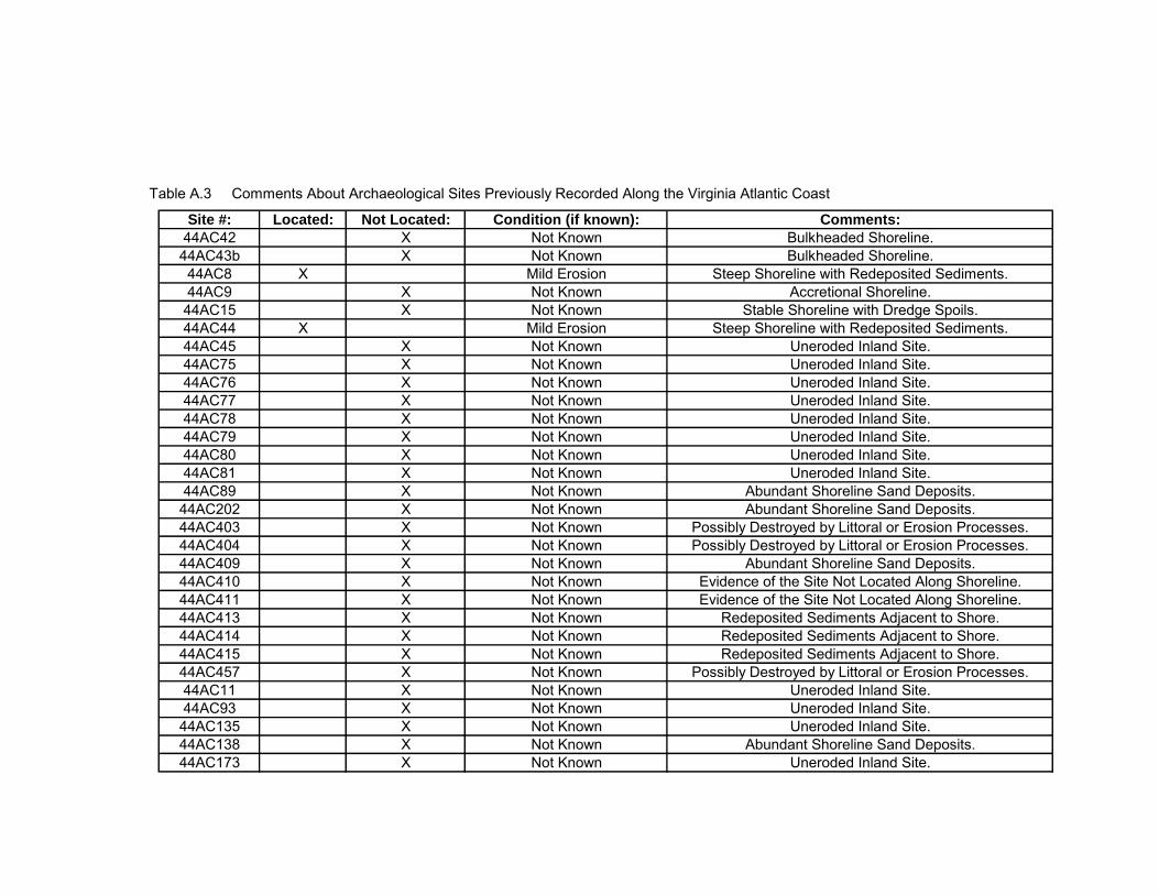
Table A.3 Comments About Archaeological Sites Previously Recorded Along the Virginia Atlantic Coast
Site #: Located: Not Located: Condition (if known): Comments:
44AC42 X Not Known Bulkheaded Shoreline.44AC43b X Not Known Bulkheaded Shoreline.44AC8 X Mild Erosion Steep Shoreline with Redeposited Sediments.44AC9 X Not Known Accretional Shoreline.44AC15 X Not Known Stable Shoreline with Dredge Spoils.44AC44 X Mild Erosion Steep Shoreline with Redeposited Sediments.44AC45 X Not Known Uneroded Inland Site.44AC75 X Not Known Uneroded Inland Site.44AC76 X Not Known Uneroded Inland Site.44AC77 X Not Known Uneroded Inland Site.44AC78 X Not Known Uneroded Inland Site.44AC79 X Not Known Uneroded Inland Site.44AC80 X Not Known Uneroded Inland Site.44AC81 X Not Known Uneroded Inland Site.44AC89 X Not Known Abundant Shoreline Sand Deposits.44AC202 X Not Known Abundant Shoreline Sand Deposits.44AC403 X Not Known Possibly Destroyed by Littoral or Erosion Processes.44AC404 X Not Known Possibly Destroyed by Littoral or Erosion Processes.44AC409 X Not Known Abundant Shoreline Sand Deposits.44AC410 X Not Known Evidence of the Site Not Located Along Shoreline.44AC411 X Not Known Evidence of the Site Not Located Along Shoreline.44AC413 X Not Known Redeposited Sediments Adjacent to Shore.44AC414 X Not Known Redeposited Sediments Adjacent to Shore.44AC415 X Not Known Redeposited Sediments Adjacent to Shore.44AC457 X Not Known Possibly Destroyed by Littoral or Erosion Processes.44AC11 X Not Known Uneroded Inland Site.44AC93 X Not Known Uneroded Inland Site.44AC135 X Not Known Uneroded Inland Site.44AC138 X Not Known Abundant Shoreline Sand Deposits.44AC173 X Not Known Uneroded Inland Site.
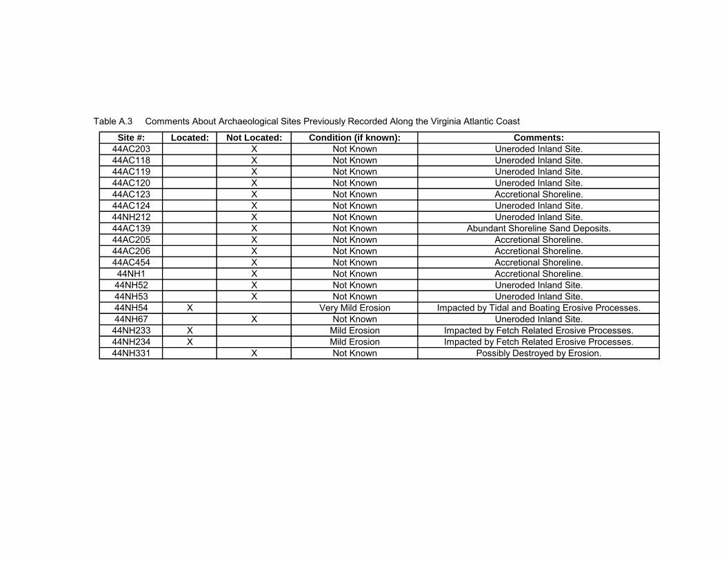
Table A.3 Comments About Archaeological Sites Previously Recorded Along the Virginia Atlantic Coast
Site #: Located: Not Located: Condition (if known): Comments:
44AC203 X Not Known Uneroded Inland Site.44AC118 X Not Known Uneroded Inland Site.44AC119 X Not Known Uneroded Inland Site.44AC120 X Not Known Uneroded Inland Site.44AC123 X Not Known Accretional Shoreline.44AC124 X Not Known Uneroded Inland Site.44NH212 X Not Known Uneroded Inland Site.44AC139 X Not Known Abundant Shoreline Sand Deposits.44AC205 X Not Known Accretional Shoreline.44AC206 X Not Known Accretional Shoreline.44AC454 X Not Known Accretional Shoreline.44NH1 X Not Known Accretional Shoreline.44NH52 X Not Known Uneroded Inland Site.44NH53 X Not Known Uneroded Inland Site.44NH54 X Very Mild Erosion Impacted by Tidal and Boating Erosive Processes.44NH67 X Not Known Uneroded Inland Site.44NH233 X Mild Erosion Impacted by Fetch Related Erosive Processes.44NH234 X Mild Erosion Impacted by Fetch Related Erosive Processes.44NH331 X Not Known Possibly Destroyed by Erosion.
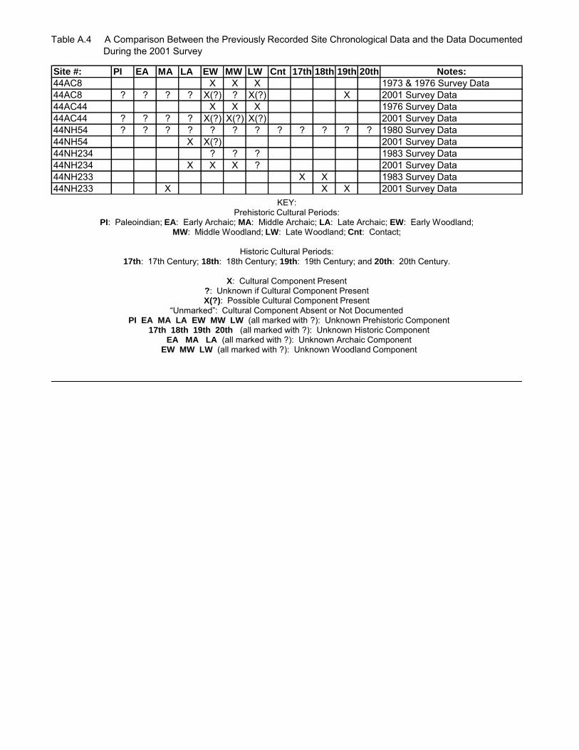
Table A.4 A Comparison Between the Previously Recorded Site Chronological Data and the Data Documented During the 2001 Survey
Site #: PI EA MA LA EW MW LW Cnt 17th 18th 19th 20th Notes:
44AC8 X X X 1973 & 1976 Survey Data44AC8 ? ? ? ? X(?) ? X(?) X 2001 Survey Data44AC44 X X X 1976 Survey Data44AC44 ? ? ? ? X(?) X(?) X(?) 2001 Survey Data44NH54 ? ? ? ? ? ? ? ? ? ? ? ? 1980 Survey Data44NH54 X X(?) 2001 Survey Data44NH234 ? ? ? 1983 Survey Data44NH234 X X X ? 2001 Survey Data44NH233 X X 1983 Survey Data44NH233 X X X 2001 Survey Data
KEY: Prehistoric Cultural Periods:
PI: Paleoindian; EA: Early Archaic; MA: Middle Archaic; LA: Late Archaic; EW: Early Woodland; MW: Middle Woodland; LW: Late Woodland; Cnt: Contact;
Historic Cultural Periods:
17th: 17th Century; 18th: 18th Century; 19th: 19th Century; and 20th: 20th Century.
X: Cultural Component Present ?: Unknown if Cultural Component Present X(?): Possible Cultural Component Present
“Unmarked”: Cultural Component Absent or Not Documented PI EA MA LA EW MW LW (all marked with ?): Unknown Prehistoric Component
17th 18th 19th 20th (all marked with ?): Unknown Historic Component EA MA LA (all marked with ?): Unknown Archaic Component
EW MW LW (all marked with ?): Unknown Woodland Component
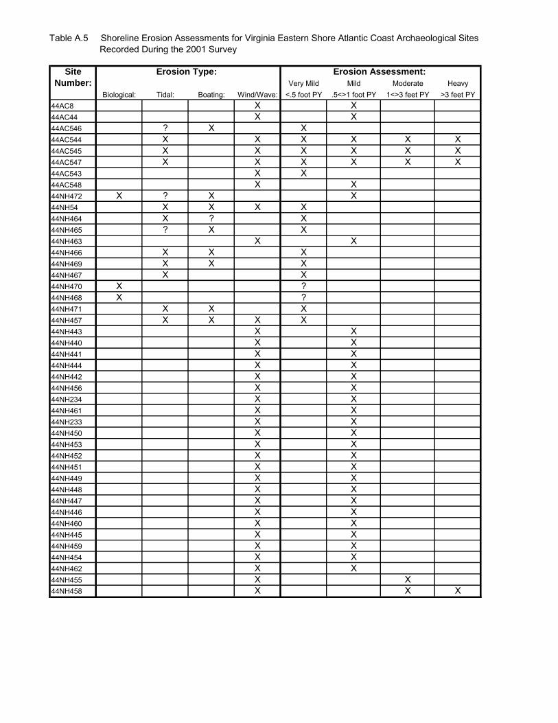
Table A.5 Shoreline Erosion Assessments for Virginia Eastern Shore Atlantic Coast Archaeological Sites Recorded During the 2001 Survey
Site Erosion Type: Erosion Assessment:
Number: Very Mild Mild Moderate HeavyBiological: Tidal: Boating: Wind/Wave: <.5 foot PY .5<>1 foot PY 1<>3 feet PY >3 feet PY
44AC8 X X44AC44 X X44AC546 ? X X44AC544 X X X X X X44AC545 X X X X X X44AC547 X X X X X X44AC543 X X44AC548 X X44NH472 X ? X X44NH54 X X X X44NH464 X ? X44NH465 ? X X44NH463 X X44NH466 X X X44NH469 X X X44NH467 X X44NH470 X ?44NH468 X ?44NH471 X X X44NH457 X X X X44NH443 X X44NH440 X X44NH441 X X44NH444 X X44NH442 X X44NH456 X X44NH234 X X44NH461 X X44NH233 X X44NH450 X X44NH453 X X44NH452 X X44NH451 X X44NH449 X X44NH448 X X44NH447 X X44NH446 X X44NH460 X X44NH445 X X44NH459 X X44NH454 X X44NH462 X X44NH455 X X44NH458 X X X
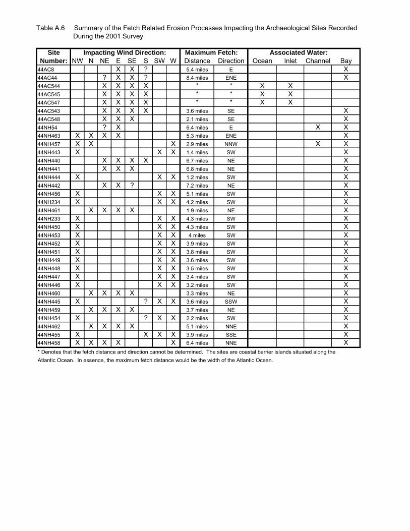
Table A.6 Summary of the Fetch Related Erosion Processes Impacting the Archaeological Sites Recorded During the 2001 Survey
Site Impacting Wind Direction: Maximum Fetch: Associated Water:
Number: NW N NE E SE S SW W Distance Direction Ocean Inlet Channel Bay44AC8 X X ? 5.4 miles E X44AC44 ? X X ? 8.4 miles ENE X44AC544 X X X X * * X X44AC545 X X X X * * X X44AC547 X X X X * * X X44AC543 X X X X 3.6 miles SE X44AC548 X X X 2.1 miles SE X44NH54 ? X 6.4 miles E X X44NH463 X X X X 5.3 miles ENE X44NH457 X X X 2.9 miles NNW X X44NH443 X X X 1.4 miles SW X44NH440 X X X X 6.7 miles NE X44NH441 X X X 6.8 miles NE X44NH444 X X X 1.2 miles SW X44NH442 X X ? 7.2 miles NE X44NH456 X X X 5.1 miles SW X44NH234 X X X 4.2 miles SW X44NH461 X X X X 1.9 miles NE X44NH233 X X X 4.3 miles SW X44NH450 X X X 4.3 miles SW X44NH453 X X X 4 miles SW X44NH452 X X X 3.9 miles SW X44NH451 X X X 3.8 miles SW X44NH449 X X X 3.6 miles SW X44NH448 X X X 3.5 miles SW X44NH447 X X X 3.4 miles SW X44NH446 X X X 3.2 miles SW X44NH460 X X X X 3.3 miles NE X44NH445 X ? X X 3.6 miles SSW X44NH459 X X X X 3.7 miles NE X44NH454 X ? X X 2.2 miles SW X44NH462 X X X X 5.1 miles NNE X44NH455 X X X X 3.9 miles SSE X44NH458 X X X X X 6.4 miles NNE X* Denotes that the fetch distance and direction cannot be determined. The sites are coastal barrier islands situated along theAtlantic Ocean. In essence, the maximum fetch distance would be the width of the Atlantic Ocean.
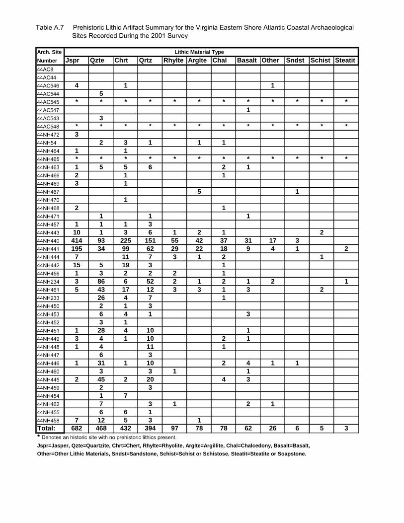
Table A.7 Prehistoric Lithic Artifact Summary for the Virginia Eastern Shore Atlantic Coastal Archaeological Sites Recorded During the 2001 Survey
Arch. Site Lithic Material Type
Number Jspr Qzte Chrt Qrtz Rhylte Arglte Chal Basalt Other Sndst Schist Steatit
44AC844AC4444AC546 4 1 1
44AC544 5
44AC545 * * * * * * * * * * * *
44AC547 1
44AC543 3
44AC548 * * * * * * * * * * * *
44NH472 3
44NH54 2 3 1 1 1
44NH464 1 1
44NH465 * * * * * * * * * * * *
44NH463 1 5 5 6 2 1
44NH466 2 1 1
44NH469 3 1
44NH467 5 1
44NH470 1
44NH468 2 1
44NH471 1 1 1
44NH457 1 1 1 3
44NH443 10 1 3 6 1 2 1 2
44NH440 414 93 225 151 55 42 37 31 17 3
44NH441 195 34 99 62 29 22 18 9 4 1 2
44NH444 7 11 7 3 1 2 1
44NH442 15 5 19 3 1
44NH456 1 3 2 2 2 1
44NH234 3 86 6 52 2 1 2 1 2 1
44NH461 5 43 17 12 3 3 1 3 2
44NH233 26 4 7 1
44NH450 2 1 3
44NH453 6 4 1 3
44NH452 3 1
44NH451 1 28 4 10 1
44NH449 3 4 1 10 2 1
44NH448 1 4 11 1
44NH447 6 3
44NH446 1 31 1 10 2 4 1 1
44NH460 3 3 1 1
44NH445 2 45 2 20 4 3
44NH459 2 3
44NH454 1 7
44NH462 7 3 1 2 1
44NH455 6 6 1
44NH458 7 12 5 3 1
Total: 682 468 432 394 97 78 78 62 26 6 5 3
* Denotes an historic site with no prehistoric lithics present.Jspr=Jasper, Qzte=Quartzite, Chrt=Chert, Rhylte=Rhyolite, Arglte=Argillite, Chal=Chalcedony, Basalt=Basalt,
Other=Other Lithic Materials, Sndst=Sandstone, Schist=Schist or Schistose, Steatit=Steatite or Soapstone.
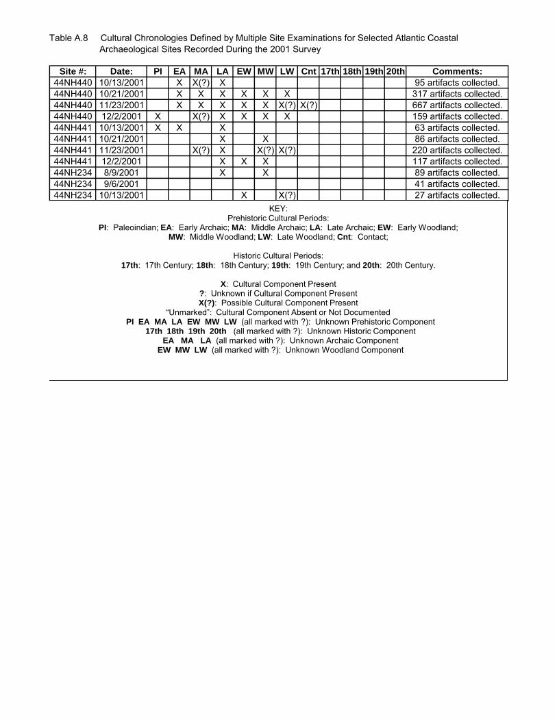
Table A.8 Cultural Chronologies Defined by Multiple Site Examinations for Selected Atlantic Coastal Archaeological Sites Recorded During the 2001 Survey
Site #: Date: PI EA MA LA EW MW LW Cnt 17th 18th 19th 20th Comments:
44NH440 10/13/2001 X X(?) X 95 artifacts collected.44NH440 10/21/2001 X X X X X X 317 artifacts collected.44NH440 11/23/2001 X X X X X X(?) X(?) 667 artifacts collected.44NH440 12/2/2001 X X(?) X X X X 159 artifacts collected.44NH441 10/13/2001 X X X 63 artifacts collected.44NH441 10/21/2001 X X 86 artifacts collected.44NH441 11/23/2001 X(?) X X(?) X(?) 220 artifacts collected.44NH441 12/2/2001 X X X 117 artifacts collected.44NH234 8/9/2001 X X 89 artifacts collected.44NH234 9/6/2001 41 artifacts collected.44NH234 10/13/2001 X X(?) 27 artifacts collected.
KEY: Prehistoric Cultural Periods:
PI: Paleoindian; EA: Early Archaic; MA: Middle Archaic; LA: Late Archaic; EW: Early Woodland; MW: Middle Woodland; LW: Late Woodland; Cnt: Contact;
Historic Cultural Periods:
17th: 17th Century; 18th: 18th Century; 19th: 19th Century; and 20th: 20th Century.
X: Cultural Component Present ?: Unknown if Cultural Component Present X(?): Possible Cultural Component Present
“Unmarked”: Cultural Component Absent or Not Documented PI EA MA LA EW MW LW (all marked with ?): Unknown Prehistoric Component
17th 18th 19th 20th (all marked with ?): Unknown Historic Component EA MA LA (all marked with ?): Unknown Archaic Component
EW MW LW (all marked with ?): Unknown Woodland Component

Table A.8 Cultural Chronologies Defined by Multiple Site Examinations for Selected Atlantic Coastal Archaeological Sites Recorded During the 2001 Survey
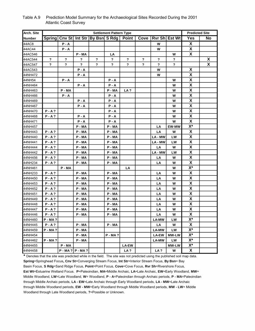
Table A.9 Prediction Model Summary for the Archaeological Sites Recorded During the 2001 Atlantic Coast Survey
Arch. Site Settlement Pattern Type Predicted Site
Number Spring Cnv St Int Str By Bsn S Rdg Point Cove Rvr Sh Est Wt Yes No
44AC8 P - A W X
44AC44 P - A W X
44AC546 P - MA LA W X
44AC544 ? ? ? ? ? ? ? ? ? X
44AC547 ? ? ? ? ? ? ? ? ? X
44AC543 P - A W X
44NH472 P - A W X
44NH54 P - A P - A W X
44NH464 P - A P - A W X
44NH463 P - MA P - MA LA ? W X
44NH466 P - A P - A W X
44NH469 P - A P - A W X
44NH467 P - A P - A W X
44NH470 P - A ? P - A W X
44NH468 P - A ? P - A P - A W X
44NH471 P - A P - A W X
44NH457 P - MA P - MA LA EW-MW X*
44NH443 P - A ? P - MA P - MA LA W X
44NH440 P - A ? P - MA P - MA LA - MW LW X
44NH441 P - A ? P - MA P - MA LA - MW LW X
44NH444 P - A ? P - MA P - MA LA W X
44NH442 P - A ? P - MA P - MA LA - MW LW X
44NH456 P - A ? P - MA P - MA LA W X
44NH234 P - A ? P - MA P - MA LA W X
44NH461 P - MA LA W X*
44NH233 P - A ? P - MA P - MA LA W X
44NH450 P - A ? P - MA P - MA LA W X
44NH453 P - A ? P - MA P - MA LA W X
44NH452 P - A ? P - MA P - MA LA W X
44NH451 P - A ? P - MA P - MA LA W X
44NH449 P - A ? P - MA P - MA LA W X
44NH448 P - A ? P - MA P - MA LA W X
44NH447 P - A ? P - MA P - MA LA W X
44NH446 P - A ? P - MA P - MA LA W X
44NH460 P - MA ? LA-MW LW X*
44NH445 P - A ? P - MA P - MA LA W X
44NH459 P - MA ? P - MA LA-MW LW X*
44NH454 P - MA P - MA ? LA-EW MW-LW X*
44NH462 P - MA ? P - MA LA-MW LW X*
44NH455 P - MA LA-EW MW-LW X*
44NH458 P - MA ? P - MA ? LA ? LA ? W X
* Denotes that the site was predicted while in the field. The site was not predicted using the published soil map data.Spring=Springhead Focus, Cnv St=Converging Stream Focus, Int Str=Interior Stream Focus, By Bsn= Bay Basin Focus, S Rdg=Sand Ridge Focus, Point=Point Focus, Cove=Cove Focus, Rvr Sh=Rivershore Focus,Est Wt=Estuarine Wetland Focus. P=Paleoindian, MA=Middle Archaic, LA=Late Archaic, EW=Early Woodland, MW=Middle Woodland, LW=Late Woodland, W= Woodland, P - A=Paleoindian through Archaic periods, P - MA=Paleoindianthrough Middle Archaic periods, LA - EW=Late Archaic through Early Woodland periods, LA - MW=Late Archaic through Middle Woodland periods, EW - MW=Early Woodland through Middle Woodland periods, MW - LW= Middle Woodland through Late Woodland periods, ?=Possible or Unknown.