appendix i marine eia report
TRANSCRIPT

APPENDIX I
MARINE EIA REPORT

MARINE ENVIRONMENTAL IMPACT ASSESSMENT STUDY FOR
THE DEVELOPMENT OF CAPTIVE JETTY, DESALINATION
PLANT WITH INTAKE AND OUTFALL AND RELATED
INFRASTRUCTURES (BACKUP STORAGE, UTILITIES AND
AMENITIES) FOR INTEGRATED UNIT OF LAKHPAT CEMENT
WORKS AT VILLAGE KAPURASI, TEHSIL LAKHPAT, DISTRICT
KUTCH, GUJARAT
PROJECT CODE: 603111718
For
ADANI CEMENTATION LIMITED (ACL)
AHMEDABAD
JANUARY 2019
INDOMER COASTAL HYDRAULICS (P) LTD. (ISO 9001: 2015 CERTIFIED, NABET- QCI, CDC - MoST & NABL ACCREDITED)
63, GANDHI ROAD, ALWAR THIRUNAGAR, CHENNAI 600 087.
Tel: + 91 44 2486 2482 to 84; M: + 91 99401 41650; Fax: + 91 44 2486 2484
Web site: www.indomer.com, E-mail:[email protected]


ACL INDOMER
Marine Environmental Impact Assessment Study for the Development of Captive Jetty, Desalination Plant Page i
with Intake and Outfall and Related Infrastructures (Backup Storage, Utilities and Amenities) for
Integrated Unit of Lakhpat Cement Works at Village Kapurasi, Tehsil Lakhpat, District Kutch, Gujarat
CONTENTS Page
List of Tables iv
List of Figures vi
ABBREVIATIONS vii
1 INTRODUCTION 1.1
1.1 Purpose of the Report 1.2
1.2 Identification of Project and Project Proponent 1.3
1.3 Brief Description of Project 1.4
1.4 Scope of the Study 1.5
1.5 TOR and Compliance 1.6
1.6 Coastal Regulation Zone 1.13
1.7 Structure of EIA Report 1.14
2 PROJECT DESCRIPTION 2.1
2.1 Type of Project 2.1
2.2 Need for the Project 2.1
2.3 Project Location 2.2
2.4 Proposed Facilities 2.13
2.4.1 Berthing Jetty 2.13
2.4.2 Berth Requirements 2.15
2.4.3 Navigational and Operational Requirements 2.16
2.4.4 Material Handling Systems (MHS) 2.17
2.4.5 Traffic Potential 2.20
2.4.6 Storage Requirements 2.21
2.4.7 Supporting Infrastructure 2.21
2.4.8 Desalination Plant 2.21
2.5 Resource Requirement 2.24
2.6 Proposed Project Schedule 2.25
2.7 Project Cost 2.26
2.8 Summary of Proposed Facilities 2.27
3 ANALYSIS OF ALTERNATIVES 3.1
3.1 Berthing Jetty 3.1
3.2 Rock Bund 3.5
3.3 Navigational Channel and Anchorage Point 3.5
3.4 Desalination Plant with Intake and Outfall 3.7
4 DESCRIPTION OF THE ENVIRONMENT 4.1
4.1 Physical Parameters 4.1
4.2 Seawater Quality 4.13
4.3 Seabed Sediment Quality 4.17
4.4 Marine Ecology and Biodiversity 4.19
4.4.1 Plankton 4.21
4.4.2 Macrobenthic Organisms 4.23

ACL INDOMER
Marine Environmental Impact Assessment Study for the Development of Captive Jetty, Desalination Plant Page ii
with Intake and Outfall and Related Infrastructures (Backup Storage, Utilities and Amenities) for
Integrated Unit of Lakhpat Cement Works at Village Kapurasi, Tehsil Lakhpat, District Kutch, Gujarat
4.4.3 Microbiology 4.24
4.4.4 Coastal Vegetation 4.25
4.4.5 Mangroves 4.26
4.4.6 Seaweeds and Sea Grasses 4.28
4.4.7 Coral Reefs 4.28
4.4.8 Marine Mammals 4.29
4.4.9 Sea Turtles 4.29
4.4.10 Endangered Species 4.29
4.4.11 Seabirds 4.30
4.4.12 Fish & Fisheries 4.30
4.4.13 Protected Areas 4.33
4.5 Comparison of Offshore and Nearshore Water 4.34
4.6 Summary of Marine Baseline Data 4.37
5 ENVIRONMENTAL IMPACT AND MITIGATION MEASURES 5.1
5.1 Identification of Impacts 5.1
5.2 Prediction of Impacts 5.2
5.3 Proposed Mitigation Measures 5.2
5.3.1 Captive Port 5.5
5.3.2 Desalination Plant 5.14
5.3.3 Environmental Sensitivity 5.17
6 POST PROJECT MONITORING 6.1
6.1 Environmental Impact Matrix 6.1
6.2 Post Project Monitoring Program 6.2
6.3 Review and Reporting 6.3
6.4 Onsite Mock Drill 6.4
7 ADDITIONAL STUDIES 7.1
7.1 Risk Assessment and Disaster Management Plan 7.1
7.1.1 Introduction 7.1
7.1.2 Objective of Disaster Management Plan 7.5
7.1.3 Preparedness Plan 7.6
7.1.4 On Site / Inhouse Emergency Preparedness 7.6
7.1.5 Coordination with National Agencies 7.9
7.1.6 Disaster Management Action 7.11
7.2 Oil Spill Contingency Plan 7.13
7.2.1 Response Policy 7.14
7.2.2 Statutory and Combat Responsibilities 7.15
7.2.3 Incident Management Team 7.15
7.2.4 Support Services 7.19
7.2.5 Scope of Oil Spill Contingency Plan 7.22
7.2.6 Oil Spill Response Procedures 7.26
7.2.7 Port Responsibility 7.29
8 MODELLING STUDIES 8.1
8.1 Introduction 8.1

ACL INDOMER
Marine Environmental Impact Assessment Study for the Development of Captive Jetty, Desalination Plant Page iii
with Intake and Outfall and Related Infrastructures (Backup Storage, Utilities and Amenities) for
Integrated Unit of Lakhpat Cement Works at Village Kapurasi, Tehsil Lakhpat, District Kutch, Gujarat
8.2 Proposed Marine Facilities 8.1
8.2.1 Seawater Intake 8.2
8.2.2 Brine Reject 8.2
8.3 Modelling Approach 8.2
8.4 Model Setup 8.3
8.4.1 Units and Conventions 8.3
8.4.2 Model Domain 8.4
8.4.3 Depth Schematization 8.4
8.5 Initial Dilution - CORMIX Model 8.4
8.5.1 Methodology 8.4
8.5.2 Design Details 8.5
8.6 Flow Model 8.7
8.6.1 Model Description 8.7
8.6.2 Boundary Conditions 8.9
8.6.3 Calibration 8.9
8.6.4 Simulations 8.9
8.7 Secondary dispersion – Mike 21 Model 8.9
8.7.1 Advection and Dispersion 8.9
8.7.2 Input to Dispersion Model 8.10
8.7.3 Dispersion of Brine Reject 8.10
8.8 Results on Currents & Secondary Dispersion 8.11
8.9 Ship/Wave Tranquility in Kori Creek 8.12
8.9.1 Waves at Offshore Near Anchorage Point 8.12
8.9.2 Wave Tranquility Using SWAN Model 8.14
8.9.3 Conclusion 8.15
9 PROJECT BENEFITS 9.1
9.1 Improvement in the Physical Infrastructure 9.1
9.2 Improvement in the Social Infrastructure 9.1
9.3 Employment Potential 9.1
9.4 Corporate Social Responsibility 9.2
9.5 Corporate Environment Responsibility 9.3
10 ENVIRONMENTAL MANAGEMENT PLAN 10.1
10.1 Summary of Proposed Impacts and Mitigation Measures 10.1
10.2 Marine Environmental Management Plan 10.5
10.2.1 EMP during Construction Phase 10.5
10.2.2 EMP during Operational Phase 10.6
10.3 Environment Management Cell (EMC) 10.7
10.4 Training, Communication and Reporting 10.8
10.5 Institutional Mechanism 10.9
10.6 Implementation of EMP 10.9
10.7 EMP Monitoring and Review 10.10
10.8 EMP budget 10.10
11 SUMMARY AND CONCLUSION 11.1
11.1 Introduction 11.1

ACL INDOMER
Marine Environmental Impact Assessment Study for the Development of Captive Jetty, Desalination Plant Page iv
with Intake and Outfall and Related Infrastructures (Backup Storage, Utilities and Amenities) for
Integrated Unit of Lakhpat Cement Works at Village Kapurasi, Tehsil Lakhpat, District Kutch, Gujarat
11.2 Project Description 11.1
11.3 Description of Environment 11.2
11.4 Environmental Impacts and Mitigation Measures 11.3
11.5 Post Project Monitoring Program 11.4
11.6 Additional Studies 11.5
11.7 Project Benefits 11.5
11.8 Environment Management Plan 11.6
12 DISCLOSURE OF CONSULTANTS ENGAGED 12.1
REFERENCES
ANNEXURE I – Water Balance Diagram
ANNEXURE II – Methods of Collection and Analysis

ACL INDOMER
Marine Environmental Impact Assessment Study for the Development of Captive Jetty, Desalination Plant Page v
with Intake and Outfall and Related Infrastructures (Backup Storage, Utilities and Amenities) for
Integrated Unit of Lakhpat Cement Works at Village Kapurasi, Tehsil Lakhpat, District Kutch, Gujarat
LIST OF TABLES
Table No. Title
4.1 Details of seawater, seabed sediment and biological sampling stations
4.2 Seawater quality of Kori creek – September 2018
4.3 Sediment size distribution of Kori creek– September 2018
4.4 Seabed Sediment quality of Kori creek – September 2018
4.5 Primary productivity of Kori creek - September 2018
4.6 Phytoplankton species composition* of Kori creek - September 2018
4.7 Numerical abundance of Phytoplankton (Nos./l)* of Kori creek - September 2018
4.8 Zooplankton population (nos./100m3) of Kori creek - September 2018
4.9 Subtidal and Intertidal benthic population (nos./m2) of Kori creek - September
2018
4.10 Bacterial population (nos.x103 CFU/ml) of Kori creek - September 2018
4.11 Bacterial population in seabed sediment (nos.x104 CFU/g) of Kori creek
- September 2018
4.12 List of Bird species sighted and reported from the study area
8.1 Significant Wave Height (Hs) Vs Wave Direction percentage distribution for the
offshore
8.2 Estimated wind and wave parameters for the offshore location near the entrance
8.3 Extreme wave parameters at different return periods at the proposed jetty

ACL INDOMER
Marine Environmental Impact Assessment Study for the Development of Captive Jetty, Desalination Plant Page vi
with Intake and Outfall and Related Infrastructures (Backup Storage, Utilities and Amenities) for
Integrated Unit of Lakhpat Cement Works at Village Kapurasi, Tehsil Lakhpat, District Kutch, Gujarat
LIST OF FIGURES
Figure No. Title
1.1 Location map of project site
1.2 Coastal Regulation Zone map
2.1 Reserve Forest map of project site
2.2 Kori creek network system
2.3 Layout of proposed Berthing jetty, Approach trestle and Rock bund
2.4 Cross section of proposed rock bund
2.5 Location map of Desalination plant, Intake and Outfall
2.6 Longitudinal section of Intake scheme
2.7 Longitudinal section of Outfall scheme
2.8 Plan view of Outfall Diffuser Ports
4.1 Current measurement location map
4.2 Variation of current speed and direction at project site
4.3 Bathymetry map of project site
4.4 Seawater, Seabed Sediments and Biological sampling locations
4.5 Boundary of Narayan Sarovar Wild Life and Eco Sensitive Zone
8.1 Bathymetry
8.2 Comparison of simulated and predicted tide near to jetty
8.3 Flow field – Spring Tide
8.4 Secondary dispersion – Spring Tide
8.5 Secondary dispersion – Neap Tide
8.6 Flow field – Neap Tide
8.7 Outer grid domain and bathymetry (top) inner grid domain and bathymetry
(bottom)
8.8 Wave climate of 1 Year return period at proposed cement jetty region for the
offshore wave direction 180°N
8.9 Wave climate of 1 Year return period at proposed cement jetty region for the
offshore wave direction 225°N
8.10 Wave climate of 1 Year return period at proposed cement jetty region for the
offshore wave direction 270°N
8.11 Wave climate of 100 Year return period at proposed cement jetty region for the
offshore wave direction 180°N
8.12 Wave climate of 100 Year return period at proposed cement jetty region for the
offshore wave direction 225°N
8.13 Wave climate of 100 Year return period at proposed cement jetty region for the
offshore wave direction 270°N

ACL INDOMER
Marine Environmental Impact Assessment Study for the Development of Captive Jetty, Desalination Plant Page vii
with Intake and Outfall and Related Infrastructures (Backup Storage, Utilities and Amenities) for
Integrated Unit of Lakhpat Cement Works at Village Kapurasi, Tehsil Lakhpat, District Kutch, Gujarat
ABBREVIATIONS
MMTPA Million Metric Tonnes Per Annum
MLD Million Liter Per Day
MSL Mean Sea Level
CD Chart Datum
DWT Dead Weight Tonnage
LOA Length Overall
MVA Mega Volt Amp
TPH Tonnes Per Hour
MW Mega Watt
GT Gross Tonnage
ACL Adani Cementation Limited
AEL Adani Enterprises Limited
ESZ Eco Sensitive Zone
PPT Parts Per Tonne
IMO International Maritime Organization
HHTL Highest High Tide Level
PMS Probable Maximum Surge
GSDMA Gujarat State Disaster Management Authority
GSDMP Gujarat State Disaster Management Plan
INCOIS Indian National Centre for Ocean Information Services
IMD India Metrological Department
ISR Institute of Seismological Research
NDMA National Disaster Management Authority
NIOT National Institute of Ocean Technology
NOSDCP National Oil Spill Disaster Contingency Plan
OSCP Oil Spill Contingency Plan
IMT Incident Management Team
CIC Chief Incident Controller
ECC Emergency Coordination Centre
SIC Site Incident Controller
IAP Incident Action Plans
ESC Environmental and Scientific Coordinator
SRC Shoreline Response Centre
VHF Very High Frequency
CPCB Central Pollution Control Board
IOPC Funds International Oil Pollution Compensation Funds
CSR Corporate Social Responsibility
CER Corporate Environment Responsibility
EMC Environment Management Cell
CTE Consent to Establish
CTO Consent to Operate
ACL INDOMER
Marine Environmental Impact Assessment Study for the Development of Captive Jetty, Desalination Plant Section 1
with Intake and Outfall and Related Infrastructures (Backup Storage, Utilities and Amenities) for Page 1.1
Integrated Unit of Lakhpat Cement Works at Village Kapurasi, Tehsil Lakhpat, District Kutch, Gujarat
1. INTRODUCTION
Adani Cementation Limited (ACL) proposes to setup an integrated cement project called Lakhpat
Cement Works which includes Limestone Mine in 251.9 ha area, Captive Power Plant and WHRS
(99 MW), Cement Plant having production capacity of 10 MMTPA Clinker and 10 MMTPA of OPC/
PPC/ PSC/ Composite Cement in Mudhvay and Koriyani, Village, Lakhpat Taluka, Kutch District,
Gujarat.
ACL also proposes to develop a berthing jetty of 19 MMTPA traffic capacity connected with
trestle and approach road to serve the import of raw materials and product transportation and 9
MLD desalination plant with seawater intake & brine reject outfall to cater the water requirement
for the proposed integrated project. For the movement of mined limestone from the mining
block to the proposed plant location and for the supply of finished products from plant to the
captive jetty, dedicated conveyor corridor with 10.2 Km will be provided. The same conveyor
corridor will be utilized for transportation of materials from jetty to cement plant.
Berthing jetty is proposed in Kori creek with anchorage in Arabian Sea. Clinker and Cement are
the main commodity to be handled at the proposed berthing jetty. In addition to that, dry bulk
commodities like Coal, Pet coke, and Limestone will also be handled. Lighterage operation will be
performed to load the product materials in large sized vessel at the anchorage point located
about 60 km south west of berthing jetty at open sea. Lighterage operation using barges will be
developed for to and fro transport of raw materials and product materials from anchorage point
to berthing jetty.
Desalination plant of 9 MLD capacity will be provided within the backup area. Seawater intake
and brine reject outfall pipeline are planned in Kori creek adjacent to berthing jetty without
obstructing the barge movement.
The proposed berthing jetty with approach trestle and desalination plant falls under following
sectors as per EIA Notification, 2006 and CRZ Notification, 2011:
Activity Sector Category Clearance
needed
Berthing Jetty with trestle
and approach road
: 7 (e) A EC+CRZ
Desalination plant : - - CRZ
As per CRZ Notification, 2011, setting up of any industry, operations or processes and
manufacture or handling within CRZ limit requires prior CRZ clearance. Therefore, the proposed
project requires both Environmental Clearance from Ministry of Environment, Forest and Climate
Change (MoEF&CC) and CRZ clearance from Gujarat Coastal Zone Management Authority
(GCZMA) and MoEF&CC.
In order to meet this statutory requirement, Marine Environmental Impact Assessment Study on
Captive Jetty with trestle and approach road, Desalination plant with seawater intake and brine
reject outfall and related infrastructures (backup storage, utilities and amenities) for integrated
unit of Lakhpat Cement Works has carried out by Indomer Coastal Hydraulics (P) Ltd., Chennai

ACL INDOMER
Marine Environmental Impact Assessment Study for the Development of Captive Jetty, Desalination Plant Section 1
with Intake and Outfall and Related Infrastructures (Backup Storage, Utilities and Amenities) for Page 1.2
Integrated Unit of Lakhpat Cement Works at Village Kapurasi, Tehsil Lakhpat, District Kutch, Gujarat
which is an ISO 9001:2015 organization and NABET - QCI accredited organization vide
NABET/EIA/1720/RA 0082 & 05.01.18 for the Sector 27: Oil & Gas Transportation pipeline (crude
and refinery/ petrochemical products), passing through national parks/ sanctuaries/ coral reefs/
ecologically sensitive areas including LNG Terminal and Sector 33: Ports, harbours, jetties, marine
terminals, breakwaters and dredging and NABL accredited organization. The copy of the
accreditation is presented in Chapter 12.
Field studies were undertaken during September – October 2018 representing the post monsoon
period. This report presents the details of EIA and EMP studies carried out for the proposed
development of captive Jetty with trestle and approach road, conveyor corridor, desalination
plant with seawater intake and brine reject outfall and related infrastructure facilities for
Integrated Lakhpat Cement Works. Environmental Impact Assessment study on Cement plant,
Thermal power plant and Mining of minerals has been done by M/S Greencindia Consulting Pvt.
Ltd, Ghaziabad for which the report is submitted separately.
1.1. Purpose of the Report
As per Environment Impact Assessment Notification dated 14th September 2006, new projects or
activities, or the expansion or modernization of existing projects proposed in any part of India
shall obtain prior environmental clearance from Ministry of Environment Forests and Climate
Change (MoEF&CC)/State Environment Impact Assessment Authority (SEIAA).
Proposed berthing jetty with trestle and approach road falls under following list of activities
requiring prior environmental clearance:
Project/Activity Sector Capacity/Area Category Type of clearance
required
Berthing Jetty with
Approach trestle 7 (e) 19 MMTPA A EC+CRZ
Desalination plant - 9 MLD - CRZ
In compliance with the EIA Notification 2006, ACL has to obtain Environmental Clearance (EC)
and Coastal Regulatory Zone (CRZ) clearance for various activities listed above. Accordingly, ACL
has presented the details of various project activities proposed to grand ToR to Expert Appraisal
Committees of Mining Project, Industrial Project, Thermal Power Project and Infrastructure
Development and Miscellaneous Project.
ACL has presented the project details to Expert Appraisal Committee- Infra-2 (Infrastructure and
Miscellaneous Projects + CRZ) in its 26th meeting held on 14 - 15 December 2017, for Captive
Jetty, Desalination plant with intake and outfall and related Infrastructures (backup storage,
utilities and amenities). After detailed deliberations, EAC committee has recommended the
project for grant of ToR.
Ministry of Environment and Forest has issued the Terms of Reference (ToR) vide letter No. F.
No. 10-63/2017-IA-III dated 22nd March 2018. Later, ACL has requested for amendment in ToR
due to increase in proposed cement grinding capacity and hence the increase in berth handling
capacity. Accordingly, Ministry of Environment and Forest vide letter no. F. No. IA-J-
11011/494/2017-IA-II(I) has delivered amendment to issued ToR on 25th June 2018 for the

ACL INDOMER
Marine Environmental Impact Assessment Study for the Development of Captive Jetty, Desalination Plant Section 1
with Intake and Outfall and Related Infrastructures (Backup Storage, Utilities and Amenities) for Page 1.3
Integrated Unit of Lakhpat Cement Works at Village Kapurasi, Tehsil Lakhpat, District Kutch, Gujarat
preparation of the Environmental Impact Assessment (EIA) report and Environmental
Management Plan (EMP) with specific and general conditions in addition to Standard ToR.
The EIA report has been prepared in accordance with the ToR issued by MoEF&CC. Details of
issued ToR along with compliance of ToR conditions is given in Section 1.5.
1.2. Identification of Project and Project Proponent
Identification of Project
Adani cementation Limited (ACL) proposes to setup an Integrated cement project as Lakhpat
Cement Works which includes Limestone Mine Area (251.9 ha), Clinkerisation Plant (10 MTPA),
Cement Plant (10 MTPA), Captive Power Plant and WHRS (99 MW) including Coal based Thermal
Power Plant and Waste Heat Recovery System, Berthing Jetty (19 MTPA), Desalination Plant (9
MLD) and Conveyor corridor (10.2 km) at villages of Koriyani, Kapurasi, Maldo, Mudhvay in
Lakhpat Taluka, Kutch District, Gujarat.
Berthing Jetty is proposed in Kori creek with anchorage in Arabian Sea. Clinker and cement are
the main commodity to be handled at the proposed berthing jetty. In addition to that, dry bulk
commodities like Coal, Pet coke, and Limestone will also handle through proposed berthing jetty.
Lighterage operation will be performed to load the product materials in large sized vessel at the
anchorage point at open sea located about 60 km south west of berthing jetty. Barges will be
utilized for transport of clinker to coastal grinding units.
Integrated Project at a Glance
Sl.
No. Plant/ Activity Village Commodity Unit Capacity
1 Limestone Mine Mudhvay Lime stone MTPA 12
2 Cement Plant Koriyani Clinker MTPA 10
Cement MTPA 10
3 Captive Power
Plant and WHRS
Koriyani Power MW 99
4 Captive Jetty Kapurasi
Clinker MTPA 5
Cement MTPA 10
Limestone MTPA 1
Coal/Petcoke/Fly
Ash, Slag/Gypsum
etc.
MTPA 3
5 Desalination Plant Kapurasi Water MLD 9
6 Conveyor corridor
Maldo, Mudhvay,
Koriyani and
Kapurasi,
Total length of 10.2 km

ACL INDOMER
Marine Environmental Impact Assessment Study for the Development of Captive Jetty, Desalination Plant Section 1
with Intake and Outfall and Related Infrastructures (Backup Storage, Utilities and Amenities) for Page 1.4
Integrated Unit of Lakhpat Cement Works at Village Kapurasi, Tehsil Lakhpat, District Kutch, Gujarat
Project Proponent
Adani Cementation Limited (ACL) is wholly owned subsidiary of Adani Enterprises Limited (AEL)
created on 6th December 2016, Adani has grown to become a global integrated infrastructure
player with businesses in key industry verticals - Resources, Logistics, Energy and Agro. The
integrated model is well adapted to the infrastructure challenges of the emerging economies. It
has combined market capitalization in excess of US$ 20 billion, a sales turnover of US$ 9 billion,
employing over 10,000 people and having diverse interests in global trading, development and
operation of Ports, IDC terminal, establishment of SEZ, Oil refining, logistics, gas distribution,
Power Generation, Power Transmission and Power Trading etc. Adani Port at Mundra promoted
by the Adani group is operational since 1998. Adani group is manned by experienced and highly
qualified professionals including technocrats of repute. The team has demonstrated capabilities
in conceptualization and implementation large projects excellent records of establishing
benchmarks in the industry. Adani group has rich and extensive experience of liaison with
government agencies, import, funding etc. With this track record of the organization in tying up
finances, flow of funds will not pose any problem for implementation of the proposed project of
its cement division. Adani Cementation Ltd (ACL) has been formed for development of a number
of Cement Projects (Integrated Cement Plant, Grinding Units & Limestone Mine).
1.3. Brief Description of Project
Project Location: Limestone Mine Area, Clinkerisation Plant, Cement Plant, Captive Power Plant,
Berthing Jetty, Desalination Plant and Conveyor corridor will be developed at villages of Koriyani,
Kapurasi, Maldo, Mudhvay adjacent to Kori creek in Lakhpat Taluka, Kutch District, Gujarat.
Berthing jetty is proposed in Kori creek with anchorage in Arabian Sea and backup storage area
near village Kapurasi. Location map of project area is shown in Fig. 1.1.
Activity wise location of the proposed Lakhpat Cement Works is given below:
Village/
Taluka
Limestone
Mine
Cement plant
& Power
Plant
Conveyor Corridor Berthing Jetty Desalination
Plant
Taluka Lakhpat
Village Mudhvay Koriyani Maldo, Mudhvay,
Koriyani and Kapurasi Kapurasi Kapurasi
Nature of Project: Integrated industrial project (Cement plant, Limestone Mining, Captive Power
Plant, Berthing Jetty and Desalination Plant).
Size of Project: Capacity of proposed facilities is given below.

ACL INDOMER
Marine Environmental Impact Assessment Study for the Development of Captive Jetty, Desalination Plant Section 1
with Intake and Outfall and Related Infrastructures (Backup Storage, Utilities and Amenities) for Page 1.5
Integrated Unit of Lakhpat Cement Works at Village Kapurasi, Tehsil Lakhpat, District Kutch, Gujarat
Sl.
No. Plant/ Activity Commodity Unit Capacity
1 Captive Jetty
Clinker MTPA 5
Cement MTPA 10
Limestone MTPA 1
Coal/Petcoke/FlyAsh,
Slag/Gypsum etc. MTPA
3
2 Desalination
Plant Water MLD
9
3 Conveyor
corridor Total length of 10.2 km
Importance to the Country and Project Region: Cement is one of the major factor in
infrastructure growth. Adani group is known for its environment friendly initiatives across
sectors it operates in and strong reputation for sustainable growth. Disposal of fly ash is an
environmental concern which is faced all coal based thermal power generating plants. Cement
can consume up to thirty five percent of fly ash produced in the power plants and thus reduce
environmental concern. The cement projects planned by Adani group would also generate
immense employment opportunities, improvement of socio economics of the area by way of
education, vocational training, animal husbandry, improving infrastructure facilities such as
roads, transport, improvement in drinking water supply, medical facility etc.
Total cement production in India does not match the demand growth and hence new capacities
have to come up concurrently. The proposed plant will ensure that the supply situation is
comfortable in the coming times, as growth is expected to propel demand.
The Adani group is committed to the development of the country and will put all efforts for
comprehensive development of the project area also as being practiced by us at other
establishments.
1.4. Scope of the Study
As per the ToR prescribed by the Expert Appraisal Committee - Infra-2 of Ministry Environment
Forest and Climate Change (Infrastructure and Miscellaneous Projects + CRZ), 10 km radius from
the proposed berthing Jetty covering intake and outfall location of Desalination plant is
considered for the EIA and EMP study.
The scope of EIA study broadly includes the following:
i) Environmental baseline data collection: Primary baseline data collection through field survey and monitoring with respect to marine environment (seawater, seabed sediment, subtidal and intertidal benthos, marine ecology and biodiversity).
ii) Identification and prediction of environmental impacts of the proposed project and their mitigation measures.
iii) Disaster Management Plan, Risk Assessment and Mathematical modelling studies.

ACL INDOMER
Marine Environmental Impact Assessment Study for the Development of Captive Jetty, Desalination Plant Section 1
with Intake and Outfall and Related Infrastructures (Backup Storage, Utilities and Amenities) for Page 1.6
Integrated Unit of Lakhpat Cement Works at Village Kapurasi, Tehsil Lakhpat, District Kutch, Gujarat
iv) Formulation of Environment Management Plan (EMP) and suggest environment monitoring requirements for effective implementation of EMP.
The EIA report has been prepared according to the Ministry Environment Forest and Climate
Change dt. 14th September 2006. Details of issued ToR along with compliance to each ToR points
is presented below.
1.5. TOR and Compliance
ToR
No. Additional ToR Reference
i. Importance and benefits of the project
Importance of Project is
presented in Chapter 1, Section
1.3, Page 1.5. The details
regarding project benefits is
presented in Chapter 9, Section
9.1 to 9.5, Page 9.1 to 9.4.
ii. Submit a complete set of documents required as per para 4.2 (i) of
CRZ Notification, 2011.
CRZ documents required as per
para 4.2 (i) of CRZ Notification,
2011 demarcated by IRS, Anna
University, Chennai is given
separately. The extract of CRZ
classification and copy of map is
shown in Fig. 1.2.
iii. Submit a copy of layout superimposed on the HTL/LTL map
demarcated by an authorized agency on 1:4000 scale.
The layout superimposed on the
HTL/LTL map demarcated by IRS,
Anna University, Chennai is given
separately. The extract of CRZ
map is shown in Fig. 1.2.
iv. Recommendation of the SCZMA. To be obtained
v. Stage- I forest clearance to be submitted. Stage- I forest clearance is
applied and is under process.
vi. Various Dock and shipbuilding facilities with capacities for existing
and proposed project.
There are no Docks or Ship
building facilities proposed.
vii. List of cargo to be handled along with mode of transportation.
The details of cargoes to be
handled is presented in Chapter
2, Section 2.4.1, Page 2.13.
viii. Layout plan of existing and proposed Port.
Layout of proposed berthing jetty
with approach trestle and rock
bund is shown in Fig. 2.3.
ix. Study the impact of dredging on the shoreline.
Impact of dredging is presented
in Chapter 5, Section 5.3, Page
5.8 & 5.9.
x. A detailed impact analysis of rock dredging.
Proposed location for berthing
jetty consists of predominantly
coarse sediments. No rock
dredging is anticipated.
xi. Mitigation measures for transport of Clinker/Cement.
Impacts and mitigation measures
for transport of Clinker/Cement
through Sea is presented in
Chapter 5, Section 5.3, Pages 5.9
to 5.12.

ACL INDOMER
Marine Environmental Impact Assessment Study for the Development of Captive Jetty, Desalination Plant Section 1
with Intake and Outfall and Related Infrastructures (Backup Storage, Utilities and Amenities) for Page 1.7
Integrated Unit of Lakhpat Cement Works at Village Kapurasi, Tehsil Lakhpat, District Kutch, Gujarat
ToR
No. Additional ToR Reference
xii. Details of loading and unloading arrangement for material.
Details loading and unloading
arrangement for raw material is
presented in Chapter 2, Section
2.4, Page 2.17 to 2.20.
xiii.
Study the impact of dredging and dumping on marine ecology and
draw up a management plan through the NIO or any other
institute specializing in marine ecology.
Details on impact of dredging
and dumping on marine ecology
is presented in Chapter 5, Section
5.3, Pages 5.8. & 5.9.
xiv.
A detailed analysis of the physico-chemical and biotic components
in the highly turbid waters round the project site (as exhibited in
the Google map shown during the presentation), compare it with
the physico-chemical and biotic components in the adjacent
clearer (blue) waters both in terms of baseline and impact
assessment and draw up a management plan.
Sampling programme was
planned in such a way to
understand the turbid waters at
nearshore and the blue water at
offshore. Comparative analysis is
presented in Chapter 4, Section
4.5 Page 4.34 to 4.36.
xv.
Details of Emission, effluents, solid waste and hazardous waste
generation and their management in the existing and proposed
facilities.
No effluent discharge is
anticipated from the proposed
berthing jetty. Management plan
for solid and hazardous waste
likely to be generated at
proposed jetty is presented
Chapter 10, Section 10.2, Page
10.6.
xvi.
The EIA would also include an affidavit that no Hazardous
chemicals as defined under the Environment Protection Act, 1986
are proposed to be handled.
Affidavit for no Hazardous
chemicals as defined under the
Environment Protection Act, 1986
are proposed to be handled is
presented in the Terrestrial EIA
report.
xvii. The Air Quality Index shall be calculated for base level air quality.
Air quality monitoring carried out
as per Notification issued on 16th
November 2009 is presented in
the Terrestrial EIA.
xviii. Toxicity Factor to be carried out on treated trade effluent beside
chemical analysis. No generation of trade effluent.
xix. The existing project should avail of and submit consent to operate
from the State Pollution Control Board.
It is a greenfield project hence,
application for CTO will be
applied after EC/CTE.
xx.
Requirement of water, power, with source of supply, status of
approval, water balance diagram, man-power requirement (regular
and contract).
Details are presented in Chapter
2, Section 2.5, Pages 2.24 & 2.25.
Water balance diagram for the
Integrated project is presented in
the Terrestrial EIA report.
xxi. Wastewater management plan.
No wastewater will be discharged
into the sea. Brine reject
management plan is presented in
Chapter 10, Section 10.2, Page
10.7.
xxii. Details of Environmental Monitoring Plan.
Details of Environmental
Monitoring Plan is presented in
Chapter 6, Page 6.1 to 6.4.

ACL INDOMER
Marine Environmental Impact Assessment Study for the Development of Captive Jetty, Desalination Plant Section 1
with Intake and Outfall and Related Infrastructures (Backup Storage, Utilities and Amenities) for Page 1.8
Integrated Unit of Lakhpat Cement Works at Village Kapurasi, Tehsil Lakhpat, District Kutch, Gujarat
ToR
No. Additional ToR Reference
xxiii.
To prepare a detailed biodiversity impact assessment report and
management plan through the NIOS or any other institute of
repute on marine, brackish water and fresh water ecology and
biodiversity. The report shall study the impact on the rivers, estuary
and the sea and include the intertidal biotopes, corals and coral
communities, molluscs, sea grasses, sea weeds, subtidal habitats,
fishes, other marine and aquatic micro, macro and mega flora and
fauna including benthos, plankton, turtles, birds etc. as also the
productivity. The data collection and impact assessment shall be as
per standard survey methods. This plan duly evaluated and
validated by the State Biodiversity Board shall form a part of the
EIA report.
The marine/coastal ecology and
biodiversity and impact on
intertidal biotopes, corals and
coral communities, molluscs, sea
grasses, seaweeds, subtidal
habitats, fishes, other marine and
aquatic micro, macro and mega
flora and fauna including
benthos, plankton, turtles, birds,
productivity etc. are studied by
the reputed marine biologist of
retired scientists from NIO by
Indomer, the organization
promoted by the scientists on
CSIR-NIO Technology promotion
scheme.
The details are presented in
Chapter 4, Section 4.4, Page 4.19
to 4.34. The likely impacts on the
marine community are given in
Chapter 5, Section 5.3., Page 5.17
to 5.19.
xxiv.
A detailed traffic management and traffic decongestion plan to
ensure that the current level of service of the roads within a 05 kms
radius of the project is maintained and improved upon after the
implementation of the project. This plan should be based on
cumulative impact of all development and increased habitation
being carried out or proposed to be carried out by the project or
other agencies in this 05 Kms radius of the site in different
scenarios of space and time and the traffic management plan shall
be duly validated and certified by the State Urban Development
department and the P.W.D. and shall also have their consent to the
implementation of components of the plan which involve the
participation of these departments.
Traffic management and
decongestion plan for 5 Km
radius of project area is prepared
and discussed in the Terrestrial
EIA report. The validation and
certification of plan to be applied.
xxv. Disaster Management Plan for the above terminal. Details are presented in Chapter
7, Page 7.1 to 7.13.
xxvi. Layout plan of existing and proposed Greenbelt.
Details on proposed Green belt
and layout plan is presented in
Terrestrial EIA report.
xxvii.
A response to any complaints that have been received by the
project against the setting up of the project including the
representation submitted by the Conservation Action Trust.
Response to the representation
submitted by the Conservation
Action Trust is presented in the
Terrestrial EIA report.
xxviii. The details of waste water disposal into the sea, its impacts and
Management plan.
Details on Desalination plant,
intake and outfall is presented in
Chapter 2, Section 2.4.8, Page
2.21 to 2.24. Its impacts and
management plans are presented
in Chapter 5, Section 5.3, Page
5.14 to 5.17.

ACL INDOMER
Marine Environmental Impact Assessment Study for the Development of Captive Jetty, Desalination Plant Section 1
with Intake and Outfall and Related Infrastructures (Backup Storage, Utilities and Amenities) for Page 1.9
Integrated Unit of Lakhpat Cement Works at Village Kapurasi, Tehsil Lakhpat, District Kutch, Gujarat
ToR
No. Additional ToR Reference
xxix. Status of court case pending against the project. As on date, no court case is
pending against this project.
xxx.
Public hearing to be conducted and issues raised, and
commitments made by the project proponent on the same should
be included in EIA/EMP Report in the form of tabular chart with
financial budget for complying with the commitments made.
Comments and replies during
Public hearing will be
incorporated in the final EIA
report.
xxxi.
The PP shall explore the possibility of sharing various common
infrastructure facilities with other project proponents, including
upcoming projects, in the surrounding areas to reduce stress on
the natural resource in the area. The PP shall have to submit the
details of efforts made with other project proponents along with
come out of such efforts (including various facilities to be shared)
in the EIA/EMP report.
The jetty allocated to ACL is only
for captive cargo. ACL is in touch
with GMB to explore ways to
handle third party cargo which
will enable common use of this
facility.
xxxii. A tabular chart with index for points wise compliance of above
ToRs.
The tabular chart is presented in
Chapter 1, Section 1.5, Page 1.6
to 1.12.
ToR
No. Standard ToR Reference
i.
Reasons for selecting the site with details of alternate sites
examined/rejected/ selected on merit with comparative statement
and reason/basis for selection. The examination should justify site
suitability in terms of environmental angle, resources sustainability
associated with selected site as compared to rejected sites. The
analysis should include parameters considered along with
weightage criteria for short-listing selected site
Details are presented in Chapter 3,
Page 3.1 to 3.8.
ii.
Details of the land use break-up for the proposed project. Details
of land use around 10 km radius of the project site. Examine and
submit detail of land use around 10 km radius of the project site
and map of the project area and 10 km area from boundary of the
proposed/existing project area, delineating project areas notified
under the wild life (Protection) Act, 1972/critically polluted areas as
identified by the CPCB from time to time/notified eco-sensitive
areas/interstate boundaries and international boundaries. Analysis
should be made based on latest satellite imagery for land use with
raw images.
Details of land use break-up and
land use/land cover map for the
Integrated project is presented in
the Terrestrial EIA report.
iii.
Submit the present land use and permission required for any
conversion such as forest, agriculture etc. land acquisition status,
rehabilitation of communities/villages and present status of such
activities.
Application for diversion of 2.6564
Ha forest land is submitted and is
under process.
57 Acres of private land in mine
area has been procured and is
under mutation. For this land
resettlement and crop

ACL INDOMER
Marine Environmental Impact Assessment Study for the Development of Captive Jetty, Desalination Plant Section 1
with Intake and Outfall and Related Infrastructures (Backup Storage, Utilities and Amenities) for Page 1.10
Integrated Unit of Lakhpat Cement Works at Village Kapurasi, Tehsil Lakhpat, District Kutch, Gujarat
ToR
No. Standard ToR Reference
compensation amount has been
given separately to the land
owner. Further acquisition of
revenue land is under process.
iv.
Examine and submit the water bodies including the seasonal ones
within the corridor of impacts along with their status, volumetric
capacity, and quality likely impacts on them due to the project.
Details are presented in the
Terrestrial EIA report.
v. Submit a copy of the contour plan with slopes, drainage pattern of
the site and surrounding area.
Copy of the contour plan with
slopes, drainage pattern of the site
and surrounding area are
presented in the Terrestrial EIA
report.
vi. Submit the details of terrain, level with respect to MSL, filling
required, source of filling materials and transportation details etc.
Details are presented in the
Terrestrial EIA report.
vii.
Examine road/rail connectivity to the project site and impact on
the existing traffic network due to the proposed project/activities.
A detailed traffic and transportation study should be made for
existing and projected passenger and cargo traffic.
Details on projected cargo traffic is
presented in Chapter 2, Section
2.4, Page 2.20.
viii. Submit details regarding R&R involved in the project.
No R&R is involved in the
construction of berthing jetty and
desalination plant.
ix.
Submit a copy of layout superimposed on the HTL/LTL map
demarcated by an authorized agency on 1:4000 scale along with
the recommendation of the SCZMA.
The layout superimposed on the
HTL/LTL map demarcated by IRS,
Anna University, Chennai is given
separately. The extract of CRZ map
is shown in Fig. 1.2.
x. Submit the status of shore line change at the project site Details are presented in Chapter 4,
Section 4.1, Page 4.8 & 4.9.
xi. Details of the layout plan including details of channel, breakwaters,
dredging, disposal and reclamation.
Layout of proposed berthing jetty
with approach trestle and rock
bund is shown in Fig. 2.3.
xii.
Details of handling of each cargo, storage, transport along with
spillage control, dust preventive measures. In case of coal, mineral
cargo, details of storage and closed conveyance, dust suppression
and prevention filters.
The details of cargo handling,
storage and transport is presented
in Chapter 2, Section 2.4, Page
2.17 to 2.21.
Impacts and mitigation measures
for transport of Clinker/Cement
through Sea is presented in
Chapter 5, Section 5.3.1, Pages 5.9
to 5.12.
xiii.
Submit the details of fishing activity and likely impacts on the
fishing activity due to the project. Specific study on effects of
construction activity and pile driving on marine life.
Details of fishing activity is
presented in Chapter, Section 4.4,
Page 4.30 to 4.33. Likely impacts
on the fishing activity due to
construction activity and pile

ACL INDOMER
Marine Environmental Impact Assessment Study for the Development of Captive Jetty, Desalination Plant Section 1
with Intake and Outfall and Related Infrastructures (Backup Storage, Utilities and Amenities) for Page 1.11
Integrated Unit of Lakhpat Cement Works at Village Kapurasi, Tehsil Lakhpat, District Kutch, Gujarat
ToR
No. Standard ToR Reference
driving is presented in Chapter 5,
Section 5.3, Page 5.8.
xiv. Details of oil spill contingency plan
A detailed oil spill contingency
plan is presented in Chapter 7,
Section 7.2, Page 7.13 to 7.29.
xv. Details of bathymetry study
Details of bathymetry study is
presented in Chapter 4, Section
4.1, Page 4.6.
xvi. Details of ship tranquility study
Details of ship/waves tranquility
study is presented in Chapter 8,
Section 8.9, Page 8.12 to 8.18.
xvii.
Examine the details of water requirement, impact on competitive
user, treatment details, use of treated waste water. Prepare a water
balance chart.
The water requirement will be met
from proposed desalination plant,
hence no impact on competitive
user. Brine reject of 21 MLD
having salinity of 57 ppt will be
disposed into Kori creek.
Sewage treatment plant will be
provided to treat the wastewater
generated from the Integrated
project. Treated waste water will
used for gardening.
xviii. Details of rainwater harvesting and utilization of rain water.
Details on rainwater harvesting
and utilization of rain water are
presented in Terrestrial EIA report.
xix. Examine details of Solid waste generation treatment and its
disposal.
Details are presented in Chapter 5,
Section 5.3, Page 5.10
xx. Details of desalination plant and the study for outfall and intake.
Details on Desalination plant,
intake and outfall is presented in
Chapter 2, Section 2.4.8, Page 2.20
to 2.23. Details on Mathematical
modelling study is presented in
Chapter 8, Page 8.1 to 8.12.
xxi. Examine baseline environmental quality along with projected
incremental load due to the proposed project/activities-.
Baseline environmental quality is
presented in Chapter 4, Page 4.1
to 4.56. Anticipated impacts and
mitigation measures is presented
in Chapter 5, Page 5.1 to 5.19.
xxii. The air quality monitoring should be carried out according to the
notification issued on 16th November 2009.
Air quality monitoring carried out
as per Notification issued on 16th
November 2009 is presented in
Terrestrial EIA.
xxiii.
Examine separately the details for construction and operation
phases both for Environmental Management Plan and
Environmental Monitoring Plan with cost and parameters.
Details of Environmental
Monitoring Plan is presented in
Chapter 6, Page 6.1 to 6.4.
Environmental Management Plan
both for construction and
operation phases Chapter 10,
Pages 10.1 to 10.11.

ACL INDOMER
Marine Environmental Impact Assessment Study for the Development of Captive Jetty, Desalination Plant Section 1
with Intake and Outfall and Related Infrastructures (Backup Storage, Utilities and Amenities) for Page 1.12
Integrated Unit of Lakhpat Cement Works at Village Kapurasi, Tehsil Lakhpat, District Kutch, Gujarat
ToR
No. Standard ToR Reference
xxiv.
Submit details of a comprehensive Risk Assessment and Disaster
Management Plan including emergency evacuation during natural
and man-made disasters
Risk Assessment and Disaster
Management Plan is presented
Chapter 7, Page 7.1 to 7.13.
xxv.
Submit details of the trees to be cut including their species and
whether it also involves any protected or endangered species.
Measures taken to reduce the number of the trees to be removed
should be explained in detail. Submit the details of compensatory
plantation. Explore the possibilities of relocating the existing trees.
No clearance of tree is anticipated
for construction of berthing jetty
and desalination plant.
xxvi.
Examine the details of afforestation measures indicating land and
financial outlay. Landscape plan, green belts and open spaces may
be described. A thick green belt should be planned all around the
nearest settlement to mitigate noise and vibrations. The
identification of species/ plants should be made based on the
botanical studies.
Details on proposed Green belt
and layout plan is presented in the
Terrestrial EIA report.
xxvii.
The Public Hearing should be conducted for the project in
accordance with provisions of Environmental Impact Assessment
Notification, 2006 and the issues raised by the public should be
addressed in the Environmental Management Plan. The Public
Hearing should be conducted based on the ToR letter issued by
the Ministry and not on the basis of Minutes of the Meeting
available on the web-site.
The application for the public
hearing will be submitted.
xxviii.
A detailed draft EIA/EMP report should be prepared in accordance
with the above additional TOR and should be submitted to the
Ministry in accordance with the Notification.
Draft EIA is prepared in
accordance with additional and
general ToR and will be submitted
for public hearing and EC
appraisal as per the EIA
Notification, 2006.
xxix.
Details of litigation pending against the project, if any, with
direction /order passed by any Court of Law against the Project
should be given.
As on date no litigation pending
against the project.
xxx.
The cost of the Project (capital cost and recurring cost) as well as
the cost towards implementation of EMP should be clearly spelt
out.
Cost of the Project is presented in
Chapter 2, Section 2.7, Page 2.26. EMP budget is presented in
Chapter 10, Section 10.8., Page
10.10 & 10.11.
xxxi.
Any further clarification on carrying out the above studies
including anticipated impacts due to the project and mitigative
measure, project proponent can refer to the model ToR available
on Ministry website "http://moef.nic.in/Manual/Port and harbour".
Referred and complied

ACL INDOMER
Marine Environmental Impact Assessment Study for the Development of Captive Jetty, Desalination Plant Section 1
with Intake and Outfall and Related Infrastructures (Backup Storage, Utilities and Amenities) for Page 1.13
Integrated Unit of Lakhpat Cement Works at Village Kapurasi, Tehsil Lakhpat, District Kutch, Gujarat
1.6. Coastal Regulation Zone
The CRZ map has been prepared by IRS, Anna University, Chennai, which is one of the approved
agencies for demarcation of HTL/LTL. The CRZ report on 'Demarcation of High Tide Line (HTL),
Low Tide Line (LTL) and CRZ map for "Lakhpat Cement Works" has been submitted separately.
The copy of CRZ map prepared by IRS, Anna university, Chennai is shown in Fig. 1.2. According to
the CRZ map based on the classification of CRZ Notification, 2011, the proposed development
falls under following Coastal Regulation Zones.
CRZ I A : Ecologically Sensitive Areas
CRZ I B : Area between Low Tide Line (LTL) and High Tide Line (HTL)
CRZ III : 100 mts or width of the creek whichever is less on the landward side.
CRZ IV A : 12 Nautical Miles into the sea from LTL
CRZ Compatibility of the proposed facilities as per CRZ Notification, 2011
Proposed Facility CRZ
classification
Permissible/Regulated/Prohibited
activity as per CRZ Notification
2011
Applicable Clause
CRZ Notification,
2011
Berthing Jetty with
approach trestle and
loading/unloading
systems.
CRZ IV (A) Permissible
3(i)(a)
4(i)(f)
Seawater intake
pipeline. CRZ IV (A)
CRZ I (A)
CRZ I (B)
CRZ III
Permissible
4 (ii)(d),
8 (I)(i)(b),
8 (III)(iii)(h)
Seawater Outfall
pipeline.
CRZ IV (A)
CRZ I (A)
CRZ I (B)
CRZ III
Permissible
4 (ii)(d)
8 (I)(i)(b)
8 (III)(iii)(h)
Desalination plant. Non CRZ area - -
Conveyor system. CRZ IV (A)
CRZ I (A)
CRZ I (B)
CRZ III
Permissible
4(ii)(d)
8(I)(i)(b)
8(III)(A)(i)

ACL INDOMER
Marine Environmental Impact Assessment Study for the Development of Captive Jetty, Desalination Plant Section 1
with Intake and Outfall and Related Infrastructures (Backup Storage, Utilities and Amenities) for Page 1.14
Integrated Unit of Lakhpat Cement Works at Village Kapurasi, Tehsil Lakhpat, District Kutch, Gujarat
Area falling under Coastal Regulation Zone pertaining to the proposed Integrated Unit is
tabulated below:
Description
Area falling in CRZ Area (in Ha)
Mudflat
(CRZ-I A)
Inter Tidal Zone
(CRZ-I B)
Rural
(CRZ-III)
Water body creek
(CRZ-IV A)
Conveyor corridor
(Plant to LTL) - ~1.26 ~2.2 -
Rock bund ~9.1 ~0.76 ~0.1 ~1.5
Jetty with approach Trestle - - - ~5.1
Total area ~9.1 ~2.02 ~2.3 ~6.6
Total area under CRZ: ~20.02 Ha Source: ACL
1.7. Structure of EIA Report
The entire report has been prepared in accordance with the generic structure of the EIA report as
per Appendix III of EIA Notification 2006. The structure of EIA report is indicated below.
Chapter 1 : Introduction
Chapter 2 : Project Description
Chapter 3 : Analysis of alternatives
Chapter 4 : Description of the Environment
Chapter 5 : Environmental Impacts & Mitigation Measures
Chapter 6 : Post Project Monitoring Program
Chapter 7 : Additional Studies
Chapter 8 : Modelling Studies
Chapter 9 : Project Benefits
Chapter 10 : Environmental Management Plan
Chapter 11 : Summary and Conclusion
Chapter 12 : Disclosure of Consultant Engaged
Reference

440000 mX
PORT LOCATION
68°30' E
23°50' N
FIG.1.1. LOCATION MAP OF PROJECT SITE
450000 mX 460000 mX
2630000 m
Y2640000 m
Y2650000 m
Y
N
NE
SE
NW
SW
S
EW
SPHEROID - WGS 84
ZONE - 42
68°20' E68°10' E68°00' E
23°40' N
23°30' N
2620000 m
Y2610000 m
Y2600000 m
Y
430000 mX420000 mX410000 mX
400000 mX
68°40' E

FIG. 1.2. COASTAL REGULATION ZONE MAP

ACL INDOMER
Marine Environmental Impact Assessment Study for the Development of Captive Jetty, Desalination Plant Section 2
with Intake and Outfall and Related Infrastructures (Backup Storage, Utilities and Amenities) for Page 2.1
Integrated Unit of Lakhpat Cement Works at Village Kapurasi, Tehsil Lakhpat, District Kutch, Gujarat
2. PROJECT DESCRIPTION
This chapter deals with the details on Type of project, Need of the project, Location of project,
Project layout, Size/Magnitude of operation, Proposed project schedule, Technology and process
description and Resource requirement.
2.1. Type of Project
Lakhpat Cement Works is an integrated industrial project which includes the following:
• Plant of 10 MTPA Clinker and 10 MTPA Cement capacity.
• Captive Power Plant (75 MW) along with WHRS (24 MW).
• Limestone mining in 251.9 ha. area.
• Berthing Jetty of capacity 19 MMTPA with trestle, approach road and conveyor belt.
• Desalination plant of capacity 9 MLD with seawater intake and brine reject outfall.
• Conveyor corridor for about 10.2 km.
2.2. Need for the Project
Indian Cement Industry
Cement industry is one of the most important infrastructure industry and Cement is crucial for
infrastructure development of the Country. With nearly 390 million tonnes of cement production
capacity, India is the second largest cement producer in the world.
Cement Production Growing at a Fast Pace
• Cement production increased from 161.3 to 407 million tonnes from 2007 to 2017.
• Availability of fly-ash and use of advance technology has increased production of blended
cement.
• Sharp growth in construction, infrastructure and real estate in Indian economy leading to
strong momentum in Cement industry.

ACL INDOMER
Marine Environmental Impact Assessment Study for the Development of Captive Jetty, Desalination Plant Section 2
with Intake and Outfall and Related Infrastructures (Backup Storage, Utilities and Amenities) for Page 2.2
Integrated Unit of Lakhpat Cement Works at Village Kapurasi, Tehsil Lakhpat, District Kutch, Gujarat
Strong Demand Drivers
i. Housing growth
ii. Infrastructure growth
iii. Commercial real estate growth
iv. Government initiatives towards new schemes
v. Development in Metro, Roads, Airports
Apart from demand due to domestic
consumption, India is one of the major
exporters of cement to countries like Myanmar,
Bangladesh, Sri Lanka and Nepal. As these countries are not capable of producing cement by
themselves due to lack of Lime stone deposits, the demand is expected to grow in the coming
years.
There is a large demand for cement in the Indian coastal areas where there is deficit in cement
supplies. Keeping in view with above statistics of cement consumption and production, Adani
Cementation Limited has proposed to setup integrated cement plant. The main aim of the project
is to supply cement to coastal locations of India through coastal shipping. Major demand centres
of proposed cement plant will be Gujarat, Karnataka, Kerala, and Maharashtra.
The cement projects planned by group would also generate employment opportunities and
significant contribution to the state & central through CSR activities.
2.3. Project Location
Location map of project site is shown in Fig. 1.1. Integrated Lakhpat Cement Works is proposed
on the banks of Kori creek at villages of Koriyani, Kapurasi, Maldo, Mudhvay in Lakhpat Taluka,
Kutch District, Gujarat. Integrated cement works will be established in flat barren land without
any vegetation. Topographically, the project area is plain with minor undulations gentle sloping
towards west. The elevation of the project site ranges between 0 m (near berthing jetty) and 20
m (Cement Plant) above MSL.
Berthing jetty, Intake well and Outfall diffuser is proposed in Kori creek. Project site is
characterized with wide tidal mud flats. Number of small creeks separated with sand bars are the
typical morphology of project location. These creeks offer seawater supply to wide tidal flats
during high tide hours. The location details of proposed facilities are listed below.
64%17%
13%6%
Major Cement Drivers (2015)
Housing Sector
Infrastruture
Commerical
Industrial

ACL INDOMER
Marine Environmental Impact Assessment Study for the Development of Captive Jetty, Desalination Plant Section 2
with Intake and Outfall and Related Infrastructures (Backup Storage, Utilities and Amenities) for Page 2.3
Integrated Unit of Lakhpat Cement Works at Village Kapurasi, Tehsil Lakhpat, District Kutch, Gujarat
Location details of proposed facilities
Revenue Details and Coordinates of Cement Plant and CPP
Survey No. and Area Sl. No. Easting Northing
Village: Koriyani
Govt. Land: Area: ~141.84 Ha.
Survey No.: 157, 159 & 160
Private Land: Area: ~48.39 Ha.
Survey No.: 143, 144, 145, 146, 147, 148,
149, 150, 151, 152, 153 & 158
Total Area: ~190.23 Ha.
1 23°44'35.69"N 68°39'42.58"E
2 23°44'18.52"N 68°39'49.02"E
3 23°44'05.06"N 68°39'52.36"E
4 23°43'54.26"N 68°39'46.54"E
5 23°43'53.17"N 68°39'53.88"E
6 23°43'55.54"N 68°40'09.65"E
7 23°43'51.18"N 68°40'24.87"E
8 23°43'42.76"N 68°40'26.67"E
9 23°43'39.49"N 68°40'37.79"E
10 23°43'49.48"N 68°40'37.18"E
11 23°44'11.14"N 68°40'43.42"E
12 23°44'21.45"N 68°40'42.72"E
13 23°44'27.41"N 68°40'44.78"E
14 23°44'27.75"N 68°40'35.53"E
15 23°44'31.84"N 68°40'17.67"E
16 23°44'43.71"N 68°40'10.51"E
Revenue Details and Coordinates of Mudhvay Limestone Mines Block C
Survey No. and Area Sl.
No. Easting Northing
Village: Mudhvay
Govt. Land: Area: 160.627 Ha
Survey No.: 26P, 27 P
Private Land: Area:91.276 Ha
Survey No.: 26P/7, 26P/10, 26P/12,
26P/16, 8P/1, 8P/2, 18P/3, 8P/9, 26P/22,
26P/18, 26P/41, 26P/49, 26P/33, 26P/11,
26P/42, 26P/30, 26P/57, 26P/32, 26P/25,
26P/8, 26P/52, 26P/37, 26P/9, 26P/19,
26P/27, 26P/63, 26P/47, 27P/10
Total Area in (Ha) – 251.9 Ha
MN1 23°43'59.93" N 68°41'51.66" E
MN2 23°44'04.91" N 68°42'08.92" E
MN3 23°42'52.46" N 68°42'40.94" E
MN4 23°42'43.65" N 68°41'53.25" E
Revenue Details and Coordinates of Conveyor Corridor
Survey No. Sl.
No. Easting Northing
Villages: Maldo, Mudhvay, Koriyani and
Kapurasi
Forest Land: Area: ~2.6564 Ha.
CN1 23°44'5.63"N 68°41'33.34"E

ACL INDOMER
Marine Environmental Impact Assessment Study for the Development of Captive Jetty, Desalination Plant Section 2
with Intake and Outfall and Related Infrastructures (Backup Storage, Utilities and Amenities) for Page 2.4
Integrated Unit of Lakhpat Cement Works at Village Kapurasi, Tehsil Lakhpat, District Kutch, Gujarat
Survey No.: 52P & 24P
Gauchar Land: Area: ~1.7235 Ha.
Survey No.: 28P
Govt. Land: Area: ~1.2993 Ha.
Survey No.: 137, 231, 232, 138, 107 & 108
Private Land (Ha): ~2.4108
Survey No.: 133, 135 & 136 (Koriyani) and
52P (Kapurasi)
Total Area (Ha) – ~8.09
CN2 23°44'20.04"N 68°38'46.29"E
CN3 23°44'15.09"N 68°36'56.19"E
Revenue Details and Coordinates of Berthing Jetty and Backup Storage Area
Survey No. Sl.
No. Easting Northing
Kori Creek of Arabian Sea
Water Front (Jetty)
JT1 23°44'50.99"N, 68°34'41.81"E
JT2 23°44'36.93"N, 68°34'50.69"E
Total Area: 4.05 Ha.
Village: Kapurasi
Backup Storage Area
BK1 23°44'15.23"N 68°37'17.63"E
BK2 23°44'15.54"N 68°37'26.00"E
Site connectivity: The project site (Cement plant) is located at 115 km southeast of Bhuj and 13
km northeast of Lakhpat. The project site can be only assessed through road network. Nearest
highway available to the project site is SH 6. The nearest airport is Bhuj at 112 km southeast of
project site. The nearest villages are Kapurashi, Koriyani, Kaiyari, and Mundhvay. Nearest
commercial port is Jakhavu.
Major features of surrounding the project site are:
i. International border of India and Pakistan/BSF Post
ii. Koteshwar temple and Jetty
iii. Narayan Sarovar wild life sanctuary
iv. Reserve forest
v. Network of creek system
vi. Tidal flats
vii. Akrimota Lignite Coal Power Station
i. International Border of India and Pakistan
Seaward side of Lakhpat is guarded by Border Security Force (BSF) as salt marshes of Lakhpat
shares International border with Pakistan.

ACL INDOMER
Marine Environmental Impact Assessment Study for the Development of Captive Jetty, Desalination Plant Section 2
with Intake and Outfall and Related Infrastructures (Backup Storage, Utilities and Amenities) for Page 2.5
Integrated Unit of Lakhpat Cement Works at Village Kapurasi, Tehsil Lakhpat, District Kutch, Gujarat
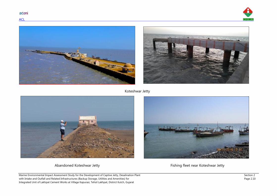
ii. Koteshwar Temple and Jetty
Koteshwar Mahadev temple is situated close to the mouth of Kori creek, about 15 km southwest
of proposed Cement plant. The Jetty is being used by the water wing of Border Security Forces
and by inhabitants of Narayan Sarovar for fishing purpose. Lakhpat Fort is located about 13 km
from the Cement plant.
iii. Narayan Sarovar Wild Life Sanctuary
Narayan Sarovar Wild Life Sanctuary is a unique eco-system, a part of which is a seasonal
wetland in the arid zone that play mother to 15 threatened wildlife species and encompasses
desert thorn and scrub forests, dotted with several seasonal water bodies and grassy patches.
As per Ministry of Environment and
Forest Notification dt. 31st May 2012 on
Narayan Sarovar wild life sanctuary,
mean distance of 1.5 km is notified under
Eco Sensitive Zone surrounding the
boundary of Narayan Sarovar. Kori creek
is present on the west and no prominent
features on the eastern, northern, and
southern side of wild life sanctuary. More
details of Narayan Sarovar wild life
sanctuary ESZ is provided in Chapter 4.
Proposed cement plant, mining area and berthing jetty falls away from the boundary of notified
Eco Sensitive Zone of Narayan Sarovar wild life sanctuary. Shortest distance from the boundary
of ESZ and Narayan Sarovar to proposed berthing jetty is 2.8 km and 5.8 km respectively.
iv. Reserve Forest
Reserve forest map surrounding the proposed facilities is shown in Fig. 2.1. Details of reserve
forest and their shortest distance to proposed berthing jetty is given below:
------- Boundary of Narayan Sarovar Wild Life
Sanctuary.
------- Eco Sensitive Zone of Narayan Sarovar Wild
Life Sanctuary.

ACL INDOMER
Marine Environmental Impact Assessment Study for the Development of Captive Jetty, Desalination Plant Section 2
with Intake and Outfall and Related Infrastructures (Backup Storage, Utilities and Amenities) for Page 2.6
Integrated Unit of Lakhpat Cement Works at Village Kapurasi, Tehsil Lakhpat, District Kutch, Gujarat
Details of reserve forest and their shortest distance to proposed berthing jetty
S.
No Name
Notified
Reserve Forest
Area (Ha)
Distance (km)
from Berthing
Jetty
1 Baranda RF 737.4 20
2 Budha RF 1068.3 12
3 Chakrai RF 728.4 24
4 Goohatad RF 1204.0 08
5 Guvar Nani RF 371.3 10
6 Harudi RF 341.5 26
7 Kaiyari RF 965.8 04
8 Kandj Rk 133.5 09
9 Lakshmirani RF 873.4 20
10 Mudhvay RF 286.3 12
11 Mudia RF 695.1 17
12 Nareda RF 885.5 19
13 Naredi RF 444.7 14
14 Ratipal RF 1819.7 23
15 West Mangrove RF 364.3 12 Source: Toposheet No. F42C10 (41 A/10)
v. Network of Tidal Creeks
Lakhpat coastline is unique among the Indian coastal lines due to presence of dense tidal
network and deltaic coast. Large part of
the tidal network will be inundated
during high tide as Lakhpat and
adjacent areas are tide dominated
coastline. Tidal network of project
region is shown in Fig. 2.2.
Network of tidal creeks includes Kori
creek, Padala creek, Vianwari creek, Pir
Sanai creek, Pabewari creek and Sir
creek. Each of these tidal creek systems
is separated by swampy and marshy
lands with mangrove swamps. Geographic features of the project region include:
Tidal mud flats
Tidal creeks
Barrier beaches
Mangroves

ACL INDOMER
Marine Environmental Impact Assessment Study for the Development of Captive Jetty, Desalination Plant Section 2
with Intake and Outfall and Related Infrastructures (Backup Storage, Utilities and Amenities) for Page 2.7
Integrated Unit of Lakhpat Cement Works at Village Kapurasi, Tehsil Lakhpat, District Kutch, Gujarat
Kori Creek
Berthing jetty is proposed in Kori creek. On the west, Padala creek, Vianwari creek, Pir
Sanai creek, Pabewari creek and Sir creek separated by intertidal flats and mud islands are
present. The creek system has large intertidal mudflats due to the sedimentation of Indus
drain and high tidal range varying from 3 to 5 m. The entrance part of the Kori creek
facing the Arabian sea is wave dominated and the remaining part of the creek inside is
dominate by tides.
Major part of the Kori creek is wide with about average width of 7 km. It forms part of
larger deltaic coast of Indus (Sindhu) river. This coastal segment is mainly made up of
depositional landforms and emerging coastal features. Depth of about 6 m CD is available
along the Koteshwar channel near Narayan Sarovar where berthing jetty is proposed.
Bathymetry at the mouth of Kori creek is complex due to the formation of small channels
of different length, bars and shoals. Also, phenomenon of bar formation exists near the
mouth. Mangrove swamp is present on the western side of Kori creek.
Padala and Vianwari Creek
Padala creek is located west of Kori creek separated by intertidal flats of about 8 km width.
Numerous minor creeks with presence of mangroves on either side of the creek is seen in
these intertidal flats. Further north of Padala creek lies Vianwari creek. These creeks are
again separated by intertidal flats of about 5 km. Similar to the entire swampy marsh land
in the area, these tidal flats are also contained with numerous minor creeks with presence
of mangroves. Vianwari creek extends upto India - Pakistan border on the north and
meets Pabewari creek on the west which eventually meets Sir creek further west. These are
uninhabited marshy lands separated by tidal network.
Pir Sanai Creek
Pir Sanai creek is placed between Kori on the east and Sir creek on the west with about
average width of 1.5 km with varying bathymetry.
Pabewari Creek
Pabewari creek is situated northeast of Pir Sanai creek, which runs upto India Pakistan
border and meets Sir creek further northeast. Either side of the creek is endowed with
presence of mangroves.
Sir Creek
Sir creek which divides Kachchh region with Sindh provinces of Pakistan is located about
20 km west of Kori creek and is the international border between India and Pakistan. This
coastal segment composed of vast tidal flats, mangroves and barrier beaches. Entire creek
system gets completely flooded during during monsoon (June - September) and is home
to many migratory birds. The creek is located in the uninhabited marshlands. This coastal
segment is mainly made up of depositional landforms and emerging coastal features.

ACL INDOMER
Marine Environmental Impact Assessment Study for the Development of Captive Jetty, Desalination Plant Section 2
with Intake and Outfall and Related Infrastructures (Backup Storage, Utilities and Amenities) for Page 2.8
Integrated Unit of Lakhpat Cement Works at Village Kapurasi, Tehsil Lakhpat, District Kutch, Gujarat
Sir Creek's core importance is its fishing resources. Further, immense potential economic
benefits as the marshlands are estimated to be rich in hydrocarbons and shale gas, is
another importance of Sir Creek.
v. Tidal Mud Flats
West of Kori creek is occupied with rich tidal flats.
The mud flats are separated by numerous tidal
creeks as mentioned above. These tidal flats
separated by numerous creeks are observed with
dense mangroves. Wide tidal flats of India
Pakistan border assume immense significance
since tidal flats support life, and are key habitat
that to fishes and migratory birds.
Tidal flats are also observed in area north of Kori creek towards the Great Rann of Kachchh. Most
of the salt pans are located within high tidal mud flat areas. The tidal mud flats are merged with
saline sand flats towards NE direction. Compared to tidal flats west of Kori creek, these high-
tidal mudflats are not biologically active as these areas do not receive daily tides. Therefore,
these mudflats remain dry and salt exposed land most of the time in dry seasons. Except some
scattered and stunted mangroves plants, no other forms of vegetation exists towards Lakhpat.
vi. Akrimota Lignite Coal Power Station
Gujarat Mineral Development Cooperation Ltd. (GMDC) has 2 X 125 MW Thermal Power Project
at village Nani Chher. Both the units have
been in commercial operation since March
2005. It is getting Lignite from its own
mines located at Panandhro, Mata-no-
Madh and Umarsar located 18 km
northeast of power plant. The cooling water
requirement for the power plant is taken
from the Kori creek through a 1.4 km long
sea water intake channel. The warm water is
disposed off at Kori creek through outfall
pipeline. A 100 m thick green belt surrounds the entire site. The power station is located about
4 km from the proposed cement plant. Due to this existing neighbouring industrial unit no
cumulative impact is anticipated in the project region.
Tidal flats of Kori Creek
Akrimota Lignite Coal Power Station

ACL INDOMER
Marine Environmental Impact Assessment Study for the Development of Captive Jetty, Desalination Plant Section 2
with Intake and Outfall and Related Infrastructures (Backup Storage, Utilities and Amenities) for Page 2.9
Integrated Unit of Lakhpat Cement Works at Village Kapurasi, Tehsil Lakhpat, District Kutch, Gujarat
Salient Features of Project Region
The salient features of the project region are given in a below.
Salient features of the project region
Sl. No Particulars Details
1 Location Berthing Jetty
Kori creek, Kapurasi Village,
Lakhpat
Conveyor
Corridor
Maldo, Mudhvay, Koriyani and
Kapurasi Village, Lakhpat
Cement Plant Koriyani Village, Lakhpat
Mudhvay
Limestone Mine Mudhvay Village, Lakhpat
2 Toposheet No. F42C10 (41A/10)
3 Current land use Barren land
4 Topography Plain barren land with 0 m (near berthing jetty) and 20
m (Cement Plant) above MSL.
5 Nearest Village Kapurashi, Koriyani, Kaiyari, and Mundhvay
6 Taluka Lakhpat
7 Nearest town Narayan Sarovar (~15 km SW)
8 Nearest highway SH 6
9 Nearest railway station Naliya (~ 65 km SE), Gandhidham (~160 km SE)
10 Nearest airport Rudra Mata Domestic Airport, Bhuj
(~ 112 km SE)
11 Nearest commercial port Jakhavu (~ 60 km SE)
12 Nearest water bodies Kori creek (~5 km W), Kapurasi Nala (Seasonal river)
13 Industries Akrimota Lignite Coal Power Station (~3 km)
14 Protected areas (National
parks/ sanctuaries)
Narayan Sarovar wild life sanctuary
No Marine National Park
15 Archeologically Important
Places
Lakhpat Fort (~13 km NE)
Koteshwar Mahadev temple (~15 km SW)
16 Ecologically Sensitive
Areas
Tidal flats of Kori creek
Narayan Sarovar wild life sanctuary
17 Reserve Forest Yes
18 Seismic Zone Zone V (Highest - Very High Risk Zone)
19 BSF Posts Yes *All distances are measured as Aerial distances from proposed Cement plant.
ACL INDOMER
Marine Environmental Impact Assessment Study for the Development of Captive Jetty, Desalination Plant Section 2
with Intake and Outfall and Related Infrastructures (Backup Storage, Utilities and Amenities) for Page 2.10
Integrated Unit of Lakhpat Cement Works at Village Kapurasi, Tehsil Lakhpat, District Kutch, Gujarat
Koteshwar Jetty
Abandoned Koteshwar Jetty Fishing fleet near Koteshwar Jetty

ACL INDOMER
Marine Environmental Impact Assessment Study for the Development of Captive Jetty, Desalination Plant Section 2
with Intake and Outfall and Related Infrastructures (Backup Storage, Utilities and Amenities) for Page 2.11
Integrated Unit of Lakhpat Cement Works at Village Kapurasi, Tehsil Lakhpat, District Kutch, Gujarat
Koteshwar temple Lakhpat fort
Mangroves on the western marsh land of Kori creek

ACL INDOMER
Marine Environmental Impact Assessment Study for the Development of Captive Jetty, Desalination Plant Section 2
with Intake and Outfall and Related Infrastructures (Backup Storage, Utilities and Amenities) for Page 2.12
Integrated Unit of Lakhpat Cement Works at Village Kapurasi, Tehsil Lakhpat, District Kutch, Gujarat
Wide tidal flats of Kori creek

ACL INDOMER
Marine Environmental Impact Assessment Study for the Development of Captive Jetty, Desalination Plant Section 2
with Intake and Outfall and Related Infrastructures (Backup Storage, Utilities and Amenities) for Page 2.13
Integrated Unit of Lakhpat Cement Works at Village Kapurasi, Tehsil Lakhpat, District Kutch, Gujarat
2.4. Proposed Facilities
The marine infrastructure comprises of berthing jetty with trestle and approach road. Berthing
jetty will be equipped with material handling system along with conveyor corridor. The details of
marine facilities are presented below.
2.4.1. Berthing Jetty
The master plan of the berthing Jetty is prepared based on expected traffic at different timelines,
size of vessels, facility requirements in terms of number and length of berths, navigational
requirements, and storage area required for each type of cargo, material handling system, road
access for the receipt/dispatch, evacuation of cargo, and other utilities and service facilities.
Berthing jetty of 19 MMTPA capacity will be developed for the transport of raw material and
product materials. At the proposed jetty location water depth available is about 6 m CD. Layout
of berthing jetty is shown in Fig. 2.3. Proposed traffic projection and material flow is tabulated
below:
Material Traffic projection Material flow Capacity
(MTPA)
Coal/ Petcoke Imported to Lakhpat IU through Barges
Import 3
Slag
Sourced from Hazira/Raigad /Open
market to Lakhpat IU through
Barges/Road
Gypsum Imported to Lakhpat IU through Barges
Fly ash Sourced from Mundra to Lakhpat IU
through Barges or by road
Total import 3
Cement Dispatched from Lakhpat IU through
barges to various bulk terminals.
Export
10
Clinker Dispatched from Lakhpat IU through
barges to various Grinding units 5
Limestone Dispatched from Lakhpat IU through
barges to various Grinding units 1
Total export 16
Overall capacity (Import + Export) 19
From above Table it can be easily inferred that volumes shall ramp up as above. Hence the
Berths, handling systems and backup infrastructure can be developed with the requirement of
facilities.
The cement plant comprises of Clinkerization plant and grinding units. The major finished
commodities from the plant will be Cement. Clinker can also be supplied from this plant as per

ACL INDOMER
Marine Environmental Impact Assessment Study for the Development of Captive Jetty, Desalination Plant Section 2
with Intake and Outfall and Related Infrastructures (Backup Storage, Utilities and Amenities) for Page 2.14
Integrated Unit of Lakhpat Cement Works at Village Kapurasi, Tehsil Lakhpat, District Kutch, Gujarat
market demand. Depending upon market dynamics, Slag can also be used as alternative to Fly
ash for process.
Lime stone requirements of Clinkerization plant will be suffice from the lime stone mine. At plant,
Cement and Clinker are the export commodities. The development of plant will require coal,
gypsum, fly ash and slag as supplement commodities to produce clinker and cement. These
cargoes will be imported via barges from the captive jetty. The export material will be supplied to
various locations, for further process and/or market demand. Import materials will be sourced
from nearby locations. Both, Export and import materials will be transported using barges via sea
route.
Vessel Size
Clinker and Cement are the main commodity to be handled at the proposed jetty. In addition to
that dry bulk commodities, Coal/Pet coke, Gypsum, Fly ash and Limestone will be handled
through proposed jetty. Since the facilities are proposed in Kori creek where natural water depth
available is 6 m CD, Lighterage operation with barges will be used for the operation. Proposed
lighterage route is shown in Chapter 3.
In order to reduce huge capital cost of building deep water & direct berthing port infrastructure,
ACL will develop vessel handling facilities for maximum 12500 DWT vessels. The main vessels
(40,000 DWT to 60,000 DWT) will be handled in the deep sea at anchorage point located about
60 km southwest of proposed Jetty. The dimensions of vessels are shown in table below:
Dimension of anticipated vessels
Anticipated
Size of vessels
(DWT)
Length
(m)
Width
(m)
Loaded
Draft
(m)
2200 70.0 14 4.5
8000 117.1 20 4.8
12500 94.5 30 5.5
Length of the Berths
The size of berthing area will depend upon the dimensions of the largest vessel and the number
of vessels likely to use the terminal. For 8000 DWT barges, the LOA will be about 120 m. This will
not create problem for berthing as adequate clearance will be available as far as the length and
width of the berth is concerned.
Width of Bulk Berth
Width of the berth is based on the functional requirement of conveyors, loading equipment,
unloading equipment and adequate maneuvering space for other equipment. A total width of 28
m has been provided, keeping a provision for front clearance and conveyors and maneuvering
space for other equipment and movement of dumpers.

ACL INDOMER
Marine Environmental Impact Assessment Study for the Development of Captive Jetty, Desalination Plant Section 2
with Intake and Outfall and Related Infrastructures (Backup Storage, Utilities and Amenities) for Page 2.15
Integrated Unit of Lakhpat Cement Works at Village Kapurasi, Tehsil Lakhpat, District Kutch, Gujarat
Deck Elevation
The deck elevation will be kept at (+) 7.0 m CD.
Approach Trestle and Rock Bund
The approach trestle will connect the rock bund to jetty. The length of approach trestle is about
498 m. The approach trestle will be design for class AA loading and stable side slopes on both
the sides such that it should be protected against the wave action. Construction of 498 m long x
12 m wide approach will be constructed with RCC deck supported Bored Cast-in situ pile
foundation. Rock Bund with intermittent suitable diameter of pipe will be provided to allow water
movement across the bund of length 2.815 Km. Cross section of rock bund is shown in Fig. 2.4.
2.4.2. Berth Requirements
Operation Time
Conventional Barges: During monsoon, due to adverse weather conditions conventional river
going barges can't operate/navigate in open sea area. Therefore, excluding monsoon, it is
assumed that proposed terminal will work seven days a week, which brings the effective number
of working days to 240 days per year for mid sea operations of smaller size barges.
Seagoing barges: Sea going barges which can travel during monsoon are also being considered
for the round year operation as looking to size of clinker plant and hinterland requirements.
Therefore, in this case, working days can be increased up to 350 days. Further, port will operate
round the clock i.e. three shifts of eight hours each. This results in an effective working of 21
hours a day.
Handling Rates
Considering the projected throughput, the handling systems assumed for various commodities
are described below.
Achievable Handling rates (TPH)
Commodity Form Export/Import Type of
loading/unloading
Achievable
Handling
Rate (TPH)
Clinker Dry Bulk Export Mechanised 1000 - 1200
Cement Dry Bulk Export Mechanised 1800 - 2000
Limestone Dry Bulk Export Mechanised 800
Coal/Pet
coke/Slag/Fly
ash
Dry Bulk Import Mechanised 800
Fully mechanized export system comprising of barge loader, conveyor system from directly plant
to jetty area. With fully mechanized system, it is expected that around 48,000 T – 54,000 T can be

ACL INDOMER
Marine Environmental Impact Assessment Study for the Development of Captive Jetty, Desalination Plant Section 2
with Intake and Outfall and Related Infrastructures (Backup Storage, Utilities and Amenities) for Page 2.16
Integrated Unit of Lakhpat Cement Works at Village Kapurasi, Tehsil Lakhpat, District Kutch, Gujarat
loaded per day at one berth on an average at 21 working hours per day depending on the size of
barge.
Berth Occupancy
Proposed facilities are of captive nature therefore random arrival of vessels/barges can be
reduced by regulation of the vessel movements. Keeping this in consideration, it is proposed to
limit berth occupancy to 70%. This shall reduce the pre-berthing detention of ships/barges and
offer reduced logistics cost to the shippers.
2.4.3. Navigational and Operational Requirements
The basic navigational and operational requirements to service the vessels calling at port are:
• Sufficient depth in maneuvering area and at berth area
• Sufficient depth and width in approach channel
• Adequate berthing infrastructure
• Mooring system
• Navigational aids
Navigation Channel Dimensions
Proposed navigational channel is shown in Chapter 3. The channel alignment is oriented
considering the following aspects:
• The channel is aligned in a straight line as far as possible.
• The channel is oriented so as to reach the deep-water contours in shortest possible
distance (this is to optimize the quantity of dredging).
• One approach channel with bottom width of 120 m will be provided.
Kori creek has adequate width therefore there is no requirement for widening of channel to
provide 120 m approach channel.
Turning Circle
A turning circle having diameter equal to 1.7 to 2 times the length of the barge will be
maintained at the jetty frontage. Keeping these requirements in view, the dimension of the
turning circle would be as 200 m. However, proposed berthing area has natural draft of 6 m
therefore, no artificial turning circle is required. Turning area can be marked with navigational
aids.
Dredging
Berthing jetty is proposed in Kori creek at 6 m water depth. Therefore, there is no requirement of
dredging in front of berth area. Entire navigational channel from the anchorage to berth pocket
has varying depths. Based on the bathymetry study it is anticipated that no capital dredging will
be required. However, in case of any necessity nominal capital dredging upto 1 Mm3 and

ACL INDOMER
Marine Environmental Impact Assessment Study for the Development of Captive Jetty, Desalination Plant Section 2
with Intake and Outfall and Related Infrastructures (Backup Storage, Utilities and Amenities) for Page 2.17
Integrated Unit of Lakhpat Cement Works at Village Kapurasi, Tehsil Lakhpat, District Kutch, Gujarat
Maintenance dredging upto 0.6 Mm3 will be taken up. Appropriate location having more than 30
m water depth based on mathematical modelling study will be chosen for dredge disposal.
Reclamation
The reclamation levels will be finalized with regards to the risk of flooding. The highest high tide
line (HHTL) at proposed site is about (+) 3.0 m CD. Final reclamation level will be designed based
on HHTL.
2.4.4. Material Handling Systems (MHS)
Overview of Material Handling system for proposed facilities is shown below:
Material Handling System
i. Barge Loader
Conventional type barge loader is proposed and to be fed using a conveyor system.
The barge loader will have the following broad parameters:
i. Length of travel - for the full length of barge berth.
ii. Design capacity - 800 TPH – 2000 TPH.
iii. Outreach - for a barge with a beam of 26 m.
Export – Mechanised (Clinker,
Cement and Limestone)
MHS of proposed facilities
Import – Mechanised (Coal,
Petcoke, Fly ash, Slag)
Barge Loader
Conveyor from plant to jetty
Mobile Harbour Crane &
Industrial Excavator & Truck
loading Hoppers
Transport of material via
dumpers/conveyor to
storage yard/plant

ACL INDOMER
Marine Environmental Impact Assessment Study for the Development of Captive Jetty, Desalination Plant Section 2
with Intake and Outfall and Related Infrastructures (Backup Storage, Utilities and Amenities) for Page 2.18
Integrated Unit of Lakhpat Cement Works at Village Kapurasi, Tehsil Lakhpat, District Kutch, Gujarat
iv. Feeding arrangement – To be fed from a feeding conveyor on the rear side through a
travelling tripper.
v. Boom - Telescopic type or with shuttle arrangement.
vi. Discharge end - with a telescopic or spiral chute to restrict/control the height of fall.
vii. Rail span – To be confirmed by supplier.
Typical
Conventional Barge Loader
ii. Conveyor System
The Clinker, Cement and Limestone loaded at the plant is proposed to be transported directly to
the vessel via conveyor. From the transfer point in the backup area of plant to transfer point of
the jetty it is proposed to install one stream of conveyor of 800 TPH - 2000 TPH.
Based on the secondary information and reconnaissance survey of the proposed jetty & plant
sites as well as the adjoining areas in the vicinity of the sites, a conveyor alignment connecting
the plant stockpile and the jetty has been proposed.
The proposed belt conveyor routing between the jetty and plant has been planned to avoid the
built up area as much as possible to minimize relocations.
Dual side pipe conveyor system is recommended for transportation of clinker/cement/limestone
from the plant to the proposed jetty/marine terminal. In the proposed conveyor system, it will
also be designed to transport unloaded coal, pet coke, Fly ash and Slag from the jetty to plant
area. Considering the future requirements and simultaneously loading/unloading arrangements,
provisions of additional conveyor stream is kept between jetty and clinker plant of same capacity.

ACL INDOMER
Marine Environmental Impact Assessment Study for the Development of Captive Jetty, Desalination Plant Section 2
with Intake and Outfall and Related Infrastructures (Backup Storage, Utilities and Amenities) for Page 2.19
Integrated Unit of Lakhpat Cement Works at Village Kapurasi, Tehsil Lakhpat, District Kutch, Gujarat
c. Mobile Harbour Crane
It is proposed to have tyre mounted mobile harbour crane on jetty to handle import cargo. Barge
will be unloaded using grab operations and discharge into truck loading hopper. Further, cargo
will be loaded to trucks and transferred to destination.
Typical tyre mounted mobile harbour crane
d. Industrial Excavators
For small barges like 2000 DWT, having lower beam and LOA can be handled using long boom
industrial excavators with grab.
Industrial Excavator
e. Truck Loading Hopper
Material will be unloaded from barge and discharged to hopper using grab operation and further
material will be transferred to the truck dumpers using sector gate operation. Equipment
recommended for captive jetty is given below.

ACL INDOMER
Marine Environmental Impact Assessment Study for the Development of Captive Jetty, Desalination Plant Section 2
with Intake and Outfall and Related Infrastructures (Backup Storage, Utilities and Amenities) for Page 2.20
Integrated Unit of Lakhpat Cement Works at Village Kapurasi, Tehsil Lakhpat, District Kutch, Gujarat
Truck loading hopper
Equipment recommended for captive jetty
No. of ship
loader
No. of conveyor
from plant to jetty
No. of industrial
excavator to
handle smaller
barges per berth
No. of Mobile
Harbour crane to
handle bigger size
barges per berth
4 2 4 1
2.4.5. Traffic Potential
Major demand centres / destinations for the proposed cement plant will be mainly Gujarat,
Karnataka, Kerala, and Maharashtra.
The main finished commodities from the plant will be clinker and cement. Details of traffic
projection is presented below:
Traffic Projection
Commodity Export/Import Capacity
(MTPA)
Clinker Export 5
Cement Export 10
Limestone Export 1
Coal/Pet
Petcoke/Slag/Flyash/Gypsum Import 3
Total 19

ACL INDOMER
Marine Environmental Impact Assessment Study for the Development of Captive Jetty, Desalination Plant Section 2
with Intake and Outfall and Related Infrastructures (Backup Storage, Utilities and Amenities) for Page 2.21
Integrated Unit of Lakhpat Cement Works at Village Kapurasi, Tehsil Lakhpat, District Kutch, Gujarat
2.4.6. Storage Requirements
Berth and yard are separated by about 9 - 10 kms of distance. Therefore, it is proposed to create
intermediate storage. This storage will be for mechanised cargo. Storage area will serve following
purposes:
• Storage of cargo during any exigency
• Enhance the productivity in case of requirements
• Inadequate space in plant area in case of any seasonal peak
About one parcel of 40,000 to 50,000 tonne of storage will be developed at intermediate storage
area.
2.4.7. Supporting Infrastructure
Electrical System
Power supply to proposed captive jetty is to be tapped from Cement plant. Adequate power
connection with step down arrangement will be made in cement plant area and it is proposed
that the transmission lines will be extended up to the proposed location of the main receiving
substation.
Firefighting system
Firefighting system of the terminal will be planned, implemented and maintained as per best
industry norms considering the size of the facility. It will be conformed to Tariff Advisory
committee's Guidelines and meet the relevant codal provision. System comprises fire pump
house, hydrants network, water storage Tank, pumping stations with standby arrangements.
Sea water based firefighting system is recommended near water front (jetty side) to cater fire
emergency of jetty and temporary stacking and utility area.
Diesel engine operated firefighting pumps and electrically operated jokey pumps will be installed
in firefighting pump house. Hydrant and fire monitor system will be installed with pipe network.
Water pipe line for berthing face shall preferably be routed through conveyor gallery. Pipeline is
supported at regular interval.
2.4.8. Desalination Plant
ACL has proposed install a Desalination Plant of 9 MLD (9000 m3/day). Total water requirement
project will be 9 MLD including the demand of Cement Plant, Limestone Mine, Captive Power
Plant, Waste Heat Recovery, Captive jetty etc.

ACL INDOMER
Marine Environmental Impact Assessment Study for the Development of Captive Jetty, Desalination Plant Section 2
with Intake and Outfall and Related Infrastructures (Backup Storage, Utilities and Amenities) for Page 2.22
Integrated Unit of Lakhpat Cement Works at Village Kapurasi, Tehsil Lakhpat, District Kutch, Gujarat
Desalination process: Desalination is a process that removes minerals from saline water. Sea
water is desalinated to produce water suitable for human consumption or irrigation. The principal
competing processes uses membranes to desalt saline water principally applying Reverse
Osmosis (RO). The RO membrane processes use semi permeable membranes and applied
pressure (on the membrane feed side) to preferentially induce water permeation through the
membrane while rejecting salt.
The main elements of desalination process include the following:
i. Seawater intake ii. Pre-treatment of feed water iii. Post-treatment and iv. Brine reject
Location of desalination plant, seawater intake and brine reject outfall are shown in Fig. 2.5.
i. Seawater intake
Seawater intake is planned through intake well. Offshore shore intake well will be constructed
adjacent to north of proposed berthing jetty with pump house as super structure. Water depth of
about 8.8 m CD is available at the proposed location. Total length of intake pipeline from
desalination plant to intake location is about 4 km. Seawater from the intake well will be
conveyed by pumping to the desalination plant on the shore through pipelines supported over
trestles. Total intake volume will be 30 MLD. Ambient salinity of intake water is estimated as 40
ppt. Longitudinal section of proposed intake scheme is shown in Fig. 2.6.
ii. Pre-treatment system
a) Coagulation/Flocculation
Coagulation process will be employed to reduce the turbidity feed water to an acceptable
level in order to avoid the fouling on RO membrane. Ferric chloride will be used as a
coagulant and control of pH will be done to achieve the optimum pH for to achieve
maximum efficiency. Polyelectrolyte will be dosed in the flocculation chambers to enhance
the elimination of suspended matter present in sea water by making the colloids to join
together and settles down.
b) Filtration
The filters will be designed to filter suspended solids in water by means of filtering media.
This designs causes particles to be trapped in filter media.
Filters will be designed to make easier inspection and maintenance. It includes drains,
complete instrumentation, as well as the set of pneumatic valves necessary for the automatic
execution of washing operations and start-up. Washing frequency may be modified by the
operator based on inlet water quality.

ACL INDOMER
Marine Environmental Impact Assessment Study for the Development of Captive Jetty, Desalination Plant Section 2
with Intake and Outfall and Related Infrastructures (Backup Storage, Utilities and Amenities) for Page 2.23
Integrated Unit of Lakhpat Cement Works at Village Kapurasi, Tehsil Lakhpat, District Kutch, Gujarat
c) Reverse Osmosis
The RO plant will be a single stage / single pass designed. Each of the RO trains will consist of
one RO rack each, with dedicated pumping system.
Each pressure vessel will house required membrane elements. The design treated water TDS
for the RO plant will be 500 mg/L. No allowance has been made in the RO plant layout for a
second pass RO system.
Ancillary system:
To protect the RO membranes and the smooth process of reverse osmosis system Oxidant
control, Scale control, RO clean in place system, etc will be provided.
iii. Post treatment
Post treatment of permeate is required to meet the statutory product water quality requirements.
Post treatment will consist of remineralisation / stabilization and disinfection of the water.
a) Remineralisation / stabilization
Due to the process of reverse osmosis, desalinated water tends to be very corrosive.
Therefore, before the permeate from reverse osmosis supply, it needs stabilization also known
as remineralisation or conditioning to prevent corrosion.
Water shall be stabilized by the addition of carbon dioxide and lime (calcium hydroxide). The
calcium is dosed via limewater, which is produced by mixing powdered hydrated lime with
reverse osmosis permeate using a clarifier. Carbon dioxide is added to the water. It reacts with
the dosed lime to form calcium bicarbonate, which buffers the water and increase resistance
to changes the pH and thus reduces the corrosivity of water.
b) Disinfection
Chlorine based disinfection (i.e. chlorination) has been considered for the project. Chlorine
kills the micro-organisms by immobilizing their metabolism rendering them harmless.
Chlorine is a slow stable reaction thus its main advantage of chlorine is the formation of
residuals which remain in the water for longer periods of time protecting the system from
bacterial contamination.
iv. Brine Reject
Longitudinal section of outfall scheme is shown in Fig. 2.7. The brine reject outfall with diffuser
ports is planned immediate to west of berthing jetty, i.e. on the downstream side where 8.6 m CD
depth is available. Outfall pipeline will be taken over proposed trestle connecting the rock bund
to berthing jetty. Total length of the outfall pipeline is about 4.5 km. Six diffuser ports of 250 mm
dia. will be provided to control possible impact arises due to brine discharge. Plan view of diffuser
ports arrangements is shown in Fig. 2.8.

ACL INDOMER
Marine Environmental Impact Assessment Study for the Development of Captive Jetty, Desalination Plant Section 2
with Intake and Outfall and Related Infrastructures (Backup Storage, Utilities and Amenities) for Page 2.24
Integrated Unit of Lakhpat Cement Works at Village Kapurasi, Tehsil Lakhpat, District Kutch, Gujarat
Outfall volume: 21 MLD of brine reject will be discharged into the sea. The salinity of the return
water released into the sea will be about 57 ppt which will have the salinity difference of 17 ppt
higher than ambient salinity of 40 ppt.
2.5. Resource Requirement
The details of resource requirement such as Water, Land, Man power, Power, etc. are discussed
below:
Land Requirement
The total area of 454.27 ha. will be needed for development of Lakhpat Cement Works. The land
area required for each facility is given below:
Land breakup details
Activity Area (in Ha.)
Limestone Mine 251.90
Cement Plant and Captive Power Plant 190.23
Jetty Backup Storage 4.05
Conveyor Corridor 8.09
Total 454.27
Manpower requirement
Total man power requirement for the Lakhpat Cement Works during construction phase
estimated to be about 630 nos. and during operational phase 600 nos. including both skilled
and unskilled labourers. The local people will be employed to the extent possible. The
occupation of the inhabitants in the nearby villages is mainly dependent on fishing and
agriculture. Opportunities for jobs under the proposed project will serve as a source of
livelihood for the local people and will pave the way for further developments.
Power Requirement
The maximum estimated power demand for the proposed integrated project is 125 MVA. The
power requirement for the integrated project will be met through CPP, WHRS and supply line
from the State Grid (GVUNL). ACL also plans to setup Captive Power Plant (including coal based
Thermal Power Plant and Waste Heat Recovery System) and total generation of captive power
and WHRS will be 99 MW. It is proposed to explore the harnessing of renewable energy through
Solar Power.
Water Requirement
Total water requirement of the entire project will be 9 MLD. This requirement will be met through
Kori creek by having 9 MLD desalination plant. Breakup details of water requirement is given
below.

ACL INDOMER
Marine Environmental Impact Assessment Study for the Development of Captive Jetty, Desalination Plant Section 2
with Intake and Outfall and Related Infrastructures (Backup Storage, Utilities and Amenities) for Page 2.25
Integrated Unit of Lakhpat Cement Works at Village Kapurasi, Tehsil Lakhpat, District Kutch, Gujarat
Details of water requirement for the proposed facilities
Seawater
Description Entity
Requirement (KLD) Loss/
Consumption
(KLD)
Wastewater
(KLD) Fresh
water
Recycled
water
Process Cement Plant 6600 0 6600 0
CPP & WHRS 2240 0 1112 1128
Domestic use
Cement Plant 100 0 40 60
CPP & WHRS 10 0 4 6
Captive Jetty 25 0 10 15
Mine 25 0 10 15
Landscaping/Green
belt development
Cement Plant 0 60 60 0
CPP & WHRS 0 6 6 0
Captive Jetty 0 15 15 0
Mine 0 15 15 0
Dust Suppression Cement Plant &
CPP & WHRS 0 903 903 0
Mine 0 225 225 0
Total water requirement 9000 1224 9000 1224
Detailed water balance diagram is shown in Annexure I.
2.6. Proposed Project Schedule
The main components for the development of captive port facilities at Kapurasi village comprises
of construction of berths and approach trestle, rock bund, supply and installation of material
handling equipment and onshore infrastructure. Overall project is likely to be completed in 36
months which includes construction period of 30 months and main machinery ordering phase of
6 months. Tentative project implantation schedule is given below.
Intake: 30,000 KLD
Desalination Plant (9,000 KLD)
Outfall: 21,000 KLD
Brine reject to seawater

ACL INDOMER
Marine Environmental Impact Assessment Study for the Development of Captive Jetty, Desalination Plant Section 2
with Intake and Outfall and Related Infrastructures (Backup Storage, Utilities and Amenities) for Page 2.26
Integrated Unit of Lakhpat Cement Works at Village Kapurasi, Tehsil Lakhpat, District Kutch, Gujarat
Proposed Construction Schedule
*The start date of project activities has been assumed as "zero date" for construction & operation of the proposed Lakhpat Cement Works.
2.7. Project Cost
Total investment of Integrated Lakhpat Cement Works is Rs. 7525.71 Crore. Project cost breakup
for different activities is given below.
Total project cost breakup details
Sl.
No Description Total Cost (in Lakhs)
1 Land and site development 14,684
2 Civil works and structures 192,158
3 Plant and machinery 316,682
4 Engineering and know how 6,000
5 Expense on training 900
6 Miscellaneous fixed assets 83,346
7 Pre-operative expenses including
interest during construction period 98,409
8 Contingency @ 6% 36,826
9 Margin money for working capital 3,566
Total Project Cost 752,571

ACL INDOMER
Marine Environmental Impact Assessment Study for the Development of Captive Jetty, Desalination Plant Section 2
with Intake and Outfall and Related Infrastructures (Backup Storage, Utilities and Amenities) for Page 2.27
Integrated Unit of Lakhpat Cement Works at Village Kapurasi, Tehsil Lakhpat, District Kutch, Gujarat
2.8. Summary of Proposed Marine Facilities
Summary of Proposed marine facilities
Item Description
Marine Infrastructure
Berth Development for barges 820 m x 28 m
Approach Trestle 498 m long x 12 m Wide
Rock Bund 2815 m long X 12m Top Width
Intermediate storage area development for
exigency operations
Backup Development (4.05 Ha)
MHS System
Conveyor from Plant to Jetty (800 TPH -
2000 TPH)
Pipe Conveyor (9.220 km long).
Ship Loader 4 No.
Industrial Excavators 4/8 No.
Road Weighbridge (100 T) For Road bound cargo
Truck loading Hopper with 2-Manual
Sector gates, wheels
For Road bound cargo
Approach road from plant to jetty Bituminous 2 lane motorable road x 8.5 km long x
7.5m wide.

RATIPAL RF
NAREDA RF
CHAKRAI RF
BUDHA RF
GOOHATAD RF
MUDIA RF
BARANDA RF
LAKSHMIRANI RF
NAREDI RF
KAIYARI RF
HARUDI RF
MUDHVAY RFKAIYARI RF
WEST MANGROVE RFGUVAR NANI RF
BUDHA RF
KANDJ RK
KAIYARI RFKAIYARI RF
KAIYARI RF
GUVAR NANI RF
68°50'E
68°50'E
68°40'E
68°40'E
68°30'E
68°30'E23
°40'N
23°40
'N
23°30
'N
23°30
'N
FIG. 2.1. RESERVE FOREST MAP OF PROJECT SITE
Captive JettyCement Plant
Lime Stone Mine
Kori Creek
Source: Survey of India Toposheet (F42C10)
:
10 km
15 km
5 km
LegendBerthing JettyReserve_ForestLimestone Mine and Cement Plant

Pad
ala creek
V
i
a
n
w
a
r
i
c
r
e
e
k
P
a
b
e
w
a
r
i
c
r
e
e
k
K
o
r
i
c
r
e
e
k
S
i
r
c
r
e
e
k
P
i
r
s
a
n
a
i
c
r
e
e
k
Kajh
ar
cre
ek
PORT LOCATION
PAKISTAN
INDIA
68°30' E
23°50' N
68°20' E68°10' E
23°40' N
23°30' N
2600000 m
Y
420000 mX
68°40' E 68°50' E 69°00' E
24°00' N
SPHEROID - WGS 84
N
NE
SE
NW
SW
S
EW
ZONE - 42
420000 mX 420000 mX 420000 mX 420000 mX
2600000 m
Y2600000 m
Y
FIG. 2.2. KORI CREEK NETWORK SYSTEM
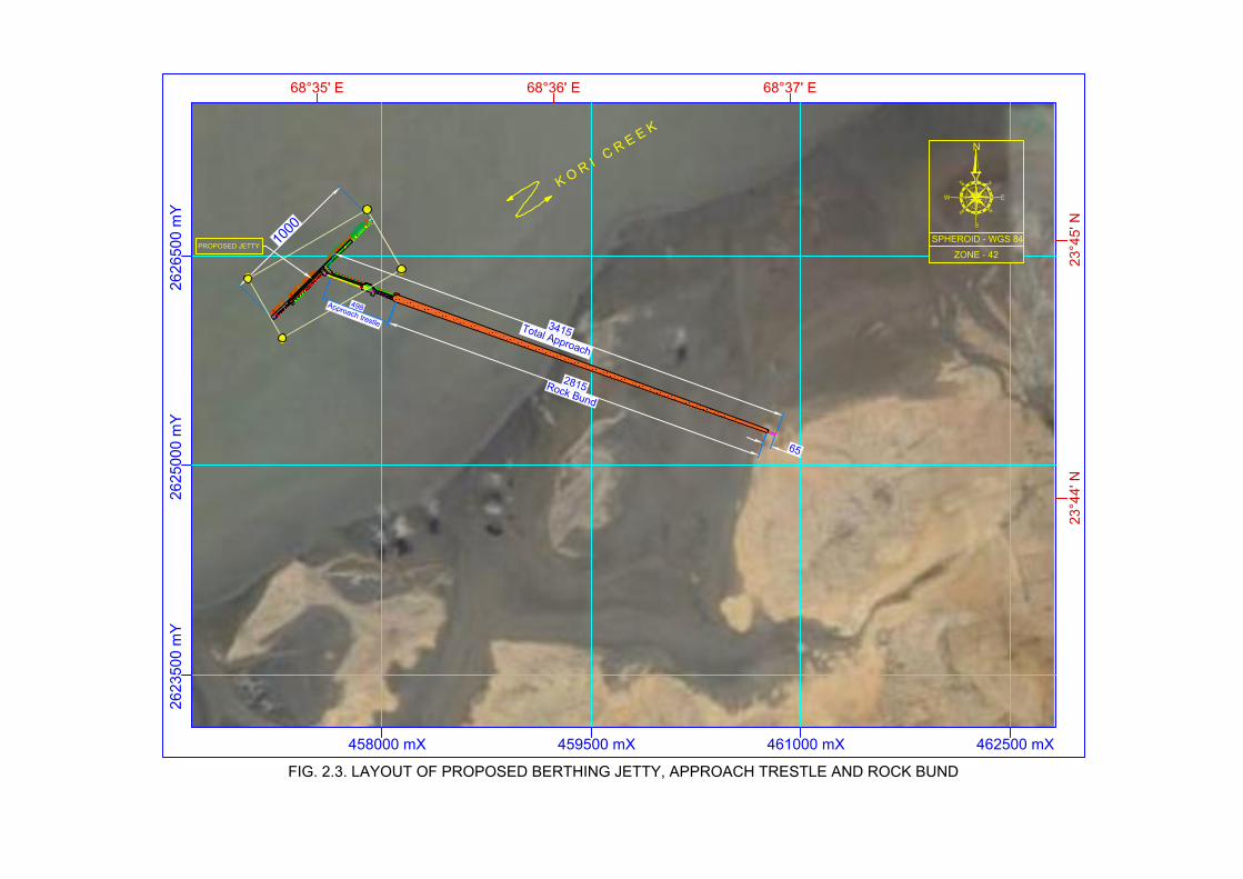
2625000 m
Y
458000 mX 459500 mX
2626500 m
Y
PROPOSED JETTY
1
0
0
0
2
8
1
5R
o
c
k
B
u
n
d
6
5
3
4
1
5
T
o
t
a
l
A
p
p
r
o
a
c
h
4
9
8
A
p
p
r
o
a
c
h
t
r
e
s
t
le
68°35' E
23
°4
5' N
68°36' E
23
°4
4' N
68°37' E
461000 mX 462500 mX
2623500 m
Y
FIG. 2.3. LAYOUT OF PROPOSED BERTHING JETTY, APPROACH TRESTLE AND ROCK BUND
N
NE
SE
NW
SW
S
EW
ZONE - 42
SPHEROID - WGS 84
K
O
R
I
C
R
E
E
K

B A
+7.0m (ROCK BUND TOP CD)
250
-1.00m (SEA BED
LEVEL CD)
-2.00m (CD INCLUDING
ROCK PENETRATION)
2000
±0.00m CD TOE TOP
1
1.5
PRIMARY ARMOUR (4.0 T TO 5.0 T)
SECONDARY ARMOUR (300kg TO 700kg)
CORE (1kg TO 100kg)
1000
1
4
0
0
1
0
0
0
DSS/FFS
PIPELINE
13000
Pipe conv. crs
7500 27502750
17000
FIG. 2.4. CROSS SECTION OF PROPOSED ROCK BUND

3
1
7
1
4
0
9
1
3
1
8
1
8
2
2
1
8
1
6
1
3
0
9
0
5
0
5
0
1
0
6
1
1
1
4
1
7
2
2
1
7
1
4
1
1
0
6
0
1
0
8
0
4
4
0
7
0
8
0
2
0
8
1
2
1
5
1
8
2
1
1
6
1
3
0
9
0
5
0
0
6
1
9
3
6
1
2
0
3
0
0
6
1
1
4
1
9
2
3
2
0
8
0
6
0
3
0
1
1
3
3
4
3
3
4
4
3
1
1
5
0
9
0
7
0
5
0
9
1
9
2
6
0
7
0
7
2
9
2
4
0
1
1
7
0
3
0
2
1
0
5
0
1
1
2
3
2
9
6
1
3
5
1
4
0
4
0
2
7
5
7
2
8
8
7
8
5
2
7
1
3
1
1
3
4
8
9
1
9
6
10
3
9
3
8
9
8
9
8
7
6
8
3
9
2
4
0
5
1
1
1
1
1
1
2
7
0
1
1
0
1
3
1
1
1
1
2
1
3
1
3
1
2
0
8
1
5
1
5
1
4
1
4
0
8
3
8
0
3
1
5
1
2
1
5
1
6
1
6
1
7
1
5
0
5
2
5
5
9
9
9
2
10
8
10
7
10
9
11
6
11
4
11
10
9
9
7
9
2
6
7
2
6
0
5
1
6
1
8
1
8
1
7
1
6
1
6
2
1
1
1
0
5
2
9
1
7
1
8
1
9
1
9
1
9
1
6
0
1
1
1
9
2
2
2
2
1
9
0
5
2
7
2
1
1
2
2
2
1
2
1
2
2
1
9
1
2
5
9
1
8
1
8
1
9
2
2
2
1
9
1
4
2
2
0
5
0
1
1
7
1
8
1
9
1
9
1
8
1
6
1
5
1
3
6
4
2
2
1
1
1
5
1
8
1
9
1
9
1
8
1
4
1
6
0
3
0
1
1
7
1
8
1
9
1
7
1
6
0
8
2
1
6
2
5
2
1
1
1
2
1
6
1
8
1
9
1
7
1
5
1
8
1
1
1
0
5
1
4
1
7
1
8
1
7
1
4
0
2
3
2
5
6
7
3
8
9
9
8
10
1
10
10
2
12
1
11
6
9
5
6
5
5
2
4
3
4
6
4
4
2
4
2
4
9
6
4
9
10
8
9
1
8
4
9
5
8
9
6
8
5
1
1
1
1
2
1
6
1
8
1
7
1
6
0
3
1
9
1
4
1
3
1
6
0
1
1
5
1
7
1
7
1
5
0
2
1
3
1
7
1
6
1
4
0
3
0
8
1
4
1
2
1
3
1
1
1
1
1
4
1
7
1
4
0
1
6
3
8
7
4
6
4
7
7
7
8
9
9
9
2
7
8
7
1
9
6
10
1
8
6
7
9
8
6
7
4
5
9
6
6
4
9
4
1
2
2
1
1
1
4
1
4
0
6
2
3
5
4
6
5
8
6
6
7
8
8
8
9
2
8
6
9
10
5
4
7
6
9
4
7
5
7
7
3
5
1
3
1
4
0
1
2
5
3
8
5
2
5
8
6
6
7
4
8
8
7
2
8
5
9
3
8
7
6
9
8
8
10
6
9
1
6
9
5
9
4
4
9
8
3
10
1
9
3
8
8
8
3
10
2
8
8
7
6
5
8
4
2
1
6
7
7
9
1
10
11
4
11
6
11
8
10
7
8
6
6
2
5
4
4
4
7
4
6
3
8
4
5
5
4
9
4
5
5
1
6
3
9
2
11
2
12
5
10
2
8
2
6
9
8
9
7
7
7
7
10
7
11
6
10
9
11
4
9
1
8
6
4
6
2
7
8
3
8
7
9
3
11
8
10
8
9
9
11
8
8
6
8
8
5
6
6
6
9
7
11
2
10
5
11
1
10
5
9
3
8
8
8
4
8
8
9
5
10
2
12
11
9
9
6
7
5
5
4
9
1
5
4
8
5
3
6
8
8
10
1
11
2
10
6
9
1
7
8
7
9
8
5
6
7
10
1
10
11
5
10
7
11
1
9
3
6
7
5
2
4
6
4
9
5
9
8
11
1
10
1
8
3
6
8
5
5
3
8
3
5
2
3
0
1
6
1
1
1
2
2
4
3
8
4
2
5
1
7
2
7
5
8
2
9
7
10
1
7
3
5
9
6
3
3
4
4
1
2
9
1
6
0
9
0
1
0
9
0
0
1
0
3
1
1
8
3
7
3
7
6
1
8
2
8
9
6
3
3
9
5
1
3
2
1
5
3
4
2
1
1
1
0
1
0
2
0
8
0
8
2
1
4
1
4
4
2
5
4
3
4
5
4
2
5
4
3
1
5
3
4
5
3
1
1
0
5
0
1
0
4
0
6
0
3
1
2
1
2
2
5
3
8
4
4
5
2
4
1
9
4
4
4
2
3
1
6
1
4
0
4
0
5
0
4
1
7
1
7
3
2
5
1
3
1
2
2
2
2
2
2
2
2
2
2
2
2
2
2
2
2
5
5
5
5
5
5
5
5
5
5
5
5
5
8
8
8
8
8
8
8
8
8
8
8
8
8
8
8
8
8
8
8
2625000 m
Y
458000 mX 459500 mX
2626500 m
Y
P
R
O
P
O
S
E
D
J
E
T
T
Y
68°35' E
23
°4
5' N
68°36' E
23
°4
4' N
68°37' E
461000 mX 462500 mX
2623500 m
Y
FIG. 2.5. LOCATION MAP OF PROPOSED DESALINATION PLANT, INTAKE AND OUTFALL
N
NE
SE
NW
SW
S
EW
ZONE - 42
SPHEROID - WGS 84
K
O
R
I
C
R
E
E
K
PROPOSED SITE AREA
FOR DESALINATION PLANT
X : 457164.28 m Y : 2626025.47 m
OUTFALL LOCATION
EASTING (mX)NORTHING (mY)
X : 457956.67 m Y : 2626781.62 m
INTAKE LOCATION
EASTING (mX)NORTHING (mY)
B
U
N
D
W
I
T
H
P
I
P
E
C
U
L
V
E
R
T

7
CD
6
5
4
3
2
1
0
-1
-2
-3
-4
-5
-6
-7
-8
-9
-10
-11
SE
AB
ED
200 400 600 800 1000 1200 1400 1600 18000
INTAKE WELL
FIG. 2.6. LONGITUDINAL SECTION OF INTAKE SCHEME
TOWARDS KORI CREEK
IN
TA
KE
P
IP
EL
IN
E
-12
FROM JETTY MID
JETTY TOP LEVEL - (+) 7 m CD

7
JETTY TOP LEVEL - (+) 7 m CD
CD
6
5
4
3
2
1
0
-1
-2
-3
-4
-5
-6
-7
-8
-9
-10
-11
SE
AB
ED
20040060080010001200140016001800 0
D
E
T
A
I
L
S
F
I
G
.
2
.
8
MULTIPORT DIFFUSERS
Ports, 250 MM OD X 3 Nos
FIG. 2.7. LONGITUDINAL SECTION OF OUTFALL SCHEME
TOWARDS OPEN SEA
OU
TF
ALL P
IP
ELIN
E
-12
OUTFALL PIPELINE 620 MM OD
FROM JETTY MID

FIG. 2.8. PLAN VIEW OF OUTFALL DIFFUSER PORTS
A
A
PLAN
Ports, 250 MM OD X 3 Nos
Ports, 250 MM OD X 3 Nos
OUTFALL PIPE 620 MM OD
SECTION AA
ANCHOR BLOCKS
Diffuser Ports,
250 MM OD

ACL INDOMER
Marine Environmental Impact Assessment Study for the Development of Captive Jetty, Desalination Plant Section 3
with Intake and Outfall and Related Infrastructures (Backup Storage, Utilities and Amenities) for Page 3.1
Integrated Unit of Lakhpat Cement Works at Village Kapurasi, Tehsil Lakhpat, District Kutch, Gujarat
3. ANALYSIS OF ALTERNATIVES
Finding an ideal location for proposed facilities like Cement plant, Mining unit, Thermal power
plant and associated aids like berthing Jetty, navigational channel, desalination plant is a
challenging task. As this could require environmentally friendly site with mining capabilities,
adequate connectivity for import and export of materials and minimum distance between
proposed units etc.
ACL has been exploring different site which is having Mining potential with seawater front having
capability for export/coastal shipping of its products to Indian markets with minimum impact on
the environment. ACL has studied the project region in detail with respect to location of mines,
cement plant and position of captive jetty. Initially, ACL has acquired limestone mine block C in
Mudhvay village from Government of Gujarat. In order to serve optimum logistics between mines
and grinding unit, cement plant is proposed close to the mining unit. Proposed location of
berthing jetty is optimized based on bathymetry, water availability, distance from cement plant,
cost of execution etc. Navigation Channel is finalized based on the existing vessel traffic in Kori
creek, dredging requirement etc. Desalination plant intake and outfall location is fixed based on
bathymetry and mathematical dispersion modelling. Details on site selection for berthing jetty,
navigational channel, anchorage point and desalination plant intake and outfall location is
explained below.
3.1. Berthing Jetty
Berthing jetty is one of the vital parts of this Integrated project, since import and export of
commodities will take place through jetty. There is no railway and seaway connection in the
vicinity of the project location. Looking at the non-availability of any bulk transportation means
in the vicinity, it is proposed to develop captive jetty in the Kori Creek.
Ever since the proposal various location has been analysed with regard to environmental aspects
and proximity of jetty location to cement plant. Initial analysis of bathymetry admits that
operation of barges is possible as water depth available close to cement plant and mining unit is
about 4 to 6 m CD. Keeping this aspect, ACL has finalized the option of barge handling facilities
for ~ 12,500 DWT self-propelled barges. The main export/coastal going vessels (40,000 DWT to
60,000 DWT) will be handled in the deep sea at anchorage point. Three options were analysed
to arrive at final design and location of berthing jetty. Following factors were considered for
selection of berthing jetty location.
Attributes Factors considered
Environmental
Aspects
Environmentally Sensitive Areas (ESA)
Coastal Regulation Zone
Shoreline change
Baseline Status
Captive port
development
Draft availability and water front area
Dredging requirement
Navigational Channel
Proximity to cement plant and mining unit
Adequate back-up space behind the berths

ACL INDOMER
Marine Environmental Impact Assessment Study for the Development of Captive Jetty, Desalination Plant Section 3
with Intake and Outfall and Related Infrastructures (Backup Storage, Utilities and Amenities) for Page 3.2
Integrated Unit of Lakhpat Cement Works at Village Kapurasi, Tehsil Lakhpat, District Kutch, Gujarat
Attributes Factors considered
for cargo handling and storage
Suitability for future development
Other aspects
Connectivity
Impact on fishing
Impact on Tourism
Alternative site locations chosen for berthing jetty (J1, J2 and J3) is given below.
Alternative berthing locations considered (J1, J2 and J3)
ACL has appointed M/s Howe Engineering Projects India Private Limited as a technical
consultant to carry out mathematical modelling for the selection of location for captive jetty,
optimization of rock bund, navigational route and offshore anchorage point. Report on "Kori
Creek Cement Jetty and offshore anchorage DPR studies (Numerical Modeling Studies)" is
submitted separately. Extract of modelling study is given below.
Hydrodynamic Modelling: Based on the Hydrodynamics of various location identified for captive
jetty, location J2 is selected. Findings of modelling study is given below.
Since the proposed area comes under tide dominant Kori creek, hydrodynamics of the area
plays a significant role. Modelled current velocity exceeds 2 m/s. Initially three probable
locations were identified based on the various favoring factors. Based on flow conditions,
available natural depth, favourable approach bund construction options and availability of land,
location J2 is selected for setting up the captive jetty.

ACL INDOMER
Marine Environmental Impact Assessment Study for the Development of Captive Jetty, Desalination Plant Section 3
with Intake and Outfall and Related Infrastructures (Backup Storage, Utilities and Amenities) for Page 3.3
Integrated Unit of Lakhpat Cement Works at Village Kapurasi, Tehsil Lakhpat, District Kutch, Gujarat
Wave disturbance modelling: Wave disturbance study has been carried out to estimate the
operational and design conditions at the captive jetty. Model SWAN was used for the study.
Finding of modelling study is given below.
The inshore wave period varies from 2.5 s to 4 s indicating all waves reaching the berthing
pocket are wind waves or swell component is negligible.
Based on different attributes, comprehensive analysis and mathematical modelling study final
location is selected. Environmental factors and other aspects of the three locations found almost
the same for three locations considered. Major criteria which lead to final selection of the jetty
location is draft availability, hydrodynamic modelling study, dredging requirement and proximity
to cement plant. Table showing the summary of various attributes considered is given below.

ACL INDOMER
Marine Environmental Impact Assessment Study for the Development of Captive Jetty, Desalination Plant Section 3
with Intake and Outfall and Related Infrastructures (Backup Storage, Utilities and Amenities) for Page 3.4
Integrated Unit of Lakhpat Cement Works at Village Kapurasi, Tehsil Lakhpat, District Kutch, Gujarat
Comparative assessment of alternative jetty location
Attributes Alternative I (J1) Alternative I (J2) Alternative I (J2)
Environmental Aspects
Environmentally Sensitive Areas (ESA) Environmental aspects of the three location in general remains the same. Only environment sensitive
factor in the proposed site area is presence of wide tidal flats. Three of the locations under
consideration was free from influence of marine national park, wild life sanctuary, mangroves etc.
*Shoreline Low Accretion Low Erosion Stable coast
Baseline Status Within regulatory limits
Coastal Regulation Zone Three of the locations considered attracts CRZ I, CRZ IV A and CRZ III
Captive port development
Draft availability 4 m 6 m 4.5 m
Dredging Requirement High Low Low
Distance of Jetty to plant site ~5 km ~ 8 km ~ 14 km
Adequate back-up space behind the
berths for cargo handling and storage Yes Yes Yes
Scope of future developments Yes Yes Yes
Other aspects
Connectivity No railway and seaway connection in the vicinity of the considered locations.
Impact on Fishing No No No
Impact on Tourism No No No *shoreline status (source): Ministry of Environment and Forest (http://www.gczma.org)
ACL INDOMER
Marine Environmental Impact Assessment Study for the Development of Captive Jetty, Desalination Plant Section 3
with Intake and Outfall and Related Infrastructures (Backup Storage, Utilities and Amenities) for Page 3.5
Integrated Unit of Lakhpat Cement Works at Village Kapurasi, Tehsil Lakhpat, District Kutch, Gujarat
3.2. Rock Bund
Option of Rock bund is proposed to connect the approach trestle at selected berthing jetty
location J2. Selected location J2 is connected to main land with a sand bar that get exposed
during low tide. Since the project site is offered with continuous flow of seawater through small
creeks available at project site, optimization of rock bund design has been carried out using
mathematical modelling study. Accordingly, Hydrodynamic modelling study for two options (i)
long bund connecting berthing jetty (ii) Detached bund connecting berthing jetty has been
conducted. Findings of modelling study is given below.
Option 1 - Long bund: Since option 1 closes the channel and high velocity (more 2m/s) may
occur at the northern side of the channel during flood. Increased velocity exists during ebb as
well. This may cause modified sedimentation pattern (erosion or deposition) and there are high
chances of scouring at north and deposition at the south side of channel.
Option 2 - Detached bund: Since the option 1 of keeping long bund approach not viable, option
2 with detached bund to ensure the free flow during flood and ebb conditions is considered.
High velocity regime exists. However, it is recommended to have detached rock bund.
Keeping the recommendations of mathematical modelling study, it is decided to provide
single/multilayer Hume pipes of sufficient quantity and size in rock bund to ensure free flow
water. It is planned to provide 2 m diameter culvert for every 20 m of approach bund. Rock
bund of length 2815 m is proposed from land side of facilities till approach trestle. Rock bund is
proposed till (–) 2 m contour with Rock bund will have two basic components, core portion of
lighter rocks/local available material followed by heavier armour rock layers.
Planning of marine facilities
The cargo complexion under dry bulk includes Clinker, Cement, Limestone coal and Pet coke for
the captive terminal. As the transfer of dry bulk between berths and stockyard is through
conveyors and dumpers, these berths do not require contiguity with land. The access to the
shore for operations and maintenance is provided through an approach bund/ trestle
connecting the berths to the onshore area.
The minimum width of the berth, keeping in view the rail span of the ship loaders, service ducts,
dumper movements and the end clearances should be about 28 m. The total length of dry bulk
berths is taken as ~820 m. In view of the above arrangement of berth and its location, piled
foundation is assumed as best option for the structural system. More details on proposed
marine facilities is given Chapter 2.
3.3. Navigational Channel and Anchorage Point
Navigational Channel
The Kori creek branches into two at about 30 km from the mouth where a mud flat is present in
the middle. The both banks of the creek channel have vast intertidal areas. Depth at the mouth

ACL INDOMER
Marine Environmental Impact Assessment Study for the Development of Captive Jetty, Desalination Plant Section 3
with Intake and Outfall and Related Infrastructures (Backup Storage, Utilities and Amenities) for Page 3.6
Integrated Unit of Lakhpat Cement Works at Village Kapurasi, Tehsil Lakhpat, District Kutch, Gujarat
of Koteshwar channel is around 6 m below CD and it has shoals on either side. The depth
gradually decreases towards the upstream.
Features of Kori creek are dynamic, indicating that a dredged channel can be expected to have
siltation and thus maintenance dredging will be required. At the entrance to the Kori creek the
phenomenon of bar formation exists and that the bathymetry at the entrance is complex due to
the small channels of different length. Due to complex nature currently, the ships use the tidal
window for navigation. At present handy-max vessels are using Kori creek channel. Detailed
bathy study from proposed jetty location to offshore anchorage has been carried out to select
the navigational channel. Initially three channels C1, C2 and C3 were considered to select the
final route. Alternative locations considered is given below.
Alternative channel alignments and anchorage points considered
Findings
• Channel C1 is too far from the coast and may pose restrictions from Border Security
Force.
• Channel C3 is very close to coast and have higher traffic of fisherman.
Anchorage Point 1
Anchorage Point 2
Channel C1
Channel C2
Channel C3

ACL INDOMER
Marine Environmental Impact Assessment Study for the Development of Captive Jetty, Desalination Plant Section 3
with Intake and Outfall and Related Infrastructures (Backup Storage, Utilities and Amenities) for Page 3.7
Integrated Unit of Lakhpat Cement Works at Village Kapurasi, Tehsil Lakhpat, District Kutch, Gujarat
• Channel C2 is with less length and at an intermediate location to avoid fishermen traffic
and Border Security Force restriction.
Approximate dredging quantity has been calculated based on the available survey data for
different channels are tabulated in Table given below. Max vessel size for (-) 13.5 m CD will be
40,000 DWT and for 8,000 DWT for (-) 6.0 m CD. The anchorage point is in the Arabian Sea, about
60 km away from the proposed jetty location. The anchorage distance can be shortened up to
some extent by shifting of anchorage point towards creek entry.
Ch
an
nel
For (-) 6 m CD For (-) 9 m CD For (-) 13.5 m CD
Length
(Km)
Width
(m)
Dredging
Volume
(Mm3)
Length
(Km)
Width
(m)
Dredging
Volume
(Mm3)
Length
(Km)
Width
(m)
Dredging
Volume
(Mm3)
C1 56 120 1.0 63.0 120 12.60 67 150 23.80
C2 55 120 0.0 60.0 120 11.09 65 150 22.52
C3 63 120 0.6 64.5 120 11.92 68 150 23.56 *Dredging quantity and length of the channel shown in the table is cumulative.
The channel C2 has shorter distance and has less dredging requirement compared to other
channels. Hence Channel C2 is selected and fixed.
Anchorage Point
Anchorage point is planned about 60 km from the proposed berthing jetty. Since the location will
be subjected to wave dynamics, it is important to study wave dynamics at proposed location to
ensure possibility of mother vessel – barge operation and to calculate downtime. Modelling
study has been carried out by M/s Howe Engineering Projects India Private Limited to cover
estimation of offshore wind and wave extremes for two of the offshore locations identified, to
establish offshore extremes to the propagation model, wave propagation modelling, tranquility
analysis and extreme wave climate analysis and inshore wave climate analysis and estimation of
downtime. Findings of modelling study is presented below.
The wave study comprised of wave conditions at the offshore anchorage and the wave climate at the berthing jetty through the channel. Results show that the offshore anchorage location may experience seasonal difficulties in operation for limited days while the jetty is completely tranquil throughout the year except during cyclone events. Wave heights for return periods 1 year to 100 year varies from 0.76 to 0.97 m in presence of wind speed of respective return periods in the direction of waves. Accordingly, anchorage point 1 is
selected.
3.4. Desalination Plant with Intake and Outfall
Desalination plant will be provided to cater the needs of cement plant, mining unit, berthing jetty
and thermal power plant. Desalination plant is planned within the proposed backup area close to
shore. Following criteria has kept under consideration for selection of intake and outfall.

ACL INDOMER
Marine Environmental Impact Assessment Study for the Development of Captive Jetty, Desalination Plant Section 3
with Intake and Outfall and Related Infrastructures (Backup Storage, Utilities and Amenities) for Page 3.8
Integrated Unit of Lakhpat Cement Works at Village Kapurasi, Tehsil Lakhpat, District Kutch, Gujarat
Parameter Remarks
Low-Impact intake technologies Intake well is considered. This will reduce impingement
and entrainment compared to open seawater intake.
Pipeline type/route Pipeline will be taken over proposed trestle for berthing
jetty. This will reduce the impact on seabed significantly
compared to submerged pipeline.
Installation of intake and outfall
outside LTL Yes
Coastal Regulation Zone Permissible activity
Minimum intake velocity Considered
Rather than going for separate intake and outfall submarine pipeline, it is planned to take the
pipeline through proposed trestle. Intake (upstream) and outfall (downstream) are planned east
and west of the proposed jetty separated by distance of about 1 km. Adequate depth is available
at proposed intake and outfall location. Indomer has carried out Advection – Dispersion study to
ensure dispersion pattern of brine reject and the details are presented Chapter 8. It is anticipated
that proposed plan will reduce additional impact on the environment which can be caused due to
laying of intake and outfall pipeline. More details on desalination plant is given in Chapter 2.

ACL INDOMER
Marine Environmental Impact Assessment Study for the Development of Captive Jetty, Desalination Plant Section 4
with Intake and Outfall and Related Infrastructures (Backup Storage, Utilities and Amenities) for Page 4.1
Integrated Unit of Lakhpat Cement Works at Village Kapurasi, Tehsil Lakhpat, District Kutch, Gujarat
4. DESCRIPTION OF THE ENVIRONMENT
This chapter covers the details of marine baseline study carried out during Post Monsoon
(September - October 2018) with respect to seawater quality, seabed sediment quality and
marine ecosystem.
The water samples were collected from 10 locations at three water depths across the vertical i.e.,
surface, mid depth and bottom covering upstream and downstream of Kori creek. Samples were
also collected from Arabian sea to make comparison between physico-chemical and biotic
components of open sea water and creek water.
The water quality parameters were analyzed by Indomer inhouse laboratory, Chennai which is
accredited by National Accreditation Board for Laboratory (NABL). The methods of collection and
analysis protocols are given in Annexure II.
Physical parameters: Temperature, Humidity, Rainfall, Wind, Waves, Tides, Currents, Bathymetry,
Seabed characteristics, Shoreline, Cyclones and Depressions and Seismicity.
Water quality parameters: Temperature, pH, Conductivity, Salinity, Total Dissolved Solids, Total
Suspended Solids, Turbidity, Dissolved Oxygen, Bio-Chemical Oxygen Demand, Chemical Oxygen
Demand, Total residual chorine, Ammonia-N, Nitrite-N, Nitrate-N, Phosphate, Total Phosphorous,
Total Nitrogen, Cadmium, Chromium, Mercury, Phenolic Compounds, Petroleum Hydrocarbons
and Oil and grease.
Sediment quality parameters: Sediment structure, Total Nitrogen, Total Phosphorous, Total
organic carbon, Calcium carbonate, Cadmium, Chromium, Lead, Mercury and Total Petroleum
Hydrocarbon.
Marine Ecology and Biodiversity: Planktons, Benthos/Molluscs, Microbial population, Coastal
vegetation, Seaweeds and Sea grasses, Mangroves, Coral reefs, Marine protected area, Marine
National Parks and Sanctuary, Marine mammals, Turtles, Endangered species and Fisheries.
4.1. Physical Parameters
Temperature: The monthly mean air temperature is above 30°C from March to November with
April and May being the hottest months. The maximum temperature reaches up to 39 °C during
these months. Temperature remains below 30°C from December to February. The monthly
variations of minimum, maximum and average temperature for the year 2017 is shown below.

ACL INDOMER
Marine Environmental Impact Assessment Study for the Development of Captive Jetty, Desalination Plant Section 4
with Intake and Outfall and Related Infrastructures (Backup Storage, Utilities and Amenities) for Page 4.2
Integrated Unit of Lakhpat Cement Works at Village Kapurasi, Tehsil Lakhpat, District Kutch, Gujarat
Maximum, Minimum and Average air Temperature (2017) - Lakhpat
Month Min Temp
(⁰C)
Avg Temp
(⁰C)
Max Temp
(⁰C)
Jan 18 25 29
Feb 21 29 33
Mar 26 34 38
Apr 30 38 42
May 32 39 43
June 33 37 40
July 31 34 36
Aug 30 34 36
Sept 28 33 37
Oct 29 36 39
Nov 25 31 34
Dec 19 25 29 Source: www.worldweatheronline.com
Humidity: High humidity is observed during the months of June, July and August in the range of
57 to 66%. During post monsoon and winter season Lakhpat is experiencing moderate to low
humidity. The monthly average humidity variation for the year 2017 is shown in below.

ACL INDOMER
Marine Environmental Impact Assessment Study for the Development of Captive Jetty, Desalination Plant Section 4
with Intake and Outfall and Related Infrastructures (Backup Storage, Utilities and Amenities) for Page 4.3
Integrated Unit of Lakhpat Cement Works at Village Kapurasi, Tehsil Lakhpat, District Kutch, Gujarat
Variation of average humidity (2017) - Lakhpat
Month Humidity (%)
Jan 0
Feb 19
Mar 30
Apr 35
May 44
June 57
July 66
Aug 62
Sept 57
Oct 37
Nov 25
Dec 20 Source: www.worldweatheronline.com
Rainfall: The entire district has irregular and erratic rainfall. The district get rain from southwest
monsoon during June to September. Total annual rainfall of Kutch district has decreased over the
years. Annual rainfall received during the last year was 493.3 mm, out of which monsoon (June -
September) contributed 493.1 mm. Post monsoon, Winter and Summer rains are negligible in
Kutch. High annual rainfall for the past years (652.1 mm) had occurred in 2013. The variation of
rainfall for Kutch district from 2013 to 2017 is shown below.
Monthly rainfall in mm (2013 to 2017) - Kutch District
Month Year
2013 2014 2015 2016 2017
Jan 4.1 0 0.8 0 0.1
Feb 0.3 0 0 0 0.1
Mar 0.2 0 2.1 0.5 0
Apr 4.1 0 2.2 0 0
May 0 2.1 1.2 1.7 0
June 69.8 2.7 37.2 12 58.9
July 147.2 101.5 377.5 45.5 295.4
Aug 86.6 100.5 7 188 104.3
Sept 326.9 81.2 52 8.6 34.5
Oct 12.9 2.2 3.9 37.9 0
Nov 0 0.6 0 0 0
Dec 0 0 0 0 0
Annual
Rainfall
652.1 290.8 483.9 294.2 493.3
Source: www.ind.gov.in

ACL INDOMER
Marine Environmental Impact Assessment Study for the Development of Captive Jetty, Desalination Plant Section 4
with Intake and Outfall and Related Infrastructures (Backup Storage, Utilities and Amenities) for Page 4.4
Integrated Unit of Lakhpat Cement Works at Village Kapurasi, Tehsil Lakhpat, District Kutch, Gujarat
Wind: The monthly average wind speed during year 2017 for Lakhpat show that the wind speed
is maximum between May and August. Lowest average wind speed is recorded during November
to February. The average gust, maximum and average monthly wind speed for Lakhpat is given
below.
Average gust, Maximum and Average monthly wind speed - Lakhpat
Month Avg Wind
(km/h)
Avg Gust
(km/h)
Max Wind
(km/h)
Jan 14.4 22.7 19.4
Feb 14 22.3 19.1
Mar 17.3 24.5 25.9
Apr 24.5 33.5 32.8
May 29.2 37.8 36.4
June 27.7 34.9 32.8
July 29.2 37.4 33.8
Aug 26.6 33.1 31.3
Sept 21.2 28.1 26.3
Oct 16.2 23.4 21.6
Nov 11.5 18 16.2
Dec 14.8 24.8 19.4 Source: www.worldweatheronline.com

ACL INDOMER
Marine Environmental Impact Assessment Study for the Development of Captive Jetty, Desalination Plant Section 4
with Intake and Outfall and Related Infrastructures (Backup Storage, Utilities and Amenities) for Page 4.5
Integrated Unit of Lakhpat Cement Works at Village Kapurasi, Tehsil Lakhpat, District Kutch, Gujarat
Source: www.worldweatheronline.com
Waves: A modelling study on waves carried out by M/s Howe Engineering Projects India Private
Limited indicates that the berthing jetty location is completely tranquil throughout the year from
waves of Arabian Sea. The inshore wave period varies from 2.5 s to 4 s indicating all waves
reaching the berthing pocket are wind waves . Wave heights for return periods 1 year to 100 year
varies from 0.76 to 0.97 m in presence of wind speed of respective return periods in the direction
of waves.
In the offshore area, predominant wave direction is between South and West. Sixty-Nine
percentage (69%) of the waves are centred at SW direction. Maximum observed offshore
significant wave height is 4.5 m. Mean Wave period (Tm) varies from 3 to 14 seconds with a high
density at 9 seconds. Swell waves are also in the direction of SW with a maximum Swell Hs of 3.5
m from SW. Maximum Significant wave height (HS) estimated for 1 year return period is 2.47 m.
Tides: The tides in this region is mixed semi-diurnal. The various design tide levels with respect
to chart datum for Kori creek region as presented in Navel Hydrographic Chart 201 is given
below:
Mean High Water Spring +3.0 m
Mean High Water Neap +2.8 m
Mean Sea Level +1.9 m
Mean Low Water Neap +1.3 m
Mean Low Water Spring +0.5 m
Currents: Continuous measurements on currents were carried out using Aanderaa RCM9 self-
recording current meters at Stn. C1 close to the proposed jetty head at about 4.5 km offshore.
The current speed and direction were recorded continuously at 15 minutes interval for a period
of 15 days. The measurements were made at 2 m below surface. The locations of current
measurement is shown in Fig. 4.1 and the details are given below.

ACL INDOMER
Marine Environmental Impact Assessment Study for the Development of Captive Jetty, Desalination Plant Section 4
with Intake and Outfall and Related Infrastructures (Backup Storage, Utilities and Amenities) for Page 4.6
Integrated Unit of Lakhpat Cement Works at Village Kapurasi, Tehsil Lakhpat, District Kutch, Gujarat
Current measurement location
Stn.
UTM Coordinates
(WGS 84-Zone 42)
Period of
measurements Measurement
depth X (m) Y (m) From To
C1 457105 2626297 18.09.18 04.10.18 2 m below
sea surface
The variation of current speed and direction measured at stn. C1 for the post monsoon period
from period 18.09.18 to 04.10.18 is shown in Fig. 4.2. During the measurement period, the
current speed reaches a maximum of upto 1.2 m/s. The predominant current direction remained
mostly towards the sector between 30° and 90° during the flood tidal phase and between 210°
and 270° during the ebb tidal phase. However, scattered movement of current direction was also
observed due to the influence of local wind effect. The magnitude of currents increases from the
mouth of Kori creek to its interior regions.
Bathymetry: In order to understand the water depth available at proposed jetty and to select
navigational channel, bathymetry study has been conducted by ACL through Ocean Science and
Surveying Pvt. Ltd. Extract of findings are given below. The extract of the bathymetry chart of
berthing jetty area provided by ACL is given in Fig. 4.3.
Berthing jetty area: The bathymetry shows a gently sloping seabed towards the northwest, with
an average gradient of 1 in 36, exhibiting undulations adjacent to the channel area. The
maximum depth of 12.5 m below CD is obtained near the northwestern boundary.
Navigational Channel: Highly undulated seabed shows a general slope towards the central part of
the navigation channel area near KP 22.5 from both northeastern and southwestern parts of the
survey area, where it achieves a maximum depth of 26.3 m. The minimum depth of 5.9 m below
CD is obtained near KP 3.5 as well as KP 10.5.
Seabed Characteristics: In order to identify the seabed characteristics both side scan sonar and
sub bottom profile survey has been carried out by ACL through Ocean Science and Surveying Pvt.
Ltd., Extracts of survey findings is explained below.
Seabed Features: Outcropping rocks are predominant in the northwestern part of the berthing
jetty area with a few patches of very coarse sediments. The remainder of the area comprises
predominantly coarse sediments with a few areas of mega ripples. Fine sediments found to be
absent. Further survey illustrate that the navigational channel predominantly composed of coarse
sediments. Figure showing the extract of seabed are given below.

ACL INDOMER
Marine Environmental Impact Assessment Study for the Development of Captive Jetty, Desalination Plant Section 4
with Intake and Outfall and Related Infrastructures (Backup Storage, Utilities and Amenities) for Page 4.7
Integrated Unit of Lakhpat Cement Works at Village Kapurasi, Tehsil Lakhpat, District Kutch, Gujarat
Extract of side scan data showing exposed rock outcrop and coarse sediments in northwestern
part of the proposed jetty area
Sub seabed Features: Within the jetty area, the reflector appears to be dipping southeastwards
from outcrops on the seabed in the northern part. The interpreted top of rock, below the seabed
exhibits undulations throughout the area, dipping towards the northwestern boundary as well as
southwestwards along the channel, with successive rises resulting in rock outcrops on the
seabed. Figure showing the extract of sub seabed features is given below.
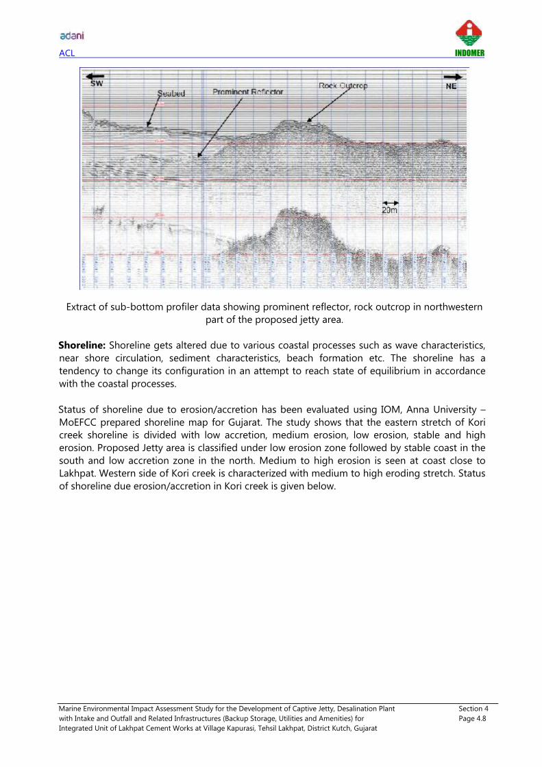
ACL INDOMER
Marine Environmental Impact Assessment Study for the Development of Captive Jetty, Desalination Plant Section 4
with Intake and Outfall and Related Infrastructures (Backup Storage, Utilities and Amenities) for Page 4.8
Integrated Unit of Lakhpat Cement Works at Village Kapurasi, Tehsil Lakhpat, District Kutch, Gujarat
Extract of sub-bottom profiler data showing prominent reflector, rock outcrop in northwestern
part of the proposed jetty area.
Shoreline: Shoreline gets altered due to various coastal processes such as wave characteristics,
near shore circulation, sediment characteristics, beach formation etc. The shoreline has a
tendency to change its configuration in an attempt to reach state of equilibrium in accordance
with the coastal processes.
Status of shoreline due to erosion/accretion has been evaluated using IOM, Anna University –
MoEFCC prepared shoreline map for Gujarat. The study shows that the eastern stretch of Kori
creek shoreline is divided with low accretion, medium erosion, low erosion, stable and high
erosion. Proposed Jetty area is classified under low erosion zone followed by stable coast in the
south and low accretion zone in the north. Medium to high erosion is seen at coast close to
Lakhpat. Western side of Kori creek is characterized with medium to high eroding stretch. Status
of shoreline due erosion/accretion in Kori creek is given below.

ACL INDOMER
Marine Environmental Impact Assessment Study for the Development of Captive Jetty, Desalination Plant Section 4
with Intake and Outfall and Related Infrastructures (Backup Storage, Utilities and Amenities) for Page 4.9
Integrated Unit of Lakhpat Cement Works at Village Kapurasi, Tehsil Lakhpat, District Kutch, Gujarat
Status of shoreline due to erosion/accretion - Kori creek
Cyclones and Depressions: Coastal areas of District like Bhachau, Gandhidham, Anjar, Mundra,
Mandvi and Lakhpat are particularly prone to cyclones. Cyclones originate out at sea and become
hazardous when they come ashore. They also drive the sea level up to cause coastal flooding.
Based on Tracks of Cyclones and Depression over North Indian Ocean, cyclones and depressions
which have crossed the coast of project region from 1918 to 2017 (within 150 km radius and 50
km radius) is shown below. Tracks show that totally 18 storms had passed within 150 km radius
of the project region where as only 4 cyclones had crossed within 50 km project radius. The
occurrence of storms is more frequent in June (3), July (3), September (3) and November (3).
Location of
Berthing Jetty

ACL INDOMER
Marine Environmental Impact Assessment Study for the Development of Captive Jetty, Desalination Plant Section 4
with Intake and Outfall and Related Infrastructures (Backup Storage, Utilities and Amenities) for Page 4.10
Integrated Unit of Lakhpat Cement Works at Village Kapurasi, Tehsil Lakhpat, District Kutch, Gujarat
Tracks of Cyclones and Depressions, 1918 - 2017 (150 km project radius)
Tracks of Cyclones and Depressions, 1918 - 2017 (50 km project radius)

ACL INDOMER
Marine Environmental Impact Assessment Study for the Development of Captive Jetty, Desalination Plant Section 4
with Intake and Outfall and Related Infrastructures (Backup Storage, Utilities and Amenities) for Page 4.11
Integrated Unit of Lakhpat Cement Works at Village Kapurasi, Tehsil Lakhpat, District Kutch, Gujarat
1935 January Cyclone Track 1959 July Cyclone Track
1961 June Cyclone Track 1964 June Cyclone Track
Table showing monthly frequency of cyclone occurrence is given below.
Number of cyclones crossed within 150 km project radius
Month Cyclones crossed within 150
km project radius
January 1
February -
March -
April -
May 2
June 3
July 3
August 1
September 3
October 2
November 3
December -
Total 18

ACL INDOMER
Marine Environmental Impact Assessment Study for the Development of Captive Jetty, Desalination Plant Section 4
with Intake and Outfall and Related Infrastructures (Backup Storage, Utilities and Amenities) for Page 4.12
Integrated Unit of Lakhpat Cement Works at Village Kapurasi, Tehsil Lakhpat, District Kutch, Gujarat
Seismicity: The project area falls in most active seismic zone (Zone V) as per IS 1893. Earthquake
zonation map is given below. The 2001 Gujarat Earthquake (moment magnitude 7.9) occurred
near Bhuj was the terrible human tragedy occurred near the project region. Over 13000 people
killed, a total of about 1.3 million houses, lifeline infrastructures were damaged to variable extent.
Source: Kutch District Disaster Management Plan
Impact zone of Bhuj Earthquake

ACL INDOMER
Marine Environmental Impact Assessment Study for the Development of Captive Jetty, Desalination Plant Section 4
with Intake and Outfall and Related Infrastructures (Backup Storage, Utilities and Amenities) for Page 4.13
Integrated Unit of Lakhpat Cement Works at Village Kapurasi, Tehsil Lakhpat, District Kutch, Gujarat
According to Institute of Seismological Research, Annual report 2017-18, 5 shocks of magnitude
4.0 - 4.2 has been recorded in Gulf of Kachchh. Also, a shock of magnitude 4.7 occurred on 9th
January 2017, 49 km ENE from Lakhpat.
Earthquakes (M≥4.0) that occurred in 2017 recorded by ISR SMA network
4.2. Seawater Quality
Details of sampling locations are given in Table 4.1 and shown in Fig. 4.4. and seawater quality
results are presented in Table 4.2. Results of each parameter is explained below.
Temperature: Steep gradients of sea water temperature across the depths bear direct impact on
the productivity and animal colony of the region. The temperature varied from 26°C to 28°C at
SS1 to SS10. There was no significant variation in temperature compared to proposed location
and further towards Arabian sea. The variation of temperature across the water column was
insignificant and followed normal pattern indicating the absence of significant stratification.
pH: Variations in pH due to chemical and other industrial discharges render a water column
unsuitable for the normal wellbeing of the aquatic life. pH is a very sensitive and most important
parameter in an environmental study. Primary production, respiration and mineralization are able
to alter the redox and pH of aqueous system due to changes in oxygen and carbonate
concentration. Identifying pH for acidic or alkaline disturbances enables one to locate zones of
pollution and other quality conditions for the use of seawater.
During the present study, pH did not show much variation and varied from 8.27 to 8.50. The
results show that the pH values lie within the range of normal seawater.

ACL INDOMER
Marine Environmental Impact Assessment Study for the Development of Captive Jetty, Desalination Plant Section 4
with Intake and Outfall and Related Infrastructures (Backup Storage, Utilities and Amenities) for Page 4.14
Integrated Unit of Lakhpat Cement Works at Village Kapurasi, Tehsil Lakhpat, District Kutch, Gujarat
Conductivity: The specific conductance (conductivity) was measured, using an appropriate
instrument of the electrical conductivity (IS 3025: Part 14). Conductivity is the capacity of water
to carry an electrical current and varies both with number and types of ions in the solutions,
which in turn is related to the concentration of ionized substances in the water. Most dissolved
inorganic substances in water are in the ionized form and hence contribute to conductance.
Conductivity did not show much variation and it ranged from 61687 to 63806 µs/m. The results
show that the conductivity values lie within the range of normal seawater.
Turbidity: Turbidity is another measure to understand the suspended particulate matter which
controls the transparency and photosynthesis in the water column. The turbidity varied between
3.2 and 15.2 NTU in the study area.
Total Suspended Solids (TSS): TSS in seawater originate either from autochthonous (biological
life) or allochthonous (derived from terrestrial matter) sources. TSS varied in a range of 35 to 135
mg/l in the study area. The minimum was observed at station SS10 surface sample, while the
maximum was recorded in station SS1 bottom sample.
Total dissolved solids: The TDS concentration varied from 41330 mg/l to 42750 mg/l at all
stations.
Salinity: The variation in salinity occurs because of differences in precipitation, freezing,
evaporation and freshwater runoff at nearshore, and due to upwelling/sinking in deeper water.
Seawater salinity also varies with water depth because of density and pressure variation. The
measured salinity of the collected water samples ranged between 38.6 to 40.1 ppt from all the
sampling stations.
Dissolved Oxygen: This is an important parameter for the survival of aquatic biota. The amount
of oxygen dissolved in the water column at a given time is the balance between replenishment
and consumption. In an ideal ecosystem, these two processes should be at equilibrium to keep
the water column saturated with DO. Generally, the coastal waters are always found to be
saturated and this is so in the present study area also.
Dissolved oxygen content varied from 5.0 to 5.6 mg/l. Review of literature indicates that the
levels below 2 mg/l only are known to cause respiratory impacts on marine fauna.
Biochemical Oxygen Demand (BOD): Rate of aerobic utilization of oxygen is a useful tool to
evaluate the intensity of deterioration in an aquatic medium. The oxygen taken up for the
breakup of organic matter leads to a reducing environment or in the event of release of excess
nutrients, it may cause eutrophication. In the present study, the BOD values varied in a low range
of 1.1 to 2.1 mg/l in the study area.
Chemical Oxygen Demand (COD): COD determines the oxygen required for chemical oxidation
of some inorganic and organic matter present in the water. During the present study, the COD
values varied from 18.8 to 28.6 mg/l in the study area.
Nutrients: Nutrients determine the potential fertility of an ecosystem and hence it is important
to know their distribution and behaviour in different geographical stations and seasons. The

ACL INDOMER
Marine Environmental Impact Assessment Study for the Development of Captive Jetty, Desalination Plant Section 4
with Intake and Outfall and Related Infrastructures (Backup Storage, Utilities and Amenities) for Page 4.15
Integrated Unit of Lakhpat Cement Works at Village Kapurasi, Tehsil Lakhpat, District Kutch, Gujarat
fishery potential of an area is in turn, dependent on the availability of primary nutrients like
nitrogen and phosphorus. Enrichment of these nutrients by anthropogenic inputs in the coastal
waters, having limited aeration, may result in water becoming eutrophicated.
The major inorganic species of nitrogen in water are ammonia, nitrite and nitrate of which nitrite
is very unstable and ammonia is bio-chemically oxidized to nitrate. Hence, the concentrations of
nitrite and ammonia are often very low in natural waters. The utilization of nutrients such as
nitrates and phosphates can be taken as a measure of the productivity of the area.
Inorganic phosphate and nitrogen compounds in the sea play a decisive role in the biological
production. Normally they occur in low concentrations. Their distribution in the coastal waters is
mostly influenced by land run off. Since nutrients form an important index to the primary
productivity of an ecosystem, the study of its distribution is important from the point of view of
its role in the biological productivity and also as an indicator of pollutant.
Ammonia-Nitrogen (NH3-N): Unpolluted waters are generally devoid of ammonia and nitrite.
However, coastal input by sewage and other nitrogenous organic matter and fertilizers can
increase these nutrients to higher levels. In addition, ammonia in seawater can also come from
various organisms as an excretory product due to the metabolic activity and the decomposition
of organic matter by micro-organisms. The concentration of Ammonia varied from 2.9 to 8.4
µmol/l at SS1 to SS10. The water quality parameters observed at the sampling region do not
show much variation. The lowest value was recorded at station SS2 in the surface, while the
highest was observed at station SS4 in the bottom.
Nitrite-Nitrogen (NO2-N): Nitrite is an essential element, which occurs in seawater as an
intermediate compound in the microbial reduction of nitrate or in the oxidation of ammonia. In
addition, nitrite is excreted by phytoplankton especially, during plankton bloom. In the present
study, Nitrite concentration ranged from 1.7 to 2.7 µmol/l at SS1 to SS10.
Nitrate-Nitrogen (NO3-N): Nitrate values are in general higher as compared to nitrite values.
Nitrate is the final oxidation product of nitrogen compounds in seawater and is considered to be
the only thermodynamically stable oxidation level of nitrogen in seawater. Nitrate is considered
to be the micronutrient, which controls primary production in the euphotic surface layer. The
concentration of nitrate is governed by several factors of which microbial oxidation of NH3 and
uptake by primary producers may be important. In the present study area, Nitrate concentration
varied from 3.9 to 10.3 µmol/l at SS1 to SS10.
Total Nitrogen: The total nitrogen concentration varied from 31.1 to 47.3 µmol/l at SS1 to SS10.
Total Phosphorus: Total phosphorous concentration varied from 0.9 to 8.5 µmol/l at SS1 to
SS10.
Residual Chlorine: Residual chlorine concentration was found to be less than 0.1 mg/l at all
stations.
Trace metal concentration: Concentrations of trace metals in water are often close to the back-
ground level due to their efficient removal from the water column through hydrolysis and
adsorption by suspended particulate matter.

ACL INDOMER
Marine Environmental Impact Assessment Study for the Development of Captive Jetty, Desalination Plant Section 4
with Intake and Outfall and Related Infrastructures (Backup Storage, Utilities and Amenities) for Page 4.16
Integrated Unit of Lakhpat Cement Works at Village Kapurasi, Tehsil Lakhpat, District Kutch, Gujarat
Knowledge of the trace metal concentration in seawater is very important from the point of view
of their possible adverse effects on marine biota. Oysters by their ability to concentrate some
trace metals from the environment are considered to be useful indicators of metal pollution.
Many of the trace metals are adsorbed to the particulate matter and are ultimately deposited at
the bottom. The relationship between gross concentration of heavy metal in solution and its
ability to cause toxic effects in an organism is a complex one and is mostly decided by the
speciation of metal and the condition of the organism. Whether or not a trace metal can interact
with the biota depends on its "bio-availability" in the medium. Presence of other toxicants or
metals can reduce or increase the additive toxicity of each element. In addition to these factors,
temperature, pH, salinity, turbidity and dissolved oxygen concentration also significantly affect
metal-organism interactions.
Cadmium (Cd): The bioavailability and toxicity of trace metals such as Cd, Cu, and Zn are related
to the activity of the free metal ion rather than the total metal concentration. For Cd it is the
CdCl2 complex that predominates in seawater. Therefore, salinity is the overriding factor which
can alter free Cd ion activity Cd2+, and hence, bioavailability and toxicity in marine systems. The
cadmium concentration in the study regions were found <0.01 mg/l at SS1 to SS10.
Chromium (Cr): In dissolved form, chromium is present as either anionic trivalent Cr (OH)3 or as
hexavalent CrO42-. The amount of dissolved Cr3+ ions is relatively low, because these form stable
complexes. Oxidation ranks from Cr(II) to Cr(VI). In natural waters, trivalent chromium is most
abundant. Chromium is a dietary requirement for a number of organisms. This however only
applies to trivalent chromium. Hexavalent chromium is very toxic to flora and fauna. Chromium
water pollution is not regarded as one of the main and most severe environmental problems,
although discharging chromium polluted untreated wastewater in creeks has caused
environmental disasters in the past. Chromium (III) oxides are only slightly water soluble, hence
concentrations in natural waters are limited. Cr3+ ions are rarely present at pH values over 5,
because hydrated chromium oxide (Cr(OH)3) is hardly water soluble. Chromium (VI) compounds
are stable under aerobic conditions but are reduced to chromium (III) compounds under
anaerobic conditions. The reverse process is another possibility in an oxidizing environment.
Chromium is largely bound to floating particles in water. The total chromium concentration in the
study regions were found <0.01 mg/l at SS1 to SS10.
Lead (Pb): The concentration of total Arsenic was found to be <0.01 mg/l at SS1 to SS10.
Mercury (Hg): The concentration of mercury was found to be <0.01 mg/l at SS1 to SS10.
Phenolic compound: The main source of Phenolic compounds in seawater is through industrial
plant. Additionally, they can also be released during humification processes occurring in soil.
Higher concentrations occur in industrial wastewaters. Phenols can be toxic to marine organisms
and can accumulate in certain cellular components. Chlorination of phenol-containing waters can
lead to formation of chlorophenols with unpleasant odour and taste. The concentration of phenol
in the study area was found to be <0.1 mg/l at SS1 to SS10.
Total Petroleum Hydrocarbons: The coastal waters are susceptible to oil pollution due to
various maritime activities like fishing operation, spillage from oil tankers, port activities etc. In
the study area, the dissolved and dispersed Petroleum hydrocarbons were found to be below
detectable level (i.e. < 0.1 µg/l) at SS1 to SS10.
ACL INDOMER
Marine Environmental Impact Assessment Study for the Development of Captive Jetty, Desalination Plant Section 4
with Intake and Outfall and Related Infrastructures (Backup Storage, Utilities and Amenities) for Page 4.17
Integrated Unit of Lakhpat Cement Works at Village Kapurasi, Tehsil Lakhpat, District Kutch, Gujarat
Oil and grease: The concentration of oil and grease in the study area was <1.0 mg/l in the study
area indicating that impact due to anthropogenic releases, if any were insignificant in the study
area.
4.3. Seabed Sediment Quality
Sediment size distribution: The seabed sediment size distribution is given in Table 4.3. It shows
that the sediment is predominantly composed of fine sand.
The seabed sediment quality is given in Table 4.4. Results of seabed sediment analysis are
detailed below.
Total Organic Carbon: Total organic carbon content ranged from 0.27 to 0.67 % at SB1 to SB10.
Total Nitrogen: Total nitrogen concentration ranged from 139.8 to 181.7 mg/kg at SB1 to SB10.
The minimum value was recorded at SB10 while the maximum was recorded at SB5.
Total Phosphorus: Total phosphorus concentration ranged from 4.9 to 12 mg/kg at all stations.
The minimum value was recorded at SB2 while the maximum was recorded at SB10.
Calcium Carbonate: The calcium carbonate content in the sediments varied from 1.1 % to 6.2 %
at SB1 to SB10. The minimum was observed at SB2 while the maximum was observed at SB8.
Cadmium (Cd): The concentration of cadmium in the study area was found to be <0.1 to 7.5
mg/kg) at SB1 to SS10. Chromium (Cr): The concentrations of chromium in the study area varied
from <0.1 to 14.8 mg/kg at SB1 to SB10. Lead (Pb): The concentrations of lead in the study area
were found to be below <0.1 mg/kg at SB1 to SB10. Mercury (Hg): The concentrations of
mercury in the study area was found to be below detectable limit (i.e., <0.1 mg/kg) at SB1 to
SB10.
Total Petroleum hydrocarbons: Total petroleum hydrocarbon concentrations was found to be
below detectable limit (i.e., <0.5 µg/kg) at SB1 to SB10.
Seawater analysis indicates the Kori creek is free from pollution. Seawater quality parameters
such as DO, BOD, nutrients, heavy metals and other parameters indicate normal range
pertaining to the coastal waters.

ACL INDOMER
Marine Environmental Impact Assessment Study for the Development of Captive Jetty, Desalination Plant Section 4
with Intake and Outfall and Related Infrastructures (Backup Storage, Utilities and Amenities) for Page 4.18
Integrated Unit of Lakhpat Cement Works at Village Kapurasi, Tehsil Lakhpat, District Kutch, Gujarat
Collection of seawater samples Collection of seabed sediments
Onsite field measurements
Collection of Intertidal benthos Collection of Plankton
Coastal Ecology and Biodiversity study
*All photographs are taken during the study period (September - October 2018)

ACL INDOMER
Marine Environmental Impact Assessment Study for the Development of Captive Jetty, Desalination Plant Section 4
with Intake and Outfall and Related Infrastructures (Backup Storage, Utilities and Amenities) for Page 4.19
Integrated Unit of Lakhpat Cement Works at Village Kapurasi, Tehsil Lakhpat, District Kutch, Gujarat
4.4. Marine Ecology and Biodiversity
Coastline of the project site and 10 km surrounding coast contains vast tidal mud flats, tidal sand
flats, tidal creeks, inshore beaches and sparse mangroves. The coast is mainly made up of
depositional landforms and emerging coastal features. It is a tide dominated coastline and major
part of this coast is composed of tidal mud flats. Dense networks of tidal creeks are present all
along the tidal flats. Clusters of crescentic barrier beaches are developed toward the south,
southeast and southwest portion of the deltaic coast separated by medium size creeks. On the
backside of some of the barrier beaches, sand flats are produced due to spreading of sand with
tidal currents towards the project area.
Study area of Coastal Ecology and Biodiversity
Mudflats and Intertidal Zones: Mudflats and marshy coast mudflats are found at extensive
expanse with fine grained soft mud along the shore and are coastal wetlands that form when
mud is deposited by the tides, sea and oceans. Generally, the substrate of mudflats is formed
mainly from silts and clays and has high organic content. Due to which, they are characterized by
high biological productivity and supporting abundance of invertebrate fauna, such as lugworms,
(Phylum Annelida Class Polychaeta genus Arenicola, one of the several marine worms that
burrow deep into the sandy sea bottom or intertidal areas and are often quite large in size.
In the context of project site, mudflats constitute major area of the total length of the coastline.
Some of the vast stretches of mud flats occur along the coastal villages assessed. The vast stretch
of mud flats supports rich diversity of shore birds. These habitats are important breeding sites for

ACL INDOMER
Marine Environmental Impact Assessment Study for the Development of Captive Jetty, Desalination Plant Section 4
with Intake and Outfall and Related Infrastructures (Backup Storage, Utilities and Amenities) for Page 4.20
Integrated Unit of Lakhpat Cement Works at Village Kapurasi, Tehsil Lakhpat, District Kutch, Gujarat
wading birds and winter-feeding areas for many sea and shore birds. They also provide suitable
habitats for many species of fish, crabs and crustaceans.
Sandy Beaches and Dunes: In the LFP and surrounding 10 km area, sandy beaches are hardly
found and mainly occurred in a small stretch.
Tidal creeks in the intertidal zone Mud flat and marshy coast
View of Intertidal region of the coast and
Narayan Sarovar Wildlife Sanctuary Intertidal Zone near project site
View of intertidal region of the sandy coast north of project site
*All photographs were taken during field survey (September - October 2018)

ACL INDOMER
Marine Environmental Impact Assessment Study for the Development of Captive Jetty, Desalination Plant Section 4
with Intake and Outfall and Related Infrastructures (Backup Storage, Utilities and Amenities) for Page 4.21
Integrated Unit of Lakhpat Cement Works at Village Kapurasi, Tehsil Lakhpat, District Kutch, Gujarat
Marine Biology: Biological status of an area is an essential prerequisite for environmental impact
assessment and can be evolved by selecting a few reliable parameters from a complex
ecosystem. The biological parameters considered in the present study are primary production,
phytoplankton biomass, diversity and population, zooplankton biomass, diversity and population,
seabed and inter-tidal macro benthic diversity and population, Bacterial population in coastal
waters and seabed sediments and fishery of the region.
Phytoplankton and zooplankton reflect the productivity of a water column at primary and
secondary levels. Benthic organisms being associated with the seabed, provide information
regarding the integrated effects of stress due to disturbances, if any, and hence are good
indicators of early warning of potential damage.
4.4.1. Plankton
Phytoplankton and primary productivity: Phytoplankton are the primary source of food in the
marine environment. The concentration and numerical abundance of the phytoplankton indicate
the fertility of a region. The plankton population depends primarily upon the nutrients present in
the seawater and the sunlight for photosynthesis. This primary production is an important source
of food for the higher organisms in the marine food chain.
Primary productivity of Kori creek is given in Table 4.5. The primary productivity values varied
between 264 and 408 mgC/m3/day and the average value was 336 mg C/m3/day from all
stations.
Phytoplankton species composition
Various phytoplankton groups observed in the samples and their species compositions are given
in Table 4.6. Totally, 32 species of phytoplankton were identified in net haul during sampling
period which includes 17 species belonging to centrales, 8 species of pennales, 6 species of
dinoflagellates and 1 species of cyanophytes. The floral diversity fluctuated from 17 to 26 species.
Numerical abundance and percentage of phytoplankton
The numerical abundance of phytoplankton population varied between 14200 to 29200 nos./l
from all stations. The maximum was observed at SS10, while the minimum at SS1.
Bacillariophyceae (Diatoms consisting of Centrales and Pennales) formed the major group
followed by Dinophyceae (Dinoflagellates) and Cyanophyceae (blue green algae). Trichodesmium erythraeum (5.3%) was most dominant species followed by Thalassionema nitzschioides, Planktoniella sol, Odontella sinensis and Odontella mobiliensis. Numerical abundance and
percentage of phytoplankton are given in Table 4.7.
Diversity indices and Bray-Curtis similarity of phytoplankton
Based on the PRIMER software, the Shannon-Wiener (H') diversity clearly showed the diverse
nature of project area (2.91-3.21 bits/inds.). The similarity in species composition and abundance
among stations varied from 59.61 to 83.42%.

ACL INDOMER
Marine Environmental Impact Assessment Study for the Development of Captive Jetty, Desalination Plant Section 4
with Intake and Outfall and Related Infrastructures (Backup Storage, Utilities and Amenities) for Page 4.22
Integrated Unit of Lakhpat Cement Works at Village Kapurasi, Tehsil Lakhpat, District Kutch, Gujarat
1 10 100
Species rank
0
20
40
60
80
100
Cu
mu
lati
ve
Do
min
an
ce%
SS 1
SS 2
SS 3
SS 4
SS 5
SS 6
SS 7
SS 8
SS 9
SS 10
Diversity indices of phytoplankton
Sample S N d J' H'(log) 1-Lambda
SS1 23 14200 2.30 0.959 3.01 0.945
SS2 20 15800 1.97 0.970 2.91 0.941
SS3 22 19600 2.13 0.951 2.94 0.940
SS4 23 16600 2.26 0.966 3.03 0.948
SS5 23 19200 2.23 0.974 3.05 0.950
SS6 21 17400 2.05 0.971 2.96 0.944
SS7 24 19600 2.33 0.977 3.11 0.952
SS8 26 22400 2.50 0.986 3.21 0.958
SS9 24 24400 2.28 0.978 3.11 0.953
SS10 25 29200 2.33 0.983 3.16 0.956
Dominance plot: The dominance plot for all the stations showed sigma shaped curves indicating
normal condition of the environment.
Zooplankton, its biomass and diversity
The number of species, biomass and numerical abundance of zooplankton are shown in Table
4.8. The species composition fluctuated from 24 to 29 species and numerical abundance varied
between 74665 to 117158 nos./100m3 (SS1 to SS10); maximum density was observed at SS9 and
minimum was observed at SS1. The percentage occurrence of various groups fluctuated among
sampling locations. The zooplankton biomass at different stations varied from 22.9 to 59.4
ml/100m3. Acartia danae (11.2%) was the most dominant zooplankton followed by Acrocalanus
sp. (4.3%), Acartia erythraea (4.2%) and Crustacean nauplii (4.0%) than the other zooplankton
species.
The Shannon-Wiener (H') diversity clearly showed the diverse nature of the project area (3.03-
3.23 bits/inds.). The similarity in species composition and abundance among stations varied from
46.55-78.21%.

ACL INDOMER
Marine Environmental Impact Assessment Study for the Development of Captive Jetty, Desalination Plant Section 4
with Intake and Outfall and Related Infrastructures (Backup Storage, Utilities and Amenities) for Page 4.23
Integrated Unit of Lakhpat Cement Works at Village Kapurasi, Tehsil Lakhpat, District Kutch, Gujarat
1 10 100
Species rank
0
20
40
60
80
100
Cu
mu
lati
ve
Do
min
an
ce%
SS 1
SS 2
SS 3
SS 4
SS 5
SS 6
SS 7
SS 8
SS 9
SS 10
Diversity indices of Zooplankton
Sample S N d J' H'(log) 1-Lambda
SS1 27 74665 2.32 0.958 3.16 0.952
SS2 24 86504 2.02 0.952 3.03 0.943
SS3 26 98786 2.17 0.948 3.09 0.947
SS4 26 101333 2.17 0.966 3.15 0.953
SS5 25 86025 2.11 0.959 3.09 0.946
SS6 27 98259 2.26 0.978 3.22 0.957
SS7 29 81521 2.48 0.960 3.23 0.955
SS8 25 89384 2.11 0.962 3.10 0.947
SS9 24 117158 1.97 0.955 3.04 0.944
SS10 29 115582 2.40 0.955 3.22 0.952
Dominance plot: The dominance plot for all the stations showed sigma shaped curves indicating
normal condition of the environment.
4.4.2. Macrobenthic Organisms
Intertidal and subtidal Benthos: Benthic faunal population in an environment depends on the
nature of the substratum and its organic matter content.
Subtidal benthos: The sediment characteristics analysis showed that the study area essentially
contained fine sand. The number of species varied from 7 to 10 species and the numerical
abundance of the benthic fauna was moderate and varied from 360 to 840 nos./m2at all stations.
Intertidal benthos: Number of species of the intertidal benthic fauna varied from 7 to 14 and the
numerical abundance between 450 and 705 nos./m2. The intertidal and subtidal faunal
population is shown in Table 4.9.
The Shannon-Wiener diversity was moderate in the project area (1.83-2.54 bits/inds.). Similarly,
the Margalef richness (d) values were also moderate (0.98-1.98). However, the evenness was

ACL INDOMER
Marine Environmental Impact Assessment Study for the Development of Captive Jetty, Desalination Plant Section 4
with Intake and Outfall and Related Infrastructures (Backup Storage, Utilities and Amenities) for Page 4.24
Integrated Unit of Lakhpat Cement Works at Village Kapurasi, Tehsil Lakhpat, District Kutch, Gujarat
1 10 100
Species rank
0
20
40
60
80
100
Cu
mu
lati
ve D
omin
ance
%
SB 1
SB 2
SB 3
SB 4
SB 5
SB 6
SB 7
SB 8
SB 9
SB 10
IB 1
IB 2
IB 3
IB 4
IB 5
similar in all stations. The similarity in species composition and abundance among stations widely
varied from 10.0 - 80.9%.
Diversity indices of benthic organisms
Station S N d J' H'(log) 1-
Lambda
SB 1 7 360 1.02 0.971 1.89 0.842
SB 2 9 520 1.28 0.973 2.14 0.877
SB 3 10 640 1.39 0.978 2.25 0.892
SB 4 10 720 1.37 0.975 2.25 0.890
SB 5 9 720 1.22 0.987 2.17 0.884
SB 6 9 800 1.20 0.898 1.97 0.831
SB 7 8 680 1.07 0.965 2.01 0.859
SB 8 10 800 1.35 0.977 2.25 0.891
SB 9 8 840 1.04 0.950 1.98 0.849
SB 10 8 840 1.04 0.984 2.05 0.867
IB 1 11 660 1.54 0.962 2.31 0.893
IB 2 12 615 1.71 0.925 2.30 0.880
IB 3 7 450 0.98 0.942 1.83 0.824
IB 4 10 570 1.42 0.969 2.23 0.887
IB 5 14 705 1.98 0.964 2.54 0.916
Dominance plot: The dominance plot for all the stations showed sigma shaped curves indicating
normal condition of the environment.
4.4.3. Microbiology
Microorganism distribution in the marine and brackish environment plays an important role in
the decomposition of organic matter and mineralization. Since the last two decades, water
quality analysis was given more importance in marine pollution monitoring programmes. These

ACL INDOMER
Marine Environmental Impact Assessment Study for the Development of Captive Jetty, Desalination Plant Section 4
with Intake and Outfall and Related Infrastructures (Backup Storage, Utilities and Amenities) for Page 4.25
Integrated Unit of Lakhpat Cement Works at Village Kapurasi, Tehsil Lakhpat, District Kutch, Gujarat
pathogenic bacteria invade into marine environment through human and animal excreta, river
runoff, and land runoff, sewage with organic and inorganic contents, agricultural waste and
industrial waste. Hence, the spatial and temporal distribution of the total faecal coliforms as well
as pathogenic bacteria in water and sediment is essential to assess the sanitary conditions. The
regular monitoring in the coastal environment is an integral and essential part in assessing the
microbial population of coastal waters.
Bacterial counts in the surface water and in sediment samples at all stations were analysed and
presented in Tables 4.10 and 4.11 respectively. In the water samples, population density varied
from 0.01 to 5.35 nos×103CFU/ml at SS1 to SS10. In the sediment samples, population density
varied from 0.02 to 5.63 nos×104 CFU/g at all stations.
The bacterial colonies were identified upto generic level. Organisms isolated were normally
expected in all coastal waters, under moderate human influence. The total count in the water
sample at the surface closer to the coastal areas was found to be higher due to terrestrial run off
and towards the open sea the count was found to be lesser. Shigella and Vibrio like organisms
were found to be present in very low numbers. Other counts indicated lesser populations. This
result implies that in this region there is no indication of any major microbiological pollution.
Bacterial densities were higher in the sediment samples than the water samples. This is normally
expected and can be ascribed to the fact that the coastal and shelf sediments play a significant
role in the demineralization of organic matter which supports the growth of microbes. Higher
bacterial population in sediments than water is generally due to the rich organic content of the
former and the lesser residence time of microorganism in the water than the sediments. The
pathogenic organism such as TVC, Total coliforms, Escherichia coli, Vibrio, Shigella, Vibrio cholerae, Vibrio parahaemolyticus like organisms, have been recorded in the study area. The
counts indicated lesser population which shows that the environment is healthy and free from
any major pollution.
In general, the coastal waters are influenced by Escherichia coli, Salmonella sp., Klebsiella sp., Enterobacter sp., Bacillus sp., and Staphylococcus sp., and Vibrio like organisms. Estuaries and
creeks are influenced by E.coli, Shigella sp., Vibrio cholerae, Vibrio parahaemolyticus, Pseudomonas sp., and other pathogens like Total Coliforms and Total Viable Counts.
4.4.4. Coastal Vegetation
The proposed project area has scanty/sparse coastal vegetation. The natural flora found in the
whole of the study area is predominantly rural and are representative of the saline tropical thorn
forest.
In the present assessment the following halophytes diversity is observed in the 10 km radius of
project site (Koteshwar coast, Narayan Sarovar coast, Dhunay, Fatehpur, Chher Moti and Nani,
Kapurashi and Koriyani village coast). The soil is halomorphic and it promotes the survival of
many halophytic vegetation, chiefly Aeluropus, Cressa, Haloxylon, Heliotropium, Suaeda, Salicornia, Sporobolus, etc.
It is observed that the halophyte diversity is less abundant in the study area. In the present study,
coastal villages edged by sea and having high saline habitat appear to support minimum

ACL INDOMER
Marine Environmental Impact Assessment Study for the Development of Captive Jetty, Desalination Plant Section 4
with Intake and Outfall and Related Infrastructures (Backup Storage, Utilities and Amenities) for Page 4.26
Integrated Unit of Lakhpat Cement Works at Village Kapurasi, Tehsil Lakhpat, District Kutch, Gujarat
halophytes diversity. The following species of halophytes are reported from the 10 km radius of
project site.
Halophytes of Kori creek within 10 km project radius
Species Status
Aeluropus lagopoides (L.) Thwaites Less abundant
Cressa cretica L. Less abundant
Cyperus conglomeratus Rottb. Common
Halopyrum mucronatum (L.) Stapf Very rare
Haloxylon recurvum Bunge ex Boiss. Rare
Haloxylon salicornicum (Moq.) Bunge ex Boiss. Less abundant
Heliotropium curassavicum L. Rare
Ipomoea pescaprae (L.) R. Br. Rare
Juncus maritimus Lam. Very rare
Limonium stocksii Kuntze Rare
Salicornia brachiata Roxb. Common
Salsola baryosma (Schult.) Dandy Common
Salvadora persica L. Quite common
Sesuvium portulacastrum (L.) L. Uncommon
Sesuvium sesuvioides (Fenzl) Verdc. Common
Sporobolus maderaspatanus Bor Rare
Suaeda fruticosa Forssk. ex. J.F. Gmel. Common
Suaeda nudiflora Moq. Common
Tamarix stricta Boiss. Rare
Tamarix troupii Hole Uncommon
Trianthema triquetra Rottler & Willd. Less abundant
Urochondra setulosa (Trin.) C. E. Hubb. Less abundant
4.4.5. Mangroves
Mangroves are salt-tolerant forest ecosystems found mainly in tropical and sub-tropical inter-
tidal regions. They are trees or shrubs that have the common trait of growing in shallow and
muddy salt water or brackish waters, especially along quiet shorelines and in estuaries.
Mangroves comprise a diverse group of large tropical trees and shrubs, which live in the
intertidal areas of sheltered marine shores, estuaries and tidal creeks and thus create an
ecological bridge between terrestrial and marine ecosystems.
Out of the total mangrove cover in Gujarat state (1103 km2), Kutch district has maximum extent
of mangroves (789 km2), followed by Jamnagar (167 km2), Bharuch (44 km2) and Ahmedabad (36
km2).
Project site and surroundings: The Indus river delta mangroves, also known as the Western
mangroves or Indus-Deltaic mangroves. A semi-arid climate with its extremely low rainfall, high
variability in seasonal temperature, high rate of evapotranspiration, high sediment and water
salinity regime with high tidal amplitude subject the mangroves of Lakhpat region to an extreme
environment. Lakhpat coast represents mangrove habitat that is adapted to some of the most
extreme temperatures and salinity conditions in the Western Indo-Pacific region.

ACL INDOMER
Marine Environmental Impact Assessment Study for the Development of Captive Jetty, Desalination Plant Section 4
with Intake and Outfall and Related Infrastructures (Backup Storage, Utilities and Amenities) for Page 4.27
Integrated Unit of Lakhpat Cement Works at Village Kapurasi, Tehsil Lakhpat, District Kutch, Gujarat
The Western mangrove cover in Abdasa and Lakhpat talukas cover an area of 529.5 km2 in
intertidal zone from Koteshwar port in the north to the northern side of Jakhau port limit. As per
the study conducted by the Space Applications Centre (ISRO), Ahmedabad and GEER Foundation,
over 640 km2 of mangroves are registered in this area.
Mangroves in Kori creek towards Pakistan are very dense and at some of the sites stem-density
reaches up to about 2000 ha. Thus, Kori creek and surrounding areas support over 65% of the
total mangrove in the state.
In response to the extreme conditions, mangroves of the study area are dominated by single
species stands of Avicennia marina (Forsk.) Vierh., which is known for its tolerance for extreme
environment. Besides this species, a mangrove associate, Urochondra setulosa, (Trin.) Hubb., an
endemic species of this coast was often found along the banks of tidal creeks. Mangrove in the
present study were observed to be hypersaline, enabling the survival of A. marina only.
Earlier reports specify that Avicennia officinalis, Rhizophora mucronata, Bruguiera gymnorrhiza and Ceriops tagal were found associated with Avicennia marina. Presently these species have
become rare and not found anywhere in the assessment area. At present, along the mainland,
mangroves are scrubby or exterminated. At the same time, the other sides of creeks and Bets
have good mangroves.
Avicennia marina in the intertidal zone near Koteshwar jetty
Avicennia marina in the intertidal zone opposite to Light house, Narayan Sarovar

ACL INDOMER
Marine Environmental Impact Assessment Study for the Development of Captive Jetty, Desalination Plant Section 4
with Intake and Outfall and Related Infrastructures (Backup Storage, Utilities and Amenities) for Page 4.28
Integrated Unit of Lakhpat Cement Works at Village Kapurasi, Tehsil Lakhpat, District Kutch, Gujarat
Avicennia marina in the west bank of Kori creek
Arthrocnemum indicum Suaeda nudiflora
4.4.6. Seaweeds and Sea Grasses
Seaweeds:
The coastal region comprises of tidal flats covered with muds which are not suitable for seaweed
to grow. The survey indicated the absence of seaweeds.
Sea grasses:
Seagrasses occupy a variety of coastal habitats. Seagrass meadows typically occur in most
shallow, sheltered soft-bottomed marine coastlines and estuaries. The survey conducted in the
project area, showed absence of seagrasses.
4.4.7. Coral Reefs
Nearest established location where corals are reported is Gulf of Kachchh (GoK). Even in GoK due
to geographical isolation and the extreme environmental conditions (temperature range 15‐35o
C, salinity range 25 ‐ 40 ppt), strong tidal currents and heavy sediment load, the diversity of coral
species is quite low compared to other reef areas in India.

ACL INDOMER
Marine Environmental Impact Assessment Study for the Development of Captive Jetty, Desalination Plant Section 4
with Intake and Outfall and Related Infrastructures (Backup Storage, Utilities and Amenities) for Page 4.29
Integrated Unit of Lakhpat Cement Works at Village Kapurasi, Tehsil Lakhpat, District Kutch, Gujarat
Except a report on stony corals young polyp of Favia sp. as well as barnacles, oyster spats,
gastropods, polychaetes (associated fauna) in the sand and muddy areas of Kori creek (23˚ 25′ 13
N; 68˚ 94′ 12 E) there is no other record of occurrence of corals in the area (Source: J. Sesh Serebiah et.al "New Discovery of Coral Rubbings in the North-Western Gulf of Kachchh, Gujarat, Western India – GIS Based Evaluation", Oceanic and Coastal Sea Research.). However, no report
has so far been found on the existence of corals in the project site.
4.4.8. Marine Mammals
Zoological Survey of India has recorded 13 species of sea mammals (Whales, dolphins and
dugongs) – Balaena australis, Balaena musculus, Megaptera novaeangliae, Delphinus delphis, Globicephala macrorhynchus, Peonocephala electra, Orcinus orca, Pseudorca crassidens, Sousa chinensis, Tursiops truncatus, Neophocaena phocaenoides, Kogia breviceps and Dugong dugon
in seawater of Gujarat.
All the thirteen species are listed in Schedule I under Wild Life Protection Act, 1972 and six
species are Appendix I and seven are under Appendix II of CITES.
None of the above reported marine mammals were sited during the present study.
4.4.9. Sea Turtles
Out of 13 coastal districts of Gujarat, only six coastal districts are potential nesting habitats.
Nests of green and olive ridley turtles were recorded from Jamnagar, Junagadh, Amreli,
Bhavnagar, Valsad districts, with the exception of Kutch, wherein only three nesting sites were
recorded.
As per secondary information, nesting has declined over the years in Koteshwar coast,
particularly along the Narayan Sarovar Koteshwar temple stretch. During the present
assessment, local fishermen of Narayan Sarovar village informed that none of the turtles were
found to nest in the coast of Koteshwar.
4.4.10. Endangered Species
Whale shark (Rhincodon typus Smith 1828 belonging to Order: Lamniformes; Sub-Order:
Lamnoidei; Family: Rhiniodontidae) is the largest fish in the world. India is said to have the largest
congregation of this species. Since 2001, Whale shark hunting has been banned, after it became
the first fish to be listed under Schedule-I of the Wildlife (Protection) Act 1972.
Whale sharks in Gujarat coast: The endangered whale sharks that are seen in the waters off the
Gujarat coast may be native to the Indian Ocean. Whale sharks are reported to be spotted at
Veraval and Sutrapada off the Gujarat coast. However, there is no report on presence of whale
shark in Kori creek.
Eurynorhynchus pygmeus (Spoon‐billed Sandpiper) migratory bird, which is critically endangered
was observed during the survey

ACL INDOMER
Marine Environmental Impact Assessment Study for the Development of Captive Jetty, Desalination Plant Section 4
with Intake and Outfall and Related Infrastructures (Backup Storage, Utilities and Amenities) for Page 4.30
Integrated Unit of Lakhpat Cement Works at Village Kapurasi, Tehsil Lakhpat, District Kutch, Gujarat
4.4.11. Seabirds
Seabirds are good ecological indicators, especially in under-studied ecosystems since they
provide insights into marine ecosystem processes and functions at various trophic levels. The
Lakhpat coast has been historically less explored with respect to avifauna, leading to a paucity of
data. List of Bird species sighted and reported in the study area is given in Table 4.12. 33 species
have been sighted from the 10 km surrounding coast of project site.
IUCN Red List: one species is critically Endangered Eurynorhynchus pygmeus (Spoon‐billed
Sandpiper) migratory and six Near Threatened viz. Anas falcata (Falcated Duck) migratory,
Numenius arquata (Eurasian curlew) migratory, Ephippiorhynchus asiaticus (Black‐necked Stork)
resident, Mycteria leucocephala (Painted Stork) resident, Phoenicopterus minor (Lesser Flamingo)
resident, Threskiornis melanocephalus (Black‐headed Ibis) resident and Pelecanus philippensis
(Spot‐billed Pelican) vagrant are reported in this assessment.
Grey heron Black necked stork
Striated Heron Flamingo
4.4.12. Fish & Fisheries
Narayan Sarovar and Chher Nani are the only fisher folk settlements on the Lakhpat coast and in
the 10 km radius of project site. The main fishing grounds are only the creeks of Lakhpat coast.

ACL INDOMER
Marine Environmental Impact Assessment Study for the Development of Captive Jetty, Desalination Plant Section 4
with Intake and Outfall and Related Infrastructures (Backup Storage, Utilities and Amenities) for Page 4.31
Integrated Unit of Lakhpat Cement Works at Village Kapurasi, Tehsil Lakhpat, District Kutch, Gujarat
Pagadiya fishing is done as a part time occupation along with agriculture and animal husbandry.
Due to border restrictions, the pagadiya fisherfolk are allowed to enter the sea only during the
day. However, the pagadiya fisherfolk don't face much of a problem as the nets remain fixed and
they only need to collect the fish every day. A unique aspect of the Narayan Sarovar area with
respect to pagadiya fishing is that women are involved in full time pagadiya fishing. There are
estimated 30-40 fulltime pagadiya fisherwomen. Men go for pagadiya fishing only during the
boat fishing ban season. In Chher Nani only pagadiya fishing is seen.
The following are the fishes caught by the fishermen of the Narayan Sarovar village either by
fishing boat or by the traditional methods given below. Most of the fishes given are only from
secondary source of information from the fisher folk. They are Cow nosed rays, Eels, Herrings,
Sardines, Wolf herrings, Anchovies, Sea catfish, Lizardfishes, Bombay ducks, Flying fishes, Jacks,
Amberjacks, Pilot fishes, Pampanos, Snapers, Seabreams, Threadfin breams, Whiptail breams,
Croakers, Mullets, Barracudas, Threadfins, Mackerels, Tunas, Silver Pomfrets, etc.
None of the above species of fishes reported are of conservation importance. They are neither
listed in the Indian Wildlife Act, 1972 nor in IUCN and CITES Appendix. Among the species of
marine fishes reported from the assessment area, most are found to have commercial value.
Mugil cephalus is the important and abundant commercial fish of the area caught and sold by
the Narayan Sarovar fishermen. Fishing village and Pagadiya fishing ground used by villagers in
the study is given below.
Fishing Villages and Pagadiya Fishing Ground

ACL INDOMER
Marine Environmental Impact Assessment Study for the Development of Captive Jetty, Desalination Plant Section 4
with Intake and Outfall and Related Infrastructures (Backup Storage, Utilities and Amenities) for Page 4.32
Integrated Unit of Lakhpat Cement Works at Village Kapurasi, Tehsil Lakhpat, District Kutch, Gujarat
Fishermen population: According to Government of Gujarat, Fisheries, there are 230 and 293
active fishermen in Lakhpat and Narayan Sarovar respectively. As per the marine fisheries census
2010, full time fishermen in the Lakhpat and Narayan Sarovar is 51 and 106 respectively.
Annual fish production: According to Gujarat fisheries statistics the estimated annual landings in
Lakhpat was 738 MT in 2014-15; 669 MT in 2015-16; 662 MT in 2016-17. In Narayan Sarovar 999
MT in 2014-15; 950 MT in 2015-16; 932 MT in 2016-17 were reported. Table showing fisher folk
boats, fishing gears and fishermen population of Lakhpat and Narayan Sarovar is given below.
Village
Actual fishing
(Marine fisheries Census
2010)
Active
fishermen
(2016-17) Full time
Part
time
Lakhpat 51 6 230
Narayan
Sarovar 106 - 293
Gear and Grafts
Gill Net 19 - -
FRP IBM 8 - -
Marine fish Production in MT
Villages 2014-15 2015-16 2016-17
Lakhpat 738 669 662
Narayan
Sarovar 999 950 932
(Source: Department of Fisheries, Government of Gujarat)
Fishing harbour and jetty in Narayan
Sarovar Fishing fleet near Narayan Sarovar
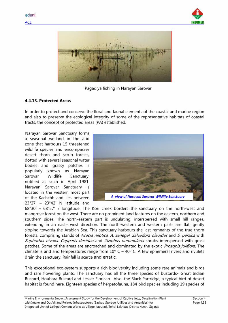
ACL INDOMER
Marine Environmental Impact Assessment Study for the Development of Captive Jetty, Desalination Plant Section 4
with Intake and Outfall and Related Infrastructures (Backup Storage, Utilities and Amenities) for Page 4.33
Integrated Unit of Lakhpat Cement Works at Village Kapurasi, Tehsil Lakhpat, District Kutch, Gujarat
Pagadiya fishing in Narayan Sarovar
4.4.13. Protected Areas
In order to protect and conserve the floral and faunal elements of the coastal and marine region
and also to preserve the ecological integrity of some of the representative habitats of coastal
tracts, the concept of protected areas (PA) established.
Narayan Sarovar Sanctuary forms
a seasonal wetland in the arid
zone that harbours 15 threatened
wildlife species and encompasses
desert thorn and scrub forests,
dotted with several seasonal water
bodies and grassy patches is
popularly known as Narayan
Sarovar Wildlife Sanctuary,
notified as such in April 1981.
Narayan Sarovar Sanctuary is
located in the western most part
of the Kachchh and lies between
23°27' – 23°42' N latitude and
68°30' – 68°57' E longitude. The Kori creek borders the sanctuary on the north-west and
mangrove forest on the west. There are no prominent land features on the eastern, northern and
southern sides. The north-eastern part is undulating, interspersed with small hill ranges,
extending in an east– west direction. The north-western and western parts are flat, gently
sloping towards the Arabian Sea. This sanctuary harbours the last remnants of the true thorn
forests, comprising stands of Acacia nilotica, A. senegal, Salvadora oleoides and S. persica with
Euphorbia nivulia, Capparis decidua and Ziziphus nummularia shrubs interspersed with grass
patches. Some of the areas are encroached and dominated by the exotic Prosopis juliflora. The
climate is arid and temperatures range from 10º C – 40º C. A few ephemeral rivers and rivulets
drain the sanctuary. Rainfall is scarce and erratic.
This exceptional eco-system supports a rich biodiversity including some rare animals and birds
and rare flowering plants. The sanctuary has all the three species of bustards- Great Indian
Bustard, Houbara Bustard and Lesser Florican. Also, the Black Partridge, a typical bird of desert
habitat is found here. Eighteen species of herpetofauna, 184 bird species including 19 species of
A view of Narayan Sarovar Wildlife Sanctuary

ACL INDOMER
Marine Environmental Impact Assessment Study for the Development of Captive Jetty, Desalination Plant Section 4
with Intake and Outfall and Related Infrastructures (Backup Storage, Utilities and Amenities) for Page 4.34
Integrated Unit of Lakhpat Cement Works at Village Kapurasi, Tehsil Lakhpat, District Kutch, Gujarat
raptors occur in the sanctuary. The most sighted animal is the Chinkara. Very large portion of
the area of the sanctuary exhibits the edaphic climax of tropical thorn forest with tree height
averaging three to 5 m. Major part of the sanctuary is under grassland and scrub forest. Map
showing protected areas of Gujarat is presented below (Source: forest.gujarat.gov.in).
Protected areas of Gujarat
Eco Sensitive Zone of Narayan Sarovar wild life sanctuary: As per Ministry of Environment and
Forest Notification dt. 31st May 2012 on Narayan Sarovar wild life sanctuary, mean distance of 1.5
km is notified under Eco Sensitive Zone surrounding the Narayan Sarovar. Map of Narayan
Sarovar Wild Life Sanctuary boundary and ESZ boundary is shown in Fig. 4.5.
4.5. Comparison of Offshore and Nearshore Water
Physico – Chemical Properties
Comparison was made on the salient water quality parameters of the stations in adjacent clear
water and nearshore water. Sampling location were selected to cover both open seawater
(Arabian sea) and creek water (between berthing jetty and Kori creek mouth). There is no
significant difference in water quality is noticed between proposed jetty location and open
seawater. Results indicate that quality of Kori creek water is as equally good as open seawater.
Apart from relatively high turbidity and TSS, no significant changes noticed. It can be inferred
that the nearshore and offshore water quality almost remains same in respect to physio-
chemical quality features.
NS Wild Life Sanctuary

ACL INDOMER
Marine Environmental Impact Assessment Study for the Development of Captive Jetty, Desalination Plant Section 4
with Intake and Outfall and Related Infrastructures (Backup Storage, Utilities and Amenities) for Page 4.35
Integrated Unit of Lakhpat Cement Works at Village Kapurasi, Tehsil Lakhpat, District Kutch, Gujarat
Marine Biology
Biological aspects such as primary productivity, Phytoplankton species composition, Numerical
abundance of Phytoplankton, Zooplankton population and Subtidal population were compared
between offshore and nearshore water. Analysis indicate that Phytoplankton species
composition, Numerical abundance of Phytoplankton, Zooplankton population and subtidal
population were comparatively high in offshore water. Relatively low population and diversity
observed in Kori creek can be attributed with turbid water quality.
A Comparison between water quality and marine biology of two extreme sampling locations
(SS1, SB1 & SS10, SB10) were also carried out and is given below.
Comparison between water quality of SS1 & SS10 Comparison between Phytoplankton &
Zooplankton abundance of SS1 & SS10
Comparison between Phytoplankton species &
Zooplankton biomass of SS1 & SS10
Comparison between primary productivity &
subtidal benthos biomass of SS1 & SS10

ACL INDOMER
Marine Environmental Impact Assessment Study for the Development of Captive Jetty, Desalination Plant Section 4
with Intake and Outfall and Related Infrastructures (Backup Storage, Utilities and Amenities) for Page 4.36
Integrated Unit of Lakhpat Cement Works at Village Kapurasi, Tehsil Lakhpat, District Kutch, Gujarat
The details of comparison between nearshore and offshore waters is presented in Table below.
Sl.
No Parameters Unit
Nearshore water (between
berthing jetty and mouth
of Kori creek)
Offshore water
(Arabian sea)
Physico – Chemical properties
1 Temperature °C 26 – 27.9 26.6 – 28.0
2 pH - 8.27 – 8.5 8.3 – 8.36
3 Salinity ppt 38.6 – 40.1 38.6 – 39.2
4 TSS mg/l 50 -135 35 - 65
5 Turbidity NTU 4.9 – 12.2 3.2 – 6.5
6 DO mg/l 5 – 5.6 5.2 – 5.4
7 BOD mg/l 1.1 – 2.1 1.1 – 1.8
8 COD mg/l 20.4 – 28.6 18.8 – 24.4
9 Ammonia Nitrogen µmol/l 2.9 – 8.4 4.0 – 6.7
10 Nitrates as NO3 µmol/l 3.9 – 10.3 6.1 – 8.0
11 Nitrites as NO2 µmol/l 2.1 – 2.7 1.7 – 2.5
12 Phosphate PO4 µmol/l 0.5 – 2.0 0.6 – 1.1
13 Total Nitrogen µmol/l 31.1 – 47.3 33.8 – 41.6
14 Heavy metals mg/l <0.01 <0.01
Marine Biology
1 Primary productivity mgC/m3/day 264 - 384 360 - 408
2 Phytoplankton
species diversity - 17 - 24 25 - 26
3 Phytoplankton
numerical abundance nos./l 14200 - 22400 24400 - 29200
4 Zooplankton
numerical abundance nos./100m3 74665 - 101333 115582 - 117158
5 Subtidal benthos
numerical abundance nos./m2 360 - 800 840

ACL INDOMER
Marine Environmental Impact Assessment Study for the Development of Captive Jetty, Desalination Plant Section 4
with Intake and Outfall and Related Infrastructures (Backup Storage, Utilities and Amenities) for Page 4.37
Integrated Unit of Lakhpat Cement Works at Village Kapurasi, Tehsil Lakhpat, District Kutch, Gujarat
4.6. Summary of Marine Baseline Data
Summary of marine baseline study carried out during September 2018 is given below,
SEAWATER
PARAMETERS Max Min *For Harbour waters
(SW IV)
Salinity (ppt) 40.1 38.6 -
pH 8.5 8.27 6 - 9
COD (mg/l) 28.6 18.8 -
BOD (mg/l) 2.1 1.1 5.0
DO (mg/l) 5.6 5.0 3.0
Oil and Grease (mg/l) <1.0 10
*Annexure V - Water Quality Standards for Coastal Waters, EIA Guidance Manual – Ports & Harbors
*SEABED SEDIMENTS
PARAMETERS Max Min
Total Organic Carbon (%) 0.67 0.27
Total Nitrogen (mg/kg) 181.7 139.8
Total Phosphorous
(mg/kg) 12.0 4.9
Calcium carbonate (%) 6.2 1.1
*No typical seawater standard is available for these parameters
BIOLOGICAL PARAMETERS
PARAMETERS Max Min Mean
Primary production
(mgC/m3/day) 408 264 336
Species diversity 26 17 22
Abundance (nos./l) 29200 14200 19840
Species diversity 24 29 26
Abundance (nos./100m3) 117158 74665 94922
Biomass (ml/100m3) 59.4 22.9 43.5
Abundance (nos./m2) 840 360 692

ACL INDOMER
Marine Environmental Impact Assessment Study for the Development of Captive Jetty, Desalination Plant Section 4
with Intake and Outfall and Related Infrastructures (Backup Storage, Utilities and Amenities) for Page 4.38
Integrated Unit of Lakhpat Cement Works at Village Kapurasi, Tehsil Lakhpat, District Kutch, Gujarat
MARINE ECOLOGY AND BIODIVERSITY
Parameters Presence/Absence Remarks
Coastal Vegetation Halophyte diversity observed within 10 km project
radius is less abundant/scanty.
Mangroves Mangroves are observed in patches, dominated by
single species of Avicennia Marina. No mangroves
were observed near proposed berthing jetty.
Seaweeds and Seagrass -
Coral reefs
No authentic evidence on corals in Kori creek is
reported. However, a literature study on stony corals
young polyp of Favia sp. as well as barnacles, oyster
spats, gastropods, polychaetes is reported from Kori
creek.
Marine Mammals -
Turtles -
Endangered Species Critically endangered Eurynorhynchus pygmeus
(Spoon‐billed Sandpiper) migratory is reported during
the study.
Seabirds Total 63 species have been reported from study area.
Fish and Fisheries
Narayan Sarovar and Chher Nani are the fishing
villages near the project site. Both fishing
boat/traditional fishing methods and Pagadiya fishing
were noticed in the project area.
Protected Areas Narayan Sarovar Wild Life Sanctuary, proposed project
site falls away the boundary and ESZ of Narayan
Sarovar Wild Life Sanctuary. Presence () and absence ()

ACL INDOMER
Marine Environmental Impact Assessment Study for the Development of Captive Jetty, Desalination Plant Section 4
with Intake and Outfall and Related Infrastructures (Backup Storage, Utilities and Amenities) for Page 4.39
Integrated Unit of Lakhpat Cement Works at Village Kapurasi, Tehsil Lakhpat, District Kutch, Gujarat
Table 4.1. Details of seawater, seabed sediment and biological sampling stations
Station. UTM Coordinates (WGS 84)
Sampling depth X (m) Y (m)
Seawater and Seabed sediment
SS1 & SB1 463589 2634432 S, B
SS2 & SB2 459375 2631182 S, B
SS3 & SB3 457174 2626777 S, M, B
SS4 & SB4 453017 2624138 S, M, B
SS5 & SB5 449154 2620898 S, M, B
SS6 & SB6 451704 2629536 S, M, B
SS7 & SB7 442040 2624336 S, M, B
SS8 & SB8 444064 2616580 S, M, B
SS9 & SB9 438355 2607837 S, M, B
SS10 & SB10 432687 2601987 S, M, B
Intertidal benthos
IB1 464350 2631302 -
IB2 462498 2627429 - IB3 460309 2624760 - IB4 454564 2622801 - IB5 452508 2619869 -
S = Surface, M = Mid depth, B = Bottom

ACL INDOMER
Marine Environmental Impact Assessment Study for the Development of Captive Jetty, Desalination Plant Section 4
with Intake and Outfall and Related Infrastructures (Backup Storage, Utilities and Amenities) for Page 4.40
Integrated Unit of Lakhpat Cement Works at Village Kapurasi, Tehsil Lakhpat, District Kutch, Gujarat
Table 4.2. Seawater quality of Kori creek – September 2018
Station Depth Temp.
(°C) pH
Conductivity
(µS/cm)
TDS
(mg/l)
Salinity
(ppt)
TSS
(mg/l)
Turbidity
(NTU)
DO
(mg/l)
BOD
(mg/l)
COD
(mg/l)
SS1 S 27.5 8.40 63373 42460 39.9 126 14.8 5.2 1.1 22.4
B 26.0 8.28 63687 42670 40.1 135 15.2 5.1 1.4 28.6
SS2 S 27.6 8.42 63164 42320 39.7 110 13.7 5.0 1.4 20.8
B 26.2 8.32 63687 42670 39.9 95 7.8 5.3 1.7 24.2
SS3
S 27.4 8.46 62955 42180 39.6 105 8.4 5.3 1.2 22.4
M 27.0 8.34 63164 42320 39.8 98 8.1 5.4 1.6 24.2
B 26.6 8.36 63194 42340 39.9 94 10.4 5.4 2.1 24.8
SS4
S 27.8 8.47 63269 42390 39.8 75 7.8 5.2 1.4 21.8
M 27.4 8.28 63373 42460 39.9 90 8.6 5.2 1.1 22.4
B 26.4 8.28 63806 42750 40.1 110 12.2 5.5 1.8 23.0
SS5
S 27.9 8.31 62418 41820 38.8 75 8.6 5.4 1.2 22.4
M 27.2 8.27 62522 41890 38.9 80 9.2 5.1 1.3 23.2
B 26.4 8.29 62627 41960 39.1 95 10.2 5.2 1.6 23.8
SS6
S 27.8 8.44 61896 41470 38.9 65 6.8 5.4 1.1 21.4
M 27.6 8.36 61687 41330 39.1 85 7.6 5.1 1.6 22.0
B 26.5 8.37 62104 41610 39.2 108 9.4 5.1 1.4 22.8
SS7
S 27.7 8.50 62418 41820 38.6 60 5.8 5.3 1.2 20.4
M 27.0 8.35 62522 41890 38.8 82 6.4 5.3 1.5 20.8
B 26.5 8.29 62731 42030 39.4 98 8.6 5.2 1.3 21.2
SS8
S 27.8 8.36 62209 41680 38.9 50 4.9 5.0 1.3 23.6
M 27.0 8.38 62418 41820 39.6 70 6.3 5.2 1.3 24.4
B 26.6 8.30 62507 41880 39.2 95 8.8 5.6 1.1 26.2
SS9
S 28.0 8.33 61955 41510 38.6 45 4.7 5.2 1.6 22.2
M 27.2 8.32 61687 41330 38.9 58 5.1 5.3 1.5 24.0
B 26.8 8.30 62000 41540 39.2 65 6.5 5.4 1.2 24.4
SS10
S 28.0 8.32 62104 41610 38.7 35 3.2 5.2 1.5 20.8
M 27.4 8.36 62000 41540 38.9 40 3.8 5.2 1.8 18.8
B 26.6 8.31 62418 41820 39.2 50 4.0 5.3 1.1 20.4 S=Surface; M=Mid depth; B=Bottom; BDL= Below Detectable Limit; DL= Detectable Limit Continued…

ACL INDOMER
Marine Environmental Impact Assessment Study for the Development of Captive Jetty, Desalination Plant Section 4
with Intake and Outfall and Related Infrastructures (Backup Storage, Utilities and Amenities) for Page 4.41
Integrated Unit of Lakhpat Cement Works at Village Kapurasi, Tehsil Lakhpat, District Kutch, Gujarat
Station Depth
Total Residual
Chlorine as Cl-
(mg/l)
Ammonical Nitrogen
as NH3 (µmol/l)
Nitrates as NO3
(µmol/l)
Nitrites as NO2
(µmol/l)
Phosphate as
PO4 (µmol/l)
Total
Phosphorus
(µmol/l)
Total Nitrogen
(µmol/l)
SS1 S <1.0 4.5 7.2 2.2 0.5 2.1 38.0
B <1.0 4.0 3.9 2.2 0.7 1.3 32.1
SS2 S <1.0 2.9 8.2 2.7 1.1 2.7 38.6
B <1.0 3.6 9.7 2.1 2.0 2.6 40.8
SS3
S <1.0 4.0 9.4 2.2 1.1 3.4 41.8
M <1.0 5.5 9.9 2.2 1.0 8.5 40.4
B <1.0 4.2 7.9 2.2 0.9 4.5 37.4
SS4
S <1.0 8.4 4.2 2.2 0.9 2.2 31.1
M <1.0 6.0 9.7 2.2 0.7 1.8 47.3
B <1.0 8.4 7.6 2.2 0.9 1.8 38.8
SS5
S <1.0 5.5 9.0 2.2 0.7 2.0 42.5
M <1.0 3.3 7.7 2.2 0.7 1.9 40.4
B <1.0 3.2 7.4 2.2 0.7 2.0 38.6
SS6
S <1.0 5.5 8.9 2.6 0.8 1.9 45.6
M <1.0 5.3 6.8 2.2 1.5 1.7 38.9
B <1.0 4.3 7.5 2.2 0.9 1.3 39.8
SS7
S <1.0 5.5 6.9 2.7 0.9 2.0 39.4
M <1.0 5.5 8.4 2.2 0.7 1.0 39.0
B <1.0 5.2 10.3 2.2 0.8 2.0 39.6
SS8
S <1.0 5.5 8.0 2.2 0.9 2.9 38.5
M <1.0 5.5 7.5 2.2 0.8 1.0 33.7
B <1.0 6.4 6.3 2.2 0.7 1.5 36.6
SS9
S <1.0 4.6 6.1 2.5 1.0 1.1 41.6
M <1.0 5.5 6.1 2.2 0.6 0.9 33.8
B <1.0 5.5 7.4 2.2 0.7 0.9 37.9
SS10
S <1.0 6.7 8.0 2.2 1.0 3.0 39.6
M <1.0 5.5 7.6 2.2 0.8 2.0 38.2
B <1.0 4.0 7.9 1.7 1.1 3.3 39.9 S=Surface; M=Mid depth; B=Bottom; BDL= Below Detectable Limit; DL= Detectable Limit Continued…

ACL INDOMER
Marine Environmental Impact Assessment Study for the Development of Captive Jetty, Desalination Plant Section 4
with Intake and Outfall and Related Infrastructures (Backup Storage, Utilities and Amenities) for Page 4.42
Integrated Unit of Lakhpat Cement Works at Village Kapurasi, Tehsil Lakhpat, District Kutch, Gujarat
Station Depth Cadmium as Cd
(mg/l)
Chromium as Cr
(mg/l)
Lead as Pb
(mg/l)
Mercury as Hg
(mg/l)
Phenolic
Compound
(mg/l)
Total Oil & Grease
(mg/l)
Petroleum
Hydrocarbon
(µg/l)
SS1 S <0.01 <0.01 <0.01 <0.01 <0.1 <1.0 <0.1
B <0.01 <0.01 <0.01 <0.01 <0.1 <1.0 <0.1
SS2 S <0.01 <0.01 <0.01 <0.01 <0.1 <1.0 <0.1
B <0.01 <0.01 <0.01 <0.01 <0.1 <1.0 <0.1
SS3
S <0.01 <0.01 <0.01 <0.01 <0.1 <1.0 <0.1
M <0.01 <0.01 <0.01 <0.01 <0.1 <1.0 <0.1
B <0.01 <0.01 <0.01 <0.01 <0.1 <1.0 <0.1
SS4
S <0.01 <0.01 <0.01 <0.01 <0.1 <1.0 <0.1
M <0.01 <0.01 <0.01 <0.01 <0.1 <1.0 <0.1
B <0.01 <0.01 <0.01 <0.01 <0.1 <1.0 <0.1
SS5
S <0.01 <0.01 <0.01 <0.01 <0.1 <1.0 <0.1
M <0.01 <0.01 <0.01 <0.01 <0.1 <1.0 <0.1
B <0.01 <0.01 <0.01 <0.01 <0.1 <1.0 <0.1
SS6
S <0.01 <0.01 <0.01 <0.01 <0.1 <1.0 <0.1
M <0.01 <0.01 <0.01 <0.01 <0.1 <1.0 <0.1
B <0.01 <0.01 <0.01 <0.01 <0.1 <1.0 <0.1
SS7
S <0.01 <0.01 <0.01 <0.01 <0.1 <1.0 <0.1
M <0.01 <0.01 <0.01 <0.01 <0.1 <1.0 <0.1
B <0.01 <0.01 <0.01 <0.01 <0.1 <1.0 <0.1
SS8
S <0.01 <0.01 <0.01 <0.01 <0.1 <1.0 <0.1
M <0.01 <0.01 <0.01 <0.01 <0.1 <1.0 <0.1
B <0.01 <0.01 <0.01 <0.01 <0.1 <1.0 <0.1
SS9
S <0.01 <0.01 <0.01 <0.01 <0.1 <1.0 <0.1
M <0.01 <0.01 <0.01 <0.01 <0.1 <1.0 <0.1
B <0.01 <0.01 <0.01 <0.01 <0.1 <1.0 <0.1
SS10
S <0.01 <0.01 <0.01 <0.01 <0.1 <1.0 <0.1
M <0.01 <0.01 <0.01 <0.01 <0.1 <1.0 <0.1
B <0.01 <0.01 <0.01 <0.01 <0.1 <1.0 <0.1 S=Surface; M=Mid depth; B=Bottom; BDL= Below Detectable Limit; DL= Detectable Limit

ACL INDOMER
Marine Environmental Impact Assessment Study for the Development of Captive Jetty, Desalination Plant Section 4
with Intake and Outfall and Related Infrastructures (Backup Storage, Utilities and Amenities) for Page 4.43
Integrated Unit of Lakhpat Cement Works at Village Kapurasi, Tehsil Lakhpat, District Kutch, Gujarat
Table 4.3. Sediment size distribution of Kori creek– September 2018
Station. Classification D50 (mm) Coarse Sand
(%)
Medium Sand
(%)
Fine Sand
(%)
Slit & Clay
(%)
SB1 Fine Sand 0.14 2.8 1.5 93.5 2.2
SB2 Fine Sand 0.15 1.8 1.6 93.6 3.0
SB3 Coarse Sand 0.47 46.0 30.8 18.5 4.7
SB4 Fine Sand 0.14 2.0 1.3 91.3 5.3
SB5 Fine Sand 0.14 13.1 3.1 82.8 0.9
SB6 Fine Sand 0.11 8.4 1.5 82.6 7.5
SB7 Fine Sand 0.12 - 0.9 93.9 5.2
SB8 Fine Sand 0.24 3.7 8.0 87.4 0.9
SB9 Fine Sand 0.14 14.9 3.7 79.5 1.8
SB10 Fine Sand 0.12 0.9 3.3 89.7 6.1
Table 4.4. Seabed Sediment quality of Kori creek – September 2018
Station Total Organic Carbon
(%)
Total Nitrogen
(mg/kg)
Total Phosphorus
(mg/kg) Calcium Carbonate (%)
SB1 0.46 167.8 9.1 1.6
SB2 0.46 167.5 4.9 1.1
SB3 0.40 167.7 6.1 5.5
SB4 0.67 181.6 8.7 1.1
SB5 0.47 181.7 8.5 1.6
SB6 0.33 167.7 7.0 2.0
SB7 0.33 153.7 7.0 2.0
SB8 0.33 153.7 5.1 6.2
SB9 0.33 153.6 5.6 1.1
SB10 0.27 139.8 12.0 2.5
Continued…
Station Cadmium as Cd
(mg/kg)
Chromium as Cr
(mg/kg)
Lead as Pb
(mg/kg)
Mercury as
Hg (mg/kg)
Total Petroleum
Hydrocarbons (µg/kg)
SB1 <0.1 14.8 <0.1 <0.1 <0.5
SB2 1.5 <0.1 <0.1 <0.1 <0.5
SB3 1.6 1.2 <0.1 <0.1 <0.5
SB4 0.9 <0.1 <0.1 <0.1 <0.5
SB5 1.6 <0.1 <0.1 <0.1 <0.5
SB6 0.5 <0.1 <0.1 <0.1 <0.5
SB7 1.1 <0.1 <0.1 <0.1 <0.5
SB8 0.8 <0.1 <0.1 <0.1 <0.5
SB9 0.7 <0.1 <0.1 <0.1 <0.5
SB10 7.5 2.0 <0.1 <0.1 <0.5

ACL INDOMER
Marine Environmental Impact Assessment Study for the Development of Captive Jetty, Desalination Plant Section 4
with Intake and Outfall and Related Infrastructures (Backup Storage, Utilities and Amenities) for Page 4.44
Integrated Unit of Lakhpat Cement Works at Village Kapurasi, Tehsil Lakhpat, District Kutch, Gujarat
Table: 4.5. Primary productivity of Kori creek - September 2018
Station
Gross
primary
productivity
Net primary
productivity
Primary
production
mgC/m3/day
SS1 1.3 0.7 312
SS2 1.1 0.6 264
SS3 1.2 0.8 288
SS4 1.4 1.0 336
SS5 1.3 0.9 312
SS6 1.5 0.9 360
SS7 1.6 1.1 384
SS8 1.4 1.0 336
SS9 1.5 1.1 360
SS10 1.7 1.0 408

ACL INDOMER
Marine Environmental Impact Assessment Study for the Development of Captive Jetty, Desalination Plant Section 4
with Intake and Outfall and Related Infrastructures (Backup Storage, Utilities and Amenities) for Page 4.45
Integrated Unit of Lakhpat Cement Works at Village Kapurasi, Tehsil Lakhpat, District Kutch, Gujarat
Table. 4.6. Phytoplankton species composition* of Kori creek - September 2018
Sl.
No. Species
Stations
SS1 SS2 SS3 SS4 SS5 SS6 SS7 SS8 SS9 SS10
Phylum: Heterokontophyta
Class: Bacillariophyceae (Diatoms)
Order: Centrales
1 Asteromphalus sp. - + - + + - + - + +
2 Bacillaria paradoxa - - + + - + - - + +
3 Chaetoceros sp. + + - + + - + + + +
4 Chaetoceros affinis + - + - - + - + + +
5 Chaetoceros coarctatus - + - + + + + - + +
6 Coscinodiscus centralis + - + + - + - + - +
7 Coscinodiscus lorenzianus - - + + + + + + + -
8 Coscinodiscus excentricus - + - + - - + + - +
9 Coscinodiscus marginatus + - + - + + - + + +
10 Ditylum brightwellii - + - + - + - + + +
11 Odontella mobiliensis + - + + + - + + + +
12 Odontella sinensis - + - + + + - + + +
13 Planktoniella sol - + - + + + + + + +
14 Rhizosolenia alata + - + - - + - + + +
15 Rhizosolenia styliformis - + + + + + + - + +
16 Skeletonema costatum - - - - + - + + - -
17 Thalassiosira subtilis + + - + + + + + + +
Subtotal 7 9 8 13 11 12 10 13 14 15
Order: Pennales
18 Asterionella japonica + - + + + + + - + +
19 Bellerochea malleus - + - + + - + + - -
20 Nitzschia longissima - + - + + + - + + +
21 Navicula hennedyii + - + - + - + + - -
22 Pleurosigma normanii + + - + - + - + + +
23 Pleurosigma directum - + + + + + + - + -
24 Thalassionema nitzschioides + - - + + + - + + +
25 Thalassiothrix frauenfeldii + + + - + + + - + +
Subtotal 5 5 4 6 7 6 5 5 6 5
Phylum: Pyrrophyta (or Dinophyta)
Class: Dinophyceae (Dinoflagellates)
26 Ceratium lineatus - + - + - - + - + +
27 Ceratium furca + + + + + + + - + +
28 Ceratium macroceros + - + - - - + + - +
29 Ceratium tripos - + - + + + - + + -
30 Dinophysis caudata + + + + - + - + + -
31 Peridinium depressum + + + - + - + - + +
Subtotal 4 5 4 4 3 3 4 3 5 4
Class: Cyanophyceae
32 Trichodesmium erythraeum + + + + + + + + + +
Subtotal 1 1 1 1 1 1 1 1 1 1
Total 17 20 17 24 22 22 20 22 26 25

ACL INDOMER
Marine Environmental Impact Assessment Study for the Development of Captive Jetty, Desalination Plant Section 4
with Intake and Outfall and Related Infrastructures (Backup Storage, Utilities and Amenities) for Page 4.46
Integrated Unit of Lakhpat Cement Works at Village Kapurasi, Tehsil Lakhpat, District Kutch, Gujarat
Table 4.7. Numerical abundance of Phytoplankton (Nos./l)* of Kori creek - September 2018
Sl.
No. Genus/Species
Stations Total %
SS1 SS2 SS3 SS4 SS5 SS6 SS7 SS8 SS9 SS10
Phylum: Heterokontophyta
Class: Bacillariophyceae (Diatoms)
Order: Centrales
1 Asteromphalus sp. 400 800 - 800 600 1000 1000 1000 600 - 6200 3.1
2 Bellerochea malleus 800 - 600 400 800 - 800 1000 600 - 5000 2.5
3 Chaetoceros sp. 1200 1200 - 600 1400 - 1000 400 1200 800 7800 3.9
4 Chaetoceros affinis 400 600 600 1000 - 600 400 1000 1600 1200 7400 3.7
5 Coscinodiscus sp. 400 600 200 1200 1200 1200 - 600 1000 1000 7400 3.7
6 Coscinodiscus excentricus - 800 600 400 1000 - 600 1200 - 1200 5800 2.9
7 Ditylum brightwellii 200 400 1000 400 - 600 1200 1400 1200 1600 8000 4.0
8 Odontella mobiliensis 1400 - 1800 400 1000 1400 600 800 - 1000 8400 4.2
9 Odontella sinensis 400 1200 1600 - 1200 800 - 600 1400 1600 8800 4.4
10 Planktoniella sol - 400 400 1200 1000 1000 800 1200 1400 1600 9000 4.5
11 Rhizosolenia alata 800 - 400 1000 800 800 - 800 1000 - 5600 2.8
12 Rhizosolenia styliformis - 1000 1200 600 1400 - 1000 1000 600 1200 8000 4.0
13 Thalassiosira subtilis 600 400 - 200 600 - 1400 1000 1000 1200 6400 3.2
Order: Pennales
14 Asterionella sp. 1000 400 1800 - - 1200 600 400 1000 1200 7600 3.8
15 Bacillaria paradoxa - 1000 - 800 400 1200 1000 - 800 1600 6800 3.4
16 Nitzschia longissima 400 400 600 1000 800 800 1000 1000 - 800 6800 3.4
17 Navicula hennedyii 400 - 600 - 600 - 1200 - 1000 400 4200 2.1
18 Pleurosigma normanii 600 800 - 1000 - 400 - 600 1400 1400 6200 3.1
19 Pleurosigma directum 200 - 1000 - 1200 600 1400 1200 400 1800 7800 3.9

ACL INDOMER
Marine Environmental Impact Assessment Study for the Development of Captive Jetty, Desalination Plant Section 4
with Intake and Outfall and Related Infrastructures (Backup Storage, Utilities and Amenities) for Page 4.47
Integrated Unit of Lakhpat Cement Works at Village Kapurasi, Tehsil Lakhpat, District Kutch, Gujarat
Sl.
No. Genus/Species
Stations Total %
SS1 SS2 SS3 SS4 SS5 SS6 SS7 SS8 SS9 SS10
20 Thalassionema nitzschioides 1000 1200 1600 800 1000 400 400 600 1600 600 9200 4.6
21 Thalassiothrix frauenfeldii 400 - 600 600 600 400 400 800 - 1200 5000 2.5
Class: Dinophyceae (Dinoflagellates)
22 Ceratium lineatus 800 1200 600 400 - 400 600 1200 1400 1400 8000 4.0
23 Ceratium furca 600 1400 600 600 200 1600 600 800 400 600 7400 3.7
24 Ceratium macroceros 400 - 1000 1000 1000 - 800 600 1200 1200 7200 3.6
25 Ceratium tripos - 400 - 200 400 1000 400 600 400 1800 5200 2.6
26 Dinophysis caudata 800 600 600 600 1000 400 600 800 800 1200 7400 3.7
27 Peridinium depressum 200 - 400 - 400 600 600 1000 1400 600 5200 2.6
Class: Cyanophyceae
28 Trichodesmium erythraeum 800 1000 1800 1400 600 1000 1200 800 1000 1000 10600 5.3
Total 14200 15800 19600 16600 19200 17400 19600 22400 24400 29200 198400 100
No. of Species 23 20 22 23 23 21 24 26 24 25 - -
Note: * Bottle sample method

ACL INDOMER
Marine Environmental Impact Assessment Study for the Development of Captive Jetty, Desalination Plant Section 4
with Intake and Outfall and Related Infrastructures (Backup Storage, Utilities and Amenities) for Page 4.48
Integrated Unit of Lakhpat Cement Works at Village Kapurasi, Tehsil Lakhpat, District Kutch, Gujarat
Table 4.8. Zooplankton population (nos./100m3) of Kori creek - September 2018
Sl. No. Genus / Species Stations
Total % SS1 SS2 SS3 SS4 SS5 SS6 SS7 SS8 SS9 SS10
Phylum: Protozoa
Order: Tintinnids (Ciliate groups)
1 Eutintinnus tenuis 4000 - 2439 - 2357 - 906 3803 - 3896 17401 1.8
2 Favella sp. 2667 1331 - 2667 2357 3312 1812 - 4449 2597 21192 2.2
3 Dictyocysta sp. 1333 - 1220 - - - - 2853 - - 5406 0.6
Phylum: Cnidaria
4 Diphysis sp. - 1331 1220 2667 - 2208 2717 - 1483 3896 15522 1.6
Phylum: Chaetognatha
5 Sagitta sp. 1333 2662 2439 - 4714 3312 - 1902 4449 2597 23408 2.5
Phylum: Annelida
Class: Polychaeta
6 Polychaete larvae 1333 - 2439 2667 - 3312 1812 - 2966 2597 17126 1.8
Phylum: Mollusca
7 Bivalve veliger 1333 - 1220 1333 - - 1812 - - 1299 6997 0.7
8 Gastropods veliger - 2662 - 1333 - - - 2853 4449 3896 15193 1.6
Phylum: Arthropoda / Class: Crustacea
Order: Copepoda
Sub-order: Calanoida
9 Acartia danae 6667 10646 10976 8000 11785 9937 8152 11410 14831 14286 106690 11.2
10 Acartia erythraea 5333 - 2439 1333 5892 5521 2717 2853 5932 7792 39812 4.2
11 Acartia spinicauda - 7985 1220 5333 - 2208 3623 2853 4449 6494 34165 3.6
12 Acrocalanus sp. 5333 6654 7317 - 4714 - 4529 3803 5932 2597 40879 4.3
13 Clausocalanus minor 1333 - 6098 4000 - 3312 - 2853 - 3896 21492 2.3
14 Calanopia minor - 3992 2439 2667 2357 - 4529 1902 - - 17886 1.9
15 Eucalanus sp. 4000 1331 - 5333 3535 2208 4529 3803 5932 2597 33268 3.5
16 Labidocera sp. - 5323 3659 - - 4416 2717 4754 2966 5195 29030 3.1
17 Labidocera acuta - 2662 - - 3535 3312 3623 - - - 13132 1.4
18 Paracalanus parvus 4000 3992 1220 6667 - 3312 2717 2853 7415 3896 36072 3.8
19 Pontella sp. 2667 - 4878 4000 2357 - 906 - - - 14808 1.6

ACL INDOMER
Marine Environmental Impact Assessment Study for the Development of Captive Jetty, Desalination Plant Section 4
with Intake and Outfall and Related Infrastructures (Backup Storage, Utilities and Amenities) for Page 4.49
Integrated Unit of Lakhpat Cement Works at Village Kapurasi, Tehsil Lakhpat, District Kutch, Gujarat
20 Temora discaudata 2667 3992 - 2667 1178 2208 - 4754 2966 3896 24328 2.6
21 Temora turbinata - 2662 3659 5333 2357 3312 - - - - 17323 1.8
22 Copepod nauplii 4000 - 4878 - 3535 - 2717 - 8898 2597 26625 2.8
Sub-order: Cyclopoida
23 Corycaeus catus 1333 - 3659 - 2357 3312 1812 2853 - - 15326 1.6
24 Corycaeus danae 2667 2662 2439 5333 3535 - 2717 3803 2966 5195 31317 3.3
25 Oncaea venusta - - 3659 4000 - 3312 1812 - - - 12783 1.3
26 Oithona brevicornis 1333 2662 - 5333 3535 3312 2717 4754 7415 2597 33658 3.5
27 Oithona sp. 4000 - 6098 2667 2357 3312 - 2853 - 2597 23884 2.5
28 Oithona similis - 3992 - - 2357 - 2717 - 7415 3896 20377 2.1
Sub-order: Harpacticoida
29 Euterpina acutifrons 2667 3992 - 5333 1178 4416 2717 1902 4449 5195 31849 3.4
30 Macrosetella sp. 1333 - 4878 - 3535 - 1812 2853 - 1299 15710 1.7
31 Microsetella sp. - 2662 - 4000 2357 2208 2717 - 2966 2597 19507 2.1
Other Crustaceans
32 Brachyuran zoeae 1333 2662 - - 2357 4416 - - 2966 - 13734 1.4
33 Crustacean nauplii 2667 1331 3659 5333 4714 3312 3623 2853 4449 6494 38435 4.0
34 Shrimp larvae 4000 - 7317 6667 - 5521 5435 7607 - - 36547 3.9
35 Lucifer sp. - 3992 2439 2667 3535 3312 906 2853 2966 3896 26566 2.8
Phylum: Chordata
36 Fish eggs 2667 - - 1333 - 3312 1812 - - 2597 11721 1.2
37 Fish larvae 1333 2662 - - - 2208 906 1902 2966 1299 13276 1.4
38 Oikopleura sp. 1333 2662 4878 2667 3535 4416 - 1902 1483 3896 26772 2.8
Total (nos./100m3) 74665 86504 98786 101333 86025 98259 81521 89384 117158 115582 949217 100
Biomass (ml/100m3) 25.0 39.9 22.9 45.7 47.1 50.5 45.3 44.4 55.1 59.4 - -
No. of Species 27 24 26 26 25 27 29 25 24 29 - -

ACL INDOMER
Marine Environmental Impact Assessment Study for the Development of Captive Jetty, Desalination Plant Section 4
with Intake and Outfall and Related Infrastructures (Backup Storage, Utilities and Amenities) for Page 4.50
Integrated Unit of Lakhpat Cement Works at Village Kapurasi, Tehsil Lakhpat, District Kutch, Gujarat
Table: 4.9. Subtidal and Intertidal benthic population (nos./m2) of Kori creek - September 2018
Sl. No. Groups Subtidal benthos Intertidal benthos
SB1 SB2 SB3 SB4 SB5 SB6 SB7 SB8 SB9 SB10 IB1 IB2 IB3 IB4 IB5
Phylum: Annelida
Class: Polychaeta
1 Armandia sp. 40 40 40 40 80 240 120 80 - 80 45 60 - 60 -
2 Capitella sp. - - 120 - 160 80 160 - 120 - 45 - 30
3 Cossura sp. 80 - 80 - 80 80 80 - 80 80 90 - 105 105
4 Eunice sp. - 40 0 80 120 - 40 40 40 120 45 45 60 30 30
5 Glycera sp. - - 80 - - - 80 80 - - 30 - 120 - -
6 Notomastus sp. - 80 80 - 80 40 - - 80 - 150 - 45 45
7 Onuphis sp. - - 40 80 - 80 - 120 - 80 45 45 - - 15
8 Polydora sp. 40 80 - - 80 - 80 200 - 45 30 30 30 30
9 Prinospio sp. - 40 - 40 80 40 - 80 80 - 75 - 45 45 45
10 Unidentified polychaetes 40 80 40 80 80 40 - 120 - 160 90 30 - - -
Phylum: Mollusca
Class: Gastropoda
11 Cerithedia sp. - - - - - - - - - - - 15 105 - 45
12 Nassarius sp. 40 - 40 80 - - - 40 - 80 - 45 - 75 75
13 Oliva sp. - 40 80 - 40 40 120 - 120 - - - 45 - 45
14 Turbo coronatus - - 80 80 - 80 - - - 120 75 30 - 45 60
Class: Bivalvia
15 Donax cuneatus - 80 - 40 80 - 40 80 - - - - - 45
16 Paphia malabarica 40 40 80 - - - - 80 - 120 30 45 - 60 60
17 Unidentified Bivalves 80 - 80 - - 120 80 - - 60 30 - 75 75
Total 360 520 640 720 720 800 680 800 840 840 660 615 450 570 705

ACL INDOMER
Marine Environmental Impact Assessment Study for the Development of Captive Jetty, Desalination Plant Section 4
with Intake and Outfall and Related Infrastructures (Backup Storage, Utilities and Amenities) for Page 4.51
Integrated Unit of Lakhpat Cement Works at Village Kapurasi, Tehsil Lakhpat, District Kutch, Gujarat
Table 4.10. Bacterial population (nos.x103 CFU/ml) of Kori creek - September 2018
Media
Type of
Bacteria
Stations
SS1 SS2 SS3 SS4 SS5 SS6 SS7 SS8 SS9 SS10
Nut Agar TVC 4.98 5.05 4.99 5.21 5.13 5.11 4.74 5.35 4.92 5.32
Mac Agar TC 0.57 0.54 0.53 0.55 0.59 0.57 0.61 0.56 0.51 0.58
Mac Agar FC 0.17 0.16 0.15 0.27 0.23 0.19 0.22 0.20 0.23 0.21
Mac Agar ECLO 0.51 0.53 0.51 0.50 0.55 0.56 0.48 0.50 0.52 0.54
XLD Agar SHLO 0.09 0.08 0.46 0.08 0.09 0.13 0.11 0.15 0.13 0.11
XLD Agar PKLO 0.05 0.06 0.04 0.04 0.05 0.04 0.06 0.07 0.03 0.05
TCBS Agar VLO 0.21 0.22 0.23 0.21 0.28 0.26 0.21 0.25 0.27 0.22
TCBS Agar VPLO 0.19 0.18 0.12 0.24 0.19 0.20 0.18 0.17 0.20 0.24
TCBS Agar VCLO 0.06 0.05 0.07 0.05 0.05 0.07 0.06 0.05 0.03 0.07
CET Agar PALO 0.03 0.02 - - 0.02 0.02 0.03 0.01 - - - Not Detectable
TVC -Total Viable Counts; TC- Total Coliforms; FC – Faecal Coliforms; ECLO - Escherichia coli like organisms; SHLO - Shigella like organisms; PKLO - Proteus klebsiella like organisms; VLO - Vibrio like organisms; VPLO - Vibrio parahaemolyticus like
organisms; VCLO - Vibrio cholerae like organisms; PALO - Pseudomonas aeruginosa like organisms.
Table 4.11. Bacterial population in seabed sediment (nos.x104 CFU/g) of Kori creek -
September 2018
Media Type of
Bacteria
Stations
SB1 SB2 SB3 SB4 SB5 SB6 SB7 SB8 SB9 SB10
Nut Agar TVC 5.36 5.25 5.28 5.27 5.46 5.45 5.63 5.40 5.42 5.38
Mac Agar TC 0.65 0.62 0.60 0.60 0.57 0.59 0.62 0.61 0.62 0.58
Mac Agar FC 0.23 0.21 0.24 0.18 0.20 0.23 0.20 0.24 0.25 0.27
Mac Agar ECLO 0.51 0.49 0.53 0.51 0.53 0.49 0.52 0.56 0.50 0.51
XLD Agar SHLO 0.08 0.07 0.08 0.06 0.05 0.08 0.07 0.06 0.05 0.07
XLD Agar PKLO 0.05 0.03 0.03 0.04 0.04 0.03 0.05 0.07 0.06 0.07
TCBS Agar VLO 0.24 0.26 0.23 0.25 0.24 0.23 0.24 0.27 0.22 0.24
TCBS Agar VPLO 0.19 0.20 0.22 0.21 0.19 0.22 0.21 0.24 0.25 0.27
TCBS Agar VCLO 0.05 0.04 0.04 0.05 0.06 0.07 0.06 0.05 0.08 0.07
CET Agar PALO 0.03 0.02 0.04 0.03 0.04 0.04 0.02 0.03 0.04 0.03
- Not Detectable
TVC -Total Viable Counts; TC- Total Coliforms; FC – Faecal Coliforms; ECLO - Escherichia coli like organisms; SHLO - Shigella like organisms; PKLO - Proteus klebsiella like organisms; VLO - Vibrio like organisms; VPLO - Vibrio parahaemolyticus like
organisms; VCLO - Vibrio cholerae like organisms; PALO - Pseudomonas aeruginosa like organisms.

ACL INDOMER
Marine Environmental Impact Assessment Study for the Development of Captive Jetty, Desalination Plant Section 4
with Intake and Outfall and Related Infrastructures (Backup Storage, Utilities and Amenities) for Page 4.52
Integrated Unit of Lakhpat Cement Works at Village Kapurasi, Tehsil Lakhpat, District Kutch, Gujarat
Table 4.12. List of Bird species sighted and reported from the study area
Sl.
No. Family List of Species
Common
name Remarks
1 ANATIDAE Anas crecca Linnaeus, 1758
Common teal* It is a common and widespread duck,
breeds in temperate regions and
migrates to south in winter.
2 LARIDAE Anous stolldes plleatus (Linnaeous,
1758)
Common
noody*
It is a seabird and they are the
largest of the noddies.
3 ARDEIDAE Ardea cinerea Linnaeus, 1758
Grey Heron* It is a long-legged predatory wading
bird native throughout temperate
and Asia. A bird of wetland areas, it
can be seen around sea coast.
4 ARDEIDAE Ardeola grayii (Sykes, 1832)
Indian Pond
heron*
They are very common in India and
are usually solitary foragers but
numbers of them may sometimes
feed in close proximity during the dry
seasons.
6 SCOLOPACIDAE Arnaria interpres Linnaeus, 1758
Ruddy
turnstone
The ruddy turnstone breeds in
northern latitudes, usually no more
than a few kilometres from the sea.
7 ARDEIDAE Bubulcus ibis (Linnaeus, 1758)
Cattle egret* Some populations of cattle egrets
are migratory, others are dispersive,
and distinguishing between the two
can be difficult for this species.
8 BURHINIDAE Burhinus oedicnemus (Linnaeus, 1758)
Eurasian stone
curlew*
Despite being classed as a wader,
this species prefers dry open habitats
with some bare ground.
9 ARDEIDAE Butorides striatus (Linnaeus, 1758)
Striated Heron Widespread and generally common,
the striated heron is classified as a
species of least concern by the IUCN.
10 SCOLOPACIDAE Calidris minuta (Leisler, 1812)
Little stint* The little stint (Calidris minuta) (or
Erolia minuta), is a very small wader.
It breeds in Asia and is wintering
south Asia.
11 CHARADRIIDAE Charadrius alexandrines Linnaeus, 1758
Kentish plover It is a small cosmopolitan shore bird
that breeds on the shores of saline
lakes, lagoons, and coasts,
populating sand dunes, marshes,
semi-arid desert, and tundra.
12 CHARADRIIDAE Charadrius leschenaultia (Linnaeus, 1758)
Greater sand
plover*
It is a small wader in the plover
family of birds.
13 CHARADRIIDAE Charadrius mongolus
Lesser sand
plover*
It breeds above the tree line in the
Himalayas and coastal plains in north
– eastern Siberia, it has also bred in
Alaska. It nests in a bare ground
scrape, laying three eggs. This
species is strongly migratory,
wintering on sandy beaches in east
Africa, south Asia and Australasia.

ACL INDOMER
Marine Environmental Impact Assessment Study for the Development of Captive Jetty, Desalination Plant Section 4
with Intake and Outfall and Related Infrastructures (Backup Storage, Utilities and Amenities) for Page 4.53
Integrated Unit of Lakhpat Cement Works at Village Kapurasi, Tehsil Lakhpat, District Kutch, Gujarat
Sl.
No. Family List of Species
Common
name Remarks
14 ACCIPITRIDAE Circus macrourus S G
Gmelin, 1770
Pallid harrier It breeds in southern parts of Central
Asia and winters mainly in India and
southeast Asia. IUCN Near
Threatened bird.
15 CORACIIDAE Coracias bengalensis
(Linnaeus, 1758)
Indian roller* It is not migratory but undertakes
some seasonal movements. The
largest population occurs in India
16 CORVIDAE Corvus splendens
Vieillot, 1817
House crow* The nominate race C. s. splendens is
found in Pakistan, India, Nepal and
Bangladesh and has a grey neck
collar.
17 HIRUNDINIDAE Delichion urbicum (Linnaeus, 1758)
Common
house martin
The common house martin, is a
migratory passerine bird which
breeds in Europe, Africa and tropical
Asia
18 Dromas ardeola Paykull, 1805
Crab plover* It is resident on the coasts and
islands, where it feeds on crabs and
other small animals. They are
gregarious and will feed in large
groups, at night and during dawn
and dusk as well as during the day.
19 ARDEIDAE Egretta gularis (Bosc, 1792)
Western reef
heron
It occurs mainly on the coasts eat
fish, crustaceans and molluscs.
20 Elanus caeruleus (Desfontaines,
1789)
Black winged
kite*
The black-winged kite breeds at
different times of the year across its
range. Although nesting has been
noted throughout the year in India,
they appear not to breed in April and
May
21 ACCIPITRIDAE Haliatus leucogaster
White bellied
sea eagle*
They are a common sight in coastal
areas but may also be seen well
inland. The white-bellied sea eagle
may travel long distances.
22 LARIDAE Larus fuscus
Linnaeus, 1758
Lesser black
backed gull
They are omnivores like most Larus
gulls, and they will eat fish,
crustaceans, starfish, molluscs and
small birds.
23 SCOLOPACIDAE Limosa lapponica
(Linnaeus, 1758
Bar tailed
godwit*
It forages by probing in mudflats or
marshes. It may find insects by sight
in short vegetation. It eats mainly
insects and crustaceans, but also
parts of aquatic plants.
24 SCOLOPACIDAE Numenius arquata
(Linnaeus, 1758)
Eurasian
curlew*
The curlew exists as a migratory
species over most of its range,
wintering in Asia.
25 SCOLOPACIDAE Numenius phaeopus
(Linnaeus, 1758)
Whimbrel* This species feeds by probing soft
mud for small invertebrates and by
picking small crabs and similar prey
off the surface.

ACL INDOMER
Marine Environmental Impact Assessment Study for the Development of Captive Jetty, Desalination Plant Section 4
with Intake and Outfall and Related Infrastructures (Backup Storage, Utilities and Amenities) for Page 4.54
Integrated Unit of Lakhpat Cement Works at Village Kapurasi, Tehsil Lakhpat, District Kutch, Gujarat
Sl.
No. Family List of Species
Common
name Remarks
26 OCEANITIDAE Oceanites oceanicus Kuhl,
1820
Wilsons storm
petrel
This species breeds on the Antarctic
coastlines and nearby islands during
the summer. It spends the rest of the
year at sea and moves into the
northern oceans in winter.
27 PANDIONIDAE Pandion haliaetus (Linnaeus, 1758
Osprey* The osprey breeds near freshwater
lakes and rivers, and sometimes on
coastal brackish waters. Rocky
outcrops are used.
28 CHARADRIIIDAE Pluvialis fulva (Gmelin, 1789)
Pacific golden
plover
It is migratory and forages for food
on tundra, fields, beaches and tidal
flats, usually by sight. It eats insects
and crustaceans.
29 CHARADRIIDAE Pluvialis squatarola (Linnaeus, 1758)
Grey plover They forage for food on beaches and
tidal flats, usually by sight. The food
consists of small molluscs,
polychaete worms, crustaceans, and
insects.
30 LARIDAE Sterna anaethetus Scopoli, 1786
Bridled tern This species breeds in colonies on
rocky islands. It nests in a ground
scrape or hole and lays one egg. It
feeds by plunge-diving for fish in
marine environments but will also
pick from the surface.
31 LARIDAE Sterna bengalensis (Lesson, 1831)
Lesser crested
tern*
This species breeds in dense colonies
on coasts and islands.
32 LARIDAE Sterna bergii vefoz
Greater
crested tern
Largest, heaviest, darkest and
longest-billed subspecies.
33 LARIDAE Sterna fuscata nubilosa (Linnaeus) 1766)
Sooty tern This bird is migratory and dispersive,
wintering more widely through the
tropical oceans.
34 SCOLOPACIDAE Actitis hypoleucos (Linnaeus, 1758)
Common sand
piper*
It is a gregarious bird and is seen in
large flocks, and has the distinctive
stiff-winged flight, low over the
water. The common sandpiper
breeds across temperate and Asia
and migrates to southern Asia.
35 PHOENICOPTERIDAE Phoenicopterus roseus Pallas,
1811
Greater
flamingo*
The bird resides inmudflats and
shallow coastal lagoons with salt
water. Using its feet, the bird stirs up
the mud, then sucks water through
its bill and filters out small shrimp,
seeds, blue-green algae, microscopic
organisms, and molluscs.
36 POENICOPTERIDAE Phoeniconaias minor Geoffroy
Saint Hilarie,
1798
Lesser
flamingo*
IUCN near threatened bird. The
species also breeds in southwestern
and southern Asia. Despite being the
most numerous, it is classified as
near threatened due to its declining
population.

ACL INDOMER
Marine Environmental Impact Assessment Study for the Development of Captive Jetty, Desalination Plant Section 4
with Intake and Outfall and Related Infrastructures (Backup Storage, Utilities and Amenities) for Page 4.55
Integrated Unit of Lakhpat Cement Works at Village Kapurasi, Tehsil Lakhpat, District Kutch, Gujarat
Sl.
No. Family List of Species
Common
name Remarks
37 CICONIIDAE Ephippiorhynchus asiaticus
(Latham, 1790)
Black necked
stork*
In India, the species is widespread in
the west, central highlands, and
northern Gangetic plains. IUCN near
threatened bird. Small numbers are
seen in Indian coastal wetland
habitats, including in mangrove
creeks and marshes.
38 THRESKIORNITHIDAE Platalea leucorodia Linnaeus, 1750
Eurasian
Spoonbill*
Common and local migrant. Found in
shallow coastal areas. Commonly
seen in large numbers in Narayan
Sarovar.
39 CHARADRIIDAE Pluvialis fulva
(Gmelin, 1789)
Pacific Golden
Plover*
Sightings from coastal areas of
Jamnagar and Kachchh also. Rare in
Gujarat.
40 SCOLOPACIDAE Phalaropus lobatus
(Linnaeus, 1758)
Red-necked
Phalarope
Uncommon winter migrant. Regular
sightings from Salt Pans and
Kachchh. Rare
41 SCOLOPACIDAE Xenus cinereus
(Guldenstadt,
1775)
Terek
Sandpiper
Uncommon winter visitor. Mainly
coastal. Sightings from in Kachchh.
Rare.
42 SCOLOPACIDAE Calidris tenuirostris
Horsfield, 1821
Great Knot* Uncommon. Sightings from Kachchh.
Not seen in large numbers.
43 SCOLOPACIDAE Calidris alba
(Palas, 1764)
Sanderling Common. Mainly coastal areas.
Sightings from Kachchh coastline.
44 SCOLOPACIDAE Calidris ferruginea (Pontoppidan,
1763)
Curlew
Sandpiper*
Common winter visitor. Mainly
coastal areas. Common in Kachchh
coastline.
45 SCOLOPACIDAE Calidris alpine (Linnaeus, 1758)
Dunlin Common winter visitor. Mainly
coastal areas. Common in Jamnagar.
Sightings from Saurashtra and
Kachchh coastline. Rare in Gujarat.
46 SCOLOPACIDAE Limicola falcinellus(Pont
oppidan, 1763)
Broad-billed
Sandpiper
Uncommon. Rare. Mainly coastal
areas. Common in Kachchh coastline.
47 LARIDAE Larus cachinnans Pallas, 1811
Caspian Gull Rare. Sighted in coastal areas of
Kachchh. Only a few confirmed
records
48 LARIDAE Larus heuglini heuglini Bree,
1876
Heuglin's Gull Common. Common in coastal areas
of Kachchh.
40 LARIDAE Larus (heuglini) barabensis
Steppe Gull Common. Coastal areas of Kachchh.
50 LARIDAE Larus canus Linnaeus, 1758
Mew Gull Recently reported from Kachchh.
Occurring in the coastal areas of
Kachchh.
51 LARIDAE Chroicocephalus genei (Breme,
1839)
Slender-billed
Gull*
Common and winter migrant. Largely
coastal and seen in Kachchh coast.

ACL INDOMER
Marine Environmental Impact Assessment Study for the Development of Captive Jetty, Desalination Plant Section 4
with Intake and Outfall and Related Infrastructures (Backup Storage, Utilities and Amenities) for Page 4.56
Integrated Unit of Lakhpat Cement Works at Village Kapurasi, Tehsil Lakhpat, District Kutch, Gujarat
Sl.
No. Family List of Species
Common
name Remarks
52 LARIDAE Hydrocoloeus minutus
(Pallas, 1776)
Little Gull Vagrant. Very few sightings Kachchh
coastal areas.
53 LARIDAE Gelochelidon nilotica (Gmelin, 1789)
Gull-billed
Tern
Common visitor. sighted in coastal
areas of Kachchh. Common.
54 LARIDAE Hydroprogne caspia (Pallas,
1770)
Caspian Tern* Common. Resident. Also winter
migrant. sighted in coastal areas of
Kachchh. Breeds in in Gulf of
Kachchh.
55 LARIDAE Thalasseus sandvicensis (Latham, 1787)
Sandwich Tern Uncommon winter visitor. Sighted
from some coastal areas of Kachchh.
Rare.
56 LARIDAE Sterna aurantia (J.E. Gray, 1831)
River Tern Common resident. Sighted in
Kachchh.
57 LARIDAE Sterna hirundo
Linnaeus, 1758
Common
Tern*
Uncommon winter visitor. Sightings
from Kachchh.
58 LARIDAE Sternula saundersi (Hume, 1877)
Saunders's
Tern
Uncommon monsoon breeding
migrant. Sightings from Kachchh.
Rare.
59 SCOLOPACIDAE Calidris pygmeus
(Linnaeus, 1758)
Spoon‐billed
Sandpiper*
IUCN - Critically Endangered bird
and a migratory Bird. Its feeding
style consists of a side-to-side
movement of the bill as the bird
walks forward with its head down.
60 ANATIDAE Anas falcataI (Georgi, 1775)
Falcated duck IUCN Near threatened bird. The
falcated duck requires coastal
wetlands for its survival.
61 CICONIIDAE Mycteria leucocephala
(Pennant, 1769)
Painted* Stork IUCN Near threatened bird. They
are resident in most regions but
make seasonal movements.
62 THERESKIORNITHIDAE Threskiornis melanocephalus
(Latham, 1790)
Black‐headed
Ibis*
IUCN Near threatened bird. The
black-headed ibis is very versatile
being able to use a large variety of
natural and man-made habitats.
63 PELICANIDAE Pelecanus philippensis
Gemelin, 1789
Spot‐billed
Pelican
IUCN Near threatened bird.
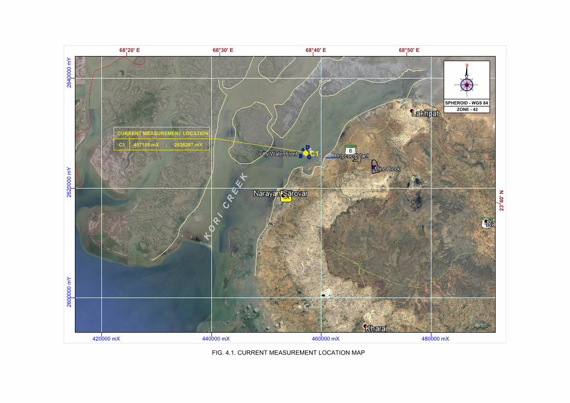
420000 mX 440000 mX 460000 mX 480000 mX
2600000 m
Y2620000 m
Y2640000 m
Y
23°40' N
68°20' E 68°40' E
N
NE
SE
NW
SW
S
EW
SPHEROID - WGS 84
ZONE - 42
K
O
R
I
C
R
E
E
K
C1
FIG. 4.1. CURRENT MEASUREMENT LOCATION MAP
68°30' E 68°50' E
C1
CURRENT MEASUREMENT LOCATION
457105 mX ; 2626297 mY

18 19 20 21 22 23 24 25 26 27 28 29 30 1 2 3 4
DATE
0
0.4
0.8
1.2
1.6
CU
RR
EN
T S
PE
ED
(M
/S)
0
90
180
270
360
CU
RR
EN
T D
IRE
CTI
ON
(D
eg)
Water depth - 12mMeasurement depth - 1 m
FIG. 4.2. VARIATION OF CURRENT SPEED AND DIRECTION AT PROJECT SITE
Location in UTM: X : 0457105 m ; Y : 2626297 m
OCTOBER 2018SEPTEMBER 2018

FIG. 4.3. BATHYMETRY MAP OF PROJECT SITE
(source: Adani Cementation Limited)

420000 mX 440000 mX 460000 mX 480000 mX
26
00
00
0 m
Y2
62
00
00
m
Y2
64
00
00
m
Y
23
°4
0' N
68°20' E 68°40' E
N
NE
SE
NW
SW
S
EW
SPHEROID - WGS 84
ZONE - 42
K
O
R
I
C
R
E
E
K
SS10
SS1
SS2
SS3
SS8
SS4
SS5
SS6
SS7
SS9
IB1
IB2
IB3
IB4
IB5
FIG. 4.4. SEAWATER, SEABED SEDIMENT AND BIOLOGICAL SAMPLING LOCATIONS
68°30' E 68°50' E
ARABIAN SEA

!
!!
!
!
Kanoj
KoriyaniKapurashi
Chher Moti Fishing Village
Narayan Sarovar Fishing Village
69°0'E
69°0'E
68°50'E
68°50'E
68°40'E
68°40'E
68°30'E
68°30'E23
°40'N
23°40
'N
23°30
'N
23°30
'N
LegendBerthing JettyLime Stone Mine
Cement PlantConveyor Belt
Conveyor BeltNarayan Sarovar Wildlife Sactuary Boundary
Narayan Sarovar Wildlife Sactuary Eco Sensitive Zone
FIG. 4.5. BOUNDARY OF NARAYAN SAROVAR WILDLIFE SANCTUARY AND ECO SENSITIVE ZONE Source: Ministry of Environment and Forest Notification on Narayan Sarovar Wildlife Sanctuary (31st may 2012)
Kori Creek
2 km
5 km
10 km
:

ACL INDOMER
Marine Environmental Impact Assessment Study for the Development of Captive Jetty, Desalination Plant Section 5
with Intake and Outfall and Related Infrastructures (Backup Storage, Utilities and Amenities) for Page 5.1
Integrated Unit of Lakhpat Cement Works at Village Kapurasi, Tehsil Lakhpat, District Kutch, Gujarat
5. ENVIRONMENTAL IMPACTS AND MITIGTION MEASURES
The construction and operation phase of the proposed project comprises of various activities,
each of which may have an impact on the marine and surrounding environment. The anticipated
impacts and mitigation measures due to the project activities during construction and operation
phases are discussed. Some of the impacts are temporary and localized and some impacts have
permanent effect. The impacts have been assessed for the proposed marine activities assuming
that the pollution due to existing activities and nearby sources has already been covered under
baseline environment monitoring.
The project activities planned on marine environment mainly includes construction of berthing
jetty and associated facilities, construction of rock bund, desalination plant intake and outfall.
Due to construction and operation of aforesaid facilities the impacts are anticipated on marine
environment. The impacts during construction are expected on marine environment from
activities such as piling, rock bund construction, construction of intake well and laying of outfall
pipeline, and dredging. Various impacts during the construction and operation phase of the
project on marine environment have been identified and the mitigation measures are suggested.
5.1. Identification of Impacts
Impacts are identified with respect to two stages of the project. They are
a) Construction phase
b) Operation phase
a. Construction Phase
Construction phase implies construction activities in the sea (berthing jetty and rock bund),
dredging, disposal of dredged materials, and transport of construction materials.
During construction period the impact on environment will be of short term, temporary and
localized. Period of disturbance to marine community due to construction of berthing jetty and
installation of intake and outfall pipeline will limit to construction phase.
b. Operation Phase
Port operation includes ship-related factors such as vessel traffic, ship discharges, spills and
leakage from ships and cargo-related factors such as cargo handling and storage, handling
equipment and desalination plant discharges.
Due to operation of berthing jetty and associated facilities and outfall discharge, marine
environment in and around the proposed facilities will be disturbed. Since the area is not rich in
plankton, benthos and do not have Protected Areas (PA) such as marine national park and marine
sanctuary rather than wide tidal flats (Environmentally Sensitive Area) it is expected that with time
the habitat will get adjusted to the environment.

ACL INDOMER
Marine Environmental Impact Assessment Study for the Development of Captive Jetty, Desalination Plant Section 5
with Intake and Outfall and Related Infrastructures (Backup Storage, Utilities and Amenities) for Page 5.2
Integrated Unit of Lakhpat Cement Works at Village Kapurasi, Tehsil Lakhpat, District Kutch, Gujarat
5.2. Prediction of Impacts
Identification of the impacts associated with proposed activities provides anticipated impact on
the environment, prediction of impact will give the extent to which these conditions can alter the
baseline environment conditions. Based on such predictions, appropriate site-specific mitigation
measures have to be drawn up in order to minimize the negative impact on the environment.
Referring to the proposed development and the measured baseline data, the different impacts
are analyzed and presented below. Environmental impact matrix for the construction and
operational phase of the project is also presented below.
5.3. Proposed Mitigation Measures
Mitigation measures are suggested based on the identification and prediction of impacts.
Mathematical modelling study has been conducted to predict the impact on the marine
environment due to construction and operation of berthing Jetty. Detailed chart showing activity
and impacts is presented below.

ACL INDOMER
Marine Environmental Impact Assessment Study for the Development of Captive Jetty, Desalination Plant Section 5
with Intake and Outfall and Related Infrastructures (Backup Storage, Utilities and Amenities) for Page 5.3
Integrated Unit of Lakhpat Cement Works at Village Kapurasi, Tehsil Lakhpat, District Kutch, Gujarat
.
Flow chart showing significant activities and impacts assessed
Impact on seawater quality
Impact on seabed sediment
quality
Impact on Plankton
Impact on Benthos
Impact on Fish and
Fisheries
Impact on Mangroves
Impact on Turtles
Impact on Marine mammals
Impact on Coastal vegetation
Impact on Seaweeds and
Seagrass
Impact on wildlife sanctuary
Construction Phase
Operation
Phase
Construction
Phase
Operation
Phase
construction of Pile
foundation
construction of Berthing
Jetty
construction of
Superstructures/Rock bund
Material handling and
transportation
Dredging and reclamation
Intake well and Laying
of outfall pipeline
Brine Discharge
Seawater intake and
outfall diffuser
Conveyor belt operation
Operation of captive port
Installation of Conveyor belt
operation
Waste discharge/Oil spill
Environmental
Impacts
Berthing Jetty
Desalination Plant
Impact on Coastal Processes
and Morphology

ACL INDOMER
Marine Environmental Impact Assessment Study for the Development of Captive Jetty, Desalination Plant Section 5
with Intake and Outfall and Related Infrastructures (Backup Storage, Utilities and Amenities) for Page 5.4
Integrated Unit of Lakhpat Cement Works at Village Kapurasi, Tehsil Lakhpat, District Kutch, Gujarat
Environmental Impact matrix for construction and Operational phase
Environmental
Parameters
Activity
Construction phase Operation phase
Construction
of berthing
jetty and
associated
facilities
Intake
well and
outfall
pipeline
Material
handling and
transportation
Dredging
Operation of captive
port
(Loading/unloading
operation)
Brine
discharge
Material
handling and
transportation
Operation of
conveyor belt
Solid waste
discharge/Oil
spill
Industrial
operation
Physical
Seawater quality Seabed sediment
quality
Biological Plankton Benthos Mangroves Seagrass and
seaweeds
Coastal vegetation Turtles Marine Mammals Fish and Fisheries Endangered species Coral reefs MNP Park and
Marine Sanctuary
Wild life sanctuary
Significance of Impact High Low
Medium No Impact

ACL INDOMER
Marine Environmental Impact Assessment Study for the Development of Captive Jetty, Desalination Plant Section 5
with Intake and Outfall and Related Infrastructures (Backup Storage, Utilities and Amenities) for Page 5.5
Integrated Unit of Lakhpat Cement Works at Village Kapurasi, Tehsil Lakhpat, District Kutch, Gujarat
5.3.1. Captive Jetty
a. Construction Phase
i) Construction of berthing jetty with approach trestle
It is proposed to place the jetty at (-) 6 m CD with approach trestle connecting rock bund to jetty.
The length of approach trestle is about 498 m. Jetty location is connected to the main land with a
sand bar that get exposed during low tide. Number of small creeks are present in the intertidal
area of project site through which seawater flows into the tidal flats during high tide. It is
proposed to place the top deck at (+) 7 m CD.
Piling will be required for the construction of berthing Jetty. The piles will be initially erected into
the sea floor upto depth where hard stratum is available. The soil inside the pile will be dredged
off and the same portion will be refilled with R.C.C concrete. Concrete mixing and construction
debris in the marine environment are envisaged during the construction activity. Due to
construction of berthing Jetty impact on following environmental parameters are anticipated:
• Seawater quality
• Seabed sediments
• Plankton
• Benthos
• Fishes
Impact on Seawater and Seabed sediments: Resuspension of sediments in water leads to an
increase in the level of suspended solids and concentration of organic matter, possibly to toxic or
harmful levels. This will cause temporary impact to seawater quality near proposed berthing jetty
location. Contaminated bottom sediments (contained with heavy metal concentration) may lead
to significant impact to seawater quality during dredging, piling etc. However, baseline data
suggests that there is no heavy metal concentration build up in the seabed sediments.
Impact on benthos: Piling and other water side construction will cause loss/displacement to
bottom habitat and its associated animal and plant life. Foot print on bottom habitat and
associated life will be limited to area of piling. The turbidity induced during driving of piles will
also have impact on the community structure and distribution of other marine life. However, the
bottom will readily be recolonized by replacement of benthic organisms within few seasons.
Fishes: One of the major impacts of pile driving operations on the marine organisms especially
on fishes is the underwater sound pressure waves generated during hammering of the piles. Pile
driving may result in 'agitation' of fish indicated by a change in swimming behaviour. For some
species like sea turtles, the pile driving operations may result in a disruption in their migratory
pattern.
The various factors which are known to influence the impact on fish are: (i) size and force of
hammer strike; (ii) distance from the pile; (iii) depth of the water around the pile; (iv) depth at
which fish swim in water column; (v) entrapped air in the water; (vi) oscillation of water level, (vii)
geological composition of seabed, (viii) size of the fish; (ix) species of the fish; (x) presence of
swim bladder; (xi) physical condition of the fish and (xii) effectiveness of sound/pressure

ACL INDOMER
Marine Environmental Impact Assessment Study for the Development of Captive Jetty, Desalination Plant Section 5
with Intake and Outfall and Related Infrastructures (Backup Storage, Utilities and Amenities) for Page 5.6
Integrated Unit of Lakhpat Cement Works at Village Kapurasi, Tehsil Lakhpat, District Kutch, Gujarat
attenuation technology used to minimize the impacts.
Since the sediment texture is mainly comprised of fine sand, the noise due to piling is expected
to be low. As the baseline data suggests there is limited commercial fishing and there are no
turtles and marine mammals observed within the project site, the impact of piling is expected to
be limited to benthos. These animals will usually return to the area once the disturbance ceases.
Plankton: The proposed project activity like piling may not have any direct bearing on plankton. It
is expected that the plankton will drift away from the disturbed area leading to minimal loss to
plankton. Further, compared to the abundance of the plankton in the site, the loss will be
moderate and temporary.
Impact on free flow of water: Berthing jetty will be constructed over Pile structures. Construction
of a pile causes interference in the flow of stream, which changes the flow pattern at obstruction.
The flow around the pile is complex as the stream flow approaches the pile, adverse gradient
caused by the pile drives a portion of the approach flow downwards just ahead of the pier.
Openings between the piles should be sufficient enough which can reduce the resistant to water
flow and subsequently limit the obstruction to water flow/scouring. It is anticipated that piles
designed for berthing jetty will offer continuous flow water without any obstruction.
Mathematical modelling study has been conducted to evaluate the impact of solid rock bund and
detached bund on free flow of water. Details are given in Chapter 3.
ii) Construction of piling supported structures
Piling installation will disturb the bottom beneath the proposed structure, destroying some of the
bottom habitat and temporarily displacing the mobile bottom animals and local fisheries. In
addition, the structure when completed with decking, will shade the area underneath and
possibly diminish survival by attached algae and other aquatic plants leading to condition of
eutrophication.
Mitigation Measures
Appropriate selection of pile driving equipment.
Clean and efficient construction technique.
Proper lubrication of pile driving machinery will ensure less noise.
The construction schedule should be strictly followed and no over runs should be
ensured. Reducing the construction time with efficient techniques will recue the period of
impact.
The scrap and waste construction materials should not be disposed into the seawater and
intertidal area.
Brief the workers and contractors on the importance of coastal environment to restrict the
unwanted damage.
iii) Construction of Rock bund connecting landside towards jetty
Rock bund of length 2815 m is proposed from land side of facilities till approach trestle. Rock
bund with culvert is proposed till (–) 2 m contour. Rock bund will have two basic components,

ACL INDOMER
Marine Environmental Impact Assessment Study for the Development of Captive Jetty, Desalination Plant Section 5
with Intake and Outfall and Related Infrastructures (Backup Storage, Utilities and Amenities) for Page 5.7
Integrated Unit of Lakhpat Cement Works at Village Kapurasi, Tehsil Lakhpat, District Kutch, Gujarat
core portion of lighter rocks/locally available material followed by heavier armour rock layers. It is
planned to provide 2 m diameter culvert for every 20 m of Rock bund.
Obstruction to seawater flow: Long bund from mainland connecting the approach trestle will
obstruct the seawater flow through small creeks present at site during high tide. This will directly
affect the intertidal benthos due to physical loss of tidal exchange/water area.
Impact on free flow of water: Number of small creeks are present at project site, which ensures
tidal exchange between Kori creek and wide tidal flats. Continuous rock bund passing through
these channels will prevent the free flow of water, and also will result in loss of water area. Rock
bund with pipe culverts is proposed to prevent obstruction to water flow, hence no significant
impact on free flow of water is anticipated due to rock bund construction.
Impact on water quality and marine & coastal ecology: Construction of road bund in tidal flats
will have minimal impact on the intertidal benthos. Intertidal benthos and marine community in
the entire proposed rock bund area will get affected during the construction phase.
The impact is expected to be short term and limited to construction period. Recolonization of
marine community is expected to take place within 4 weeks to 18 months as bund with causeway
will offer continuous supply of seawater to tidal flats of project site.
Mitigation Measures
Controlled and efficient construction technique shall be ensured to limit the impact.
No impact to free flow of seawater at project site is anticipated, since construction of rock
bund with pipe culvert will ensure continuous flow of water to tidal flats through small
channels.
No construction waste shall be disposed off at sea/tidal flats. Construction waste shall be
used for reclamation of land or it should be used for integrated works.
No construction materials shall be stored in the intertidal area, Sediment fencing and
covering with tarpaulin shall be provided to control material runoff during rainstorms.
Brief the workers and contractors on the importance of coastal environment to restrict
impact to construction corridor.
Modelling study show that construction of bund with culverts will enable flow of seawater on
either side of the bund. Impact due to construction will be short term, faster recolonization of
benthos is anticipated due to continuously supply of seawater.
iv) Material Handling Operations
No major impact on marine environment is anticipated since the material handling operations
will be carried out through land. However, it is suggested that construction materials should be
placed at locations away from intertidal flats during rock bund and berthing jetty construction to
avoid runoff of construction materials into Kori creek. Also, no construction waste and debris
shall be disposed into Kori creek.

ACL INDOMER
Marine Environmental Impact Assessment Study for the Development of Captive Jetty, Desalination Plant Section 5
with Intake and Outfall and Related Infrastructures (Backup Storage, Utilities and Amenities) for Page 5.8
Integrated Unit of Lakhpat Cement Works at Village Kapurasi, Tehsil Lakhpat, District Kutch, Gujarat
v) Dredging and disposal of dredged material
Proposed berthing jetty location has depth of about 6 m CD. Bathymetric survey depicts that the
proposed navigational channel has adequate depth to operate proposed barge sizes. Hence
dredging is not anticipated. However, if necessity arises, to be on the safer side both capital
(deepening of pockets if any) and maintenance dredging will be carried out.
The dredging effects include: (i) entrainment and removal of organisms, (ii) increased turbidity at
the dredging site, (iii) organic matter enrichment, (iv) impact on fishes and (v) altered bathymetry.
Entrainment and Removal of organisms: During dredging operations, the extraction of bottom
sediments will directly lead to the removal of benthic organism living on the seabed. Some deep
burrowing animals or mobile surface animals may survive a dredging operation through
avoidance, dredging may initially result in the complete removal of organism from the dredging
site.
The recovery of disturbed habitats following the dredging activity ultimately depends upon the
nature of the new sediments reaching the dredged site, sources and types of recolonizing
animals and the extent of disturbance. In soft sediment environment, the recovery of animal
communities generally occurs relatively quick. From the rates of recovery of the benthic fauna
following dredging in various habitats in coastal areas, it is reported that recolonization of
benthic fauna was observed within 4 weeks to 18 months in mud substratum, while it took 1 to
>2 years in sandy/gravel substratum. (*Newell et al, 1998). Also, due to development turbidity
close to dredging location, removal/disturbance to plankton is also anticipated.
Increased turbidity at the dredging site: Increase in turbidity results in decrease of light
penetration in water column which may eventually affect the mass of phytoplankton.
In most cases, sediment re-suspension is likely to cause problem only if it is carried out of the
dredging location by currents. In general, the effects of suspended sediments and turbidity are
confined to short term for less than a week on completion of dredging and limited to a region of
about a kilometer from the dredging location.
Organic matter enrichment: Release of organic rich sediments during dredging can result in
localized removal of oxygen from water. Depending on the location and timing of the dredging,
this may lead to the suffocation of marine animals and plants within the localized area or may
deter migratory fish or mammals from passing through. However, it is important to stress that
the removal of oxygen from water is only temporary, as tidal exchange would quickly replenish
the oxygen supply. Therefore, in most cases where dredging is taking place, this localized
removal of oxygen has minimal effect on marine life.
Fishes: Introduction of turbidity will cause disturbance to fish due to dredging and disposal. The
impact is temporary and reversible in nature. The fishes move away from the disturbed area.
Altered Bathymetry: Deepening of navigation channel and berth construction can create change
in tidal flow. Mathematical modelling studies on hydrodynamics of navigational channel,
anchorage point and berthing jetty is conducted to understand hydrodynamics of Kori creek
along with oceanographic measurements.

ACL INDOMER
Marine Environmental Impact Assessment Study for the Development of Captive Jetty, Desalination Plant Section 5
with Intake and Outfall and Related Infrastructures (Backup Storage, Utilities and Amenities) for Page 5.9
Integrated Unit of Lakhpat Cement Works at Village Kapurasi, Tehsil Lakhpat, District Kutch, Gujarat
Mitigation Measures
The following mitigation measures were suggested for dredging and dredge disposal location.
• Appropriate dredger and dredging & disposal method should be selected to minimize
the impact.
• The net enclosures with booms may be placed around the dredging area in order to
control the spread of the turbid plume.
• For the proposed reclamation of site to about (+) 7 m CD dredged material shall be made
use of if found possible.
• Selection of suitable dredge disposal locations.
• To minimize the impacts of dredging and disposal, proper timings have to be selected i.e.
(i) selection of most favourable points in the tidal cycle to limit the extent of effects (ii)
avoiding sensitive periods /breeding season for fishes and marine animals.
• Schedule for dredging shall be prepared and list of DO(s) and DO NOT(s) shall be
circulated among the people involved in construction activities.
• Post dredging monitoring program shall be carried out to assess effect of dredging and
disposal on marine ecology.
• The turbidity induced during the dredging can be minimized using controlled dredging
techniques using appropriate cuter suction dredgers.
Selection of dredge disposal location:
• The selection of dumping ground should be such that the dredged material disposed at
the dumping ground should not come back into the port channel.
• The material shall be disposed off evenly spread at the dumping ground to see that the
depths should not get reduced unevenly.
• Mathematical modelling study shall be carried out to find out dredge disposal location
and change in bed level due to dumping.
• Dredge spoil disposal sites should be selected on the basis of no interference with
navigation.
• Dredged material shall be tested for heavy metals, Petroleum hydrocarbons etc., for
contamination.
b. Operation Phase
Shipping/Transport of Cargoes
Transport of Cargoes such as Cement, Clinker, Limestone, Fly ash etc. by sea will generally have
impacts on the marine environment due to following activities.
• Ship Discharges - Oily Ballast, Bilge Water, Sewage/Solid waste
• Accidental oil spill from ship
• Dry cargo releases
ACL INDOMER
Marine Environmental Impact Assessment Study for the Development of Captive Jetty, Desalination Plant Section 5
with Intake and Outfall and Related Infrastructures (Backup Storage, Utilities and Amenities) for Page 5.10
Integrated Unit of Lakhpat Cement Works at Village Kapurasi, Tehsil Lakhpat, District Kutch, Gujarat
i) Ship Discharges - Oily Ballast, Bilge Water, Sewage/Solid waste
The main coastal going vessels (40,000 DWT to 60,000 DWT) will be handled in the deep sea at
anchorage point located 60 km to proposed berthing jetty. From the mother vessels using
barges, cargoes will be imported to the berthing jetty.
Continuous operation of these vessels can generate discharges such as oily ballast, bilge water
and sewage. Discharges and spills of these wastes can cause problems such as oil pollution,
floating garbage, unsanitary conditions, Odour and degradation of water quality.
Mitigation Measures
Appropriate regulations on ship discharges and provision of reception facilities are indispensable
for proper control of effluent from ships.
International Convention on Ballast Water Management: India has introduced Merchant Shipping
(Amendment) Bill, 2015 on 29 April 2015 and approved accession to the International Convention
for the Control and Management of Ship's Ballast Water and Sediments, 2004 (Ballast Water
Management Convention) of International Maritime Organization (IMO). India is signatory of the
convention.
The Convention requires all new ships to implement an approved Ballast Water and Sediments
Management Plan. All new ships will also have to carry a ballast water record book and follow
ballast water management procedures to a given standard.
Indian ships of 400 Gross Tonnage (GT) and above on international voyages are required to
possess an International Ballast Water Management Certificate. Indian ships below 400 GT plying within the territorial waters of India shall be issued an Indian Ballast Water Management Certificate. Ships which are not designed/constructed to carry ballast water, warships, naval auxiliary or other government-owned non-commercial ships are exempted.
Port Reception Facilities
Port should provide sufficient reception facilities to receive residues and oily mixtures generated
from ship operations according to latest provisions. Besides oily residues, reception of sewage
and garbage is also required.
Adequate reception facilities will be made based on amount of waste likely to be generated.
Emphasis will be given to separation and reduction of waste. Waste collection bin will be
provided for collection of both Solid and Hazardous waste. The collected waste will be
transported and disposed of in accordance with regulations
Ship under operation should have Indian Management Ballast Water Certificate. Every effort
should be made to prevent discharges of untreated sewage from ships. Closable skips can be
provided at the berths to collect garbage from barges.

ACL INDOMER
Marine Environmental Impact Assessment Study for the Development of Captive Jetty, Desalination Plant Section 5
with Intake and Outfall and Related Infrastructures (Backup Storage, Utilities and Amenities) for Page 5.11
Integrated Unit of Lakhpat Cement Works at Village Kapurasi, Tehsil Lakhpat, District Kutch, Gujarat
ii) Accidental oil spill from ship
Operational spillages from vessels in ports can be prevented by regulations supported by an
effective enforcement program and provision of adequate reception facilities for ship generated
wastes. Accidental spills can and do occur owing to marine casualties, failure of equipment or
improper operating procedures during cargo transfer.
Some of the potential effects of oil pollution are as follows:
Marine animals and plants tend to be tolerant to low level concentrations of oil in sediments
from chronic or small discharges, however this is not always the case.
• Prolonged exposure to major or minor oil spills can lead to mass mortality of plankton,
benthic communities, fish, mammals and birds.
• Contamination of sediments with oil may modify chemical, physical and biological
processes.
• Contaminants can be trapped in the sediments and later released as a result of
disturbance such as erosion or dredging.
• In sediments, as it is organic, oil will be broken down relatively quickly by microorganisms
which may result in the localized removal of oxygen from the sediments and surrounding
water with possible effects on marine life.
• The persistent toxic constituents of oil, such as heavy metals, can become stored in the
sediments, and taken up into the food chain. This will have devastating effect on the
ecosystem.
• The breakdown of oil tends to be slowest in intertidal areas, which leads to the highest
concentration and longest residence times.
Mitigation Measures
• Identification of areas within the port that are sensitive to spillages.
• Emergency contingency plan should be prepared clearly outlining authority and
responsibility for dealing with oil spills.
• A detailed oil spill contingency plan is prepared separately and given in Chapter 7.
• Reporting and alerting mechanisms must be established to ensure that any spillage is
promptly reported, and those personnel involved are informed in order to take
appropriate action.
• Specialized oil spill response equipment should be available in the port to deal with small
to medium spillages.
ACL INDOMER
Marine Environmental Impact Assessment Study for the Development of Captive Jetty, Desalination Plant Section 5
with Intake and Outfall and Related Infrastructures (Backup Storage, Utilities and Amenities) for Page 5.12
Integrated Unit of Lakhpat Cement Works at Village Kapurasi, Tehsil Lakhpat, District Kutch, Gujarat
• The equipment operators must be trained in deployment of the equipment, and the
contingency plan regularly exercised to test reporting and alerting procedures.
• Hazardous waste generated at berth due to cargo handling operation shall be carefully
stored and should be stored in centralized hazardous waste storage facility.
The marine loading/unloading arms should be provided with alarms system to prevent
any accidental leak during product handling.
iii) Dry Cargo Releases
Dry cargos carried on vessels can have impact on the marine environment during loading,
unloading and washing of cargo board. Dry bulk cargoes like Cement, Clinker etc. of small
quantity are likely to be released during these events into the sea. Dry cargo release due to wash
overboard cargo residues left on vessels after unloading is the most dominant intentional activity.
Although effect of nontoxic cargo releases is not as significant as toxic cargoes, they may cause
localized negative environmental effects on marine environment when released in large
quantities. Also, nontoxic cargo releases are not described under MARPOL Annexure V for
operational discharges. Unfortunately, no comprehensive studies have been made on the impact
of each type of cargo and its impact on the marine environment.
Mitigation Measures
While no individual MARPOL Annexure for solid bulk cargoes have been drafted, the rules for
garbage discharge apply instead. 2012 Guidelines for the implementation of MARPOL annexure V
prohibits the discharge of all types of garbage into the sea unless explicitly permitted under the
Annexure. Management practices for dry bulk cargo is underlined as below.
• Solid bulk cargoes should be classified and declared by the shipper as to whether or not
they are harmful to the marine environment.
• Ports, terminals and ship operators should consider cargo loading, unloading and
onboard handling practices following IMSBC (International Maritime Solid Bulk Cargoes
Code)
• Ensuring ships/barges are suitable to carry the intended cargo and also suitable for
unloading the same cargo using proposed methods.
• Unloading cargo as efficiently as possible, utilizing all appropriate safety precautions to
prevent injury or ship and equipment damage. Intense care should be taken during
lighterage operation.
• Minimizing spillage of the cargo during transfer operations by carefully controlling cargo
transfer operations, both on board and from dockside.
iv) Drainage
Contaminated drainage from waterfront areas, if allowed to flow unimpeded into the port it may
lead to contamination and water quality degradation. To the extent possible, the direct drainage
from port to the sea shall be prevented. Area should be paved and sloped to direct the water
towards the catch basins (collection systems)/treatment plant.

ACL INDOMER
Marine Environmental Impact Assessment Study for the Development of Captive Jetty, Desalination Plant Section 5
with Intake and Outfall and Related Infrastructures (Backup Storage, Utilities and Amenities) for Page 5.13
Integrated Unit of Lakhpat Cement Works at Village Kapurasi, Tehsil Lakhpat, District Kutch, Gujarat
Proposed port should have adequate facilities like catch basin/treatment plant to deal with runoff
from port areas. Drainage should not be disposed off to wetland area, this will cause impact to
benthic community.
v) Water front Industry Discharge
No industrial discharge is planned from the proposed cement plant, thermal power plant and
Mining unit. Wastewater from the industrial unit will be treated in the proposed Sewage
treatment plant and will be used for gardening. Brine reject from desalination plant will be
disposed off into sea. Details on discharge from desalination plant is discussed in the section
5.3.2.
vi) Maintenance Dredging
Presence of piling clusters may alter the habitat to marginal extent. Pilings may also marginally
slow down the existing tidal or river flows, thus causing sediment deposition at some locations
beneath the structure. Natural coastal processes will also result in sediment deposition.
Depending on local conditions, this shoaling tendency may extend to nearby navigation zones,
necessitating more frequent maintenance dredging. Required maintenance dredging will also
have the same effect as mentioned in section 5.3.1.
vii) Shoreline
The site and surrounding is so typical that it comprises of wide intertidal flats without any sandy
beaches. There is no movement of littoral drift is anticipated and hence there will not be any
change in shoreline.
Construction of pile and rock bund may have marginal effect on the flow pattern which may
influence the scouring along Kori creek for short distance along either side of the jetty. Shoreline
study done by IOM, Anna University indicates that the proposed stretch is a low eroding coast.
Study also states that high eroding coast is identified in the northern end of Kori creek.
Mitigation Measures
The jetty will be built over the piles, hence construction of jetty will not affect the free flow of
water and the movement of seabed sediment. Therefore, there will not be any shoreline erosion.
Impact during the construction and operation phase of jetty is analysed and it is found that the only environmentally sensitive factor near the project site is presence of wide mudflats. Implementation of mitigation measures and Environmental Management Plan will be the key to address impact on marine environment. Other anticipated impacts due to construction of jetty such as change in flow pattern, wave dynamics etc. has been studied using mathematical modeling by M/s Howe Engineering Projects India Private Limited. Modelling study indicate that there will not be any significant changes to the existing coastal processes.

ACL INDOMER
Marine Environmental Impact Assessment Study for the Development of Captive Jetty, Desalination Plant Section 5
with Intake and Outfall and Related Infrastructures (Backup Storage, Utilities and Amenities) for Page 5.14
Integrated Unit of Lakhpat Cement Works at Village Kapurasi, Tehsil Lakhpat, District Kutch, Gujarat
5.3.2. Desalination Plant
Desalination plant of 9 MLD capacity is proposed for the Integrated Cement Works to cater the
water demand of the industry, jetty operation etc. Details on selection of intake and outfall
pipeline is presented in Chapter 3.
During the construction stage activities such as construction of intake well, laying of pipeline and
brine discharge during the operational phase will have marginal impact on the marine
environment. However, the potential impact which will arise due to the project will be mitigated
through selection of proper intake and outfall location.
Selection of appropriate location for intake and outfall is one of the most important steps to
enhance the positive impact of the project and to reduce the negative impacts. Intake and outfall
location are selected based on CRZ, bathymetry, availability of water, water quality, brine
dispersion study etc. The key marine environmental concerns associated with seawater
desalination are:
i. Seawater intake – Impingement and Entrainment
ii. Environmental impacts of outfall systems – Brine discharge
The details of anticipated impacts of construction of intake well, intake and outfall pipelines
associated with desalination plant are detailed below with respect to construction and operation
phases:
a. Construction Phase
i) Intake well and outfall pipeline
Desalination plant is planned within the proposed backup area close to shore. Rather than going
for intake and outfall submarine pipelines, it is planned to take the pipeline through proposed
bund and trestle. Intake and outfall are planned east and west of the proposed jetty separated by
a distance of about 1 km. Adequate depth of > 8 m CD is available at proposed intake and outfall
location. It is anticipated that proposed plan will reduce additional impact on the environment,
which can be caused due to laying of underwater intake and outfall pipeline.
In general, following impacts are anticipated.
• Increase in turbidity due to construction of intake well (piling) will enhance levels of
suspended solids. This can negatively influence photosynthesis and hence primary
productivity. However, the impact would be local, reversible, temporary with plankton
community structure quickly establishing once the construction is completed.
• Piling will have direct bearing on the bottom habitat pertaining to the construction
corridor.
• Improper design of outfall diffuser may reduce the mixing and increase the distance of
mixing zone.

ACL INDOMER
Marine Environmental Impact Assessment Study for the Development of Captive Jetty, Desalination Plant Section 5
with Intake and Outfall and Related Infrastructures (Backup Storage, Utilities and Amenities) for Page 5.15
Integrated Unit of Lakhpat Cement Works at Village Kapurasi, Tehsil Lakhpat, District Kutch, Gujarat
Mitigation Measures
• Intake well construction and pipeline laying operation have to be done in shortest
duration.
• Piling for intake and outfall should be carefully done to limit the impact to construction
corridor.
• Barricading the water during laying has to be avoided.
• Installation of proper marker lights indicating obstructions if any.
ii) Impact due to intake well
• Entrainment and impingement corresponding to drawing smaller marine organisms into
the well with the seawater. However, the rate of impingement and entrainment
compared to open seawater intake is very low in intake well. Also, intake well offers better
quality in terms of solids, organic matter and aquatic micro-organisms.
• Migration of benthic animals.
• Possibility of causing scour around the well.
Mitigation Measures
• Use well screens and low intake velocity to minimize impingement and entrainment of
larger organisms.
• Selection of intake location away from productive areas to reduce entrainment of smaller
organisms.
• Low-impact intake technologies: Intake system offers better water quality in terms of
solids, organic matter and aquatic micro organisms which will lead to minimum chemical
treatment, there by impact on water quality and marine ecology can be prevented.
The intake velocity and volume are known to be the major contributory factors for the
impingement. Careful design of intake velocity and well will minimize the potential impacts.
iii) Outfall diffuser
The presence of outfall diffuser may locally restrict the use of drifting nets. The installation of
diffuser in sea and the jet plume discharge of brine reject would locally alter the flow pattern
within the initial mixing zone. Improper design of outfall diffuser may reduce the mixing and
increase the distance of mixing zone.
Mitigation Measures
• The outfall diffuser should not have any sharp projection and should not pose any risk for
the boats and fishermen moving around the region.
• The part of the outfall pipelines before the diffuser ports may suitably be placed and laid
on seabed to avoid hindrance for fishing and the movement of the boat.
• A marker buoy has to be placed close to the outfall to help boats to avoid the area.

ACL INDOMER
Marine Environmental Impact Assessment Study for the Development of Captive Jetty, Desalination Plant Section 5
with Intake and Outfall and Related Infrastructures (Backup Storage, Utilities and Amenities) for Page 5.16
Integrated Unit of Lakhpat Cement Works at Village Kapurasi, Tehsil Lakhpat, District Kutch, Gujarat
b. Operation Phase
i) Brine Discharge
Salinity and Density
High salinity and density are the typical characteristic of desalination plant effluent. The primary
environmental impacts associated with discharge of SWRO plants effluent include:
• Increases in the salinity of receiving water bodies.
• Local impacts of hypersaline brines on marine benthic communities at and near the point
of discharge.
Deaeration and oxygen scavengers
With increasing salinity, oxygen becomes less soluble in seawater. However, oxygen levels are
deliberately reduced by physical deaeration and addition of oxygen scavengers like sodium
bisulfite to inhibit corrosion. Oxygen depletion is also a problem of the RO brine, if sodium
bisulfite is used as a neutralizing agent for chlorine. The lack of dissolved oxygen could be toxic
to marine organisms and aeration is recommended prior to oceanic discharge.
Effect on Marine Organisms
Stenohaline – Sensitive to salinity changes
Increased salinities could also impact more sensitive elements of the biota, especially some of the
single cell plankton. Marine organisms have varying sensitivity to changes in salinity. Osmotic
conformers are organisms that have no mechanism to control osmosis and therefore their cells
conform to the same salinity as their environment. Large increases in salinity in the surrounding
marine environment cause water to flow out of the cells of these organisms, which could lead to
cell dehydration and ultimately to cell death. Organisms that can survive in only a narrow salinity
range are referred to as "stenohaline".
Osmotic regulators - Resistant to salinity changes
Osmotic regulators, on the contrary, can control the salt content and hence the osmotic potential
within their cells despite variations in external salinity. Most marine fish, reptiles, birds and
mammals are osmotic regulators. Salinity tolerances of marine organisms vary, but some shellfish
(scallops, clams, oysters, mussels or crabs) not already stressed from abnormally high salinities
are able to tolerate very high salinities.
An additional factor when considering environmental impacts of concentrate discharges is the
mobility of the organisms. Mobile organisms may simply move away from areas of higher salinity
without adverse impacts. Sessile organisms (e.g., plants) are more vulnerable to salinity changes.
Since the brine has high density compared to seawater it may settle on bottom with potential
deleterious effects to the benthic community.

ACL INDOMER
Marine Environmental Impact Assessment Study for the Development of Captive Jetty, Desalination Plant Section 5
with Intake and Outfall and Related Infrastructures (Backup Storage, Utilities and Amenities) for Page 5.17
Integrated Unit of Lakhpat Cement Works at Village Kapurasi, Tehsil Lakhpat, District Kutch, Gujarat
Mitigation Measures
• Location of discharge point for installation of discharge systems should be selected based
on the favorable oceanographic site dissipating the salinity quickly through hydrodynamic
modelling.
• Monitoring of seawater quality near discharge point shall be carried out as part of post
project monitoring program.
ii. Breakage of pipeline
Pipeline can be damaged due to natural hazards like storm, earthquake, scouring, tsunami etc. It
can also get damaged due to manmade causes like fishing, trawling and intentional damage. In
case of any damage leading to breakage caused on the outfall pipeline, the brine water will gush
out at shorter distance from the shoreline and would affect the marine environment.
Mitigation Measures
Necessary mitigation measures like immediately attending the repair of pipeline has to be taken
up. Necessary spares of pipeline segments with bends/Tees and divers with experience in
salvation operation irrespective of sea condition have to be kept ready always within the plant.
5.3.3. Environmental Sensitivity
a. Plankton
Construction of piled berthing Jetty, laying of intake and outfall pipeline, brine discharge will
affect the plankton community as they are weak against the turbidity generated in the water due
to construction activities. The impact on these communities are directly linked to the extent upto
which turbidity persist. It is anticipated that area of pile construction and nearby corridor and
intake, outfall pipeline corridor will be induced with turbidity may have localized effect on
plankton. However, it is anticipated that with time, plankton community will recolonize. More
details on impact and mitigation measures for plankton is described under impact during to
construction phase and operation phase of berthing jetty and desalination plant.
b. Benthos
Piling and dredging for berthing jetty and laying of intake and outfall pipeline will disturb the
bottom habitat. Major impact to benthos is anticipated during the construction stage. During
Impact due to desalination plant intake and outfall are considered while planning of intake
and outfall systems. Potential impact which may arise due to the construction of seawater
intake head, laying of intake and outfall pipeline, brine discharge will be encountered with
seawater intake well and taking pipeline through proposed trestle. Also, Advection-Dispersion
study is conducted to predict the impact due to brine discharge. It is found that brine quantity
of 21 MLD with 57 ppt salinity (17 higher than ambient salinity) is modest enough to cause
any significant damage on the marine environment.

ACL INDOMER
Marine Environmental Impact Assessment Study for the Development of Captive Jetty, Desalination Plant Section 5
with Intake and Outfall and Related Infrastructures (Backup Storage, Utilities and Amenities) for Page 5.18
Integrated Unit of Lakhpat Cement Works at Village Kapurasi, Tehsil Lakhpat, District Kutch, Gujarat
operational stage, impact to benthos is anticipated only due to maintenance dredging. Other
likely impact to benthos includes unwanted disturbance in the intertidal area of project site. Strict
guidelines to workers should be given to avoid unwanted disturbance to tidal flats. The impact
will be localized, and benthos will start recolonizing after the construction period. More details on
impact and mitigation measures to benthos is described under construction and operation phase
of berthing jetty and desalination plant.
c. Mangroves
Eastern banks of Kori creek from Lakhpat to Guhar Nani is composed of scanty mangroves,
whereas, banks of Lakki (south of proposed jetty) to mouth of Kori creek mangroves are
observed in the the tidal flats which are connected with small channels. Dense mangroves are
present on western side of Kori creek where dense tidal network of Padala creek, Pir Sanai creek,
Pabiwari creek, Vianwari creek and Sir creek is present.
Since project site devoid of mangroves, Hence, no question on impact to mangroves due to
proposed jetty.
d. Seaweeds and Seagrass
Project site and surroundings are devoid of seagrass and seaweeds. Hence, no impact.
e. Coastal Vegetation
Coastal areas of project and 10 km radius support minimum halophytes. No impact to coastal
vegetation is anticipated since construction of berthing Jetty and rock bund will limit to intertidal
area where no coastal vegetation is seen.
f. Corals
Project site and surroundings are devoid of corals. Hence, no impact.
g. Turtles
The turtles need ideal locations like isolated, undisturbed and well developed sandy beaches for
seasonal breeding. They do not select the places like tidal flats, marshy lands and swampy terrain.
Study area consist of wide intertidal flat without the presence of any sandy beaches. Ecology and
biodiversity survey also show that there is no breeding of turtles in this stretch. Hence there is no
question of impact on turtles.
h. Fishes
Like plankton and benthos due to construction of berthing jetty, desalination plant and
associated facilities, impact on fishes are also anticipated. However, since fishes are mobile, they
tend to move away from under water disturbances. Compared to the impact of construction
activities on plankton and benthos, no significant impact on fishes are anticipated since they are
mobile and tend to move away. These animals will usually return to the disturbed area once the

ACL INDOMER
Marine Environmental Impact Assessment Study for the Development of Captive Jetty, Desalination Plant Section 5
with Intake and Outfall and Related Infrastructures (Backup Storage, Utilities and Amenities) for Page 5.19
Integrated Unit of Lakhpat Cement Works at Village Kapurasi, Tehsil Lakhpat, District Kutch, Gujarat
disturbance ceases.
i. Wild Life Sanctuary
Narayan Sarovar wild life sanctuary is the nearest wildlife sanctuary to project site. As per Ministry
of Environment and Forest Notification dt. 31st May 2012 on Narayan Sarovar wild life sanctuary,
mean distance of 1.5 km is notified under Eco Sensitive Zone surrounding the Narayan Sarovar.
Based on the coordinates given in the Notification dt. 31st May 2012 on Narayan Sarovar wild life
sanctuary, the boundary and ESZ of Narayan Sarovar wild life sanctuary is plotted and shown in
Fig. 4.5. Since the ESZ boundary of Narayan Sarovar wild life sanctuary is not falling within the
proposed project boundary, no impact to wild life sanctuary is anticipated. Also, no Marine
National Park and Marine Sanctuary is falling near the project site.

ACL INDOMER
Marine Environmental Impact Assessment Study for the Development of Captive Jetty, Desalination Plant Section 6
with Intake and Outfall and Related Infrastructures (Backup Storage, Utilities and Amenities) for Page 6.1
Integrated Unit of Lakhpat Cement Works at Village Kapurasi, Tehsil Lakhpat, District Kutch, Gujarat
6. POST PROJECT MONITORING
The primary objective of post project monitoring program is to develop site specific monitoring
program for environmental parameters likely to be affected by proposed project activity. Post
project monitoring will be undertaken to determine the environmental affects of operational
activities and secondarily to increase understanding of cause-effect relationships between activity
and environmental change.
In order to verify the efficacy of the implemented mitigation measures and there on to modify
them if necessary, the post project monitoring becomes inevitable. The post project monitoring
program is an equally important aspect in Environmental Management Plan. A continuous review
of post project monitoring program shall be conducted by the Environment Management Cell
(EMP) to identify the effectiveness of mitigation measures suggested.
6.1. Environmental Impact Matrix
Identification of post project monitoring locations, frequency and parameters to be analysed is
done based on the anticipated impacts on the marine environment during operation phase of
the project. Environmental management matrix used to identify frequency, location and
parameters is given below:
Environmental Impact Matrix
Activity Anticipated impact Proposed mitigation
measures Monitoring Program
Ship
Discharges
Degradation of seawater
and seabed sediment
quality.
Impact to plankton,
benthos and other marine
community
Collection and disposal
facilities at port.
Operation of ships
having Indian Ballast
Water Management
Certificate.
Monitoring of seawater
and seabed quality where
areas close to berthing
jetty.
Monitoring biomass and
species diversity of
plankton, benthos and
other marine community. Frequency of Monitoring: Since proposed mitigation measure will ensure adequate control over the port generated waste, half yearly monitoring program of marine environment is suggested for ship discharges.
Accident Oil
spill/ Spill
during
handling
operations
Degradation of seawater
and seabed sediment
quality.
Impact to plankton,
benthos and other marine
community
Emergency oil spill
contingency plan.
Development of
reporting and alerting
mechanisms.
Specialized oil spill
response equipment.
Monitoring of seawater
and seabed quality areas
close to berthing jetty.
Monitoring biomass and
species diversity of
plankton, benthos and
other marine community.
Frequency of Monitoring: Incase of oil spill immediate attending of spill must be taken up. Continuous monitoring of Oil and Grease content in seawater shall be analysed till complete recovery of spilled oil. Oil

ACL INDOMER
Marine Environmental Impact Assessment Study for the Development of Captive Jetty, Desalination Plant Section 6
with Intake and Outfall and Related Infrastructures (Backup Storage, Utilities and Amenities) for Page 6.2
Integrated Unit of Lakhpat Cement Works at Village Kapurasi, Tehsil Lakhpat, District Kutch, Gujarat
Activity Anticipated impact Proposed mitigation
measures Monitoring Program
content in the seawater shall also be analysed during half yearly monitoring of marine environment.
Drainage Degradation of seawater
and seabed sediment
quality.
Construction of catch
basin/treatment plant
to deal with runoff from
port areas.
Monitoring of seawater
and seabed quality areas
close to berthing jetty.
Frequency of Monitoring: Monitoring locations will be covered under monitoring programme for ship discharge.
Maintenance
Dredging
and Disposal
Degradation of seawater
and seabed sediment
quality.
Impact to plankton,
benthos and other marine
community
Provisions for net
enclosures with booms.
Selection of most
favorable points in the
tidal cycle to limit the
extent of effects.
Monitoring of seawater
and seabed quality areas
close to berthing jetty
and at dredge disposal
location.
Monitoring biomass and
species diversity of
plankton, benthos and
other marine community. Frequency of Monitoring: Post dredging monitoring shall be carried out after the event of dredging to ensure the seawater and seabed sediment quality.
Brine
Discharge
Degradation of seawater
and seabed sediment
quality.
Impact to plankton,
benthos and other marine
community
Monitoring of seawater
quality near discharge
point.
Monitoring of seawater
and seabed quality near
discharge point.
Monitoring biomass and
species diversity of
plankton, benthos and
other marine community. Frequency of Monitoring: Half yearly monitoring of seawater, seabed sediments and biological parameters are suggested for brine discharge near outfall location.
Based on the environment impact matrix, post project monitoring program is suggested.
6.2. Post Project Monitoring Program
Monitoring program is suggested to identify the variation in the marine environment due to
operation of port and desalination plant. Monitoring program shall be done during the
operational phases of the project and it should be repeated at periodic intervals after the
commencement of operation. The monitoring must be organized with qualified and experienced
environmental team. Standard procedure shall be followed in sample collection and analysis. Half
yearly monitoring of seawater quality, seabed sediment and marine ecology is recommended at
water front, inner approach channel, near brine disposal location and near dredge disposal
location.
Post project monitoring program has been planned based on the prediction of impacts and
mitigation measures suggested. Summary matrix of environmental monitoring covering locations
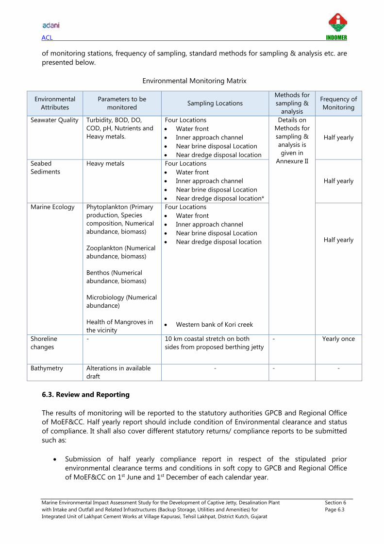
ACL INDOMER
Marine Environmental Impact Assessment Study for the Development of Captive Jetty, Desalination Plant Section 6
with Intake and Outfall and Related Infrastructures (Backup Storage, Utilities and Amenities) for Page 6.3
Integrated Unit of Lakhpat Cement Works at Village Kapurasi, Tehsil Lakhpat, District Kutch, Gujarat
of monitoring stations, frequency of sampling, standard methods for sampling & analysis etc. are
presented below.
Environmental Monitoring Matrix
Environmental
Attributes
Parameters to be
monitored Sampling Locations
Methods for
sampling &
analysis
Frequency of
Monitoring
Seawater Quality Turbidity, BOD, DO,
COD, pH, Nutrients and
Heavy metals.
Four Locations
• Water front
• Inner approach channel
• Near brine disposal Location
• Near dredge disposal location
Details on
Methods for
sampling &
analysis is
given in
Annexure II
Half yearly
Seabed
Sediments
Heavy metals Four Locations
• Water front
• Inner approach channel
• Near brine disposal Location
• Near dredge disposal location*
Half yearly
Marine Ecology Phytoplankton (Primary
production, Species
composition, Numerical
abundance, biomass)
Zooplankton (Numerical
abundance, biomass)
Benthos (Numerical
abundance, biomass)
Microbiology (Numerical
abundance)
Health of Mangroves in
the vicinity
Four Locations
• Water front
• Inner approach channel
• Near brine disposal Location
• Near dredge disposal location
• Western bank of Kori creek
Half yearly
Shoreline
changes
- 10 km coastal stretch on both
sides from proposed berthing jetty
- Yearly once
Bathymetry Alterations in available
draft
- - -
6.3. Review and Reporting
The results of monitoring will be reported to the statutory authorities GPCB and Regional Office
of MoEF&CC. Half yearly report should include condition of Environmental clearance and status
of compliance. It shall also cover different statutory returns/ compliance reports to be submitted
such as:
• Submission of half yearly compliance report in respect of the stipulated prior
environmental clearance terms and conditions in soft copy to GPCB and Regional Office
of MoEF&CC on 1st June and 1st December of each calendar year.

ACL INDOMER
Marine Environmental Impact Assessment Study for the Development of Captive Jetty, Desalination Plant Section 6
with Intake and Outfall and Related Infrastructures (Backup Storage, Utilities and Amenities) for Page 6.4
Integrated Unit of Lakhpat Cement Works at Village Kapurasi, Tehsil Lakhpat, District Kutch, Gujarat
• Submission of environmental statement for the financial year ending 31st March to the
GPCB on or before 30th September every year.
6.4. Onsite Mock Drill
Onsite mock drills shall be encouraged by the proponent to make aware of the existing disaster
management plan and how to respond to emergency cases such as oil spill, natural calamities
etc. Conducting mock drills will enhance the preparedness and practicality of designed
responses. Mock drills shall be done in presence of municipal authorities, hospitals, fire
department etc. Documentation of mock drills should be done to revise the shortcomings of
existing plans.

ACL INDOMER
Marine Environmental Impact Assessment Study for the Development of Captive Jetty, Desalination Plant Section 7
with Intake and Outfall and Related Infrastructures (Backup Storage, Utilities and Amenities) for Page 7.1
Integrated Unit of Lakhpat Cement Works at Village Kapurasi, Tehsil Lakhpat, District Kutch, Gujarat
7. ADDITIONAL STUDIES
7.1. Risk Assessment and Disaster Management Plan
7.1.1. Introduction
Emergency/ disaster is an undesirable occurrence of events of such magnitude and nature that
adversely affect operations, cause loss of human lives and property as well as damage to the
environment. Coastal infrastructure is vulnerable to various kinds of natural and manmade
disasters. Examples of natural disaster are Flood, Cyclone, Tsunami, Earthquake etc., and
manmade disasters like major fire, explosion, sudden heavy leakage of toxic/ poisonous gases,
etc. An effective disaster management plan helps to minimize the losses in terms of human lives,
assets and environmental damage.
Disaster Management Hierarchy
Disaster Identification
A disaster occurs when a hazard such as Earthquake, Flood or Cyclone coincides with a vulnerable
situation. Based on project details, geography, environmental setting of the study area and
available information (Kutch District Disaster Management Plan, May 2017 - 18) following hazards
have been identified which may possibly lead to disaster. The probability/seasonality of hazard in
the project area is also listed below.
Identified natural hazards in the study area
Sl.
No. Hazard
Project area
(Lakhpat) Findings
1 Earthquake Zone V (Very High damage risk zone)
2 Cyclone Open to wind speed of 50 m/sec and greater. (Highly
vulnerable)
3 Sea surge Highly vulnerable
4 Tsunami Highly vulnerable
5 Flood Low (may occur due to very heavy rainfall, sea surge or
tsunami)
Gujarat State
Disaster
Management
Authority
District
Disaster
Management
Authority
Lakhpat
Captive Port
DMP
Action Response Preparednes
s
Recovery

ACL INDOMER
Marine Environmental Impact Assessment Study for the Development of Captive Jetty, Desalination Plant Section 7
with Intake and Outfall and Related Infrastructures (Backup Storage, Utilities and Amenities) for Page 7.2
Integrated Unit of Lakhpat Cement Works at Village Kapurasi, Tehsil Lakhpat, District Kutch, Gujarat
Disaster identification suggests that the project site is vulnerable to natural hazards other than
Flood. According to Kutch District Disaster Management Plan, probability of flood in entire Kutch
district is low, it may occur only on the event of very heavy rainfall, sea surge or tsunami. Among
the identified impacts, Earthquake is most probable to occur in the project site followed by
Tsunami and Cyclones. Probability period and seasonality of natural disasters is given below.
Probability Period/Seasonality of disasters
Type of Hazards Time of
Occurrence Potential Impact
Flood June – September Loss of life, livestock, crop
and infrastructure
Earthquake Anytime Loss of life, livestock and
Infrastructure.
Cyclone April - May
October - November
Loss of life, livestock and
infrastructure
(Kutch District Disaster Management Plan, May 2017 – 18)
History of Natural Disasters in Kutch District
Kutch district is highly prone to multi hazards like Cyclone, Earthquake, Tsunami and Drought.
Matrix showing past disasters in Kutch is shown below.
Matrix of past disasters in Kutch District
Disaster Year Magnitude Taluka & No. of.
villages affected
Life &
Cattle loss Damage property
Flood 2011 3
2 taluka and
200 villages
Human death
(11) and
Cattle loss
(74)
-
Earthquake 2001 4
10 Taluka
884 Village
affected.
12216
146087 houses fully
damaged, 278217
partially damaged.
Cyclone 1998 4
Gandhidham,
Mundra, Anjar 1 life lost &
41 cattle loss -
Source: Kutch District Disaster Management Plan, May 2017-18
(i) Earthquake
As per Indian Seismic Zone Map, Gujarat lies in three zones- Zone III, IV and V. Entire Kutch
region lies in zone V where earthquakes of magnitude 8 can be expected. District like Bhachau,
Rapar, Anjar, Bhuj, Gandhidham, Lakhpat Taluka have been adequately provided with the seismic
instrumentation since these talukas are highly vulnerable to Earthquakes.

ACL INDOMER
Marine Environmental Impact Assessment Study for the Development of Captive Jetty, Desalination Plant Section 7
with Intake and Outfall and Related Infrastructures (Backup Storage, Utilities and Amenities) for Page 7.3
Integrated Unit of Lakhpat Cement Works at Village Kapurasi, Tehsil Lakhpat, District Kutch, Gujarat
Gujarat Earthquake Zones
(ii) Cyclones
A "Cyclonic Storm" or a "Cyclone" is an intense vortex or a whirl in the atmosphere with very
strong winds circulating around it in anti-clockwise direction in the Northern Hemisphere and in
clockwise direction in the Southern Hemisphere. Cyclones are intense low-pressure areas, from
the centre of which pressure increases outwards. The amount of the pressure drop in the centre
and the rate at which it increases outwards gives the intensity of the cyclones and the strength of
winds. The details of types of disturbances and associated wind speed in the circulation are
presented below:
Types of Disturbances Associated wind speed in the circulation
Low Pressure Area
Depression
Deep Depression
Cyclonic Storm
Severe Cyclonic Storm
Very Severe Cyclonic Storm
Super Cyclonic Storm
Less than 17 knots (< 31 kmph)
17 to 27 knots (31 to 49 kmph)
28 to 33 knots (50 to 61 kmph)
34 to 47 knots (62 to 88 kmph)
48 to 63 knots (89 to 118 kmph)
64 to 119 knots (119 to 221 kmph)
120 knots and above (222 kmph and above)
Gujarat Wind and Cyclone zone indicates that coastal areas of Kutch, especially district like
Bhachau, Gandhidham, Anjar, Mundra, Mandvi and Lakhpat are particularly prone. Cyclones also
drive the sea level to cause coastal flooding. Project site and neighbouring villages will be

ACL INDOMER
Marine Environmental Impact Assessment Study for the Development of Captive Jetty, Desalination Plant Section 7
with Intake and Outfall and Related Infrastructures (Backup Storage, Utilities and Amenities) for Page 7.4
Integrated Unit of Lakhpat Cement Works at Village Kapurasi, Tehsil Lakhpat, District Kutch, Gujarat
exposed to high wind speed of greater than 50 m/sec during the event of cyclonic storm. Gujarat
wind and cyclone zones are presented below.
Gujarat Wind and Cyclone Zone
(iii) Tsunami
Gujarat is prone to tsunami risk due to its long coastline and probability of occurrence of near
and offshore submarine earthquakes in the Arabian sea. Kutch District is classified as highly prone
to tsunami as per Hazard Risk and Vulnerability Atlas prepared by GSDMA. Areas at greatest risk
are those which have less than 25 ft above sea level and within one mile of the shoreline. Most
deaths caused by a tsunami are because of drowning, associated risks include flooding,
contamination of drinking water, fires from ruptured tanks or gas lines, and the loss of vital
community infrastructure. Probability of flooding of project site during tsunami is very high.
Tsunami vulnerability assessment is carried out based on Probable Maximum Surge (PMS) at
Highest High Tide Level. Maximum possible inundation at Highest High Tide Level (HHTL) and
100 % Probable Maximum Surge (PMS) for some of the talukas of Kutch District is given below.
Map showing Gujarat tsunami hazard risk zonation is also presented below.
Tsunami hazard risk zonation based on PMS at Highest High Tide Level (HHTL)
District Name Taluka
Maximum possible inundation (Area of Taluka in
%) at Highest High Tide Level (HHTL) and 100 %
Probable Maximum Surge (PMS)
Kutch Bhachau 18
Kutch Lakhpat 10
Kutch Gandhidham 42

ACL INDOMER
Marine Environmental Impact Assessment Study for the Development of Captive Jetty, Desalination Plant Section 7
with Intake and Outfall and Related Infrastructures (Backup Storage, Utilities and Amenities) for Page 7.5
Integrated Unit of Lakhpat Cement Works at Village Kapurasi, Tehsil Lakhpat, District Kutch, Gujarat
Kutch Mandvi 5
Kutch Mundra 23 Source: Gujarat State Tsunami Management Plan, 2009
Gujarat Tsunami Hazard Risk Zonation
7.1.2. Objective of Disaster Management Plan
Disaster may arrive without any warning, unexpectedly despite all precautions & preventive
measures taken. However, an efficient control/response plan can minimize the losses in terms of
property, human lives and damage to the environment. The disasters that can occur in the
coastal areas of project site are storms, storm surges, tsunami and earth quakes.
The plan should be developed to make best possible use of the resources at the operational
area as well as outside available resources like State Fire Services, Police, Civil Defence, Hospitals,
Civil Administration, neighbouring institution and industries.
The objectives of Disaster Management Plan are:
To contain and control the incident.
To rescue the victim and treat them suitably in quickest possible time.
To safeguard other personnel and evacuate them to safer places.
To identify personnel affected/dead.

ACL INDOMER
Marine Environmental Impact Assessment Study for the Development of Captive Jetty, Desalination Plant Section 7
with Intake and Outfall and Related Infrastructures (Backup Storage, Utilities and Amenities) for Page 7.6
Integrated Unit of Lakhpat Cement Works at Village Kapurasi, Tehsil Lakhpat, District Kutch, Gujarat
To give immediate warning signal to the people in the surrounding areas in case
such situation arising.
To inform relatives of the casualties.
To safeguard important records & information about the organization.
To preserve damaged records & equipment needed as evidence for any subsequent
enquiry.
To rehabilitate the affected areas.
To restore the facilities to normal working condition at the earliest
Gujarat state Disaster Management authority has prepared Disaster Management Plan for
tsunami, earth quake and cyclone. The Revenue department is primarily responsible for
emergency response and relief (DM Act - Section 12(2)(b)) in the State, while the Gujarat State
Disaster Management Authority (GSDMA) is designated as the nodal agency for formulation of
policies, long-term planning, coordination and monitoring body for mitigation, reduction and
preparedness for disasters in the State (DM Act - Section 12). Disaster management plans exist at
District and Taluka levels in Gujarat. The District Collector is the chairman of the District Disaster
Management Authority. The Taluka Disaster Management Committee is headed by Mamlatdar.
This Committee will look into all the aspects of disaster management including mitigation
preparedness, response and relief at Taluka level.
7.1.3. Preparedness Plan
As seen earlier, the project site is prone to natural disasters. Therefore, careful Disaster
Management Plan should be implemented to safeguard the project area from disasters.
Preparedness for any probable disaster is an essential and proactive step to deal with any
emergency. It is a peacetime phase and provides opportunity to develop and build capacity of
the system and society. Each stakeholder needs to develop and enhance his/her skills and
resources so as to be able to perform the respective role and responsibility at the onset of the
disaster. Key stake holders and their functions are detailed in the GSDMP.
The preparedness plan shall contain details about: i) warning that should be given ii) Protective
measures to contain the effect of surging water level and ii) Responsibilities of key stakeholders
iii) Other precautionary measures to be taken. The following measures are the key aspects in the
preparedness plan.
i) Coordination with National Designated Agencies,
ii) Vigilant online monitoring,
iii) Emergency Evacuation.
7.1.4. On Site / Inhouse Emergency Preparedness
Incident Response Team
An incident management team should be constituted at the project site. This team should have
the following personnel:

ACL INDOMER
Marine Environmental Impact Assessment Study for the Development of Captive Jetty, Desalination Plant Section 7
with Intake and Outfall and Related Infrastructures (Backup Storage, Utilities and Amenities) for Page 7.7
Integrated Unit of Lakhpat Cement Works at Village Kapurasi, Tehsil Lakhpat, District Kutch, Gujarat
i) Head of the project site,
ii) Marine control room officer,
iii) Safety officer,
iv) Environment Management Cell,
v) Department Heads,
vi) Security Officers
This team should have the details of people on duty and their locations on daily basis. The
evacuation plan should be available with the team. This team should have control on the
emergency alarm. One staff should be designated to inspect the preparedness on a daily basis.
Communication network for DMP
Incident
Identifier
Radio/TV
other sources
IMD/INCOIS/
ISR
Disaster
Management -
Team head
Director
Department
Heads
Disaster
Management
Team
Head of field
works
Office staffs Field workers

ACL INDOMER
Marine Environmental Impact Assessment Study for the Development of Captive Jetty, Desalination Plant Section 7
with Intake and Outfall and Related Infrastructures (Backup Storage, Utilities and Amenities) for Page 7.8
Integrated Unit of Lakhpat Cement Works at Village Kapurasi, Tehsil Lakhpat, District Kutch, Gujarat
Emergency Alarm
An emergency alarm /siren should be in place at the site area. The details of agencies competent
enough for issuing warning or alert pertaining to various types of disasters are given below. In
case of emergency when warning is given, the alarm at the site can be instantly activated and the
vigilant team including the emergency response team can immediately start the evacuation and
rescue operation. All the workers also should be advised to vacate and move to the designated
safe places.
Details of agencies which give early warning systems
Disaster Agencies
Earthquakes IMD/ISR
Floods Meteorological Department, Irrigation Department
Tsunamis INCOIS
Cyclones IMD Source: Kutch District Disaster Management Plan, May 2017
Evacuation Plan
Evacuation of people from risk areas is the priority when early warning is received, or the natural
warning sign indicates the immediate arrival of cyclone, Tsunami wave or rise of storm surge.
Evacuation plan describes the time span available before and during the Tsunami or storm surge
event. When facing local threat, evacuation procedures most possibly will have the character of a
'runaway effort' and people should not expect to receive much institutional support. The primary
objective should be bringing as many people as possible out of the reach of the wave's impact to
safe or 'relatively safe' areas. Therefore, necessary steps have to be taken in advance to enable
and support the community at risk to protect themselves at any time.
An assembly point could be identified and marked which should be known to all employees. A
mock drill should be carried out every six months so that it acts as a training as well as alertness
to the employees.
Emergency Rescue Kit
Minimum rescue resources should be kept in readiness. The following Table gives the list of
Emergency rescue kit to be kept at the site.
Emergency rescue kit
Life saving jacket 200 ft. Ropes 100 ft. Ropes
10 1 2
Medical and Related Resources
Medical management should consist of first aid facilities. Emergency numbers of nearby hospitals
shall be displayed at the site to avail medical facilities at the earliest. First aid posts will be
provided at the site to attend the workers on immediate basis in case of an injury or accident.
This first-aid post will have the following facilities:

ACL INDOMER
Marine Environmental Impact Assessment Study for the Development of Captive Jetty, Desalination Plant Section 7
with Intake and Outfall and Related Infrastructures (Backup Storage, Utilities and Amenities) for Page 7.9
Integrated Unit of Lakhpat Cement Works at Village Kapurasi, Tehsil Lakhpat, District Kutch, Gujarat
• First aid box with essential medicines including ORS packets.
• First aid appliances-splints and dressing materials.
• Stretcher, wheel chair, etc.
The first aid box must contain the following:
• 15 small sterilized dressings.
• 8 medium size sterilized dressings.
• 8 large size sterilized dressings.
• 8 large size sterilized burn dressings.
• 8 (15 g) packets sterilized cotton wool.
• 2 (60 ml.) bottle containing a two per cent alcohol solution of iodine.
• 2 (60 ml.) bottle containing sal volatile having the dose and mode of administration
indicated on the label.
• 2 rolls of adhesive plaster, a snake-bite lancet.
• 2 (30 g) bottle of potassium permanganate crystals.
• 2 pair scissors.
• 2 copies of the first-aid leaflet issued by the Director General, Factory.
• Advice Service and Labour Institutes, Government of India.
• 2-3 bottles containing 100 tablets (each of 5 grains) of aspirin.
• Ointment for burns.
7.1.5. Coordination with National Agencies
Tsunami waves do not induce high surface elevation in Deep Ocean and hence their presence is
not felt in Deep Ocean until they reach the shallow water close to coast. If any small yet
potentially significant sea level change is noted following a seismic activity, the data are
transmitted acoustically to the surface buoys and relayed by satellites to the warning stations.
Computer modelling converts the data into a prediction of potential damages for the use of the
members of the network.
National: After the 2004 Tsunami affected the Indian sub-continent, the following organizations
are involved on watch and cautioning the government and public in the event of possibility of
occurrence of Tsunami. As a part of Tsunami hazard mitigation, warning systems have been
established in India by the coordination of the following organizations.
i) National Disaster Management Authority (NDMA), New Delhi.
ii) Indian National Centre for Ocean Information Services (INCOIS), Hyderabad.
iii) Indian Meteorological Department (IMD), New Delhi.
The contact details of International and National agencies are given below:
Organization Address Email ID Contact Number
NDMA NDMA Bhavan,
A-1 Safdarjang Enclave,
New Delhi,
DL 110029.
www.ndma.gov.in +91 - 11 - 26701700

ACL INDOMER
Marine Environmental Impact Assessment Study for the Development of Captive Jetty, Desalination Plant Section 7
with Intake and Outfall and Related Infrastructures (Backup Storage, Utilities and Amenities) for Page 7.10
Integrated Unit of Lakhpat Cement Works at Village Kapurasi, Tehsil Lakhpat, District Kutch, Gujarat
Organization Address Email ID Contact Number
INCOIS Ocean Valley,
Pragathi Nagar (BO),
Nizampet (SO),
Hyderabad - 500090
www.incois.gov.in +91 - 40 - 23895002
IMD
Mausam Bhavan,
Lodi road,
New Delhi,
DL 110033.
www.imd.gov.in +91- 11 - 24699216
Ahmedabad 079 - 22861413/
22865012 0278-22867206
Bhuj - 099799 95441
GSDMA Block NO.11, 6 th Floor,
Udyog Bhavan, Sector 11,
Gandhi Nagar, Gujarat
(M) 9978405367
(O) 079-23259276,
(F) 079-23259275
079 – 23259283
District
Collector
District Collector Office
Near Circuit House, Mandvi
Road, Nr. Mota Bandh,
Bhuj, Gujarat - 370001
collector-
[email protected] +91 2832 250020
Mamlatdar Bhuj mam-
[email protected] 91 2832 230832
INCOIS in collaboration with NIOT has deployed DART buoys at 3 locations in the deep ocean
along the fault plane of Andaman plate and Indonesian plate.
Vigilant Online Monitoring
The time at which the cyclone, storm surge or Tsunami may reach the coast can be predicted with
sufficient lead time. The destruction can be minimized if the coastal populations are warned and
evacuated to elevated place and inland in time. Therefore, keeping vigil on the warning is the
very important aspect in protecting the lives. Live contact should be kept with the organizations
indicated above transmitting the instant warning on occurrence of cyclone, Tsunami and storm
surge. A vigilant team must be created, and they should be trained to understand the method of
monitoring and the kind of emergency preparedness. The vigilant team must monitor the
warning systems around the clock. The training should be given periodically to update the system
and methods of warning. The team should take the responsibility of giving immediate warning to
the people in and around the port in case of disaster warning and they have to undertake the
Emergency Preparedness Action. Safety drills should be conducted periodically. Operational and
emergency preparedness procedures should be planned meticulously in order to act on the
warning and to disseminate it rapidly and effectively to the public.
Emergency Response System
Incident Response System (IRS) is one of the crucial tools for coordinated response. The system
envisages that the roles and duties are laid down in advance, the personnel earmarked and
trained in their respective roles and duties. It fixes accountability of the earmarked personnel and

ACL INDOMER
Marine Environmental Impact Assessment Study for the Development of Captive Jetty, Desalination Plant Section 7
with Intake and Outfall and Related Infrastructures (Backup Storage, Utilities and Amenities) for Page 7.11
Integrated Unit of Lakhpat Cement Works at Village Kapurasi, Tehsil Lakhpat, District Kutch, Gujarat
also avoids duplication of efforts by clearly demarcating the area specific task force teams. The
details of incident response network are given in GSDMA.
7.1.6. Disaster Management Action
Details of mitigation measures which can be taken up by project proponent as part of disaster
preventive action is listed below.
Disaster Management Measures
Action Concerned departments
Development of port structures & desalination plant
infrastructure following IS 4326: 1993 (Earthquake
Resistant Design and Construction of Buildings)
Department of rural development
Revenue department
R & B department
Soil and material testing before commencement of onsite
activities.
Education & Technical Department
State Training Centre (R&B)
Shelter belt plantation. Revenue Department
Forest Department
Development of secure and reliable communication
system in case of emergency
GSDMA
District collector Kutch
Encourage disaster insurance Labour & employment department
Awareness among workers GSDMA, Labour & employment
department
Co-ordination with Gujarat State Government Disaster
Management Plan GSDMA
Disaster management action can be divided into preventive (pre-incident), during incident and
post incident actions. Each disaster, depending upon its intensity would have different extent of
damage.
General precautions which are important to face any natural disaster in the site are:
• Port employees working in open area shall stay out doors away from fall objects, falling
debris, trees, and power line.
• Disaster related training to staff (basic knowledge on behavior during earthquake, dos and
don'ts etc.)
• Precautions such as staying away from buildings, windows and loosely lying materials etc.
• Cutting off the power supply to avoid electric shocks.
• Emergency telephone number should be displayed in the plant house and operational
area.
• Vehicle drivers should drive to a clear spot (free from falling objects) and stay in the
vehicle.
• Do not walk or drive through flooded area.

ACL INDOMER
Marine Environmental Impact Assessment Study for the Development of Captive Jetty, Desalination Plant Section 7
with Intake and Outfall and Related Infrastructures (Backup Storage, Utilities and Amenities) for Page 7.12
Integrated Unit of Lakhpat Cement Works at Village Kapurasi, Tehsil Lakhpat, District Kutch, Gujarat
• Provision for harvesting most of the rain water from the site, this will reduce the shortage
of drinking water during summer months in addition to daily water supply.
• Construction of elevated standing tower of 10 m height at project site.
i) Cyclone
In case of warning received from India Metrological Department, following action shall be taken
immediately:
Before Cyclone
• Marine control room shall monitor low pressure formation, cyclone and IMD published
details and warnings regularly.
• In case of any warnings, the same shall be reported to onsite Disaster Management Team,
Managing director, Group heads etc.
• Onsite Disaster Management team shall conduct a meeting if possible, immediately after
the warning to recollect the management facilities and action to be taken.
• All preparations before the onset of cyclone, actions during cyclone shall be reviewed by
the team head.
During Cyclone:
• Sound Emergency alarm/siren
• Inform all staffs about the occurrence of event
• Stop working/suspend cargo operation
• Activate rescue operation team
• Adequate manpower with tools, welding sets, ropes etc. shall be maintained during
cyclone for rescue operation.
After Cyclone: Immediate attending of work area and report damage if any to higher authority.
Immediate attending of damages and record should be kept for quick recovery as soon as
possible.
ii) Earthquake
During Earthquake:
• Evacuate to safest place by following emergency exist route
• Hold onto a firm object
• If outside, stay outside
• If there is no place to take cover, then move to and brace against an inside wall.
After Earthquake:
• Collect report of damages from every division immediately after the event of earthquake
• Inspection of affected area by Disaster Management Team

ACL INDOMER
Marine Environmental Impact Assessment Study for the Development of Captive Jetty, Desalination Plant Section 7
with Intake and Outfall and Related Infrastructures (Backup Storage, Utilities and Amenities) for Page 7.13
Integrated Unit of Lakhpat Cement Works at Village Kapurasi, Tehsil Lakhpat, District Kutch, Gujarat
• Procurement of emergency power in case of power failure
• Inform State and District Management authorities about the damage
• Take necessary actions for the speedy recovery of port operations
iii) Tsunami
Before Tsunami:
• Marine control room shall monitor Tsunami warnings from IMD and Indian National
Centre for Ocean Information (INCOIS).
• In case of any warnings, the same shall be reported to on site Disaster Management
Team, Managing director, Group heads etc.
• Make sure all employees know how to respond to a tsunami.
• Flashlight, extra batteries, battery-operated radio, emergency medicines should be kept
ready.
During Tsunami:
• Listen to a radio to get the latest emergency information and be ready to evacuate.
• Cut down power supply.
• Try to move to elevated ground and stay there for till further information on tsunami.
• Return to workplace only after authorities advise it is safe to do so.
After Tsunami:
• Collect report of damages from every division immediately after the event of tsunami.
• Inspection of affected area by Disaster Management Team.
• Procurement of emergency power in case of power failure.
• Inform State and District Management authorities about the damage.
• Take necessary actions for the speedy recovery of port operations.
7.2. Oil Spill Contingency Plan
India is a party to the United Nations Convention on the Law of the Sea (UNCLOS) and has an
obligation to protect and preserve the marine environment. The Forty-second amendment to the
Constitution of India obliges the State to endeavor to protect and improve the environment. This
plan is a measure of fulfilment of the obligation on the State under the Law of the Sea
Convention and the Constitution of India.
Project area is prone to natural hazards. Composite Risk Analysis show that, Bhuj is vulnerable to natural disasters and are classified under high risk zone. Coordination with National and State agency and implementation of proposed management plan as discussed above in case of emergency will be key to address natural disasters.

ACL INDOMER
Marine Environmental Impact Assessment Study for the Development of Captive Jetty, Desalination Plant Section 7
with Intake and Outfall and Related Infrastructures (Backup Storage, Utilities and Amenities) for Page 7.14
Integrated Unit of Lakhpat Cement Works at Village Kapurasi, Tehsil Lakhpat, District Kutch, Gujarat
Oil spills may occur from ships either accidentally or due to illegal operational discharges.
Accidental discharges may involve the escape of bunker fuel or oil cargo resulting from a marine
incident. The threat is largely a function of the types of oil and bunkers and operational issues
such as the degree of navigational hazards, the weather and shipping density.
The contingency plan is provided to assist the captive port in dealing with an accidental
discharge of oil. Its primary purpose is to set in motion the necessary actions to stop or minimize
the discharge and to mitigate its effects. Effective planning ensures that the necessary actions are
taken in a structured, logical and timely manner.
7.2.1. Response Policy
The primary aim of an oil spill response is to:
• protect human health and safety;
• minimize environmental impacts; and
• restore the environment to pre-spill conditions.
The environmental impact of an oil spill can be minimized by good management and
planning, and by the response actions put into effect by the Combat Agency. Such actions will
largely depend on several factors:
• type of oil(s) involved;
• size of the spill;
• location of the spill;
• prevailing sea and weather conditions at the spill site; and
• environmental sensitivity of site impacted.
Levels of Response
Under the NOSDCP, oil pollution preparedness and response requirements are categorized into
three 'tiers'. The tiered approach to oil contingency planning identifies resources for responding to
spills of increasing magnitude and complexity by extending the geographic area over which the
response is coordinated. It provides a convenient categorization of response levels and a practical
basis for planning. The NOSDCP recognizes three levels of tiered response.
TIER 1: Tier 1 is concerned with preparedness and immediate response to a small spill within the
capabilities of facility operator or port authority. Seven hundred tons will be the upper limit of
tier 1; however, the risk assessment of oil pollution and the surrounding environment will
determine the required level of response preparedness and reflected in the standard of inventory
for ports, oil agencies and coastal States.
The agencies should have capability to provide first response to oil spill in their areas. The
capability includes trained manpower and equipment. In cases where additional resources are
required, these will generally be available from the local port authority, or from adjacent industry
operators under mutual aid arrangements or locally from the Indian Coast Guard.
TIER 2: Tier 2 is concerned with preparedness and response to a spill that requires the co-

ACL INDOMER
Marine Environmental Impact Assessment Study for the Development of Captive Jetty, Desalination Plant Section 7
with Intake and Outfall and Related Infrastructures (Backup Storage, Utilities and Amenities) for Page 7.15
Integrated Unit of Lakhpat Cement Works at Village Kapurasi, Tehsil Lakhpat, District Kutch, Gujarat
ordination of more than one source of equipment and personnel. 'Tier 2' describes a wide range
of spill sizes and potential scenarios response assistance for which can come from entities within
a port area or from national sources outside the immediate geographic area.
The resources of the Combat Agency will need to be supplemented by other local, regional, and
national resources.
TIER 3: Tier 3 is concerned with a major spill requiring the mobilization of all available national
resources and depending upon the circumstances, will likely involve mobilization of regional and
international systems. It is this tier of response where positive advance customs arrangements are
critical to facilitate a successful effort.
The Combat Agency will require local, regional, national and possibly international assistance.
International resources will be facilitated by the Statutory Agency through the Ministry of External
Affairs.
7.2.2. Statutory and Combat Responsibilities
Responsibilities for responding to oil spills in Indian waters are shared between the Indian Coast
Guard, State Governments, Port Authorities and Corporations, and the oil industry. Liability for
clean-up of both, oil and HNS spills remains with the polluter.
Statutory Agencies
The Statutory Agency is responsible for the institution of prosecutions and the recovery of
cleanup costs on behalf of all participating agencies. The Statutory Agencies for oil spills are
given the Table below:
Statutory Agencies for oil spills
Source / Location Statutory Agency
From ships The relevant Designated Authority under the Merchant
Shipping Act, 1958
From offshore
installations and
upstream pipelines
The relevant Designated Authority under the
Petroleum Act, 1934
From shore terminals,
refineries and
downstream pipelines
The relevant Designated Authority under the
Petroleum and Natural Gas Regulatory Board Act,
2006
In major ports The relevant Port Authority under the Major Ports Act
In non-major ports The relevant Designated Authority in the Coastal
State, or Union Territory
7.2.3. Incident Management Team
The facility oil spill contingency plan (OSCP) shall identify the safe transition from normal operation
to emergency operations and systematic shut down, if any, and the delegation of authority from
operations personnel to emergency response personnel. For this purpose, persons in charge of
sea ports and oil installations shall identify in the facility OSCP an emergency response organization

ACL INDOMER
Marine Environmental Impact Assessment Study for the Development of Captive Jetty, Desalination Plant Section 7
with Intake and Outfall and Related Infrastructures (Backup Storage, Utilities and Amenities) for Page 7.16
Integrated Unit of Lakhpat Cement Works at Village Kapurasi, Tehsil Lakhpat, District Kutch, Gujarat
with appropriate individuals to perform designated responsibilities through specified lines of
authority with succession planning and actuating the response management in accordance with
relevant contingency plan requirements. Responsibilities for decision making shall be clearly
shown in an emergency organization chart. The plan shall identify each responder's position,
mission, duties and reporting relationship.
Overall objectives of the facility oil spill emergency control organization shall be:
• To promptly control oil pollution problems as they develop at the scene;
• To prevent or limit the impact of oil pollution on other areas and off-site;
• To provide emergency personnel, selected for duties compatible with their normal work
functions wherever feasible, with duties and functions assigned making full use of existing
organizations and service groups such as fire, safety, occupational health, medical,
transportation, personnel, maintenance, and security;
• To provide for employees who must assume additional responsibilities as per laid down
procedure of the facility OSCP in the event of oil spill contingency.
• To provide for round-the-clock coverage, with shift personnel being prepared to take charge
of the emergency control functions or emergency shutdown of system.
• To provide for an alternate arrangement for each function.
The emergency organization shall be based on an incident command system to provide a
standardized organizational structure that is flexible yet provides compatibility between
agencies and events, whilst ensuring accountability and standardized records. The system
clearly defines roles and responsibilities and provides interoperability between resource
agencies. The structure also allows for the ability to escalate or downsize the response as
required. A typical facility level Incident Management Team (IMT) for control of an oil spill
emergency is shown the figure given below.
Typical facility level IMT for control of an oil spill

ACL INDOMER
Marine Environmental Impact Assessment Study for the Development of Captive Jetty, Desalination Plant Section 7
with Intake and Outfall and Related Infrastructures (Backup Storage, Utilities and Amenities) for Page 7.17
Integrated Unit of Lakhpat Cement Works at Village Kapurasi, Tehsil Lakhpat, District Kutch, Gujarat
An entity can merge the functions as per their other statutory requirements and based on level
of risk and range of operations. The organization shall have to address all services and support
system required and available to it. Basic oil spill emergency organogram is given below:
Basic oil spill emergency organogram
Support Services include Communication Services, Engineering/ Maintenance Services, Medical and
Occupational Health, Human Resource and Welfare Service, Security, Media/ Public Relations,
Transport and Logistics, Finance, Contract and Procurement and Environmental Services.
The number of staff required to fill positions in the IMT of the emergency organization can be
varied according to the size and complexity of the incident and the number of staff available. In a
major incident all positions may be filled, but in a lesser incident one person may fill a number of
positions. In a very small incident, the Site Incident Controller (SIC) will be able to carry out all
management functions.
Persons in charge of sea ports and oil installations ensure that persons with appropriate
experience and skills are identified so that they can be appointed to the various positions in the
emergency organization in the event of a marine pollution incident. If agency input into a
response is required, the Coast Guard may place its liaison officer/s within the IMT, so as not to
burden personnel that will be fully engaged in response activities.
The concerned Coast Guard Commander takes overall responsibility for management of the
response in the event of a tier 2 or tier 3 oil spill and assumes charge of senior government,
industry and media liaison.

ACL INDOMER
Marine Environmental Impact Assessment Study for the Development of Captive Jetty, Desalination Plant Section 7
with Intake and Outfall and Related Infrastructures (Backup Storage, Utilities and Amenities) for Page 7.18
Integrated Unit of Lakhpat Cement Works at Village Kapurasi, Tehsil Lakhpat, District Kutch, Gujarat
Chief Incident Controller
Persons in charge of sea ports and oil installations shall identify appropriate individuals to act as a
Chief Incident Controller (CIC). The CIC is responsible for the management and coordination of
response operations at the scene of a pollution incident to achieve the most cost effective and
least environmentally damaging resolution to the problem.
During a major incident, the CIC is responsible to the relevant Coast Guard Commander for the
operational aspects of the response.
The Chief Incident Controller (CIC) shall have overall responsibility to protect personnel, site
facilities, and the public before, during, and after an emergency or disaster. The CIC shall be
present at the Emergency Coordination Centre (ECC) for counsel and overall guidance.
Responsibilities of the Chief Incident Controller shall include the following:
• preparation, review and updation of the OSCP;
• assessment of situation and declaration of an oil spill emergency;
• mobilization of main coordinators and key personnel;
• activation of ECC;
• taking decision on seeking assistance from mutual aid members and external agencies;
• continuously reviewing situation and deciding on appropriate response strategy;
• taking stock of casualties and ensuring timely medical attention;
• ensuring correct accounting and position of personnel after the emergency;
• ordering evacuation of personnel as and when necessary;
• taking decision in consultation with local Coast Guard and District Authorities, when a tier
2 or tier 3 spill is to be declared.
Site Incident Controller
The Site Incident Controller (SIC) shall be identified by the Chief Incident Controller and will report
directly to him. SIC should be nominated by the entity in each shift of 24 hours. During lesser
incidents, the SIC shall have overall responsibility for managing the response. Persons in charge
of sea ports and oil installations should ensure that the SIC is assisted by a response team with
appropriate planning, operational, technical, scientific, chemical, environmental, logistical,
administrative, financial, and media liaison skills.
Responsibilities of the Site Incident Controller shall include the following:
• to maintain a workable oil spill emergency control plan, establish emergency control centers,
ACL INDOMER
Marine Environmental Impact Assessment Study for the Development of Captive Jetty, Desalination Plant Section 7
with Intake and Outfall and Related Infrastructures (Backup Storage, Utilities and Amenities) for Page 7.19
Integrated Unit of Lakhpat Cement Works at Village Kapurasi, Tehsil Lakhpat, District Kutch, Gujarat
organize and equip the organization with OSCP and train the personnel;
• to make quick decisions and take full charge;
• to communicate to the ECC where it can coordinate activities among groups;
• to be responsible for ensuring that appropriate local and national government authorities
are notified, preparation of media statements, obtaining approval from the CIC and releasing
such statements once approval received;
• to ensure that the response to the oil pollution emergencies is in line with entity procedures,
and to coordinate business continuity or recovery plan from the incident;
• to coordinate any specialist support required for the above purpose; and
• to decide on seeking assistance of mutual aid members and external agencies.
• Administration and Communication Coordinator
Responsibilities of the administration and communication coordinator shall include the
following:
• to coordinate with mutual aid members and other external agencies;
• to direct them on arrival of external agencies to respective coordinators at desired
locations;
• to mobilize oil spill responders and resources for facilitating the response measures;
• to monitor mobilization and demobilization of personnel and resources;
• to provide administrative and logistics assistance to various teams;
• to be responsible for all financial, legal, procurement, clerical, accounting and
recording activities including the contracting of personnel, equipment and support
resources;
• to be responsible for the management of the ECC.
7.2.4. Support Services
The following additional coordinators will be nominated at the sea ports and oil installations and
delegated the specific responsibilities falling under the basic functions of SIC and/ or CIC:
• Human Resources Services coordinator
• Logistics Services Coordinator

ACL INDOMER
Marine Environmental Impact Assessment Study for the Development of Captive Jetty, Desalination Plant Section 7
with Intake and Outfall and Related Infrastructures (Backup Storage, Utilities and Amenities) for Page 7.20
Integrated Unit of Lakhpat Cement Works at Village Kapurasi, Tehsil Lakhpat, District Kutch, Gujarat
In any response there is a vital need to ensure that response personnel are provided with adequate
resources to enable an effective response to be mounted. The Logistics Services Coordinator shall
ensure that all resources are made available as required. This includes the procurement and
provision of personnel, equipment and support services for operations in the field and for the
management of resource staging areas.
Media and Public Relations Coordinator: The Media and Public Relations Coordinator shall
ensure adequate liaison between the incident management team and the media. All queries
received from the media should be directed to this person. Before releasing any information, the
Media and Public Relations Coordinator's action should have the approval of either the relevant
Coast Guard Commander or CIC, depending on the size of the spill.
Operations and Technical Coordinator: The Operations and Technical Coordinator is
responsible for the provision of scientific and environmental information, maintenance of
incident information services, and the development of Strategic and Incident Action Plans. He/She
shall ensure the distribution of all information to the Incident Management Team and to all
response personnel generally. He/She is responsible to the CIC for all response operational
activities. This includes ensuring that the requirements of Incident Action Plans (IAP) are passed
on to operational personnel in the field, and for ensuring that the plans are implemented
effectively.
Environmental and Scientific Coordinator: The State Government shall pre-appoint the
Environmental and Scientific Coordinator (ESC), either on a State, regional or local area basis.
During a spill response, the ESC will normally form part of the Operations team. In this role the
Operations Team is to provide the CIC with an upto date and balanced assessment of the likely
environmental effects of an oil spill. The Planning Section will advise on environmental priorities
and preferred response options, taking into account the significance, sensitivity and possible
recovery of the resources likely to be affected. In major incidents, the ESC may directly advise the
relevant Coast Guard Commander.
Harbour Response Powers of Port Authorities
For an incident occurring inside the port authority's jurisdiction, the harbour master (or
equivalent person) is in control of the incident response from the outset. Harbour masters have
powers to direct the time and manner of a ship's entry into, departure from, or movement within
a port. This gives a harbour master the power to regulate day to day movements within the port.
However, it does not permit the harbour master to prohibit or insist upon entry.
Some port authorities have powers to issue general directions but, unlike the harbour master's
powers, these powers are not ship and movement specific. Neither do they enable the port
authority to prohibit or insist upon ship's entry into, departure from, or movement within a port.
Roles of the Port Authority and the Coast Guard: It is envisaged that many incidents will be
handled entirely adequately by implementation the local contingency plan and through the
combined efforts of the port authority, salvors, ship owners and crew, and Coast Guard staff from
the region. In such cases the Coast Guard may not need to issue any directions. But the Coast
Guard will be monitoring the decision and actions being taken and ensuring that they are being
taken in the light of full knowledge of the relevant environment sensitivities and an

ACL INDOMER
Marine Environmental Impact Assessment Study for the Development of Captive Jetty, Desalination Plant Section 7
with Intake and Outfall and Related Infrastructures (Backup Storage, Utilities and Amenities) for Page 7.21
Integrated Unit of Lakhpat Cement Works at Village Kapurasi, Tehsil Lakhpat, District Kutch, Gujarat
understanding of the effects that might ensure.
Command and Control Centre: The SMCU is located either at the port's own ECC or at the
nearest Coast Guard MRCC. Some ports can cope with large salvage operations. In these ports, it
may be advantageous to exercise control using port facilities. The harbour master is a member of
the SMCU and it may be beneficial to maintain their presence at the port so that they can keep
control of to the activities within the port. The decision whether to use the port or Coast Guard
facilities for the SMCU would be predetermined in the local plan taking account of many factors,
including:
• the availability and range of communications equipment (radio link with the casualty,
salvors, and emergency units on scene, spare telephone lines, e-mail facilities, faxes etc.);
• the need for ancillary equipment such as radar equipment for the control of port traffic;
• the availability of local knowledge such as environmentally sensitive areas, bathymetry, port
resources to supplement rescue, salvage and counter pollution efforts;
• size of building and number of rooms available (large rooms for press briefings and
communication, quiet rooms for decision making by the SMCU)
• the availability of support staff; and
• location (ease of access, availability parking).
Division of Responsibility for Clean up
The responsibility for cleanup of pollution on the water and at jetties wharves/ structure within
jurisdiction, and at shoreline owned by the port authority, whatever the source of the pollution,
lies with the port authority. Cleanup of shoreline (including land exposed by falling tide) beyond
port jurisdiction vests with the local administration.
Shoreline and On-Shore Response
In the early stages of an incident, the local administration establishes a response as per its own
contingency plan. When the threat of pollution of the shoreline exceeds the capability of the most
affected local administration, the Coast Guard initiates a national plan response, and that local
administration (or authorities) sets up a Shoreline Response Centre (SRC).
Each local authority's own contingency plan details the mechanism for escalating the response in
accordance with the tiered response concept and specifies how to set up the SRC in the light of
its own practices and organization. These plans also contain the necessary authorization to each
local authority to enable the designated officer directing the SRC to take decision on behalf of the
other local authorities concerned.
An SRC needs to contain representative of all the local authority services that may need to
participate in the clean-up operation, and representative of all local and port authorities that may
become involved. In addition, it contains an Environment Liaison Officer (ELO) nominated by the

ACL INDOMER
Marine Environmental Impact Assessment Study for the Development of Captive Jetty, Desalination Plant Section 7
with Intake and Outfall and Related Infrastructures (Backup Storage, Utilities and Amenities) for Page 7.22
Integrated Unit of Lakhpat Cement Works at Village Kapurasi, Tehsil Lakhpat, District Kutch, Gujarat
Chair of the Environment Group.
Disposal of Recovered Oil
Disposal of recovered oil is a difficult process. The recovered oil is to be stored in temporary
storage devices or pits lined with plastic sheet until transferred to reception facilities. The Guidelines
for disposal of recovered oil and the current list of approved recyclers is are given in NOS -DCP.
7.2.5. Scope of Oil Spill Contingency Plan
An oil spill contingency plan may appear complicated because it provides many details about the
numerous steps required to prepare for and respond to spills. It also covers many different spill
scenarios and addresses many different situations that may arise during or after a spill. Despite its
complexity, a well-designed plan is easy to follow. The Contingency plans always have four major
aspects in common,
• Hazard identification
• Vulnerability analysis
• Risk assessment
• Response actions
Planners use hazard identification and vulnerability analysis for developing risk assessment and
then it is used as a basis for planning specific response action.
Notification
• Spill of any nature shall be notified to the port through signal station. The responsibility of
raising the alarm shall be with the Master of the Ship while the vessel in port limits.
• Preliminary Oil Spill Notification report shall be given to the signal station.
Signal Station
• On receiving and recording the alarm, will communicate the same to the General
Manager (MS)/Chief Manager (MS).
• Make an announcement on Very High Frequency (VHF) about the situation.
• Inform the Agents of the vessel.
• Inform harbour crafts to be ready and should report to response team for further
instructions.
• Activate response team.
• Update Port main office all the reports received from response team.

ACL INDOMER
Marine Environmental Impact Assessment Study for the Development of Captive Jetty, Desalination Plant Section 7
with Intake and Outfall and Related Infrastructures (Backup Storage, Utilities and Amenities) for Page 7.23
Integrated Unit of Lakhpat Cement Works at Village Kapurasi, Tehsil Lakhpat, District Kutch, Gujarat
• As per instructions from main office center inform all other parties.
• Initial crisis notification/ Oil spill notification sheet to be filled up and faxed to main office.
• Maintain record of events and communication log.
• Make an announcement on VHF Ch 16/74 about the latest situation.
Reporting of oil spill should be according to the format and structure given in National Oil Spill
Disaster Contingency Plan (NOS-DCP). The primary aims of an oil spill response are to protect
human health and safety, minimize environmental impacts and to restore the environment as
closer as possible to pre-spill conditions.
The environmental impact of an oil spill can be minimized by good management and planning,
and by the response actions put into effect by the responsible agency. Such actions will largely
depend on several factors viz., the type of oil(s) involved, the size of the spill, the location of the
spill, the prevailing sea and weather conditions at the spill site; and the environmental sensitivity
of the coastline impacted.
Oil Spill Response Techniques has to be planned according to type of accident. Generally, it is
done into three means: (i) Mechanical Recovery (normally done within 6 hrs of the spill), (ii)
Application of Dispersants (as per Guidelines of Coast Guard) and (iii) In-situ burning (seldom
used because of safety to other infrastructure in the area of incident).
The action plan changes according to the quantity of oil spilled as the requirement of handling
equipment and vessels may vary. For this purpose, the action plan is divided into two Tiers, i.e.
Tier-I where the spill is < 700 ton oil and Tier – II where the spill exceeds 700 ton. In Tier-I the
local ports and organizations will normally take the responsibility of controlling spill and recovery
of spilled oil. In Tier-II, the responsibility will be with Coast Guard who is well equipped with
trained man power and equipment including vessels.
The Government of India has established three national oil spill response (OSR) centres at Port
Blair, Chennai and Mumbai under the overall control of Director General, Indian Coast Guard.
However, each OSR is under the control of Regional Commander.
As these action plans are location specific, specific contingency plans are to be developed by Port
Authorities and vetted by the Indian Coast Guard. Accordingly, the Port should have necessary
handling equipment like booms (Recovery booms, Inshore boom and Offshore booms), Recovery
skimmers, Heavy oil recovery equipment, Transfer pumps and Dispersant Application sets. More
importantly trained personnel needed to implement the contingency plan should be recruited in
the company who knows to follow up the procedure/ guidelines set forth by Indian Coast Guard.
The Indian Coast Guard conducts regular training programmes (twice in a year at local level, once
in a year at Regional level and once in three years at National level) for equipment operators and
response personnel at their Mumbai office which meets the requirements of the International
Maritime Organization (IMO) modules.
The following people have to be informed immediately in case of any oil spill incident without
delay:

ACL INDOMER
Marine Environmental Impact Assessment Study for the Development of Captive Jetty, Desalination Plant Section 7
with Intake and Outfall and Related Infrastructures (Backup Storage, Utilities and Amenities) for Page 7.24
Integrated Unit of Lakhpat Cement Works at Village Kapurasi, Tehsil Lakhpat, District Kutch, Gujarat
i) Indian Coast Guard
ii) Ministry of Environment at State (Gujarat)
iii) Other adjacent located ports, if any.
iv) The Collectorate of Kutch district.
v) Gujarat Pollution Control Board.
vi) Department of State Fisheries, Gujarat.
vii) Department of Tourism.
viii) State Disaster Management Authority, Gujarat.
ix) Gujarat Maritime Board.
x) Local Fishing Hamlets and fishermen.
xi) State Forest Department and
xii) State Blue Cross Society.
The following table gives the details of procedure of reporting and their role in case of oil spill for
the Port region.
Action Agency Address/Phone nos.* E-mail*
First hand
information to and
entire planning of
Oil combating
exercise
Indian Coast
Guard
Indian Coast Gurad
(North West)
Gandhinagar - 382010.
Gujarat.
Indian Coast
Guard, New Delhi
Coast Guard
Headquarters, National
Stadium Complex,
New Delhi
Pin Code: 110 001
Tel: 0091-891-2568875
Advise Gujarat Pollution
Control Board
Gujarat Pollution
Control Board
Paryavaran Bhavan,
Sector-10A,
Gandhinagar-382010.
Ph: (079) 2323 2152
Support Gujarat Maritime
Board
GMB Head Quarters
'Sagar Bhavan’
Sector 10-A,
Gandhinagar - 382010.
Gujarat.
Ph: +91 79 23238346
In situ
measurements of
oil concentrations
and finger printing
National Institute
of oceanography,
Goa or other
institution as per
ICG's advise.
NIO, Dona Paula-Goa,
India.
Tel: +91(0)832-
2450450
Fax: +91(0)832-
2450602, -2450603
Prediction
Modelling of oil
Indomer Coastal
Hydraulics (P)
63, Gandhi Road, Alwar
Thirunagar Chennai

ACL INDOMER
Marine Environmental Impact Assessment Study for the Development of Captive Jetty, Desalination Plant Section 7
with Intake and Outfall and Related Infrastructures (Backup Storage, Utilities and Amenities) for Page 7.25
Integrated Unit of Lakhpat Cement Works at Village Kapurasi, Tehsil Lakhpat, District Kutch, Gujarat
Action Agency Address/Phone nos.* E-mail*
movement Ltd., Chennai Pin Code: 600 087.
Tel: 044-24862482-84
Fax: 044-24862484
Contingent action
on spill control
and spraying of
dispersants
Incident management team at Port as per instructions of ICG for Tier-I
*these information have to be updated continuously
Mobilizing Immediate Response
• Dispatch the oil spill combating equipment and activate the response
• Dispatch a vessel to collect a reel of boom, power pack, towing bridles, etc., a skimming
unit and to take a slop barge alongside. Assisted by one of the line boats, the vessel will
maintain 'J' configuration or take instruction from SCO.
• Once in position with the boom deployed, the vessel will deploy the recovery unit into the
oil and commence recovery into flexi barge.
• In high sea states or currents a second vessel may need to assist.
• If oil traveled past the fixed boom, the vessels should proceed to the leading edge of the
slick, deploy the boom, retaining one end, and passing the other end to other available
vessel. The vessel should then take up station such that the boat forms 'J' configurations.
The vessel on the short leg of the boom with the slop barge alongside will deploy the
skimmer unit and recover oil into the slop barge.
• In the event of a large or continuing spillage a second boom should be deployed with two
vessels, one of which will have storage capacity and a recovery unit onboard. This second
containment system will take up station astern of the first boom array. Any oil escaping
from the first system will then be contained by the second boom.
Use of Dispersants
• If oil is not contained, or is unlikely to be contained, SCO recommend who will seek
approval from ICG for use of dispersants.
• While permission is being sought one or two vessels proceed to the leading edge of slick,
deploying dispersant spraying equipment during transit.
• Once on station after firm instruction of on receipt of permission, vessel shall commence
applying dispersant.

ACL INDOMER
Marine Environmental Impact Assessment Study for the Development of Captive Jetty, Desalination Plant Section 7
with Intake and Outfall and Related Infrastructures (Backup Storage, Utilities and Amenities) for Page 7.26
Integrated Unit of Lakhpat Cement Works at Village Kapurasi, Tehsil Lakhpat, District Kutch, Gujarat
Post Cleaning Operations
• The collected oil samples will be sent to the Laboratory for analysis.
• The waste materials will be brought ashore and disposed through CPCB approved recyclers.
7.2.6. Oil Spill Response Procedures
i) Detection and Reporting of Spillage of Oil
• Any person seeing the spill shall report the same by telephone to the Port Control Station.
• The person In-charge of the shift at the jetty where the ship is berthed, involved in
Pollution during cargo/bunker operations will also be responsible for raising the alarm
and shall inform the Port Control Station.
• The Port Control Station on hearing the alarm/receipt of the information will pass the
message to the Harbour Master and all other members of Incident Management Team.
Description of oil spill is given below:
Description of oil spill
Sl. No. Description Appearance
Layer
Thickness
Interval (μm)
Liters /km2 Description of
Appearance
1 Sheen (Silvery / Grey) 0.04 – 0.30 40 - 300 Light reflecting from very
thin oil films
2 Rainbow 0.30 – 5.0 300 – 5000 Range of colors
3 Metallic 5.0 – 50 5000 – 50000 Homogeneous color i.e.
brown, blue or purple
4 Discontinuous True oil
color 50 – 200
50000 –
200000 Broken nature of color
5 Continuous True oil
color
200 to more
than 200
More than
200000
Diffuse in overcast
condition
ii) Assessment and Containment
It is essential to do rapid assessment of the oil spill. Harbor Master will be the authority to assess
the oil spill. If an oil spill has occurred, first collect the weather information and hydrographic
data to find out the movement of the spill and then finalize the action plan to clean up the
spillage. Containment Booms may be used to restrict the movement of oils from spreading
farther distances.
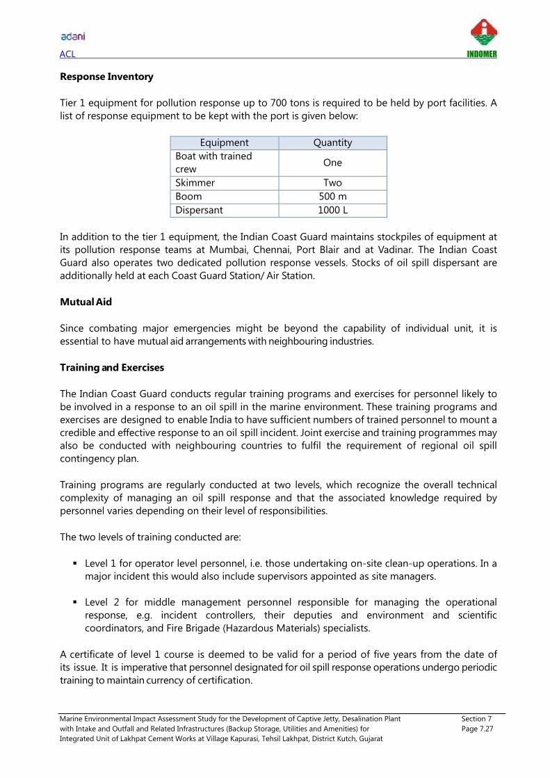
ACL INDOMER
Marine Environmental Impact Assessment Study for the Development of Captive Jetty, Desalination Plant Section 7
with Intake and Outfall and Related Infrastructures (Backup Storage, Utilities and Amenities) for Page 7.27
Integrated Unit of Lakhpat Cement Works at Village Kapurasi, Tehsil Lakhpat, District Kutch, Gujarat
Response Inventory
Tier 1 equipment for pollution response up to 700 tons is required to be held by port facilities. A
list of response equipment to be kept with the port is given below:
Equipment Quantity
Boat with trained
crew One
Skimmer Two
Boom 500 m
Dispersant 1000 L
In addition to the tier 1 equipment, the Indian Coast Guard maintains stockpiles of equipment at
its pollution response teams at Mumbai, Chennai, Port Blair and at Vadinar. The Indian Coast
Guard also operates two dedicated pollution response vessels. Stocks of oil spill dispersant are
additionally held at each Coast Guard Station/ Air Station.
Mutual Aid
Since combating major emergencies might be beyond the capability of individual unit, it is
essential to have mutual aid arrangements with neighbouring industries.
Training and Exercises
The Indian Coast Guard conducts regular training programs and exercises for personnel likely to
be involved in a response to an oil spill in the marine environment. These training programs and
exercises are designed to enable India to have sufficient numbers of trained personnel to mount a
credible and effective response to an oil spill incident. Joint exercise and training programmes may
also be conducted with neighbouring countries to fulfil the requirement of regional oil spill
contingency plan.
Training programs are regularly conducted at two levels, which recognize the overall technical
complexity of managing an oil spill response and that the associated knowledge required by
personnel varies depending on their level of responsibilities.
The two levels of training conducted are:
Level 1 for operator level personnel, i.e. those undertaking on-site clean-up operations. In a
major incident this would also include supervisors appointed as site managers.
Level 2 for middle management personnel responsible for managing the operational
response, e.g. incident controllers, their deputies and environment and scientific
coordinators, and Fire Brigade (Hazardous Materials) specialists.
A certificate of level 1 course is deemed to be valid for a period of five years from the date of
its issue. It is imperative that personnel designated for oil spill response operations undergo periodic
training to maintain currency of certification.

ACL INDOMER
Marine Environmental Impact Assessment Study for the Development of Captive Jetty, Desalination Plant Section 7
with Intake and Outfall and Related Infrastructures (Backup Storage, Utilities and Amenities) for Page 7.28
Integrated Unit of Lakhpat Cement Works at Village Kapurasi, Tehsil Lakhpat, District Kutch, Gujarat
The persons qualified in level 2 course will be designated for carrying out duties as Chief Incident
Controller and Incident Controller.
Mock drills and exercises will be conducted by every port facility and oil installation at such
periodicity and at such scales as required by the Central Coordinating Authority. However, such
mock drills and exercises shall in any case be conducted at least once every three months and a
record shall be maintained of its conduct including the personnel participated, resources mobilized,
etc. Area or regional level exercises will be conducted at least once every six months. National level
pollution response exercises will be conducted at least once a year and involve mobilization of
stakeholder resources.
In addition, communication mock drills will be conducted by the Coast Guard at the national and
area or regional level as required.
Financial Arrangements
Detailed financial records, including all supporting information are required, and are of particular
importance when submitting claims to the Protection and Indemnity (P&I) insurers, as all claims
will be assessed to ensure that the costs are reasonable, and are supported by satisfactory
documentation.
Agencies should have in place appropriate systems to ensure that these requirements are met
and that these are adequately outlined in contingency plans.
In general, costs will be considered "reasonable" if they result from actions:
• undertaken on the basis of a technical appraisal of the incident;
• sought to enhance the natural processes of recovery; and recovery; and
• not undertaken purely for public relations reasons.
Capitation costs for deployment of government ships and aircraft shall be as promulgated by the
Government of India, Government of any coastal State of India, or any other department or
agency of the central or state government.
Record Keeping and Preparation of Claims
In order that claims may be processed with minimum delay, it is essential that accurate records are
maintained to support claims. It should be noted that claims should be based on expenses
actually incurred, that these are made as a direct result of an incident, and that the expenses
incurred are reasonable. In the case of economic loss, documentation supporting the claims
should demonstrate how the claim has been calculated. The following aspects are to be considered
during response operations, and preparation of claims:
• delineation of the area affected describing the extent of pollution and identifying areas
most heavily contaminated. This may be best presented as a map or chart accompanied by
photographs;
• summary of events including a description of the work carried out in different areas and of

ACL INDOMER
Marine Environmental Impact Assessment Study for the Development of Captive Jetty, Desalination Plant Section 7
with Intake and Outfall and Related Infrastructures (Backup Storage, Utilities and Amenities) for Page 7.29
Integrated Unit of Lakhpat Cement Works at Village Kapurasi, Tehsil Lakhpat, District Kutch, Gujarat
the working methods chosen in relation to the circumstantial evidence linking an oil
pollution with the ship involved in the incident (e.g. chemical analysis);
• labour costs (numbers and categories of laborer, rates of pay, hours worked, total costs
etc.);
• dates on which work was carried out (weekly or daily costs); and
• material costs (consumable materials, fuel utilized, food, shelter, etc.).
Preparation of claims shall be guided by the manuals, guidelines etc. published from time to time by
the International Oil Pollution Compensation Funds (IOPC Funds) such as the claims manual and
guidelines for claims in the fisheries and tourism sector.
7.2.7. Port Responsibility
• To be in charge of the overall coordination of oil pollution response actions in jurisdiction.
• To identify suitable tugs, vessels and crafts when required for the operations.
• To identify surface crafts on which dispersant spraying equipment can be mounted, and
which can be used for rigging the boom.
• To ensure that for the purpose of part XIII of the Merchant Shipping Act, 1958, actions are
taken by the various authorities under the overall legal responsibility of the receiver of
wrecks.
• To ensure that at least the minimum equipment is kept available locally at all times.
• To arrange for training of personnel expected to be engaged in above operations.
• To arrange for periodical mock drills and exercises so as to keep equipment and personnel on
continuous readiness for oil spill response operations.
• To consult the ICG, DG Shipping, OISD or other authority, when further advice/ assistance is
required.
• To keep the ICG apprised of actions being taken.

ACL INDOMER
Marine Environmental Impact Assessment Study for the Development of Captive Jetty, Desalination Plant Section 8
with Intake and Outfall and Related Infrastructures (Backup Storage, Utilities and Amenities) for Page 8.1
Integrated Unit of Lakhpat Cement Works at Village Kapurasi, Tehsil Lakhpat, District Kutch, Gujarat
8. Modelling Studies
8.1. Introduction
The proposed jetty and Desalination plant in the water front area of Lakhpat in Kori creek will have
the following establishments in the nearshore region for loading/unloading and transportation of
cargoes.
• Construction of berthing jetty with trestle and approach road with pipe culverts to allow
seawater to pass through.
• Desalination plant with seawater intake and brine reject outfall.
Construction of berthing jetty with trestle and approach road (protruding into the sea) in Kori creek
might have direct or indirect impact to the natural coastal processes in the nearshore region.
Similarly, discharge of brine reject will have impact on the marine community if disposed off at
inappropriate location. This trifling impact on the marine environment can predicted through
mathematical modelling studies.
Proponent has appointed M/s Howe Engineering Projects India Private Limited as a technical
consultant to carry out mathematical modelling studies on
(i) Offshore wave analysis at proposed jetty locations along with flow pattern assessment.
(ii) Cyclone modelling studies.
(iii) Hydrodynamic studies to find out the suitable location of jetty, orientation and approach
bund optimization.
Findings of mathematical modelling studies conducted by M/s Howe Engineering Projects India
Private Limited is presented in report entitled "Kori Creek Cement Jetty and Offshore Anchorage
DPR studies (Numerical Modeling Studies)".
Indomer has carried out Hydrodynamic secondary dispersion model study (MIKE 21) to identify and
fix the feasible location of seawater intake & outfall diffuser for mixing of brine reject at offshore. It is
essential to understand the tide and flow characteristics in and around the vicinity of outfall during
different tidal condition over a Spring - Neap tidal cycle. Details of Advection Dispersion study is
presented below.
8.2. Proposed Marine Facilities
The proposed marine facilities for the additional facility of 9 MLD desalination plant consists of:
i) Construction of intake well with intake head
ii) Outfall pipeline with outfall diffuser
iii) Construction of seawater sump with pump house on the land
Proposed location of desalination plant with intake and outfall location is shown in Fig. 2.5.

ACL INDOMER
Marine Environmental Impact Assessment Study for the Development of Captive Jetty, Desalination Plant Section 8
with Intake and Outfall and Related Infrastructures (Backup Storage, Utilities and Amenities) for Page 8.2
Integrated Unit of Lakhpat Cement Works at Village Kapurasi, Tehsil Lakhpat, District Kutch, Gujarat
8.2.1. Seawater Intake
Intake Volume: The seawater requirement for the RO (Reverse Osmosis) plant will be 30 MLD
~1250 m3/hour ~ 0.347 m3/s.
Intake description: The seawater intake well will be located immediate to east of berthing jetty at
a distance of 4000 m from the desalination plant at 8.8 m CD (Chart Datum) water depth.
8.2.2. Brine Reject
Outfall volume: The brine discharge into the sea from the desalination plant is 21 MLD ~ 875
m3/hour ~0.243 m3/s.
Brine outfall description: The outfall diffuser will be located immediate to west of berthing jetty
at 4500 m distance from the desalination plant at a water depth of 8.6 m CD. The salinity of the
brine reject released into the sea will be 57 ppt, which will have the salinity difference of 17 ppt
higher than the seawater ambient salinity of 40 ppt. The outfall diffuser will have multi ports of 6
nos. x 250 mm diameter (ID). The ports will be oriented 30° to the horizontal. The discharge will
comply with the water quality standards stipulated by Central Pollution Control Board.
8.3. Modelling Approach
DHI - MIKE 21 model is comprised of the modules on Hydrodynamic – HD and Dispersion model. These models have been developed by Danish Hydraulic Institute (DHI), Denmark, and are being
used worldwide for many coastal engineering applications. The flow chart of the model
describing the approach followed in the present study is given below.

ACL INDOMER
Marine Environmental Impact Assessment Study for the Development of Captive Jetty, Desalination Plant Section 8
with Intake and Outfall and Related Infrastructures (Backup Storage, Utilities and Amenities) for Page 8.3
Integrated Unit of Lakhpat Cement Works at Village Kapurasi, Tehsil Lakhpat, District Kutch, Gujarat
Flow chart showing modelling approach for Initial dilution and dispersion study
8.4. Model Setup
8.4.1. Units and Conventions
Units: Units of all parameters and variables in the model study are according to international SI
conventions. Coordinate system: The coordinate system used for model grid generation and
other horizontal positioning was UTM based on WGS 84 spheroid. Vertical reference level: The
depth information used in the tidal flow models is relative to Mean Sea Level (MSL); depths below
MSL are defined negative.
Directions: Current – Ocean current directions refer to the direction towards which the flow is
taking place. Directions of the flow are always given clockwise with respect to North. The Unit is
degrees, where 360 degrees cover the circle. Wind - Wind directions refer to the direction from
which the wind is approaching the observer. Directions of the wind are always given clockwise
with respect to North. The Unit is degrees, where 360 degrees cover the circle. Wave - Wave
directions refer to the direction from which the wave (orthogonal) is approaching. Directions of
the wave are always given clockwise with respect to North. The Unit is degrees, where 360
degrees cover the circle.
ACL INDOMER
Marine Environmental Impact Assessment Study for the Development of Captive Jetty, Desalination Plant Section 8
with Intake and Outfall and Related Infrastructures (Backup Storage, Utilities and Amenities) for Page 8.4
Integrated Unit of Lakhpat Cement Works at Village Kapurasi, Tehsil Lakhpat, District Kutch, Gujarat
8.4.2. Model Domain
The model domain covers an area of approximately 15 km along the coast and 10 km across the
coast. Model domain with bathymetry is shown in Fig. 8.1.
8.4.3. Depth Schematization
For the schematization of depths in the flow model, the depths of the sea were extracted from
different sources viz., i) DHI - MIKE 21 – C Map data base, ii) Indian Naval Hydrographic Charts
corresponding to this region and iii) available measured bathymetry at the site.
Depth schematization or setting up bathymetries at model grid points has always been one of the
most tedious, expensive and yet crucial part of any coastal modelling problem. The time and
effort required for bathymetry preparation is now greatly reduced by the availability of the MIKE-
C-MAP's worldwide electronic chart database. The C-MAP database and the program to extract
the bathymetric data over the selected area have been developed jointly by DHI and C-MAP,
Norway.
8.5. Initial Dilution - CORMIX Model
The dilution of any return water (brine in this case) released in a natural water body takes place in
2 stages, viz., i) initial dilution due to jet mixing, and ii) secondary dispersion due to turbulence.
The extent of initial dilution is controlled by the engineering design of the diffuser. For a
proposed design of the diffuser port the behaviour of the return water jet plume is designed and
estimated using CORMIX model. Once the return water rises to the water surface as the water
moves away from the outfall location the subsequent dilution takes place by larger scale
turbulence in the horizontal direction. This second stage is controlled by the prevailing currents
and turbulence that exist in the coastal region. Such secondary dispersion is estimated using
DHI-MIKE 21- FLOW -Dispersion model.
The Cornell Mixing Zone Expert System (CORMIX) is a software module for the analysis,
prediction, and design of aqueous toxic or conventional pollutant discharges into diverse water
bodies. It is a widely accepted and recommended analysis tool in US on granting permission for
industrial, municipal, thermal, and other point source discharges to receiving waters. It is used to
predict the geometry and dilution characteristics of the initial mixing zone and also the behavior
of the discharge plume at larger distances.
8.5.1. Methodology
The highly user-interactive CORMIX system is organized with three subsystems: (i) CORMIX1- for
the analysis of submerged single port discharges, (ii) CORMIX2- for the analysis of submerged
multiport diffuser discharges and (iii) CORMIX3- for the analysis of buoyant surface discharges.
Several post-processing options are available like, CORJET (the Cornell Buoyant Jet Integral
Model) for the detailed analysis of the near-field behaviour of buoyant jets, FFLOCATR (the Far-
Field Plume Locator) for the far-field delineation of discharge plumes in non-uniform river or
estuary environments, and CMXGRAPH, a graphics package for plume plotting.

ACL INDOMER
Marine Environmental Impact Assessment Study for the Development of Captive Jetty, Desalination Plant Section 8
with Intake and Outfall and Related Infrastructures (Backup Storage, Utilities and Amenities) for Page 8.5
Integrated Unit of Lakhpat Cement Works at Village Kapurasi, Tehsil Lakhpat, District Kutch, Gujarat
Hydrodynamic Mixing Processes: The mixing behaviour of any effluent discharge is governed by
the interplay of ambient conditions in the receiving water body and by the discharge
characteristics. The ambient conditions in the receiving water body are described by the water
body's geometric and dynamic characteristics such as: plan shape, vertical cross-sections, and
bathymetry, especially in the discharge vicinity. Dynamic characteristics are given by the velocity
and density distribution in the water body, again primarily in the discharge vicinity. The discharge
conditions relate to the geometric and flux characteristics of the submerged outfall installation.
For a single port discharge the port diameter, its elevation above the bottom and its orientation
provide the geometry; for multiport diffuser installations the arrangement of the individual ports
along the diffuser line, the orientation of the diffuser line, and construction details represent
additional geometric features; and for surface discharges the cross-section and orientation of the
flow entering the ambient watercourse are important. The distinction between near-field and far-
field is made purely on hydrodynamic grounds and it is unrelated to any regulatory mixing zone
definitions.
8.5.2. Design Details
Cormix has been used to estimate the initial dilution for discharge. The total discharge will be
21000 m3/day. The outfall diffuser will have multi ports of 6 nos. x 250 mm diameter (ID). The
ports will be oriented 30° to the horizontal.
Model: The various input parameters to the CORMIX model to determine the behaviour of the
return water jet plume around the proposed diffuser port are given below.
CORMIX SESSION REPORT:
---------------------------------------------------------------------------------------------
CORMIX MIXING ZONE EXPERT SYSTEM
CORMIX Version 11.0 GTH
DYDRO: Version-11.0.0.0
----------------------------------------------------------------------------------------------
SITE NAME/LABEL : Lakhpat
DESIGN CASE : ACL - Lakhpat
FILE NAME:C : C \Program Files (x86) \CORMIX 11.0\Lakhpat.prd
Using subsystem BCORMIX2 : Multiport Diffuser Brine Discharges
Start of session :12/29/2018--17:41:25
----------------------------------------------------------------------------------------------
SUMMARY OF INPUT DATA:
----------------------------------------------------------------------------------------------
AMBIENT PARAMETERS:
Cross-section = unbounded
Average depth HA = 8.6 m
Depth at discharge HD = 8.6 m
Ambient velocity UA = 0.9 m/s
Darcy-Weisbach friction factor F = 0.01
Wind velocity UW = 1 m/s
Stratification Type STRCND = U
Surface density RHOAS = 1024 kg/m^3
Bottom density RHOAB = 1024 kg/m^3

ACL INDOMER
Marine Environmental Impact Assessment Study for the Development of Captive Jetty, Desalination Plant Section 8
with Intake and Outfall and Related Infrastructures (Backup Storage, Utilities and Amenities) for Page 8.6
Integrated Unit of Lakhpat Cement Works at Village Kapurasi, Tehsil Lakhpat, District Kutch, Gujarat
----------------------------------------------------------------------------------------------
DISCHARGE PARAMETERS: Submerged Multiport Diffuser Discharge
Diffuser type DITYPE = unidirectional perpendicular
Diffuser length LD = 25 m
Nearest bank = right
Diffuser endpoints YB1 = 275 m; YB2 = 300 m
Number of openings NOPEN = 6
Number of Risers NRISER = 6
Ports/Nozzles per Riser NPPERR = 1
Spacing between risers/openings SPAC = 5 m
Port/Nozzle diameter D0 = 0.25 m
Contraction ratio = 1
Total area of openings TA0 = 0.2945 m^2
Discharge velocity U0 = 0.81 m/s
Total discharge flowrate Q0 = 0.243 m^3/s
Discharge port height H0 = 1 m
Nozzle arrangement BETYPE = unidirectional without fanning
Diffuser alignment angle GAMMA = 90 deg
Vertical discharge angle THETA = 30 deg
Actual Vertical discharge angle THEAC = 30 deg
Horizontal discharge angle SIGMA = 0 deg
Relative orientation angle BETA = 90 deg
Discharge density RHO0 = 1027 kg/m^3
Density difference DRHO = -3 kg/m^3
Discharge concentration KD = 17000 mg/l
----------------------------------------------------------------------------------------------
NON-DIMENSIONAL PARAMETERS:
Slot Froude number FR0 = 48.52
Port/nozzle Froude number FRD0 = 9.61
Velocity ratio R = 0.89
----------------------------------------------------------------------------------------------
D-CORMIX PREDICTION FILE:
----------------------------------------------------------------------------------------------
FLOW CLASSIFICATION
X-Y-Z Coordinate system:
ORIGIN is located directly at the LEFT bank/shore.
X - axis points downstream,
Y - axis points to left,
Z - axis points upward.
S - hydrodynamic average (bulk) dilution

ACL INDOMER
Marine Environmental Impact Assessment Study for the Development of Captive Jetty, Desalination Plant Section 8
with Intake and Outfall and Related Infrastructures (Backup Storage, Utilities and Amenities) for Page 8.7
Integrated Unit of Lakhpat Cement Works at Village Kapurasi, Tehsil Lakhpat, District Kutch, Gujarat
Initial Dilution – CORMIX results
Cumulative travel time = 559 sec = 9.31 min Dilution 25 times in 500 m distance
Discussion
The study on CORMIX model shows the mixing zone will extend upto 500 m from the diffuser
port location. Within this zone, it undergoes dilution of the order of 25 times in 9.31 minutes.
Thereafter the initial dilution, the secondary dispersion take place due to convection currents and
undergoes further dilution. The secondary dispersion characteristics are studied in detail using
MIKE 21 model.
8.6. Flow Model
The tide induced flow fields over the project area are determined using MIKE 21 HD
(hydrodynamic) module with appropriate boundary conditions.
8.6.1. Model Description
The MIKE 21 Flow module (HD) is a modelling system for two dimensional free-surface flows. It
calculates non-steady flow and transport phenomena that result from tidal and meteorological
forcing on a spherical, or rectilinear or curvilinear boundary fitted grid. This module is applicable
for the simulation of flow fields in natural water bodies, such as lakes, estuaries, bays, coastal
areas and seas, wherever stratification can be neglected. The output of the HD module is also
used as input for many of the other MIKE 21 modules, viz., Advection-Dispersion module (AD),
Sediment Transport module (ST), Particle tracking (PA) and the Environmental module (ECO).
The MIKE 21 Flow module is a multi-dimensional 2D, which solves shallow-water equations for
given boundary conditions to compute non-steady flow fields in response to a variety of
environmental forcing and processes in natural water bodies. The environmental forcing and
processes include: bottom shear stress, wind shear stress, barometric pressure gradients, Coriolis
force, momentum dispersion, sources and sinks, evaporation, flooding and drying and wave
radiation stresses.
It uses an Alternate Direction Implicit (ADI) Finite Difference Method on staggered orthogonal
grids and also has the option to use Finite Element Method. The basic shallow-water equations
in the Cartesian co-ordinate system used in the HD flow module are:
X (m) Y (m) Z (m) S
0.00 0.00 - 8.60 1
500 0.00 - 8.97 25

ACL INDOMER
Marine Environmental Impact Assessment Study for the Development of Captive Jetty, Desalination Plant Section 8
with Intake and Outfall and Related Infrastructures (Backup Storage, Utilities and Amenities) for Page 8.8
Integrated Unit of Lakhpat Cement Works at Village Kapurasi, Tehsil Lakhpat, District Kutch, Gujarat
Continuity equation:
Momentum equations in x- and y- directions:
Symbol List:
(x, y, t) - Water surface level above datum (m)
p(x, y, t) - flux density in the x-direction (m3/s/m)
q(x, y, t) - flux density in the y-direction (m3/s/m)
h(x, y, t) - water depth (m)
S - source magnitude per unit horizontal area (m3/s/m2)
iXS , iYS - source impulse in x and y-directions m3/s/m2.m/s)
e - evaporation rate (m/s)
g - gravitational acceleration (m/s2)
C - Chezy resistance No. (m1/2/s)
Ka - Water
airwC
Cw - wind friction factor
W, WX, WY (x, y, t) - wind speed and components in x - and y – directions (m/s)
pa (x, y, t) - barometric pressure (Kg/m/s2)
ρw - density of water (kg/m3)
Ω - Coriolis coefficient (latitude dependent) (s-1)
ε(x, y) - eddy or momentum dispersion coefficient (m2/s)
x, y - space coordinates (m)
t - time (s)
+
=
Y
uh
YX
uh
XF YXEX ....
+
=
Y
uh
YX
uh
XF YXEY ....
bxF = h
p
h
q
h
p
C
g.
2
2
2
2
2+
byF = h
q
h
q
h
p
C
g.
2
2
2
2
2+

ACL INDOMER
Marine Environmental Impact Assessment Study for the Development of Captive Jetty, Desalination Plant Section 8
with Intake and Outfall and Related Infrastructures (Backup Storage, Utilities and Amenities) for Page 8.9
Integrated Unit of Lakhpat Cement Works at Village Kapurasi, Tehsil Lakhpat, District Kutch, Gujarat
8.6.2. Boundary Conditions
The model domain is forced by the tidal water level variations along the open sea boundaries.
For the generation of these boundary conditions, the MIKE 21 C-Map data base or DHI Global
tide data base can be used. These boundary conditions for the model domain are prescribed as
time series of tidal water level variations along the open boundaries of the model.
If the tidal constituents along the boundaries of the model domain are available, then the
boundary conditions are represented by:
Where,
ht = water level at time t
Ao = mean value of the signal
Ai = amplitude of component i
fi = nodal amplitude factor of component i
i = angular frequency of component i
(v0+u) i = astronomic argument of component i
gi = phase lag of component i
For the model domain, the Global tides were applied along the southern boundary and on the
northern boundary. Along the eastern boundary, the tide levels linearly interpolated between
the south and north boundaries have been imposed.
8.6.3. Calibration
The model is calibrated using simulated and predicted tides. A good agreement was observed
between the simulated tides and the predicted tides. The comparison between simulated and
predicted tides is shown in Fig. 8.2.
8.6.4. Simulations
The tide induced flow field inside the Kori creek was simulated to represent the flow over two
lunar tidal cycle covering 29 days from 15th September 2018 to 15th October 2018. This period
has been chosen for simulation which can form as good representation for the various tidal
cycles occurring over the year. The simulation of hydrodynamic flow field was carried out for the
proposed berthing jetty with approach trestle and rock bund.
8.7. Secondary Dispersion – MIKE 21 Model
8.7.1. Advection and Dispersion
The Dispersion module of the MIKE 21 model suite simulates dispersion of return water in an
aquatic environment under the influence of the fluid transport and associated natural dispersion
process. The dispersing substance may be conservative or non-conservative, inorganic or
organic: e.g. salt, heat, dissolved oxygen, inorganic phosphorus, nitrogen and other such water
quality parameters. Applications of the MIKE 21 AD module are in principle essential for two
types of investigations, viz., i) cooling water recirculation studies for power plants and salt

ACL INDOMER
Marine Environmental Impact Assessment Study for the Development of Captive Jetty, Desalination Plant Section 8
with Intake and Outfall and Related Infrastructures (Backup Storage, Utilities and Amenities) for Page 8.10
Integrated Unit of Lakhpat Cement Works at Village Kapurasi, Tehsil Lakhpat, District Kutch, Gujarat
recirculation studies for desalination plants, and ii) water quality studies connected with sewage
outfalls and non-point pollution sources.
This module determines the concentration of the dispersing substance by solving the equation
of conservation of mass for a dissolved or suspended substance. The concentration of the
substance is calculated at each point of a rectangular grid covering the area of interest using a
two-dimensional finite difference scheme. Information on the transport, i.e. currents and water
depths at each point of the grid, are provided by the MIKE 21 HD module. Other data required
in the model include effluent volume discharged, the concentration of the pollutant, initial and
the boundary conditions.
Governing Equation
The MIKE 21 AD module solves the advection-dispersion equation for dissolved or suspended
substances in two dimensions. This is in reality the mass-conservation equation to which
quantities of substances discharged and their concentrations at source and sink points are
included together with their decay rate.
Symbol list
C - compound concentration (arbitrary units)
u, v - horizontal velocity components in the x, y directions (m/s)
h - water depth (m)
Dx, Dy - dispersion coefficients in the x, y directions (m2/s)
F - linear decay coefficient (1/s)
S - Qs. (Cs – C)
Qs - Source / sink discharge per unit horizontal area (m3/s/ m2)
Cs - concentration of compound in the source / sink discharge.
Information on u, v and h at each time step is provided by the MIKE 21 HD module.
8.7.2. Input to Dispersion Model
The volume of discharge into the sea will be 21 MLD (=21000 m3/day ≈ 875 m3/hour ≈ 0.243
m3/s). The salinity of the return water released into the sea will be 57 ppt, which will have a
salinity difference of 17 ppt above the seawater ambient salinity of 40 ppt.
8.7.3. Dispersion of Brine Reject
In the secondary dispersion studies, the discharge of return water introduced at any grid cell is
assumed to be uniformly dispersed over the entire volume of water in this grid cell. The flow
field induced by tides and the reject water mixing patterns for a period of one lunar month
covering spring and neap tidal phase were simulated. The mixing of brine reject during the flood
and ebb tidal phases are described below.

ACL INDOMER
Marine Environmental Impact Assessment Study for the Development of Captive Jetty, Desalination Plant Section 8
with Intake and Outfall and Related Infrastructures (Backup Storage, Utilities and Amenities) for Page 8.11
Integrated Unit of Lakhpat Cement Works at Village Kapurasi, Tehsil Lakhpat, District Kutch, Gujarat
8.8. Results on Currents & Secondary Dispersion
During the simulation period the wind speed over the sea (Kori creek) are expected to be less,
and the sea appears to be calm without the influence of high waves at the interior regions of
creek. The tide induced flow field in the project region with the construction of jetty and rock
bund are described below.
Flow field with berthing jetty, trestle and approach road during spring and neap tidal phase is
considered for the secondary dispersion study. Output of the Advection – Dispersion study is
explained below.
Spring tide
Flow: The flow pattern in the project region with the construction of jetty during different phases
of tide on a spring tidal day are shown in Fig. 8.3. During the peak flood flow, the tidal induced
current speed reaches up to 1.1 m/s and it is directed towards northeast. During the peak ebb
flow, the current speed reaches up to 0.9 m/s and directed towards southwest. During the slack
hours, the current speed remained very small (< 0.02 m/s) and it was reversing its direction.
With the construction of proposed jetty, the current pattern during flood flow close to the jetty
head reaches a maximum of 1.0 m/s and it is directed towards northeast during flood flow.
Similarly, the current pattern during ebb flow close to the jetty head reaches a maximum of 0.8
m/s and it is directed towards southwest during flood flow.
Salinity: The mixing pattern of the brine reject in the nearshore region is shown in Fig. 8.4. The
brine (∆S=17 ppt) discharged in the nearshore waters undergoes dilution with maximum current
speed reaching upto 1.1 m/s, it reaches the salinity of 2 ppt (∆S = 17 ppt) art 110 m from the
outfall.
Neap tide
The flow pattern in the project region with the construction of jetty during different phases of
tide on a neap tidal day are shown in Fig. 8.5. During the peak flood flow, the tidal current speed
reaches up to 0.7 m/s and it is directed towards northeast. During the peak ebb flow, the current
speed reaches up to 0.6 m/s and directed towards southwest. During the slack hours, the current
speed remained very small (< 0.02 m/s) and it was reversing its direction.
During the neap tide, the current pattern during flood flow close to the jetty head reaches a
maximum of 0.6 m/s and it is directed towards northeast during flood flow. Similarly, the current
pattern during ebb flow close to the jetty head reaches a maximum of 0.5 m/s and it is directed
towards southwest during flood flow.
Salinity: The mixing pattern of the brine reject in the nearshore region is shown in Fig. 8.6. The
brine (∆S=17 ppt) discharged in the nearshore waters undergoes dilution with maximum current
speed reaching upto 0.6 m/s, it reaches the salinity of 2 ppt (∆S=17 ppt) at 280 m from the
outfall.

ACL INDOMER
Marine Environmental Impact Assessment Study for the Development of Captive Jetty, Desalination Plant Section 8
with Intake and Outfall and Related Infrastructures (Backup Storage, Utilities and Amenities) for Page 8.12
Integrated Unit of Lakhpat Cement Works at Village Kapurasi, Tehsil Lakhpat, District Kutch, Gujarat
The MIKE 21 modelling studies indicate that the difference in salinity of 2 ppt from ambient will
be experienced in 280 m distance from the outfall diffuser. The increase in turbulent due to
stronger currents (> 0.2 m/s) induced by monsoon wind and rough seas would enhance the
mixing during monsoon periods.
Thus, the studies show that the impact due to the discharge of the brine reject at 4500 m
offshore would be insignificant. Hence, it is recommended that the brine reject can be
discharged in Kori creek at the suggested location.
8.9. Ship/Wave Tranquility in Kori Creek
The ship/wave tranquility study inside the Kori creek has been carried out in detail by Howe
Engineering Projects India Private Limited, Ahmedabad and submitted a detailed Project Report
entitled 'Kori creek cement jetty and offshore anchorage DPR studies' in July 2018.
8.9.1. Waves at Offshore Near Anchorage Point
ERA Interim data are produced by the ECMWF, which is a global atmospheric reanalysis from
1900 to 2010. ERA Interim is the first to perform reanalysis using adaptive and fully automated
bias corrections of observations (Dee and Uppala, 2008). The parameters such as significant wave
height (Hs), mean wave direction and mean wave period can be obtained with 3 hourly fields
covering the whole globe at a space resolution of 0.5°. Joint distribution of Significant Wave
Height (Hs) Vs Wave Direction at offshore is given in Table 8.1. The wave data base location (ERA
Interim data) is shown below.
Locations of ERA Interim data
Offshore Wave Data

ACL INDOMER
Marine Environmental Impact Assessment Study for the Development of Captive Jetty, Desalination Plant Section 8
with Intake and Outfall and Related Infrastructures (Backup Storage, Utilities and Amenities) for Page 8.13
Integrated Unit of Lakhpat Cement Works at Village Kapurasi, Tehsil Lakhpat, District Kutch, Gujarat
Extreme Waves:
Fundamentally, extreme values are necessarily outside the range of the available observations,
results in an extrapolation from the observed sea states to unknown period is required. An
estimate of anticipated wave height can be furnished using historical wave hind cast data or
field observed data with the help of various distribution models suggested that the estimation
of extreme values should rely on methods based on extreme value theory which makes use of
the largest of the observations in the sample. The detailed statistical results of extreme value
prediction using the annual maximum (AM) and Peaks Over Threshold (POT) sampled
observations are commonly used. Other methods commonly used extreme value statistical
methods are generalized extreme value, or GEV, generalized Pareto distribution, or GPD,
equivalent storm based on the concept of sea storm and equivalent power storm model and
probability distribution models Gumbel and Weibull. The accuracy of any methodology for
extreme values significantly depends on the length of the recorded time series.
In the recent years, the performance of wave models has appreciably improved, with better
quality of the wind fields and enhancement in numerical wave modelling. The meteorological
centres like European Centre for Medium Range Weather Forecasts (ECMWF) operate global
wave models using altimeter wind data. The process combines numerical wave model and
observations of diverse sorts in the best possible ways to generate a consistent, global estimate
of the various atmospheric, wave and oceanographic parameters. Present study is based on the
111 years wave hindcast by ECMWF. Parameters used for the analysis are significant wave height
(total), swell wave height, mean wave period, wave direction, wind speed and direction.
Extreme Estimation Methods:
Generalized Extreme Value Distribution:
The generalized extreme-value (GEV) distribution, introduced by Jenkinson, has found many
applications in hydrology. It was recommended for at-site flood frequency analysis in the United
Kingdom [Natural Environmental Research Council (NERC)], for rainfall frequency in the United
States, and for sea waves. For regional frequency analysis the GEV distribution has received
special attention since the introduction of the index-flood procedure based on probability
weighted moments (PWM) by Wallis (Eduardo S. & Stedinger.J.R., 2000). An advantage of
maximum-likelihood estimators is that they can employ censored information without difficulty.
To take advantage of the efficiency of L moments in small samples for the GEV distribution with
regional flood data and historical flood information.
Probability Distribution Function

ACL INDOMER
Marine Environmental Impact Assessment Study for the Development of Captive Jetty, Desalination Plant Section 8
with Intake and Outfall and Related Infrastructures (Backup Storage, Utilities and Amenities) for Page 8.14
Integrated Unit of Lakhpat Cement Works at Village Kapurasi, Tehsil Lakhpat, District Kutch, Gujarat
Cumulative Distribution Function
The estimation models used in this study to obtain extreme wave return values include the GEV
and the GPD, which are currently being adopted for the standard practice in mainstream extreme
statistics. Each distribution was fit to the data using the maximum likelihood estimate (MLE)
method and the probability weighted moments (PWM) method. Using the min-max criteria
Thresholding of hydrodynamic variables has been carried out in the current study. Table 8.2 show
estimated wind and wave parameters for the offshore location near the Kori entrance.
8.9.2. Wave Tranquility Using SWAN Model
To obtain realistic estimates of random, short-crested, waves for a given bottom topography,
the numerical wave model SWAN was used with reliable accuracy. SWAN (acronym for
Simulating Waves Nearshore) is a third-generation stand-alone (phase-averaged) wave model
ideal for simulation of waves in coastal waters. In brief, SWAN includes the effects of refraction,
shoaling, friction, wave breaking and wave-wave interactions. The model is best suited to the
transformation of wave energy spectra in relatively large coastal areas. It is so particularly in
areas where the features of the seabed, such as offshore banks, result in depth-induced wave
breaking and wave-wave interactions. SWAN simulates the following physical phenomena: (i)
Wave generation by wind; (ii) Wave propagation in time and space; (iii) Non-linear wave
interactions; (iv) White capping, friction and depth induced breaking.
SWAN is useful in regions like partially enclosed bays, estuaries, lochs or fjords where wave
conditions comprise of offshore waves and waves generated locally by winds. The inclusion of
wave growth due to winds in spectral wave models also enables their use in assessing, for
example, the combined effect of the propagation of offshore waves with local winds, not
necessarily correlated with the predominant offshore wave direction. We have conducted swan
simulations on regular grid with nesting.
Wave tranquility at jetty location:
A SWAN wave model was set-up to establish wave conditions with offshore operational offshore
boundary wave conditions derived from ECMWF wave data analysis. The model consists of two
nested grids of increasingly high resolution (Fig. 8.7). The outer grid is of 300 m x 300 m while
the coastal grid has a spacing of 90 m x 90 m. Output of the model is the coastal wave climate.
Spectrum generated at the boundary points of inner grid by the outer model is transferred
(boundary spectrum) to fine grid for computation of wave parameters for the fine grid. The
model is run with options activated for breaking, quadruplets, triads, quads and white capping.

ACL INDOMER
Marine Environmental Impact Assessment Study for the Development of Captive Jetty, Desalination Plant Section 8
with Intake and Outfall and Related Infrastructures (Backup Storage, Utilities and Amenities) for Page 8.15
Integrated Unit of Lakhpat Cement Works at Village Kapurasi, Tehsil Lakhpat, District Kutch, Gujarat
It assumed a JONSWAP spectrum formulation with a frictional coefficient 0.067, the
recommended values for wind waves.
The SWAN model results were used to analyse wave conditions at the proposed berths and
adjoining area under specified operational and design conditions. Nearshore wave climate for
each offshore wind, wave, and water level 4.37 m (HWS) for the return period 1, 5, 25, 50 and 100
years are estimated. Results from each condition were extracted and analysed and is presented in
the Table 8.3. Predominant direction of waves entering the creek is the SW sector. All sectors,
wave energy are significantly dissipated over the shallow area in the creek. Wave energy is
reaching the jetty primarily through the channel and the south to west sector. To resolve the
direction properly five directions between south and west are considered for simulation.
The SWAN model results were used to analyse wave conditions at the proposed berths and
adjoining area under specified operational and design conditions. A set of offshore conditions
selected during the offshore wave data analysis were simulated to get the wave climate near the
jetty. Near the Jetty wave climate for each offshore wind, wave, and water level 4.37 m for the
return period 1 and 100 years are presented in Fig. 8.8 to 8.13 respectively. Point results at 5m
6m and 7m contour for each offshore condition was extracted and analysed for the jetty
location and is presented in the Table 8.3. Predominant direction of waves entering the creek is
the SW sector. All sectors, wave energy are significantly dissipated over the shallow area in the
creek. Wave energy is reaching the proposed berthing jetty primarily through the channel and
the south to west sector. Significant wave heights at the berths can reach about 0.83m during
operational conditions while it reaches 1 m during the normal extreme events of 100 years
return periods.
Peak periods drop to 4 s or below and noticed that locally generated waves (wind waves) are
dominant at the berth and adjoining area. Wave direction at the berths varies from 204°N to
255°N.
8.9.3. Conclusion
The wave tranquility study shows the wave parameters near the jetty will be vary from offshore
anchorage point.
• The inshore wave period varies from 2.5 s to 4 s indicating all waves reaching the
berthing pocket are wind waves or swell component is negligible.
• Wave heights for return periods 1 year to 100 year varies from 0.76 to 0.97 m in
respective return periods in the direction of waves.

ACL INDOMER
Marine Environmental Impact Assessment Study for the Development of Captive Jetty, Desalination Plant Section 8
with Intake and Outfall and Related Infrastructures (Backup Storage, Utilities and Amenities) for Page 8.16
Integrated Unit of Lakhpat Cement Works at Village Kapurasi, Tehsil Lakhpat, District Kutch, Gujarat
Table 8.1. Significant Wave Height (Hs) Vs Wave Direction percentage distribution for the offshore
Wave direction °N
Hs range(m) p(x>hs) <15 15-45 45-75 75-105 105-135 135-165 165-195 195-225 225-255 255-285 285-315 315-345
0.00-0.25 1 0.002 0.004 0.021 0.196 0.07 0.006 0.002
0.25-0.50 0.99699 0.039 0.088 0.323 0.48 0.543 0.959 6.546 4.697 1.885 0.518 0.101 0.043
0.50-0.75 0.83476 0.146 0.6 1.866 1.128 0.668 0.654 2.364 6.559 4.889 1.906 0.331 0.11
0.75-1.00 0.62255 0.076 0.703 1.774 0.376 0.115 0.099 0.193 3.816 5.61 2.134 0.252 0.08
1.00-1.25 0.47027 0.013 0.451 0.854 0.057 0.019 0.012 0.018 3.14 5.534 1.543 0.161 0.021
1.25-1.50 0.35204 0.003 0.248 0.351 0.008 0.001 0.001 0.018 3.157 4.788 0.884 0.077 0.008
1.50-1.75 0.25660 0.077 0.123 0.003 0.005 3.903 3.721 0.439 0.028 0.002
1.75-2.00 0.17357 0.028 0.029 0.001 0.002 0.002 0.004 3.898 2.92 0.178 0.021 0.001
2.00-2.25 0.10273 0.01 0.008 0.001 0.001 0.002 2.77 2.209 0.07 0.014
2.25-2.50 0.05188 0.002 0.002 0.001 0.001 0.001 0.004 1.368 1.583 0.029 0.01
2.50-2.75 0.02186 0.001 0.511 0.825 0.019 0.009
2.75-3.00 0.0082 0.107 0.399 0.009 0.004
3.00-3.25 0.00301 0.02 0.167 0.003
3.25-3.50 0.00111 0.005 0.07 0.002
3.50-3.75 0.00035 0.026
3.75-4.00 0.00009 0.007
4.00-4.25 0.00002 0.002
4.25-4.50 0.00001 0.001
% in each direction→ 0.277 2.207 5.33 2.057 1.354 1.75 9.35 34.021 34.642 7.736 1.008 0.265

ACL INDOMER
Marine Environmental Impact Assessment Study for the Development of Captive Jetty, Desalination Plant Section 8
with Intake and Outfall and Related Infrastructures (Backup Storage, Utilities and Amenities) for Page 8.17
Integrated Unit of Lakhpat Cement Works at Village Kapurasi, Tehsil Lakhpat, District Kutch, Gujarat
Table 8.2. Estimated wind and wave parameters for the offshore location near the entrance
Return
period
(year)
Hs
(m)
Mean
Period, Tm
(s)
Wind
speed
(m/s)
1 2.47 10.37 11.00
2 2.29 10.51 11.51
5 2.54 11.10 12.04
25 2.91 11.98 12.83
50 3.06 12.34 13.16
100 3.22 12.71 13.49
200 3.37 13.07 13.81
500 3.57 13.54 14.24

ACL INDOMER
Marine Environmental Impact Assessment Study for the Development of Captive Jetty, Desalination Plant Section 8
with Intake and Outfall and Related Infrastructures (Backup Storage, Utilities and Amenities) for Page 8.18
Integrated Unit of Lakhpat Cement Works at Village Kapurasi, Tehsil Lakhpat, District Kutch, Gujarat
Table 8.3. Extreme wave parameters at different return periods at the proposed jetty
Return
period
Offshore
direction
(°N)
Wave
parameters at
7m depth
Wave
parameters at
6m depth
Wave
parameters at
5m depth
Hs Tp dir Hs Tp dir Hs Tp dir
1
180 0.60 2.62 207.14 0.59 2.66 206.44 0.59 2.71 206.53
202.5 0.71 3.75 229.03 0.70 3.67 228.56 0.70 3.60 228.24
225 0.77 3.89 239.57 0.76 3.81 239.50 0.76 3.71 238.85
247.5 0.77 3.71 245.41 0.75 3.64 245.78 0.76 3.60 245.28
270 0.68 3.37 252.89 0.67 3.35 253.86 0.67 3.33 253.90
5
180 0.66 2.79 207.92 0.65 2.79 207.15 0.65 2.83 207.28
202.5 0.77 3.92 229.20 0.76 3.88 228.70 0.76 3.75 228.38
225 0.83 3.90 239.66 0.82 3.85 239.55 0.82 3.78 238.88
247.5 0.83 3.84 245.84 0.82 3.77 246.27 0.82 3.73 245.83
270 0.74 3.52 253.40 0.73 3.50 254.40 0.73 3.49 254.35
25
180 0.73 2.89 208.39 0.73 2.90 207.32 0.73 2.98 207.19
202.5 0.85 3.98 229.18 0.84 3.92 228.48 0.85 3.86 228.06
225 0.92 4.04 240.05 0.90 3.97 239.93 0.91 3.94 239.31
247.5 0.90 3.94 246.35 0.89 3.88 246.78 0.89 3.84 246.31
270 0.83 3.67 253.76 0.82 3.64 254.77 0.82 3.62 254.88
50
180 0.75 2.99 206.51 0.75 3.00 205.56 0.75 3.04 205.54
202.5 0.88 3.92 229.01 0.87 3.90 228.40 0.87 3.88 228.05
225 0.94 3.95 240.69 0.93 3.93 240.66 0.94 3.93 240.00
247.5 0.94 3.92 247.12 0.93 3.90 247.67 0.94 3.90 247.36
270 0.88 3.74 254.25 0.87 3.70 255.34 0.87 3.68 255.50
100
180 0.78 3.05 206.67 0.77 3.04 205.68 0.78 3.08 205.65
202.5 0.91 3.96 229.34 0.90 3.93 228.70 0.90 3.91 228.31
225 0.97 4.02 240.76 0.96 3.99 240.68 0.97 3.98 240.05
247.5 0.96 3.93 247.34 0.95 3.92 247.89 0.95 3.92 247.55
270 0.91 3.78 254.59 0.89 3.74 255.72 0.90 3.73 255.91

FIG. 8.1. BATHYMETRY
INTAKE
OUTFALL
JETTY WITH TRESTLE
&
APPROACH BOND

15 16 17 18 19 20 21 22 23 24 25 26 27 28 29 30 1 2 3 4 5 6 7 8 9 10 11 12 13
DATE
-3.0
-2.0
-1.0
0.0
1.0
2.0
3.0T
idal
Ele
vat
ion
w.r
.t.
M.S
.L (
m)
FIG. 8.2. COMPARISION OF SIMULATED AND PREDICTED TIDE NEAR TO JETTY
October 2018
Predicted TideSimulated Tide
September 2018

FIG. 8.3. FLOW FIELD – SPRING TIDE
Flood Phase
Ebb Phase
INTAKE OUTFALL
LAND
LAND
JETTY WITH TRESTLE & APPROACH BOND

FIG. 8.4. SECONDARY DISPERSION – SPRING TIDE
Flood Phase
Ebb Phase
INTAKE OUTFALL
LAND
LAND
JET`TY WITH TRESTLE & APPROACH BOND

FIG. 8.5. SECONDARY DISPERSION – NEAP TIDE
Flood Phase
Ebb Phase
INTAKE OUTFALL
LAND
LAND
JETTY WITH TRESTLE & APPROACH BOND

FIG. 8.6. FLOW FIELD – NEAP TIDE
Flood Phase
Ebb Phase
INTAKE OUTFALL
LAND
LAND
JETTY WITH TRESTLE & APPROACH BOND

Fig. 8.7. Outer grid domain and bathymetry (top) inner grid domain and bathymetry (bottom)

Fig. 8.8. Wave climate of 1 Year return period at proposed cement jetty region for the offshore
wave direction 180°N
Fig. 8.9. Wave climate of 1 Year return period at proposed cement jetty region for the offshore
wave direction 225°N

Fig. 8.10. Wave climate of 1 Year return period at proposed cement jetty region for the offshore
wave direction 270°N
Fig. 8.11. Wave climate of 100 Year return period at proposed cement jetty region for the
offshore wave direction 180°N

Fig. 8.12. Wave climate of 100 Year return period at proposed cement jetty region for the
offshore wave direction 225°N
Fig. 8.13. Wave climate of 100 Year return period at proposed cement jetty region for the
offshore wave direction 270°N

ACL INDOMER
Marine Environmental Impact Assessment Study for the Development of Captive Jetty, Desalination Plant Section 9
with Intake and Outfall and Related Infrastructures (Backup Storage, Utilities and Amenities) for Page 9.1
Integrated Unit of Lakhpat Cement Works at Village Kapurasi, Tehsil Lakhpat, District Kutch, Gujarat
9. PROJECT BENEFITS
9.1. Improvement in the Physical Infrastructure
The beneficial impact of proposed project on the civic amenities will be substantial after the
commencement of project activities. The basic requirement of the community needs will be
strengthened by building roads/strengthening of existing roads in the area. Adani Cementation
Limited (ACL) will make efforts to improve the facilities in the area, which will help in uplifting the
living standards of local communities. The project will also contribute to
• Development of basic local amenities
• Expansion/development/improvements in road network
• Exposure to modern technologies used in production
• Increase in local income
9.2. Improvement in the Social Infrastructure
Adani Enterprises Limited (AEL)the flagship company of Adani Group believes that an effective
growth policy must also take into account the fulfillment of basic needs of the masses, especially
of those living in rural areas. AEL has one of the best social infrastructure proposals which are
based on the implementation already done by APSEZ and APL at Mundra, in the core area of
health, education, sustainable livelihood options & women empowerment, community
infrastructure, youth sport & cultural activities, calamity management. AEL is strictly committed
and is going to implement the proposal to uplift the social infrastructure surroundings the plant
area.
The project will have positive impact on the socio-economic conditions of the region. The project
will create more job opportunities and avenues for income generation. As a result, it will lead to
various indirect employment opportunities. People will have higher earning and buying capacities
and their standard of living will increase. The employment generation also reduces the migration
of local people to nearby areas.
9.3. Employment Potential
Significant employment opportunities will be generated from the proposed project. During
construction phase and operational phase 630 and 600 nos. of employment will be generated.
The impact of the project on the economic aspects can be clearly observed. The proposed project
activities will provide employment to persons of different skills and trades. The local population
will be given preference to employment according to the skill set required for the job. The
employment potential will ameliorate economic conditions of these families directly and provide
employment to many other families indirectly.
The development of this proposed facility will generate and support economic development as it
will create economic benefits both in a direct and indirect way. By giving preference to local
employment, the project will reduce influx of immigrants from other parts of the country and
there by not creating stress on the existing amenities and infrastructure. The indirect
employment opportunities as a result of operation of project will aid in improving the economic
status of the area.

ACL INDOMER
Marine Environmental Impact Assessment Study for the Development of Captive Jetty, Desalination Plant Section 9
with Intake and Outfall and Related Infrastructures (Backup Storage, Utilities and Amenities) for Page 9.2
Integrated Unit of Lakhpat Cement Works at Village Kapurasi, Tehsil Lakhpat, District Kutch, Gujarat
During construction phase, it is likely to provide employment for 100 personnel on direct basis
and around 800 on indirect basis. During operation phase, it is likely to generate employment of
around 65 people on direct and basis and around 500 people will get on indirect basis. The
proposed project is likely to have positive impact on socio-economic condition of the project
region.
9.4. Corporate Social Responsibility
Corporate Social Responsibility (CSR) has been recognized and governed by Clause 135 of the
Companies Act, 2013. Clause 135 contains 5 sub-clauses in which sub clause (5) mentions that
every company shall ensure that the company spends, in every financial year, at least two percent
(2%) of the average net profits of the company made during three immediately preceding
financial years, in pursuance of its Corporate Social Responsibility Policy.
Adani group have been pioneers in corporate social responsibility and made significant
contributions to improve quality of people's life in all the regions they made their presence. In
Gujarat, APSEZL and AEL have started key initiatives in support of sustainable development. The
mission of Adani foundation is "To play the role of a facilitator for the benefit of the people
without distinction of caste or community, sector, religion, class or creed, in the fields of
education, community health, and promotion of social and economic welfare and upliftment of
the people in general.”
Education
Under Education, Adani Foundation adopts a three pronged approach. It runs Adani Vidya
Mandirs- a school with a difference for the students coming from an economically challenged
background. Having a total strength of 1900 student, Adani Vidya Mandir is currently operational
at Ahmedabad & Bhadreshwar in Gujarat and Surguja in Chhattisgarh. The Foundation is also
catering to 2400 students, through subsidized schools, like Adani Public School in Mundra
(Gujarat), Adani Vidyalaya in Tiroda (Maharashtra) and Kawai (Rajasthan) and Navchetan
Vidyalaya in Junagam (Gujarat) and Adani DAV Public School, Dharma. The Foundation further
extends its support to 300 government schools and balwaadis across the nation.
Community Health
Bringing healthcare at the threshold in the remotest of regions, Adani foundation has fifteen
Mobile Health Care Units (MHCUs) across the nation which attend to 25,000 patients per month
and 3.0 Lakhs people a year on an average; a total of twelve rural clinics at Mundra (Gujarat) and
Sainj (Himachal Pradesh) cater to 72,000 patients per year. With an objective of providing
affordable and accessible health care to all, GAIMS G.K. Hospital attends almost 1500 patients
and conducts 40 surgeries each day. The BPL families are given treatment free of cost in this
hospital.
Sustainable Livelihood
The common thread that runs across all the sustainable livelihood promotion programs is to
improve the bargaining power of the poor and marginalized communities by providing them
with a range of informed choices & livelihood options, facilitating stakeholder consultations, and
ACL INDOMER
Marine Environmental Impact Assessment Study for the Development of Captive Jetty, Desalination Plant Section 9
with Intake and Outfall and Related Infrastructures (Backup Storage, Utilities and Amenities) for Page 9.3
Integrated Unit of Lakhpat Cement Works at Village Kapurasi, Tehsil Lakhpat, District Kutch, Gujarat
developing local partnerships to upgrade their basket of skill sets. The Foundation invests in
building social capital, promoting collective strength through self-help groups, supporting
initiatives towards preservation of traditional art and organizing skill development training for the
youth and women artisans. The income generating activities of the Foundation has impacted
numerous peasants and their families directly.
Rural Infrastructure
Developing the rural infrastructure has a direct effect on the economic growth and wellness of an
area. Access to resources, increase in the avenues for developing rural livelihoods, increased
opportunities for income generation, safe & clean sources of drinking water, and access to
qualitative primary health care systems lead to better productivity, reduction in morbidity,
adequate employment and increased agricultural income and savings. Recognizing the
government as the key player in the provision of basic infrastructure facilities, the Foundation
endeavors to bridge the gaps and make its activities more need specific and responsive to the
grassroot requirements.
9.5. Corporate Environment Responsibility
As an approach of sustainable development, any project proponent should also contribute a
stock of their capital investment for the development of the neighbouring environment. In view
of this aspect, the project proponent should allot 0.5 % of the capital cost (>from 1000 crores to
-10000 crores) to monitor the surrounding environment periodically through corporate
environment responsibility. The CER fund allocation should be utilized to develop infrastructure
facilities like drinking water supply, sanitation and health, access roads, cross drainage,
electrification through solar panel installation, rain water harvesting and solid waste
management. Meanwhile, the ecological and biological status of the surrounding environment
shall be monitored half yearly by the proponent.
The proponent should also confirm that the aspects followed in the corporate environment
responsibility are being implemented and periodically monitored. The same can be compiled and
a compliance report can be forwarded to the concerned pollution control board / MoEF&CC
regional office and to the district magistrate for review. CER activities for the proposed Lakhpat
Cement Works for a period of five years is given in Table below.

ACL INDOMER
Marine Environmental Impact Assessment Study for the Development of Captive Jetty, Desalination Plant Section 9
with Intake and Outfall and Related Infrastructures (Backup Storage, Utilities and Amenities) for Page 9.4
Integrated Unit of Lakhpat Cement Works at Village Kapurasi, Tehsil Lakhpat, District Kutch, Gujarat
Proposed CER activities and allocated budget (2019 - 2024)
CER Activities 2019-20
Crores
2020-21
Crores
2021-22
Crores
2022-23
Crores
2023-24
Crores
Total
(In crores)
Estimation-
Total CER
Budget
(in Crores)
Infrastructure
Development for
Drinking Water
Supply, Sanitation,
Health, Housing for
BPL families, Skill
Development
3.2 3.2 3.2 3.2 3.2 16
36
School infrastructure,
facilities and support
(e.g., library, science
lab etc.)
0.8 0.8 0.8 0.8 0.8 4
Contribution to
various Govt.
Schemes (Swachh
Bharat, Skill
development etc.)
0.8 0.8 0.8 0.8 0.8 4
Plantation in
Community Areas 0.8 0.8 0.8 0.8 0.8 4
Scientific Support
and Awareness to
local Farmers to
increase yield of crop
and Fodder
1.6 1.6 1.6 1.6 1.6 8
Total 7.2 7.2 7.2 7.2 7.2 36
Note: Budget Estimated Under the Activities Listed as above may subject to change based on inputs / discussion/
issues shortlisted/ identified/ presented during the Public Hearing.

ACL INDOMER
Marine Environmental Impact Assessment Study for the Development of Captive Jetty, Desalination Plant Section 10
with Intake and Outfall and Related Infrastructures (Backup Storage, Utilities and Amenities) for Page 10.1
Integrated Unit of Lakhpat Cement Works at Village Kapurasi, Tehsil Lakhpat, District Kutch, Gujarat
10. ENVIRONMENTAL MANAGEMENT PLAN
The proposed project involves berth construction, Rock bund construction, Capital and
maintenance dredging, Disposal of dredge spoil, Setting up of desalination plant with supporting
infrastructure like laying of intake and outfall pipelines etc. The impacts due to construction and
operation of these facilities were described in Chapter 4. To address the anticipated impacts and
to implement the mitigation measures Environment Management Plan (EMP) needs to be
formulated. EMP identifies the approach, procedures and methods that will be used to control
and minimize the environmental impacts of construction and operational activities associated
with project development. It is intended to reduce the negative impact of proposed project and
to enhance the positive benefits from the project. As part of project, proponent shall commit to
excel in environmental and social performance by ensuring the following:
• Comply with all environmental and social conditions associated with project approvals.
• Promote environmental awareness and understanding among employees and contractors
through training, identification of roles and responsibilities towards environmental and
social management.
• Monitor environmental performance throughout the project and implement an adaptive
approach for continuous improvement.
The EMP provides an outline for environmental management measures developed for
construction and operations phase to ensure environmental safeguards are in place to minimize
and mitigate the identified impacts to the surrounding environment.
10.1. Summary of Proposed Impacts and Mitigation measures
The details of the impacts due to the proposed project activities during construction and
operation and its respective mitigation measures are explained in detail in Chapter 5. Based on
these mitigation measures Environmental Management Plan (EMP) has been prepared. The
environmental mitigation measures for construction and operation phases are briefly listed in
below Table.

ACL INDOMER
Marine Environmental Impact Assessment Study for the Development of Captive Jetty, Desalination Plant Section 10
with Intake and Outfall and Related Infrastructures (Backup Storage, Utilities and Amenities) for Page 10.2
Integrated Unit of Lakhpat Cement Works at Village Kapurasi, Tehsil Lakhpat, District Kutch, Gujarat
Summary of proposed impacts and mitigation measures
Activity Environmental
Component Impact Mitigation Measures
Responsible
Authority
Construction Phase
Construction
of berthing
Jetty with
approach
trestle.
Marine water quality
Seabed sediment
quality.
Increase in Turbidity and TSS.
Heavy metal contamination.
Appropriate selection of Piling driving
equipment.
Proper lubrication of pile driving machinery will
ensure less noise.
Follow construction schedule.
No waste disposal into seawater.
Proper use of silt curtains to limit turbidity.
Marine environmental monitoring as per post
project monitoring programme.
EMC/Contractor
Marine Ecology &
Biodiversity.
Decrease in DO level.
Removal of benthos from piling area.
Disturbance to Plankton.
Flow pattern Impact on free flow of water. Openings between the piles should be
sufficient enough to minimize change in flow
pattern.
Modelling study shall be conducted to evaluate
the change in flow pattern with and without
construction of berthing jetty.
EMC
Dredging and
Disposal of
Dredged
Material.
Marine water quality
Seabed sediment
quality.
Increase in Turbidity and TSS.
Heavy metal contamination.
Reclamation of site using dredged material if found suitable.
Selection of suitable dredge disposal locations.
Selection of most favorable points in the tidal
cycle to limit the extent of effects.
Avoiding sensitive periods /breeding season for
fishes and marine animals.
Post dredging monitoring program.
Mathematical modelling study shall be carried
out to find out dredge disposal location.
EMC/Contractor
Marine Ecology &
Biodiversity.
Decrease in DO level.
Removal of benthos from piling area.
Disturbance to Plankton.
Construction
of intake well
Marine water quality
Seabed sediment
Increase in Turbidity and TSS.
Heavy metal contamination.
Piling for intake well should carefully done to
limit the impact to construction corridor.
EMC/Contractor

ACL INDOMER
Marine Environmental Impact Assessment Study for the Development of Captive Jetty, Desalination Plant Section 10
with Intake and Outfall and Related Infrastructures (Backup Storage, Utilities and Amenities) for Page 10.3
Integrated Unit of Lakhpat Cement Works at Village Kapurasi, Tehsil Lakhpat, District Kutch, Gujarat
Activity Environmental
Component Impact Mitigation Measures
Responsible
Authority
and outfall
pipeline.
quality.
Decrease in DO level.
Removal of benthos from piling area.
Disturbance to Plankton.
Barricading the water during laying has to be
avoided.
Selection of intake location away from
productive areas to reduce entrainment of
smaller organisms.
The outfall diffuser should not have any sharp
projection.
Construction
of Rock bund
connecting
landside
towards jetty.
Marine Ecology &
Biodiversity.
Decrease in DO level.
Removal of benthos from piling area.
Disturbance to Plankton.
No construction waste shall be disposed off at
sea/tidal flats.
Construction waste shall be used for
reclamation of land or it should be used for
integrated works.
No construction materials shall be stored in the
intertidal area.
Hume pipes of sufficient quality and numbers
in rock bund shall be provided to ensure
continuous flow of seawater.
EMC/Contractor
Operation Phase
Ship
Discharges -
Oily Ballast,
Bilge Water,
Sewage.
Water quality and
marine & coastal
ecology.
Change in water quality and impact on
marine ecology.
Reporting and alerting mechanisms must be
established to respond for any spillage.
Specialized oil spill response equipment should
be available in the port to deal with small to
medium spillages.
Port operator
/EMC
Accidental oil
spill from ship.
Water quality and
marine & coastal
ecology.
Change in water quality and impact on
marine ecology.
Identification of areas within the port that are
sensitive to spillages.
Preparation of Emergency contingency plan.
Port operator
/EMC
Dry Cargo
Releases.
Water quality Increase in Turbidity and TSS.
Enclosed storage or loading/offloading
facilities.
Shoreline No impact is anticipated
Brine Water quality Increase in salinity and density Location of discharge point for installation of Desal

ACL INDOMER
Marine Environmental Impact Assessment Study for the Development of Captive Jetty, Desalination Plant Section 10
with Intake and Outfall and Related Infrastructures (Backup Storage, Utilities and Amenities) for Page 10.4
Integrated Unit of Lakhpat Cement Works at Village Kapurasi, Tehsil Lakhpat, District Kutch, Gujarat
Activity Environmental
Component Impact Mitigation Measures
Responsible
Authority
Discharge. Plankton Deaeration and oxygen scavengers
Effect on marine organisms
discharge systems should be selected based on
the favorable oceanographic site dissipating
the salinity quickly through hydrodynamic
modelling.
Monitoring of seawater quality near discharge
point.
Head/EMC

ACL INDOMER
Marine Environmental Impact Assessment Study for the Development of Captive Jetty, Desalination Plant Section 10
with Intake and Outfall and Related Infrastructures (Backup Storage, Utilities and Amenities) for Page 10.5
Integrated Unit of Lakhpat Cement Works at Village Kapurasi, Tehsil Lakhpat, District Kutch, Gujarat
10.2. Marine Environmental Management Plan
Environmental management plan for marine environment are proposed based on impacts and
mitigation measures identified. The major environment management measures are given below:
• Environment Management Cell (EMC)
• Institutional Mechanism
• Construction phase EMP
• Operation Phase EMP
• EMP monitoring and Review
10.2.1. EMP during Construction Phase
Environment management cell along with contractor shall form construction environment
management plan. Management plan shall constitute main considerations to reduce impact on
marine environment. The major activities under marine EMP are
• Formation of labour camp
• Material storage area
• Dredge disposal management plan
• Sanitation facilities
Labour camp: Preference will be to source the labours from nearby villages and temporary labour
camp/ residential colony may setup during the construction period of captive jetty and
desalination plant. Prior to commencement of work, HSE management plan should be worked
out with contractor to ensure the health and safety of labours and to keep quality of environment
at project site. Workers should be provided with proper sanitation facilities, drinking water,
training and awareness, medical checkup, good housekeeping etc. The construction time
schedule should be strictly followed so that the impacts from the construction activities are not
prolonged.
Material storage area: Proper material storage shall be identified close to project site. In no case
material should be stored in the intertidal area during construction of rock bund and berthing
jetty. Material storage area should be adequately covered to control runoff of material towards
intertidal area/seawater.
Dredge disposal management plan: Proper equipment and dredge control measures should be
kept in readiness to control the affect of turbidity, heavy metal contamination etc. on marine
environment. Proper dredging equipment based on seabed characteristics shall be used.
Possibility of using dredged material for reclamation works shall be explored.
Suitable GMB designated dredge disposal location/location where enough mixing and minimum
bed level change shall be selected for disposal of dredged material. The dredged spoil barges will
dispose the sediments at different locations in the disposal area in a sequential order and repeat
the order in a cyclic manner. Monitoring program for seawater quality and seabed quality shall
be carried out after event of dredging.

ACL INDOMER
Marine Environmental Impact Assessment Study for the Development of Captive Jetty, Desalination Plant Section 10
with Intake and Outfall and Related Infrastructures (Backup Storage, Utilities and Amenities) for Page 10.6
Integrated Unit of Lakhpat Cement Works at Village Kapurasi, Tehsil Lakhpat, District Kutch, Gujarat
Sanitation facilities: Proper sanitation facilities for labour camp should be provided. The basic
facilities required for the labours at the work place as per the Contract Labour (Regulation &
Abolition) Act, 1970 will be made available.
10.2.2. EMP during Operational Phase
The environment management plan is required for mitigating the impacts on marine
environment due to operation phase of the project. Most of the potential impacts are anticipated
from accidental oil spill, waste generation from port activities, maintenance dredging etc.
• Half yearly monitoring of water quality should be carried out within the port and in
adjacent waters during operation to identify adverse environmental changes.
• The discharge of oil waste into the sea during unloading operations should be controlled.
• The discharge of solid waste and sewage from ships should be controlled. Ship visiting
the port shall have Indian Ballast Water Management Certificate.
• Catch basins/treatment plant to deal with runoff from port area.
• Provide adequate ship to shore waste handling facilities and ensure good signs to the
location of waste bins.
• Maintain ship to shore equipment in good order to reduce oil spill.
• Provide adequate solid waste storage facilities.
• Facilities for storing oil waste separately from solid waste.
• Separate storage of hazardous waste (clearly labelled)
• Selection of authorized vendors/agency to dispose/manage oil, solid and hazardous
waste.
• Hazardous waste authorization shall be obtained from Pollution Control Board and
disposal method as prescribed in the authorization shall be strictly followed.
• Training for field personnel regarding the implication of bad handling, collection and
disposal of waste.
• Conduct oil spill response and drills.
• Ensure available capacity to contain accidental oil spill.
• Halting dredging during the breeding seasons of economically important fish stocks or
protected or rare species.

ACL INDOMER
Marine Environmental Impact Assessment Study for the Development of Captive Jetty, Desalination Plant Section 10
with Intake and Outfall and Related Infrastructures (Backup Storage, Utilities and Amenities) for Page 10.7
Integrated Unit of Lakhpat Cement Works at Village Kapurasi, Tehsil Lakhpat, District Kutch, Gujarat
• Brine Reject Management: The MIKE 21 modelling studies indicate that the difference in
salinity of 2 ppt from ambient will be experienced in 280 m distance from the outfall
diffuser. Six ports of 250 mm dia. will be provided to ensure adequate dilution. Brine
reject during ebb phase is preferred for discharge so that there may not be recirculation
between intake and outfall. Also, no discharge of chemicals will be made into Kori creek.
10.3. Environment Management Cell (EMC)
An Environment Management Cell (EMC) will be formed, which will be responsible for monitoring
the environment status during construction and operation phases of the project. EMC will also
organize the implementation of the aforesaid Environment Management Plan (EMP) / Post
Project Monitoring (PPM). Role and responsibilities of EMC is listed below.
• Ensure effective communication and explanation of the content and requirements of the
EMP to contractors and subcontractors.
• Provide appropriate and adequate resources allocated to allow for the effective
implementation and maintenance of the EMP.
• Review of EMP performance and implementation of corrective actions, or stop work
procedures, in the event of breaches of EMP conditions, that may lead to serious impacts
on local communities, or affect the reputation of the project.
• Report any major environmental incidents that may have a significant impact on the
surrounding environment.
• Preparation and implementation of Environmental Supervision Plan during construction.
• Ensuring adequate training and education to all staff involved in environmental
supervision.
• Evaluating the efficacy of the EIA, mitigation measures as stipulated in the EMP.
• Coordination with MoEF&CC and other central/state pollution control boards for
prevention and control of environmental pollution.
• Carryout half yearly monitoring program and preparation of compliance report.
• To implement Environmental Clearance condition stipulated by MoEFCC.
• Maintain environment monitoring records.
Composition of Environment Management Cell is given below
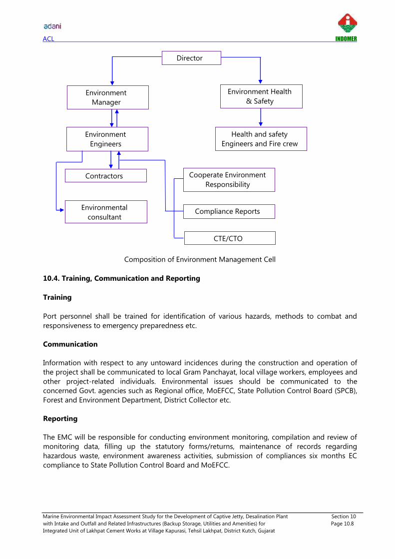
ACL INDOMER
Marine Environmental Impact Assessment Study for the Development of Captive Jetty, Desalination Plant Section 10
with Intake and Outfall and Related Infrastructures (Backup Storage, Utilities and Amenities) for Page 10.8
Integrated Unit of Lakhpat Cement Works at Village Kapurasi, Tehsil Lakhpat, District Kutch, Gujarat
Composition of Environment Management Cell
10.4. Training, Communication and Reporting
Training
Port personnel shall be trained for identification of various hazards, methods to combat and
responsiveness to emergency preparedness etc.
Communication
Information with respect to any untoward incidences during the construction and operation of
the project shall be communicated to local Gram Panchayat, local village workers, employees and
other project-related individuals. Environmental issues should be communicated to the
concerned Govt. agencies such as Regional office, MoEFCC, State Pollution Control Board (SPCB),
Forest and Environment Department, District Collector etc.
Reporting
The EMC will be responsible for conducting environment monitoring, compilation and review of
monitoring data, filling up the statutory forms/returns, maintenance of records regarding
hazardous waste, environment awareness activities, submission of compliances six months EC
compliance to State Pollution Control Board and MoEFCC.
Director
Environment
Manager
Environment Health
& Safety
Environment
Engineers
Health and safety
Engineers and Fire crew
Contractors
Environmental
consultant
Cooperate Environment
Responsibility
Compliance Reports
CTE/CTO

ACL INDOMER
Marine Environmental Impact Assessment Study for the Development of Captive Jetty, Desalination Plant Section 10
with Intake and Outfall and Related Infrastructures (Backup Storage, Utilities and Amenities) for Page 10.9
Integrated Unit of Lakhpat Cement Works at Village Kapurasi, Tehsil Lakhpat, District Kutch, Gujarat
10.5. Institutional Mechanism
Institutional mechanism includes initial implementation of mitigation measures suggested in the
EIA report along with EC conditions and implementation of CTO, CTE conditions. Continual
improvement program includes adherence to stipulated EC condition, CTO and CTE condition by
implementing latest equipments, technologies and labour force to monitor the environment.
Proposed institutional mechanism is given below.
Institutional Mechanism
10.6. Implementation of EMP
Overall implementation of EMP will be the responsibility of EMC. Various implementation items,
description and appropriate time to implement EMP is listed below.
Implementation item Description When to implement
Formation of an
Environment
Management Cell
(EMC)
An Environmental Management Cell shall
be formed to implement proposed EMP
Two months before
preparation of
construction site for
the main work.
Contractor The Construction Contractor should ensure
that the intent of EMP is spread among
Before commencing
construction work.
Post project
monitoring
Six monthly
compliance
report
EMP Monitoring
and Review
Consent to
Operate
&
Inspection
Compliance of EC
conditions
Environment
Management Cell
(EMC)
MoEFCC
GPCB
Port
Management

ACL INDOMER
Marine Environmental Impact Assessment Study for the Development of Captive Jetty, Desalination Plant Section 10
with Intake and Outfall and Related Infrastructures (Backup Storage, Utilities and Amenities) for Page 10.10
Integrated Unit of Lakhpat Cement Works at Village Kapurasi, Tehsil Lakhpat, District Kutch, Gujarat
Implementation item Description When to implement
construction workers.
Make sure that all environmental
safeguards and precautions are in place.
Ensure that all equipment used is properly
serviced and that all precautions are in
place to prevent the likelihood of an
environmental impact.
The contractor shall be responsible for
construction and worker management plan
and safety of workers.
Workers Should be aware of the contents of EMP,
and the reason for implementing its
elements.
Report all environmental incidents to the
contractor /manager as soon as practicable,
but within 24 hours of them occurring.
10.7. EMP Monitoring and Review
The EMC shall continually review the EMP and mitigation measures described in Chapter 5 to find
the effectiveness of proposed measures. The management shall conduct review to find
effectiveness of EMP as follows:
Annual review of EMP
Review of EMP after reported accident/ significant non-compliance
Post project monitoring results & evaluation
Feedback from workers/stake holders
10.8. EMP Budget
The environment budget allocation is necessary to make resource available for effective
implementation of Environment Management Plan. The budget allocated for marine environment
management for proposed project is about 11.7 Crores. This capex is towards installation of
various control facilities and environmental monitoring program, waste management, shoreline
monitoring, drainage system, sanitation and sewage facilities and EMC, environment monitoring
etc.

ACL INDOMER
Marine Environmental Impact Assessment Study for the Development of Captive Jetty, Desalination Plant Section 10
with Intake and Outfall and Related Infrastructures (Backup Storage, Utilities and Amenities) for Page 10.11
Integrated Unit of Lakhpat Cement Works at Village Kapurasi, Tehsil Lakhpat, District Kutch, Gujarat
Environment Management Plan Budget
Sl. No Construction Phase
Cost
per Annum
(Rs. in
Crores)
Operation Phase
Cost
per Annum
(Rs. in Crores)
1 Environment
Management Cell 3.50
Environment
Management Cell 4.80
2 Waste Management 0.50 Environmental
Monitoring 0.80
Shoreline monitoring 0.60
Miscellaneous 0.50
Total 4.0 Total 6.70

ACL INDOMER
Marine Environmental Impact Assessment Study for the Development of Captive Jetty, Desalination Plant Section 11
with Intake and Outfall and Related Infrastructures (Backup Storage, Utilities and Amenities) for Page 11.1
Integrated Unit of Lakhpat Cement Works at Village Kapurasi, Tehsil Lakhpat, District Kutch, Gujarat
11. SUMMARY AND CONCLUSION
11.1. Introduction
Adani Cementation Limited (ACL) is wholly owned subsidiary of Adani Enterprises Limited (AEL)
proposes setup an integrated cement project "Lakhpat Cement Works" which includes Limestone
Mine in 251.9 ha area, Captive Power Plant and WHRS (99 MW) and Cement Plant having
production capacity of 10 MMTPA Clinker and 10 MMTPA of OPC/ PPC/ PSC/ Composite Cement
in Mudhvay and Koriyani, Village, Lakhpat Taluka, Kutch District, Gujarat.
ACL also proposes to develop a berthing jetty of 19 MMTPA traffic capacity connected with
trestle and approach road to serve the import of raw materials and product transportation and 9
MLD desalination plant with seawater intake & brine reject outfall to cater the water requirement
for the proposed integrated project.
Berthing Jetty is proposed in Kori creek with anchorage in Arabian Sea. Lighterage operation
using barges will be performed for the transport of raw materials and product materials from
anchorage point to berthing jetty and vice versa. Clinker and Cement are the main commodity to
be handled at the proposed berthing jetty. Berthing jetty will be equipped with cargo handling
facilities, conveyor system and intermediate storage area.
As the development of captive jetty and desalination plant attracts EIA Notification, 2006, Sector
7 (e) Category A and CRZ Notification 2011 proposed project requires both Environmental
Clearance and CRZ clearance from Gujarat Coastal Zone Management Authority (GCZMA) and
Ministry of Environment, Forest and Climate Change (MoEF&CC).
Accordingly, Marine Environmental Impact Assessment study is conducted by Indomer Coastal
Hydraulics (P) Ltd., Chennai which is the NABET - QCI accredited organization for Sectors 27. Field
studies were undertaken during September – October 2018 representing the post monsoon
period.
11.2. Project Description
Captive Jetty
The captive jetty and associated marine facilities are proposed to be developed in Kori creek at
Kapurasi village where natural depth of 6 m CD is available. Lighterage operation using barges
with anchorage point at Arabian sea, i.e. 60 km southwest of proposed berthing jetty will be
developed. Conveyor corridor will be used to transport the materials from jetty to cement plant.
The development is planned as mentioned below:
• Berthing jetty having total length of 820 m and 28 m wide.
• Mechanized handling system to export clinker, cement and limestone.
• Mechanized handling system to import coal, Petcoke, Fly ash, Gypsum, Slag.
• Approach road of 2.815 km and piled trestle of 0.498 Km to connect landside facilities
to berthing jetty.
• Approximately 4.05 acres of intermediate backup development for storage of cargo.
• Conveyor belt connecting jetty to cement plant.
• Mobile equipment like pay-loaders, excavators, back hoe for material handling at
intermediate backup area / Jetty.
• Supporting infrastructure.

ACL INDOMER
Marine Environmental Impact Assessment Study for the Development of Captive Jetty, Desalination Plant Section 11
with Intake and Outfall and Related Infrastructures (Backup Storage, Utilities and Amenities) for Page 11.2
Integrated Unit of Lakhpat Cement Works at Village Kapurasi, Tehsil Lakhpat, District Kutch, Gujarat
Desalination Plant
In order to meet total water requirement of Lakhpat Cement Works, R.O. based desalination plant
of 9 MLD capacity will be set up with following marine facilities.
• Seawater Intake well at the upstream end of the proposed berthing jetty.
• Brine reject Outfall at the downstream end of the proposed berthing jetty.
• Intake volume will be 30 MLD with ambient salinity of 40 ppt
• Return water brine reject will be 21 MLD with the salinity of 57 ppt.
11.3. Description of Environment
Baseline data collection for marine EIA has been conducted during Post Monsoon (September -
October 2018) with respect to seawater quality, seabed sediment quality and marine & coastal
ecosystem. Samples were collected from 10 locations at three water depths across the vertical
covering upstream and downstream of Kori creek.
Seawater quality: Seawater analysis indicates that the water in Kori creek is free from pollution.
Seawater quality parameters such as DO, BOD, nutrients, Heavy metals and other parameters
indicate normal range pertaining to the coastal waters. The offshore (blue water) and nearshore
samples were analysed for assessing the turbidity, TSS and other parameters, results show that
apart from TSS and Turbidity the others are found to be within normal values expected for creek
water. The results of some of the important parameters are given below.
PARAMETERS Max Min *For Harbour waters (SW IV)
Salinity (ppt) 40.1 38.6 -
pH 8.5 8.27 6 - 9
COD (mg/l) 28.6 18.8 -
BOD (mg/l) 2.1 1.1 5.0
DO (mg/l) 5.6 5.0 3.0
Oil and Grease (mg/l) <1.0 10
*Annexure V - Water Quality Standards for Coastal Waters, EIA Guidance Manual – Ports & Harbors
Seabed Sediment Quality: The sediment is predominantly composed of fine sand. Total Organic
Carbon, Total Nitrogen, Total Phosphorus, Calcium Carbonate, and Heavy metals are within
normal range for coastal waters.
Marine Ecology & Biology: Primary production, Phytoplankton biomass, diversity and population,
Zooplankton biomass, diversity and population, Seabed and Inter-tidal / Sub-tidal macro benthic
diversity and population, Bacterial population in coastal waters and seabed sediments were
studied.
Phytoplankton: The primary productivity values varied between 264 and 408 mgC/m3/day and
the average value was 336 mg C/m3/day from all stations. Totally, 32 species of Phytoplankton
were identified. The floral diversity fluctuated from 17 to 26 species. The numerical abundance
of Phytoplankton population varied between 14200 to 29200 nos./l from all stations.
Zooplankton: The species composition of Zooplankton fluctuated from 24 to 29 species and
numerical abundance varied between 74665 to 117158 nos./100m3. The Zooplankton biomass
at different stations varied from 22.9 to 59.4 ml/100m3.

ACL INDOMER
Marine Environmental Impact Assessment Study for the Development of Captive Jetty, Desalination Plant Section 11
with Intake and Outfall and Related Infrastructures (Backup Storage, Utilities and Amenities) for Page 11.3
Integrated Unit of Lakhpat Cement Works at Village Kapurasi, Tehsil Lakhpat, District Kutch, Gujarat
Benthos: The number of species of Subtidal benthos varied from 7 to 10 species and the
numerical abundance of the benthic fauna was moderate and varied from 360 to 840 nos./m2
at all stations. Number of species of intertidal benthic fauna varied from 7 to 14 and the
numerical abundance between 450 and 705 nos./m2.
Microbiology: The bacterial colonies were identified upto generic level. Organisms isolated
were normally expected in all coastal waters, under moderate human influence. The results
show that in this region there is no indication of any major microbiological pollution.
Coastal Vegetation: The proposed project area has scanty/sparse coastal vegetation. The
natural flora found in the 10 km project radius is predominantly rural and are representative of
the saline tropical thorn forest.
Mangroves: There are no mangroves in the proposed port location. Mangroves in the 10 km
project radius is dominated by single species stands of Avicennia marina (Forsk.) Vierh.
Besides this species, a mangrove associate, Urochondra setulosa, (Trin.) Hubb., an endemic
species of this coast was often found along the banks of tidal creeks. Mangrove were
observed to be hypersaline, enabling the survival of A. marina only. However, western bank of
creeks and Bets is endowed with dense mangroves.
Fish & Fisheries: Narayan Sarovar and Chher Nani are the fisher folk settlements in the 10 km
project radius. Fishing by both fishing boat or by the traditional methods and Pagadiya fishing
is practiced. Construction of berthing jetty will not cause any obstruction to existing fishing in
the project region.
Seaweeds, Sea Grasses and Coral Reefs: Not reported from the project region.
Marine Mammals and Turtles: Not reported from the project region.
Seabirds: 33 species have been sighted from the 10 km coast of project site. One migratory
species is critically Endangered and six are Near Threatened.
Endangered Species: Critically endangered Eurynorhynchus pygmeus (Spoon‐billed Sandpiper)
is observed during the survey.
Protected Areas: Narayan Sarovar Wildlife Sanctuary is falling within 5 km radius of the
proposed berthing jetty.
11.4. Environmental Impacts and Mitigation Measures
Anticipated impacts on the marine environment likely to arise due to construction and operation
of proposed berthing jetty and desalination plant have been identified, predicted and mitigation
measures are suggested. Details of identified impacts are presented below.
• Construction of berthing jetty with approach trestle will disturb the seawater quality,
seabed sediment quality, plankton, benthos and fisheries.
• Construction of approach road connecting landside towards jetty may cause obstruction
to seawater flow.
• Construction of approach road will disturb the intertidal benthos present in the
construction corridor.

ACL INDOMER
Marine Environmental Impact Assessment Study for the Development of Captive Jetty, Desalination Plant Section 11
with Intake and Outfall and Related Infrastructures (Backup Storage, Utilities and Amenities) for Page 11.4
Integrated Unit of Lakhpat Cement Works at Village Kapurasi, Tehsil Lakhpat, District Kutch, Gujarat
• Impact on seawater quality, seabed sediment quality, plankton, benthos and fisheries due
to dredging and disposal of dredged material.
• Construction of intake well and outfall may disturb the seawater quality and marine
habitat.
• Entrainment and impingement of marine habitat due to intake well and outfall pipeline.
• Ship Discharges - Oily Ballast, Bilge Water, Sewage during operation of captive port.
• Accidental Oil Spill from ship will degrade the seawater quality and disturb the marine
habitat.
• Brine reject with high salinity may disturb the seawater quality and marine habitat.
• Impact on shoreline due to proposed captive port.
Summary of mitigation measures suggested is given below.
• Appropriate selection of pile driving equipment with clean and efficient construction
technique.
• No construction waste shall be disposed off at sea/tidal flats. Construction waste shall be
used for reclamation of land or it should be used for integrated works.
• No impact to free flow of seawater at project site is anticipated, since construction of rock
bund with culvert will ensure continuous flow of seawater to tidal mud flats.
• The turbidity induced during the dredging will be minimized using controlled dredging
techniques such as by use of cuter suction dredgers.
• Use of dredged material for proposed reclamation of site to about (+) 7 m CD.
• Appropriate dumping location away from port having water depth greater than 30 m is
suggested.
• Port should provide sufficient facilities to receive residues and oily mixtures generated
from ship operations according to latest provisions. Besides oily residues, reception of
sewage garbage and hazardous waste if any, should also be provided.
• Advection – Diffusion mathematical modelling ensures that brine quantity of 21 MLD with
57 ppt salinity (17 higher than ambient salinity) is modest enough to cause any significant
damage on the marine environment.
• Formation of Environment Management Cell to monitor the implementation of suggested
mitigation measures.
11.5. Post Project Monitoring Program
Based on the various impacts identified, Post Project Monitoring Program is suggested. Post
project monitoring on marine environment will be carried out at jetty water front, inner approach
channel, near brine disposal Location, near dredge disposal location on half yearly basis following
standard sampling collection, identification and analysis procedure.
The responsibility for ensuring the effective implementation of environment monitoring
programme will lie with head of captive port along with support of Environment Management
Cell. The results of half yearly monitoring will be reported to the statutory authorities GPCB and
Regional Office of MoEF&CC. Half yearly report should include compliance against condition of
Environmental clearance and monitoring report.

ACL INDOMER
Marine Environmental Impact Assessment Study for the Development of Captive Jetty, Desalination Plant Section 11
with Intake and Outfall and Related Infrastructures (Backup Storage, Utilities and Amenities) for Page 11.5
Integrated Unit of Lakhpat Cement Works at Village Kapurasi, Tehsil Lakhpat, District Kutch, Gujarat
11.6. Additional Studies
Disaster Management Plan
Disaster identification suggests that the project site is highly vulnerable to natural hazards like
Cyclone, Earthquake, and Tsunami. A Disaster Management frame work has been prepared to
minimize the impact in the event of natural disaster. Incident response team with communication
network is established to deal with emergencies. Onsite emergency rescue kit, emergency alarm,
evacuation plan, medical and related resources to be kept in readiness were also broadly
suggested. Disaster Management Plan likely to followed before, during and after the event major
disasters like Earthquake, Cyclone and Tsunami is also enumerated. Onsite preparedness plan and
Coordination of National and State agency will be key to address any natural disasters.
Oil Spill Contingency Plan
Oil spill contingency plan covering response policy, incident management team, support services,
scope of oil spill contingency plan, oil spill response procedures and port responsibility has been
prepared separately and presented.
Modelling Studies
Proponent has appointed M/s Howe Engineering Projects India Private Limited as a technical
consultant to carry out mathematical modelling studies on Offshore wave analysis at proposed jetty
locations along with flow pattern assessment, Cyclone modelling studies, Hydrodynamic studies to
find out the suitable location of jetty, orientation and approach bund optimization. Findings of
mathematical modelling studies conducted by M/s Howe Engineering Projects India Private Limited
is presented in report entitled "Kori Creek Cement Jetty and Offshore Anchorage DPR studies
(Numerical Modeling Studies)".
The MIKE 21 modelling studies on dispersion of brine reject indicate that the outfall salinity of 57
ppt falls to 2 ppt above the ambient salinity of 40 ppt in 280 m distance from the outfall diffuser.
The increase in turbulence due to stronger currents (> 0.2 m/s) induced by monsoon wind and
rough sea would enhance the mixing during monsoon period. Thus, the studies show that the
impact due to the discharge of the brine reject at 4500 m offshore would be insignificant. Hence,
it is recommended that the brine reject can be discharged in Kori creek at the suggested location.
11.7. Project Benefits
The beneficial impact of proposed project on the civic amenities will be substantial after the
commencement of project activities. Adani Cementation Limited (ACL) will make efforts to
improve the facilities in the project area, which will help in uplifting the living standards of local
communities. The project will also contribute to:
• Development of basic local amenities.
• Expansion/development/improvements in road network.
• Exposure to modern technologies used in production.
• Employment opportunities
• Benefits through Cooperate Social Responsibility (CSR)

ACL INDOMER
Marine Environmental Impact Assessment Study for the Development of Captive Jetty, Desalination Plant Section 11
with Intake and Outfall and Related Infrastructures (Backup Storage, Utilities and Amenities) for Page 11.6
Integrated Unit of Lakhpat Cement Works at Village Kapurasi, Tehsil Lakhpat, District Kutch, Gujarat
• Ensuring sustainable development through Corporate Environment Responsibility (CER)
11.8. Environment Management Plan
Environmental management plan for marine environment are proposed based on impacts and
mitigation measures identified. Marine environment management plan is suggested to mitigate
the impacts of the project during construction and operational phase of project. An Environment
Management Cell (EMC) will be formed, which will be responsible for monitoring the
environment status during construction and operation phases of the project. The EMC will report
environmental performance and monitoring reports including compliance of EC conditions to
statutory authorities. An EMP budget of 11.7 Crores will be allocated to manage marine
environment.


ACL INDOMER
Marine Environmental Impact Assessment Study for the Development of Captive Jetty, Desalination Plant Section 12
with Intake and Outfall and Related Infrastructures (Backup Storage, Utilities and Amenities) for Page 12.2
Integrated Unit of Lakhpat Cement Works at Village Kapurasi, Tehsil Lakhpat, District Kutch, Gujarat
NABET – QCI Accreditation Certificate

ACL INDOMER
Marine Environmental Impact Assessment Study for the Development of Captive Jetty, Desalination Plant Reference
with Intake and Outfall and Related Infrastructures (Backup Storage, Utilities and Amenities) for
Integrated Unit of Lakhpat Cement Works at Village Kapurasi, Tehsil Lakhpat, District Kutch, Gujarat
REFERENCES
i) Bhaskar, S. 1984. The distribution and status of Sea Turtle in India. C.M.F.R.I, special
publication. 18: 21-36
ii) Status of shoreline change due to erosion/accretion Kutch district, Gujarat
(www.gczma.org)
iii) Conway D.V.P., R. G. White, J. Hugues-Dit-ciles, C. P. Gallienne & D. B. Robins, 2003. Guide
to the coastal and surface zooplankton of the South-Western Indian ocean. Marine
Biological Association of the United Kingdom. Occasional Publication No 15.
iv) John D. Davis, Scott MacKnight, "Environmental considerations for ports and harbour
development".
v) Kutch district Disaster Management Plan - 2017-18 (Gujarat State Disaster Management
Authority)
vi) Gopinathan, C. P 1975. On new distributional records of plankton diatoms from the Indian
Seas. Journal of the Marine Biological Association of India 17(1): 223-240.
vii) J. Sesh Serebiah et.al "New Discovery of Coral Rubbings in the North-Western Gulf of
Kachchh, Gujarat, Western India – GIS Based Evaluation".
viii) Kasturirangan, L. R., 1963. A key for the identification of the more common
planktonopepoda of Indian coastal waters. Indian National Committee on Oceanic
Research, Council of Scientific and Industrial Research, New Delhi publication No. 2.
ix) Tomas, C.R., 1997. Identifying Marine Phytoplankton. Academic Press, USA. pp. 858.
x) Annual report 2017 -18, Institute of Seismological Research, Department of Science and
Technology Government of Gujarat.
xi) Ministry of Environment Forest and Climate Change (www.moef.nic.in) Notification on
"Eco Sensitive Zone of Narayan Sarovar Wild Life Sanctuary".
xii) www.surveyofindia.gov.in
xiii) forests.gujarat.gov.in
xiv) Talwar, P.K. and R.K. Kacker. 1984. Commercial Sea fishes of India.
xv) Gopinathan, C.P. Training Manual on Phytoplankton Identification/ Taxonomy.
xvi) GEC. 2009. Mangrove Atlas of Gujarat State. Gujarat Ecology Commission, Government of
Gujarat, Gandhinagar

ANNEXURE I - Water Balance Diagram

ACL INDOMER
Marine Environmental Impact Assessment Study for the Development of Captive Jetty, Desalination Plant Annexure II
with Intake and Outfall and Related Infrastructures (Backup Storage, Utilities and Amenities) for
Integrated Unit of Lakhpat Cement Works at Village Kapurasi, Tehsil Lakhpat, District Kutch, Gujarat
ANNEXURE II
Method of Collection and Analysis
MARINE ENVIRONMENT
Seawater
Collection
The seawater samples were collected at 10 stations. The water samples were collected at three
different depths i.e., surface, mid depth and bottom. Van Dorn water samplers was used for
collecting the water samples at subsurface.
Samples for dissolved oxygen was collected in 300 ml capacity DO bottles immediately after the
sampler was hauled up. The bottles were rinsed with the same water sample. DO samples were
fixed immediately with Winkler reagents by adding 2 ml of manganese chloride and 2 ml of
alkaline potassium iodide (KI). The stopper was then inserted and the bottle shaken vigorously for
about 1 minute to bring each molecule of dissolved oxygen in contact with manganese (II)
hydroxide. After fixation of oxygen, the precipitate was allowed to settle. The DO bottles were
kept in dark and transported to the laboratory for analysis. Samples for Biochemical Oxygen
Demand (BOD) was also collected in the similar fashion as described for DO in 300 ml glass BOD
bottles. Winkler A and Winkler B were added and analysed after 5 days of incubation at 20° C in a
BOD incubator.
Water samples for salinity, total suspended solids, and nutrients were collected and stored in PVC
bottles directly from the water sampler, after rinsing the same with the water sample. For heavy
metal analysis, water samples were stored in PVC bottles adding Nitric acid <2 pH as
preservative. The samples were then transported to the laboratory in an ice box. Water samples
for Petroleum hydrocarbons were collected separately in amber coloured glass bottles. The
sample for Phenol was collected in a pre-cleaned 1 liter plastic container.

ACL INDOMER
Marine Environmental Impact Assessment Study for the Development of Captive Jetty, Desalination Plant Annexure II
with Intake and Outfall and Related Infrastructures (Backup Storage, Utilities and Amenities) for
Integrated Unit of Lakhpat Cement Works at Village Kapurasi, Tehsil Lakhpat, District Kutch, Gujarat
Analysis
Sl. No Parameters Protocol
Water quality
1 Temperature IS 3025: Part 35
2 pH IS 2720: Part 26
3 Salinity IS 3025: Part 34
4 Dissolved Oxygen IS 3025: Part 38
5 Primary productivity APHA 10200 J
6 BOD IS 3025: Part 44
7 Turbidity IS 3025: Part 10
8 Ammonia APHA 4500-NH3 (F)
9 Nitrite IS 3025: Part 34
10 Nitrate IS 3025: Part 34
11 Dissolved phosphate IS 3025: Part 31
12 Total Nitrogen IS 3025: Part 34
13 Total Phosphorous IS 3025: Part 31
14 Total Suspended Solids (TSS) IS 3025: Part 17
15 Cadmium IS 3025: Part 41
16 Lead IS 3025: Part 47
17 Chromium IS 3025: Part 52
18 Mercury IS 3025: Part 48
19 Phenolic Compounds IS 3025: Part 43
20 Petroleum Hydrocarbons TNRCC method 1055
21 Oil and grease APHA 5520
Seabed Sediment
Collection
The seabed sediments were collected at 10 stations. After collection, the scooped sample was
transferred to polythene bags, labeled and stored under refrigerated conditions.

ACL INDOMER
Marine Environmental Impact Assessment Study for the Development of Captive Jetty, Desalination Plant Annexure II
with Intake and Outfall and Related Infrastructures (Backup Storage, Utilities and Amenities) for
Integrated Unit of Lakhpat Cement Works at Village Kapurasi, Tehsil Lakhpat, District Kutch, Gujarat
Analysis
Sl. No Parameters Protocol
1 Soil texture IS : 2720: Part 4
2 Total Organic Carbon IS : 2720: Part 22
3 Total Nitrogen IS : 14684: Part 23
4 Total Phosphorous IS : 10158 - 1982
5 Calcium carbonate IS : 2720: Part 23
6 Cadmium USEPA 3050 B
7 Lead USEPA 3050 B
8 Chromium USEPA 3050 B
9 Mercury USEPA 3050 B
10 Phenolic Compounds USEPA 8041 & 3545 A
11 Petroleum Hydrocarbons TNRCC method 1055
Marine biological parameters
Primary Productivity: Primary production was estimated from 10 stations (SS1 to SS10). From
the water sampler, the samples were immediately transferred to 125 ml DO bottles (two light
bottles and one dark bottle). The sample in the first bottle was used immediately to determine
the initial level of dissolved oxygen (DO) content followed by Winkler method. The light and dark
bottles were incubated under water for a period of 6 hr and dissolved oxygen was measured.
Primary productivity was calculated by oxygen method. Oxygen values were converted to carbon
values by applying the equation.
Phytoplankton: Phytoplankton samples were collected from 10 stations (SS1 to SS10), for both
qualitative and quantitative analyses.
Phytoplankton samples for quantitative analyses were taken by collecting 1 liter of surface water
in plastic container and preserved with Lugol's iodine solution. The analysis of phytoplankton
samples include initial concentration of water sample to 15 ml volume based on settling and
siphoning procedure. Quantitative estimation of phytoplankton was done by counting in Sedge
wick-Rafter cell counter. It involved calculation of the number of cells of each species of
phytoplankton in one liter of sea water.
For the qualitative analysis, phytoplankton samples were collected using circular standard
plankton net (60µ mesh and 60 cm mouth diameter). The net was towed at subsurface for 5
minutes. After the collection, samples were preserved in 4% buffered formaldehyde and analyzed
under an inverted microscope following the standard literature (R. Subrahmanyan, 1946; C.P.
Gopinathan, 1976 and Thomas, 1997).
Zooplankton: Zooplankton samples were collected using circular zooplankton net (300 µ mesh
and 60 cm mouth diameter). The samples were collected during day time to calculate their
biomass, population and bio diversity. The net was towed for 5 minutes. After the collection,
samples were preserved in 5% buffered formaldehyde. The biomass value of zooplankton was
calculated using the displacement volume method. The faunal composition and the relative
abundance of different zooplankton taxa were sorted out and identified from aliquots upto
species level as far as possible. All taxonomic observation and measurements were made on
preserved samples. Specimens were identified based on the standard manuals (Kasturirangan,

ACL INDOMER
Marine Environmental Impact Assessment Study for the Development of Captive Jetty, Desalination Plant Annexure II
with Intake and Outfall and Related Infrastructures (Backup Storage, Utilities and Amenities) for
Integrated Unit of Lakhpat Cement Works at Village Kapurasi, Tehsil Lakhpat, District Kutch, Gujarat
1963; and Conway et al. 2003). The estimated abundance (density) for the different groups was
expressed as nos. /100m3.
Flowmeter: Digital Flowmeter (model - 2030R) duly calibrated by the
company was used for estimating the volume of flow into the net
towed for 5 minutes for the collection of phytoplankton and
zooplankton. The flow meter consists of an impeller and a counter.
The impeller is directly connected to the counter which records each
revolution of the impeller. The flow meter has to be attached to the
mouth region of the plankton net.
Macro Benthos: Seabed sediment samples were collected using Van Veen grab from 10 stations
(SB1 to SB10). The intertidal benthic samples were collected from 4 stations. The benthic
organisms were separated by sieving through 500 micron mesh and preserved using
formaldehyde and Rose Bengal stain. The samples were sorted and identified upto
groups/genera level using stereo microscope. The wet weight was taken to calculate the biomass
of benthic organisms.
Microbiology: The microbiological samples were collected from 10 stations (SS1 to SS10). The
total coliform from each location were identified by membrane filter technique (APHA 9060 A &
B). Samples were collected clean, sterile and non-reactive glass or plastic bottles. Microbial
analysis is started as soon as possible after collection to avoid unpredictable changes. Spread
plate method was used to culture the microorganisms. The agar media used for analysis were:
Nutrient agar, MacConkey agar, Thiosulphate Citrate Bile Sucrose agar, Xylose Lysine
Deoxycholate agar, M-Enterococcus agar and Cetrimide agar. Plates were incubated at 37° C for
48 hrs. After incubation, the colonies were counted and identified based on their colour
characteristics.
Fisheries: The information on fisheries were collected from local fishing villages and also from
the Commissioner of Fisheries, Department of Fisheries, Government of Gujarat.
Coastal sand dune vegetation: Coastal plants, in this study are considered as those higher
plants other than the mangroves, which are directly influenced by the sea. These plants present in
the intertidal and subtidal region. Those plants which are rooted in the substrate near the shore,
which is saline and contains a very high content of marine sediments, are also included.
Statistical Analyses: Statistical analyses were performed for phytoplankton, zooplankton and
macro benthos. All statistical calculations and graphs were generated using computer software
package PRIMER V.6.1.9. Its scope is the analysis of data arising in community ecology and
environmental science which is multivariate in character (many species, multiple environmental
variables). Sample data were compiled into square matrix (species x samples) and square root
transformed to counter act the weight of dominant species without severely diminishing their
importance. The transformed species - by - sample was then converted into a triangular sample-
by-sample similarity matrix by calculating the Bray - Curtis similarity index between all samples -
pairs, based on joint species abundance, and presence and absence. Ecological data were then
analyzed for similarity of population using agglomerative hierarchical cluster analysis based on
the Bray - Curtis similarity index and an average linkage Dendrogram were produced.

ACL INDOMER
Marine Environmental Impact Assessment Study for the Development of Captive Jetty, Desalination Plant Annexure II
with Intake and Outfall and Related Infrastructures (Backup Storage, Utilities and Amenities) for
Integrated Unit of Lakhpat Cement Works at Village Kapurasi, Tehsil Lakhpat, District Kutch, Gujarat
Stages in a multivariate analysis based on similarity coefficients
Diversity measures were calculated from the untransformed data for each sample. Indices
calculated were: Margalef's species evenness coefficient (J'), the Shannon-Wiener diversity
coefficient (H') and Simpson's diversity index (1-λ). The cumulative dominance plot was also
constructed to compare the biodiversity between the samples.