ancient land in a modern world
TRANSCRIPT


Tropical Forests of the Guiana Shield
Ancient Forests in a Modern World

This page intentionally left blank

Tropical Forests of the Guiana Shield
Ancient Forests in a Modern World
Edited by
D.S. Hammond
Formerly of Iwokrama International Centre for Rain ForestConservation and Development
Georgetown, Guyana
CABI Publishing

CABI Publishing is a division of CAB International
CABI Publishing CABI PublishingCAB International 875 Massachusetts AvenueWallingford 7th FloorOxfordshire OX10 8DE Cambridge, MA 02139UK USA
Tel: +44 (0)1491 832111 Tel: +1 617 395 4056Fax: +44 (0)1491 833508 Fax: +1 617 354 6875E-mail: [email protected] E-mail: [email protected] site: www.cabi-publishing.org
©CAB International 2005. All rights reserved. No part of this publication may bereproduced in any form or by any means, electronically, mechanically, byphotocopying, recording or otherwise, without the prior permission of thecopyright owners.
A catalogue record for this book is available from the British Library, London,UK.
Library of Congress Cataloging-in-Publication DataTropical forests of the Guiana Shield: ancient forests of the modern world / editedby D. Hammond
p. cm.Includes bibliographical references and index.ISBN 0-85199-536-5 (alk. paper)1. Rain forest ecology--Guyana Shield. 2. Rain forests--Guyana Shield. 3. NaturalHistory--Guyana Shield. 4. Guyana Shield. I. Hammond, D. (David S.) II. Title.
QH111.T76 2005578.734´098--dc22
2004021133
ISBN 0 85199 536 5
Typeset by MRM Graphics Ltd, Winslow, BucksPrinted and bound in the UK by Biddles Ltd, King’s Lynn

Contents
Contributors vii
Acknowledgements ix
Acronyms and Abbreviations xi
1 Ancient Land in a Modern World 1David S. Hammond
2 Biophysical Features of the Guiana Shield 15David S. Hammond
3 Ecophysiological Patterns in Guianan Forest Plants 195Thijs L. Pons, Eustace E. Alexander, Nico C. Houter, Simmoné A. Roseand Toon Rijkers
4 Rainforest Vertebrates and Food Plant Diversity in the Guiana Shield 233Pierre-Michel Forget and David S. Hammond
5 Folivorous Insects in the Rainforests of the Guianas 295Yves Basset, Neil D. Springate and Elroy Charles
6 Flower-visiting Insects in Guianan Forests: Pollinators, Thieves, Lovers andTheir Foes 321Bart P.E. De Dijn
7 Guianan Forest Dynamics: Geomorphographic Control and Tropical ForestChange Across Diverging Landscapes 343David S. Hammond
8 Socio-economic Aspects of Guiana Shield Forest Use 381David S. Hammond
v

9 Forest Conservation and Management in the Guiana Shield 481David S. Hammond
Index 521
vi Contents

Contributors
Alexander, E.E., Planning and Research Development Division, Guyana ForestryCommission, 1 Water Street, Kingston, Georgetown, Guyana.
Basset, Y., Smithsonian Tropical Research Institute, Apartado 2072, Balboa, Ancon,Panama. (e-mail: [email protected])
Charles, E., Faculty of Agriculture/Forestry, University of Guyana, Turkeyen, Georgetown,Guyana. (e-mail: [email protected])
De Dijn, B.P.E., National Zoological Collection, University of Suriname, UniversityComplex, Leysweg, PO Box 9212, Paramaribo, Suriname. (e-mail: [email protected])
Forget, P.-M., Département Ecologie et Gestion de la Biodiversité, Museum Nationald’Histoire Naturelle, UMR 5176, CNRS-MNHN, 4 Av. Du Petit Chateau, F.91800Brunoy, France. (e-mail: [email protected])
Hammond, D.S., Iwokrama International Centre for Rain Forest Conservation andDevelopment, Georgetown, Guyana. Current Address: NWFS Consulting, 15595 NWOak Hill Dr., Beaverton, OR 97006, USA. (e-mail: [email protected])
Houter, N.C., Department of Plant Ecophysiology, Utrecht University, Sorbonnelaan 16,3584 CA Utrecht, The Netherlands.
Pons, T.L., Department of Plant Ecophysiology, Utrecht University, Sorbonnelaan 16, 3584CA Utrecht, The Netherlands. (e-mail: [email protected])
Rijkers, T., Department of Forest Ecology and Forest Management, Wageningen University,PO Box 47, 6700 AA Wageningen, The Netherlands.
Rose, S.A., Planning and Research Development Division, Guyana Forestry Commission, 1Water Street, Kingston, Georgetown, Guyana.
Springate, N.D., Department of Entomology, The Natural History Museum, CromwellRoad, London SW7 5BD, UK. (e-mail: [email protected])
vii

This page intentionally left blank

Acknowledgements
Any work is the product of numerous contributions at many different moments in manydifferent ways. This book is no different and the individuals who have contributed throughtheir patient and persistent collection of data in the field, organization and compilation ofreferences, time series and spatial information and administrative support are numerous.I would particularly like to thank again Kate Lance, Kwasie Crandon, Roxroy Bollers,George Roberts, Catherine Clarebrough, Luc van Tienen, Mariska Weijerman, ArnoudSchouten and Dexter Angoy for their efforts in collecting data presented or referred to invarious chapters of the book. Several UK and Guyanese volunteer and training groups dida marvellous job with data collection. Twydale Martinborough deserves special thanks forher efforts in meticulously compiling much of the data on production statistics andChanchal Prashad for her excellent work in digitizing and compiling many of the geologi-cal and historical GIS coverages presented in figures throughout the book. Thanks areextended to all of the scientists and resource management professionals in French Guiana,Guyana and Suriname for sharing information and literature early in the book’s develop-ment. I also owe a debt of gratitude for the efficient and timely administrative support ofJuliet Dos Santos and Jean Bacchus in making the compilation of ‘grey’ literature and sta-tistics that much easier. The amazing efficiency and speed through which high quality datawere made available by governmental institutions in Guyana, Venezuela, Suriname,France, Brazil, the USA and the UK, often free-of-charge and through ftp downloading, hasenhanced in no small measure the quality of content and avoided the labyrinth typicallyencountered en route to acquiring such types of environmental data. I would like toacknowledge their effort here as a means of registering support for the growing trend inmaking these types of data available to the international community. These includeANEEL (Brazil), CDC (USA), CNRS (France), CPRM (Brazil), DAAC (USA), DANE(Colombia), GEBCO (UK), IBAMA (Brazil), IBGE (Brazil), INMET (Brazil), IRD (France),INSEE (France), MARNR (Venezuela), NOAA (USA), NODC (USA), OCEI (Venezuela),ODP (USA), SCOPE (USA), UEA-CRU (UK), USGS (USA), and Woods Hole OceanographicInstitute – LBA (USA). Similarly, I wish to thank agencies and commissions under the UNumbrella – the FAO, UNEP, UNESCO, UNDP, IPCC and WCD, for making data and litera-ture they have generated widely and easily available.
Administrative, logistical, data-sharing and library support were provided to the bookat various stages by the Tropenbos-Guyana Programme, Tropenbos Foundation, GuyanaForestry Commission, Geology and Mines Commission, Imperial College – Silwood Park,UK Natural History Museum, CABI Bioscience, and the Iwokrama International Centre forRain Forest Conservation and Development. In particular, thank you for the great cooper-ation and exchange with various institutions in Guyana, including the Guyana Forestry
ix

x Acknowledgements
Commission, University of Guyana, National Agricultural Research Institute andEnvironmental Protection Agency.
Without the financial support provided to the editor and for project development, thisbook would not have been possible. To this end, generous support provided at variousearly stages by the Department for International Development-UK, the TropenbosFoundation and the European Commission (to the Iwokrama Centre) is gratefully acknowl-edged. Support during the final stages was provided solely by the editor.
I wish to acknowledge the professional and motivational support provided at varioustimes through the development of this book by Professor Val Brown (now at University ofReading), David Cassells (Iwokrama/World Bank), Ben ter Welle (Tropenbos/UtrechtUniversity/GTZ), my friend and colleague Pierre-Michel Forget (MNHN – Paris) and Hanster Steege (National Herbarium – Utrecht). I also would like to thank the many scientificcolleagues who agreed to review chapters at various stages and often at short notice andthe contributing authors for their unprecedented patience while this volume went throughvarious changes.
The editor would like to dedicate his effort on this book to the memory of Timothy C.Whitmore, one of the great tropical botanists, ecologists and foresters of the 20th centuryand a scientific guiding light during my time living and working in Guyana.
Most of all, thanks to my family for their endless patience.
About the Editor
David S. Hammond has been researching and working to help conserve and sustainablydevelop neotropical forests since 1987. He received his BSc in Botany–EnvironmentalScience from Miami University, USA, and a PhD in Environmental Sciences from theUniversity of East Anglia, UK. He currently resides in Portland, Oregon.

ANEEL Agencia Nacional de Energia EletricaAVHRR Advanced very high resolution radiometryBP Before present (normally 1950)CAM Crassulacean acid metabolismCOADS Coupled ocean–atmospheric data set, NOAACVG Corporacion Venezolana de GuayanaDAAC Distributed Active Archive Center, NASA DANE Departamento Administrativo Nacional de Estadistica, ColombiaDNPM Departamento Nacional de Produção Mineral, BrazilDOC Dissolved oxygen concentrationDWIC Dutch West Indies CompanyENSO El Niño – southern oscillationETR Electron transport rateFAO Food and Agriculture Organization of the United NationsGDP Gross domestic productGFC Guyana Forestry CommissionGGMC Guyana Geological and Mines CommissionGOES Geostationary operational environmental satelliteHIV Human immuno-deficiency virusHydromet Guyana Hydrometeorological OfficeIBAMA Instituto Brasileiro do Meio Ambiente e dos Recursos Naturais
RenováveisIBGE Instituto Brasileiro de Geografia y EstatisticaINDERENA Instituto de Desarrollo de los Recursos Naturales, ColombiaINPARQUES Instituto Nacional de Parques, VenezuelaINRA Institut National de Recherche Agronomique ISR Incoming short-wave radiationITCZ Inter-tropical convergence zoneJERS Japanese earth resources satelliteLAPD Latin American Pollen databaseLAR Leaf area ratioLGM Last Glacial MaximumLMA Leaf mass per unit areaLMF Leaf mass fractionNAR Net assimilation rate
xi
Acronyms and Abbreviations

xii Acronyms and Abbreviations
NCAR National Center for Atmospheric ResearchNCEP National Center for Environmental Prediction, NOAANEP Net ecosystem productivityNOAA National Oceanic and Atmospheric AdministrationNPV Net present valueNTFP Non-timber forest productOCEI Oficina Central de Estadistica e Informatica, VenezuelaOLR Outgoing long-wave radiationONF Office National de Forêt, FranceORSTOM Institut de Recherche Scientifique pour le Développement en
CoopérationPFD Photon flux densityPS II Photosystem IIRGR Relative growth rateRIL Reduced impact loggingSAR Synthetic aperture radarSLP Sea-level atmospheric pressureSOI Southern oscillation indexSPC Spare productive capacitySST Sea-surface temperatureTATE Trans-Amazonian tectonothermal episodeTRMM Tropical rainfall measuring missionTSS Total suspended solidsTZ+ Total dissolved cation concentrationUSGS United States Geological SurveyVPD Vapour pressure deficitWBR World base reference WCMC World Conservation Monitoring CentreWMSSC World Monthly Surface Station Climatology, NCARWPA World petroleum assessmentWRI World Resources InstituteWUE Water use efficiency

Introduction
The Guiana Shield could be described as aland of old rock, poor soils, much water,extensive forest and few people. These fiveattributes, perhaps better than any other,lay down a foundation for much of the geo-graphic and historic variation that hasshaped the shield, its forests and the waythese have and will be conserved and used.
Few tropical forest regions of the worldcan trace their geological origins directlyback to the earliest days of life itself. Evenfewer can be recognized as having largelyescaped thus far the sweep of modernhuman society as it appropriates an everincreasing share of the global naturalresource base. Covering much of the north-east corner of South America between theOrinoco and Amazon Rivers, the contempo-rary forest landscape of this region is acomplex of ancient and recent geologicalfeatures, many of these showing few signsof recent human modification. Today,forests of the shield rest upon a silent geo-logical landscape. Billions of years ofrepeated deformation have all butexhausted the geological processes thatcatalyse the natural transfer of nutrients,soil and biomass across other landscapes.During the Precambrian and throughout thePhanerozoic, the shield landscape has beenshaped by an incredible sequence ofrepeated fracturing, volcanism, erosion anddeposition that was compounded by mil-lennial-scale effects of regional climate
change. In recent times, the silence of thegeological landscape has been broken by agrowth in industrial human activity. Placedin perspective, the forests of the GuianaShield that are used and conserved todayrepresent a mere snapshot of the evolution-ary process extending back to a CretaceousGondwanaland, more than 120 millionyears ago (Romero, 1993) (see Chapters 2and 7). From all available evidence, the dis-tribution of closed forests in the region overthe last several million years has continu-ally expanded and contracted in responseto climate change and its impact on sealevel, rainfall and temperature (see Chapter2). Compared with the natural dynamism ofthe much younger geological landscapes ofwestern Amazonia and Central America,however, recent surface and internalchanges to the lithosphere (‘crust’) areabsent or indiscernible in the modernGuianan landscape (see Chapter 2). Themountains have been weathered to theirroots and the resulting sediments reworkedto such an extent that, in many areas, thenutrient and water holding capacity haslargely disappeared (see ‘Soil and soil fer-tility’, Chapter 2). The shaping influence ofthis environment on many short- and long-term biological processes is increasinglybecoming clear as we accrue information oncontemporary and historical events in theregion. The biological evidence, however,does not in all cases reinforce the view thatan exhausted edaphic environment leads toa proportional decline in the variety of life,
1© CAB International 2005. Tropical Forests of the Guiana Shield (ed. D.S. Hammond)
1 Ancient Land in a Modern World
David S. HammondIwokrama International Centre for Rain Forest Conservation and Development,Georgetown, Guyana. Currently: NWFS Consulting, Beaverton, Oregon, USA

as plants and animals find novel means tocope with diminishing opportunities forsurvival and growth (see Chapters 3–5) andother processes continue to play a moreimportant role in sustaining diversity(Chapter 7). The implications of the geolog-ical age of the shield to the debate onhuman use and conservation of theseforests is profound, but often diluted due tothe scale and duration of its shaping influ-ence. There is no factor, apart from the cur-rent decisions made by human society, thatwields greater overarching influence on thesize and location of resource use and con-servation opportunities in the region andthe land’s future ability to sustain economicgrowth than the twin foundational forces ofgeology and climate (see Chapters 2, 8, and 9).
The (sparse) archaeological and histor-ical record suggests that society and culturein the shield region have come and goneand recycled again through repeated wavesof colonization and abandonment (see‘Human Prehistory of the Guiana Shield’,Chapter 8). Today, the region remains oneof the least populated areas of the world(Fig. 1.1 and Chapter 8). In fact, population
densities in most parts of the shield aremore comparable to the coldest and leastproductive (shield) areas of the planet, suchas Nunuvut (northern Canada) and Siberia(Russia), than to other tropical forestregions. Yet the Guiana Shield is coveredby vast stretches of forest and savanna that,at first glimpse, appear no less productiveand accommodating to human life than anyother tropical environment. Other tropicalcountries, such as Indonesia, southernIndia, Bangladesh and Nigeria, have popu-lation densities comparable to the USA,Great Britain or Germany. How can such avast area of tropical forest remain sosparsely populated despite a long history ofhuman colonization (see ‘Colonial History’,Chapter 8)? Is the paradox of a tropical for-est landscape both verdant and impover-ished an adequate explanation? Orhave other factors worked surreptitiouslyto shape the relationship between peopleand the environment of the GuianaShield?
The answer to this and other large-scale questions is rarely addressed ade-quately by any single perspective. The‘forêt dynamique’ can follow a trajectory
2 D.S. Hammond
Fig. 1.1. Two-hundred and thirteen countries ranked by forest area per capita in 2000. Rankings ofcountries are influenced by both the natural extent of forest cover and losses due to deforestation. Datasource: FAO (2001). France (Metropole) and French Guiana (DOM) are considered separately here forcomparative purposes.
French Guiana
Suriname
Guyana
CanadaBrazil
VenezuelaUSA France China India UK
Netherlands
Ranking
For
est
area
per
cap
ita (
ha)

that is not necessarily the sole product ofunderstood biophysical mechanisms orcontemporary social processes. The sumtotal of numerous anomalies, the relicts ofpast events unrecorded and poorly under-stood, may plausibly constrain the courseof natural processes, and thus drive forestchange along a course that is otherwiseassigned wholly to environmental forces (instatistical parlance, an ‘aggregated’ type IIerror). Human history and the socialdynamics of decision-making can inter-weave with a wide range of biological andphysical processes to create a unique andunreplicable forest filled with its own spe-cial mix of life. The forces that work to fash-ion the forest we see today and that we willsee in the future are not easily attributed toany single approach or perspective. A sim-plified depiction of these broad interdisci-plinary relationships and their scale ofoperation is offered in Fig. 1.2. Manage-ment of forest cover and composition basedon a static snapshot of either biological orsocial structure, composition and function
overlooks the essence of that which consti-tutes a forest ecosystem: change. The the-matic approach taken in this book is aimedat drawing together what we know aboutthese forces, the forest components andprocesses they influence, and how these arelinked to forest composition, function andchange in the Guiana Shield region. Do for-est-use planning horizons adequatelyaccount for both slow-moving, low-fre-quency and short-term, high-frequencyforces and reflect the proportional influenceattached to their level of resonance throughthe forest ecosystem? And can these systemattributes be sensibly considered in practi-cal management action in the field? Manyapproaches already work to this end. Yetimportant facets of forest use remain largelyoutside the scope of resource management,confounding long-term sustainability. Theinteraction of socio-economic and biophys-ical foundations vary across the neotropics.The applicability of practices across thisvariance towards a common goal, thus mayrequire further thought (see Chapter 9).
Ancient Land in a Modern World 3
ENERGY, GEOPHYSICAL EARTH,
CLIMATE, GEOLOGY & SOILS (water & nutrients)
Plant cycle
Adult
Seeds & Seedlings
Flowers
Fruits
FLORA
Herbivores Granivores
Pollinators Dispersers
InsectivoresCarnivores FAUNA
SUSTAINED YIELD
Governance
Mining
Conversion
FOREST USE
Renewable
Non-Renewable
SOCIAL SYSTEM
History Cultural & Spiritual
Beliefs
Business
& Trade
International Relations
Law
Transport & Communications
Logging
Hunting, Fishing & Collecting
NTFPs(plants)
HUMAN
Tourism & Education
& ASTRONOMICAL INTERACTIONS
Technology
(zoo) Parasites
FoodSystems
Health & Nutrition
FU
NG
I
PR
OT
IST
S
Fig. 1.2. Simplified depiction of the major social, biological and physical forces working to shape thetropical forest ecosystem. The size of the line increases with a putative increase in magnitude of control,magnitude defined as a combination of spatial extent and rapidity of change. Dual arrowheads representdirect feedback. See Chapters 2 and 7 for details of energy, geophysical and astronomical forces andgeology, climate and soils; Chapters 7–9 for social forces; Chapters 3, 4, 7 and 9 for plant systems andChapters 4–7 for animal systems.
Decom
posers

Contents of this Book
Thus, the objective of this volume is to pro-vide a wide base of information compiledin a single source so the broadest range ofinfluences can be considered by the readerand assessed for their relevance across theGuiana Shield region (and perhaps, thelarger neotropics). The book also aims toprovide a glimpse at the inner workings ofthe Guiana Shield as a regional landscape,rather than only as a series of political enti-ties or as a poorly studied part of theAmazon Basin. Both biophysical and social(Chapters 8, 9) features of the region arecovered, but the emphasis on geological(Chapter 2), pedological (Chapter 2), cli-matic (Chapter 2), hydrological (Chapter 2),botanical (Chapters 3–5), ecological (Chap-ters 4, 5, 8, 9) and zoological (Chapters 5–7)research is apparent.
The book content is wide-ranging.More effort was expended on trying tobroadly triangulate the complex of attrib-utes that combine to shape forests of theshield region than diving to the deepestlevel of detail in each of the various fieldscovered. As a consequence, many key con-cepts, processes and attributes may appearinadequately characterized in the view ofexperts and for this the editor apologizes. Itis my hope that the effort to bring a broadcross-disciplinary approach to theories andexplanations that are often otherwisedelimited and isolated by a specific scien-tific focus can compensate in some smallmeasure for the lack of technical refine-ment. A solid reference base underpinnedby an extensive bibliography should beused to explore in greater detail the manyareas only briefly addressed in this singlevolume. Contributors have made a specialeffort to review a growing volume ofresearch conducted within the region andorganize this into a series of sectional topicsthat improve access to specific areas ofinterest. In many instances, very littleresearch has been conducted and this con-dition is noted in each of the chaptersexplicitly or as a set of testable hypotheses.Elsewhere, comparisons with other tropicalforest regions are constructed as a way of
characterizing the different environmentswithin the Guiana Shield by their socio-economic ranking (Chapters 8, 9) or posi-tion along a larger-scale biophysicalgradient (Chapters 2 and 7).
Chapter 2 does much of the latter. Itattempts to bring together information frommany sources to define the spatial distribu-tion and properties of rock, soils, rivers andlakes, rainfall and temperature and com-pare these with other neotropical regions. Italso describes the main regional landformsand landscape macro-features. Biophysicalfeatures are continually changing and thischapter also briefly describes many, but cer-tainly not all, of the main factors that gov-ern the change trajectory. In manyinstances, the specific effects of these fac-tors on the Guiana Shield are poorly under-stood, often due to sparse research andmonitoring. In other cases, the importanceand/or relevance of specific processes haveebbed and waned over the course of theregion’s history. Climate change mecha-nisms in particular are summarilydescribed in an effort to highlight the link-ages between terrestrial, marine and atmos-pheric systems and how these have shapedforest evolutionary development, distribu-tion and composition across the GuianaShield.
In Chapter 3, Thijs Pons and colleaguesprovide an interesting look at the ecophysi-ological function of forest plants in theGuiana Shield. They present a wide rangeof experimental results and address thesewithin a broader context defined by otherstudies conducted within the region andelsewhere. The chapter addresses most ofthe main plant physiological pathways:photosynthesis, growth, transpiration,water and nutrient uptake and discusseschanges in these in relation to canopy struc-ture, openness and water availability,among others. The chapter also brieflyexplores the role of symbionts in catalysingand sustaining nutrient uptake pathways ina highly limited growth environment. Theauthors conclude that regional forest treespecies can be described by wide-rangingcombinations of different ecophysiologicalattributes.
4 D.S. Hammond

Chapter 4 focuses on reviewing thelarge body of literature published on theterrestrial fauna known to reside in theregion’s forests and how these animalsmake use of the plant resources. Theauthors review what is known about dietaryhabits of the main forest fauna taxa, butwith an emphasis on mammals. The chap-ter also discusses the cross-regulatingeffects that plants and animals can exert oneach other. Dispersal and pollination areperhaps of greatest importance to thisexchange and these important componentsof plant–animal relationships are discussedin relation to the type and diversity of ani-mal food preferences, along with otheractivities such as seed and seedling preda-tion, folivory and nectar/pollen-feeding. Anaccompanying checklist of known verte-brates (less fish) from the region representsa simple taxonomic snapshot of the diver-sity, but provides a good point source forcomparison with other regions and acrossthe shield itself.
Chapter 5 by Yves Basset et al. pro-vides a broad review of the work done withabove-ground, leaf-feeding insects in theregion, including a historical account ofinsect collecting and curation in the threeGuianas. The authors briefly address severalimportant topics relevant to tropical forestfolivory and folivore diversity, such as host-specificity, stand (mono)dominance andspatial resource distribution. The authorsemphasize the relatively sparse entomologi-cal studies carried out in the region.
Chapter 6 addresses the specific role ofinsects as flower visitors. It examines therole of visitors as both pollinators and nec-tar-robbers, providing examples drawnfrom the very few studies carried out atlocations within the Guiana Shield. De Dijnbriefly examines trends in pollinator andplant diversity, but highlights the paucityof concrete information from the region.The chapter concludes with suggestions forfuture pollination research in the GuianaShield.
Chapter 7 explores the ecological andevolutionary responses of forests to changescharacterized in Chapter 2. Forest structureand composition are interlocked with indi-
vidual recruitment, growth and survivor-ship along a reaction function. Variation inthese attributes in many ways betterdescribes a forest than traditional staticmeasures of standing diversity and biomassbecause these quantities represent aresponse to past forces without first under-standing how and for how long these res-onate through a forest system. The chapterdraws on a large volume of publishedresearch to explore regional differences inmany of the common disturbances believedto drive forest change. It also compares sev-eral plant life-history attributes and geo-graphical ranges believed to be important indistinguishing system contrasts. It con-cludes with a discussion of the relative roleof geomorphic and geographical controls inshaping forest trajectories and an eclecticis-tic proposal for observed differences in for-est composition and diversity.
Chapter 8 approaches the descriptionof the regional forests from a (pre-)historicaland socio-economic perspective. It summa-rizes the relatively small amount of archae-ological and anthropological knowledge ofpre-Columbian Amerindian societies andthe dynamics of settlement, migration andforest use within the region. The chapterdoes not attempt to cover the diverse andunique cultural drivers of these societies(e.g. cosmology), although the role of ritual,religion, kinship and other cornerstones ofsocial structure are recognized as importantfactors influencing both Amerindian andnon-Amerindian forest use patterns andpurposes. The chapter also provides a briefchronology of post-Columbian colonizationand forest use within the region and the his-torical establishment and development offorestry, mining and agriculture. The chap-ter finishes with a brief description of thecurrent social and economic condition ofthe different countries/provinces/statesfound within the Guiana Shield with anemphasis on the historical transition fromindustrial uses of NTFPs, timber and min-erals.
Chapter 9 draws upon preceding chap-ters to explore forest conservation and man-agement direction in the Guiana Shieldsince its earliest inception through to recent
Ancient Land in a Modern World 5

initiatives. This section attempts to high-light relationships between regional land-scape conservation, patterns of biologicaldiversity, economic use of forestlandresources and global economic drivers,drawing upon the growing volume of stud-ies published on these topics recently.
Ancient Land, Modern Name
The Guiana Shield draws its name from thefusion of two terms – one ancient, one mod-ern. ‘Guiana’, ‘Guayana’ and ‘Guyana’ arebelieved to be linguistic variants on a tradi-tional Amerindian word widely interpretedto mean ‘water’ or ‘much water’ (but seeWilliams, 1923; Cummings, 1963).1 Theword ‘Shield’ in this context refers to amodern scientific term used by geologists todescribe a large region of very old, exposedPrecambrian basement rock that is notaffected to any large extent by modern vol-canic or tectonic activity (Press and Siever,1982; Gibbs and Barron, 1993; Goodwin,1996). The Guiana Shield region, however,was not commonly referred to as a singlegeological province until the late 1950s,when techniques for isotopic dating of rockimproved and evidence supporting platetectonic theory began to accrue. The area isalso described in regional languages ofFrench, Spanish and Portuguese as the‘Bouclier Guyanais’, ‘Escudo de Guayana’and ‘Escudo Guyanense’, respectively (seeGibbs and Barron, 1993). The names Guianaand Guayana are interchangeable andapplied equally in describing the specificshield region (e.g. Maguire, 1970; seehttp://www.guayanashield.org).
The region was defined as a discretegeopolitical entity in Western literaturelong before it was recognized as a geologicalprovince. This was at first based on themythical view that the lands were part of avast Amerindian empire, centred on thefabled city of Manoa and akin to thoseencountered by the Spanish in Peru andMexico (Raleigh, 1596). Later, the geopoli-tics of European imperial ambitionsdivided South America into three broadareas, viz. Brazil (Portugal), New Grenada
(Spain) and Guiana (England, France andThe Netherlands). On this basis, Guianawas considered at the time by some toextend between the Amazon, Orinoco andNegro Rivers (Bancroft, 1769), though thelocations of international boundarieswithin the region were not established untilalmost a century later (Schomburgk, 1840,1848), and even then returning to the searchfor El Dorado as the root basis of colonialclaims to the region (see Burnett, 2000).2
Guiana Shield, Tropical Forest Coverand the Global Distribution of
Precambrian Landscapes
In part the significance of the Guiana Shieldforests rests with the underlying geologicallandscape and the relative importance ofthe region to the global stock of tropicalforests growing on surfaces dominated bythe Precambrian. There are nine main areasof exposed Precambrian rock, belonging toten geological provinces (after Osmonson etal., 2000), that are subject to climatic con-ditions capable of sustaining tropical moistforests worldwide (after Olson et al., 2001)(Fig. 1.3). Of these, three are located inSouth America, four in Africa and two inIndia. Indian and Madagascan forests arelocated at the northern and southern maxi-mum of tropical climates, respectively, andwould typically classify as sub-tropical,while the remaining areas consist of a widevariety of tropical forest assemblages,including both open and closed canopy for-mations. The total global area ofPrecambrian rock naturally covered bytropical forests is estimated at 5.08 × 10⁶
km2. The Guiana Shield is by far the largestcontiguous area of exposed Precambrianrock naturally covered by tropical forests inthe world, accounting for one-third of thistotal (Fig. 1.4). When further consideringthe levels of deforestation that have affectedPrecambrian areas in India, Madagascar,the Atlantic coast of Brazil and West Africaover the last 50 years, the relatively largearea of forest remaining in the GuianaShield accounts for more than half of theremaining tropical moist forests growing on
6 D.S. Hammond

Precambrian geological landscapes world-wide.
The significance of this statistic rests inthe biophysical and socio-economic controlthat underlying geology exerts upon forestecological and evolutionary processes, theway in which forestlands are used andmanaged, and the opportunities and limitsthat this region’s forest resources can offerto local rural communities, nationaleconomies and the global storage of biolog-ical diversity, carbon and water. The voy-age of the shield area atop its underlyingcrustal plate has combined with movementof the other continental land masses toplace this Precambrian region in a uniquegeographical position along the meteorologi-cal equator, a position not held by any otherarea of similar geological antiquity (Chapter2). Its current position along the westernrim of the Atlantic basin also exposes theancient geology of this region to a tropicalclimate that is responsive to a wide range offorcing factors, ranging from El Niño eventsthrough to periodic fluctuation in solarsunspot activity and planetary orientation(see Chapter 2). While many regions cur-
rently accommodating tropical forestsformed part of the sea floor over most of ourplanet’s geological history, the landscape ofthe Guiana Shield was actively evolving inresponse to climatic fluctuations (see ‘Sea-level change’, Chapter 2). This long historyof exposure is now strongly reflected in thespatial distribution of soils, water and min-erals (see Chapter 2), the ways in which for-est plants and animals interact to surviveand reproduce (see Chapters 3, 4, 5 and 7),and in our own (pre-)history of occupation(Chapter 8).
Location and Size of the Guiana Shield
Location
The Guiana Shield is a vast expanse of low-land forest, mountains, wetlands andsavanna in northern South America,wedged between the llanos of northernVenezuela and eastern Colombia and theAmazon River in northern Brazil. The size,shape and location of the shield have beenoutlined since the early 1950s by numerous
Ancient Land in a Modern World 7
Fig. 1.3. The estimated global area (× 1000 km2) of tropical moist forest naturally occurring onPrecambrian landscapes grouped by geological province. Forest areas were estimated by spatiallyintersecting a modified subset of Precambrian geological provinces derived from Osmonson et al. (2000)and a subset of tropical moist forest ecoregions derived from Olson et al. (2001). See these references fordetails of positional accuracy and resolution.

8 D.S. Hammond
Fig. 1.4. (A) Distribution of the major areas of exposed Precambrian rock, (B) maximum extent of modern(sub)tropical forest cover (not including losses to deforestation) and (C) major tropical forest areas situatedon Precambrian formations, all in black. Distribution of Precambrian rock based on USGS WPA-derivedcoverage of global geological provinces (Osmonson et al., 2000) and cross-checked with Goodwin (1996)and references contained therein. Distribution of tropical forests based on WWF Ecoregion classificationsystem coverage (Olson et al., 2001) and cross-checked with FAO (2001), Collins et al. (1991), Sayer et al.(1992) and Harcourt and Sayer (1996). Note that the Mercator Projection stretches graticules at highlatitudes. This super-sizes areas of Precambrian rock occurring above the 20th parallel in (A). Backgroundimage shows ocean floor topography with major tectonic joints and platforms as white lines and surfaces.Courtesy of ESRI.

geographers, geologists (Gansser, 1954;McConnell, 1961; Kalliokoski, 1965;Blancaneaux and Pouyllau, 1977; Mendoza,1977; Gibbs and Barron, 1993; USGS andT.M. Corporacion Venezolana de Guayana,1993; Goodwin, 1996) and more recently,conservation groups (e.g. http://www.guayanashield.org). All of the SouthAmerican craton consists of Precambrianrock of one form or another, but not allremains exposed, principally due to down-warping of the crust along faults, geosyn-clines and other points of subsidence thatcriss-cross the continent. Many of theseareas are covered by sediments depositedduring the Phanerozoic and the questionremains whether these areas should beincluded when defining the location andarea of the shield.
The most detailed and extensive depic-tion of the Guiana Shield, as a geologicalentity, has been drawn up by Gibbs andBarron (1993). Considering only those areaslargely occupied by Precambrian rock for-mations in the map presented in Gibbs andBarron (1993), the shield area consists ofnorthwestern and southeastern lobes, sepa-rated by two central sedimentary depres-sions extending from Atlantic andAmazonian sediment margins towards thecentre of the region (Fig. 1.5A). IncludingAtlantic and central areas of Quaternarysediment as depicted by Gibbs and Barronextends the area considerably (Fig. 1.5B).Adding the large area along the south-cen-tral margin of the shield located betweenthe Japurá and Solimões Rivers extends thisto the maximum area delimited by Gibbsand Barron and others (Fig. 1.5C). In thiscase, the northern and southern boundariescan be defined by the maximum width ofthe Orinoco and Amazon River floodplains,respectively, while the Atlantic coast ofSouth America and the central ChiribiquetePlateau in southeastern Colombia could beconsidered as the eastern and westernboundaries. On this basis the shield rangesmore than 14 degrees in latitude betweenits most northerly point at the OrinocoDelta (10°N, 62°W) and southerly pointapproximately 75 km north of Coari, Brazil
(4°S, 63°W), on the south bank of theSolimões. The most easterly point is foundin the coastal swamplands north of themouth of the Amazon near Sucuriju,Amapá, Brazil (2°N, 50°W). The shieldreaches its most westerly point at ColimaCumare (0°40′N, 74°W), north of theCaquetá River in Colombia.
Other depictions have generally agreedwith Gibbs and Barron’s demarcation,though the inclusion/exclusion of the largeAtlantic and Amazonian margins of shield-derived sediments repeatedly acts as themain filter in defining the areal extent of theshield. Williams and others depicted theshield as an area that extended from theAtlantic seaboard westward to the RioNegro between the Orinoco in the north andband of Palaeozoic sediment runningimmediately north and in parallel with theAmazon River. As part of a WorldPetroleum Assessment (Schenk et al.,1999), the US Geological Survey delimitedthe Guiana Shield area as a geologicalprovince that excludes Quaternary sedi-mentary lowland areas around the conflu-ence of the Negro and Branco Rivers and inthe Berbice Basin (Fig. 1.5D). This depic-tion of the shield area has a western marginalong the Brazil–Colombia border. The areahas been similarly delimited in Goodwin(1996), Berrangé (1977), Putzer (1984) andRäsänen (1993). Pouyllau (1976, cited inBlancaneaux and Pouyllau, 1977) similarlyexcluded areas covered by deep sedimentsalong the Atlantic and Amazon margins,but also placed the western margin fullyeast of the Rio Negro. Dosso (1990, cited inChareyre, 1994, Fig. 2) depicted the GuianaShield as limited to an area even furthereast and south of the Orinoco and RioNegro Rivers, but including sedimen-tary margins along the Atlantic, NorthPará and Amapá. In the process of de-fining regional conservation prioritiesat a 2002 meeting in Suriname, parti-cipants identified a shield area very similarin size and shape to Gibbs and Barron’sdepiction including Phanerozoic sedimen-tary cover (http://www.guayanashield.org)(Fig. 1.5E).
Ancient Land in a Modern World 9

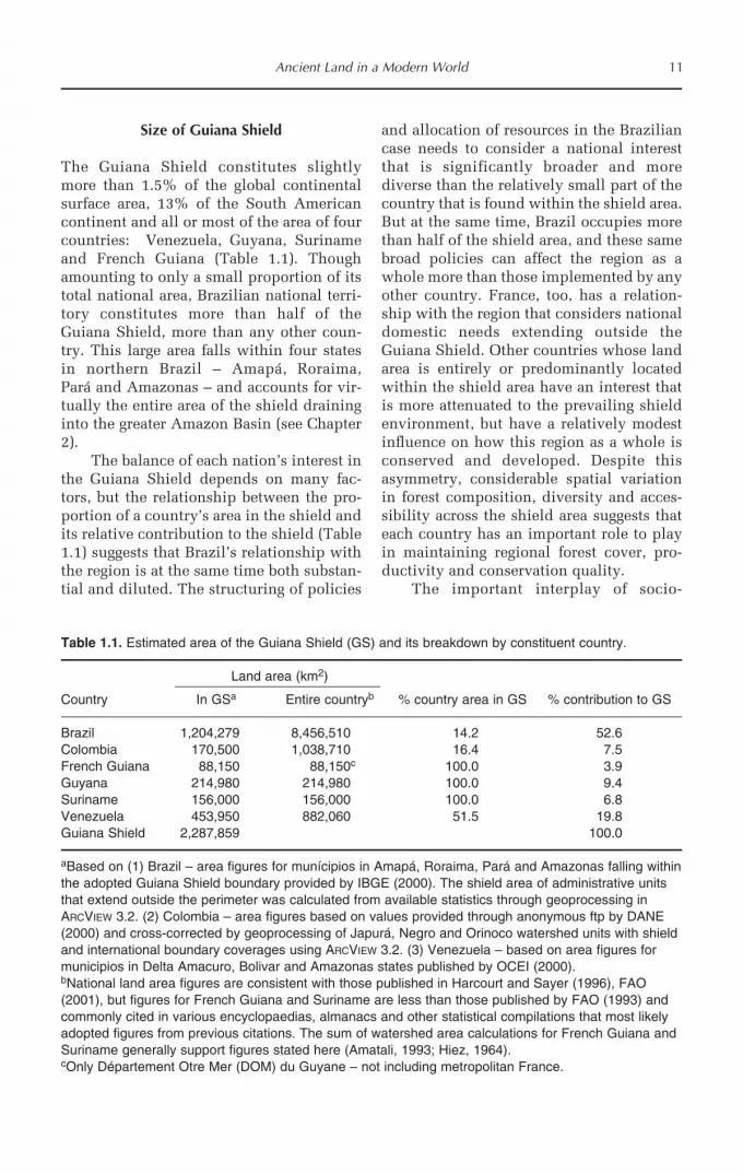
Size of Guiana Shield
The Guiana Shield constitutes slightlymore than 1.5% of the global continentalsurface area, 13% of the South Americancontinent and all or most of the area of fourcountries: Venezuela, Guyana, Surinameand French Guiana (Table 1.1). Thoughamounting to only a small proportion of itstotal national area, Brazilian national terri-tory constitutes more than half of theGuiana Shield, more than any other coun-try. This large area falls within four statesin northern Brazil – Amapá, Roraima,Pará and Amazonas – and accounts for vir-tually the entire area of the shield draininginto the greater Amazon Basin (see Chapter2).
The balance of each nation’s interest inthe Guiana Shield depends on many fac-tors, but the relationship between the pro-portion of a country’s area in the shield andits relative contribution to the shield (Table1.1) suggests that Brazil’s relationship withthe region is at the same time both substan-tial and diluted. The structuring of policies
and allocation of resources in the Braziliancase needs to consider a national interestthat is significantly broader and morediverse than the relatively small part of thecountry that is found within the shield area.But at the same time, Brazil occupies morethan half of the shield area, and these samebroad policies can affect the region as awhole more than those implemented by anyother country. France, too, has a relation-ship with the region that considers nationaldomestic needs extending outside theGuiana Shield. Other countries whose landarea is entirely or predominantly locatedwithin the shield area have an interest thatis more attenuated to the prevailing shieldenvironment, but have a relatively modestinfluence on how this region as a whole isconserved and developed. Despite thisasymmetry, considerable spatial variationin forest composition, diversity and acces-sibility across the shield area suggests thateach country has an important role to playin maintaining regional forest cover, pro-ductivity and conservation quality.
The important interplay of socio-
Ancient Land in a Modern World 11
Table 1.1. Estimated area of the Guiana Shield (GS) and its breakdown by constituent country.
Land area (km2)
Country In GSa Entire countryb % country area in GS % contribution to GS
Brazil 1,204,279 8,456,510 14.2 52.6Colombia 170,500 1,038,710 16.4 7.5French Guiana 88,150 88,150c 100.0 3.9Guyana 214,980 214,980 100.0 9.4Suriname 156,000 156,000 100.0 6.8Venezuela 453,950 882,060 51.5 19.8Guiana Shield 2,287,859 100.0
aBased on (1) Brazil – area figures for munícipios in Amapá, Roraima, Pará and Amazonas falling withinthe adopted Guiana Shield boundary provided by IBGE (2000). The shield area of administrative unitsthat extend outside the perimeter was calculated from available statistics through geoprocessing inARCVIEW 3.2. (2) Colombia – area figures based on values provided through anonymous ftp by DANE(2000) and cross-corrected by geoprocessing of Japurá, Negro and Orinoco watershed units with shieldand international boundary coverages using ARCVIEW 3.2. (3) Venezuela – based on area figures formunicipios in Delta Amacuro, Bolivar and Amazonas states published by OCEI (2000).bNational land area figures are consistent with those published in Harcourt and Sayer (1996), FAO(2001), but figures for French Guiana and Suriname are less than those published by FAO (1993) andcommonly cited in various encyclopaedias, almanacs and other statistical compilations that most likelyadopted figures from previous citations. The sum of watershed area calculations for French Guiana andSuriname generally support figures stated here (Amatali, 1993; Hiez, 1964).cOnly Département Otre Mer (DOM) du Guyane – not including metropolitan France.

economic and biophysical factors indicatesthat the size and shape of the shield usedfor the purpose of describing regional fea-tures may vary depending on the factorunder consideration. While the definitionof the shield as a geological provinceundoubtedly underpins all others, the term‘Guiana Shield’ is increasingly used as ameans of demarcating and defining a regionof interest for many non-geological attrib-utes (e.g. Bryant et al., 1997; Haden, 1999).Expanding the definition of the GuianaShield as an area of biogeographical (e.g.floristic province; Maguire, 1966; Mori,1991) and conservation significance (e.g.http://www.guayanashield.org) influencesthe shape and area of interest, one that isnot necessarily identical to a shield definedin the strictest sense by the presence ofunderlying exposed Precambrian rock (Fig.1.5A,D vs. 1.5C,E). In this context, definingan area that includes the main sedimentarydepressions traversing the area would bemore appropriate since the upland and low-land landscapes are strongly interlinked.
Impinging uncertainties
The location, size and shape of the GuianaShield presented here is based on a series ofgeological and topographical thresholds.While the shield is considered to be adistinct geological entity, the fine-scaleresolution of its boundaries is little morethan a good approximation for a number ofreasons. First, it forms one part of a muchlarger biogeochemical region and theprocesses that have shaped the shieldenvironment are shared, to varying extent,with other areas of South America andother continents (especially West Africa).The area of mineralogical affinity thatdefines the modern-day shield areaexpands as one moves further back in timethrough the Precambrian. Secondly, thearea remains remote and many parts havebeen poorly surveyed. Our knowledge ofmore specific small-scale landscape fea-tures of the region have in the past beenlargely interpolated at larger scales, thoughimprovements in remotely sensed data
acquisition are improving this knowledgebase. This coverage also varies by countrydue to differences in national technicalcapability. Suriname and Guyana are par-ticularly constrained in this regard in com-parison with their French, Brazilian andVenezuelan neighbours.
Whether the vast areas of Phanerozoiccover along the Atlantic coast and in north-ern Pará, Amazonas and Roraima statesshould be included or excluded from theGuiana Shield has largely favoured theirexclusion from a strict geological perspec-tive. However, many included areas alsohave significant sedimentary cover formedunder the same conditions and through thesame processes as those excluded (Gibbsand Barron, 1993). Much of the cover isthought to have originated from the erosionof older sedimentary structures (e.g. theRoraima Group) and basement rock withsignificant redeposition and remixingthrough oscillating periods of marine flood-ing, retreat and evaporation. Precambrianrock rests below all of these sedimentarybasins and its presence/absence does notqualify as a selective factor alone. Thethreshold depth and mineralogical prove-nance of Phanerozoic cover that should beincluded as part of the Guiana Shield is,however, a major criterion playing on thesize and shape of the shield and has yet tobe objectively established.
There are also complications with gen-eralizing the extent of the shield area whenconsidering the eastern and western limits.The eastern edge can vary depending onwhether current or past sea level is consid-ered as a limit to the eastern boundary. Thewestern edge of the shield is even more dif-ficult to define unambiguously, since signif-icant geological and floristic elementstypical of central shield locations canextend as far west as southeastern Colombianorth of the Solimões River (Gibbs andBarron, 1993; Duivenvoorden and Lips,1995; Cortès and Franco, 1997; Cortès et al.,1998). Information from these areas sug-gests that flora, fauna, soils and hydrologi-cal attributes are equally or more typical ofcentral and western Amazonian forestlands(Duivenvoorden and Lips, 1995) as biogeo-
12 D.S. Hammond

graphical and geological influences of theAndes to the west and north intermingledwith the much older shield contributionscentred to the east and south. From ananthropological perspective, the Amer-indian languages spoken in southernColombia are also considered part of theTukano/Ticuna linguistic groups ratherthan the shield-centred Carib/Arawakan/Yanomami groups (Chapter 8). Southern
parts of the geological shield are largelyinhabited by Tupi/Guarani-speaking peo-ples traditionally found living south of theAmazon River but not in any other part ofthe Guiana Shield. These and other attrib-utes that together help in creating a distinctpicture of the Guiana Shield region, andthrough this a better sense of its size as itrelates to many different attributes, aredescribed in much greater detail later.
Ancient Land in a Modern World 13
Notes
1 The etymological origins of ‘Guiana’ are debatable, though the modern translation is widely accepted tomean ‘water’ or ‘many waters’. Schomburgk (1840) suggested that the name is derived from a small tribu-tary of the Orinoco, while Codazzi (1841) argued that the name originated with an Amerindian tribe, theGuayanos, and that the term for pale or white, ‘uayana’, was used in describing the first Europeans theyencountered. Certainly a vast area extending inland from the Atlantic was referred to as Guiana since theearliest written accounts of exploration by Raleigh (1596), Keymis (1596) and Harcourt (1613), though theyused this name without qualifying its origins. A succinct account of some of the possibilities and variationsis also given by Berry et al. (1995).2 Segments of the international boundaries within the shield are still disputed more than 150 years later(Braveboy-Wagner, 1984; Burnett, 2000).
References
Amatali, M. (1993) Climate and surface water hydrology. In: Ouboter, P.E. (ed.) The Freshwater Ecosystemsof Suriname. Kluwer Academic, Dordrecht, The Netherlands, pp. 29–52.
Bancroft, E. (1769) An Essay on the Natural History of Guiana in South America. T. Becket and P.A. DeHondt, London.
Berrangé, J.P. (1977) The Geology of Southern Guyana, South America. Overseas Memoir 4. HMSO,London.
Berry, P.E., Holst, B.K. and Yatskievych, K. (1995) Flora of the Venezuelan Guayana. Volume 1:Introduction. Timber Press, Portland, Oregon.
Blancaneaux, P. and Pouyllau, M. (1977) Les relations géomorpho-pédologiques et la retombée nord-occi-dentale du massif guyanais (Vénézuela). Cahiers ORSTOM, Série Pédologique 15, 437–448.
Braveboy-Wagner, J.A. (1984) The Venezuela–Guyana Border Dispute: Britain’s Colonial Legacy in LatinAmerica. Westview Press, Boulder, Colorado.
Bryant, D., Nielsen, D. and Tangley, L. (1997) The Last Frontier Forests – Ecosystems and Economies on theEdge. World Resources Institute, Washington, DC.
Burnett, D.G. (2000) Masters of all they Surveyed – Exploration, Geography, and a British El Dorado.University of Chicago Press, Chicago, Illinois.
Chareyre, P. (1994) Régénération Naturelle en Guyane Française. Distribution Spatiale de Quelques EspècesLigneuses dans une Forêt Secondaire de 18 Ans. UFR de Sciences, Université Paris XII Val de Marne, Paris.
Codazzi, A. (1841) Resumen de la Geografia de Venezuela. H. Fournier, Paris.Collins, N.M., Sayer, J.A. and Whitmore, T.C. (1991) The Conservation Atlas of Tropical Forests: Asia.
Macmillan, London.Cortès, R. and Franco, P. (1997) Análisis panbiogeográfico de la flora de Chiribiquete, Colombia. Caldasia
19, 465–478.Cortès, R., Franco, P. and Rangel, O. (1998) La flora Vascular de la Sierra de Chiribiquete, Colombia.
Caldasia 20, 103–141.Cummings, L.P. (1963) The name Guiana: its origin and meaning. Journal of the British Guiana Museum and
Zoo 38, 51–53.

DANE (2000) Informacion geoestadistico. http://www.dane.gov.coDuivenvoorden, J.F. and Lips, J.M. (1995) A Land–Ecological Study of Soils, Vegetation and Plant Diversity
in Colombian Amazonia. Tropenbos Foundation, Wageningen, The Netherlands.FAO (1993) Forest Resources Assessment 1990: Tropical Countries. FAO Forestry Paper 112. FAO, Rome.FAO (2001) Global Forest Resources Assessment 2000. FAO Forestry Paper 140. FAO, Rome.Gansser, A. (1954) Observations on the Guiana Shield (South America). Ecologae Geologicae Helvetiae 47,
77–112.Gibbs, A.K. and Barron, C.N. (1993) The Geology of the Guiana Shield. Oxford University Press, Oxford,
UK.Goodwin, A. (1996) Principles of Precambrian Geology. Academic Press, New York.Haden, P. (1999) Forestry Issues in the Guiana Shield Region: A Perspective on Guyana and Suriname. EU
Tropical Forestry Paper 3. Overseas Development Institute, London.Harcourt, C.S. and Sayer, J.A. (1996) The Conservation Atlas of Tropical Forests: the Americas. Simon and
Schuster, London.Harcourt, R. (1613) A Relation of a Voyage to Guiana. John Beale, London.Hiez, G. and Dubreuil, P. (1964) Les Régimes Hydrologiques en Guyane Francaise. ORSTOM, Paris.IBGE (2000) Cidades@. http://www.ibge.gov.brKalliokoski, J. (1965) Geology of north-central Guyana Shield, Venezuela. Geological Society of America
Bulletin 76, 1027–1050.Keymis, L. (1596) A Relation of the Second Voyage to Guiana. Thomas Dawson, London.Maguire, B. (1966) Contributions to the botany of the Guianas. Memoirs of the New York Botanical Gardens
15, 50–128.Maguire, B. (1970) On the flora of the Guayana Highland. Biotropica 2, 85–100.McConnell, R.B. (1961) The Precambrian rocks of British Guiana. Timehri 40, 77–91.Mendoza, V. (1977) Evolucion tectonica del Escudo de Guayana. Boletín de Geologia (Publicacion Especial)
7, 2237–2270.Mori, S.A. (1991) The Guayana lowland floristic province. Comptes Rendu de la Société de Biogéographie
67, 67–75.OCEI (INE) (2000) Aspectos fisicos. http://www.ocei.gov.veOlson, D.M., Dinerstein, E., Wikramanayake, E.D., Burgess, N.D., Powell, G.V.N., Underwood, E.C.,
D’Amico, J.A., Itoua, I., Strand, H.E., Morrison, J.C., Loucks, C.J., Allnutt, T.F., Ricketts, T.H., Kura, Y.,Lamoreux, J.F., Wettengel, W.W., Hedao, P. and Kassem, K.R. (2001) Terrestrial ecoregions of theworld: a new map of life on Earth. Bioscience 51, 933–938.
Osmonson, L.M., Persits, F.M., Steinhouer, D.W. and Klett, T.R. (2000) Geologic Provinces of the World –wrld_prvg. USGS, Denver, Colorado.
Press, F. and Siever, R. (1982) Earth. W.H. Freeman and Co., San Francisco, California.Putzer, H. (1984) The geological evolution of the Amazon basin and its mineral resources. In: Sioli, H. (ed.)
The Amazon: Limnology and Landscape Ecology of a Mighty Tropical River and its Basin. Dr W. Junk,Dordrecht, The Netherlands, pp. 15–46.
Raleigh, W. (1596) The Discoverie of the large, rich, and bewtiful empyre of Guiana, with a relation of thegreat and golden citie of Manoa (which the Spanyards call El Dorado) and of the provinces of Emeria,Arromaia, Amapaia, and othe countries, with their rivers, adjoyning. Robert Robinson, London.
Räsänen, M. (1993) La geohistoria y geologia de la Amazonia Peruana. In: Danjoy, W. (ed.) AmazoniaPeruana. Vegetacion Humeda Tropical en el Llano Subandino. PAUT/ONERN, Jyväskylä, Finland, pp.43–65.
Romero, E.J. (1993) South American paleofloras. In: Goldblatt, P. (ed.) Biological Relationships BetweenAfrica and South America. Yale University Press, New Haven, Connecticut, pp. 62–85.
Sayer, J.A., Harcourt, C.S. and Collins, N.M. (1992) The Conservation Atlas of Tropical Forests: Africa.Macmillan, London.
Schenk, C.J., Viger, R.J. and Anderson, C.P. (1999) Maps Showing Geology, Oil and Gas Fields and GeologicProvinces of South America. USGS Open File Report. 97-470D. USGS, Denver, Colorado.
Schomburgk, R.H. (1840) A Description of British Guiana. Simpkin, Marshall and Co., London.Schomburgk, R.H. (1848) Reisen in British Guiana den Jahren 1840–1844. J.J. Weber, Leipzig.USGS and T.M. Corporacion Venezolana de Guayana (1993) Geology and Mineral Resource Assessment of
the Venezuelan Guayana Shield. USGS Bulletin 2062. US GPO, Washington, DC.Williams, J. (1923) The name Guiana. Société des Américanistes de Paris – New Series 15, 19–34.
14 D.S. Hammond