accuracy for all - cloudfront.net
TRANSCRIPT
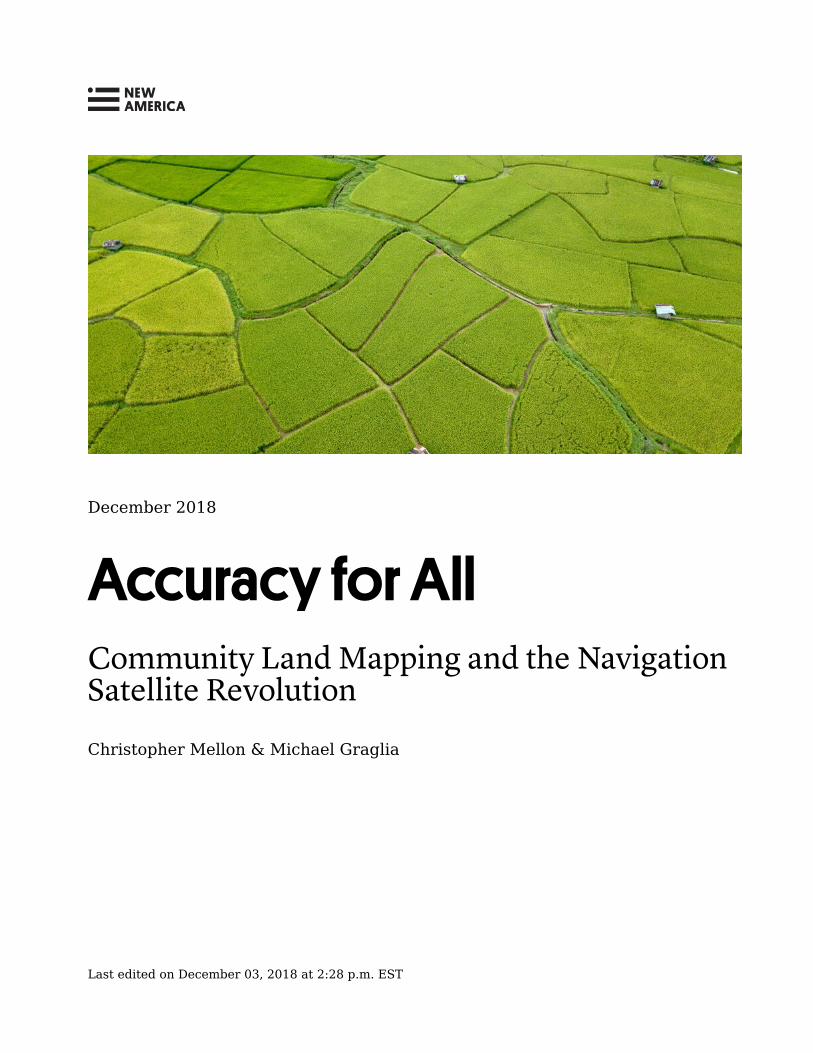
December 2018
Accuracy for AllCommunity Land Mapping and the NavigationSatellite Revolution
Christopher Mellon & Michael Graglia
Last edited on December 03, 2018 at 2:28 p.m. EST
Acknowledgments
The authors would like to thank Walter Volkmann ofMicro Aerial Projects for his time and technicalexpertise, Yuliya Pan�l and Ioana Bouvier for theirinsights into the MAST program, and our colleagueTim Robustelli for his help in reviewing and editing thispaper.
newamerica.org/future-property-rights/reports/accuracy-all/ 2
About the Author(s)
Christopher Mellon is a policy analyst with the Futureof Property Rights program at New America.
Michael Graglia is the director of the Future ofProperty Rights program at New America.
About New America
We are dedicated to renewing America by continuingthe quest to realize our nation’s highest ideals,honestly confronting the challenges caused by rapidtechnological and social change, and seizing theopportunities those changes create.
About Future of Property Rights
The Future of Property Rights initiative engages withpolicy makers, technologists, academics, civil society,and jurisdictions, as well as the property rightsformalization community of practice. Property rightsformalization is a powerful tool for creating wealth,opportunity, and security. A number of recenttechnology developments and advancements greatlyreduce the time, cost, and complexity of propertyrights formalization. As a result, there are many ripeopportunities to apply this policy solution. Our role isto highlight these opportunities, expand theconversation and facilitate instances of property rightsformalization improving lives.
newamerica.org/future-property-rights/reports/accuracy-all/ 3
6
8
910
11
13
14
15
17
18
21
25
26
26
32
37
44
Contents
Introduction
High-Accuracy Location Services, Community Mapping, and the Future ofGeospatial Data Collection
Accurate Location Data For All: Why Dual-Frequency GNSS is Necessary
A Second Frequency
New Developments
New Signals
New Hardware
New Software
Spatial Collective in Kenya
Their Findings
Spoo�ng, Proof of Location, and Trusted Data
Going Forward
Appendix: Background Research for This Report
Peering into the Future: How Dual-Frequency Satellite Receivers WillDemocratize Land Surveying
The Price of Precision: How Autonomous Vehicles Will Drive Down theCost of Dual-Frequency Satellite Receivers
A Mobile Application to Secure Land Tenure
Arrival of the Future: Dual Frequency Satellite Receivers, Smartphones,and Property Rights
newamerica.org/future-property-rights/reports/accuracy-all/ 4
47
Contents Cont'd
Appendix: Glossary
newamerica.org/future-property-rights/reports/accuracy-all/ 5
Introduction
On May 1, 2000, the White House Office of Science and Technology Policy
issued a short press release on behalf of President Bill Clinton which began:
Today, I am pleased to announce that the United States will stop the
intentional degradation of the Global Positioning System (GPS) signals
available to the public beginning at midnight tonight. We call this
degradation feature Selective Availability (SA). This will mean that
civilian users of GPS will be able to pinpoint locations up to ten times
more accurately than they do now.
With the push of a button, the accuracy of civilian GPS receivers improved from
roughly 50 meters to about 5 meters, creating a new and open market for location
services—like the now ubiquitous turn-by-turn navigation—that had previously
been impossible. In June 2000, Steven W. Berglund, the president and CEO of
Trimble Navigation, called the decision to turn off SA “a milestone in GPS
history” that “underscores the importance of the technology as a global
information utility.”
He was right. Today, daily use of global navigation satellite system (GNSS)
location services is taken for granted by everyone with a smartphone. In 2013, the
direct economic impact of GPS in the U.S. alone was estimated to be between $37
billion and $74 billion. The 2017 EU GNSS Market Report predicts that the
number of GNSS devices in use will “increase from 5.8 billion...in 2017 to almost
8 billion in 2020 – averaging an estimate of more than one device per person on
the planet.” They predict further that the “global GNSS downstream market,
which comprises both devices (e.g. GNSS receivers) and augmentation services,”
will grow to €195 billion in 2025.
Now, as investment in the GNSS market continues to increase, we are
approaching another milestone that may prove as significant as the end of
Selective Availability. That milestone is the emergence of new satellite navigation
signals and signal processing capabilities that will, in a few short years, improve
the location accuracy of consumer devices—including smartphones—from
meters to centimeters. Just as happened with the ending of Selective
Availability, this new level of accuracy will enable new applications, from
autonomous vehicle navigation to augmented reality. Access to centimeter-level
accuracy also opens up another use case, one that is not commercial but could
have a far greater economic impact than any other: community land mapping.
Community land mapping combines surveying with the collection of information
about land ownership and/or occupancy to support the formal recognition of
property rights.
1
2
3
4
5
6
newamerica.org/future-property-rights/reports/accuracy-all/ 6
In this report, we first discuss the developments that are making high-accuracy
location services available to all for the first time. Then, through the lens of a
recent case study, we look at the current state of community land mapping and
how some of the remaining challenges can be addressed with new tools. Finally,
we look at how new identity and trusted data systems can help enhance the non-
geospatial half of community mapping, the collection of attribute data.
Note: In the appendices we include some lightly edited earlier writing on these subjects.
In addition to providing greater detail on the evolution of GNSS and mobile mapping,
these articles introduce and explain in simple terms the technical concepts referenced in
the first section of this paper. Readers who are not already familiar with GNSS
technolog� will find it helpful to read the appendices first. We also include a glossary of
key technical terms and concepts.
newamerica.org/future-property-rights/reports/accuracy-all/ 7

High-Accuracy Location Services, CommunityMapping, and the Future of Geospatial DataCollection
Across the developing world, nearly a billion people live without legal title to their
land. In order to formalize this property, governments need to issue titles and
create secure registries in which to record them. But unlike other types of
property, parcels of land cannot be registered until they have been defined.
Delineating one person’s property from another’s is a serious technical challenge
and a prerequisite for granting secure legal titles.
This challenge is all but insurmountable if approached with conventional
methods. Professional surveying is extremely accurate but prohibitively
expensive in the developing world. Recent advances in GNSS technology have
weakened the correlation between precision and cost, but survey-grade accuracy
is not yet widely affordable.
Widespread access to high-accuracy geospatial data is critical for formalization
efforts because expense is not the only problem with depending on professional
surveyors. Documenting the world’s informal property involves a more
fundamental issue of scale; there is not enough time for the small number of
professional surveyors to register it all. According to the Cadasta Foundation,
there are fewer than two professional surveyors per 10,000 square kilometers of
land in the Ivory Coast and Tanzania, compared to 41 per 10,000 square
kilometers in the United States. There were only 74 registered land surveyors in
Uganda in 2015 and an estimated 15 million parcels of informally owned land.
With more than 200,000 parcels per registered surveyor, Cadasta calculates that
it would take them over a thousand years to finish the job.
With more than 200,000 parcels per registered
surveyor, it would take Uganda over a thousand
years to finish the job.
When everyone has access to high-accuracy location data, some of the most
time-consuming and expensive parts of the formalization process can be
completed more quickly and cheaply at a local level. But collecting accurate,
high-integrity geospatial data is only one part of the challenge. Formalization
7
newamerica.org/future-property-rights/reports/accuracy-all/ 8
also requires the collection of a great deal of information about the people living
in these communities, and this information should be collected in a way that
respects local cultural sensitivities and land use practices, as well as the privacy
of the landholders. This is the other half of community mapping.
Accurate Location Data For All: Why Dual-Frequency GNSS isNecessary
One of the primary obstacles to the acceptance of community mapping is that it
does not produce data as accurate or trusted as that gathered by professionals.
On the surveying side this is largely a technical problem: the hardware and
expertise required by traditional geospatial surveying methods is beyond the
reach of most communities. But when it comes to gathering non-geospatial
information about properties, their attributes, the people who own them, and
their rights, there is a problem of trust. Professional surveyors and government
officials are considered trustworthy to a degree that members of the community,
with their diverse and potentially conflicting interests, may not be. In order for
community mapping to have the greatest impact, the information it produces
must be trusted enough to be accepted by the authorities who control access to
services.
Mapping conducted with cheap and accessible tools is at present unlikely to meet
legal standards for property registration, making it of limited use as collateral for
a loan. Moreover, lenders may not be willing to accept low-value properties as
security for loans, regardless of the formal ownership status. Expanding access
to capital is often cited as the primary economic benefit of formalization, but it is
only one positive impact of many. Community mapping can be used to increase
tenure security and bootstrap financial inclusion, even when it does not result in
formal registration. Indeed, increased tenure security can itself be a driver of
increased investment in land. The information gathered can provide strong
evidence for the legal defense of property rights, increasing security of tenure.
For example, in 2011 community maps created by the Basarwa Bushmen helped
them to challenge the Government of Botswana in court and “win back the right
to live on their land.”
Community mapping can be used to increase tenure
security and bootstrap financial inclusion.
8
9
newamerica.org/future-property-rights/reports/accuracy-all/ 9
Many in the international development community argue that rather than trying
to adopt more accurate mapping tools and techniques—which have been
prohibitively expensive—it would be better to relax surveying accuracy
standards. But there are good reasons to resist this argument, especially now that
high-accuracy tools are becoming more accessible. First, governments have little
incentive to relax their standards, given the risk of increasing the number of legal
boundary disputes. More accurate surveying enhances the clarity and security of
land claims. Second, quality of surveying and security of title should not be tied
to the income of the property owner. Third, in a rapidly urbanizing world,
accuracy is increasingly important: errors on the order of meters, even
decimeters, can encompass a large percentage of the area of a small apartment.
This is one reason that the focus of formalization efforts has to date been largely
on rural surveying. Fortunately, cheap tools are emerging that promise to make
professional-grade accuracy accessible to everyone. It is important to note that
there will still be a role to play for expert surveyors, who will help design
community mapping efforts, train the participants, and provide quality control of
data gathered.
A Second Frequency
Position measurements using a single frequency are vulnerable to interference
and accurate, at best, to about five meters. This is fine for most people’s daily use,
and in developed areas Wi-Fi signals can be used to augment accuracy. Until May
2018, for example, every smartphone ever released used a single-frequency
receiver. But errors on the scale of meters are not good enough for survey work,
which should be accurate to the one to ten centimeter range, depending on local
standards and the type of surveying.
By making use of a second signal frequency, dual-frequency receivers can correct
for delays caused by the ionosphere, which are the greatest single contributor to
inaccuracy. Using a second frequency also provides greater signal redundancy,
allowing for better error-correction and improved satellite availability in tree
cover and urban canyons. With error-checking algorithms that can identify faulty
satellite signals, dual-frequency receivers produce measurements that are not
only far more accurate but also significantly more trustworthy. This last quality is
important when it comes to registering land, as it allows the authorities validating
title claims to have confidence in the integrity of the data they are given. Dual-
frequency receivers also resolve positions more quickly than single-frequency
receivers, so the surveyor does not have to wait as long on a reference point
acquiring multiple satellites.10
newamerica.org/future-property-rights/reports/accuracy-all/ 10
New Developments
In our earlier writing, we predicted that the imminent availability of new
navigation satellite signals and new markets for precision navigation (notably for
autonomous vehicles) would bring survey-grade accuracy to mobile devices by
2022. One year later our prediction looks conservative. The number and
sophistication of navigation satellite constellations and signals is increasing, and
dual-frequency chips are, for the first time, being mass manufactured for
consumer applications. As of 2018, sub-meter accuracy is available for the mass
market in the Xiaomi Mi-8 smartphone. Decimeter accuracy will be achievable
soon, with centimeter accuracy to follow.
11
newamerica.org/future-property-rights/reports/accuracy-all/ 11
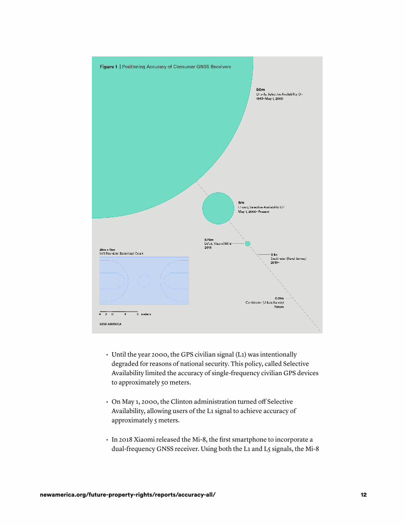
• Until the year 2000, the GPS civilian signal (L1) was intentionally
degraded for reasons of national security. This policy, called Selective
Availability limited the accuracy of single-frequency civilian GPS devices
to approximately 50 meters.
• On May 1, 2000, the Clinton administration turned off Selective
Availability, allowing users of the L1 signal to achieve accuracy of
approximately 5 meters.
• In 2018 Xiaomi released the Mi-8, the first smartphone to incorporate a
dual-frequency GNSS receiver. Using both the L1 and L5 signals, the Mi-8
newamerica.org/future-property-rights/reports/accuracy-all/ 12
achieved sub-meter accuracy in testing conducted by the European Space
Agency.
• Survey accuracy requirements vary greatly by jurisdiction. For many
applications, including rural boundary surveying, allowable errors are
commonly measured by tenths of a meter.
• More stringent urban cadastral surveying standards may require
centimeter-level accuracy.
New Signals
As we have detailed before, the declining cost of high-accuracy location
capabilities is the result of several concurrent developments. One is the
availability of new satellite constellations broadcasting new, open satellite
navigation signals, notably the L5/E5 signals broadcast by Galileo and the new
GPS Block IIF and Block III satellites. Progress has been rapid. On October 12,
2018, four new Galileo satellites went online. On November 1, the sixth of ten
advanced navigation payloads was delivered for integration into forthcoming
GPS III satellites. In its 2018 GNSS User Technolog� Report, the European Global
Navigation Satellite Systems Agency (GSA) wrote that all of the major navigation
constellations will reach full operational capability in the next five years. In
layman's terms, in five years or less the globe will be covered by two different
frequencies of free and open signal. Multi-constellation receivers using Russia’s
GLONASS and China’s BeiDou satellites in addition to GPS and Galileo could
eventually have access to more than 100 satellites. New satellite-based
augmentation networks are also being deployed to improve the accuracy of
location services:
The coming years will see two new GNSS (Galileo and BeiDou), and two
RNSS (QZSS and NavIC), reach full operational capability. In parallel,
the modernisation of existing GNSS (GPS and GLONASS) is also well
underway. Thus, in just a few years there will be four global and three
regional satellite navigation systems, and more than 100 satellites
providing open access to more accurate and reliable PNT services,
including through the use of multiple frequencies. Public augmentation
systems, such as EGNOS, are also evolving to become multi-
constellation and multi-frequency.
These augmentation systems supply correction data needed to cancel out
positioning errors, improving receiver accuracy to decimeter or centimeter levels.
A particularly interesting augmentation method for our purposes is Precise Point
Positioning (PPP). PPP systems allow dual- and multi-frequency receivers to
12
13
14
15
16
17
newamerica.org/future-property-rights/reports/accuracy-all/ 13

achieve centimeter-level accuracy anywhere on the globe. The correction data
can be supplied via satellite, meaning that this accuracy can be achieved without
using differential techniques that require a second receiver and a
communications channel. PPP is for the most part only available on a
subscription basis, but there is increasing recognition of the value of making it
accessible as a public, global utility. Japan’s QZSS constellation includes
experimental sub-meter and centimeter-level PPP signals for East Asia and
Oceania, and the EU is exploring upgrading its EGNOS augmentation system to
support centimeter-level accuracy using the L1/E1 and L5/E5 signals. The
International GNSS Service (IGS) launched a free, real-time global PPP service in
2013, streaming dual-frequency GPS corrections over the internet. This service
allows sub-decimeter accuracy, but requires special firmware and only supports
the GPS constellation. Open access to PPP for all satellites would be a huge gain
for the developing world, where the infrastructure required for other
augmentation and correction systems is often lacking.
New Hardware
The most notable recent advance in hardware has been the appearance of cheap
dual-frequency chips for mobile devices. In 2018, we saw the launch of the
Xiaomi Mi-8, the first cell phone equipped with dual-frequency GNSS. The dual-
frequency Broadcom BCM47755 chip in the Xiaomi was the first of its kind to
market, though numerous other chip makers are expected to follow suit.
We should emphasize that our predictions concerned the convergence of
consumer devices towards survey-grade accuracy. Standards vary by jurisdiction,
but rural parcels often require decimeter accuracy, and accuracy on the order of
one to five centimeters is often needed to meet more stringent urban
requirements. Accuracy depends on many factors beyond the dual-frequency
receiver, including antenna quality, signal processing software, and satellite
availability.
Initial consumer testing of the Xiaomi revealed mixed results. This is likely
attributable to uneven regional coverage of the L5/E5 satellites. In its own
comprehensive testing, the GSA achieved static accuracy of 0.78 meters, and this
can be improved upon with augmentation techniques like Precise Point
Positioning and Real-Time Kinematic positioning (RTK). Broadcom claims to
have successfully tested both RTK and PPP internally. Broadcom’s results have
not been made public, but in May 2017 they provided a team of researchers
from Trimble Inc. with a development kit for the dual-frequency BCM47755 chip
found in the Mi-8. The researchers tested the Broadcom chip against a
professional survey-grade receiver and found that both were able to achieve
centimeter-level accuracy when using RTK and a professional-grade antenna.
They were able to achieve similar results with the Broadcom chip and a cell-
18
19
20
21
22
23
24
25
26
27
newamerica.org/future-property-rights/reports/accuracy-all/ 14
phone antenna, though with much longer convergence times. This was
accomplished under ideal laboratory conditions, but their conclusion is
nevertheless remarkable:
By connecting this next-generation GNSS chipset to a GNSS antenna
typical of a cellular device and comparing the performance from a
precision GNSS antenna, we’ve shown for the first time that it is
possible to produce precision positions from a static cellular class GNSS
device in ideal conditions at the centimeter level with both an RTK
solution and a PPP solution.
New Software
Since 2016, Google’s Android—the operating system for 88 percent of the world’s
handheld devices, and even more in the developing world—has allowed access to
raw navigation signal data, which is required for advanced signal processing
techniques. Supporting innovation in the Android ecosystem is a key part of the
European Space Agency's (ESA) strategy for promoting “better location
performance in mass market applications.” In 2017 ESA launched a Raw
Measurements Task Force to “share knowledge and expertise on Android raw
measurements and its use, including its potential for high accuracy positioning
techniques.” The task force also organizes workshops, hackathons, and app
development competitions. A September 2018 GSA presentation outlines the
“four main areas of use...enabled by GNSS raw measurements:”
• “Scientific/R&D: As the observations are provided in a much more
coarse form they can be used for testing hardware and software solutions
and for new post processing algorithms e.g. for modelling ionosphere or
troposphere.”
• “Integrity/Robustness: Access to raw measurements will offer new
ways to detect RF interferences and to locate the interference source by
combining the measurements from multiple devices (crowdsourcing), or
verify the source (OS�NMA). SBAS corrections can be incorporated
without the need for additional equipment.”
• “Increased Accuracy: Subject to hardware limitations, access to raw
measurements means a developer can employ advanced positioning
techniques (RTK, PPP) and create a solution currently only available in
professional receivers. It results in a technological push to develop new
applications.”
28
29
30
31
32
newamerica.org/future-property-rights/reports/accuracy-all/ 15
• “Testing, performance monitoring, and education: Raw
measurements can be used for monitoring performance (data, accuracy,
Rx clock), testing and to compare solution [sic] from single constellations,
eliminate specific satellites or test for worst scenario performance.
Education use for understanding GNSS, Signal [sic] processing or orbits in
smartphone is not negligible too.”
It is difficult to overstate the R&D value of the Android raw measurements,
especially in enabling mathematical signal processing advances which enhance
location performance independently from the hardware. For example, a recent
paper from the University of Otago in New Zealand demonstrated the potential
for multi-constellation, single-frequency (L1) GNSS with RTK to compete with
dual-frequency for accuracy:
By combining signals from four different Global Navigation Satellite
Systems (GNSSs), Otago’s Dr Robert Odolinski and Curtin University
colleague Prof Peter Teunissen, have demonstrated that it is possible to
achieve centimeter(cm)-level precise positioning on a smartphone. “It’s
all down to the mathematics we applied to make the most of the
relatively low-cost technology smartphones use to receive GNSS
signals, combining data from American, Chinese, Japanese, and
European GNSS. We believe this new capability will revolutionize
applications that require cm-level positioning,” Dr Odolinski says.
The “smartphone implementation” tested here consisted of a DataGNSS D302-
RTK receiver with a list price of $1199. Because it used only one frequency it
remains sensitive to ionospheric interference. More importantly, multipath
interference mitigation is inherently better with the L5 and E5 signals, which is
critical in urban areas and places with heavy tree cover. But solutions like this,
which leverage a profusion of signals to cancel out errors and mitigate the
limitations of consumer grade antennas, could become even more powerful
when used to enhance cheap dual-frequency receivers.
33
34
35
newamerica.org/future-property-rights/reports/accuracy-all/ 16
Spatial Collective in Kenya
Where do we stand going into 2019? What do these advancements mean for
community land mapping? In a previous article, we covered the MAST mobile
mapping app used by USAID to record communal land rights in Africa beginning
in 2014. Now we present a more recent example. In 2017, Spatial Collective
conducted a study to assess whether current mobile GNSS technologies and
community mapping techniques could meet surveying standards in Kenya. Their
methodology, reproduced from their report Putting Community and Rights on the
Map in Southern Kenya, is below.
→ BOX 1
Methodology of Spatial Collective Initiative in Kenya
From Putting Community and Rights on the Map in Southern Kenya
• The idea of communities demarcating their own land is predicated on aseries of assumptions:
◦ Cheap and widely available tools that can be used for landdemarcation exist.
◦ These tools can reach the demarcation threshold required by theKenyan government in terms of accuracy and attribution.
◦ The communities, using these tools, can replicate the work of aprofessional surveyor.
• To test these assumptions, we conducted a series of experiments in TaitaHills, Taita Taveta County:
◦ We examined the process of demarcating land both for newgrants and for subdivision of land. Speci�cally, we focused on theaccuracy and attribution of spatial data required by theprofessional surveyor and government o�ces.
◦ We tested a series of a�ordable and ubiquitous technologies forcapture and demarcation of land to see whether they achieve thethresholds required. We tested these tools under varying
36
37
newamerica.org/future-property-rights/reports/accuracy-all/ 17
environmental conditions to see how they a�ect themeasurements.
◦ Finally, we assessed whether communities can replicate thedemarcation of land by the professional surveyor using thesetools.
Their Findings
Spatial Collective found that current mobile devices were not accurate enough to
meet the three to four centimeter survey requirements for demarcation of fixed
boundaries, but were able to meet the much less stringent requirements (up to
three meters) for general boundaries in rural surveying. They also found that the
field performance of the smartphones they tested was not constrained by
network availability. Access to mobile data had no impact on accuracy, while
environmental factors like tree cover had a major impact.
The handheld Bad Elf and Garmin GPS units were far more accurate than the
mobile phones, but as single-purpose devices they did not share the phones’
usefulness in gathering attribute and ownership data. The same can be said of
any single-purpose device, even the $30,000 Leica survey receiver used as a
control.
The report emphasizes that community mapping is not just about geospatial data.
Additional information must be gathered (e.g. to tie occupants to properties and
demonstrate agreement over boundaries). Processes might include taking photos
or videos of neighbors agreeing to a boundary between their properties, or filling
out and storing digital forms. Smartphones, increasingly prevalent in the
developing world, are the best candidate for an accessible, low-cost platform to
perform all of these functions. The report identifies bottlenecks and how they
can be addressed using the affordable mapping tools tests, which are reproduced
below.
→ BOX 2
Bottlenecks and Related Solutions from Spatial Collective Initiative inKenya
newamerica.org/future-property-rights/reports/accuracy-all/ 18
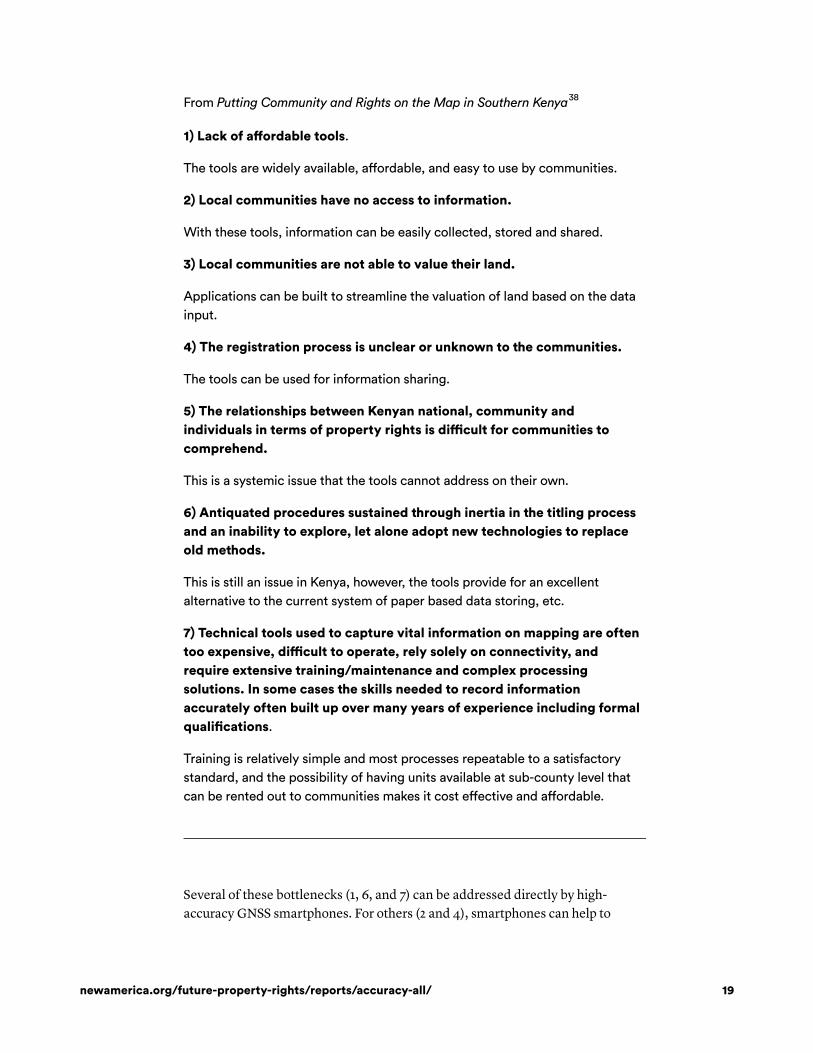
From Putting Community and Rights on the Map in Southern Kenya
1) Lack of a�ordable tools.
The tools are widely available, a�ordable, and easy to use by communities.
2) Local communities have no access to information.
With these tools, information can be easily collected, stored and shared.
3) Local communities are not able to value their land.
Applications can be built to streamline the valuation of land based on the datainput.
4) The registration process is unclear or unknown to the communities.
The tools can be used for information sharing.
5) The relationships between Kenyan national, community andindividuals in terms of property rights is di�cult for communities tocomprehend.
This is a systemic issue that the tools cannot address on their own.
6) Antiquated procedures sustained through inertia in the titling processand an inability to explore, let alone adopt new technologies to replaceold methods.
This is still an issue in Kenya, however, the tools provide for an excellentalternative to the current system of paper based data storing, etc.
7) Technical tools used to capture vital information on mapping are oftentoo expensive, di�cult to operate, rely solely on connectivity, andrequire extensive training/maintenance and complex processingsolutions. In some cases the skills needed to record informationaccurately often built up over many years of experience including formalquali�cations.
Training is relatively simple and most processes repeatable to a satisfactorystandard, and the possibility of having units available at sub-county level thatcan be rented out to communities makes it cost e�ective and a�ordable.
Several of these bottlenecks (1, 6, and 7) can be addressed directly by high-
accuracy GNSS smartphones. For others (2 and 4), smartphones can help to
38
newamerica.org/future-property-rights/reports/accuracy-all/ 19
improve information access and sharing, though this is dependent to a great
extent on the degree of device ownership and network connectivity. Systemic
and legal obstacles remain and, as the report notes, are issues that “tools cannot
address on their own.”
The greatest missing element which has prevented a single-device solution for
geospatial and attribute data collection is GNSS accuracy. Adding this capability
to smartphones can help consolidate both device functions and data collection
roles. Trusted members of the community will be able to gather geospatial and
attribute data. The collection of this attribute data introduces privacy concerns,
especially when it comes to storage and sharing. Fortunately, with the right
software, smartphones also provide a platform for secure data handling. Once
high-accuracy GNSS becomes standard in smartphones, they will become the
best tool for most mapping applications.
39
newamerica.org/future-property-rights/reports/accuracy-all/ 20
Spoo�ing, Proof of Location, and Trusted Data
Even if we assume that dual-frequency phones augmented with PPP or RTK will
solve the location accuracy problem in the near future, the integrity and
provenance of community mapping data, both geospatial and attribute, will
remain a serious concern. Indeed, as the latest GNSS User Technolog� Report
points out, “high accuracy is not the endgame, but rather ‘trusted and resilient’
high accuracy remains the ultimate goal.”
Many of the new, safety-critical uses for high-accuracy GNSS, most notably
aviation and autonomous vehicles, have drawn attention to the possibility of
spoofing attacks, in which false signals are generated to disrupt or mislead
receivers. Once thought to be prohibitively complex and expensive for any but
the most sophisticated actors to execute, successful spoofing attacks were
demonstrated in 2012 against targets including drones and ships using hardware
that cost only $2,000. In 2018, we saw that fake signals can be broadcast using a
software-defined radio and a $5 USB to VGA display adapter.
The use of multiple frequencies and constellations makes spoofing inherently
more difficult because more false signals have to be generated at different
frequencies. But additional steps must be taken to harden receivers against
spoofing. Galileo is working to incorporate a cryptographic message
authentication system into its signals, and GPS is considering doing the same.
Galileo’s version is expected to be fully operational by 2020. There are a
number of other hardware and software tools for combating spoofing. Some
types of antennas can detect the direction from which a signal originates,
allowing spoofed signals (which tend to originate from one location) to be
identified and discarded. Other techniques involve measuring qualities of the
signals, including signal power and the doppler shift caused by the motion of the
satellite. These require access to the raw satellite tracking data.
But spoofing is not a major concern with community mapping. It remains quite
difficult to do, especially when directed against multiple receivers, and would be
easy to detect when coordinates were overlaid with the base map. Perhaps most
importantly, there would be very little incentive for a bad actor to do it in the first
place.
There is a much greater risk of mappers submitting falsified data. This is
especially true if crowdsourced data collection is done remotely and is driven by
economic incentives. There are already several examples of location-based
services being manipulated by users faking their GNSS coordinates in order to
cheat at games like Pokémon Go or earn cryptocurrency for participating in
crowdsourced mapping projects. In the future there will be many more services
40
41
42
43
44
45 46
47
newamerica.org/future-property-rights/reports/accuracy-all/ 21
that require verified location data, including autonomous transportation, supply
chain tracking, usage-based insurance, and location-based access control.
There is a much greater risk of mappers submitting
falsified data.
Defenses against spoofing address the trustworthiness of the signals received,
not of the receiver. Proof of location addresses a very different problem: how can
a third party authenticate location data from an untrusted receiver?
There are several approaches to this problem. One would be to create an
aggregated proof of location, cross-checking GNSS data against input from a
number of other sensors in the phone, like the inertial measurement unit and
barometer, in addition to network-based location information from Wi-Fi and
cell networks. Apps like Truepic already do this to verify the authenticity of
photographs for their clients, including insurance companies. An obvious
drawback to this solution is the reliance on network access, though it would also
be possible to store the data on the user’s device in such a way that it would be
extremely difficult to tamper with it. This could be accomplished with a Trusted
Computing architecture in which the data is signed and encrypted by a secure
chip attached to the device CPU.
Another solution would be to incorporate a proof of location method into the
GNSS signal itself. For example, one proposed system for “Pretty Good Proof of
Location” would be to encrypt the navigation signal and have the satellite send
the encryption key after a small time delay, perhaps five minutes. The receiver
would be able to store the raw data or stream it to a third party, who could decode
it upon publication of the key. The forger would be unable to forge the raw data
without knowing the key beforehand.
Even in the absence of these technical solutions, community mapping is
inherently resistant to forgery of location data because it is a group activity in
which claims are made and validated collectively. For community boundary
surveys, trained community members supervise the collection of GNSS data, and
it is validated against a base map with identifiable landmarks, like trees, fences,
and buildings. Moreover, the boundaries of the demarcated plots are reviewed
and agreed to by the owners of adjacent plots. This leaves very little room for
falsification or manipulation of coordinates.
48
49
50
51
newamerica.org/future-property-rights/reports/accuracy-all/ 22
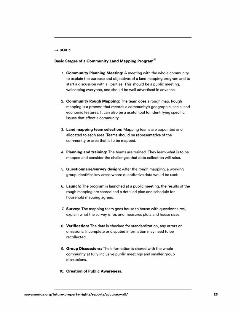
→ BOX 3
Basic Stages of a Community Land Mapping Program
1. Community Planning Meeting: A meeting with the whole communityto explain the purpose and objectives of a land mapping program and tostart a discussion with all parties. This should be a public meeting,welcoming everyone, and should be well advertised in advance.
2. Community Rough Mapping: The team does a rough map. Roughmapping is a process that records a community’s geographic, social andeconomic features. It can also be a useful tool for identifying speci�cissues that a�ect a community.
3. Land mapping team selection: Mapping teams are appointed andallocated to each area. Teams should be representative of thecommunity or area that is to be mapped.
4. Planning and training: The teams are trained. They learn what is to bemapped and consider the challenges that data collection will raise.
5. Questionnaire/survey design: After the rough mapping, a workinggroup identi�es key areas where quantitative data would be useful.
6. Launch: The program is launched at a public meeting, the results of therough mapping are shared and a detailed plan and schedule forhousehold mapping agreed.
7. Survey: The mapping team goes house to house with questionnaires,explain what the survey is for, and measures plots and house sizes.
8. Veri�cation: The data is checked for standardization, any errors oromissions. Incomplete or disputed information may need to berecollected.
9. Group Discussions: The information is shared with the wholecommunity at fully inclusive public meetings and smaller groupdiscussions.
10. Creation of Public Awareness.
52
newamerica.org/future-property-rights/reports/accuracy-all/ 23
That brings us to the related question of recording attestations between
community members. Our recent research into self-sovereign identity provides a
possible answer, one that is conveniently amenable to use with smartphones.
Self-sovereign identity (SSI) uses cryptography to give individuals a secure digital
identity under their control, paired with a platform for storing and sharing
verifiable, digitally signed data. This is critical for recording attestations in a way
that is secure and easily tracked and audited.
Current community mapping apps can upload scans of signed paper documents
and record videos of neighbors agreeing on property boundaries. Video is much
harder to fake than a signature, and therefore harder to repudiate. But while it
might provide stronger evidence in court, the use of video creates a number of
problems. Video files are large and take up a lot of storage capacity. Moreover,
they are hard to check. How do you verify the identities of the people in the
video? And validating the interaction requires a human to sit down and watch it.
By contrast, SSI uses cryptographic signatures to record agreements and
attestations in a way that is both secure and easy to validate. Signatures can be
indelibly linked to a single digital identity, or even to a natural person using
biometry.
SSI architecture can also allow communities to organize themselves and
determine group membership. When documenting the claims of a given
indigenous community, for example, it might be necessary to know who is and is
not a member. In many cases that determination is best made by the community
itself rather than by outsiders, for example a foreign NGO organizing the
mapping. The community could instead issue membership credentials to its
members who could present them to the NGO as necessary.
Finally, SSI can provide a critical infrastructure component for connection to a
variety of services, for example subsidies. The SSI firm Everest has partnered
with the Government of Indonesia to distribute liquefied petroleum gas subsidies
to digital wallets linked to self-sovereign identities. Similarly, a digital
credential issued and signed by the land registry could be used to establish
entitlement to agricultural subsidies, which could even be delivered to the
farmer’s digital wallet. SSI can also incorporate a messaging system. If integrated
into a digital registry this could be used combat fraud, sending automated
notifications to property owners whenever a transfer of their land is initiated or
when it is used as collateral for a loan. (For more on SSI and land registries, see
the Future of Property Rights report The Nail Finds a Hammer: Self-Sovereign
Identity, Design Principles, and Property Rights in the Developing World.)
53
newamerica.org/future-property-rights/reports/accuracy-all/ 24
Going Forward
The apparent infeasibility of attaining legal survey accuracy standards with
community mapping has led many in the development community to argue that
the best solution is for survey standards to be relaxed. But once mobile accuracy
in the field can meet those standards, the conversation will shift towards
persuading governments to trust community mapping data. And it should be an
easy argument to make. Many governments make the formalization of land
rights a priority in their development agendas but cannot afford to carry it out.
This is largely because of the need to go out and collect all of the relevant
geospatial and attribute data. The alternative that is emerging might look
something like the TurboTax model, where the individual taxpayer combines
data from various sources, some self-reported and some imported from his or her
employer, and submits it electronically to a government database for processing.
This new paradigm is becoming possible, thanks primarily to the advent of high-
accuracy consumer positioning technology and digital identity systems capable
of managing trusted, auditable data. Governments will have the opportunity to
relinquish the burden of data collection and take on the role of validator and
auditor.
newamerica.org/future-property-rights/reports/accuracy-all/ 25
Appendix: Background Research for This Report
The following appendices consist of lightly edited earlier writing related to the report.
In addition to providing greater detail on the evolution of GNSS and mobile mapping,
these articles introduce and explore in simple terms the technical concepts referenced in
the report.
The pieces are the following:
• “Peering into the Future: How Dual-Frequency Receivers Will
Democratize Land Surveying,” by Michael Graglia and Christopher
Mellon (March 23, 2017).
• “The Price of Precision: How Autonomous Vehicles Will Drive Down the
Cost of Dual-Frequency Receivers,” by Michael Graglia and Christopher
Mellon (June 20, 2017).
• “A Mobile Application to Secure Land Tenure,” by Michael Graglia and
Christopher Mellon (August 3, 2017).
• “Arrival of the Future: Dual Frequency Satellite Receivers, Smartphones,
and Property Rights,” by Christopher Mellon (July 10, 2018).
Peering into the Future: How Dual-Frequency Satellite Receivers WillDemocratize Land Surveying
By Michael Graglia and Christopher Mellon
This post originally appeared in the Future of Property Rights blog here.
March 23, 2017
Drawing Lines
Across the developing world nearly a billion people live without legal title to their
land. In order to formalize this property, governments need to issue deeds and
create registries in which to record them. But unlike other types of property,
parcels of land cannot be registered until they have been defined. Delineating
one person’s property from another’s is a serious technical challenge and a
prerequisite for granting secure legal titles.
Precise surveying is expensive, requiring specialized equipment operated by
professional surveyors. This means that precision is often inaccessible to people
in the marginalized populations who most require it.
newamerica.org/future-property-rights/reports/accuracy-all/ 26
When professional surveyors are asked to compromise on price, the accuracy of
the service they provide also becomes subject to compromise. Walter Volkmann,
a third-generation land surveyor and president of Micro Aerial Projects L.L.C.,
saw firsthand how one such negotiation combined with the politics of apartheid
to jeopardize formalization efforts in Namibia in the 1980s:
In the late 1970s South Africa decided to no longer rule Namibia,
formerly known as South West Africa, as a fifth South African province.
Instead it began to follow a policy in terms of which Namibia would
gradually be granted administrative autonomy until it would ultimately
gain full independence from South Africa. In 1978 the first “one man,
one vote” elections were held. Although boycotted by SWAPO, a major
anti-apartheid movement, the newly elected “Government of National
Unity” decided to extend the right to formally own land in the then
racially segregated urban areas to all people, irrespective of skin color.
For this purpose, the so-called “locations,” townships which were
developed and reserved exclusively for the housing of non-white
citizens under South African apartheid policy, had to be surveyed and
registered in the Deeds Registry. My entry into the land surveying
profession fell into that period in the early 1980s when the large volume
cadastral surveys of the so-called “locations” were being rolled out.
While the small number of professional land surveyors were welcoming
this sudden abundance of work, the government was of course facing
the challenge of funding these surveys. And, as so often happens when
budgets are being discussed for survey work, an attempt was made to
negotiate a reduction in fees in exchange for a relaxation in the
prescribed accuracy standards. Given the prevailing technology at that
time, accuracy standards were indeed a legitimate factor in the cost of
cadastral surveying. One could argue that lower fees would result in the
survey of a larger number of properties and thereby facilitate formal
ownership for more people than would otherwise have been the case.
However, this would result in the absurd reality that although formal
ownership of land would be made possible for all citizens irrespective of
race, an ugly residual of racial prejudice would remain: your skin color
would determine the accuracy to which your property was surveyed and
thus the security of your title. In the end both parties agreed on reduced
fees for the survey of formerly “black townships” without
compromising accuracy standards. Although the introduction of the
term “black township” in the text of the cadastral survey legislation is
not exactly indiscriminate, it certainly is less detrimental and offensive
than granting inferior security of title to formerly disadvantaged
citizens. And, rather happily, the discriminatory language has long since
vanished from the regulatory texts as now all formal townships in
54
newamerica.org/future-property-rights/reports/accuracy-all/ 27
Namibia enjoy a homogeneous standard of accuracy and hence security
of title.
Subsequent advances in global navigation satellite system (GNSS) technology
have weakened the correlation between precision and cost, but survey-grade
accuracy is not yet widely and cheaply available.
Widespread access to this level of accuracy is critical for formalization efforts
because expense is not the only problem with depending on professional
surveyors to document the world’s informal property. There is a more
fundamental problem of scale. A significant percentage of all land in the
developing world is informally owned. There is simply not enough time for
professional surveyors to register it all.
According to the Cadasta Foundation, there are fewer than two professional
surveyors per 10,000 square kilometers of land in the Ivory Coast and Tanzania,
compared to 41 per 10,000 square kilometers in the United States.
There were only 74 registered land surveyors in Uganda in 2015 and an
estimated 15 million parcels of informally owned land. With more than 200,000
parcels per registered surveyor, Cadasta calculates that it would take them over a
thousand years to finish the job.
When everyone has access to survey-grade precision, formalization efforts can be
expanded and accelerated. With the advent of relatively cheap, dual-frequency
satellite receivers, this may soon become possible.
Dual-Frequency Receivers
Position measurements using a single frequency are vulnerable to interference
and accurate, at best, to about five meters. This is fine for most people’s daily
use, and in developed areas Wi-Fi signals can be used to augment accuracy. All
smartphones, for example, use single-frequency receivers. But errors on the scale
of meters are not good enough for survey work, which should be accurate to the
one to ten centimeter range, depending on local standards and the type of survey.
By making use of a second signal frequency, dual-frequency receivers can correct
for delays caused by the ionosphere, which are the greatest single contributor to
inaccuracy. Using a second frequency also provides greater signal redundancy,
allowing for better error-correction and improved satellite availability in tree
cover and urban canyons. With error-checking algorithms that can identify faulty
satellite signals, dual-frequency receivers produce measurements that are not
only accurate but trustworthy. This last property is important when it comes to
registering land, as it allows the authorities validating title claims to have
confidence in the integrity of the data they are given. Dual-frequency receivers
also resolve positions more quickly than single-frequency receivers, so the
55
56
57
58
59
60
61
62
newamerica.org/future-property-rights/reports/accuracy-all/ 28
surveyor does not have to wait as long on a reference point acquiring multiple
satellites.
Using free, open-source signal processing software, dual-frequency receivers
can achieve survey-grade accuracy. The downside of dual-frequency receivers is
the cost of the hardware. In 2013, a $2,500 dual-frequency receiver could be
described as “incredibly inexpensive.”
Two things need to happen in order for hardware prices to continue to drop: the
deployment of large numbers of satellites operating civilian signals on at least
two different frequencies, and a large, competitive market for survey-grade
receivers. It appears that both of these conditions will be met in the near future.
Open Signals
When the U.S. launched the first navigational satellite constellation, GPS, it
broadcast signals on two main frequencies. The first signal, called L1 (1575.42
MHz), was intentionally degraded, limiting the accuracy of the single-frequency
receivers that used it to around 100 meters. The second signal, L2
(1227.60MHz), was available only to authorized users, like the U.S. military, who
were issued encryption keys. This policy prevented civilians and foreign
governments alike from getting precise GPS coordinates without ground-based
augmentation systems. This policy was eventually reversed, but not before a
few civilian companies figured out how to use the L2 signal without an encryption
key and patented the techniques. Until a second civilian signal becomes
available to replace L2, these patents will continue to restrict competition in the
development of dual-frequency receivers.
In 2013 the governments of the United States and the United Kingdom
announced their commitment to “ensuring that GPS civil signals will remain
perpetually free and openly available for users worldwide,” agreeing to place all
technical information and intellectual property relating to civil GPS signals in the
public domain. Manufacturers will be able to patent specific receiver designs,
but not techniques needed to track the signals themselves, like the patents filed
on the L2 signal. A U.S. Department of State document from September 2013
notes that this commitment to open signals is intended in part to promote “open,
market-driven competition” and “equal access for user equipment
manufacturing.”
One of these new, open signals, the L5 (1176.45 MHz) signal, is the best
candidate to replace L2 for dual-frequency use. L5 is the most advanced civilian
signal, designed for “safety-of-life transportation and other high-performance
applications.” An open GPS signal called L2C (1227 MHz) is being introduced to
replace the L2 signal, but it will be used by fewer satellites and the U.S.
government may not continue to support it once the L5 constellation is complete.
Survey-grade receivers need to be able to see at least eight satellites to function
63
64
65
66
67
68
69
70
71
72
newamerica.org/future-property-rights/reports/accuracy-all/ 29
optimally, making the L5 signal, which is more powerful than L2C and will be
used by multiple satellite constellations, a better option. A modernized
American GPS constellation broadcasting both L1 and L5 from its newer Block
IIF and Block III satellites is scheduled to be completed by 2024. The European
Union’s Galileo constellation is deploying satellites with the interoperable E5
signal, meaning that a full complement of 24 L5/E5 satellites will be available
before either constellation is completed individually. Multi-constellation
receivers that can also use Russia’s GLONASS and China’s BeiDou satellites in
addition to GPS and Galileo could eventually have access to more than 100
satellites.
New Markets
Recent technological advances are creating huge new markets for accurate GNSS
receivers.
Autonomous vehicles, from tractors to taxis, are poised for massive growth
and will require more accurate and reliable GNSS receivers for both functionality
and safety purposes. Single-frequency receivers can also achieve very high
accuracy with augmentation, but the inherent accuracy and integrity offered by
dual-frequency receivers makes them more attractive for safety applications.
Aerial drones, used for everything from oil and gas exploration to grocery
delivery, will benefit from increased accuracy in vertical positioning.
Commercial aircraft will be able to use dual-frequency L1/L5 receivers for
navigation and safety-of-life applications.
The average smartphone user will appreciate more accurate location services for
navigation, fitness apps, even virtual reality.
Manufacturers are already developing dual-frequency receivers for these
markets. Broadcom, for example, which manufactures GNSS chips for
smartphone giants like Apple and Samsung, revealed in 2016 that it was testing a
dual-frequency chip for cell phones.
Future Developments
Survey-grade GNSS receivers will continue to shrink, become cheaper, and may
eventually be digitized altogether. A software-defined receiver (SDR) like the
Trimble Catalyst can transform an Android phone into a dual-frequency
receiver with a software download and a plug-in antenna. The Catalyst requires a
monthly subscription to Trimble’s augmentation services and accuracy is pay-as-
you-go, with meter accuracy priced at $40 per month, and centimeter precision
at $350 per month.
73
74
75 76 77
78
79
80
81
82
83
84
85
newamerica.org/future-property-rights/reports/accuracy-all/ 30
But devices with open-source SDR and post-processing software could reduce
the total user cost to the price of the antenna. As long as it had enough processing
power, an SDR device could be updated to support additional constellations and
signals without any hardware development costs.
Antennas for surveying receivers currently cost a few hundred dollars and are
fairly large. They must be shielded from reflected signals, especially those
bouncing off the ground, and usually have a plate around ten centimeters in
diameter built into the bottom of the antenna.
New methods of compensating mathematically for these reflected signals
promise survey-grade precision with antennas small enough to fit in a
smartphone. A team at the University of Texas, working with Samsung, is using
these techniques to achieve centimeter precision with $5 antennas similar to
those currently found in smartphones. They estimate that their system,
consisting of an SDR and antenna, will “eventually cost less than $50.”
The hardware component of the Trimble Catalyst, introduced in November
2016, costs $350, seven times less than the “incredibly inexpensive” X90-
OPUS introduced in 2013. With increased competition among manufacturers and
increased demand, prices will only continue to drop. It is hard to predict how far,
but the fact that a major chip-maker like Broadcom is experimenting with dual-
frequency chips in cellphones is telling. Apple is unlikely to accept adding
hundreds of dollars to the price of an iPhone for a dual-frequency receiver and
antenna.
What Will This Mean for the Various Stakeholders in Property
Formalization Efforts?
For governments and aid agencies, it will be easier and cheaper to organize
large-scale formalization efforts when surveying is decentralized and pushed
down to the local level. The government’s focus will move to providing the legal
staff and registry system needed to validate and record property claims.
Crowd-sourced surveying will allow more property to be registered more quickly.
The more complete a land registry is, the more useful it is to government officials
managing land use, natural resources, and public utilities.
NGOs will also be able to expand their formalization programs thanks to reduced
equipment and personnel costs. As data collection becomes easier and cheaper,
they may dedicate more resources to addressing governance issues and
bureaucratic obstacles that threaten to negate the positive effects of
formalization.
Occupants will benefit the most from the democratization of surveying. In areas
where the nature of customary ownership or usage does not translate easily into a
86
87
88 89
newamerica.org/future-property-rights/reports/accuracy-all/ 31
formal cadastral system (as with shared lands with communal rights or lands
used by different parties according to an annual cycle) land use arrangements
decided at the local level are preferable.
Cheaper surveying should allow for the reduction of property registration fees,
which currently discourage many small landowners from participating in
formalization programs. According to the World Bank, registering property in
sub-Saharan Africa costs, on average, eight percent of the value of the registered
property.
For professional surveyors, documenting informal property is time-
consuming and not especially profitable. When the task of data collection is
crowdsourced, they will be free to focus on more demanding work which requires
expertise in managing and analyzing geospatial data. This will include designing
and supervising crowdsourced data collection projects.
The Price of Precision: How Autonomous Vehicles Will Drive Downthe Cost of Dual-Frequency Satellite Receivers
By Michael Graglia and Christopher Mellon
This post originally appeared in the Future of Property Rights blog here.
June 20, 2017
Executive Summary: Investment in autonomous vehicles will reduce the cost of dual-
frequency GNSS receivers by a factor of ten within the next five years.
In a previous article we argued that the price of dual-frequency satellite
receivers is poised to fall precipitously with the advent of new satellite navigation
signals and new markets. We discussed the dynamics driving this process and its
implications for the democratization of land surveying, but we did not quantify
this price reduction or say when these new, cheaper devices would be available.
In this article we address those questions in detail by looking at the projections
that government agencies, think tanks, and market analysts have made regarding
the development of dual-frequency satellite receivers for the transportation
market. There is a widespread expectation that autonomous vehicles will become
the first mass market application for dual-frequency GNSS receivers. The vehicle
market is best positioned to adopt this technology both because it has the most
pressing need and because it is not limited by the energy consumption,
processing power, and miniaturization concerns that restrict the use of dual-
frequency in drones, wearables, and cell phones. We anticipate that the mass
production of dual-frequency receivers for the vehicle market will reduce their
price by a factor of ten within the next five years.
The Race Towards Automation
90
91
newamerica.org/future-property-rights/reports/accuracy-all/ 32
There is no consensus on when fully autonomous vehicles will become common.
A May 2017 report from the independent technology think tank RethinkX,
entitled Rethinking Transportation 2020-2030, projects an exponential adoption
curve that will result in 95 percent of U.S. passenger miles being served by on-
demand autonomous vehicles by 2030. Their conclusion, premised on
economic feedback loops making individually owned cars prohibitively
expensive compared to Transportation-as-a-Service, is far more optimistic than
most other estimates. Market reports from business consultancies, while more
cautious, still project rapid growth. PwC said in its Connected Car Study 2015 that
“fully autonomous long-range driving at highway speeds [is] expected between
2020 and 2025.” McKinsey’s Automotive revolution - perspective towards 2030,
concludes that anywhere between 15 and 50 percent of cars will be highly
autonomous in 2030, depending on the degree of market disruption.
Car manufacturers, tech companies, and ride-sharing services such as General
Motors, Renault-Nissan, Daimler, Volkswagen, Waymo, and Tesla are all
working towards fully autonomous vehicles. Uber and Ford have announced
plans to put highly or fully autonomous cars on the road in high volume by 2021.
As a result, enabling technologies are receiving significant levels of investment,
both because they improve human-driven connected cars and because they are a
prerequisite for autonomous vehicles.
This is particularly true of technologies like dual-frequency GNSS that increase
safety. In the words of Craig Giffi, leader of Deloitte LLP’s U.S. automotive
practice: “to win consumers’ trust, automakers will need to integrate limited self-
driving and advanced safety features into new product offerings steadily over
time to introduce people to the technology, demonstrate the improvement in
vehicle safety and develop a proven track record.” Autonomy is simultaneously
appealing and frightening to consumers, who are enthusiastic about the potential
of Transportation-as-a-Service to reduce travel costs, pollution, and urban
congestion, but will be reluctant to adopt it until they are absolutely convinced it
is safe. Autonomous vehicles have the potential to greatly reduce road
fatalities, but consumers fear the loss of control and are likely to judge them by a
more critical standard than human-operated vehicles. More people are afraid
of commercial air travel than of driving despite the fact that flying is statistically
much safer. The confidence of regulators and investors is as critical as the
confidence of potential users. PwC notes that in the scramble to control the
emerging connected and autonomous car market, “no one will win...if security
concerns undermine consumers’ trust in connected car technology.”
Why is Dual-Frequency Important for Autonomous Vehicle Safety?
Unlike the current generation of in-dash and phone-based car navigation
systems, which only use a single frequency, GNSS systems used for autonomous
vehicle navigation must employ at least two frequencies to achieve the highest
92
93
94
95
96
97 98 99
100 101
102
103
104
105
106
newamerica.org/future-property-rights/reports/accuracy-all/ 33
safety standards, which mandate higher accuracy and signal integrity than
single-frequency can provide. As the European GNSS Agency noted succinctly in
its 2016 GNSS User Technolog� Report: “For safety-critical applications, where
redundancy and resistance to jamming is important, dual-frequency (L1/E1 + L5/
E5) is undoubtedly the best choice.” The greater integrity possible with dual-
frequency allows a navigation system to detect when the navigation signal
includes errors outside of a given confidence range and take appropriate action.
In most cases, this simply means excluding any faulty data from the position
calculation.
Dual-frequency also allows for greater positional accuracy and, crucially, is much
quicker to resolve “integer ambiguities” when it has to re-initialize because the
signal is interrupted. This means that if a car goes through a tunnel or loses sight
of satellites in an “urban canyon” it can re-establish an accurate position fix in a
matter of seconds once the satellites are back in view. Since highly urban areas
will be the primary market for autonomous vehicles, this is a serious advantage.
New augmented single-frequency receivers—more advanced versions of what
you have in your car today—can match the positioning accuracy of dual-
frequency receivers under certain conditions, but dual-frequency options are
superior because of their greater integrity and the fact that they are not
dependent on augmentation from a local network of ground-based reference
stations. As the 2017 GSA GNSS Market Report says, “It is clear that
autonomous driving technology requires highly accurate position and navigation
in all scenarios. This means 100 percent position availability at decimeter level or
less, anywhere, anytime and under any condition.” The report points out that
this is only achievable through the integration of a variety of sensor types, but
given the stringency of this requirement, the only reason for a manufacturer to
prefer a single-frequency receiver would be the reduced cost.
Liability
Single-frequency receivers may be cheaper for autonomous vehicle
manufacturers in the short term, but skimping on safety-critical technology could
be a serious risk. A 2017 Mobile World Live survey found that “only 5.5% of
respondents felt the vehicle owner was liable for connected car security,
suggesting that security will continue to be the responsibility of vendors and
service providers rather than the users themselves.” Every precaution will have
to be taken to protect vehicle manufacturers and operators from liability and to
protect user confidence in the safety of autonomous transportation services.
Investors and adopters alike will be very sensitive to these concerns, and it will be
well worth the additional investment in the safest guidance systems. GNSS will
be a part of that investment, integrated into sensor packages including lidar,
radar, and cameras.
107 108
109
110
111
112
newamerica.org/future-property-rights/reports/accuracy-all/ 34
The increased accuracy and integrity provided by precision GNSS will have
important financial implications beyond consumer confidence and injury
liability, as insurance and ride fees move to usage-based models. Many other
location-based services, including tolling, weather updates, traffic information,
parking availability, and stolen vehicle recovery, also stand to benefit.
It must also be noted that autonomous and connected cars will provide a massive
new target for cybercriminals to steal, hijack, or crash by spoofing guidance
signals. Dual-frequency signals are harder to spoof than single-frequency and
also more resistant to jamming and other interference. This is due in part to the
increased complexity of simulating multiple signals and partly due to simple
redundancy. Starting in 2018, the new European Galileo constellation will also
help guard against spoofing by broadcasting an authentication signal on a
separate frequency.
Price Reductions
A 2016 market report from ABI Research, entitled Low-Cost Precision GNSS
Receivers, estimates that dual-frequency receivers will be available for $50 per
unit by 2021. This is consistent with the recent trends in price reduction and
mirrors the autonomous vehicle deployment timelines put forward by Uber and
Ford. It is also consistent with the forecast of the GSA, which said in 2015 that it
expected “low-cost, multi-frequency chipset/receivers to appear on the market in
the next few years” driven by “automotive and other machine-to-machine
applications.” Dual-frequency surveying units traditionally cost upwards of
$5,000, but the new, more affordable receivers now available from companies
like SwiftNav cost about $600. Another roughly similar decrease to $50 seems
plausible as dual-frequency receivers change from specialist, low-volume
products to mass-produced car components.
There is no reason to believe that the price reductions will stop there. Many of the
top chipset manufacturers are investing in dual-frequency systems for both
mobile devices and wearables. Their biggest clients, cell phone manufacturers,
are not interested in adding $50 to the cost of a phone for improved location
services. One startup in Poland, ChipCraft, is developing a multi-constellation,
dual-frequency system-on-a-chip with an integrated antenna that they project
will cost only $10 per unit. That project is a long way from completion, but it is
a clear indication of the direction that receiver development is heading. As ABI
principal analyst Patrick Connolly has said, “As the receivers’ unit price drops
below $50, we expect to see a market develop for location technology services,
such as artificial reality and head-up displays in higher-end vehicles.” As the
entry price for the adoption of the technology is lowered, more and more
developers and users can be expected to embrace it for an increasing number of
applications, including crowdsourced surveying.
113
114
115
116
117
118
119
120
121
newamerica.org/future-property-rights/reports/accuracy-all/ 35
Implications for Surveying
In the next five to ten years there will be massive new scaling opportunities for
organizations who crowdsource surveying. Together with already available open-
source post-processing software, $50 dual-frequency receivers would allow
parcels to be surveyed with decimeter accuracy—even without any supporting
augmentation infrastructure—for a fraction of the current equipment cost.
Where satellite-based augmentation or geodetic control points are available,
accuracy down to the one centimeter level will be possible.
The rapid initialization and signal acquisition of dual-frequency—which allow
parcels to be surveyed more quickly—may be an even more important long-term
advantage than reduced equipment costs, which are amortized over long periods
when surveying at scale. The speed of surveying can be further enhanced with
the use of unmanned aerial vehicles. Drones equipped with cameras and dual-
frequency receivers can rapidly create maps of land parcels. The V�Map system,
from Micro Aerial Projects L.L.C., uses a dual-frequency receiver to record the
drone’s location each time the onboard camera takes a picture. Linking 2D
images to precise GPS coordinates enables the system to use a technique called
“Structure from Motion” to create a detailed 3D map of the surveyed area
without the use of ground control points. In March 2017, V�Map receivers were
certified to meet the international accuracy standards for first order geodetic
control positioning by the National Mapping and Resource Information Authority
of the Philippines. (Full disclosure: Walter Volkmann, the President of Micro
Aerial Projects L.L.C., served as a technical advisor for this article.)
Crowdsourced surveying is already being conducted in some areas. Through
funding from the United States Agency for International Development, citizens
of rural African nations are using the Mobile Application to Secure Tenure
(MAST) smartphone application to record formal land holdings. MAST was
launched in Tanzania in 2015, expanded to Zambia in 2016, and is being rolled
out in Burkina Faso. MAST uses GPS in existing cellphones that is only accurate
to a few meters, supplementing this GPS data with satellite imagery. Once dual-
frequency receivers are widely affordable, programs like MAST will become
feasible in countries, like Jamaica, where there is a legal requirement for higher
accuracy, as well as in urban and peri-urban settings where greater property
density and property value demand increased accuracy and resistance to
interference.
Even as hardware costs are reduced, challenges to property rights formalization
will remain. It will still be resource intensive and regulations must evolve to allow
for these technologies. Governments must be convinced of the trustworthiness of
crowdsourced survey data. In most jurisdictions, laws require that surveying is
conducted only by licensed surveyors. Crowdsourced data cannot be used to
register land no matter how accurate it is. We believe, however, that as the quality
122
123
124
125
126 127
newamerica.org/future-property-rights/reports/accuracy-all/ 36
of crowdsourced data converges with professional survey standards these
policies will change despite resistance from entrenched interests. When trust can
be placed in the integrity of the data rather than that of the operator, the
argument for restricting surveying services to licensed professionals will be
weakened significantly.
More accurate surveys will also help avoid problems down the line when the
formalized land is bought, sold, or inherited. When conflicts arise between
owners who were not party to the original, mutually-recognized boundaries,
inaccurately surveyed land can lead to costly disputes. In such cases, there would
be a real risk of deformalization. If a land title is less secure it is less valuable, and
there is less incentive to keep an insecure parcel registered.
As we previously noted, there are not enough professional surveyors in
developing countries to help formalize all the land that needs attention. Only
crowdsourced surveying, enabled by tools like dual-frequency receivers and
programs like MAST, can bring about significant progress. The potentially
transformative impact of these technologies is hard to overstate, and increasingly
hard to overlook. The GSA’s May 2017 summary of emerging trends in the GNSS
surveying market begins simply: “falling device prices drive the democratization
of mapping.”
A Mobile Application to Secure Land Tenure
By Michael Graglia and Christopher Mellon
This post originally appeared in the Future of Property Rights blog here.
August 3, 2017
The Future of Property Rights initiative believes that property rights matter and
that technology can play a critical role in helping countries accelerate the pace of
property rights formalization while simultaneously reducing costs.
We analyze multiple technologies, looking at the tools that are currently in use,
the established technologies that could replace them, and the emerging
technologies we believe will be used in the future. We are in the process of
doing this for each essential task—from mapping to database management—
required for property rights formalization and land administration.
For the task of demarcating informal lands, for example, the prevalent solution is
to contract professional surveyors who use expensive tools. A widely available
and more cost effective technology which could be used instead is a GPS-enabled
smartphone coupled with cloud-based data processing, and the technology we
can see improving land demarcation in the immediate future is dual-band GPS,
paired with either smartphones or drones to create ortho-maps.
128
129
130
131
132 133
newamerica.org/future-property-rights/reports/accuracy-all/ 37
Cadasta illustrates the inadequacy of professional surveying for property
formalization in emerging economies with a compelling infographic. They
argue that given the scarcity of professional surveyors in the developing world,
“documenting land rights through traditional methods [surveying] will take
generations.” In Uganda, for example, they estimate that it would take the
country's “few dozen” surveyors a millennium to survey the “estimated 15 million
parcels of unregistered land.” They go on to point out that Tanzania only has 1.9
surveyors per 10,000 square kilometers compared to 26 in Norway, and 41 in
America. It is fair to assume that wealthy, developed countries like Norway and
the U.S. have significantly less informal land. So how can countries like Uganda
catch up?
There’s an App for That
As smartphones have become ubiquitous over the last decade, an ecosystem of
mobile data collection apps has emerged, making the prospect of cheap,
crowdsourced data collection more feasible than ever before. Most of these apps
have been aimed at users in the developed world, where the use cases impose
very different cost and accessibility requirements. An app that only runs on a late-
model iPhone, for example, would be unsuitable for community mapping in the
developing world no matter its functionality.
In her 2016 Master’s thesis, “An app for land administration: criteria, functional
requirements and a prototype in Ethiopia,” Julinda Dyli of the University of
Twente examined 30 of these apps for their suitability for community mapping.
The two fundamental requirements she identified were that the apps must be
“designed to support poor people and communities” (pro-poor) and “designed to
support management of land administration systems” (fit-for-use). Dyli breaks
these two requirements down into sixteen criteria. Many of these overlap, and
for the sake of simplicity we will distill them down to four broad criteria:
1) Affordability
The app must be free or very inexpensive. If the purchase price or subscription
fee is high, or if the app can only be run on an expensive phone, then it will not be
suitable for community mapping.
2) Accessibility
The app must be simple and intuitive to use for people with limited education
and literacy. If it is too complex to operate it will not fit into the sort of
collaborative, inclusive methodology that is best able to guarantee fairness and
transparency. The geospatial data cannot be abstract; it must be tied to a map
that shows people what it corresponds to on the ground. The data produced must
be in format that is easily shared and read by the different parties involved.
134
135
136
137
newamerica.org/future-property-rights/reports/accuracy-all/ 38
3) Adaptability
Different regions and jurisdictions have different requirements for land and
tenure attribute information as well as GPS accuracy. The app must therefore be
flexible in its ability to collect both kinds of data. It must be able to collect
complex usage and tenure information across the continuum of rights. The app
must include forms to enter attribute data, ideally ones that can be customized
without programming. Compatibility with external GPS receivers is also
important for simple adaptation to regional accuracy standards.
4) Accuracy
The integrity of the information collected must be high so that everyone involved
in the process, from the landholder to the government land agency, has trust in
the data. The accuracy of the GPS data should be high enough to satisfy legal
standards in the area where the mapping takes place, but no higher if increased
accuracy will impose greater costs.
Apps designed with these criteria in mind are already being used to record
property rights, notably by the USAID Mobile Application to Secure Tenure
(MAST) program.
USAID - MAST
MAST is an approach that includes a participatory process for land
documentation and a suite of open source applications customizable for GPS-
enabled smartphones and tablets. After a brief training, villagers can use the app
to “map the boundaries of their land and gather the demographic and tenure
information that government officials can then use to issue formal land rights
documents.”
MAST is designed to address the social, logistical, and legal challenges of
property rights formalization, not just the technical ones. At the highest level,
MAST’s strategy is to engage citizens in the work of mapping, freeing up
government personnel to focus on validating and registering land claims. This
process starts with education and capacity building, efforts which are required to
build trust in the process among everyone involved, from landholders skeptical of
the value of the program to government officials skeptical of the value of
community mapping. Special attention is paid to women and other vulnerable
groups, ensuring they understand their rights and are empowered to exercise
them.
Local committees are formed to represent the interests of customary
landholders. Any disagreements that arise, such as boundary overlaps, are
reviewed by these committees before being validated by government land
138
139
140
newamerica.org/future-property-rights/reports/accuracy-all/ 39
officials. USAID does not pass judgment on contested land claims, deferring
instead to local authorities.
Landholders and their neighbors walk the boundaries of their lands and overlay
the collected data onto a satellite map. In addition to capturing geospatial data,
MAST allows users to record the names and photographs of landholders and
document various types of property rights arrangements, such as joint holdings
between a wife and husband. Critically, MAST allows data to be collected offline
and uploaded to the cloud when 3G or Wi-Fi service becomes available. Without
this feature it would be useless in many of the rural areas where it is most needed.
Once all parties, including community, government, and traditional authorities
have agreed on the accuracy of the maps and attribute data, they upload it to the
cloud, where it can be accessed by land officials through a web application to be
cleaned and validated. By making the data and registration requests available
through a browser-based platform, MAST eliminates the need to send it by mail,
cutting out a major source of latency in the registration process. After processing,
a cadastral map can be rendered in jurisdictions where they are used. In Burkina
Faso it took three Rural Land Service officers less than two months to complete
this process for 2,638 parcels, with verification taking about 30 minutes each—a
dramatic increase over previous methods.
MAST has for the most part been used to issue occupancy certificates, which
recognize customary land rights. The rights afforded by these documents vary
substantially, and may be communal or individual, depending on the jurisdiction.
In Tanzania, documents called Certificates of Customary Right of Occupancy
(CCRO) are issued. These are not statutory freehold titles, but they can be issued
to individuals as well as communities.
Burkina Faso issues a document called a Rural Land Certificate of Possession
(APFR). Similar to CCROs, these can be issued to individuals, and occupy a
middle ground between statutory and customary land rights.
The certificates issued in Zambia, by contrast, were both communal and
customary. These certified the landholder’s right to occupy as part of a greater,
communally-owned parcel, such as a village.
MAST was piloted in Tanzania in 2014 and later scaled up as part of a larger Feed
the Future program; it was rolled out in Zambia in the same year; and it was
brought to Burkina Faso in 2016. A detailed summary of the results in each
country follows, but what is most significant is that MAST was able to use
smartphones, a widely available technology, to crowdsource data collection,
bypassing the professional surveying bottleneck.
MAST in Tanzania
141
142
143
144
145
146
147
148 149
150
newamerica.org/future-property-rights/reports/accuracy-all/ 40
MAST debuted in Tanzania, where the government and USAID recognized that
the lack of registered land was having a negative impact on the business climate,
ecology, and social institutions of the country. The $1 million initiative—
originally called the Mobile Technology Pilot and renamed MAST —ran from
2014 to 2016 and was a successful proof of the crowd-sourced formalization
concept, mapping land quickly with low-cost mobile technology.
Laying the groundwork for the project, the village government organized
educational councils and committees to teach the community the basic land laws
of Tanzania, as well as the technical and procedural details of MAST’s operation.
The village government also established a special council of land dispute
resolution. Groups of young people were trained to be the project’s data
collectors, known as trusted intermediaries. Women were allotted half of the
seats on the council, which performed the critical task of ruling on arguments
between landholders.
This measure was intended to safeguard the property rights of women. Women
are afforded equal property rights under national law, but are often denied these
rights because of customary norms. This proved to be a successful strategy;
women became proprietors of 50 percent of the newly mapped land.
The expanded MAST program resulted in CCROs being issued quickly and at low
cost. The villagers were able to map nearly 1,000 parcels in less than three weeks,
though it took several months for the District Land Office to issue the CCROs.
MAST in Zambia
In 2014 MAST expanded into Zambia, where there was widespread public
demand for more secure property rights. One survey conducted in rural Zambia
found that 91 percent of respondents “stated a desire to acquire some form of
paper documentation for their land.” According to a 2015 USAID publication,
26 percent of rural households in Zambia’s Eastern Province reported having
experienced “at least one land conflict in the past three years, with the vast
majority [being] over boundaries or inheritance.”
According to a Devex article on climate-smart agriculture and tenure in Zambia,
this pervasive lack of formal property rights had consequences beyond the
frequent land disputes: it discouraged farmers in one of Africa’s most fertile
countries from investing in their own land to increase food crop yields.
Zambians needed to farm more sustainably, for example, by planting nitrogen-
fixing fertilizer trees to improve crop yields, but were afraid to do so because of
the lack of formal property boundaries.
The land laws in Zambia introduced new complications for MAST. The land
system in Zambia is split into parallel statutory and customary systems, which
have very little interaction with one another. The customary system is informal
151
152
153
154
155
156
157
158
159
160
161
162
newamerica.org/future-property-rights/reports/accuracy-all/ 41
and undocumented, while the state system is largely absent in these rural areas.
In addition, the process of converting customary land to state land is
irreversible under national law, which has created islands of long-abandoned but
technically statutory land. According to a 2017 paper presented at the World Bank
Conference on Land and Poverty, this includes “hundreds of hectares of pre-
colonial farms which technically rest in the state system yet have been inhabited
exclusively for decades by local communities.” This introduced a risk of
formalization efforts exposing customary landholders to these latent statutory
claims.
An important methodological development in Zambia was the introduction of a
randomized control trial evaluation to measure the program’s effectiveness.
The mapping process was otherwise similar to the one in Tanzania. It was
implemented in 150 villages by a team of less than 50 people with less than three
weeks training. The program issued over 6,000 customary land certificates, one-
quarter of which were issued to women.
USAID, in partnership with Tetra Tech, Terra Firma, and the Petauke District
Land Alliance, is also engaged in a follow-up activity in which MAST would be
brought to a larger customary territory with a diverse set of resource
management challenges to be tested for scalability.
MAST in Burkina Faso
Burkina Faso’s USAID MAST pilot, which began in late 2016, required a
customization of the MAST�Tanzania approach and applications in order to meet
the requirements of a major land reform law passed in Burkina Faso in 2009.
The law was enacted in response to “pervasive and increasingly violent” land
conflict, driven by a variety of factors including migration, drought, and rising
demand for natural resources. The land law it replaced, the Agricultural and
Land Tenure Reform law of 1984, sought to bring all customary lands under the
centralized control of the national government. Though it was intended to
bolster development, the law has itself been cited as a major driver of land
conflict. The intent of the 2009 law was to replace this system with a more
decentralized and inclusive one which would formalize customary land rights
instead of excluding them from the statutory system as the old law had done. The
recognition of customary rights was seen as key to ensuring equal access to
agricultural land, promoting investment and productivity, reducing conflict, and
promoting more sustainable resource management.
To this end, the law created a system of rural land departments and village land
commissions to be responsible for land registration and management. The law
also called for the technical departments of the state government to provide
management and capacity building assistance to the rural land departments, and
established a national fund to finance these activities.
163
164
165
166
167
168
169
170
newamerica.org/future-property-rights/reports/accuracy-all/ 42
Also introduced was a three meter accuracy requirement for rural land surveying,
which necessitated the addition of external GPS receivers to the USAID MAST
platform. The unit selected, the Bad Elf GPS Pro, cost about $200 per unit in
Burkina Faso. These receivers were paired to the mappers’ phones by Bluetooth
and powered by external batteries. Including the 32GB Android phone, the total
cost of each handheld data collector was $720, still a substantial reduction in cost
compared to the $3,000 sub-meter GPS unit used by the government
topographer in the previous survey system. Other changes to the original mobile
app, data model, workflows and server application were required, including the
translation of the app into French.
As in Tanzania and Zambia, the result was a dramatic increase in the pace of
mapping compared to the traditional system MAST replaced. It took less than
two weeks for a dozen data collectors to map nearly 2,700 parcels. Between
October 2016 and February 2017, they were able to prepare 2,638 land claims in
single commune, compared to 3,706 prepared by the old mapping method in 47
communes from 2013 to 2016.
The Future of MAST
In early 2017, USAID launched a new program—called Land Technology
Solutions—to expand its successful Mobile Applications to Secure Tenure
(MAST) initiative, designed to refine MAST and support its expansion into new
countries.
For now, MAST is only used in rural areas. This is due in part to high need in
these areas, though MAST and similar crowdsourced mapping programs are also
limited by urban accuracy requirements, which cannot be easily met with the
type of GPS (single-frequency) currently available in cell phones and affordable
external receivers.
Within the next five to ten years this limitation may be removed by the
availability of affordable dual-frequency GPS units capable of centimeter
precision in urban environments. In addition to being very precise, dual-
frequency GPS is easier to operate in cities, where there is more interference and
lower signal availability. This gives us hope that the MAST concept can be
extended to the African urban setting, where there is a pressing—and growing—
need for it.
Globally, 54% of the population is already urban. In Africa, according to a
February 2017 World Bank report, entitled Africa’s Cities: Opening Doors to the
World, the urban population is expected to double over the next 25 years. This
growth is making Africa’s cities increasingly critical to their countries’ economic
development, but it is at risk of being derailed by unclear property rights. If this
growth is to be protected, the report concludes, the first priority is to formalize
171
172
173
174
175
newamerica.org/future-property-rights/reports/accuracy-all/ 43
land markets, clarify property rights, and institute effective urban planning that
allows land to be brought together.
For more on GPS, see our articles on dual-frequency GPS and surveying and the
forces driving the falling price of dual-frequency hardware.
Arrival of the Future: Dual Frequency Satellite Receivers,Smartphones, and Property Rights
By Christopher Mellon
This post originally appeared in the Future of Property Rights blog here.
July 10, 2018
In 2017 we wrote a pair of blog posts highlighting the arrival of new satellite
technologies that offered to make high-precision location data widely and
cheaply accessible for the first time with affordable dual-frequency receivers.
Compared to single-frequency devices, dual-frequency receivers are more
accurate, better in urban environments, and more resistant to interference,
making them a powerful tool for mapping as well as for safety-critical
applications like autonomous vehicle navigation.
The increasing availability and affordability of these receivers has two major
causes. The first is the increasing number of satellites broadcasting a new, open
navigation signal called L5 (or E5, the equivalent for the EU’s Galileo
constellation) which can be used alongside the L1 signal. It is supported by all of
the major constellations, including GPS, Galileo, BeiDou, QZSS, and IRNSS.
Although the individual satellite constellations broadcasting this new signal have
not yet been completed, as of 2017 they collectively provide enough coverage to
make the L5 signal useful. Only four visible satellites are technically required for
a position fix, but eight is preferable for the best service, a level of coverage that
has only just become a possibility for large parts of the earth. This has helped to
create a ballooning market for accurate location services, most notably for
transportation, but also virtual reality and wearable medical devices.
In a previous article we estimated that investment in dual-frequency GNSS
receivers for these mass market applications would see prices fall to $50 within
five years and that this hardware would eventually appear in smartphones once
battery and antenna limitations were addressed. That prediction was in some
ways a conservative one. In September 2017 the chip manufacturer Broadcom
announced that it was releasing a dual-frequency GNSS chip for the smartphone
market called the BCM47755. The cost and performance of that chip were
unknown, but Broadcom’s announcement that it would appear in a smartphone
from a major manufacturer in 2018 signaled that a massive leap in mobile
176
177
178
179
180
181
182
newamerica.org/future-property-rights/reports/accuracy-all/ 44
location technology was on the horizon. But Broadcom did not disclose which
manufacturer they were partnering with. In May 2018 the Xiaomi Mi-8 was
announced as the first phone to incorporate Broadcom’s new chip.
Mi-8 Cost and Performance
The Mi-8 may have a dual-frequency GNSS chip, but location accuracy is
dependent on many factors beyond the use of multiple frequencies, including the
quality of the antenna and signal processing software. The company claims that
the Mi-8 is capable of 30 centimeter accuracy, which would be a drastic
improvement from the five meter achievable with a standard single-frequency
chip. In urban settings where more signal paths are obstructed by buildings and
there are many reflective surfaces, the accuracy difference will be even more
pronounced, as the L5/E5 signal is designed to make it easier to identify and
discard reflected signals. Anyone who has ever called an Uber in the downtown
area of a major city can appreciate the difference this would make. In addition to
the 16x greater accuracy, Broadcom claims the new chip actually improves
battery consumption, requiring 50 percent less power than the previous
generation of single-frequency chips.
As for cost, the new chip makes no discernible contribution to the cost of the
phone, which starts at a little over $400, well below the price of flagships from
Apple and Samsung. In 2017 a Broadcom representative told GPS World that
OEM manufacturers would probably pay the same amount for the BCM47755
that they did for the older L1-only chips.
Xiaomi has emphasized the advantages of the Mi-8’s dual-frequency receiver for
in-car navigation, conducting a demonstration in which a car with blacked-out
windows navigated a closed road course using only the phone GPS. It is very
likely that the first major impact for the consumer will be the ability to support
lane-level navigation.
The real-world performance of the Mi-8 is not yet known. Some users have found
that the location accuracy is no better, or even worse than that achieved with
single-frequency devices in their areas. This may be due to inadequate signal
availability or to software issues. Daily usage and experimentation with different
augmentation methods will reveal the true capabilities of the device. And while
the Mi-8 does not deliver centimeter-level accuracy like a professional survey
receiver, access to raw signal data means that differential techniques like RTK
can be developed for Android devices.
Ecosystem
While the first appearance of a dual-frequency chip in a smartphone is a major
step forward, the development of a high-precision location data ecosystem also
requires software and services. The open-source Android operating system now
gives developers access to raw signal data (including pseudoranges, doppler, and
183
184
185
186
187
188
newamerica.org/future-property-rights/reports/accuracy-all/ 45
carrier phase) from multiple satellite constellations. Organizations betting on
expansion of location services are helping to promote their growth and
development. In June 2017 the EU launched a GNSS Raw Measurements Task
Force to “boost innovation around this new feature” and “share knowledge and
expertise on Android raw measurements and its use, including its potential for
high accuracy positioning techniques.”
Impact for Land Rights
The introduction of dual-frequency GNSS in mobile devices has enormous
implications for land rights. As access to high-accuracy location data becomes
ubiquitous, it will become a powerful tool for anchoring claims of occupancy and
land usage.
For example, the Interethnic Association for the Development of the Peruvian
Rainforest (AIDESEP) has been using drone imagery to document the
encroachment of palm oil, mining, and logging companies on indigenous lands.
According to an article in Fast Company, AIDESEP had previously “equipped
community leaders with smartphones that allowed them to take GPS-tagged
photographs of changes and infractions,” but “found that the evidence they were
presenting was always questioned or pushed back on. But with drones,
community leaders can present continuous footage that starts at a known
location, and tracks over the site of whatever violation they’re trying to
document.” Dual-frequency GNSS data has higher integrity than single-
frequency data, and combined with proof of location and image hashing could
allow photographic or video evidence from a $400 smartphone to provide the
same assurance as video from a $25,000 drone.
In Puerto Rico roughly half of all properties are informal. In the aftermath of
Hurricane Maria, many residents of these informal communities were unable to
access FEMA aid because they had no legal documentation of their ownership.
This became such an obstacle to the relief efforts that FEMA began accepting
affidavits as evidence of property ownership in lieu of titles.
As mobile accuracy converges towards legal surveying standards there will be
greater opportunity for crowd-sourced surveying projects like USAID’s MAST
to bypass the surveyor bottleneck we have described elsewhere. Crowdsourced
data collection will not replace surveying for the time being, but it will be a
powerful tool to document the property rights of vulnerable populations.
189
190
191
192
193
194
195
newamerica.org/future-property-rights/reports/accuracy-all/ 46
Appendix: Glossary
The Basics
Control Segment
The control segment of a navigation satellite system includes a ground-based
network of master control stations, monitor stations, and data uploading stations.
The master control stations adjust the satellites’ orbit parameters and onboard
high-precision clocks when necessary to maintain accuracy. Monitor stations,
usually installed over a broad geographic area, monitor the satellites’ signals and
status, and relay this information to the master control stations. The master
control stations analyze these signals, and then transmit orbit and time
corrections to the satellites via data uploading stations.
GNSS Receiver
A GNSS receiver—or a satellite receiver—processes the signals transmitted by
satellites, and is the user interface to any global navigation satellite system
(GNSS). A GNSS receiver displays a navigation solution after computing user
position, velocity, and time (PVT).
PNT (Positioning, Navigation, and Timing)
“Positioning [is] the ability to accurately and precisely determine one’s location
and orientation two-dimensionally (or three-dimensionally when required)
referenced to a standard geodetic system...Navigation [is] the ability to
determine current and desired position (relative or absolute) and apply
corrections to the course, orientation, and speed to attain a desired
position...Timing [is] the ability to acquire and maintain accurate and precise
time from a standard...anywhere in the world and within user-defined timeliness
parameters. When PNT is used in combination with map data and other
information (weather or traffic data, for instance) the result is...the modern
navigation system better known as [a global navigation satellite system].”
Space Segment
The space segment of a navigation satellite system consists of satellites orbiting
about 20,000 kilometers above Earth. Each system has its own constellation of
satellites, arranged in orbits necessary to provide the desired coverage. Each
satellite in a constellation broadcasts a signal that identifies it and provides its
time, orbit, and status. Satellites receive orbit and time corrections from master
control stations via data uploading stations.
User Segment
196
197
198
199
newamerica.org/future-property-rights/reports/accuracy-all/ 47
The user segment of a navigation satellite system “consists of equipment that
processes the received signals from...satellites and uses them to derive and apply
location and time information. The equipment ranges from smartphones and
handheld receivers used by hikers, to sophisticated, specialized receivers used
for [high-end] survey and mapping applications.”
Performance
Accuracy
Accuracy is a statistical measure of performance for navigation satellite
systems. It is the degree of conformance of an estimated or measured receiver
position, velocity, and/or time with the true receiver position, velocity, and/or
time. Because accuracy is a statistical measurement of performance, navigation
satellite system accuracy is meaningless unless it includes a statement of
uncertainty regarding the relevant position, velocity, and/or time.
Availability
Availability is a statistical measure of performance for navigation satellite
systems. It is the percentage of time that system services are usable by a receiver
within a specified coverage area. Availability is a function of the physical
environment, the technical capabilities of the transmitting satellites, and
constellation figuration.
Integrity
Integrity is a statistical measure of performance for navigation satellite systems.
It “is the measure of trust that can be placed in the correctness of information
supplied by a navigation [satellite] system. Integrity includes the ability of [a]
system to provide timely warnings to users [if and] when the system should not
be used for navigation.”
Precision
Precision is a statistical measure of performance for navigation satellite
systems. It is an expression of how closely a measurement is repeated over time.
Importantly, precision has no relation to any given value or benchmark.
Time to First Fix
“Time to First Fix (TTFF) is a measure of performance of a GNSS receiver.”
TTFF is the measure of the time required for a GNSS receiver to acquire satellite
signals and navigation data, and to subsequently calculate a position solution.
200
201
202
203
204
205
206
207
newamerica.org/future-property-rights/reports/accuracy-all/ 48
Various Global Navigation Satellite Systems
BeiDou
BeiDou is a space-based global navigation satellite system (GNSS). It is a
Chinese system, and will soon be capable of providing positioning, navigation,
and timing (PNT) services to users on a continuous worldwide basis. It began
offering services to the public in the Asia-Pacific region in late 2012. BeiDou is
expected to provide global navigation services, similar to GPS, GLONASS, and
Galileo, by 2020.
Galileo
Galileo is a space-based global navigation satellite system (GNSS) that provides
a highly accurate, guaranteed global positioning service. It is an independent
European system under civilian control, unlike GPS, GLONASS, and BeiDou,
which are technically military systems, under military control, providing a civil
service. Galileo initiated services in late 2016 and it is interoperable with GPS
and GLONASS.
GLONASS (Global Navigation Satellite System)
The Global Navigation Satellite System (GLONASS) is a space-based global
navigation satellite system (GNSS). It provides reliable positioning, navigation,
and timing (PNT) services to users on a continuous worldwide basis. GLONASS
is operated by the Government of Russia and is freely available to civilians. It is
an alternative and complementary to other GNSSs, such as the American GPS,
the Chinese BeiDou system, and the European Galileo system.
GNSS (Global Navigation Satellite System)
A global navigation satellite system (GNSS) “is a constellation of satellites
providing signals from space that transmit positioning and timing data to GNSS
receivers. These receivers then use this data to determine their location
[globally].”
GPS (Global Positioning System)
The Global Positioning System (GPS) is a space-based global navigation
satellite system (GNSS). It provides reliable positioning, navigation, and timing
(PNT) services to civilian and military users on a continuous worldwide basis.
GPS is operated by the United States Government and is freely accessible to
anyone with a GPS receiver.
IRNSS (Indian Regional Navigation Satellite System)
208
209
210
211
212
newamerica.org/future-property-rights/reports/accuracy-all/ 49
The Indian Regional Navigation Satellite System (IRNSS) is a space-based
regional navigation satellite system (RNSS). It is owned by the Government of
India with coverage area including India and the surrounding region. It is an
independent and autonomous system and includes seven satellites in its
constellation. IRNSS was expected to be operational by early 2018, but was
delayed by the failures of a satellite and its replacement. Of note, IRNSS was
renamed the Navigation Indian Constellation (NavIC) in April 2016.
QZSS (Quasi-Zenith Satellite System)
The Quasi-Zenith Satellite System (QZSS) is a space-based regional
navigation satellite system (RNSS). It is the Japanese system, providing coverage
of the Asia-Oceania region, while maintaining compatibility with GPS. The
system, which includes a constellation of four satellites, began to provide services
in late 2018. Enabled by the reception of signals from satellites such as GPS
satellites, QZSS provides highly precise data and stable positioning services that
cannot be obtained merely by GPS.
RNSS (Regional Navigation Satellite System)
A regional navigation satellite system (RNSS) “is a constellation of satellites
providing signals from space that transmit positioning and timing data” to
receivers within a specified region. These receivers then use this data to
determine their location regionally.
GPS Blocks
GPS Block IIF
GPS Block IIF is a generation, or block, of GPS satellites that is part of the GPS
modernization program. The block notably includes “the addition of a third civil
signal in a frequency protected for safety-of-life transportation...Compared to
previous generations, [GPS Block IIF] satellites have a longer life expectancy
and a higher accuracy requirement.” The block includes a total of twelve
satellites; the first was launched in May 2010 and the last was launched in
February 2016.
GPS Block III
GPS Block III is a planned generation, or block, of satellites that is part of the
GPS modernization program. GPS Block III “will provide more powerful signals
in addition to enhanced signal reliability, accuracy, and integrity, all of which will
support precision, navigation, and timing services.” Other key advances for
GPS Block III include a fourth civilian GPS signal (LC1) and a 15-year life
expectancy. Launch of the first satellite is planned for December 2018.
213
214
215
216
217
218
219 220
newamerica.org/future-property-rights/reports/accuracy-all/ 50
Augmentation Systems
Augmentation
Augmentation is a method of improving—or “augmenting”—the performances
of a global navigation satellite system (GNSS), such as precision, accuracy,
integrity, and availability, through use of external information.
Differential Correction
“Differential correction is a class of techniques [used to improve] the accuracy
of [GNSS] positioning by comparing measurements taken by two or more
receivers.”
EGNOS (European Geostationary Navigation Overlay Service)
The European Geostationary Navigation Overlay Service (EGNOS) is the
European satellite-based augmentation system (SBAS). “EGNOS was the first
pan-European navigation satellite system—a precursor to the Galileo system—
and augments various GNSS for safety-critical tasks such as guiding aircraft and
navigating ships.” The system is mainly operational over Continental Europe
and its surrounding islands.
GBAS (Ground-Based Augmentation System)
A ground-based augmentation system (GBAS) “aims to enhance global
navigation satellite system (GNSS) services for aviation during departure,
approach, and landing, as well as during surface operations. It has local coverage
—the surroundings of an airport—and helps to ensure aviation requirements in
terms of integrity, accuracy, and safety...A GBAS includes two or more satellite
receivers, which collect pseudoranges for all primary satellites in view, then
computes and broadcasts differential corrections and integrity-related
information...Any aircraft may use these corrections to compute its position.”
Safety-of-Life
Safety-of-Life (SoL) “applications augment GNSS services intended for safety-
critical transportation systems. Target domains include aviation, maritime
navigation, rail travel, and automobile travel, where degradation in navigation
system performance without a timely alert would endanger lives.” Different
jurisdictions enforce different standards, adhere to different regulations, and use
different technology. Nonetheless, “the key performance parameter for Safety-
of-Life applications is integrity, or the trust that a user can have in the
functioning of a navigation satellite system.”
Signal Authentication
221
222
223
224
225
226
227
newamerica.org/future-property-rights/reports/accuracy-all/ 51
Signal authentication is a concept related to navigation satellite systems. “The
basic idea is that a GNSS receiver would like to ensure that a received signal is
identical to the originally transmitted signal, and that it was transmitted by a
trusted source.” Signal authentication signatures can be generated through
cryptographic techniques. The concept can help to mitigate deliberate signal
interference. Signal authentication has been proposed for both GPS and the
Galileo system.
SBAS (Satellite-Based Augmentation System)
A satellite-based augmentation system (SBAS) is used “for the safety-critical
task of guiding aircraft—vertically and horizontally—during different operations,
such as approach and landing...It supports wide-area and/or regional
augmentation through the use of geostationary satellites, which broadcast
augmentation information related to integrity and differential corrections...An
SBAS can help to mitigate satellite position errors, satellite clock—or time—
errors, and errors caused by the delay of a signal passing through the
ionosphere...While the main goal of an SBAS is to provide integrity assurance, a
system can also increase accuracy.”
WAAS (Wide Area Augmentation System)
The Wide Area Augmentation System (WAAS) “is the American satellite-
based augmentation system (SBAS). WAAS is managed by the Federal Aviation
Agency (FAA) and is specially developed for the civil aviation community.
Operational since 2003, the system currently supports thousands of aircraft
instrument approaches at more than one thousand airports throughout North
America...The WAAS program is continuously in evolution...There are currently
plans to improve the capability of the system, in parallel with the evolution of
SBAS standards, towards a dual-frequency augmentation service.”
Augmentation and Surveying Techniques
Differential GNSS
Differential GNSS “is an augmentation system involving enhancement to
primary GNSS data through use of a network of ground-based reference
stations...This network enables the broadcasting of differential information to the
user in order to improve position accuracy; integrity is not ensured. There are
several differential GNSS techniques, including Real Time Kinematics (RTK).”
Geodetic Control Point
228
229
230
231
232
newamerica.org/future-property-rights/reports/accuracy-all/ 52
A geodetic control point is a monumented, or otherwise marked, survey point.
As part of a larger geodetic control network, it is established for the purpose of
providing geodetic reference for mapping and surveying activities. Geodetic
control points help to obtain precise accuracy in surveying—often in the order
of millimeters. A particular point is normally identified by a number, an
alphanumeric symbol, or a concise, intelligible name, which is usually stamped
on the disk marker.
PPK (Post-Processed Kinematics)
Post-processed kinematics (PPK) “is a technique similar to RTK, but the
baselines are not processed in real time. PPK involves the use of one or more
rover receivers and at least one reference receiver remaining stationary over a
known control point. GNSS data is simultaneously collected at the rover and
reference receivers. The data is downloaded from the receivers, and the baselines
are processed via software.”
PPP (Precise Point Positioning)
Precise point positioning (PPP) “is a positioning technique that removes or
models GNSS errors to provide a high level of position accuracy from a single
satellite receiver. A PPP solution is dependent on GNSS satellite clock and orbit
corrections, which are generated from a network of global reference stations.
Once corrections are calculated, they are delivered to the end user via satellite or
the internet...A PPP system is similar in structure to an SBAS system, providing
corrections to a satellite receiver to increase position accuracy. However, PPP
systems typically provide a greater level of accuracy—up to three centimeters—
and allow for a single correction “stream” to be used worldwide.” This
technique is notably available on Android devices.
RAIM (Receiver Autonomous Integrity Monitoring)
Receiver autonomous integrity monitoring (RAIM) “is a technology
developed to assess the integrity of GPS signals in a GPS receiver system. RAIM
is of special importance to safety-critical GPS applications, such as aviation or
marine navigation. GPS does not include any internal information about the
integrity of its signals. It is possible for a GPS satellite to broadcast slightly
incorrect information that will cause navigation information to be incorrect, but
there is no method for the receiver to determine this fault using standard
techniques.” “RAIM detects faults with redundant GPS pseudorange
measurements. That is, when more satellites are available than needed to
produce a position fix, the extra pseudoranges should all be consistent with the
computed position. A pseudorange that differs significantly from the expected
value may indicate a fault in the associated satellite or another signal integrity
233
234
235
236
237
238
239
240
newamerica.org/future-property-rights/reports/accuracy-all/ 53
problem.” Of note, RAIM is considered available if 24 GPS satellites or more
are operative.
RTK (Real Time Kinematics)
Real time kinematics (RTK) is a specific “differential GNSS technique. RTK
provides high positioning performance in the vicinity of a base station...The
technique utilizes a base station, one or several users, and a communication
channel allowing the base to broadcast information to the user in real time...The
base station will transmit its well-known location to all in-view satellites.
Utilizing this data, a user is then able to determine their location relative to the
base with high precision. The user is then positioned globally...The RTK
technique can yield accuracies of a few centimeters to the true position and is
extensively used for surveying.”
RTKlib
RTKlib “is an open source GNSS toolkit for performing standard and precise
positioning. Through use of raw GNSS data, RTKlib is capable of real-time and
post-processing computing to accurately determine a position. It is possible to
use precise point positioning (PPP) or real time kinematics (RTK)...With
professional receivers and antennas, it is possible to achieve centimeter accuracy.
Low-cost single frequency equipment can achieve decimeter accuracy...The
software supports all major satellite constellations --GPS, GLONASS, Galileo,
BeiDou, QZSS, and SBAS...The RTKlib toolkit runs on Windows, Linux, and
Android.”
Receiver Capabilities
Dual-frequency
A dual-frequency GNSS receiver utilizes two signal frequencies. Through use of
a second frequency, these receivers can correct for transmission delays caused by
the ionosphere, which is the greatest single contributor to inaccuracy. Use of a
second signal also provides greater signal redundancy, allowing for better error
corrections and improved satellite availability, particularly in tree cover and
urban canyons. With error-checking algorithms that can identify faulty satellite
signals, dual-frequency GNSS receivers provide measurements that are not
only accurate, but trustworthy. Manufacturers are currently developing dual-
frequency GNSS receivers for smartphones, and related prices are expected
to lower to the $50-range by 2021.
Frequency
Frequency is “the particular wavelength at which a [GNSS] broadcasts or
transmits signals.”
241
242
243
244
245
246
247
248
249
newamerica.org/future-property-rights/reports/accuracy-all/ 54
Multi-constellation
A multi-constellation GNSS receiver can “access signals from several satellite
constellations, such as GPS, GLONASS, BeiDou, and Galileo...As a larger number
of satellites can be in its field of view, a multi-constellation GNSS receiver
benefits from reduced signal acquisition time; improved accuracy of position and
time; and a reduction of issues caused by obstructions such as buildings and tree
cover...Redundancy is also built into a multi-constellation GNSS receiver. If a
particular signal is blocked due to the working environment, there is a very high
likelihood that the receiver can locate a signal from another satellite
constellation.”
Multi-frequency
A multi-frequency GNSS receiver utilizes more than two, or multiple, signal
frequencies. Use of the technology is an effective method to remove ionospheric
error from position measurements and improve accuracy. A multi-frequency
GNSS receiver also provides greater protection against signal interference.
Low-cost multi-frequency GNSS receivers are expected to appear on the
market in the near future.
Single-frequency
A single-frequency GNSS receiver only utilizes one frequency to determine a
position measurement. These measurements are vulnerable to interference and
are accurate, at best, to roughly five meters. A single-frequency GNSS
receiver is adequate for most daily civilian uses, and Wi-Fi signals can be used to
augment accuracy in developed areas. But related measurement errors are
insufficient for survey work, which should be accurate to the one to ten
centimeter range. Most smartphones use single-frequency GNSS receivers.
Signals & Frequencies
E5
E5 is a GNSS band, and refers to two GNSS signals, E5a and E5b. They are two of
the four Galileo signals. Several Galileo system services are available through
E5a and E5b, notably Open Service (OS) and the Safety-of-Life (SoL) service.
Open Service is free and available for positioning and timing applications. The
Safety-of-Life service provides increased guarantees regarding integrity
monitoring, and will be available globally. E5a and E5b are both public assets,
and are compatible with L1 and L5. The frequency of E5a is 1176 MHz and the
frequency of E5b is 1207 MHz.
E6
250
251
252
253
254
255
newamerica.org/future-property-rights/reports/accuracy-all/ 55
E6 is a GNSS signal. It is one of four Galileo signals. The Public Regulated
Service (PRS), a Galileo system service, is provided on E6. “PRS is encrypted and
is meant to assist public security and civil authorities. The service is under
government control, providing significant jamming protection, with likely
applications including emergency services, law enforcement, intelligence
services, and customs...The frequency of E6 is 1278 MHz...and it is part of the
radio navigation satellite service (RNSS) for Galileo.”
L1
L1 is a GNSS band. It is one of two main frequencies broadcast by GPS. L1 “is the
most important band for navigation purposes, and it is the basis for the majority
of current GPS applications. Signals are transmitted using a number of codes: the
open Coarse/Acquisition (C/A) code signal is the most important signal for mass
market applications; the P Code is used for precision measurements; the
modernized military signal (M�Code) is designed exclusively for military use; the
L1C code is the new civil signal...The frequency of the L1 band is 1575 MHz.” It
was subject to Selective Availability measures, enforced by the United States
Government, until 2000.
L1C
L1C is a GNSS signal. “It will be the fourth civilian GPS signal, designed to
enable interoperability among international navigation satellite systems...Design
will also improve mobile signal reception in cities and other challenging
environments...The name L1C refers to the radio frequency used by the signal
--1575 MHz or L1-- and to the fact that it is for civilian use...The United States and
Europe developed L1C as a common civil signal for GPS and Galileo...The United
States will launch its first L1C signal with GPS Block III.
L2
L2 is a GNSS band. It is one of two main frequencies broadcast by GPS. At first,
the L2 band was available only to authorized users, such as the United States
Armed Forces. These users were issued encryption keys for access to data. This
policy prevented both civilians and foreign governments from obtaining precise
GPS coordinates without the assistance of ground-based augmentation systems.
Several civilian companies eventually discovered how to use the L2 band without
an encryption key and patented their various techniques. As a result, the policy of
restricted access to L2 was reversed by the United States Government. Yet the
related patents continue to restrict competition in the development of dual-
frequency receivers. L2C, a preoperational civilian signal, may soon replace
the original L2 signal.
L2C
256
257
258
259
260
newamerica.org/future-property-rights/reports/accuracy-all/ 56
L2C is a GNSS signal. “It is the second civilian GPS signal, designed specifically
to meet commercial needs...When combined with the legacy L1 C/A signal in a
dual-frequency GNSS receiver, L2C enables ionospheric correction, boosting
accuracy...and enables faster signal acquisition, enhanced reliability, and greater
operating range. L2C also broadcasts at a higher effective power than legacy
signals, strengthening reception under tree cover and even indoors...The name
L2C refers to the radio frequency used by the signal—1227 MHz or L2—and the
fact that it is for civilian use...The first GPS satellite featuring L2C launched in
2005. Every GPS satellite fielded since has included an L2C
transmitter...However, the signal is still considered preoperational.”
L5
L5 is a GNSS signal. “It is the third civilian GPS signal, designed to meet
demanding requirements for safety-of-life transportation and other high-
performance applications...L5 is broadcast in a radio band exclusively for
aviation safety services. It features higher power, greater bandwidth, and an
advanced signal design. Future aircraft will be able to use L5 in combination with
other signals to improve accuracy, via ionospheric corrections, and robustness,
via signal redundancy. In addition to enhancing safety, L5 will increase capacity
and fuel efficiency within US airspace, railroads, waterways, and highways...The
name L5 refers to the U.S. designation of the radio frequency used by the signal,
1176 MHz...The U.S. Air Force began broadcasting civil navigation (CNAV)
messages on L5 in April 2014, but it is still preoperational.”
Selective Availability
“Selective availability (SA) was an intentional degradation of public GPS
signals implemented for American national security reasons. In May 2000, at the
direction of President Bill Clinton, the United States Government discontinued
its use of Selective Availability in order to make GPS more responsive to civil
and commercial users worldwide. In September 2007, the United States
Government announced its decision to procure [GPS Block III] without SA. This
made the May 2000 policy decision permanent and eliminated a source of
uncertainty for GPS performance.”
GNSS Raw Measurements
Carrier-phase
“The carrier-phase measurement is a measure of the range between a satellite
and a GNSS receiver. It is expressed in units of cycles of the carrier frequency.
The carrier-phase measurement can be expressed with very high precision—in
the order of millimeters—but the total number of cycles between satellite and
GNSS receiver is ambiguous.”
261
262
263
264
265
newamerica.org/future-property-rights/reports/accuracy-all/ 57
Code-phase
The code-phase measurement is a measure of the travel time of a signal from a
satellite to GNSS receiver. It is also used to calculate positioning. The code-
phase measurement is based on pseudo-random code—C/A code or P Code—
and is expressed in sequences of zeros and ones. After differential correction, the
code-phase measurement technique results in one to five meter accuracy.
Doppler
“The Doppler effect, or the Doppler shift, is the change in frequency for an
observer, such as a GNSS receiver, moving relative to its source, such as a
particular satellite.” Using Doppler data, a GNSS receiver can estimate its
velocity, augment its position, and determine its range rate.
GNSS Raw Measurements
“GNSS raw measurements, such as pseudoranges, Doppler measurements,
and carrier-phase measurements, are directly accessible to application
developers via smartphones that feature Android 7.0 or higher. This access
creates the possibility of using alternative, and possibly more advanced,
techniques for position, velocity, and time (PVT) computations.” Use of GNSS
raw measurements can lead to increased GNSS performance—notably
increased accuracy—as well.
GNSS Raw Measurements Task Force
The GNSS Raw Measurements Task Force was launched by the European
Global Navigation Satellite Systems Agency (GSA) in June 2017, following the
release of GNSS raw measurements on Android. “The task force aims to share
knowledge and expertise on Android raw measurements and their use, including
the potential for high accuracy positioning techniques. The [GNSS Raw
Measurements] Task Force includes GNSS experts, scientists and GNSS
market players, and promotes a wider use of [GNSS] raw measurements.”
GNSS Software-Defined Receiver
A GNSS software-defined receiver “is a GNSS receiver that has been designed
and implemented following the philosophy of software-defined
radio...Traditionally, GNSS receivers have been implemented in hardware, which
is conceived as a dedicated chip that is designed and built with the single purpose
of being a GNSS receiver. In a GNSS software-defined receiver, all digital
processing is performed by a general purpose microprocessor. In this approach, a
small amount of inexpensive hardware is still needed to digitize a signal from a
satellite. The microprocessor can then use this raw digital data to implement
GNSS functionality.”
266
267
268 269 270
271
272
273
274
275
newamerica.org/future-property-rights/reports/accuracy-all/ 58
Pseudorange
“The pseudorange is an approximation of the distance between a satellite and a
GNSS receiver...The pseudorange of a particular satellite is obtained by
multiplying ‘the time taken for a signal to reach the receiver’ by ‘the speed of
light’...As there will inevitably be accuracy errors in the time measured, the term
pseudorange is used in place of range.”
Common Sources of Signal Interference
Integer Ambiguity Resolution
Integer ambiguity resolution occurs when a GNSS receiver must reinitialize
because a signal was interrupted. This process is often necessary when an
automobile passes through a tunnel or is within an urban canyon—locations
where a GNSS receiver can lose sight of satellites. Once the satellites are back in
view, the GNSS receiver can re-establish an accurate position fix, usually in a
matter of seconds. Dual-frequency receivers allow for more rapid integer
ambiguity resolution. Of note, this capability is a serious advantage within the
autonomous vehicle sector, as highly urban areas will be its primary market.
Ionospheric Delay
“Ionospheric delay is the amount of additional transmission time a signal
incurs as it passes through the ionosphere,” —a region of the earth’s
atmosphere extending from 60 kilometers to 1,000 kilometers in altitude. The
amount of ionospheric delay varies with the frequency of the passing signal,
and also varies based on the electron density of the ionosphere. This density, in
turn, can vary based on geographic location and sunspot activity.
Multipath Interference
Multipath interference is generated when a signal arrives via multiple paths at
a GNSS receiver, rather than from a direct line of sight. Reflected signals can
interfere with signals that reach the GNSS receiver directly from a satellite. The
principle cause is close proximity of a GNSS receiver to reflecting structures, such
as buildings. Multipath interference can also be caused when a signal is
transmitted by a satellite with low elevation.
Deliberate Signal Interference
GNSS Spoofing
276
277
278
279
280
newamerica.org/future-property-rights/reports/accuracy-all/ 59
GNSS spoofing “is the broadcast of false signals with the intent that the victim
receiver will misinterpret them as authentic signals. The victim [receiver] might
deduce a false position fix, a false clock offset, or both. A coordinated sequence
of false position or timing fixes could induce dangerous behavior by a user
platform that believes the false fixes. For example, [GNSS] spoofing has been
used to send a hovering drone into an unplanned dive and to steer a yacht off
course.”
Location Spoofing
“Location spoofing refers to a variety of emerging online geographic practices
that allow users to [intentionally] hide their true geographic locations.” There
are presently a number of location spoofing, or mock location, applications
available to users. Many are readily available on Android devices. The
applications will usually alter a user’s latitude and longitude. The proliferation
of location spoofing in recent years has created controversy and debate
regarding the reliability and convenience of crowdsourced geographic
information.
Meaconing
“Meaconing is the interception and rebroadcast of navigation signals. These
signals are rebroadcast on the received frequency, typically with higher power
than the original signal...Consequently, aircraft or ground stations are given
inaccurate bearings...Meaconing is often used in warfare to confuse enemy
navigation...Successful meaconing can cause aircraft to be lured into ambush-
ready landing zones or enemy airspace, ships to be diverted from their intended
routes, bombers to expend ordnance on false targets, and ground stations to
receive inaccurate bearings or position locations.”
Proof of Location
Proof of Location (PoL), or location assurance, is a concept that would allow a
user to record their location, and the related timestamp, at their choosing. The
user could then reveal this information at their discretion through presentation of
a location claim. “Proof of Location can provide consensus [about] whether [a
user] is verifiably at a certain point in time and space.”
Related Technology
Connected Car
“A connected car is a car equipped with internet access, and usually also with a
wireless local area network (LAN). This allows the car to share internet access
with other devices, both inside and outside the vehicle. Often, a connected car
281
282
283
284
285
286
287
newamerica.org/future-property-rights/reports/accuracy-all/ 60
is outfitted with special technologies that tap into the internet or wireless LAN
and provide additional benefits to the driver,” such as real-time traffic,
roadside assistance, and parking services. Connected cars are often considered
as part of the Internet of Things.
Orthophoto
“An orthophoto is a uniform-scale photograph, or a photographic map...A
conventional perspective aerial photograph contains image displacements
caused by the tilting of the camera and terrain relief, or topography.” An aerial
photograph can also be distorted by the curvature of the earth if taken from a
very high altitude. “These images do not have uniform scale, and distances
therefore cannot be measured accurately using the photographs. The effects of
tilt and relief [can be] removed from an aerial photograph via a rectification
process to create an orthophoto. Since an orthophoto is uniform in scale, it is
possible to measure directly on it, similar to other maps. An orthophoto can
[also] serve as a base map onto which other information can be overlaid.”
TaaS (Transportation-as-a-Service)
Transportation-as-a-Service (TaaS), or Mobility-as-a-Service (MaaS),
“describes a shift away from personally-owned modes of transportation and
towards mobility solutions that are consumed as a service.” “TaaS may take a
variety of forms, offering more consumer choices and business opportunities.”
Ride-hailing, on-demand delivery services, car sharing, bike sharing, and public
transportation services are all forms of Transportation-as-a-Service. In the
future, TaaS may include autonomous driving services.
Organizations and Initiatives
ESA (European Space Agency)
“The European Space Agency (ESA) is an intergovernmental organization of
22 member states dedicated to the exploration of space...Headquartered in Paris,
ESA has a worldwide staff of about 2,000 and an annual budget of about €5.25
billion. The ESA space flight program includes: human spaceflight, mainly
through participation in the International Space Station program; the launch and
operation of unmanned exploration missions to the Moon and other planets;
Earth observation, science, and telecommunication; designing launch vehicles;
and maintaining a major spaceport in French Guiana.”
GSA (European Global Navigation Satellite Systems Agency)
The European Global Navigation Satellite Systems Agency (GSA) “is the
European Union (EU) agency that aims to ensure that essential public interests
are properly defended and represented in connection with [the EU navigation
288
289
290
291
292
293
294
295
newamerica.org/future-property-rights/reports/accuracy-all/ 61
satellite programs]: Galileo and EGNOS...It is also responsible for managing and
monitoring the use of the navigation satellite programs’ funds...The GSA was
established in 2004 and is based in Prague.”
MAST (Mobile Application to Secure Tenure)
The Mobile Application to Secure Tenure (MAST) project is a United States
Agency for International Development (USAID) initiative to address land tenure
insecurity and related socioeconomic problems. “The project [included the use
of ] an easy-to-use, open-source smartphone application [to] capture the
information needed to issue formal documentation of land rights. Coupled with a
cloud-based data management system to store geospatial and demographic
information, the [MAST] project was designed to lower costs and time involved
in registering land rights” through community mapping. Importantly, the
initiative also made land administration processes more transparent and
accessible at the local level. MAST has been implemented in Tanzania, Zambia,
and Burkina Faso.
296
297
newamerica.org/future-property-rights/reports/accuracy-all/ 62
Notes
1 O�ce of Science and Technology Policy, “TheUnited States’ Decision to Stop Degrading GlobalPositioning System Accuracy,” White House, May 1,2001, https://clintonwhitehouse4.archives.gov/WH/EOP/OSTP/html/0053_2.html, accessed November 7,2018.
2 Todd Humphreys, “How to fool a GPS,” �lmedFebruary 2012 in Austin, Texas, TED Talk, 15:39,https://www.ted.com/talks/todd_humphreys_how_to_fool_a_gps?language=en.
3 Lieca N. Brown, “‘Selective Availability Turned O�,” Point of Beginning, June 1, 2001, https://www.pobonline.com/articles/84412-selective-availability-turned-o�, accessed November 7, 2018.
4 Irv Leveson, GPS Civilian Economic Value to theU.S., Interim Report: Prepared for the NationalExecutive Committee for Space-Based Positioning,Navigation, and Timing (Version 3), ASRC FederalResearch and Technology Solutions, Inc., last updatedAugust 31, 2015, https://www.performance.noaa.gov/wp-content/uploads/2015-08-31-Phase-1-Report-on-GPS-Economic-Value.pdf, accessed November 9, 2018,VII.
5 GNSS Market Report: Issue 5, European GlobalNavigation Satellite Systems Agency, 2017, https://www.gsa.europa.eu/system/�les/reports/gnss_mr_2017.pdf, accessed November 9, 2018, 7.
6 See Michael Graglia and Christopher Mellon,“Peering into the Future: How Dual-FrequencyReceivers Will Democratize Land Surveying,” FPR Blog(blog), Future of Property Rights Program, NewAmerica, March 23, 2017, https://www.newamerica.org/future-property-rights/blog/peering-future-how-dual-frequency-satellite-receivers-will-democratize-land-surveying/, accessedNovember 9, 2018 in appendices.
7 “Surveying the Landscape to Reduce Poverty,”Cadasta, accessed March 23, 2017, https://
cadasta.org/resources/infographics/surveying-the-landscape-to-reduce-poverty/.
8 John W. Bruce et al., Legal Empowerment of thePoor: From Concepts to Assessment, USAID, March2007, https://www.usaid.gov/sites/default/�les/documents/1866/Legal%20Empowerment%20for%20the%20Poor%20Guide.pdf, accessed November 15,2018, 8.
9 “Community Mapping,” Survival International,accessed November 9, 2018, https://www.survivalinternational.org/about/community-mapping; John Simpson, “Kalahari Bushmen in‘remarkable’ legal victory,” BBC News, January 27,2011, https://www.bbc.com/news/world-africa-12300290, accessed November 9, 2018.
10 See Michael Graglia and Christopher Mellon, “ThePrice of Precision: How Autonomous Vehicles WillDrive Down the Cost of Dual-Frequency SatelliteReceivers,” FPR Blog (blog), Future of Property RightsProgram, New America, June 20, 2017, https://www.newamerica.org/future-property-rights/blog/price-precision-dual-frequency/, accessed August 3,2017 in appendices.
11 See Michael Graglia and Christopher Mellon, “AMobile Application to Secure Land Tenure,” FPR Blog(blog), Future of Property Rights Program, NewAmerica, August 3, 2017, https://www.newamerica.org/future-property-rights/blog/mobile-application-secure-land-tenure/, accessedNovember 9, 2018 in appendices; and Graglia andMellon, “Peering into the Future” in appendices.
12 See Christopher Mellon, “Arrival of the Future:Dual Frequency Satellite Receivers, Smartphones, andProperty Rights,” FPR Blog (blog), Future of PropertyRights Program, New America, July 10, 2018, https://www.newamerica.org/future-property-rights/blog/arrival-future-dual-frequency-smartphones-property-rights/, accessed November 9, 2018 in appendices.
13 GPS World Sta�, “Galileo constellation grows by 4satellites,” GPS World, October 29, 2018, http://
newamerica.org/future-property-rights/reports/accuracy-all/ 63
gpsworld.com/galileo-constellation-grows-by-4-satellites/, accessed November 2, 2018.
14 GNSS User Technology Report: Issue 2, EuropeanGlobal Navigation Satellite Systems Agency, 2018,https://www.gsa.europa.eu/system/�les/reports/gnss_user_tech_report_2018.pdf, accessed November2, 2018, 12. See also Miguel Torroja, “Dual Frequencyperformance in mass market,” PowerPointpresentation, Broadcom, 2018, https://www.gsa.europa.eu/sites/default/�les/expo/miguel_torroja_broadcom.pdf, accessed November 7,2018, 5.
15 GPS World Sta�, “Quad-Constellation Receiver:GPS, GLONASS, Galileo, BeiDou,” GPS World,January 1, 2014, http://gpsworld.com/quad-constellation-receiver-gps-glonass-galileo-beidou/,accessed March 23, 2017.
16 GNSS User Technology Report: Issue 2, EuropeanGlobal Navigation Satellite Systems, 5.
17 See glossary for a de�nition of Precise PointPositioning (PPP).
18 Cabinet O�ce, “Centimeter Level AugmentationService (CLAS),” Quasi-Zenith Satellite System,Government of Japan, accessed November 7, 2018,http://qzss.go.jp/en/overview/services/sv06_clas.html.
19 “Project launched to determine bene�ts of EGNOSV3 high accuracy service,” European GlobalNavigation Satellite Systems Agency, last updated July9, 2018, https://www.gsa.europa.eu/newsroom/news/project-launched-determine-bene�ts-egnos-v3-high-accuracy-service, accessed November 9, 2018.
20 Eric Gakstatter, “Sources of Public, Real-Time,High-Precision Corrections,” GPS World, April 5, 2013,https://www.gpsworld.com/sources-of-public-real-time-high-precision-corrections/, accessed November15, 2018.
21 Ibid.
22 “Precise Point Positioning (PPP),” NovAtel,accessed November 2, 2018, https://www.novatel.com/an-introduction-to-gnss/chapter-5-resolving-errors/precise-point-positioning-ppp/.
23 See Mellon, “Arrival of the Future,” in appendices.
24 Gaetano Galluzzo, Moisés Navarro-Gallardo, andMartin Šunkevic, “Tutorial: Using GNSS RawMeasurements on Android Devices,” tutorial, NinthInternational Conference on Indoor Positioning andIndoor Navigation, Nantes, France, September 24-28,2018, http://ipin2018.ifsttar.fr/�leadmin/contributeurs/IPIN2018/Tutorials/Using_GNSS_Raw_Measurements_on_Android_Devices_-_IPIN_2018_Tutorial_FV.pdf; See glossary for ade�nition of Real-Time Kinematics (RTK).
25 Torroja, “Dual Frequency performance in massmarket,” 13.
26 Stuart Riley et al., “Positioning with Android:GNSS observables,” GPS World, January 17, 2018,https://www.gpsworld.com/positioning-with-android-gnss-observables/, accessed November 1, 2018.
27 Ibid.
28 Ibid.
29 “Global mobile OS market share in sales to endusers from 1st quarter 2009 to 2nd quarter 2018,”Statista, https://www.statista.com/statistics/266136/global-market-share-held-by-smartphone-operating-systems/, accessed November 5, 2018.
30 Galluzzo, Navarro-Gallardo, and Šunkevic,“Tutorial: Using GNSS Raw Measurements on AndroidDevices.”
31 “GNSS Raw Measurements Task Force,” EuropeanGlobal Navigation Satellite Systems Agency, lastupdatedOctober 12, 2018, https://www.gsa.europa.eu/gnss-raw-measurements-task-force, accessed November 2,2018.
newamerica.org/future-property-rights/reports/accuracy-all/ 64
32 Ibid.
33 Galluzzo, Navarro-Gallardo, and Šunkevic,“Tutorial: Using GNSS Raw Measurements in AndroidDevices.”
34 “Otago-led research set to make smartphoneseven smarter,” University of Otago, August 31, 2018,https://www.otago.ac.nz/news/news/otago694439.html, accessed November 1, 2018.
35 Tim Everett, “A look at the new DataGNSS D302-RTK single frequency receiver,” rtklibexplorer (blog),March 13, 2018, https://rtklibexplorer.wordpress.com/2018/03/13/a-look-at-the-new-datagnss-d302-rtk-single-frequency-receiver/, accessed November 9, 2018.
36 See Graglia and Mellon, “A Mobile Application toSecure Land Tenure” in appendices.
37 Putting Community and Rights on the Map inSouthern Kenya, Spatial Collective Limited, April 2018,accessed November 7, 2018, 9.
38 Ibid., 33.
39 Ibid.
40 GNSS User Technology Report: Issue 2, EuropeanGlobal Navigation Satellite Systems Agency, 5.
41 Mark L. Psiaki and Todd E. Humphreys, “ProtectingGPS From Spoofers Is Critical to the Future ofNavigation,” IEEE Spectrum, July 29, 2018, https://spectrum.ieee.org/telecom/security/protecting-gps-from-spoofers-is-critical-to-the-future-of-navigation,accessed November 6, 2018.
42 Tom Nardi, “Spoo�ng Cell Networks with a USB toVGA Adapter,” Hackaday (blog), April 23, 2018, https://hackaday.com/2018/04/23/spoo�ng-cell-networks-with-a-usb-to-vga-adapter/, accessed November 6,2018; “Osmo-�2k,” Osmocom, accessed November 6,2018, https://osmocom.org/projects/osmo-�2k/wiki/Osmo-�2k.
43 “Assuring authentication for all,” European GNSSService Center, European Global Navigation SatelliteSystems Agency, last updated November 10, 2018,https://www.gsc-europa.eu/news/assuring-authentication-for-all, accessed November 6, 2018.
44 “A new generation of OS-NMA user terminals,”European Global Navigation Satellite Systems Agency,last updated April 9, 2018, https://www.gsa.europa.eu/newsroom/news/new-generation-os-nma-user-terminals, accessed November 6, 2018.
45 Markus G. Kuhn, “Signal Authentication in TrustedSatellite Navigation Receivers,” Department ofComputer Science and Technology, University ofCambridge, accessed November 14, 2018, https://www.cl.cam.ac.uk/~mgk25/gps-auth.pdf, 11-12..
46 Ibid., 16.
47 Greg Milner, “A New Way of Mapping Everything,”Breaker, October 22, 2018, https://breakermag.com/a-new-way-of-mapping-everything/, accessedNovember 2, 2018.
48 Joshua Rothman, “In the Age of A.I., Is Seeing StillBelieving?,” The New Yorker, accessed November 9,2018, https://www.newyorker.com/magazine/2018/11/12/in-the-age-of-ai-is-seeing-still-believing.
49 Eric Roberts, “What is Trusted Computing?,”Computer Science Department, School ofEngineering, Stanford University, accessed November14, 2018, https://cs.stanford.edu/people/eroberts/cs201/projects/trusted-computing/what.html; JohnLyle and Andrew Martin, “Trusted Computing andProvenance: Better Together,” paper presented atTaPP ‘10: 2nd Workshop on the Theory and Practice ofProvenance, San Jose, California, February 22, 2010.
50 “Spoofs, Proofs & Jamming,” Inside GNSS,September 3, 2012, http://insidegnss.com/spoofs-proofs-jamming/, accessed November 2, 2018.
newamerica.org/future-property-rights/reports/accuracy-all/ 65
51 Gianluca Caparra et al., “Design Drivers and NewTrends for Navigation Message AuthenticationSchemes for GNSS Systems,” Inside GNSS(September/October 2016): 66.
52 Victoria Stodart, ‘Minimum elements’ forcommunity-based land mapping approaches in postdisaster contexts, International Federation of RedCross and Red Crescent Societies, Geneva,Switzerland, 2015, http://www.ifrc.org/Global/Documents/Secretariat/Shelter/1301400_Community%20Land%20Mapping_En_LR.PDF, accessedNovember 13, 2018, 16-17.
53 GlobeNewswire, “Everest, ID2020 and theGovernment of Indonesia (TNP2K Secretariat)Announced Innovative Identity and Blockchain PilotSolution to Enhance the National LPG SubsidyProgram,” Morningstar, September 14, 2018, https://www.morningstar.com/news/globe-news-wire/GNW_7377585/everest-id2020-and-the-government-of-indonesia-tnp2k-secretariat-announce-innovative-identity-and-blockchain-pilot-solution-to-enhance-the-national-lpg-subsidy-program.html, accessedNovember 9, 2018.
54 “About Us,” Micro Aerial Projects L.L.C., accessedMarch 23, 2017, https://www.microaerialprojects.com/about-us/.
55 This block quotation is edited copy of informationoriginally provided by Walter Volkmann, President,Micro Aerial Projects L.L.C., via emails andconversations.
56 See glossary for a de�nition of a global navigationsatellite system (GNSS).
57 “Surveying the Landscape to Reduce Poverty,”Cadasta.
58 Surveyors Registration Board (Uganda), “PublicNotice: List of Practising Surveyors for 2015,”advertisement, New Vision, Kampala, Uganda, May 11,2015, 46.
59 “Surveying the Landscape to Reduce Poverty,”Cadasta.
60 See glossary for a de�nition of a dual-frequencyreceiver.
61 “GPS Accuracy,” GPS.gov, National CoordinationO�ce for Space-Based Positioning, Navigation, andTiming, last updated December 5, 2017, https://www.gps.gov/systems/gps/performance/accuracy/,accessed March 23, 2017.
62 Geo� Duncan, “GPS III explained: Everything youneed to know about the next generation of GPS,” Digital Trends, December 13, 2011, https://www.digitaltrends.com/cool-tech/gps-iii-explained-everything-you-need-to-know-about-the-next-generation-of-gps/, accessed March 23, 2017.
63 See “RTKLIB: An Open Source Program Packagefor GNSS Positioning,” rtklib.com, accessed March 23,2017, http://www.rtklib.com/.
64 Eric Gakstatter, “A New Standard for L1/L2 GPSState Receivers,” GPS World, June 13, 2013, https://www.gpsworld.com/a-new-standard-for-l1l2-gps-static-receivers/, accessed March 23, 2017.
65 “Selective Availability,” GPS.gov, NationalCoordination O�ce for Space-Based Positioning,Navigation, and Timing, last updated September 27,2018, https://www.gps.gov/systems/gps/modernization/sa/, accessed March 23, 2017.
66 O�ce of Science and Technology Policy, “UnitedStates’ Decision to Stop Degrading Global PositioningSystem Accuracy.”
67 Eric Gakstatter, “What’s Going to Happen WhenHigh-Accuracy GPS is Cheap?,” GPS World, June 3,2010, http://gpsworld.com/surveywhats-going-happen-when-high-accuracy-gps-cheap-10024/,accessed March 23, 2017.
68 “Joint United Kingdom-United States StatementRegarding Global Positioning System (GPS) Intellectual
newamerica.org/future-property-rights/reports/accuracy-all/ 66
Property,” GPS.gov, National Coordination O�ce forSpace-Based Positioning, Navigation, and Timing,January 17, 2013, https://www.gps.gov/policy/cooperation/uk/2013-joint-statement/, accessedMarch 23, 2017.
69 David A. Turner, “U.S. Position Regarding GPS/GNSS Civil Signal Intellectual Property,” PowerPointpresentation, O�ce of Space and AdvancedTechnology, Bureau of Oceans, and InternationalEnvironmental & Scienti�c A�airs, US Department ofState, Washington, DC, September 18, 2013, https://www.gps.gov/multimedia/presentations/2013/09/ION/turner.pdf, accessed March 23, 2017, 4.
70 See glossary for a de�nition of the L5 signal.
71 “New Civil Signals,” GPS.gov, NationalCoordination O�ce for Space-Based Positioning,Navigation, and Timing, last updated June 12, 2017,https://www.gps.gov/systems/gps/modernization/civilsignals/#L1C, accessed March 23, 2017.
72 “Codeless/Semi-Codeless GPS AccessCommitments,” GPS.gov, National CoordinationO�ce for Space-Based Positioning, Navigation, andTiming, last updated September 26, 2017, https://www.gps.gov/technical/codeless/, accessed March23, 2017.
73 US Geological Survey (USGS), “USGS GlobalPositioning Application and Practice,” US Departmentof the Interior, last updated April 6, 2017, https://water.usgs.gov/osw/gps/, accessed March 23, 2017.
74 GPS World Sta�, “Quad-Constellation Receiver.”
75 Je� Daniels, “Future of farming: Driverlesstractors, ag robots,” CNBC, last updated September16, 2016, https://www.cnbc.com/2016/09/16/future-of-farming-driverless-tractors-ag-robots.html, accessedMarch 23, 2017.
76 Max Chafkin, “Uber’s First Self-Driving FleetArrives in Pittsburgh This Month,” Bloomberg, August18, 2016, https://www.bloomberg.com/news/
features/2016-08-18/uber-s-�rst-self-driving-�eet-arrives-in-pittsburgh-this-month-is06r7on, accessedMarch 23, 2017.
77 Nikolaus Lang, Michael Rüßmann, Je�rey Chua,and Xanthi Doubara, “Making Autonomous Vehicles aReality: Lessons from Boston and Beyond,” BostonConsulting Group, October 17, 2017, https://www.bcg.com/publications/2017/automotive-making-autonomous-vehicles-a-reality.aspx, accessedNovember 12, 2018.
78 John Verducci, Ken Pesyna, and Paula Reinman,“Beyond the Mapping Frenzy: Driverless Cars WillDepend on Highly Accurate GPS,” Marconi Society,August 23, 2016, http://marconisociety.org/accurate-mapping/, accessed March 23, 2017.
79 Wojciech Moskwa, “World Drone Market SeenNearing $127 Billion in 2020, PwC Says,” Bloomberg,May 9, 2016, https://www.bloomberg.com/news/articles/2016-05-09/world-drone-market-seen-nearing-127-billion-in-2020-pwc-says, accessed March23, 2017.
80 “Drones For Delivery Are Here,” video, 2:57, TheWall Street Journal, May 28, 2014, https://www.wsj.com/video/drones-for-delivery-are-here/DC32E738-14C3-4FB1-AA4E-7E3F445F6046.html.
81 “Satellite Navigation,” Federal AviationAdministration, last updated November 13, 2014,https://www.faa.gov/about/o�ce_org/headquarters_o�ces/ato/service_units/techops/navservices/gnss/gps/policy/modernization/, accessedMarch 23, 2017.
82 Eric Limer, “Why Centimeter-Accurate GPS inYour Phone Is Such a Big Deal,” Popular Mechanics,May 7, 2015, https://www.popularmechanics.com/technology/gadgets/a15420/super-accurate-gps-for-vr/, accessed March 23, 2017.
83 Eric Gakstatter, “ION GNSS+ a playground forhigh precision,” Geospatial Solutions, September 22,2016, http://geospatial-solutions.com/ion-gnss-a-
newamerica.org/future-property-rights/reports/accuracy-all/ 67
playground-for-high-precision-gnss/, accessed March23, 2017.
84 “Catalyst,” Trimble, accessed March 23, 2017,https://catalyst.trimble.com/.
85 “Trimble Catalyst GNSS Receiver for use withCollector for ArcGIS,” Esri, accessed November 13,2018, https://www.esri.com/~/media/Files/Pdfs/partners/hardware/trimble/Catalyst.pdf.
86 GPS World Sta�, “Accuracy in the Palm of YourHand,” GPS World, February 2, 2015, https://www.gpsworld.com/accuracy-in-the-palm-of-your-hand/, accessed March 23, 2017.
87 Prachi Patel, “Cheap Centimeter-Precision GPSFor Cars, Drones, Virtual Reality,” IEEE Spectrum, May6, 2015, https://spectrum.ieee.org/tech-talk/transportation/self-driving/cheap-centimeterprecision-gps-for-cars-and-drones,accessed March 23, 2017.
88 Juliet Van Wagenen, “Trimble Catalyst TurnsSmartphones into GNSS Receivers,” Via Satellite,November 7, 2016, https://www.satellitetoday.com/innovation/2016/11/07/trimble-catalyst-turns-smartphones-gnss-receivers/, accessed March 23,2017.
89 “Shop Now,” Trimble, accessed March 23, 2017,https://catalyst.trimble.com/ShopNow/.
90 “Registering Property,” World Bank Group, lastupdated May 2018, http://www.doingbusiness.org/en/data/exploretopics/registering-property, accessedMarch 27, 2017.
91 See Graglia and Mellon, “Peering into the Future”in appendices.
92 “Headlines,” RethinkX, accessed June 20, 2017,https://www.rethinkx.com/headlines/.
93 See glossary for de�nition of Transportation-as-a-Service.
94 For example, see Christopher Mims, “Self-DrivingHype Doesn’t Re�ect Reality,” The Wall Street Journal,September 25, 2016, https://www.wsj.com/articles/self-driving-hype-doesnt-re�ect-reality-1474821801,accessed June 20, 2017.
95 Richard Viereckl, Dietmar Ahlemann, Alex Koster,and Sebastian Jursch, Connected Car Study 2015:Racing ahead with autonomous cars and digitalinnovation, PwC, 2015, https://www.strategyand.pwc.com/media/�le/Connected-Car-Study-2015.pdf, accessed June 20, 2017, 16.
96 Automated revolution - perspective towards 2030:How the convergence of disruptive technology-driventrends could transform the auto industry, McKinsey &Company, January 2016, https://www.mckinsey.com/~/media/mckinsey/industries/high%20tech/our%20insights/disruptive%20trends%20that%20will%20transform%20the%20auto%20industry/auto%202030%20report%20jan%202016.ashx, accessedJune 20, 2017, 11.
97 Alex Davies, “Detroit is Stomping Silicon Valley inthe Self-Driving Car Race,” Wired, April 3, 2017,https://www.wired.com/2017/04/detroit-stomping-silicon-valley-self-driving-car-race/, accessed June 20,2017.
98 Sean O’Kane, “Waymo’s self-driving cars areracking up miles faster than ever,” The Verge, May 10,2017, https://www.theverge.com/2017/5/10/15609844/waymo-google-self-driving-cars-3-million-miles,accessed June 20, 2017.
99 Andrew J. Hawkins, “Tesla wants to make self-driving cars a reality by collecting more video datafrom drivers,” The Verge, May 8, 2017, https://www.theverge.com/2017/5/8/15581094/tesla-autopilot-update-video-data-speed-restriction-lifted,accessed June 20, 2017.
100 Chafkin, “Uber’s First Self-Driving Fleet Arrives inPittsburgh This Month.”
newamerica.org/future-property-rights/reports/accuracy-all/ 68
101 Ford Media Center, “Ford Targets FullyAutonomous Vehicle for Ride Sharing in 2021; Investsin New Tech Companies, Doubles Silicon ValleyTeam,” Ford, August 16, 2016, https://media.ford.com/content/fordmedia/fna/us/en/news/2016/08/16/ford-targets-fully-autonomous-vehicle-for-ride-sharing-in-2021.html, accessed June 20, 2017.
102 Dan Neil, “Not Quite a Self-Driving Car...ButClose,” The Wall Street Journal, June 15, 2017, https://www.wsj.com/articles/not-quite-a-self-driving-car-but-close-1497541911a, accessed June 20, 2017; CadieThompson, “18 awesome innovations in the newMercedes E-Class,” Business Insider, June 22, 2016,https://www.businessinsider.com/mercedes-e-class-2017-features-2016-6/#1-the-new-e-class-sedan-is-loaded-with-tech-that-not-only-makes-it-safer-but-that-also-gives-it-the-power-to-drive-itself-in-certain-situations-1, accessed June 20, 2017.
103 Tre�s Team, “Self-Driving Cars: The BuildingBlocks of Transportation-as-a-Service,” Forbes,September 20, 2016, https://www.forbes.com/sites/greatspeculations/2016/09/20/self-driving-cars-the-building-blocks-of-transportation-as-a-service/#2c�a4d9491e, accessed June 20, 2017.
104 Pete Bigelow, “Fear of the Future: MostAmericans Are Afraid to Ride in Self-Driving Cars,” Carand Driver, March 8, 2017, https://www.caranddriver.com/news/fear-of-the-future-most-americans-are-afraid-to-ride-in-self-driving-cars,accessed June 20, 2017.
105 Jason Daley, “What You Don’t Know Can KillYou,” Discover, October 3, 2011, http://discovermagazine.com/2011/jul-aug/11-what-you-dont-know-can-kill-you, accessed November 13, 2018.
106 Viereckl, Ahlemann, Koster, Jursch, ConnectedCar Study 2015, 5.
107 GNSS User Technology Report: Issue 1, EuropeanGlobal Navigation Satellite Systems Agency, 2016,https://www.gsa.europa.eu/system/�les/reports/
gnss_user_technology_report_webb.pdf, accessedJune 20, 2017.
108 See glossary for a de�nition of integrity.
109 Verducci, Pesyna, Reinman, “Beyond theMapping Frenzy.”
110 GNSS Market Report: Issue 5, European GlobalNavigation Satellite Systems Agency, 36.
111 Ibid.
112 Connected Cars: From Here to Autonomy, MobileWorld Live, February 2017, https://www.mobileworldlive.com/wp-content/uploads/2017/02/MWL-Connected-Cars-Report-Feb-2017.pdf, accessed June 20, 2017, 23.
113 Sarwant Singh, “The Future of Car Insurance:Digital, Predictive, and Usage-Based,” Forbes,February 24, 2017, https://www.forbes.com/sites/sarwantsingh/2017/02/24/the-future-of-car-insurance-digital-predictive-and-usage-based/#2701�0352fb,accessed June 20, 2017.
114 Andy Greenberg, “The Jeep Hackers Are Back ToProve Car Hacking Can Get Much Worse,” Wired,August 1, 2016, https://www.wired.com/2016/08/jeep-hackers-return-high-speed-steering-acceleration-hacks/, accessed June 20, 2017.
115 Psiaki and Humphreys, “Protecting GPS FromSpoofers Is Critical to the Future of Navigation.”
116 “Assuring authentication for all,” European GlobalNavigation Satellite Systems Agency, last updatedAugust 3, 2016, https://www.gsa.europa.eu/news/assuring-authentication-all, accessed June 20, 2017.
117 Precision GNSS Receivers in Consumer Devices,ABI Research, 2016, https://www.abiresearch.com/market-research/product/1023878-precision-gnss-receivers-in-consumer-devic/, accessed June 20, 2017,1.
newamerica.org/future-property-rights/reports/accuracy-all/ 69
118 “Digging Deeper: An Inside Look at GNSS MarketTrends,” European Global Navigation Satellite SystemsAgency, last updated August 12, 2016, https://www.gsa.europa.eu/news/digging-deeper-inside-look-gnss-market-trends, accessed June 20, 2017.
119 “Piksi Multi GNSS Module,” Swift Navigation,accessed June 20, 2017, https://www.swiftnav.com/piksi-multi.
120 “Navigation SoC,” ChipCraft, accessed June 20,2017, http://chipcraft-ic.com/32,Navigation_SoC.html.
121 Steven Ashley, “Centimeter-accurate GPS for self-driving vehicles,” SAE International, November 2,2016, https://www.sae.org/news/2016/10/centimeter-accurate-gps-for-self-driving-vehicles, accessed June20, 2017.
122 See “RTKLIB: An Open Source Program Packagefor GNSS Positioning,” rtklib.com.
123 “Home,” V-map, accessed June 20, 2017, http://v-map.net/.
124 “Structure from Motion,” MathWorks, accessedJune 20, 2017, https://www.mathworks.com/help/vision/ug/structure-from-motion.html?w.mathworks.com.
125 M V, “National Mapping and ResourceInformation Authority (NAMRIA) of the Republic of thePhilippines certi�es and registers V-Map receivers assuitable for “�rst order geodetic control positioning,””Micro Aerial Projects L.L.C., May 16, 2017, https://www.microaerialprojects.com/mapping/national-mapping-resource-information-authority-republic-philippines-certi�es-registers-v-map-receivers/,accessed June 20, 2017.
126 “MASTUSAID (Mobile Application to SecureTenure),” GitHub, accessed June 20, 2017, https://github.com/MASTUSAID.
127 See glossary for a de�nition of the MobileApplication to Secure Tenure (MAST) project.
128 GNSS Market Report: Issue 5, European GlobalNavigation Satellite Systems Agency, 6.
129 Michael Graglia and Patrick Kelley, “WhyProperty Rights Matter,” FPR Blog (blog), Future ofProperty Rights Program, New America, March 10,2017, https://www.newamerica.org/future-property-rights/blog/why-property-rights-matter/, accessedAugust 3, 2017.
130 Michael Graglia, “Seven TechnologiesAccelerating Property Rights Formalization,” FPR Blog(blog), Future of Property Rights, New America,January 24, 2017, https://www.newamerica.org/future-property-rights/blog/seven-technologies-accelerating-property-rights-formalization/, accessed August 3,2017.
131 See Graglia and Mellon, “Peering into the Future”in appendices.
132 “Home,” V-map.
133 See glossary for a de�nition of the related termorthophoto.
134 “Surveying the Landscape to Reduce Poverty,”Cadasta, https://cadasta.org/resources/infographics/surveying-the-landscape-to-reduce-poverty/.
135 Ibid.
136 Julinda Dyli, “An app for land administration:criteria, functional requirements, and a prototype inEthiopia,” Master’s thesis, University of Twente,Enschede, The Netherlands, 2016, vii, 2.
137 Ibid., 19.
138 See “Continuum of Land Rights,” Global LandTool Network, accessed November 13, 2018, http://mirror.gltn.net/index.php/land-tools/gltn-land-tools/continuum-of-land-rights.
139 “MASTUSAID,” GitHub.
newamerica.org/future-property-rights/reports/accuracy-all/ 70
140 Yuliya Neyman, “Mobile Mapping ExpandsAcross Africa,” Medium (blog), USAIDEnvironment,October 3, 2016, https://medium.com/@USAIDEnviro/mobile-mapping-expands-across-africa-7c8aa49f5a5d?swo�=true, accessed August 3,2017.
141 “It Takes a Village - Mapping Land Rights inTanzania,” LandLinks (blog), USAID, July 9, 2015,https://www.land-links.org/2015/07/it-takes-a-village-mapping-land-rights-in-tanzania/, accessed August 3,2017.
142 Ioana Bouvier, “Flexible mobile land technologyapplications: demonstrations and lessons learned,”lightning talk, World Bank Conference on Land andPoverty, Washington, DC, March 23, 2017.
143 “Tanzania: Mobile Application to Secure Tenure,” LandLinks, USAID, accessed August 3, 2017, https://www.land-links.org/project/mobile-application-to-secure-tenure-tanzania/.
144 Issifou Ganou, Medard Some, RaymondSoumbougma, and Anne Girardin, “Using MobilePhones, GPS, and the Cloud to Deliver Faster, CheaperAnd More Transparent Land Titles: The Case ofBurkina Faso,” paper presented at the World BankConference on Land and Poverty, Washington, DC,March 21, 2017.
145 Edward Lekaita, Fred Nelson, and Jessie Davie, Securing Communal Land Tenure in Northern TanzaniaUsing Certi�cates of Customary Right of Occupancy,Ujamaa Community Resource Team and MaliasiliInitiatives, 2014, http://www.ujamaa-crt.org/uploads/1/2/5/7/12575135/ucrt_ccro_brief_2014.pdf,accessed August 3, 2017.
146 “Brief: Burkina Faso’s Ambitious Experiment inParticipatory Land Reform,” Focus on Land in Africa,accessed August 3, 2017, http://www.focusonland.com/fola/en/countries/briefs-burkina-fasos-ambitious-experiment-in-participatory-land-reform/.
147 “Land Documentation in Zambia: A Comparisonof Approaches and Relevance for the National LandTitling Program,” LandLinks, USAID, March 21, 2017,https://www.land-links.org/research-publication/world-bank-2017-paper-land-documentation-zambia-comparison-approaches-relevance-national-land-titling-program/, accessed August 3, 2017.
148 “Tanzania: Feed the Future Tanzania Land TenureAssistance Activity,” LandLinks, USAID, accessedAugust 3, 2017, https://www.land-links.org/project/feed-the-future-tanzania-land-tenure-assistance-activity/.
149 “Project Brief: Tenure and Global Climate Change- Zambia,” LandLinks, USAID, June 21, 2017, https://www.land-links.org/document/project-brief-tenure-and-global-climate-change-zambia/, accessed August3, 2017.
150 “Burkina Faso: Mobile Applications to SecureTenure,” LandLinks, USAID, accessed August 3, 2017,https://www.land-links.org/project/mobile-applications-secure-tenure-burkina-faso/.
151 “Tanzania: Mobile Application to Secure Tenure,” LandLinks, USAID.
152 Ibid.
153 “It Takes a Village - Mapping Land Rights inTanzania,” LandLinks (blog), USAID.
154 Ibid.
155 USAID, “USAID’s Mobile Application to SecureTenure (MAST),” YouTube video, 2:16, March 14, 2016,https://www.youtube.com/watch?v=pWJTxJVRPQc,accessed August 3, 2017.
156 Kizito Makoye, “Smartphones help Tanzanianwomen secure land rights,” Reuters, August 25, 2015,https://www.reuters.com/article/us-tanzania-rights-women/smartphones-help-tanzanian-women-secure-land-rights-idUSKCN0QU11420150825, accessedAugust 3, 2017.
newamerica.org/future-property-rights/reports/accuracy-all/ 71
157 Ibid.
158 “It Takes a Village - Mapping Land Rights inTanzania,” LandLinks (blog), USAID.
159 Stephen Brooks, “Property rights and miracletrees: Growing climate-smart agriculture in Zambia,”Devex, December 4, 2015, https://www.devex.com/news/property-rights-and-miracle-trees-growing-climate-smart-agriculture-in-zambia-87430, accessedAugust 3, 2017.
160 “Certifying Zambia’s Future,” USAID Publications,December 5, 2015, https://usaidpubs.exposure.co/certifying-zambias-future, accessed August 3, 2017.
161 Brooks, “Property rights and miracle trees.”
162 Jessica Marshall, “African tree acts as ‘fertilizerfactory’ for crops,” NBC News, last updated August28, 2009, http://www.nbcnews.com/id/32600636/ns/technology_and_science-science/t/african-tree-acts-fertilizer-factory-crops/#.W-r3ZpNKg2z, accessedAugust 3, 2017.
163 “Documenting Customary Resource RightsReconciling State and Customary Records for Land-Use Planning: Sandwe Chiefdom, Zambia,” LandLinks,USAID, March 23, 2017, https://www.land-links.org/research-publication/world-bank-2017-paper-documenting-customary-resource-rights-reconciling-state-customary-records-land-use-planning-sandwe-chiefdom-zambia/, accessed August 3, 2017.
164 Matt Sommerville, Simon Norfolk, TerenceMothers, Bwalya Chuba, and Moses Phiri,“Documenting Customary Resource Rights:Reconciling State and Customary Records for Land-Use Planning: Sandwe Chiefdom, Zambia,” paperpresented at the World Bank Conference on Land andPoverty, Washington, DC, March 23, 2017.
165 “Tenure and Global Climate Change (TGCC) inZambia,” LandLinks, USAID, accessed August 3, 2017,https://www.land-links.org/evaluation/tenure-global-
climate-change-tgcc-zambia/; Brooks, “Property rightsand miracle trees.”
166 Matt Sommerville, “Mobile Applications toSecure Tenure (MAST): Documenting Land Rights inZambia; Burma; Vietnam (USAID Tenure and GlobalClimate Change Project),” PowerPoint presentation,Tetra Tech, May 4, 2016, https://slideplayer.com/slide/10262249/, accessed August 3, 2017, 7.
167 “Certifying Zambia’s Future,” USAID Publications.
168 “Burkina Faso: Mobile Applications to SecureTenure,” LandLinks, USAID.
169 “Act No. 034 of the Year 2009 on Rural LandTenure System (Uno�cial English Translation),”National Assembly of Burkina Faso, June 16, 2009,https://s3.amazonaws.com/landesa_production/resource/1694/Burkina_Land-Law_2009_EnglishTranslation.pdf?AWSAccessKeyId=AKIAICR3ICC22CMP7DPA&Expires=1542213835&Signature=42RJxoaNSixqrDdbT890MzOSRfo%3D.
170 “Brief: Burkina Faso’s Ambitious Experiment inParticipatory Land Reform” Focus on Land in Africa.
171 Ganou, Some, Soumbougma, and Girardin, “UsingMobile Phones, GPS and the Cloud to Deliver Faster,Cheaper and More Transparent Land Titles.”
172 “Land Technology Solutions,” LandLinks, USAID,accessed August 3, 2017, https://www.land-links.org/tools-and-mission-resources/mobile-apps-to-secure-tenure-mast/.
173 Graglia and Mellon, “The Price of Precision.”
174 United Nations Population Division, “Urbanpopulation (% of total),” United Nations, last updated2018, https://data.worldbank.org/indicator/SP.URB.TOTL.IN.ZS, accessed August 3, 2017.
175 Somik Vinay Lall, J. Vernon Henderson, AnthonyJ. Venables, Africa’s Cities: Opening Doors to the
newamerica.org/future-property-rights/reports/accuracy-all/ 72
World, World Bank Group and the Department forInternational Development, Washington, DC, February2017, http://documents.worldbank.org/curated/en/854221490781543956/pdf/113851-PUB-PUBLIC-PUBDATE-2-9-2017.pdf, accessed August 3, 2017, 11.
176 “World Bank Report: Improving Conditions forPeople and Businesses in Africa’s Cities is Key toGrowth,” World Bank Group, February 9, 2017, http://www.worldbank.org/en/news/press-release/2017/02/09/world-bank-report-improving-conditions-for-people-and-businesses-in-africas-cities-is-key-to-growth, accessed August 3, 2017.
177 See Graglia and Mellon, “Peering into the Future”in appendices.
178 See Graglia and Mellon, “The Price of Precision”in appendices.
179 See Graglia and Mellon, “Peering into the Future”in appendices; and Graglia and Mellon, “A MobileApplication to Secure Land Tenure” in appendices.
180 See GNSS Market Report: Issue 5, EuropeanGlobal Navigation Satellite Systems Agency.
181 See Graglia and Mellon, “The Price of Precision” inappendices.
182 “Broadcom announces world’s �rst dualfrequency GNSS receiver for smartphones,” EuropeanGlobal Navigation Satellite Systems Agency, lastupdated September 29, 2017, https://www.gsa.europa.eu/newsroom/news/broadcom-announces-world-s-�rst-dual-frequency-gnss-receiver-smartphones, accessed July 10, 2018.
183 Graglia and Mellon, “The Price of Precision.”
184 Sumukh Rao, “Here’s How the Dual-FrequencyGPS Works on the Xiaomi Mi 8,” TechnologyPersonalized (blog), May 31, 2018, http://techpp.com/2018/05/31/xiaomi-mi-8-dual-frequency-gps-tracking/, accessed July 10, 2018; “Broadcomannounced world’s �rst dual frequency GNSS receiver
for smartphones,” European Global NavigationSatellite Systems Agency.
185 Jed John, “Again, Xiaomi Mi 8 Gets Sold Out In aFlash During Second Flash sale,” Gizmochina (blog),June 12, 2018, https://www.gizmochina.com/2018/06/12/again-xiaomi-mi-8-gets-sold-out-in-a-�ash-during-second-�ash-sale/,accessed July 10, 2018.
186 Tony Mur�n, “Big news from Broadcom: 30-cmpositioning for consumers,” GPS World, September 21,2017, https://www.gpsworld.com/big-news-from-broadcom-30-cm-positioning-for-consumers/,accessed July 10, 2018.
187 Nate, “Test GPS of the Xiaomi Mi 8 dual-band, itworks incredibly �ne!,” XiaomiToday, June 6, 2018,https://www.xiaomitoday.com/gps-mi-8-test/,accessed July 10, 2018.
188 Tech Tablets, “Xiaomi Mi 8 Dual Frequency BetterThan Others or Marketing Hype?,” YouTube video,3:48, June 30, 2018, https://www.youtube.com/watch?v=ZTEXJHR4tOA&app=, accessed July 10,2018.
189 Sean Barbeau, “Dual-frequency GNSS on Androiddevices,” Medium (blog), April 4, 2018, https://medium.com/@sjbarbeau/dual-frequency-gnss-on-android-devices-152b8826e1c, accessed July 10, 2018.
190 “GNSS Raw Measurements Task Force,”European Global Navigation Satellite Systems Agency,last updated October 12, 2018, https://www.gsa.europa.eu/gnss-raw-measurements-task-force, accessed July 10, 2018.
191 Eillie Anzilotti, “Indigenous people in the Amazonare using drones to save their land,” Fast Company,June 7, 2018, https://www.fastcompany.com/40582207/indigenous-people-in-the-amazon-are-using-drones-to-save-their-land,accessed July 10, 2018.
newamerica.org/future-property-rights/reports/accuracy-all/ 73
192 John, “Again Xiaomi Mi 8 Gets Sold Out In a FlashDuring Second Flash sale;” Anzilotti, “Indigenouspeople in the Amazon are using drones to save theirland.”
193 Nicole Acevedo and Istra Pacheco, “No deeds, noaid to rebuild homes: Puerto Rico’s reconstructionchallenge,” NBC News, May 8, 2018, https://www.nbcnews.com/storyline/puerto-rico-crisis/no-deeds-no-aid-rebuild-homes-puerto-rico-s-reconstruction-n868396, accessed July 10, 2018.
194 See Graglia and Mellon, “A Mobile Application toSecure Land Tenure” in appendices.
195 See Graglia and Mellon, “Peering into the Future”in appendices.
196 “An Introduction to GNSS,” NovAtel, accessedNovember 8, 2018, https://www.novatel.com/an-introduction-to-gnss/chapter-1-gnss-overview/section-1/.
197 “GNSS Receivers General Introduction,”Navipedia, European Space Agency, last updatedSeptember 2, 2018, https://gssc.esa.int/navipedia/index.php/GNSS_Receivers_General_Introduction,accessed November 7, 2018.
198 “What is Positioning, Navigation, and Timing(PNT)?,” US Department of Transportation, lastupdated June 13, 2017, https://www.transportation.gov/pnt/what-positioning-navigation-and-timing-pnt, accessed November 6,2018.
199 Ibid.
200 Ibid.
201 “Accuracy,” Navipedia, European Space Agency,last updated July 23, 2018, https://gssc.esa.int/navipedia/index.php/Accuracy#cite_note-2, accessedNovember 7, 2018.
202 “Availability,” Navipedia, European SpaceAgency, last updated September 18, 2014, https://gssc.esa.int/navipedia/index.php/Availability,accessed November 7, 2018.
203 “Integrity,” Navipedia, European Space Agency,last updated July 26, 2018, https://gssc.esa.int/navipedia/index.php/Integrity, accessed November 7,2018.
204 Tim Burch, “Accuracy, precision and boundaryretracement in surveying,” GPS World, July 5, 2017,http://gpsworld.com/accuracy-precision-and-boundary-retracement-in-surveying/, accessedNovember 8, 2018.
205 “TTFF,” Navipedia, European Space Agency, lastupdated September 18, 2014, https://gssc.esa.int/navipedia/index.php/TTFF, accessed November 7,2018.
206 A position solution is also called a �x.
207 “Time to �rst �x,” Wikipedia, last updatedOctober 25, 2018, https://en.wikipedia.org/wiki/Time_to_�rst_�x, accessed November 7, 2018.
208 “BeiDou General Introduction,” Navipedia,European Space Agency, last updated August 10, 2018,https://gssc.esa.int/navipedia/index.php/BeiDou_General_Introduction, accessed November 6,2018; “China’s Beidou GPS-substitute opens to publicin Asia,” BBC, December 27, 2012, https://www.bbc.com/news/technology-20852150, accessedNovember 6, 2018.
209 “Galileo General Introduction,” Navipedia,European Space Agency, last updated July 25, 2018,https://gssc.esa.int/navipedia/index.php/GALILEO_General_Introduction, accessed November6, 2018.
210 “GLONASS General Introduction,” Navipedia,European Space Agency, last updated June 22, 2018,https://gssc.esa.int/navipedia/index.php/
newamerica.org/future-property-rights/reports/accuracy-all/ 74
GLONASS_General_Introduction, accessed November6, 2018.
211 “What is GNSS?,” European Global NavigationSatellite Systems Agency, last updated October 29,2018, https://egnos-user-support.essp-sas.eu/new_egnos_ops/european-gnss/what-gnss, accessedNovember 6, 2018.
212 “GPS,” Navipedia, European Space Agency, lastupdated December 9, 2018, https://gssc.esa.int/navipedia/index.php/GPS, accessed November 6,2018.
213 “NAVIC,” Navipedia, European Space Agency,last updated September 2, 2018, https://gssc.esa.int/navipedia/index.php/IRNSS, accessed November 6,2018; Vasudevan Mukunth, “‘India’s GPS’ RemainsUn�nished as an ISRO PSLV Mission Fails After 20Years,” The Wire, September 2, 2018, https://web.archive.org/web/20180126214443/https://thewire.in/173088/irnss-isro-pslv-c39-spectratime-atomic-clocks-space-debris/, accessed November 6,2018.
214 Cabinet O�ce, “[Movie] Quasi-Zenith SatelliteSystem “QZSS,”” Quasi-Zenith Satellite System,Government of Japan, August 16, 2018, http://qzss.go.jp/en/overview/downloads/movie_qzss.html,accessed November 6, 2018; Cabinet O�ce, “StartDate of QZSS Services,” Quasi-Zenith SatelliteSystem, Government of Japan, March 2, 2018, https://web.archive.org/web/20180311021244/http://qzss.go.jp/en/overview/notices/service_180302.html,accessed November 6, 2018.
215 “What is GNSS?,” European Global NavigationSatellite Systems Agency.
216 “GPS Future and Evolutions,” Navipedia,European Space Agency, last updated June 19, 2018,https://gssc.esa.int/navipedia/index.php/GPS_Future_and_Evolutions, accessed November 6,2018.
217 Ibid.
218 Ibid.
219 Ibid.
220 Anthony Capaccio, “The GPS Satellite Praised byMike Pence for Space Force Is Delayed Yet Again,”Bloomberg, August 10, 2018, https://www.bloomberg.com/news/articles/2018-08-10/gps-satellite-praised-by-pence-for-space-force-delayed-yet-again, accessed November 6, 2018.
221 “GNSS Augmentation,” Navipedia, EuropeanSpace Agency, last updated July 26, 2018, https://gssc.esa.int/navipedia/index.php/GNSS_Augmentation, accessed November 6, 2018.
222 David DiBiase, “Di�erential Correction,”Department of Geography, College of Earth andMineral Sciences, Pennsylvania State University,accessed November 8, 2018, https://www.e-education.psu.edu/natureofgeoinfo/c5_p23.html.
223 “Category:EGNOS,” Navipedia, European SpaceAgency, last updated January 13, 2014, https://gssc.esa.int/navipedia/index.php/Category:EGNOS,accessed November 6, 2018.
224 “EGNOS General Introduction,” Navipedia,European Space Agency, last updated August 2, 2018,https://gssc.esa.int/navipedia/index.php/EGNOS_General_Introduction, accessed November 6,2018.
225 “GNSS Augmentation,” Navipedia.
226 “EGNOS Safety of Life Service,” Navipedia,European Space Agency, last updated July 30, 2018,https://gssc.esa.int/navipedia/index.php/EGNOS_Safety_of_Life_Service, accessed November7, 2018.
227 SoL: Safety of Life, Deutsches Zentrum für Luft-und Raumfahrt, accessed November 7, 2018, https://www.dlr.de/kn/Portaldata/27/Resources/dokumente/kn-�yer-2007-sol-e.pdf.
newamerica.org/future-property-rights/reports/accuracy-all/ 75
228 “What is navigation message authentication,” Inside GNSS, January 1, 2018, http://insidegnss.com/what-is-navigation-message-authentication/, accessedNovember 9, 2018.
229 Ibid.
230 Ibid.
231 “WAAS General Introduction,” Navipedia,European Space Agency, last updated September 28,2018, https://gssc.esa.int/navipedia/index.php/WAAS_General_Introduction, accessed November 6,2018.
232 “Di�erential GNSS,” Navipedia, European SpaceAgency, last updated July 23, 2018, https://gssc.esa.int/navipedia/index.php/Di�erential_GNSS,accessed November 6, 2018.
233 US National Geodetic Survey, Input Formats andSpeci�cations of the National Geodetic Survey (NGS)Data Base, National Oceanic and AtmosphericAdministration, last updated May 23, 2018, https://www.ngs.noaa.gov/FGCS/BlueBook/, accessedNovember 9, 2018, D-1.
234 “Geodetic control network,” Wikipedia, lastupdated July 11, 2018, https://en.wikipedia.org/wiki/Geodetic_control_network, accessed November 9,2018.
235 US National Geodetic Survey, Input Formats andSpeci�cations of the National Geodetic Survey (NGS)Data Base, D-1.
236 In surveying, a baseline is a line between twopoints on the earth’s surface, and the direction anddistance between them (“Baseline (surveying),”Wikipedia, last updated July 22, 2018, https://en.wikipedia.org/wiki/Baseline_(surveying), accessedNovember 15, 2018).
237 This reference receiver is also known as a basestation.
238 US Geological Survey, “USGS Global PositioningApplication and Practice.”
239 “Precise Point Positioning (PPP),” NovAtel,accessed November 6, 2018, https://www.novatel.com/an-introduction-to-gnss/chapter-5-resolving-errors/precise-point-positioning-ppp/.
240 Receiver autonomous integrity monitoring,”Wikipedia, last updated August 23, 2018, https://en.wikipedia.org/wiki/Receiver_autonomous_integrity_monitoring, accessedNovember 6, 2018.
241 Stanford GPS Lab, “Receiver AutonomousIntegrity Monitoring (RAIM),” Aeronautics andAstronautics Department, Stanford University,accessed November 7, 2018, https://gps.stanford.edu/research/current-research/raim.
242 “Receiver autonomous integrity monitoring,”Wikipedia.
243 Users are also known as rovers.
244 “RTK Fundamentals,” Navipedia, European SpaceAgency, last updated July 26, 2018, https://gssc.esa.int/navipedia/index.php/RTK_Fundamentals,accessed November 6, 2018.
245 T. Takasu, “RTKLIB,” OpenStreetMap Wiki, lastupdated March 4, 2018, https://wiki.openstreetmap.org/wiki/RTKLIB, accessedNovember 6, 2018.
246 Duncan, “GPS III explained.”
247 Gakstatter, “ION GNSS+ a playground for highprecision.”
248 Precision GNSS Receivers in Consumer Devices,ABI Research.
249 “Google De�nition: Frequency,” Google,accessed November 7, 2018.
newamerica.org/future-property-rights/reports/accuracy-all/ 76
250 “Multi-constellation and multi-frequency,”NovAtel.
251 “Multi-constellation and multi-frequency,”NovAtel, accessed November 7, 2018, https://www.novatel.com/an-introduction-to-gnss/chapter-5-resolving-errors/multi-constellation-and-multi-frequency/.
252 “Digging Deeper,” European Global NavigationSatellite Systems Agency.
253 “GPS Accuracy,” GPS.gov.
254 Jan Van Sickle, “Galileo Signals and Services,”Department of Geography, College of Earth andMineral Sciences, Pennsylvania State University,accessed November 7, 2018, https://www.e-education.psu.edu/geog862/node/1877.
255 “Galileo Frequency bands,”GalileoGNSS.eu,accessed November 7, 2018, https://galileognss.eu/galileo-frequency-bands/.
256 Van Sickle, “Galileo Signals and Services.”
257 “GPS Signal Plan,” Navipedia, European SpaceAgency, last updated January 10, 2014, https://gssc.esa.int/navipedia/index.php/GPS_Signal_Plan,accessed November 8, 2018.
258 “Selective Availability,” GPS.gov.
259 “New Civil Signals,” GPS.gov.
260 Gakstatter, “What’s Going to Happen WhenHigh-Accuracy GPS is Cheap?”
261 “New Civil Signals,” GPS.gov.
262 Ibid.
263 “Selective Availability,” GPS.gov.
264 The carrier wave for a GNSS signal is a sine wavewith a period of less than one meter, allowing forprecise measurements (“GNSS Measurements,”
NovAtel, accessed November 7, 2018, https://www.novatel.com/an-introduction-to-gnss/chapter-5-resolving-errors/gnss-measurements/).
265 “Generating Carrier Phase Measurements,” Inside GNSS, June 22, 2010, http://insidegnss.com/generating-carrier-phase-measurements/, accessedNovember 7, 2018.
266 US National Park Service, “Di�erentialCorrection: Carrier Phase vs. Code Phase,” USDepartment of the Interior, accessed November 9,2018, https://www.nps.gov/gis/gps/gps4gis/how2s_byCatagories/6-GPSPostProcessing/GPS_Di�Corr_CarriervsCode_COStateParks.doc.
267 “Observables,” GNSS-SDR, last updated May 27,2017, https://gnss-sdr.org/docs/sp-blocks/observables/, accessed November 7, 2018.
268 “How does a GNSS receiver estimate velocity?,” Inside GNSS, March 14, 2015, http://insidegnss.com/how-does-a-gnss-receiver-estimate-velocity/,accessed November 7, 2018.
269 Of note, range rate is the rate at which the rangebetween a satellite and a receiver changes over aparticular period of time.
270 Jan Van Sickle, “Doppler Shift,” Department ofGeography, College of Earth and Mineral Sciences,Pennsylvania State University, accessed November 7,2018, https://www.e-education.psu.edu/geog862/node/1786.
271 “GNSS Raw Measurements Task Force,” EuropeanGlobal Navigation Satellite Systems Agency.
272 GNSS Raw Measurements Task Force, UsingGNSS Raw Measurements on Android Devices (WhitePaper), European Global Navigation Satellite SystemsAgency, 2017, https://www.gsa.europa.eu/system/�les/reports/gnss_raw_measurement_web_0.pdf,accessed November 7, 2018, 5.
newamerica.org/future-property-rights/reports/accuracy-all/ 77
273 “GNSS Raw Measurements Task Force,”European Global Navigation Satellite Systems Agency.
274 Ibid.
275 “GNSS software-de�ned receiver,” Wikipedia,last updated September 22, 2018, https://en.wikipedia.org/wiki/GNSS_software-de�ned_receiver, accessed November 7, 2018.
276 “What is Pseudorange?,” Spirent Blogs (blog),Spirent, January 25, 2011, https://www.spirent.com/blogs/positioning/2011/january/2011-01-25_what_is_pseudorange, accessedNovember 7, 2018.
277 “Ionospheric Delay,” Wireless Dictionary, Althos,accessed November 7, 2018, http://www.wirelessdictionary.com/Wireless-Dictionary-Ionospheric-Delay-De�nition.html.
278 “Ionosphere,” Wikipedia, last updated October31, 2018, https://en.wikipedia.org/wiki/Ionosphere,accessed November 8, 2018.
279 “Ionospheric Delay,” Wireless Dictionary, Althos.
280 “Multipath,” Navipedia, European Space Agency,last updated February 23, 2012, https://gssc.esa.int/navipedia/index.php/Multipath, accessed November 7,2018; Jan Van Sickle, “Multipath,” Department ofGeography, College of Earth and Mineral Sciences,Pennsylvania State University, accessed November 7,2018, https://www.e-education.psu.edu/geog862/node/1721.
281 Mark L. Psiaki and Todd E. Humphreys, “GNSSSpoo�ng and Detection,” Proceedings of the IEEE 104,no. 6 (June 2016): 1258.
282 Bo Zhao, “Detecting Location Spoo�ng in SocialMedia: Initial Investigations of an Emerging Issue inGeospatial Big Data,” PhD dissertation, Ohio StateUniversity, Columbus, Ohio, 2015, ii.
283 App Ninjas, “What Are GPS Spoo�ng AppsActually Doing?,” Medium (blog), January 20, 2017,https://medium.com/@theappninjas/what-are-gps-spoo�ng-apps-actually-doing-5c9f373540c4,accessed November 8, 2018.
284 Zhao, “Detecting Location Spoo�ng in SocialMedia.”
285 “Meaconing,” Wikipedia, last updatedSeptember 20, 2017, https://en.wikipedia.org/wiki/Meaconing, accessed November 9, 2018.
286 Ryan John King, “Introduction to Proof ofLocation,” Medium (blog), FOAM, January 23, 2018,https://blog.foam.space/introduction-to-proof-of-location-6b4c77928022, accessed November 9, 2018.
287 Ibid.
288 “Connected car,” Wikipedia, last updated July 17,2018, https://en.wikipedia.org/wiki/Connected_car,accessed November 7, 2018.
289 “De�nition of Connected Car,” Auto ConnectedCar News, accessed November 8, 2018, http://www.autoconnectedcar.com/de�nition-of-connected-car-what-is-the-connected-car-de�ned/.
290 US Geological Survey (USGS) Western Region,“Digital Orthophoto Basics,” US Department of theInterior, last updated November 30, 2016, https://online.wr.usgs.gov/ngpo/doq/doq_basics.html,accessed November 9, 2018.
291 Ibid.
292 “Mobility as a service,” Wikipedia, last updatedOctober 23, 2018, https://en.wikipedia.org/wiki/Mobility_as_a_service, accessed November 7, 2018.
293 Paul Asel, “The Road to Transportation-As-A-Service,” Medium (blog), NGP Capital, June 19, 2017,https://medium.com/re�ections-by-ngp/the-road-to-transportation-as-a-service-b72c3fe780ec, accessedNovember 8, 2018.
newamerica.org/future-property-rights/reports/accuracy-all/ 78
294 Ibid.
295 “European Space Agency,” Wikipedia, lastupdated October 25, 2018, https://en.wikipedia.org/wiki/European_Space_Agency, accessed November 8,2018.
296 “European GNSS Agency,” Wikipedia, lastupdated June 22, 2018, https://en.wikipedia.org/wiki/European_GNSS_Agency, accessed November 8,2018.
297 “Mobile Application to Secure Tenure (MAST)Brochure,” LandLinks, USAID, April 3, 2015, https://land-links.org/document/mobile-application-to-secure-tenure-mast-brochure/, accessed November 9,2018.
298 Graglia and Mellon, “A Mobile Application toSecure Land Tenure.”
newamerica.org/future-property-rights/reports/accuracy-all/ 79
This report carries a Creative Commons Attribution4.0 International license, which permits re-use of NewAmerica content when proper attribution is provided.This means you are free to share and adapt NewAmerica’s work, or include our content in derivativeworks, under the following conditions:
• Attribution. You must give appropriate credit,provide a link to the license, and indicate if changeswere made. You may do so in any reasonable manner,but not in any way that suggests the licensor endorsesyou or your use.
For the full legal code of this Creative Commonslicense, please visit creativecommons.org.
If you have any questions about citing or reusing NewAmerica content, please visit www.newamerica.org.
All photos in this report are supplied by, and licensedto, shutterstock.com unless otherwise stated. Photosfrom federal government sources are used undersection 105 of the Copyright Act.
newamerica.org/future-property-rights/reports/accuracy-all/ 80