aaib bulletin: 3/2010 g-euur ew/c2998/11/07 - skybrary
TRANSCRIPT
1© Crown copyright 2010
AAIB Bulletin: 3/2010 G-EUUR EW/C2998/11/07
INCIDENT
Aircraft Type and Registration: Airbus A320-232, G-EUUR
No & Type of Engines: 2 International Aero Engine V2527-A5 turbofan engines
Year of Manufacture: 2003
Date & Time (UTC): 26 November 2008 at 0820 hrs
Location: Approx 10 miles north-east of Glasgow Airport
Type of Flight: Commercial Air Transport (Passenger)
Persons on Board: Crew - 4 Passengers - Not known
Injuries: Crew - None Passengers - None
Nature of Damage: None
Commander’s Licence: Airline Transport Pilot’s Licence
Commander’s Age: 49 years
Commander’s Flying Experience: 14,750 hours (of which 5,400 were on type) Last 90 days - 150 hours Last 28 days - 82 hours
Controller’s Experience The controller had qualified in 1973, had been an approach radar controller since 1980 and employed at Glasgow since 1994
Information Source: AAIB Field Investigation
Synopsis
During a day IMC approach to Runway 23 at Glasgow the aircraft was given, and the flight crew accepted and actioned, a ‘terrain unsafe’ clearance. The flight crew then climbed the aircraft upon receipt of a GPWS warning. The minimum terrain clearance was 959 feet. During vectors for a second approach the aircraft was again descended below the permitted altitude, although in a location where there was no risk of terrain collision. History of the flight
The CVR and DFDR were overwritten before this event was reported to the AAIB, so information to construct
the history of the flight was obtained from the operator’s
flight data monitoring system, radar and ATC voice
tapes, and interviews with the people involved.
The aircraft was operating a London Heathrow to Glasgow
passenger schedule as the ‘Shuttle 6C’ (SHT6C). The
flight was the first sector of the day for the flight crew and
took off at 0724 hrs with the commander as the handling
pilot. The flight was uneventful until the approach at
Glasgow which commenced at around 0811 hrs with
the aircraft level at FL050. In accordance with the
operator’s standard procedures, before the top of descent
2© Crown copyright 2010
AAIB Bulletin: 3/2010 G-EUUR EW/C2998/11/07
the commander handed control to the first officer, who was to conduct the approach with the commander taking carry out to conduct the landing.1 This meantthat the first officer was ‘pilot flying’ (PF) throughout the events of this report.
The air traffic control officer (ATCO) was on his first shift since being on leave. At 0800 hrs he was ‘single-staffed’ on radar2 with a light traffic load and had been in position for 20 minutes since his last break. He gave the incident aircraft, G-EUUR, a heading from the LANAK reporting point and a descent to 3,000 ft. After passing the base leg heading of 325°, and because of a strong westerly wind of around 40 kts, the controller considered the closing heading that he would pass to the aircraft. He then wrote this closing heading, of 275°, on the ATC strip but without transmitting it to the aircraft.
Believing he had given a closing heading to the aircraft, the controller cleared it to descend to 2,000 ft. The flight crew acknowledged the clearance and, with the aircraft still heading 325° (and, due to the wind, tracking more than 90° from the ILS centreline), initiated a descent. The PF used ‘Open’ (idle thrust) descent for this altitude change. He was initially concerned that the aircraft would have too much energy if he were given a short route towards the final approach: this resulted in a descent rate of 1,500 fpm.
The ATCO saw the aircraft on radar at around 10 miles from the airfield, descending on the base leg and thought it was doing a slow turn to the heading he believed he had passed. Approximately 35 seconds after the aircraft
Footnote
1 A procedure known as a ‘monitored approach’.2 This is normal practice in periods of low traffic; an additional controller was available to assist if required
initiated the descent the ATCO realised that it was not turning and transmitted the heading of 275°.
Actions by the flight crew
The PF commenced the left turn to 275° using the autopilot, which commanded 25° of left bank. Realising that the energy management situation had reversed, the PF selected ‘vertical speed’ mode and was reducing the rate of descent as the aircraft descended through 2,500 ft amsl. The flight data monitoring system recorded a change in descent rate from 1,500 fpm to 1,300 fpm shortly before a GPWS mode 2 “TERRAIN TERRAIN PULL UP3” warning was initiated. The rate of terrain closure exceeded 6,000 fpm, due to a combination of steeply rising ground and aircraft descent rate.
On hearing the GPWS warning the PF disconnected the autopilot, selected full thrust and pitched the aircraft to approximately 17° nose-up, initially levelling the wings. He then followed flight director commands for a right turn and banked the aircraft right, the bank angle peaking at nearly 30°. The aircraft rate of climb reached over 5,000 fpm and, very shortly after initiating the climb, the flight conditions became VMC above the cloud layer. An altitude loss of 130 ft was recorded from the start of the warning to the minimum recorded altitude. During the recovery manoeuvre the minimum recorded radio height was 959 ft, associated with an altitude of approximately 2,170 ft amsl and the turn towards 275° resulted in the track of the aircraft being to the left of the ridge of terrain that caused the alert. This ridge had terrain that was approximately 300 ft higher than that
Footnote
3 Although there was no CVR the flight crew confirm this audio occurred as per the data.
3© Crown copyright 2010
AAIB Bulletin: 3/2010 G-EUUR EW/C2998/11/07
sensed by the radio altimeter so the minimum terrain clearance would have been reduced further by any lateral displacement to the right.
Actions by the controller
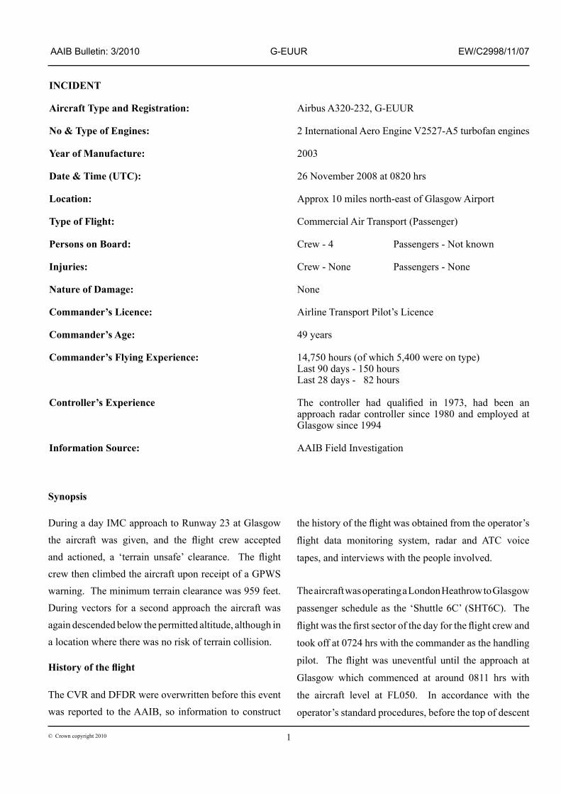
The controller had become involved in an exchange with an air ambulance flight and when he next looked at the radar G-EUUR was crossing the ILS centreline, but north of the ‘Campsie Line’ (Figure 1) and below the minimum altitude for that area. The controller had decided that, if he turned the aircraft further towards the ILS, it might still successfully intercept the localiser. He had then given a further radar heading of 200° as the aircraft passed slightly through the localiser; at this point the flight crew informed him of the GPWS go-around and that they were climbing to 5,000 ft on heading 320°. The controller had acknowledged this and once the aircraft was level he vectored it for a right base to a final approach at 12 miles.
The second approach
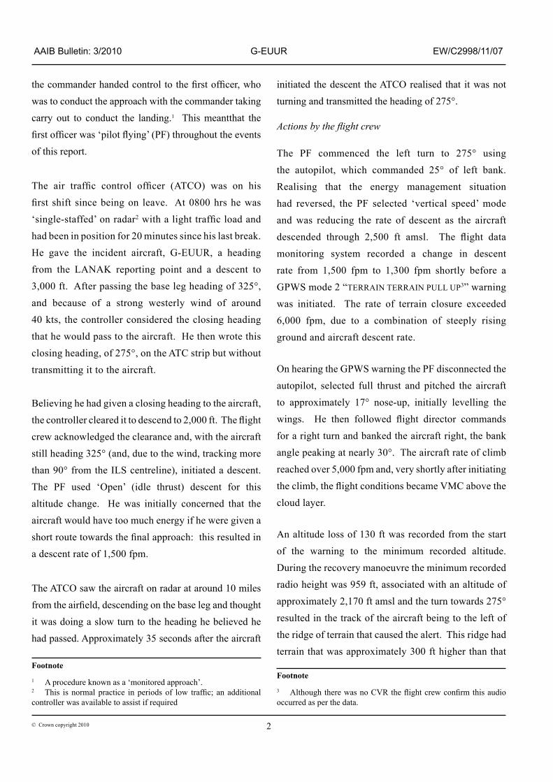
On receiving the GPWS warning the PF had climbed the aircraft to 5,000 ft, which was above the Minimum Safe Altitude (MSA) on the approach chart (Figure 2) of 4,900 ft. The crew levelled at 5,000 ft before being vectored for a second approach.
The controller then instructed a descent from 5,000 ft to 4,000 ft. At the point the clearance was issued this altitude was permitted on the controller’s terrain chart (Figure 3). However as the aircraft turned to the north north‑east the track was influenced by the 40 kt south-westerly wind. The resulting ground track took the aircraft into an area where the ATC terrain chart had an MSA of 4,500 ft. The controller did not recognise this second breach of ATC MSA. The flight crew were unaware that this descent had taken them
below radar MSA and were at this point outside the area covered by their approach charts.
Although below the MSA on the terrain chart, the aircraft remained ‘terrain safe’ throughout this second descent. Both the ATCO and the flight crew reported the incident using their separate safety reporting systems. However, both continued to operate their remaining duty that day and neither considered that the event had affected their subsequent performance.
ATC information
Glasgow ATC use the procedure of ‘write while you talk, read while you listen’. An instruction should be written on the ATC strip at the same time as it is transmitted to the aircraft; the controller then reads the ATC strip as the flight crew reads back the instruction. This confirms the instruction is correctly understood and then provides the controller with a quick reference as to the expected actions of the aircraft.
Figure 1
Radar ‘screen grab’ - Campsie Line & G-EUUR (SHT6C)
Campsie Line
4© Crown copyright 2010
AAIB Bulletin: 3/2010 G-EUUR EW/C2998/11/07
The ATCO was unable to explain why he had written the heading on the strip without having transmitted it and this was the first time he was aware of making this mistake. He could see no reason why he would have done so.
During interview the controller commented that once he realised the aircraft was north of the Campsie Line he should have sent it around rather than attempt to recover the approach.
Figure 2
Approach chart - ILS rwy 23
5© Crown copyright 2010
AAIB Bulletin: 3/2010 G-EUUR EW/C2998/11/07
Airport and terrain information
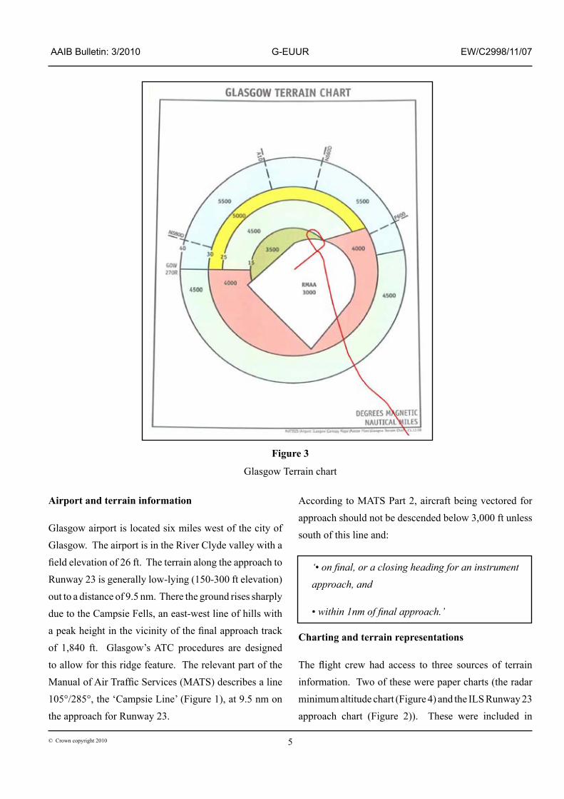
Glasgow airport is located six miles west of the city of Glasgow. The airport is in the River Clyde valley with a field elevation of 26 ft. The terrain along the approach to Runway 23 is generally low-lying (150-300 ft elevation) out to a distance of 9.5 nm. There the ground rises sharply due to the Campsie Fells, an east-west line of hills with a peak height in the vicinity of the final approach track of 1,840 ft. Glasgow’s ATC procedures are designed to allow for this ridge feature. The relevant part of the Manual of Air Traffic Services (MATS) describes a line 105°/285°, the ‘Campsie Line’ (Figure 1), at 9.5 nm on the approach for Runway 23.
According to MATS Part 2, aircraft being vectored for approach should not be descended below 3,000 ft unless south of this line and:
‘• on final, or a closing heading for an instrument approach, and
• within 1nm of final approach.’
Charting and terrain representations
The flight crew had access to three sources of terrain information. Two of these were paper charts (the radar minimum altitude chart (Figure 4) and the ILS Runway 23 approach chart (Figure 2)). These were included in
Figure 3
Glasgow Terrain chart
6© Crown copyright 2010
AAIB Bulletin: 3/2010 G-EUUR EW/C2998/11/07
the company approach plate booklets, The aircraft’s ground track has been overlaid on these figures. The
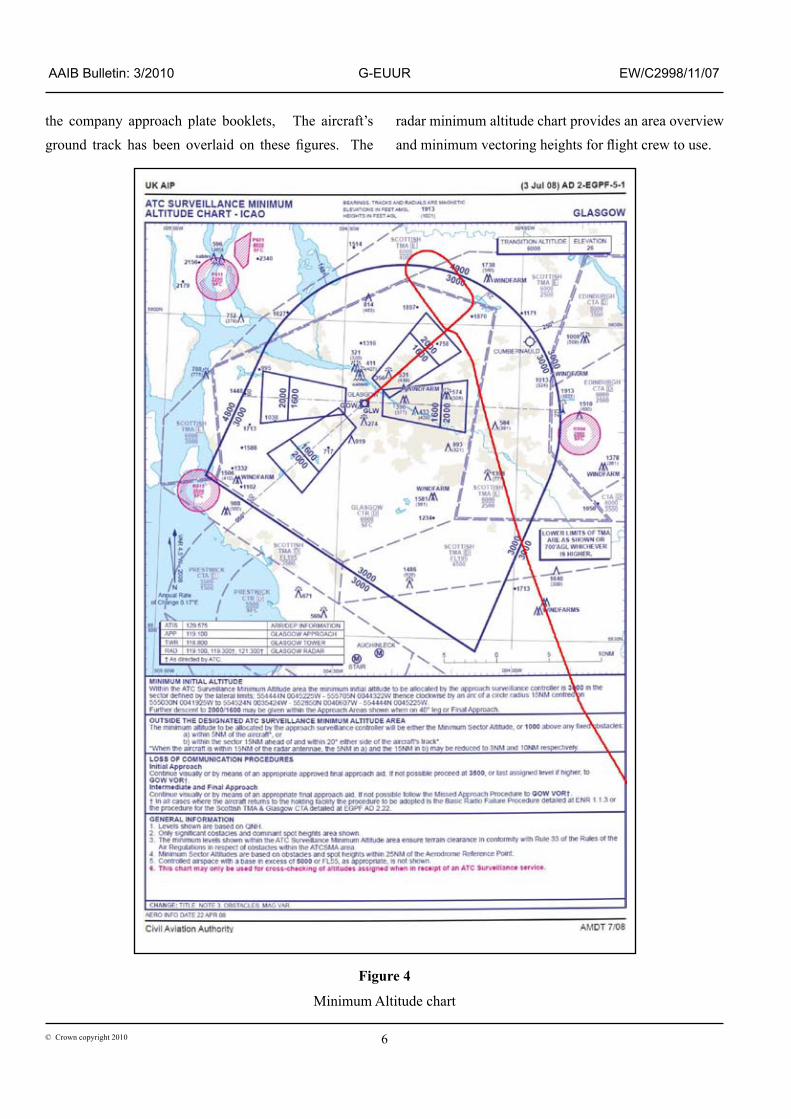
radar minimum altitude chart provides an area overview and minimum vectoring heights for flight crew to use.
Figure 4
Minimum Altitude chart
7© Crown copyright 2010
AAIB Bulletin: 3/2010 G-EUUR EW/C2998/11/07
The ILS RWY 23 chart shows the approach in detail and includes diagrammatic representations of the higher terrain in progressively darkening green. The side profile box provides greyed‑out minimum altitudes for the approach. Both these charts also include a 25 nm MSA, based on the GOW VOR, for emergency use. For the sector used this shows an MSA of 4,900 ft within 25 nm.
The flight crew’s third source of terrain information was the aircraft EFIS navigation display, which incorporates the EGPWS relative terrain display.
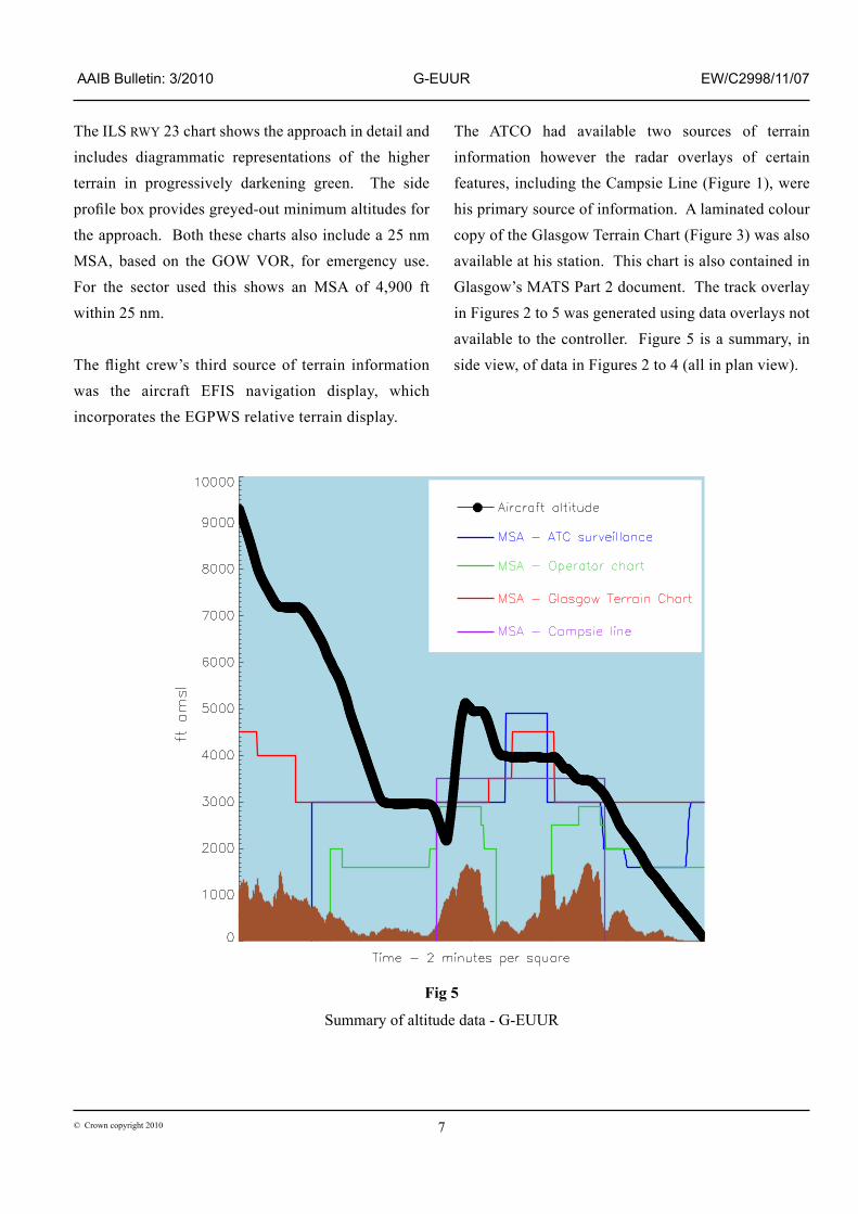
The ATCO had available two sources of terrain information however the radar overlays of certain features, including the Campsie Line (Figure 1), were his primary source of information. A laminated colour copy of the Glasgow Terrain Chart (Figure 3) was also available at his station. This chart is also contained in Glasgow’s MATS Part 2 document. The track overlay in Figures 2 to 5 was generated using data overlays not available to the controller. Figure 5 is a summary, in side view, of data in Figures 2 to 4 (all in plan view).
Fig 5
Summary of altitude data - G-EUUR
8© Crown copyright 2010
AAIB Bulletin: 3/2010 G-EUUR EW/C2998/11/07
Use of ATC Glasgow terrain chart
During the investigation an attempt was made, by a CAA Air Traffic Services Investigator (ATSI), the AAIB Inspector and a NATS ATC Manager, to locate accurately the incident aircraft on the ATC Glasgow terrain chart, using an ‘as live’ radar replay. The team found this chart difficult to use and were unable to perform the task satisfactorily.
Previous events
The CAA provided details of all the Mandatory Occurrence Reports (MORs) from all operators regarding ground proximity warnings at Glasgow Airport between 1 Jan 2000 and 29 December 2008. Of these events two, in 2005 and 2007, appear to have very similar characteristics to this incident. The remaining 26 reports appear to consist of ‘terrain safe’ aircraft GPWS warnings, triggered by rapid change of radio height. In the years 2003, 2004 and 2005 there were six, five and six reports respectively; this reduced to two events in each of 2006, 2007 and 2008.
Minimum Safe Altitude Warning (MSAW)
MSAW is a ground-based ‘safety net’ system for the prevention of controlled flight into terrain (CFIT), by generating alerts of infringement of minimum safe altitude to ATC to enable the controller to alert and redirect the aircraft. The system relies on transponder altitude reporting and, depending on the MSAW system, either ‘polygonal’ MSAs, a digital terrain map or a combination of both. MSAW requires considerable location‑specific configuration and is not, at the time of writing, widely used in Europe.
The radar system installed at Glasgow was fitted with the required hardware and software for MSAW functionality. However, at the time of the incident the
system had not had the required location‑specific work conducted, nor had it been approved for use. Initial work conducted by the service provider had shown a high number of false warnings generated by military and VFR traffic outside the control of Glasgow ATC, sufficient to render the system unsuitable for immediate deployment.
The current UK CAA position on MSAW was set out in a 2002 policy statement, that MSAW should be:
‘… encouraged where a reduction in risk of CFIT can be demonstrated and the presentation of warning information to air traffic controllers does not result in any detrimental impact to the routine provision of air traffic control services.’
The CAA has informed the AAIB that it intends to amend CAP 670 (Air Traffic Services Safety Requirements). This amendment is expected to alter the CAA’s position on MSAW significantly.
Analysis
ATC actions
The air traffic controller was experienced both in role and at Glasgow. Immediately following the incident the controller identified the initiating action of the incident: writing down the closing heading on the ATC slip without having transmitted it to ATC. This broke the concept of ‘write while you talk, read while you listen’. He then issued a descent clearance to the aircraft, without checking that the aircraft was in compliance with unit procedures: it was not south of the Campsie Line, on a closing heading and within one mile of the final approach track. The controller acknowledged that as he observed G-EUUR passing through the ILS centreline he should have sent the aircraft around and then vectored it for a further approach. As he attempted to provide vectors
9© Crown copyright 2010
AAIB Bulletin: 3/2010 G-EUUR EW/C2998/11/07
to recover the approach, the aircraft responded to the GPWS alert and was above the MSA very quickly.
With the initial situation resolved and the aircraft above the MSA, tracking north-west, the controller then instructed a descent from 5,000 ft to 4,000 ft. At the point the clearance was issued this altitude was permitted on the controller’s terrain chart. However as the aircraft turned to the north north‑east its track was influenced by the 40 kt south-westerly wind. The resulting ground track took the aircraft into an area where the ATC terrain chart had an MSA of 4,500 ft and the controller did not recognise this second breach of ATC MSA.
Flight crew actions
The flight crew believed they were being conservative in the speeds they were flying on the approach and felt the aircraft was “in the groove”, with no traffic or other stresses. The flight crew’s mental model was similar to that planned by the ATCO. They were unconcerned when given the descent clearance to 2,000 ft as they were anticipating that the controller would shortly issue them with a turn to intercept the ILS.
During a post-incident interview the commander expressed surprise that he had accepted the ATC clearance. He also commented that the normal competence and confidence displayed by the local ATCOs could engender a sense of security which, in this instance, was false.
The clearance to descend to 2,000 ft was issued at a time when the aircraft was at 90° to the ILS and tracking towards high ground with an MSA of 2,900 ft. Both flight crew were aware of the approximate position of the high ground but their mental models differed subtly. The PF was anticipating a tighter turn onto the ILS. His decision to use ‘open’ descent, with its higher rate
of altitude loss, reflected his concern that the aircraft had too much energy and might not remain below the glideslope. Had the descent clearance been followed immediately by a left turn towards the final approach track then this might have been a valid concern and the use of ‘open’ descent would have been prudent. However, as the aircraft remained on a heading of 325° ,the energy management situation reversed, so that a mode with a lower rate of descent would have been more appropriate. As such the PF was altering the vertical speed selector at the point where the GPWS alert started.
However, the flight crew did respond to the GPWS warning promptly and minimised further height loss. The extended turn to the right commanded by the flight directors had no effect on the terrain avoidance.
Conclusion
The terrain at Glasgow causes difficulties in descent and approach planning for both ATC and pilots. The ATC procedures in place will keep aircraft ‘terrain safe’ if followed accurately but records show that at least three arrivals in nine years have breached the Campsie Line below MSA.
In each case the actual ATC clearance, of 2,000 ft amsl, remained above the highest terrain, though safety margins were eroded. Thus, had the GPWS not operated in G-EUUR, or the crew not reacted to the warning, then this aircraft’s cleared flightpath would not have resulted in a ground collision. There would, however, have been less margin for any other error, such as a mis-set QNH or a ‘level bust’ in descent. In all the reported cases, and for the vast majority of public transport aircraft, GPWS/TAWS provides a high level of protection. MSAW offers additional protection from human error and extends this protection to any
10© Crown copyright 2010
AAIB Bulletin: 3/2010 G-EUUR EW/C2998/11/07
transponding aircraft, though its technical complexity and high numbers of inappropriate warnings mean that it is not available for immediate deployment at Glasgow. The air traffic service provider continues to work on a technical solution for MSAW and no Safety Recommendation is made.
Safety actions
Actions by the air traffic service provider (ATSP)
The ATSP is planning to conduct further work, including trials, to overcome the issues with MSAW at Glasgow. The ATSP has also initiated changes to the presentation of the Glasgow terrain chart to improve readability and accuracy.
The unit is due to convert to electronic flight strips and
new procedures relating to these will be utilised when
the conversion goes ahead.
Actions by the aircraft operator
The aircraft operator produced a training package for its
flight crews, relating to this incident. The package was
deployed in May 2009, including a video debrief and
simulator training.
Actions by the CAA
Before this incident occurred the CAA was already
reviewing their policy regarding MSAW.