2017 campus master plan - bothell - cascadia college
TRANSCRIPT

2017 Campus Master PlanUW BOTHELL | CASCADIA COLLEGE
DRAFT
J U LY 2 0 1 7

i2 0 1 7 C A M P U S M A S T E R P L A N : : U W B O T H E L L | C A S C A D I A C O L L E G E
2017 Campus Master PlanUW BOTHELL | CASCADIA COLLEGE
DRAFT
J U LY 2 0 1 7

iiiii T A B L E O F C O N T E N T S 2 0 1 7 C A M P U S M A S T E R P L A N : : U W B O T H E L L | C A S C A D I A C O L L E G ED R A F T
PURPOSE AND CONTEXT ............. 4
GUIDING PRINCIPLES .................. 6
CAMPUS GROWTH AND CAPACITY ........................... 8
CAMPUS VISION ....................... 12
Executive Summary
SECTION 01
SITE HISTORY ........................... 20
INSTITUTIONAL EVOLUTION ...... 22
TODAY’S CAMPUS (2017)........... 28
Site History andPlanning Context
SECTION 02
GROWTH AND DEVELOPMENT ......................... 34
FACILITIES BENCHMARKING ....................... 36
EXISTING CAMPUS PLAN ........... 38
Growth Profi le
SECTION 03
Campus Vision &Design Principles
SECTION 04
LONG-TERM CAMPUS VISION ......................... 42
NEAR-TERM DEVELOPMENT PLAN .................. 66
BUILT ENVIRONMENT AND OPEN SPACE FRAMEWORK .......... 68
MOBILITY FRAMEWORK ............ 100
UTILITIES AND INFRASTRUCTURE FRAMEWORK ............................ 122
Campus Design Review Process
SECTION 05
INSTITUTIONAL PROJECT REVIEW PROCESSES ..................142
TRANSPORTATIONMANAGEMENT PLAN ................144
Campus District Regulations
SECTION 06
Table of Contents
402 18 32 140
INDEX OF FIGURES .................... 158
ACKNOWLEDGEMENTS .............. 161
JURISDICTIONAL PROJECT REVIEW PROCESSES ................... 148
MITIGATION COMMITMENTS ...... 155
146
Appendix

32 S E C T I O N 1 | E X E C U T I V E S U M M A R Y 2 0 1 7 C A M P U S M A S T E R P L A N : : U W B O T H E L L | C A S C A D I A C O L L E G ED R A F T
Executive Summary
SECTION 01
2 S E C T I O N 1 | E X E C U T I V E S U M M A R Y
PURPOSE AND CONTEXT ........................................................... 4
GUIDING PRINCIPLES ................................................................ 6
CAMPUS GROWTH AND CAPACITY ............................................. 8
CAMPUS VISION ..................................................................... 12
32 0 1 7 C A M P U S M A S T E R P L A N : : U W B O T H E L L | C A S C A D I A C O L L E G E

54 S E C T I O N 1 | E X E C U T I V E S U M M A R Y 2 0 1 7 C A M P U S M A S T E R P L A N : : U W B O T H E L L | C A S C A D I A C O L L E G ED R A F T
4 S E C T I O N 1 | E X E C U T I V E S U M M A R YD R A F T
PURPOSE AND CONTEXT
In June of 2016, the University of Washington Bothell and Cascadia College initiated a new Campus Master Plan (CMP). Developed in coordination and cooperation with the City of Bothell and the community, this CMP establishes a shared Long-term Vision for the campus, serving as the basis for future development and regulatory action.
The CMP accounts for contiguous properties acquired or controlled by the institutions, which have been recently incorporated into the Campus District in the City of Bothell’s 2016 Comprehensive Plan Update.
The CMP defi nes a fl exible framework to guide land use, physical development and infrastructure investments. It establishes a campus-wide Development Allowance for academic building area in gross square feet (GSF Cap), distributed throughout campus within six unique Development Areas, and a Parking Allowance
Purpose and Context
outlining the maximum number of parking stalls provided on campus. It incorporates Development Standards that serve as the basis for jurisdictional evaluation and approval of future development.
The illustrative Long-term Campus Vision conceptualizes a campus that has realized the development capacity included herein. It is based upon current understanding of conditions affecting or infl uencing campus growth, and is presented with the full understanding that these conditions will change over time. The CMP establishes overarching Guiding Principles and more detailed Design Principles that complement the Development Standards and will inform and guide both design teams and campus design oversight processes, serving as the foundation for ultimate realization of the Campus Vision.
The CMP is organized into six Sections. Sections 1 through 4 review campus and institutional history and growth profi les, establish campus development capacity and culminate by detailing the Long-term Campus Vision and underlying Design Principles.
UW Bothell and Cascadia College internal review and approval processes for development projects and ongoing planning decisions are described in Section 5. Section 6 includes City of Bothell Development Regulations, a description of jurisdictional review and approval processes and detailed mitigation commitments negotiated during the CMP Process.
Collectively, these components of the CMP will provide clarity and transparency of both purpose and process for the long-term campus development for the University of Washington, Cascadia College and City of Bothell communities.

76 S E C T I O N 1 | E X E C U T I V E S U M M A R Y 2 0 1 7 C A M P U S M A S T E R P L A N : : U W B O T H E L L | C A S C A D I A C O L L E G ED R A F T
Guiding Principles
GUIDING PRINCIPLE NO. 1:
COHESIVE CAMPUS CHARACTER
GUIDING PRINCIPLE NO. 2:
DURABLE AND ADAPTABLE FACILITIES
The Guiding Principles identify a shared vision for actions and outcomes that meet multiple objectives to ensure that land use and capital investment decisions support the institutional missions of UW Bothell and Cascadia College. They were developed to guide both the planning process and implementation of the Campus Master Plan and are organized into six categories:
GUIDING PRINCIPLE NO. 3:
ENRICHED CAMPUS COMMUNITY EXPERIENCE
The physical setting of the campus
expresses the institutional values and
commitment to educational excellence,
with regard to contextual integration
within the surrounding community and
region. The architectural expression of
buildings, landscapes and circulation
patterns should be context-driven to
enhance the character and quality of
the campus while retaining the identity
of each institution and providing a
welcoming and user-friendly experience
for fi rst-time and daily users.
Ongoing demands to maximize the
versatility of space must be considered
in the design of academic buildings to
meet evolving program needs. Buildings
should be designed with fl exible interiors
to allow for the reconfi guration of space
over time without major structural or
utility modifi cations and infrastructure
should be provided to meet current and
future technology needs.
Providing a vibrant, student-centered
campus with ease of access and amenities
that encourage the interdisciplinary
exchange of ideas and discovery is
vital to achieving academic excellence.
Maximizing resources and co-location
opportunities to meet the needs of
commuting and residential students
through inclusiveness and equity will
enrich the student experience. Providing
resources and co-location opportunities
for faculty and staff to socially and
academically interact with each other and
with students will help enhance a culture
of learning, innovation and partnership.
GUIDING PRINCIPLE NO. 6:
MOBILITY, ACCESS AND SAFETY
GUIDING PRINCIPLE NO. 4:
ENHANCED ENVIRONMENTAL AND HUMAN HEALTH
GUIDING PRINCIPLE NO. 5:
INTEGRATION WITH THE CITY OF BOTHELL
Safe, effi cient, and effective movement
of people and vehicles (including
personal, service, emergency and transit)
to and through campus requires regular
monitoring and management. Suffi cient
and appropriately located parking,
transit connectivity, universally accessible
pathways, and intentionally designed
intersections and crossings are necessary
both on and off campus, requiring close
collaboration with the City of Bothell
and local transit agencies.
The commitment of both UW Bothell
and Cascadia College to environmental
protection, sustainability, and the well-
being of students, staff, faculty, and
the surrounding community is integral
to the Campus Master Plan. Energy
conservation, natural daylight and
ventilation, effi cient use of resources,
preservation of environmentally valuable
features, and a mix of vibrant and
passive open spaces are all means of
enhancing the environmental and human
health of campus and community. The
campus’ environmental resources and
critical habitats will continue to be
managed in a manner that promotes
academic, research and partnership
opportunities for UW Bothell, Cascadia
College and the community-at-large.
Considerations for enrollment growth
of UW Bothell and Cascadia College
and the physical development of the
campus to meet space needs require
close collaboration and connectivity
with the City of Bothell’s long-range
vision. Development along the edges of
campus should acknowledge, and where
appropriate, complement adjacent uses
relative to scale and proximity. Pedestrian
and bicycle connections between the
campus and downtown core should
continue to be strengthened.

98 S E C T I O N 1 | E X E C U T I V E S U M M A R Y 2 0 1 7 C A M P U S M A S T E R P L A N : : U W B O T H E L L | C A S C A D I A C O L L E G ED R A F T
The Campus Area Summary (Figure 1-1) details both existing conditions and anticipated space needs for UW Bothell and Cascadia College, guiding the establishment of a Development
Allowance (GSF Cap) for campus of
1,800,000 GSF under this Campus Master Plan. This equates to 1,042,368
Net New GSF of campus Academic Uses (excludes parking facilities). The resulting net new GSF cap assumes that functions currently housed in off-site leased space would be accommodated on campus in the Long-term Campus Vision buildout.
For the purposes of the CMP, facilities supporting Academic Uses are defi ned as “all facilities which relate to and support instruction and research and the needs of students, faculty and staff.” The Campus Master Plan Development Allowance incorporates the assessed needs for both non-housing related academic space and on-site student housing to accommodate 10,000 on-campus student FTE, consistent with original enrollment targets established by the state legislature.
Academic space needs (excluding housing) were evaluated based on benchmark data comparing total Gross Square Feet (GSF) to on-campus student full-time equivalents (FTE) from peer institutions of both UW Bothell and Cascadia College. This key metric is represented as GSF/FTE. For planning purposes, a target benchmark of 150 GSF/FTE was established based on peer data research (see Figure 3-3, page 36).
The combined UW Bothell and Cascadia College metric of 94 GSF/FTE falls well below the planning benchmark of 150 GSF/FTE suggesting that current facilities are undersized for the existing enrollment, and supporting anecdotal stakeholder input that programs are currently “bursting at the seams” of existing facilities. This also suggests that near-term facility development is needed to ‘decompress’ the use of existing facilities in order to better serve current programs and enrollment levels. At the same time, bringing off-campus uses back onto campus is desirable to maximize operational effi ciencies and pedagogical engagement.
On-site student housing needs were determined to accommodate ten to twenty percent (10-20%) of the UW Bothell student population. Assuming a total UW Bothell enrollment of 6,000 FTE, a student housing allowance of 300,000 GSF is established to support between 600-1,200 student residents on campus in a mix of traditional and apartment style housing.
DEVELOPMENT ALLOWANCE (GSF CAP)
Campus Growth & Capacity
ACADEMIC
OFF
CA
MP
US:
46
,13
7 G
SF
ON
CA
MP
US:
68
3,4
80
GSF
FIGURE 1-1:CAMPUS AREA SUMMARY
TOTAL: 849,906 GSF
TOTAL: 1,800,000 GSF(NET TOTAL ADDITIONAL GSF ON CAMPUS: 1,042,368 GSF)
NE
T N
EW
: 2
25
,84
8 G
SF
EXISTING CONDITIONS (FALL 2016 ENROLLMENT)
NE
T N
EW
: 8
16
,52
0 G
SF
HOUSING
OFF
CA
MP
US:
16
,20
0 G
SF
ON
CA
MP
US:
74
,15
2 G
SF
ACADEMIC150,000 GSF(ON CAMPUS)
HOUSING300,000 GSF(ON CAMPUS)
EX
IST
ING
:6
83
,48
0 G
SF
LONG-TERM CAMPUS VISION
10,000 FTE STUDENTS 150 GSF PER FTE STUDENT
(PER BENCHMARK)
7,846 FTE STUDENTS 93 GSF PER FTE STUDENT
EXIS
TIN
G:
74,1
52 G
SF
FIGURE 1-2:LONG-TERM CAMPUS VISION
Existing Buildings
New Buildings
Pedestrian Pathways
GRAPHICS ARE FOR ILLUSTRATIVE PURPOSES ONLY

1110 S E C T I O N 1 | E X E C U T I V E S U M M A R Y 2 0 1 7 C A M P U S M A S T E R P L A N : : U W B O T H E L L | C A S C A D I A C O L L E G ED R A F T
GRAPHICS ARE FOR ILLUSTRATIVE PURPOSES ONLY
FIGURE 1-4:PARKING DISTRIBUTION RANGES, EXISTING AND CAMPUS VISION
Parking Stall Quantity (Range)
Development Area Boundary
Developable Campus Area
North Creek Wetland Buffer
North Creek WetlandDEVELOPMENT AREAS
To ensure development is equitably distributed across campus with a desirable mix of buildings and open space, the campus is divided into six Development Areas (A-F, fi gure 1-3).
Each area is assigned a maximum net new GSF Development Area Cap (shown below), the sum of which exceeds the CMP Development Allowance GSF. This provides campus-wide fl exibility for locating new development relative to building adjacencies and programmatic needs, allowing the campus to be nimble in adapting to current and future opportunities and demands. All Academic Uses are permitted in every Development Area, with the exception of student housing which is not permitted on land owned by UW Bothell/CC within Development Area C.
Future building development is not permitted within the Wetland or Wetland Buffer areas. Trails, boardwalks or other features to enable pedestrian access to Wetland areas may be permitted.
PARKING ALLOWANCE
UW Bothell and Cascadia College currently utilize 2,292 on-campus parking stalls and an additional 158 stalls associated with nearby leased properties. Based on past and ongoing analysis, a
Parking Allowance of 4,200 total stalls
on campus is established as a planning assumption for 10,000 FTE. This equates to 1,708 net new parking stalls to support the Long-term Campus Vision.
Figure 1-4 indicates potential parking distribution ranges (in stalls) for anticipated parking zones on campus. Parking would be a mix of surface and structured lots.
The original 1995 Campus Master Plan predicted a total future parking demand of 4,200-6,600 parking stalls to support 10,000 student FTE. Annual on campus traffi c utilization studies have demonstrated steadily decreasing parking demand rates over time, largely due to increased transit service and use, resulting in a presumed total need signifi cantly less than originally anticipated.
MAXIMUM NET NEW GSFPER DEVELOPMENT AREA
A 293,100 GSFB 407,200 GSFC 144,800 GSFD 295,900 GSFE 425,800 GSFF 10,000 GSF
FIGURE 1-3:DEVELOPMENT AREAS

1312 S E C T I O N 1 | E X E C U T I V E S U M M A R Y 2 0 1 7 C A M P U S M A S T E R P L A N : : U W B O T H E L L | C A S C A D I A C O L L E G ED R A F T
Campus VisionLONG-TERM CAMPUS VISION: REINFORCE CORE & GROW NORTH
The illustrative plan shown in fi gure 1-5 represents the Long-term Campus Vision for UW Bothell and Cascadia College.
The CMP focuses near-term development at the campus core while seeking to grow northward over time, strategically leveraging the development capacity and potential of campus property immediately south of Beardslee Boulevard and west of NE 110th Street to strengthen connections to downtown Bothell and create a new front door to campus. This northward growth generally follows campus topography, emphasizing equitable access for all campus users in a wide range of pedestrian and transportation modes.
The Campus Master Plan establishes a set of Design Principles for new development illustrated through a series of frameworks relative to the Built Environment and Open Space, Mobility, and Utilities and Infrastructure. These Design Principles evolve from, reinforce and support the Guiding Principles.
UW BOTHELL FACILITIES (EXISTING)
1. UW1 (Founders Hall)2. UW2 (Commons Hall)3. UW3 (Discovery Hall)5. Sarah Simonds Green Conservatory
CASCADIA COLLEGE FACILITIES (EXISTING)
6. CC17. CC28. CC3
SHARED FACILITIES (EXISTING)
9. Chase House10. Truly Ranch House11. Central Utility Plant 12. Library 113. Library 214. Library Annex15. Activity & Recreation Center (ARC)16. North Creek Event Center
PROPOSED FACILITIES
18. Corporation Yard19. Residence Hall/Campus Dining20. Academic Building (UW4)21. Library Expansion22. ARC Expansion23. Potential Residence Hall24. Academic Building (CC4)25. Academic Building26. Academic Building27. Academic Building28. Satellite Physical Plant29. Academic/Housing30. Academic Building31. Academic/Housing
SHARED STRUCTURED PARKING (EXISTING)
A. South Parking GarageB. North Parking Garage
PROPOSED SHARED STRUCTURED PARKING
C. South Parking Garage ExpansionD. West Parking Garage
FIGURE 1-5:LONG-TERM CAMPUS VISION PLAN KEY
A
C
D
9
11
2
3
1
12
13
5
10 14
15 2321
25
2627
28
2930
31
22
16
6
24
78
18
19
20
B
Throughout the CMP, Long-term Campus Vision graphics are labeled “for illustrative purposes only.” UW Bothell and Cascadia College recognize that myriad factors and conditions infl uencing campus development will change signifi cantly over time.
The CMP identifi es and refl ects a current understanding of such factors and conditions. While future campus development will follow the Design Principles and Development Regulations included herein, it is a certainty that the campus plan that evolves over time will ultimately differ from this Long-term Campus Vision.
FIGURE 1-5:LONG-TERM CAMPUS VISION PLAN
Existing Buildings
New Buildings
Pedestrian Pathways
GRAPHICS ARE FOR ILLUSTRATIVE PURPOSES ONLY
19

1514 S E C T I O N 1 | E X E C U T I V E S U M M A R Y 2 0 1 7 C A M P U S M A S T E R P L A N : : U W B O T H E L L | C A S C A D I A C O L L E G ED R A F T
UW BOTHELL FACILITIES (EXISTING)
1. UW1 (Founders Hall)2. UW2 (Commons Hall)3. UW3 (Discovery Hall)4. Husky Village5. Sarah Simonds Green Conservatory
CASCADIA COLLEGE FACILITIES (EXISTING)
6. CC17. CC28. CC3
SHARED FACILITIES (EXISTING)
9. Chase House10. Truly Ranch House 11. Central Utility Plant 12. Library 113. Library 214. Library Annex15. Activity & Recreation Center (ARC)16. North Creek Event Center
PROPOSED FACILITIES
18. Corporation Yard19. Residence Hall/Campus Dining20. Academic Building (UW4)22. ARC Expansion24. Academic Building (CC4)
UW LEASED FACILITIES (EXISTING)
L1. Husky HallL2. Beardslee BuildingL3. Beardslee Crossing
SHARED STRUCTURED PARKING
A. South Parking GarageB. North Parking Garage
>FIGURE 1-6:NEAR-TERM DEVELOPMENT PLAN KEY
NEAR-TERM DEVELOPMENT PLAN
The CMP includes a Near-term Development Plan that identifi es a handful of projects assumed to be completed in the next six to ten years as funding becomes available. The University of Washington Bothell and Cascadia College receive funding for academic buildings from the state legislature. The funding for higher education is diffi cult to acquire and oversubscribed with substantial needs across the State of Washington. During the past ten years, UW Bothell and Cascadia College received funding for only one academic building each, and it is anticipated that each institution would continue to receive funding at a similar pace in the future. A small number of projects are funded by alternative sources, primarily supporting student life and minor improvements.
CAMPUS DESIGN REVIEW PROCESS
CAMPUS DISTRICT REGULATIONS
Sections 5 and 6 of the Campus Master Plan outline the processes and regulations that will guide proposed development within the campus boundaries.
Campus Design Review Processes (Section 5) describes internal campus review and approval processes and is included to provide clarity around the alignment of these processes with jurisdictional review and approval processes as described in Section 6. The purpose of the Campus District Regulations is to:
:: Protect and promote public health, safety and general welfare, and to guide the use of land consistent with the goals and vision of the University of Washington Bothell’s and Cascadia College’s Campus Master Plan (CMP).
:: Increase awareness of land use activities and their impacts, and to coordinate necessary review processes.
:: Provide adequate light, air, access, and open space; conserve the natural environments; maintain a compatible scale within a campus development area; and enhance the pedestrian and streetscape environment.
:: Seek to achieve an effi cient use of campus property without major disruption of the natural environment and to organize development to serve students, faculty and staff.
:: Establish a process and criteria for determining measures required to mitigate development impact.
While Design Principles seek to support the Guiding Principles, Campus District Regulations defi ne conformance with, or departure from City of Bothell Municipal Code relative to allowed uses, building orientation, height limits, buffers, setbacks, maximum GSF per Development Area, vegetation, light and glare, building modulation, noise, odors, parking, wetland restoration, public realm, signs and banners, storm water, telecommunications, temporary facilities, and tree retention and replacement.
A
9
11
2
31
12
13
5
10 14
15
L1
L2
L3
4
22
16
6
78
24
18
19
20
B
FIGURE 1-6:NEAR-TERM DEVELOPMENT PLAN
Existing Buildings
New Buildings
Pedestrian Pathways
GRAPHICS ARE FOR ILLUSTRATIVE PURPOSES ONLY
19
1716 S E C T I O N 1 | E X E C U T I V E S U M M A R Y 2 0 1 7 C A M P U S M A S T E R P L A N : : U W B O T H E L L | C A S C A D I A C O L L E G ED R A F T
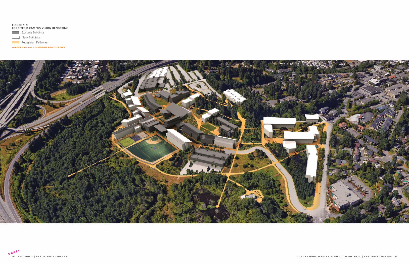
FIGURE 1-7:LONG-TERM CAMPUS VISION RENDERING
Existing Buildings
New Buildings
Pedestrian Pathways
GRAPHICS ARE FOR ILLUSTRATIVE PURPOSES ONLY

1918 S E C T I O N 2 | S I T E H I S T O R Y A N D P L A N N I N G C O N T E X T 2 0 1 7 C A M P U S M A S T E R P L A N : : U W B O T H E L L | C A S C A D I A C O L L E G ED R A F T
Site History andPlanning Context
SECTION 02
18 S E C T I O N 2 | S I T E H I S T O R Y A N D P L A N N I N G C O N T E X T
SITE HISTORY ......................................................................... 20
INSTITUTIONAL EVOLUTION .................................................... 22
TODAY’S CAMPUS (2017)......................................................... 28
192 0 1 7 C A M P U S M A S T E R P L A N : : U W B O T H E L L | C A S C A D I A C O L L E G E

2120 S E C T I O N 2 | S I T E H I S T O R Y A N D P L A N N I N G C O N T E X T 2 0 1 7 C A M P U S M A S T E R P L A N : : U W B O T H E L L | C A S C A D I A C O L L E G ED R A F T
That year, Canadian lumberman George Brackett purchased the fi rst several timber parcels and launched a logging operation. He fl oated his logs into the river from the north bank of the river and the logging camp became Brackett’s Landing. A Mr. Allen built a store, and in 1885 residents built a school. A sawmill rose at Brackett’s Landing in 1887. Logging would be a mainstay of the community economy until the early 1910s.”
Bothell – Thumbnail History,Historylink.org Essay, David Wilma, 2003 http://www.historylink.org/File/419
EARLY SETTLEMENT
“The earliest known residents of the Sammamish River and what would become Bothell were a Native American tribe that called themselves s-tsah-PAHBSH or “willow people.” These were members of a larger group called hah-chu-AHBSH or “people of the lake” and the Duwamish Tribe. The Willow People built a permanent settlement of cedar longhouses they called tlah-WAH-dees along a river the Americans would call Squak and Sammamish at the north end of Lake Washington.
The Sammamish River -- also called Sammamish Slough and Squak Slough -- remained unoccupied until the summer of 1870 when Columbus S. Greenleaf and George R. Wilson fi led claims and built cabins. By 1876, eight families had settled along the banks of the river, which meandered between Lake Sammamish and Lake Washington through marshes.
Site History
FIGURE 2-2: BOTHELL, CIRCA 1890
University of Washington Bothell and Cascadia College are co-located on a 135-acre site approximately a half-mile east of downtown Bothell core, adjacent to the intersection of State Route 522 and Interstate 405. The campus and its resident institutions are unique in the State of Washington in terms of both physical setting and planning history. This section provides a high level historical summary, to serve as a basis of understanding the history of this site and the evolution of the co-located campus development.
FIGURE 2-1: HISTORICAL MAP, 1895 (SOURCE: USGS)
PRE BOTHELL INCORPORATION
By the end of the nineteenth century, non-indigenous settlement of Bothell was underway. The Bothell Pioneer Cemetery had been established a decade earlier in 1889. The primary economy relied on logging and emerging agricultural uses. The lowland areas of the present-day campus, along North Creek, were marshy wetlands.
A railway spur built to move coal swept past the campus along what is now Beardslee Boulevard, around to the north side of Beckstrom Hill (see Figure 2-1).
The route of NE 180th Street heading southward at 113th Avenue NE had already been established as a primary road eastward out of Bothell and towards Woodinville. The Chase House was constructed along this road in 1885.
FIGURE 2-4: MAIN STREET, BOTHELL, 1955
INCORPORATION THROUGHPOST-WAR
The town of Bothell, named after a Pennsylvania settler, was incorporated in 1909. By the mid-1930’s, signifi cant logging of the region had occurred, and a majority of the present-day campus had been cleared, as had the area now referred to as the Sunrise Valley View (SVV) neighborhood and Beckstrom Hill north of Beardslee Boulevard (then P.N. Frease Road). North Creek had been channelized and the marshy wetlands largely converted to agricultural use.
By 1954 (fi gure 2-3), the urban center of Bothell had grown outward. More auto-oriented residential developments had begun forming in the Sunrise Valley View neighborhood, and new residential streets had emerged on Beckstrom Hill. A large stand of trees still straddled the future west campus property line on the wooded uplands, mostly following the steeper topography down the hill. Another stand of trees remained at the eastern base of the hill near the Chase House.
FIGURE 2-3: AERIAL PHOTOGRAPH OF SITE, 1954
MARSHY WETLANDS
PRESENTCAMPUSNE 180TH
NO
RT
H C
REEK
RA
IL S
PU
R
CHASEHOUSE
SUNRISE VALLEY VIEW
BECKSTROM HILL
BOTHELL PIONEER CEMETERY
STANDS OF TREES

2322 S E C T I O N 2 | S I T E H I S T O R Y A N D P L A N N I N G C O N T E X T 2 0 1 7 C A M P U S M A S T E R P L A N : : U W B O T H E L L | C A S C A D I A C O L L E G ED R A F T
Institutional EvolutionCO-LOCATION
The creation of the UW Bothell and Cascadia College campus was a result of state-wide planning efforts in the late 1980’s to address regional population growth and increasing demand for post-secondary education.
In 1989, the Washington State Legislature authorized the creation of two upper division UW branch campuses (Tacoma and Bothell) in order to address “insuffi cient and inequitable access to upper division baccalaureate education” within the state. In 1990, UW Bothell was founded, holding its fi rst classes in leased space in the Canyon Park Business Center, with a student enrollment of 126 and 13 founding faculty.
Also in 1990, the State Board for Community and Technical Colleges (SBCTC) identifi ed north King County and south Snohomish County as encompassing an area with the most signifi cant recent growth combined with the least access to a community college. Cascadia Community College was founded in 1994 and remains the youngest college in the system.
A study by the Washington State Higher Education Coordination Board (HECB) led to a recommendation to co-locate the new community college with UW Bothell in an innovative partnership to deliver both higher education and workforce training within the same geographic area, using land judiciously and realizing cost savings through shared amenities. A separate SBCTC study identifi ed the Boone-Truly Ranch in Bothell as the preferred site for a new community college. These recommendations led to the completion of the fi rst Campus Master Plan (CMP) in 1995. This CMP envisioned a shared campus on the Boone-Truly Ranch site and guided the initial phases of campus development.
In 1996, a portion of the 500-acre Boone-Truly Ranch (Figure 2-6) was sold to the State of Washington. The upland portions of this 128-acre plot (since expanded) of picturesque land overlooked what would become restored and protected wetlands and encompassed views of the Cascade mountain range beyond.
In 2006, the Washington State Legislature changed the mission of the UW branch campuses to full four-year institutions.In 2014, ‘Community’ was dropped from the name, and in 2015 Cascadia College offered its fi rst Baccalaureate programs.
The 1995 CMP included many goals
that remain relevant today, including:
:: Create one sense of place while balancing each institution’s identity
:: Integrate campus and natural resource functions
:: Leverage natural resources: restoration, preservation, research, education
:: Provide accessible, multi-modal transportation options
:: Connect hillside & lowland areas with vegetation & buildings
:: Provide fl exible and adaptable facilities
:: Foster partnerships and connections with the Bothell community
FIGURE 2-5: TRULY RANCH HOUSE, ORIGINAL LOCATION
1998
In 1995, the State of Washington purchased the large Boone-Truly Ranch in Bothell, in order to co-locate (then small) UW Bothell with Cascadia College. As planning was underway, the Truly Ranch House was relocated to its present location to make way for the central campus promenade. While the Chase House remained in its present location, 21 existing structures, and their site infrastructure were demolished to make way for the campus.
FIGURE 2-6: AERIAL PHOTOGRAPH OF SITE, 1998
UW Bothell and Cascadia College also embarked on an ambitious project to restore former cattle-grazing pastures to the wetland that once existed. This included a massive engineering effort to redirect North Creek from the straight channel, to a naturally-shaped river delta; bounded by I-405 on its east edge and the natural topography of the campus hill on the west, the wetland restoration was the largest project of its kind in Washington State at the time.
The original campus property did not include the Husky Hall building, the “Marvin properties” to the west, or Husky Village. NE 185th Street provided direct pedestrian and bicycle access between downtown Bothell and the site.
NO
RT
H C
REEK
STATE ROUTE 522
INTER
STATE 4
05
NE 195TH ST
BEARDSL
EE B
LVD
10
8T
H A
VE
NE
NE 185TH ST
TRULY RANCH HOUSE RELOCATION
CHASE HOUSE
FUTURE CAMPUSEXPANSION AREA

2524 S E C T I O N 2 | S I T E H I S T O R Y A N D P L A N N I N G C O N T E X T 2 0 1 7 C A M P U S M A S T E R P L A N : : U W B O T H E L L | C A S C A D I A C O L L E G ED R A F T
2002
The early 2000s marked the most intensive period of construction activity in the campus’ history, including completion of the North Creek restoration project (2002) and commencement of fi rst phase of campus development. Over 400,000 gross square feet of academic buildings were constructed along with two parking garages. A primary vehicle entrance was constructed off of Beardslee Boulevard, creating a level route through the site along Campus Way, connecting the north and south garages.
FIGURE 2-7: AERIAL PHOTOGRAPH OF SITE, 2002
In addition to the south garage, the entire property south of NE 180th Street was cleared to accommodate extensive surface parking lots and a central utility plant (CUP). This initial infrastructure investment has shaped a number of the development decisions in this Campus Master Plan.
The fi rst phase of construction oriented campus buildings along the topography. UW1 and CC1 were placed along the west side of Campus Way, while fronting and defi ning a new Campus Promenade to the west, the central pedestrian spine of the new campus.
2012
In 2009, WSDOT widened the south entrance with an exit ramp and signalized intersection with SR-522. The work required a substantial soil nailed retaining wall and hillside excavation to allow for the six-lane curved drive and pedestrian walkway. Also completed in 2009, CC3 became the third Cascadia College building.
FIGURE 2-8: AERIAL PHOTOGRAPH OF SITE, 2012
Starting in 2011, UW Bothell purchased and began leasing adjacent properties to accommodate the rapidly growing student population. This includes: the 2011 purchase of Husky Village (student housing); the 2011 lease of the Campus View Apartments across Beardslee Boulevard; the 2011 lease-option of Beardslee Professional Building (classrooms); the lease of Beardslee Crossing (Administrative Offi ces); the 2012 lease-option of Husky Hall (a small offi ce building to the south of NE 185th); and a warehouse along SR-522 (storage with loading dock access).
NO
RT
H C
REEK
NO
RT
H C
REEK
NEW CUP
NEW SOUTHENTRANCE
LEASEDWAREHOUSE
STATE ROUTE 522
INTER
STATE 4
05
NE 195TH ST
BEARDSL
EE B
LVD
10
8T
H A
VE
NE
NE 185TH ST
STATE ROUTE 522
INTER
STATE 4
05
NE 195TH ST
BEARDSL
EE B
LVD
10
8T
H A
VE
NE
NE 185TH ST
NEW NORTHENTRANCE
SU
RFA
CE
PA
RK
ING
CAMPUS WAY
HUSKYVILLAGE
HUSKYHALL
BEARDSLEEPROFESSIONAL BUILDING
CAMPUS PROMENADE

2726 S E C T I O N 2 | S I T E H I S T O R Y A N D P L A N N I N G C O N T E X T 2 0 1 7 C A M P U S M A S T E R P L A N : : U W B O T H E L L | C A S C A D I A C O L L E G ED R A F T
CC
-1 &
CC
-2 O
PE
N;
CLA
SSE
S A
T N
EW
CA
MP
US B
EG
INS
UW
BO
TH
ELL
FO
UN
DE
D
FIR
ST
CLA
SSE
S H
ELD
AT
CA
NY
ON
PA
RK
BU
SIN
ESS C
EN
TE
R
FIR
ST
GR
AD
UA
TE
S
EN
RO
LLM
EN
T R
EA
CH
ES 1
,00
0
UW
B-2
OP
EN
S
1989 1990 1991 1992 1993 1994 1995 1996 1997 1998 1999 2000 2001 2002
CA
SC
AD
IA C
OM
MU
NIT
Y C
OLL
EG
E F
OU
ND
ED
BO
ON
E-T
RU
LY R
AN
CH
P
UR
CH
ASE
D
NE
W C
AM
PU
S C
ON
ST
RU
CT
ION
BE
GIN
S
UW
B-1
OP
EN
S;
CLA
SSE
S A
T
NE
W C
AM
PU
S B
EG
INS
LIB
RA
RY
1/A
NN
EX
, P
HY
SIC
AL
PLA
NT,
N &
S
PA
RK
ING
OP
EN
LIB
RA
RY-2
OP
EN
S
RE
STO
RA
TIO
N O
F N
OR
TH
C
RE
EK
WE
TLA
ND
ESTA
BLI
SH
ED
1989 1990 1991 1992 1993 1994 1995 1996 1997 1998 1999 2000 2001 2002
FIR
ST
2-Y
EA
R G
RA
DU
AT
ES (
AA
)
FIGURE 2-9: CAMPUS TIMELINE
SAR
AH
SIM
ON
DS
GR
EEN
CO
NSE
RV
ATO
RY
OP
ENS
SP
OR
TS &
RE
CR
EA
TIO
N C
OM
PLE
X O
PE
NS
10
,00
0 G
RA
DU
AT
ES;
HU
SK
Y V
ILLA
GE
(H
OU
SIN
G)
AC
QU
IRE
D
FIR
ST
FR
ESH
MA
N C
LASS G
RA
DU
AT
ES
FIR
ST
ST
UD
EN
T H
OU
SIN
G (
CA
MP
US V
IEW
)
20
-YE
AR
AN
NIV
ER
SA
RY
5,0
00
GR
AD
UA
TE
S
4-Y
EA
R P
RO
GR
AM
BE
GIN
S
AR
C O
PE
NS
2003 2004 2005 2006 2007 2008 2009 2010 2011 2012 2013 2014 2015 2016 2017
2003 2004 2005 2006 2007 2008 2009 2010 2011 2012 2013 2014 2015 2016 2017
CC
-3 O
PE
NS
NA
ME
CH
AN
GES T
O C
ASC
AD
IA C
OLL
EG
E
BA
CC
ALA
UR
EA
TE D
EG
RE
ES O
FFE
RE
D2
5-Y
EA
R A
NN
IVE
RSA
RY
CC
-3 B
UIL
DIN
G E
AR
NS L
EE
D
PLA
TIN
UM
CE
RT
IFIC
AT
ION
FO
OD
FO
RE
ST
AN
D P
OLL
INA
TIO
N
GA
RD
EN
IN
STA
LLE
D
FIR
ST
4-Y
EA
R G
RA
DU
AT
ES
DIS
CO
VE
RY
HA
LL O
PE
NS
UW
BO
THEL
LSH
ARE
DC
ASC
AD
IA C
OLL
EGE

2928 S E C T I O N 2 | S I T E H I S T O R Y A N D P L A N N I N G C O N T E X T 2 0 1 7 C A M P U S M A S T E R P L A N : : U W B O T H E L L | C A S C A D I A C O L L E G ED R A F T
Today’s Campus (2017)
FIGURE 2-10: AERIAL PHOTOGRAPH OF SITE, 2017
Between 2012 and 2015, the campus added UW Bothell’s Discovery Hall, a STEM lab and classroom building; UW Bothell’s Sarah Simonds Green Conservatory (SSGC); and shared student life amenities, such as the Activities and Recreation Center (ARC) and the adjacent sports complex.
Additional facilities are in the planning or funding request phases and include:
UW4 Academic Building
CC4 Academic Building
UW Bothell Student Housing and Dining
Corporation Yard (shared)
Parking (shared, structured and/or surface)
FIGURE 2-11: VIEW OF DISCOVERY HALL FROM CRESCENT WALK
292 0 1 7 C A M P U S M A S T E R P L A N : : U W B O T H E L L | C A S C A D I A C O L L E G E
ARC
DISCOVERY HALL
SSGC
BEA
RD
LEE
CRO
SSIN
G
NO
RT
H C
REEK
SPORTSCOMPLEX
STATE ROUTE 522
INTER
STATE 4
05
NE 195TH ST
BEARDSL
EE B
LVD
10
8T
H A
VE
NE

3130 S E C T I O N 2 | S I T E H I S T O R Y A N D P L A N N I N G C O N T E X T 2 0 1 7 C A M P U S M A S T E R P L A N : : U W B O T H E L L | C A S C A D I A C O L L E G ED R A F T
Campus Zone (C)
General Downtown Corridor (GDC)
Downtown (DN)
Residential (R)
Public Park and Open Space (PPOS)
Offi ce Park (OP)
Minimum Building Setback
Height-conditioned Setback and Landscape Buffer
Campus Landscape
Wetland Buffer
Wetland
JURISDICTIONAL CONTEXT
The UW Bothell/Cascadia College campus was developed under a Planned Unit Development (PUD) fi nalized with City of Bothell in 1998. The PUD established the development requirements and review and approval criteria for any proposed development on campus and has since been modifi ed six separate times as development occurs. The CMP will serve, in conjunction with a development agreement with City of Bothell, as the primary tool governing jurisdictional, evaluation and approval for future projects.
ZONING
To address the rapid urbanization of Downtown Bothell nearby, in 2005 the City of Bothell created a subarea zone with its own comprehensively planned regulations, separate from the standard Bothell zoning template. The campus property is regulated within this subarea as a Campus District (C) zone as shown in the partial City of Bothell Zoning map (Figure 2-12).
It should be noted that several parcels recently acquired or leased since the 2010/2011 Campus Master Plan (Husky
Village, Husky Hall, Marvin properties, shown hatched) were recently incorporated into the Campus District as part of the 2016 City of Bothell Comprehensive Plan Amendment process in anticipation of a forthcoming development agreement.
LANDSCAPE BUFFERS AND SETBACKS
The Bothell Municipal Code places specifi c requirements upon development within the Campus District. Notably, height limits in general and specifi c setback, landscape buffer and height restrictions for portions of campus abutting single-family residential zones.
These requirements are described in detail in Section 6, Campus District Regulations.
FIGURE 2-13: LANDSCAPE BUFFERS AND SETBACKS
FIGURE 2-13: ZONING

3332 S E C T I O N 3 | G R O W T H P R O F I L E 2 0 1 7 C A M P U S M A S T E R P L A N : : U W B O T H E L L | C A S C A D I A C O L L E G ED R A F T
Growth Profi leSECTION 03
32 S E C T I O N 3 | G R O W T H P R O F I L E
GROWTH AND DEVELOPMENT ................................................. 34
FACILITIES BENCHMARKING .................................................... 36
EXISTING CAMPUS PLAN ......................................................... 38
332 0 1 7 C A M P U S M A S T E R P L A N : : U W B O T H E L L | C A S C A D I A C O L L E G E

3534 S E C T I O N 3 | G R O W T H P R O F I L E 2 0 1 7 C A M P U S M A S T E R P L A N : : U W B O T H E L L | C A S C A D I A C O L L E G ED R A F T
2006 CAMPUS FACILITIES MASTER PLAN
Planning Assumptions: 10,000 student FTE
1,017,442 GSF (102 GSF/FTE)*
3,700 parking stalls**
No housing anticipated
2010/2011 MASTER PLAN
Planning Assumptions: 10,000 student FTE
1,242,500 GSF (124 GSF/FTE)
4,150 parking stalls**
900-1,500 student housing beds**
Additional unquantifi ed needs**
4
5 6
7
8
9
10
11
12
13
14
15
1617
1819
20
21
22
23
24
25
26
27
28
29
30
31
32
* No programmatic basis provided for these quantities
** Not included in GSF quantities
1995 CAMPUS MASTER PLAN WITH 2003 UPDATE
Planning Assumptions: 10,000 student FTE
1,143,800 GSF (114 GSF/FTE)*
4,200 parking stalls**
No housing anticipated
Growth and DevelopmentENROLLMENT AND PHYSICAL GROWTH
Figure 3-2: UW Bothell/CC Enrollment & Development Timeline documents the growth of UW Bothell and Cascadia College since classes were fi rst offered at the current location in 2000 through present day, 2017. This timeline charts on-campus student FTE with GSF of constructed buildings (excluding parking and housing) and the resulting GSF/FTE ratio for each institution. Key development and planning milestones are also included.
For the fi rst fi ve years on the new campus, the UW Bothell and Cascadia College had modest enrollment growth and adequate space for instruction. However, in 2006 when UW Bothell converted from a two-year to a four-year institution, UW Bothell enrollment began to accelerate and the GSF/FTE metric began to decrease without the addition of new facilities. From 2008 to 2010 the
two institutions added over 1,650 student FTEs, growing 46% in two years. During this same period, only a single building (CC3, completed in 2009) was added to absorb the spike in enrollment growth. UW Bothell began leasing facilities off-campus in subsequent years through 2015, however the GSF/FTE ratio, while stable, never reached the targeted benchmarks.
The original 1995 Campus Master Plan (Figure 3-1) does not provide a detailed description of how the quantity of facilities (total GSF) required to support 10,000 student FTE was determined. However, at the direction of the Legislature, UW Bothell converted to a four-year institution in 2006 and Cascadia joined many of its peer institutions in offering baccalaureate degrees in 2015. As a result, an increased demand for spaces not traditionally required for the original two-year commuter schools has emerged. Pedagogical change and the recent emphasis on Science, Technology, Engineering, and Math (STEM) programs have dramatically increased the
need for laboratory and research space to support instruction and student and employee demand, and to attract qualifi ed faculty members. UW Bothell is still primarily a commuter campus, but is trying to meet the changing needs of students and their families, increasing the opportunity for on- campus student housing and a wide array of student life spaces (dining, recreation, etc.) that were not anticipated in earlier planning efforts.
The 2010/2011 Campus Master Plan (CMP)refl ects these opportunities, and for the fi rst time includes student housing in its long-range planning. This thinking led to the acquisition of Husky Village student apartments in 2011. The CMP also indicated (for the fi rst time) long-range demand exceeding the 1.14 million GSF anticipated in the 1995 Campus Master Plan; the 2010 plan calls for 1.24 million GSF exclusive of housing and parking, and also identifi es additional unquantifi ed needs such as a health center and research space that would ultimately push the GSF higher.
FIGURE 3-1: CAMPUS PLANNING HISTORY
2005: UW BOTHELL BEGINS 4-YEAR PROGRAM
2006 CAMPUS FACILITIES MASTER PLAN
300,000
400,000
500,000
600,000
700,000
800,000
UW
BO
TH
ELL
/CC
GR
OSS S
QU
AR
E F
EET
(G
SF)
CO
NSER
VA
TO
RY
UW
B3
AR
C,
UW
BX
HU
SK
Y H
ALL
UW
B1
+2
, C
CC
1+
2,
LIB
RA
RIE
S
BE
AR
DSLE
E B
UIL
DIN
G
CC
C3
2015: CASCADIA COLLEGE BEGINS BACCALAUREATE DEGREES
2010 MASTER PLAN (REVISED 2011)
2003 LONG-RANGE PHYSICAL DEVELOPMENT PLAN
FIGURE 3-2:UW BOTHELL/CC ENROLLMENT AND DEVELOPMENT TIMELINE
0
100
150
200
CMP TARGET: 150 SF
UW
BO
TH
ELL
/CC
GSF/
FTE
2000 2005 2010 2015 2017
2,000
3,000
4,000
5,000
6,000
7,000
8,000
ST
UD
EN
T F
ULL
TIM
E E
QU
IVA
LEN
T (
FT
E)
1,000
UW BOTHELL
CASCADIACOLLEGE
UW BOTHELLCASCADIA COLLEGE
COMBINED

3736 S E C T I O N 3 | G R O W T H P R O F I L E 2 0 1 7 C A M P U S M A S T E R P L A N : : U W B O T H E L L | C A S C A D I A C O L L E G ED R A F T
UW
TA
CO
MA
SBC
TCB
ENC
HM
AR
K
WSU
TR
I-C
ITIE
S
WSU
V
AN
CO
UV
ER
SBC
TC
SY
STEM
AV
ERA
GE
UW
BO
TH
ELL
CA
SC
AD
IA
CO
LLEG
E
150
90GSF
100GSF
200GSF
145GSF
135GSF
150GSF
153GSF
0
100
200
FACILITIES BENCHMARKING
A facilities benchmarking study (Figure 3-3) was used to evaluate Academic space needs in total Gross Square Feet (GSF) relative to on-campus student full-time equivalents (FTE), allowing for broad comparisons to peer institutions of similar size and character. Neither housing nor structured parking were included in establishing the metrics in this study. On-campus shared facilities were also allocated proportionately by FTE when looking at metrics for a single institution.
For the purposes of the CMP, facilities supporting Academic Uses are defi ned as “all facilities which relate to and support instruction and research and the needs of students and faculty.”
WSU Vancouver, WSU Tri-Cities, and UW Tacoma provide the most relevant comparisons for UW Bothell; they are all public institutions with relatively small residential student populations and limited but growing academic research needs. Larger institutions like Western Washington University, UW Seattle
and Washington State University (all of which have signifi cantly higher GSF/FTE ratios) were not deemed appropriate comparisons.
Similarly, Cascadia College was evaluated based on both the State Board for Community and Technical College’s (SBCTC) published benchmark of 150 GSF/FTE as well as the system-wide average of 153 GSF/FTE.
Clarifi cation of the difference between FTE and head count – the actual number of students registered – is warranted. Since most UW Bothell students are full-time, there is typically little difference in these statistics: 5,420 FTE versus 5,735 headcount in fall 2016.
Cascadia College serves a different demographic and typically sees more part-time students and thus a greater difference between these two statistics: 2,471 on-campus FTE versus 3,551 headcount in fall 2016.
FTE is the accepted standard for planning and programming of academic facilities; however, is important to consider this issue globally. Parking demand, for example is generally driven by number of people on campus during peak times, rather than FTE. As a result, the campus’ approach to addressing parking demand relies on regularly updated transportation surveys rather than FTE or headcount.
UW Bothell, at 90 GSF/FTE, is nearly 40% lower than the weighted average (151) of its peers, providing some objective evidence for the anecdotal reports of its users: the campus is ‘bursting at the seams.’ This also suggests that near-term facility development is needed to ‘decompress’ the use of existing facilities, better serving current programs and enrollment levels. At the same time, bringing off-campus uses back onto campus is desirable to maximize operational effi ciencies and pedagogical engagement.
<FIGURE 3-3: COMPARATIVE BENCHMARKING(DATA SOURCE: CAMPUS CAPACITY STUDY, 2016)
GSF/F
TE
Facilities Benchmarking
WEIGHTED AVERAGE OF PEERS
With an anticipated 6,000 FTE, at 150 GSF/FTE, UW Bothell non-housing academic space needs amount to
900,000 GSF, or 388,514 net new GSF.
Cascadia College, at 100 GSF/FTE, is well below the established SBCTC benchmark of 150 and the system-wide average of 153 GSF/FTE. Rounding this to a similar 150 GSF/FTE metric, with 4,000 FTE, Cascadia College’s non-housing academic space needs amount to 600,000 GSF, or
353,854 net new GSF.
On-site student housing needs were determined to accommodate ten to twenty percent (10-20%) of the UW Bothell student population. Assuming a total enrollment of 6,000 FTE, a student housing allowance of 300,000 GSF, or
225,848 net new GSF will support up to 1,200 student residents on campus in a mix of traditional and apartment style housing.
The Campus Master Plan Development Allowance incorporates the assessed needs for both non-housing related academic space and on-site student housing to accommodate 10,000 on-campus student FTE, consistent with original enrollment targets established by the state legislature. Using a combined planning target of 150 GSF/FTE for UW Bothell and Cascadia College facility needs, excluding both housing and structured parking, the
Development Allowance (GSF Cap)
for campus is 1,800,000 GSF under this Campus Master Plan. This equates to 1,042,368 net new GSF of campus Academic Uses. The resulting net new GSF cap assumes that functions currently housed in off-site leased space would be accommodated on campus in the Long-term Campus Vision buildout.

3938 S E C T I O N 3 | G R O W T H P R O F I L E 2 0 1 7 C A M P U S M A S T E R P L A N : : U W B O T H E L L | C A S C A D I A C O L L E G ED R A F T
UW BOTHELL FACILITIES
1. UW1 (Founders Hall)2. UW2 (Commons Hall)3. UW3 (Discovery Hall)4. Husky Village5. Sarah Simonds Green Conservatory
CASCADIA COLLEGE FACILITIES
6. CC17. CC28. CC3
SHARED FACILITIES
9. Chase House10. Truly Ranch House11. Central Utility Plant 12. Library 113. Library 214. Library Annex15. Activity & Recreation Center (ARC)16. North Creek Event Center17. Corporation Yard
UW BOTHELL LEASED FACILITIES
L1. Husky HallL2. Beardslee BuildingL3. Beardslee Crossing L4. Campus View ApartmentsL5. SR-522 Warehouse
SHARED STRUCTURED PARKING
A. South Parking GarageB. North Parking Garage
Existing Campus Plan
>FIGURE 3-4:EXISTING CAMPUS PLAN KEY
Figure 3-4 (opposite page) represents the current campus confi guration. Detailed analyses of existing conditions are included in Section 4; a summary description is included below.
Campus topography generally falls away from west to east, with the large restored fl oodplain wetland occupying the fl at, northeastern portion of the site and bordered by the North Creek Trail. The current campus boundary is shown, and includes a small portion of land south of SR 522, accessed by the North Creek Trail, and adjacent to the Sammamish River.
Campus development has generally occurred parallel to site topography, with initial academic phases organized along Campus Way (to the east) providing vehicular and bicycle access and Campus Promenade (west) serving as the main pedestrian campus spine. UW Bothell operated buildings are generally located to the south and Cascadia College operated buildings to the north, with primary shared-use facilities (Library, Activities and Recreation Center, buildings 12-16) located between at the central campus core.
More recent construction phases including CC3 (10) and UW3 (3) have begun to build and connect further west and upslope, each including signifi cant plaza development connected by the Crescent Path. This and other pedestrian pathways provide for convenient accessible access in the north and south directions, while strategic building and elevator placement allows for accessible travel in the east-west direction.
L4
L5
A
9
11
2
31
12
13
5
10 14
15
L1
L2
L3
4
16
6
78
B
17
FIGURE 3-4:EXISTING CAMPUS PLAN
Existing Buildings
Pedestrian Pathways
Campus operations and maintenance functions and facilities, are generally shared between UW Bothell and Cascadia College. Primary facilities functions occur at the Central Utility Plant (11), Chase House (9) and Corporation Yard (17).
Parking is also a shared function, with primary structures (A & B) located near the south and north entrances respectively. Additional surface lots are also located across campus.
UW Bothell also controls and/or owns and operates several facilities on- and off-campus. Husky Village (4, owned) and Campus View Apartments (L4, leased) provide apartment style housing for UW Bothell students. Husky Hall (L1) and two leased spaces at Beardslee Crossing (L2) are leased by UW Bothell and house administrative space. Administrative and Instructional functions are also housed in the leased Beardslee Building (L2). Finally, athletic fi elds and facilities are located adjacent to the ARC (15) and the North Creek Trail.

4140 S E C T I O N 4 | C A M P U S M A S T E R P L A N A N D D E S I G N P R I N C I P L E S 2 0 1 7 C A M P U S M A S T E R P L A N : : U W B O T H E L L | C A S C A D I A C O L L E G ED R A F T
Campus Vision and Design Principles
SECTION 04
40 S E C T I O N 4 | C A M P U S M A S T E R P L A N A N D D E S I G N P R I N C I P L E S
LONG-TERM CAMPUS VISION ................................................... 42
NEAR-TERM DEVELOPMENT PLAN ............................................ 66
BUILT ENVIRONMENT AND OPEN SPACE FRAMEWORK .............. 68
MOBILITY FRAMEWORK ........................................................ 100
UTILITIES AND INFRASTRUCTURE FRAMEWORK ...................... 122
412 0 1 7 C A M P U S M A S T E R P L A N : : U W B O T H E L L | C A S C A D I A C O L L E G E

4342 S E C T I O N 4 | C A M P U S M A S T E R P L A N A N D D E S I G N P R I N C I P L E S 2 0 1 7 C A M P U S M A S T E R P L A N : : U W B O T H E L L | C A S C A D I A C O L L E G ED R A F T
A
C
D
9
11
2
3
1
12
13
5
1014
15 2321
25
2627
28
2930
31
22
16
6
24
78
18
19
20
B
>FIGURE 4-1:LONG-TERM CAMPUS VISION PLAN KEY
Long-termCampus VisionFigure 4-1 represents the Long-term Campus Vision for UW Bothell and Cascadia College; a bold physical framework for the full build-out of campus to accommodate 10,000 FTE. It represents an understanding that near term development will reinforce and expand the campus core, while seeking to grow northward over time, strategically leveraging the development capacity and potential of campus property immediately south of Beardslee Boulevard and west of NE 110th Street to strengthen connections to downtown Bothell and create a new front door to campus.
This northward growth generally follows campus topography, emphasizing equitable access for all campus users in a wide range of pedestrian and transportation modes. While development to the south of the core is permitted under this plan, it was deemed non-desirable at this time to develop on and displace the much needed and expensive to replace parking facilities in this vicinity of campus.
The Campus Master Plan refl ects the total assumed need for full build-out of 1,042,368 Net New GSF as allowed by the Development Allowance. To ensure development is equitably distributed across campus with a desirable mix of buildings
and open space, the campus is divided into six development areas, A-F (as shown in Figure 4-3). Each area is assigned a maximum net new GSF Development Area Cap (included in Section 5), the sum of which exceeds the CMP Development Allowance GSF. This provides campus-wide fl exibility for locating new development relative to building adjacencies and programmatic needs, allowing the campus to be nimble in adapting to current and future opportunities and demands. All Academic Uses are permitted in every Development Area, with the exception of student housing which is not permitted on land owned by UW Bothell/CC within Development Area C. The illustrative Long-term Campus Vision represents current thinking regarding placement of housing clusters as well as UW Bothell and Cascadia College academic facilities.
Guiding principles were created to identify a shared vision for actions and outcomes to meet multiple objectives ensuring that land use and capital investment decisions can support the institutional missions of UW Bothell and Cascadia College. They were developed to guide both the planning process and implementation of the Campus Master Plan and are organized into six categories; Cohesive Campus Character, Durable and Adaptable Facilities, Enriched Campus Community Experience, Enhanced Environmental and Human Health, Integration with City of Bothell, Mobility Access and Safety.
UW BOTHELL FACILITIES (EXISTING)
1. UW1 (Founders Hall)2. UW2 (Commons Hall)3. UW3 (Discovery Hall)5. Sarah Simonds Green Conservatory
CASCADIA COLLEGE FACILITIES (EXISTING)
6. CC17. CC28. CC3
SHARED FACILITIES (EXISTING)
9. Chase House10. Truly Ranch House11. Central Utility Plant 12. Library 113. Library 214. Library Annex15. Activity & Recreation Center (ARC)16. North Creek Event Center
PROPOSED FACILITIES
18. Corporation Yard19. Residence Hall/Campus Dining20. Academic Building (UW4)21. Library Expansion22. ARC Expansion23. Potential Residence Hall24. Academic Building (CC4)25. Academic Building26. Academic Building27. Academic Building28. Satellite Physical Plant29. Academic/Housing30. Academic Building31. Academic/Housing
SHARED STRUCTURED PARKING (EXISTING)
A. South Parking GarageB. North Parking Garage
PROPOSED SHARED STRUCTURED PARKING
C. South Parking Garage ExpansionD. West Parking Garage
FIGURE 4-1:LONG-TERM CAMPUS VISION PLAN
Existing Buildings
New Buildings
Pedestrian Pathways
GRAPHICS ARE FOR ILLUSTRATIVE PURPOSES ONLY
19

4544 S E C T I O N 4 | C A M P U S M A S T E R P L A N A N D D E S I G N P R I N C I P L E S 2 0 1 7 C A M P U S M A S T E R P L A N : : U W B O T H E L L | C A S C A D I A C O L L E G ED R A F T
FIGURE 4-2:LONG-TERM CAMPUS VISION RENDERING
Existing Buildings
New Buildings
Pedestrian Pathways
GRAPHICS ARE FOR ILLUSTRATIVE PURPOSES ONLY

4746 S E C T I O N 4 | C A M P U S M A S T E R P L A N A N D D E S I G N P R I N C I P L E S 2 0 1 7 C A M P U S M A S T E R P L A N : : U W B O T H E L L | C A S C A D I A C O L L E G ED R A F T
MOBILITYCampus growth along topographic lines envisions signifi cant improvements in equitable pedestrian access and safety. Planning and development of a future transit center in conjunction with City of Bothell and regional transit agencies offers not only improved transit access (and corresponding reduced parking demand over time) but also separation and careful reconfi guration of transportation modes on campus, always emphasizing pedestrian mobility as the defi ning campus experience.
STEWARDSHIPBuilding design will stress sustainable practices to the greatest degree practicable, including energy and resource effi ciency, and healthy systems and environments. Natural campus environments are organized by three campus zones that generally follow the topography: upland forest, managed campus landscape, and fl oodplain wetlands. Campus features reinforce the interconnected nature and functionality of these zones through vegetation, creation and preservation of view corridors, and constructed stormwater solutions that complement rather than subvert natural hydrological systems. Campus Crossing, a new iconic open space north of the current campus core, physically connects all three zones and envisions preservation of existing upland wetlands as part of a visible stormwater conveyance system ultimately linking to the fl oodplain North Creek wetlands below.
PARTNERSHIPLong term partnership and collaboration with the City of Bothell is critical for achieving both unique and shared institutional goals. Application of Campus District Regulations and Design Principles included in the CMP provide a functional framework for managing growth in a way that fosters positive working relationships. Long term development opportunities, as envisioned, will enhance connectivity and engagement, creating amenities and uses that are assets to both the campus and broader Bothell communities.
CHARACTERFuture development will take cues from existing structures and open space to maintain and strengthen a common sense of place as an academic setting, while enabling a sense of identity for each institution. Building design will support a consistent campus experience, considering aspects such as placement, orientation, massing, roof forms, and materiality and will be subject to a consistent campus design review processes and approvals. Outdoor spaces will be designed to enhance the experiential quality of campus with welcoming points of entry and gathering areas, connected by a network of universally accessible pathways, prioritizing the pedestrian over other modes of travel.
DURABILITYBuildings will be designed for a long life and a loose fi t, anticipating change of use over time. Consideration for usefulness and fl exibility in structural systems, building utility infrastructure and daylighting will ensure quality spaces for a variety of occupants and uses over time. Material selections should emphasize both durability and maintainability.
COMMUNITYAn enhanced built environment composed of shared open spaces and student-centered amenities will foster deeper collaboration and innovation. Near term development of student housing and dining at the campus core and corresponding redevelopment of Campus Way into a vibrant, pedestrian-oriented environment will fundamentally change and enliven the eastern edge of campus, paralleling and expanding upon many of the desired characteristics of the Campus Promenade. Northward extension of the Campus Promenade over time, accessibly linking a series of formal outdoor gathering areas that foster dynamic student, faculty and staff interaction with naturalized open spaces that foster a contemplative connection to nature. Development of a new urbanized edge of campus at Beardslee Boulevard offers an opportunity for active engagement and interaction between campus and downtown Bothell.
GUIDING PRINCIPLE NO. 1:COHESIVE CAMPUS CHARACTER
RELATED GUIDING PRINCIPLE:
GUIDING PRINCIPLE NO. 2:DURABLE AND ADAPTABLE FACILITIES
RELATED GUIDING PRINCIPLE:
GUIDING PRINCIPLE NO. 3:
ENRICHED CAMPUS COMMUNITY EXPERIENCE
RELATED GUIDING PRINCIPLE:
GUIDING PRINCIPLE NO. 4:
ENHANCED ENVIRONMENTAL AND HUMAN HEALTH
RELATED GUIDING PRINCIPLE:
GUIDING PRINCIPLE NO. 5:
INTEGRATION WITH THE CITY OF BOTHELL
RELATED GUIDING PRINCIPLE:
GUIDING PRINCIPLE NO. 6:
MOBILITY, ACCESS AND SAFETY
RELATED GUIDING PRINCIPLE:
The Campus Master Plan establishes a set of Design Principles for new development illustrated through a series of frameworks relative to the Built Environment and Open Space, Mobility, and Utilities and Infrastructure. The Design Principles introduced below and included throughout Section 4 evolve from, reinforce and support the Guiding Principles and should be referenced as a basis of departure for future development on campus.
DESIGN PRINCIPLES

4948 S E C T I O N 4 | C A M P U S M A S T E R P L A N A N D D E S I G N P R I N C I P L E S 2 0 1 7 C A M P U S M A S T E R P L A N : : U W B O T H E L L | C A S C A D I A C O L L E G ED R A F T
FIGURE 4-3:CAMPUS FOCUS AREAS
1
2
43
5
1: Campus Core
2: Student Life
3: Campus Crossing
4: Beardslee Commons
5: South Entrance
GRAPHICS ARE FOR ILLUSTRATIVE PURPOSES ONLY
FOCUS AREA OVERVIEW
The Illustrative bird’s-eye views on the following pages describe in greater detail features of the Long-term Campus Vision. For this purpose, the campus is divided into fi ve Focus Areas, referenced in Figure 4-3 and described below. Three illustrative renderings are also included to help explain and clarify the Campus Vision:
FOCUS AREA 1: CAMPUS CORE
This view focuses on the development of the Academic Campus Core west of Campus Way and upslope toward the west campus boundary.
FOCUS AREA 2: STUDENT LIFE
Student Life focused development east of and including Campus Way is presented in this view. The illustrative rendering imagines an improved and pedestrian-focused environment along Campus Way.
FOCUS AREA 3: CAMPUS CROSSING
This view focuses on Campus Crossing, the proposed iconic open space physically connecting the Campus Core with the future Beardslee Commons area of campus to the north, and functionally connecting the Upland Forest landscape with the Floodplain Wetlands below and to the east along an interconnected riparian habitat. An illustrative rendering looking north across the Crossing conveys the vision of crossing through the naturalized landscape.
FOCUS AREA 4: BEARDSLEE COMMONS
The reimagined front door to campus is enabled by an extensive redevelopment of the Husky Village property proposed in the Beardslee Commons view. A widened Beardslee Boulevard with enhanced transit and cycling mobility functions is featured, as is an enhanced pedestrian environment activated by academic/housing mixed-use development fronting the right of way with a central plaza connecting south toward campus along the Promenade. An illustrative rendering of this environment demonstrates the mixed modal connections that could be made available at the gateway to campus.
FOCUS AREA 5: SOUTH ENTRANCE
This view studies the primarily service components of campus adjacent to the southern campus entry, including a Corporation Yard developed adjacent to the Chase House and future expanded parking facilities.

5150 S E C T I O N 4 | C A M P U S M A S T E R P L A N A N D D E S I G N P R I N C I P L E S 2 0 1 7 C A M P U S M A S T E R P L A N : : U W B O T H E L L | C A S C A D I A C O L L E G ED R A F T
FOCUS AREA NO. 1:
Campus CoreFIGURE 4-4: CAMPUS CORE VIGNETTE
Existing Buildings
New Buildings
Pedestrian Pathways
GRAPHICS ARE FOR ILLUSTRATIVE PURPOSES ONLY
EXISTING CASCADIA QUADRANGLE PROVIDES NECESSARY OUTDOOR SPACE FOR STUDENTS
NORTH-SOUTH PATHWAYS FOLLOW TOPOGRAPHIC CONTOURS, PROVIDING ACCESSIBLE CONNECTIONS THROUGHOUT CAMPUS
STUDENT ORIENTED DEVELOPMENT EAST OF CAMPUS WAY BRIDGES BETWEEN NATURALIZED FLOODPLAIN WETLANDS AND ACTIVE CAMPUS WAY, PROVIDING A MULTITUDE OF EXPERIENCES
NEW DEVELOPMENT FOLLOWS DESIGN CUES FROM DISCOVERY HALL, TRANSITIONING STEEP SLOPES WITH MULTI-LEVEL ENTRANCES AND TUCKED INTO THE FOREST
EXISTING UW BOTHELL QUADRANGLE ANCHORS THE SOUTH END OF CAMPUS
EAST-WEST PATHWAYS CONNECT UPPER CAMPUS TO FLOODPLAIN, WITH ACCESSIBLE CONNECTIONS PROVIDED INSIDE BUILDINGS
LIMITED VEHICULAR ACCESS ALONG CAMPUS WAY EMPHASIZES BIKE AND PEDESTRIAN MOBILITY, FURTHER ENHANCED BY ACTIVE GROUND FLOOR USES OF NEW DEVELOPMENT
MAINTAIN AND ENHANCE UPLAND FOREST TO SERVE AS BOTH BUFFER AND AMENITY FOR THE CAMPUS
HUMAN-CENTRIC ECOLOGICAL LANDSCAPES IN CORE OF CAMPUS SUPPORT ACADEMIC MISSION WITH ABILITY TO EVOLVE IN FUNCTION AND LEARNING OPPORTUNITIES
NEW DEVELOPMENT TO PROVIDE INTERNAL, ACCESSIBLE CONNECTIONS BETWEEN CAMPUS WAY AND THE PROMENADE
FOCUS AREA 1: CAMPUS CORE
The Long-term Campus Vision anticipates densifi cation and development of the Campus Core in the near-term, as shown in this illustrative bird’s-eye view looking southwest. UW4 and CC4, both STEM buildings currently in planning/funding request phases, are oriented perpendicular to topographic lines, following the lead of Discovery Hall. Trees located in the existing stand between and to the north of these buildings are envisioned to be preserved to the greatest extent practical.
Future development (beyond Near-term) includes a Library Addition adjacent to the Crescent Path, an academic addition to the north of CC2, and a new academic building on Campus Way overlooking the athletic fi elds.
The campus landscape continues to evolve to support the identity of the campus, as one that embraces its natural surroundings, with buildings that sit within their setting. Efforts to expand the native conifer tree canopy throughout the campus core, within parking lots, along 110th and 180th, and between buildings that transition steep slopes will nestle the campus in the forest. Landscapes between buildings paralleling the promenade and Campus Way can continue to evolve to support human permaculture, supporting teaching opportunities with ecologically rich plantings that provide food, materials, or other benefi ts to people.

5352 S E C T I O N 4 | C A M P U S M A S T E R P L A N A N D D E S I G N P R I N C I P L E S 2 0 1 7 C A M P U S M A S T E R P L A N : : U W B O T H E L L | C A S C A D I A C O L L E G ED R A F T
FOCUS AREA NO. 2:
Student LifeFIGURE 4-5: STUDENT LIFE VIGNETTE
Existing Buildings
New Buildings
Pedestrian Pathways
GRAPHICS ARE FOR ILLUSTRATIVE PURPOSES ONLY
PEDESTRIANIZED CAMPUS WAY ENHANCES SAFETY AND INCREASES CONNECTIONS BETWEEN STUDENT LIVING, RECREATION AND LEARNING
FOCUS AREA 2: STUDENT LIFE
This illustrative bird’s-eye view (looking northwest) features near-term development of student life amenities east of Campus Way and overlooking the fl oodplain wetlands to the east. A new Residence and Dining Hall sits east of UW1 and south of an expanded Activities and Recreation Center (ARC) creating the potential for a vibrant, student-centered campus district. Signifi cant redevelopment of Campus Way is also envisioned (Figure 4-6) by limiting vehicular traffi c and emphasizing pedestrian and cycling mobility. Enhanced landscapes incorporate a balance of hard and soft surfaces while integrating stormwater management landscape features.
Long-term development could include the development of an additional housing or academic building just south of the athletic fi elds and north of the North Creek Events Center.
RESIDENTIAL/DINING PLAZA CONNECTS HOUSING TO ACADEMICS/CAMPUS WAY AND PROVIDES AN OVERLOOK TO THE WETLANDS AND BEYOND
NEW DEVELOPMENT SITS WITHIN A MEADOW LANDSCAPE, REINFORCING CONNECTIONS TO THE NATURAL ENVIRONMENT OF THE FLOODPLAIN WETLANDS
SOUTH FACING ROOF SLOPES SUPPORT SOLAR POWER
EXPANDED ARC STRENGTHENS A CAMPUS WIDE HUB FOR LIVING AND LEARNING
PEDESTRIANIZED CAMPUS WAY ENHANCES SAFETY, PROVIDES CONVENIENT BIKE ACCESS AND STORAGE, AND PROVIDES OPPORTUNITIES FOR STORM WATER MANAGEMENT THAT SUPPORTS AN ECOLOGICALLY DIVERSE AND ENGAGING LANDSCAPE
ENHANCED EAST-WEST CONNECTION PROVIDES GREATER ACCESS BETWEEN THE ACADEMIC CORE OF CAMPUS AND STUDENT LIFE

5554 S E C T I O N 4 | C A M P U S M A S T E R P L A N A N D D E S I G N P R I N C I P L E S 2 0 1 7 C A M P U S M A S T E R P L A N : : U W B O T H E L L | C A S C A D I A C O L L E G ED R A F T
FIGURE 4-6: CAMPUS WAY RENDERING
GRAPHICS ARE FOR ILLUSTRATIVE PURPOSES ONLY
STORM WATER TREATMENT AND ENHANCED PLANTING
PERVIOUS PAVING
PROPOSED STUDENT RESIDENCE HALL AND DINING COMMONS

5756 S E C T I O N 4 | C A M P U S M A S T E R P L A N A N D D E S I G N P R I N C I P L E S 2 0 1 7 C A M P U S M A S T E R P L A N : : U W B O T H E L L | C A S C A D I A C O L L E G ED R A F T
FOCUS AREA NO. 3:
Campus CrossingFIGURE 4-7: CAMPUS CROSSING VIGNETTE
Existing Buildings
New Buildings
Pedestrian Pathways
GRAPHICS ARE FOR ILLUSTRATIVE PURPOSES ONLY
BIODIVERSITY IS INTEGRATED INTO THE FABRIC OF THE CAMPUS
WEDGES OF OPEN SPACE ARE PROVIDED FOR ACADEMIC STUDY AND TO PROVIDE VIEW CORRIDORS TO THE CAMPUS ABOVE
CAMPUS WAY IS RESTRICTED TO FIRE AND SERVICE VEHICLES ONLY
EXTENDED PATHWAY CONNECT THE UPLANDS TO THE WETLANDS
NORTH CREEK TRAIL IS EXTENDED INTO CAMPUS VIA STAIRS, PROVIDING MORE DIRECT ACCESS TO DOWNTOWN BOTHELL
WATER AND HABITAT CORRIDOR CONNECTS THE FOREST UPLANDS TO THE RESTORED WETLANDS
EXISTING WETLANDS ARE LINKED AND ENHANCED
PROMENADE CROSSES THROUGH THE OPEN MEADOW
FOCUS AREA 3: CAMPUS CROSSING
Campus Crossing is envisioned and illustrated as an iconic open space bridging between the campus core to the south and a future developed Beardslee Commons to the north, while ecologically connecting the upland forest to the fl oodplain wetlands. The Campus Promenade extends through Campus Crossing creating an accessible connection through Beardslee Commons and to Beardslee Boulevard beyond. A secondary pedestrian pathway with stairs connects the North Creek Trail to the Beardslee Commons development.
A new east-west pedestrian walkway extends down the slope at the southern edge of the Crossing, extending as a boardwalk into the Floodplain Wetland, allowing access to portions of the wetland not currently visible. Enhancements to the three existing upslope/pocket wetlands are envisioned as a way to demonstrate ecological (and educational) value and function of these unique features in this interconnected campus landscape.
The illustrative rendering (Figure 4-8) on the following pages depicts the view looking north along Campus Promenade as it traverses Campus Crossing.

5958 S E C T I O N 4 | C A M P U S M A S T E R P L A N A N D D E S I G N P R I N C I P L E S 2 0 1 7 C A M P U S M A S T E R P L A N : : U W B O T H E L L | C A S C A D I A C O L L E G ED R A F T
FIGURE 4-8: CAMPUS CROSSING RENDERING
GRAPHICS ARE FOR ILLUSTRATIVE PURPOSES ONLY

6160 S E C T I O N 4 | C A M P U S M A S T E R P L A N A N D D E S I G N P R I N C I P L E S 2 0 1 7 C A M P U S M A S T E R P L A N : : U W B O T H E L L | C A S C A D I A C O L L E G ED R A F T
FOCUS AREA NO. 4:
Beardslee CommonsFIGURE 4-9: BEARDSLEE COMMONS VIGNETTE
Existing Buildings
New Buildings
Pedestrian Pathways
GRAPHICS ARE FOR ILLUSTRATIVE PURPOSES ONLY
FOCUS AREA 4: BEARDSLEE COMMONS
A key component of the Long-term Campus Vision as illustrated is the comprehensive redevelopment of the existing Husky Village site into a new campus gateway at Beardslee Boulevard with accessible pedestrian connections to the Campus Core to the south. Beardslee Commons is envisioned as a new front door to the campus incorporating mixed-use retail, housing and academic functions as well as enhanced transit and cycling mobility features, all enabling a vibrant, pedestrian oriented environment along Beardslee Boulevard.
A plaza is proposed as a gathering space and terminus of the Campus Promenade, with a new secondary path downslope (by stairs) across 110th Avenue NE and connecting to the North Creek Trail beyond. A new Campus quadrangle is framed by new academic buildings west of the Promenade, and new Central Utility Plant serving these new developments is located near the intersection of NE 185th Street and Beardslee Boulevard.
The illustrative rendering (Figure 4-10) on the following pages depicts the view of a proposed Beardslee Commons area looking northeast along Beardslee Boulevard.
PEDESTRIAN PATHWAY PROVIDES CONVENIENT ACCESS TO NORTH CREEK TRAIL
ACTIVE GROUND FLOOR ACADEMIC USES AND STUDENT HOUSING PROVIDE VIBRANT NEW PLAZA AND EDGE ALONG BEARDSLEE BOULEVARD
PROTECTED BIKEWAY PROVIDES SAFE CONNECTION FROM NORTH CREEK TRAIL TO DOWNTOWN
EXISTING AND NEW PLANTINGS BUFFER CAMPUS AND ADJACENT RESIDENTIAL NEIGHBORHOOD
NEW PLAZA ON BEARDSLEE BLVD PROVIDES NEW OPPORTUNITY FOR SHARED IDENTITY OF BOTH INSTITUTIONS
CAMPUS PROMENADE EXTENDS UNIVERSAL ACCESS FROM THE CORE OF CAMPUS OUT TO BEARDSLEE BLVD
LIMITED SERVICE AND EMERGENCY ACCESS ROAD FROM 185TH AND BEARDSLEE BOULEVARD
CC1
LIBRARY 1
NEW CAMPUS QUADRANGLE PROVIDES A SPACE FOR SHARED STUDENT LIFE ACTIVITIES
ENHANCED BEARDSLEE BOULEVARD AND TRANSIT CENTER IN PARTNERSHIP WITH OTHERS
BEARDSLEE BOULEVARD
NE
18
5 S
T
108TH AVE NE

6362 S E C T I O N 4 | C A M P U S M A S T E R P L A N A N D D E S I G N P R I N C I P L E S 2 0 1 7 C A M P U S M A S T E R P L A N : : U W B O T H E L L | C A S C A D I A C O L L E G ED R A F T
FIGURE 4-10: BEARDSLEE COMMONS RENDERING
GRAPHICS ARE FOR ILLUSTRATIVE PURPOSES ONLY

6564 S E C T I O N 4 | C A M P U S M A S T E R P L A N A N D D E S I G N P R I N C I P L E S 2 0 1 7 C A M P U S M A S T E R P L A N : : U W B O T H E L L | C A S C A D I A C O L L E G ED R A F T
FOCUS AREA NO. 4:
South EntranceFIGURE 4-11:SOUTH ENTRANCE VIGNETTE
Existing Buildings
New Buildings
Pedestrian Pathways
GRAPHICS ARE FOR ILLUSTRATIVE PURPOSES ONLY
FOCUS AREA 5: SOUTH ENTRANCE
This illustrative bird’s-eye view depicts proposed reconfi guration of campus service circulation and functions adjacent to the south campus entrance from SR 522. A new Corporation Yard project is planned as a component of the Near-term Development Plan, located adjacent to the existing Chase House (listed on the National Historic Register). New loading and warehouse functions at this location would eliminate through-campus delivery truck traffi c and the corresponding need for trucks to navigate steep roadways during inclement weather. A new roadway spur north of the Corp Yard is envisioned to provide service access to the proposed Residence and Dining Hall to the north.
A future South Parking Structure expansion is also envisioned in the Campus Service area to meet long-term parking needs for the campus.
SERVICE DRIVE FOR CORPORATION YARD AND STUDENT HOUSING/DINING COMPLEX
NEW PLANTINGS ENHANCE CAMPUS ENTRANCE EXPERIENCE
EXPANDED SOUTH CAMPUS PARKING STRUCTURE ARCHITECTURALLY RESPECTS EXISTING STRUCTURE AND PROVIDES QUICK ACCESS FROM SOUTH ENTRANCE, MINIMIZING PEDESTRIAN-VEHICLE CONFLICTS THROUGHOUT CAMPUS
ACCESSIBLE CONNECTION FROM NORTH CREEK TRAIL
CORP YARD SET INTO HILLSIDE AND SCREENED FORM CAMPUS WAY BY PLANTING
"KISS AND RIDE" DROP OFF AND TURN AROUND SITS AT THE GATEWAY TO PEDESTRIANIZED CAMPUS WAY
CHASE HOUSE TO REMAIN AND BE USED FOR FACILITIES SERVICES OFFICES
113 AVE NE
NE 180 TH ST
CAMPUS
WAY

6766 S E C T I O N 4 | C A M P U S M A S T E R P L A N A N D D E S I G N P R I N C I P L E S 2 0 1 7 C A M P U S M A S T E R P L A N : : U W B O T H E L L | C A S C A D I A C O L L E G ED R A F T
Near-termDevelopment Plan
>FIGURE 4-12:NEAR-TERM DEVELOPMENT PLAN KEY
The CMP includes a Near-term Development Plan that identifi es a handful of projects assumed to be completed in the next six to ten years as funding becomes available. The University of Washington Bothell and Cascadia College receive funding for academic buildings from the state legislature. The funding for higher education is diffi cult to acquire and oversubscribed with substantial needs across the State of Washington. During the past ten years, UW Bothell and Cascadia College received funding for only one academic building each and it is anticipated each institution would continue to receive funding at a similar pace in the future. A small number of projects are funded by alternative sources, primarily supporting student life, parking and minor improvements.
Additional facilities currently in the planning or funding request phase and anticipated to be completed within the next six to ten years include:
:: Corporation yard
:: Parking (structured and/or surface)
:: UW4 Academic Building
:: CC4 Academic Building
:: UW Bothell Student Housing
and Dining
UW BOTHELL FACILITIES (EXISTING)
1. UW1 (Founders Hall)2. UW2 (Commons Hall)3. UW3 (Discovery Hall)4. Husky Village5. Sarah Simonds Green Conservatory
CASCADIA COLLEGE FACILITIES (EXISTING)
6. CC17. CC28. CC3
SHARED FACILITIES (EXISTING)
9. Chase House10. Truly Ranch House 11. Central Utility Plant 12. Library 113. Library 214. Library Annex15. Activity & Recreation Center (ARC)16. North Creek Event Center
PROPOSED FACILITIES
18. Corporation Yard19. Residence Hall/Campus Dining20. Academic Building (UW4)22. ARC Expansion24. Academic Building (CC4)
UW LEASED FACILITIES (EXISTING)
L1. Husky HallL2. Beardslee BuildingL3. Beardslee Crossing
SHARED STRUCTURED PARKING
A. South Parking GarageB. North Parking Garage
The Near-term Plan also identifi es a possible expansion to the Activities and Recreation Center. While formal planning or funding requests have not commenced for this project, it is feasible as a student funded project that an ARC Expansion could be developed within this timeframe.
A
9
11
2
31
12
13
5
10 14
15
L1
L2
L3
4
22
16
6
78
24
18
19
20
B
FIGURE 4-12:NEAR-TERM DEVELOPMENT PLAN
Existing Buildings
New Buildings
Pedestrian Pathways
GRAPHICS ARE FOR ILLUSTRATIVE PURPOSES ONLY
19

6968 S E C T I O N 4 | C A M P U S M A S T E R P L A N A N D D E S I G N P R I N C I P L E S 2 0 1 7 C A M P U S M A S T E R P L A N : : U W B O T H E L L | C A S C A D I A C O L L E G ED R A F T
Built Environment and Open Space FrameworkThe built environment of campus is instrumental in establishing a vibrant and welcoming campus experience, deeply rooted in a sense of place, celebrating the unique Bothell setting and co-location aspects of UW Bothell and Cascadia College.
The Campus Master Plan accommodates the need for increased development capacity necessary to meet the demands relative to academic instruction and student life. The increased capacity is distributed throughout campus in the Development Areas, but for purposes of this plan, is primarily illustrated by densifying the main core of campus and expanding northward, engaging the campus more directly with Beardslee Boulevard, and by extension, downtown Bothell. Both areas of development hold to Design Principles established and built upon from the original Campus Master Plan, including the engagement of the built environment with the natural environment.

7170 S E C T I O N 4 | C A M P U S M A S T E R P L A N A N D D E S I G N P R I N C I P L E S 2 0 1 7 C A M P U S M A S T E R P L A N : : U W B O T H E L L | C A S C A D I A C O L L E G ED R A F T
Campus Property Line
20' Contour Line (Major)
Existing Property
TOPOGRAPHY
The topography of campus is signifi cant, with over 140 feet of grade change between the neighboring wooded uplands and the restored North Creek wetland. These steep slopes, as high as 30%, provide both opportunities and challenges for the campus, while fully informing its organization.
The topography generally slopes from the west property line, bordering residential neighborhoods, to the northeast and east down to the North Creek wetland. Buildings and outdoor circulation generally follow the arc of this hillside, taking advantage of views toward Woodinville and the Cascade Range in the distance.
While the fi rst phase of buildings are oriented parallel to the topography, accessibility routes to higher and lower elevations were limited. The construction of Discovery Hall in 2014, which sits perpendicular to the grade, and the Activities and Recreation Center (ARC) in 2015 introduced the use of elevators within buildings to improve access across campus slopes.
FIGURE 4-13: RELATIONSHIP TO TOPOGRAPHY: BUILDING ORIENTATION PARALLEL AND PERPENDICULAR TO TOPOGRAPHY
BUILT ENVIRONMENT ANDOPEN SPACE FRAMEWORK
PhysicalContext
GRAPHICS ARE FOR ILLUSTRATIVE PURPOSES ONLY
FIGURE 4-14:BOTHELL TOPOGRAPHY
COHESIVE CAMPUS CHARACTER
The Long-term Campus Vision is anchored
and organized by the land. Buildings are
built either parallel or perpendicular to
the topography (Figure 4-14), reinforcing
and providing major pedestrian pathways
while enhancing views.
DESIGN PRINCIPLE: TOPOGRAPHY
RELATED GUIDING PRINCIPLE:

7372 S E C T I O N 4 | C A M P U S M A S T E R P L A N A N D D E S I G N P R I N C I P L E S 2 0 1 7 C A M P U S M A S T E R P L A N : : U W B O T H E L L | C A S C A D I A C O L L E G ED R A F T
Liquefaction Prone Fill
Gravely Sandy Loam, 6-15% Slopes
Gravely Sandy Loam, 15-30% Slopes
Puget Silty Clay Loam
Seattle Muck
Snohomish Silt LoamGEOTECHNICAL CONSIDERATIONS
As the property spans the crest of a prominent hill through its intersection with a marshy lowland and creek, the soil profi le of the campus varies greatly depending on location.
The campus hosts the fi nal run of North Creek before fl owing into the Sammamish River. The North Creek Wetlands area is wide and fl at, an accumulation of thousands of years of drainage and silt. In general, the higher elevations yield more stable, better-draining, sandy loam. Slopes approach 30% in places, but are mostly fl at at the top of the hill. The area between Campus Way and the North Creek Wetland has known poor soils, which are liquefaction prone, adding a cost premium for new development to include enhanced foundation systems.
BUILT ENVIRONMENT ANDOPEN SPACE FRAMEWORK
PhysicalContext
GRAPHICS ARE FOR ILLUSTRATIVE PURPOSES ONLY
FIGURE 4-15:CAMPUS SOIL COMPOSITION

7574 S E C T I O N 4 | C A M P U S M A S T E R P L A N A N D D E S I G N P R I N C I P L E S 2 0 1 7 C A M P U S M A S T E R P L A N : : U W B O T H E L L | C A S C A D I A C O L L E G ED R A F T
Seeps
Drainage Direction
Wet Soil
Water Body
Designated WetlandHYDROLOGY
Groundwater conditions at the site are highly variable due to variable soil conditions and geologic anomalies. There are two water tables: a perched water table on top of unweathered glacial till; and a more regional water table in the advance outwash sands and gravels and transitional beds above and/or below the lacustrine silt/clay deposits. The permeability of the advance outwash and some of the interbedded transitional beds is relatively high, resulting in potential for signifi cant seepage fl ow. Groundwater on the Campus fl uctuates as a function of season, precipitation, and other factors. Subsurface drains have been installed in many areas of the Campus to capture seepage fl ows. These subsurface drains have been tied into the clean water system, ultimately being conveyed into the North Creek wetland.
On the newly acquired Husky Village and currently leased Husky Hall sites, the soil conditions and hydrology are similar to the rest of campus. Glacial till soils with variable materials over the top result in poor infi ltration and lateral migration based on topography. The Husky Hall site generally drains to the north and east. The Husky Village site generally drains toward the existing detention pond. The east side of the Husky Village site (east of the pond) fl ows east towards the North Creek wetland on the east side of 110th Ave NE.
BUILT ENVIRONMENT ANDOPEN SPACE FRAMEWORK
PhysicalContext
The Long-term Campus Vision supports the integration of hydrological fl ows with new development. The campus must pay special attention to stormwater runoff quality and quantity due to its proximity to North Creek and its associated wetlands. Stormwater drainage and treatment should be expressed and visibly integrated into new development to minimize erosion, contribute water to campus plant material, clean stormwater and slow its fl ow before it enters the North Creek wetland, and provide visual interest. Pervious paving should be considered wherever practicable to reduce the need for stormwater infrastructure.
FIGURE 4-16:DISCOVERY HALL STORMWATER
GRAPHICS ARE FOR ILLUSTRATIVE PURPOSES ONLY
FIGURE 4-17:HYDROLOGY, CAMPUS VISION
ENRICHED CAMPUS COMMUNITY EXPERIENCE
DESIGN PRINCIPLE: HYDROLOGY
The Discovery Hall stormwater system should be considered a precedent for future campus projects in the way it integrates roof runoff into the site design, making use of the steep topography to express the fl ow of water and direct it into a rain garden before it is piped to the North Creek wetland below.
RELATED GUIDING PRINCIPLES:
ENHANCED ENVIRONMENTAL AND HUMAN HEALTH

7776 S E C T I O N 4 | C A M P U S M A S T E R P L A N A N D D E S I G N P R I N C I P L E S 2 0 1 7 C A M P U S M A S T E R P L A N : : U W B O T H E L L | C A S C A D I A C O L L E G ED R A F T
Wetland Buffer
Wetland
WETLANDS
The most signifi cant natural feature of the campus is the large, 58-acre North Creek Wetland, which is the result of a signifi cant restoration project that occurred shortly after the property was acquired by the State and is regulated by the State of Washington and the Army Corps of Engineers. North Creek was redirected from its former linear channel to meander through the site on a more natural course. A secondary channel was also created to accommodate higher fl ow rates and a large area of standing water collects above the former channel course. A substantial buffer limits development within 100 feet of the wetland and with the exception of the Sarah Simonds Green Conservatory and an interpretive boardwalk (educational venues), there is no development within the North Creek Wetland.
Three upland/pocket wetland areas have also been identifi ed on campus. The southernmost wetland lying within the development reserve was previously mitigated and could be removed without further jurisdictional decision. Members of the campus community, however, have expressed both the ecological and educational value of these wetlands as distinct in character and function from the North Creek Wetlands below.
FIGURE 4-18:PRE-SETTLEMENT WETLAND EDGE ILLUSTRATION
BUILT ENVIRONMENT ANDOPEN SPACE FRAMEWORK
PhysicalContext GRAPHICS ARE FOR ILLUSTRATIVE PURPOSES ONLY
FIGURE 4-19:WETLANDS, CAMPUS VISION
The Long-term Campus Vision respects the extent of the restored North Creek Wetland, and while direct impacts to the wetland will not occur, potential indirect effects of upland construction should be carefully considered during planning, design and construction of future development phases, regardless of location on campus.
Opportunities should be considered to demonstrate the interconnectedness of campus ecosystems. Preservation of the upland pocket wetlands should be considered to leverage their distinct ecological and educational value. The proposed Campus Crossing open space envisions enhancing and even linking these small wetlands, with both plantings and hydrologic features, creating a visual and physical connection across landscape zones to the North Creek wetland below.
DESIGN PRINCIPLE: WETLANDS
Access to the wetlands should be increased for both the campus community and communities at large. A new wetland overlook is proposed in association with the Campus Crossing, connecting it visually to the natural environment and physically providing another point of access between Campus Way and the North Creek Trail. Development of a perimeter trail around the North Creek wetland is also indicated in the Long-term Campus Vision.
RELATED GUIDING PRINCIPLES:
ENHANCED ENVIRONMENTAL AND HUMAN HEALTH

7978 S E C T I O N 4 | C A M P U S M A S T E R P L A N A N D D E S I G N P R I N C I P L E S 2 0 1 7 C A M P U S M A S T E R P L A N : : U W B O T H E L L | C A S C A D I A C O L L E G ED R A F T
FIGURE 4-22: NORTH CREEK, FLOODPLAIN WETLANDS VIEW
CAMPUS VEGETATION
The campus contains three primary vegetation zones: upland forest along the western edge of campus and portions of the hillside, managed landscape throughout the developed portions of campus, and fl oodplain wetland throughout the eastern portion of campus.
The Upland Forest Zone (Figure 4-20)features a coniferous forest that is an evocative remnant of what stood on this part of campus for millennia. It is dominated by Douglas fi r, western red cedar and other native plants, and plays a signifi cant role for habitat as well as campus identity. This area also contains small isolated wetlands which contribute to storm water control, research, and education.
The Intentional Landscape Zone (Figure 4-21) contains varied intentional landscape typologies. Primary circulation corridors, access to facilities, and hard or soft gathering areas provide the backbone and structure for this zone of campus. The vegetation serves more of a supporting role, as remnant native forests that provide connective tissue between more naturalized areas, cultivated landscapes that offer educational benefi ts, or simply aesthetic beauty. Some areas have been specifi cally designed to support student life in the form of large or small gathering areas, such as the new Discovery Hall Plaza and offer very little in the form of vegetation, while others have transformed over time to integrate aspects of curriculum such as Cascadia’s Food Forest.
FIGURE 4-21: CRESCENT PATH, INTENTIONAL LANDSCAPE ZONEFIGURE 4-20: UPLAND FOREST VIEW
Intentional landscapes have developed in subtly different styles for each institution. While the approach to landscape designs for both UW Bothell and Cascadia are is based in native plant selection and sound environmental practices, landscapes surrounding Cascadia buildings tend to have a naturalistic character, while those surrounding UW Bothell buildings tend to be more manicured.
The Floodplain Wetlands (Figure 4-22) constructed between 1997-2002 with the realignment of North Creek are a rich and well-functioning ecosystem that has signifi cant value for habitat – including migrating salmon and many other species. The area was planted with a heavy focus on early successional species such as red alder and black cottonwood, supplemented with native shrubs and herbaceous plants that require full conditions allow. The Sarah Simonds Green Conservatory is located on the western edge of the wetland, supporting education, research, and public outreach through demonstration beds and facilities to raise native plants for the ongoing maintenance of the wetlands.
BUILT ENVIRONMENT ANDOPEN SPACE FRAMEWORK
PhysicalContext

8180 S E C T I O N 4 | C A M P U S M A S T E R P L A N A N D D E S I G N P R I N C I P L E S 2 0 1 7 C A M P U S M A S T E R P L A N : : U W B O T H E L L | C A S C A D I A C O L L E G ED R A F T
Upland Forest
Managed Landscape
Floodplain Wetlands
Wetland Boundary
BUILT ENVIRONMENT ANDOPEN SPACE FRAMEWORK
PhysicalContext
GRAPHICS ARE FOR ILLUSTRATIVE PURPOSES ONLY
FIGURE 4-23:CAMPUS VEGETATION, CAMPUS VISION
The Long-term Campus Vision preserves and expands the distinct campus vegetation zones: the Upland Forest, the Managed Landscape, and the Floodplain Wetlands. The proposed Campus Crossing is the focal point of these strategies, providing visual, physical and functional connectivity between these vibrant landscapes up and downslope, and extending them northward to reenvision a redeveloped Beardslee Commons site.
The campus seeks to protect as much of the original extents of the Upland Forest as possible in a contiguous block. This will provide a rich natural backdrop and Northwest identity to the campus, a buffer to nearby residential areas and a valuable resource as a student learning environment. Where disturbance to Upland Forest areas is unavoidable, mitigation should seek to improve forest health, protecting root zones and campus hydrology, while restoring the forest understory to a more native condition and planting new trees in disturbed areas.
New development will be inserted carefully into the forest and new pathways and roads will be minimized.
DESIGN PRINCIPLE: CAMPUS VEGETATION
Development should prioritize preservation and/or restoration of native planting buffers and drainage systems in upland areas in order to contribute to the overall ecological health of the landscape.
In areas of the core campus where Intentional Landscapes dominate, plazas with multi-functioning landscape should be developed as new buildings are constructed. Site-specifi c stormwater treatment, including stormwater swales, detention, and local constructed wetlands will be required to manage on-site stormwater and should be developed to provide high-performance landscapes that support natural ecological processes while also contributing to the beauty and function of the campus. New native or climate-adapted plantings should be incorporated to support the ecological heath of the campus and provide opportunities for outdoor learning and experimentation. Campus Way and the proposed student housing area, in particular, should be enriched with dense native planting that helps disperse and absorb stormwater fl ow from above, and mitigates and treats runoff from new development.
RELATED GUIDING PRINCIPLES:
ENHANCED ENVIRONMENTAL AND HUMAN HEALTH
In quads and other spaces defi ned by new buildings, pockets of a more traditional campus greenspace, with lawns and shade trees, are appropriate, refl ecting the intensity of student use. These can include walkways and programmable spaces for outdoor learning, informal seating, or places for art or expressions of campus identity. Variations in landscape styles (manicured vs. naturalistic), refl ecting each institution's culture and traditions, should be encouraged.
COHESIVE CAMPUS CHARACTER

8382 S E C T I O N 4 | C A M P U S M A S T E R P L A N A N D D E S I G N P R I N C I P L E S 2 0 1 7 C A M P U S M A S T E R P L A N : : U W B O T H E L L | C A S C A D I A C O L L E G ED R A F T
FIGURE 4-24: ON-CAMPUS TREES
TREE CANOPY
The tree canopy is highly valued as a defi ning character of the campus, is used as a learning resource for environmental science curriculum, and serves important ecological functions supporting habitat and stormwater management functions. Development impacts on site hydrology have been observed and studied, and though it is not entirely predictable, mature stands of trees that become isolated by development have declined. Other areas of campus where soils have become severely compacted due to construction activities have also suffered from poor planting conditions that are unsupportive of new tree plantings.
Development of the CMP included completion of a Level 1 limited visual assessment of the campus’ tree stands (excluding the North Creek wetland and buffer area), which built upon previous inventories from 2010, 2015, and 2016. The assessment delineates stands of trees and evaluates them based on their degree of ecological value. The number of signifi cant trees, greater than 8-inch diameter at standard height (DSH), was also estimated using aerial photography, past surveys, and visual assessments. It’s estimated there are approximately 525 signifi cant trees within the campus boundary, excluding the wetland and its buffer.
The ecological value of trees stands was rated between low and moderate. Ecological value is defi ned by benefi ts the trees provide, such as wildlife habitat, stormwater mitigation, carbon storage, aesthetic value, and more. Because coniferous trees maintain foliage year-round, they generally have a higher
BUILT ENVIRONMENT ANDOPEN SPACE FRAMEWORK
PhysicalContext
ecosystem value. Foliage intercepts rain water that would otherwise fall on the ground and contribute to stormwater runoff and/or soil erosion. Additionally, larger trees generally offer greater ecosystem benefi ts for a variety of reasons including the ability to intercept more water and store larger amounts of carbon.
The following defi nes the factors that guided the ecological value ratings, low to moderate:
LOW: Low tree density with trees predominantly 12 inches DSH or smaller; smaller sized canopies either due to low live crown ratio or tree stature; lower ratio of coniferous trees to deciduous trees; some trees may be in poor condition;
relatively few understory plantings or vegetation; highly maintained areas (leaf removal, frequent mowing and edging, blowing, weeding, etc.); lower soil volume, like planters surrounded by pavement (examples: parking lots, landscape strips)
MODERATE: Trees growing in groves of 8 trees or more; a mix of tree sizes up to 20 inches DSH; moderately sized canopies; balance of coniferous trees and deciduous trees; majority of trees in fair to good condition; lawn areas and/or understory vegetation present; moderately maintained areas (mowed infrequently, woodchip mulch used, no blowing or edging); greater soil volume like lawn areas, or large planting beds.
FIGURE 4-26: CAMPUS TREES
Moderate Tree Density
Low Tree Density
FIGURE 4-25: TREE CANOPY, EXISTING

8584 S E C T I O N 4 | C A M P U S M A S T E R P L A N A N D D E S I G N P R I N C I P L E S 2 0 1 7 C A M P U S M A S T E R P L A N : : U W B O T H E L L | C A S C A D I A C O L L E G ED R A F T
GRAPHICS ARE FOR ILLUSTRATIVE PURPOSES ONLY
FIGURE 4-27: HABITAT RESTORATION
BUILT ENVIRONMENT ANDOPEN SPACE FRAMEWORK
PhysicalContext
In addition to the natural, forested areas of campus, there is habitat value in more heavily-used parts of campus, which may at fi rst seem to be marginally natural. Tree canopies of all species are potential avian habitat, while smaller mammals use interstitial landscapes. Larger species like deer may use campus landscapes at night to traverse between the North Creek wetlands and upland forest, so campus lighting plans should consider this possibility. Edge conditions, or ecotones, are particularly rich mixing zones for wildlife, for example, the edge of North Creek Trail, or where the Upland Forest zone meets more constructed campus landscapes.
The Long-term Campus Vision emphasizes balance between the need for physical growth and the importance and ecological value of existing tree stands to the campus character. Signifi cant portions of existing mature tree stands in the wooded uplands are proposed to be preserved. Care should be taken during planning, design and construction to minimize tree removal and to ensure the long-term health of trees that will be maintained.
When tree removal is necessary, care should be taken to leverage the inherent ecological and cultural value of the removed materials. An array of potentials for repurposing should be considered ranging from use in habitat restoration and conservation projects to harvesting the wood for a wide variety of re-use (furniture, building materials, artwork, etc), preferably on or in the immediate vicinity of campus.
DESIGN PRINCIPLE: TREE CANOPY
RELATED GUIDING PRINCIPLES:
ENHANCED ENVIRONMENTAL AND HUMAN HEALTH
COHESIVE CAMPUS CHARACTER
FIGURE 4-28:TREE CANOPY, CAMPUS VISION
Future campus development should seek opportunities to either preserve, restore or expand habitat.
DESIGN PRINCIPLE: HABITAT
RELATED GUIDING PRINCIPLE:
DURABLE AND ADAPTABLE FACILITIES
Moderate Tree Density
Low Tree Density

8786 S E C T I O N 4 | C A M P U S M A S T E R P L A N A N D D E S I G N P R I N C I P L E S 2 0 1 7 C A M P U S M A S T E R P L A N : : U W B O T H E L L | C A S C A D I A C O L L E G ED R A F T
BUILT ENVIRONMENT ANDOPEN SPACE FRAMEWORK
Built Environment Framework
The UW Bothell / Cascadia College campus benefi ts from the fact that nearly two-thirds of its existing on- campus building stock was constructed over a three year period in multiple phases. The consistency of building massing and materiality, integration of built form and open space, and respect for/access to the natural environment evident in the original campus design created a unique and powerful campus character, one that has been successfully maintained even as it has evolved during subsequent campus development phases. A signifi cant strength and asset of development has been the creation of a single sense of place that balances the identity of each institution.
This Campus Master Plan accommodates the need for increased capacity and growth that respects the planning principles established in the original CMP and that guided initial campus development. Increased capacity comes from two areas: by densifying the main core of campus into areas that previous master plans have identifi ed, and by creating a new node of academic development on the parcels which currently hold Husky Village and Husky Hall adjacent to Beardslee Boulevard.
The incorporation of Husky Village and Husky Hall properties into the campus boundary has created both challenges and opportunities for an expanding campus. Both Husky Village and Husky Hall were an expedient means to meet growing demand for increasing and evolving services, yet each suffers from a lack of connectivity and aesthetic and functional cohesion with the original campus core.
Densifying the core of campus allows for academic expansion while also meeting the needs of student life by placing residence hall-style housing to the east of Campus Way. The placement of housing in this location creates synergy with the adjacent Activities and Recreation Center (ARC) and serves as a catalyst to transform Campus Way into a pedestrian orientated experience (Figure 4-29). By concentrating after-hours activity along Campus Way and to the east, a student life precinct of the campus is created. The benefi ts from adjacency to fi elds, food service and recreation make this location ideal. The result is a compact and engaged 24/7 student experience at the campus core, far removed from adjacent residential neighborhoods.
Development along Beardslee Boulevard brings the campus to the community and invites the community into the campus. A new pedestrian “front door” at the intersection of the Campus Promenade and Beardslee celebrates both institutions’ identities by providing two gateway buildings and open plaza hardscape for gathering (Figure 4-30). These buildings anticipate open and activated fi rst fl oor programs which intend to engage not only the campus community, but the Bothell community at large.
The Long-term Campus Vision imagines growth and development over time that will seamlessly integrate these new campus zones into a built environment refl ecting appropriately evolved yet cohesive campus character. It also calls for a densifi ed campus core that maintains an appropriate balance of building and open space, and of infrastructure and environment that are essential to the current campus character. Analysis and Design Principles that follow will help guide the campus toward realization of this vision.
FIGURE 4-29: CAMPUS WAY RENDERING FIGURE 4-30: BEARDSLEE COMMONS RENDERING
The extension of the existing Campus Promenade along the topography from the north allows for this new front door to directly link to the heart of campus, creating clear wayfi nding in a series of linked quadrangles and open spaces. This new pedestrianized experience extends existing patterns of the campus into a northern development which engages the urban edge and transforms the suburban campus into one which is engaged with and visible to the larger community.

8988 S E C T I O N 4 | C A M P U S M A S T E R P L A N A N D D E S I G N P R I N C I P L E S 2 0 1 7 C A M P U S M A S T E R P L A N : : U W B O T H E L L | C A S C A D I A C O L L E G ED R A F T
are used, mechanical units are best located below and enclosed under these roofs. When parapet roof forms are used, roof top mechanical should be fully screened in an architectural enclosure.
BUILT ENVIRONMENT ANDOPEN SPACE FRAMEWORK
Built Environment Design Principles
To support a cohesive campus character and strong campus identity, the UW Bothell and Cascadia Campus should maintain a consistent and complementary materials palette across each subsequent building and landscape addition. Exterior building cladding should take cues from existing building materials on campus in terms of color, materiality and usage of these materials. Brick shall complement the blended brick in existing buildings. When utilizing the shed roof form, the roof shall be clad in standing seam metal. Metal cladding and accent paint color and window frame color shall also complement existing conditions across campus. Complementary Material Design Principle should not be construed to limit the use of advancements in building envelope technology, but should guide the design teams to consider harmony in color, texture and scale when proposing exterior designs. The Campus Master
Plan encourages design responses which support a consistent campus experience, rather than an accumulation of various exterior materials, colors and radical forms.
DESIGN PRINCIPLE: COMPLEMENTARY MATERIALS
ENRICHED CAMPUS COMMUNITY EXPERIENCE
Due to the sloping nature of the campus, roofs are the fi fth “elevation” and should be treated as such. The original campus buildings were designed with iconic shed roofs fi nished with standing seam metal. Subsequent buildings have utilized “low-sloped to drain” roofs with parapets. These two roof forms are the preferred forms to be utilized on all subsequent campus buildings. In each case, mechanical unit screening should be treated architecturally. When shed roofs
DESIGN PRINCIPLE: ROOF DESIGN AND MECHANICAL SCREENING
RELATED GUIDING PRINCIPLES:
COHESIVE CAMPUS CHARACTER
ENRICHED CAMPUS COMMUNITY EXPERIENCE
RELATED GUIDING PRINCIPLES:
COHESIVE CAMPUS CHARACTER
Buildings should be designed for a long life and a loose fi t, anticipating change of use over time. Consideration for usefulness and fl exibility in structural systems and daylighting will ensure quality spaces for a variety of occupants and uses over time. For best daylighting, classroom building widths, in general, should not exceed 80-90’.
Materials should be selected to minimize maintenance (see Design Principle: Complementary Materials, page 88).
DESIGN PRINCIPLE: DURABILITY ANDMAINTAINABILITY
ENRICHED CAMPUS COMMUNITY EXPERIENCE
RELATED GUIDING PRINCIPLE:
teams to prioritize sustainable strategies. Alternatively funded projects such as student housing, that are not required to meet state mandated thresholds should similarly be encouraged to establish aggressive targets.
State funded capital projects are required to achieve a minimum of LEED Silver Certifi cation, however recent projects for both UW Bothell and Cascadia College have exceeded this baseline target: CC3 achieved a LEED Platinum rating and Discovery Hall (UW3) achieved LEED Gold certifi cation. Capital budgets draw from fi nite resources; however, future capital projects should, as practicable within the context of project budgets, establish sustainability goals that strive to exceed state-mandate minimums and encourage design and construction
DESIGN PRINCIPLE: SUSTAINABILITY / LEED CERTIFICATION
RELATED GUIDING PRINCIPLE:
ENHANCED ENVIRONMENTAL AND HUMAN HEALTH

9190 S E C T I O N 4 | C A M P U S M A S T E R P L A N A N D D E S I G N P R I N C I P L E S 2 0 1 7 C A M P U S M A S T E R P L A N : : U W B O T H E L L | C A S C A D I A C O L L E G ED R A F T
MOBILITY, ACCESS AND SAFETY
BUILT ENVIRONMENT ANDOPEN SPACE FRAMEWORK
Built Environment Design Principles
Facility planning and design should carefully consider the relationship between ground fl oor building uses and adjacent exterior pathways. Building programming should consider interior functions’ ability to ‘activate’ adjacent exterior environments, and vice versa. Creating such ‘synergy of use’ patterns can create ‘see and be seen’ interior and exterior environments that appeal to students and offer the added benefi t of creating safe, passively supervised spaces.
DESIGN PRINCIPLE: ACTIVE FAÇADES
RELATED GUIDING PRINCIPLE:
MOBILITY, ACCESS AND SAFETY
DURABLE AND ADAPTABLE FACILITIES
Active FaçadesKEY
Appropriate material selection is an important component of broader sustainability goals. Where practicable within budget constraints, design and construction teams should consider repurposed materials or materials with recycled or rapidly renewing content that do not sacrifi ce durability or performance.
Materials transparency is an emerging design and construction trend, with increasing pressure being leveraged on materials manufacturers to publicly disclose material content or manufacturing processes that are potentially harmful during manufacturing or during and after installation. Certifi cation standards such as the Living Building Challenge have established ‘red lists’ of products and materials that should be avoided. As this movement continues to emerge and develop, design and construction teams should
be encouraged to follow current best practices to ensure materials and product selection that do not negatively impact the health and welfare of those involved in the manufacturing, installation or use
of the products.
DESIGN PRINCIPLE: RESOURCE CONSERVATION AND HEALTHY MATERIALS
RELATED GUIDING PRINCIPLE:
ENHANCED ENVIRONMENTAL AND HUMAN HEALTH
When planning building expansion, connectivity with other buildings should focus on creating shared entry plazas which give a sense of community and promote the crossing of pathways throughout the day. The more people you know and recognize on campus the safer you will feel.
DESIGN PRINCIPLE: CONNECTIVITY(NOT ISOLATION)
RELATED GUIDING PRINCIPLE:
DURABLE AND ADAPTABLE FACILITIES
Snugness is a concept of safety that provides for small, defensible spaces, protects a person’s back and eliminates a sense of vulnerability. Both inside and out, snugness can be employed to create comfortable spaces (booths and nooks or quiet gardens) where someone can let down their defenses, relax and restore.
DESIGN PRINCIPLE: SNUGNESS
RELATED GUIDING PRINCIPLE:

9392 S E C T I O N 4 | C A M P U S M A S T E R P L A N A N D D E S I G N P R I N C I P L E S 2 0 1 7 C A M P U S M A S T E R P L A N : : U W B O T H E L L | C A S C A D I A C O L L E G ED R A F T
BUILT ENVIRONMENT ANDOPEN SPACE FRAMEWORK
Open SpaceFramework
The amount of open space on campus is signifi cant given the relatively low development density, and is highly defi ned by the topographic conditions of campus. In general, it can be defi ned as a mix of naturalized, forested areas surrounding a more concentrated network of smaller designed open spaces.
VIEW CORRIDORS
The formalized open spaces associated with the developed portion of campus provide opportunities for large and small groups to gather and are often an extension of the Campus Promenade running north-south. Three primary open spaces defi ne the core of campus: the gardens, patio and lawn at the north end of the promenade framed by Cascadia College facilities (see 1 in Figure 4-32); the lawn and plaza at the south end of the promenade framed by UW Bothell facilities (2); and the hillside west of the library, defi ned by a remnant forest and secondary pathway (3).
Additionally, more utilitarian types of open spaces such as the transit center and associated fl agpole landscape, the sports fi elds, and the wooded detention pond at Husky Village support structured uses and functions, while the landscapes around the Truly House and Chase House provide garden-like outdoor areas.
The confi guration of buildings and public open spaces within the campus core have been consciously developed to frame and preserve views to the North Creek wetland and Cascade mountain range beyond, providing a strong sense of place rooted in the Pacifi c Northwest. In addition, more proximate views to, from and along the Campus Promenade acknowledge naturalized portions of the campus. This integrates nature into the built environment while also directing views between open spaces, aiding in wayfi nding and providing a sense of identity unique to each institution but cohesive in character.
The Long-term Campus Vision maintains as an organizing principle the use of view corridors serving as visual and physical connectors, bounded by buildings, between the forested uplands and fl oodplain wetlands. This is most visibly achieved through the development of the Campus Crossing, which links the uplands forest and the fl oodplain wetlands with an iconic open space. This space not only provides a gathering and refl ection point for the entire campus, it has the ability to provide a connected habitat, linking small pockets of existing wetlands in the upper portions of campus to the larger North Creek wetlands below. This repaired and enhanced habitat is seen to be a restorative environment that is fully accessible by students, faculty, staff and the community and will give structure and identity to the campus as a whole.
FIGURE 4-31: CAMPUS CROSSING RENDERING
2
3
1
GRAPHICS ARE FOR ILLUSTRATIVE PURPOSES ONLY
FIGURE 4-32:VIEW CORRIDORS, CAMPUS VISION
Refer to text on page 92.2 31
CAMPUS CROSSING VIEW CORRIDOR

9594 S E C T I O N 4 | C A M P U S M A S T E R P L A N A N D D E S I G N P R I N C I P L E S 2 0 1 7 C A M P U S M A S T E R P L A N : : U W B O T H E L L | C A S C A D I A C O L L E G ED R A F T
BUILT ENVIRONMENT ANDOPEN SPACE FRAMEWORK
Open SpaceDesign Principles
the surrounding environment. Doing so will have myriad benefi ts: health and wellbeing of campus community; educational and research opportunities for students and faculty; and unique outdoor experience and campus engagement for the broader community.
Future campus development should adhere to the intent and goals of the Campus Crossing: outdoor environments that are both meaningful and functional at varying scales, serving to encourage contact and interaction on multiple levels between campus occupants and
DESIGN PRINCIPLE: INTEGRATION WITH THE NATURAL ENVIRONMENT AND ACCESS TO NATURE
RELATED GUIDING PRINCIPLES:
ENHANCED ENVIRONMENTAL AND HUMAN HEALTH
DURABLE AND ADAPTABLE FACILITIES
Guidelines for new campus hardscapes,
or paved areas include:
:: Hardscapes should be provided to promote gathering, but generally be balanced with greenscapes as appropriate; further, hardscape design should generally incorporate green/planted materials.
:: Grading should seek to minimize impacts to upland forest areas. Walls should visually blend into the natural character of the campus.
:: New hardscaped areas should complement the design palette of the existing central campus Plaza, the Promenade and Codex Plaza, using similar stone and simple paving patterns
DESIGN PRINCIPLE: HARDSCAPE
RELATED GUIDING PRINCIPLES:
ENHANCED ENVIRONMENTAL AND HUMAN HEALTH
DURABLE AND ADAPTABLE FACILITIES
:: Pervious paving should be used where possible, particularly in areas adjacent to the wetlands
:: The redevelopment of Campus Way as a pedestrian-oriented ‘spine’ of circulation, paralleling the Promenade, offers an opportunity to create a singular linear campus space integrated with future building entries.
:: Pedestrian walkways are a combination of concrete and brick pavers. The North Creek trail is asphalt currently, but new or re-routed sections could be paved with pervious asphalt to allow stormwater fi ltration.
:: Pervious pavement should be evaluated for effi cacy and considered campus wide in order to help mitigate storm water fl ow.
ENRICHED CAMPUS COMMUNITY EXPERIENCE
COHESIVE CAMPUS CHARACTER

9796 S E C T I O N 4 | C A M P U S M A S T E R P L A N A N D D E S I G N P R I N C I P L E S 2 0 1 7 C A M P U S M A S T E R P L A N : : U W B O T H E L L | C A S C A D I A C O L L E G ED R A F T
BUILT ENVIRONMENT ANDOPEN SPACE FRAMEWORK
Open SpaceDesign Principles
advantage of views, shade or protection
from rain. Furnishings may refl ect the distinct character of adjacent buildings. This consistency and contextual consideration both enhances the campus’s image and can help reduce maintenance costs. Selection of furnishings should also consider recycled content, durability and lifespan.
Site furnishings are important elements
of the campus exterior public realm. They help defi ne campus character and improve collegial communication and interaction by providing places to gather, study and socialize. Furnishings should be selected and located to establish the continuity of campus, enhance circulation and take
DESIGN PRINCIPLE: SITE FURNISHINGS
RELATED GUIDING PRINCIPLES:
ENHANCED ENVIRONMENTAL AND HUMAN HEALTH
ENRICHED CAMPUS COMMUNITY EXPERIENCE
COHESIVE CAMPUS CHARACTER
Guidelines for new campus lighting
include:
:: Exterior lighting should be selected and located to establish the continuity of campus, enhance circulation and provide adequate illumination to allow for safe access and use of exterior spaces.
:: Walks and paths should be illuminated with pedestrian-scaled lighting. In-ground, up-lighting should be avoided.
:: Site fl ood lighting is discouraged given its stark appearance and light spill-over to neighboring properties and wetlands area.
DESIGN PRINCIPLE: LIGHTING
RELATED GUIDING PRINCIPLES:
DURABLE AND ADAPTABLE FACILITIES
:: Light illuminating from fi xtures should be cast downward with full cut-off shades to preserve dark skies and to reduce impacts to wildlife, particularly birds.
:: Use minimum lighting levels required by code and campus standards; focus on contrast ratios versus standard foot candle light levels.
:: Consider lighting to enhance the aesthetic qualities of the campus and highlight special building features.
:: Coordinate lighting locations and pole heights with tree locations and constructed elements.
COHESIVE CAMPUS CHARACTER
MOBILITY, ACCESS AND SAFETY

9998 S E C T I O N 4 | C A M P U S M A S T E R P L A N A N D D E S I G N P R I N C I P L E S 2 0 1 7 C A M P U S M A S T E R P L A N : : U W B O T H E L L | C A S C A D I A C O L L E G ED R A F T
MOBILITY, ACCESS AND SAFETY
Perceptions of safety vary and should be carefully considered in all design responses. By day the campus can be made to feel
safer by providing clear sight lines and by avoiding pathways through hidden areas masked by trees or blank building facades.
Further strategies include “eyes on the street” by providing activating facades facing pedestrian walkways, creating a sense of community and concentration of activity (safety in numbers).
By night, campus pathway lighting should provide illumination to the human face to ensure facial recognition.
DESIGN PRINCIPLE: VISIBILITY AND SAFETY
Support visual and verbal eye contact by planning buildings and programs to engage entrances through personal
interactions. Knowing that support is just inside a campus door will help to give students, faculty and staff the reassurance
that help is nearby. In addition, this active and passive supervision gives timely support in a true emergency.
DESIGN PRINCIPLE: SUPERVISION AND GREET
The new “front door” at the Intersection of the Campus Promenade and Beardslee Boulevard enlivens the streetscape and
signals entry to the downtown. These campus buildings should provide an open and activated fi rst fl oor which intends to
engage not only the campus community, but the Bothell community at large. They may serve as active players in the city fabric, integrating academia and commerce.
DESIGN PRINCIPLE: VIBRANT STREETSCAPE
RELATED GUIDING PRINCIPLE:
INTEGRATION WITH THE CITY OF BOTHELL
BUILT ENVIRONMENT ANDOPEN SPACE FRAMEWORK
Open SpaceDesign Principles
RELATED GUIDING PRINCIPLE:
DURABLE AND ADAPTABLE FACILITIES
RELATED GUIDING PRINCIPLE:
Clearly defi ned pathways and patterns also support a sense of safety. Physical layout can be supported by the use
of simple and clear signage including building identifi cation, maps and directional signage. Such signage
should be selected and located to establish the continuity of campus and enhance circulation.
DESIGN PRINCIPLE: WAYFINDING
RELATED GUIDING PRINCIPLE:
DURABLE AND ADAPTABLE FACILITIES
MOBILITY, ACCESS AND SAFETY

101100 S E C T I O N 4 | C A M P U S M A S T E R P L A N A N D D E S I G N P R I N C I P L E S 2 0 1 7 C A M P U S M A S T E R P L A N : : U W B O T H E L L | C A S C A D I A C O L L E G ED R A F T
5 Minute Walk-time
10 Minute Walk-time
15 Minute Walk-time
Downtown Amenities
Trail Networks & Public Open Space
DYNAMIC WALK RADIUS
Topography and physical barriers, both natural and man-made, limit the distance one can travel on foot in a given period of time. A typical walking distance study overlays 5, 10, and 15-minute walk radii on a map with concentric circles measuring 1/4, 1/2, and 3/4 miles respectively. Figure 4-32 indicates adjusted walking times, taking into account topography and other natural or man-made considerations. SR-522, Beardslee Boulevard and the east North Creek wetland act as limitations or barriers to pedestrians.
From the center of the campus promenade (the library), pedestrians can access most of the core campus within 5 minutes; however, grades and challenging street crossings limit the ability to access all of Husky Village or the Marvin properties. The Beardslee Professional Building (housing leased academic facilities), the Sammamish River Trail and the Sunrise Valley View neighborhood can all be reached within 10 minutes. UW Bothell administrative functions at Beardslee Crossing as well as most of the retail and service amenities of downtown Bothell can be reached within 15 minutes.
NE 180th Street and Valley View Road currently provide secondary pedestrian access to downtown from southern portions of the Campus Core; measures could be considered to make this route more appealing and used.
Mobility Framework
FIGURE 4-33:DYNAMIC WALK RADIUS AND PEDESTRIAN AMENITIES, EXISTING
Development at the campus perimeter should feature pedestrian oriented environments that promote ease of pedestrian access to and from Bothell's downtown core per the vision elements of the Bothell Downtown Subarea Plan & Regulations.
DESIGN PRINCIPLE: ENHANCE PEDESTRIAN CONNECTIONS WITH DOWNTOWN BOTHELL
INTEGRATION WITH THE CITY OF BOTHELL
RELATED GUIDING PRINCIPLE:

103102 S E C T I O N 4 | C A M P U S M A S T E R P L A N A N D D E S I G N P R I N C I P L E S 2 0 1 7 C A M P U S M A S T E R P L A N : : U W B O T H E L L | C A S C A D I A C O L L E G ED R A F T
PEDESTRIAN CIRCULATION ON CAMPUS
With the exception of the Campus Promenade and Crescent Path, many of the pedestrian routes follow roads and fi re lanes. There are fewer dedicated paths that run cross-slope, such as the stair adjacent to Discovery Hall, and the walkway that leads into the North Creek wetland.
There are several connections between on-campus facilities and adjacent regional and local facilities. Following the North Creek Trail, individuals can walk north to Beardslee Boulevard, and the Beardslee Crossing commercial development, or they can walk south, under SR-522 and connect to the Sammamish River Trail. Locally, NE 180th Street and NE 185th Street also provide direct routes to downtown Bothell.
Note that routes are identifi ed as accessible based on available data; determination of inaccessible routes is based on known or assumed information regarding grade and surface condition Future development should confi rm accessibility based on more detailed topographic information.
FIGURE 4-34: PEDESTRIAN ROUTES, EXISTING
MOBILITY FRAMEWORK
PedestrianCirculation
GRAPHICS ARE FOR ILLUSTRATIVE PURPOSES ONLY
FIGURE 4-35:PEDESTRIAN ROUTES, CAMPUS VISION
ADA Accessible, Proposed
ADA Accessible, Existing
ADA Inaccessible (Slope > 5%)
Care should be taken to enhance the pedestrian experience by prioritizing people walking over vehicle movements in all design responses. Pathways should consider the anticipated amount of pedestrian use and provide ample
DURABLE AND ADAPTABLE FACILITIES
DESIGN PRINCIPLE: PRIORITIZE PEDESTRIAN EXPERIENCE
width to accommodate side by side conversations in two directions, at a minimum. Buildings and landscaping along pedestrian pathways should support the pedestrian experience by providing visual stimulus and variety.
RELATED GUIDING PRINCIPLES:
MOBILITY, ACCESS AND SAFETY

105104 S E C T I O N 4 | C A M P U S M A S T E R P L A N A N D D E S I G N P R I N C I P L E S 2 0 1 7 C A M P U S M A S T E R P L A N : : U W B O T H E L L | C A S C A D I A C O L L E G ED R A F T
ADA Accessible Routes (Low Slope, Paved)
Mechanical Assist (Elevators)
ADA Parking
ACCESSIBLE ROUTES ON CAMPUS
The site topography and lack of integration with recently acquired or leased parcels creates challenges in places for mobility impaired individuals. In general, north-south circulation within the campus core is well accommodated, however accessible east-west travel is only possible through buildings and their elevators. This requires careful operational planning to ensure continual access to these facilities. Also, no accessible route currently exists connecting the core of campus to NE 185th Street, Husky Hall, Husky Village, the Beardslee Building or Beardslee Crossing.
Unlike the perimeter conditions, the main campus promenade and crescent path offer an accessible route through campus with wide, level surfaces and minimal grade change. Likewise, Campus Way provides fl at, generous sidewalks and curb ramps at crossings. Accessible parking spaces are distributed throughout campus in most lots and garages.
CAMPUS WAY
Campus Way is envisioned as a Pedestrian and Bicycle corridor, focusing on supporting the enhanced Student Life, Dining and Housing development along its eastern length. It is anticipated that over time, single occupant vehicles and parallel parking could be eliminated from Campus Way to be replaced by planting and pedestrian walkways. Fire and service access would be maintained along its entire length. Parallel parking areas would be replaced by planting and pedestrian plazas developed to link new development to existing building entries along the western edge.
MOBILITY FRAMEWORK
PedestrianCirculation
DURABLE AND ADAPTABLE FACILITIES
RELATED GUIDING PRINCIPLES:
MOBILITY, ACCESS AND SAFETY
DESIGN PRINCIPLE: EQUITABLE ACCESSPedestrian circulation should be developed along topographic lines (generally North-South) to encourage universal access for all. In coordination with building improvements, pathways/stairs perpendicular to the topography (generally East-West) should be supplemented by elevators inside of buildings whenever possible (Discovery Hall as an example). This has proved an effective strategy; however off-hours access (as provided in the ARC) and redundancy (multiple elevators to account for break-downs) in elevator planning and design are critical to ensuring appropriate access. On-grade pathways designed to gain elevation should be low sloped when possible to avoid ramps, switchbacks and guardrails thereby encouraging universal access and use by all.
FIGURE 4-36:ACCESSIBLE ROUTES
CAMPUS PROMENADE
CAMPUS PROMENADE
This is the most developed and constructed of all the pathways on campus and is interlinked with both the primary hardscapes and signifi cant natural landscapes on campus. The Campus Promenade is planned to extend northward to Beardslee Boulevard, maintaining a consistent character along its entire length.

107106 S E C T I O N 4 | C A M P U S M A S T E R P L A N A N D D E S I G N P R I N C I P L E S 2 0 1 7 C A M P U S M A S T E R P L A N : : U W B O T H E L L | C A S C A D I A C O L L E G ED R A F T
B
B
Dedicated Bike Lane
Existing Shared Bike/Vehicle Route
Proposed Shared Bike/Vehicle Route
Existing Shared Bike/ Pedestrian Route
Proposed Shared Bike/Pedestrian Route
Existing Regional Trail
Proposed Regional Trail
Existing Bicycle Parking
Proposed Bicycle Parking
MOBILITY FRAMEWORK
BicycleCirculation
The UW Bothell/Cascadia College campus is well-connected to a signifi cant regional bicycle trail network. Most notable, the Sammamish River trail, with its connections to the Burke-Gilman trail, Marymoor Park and Lake Sammamish near Redmond, passes campus just south of SR-522. The North Creek bicycle trail passes under the highway alongside the waterway and emerges at the lower campus. The trail continues north, following the west edge of the North Creek wetland to Beardslee Boulevard; along the way there are intersecting paths that provide routes up to Campus Way.
In general, the primary routes for bicycles through campus travel in a north-south direction, following the topography. Bicycle racks are generally located at building entrances, concentrated along Campus Way, and skateboard racks are located at building interiors. Bicycle lockers and bicycle service stations are provided on campus.
NE 180th Street, while closed to campus vehicle traffi c, offers a relatively level route towards downtown Bothell. Given it is accessed from the highest point on campus, it likely sees little bicycle traffi c. Alternatively, cyclists can access downtown Bothell by heading west on 185th Street and follow Beardslee Boulevard, which is marked with bicycle travel lanes on both shoulders. Cyclists traveling north can ride on the North Creek trail, which parallels Beardslee Boulevard and follows the edge of the North Creek wetland, crosses I-405, and continues north toward Thrashers Corner.
Right-of-Way improvements along Beardslee Boulevard should include linkage between the North Creek trail and downtown Bothell. A cycle track (Figure 4-36) on the south side of Beardslee Boulevard could transition to bicycle lanes at a new signalized intersection at NE 185th Street.
Bicycle connections between the regional trail system/city street network and campus core will be encouraged by the campus as city improvements occur. New facilities should include covered bicycle storage near building entrances, with consideration given to improving circulation infrastructure to minimize bicycle/pedestrian confl icts.
DESIGN PRINCIPLE: IMPROVED BICYCLE CONNECTIONS
INTEGRATION WITH THE CITY OF BOTHELL
RELATED GUIDING PRINCIPLES:
MOBILITY, ACCESS AND SAFETY
Development of Campus Way should include a dedicated cycle lane in each direction to ensure safe mode mix. Planning for future bicycling infrastructure should also be coordinated with the City of Bothell Bicycle Master Plan, currently under development.
GRAPHICS ARE FOR ILLUSTRATIVE PURPOSES ONLY
FIGURE 4-37:BICYCLE ROUTES, CAMPUS VISION
Ongoing campus development should include integration of a variety of bicycle storage facilities to encourage increased commuter ridership. Bicycle storage could include bicycle racks, lockers, or secure covered storage enclosures. The design of bicycle storage should complement the existing campus character in both material and scale.
DESIGN PRINCIPLE: IMPROVED BICYCLE STORAGE
RELATED GUIDING PRINCIPLES:
MOBILITY, ACCESS AND SAFETY
COHESIVE CAMPUS CHARACTER

109108 S E C T I O N 4 | C A M P U S M A S T E R P L A N A N D D E S I G N P R I N C I P L E S 2 0 1 7 C A M P U S M A S T E R P L A N : : U W B O T H E L L | C A S C A D I A C O L L E G ED R A F T
MOBILITY FRAMEWORK
Transit
105 : Bothell - Mariner P&R 106 : Bothell - Mariner P&R 238 : UW Bothell/Cascadia - Kirkland312 : Bothell - Seattle372 : Woodinville - University District522 : Woodinville - Seattle535 : Lynnwood - Bellevue931 : DART Bothell - Woodinville
FIGURE 4-39: TRANSIT ROUTES TO AND FROM UW BOTHELL/CC CAMPUS, EXISTING
S O U T HS O U T H W E S TW E S TN O R T H S O U T H E A S T E A S T O U T O F S TAT E
Cascadia Faculty
Cascadia Students
UW Bothell Faculty
UW Bothell Students
FIGURE 4-38: CAMPUS RESIDENTS, EXISTING
ORIGINS OF CAMPUS COMMUTES
Based on data of the campus community, both UW Bothell and Cascadia College largely attract students and faculty that reside locally in Bothell. However, a sizable amount travel from other population centers in the region, most notably Seattle and Everett, but also Lynnwood, Snohomish, Kirkland, and Woodinville.
Each population center is represented proportionally, with a graphic percentage breakdown of students and faculty from each institution.
REGIONAL TRANSIT SERVICE
The campus is well-served by transit, with eight routes connecting the campus to large population centers in King and Snohomish counties. Currently 21% of the campus population commutes via bus; most of the remaining population commutes to campus by car.
Routes serving campus and their respective operators are listed below; refer to Figure 39 for on-campus transit circulation.
S O U N D T R A N S I T
522 Woodinville - Seattle535 Lynnwood - Bellevue
C O M M U N I T Y T R A N S I T
105 Mariner P&R - Bothell106 Mariner P&R - Bothell
K I N G C O U N T Y M E T R O
238 UW Bothell/Cascadia - Kirkland312 Bothell - Seattle372 Woodinville - University District931 DART Bothell - Woodinville

111110 S E C T I O N 4 | C A M P U S M A S T E R P L A N A N D D E S I G N P R I N C I P L E S 2 0 1 7 C A M P U S M A S T E R P L A N : : U W B O T H E L L | C A S C A D I A C O L L E G ED R A F T
Campus Bus Route
Layover Area
Campus Bus Stop
Comfort Station
MOBILITY FRAMEWORK
Transit
ON-CAMPUS TRANSIT
CIRCULATION
There are currently eight transit routes that serve campus, with approximately 500 total daily trips accessing Campus. All bus service comes through the north campus entrance. Accommodations for these buses include: two bus stop shelters located at the traffi c circle at the north end of the campus promenade; a comfort station for drivers located on Campus Way below the library (per a service agreement between King County Metro and UW Bothell); and bus layover is accommodated at the south loop by the Chase House. This distribution of transit functions contributes to traffi c and congestion on campus, as well as increased bus and pedestrian points of confl ict.
FIGURE 4-40:TRANSIT ROUTES, EXISTING
NEAR-TERM TRANSIT PLANS
Sound Transit 3, approved by Washington voters in 2016 includes development of an improved transit center at the UW Bothell / Cascadia College campus as a component of the proposed 145th and SR 522 Bus Rapid Transit (BRT) project. Serving existing and future King County Metro and Community Transit (in addition to ST3 BRT) routes, this project can serve as a catalyst toward realizing the UW Bothell/CC Long-term Campus Vision. Design of the 145th/SR 522 BRT project has yet to commence, however it is scheduled for completion by 2024. It is anticipated that UW Bothell and Cascadia College will be active participants in the development of a proposed solution, along with City of Bothell, WSDOT and the various transit agencies.
Local Bus Route
Local Bus Stop

113112 S E C T I O N 4 | C A M P U S M A S T E R P L A N A N D D E S I G N P R I N C I P L E S 2 0 1 7 C A M P U S M A S T E R P L A N : : U W B O T H E L L | C A S C A D I A C O L L E G ED R A F T
MOBILITY FRAMEWORK
Transit
TRANSIT SERVICE GOALS & CONCEPTS
In anticipation of the increased bus service to campus, the Long-term Campus Vision is fl exible in nature and can accommodate a variety of transit solutions. To understand the potential impacts of increased transit service and how it relates to the increased density of campus proposed by the CMP, several meetings were convened with participants from UW Bothell, Cascadia College, the City of Bothell, King County Metro, Community Transit, Sound Transit, and WSDOT.
UW BOTHELL/CC CAMPUS MASTER PLAN
TRANSIT & DEVELOPMENT GOALS
Maintain high level of service and connectivity from transit agencies to campus.
Minimize bus/vehicle/bike pedestrian congestion and confl icts on campus .
Promote maximum land use fl exibility for future campus development strategies.
Create and reinforce a new “front” door to the UW Bothell/CC campus.
CITY OF BOTHELL COMPREHENSIVE
PLAN AND TRANSIT GOALS
Establish NE 185th Street as the predominant east-west transit corridor per the Downtown plan (connection to campus could be 185th or Beardslee Boulevard east of 108th Ave NE) and consider service to the North Creek Regional Activity Center in plans for terminating transit lines using this corridor.
Improve a.m. and p.m. peak hour traffi c fl ows along Beardslee Boulevard from NE 185th Street to I-405.
Reduce existing bus/vehicle/pedestrian congestion and confl icts on the City street network.
Improve bicycle circulation along Beardslee Boulevard from 110th Ave NE.
Improve pedestrian infrastructure between campus and downtown core along 108th Ave NE and Beardslee Boulevard.
Maintain and improve service to the downtown core (and campus) by all of the planned BRT transit routes through Bothell.
TRANSIT AGENCY GOALS
Continue to serve existing demands with opportunity to increase service in the future as needed.
Complete transit center expansion at campus by 2024 per ST3 schedule (Community Transit may be later).
Provide layover (lengths listed below), comfort station and turn-around (current assumption is 5 out of 9 routes):
:: Metro – 380’ peak-period, 280’ midday
:: Community Transit – 120-180’
:: ST – 120’
Design bus stops/layover stations to accommodate specifi c agency vehicle needs:
:: Local routes could share space
:: BRT requires branding and technology
:: Inter-transit coordination required
Retain or improve transit speed and reliability.
Provide independent off-boarding ticket vending machines and ORCA readers.
Preference for Rapid Ride connection at NE 195th Street/I-405 with implementation of I-405 BRT only; some layover could then be moved to North Creek (KC Metro).
WSDOT GOALS
Maintain or improve I-405 and SR 522 level of service
CAMPUS, CITY AND TRANSIT AGENCY GOALS
The outcome was a set of Multi-Agency
Goals for the UW Bothell and Cascadia College Campus and downtown Bothell area as follows (see next page):

115114 S E C T I O N 4 | C A M P U S M A S T E R P L A N A N D D E S I G N P R I N C I P L E S 2 0 1 7 C A M P U S M A S T E R P L A N : : U W B O T H E L L | C A S C A D I A C O L L E G ED R A F T
Bus Route
Layover Area
Bus Stop
Traffi c Signal
MOBILITY FRAMEWORK
Transit
TRANSIT CENTER CONCEPTS
Multiple conceptual diagrams were developed and reviewed during several transit planning meetings. Two transit center concept diagrams are included in the CMP that represent ‘preferred options’ in terms of supporting UW Bothell/CC CMP transit and development goals. They are intended to inform ongoing multiagency and jurisdictional transit planning efforts while maintaining fl exibility toward consideration of additional options that may emerge.
BEARDSLEE TRANSIT HUB CONCEPT
OPERATIONAL ASSUMPTIONS
The Transit Center is located in eastbound and westbound lanes of widened Beardslee Boulevard.
Layover would occur after transit nodes along route. Turnaround location and procedures are to be identifi ed.
A capacity of 6-8 bays in each direction is assumed.
KEY CONSIDERATIONS
Transit access and circulation could be fully accommodated on Beardslee Boulevard.
No bus service would enter the campus via Campus Way or NE 185th Street Eastbound.
Transit stops would be located to ensure accessibility to parcels on the north side of Beardslee Boulevard.
Pedestrian accessibility would be facilitated by a direct and accessible pedestrian connection through the campus center (a minimal two-minute walk time increase).
NE 185TH STREET TRANSIT STATION CONCEPT
OPERATIONAL ASSUMPTIONS
The Transit Station would be located on campus with access from NE 185th Street. Design and construction would be integrated with a future academic building on or near the current location of Husky Hall.
Layover and turnaround will be provided within the Transit Station. Buses would no longer access NE 110th St. A new signal would be required at NE 185th St. and Beardslee Boulevard.
A capacity of 6-8 bays is assumed.
KEY CONSIDERATIONS
Transit access and circulation would be fully accommodated within the Transit Station.
Flow and safety would be supported with the addition of a signal at the intersection at NE 185th Street and Beardslee Blvd.
Pedestrian accessibility would be maintained with minimal walk time increase (1 min.) to access Station.
A direct and accessible pedestrian connection would be provided through the campus center.
Transit effi ciency may increase or decrease depending on route’s need to layover or turnaround.
Safety issues related to transit/vehicle/pedestrian confl icts would be greatly reduced over current conditions.
Potential safety confl icts for westbound passengers crossing Beardslee Boulevard may require a crossing signal.
Transit oriented academic development is proposed along Beardslee Boulevard.
Transit effi ciency may increase or decrease depending on route’s need to layover or turnaround.
Improved bicycle circulation; a dedicated cycle track in the ROW would eliminate bus-bicycle confl icts in both directions.
Bus Route
Bus Stop
FIGURE 4-41: BEARDSLEE TRANSIT HUB
FIGURE 4-42: NE 185TH STREET TRANSIT STATION

117116 S E C T I O N 4 | C A M P U S M A S T E R P L A N A N D D E S I G N P R I N C I P L E S 2 0 1 7 C A M P U S M A S T E R P L A N : : U W B O T H E L L | C A S C A D I A C O L L E G ED R A F T
FIGURE 4-43: VEHICULAR ROUTES, EXISTING
MOBILITY FRAMEWORK
Vehicles
VEHICULAR CIRCULATION AND PARKING
The campus has two primary access points for vehicles and an internal roadway loop. A signaled intersection at the north end of campus on Beardslee Boulevard has turning lanes for travel in all directions. Cars entering campus follow the North Creek wetland buffer southward and arrive at a second signaled intersection on campus, where they can turn left down Campus Way to access the north garage, or continue south to reach the upper parking lots at the south end of campus. A second access point is provided from SR-522 at the south end of campus. When constructed, this entrance was assumed to become the primary point of vehicular access, being closest to the majority of campus parking.
The fi rst come, fi rst served style parking system often leads to excessive searching for open spaces at the most desired parking locations, increasing vehicle travel on campus. The through-campus circulation loop contributes to congestion at the traffi c circle, particularly in the PM peak hour when transit service and vehicle exiting are at their peak, leading to increased pedestrian/vehicle confl icts along Campus Way and across 110th Street to 185th Street and Husky Village. Campus circulation along the western route is diffi cult during inclement weather due to steep grades.
GRAPHICS ARE FOR ILLUSTRATIVE PURPOSES ONLY
FIGURE 4-44:VEHICULAR CIRCULATION, CAMPUS VISION
Roadway
Controlled Route
Gate (no passage)
Traffi c Signal
The Long-term Campus Vision prioritizes pedestrian mobility and seeks to
minimize vehicle/pedestrian confl icts. The redevelopment of Campus Way into a pedestrian oriented environment is a key feature of the CMP. Signifi cant traffi c calming measures should be incorporated to enhance safety and access and discourage through-campus vehicle traffi c.
Operational and facilities planning should accommodate reduced through-campus traffi c fl ow, and use of the south entrance as
the primary access point to campus should be encouraged through parking permitting strategies and other measures.
DESIGN PRINCIPLE: WELL-INTEGRATED VEHICULAR CIRCULATION
RELATED GUIDING PRINCIPLES:
MOBILITY, ACCESS AND SAFETY
The Long-term Campus Vision also imagines detaching the western vehicle route from
the existing north campus entrance at 110th Ave NE and Beardslee Blvd. This and other measures are implemented to achieve the primary design principle of minimizing vehicle/pedestrian confl icts along the northward
extension of the Campus Promenade to new development along Beardslee Blvd. A new vehicular access point is envisioned at NE 185th with limited through-campus access along the western route.

119118 S E C T I O N 4 | C A M P U S M A S T E R P L A N A N D D E S I G N P R I N C I P L E S 2 0 1 7 C A M P U S M A S T E R P L A N : : U W B O T H E L L | C A S C A D I A C O L L E G ED R A F T
MOBILITY FRAMEWORK
Parking
PARKING
A majority of available parking (70%) is located at the south end of campus; half of those spaces are in the four-story south garage and the other half are distributed over several surface lots. While there are a few parallel spaces along Campus Way, the primary option for parking at the north end is the north garage. Additional surface parking is associated with Husky Hall and Husky Village, however those spaces are not accessible from the campus core as 185th Street is closed to traffi c at the east end; access for those lots needs to be made from the west off of Beardslee Boulevard and 185th Street.
Traffi c patterns are split between the two entrances based on the origin/destination of the trip area congestion (i.e. I-405 or Beardslee Boulevard), and the desired parking location. Recent surveys conducted in the fall of 2016 confi rmed a split of 52/48% (north/south) during the AM and PM peak hours respectively.
Annual parking utilization counts show that the current on-campus peak parking results in a utilization of between 90-95% depending on the time of day. The higher utilization results in increased on-campus circulation and drivers looking for parking opportunities.
FIGURE 4-45: PARKING DISTRIBUTION, EXISTING
ADDRESSING FUTURE PARKING DEMANDS
The cap for campus parking under the CMP is 4,200 stalls. Planning and implementation of additional parking, whether surface or structured, will be informed by ongoing annual parking surveys, ensuring that parking is optimized and based on actual usage and demand.
Parking will continue to be a critical component of campus infrastructure, even as the campus expands residential
components. While construction of surface lots is economically appealing to meet near term demand, it is likely that some combination of surface and structured lots will be required to meet the Long-term Campus Vision.
Construction of parking facilities is expensive and funding used to construct facilities is paid out of revenues generated from parking permits. The decision to construct surface parking on a potential future building site must consider the
burden of replacement costs of such parking upon the future building project. The relative increase of impervious surfaces from added parking will need to be carefully considered and mitigated. Finally, distribution of future parking should reinforce the desire to utilize the south campus entrance as the primary point of vehicular access.
GRAPHICS ARE FOR ILLUSTRATIVE PURPOSES ONLY
FIGURE 4-46:PARKING DISTRIBUTION RANGES, EXISTING AND CAMPUS VISION
Parking Stall Quantity (Range)

121120 S E C T I O N 4 | C A M P U S M A S T E R P L A N A N D D E S I G N P R I N C I P L E S 2 0 1 7 C A M P U S M A S T E R P L A N : : U W B O T H E L L | C A S C A D I A C O L L E G ED R A F T
MOBILITY FRAMEWORK
Parking
Figures 4-46 and 4-47 show options studied for construction of both surface and structured parking lots. Surface lots are generally seen as a relatively low-cost solution for meeting near-term parking demand. Stormwater mitigation requirements for surface parking can be costly, however; careful consideration should be given to whether a near-term surface lot is a prime candidate for a future parking structure or academic building site. Replacement of the near-term surface parking will add signifi cant costs to the future project budget.
Surface and structured parking locations shown here are not necessarily the only options available. Further study could confi rm feasibility of other location options.
FIGURE 4-47: SURFACE PARKING OPTIONS FIGURE 4-48: STRUCTURED PARKING OPTIONS
Location of parking – surface or structured – should not adversely affect other Design Principles. For example, parking should not be located within established view corridors.
Care should also be taken to properly screen parking areas from adjacent residential uses to reasonably mitigate visual impacts and impacts caused by light, glare or noise.
DESIGN PRINCIPLE: WELL-INTEGRATED PARKING
RELATED GUIDING PRINCIPLES:
MOBILITY, ACCESS AND SAFETY

123122 S E C T I O N 4 | C A M P U S M A S T E R P L A N A N D D E S I G N P R I N C I P L E S 2 0 1 7 C A M P U S M A S T E R P L A N : : U W B O T H E L L | C A S C A D I A C O L L E G ED R A F T
Narrative, Diagrams and Design Principles included in the following pages were developed on the basis of a high-level assessment of Utilities and Infrastructure for the UW Bothell/Cascadia College Campus.
The intent of this study was to support development of the Long-term Campus Vision; however, It is recommended that consideration be given to preparing a more detailed Utilities Master Plan to inform future campus development.
STORMWATER
Stormwater management will be based on utilization of existing campus infrastructure, retrofi tting of existing infrastructure, and the addition of new stormwater infrastructure needed to support the expansion of the current campus. The campus is committed to using the most current stormwater drainage requirements and practices, based on the current standards in place at the time of development. Stormwater management will include conveyance, water quality, and fl ow control. It is recommended that consideration be given to preparing a more detailed Utilities Master Plan to inform future campus development.
Flow control requirements will continue to be evaluated as the campus expands. Much of the campus is currently exempt from fl ow control, due to the proximity of discharge to North Creek and the Sammamish River. It has been technically demonstrated that during large storm events it is actually better to discharge stormwater to the Sammamish River ahead of the urban peak fl ows contributed by the North Creek drainage basin, to
Utilities and InfrastructureFramework
Proposed Storm Drain
Existing Storm Drain
Storm Drain (to be removed)
Detention Vault
Water Quality Vault
Existing Bioswale
New/Modifi ed Bioswale
Existing Raingarden/Water Quality Feature
Proposed Raingarden/ Water Quality Feature
Clean Water System Route
FIGURE 4-49: STORMWATER, EXISTING
better stabilize overall fl ows. Additional buildings and campus development will result in more collection and diversion of groundwater. Groundwater diversion in the Uplands needs to be carefully considered to protect existing trees and vegetation. It is also recognized that additional groundwater will result in addition fl ow into the Lowlands, which needs to be balanced. This overall drainage strategy will continue to be evaluated as the campus expands and as storm drainage requirements change.
GRAPHICS ARE FOR ILLUSTRATIVE PURPOSES ONLY
FIGURE 4-50:STORMWATER, CAMPUS VISION
Low impact development (LID) considerations will be reviewed and utilized for stormwater management wherever possible, particularly alternatives and strategies to reduce overall runoff. LID considerations and alternative measures should also be considered to address overall water quality and to reduce contaminants. Regular maintenance of such facilities is also critical to overall system performance. Salmon Safe Certifi cation was received by the campus in approximately 2008, and

125124 S E C T I O N 4 | C A M P U S M A S T E R P L A N A N D D E S I G N P R I N C I P L E S 2 0 1 7 C A M P U S M A S T E R P L A N : : U W B O T H E L L | C A S C A D I A C O L L E G ED R A F T
STORMWATER (CONT.)
has been maintained through present time. The original certifi cation was largely based on the core infrastructure that has been installed, particularly stormwater systems and the overall wetland restoration area. The campus has been highly committed to regular maintenance and has made frequent adjustments to existing facilities (such as bioswales, etc.) as part of the re-certifi cation process. New buildings/facilities that have been added have been designed and constructed to meet Salmon Safe requirements. As the Campus Master Plan develops and as new buildings/facilities are added, Salmon Safe requirements are planned to be met – based on the current program.
While the stormwater conveyance system was designed to handle the full build-out of the campus based on the Preliminary 1995 Master Plan, modifi cations will be required to support the proposed building locations in the 2017 Master Plan. Runoff from non-pollution generating surfaces will be conveyed to the wetland restoration area as currently confi gured. Runoff from new pollution generating surfaces (parking, roadways, etc.) will be collected by a system of catch basins and pipes, and conveyed to a new LID stormwater treatment facility prior to releasing to the existing drainage system. Runoff from pollution generating surfaces in association with new buildings will be collected locally and treated and detained (if required) using an approach to fi t the expanding campus. Landscaped and natural areas will utilize a combination of catch basins, underdrains, and underground pipes to collect and convey other surface fl ows to the existing storm drainage system.
UTILITIES AND INFRASTRUCTURE FRAMEWORK
Stormwater systems will at a minimum be designed to the City of Bothell Design and Construction Standards based on the current standards in place at the time of development. Materials for the future phases will also be based on design and construction standards in place at time of development. See Stormwater Design Principles for additional information.
The existing stormwater treatment system is well documented, seeking to slow runoff from campus streets and buildings with a combination of low-impact development (LID) facilities, as described below, and thus avoid erosion, stream warming and pollution.
Low Impact Design (LID) attempts to minimize project effects by mimicking the site’s natural state as closely as possible. LID aims to capture, store, fi lter, evaporate, detain and/or infi ltrate runoff as close to the source as possible and keep runoff on site. Infi ltration systems are the fi rst priority type as they provide for percolation and infi ltration of stormwater into the ground, reducing the volume of stormwater runoff entering the storm drain system or nearby wetlands and contributing to groundwater recharge. Infi ltration can provide multiple benefi ts, including pollutant removal, peak fl ow control and fl ood control. These structures include basins, infi ltration trenches, dry wells, and permeable pavements. Stormwater infi ltration will be more effective on level or gently sloping areas of the campus.
DESIGN PRINCIPLE: STORMWATER
RELATED GUIDING PRINCIPLES:
On hillsides, infi ltrated runoff may seep a short distance down slope which could cause slope instability or result in nuisance seepage, which could affect the Upland Forest.
There are several existing landscaped bioswale facilities that capture and treat stormwater runoff and this system can be expanded with development. Pollutants are removed from runoff in these bioswales as the water passes through a biofi ltration system through natural absorption and fi ltration by plants, soils, and microbes that live within the system. Bioswales on campus can provide multiple benefi ts, including pollutant removal, peak fl ow control, and minor stormwater runoff volume reduction through infi ltration and evapotranspiration.
Some guidelines for stormwater treatment include:
:: Grading should be designed to facilitate surface drainage, limit soil erosion, and avoid instability.
:: Where possible, site development should maintain and enhance natural drainage patterns.
:: Stormwater drainage from impervious surfaces should be directed to pervious surfaces to encourage infi ltration, biofi ltration and/or absorption to reduce the volume of runoff to be handled by piped systems.
:: Swales should be planted in such a manner as to reinforce the visual quality and continuity of the adjacent area.
:: Trees, especially along campus streets, serve to fi lter pollutants originating from vehicles and also shade nearby buildings, reducing cooling costs and providing a cooler microclimate for sidewalks and streets.
ENHANCED ENVIRONMENTAL AND HUMAN HEALTH
ENRICHED CAMPUS COMMUNITY EXPERIENCE

127126 S E C T I O N 4 | C A M P U S M A S T E R P L A N A N D D E S I G N P R I N C I P L E S 2 0 1 7 C A M P U S M A S T E R P L A N : : U W B O T H E L L | C A S C A D I A C O L L E G ED R A F T
SANITARY SEWER
The existing campus sanitary sewer (gravity) system consists of 6-inch, 8-inch and 12-inch diameter pipes, manholes, and cleanouts. The northern portion of the site (all buildings north of the library) discharges to the existing King County maintained 60-inch diameter trunkline bisecting the site. The southern portion of the site (all buildings south of the library including the Truly House) discharges to the existing 24-inch diameter trunkline underneath SR-522. The existing 24-inch trunkline was recently (2013) renovated underneath SR 522 to accommodate existing and future sanitary sewer fl ows. A single sanitary lift station captures fl ow from the bottom fl oor of the Activities and Recreation Center building and discharges into the gravity line in Campus Way via force main.
To accommodate the build-out condition, a new sanitary sewer line will be installed along the regional trail to serve the new buildings at the south end of campus, east of Campus Way. Once this new line is installed, the bottom fl oor of the Activities and Recreation Center building can be served by gravity and the existing lift station can be decommissioned.
Near-term academic building UW4 will be served by extending the sewer line servicing UW3 (Discovery Hall). A new sewer line to serve near-term academic building CC4 will route to Campus Way to tie into the existing sewer main line in Campus Way. The area south of Beardslee Boulevard will be served by new sewer lines that tie into the existing King County maintained trunkline. Sanitary sewer systems will be designed to City of Bothell Design and Construction Standards. The sanitary sewer system will consist of appropriately sized PVC pipe, manholes, and cleanouts.
UTILITIES AND INFRASTRUCTURE FRAMEWORK
It is recommended that consideration be given to preparing a more detailed Utilities Master Plan to inform future campus development.
FIGURE 4-51: SANITARY SEWER, EXISTING
GRAPHICS ARE FOR ILLUSTRATIVE PURPOSES ONLY
FIGURE 4-52:SANITARY SEWER, CAMPUS VISION
Proposed Sewer Line
Sewer Line (to be removed)
Existing County Trunk Line
Existing Sewer Lines
Sewer Lift Station

129128 S E C T I O N 4 | C A M P U S M A S T E R P L A N A N D D E S I G N P R I N C I P L E S 2 0 1 7 C A M P U S M A S T E R P L A N : : U W B O T H E L L | C A S C A D I A C O L L E G ED R A F T
Proposed Water LinesExisting Water LinesWater Line (to be removed)
DOMESTIC WATER
The existing campus domestic water system consists of 6-inch, 8-inch and 12-inch diameter pipes. The existing water system generally consists of looped pipe routes. A loop south of NE 180th Street encompasses the South Garage and Physical Plant. A loop is formed along the main “spine” of the existing campus with a line running in Campus Way and a line routed along the west side of the buildings located along the west side of Campus Way connecting to water lines on the north and south ends to form the loop. Another loop is located in 110th Avenue NE, West Campus Lane, and NE 180th Street in the western part of campus. The campus water system is tied into City of Bothell water lines on the south end of campus, beneath SR-522
and west of 110th Avenue NE along 180th Street, and in the north at three locations along Beardslee Boulevard;
one at NE 185th Street, one at the north entry to Husky Village, and one at 110th
Avenue NE. Buildings are serviced from the nearest water main to the building.
To accommodate future improvements, the existing water system will need to expand. A new appropriately sized water line will need to be installed along the regional trail to complete a closed loop between Campus Way and 180th Street. The existing closed loop system around the South Garage, between 180th Street and the South Access, will be adjusted to accommodate the expansion of the South Garage. Near-term academic buildings UW4 and CC4 will be served from existing adjacent water mains. The area south of Beardslee Boulevard will require rerouting of existing water lines to serve future buildings and align with future roadway infrastructure.
UTILITIES AND INFRASTRUCTURE FRAMEWORK
In addition to the new water lines, additional fi re hydrants, fi re department connections (FDC), and other appurtenances may be required to comply with City of Bothell requirements.
Water fl ow and system pressure will need to be confi rmed with the City of Bothell water system model at each phase of development to ensure adequate accommodation can be made to support the build-out condition. Domestic water systems will be designed in accordance with the City of Bothell Design and Construction Standards.
It is recommended that consideration be given to preparing a more detailed Utilities Master Plan to inform future campus development.
FIGURE 4-53: DOMESTIC WATER, EXISTING
GRAPHICS ARE FOR ILLUSTRATIVE PURPOSES ONLY
FIGURE 4-54:DOMESTIC WATER, CAMPUS VISION

131130 S E C T I O N 4 | C A M P U S M A S T E R P L A N A N D D E S I G N P R I N C I P L E S 2 0 1 7 C A M P U S M A S T E R P L A N : : U W B O T H E L L | C A S C A D I A C O L L E G ED R A F T
Proposed Gas LinePrimary Gas LineBranch Gas Line
NATURAL GAS
Natural gas service to campus is straight forward, following a 6” pipe under NE 185th Street, where it enters, and travelling south along Campus Way and then back up NE 180th Street. Short spurs branch off the main line to service each building.
The future buildings on the east side of Campus Way can be served from the gas main in Campus Way. Near-term academic buildings UW4 and CC4 will be served from existing gas mains. The area south of Beardslee Boulevard will require the existing gas main along NE 185th Street to be rerouted along the new proposed roadway. Gas service to buildings in that area will be from Beardslee Boulevard or from a rerouted gas main on campus.
Gas service capacity will need to be confi rmed with Puget Sound Energy to ensure adequate accommodation can be made to support the build-out condition.
It is recommended that consideration be given to preparing a more detailed Utilities
Master Plan to inform future campus development.
UTILITIES AND INFRASTRUCTURE FRAMEWORK
FIGURE 4-55: NATURAL GAS, EXISTING
GRAPHICS ARE FOR ILLUSTRATIVE PURPOSES ONLY
FIGURE 4-56:NATURAL GAS, CAMPUS VISION

133132 S E C T I O N 4 | C A M P U S M A S T E R P L A N A N D D E S I G N P R I N C I P L E S 2 0 1 7 C A M P U S M A S T E R P L A N : : U W B O T H E L L | C A S C A D I A C O L L E G ED R A F T
CHILLED WATER
The existing chilled water plant major infrastructure was installed as part of the original campus design. The physical plant is located at the south end of the campus just west of the south parking garage and serves all of the original buildings of UW Bothell and Cascadia College campuses. The plant currently delivers 1,800 tons of nominal capacity, and has a future maximum capacity potential of approximately 3,750 tons. The major equipment associated with the plant are three chillers (1,000 ton, 500 ton and 300 ton), four cooling towers, individual condenser water pumps for each chiller, individual chilled water pump for each chiller, central campus chiller water pumps and a heat exchanger utilized for economizer conditions.
Direct buried chilled water supply and return piping originates as 18” piping at the central plant at the South Parking Garage. A 16” branch of this large service extends to the current north edge of the campus at the level of the existing buildings. In addition, the original design provided for future development to the west with a 16” valve branch located immediately north of the plant.
The proposed campus development could be served by a variety of different means ranging from continued development of central chilled water infrastructure, development of the existing south chilled water infrastructure and creation of a new north condenser water infrastructure, or decentralized development. The campus vision depicted here would be comprised of the following three elements:
UTILITIES AND INFRASTRUCTURE FRAMEWORK
• Extension of a new branch of the existing south chilled water plant to the east of Campus Way NE.
• Once the existing 400 tons of spare chilled water capacity are allocated to new construction, expand the existing south chilled water plant capacity to accommodate new campus buildings drawing from the existing and the new east piping distribution.
• Development of a North Chilled Water Plant capable of serving between 400,000 and 600,000 square feet of new development north of the existing campus chilled water system. Interconnect the new system to the existing system for redundancy and partial load operation.
FIGURE 4-57: CHILLED WATER, EXISTING
It is recommended that consideration be given to preparing a more detailed Utilities Master Plan to inform future campus development.
Proposed Chilled Water LineExisting Chilled Water LineChilled Water Line (to be removed)
GRAPHICS ARE FOR ILLUSTRATIVE PURPOSES ONLY
FIGURE 4-56:CHILLED WATER, CAMPUS VISION

135134 S E C T I O N 4 | C A M P U S M A S T E R P L A N A N D D E S I G N P R I N C I P L E S 2 0 1 7 C A M P U S M A S T E R P L A N : : U W B O T H E L L | C A S C A D I A C O L L E G ED R A F T
Proposed Buried Power Lines Existing Buried Power LinesExisting Overhead Power Lines
Transformer
Existing Generator
Proposed Generator
T
G
• UW Bothell/CC purchase and operate the current PSE system in order to assume greater control of service and reliability. This approach would not address conditions where both campus feeds are experiencing outages.
• UW Bothell/CC in coordination with PSE install an Automatic Throw Over switch (ATO) that would transfer load from one feeder that loses power to the second feeder automatically. This approach also would not address conditions where both feeds are experiencing an outage.
• Consider a secondary, stand-alone power generation (for example diesel generators or co-generation by fuel cells) to provide power when the utility is absent.
POWER
The campus is supplied with power from two separate feeds: the fi rst, originating at the North Bothell Substation, enters campus via above-ground lines on NE 185th, which are routed underground at Husky Hall; the second power feed comes on overhead lines along Valley View Street, which are routed underground at the property boundary next to the cemetery. There is also a line that exits the campus at the south end, near the Chase House; this line serves the residential neighborhood south of SR-522 on the Sammamish River. With the exception of Husky Hall and Husky Village, all lines through campus run underground, looping through campus down Campus Way and up NE 180th, with short spurs off to feed adjacent buildings.
Emergency Power is one of the most pressing utility issues facing the campus, which experiences several power outages (6-8 per year), mostly occurring during storms. While some buildings have backup generators, there is insuffi cient capacity to run the campus in the event of an outage.
Several high-level concepts were discussed during development of the CMP to address this issue. Given its complexity, however, much more detailed analysis is required to arrive at a preferred solution; it is recommended that such analysis be completed within the scope of a Campus Utilities Master Plan to guide infrastructure decisions around future campus development.
Strategies that warrant further consideration include:
UTILITIES AND INFRASTRUCTURE FRAMEWORK
FIGURE 4-59: POWER, EXISTING
• Continue to provide stand-alone back up to all new buildings, and consider retrofi tting existing buildings with updated equipment. This backup power would consist of either diesel powered generators, or fuel cells.
It is recommended that consideration be given to preparing a more detailed Utilities Master Plan to inform future campus development.
GRAPHICS ARE FOR ILLUSTRATIVE PURPOSES ONLY
FIGURE 4-60:POWER, CAMPUS VISION
G

137136 S E C T I O N 4 | C A M P U S M A S T E R P L A N A N D D E S I G N P R I N C I P L E S 2 0 1 7 C A M P U S M A S T E R P L A N : : U W B O T H E L L | C A S C A D I A C O L L E G ED R A F T
UTILITIES AND INFRASTRUCTURE FRAMEWORK
TELECOMMUNICATIONS & DATA
The existing communications service provider cabling enters the campus from the west along Valley View Road via overhead lines, and transitions at the UW Bothell/CC property line to underground conduits via a vault located at the intersection of 110th Ave and 180th Street The underground conduit path continues east along 180th Street and enters into the Central Utility Plant (CUP) building, where the campus demarcation and main distribution frame (MDF) is located. The contents of these conduits include fi ber optic cabling for high speed internet service, copper cabling for analog telephone service, and coaxial cabling for community access television (CATV) service.
There is an existing Verizon-owned fi ber optic cabling pathway that follows the same path along 180th Street continues past the CUP, and exits the campus to the south past the Chase house. There is an agreement between UW Bothell/CC and Verizon that allows use of the campus conduit infrastructure.
Additionally, there is a similar overhead service provider feed that enters the campus along 185th St, but is currently not in use by the campus.
Communications services to all buildings on campus are fed from the MDF in the CUP building via fi ber optic and copper lines via the main communications underground duct bank and vault infrastructure that runs along Campus Way. The buildings are wired in a star pattern; meaning, there is a direct fi ber/copper connection from the MDF room to the demarcation room in each building. The existing fi ber optic cabling is suffi cient for current and future needs of the existing buildings.
The current copper cabling consists of high copper pair counts that are not relied on for communications services to the level they were when originally installed. It is recommended that an audit be performed to learn how much of this cabling is currently abandoned in place, to evaluate what can be removed to free
FIGURE 4-61: TELECOM AND DATA, EXISTING
FIGURE 4-62:TELECOM AND DATA, CAMPUS VISION
Existing Overhead Comm. Lines
Existing Buried Comm. Lines
Proposed New Comm Lines
Existing Overhead Data Line
Existing Buried Data Line
Proposed Line to Be Removed
Fiber Loop Node
Wi-Fi Coverage Area
GRAPHICS ARE FOR ILLUSTRATIVE PURPOSES ONLY
Cellular service inside buildings should be upgraded to provide consistent coverage. WiFi coverage should be provided within buildings and in all public open spaces on campus. Blue and yellow phones should be upgraded to an audible style to provide broadcasting abilities in case of emergency. Future housing should include UW networking, including upgrades at Husky Village.
ENRICHED CAMPUS COMMUNITY EXPERIENCE
DESIGN PRINCIPLE: TELECOMMUNICATIONS AND DATA
RELATED GUIDING PRINCIPLES:
DURABLE AND ADAPTABLE FACILITIES
up the existing pathway for fi ber optic cabling to future buildings.
It is recommended that consideration be given to preparing a more detailed Utilities Master Plan to inform future campus development.

139138 S E C T I O N 4 | C A M P U S M A S T E R P L A N A N D D E S I G N P R I N C I P L E S 2 0 1 7 C A M P U S M A S T E R P L A N : : U W B O T H E L L | C A S C A D I A C O L L E G ED R A F T
U W B O T H E L L R E G I O N A L N O D E
REGIONAL DATA
The University of Washington Bothell and Cascadia College campus serves as a node on a high-speed fi ber loop that circles Lake Washington, serving most of urban and suburban King County. The network was created in 2015; the service enters and leaves campus on overhead lines along Valley View Road, traveling underground along NE 180th Street to a router room in the physical plant building, which has generator backup. This confi guration has allowed UW Bothell/CC to offl oad much of its IT infrastructure to the ‘cloud’, operated in part from the UW Seattle campus. Fiber serves as the backbone of campus internet service, with copper wire legs connecting the endpoints.
The campus enjoys broad, reliable wi-fi coverage in public spaces near buildings; however, service is dependent on power being supplied to routers, so it is not immune to outages.
In general, cellular network penetration is good outdoors on campus, but penetration into buildings is reported to be poor.
UTILITIES AND INFRASTRUCTURE FRAMEWORK
Fiber Optic Data LineNode
FIGURE 4-63: REGIONAL DATA, EXISTING

141140 S E C T I O N 5 | C A M P U S D E S I G N R E V I E W P R O C E S S 2 0 1 7 C A M P U S M A S T E R P L A N : : U W B O T H E L L | C A S C A D I A C O L L E G ED R A F T
REVIEW AND APPROVAL PROCESS ...........................................XX
DEVELOPMENT GUIDELINES ....................................................XX
DEVELOPMENT REGULATIONS .................................................XX
Campus DesignReview Process
SECTION 05
INSTITUTIONAL PROJECT REVIEW PROCESSES ........................ 142
TRANSPORTATION MANAGEMENT PLAN ................................ 144

143142 S E C T I O N 5 | C A M P U S D E S I G N R E V I E W P R O C E S S 2 0 1 7 C A M P U S M A S T E R P L A N : : U W B O T H E L L | C A S C A D I A C O L L E G ED R A F T
DEVELOPMENT PROCESS
The process of identifying projects and priorities for capital budgets is initiated by the University/College and involves several steps beginning with an assessment of academic need.
UW Major capital projects are reviewed for academic need and priority assessment by the University administrations. The Board of Regents/Board of Trustees are charged with the fi nal adoption of the capital and operating budget proposals.
Funding requests for Cascadia College capital projects are evaluated and prioritized against other institutions represented by the State Board for Community and Technical Colleges (SBCTC) which has responsibility for approval of all capital and operating expenditures.
DESIGN AND ENVIRONMENTAL REVIEW PROCESS
The University’s/College’s processes for design and environmental review encourage quality design and site planning to help ensure that new development enhances the character of the campus, while allowing for functionality and creativity. The process provides for fl exibility in the application of development regulations to meet the intent of the Campus Master Plan, effective mitigation of a proposed project’s impacts, and improved communication and mutual understanding among the University/College, neighbors, and the City of Bothell.
Major and minor projects with the potential for impacts on the experience of the campus setting are reviewed by the Campus Design Review Team, UW Architectural Commission and/or the
Institutional Project Review Processes
University Landscape Advisory Committee. The campus’ design review processes foster good stewardship of the campus setting.
CAMPUS DESIGN REVIEW TEAM
The primary purpose of Campus Design Review Team (CDRT) is to maximize the functionality and desirable experiential qualities of the campus, its facilities and setting. The CDRT reviews all projects that either individually or cumulatively have temporary or permanent visual and/or functional impacts on the campus setting, including any historic resources. The campus setting is defi ned for CDRT purposes as the campus landscape, plantings, circulation corridors and gathering places, building exteriors, public spaces and rights of way, signage, and shared building interior public spaces. The CDRT reviews project plans at the earliest possible time in a project so that the project may achieve its goals and those of the University/College within budget and schedule parameters.
UNIVERSITY OF WASHINGTON ARCHITECTURAL COMMISSION
For University projects that are generally over $15 million and/or that may result in a signifi cant change to campus in terms of setting, public realm, visual aesthetics or pedestrian experience, the University of Washington Architectural Commission (UWAC) (established in 1957) reviews and evaluates selection of building sites, design of new building and public spaces, major additions and modifi cations to these elements, and campus plans. The Commission advises the Regents and President in the selection of architects and design consultants for
projects that infl uence the physical and aesthetic character of the campus settings and periodically reviews the design of these projects through all phases of their development. The Commission advises on environmental issues as they may arise, including strategic plans and master plans, historic preservation, new construction, additions to existing buildings, major interior renovations of existing signifi cant buildings, and development of the campus grounds including landscape features and plantings, monuments, memorials, and conformance with the Campus Master Plan. In making recommendations involving the campus grounds, the Commission consults with the University Landscape Advisory Committee (ULAC).
UNIVERSITY OF WASHINGTON LANDSCAPE ADVISORY COMMITTEE
For University projects, the University Landscape Advisory Committee (ULAC) plays a key role in helping to preserve and enhance the unique character of the campus outdoor spaces and attain high quality campus environments. The Committee is charged with the responsibility of reviewing signifi cant matters relative to campus planning and landscape design for new construction or renovation. Issues reviewed include, but are not limited to: site circulation for vehicles and pedestrians; parking location, screening and development; placement and selection of site furnishings, signage, and lighting; the location of memorial objects and public art; open space development and connectivity; preservation of existing and selection of new vegetation; irrigation performance; and conformance with the Campus Master Plan.
UNIVERSITY OF WASHINGTON SEPA ADVISORY COMMITTEE
As the lead agency for the State Environmental Policy Act (SEPA), the University of Washington prepares environmental checklists, threshold determinations, and Environmental Impact Statements (EIS) documents, conducts environmental review, and makes environmental determinations. Because the environmental impacts of University development are studied in the EIS that accompanies this Campus Master Plan, environmental review for specifi c projects authorized by the Plan relies on that document and completes additional environmental review where appropriate. The University, as lead agency, invites public comment on proposed Declarations of Non-Signifi cance, Mitigated Declarations of Non-Signifi cance and the proposed scope of a project’s Draft Supplemental EIS, and responds to comments in the fi nal Supplemental EIS and in appropriate cases, processes EIS Addenda.
The University’s SEPA Advisory Committee reviews preliminary environmental documents and makes recommendations regarding their adequacy, identifi es environmental issues and concerns of a campus-wide nature, and suggests mitigating measures.
CASCADIA COLLEGE OVERSIGHT: STATE BOARD FOR COMMUNITY AND TECHNICAL COLLEGES,DEPARTMENT OF ENTERPRISE SERVICES
Cascadia College coordinates capital funding requests through the State Board for Community and Technical Colleges (SBCTC). SBCTC is required by law to submit a single capital request for state appropriations and authorities for all 34 of Washington State’s community and technical colleges. The SBCTC is also required to approve the expenditure of non-appropriated funds for any capital purpose and holds title to all college property. All state appropriations fl ow through the SBCTC to the individual colleges for the purposes intended by the legislature and approved by the Offi ce of Financial Management. Neither the SBCTC nor the individual colleges have public work contracting authority.
The Engineering and Architecture Services (E&AS) division of the State of Washington Department of Enterprise Services provides public work contracting authority and management services for all of the community and technical colleges. Their stated role is to act as ‘advocates for the interests of client agencies, and to provide subject matter expertise in Engineering, Architecture and Public Works project delivery.’ Relevant services provided by E&AS include project management, pre-design services, capital budget development assistance, contracting, advertisement for bidding and claims and dispute resolution. E&AS typically assigns project managers to colleges based on workload and geographic location.
TRANSIT AND TRANSPORTATION
As the City of Bothell and regional population grows, the demand for higher education, transit and transportation infrastructure is anticipated to grow. Several transit agencies, including King County Metro, Community Transit and Sound Transit, currently serve the campus area. WSDOT owns and operates two regional roadways adjacent to campus, I-405 and SR 522. A transit stop, circulation and layover space are currently located on the University/College campus. The University/College will participate in a Transportation Coordinating Advisory Committee (or subsequent group) with the City of Bothell to share information and coordinate with transit and transportation agencies on local planning, construction and operational opportunities.

145144 S E C T I O N 5 | C A M P U S D E S I G N R E V I E W P R O C E S S 2 0 1 7 C A M P U S M A S T E R P L A N : : U W B O T H E L L | C A S C A D I A C O L L E G ED R A F T
Prioritization and on-going review of campus wide transportation management strategies are critical to reducing the overall parking demand by encouraging alternative modes of transportation and minimizing transportation related impacts adjacent to campus.
Travel to campus occurs through personal vehicles, walking and biking, as well as transit. Intercept surveys were conducted on October 11 and 12, 2016 between 10 a.m. and 1:30 p.m. to identify how students, faculty, and staff travel to and from campus and the routes travelled. Figure 5-1 indicates the existing mode splits for the campus. As shown on the fi gure, the majority of travel to campus is currently via single occupancy vehicle (SOV). This higher SOV mode share is impacted by the combined population of the two institutions and the general commuter make-up of the campus. Limited on-campus housing is provided resulting a higher “commuter” population.
Transportation Management Plan
BICYCLE
Approximately 8 percent of the survey respondents indicated biking or walking was the primary mode of travel to the campus. While this is not a large percentage of the population, it is an important mode to accommodate and encourage increased ridership in the future. On-site amenities need to be developed in the future in response to increased population density. Partnerships with the local agencies to complete the “missing links” in the bike network would facilitate bicycle travel as a model of choice.
PEDESTRIAN Although the walking mode split only constitutes 8 percent of the population surveyed, it is critical to maintaining a strong connection to the downtown core. The importance of these connections increases with the increase in student housing included in the Campus Master Plan.
MARKETING AND EDUCATION Marketing and education are essential for encouraging and supporting travel behavior choices that help the Campus meet its SOV goals. The Campus participates in a number of marketing programs to inform students, staff, and faculty of commuting options.
INSTITUTIONAL POLICIES
The Campus can modify and implement institutional policies that promote different modes of travel and/or reduce vehicle trips on the transportation network. While the other TMP elements provide transportation choices, institutional policies are another means by which these measures can be implemented or supported at all levels of University and College leadership.
FIGURE 5-1: EXISTING (2016) CAMPUS TRAVEL MODE SPLITS
Transportation Management Plan (TMP) strategies have been summarized for seven main areas. Actual strategies implemented will depend on the nature of the population that is being targeted and the overall effectiveness of the strategy. On-going monitoring via online surveys or intercept surveys can provide important information which can inform changes or updates in the strategies.
TRANSIT A frequent, reliable and integrated transit network gives passengers the fl exibility to travel to campus from locations throughout the region, providing convenient and reliable travel options other than driving alone. Continuing to partner with the local transit agencies to increase service, improve on-site amenities, and facilitate increased transit service will be essential for maximizing the use of this mode.
Drive Alone
Transit
Walk or Bike
Carpool
SHARED-USE TRANSPORTATION Shared-use transportation includes a range of methods for providing fl exible travel options through the sharing of transportation resources including cars and bikes. Shared-use mobility options are expanding and emerging including transportation network companies (TNCs) like Lyft and Uber and bike share which may make it easier to not own a vehicle. In addition, autonomous vehicles can greatly enhance safety for all modes.
PARKING MANAGEMENT The Campus manages its parking supply in a variety of ways to reduce SOV travel. Paid parking is an important tool used to reduce demand, manage operations, and fund transportation options. Parking resources are managed holistically on a campus-wide basis. Students, faculty and staff are able to purchase parking permits or pay on a pay-per-use basis, depending on what best meets their needs. Parking is also available for daily users and visitors with payment at pay stations.

147146 S E C T I O N 6 | C A M P U S D I S T R I C T R E G U L A T I O N S 2 0 1 7 C A M P U S M A S T E R P L A N : : U W B O T H E L L | C A S C A D I A C O L L E G ED R A F T
REVIEW AND APPROVAL PROCESS ...........................................XX
DEVELOPMENT GUIDELINES ....................................................XX
DEVELOPMENT REGULATIONS .................................................XX
Campus DistrictRegulations
SECTION 06
JURISDICTIONAL PROJECT REVIEW PROCESSES ....................... 148
MITIGATION COMMITMENTS ................................................. 155

149148 S E C T I O N 6 | C A M P U S D I S T R I C T R E G U L A T I O N S 2 0 1 7 C A M P U S M A S T E R P L A N : : U W B O T H E L L | C A S C A D I A C O L L E G ED R A F T
The following text sets forth standards and limits that are to be codifi ed in the District Regulations in BMC 12.64.108 and used by the City to determine whether proposed campus development is consistent with the CMP.
In addition, the following amendments are proposed to other sections of BMC 12.64:
Amend 12.64.001.A to read:
All regulations in the chapter shall apply, except that within the Campus District the regulations of this chapter shall apply only to the extent such regulations are identifi ed in BMC 12.64.108.
Add a new subsection 12.64.201.F (to track the language proposed for 12.64.108):
12.64.201.F ACADEMIC
Description: All principal and accessory uses that relate to and support instruction and research and the needs of students and faculty, including, but not limited to, classrooms, labs, faculty and administrative offi ces, lecture halls, museums, theatres, libraries, faculty/staff/student services, student housing (including dormitories and married student/family housing); transportation (including parking); open space; support facilities such as bookstores, food services, faculty club; athletic/recreation facilities; and facilities supporting maintenance of the campus.
Temporary academic uses that do not involve development of a permanent structure are permitted without the need for a consistency determination.
Jurisdictional Project Review Process
12.64.108 CAMPUS DISTRICT REQUIREMENTS
A. DISTRICT CHART
Academic uses are permitted, consisting of all principal and accessory uses that relate to and support instruction and research and the needs of students and faculty, including, but not limited to, classrooms, labs, faculty and administrative offi ces, lecture halls, museums, theatres, libraries, faculty/staff/student services, student housing (including dormitories and married student/family housing); transportation (including parking); open space; support facilities such as bookstores, food services, faculty club; athletic/recreation facilities; and facilities supporting maintenance of the campus. NOT PART OF PLANNED ACTION ORDINANCE
B. SPECIAL CAMPUS DISTRICT REQUIREMENTS
Development ReviewThese Campus District Regulations are the development regulations for University and College development within the Campus District boundary. In these regulations the University and/or College are referred to collectively and individually as the “Campus” while the physical site is referred to as the “campus.” The development regulations in this section are tailored to the campus and its local setting, and are intended to allow development fl exibility and improve compatibility with surrounding uses.
The size, use, and purpose of the campus present unique circumstances that are not addressed in the generally applicable provisions of the Downtown
Subarea Regulations. The provisions of other sections of BMC 12.64 apply to the campus only to the extent these provisions are specifi cally referenced in BMC 12.64.108.
BMC 12.64.108 does not apply to development within the Campus District that is not for Academic use and not on property owned by the Campus. Any such development shall comply with the provisions of BMC 12.64 that apply within the General Downtown Corridor district.
Campus development will comply with other applicable City regulations, not in BMC 12.64, and all applicable State and federal regulations.
DEVELOPMENT REGULATIONS AND DEFINITIONS
Allowed UsesThe use of the campus is Academic.
Description: All principal and accessory uses that relate to and support instruction and research and the needs of students and faculty, including, but not limited to, classrooms, labs, faculty and administrative offi ces, lecture halls, museums, theatres, libraries, faculty/staff/student services, student housing (including dormitories and married student/family housing); transportation (including parking); open space; support facilities such as bookstores, food services, faculty club; athletic/recreation facilities; and facilities supporting maintenance of the campus.
Temporary academic uses that do not involve development of a permanent structure are permitted without the need for a consistency determination by the City.
Development As used throughout the Campus Master Plan, the word “development” means any Campus decision to undertake any action of a project nature within the campus boundaries, which will directly modify the physical environment and which is not exempt from SEPA.
Potential DevelopmentThe Campus Master Plan identifi ed a total Campus need of 1.8 million gross square feet to serve 10,000 student full-time equivalents (FTEs). The campus at the time of approval of this Campus Master Plan comprises approximately 0.76 million gross square feet of development, and the total amount of additional development authorized is approximately 1.04 million gross square feet. The Campus District is divided into six Development Areas, plus the wetlands area, as shown in Figure 6-1. The potential net new amount allowed within each Development Area under this Campus Master Plan is shown in Figure 6-2 (page 150), however this potential net new gross square footage cannot be achieved within each Development Area because the total campus development cannot exceed 1.8 million gross square feet under this Campus Master Plan Parking structures are not included within or subject to this limit on total campus development.
FIGURE 6-1:DEVELOPMENT AREAS
Development Area Boundary
Developable Campus Area
North Creek Wetland Buffer
North Creek Wetland

151150 S E C T I O N 6 | C A M P U S D I S T R I C T R E G U L A T I O N S 2 0 1 7 C A M P U S M A S T E R P L A N : : U W B O T H E L L | C A S C A D I A C O L L E G ED R A F T
ADDITIONAL REGULATIONS WITHIN DEVELOPMENT AREA D
Within Development Area D, uses that could serve the general public, such as a bookstore, shall be limited to a maximum size of 15,000 square feet unless the Campus demonstrates that a bigger space is needed.
A building proposed within Development Area D with a façade that is within 50 feet of the Beardslee right-of-way shall be consistent with the City’s district regulations for the General Downtown Corridor (GDC), except that (1) any Academic use is permitted; (2) the portion of any building that is more than 50 feet from the Beardslee right-of-way may comply with the maximum height in Figure 6-2; and (3) the City may grant one or more exceptions to the GDC regulations to the extent that the Campus’ application for a consistency determination demonstrates that such exception is consistent with the CMP and compatible with other nearby development on Beardslee.
Net New Gross Square FeetNet new gross square feet is calculated by subtracting the amount of existing gross square feet and any gross square feet anticipated to be demolished in a Development Area from the total gross square feet of development identifi ed for a particular Development Area in Figure 6-2.
Gross Square FootageGross Square footage is calculated according to the FICM (Facilities Inventory and Classifi cation Manual) calculations provided below. FICM is an industry standard for higher education space metrics.
FICM Gross Square Feet (GSF) Calculation:1. A building is defi ned as a roofed
structure for permanent or temporary shelter of persons, animals, plants, materials, or equipment, and exhibits the following characteristics: it is attached to a foundation and has a roof, is serviced by a utility, exclusive of lighting, and is the source of signifi cant
maintenance and repair activities. Temporary tent structures are not considered buildings.
2. FICM-GSF is the sum of all areas on all fl oors of a building included within the outside faces of its exterior walls, including fl oor penetration areas, however insignifi cant, for circulation and shaft areas that connect one fl oor to another. It includes additional space generally not included in calculating square footage using other methods, such as mechanical penthouses and mezzanines, attics, enclosed porches, inner and outer balconies and top, subject to the exceptions and adjustments referenced below. Consistent with other methods of calculating square footage, it does not include open areas such as parking lots, playing fi elds, courts, and light-wells or portions of upper fl oors eliminated by rooms or lobbies that rise above single-fl oor height.
3. Gross area is computed by measuring from the outside faces of exterior walls, disregarding cornices, pilasters, buttresses, etc., which extend beyond the wall faces. Areas having less than a six-foot, six-inch clear ceiling height are excluded.
4. In addition to all the internal fl oored spaces covered in section 2 above, gross area includes the following: mezzanines, penthouses, attics, enclosed porches, inner or outer balconies whether walled or not if they are utilized for operational functions, and corridors whether walled or not, provided they are within the outside face lines of the building to the extent of the roof drip line. The footprints of stairways, elevator shafts, and ducts (examples of building infrastructure) are counted as gross area on each fl oor through which they pass.
ADJUSTMENTS AND EXCEPTIONS TO THE FICM-GSF FOR CAMPUS MASTER PLAN PURPOSE
1. If a project includes demolition, the gross square feet demolished will be a deduction from the total project gross square feet to calculate net new gross square feet. Only the net new gross square feet will be deducted from the Campus Master Plan development allocation.
2. Consistent with other methods of calculating building square footage, the Campus Master Plan gross square feet will not include open areas such as parking lots, playing fi elds, courts, and light wells, or portions of upper fl oors eliminated by rooms or lobbies that rise above single-fl oor ceiling height.
3. Net new gross square footage of new building is counted towards the growth allowable when the building is occupied.
4. All parking areas and structures, loading areas, and interstitial space required
for mechanical and electrical systems to support the building are excluded from the Campus Master Plan gross square feet. Interstitial space is the space between fl oors for mechanical, electrical, and HVAC systems.
Landscape Buffers and VegetationRequired Landscape: A 30-foot Type II landscaped buffer will be maintained at the campus boundary adjacent to single-family residential zoning.
North Creek: Indigenous plant material with emphasis on trees and shade cover shall be included in landscaping along North Creek. Planting of shade trees native to the area is required along public access routes to the North Creek shoreline.
Light and GlareExterior lighting will be shielded or directed away from structures in adjacent or abutting residential zoned areas and arterials. Mirror glass is not permitted.
Solar panels are permitted consistently with BMC 12.14.250.D.
Parking and loading areas shall include lighting capable of providing adequate illumination for security and safety. Lighting standards shall be in scale with the height and use of the associated structure. Pedestrian walkways and sidewalks may be lighted with three- to four-foot-high lighting bollards. Any illumination, including security lighting, shall be directed away from adjoining properties and public rights-of-way.
The sports fi eld complex fi eld lights may be operated between the hours of 8:00 AM to 11:00 PM.
North Creek Restoration AreaThe North Creek relocation and wetland restoration area was incorporated as a Native Growth Protection Area. No clearing, grading, construction or tree removal except for dead, diseased or hazardous trees, will occur, except for
construction specifi cally authorized as part of stream relocation and restoration plans, the regional trail and overlooks and drainage and utility extensions.
To highlight the successful restoration of the wetlands and enhance educational opportunities for students of the campus, the previously disturbed area associated with the Sarah Simonds Green Conservatory is excluded from the buffer requirements. Maintenance and building improvements are allowed. Creation and maintenance of a trail for educational access of the wetland is allowed.
OdorsVentilation devices and other sources of odors will be directed away from residential zoned property.
ParkingMotor vehicle parking will be limited to a maximum of 4,200 spaces within the campus boundary, including spaces associated with campus housing but not including service and load zones, bicycle spaces, and accessory off-campus leased spaces. Parking spaces may be located in any Development Area to accommodate need. The Campus shall develop additional parking spaces consistently with a Transportation Management Plan prepared by the Campus, fi led with the City, and updated on a yearly basis. When the Campus applies for a consistency determination for new development, the application will include an explanation of how parking for the new development will be consistent with the TMP.
Parking lots and garages may contain standard and small vehicle spaces. No minimum parking stall size is established. The standard size to use in design planning for standard vehicle space may be approximately 8.5 feet in width and 19 feet in length. The standard size to use in design planning for a small vehicle space may be approximately 8 feet in width by 16 feet in length.
FIGURE 6-2: DEVELOPMENT REGULATIONS MATRIX (BY DEVELOPMENT AREA)

153152 S E C T I O N 6 | C A M P U S D I S T R I C T R E G U L A T I O N S 2 0 1 7 C A M P U S M A S T E R P L A N : : U W B O T H E L L | C A S C A D I A C O L L E G ED R A F T
The campus parking, regardless of location, is intended to serve the entire campus. The campus and associated parking facilities may be considered a unifi ed site (area) for ADA accessible parking spaces, and the Campus shall distribute and assign ADA compliant parking around campus to accommodate need.
Temporary construction-related parking provided for construction workers is exempt from the parking maximum.
Screening of parking areas at the campus boundary adjacent to single-family zoning will be provided by the required 30-foot landscaped buffer (described herein). Parking areas located across a City-owned street from property not owned by the Campus will be screened according to BMC 12.16.090.
SetbacksSetbacks are required as set forth in Table 1. Setbacks will only be required for new structures located on the campus boundary and along City-owned streets when the property located across from the structure is not owned by the Campus. Campus structures across a City street from commercial or campus zones have no required setbacks.
Retaining walls, raised plazas, sculpture and other site elements shall have no setback requirements in any Development Area.
Wireless communication facilities will be located outside of any buffer, and facilities that exceed the maximum height of the campus district will be located a minimum of 100 feet within the campus boundary.
Underground structures may be located within setback areas. Covered and uncovered pedestrian walkways and similar facilities are permitted within setbacks.
In areas where both setbacks and landscape buffers are required, these features are overlaid upon each other and
are not considered additive. For example, a structure may be located 30 feet from a property line in a location requiring both a 30-foot landscaped buffer and a 30-foot setback as long as the requirements for both buffers and setbacks are satisfi ed. Surface parking may be located within portions of setback areas that are not also considered portions of a required landscape buffer.
Signs and BannersSigns on buildings that adjoin Beardslee Boulevard, or that are intended to be visible from Beardslee Boulevard, shall comply with BMC 12.64.602.
Signs, banners and fl ags located across a street, easement, or lot line from property in a residential zone not owned by the Campus, that are visible from non-Campus property will be limited to:
:: 100 square feet per sign for main entrance signs and 50 square feet for all other permanent signs.
:: Illuminated signing will be minimal and the light source will be shielded from view.
:: Freestanding signs will be limited to 12 feet in height.
:: Temporary signs and banners erected to publicize special events, emergency entrance signs, and traffi c and directional signs are exempt from these regulations.
Signs internal to the campus are not subject to the above regulations.
StormwaterThe Campus is a secondary permittee under the Phase II Western Washington Stormwater Permit and complies with its Stormwater Operations and Maintenance Plan fi led with the Department of Ecology. New development will comply with the City of Bothell Surface Water Design Manual in effect at the time application is made for a determination of consistency.
The following text sets forth the process that will be codifi ed in BMC 11.04.
PROJECT REVIEW PROCESS
11.10.004 DETERMINATION OF CONSISTENCY FOR DEVELOPMENT PROPOSED ON THE BOTHELL CAMPUS OF THE UNIVERSITY OF WASHINGTON BOTHELL AND CASCADIA COLLEGE
A. Notwithstanding any other provision of this Chapter, a determination of consistency for a project proposed within the Campus District by the University of Washington Bothell or Cascadia College shall be made under this section instead of under BMC 11.10.001.
B. The University or College shall submit an application that:
1. Explains how the proposed development expresses or implements the planning and design principles in Section 4 of the Campus Master Plan.
2. Identifi es the intended Academic use(s) of the proposed development;
3. Includes a site plan and plan views;
4. Includes renderings that demonstrate the architectural features of the proposed development;
5. Describes the University’s or College’s review as SEPA lead agency, and provides any additional SEPA documents prepared pursuant to WAC 197-11-600;
6. Identifi es any mitigation set forth in Section 7 of the Campus Master Plan that will be included with the proposed development;
7. Explains how the proposed development complies with the District Regulations in BMC 12.64.108:
a. Calculates the gross square feet of proposed development and, if the project includes demolition, calculates net new gross square feet;
Structure HeightIn Development Areas A, B, C, D and F, 65 feet is the allowed height and in Development Area E, 100 feet is the allowed height as set forth in Figure 6-2. The exceptions to building height limits in BMC 12.14.120 shall apply. All vents, air conditioning units, mechanical, electrical and other equipment located on the roof of any structure shall be screened as needed to avoid an unsightly appearance as viewed from surrounding property, including hillside locations. The building roof design and covering/screening materials shall be described in detail in an application for a consistency determination, and it shall be demonstrated how these items will mitigate the visual impact of the equipment.
Structure Height SetbacksWhen buildings exceed 35 feet, in accordance with Figure 6-2 of this section, the mandatory setbacks from any abutting single-family zone (not including combination zones) shall be increased as follows: (A) The mandatory setbacks shall be increased three feet horizontally for each foot of building height exceeding 35 feet. These increased setbacks shall apply to the entire building, rather than only to those portions of the building which may be higher than 35 feet. Where a property is along a City-owned street, the increased setbacks from any abutting single-family zone shall be measured from the street property line of the single-family property. See Figure 6-3.
General Height Measurement MethodBuilding height shall be measured in accordance with the IBC.
Wireless Communication FacilitiesAntennae and other wireless communication facilities that serve only the campus are permitted without compliance with BMC 12.11 and do not require a determination of consistency. Any such facility that exceeds the maximum height of the development area shall be located a minimum of 100 feet within the campus boundary.
30’ landscape
bufferAdjacent single-family residential property
35’
13
prop
erty
line
Building height envelope
Note: maximum building height: 65’ (per develop-ment standards definition)
ne
uildrty
li
Bu
35’
113
prop
er
FIGURE 6-3: HEIGHT & SETBACK AT LANDSCAPE BUFFER
b. Calculates how much of the total capacity allowed by the Campus Master Plan will remain undeveloped after approval of the proposed development;
c. Demonstrates compliance with height limits, setbacks and any applicable size limitation;
d. Identifi es and describes any required landscape buffer;
e. Describes additional landscaping;
f. Identifi es the number of additional student full time equivalents (student FTEs) who will come to the campus as a result of the proposed development;
g. Identifi es the number of additional beds to be created by any development that includes student housing, and calculates the effect of this student housing on transportation and parking;
h. Explains compliance with other applicable provisions of the Campus District regulations, including lighting, signage, and control of odors from cooking areas.
i. Explains how the proposed development is consistent with the Transportation Management Plan, or how this Plan will be amended to address the proposed development; and
j. Identifi es other City approvals that will be applied for, including any building permit or other construction permit; concurrency encumbrance letter; public area use permit; storm drainage side sewer permit; or shoreline substantial development permit.
C. The Department shall determine whether a proposed development is consistent with the Campus Master Plan by determining:
1. whether the application includes the information required in section B;
2. whether the application is consistent with the District Regulations in BMC 12.64.108; and

155154 S E C T I O N 6 | C A M P U S D I S T R I C T R E G U L A T I O N S 2 0 1 7 C A M P U S M A S T E R P L A N : : U W B O T H E L L | C A S C A D I A C O L L E G ED R A F T
3. whether additional mitigation is appropriate under the City’s substantive SEPA authority, BMC 14.02.230, or is required to ensure consistency with other applicable city regulations. The Department may require such additional mitigation as a condition of the consistency determination.
D. The Department may not approve development that is inconsistent with the Campus Master Plan. The Department may approve a minor amendment to the Campus Master Plan in response to a specifi c development proposal. A minor amendment is one that:
1. accommodates reasonable academic use of the Campus;
2. creates environmental impacts that are within the range of impacts analyzed in the Final Environmental Impact Statement for the Campus Master Plan;
3. does not entail amendment of height limits or setback or buffer requirements in development areas A and C; and
4. does not move more than ten percent of net new gross square feet from one development area to another, and does not increase the total gross feet allowed by this Campus Master Plan.
Any other amendment is a major amendment of the Campus Master Plan that requires approval by the City Council, University Board of Regents, and College Board of Trustees.
E. The Department’s consistency determination under subsection C, and any decision regarding a minor amendment under subsection D, are Type II land use actions that may be appealed pursuant to BMC 11.14.005.
F. Demolition within the Campus District is not subject to a consistency determination and a demolition permit may be applied for and issued in advance
of a consistency determination for new campus development. Demolition of a building within the Campus District that is on the City’s historic register shall not be subject to the provisions of BMC 22.28.060 so long as the application for a demolition permit includes an Historic Resources Addendum or similar document that identifi es the historic qualities of the building and demonstrates that alternatives to demolition have been considered. The site of any demolition shall be maintained in a safe condition and free of debris.
Mitigation CommitmentsAt the time of this draft printing, UW Bothell, Cascadia College and the City of Bothell are engaged in the process of negotiating Mitigation Commitments, which will be included in the fi nal CMP.

157156 A P P E N D I X 2 0 1 7 C A M P U S M A S T E R P L A N : : U W B O T H E L L | C A S C A D I A C O L L E G ED R A F T
Appendix
156 A P P E N D I X
INDEX OF FIGURES ................................................................ 158
ACKNOWLEDGEMENTS .......................................................... 161
1572 0 1 7 C A M P U S M A S T E R P L A N : : U W B O T H E L L | C A S C A D I A C O L L E G E

159158 A P P E N D I X 2 0 1 7 C A M P U S M A S T E R P L A N : : U W B O T H E L L | C A S C A D I A C O L L E G ED R A F T
SECTION 1:EXECUTIVE SUMMARY
Index of Figures
SECTION 2:SITE HISTORY AND PLANNING CONTEXT
1-1 Campus Area Summary ............. 8
1-2 Long-term Campus Vision .......... 9
1-3 Development Areas ................. 10
1-4 Parking Distribution Ranges, Existing and Campus Vision ..... 11
1-5 Long-term Campus Vision Plan ............................... 13
1-6 Near-term Development Plan ... 15
1-7 Long-term Campus Vision Rendering ................ 16-17
2-1 Historical Map, 1895 .............. 20
2-2 Bothell, Circa 1890 .................. 20
2-3 Aerial Photograph of Site, 1954............................ 21
2-4 Main Street, Bothell, 1955 ....... 21
2-5 Truly Ranch House, Original Location ..................... 22
2-6 Aerial Photograph of Site, 1998............................ 23
2-7 Aerial Photograph of Site, 2002............................ 24
2-8 Aerial Photograph of Site, 2012............................ 25
2-9 Campus Timeline ................ 26-27
2-10 Aerial Photograph of Site, 2017............................ 28
2-11 View of Discovery Hall from Crescent Walk ......................... 29
2-12 Zoning ..................................... 30
2-13 Landscape Buffers and Setbacks ........................... 31
FIG. NAME PAGE FIG. NAME PAGE
SECTION 3:GROWTH PROFILE
3-1 Campus Planning History ......... 34
3-2 UW Bothell/CC Enrollment and Development Timeline ...... 35
3-3 Comparative Benchmarking ..... 36
3-4 Existing Campus Plan ............... 38
FIG. NAME PAGE
SECTION 4:CAMPUS MASTER PLAN AND DESIGN PRINCIPLES
4-1 Long-Term Campus Vision Plan ............................... 43
4-2 Long-Term Campus Vision Rendering ................ 44-45
4-3 Campus Focus Areas ................ 49
4-4 Campus Core Vignette ........ 50-51
4-5 Student Life Vignette .......... 52-53
4-6 Campus Way Rendering...... 54-55
4-7 Campus Crossing Vignette ............................. 56-57
4-8 Campus Crossing Rendering ........................... 58-59
4-9 Beardslee Commons Vignette ............................. 60-61
4-10 Beardslee Commons Rendering ........................... 62-63
4-11 South Entrance Vignette ..... 64-65
4-12 Near-Term Development Plan ................... 67
4-13 Relationship to Topography ..... 71
4-14 Bothell Topography ................. 73
4-15 Campus Soil Composition ........ 73
4-16 Discovery Hall Stormwater ....... 74
4-17 Hydrology, Campus Vision ....... 75
FIG. NAME PAGE
4-18 Pre-Settlement Wetland Edge Illustration....................... 76
4-19 Wetlands, Campus Vision ........ 77
4-20 Upland Forest View ................. 78
4-21 Crescent Path, Intentional Landscape Zone ...................... 78
4-22 North Creek, Floodplain Wetlands View ....... 79
4-23 Campus Vegetation, Campus Vision ......................... 81
4-24 On-Campus Trees .................... 82
4-25 Tree Canopy, Existing ............... 83
4-26 Campus Trees .......................... 83
4-27 Habitat Restoration.................. 84
4-28 Tree Canopy, Campus Vision .... 85
4-29 Campus Way Rendering........... 86
4-30 Beardslee Commons Rendering ................................ 87
4-31 Campus Crossing Rendering ................................ 92
4-32 View Corridors, Campus Vision ......................... 93
4-33 Dynamic Walk Radius and Pedestrian Amenities, Existing ........................... 100-101
4-34 Pedestrian Routes, Existing .... 102
4-35 Pedestrian Routes, Campus Vision ....................... 103
4-36 Accessible Routes, Existing .... 105
4-37 Bicycle Routes, Campus Vision ....................... 107
4-38 Campus Residents, Existing .... 108
4-39 Transit Routes To and From UW Bothell/CC Campus ......... 109
4-40 Transit Routes, Existing ........................... 110-111
4-41 Beardslee Transit Hub ............ 114
4-42 NE 185th Street Transit Station ....................... 115
4-43 Vehicular Routes, Existing ...... 116
4-44 Vehicular Circulation, Campus Vision ....................... 117
4-45 Parking Distribution, Existing .................................. 118
4-46 Parking Distribution Ranges, Existing and Proposed ........... 119
4-47 Surface Parking Options ........ 120
4-48 Structured Parking Options .... 121
4-49 Stormwater, Existing .............. 122
4-50 Stormwater, Campus Vision ... 123
FIG. NAME PAGE FIG. NAME PAGE

161160 A P P E N D I X 2 0 1 7 C A M P U S M A S T E R P L A N : : U W B O T H E L L | C A S C A D I A C O L L E G ED R A F T
4-51 Sanitary Sewer, Existing ......... 126
4-52 Sanitary Sewer, Campus Vision ....................... 127
4-53 Domestic Water, Existing ....... 128
4-54 Domestic Water, Campus Vision ....................... 129
4-55 Natural Gas, Existing .............. 130
4-56 Natural Gas, Campus Vision ... 131
4-57 Chilled Water, Existing ........... 132
4-58 Chilled Water, Campus Vision 133
4-59 Power, Existing ...................... 134
4-60 Power, Campus Vision ........... 135
4-61 Telecom and Data, Existing .... 136
4-62 Telecom and Data, Campus Vision ....................... 137
4-63 Regional Data, Existing .......... 138
SECTION 4:CAMPUS MASTER PLAN AND DESIGN PRINCIPLES (CONT.)FIG. NAME PAGE
5-1 Existing (2016) Campus Travel Mode Splits ................. 144
SECTION 5:CAMPUS DESIGN REVIEW PROCESS
FIG. NAME PAGE
6-1 Development Areas ............... 149
6-2 Development Regulations Matrix (by Development Area) ..................................... 150
6-3 Height and Setback at Landscape Buffer ................... 153
SECTION 6:CAMPUS DISTRICT REGULATIONS
FIG. NAME PAGE
CAMPUS MASTER PLAN EXECUTIVE COMMITTEE
Acknowledgements
Wolf Yeigh Chancellor, UW Bothell
Eric Murray President, Cascadia College
Ana Karaman Vice Chancellor, UW Bothell (June 2016 – August 2016)
Ruth Johnston Vice Chancellor, UW Bothell (September 2016 – present)
Michael McCormick Associate Vice President, UW Capital Planning and Development
Rebecca BarnesUniversity Architect and Associate Vice Provost, UW Capital Planning and Development
CAMPUS MASTER PLAN CORE ADVISORY COMMITTEE
Kristine Kenney CMP Project Manager, University Landscape Architect and Director of Campus Design and Planning, UW Capital Planning and Development
Rebecca Barnes University Architect and Associate Vice Provost, UW Capital Planning and Development
Kelly Snyder Assistant Vice Chancellor, UW Bothell
Amy Van Dyke Director of Physical Planning and Space Management, UW Bothell
Terence Hsiao Vice President for Administrative Services, Cascadia College
Meagan WalkerExecutive Director of College Relations, Cascadia College
Julie Blakeslee Environmental & Land Use Planner, UW Capital Planning and Development
Sally ClarkUW External Affairs
Jeanette HendersonUW Real Estate
CONSULTANT TEAM
Mark CorkManaging Principal, Mahlum
Anne SchopfDesign Principal, Mahlum
Chester WeirCampus Planner, Mahlum
Erica HildebrandGraphic Designer, Mahlum
Christian Van WassenDesigner, Mahlum
Elijah ColeyDesigner, Mahlum
Nico VanderhorstOtak
Kevin KraxbergerOtak
Lara RoseWalker Macy
Ken PirieWalker Macy
Kirk Davis Glumac
James Thomas Glumac
Max WilsonGlumac
Dustin Stallings Glumac
Jon Bayles JMB Consulting Group

163162 A P P E N D I X 2 0 1 7 C A M P U S M A S T E R P L A N : : U W B O T H E L L | C A S C A D I A C O L L E G ED R A F T
COMMUNITY OUTREACH COMMITTEE
CAMPUS STAKEHOLDERSAND ADVISORS
CONSULTANT TEAM (CONT.)
Mike Swenson Transpo Group
Stefanie Herzstein Transpo Group
Rich Schipanski EA Engineering
Jeff Ding EA Engineering
Haley GalbraithTree Solutions
Katie Hogan Tree Solutions
Katherine Taylor Tree Solutions
Kelly Snyder Assistant Vice Chancellor, UW Bothell
Meaghan Walker Vice President of College Relations and Advancement, Cascadia College
Terence Hsiao Vice President for Administrative Services, Cascadia College
Philip Akers Vice Chancellor for Advancement and External Relations, UW Bothell
Rebecca Barnes University Architect, Capital Planning and Development
Kristine Kenney University Landscape Architect, Capital Planning and Development
Amy Van Dyke Director of Physical Planning and Space Management, UW Bothell
Julie Blakeslee Environmental Planner, Capital Planning and Development
Lisa Hall Director of Media Relations and Communications, Advancement, UW Bothell
Susan JeffordsVice Chancellor for Academic Affairs, UW Bothell
Phil Akers Vice Chancellor for Advancement and External Relations
Rolf Johnson Assistant Attorney General, UW Bothell
Joe Shelley Assistant Vice Chancellor and CIO, UW Bothell
Bill ErdlyAssociate Professor, UW Bothell
Carolyn Brennan Assistant Vice Chancellor for Research, UW Bothell
Jonathan Cluts Director of Strategic Initiatives, UW Bothell
Rosemary Sutton Vice President for Student Learning and Success, Cascadia College
Sarah Leadley Associate Dean of University Libraries and Library Director, UW Bothell
Steve Syverson Assistant Vice Chancellor, Enrollment Management, UW Bothell
Emily ChristianInterim Dean of Student Services, UW Bothell
Tony Guerrero Assistant Vice Chancellor, Facility Services, UW Bothell
John Egdorf Construction Project Manager, UW Bothell
David Moehring Senior Capital Planner, UW Bothell
Tim Rhoades Director of Operations, UW Bothell
Brian Calver Director of Information Services, Cascadia College
Calvin Johnson Commuter Services, UW Bothell
Catherine Calhoun Assistant Director of Disability Support Services, Cascadia College
Rosa Lundborg Manager of Veterans Services & Disability Resources for Students, UW Bothell
Kimberlee Clark Assistant Director of Facilities, Cascadia College
Rob Turner Assistant Professor, UW Bothell
Tyson Kemper Grounds Supervisor, UW Bothell
Lisa Siu Campus Space Analyst, UW Bothell
Warren G. Gold Associate Professor and Director of UW Restoration Ecology Network, UW Bothell
Segan Jube Institutional Planning and Budget, Senior Director, UW Bothell
Bill Starkey Senior Associate Treasurer, Treasury at University of Washington
Chris Malins Associate Vice President, Treasury at University of Washington
Scott Selfridge Assistant Treasurer, Treasury at University of Washington
INTERNAL ADVISORS
University of Washington Landscape Advisory Committee
University of Washington Architectural Commission
UW Board of Regents
Cascadia Board of Trustees
CITY OF BOTHELL
Dave Boyd
Steve Morikawa
Don Fiene
Sherman Goong
AGENCIES
KING COUNTY METRO
Brand Koster
Ted Day
COMMUNITY TRANSIT
Kate Tourtellot
Eric Goodman
Tony Smith
SOUND TRANSIT
Paul Cornish
Jim Moore
Kathy Leotta
WSDOT
Barrett Hanson
PUGET SOUND ELECTRIC
Tisha Stril
Daniel Chan
Sunitha Kothapali
Ray Hisayahu
CAMPUS STAKEHOLDERSAND ADVISORS (CONT.)

S E ATT L E , WAS H I N G TO N | P O R T LA N D , O R E G O N | M A H LU M . CO M