2017 annual report - cedar river watershed district
TRANSCRIPT
In 2017, CRWD issued 25 permits for the same number of applications for work in Mower, Dodge and Freeborn counties. CRWD staff are available help with permit questions and strive to make permitting as
speedy and efficient as possible. Permitting information for projects in the watershed district are on CRWD’s website at:
www.cedarriverwd.org/permits.html
In 2010, the CRWD Board of Managers adopted rules for the watershed district and re-vised those rules in 2015. Below is a summary of all CRWD permits granted in 2017.
Cedar River Watershed District 1408 21st Ave. NW Austin, MN 55912 507-434-2603 www.cedarriverwd.org
CRWD permits total 25 for ’17
South Branch of Dobbins Creek - Austin
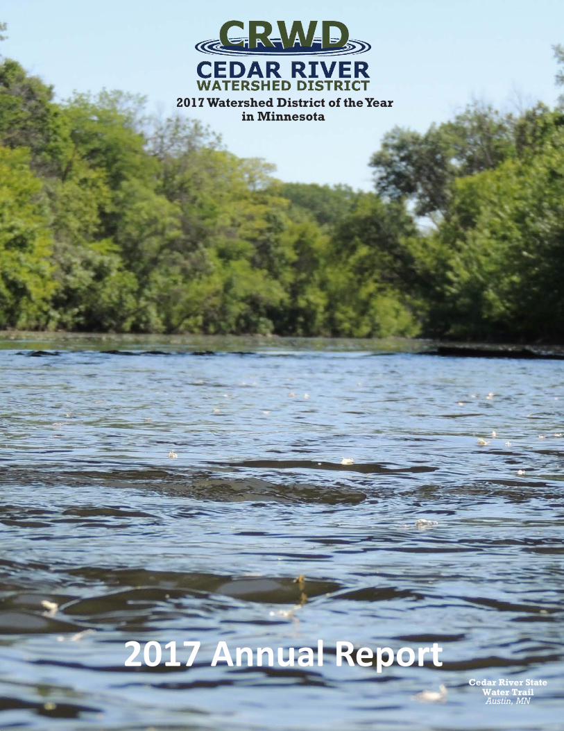
2017 Annual Report Cedar River State
Water Trail Austin, MN
2017 Watershed District of the Year in Minnesota
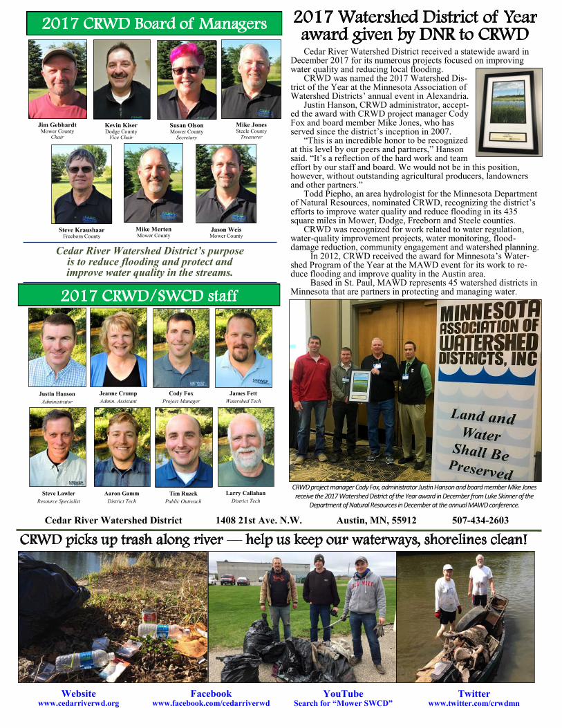
2017 CRWD/SWCD staff
Cedar River Watershed District 1408 21st Ave. N.W. Austin, MN, 55912 507-434-2603
Website www.cedarriverwd.org
Facebook www.facebook.com/cedarriverwd
YouTube Search for “Mower SWCD”
Twitter www.twitter.com/crwdmn
Cedar River Watershed District’s purpose is to reduce flooding and protect and improve water quality in the streams.
Steve Kraushaar Freeborn County
2017 CRWD Board of Managers
Mike Merten Mower County
Susan Olson Mower County
Secretary
Jason Weis Mower County
Mike Jones Steele County
Treasurer
Kevin Kiser Dodge County
Vice Chair
Jim Gebhardt Mower County
Chair
2017 Watershed District of Year award given by DNR to CRWD
Cedar River Watershed District received a statewide award in December 2017 for its numerous projects focused on improving water quality and reducing local flooding. CRWD was named the 2017 Watershed Dis-trict of the Year at the Minnesota Association of Watershed Districts’ annual event in Alexandria. Justin Hanson, CRWD administrator, accept-ed the award with CRWD project manager Cody Fox and board member Mike Jones, who has served since the district’s inception in 2007. “This is an incredible honor to be recognized at this level by our peers and partners,” Hanson said. “It’s a reflection of the hard work and team effort by our staff and board. We would not be in this position, however, without outstanding agricultural producers, landowners and other partners.” Todd Piepho, an area hydrologist for the Minnesota Department of Natural Resources, nominated CRWD, recognizing the district’s efforts to improve water quality and reduce flooding in its 435 square miles in Mower, Dodge, Freeborn and Steele counties. CRWD was recognized for work related to water regulation, water-quality improvement projects, water monitoring, flood-damage reduction, community engagement and watershed planning.
In 2012, CRWD received the award for Minnesota’s Water-shed Program of the Year at the MAWD event for its work to re-duce flooding and improve quality in the Austin area.
Based in St. Paul, MAWD represents 45 watershed districts in Minnesota that are partners in protecting and managing water.
CRWD project manager Cody Fox, administrator Justin Hanson and board member Mike Jones receive the 2017 Watershed District of the Year award in December from Luke Skinner of the
Department of Natural Resources in December at the annual MAWD conference.
Justin Hanson Administrator
Jeanne Crump Admin. Assistant
Cody Fox Project Manager
James Fett Watershed Tech
Aaron Gamm District Tech
Larry Callahan District Tech
Steve Lawler Resource Specialist
Tim Ruzek Public Outreach
CRWD picks up trash along river — help us keep our waterways, shorelines clean!
First-time Cedar Scenes contest’s 2017 weekly photo winners
Community service, education in Cedar River Watershed New CREP round opens in Mower, other MN counties
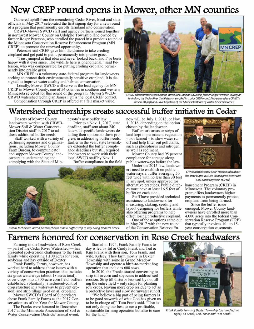
Dozens of Mower County landowners worked with CRWD-Mower Soil & Water Conserva-tion District staff in 2017 to ad-dress additional buffer needs. Staff worked with a variety of partnering agencies and organiza-tions, including Mower County Farm Bureau, to communicate and support Mower County land-owners in understanding and complying with the State of Min-
nesota’s new buffer law. Prior to a Nov. 1, 2017, state deadline, staff sent about 240 letters to specific landowners de-tailing their options to show pro-gress in addressing buffer needs. Earlier in the year, state lawmak-ers extended the buffer compli-ance deadlines but still required landowners to work with their local SWCD staff by Nov. 1. Buffer compliance in the field
now will be July 1, 2018, or Nov. 1, 2018, depending on the option chosen by the landowner. Buffers are areas or strips of land kept in permanent vegetation – not farmed – to slow water run-off and help filter out pollutants, such as phosphorus and nitrogen, as well as sediment. Mower County had 95 percent compliance for acreage along public waterways before the law. Under the 2015 law, landown-ers need to establish on public waterways a buffer averaging 50 feet wide with no less than 30 feet in any spot, unless approved for alternative practices. Public ditch-es must have at least 16.5 feet of buffer on each side. Staff have provided technical assistance to landowners for measuring, staking, seeding and layout designing for buffers while also offering programs to help offset losing productive cropland. One of those options came out in May 2017 with the new round of the Conservation Reserve En-
hancement Program (CREP) in Minnesota. The voluntary pro-gram offers landowners higher payments to permanently protect cropland from being farmed. Since the buffer issue emerged, Mower County land-owners have enrolled more than 4,000 acres into the federal Con-servation Reserve Program (CRP) that typically involves 10– to 15-year conservation easements.
Farming in the headwaters of Rose Creek — part of the Cedar River Watershed — has presented soil-erosion challenges to the Frank family while operating 1,100 acres for corn, soybeans and hay outside of Dexter.
Frank Family Farms, however, has worked hard to address those issues with a variety of conservation practices that includes six grass waterways (about 18 acres total); cover crops into a 300-acre corn field; buffers established voluntarily; a sediment-control drop structure in a waterway to prevent ero-sion; and strip tillage used on all cropland.
Mower SWCD’s Board of Supervisors chose Frank Family Farms as the 2017 Con-servationists of the Year for Mower County.
The Franks were honored in December 2017 at the Minnesota Association of Soil & Water Conservation Districts’ annual event.
Started in 1974, Frank Family Farms to-day is led by Ed & Cindy Frank and Ted & Kim Frank with their son, Tom Frank, and wife, Kelsey. They farm mostly in Dexter Township with some in Grand Meadow Township and operate a birth-to-market hog operation that includes 600 sows.
In 2010, the Franks started converting to strip till in corn and soybeans to address soil erosion. Strip till disturbs less soil by not till-ing the entire field – only strips for planting row crops, leaving more crop residue to act as a protective layer and slow stormwater runoff.
“We believe a big part of being farmers is to be good stewards of what God has given us to be in charge of,” Tom Frank said. “That is not only doing our best to run a profitable, sustainable farming operation but also to care for the land.”
Gathered uphill from the meandering Cedar River, local and state officials in May 2017 celebrated the first signup day for a new round of a program that permanently enrolls farmland into conservation. CRWD-Mower SWCD staff and agency partners joined together in northwest Mower County on Udolpho Township land owned by farmer Roger Peterson, who enrolled the parcel in a previous round of the Minnesota Conservation Reserve Enhancement Program (MN CREP), to promote the renewed opportunity.
Peterson said CREP gave him the chance to take eroding cropland and get paid to put it permanently into prairie grass.
“I just jumped at that idea and never looked back, and I’ve been happy with it ever since. The wildlife here is phenomenal,” said Pe-terson, who was compensated for putting eroding cropland perma-nently into prairie grass.
MN CREP is a voluntary state-federal program for landowners seeking to protect their environmentally sensitive cropland. It is de-signed to improve water quality and habitat conservation.
Locally, Mower SWCD will serve as the lead agency for MN CREP in Mower County, one of 54 counties in southern and western Minnesota selected for this round of the program. Mower SWCD-CRWD watershed technician James Fett is the local CREP contact. Compensation through CREP is offered at a fair market value.
Watershed partnerships create successful buffer initiative in Cedar
Farmers honored for conservation in Rose Creek headwaters
Frank Family Farms of Dexter Township (pictured left to right): Ed Frank; Ted Frank; and Tom Frank.
CRWD technician Aaron Gamm checks a new buffer strip in July along Roberts Creek.
CRWD administrator Justin Hanson talks about the state buffer law Oct. 30 at a press event with
Gov. Mark Dayton in St. Paul.
CRWD administrator Justin Hanson introduces Udolpho Township farmer Roger Peterson in May on land along the Cedar River that Peterson enrolled in a prior CREP round. Also pictured are CRWD’s
James Fett (left) and Dave Copeland of the Minnesota Board of Water & Soil Resources.
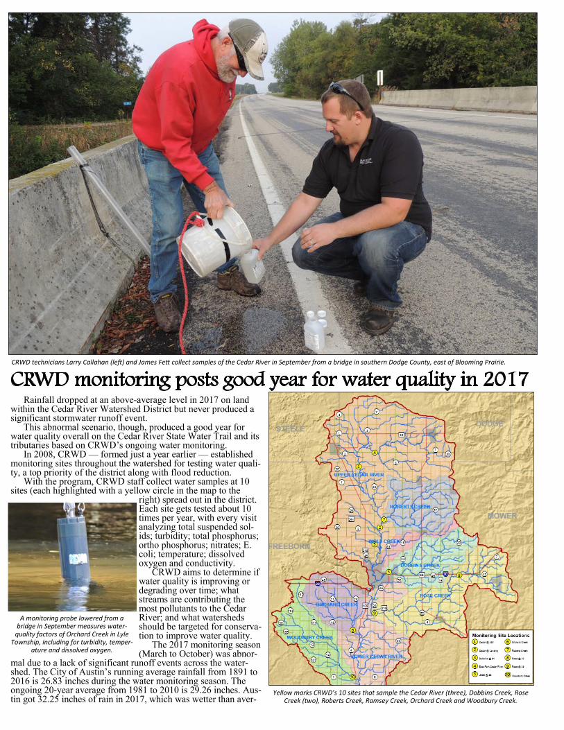
CRWD monitoring posts good year for water quality in 2017 CRWD technicians Larry Callahan (left) and James Fett collect samples of the Cedar River in September from a bridge in southern Dodge County, east of Blooming Prairie.
Yellow marks CRWD’s 10 sites that sample the Cedar River (three), Dobbins Creek, Rose Creek (two), Roberts Creek, Ramsey Creek, Orchard Creek and Woodbury Creek.
Rainfall dropped at an above-average level in 2017 on land within the Cedar River Watershed District but never produced a significant stormwater runoff event. This abnormal scenario, though, produced a good year for water quality overall on the Cedar River State Water Trail and its tributaries based on CRWD’s ongoing water monitoring. In 2008, CRWD — formed just a year earlier — established monitoring sites throughout the watershed for testing water quali-ty, a top priority of the district along with flood reduction. With the program, CRWD staff collect water samples at 10 sites (each highlighted with a yellow circle in the map to the
right) spread out in the district. Each site gets tested about 10 times per year, with every visit analyzing total suspended sol-ids; turbidity; total phosphorus; ortho phosphorus; nitrates; E. coli; temperature; dissolved oxygen and conductivity. CRWD aims to determine if water quality is improving or degrading over time; what streams are contributing the most pollutants to the Cedar River; and what watersheds should be targeted for conserva-tion to improve water quality. The 2017 monitoring season (March to October) was abnor-
mal due to a lack of significant runoff events across the water-shed. The City of Austin’s running average rainfall from 1891 to 2016 is 26.83 inches during the water monitoring season. The ongoing 20-year average from 1981 to 2010 is 29.26 inches. Aus-tin got 32.25 inches of rain in 2017, which was wetter than aver-
A monitoring probe lowered from a bridge in September measures water-
quality factors of Orchard Creek in Lyle Township, including for turbidity, temper-
ature and dissolved oxygen.
CRWD, partners create river access One of Austin’s most-popular spots to
launch a canoe or kayak now has a dedicated access with a rock surface to enable paddlers to get floating more easily and cleanly on the Cedar River State Water Trail.
In August 2017, CRWD and partners celebrated the opening of a new walk-in river access behind Marcusen Park baseball stadium on Austin’s south side.
CRWD was awarded a $2,000 grant in late 2016 from Austin Area Foundation to cover the cost of materials for con-structing the canoe-kayak access. The City of Austin’s public works department agreed to de-sign the access and deliver materials for the Minnesota Department of Natural Resources to build the launch.
“Our strong, collaborative effort on the project has helped enhance the Cedar River State Water Trail for local residents and an increasing number of visitors to the area,” CRWD outreach coordinator Tim Ruzek said.
Last summer, a DNR crew brought in
machinery to build the access over a few days on the north side of the Cedar River, creating a slope with a rock surface and rip-rap rock on each side to protect it from washing out.
DNR was able to build the launch because CRWD led an effort in 2011 to get legislative approval of designating the Cedar River as an official DNR state water trail. With that designation, DNR annually removes river haz-ards as well as provides other assistance, including a water trail map and real-time data on the Cedar River’s water levels. With the project, the river now has an access in the city that bet-
ter accommodates groups seeking to start paddling at the same time. Its rocky surface slope also allows for safer and less-muddy launches onto the river.
The project originated with the Vision 2020 Waterways Committee that began in 2012 to explore ways to enhance the Cedar River and other local waterways. Adding access sites was one of its goals.
Public input and perspective on Minnesota’s Cedar River Water-shed are wanted by local officials working on a new plan aimed at protecting and improving local waterways.
On June 1, local staff led the hosting of a public kickoff for Cedar River 1W1P at the Jay C. Hormel Nature Center in Austin, which included ways for attendees to provide input as well as learn about the watershed and the 1W1P process.
Partners from Dodge, Freeborn, Mower and Steele counties and each’s SWCD along with the Cedar River Watershed District, Turtle Creek Watershed District and the City of Austin are working together on the Cedar River 1W1P initiative.
Overall, the Cedar River 1W1P boundaries cover 462,295 acres. Most of the land – about 57 percent – is in Mower County.
CRWD’s political boundaries are within the 1W1P planning area along with Turtle Creek Watershed District and the watersheds for the Little Cedar River, Otter Creek and Wapsipinicon River in Mower County and the Deer Creek watershed in southeast Freeborn County.
In August 2016, the state approved up to $1.7 million overall for seven watersheds, including the Cedar, to conduct the next round of 1W1P projects. Cedar River 1W1P has about $192,500 for its work.
The Policy Committee – board members from SWCDs, watershed districts and counties within the watershed along with the City of Austin – began meeting in March 2017. The initiative now is in the watershed-based planning phase with Barr Engineering.
Under 1W1P, the state aims to create plans based on watershed boundaries rather than smaller, political boundaries to ensure the most significant threats to a watershed’s water resources are addressed with practices providing the greatest environmental benefits. The plan will not add a new layer of government.
Cedar River 1W1P moving into plan development
EQIP adds grass waterways in Dobbins, Rose Creek watersheds Federal funds helped an array of Mower
County agricultural producers and landowners solve natural resource problems on their farms in 2017, including in the CRWD’s Dobbins and Rose Creek subwatersheds.
EQIP is a voluntary, federal program of-fered to provide financial and technical assis-tance to producers and landowners.
The contracts give financial assistance to help plan and implement conservation practic-es that address natural resource concerns and for opportunities to improve soil, water, plant, animal, air, and related resources on ag land and non-industrial private forestland.
DURING CONSTRUCTION AFTER GRASS ESTABLISHED One EQIP project in 2017 involved building a long grass waterway in the Rose Creek Watershed near Interstate 90.
Cedar River 1W1P Policy Committee members meet for the first time with staff in March 2017 at the Austin Public Library. Policy meetings usually are hosted monthly.
A group of kayakers prepare to launch last summer at the new Cedar River access. (Bottom) DNR access sign.
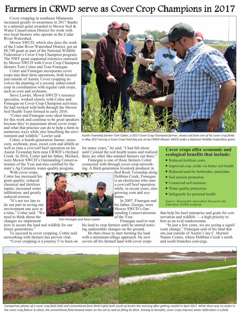
Farmers in CRWD serve as Cover Crop Champions in 2017 Cover cropping in southeast Minnesota
increased greatly in awareness in 2017 thanks to a national grant awarded to Mower Soil & Water Conservation District for work with two local farmers who operate in the Cedar River Watershed. Mower SWCD, which also does the work of the Cedar River Watershed District, got an $8,740 grant as part of the National Wildlife Federation’s Cover Crop Champion program. The NWF grant supported extensive outreach by Mower SWCD with Cover Crop Champion farmers Tom Cotter and Tom Finnegan.
Cotter and Finnegan incorporate cover crops into their farm operations, both located just outside of Austin. Cover cropping in-volves the planting of a second, unharvested crop in coordination with regular cash crops, such as corn and soybeans.
Steve Lawler, Mower SWCD’s resource specialist, worked closely with Cotter and Finnegan on Cover Crop Champion activities. He had worked with both through the Mower Soil Health Team formed in early 2016.
“Cotter and Finnegan were ideal farmers for this work and continue to be great speakers because they’re passionate about cover crops and what that practice can do to help a farm in numerous ways while also benefiting the envi-ronment and wildlife,” Lawler said.
Cotter, a fourth-generation farmer, raises corn, soybeans, peas, sweet corn and alfalfa as well as runs a cow/calf beef operation on his Austin Township farm near CRWD’s Orchard Creek. In 2016, Cotter and his father, Michael, were Mower SWCD’s Outstanding Conserva-tionists of the Year and also certified by the state’s Ag Certainty water-quality program.
With cover crops, Cotter has increased his grain quality; reduced chemical and fertilizer inputs; increased water infiltration; and greatly reduced erosion.
“It’s not too late to do our part in saving our environment one acre at a time,” Cotter said. “We need to think about the changes we implement now to secure the land and wildlife for our future generations.”
To succeed in cover cropping, Cotter said networking with farmers has proven vital. “Cover cropping is a journey I’ve been on
for many years,” he said. “I had felt alone until I joined the soil health teams and realized there are other like-minded farmers out there.”
Finnegan is one of those farmers Cotter connected with through cover-crop network-ing. A third-generation livestock producer in
Red Rock Township along Dobbins Creek, Finnegan is an electrician who runs a cow/calf beef operation while, in recent years, also growing corn and soy-beans. In 2007, Finnegan and his father, George, were Mower SWCD’s Out-standing Conservationists of the Year. Finnegan used to rent
his land to crop farmers until he started notic-ing undesirable changes on the ground.
He then chose to start farming his land with a minimum-tillage approach. He now covers all his farmed land with cover crops
that help his beef enterprise and goals for con-servation and wildlife — a high priority to him as an avid outdoorsman.
“In just a few years, we are seeing a signif-icant change,” Finnegan said of his land that sits just outside of Austin’s Jay C. Hormel Nature Center, where Dobbins Creek’s north and south branches converge.
Austin Township farmer Tom Cotter, a 2017 Cover Crop Champion farmer, shows soil from one of his cover crop fields in May 2017 during a Cover Crop Field Day put on by CRWD-Mower SWCD under a National Wildlife Federation grant.
Tom Finnegan and Steve Lawler
Comparison photos of a cover crop field (left) and conventional farm field (right) both south of Austin the morning after getting rainfall in April 2017. While there was no water in the cover crop field or its ditch, the conventional field showed water on the soil as well as filling its ditch. Among its benefits, cover crops improve water infiltration in a field.
Cover crops offer economic and ecological benefits that include:
• Reduced fertilizer costs. • Improved crop yields via better soil health • Reduced need for herbicides, pesticides • Soil erosion protection • Conserved soil moisture • Water quality protection • Safeguards for personal health
Source: Sustainable Agriculture Research and Education (SARE) program
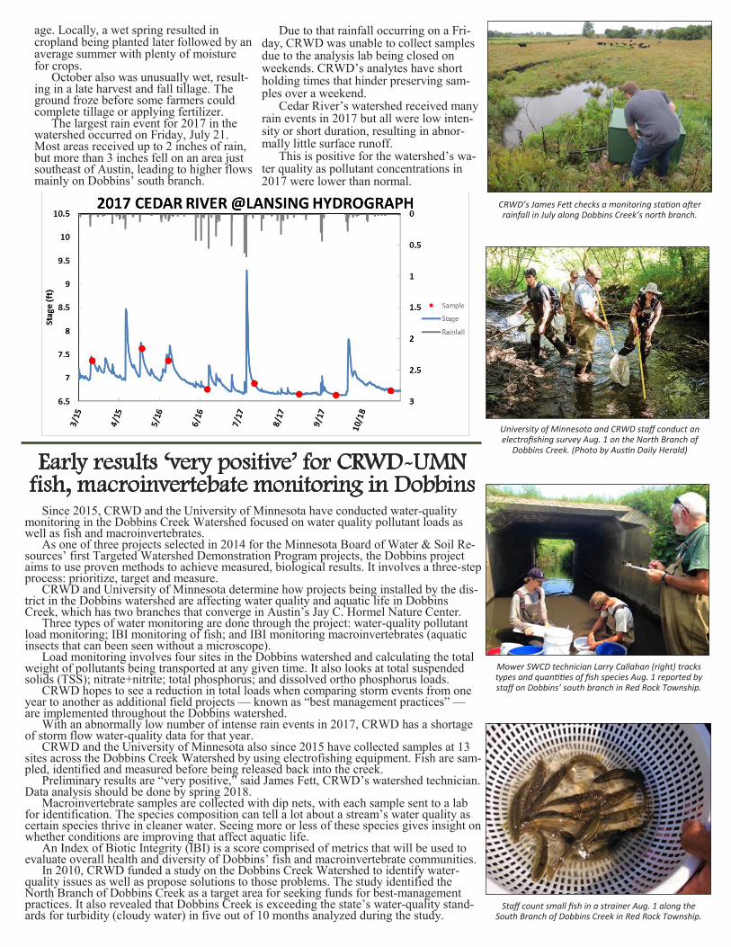
age. Locally, a wet spring resulted in cropland being planted later followed by an average summer with plenty of moisture for crops. October also was unusually wet, result-ing in a late harvest and fall tillage. The ground froze before some farmers could complete tillage or applying fertilizer. The largest rain event for 2017 in the watershed occurred on Friday, July 21. Most areas received up to 2 inches of rain, but more than 3 inches fell on an area just southeast of Austin, leading to higher flows mainly on Dobbins’ south branch.
Due to that rainfall occurring on a Fri-day, CRWD was unable to collect samples due to the analysis lab being closed on weekends. CRWD’s analytes have short holding times that hinder preserving sam-ples over a weekend. Cedar River’s watershed received many rain events in 2017 but all were low inten-sity or short duration, resulting in abnor-mally little surface runoff. This is positive for the watershed’s wa-ter quality as pollutant concentrations in 2017 were lower than normal.
Mower SWCD technician Larry Callahan (right) tracks types and quantities of fish species Aug. 1 reported by staff on Dobbins’ south branch in Red Rock Township.
University of Minnesota and CRWD staff conduct an electrofishing survey Aug. 1 on the North Branch of
Dobbins Creek. (Photo by Austin Daily Herald)
CRWD’s James Fett checks a monitoring station after rainfall in July along Dobbins Creek’s north branch.
Staff count small fish in a strainer Aug. 1 along the South Branch of Dobbins Creek in Red Rock Township.
Since 2015, CRWD and the University of Minnesota have conducted water-quality monitoring in the Dobbins Creek Watershed focused on water quality pollutant loads as well as fish and macroinvertebrates. As one of three projects selected in 2014 for the Minnesota Board of Water & Soil Re-sources’ first Targeted Watershed Demonstration Program projects, the Dobbins project aims to use proven methods to achieve measured, biological results. It involves a three-step process: prioritize, target and measure. CRWD and University of Minnesota determine how projects being installed by the dis-trict in the Dobbins watershed are affecting water quality and aquatic life in Dobbins Creek, which has two branches that converge in Austin’s Jay C. Hormel Nature Center. Three types of water monitoring are done through the project: water-quality pollutant load monitoring; IBI monitoring of fish; and IBI monitoring macroinvertebrates (aquatic insects that can been seen without a microscope). Load monitoring involves four sites in the Dobbins watershed and calculating the total weight of pollutants being transported at any given time. It also looks at total suspended solids (TSS); nitrate+nitrite; total phosphorus; and dissolved ortho phosphorus loads. CRWD hopes to see a reduction in total loads when comparing storm events from one year to another as additional field projects — known as “best management practices” — are implemented throughout the Dobbins watershed. With an abnormally low number of intense rain events in 2017, CRWD has a shortage of storm flow water-quality data for that year. CRWD and the University of Minnesota also since 2015 have collected samples at 13 sites across the Dobbins Creek Watershed by using electrofishing equipment. Fish are sam-pled, identified and measured before being released back into the creek. Preliminary results are “very positive,” said James Fett, CRWD’s watershed technician. Data analysis should be done by spring 2018. Macroinvertebrate samples are collected with dip nets, with each sample sent to a lab for identification. The species composition can tell a lot about a stream’s water quality as certain species thrive in cleaner water. Seeing more or less of these species gives insight on whether conditions are improving that affect aquatic life. An Index of Biotic Integrity (IBI) is a score comprised of metrics that will be used to evaluate overall health and diversity of Dobbins’ fish and macroinvertebrate communities. In 2010, CRWD funded a study on the Dobbins Creek Watershed to identify water-quality issues as well as propose solutions to those problems. The study identified the North Branch of Dobbins Creek as a target area for seeking funds for best-management practices. It also revealed that Dobbins Creek is exceeding the state’s water-quality stand-ards for turbidity (cloudy water) in five out of 10 months analyzed during the study.
Early results ‘very positive’ for CRWD-UMN fish, macroinvertebate monitoring in Dobbins
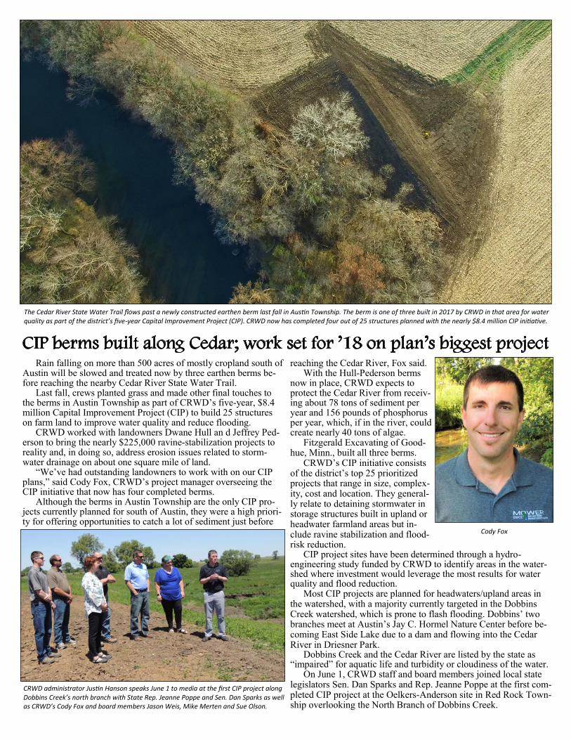
CIP berms built along Cedar; work set for ’18 on plan’s biggest project
The Cedar River State Water Trail flows past a newly constructed earthen berm last fall in Austin Township. The berm is one of three built in 2017 by CRWD in that area for water quality as part of the district’s five-year Capital Improvement Project (CIP). CRWD now has completed four out of 25 structures planned with the nearly $8.4 million CIP initiative.
Rain falling on more than 500 acres of mostly cropland south of Austin will be slowed and treated now by three earthen berms be-fore reaching the nearby Cedar River State Water Trail.
Last fall, crews planted grass and made other final touches to the berms in Austin Township as part of CRWD’s five-year, $8.4 million Capital Improvement Project (CIP) to build 25 structures on farm land to improve water quality and reduce flooding.
CRWD worked with landowners Dwane Hull an d Jeffrey Ped-erson to bring the nearly $225,000 ravine-stabilization projects to reality and, in doing so, address erosion issues related to storm-water drainage on about one square mile of land.
“We’ve had outstanding landowners to work with on our CIP plans,” said Cody Fox, CRWD’s project manager overseeing the CIP initiative that now has four completed berms.
Although the berms in Austin Township are the only CIP pro-jects currently planned for south of Austin, they were a high priori-ty for offering opportunities to catch a lot of sediment just before
reaching the Cedar River, Fox said. With the Hull-Pederson berms
now in place, CRWD expects to protect the Cedar River from receiv-ing about 78 tons of sediment per year and 156 pounds of phosphorus per year, which, if in the river, could create nearly 40 tons of algae.
Fitzgerald Excavating of Good-hue, Minn., built all three berms.
CRWD’s CIP initiative consists of the district’s top 25 prioritized projects that range in size, complex-ity, cost and location. They general-ly relate to detaining stormwater in storage structures built in upland or headwater farmland areas but in-clude ravine stabilization and flood-risk reduction.
CIP project sites have been determined through a hydro-engineering study funded by CRWD to identify areas in the water-shed where investment would leverage the most results for water quality and flood reduction.
Most CIP projects are planned for headwaters/upland areas in the watershed, with a majority currently targeted in the Dobbins Creek watershed, which is prone to flash flooding. Dobbins’ two branches meet at Austin’s Jay C. Hormel Nature Center before be-coming East Side Lake due to a dam and flowing into the Cedar River in Driesner Park.
Dobbins Creek and the Cedar River are listed by the state as “impaired” for aquatic life and turbidity or cloudiness of the water.
On June 1, CRWD staff and board members joined local state legislators Sen. Dan Sparks and Rep. Jeanne Poppe at the first com-pleted CIP project at the Oelkers-Anderson site in Red Rock Town-ship overlooking the North Branch of Dobbins Creek.
CRWD administrator Justin Hanson speaks June 1 to media at the first CIP project along Dobbins Creek’s north branch with State Rep. Jeanne Poppe and Sen. Dan Sparks as well as CRWD’s Cody Fox and board members Jason Weis, Mike Merten and Sue Olson.
Cody Fox
Aside from viewing the site’s new earthen berm — a $60,000 project built where a large gully had formed — they also spoke to media about $1.7 million in newly approved state bonding funds for future CIP projects. Sparks and Poppe helped get bonding bill funds included as a match for CRWD’s $3.2 million grant from The Hormel Foundation for the CIP initiative.
Sparks and Poppe emphasized the importance of the CIP work by the district and the need to keep moving forward on projects.
“Providing state bonding dollars advances the good work done by CRWD’s staff and board,” Poppe said. “They have a story to tell and an outcome to showcase. I’m pleased the state is a partner in this journey.”
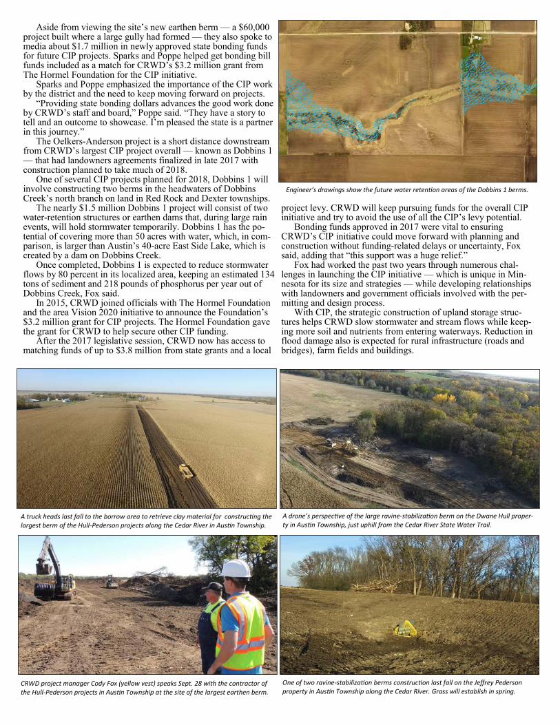
The Oelkers-Anderson project is a short distance downstream from CRWD’s largest CIP project overall — known as Dobbins 1 — that had landowners agreements finalized in late 2017 with construction planned to take much of 2018.
One of several CIP projects planned for 2018, Dobbins 1 will involve constructing two berms in the headwaters of Dobbins Creek’s north branch on land in Red Rock and Dexter townships.
The nearly $1.5 million Dobbins 1 project will consist of two water-retention structures or earthen dams that, during large rain events, will hold stormwater temporarily. Dobbins 1 has the po-tential of covering more than 50 acres with water, which, in com-parison, is larger than Austin’s 40-acre East Side Lake, which is created by a dam on Dobbins Creek.
Once completed, Dobbins 1 is expected to reduce stormwater flows by 80 percent in its localized area, keeping an estimated 134 tons of sediment and 218 pounds of phosphorus per year out of Dobbins Creek, Fox said.
In 2015, CRWD joined officials with The Hormel Foundation and the area Vision 2020 initiative to announce the Foundation’s $3.2 million grant for CIP projects. The Hormel Foundation gave the grant for CRWD to help secure other CIP funding.
After the 2017 legislative session, CRWD now has access to matching funds of up to $3.8 million from state grants and a local
project levy. CRWD will keep pursuing funds for the overall CIP initiative and try to avoid the use of all the CIP’s levy potential.
Bonding funds approved in 2017 were vital to ensuring CRWD’s CIP initiative could move forward with planning and construction without funding-related delays or uncertainty, Fox said, adding that “this support was a huge relief.”
Fox had worked the past two years through numerous chal-lenges in launching the CIP initiative — which is unique in Min-nesota for its size and strategies — while developing relationships with landowners and government officials involved with the per-mitting and design process.
With CIP, the strategic construction of upland storage struc-tures helps CRWD slow stormwater and stream flows while keep-ing more soil and nutrients from entering waterways. Reduction in flood damage also is expected for rural infrastructure (roads and bridges), farm fields and buildings.
One of two ravine-stabilization berms construction last fall on the Jeffrey Pederson property in Austin Township along the Cedar River. Grass will establish in spring.
A drone’s perspective of the large ravine-stabilization berm on the Dwane Hull proper-ty in Austin Township, just uphill from the Cedar River State Water Trail.
A truck heads last fall to the borrow area to retrieve clay material for constructing the largest berm of the Hull-Pederson projects along the Cedar River in Austin Township.
CRWD project manager Cody Fox (yellow vest) speaks Sept. 28 with the contractor of the Hull-Pederson projects in Austin Township at the site of the largest earthen berm.
Engineer’s drawings show the future water retention areas of the Dobbins 1 berms.
CIP berms built along Cedar; work set for ’18 on plan’s biggest project
The Cedar River State Water Trail flows past a newly constructed earthen berm last fall in Austin Township. The berm is one of three built in 2017 by CRWD in that area for water quality as part of the district’s five-year Capital Improvement Project (CIP). CRWD now has completed four out of 25 structures planned with the nearly $8.4 million CIP initiative.
Rain falling on more than 500 acres of mostly cropland south of Austin will be slowed and treated now by three earthen berms be-fore reaching the nearby Cedar River State Water Trail.
Last fall, crews planted grass and made other final touches to the berms in Austin Township as part of CRWD’s five-year, $8.4 million Capital Improvement Project (CIP) to build 25 structures on farm land to improve water quality and reduce flooding.
CRWD worked with landowners Dwane Hull an d Jeffrey Ped-erson to bring the nearly $225,000 ravine-stabilization projects to reality and, in doing so, address erosion issues related to storm-water drainage on about one square mile of land.
“We’ve had outstanding landowners to work with on our CIP plans,” said Cody Fox, CRWD’s project manager overseeing the CIP initiative that now has four completed berms.
Although the berms in Austin Township are the only CIP pro-jects currently planned for south of Austin, they were a high priori-ty for offering opportunities to catch a lot of sediment just before
reaching the Cedar River, Fox said. With the Hull-Pederson berms
now in place, CRWD expects to protect the Cedar River from receiv-ing about 78 tons of sediment per year and 156 pounds of phosphorus per year, which, if in the river, could create nearly 40 tons of algae.
Fitzgerald Excavating of Good-hue, Minn., built all three berms.
CRWD’s CIP initiative consists of the district’s top 25 prioritized projects that range in size, complex-ity, cost and location. They general-ly relate to detaining stormwater in storage structures built in upland or headwater farmland areas but in-clude ravine stabilization and flood-risk reduction.
CIP project sites have been determined through a hydro-engineering study funded by CRWD to identify areas in the water-shed where investment would leverage the most results for water quality and flood reduction.
Most CIP projects are planned for headwaters/upland areas in the watershed, with a majority currently targeted in the Dobbins Creek watershed, which is prone to flash flooding. Dobbins’ two branches meet at Austin’s Jay C. Hormel Nature Center before be-coming East Side Lake due to a dam and flowing into the Cedar River in Driesner Park.
Dobbins Creek and the Cedar River are listed by the state as “impaired” for aquatic life and turbidity or cloudiness of the water.
On June 1, CRWD staff and board members joined local state legislators Sen. Dan Sparks and Rep. Jeanne Poppe at the first com-pleted CIP project at the Oelkers-Anderson site in Red Rock Town-ship overlooking the North Branch of Dobbins Creek.
CRWD administrator Justin Hanson speaks June 1 to media at the first CIP project along Dobbins Creek’s north branch with State Rep. Jeanne Poppe and Sen. Dan Sparks as well as CRWD’s Cody Fox and board members Jason Weis, Mike Merten and Sue Olson.
Cody Fox
Aside from viewing the site’s new earthen berm — a $60,000 project built where a large gully had formed — they also spoke to media about $1.7 million in newly approved state bonding funds for future CIP projects. Sparks and Poppe helped get bonding bill funds included as a match for CRWD’s $3.2 million grant from The Hormel Foundation for the CIP initiative.
Sparks and Poppe emphasized the importance of the CIP work by the district and the need to keep moving forward on projects.
“Providing state bonding dollars advances the good work done by CRWD’s staff and board,” Poppe said. “They have a story to tell and an outcome to showcase. I’m pleased the state is a partner in this journey.”
The Oelkers-Anderson project is a short distance downstream from CRWD’s largest CIP project overall — known as Dobbins 1 — that had landowners agreements finalized in late 2017 with construction planned to take much of 2018.
One of several CIP projects planned for 2018, Dobbins 1 will involve constructing two berms in the headwaters of Dobbins Creek’s north branch on land in Red Rock and Dexter townships.
The nearly $1.5 million Dobbins 1 project will consist of two water-retention structures or earthen dams that, during large rain events, will hold stormwater temporarily. Dobbins 1 has the po-tential of covering more than 50 acres with water, which, in com-parison, is larger than Austin’s 40-acre East Side Lake, which is created by a dam on Dobbins Creek.
Once completed, Dobbins 1 is expected to reduce stormwater flows by 80 percent in its localized area, keeping an estimated 134 tons of sediment and 218 pounds of phosphorus per year out of Dobbins Creek, Fox said.
In 2015, CRWD joined officials with The Hormel Foundation and the area Vision 2020 initiative to announce the Foundation’s $3.2 million grant for CIP projects. The Hormel Foundation gave the grant for CRWD to help secure other CIP funding.
After the 2017 legislative session, CRWD now has access to matching funds of up to $3.8 million from state grants and a local
project levy. CRWD will keep pursuing funds for the overall CIP initiative and try to avoid the use of all the CIP’s levy potential.
Bonding funds approved in 2017 were vital to ensuring CRWD’s CIP initiative could move forward with planning and construction without funding-related delays or uncertainty, Fox said, adding that “this support was a huge relief.”
Fox had worked the past two years through numerous chal-lenges in launching the CIP initiative — which is unique in Min-nesota for its size and strategies — while developing relationships with landowners and government officials involved with the per-mitting and design process.
With CIP, the strategic construction of upland storage struc-tures helps CRWD slow stormwater and stream flows while keep-ing more soil and nutrients from entering waterways. Reduction in flood damage also is expected for rural infrastructure (roads and bridges), farm fields and buildings.
One of two ravine-stabilization berms construction last fall on the Jeffrey Pederson property in Austin Township along the Cedar River. Grass will establish in spring.
A drone’s perspective of the large ravine-stabilization berm on the Dwane Hull proper-ty in Austin Township, just uphill from the Cedar River State Water Trail.
A truck heads last fall to the borrow area to retrieve clay material for constructing the largest berm of the Hull-Pederson projects along the Cedar River in Austin Township.
CRWD project manager Cody Fox (yellow vest) speaks Sept. 28 with the contractor of the Hull-Pederson projects in Austin Township at the site of the largest earthen berm.
Engineer’s drawings show the future water retention areas of the Dobbins 1 berms.
Farmers in CRWD serve as Cover Crop Champions in 2017 Cover cropping in southeast Minnesota
increased greatly in awareness in 2017 thanks to a national grant awarded to Mower Soil & Water Conservation District for work with two local farmers who operate in the Cedar River Watershed. Mower SWCD, which also does the work of the Cedar River Watershed District, got an $8,740 grant as part of the National Wildlife Federation’s Cover Crop Champion program. The NWF grant supported extensive outreach by Mower SWCD with Cover Crop Champion farmers Tom Cotter and Tom Finnegan.
Cotter and Finnegan incorporate cover crops into their farm operations, both located just outside of Austin. Cover cropping in-volves the planting of a second, unharvested crop in coordination with regular cash crops, such as corn and soybeans.
Steve Lawler, Mower SWCD’s resource specialist, worked closely with Cotter and Finnegan on Cover Crop Champion activities. He had worked with both through the Mower Soil Health Team formed in early 2016.
“Cotter and Finnegan were ideal farmers for this work and continue to be great speakers because they’re passionate about cover crops and what that practice can do to help a farm in numerous ways while also benefiting the envi-ronment and wildlife,” Lawler said.
Cotter, a fourth-generation farmer, raises corn, soybeans, peas, sweet corn and alfalfa as well as runs a cow/calf beef operation on his Austin Township farm near CRWD’s Orchard Creek. In 2016, Cotter and his father, Michael, were Mower SWCD’s Outstanding Conserva-tionists of the Year and also certified by the state’s Ag Certainty water-quality program.
With cover crops, Cotter has increased his grain quality; reduced chemical and fertilizer inputs; increased water infiltration; and greatly reduced erosion.
“It’s not too late to do our part in saving our environment one acre at a time,” Cotter said. “We need to think about the changes we implement now to secure the land and wildlife for our future generations.”
To succeed in cover cropping, Cotter said networking with farmers has proven vital. “Cover cropping is a journey I’ve been on
for many years,” he said. “I had felt alone until I joined the soil health teams and realized there are other like-minded farmers out there.”
Finnegan is one of those farmers Cotter connected with through cover-crop network-ing. A third-generation livestock producer in
Red Rock Township along Dobbins Creek, Finnegan is an electrician who runs a cow/calf beef operation while, in recent years, also growing corn and soy-beans. In 2007, Finnegan and his father, George, were Mower SWCD’s Out-standing Conservationists of the Year. Finnegan used to rent
his land to crop farmers until he started notic-ing undesirable changes on the ground.
He then chose to start farming his land with a minimum-tillage approach. He now covers all his farmed land with cover crops
that help his beef enterprise and goals for con-servation and wildlife — a high priority to him as an avid outdoorsman.
“In just a few years, we are seeing a signif-icant change,” Finnegan said of his land that sits just outside of Austin’s Jay C. Hormel Nature Center, where Dobbins Creek’s north and south branches converge.
Austin Township farmer Tom Cotter, a 2017 Cover Crop Champion farmer, shows soil from one of his cover crop fields in May 2017 during a Cover Crop Field Day put on by CRWD-Mower SWCD under a National Wildlife Federation grant.
Tom Finnegan and Steve Lawler
Comparison photos of a cover crop field (left) and conventional farm field (right) both south of Austin the morning after getting rainfall in April 2017. While there was no water in the cover crop field or its ditch, the conventional field showed water on the soil as well as filling its ditch. Among its benefits, cover crops improve water infiltration in a field.
Cover crops offer economic and ecological benefits that include:
• Reduced fertilizer costs. • Improved crop yields via better soil health • Reduced need for herbicides, pesticides • Soil erosion protection • Conserved soil moisture • Water quality protection • Safeguards for personal health
Source: Sustainable Agriculture Research and Education (SARE) program
age. Locally, a wet spring resulted in cropland being planted later followed by an average summer with plenty of moisture for crops. October also was unusually wet, result-ing in a late harvest and fall tillage. The ground froze before some farmers could complete tillage or applying fertilizer. The largest rain event for 2017 in the watershed occurred on Friday, July 21. Most areas received up to 2 inches of rain, but more than 3 inches fell on an area just southeast of Austin, leading to higher flows mainly on Dobbins’ south branch.
Due to that rainfall occurring on a Fri-day, CRWD was unable to collect samples due to the analysis lab being closed on weekends. CRWD’s analytes have short holding times that hinder preserving sam-ples over a weekend. Cedar River’s watershed received many rain events in 2017 but all were low inten-sity or short duration, resulting in abnor-mally little surface runoff. This is positive for the watershed’s wa-ter quality as pollutant concentrations in 2017 were lower than normal.
Mower SWCD technician Larry Callahan (right) tracks types and quantities of fish species Aug. 1 reported by staff on Dobbins’ south branch in Red Rock Township.
University of Minnesota and CRWD staff conduct an electrofishing survey Aug. 1 on the North Branch of
Dobbins Creek. (Photo by Austin Daily Herald)
CRWD’s James Fett checks a monitoring station after rainfall in July along Dobbins Creek’s north branch.
Staff count small fish in a strainer Aug. 1 along the South Branch of Dobbins Creek in Red Rock Township.
Since 2015, CRWD and the University of Minnesota have conducted water-quality monitoring in the Dobbins Creek Watershed focused on water quality pollutant loads as well as fish and macroinvertebrates. As one of three projects selected in 2014 for the Minnesota Board of Water & Soil Re-sources’ first Targeted Watershed Demonstration Program projects, the Dobbins project aims to use proven methods to achieve measured, biological results. It involves a three-step process: prioritize, target and measure. CRWD and University of Minnesota determine how projects being installed by the dis-trict in the Dobbins watershed are affecting water quality and aquatic life in Dobbins Creek, which has two branches that converge in Austin’s Jay C. Hormel Nature Center. Three types of water monitoring are done through the project: water-quality pollutant load monitoring; IBI monitoring of fish; and IBI monitoring macroinvertebrates (aquatic insects that can been seen without a microscope). Load monitoring involves four sites in the Dobbins watershed and calculating the total weight of pollutants being transported at any given time. It also looks at total suspended solids (TSS); nitrate+nitrite; total phosphorus; and dissolved ortho phosphorus loads. CRWD hopes to see a reduction in total loads when comparing storm events from one year to another as additional field projects — known as “best management practices” — are implemented throughout the Dobbins watershed. With an abnormally low number of intense rain events in 2017, CRWD has a shortage of storm flow water-quality data for that year. CRWD and the University of Minnesota also since 2015 have collected samples at 13 sites across the Dobbins Creek Watershed by using electrofishing equipment. Fish are sam-pled, identified and measured before being released back into the creek. Preliminary results are “very positive,” said James Fett, CRWD’s watershed technician. Data analysis should be done by spring 2018. Macroinvertebrate samples are collected with dip nets, with each sample sent to a lab for identification. The species composition can tell a lot about a stream’s water quality as certain species thrive in cleaner water. Seeing more or less of these species gives insight on whether conditions are improving that affect aquatic life. An Index of Biotic Integrity (IBI) is a score comprised of metrics that will be used to evaluate overall health and diversity of Dobbins’ fish and macroinvertebrate communities. In 2010, CRWD funded a study on the Dobbins Creek Watershed to identify water-quality issues as well as propose solutions to those problems. The study identified the North Branch of Dobbins Creek as a target area for seeking funds for best-management practices. It also revealed that Dobbins Creek is exceeding the state’s water-quality stand-ards for turbidity (cloudy water) in five out of 10 months analyzed during the study.
Early results ‘very positive’ for CRWD-UMN fish, macroinvertebate monitoring in Dobbins
CRWD monitoring posts good year for water quality in 2017 CRWD technicians Larry Callahan (left) and James Fett collect samples of the Cedar River in September from a bridge in southern Dodge County, east of Blooming Prairie.
Yellow marks CRWD’s 10 sites that sample the Cedar River (three), Dobbins Creek, Rose Creek (two), Roberts Creek, Ramsey Creek, Orchard Creek and Woodbury Creek.
Rainfall dropped at an above-average level in 2017 on land within the Cedar River Watershed District but never produced a significant stormwater runoff event. This abnormal scenario, though, produced a good year for water quality overall on the Cedar River State Water Trail and its tributaries based on CRWD’s ongoing water monitoring. In 2008, CRWD — formed just a year earlier — established monitoring sites throughout the watershed for testing water quali-ty, a top priority of the district along with flood reduction. With the program, CRWD staff collect water samples at 10 sites (each highlighted with a yellow circle in the map to the
right) spread out in the district. Each site gets tested about 10 times per year, with every visit analyzing total suspended sol-ids; turbidity; total phosphorus; ortho phosphorus; nitrates; E. coli; temperature; dissolved oxygen and conductivity. CRWD aims to determine if water quality is improving or degrading over time; what streams are contributing the most pollutants to the Cedar River; and what watersheds should be targeted for conserva-tion to improve water quality. The 2017 monitoring season (March to October) was abnor-
mal due to a lack of significant runoff events across the water-shed. The City of Austin’s running average rainfall from 1891 to 2016 is 26.83 inches during the water monitoring season. The ongoing 20-year average from 1981 to 2010 is 29.26 inches. Aus-tin got 32.25 inches of rain in 2017, which was wetter than aver-
A monitoring probe lowered from a bridge in September measures water-
quality factors of Orchard Creek in Lyle Township, including for turbidity, temper-
ature and dissolved oxygen.
CRWD, partners create river access One of Austin’s most-popular spots to
launch a canoe or kayak now has a dedicated access with a rock surface to enable paddlers to get floating more easily and cleanly on the Cedar River State Water Trail.
In August 2017, CRWD and partners celebrated the opening of a new walk-in river access behind Marcusen Park baseball stadium on Austin’s south side.
CRWD was awarded a $2,000 grant in late 2016 from Austin Area Foundation to cover the cost of materials for con-structing the canoe-kayak access. The City of Austin’s public works department agreed to de-sign the access and deliver materials for the Minnesota Department of Natural Resources to build the launch.
“Our strong, collaborative effort on the project has helped enhance the Cedar River State Water Trail for local residents and an increasing number of visitors to the area,” CRWD outreach coordinator Tim Ruzek said.
Last summer, a DNR crew brought in
machinery to build the access over a few days on the north side of the Cedar River, creating a slope with a rock surface and rip-rap rock on each side to protect it from washing out.
DNR was able to build the launch because CRWD led an effort in 2011 to get legislative approval of designating the Cedar River as an official DNR state water trail. With that designation, DNR annually removes river haz-ards as well as provides other assistance, including a water trail map and real-time data on the Cedar River’s water levels. With the project, the river now has an access in the city that bet-
ter accommodates groups seeking to start paddling at the same time. Its rocky surface slope also allows for safer and less-muddy launches onto the river.
The project originated with the Vision 2020 Waterways Committee that began in 2012 to explore ways to enhance the Cedar River and other local waterways. Adding access sites was one of its goals.
Public input and perspective on Minnesota’s Cedar River Water-shed are wanted by local officials working on a new plan aimed at protecting and improving local waterways.
On June 1, local staff led the hosting of a public kickoff for Cedar River 1W1P at the Jay C. Hormel Nature Center in Austin, which included ways for attendees to provide input as well as learn about the watershed and the 1W1P process.
Partners from Dodge, Freeborn, Mower and Steele counties and each’s SWCD along with the Cedar River Watershed District, Turtle Creek Watershed District and the City of Austin are working together on the Cedar River 1W1P initiative.
Overall, the Cedar River 1W1P boundaries cover 462,295 acres. Most of the land – about 57 percent – is in Mower County.
CRWD’s political boundaries are within the 1W1P planning area along with Turtle Creek Watershed District and the watersheds for the Little Cedar River, Otter Creek and Wapsipinicon River in Mower County and the Deer Creek watershed in southeast Freeborn County.
In August 2016, the state approved up to $1.7 million overall for seven watersheds, including the Cedar, to conduct the next round of 1W1P projects. Cedar River 1W1P has about $192,500 for its work.
The Policy Committee – board members from SWCDs, watershed districts and counties within the watershed along with the City of Austin – began meeting in March 2017. The initiative now is in the watershed-based planning phase with Barr Engineering.
Under 1W1P, the state aims to create plans based on watershed boundaries rather than smaller, political boundaries to ensure the most significant threats to a watershed’s water resources are addressed with practices providing the greatest environmental benefits. The plan will not add a new layer of government.
Cedar River 1W1P moving into plan development
EQIP adds grass waterways in Dobbins, Rose Creek watersheds Federal funds helped an array of Mower
County agricultural producers and landowners solve natural resource problems on their farms in 2017, including in the CRWD’s Dobbins and Rose Creek subwatersheds.
EQIP is a voluntary, federal program of-fered to provide financial and technical assis-tance to producers and landowners.
The contracts give financial assistance to help plan and implement conservation practic-es that address natural resource concerns and for opportunities to improve soil, water, plant, animal, air, and related resources on ag land and non-industrial private forestland.
DURING CONSTRUCTION AFTER GRASS ESTABLISHED One EQIP project in 2017 involved building a long grass waterway in the Rose Creek Watershed near Interstate 90.
Cedar River 1W1P Policy Committee members meet for the first time with staff in March 2017 at the Austin Public Library. Policy meetings usually are hosted monthly.
A group of kayakers prepare to launch last summer at the new Cedar River access. (Bottom) DNR access sign.
Community service, education in Cedar River Watershed New CREP round opens in Mower, other MN counties
Dozens of Mower County landowners worked with CRWD-Mower Soil & Water Conserva-tion District staff in 2017 to ad-dress additional buffer needs. Staff worked with a variety of partnering agencies and organiza-tions, including Mower County Farm Bureau, to communicate and support Mower County land-owners in understanding and complying with the State of Min-
nesota’s new buffer law. Prior to a Nov. 1, 2017, state deadline, staff sent about 240 letters to specific landowners de-tailing their options to show pro-gress in addressing buffer needs. Earlier in the year, state lawmak-ers extended the buffer compli-ance deadlines but still required landowners to work with their local SWCD staff by Nov. 1. Buffer compliance in the field
now will be July 1, 2018, or Nov. 1, 2018, depending on the option chosen by the landowner. Buffers are areas or strips of land kept in permanent vegetation – not farmed – to slow water run-off and help filter out pollutants, such as phosphorus and nitrogen, as well as sediment. Mower County had 95 percent compliance for acreage along public waterways before the law. Under the 2015 law, landown-ers need to establish on public waterways a buffer averaging 50 feet wide with no less than 30 feet in any spot, unless approved for alternative practices. Public ditch-es must have at least 16.5 feet of buffer on each side. Staff have provided technical assistance to landowners for measuring, staking, seeding and layout designing for buffers while also offering programs to help offset losing productive cropland. One of those options came out in May 2017 with the new round of the Conservation Reserve En-
hancement Program (CREP) in Minnesota. The voluntary pro-gram offers landowners higher payments to permanently protect cropland from being farmed. Since the buffer issue emerged, Mower County land-owners have enrolled more than 4,000 acres into the federal Con-servation Reserve Program (CRP) that typically involves 10– to 15-year conservation easements.
Farming in the headwaters of Rose Creek — part of the Cedar River Watershed — has presented soil-erosion challenges to the Frank family while operating 1,100 acres for corn, soybeans and hay outside of Dexter.
Frank Family Farms, however, has worked hard to address those issues with a variety of conservation practices that includes six grass waterways (about 18 acres total); cover crops into a 300-acre corn field; buffers established voluntarily; a sediment-control drop structure in a waterway to prevent ero-sion; and strip tillage used on all cropland.
Mower SWCD’s Board of Supervisors chose Frank Family Farms as the 2017 Con-servationists of the Year for Mower County.
The Franks were honored in December 2017 at the Minnesota Association of Soil & Water Conservation Districts’ annual event.
Started in 1974, Frank Family Farms to-day is led by Ed & Cindy Frank and Ted & Kim Frank with their son, Tom Frank, and wife, Kelsey. They farm mostly in Dexter Township with some in Grand Meadow Township and operate a birth-to-market hog operation that includes 600 sows.
In 2010, the Franks started converting to strip till in corn and soybeans to address soil erosion. Strip till disturbs less soil by not till-ing the entire field – only strips for planting row crops, leaving more crop residue to act as a protective layer and slow stormwater runoff.
“We believe a big part of being farmers is to be good stewards of what God has given us to be in charge of,” Tom Frank said. “That is not only doing our best to run a profitable, sustainable farming operation but also to care for the land.”
Gathered uphill from the meandering Cedar River, local and state officials in May 2017 celebrated the first signup day for a new round of a program that permanently enrolls farmland into conservation. CRWD-Mower SWCD staff and agency partners joined together in northwest Mower County on Udolpho Township land owned by farmer Roger Peterson, who enrolled the parcel in a previous round of the Minnesota Conservation Reserve Enhancement Program (MN CREP), to promote the renewed opportunity.
Peterson said CREP gave him the chance to take eroding cropland and get paid to put it permanently into prairie grass.
“I just jumped at that idea and never looked back, and I’ve been happy with it ever since. The wildlife here is phenomenal,” said Pe-terson, who was compensated for putting eroding cropland perma-nently into prairie grass.
MN CREP is a voluntary state-federal program for landowners seeking to protect their environmentally sensitive cropland. It is de-signed to improve water quality and habitat conservation.
Locally, Mower SWCD will serve as the lead agency for MN CREP in Mower County, one of 54 counties in southern and western Minnesota selected for this round of the program. Mower SWCD-CRWD watershed technician James Fett is the local CREP contact. Compensation through CREP is offered at a fair market value.
Watershed partnerships create successful buffer initiative in Cedar
Farmers honored for conservation in Rose Creek headwaters
Frank Family Farms of Dexter Township (pictured left to right): Ed Frank; Ted Frank; and Tom Frank.
CRWD technician Aaron Gamm checks a new buffer strip in July along Roberts Creek.
CRWD administrator Justin Hanson talks about the state buffer law Oct. 30 at a press event with
Gov. Mark Dayton in St. Paul.
CRWD administrator Justin Hanson introduces Udolpho Township farmer Roger Peterson in May on land along the Cedar River that Peterson enrolled in a prior CREP round. Also pictured are CRWD’s
James Fett (left) and Dave Copeland of the Minnesota Board of Water & Soil Resources.
2017 CRWD/SWCD staff
Cedar River Watershed District 1408 21st Ave. N.W. Austin, MN, 55912 507-434-2603
Website www.cedarriverwd.org
Facebook www.facebook.com/cedarriverwd
YouTube Search for “Mower SWCD”
Twitter www.twitter.com/crwdmn
Cedar River Watershed District’s purpose is to reduce flooding and protect and improve water quality in the streams.
Steve Kraushaar Freeborn County
2017 CRWD Board of Managers
Mike Merten Mower County
Susan Olson Mower County
Secretary
Jason Weis Mower County
Mike Jones Steele County
Treasurer
Kevin Kiser Dodge County
Vice Chair
Jim Gebhardt Mower County
Chair
2017 Watershed District of Year award given by DNR to CRWD
Cedar River Watershed District received a statewide award in December 2017 for its numerous projects focused on improving water quality and reducing local flooding. CRWD was named the 2017 Watershed Dis-trict of the Year at the Minnesota Association of Watershed Districts’ annual event in Alexandria. Justin Hanson, CRWD administrator, accept-ed the award with CRWD project manager Cody Fox and board member Mike Jones, who has served since the district’s inception in 2007. “This is an incredible honor to be recognized at this level by our peers and partners,” Hanson said. “It’s a reflection of the hard work and team effort by our staff and board. We would not be in this position, however, without outstanding agricultural producers, landowners and other partners.” Todd Piepho, an area hydrologist for the Minnesota Department of Natural Resources, nominated CRWD, recognizing the district’s efforts to improve water quality and reduce flooding in its 435 square miles in Mower, Dodge, Freeborn and Steele counties. CRWD was recognized for work related to water regulation, water-quality improvement projects, water monitoring, flood-damage reduction, community engagement and watershed planning.
In 2012, CRWD received the award for Minnesota’s Water-shed Program of the Year at the MAWD event for its work to re-duce flooding and improve quality in the Austin area.
Based in St. Paul, MAWD represents 45 watershed districts in Minnesota that are partners in protecting and managing water.
CRWD project manager Cody Fox, administrator Justin Hanson and board member Mike Jones receive the 2017 Watershed District of the Year award in December from Luke Skinner of the
Department of Natural Resources in December at the annual MAWD conference.
Justin Hanson Administrator
Jeanne Crump Admin. Assistant
Cody Fox Project Manager
James Fett Watershed Tech
Aaron Gamm District Tech
Larry Callahan District Tech
Steve Lawler Resource Specialist
Tim Ruzek Public Outreach
CRWD picks up trash along river — help us keep our waterways, shorelines clean!
First-time Cedar Scenes contest’s 2017 weekly photo winners
In 2017, CRWD issued 25 permits for the same number of applications for work in Mower, Dodge and Freeborn counties. CRWD staff are available help with permit questions and strive to make permitting as
speedy and efficient as possible. Permitting information for projects in the watershed district are on CRWD’s website at:
www.cedarriverwd.org/permits.html
In 2010, the CRWD Board of Managers adopted rules for the watershed district and re-vised those rules in 2015. Below is a summary of all CRWD permits granted in 2017.
Cedar River Watershed District 1408 21st Ave. NW Austin, MN 55912 507-434-2603 www.cedarriverwd.org
CRWD permits total 25 for ’17
South Branch of Dobbins Creek - Austin
2017 Annual Report Cedar River State
Water Trail Austin, MN
2017 Watershed District of the Year in Minnesota