2011 eastern arrernte rock art and land tenure
TRANSCRIPT
225Rock Art Research 2011 - Volume 28, Number 2, pp. 225-239. R. G. GUNN
KEYWORDS: Eastern Arrernte – Pictogram – Land tenure – Central Australia
EASTERN ARRERNTE ROCK ARTAND LAND TENURE
R. G. Gunn
Abstract. The identification of patterns and trends in rock art can offer substance to the interpretation of inter-group relationships beyond that provided by other areas of archaeology and anthropology. The rock art within the lands of the Arrernte and Luritja people of central Australia has been subject to intensive study over the past twenty years and a broad framework is now available. Studies of recent Eastern Arrernte art have seen a number of smaller scale patterns identified that form sub-divisions within the Eastern Arrernte language area. The patterns are based on the occurrence of two distinctive motif types within the recent pigment art, whose distributions overlap a number of different clan estates, but do not extend throughout the language area. As these clearly do not reflect either linguistic or estate boundaries, they are not seen as ‘markers’ of clan identity. It is suggested that these patterns reflect the existence of an informal alliance between adjoining clans, based on both ritual and social allegiances, and probably reflecting the movements or influences of a single artist or small group of artists.
IntroductionRock art is a permanent fixture of the landscape
and hence the distribution of its attributes remains as a direct reflection of the society, ideas and/or personality of the artist or artists involved (Gamble 1982; Chippindale and Nash 2004; Domingo-Sanz et al. 2008). In central Australia, those mountain ranges and plains in northern South Australia and southern Northern Territory, rock art has been well linked to social identity and territory (Spencer and Gillen 1899; Strehlow 1965, 1970; Wallace and Wallace 1977; Taçon 1992, 1994; Gunn 1995, 2002a; Galt-Smith 1997). The recognition of two sets of chronologically distinct motifs in the repertoire of the Arrernte in central Australia was therefore seen as a means of examining and delineating the socio-cultural space of a particular artistic practice.
A wide range of rock art has been recorded through-out the ranges of central Australia (Spencer and Gillen 1899, 1927; Adams 1960; Tindale 1959; Mountford 1960, 1965, 1968, 1976; Strehlow 1964; Edwards 1965, 1966, 1968; Forbes 1982, 1983; Rosenfeld 1990; Smith and Rosenfeld 1992; Gunn 1995, 2000; Rosenfeld and Mumford 1996; Rosenfeld and Smith 2002; Ross 2002, 2003, 2005; Smith and Ross 2008). The ranges form an oasis in the central arid heart of the continent, which has been occupied from the Pleistocene to the present,
although occupation during the extreme arid phase of the late Pleistocene appears to have been restricted to a small number of favoured sites (Smith 1988; Thorley 1998; Rosenfeld and Smith 2002).
In her study of the social indicators of rock art, Rosenfeld (1997) noted that the stylistic unity of the Wanjina rock art areas of the Kimberley, in north-west Australia, does not ‘closely parallel the actualisation of the communication networks and residence patterns in relation to subsistence’ (p. 293), and suggests that the clan-based totemic focus ‘should be recoverable from the geographic distribution of its less dominant motifs’ (ibid., but note Blundell 1980) However in her discussion of central Australian rock art (p. 295) she limits herself to two classes of art from the Western Desert areas:• handstencils and tracks arranged with a ‘loosely
structured syntax’ (equated with mundane art produced at campsites); and
• circles, arcs and lines with a tighter organisational syntax (equated with ceremonial sites produced at non-occupation sites). Her conclusion of a dual art system for central
Australia based on ritual and economics is now being replaced by one with a greater degree of complexity, based on a mixture of geology and social relationships, and one that may more closely follow that observed
Rock Art Research 2011 - Volume 28, Number 2, pp. 225-239. R. G. GUNN226
in the Kimberley (Gunn 1995, 2000; Ross 2002, 2003, 2005). Although Rosenfeld’s notion of recovering clan distributions from the less dominant motifs has yet to be tested, it is these less dominant motifs that form the basis of this paper.
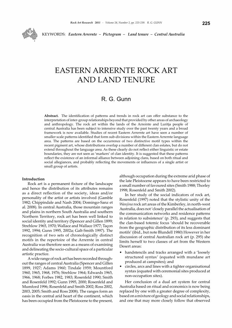
The rock art of the Arrernte, focused on the Mac-Donnell Ranges and Alice Springs (Fig. 1), is now seen as being dominated by eight broad categories:
stencils and prints predominantly of hands; small paintings and dry pigment drawings dominated by geometric forms; large bichrome paintings of singular geometric designs; peckings of animal tracks and small circles;peckings of large (1m diameter) circles; peckings of static, standing, anthropomorphous
••
•
•••
figures or animals; abraded motifs, including the abrading of early pecked motifs; andcontact art (drawings and paintings). That of the Eastern Arrernte, however, located
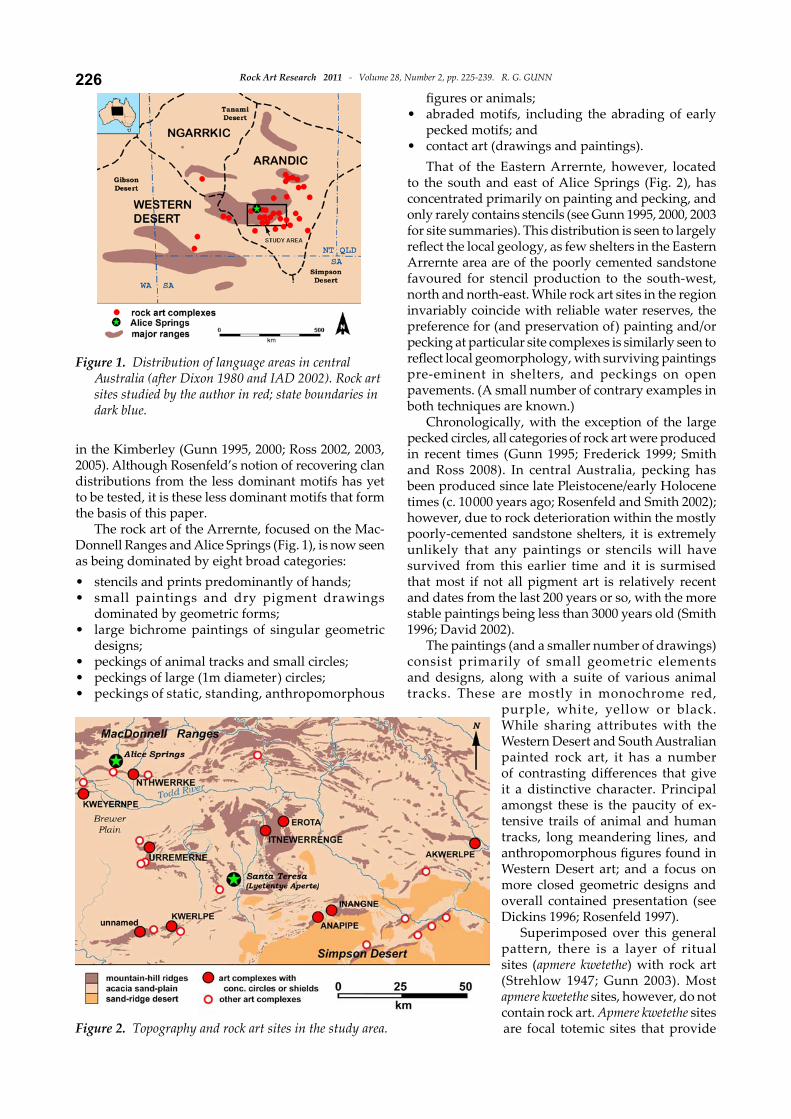
to the south and east of Alice Springs (Fig. 2), has concentrated primarily on painting and pecking, and only rarely contains stencils (see Gunn 1995, 2000, 2003 for site summaries). This distribution is seen to largely reflect the local geology, as few shelters in the Eastern Arrernte area are of the poorly cemented sandstone favoured for stencil production to the south-west, north and north-east. While rock art sites in the region invariably coincide with reliable water reserves, the preference for (and preservation of) painting and/or pecking at particular site complexes is similarly seen to reflect local geomorphology, with surviving paintings pre-eminent in shelters, and peckings on open pavements. (A small number of contrary examples in both techniques are known.)
Chronologically, with the exception of the large pecked circles, all categories of rock art were produced in recent times (Gunn 1995; Frederick 1999; Smith and Ross 2008). In central Australia, pecking has been produced since late Pleistocene/early Holocene times (c. 10 000 years ago; Rosenfeld and Smith 2002); however, due to rock deterioration within the mostly poorly-cemented sandstone shelters, it is extremely unlikely that any paintings or stencils will have survived from this earlier time and it is surmised that most if not all pigment art is relatively recent and dates from the last 200 years or so, with the more stable paintings being less than 3000 years old (Smith 1996; David 2002).
The paintings (and a smaller number of drawings) consist primarily of small geometric elements and designs, along with a suite of various animal tracks. These are mostly in monochrome red,
purple, white, yellow or black. While sharing attributes with the Western Desert and South Australian painted rock art, it has a number of contrasting differences that give it a distinctive character. Principal amongst these is the paucity of ex-tensive trails of animal and human tracks, long meandering lines, and anthropomorphous figures found in Western Desert art; and a focus on more closed geometric designs and overall contained presentation (see Dickins 1996; Rosenfeld 1997).
Superimposed over this general pattern, there is a layer of ritual sites (apmere kwetethe) with rock art (Strehlow 1947; Gunn 2003). Most apmere kwetethe sites, however, do not contain rock art. Apmere kwetethe sites are focal totemic sites that provide
•
•
Figure 2. Topography and rock art sites in the study area.
Figure 1. Distribution of language areas in central Australia (after Dixon 1980 and IAD 2002). Rock art sites studied by the author in red; state boundaries in dark blue.
227Rock Art Research 2011 - Volume 28, Number 2, pp. 225-239. R. G. GUNN
the name and associations for the estate. Generally, each estate had only one apmere kwetethe site. Where rock art occurs at one, it is invariably dominated by a single, large (1–2 m), atywerrenge motif, or a tightly composed set of motifs that were intimately linked to the totemic Dreaming of the site. Each atywerrenge design is unique, although all are variants of the common motif core. They occur as either pictograms, in which case they are invariably large bichrome paintings, or petroglyphs where they occur as large, singular and unpatinated, pecked or abraded motifs. The unique design, colour/patination, and the larger size of these motifs contrasts with the more common core of the regions motifs. It is this art form that most closely parallels the clan-based totemic religion of the Kimberley recorded by Rosenfeld (1997), both in its manifestation and its religious base. These atywerrenge motifs show no patterning in their distribution.
The data presented here has been accumulated over a 15-year period while working with many of the same senior custodians (see Acknowledgments). It is this long-term relationship that has permitted the recording of the artwork, while also documenting the social relationships and spiritual associations of these sites. It is also noted, however, that over this time, the death of several senior custodians with traditional knowledge has created a re-appraisal of some sites by today’s custodians such that restrictions on viewing and interpretation at some sites are more lenient than previously. This rationalisation is not a new concept as, over the past 50 years, the restrictions on some previously major sites have been completely lifted with the next generation (as I found when comparing information I had collected with that recorded in Strehlow’s field notes from the 1930s and 1960s; and note also Kimber 1996).
The study areaThe area of central Australia is defined as the set of
discontinuous, predominantly sandstone and quartzite ranges (Thompson 1991) isolated from the periphery of the continent by a series of expansive sandy deserts (Fig. 1). The ranges have weathered to form rock-holes and rockshelters in an extreme arid inland climate: with hot summers (mean max 36˚C; highest 45.2˚C) and cold winters (mean min 4˚C; lowest -7.5˚C) (http://reg.bom.gov.au/climate/averages/tables/cw_015590.shtml). Despite a predominantly summer rainfall, high daytime temperatures and stronger winds cause evaporation to be extreme, making surface water reserves scarce (see also Finlayson 1935; Latz 1995). The localised rock-holes, riverbed or claypan soaks, and spring-fed waterholes are therefore essential for both human and animal survival (Cook 1972; Smith 1988, 1993; Veth 1989, 2005; Thompson 1991; Thorley 1998, 2001). Not surprisingly therefore, all sizeable water reserves have high social and religious significance.
The central Australian ranges are within two differing cultural blocks: Arrernte in the central and
eastern areas, and Western Desert (Luritja) to the west (Strehlow 1965, 1970; Tindale 1974; Hobson 1990; Smith 2005). The area south-east from the central ranges, in which the present study is located, is largely within the Eastern Arrernte language area of the Arrernte block. Although the time depth of this land/culture association is unknown, it is assumed to have been from at least the late Holocene when weather conditions were broadly similar to those of today. To the Arrernte, the landscape in which they lived was the product of the activities of various Dreaming Beings, and therefore, can be seen to form a continuous religious feature (Spencer and Gillen 1899; Strehlow 1970, 1971, 1978; and cf. Lewis and Rose 1988). Within this symbolic continuum, however, there are clusters of named features, such as rock-holes, that form nodes or symbolic sites, over and above the background. These symbolic sites are not necessarily confined to a single place, but may be one of many inter-linked places along their respective Dreaming path. Where geological and geomorphic conditions are favourable, such sites will contain shelters or pavements that, in almost all cases, have been decorated with rock art.
‘Distinctive’ motifsRecent detailed site recordings have revealed
another layer of site associations through the presence of what I am terming ‘distinctive’ motifs. These are imposing and repeated motifs that are generally visually prominent within their shelter or open settings. They are, however, less dramatic and not as prominent as the apmere kwetethe motifs (Gunn 2003). Also, while not as large as apmere kwetethe designs, they tend to be slightly larger (30–100 cm) than the core motifs of small geometrics (10–30 cm).
The two ‘distinctive’ motif types discussed here are both painted and, at sites where they occur together, appear to be contemporary. These are:
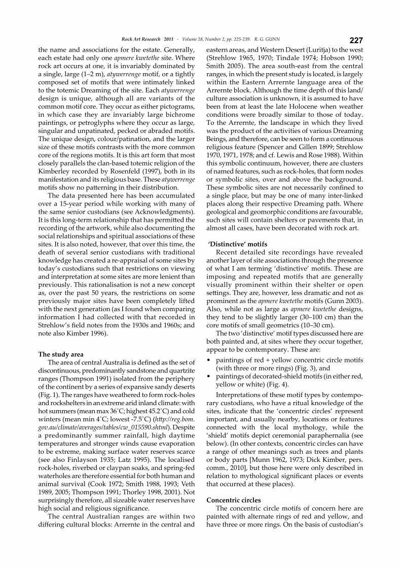
paintings of red + yellow concentric circle motifs (with three or more rings) (Fig. 3), andpaintings of decorated-shield motifs (in either red, yellow or white) (Fig. 4). Interpretations of these motif types by contempo-
rary custodians, who have a ritual knowledge of the sites, indicate that the ‘concentric circles’ represent important, and usually nearby, locations or features connected with the local mythology, while the ‘shield’ motifs depict ceremonial paraphernalia (see below). (In other contexts, concentric circles can have a range of other meanings such as trees and plants or body parts [Munn 1962, 1973; Dick Kimber, pers. comm., 2010], but those here were only described in relation to mythological significant places or events that occurred at these places).
Concentric circlesThe concentric circle motifs of concern here are
painted with alternate rings of red and yellow, and have three or more rings. On the basis of custodian’s
•
•
Rock Art Research 2011 - Volume 28, Number 2, pp. 225-239. R. G. GUNN228
statements and their generally good preservation, they are probably the most recent artwork in the region. Generally, concentric circles throughout central Australia (and regardless of the technique used to produce them) have been interpreted by custodians as depictions of place (cf. Munn 1973; Peterson 1981; Gunn 2001, 2002b), with the number of internal circles (or rings) being indicative of its general significance.
The motifs range from 10 cm to 49 cm in diameter, with a mean of 18 cm and a median of 16 cm (n = 79). In general, the diameter was proportional to the number of rings, as the thickness of the rings (finger-width) remained relatively constant. The 461 motifs documented occur at six site complexes within the Eastern Arrernte (south) area, and are most numerous at Erota, a site that is near the centre of their distribution. These motifs generally occur with a range of other red + yellow designs, and may occur in shelters with a range of other colours and motif types. A more detailed discussion of Erota follows below.
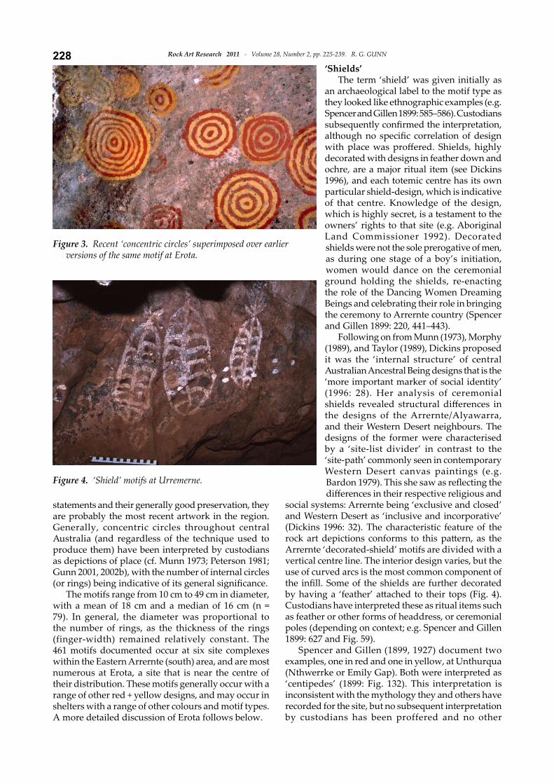
‘Shields’The term ‘shield’ was given initially as
an archaeological label to the motif type as they looked like ethnographic examples (e.g. Spencer and Gillen 1899: 585–586). Custodians subsequently confirmed the interpretation, although no specific correlation of design with place was proffered. Shields, highly decorated with designs in feather down and ochre, are a major ritual item (see Dickins 1996), and each totemic centre has its own particular shield-design, which is indicative of that centre. Knowledge of the design, which is highly secret, is a testament to the owners’ rights to that site (e.g. Aboriginal Land Commissioner 1992). Decorated shields were not the sole prerogative of men, as during one stage of a boy’s initiation, women would dance on the ceremonial ground holding the shields, re-enacting the role of the Dancing Women Dreaming Beings and celebrating their role in bringing the ceremony to Arrernte country (Spencer and Gillen 1899: 220, 441–443).
Following on from Munn (1973), Morphy (1989), and Taylor (1989), Dickins proposed it was the ‘internal structure’ of central Australian Ancestral Being designs that is the ‘more important marker of social identity’ (1996: 28). Her analysis of ceremonial shields revealed structural differences in the designs of the Arrernte/Alyawarra, and their Western Desert neighbours. The designs of the former were characterised by a ‘site-list divider’ in contrast to the ‘site-path’ commonly seen in contemporary Western Desert canvas paintings (e.g. Bardon 1979). This she saw as reflecting the differences in their respective religious and
social systems: Arrernte being ‘exclusive and closed’ and Western Desert as ‘inclusive and incorporative’ (Dickins 1996: 32). The characteristic feature of the rock art depictions conforms to this pattern, as the Arrernte ‘decorated-shield’ motifs are divided with a vertical centre line. The interior design varies, but the use of curved arcs is the most common component of the infill. Some of the shields are further decorated by having a ‘feather’ attached to their tops (Fig. 4). Custodians have interpreted these as ritual items such as feather or other forms of headdress, or ceremonial poles (depending on context; e.g. Spencer and Gillen 1899: 627 and Fig. 59).
Spencer and Gillen (1899, 1927) document two examples, one in red and one in yellow, at Unthurqua (Nthwerrke or Emily Gap). Both were interpreted as ‘centipedes’ (1899: Fig. 132). This interpretation is inconsistent with the mythology they and others have recorded for the site, but no subsequent interpretation by custodians has been proffered and no other
Figure 3. Recent ‘concentric circles’ superimposed over earlier versions of the same motif at Erota.
Figure 4. ‘Shield’ motifs at Urremerne.
229Rock Art Research 2011 - Volume 28, Number 2, pp. 225-239. R. G. GUNN
explanation of these ‘centipede’ mo-tifs can be offered at this stage. The yellow example no longer exists. This was presumably erased by water wash, as the red examples (there are at least seven) are on a near-vertical wall with no protective overhang, and all are in very poor condition (Gunn 1999).
The 88 recorded examples occur at six site complexes in Eastern Arrernte (north and south) and Central Arrernte areas and are most numerous at the Urremerne complex that is central to their distribution. They were painted in red, white, purple and yellow pigments and a single example was drawn in white. None utilised more than one colour. They ranged from 18 cm to 110 cm in length, with a mean of 46 cm. The shields occur within both deep narrow shelters and on open wall panels, some being seen by one or two people at a time and others seen by larger groups or people walking past.
In the past, painted shields were important ‘terri-torial deeds’ for the Arrernte, although they ranked below the higher significance of the secret-sacred atywerrenge. The restricted depiction of these ‘shield’ motifs to a particular geographic distribution suggests that what is represented here is not related to generalised territorial title but, more likely, to a localised Dreaming event or episode (such as that of the Dancing Women mentioned above).
ComparisonComparison of the two motif types also provides
some interesting contrasts. The concentric circles con-trast red and yellow colours to form a solid bichrome motif. Interestingly, there are no red + white concentric circles despite the prevalence of red + white solid striped designs amongst the apmere kwetethe motifs of the region. However, as one of the apmere kwetethe designs is in red + yellow, this suggests that while the red + white combinations were restricted to apmere kwetethe motifs, the apmere kwetethe motifs were not exclusively limited to these colours. Possibly related is the almost exclusive use and high significance of red and white colours for body and ritual paraphernalia decoration at Aranda [Arrernte] ceremonies (Spencer and Gillen 1899).
The shields, on the other hand, are monochrome outlines with decorative, but not complex, interior infill and are generally larger than the concentric circles. Both groups tend to occur in clusters that, together, provide a greater visual impact than the singular motif.
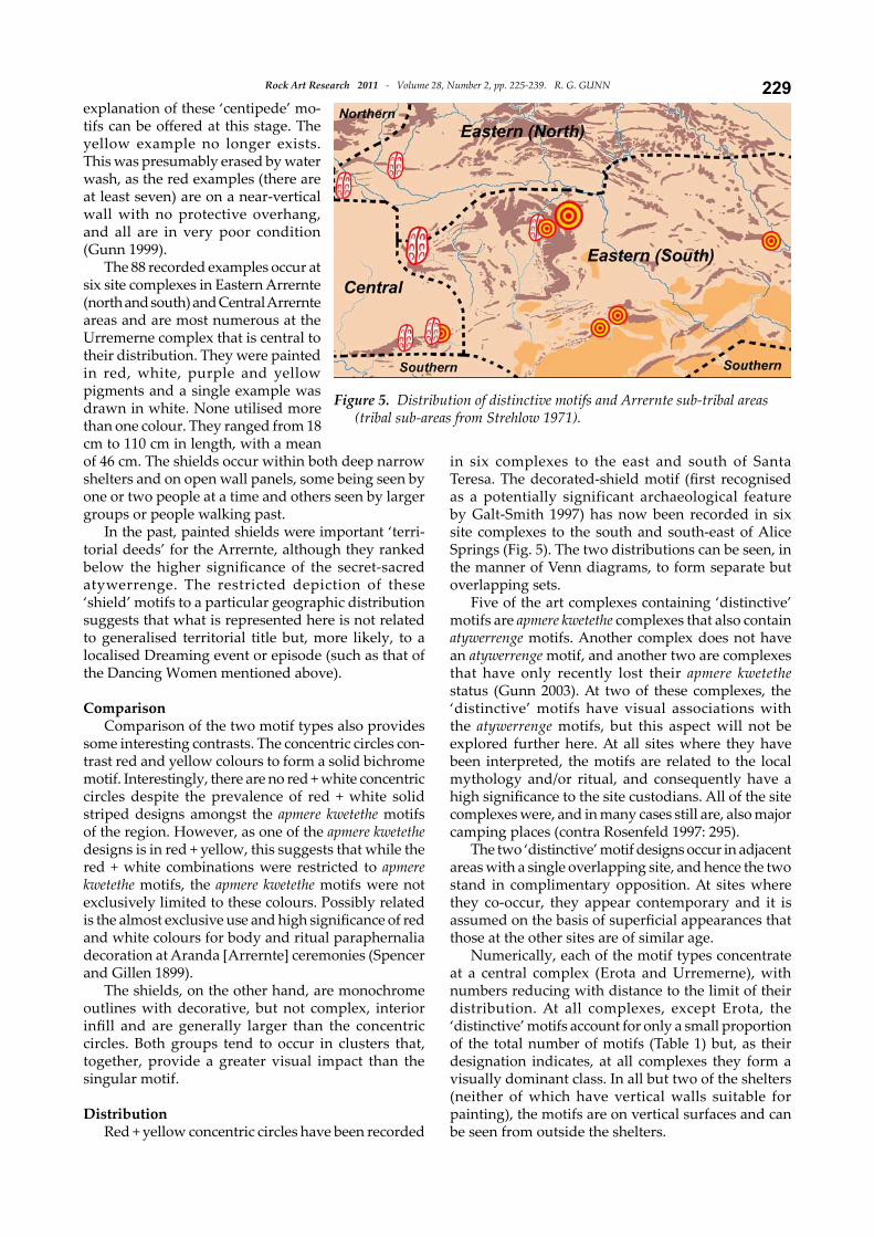
DistributionRed + yellow concentric circles have been recorded
in six complexes to the east and south of Santa Teresa. The decorated-shield motif (first recognised as a potentially significant archaeological feature by Galt-Smith 1997) has now been recorded in six site complexes to the south and south-east of Alice Springs (Fig. 5). The two distributions can be seen, in the manner of Venn diagrams, to form separate but overlapping sets.
Five of the art complexes containing ‘distinctive’ motifs are apmere kwetethe complexes that also contain atywerrenge motifs. Another complex does not have an atywerrenge motif, and another two are complexes that have only recently lost their apmere kwetethe status (Gunn 2003). At two of these complexes, the ‘distinctive’ motifs have visual associations with the atywerrenge motifs, but this aspect will not be explored further here. At all sites where they have been interpreted, the motifs are related to the local mythology and/or ritual, and consequently have a high significance to the site custodians. All of the site complexes were, and in many cases still are, also major camping places (contra Rosenfeld 1997: 295).
The two ‘distinctive’ motif designs occur in adjacent areas with a single overlapping site, and hence the two stand in complimentary opposition. At sites where they co-occur, they appear contemporary and it is assumed on the basis of superficial appearances that those at the other sites are of similar age.
Numerically, each of the motif types concentrate at a central complex (Erota and Urremerne), with numbers reducing with distance to the limit of their distribution. At all complexes, except Erota, the ‘distinctive’ motifs account for only a small proportion of the total number of motifs (Table 1) but, as their designation indicates, at all complexes they form a visually dominant class. In all but two of the shelters (neither of which have vertical walls suitable for painting), the motifs are on vertical surfaces and can be seen from outside the shelters.
Figure 5. Distribution of distinctive motifs and Arrernte sub-tribal areas (tribal sub-areas from Strehlow 1971).
Rock Art Research 2011 - Volume 28, Number 2, pp. 225-239. R. G. GUNN230
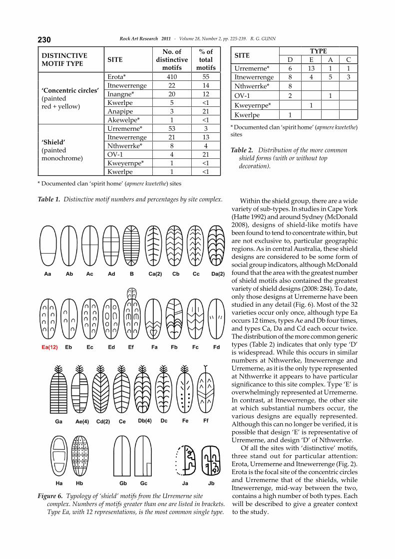
Within the shield group, there are a wide variety of sub-types. In studies in Cape York (Hatte 1992) and around Sydney (McDonald 2008), designs of shield-like motifs have been found to tend to concentrate within, but are not exclusive to, particular geographic regions. As in central Australia, these shield designs are considered to be some form of social group indicators, although McDonald found that the area with the greatest number of shield motifs also contained the greatest variety of shield designs (2008: 284). To date, only those designs at Urremerne have been studied in any detail (Fig. 6). Most of the 32 varieties occur only once, although type Ea occurs 12 times, types Ae and Db four times, and types Ca, Da and Cd each occur twice. The distribution of the more common generic types (Table 2) indicates that only type ‘D’ is widespread. While this occurs in similar numbers at Nthwerrke, Itnewerrenge and Urremerne, as it is the only type represented at Nthwerrke it appears to have particular significance to this site complex. Type ‘E’ is overwhelmingly represented at Urremerne. In contrast, at Itnewerrenge, the other site at which substantial numbers occur, the various designs are equally represented. Although this can no longer be verified, it is possible that design ‘E’ is representative of Urremerne, and design ‘D’ of Nthwerrke.
Of all the sites with ‘distinctive’ motifs, three stand out for particular attention: Erota, Urremerne and Itnewerrenge (Fig. 2). Erota is the focal site of the concentric circles and Urremerne that of the shields, while Itnewerrenge, mid-way between the two, contains a high number of both types. Each will be described to give a greater context to the study.
DISTINCTIVEMOTIF TYPE SITE
No. of distinctive
motifs
% of total
motifs
‘Concentric circles’(painted red + yellow)
Erota* 410 55Itnewerrenge 22 14Inangne* 20 12Kwerlpe 5 <1Anapipe 3 21Akewelpe* 1 <1
‘Shield’ (painted monochrome)
Urremerne* 53 3Itnewerrenge 21 13Nthwerrke* 8 4OV-1 4 21Kweyernpe* 1 <1Kwerlpe 1 <1
* Documented clan ‘spirit home’ (apmere kwetethe) sites
Table 1. Distinctive motif numbers and percentages by site complex.
SITE TYPED E A C
Urremerne* 6 13 1 1Itnewerrenge 8 4 5 3Nthwerrke* 8OV-1 2 1Kweyernpe* 1Kwerlpe 1
* Documented clan ‘spirit home’ (apmere kwetethe) sites
Table 2. Distribution of the more common shield forms (with or without top decoration).
Figure 6. Typology of ‘shield’ motifs from the Urremerne site complex. Numbers of motifs greater than one are listed in brackets. Type Ea, with 12 representations, is the most common single type.
231Rock Art Research 2011 - Volume 28, Number 2, pp. 225-239. R. G. GUNN
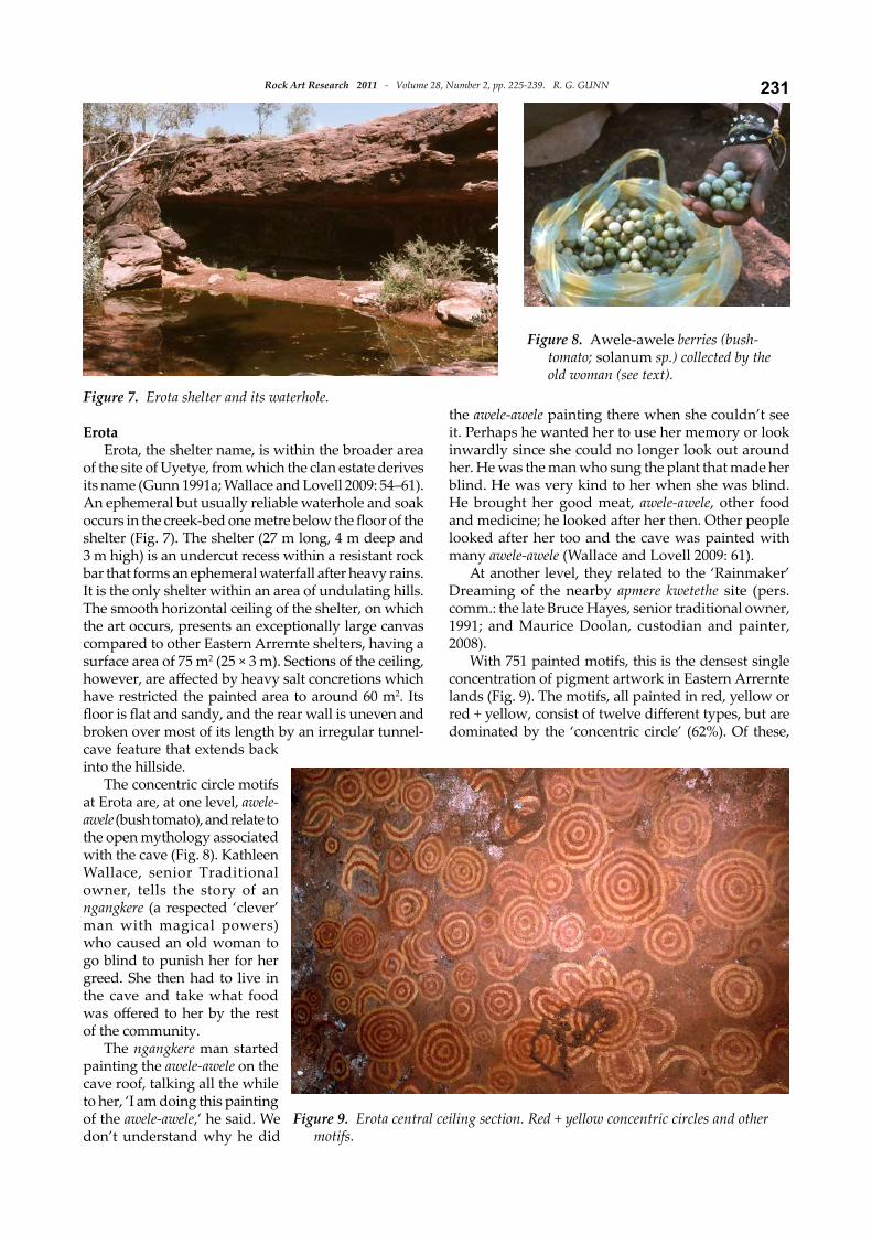
ErotaErota, the shelter name, is within the broader area
of the site of Uyetye, from which the clan estate derives its name (Gunn 1991a; Wallace and Lovell 2009: 54–61). An ephemeral but usually reliable waterhole and soak occurs in the creek-bed one metre below the floor of the shelter (Fig. 7). The shelter (27 m long, 4 m deep and 3 m high) is an undercut recess within a resistant rock bar that forms an ephemeral waterfall after heavy rains. It is the only shelter within an area of undulating hills. The smooth horizontal ceiling of the shelter, on which the art occurs, presents an exceptionally large canvas compared to other Eastern Arrernte shelters, having a surface area of 75 m2 (25 × 3 m). Sections of the ceiling, however, are affected by heavy salt concretions which have restricted the painted area to around 60 m2. Its floor is flat and sandy, and the rear wall is uneven and broken over most of its length by an irregular tunnel-cave feature that extends back into the hillside.
The concentric circle motifs at Erota are, at one level, awele-awele (bush tomato), and relate to the open mythology associated with the cave (Fig. 8). Kathleen Wallace, senior Traditional owner, tells the story of an ngangkere (a respected ‘clever’ man with magical powers) who caused an old woman to go blind to punish her for her greed. She then had to live in the cave and take what food was offered to her by the rest of the community.
The ngangkere man started painting the awele-awele on the cave roof, talking all the while to her, ‘I am doing this painting of the awele-awele,’ he said. We don’t understand why he did
the awele-awele painting there when she couldn’t see it. Perhaps he wanted her to use her memory or look inwardly since she could no longer look out around her. He was the man who sung the plant that made her blind. He was very kind to her when she was blind. He brought her good meat, awele-awele, other food and medicine; he looked after her then. Other people looked after her too and the cave was painted with many awele-awele (Wallace and Lovell 2009: 61).
At another level, they related to the ‘Rainmaker’ Dreaming of the nearby apmere kwetethe site (pers. comm.: the late Bruce Hayes, senior traditional owner, 1991; and Maurice Doolan, custodian and painter, 2008).
With 751 painted motifs, this is the densest single concentration of pigment artwork in Eastern Arrernte lands (Fig. 9). The motifs, all painted in red, yellow or red + yellow, consist of twelve different types, but are dominated by the ‘concentric circle’ (62%). Of these,
Figure 7. Erota shelter and its waterhole.
Figure 8. Awele-awele berries (bush-tomato; solanum sp.) collected by the old woman (see text).
Figure 9. Erota central ceiling section. Red + yellow concentric circles and other motifs.
Rock Art Research 2011 - Volume 28, Number 2, pp. 225-239. R. G. GUNN232
410 were painted with red + yellow; the others being either red or yellow monochromes. The number of rings per motif ranges from 2 to 15, with most having 2–4 rings around a central dot. The only other numerically significant motif is the ‘crescent’ motif (27%), although ‘compound designs’ are noteworthy by their larger size and more complex construction. The site, its artwork and mythology are now not subject to any restrictions. The extremely high number of motifs is attributed to the shelter’s singular occurrence and its previous significance as an apmere kwetethe, as recorded by Strehlow (field notes 1958), and the paintings themselves which, as a group, constituted a former atywerrenge motif. (Due to a range of post-contact interruptions to traditional customs and land use over the past 60 years or so, the apmere kwetethe site was reassigned to a companion site some distance away; see Gunn 2003.) Camping within the shelter was either during the heat of the day on hot days, or during cool or wet weather. Kathleen Wallace, a senior Traditional Owner, was born at the site (Wallace and Lovell 2009: 55) and the previous senior owner (now deceased) and Bobby Hayes (now kwertengwerle) used to play around
in the tunnels when they were children (Gunn 1991a: 10). At other times camping was on top of the rock-bench above the shelter, where there is a broad and flat natural terrace. Below the shelter, the stony creek-bed winds through low hills with few flat areas suitable for camping.
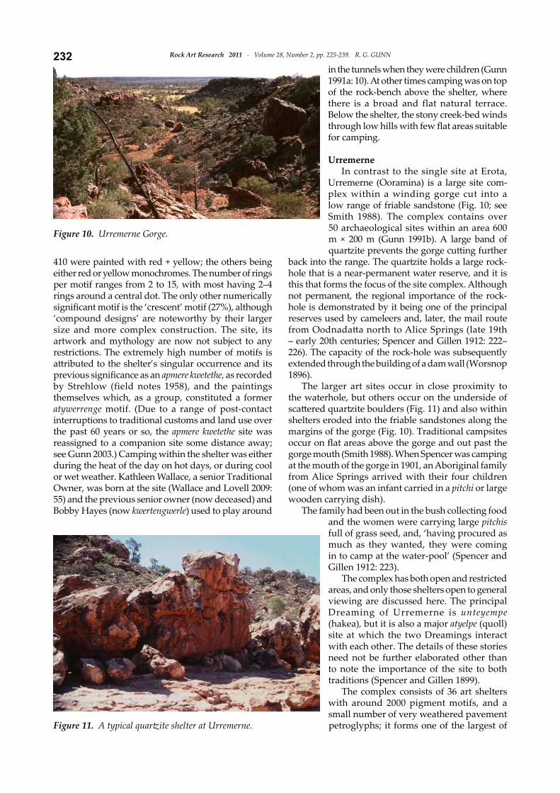
UrremerneIn contrast to the single site at Erota,
Urremerne (Ooramina) is a large site com-plex within a winding gorge cut into a low range of friable sandstone (Fig. 10; see Smith 1988). The complex contains over 50 archaeological sites within an area 600 m × 200 m (Gunn 1991b). A large band of quartzite prevents the gorge cutting further
back into the range. The quartzite holds a large rock-hole that is a near-permanent water reserve, and it is this that forms the focus of the site complex. Although not permanent, the regional importance of the rock-hole is demonstrated by it being one of the principal reserves used by cameleers and, later, the mail route from Oodnadatta north to Alice Springs (late 19th – early 20th centuries; Spencer and Gillen 1912: 222–226). The capacity of the rock-hole was subsequently extended through the building of a dam wall (Worsnop 1896).
The larger art sites occur in close proximity to the waterhole, but others occur on the underside of scattered quartzite boulders (Fig. 11) and also within shelters eroded into the friable sandstones along the margins of the gorge (Fig. 10). Traditional campsites occur on flat areas above the gorge and out past the gorge mouth (Smith 1988). When Spencer was camping at the mouth of the gorge in 1901, an Aboriginal family from Alice Springs arrived with their four children (one of whom was an infant carried in a pitchi or large wooden carrying dish).
The family had been out in the bush collecting food and the women were carrying large pitchis full of grass seed, and, ‘having procured as much as they wanted, they were coming in to camp at the water-pool’ (Spencer and Gillen 1912: 223).
The complex has both open and restricted areas, and only those shelters open to general viewing are discussed here. The principal Dreaming of Urremerne is unteyempe (hakea), but it is also a major atyelpe (quoll) site at which the two Dreamings interact with each other. The details of these stories need not be further elaborated other than to note the importance of the site to both traditions (Spencer and Gillen 1899).
The complex consists of 36 art shelters with around 2000 pigment motifs, and a small number of very weathered pavement petroglyphs; it forms one of the largest of
Figure 10. Urremerne Gorge.
Figure 11. A typical quartzite shelter at Urremerne.
233Rock Art Research 2011 - Volume 28, Number 2, pp. 225-239. R. G. GUNN
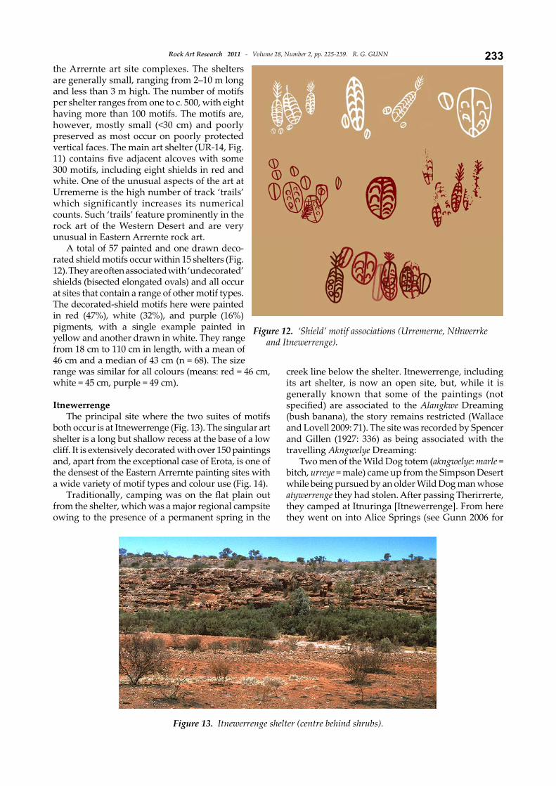
the Arrernte art site complexes. The shelters are generally small, ranging from 2–10 m long and less than 3 m high. The number of motifs per shelter ranges from one to c. 500, with eight having more than 100 motifs. The motifs are, however, mostly small (<30 cm) and poorly preserved as most occur on poorly protected vertical faces. The main art shelter (UR-14, Fig. 11) contains five adjacent alcoves with some 300 motifs, including eight shields in red and white. One of the unusual aspects of the art at Urremerne is the high number of track ‘trails’ which significantly increases its numerical counts. Such ‘trails’ feature prominently in the rock art of the Western Desert and are very unusual in Eastern Arrernte rock art.
A total of 57 painted and one drawn deco-rated shield motifs occur within 15 shelters (Fig. 12). They are often associated with ‘undecorated’ shields (bisected elongated ovals) and all occur at sites that contain a range of other motif types. The decorated-shield motifs here were painted in red (47%), white (32%), and purple (16%) pigments, with a single example painted in yellow and another drawn in white. They range from 18 cm to 110 cm in length, with a mean of 46 cm and a median of 43 cm (n = 68). The size range was similar for all colours (means: red = 46 cm, white = 45 cm, purple = 49 cm).
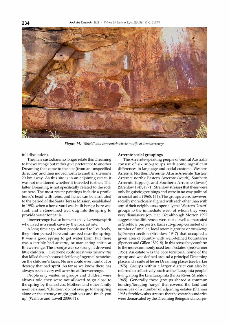
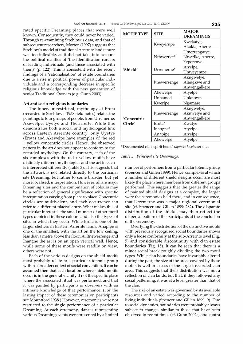
ItnewerrengeThe principal site where the two suites of motifs
both occur is at Itnewerrenge (Fig. 13). The singular art shelter is a long but shallow recess at the base of a low cliff. It is extensively decorated with over 150 paintings and, apart from the exceptional case of Erota, is one of the densest of the Eastern Arrernte painting sites with a wide variety of motif types and colour use (Fig. 14).
Traditionally, camping was on the flat plain out from the shelter, which was a major regional campsite owing to the presence of a permanent spring in the
creek line below the shelter. Itnewerrenge, including its art shelter, is now an open site, but, while it is generally known that some of the paintings (not specified) are associated to the Alangkwe Dreaming (bush banana), the story remains restricted (Wallace and Lovell 2009: 71). The site was recorded by Spencer and Gillen (1927: 336) as being associated with the travelling Akngwelye Dreaming:
Two men of the Wild Dog totem (akngwelye: marle = bitch, urreye = male) came up from the Simpson Desert while being pursued by an older Wild Dog man whose atywerrenge they had stolen. After passing Therirrerte, they camped at Itnuringa [Itnewerrenge]. From here they went on into Alice Springs (see Gunn 2006 for
Figure 13. Itnewerrenge shelter (centre behind shrubs).
Figure 12. ‘Shield’ motif associations (Urremerne, Nthwerrke and Itnewerrenge).
Rock Art Research 2011 - Volume 28, Number 2, pp. 225-239. R. G. GUNN234
full discussion).The male custodians no longer relate this Dreaming
to Itnewerrenge but rather give preference to another Dreaming that came to the site (from an unspecified direction) and then moved north to another site some 20 km away. As this site is in an adjoining estate, it was not mentioned whether it travelled further. This latter Dreaming is not specifically related to the rock art here. The most recent paintings include a profile horse’s head with reins, and hence can be attributed to the period of the Santa Teresa Mission, established in 1952, when a horse yard was built here, a bore was sunk and a stone-lined well dug into the spring to provide water for cattle.
Itnewerrenge is also home to an evil arrentye spirit who lived in a small cave by the rock art site:
A long time ago, when people used to live freely, they often passed here and camped near the spring. It was a good spring to get water from, but there was a terribly bad arrentye, or man-eating spirit, at Itnewerrenge. The arrentye was so strong, it drowned little children. ... Everyone could see it was the arrentye that killed them because it left long fingernail scratches on the children’s faces. No one could ever hunt out or destroy that bad spirit. As far as we know there has always been a very evil arrentye at Itnewerrenge.
People only visited in groups and children were always told they were not allowed to go close to the spring by themselves. Mothers and other family members said, ‘Children, do not ever go to the spring alone or the arrentye might grab you and finish you up’ (Wallace and Lovell 2009: 71).
Arrernte social groupingsThe Arrernte-speaking people of central Australia
consist of six sub-groups with some significant differences in language and social customs: Western Arrernte, Northern Arrernte, Akarre Arrernte (Eastern Arrernte north); Eastern Arrernte (south); Southern Arrernte (upper); and Southern Arrernte (lower) (Strehlow 1947, 1971). Strehlow stresses that these were only linguistic groupings and were in no way political or social units (1965: 134). The groups were, however, socially more closely aligned with each other than with any of their neighbours, especially the ‘Western Desert’ groups to the immediate west, of whom they were very dismissive (op. cit.: 132; although Morton 1997 suggests the differences were not as well demarcated as Strehlow purports). Each sub-group consisted of a number of smaller, local totemic groups or nyenhenge (njinanga) section (Strehlow 1947) that occupied a given area of country with well-defined boundaries (Spencer and Gillen 1899: 8). In this sense they conform to the more commonly used term ‘estates’ (see Stanner 1965). An estate was the core territorial home of the group and was defined around a principal Dreaming place and a suite of lesser Dreaming places (see Barker 1975). Groups within a larger district can also be referred to collectively, such as the ‘Larapinta people’ living along the Lira Larapinta (Finke River; Strehlow 1965). Generally these groups shared a common hunting/foraging ‘range’ that covered the land and resources of a number of adjoining estates (Stanner 1965). Strehlow also stresses that the estate boundaries were demarcated by the Dreaming Beings and incorpo-
Figure 14. ‘Shield’ and concentric circle motifs at Itnewerrenge.
235Rock Art Research 2011 - Volume 28, Number 2, pp. 225-239. R. G. GUNN
rated specific Dreaming places that were well known. Consequently, they could never be varied. Through re-examining Strehlow’s data, and that of subsequent researchers, Morton (1997) suggests that Strehlow’s model of traditional Arrernte land tenure was too inflexible, as it did not take into account the political realities of ‘the identification careers of leading individuals (and those associated with them)’ (p. 122). This is consistent with the recent findings of a ‘rationalisation’ of estate boundaries due to a rise in political power of particular indi-viduals and a corresponding decrease in specific religious knowledge with the new generation of senior Traditional Owners (e.g. Gunn 2003).
Art and socio-religious boundariesThe inner, or restricted, mythology at Erota
(recorded in Strehlow’s 1958 field notes) relates the paintings to four groups of people: from Urremerne, Akewelpe, Uyetye and Therirrerte. While this demonstrates both a social and mythological link across Eastern Arrernte country, only Uyetye (Erota) and Akewelpe have examples of the red + yellow concentric circles. Hence, the observed pattern in the art does not appear to conform to the recorded mythology. On the contrary, each of the six complexes with the red + yellow motifs have distinctly different mythologies and the art in each is interpreted differently (Table 3). This suggests that the artwork is not related directly to the particular site Dreaming, but rather to some broader, but yet more localised, interpretation. However, all are major Dreaming sites and the combination of colours may be a reflection of general significance with specific interpretation varying from place to place. Concentric circles are multivalent, and each occurrence can refer to a different place/feature. What makes this of particular interest is the small number of other motif types depicted in these colours and also the types of sites in which they occur. While Erota is one of the larger shelters in Eastern Arrernte lands, Anapipe is one of the smallest, with the art on the low ceiling, less than a metre above the floor. At Itnewerrenge and Inangne the art is on an open vertical wall. Hence, while some of these motifs were readily on view, others were not.
Each of the various designs on the shield motifs most probably relate to a particular totemic group within a broader context of social convention. It can be assumed then that each location where shield motifs occur is in the general vicinity if not the specific place where the associated ritual was performed, and that it was painted by participants or observers with an intimate knowledge of that performance. (For the lasting impact of these ceremonies on participants see Mountford 1938.) However, ceremonies were not restricted to the single performance of a particular Dreaming. At each ceremony, dances representing various Dreaming events were presented by a limited
number of performers from a particular totemic group (Spencer and Gillen 1899). Hence, complexes at which a number of different shield designs occur are most likely the place where members from different groups performed. This suggests that the greater the range of painted shield designs at a complex, the larger were the ceremonies held there, and in consequence, that Urremerne was a major regional ceremonial site (cf. Spencer and Gillen 1899: 282). The disparate distribution of the shields may then reflect the dispersal pattern of the participants at the conclusion of the ceremony.
Overlying the distribution of the distinctive motifs with previously recognised social boundaries shows only a loose conformity at the sub-Arrernte level (Fig. 5) and considerable discontinuity with clan estate boundaries (Fig. 15). It can be seen that there is a minor social break roughly dividing the two motif types. While clan boundaries have invariably altered during the past, the size of the areas covered by these motifs is well in excess of the largest recorded clan area. This suggests that their distribution was not a reflection of clan lands, but that, if they followed any social patterning, it was at a level greater than that of the clan.
The size of an estate was governed by its available resources and varied according to the number of living individuals (Spencer and Gillen 1899: 9). Due to social dynamics, boundaries were probably always subject to changes similar to those that have been observed in recent times (cf. Gunn 2002a, and contra
MOTIF TYPE SITE MAJOR DREAMINGS
‘Shield’
Kweyernpe Kwekatye,Akakia, Aherte
Nthwerrke*Utnerrengatye,Ntyarlke, Aperre,Yeperenye
Urremerne* Atyelpe, Untyeyempe
ItnewerrengeAkngwelye, Alangkwe and Anwengalkere
Akewelpe AtyelpeUnnamed Unknown
‘Concentric Circle’
Kwerlpe Ngamare
ItnewerrengeAkngwelye,Aknwelye andAnwengalkere
Erota* KwatyeInangne* AtyelpeAnapipe AtyelpeAkewelpe Atyelpe
* Documented clan ‘spirit home’ (apmere kwetethe) sites
Table 3. Principal site Dreamings.
Rock Art Research 2011 - Volume 28, Number 2, pp. 225-239. R. G. GUNN236
Strehlow 1947). Accordingly, the present boundaries cannot be held to reflect those extant at the time of the rock art’s production. Nonetheless, it is assumed that the general area of an estate, while flexible during periods of redefinition, would probably have been similar around any particular resource, regardless of the particular owning group at any one time.
The ‘distinctive’ motifs occur within areas larger than a local estate but considerably smaller than the tribal or sub-tribal group. This suggests that some other form of local clan confederacy was in operation. On the basis of land claims data (Olney 1992, 1993) and personal fieldwork, the two areas tend to also separate on the basis of the pmere kartweye (site owner from the estate in question) and kwertengwerle (site manager from an adjacent estate): shields to the south of Alice Springs and concentric circles to the south-west (Fig. 5). On the basis of these associations, which land claim hearings accept to be more than a post-contact phenomenon associated with the town centres of Alice Springs and Santa Teresa (e.g. Olney 1992), these areas most likely reflect the distinct range and domain of two groups (see Stanner 1965).
From discussions with the senior custodians of the clans involved, the shields and concentric circles tend to reflect a pattern of loose social relationships whereby those groups around Urremerne have close formal and informal relationships with groups within the MacDonnell Ranges (to the north). In contrast, groups at Lyetentye Aperte (Santa Teresa) have close links to those groups to the east and south, but much lesser associations with those in the MacDonnell Ranges.
The ranges around Lyetentye Aperte are well-supplied with freshwater springs, while the rivers of the MacDonnell Ranges to the north contain a number of permanent waterholes and soaks. Consequently,
despite the arid environment, the need for water is not seen as an incentive for any interaction between these two groups (although during prolonged droughts exceptional interaction may indeed have been necessary). In contrast, the groups on the northern and western edge of the Simpson Desert have mostly ephemeral water reserves and would have been required to fall back, much more regularly, on Lyetentye Aperte (later the site for the Santa Teresa Mission) and a small number of other permanent springs (Finlayson 1935; Wilson et al. 1990; Wallace and Lovell 2009: 97; and cf. Thorley 2001). Similarly, those groups from the Brewer Plain and Urremerne, to the south of Alice Springs, would move north to the MacDonnell Ranges. In this instance the foci of the shield motifs is the upper Todd River/Brewer Plain (Nthwerrke, Kweyernpe, Urremerne) and that of the concentric circles the lower
Todd River and flood-out (Erota, Inangne, Anapipe) (Figs 2 and 5).
DiscussionAs the distribution of these two significant motifs
does not reflect known formal social boundaries or religious networks, what other model can account for them? A study of the work of a single artist in Kakadu, in northern Australia, found that the artist, Najombolmi, painted rock art both within and beyond his clan lands (Haskovec and Sullivan 1989). In total he visited and painted in six adjoining clan areas and most of his paintings (>80%) were done outside his own clan area. The distribution was not related to strong socio-economic ties, or to religious obligations. The biggest factor appears to have been the locations where Najombolmi spent most of his time, which in his case was the location of European settlements where he was working. On reflection, Haskovec and Sullivan further concluded that the proliferation of (recent?) rock art in the Kakadu area (see Edwards 1979) may be largely due to a small number of innovative individuals.
This model appears to account convincingly for the distribution of distinctive motifs within the present study area. As particular motif/technique types radiate out from a central focus it is likely that their distribution reflects an informal social network between adjacent clans. From the example of Najombolmi, it is possible that some of these motifs reflect the work, or at least the influence (fashion?) of a particular artist. However, the repainting of the concentric circles in Erota and the varying forms and colours of the shields at Urremerne indicates that more than one artist was involved to create the observed patterns. Clearly, these two groups of artists (circle and shield groups) were all deeply involved in their respective predominant religious
Figure 15. Schematic map of kirte (owner) / kwertengwerle (manager) relationships for the respective clan estates. The thicker line represents a minor social boundary roughly equating with the foci of the two ‘distinctive’ motif types.
237Rock Art Research 2011 - Volume 28, Number 2, pp. 225-239. R. G. GUNN
beliefs in relation to some restricted territorial range. The range of preservation of the motifs and the number of superimpositions of each suggests that both groups doubtless involved several generations of painters. In no sense can these paintings be seen to act as ‘boundary markers’, particularly as Arrernte people and their neighbours knew their landscape and limits intimately through place, song and mythological associations and had no need of visual reminders in rockshelters. More likely, the patterns here are seen as reflecting the ‘sphere of influence’ of individuals with informal socio-religious associations to their neighbours.
Consequently, the artwork can be seen to reflect the shared domain of a particular group (cf. Stanner 1965), determined by its negotiated group affiliations (Rosenfeld 1997: 295). However, in contrast to northern Australia where fluidity of access is paralleled by a fluidity of rules that permits the painting of non-sacred motifs in someone else’s estate (Rosenfeld 1997: 294), the pattern here suggests that at least some of the paintings done across estate boundaries were indeed related to sacred themes.
ConclusionFrom this study, it appears that recent distinctive
motifs in Arrernte rock art do not reflect formal social boundaries or religious networks. As the particular motif/technique types radiate out from central foci, it is likely that their distributions reflect informal social networks between adjacent clans. Further, it is probable that these motifs reflect the range of a number of particular artists and, in this sense, the rock art is seen to reflect informal religious and artistic associations across the landscape.
AcknowledgmentsMy primary thanks go to the many senior Arrernte
traditional owners and other knowledgeable people who assisted with both the fieldwork and subsequent discussions: Alan Drover, Bruce Hayes, Bobby Hayes, Clem Alice, Basil Hayes, Myra Hayes, Peter Johnson, David Johnson, Willie Williams, Louie Ryder, Maurice Wallace (Werrirt-arenye), Kathleen Wallace and Veronica Dobson. Unfortunately, some of these have since passed away and did not see the results of this research.
Additional help was provided by Brett Galt-Smith, Scott Mitchell and Michael Cawthorn (Strehlow Research Centre, Alice Springs); Michael Pickering, Andrew Allen, Walter Zukowski and Joe Firinu (Aboriginal Areas Protection Authority, Alice Springs). Judy Lovell assisted greatly with obtaining permission to use the illustrations. My thanks also to Michael Pickering, Leigh Douglas, and RAR referees June Ross, Dick Kimber and an anonymous reader for their comments on the draft paper.
The Eastern Arrernte rock art recording project was undertaken with funding from the Australian Heritage Commission, Canberra, and the Australian Institute of Aboriginal and Torres Strait Islander Studies, Canberra, and administered by the Aboriginal Areas Protection Authority, Darwin.
R. G. Gunn329 Mt Dryden RoadLake Lonsdale, VIC 3381AustraliaE-mail: [email protected]
Final MS received 17 September 2010.
REFERENCES
Aboriginal Land Commissioner 1992. North-west Simpson Desert land claim. Australian Government Publishing Service, Canberra.
Adams, L. 1960. The abstract art of the Aranda. Anthropos 55: 345–356.
Barker, G. 1975. The ritual estate and Aboriginal polity. Mankind 10: 225–239.
Bardon, G. 1979. Aboriginal art of the Western Desert. Rigby, Adelaide.
Blundell, V. 1980. Hunter-gatherer territoriality: ideology and behaviour in northwest Australia. Ethnohistory 27: 213–233.
Chippindale, C. and G. Nash (eds) 2004. The figures landscapes of rock-art: looking at pictures in place. Cambridge University Press, Cambridge.
Cook, P. J. 1972. Rodinga, Northern Territory; 1:250 000 Geological Series explanatory notes (Sheet SG/53-2). Australian Government Publishing Service, Canberra.
David, B. 2002. Landscapes, rock-art and the Dreaming: an archaeology of preunderstanding. Leicester University Press, London.
Dickins, J. 1996. Change and continuity in central Australian graphic systems. Journal of Anthropological Anthropology 15: 20–40.
Dixon, R. M. W. 1980. The languages of Australia. Cambridge University Press, Cambridge.
Domingo-Sanz, I, D. Fiore and S. K. May (eds) 2008. Archaeologies of art: time, place and identity. Left Coast Press, Walnut Creek, CA.
Edwards, R. 1965. Report on the Ooramina rock engraving site, Alice Springs, Northern Territory. Unpubl. report on file at the AIATSIS, Canberra.
Edwards, R. 1966. Comparative study of rock engravings in South and central Australia. Transactions of the Royal Society of South Australia 90: 33–38.
Edwards, R. 1968. Prehistoric rock engravings at Thomas Reservoir, Cleland Hills, western central Australia. Records of the South Australian Museum 15: 647–670.
Edwards, R. 1979. Australian Aboriginal art: the art of the Alligators Rivers region, Northern Territory. Australian Institute of Aboriginal Studies, Canberra.
Finlayson, H. H. 1935. The Red Centre. Angus and Robertson, Sydney.
Forbes, S. 1982. Aboriginal rock engravings at N’Dhala Gorge. Unpubl. BLitt. thesis, Australian National University, Canberra.
Forbes, S. 1983. Aboriginal rock engravings at N’Dhala Gorge, Northern Territory. In M. Smith (ed.), Archaeology at ANZAAS 1983, pp. 199–213. Western Australian Museum, Perth.
Frederick, U. K. 1999. At the centre of it all: constructing contact through the rock-art of Watarrka National Park, central Australia. Archaeology in Oceania 34: 132–144.
Galt-Smith, B. 1997. Motives for motifs. Unpubl. BA (Hons) thesis, Archaeology and Palaeoanthropology, University

Rock Art Research 2011 - Volume 28, Number 2, pp. 225-239. R. G. GUNN238of New England, Armidale.
Gamble, C. 1982. Interaction and alliance in Palaeolithic society. Man 17: 92–107.
Gunn, R. G. 1991a. The rock art of Erota and Inangne, central Australia. Unpubl. report to the Aboriginal Areas Protection Authority, Alice Springs, and the Australian Heritage Commission, Canberra.
Gunn, R. G. 1991b. Urremerne (Ooramina) rock art survey. Unpubl. report to the Aboriginal Areas Protection Authority, Alice Springs, and the Australian Heritage Commission, Canberra.
Gunn, R. G. 1995. Regional patterning in the Aboriginal rock art of central Australia: a preliminary report. Rock Art Research 12: 117–128.
Gunn, R. G. 1999. The rock art of Nthwerrke, Atherrke and Intriyapa (Emily Gap, Jessie Gap and Heavitree Gap): near Alice Springs, central Australia. Unpubl. report for the Traditional Owners to the Aboriginal Areas Protection Authority, Alice Springs, and the Australian Heritage Commission, Canberra.
Gunn, R. G. 2000. Central Australian rock art: a second report. Rock Art Research 17: 111–126.
Gunn, R. G. 2001. The rock art of Uluru: an archaeological study. Unpubl. report to Cultural Heritage Unit, Uluru and Kata-Tjuta National Park (Environment Australia), Yulara.
Gunn, R. G. 2002a. Our country, their country: preliminary comparisons of the rock-art across the Western Desert / Arrernte borderlands. Tempus 7: 109–119.
Gunn, R. G. 2002b. Alyemperrke: an Eastern Arrernte rock art and Dreaming site. Unpubl. report for the Traditional Owners to the Aboriginal Areas Protection Authority, Alice Springs, and the Australian Institute of Aboriginal and Torres Strait Islander Studies, Canberra.
Gunn, R. G. 2003. Arrernte rock-art: interpreting physical permanence in a changing social landscape. Australian Aboriginal Studies 2003(1): 52–73.
Gunn, R. G. 2006. Select Eastern Arrernte rock art complexes in the Rodinga region, central Australia. Unpubl. report for the Site Custodians to the Aboriginal Areas Protection Authority, Alice Springs, and the Australian Institute of Aboriginal and Torres Strait Islander Studies, Canberra.
Haskovec, I. P. and H. Sullivan 1989. Reflections and rejections of an Aboriginal artist. In H. Morphy (ed.), Animals into art, pp. 57–74. Unwin Hyman, London.
Hatte, L. 1992. ‘Boring coastal stuff’: rock images of the Townsville district, north Queensland. In J. McDonald and I. P. Haskovec (eds), State of the art, pp. 71–75. Occasional AURA Publication 6, Australian Rock Art Research Association, Melbourne.
Hobson, J. 1990. Current distribution of central Australian languages. Institute for Aboriginal Development, Alice Springs. Institute of Aboriginal Development (IAD) 2002. Central Australian languages: current distribution [map]. IAD Press, Alice Springs.
Kimber, R. G. 1996. The dynamic century before the Horn Expedition: a speculative history. In S. R. Morton and D. J. Mulvaney (eds), Exploring central Australia: society, the environment and the 1894 Horn expedition, pp. 91–103. Surrey Beatty and Sons, Chipping Norton.
Latz, P. 1995. Bushfires and bush tucker: Aboriginal plant use in central Australia. IAD Press, Alice Springs.
Lewis, D. and D. Rose 1988. The shape of the Dreaming: the cultural significance of Victoria River rock art. Aboriginal Studies Press, Canberra.
McDonald, J. 2008. Dreamtime superhighway: Sydney Basin rock
art and prehistoric information exchange. Terra Australis 27. ANU EPress, Canberra.
Morphy, H. 1989. On representing Ancestral Beings. In H. Morphy (ed.), Animals into art, pp. 144–160. Unwin Hyman, London.
Morton, J. 1997. Arrernte (Aranda) land tenure: an evaluation of the Strehlow model. Strehlow Research Centre Occasional Paper 1: 107–126.
Mountford, C. P. 1938. Contrast in drawings made by an Australian Aborigine before and after initiation. Records of the South Australian Museum 6(2): 111–114.
Mountford, C. P. 1960. Simple rock engravings in central Australia. Man 192: 145–147.
Mountford, C. P. 1965. Ayers Rock: its people, their beliefs and their art. Angus & Robinson, Sydney.
Mountford, C. P. 1968. Winbaraku and the myth of Jarapiri. Rigby, Adelaide.
Mountford, C. P. 1976. Nomads of the Australian desert. Rigby, Adelaide.
Munn, N. D. 1962. Walbiri graphic signs: an analysis. American Anthropologist 64: 972–984.
Munn, N. D. 1973. Walbiri iconography. Cornell University Press, Ithaca.
Olney, H. W. 1992. North-west Simpson Desert land claim. Australian Government Publishing Service, Canberra.
Olney, H. W. 1993. North Simpson Desert land claim. Australian Government Publishing Service, Canberra.
Peterson, N. 1981. Art of the desert. In Australian Gallery Directors Council (eds), Aboriginal Australia, pp. 42–51. AGDC, Canberra.
Rosenfeld, A. 1990. Rock art in Watarrka National Park. Fieldwork report to the Faculties, Australian National University.
Rosenfeld, A. 1997. Archaeological signatures of the social production of rock art. In M. Conkey, O. Soffer, D. Stratmann and N. G. Jablonski (eds), Beyond art: Pleistocene image and symbol, pp. 289–300. University of California Press, San Francisco.
Rosenfeld, A. and W. Mumford 1996. The Thuiparta rock engravings at Erowalle, Wallace Rock Hole, James Range, Northern Territory. Tempus 6: 247–255.
Rosenfeld, A. and M. A. Smith 2002. Rock-art and the history of Puritjarra rock shelter, Cleland Hills, central Australia. Proceedings of the Prehistoric Society 68: 103–124.
Ross, J. 2002. Rocking the boundaries, scratching the surface: an analysis of the relationship between painting and engravings in the central Australian arid zone. Tempus 7: 83–91.
Ross, J. 2003. Rock art, ritual and relationships: an archaeolo-gical analysis of rock art from the central Australian arid zone. Unpubl. PhD thesis, University of New England, Armidale.
Ross, J. 2005. Rock art of the Red Centre. In M. Smith and P. Hesse (eds), Archaeology and environmental history of the southern deserts, pp. 217–232. National Museum of Australia, Canberra.
Smith, M. A. 1988. The pattern and timing of prehistoric settlement in central Australia. Unpubl. PhD thesis, Archaeology, University of New England, Armidale.
Smith, M. A. 1993. Biogeography, human ecology and prehistory in the sandridge deserts. Australian Archaeology 37: 35–50.
Smith, M. A. 1996. Prehistory and human ecology in central Australia: an archaeological perspective. In S. R. Morton and D. J. Mulvaney (eds), Exploring central Australia: society, the environment and the 1894 Horn expedition, pp. 61–73.

239Rock Art Research 2011 - Volume 28, Number 2, pp. 225-239. R. G. GUNN
Surrey Beatty & Sons, Chipping Norton.Smith, M. A. 2005. Desert archaeology, linguistic stratigraphy
and the spread of the Western Desert language. In P. Veth, M. Smith and P. Hiscock (eds), Desert peoples: archaeological perspectives, pp. 222–242. Blackwell Publishing, Carlton.
Smith, M. A. and A. Rosenfeld 1992. Archaeological sites in Watarrka National Park: the northern sector plateau. Unpubl. report to the Conservation Commission of the Northern Territory, Alice Springs.
Smith, M. A. and J. Ross 2008. Glen Thirsty: the history and archaeology of a desert well. Australian Archaeology 66: 45–59.
Spencer, B. and F. J. Gillen 1899. The native tribes of central Australia. MacMillan and Co., London.
Spencer, B. and F. J. Gillen 1912. Across Australia. MacMillan and Co., London.
Spencer, B. and F. J. Gillen 1927. The Arunta. MacMillan, London. (2 vols).
Stanner, W. E. H. 1965. Aboriginal territorial organisation: estate, range, domain and regime. Oceania 36(1): 1–26.
Strehlow, T. G. H. 1947. Aranda traditions. Melbourne University Press. (1967 reprint edition).
Strehlow, T. G. H. 1964. The art of circle, line and square. In R. M. Berndt (ed.), Australian Aboriginal art, pp. 44–59. Ure Smith, Sydney.
Strehlow, T. G. H. 1965. Culture, social structure and environ-ment in Aboriginal central Australia. In R. M. Berndt (ed.), Aboriginal man in Australia, pp. 121–145. Angus and Robertson, Melbourne.
Strehlow, T. G. H. 1970. Geography and the totemic landscape in central Australia: a functional study. In R. M. Berndt (ed.), Australian Aboriginal anthropology, pp. 92–140. Australian Institute of Aboriginal Studies, Canberra, and University of Western Australia Press, Nedlands.
Strehlow, T. G. H. 1971. Songs of central Australia. Angus and Robinson, Sydney.
Strehlow, T. G. H. 1978. Central Australian religion: personal monototemism in a polytotemic community. Australian Association for the Study of Religions, Bedford Park, S.A.
Taçon, P. S. C. 1992. The Roma Gorge rock art complex: an assessment and description. Unpubl. report to the Conservation Commission of the Northern Territory,
Alice Springs.Taçon, P. S. C. 1994. Socialising landscapes: the long term
implications of signs, symbols and marks on the land. Archaeology in Oceania 29: 117–129.
Taylor, L. 1989. Seeing the ‘Inside’: Kunwinjku painting and the symbol of the divided body. In H. Morphy (ed), Animals into art, pp. 371–389. Unwin Hyman, London.
Thompson, R. B. 1991. A guide to the geology and landforms of central Australia. Northern Territory Geological Survey, Alice Springs.
Thorley, P. B. 1998. Shifting location, shifting scale: a regional landscape approach to the prehistoric archaeology of the Palmer River catchment, central Australia. Unpubl. PhD thesis, Northern Territory University, Darwin.
Thorley, P. B. 2001 Uncertain supplies: water availability and regional archaeological structure in the Palmer River catchment, central Australia. Archaeology in Oceania 36(1): 1–14.
Tindale, N. B. 1959. Totemic beliefs of the Western Desert of Australia. Records of the South Australian Museum 13(3): 305–332.
Tindale, N. B. 1974. Aboriginal tribes of Australia. ANU Press, Canberra.
Veth, P. M. 1989. Islands in the interior: a model for the colonization of Australia’s arid zone. Archaeology in Oceania 24: 81–92.
Veth, P. M. 2005. Cycles of aridity and human mobility: risk-minimisation amongst the late Pleistocene foragers of the Western Desert, Australia. In P. Veth. M. A. Smith and P. Hiscock (eds), Desert peoples: archaeological perspectives, pp. 100–115. Blackwell Publishing, Oxford.
Wallace, K. and J. Lovell 2009. Listen deeply, let these stories in. IAD Press, Alice Springs.
Wallace, P. and N. Wallace 1977. Killing me softly: the destruction of a heritage. Nelson, Melbourne.
Wilson, B. A., P. S. Brocklehurst, M. J. Clark and K. J. M. Dickson 1990. Vegetation survey of the Northern Territory. Conservation Commission of the Northern Territory, Darwin.
Worsnop, T. 1896. The prehistoric art of the Aborigines of Australia. Australian Association for the Advancement of Science 6: 135–148.
RAR 28-1020

Rock Art Research 2011 - Volume 28, Number 2, pp. 225-239. R. G. GUNN240 Rock Art Research 2011 - Volume 28, Number 2.