151 - international glaciological society
TRANSCRIPT


1
ISSN0019–1043
Ice
NewsBulletinoftheInternationalGlaciologicalSociety
Number 151 3rd Issue 2009
Contents 2 FromtheEditor 3 Recentwork 3 Italy 3 Alpine glaciers 14 Ice cores 16 Alpine inventories 17 Apennine glaciers 18 Tropical glaciers 18 Himalaya–Karakoram glaciers 20 Polar glaciers and ice sheets 23 Glacier hydrology 24 The Miage Lake project 25 Applied glaciology 28 Remote sensing 30 Permafrost 33 Ice caves 33 Ecological studies 37 Snow and avalanches
40 InternationalGlaciologicalSociety 40 Journal of Glaciology 41 Annals of Glaciology, Volume 51(54) 41 Annals of Glaciology, Volume 51(55) 42 Report from the Nordic Branch Meeting 43 Notes from the production team 44 Meetings of other societies: 44 Northwestern Glaciologists meeting
2009 47 Sapporo symposium 2nd circular 52 Ohio symposium 2nd circular 57 Future meetings of other societies: 11th International Circumpolar
Remote Sensing Symposium 57 Books received 58 News 58 Obituary: Hans Röthlisberger 60 Glaciologicaldiary 66 Newmembers
Cover picture: River Skeiðará flowing along the terminus of the outlet glacier Skeiðarárjökull from southern Vatnajökull ice cap. The river changed course in July 2009. Until then the river flowed directly to the south from the outlet on the eastern side of the terminus and under the longest bridge in Iceland, the ~900 m long Skeiðará bridge. The river now flows to the west along the terminus and merges with the river Gígjukvísl near the centre of the glacier and the Skeiðará bridge is more or less on dry land. Photo: Oddur Sigurðsson.
Scanning electron micrograph of the ice crystal used in headings by kind permission of William P. Wergin, Agricultural Research Service, US Department of Agriculture
EXCLUSION CLAUSE. While care is taken to provide accurate accounts and information in this Newsletter, neither the editor nor the International Glaciological Society undertakes any liability for omissions or errors.

2
FromtheEditor
Dear IGS member
We have now had the opportunity to test our two new digital systems. The online member-ship payment has worked very well, and you have responded very well – but there are still some stragglers out there. As I mentioned in my last editorial in ICE 150, it is much more economical for us to send out as many of the Journals as possible when we print them. We sent out the second reminder in March which brought on another flurry of renewals. We will now target those who have been members of the IGS in the past but for whatever reason have not renewed. If you know of anyone like that, please encourage them to rejoin. We are constantly trying to think of things that will make IGS membership more attractive: the lat-est is that we are making back issues of all IGS publications available online. That means that volume 1, issue 1 of the Journal is now online and so is volume 1 of the Annals. So please help us in getting former members back.
Quite a few of you have come back to us with suggestions as to how we can further improve the system. In particular you have mentioned that you would like to be able to purchase back issues of both the Annals and Journal at the same time as you renew. That is of course our intention but we decided to take it one step at the time. We will introduce a ‘shop’ where you will be able to put other IGS publi-cations into a ‘shopping basket’, just like you do when you shop at any other online vendor. You have also asked us to enable you to change your type of membership, i.e. from ‘student’ to ‘ordinary’ or ‘ordinary’ to ‘contributing’. That is something we will be working on and hopefully it will be up and running later this year. You also asked whether you could print out receipts once you have paid your membership dues. That is also in the pipeline. This online presence opens up all sorts of possibilities for the future.
The online submission system was a little later getting off the ground than I had hoped, as the online membership took up much more of our time than anticipated. But that did not deter you from submitting as we had a record number of submissions in January. It is really interesting and enjoyable for us to report that 2009 was yet another record-breaking year as regards the number of submissions. And that is the fourth year in a row that we have broken the submission record. With the online submission system we anticipate that we will make that five years in a row.
As we are now publishing six issues per year we decided to go back to the tradition of having a new cover photograph on each issue. That means we are going to need a steady stream of high-quality pictures. So please look at your photo album and check to see if you have any stunning pictures in your collection. This applies especially to authors whose papers we are going to publish, as we would like the cover to illuminate an article in the issue. So if your paper is accepted for publication, please check to see if you have a potential cover photograph that is relevant to the subject of your article.
On a similar note, some of you may have noticed that the last issue of 2010 is going to be the 200th issue of the Journal of Glaciology. We are planning to commemorate this by republishing some classic papers that have appeared in the Journal. In addition we are going to invite our members to submit poten-tial cover pictures to celebrate this milestone. So start looking at your slides and send us a sample. Remember that the picture must be of a very high quality. As a prize for the win-ning photograph, we will present you with a framed picture of the cover and one year’s free subscription to the Journal.
MagnúsMárMagnússonSecretary General

3
ALPINE GLACIERS
Glacier variations, long term length and mass balance monitoring
LongtermmonitoringoflengthchangesComitato Glaciologico Italiano (CGI), Carlo Baroni (UNIPI-DST), Mirco Meneghel (UNIPD-DG), Giovanni Mortara (CNR-IRPI)Since the beginning of the last century the CGI has been paying attention to the fluctuations of Italian glaciers. Actually a yearly monitoring of the snout position on selected glaciers is carried out by the surveyors of the CGI in close cooperation with several organizations involved in glaciology (among others SMI, SGL, CGT-SAT, SG-CAIAA). The present (last 15 years) monitoring program was also sustained by recent COFIN-PRIN Projects funded by the Italian Research Ministry.
The collected data are published annually in a report in the CGI official journal named ‘Geografia Fisica e Dinamica Quaternaria’. Moreover data of many glaciers are also periodically sent to WGMS to be published in the volumes ‘Fluctuations of Glaciers’. Snout position is commonly measured on the ground by topographic instruments (mainly tape, in some cases laser rangefinder, GPS). A de-scription of the year by year glacier changes is usu-ally given along with the measurements. For some glaciers these measurements have been collected since the end of the XIX century thus making their data-records more than 100 years old. Over the last ten years 134 glaciers (average value) have been monitored in the Italian Alps (66 glaciers in the Western Alps, 25 in the Central Alps and 43 in the Eastern Alps). About 88% (average value) of the glaciers measured are retreating (from 69% in 2001 to a maximum of 99% in 2007); some of them are now vanishing.Contact: [email protected]
AcenturyofItalianglaciersfluctuationsGuglielmina Diolaiuti, Carlo D’Agata, Claudio Smiraglia (UNIMI-DST), Michele Citterio (GEUS), Francesco Apadula, Giuseppe Stella (CESI)The project is based on the analysis of all the avail-able Italian terminus fluctuation data published since 1908 by the CAI journal (named ‘Bollettino del Club Alpino Italiano’) and since l914 in the yearly reports of CGI (published in the CGI official journal). The data were entered in a special data base (named GLAD) available online through the website of CESI which supported the research.In GLAD information and data regarding 883 Ital-
ian glaciers were inserted. The glaciers entered in GLAD were surveyed with variable continuity between 1908 and 2002. Since the time series for most of the 883 glaciers are short or very discon-tinuous, a representative subset of 95 glaciers fea-turing longer and more reliable data was selected for further analysis.
This subset contains a total of 3776 field-surveyed measurements, with an average record length of 39.7 years per glacier, ten glaciers in the 60- to 70-year class of record length, four glaciers surveyed for more than 70 years and one glacier (i.e., Ventina) with records covering 85 years.
Glaciers known to surge (i.e., Belvedere) or af-fected by active calving at the terminus (i.e. Sab-bione Meridionale) were excluded. Because of this, it is not possible simply to average the curves of cumulated terminus fluctuations, and for inter-comparison purposes, the 95 selected glaciers were sorted according to their maximum length (<1 km, 1–2 km, 2–4 km and >4 km) and the data were averaged over time intervals of 10 years (from 1913 to 2002).
The results show that the general trend for Ital-ian glaciers, in spite of the fact that such glaciers show strong fluctuations with large amplitudes, is one of retreat for most of the 20th century. The only significant interruptions in the retreat trend proved to have taken place in the 1913–1922 interval (though very few glaciers were monitored during those wartime years) and then in the 1970s and 1980s. The lowest fraction of retreating glaciers and the lowest rates of retreat or even significant advances were recorded in the decade from 1973 to 1982, compared to the preceding and subse-quent decades, regardless of glacier size. However, a consistent pattern was recognizable with respect to glacier size, both in the percentage of retreating glaciers and in the average rate of terminus fluctua-tion within the 1973–1982 decade itself: while the longest glaciers (i.e. >2 km in length) were mostly advancing, only a minority of glaciers shorter than 2 km advanced. Longer glaciers, on average, had positive or slightly positive rates of terminus posi-tion change, while shorter glaciers saw only a tem-porary slowdown of their retreat.
The last period (1993–2002) is the only one, together with 1933–1942, without any advancing glaciers at all (on the decadal scale) in the sub-sample of 95 glaciers, and it is interesting to ob-serve that average decadal rates of retreat in these two periods are similar for all size classes but the shortest (i.e. glaciers shorter than 1 km). It also
RecentworkItaly

4
must be added that all the glacier classes showed a retreat acceleration from the decade 1983–1992 to 1993–2002.
The next step of the project is the GLAD data uploading and the analysis of the terminus fluc-tuation data over the last decade (2003-2012).Contact: [email protected]
GlacierretreatintheMaritimeAlpsareaPaolo Roberto Federici, Marta Pappalardo (UNIPI-DST)In the southernmost tract of the Alps (Italian-French Maritime Alps, 44° N), extensively cov-ered by glaciers during the Last Glacial Maxi-mum, about 30 small glaciers were present by the end of the Little Ice Age and only six persisted in the early 1990s. The focus of this research activ-ity is to quantify the progressive decrease towards exhaustion of these glaciers, highlight the factors affecting their retreat and state their current condi-tion. All available data sources were investigated, including: the yearly glacier fluctuations record, comparative analyses of historical maps and mul-titemporal oblique photographs and direct sur-veys in the field. The history of the Maritime Alps glacier fluctuations was thoroughly researched since 1896. Time-distance curves were obtained for some of the glaciers. In particular during the past two decades, the Maritime Alps glacier ter-mini experienced a global retreat of about 100 m, with a sharp acceleration after 2002. Currently ice patches along cirque walls and/or semi-bur-ied lenses of ice are still present, as testified by geo-electrical surveys carried out in three cirque hollows; morphological evidence of permafrost creeping in the glacier forefield accounts for the incipient transition to periglacial landforms (i.e., rock glaciers). The main factors controlling gla-ciers retreat seem to have been their original ex-tension at the beginning of the current regressive phase and their distance from the main chain di-vide. From a climatic point of view unfavourable factors for glaciers persistence have been in the last decades a remarkable and sharp temperature increase, a decrease in winter snowfall and a shift of the rainfall peak from autumn to spring. Contact: [email protected]
Glacier monitoring in Aosta Valley – NorthWesternItalianAlpsAlex Théodule, Elena Motta, Marco Vagliasindi, Claudio Lucianaz (FMS-CRGV), Umberto Morra di Cella, Paolo Pogliotti (ARPA-VdA)Aosta Valley is a medium size alpine region cov-ering a surface of about 3300 km2; here glacial and periglacial environments represent important land elements (i.e. more than 50% of the region area is located above an elevation of 2000 m a.s.l.). Consequently is important to acquire and update detailed information on glaciers and gla-cial environments.
At the regional scale, by analysing aerial pho-tographs, orthophotos and satellite imagery gla-cier changes are quantified. All this information is collected in the Regional Glacier Inventory, which was performed according to the World Glacier In-ventory standard and recommendations.
At the local scale, mass-balance measure-ments, terminus fluctuations and snow accumu-lation surveys are carried out on glacier sample sites. The yearly mass balances are measured on Timorion Glacier (Gran Paradiso Massif, from 2001), Rutor Glacier (from 2004), Pré de Bard Glacier (Mont Blanc Massif, from 2007) and In-dren Glacier (Mont Rose Massif, from 2007) by applying the traditional glaciological method (through ablation stakes and snow pits). Moreo-ver, from 2005 some other representative glaciers (Chérillon, Mont Gelé, Tsanteleina and Verra Grande) are monitored by surveying their termi-nus with GPS and performing snow depth and density measurements.Contact: [email protected]
IntegrationoficonographichistoricalandrecentdatainanGISfortheMultitemporalanalysisoftheMiageGlacierevolution(MonteBianco)Marco Giardino, Luigi Perotti, Walter Alberto (UNITO-GSL), Giovanni Mortara (CNR-IRPI)The available data on the geomorphological changes of the Miage glacial environment are huge; besides the splendid iconographical repre-sentations of the 18th and 19th centuries, it is also possible to admire the numerous photographs from the end of the 19th century, most of them preserved at the CGI in Torino.
Another important iconographical patrimony is constituted by the aerial photographs (stereo pairs), first taken in the 1930s, that document the glacial characteristics of the Miage in recent times. This great amount of data has allowed to realize a first catalogue on the aerial documenta-tion of the Miage glacier. At last, the iconographi-cal patrimony can be completed with the recent photograph research and catalogue of glacial and alpine interest at the FMS of Courmayeur, Valle d’Aosta.
With the available documentation it was possi-ble to realize a Geographical Information System containing an inventory of all the cartographical, iconographical, photogrammetrical and satellite data on the Miage glacier. The structure of the database has not only been conceived as a scien-tific tool on the glacial area, but also as an impor-tant information resource on the high mountain environment. Therefore, it represents a valid in-strument for the data integration on the territorial transformations. Besides, on the base of the aerial and satellite data, some quantitative and qualita-tive analyses have been developed with photo-grammetric and digital classification techniques

5
of the images that allowed, where possible, a tem-poral planimetric and volumetric reconstruction of the Miage Glacier. This system, also allowed to analyze natural hazards interfering with human activities. In the next few months, it will be pos-sible to create a monitoring system of the study area based on the available data.Contact: [email protected]
MultitemporalanalysisofGranParadisoglaciersValerio Bertoglio (PNGP), Luigi Perotti, Walter Alberto, Marco Giardino (UNITO-GSL)The last 15 years has been brought forward a project of tracking glacier termini of most of the glaciers in the Gran Paradiso Group. The work was done through the use of GPS code and phase instrumentation. The collected data were entered into a GIS in order to be analyzed.
A map of the multitemporal changes was pro-duced in order to have an updated progress of the glacier environment.Contact: [email protected]
Mass balance of the Grand Etret Glacier, GranParadisoValerio Bertoglio, Stefano Cerise (PNGP), Luigi Motta, Michele Motta (UNITO-DST) Grand Etrèt is a medium-size valley glacier lo-cated in the Gran Paradiso Massif (Western Alps). Since 1999 its yearly mass balance was studied in the framework of a cooperation between the Gran Paradiso National Park and the University of Turin. From 1999 to 2009 the glacier had lost 10.6 m of thickness (9.22 mm w.e.). The mass balance result was particularly negative in the hydrological years 2002–2003 and 2005–2006. Instead, the mass balance was found positive in the hydrological years 2000–2001 and 2008–2009, mainly due to heavy snow precipitations.
The analysis of mass balance data over the last ten years showed that generally at the beginning of the ablation season, in June, ablation increases fast, reaching generally high values (up to 7–9 cm/day in sunny days), although with wide oscillations, up to the middle of September. Moreover ablation re-sulted quite homogeneous at all elevations due to the compensation between air temperature (which decreases with increasing altitude) and solar ra-diation (which rises at higher altitude). Generally accumulation was found to increase with altitude with the exception of the glacier central sector where snow cover resulted decreasing probably due to glacier local aspect and/or to wind erosion. Moreover during some summer seasons exudation ice was found outstanding at the glacier surface thus emphasizing the role of the solar radiation in driving glacier ablation.Contact: [email protected]
History of the Rutor Glacier retreat (Valled’Aosta,Italy)fromtheLittleIceAgeFabio Villa, Mattia De Amicis, Valter Maggi, Giuseppe Orombelli (UNIMIB)Variations in the surface area and volume of the Rutor Glacier (Val d’Aosta), from the maximum expansion in the Little Ice Age to the present re-treating phase, were determined by combining ground surveys, digital techniques and pre-exist-ing data time series. From the mid-19th century to 2004 the glacier terminus retreated by about 2 km, nevertheless there was evidence of two (cooler) periods of glacier advance. Furthermore, the most recent glacier retreating phase, which started in 1990, seems to be faster than the previous ones. The Rutor Glacier lost about 480 × 106 m3 of ice between the Little Ice Age and 1991. Morpholog-ic and volumetric analysis indicate that in the last decades the Rutor Glacier had lost large quantities of ice with no significant terminus retreat (an ice loss of -46 × 106 m3 and a surface decrease of –1.4 ha, this latter with respect to a total surface area of 911 ha); the glacier has gradually thinned while maintaining an almost constant surface area. The Equilibrium Line Altitude changed from 2775 m in the Little Ice Age maximum to 2850 m in 1991, with a total rise of 75 m. Contact: [email protected]
ThemassbalancenetworkofLombardyglaciersClaudio Smiraglia, Guglielmina Diolaiuti (UNIMI-DST), Giacomo Casartelli (CGI), Riccardo Scotti (SGL)Part of the network was developed in the frame-work of several COFIN-PRIN Projects funded by the Italian Research Ministry and under the um-brella of a partnership with the CAI.
On the Lombardy Alps mass balance moni-toring has been performed without interruptions since the end of the 1980s on the Sforzellina Gla-cier, a small (less than 1 km2 wide) cirque glacier in the Ortles-Cevedale group. Other benchmark glaciers are the Scalino Glacier, in the Bernina group, monitored from 1993, and the Dosdè Orientale Glacier, in the Piazzi-Campo Group, monitored from 1995. The mass balance data are acquired according to the glaciological method (ablation stakes and snow pits). All mass balance data calculated for the last 20 hydrological years resulted negative but one (the only exception was 2001) thus witnessing a considerable glacier mass loss. The mean ice loss was 2.1 m w.e. during the heat wave of 2003.
Analysing Lombardy mass balance data and comparing them with the ones of other Euro-pean glaciers shows this glaciological parameter encloses not only a temporal index of climate change but also a spatial determination of the climate variability. In this way it is possible to describe glacier regions characterized by differ-
6
ent mass balance patterns. The Lombardy glaciers results form part of the results of glacier regions up to 200 km wide.
Other benchmark glaciers are the ones moni-tored by SGL: the Suretta Meridionale in the Spluga-Lei Group (surveyed from 2002) and the Alpe Meridionale in the Ortles-Cevedale Group (from 1998). The mass balance data of the Suretta glacier are evaluated from GPS surveys coupled with glaciological investigations; The Alpe Merio-dionale data, instead, derived from glaciological surveys. Both the balance records shoe negative results over the last decade: the Alpe Meridionale Glacier had lost 16 m w.e. from 1998 to 2008. Contacts: [email protected], guglielmina. [email protected], [email protected]
Recent surface variations of the Lombardy glaciers
Recent surface variations of glaciers in theAdamellogroupGuglielmina Diolaiuti, Davide Maragno, Carlo D’Agata, Claudia Mihalcea, Claudio Smiraglia (UNIMI-DST), Daniele Bocchiola (POLIMI-DIIAR)In the framework of the Project CARIPANDA man-aged by the Adamello Regional Park and funded by Fondazione Cariplo, an investigation on the recent surface area changes of the Adamello gla-ciers (Lombardy Alps) has been carried out. Four surface area records (1983–1991–1999–2003) were compiled by combining aerial photo analy-sis, Differential Global Positioning System (DGPS) surveys of glaciers and Geographic Information System (GIS) data processing. The analysis led to a quantification of surface reduction ca. 19% from 1983 to 2003 (total surface about 17 km2 in 2003) with strong glacier morphology changes, including growing rock outcrops, tongue separa-tion, formation of ice-contact lakes, increasing supraglacial debris and collapse structures, well detected on the 2003 orthophotos.
Moreover small glaciers proved to contribute strongly to total area loss: in 2003, 31 glaciers (c. 91% of the total number) were smaller than 1 km2, covering 2.28 km2 (c. 10% of the total area), but accounted for 39% of the total loss in area (losing 2.05 km2 from 1983 to 2003). Presently an update of the variations using the most recent orthophotos (2007) is continuing. Contact: [email protected]
Fifty years of glacier changes in Dosdè-PiazzigroupGuglielmina Diolaiuti, Davide Maragno, Claudio Smiraglia (UNIMI-DST)In the framework of the ‘Water & Glaciers’ Project funded by San Pellegrino-Levissima Spa, the gla-cier surface area variations along half a century (1954–2003) of the Dosdè-Piazzi group in the up-
per Valtellina have been analyzed by using aerial photos (1954–1981), a former glacier inventory (1991) and orthophotos (1999, 2003). The Dosdè-Piazzi glacierized area was 8.21 km2 in 1954 (19 glaciers and 3 glacierets), 6.53 km2 in 1981 (22 glaciers and 3 glacierets), 5.55 km2 in 1991 (24 glaciers), 4.10 km2 in 1999 (14 glaciers) and 3.77 km2 in 2003 (23 glaciers). The area change between 2003 and 1954 was –3.97 km2 (–51% of the area coverage in 1954). Moreover, the surface reduction seems to be stronger in the last time frame. Pres-ently an update of the variations by using the most recent orthophotos (2007) is continuing. Contact: [email protected]
Twenty years of glacier changes in the Ortles-CevedalegroupGuglielmina Diolaiuti, Davide Maragno, Claudio Smiraglia (UNIMI-DST)In the framework of the ‘SHARE-STELVIO’ Project funded by Lombardy Region and managed by FLA and EvK2CNR, the glacier surface area variations over the last 20 years (1981–2003) of the Ortles-Cevedale group in the upper Valtellina were evaluated. For this purpose aerial photos (1981), a former glacier inventory (1991) and orthophotos (1999, 2003) were analysed.
Surface data of 53 glaciers were compared thus permitting to quantify a surface area change of ca. – 25.3%. Moreover, the surface reduction seems to be stronger in the last time frame.
Presently an update of the variations by using the most recent orthophotos (2007) is continuing. Contact: [email protected]
Investigations on the cryosphere of EasternItalianAlpsAlberto Carton, Mirco Meneghel (UNIPD-DG), Roberto Seppi (UNIPV-DST), Luca Carturan (UNIPD-TeSAF)The objective of this project is a quantitative analy-sis of the climate change effects on the cryosphere of Eastern Italian Alps. The analysis is focused on glaciers and permafrost, and is intended to: (1) evaluate the historical variations of these compo-nents, (2) to understand the spatial variability of the reaction to climate change and (3) to model the distribution of glaciers and permafrost in the future. The investigations on glaciers are focused on three mountain groups: Adamello-Presanella, Ortles-Cevedale and Dolomites. Past changes of the glaciers are studied through the collection of historical documentation (photos, maps, topo-graphic surveys, field campaigns) and detailed geomorphological investigations. The application a of mass balance modelling tool is useful to un-derstand the dominant processes involved in the present deglaciation phase and to predict the po-tential future extent of glaciers.
The research on permafrost combines different investigation methods. These include the map-

7
ping and inventorying of rock glaciers and other permafrost-related land forms, the monitoring of ground surface and spring thermal regime and geophysical surveying. It is planned to compare the results among different geographic areas of Eastern Italian Alps, in order to put in evidence possible differences in present and past perma-frost distribution and their causes (lithology, cli-mate, etc.).
Further investigations regard the relationship among glaciers and permafrost and the progres-sive transition from glacial to periglacial morpho-genesis in the former glaciated areas. Contact: [email protected]
Monitoring and modelling the climate changeeffectsonthecryosphereofOrtles-CevedaleLuca Carturan, Giancarlo Dalla Fontana (UNIPD - TeSAF), Federico Cazorzi (UNIUD-DSAA)The Ortles-Cevedale is a 1638 km2 wide moun-tain group located in the Eastern Italian Alps. The glaciers currently cover a surface of 80 km2, and the lower limit of discontinuous permafrost aver-ages 2700 m a.s.l.. Since 2003 an extensive effort has been undertaken, to collect detailed field data and to develop operational modelling tools for the study of the climate changes in act and their ef-fects on cryosphere and hydrology.
The investigations are carried out in the up-per part of Val de La Mare (Trentino), and in the Vedretta Alta dell’Ortles (Bolzano Province). The main research topics are: (1) meteorological in-vestigations at high altitude, (2) process-oriented mass balance measurements on glaciers, (3) gla-cier mass balance modelling and (4) permafrost distribution observation and modelling.
The meteorological investigations are mostly focused on the estimation of precipitation at high altitude, on the spatial and temporal variability of glacier surface albedo and on the temporal and spatial variability of cloud cover. Experimental data are collected by means of automatic weather stations which are placed both inside and outside the glaciers, and by distributed measurements with portable instrumentation.
Detailed mass balance measurements are car-ried out on three glaciers (Careser, La Mare and Vedretta Alta dell’Ortles) and provide the experi-mental basis for the development of an operation-al tool for the glacier mass balance modelling. Model implementation involved the parameteri-zation of major processes controlling accumula-tion and ablation, like snow redistribution, glacier cooling effect, surface albedo and cloud cover. The modeling approach only uses currently avail-able off-site meteorological data (temperature and precipitations).
The researches on the permafrost distribution are carried out by means of observations regard-ing the periglacial geomorphology and the ther-
mal regime of springs and ground surface. We are currently involved in the development of a permafrost distribution map and further investiga-tions are planned to improve the knowledge on the interactions between permafrost, lithosphere and climate. Contact: [email protected]
Long-termmonitoringoflengthandmassbalanceofTrentinoglaciersLuca Carturan (UNIPD-TeSAF), Stefano Fontana (CGT-SAT), Roberto Seppi (UNIPV-DST), Alberto Trenti (PAT-M), Alberto Bellin (UNITN-DIA), Michele Lanzinger (MTSN)A team of specifically educated volunteers and professional glaciologists monitors the annual variations of glaciers in the Trento Province. The observations regard the length changes and the annual mass balance of a subset of glaciers, that were selected as benchmarks. The investigated mountain groups are the Adamello-Presanella, Dolomiti di Brenta, Ortles-Cevedale, Pale di San Martino and Marmolada. The length changes are measured in the month of September. Additional observations are carried out on morphological changes and residual snow cover, and photo-graphic documentation is also collected.
Mass balance investigations according to the direct glaciological method are carried out on Careser Glacier (Ortles-Cevedale) since 1967, Agola Glacier (Dolomiti di Brenta) since 2002, La Mare Glacier (Ortles-Cevedale) since 2003, Man-drone Glacier (Adamello-Presanella) since 2005, Marmolada Glacier (Marmolada) and Lobbia Glacier (Adamello-Presanella) since 2009. Addi-tional mass balance investigations are performed since 1990 on five other glaciers by means of the geodetic method. High resolution LiDAR data and orthophotos were acquired in 2003 and were used to compile a GIS-based inventory of Tren-tino glaciers, which currently cover an area of 38.29 km2.
The observations are collected and archived. Annual reports are compiled including a discus-sion of the climatic conditions during the observa-tion period, in relation to the observed behaviour of monitored glaciers.Contact: [email protected]
Long-term mass-balance monitoring of CareserandLaMareGlacierLuca Carturan (UNIPD-TeSAF), Stefano Fontana (CGT-SAT), Roberto Seppi (UNIPV-DST), Alberto Trenti (PAT-M), Michele Lanzinger (MTSN), Alberto Bellin (UNITN-DIA)The Careser is a south facing mountain glacier with a total surface area of 2.4 km2 and an average altitude of 3057 m a.s.l.. It is located in the central sector of the Italian Alps, in the Ortles-Cevedale Group. Mass balance investigations on Careser Glacier started in 1967 and the measurement se-
8
ries extends until present without interruptions. Since the beginning, the research activity has been promoted by the CGI. The mass balance is moni-tored according to the direct glaciological meth-od, evaluating the seasonal components (winter and summer balances). The series is reported to WGMS. The glacier has been near to equilibrium conditions in the first 14 years of monitoring. However, since 1981 increasingly negative mass balances were measured, with almost the entire glacier in the ablation area. Since 2003 the mass-loss rate nearly doubled, and the average mass balance in the 2003 to 2009 period has been -2141 mm y–1 w.e., as a result of both the warmer ablation seasons and the feedbacks of the eleva-tion and albedo. The stakes movement is near to zero and the glacier has started to disintegrate, due to the rapid surface lowering and widespread out-crop of the bedrock. A further fragmentation and a complete vanishing of the ice body are expected in the next 30 years, with the ongoing unfavorable climatic conditions. In order to provide an over-lapping series and to study the spatial variability of the deglaciation process in this area, mass balance investigations have been initiated in the nearby La Mare Glacier in 2003. This east facing valley gla-cier has an area of 3.8 km2. Its average altitude is 3285 m a.s.l. and it still has an accumulation area (30% of the total surface). Therefore, the cur-rent mass-loss rate is an order of magnitude lower compared to Careser Glacier.Contact: [email protected]
Massbalancemeasurementson theVedrettadiRiesoccidentale/westlicherRieserfernerglacierRoberto Dinale, Michela Munari (PAB-UI), Stephan Galos, Georg Kaser (UNINN-IG)The name Vedrette di Ries/Rieserferner refers to three glaciers in the southern Zillertaler Alps, which formed one single ice body during the Little Ice Age. In this region a gap in glaciological infor-mation was not closed until 2008 when mass bal-ance measurements were started in collaboration with the Institute of Geography of the Innsbruck University. The aim of this was to select a glacier for mass balance investigations in the north-east of South Tyrol. The Vedretta di Ries occidentale/west-licher Rieserferner was chosen on the basis of vari-ous considerations. First off all its surface (of about 2 km2) and altitude (range from 2620 to 3220 m a.s.l.) proved to be suitable for detecting the in-terannual ELA variability. Secondly, also the safe and easy accessibility both in summer and win-ter as well as the close neighbourhood of Kasseler mountain hut were taken into account. A network of 20 ablation stakes has been designed to cover the entire glacier elevation along its longitudinal profile and taking possible lateral mass balance variations into account. The drilling operations were performed using Heucke’s steam drill. The
balance year 2008/2009 brought a mass loss of 0.61 m w.e. To evaluate the maximum mass ac-cumulation on the glacier, a winter balance survey was performed on May 12. The winter balance of the glacier was +1.27 m w.e., the summer balance resulted as –1.90 m w.e. The analysed Equilibrium Line Altitude (ELA) was at 3100 m a.s.l., the Ac-cumulation Area Ratio (AAR) was 0.167.Contacts: [email protected]; [email protected]
Mass balance measurements on the FontanaBianca/WeissbrunnfernerglacierRoberto Dinale, Christoph Oberschmied (PAB-UI), Rainer Prinz, Georg Kaser (UNINN-IG), Andrea Di Lullo (UNITS)Fontana Bianca/Weissbrunnferner is a small east-exposed glacier in the southern part of the Eastern Alps (Ortler/Cevedale Group, Italy). It now covers an area of 0.37 km² and extends from 3340 m to 2920 m a.s.l. It has two short tongues on which blown-in winter snow tends to last far into the summer months. At the nearby Weissbrunn mete-orological station (1900 m a.s.l.) mean annual air temperature is 3.2°C and precipitation amounts to 1023 mm per year on average.
On this glacier mass balance studies began in 1983/84 but were interrupted in the period from 1988/89 to 1990/91. They started again the fol-lowing year and are currently still progressing. Therefore, the available data series of winter, sum-mer and net mass balances consists of 23 years of measurements. Since summer 2004 the direct gla-ciological method is integrated with the hydrolog-ical data collected on two gauging stations. These are positioned immediately downstream the gla-cier tongues on the orographic left and right parts of the glacier. Discharge measurements allowed calculating maximum ice melt rates of 8 cm ice/day averaged over the entire glacier.
The progressive retreat of the glacier is empha-sized by the enlargement of the rock outcrops in the central part both in the steep upper limit and at the borders of the ice body. The surface loss is about 46% since 1983. Ice thickness measure-ments were performed in 1995 using a ground penetrating radar and a volume of 0.0165 km3 of water equivalent was estimated. The cumulative mass balance since 1983 reaches –2.0 m w.e., that means –0.88 m w.e in average per year. The relative volume loss is 60.1%. The mean winter balance of the Fontana Bianca glacier is +1.05 m we, the mean summer balance results of –1.93 m w.e. The ELA was often higher than the highest point of the glacier. Only two hydrological years (1983/84 and 2000/01) had a positive net mass balance, each one accumulating +0.39 m w.e.Contacts: [email protected]; [email protected]

9
Mass balance monitoring on GhiacciaioMalavalle/ÜbeltalfernerandVedrettaPendente/Hangenderferner,ItalianAlpsGianluigi Franchi, Giancarlo Rossi (CGI), Michela Munari, Roberto Dinale (PAB-UI)The mass balance measurements on the Ridnaun-Ridanna Valley glaciers (Breonie Alps, Alto Adige-South Tyrol) cover the two largest ice bodies: the Vedretta Pendente-Hangenderferner (0.85 km2) observations began in the 1995–96 hydrological year, while the Malavalle Glacier-Übeltalferner (6.16 km2) ones began in the 2001–02. The Hydro-graphic Office of the Autonomous Province of Bolzano, which supports the field measurements, identified this glacial basin as a ‘representative basin’ for the monitoring of the Climate Change on the Alpine Glacial basin, and two years ago installed an AWS for meteorological and hydro-logical data acquisition. A recent high-resolution DTM and orthophoto, associated with regular GPS measurements, provide a thorough geographical environment for GIS assisted mass balance com-putations. Mean annual mass balance values on the whole observation time are –1043 mm w.e. for the Vedretta Pendente, and –932 mm w.e. for the Malavalle Glacier.Contacts: [email protected], [email protected]
Ice thickness measurements on the Malavalle/ÜbeltalfernerglacierRoberto Dinale, Michela Munari (PAB-UI), Andrea Fischer, Michael Kuhn (UNINN-IMGI) The Malavalle/Übeltalferner glacier is situated in the Stubaier Alps close to the border to Austria, it has a meanly east exposed compound basin form and covers an area of about 6.4 km2. In May 2009, a cooperative of the Hydrographic Office of the Autonomous Province of Bolzano and the Institute of Meteorology and Geophysics of the University of Innsbruck measured the ice thick-ness using a 6.5 MHz ground penetrating radar. Ideal snow cover conditions allowed us to per-form 155 point measurements and to get the pre-defined longitudinal and transversal transects. The snow depth was measured and subtracted from the measurement results to get the net ice thickness.
The bedrock topography is characterized by many plateaus divided by rock ridges, which force and accelerate the ice-flow producing the depres-sion where the highest ice thickness values were found. The lowest ice thicknesses were measured on the upper south exposed glacier part. The mean ice thickness was 68 m, the maximum val-ue calculated was 214 m ice. The ice volume was determined to be 0.434 km³.Contacts: [email protected]; [email protected]
Long termmonitoringof length changes in theJulianandPusteresiAlpsRossana Serandrei-Barbero (CNR-ISMAR)Measurements of the snout variations of the Julian Alps Glaciers are available from the beginning of the last century. They indicate a general retreat interrupted by two short advances around 1920 and around 1960. The morphological features of the rocks surrounding the glaciated surfaces make possible the evaluation of the change in their sur-faces and thickness. The climatic parameters re-corded starting from the ‘20s at Cave del Predil allow some evaluation on the mechanisms that control the snout and thickness variations and their response time. The short advances of the ‘20s and ‘60s seem due to the concomitance between colder temperatures in summer and a higher amount of precipitations in winter. On these very small alpine glaciers, the correlation between summer temperature and winter precipitations indicates that the response time of the position of the glacier terminus with respect to each measur-ing station results in a one year time lag.
On the Pusteresi Alps, frontal measurements, made since 1977, show a prevailing retreat from 1983 and a more intensified retreat since 1991. Their comparison with the trend of temperature and precipitation data recorded at Predoi since 1977 shows temperature increases in 1986-87 as the main factor controlling the snouts with a response time around 5 years; the progressive in-crease of the glacier retreat still ongoing is due to the scarcity of winter precipitation and their fur-ther decrease since the 1990s.Contact: [email protected]
The Italian debris covered glacier project
The expansion of insulating debris mantles across glacier ablation zones feeds back negatively on melt rates. This is important for forecasting the glacier response to climate change on a dec-adal scale. Debris covered glaciers, which are typical landforms of the Pamirs, Karakoram and Himalaya, on the Italian Alps are quite rare, but with the current warming climate, their number and also the magnitude of debris cover on single glaciers seem to be increasing. The study has been devoted to Italian debris-covered gla-ciers, to improve understanding of their special behavior, to collect more data concerning their fluctuations, their dynamics, energy exchanges and mass balance. Contacts: [email protected], claudio. [email protected]

10
Supraglacial debris cover and thicknesspatternonMiageGlacier(MontBlancMassif)Claudia Mihalcea, Guglielmina Diolaiuti, Carlo D’Agata, Claudio Smiraglia (UNIMI-DST), Ben W. Brock, Martin P. Kirkbride, Mark Cutler (UNIDUN-SSES), Michele Citterio (GEUS)Miage is the largest debris-covered glacier of the Italian Alps. It was studied in the recent years in the framework of a cooperation between Italian and Scottish scientists supported by the British Council, the CRUI and the NERC organizations. Several field campaigns were performed starting from 2004 summer season up to now. Moreover the Miage Glacier was studied in the frame of the GLIMS (Global Land Ice Monitoring from Space) Project thus permitting us to take advantage of ASTER satellite imagery.
High resolution in situ surface temperature measurements of supraglacial debris cover were compared to ASTER-derived surface temperature data. The ground- and remotely-sensed tempera-tures were strongly correlated over continuously debris-covered areas, while on partially debris-covered ice (i.e. crevassed areas and ice cliffs) the correlation was weaker. A map representing the spatial distribution and thickness of the debris cover was derived from the ASTER surface tem-perature data using debris surface temperature-thickness relationships. Both ground- and remotely sensed data predicted well the thick debris cover at the terminus and its upstream decrease, broad cross-and along-glacier patterns of debris thickness were revealed in the ASTER data, e.g. moraines, crevassed areas. Finer details in the debris thick-ness distribution were not revealed in the ASTER data, due mainly to the coarse resolution (90 × 90 m pixel size) of the thermal band imagery.Contact: [email protected]
Recent changes in the Miage debris-coveredglacier tongue (Mont Blanc) from analysis ofaerialphotosandmapsGuglielmina Diolaiuti, Carlo D’Agata, Andrea Meazza, Claudio Smiraglia (UNIMI-DST), Antonio Zanutta (UNIBO-DISTART)In the framework of a COFIN-PRIN (2005) Project funded by the Italian Research Ministry the recent (last 30 years) evolution of the Miage Glacier was analysed. The aim of the project was to identify the changes in volume and thickness in the Miage Glacier tongue during the period 1975–2003 and to compare the results with those calculated for the same period on debris free glaciers located in the Mont Blanc area. The period examined (1975–2003) addresses climate conditions which were glacier-favourable (around the 1980s), as well as glacier-unfavourable (since the early to mid-1990s), thus contributing to an understand-ing of the behaviour of debris covered glaciers under a changing climate.
The analysis was based on the comparison be-tween digital elevation models (DEMs) derived from historical records, specifically maps (1975; scale 1:10,000) and photogrammetric surveys (1991 and 2003, scale 1:15,000). The results showed a gen-eral glacier volume loss from 1975 to 2003; nev-ertheless if we consider the two time sub-windows (i.e.: 1975–1991 and 1991–2003) opposite trends were found: in the period 1975–2003 the volume variation of the Miage Glacier was negative, in the period 1975–1991, on the other hand, a volume increase occurred. Moreover the volume and thick-ness changes resulted highly related to distribution and patter of the supraglacial debris cover (derived from ASTER) thus evidencing the key role played by surface debris layer in driving glacier changes.Contact: [email protected]
Meteorology and surface energy fluxes in the2005–2007 ablation seasons at Miage debriscoveredglacier,MontBlancMassifBen W. Brock, Martin P. Kirkbride, Mark E.J. Cutler (UNIDUN-SSES), Claudia Mihalcea, Guglielmina Diolaiuti, Claudio Smiraglia (UNIMI-DST)This project was performed in the framework of a cooperation between Scottish and Italian scientists supported by the British Council, the CRUI and the NERC organizations. During the 2005–2007 abla-tion seasons, meteorological conditions were re-corded on the lower and upper parts of the debris-covered ablation zone of Miage Glacier. In 2005, debris temperature and sub-debris ice melt were also monitored at 25 points with debris thickness 0.04–0.55 m, spread over 5 km2 of the glacier. The radiative fluxes were directly measured, and near-closure of the surface energy balance was achieved, providing support for the bulk aerody-namic calculation of the turbulent fluxes.
Surface-layer meteorology and energy fluxes were dominated by the pattern of incoming solar radiation which heats the debris, driving strong convection. Mean seasonal values of the net short-wave, net longwave and debris heat fluxes showed little variation between years, despite contrasting meteorological conditions, while the turbulent la-tent (evaporative) heat flux was more than twice as large in the wet summer of 2007 compared with 2005. The increase in energy output from the de-bris surface in response to increasing surface tem-perature means that sub-debris ice melt rates are fairly insensitive to atmospheric temperature varia-tions, in contrast to debris-free glaciers. Contact: [email protected]

11
Recent variations of the Brenva debris-coveredglacier (Mont Blanc) derived by comparison ofmapsanddigitalorthophotosCarlo D’Agata, Claudio Smiraglia (UNIMI-DST), Antonio Zanutta (UNIBO-DISTART)In the framework of the 2003 and 2005 COFIN-PRIN Projects funded by the Italian Research Ministry the recent (last 40 years) evolution of the Brenva Glacier was analysed. The aim of the project was to identify changes in the volume and thickness of the Brenva Glacier debris covered tongue (Mont Blanc Massif) in the second half of the 20th century. The Brenva Glacier up to sum-mer 2004 was the Italian glacier with the lowest terminus elevation (ca. 1400 m a.s.l.).
The analysis was based on the comparison of digital elevation models (DEMs) derived from his-torical records, specifically maps (1959, 1971, 1983, 2003) and photogrammetric surveys (1991, 1997). The DEMs were generated by means of a digital photogrammetric workstation, with semi-automatic and automatic procedures. An uncon-ventional photogrammetric methodology, based on the identification of homologous points in zones considered outside of the glacier area, was adopt-ed to insert the surveys into a single reference sys-tem. Furthermore, along with the photogrammetric data, DEMs derived from digitized historical maps were generated and compared to define changes in the geometry of the glacier tongue. The results indicates a positive long-term glacier tongue bal-ance; in fact, between 1959 and 2003, there was an average thickness increase of ca. 34 m.
This positive trend was confined to the glacier tongue only, instead the glacier debris free areas witnessed strong decrease due to ongoing climate warming. During very recent years, important changes have affected this debris-covered glacier which resulted, during the summer of 2004, in the tongue of the Brenva debris-covered glacier detaching from the accumulation basins. Actually the terminus of the Brenva Glacier is found at ca. 2400 m a.s.l.Contact: [email protected]
Tonguethicknessandvolumevariationsofdebriscovered Belvedere Glacier, Monte Rosa, in thesecondhalfofthe20thcentury.Guglielmina Diolaiuti, Carlo D’Agata, Claudio Smiraglia (UNIMI-DST)In the framework of the 2001 and 2003 COFIN-PRIN Projects funded by the Italian Research Min-istry the recent evolution of the Belvedere Glacier was analysed. Moreover the project took advan-tage from the 2001 CESI research program. The Belvedere Glacier is well-known for the surge-type phenomena which occurred from 2001 and for the development at its surface of the ‘Effimerous’ Lake. The project here presented was performed before the glacier surge and the lake occurrence,
thus permitting to describe the Belvedere Glacier before those strong and radical changes.
Volume and thickness variations of Belvedere Glacier tongue were quantified by comparison of large scale maps from 1957 and 1991. Moreover in summer 2000 field investigations were per-formed to measure debris thickness and to cal-culate a debris distribution map. The volume and thickness changes were also analysed with respect to the debris thickness map to evaluate debris in-fluence on glacier long term changes. A volume increase of 22.7 × 10⁶ m3 was calculated equal to a mean thickness increase of 15 m. Thickening resulted major above 1830 m while thinning was found characterizing the glacier front. The glacier terminus advanced only slightly. This particular evolution of Belvedere tongue was attributed to positive balances of glacier created by the favour-able climatic conditions (increase in winter pre-cipitation between the early 1970s and mid-1980s and lower summer temperatures in the 1960s and 1970s). After the mid-1980s, reduced precipita-tion and a simultaneous increase in temperature led to a slight retreat of the glacier front in the early 1990s. However these climatic conditions were not sufficient to determine a significant re-duction of glacier thickness up to 1991, partly due to the role of debris cover, whenever thicker than the critical value (which occurred on the 75% of the debris covered area), in reducing the ablation rates. From summer 2009 new field investigations were performed by the UNIMI DST scientists de-voted to study Belvedere glacier surface changes and to describe the actual debris cover distribution and pattern after the surge phenomena.Contact: [email protected]
Recent changes of Lys Glacier tongue (MonteRosaMassif,Italy)fromremotesensingdataandfieldmeasurementsGuglielmina Diolaiuti, Claudio Smiraglia, Carlo D’Agata, Claudia Mihalcea, Boris Mosconi (UNIMI-DST), Antonio Zanutta (UNIBO-DISTART)In the framework of the 2005 COFIN-PRIN Project funded by the Italian Research Ministry the recent evolution of the Lys Glacier was analysed. Moreo-ver the project took advantage from the 2005 CESI research program. Moreover this glacier is studied in the frame of the GLIMS (Global Land Ice Moni-toring from Space) Project thus allowing us to take advantage of ASTER satellite imagery. The Lys Glacier (Monte Rosa Massif, Italy) evolution was evaluated by analysing and comparing field data (DGPS campaigns, ice ablation, debris thickness and debris surface temperature measurements), remote sensing information (aerial photos, satel-lite imageries) and maps. Lys Glacier experienced strong changes in the ablation area due to rock-fall events from the lateral rock walls nesting the glacier tongue and rock outcrops in the glacier

12
ablation area and actually it is a partially debris-covered glacier as evidenced by the recent evo-lution of the debris coverage from 1975 to 2003 derived from orthophotos and maps analysed in a GIS environment.
Moreover from the comparison of DEMs de-rived from maps and aerial photos it resulted that from 1975 to 2003 the Lys Glacier tongue lost c. –15.4 × 10⁶ m³ of ice and the behaviour of the losses occurred at the glacier tongue resulted markedly different in the median sector respect to the marginal areas. In addition a distributed abla-tion model was applied to Lys glacier to evalu-ate the total ablation amount during the summer seasons 2005 and 2006 (July - September). Mete-orological data (air temperature and global radia-tion) from closest weather stations (i.e.: Gabiet La Trinitè and Gressoney Saint Jean) represented the data input of the ablation.
For the debris-covered area, a debris thickness map was calculated from an ASTER image (03–06–2006 10:27 GMT), TIR band, and used for the model distribution coupled with a high resolution DEM. From summer 2009 new field investigations were performed by the UNIMI DST scientists de-voted to describe the actual debris cover distribu-tion and pattern at a finer spatial scale. Moreover field campaigns were performed on the Lys ac-cumulation basin to evaluate snow accumulation pattern. Contact: [email protected]
Calculatingseasonalablationondebris-coveredVenerocologlacier,AdamelloGroup,ItalyClaudia Mihalcea, Boris Mosconi, Guglielmina Diolaiuti, Carlo D’Agata, Claudio Smiraglia (UNIMI-DST), Daniele Bocchiola (POLIMI- DIIAR)In the framework of the Project CARIPANDA man-aged by the Adamello Regional Park and funded by Fondazione Cariplo, an investigation on the seasonal ablation of the debris-covered Venero-colo Glacier (north side of Adamello, Lombardy Alps) has been carried out.
Venerocolo Glacier represents a recent de-bris-covered glacier and it is the first actual one in the Central Italian Alps. During 2007 an Au-tomatic Weather Station (AWS) was positioned at the debris-covered surface to measure the energy fluxes at the ice-debris-air interface. The 2007 meteorological data (air temperature and energy fluxes) recorded by the AWS at the glacier sur-face and the 2008 meteorological data from Pan-tano weather station (2325 m a.s.l.) represent the main data input for distributed ablation models to calculate the glacier ablation. Moreover a map describing debris covered distribution and pat-tern with a spatial resolution of 10 × 10 m was obtained from field measurements and used as data input for calculating ablation with different debris thicknesses. In addition a network of abla-
tion stakes on the debris free and debris covered area were used to measure ablation rates and to validate the results from the ablation models. The correlation among calculated and measured abla-tion data was meaningful with some exceptions in areas with crevasses and high variability of debris thickness. Contact: [email protected]
Supraglacial meteorology
The Italian network of supraglacial automaticweatherstationsGuglielmina Diolaiuti, Antonella Senese, Claudia Mihalcea, Claudio Smiraglia (UNIMI-DST), Elisa Vuillermoz, Gianpietro Verza, Roberta Toffolon (EvK2CNR), Paolo Bonasoni (CNR-ISAC)The network was developed in the framework of the SHARE (Station at High Altitude for Research on the Environment) Project managed by EvK2C-NR, sub-program SHARE – ITALY. The research was also a part in the national program COFIN-PRIN 2005 funded by the Italian Research Minis-try. Moreover important contributions came from San Pellegrino-Levissima and Osram and funda-mental suggestions were given by the scientists of the IMAU of Utrecht (NL).
On Italian Alpine glaciers, in spite of the long tradition in field surveying, meteorological data and solar fluxes permanently measured on glacier melting surface were not available until 26 Sep-tember 2005 when the AWS1 Forni was installed.
In fact, all other past Italian AWSs running over long time period in glacial environments were located or on glacier accumulation area or on rock exposures and nunatak or buildings (such as mountain huts), thus making their data representa-tive of high mountain atmospheric conditions but not very useful for knowing and understanding micrometeorology at the glacier melting surface.
Up to now a four year record (from 1 October 2005 to 30 September 2009) of meteorological data acquired by the WS1 Forni was analyzed. They permitted to describe glacier surface con-ditions, to calculate the energy balance and to evaluate the ablation amount; moreover snow accumulation was measured thus permitting to estimate the glacier mass balance over the last 4 years. In addition to summer 2009 the AWS1 Forni has been inserted in the CEOP (Coordinated Energy and Water Cycle Observations Project) network in the frame of the GEWEX (Global En-ergy and Water Cycle Experiment) program.
Other installations of supraglacial AWSs fol-lowed the one of AWS1 Forni, thus reinforcing the SHARE ITALY glacier network. In summer 2007 the AWS Dosdè-Levissima, which was located at the surface of Dosdè Est Glacier (Upper Valtel-lina, Lombardy) at ca. 2850 m a.s.l., and in win-ter 2007 the AWS Gigante-OSRAM, which was
13
located at the surface of Gigante Glacier (Mont Blanc Massif, Aosta Valley) at ca. 3430 m a.s.l. The collected data will allow to analyse the su-praglacial meteorological conditions both in the western and in the eastern alpine sectors and will be useful to improve and validate energy balance models. The supraglacial AWSs do not represent a final goal, but are the first fundamental steps of scientific projects devoted to study alpine glacier changes and dynamics.Contact: [email protected]
Glacier hazard
DebrisflowsfromglacierforefieldsMarta Chiarle, Giovanni Mortara (CNR-IRPI)Debris flows from glacier forefields, triggered by heavy rain or glacial outbursts, or damming of streams by ice avalanches, pose hazards in Alpine valleys. Glacier-related debris flows are, in part, a consequence of general glacier retreat and the corresponding exposure of large quantities of un-consolidated, without vegetation, and sometimes ice-cored glacial sediments. A research project of CNR-IRPI focuses on this type of debris flow in the Italian Alps (and specifically in the northwest sec-tor). Past and recent occurrences are documented and investigated, in order to identify causes, trig-gers and dynamics, with the aim to point out the specificities of these debris flows. The outcomes of this research can help in assessing debris flow hazard in glacial and periglacial environments, where experience gained in ice-free contests can only be partially applied.Contact: [email protected]
GlacialhazardintheItalianAlpsGiovanni Mortara, Marta Chiarle (CNR-IRPI), Luca Mercalli, Daniele Cat-Berro (SMI), Andrea Tamburini (IMAGEO)Glacial hazard in the Italian Alps has been investi-gated in the framework of the EU Project ‘Glacior-isk’ (2001–2003), involving 11 different institutes from 6 European countries (France, Norway, Swit-zerland, Italy, Iceland and Austria). The project aimed at identifying, surveying and preventing catastrophic events that may occur as the result of glacial hazards. For this purpose, a specific database system (Gridabase, http://www.nimbus.it/glaciorisk/gridabasemainmenu.asp) was devel-oped and implemented by SMI computer scien-tists, with the suggestions of the other partners. Gridabase stores all the data about glaciers, gla-cial hazard, instability events and damages. In the Italian Alps, glacial lake outburst floods (GLOF) and ice avalanches proved to be the most report-ed and hazardous instability processes related to glaciers. In addition, some sites have been object of detailed investigations, because of risks related to the dynamics of the glacial environment (Gla-
ciers of Croce Rossa, Belvedere and Rochemelon). These site-specific studies gave the opportunity to test innovative investigations techniques and strat-egies, and to outline guidelines for glacial risk as-sessment and mitigation.Contact: [email protected]
Experimental investigations of the GrandesJorassesavalanchingglacierClaudio Lucianaz, Fabrizio Diotri, Marco Vagliasindi, Elena Motta (FMS-CRGV)The Grandes Jorasses avalanching glacier is a well known ice mass hanging on Ferret Valley (Mont Blanc Massif, Italian Alps). Periodically the ava-lanching glacier shows cycles of growth which are followed by collapses. The fall down is an-nounced by a progressive acceleration of the gla-cier flow which permitted to forecast these events. The Ferret Valley, located under the avalanching glacier and then potentially interested by the fall down events, is a well known tourist location thus requiring an accurate monitoring program of the unstable and hazardous ice mass. For this purpose the local Civil Protection settled up a monitoring system based on topographic surveys performed automatically by an instruments which measures the positions of several control points located at the avalanching glacier surface. Moreover, with the same aim, the FMS developed and installed on the avalanching glacier surface a low cost GPS receiver which acquires and transmits con-tinuously its position. The collected data permit to increase the knowledge of the glacier flow and dynamics and improve the development of new survey techniques. In addition, with the aim of monitoring the micro-seismic activity preceding ice failures and collapses, on the upper part of the glacier the FMS is now installing a seismograph.
Another on going activity on Grandes Jorasses avalanching glacier is the calculation of Digital Surface Models (DSMs) from close range photo-grammetry data; the surveys are performed using an helicopter equipped with a high resolution digital camera. The registration of the acquired photos, needed to evaluate volume and morpho-logical changes, takes advantage from perma-nent marks on rock exposures located in the area close to the glacier. The future planned activities embrace both the temperature measurement of glacier ice and of the rocks nearby and the evalu-ation of ice thickness by GPR techniques.Contact: [email protected]
14
The Belvedere Glacier and the ‘Lago Effimero’emergency(NWItaly)Giovanni Mortara, Marta Chiarle (CNR-IRPI), Andrea Tamburini (IMAGEO), Wilfried Haeberli, Christian Huggel, Luzia Fisher (UZH-DG), Andreas Kaeaeb (UIO-DG), Luca Mercalli, Daniele Cat-Berro (SMI), Alberto Carton (UPD-DG)The uppermost Anzasca Valley is dominated by the huge northeast face of Monte Rosa, which in the recent years has displayed extraordinary insta-bility, without comparison in the Alps. A variety of natural processes, driven by a warming climate, are dramatically modifying the northeast face of the mountain and Belvedere Glacier at its base. Occasionally, the risk level has been so high that the Civil Defence Department must had to inter-vene to prevent people from hiking and climbing in the area. Because of this extraordinary activity, a multidisciplinary working group of Italian and Swiss researchers and technicians is supporting the administration technicians in gathering data that will assist in decision making. Logistical sup-port and funding from this body has led to the development of a plan of field investigations and instrumental monitoring that has greatly improved knowledge about processes operating at Monte Rosa. Experience gained from this study is more broadly applicable to other glacierized areas in the Alps where similar instability is arising due to climate change.Contact: [email protected]
GlacialHazardon the Italian sideof theMontBlancMassifMarta Chiarle (CNR-IRPI), Giovanni Mortara (CNR-IRPI), Giannantonio Bottino (DITAG)In the framework of a PhD fellow (1998-2001) of the Polytechnic of Turin, a study of the glacial hazard in the Mont Blanc area (Italian side) has been carried out. About 20 glaciers, set on massif granitic walls, bring great charm to landscape but, in the meantime, are a relevant source of hazards for the area. An historical analysis was carried out on the entire Courmayeur municipality and identified more than 220 instability events. One third of these events involved glaciers and all the numerous typologies described in literature are represented: emptying of ice-dammed or margin-al lakes, emptying of internal water-pockets, pro-glacial stream debris flows, rock-ice avalanches, ice-falls, supraglacial debris fall outside the lateral moraine, rapid advance of snout of glaciers. Even if phenomena tend to occur always in the same places and with similar characteristics, the strong dynamism of the glacial environment and cli-matic trend towards global warming which could lead to exceed historical boundaries of variability, made it necessary to integrate historical data with the analysis of present landscape characteristics and of possible future scenery. In this contest and
taking into account outcomes from the present re-search, a particular attention has to be devoted in the future to ice falls, rock-ice avalanches and emptying of internal water-pockets. These phe-nomena are particularly dangerous because of ve-locity (up to 100 km/h), runout distances (up to 13 km) and involved volumes (sometimes millions of cubic meters) and for lacking, in some cases, any easily identified forerunning phase.Contact: [email protected]
The recent evolution of an avalanching glacieron Monte San Matteo (Ortles-Cevedale Group,ItalianAlps)Anna Giulia Riccardi, Claudio Smiraglia (UNIMI-DST) Riccardo Scotti (SGL), Matteo Sgrenzaroli (inntec.),Giorgio Vassena (UNIBS-DICATA)The project was performed in the framework of a partnership between the University of Milan and the University of Brescia.
Avalanching glaciers may be affected by pe-riodic or occasional breaking off of ice (due to dry calving), which often leads to tragic events. These events have aroused a growing interest in the instability of avalanching glaciers. This project focused on the surveys carried out on an avalanching glacier on Monte San Matteo (Ortles-Cevedale Group, Italy). The monitoring campaigns consisted in surveying the avalanch-ing glacier with a Total Station (Leica T 1000) over the period from July 2005 to November 2005. In addition, in May 2005 a laser scanner survey had been performed. The role of air temperature in the evolution of the ice mass was also investigated. The total station data were processed to calculate the changes of the unstable ice mass during the study period (displacements, average value 12.4 m; velocities, average value 11.2 cm/d and flow direction, main direction was found West). The laser scanner survey permitted an analysis of the unstable ice mass geometry. In addition several photographs collected during the field campaigns made it possible to describe also from a qualita-tive point of view the evolution of this unstable ice mass. Lastly, it was found that during the ana-lysed period air temperature did not play a key role in the evolution of the ice mass.Contact: [email protected]
ICE CORES
LysGlaciericecore(Valled’Aosta,Italy)Valter Maggi, Barbara Delmonte, Claudia Mazzola, Samuel Albani, Chiara Uglietti, Federica Marino (UNIMIB), Barbara Stenni, Onelio Flora (UNITS), Roberto Udisti (UNIFI)High altitude glaciers in European Alps represent an important archive for atmospheric and envi-ronmental information, and for the quantitative assessment of the human impact.
15
Glaciers from the Monte Bianco and Monte Rosa group, located at the border between Italy, France and Switzerland, reach more that 4000 m a.s.l. and are located close to the most indus-trialized areas of the world. Air masses reaching these glaciers and travelling over these lands col-lect fine particles from both natural and human origin. Therefore, ice cores drilled on these high accumulation areas provide records both of natu-ral and anthropogenic climate and environmental change with seasonal resolution. Moreover, trans-port from North Africa, mainly Sahara Desert, provide high concentration dust events that sea-sonally reach the Alpine area.
Colle del Lys is a saddle located on the accu-mulation area of Lys Glacier (Monte Rosa, Valle d’Aosta, Italy), on the Italian-Swiss border. This site is optimal for ice core activities, with annu-al accumulation rate of 1.3 m water equivalent. Thanks to the ENEA and Italian Antarctic Program, in a summer 2003, a 106 meter deep ice core was recovered. From this core, a one century long at-mospheric dust concentration, size distribution, and oxygen stable isotopes records were obtained. Dating was performed through some well known Saharan dust events (1977 and 1934-35) and the well-marked 1963 tritium peak, and the depth/age scale was subsequently refined using the season-al variations of dust and oxygen stable isotopes. These new records allow improving the knowl-edge of the variability of atmospheric circulation on Southern Europe and in the Mediterranean ba-sin, and the relationship with the North Atlantic atmospheric variability on the last 100 years. Contact: [email protected]
Reconstruction of climatic and environmentalvariationsduring theHolocene inferred fromafirn/icecoredrilledatColleGnifettiMonteRosaGroup(4450ma.s.l.)Jacopo Gabrieli, Carlo Barbante (UNIVE), Margit Schwikowski (UNIB), Claude Boutron (LGGE)The exploration of past climate prior to instru-mental records is based on the interpretation of paleo-archives, where the most important are ice cores from both polar and low-latitude regions. Ice core drilling has a long tradition in the polar regions and was later extended to mountain gla-ciers in the Alps. In particular, snow in the Alps documents the effects of European anthropogenic emissions with the use of mountain glaciers as natural archives for studying historical trends of pollution. Colle Gnifetti (4450 m) is a cold-based glacier saddle in the Monte Rosa Group which has been extensively studied during the past few decades. In September 2003 two parallel cores were drilled to bedrock at a location where ice flow modeling indicated the greatest thickness of ice older than 500 years. The ice core chronology was obtained by combining results from annual
layer counting, dust stratigraphy, volcanic erup-tions, tritium horizons and radiocarbon measure-ments which together demonstrated that ice older than 10,000 years is present near the bedrock.
The core has been analyzed for major ions, stable isotopes, heavy metals and plutonium at high resolution. A continuous record of 24 trace elements was obtained by coupling a novel on-line melting system with an inorganic mass spectrometer (ICP-QMS). Aliquots of melt water were on-line extracted by solid-phase cartridges for semi-continuous Polycyclic Aromatic Hydro-carbons (PAHs) analysis. These data represent the longest glaciological paleo-archives ever obtained in an ice core from the Alps and are integral in reconstructing the climatic and environ-mental conditions during the Holocene. Contact: [email protected]
Historical record of European emissions ofPolycyclicAromatic Hydrocarbons since 1700sfromanice-coredrilledatColleGnifetti,MonteRosaGroup(4450ma.s.l.)Jacopo Gabrieli, Carlo Barbante (UNIVE), Margit Schwikowski (UNIB), Paolo Gabrielli (OSU), Claude Boutron (LGGE)The history of trace species (ions, heavy met-als) pollution over the last centuries has been re-constructed from different alpine ice cores while trends of Persistent Organic Pollutants (POPs) are lacking in literature. Polycyclic Aromatic hydro-carbons (PAHs) are POPs originate mostly from anthropogenic combustion of organic matter and fossil fuels. The occurrence of PAHs in a firn/ice core drilled near Monte Rosa, covering the last three centuries was achieved by a continuous ice core melting system. Before 1875 the level of PAHs was very low with total mean concentrations lower than 2 ng/kg. During the initial Industrial Revolu-tion (1770–1830) the PAHs deposition showed a weak increase which became much greater during later Industrial Revolution at the end of 19th cen-tury. In the 1920s, economic recession in Europe depressed industrial production, halving PAHs emissions until the 1930s when they increased again and reached a maximum concentration of 32 ng/kg in 1950s. From 1955 to 1975 the PAH con-centrations decreased significantly reflecting im-provements in emission controls while from 1975 to 2003 rose again to values equivalent to those of 1910s. The use of specific ratio Fla/(Fla+Pyr) indicates an increase in the relative contribution of gasoline and diesel combustion with respect to coal and wood in 19th century. This value has been increased in the last two decades probably due in part to the growth in the relative contribu-tion of wood combustion has become very popular for domestic heating in many large cities. Contact: [email protected]

16
Mt Ortles as a new indicator of climate andenvironmentalchangesintheTyroleanAlpsPaolo Gabrielli, Lonnie Thompson (OSU), Roberto Dinale, Michela Munari, Hanspeter Staffler (PAB-UI), Jacopo Gabrieli, Carlo Barbante (UNIVE), Luca Carturan, Giancarlo Dalla Fontana (UNIPD), Karl Krainer (UNINN), Hans Hausmann (UNIVI), Roberto Seppi (UNIPV-DST), Ludwig Noessig, Volkmar Mair (PAB-UG), Mark Zebisch, Claudia Notarnicola (EURAC), Michele Lanzinger (MTSN)Mt. Ortles (3905 m a.s.l., Trentino Alto-Adige, Italy) is the highest mountain of the Tyrolean Alps and its upper glacier Vedretta Alta, probably due to its difficult access, has never been investigated. This glacier may constitute a unique opportunity to obtain the first paleoclimate record from an ice core drilled in this untapped area of the Alps. In order to study the potential of Vedretta Alta as a drilling site, we performed the first preliminary study of its glaciological characteristics at 3830 m a.s.l. We measured snow, firn and ice thickness and we analyzed the shallow snow/firn layers. Finally we started to monitor the snow accumu-lation rate and the thermal behavior of the firn. The information obtained is useful in perspective of a future ice drilling operation. We have also in program a monitoring study of Vedretta Alta as strategic observatory of the current climatic and environmental changes at high altitudes in the Alps by monitoring the main meteorological pa-rameters, the mass balance, the snow line with satellite imaginary and the permafrost conditions on the adjacent deglaciated areas.Contacts: [email protected], [email protected]
ALPINE INVENTORIES
The 1999 and 2005 inventories of the AostaValleyglaciersMarco Vagliasindi (FMD-CRGV), Guglielmina Diolaiuti, Carlo D’Agata, Claudio Smiraglia (UNIMI-DST)The most recent glacier inventories of the Aosta Valley Region (Western Alps), were realized in the framework of a cooperation between FMS and UNIMI-DST. The inventories, compiled according to the standards of the World Glacier Inventory, were based on 1999 and 2005 aerial photographs and orthophotos. A previous regional inventory (1975) was also available, thus allowing us to evaluate the glacier changes over the last 30 years. It resulted in 175 glaciers common to the three inventories covering, in 2005, an area of 136 km2 (about 5% of the whole Aosta Valley territory), most of all concentrated in the three main mount massifs of the region: Mont Blanc (25%), Monte Rosa (18%) and Gran Paradiso (18%). Seven gla-ciers (among others Miage and Lys) were wider than 5 km2. The comparison among the three data
records permitted to quantify the surface reduc-tion: from 1975 to 2005 the Aosta Valley glaciers had lost ca. 27% of their area.
Inventory Information will be soon available to different kind of users through the official web site of Aosta Valley Region.Contacts: [email protected], [email protected]
TherecentinventoriesofLombardyglaciersGuglielmina Diolaiuti, Davide Maragno, Carlo D’Agata, Claudio Smiraglia (UNIMI-DST), Daniele Bocchiola (POLIMI-DIIAR), Anna Rampini (CNR–IREA)In the framework of ‘Quantification, Evaluation and Description of Lombardy glacier resource’ projects (2004 and 2007) managed by IREALP and funded by Lombardy Region the most recent (1999 and 2003) Lombardy glacier inventories were compiled.The structure of the Regional Gla-cier database was realized by the CNR-IREA. The collection and analysis of glacier data was per-formed by the UNIMI-DST in cooperation with colleagues POLIMI-DIIAR, who particularly in-vestigated the relations among glacier changes and regional climate dynamics.
The most recent surface area records (1999–2003) were compiled by combining aerial photo analysis, Differential Global Positioning System (DGPS) surveys of glaciers and Geographic Infor-mation System (GIS) data processing. Moreover a previous regional inventory (1991 by SGL) was available thus permitting to evaluate the glacier changes over the last decade.
The total number of glaciers in Lombardy was 334 in 1991 (SGL, 1992), 340 in 1999 and 348 in 2003. The numerical increase is due to glacier frag-mentation (i.e., the formation of two or more small-er separate glaciers from a former larger glacier) and reveals an ongoing phase of marked glacier reduction. A total of 249 glaciers were recorded in all three data series (1991, 1999 and 2003) and the respective data were compared and analyzed. Considering these 249 glaciers common to the three inventories, in 1991 they were spread over an area of 117.4 km2±0.8%; in 1999, the same 249 glaciers covered an area of 104 km2±0.3%, and in 2003 an area of 92.4 km2±0.1%. The total loss in glacierized area from 1991 to 2003 amounted to 25 km2±1%, equal to a loss of about 21% of the glacier coverage in 1991.
Moreover, the comparison between the mean yearly value of glacierized area lost over the en-tire period (1991–2003) and the yearly average calculated for the shorter period (1999-2003) clearly indicates a pattern of acceleration: the rate of retreat rose from -1.58 km2/y (average value for the 1991–1999 period) to -3.1 km2/y (average value for the 1999-2003 period); the mean year-ly loss over the whole period (1991–2003) was

17
–2.11 km2/y. Data and maps are already available at the official web site of Lombardy Region. Pres-ently an update of the variations by using the most recent orthophotos (2007) is ongoing.Contact: [email protected]
The 1997 inventory of the South-TyroleanglaciersRoberto Dinale, Christoph Oberschmied, Michela Munari (PAB-UI), Christoph Knoll, Hanns Kerschner (UNINN-IG), Konrad Eder, Hermann Rentsch (TUM)South Tyrol’s glacier inventory was performed with a partnership between PAB-UI, UNINN-IG and TUM. During September 1997 all South-Tyrolean glaciers were covered by aerial images with the aim to create a new inventory of this region. These images were matched with digital photogramme-try techniques and the surfaces of the glaciers were analysed using an analytical stereoscope at TUM. Next UNINN-IG worked on the verifica-tion of the mapped shapes with the assistance of the 20x20 Mm DTM model of the year 2000 and applying GIS methods. The WGI standard meta-data were computed for each glacier and some comparisons with the precedent inventory 1983 were performed. Another important task that was carried is the glaciers toponymy check. 259 gla-ciers were mapped with a total surface of 109,65 km2. Estimating the mean glacier depth using the Maisch-approach (1999) results an ice volume of 3326 106 m3. Since 1983 (14 years) the glacier surface retreat was of about 20%. The most part of the glaciers are located between 2660 and 3310 m a.s.l. The equilibrium line altitude for a zero net balance, i.e. a hypothetical steady state, of a theoretical ‘South Tyrolean glacier’ comprising the whole ice surfaces, lies at 2910 m a.s.l.
Assuming an ELA rise of 200 m due to global warming the future glaciers retreat would be of about 1/5 of surface. In case of a rise of 300 or 400 m, that means a temperature increase of about 3°C with unvarying precipitation, the surface re-duction would reach respectively 50 or 80%.
Further inventory update is still planned be-cause of the availability of a new LIDAR Laserscan model with 2.50 m raster resolution and of new aerial photos of 2006 and 2008.Contacts: [email protected]; [email protected]
APENNINE GLACIERS
The strong reduction phase of the CalderoneGlacier during the last two centuries:reconstruction of the variation with GIStechnologiesMassimo Pecci (EIM), Leandro D’Alessandro (UNICH-DST), Claudio Smiraglia (UNIMI-DST)Calderone, the southernmost glacier of Europe, is located almost in the exact centre of the Italian peninsula in the Gran Sasso d’ltalia Massif. Char-acterized by a reduction phase since the end of the Little Ice Age, the glacier has been split into two ice bodies since the end of the Summer of 2000. A set of multidisciplinary studies started to evaluate the role of the glacier as indicator of the effects of human activities and finally of region-al and global climate change. Several analysis were performed to evaluate the surface area and volume variations since the end of the Little Ice Age. Moreover the glacier surface morphology, analyzed in GIS environment and coupled with the geometry data of the bed rock (derived from Ground Penetrating Radar surveys), allowed the computation of the volume variations over time and their 3D-reconstruction. From these analysis since the end of the LIA up to 1990 it resulted an area loss of about 50,000 m2 and a volume de-crease of about 4 × 10⁶ m3.Contact: [email protected]
LongtermmassbalanceoftheCalderoneGlacier(CentralApennine)Massimo Pecci, Pinuccio D’Aquila, Stefano Pignotti (EIM), Claudio Smiraglia, Carlo D’Agata (UNIMI-DST)Globally the 1995–2008 mass balance of the Cal-derone Glacier was negative, with a total cumula-tive loss of more than 5 m w.e. Nevertheless some exceptions were found in the hydrological years 1995, 1996, 2004, 2006, 2008 and 2009; these years were found characterized by positive mass balance data in strong contrast with the general trend affecting the largest part of Alpine glaciers. This peculiar trend can be attributed to a slight drop in local summer temperatures in the Gran Sasso area which was accompanied by a small in-crease in total winter snowfall (from about 5900 mm w.e. in the 1985–1994 period to about 6400 mm w.e. in the 1995–2003 period). Particularly snowdrifting and avalanche effect lead to redistri-bution of the snow, making longer its persistence; in fact, in the upper sector of the glacier at the end of the winter season 2006 and 2009 more than 10 m of cumulate snow were found thus driving the positive mass balance of those years.
In addition supraglacial debris was found cov-ered a large part of the glacier surface thus re-ducing buried ice ablation. The debris coverage, which seems increasing during the last years, probably will make more difficult and at the end

18
will avoid the activity of ablation measurements through ablation stakes at the glacier lower sector. Therefore, DGPS (Differential Global Positioning System) and laser surveys will be also employed, with the aim of integrating traditional measure-ment methods at the glacier surface, in order to reconstruct the vertical changes and the ablation amount.Contact: [email protected]
Multitemporal radar survey for monitoring theevolution of the Calderone Glacier (CentralApennine)Massimo Pecci (EIM), Claudio Smiraglia (UNIMI-DST)The Calderone thickness has been recently evalu-ated by a ground-probing radar surveying, which also permitted to determine the bedrock morphol-ogy. The equipment included a GPR SIR 2 with a 40-MHz antenna. The comparison with data from a previous survey (1992) revealed a clear reduc-tion of the ice near the terminal moraine and in the central part of the glacier. The current maxi-mum thickness resulted to be about 27 m in the lower sector of the glacier.Contact: [email protected]
TROPICAL GLACIERS
Huascaran glaciers (Peru): Multitemporal andGeomorphologicalanalysisValerio Bertoglio (PNGP), Luigi Perotti, Walter Alberto, Marco Giardino (UNITO-GSL)The research group is working on the multitem-poral analysis of the Huascaran massif (Cordillera Blanca, Peru). For this goal natural color stereo aero-photogrammetric images and infrared ones of 1972 and two Terra ASTER Satellite images of 2006 were acquired. The team have already performed a geomorphological survey in order to detect the landforms evolution in glacial and periglacial areas. A complete GPS survey will be made as soon as possible in order to have a suf-ficient set of Ground Control Points to permit the orientation of digital aero and satellite images. The aim is to produce a multitemporal comparison of the volume differences of the Huascaran ice cap during the last 40 yearsContact: [email protected]
HIMALAYA–KARAKORAM GLACIERSGlacier surface-area changes in Sagarmathanationalpark,NepalFranco Salerno, Gianni Tartari, Elisa Buraschi, Gabriele Bruccoleri (CNR-IRSA), Claudio Smiraglia (UNIMI-DST)The variations in the surface area of glaciers in Sagarmatha National Park, Nepal, during the sec-ond half of the 20th century have been analyzed, within the framework of the EvK2CNR Research Project in Himalaya and Karakoram, through the
comparison of maps of the late 1950s with the official map of Nepal in the early 1990s. The re-sults reveal a slight overall decrease in glacier area (by 4.9%, from 403.9 to 384.6 km2), which, though subject to errors arising from cartographic elaboration and interpretation, is not so different from the area reductions found by other studies of Asian high mountain glaciers. We find that the areas of some individual glaciers, the largest situated at higher altitudes, increased during the study period. This was most apparent for the gla-ciers oriented to the south, with the increase oc-curring mainly in the glacier accumulation zones while the fronts tended to recede. Meanwhile, the smaller glaciers, situated lower and on steep basins, experienced a reduction. For the smaller glaciers, the sections most affected by change were the accumulation zones, and these glaciers showed a tendency for the front to advance. In this region there is a lack of climate data for high altitudes. Nevertheless, observations from stations situated around the park suggest that, alongside temperature variations which are often consid-ered the primary factor eliciting glacier response, changes in precipitation play a significant role.Contact: [email protected]
The recent evolution of a surge-type glacier,LiligoGlacier,Karakoram,PakistanClaudio Smiraglia, Guglielmina Diolaiuti (UNIMI-DST), Marco Belò (TRI), Christoph Mayer (BAS)Liligo glacier, in the central eastern Karakoram, Pakistan, is a small, south-to-north-flowing glacier situated in a transverse valley on the left (south) side of Baltoro glacier. Terminus variations of Liligo Glacier since 1892 were reconstructed, within the framework of the EvK2CNR ‘Scientific and Tech-nological Research in Himalaya and Karakoram’ project, using various methods and sources (histor-ical documents, cartography, photographs, satellite images and field surveys). The glacier is character-ized by two phases of strong advance (beginning and end of the 20th century), separated by at least half a century of retreat. The advance rates, togeth-er with some ice-surface features such as the heav-ily crevassed surface and terminus morphology, are considered to be indicative of a surge-type glacier. New processing of satellite imagery enables a bet-ter quantification of terminus oscillations over the past 30 years. From the beginning of the 1970s to the beginning of the 21st century, Liligo glacier advanced about 2 km (60m a–1). The progress was characterized by a significant evolution of terminus morphology, similar to that observed on the same glacier during the advance event near the begin-ning of the 20th century, and to those of many other Karakoram glaciers. This suggests indications of a surge-type mechanism.Contact: [email protected]

19
AblationconditionsonHinarcheGlacier in theBagrotValley,Karakoram,PakistanChristoph Mayer (BAS), Astrid Lambrecht (UNINN-IMG), Claudia Mihalcea, Guglielmina Diolaiuti, Claudio Smiraglia (UNIMI-DST), Marco Belò (TRI), Furrukh Bashir (PMS)Glacial melt water is an important resource in the Karakoram and even more important in a protected area like CKNP, calling for detailed and well designed management. To establish a baseline for future monitoring and as a contribu-tion to an inventory of ice and water resources in CKNP, a study on the specific melt conditions has been carried out on a medium size, debris cov-ered glacier. Debris covered glaciers are largely present in the Karakoram and their role as a water source has been only partially investigated so far. The area chosen for the investigations is the Ba-grot Valley and field work focused on the ablation tongue of Hinarche Glacier. Hinarche Glacier and its tributaries provide an essential part of the water utilized in Bagrot Valley, especially during the dry season. During the main ablation season 2008 a comprehensive data set on the glacier morphol-ogy, energy and mass exchange and on surface velocity has been collected within the framework of the HKKH-IUNC projects sustained by EvK2C-NR. These data are of fundamental importance for validating further modelling approaches which will be developed to evaluate the ongoing glacier changes on the entire glacier and to project the future evolution under different climate change scenarios. The investigations took place on the 9 km long main glacier tongue in order to obtain information representative for the ablation zone. Contact: [email protected]
Spatialdistributionofdebristhicknessandmeltingfrom remote-sensing and meteorological dataat debris-covered Baltoro glacier, Karakoram,PakistanClaudia Mihalcea, Guglielmina Diolaiuti, Carlo D’Agata, Claudio Smiraglia (UNIMI-DST), Christoph Mayer (BAS), Astrid Lambrecht (UNINN-IMG), Elisa Vuillermoz (EvK2CNR), Gianni Tartari (CNR-IRSA)In the framework of a EvK2CNR project focused on Karakoram, a distributed surface energy-balance was performed to determine sub-debris ablation across a large part of Baltoro glacier, a wide debris-covered glacier in the Karakoram range, Pakistan. The spatial distribution of the physical and thermal characteristics of the debris was calculated from remote-sensing (ASTER image) and field data. Me-teorological data from an automatic weather sta-tion at Urdukas (4022 m a.s.l.), located adjacent to Baltoro glacier on a lateral moraine, were used to calculate the spatial distribution of energy avail-able for melting during the period 1–15 July 2004. The model performance was evaluated by compar-isons with field measurements for the same period.
The model resulted reliable in predicting ablation over wide debris-covered areas. It underestimates melt rates over highly crevassed areas and water ponds with a high variability of the debris thickness distribution in the vicinity, and over areas with very low debris thickness. We also examined the spa-tial distribution of the energy-balance components (global radiation and surface temperature) over the study area. Contact: [email protected]
GlaciologicalinvestigationsontheUrdokGlacier,KarakoramChristoph Mayer (BAS), Astrid Lambrecht (UNINN-IMG), Claudia Mihalcea, Guglielmina Diolaiuti, Claudio Smiraglia (UNIMI-DST) In 2006 glaciological investigations have been carried out on Urdok glacier in the northern part of Karakoram. The measurements aimed at com-paring ice melt of debris covered glaciers on both sides of the Karakoram divide in the framework of the project Ev-K2-CNR. The glacier tongue is com-pletely covered by a thick debris layer and thus comparable to the lower tongue of Baltoro glacier, further to the West. The results from stake read-ings, weather data and in situ debris temperature measurements reveal rather similar conditions for sub-debris ice melt. Based on a period of parallel weather data records at both glaciers it is now pos-sible to estimate the mass loss on the glacier tongue using the data from the Urdukas climate station close to Baltoro glacier. In addition, accumulation studies in the higher part of the glacier revealed a detailed record of precipitation events which could be linked to general circulation patterns.Contact: [email protected]
ImpactofatmosphericabsorbingaerosolonhighHimalayan glacier melting: the Changri NupGlacier(Nepal,Himalaya)studyElisa Vuillermoz, Gianpietro Verza (EVK2CNR), Angela Marinoni, Paolo Bonasoni (CNR-ISAC), Guglielmina Diolaiuti, Claudio Smiraglia (UNIMI-DST) Within the EvK2CNR Project SHARE (Stations at High Altitude for Research on the Environ-ment) on February 2010 an Automatic Weather Stations (AWS) has been installed on the debris-free surface of the Changri Nup Glacier (Nepal, Himalayas) at 5,700 m a.s.l.. The AWS is acquir-ing meteorological data and energy fluxes (in-coming and outgoing) at the glacier surface. The data will permit the calculation of the glacier energy balance and the high resolution analysis of glacier albedo. During the field campaign, ablation stakes have been positioned and snow samplings have been carried out as well. The ablation stakes will allow the evaluation of gla-cier ablation thus permitting a useful comparison with the melting amount derived from the energy

20
balance measurements. The snow samples, which are planned to be acquired periodically by the EvK2CNR scientists over the next months, will be analyzed to quantify the presence of atmospheric absorbing aerosols (e.g. black carbon, soil dust). The latter was found to play a key role in vary-ing snow and ice albedo and in driving glacier ablations on several high elevation Himalayan glaciers. In this experiment, by coupling energy data (from the AWS) with the results from snow sample chemical analysis, will be possible to investigate the relations among atmosphere and cryosphere and to quantify the impacts, if any, of atmospheric dust and /or black carbon deposition on the Changri Nup ablation rates. Furthermore, the obtained results will be correlated with the at-mospheric observations carried out at the Nepal Climate Observatory-Pyramid (NCO-P) located at 5079 m a.s.l. near the Pyramid Laboratory Ob-servatory. Contact: [email protected]
POLAR GLACIERS AND ICE SHEETS
European Project for Ice Coring in Antarctica(EPICA)Valter Maggi (UNIMIB) (EPICA Italian Representative) and Italian EPICA TeamA European/EU collaboration for drilling ice cores in two sites in the East Antarctic plateau aims to depict the climate history of Earth. Dome C (EDC, 75°06’S, 123°21’E) in the Pacific Ocean sec-tor, and Dronning Maud Land (EDML 75°00’S, 00°04’N) in the Atlantic Ocean sector provide respectively 800,000 years and 150,000 years of atmospheric records.
The Italian activities were was strongly in-volved in the EDC ice core, with logistic, techni-cal and scientific purposes. From 1996 to 2005, during the building-up of the Italy–France over-winter Concordia Station, EPICA project used the facilities of Mario Zucchelli Station (Italian coastal station) and Dumont D’Urville (France coastal station) and the support of PNRA (Italian Antarctic Programme) and IPEV (French Antarctic Programme) for reaching Dome C and for drilling a 3.260 m deep ice core (drilling stopped several meters above the bedrock). At EDML, the German Alfred Wegener Institute (AWI) coordinated the activities, while Italy provided people for in-field activities. Atmospheric dust (fine particles and tephra), chemistry (ions and trace metals), stable isotopes (O and H), remote sensing (radar), and drilling technology represent the main activity activities where Italy is involved, through about ten research groups from six universities and three research institutions. The international collabo-ration inside the EPICA project received funding from the EU and from national funding systems,
and allowed us to join scientific efforts in creating a European science network for science activities and data integration, as demonstrated by more than 200 articles published in peer-review jour-nals. In 2007 the EPICA project was awarded the Descartes Prize for Collaborative Research, the prestigious EU scientific prize. Contact: [email protected].
SurfacemassbalanceofDomeCandTalosDomedrainageareaMassimo Frezzotti (ENEA), Silvia Becagli (UNIFI), Anselmo Cagnati (ARPAV-CVA), Barbara Stenni (UNITS), Stefano Urbini (INGV), Luca Vittuari (UNIBO-DISTART)Snow accumulation is one of the most direct climate change indicators and has important implications for ice-sheet mass balance and pal-aeoclimatic reconstruction from ice cores. In the convergence slope/coastal areas of Antarctica, a large fraction of snow is continuously eroded and exported by wind to the atmosphere and into the ocean. Wind-driven processes are fundamental components of surface mass balance. The extreme environmental conditions and remote location of Antarctica have long inhibited the systematic study of its climate and snow accumulation proc-esses. Measurement of blowing snow in Antarc-tica is very difficult and limited and data are only available for a few sites. Blowing snow transport and erosion data detected by instruments, snow radar profiles, firn cores, stakes and satellite im-ages were acquired in East Antarctica. Spatial var-iations in accumulation are well correlated with surface slope changes along the prevalent wind direction. Extensive presence of ablation surface (blue ice and wind crust) upwind and downwind of the measurement site suggest that the combine processes of blowing snow sublimation and snow transport remove up to 50% of the precipitation in the coastal and slope convergence area. These phenomena represent a major negative effect on the snow accumulation and, till now, they are not sufficiently taken into account in studies and simulation of surface mass balance. The observed wind-driven ablation explains the inconsistency between atmospheric model precipitation and measured snow accumulation value. Temporal variability of accumulation over the last two cen-turies shows no significant increase in accumula-tion in Dome C and Talos Dome drainage area. Observations of time/source variability of precipi-tation and of redistribution/sublimation process are studied for improving the climate and mete-orological models and for studying post-deposi-tional losses of chemical species by re-emission and snow metamorphism. Contact e-mail: [email protected]

21
TALosDomeIceCorE(TALDICE)Massimo Frezzotti (ENEA), Carlo Barbante (UNIVE), Valter Maggi (UNIMIB), Barbara Stenni (UNITS), Roberto Udisti (UNIFI), Stefano Urbini (INGV)The TALos Dome Ice CorE (TALDICE, www.tal-dice.org) is a European ice core research project (Italy, France, Germany, Switzerland, UK) aimed at retrieving an ice core reaching back through the previous two interglacials (about 250,000 years), from a peripheral dome of East Antarc-tica. The Italian Antarctic Programme provided logistical support. TALDICE ice core analysis contributes to decipher climate change mecha-nisms and will help to explain past, present and future climate trends. The results obtained at Talos Dome will complement, verify, and augment the palaeorecords collected at the ‘near-coastal sites’ EPICA-DML, Berkner Island, Taylor Dome, Siple Dome and Law Dome DSS etc., and at other Ant-arctic deep drilling sites (EPICA-Dome C, Vostok, Dome Fuji). As such, it would be a significant contribution to the International Partnerships in Ice Core Sciences 40,000 years network: a bipo-lar record of climate forcing and response. Deep drilling, using Berkner Island drill system, started during the 2004–05 austral summer season and successfully reached a depth of 1620 metres dur-ing the 2007–08 season. Talos Dome is located in the Ross Sea sector, about 250 km from ocean, 550 km north of Taylor Dome and 1100 km East from the Dome C drilling site. The TALDICE cor-ing site (159°11’E 72°49’S; 2315 m elevation; an-nual mean temperature –41°C) is located near the dome summit and is characterized by an annual snow accumulation rate of 80 mm water equiva-lent. Given the relatively high accumulation rate at Talos Dome when compared to sites from the East Antarctic Plateau, the uppermost 900 m of the TALDICE ice core preserve a decadal reso-lution climate record spanning the Last Glacial Maximum to Holocene climate transition. Termi-nation lies at 800 m depth that is only 50% of the total ice thickness.Contact: [email protected]
Paleoclimate and paleoenvironment fromthe study of Antarctic ice cores (EDC, EDML,TALDICE)Roberto Udisti, Silvia Becagli, Costanza Ghedini, Francesco Rugi, Mirko Severi, Rita Traversi (UNIFI-DC) In order to improve the currently available predic-tive climatic models, a better knowledge of the interactions between forcing factors and envi-ronmental responses occurring in the past, likely in volving complex feedback processes, is manda-tory. Several issues are yet poorly understood; among them, the factors affecting the glaciation–deglaciation transitions, defining the processes able
to lead and to maintain stable interglacial stages and understanding the tele-connections between climate and atmospheric and oceanic circulations.
The availability of continuous, high-resolu-tion stratigraphies of climatic and environmental markers from Greenland and Antarctic ice cores can help to untangle this plot. So far, they have allowed the observation of the huge glacial/inter-glacial sequences occurring at orbital timescales as well as the climate changes at millennial scale occurred in the last glacial period. The whole chemical records from EDML (EPICA – Dronning Maud Land), EDC (EPICA – Dome C) and TALDICE ice cores (TALos Dome Ice CorE) have highlighted some relevant features. For instance, the record of non sea salt Ca, taken as marker for terrestrial material, has shown that very major changes in the climatic conditions in southern South America over glacial-interglacial transitions must have oc-curred. Moreover, the flatness of non sea salt sul-phate flux across the entire 800 kyr, despite the huge climate changes taking place, suggests a sur-prising constancy in marine biogenic production. Although sea ice surface is thought to be a sig-nificant contributor to sea salt in central Antarc-tica, it has also been recognized that the response falls off strongly at large ice extents, therefore the proxy (which still requires a good model calibra-tion) is most useful under moderate or interglacial conditions. In this respect, we have pointed out that an exceptionally low sea ice extent must have played an amplifying role in the unusually high temperatures of the last interglacial.Contact: [email protected]
Paleoclimate and evolution of Antarcticcryosphere from the study of pleistocenesedimentsintheANDRILLAND-1BdrillcoreRoberto Udisti, Silvia Becagli, Costanza Ghedini, Francesco Rugi, Mirko Severi, Rita Traversi (UNIFI-DC)The main target of ANtarctic Geological DRILLing Program (ANDRILL) is to determine past ice shelf responses to climate forcing, including variabil-ity at a range of timescales. To achieve this goal, 1200 m of glaciomarine, terrigenous, volcanic, and biogenic sediments have been extracted on the northwest corner of the Ross Ice Shelf: the McMurdo Ice Shelf (MIS) sector, east of Hut Point Peninsula, Ross Island. This site is located at a critical juncture between components of the West Antarctic Land Basin (VLB), the Transantarctic Mountains (TAM) and the Erebus Volcanic Prov-ince. It is one of a limited number of locations that have been influenced by three significant compo-nents of the Antarctic cryospheric system: East Antarctic Ice Sheet (EAIS), Ross Ice Shelf (RIS)/WAIS, and Ross Embayment sea-ice.
The first 90 m of ANDRILL AND-1B drillcore have been analysed by an integrated ICP–SFMS/

22
ICP–AES system in order to quantify 39 major and trace elements (including rare earth elements – REE). Preliminary interpretation of the obtained dataset relative to geochemical composition of sediments deposited during the last Ma at the MIS site suggests different rock sources for the material deposited before and after about 0.45 Ma BP, with the oldest sediments showing a composition more similar to that typical of trans-Antarctic mountains and the youngest showing characteristics close to McMurdo volcanic rocks composition. This varia-tion of composition could be linked to the Mid-Brunhes Event (MBE), a climatic discontinuity dat-ed 430 kyr BP, which marks the boundary between two different global climatic conditions, with the youngest layers characterized by a larger tempera-ture gap between short and warm interglacials and long and cold glacials, with respect to the oldest part. Statistical procedures (e.g. principal compo-nent analysis) will be tested on the whole data-set in order to support this hypothesis.Contact: [email protected]
Aerosol/snowstudyatConcordiaStation(DomeC,centralEastAntarctica)–present-dayaerosoltransport processes and tools for interpretationoficecoredataRoberto Udisti, Silvia Becagli, Costanza Ghedini, Francesco Rugi, Mirko Severi, Rita Traversi (UNIFI-DC)Ice core stratigraphies of chemical components of atmospheric gases and aerosols trapped in the snow layers by scavenging processes are a power-ful tool in understanding past climatic and envi-ronmental changes. Though the basic features of glacial and interglacial periods are well known by high resolution isotopic, physical and chemical records from East Antarctic ice cores (especially from EPICA Dome C ice core, spanning the last nine glacial cycles), several issues are still highly debated. In particular, the role of biogenic activity in controlling the climate by feedbacks on CO2 uptake and cloud coverage, the relevance of sea ice extent in revealing superficial sea-water tem-perature and albedo variations, and the effect of hydrological cycle of southern-hemisphere conti-nental areas in controlling atmospheric load and composition of mineral dust. These interpretative difficulties are made more complex by the occur-rence of post-depositional processes at the atmos-phere-snow interface and in shallow snow and firn layers, which can perturb the air-snow trans-fer function of chemical species and complicate the interpretation of their stratigraphies in terms of past environmental and climatic conditions.
In order to better address such controversial issues, since 2005, a continuous, high temporal resolution size-segregated aerosol and surface snow sampling has been performed at Dome C, in the framework of ‘Station Concordia’ Project. The
chemical analysis of size-segregated aerosol, col-lected all year-round for more than 4 years, can contribute to clarify on timing and relevance of the different aerosol sources and transport proc-esses. Moreover, the analysis of chemical mark-ers in aerosol, superficial snow and hoar crystals, sampled contemporaneously, will allow to under-stand the key factors (e.g., snow acidity, solar irra-diation) affecting the preservation of components reversibly fixed in the snow layers (such as meth-anesulphonate, nitrate and chloride).Contact: [email protected]
Inventoryoflocalor‘Alpine’glaciersinNorthernVictoriaLand(Antarctica)Guglielmina Diolaiuti, Claudio Smiraglia (UNIMI-DST)The so-called ‘local’ or ‘Alpine’ glaciers are very diffuse in Antarctica along the coastal areas. They are isolated and independent of ice flowing down from the plateau and their mass balance is mainly controlled by sublimation and aeolian erosion and accumulation. The glaciers closest to the coast undergo dry calving and melting. The most known local Antarctic glaciers are found in the Dry Valleys, but they are also diffuse in the North-ern Victoria Land coastal region. By collecting data from satellite images, aerial photographs and field surveys a first group of twelve local glaciers was identified from Mount Joyce to Cape Hallet. A data sheet with the main morphometric charac-teristic was prepared.Contact: [email protected]
Recentevolutionofthelocalglaciers:thecaseofthe Strandline Glacier, NorthernVictoria Land,AntarcticaGuglielmina Diolaiuti, Claudio Smiraglia (UNIMI-DST), Michele Motta (UNITO-DST), Giorgio Vassena (UNIB-DICATA)Seasonal variations on Strandline Glacier, Terra Nova Bay, northern Victoria Land, Antarctica, obtained from field measurements during two campaigns have been performed. It was possible to calculate summer changes in thickness (mean decrease over the whole glacier surface of 0.04 m w.e.) and in volume (decrease of 352 m3 at the terminus). Numerous are the processes responsi-ble for these variations (e.g. melting, evaporation, wind erosion/deposition and dry calving). This last revealed to be the most effective one, by causing at the terminus ice cliff at the terminus a summer retreat rate of about 1 m week−1 in the central part of the front. Contact: [email protected]

23
GLACIER HYDROLOGY
Newly formed glacial lakes in Aosta Valley(Italy)Alex Théodule (FMS-CRGV), Germain Bal, Alberto Godio (POLITO)For the last three decades, several glacial lakes have been forming due to increasing glacier re-duction. Glacial lakes could give origin to sudden outburst (the well known GLOF phenomena), thus representing hazardous elements in glacierized areas in addition to other glacier hazards. Firstly, an analysis of all the available literature has been carried out in order to describe the state-of-the-art in this topic and to know methods and techniques to be applied for classifying glacial lake hazard on the basis of lake morphological and environmen-tal elements.
Then, to list the more recently formed (after 1975) glacial lakes and to assess, if any, condi-tions of outburst hazard (considering also impacts and damages on the lower lands), a glacial lake inventory has been compiled in 2009. The analy-sis, based on orthophotos, satellite imagery (SPOT 2009) and field surveys, allowed to detect more than 120 newly formed glacial lakes. Further-more, in order to detect englacial or subglacial water ponds which cannot be directly observed, geophysical investigations were performed on a sample glacier. In addition, a collection and anal-ysis of historical data allowed to identify glaciers recurrently subject to GLOF events in the past.Contact: [email protected]
Hydrologyofdebriscoveredglaciers:casestudyVenerocoloGlacier,AdamelloDaniele Bocchiola, Maria Cristina Rulli, Renzo Rosso (POLIMI-DIIAR), Guglielmina Diolaiuti, Claudia Mihalcea, Boris Mosconi, Claudio Smiraglia (UNIMI-DST)In the framework of the Project CARIPANDA man-aged by the Adamello Regional Park and funded by Fondazione Cariplo, an investigation on the hydrology of the Venerocolo Glacier (Adamello Group, Lombardy Alps) has been carried out. We coupled field surveys of glacier climatology, ab-lation and stream flows during thaw season with use of historical hydrologic and climatic data base to develop energy based models able to simulate complex ice melt upon debris covered glaciers, and hydrological models able to mimic hydrologi-cal cycle therein (case study Venerocolo Glacier, Adamello Group). We developed and tested a daily (semi-distributed, with altitude belts) model coupled with a simple debris cover driven degree day ablation model for long term simulation of runoff, well performing against four years of es-timated in stream discharges as from pool level reservoirs’ routing. Also, we developed a event based distributed hourly hydrological model, cou-
pled with a more refined finite difference energy balance ablation model upon debris cover, able to describe spatial complexity of ablation patterns on the glacier. This was validated against in stream measured (using a 3D wading flow tracker) hourly discharges, with good results. These models will be then used for projections of future hydrological cycle, based upon climatic forcing from GCMs.Contact: [email protected]
Monitoringofinstreamdischargesfrommountainglaciers(DosdèGlacier)Daniele Bocchiola (POLIMI-CIMI), Guglielmina Diolaiuti, Claudio Smiraglia (UNIMI-DST)In the framework of the ‘Water & Glaciers’ Project funded by San Pellegrino–Levissima Spa, the in-stream discharges from a mountain glacier (Dosdè Glacier) in the Dosdè-Piazzi group has been analyzed. We carried out design, setting up, and operation of a hydrometric station based upon piezometric pressure, gauging within the catchment of a mountain bare ice glacier (Dosdè, Valtellina Valley), to measure thaw discharge for the year 2009. We calibrated a stage-discharge equation using a wading 3D flow meter, so allowing discharge estimation from stream stage. The measured discharges will be coupled to AWS meteorological variables and snow and ice abla-tion measurements within the Dosdè glacier area to validate hydrological budget therein. The so calibrated hydrological models will then be fed projected future climate from GCMs (plus down-scaling) to depict future expected hydrological cycle and mass budget of the glacier. Contact: [email protected]
ImpactofclimatechangeuponwaterbudgetinglacierizedareasDaniele Bocchiola (POLIMI-DIIAR), Guglielmina Diolaiuti (UNIMI-DST)The recognized evidence of global warming de-mands assessment of water resource from the cryosphere in temperate regions, and more chal-lenging foresight of its destiny, including potential extinction of permanently glacierized areas, and the tremendous impact on the Alpine environ-ment Therefore, importance of hydrological cycle in high altitude glacierized catchments in tem-perate regions is paramount. Within this research line we used statistical techniques to address the presence of observable effect of climate change upon atmospheric feeding to hydrological cycle within high altitude Alpine areas of Italy (i.e. Ad-amello Glacier). We studied rainfall, temperature and snowfall and we found significant trend in time (from 1967 onward), as well as significant dependence against indexes of general circula-tion, e.g. NAO. Contact: [email protected]
24
THE MIAGE LAKE PROJECT
CalvingphenomenaattheMiageGlacier(MontBlanc)Guglielmina Diolaiuti, Carlo D’Agata, Claudio Smiraglia (UNIMI-DST), Martin P. Kirkbride (UNIDUN-SSES), Michele Citterio (GEUS), Douglas I. Benn (USN), Lindsay Nicholson (UNINN)The Miage Lake is an Italian ice-contact lake where calving phenomena have been occurring since the end of the 18th century. The Miage calv-ing was studied in recent years in the framework of a cooperation between Italian and Scottish scientists supported by the British Council, the CRUI and the NERC organizations. Several field campaigns were carried out, starting from sum-mer 2002 up to now. Moreover the project took advantage of the 2003 and 2005 COFIN-PRIN projects. Our research covers rates and process-es of freshwater calving at Miage Glacier (Mont Blanc Massif, Italy). Field surveys identified the main processes leading to iceberg production and quantified the calving losses over a sum-mer season. Calving losses were compared (1) with the surface ablation of the debris-covered tongue, evaluated through a simple model based on measured ablation rates at different altitudes and debris cover thicknesses, and (2) with other inputs to the lake (stream inflow discharge) and with the lake volume. Results show that thermal undercutting by warmer surface water plays an important role in driving ice-cliff evolution. Ther-mal notches grow at ca. 30–35m a–1 and cause a similar amount of cliff retreat. Calving contributes ca. 2% of the estimated summer runoff from the debris-covered part of the ablation zone, but this is equivalent to ca. 38% of the lake volume, and is of the same magnitude as the mean discharge from the inflow streams. These data indicate that calving of the ice cliff is one of the main water sources for maintaining the lake at the maximum summer volume, with the surface at the level of the subaerial outlet stream. A recent survey of Ital-ian calving glaciers shows that calving is becom-ing more widespread, and that debris covers are present at all calving ice margins. The lake–ice in-teractions described in this project can, therefore, be considered to have wider relevance.Contact: [email protected]
HydrologicalcharacterizationoftheMiageIce-ContactLake(MonteBianco,Italy)Marco Masetti, Guglielmina Diolaiuti, Carlo D’agata, Claudio Smiraglia (UNIMI-DST)The project was developed in the framework of the 2005 COFIN-PRIN project.
The Miage ice-contact lake is characterized by rapid drawdown episodes that have occurred with varying frequency in the lake’s history. The emptying episode of September 2004 gave the
possibility of performing many activities, up to the filling phases which occurred during spring and summer 2005. In situ tests and measurements and laboratory tests lead to a reliable reconstruc-tion of the path of water recharge and draining and to the development of a numerical model of unsaturated-saturated groundwater flow to evalu-ate natural losses through the lake bed sediments. Results show that material at the bed of the lake has a low permeability and can be responsible for water losses of a few litres per second, very far from the discharge calculated during the rapid drawdown episodes. These results gave the exper-imental and numerical evidences to support the hypothesis that identifies sudden and temporary failure in the ice floor as the only possible cause of the rapid draining events historically occurred in Miage Lake. In the monitoring period the hy-drological balance has also been assessed to eval-uate the factors affecting the main recharge phase of the year. Calving was found to be the most im-portant factor contributing to recharge, followed by direct melting and precipitation while water losses occurring through the lake bed sediments and evapotranspiration are much smaller even if not negligible.Contact: [email protected]
HydrologicalbalanceoftheMiageglacierbasinMarco Masetti, Guglielmina Diolaiuti, Carlo D’agata, Anna Giulia Riccardi, Claudio Smiraglia (UNIMI-DST)The project was started within the framework of the 2005 COFIN-PRIN project, and now is per-formed under the umbrella of the 2008 COFIN-PRIN project.
The aim of the project was the calculation of the hydrological balance of the Miage Glacier basin (Mont Blanc, Aosta Valley, Italy), c. 24 km2 wide. Miage debris-covered glacier, at 10.7 km2 the third largest Italian glacier, stretches from 1780 m at its terminus to Mount Blanc Peak (4810 m a.s.l.). The debris-covered area is 2.9 km2, the debris-free sec-tor covers 7.8 km2. The ratio glacier surface/basin surface is 0.44. In 2006 two different methods were applied: a glaciological approach (by measuring ablation rates and by applying a simple distributed ablation model) and a hydrological method found-ed on river discharge measurements performed during summer months. The first data available showed the largest ablation amount (61%) to occur on the bare ice sector. Moreover the hydrological approach showed that a large part of the basin run-off was due to glacier ablation (c. 52%). The glacier ablation calculated by hydrological approach and the glacier ablation evaluated through the distrib-uted ablation model resulted in good agreement, the small discrepancies are probably due to the simplifications we applied particularly regarding snow melt amount. Moreover since winter 2007

25
a permanent AWS was located at 3430 m a.s.l. (in the framework of the SHARE-Italy program) to measure snow accumulation and then to evaluate its contribute to spring and summer meltwater river discharge for improving the hydrological balance computation. The next project step to be performed in summer 2010 in close cooperation with the col-leagues from UNIDUN-SSES, from FMS and from POLIMI-DIIAR will be the installation of a hydro-metric station based upon piezometric pressure gauging. This will permit continuous measure-ments of glacier melt river discharge thus further improving our computations.Contact: [email protected]
Glacial lake surface-area changes in theSagarmathaNationalPark,NepalGianni Tartari, Franco Salerno, Elisa Buraschi, Gabriele Bruccoleri (CNR-IRSA), Claudio Smiraglia (UNIMI-DST)In the framework of the EvK2CNR Research Project in Himalaya and Karakoram, the recent (end of the 20th century) surface area changes of lakes in the north-eastern sector of the Sagarmatha National Park (SNP, Nepal) have been analyzed by compar-ing maps in a GIS environment. More precisely the Mount Everest maps (based on a survey done in the early 1980s) and the official Map of Nepal (based on a survey performed at the beginning of the nineties) have been analysed and compared. The analysis of the changes occurred in lake sur-face area and distribution showed that lake areas in this park sector substantially increased of about 15%, in particular in the case they were located in hydrographic basins including glacier cover-age. In fact, 96% of the lakes whose surface area increased were situated in glacierized basins.
Conversely, the majority of the lakes not owing to glacierized basins showed a reduction in sur-face area, and in many cases disappeared (83% of the lakes that disappeared were located in ba-sins without glaciers). The project permitted also to produce a digital tool named LIS (Limnological Information System) which provides a useful plat-form for extending the analysis to the whole SNP, as well as for subsequent comparisons based on earlier maps or more recent satellite images.Contact: [email protected]
APPLIED GLACIOLOGY
‘GlacierTrails’,anexperiencefortheknowledgeand the promotion of the high mountainenvironmentClaudio Smiraglia, Guglielmina Diolaiuti (UNIMI-DST)The Glacier Trails, a particular kind of naturalistic trail, are an original means of passing on know-ledge about geomorphology and glaciology of the high mountain environment and especially
about the fast ongoing evolution of glacial and periglacial landscape. The trails provide for learn-ing ‘in the field’ and are usually equipped with specific signs indicating the positions of the gla-cier termini during the various period of glacier evolution, as well as signs explaining the differ-ent morpho-glacial evidences. That is the case of the well known trail of the Morteratsch Glacier in the Bernina Massif, Switzerland Alps. On the Italian Alps the first trail was organized on Ventina Glacier (Disgrazia-Bernina Massif) in 1992 by the SGL. One of the most interesting and frequented path is surely the Forni Glacier Trail on the Lom-bardy Alps (Ortles-Cevedale massif), realized by the CGI in 1995. This trail was addressed to a se-lect tourist type because it required knowledge of the basic techniques of walking on a glacier. During the last years the strong retreat of the gla-cier terminus and the accelerate melting of the ice core of the lateral moraines destroyed some parts of the trails and made the path more difficult and dangerous. In the last summer, also by build-ing some new light bridges crossing the glacial streams, the Forni Trail was renewed and opened again, thus allowing all the tourists to appreciate directly the new landscapes and morphologies of the just deglaciated terrains. Contact: [email protected]
Glaciers as geomorphosites: identification andevolution.SomeexamplesfromtheLombardyAlpsClaudio Smiraglia, Guglielmina Diolaiuti (UNIMI-DST)Alpine glaciers are important in terms of envi-ronmental and economic systems. The rapid ‘dis-integration’ of Alpine glaciers has already been discussed in previous studies; less attention, how-ever, has been paid to their role as changing and potentially vanishing geomorphosites.
Most Alpine glaciers, in fact, subject to rapid change driven by climate, are now responsible for unexpected environmental impacts, which in the Italian Alps have only been partially investi-gated. This project, performed in the framework of the ‘Water and Glaciers’ program funded by San Pellegrino-Levissima Spa, analysed and discussed features and evolution in two representative glacier geomorphosites included in the official ‘Geosites In-ventory’ of the Lombardy region (Italy). The geomor-phosites analyzed are the Forni Glacier, the largest valley glacier in the Italian Alps, and the Val Viola glacierized basin, where various small glaciers with well preserved moraine ridges (dating from the up-per Holocene to the present) can be found.
Both the geosites are located in areas identified as ‘Sites of Community Importance’ (SCI) under directive 92/43/EEC; furthermore, the Forni Gla-cier is also located in a protected area, the Stelvio National Park. These glacier geomorphosites rep-resent well the variations affecting all Alpine gla-

26
ciers; these variations are not only driving signifi-cant changes in the morphology and ecology of the present mountain landscape, but at the same time are shaping newly formed morphologies, which may develop into smaller geomorphosites with significant value from a scientific and cultur-al point of view. The changes include thermokarst features such as kettles and supraglacial lakes, debris-covered glacier tongues frequently without any direct connections with the actual glacier, rounded rock outcrops emerging from the glacier surface which increase ice melting and acceler-ate glacier shrinkage, ice contact and moraine-dammed lakes where calving phenomena occur and icebergs drift loose, moraines affected by ice core melting with subsequent collapse and gen-eration of mud and debris flows.Contact: [email protected]
ItalianglaciergeomorphositesevolutionManuela Pelfini, Irene Bollati, Valentina Garavaglia (UNIMI-DST)Glaciers defined as glacial geomorphosites are af-fected by intense shrinkage and new territories are progressively suitable for studies and valorization. Landforms related to glacial erosion and deposi-tion are visible at different scales and the con-sequences of climate change on vegetation are also evident. Research on glacier geomorphosites evolution is significant not only for defining their scientific attributes through its ‘model of evolu-tion’ and didactic exemplarity valences but also for glacial geomorphosites additional values like cultural and aesthetic ones. A recent realization of a database allows us to quantify glacial geomor-phosites attributes; detailed researches on sample glaciers allowed to underline the ecological value represented by supraglacial and proglacial trees as recorders of glaciological data (Miage and Bel-vedere glaciers), the role of tree vegetation living on moraine system or buried in till as an instru-ment for glacier fluctuation reconstruction and as an educational tool (Marlet, Forni glacier);. the role of the proglacial areas as an important part of complex geomorphosites or of geomorphological landscapes (Forni and Verra glaciers).
The results highlight the importance of moni-toring geomorphosites evolution and degradation for tourist promotion, for educational purposes and for risk assessment in tourist areas. Contact: [email protected]
The recent evolution of anAlpine glacier usedforsummerskiing(VedrettaPiana,StelvioPass,Italy)Guglielmina Diolaiuti, Claudio Smiraglia, Manuela Pelfini (UNIMI-DST), Marco Belo (TRI), Mauro Pavan (UNIGE-DIPTERIS), Giorgio Vassena (UNIBS-DICATA)In Europe, the Stelvio Pass (2757 m a.s.l) glacier area is a popular zone for summer ski activity;
summer skiing has been practiced there since the beginning of the 20th century. The effects of human impact on this kind of glacier was poorly known up to recent years when a project was funded by the Stelvio National Park. In the Stelvio Park area, volume and thickness variations in a sample glacier (Vedretta Piana, Stelvio Pass) were quantified through a comparison of large-scale maps (1955–1981) and field surveys (by GPS in RTK techniques during summers 1999, 2000 and 2001). A thickness increase on the larger part of the glacier profile was evident from 1955 to 1981, maximum value of +10 m. In the subsequent pe-riod (1981–1999), a strong reduction was evident, maximum of about −30 m. The field surveys per-formed on two following summer seasons allowed also to calculate the glacier volume variations re-sulted equal, for summer 1999 to −442,000 m3 w.e. (mean thickness variation of about −0.8 m) and for the summer 2000, to −606,000 m3 w.e. (mean thickness variation of about −1 m). More-over the seasonal investigations revealed pattern and distribution of snow accumulation on Vedret-ta Piana Glacier to be strongly influenced by ski activities. In addition on this glacier, geophysical surveys by GPR techniques have also been per-formed allowing the calculation of the ice thick-ness and of the glacier ice volume (72.5 × 10⁶ m3). Attention was also paid to the historical evo-lution of the glacier human-use by analyzing the number of infrastructures located on the glacier (especially lifts and their capacity) and the number of customers (largely skiers) using the lifts with a special focus on two summer seasons (2000 and 2001 summer seasons), trying to relate these data with glacier seasonal surface evolution (crevasses presence and snow cover persistence and distri-bution) and with the summer climate trends. The results underline that the climate conditions of summer of 2001 was more favourable for summer ski activities. An increase in the number of skiers was in fact evident for the 2001 summer (+21%); this datum is an exception respect to the general Italian trend of the last decade which underline an uninterrupted decline of Alpine skiers (−35% in the year 2004 respect to the year 1997).Contact: [email protected]
Strategies to reduce snow and ice ablation:investigations at the Dosdè East Glacier(LombardyAlps)Guglielmina Diolaiuti, Claudio Smiraglia, Davide Maragno, Boris Mosconi (UNIMI-DST), Eraldo Meraldi (ARPAL-CNB)On Dosdè Est Glacier (Upper Valtellina, Italy) in-vestigations to reduce snow and ice ablation were performed between May and October 2008 and between June and October 2009 in the framework of the ‘Water & Glaciers’ Project funded by San Pellegrino-Levissima Spa. In summer 2008 on this

27
Alpine glacier (ca. 1 km2 of area, North aspect) a cover of Ice protector® was spread on a glacier sur-face 150 m2 wide at an elevation of about 2800 m a.s.l. The experiments were performed close to an Automatic Weather Station located at the glacier surface (AWS Dosdè Levissima). The AWS permits the collection of meteorological data and energy fluxes fundamental to calculate the glacier energy budget.. At the end of the 2008 ablation season on the glacier area without artificial cover, a snow ab-lation of 1.29 m water equivalent (w.e.) and an ice ablation of 1.05 m w.e. resulted; the glacier surface protected with the cover instead was affected only by snow ablation and its magnitude was lower than in unprotected areas: there was a snow loss equal to 0.73 m w.e. and no ice ablation occurred. The second time (summer 2009) the glacier covering was performed between 5 June and 14 October 2009. Moreover during summer 2009 we meas-ured also the temperature of the artificial cover and the temperature of the covered snow pack. This second test was aimed at measuring the heat flux due to incoming solar radiation and to positive air temperature able to reach snow and ice covered by the Ice protector, thus promoting their melting. Contact: [email protected]
Methods and techniques to reduce ablationat glacier skiing resorts: the Presena Glacier(Trento)Guglielmina Diolaiuti (UNIMI-DST), Alberto Trenti, Nicola Paoli, Elvio Panettieri (PAT-M) and with the cooperation of SAT and SIATOn Presena Glacier (Adamello Group, Trentino Region), investigations to reduce snow and ice ablation were performed between June and Sep-tember 2008 and between June and September 2009 in the framework of a regional research pro-gram. Presena is a mountain glacier used for ski activities which during the last two decades expe-rienced a strong area and thickness reduction thus suggesting to apply strategies devoted to reduce the magnitude of glacier ablation and to preserve part of the winter and spring snow cover. For this purpose detailed field investigations were per-formed and ca. 2 ha of artificial cover was spread at the glacier surface at the beginning of the sum-mer season 2008 and 2009. In particular it was covered the glacier sector considered more fragile since rock exposures were found to outstand at the glacier surface. The artificial cover was main-tained for the whole ablation season 2008 and 2009 up to the month of September (both 2008 and 2009). To evaluate the role played by the arti-ficial cover in reducing snow and ice ablation and particularly in modifying glacier energy budget three AWS were located at the glacier surface (2 AWSs) and at the glacier forefield (1 AWS). More precisely at the glacier surface one AWS was lo-cated in the covered area to measure here energy
fluxes and meteorological parameters and instead a second one was located on the natural (bare ice) glacier surface with the purpose of compare the energy budgets.
In addition a network of ablation stakes was developed at the glacier surface to measure snow and ice ablation in natural vs artificial conditions. The investigations will continue in summer 2010.Contact: [email protected]
Glaciers andWar: climate, ice caves, huts anddeglaciationintheOrtles-CevedaleGroupClaudio Smiraglia, Guglielmina Diolaiuti (UNIMI-DST), Giovanni Peretti (ARPAL-CNV), Giuseppe MagrinDuring the First World War on the Italian–Austrian alpine war lines, many military operations were carried out and many battles were fought; even if all of them had a small influence on the war evolution, they were meaningful because of the morphological and climatic context where they occurred, so that they were defined ‘the high-est battles of history’. That is true overall for the Ortles-Cevedale sector, where at the beginning of the 20th century the widest glaciers of the Italian Alps were concentrated and where they are still largely present. The hard morphological and cli-matic conditions caused many problems, either to the war actions (especially the battles of San Mat-teo, 3684 m a.s.l. in the August–September 1918), or even to the soldiers’ lives (it is sadly known that in December 1916 the huge snowfalls, at least 50 m of snow, caused a lot of avalanches that killed more than 10,000 soldiers on the Alpine front). In that period glaciers were not only scenes of vio-lent battles and conflicts but they were also loca-tions where engineers and technicians performed feats of ‘glacial engineering’. The new science of glaciology had many practical applications: long tunnels were excavated into the ice to catch the enemy (among others, Zebrù, Ortles, Trafoi, Mini-era). Moreover the recent emersion from the ice of many wooden huts on numerous summit peaks, observed during these last tens of years (for ex-ample on the tops of Mount Cevedale and Mount S. Matteo), caused by the strong present glacier shrinkage, raises interesting scientific questions about the climate and glacier conditions at the beginning of the 20th century.Contact: [email protected]
Assessmentofwater resourceswithin snow fedareasDaniele Bocchiola, Bibiana Groppelli, Renzo Rosso (POLIMI-DIIAR)Snow cover extent, duration and dynamics influ-ence vegetal and animal biota in Alpine areas, and freshwater availability from cryosphere dur-ing spring and summer regulates hydrological cycle of Alpine basins, and influences Alpine ecosystems development. Snow cover delays ice

28
melting and crevassing upon glaciers and snow surviving summer thaw at high altitudes even-tually feeds ice cover in glacierized areas. As a result of the several processes governing snow cover dynamics, snow cover patterns show a tre-mendous variability in space and time and their proper assessment at both macro and micro-scale is of utmost importance. Any modelling approach to water and ice budget within alpine areas re-quires accurate assessment of Snow Water Equiv-alent (SWE) during winter and spring. Within this research line, we developed statistical methods for optimal (with uncertainty) estimation of SWE at different dates during accumulation and thaw season, based upon use of ground snow surveys and of remotely sensed snow covered areas. Also, we studied regionally valid statistical distribution of snowfall within Northern Italy, useful to quan-tify regional amount of SWE during the year and for simulation of climate feeding to hydrological cycle within snow fed areas. Further on, we de-veloped downscaling techniques for use of coarse scale GCMs projections of future climate, at a scale suitable for hydrological conjectures.
Contact: [email protected]
REMOTE SENSING
RemotesensingoftheEasternAlpsinthe1980sRossana Serandrei-Barbero (CNR-ISMAR), Elisabetta Binaghi (CNR-CNR), Anna Rampini (CNRIREA)In 1999, the analysis of some Landsat TM images taken at the end of the ablation season highlighted retreat modes in the 1980s on all glaciers in the Breonie, Aurine and Pusteresi Groups (Eastern Alps). In the Italian Alps, the majority of glaciers are small (less than 1 km2), but cover a significant glaciated area, despite the fact that ground survey have only dealt with the major glaciers. In the East-ern Alps, in the early 1980s, large glaciers were advancing and small ones receding. The procedure used to identify glacier surfaces integrates Landsat TM images (bands 1, 3 and 5) and topographic data combining information derived from elevation, ex-posure, and morphological aspects. Between 1985 and 1987, the greatest retreat involved the glaciers with surface greater than 1 km2. Between 1987 and 1989 the loss of glaciated surface was mostly found for the smaller glaciers. Quantitative assessment of glacial evolution on large areas shows inside oppo-site trends which generally escape ground observa-tions on selected glaciers.Contact: [email protected]
RemotesensingoftheVedrettediRies(PusteresiAlps)inthe1990sRossana Serandrei-Barbero (CNR-ISMAR), Elisabetta Binaghi , Cristina Galli (CNR-ITIM), Anna Rampini (CNR-IREA)In 1999 the analysis of the Landsat TM image 192/27 of 24 September 1991 was performed and all the glaciers of the Vedrette di Ries were classified and described. The procedure used to identify and describe glacier surfaces is based on the integrate use of remotely sensed data and topographic information. The first phase of the procedure is the classification of the multispec-tral Landsat TM images using the bands 3, 4 and 5: a supervized fuzzy-statistical classifier gives, for each pixel, the degree of membership to the classes sunny snow, shaded snow, sunny ice, shaded ice, sunny other, shaded other. The sec-ond step of the classification procedure identifies the glacier body using spectral features and other ancillary information. The glaciated surfaces were classified and measured and snow line identified in spite of unfavourable exposure, advanced sea-son and the scarcity of snow. The results indicate the morphological changes due to the occurring retreat and update glaciated surfaces quantitative data extending to the hydrological year 1990–91 the automatic monitoring made possible by re-mote sensed data.Contact: [email protected]
RetreatofAurineandPusteresiAlpsglaciers inthelastdecadesfromLandsatTMimageon2003andpreviousresultsAnna Rampini, Pietro Alessandro Brivio, Francesco Rota Nodari (CNR-IREA) Rossana Serandrei-Barbero (CNR-ISMAR) The objective of the work was the analysis of Ital-ian Alpine glacier changes in the last decades us-ing Landsat imagery, acquired from TM sensors. In particular, Aurine and Pusteresi Alps glaciers have been studied and changes over 20 years, from 1985 to 2003, have been evaluated. A fuzzy set based classification technique permitted to quan-tify snow and exposed ice extents in glaciated areas. Integration with topographic information allowed to derive the elevation of glacier termi-nus, although the result is overestimated due to some problems with digital elevation data and frontal debris coverage. A comparison of front altitude changes data derived from satellite im-age processing with elevation measured during field surveys supports the knowledge of the size of glacier retreat of the last decades. On Aurine and Pusteresi Alps glaciers, the changes in the last 20 years show a retreat corresponding to the 40% of the glaciated surface in the 1980s, but a lot of them are now characterized by new debris cover-age in the frontal zones.Contact: [email protected]

29
Optical remote sensing automatic mapping ofalpineglaciers:improvedtechniquestofaceup-to-datepatternsMonica Pepe, Anna Rampini (CNR-IREA), Francesco Zucca (UNIPV-DST), Alberto Carton (UNIPD-DG) When dealing with glacier mapping from optical satellite remote sensing two major constraints af-fect the mapping accuracy level: scale of obser-vations, as related to spatial resolution of remote sensors with an adequate temporal resolution; presence of supraglacial debris which, presenting the same spectral characteristics as the surround-ing terrains, is difficult to detect. The two prob-lems are addressed separately using two different approaches.
To improve spatial resolution a sub-pixel ap-proach has been tested and evaluated as com-pared to traditional methods; the basis of this improvement lies in the possibility of recogniz-ing, by supervized unmixing classification, the percentage of different land cover classes, within a single pixel. In such a way the information ex-tracted can be considered spatially finer than at the pixel size. This theoretical benefit in spatial accuracy has been analytically demonstrated by the application of the Pareto Boundary statistical method for comparison of classification results as obtained from different spatial resolution optical imagery. The Adamello Glacier has been consid-ered as case study for the application.
As regards the debris covered ice issue a nov-el approach has been designed, implemented and tested, i.e. a decision-tree able to provide a complete delineation of glacier covers also in the presence of debris-covered ice. The method takes advantage of a new feature space, as derived from apparent reflectance values of some multi-spectral bands, allowing its application on image series in time and providing a semi-operative character to the classification scheme. The Belvedere Glacier has been considered as case study for the applica-tion. Results obtained from both proposed meth-odologies demonstrate their feasibility to produce valuable information as related to up-to-date gla-cier fluctuation patterns, helping the understand-ing of climate forcing over the alpine areas.Contact: [email protected]
An event-based archive of soft maps for theanalysisofglacierchangesPaola Carrara, Anna Rampini (CNR-IREA)A system for creating and managing archives of thematic maps derived from remote sensing im-ages by soft classification techniques has been de-signed. Unlike traditional spatial approaches, the main key feature for query formulation is time, thus improving the investigation on changes occurred in time ranges. The system, named GeoTemp, has been applied on glaciers of the Vedrette di Ries
Group in the Southern flank of the Eastern Italian Alps. The GeoTemp analysis has been applied to images resulting from a classification procedure performed by a fuzzy-statistical classifier which provide for each pixel the degrees of member-ship to classes. Three classes have been identified: Snow, Ice and Other, this last collecting all land covers present in the image but not meaningful for the application.
Classified maps together with topographic data (elevation, slope and aspect) have been stored in a GeoTemp archive. At a first step, simple que-ries have been formulated to search for variations of the single classes in the time range from 1989 and 1991. In a second step, to confirm the analy-sis and to detect the elevation of the snow tran-sient area, GeoTemp has been used to formulate a composed query to search for pixels in which the percentage of Snow decreased of the 50% and contemporary the Ice increased of 50%: the result is of 332 pixels on a total of 338 pixels in which The elevation of the pixels satisfying this query, locates the transition area at about 2900 m, ac-cording to the data measured by experts during on field campaigns.Contact: [email protected]
Geomatics techniques for multitemporalestimation of volume change in Miage glacierreservoir(MontBlanc)Luigi Perotti, Walter Alberto, Roberto Carletti, Marco Giardino (UNITO-GSL)The Miage glacier is the major one on the Ital-ian side of the Mont Blanc Massif. A wide super-ficial debris cover confers the Miage the typical aspect of a debris-covered glacier, acquired 150 years ago towards the end of the Little Ice Age. For these reasons, the Miage glacier shows prevailing vertical movements instead of the typical debris-free glacier retreat of the front. For its conservative landforms, the Miage Glacier have a great impor-tance for the analysis of the geomorphological re-sponse to recent climatic changes and represent a particular type of alpine water reservoir. Thanks to an organized existing archive of multitemporal aerial images, we produced a multitemporal digit-al photogrammetric work to estimate the volumes fluctuations of ice/water stored in glacier reservoir since 1954. High resolution satellite images are being currently considered for future investiga-tions, considering the possibility of ordering stereo acquisitions for different satellite missions (EROS, QuickBird, OrbView3, Ikonos, Cartosat etc.). Contact: [email protected]

30
EnergyandmassbalanceoftheAdamelloGlacierwithsatellite-derivedinformationRanzi Roberto, Stafano Barontini, Grossi Giovanna (UNIBS-DICATA) Evidences of the retreat of the Adamello Glacier, the largest glacier in the Southern Alps, have been reported in the scientific literature since the half of the 19th century. The evaluation of the amount of water resource lost or gained each year is actually a very important information for managing reser-voirs and river quality downstream. To this aim an energy-balance hydrological model was applied, supported by point ice ablation and snowpack measurements, as well as by meteorological, run-off and satellite data over the period 1995–2009. The accuracy of the model in simulating ablation at the point scale was verified over 2 years ver-sus measurements at a network of ablation stakes installed in early summer 2007. Average glacier melt was also verified with hourly stream flow observation downstream. The simulated retreat of the snow covered areas during the melt season at the large scale was verified using the snow cover monitored by two ASTER images in June and July 2003, used also to estimate distributed values of snow and ice albedo. This result is framed within the GLIMS project http://www.glims.org/.
Over the snow free areas, the melt factor at ab-lation stakes was estimated as 7 mm/(°C×d).
A net loss of about 1400 mm/a, on average over the 1995–2009 period, results from the es-timated winter accumulation and the simulated summer mass balance. The result is in qualitative and quantitative agreement with runoff measure-ments downstream the glacierized areas and with mass balances conducted with the glaciological method in the nearby Careser glacier for which the longest mass balance time-series in Italy is avail-able. Uncertainties in the estimation of snowfall and in modelling turbulent fluxes cannot be ne-glected but the trend of glacier’s retreat simulated by the energy-balance model is clearly confirmed by observations and measurements.Contact: [email protected]
PERMAFROST
TheRockGlacierInventoryofAostaValleyMichèle Curtaz, Marco Vagliasindi (FMS-CRGV), Umberto Morra di Cella, Paolo Pogliotti (ARPA-VdA), Stephanie Letey (UNITO)Aosta Valley is a medium size alpine region cover-ing a surface of about 3300 km2; here glacial and periglacial environments represent important land elements (i.e. more than 50% of the region area is located above an elevation of 2000 m a.s.l.). Con-sequently it is important to acquire and update detailed information on permafrost and periglacial environments. An inventory of rock glaciers of the Aosta Valley territory is currently being compiled
in the framework of the project PermaNET – Long-term Permafrost Monitoring Network (Alpine Space program). The inventory is carried out through the analysis of aerial photographs (orthophotos with a resolution of 0.5 m), Digital Terrain Models (DTM, 2 m grid spaced) and InfraRed False Colour images (IRFC, with a resolution of 15 cm). Each identified rock glacier is manually delimited in a GIS envi-ronment and the main morphological parameters are derived from the DTM. Then all data are in-serted in a tables forming the inventory database. This latter was shaped and organized according to previous rock glacier inventories, moreover new fields were added. Therefore, in order to assess the main features of the Aosta Valley rock glaciers and to evaluate their distribution with respect to topog-raphy a geo-statistic analysis is being performed. A field campaign to validate the inventory data is planned for summer 2010.Contact: [email protected]
TheRockGlacierInventoryofLombardyAlpsGuglielmina Diolaiuti, Carlo D’Agata, Claudio Smiraglia (UNIMI-DST), Mauro Guglielmin (UNINS-DBSF), Mirela Cristea (UNIBU)An inventory of rock glaciers of the Lombardy terri-tory is currently being compiled in the framework of a cooperation among UNIMI-DST, UNINS-DBSF and UNIBU. The source of the data are both field surveys and remote sensing investigations. The latter are supported by the IIT (Infrastructure for the Territory Information) project of the Lom-bardy Region providing the 2003 and 2007 ortho-photos which cover the whole Lombardy territory. The inventory is based on the well known criteria (to identify and describe rock glaciers) reported in the recent available literature. All the data are being inserted in a data base linked to maps and orthophotos which will be made available through the official web site of the Lombardy Region.Contact: [email protected], [email protected]
Permafrost-glacier interaction in Western andCentralAlpsMauro Guglielmin (UNINS-DBSF), Adriano Ribolini (UNIP-DST), Denis Fabre (CNA), Xavier Bodin (UNIW), Matteo Spagnolo (UNIAB-GED)In Western and Central Alps (Italy-France), ground ice of permafrost origin and sedimentary ice of gla-cial origin can coexist where (1) rock glaciers and glaciers interacted, as well as (2) in glacigenic sedi-ments abandoned by a retreating glacier and sub-sequently exposed again to atmospheric cooling. In the last few years, a group of Italian, French and Scottish researchers focussed on this topic, analys-ing the rock glaciers and the recently deglaciated slopes of Maritime (Argentera Massif), Cothian (Monviso area) and Retich Alps (Livigno area), un-dertaking several geophysical prospections (elec-trical tomography and georadar), ground surface

31
temperature monitoring and geodetic measure-ments of surface movements. The principal aim is to understand if and at which extent the internal structure of rock glaciers and recent-deglaciated slopes can be used as a potential archive storing the different climatically-driven episodes occurred in the cryosphere of a specific area, such as events linked to the shifting between glacial to criotic condition and vice versa. A glacial overrode dis-rupting permafrost can be claimed to explain the scarcity of frozen debris/ice in the upper or mid-dle part of some rock glaciers, whereas ice transfer from a glacial snout to sectors of rock glacier can cause the embedding of fragments of sedimentary ice in a syngenetically permafrost creeping, even-tually transported downvalley by the flow. Geo-morphological data have served the reconstruction of glacier-rock glacier interactions, and available borehole stratigraphies were used to calibrate the subsurface geophysical characteristics.Contact: [email protected]
Investigations in periglacial and cryoticenvironmentsinLombardiaMauro Guglielmin (UNINS-DBSF)Since 1995 the research on periglacial and per-mafrost environments arisen significantly after the realization of the National Rock Glacier Inven-tory. Some of these rock glaciers were also dated with the C14 method in order to reconstruct their paleoclimatic significance. A great impulse to the research was given by the European Project PACE (Permafrost and Climate in Europe). During this project the different types of geophysical prospec-tions were tested on the Foscagno rock glacier, in Upper Valtellina) where the first borehole was cored. The crystallography and the chemical and isotopic composition of the core indicated that the massive ice found in the core was a glacier relict ice body formed during the Middle Age (1020 ± 20 BP). The same rock glacier was the pilot area for a national project to analyse the re-lationships between the hydrology and permafrost occurrence through the realization of other three boreholes and the installation of monitoring sta-tion to record chemical and physical properties of the main spring located at the foot of the rock glacier. The identification of the coexistence of different types of ice (buried relict glacier ice and different types of ground ice) both vertically and laterally within Foscagno rock glacier confirm the complexity of the geological and cryological na-ture of the rock glacier.
In addition the relationships between rock glacier dynamics and vegetation colonization were analysed in different rock glaciers of the Upper Valtellina. Regarding the permafrost dis-tribution different techniques (e.g. BTS) were used showing a patchy permafrost occurrence even within the rock glaciers. Permafrost occur-rence was modelled in different sectors of the
Italian Alps through empirical models. Moreo-ver a physical-based permafrost model called Permaclim was developed using as input data the digital elevation model, air temperature and snow cover. During the PACE project the first deep (100.1 m) borehole fully instrumented to monitor permafrost regime was realized close to Stelvio Pass at 3000 m a.s.l.. In this site perma-frost was thicker than expected, in fact assuming the thermal properties constant with depth the permafrost thickness in this site should excess of 200 m and within the share Stelvio project the deepest alpine permafrost borehole in Europe will be drilled, crossing the permafrost base, next year. The permafrost profile recorded within the pace borehole allowed us to reconstruct the last 200 years of ground surface temperature. Since 2004 a 64 m deep borehole has been monitored close to Punta Helbronner (3480 m a.s.l.). Close to this borehole, a program to monitor the rock surface and subsurface temperature oscillations was started in 2008 within the framework of co-operation between UNIMI-DST, UNINS-DBSF and EVK2-CNR. A key permafrost case study was also the Val Pola landslide where for the first time in Europe the role of permafrost in the triggering of a deep landslide was demonstrated. Contact: [email protected]
InvestigationsonrockglaciersandpermafrostinTrentinoRoberto Seppi (UNIPV-DST), Alberto Carton (UNIP-DG), Luca Carturan (UNIPD-TeSAF), Carlo Baroni (UNIPI-DST), Saverio Cocco, Mauro Degasperi, Matteo Zumiani (PAT-SG)Several research activities are in progress on per-mafrost environments of the Adamello Presanella and Ortles Cevedale groups. A GIS-based inven-tory of permafrost evidences (i.e. rock glaciers) has been carried out in the former and in se-lected areas of the latter mountain group (UNIPV, UNIPD, UNIPI). The inventory is based on aerial photo interpretation and field observations, and describes the activity status, geometry and geo-morphological characteristics of the rock glaciers. Furthermore, the rock glaciers distribution has been compared with the current climatic condi-tions of the study areas and some paleoclimatic information have been inferred from the distri-bution of the relict landforms. Part of these rock glaciers were selected as test sites for further in-vestigations. Annual surface velocity measure-ments using terrestrial topographic surveys (total station and GPS-RTK) were initiated in 2001 on two active landforms (UNIPV, PAT-SG). The results show a marked interannual variability of the sur-face velocity, and both the rock glaciers display a nearly homogeneous and synchronous behaviour. The potential relationships between the dynamic behaviour of the landforms and the local climatic conditions (e.g. air and ground temperature and

32
snow cover) are currently under investigation. In several areas of the two mountain groups, tem-perature measurements at the base of the winter snow cover (i.e. BTS) were annually conducted since 2003, both on rock glaciers and numerous other slopes (UNIPV, UNIPD). In particular sites, these measurements were coupled with continu-ous temperature measurements at the ground surface using miniature temperature dataloggers (MTD). These investigations aim at verifying the presence of permafrost and at analysing its ther-mal condition in relation with the air tempera-ture and the snow cover evolution. Finally, the springs located on numerous slopes and emerg-ing from rock glaciers are also under investigation (UNIPV). The research focuses on using the water temperature as a useful indicator of the presence of permafrost and on the physical and chemical characteristics of the water. Contact: [email protected]
The PermaNET project inTrentino: advance oftheresearchandmonitoringactivitiesRoberto Seppi (UNIPV-DST), Saverio Cocco, Giorgio Zampedr, Matteo Zumiani (PAT-SG), Matteo dall’Amico, Riccardo Rigon (UNITN-DIA), Alberto Carton, Mirco Meneghel (UNIPD-DG)Research and monitoring activities on permafrost in Trentino have received a significant increase by the approval of the Alpine Space PermaNET project. As local partner of the project, the PAT-GS co-ordinates the activities, with the collaboration of several universities (UNIPV, UNITN, UNIPD). In the framework of the project, an inventory of permafrost evidences (i.e. rock glaciers) is cur-rently in progress in the whole province of Trento. The inventory is built in a GIS environment and is based on orthophotos and DEM analyses and on field controls. So far, the inventory includes the active landforms, and will be completed within the end of the project including also the relict ones. The measurement activities focus on three areas, located respectively in the Adamello Pre-sanella Group (Presena ski area), in the Ortles Cevedale Group (Cavaion basin) and in the Dolo-mites (Cima Uomo area). In these areas, BTS and ground surface thermal regime measurements are in progress. Deep thermal measurements are con-ducted in two already existing boreholes located near the alpine hut ‘Ai Caduti dell’Adamello’ at 3030 m a.s.l.. The aim of these surveys is to inves-tigate the existence of permafrost in the slope on which the hut is located and try to relate the ob-served slope movement with the permafrost deg-radation. Preliminary results confirmed the exist-ence of stable below-zero temperatures in one of the boreholes, under a depth of about 5.5 m. Fur-thermore, a 50 m deep borehole has been drilled at the Cavaion basin (2900 m a.s.l.). This site is going to be fully instrumented with a thermistor
chain and a meteorological station. Modelling activities are also performed in the framework of PermaNET, aiming at modelling the distribution of permafrost in the province of Trento. A freezing-soil module has been developed inside the open source hydrological model GEOtop. The model allows to perform long term simulations to investi-gate the temperature in depth accounting for heat conduction and phase change.Contact: [email protected]
InvestigationsonpermafrostinAntarcticaMauro Guglielmin (UNINS-DBSF)More than 10 years ago (1994) the Italian Pro-gram for Antarctic Research sponsored the first research campaign to begin the research on periglacial features and permafrost in Northern Victoria Land. From that first campaign, original data on the occurrence of different types of ice within permafrost were achieved. The first perma-nent permafrost monitoring station in all Antarc-tica was settled on 1998 and the following year also the first CALM grid (100 × 100m) to monitor the active layer variability was established close to the Italian Antarctic station. Through also the cooperation with the University of Ottawa sev-eral aspects of the periglacial and cryotic proc-esses and landforms were analysed in Victoria Land. Among them icing blisters, frost blisters, patterned ground, ice wedges and other frozen ground phenomena were studied and in some cases monitored. Weathering processes in cryo-tic environment with particular attention to tafoni development and grooves and weathering pits formation and development were analysed. The study of weathering processes revealed a strong influence of the biotic action. Since 2000 the Ital-ian project was more focussed on the analyses of the impacts of the climate change on permafrost and on the vegetation associated working also in Maritime Antarctica. The influence of the different vegetation types on the ground surface tempera-ture and the underlying active layer in Maritime Antarctica and more recently in Continental Ant-arctica was demonstrated. Permafrost monitoring network started with the 3.6 m deep borehole at Boulder Clay in 1996 has been strongly devel-oped with the cooperation of Waikato University with the realization of two new 30 m deep bore-holes fully instrumented located at Marble Point and at Wright Valley in the McMurdo Dry valleys. Also a new 30 m deep borehole has been fully instrumented close to the Italian Antarctic station while another 30 m deep borehole has been in-strumented last year at Rothera in Maritime Ant-arctica with the cooperation of British Antarctic Survey. Moreover another Calm grid and a 2.5 m deep borehole was set in 2005 at the northern border of Maritime Antarctica (Signy island).Contact: [email protected]

33
ICE CAVES
GlaciologicalandclimaticstudiesoficedepositsincavesValter Maggi (UNIMIB), Alfredo Bini (UNIMI-SDT), Stefano Turri (PRGS), Barbara Stenni (UNITS), Roberto Udisti (UNIFI)Ice deposits in caves, as glaciers of mid latitudes, represent a promising archive for environmental and climate information. Ice cave deposits can be found at low altitude, below the snow line, because of the very conservative hypogean en-vironment. These deposits are usually located in deep of karstic areas, widespread throughout the world, and under optimal conditions they allow collection of natural and anthropogenic informa-tion on stratified ice deposits. Many Italian caves, mainly in the Alps, preserve ice deposits at great depth. In these environments, some glaciologi-cal, stratigraphical, climatic and environmental studies were recently performed. These allowed a preliminary modelling of the ice cave system, and some ice core drilling provided environmen-tal and climatic information. In the Moncodeno area (Grigna Settentrionale, Lecco, Italy) ice caves were found about 1800 m a.s.l., close to one of the most industrialized area of the world (Lom-bardy). More than 20 m of stratified ice deposits originated from water dripping were found at 80 m depth in a vertical shaft without direct contact with surface (2330 m a.s.l.). In the framework of this study, a complete weather station was in-stalled in the cave. Microclimatie studies of air circulation, temperature variability and humid-ity were done with a preliminary assessment of the relationship between epigean and hypogean environments. Other caves were found in Veneto and Trentino Alto Adige regions (Eastern Alps), in-side the Dolomite area, between 2000 and 3000 m a.s.l.. In Italy, ice deposits are widespread; also in Sicily some ice deposit exist inside old volcanic pipes in Mt Etna. International collaborations are in course with Romania and Slovak Republics for studying the large ice deposits located in Apuseni Mountains (Transylvania) and in Tatras Montains. Contact: [email protected]
ECOLOGICAL STUDIES
Culturable yeasts in melt waters draining fromtwoglaciersintheItalianAlpsPietro Buzzini, Benedetta Turchetti, Alessandro Martini (UNIPG-DBA), Guglielmina Diolaiuti, Carlo D’Agata, Claudio Smiraglia (UNIMI-DSTI)This project was developed in the framework of a partnership between UNIPG and UNIMI.
The melt waters draining from two glaciers (Forni and Sforzellina glaciers, Ortles cevedale Group, Lombardy) in the Italian Alps resulted containing metabolically active yeasts isolable
by culture-based laboratory procedures. The aver-age number of culturable yeast cells in the melt waters was 10–20 colony-forming units (CFU) L–1, whereas supra-glacial stream waters originating from overlying glacier ice contained <1 CFUL–1. Yeast cell number increased as the suspended-sediment content of the water samples increased. Basidiomycetous yeasts represent > 80% of iso-lated strains (Cryptococcus spp. and Rhodotorula spp. were 33.3% and 17.8% of total strains, re-spectively). Culturable yeasts were psychro-toler-ant, predominantly obligate aerobes and able to degrade organic macromolecules (e.g. starch, es-ters, lipids, proteins). To the authors’ knowledge, this is the first study to report the presence of culturable yeasts in melt waters originating from glaciers. On the basis of these results, it is reason-able to suppose that the viable yeasts observed in melt waters derived predominantly from the sub-glacial zone and that they originated from the sub-glacial microbial community. Their metabolic abilities could contribute to the microbial activity occurring in sub-glacial environments.Contact: [email protected]
Psychrophilic yeasts in glacial environments ofAlpineglaciersBenedetta Turchetti, Pietro Buzzini, Marta Goretti, Eva Branda, Ann Vaughan-Martini (UNIPG- DBA), Guglielmina Diolaiuti, Carlo D’Agata, Claudio Smiraglia (UNIMI- DST)This project was developed in the framework of a partnership between the UNIPG and UNIMI.
The presence of psychrophilic yeasts in supra- and subglacial sediments, ice and meltwater col-lected from two glaciers of the Italian Alps (Forni and Sforzellina – Ortles-Cevedale group) was in-vestigated. After incubation at 4 1C, subglacial sediments contained from 1.3 × 10³ to 9.6 × 10³ CFU of yeasts g–1. The number of yeast cells in supraglacial sediments was c. 10–100-fold lower. A significant proportion of isolated yeasts exhib-ited one or more extracellular enzymatic activities (starch-degrading, lipolytic, esterolytic, proteolytic and pectinolytic activity) at 4°C. Selected isolates were able to grow at 2°C under laboratory-simu-lated in situ conditions. In all, 106 isolated yeasts were identified by MSP-PCR fingerprinting and 26S rRNA gene sequencing of the D1/D2 region as belonging to 10 species: Aureobasidium pullulans, Cryptococcus gilvescens (over 50% of the total), Cryptococcus terricolus, Mrakia gelida, Nagan-ishia globosa, Rhodotorula glacialis, Rhodotorula psychrophenolica, Rhodotorula bacarum, Rhodo-torula creatinivora and Rhodotorula laryngis. Four strains, all belonging to a new yeast species, yet to be described, were also isolated.Contact: [email protected]

34
Yeastandyeast-likediversityinthesouthernmostglacierofEurope(CalderoneGlacier,Apennines,Italy)Eva Branda, Benedetta Turchetti Pietro Buzzini (UNIPG-DBA) Guglielmina Diolaiuti, Claudio Smiraglia (UNIMI-DST) Massimo Pecci (EIM)This project was developed in the framework of a partnership between UNIPG and UNIMI.
Through this project the characterization of psychrophilic yeast and yeast like diversity in cold habitats (superficial and deep sediments, ice cores and melt waters) of the Calderone Glacier (Italy), which is the southernmost one of Europe, was per-formed. After incubation at 4 and 20°C, sediments contained about from 102 to 103 CFU of yeasts g–1. The number of viable yeast cells in ice and melt waters was several order of magnitude lower. The concomitant presence of viable bacteria and filamentous fungi has also been observed. Two-hundred and fifty-eight yeast strains were isolated and identified by 26S rRNA gene D1/D2 and ITS sequencing as belonging to 28 basidio mycetous and ascomycetous species of 11 genera (Can dida, Cystofilobasidium, Crypto coccus, Dios zegia,
, Gueho myces, Mastigo basidium, Mrakia, Mrakiella, Rhodoto rula and Sporobolomyces). Among them, the species Cryptococcus gastricus accounted for most of 40% of the total isolates. In addition, 12 yeast-like strains were identified as belonging to the species Aureobasidium pullulans and Exo phiala dermatitidis, whereas 14 strains, presumably belonging to new species, yet to be described, were also isolated. These results indicate that the Calderone Glacier, although is considered a vanishing ice body due to on going global warming phenomenon, still harbours viable psychrophilic yeast populations.Contact: [email protected]
Cold-adapted yeasts from Antarctica and theItalianAlps.Descriptionof threenovel species:Mrakiarobertiisp.nov.,Mrakiablollopissp.nov.andMrakiellaniccombsiisp.nov.Skye Robin Thomas-Hall, Kenneth Watson, Benedetta Turchetti, Pietro Buzzini, Eva Branda (UNIPG-DBA), Teun Boekhout, Bart Theelen (CBS), Kenneth Watson (UNE-SBS).Worldwide glaciers are annually retreating due to global warming and this phenomenon determines the potential lost of microbial diversity represent-ed by psychrophilic microbial population shar-ing these peculiar habitats. In this context, yeast strains, all unable to grow above 20 °C, consist-ing of 42 strains from Antarctic soil and 14 strains isolated from Alpine Glacier, were isolated and grouped together based on similar morphological and physiological characteristics. Sequences of the D1/D2 and ITS regions of the ribosomal DNA confirmed the previous analyses and demonstrat-ed that the strains belong to unknown species.
Three new species are proposed: Mrakia robertii sp. nov. (type strain CBS 8912), Mrakia blollopis sp. nov. (type strain CBS 8921) and a related an-amorphic species Mrakiella niccombsii sp. nov. (type strain CBS 8917). Phylogenetic analysis of the ITS region revealed that the new proposed species were closely related to each other within the Mrakia clade in the order Cystofilobasidi-ales, class Tremellomycetes. The Mrakia clade now contains 8 sub-clades. Teliospores were ob-served in all strains except CBS 8918 and for the Mrakiella niccombsii strains.Contact: [email protected]
Biodiversityofcold-adaptedyeasts fromglacialmeltwaterriversinPatagonia,ArgentinaVirginia de Garcıa, Silvia Brizzio, Diego Libkind, Marıa van Broock (CRUB), Pietro Buzzini (UNIPG-DBA)This project permitted to detect the occurrence of culturable yeasts in glacial meltwater from the Frıas, Castano, Overo and Rıo Manso glaciers, lo-cated on Mount Tronador in the Nahuel Huapi Na-tional Park (Northwestern Patagonia, Argentina). Subsurface water samples were filtered for colony counting and yeast isolation. The total yeast count ranged between 6 and 360 CFU L–1. Physiologic and molecular methods were employed to identi-fy 86 yeast isolates. In agreement with yeast diver-sity data from studies for Antarctic and Alpine gla-ciers, the genera Cryptococcus, Leucosporidiella, Dioszegia, Rhodotorula, Rhodo sporidium, Mrakia, Sporobolomyces, Udenio myces and Candida were found. Cryptococcus and Leucosporidiella accounted for 50% and 20% of the total number of strains, respectively. Among 21 identified yeast species, Cryptococcus sp. 1 and Leucosporidiella fragaria were the most frequent. The typically psy-chrophilic Mrakia yeast strain and three new yeast species, yet to be described, were also isolated. All yeast strains were able to grow at 5, 10, and 15 1°C. Among yeast strains expressing extracel-lular enzymatic activity, higher proteolytic and lipolytic activities were obtained at 4 1°C than at 20 1°C.Contact: [email protected]
Extracellular enzymatic activities ofbasidiomycetous yeasts isolated from glacialand sub-glacial waters of Northwest Patagonia(Argentina)Sinvia Brizzio, Virginia de Garcıa, Diego Libkind, Marıa van Broock (CRUB), Pietro Buzzini, Benedetta Turchetti (UNIPG-UNIPG)As a part of a project aimed at the selection of cold-adapted yeasts expressing biotechnologically interesting features, the extracellular enzymatic activity (EEA) of basidiomycetous yeasts isolated from glacial and sub-glacial waters of northwest Patagonia (Argentina) was investigated. Ninety-one basidio-mycetous yeasts (belonging to the genera

35
Cryptococcus, Leucosporidiella, Dio szegia, Mrakia, Rhodotorula, Rhodo sporidium, Sporobolomyces, Sporidiobolus, Cystofilo basi dium, and Udeniomyces) were screened for extra cellular amylolytic, proteolytic, lipolytic, esterasic, pectinolytic, chiti-nolytic and cellulolytic activities. Over 15% of the strains exhibited three or more different EEAs at 4°C and more than 63% had at least two EEAs at the same temperature. No chitinolytic and cellulo-lytic activities were detected at 4 and 20°C. Cell-free supernatants exhibited significantly higher (P < 0.01) protease and lipase activities at ≤ 10°C, or even at 4°C. In light of these findings, cold environ-ments of Patagonia (Argentina) may be considered a potential source of cold-adapted yeasts produc-ing industrially relevant cold-active enzymes. Contact: [email protected]
Vegetation patterns relating to rock glaciers,surface instability, snow and climate changeimpactsNicoletta Cannone (UNIFE)The patterns of vegetation colonization were in-vestigated on several active and inactive rock gla-ciers of the Italian Central Alps, focussing on the impact of surface disturbance (due to permafrost creep within active rock glaciers) on singe plant species. The investigations on the relations be-tween vegetation and surface disturbance are un-der investigation at Foscagno active and inactive rock glacier, where the monitoring of vegetation and surface movement is going on since 4 years. At the same site (Foscagno Valley) since three years seventy plots were installed and monitored for the analysis and monitoring of snow cover distribution and permanence and for the assessment and mon-itoring of the phenology of 20 target high alpine plant species in response to snow and climate
The impacts of climate change on vegeta-tion in the last 50 years were analyzed at Stelvio Pass. At this site vegetation changes were quan-tified comparing through GIS a phytosociologi-cal map drawn in 2003 and a phytosociological map drawn in 1955. Above 2500 m, vegetation coverage exhibited unexpected patterns of regres-sion associated with increased precipitation and permafrost degradation. As these changes follow a sharp increase in both summer and annual tem-peratures after 1980, we suggest that vegetation of the alpine (2400–2800 m) and nival (above 2800 m) belts respond in a fast and flexible way, contra-dicting previous hypotheses that alpine and nival species appear to have a natural inertia and are able to tolerate an increase of 1–2°C in mean air temperature. Actually measurements of the CO
2 fluxes were carried out during the growing season, showing that vegetation changes induces a de-crease of CO2 sequestration from the atmosphere to the ecosystems (plants and soils) of 22ton CO2 . Contact: [email protected]
Accelerating climate change impacts on Italianalpine glacier forefield ecosystems: the case oftheSforzellinaGlacier(Ortles-CevedaleGroup)Nicoletta Cannone (UNIFE), Guglielmina Diolaiuti, Claudio Smiraglia (UNIMI-DST), Mauro Guglielmin (UNINS)Recently climate change was demonstrated to af-fect higher levels of ecological systems, with veg-etation exhibiting surface area changes, indicat-ing that alpine and nival vegetation may be able to respond in a fast and flexible way in response to 1–2°C warming. The analysis of the vegetation succession on the forefield of the Sforzellina Gla-cier (Ortles-Cevedale Group) over the past three decades permit to quantify the impacts of climate change on biotic components of high alpine eco-systems, to verify that an acceleration was occur-ring on them during the last. Vegetation started to colonize surfaces deglaciated for only one year, with a rate at least four times greater than that reported in the literature for the establishment of scattered individuals and about two times greater for the well-established discontinuous early-suc-cessional community. The colonization strategy changed: the first colonizers are early-succession-al, scree slopes, and perennial clonal species with high phenotypic plasticity rather than pioneer and snowbed species.Contact: [email protected]
Alpine debris-covered glaciers as a habitat forplantlifeMarco Caccianiga (UNIMI-DB), Guglielmina Diolaiuti, Claudia Mihalcea, Carlo D’Agata, Claudio Smiraglia (UNIMI-DST) The project was developed in the frame of the 2005 COFIN-PRIN Project
Debris-covered glaciers represent a signifi-cant, increasing fraction of the worldwide glaciers which could support the development of plant life at their debris-covered surface. The research was carried out on the Miage Debris Covered Glacier (Mont Blanc massif, Western Alps, Italy). The goal of this project was to evaluate the role of supragla-cial debris as a habitat for plant life in the Alps and to discuss the ecological and biogeographi-cal implications. Physical factors mostly influenc-ing the vascular plant distribution were evaluated and comparison of different plant cover occurring on debris-covered glaciers with that observed on other alpine environments were performed. It re-sulted that the glacier surface hosted a remarkable biodiversity, with 40 vascular plant species, in-cluding trees and shrubs. The main physical factor affecting plant life was expressed by an altitude-glacier surface velocity gradient, while debris thickness of 10 cm could sustain plant growth. On the most stable areas, plant communities could be compared with those of glacier forelands of the subalpine belt, but with the significant addition of

36
high altitude species. From our investigations it re-sults that debris-covered glaciers represent a rela-tively favourable habitat for plant life if a sufficient degree of stability of the debris layer is given. In this case, they host specific plant species assem-blages and can act as a refuge of high altitude taxa below their altitudinal limits. More in general de-bris covered ice areas, as medial moraines, could act as vehicle of dispersal of alpine plant species, and this could have been particularly important during past glacial periods.Contact: [email protected]
Dendroglaciological analysis on debris-coveredglaciersintheWesternItalianAlpsManuela Pelfini (UNIMI-DST)Dendroglaciological analysis of supraglacial trees represents an example of applied dendrogeomor-phological methods for reconstructing glacier var-iations. Supraglacial trees react to ice and debris movement, assuming typical shapes with modi-fied radial growth. Tree ring analysis on Larix de-cidua Mill., located on the Miage glacier tongue (M. Blanc massif, Aosta valley) allowed to recon-struct the recent glacier surface movements and to detect the passage of the last kinematic wave. Different growth anomalies (e.g. pointer years, compression wood, abrupt growth changes) were identified and dated. Reference chronologies based on undisturbed larches growing outside the glacier were constructed for comparison with tree-ring data from supraglacial trees. The simulta-neous presence of different disturbance indicators occurred mainly between 1984 and 1990 on the southern lobe and during the period 1989–93 on the northern glacier lobe. These results resulted to fit with glaciological data documenting volume and surface-level variations in the same period. Surface glacier velocity controls the time life span of supraglacial trees interrupting their func-tion of proxy glaciological data recorder. New researches are in progress on Belvedere Glacier (M. Rosa massif), where a small tree layer com-posed by very young specimens is present.Contact: [email protected]
Glacialstreamactivityindebriscoveredglaciersproglacialareas intheWesternItalianAlpsandinExtra-EuropeanchainsManuela Pelfini, Valentina Garavaglia (UNIMI-DST) Tree vegetation growing in the proglacial areas is suitable for hydrological information and for the correlation with surface glacier movements. Re-search carried out on the Miage Glacier (Mount Blanc Massif) indicated the continuous remobi-lization of the debris by the glacial stream flow and the consequent influence on tree growth rate. Dating scars, compression wood and sudden growth releases or reductions it has been possible to identify the areas directly affected by glacial
discharge and others characterized by boulders falling from the glacier front. The concentration of growth anomalies starting from 1984 probably indicates a more intense glacial activity influenc-ing the forest vegetation. The tree age spatial dis-tribution allows the reconstruction of periods of major flood events and periods of relative stabil-ity. Moreover, growth anomalies well fit with data from supraglacial trees, attesting the possibility to extract information about the debris covered gla-cier behaviour also from tree vegetation coloniz-ing the proglacial environment. Following these encouraging results, dendroglaciological analysis of tree rings sampled in the Karakorum region are now in progress. Contact: [email protected]
TreevegetationresponsestoglacierretreatinthealpineenvironmentManuela Pelfini, Giovanni Leonelli, Valentina Garavaglia (UNIMI-DST)In the Alps the glacial retreat is accompanied by a fragmentation of ice masses into glaciers of re-duced extension, by an increase in supraglacial debris coverage and by enlargements and recol-onization of proglacial areas by vegetation. Re-searches on recently deglaciated areas in Central and Western Italian Alps allow to investigate the ecesis time (estimation of the elapsed time be-tween deglaciation and the germination of the first tree). On the Forni Glacier (Ortles-Cevedale Group) the tree vegetation colonizing the glacier forefield has been studied in order to evaluate the colonization rate in relation to global warming. Norway spruces present an average ecesis value between 52 years and 30 years if related to the glacier front position in 1998. Also the sampled larches present an average and minimum ecesis with trends similar to the Norway spruces. The first one varies between 58 and 25 years, the latter between 48 and 20. Even if the ecesis rate can be affected by some errors in estimation, a reduction in ecesis time from the Little Ice Age maximum and the present time seems evident. Analogous researches are in progress on the Verra Glacier (Aosta Valley) where the minimum ecesis presents values higher than the Forni Glacier. Also in this study area an acceleration in the glacier forefield has been identified.Contact: [email protected]
TreeringsandglaciermassbalanceGiovanni Leonelli, Manuela Pelfini (UNIMI), Paolo Cherubini (WSL)Tree rings and glacier mass balance are two high-ly sensitive climatic proxies which are often used as indicators of changes involving the biological and physical components of high-altitude ecosys-tems. Global warming and the stronger regional temperature trends recently recorded over the European Alps have triggered several biological

37
and physical dynamics in high-altitude environ-ments. Tree-ring data have been widely used for temperature reconstructions and sporadically for reconstructing past glacier mass balance. How-ever, these reconstructions are based on the uni-formitarian principle, which assumes that the re-lationships found for the recent past remain stable over time. We found that tree rings and glaciers from the same alpine region recently changed their sensitivity to air temperature over time (the climatic factor to which they are mostly linked), and also responded non-proportionally to tem-perature extremes. Both ring-width chronologies and the mass-balance series of some glaciers from the same region have shown an increasing sen-sitivity to summer (JJA) temperatures. Our results demonstrate that the sensitivity to climate of both of tree-ring chronologies and glacier mass balance is not stable over time, posing some limitations to tree-ring based glacier mass balance reconstruc-tion in the European Alps. Moreover, we found these reconstructions are more reliable for large than for small glaciers (which are increasingly showing signs of downwasting and collapse due to rapid warming rather than ‘retreat’) and may not be able to reveal years of extreme ablation that could have occurred in the past.Contact: [email protected]
SNOW AND AVALANCHES
SetupofregionalmethodsforavalanchehazardassessmentinNorthernItalyDaniele Bocchiola, Renzo Rosso, Michele Medagliani (POLIMI-DIIAR).Regional statistical methods have considerable bear-ing on the prediction of natural events with low fre-quency of occurrence, including snow avalanches in mountain ranges. These methods trade the time variability of the involved variables for their spatial distribution and increase sample dimensionality for model estimation, so coping with shortness of usu-ally available data base as compared to the high re-turn periods of the design events. In turn, regional methods require accurate assessment of homogene-ous regions, where data pooling can be carried out confidently. In the Italian alpine range, the guide-lines set out by AINEVA, and inspired to Swiss Pro-cedure, prescribe hazard mapping based on design avalanches with release depth predicted using the 3 day snow depth H72, with return period up to 100 years. Considerable uncertainty is entailed in such prediction, mainly due to the average length of the observed H72 series, of 20 years or so. Within this research line, methods were introduced for regional approach based on index value to predict H72 for the case study area of Northern Italy, and then carry out hazard mapping based on the guidelines for some case study sites. Also, regional methods were used to setup methods for performing continuous
avalanche simulation in time. The regional approach allow improved prediction of avalanche hazard via the presently adopted methods, and as well increase our knowledge of avalanche phenomena, e.g. for study of their ecological and morphological effects.Contact: [email protected]
Improved methods for avalanche hazardassessmentinSwitzerlandDaniele Bocchiola, Emanuela Bianchi Janetti, Elisa Gorni (POLIMI-DIIAR), Betty Sovilla, Christhoph Marty (SLF)The currently adopted approach for avalanche hazard mapping in Switzerland includes ava-lanche dynamics modelling coupled with statisti-cal analysis of the greatest annual three-day snow fall depth, H72, used as a proxy data for the re-lease depth. New advances in avalanche dynam-ics show that this approach can be improved using models with mass entrainment, requiring in turn a statistical definition of the erodible snow cover. Also, definition of conditions of snowfall depth based upon regional methods provides more ac-curate estimates as compared, on the one hand against single site estimation, and on the other hand against country-wide valid maps as used hitherto. Within this research line we developed a regional approach valid for the whole of Swit-zerland based on index value to evaluate release depth and erodible snow cover for large return pe-riods. The territory of Switzerland is divided into 7 climatologically homogenous regions. General extreme value distributions for the growth factors were developed valid within these seven regions, together with index value estimation based upon altitude. We then used the snowfall so obtained as input for avalanche hazard mapping using RAMMS, a 2D avalanche dynamics model includ-ing snow entrainment. We studied a number of reference study sites of the Swiss procedure. The evaluation of the statistical uncertainties in the re-lease and erosion depth results in mapping proce-dure with well defined accuracy, greater than that obtained using single site estimation.Contact: [email protected]
Quickchemical–environmentalsnowpackprofileinItalianmountainsMassimo Pecci, Pinuccio D’Aquila (EIM), Mauro Valt, Valter Cagnati, Tiziana Corso (ARPAV-CVA), Alfredo Praolini, Eraldo Meraldi, Flavio Berbenni (ARPAL-CNB), Giovanni Kappenberger (METEOSWISS), Michele Freppaz, Paola Dellavedova, Gianluca Filippa (UNITO-DIVAPRA-LNSAUT)After 3 years of observations, experimental meas-urements, tests and technical–scientific debates, started in winter 2005–06, over 700 measure-ments of pH and electrical conductivity were elaborated in 2009 in order to provide a ‘photog-raphy’ of the state of the environmental quality of the Alps and Apennines, though being extremely
38
simplified and localized. All that has led to con-sidering snow ‘in trench’ an environmental frame-work that needs to be analyzed in depth and kept under control, also in the perspective of an ‘envi-ronmental early warning’ and in a more effective evaluation of the water resources quality. Contact: [email protected]
ABBREVIATIONS
AINEVA Associazione Italiana Neve e ValangheARPAV- Agenzia Regionale per la Protezione CVA dell’Ambiente del Veneto – Centro
Valanghe, ArabbaARPA-VdA Agenzia Regionale per la Protezione
dell’Ambiente della Valle d’AostaARPAL- Agenzia Regionale per la Protezione CNB dell’Ambiente della Lombardia – Centro
Nivometeorologico, BormioBAS Bavarian Academy of Sciences and
Humanities, Munich, GermanyCAI Club Alpino ItalianoCBS Centraal Bureau voor Schimmelcultures,
The NetherlandsCESI Centro Elettrotecnico Sperimentale
Italiano, MilanoCGI Comitato Glaciologico Italiano, TorinoCGT-SAT Comitato Glaciologico Trentino –
Società Alpinisti Tridentini, TrentoCKNP Central Karakoram National Park CNR-IREA Consiglio Nazionale delle Ricerche –
Istituto per il Rilevamento Elettro-magnetico dell’Ambiente, Milano
CNR-IRPI Consiglio Nazionale delle Ricerche – Istituto per la Protezione Idrogeologica del Bacino Padano, Torino
CNR-IRSA Consiglio Nazionale delle Ricerche – Istituto per la Ricerca sulle Acque, Milano
CNR-ISAC Consiglio Nazionale delle Ricerche – Istituto di Scienze dell’Atmosfera e del Clima, Bologna
CNR- Consiglio Nazionale delle Ricerche – ISMAR Istituto di Scienze Marine, VeneziaCNR-ITIM Consiglio Nazionale delle Ricerche –
Istituto per le Tecnologie Informatiche Multimediali, Milano
CRUB Centro Regional Universitario, Bariloche, Argentina
CRUI Conferenza dei Rettori delle Università Italiane
EIM Ente Italiano per la Montagna, RomaENEA Agenzia Nazionale Nuove Tecnologie,
Energia e Sviluppo Economico Sostenibile, Roma
EvK2CNR EvK2CNR -URT del Consiglio Nazion-ale delle Ricerche (CNR) e Associazione ‘Comitato EvK2CNR’, Bergamo
EURAC Accademia Europea Bozen/BolzanoFLA Fondazione Lombardia per L’Ambiente,
MilanoFMS- Fondazione Montagna Sicura-Cabina di CRGV Regia dei Ghiacciai Valdostani, Cour-
mayeurGEUS Nationale Geologiske Undersøgelser for
Danmark og GrønlandIMAGEO IMAGEO s.r.l., TorinoIMAU Institute for Marine and Atmospheric
Research University of Utrecht.INGV Istituto Nazionale Geofisica e
Vulcanologia, RomaINN.TEC. Innovation Technology Consortium,
BresciaIREALP Istituto per L’Economia e L’Ecologia
Applicate alle Aree Alpine (Regione Lombardia, Milano)
LGGE Laboratoire de Glaciologie et Géophysique de l’Environnement, Grenoble, France
METEO Meteo Swiss, Switzerland SWISS MTSN Museo Tridentino di Scienze Naturali,
TrentoNERC Natural Environment Research Council,
UKOSU Ohio State University, USAPAB-UG Provincia Autonoma di Bolzano–
Sudtyrol–Ufficio GeologicoPAB-UI Provincia Autonoma di Bolzano–
Sudtyrol–Ufficio Idrografico PAT-M Provincia Autonoma di Trento–
MeteotrentinoPAT-SG Provincia Autonoma di Trento – Servizio
GeologicoPMS Pakistan Meteorological ServicePNGP Parco Nazionale Gran ParadisoPRGS Parco Regionale Grigna Settentrionale POLIMI- Politecnico di Milano – Dipartimento DIIAR di Ingegneria Idraulica, Ambientale,
Infrastrutture viarie, e RilevamentoPOLITO Politecnico di TorinoPOLITO- Politecnico di Torino, Dipartimento DITAG di Ingegneria del Territorio,
dell’Ambiente e delle GeotecnologieRL–IIT Regione Lombardia – Infrastruttura per
l’Informazione TerritorialeSAT Società Alpinisti Tridentini, TrentoSG-CAIAA Servizio Glaciologico Club Alpino
Italiano Alto Adige, BolzanoSGL Servizio Glaciologico Lombardo,
MilanoSLF Institut für Schnee und Lawinen-
forschung, Davos, SwitzerlandSIAT Società Impianti Adamello TonaleSMI Società Meteorologica Italiana, TorinoTRI Trimble ItaliaTUM Technical University of Munich,
Germany.

39
UIO-DG University of Oslo, Norway, Department of Geosciences
UNE-SBS University of New England, Australia – School of Biological Sciences
UNIB University of Bern, SwitzerlandUNIBO- Università di Bologna – Dipartimento di DISTART Strutture, Trasporti, Acque, Rilevamento,
TerritorioUNIBO- Università di Bologna – Dipartimento di DPS Scienze Farmacologiche UNIBS- Università di Brescia – Dipartimento di DICATA Ingegneria Civile, Architettura, Territorio,
AmbienteUNIBU University of Bucarest, RomaniaUNICH- Università di Chieti-Dipartimento di DST Scienze della TerraUNIDUN- University of Dundee, School of Social SSES and Environmental Sciences, UKUNIFE Università di FerraraUNIFI-DC Università di Firenze – Dipartimento di
ChimicaUNIGE- Università di Genova – Dipartimento DIPTERIS per lo Studio del Territorio e sue RisorseUNIMIB Università di Milano BicoccaUNIMI- Università di Milano – Dipartimento di DST Scienze della TerraUNIMI-DB Università di Milano – Dipartimento di
BiologiaUNIMORE- Università di Modena e Reggio Emilia – DC Dipartimento di ChimicaUNINN- University of Innsbruck – Institute of IG Geography, AustriaUNINN- University of Innsbruck – Institute of IMG Meteorology and Geophysics, Austria UNINS Università dell’Insubria, VareseUNIPD- Università di Padova – Dipartimento di
Geografia
UNIPD- Università di Padova – Dipartimento TeSAF Territorio e Sistemi Agro-ForestaliUNIPG- Università di Perugia – Dipartimento di DBA Biologia Applicata UNIPI-DST Università di Pisa – Dipartimento di Scienze della TerraUNIPV- Università degli Studi di Pavia – DST Dipartimento di Scienze della Terra UNITO Università di TorinoUNITO- Università di Torino – Dipartimento di DIVAPRA- Valorizzazione e Protezione delle LNSAUT Risorse Agroforestali, Laboratorio Neve
e Suoli AlpiniUNITO- Università di Torino – Dipartimento di DST Scienze della TerraUNITO- Università di Torino – Geositlab Gis and GSL Geomatics Laboratory UNITN- Università di Trento – Dipartimento di DIA Ingegneria AmbientaleUNITS Università di TriesteUNIUD- Università di Udine - Dipartimento di DSAA Scienze Agricole e AmbientaliUNIVE Università di VeneziaUNIVI University of Vienna, AustriaUSN The University in Svalbard, NorwayUZH-DG University of Zurich, Department of
Geography, SwitzerlandWSL Swiss Federal Institute for Forest, Snow
and Landscape, Birmensdorf, Switzerland
ClaudioSmiragliaandGuglielminaDiolaiuti

40
Kelly M. Brunt, Matt A. King, Helen Amanda Fricker, Douglas R. MacAyealFlow of the Ross Ice Shelf, Antarctica, is modulated by the ocean tide
Caidong Caidong, Asgeir SortebergModelled mass balance of Xibu Glacier, Tibetan Plateau: sensitivity to climatic change
Helen Amanda Fricker, Ted Scambos, Sasha Carter, Curt Davis, Terry Haran, Ian JoughinSynthesizing multiple remote-sensing techniques for subglacial hydrologic mapping: application to a lake system beneath MacAyeal Ice Stream, West Antarctica
K. Grunewald, J. ScheithauerEurope’s southernmost glaciers: response and adaptation to climate change
Alessio Gusmeroli, Roger A. Clark, Tavi Murray, Adam D. Booth, Bernd Kulessa, Brian E. BarrettSeismic wave attenuation in the uppermost glacier-ice of Storglaciären, Sweden
Han Haidong, Wang Jian, Wei Junfeng, Liu ShiyinBackwasting rate on debris-covered Koxkar Glacier, Tuomuer mountain, China
Andy Hodson, Karen Cameron, Carl Bøggild, Tristram Irvine-Fynn, Harry Langford, Dave Pearce, Steven BanwartThe structure, biological activity and biogeo-chemistry of cryoconite aggregates upon an Arctic valley glacier: Longyearbreen, Svalbard
Tristram D.L. Irvine-Fynn, Jonathan W. Bridge, Andrew J. HodsonRapid quantification of cryoconite: granule geometry and in situ supraglacial extents, using examples from Svalbard and Greenland
Anne-Marie Kietzig, Savvas G Hatzikiriakos, Peter EnglezosIce friction: the effect of thermal conductivity
Matt A. King, Tavi Murray, Andy M. SmithNon-linear responses of Rutford Ice Stream, Antarctica, to semi-diurnal and diurnal tidal forcing
Liu Qiao, Liu Shiyin, Zhang Yong, Wang Xin, Zhang Yingsong, Guo Wanqin, Xu JunliRecent shrinkage and hydrological response of Hailuogou glacier, a monsoon temperate glacier on the east slope of Mount Gongga, China
Sebastian H. Mernild Glen E. Liston Konrad Steffen Petr ChylekMeltwater flux and runoff modeling in the ablation area of Jakobshavn Isbræ, West Greenland
M. Montagnat, J. Weiss, B. Cinquin-Lapierre, P.A. Labory, L. Moreau, F. Damilano, D. LavigneWaterfall ice: formation, structure and evolution
Tsutomu Nakamura, Osamu Abe, Ryuhei Hashimoto, Takeshi OhtaDynamic method to measure the shear strength of snow
Daiki Nomura, Hisayuki Yoshikawa-Inoue, Takenobu Toyota, Kunio ShirasawaEffects of snow, snowmelting and refreezing processes on air–sea-ice CO2 flux
Jaime Otero, Francisco J. Navarro, Carlos Martin, Maria L. Cuadrado, Maria I. CorcueraA three-dimensional calving model: numerical experiments on Johnsons Glacier, Livingston Island, Antarctica
Patrick Riesen, Shin Sugiyama, Martin FunkThe influence of the presence and drainage of an ice-marginal lake on the ice flow of Gornergletscher, Switzerland
Sam Roberson, Bryn HubbardApplication of borehole optical televiewing to investigating the 3-D structure of glaciers: implications for the formation of longitudinal debris ridges, midre Lovénbreen, Svalbard
David E. Shean, David R. MarchantSeismic and GPR surveys of Mullins Glacier, McMurdo Dry Valleys, Antarctica: ice thickness, internal structure, and implications for surface-ridge formation
JOURNAL OF GLACIOLOGYPapers accepted for publication between 3 December 2009 and 31 March 2010. The papers are listed in alphabetical order by first author. Some of these papers have already been published.
InternationalGlaciologicalSociety

41
Bert de Smedt, Frank Pattyn, Pieter de GroenUsing the unstable manifold correction in a Picard iteration to solve the velocity field in higher-order ice-flow models
Hans Christian Steen-Larsen, Edwin D. Waddington, Michelle R. KoutnikFormulating an inverse problem to infer the accumulation-rate pattern from deep internal layering in an ice sheet using a Monte Carlo approach
Ken D. Tape, Nick Rutter, Hans-Peter Marshall, Richard Essery, Matthew SturmRecording microscale variations in snowpack layering using near-infrared photography
Kai Ueltzhöffer, Verena Bendel, Johannes Freitag, Sepp Kipfstuhl, Dietmar Wagenbach, Sérgio H. Faria, Christoph S. GarbeDistribution of air bubbles in the EDML and EDC ice cores from a new method of automatic image analysis
Ioanna Vlahou, M. Grae WorsterIce growth in a spherical cavity of a porous medium
Jiahong Wen, Yafeng Wang, Weili Wang, K.C. Jezek, Hongxing Liu, I. AllisonBasal melting and freezing under the Amery Ice Shelf, East Antarctica
ANNALS OF GLACIOLOGY51(54)The folowing papers have been selected for publication in Annals of Glaciology 51(54) (thematic issue on Snow and Avalanches), edited by Perry Bartelt and Jürg Schweizer
Agraj Upadhyay, Amod Kumar, Arun ChaudharyVelocity measurements of wet snow avalanche on the Dhundi snow chute
Marc Christen, Perry Bartelt, Julia KowalskiBack calculation of the In den Arelen avalanche with RAMMS: interpretation of model results
J.C. Kapil, Anupam Kumar, P S NegiMeasurements of mid-winter spatial distribution of meltwater saturation
P. Mahajan, R. Kalakuntla, C. ChandelNumerical simulation of failure in a layered thin snowpack under skier load
Prem Datt, P.K. Srivastava, G.K. Sood, P.K. SatyawaliEstimation of equivalent permeability of snowpack using a snowmelt lysimeter at Patsio, northwest Himalaya
Ashok K. Keshari, Deba P. Satapathy, Amod KumarThe influence of vertical density and velocity distributions on snow avalanche runout
Annals 51(54) is now complete and has been published
ANNALS OF GLACIOLOGY51(55)The folowing paper has been selected for publication in Annals of Glaciology 51(55) (thematic issue on Glaciology in the International Polar Year), edited by G. Hilmar Gudmundsson
Kelly M. Brunt, Helen A. Fricker, Laurie Padman, Ted A. Scambos, Shad O’NeelMapping the grounding zone of the Ross Ice Shelf, Antarctica, using ICESat laser altimetry
Annals 51(55) is now complete and has been published

42
The Nordic branch IGS meeting was held for the first time in Iceland on 29–30 October, followed by a excursion to the outlet glaciers of Vatnajökull on the way back to Reykjavík. The meeting was held on the east coast of Iceland, where the view to Vatnajökull and its outlet glaciers is fantastic and the closeness to the glacier is amazing – if only the fog would lift and reveal it. The first two days we had to do with the pictures the local peo-ple projected onto the walls to compensate for the bad visibility and believe their account of how great the views are. The weather improved, how-ever, and during the excursion we were given the chance to confirm the stories and see the views with our own eyes.
On Thursday morning everybody was flown from Reykjavík to Höfn in a small aircraft and, had the conditions been good, we would have got a fantastic view over the glaciers in southern Ice-land, but it was not granted this time. The meeting started in the afternoon, after registration, with the report from the IGS Secretary General who con-vinced us that the production time of the Journal and Annals has reduced so much that there is no excuse any longer not to submit papers to them. This was followed by a comprehensive talk by Finnur Pálsson about the evolution of of Vatna-jökull ice cap from the settlement of the island. Two full sessions on various interesting topics fol-lowed before the meeting was treated to an excel-lent photo exhibition by Oddur Sigurðsson, who vividly told us interesting things about the glaciers in Iceland. The day ended with an icebreaker at the Glacier Museum in Höfn, where a very inter-esting exhibition was presented.
The meeting continued during Friday and we learned about the various projects in Norway, Svalbard, Iceland and other places where there is still ice, and mass balance records were presented that gave a rather bad outlook for the future of the glaciers. The lunch was given by the local hosts and we were treated to a wonderful meat soup served the Icelandic way, with a cultural event or-ganized by the local organizer. A short but most interesting programme of the male choir Jökull culminated when Glacier sang the song Glacier, for the glaciologists. The day ended with a poster session with a number of interesting posters pre-sented in the library of Nýheimar, the new build-ing in Höfn where the meeting was held.
Singing continued to be a theme of the meet-ing. During the dinner all the countries repre-sented provided an insight in the singing culture of each country. The Finns sang a drinking song, the French invited us to Paris and a stroll along the Champs Elysées, the Dutch …sang ein, zwei, drei (can you remember?) and the sole Brit stood up and toasted everybody, the Norwegians gave a indoor ski performance, and the solitary Chileno sang a song about a broken Latin heart, and we even got a special vallon song from the Belgian participants, who managed also to team up with the Dutch and French (but skipped the Swedes al-though he was sponsored by them....). No wonder the EU selected a Belgian as president a few weeks later! The food was wonderful, left-over fish with bread made from left-over Danish pastries in the form of rye bread and then the main dish was the ugly fish lobster, which has not been considered human food until very recently (to quote Magnús
REPORTFROMTHENORDICBRANCHMEETINGHöfn i Hornafjörður, east Iceland
Fig. 1 En-route to the new lake in front of Hoffellsjökull, an outlet glacier from Vatnajökull ice cap near Höfn.
Fig. 2 Meeting participants at the margin of Hoffellsjökull. The glacier has retreated in recent years forming a new lake at the terminus.
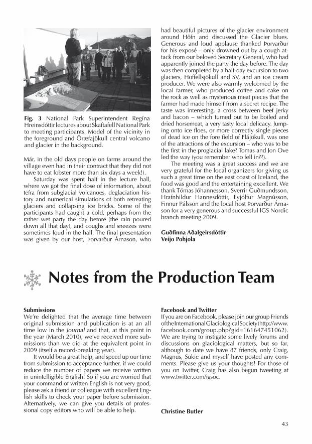
43
SubmissionsWe’re delighted that the average time between original submission and publication is at an all time low in the Journal and that, at this point in the year (March 2010), we’ve received more sub-missions than we did at the equivalent point in 2009 (itself a record-breaking year).
It would be a great help, and speed up our time from submission to acceptance further, if we could reduce the number of papers we receive written in unintelligible English! So if you are worried that your command of written English is not very good, please ask a friend or colleague with excellent Eng-lish skills to check your paper before submission. Alternatively, we can give you details of profes-sional copy editors who will be able to help.
FacebookandTwitterIf you are on Facebook, please join our group Friends of the International Glaciological Society (http://www.facebook.com/group.php?gid=161647451062). We are trying to instigate some lively forums and discussions on glaciological matters, but so far, although to date we have 87 friends, only Craig, Magnus, Sukie and myself have posted any com-ments. Please give us your thoughts! For those of you on Twitter, Craig has also begun tweeting at www.twitter.com/igsoc.
ChristineButler
Már, in the old days people on farms around the village even had in their contract that they did not have to eat lobster more than six days a week!).
Saturday was spent half in the lecture hall, where we got the final dose of information, about tefra from subglacial volcanoes, deglaciation his-tory and numerical simulations of both retreating glaciers and collapsing ice bricks. Some of the participants had caught a cold, perhaps from the rather wet party the day before (the rain poured down all that day), and coughs and sneezes were sometimes loud in the hall. The final presentation was given by our host, Þorvarður Árnason, who
had beautiful pictures of the glacier environment around Höfn and discussed the Glacier blues. Generous and loud applause thanked Þorvarður for his exposé – only drowned out by a cough at-tack from our beloved Secretary General, who had apparently joined the party the day before. The day was then completed by a half-day excursion to two glaciers, Hoffellsjökull and SV, and an ice cream producer. We were also warmly welcomed by the local farmer, who produced coffee and cake on the rock as well as mysterious meat pieces that the farmer had made himself from a secret recipe. The taste was interesting, a cross between beef jerky and bacon – which turned out to be boiled and dried horsemeat, a very tasty local delicacy. Jump-ing onto ice floes, or more correctly single pieces of dead ice on the fore field of Flájökull, was one of the attractions of the excursion – who was to be the first in the proglacial lake? Tomas and Jon Ove led the way (you remember who fell in??).
The meeting was a great success and we are very grateful for the local organizers for giving us such a great time on the east coast of Iceland, the food was good and the entertaining excellent. We thank Tómas Jóhannesson, Sverrir Guðmundsson, Hrafnhildur Hannesdóttir, Eyjólfur Magnússon, Finnur Pálsson and the local host Þorvarður Árna-son for a very generous and successful IGS Nordic branch meeting 2009.
GuðfinnaAðalgeirsdóttirVeijoPohjola
NotesfromtheProductionTeam
Fig. 3 National Park Superintendent Regína Hreinsdóttir lectures about Skaftafell National Park to meeting participants. Model of the vicinity in the foreground and Öræfajökull central volcano and glacier in the background.

44
MeetingsofothersocietiesNorthwestGlaciologistsMeeting2009
On Friday 23 October many of the glaciologists of the Pacific Northwest were meeting at Vancou-ver’s University of British Columbia for the annual meeting of the Northwest Glaciologists. During two wonderful days we had the opportunity to hear about research progress in a great variety of topics and once more I was reminded why this remains my favorite scientific meeting. In tradi-tional fashion the meeting participants showed up without abstract submission, so the program had to be assembled on the fly. Despite the fact that this is explicitly not a branch meeting of the IGS, we were very happy to welcome the esteemed Secretary General of the IGS, Magnús Magnús-son. He opened the meeting by showing various graphs of journal publications and membership numbers. The Journal of Glaciology appears very healthy and in a remarkable turnaround has be-come one of the fastest publications in the field. Magnús presented a very thorough analysis and even pointed out the effects of the Chief Editor’s summer vacation! Membership numbers are re-maining lower than desired, however, and eve-rybody was encouraged to join the society. These opening remarks were followed by an introduc-tion to a new Glossary of Mass Balance Terms by one of its authors, Regine Hock. She reminded us that mass balance terms were often used in con-fusing and different ways. This immediately sent the IGS Secretary General off to a peaceful sleep. The glossary is still at the revision stage, so the precise use of mass balance, specific balance, etc, had not caught on yet, and in what followed, not
even her own student would adhere to the new recommendations.
MacDougall then continued by explaining some methods to extrapolate local mass balance measurements to the regional level. This was fol-lowed with talks by Borstad and MacClung on fracture mechanisms in avalanches. After coffee break the attention shifted back to glaciers. Pfef-fer gave a nice overview of all recent assessments of the cryosphere’s contribution to sea level rise and projections for the next decade. Current change and projections for the next few decades are still dominated by mountain glaciers and ice caps, but Greenland is contributing at the same order of magnitude and Antarctica is no longer a
Fig.3 Charlie Raymond came out of retirement to attend the NWG meeting and to see some of his old students, such as Neil Humphrey.
Fig.1 The standard of the presentations was, as always, very high.
Fig.2 Those University of Washington students are all the same – they can never be serious whether in or out of class.

45
negligible component of eustatic sea level rise. Obviously, all components have to be monitored and studied closely. As an example, Menounos presented work from co-author Berthier showing large changes in Alaska and neighboring Canada by analyzing digital elevation models produced from satellite imagery. Garry Clarke spoiled our picture of white landscapes and reminded us that glaciers are often quite dirty, which has a pro-found effect on their mass balance. He showed some ideas on how to incorporate this into glacier models. The topic then shifted rather abruptly to microbiology and Lanoil showed some evidence for life in subglacial environments. The morning was rounded out by a presentation from Miles. He does environmental consulting and showed many examples of changes in stream flow and sediment discharge caused by glacier change. It was a nice reminder that the most immediate effect of glacier change is usually not sea level rise, but the geomorphological and hydrological changes in glaciated basins.
After lunch, Piementel showed how to in-clude hydrology into a higher order ice flow model. This was followed by Tsai’s presentation of a fracture model for the rapid drainage of a supraglacial lake. McNabb presented a simple model for volume changes on Columbia Glacier,
with the hope of expanding this to other calving glaciers. Bartholomaus introduced a new project of motion, seismicity and calving at the Alaskan Yahtse Glacier. Picking up on the theme of mode-ling again, Andy Aschwanden presented his work on an enthalpy formulation for polythermal gla-ciers that avoids having to track a free boundary between cold and temperate ice. After a coffee break, Matsuoka presented some insights into ra-dar wave attenuation in ice and some of the cave-ats in trying to distinguish wet from frozen beds using radar returns. Dan Shugar picked up on the subject of dirty glaciers by looking at the evolu-tion of Black Rapids Glacier, which was covered in landslides during the 2002 Denali Fault earth-quake. Florentine talked about rock glaciers and the potential to extract paleoclimate informa-tion from them. The day closed with Campbell’s presentation of the changes at Crane Glacier and other glaciers on the Antarctic Peninsula.
Fig. 4a The NWG meeting attracts a lot of interesting people....
Fig.5 When Gwenn talks, the world listens.
Fig.4b ... Some come from far away, like Tad Pfeffer from Boulder.
Fig. 6 The meeting is an excellent opportunity to sit down to some face to face (computer) discussions.

46
Everybody’s favorite part of Northwest Glaci-ologists is the Friday party, which was again gra-ciously hosted by Julie Cruikshank and Garry Clarke. Good food and wine and plenty of op-portunity for catching up with old friends rounded out a fine day.
Despite the previous night’s party, people were off to a feisty start on Saturday morning. Jarosch had us all convinced that glacier dynamics really do matter, but he had most of us confused as to how he actually showed this. Things were clari-fied after heated discussion. Burke then followed by talking about climate glacier interactions and claiming that glacier reaction to random fluctua-tions in climate can be very large. The attention subsequently shifted back to Antarctica where
Fudge was analyzing radar layers to infer past ice flow at Thwaites Glacier and Winberry presented a model for tidally induced seismicity that implies that the stagnant Kamb Ice Stream is still subject to very high basal water pressure.
After coffee break Truffer talked about season-ality in ocean temperatures and its effect on ice calving and proposed the term ‘calving season’ for the Mass Balance Glossary. Pettit talked about screaming infant bubbles breaking away from their icy confinements as she took on the novel subject of underwater acoustics near tidewater glaciers. The next two talks by Kennedy and Cairns were about the development of ice fabric in the snow and firn pack and in the interior of the ice sheets. Finally, Poinar presented a combined thermal and flow model to deduce both thickness of temperate layers and the magnitude of basal motion.
The afternoon was opened by Humphrey who presented fascinating year-round measurements of temperature in the upper 10 m of firn in Green-land with evidence for water motion and refreez-ing at all times of the year and at depths of more than 10 m. Jiskoot and her graduate student Juhlin presented an inventory of glaciers in Central East Greenland, which represents a large volume of ice that is not connected to the ice sheet proper. Dadic pointed out that there is a lack of good distributed accumulation models and proceeded to present one that was field tested on Haut Glacier d’Arolla. Anslow presented a model of regional glacier change in Western Canada on the centennial time scale. Koutnik gave a nice overview of the use of inverse methods in glaciology, together with the many opportunities and pitfalls of such methods. The meeting was closed by Lundstrom who ven-tured into glacial geology and talked about tunnel valleys under the Laurentide Icesheet.
Approximately 50 people attended the meet-ing, of which 34 elected to give talks. This left plenty of time for questions and discussion. A majority of the talks was given by graduate stu-dents or very recent post-graduates, while many of the ‘old-timers’, such as Charlie Raymond, Ed Waddington, and Bernhard Hallet, chose to listen and offer good advice. This has been a typical and welcome feature of many NWG meetings. The organizing committee under the able leadership of Gwenn Flowers deserves many thanks and so do Julie Cruikshank and Garry Clarke for hosting the wonderful party.
The tradition of the Northwest Glaciologists Meeting will continue in Fairbanks, Alaska, next year and we hope to welcome many of you up here.
MartinTruffer
Fig.7 The bar staff at the dinner held at Garry and Julia’s house.
Fig. 8 Clarke cuts the meat with the same dedication he gives to all his projects.

47
INTERNATIONAL GLACIOLOGICAL SOCIETY
INTERNATIONALSYMPOSIUMONSNOW,ICEANDHUMANITYINACHANGINGCLIMATE
Sapporo, Japan21–25 June 2010
CO-SPONSORED BY:
Japanese Society of Snow and Ice
SECOND CIRCULAR
December 2009
http://www.lowtem.hokudai.ac.jp/IGS-Sapporo/
Registered Charity

48
INTERNATIONAL SYMPOSIUM ON SNOW, ICE AND HUMANITY IN A CHANGING CLIMATEThe International Glaciological Society will hold an International Symposium on Snow, Ice and Humanity in a Changing Climate in 2010. The symposium will be held from 21–25 June in Sapporo, Japan.
ThemeSnow and ice in the natural environment are fac-ing drastic changes under the influence of rapidly changing global and regional climates. Since snow and ice play crucial roles in cold regions, such changes have substantial impacts on human socie-ties and activities. For example, the amount of snow-fall and the duration of seasonal snow cover have been affected in many places, with consequences for the water resources and avalanche risks. Thaw-ing permafrost causes destruction of infrastructure, and formation of glacier-dammed lakes poses po-tential hazards in mountainous regions. On the other hand, reduction of the summer sea ice extent in the Arctic creates new possibilities to use open water as a sea route for commercial vessels.
This symposium focuses on recent changes in the cryospheric components (snow, glaciers, ice sheets, permafrost, sea ice, lake ice, river ice) with respect to their influences on humanity. We invite contributions related to this subject in a broad sense, including ground-based observations, re-mote sensing, laboratory experiments, numeri-cal modelling, data compilations and analyses, risk management and social impact assessment. Topics are not restricted to present-day issues, but also open for paleo-environmental records as they are important for understanding the present and predicting the future. The conference will bring together researchers engaged in different fields of cryospheric science in order to discuss interactions of snow and ice with humanity in the past, present and future.
TopicsThe suggested topics include:1. Land ice and snow, including: Snow cover,
Glaciers, Ice sheets, Permafrost, Snow and gla-cier melt
2. Iceand snow in thehydrosphere, including: Sea ice, Ice shelves, Icebergs, River and lake ice
3. Hazardsandsocialproblemsrelatedtosnowandice, including: Snow avalanches, Glacier-dammed lake outbursts, Permafrost thawing, Snow and ice accretion, Blowing snow, Snow removal
4. Use of snow and ice, including: Snow air conditioning, Tourism, Teaching materials, Recreation
5. Paleoclimate and paleoenvironment, inclu-ding: Ice core records, Past glaciation, Glaci-lacustrine and glacimarine deposits, Subglacial and proglacial sediment-landform record
6. Prediction of changes in the cryosphere, including: Arctic sea ice, Area and property of snow cover, Glacier advance and retreat, Sea-level change
SessionsOral sessions are scheduled on four days from Monday to Friday (except for Wednesday, which is allocated for an excursion). Each oral presentation should last 20 minutes, including 5 minutes for ques-tions and discussion. Poster sessions are planned on Tuesday and Thursday afternoons. The room for the poster sessions will be open from Monday to Thurs-day and posters may be displayed for approximately two days. Rooms are available during the symposi-um period for participants who wish to arrange small meetings. Please contact the local organizers ([email protected]) in advance to book a room for your meeting.
ThematicpublicationThe Council of the IGS has decided to dedicate an issue of the Annals of Glaciology to the theme ‘Snow, Ice and Humanity in a Changing Climate’. A first call for papers will be made in January 2010. Paper submission is open to anyone provided the topic of the paper is consistent with the theme of the Annals issue. Deadline for manuscript submission is 10 May 2010. Papers should be submitted through the IGS system and will be refereed according to the Society’s normal standards before a publication de-cision is made. Every effort will be made to complete the reviews before the symposium so the associate editor and authors can discuss revisions during the symposium week. When submitting abstracts to the symposium, you will be asked to indicate whether you intend to submit a paper for the Annals issue, so that reviewers may be sought in advance. Papers submitted for consideration in the Annals issue must comply with the normal submission criteria of IGS publications.
AbstractsParticipants who would like to contribute to the Symposium should submit an abstract of their pro-posed presentation. This abstract must contain suf-ficient details, scientific merit and relevance to the symposium theme to be evaluated by the Scientific Steering Committee. The abstract should be less than 400 words with no references or illustrations. Please submit your abstract and relevant informa-tion online from the IGS or conference website. Au-thors may indicate a preference for an oral or poster presentation, although the number of oral presen-tations is limited by time. Those unable to submit their abstract online can send electronic files to
49
the IGS office where a member of staff will upload them onto the website.
DEADLINE FOR SUBMISSION OF ABSTRACTS IS 5 MARCH 2010
Each abstract will be assessed on its scien-tific quality and relevance to the symposium theme. Corresponding authors will be notified by 26 March 2010 regarding abstract acceptance. Please contact the IGS office if you do not re-ceive the notification by this date. The accepted abstracts will be compiled into a booklet which will be provided to participants upon registration on 20 June 2010.
ParticipationOnline registration through the IGS system is en-couraged. A link to the site will be available on the IGS and conference websites once the registration is open. For those who wish to register by post or FAX, a registration form is attached to this circular. Registration and the accompanying payment are due on 23 April 2010. There is a surcharge of £50 for later registration. The participant’s registration fee includes organization costs, a set of abstracts, the ice breaker, coffee breaks, mid-week excur-sion, the symposium dinner and an issue of the Annals of Glaciology.
RegistrationfeesAll fees are in Pounds Sterling, GBP
Participant (IGS member) £400 Participant (non-member) £479 Student or retired IGS member £200 Accompanying person (18+) £200 Accompanying person (12–17) £160 Late registration surcharge £ 5 0 (after 23 April 2010)
RegistrationbymailThough we strongly prefer registration through the website, it can also be done by filling in and re-turning the back page of this circular. If payment by credit card is not possible, contact the IGS of-fice to arrange for a bank transfer. Payments made after 23 April 2010 must include the additional £50 late-registration fee. When completed, please send the form to Magnús Már Magnússon at the IGS address.
AccompanyingpersonsThe accompanying person’s registration fee (£200 for 18 and over; £160 for ages 12 to 17; under 12 free) includes the icebreaker, the mid-week excur-sion, and the symposium dinner. Short excursions in and around Sapporo will be offered on request at additional cost. These include short trips to sight-seeing spots in the city, day trip to the surrounding regions and experience of Japanese traditional cul-ture (e.g. tea ceremony, dressing Kimono).
SocialprogrammeThe icebreaker reception will be on the evening of 20 June (Sun) after registration at Faculty House ‘Enreiso’ in the university campus. The excursion will be organized on 23 June (Wed). There will be a one day excursion to the natural and cultural sights of Sapporo and its vicinity. Details will be updated on the conference website. The sympo-sium dinner will be held on 24 June (Thu) evening at ‘The Sapporo Beer Garden’ located in a former factory of Sapporo Brewery. More information will be listed on the conference website.
VenueThe symposium will be held at Hokkaido Uni-versity in Sapporo. Sapporo is the capital city of Hokkaido, the northernmost main island of Japan, and is well known for its snowy winter, with a cumulative snowfall of more than 5 me-tres. There is no other city in the world with a population of nearly 2 million that accumulates this amount of snow. The university campus is located close to the heart of the city. The venue of the symposium is the University Conference Hall, 10 minutes walk from Sapporo’s main rail-way station and within easy reach of the city centre. June is a wonderful season to visit the region. The city is filled with fresh green along with a feast of flowers and the climate is ideal for enjoying outdoor activities. Daily minimum and maximum temperatures in June are 12 and 21°C, respectively. Hokkaido escapes the rainy season, which lasts from June to July in the other regions of Japan. Further information on Sapporo is available at http://www.welcome.city.sapporo.jp/english/.
TraveltoSapporoSapporo’s main airport is New Chitose Airport, which is connected to the city centre by JR (Japan Railways Company) airport express train. The train runs about every 15 minutes, takes about 40 minutes and costs 1,040 yen (one way). JAL (Japan Air Lines), ANA (All Nippon Airways) and some other carriers operate 40–50 flights per day between Tokyo Haneda Air-port and New Chitose Airport (the world’s busiest air route!). Several flights from Japan’s main internation-al airports, Tokyo Narita, Kansai Osaka and Nagoya Central Japan, as well as other regional airports are available per day. International flights are also op-erated from Korea (Incheon Seoul and Pusan) and China (Shanghai, Beijing, Hong Kong and Dalian).
AccommodationA number of hotels ranging in price from budget to higher-end are available within a walking distance of the symposium venue. A limited number of rooms are reserved at these hotels for the symposium period. Available accommodation as well as booking instructions

50
will be provided on the conference website. To take advantage of the block bookings, please reserve your rooms online by 31 May. Please contact the travel agency of the conference (JTB: Japan Travel Bureau) at [email protected] for inquiries on the accommodation booking and any other domestic travel information.
SymposiumorganizationMagnús Már Magnússon (International Glacio-logical Society)
ScientificsteeringandeditorialcommitteePerry Bartelt (Co-Chief Scientific Editor), Douglas R. MacAyeal (Co-Chief Scientific Editor), Luca Egli, Ed Adams, Kalle Kronholm, Florence Naaim, Jo Jacka, Ralf Greve, Shuhei Takahashi
LocalorganizingcommitteeAtsushi Sato (Chairman), Osamu Abe, Kumiko Goto-Azuma, Yoshiyuki Ishii, Yuji Kodama, Sumito Matoba, Hiroki Matsushita, Kazuki Nakamura, Koichi Nishimura, Toshihiro Ozeki,Shin Sugiyama, Nozomu Takeuchi
ContactsforfurtherinformationFurther information may be obtained from:
MagnúsMárMagnússonInternational Glaciological Society Scott Polar Research Institute Lensfield Road, Cambridge. CB2 1ER, UKTel: +44 (0)1223 355 974; Fax: +44 (0)1223 354 931Email: [email protected]: http://www.igsoc.org/symposia/2010/ sapporo/
AtsushiSatoSnow and Ice Research CenterNational Research Institute of Earth Science and Disaster Prevention187–16, Maeyama, SuyoshiNagaoka, Niigata 940-0821, JapanTel: +81 (0)258 35 7522; Fax: +81 (0)258 35 0020Email: [email protected]: http://www.lowtem.hokudai.ac.jp/ IGS-Sapporo/index.html
DatesanddeadlinesAbstract submission deadline 5 March 2010 Notification of acceptance 26 March 2010 Preregistration deadline 23 April 2010 Paper submission deadline 10 May 2010 Deadline for refund 14 May 2010 Registration and Icebreaker 20 June 2010 Conference begins 21 June 2010 Final revised papers deadline 9 August 2010

51
INTERNATIONALSYMPOSIUMONSNOW,ICEANDHUMANITYINACHANGINGCLIMATE
Sapporo, Japan, 21–25 June 2010
REGISTRATION FORMRegister online at www.igsoc.org/symposia/2010/sapporo/registration
Family Name: ___________________________________________________________________________
Given Name(s): __________________________________________________________________________
Address: _______________________________________________________________________________
_______________________________________________________________________________________
_______________________________________________________________________________________
Tel: ____________________________ Fax: __________________________________________________
E-mail: _________________________________________________________________________________
Accompanied by:
Name: _____________________________________________________ Age (if under 18) _____________
Name: _____________________________________________________ Age (if under 18) _____________
Dietary requirements (vegetarian, pescetarian, gluten, lavtose, etc.)
_______________________________________________________________________________________
Registration fees (British pounds)
Participant (IGS member) £400
Participant (not IGS member) £479
Student or retired IGS member £200
Accompanying person (18+/12–17) £200/£160
Late registration surcharcge (after 23 April 2010 £50
TOTAL REGISTRATION FEES £______
Payment of registration fee by Access/Eurocard/MasterCard or VISA/Delta
Card number
Expiration (yy/mm) CVV (last 3 numbers on signature strip)
Name of card holder as shown on card: ____________________________________________________
Signature: ____________________________________________________

52
INTERNATIONAL GLACIOLOGICAL SOCIETY
INTERNATIONALSYMPOSIUMONEARTH’SDISAPPEARINGICE:
DRIVERS,RESPONSESANDIMPACTSA celebration of the 50th anniversary of the Byrd Polar Research Center
(formerly the Institute of Polar Studies) Columbus, Ohio 43210, USA
15–20 August 2010
CO-SPONSORED BY:Byrd Polar Research Center
Climate, Water & Carbon Program The Ohio State University
SECOND CIRCULAR
January 2010
http://www.igsoc.org/symposia/http://bprc.osu.edu/workshops/igs_2010/
Registered Charity
53
The International Glaciological Society will hold an International Symposium on ‘Earth’s Dis ap-pearing Ice’ in 2010. The symposium will be held in Columbus, Ohio, USA, from 15–20 August 2010.
THEMEOne of the most visible indicators of climate change is the response of Earth’s ice cover. Over the second half of the 20th century alpine glaciers worldwide retreated. Satellite observations over the last two decades reveal rapid changes in many outlet glaciers that drain large sections of the Greenland and Antarctic ice sheets. Ice-shelf dis-integration is becoming more frequent with con-sequences for the discharge of land-based ice to the oceans. The extent of summer sea ice on the Arctic Ocean is declining and the possibility of ice-free summer conditions well before the end of the century is not outside the realm of possibility. This symposium will focus on the drivers for such changes, the potential feedback and responses of the climate system to these changes and the likely impact that might be expected in response to the ongoing large-scale deglaciation of the planet. An additional goal of the conference is to identify major gaps in our scientific understanding, obser-vational databases, modeling approaches and the need for enhanced human capital and fiscal re-sources to advance our predictive capability.
TOPICSThe suggested topics include:1. Sea ice extent and thickness changes in the Arctic
and Antarctic, focusing on the different driving mechanisms, responses in the Arctic versus the Antarctic, potential impact on the ocean–atmos-phere system, regional climate variability, polar ecosystems, human systems and infrastructure.
2. Tidewater glacier dynamics, iceberg calving and sedimentation dynamics, including observations and parameterizations of calving from floating and grounded termini, the role of sedimentation in grounding line stability, and interactions be-tween ice-marginal processes and glacier speed.
3. Ice shelf dynamics, including the precondition-ing and eventual mechanisms by which breakup occurs, impacts of breakup on the ocean–at-mosphere system and adjacent land-based ice, limitations to ice-shelf break-up suggested by past ice-sheet and ice-shelf configurations, and break-up scenarios under other climate regimes suggested by paleo-oceanographic and glacial geologic inference.
4. Ice streams and outlet glacier dynamics, in-cluding observations and modeling to eluci-date the key mechanisms controlling flow and discharge with particular emphasis on subgla-cial processes.
5. Glacier and ice-sheet mass balance, including a global inventory and assessments, atmospheric and oceanic forcing, response to large-scale
modes of climate variability, observational meth-ods, modeling approaches and predictions, up-scaling, partitioning into climatic and dynamic mass balance components, key unknowns, criti-cal observations and limitations to progress.
6. Alpine glaciers (at all latitudes), including obser-vations, driving mechanisms, modeling, impact on associated watersheds and associated soci-etal impact. Special emphasis on alpine glacier changes in regions where traditional forms of glaciological survey are limited and that may be especially vulnerable to climate change (such as the Himalayas and South American Andes).
7. Records of past glacier changes, including proxy histories that elucidate key drivers, responses and response rates.
SESSIONS
Oral sessions are scheduled on four days from Monday to Friday (except for Wednesday, which is allocated for an excursion). Each oral presenta-tion should last 20 minutes, including 5 minutes for questions and discussion. Poster sessions are planned on Tuesday and Thursday afternoons. The room for the poster sessions will be open from Monday to Thursday and posters may be displayed for approximately two days. Rooms are available during the symposium period for participants who wish to arrange small meetings. Please contact the local organizers ([email protected]) in advance to book a room for your meeting.
THEMATICPUBLICATIONThe Council of the IGS has decided to dedicate an issue of the Annals of Glaciology to the theme ‘Earth’s Disappearing Ice’. A first call for papers will be made in March 2010. Paper submission is open to anyone provided the topic of the pa-per is consistent with the theme of the Annals is-sue. Deadline for manuscript submission is 5 July 2010. Papers should be submitted through the IGS system and will be refereed according to the Soci-ety’s normal standards before a publication deci-sion is made. Every effort will be made to com-plete the reviews before the symposium so the associate editor and authors can discuss revisions during the symposium week. When submitting abstracts to the symposium, you will be asked to indicate whether you intend to submit a paper for the Annals issue, so that reviewers may be sought in advance. Papers submitted for consideration in the Annals issue must comply with the normal submission criteria of IGS publications.
ABSTRACTSParticipants who would like to contribute to the Symposium should submit an abstract of their proposed presentation. This abstract must contain sufficient details, scientific merit and relevance to the symposium theme to be evaluated by the Sci-entific Steering Committee. The abstract should be less than 400 words with no references or illus-

54
trations. Please submit your abstract and relevant information online from the IGS or conference website. Authors may indicate a preference for an oral or poster presentation, although the number of oral presentations is limited by time. Those un-able to submit their abstract online can send elec-tronic files to the IGS office where a staff member will upload them onto the website.
DEADLINE FOR SUBMISSION OF ABSTRACTS IS 23 APRIL 2010
Each abstract will be assessed on its scientific qual-ity and relevance to the symposium theme. Corre-sponding authors will be notified by 21 May 2010 regarding abstract acceptance. Please contact the IGS office if you do not receive the notification by this date. The accepted abstracts will be compiled into a booklet that will be provided to participants upon registration on 15 August 2010.
PARTICIPATIONOnline registration through the IGS system is en-couraged. A link to the site will be available on the IGS and conference websites once the registration is open. For those who wish to register by post or fax, a registration form is attached to this circular. Registration and the accompanying payment are due on 18 June 2010. There is a surcharge of £50 for later registration. The partici-pant’s registration fee includes organization costs, a set of abstracts, the ice breaker, coffee breaks, mid-week excur-sion, the symposium dinner and an issue of the Annals of Glaciology.
REGISTRATIONFEES $ £ €Participant (IGS member) 510 310 350 Participant (non-member) 650 400 440 Student/Retired 255 155 175 Accompanying person (adult) 325 198 223 Accompanying person 75 46 52 (no field trip)Accompanying person (<18) 260 158 179Accompanying person (<12) FreeLate registration fee 85 50 58
Note that all online credit card payments will be in £ sterling (GBP)
REGISTRATIONBYMAILThough we strongly prefer registration through the website, it can also be done by filling in and returning the back page of this circular. If payment by credit card is not possible, con-tact the IGS office to arrange for a bank transfer. Payments made after 18 June 2010 must include the additional £50 late-registration fee. When completed, please send the form to Magnús Már Magnússon at the IGS address.
ACCOMPANYINGPERSONSThe accompanying person’s registration fee ($325 for 18 and over; $260 for ages 12–17; under 12 free) includes the icebreaker, the mid-week field trip, and the symposium dinner. Those adult (18
and older) accompanying persons who do not wish to participate in the field trip can attend the ice-breaker and banquet for a fee of $75.
SOCIALPROGRAMMEAn icebreaker reception will be on Sunday evening at the newly renovated William Oxley Thompson Library Campus Reading Room located on the 11th floor at the west end of the OSU Oval. The window-filled room provides a spectacular birds-eye view of the OSU campus, including the often photographed Oval Mall and Orton Hall.
Tuesday evening conference attendees will have the opportunity to visit the Byrd Polar Re-search Center. Guided tours and video presenta-tions will give conference participants a first hand look at the extensive research that has been con-ducted by faculty, research scientists, post-docs and students at the Center since 1960.
The symposium banquet will be held on Thurs-day evening at the Ohio State University Faculty Club. The Faculty Club is located on the historic Oval between Mirror Lake and Orton Hall, home to the Geology Library and the Orton Geologi-cal Museum. The Faculty Club has been serving the OSU Community since the late 1930s and its quiet ambience makes it an excellent venue for dining and conversation.
VENUEThe symposium will be held at the Ohio State University (OSU), Columbus, Ohio in the New Ohio Union on High Street. OSU is a public research university founded in 1870 as a land-grant university and is currently the second larg-est university campus in the USA. Columbus is the state capital, located in the heart of Ohio, and the city has numerous historic areas including German Village, the Short North, and Victorian Village. Other attractions include the Arena Dis-trict, Franklin Park Conservatory, Ohio Historical Society, Columbus Art Museum and the Center of Science and Industry. The city features restau-rants of every cuisine including American, Ital-ian, German, Japanese, Korean and Indian, with prices for all budgets. Weather in August can be very hot and humid, reaching 31°C / 88°F, and on occasion even higher. Short sleeves and light-weight clothing are recommended. Be prepared for rain or a cool spell, as in Columbus we say, ‘wait five minutes and the weather will change!’ More information on OSU is available at http://www.osu.edu/ and details on Columbus can be found at http://www.experiencecolumbus.com/.
FIELDEXCURSIONWednesday field trip: Visualizing Changing Land-scapes: Disappearance of the Scioto Lobe of the Laurentide Ice Sheet, Ohio (the trip includes sev-eral other points of geologic and cultural interest). Landforms associated with the Scioto Lobe in east-central Ohio during the Last Glacial Maximum (LGM) reveal the processes, materials and envi-
55
ronments of the glacier system. We reconstruct the paleogeography and glacial history to provide a model of changes at and near the ice margin on this glaciated section of the Appalachian Plateaus Province at 40°N. In eastern Licking County, kames, terraces, moraines, ice-marginal lake de-posits and reversed drainage systems record the impact of the glacier at and beyond the terminus. Field stops will highlight glacial, glacifluvial, and glacilacustrine landforms and related materials (e.g. till, outwash gravel, lake sediments and peat deposits) as we seek to improve our understand-ing and visualization of the glacier system.
As the ice disappeared, landforms continued to evolve and lake basins and kettles accumulated the record of a changing biosphere, one in which northern species of trees gave way to hardwoods and some Ice Age animals disappeared. Research on materials from the Burning Tree mastodon site (1989) in Licking County has provided new insight to the paleoenvironment, the mastodon diet, viabil-ity of bacteria, and our understanding of human oc-cupation of Ohio 13,000 years ago. After viewing a time-line of ancient cultures at the Great Circle Earth-works Museum in Heath, participants can explore the adjacent Newark Earthworks, ‘the largest set of geometric earthen enclosures in the world’. Built by the prehistoric Hopewell about 2000 years ago, the earthworks had ceremonial, social and astronomical functions. The evening meal will be in the Newark area, possibly overlooking ancient Earthworks, while we reflect on natural and human-induced landscape changes since the Scioto Lobe disappeared and we attempt to visualize future landscapes in response to continuing loss of ice far from here. The trip will con-clude in Columbus by 10:00 pm.
TRAVELTOCOLUMBUSPort Columbus International Airport is located ap-proximately 20 minutes from the OSU campus. The airport is 7 miles (11 km) NE of the city center. Taxis, hotel shuttles and rental cars are available from the airport into the city. Columbus has connections throughout the USA with Washington DC, Chicago, Atlanta, Minneapolis and New York non-stops con-necting with many international flights. Delta, Unit-ed, Northwest and US Airways have daily flights in and out of Columbus with over a dozen airlines serving the area. For more information on Port Columbus please visit their website: http://www.port-columbus.com/home.asp.
ACCOMMODATIONBlock bookings have been arranged at hotels in Columbus on or near the OSU campus. A large block of individual dorm rooms (single & double accommodation) have been reserved in the OSU North Campus area. Prices range from budget dorms to high-end hotels. For those interested, bed and breakfast offerings near the campus are also listed on the BPRC IGS web page (http://bprc.osu.edu/workshops/
igs_2010/). To ensure a room please reserve it by 30 June and mention the OSU–IGS Symposium to get the conference rate. A conference bus will pick up participants at designated locations for transportation to and from the conference site. A list of available accommodation is on the conference website (http://bprc.osu.edu/workshops/igs_2010/) with individual hotel information and booking instructions included.
SYMPOSIUMORGANIZATIONMagnús Már Magnússon (International Glaciological Society)
SCIENCESTEERINGANDEDITORIALCOMMITTEEKees van der Veen, Chief Editor (U. Kansas), Gudfinna Adalgeirsdottir (Danish Meteorological Institute), Jason Box (Ohio State U.), Adrian Jenkins (British Antarctic Survey), Ian Joughin (U. Washington), Nina Kirchner (Stockholm U.), Doug MacAyeal (U. Chicago), Ellen Mosley-Thompson (Ohio State U.), Tad Pfeffer (U. Colorado), Stephen Price (Los Alamos National Lab.), Leigh Stearns (U. Kansas), Lonnie Thompson (Ohio State U.), Slawek Tulaczyk (U. California Santa Cruz), Dirk van As (Geological Survey of Denmark and Greenland)
LOCALORGANIZINGCOMMITTEEEllen Mosley-Thompson (Chair), Michele Cook, Lynn Everett, David Elliot, Paolo Gabrielli, Ian Howat, Lynn Lay, Garry McKenzie and Lonnie Thompson
CONTACTSFORFURTHERINFORMATIONMagnúsMárMagnússonInternational Glaciological Society Scott Polar Research Institute Lensfield Road, Cambridge. CB2 1ER, UKTel: +44 (0)1223 355 974; Fax: (0)1223 354 931Email: [email protected]: http://www.igsoc.org/symposia/2010/ohio/
LocalOrganizingCommitteeByrd Polar Research Center The Ohio State University, 108 Scott Hall 1090 Carmack Road, Columbus, OH 43210 USATel: +1 614-292-6531 or 614-292-9909Fax: +1 614-292-4697 Email: [email protected]
IMPORTANTDATESAbstract submission deadline 23 April 2010 Notification of acceptance 21 May 2010 Preregistration deadline 18 June 2010 Paper submission deadline 5 July 2010 Deadline for refund 9 July 2010 Registration and Icebreaker 15 August 2010 Conference begins 16 August 2010 Final revised papers deadline 4 October 2010

56
INTERNATIONALSYMPOSIUMONEARTH’SDISAPPEARINGICECOVER
Columbus, Ohio, USA, 15–20 August 2010
REGISTRATION FORMRegister online at www.igsoc.org/symposia/2010/ohio/registration
Family Name: ___________________________________________________________________________
Given Name(s): __________________________________________________________________________
Address: _______________________________________________________________________________
_______________________________________________________________________________________
_______________________________________________________________________________________
Tel: ____________________________ Fax: __________________________________________________
E-mail: _________________________________________________________________________________
Accompanied by:
Name: _____________________________________________________ Age (if under 18) _____________
Name: _____________________________________________________ Age (if under 18) _____________
Dietary and other requirements
_______________________________________________________________________________________
Registration fee $ £ €
Participant (IGS member) 510 310 350
Participant (non-member) 650 400 440
Student/Retired 255 155 175
Accompanying person (adult) 325 198 223
Accompanying person (no field trip) 75 46 52
Accompanying person (<18) 260 158 179
Accompanying person (<12) Free
Late registration fee (after 18 June) 85 50 58
TOTAL REGISTRATION FEES £______
Payment of registration fee by Access/Eurocard/MasterCard or VISA/Delta
Card number
Expiration (yy/mm) CVV (last 3 numbers on signature strip)
Name of card holder as shown on card: ____________________________________________________
Signature: ____________________________________________________

57
Futuremeetingsofothersocieties 11thInternationalCircumpolarRemoteSensingSymposium Scott Polar Research Institute, Cambridge, UK 20–24 September 2010
The 11th International Circumpolar Remote Sensing Symposium (http://alaska.usgs.gov/science/geography/CRSS2010/) will be held in September 2010 at Cambridge's Scott Polar Research Institute. Prior to the conference (Monday, 20 September 2010), there will be a one day UK Polar Network Workshop on Circumpolar Remote Sensing.
The conference deals specifically with remote sensing applications in the polar environments, both Arctic and Antarctic. It will provide an inter-national forum for the discussion of work current-ly being carried out in the circumpolar regions. Topics that have been discussed at previous CRSS meetings have included environmental monitor-ing, the cryosphere, resource prospecting, vegeta-tion measurement, LiDAR, RADARSAT, Polar GIS
applications, and many others. The deadline for abstract submission is 31 May 2010.
Prior to the conference, the UKPN Work-shop is directed at graduate students and other early career researchers. Sessions in develop-ment include Open source remote sensing and GIS, Imaging climate change and Innovating new techniques; suggestions from potential partici-pants are encouraged. The day will also feature a career mentoring panel and will culminate with the CRSS Icebreaker Reception.
Further details of the conference and work-shop are under development – please contact Allen Pope at [email protected] with questions and input.
Booksreceived
Eicken, H., R. Gradinger, M. Salganek, K. Shiras-awa, D. Perovich and M. Leppäranta, eds. 2009. Field techniques for sea ice research. Fairbanks, Alaska, University of Alaska Press. 588 pp, 218 graphs and figures, DVD. (ISBN: 978-1-60223-059-0, (Cloth) US$65.00.)
Thomas, D.N. and G.S. Dieckmann, eds. 2009. Sea ice, Second edition. Oxford, Wiley-Blackwell. 640 pp. (ISBN: 978-1-4051-8580-6, (Cloth) £89.99/ €103.50.)
Pellikka, P. and W.G. Rees, eds. 2010. Remote sensing of glaciers; techniques for topographic, spatial and thematic mapping of glaciers. London, CRC Press/Balkema (Taylor & Francis Group). 340pp. (ISBN: 978-0-415-40166-1, (Cloth) £89).
Bennett, M.M. and N.F. Glasser, eds. 2009. Glacial geology: ice sheets and landforms, Second edition. Oxford, Wiley-Blackwell. 400 pp. (ISBN: 978-0-470-51690-4, (Cloth) £85.00 / €97.80, ISBN: 978-0-470-51691-1, (paperback) £ 29.95 / €34.50).

58
Dr Hans Röthlisberger, professor emeritus at ETH (Swiss Federal Institute of Technology) Zurich, and 9th president of the International Glaciological So-ciety, died at his home in Uerikon, Zurich, on 10 September 10 2009. Hans, who used jokingly to call himself ‘Tschoon’ in a Swiss German pronun-ciation of his Anglicized name, had a rich life.
Hans was born on 1 February 1923 in Lang-nau in Emmental, the youngest of the three chil-dren of Johann and Marie Röthlisberger-Stucki, who were both teachers. Emmental, best known for the famous Swiss cheese, is a valley located in the middle of the tertiary pre-alpine uplifted ter-races. These terraces are dissected by many small valley systems, forming a gently undulating hilly landscape covered with rich vegetation and pas-ture. At the southern end of the Emmental Valley the Alps soar abruptly to above 2000 meters.
Hans’s father died when he was a year old, leaving his mother to raise three children and to support the family as a teacher. He spent his childhood in Emmental with his two older sisters, attending local primary and secondary schools, before moving to the Cantonal Seminar in Berne. In 1943 he entered the Faculty of Natural Scienc-es at ETH. Between university semesters, he was a substitute teacher at a primary school in Kalber-höni, a beautiful side valley of Saanen-Gstaad. It was there that he developed his life-long love of mountains. In 1947, he completed his ‘Diplo-marbeit’ (equivalent to an MSc thesis) at the De-partment of Petrography with the theme ‘Profile through Gotthardmassiv between Ulrichen and the Gries Pass with special reference to structural geology’. Prof. Paul Niggli, discoverer of the iso-tope/paeleo-temperature principle, supervised him. In that year he became a member of the Academic Alpine Club of Berne. He grew into an accomplished rock and ice climber. Hans started his doctoral studies in the same year at the De-partment of Geophysics under the supervision of Prof. Fritz Gassmann, who was also the director of the Swiss Earthquake Service.
During his time as a doctoral student, Hans participated in three expeditions to the Arctic. In 1950 he spent half a year on the Barnes ice cap with the Arctic Institute of North America’s
Baffin Island Expedition. In the summer of 1951 he worked in East Greenland, accompanying Dr Hans Rudolf Katz, a geologist. In 1953 he was back in Baffin Island, on Penny Highland. During these expeditions, his contributions were cen-tered on seismology. His doctoral thesis, com-pleted in 1954, was entitled ‘On seismic and petrographic characterization of several Molasse rocks, including a description of the methods for determining grain size in solid material’. Upon completion of his doctoral thesis, Hans obtained a position as a research fellow at the Institute of Water and Foundation Engineering at ETH. Here Hans came in con tact with Prof. Peter Kasser and Robert Haefeli , who influenced his future inter-est in glaciers.
Hans met a young woman named Miss Doris Baechi in Zurich and led her to the altar in 1954. Two years later their first daughter, Annelis, was born. In 1957 the young family moved to Wilmette, IL, USA, where Hans worked at the US Army Snow, Ice and Permafrost Research Establishment (SIPRE, the predecessor of CRREL). He was engaged in seismological applications in the northwestern re-gion on the Greenland ice sheet. In Wilmette he shared an office with Prof. Ukichiro Nakaya. Hans spoke of their stimulating discussions on the de-formation of single crystal ice, a lesser-known part of Nakaya’s work. In 1958, their second daughter,
News
Obituary:HansRöthlisberger

59
Susan, was born, so that when the Röthlisbergers returned to Switzerland and Hans to ETH in 1961, they were now a family of four.
At ETH Hans’s work was very much concerned with the engineering side of glaciology, in partic-ular of the safety and risk issues of ice. He was engaged in the decision-making process on the safety of the frozen Lake of Zurich in 1962/63; the catastrophic collapse of Allalingletscher in 1965; an estimation of the risk of glacier collapse near Mauvoisin and Les Diableret in 1966; the danger of a glacier collapse in Gasterentales in 1967; the flood from the moraine-dammed lakes of the Gru-bengletscher; an ice avalanche problem above Felskinn in 1969; the breaking-off of Biesgletscher on Weisshorn in 1972/73; safety considerations of water intake facilities of the hydroelectric com-pany Oberhasli in face of a glacier advance in 1982/83; and the danger posed by an ice-dammed lake at Austdalsbreen in 1987. He closely cooper-ated with the Swiss Federal Institute of Snow and Avalanche, Weissfluhjoch, Davos, especially with the late Prof. Marcel de Quervain and Dr Bruno Salm. In many problems presented above, his of-ten technical solutions to actively mitigate dan-gers are pioneering works in engineering glaciol-ogy. Hans did not draw any sharp lines between these highly applied fields and the basic research for which he is better known.
In 1972 after completing his Habilitation (post-doctoral) thesis, which was concerned with flood and ice catastrophes related to glaciers, he began his two year lecture series ‘Physical and technical glaciology’, a title which aptly describes how he viewed glaciology. Each of the four semesters cov-ered a theme: first semester, basic physics of ice; second semester, physics of glaciers; third semes-ter, physics of lake ice, river ice, sea ice and per-mafrost; forth semester, prospect and sounding of ice bodies. The lectures were extremely demand-ing, requiring a sound knowledge of mathematics and physics. Students who attended these lectures gained a deep appreciation for glacial processes.
At the same time as preparing his lectures, Hans was making significant advances in his research area. One of his most prominent achievements, the hydraulics of glacier channels, was published in 1972 (J. Glaciol., Vol.11, No. 62). This work opened a new chapter in glaciology, by introducing the opening and maintaining mechanisms of the sub-glacier channel. This was probably the most important step after the earlier lubrication mecha-nisms had been proposed. Theoretical estimations
of sub-glacier channel conditions had never been made in such a comprehensive manner; many of the theoretical assumptions in his model were based on Gornergletscher, whose Gornersee made occasional bursts through the sub-glacier channel to flood the village of Zermatt. Following this paper Hans made significant and valued contributions to research whenever water in glaciers was involved. One of the later tasks he personally took in hand was the study of the flow of Jakobshavn Isbrae on west Greenland, a rare ice stream in the Northern Hemisphere.
Owing to his significant and numerous ac-complishments in research and teaching, the Swiss Federal Council bestowed on him the title of Professor in 1984. He was the president of the International Glaciological Society from 1984 to 1987, receiving many honors including the Selig-man Crystal in 1992, and was elected an honorary member of the society in 2008. Even after Hans’s retirement from ETH in 1988, he actively partici-pated in glaciology seminars, sharing his extensive knowledge and experience with young scientists. In discussions Hans was always extremely modest and respected the ideas of others.
Throughout their marriage, Doris cared for the family and her excellent organization and tireless support created the ideal environment for Hans to make his significant and unique contribution to glaciology.
In 2007 Hans was diagnosed with cancer. While he fought the disease, he never allowed his illness to rule his life. He continued to attend glaciology seminars, took part in symposia, and attended lectures in other scientific disciplines. He enjoyed an active social life with family and friends. He never lost his wonderful sense of humour. I visited Hans on Sunday 6 September to deliver a bottle of wine from Tramin. He said cheerfully, ‘Oh, we should open the bottle now, so that Atsumu can also enjoy it’, knowing that I could not drink a drop of wine. This was just four days before he left us, and three days before he fell into a coma. We will deeply miss this genu-ine, optimistic and warmhearted man, but the courage he showed to the end is an invaluable gift to all of us.
Hans is survived by his wife, Doris, his two daughters, Annelis and Susan, and his three granddaughters, Esther, Kathrin and Miriam, and both sisters, Klara and Verena.
AtsumuOhmura

60
20091–3 October 2009InternationalForumforResearchintoIceShelfProcesses(FRISP)/WestAntarcticIceSheetInitiative(WAIS)JointWorkshopPack Forest Conference Center, WA, USAContact: Adrian Jenkins [[email protected]]
7–10 October 2009PolarScienceandtheChemistryofClimateChange Northeast Regional Meeting, American Chemical SocietyHartford, ConnecticutWebsite: http://membership.acs.org/N/nerm/ Contact: Kathy Gorski [[email protected]]
12–13 October 2009UKPolarNetworkArcticMarineSciencesWorkshopPlymouth, UKWebsite: http://www.polarnetwork.org/new/index.php?option=com_content&view=article&id=93&Itemid=88) Contact: Claudia Halsband-Lenk [[email protected]] or Angelika Renner [[email protected]]
23–24 October 2009NorthwestGlaciologists’MeetingVancouver, BC, CanadaWebsite: http://www.sfu.ca/~gflowers/nwg2009 Contact: Gwenn Flowers [[email protected]] or Christian Schoof [[email protected]]
28–31 October 2009Environments,Movements,NarrativesintheCircumpolarNorthRovaniemi, FinlandWebsite: http://www.arcticcentre.org/?Deptid=28867Contact: Karl Mertens [[email protected]]
27–31 October 2009InternationalColloquium–ClimateChangeinMagellanandAntarcticRegions:EvidenceandChallengefortheFuturePunta Arenas, ChileWebsite: http://www.umag.cl/cambioclimatico/en
29–31 October 2009*NordicBranchmeetingoftheInternationalGlaciologicalSocietyHöfn in Hornafjörður, IcelandContact: Sverrir Guðmundsson, Helgi Björnsson, Tómas Jóhannesson at [email protected]: http://www.raunvis.hi.is/NIGS-09/
3–5 November 2009NorthernGovernancePolicyResearchConferenceYellowknife, Northwest Territories, CanadaContact: Stephanie Irlbacher-Fox [[email protected]]
4–6 November 2009UKPolarNetworkCryosphericScienceWorkshopUniversity of Sheffield, UKContact: [email protected]
7–9 November 2009ArcticinRapidTransitionInitiationWorkshopInternational Arctic Research Center Fairbanks, AlaskaWebsite: http://www.aosb.org/art.html Contact: Carolyn Wegner [[email protected]]
10–12 November 2009AcquaAlta:InternationalConferenceandExhibitiononConsequencesofClimateChangeandFloodProtectionHamburg, GermanyWebsite: http://www.acqua-alta.de/
10–13 November 2009InternationalWorkshoponGlacierHazards,PermafrostHazardsandGLOFsinMountainAreas:Processes,Assessment,Prevention,MitigationVienna, AustriaWebsite: http://www.geo.uio.no/remotesensing/gaphaz/
13–14 November 200917thArcticConferenceoftheInstituteofArcticandAlpineResearch(INSTAAR)Boulder, CO, USAWebsite: http://instaar.colorado.edu/ArcticConference Contact: Craig Lee [[email protected]] or John Hoffecker [[email protected]]
Glaciologicaldiary ** IGS sponsored * IGS co-sponsored

61
30 November–3 December 2009AntarcticTreatySummit:Science–PolicyInteractionsinInternationalGovernanceSmithsonian Institution, Washington, DCWebsite: http://www.atsummit50.aq/ Contact: Michael Lang [[email protected]]
4–8 December 2009IPYInternationalEarlyCareerResearcherSymposiumVictoria, BC, CanadaWebsite: http://www.apecs.is/victoria09 Contact: Amy Wiita [[email protected]]
14 December 2009SecondAnnualOpenMeeting:InternationalStudyofArcticChangeSan Francisco, CA, USAWebsite: http://www.arcticchange.org/ Contact: Maribeth Murray [[email protected]]
20105–8 January 2010QuaternaryResearchAssociation(QRA)–AnnualDiscussionMeetingSea-LevelChanges:theScienceofaChangingWorldDurham, UKWebsite: http://www.geography.dur.ac.uk/conf/sealevelchanges Contact: Sarah Woodroffe [[email protected]]
13-15 January 2010EUREKA2010:CanadianArcticScienceat80NOttawa, Ontario, CanadaA flier with complete information can be downloaded by clicking on the ‘EUREKA 2010: Canadian Arctic Science at 80N’ link on http://www.candac.ca/candac/index.php
18–22 January 20102010AlaskaMarineScienceSymposiumAnchorage, Alaska, USAWebsite: http://www.alaskamarinescience.org/ Contact: Carolyn Rosner [[email protected]]
24 January–3 February 2010MarineBiodiversityUnderChangeWorkshopFor PhD students interested in the pan-Arctic region – registration at the Arctic Frontiers conference also required.Tromsø, NorwayWebsite: http://tinyurl.com/ARCTOS-wkshp Contact: Matias Langgaard Madsen [[email protected]]
27–29 January 2010ArcticFrontiers2010Tromsø, NorwayWebsite: http://www.arcticfrontiers.com/ Contact: Arntraut Götsch [[email protected]]
1–3 February 2010*InternationalGlaciologicalConferenceIceandClimateChange:AViewfromtheSouthValdivia, ChileWebsite: http://www.cecs.cl/VICC2010/ Contact: Claudia Flores [[email protected]]
1–3 February 2010PolarClimateandEnvironmentalChangeintheLastMillenniumTorun, PolandWebsite: http://www.zklim.umk.pl/nowa/polarna – for information in English, please click on the ‘english_torun-1-circular.doc’ link Contact: Rajmund Przybylak [[email protected]] or Andrzej Arazny [[email protected]]
21–24 February 2010WesternRegionalScienceAssociation49thAnnualMeeting:RemoteRegions/NorthernDevelopmentsessionsSedona, ArizonaWebsite: http://www.u.arizona.edu/~plane/wrsa.html Contact: Lee Huskey [[email protected]]
22–26 February 2010ClimateChangeImpactsOntheBeringSeaandRelatedPolarSeas:FromObservationtoPrediction American Geophysical Union Ocean Sciences MeetingPortland, Oregon Contact: Rodger Harvey [[email protected]] or Michael F. Sigler [[email protected]]
7–10 March 2010WorkshoponthedynamicsandmassbudgetofArcticglaciers/GLACIODYN(IPY)meetingUniversity of Innsbruck, Obergurgl, AustriaArranged by the International Arctic Science Committee – Network for Arctic Glaciology (IASC-NAG).Contact: Andreas P. Ahlstrøm [[email protected]];
9–10 March 20102010AlaskaWeatherSymposiumUniversity of Alaska Fairbanks, Fairbanks, AKWebsite: http://weather.arsc.edu/Events/AWS10/ Contact: Don Morton [[email protected]]

62
10–12 March 201040thAnnualInternationalArcticWorkshopWinter Park Mountain Lodge, ColoradoWebsite: http://instaar.colorado.edu/AW Contact: [email protected]
13–20 March 2010DissertationsInitiativefortheAdvancementofClimateChangeResearch (an interdisciplinary climate change research symposium)Mesa, ArizonaWebsite: http://www.disccrs.org/ Contact: organisers [[email protected]]
15–17 March 2010AGUChapmanConferenceontheExplorationandStudyofAntarcticSubglacialAquaticEnvironmentsBaltimore, Maryland, USAWebsite: http://www.agu.org/meetings/chapman/2010/ccall/
16–19 March 20102010StateoftheArcticConferenceMiami, FloridaWebsite: http://soa.arcus.org/Contact: Helen V. Wiggins [[email protected]] or (for questions about abstract submission) Judy Fahnestock [[email protected]]
25–26 March 20106thAnnualPolarTechnologyConferenceBoulder, Colorado, USAWebsite: http://polartechnologyconference.org/Contact: [email protected]
25–26 March 2010The14thAlpineGlaciologyMeetingMilan, ItalyWebsite to be announced
8–9 April 2010UKPolarNetworkWorkshop–Investigatingvariabilityinpolarclimates:Past,presentandfutureMonte Verita, Ascona, SwitzerlandWebsite: http://www.polarnetwork.org/new/index.php?option=com_content&view=article&id=122Contact: [email protected]
11–16 April 2010Triggeringofrapidmassmovementsinsteepterrains–mechanismsandrisksMonte Verita, Ascona, SwitzerlandWebsite: http://www.cces.ethz.ch/projects/hazri/tramm/conference
14–18 April 2010AnnualMeetingoftheAssociationofAmericanGeographersWashington, DC, USASessions (co) sponsored by the Cryosphere Specialty Group include: State and Fate of Frozen Ground and Periglacial Environments; Glaciers & changing environments; Land, Ocean, and Atmosphere in a Changing Arctic; Hydroclimatology; Re-exploring the NorthWebsite: http://www.igsoc.org/www.aag.org/
15–18 April 2010ArcticScienceSummitWeek2010Nuuk, GreenlandWebsite: http://www.assw2010.org/
28–30 April 2010WorkshoponColdRegionsHydrologyInnsbruck, AustriaOrganized by the Network of Climate and Cryosphere Research at the University of Innsbruck, the European Space Agency (ESA) and ENVEO IT The Climate and Cryosphere (CliC) Programme of WCRP and ICSIH-IAHS are scientific co-sponsorsWebsite: http://www.congrex.nl/10c06/
29–30 April 2010**SPIRIT(Spot5stereoscopicsurveyofPolarIce:ReferenceImages&Topographies)workshopToulouse, FranceWebsite: http://etienne.berthier.free.fr/SPIRIT/Home.html
2–7 May 2010EGUGeneralAssembly Session ‘Modeling the Spatial Dynamics of Permafrost and Seasonally Frozen Ground at Diverse Scales (CR4.2)’Vienna, AustriaWebsite: http://meetingorganizer.copernicus.org/EGU2010/session/2662Contact: Stephan Gruber [[email protected]]Session ‘Climate of the Polar Regions (CL2.1)’Website: http://meetingorganizer.copernicus.org/EGU2010/session/1868Contact: Peter Wadhams [[email protected]] or Steve Piacsek [[email protected]]Session ‘Boundary Layers in High Latitudes: Physical and Chemical Processes, Observational and Monitoring Programs, Modeling, and Analysis (AS2.4)’Website: http://meetingorganizer.copernicus.org/EGU2010/session/1853Contact: William Neff [william.neff@noaa.

63
gov], Gunther Heinemann [[email protected]], Anna Jones [[email protected]], Stefania Argentini [[email protected]] or Philip Anderson [[email protected]]Session ‘Sea Ice and Sea Ice-Climate Interactions (CR9.1)’Website: http://meetingorganizer.copernicus.org/EGU2010/session/1890Contact: Daniel Feltham [[email protected]]
17–20 May 2010SeventhInternationalWorkshopontheMicromorphologyofGlacialSedimentsQueen Mary University of London, London, UKContact: Jaap JM van der Meer [[email protected]]
20 May–4 June 2010ArcticinaChangingClimate:PhysicalandBiologicalLinkagestoPermafrostSummer School program organized by the International Arctic Research Center at the University of Alaska FairbanksFairbanks, Alaska, USAWebsite: http://www.iarc.uaf.edu/education_outreach/summer/2010/Contact: Tohru Saito [[email protected]]
18 May–11 June 2010SummerFieldCourseinArcticScienceUniversity of Alaska Fairbanks and Toolik Field StationContact: Anja Kade [[email protected]]
30 May 2010SCAR/AGCSAntarcticSeaIceWorkshopIITromsø, NorwayContact: Stephen Ackley [[email protected]]
31 May–4 June 2010InternationalGlaciologicalSymposium:IceandSnowintheClimaticSystemKazan, RussiaWebsite (address to be announced) will open on 15 December 2009
31 May–4 June 2010**InternationalSymposiumonSeaIceinthePhysicalandBiogeochemicalSystemTromsø, NorwayContact: Secretary General, International Glaciological Society
4–11 June 20104thInternationalWorkshoponIceCavesObertraun, AustriaWorkshop theme: meteorology, glaciology and paleoclimatology in ice cavesWebsite: http://www.iwic2010.info/E-mail: [email protected]
8–12 June 2010InternationalPolarYearopenscienceconferenceOslo, NorwayWebsite: http://www.ipy-osc.no/
8–19 June 2010AdvancedClimateDynamicsCourseonIce-SheetOceanInteractionsMIT FabLab, Lyngen, northern NorwayWebsite: http://www.bccr.no/filer/318.BYQIEx.pdf
13–17 June 2010ThirdEuropeanConferenceonPermafrost(EUCOPP2010)Longyearbyen, SvalbardWebsite: http://www.eucop2010.no/
5–11 June 20104thInternationalWorkshoponIceCaves(IWIC-IV)Obertraun, AustriaWebsite: http://www.iwic2010.info/ Contact: [[email protected]]
8–10 June 201067thEasternSnowConference:Heretodaygonetomorrow,theEasternNorthAmericaCryosphereJiminy Peak Mountain Resort, Hancock, MA USAWebsite: http://www.easternsnow.org/annual_meeting.html Contact: Mauri Pelto [[email protected]]
8–12 June 2010IPYOsloScienceConferenceSession T2-3: Snow and ice dynamics and processesOslo, NorwayWebsite: http://www.ipy-osc.no/Contact: Jon Ove Hagen[[email protected]]
14–18 June 2010The20thIAHRInternationalSymposiumonIceLahti, FinlandWebsite: http://www.geo.physics.helsinki.fi/IAHR2010/IAHR2010_2.html
21–24 June 201024thinternationalForumforResearchintoIceShelfProcesses(FRISP)Evangelisches Bildungszentrum, Bad Bederkesa, GermanyWebsite: http://www.gfi.uib.no/forskning/frisp/ Contact: Adrian Jenkins[[email protected]]

64
21–25 June 2010**InternationalSymposiumonSnow,IceandHumanityinaChangingClimateSapporo, JapanContact: Secretary General, International Glaciological Society
22–23 July 20106thAntarcticPeninsulaClimateChangeworkshopLeeds, UKContact: Noel Gourmelen [[email protected]]A follow-up announcement will appear shortly on the 2010 APCC workshop website
3–6 August 20104thSCAROpenScienceConference:WitnesstothePastandGuidetotheFutureBuenos Aires, ArgentinaA session titled ‘An interdisciplinary approach to understanding Antarctic ice shelf disintegration’ will be convened by Eugene Domack [[email protected]] and Amy Leventer [[email protected]] Website: http://www.dna.gov.ar/scar2010/
8–13 August 2010AGUMeetingoftheAmericas:DynamicCryospheresessionFoz do Iguaçu, BrazilConvened by Drs.Paul Winberry & Audrey Huerta (CWU) and Slawek Tulaczyk (UCSC)Website: http://www.agu.org/meetings/ja10/
12–14 August 2010CryosphericChangesandInfluence–CryosphericIssuesinRegionalSustainableDevelopmentInternational Joint Conference by CliC/IACSLijiang, Yunnan Province, ChinaWebsite: http://www.casnw.net/ Contact: Xie Aihong [[email protected]]
16–20 August 2010**InternationalSymposiumonEarth’sDisappearingIce:Drivers,ReponsesandImpacts:Acelebrationofthe50thAnniversaryofByrdPolarResearchCenterByrd Center, Ohio State University, USAContact: Secretary General, International Glaciological Society
5–10 September 201012thInternationalConferenceonthePhysicsandChemistryofIceSapporo, JapanContact: Chairperson Yoshinori Furukawa (Hokkaido University)Website: http://www.lowtem.hokudai.ac.jp/PCI-2010/
12–16 September 20106thCanadianConferenceonPermafrostCalgary, Alberta, CanadaWebsite: http://ninja.pro.net/disk2/geocalgary10/index.php?lang=enContact: Jim Henderson [[email protected]]
14–25 September 2010KarthauscourseonIceSheetsandGlaciersintheClimateSystemKarthaus, ItalyWebsite: http://www.phys.uu.nl/~wwwimau/education/summer_school (coming soon)
20–23 September 2010HydroPredict’20102ndInternationalInterdisciplinaryConferenceonPredictionsforHydrology,Ecology,andWaterResourcesManagement:ChangesandHazardscausedbyDirectHumanInterventionsandClimateChangePrague, Czech RepublicWebsite: http://www.natur.cuni.cz/hydropredict2010/
20–24 September 201011thInternationalCircumpolarRemoteSensingSymposiumCambridge, UKWebsite: http://alaska.usgs.gov/science/geography/CRSS2010/
26–30 September 2010Internationalconference:GlobalChangeandtheWorld’sMountainsPerth, UKWebsite: http://www.perth.uhi.ac.uk/mountainstudies/2010
27–30 September 2010RemoteSensinginHydrology2010SymposiumJackson Hole, Wyoming, USAWebsite: http://www.remotesensinghydrology.org/ Contact: Christopher Neale (VP ICRS) [[email protected]]
8–9 October 2010NorthwestGlaciologistsMeeting2010University of Alaska Fairbanks, Fairbanks, Alaska, USAFurther details to be announced. Please note that the date agreed on at the 2009 meeting has had to be changed
15–17 October 20104thGraduateClimateConferencePack Experimental Forest, Mount Rainier, Washington, USAWebsite: http://uwpcc.washington.edu/gcc

65
24–27 October 2010NorthernResearchForum6thOpenAssembly–OurIceDependentWorldOslo and Kirkenes, NorwayWebsite: http://www.nrf.is/
201129 March–2 April 2011ArcticScienceSummitWeek2011Coex Center, Seoul, South KoreaASSW 2011 will have an integrated Science Symposium covering the theme: ‘The Arctic: The New Frontier for Global Science’. Further details to be announced
5–10 June 2011**InternationalSymposiumonInteractionsofIceSheetsandGlacierswiththeOceanScripps Institution of Oceanography, La Jolla, California, USAContact: Secretary General, International Glaciological Society
27 June–8 July 2011InternationalUnionofGeodesyandGeophysicsIUGGXXVGeneralAssemblyEarthontheEdge:ScienceforaSustainablePlanetMelbourne, AustraliaWebsite: http://www.iugg.org/assemblies/2011melbourne/ Contact: Regine Hock ([email protected])
24–28 October 2011WorldClimateResearchProgrammeOpenScienceConference:ClimateResearchinServicetoSocietyDenver, ColoradoWebsite: http://www.wcrp-climate.org/conference2011
201222–27 April 2012IPYFromKnowledgetoActionConferenceMontreal, Québec, CanadaSee news release at: http://www.ainc-inac.gc.ca/ai/mr/nr/s-d2009/23301-eng.asp
June 2012**InternationalSymposiumonseasonalsnowandiceHelsinki, FinlandContact: Secretary General, International Glaciological Society
25–29 June 2012**InternationalSymposiumonGlaciersandIceSheetsinaWarmingClimateFairbanks, Alaska, USAContact: Secretary General, International Glaciological Society
Late summer 2012**InternationalSymposiumonIceCoreScienceLocation to be determinedContact: Secretary General, International Glaciological Society

66
MrLeifAndersonGeological Sciences, University of Colorado – Boulder399 UCB, 2200 Colorado Ave., Boulder, Colorado 80309-0399, [email protected]
MrMichelBaraerEarth and Planetary Sciences, McGill University3450 University, Room FDA 232, Montreal, Quebec H3A 2A7, CanadaTel +1 [email protected]
MrRichardBecker408 Eagle Hts Apt K, Madison, Wisconsin 53705, USATel +1 608 628 [email protected]
MsKatherineBoldtSchool of Oceanography, University of WashingtonBox 357940, Seattle, Washington 98195, USATel +1 206-543-6454
MissVictoriaBrownDepartment of Geography, University of DurhamScience Laboratories, South Road, Durham DH1 3LH, UKTel +44 (0)1913 241 [email protected]
MrGauthierCarnatCEOS, University of Manitoba470 Wallace Building, 125 Dysart Road, Winnipeg, Manitoba R3T2N2, CanadaTel +1 204 990 4424 [email protected]
DrSashaCarterScripps Institution of Oceanography, University of California San Diego9500 Gilman Drive, La Jolla, California 92093-0225, [email protected]
MrKnutChristiansonDepartment of Geosciences, Pennsylvania State University441 Deike Building, University Park, Pennsylvania 16802, [email protected]
MsLauraCorderoLlanaGeography Department, Swansea UniversitySchool of Environment and Society, Singleton Park, Swansea SA2 8PP, [email protected]
MrsChristinaCoulterPO Box 60949, Fairbanks, Alaska 99706, USATel +1 [email protected]
MrTomR.CowtonSchool of Geosciences, University of EdinburghInstitute of Geography, Drummond Street, Edinburgh EH8 9XP, UKTel +44(0)131 650 [email protected]
MrChristopherCoxGeology and Geophysics, University of Wyoming1000 University Ave, Laramie, Wyoming 82071, USATel +1 [email protected]
DrGijsdeBoerEnvironmental Energy Technologies Division, Lawrence Berkeley National LaboratoryMS90KR107 LBNL, 1 Cyclotron Road, Berkeley, California 94720, USATel +1 510 486 [email protected]
MissSiobhanDunneSchool of Geography, University of Birmingham, Edgbaston, Birmingham B15 2TT, [email protected]
MrRobertDykesGeography Programme, Massey UniversitySchool of People, Environment and Planning, Massey University, Private Bag 11 222, Palmerston North 4442, New ZealandTel +64 06 356 9099 ext [email protected]
DrAlexeyA.EkaykinArctic and Antarctic Research Institute38 Beringa Street, St. Petersburg 194295, [email protected]
MsNataliaGalin34 Victoria Street, Revesby, NSW 2212, [email protected]
Newmembers

67
DrPatrickHarknessUniversity of GlasgowJames Watt Building, University Avenue, Glasgow G12 8QQ, UKTel +44 (0)141 330 3233 [email protected]
MrPeterM.HauganApplied Physics Laboratory, University of WashingtonPolar Science Center, 1013 N.E. 40th Street, Seattle, Washington 98195-5640, [email protected]
MissJoyA.JarvieDepartment of Geography, Durham UniversityScience Laboratories, South Road, Durham DH1 3LE, [email protected]
MrMatthiasKunzSchool of Civil Engineering & Geosciences, Newcastle UniversityNewcastle upon Tyne NE1 7RU, UKTel +44 (0)191 222 6544 [email protected]
MissKathrynNyeDepartment of Geography, Durham UniversityScience Laboratories, South Road, Durham DH1 3LE, [email protected]
MrTsutaoOizumiDepartment of Engineering, Kyoto University Graduate School, Gokasyou Kyoto University DPRI, Takara Lab E314D, UJI, Kyoto 6110011, JapanTel +81 (0)774 38 [email protected]
MrSatoshiOmiyaSnow and Ice Research Center, Maeyama, Suyoshi, Nagaoka, Niigata, Japan 940-0821, JapanTel +81 258 37 [email protected]
MsVickiSahanatien174 Valleyview Dr., Whitehorse, Yukon Y1A 3C9, CanadaTel +1 867 633 [email protected]
DrOlgaVSergienko201 Forrestal Road, Princeton, New Jersey 08540, [email protected]
MrRobertSidjakPO Box 337, Revelstoke, British Columbia V0E 2S0, CanadaTel 250-837-0079
MsKateESinclairNational Isotope Centre, GNS Science30 Gracefield Road, Gracefield, PO Box 31312, Lower Hutt 5010, New ZealandTel +64 4 570 [email protected]
MrAndrewSoleSchool of Geosciences, University of AberdeenGeography and Environment, St Marys, Elphinstone Road, Aberdeen AB24 3UF, [email protected]
MrDerekSweeney654 Homestead St, Lafayette, Colorado 80026, [email protected]
MrFabianWalterVer f. Wasserbau/Hydrologie/Glaziologie, ETH ZürichVAW A 14.1, Gloriastrasse 37/39, Zurich CH-8092, [email protected]
MrStephenWilson3684 NW 124th Place, Portland, Oregon 97229, USATel +1 503-701-1534

68

International Glaciological SocietySecretary General M.M. Magnússon
Council Members Concurrent service on Council, from President E. Brun 2008–2011 2008Vice-Presidents M. Funk 2008–2011 2008 C. Hulbe 2009–2012 2006 K. Goto-Azuma 2008–2011 2008Immediate Past President A. Ohmura 2008–2011 2000Treasurer I.C. Willis 2009–2012 2006Elective Members G. Flowers 2009–2012 2009 *M. Frezzotti 2008–2011 2008 *O. Gagliardini 2007–2010 2007 *R. Hock 2008–2011 2008 *C. Hvidberg 2007–2010 2006 *W.F. Kuhs 2009–2012 2009 *R. Massom 2009–2012 2009 *F. Navarro 2007–2010 2007 *J.A. Richter-Menge 2009–2012 2009 *A. Rivera 2008–2011 2008 *S. Sokratov 2008–2011 2008 *N. Wang 2007–2010 2007Co-opted R. Bindschadler 2009 2009 F. Pattyn 2009 2008 *M. Siegert 2009 2009
*First term of service on the Council
IGS Committees Awards P. Langhorne (Chairman) Nominations A. Ohmura (Chairman) Publications C.L. Hulbe (Chairman)
CorrespondentsAustralia P. HeilAustria Friedrich ObleitnerBelgium J.-L. TisonCanada C.S.L. OmmanneyChile G. Casassa and Andrés RiveraChina Yao TandongDenmark A.P. AhlstrømFinland M. LeppärantaFrance C. RitzGermany H. OerterIceland Þ. ÞorsteinssonItaly C. SmiragliaJapan (Hokkaido) T. ShiraiwaJapan (Honshu) K. Nishimura
Seligman Crystal Honorary Members1963 G. Seligman 1986 G. de Q. Robin 2000 S.C. Colbeck G.K.C. Clarke J.W. Glen1967 H. Bader 1989 H. Oeschger 2001 G.S. Boulton V.M. Kotlyakov M.F. Meier1969 J.F. Nye 1989 W.F. Weeks 2001 G.K.C. Clarke W.S.B. Paterson U. Radok 1972 J.W. Glen 1990 C.R. Bentley 2003 K. Hutter Shi Yafeng C.W.M. Swithinbank1972 B.L. Hansen 1990 A. Higashi 2005 R.B. Alley G. Wakahama G. Østrem1974 S. Evans 1992 H. Röthlisberger 2007 L.G. Thompson 1976 W. Dansgaard 1993 L. Lliboutry 2009 P.A. Mayewski1977 W.B. Kamb 1995 A.J. Gow1982 M. de Quervain 1996 W.F. Budd Richardson Medal1983 W.O. Field 1997 S.J. Johnsen 1993 H. Richardson 1999 J.A. Heap1983 J. Weertman 1998 C. Lorius 1997 D.R. MacAyeal 2003 C.S.L. Ommanney1985 M.F. Meier 1999 C.F. Raymond 1998 G.K.C. Clarke
Netherlands J. OerlemansNew Zealand A. MackintoshNorway J.C. KohlerPoland W. DobinskiRussia V.N. MikhalenkoSpain F. NavarroSweden V.A. PohjolaSwitzerland W.J. AmmannUK B.P. HubbardUSA (Eastern) D.C. FinneganUSA (Western) H.B. Conway and E.D. WaddingtonUSA (Alaska) M.A. Nolan
The Society is registered as a charity in the United Kingdom with the Charity Commissioners – No. 23104

International Glaciological SocietyScott Polar Research Institute, Lensfield Road
Cambridge CB2 1ER, UK
DETAILS OF MEMBERSHIP
Membership is open to all individuals who have a scientific, practical or general interest in any aspect of snow and ice. Payment covers purchase of the Journal of Glaciology and ICE.
Forms for enrolment can be obtained from the Secretary General or filled in on line on http://www.igsoc.org/membership. No proposer or seconder is required.
ANNUAL MEMBERSHIP FEE 2010Sterling US Euro
Ordinary members £79 $132 €91Supporting members £252 $420 €289Contributing members £126 $210 €145Retired members £26 $44 €30Student members (and juniors under 30 years) £40 $67 €46Institutions, libraries for Journal of Glaciology Volume 56 £313 $522 €359
Annals of Glaciology – 51(54), 51(55) and 51(56) Individual price to members £31 $52 €36Subscription price to members £74 $124 €85Individual price to libraries/institutions £72 $120 €83Subscription price to libraries/institutions £207 $345 €237
Note: Payments in currencies other than those listed above should be calculated at the exchange rate in force at the time of payment. Then add sufficient money to cover the bank charges. Any bank transfers from outside the UK into our £ sterling account incur bank charges. The Society needs the full payment, so bank charges should be paid by you. The most economical way is to transfer payments into the respective account, i.e. USD$ into our $ account and EURO€ into our € account. Payment may also be made by Access/Eurocard/MasterCard or VISA/Delta.
ICEEditor: M.M. Magnússon (Secretary General)
This news bulletin is issued to members of the International Glaciological Society and is published three times a year. Contributions should be sent to your National Correspondent or to the Secretary
General, International Glaciological Society, Scott Polar Research Institute, Lensfield Road, Cambridge CB2 1ER, UK.
Annual cost for libraries, etc., and for individuals who are not members of the Society:
Sterling £33.00 US$55 €38
All enquiries about the International Glaciological Society should be addressed to:Secretary General, International Glaciological Society, Scott Polar Research Institute,
Lensfield Road, Cambridge CB2 1ER, UKTel: +44 (1223) 355 974 Fax: +44 (1223) 354 931
E-mail: [email protected]: http://www.igsoc.org/