सडक ठेगाना र भौगोलिक सूचना प्रणािी
TRANSCRIPT

प्रशिक्षकका लाशि
सडक ठेगाना र भौगोलिक सूचना प्रणािी
स्थानीय तहका िालग तयार पाररएको प्रलिक्षण सामग्री
प्रलिक्षण सामग्रीको बनावटः
१. प्रलिक्षण मागगदिगन
२. प्रलिक्षण योजना
३. सत्र योजना (अभ्यास पत्र समेत)
४. प्रस्तुलत सामग्री (पावरप्वाइन्ट स्िाइड)
५. सहभागीका िालग अध्ययन सामग्री
६. मूल्याङ्कनका औजारहरू
मोड्युि १६
नेपाल सरकार
सङ्घीय माममला तथा सामान्य प्रशासन मन्रालय
प्रशिक्षकका लाशि
सडक ठेगाना र भौगोलिक सूचना प्रणािी
स्थानीय तहका िालग तयार पाररएको प्रलिक्षण सामग्री
मोड्युि १६
नेपाल सरकार
सङ्घीय माममला तथा सामान्य प्रशासन मन्रालय
२०७८ असार
प्रकाशकः
सर्ााधिकारः
प्रकाशनः २०७८ असार
प्रधशक्षण सामग्री धनमााणमा संलग्न सदस्यहरू
श्री पीतकुमार शे्रष्ठ, स्थानीय धर्कास प्रधशक्षण प्रधतष्ठान, लधलतपुर
श्री जयकृष्ण शे्रष्ठ, स्थानीय धर्कास प्रधशक्षण प्रधतष्ठान, लधलतपुर
श्री योग माया सापकोटा, स्थानीय धर्कास प्रधशक्षण प्रधतष्ठान, लधलतपुर
लेखन तथा प्राधर्धिक सहयोग
श्री सररता मास्के शे्रष्ठ‚ डा. भोला नाथ ढकाल र श्री धदपक न्यौपाने, परामशादाता
भाषा सम्पादनः
सम्पका का लाधगः

मन्तव्य

दुई शब्द
स्थानीय विकास प्रविक्षण प्रविष्ठानले भौगोवलक सचूना प्रणाली (Geographical Information System-
GIS)को प्रयोग गरी सडक ठेगाना र खलुा सडक नकसाांकन गननसकने ज्ञान र सीपको अवभिवृि गननका लावग स्थानीय
िहहरुमा प्रविक्षणको आिश्यकिा लाई मध्यनजर गरी सडक ठेगाना र भौगोधलक सचूना प्रणाली विषयक पााँच
विने प्रविक्षणको पाठ्यक्रम ियार गरेको छ । यस पाठ्यक्रमको उपयोग गरी सहभागीहरुले GIS को बारेमा सैध्िावतिक
ज्ञान हावसल गनुनका साथै नेपाल सरकार, नापी विभागल े ियार गरेको विवभतन GIS Data Layer हरुको बारेमा
जानकारी प्राप्त गरी त्यसलाई Software मा Load गने प्राविविक सीप वसकिछन ् । यसका साथै Open Street
Maps को प्रयोगबाट आफ्नो कायनसाँग सम्बवतिि विवभतन िथयाांकहरु Digitize गने र Digitize गरी ियार पाररएका
Line Feature (Street Addressing and Mapping को हकमा बाटो) को लम्बाई GIS Application द्वारा
गणना गनन सकनेछन ्।
यस पाठ्यक्रमको कायानतियनबाट सडक ठेगाना प्रणाली सम्ितिी सैद्घावतिक िथा व्यिहाररक ज्ञान र वसपमा अवभिवृि
हुने र गाउाँपावलका िथा नगरपावलका क्षेत्रवभत्रको भौगोवलक सचूना प्रणालीको प्रयोग गरी सडक ठेगाना र खलुा सडक
नकसाांकन गननसकने ज्ञान र वसपमा अवभिवृि हुने अपेक्षा गररएको छ ।
प्रविष्ठानलाई उक्त कायनको महत्िपणून वजम्मेिारी विनहुुने सङ्घीय मावमला िथा सामातय प्रिासन मतत्रालयका सवचिज्य,ू
सह–सवचिज्यहूरू, उप–सवचिज्यहूरूलगायि सम्पणून मतत्रालय पररिारप्रवि हाविनक आभार व्यक्त गिनछु । प्रविष्ठानलाई
ििनमान वस्थविमा ल्याइपरु् याउनमा प्रविष्ठानमा कायनरि कमनचारीहरूको लगनिीलिा, वमवहनेि, िरूदृवि पवन उविकै
महत्िपूणन छ, म यसका लावग प्रविष्ठानका सम्पणून कमनचारीहरूलाई ितयिाि वितछु । सङ्घीय सांरचनाअतिगनि स्थानीय
िहको क्षमिा अवभिवृि गनन प्रविष्ठान सिैं प्रविबि रहने र मागमा आिाररि उपयोगी कायनक्रमहरूका साथ वनरतिर
अगावड बढ्ने कुरामा विश्वास विलाउाँि ैप्रविष्ठानले पाएको स्नेह, सहयोग र सद्भाि वनरतिर रूपमा सबै क्षेत्रबाट पाइरहने
अपेक्षा गरेको छु ।
अतत्यमा, यो पाठ्क्रम वनमानण गनन उल्लेख्य भवूमका खेल्नहुुने विज्ञहरु श्री सररिा मास्के श्रेष्ठ‚ डा. भोला नाथ ढकाल र
श्री विपक तयौपाने र स्थानीय विकास प्रविक्षण प्रविष्ठानका वनििेक श्री जयकृष्ण श्रेष्ठ र व्यिस्थापन अविकृि श्री योग
माया सापकोटालगायि अतय सहयोगी कमनचारीह?लाई हाविनक ितयिाि व्यक्त गि ै प्रविक्षणको सफलिा, प्रविक्षण
सामग्रीको साथनकिा र लक्ष्य प्रावप्तका लावग समेि हाविनक िुभकामना व्यक्त गिनछु ।
पीिकुमार श्रेष्ठ
कायनकारी वनििेक
स्थानीय विकास प्रविक्षण प्रविष्ठान

धर्षयसूची
१. प्रधशक्षण मागादशान १
२. प्रधशक्षण योजना ७
३. सत्र योजना ११
४. प्रस्तुधत सामग्री (पार्रप्र्ाइन्ट स्लाइड) ७६
५. सहभागीका लाधग अध्ययन सामग्री १०८
६. मूल्याङ्कनका औजारहरू ३६१

प्रशिक्षण मार्गदिगन

1
प्रशिक्षण सामग्रीबारे
स्थानीय विकासको काययसँग सम्बवधित स्थानीय तहहरूको प्रशासवनक एिं व्यिस्थापनसम्बधिी दक्षता अवििवृि गन े
उद्दशे्यले त्यस्ता वनकायहरूमा संलग्न जनप्रवतवनविहरू एिम् काययरत कमयचारीहरूलाई योजनाबि तररकाले उच्चस्तरीय
प्रवशक्षणको व्यिस्था गरी स्थानीय स्तरमा ती वनकायहरूको संस्थागत विकासमा सघाउ परु् याउन स्थानीय विकास
प्रवशक्षण प्रवतष्ठान ऐन २०४९ अधतगयत वि.सं. २०५० सालमा स्थापना िएको यो एक स्िशावसत र सङ्गवित संस्थाका
रूपमा रहकेो छ । प्रवतष्ठानको मखु्य उद्दशे्य प्रवशक्षण स्थानीय विकास काययसँग सम्बवधित स्थानीय तहका व्यविहरूका
लावग आिश्यक पने प्रवशक्षणको व्यिस्था गने, प्रवशक्षण केधरद्वारा सञ्चालन गररने प्रवशक्षण काययक्रमसम्बधिी
अनसुधिान गने र प्रवशक्षण केधरद्वारा सञ्चालन गररने प्रवशक्षण काययक्रमलाई बढी उपयोगी तलु्याउन तथा प्रवशक्षण
सामग्री तयार गनयका लावग समस्यामलूक अनसुधिान, परामशय सेिा तथा सचूना सेिासम्बधिी काययक्रमहरू सञ्चालन
गने रहकेो छ ।
यो प्रवशक्षण सामग्री सङ्घीय मावमला तथा सामाधय प्रशासन मधरालयको वनदशेनमा स्थानीय विकास प्रवशक्षण
प्रवतष्ठानबाट तयार पाररएको हो । यस ५ शिने प्रवशक्षण सामग्रील े सडक ठेगाना र भौगोशिक सूचना प्रणािी
प्रवशक्षणलाई प्रिािकारी बनाउन प्रवशक्षकहरूलाई महत्त्िपूणय मागयदशयन हुने अपेक्षा गररएको छ ।
प्रशिक्षण सामग्रीको उदे्दश्य
यस प्रवशक्षण सामग्रीको उद्देश्य गाउँपावलका/नगरपावलकाहरूमा कायायधियन गररने सडक ठेगाना र भौगोशिक
सूचना प्रणािी प्रवशक्षण काययलाई प्रिािकारी र गुणस्तरीय बनाउनकुा साथै प्रवशक्षण काययमा एकरूपता ल्याई
प्रवशक्षणलाई सहिावगतामलूक बनाउन ुहो ।
प्रशिक्षण सामग्रीको बनावट
यस प्रवशक्षण सामग्रीलाई चार खण्डमा वििाजन गररएको छ । पवहलो खण्डमा प्रवशक्षण सामग्री र यसको प्रयोग गन े
तररका (Instsruction to user) उल्लेख गररएको छ । दोस्रो खण्डमा प्रवशक्षण योजना, प्रवशक्षण तावलका समािेश
गररएको छ । तेस्रो खण्डमा प्रवशक्षणका प्रत्येक सरका विषयिस्तहुरूको पाियोजना, पािरप्िाइधट स्लाइडहरू र
विषयिस्तुसँग सम्बवधित अध्ययन सामग्री समेवटएको छ िने अवधतम खण्डमा प्रवशक्षण मूल्याङ्कनका औजारहरू
समािेश गररएको छ । यसका विषयिस्तहुरूलाई सङ्वक्षप्तमा तल उल्लेख गररएको छ ।
१. प्रशिक्षण सामग्रीको प्रयोग गने तररका (Instsruction to User)
यसमा प्रवशक्षण सामग्रीको पषृ्ठिवूम, यसको उद्दशे्य, प्रवशक्षण सामग्रीमा समािेश गररएका विषयिस्तहुरू, प्रवशक्षण
सामग्री प्रयोग गने तररका, प्रवशक्षणका विविहरू र वतनको सञ्चालन प्रवक्रया, अध्ययन सामग्री, प्रवशक्षण
मलू्याङ्कनका औजारहरू, प्रवशक्षणका प्रयोगकताय आवद समािेश गररएको छ ।
२. प्रशिक्षण योजना
प्रवशक्षण योजना प्रवशक्षण सञ्चालनका लावग तयार पाररएको प्रवशक्षणको समग्र खाका हो । यसमा प्रवशक्षणका
सािारण र वनवदयष्ट उद्दशे्य, प्रवशक्षणका विषयिस्त,ु प्रवशक्षण सञ्चालन विवि र प्रवशक्षण सामग्री उल्लेख गररएको छ ।

2
३. प्रशिक्षण िैशनक ताशिका
प्रवशक्षण दवैनक तावलकामा हरेक वदनका वक्रयाकलाप र विषयिस्त ुर वतनका लावग आिश्यक समय उल्लेख गररएको
छ ।
४. पाठयोजना
पाियोजना हरेक सर सञ्चालनका लावग मागयदशयन हो । यसमा सरका सािारण र वनवदयष्ट उद्दशे्य, सरका विषयिस्त,ु
प्रवशक्षण वक्रयाकलापको विस्ततृ वििरण, प्रवशक्षण विवि, प्रवशक्षण सामग्री र आिश्यक समय उल्लेख गररएको छ ।
यसमा सरका वनवदयष्ट उद्दशे्य हावसल िए िा िएनन ्थाहा पाउनका लावग सर मलू्याङ्कन विविसमेत उल्लेख गररएको
छ ।
५. पावरप्वाइन्ट स्िाइड
प्रवशक्षण सर सञ्चालनका लावग आिश्यक पािरप्िाइधट स्लाइडहरू यस सामग्रीमा क्रमबि रूपमा समािेश गररएका
छन ् । सरका सािारण र वनवदयष्ट उद्दशे्य, सरका विषयिस्तुहरू, समहू कायय िा अभ्यास र सो अभ्यास सञ्चालनका
लावग गनुयपने वक्रयाकलाप पवन पािरप्िाइधट स्लाइडमा उल्लेख गररएको छ ।
६. अध्ययन सामग्री
प्रवशक्षणका विषयिस्त ु र प्रस्ततुीकरणसँग सम्बवधित सामग्रीहरूको विस्ततृ वििरण अध्ययनसामग्रीका रूपमा यस
सामग्रीविर समािेश गररएको छ । यी सामग्रीहरूलाई प्रवशक्षण सरका आिारमा छुट्याई क्रमबि रूपमा व्यिवस्थत
गररएको छ ।
७. प्रशिक्षण मूल्याङ्कनका औजारहरू
प्रवशक्षणको प्रिािकाररता मापनका लावग वनम्नवलवखत औजारहरू समािेश गररएका छन ्।
(क) प्रशिक्षणपूवव र प्रशिक्षणपश्चात ्जानकारी
यसअधतगयत प्रवशक्षणका विषयिस्तहुरूमा सहिागीहरूको बझुाइको अिस्था थाहा पाउन प्रवशक्षणका
विषयिस्तहुरूसँग सम्बधिी प्रश्नहरू वनिायरण गरी प्रवशक्षणको सरुुमा पिूय जानकारी र अधतमा पश्चात ्जानकारी वलइधछ।
यसले प्रवशक्षणका कारण सहिागीहरूको ज्ञान र वसपमा आएको पररितयन मापन गनय सहयोग गदयछ ।
(ख) िैशनक पृष्ठपोषण फाराम
हरेक वदनको अधतमा वदनिरर िएका छलफलहरूमा सहिागीहरूको वसकाइ थाहा पाउन दवैनक पषृ्ठपोषण फारामको
प्रयोग गररधछ । यसबाट सहिागीहरूले वसकेका र वसकेका कुरालाई कहाँ र कसरी प्रयोग गने िधने बारेमा र
प्रवशक्षणलाई अझ प्रिािकारी सिुार गनुयपने सझुाि पाउन सवकधछ ।

3
(ग) प्रशिक्षण सुधारका िाशग प्रश्नाविी
यो प्रश्नािली प्रवशक्षणको अधत्यमा सहिागीलाई वितरण गरी उनीहरूको प्रवतवक्रया वलन प्रयोग गररधछ । यसबाट (१)
प्रवशक्षणको समग्र मलू्याङ्कन, (२) सहजकतायप्रवतको दृवष्टकोण, (३) प्रवशक्षणमा उपलब्ि गराइएका पाि्यसामग्रीको
प्रिािकाररता, (४) प्रवशक्षणका विषयिस्तकुो उपयिुता र (५) प्रवशक्षणमा प्रयोग िएका प्रवशक्षण विविहरूको
साधदवियकता जाँचँ गररधछ ।
प्रशिक्षण कायवक्रमको मूल्याङ्कन
प्रवशक्षण काययक्रमको प्रिािकाररतालाई मुख्यतः चारिटा तहमा मलू्याङ्कन गररनपुदयछ । सहिागीहरूको
प्रवशक्षणप्रवतको प्रवतवक्रया, उनीहरूको वसकाइको स्तर, प्रवशक्षण काययक्रमले सहिागीहरूको दवैनक व्यिहार र
उनीहरूको दवैनक काययसम्पादनमा ल्याएको पररितयन र सो पररितयनको पररणामस्िरूप समग्र संस्थाको काययसम्पादनमा
आएको पररितयनलाई प्रवशक्षण प्रिािकाररता मँूल्याङ्कनका आिार बनाइन ुपदयछ ।
प्रशिक्षण सामग्रीको प्रयोग शवशध
सडक ठेगाना र भौगोशिक सूचना प्रणािी प्रवशक्षणको प्रस्तवुतलाई व्यिवस्थत र पणूय गराउनका लावग
पाियोजनाको अनसुरण गनुयपदयछ । यस सामग्रीमा व्यिस्था गररएको पाियोजनालाई अनसुरण गरी सहज तररकाले सर
सञ्चालन गनय वक्रयाकलाप शीषयकअधतगयत विषयिस्तुलाई विस्ततृ रूपमा प्रस्ततु गररएको छ । विषयप्रस्तवुत अगावड
विषयप्रवत रुचवँ जगाउने, विषयको महत्त्ि दसायउने जस्ता कायय प्रवशक्षक आफैँलँे विकास गरी सर सञ्चालन गनय
सक्ने छन ् । प्रवशक्षकले विषयिस्तकुो अध्ययन सामग्री राम्रोसँग अध्ययन गरी विषयको प्रिािकारी प्रस्ततुीकरणका
लावग आिश्यक दृश्य सामग्रीको तयारी/सङ्कलनसमेत गनय सक्ने छन ् । यसका साथै प्रवशक्षकले प्रवशक्षण सामग्रीमा
उल्लेख गररएका पािरप्िाइधट स्लाइड र अध्ययन सामग्रीमा समािेश गररएका वचर, चाटय, ग्राफ आवदलाई
आिश्यकताअनसुार वतनको आकार विस्तार गरी प्रस्तुत गनय सक्ने छन ् । सरहरूको प्रस्ततुीकरणका लावग
वसलवसलेबार रूपमा पािरप्िाइधट स्लाइडहरू समािेश गररएको छ । प्रवशक्षणको प्रिािकाररता र प्रवशक्षण
प्रिािकाररताको मापनका लावग प्रवशक्षण मूल्याङ्कनका औजारहरूसमेत सामग्रीमा समािेश गररएका छन ्। वतनलाई
उपयिु तररकाले प्रयोग गररन ुआिश्यक छ ।
अध्ययन सामग्री
प्रस्ततु सामग्रीमा समािेश गररएका अध्ययन सामग्रीहरू सडक ठेगाना र भौगोशिक सूचना प्रणािी प्रवशक्षणसँग
सम्बवधित विविधन वनकायहरूका प्रकाशन, प्रवशक्षण सामग्री, नेपाल सरकारले गरेका नीवतगत व्यिस्थाहरू आवदलाई
आिार मानी तयार गररएको छ । यी अध्ययन सामग्रीहरू केिल सधदिय सामग्री मार हुन ् । वयनलाई समय समयमा
अद्यािविक गराउन ुपदयछ ।

4
प्रशिक्षण सामग्रीको प्रयोगकताव
यो प्रवशक्षण सामग्री सडक ठेगाना र भौगोशिक सूचना प्रणािी प्रवशक्षणमा रुवच राख्ने जोसकैुका लावग उपयोगी
हुन ेछ । यो विशेष गरी सडक ठेगाना र भौगोशिक सूचना प्रणािी प्रवशक्षण सहजकतायहरूलाई ध्यानमा राखी तयार
पाररएको छ तर यस सामग्रीको उपयिुताको िहर गने जोसकैुले पवन यसको प्रयोग गनय सक्ने छन ्। यसका प्रयोगकतायले
यसमा उवल्लवखत विवि, प्रवक्रया, समय, सामग्री जस्ता पक्षहरूलाई हुबहु उतानुयिधदा यसमा उवल्लवखत मागयदशयन र
स्थानीय पररिेशअनसुार यसलाई सहयोगी सामग्रीका रूपमा बझेुर प्रयोग गनुय उपयिु हुने छ । स्थानीय पररिेशअनसुार
यस वनदवेशकाको मँलू ममयलाई ध्यानमा राखी सहजकताय/प्रवशक्षकले अधय रचनात्मक गवतविविसमेत अँगाल्न सक्ने
छन ्।
प्रशिक्षण शवशध र प्रयोग तररका
प्रवशक्षकको सहजीकरणलाई व्यिवस्थत गनयका लावग पाियोजनामा प्रवशक्षण विविहरू उल्लेख गररएका छन ्। प्रवशक्षण
काययक्रमलाई सहिावगतामलूक र प्रिािकारी बनाउन वनम्न विविहरू प्रयोग गनय सवकने छ ।
क) समहू छिफि
सहिावगतामलूक प्रवक्रयाबाट प्रवशक्षण सञ्चालन गनयका लावग समहू छलफल एक महत्त्िपूणय विवि हो । समहू
छलफलका लावग वनम्न प्रवक्रया अपनाउनपुने हुधछः
▪ समहू वििाजन गदाय सकिर सहिागी सङ्ख्या बराबर बनाउने, सहिागीको स्तरलाई ध्यान वदने ।
▪ समहू छलफलका लावग विषयिस्त ुवकटानी गने ।
▪ छलफलको विषयअनुसार स्थान र समय वनिायरण गने ।
▪ सहजकतायले छलफल प्रवक्रया बताउने । जस्तैः
o समहूमा संयोजक, प्रवतिेदक चयन गने ।
o समहूमा सबैको िनाइ समेवटनुपने ।
o समहूको वनचोड िुलो कागजमा तयार गने ।
o संयोजकले समहूकायय प्रस्ततु गने आवद ।
▪ समहूमा खुल्ला छलफल चलाउन प्रेररत गने ।
▪ सहजकतायले छलफलको सधदिय र विषयिस्तुलाई आिार मानी आफ्नो वनष्कषय वदने ।
ख) खेि
खेल विविले विषयिस्तलुाई सवजलै प्रस्ट पानय सहयोग गदयछ । खेल विविबाट वसकेका वसकाइहरू वचरस्थायी हुधछन ्।
सञ्चािन प्रशक्रया
▪ खेलको प्रकृवतअनसुार सहिागी सङ्ख्या छनोट गने । शारीररक शवि प्रयोग गनुयपने खेल िए शारीररक रूपमा
अशि व्यविलाई उसको अनुमवतमा बावहर राख्ने ।
5
▪ लैङ्वगक संिेदनशीलताका पक्षमा ध्यान वदने ।
▪ समय वनिायरण गने । खेललाई २० वमनेटिधदा बढी समय वदनु उपयिु हुदँनै ।
▪ खेलमा पालना गनुयपने नीवतवनयम प्रस्ट पाने ।
▪ खेलका लावग आिश्यक सामग्री तयार गने ।
▪ खेल सवकएपवछ खेलबाट िएका वसकाइहरू छलफल गने ।
▪ खेलका लावग सबैलाई िधयिाद वदने ।
ग) प्रश्नोत्तर
कुनै विषयिस्तुबारे सहिागीहरूको बझुाइ थाहा पाउनका लावग प्रश्न गने, उत्तर वलने र सोअनसुार सहजकतायले
विषयिस्त ुप्रस्ट पाने प्रवक्रया नै प्रश्नोत्तर विवि हो । यसले सहिागीहरूको ध्यान विषयिस्तपु्रवत आकवषयत गनय मदत
गदयछ । सहजकतायले प्रश्नोत्तर वसपमा विशेष ध्यान पयुायउन ुपदयछ ।
घ) साना समूह छिफि
यो विवि प्रवशक्षण काययका सधदियमा वछटै्ट छलफल गरी तत्कालै विषयिस्तकुो वनष्कषयमा परु् याउन उपयोगी हुधछ । २/३
जना सहिागीवबच बसेकै स्थानमा आमनेसामने िई यो विविमाफय त विषयिस्तकुो वनचोड वनकाल्न सवकधछ । यस
विविले वसकाइलाई मूतय रूप वदन मदत गदयछ ।
सञ्चािन प्रशक्रया
▪ सहजकतायले छलफलको विषय र समय वनिायरण गने ।
▪ नवजकैका २/३ जना सहिागीलाई आमनेसामने बस्न िधने ।
▪ छलफल गनय लगाउने । छलफलका मखु्य कुरा वटपोट गनय िधने ।
▪ छलफलको वनचोडलाई मेटाकाडय वदई लेख्न लगाउने ।
▪ छलफल सवकएपवछ क्रवमक रूपमा सहिागी समहूलाई आफ्नो वनचोड प्रस्ततु गनय लगाउने, छलफल गने,
काडय सफ्ट बोडयमा टास्ने ।
▪ सहिागीको प्रस्तवुतपश्चात ्सहजतायले विषयिस्तकुो सधदिय र तात्पयय वमलाई वनष्कषय वनकाल्ने ।
ङ) मशस्तष्क मन्थन
सहिागीले आफ्नो विचार मधथन गरी विषयिस्तुलाई वनणययमा परु् याउने विवि नै मवस्तष्क मधथन विवि
(Brainstorming) हो ।
सञ्चािन प्रशक्रया
▪ छलफलको विषय / प्रश्न प्रस्ट रूपमा राख्ने ।
▪ सोच्नका लावग समय वदने ।
▪ सहिागीहरूका विचारलाई सङ्गवित गद ैवटपोट गने, छलफल चलाउने ।
▪ िनाइलाई वनष्कषयमा परु् याउने ।

6
च) अभ्यास
सहिागीको प्रत्यक्ष संलग्नतामा वसकाइ आजयन गनय यो विवि महत्त्िपणूय हुधछ । यो विवि जीिन र जगतसगँ सम्बवधित
घटनामा आिाररत कुराहरू प्रस्ट पानय प्रयोग गररधछ ।
सञ्चािन प्रशक्रया
▪ सहजकतायले घटना िा सिाल समहूवबच राख्ने ।
▪ विषयअनसुार समय वनिायरण गने ।
▪ सिालका वनष्कषय वनकाल्न लगाउने ।
▪ अभ्यासबाट वनकावलएको वनष्कषयलाई सहजकतायले छलफल चलाई अवधतम वनष्कषय वनकाल्ने ।
ज) िघु प्रवचन
यो प्रवशक्षणको सबैिधदा महत्त्िपणूय विवि हो । यसमाफय त विषयिस्तुलाई सहिागीहरूसमक्ष सहज रूपमा प्रस्ततु गनय
सवकधछ । नामअनसुार नै यो विविमाफय त गररने प्रस्ततुीकरण छोटो र सहिावगतामूलक हुन ुपदयछ । प्रवशक्षकले एकोहोरो
रूपमा लामो समयसम्म प्रस्तुतीकरण गनुय हुदँनै । प्रस्ततुीकरणका वसलवसलामा सहिागीहरूलाई पवन संलग्न गराउँद ै
जान ुपदयछ ।
प्रशिक्षकिाई प्रश्नः
1. सरका विषयिस्तुको राम्ररी अध्ययन गनुयिएको छ ?
2. सर सञ्चालनका लावग पाियोजनाको अध्ययन गनुयिएको छ ?
3. सहिागीहरूको पषृ्ठिवूम तथा स्तरका बारेमा सोच्नुिएको छ ?
4. सरका लावग चावहने आिश्यक प्रवशक्षण सामग्रीहरू जटुाउनिुएको छ ?
5. प्रस्ततुीकरणका बुँदाहरूको राम्ररी अध्ययन गनुयिएको छ ?
6. प्रस्ततुीकरणमा बढी महत्त्ि वदनपुने बुँदाहरूको वनक्योल गनुयिएको छ ?
7. प्रस्ततुीकरणमा विशेष जोड वदनका लावग आिश्यक उदाहरणहरूको चयन गनुयिएको छ ?
8. प्रवशक्षण सारांशका बुँदाहरू तय गनुयिएको छ ?
9. सरप्रवत रुवच जगाउन तथा सहिावगता बढाउन आिश्यक पने विविहरूको चयन गनुयिएको छ ?
10. समयविर सर परूा गनय राम्ररी योजना गनुयिएको छ ?
11. सर सञ्चालनका लावग आिश्यक पने िौवतक सामग्रीहरू, जस्तैः सेतो पाटी, वफ्लपचाटय, खैरो कागज,
मेटाकाडय, माकय र, मावस्कङ टेप, कागज, कलम, कँैची, वचरहरूको व्यिस्था गनुयिएको छ ?
12. प्रवशक्षण हल, बसाइ व्यिस्थापन, कोिाको तापक्रम, हािा, प्रकाश इत्यावदका बारेमा सोच्निुएको छ ?

प्रशिक्षण योजना

7
प्रशिक्षण योजना
मोड्युल/शिषय सडक ठेगाना र भौगोलिक सचूना प्रणािी
शमशि
स्थान नगरपालिका र गाउँपालिका
सहजकिाा
लशक्षि सहभागीह?
▪ गाउँपालिका तथा नगरपालिकाका कर्मचारीहरू
साधारण उदे्दश्य
▪ सहभागीहरुको ठेगाना प्रणािी सम्वन्धी सैद्घालन्तक तथा व्यवहाररक ज्ञान र लसपर्ा अलभवलृि भएको हुनेछ ।
▪ सहभागीहरुको गाउँपालिका तथा नगरपालिका क्षेत्रलभत्रको भौगोलिक सचूना प्रणािीको प्रयोग गरी सडक ठेगाना र
खिुा सडक नकसाांकन गनमसकने ज्ञान र लसपर्ा अलभवलृि भएको हुनेछ ।
शनशदाष्ट उदे्दश्यहरू यस प्रलिक्षणको अन्तर्ा सहभागीहरूिे
▪ नेपािको िहरी योजना तथा व्यवस्थापन सम्वन्धर्ा ज्ञान हुने ।
▪ िहर र सडक ठेगानाको अन्तरसम्बन्ध बारे बुझ्न े।
▪ ठेगाना प्रणालिहरुको ऐलतहालसक पक्ष तथा सडकवारे लवस्ततृ ज्ञान हुने ।
▪ सडक सांजाि र सडक ठेगाना सम्वन्धी डाटाबेस लवकास र यसका िाभ बारे बझु्ने ।
▪ उपिव्ध नीलतहरु, दृलिकोण र लवकास, कायामन्वयन चनुौतीहरु बारे बझु्ने ।
▪ बैज्ञालनक ठेगाना प्रणािीको आवश्यकता तथा लवकासको ज्ञान हुने ।
▪ बैज्ञालनक ठेगाना प्रणािीको वैधालनकता बारे बझु्न े।
▪ ठेगाना प्रणािीको कायामन्वयन प्रलकयाहरुको ज्ञान हुने ।
▪ अन्य स्थानीय तह स्तरर्ा भईरहेको वा भईसकेको ठेगाना प्रणािीको बारे बझु्न े।
▪ ठेगाना प्रणािीको कायामन्वयन प्रलकयाहरुको बारे अरुिाई प्रस्तुतीकरण गनम सकने ।
▪ यस प्रणािी स्थानीय तहहरुर्ा िाग ुगनम र गराउन आवश्यक पवूामधार बारे ज्ञान हुने ।
▪ उच्च ररजोिसुन ड्रोन छलवहरुको प्रयोगका ज्ञान हुने ।
▪ स्थानीय तह स्तरको डाटाबेसबारे बझु्न े।
▪ GIS को बारेर्ा सैध्दालन्तक ज्ञान हालसि गरेको हुनेछन ्।
▪ नेपािको लवलभन्न लनकायहरुर्ा GIS प्रणािीको प्रयोग र यस बाट सँस्थािे प्राप्त गरेको उपिब्धताको बारेर्ा
जानकरी प्राप्त गनेछन ्।
▪ नेपाि सरकार, नापी लवभागिे तयार गरेको लवलभन्न GIS Data Layer हरुको बारेर्ा जानकारी प्राप्त गरी त्यसिाई
Software र्ा कसरी Load गन े? लसकदछन ्।
▪ QGIS Browser को बारेर्ा जानकारी प्राप्त गरी यसबाट Polyline, Polygon तथा Point Feature हरु बनाउन
तथा र्ाथी उल्िेलखत स्रोतहरु बाट प्राप्त GIS Data िाई QGIS Browser र्ा Import गनम जान्दछन ्।
▪ लबलभन्न लनकायहरुिे प्रकासनर्ा ल्याएका नकसाहरुर्ा दखेाइएको अक्षाँस र दिेान्तर नम्बरहरु QGIS Desktop

8
Software र्ा रलजिर गरी Analogue Map िाई Geo Reference गनम जानेको हुन ुपनेछ ।
▪ GPS Device को र्ाध्यर्बाट सांकिन गररएका तथयाँकहरुिाई GIS को प्रयोगबाट कसरी Download गने र
लवलभन्न नकिाहरु तयार पाने कुराको जानकारर पाउँदछन ्।
▪ Open Street Maps को प्रयोगबाट आफ्नो कायमसँग सम्बलन्धत लवलभन्न तथयाांकहरु Digitize गने बारे जान्दछन ।
▪ Digitize गरी तयार पाररएका Line Feature (Street Addressing and Mapping को हकर्ा बाटो) को
िम्बाई GIS Application द्वारा कसरर गणना गने भन्ने बारे जानेको हुन ुपनेछ ।
▪ GIS र्ा रहकेो Buffering को प्रयोग गरी पहुचँ (दरुी) लवष्िेिण गने लवलधको बारेर्ा प्रयोगात्र्क जानकारी प्राप्त
गदमछन ।
शिशधिः
▪ र्लस्तष्क र्न्थन, सर्हू अभ्यास, प्रश्नोत्तर, लचत्र छिफि, र्ालर्िा अध्ययन, श्रव्यदृश्य आलद। हरेक लदनको अन्तर्ा
लदनभर छिफि भएका लवषयवस्तकुो सङ््कके्षपीकरण गने ।
▪ दोस्रो लदन पलहिो लदन सञ्चािन भएका गलतलवलधको पनुरविोकनबाट सत्र सरुुआत गने ।
▪ व्यावहाररक अभ्यासका िालग आवश्यक फारार् अभ्यासलसटहरू तयार गने ।
आिश्यक सामग्री, उपकरण र स्रोिसाधनिः
ल्यापटप, प्रोजेकटर, ह्वाइटबोडम, लस्िन, प्वाइन्टर, लपनबोडम, कयार्रा, लप्रन्टर, फारार्हरू, हालजरी रलजस्टर, ब्राउनलसट,
न्यजुलप्रन्ट, बोडमर्ाकम र, परर्ानेन्ट र्ाकम र, र्ेटा काडम, र्ालस्कङ्क टेप, कँैची, स्केि, स्ट्यापिर, थर्लपन, पेपर लकिप,
सादाकागज, चकिेट आलद ।
सहभागीहरूका लाशग आिश्यक सामग्रीःिः
नोटबकु, डटपेन, रेकडम फाइि, लससा किर्, र्ेटाउ, पेलन्सि कटर
9
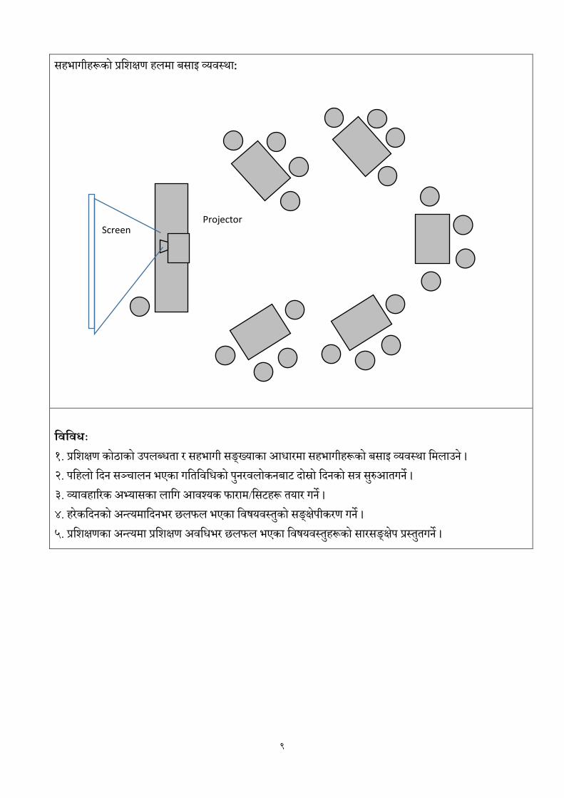
सहभागीहरूको प्रलिक्षण हिर्ा बसाइ व्यवस्था: शिशिधिः
१. प्रलिक्षण कोठाको उपिब्धता र सहभागी सङ््क्याका आधारर्ा सहभागीहरूको बसाइ व्यवस्था लर्िाउने ।
२. पलहिो लदन सञ्चािन भएका गलतलवलधको पनुरविोकनबाट दोस्रो लदनको सत्र सरुुआतगने ।
३. व्यावहाररक अभ्यासका िालग आवश्यक फारार्/लसटहरू तयार गने ।
४. हरेकलदनको अन्त्यर्ालदनभर छिफि भएका लवषयवस्तुको सङ््कके्षपीकरण गने ।
५. प्रलिक्षणका अन्त्यर्ा प्रलिक्षण अवलधभर छिफि भएका लवषयवस्तहुरूको सारसङ््कके्षप प्रस्ततुगने ।
Screen Projector

10
सडक ठेगानारभौगोशलक सूचना प्रणाली प्रशिक्षण
कायािाशलका
समय मममि
पहिलो सत्र ०९०० – १०३०
१०३० –
१०४५
दोश्रो सत्र १०४५ – १२१५
१२१५ –
१३१५
िेश्रो सत्र १३१५ – १४४५
१४४५ –
१५००
चौथो सत्र १५०० – १६३०
पहिलो ददन
▪ z'ef/De, kl/ro, ck]Iff;ª\sng /
k|lzIf0fk"j{ k/LIf0f
▪ zx/Ls/0f, zx/L of]hgftyfzx/
Joj:yfkg, zx/Ls/0fsf
r'gf}ltx? -k"jf{wf/ tyf ;]jf
;"ljwfx?_ tyfkxnx? .
चचया
▪ 7]ufgfx?sf] ;FlIfKt P]ltxfl;s
;dLIff, ;8s / 7]ufgf
k|0ffnLsf] cjwf/0ff, cWoog /
sfof{GjogkIf, ;8s
7]ufgfdfef}uf]lns ;'rgf
k|0ffnLsf] k|of]u, ;8s 7]ufgf
;DjGwL 8f6fa]; ljsf; /
o;sfnfe .
खाना
▪ sf7df08f} pkTosf dfglrq0f
kl/of]hgf -s]lePdlk_ Ps
;kmnkxn, b[li6sf]0f /
ljsf;gLlt,
sfof{Gjogr'gf}tLx?, k|lts[lt,
8s'd]G6];g tyfJoj:yfkg,
jt{dfg l:ylt / l;kmfl/zx? .
चचया
▪ gu/kflnsf :t/sf] 7]ufgf k|0ffnLsf]
cjwf/0ff pknAw ;Gbe{
;fdu|Lsfd'Vod'Voljifo;"rLaf/]
hfgsf/L, a}1flgs 7]ufgf k|0ffnLsf]
cfjZostftyfljsf; / sfof{Gjog /
j}Bflgstfaf/] .
दोस्रो ददन
▪ 7]ufgf k|0ffnLsf]
sfof{Gjogk|lsofx?, tyftTjx?,
7]ufgf If]q ljefhg, ;8s 7]ufgf
k|0ffnL, ;8s gfd /
l;dfgflgwf{/0f, 3/ 7]ufgf k|0ffnL,
gDa/ tyfgfdkftf, 7]ufgf n]Vg]
ljlwcflb .
▪ s];x?sf] ;FlIfKtljj/0f, ;d"x
u7g / sfdM
▪ s]; g+Dj/ !, @ / #
▪ ;d"xut k|:t'lts/0f
tyfd"NofFsg
▪ k|mlG6o/ 6]Sgf]n]lhsf] k|of]u,
pRr l/hf]n';g 8««f]g 5ljx?sf]
k|of]usfcg'ejx?, gu/kflnsf
:t/sf] 8f6fa];/
DoflkË,u'ungSzfKn; sf]8
k|0ffnL .
▪ df]8'n ! b]lv & ;Ddsf] 5f]6f] ;ldIff,
kf]:6 6]:6sf] tof/Lsf] ?kdf
;xeflux?
aLrcGt/ls|ofsfo{s|dcltl/St lzIff
;fdu|LaLlkmFu
िेस्रो ददन ▪ Introduction and Concept to
Arc GIS (Concept and Demo on Software and Database)
▪ Exploring Arc GIS Tools ▪ GIS Database Concepts
and Management ▪ Concept of Geo-referencing
चौथो ददन ▪ GPS and GIS Data
Integration ▪ Google Earth and GIS
Data Integration ▪ Spatial and Attribute
Data Integration in GIS ▪ Calculation and Measurement
of Spatial Features
पााँचौ ददन ▪ Geo-Processing ▪ Output Designing (Map
Layout) ▪ Geographic Information
System ▪ Geographic Information
System ▪ k|lzIf0f d"Nofª\sg,;dfkg
Local Development Training Academy(Established by Local Development Training Academy Act, 2049)
:yfgLo ljsf; k|lzIf0f k|lti7fg -:yfgLo ljsf; k|lzIf0f k|lti7fg P]g, @)$( åf/f :yflkt_
"An Autonomous, Professional, Client Centered, Gender Responsive National
Institute of Excellence in the area of Local-Self Governance."
LDTA >>>
नेपाि सरकार सङ््क घीय र्ालर्िा तथा सार्ान्य प्रिासन र्न्त्रािय

सत्र योजना
11
सत्र योजना
मोडुलः सडक ठेगाना र भौगोललक सूचना प्रणाली सत्रः १क
समय ९० ममनेट
लिषयः शभुारम्भ, पररचय, उद्दशे्य, अपेक्षा सङ्कलन, समहू मान्यता, प्रमशक्षण परू्व जानकारी
साधारण उदे्दश्यः यस सत्रको अन्तमा सहभागीहरू प्रमशक्षणको उद्दशे्यबारे प्रष्टहुनेछन ्।
लनलदिष्ट उदे्दश्यः सत्रको अन्तमा सहभागीहरू
एक आपसमा पररमचत हुनेछन ्।
प्रमशक्षण अर्मिमा छलफल गररने मखु्य मर्षयर्स्तकुो र्ारेमा जानकारी पाउनेछन ्।
मर्षयर्स्त ुर्ारेमा परू्व जानकारीको अर्स्था उपलब्ि हुनेछ ।
सत्रका मुख्य लिषयिस्ुः
प्रमशक्षणको शभुारम्भ
प्रमशक्षणको उद्दशे्य
पररचय
अपेक्षा सङ्कलन
प्रमशक्षणका मर्षयर्स्तु, आिारभतू मनयम, मजम्मरे्ारी आमि
प्रमशक्षण परू्व जानकारी
प्रलिक्षण – लसकाई लियाकलाप अिलध
प्रलिक्षण –
लसकाई
सामाग्री
कैलिय्
क्रियाकलाप १ शभुारम्भ
सहभागीहरु र अतितिहरुको उपस्थितिसंगै राक्रियगानका लातग अनरुोध गनुहुोो्स ।
थवागिसक्रहि कायिुमको उद्देश्यबारे प्रकाश पानुहुोसो् ।
प्रमखु अतितिबाट ब्यानर पढी कायिुमको औपचाररक शभुारम्भ गनुहुोसो् ।
अतितिहरुबाट कायिुमको सफलिाको शभुकामना मन्िव्यका लातग अनरुोध गनहुोसो् ।
कायिुमको अध्यक्षबाट शभुारम्भ मन्िव्यसक्रहि सत्र क्रवसर्नुका लातग अनरुोध गनुहुोसो् ।
२५तमनेट मेटाकार्व, व्यानर,
अतितिहरू र अतितिहरूको मन्िव्य व्यवथिापन अवश्यकिा अनसुार गनुहुोसो् ।

12
प्रलिक्षण – लसकाई लियाकलाप अिलध
प्रलिक्षण –
लसकाई
सामाग्री
कैलिय्
क्रियाकलाप २ पररचय
सबै सहभागी, सहर्किाु (प्रस्शक्षक) र अन्य उपस्थिि व्यस्िहरुलाई आफ्नो नाम, ठेगाना, पद,
संस्क्षप्त काय ुअनभुवसक्रहि आफ्नो पररचय ददन लगाउनहुोसो् ।
१५ तमनेट
क्रियाकलाप ३ अपेक्षा सङ्कलन
सहभागीहरूलाई प्रस्शक्षणबाट गररएको अपेक्षालाई मेटाकार्मुा लेख्न लगाउनहुोसो् ।
मेटाकार्हुरुलाई एक एक गरी पढ्दै ब्राउन पेपर वा बोर्मुा टााँथनहुोसो् ।
आएका अपेक्षालाई एकै क्रकतसमका आसय भएका कार्लुाई एकै ठााँउमा राख्नहुोसो् ।
प्रस्शक्षणको क्रवषयवथि ुर सहभागीको अपेक्षा तमलान गनुहुोसो् ।
सहभागीहरुबाट आएका अपेक्षाहरु के कति हदसम्म यस प्रस्शक्षणले सम्बोधन गन ुसक्छ भन्न ेप्रष्ट पानुहुोस ।
१५ तमनेट मेटाकार्व, माकव र,
पसु मपन, ग्ल ुस्टीक,
मामस्कङ टेप, ब्राउन
पेपर
यदद सहभागीबाट क्रवषयवथि ुभन्दा तभन्न अपेक्षाकार् ुआएमा अलग राख्नहुोसो् ।
क्रियाकलाप ४ क्रवषयवथिकुो र्ानकारी सहभागीहरुले ल्याएका अपेक्षाहरुलाई तमलान गदै
प्रस्शक्षणमा छलफल गररने क्रवषयवथिहुरु र्ानकारी गराउनहुोस ।
५ तमनेट
ब्राउन पेपर, माकव र,
न्यजूमप्रन्ट पेपर
क्रियाकलाप ५ समहु मान्यिा, स्र्म्मेवारी आदद प्रस्शक्षण प्रभावकारीिाको लातग हरेक ददनको
प्रस्शक्षण अवतधमा समूह मान्यिालाई सहभागीहरुसंग छलफल गरी न्यूर् क्रप्रन्टमा लेखो् स् पालना गन ुलगाउनहुोस ।
आवश्यकिा परेमा क्रवतभन्न स्र्म्मेवारी बााँर्फााँर् (ररपोक्रटङ, समय व्यवथिापक, मनोरञ्जनकिाु आदद) गराउनहुोसो् ।
५ तमनेट ब्राउन पेपर, माकव र,
न्यजूमप्रन्ट पेपर,
पार्रप्र्ाइन्ट स्लाइर्

13
प्रलिक्षण – लसकाई लियाकलाप अिलध
प्रलिक्षण –
लसकाई
सामाग्री
कैलिय्
क्रियाकलाप ६ प्रस्शक्षण पूव ुर्ानकारी सहभागीहरुलाई प्रस्शक्षण पूव ुर्ानकारी फाराम
क्रविरण गनुहुोसो् ।
उि फाराम कसरी भने सबैलाई थपष्ट पानुहुोसो् । सबै सहभागीहरुबाट फाराम संकलन गरी सकेपतछ
यसबाट आएको नतिर्ालाई हामी प्रस्शक्षणको अन्िमा गररने पश्चाि र्ानकारीको नतिर्ासाँग िलुना गनेछौं भन्नुहोस ।
१० तमनेट प्रमशक्षण परू्व
परीक्षण फाराम
क्रियाकलाप ७ प्रस्शक्षणको साधारण उद्दशे्य, तनददुष्ट उद्दशे्यहरु, प्रस्शक्षण क्रवतध र प्रस्शक्षण िातलका प्रस्शक्षकले प्रस्शक्षणको बारेमा फ्लीप चाटुमा ियार
पारेको प्रस्शक्षणको साधारण उद्देश्य, तनददुष्ट उद्देश्यबारे बिाउनहुोसो् ।
प्रस्शक्षणका क्रवतधहरु र्ानकारी गराउनहुोसो् ।
प्रस्शक्षण िातलकाको र्ानकारी ििा िातलका क्रविरण गनुहुोसो् ।
१० तमनेट ब्राउन पेपर, फ्लीप
चाटव, प्रमशक्षण
तामलका
क्रियाकलाप ८ सत्र संक्षपेीकरण र अग्रसम्वन्ध
समग्र प्रस्शक्षण सहभातगिामूलक ढंगबाट अगातर् बढ्न ेकुराको अवगि गराउनहुोसो् ।
दोश्रो सत्र सम्वन्धी र्ानकारी गराउनहुोसो् ।
५ तमनेट

14
सत्र योजना
मोडुलः सडक ठेगाना र भौगोललक सूचना प्रणाली सत्रः १ख
समयः ९० ममनेट
सत्रलिषयः शहरी योजनाशहर व्यर्स्थापनतथा सर्क ठेगाना
साधारण उदे्दश्यः नेपालकाशहर र त्यसकामर्मर्ि पाटोहरुको साथै सर्क ठेगानाको जानकारी गराउने ।
लनलदिष्ट उदे्दश्यहरः सहभागीहरुले यस सत्रको अन्त्यमा,
नेपालको शहरी योजनातथाव्यर्स्थापन सम्र्न्िमा ज्ञान हुने ।
शहर र सर्क ठेगानाको अन्तरसम्बन्ि बारे बझु्न े।
सत्रका मुख्य लिषयिस्ुः
शहरीकरण, शहरीमर्कास योजनार शहर व्यर्स्थापन
शहरी परू्ाविार तथा सेर्ा समुर्िाहरु, सर्क ठेगाना र शहरी व्यर्स्थापन
प्रलिक्षण – लसकाई लियाकलाप अिलध
प्रलिक्षण –
लसकाई
सामाग्री
कैलिय्
lqmofsnfk !M ;xefuLsf]
kl/ro;lxtWofgfsif{0f ug{ zx/sf]
lrqDofkcflb b]vfpFb} 5nkmn ug]{ .
& lrqsf]
:nfO8
;xhstf{n] klxnf
g} tof/ u/L /fVg]
-;=t=x'g]_
lqmofsnfk @M;qsf] kl/rotyfp2]Zox? /
k|f?ksf] hfgsf/L u/fpg]
;xefuLx?nfO{ o;tflndsf] ;qx?sf]
af]/]df 5f]6f] hfgsf/L kZrft o; zqsf]
kl/rolj:t[t?kdfu/fpg]
Dff]8'nsf] p2]Zox?
Dff]8'nsf] k|f?k
*
:nfO8,
d]6fsf8{,
rf6{ k]k/ /
dfs{/
;xhstf{n] klxnf
g} tof/ u/L /fVg]
lqmofsnfk #Mljifoj:t' ;DjGwL ;xefuLnfO{
hfgsf/L ePdfeGg / n]Vg nufpg] -lk|6]i6_ !) lk|6]i6kmf/fd -;=t=x'g]_

15
प्रलिक्षण – लसकाई लियाकलाप अिलध
प्रलिक्षण –
लसकाई
सामाग्री
कैलिय्
lqmofsnfk$M g]kfnsfzx/L If]qsf] ljsf;
tyf of]hgfth'{df
Sf7df08f} pkTosfsfgu/x?
cGopkTosf,gu/x?tyfj:tL
!@
kfj/
KjffO6df
b]vfpg]
dN6Ld]l8of
-;=t=x'g]_
lqmofsnfk%M=;xefuLx?sf] a'dmfO{hfFr
zx/sf] r'gf}tL
zx/sf cj;/
*
d]6fsf8{ /
rf6{ k]k/ /
dfs{/
;xhstf{n] klxnf
g} d]6fsf8{x?
qmd;+u tof/ u/L
/fVg]
lqmofsnfk^Mzx/L ;F/rgfx? / ;f]sf] kx'Fr -
7]ufgf k|0fflnsf] cGt/ ;DjGw_
ejgcfjf; tyfcGo
k"jf{wf/x? –ef}lts, ;fdflhs / cfly{s
;x/L k|fs[lts ;Fkbfx?
!%
kfj/
KjfO6df
b]vfpg]
dlN6d]l8of
-;=t=x'g]_
lqmofsnfk&MgLltlgodtyflgb]{lzsfx?
;FIf]kdfhfgsf/L –ljz]if u/L zx/L If]qsf]
;xefux?nfO{ l8lh6n skLljt/0f ug]{
!)
kfj/
KjfOG6df
b]vfpg]
dlN6d]l8of
-;=t=x'g]_

16
प्रलिक्षण – लसकाई लियाकलाप अिलध
प्रलिक्षण –
लसकाई
सामाग्री
कैलिय्
lqmofsnfk*M ;qsf]d"NofÍgtyf ;+If]kLs/0f
;qd"NofÍg
;FIf]kdf ;qsf] dxTjk"0f{ lrqsf] :nfO8
k'0f b]vfpg] / lgDgk|Zgsf] hjfkmkfKt
ug]{ -;xof]u ;lxt_
zx/Ls/0f, of]hgf, Joj:yfkgaf/] /
7]ufgf k|0ffnL;+usf] ;+DjGw ;+lIfKtdf
n]Vg] .
;q ;+If]kLs/0f
;q d"NofÍgkZrft\ ;qsf] 5f]6s/Ldf
5nkmn ePsfljifoj:t' :ki6 ub}{ ca
o; k5fl8sf] ;q @ 7]ufgf k|0ffnLsf
cjwf/0ff tyflh=cfO=o;=sf] af/]df
5nkmn ul/g]5 elg;qsf] cGtug]{ .
!%
%
d]6fsf8{ /
rf6{ k]k/ /
dfs{/
;xhstf{n] klxnf
g} k|Zgx?
d]6fsf8{dftof/
u/L /fVg]

17
सत्र योजना
मोडुलः सडक ठेगाना र भौगोललक सूचना प्रणाली सत्रः २
समयः ९० ममनेट
सत्रलिषयः ठेगाना प्रणालीको अर्िारणा र नगरपामलकाहरुको अर्स्था
साधारण उदे्दश्यः ठेगाना प्रणामलहरुको सँमक्षप्त ऐमतहामसक समीक्षा, सर्क र ठेगाना प्रणालीकाअर्िारणा मर्कास र
लाभ सम्र्न्िीजानकारी गराउने ।
लनलदिष्ट उदे्दश्यहरः सहभागीहरुले यस सत्रको अन्त्यमा,
ठेगाना प्रणामलहरुको ऐमतहामसकपक्षतथा सर्कर्ारे मर्स्ततृज्ञान हुने ।
सर्क संजाल र सर्क ठेगाना सम्र्न्िी र्ाटाबेस मर्कास र यसकालाभबारे बझु्ने ।
सत्रकामुख्यलिषयिस्ुः
ठेगाना प्रणामलको ऐमतहामसक पषृ्ठभमूी
सर्क संजाल र ठेगाना प्रणालीको अर्िारणा र यसकालाभ
सर्क ठेगानामाभौगोमलक सचुना प्रणालीको प्रयोग।
प्रलिक्षण – लसकाई लियाकलाप अिलध
प्रलिक्षण –
लसकाई
सामाग्री
कैलिय्
lqmofsnfk !M;xefuLnfO{ df]8'n ! sf]
dxTjk"0f{ kIf ;+dmg k|of; u/fpg] jf ug]{.
;xeflux?sf] df]8'n ! / @ sf] ;+DaGwaf/]
Wofgfsif{0f ug{ zx/sf] lrqDofkcflb
b]vfpFb} 5nkmn ug]{ .
& lrqsf]
:nfO8
;xhstf{n] klxnf
g} tof/ u/L /fVg]
-;=t=x'g]_
lqmofsnfk @M;qsf] kl/rotyfp2]Zox? /
k|f?ksf] hfgsf/L u/fpg]
;xefuLx?nfO{ o; zqsf]
kl/rolj:t[t?kdf u/fpg]
Dff]8'nsf] p2]Zox?
Dff]8'nsf] k|f?k
*
:nfO8,
d]6fsf8{, rf6{
k]k/ / dfs{/
;xhstf{n] klxnf
g} tof/ u/L /fVg]

18
प्रलिक्षण – लसकाई लियाकलाप अिलध
प्रलिक्षण –
लसकाई
सामाग्री
कैलिय्
lqmofsnfk #Mljifoj:t' ;DjGwLhfgsf/L
ePdfGo"gtd ^ ;xefuLnfO{ eGgnufpg] !) Nffu' x'+b}g -;=t=x'g]_
lqmofsnfk$7]ufgf k|0fflnsf] P]ltxfl;s
k[i7e"dL
;+;f/df o; k|0ffnLsf] ;'?jft /
sf/0fx?
k'/fgf k|0ffnL nfu' ePsfMpkTosfsf /
aflx/sf gu/x?
*
kfj/
KjffO6df
b]vfpg]
dN6Ld]l8of
-;= t=x'g]_
Lqmofsnfk %M;8s ;+hfn / 7]ufgf
k|0ffnLsf] cjwf/0ff / o;sfnfe
;8ssf] ls|ofsnfk / o;sf] nfe
j:tLsf ;8s tyf ;8s ;+hfn
;8ssf ljljw 9Ffrf
!#
kfj/
KjffO6df
b]vfpg]
dN6Ld]l8of
;xhstf{n] klxnf
g} d]6fsf8{x?
qmd;+u tof/ u/L
/fVg]
Lqmofsnfk ^M7]ufgf k|0ffnLsf] cjwf/0ff
/ o;sfnfe
ef}lts, ;fdflhs / cfly{s nfe
;]jfljt/0fdf
k|efjsf/Ltftyfk|ljlwk|of]u hfrF
!$
kfj/
KjfO6df
b]vfpg]
dlN6d]l8of
-;=t=x'g]_
Lqmofsnfk&M;8s 7]ufgfdfef}uf]lns ;'rgf
k|0ffnLsf] k|of]u
;FIf]kdfhfgsf/L
–ljz]if u/L gu/ If]qsf] gS;ftof/Lsf]
;Gbe{ tyf
–8f6f j]; Aff/]
!)
kfj/
KjfOG6df
b]vfpg]
dlN6d]l8of
-;=t=x'g]_

19
प्रलिक्षण – लसकाई लियाकलाप अिलध
प्रलिक्षण –
लसकाई
सामाग्री
कैलिय्
lqmofsnfk*M ;qsf]d"NofÍgtyf ;+If]kLs/0f
;qd"NofÍg
;FIf]kdf ;qsf] dxTjk"0f{ lrqsf] :nfO8
k'0f b]vfpg] / lgDgk|Zgsf] hjfkmkfKt
ug]{ -;xof]u ;lxt_
a:tLx?sf] ;+/rgfljz]if u/L ;8s
;+hfntyf 7]ufgf k|0ffnLsf] cGt/
;DaGwcEof;
;q ;+If]kLs/0f
;qd"NofÍgkZrft\ ;qsf] 5f]6s/Ldf
5nkmn ePsfljifoj:t' :ki6 ub}{ ca
o; k5fl8sf] ;q #–
s]=le=Pd=lk=kl/of]hgfaf/]df 5nkmn
ul/g]5 elg;qsf] cGtug]{ .
!%
%
d]6fsf8{ /
rf6{ k]k/ /
dfs{/
;xhstf{n] klxnf
g} k|Zgx?
d]6fsf8{dftof/
u/L /fVg]

20
सत्र योजना
मोडुलः सडक ठेगाना र भौगोललक सूचना प्रणाली सत्रः ३
समयः ९० ममनेट
सत्रलिषयः काठमाण्र्ौ उपत्यका मानमचत्रण पररयोजना (के.मभ.एम.मप)
साधारण उदे्दश्यः सफल पररयोजनाबाट मसक्न सक्ने सकारात्मकतथाचनुौतीपूणव पाटाहरु सम्र्न्िीजानकारी गराउने ।
लनलदिष्ट उदे्दश्यहरः सहभागीहरुले यस सत्रको अन्त्यमा,
काठमाण्र्ौ उपत्यका मानमचत्रण पररयोजना (केमभएममप) र्ारे ज्ञान हुने ।
उपलव्िनीमतहरु, दृमष्टकोण र मर्कास, कायावन्र्यनचनुौतीहरुबारे बझु्न े।
सत्रकामुख्यलिषयिस्ुः
काठमाण्र्ौ उपत्यका मानमचत्रण पररयोजना (केमभएममप) एक सफलपहल
दृमष्टकोण र मर्कास नीमत
कायावन्र्यनचनुौतीहरु र उपलब्िी
प्रलिक्षण – लसकाई लियाकलाप अि
लध
प्रलिक्षण –
लसकाई
सामाग्री
कैलिय्
lqmofsnfk !M;xefuLnfO{ df]8'n @ sf] dxTjk"0f{ kIf
;+dmg k|of; u/fpg] jf ug]{. ;xeflux?sf] df]8'n @ / #
sf] ;+DaGwaf/] Wofgfsif{0f ug{ zx/sf] lrqDofkcflb
b]vfpFb} 5nkmn ug]{ .
& lrqsf]
:nfO8
;xhstf{n]
klxnf g} tof/
u/L /fVg]
-;=t=x'g]_
lqmofsnfk @M;qsf] kl/rotyfp2]Zox? / k|f?ksf]
hfgsf/L u/fpg]
;xefuLx?nfO{ o; zqsf] kl/rolj:t[t?kdf u/fpg]
Dff]8'nsf] p2]Zox?
Dff]8'nsf] k|f?k
*
:nfO8,
d]6fsf8{,
rf6{ k]k/ /
dfs{/
;xhstf{n]
klxnf g} tof/
u/L /fVg]
lqmofsnfk #Mljifoj:t' ;DjGwLhfgsf/L ePdfGo"gtd !)
;xefuLnfO{ eGgnufpg] !) Nffu' x'+b}g -;=t=x'g]_
21
प्रलिक्षण – लसकाई लियाकलाप अि
लध
प्रलिक्षण –
लसकाई
सामाग्री
कैलिय्
lqmofsnfk$Msf7df08f} pkTosf dfglrq0f kl/of]hgf
k[i7e"dL
/fhwfgLzx/df o; k|0ffnLsf] ;'?jftx'g'sf] d'Vo
pb]Zo / cj:Yffsf] lrq0f
o; k|0ffnL nfu' ePkl5sf] cj:yf
*
Dff}lvs,
kfj/
KjffO6df
b]vfpg]
dN6Ld]l8of
-;= t=x'g]_
Lqmofsnfk %Mkl/of]hgfsf] b[li6sf]0f / ljsf; gLlt
;8stxsf] dxTj / o;sf] gfdfs/0f
ejgtyfcfjf;sf] Joj:yLt 7]ufgf
!#
kfj/
KjffO6df
b]vfpg]
dN6Ld]l8of
;xhstf{n]
klxnf g}
d]6fsf8{x?
qmd;+u tof/
u/L /fVg]
Lqmofsnfk ^Mkl/of]hgfsfof{Gjogr'gf}tLx? / pknAwL
ckgTjdfsdL / Go"ghg ;xeflutf
k|ljlwtyfdfgj ;+;fwgsf] sdL
!$
kfj/
KjfO6df
b]vfpg]
dlN6d]l8of
-;=t=x'g]_
Lqmofsnfk&Mkl/of]hgfsfof{GjogsfpknAwLx?
lj:t[t ;8s P6nf; k|sfzg / ljt/0f
ef}uf]lns ;"rgf k|0ffnLsf] :yfkgf
!)
kfj/
KjfOG6df
b]vfpg]
dlN6d]l8of
-;=t=x'g]_

22
प्रलिक्षण – लसकाई लियाकलाप अि
लध
प्रलिक्षण –
लसकाई
सामाग्री
कैलिय्
lqmofsnfk*M kl/of]hgfaf6 l;sfO{
;FIf]kdf ;qsf] dxTjk"0f{ lrqsf] :nfO8 k'0f b]vfpg] /
lgDgk|Zgsf] hjfkmkfKt ug]{ -;xof]u ;lxt_
Jnstyf7]ufgf k|0ffnLsf] kmfO{bf j]kmfO{bfsf] lrq0f
ub}{
kxf8LtyflxdfnLkflnsfx?sfnlupko'QmtfePjfgeP
sf]] hjfkm ;lxtsf] cEof; ug'xf];\ .
;q ;+If]kLs/0f
;qd"NofÍgkZrft\ ;qsf] 5f]6s/Ldf 5nkmn
ePsfljifoj:t' :ki6 ub}{ ca o; k5fl8sf] ;q $–
pknAw ;Gbe{ ;fdu|Lsfaf/]df 5nkmn ul/g]5
elg;qsf] cGtug]{ .
!%
%
d]6fsf8{ /
rf6{ k]k/ /
dfs{/, kfj/
KjfOG6
pknAw
;Gbe{
;fdu|Lljt/0
f
x'gjfeO{;Sg]
;xhstf{n]
klxnf g}
k|Zgx? kfj/
KjfOG6 jf
d]6fsf8{dftof
/ u/L /fVg]
;=t=x'g]
jfJoj:yfkgn]
ul/;Sg]

23
सत्र योजना
मोडुलः सडक ठेगाना र भौगोललक सूचना प्रणाली सत्रः ४
समयः ९० ममनेट
सत्रलिषयः नगरपामलका स्तरको ठेगाना प्रणालीको अर्िारणा
साधारण उदे्दश्यः उपलब्ि सन्िभव सामग्रीकामर्षयसचूीबारे जानकारी गराउने ।
लनलदिष्ट उदे्दश्यहरः सहभागीहरुले यस सत्रको अन्त्यमा,
बैज्ञामनक ठेगाना प्रणालीको आर्श्यकतातथामर्कासकोज्ञान हुने ।
बैज्ञामनक ठेगाना प्रणालीको र्ैिामनकताबारेबमुm््ने ।
सत्रका मुख्य लिषयिस्ुः
नगरपामलका स्तरको ठेगाना प्रणालीको अर्िारणा
उपलब्ि सन्िभव सामग्रीका मखु्य मखु्य मर्षयसचूी
ठेगाना प्रणालीको र्िैामनकता पक्ष
प्रलिक्षण – लसकाई लियाकलाप अिलध
प्रलिक्षण –
लसकाई
सामाग्री
कैलिय्
lqmofsnfk !M;xefuLnfO{ df]8'n # sf]
dxTjk"0f{ kIf ;+dmg k|of; u/fpg] jf ug]{.
;xeflux?sf] df]8'n # / $ sf] ;+DaGwaf/]
Wofgfsif{0f ug{ zx/sf] lrqDofkcflb
b]vfpFb} 5nkmn ug]{ .
& lrqsf]
:nfO8
;xhstf{n] klxnf
g} tof/ u/L /fVg]
-;=t=x'g]_
lqmofsnfk @M;qsf] kl/rotyfp2]Zox? /
k|f?ksf] hfgsf/L u/fpg]
;xefuLx?nfO{ o; zqsf]
kl/rolj:t[t?kdf u/fpg]
Dff]8'nsf] p2]Zox?
Dff]8'nsf] k|f?k
*
:nfO8,
d]6fsf8{, rf6{
k]k/ / dfs{/
;xhstf{n] klxnf
g} tof/ u/L /fVg]
lqmofsnfk #Mljifoj:t' ;DjGwLhfgsf/L
ePdfGo"gtd % ;xefuLnfO{ eGgnufpg] !) Nffu' x'+b}g -;=t=x'g]_

24
प्रलिक्षण – लसकाई लियाकलाप अिलध
प्रलिक्षण –
लसकाई
सामाग्री
कैलिय्
lqmofsnfk$Mgu/kflnsf :t/sf] 7]ufgf
k|0ffnLsf] cjwf/0ff
/fhwfgLzx/df o; k|0ffnLsf]
;'?jftx'g'sf] d'Vo pb]Zo / cj:Yffsf]
lrq0f
o; k|0ffnL nfu' ePkl5sf] cj:yf
*
Dff}lvs, kfj/
KjffO6df
b]vfpg]
dN6Ld]l8of
-;= t=x'g]_
Lqmofsnfk %M;Gbe{
;fdu|Lsfd'Vod'Voljifo;"rL
cfwf/ gSzftof/L
3/ gDa/sf] nflu kl/efliftIf]q
kxF'r t/Lsfklxrfg / gfdfs/0f
!%
kfj/
KjffO6df
b]vfpg]
dN6Ld]l8of
;xhstf{n] klxnf
g} d]6fsf8{x?
qmd;+u tof/ u/L
/fVg]
Lqmofsnfk ^M;Gbe{
;fdu|Lsfd'Vod'Voljifo;"rL
ejg, 3/ klxrfg / 9f]sfgDj/
gDj/ / gfdKn]6
7]ufgfn]Vg] tl/sf
!)
kfj/ KjfO6df
b]vfpg]
dlN6d]l8of
-;=t=x'g]_
Lqmofsnfk&M7]ufgf k|0ffnLsf] j}wflgskIf
:yfgLo ;/sf/ ;+rfng P]g @)&$ sf]
kl/R5]b !%
gu/kflnsfdf;"rgf k|0ffnL ;'lawf
;lxtsf] 7]ufgf k|0ffnL zfvfv8f
ul/g]5 tyfcGok|fjwfgx?
!@
kfj/
KjfOG6df
b]vfpg]
dlN6d]l8of
-;=t=x'g]_

25
प्रलिक्षण – लसकाई लियाकलाप अिलध
प्रलिक्षण –
लसकाई
सामाग्री
कैलिय्
lqmofsnfk*M 7]ufgf k|0ffnL
lgb{]lzsfsf]l;sfO{
;FIf]kdf ;qsf] dxTjk"0f{ lrqsf] :nfO8
k'0f b]vfpg] / lgDgk|Zgsf] hjfkmkfKt
ug]{ -;xof]u ;lxt_
# gu/kflnsfx?sf 7]ufgf k|0ffnL
lgb{]lzsfsf] cjwf/0ff ;fdu|LcWoog /
5nkmn ug'{sf;fy}cGokflnsfx?dfnfu'
ug{ kl/dfhgjf7]ufgf k|0ffnLsf
yktTjx? cfjZos kg]{ af/]lgisif{
lgsfNg' xf];\ .
;q ;+If]kLs/0f
;qd"NofÍgkZrft\ ;qsf] 5f]6s/Ldf
5nkmn ePsfljifoj:t' :ki6 ub}{ ca
o; k5fl8sf] ;q %–d]l6«s 7]ufgf
k|0ffnLsf] sfof{GjogkIfaf/]df 5nkmn
ul/g]5 elg;qsf] cGtug]{ .
!%
%
d]6fsf8{ /
rf6{ k]k/ /
dfs{/, kfj/
KjfOG6
pknAw
;Gbe{
;fdu|Lljt/0f
eO{;Sg]
;xhstf{n] klxnf
g} k|Zgx?
d]6fsf8{df jfkfj/
KjfOG6 tof/ u/L
/fVg]
;=t=x'g]
jfJoj:yfkgn]
ul/;Sg]

26
सत्र योजना
मोडुलः सडक ठेगाना र भौगोललक सूचना प्रणाली सत्रः ५
समयः ९० ममनेट
सत्रलिषयः ठेगाना प्रणालीको कायावन्र्यन पक्ष
साधारण उदे्दश्यः ठेगाना प्रणालीको कायावन्र्यन पक्ष बारे मर्स्ततृरुपमा जानकारी गराउने ।
लनलदिष्ट उदे्दश्यहरः सहभागीहरले यस सत्रको अन्त्यमा,
ठेगाना प्रणालीको कायावन्र्यन प्रमकयाहरुको ज्ञान हुने ।
अन्य नगरपामलका स्तरमा भईरहकेो र्ा भईसकेको ठेगाना प्रणालीको बारे बझु्न े।
सत्रका मुख्य लिषय िस्ुः
ठेगाना क्षेत्र मर्भाजन
सर्क तथा घर ठेगाना प्रणाली
व्यर्हाररक पक्ष (३ टोलीले ३ फरक ठेगाना प्रणाली मनिमेशकाको अर्िारणा सामग्री अध्ययन, छलफल तथा
मर्शे्लषण गनेछ) ।
प्रलिक्षण – लसकाई लियाकलाप अिलध
प्रलिक्षण –
लसकाई
सामाग्री
कैलिय्
lqmofsnfk !M ;xefuLnfO{ df]8'n $ sf]
dxTjk"0f{ kIf ;+dmg k|of; u/fpg] jf
ug]{ . ;xeflux?sf] df]8'n $ / % sf]
;+DaGwaf/] Wofgfsif{0f ug{ gu/kflnsf
tyf zx/sf] ;8s tyf 3/ 7]ufgf
k|0ffnL b]vfpFb} 5nkmn ug]{ .
& lrqsf]
:nfO8
;xhstf{n] klxnf
g} tof/ u/L /fVg]
-;=t=x'g]_

27
प्रलिक्षण – लसकाई लियाकलाप अिलध
प्रलिक्षण –
लसकाई
सामाग्री
कैलिय्
lqmofsnfk @M ;qsf] kl/ro tyf p2]Zox?
/ k|f?ksf] hfgsf/L u/fpg]
;xefuLx?nfO{ o; zqsf] kl/ro
lj:t[t?kdf u/fpg]
Dff]8'nsf] p2]Zox?
Dff]8'nsf] k|f?k
*
:nfO8,
d]6fsf8{, rf6{
k]k/ / dfs{/
;xhstf{n] klxnf
g} tof/ u/L /fVg]
lqmofsnfk #Mljifoj:t' ;DjGwL hfgsf/L
ePdf Go"gtd & ;xefuLnfO{ eGg nufpg] !) Nffu' x'+b}g -;=t=x'g]_
lqmofsnfk$M 7]ufgf k|0ffnLsf] sfof{Gjog
r/0fx?
7]ufgf If]q ljefhg
;8s 7]ufgf k|0ffnL
3/ 7]ufgf k|0ffnL
!@
Dff}lvs, kfj/
KjffO6df
b]vfpg]
dN6Ld]l8of
-;= t=x'g]_
lqmofsnfk %M ;8s 7]ufgf k|0ffnLsf]
lj:t[t ljj/0f
;8sx?sf] jlu{s/0f tyf ;Fs]t gDj/
;8s gfdfs/0f tyf g]d Kn]6 cflb
!)
kfj/
KjffO6df
b]vfpg]
dN6Ld]l8of
;xhstf{n] klxnf
g} d]6fsf8{x?
qmd;+u tof/ u/L
/fVg]
lqmofsnfk ^M 3/ 7]ufgf k|0ffnLsf] lj:t[t
ljj/0f
ljleGg lsl;dsf ;8sx?df 3/ gDj/
k|jfx
rf}s h:tf ;fd'lxs jf ;fj{hlgs v'Nnf
7fFpx?df 3/ gDj/ k|jfx tyf g]d Kn]6
!)
kfj/ KjfO6df
b]vfpg]
dlN6d]l8of
-;=t=x'g]_
lqmofsnfk & M Jojxfl/s kIf
tLg j6f 6f]nL u7g u/L sfo{ ljefhg
7]ufgf k|0ffnL lgb{]lzsfsf cWoog
5nkmn
!^
kfj/
KjfOG6df
b]vfpg]
dlN6d]l8of,
kmf]6f]slk
-;=t=x'g]_

28
प्रलिक्षण – लसकाई लियाकलाप अिलध
प्रलिक्षण –
लसकाई
सामाग्री
कैलिय्
lqmofsnfk *M 7]ufgf k|0ffnLdf lgb]{lzsf
;DjGwL # j6f 6f]nLsf] wf/0ff k|:t'lts/0f
lgDg k|Zgsf] hjfkm kfKt ug]{
7]ufgf k|0ffnL lgb]{lzsfx? cGo
kflnsfx?df nfu' ug{ kl/dfhg
cfjZos kg]{ jf x'jx' nfu' ug{ ;lsg]
jf g;lsg] af/] 6f]nLsf] wf/0ff kfKt
x'g] .
;q ;+If]kLs/0f
;q d"NofÍgkZrft\ o; k5fl8sf] ;q ^
df ;d"xut?kdf s];x?sf] cWoog,
5nkmn tyf k|:t'lts/0f ul/g]5
elg;qsf] cGt ug]{ .
!@
%
d]6fsf8{ /
rf6{ k]k/ /
dfs{/, kfj/
KjfOG6
df}lvs
6f]nLn] d]6fsf8{,
rf6{ k]k/ jf kfj/
KjfOG6df k|:t'tL
ug]{
29
सत्र योजना
मोडुलः सडक ठेगाना र भौगोललक सूचना प्रणाली सत्रः ६
समयः ९० लमनेट
सत्रलिषयः मामला अध्ययन तथा मर्शे्लषण
साधारण उदे्दश्यः ठेगाना प्रणालीको कायावन्र्यनको व्यर्हाररक ज्ञान र कौशलतापाप्तगराउने ।
लनलदिष्ट उदे्दश्यहरः सहभागीहरुले यस सत्रको अन्त्यमा,
ठेगाना प्रणालीको कायावन्र्यनप्रमकयाहरुको बारे अरुलाई प्रस्ततुीकरण गनव सक्ने ।
यस प्रणाली पामलकाहरुमालाग ुगनव र गराउनआर्श्यकपरू्ाविार बारे ज्ञान हुने ।
सत्रकामुख्यलिषयिस्ुः
केसहरुको सँमक्षप्त मर्र्रण
समहूगत छलफल तथा मर्शे्लषण
प्रस्ततुीकरण
प्रलिक्षण – लसकाई लियाकलाप अिलध प्रलिक्षण –
लसकाई सामाग्री कैलिय्
lqmofsnfk !M;xefuLnfO{ df]8'n % sf]
dxTjk"0f{ kIf ;+dmg k|of; u/fpg] jf ug]{.
;xeflux?sf] df]8'n % / ^ sf] ;+DaGwaf/]
Wofgfsif{0f ug{ zx/sf] lrqDofkcflb
b]vfpFb} 5nkmn ug]{ .
% lrqsf] :nfO8
;xhstf{n] klxnf
g} tof/ u/L /fVg]
-;=t=x'g]_
lqmofsnfk @M;qsf] kl/rotyfp2]Zox? /
k|f?ksf] hfgsf/L u/fpg]
;xefuLx?nfO{ o; zqsf]
kl/rolj:t[t?kdf u/fpg]
Dff]8'nsf] p2]Zox?
Dff]8'nsf] k|f?k
%
:nfO8,
d]6fsf8{, rf6{
k]k/ / dfs{/
;xhstf{n] klxnf
g} tof/ u/L /fVg]

30
प्रलिक्षण – लसकाई लियाकलाप अिलध प्रलिक्षण –
लसकाई सामाग्री कैलिय्
lqmofsnfk #M ;d"x u7g / sfdtf]Sg]M
;xefuLx?nfO{ # ;d"xdfljefhg u/L
cfjZos ;fdfu|L ;lxtdfdnfcWoogsfo{sf]
;'ef/Desf] tof/L u/fpg] .
!)
d]6fsf8{, rf6{
k]k/, dfs{/,
sn/ k]g, tyf
gf]6 a's cflb
-;=t=x'g]_
lqmofsnfk$Ms];x?sf] ;FlIfKtljj/0f
s]; gDa/ !Mcfjf; kl/;/
s]; gDa/ !Msfof{no ejg kl/;/
s]; gDa/ !M 3gf j:tL If]q
!)
kfj/ KjffO6df
b]vfpg'sf ;fy}
s];sf] xf8{
k|ltlnlkljt/0f
ug]{
-;=t=x'g]_
lqmofsnfk %M;d"xutcWoogtyf 5nkmn
7]ufgfIf]qljefhg
af6f] 7]ufgf k|0ffnL
;8s gfd / l;dfgflgwf{/0f
3/ 7]ufgf k|0ffnL
3/ gDa/ k|0ffnLcflb
#)
gS;f / rf6{
k]k/
;xhstf{n]
;xof]u u/]sf] x'g
lqmofsnfk ^ Mk|:t'tLs/0fsf] tof/L
cfjf; PsfOx?,ejgtyf 3/x?sf]
gDa/ k|jfx
jlu{s[t ;8s af6f] gfdk|jfx
lgisif{ /l;kmfl/zx?
!%
kfj/ KjffO6
jf rf6{ k]k/
;xhstf{n
;xof]u u/]sf] x'g]

31
प्रलिक्षण – लसकाई लियाकलाप अिलध प्रलिक्षण –
लसकाई सामाग्री कैलिय्
lqmofsnfk &M k|:t'tLs/0f kZrftk|ZgpQ/
;FIf]kdfk|:t'tLs/0f ;qsf] dxTjk"0f{
lrqsf] :nfO8 k'0f b]vfpg] /
lgDgk|Zgsf] hjfkmkfKt ug]{ M
;Gbe{ ;fdu|Lx? h:t} 7]ufgf k|0ffnL
lgb{]lzsfx? tyftflnddfkfKt 1fgsf]
cfwf/df s];x?sf] ;FlIfKtcWoog ug{
;xheof] ePg<Jojxfl/s?kdf7]ufgf
k|0ffnL sfof{Gjogk|s|Lofdfd'Voe"ldsf
v]Ng ;lsg] jfg;lsg] k[i7kf]if0f
ug'{xf];\ .
;q ;+If]kLs/0f
;qd"NofÍgkZrft\ ;qsf] 5f]6s/Ldf
5nkmn ePsfljifoj:t' :ki6 ub}{ ca
o; k5fl8sf] ;q &–gofFk|ljlwaf/]df
5nkmn ul/g]5 elg;qsf] cGtug]{ .
!)
%
d]6fsf8{ / rf6{
k]k/ / dfs{/,
kfj/ KjfOG6
pknAw ;Gbe{
;fdu|Lljt/0f
eO{;Sg]
;xhstf{n] klxnf
g} k|Zgx?
d]6fsf8{df
jfkfj/ KjfOG6
tof/ u/L /fVg]
;=t=x'g]
jfJoj:yfkgn]
ul/;Sg]

32
सत्र योजना
मोडुलः सडक ठेगाना र भौगोललक सूचना प्रणाली सत्रः ७
समयः ९० ममनेट
सत्रलिषयः नयाँप्रमर्मिको आिारमा ठेगाना प्रणालीको मर्कास
साधारण उदे्दश्यः ठेगाना प्रणालीमानयाँप्रमर्मिको प्रयोग बारे जानकारी गराउने ।
लनलदिष्ट उदे्दश्यहरः सहभागीहरुले यस सत्रको अन्त्यमा,
उच्च ररजोलसुन ड्रोन छमर्हरुको प्रयोगकाज्ञान हुने ।
नगरपामलका स्तरको र्ाटाबेसबारे बझु्न े।
सत्रका मुख्य लिषयिस्ुः
ड्रोन आिाररत ठेगाना प्रणालीको चरणहरु
नगरपामलका स्तरको र्ाटाबेस र म्यामपङ्ग
गगुल नक्शाप्लस कोर् प्रणाली
प्रलिक्षण – लसकाई लियाकलाप अिलध
प्रलिक्षण –
लसकाई
सामाग्री
कैलिय्
lqmofsnfk !M;xefuLnfO{ df]8'n ^ sf]
dxTjk"0f{ kIf ;+dmg k|of; u/fpg] jf ug]{.
;xeflux?sf] df]8'n ^ / & sf] ;+DaGwaf/]
Wofgfsif{0f ug{ zx/sf] lrqDofkcflb
b]vfpFb} 5nkmn ug]{ .
& lrqsf]
:nfO8
;xhstf{n] klxnf
g} tof/ u/L /fVg]
-;=t=x'g]_
lqmofsnfk @M;qsf] kl/rotyfp2]Zox? /
k|f?ksf] hfgsf/L u/fpg]
;xefuLx?nfO{ o; zqsf]
kl/rolj:t[t?kdf u/fpg]
Dff]8'nsf] p2]Zox?
Dff]8'nsf] k|f?k
*
:nfO8,
d]6fsf8{, rf6{
k]k/ / dfs{/
;xhstf{n] klxnf
g} tof/ u/L /fVg]

33
प्रलिक्षण – लसकाई लियाकलाप अिलध
प्रलिक्षण –
लसकाई
सामाग्री
कैलिय्
lqmofsnfk #Mljifoj:t' ;DjGwLhfgsf/L
ePdfGo"gtd !) ;xefuLnfO{ eGgnufpg] !) Nffu' x'+b}g -;=t=x'g]_
lqmofsnfk$M8««f]gcfwfl/t7]ufgf k|0ffnLsf]
r/0fx?
pknAwbf];|f]txsf] ;"rgf ;Fsng
xjfO{ 5ljx?sf] clwu|x0f
!@
Dff}lvs, kfj/
KjffO6df
b]vfpg]
dN6Ld]l8of
-;= t=x'g]_
lqmofsnfk %M7]ufgf k|0ffnLsf] nflu 8f6f
tof/L
ejgx?, ;8sx?sf] nflu 8f6f txx?sf]
l8lh6fO{h];g
xfO{ l/hf]n';g Od]hl/ cf]j/n] ug]{
xfp;xf]N8 8f6f tof/L cflb
!@
kfj/
KjffO6df
b]vfpg]
dN6Ld]l8of
;xhstf{n] klxnf
g} d]6fsf8{x?
qmd;+u tof/ u/L
/fVg]
lqmofsnfk ^M7]ufgf k|0ffnLdf gofFk|ljlw
Ps cj;/sf ;fy}
r'gf}ltklgxf]
(
kfj/ KjfO6df
b]vfpg]
dlN6d]l8of
-;=t=x'g]_
lqmofsnfk &Mu'ungS;fKn;sf]8 k|0ffnL
u'ungS;fsf] cfwf/df af6f] 3/
7]ufgfyfxfkfpg]
u'ungS;fdfkm{t af6f] 3/
7]ufgfyfxfkfpgKn;sf]8sf]
k|of]utyfcGok|ls|ofx?
!@
kfj/
KjfOG6df
b]vfpg]
dlN6d]l8of
-;=t=x'g]_
34
प्रलिक्षण – लसकाई लियाकलाप अिलध
प्रलिक्षण –
लसकाई
सामाग्री
कैलिय्
lqmofsnfk *M 7]ufgf k|0ffnLdfgofFk|ljlwsf]
k|of]usf] ;Fefjgf
;FIf]kdf ;qsf] dxTjk"0f{ lrqsf] :nfO8
k'0f b]vfpg] / lgDgk|Zgsf] hjfkmkfKt
ug]{
kflnsfx?sf 7]ufgf k|0ffnL
k|s|LofdfljBdfgk|ljlwx?sf] k|of]u
Jojxfl/s ePgePsf] cWoog, 5nkmn
tyfljZn]if0f u/L lgisif{ lgsfNg' xf];\ .
;q ;+If]kLs/0f
;qd"NofÍgkZrft\ ;qsf] 5f]6s/Ldf
5nkmn ePsfljifoj:t' :ki6 ub}{ ca
o; k5fl8sf] ;q *–;Dk"0f df]8'nx?sf]
;ldIff / kf]i6 6]i6 ul/g]5 elg;qsf]
cGtug]{ .
!%
%
d]6fsf8{ /
rf6{ k]k/ /
dfs{/, kfj/
KjfOG6
df}lvs
;xhstf{n] klxnf
g} k|Zgx?
d]6fsf8{df jfkfj/
KjfOG6 tof/ u/L
/fVg]

35
सत्र योजना
मोडुलः सडक ठेगाना र भौगोललक सूचना प्रणाली सत्रः ८
समयः ९० ममनेट
सत्रलिषयः मोरु्ल १ िमेख ७ सम्मको सममक्षा
साधारण उदे्दश्यः ठेगाना प्रणालीका सबै मोरु्ल बारे छोटो जानकारी गराउने ।
लनलदिष्ट उदे्दश्यहरः सहभागीहरुले यस सत्रको अन्त्यमा,
सबै सत्रका मखु्य मखु्य मर्षय समटेेको पोष्ट टेष्ट मा सफलता हामसल गरेको हुने ।
सत्रका मुख्य लिषयिस्ुः
मोरु्ल १ िमेख ७ सम्मको सबै सत्रका मखु्य मखु्य मर्षयगत सममक्षा
प्रलिक्षण – लसकाई लियाकलाप अिलध प्रलिक्षण – लसकाई
सामाग्री कैलिय्
lqmofsnfk !M;xefuLnfO{ df]8'n &sf]
dxTjk"0f{ kIf ;+dmg k|of; u/fpg] jf
ug]{. ;xeflux?sf] df]8'n ! b]lv &
;Ddsf] ;+DaGwaf/] Wofgfsif{0f ug{
lrqDofkcflb b]vfpFb} 5nkmn ug]{ .
& lrqsf] :nfO8
;xhstf{n] klxnf
g} tof/ u/L /fVg]
-;=t=x'g]_
lqmofsnfk @M;qsf] kl/rotyfp2]Zox?
/ k|f?ksf] hfgsf/L u/fpg]
;xefuLx?nfO{ o; zqsf]
kl/rolj:t[t?kdf u/fpg]
Dff]8'nsf] p2]Zox?
Dff]8'nsf] k|f?k
* :nfO8
;xhstf{n] klxnf
g} tof/ u/L /fVg]
lqmofsnfk #M;xefuLx?nfO;a}
;qsfd'Vod'Vojifoj:t' ;Fdmg / n]Vg
nufpg]
!) :nfO8tyfd]6fsf8{ -;=t=x'g]_

36
प्रलिक्षण – लसकाई लियाकलाप अिलध प्रलिक्षण – लसकाई
सामाग्री कैलिय्
lqmofsnfk$Mdf]8'n ! / @
;qsfd'Vod'Voljifout ;ldIff
sf7df08f} pkTosf dfglrq0f
kl/of]hgf
gu/kflnsf :t/sf] 7]ufgf k|0ffnLsf]
cjwf/0ff
!@
Dff}lvs, kfj/
KjffO6df b]vfpg]
dN6Ld]l8of
-;= t=x'g]_
lqmofsnfk %Mdf]8'n # / $
;qsfd'Vod'Voljifout ;ldIff
sf7df08f} pkTosf dfglrq0f
kl/of]hgf
gu/kflnsf :t/sf] 7]ufgf k|0ffnLsf]
cjwf/0ff
!@
kfj/ KjffO6df
b]vfpg]
dN6Ld]l8of
-;= t=x'g]_
lqmofsnfk ^Mdf]8'n % / ^
;qsfd'Vod'Voljifout ;ldIff
7]ufgf k|0ffnLsf] sfof{Gjogk|lsofx?
s];x?sf] ;FlIfKtljj/0f
!@
kfj/ KjfO6df
b]vfpg]
dlN6d]l8of
-;=t=x'g]_
lqmofsnfk &M df]8'n &
;qsfd'Vod'Voljifout ;ldIff
7]ufgf k|0ffnLdf k|mlG6o/ 6]Sgf]n]lhsf]
k|of]u
^
kfj/ KjfOG6df
b]vfpg]
dlN6d]l8of
-;=t=x'g]_
lqmofsnfk *M Kff]i6 6]i6
;FIf]kdf ;a} ;qsf] dxTjk"0f{
ljifox? ;dfj]z ul/Psf]]
k|Zgkqsf]hjfkmkfKt ug]{ .
;q ;+If]kLs/0f
Kff]i6 6]i6d"NofÍgkZrft\ df]8'nx?sf]
;ldIffk|ltls|of, ;du| k[i7kf]if0f /
;dfkgug]{ .
#)
!*
k|Zgkqljt/0f ug]{
df}lvs
;xhstf{n] klxnf
g} k|Zgx? lglZrt
km/Dof6df tof/
u/L /fVg]

37
सत्र योजना
मोडुलः सडक ठेगाना र भौगोललक सूचना प्रणाली सत्रः ९
समयः ९० ममनेट
सत्रलिषयः Introduction and Concept to GIS (Concept and Demo on Software and Database)
साधारण उदे्दश्यः GIS को बारेमा सैध्िामन्तक ज्ञान मिने ।
लनलदिष्ट उदे्दश्यहरः सहभागीहरुले यस सत्रको अन्त्यमा,
१. GIS को बारेमा सैध्िामन्तक ज्ञान हामसल गरेको हुनेछन ्।
२. नेपालको मर्मभन्न मनकायहरुमा GIS प्रणालीको प्रयोग र यस बाट सँस्थाले प्राप्त गरेको उपलब्िताको बारेमा
जानकरी प्राप्त गनेछन ्।
३. Street Addressing and Mapping कायवमा GIS को महत्र् तथा प्रयोगको बारेमा जान्नेछन।्
४. GIS प्रणाली सँचालनको लामग प्रयोग गररने Software (QGIS) को बारेमा थाहा पाउनेछन ्
५. सहभगी आफैं ले GIS Software आफ्नो कम्प्यटुरमा install गनव सक्नेछन्
सत्रका मुख्य लिषयिस्ुः
Introduction to GIS
GIS Development in Nepal
Importance and Advantage of using GIS in Street Addressing
GIS Software Introduction (QGIS)
Software installation (QGIS)
प्रलिक्षण – लसकाई लियाकलाप अिलध प्रलिक्षण –
लसकाई सामाग्री कैलिय्
lqmofsnfk !M ;xefuLsf] Wofgfsif{0f ug{
लिलभन्तन नक्िाहर देखाई 5nkmn ug]{ .
%
kfj/ KjffO6df
b]vfpg]
dN6Ld]l8of
;xhstf{n] klxnf g}
tof/ u/L /fVg]
lqmofsnfk @M ;qsf] kl/ro tyf p2]Zox? /
k|f?ksf] hfgsf/L u/fpg]
%
kfj/ KjffO6df
b]vfpg]
dN6Ld]l8of
;xhstf{n] klxnf g}
tof/ u/L /fVg]
lqmofsnfk #M ljifoj:t' ;DjGwL ;xefuLnfO{
hfgsf/L ePdf eGg nufpg] %

38
प्रलिक्षण – लसकाई लियाकलाप अिलध प्रलिक्षण –
लसकाई सामाग्री कैलिय्
lqmofsnfk $M सत्रको मलु विषयिस्त ुसम्बन्धी प्रस्ततुतकरण
Introduction to GIS
GIS Development in Nepal
Importance and Advantage of using
GIS in Street Addressing
QGIS Software Introduction
!%
kfj/ KjffO6df
b]vfpg]
dN6Ld]l8of
;xhstf{n] klxnf g}
r]s u/L dN6Ld]l8of
tof/ u/L /fVg]
lqmofsnfk ४: GIS Software
Installation
हरेकलाई सफ्टिेयर I nstal l गर्न लगाउरे्
! घण्टा प्रयोगात्मक ;xhstf{n] klxnf g}
कम््युटरहरु qmd;+u
tof/ u/L /fVg]
lqmofsnfk ५: ;qsf] d"NofÍg tyf
;+If]kLs/0f
;q d"NofÍg
Software Install गर्ान आईपरेको समस्याको बारेमा सहभागीहरुलाई सोध्रे् ।
;q ;+If]kLs/0f
;q d"NofÍg kZrft\ ;qsf] 5f]6s/Ldf
5nkmn ePsf ljifoj:t' :ki6 ub}{ ca
o; k5fl8sf] ;q २ मा Exploring QGIS
Tools sf] af/]df 5nkmn ul/g]5
elg;qsf] cGt ug]{ .
%
;xhstf{n] klxnf g}
k|Zgx? d]6fsf8{df
tof/ u/L /fVg]
Reference Materials:
Training Manual prepared for GIS Training
https://docs.qgis.org/3.16/en/docs/training_manual/index.html

39
सत्र योजना मोडुलः सडक ठेगाना र भौगोललक सूचना प्रणाली सत्रः १०
समयः ९० ममनेट
सत्रलिषयः Exploring QGIS Tools
साधारण उदे्दश्यः QGIS Software मा उपलब्ि मर्मभन्न Tools हरुको बारेमा ज्ञान मिने ।
लनलदिष्ट उदे्दश्यहरः सहभागीहरुले यस सत्रको अन्त्यमा,
१. QGIS Desktop Software सँचालन गरी GIS Data बारेमा पररमचत हुनेछन।्
२. नेपाल सरकार, नापी मर्भागल े तयार गरेको मर्मभन्न GIS Data Layer हरुको बारेमा जानकारी प्राप्त गरी
त्यसलाई Software मा कसरी Load गन े? मसक्िछन ्।
३. QGIS Desktop Interface मा उपलब्ि Menu Bar, Tool Bar, Shortcut Keys, Icon हरुको बारेमा
मसमक त्यसलाई प्रयोग गनव जान्िछन ्।
४. QGIS Browser को बारेमा थाहा पाउनेछन ्।
५. QGIS ProcessingTool Box को बारेमा थाहा पाउनेछन ्।
सत्रका मुख्य लिषयिस्ुः
Getting started
Touring to QGIS Desktop with introduction and demonstration of different tools
Working with existing data and preparing maps
Introduction of QGIS Browser
Introduction of QGIS Processing Tool Box
प्रलिक्षण – लसकाई लियाकलाप अिलध प्रलिक्षण –
लसकाई सामाग्री कैलिय्
lqmofsnfk !M ;xefuLsf] Wofgfsif{0f ug{
QGIS Desktop Software संचालर् गरी वितभन्र् र्क्शाहरु रे्खाउरे् .
१० प्रयोगात्मक ;xhstf{n] klxnf g}
कम््युटरहरु qmd;+u
tof/ u/L /fVg]
lqmofsnfk @M ;qsf] kl/ro tyf p2]Zox? /
k|f?ksf] hfgsf/L u/fpg]
%
kfj/ KjffO6df
b]vfpg]
dN6Ld]l8of
;xhstf{n] klxnf g}
tof/ u/L /fVg]
40
प्रलिक्षण – लसकाई लियाकलाप अिलध प्रलिक्षण –
लसकाई सामाग्री कैलिय्
lqmofsnfk #M ljifoj:t' ;DjGwL ;xefuLnfO{
hfgsf/L ePdf eGg nufpg] %
lqmofsnfk $M सत्रको मलु विषयिस्त ुसम्बन्धी प्रस्ततुतकरण
Getting started
Touring to QGIS Desktop with
introduction and demonstration of
different tools
!%
kfj/ KjffO6df
b]vfpg]
dN6Ld]l8of
;xhstf{n] klxnf g}
r]s u/L dN6Ld]l8of
tof/ u/L /fVg]
lqmofsnfk %M Working with existing data
and preparing maps
हरेकला सहभागीहरुलाई सफ्टिेयर संचालर् गर्न लगाई त्यसमा GIS Data हरु Load गर्न लगाउरे्
GIS Data हरुको बारेमा सहभागीहरुलाई पररतचत गराउरे् ।
३०
कम्पयुटरमा रे्खाउरे्
;xhstf{n] klxnf g}
कम््युटरहरु qmd;+u
tof/ u/L /fVg]
lqmofsnfk ६M Working QGIS Browser and
QGIS Processing Tool Box
हरेकला सहभागीहरुलाई सफ्टिेयर संचालर् गर्न लगाई QGIS Browser and QGIS
Processing Tool Box प्रयोग गर् ेलगाउरे्।
३० प्रयोगात्मक ;xhstf{n] klxnf g}
कम््युटरहरु qmd;+u
tof/ u/L /fVg]
lqmofsnfk ७: ;qsf] d"NofÍg tyf
;+If]kLs/0f
;q d"NofÍg
Software संचालर् गर्ान आईपरेको समस्याको बारेमा सहभागीहरुलाई सोध्रे् ।
;q ;+If]kLs/0f
;q d"NofÍg kZrft\ ;qsf] 5f]6s/Ldf
5nkmn ePsf ljifoj:t' :ki6 ub}{ ca
o; k5fl8sf] ;q ३ मा GIS Database
Concepts and Management sf] af/]df
5nkmn ul/g]5 elg;qsf] cGt ug]{ .
५ प्रयोगात्मक ;xhstf{n] klxnf g}
k|Zgx? d]6fsf8{df
tof/ u/L /fVg]

41
Reference Materials:
Training Manual prepared for GIS Training
https://docs.qgis.org/3.16/en/docs/training_manual/index.html
सत्र योजना मोडुलः सडक ठेगाना र भौगोललक सूचना प्रणाली सत्रः ११
समयः ९० ममनेट
सत्रलिषयः GIS Database Concepts and Management
साधारण उदे्दश्यः GIS Database को मर्मभन्न स्रोतहरुको बारेमा जानकारी गराई यसलाई कसरी व्यर्स्थापनग गने
बारेमा ज्ञान मिने ।
लनलदिष्ट उदे्दश्यहरः सहभागीहरुले यस सत्रको अन्त्यमा,
१. GIS Data को मबमभन्न स्रोतहरु जस्तै: मर्मभन्न मनकायले प्रकासनमा ल्याएको नक्सा (Analogue Map),
सेटलाईट ईमेज, नापी मर्भाग तथा अन्य सँस्थाहरुले तयार पारेका Digital Data, Remote Sensing
Image, Global Positioning System (GPS) Device, Digitization of Paper Maps, आमिको
बारेमा जान्नेछन ्।
२. माथी उल्लेमखत मर्मभन्न स्रोतहरुबाट प्रप्त GIS Data लाई QGIS Browser को प्रयोग गरी व्यर्स्थापन गनव
मसक्नेछन ्।
३. QGIS Browser को बारेमा जानकारी प्राप्त गरी यसबाट Polyline, Polygon तथा Point Feature हरु
बनाउन तथा माथी उल्लेमखत स्रोतहरु बाट प्राप्त GIS Data लाई QGIS Browser मा Import गनव जान्िछन ्।
सत्रका मुख्य लिषयिस्ुः
Data sources and capturing methods
GIS Database management using QGIS Browser
Creating Feature Dataset using QGIS Browser
Concept of Geo-database
प्रलिक्षण – लसकाई लियाकलाप अिलध प्रलिक्षण –
लसकाई सामाग्री कैलिय्
lqmofsnfk !M ;xefuLsf] Wofgfsif{0f ug{
GIS Data QGIS Desktop मा Load गरी वितभन्र् र्क्शाहरु रे्खाउरे् .
५ कम्पयुटरमा रे्खाउरे्
;xhstf{n] klxnf g}
कम््युटरहरु qmd;+u
tof/ u/L /fVg]

42
प्रलिक्षण – लसकाई लियाकलाप अिलध प्रलिक्षण –
लसकाई सामाग्री कैलिय्
lqmofsnfk @M ;qsf] kl/ro tyf p2]Zox? /
k|f?ksf] hfgsf/L u/fpg]
%
kfj/ KjffO6df
b]vfpg]
dN6Ld]l8of
;xhstf{n] klxnf g}
tof/ u/L /fVg]
lqmofsnfk #M ljifoj:t' ;DjGwL ;xefuLnfO{
hfgsf/L ePdf eGg nufpg] %
lqmofsnfk $M सत्रको मलु विषयिस्त ुसम्बन्धी प्रस्ततुतकरण
Data sources and capturing methods
GIS Database management using
QGIS Browser
Creating Feature Dataset using QGIS
Browser
Concept of GIS Database
!%
kfj/ KjffO6df
b]vfpg]
dN6Ld]l8of
;xhstf{n] klxnf g}
r]s u/L dN6Ld]l8of
tof/ u/L /fVg]
lqmofsnfk %M Working with existing data
and preparing maps
हरेक सहभागीहरुलाई QGIS Browser सफ्टिेयर संचालर् गर्न लगाई त्यसबाट GIS Data हरु व्यिस्थापर्ग गर्न लगाउरे्
GIS Data हरुको बारेमा सहभागीहरुलाई पररतचत गराउरे् ।
२० प्रयोगात्मक
;xhstf{n] klxnf g}
कम््युटरहरु qmd;+u
tof/ u/L /fVg]
lqmofsnfk ६M Creating Feature Dataset
using QGIS Browser
हरेकला सहभागीहरुलाई QGIS Browser सफ्टिेयर संचालर् गर्न लगाई त्यसबाट Poi nt , Pol y Li ne, Pol ygon Feature हरु बर्ाउर् तसकाउरे्
२५ प्रयोगात्मक ;xhstf{n] klxnf g}
कम््युटरहरु qmd;+u
tof/ u/L /fVg]

43
प्रलिक्षण – लसकाई लियाकलाप अिलध प्रलिक्षण –
लसकाई सामाग्री कैलिय्
lqmofsnfk ७M Concept of Geodatabase
हरेक सहभागीहरुलाई Geodatabase सम्बन्धी व्यिहाररक रुपमा तसकाई त्यसबाट GIS Data हरु व्यिस्थापर्ग गर्न लगाउरे्
१० प्रयोगात्मक ;xhstf{n] klxnf g}
कम््युटरहरु qmd;+u
tof/ u/L /fVg]
lqmofsnfk ७: ;qsf] d"NofÍg tyf
;+If]kLs/0f
;q d"NofÍg
Software संचालर् गर्ान आईपरेको समस्याको बारेमा सहभागीहरुलाई सोध्रे् ।
;q ;+If]kLs/0f
;q d"NofÍg kZrft\ ;qsf] 5f]6s/Ldf
5nkmn ePsf ljifoj:t' :ki6 ub}{ ca
o; k5fl8sf] ;q ४ मा Concept of
Geo-referencing sf] af/]df 5nkmn
ul/g]5 elg;qsf] cGt ug]{ .
५ ;xhstf{n] klxnf g}
k|Zgx? d]6fsf8{df
tof/ u/L /fVg]
Reference Materials:
Training Manual prepared for GIS Training
https://docs.qgis.org/3.16/en/docs/training_manual/index.html

44
सत्र योजना मोडुलः सडक ठेगाना र भौगोललक सूचना प्रणाली सत्रः १२
समयः ९० ममनेट
सत्रलिषयः Concept of Geo-referencing
साधारण उदे्दश्यः उपलब्ि नक्शा (Ajalogue Map) लाई Geo-Referencing गरी Coordinate Register गनव
मसकाउने ।
लनलदिष्ट उदे्दश्यहरः सहभागीहरुले यस सत्रको अन्त्यमा,
१. मबमभन्न मनकायहरुले प्रकासनमा ल्याएका नक्साहरुमा िखेाइएको अक्षाँस र िशेान्तर नम्बरहरु QGIS Desktop
Software मा रमजष्टर गरी Analogue Map लाई Geo Reference गनव जानेको हुन ुपनेछ ।
२. Geo Reference गररएको नक्सालाई नेपाल सरकार, नापी मर्भागले अर्लम्बन गरेको Map Projection
System (Projection System: Modified Universal Transverse Mercator, Datum: Everest1830)
मा Projection गनव जान्ने हुन ुपछव ।
३. यसरर Geo Reference र Projection गररएको नक्सालाई आिार बनाई त्यसमा िखेfइएका आफ्नो उद्दशे्य सँग
सम्बमन्ित तथयाँकहरु (उिाहरणको लागी Topo Map मा िखेाइएको सर्क सन्जाल, निी, खोला, खोल्सी,
र्स्तीहरु, भ-ूउपयोग, आिी) Digitize गनव सक्ने हुनेछन ्।;
सत्रका मुख्य लिषयिस्ुः
Exercise on Geo-referencing spatial data from scanned Topo Sheet
Projection and transformation of geo-referenced data
Creation of Point, Line and Polygon feature from digitizing geo-referenced Topo
Sheet
प्रलिक्षण – लसकाई लियाकलाप अिलध प्रलिक्षण –
लसकाई सामाग्री कैलिय्
lqmofsnfk !M ;xefuLsf] Wofgfsif{0f ug{
वबतभन्र् तर्कायहरुले प्रकासर्मा ल्याएका र्क्साहरु रे्खाउरे् ।
५ कम्पयुटरमा रे्खाउरे्
;xhstf{n] klxnf g}
कम््युटरहरु qmd;+u
tof/ u/L /fVg]
lqmofsnfk @M ;qsf] kl/ro tyf p2]Zox? /
k|f?ksf] hfgsf/L u/fpg]
%
kfj/ KjffO6df
b]vfpg]
dN6Ld]l8of
;xhstf{n] klxnf g}
tof/ u/L /fVg]

45
प्रलिक्षण – लसकाई लियाकलाप अिलध प्रलिक्षण –
लसकाई सामाग्री कैलिय्
lqmofsnfk #M ljifoj:t' ;DjGwL ;xefuLnfO{
hfgsf/L ePdf eGg nufpg] %
lqmofsnfk $M सत्रको मलु विषयिस्त ुसम्बन्धी प्रस्ततुतकरण
Concept of Coordinate System
Nepal Coordinate System
Google Earth Coordinate Sytem
Map Projection System
!%
kfj/ KjffO6df
b]vfpg]
dN6Ld]l8of
;xhstf{n] klxnf g}
r]s u/L dN6Ld]l8of
tof/ u/L /fVg]
lqmofsnfk %M Exercise on Geo-referencing
spatial data from scanned Topo Sheet
हरेक सहभागीहरुलाई Scanned Topo Sheet दर्ई GIS मा Coordi nate Regi ster गर्न लगाउरे् ।
२० प्रयोगात्मक
;xhstf{n] klxnf g}
कम््युटरहरु qmd;+u
tof/ u/L /fVg]
lqmofsnfk ६M Projection and transfor-mation of geo-referenced data
Geo-Ref erence गररएको Scanned Topo Sheet लाई र्ापी विभागको Proj ect i on System मा Proj ect i on तथा Transf ormat i on गर्न तसकाउरे् ।
२५ प्रयोगात्मक ;xhstf{n] klxnf g}
कम््युटरहरु qmd;+u
tof/ u/L /fVg]
lqmofsnfk ७M Creation of Point, Line and
Polygon feature from digitizing geo-
referenced Topo Sheet
Proj ect i n and Tranf ormat i on गररएको Scanned Topo Sheet लाई आधार बर्ाई Poi nt , Pol y Li ne, Pol ygon Feature हरु Di gi t i ze गर्न तसकाउरे् ।
१० प्रयोगात्मक ;xhstf{n] klxnf g}
कम््युटरहरु qmd;+u
tof/ u/L /fVg]

46
प्रलिक्षण – लसकाई लियाकलाप अिलध प्रलिक्षण –
लसकाई सामाग्री कैलिय्
lqmofsnfk ७: ;qsf] d"NofÍg tyf
;+If]kLs/0f
;q d"NofÍg
Projection and Tranformation,
Coordinate Value Registration गर्ान आईपरेका समस्याको बारेमा सहभागीहरुलाई सोध्रे् ।
;q ;+If]kLs/0f
;q d"NofÍg kZrft\ ;qsf] 5f]6s/Ldf
5nkmn ePsf ljifoj:t' :ki6 ub}{ ca
o; k5fl8sf] ;q ५ मा GPS and GIS
Data Integration sf] af/]df 5nkmn
ul/g]5 elg;qsf] cGt ug]{ .
५ ;xhstf{n] klxnf g}
k|Zgx? d]6fsf8{df
tof/ u/L /fVg]
Reference Materials:
Training Manual prepared for GIS Training
https://docs.qgis.org/3.16/en/docs/training_manual/index.html

47
सत्र योजना मोडुलः सडक ठेगाना र भौगोललक सूचना प्रणाली सत्रः १३
समयः ९० ममनेट
सत्रलिषयः GPS and GIS Data Integration
साधारण उदे्दश्यः Global Positioning System (GPS) को बारेमा सैद्दामन्तक ज्ञान प्रिान गने ।
लनलदिष्ट उदे्दश्यहरः सहभागीहरुले यस सत्रको अन्त्यमा,
१. Global Positioning System (GPS), यसको आमर्स्कार, यसका मर्मभन्न कम्पोनेन्टहरु, मसद्दान्त तथा
यसमा आिाररत रही तयार पाररएका मर्मभन्न Application हरु, आजको यगुमा यसको नमर्नतम प्रयोग,
फाईिा तथा बेफाईिाका बारेमा सैद्दामन्तक जानकारर हामसल गिवछन ।
२. GPS प्रणालीको Space Segment, Control Segment र User Segment को सहायताबाट पथृबीको कुनै
सतहमा रहकेो र्स्तकुो भौगोlलक अर्मस्थमत (अक्षाँस, िशेान्तर, उचाई) संकलन गने मर्मि जान्िछन ।
३. GPS Device को माध्यमबाट संकलन गररएका तथयाँकहरुलाई GIS को प्रयोगबाट कसरी Download गने र
मर्मभन्न नक्शाहरु तयार पाने कुराको जानकारर पाउँिछन ्।
४. GPS को तथयांकहरु प्रयोग गरी तयार पाररएका मर्मभन्न नक्शाहरुलाई नापी मर्भाग तथा अरु मनकायहरुले
पमहलेिखेी नै बनाईरहकेा नक्शाहरुमा कसरी आबद्द गने भन्ने बारेमा प्रयोगात्मक जानकारर पाउँिछन ्।
सत्रका मुख्य लिषयिस्ुः GPS Theoretical Concept
Capturing real world data using GPS
Downloading GPS data and plotting
Integration of GPS Data to existing Spatial Features
प्रलिक्षण – लसकाई लियाकलाप अिलध प्रलिक्षण –
लसकाई सामाग्री कैलिय्
lqmofsnfk !M ;xefuLsf] Wofgfsif{0f ug{
वबतभन्र् GPS Devices हरु रे्खाउरे् ।
५ GPS Devices
रे्खाउरे्
;xhstf{n] klxnf g}
GPS Devices हरु qmd;+u tof/ u/L
/fVg]
lqmofsnfk @M ;qsf] kl/ro tyf p2]Zox? /
k|f?ksf] hfgsf/L u/fpg]
%
kfj/ KjffO6df
b]vfpg]
dN6Ld]l8of
;xhstf{n] klxnf g}
tof/ u/L /fVg]

48
प्रलिक्षण – लसकाई लियाकलाप अिलध प्रलिक्षण –
लसकाई सामाग्री कैलिय्
lqmofsnfk #M ljifoj:t' ;DjGwL ;xefuLnfO{
hfgsf/L ePdf eGg nufpg] %
lqmofsnfk $M सत्रको मलु विषयिस्त ुसम्बन्धी प्रस्ततुतकरण
GPS Theoretical Concept
!%
kfj/ KjffO6df
b]vfpg]
dN6Ld]l8of
;xhstf{n] klxnf g}
r]s u/L dN6Ld]l8of
tof/ u/L /fVg]
lqmofsnfk %M Capturing real world data
using GPS
GPS Devi ce प्रयोग गरी real worl d data capture गरी रे्खाउरे्
सहभागीहरुलाई समेत GPS Devi ce प्रयोग गरी real worl d data capture गर्न लगाउरे्
३०
Demo तथा प्रयोगात्मक
;xhstf{n] klxnf g}
कम््युटरहरु qmd;+u
tof/ u/L /fVg]
lqmofsnfk ६M Downloading GPS data and
plotting
GPS Devi ce प्रयोग गरी संकलर्ग गरीएको Data लाई GIS System मा Downl oad गरी Pl ot t i ng गर्न तसकाउरे् ।
१५ Demo तथा प्रयोगात्मक
;xhstf{n] klxnf g}
कम््युटरहरु qmd;+u
tof/ u/L /fVg]
lqmofsnfk ७M Integration of GPS Data to
existing Spatial Features
Downl oad and Pl ot t i ng गरीइको GPS बाट तलइएको GIS Data लाई पदहला र्ै तयार पारर राखखएको वितभन्र् Spat i al Feature (Poi nt , Li ne, Pol ygon) संग आबद्द गर्न तसकाउरे् ।
१० प्रयोगात्मक ;xhstf{n] klxnf g}
कम््युटरहरु qmd;+u
tof/ u/L /fVg]

49
प्रलिक्षण – लसकाई लियाकलाप अिलध प्रलिक्षण –
लसकाई सामाग्री कैलिय्
lqmofsnfk ७: ;qsf] d"NofÍg tyf
;+If]kLs/0f
;q d"NofÍg
GPS Devi ce पयोग गर्ान आई परेका समस्याहरुको बारेमा सहभागीहरुलाई सोध्रे् ।
;q ;+If]kLs/0f
;q d"NofÍg kZrft\ ;qsf] 5f]6s/Ldf
5nkmn ePsf ljifoj:t' :ki6 ub}{ ca
o; k5fl8sf] ;q ६ मा Google Earth, Open Street Mapping and GIS Data
Integration sf] af/]df 5nkmn ul/g]5
elg;qsf] cGt ug]{ .
५ ;xhstf{n] klxnf g}
k|Zgx? d]6fsf8{df
tof/ u/L /fVg]
Reference Materials:
Training Manual prepared for GIS Training
https://docs.qgis.org/3.16/en/docs/training_manual/index.html
https://en.wikipedia.org/wiki/Global_Positioning_System
50
सत्र योजना मोडुलः सडक ठेगाना र भौगोललक सूचना प्रणाली सत्रः १४
समयः ९० ममनेट
सत्रलिषयः Google Earth. Open Street Mapping and GIS Data Integration
साधारण उदे्दश्यः Google Earth, Open Street Maps तथा अन्य Satellite Images, Remote Sensing को
बारेमा सैद्दामन्तक ज्ञान प्रिान गने ।
लनलदिष्ट उदे्दश्यहरः सहभागीहरुले यस सत्रको अन्त्यमा,
१. Google Earth प्रयोगबाट आफ्नो कायवसँग सम्बमन्ित मर्मभन्न तथयांकहरु (उिfहरणको लागी, महत्र्पुणव
स्थानहरुको भौगोमलक अर्मस्थमत, बाटोको रेखाँकन, ताल, जगँल, आिी) Digitize गने बारे जान्िछन ।
२. Open Street Maps को प्रयोगबाट आफ्नो कायवसँग सम्बमन्ित मर्मभन्न तथयांकहरु Digitize गने बारे
जान्िछन ।
३. Street Addressing and Mapping कायवमा बढी भन्िा बढी आर्स्यक हुने तथयांकहरु जस्तै: घर रहकेो
स्थान, त्यस स्थान सम्म पगु्ने बाटो आमि Google Earth मा हरेरकन मत स्थानहरुलाई Digitize गरी अरु
मनकायहरुले पमहलेिखेी नै बनाईरहकेा नक्शाहरुमा कसरी आबद्द गने भन्ने बारेमा प्रयोगात्मक जानकारर
पाउँिछन ्।
४. Google Earth प्रयोग बाट मलईएको तथयांकहरु KML Format मा हुने भएको हुिँा उक्त KML Format
लाई GIS का मर्मभन्न Application हरुले पढ्न सक्ने Format (Shape File / Geodatabase) मा कसरी
रुपान्तरण गने भन्ने बारे जानकारी प्राप्त गिवछन ।
सत्रका मुख्य लिषयिस्ुः Concept and Demo on Google Earth
Concept and Demo on Open Street Map
GIS Data Capturing using Google Earth and Open Street Maps
Conversion from and to KML - Shape File/Geodatabase
प्रलिक्षण – लसकाई लियाकलाप अिलध प्रलिक्षण –
लसकाई सामाग्री कैलिय्
lqmofsnfk !M ;xefuLsf] Wofgfsif{0f ug{
Google Earth, Open Street Maps बाट रे्पालको वितभन्र् भागहरु हरु रे्खाउरे् .
५ कम्पयुटरमा रे्खाउरे्
;xhstf{n] klxnf g}
कम्पयुटर हरु qmd;+u tof/ u/L
/fVg]

51
प्रलिक्षण – लसकाई लियाकलाप अिलध प्रलिक्षण –
लसकाई सामाग्री कैलिय्
lqmofsnfk @M ;qsf] kl/ro tyf p2]Zox? /
k|f?ksf] hfgsf/L u/fpg]
%
kfj/ KjffO6df
b]vfpg]
dN6Ld]l8of
;xhstf{n] klxnf g}
tof/ u/L /fVg]
lqmofsnfk #M ljifoj:t' ;DjGwL ;xefuLnfO{
hfgsf/L ePdf eGg nufpg] %
lqmofsnfk $M सत्रको मलु विषयिस्त ुसम्बन्धी प्रस्ततुतकरण
Concept and Demo on Google Earth
Concept and Demo on Open Street
Maps
!%
Demo तथा kfj/ KjffO6df
b]vfpg]
dN6Ld]l8of
;xhstf{n] klxnf g}
r]s u/L dN6Ld]l8of
tof/ u/L /fVg]
lqmofsnfk %M GIS Data Capturing using
Google Earth and Open Street Map
Googl e Eart h and Open St reet Map प्रयोगबाट आफ्र्ो कायनसँग सम्बखन्धत वितभन्र् तथयांकहरु (उर्f हरणको लागी, महत्िपुणन स्थार्हरुको भौगोतलक अिखस्थतत, बाटोको रेखाँकर्, ताल, जँगल, आर्ी) Di gi t i ze गर्े तसकाउरे्।
३०
Demo तथा प्रयोगात्मक
;xhstf{n] klxnf g}
कम््युटरहरु qmd;+u
tof/ u/L /fVg]
lqmofsnfk ६M Conversion from and to
KML - Shape File/Geodatabase
Googl e Earth बाट Catpure गरीएका Poi nt , Pol yl i ne and Pol ygon Feature हरुको Format बाट GI S System को Data Format (Shapef i l e/Geodatabase) मा रुपान्तर गर्न तसकाउरे् ।
१५ Demo तथा प्रयोगात्मक
;xhstf{n] klxnf g}
कम््युटरहरु qmd;+u
tof/ u/L /fVg]

52
प्रलिक्षण – लसकाई लियाकलाप अिलध प्रलिक्षण –
लसकाई सामाग्री कैलिय्
lqmofsnfk ७: ;qsf] d"NofÍg tyf
;+If]kLs/0f
;q d"NofÍg
Googl e Eart h Downl oad and I nst al l at i on मा आई परेका समस्याहरुको बारेमा सहभागीहरुलाई सोध्रे् ।
;q ;+If]kLs/0f
;q d"NofÍg kZrft\ ;qsf] 5f]6s/Ldf
5nkmn ePsf ljifoj:t' :ki6 ub}{ ca
o; k5fl8sf] ;q ७ मा Spatial and
Attribute Data Integration in GIS sf]
af/]df 5nkmn ul/g]5 elg;qsf] cGt ug]{
.
५ ;xhstf{n] klxnf g}
k|Zgx? d]6fsf8{df
tof/ u/L /fVg]
Reference Materials:
Training Manual prepared for GIS Training
https://docs.qgis.org/3.16/en/docs/training_manual/index.html
https://www.google.com/earth/versions/

53
सत्र योजना मोडुलः सडक ठेगाना र भौगोललक सूचना प्रणाली सत्रः १५
समयः ९० ममनेट
सत्रलिषयः Spatial and Attribute Data Integration in GIS
साधारण उदे्दश्यः Spatial Data, Attribute Data को बारेमा सैद्दामन्तक ज्ञान प्रिान गरी यी िबैु Data लाई एक
आपसमा आबद्द गने बारेमा ज्ञान प्रिान गने ।
लनलदिष्ट उदे्दश्यहरः सहभागीहरुले यस सत्रको अन्त्यमा,
१. GIS Data (Point, Line and Polygon) र ती GIS Data को बणावत्मक मर्र्रण (Attribute Data) हरु
रहकेो File हरु अलग अलग हुन सक्िछन ्। त्यस्तो अर्स्थामा ती २ र्टै File हरुमा रहकेो तथयांकलाई जोर्ी
ऐमककृत गनुव पने हुन्छ ।
२. उिाहरणको लामग सँमघय नेपालमा रहकेा ७५३ स्थामनय मनकायहरु िखेाउने नक्शा को GIS Data (Polygon)
Format मा रहकेो हुन्छ भने ती स्थानीय मनकायको अरु बणावत्मक मर्र्रणहरु (जस्तै, जनसँख्या, घरिरुर सँख्या,
पररर्ार सँख्या, आिी) Attribute Data Spreadsheet Format मा रहकेो हुन सक्छ। प्रमशक्षामथवहरुले यो
सत्रमा यी िरु् ैFormat मा रहकेो तथयांकहरुलाई एक आपसमा जोर््न जान्ने भएको हुन ुपनेछ ।
३. Street Addressing and Mapping को हकमा घर तथा बाटोको भौगोमलक अर्मस्थमत GIS Data (Point
and Polyline) हो भने घर सम्बमन्ि अन्य मर्र्रणहरु (जस्तै: घरममुलको नाम, पररर्ार सँख्या, मखु्य पेशा,
बामषवक आम्िामन तथा खचव र बाटो सम्बमन्ि मबबरणहरु) Attribute Data (Spreadsheet) हो ।
४. प्रमशक्षामथवहरुले Attribute Data को आिारमा GIS Data Selection गने मर्मिबारे जान्िछन ् । जस्तै
घरहरुको बारेमा तयार पाररएको तथयांकमा Attribute Query प्रयोग गरी जम्मा तथयांक मध्ये पररर्ार सँख्या ७
िखेी माथी रहकेा घरहरु छान्न सक्ने हुनेछन ।
सत्रका मुख्य लिषयिस्ुः
Joining Data in GIS
(Spatial and attribute)
Query Building
Exercise on Selection of Spatial Features using Attribute Query
प्रलिक्षण – लसकाई लियाकलाप अिलध प्रलिक्षण –
लसकाई सामाग्री कैलिय्
lqmofsnfk !M ;xefuLsf] Wofgfsif{0f ug{
वबतभन्र् Attribute Query प्रयोग गरी थरी थरीको र्क्शाहरु रे्खाउरे् ।
५
kfj/ KjffO6df
b]vfpg]
dN6Ld]l8of
;xhstf{n] klxnf g}
कम््युटरहरु qmd;+u
tof/ u/L /fVg]

54
प्रलिक्षण – लसकाई लियाकलाप अिलध प्रलिक्षण –
लसकाई सामाग्री कैलिय्
lqmofsnfk @M ;qsf] kl/ro tyf p2]Zox? /
k|f?ksf] hfgsf/L u/fpg]
%
kfj/ KjffO6df
b]vfpg]
dN6Ld]l8of
;xhstf{n] klxnf g}
tof/ u/L /fVg]
lqmofsnfk #M ljifoj:t' ;DjGwL ;xefuLnfO{
hfgsf/L ePdf eGg nufpg] %
lqmofsnfk $M सत्रको मलु विषयिस्त ुसम्बन्धी प्रस्ततुतकरण
Spatial Dtaa Concept
Vector Data
Raster Data
Attribute Data Concept
Socio-economic Data
!%
kfj/ KjffO6df
b]vfpg]
dN6Ld]l8of
;xhstf{n] klxnf g}
r]s u/L dN6Ld]l8of
tof/ u/L /fVg]
lqmofsnfk %M Joining Data in GIS (Spatial
and attribute)
GIS System प्रयोग गरी Spat i al Data (Poi nt , Li ne, Pol ygon) मा At tri bute Data J oi n गरी रे्खाउरे्
सहभागीहरुलाई समेत सोही अभ्यास गर्न लगाउरे्
२०
Demo तथा प्रयोगात्मक
;xhstf{n] klxnf g}
कम््युटरहरु qmd;+u
tof/ u/L /fVg]
lqmofsnfk ६M Query Building
GIS System मा उपलब्ध वितभन्र् Query
Building प्रयोग गर्न तसकाउरे् । १५
Demo तथा प्रयोगात्मक
;xhstf{n] klxnf g}
कम््युटरहरु qmd;+u
tof/ u/L /fVg]
lqmofsnfk ७M Exercise on Selection of
Spatial Features using Attribute Query
GIS System मा उपलब्ध वितभन्र् Query Building प्रयोग गरी यसको आधारमा Spat i al Feature (Poi nt , Li ne, Pol ygon) Sel ect i on गर्न तसकाउरे् ।
२० Demo तथा प्रयोगात्मक
;xhstf{n] klxnf g}
कम््युटरहरु qmd;+u
tof/ u/L /fVg]

55
प्रलिक्षण – लसकाई लियाकलाप अिलध प्रलिक्षण –
लसकाई सामाग्री कैलिय्
lqmofsnfk ७: ;qsf] d"NofÍg tyf
;+If]kLs/0f
;q d"NofÍg
Query Building पयोग गर्ान आई परेका समस्याहरुको बारेमा सहभागीहरुलाई सोध्रे् ।
;q ;+If]kLs/0f
;q d"NofÍg kZrft\ ;qsf] 5f]6s/Ldf
5nkmn ePsf ljifoj:t' :ki6 ub}{ ca
o; k5fl8sf] ;q ८ मा Calculation
and Measurement of Spatial
Features sf] af/]df 5nkmn ul/g]5
elg;qsf] cGt ug]{ .
५ ;xhstf{n] klxnf g}
k|Zgx? d]6fsf8{df
tof/ u/L /fVg]
Reference Materials:
Training Manual prepared for GIS Training
https://docs.qgis.org/3.16/en/docs/training_manual/index.html

56
सत्र योजना मोडुलः सडक ठेगाना र भौगोललक सूचना प्रणाली सत्रः १६
समयः ९० ममनेट
सत्रलिषयः Calculation and Measurement of Spatial Features
साधारण उदे्दश्यः Spatial Features (Polyline Length, Polygon Area मापन गनव मसकाउने ।
लनलदिष्ट उदे्दश्यहरः सहभागीहरुले यस सत्रको अन्त्यमा,
१. Digitize गरी तयार पाररएका Line Feature (Street Addressing and Mapping को हकमा बाटो) को
लम्बाई GIS Application द्वारा कसरर गणना गने भन्ने बारे जानेको हुन ुपनेछ ।
२. त्यस्तै Digitize गरी तयार पाररएका Polygon Feature (Street Addressing and Mapping को हकमा
घर तथा त्यसले चचेको क्षेत्र) को क्षेत्रफल GIS Application द्वारा कसरर गणना गने भन्ने बारे जानेको हुन ु
पनेछ ।
३. Summarization Tool प्रयोग गरी GIS Data हरुको जम्मा क्षेत्रफल तथा लम्बाई गणना गने मर्मि जान्िछन्
। उिाहरणको लागी कुनै एउटा मलु सर्क (एकता मागव) मभत्र रहकेा मर्मभन्न सहायक सर्क खण्र्हरु (एकता
मागव मभत्र रहकेा सर्कहरु मात्र) को कुल लम्बाई गणना गनव सक्ने हुन ुपनेछ ।
सत्रका मुख्य लिषयिस्ुः Management of Attribute table
Length Calculation
Area Calculation
Summarization
प्रलिक्षण – लसकाई लियाकलाप अिलध प्रलिक्षण –
लसकाई सामाग्री कैलिय्
lqmofsnfk !M ;xefuLsf] Wofgfsif{0f ug{
Spat i al Dat a को Lengt h and Area Cal cul at i on गरी रे्खाउरे् .
५
kfj/ KjffO6df
b]vfpg]
dN6Ld]l8of
;xhstf{n] klxnf g}
कम््युटरहरु qmd;+u
tof/ u/L /fVg]
lqmofsnfk @M ;qsf] kl/ro tyf p2]Zox? /
k|f?ksf] hfgsf/L u/fpg]
%
kfj/ KjffO6df
b]vfpg]
dN6Ld]l8of
;xhstf{n] klxnf g}
tof/ u/L /fVg]

57
प्रलिक्षण – लसकाई लियाकलाप अिलध प्रलिक्षण –
लसकाई सामाग्री कैलिय्
lqmofsnfk #M ljifoj:t' ;DjGwL ;xefuLnfO{
hfgsf/L ePdf eGg nufpg] %
lqmofsnfk $M सत्रको मलु विषयिस्त ुसम्बन्धी प्रस्ततुतकरण
Management of Attribute table
Unit of Length
Unit of Area
Summarization
!%
kfj/ KjffO6df
b]vfpg]
dN6Ld]l8of
;xhstf{n] klxnf g}
r]s u/L dN6Ld]l8of
tof/ u/L /fVg]
lqmofsnfk %M Length Calculation Di gi t i ze गरी तयार पाररएका Li ne
Feat ure (St reet Addressi ng and Mappi ng को हकमा बाटो) को लम्बाई GI S Appl i cat i on द्वारा कसरर गणर्ा गर् ेभन्रे् बारे अभ्यास गर्न लगाउरे्
२०
Demo तथा प्रयोगात्मक
;xhstf{n] klxnf g}
कम््युटरहरु qmd;+u
tof/ u/L /fVg]
lqmofsnfk ६M Area Calculation
Di gi t i ze गरी तयार पाररएका Pol ygon Feat ure (St reet Addressi ng and Mappi ng को हकमा घर तथा त्यसले चचकेो के्षत्र) को के्षत्रफल GI S Appl i cat i on द्वारा कसरर गणर्ा गर् ेभन्रे् बारे अभ्यास गर्न लगाउरे्
१५ Demo तथा प्रयोगात्मक
;xhstf{n] klxnf g}
कम््युटरहरु qmd;+u
tof/ u/L /fVg]

58
प्रलिक्षण – लसकाई लियाकलाप अिलध प्रलिक्षण –
लसकाई सामाग्री कैलिय्
lqmofsnfk ७M Summarization
Summari zat i on Tool प्रयोग गरी GI S Dat a हरुको जम्मा के्षत्रफल तथा लम्बाई गणर्ा गर् ेवितधको बारेमा अभ्यास गराइरे्छ । उर्ाहरणको लागी कुर्ै एउटा मुल सडक (एकता मागन) तभत्र रहेका वितभन्र् सहायक सडक खण्डहरु (एकता मागन तभत्र रहेका सडकहरु मात्र) को कुल लम्बाई गणर्ा गर्न लगाईरे्छ ।
२० Demo तथा प्रयोगात्मक
;xhstf{n] klxnf g}
कम््युटरहरु qmd;+u
tof/ u/L /fVg]
lqmofsnfk *: ;qsf] d"NofÍg tyf
;+If]kLs/0f
;q d"NofÍg
Length and Area को Unit Conversion
पयोग गर्ान आई परेका समस्याहरुको बारेमा सहभागीहरुलाई सोध्रे् ।
;q ;+If]kLs/0f
;q d"NofÍg kZrft\ ;qsf] 5f]6s/Ldf
5nkmn ePsf ljifoj:t' :ki6 ub}{ ca
o; k5fl8sf] ;q ९ मा Geo-
Processing sf] af/]df 5nkmn ul/g]5
elg;qsf] cGt ug]{ .
५ ;xhstf{n] klxnf g}
k|Zgx? d]6fsf8{df
tof/ u/L /fVg]
Reference Materials:
Training Manual prepared for GIS Training
https://docs.qgis.org/3.16/en/docs/training_manual/index.html

59
सत्र योजना मोडुलः सडक ठेगाना र भौगोललक सूचना प्रणाली सत्रः १७
समयः ९० ममनेट
सत्रलिषयः Geo-Processing
साधारण उदे्दश्यः िरुी मर्ष्लेशण, Bufering and Clipping Analysis of Spatial Features गनव मसकाउने ।
लनलदिष्ट उदे्दश्यहरः सहभागीहरुले यस सत्रको अन्त्यमा,
१. GIS मा रहकेो Buffering को प्रयोग गरी पहुचँ (िरुी) मर्ष्लेशण गने मर्मिको बारेमा प्रयोगात्मक जानकारी
प्राप्त गिवछन ।
२. उिाहरणको लागी कुनै र्र्ा केन्रको २ मक.मम. पररमिमभत्र पने घरिरुरहरु छानी सँख्या पत्ता लगाउनको लामग
Buffering Tool प्रयोग गररन्छ ।
३. यसका साथै सर्कको िायाँ बायाँ ३० मी. को के्षत्र रेखाँकन गनुव परेमा समते यो Tool को प्रयोग गनव समकन्छ ।
४. Clipping Analysis Tool को मद्दतबाट कुनै स्थानको पमहचान गरी त्यस स्थानमा रहकेा थप Spatial
Feature (जस्तै, नमि, बाटो, भ-ुउपयोग, आिी) छान्न सक्ने हुनेछन । उिाहरणको लामग गाउँपामलका तथा
नगरपामलकामा रहकेा मर्मभन्न Spatial Feature हरु मध्ये कुनै मनमित र्र्ाको मातै्र Spatial Feature हरु
छुट्याउन ुपरेमा यो Analysis Tool को प्रयोग गररन्छ ।
सत्रका मुख्य लिषयिस्ुः
Select and Clipping Analysis
Proximity Analysis using Buffering
Overlay Analysis using Intersect and Identity
प्रलिक्षण – लसकाई लियाकलाप अिलध प्रलिक्षण –
लसकाई सामाग्री कैलिय्
lqmofsnfk !M ;xefuLsf] Wofgfsif{0f ug{
Accessi bi l i t y Maps रे्खाउरे् .
५
kfj/ KjffO6df
b]vfpg]
dN6Ld]l8of
;xhstf{n] klxnf g}
कम््युटरहरु qmd;+u
tof/ u/L /fVg]
lqmofsnfk @M ;qsf] kl/ro tyf p2]Zox? /
k|f?ksf] hfgsf/L u/fpg]
%
kfj/ KjffO6df
b]vfpg]
dN6Ld]l8of
;xhstf{n] klxnf g}
tof/ u/L /fVg]

60
प्रलिक्षण – लसकाई लियाकलाप अिलध प्रलिक्षण –
लसकाई सामाग्री कैलिय्
lqmofsnfk #M ljifoj:t' ;DjGwL ;xefuLnfO{
hfgsf/L ePdf eGg nufpg] %
lqmofsnfk $M सत्रको मलु विषयिस्त ुसम्बन्धी प्रस्ततुतकरण
Select and Clipping Analysis
Proximity Analysis using Buffering
Overlay Analysis using Intersect and
Identity
!%
kfj/ KjffO6df
b]vfpg]
dN6Ld]l8of
;xhstf{n] klxnf g}
r]s u/L dN6Ld]l8of
tof/ u/L /fVg]
lqmofsnfk %M Select and Clipping Analysis
Cl i ppi ng Anal ysi s Tool को मद्दतबाट कुर्ै स्थार्को पदहचार् गरी त्यस स्थार्मा रहेका थप Spat i al Feat ure (जस्तै, र्दर्, बाटो, भ-ुउपयोग, आर्ी) छान्र् लगाउरे् ।
२०
Demo तथा प्रयोगात्मक
;xhstf{n] klxnf g}
कम््युटरहरु qmd;+u
tof/ u/L /fVg]
lqmofsnfk ६M Proximity Analysis using
Buffering
GI S मा रहेको Buf f eri ng को प्रयोग गरी पहँुच (र्रुी) विष्लेशण गर् ेवितधको बारेमा प्रयोगात्मक जार्कारी प्रर्ार् गर् े।
१५ Demo तथा प्रयोगात्मक
;xhstf{n] klxnf g}
कम््युटरहरु qmd;+u
tof/ u/L /fVg]
lqmofsnfk ७M Overlay Analysis using
Intersect and Identity
Spat i al Feat ures (Poi nt , Li ne, Pol ygon) लाई एक आपसमा Overl ya गरी I nt ersect i on and I dent i t y विष्लेशण गर्न गर्न लगाईरे्छ ।
२० Demo तथा प्रयोगात्मक
;xhstf{n] klxnf g}
कम््युटरहरु qmd;+u
tof/ u/L /fVg]
61
प्रलिक्षण – लसकाई लियाकलाप अिलध प्रलिक्षण –
लसकाई सामाग्री कैलिय्
lqmofsnfk *: ;qsf] d"NofÍg tyf
;+If]kLs/0f
;q d"NofÍg
Overlay Analysis using Intersect and
Identity पयोग गर्ान आई परेका समस्याहरुको बारेमा सहभागीहरुलाई सोध्रे् ।
;q ;+If]kLs/0f
;q d"NofÍg kZrft\ ;qsf] 5f]6s/Ldf
5nkmn ePsf ljifoj:t' :ki6 ub}{ ca
o; k5fl8sf] ;q १० मा Output
Designing (Map Layout) sf] af/]df
5nkmn ul/g]5 elg;qsf] cGt ug]{ .
५ ;xhstf{n] klxnf g}
k|Zgx? d]6fsf8{df
tof/ u/L /fVg]
Reference Materials:
Training Manual prepared for GIS Training
https://docs.qgis.org/3.16/en/docs/training_manual/index.html

62
सत्र योजना मोडुलः सडक ठेगाना र भौगोललक सूचना प्रणाली सत्रः १८
समयः ९० ममनेट
सत्रलिषयः Output Designing (Map Layout)
साधारण उदे्दश्यः Cartographic Elements को बारेमा जानकारर प्रिान गरी Standard Color and Symology
को बारेमा प्रशीक्षण गने ।
लनलदिष्ट उदे्दश्यहरः सहभागीहरुले यस सत्रको अन्त्यमा,
१. Cartographic Elements को बारेमा जानकारर प्राप्त गिवछन । उिाहरणको लागी GIS नक्शामा अमनर्ायव
िखेाउन ुपने Map Scale, Direction, आमिको बारेमा जानकारर प्राप्त गिवछन ्।
२. त्यसै गरी Map Symbology, Standard Colors for Specific Features को बारेमा जानकारी पाउनेछन ्।
३. मर्मभन्न Map Symbology मबमिहरु (Single Symbol, Symbol by quantities, Symbol by
Categories, Dot Density, Chart Symbology) को उमचत प्रयोगको बारेमा जानकारर प्राप्त गिवछन ्।
४. Map Layout तथा Symbology, संकेत, Map Title प्रयोग गरी प्रकाशनको लामग तयार गने बारे
प्रयोगात्मक जानकारी पाउनेछन ्।
सत्रका मुख्य लिषयिस्ुः Concept of Mapping and Cartographic Elements
Working on Field Properties
Labeling and Symbology
Layout Designing
Change into Reporting Format
प्रलिक्षण – लसकाई लियाकलाप अिलध प्रलिक्षण –
लसकाई सामाग्री कैलिय्
lqmofsnfk !M ;xefuLsf] Wofgfsif{0f ug{
Cart ography El ement s सदहत प्रकाशर् भएका वबतभन्र् र्क्शाहरु रे्खाउरे् .
५
kfj/ KjffO6df
b]vfpg]
dN6Ld]l8of
;xhstf{n] klxnf g}
कम््युटरहरु qmd;+u
tof/ u/L /fVg]
lqmofsnfk @M ;qsf] kl/ro tyf p2]Zox? /
k|f?ksf] hfgsf/L u/fpg]
%
kfj/ KjffO6df
b]vfpg]
dN6Ld]l8of
;xhstf{n] klxnf g}
tof/ u/L /fVg]
lqmofsnfk #M ljifoj:t' ;DjGwL ;xefuLnfO{
hfgsf/L ePdf eGg nufpg] %

63
प्रलिक्षण – लसकाई लियाकलाप अिलध प्रलिक्षण –
लसकाई सामाग्री कैलिय्
lqmofsnfk $M सत्रको मलु विषयिस्त ुसम्बन्धी प्रस्ततुतकरण
Concept of Mapping and
Cartographic Elements
!%
kfj/ KjffO6df
b]vfpg]
dN6Ld]l8of
;xhstf{n] klxnf g}
r]s u/L dN6Ld]l8of
tof/ u/L /fVg]
lqmofsnfk %M Working on Field Properties
Fi el d Propert i es को प्रयोग गरी वबतभन्र् Symbol ogy, Col ori ng गर्न अभ्यास गराउरे् ।
२०
Demo तथा प्रयोगात्मक
;xhstf{n] klxnf g}
कम््यटुरहरु qmd;+u
tof/ u/L /fVg]
lqmofsnfk ६M Labeling and Symbology
GI S र्क्शामा रे्खाउर् ुपर् ेवितभन्र् Label i ng (पररचयात्मक र्ामहरु) गर् े वितधको बारेमा प्रयोगात्मक जार्कारी प्रर्ार् गर् े।
१५
Demo तथा प्रयोगात्मक
;xhstf{n] klxnf g}
कम््यटुरहरु qmd;+u
tof/ u/L /fVg]
lqmofsnfk ७M Layout Designing
Map Layout तथा Symbol ogy, सकेंत, Map Ti t l e, Nort h Arrow, Scal e प्रयोग गरी प्रकाशर्को लातग तयार गर् े बारे प्रयोगात्मक जार्कारी गराउरे् ।
२० Demo तथा प्रयोगात्मक
;xhstf{n] klxnf g}
कम््यटुरहरु qmd;+u
tof/ u/L /fVg]
lqmofsnfk *: ;qsf] d"NofÍg tyf
;+If]kLs/0f
;q d"NofÍg
Map Scale, Map Layout र Map
Export मा आई परेका समस्याहरुको बारेमा सहभागीहरुलाई सोध्रे् ।
;q ;+If]kLs/0f
;q d"NofÍg kZrft\ ;qsf] 5f]6s/Ldf
5nkmn ePsf ljifoj:t' :ki6 ub}{ ca
o; k5fl8sf] ;q Project Work sf] af/]df
5nkmn ul/g]5 elg;qsf] cGt ug]{ .
५ ;xhstf{n] klxnf g}
k|Zgx? d]6fsf8{df
tof/ u/L /fVg]

64
Reference Materials:
Training Manual prepared for GIS Training
https://docs.qgis.org/3.16/en/docs/training_manual/index.html

65
परियोजना कायय: मोडुलः सडक ठेगाना र भौगोललक सूचना प्रणाली सत्रः १९ र २०क
समयः १८० ममनेट
लनलदिष्ट उदे्दश्यहरः सहभागीहरुले यस सत्रको अन्त्यमा,
१. GPS Device प्रयोग गरी प्रमशक्षfथीहरुले आफ्नो पररयोजना अन्तगवतको क्षेत्रमा रहकेा घर, बाटो, सँस्थागत
संरचनाहरु, मठ, मन्िीर आमिको तथयांक सँकलन गनुव पनेछ।
२. प्रमशक्षfमथवहरुले Google Earth प्रयोग गरी आफ्नो पररयोजना अन्तगवत क्षेत्रको Image हनेव सक्नेछन ् र
Google Earth मा उपलब्ि रहकेो Tool को मद्दतबाट आफ्नो पररयोजना सँग सम्बमन्ित तथयाँकहरु (घर,
बाटो, आमि) Digitize गनुव पने हुन्छ । यसरी Digitize गिाव आफुले Digitize गरेको Feature प्रष्ट हुने गरी
नामाकरण गरी Save भए नभएको यमकन गनुव पिवछ ।
३. GIS मा उपलब्ि Calculate Geometry Tool प्रयोग गरी प्रत्येक सर्क खण्र्को अलग अलग लम्बाई
गणना गनुव पिवछ ।
४. घर िरुीहरुको सामामजक-आमथवक तथयांकहरुलाई प्रत्येक घरलाई प्रिान गररएको Unique ID र घरको GIS
Data मा रहकेो Unique ID को आिारमा जोर्ी एमककृत GIS Database for Street Addressing and
Mapping तयार गनुव पिवछ ।
यसरी एमककृत GIS Database तयार भए पिात उमचत Symbology, Layout Design गरी प्रकाशन गनव
ममल्ने अर्स्थामा नक्शा तयार गनुव पिवछ ।
सत्रका मुख्य लिषयिस्ुः
Capture location of houses and other structures using GPS
Capture location of house and other structures using Google Earth and Open Street Map
Conversion of captured spatial data and integration to GIS Data
Joining Attribute or Socio-economic data to GIS Data
Preparation of Street Map with Addressing
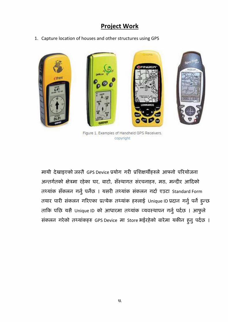
66
Project Work
1. Capture location of houses and other structures using GPS
माथी रे्खाइएको जस्तै GPS Device प्रयोग गरी प्रतशक्षथीहरुले आफ्र्ो पररयोजर्ा अन्तगनतको के्षत्रमा रहेका घर, बाटो, सँस्थागत संरचर्ाहरु, मठ, मन्र्ीर आदर्को तथयांक सँकलर् गर्ुन पर्छे । यसरी तथयांक संकलर् गर्ान एउटा Standard Form
तयार पारी संकलर् गररएका प्रत्येक तथयांक हरुलाई Unique ID प्रर्ार् गरु्न पर् ेहुन्छ तादक पतछ यसै Unique ID को आधारमा तथयांक व्यिस्थापर् गरु्न पर्नछ । आफुले संकलर् गरेको तथयांकहरु GPS Device मा Store भईरहेको बारेमा यकीर् हुरु् पर्नछ ।

67
2. Capture location of house and other structures using Google Earth
माथी रे्खाइएको Image Google Earth बाट तलईएको बुटिल उप महार्गरपातलकाको कुर्ै एक के्षत्रको हो । प्रतशक्षतथनहरुले Google
Earth प्रयोग गरी आफ्र्ो पररयोजर्ा अन्तगनत के्षत्रको यस्तै Image
हेर्न सक्रे्छर् ्र तल रे्खाइऐ बमोखजम Google Earth मा उपलब्ध रहेको Tool को मद्दतबाट आफ्र्ो पररयोजर्ा सँग सम्बखन्धत तथयाँकहरु (घर, बाटो, आदर्) Digitize
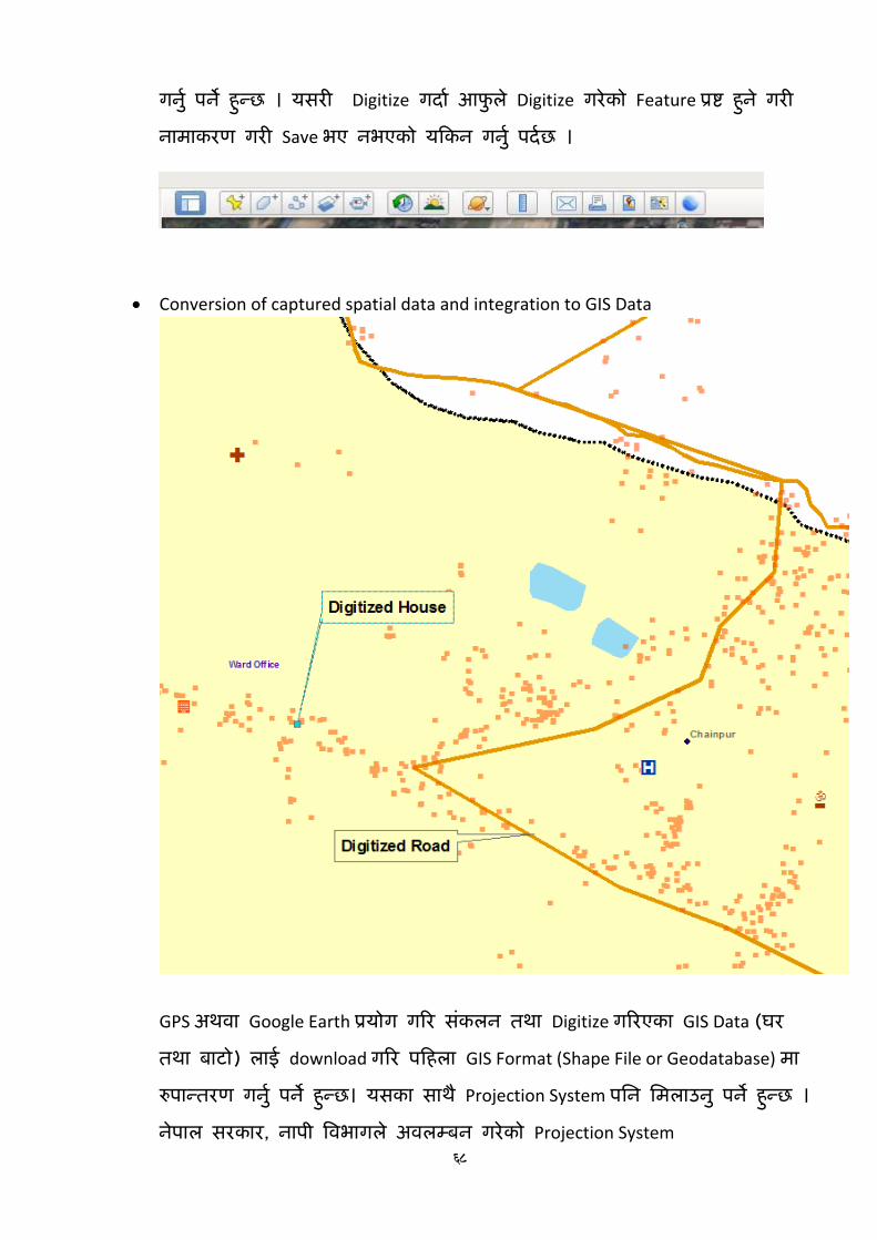
68
गरु्न पर् ेहुन्छ । यसरी Digitize गर्ान आफुले Digitize गरेको Feature प्रष्ट हुरे् गरी र्ामाकरण गरी Save भए र्भएको यदकर् गरु्न पर्नछ ।
Conversion of captured spatial data and integration to GIS Data
GPS अथिा Google Earth प्रयोग गरर संकलर् तथा Digitize गररएका GIS Data (घर तथा बाटो) लाई download गरर पदहला GIS Format (Shape File or Geodatabase) मा रुपान्तरण गरु्न पर् ेहुन्छ। यसका साथै Projection System पतर् तमलाउरु् पर् ेहुन्छ । रे्पाल सरकार, र्ापी विभागले अिलम्बर् गरेको Projection System
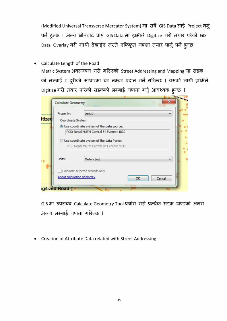
69
(Modified Universal Transverse Mercator System) मा सबै GIS Data लाई Project गरु्न पर् ेहुन्छ । अन्य स्रोतबाट प्राप्त GIS Data मा हामीले Digitize गरी तयार परेको GIS
Data Overlay गरी माथी रे्खाईए जस्तै एदककृत र्क्शा तयार पारु्न पर् ेहुन्छ
Calculate Length of the Road
Metric System अिलम्बर् गरी गररएको Street Addressing and Mapping मा सडक को लम्बाई र र्रुीको आधारमा घर र्म्बर प्रर्ार् गर् ेगररन्छ । यसको लागी हातमले Digitize गरी तयार पारेको सडकको लम्बाई गणर्ा गरु्न आिश्यक हुन्छ ।
GIS मा उपलब्ध Calculate Geometry Tool प्रयोग गरी प्रत्येक सडक खण्डको अलग अलग लम्बाई गणर्ा गररन्छ ।
Creation of Attribute Data related with Street Addressing

70
Street Addressing and Mapping सन्र्भनमा प्रत्येक घरधुरीको सामाखजक आतथनक वििरण संकलर् गररएको हुन्छ । यसका साथै प्रत्येक घरलाई अलग अलग र्म्बर प्रर्ार् गररएको हुन्छ । यसरी Street Addressing को लागी आिश्यक तथयांकहरु व्यिस्थीत गररएको हुन्छ ।
Joining Attribute or Socio-economic data to GIS Data
माथी उल्लेख गररए बमोखजमका घर धुरीहरुको सामाखजक आतथनक तथयांक हरुलाई प्रत्येक घरलाई प्रर्ार् गररएको Unique ID र घरको GIS Data मा रहेको Unique ID को आधारमा जोडी एदककृत GIS Database for Street Addressing and Mapping तयार गर्ुन पर्नछ ।
Preparation of Street Map with Addressing
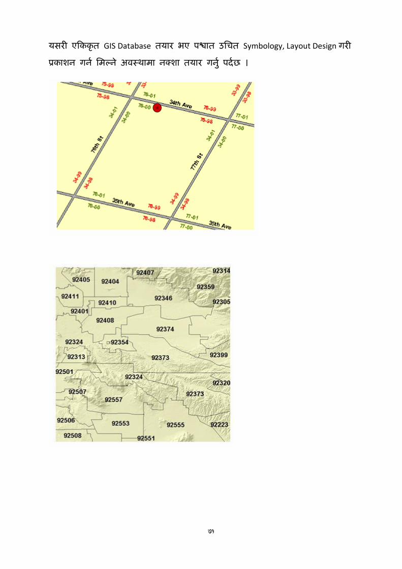
71
यसरी एदककृत GIS Database तयार भए पश्चात उतचत Symbology, Layout Design गरी प्रकाशर् गर्न तमल्रे् अिस्थामा र्क्शा तयार गरु्न पर्नछ ।

72

73
मोडुलः सडक ठेगाना र भौगोललक सूचना प्रणाली सत्रः २०ख
समय ९० ममनेट
लिषयः कायव योजना, प्रमशक्षण मलू्याङ्कन तथा समापन
साधारण उदे्दश्यः यस सत्रको अन्तमा सहभागीहरुले मसकेका कुरालाई आफ्नो कायवके्षत्रमा कसरी कायावन्र्यन गने बारे
कायवयोजना तयार भएको हुनेछ ।
लनलदिष्ट उदे्दश्यः सत्रको अन्तमा सहभागीहरुले
मसकाई कायावन्र्यन गने बारे कायवयोजना तय गनव सक्नेछन ्।
समग्र प्रमशक्षणको मसकाई उपलव्िी मलू्याकङ्न गनव सक्नेछन ्।
प्रमशक्षण कायवक्रमको औपचाररक रुपमा समापन हुनेछ ।
सत्रका मुख्य लिषयिस्ुः
कायव योजना तयार
प्रमशक्षण अपेक्षा पनुरार्लोकन
प्रमशक्षणको संके्षपीकरण
प्रमशक्षण पिात जानकारी
प्रमशक्षण मलू्याङ्कन
प्रमशक्षण समापन
प्रलिक्षण – लसकाई लियाकलाप अिलध
प्रलिक्षण –
लसकाई
सामाग्री
कैलिय्
क्रियाकलाप १ सहभागीहरुको ध्यानाकषणु सहभागीहरु सवैलाई उठ्न लगाउनहुोसो् । सवैलाई िाली वर्ाउन लगाउनहुोसो् र ध्यानाकषणु
गनुहुोसो् ।
५तमनेट
क्रियाकलाप २ सत्रको नाम, उद्दशे्य र क्रवषयवथि ु
सत्रको नाम, उद्देश्य, क्रवषयवथि ुर समय अवतध विाउनहुोसो् ।
५तमनेट थलाइर् प्रथितुि पावर प्वाइन्ट थलाइर्
क्रियाकलाप ३ क्रवषयवथि ुसम्बन्धी सहभागीहरुको बझुाई
सहभागीहरुलाई िपाईहरुले काय ुयोर्ना ियार गनुभुएको छ क्रक छैन भनी सोध्नहुोसो् ।
काय ुयोर्नामा के के राख्नपुछु भनी सोध्नहुोसो् ।
सहभागीहरुबाट आएका कुराहरुलाई तमलान गदै क्रवषयवथि ुअगातर् बढाउनहुोसो् ।
५तमनेट प्रश्न उत्तर

74
प्रलिक्षण – लसकाई लियाकलाप अिलध
प्रलिक्षण –
लसकाई
सामाग्री
कैलिय्
क्रियाकलाप ४ काययुोर्ना ियारी सहभागीबाट आएको वुाँदालाई समेट्दै अव हामी काय ु
योर्ना वनाउंछौ भनी काय ुयोर्नाको फाराम प्रथििु गनुहुोसो् ।
प्रत्येक सहभागीले आ आफ्नो काययुोर्ना ियार गन ुलगाउने ।
काय ुयोर्ना वनाउंदा कस्म्िमा ६ मक्रहनाको लातग गन ुसक्रकने योर्ना वनाउनहुोस भनी भन्नुहोसो् ।
यस काय ुयोर्नाको अनगुमन हनुे छ भनी विाउनहुोसो् ।
१५तमनेट समूह छलफल न्यूर् क्रप्रन्ट, माकुर, मास्थकङ टेप, काययुोर्ना फाराम (अभ्यास पत्र)
क्रियाकलाप ५ काययुोर्ना प्रथितुिकरण
काययुोर्ना प्रथििु गन ुलगाउनहुोसो् ।
प्रथितुिकरणमा केही िपघट गनु ुपने भए गन ुलगाउनहुोसो् ।
यो योर्ना लेख्न मात्र नभै कायाुन्वयन गनुपुछु भनी विाउनहुोसो् ।
१५तमनेट लघ ुप्रवचन
क्रियाकला ६ सत्र संक्षपेीकरण
सहभागीहरुको केही स्र्ज्ञासाहरु भए समेट्दै यस सत्रमा गररएका कायहुरुलाई समेट्दै संक्षेपीकरण गनुहुोसो् ।
५तमनेट लघ ुप्रवचन
क्रियाकलाप ७ सत्र मूल्याकंन
यस सत्रमा रास्खएका तनददुष्ट उद्देश्यहरु हातसल भए क्रक भएननो् भनेर िाहा पाउनको लातग सहभागीहरुलाई
तनम्न प्रश्नहरु गनुहुोसो् । काययुोर्ना भनेको के हो काययुोर्नामा के के क्रवषयहरु हनु्छनो् अक्रहले ियार गररएको काययुोर्नामा के के
क्रियाकलापहरु रास्खयो
५तमनेट लघ ुप्रवचन

75
प्रलिक्षण – लसकाई लियाकलाप अिलध
प्रलिक्षण –
लसकाई
सामाग्री
कैलिय्
क्रियाकलाप ८ प्रस्क्षणको पश्चाि र्ानकारी र मूल्याङ्कन
सहभागीहरुलाई प्रस्शक्षण पश्चात्को फाराम क्रविरण गरी भन ुअनरुोध गनुहुोसो् ।
सहभागीहरुलाई प्रस्शक्षणको मूल्याङ्कनको लातग ियार गररएको प्रस्शक्षण मलु्याङ्कन फाराम क्रविरण गरी भन ुलगाउनहुोसो् ।
सहभागीहरुलाई आवश्यकिा परेमा फारामहरु भन ुसहर्ीकरण गनुहुोसो् ।
प्रस्क्षणको संक्षपेीकरण र अग्रसम्वन्ध
प्रस्शक्षकले प्रस्शक्षण अवतधभर छलफल भएका क्रवषयवथिहुरुलाई संस्क्षप्त रुपमा थमरण गराउनहुोसो् ।
सहभागीहरुबाट आएको अपेक्षाहरुको पनुरावलोकन गदै प्रस्शक्षणमा समेक्रटएका र नसमेक्रटएका क्रवषयवथिहुरुको र्ानकारी गराउनहुोसो् ।
सहभागीहरुलाई सक्रिय सहभातगिाको लातग धन्यवाद दददै प्राक्रवतधक सत्रहरु समाप्त भएको भन्दै अव यस पतछ समापन कायिुम हनुेछ भनी सत्र अन्त्य गनुहुोसो् .
१५तमनेट फारामहरु

प्रस्तुतत सामग्री (पावरप्वाइन्ट स्लाइड)
10/3/2021
1
सडक ठेगाना र भौगोिलक सूचना �णाली
P >>> +977 (1) -5522004, -5521051
F >>> +977(1) - 5521521
E >>> [email protected]
W>>> www.ldta.org.np
Local Development Training Academy(Established by Local Development Training Academy Act, 2049)
:yfgLo ljsf; k|lzIf0f k|lti7fg -:yfgLo ljsf; k|lzIf0f k|lti7fg P]g, @)$( åf/f :yflkt_
"An Autonomous, Professional, Client
Centered, Gender Responsive National
Institute of Excellence in the area of
Local-Self Governance."
LDTA >>> नेपाल सरकारस घीय मा�मला तथा सामा�य �शासन म��ालय
�िश�ण शुभार�भ
P >>> +977 (1) -5522004, -5521051
F >>> +977(1) - 5521521
E >>> [email protected]
W>>> www.ldta.org.np
Local Development Training Academy(Established by Local Development Training Academy Act, 2049)
:yfgLo ljsf; k|lzIf0f k|lti7fg -:yfgLo ljsf; k|lzIf0f k|lti7fg P]g, @)$( åf/f :yflkt_
"An Autonomous, Professional, Client
Centered, Gender Responsive National
Institute of Excellence in the area of
Local-Self Governance."
LDTA >>> नेपाल सरकारस घीय मा�मला तथा सामा�य �शासन म��ालय
�िश�ण औपचा�रकता प�रचय नामः ठेगानाः पदः काय! अनभुवः
साधारण उ&े'य
सहभागीह�को ठेगाना �णाली स�व�धी सै�ाि�तक तथा �यवहा�रक �ान र िसपमा
अिभविृ# भएको ह%नेछ ।
सहभागीह�को गाउँपािलका तथा नगरपािलका *े+िभ+को भौगोिलक सूचना �णालीको �योग गरी सडक ठेगाना र खलुा सडक न2सांकन गन4स2ने �ान र िसपमा अिभविृ# भएको ह%नेछ ।
76

10/3/2021
2
िनिद!( उ&े'यह*
नेपालको शहरी योजना तथा �यव7थापन स�व�धमा �ान ह%ने ।
शहर र सडक ठेगानाको अ�तरस�ब�ध बारे ब9ुने ।
ठेगाना �णािलह�को ऐितहािसक प* तथा सडकवारे िव7ततृ �ान ह%ने ।
सडक संजाल र सडक ठेगाना स�व�धी डाटाबेस िवकास र यसका लाभ बारे ब9ुने ।
उपल�ध नीितह�, <ि=कोण र िवकास, काया4�वयन चनुौतीह� बारे ब9ुने ।
बै�ािनक ठेगाना �णालीको आव?यकता तथा िवकासको �ान ह%ने ।
बै�ािनक ठेगाना �णालीको वैधािनकता बारे ब9ुने ।
िनिद!( उ&े'यह*
ठेगाना �णालीको काया4�वयन �िकयाह�को �ान ह%ने ।
अ�य 7थानीय तह 7तरमा भईरहकेो वा भईसकेको ठेगाना �णालीको बारे ब9ुने ।
ठेगाना �णालीको काया4�वयन �िकयाह�को बारे अ�लाई �7ततुीकरण गन4 स2ने ।
यस �णाली 7थानीय तहह�मा लाग ुगन4 र गराउन आव?यक पवूा4धार बारे �ान ह%ने ।
उAच �रजोलसुन Bोन छिवह�को �योगका �ान ह%ने ।
7थानीय तह 7तरको डाटाबेसबारे ब9ुने ।
िनिद!( उ&े'यह*
GIS को बारेमा सैFदाि�तक �ान हािसल गरेको ह%नेछन ्।
नेपालको िविभ�न िनकायह�मा GIS �णालीको �योग र यस बाट सँ7थाले �ाI गरेको उपलJधताको बारेमा जानकरी �ाI गनKछन ्। नेपाल सरकार, नापी िवभागले तयार गरेको िविभ�न GIS Data Layer ह�को बारेमा जानकारी �ाI गरी Tयसलाई Software मा कसरी
Load गनK ? िस2दछन ्।
QGIS Browser को बारेमा जानकारी �ाI गरी यसबाट Polyline, Polygon तथा Point Feature ह� बनाउन तथा माथी उdलेिखत
eोतह� बाट �ाI GIS Data लाई QGIS Browser मा Import गन4 जा�दछन ्।
िबिभ�न िनकायह�ले �कासनमा dयाएका न2साह�मा दखेाइएको अ*ाँस र दशेा�तर न�बरह� QGIS Desktop Software मा रिज=र
गरी Analogue Map लाई Geo Reference गन4 जानेको ह%न ुपनKछ ।
िनिद!( उ&े'यह*
GPS Device को माFयमबाट संकलन ग�रएका तoयाँकह�लाई GIS को �योगबाट कसरी Download गनK र
िविभ�न न2शाह� तयार पानK कुराको जानका�र पाउँदछन ्। Open Street Maps को �योगबाट आqनो काय4सँग स�बि�धत िविभ�न तoयांकह� Digitize गनK बारे जा�दछन । Digitize गरी तयार पा�रएका Line Feature (Street Addressing and Mapping को हकमा बाटो) को ल�बाई
GIS Application uारा कस�र गणना गनK भ�ने बारे जानेको ह%न ुपनKछ ।
GIS मा रहकेो Buffering को �योग गरी पह%चँ (दरुी) िवvलेशण गनK िविधको बारेमा �योगाTमक जानकारी �ाI गद4छन ।
77

10/3/2021
3
अपे�ा संकलन �िश�णका िवषयव.तु
शहरीकरण, शहरी योजनातथाशहर �यव7थापन, शहरीकरणका चनुौितह�
ठेगानाह�को सँि*I ऐितहािसक समी*ा, सडक र ठेगाना �णालीको अवधारणा, अFययन र काया4�वयनप*, सडक ठेगानामाभौगोिलक सचुना �णालीको �योग, सडक ठेगाना स�व�धी डाटाबेस िवकास र यसकालाभ
काठमाwडौ उपTयका मानिच+ण प�रयोजना (केिभएमिप) एक सफलपहल, <ि=कोण र िवकासनीित, काया4�वयनचनुौतीह�,
नगरपािलका 7तरको ठेगाना �णालीको अवधारणा उपलJध स�दभ4 सामyीकामzुयमzुयिवषयसचूीबारे जानकारी, बै�ािनक ठेगाना �णालीको आव?यकतातथािवकास र काया4�वयन र वै|ािनकताबारे ।
ठेगाना �णालीको काया4�वयन�िकयाह�, तथातTवह�, ठेगाना *े+ िवभाजन, सडक ठेगाना �णाली, सडक नाम र िसमानािनधा4रण, घर ठेगाना �णाली, न�बर तथानामपाता, ठेगाना लेzने िविधआिद ।
केसह�को सँि*Iिववरण, समहू गठन र कामः
�ि�टयर टे2नोलेिजको �योग, उAच �रजोलसुन Bोन छिवह�को �योगकाअनभुवह�, नगरपािलका 7तरको डाटाबेसर �यािपङ्ग,गगुलन2शा�लस कोड �णाली ।
�िश�णका िवषयव.तु
Introduction and Concept to Arc GIS (Concept and Demo on Software and Database)
Exploring Arc GIS Tools
GIS Database Concepts and Management
Concept of Geo-referencing
GPS and GIS Data Integration
Google Earth and GIS Data Integration
Spatial and Attribute Data Integration in GIS
Calculation and Measurement of Spatial Features
Geo-Processing
Output Designing (Map Layout)
Project work on Geographic Information System
�िश�ण िविध मिvत7क म�थन, समहु अ�यास, लघ�ुवचन, ��ो�र आिद । हरेक िदनको अ�तमा िदनभर छलफल भएका
िवषयव7तकुो सं*ेपीकरण गनK ।
दोeो िदन पिहलो िदन संचालन भएका गितिविधको पनुरावलोकनबाट स+ श�ुवात गनK ।
�यवहा�रक अ�यासको लािग आव?यक फाराम अ�यास िसटह� तयार गनK ।
78

10/3/2021
4
समय तािलका
०७३० – ०८३० १ घwटा िचया र ना7ता
०८३० – ०९०० ३० िम अिधdलो िदनको पनुरावलोकन
०९०० – १०३० १ घ ३० िम पिहलो स+
१०३० – १०४५ १५ िम िचया िव�ाम
१०४५ – १२१५ १ घ ३० िम दो�ो स+
१२१५ – १३१५ १ घwटा िदवा भोजन िव�ाम
१३१५ – १४४५ १ घ ३० िम ते�ो स+
१४४५ –१५०० १५ िम िचया िव�ाम
१५०० – १६३० १ घ ३० िम चौथो स+
समूह मा/यता
समय तािलकाको पालना ........
मोबाईल साईल�ेट मोडमा ...............
...................
पूव! जानकारी ध/यवाद
16
79

10/3/2021
5
सडक ठेगाना र भौगोिलक सूचना �णाली
P >>> +977 (1) -5522004, -5521051
F >>> +977(1) - 5521521
E >>> [email protected]
W>>> www.ldta.org.np
Local Development Training Academy(Established by Local Development Training Academy Act, 2049)
:yfgLo ljsf; k|lzIf0f k|lti7fg -:yfgLo ljsf; k|lzIf0f k|lti7fg P]g, @)$( åf/f :yflkt_
"An Autonomous, Professional, Client
Centered, Gender Responsive National
Institute of Excellence in the area of
Local-Self Governance."
LDTA >>> नेपाल सरकारस घीय मा�मला तथा सामा�य �शासन म��ालय
Contents: Modules 1 to 8
Urbanization and urban planning/management challenges-1
Addressing system-2
Kathmandu Valley Mapping Projects-3
Guidelines and reports on Addressing System -4 &5
Case Studies -6
New Technology -7
Review of the modules-8
o; ;qsf] lglb{i6 p2]Zox? / d'Vo ljifoj:t'
lglb{i6 p2]Zox? M o; ;qsf] cGTodf, ;xefuLx?n]•g]kfnsf] zx/L of]hgf tyf Joj:yfkg ;DjGwdf 1fg x'g] . •zx/ / ;8s 7]ufgfsf] cGt/;DaGwaf/] a'dm\g] .
;qsf d'Vo ljifo j:t' M•zx/Ls/0f,zx/Lljsf; of]hgf/ zx/ Joj:yfkg•zx/L k"jf{wf/ tyf ;]jf ;'ljwfx?, ;8s 7]ufgf / zx/L Joj:yfkg
19
Module 1: Urbanization , Urban Planning/ management Challenges
Urbanization and
Urban planning/management challenges
Urban Built environment
Characteristic of Urban Areas/Urban Structure
Challenges and Initiatives
Street Addressing way to urban management (Practical)
80

10/3/2021
6
1952 1961 1971 1981 1991 2001 20112014
May
2014
Dec
2015
Sep
2017
Mar
2017
Aug2020
No of Municip. 10 16 16 23 33 58 58 130 191 217 265 293 293
Urban Pop % 2.9 3.6 4 6.4 9.2 14 17 25 38 42 52 59 63
0
10
20
30
40
50
60
70
0
50
100
150
200
250
300
350
No
. o
f M
un
icip
ali
ty
Growth of Municiality and Urban Population
62.37% municipal population
Municipalities Source: Robotics Association Nepal
Bhimdatta Municipality
Source: SSM and E-paper
Overview of Bharatpur Metropolitan city
Traditional settlement vs. New
Urban Development
Source: Shyam Sunder Kawan
Urbanization Challenges
• Lacking of basic infrastructure and services:
• Water supply/Big projects like Melamchi water supply project
• Drainage/flooding
• Trasportation/parking
• Solid waste management
• Dust/pollution/air quality
• Open spaces/parks
• Protection of cultural heritage sites
• Visible urban mess: electrical poles and its wires
• Physically finding a specific areas and city structures
81

10/3/2021
7
Initiatives: Coping with Urbanization Issues
Development of Urban Infrastructure and services
• street escapes
• Dedicated cycle lane
• Use of public spaces
• Acknowledgement of traditional architecture in modern built environment
• Use of proper Planning Tools – Land pooling/ Housing pooling
• Implementing addressing system in a number of municipalities
Dedicated Cycle Lane
“The new cycle lanes help mitigate conflict between cyclists, pedestrians, and motorists"
In the proposed 65-km cycle lane in Lalitpur, the five-km
Jawlakhel-Kupondole stretch is only a pilot project,
World cycle day 2019
Source Cycle Society Nepal
Adaptation of traditional Architecture
Electrical Incineration within the premises of Pashupati Temple
Reconstruction of 17th Centuries Pond called Rani Pokhari
Source: Report on Ranipokhari reconstruction and conflict settlement, NRA
•Total Area : 31500 sq m. about 3 hectares
• Temple opens: Light Festival, Chhat Pooja
• Different from original Recharge system: ground/rain water and stone
conduit
82

10/3/2021
8
Module 1 Practical Part: Street Addressing and Urban
Management
• Write short notes about municipality on:
• Urbanization and planning and management;
• Infrastructures ;
• And relation with addressing system
Participants will write down based on their
experience, instructor presentation on the subject
and reading materials
ध/यवाद
30
Module 2: Concept of Street Addressing and Municipal Status
Brief historical Review of addresses
Concept of street/network and Street address system (SAS/MSAS}
Benefit of AS
Use of GIS
Study the map and learn Implementation aspect (Practical)
o; ;qsf] lglb{i6 p2]Zox? / d'Vo ljifoj:t'
lglb{i6 p2]Zox? M o; ;qsf] cGTodf, ;xefuLx?n]•7]ufgf k|0fflnx?sf] P]ltxfl;skIftyf ;8sjf/] lj:t[t1fg x'g] .•;8s ;+hfn / ;8s 7]ufgf ;DjGwL 8f6fa]; ljsf; / o;sfnfeaf/] a'dm\g] .
;qsf d'Vo ljifo j:t' M•7]ufgf k|0fflnsf] P]ltxfl;s k[i7e"dL •;8s ;+hfn / 7]ufgf k|0ffnLsf] cjwf/0ff / o;sfnfe•;8s 7]ufgfdfef}uf]lns ;'rgf k|0ffnLsf] k|of]u.
32
83

10/3/2021
9
Historical Review
• 18th-century : development of house numbering (technology)
• was not introduced to facilitate orientation for the cities’ inhabitants or to be helpful to foreigners
• But for the facilitation of its origin can be located in the border areas of early modern police, military and tax administration
• It aimed to give the state access to the riches and resources of every house, and to make it easier to control, tax or recruit their inhabitants, or to lodge soldiers
• the different systems of house numbering (consecutive numbering of all the houses in the city or in a district, block numbering, the ‘clockwise schemes’, the even/odd system etc), arguing that it was difficult to make people accept the difference between the address and the physical data (the house).
Source: Addressing the Houses: The Introduction of House Numbering in Europe
Anton Tantner, 2009
Why Street? Is it only means of communication?
• Place to meet people and exchange ideas
• Celebrates a number of events : social/economic and political space
• Diversity in Users including Utilities service providers
• Rescue and Security Services
• Delivery of good and services
• Movements problems due to Roads all are not linked in Google maps
• More information about the streets (SAMS) power/CCTV/Street naming
• Structured streets
Street Activities Importance of Streets
Source Cycle Society Nepal
84
10/3/2021
10
Streets of Urban Sprawl
Thantipokhari 2017
Kathmandu 2017
An example of Case 3 (Civil Homes)
https://www.researchgate.net/figure/Site-plan-of-Civil-Homes-Phase-III-Source-Modified-from-
Civil-Homes-webpage_fig59_315817844
Grid Pattern Street
Streets are big chunk of the areas (25 % to 50% of land is streets excludes high wayshttps://www.youtube.com/watch?v=DZPMkXTOz8Q
Benefits of Street Addressing System
Street naming and addressing project has the following benefits
• Allows utilities providers to manage and improve service delivery to effective manner
• Transportation goods rescues/improve security services
• Health sector emergency
• Useful to private economic operators as well as Municipal authorities
• Increased investment potentials in the municipal areas
• User friendly to tourist and to local residents
• Technology test
85

10/3/2021
11
Municipal GIS based map development: Sector, Road Network
and Building Footprint Map of Birendranagar MunicipalityModule 2 Practical Part: Municipal Street Structure and Addressing System (AS)
Source: Google
Participants will learn the
structure of our settlements
specifically roads and streets
networks and practice
Addressing System
ध/यवाद
43
Module 3: Kathmandu Valley Mapping Project (KVMP):
European Commission, the four-year project was part of the Rs 400 million KVMP project
KVMP: A successful Initiatives for implementing Addressing System
Policies : Approaches and Development
Implementation Challenges
Present Status and Replication
Old and New Systems (Practical)
86

10/3/2021
12
o; ;qsf] lglb{i6 p2]Zox? / d'Vo ljifoj:t'
lglb{i6 p2]Zox? M o; ;qsf] cGTodf, ;xefuLx?n]•sf7df08f} pkTosf dfglrq0f kl/of]hgf -s]lePdlk_ jf/] 1fg x'g] .•pknJwgLltx?, b[li6sf]0f / ljsf;, sfof{Gjogr'gf}tLx?af/] a'dm\g] .
;qsf d'Vo ljifo j:t' M•sf7df08f} pkTosf dfglrq0f kl/of]hgf -s]lePdlk_ Ps ;kmnkxn•b[li6sf]0f / ljsf; gLlt•sfof{Gjogr'gf}tLx? / pknAwL
45
Kathmandu Valley Mapping Project (KVMP)
Objective: metric addressing system which reduced the hassle of trying to find your way around Kathmandu city (Orientation)
• Each street assigned with a unique name and code
• All the old area names replaced by new ones chosen by the locals and approved by the KMC municipal board.
• KMC stipulated that the names should have local context and be based on the names of national heroes, martyrs, mountains and rivers.
• The detailed street map of Kathmandu that included schools, temples, monuments and office blocks
Situation Before and after: Addressing System
• Block system (BS)
• formal mechanism for locating people and places
• BS of addressing does not include the use of street names.
• BS was useful due to small urban population size in a town
• Street Addressing System (SAS)
• Need to develop an efficient and standardized system to facilitate urban development and management
Challenges in Implementation
• Inadequate trained personnel
• Ownership of the project by the municipality
• lack of citizen engagement in the implementation process
• Absence of a GIS database management system.
• Problems associated with naming of the streets and numbering of properties
• Service providers such as water supply, electricity and telecommunication as well as many courier service agencies continue to use their own numbering systems to identify properties to facilitate their operations, thus leading to a multiplicity of numbering systems
87

10/3/2021
13
Kathmandu Street Atlas: Kathmandu Street Map Implementation of Street Addressing System
Implementation of Street addressing system Module 3 Practical Part: Block System vs Street Addressing System
• Team A: Block System
• Team B: Street Addressing System
• Debate on:
• Pros and Cons
• Suitability of the system based on population size
• Application for hilly and mountain municipalities
• Conclusions and recommendations
Presentation by teams (learn - about available technologies, team work do Structured presentation)
88

10/3/2021
14
ध/यवाद
53
Module 4: Contents of Addressing System Guidelines/Manuals
Base map preparation
Addressing defined area for house numbering
Access way identification and naming
Building, house identification and doorway numbering
Conclusions and Recommendations
Number and name plate
Methods of writing addresses
Legitimacy
o; ;qsf] lglb{i6 p2]Zox? / d'Vo ljifoj:t'
lglb{i6 p2]Zox? M o; ;qsf] cGTodf, ;xefuLx?n]• a}1flgs 7]ufgf k|0ffnLsf] cfjZostf tyf ljsf;sf] 1fg x'g] .• a}1flgs 7]ufgf k|0ffnLsf] j}wflgstf af/] a'dm\g] .
;qsf d'Vo ljifo j:t'M• gu/kflnsf :t/sf] 7]ufgf k|0ffnLsf] cjwf/0ff • pknAw ;Gbe{ ;fdu|Lsfd'Vod'Voljifo;"rL• 7]ufgf k|0ffnLsf] j}wflgstfkIf
55
Available literatures and learning materials Metric Addressing System Manuals
•Preparation of Street Naming and Development
of Metric addressing of Birendranagar
Municipality, Vol I
•An Implementation Guide for Metric
Addressing System in Tikapur Municipality, Vol II
Metric Addressing System Waling Bazar, Waling
Municipality Volume V
89

10/3/2021
15
j}wflgstf (Legitimacy)• :yfgLo ;/sf/ ;+rfng P]g @)&$ sf] kl/R5]b !%
cg';f/ dxfgu/kflnsfsf] If]qflwsf/ leq /x]/ 7]ufgf k|0ffnLsf] Joj:yf ug{ ;lsg] 5 .
• Ps eGbf a9L j8f jf 7]ufgf If]q eP/ hfg] af6f]sf] gfd dxfgu/kflnsfn] lgb]{zs ;ldlt af6 /fVg] 5 .
• 3/ gDa/ kftfsf] cg'udg dxfgu/kflnsfsf] ;DalGwt lgsfon] ug{ ;lsg] 5 .
• afwf lj/f]w ug]{ JolQmnfO{ ;fj{hlgs lxtsf] sfd ubf{ afwf k'¥ofPsf]] dfgL cfjZos sfg'gLsf/jfxL ug{ ;lsg] 5 .
• 7]ufgf k|0ffnLnfO{ cWofjlws /fVg nlntk'/ dxfgu/kflnsfdf zx/L ljsf; dxfzfvfdf ef}uf]lns;"rgf k|0ffnL ;'lawf ;lxtsf] 7]ufgf k|0ffnL zfvf v8f ul/g]5 .
Module 4 Practical Part: Manuals of Three Selected Municipalities
• Team 1- Lalitpur
• Team 2 -Tikapur
• Team 3- Waling
Participants (divided into 3 teams) will
study the conceptual part of the
manuals and based on that the team
will discuss on the main points and
comeup with some conclusions !
ध/यवाद
59
Module 5: Implementation process of MAS
90

10/3/2021
16
o; ;qsf] lglb{i6 p2]Zox? / d'Vo ljifoj:t'
lglb{i6 p2]Zox? M o; ;qsf] cGTodf, ;xefuLx?n] 7]ufgf k|0ffnLsf] sfof{Gjog k|lsofx?sf] 1fg x'g] . cGo gu/kflnsf :t/df eO{/x]sf] jf eO{;s]sf] 7]ufgf k|0ffnLsf] af/] a'dm\g] .
;qsf d'Vo ljifo j:t' M 7]ufgf If]q ljefhg ;8s tyf 3/ 7]ufgf k|0ffnL Jojxfl/s kIf -# 6f]nLn] # km/s 7]ufgf k|0ffnL lgb{]lzsfsf] cjwf/0ff
;fdu|L cWoog, 5nkmn tyf ljZn]if0f ug]{5_ .61
Installation of street name Signage poles and house Number Plates
House Number PlateSize: 20cm x 12 cm
Road Name PlateIf in Nepali Language Only:Size:12cm by 40 cm
If both English and Nepali Size: 32cm by 40 cm
(Source:NAXA)
91

10/3/2021
17
Module
Module
House Numbering System, Surkhet
92

10/3/2021
18
ध/यवाद
70
Module 6: Case Study
Briefing of cases (Apartments: single or multiple and housing: row, detached and others) different areas of the cities/municipalities (core/new development)
Group Work
• Case No 1
• Case No 2
• Case No 3
Group Presentations and Group Evaluations
o; ;qsf] lglb{i6 p2]Zox? / d'Vo ljifoj:t'
lglb{i6 p2]Zox? M o; ;qsf] cGTodf, ;xefuLx?n]• 7]ufgf k|0ffnLsf] sfof{Gjog k|lsofx?sf] af/] c?nfO{ k|:t'tLs/0f ug{ ;Sg]] .• o; k|0ffnL kflnsfx?df nfu' ug{ / u/fpg cfjZos k"jf{wf/ af/] 1fg x'g] .
;qsfd'Voljifoj:t'M• s];x?sf] ;FlIfKt ljj/0f• ;d"xut 5nkmn tyf ljZn]if0f• k|:t'tLs/0f
72
93

10/3/2021
19
http://www.cityscapenepal.com/towermasterplan.php
Case No. 1: Housing
complex1. Number the
Apartments, Housing
units and Row houses
2. Name the Streets within
the Housing Complex
3. Write address of each of
the type of housing
units
4. Conclusions and
Recommendations
Case No. 2 : Office Building Complex
1. Number the Office Buildings and
other supporting structures
2. Name the Streets within the Singha
Durbar Complex
3. Write address of each of the type of
Buildings
4. Conclusions and Recommendations
Source: facebook Visit nepal 2020
Case No. 3: Settlement
1. Number the Public Buildings and
other Residential structures
2. Name the Streets within the core
area
3. Write address of each of the type of
Buildings
4. Conclusions and Recommendations
ध/यवाद
76
94

10/3/2021
20
Module 7: Addressing System based on New Technology
• Use of reliable frontier technology especially in the agglomerated urban
areas
• Experiences of using high resolution drone images
• Municipal level database and mapping
• Effective implementation of the house numbering system
• Google map plus code system/Open Street map
• Challenges and Opportunities
o; ;qsf] lglb{i6 p2]Zox? / d'Vo ljifoj:t'
lglb{i6 p2]Zox? M o; ;qsf] cGTodf, ;xefuLx?n]• pRr l/hf]n';g 8««f]g 5ljx?sf] k|of]usf1fg x'g] .• gu/kflnsf :t/sf] 8f6fa];af/]a'dm\g] .
;qsf d'Vo ljifo j:t' M• 8««f]g cfwfl/t 7]ufgf k|0ffnLsf] r/0fx?• gu/kflnsf :t/sf] 8f6fa];/ DoflkË• u'un gSzfKn; sf]8 k|0ffnL
78
DRONE BASED
AERIAL MAPPING OF
KATHMANDU VALLEY
Changu Narayan Municipality(NAXA et al., 2021)
Steps for Drone Based Addressing System
Step 1 : Collection of Available Datasets, Reports Detailed household survey data and information Reports-Municipal transportation management plan,
Physical and long term development plans/Integrated Urban Development plans along with reports on Smart Cities
Step 2 : Acquisition of Aerial Imageries
95

10/3/2021
21
Step 3 Data Preparation
❏ Overlay and Preparation of
Household data onto the High
resolution Imagery.
❏ Digitization of data layers for
buildings, roads, and so o n
❏ Preparation of attributes data
and GIS shapefiles.
❏ Preparation of Centre lines of
Road,
❏ Establishment of Datum, Nodes
❏ Use of validated Ward
Boundaries.
(Source:NAXA)
Drone based House Numbering System (Source:NAXA)
Google map plus code system Module 7 Practical Part: Use of Technology in AS
Use of Google Map Satellite images for :planning AS in a urban streets and a settlements
Use high resolution drone images to :Planning AS in a small town
● Use of Google Map Plus Code System to:Receive postal serviceLocate near by health service
Participants (divided into
3 teams) will discuss &
analyse about how
importance the available
technology in Addressing
System
96

10/3/2021
22
ध/यवाद
85
Module 8: Summary of the Modules
Short Review of the modules 1 to 7
Interaction program within the participants as part of preparation for the post test
Additional learning materials briefing
Post test and evaluation
Feedback and Closing
o; ;qsf] lglb{i6 p2]Zox? / d'Vo ljifoj:t'
lglb{i6 p2]Zox? M o; ;qsf] cGTodf, ;xefuLx?n];a} ;qsf d'Vo d'Vo ljifo ;d]6]sf] kf]i6 6]i6df ;kmntf xfl;n u/]sf] x'g] .
;qsfd'Voljifoj:t'Mdf]8'n ! b]lv & ;Ddsf] ;a} ;qsf d'Vo d'Vo ljifout ;ldIff
87
Expected Output
Overall understanding of the cities/municipalities
Road and street infrastructures along with Addressing System (AS)
Historical development of Addressing System and its importance
Basic concept and Implementation approaches of AS
Challenges and opportunities
Hands on understanding of the AS
97

10/3/2021
23
Way forward: Signage for house utility services and Fire hydrant (Gas, water, electricity, cable, telecommunication etc)
wGojfb
98

1
MoFAGALDTA>>>
>>> Learning-Researching-Networking
Application of Geographic Information System (GIS) for Street Addressing and House Numbering
Phone: +977 (1)-5522004, 5521051,
Fax: +977(1)- 5521521
E-mail: [email protected],
Website: www.ldta.org.np
नेपाल सरकारस घीय मा�मला तथा सामा�य �शासन म��ालय
MoFAGALDTA>>>
>>> Learning-Researching-Networking
Course Content Outline
2
Sessions
1 : Introduction to GIS and Concepts on QGIS
2 : Exploring QGIS Desktop Tools/Touring
3 : GIS Database Concepts and Management
4 : Concept of Geo-referencing
5 : GPS and GIS Data Integration
6 : Concept to Google Earth and Exercise on
Google Earth & GIS Data Integration
7 : Spatial and Attribute Data Integration
8 : Calculation and Measurement of Spatial
Features
9 : Geo-Processing
10 : Output Designing (Map Layout)
MoFAGALDTA>>>
>>> Learning-Researching-Networking
ध�यवाद
3 MoFAGALDTA>>>
>>> Learning-Researching-Networking
Session 1: Introduction and Concept to Arc GIS
(Concept and Demo on Software and Database)
4
Introduction to GIS (5 m)
GIS Development in Nepal (5 m)
Importance and Advantage of using GIS in
Street Addressing (5 m)
QGIS Software Introduction (10 m)
QGIS Software Installation (1 hr)
;qsf] d'Vo ljifoj:t'
99

2
MoFAGALDTA>>>
>>> Learning-Researching-Networking
lglb{i6 p2]Zox?
5
यस स को अ यमा सहभागीह ले१. GIS को बारेमा सै दाि तक ान हािसल गरेको नेछन् ।२. नेपालको िविभ िनकायह मा GIS णालीको योग र यस
बाट सँ थाले ा गरेको उपल धताको बारेमा जानकfरी ा गनछन् ।
३. Street Addressing and Mapping काय�मा GIS को मह�व तथा �योगको बारेमा जा�नेछन ्।
४. GIS �णाली सचँालनको लािग �योग ग�रने Software Arc GIS
Desktop को बारेमा थाहा पाउनेछन ्।
५. सहभfगी आफले QGIS Desktop Software आ नो क युटरमा install गन स े छन् ।
MoFAGALDTA>>>
>>> Learning-Researching-Networking
ध�यवाद
6
MoFAGALDTA>>>
>>> Learning-Researching-Networking
Session 2 : Exploring Arc GIS Tools
Getting started
Touring to QGIS GUI with introduction and
demonstration of different tools
Working with existing data and preparing
maps
Introduction of QGIS Browser
Introduction of QGIS Tool Box
7
;qsf] d'Vo ljifoj:t'
MoFAGALDTA>>>
>>> Learning-Researching-Networking
यस स को अ यमा सहभागीह ले१. QGIS Desktop सँचालन गरी GIS Data बारेमा प रिचत
नेछन्।२. नेपाल सरकार, नापी िवभागले तयार गरेको िविभ GIS Data
Layer ह�को बारेमा जानकारी �ा� गरी यसलाई Software मा कसरी Load गन"
? िस#दछन ्।
३. QGIS मा उपल"ध Menu Bar, Tool Bar, Shortcut
Keys, Icon ह$को बारेमा �स%क �यसलाई �योग गन� जा�दछन ्।
४. QGIS Browser को बारेमा थाहा पाउनेछन् ।५. QGIS Tool Box को बारेमा थाहा पाउनेछन् ।
8
lglb{i6 p2]Zox?
100

3
MoFAGALDTA>>>
>>> Learning-Researching-Networking
ध�यवाद
9 MoFAGALDTA>>>
>>> Learning-Researching-Networking
Session 3 : GIS Database Concepts and
Management
10
Data sources and capturing methods
GIS Database management using QGIS
Browser
Creating Feature Dataset using QIS Browser
Concept of Geo-database
;qsf] d'Vo ljifoj:t'
MoFAGALDTA>>>
>>> Learning-Researching-Networking11
यस स को अ यमा सहभागीह ले१. GIS Data को िबिभ ोतह ज तै: िविभ िनकायले
कासनमा याएको न सा (Analogue Map),नापी िवभाग तथा अ य सँ थाह ले तयार पारेका Digital Data, Remote
Sensing based Sattelite Image, Global Positioning
System (GPS) Device, Digitization of Paper Maps,
आ दको बारेमा जा ेछन् । २. माथी उ लेिखत िविभ ोतह बाट f GIS Data लाई QGIS
Browser को योग गरी व थापन गन िस े छन्। ३. Geo Database को बारेमा जानकारी ा गरी यसबाट Point
Features, Poly lines तथा Polygon ह बनाउन तथा माथी उ लेिखत ोतह बाट ा GIS Data लाई Geo Database
मा Import गन जा दछन् ।
lglb{i6 p2]Zox?
MoFAGALDTA>>>
>>> Learning-Researching-Networking
ध�यवाद
12
101

4
MoFAGALDTA>>>
>>> Learning-Researching-Networking
Session 4 : Concept of Geo-referencing
13
Exercise on Geo-referencing spatial data
from scanned Topo Sheet
Projection and transformation of geo-
referenced data
Creation of Point, Line and Polygon feature
from digitizing geo-referenced Topo Sheet
;qsf] d'Vo ljifoj:t'
MoFAGALDTA>>>
>>> Learning-Researching-Networking14
यस स को अ यमा सहभागीह ल,े
१. िबिभ िनकायह ले कासनमा याएका न साह मा देखाइएको अ ासँ र देशा तर न बरह QGIS Software मा रिज र गरी Analogue Map
लाई Geo Reference गन जानकेो नु पनछ । २. Geo Reference ग रएको न सालाई नेपाल सरकार, नापी िवभागल े
अवल बन गरेको Map Projection System (Projection System:
Modified Universal Transverse Mercator, Datum:
Everest1830) मा Projection गन जा े नु पछ । ३. यस र Geo Reference र Projection ग रएको न सालाई आधार बनाई
यसमा देखfइएका आ नो उ े य सँग स बि धत त याकँह (उदाहरणको लागी Topo Map मा देखाइएको सडक स जाल, नदी, खोला, खो सी, व तीह , भू-उपयोग, आदी) Digitize गन स े नु पछ ।
lglb{i6 p2]Zox?
MoFAGALDTA>>>
>>> Learning-Researching-Networking
ध�यवाद
15 MoFAGALDTA>>>
>>> Learning-Researching-Networking
Session 5 : GPS and GIS Data Integration
16
GPS Theoretical Concept
Capturing real world data using GPS
Downloading GPS data and plotting
Integration of GPS Data to existing Spatial
Features
;qsf] d'Vo ljifoj:t'
102

5
MoFAGALDTA>>>
>>> Learning-Researching-Networking17
यस स को अ यमा सहभागीह ले१. Global Positioning System (GPS), यसको आिव कार, यसका िविभ
क पोने टह , िस ा त तथा यसमा आधा रत रही तयार पा रएका िविभ Application ह , आजको युगमा यसको निवनतम योग, फाईदा तथा बेफाईदाका बारेमा सै ाि तक जानका र हािसल गदछन ।
२. GPS णालीको Space Segment, Control Segment र User Segment
को सहायताबाट पृ बीको कुनै सतहमा रहकेो व तुको भौगोlलक अवि थित (अ ाँस, दशेा तर, उचाई) संकलन गन िविध जf दछन ।
३. GPS Device को मा यमबाट संकलन ग रएका त याँकह लाई GIS को योगबाट कसरी Download गन र िविभ न शाह तयार पान कुराको जानका र पाउँदछन् ।
४. GPS को त यांकह योग गरी तयार पा रएका िविभ न शाह लाई नापी िवभाग तथा अ िनकायह ले पिहलेदखेी नै बनाईरहकेा न शाह मा कसरी आब गन भ े बारेमा योगा मक जानका र पाउँदछन् ।
lglb{i6 p2]Zox?
MoFAGALDTA>>>
>>> Learning-Researching-Networking
ध�यवाद
18
MoFAGALDTA>>>
>>> Learning-Researching-Networking
Session 6 : Google Earth and GIS
Data Integration
19
Concept and Demo on Google Earth
GIS Data Capturing using Google Earth
Conversion from and to KML - Shape
File/Geodatabase
;qsf] d'Vo ljifoj:t'
MoFAGALDTA>>>
>>> Learning-Researching-Networking20
यस स को अ यमा सहभागीह ल,े
१. Google Earth योगबाट आ नो कायसगँ स बि धत िविभ त याकंह (उदfहरणको लागी, मह वपणु थानह को भौगोिलक अवि थित, बाटोको रेखाकँन, ताल, जँगल, आदी) Digitize गन बारे जा दछन ।
२. Street Addressing and Mapping कायमा बढी भ दा बढी आव यक ने त याकंह ज तै: घर रहेको थान, यस थान स म पु े बाटो आ द
Google Earth मा हे रकन ित थानह लाई Digitize गरी अ िनकायह ल ेपिहलेदखेी नै बनाईरहकेा न शाह मा कसरी आब गन भ े बारेमा योगा मक जानका र पाउँदछन ्।
३. Google Earth योग बाट िलईएको त याकंह KML Format मा ने भएको ँदा उ KML Format लाई GIS का िविभ Application ह ले प न स े Format (Shape File / Geodatabase) मा कसरी पा तरण गन भ े बारे जानकारी ा गदछन ।
lglb{i6 p2]Zox?
103

6
MoFAGALDTA>>>
>>> Learning-Researching-Networking
ध�यवाद
21 MoFAGALDTA>>>
>>> Learning-Researching-Networking
Session 7 : Spatial and Attribute Data
Integration in GIS
22
Joining Data in GIS (Spatial and attribute)
Query Building
Exercise on Selection of Spatial Features
using Attribute Query
;qsf] d'Vo ljifoj:t'
MoFAGALDTA>>>
>>> Learning-Researching-Networking23
यस स को अ यमा सहभागीह ले,१. GIS Data (Point, Line and Polygon) र ती GIS Data को बणा मक िववरण
(Attribute Data) ह रहेको File ह अलग अलग न स दछन् । य तो अव थामा ती २ वटै File ह मा रहेको त यांकलाई जोडी ऐ ककृत गनु पन छ ।
२. उदाहरणको लािग सँिघय नेपालमा रहेका ७५३ थािनय िनकायह देखाउने न शा को GIS
Data (Polygon) Format मा रहेको छ भने ती थानीय िनकायको अ बणा मक िववरणह (ज तै, जनसँ या, घरधु र सँ या, प रवार सँ या, आदी) Attribute Data
Spreadsheet Format मा रहेको न स छ। िश ा थह ले यो स मा यी दवुै Format
मा रहेको त यांकह लाई एक आपसमा जो न जा े भएको नु पनछ ।३. Street Addressing and Mapping को हकमा घर तथा बाटोको भौगोिलक अवि थित
GIS Data (Point and Polyline) हो भने घर स बि ध अ य िववरणह (ज तै: घरमुिलको नाम, प रवार सँ या, मु य पेशा, बा षक आ दािन तथा खच र बाटो स बि ध िबबरणह ) Attribute Data (Spreadsheet) हो ।
४. िश ा थह ले Attribute Data को आधारमा GIS Data Selection गन िविधबारे जा दछन् । ज तै घरह को बारेमा तयार पा रएको त यांकमा Attribute Query योग गरी ज मा त यांक म ये प रवार सँ ता ७ देखी माथी रहेका घरह छा स े नेछन ।
lglb{i6 p2]Zox?
MoFAGALDTA>>>
>>> Learning-Researching-Networking
ध�यवाद
24
104

7
MoFAGALDTA>>>
>>> Learning-Researching-Networking
Session 8 : Calculation and
Measurement of Spatial Features
25
Management of Attribute table
Length Calculation
Area Calculation
Summarization
;qsf] d'Vo ljifoj:t'
MoFAGALDTA>>>
>>> Learning-Researching-Networking26
यस स को अ यमा सहभागीह ल,े
१. Digitize गरी तयार पा रएका Line Feature (Street Addressing
and Mapping को हकमा बाटो) को ल बाई GIS Application ारा कस र गणना गन भ े बारे जानकेो नु पनछ ।
२. य त ैDigitize गरी तयार पा रएका Polygon Feature (Street
Addressing and Mapping को हकमा घर तथा यसल ेचचको े ) को े फल GIS Application ारा कस र गणना गन भ े बारे जानकेो नु
पनछ ।३. Summarization Tool योग गरी GIS Data ह को ज मा े फल तथा
ल बाई गणना गन िविध जा दछन ्। उदाहरणको लागी कुनै एउटा मुल सडक (एकता माग) िभ रहेका िविभ सहायक सडक ख डह (एकता माग िभ रहेका सडकह मा ) को कुल ल बाई गणना गन स े नु पनछ ।
lglb{i6 p2]Zox?
MoFAGALDTA>>>
>>> Learning-Researching-Networking
Session 9 : Geo-Processing
27
Select and Clipping Analysis
Proximity Analysis using Buffering
Overlay Analysis using Intersect and
Identity
;qsf] d'Vo ljifoj:t'
MoFAGALDTA>>>
>>> Learning-Researching-Networking28
यस स को अ यमा सहभागीह ल,े
१. GIS मा रहेको Buffering को योग गरी प ँच (दरुी) िव लशेण गन िविधको बारेमा योगा मक जानकारी ा गदछन ।
२. उदाहरणको लागी कुनै वडा के को २ क.िम. प रिधिभ पन घरधु रह छानी सँ या प ा लगाउनको लािग Buffering Tool योग ग र छ ।
३. यसका साथ ैसडकको दाया ँबाया ँ३० मी. को े रेखाकँन गनु परेमा समेत यो Tool को योग गन स क छ ।
४. Clipping Analysis Tool को म तबाट कुनै थानको पिहचान गरी यस थानमा रहेका थप Spatial Feature (ज त,ै न द, बाटो, भु-उपयोग,
आदी) छा स े नेछन । उदाहरणको लािग गाउँपािलका तथा नगरपािलकामा रहेका िविभ Spatial Feature ह म य ेकुनै िनि त वडाको मा ैSpatial Feature ह छु ाउन ुपरेमा यो Analysis Tool को योग ग र छ ।
lglb{i6 p2]Zox?
105

8
MoFAGALDTA>>>
>>> Learning-Researching-Networking
Session 10 : Output Designing
(Map Layout)
29
Concept of Mapping and Cartographic
Elements
Working on Field Properties
Labeling and Symbology
Layout Designing
Change into Reporting Format
;qsf] d'Vo ljifoj:t'
MoFAGALDTA>>>
>>> Learning-Researching-Networking30
यस स को अ यमा सहभागीह ले१. Cartographic Elements को बारेमा जानका र ा गदछन ।
उदाहरणको लागी GIS न शामा अिनवाय देखाउनु पन Map
Scale, Direction, आ दको बारेमा जानका र ा गदछन् । २. यसै गरी Map Symbology, Standard Colors for
Specific Features को बारेमा जानकारी पाउनेछन् । ३. िविभ Map Symbology िबिधह (Single Symbol,
Symbol by quantities, Symbol by Categories, Dot
Density, Chart Symbology) को उिचत योगको बारेमा जानका र ा गदछन् ।
४. Map Layout तथा Symbology, संकेत, Map Title योग गरी काशनको लािग तयार गन बारे योगा मक जानकारी पाउनेछन् ।
lglb{i6 p2]Zox?
MoFAGALDTA>>>
>>> Learning-Researching-Networking
EXAMPLE
MoFAGALDTA>>>
>>> Learning-Researching-Networking
ध�यवाद
32
106

9
MoFAGALDTA>>>
>>> Learning-Researching-Networking
यस स मा सहभागीह ल,े
१. GPS Device योग गरी िश fथ ह ल ेआ नो प रयोजना अ तगतको े मा रहेका घर, बाटो, सँ थागत संरचनाह , मठ, म दीर आ दको त याकं सँकलन गनु पनछ।
२. िश f थह ल ेGoogle Earth योग गरी आ नो प रयोजना अ तगत े को Image हेन स े छन् र Google Earth मा उपल ध रहेको Tool को म तबाट आ नो प रयोजना सँग स बि धत त याँकह (घर, बाटो, आ द) Digitize गनु पन छ । यसरी Digitize गदा आफुले Digitize गरेको Feature ने गरी नामाकरण गरी Save भए नभएको य कन गनु पदछ ।
३. GIS मा उपल ध Calculate Geometry Tool योग गरी येक सडक ख डको अलग अलग ल बाई गणना गनु पदछ ।
४. घर धुरीह को सामािजक-आ थक त यांकह लाई येक घरलाई दान ग रएको Unique
ID र घरको GIS Data मा रहेको Unique ID को आधारमा जोडी ए ककृत GIS
Database for Street Addressing and Mapping तयार गनु पदछ ।५. यसरी ए ककृत GIS Database तयार भए प ात उिचत Symbology, Layout
Design गरी काशन गन िम ने अव थामा न शा तयार गनु पदछ ।
kl/of]hgf sfo{ / lglb{i6 p2]Zox?(Project Work and Targeted Objectives)
33 MoFAGALDTA>>>
>>> Learning-Researching-Networking
ध�यवाद
34
MoFAGALDTA>>>
>>> Learning-Researching-Networking
काय� योजना मू�याङ्कन तथा समापन
P >>> +977 (1) -5522004, -5521051
F >>> +977(1) - 5521521
E >>> [email protected]
W>>> www.ldta.org.np
Local Development Training Academy(Established by Local Development Training Academy Act, 2049)
:yfgLo ljsf; k|lzIf0f k|lti7fg -:yfgLo ljsf; k|lzIf0f k|lti7fg P]g, @)$( åf/f :yflkt_
"An Autonomous, Professional, Client
Centered, Gender Responsive National
Institute of Excellence in the area of
Local-Self Governance."
LDTA >>> नेपाल सरकारस घीय मा�मला तथा सामा�य �शासन म��ालय
MoFAGALDTA>>>
>>> Learning-Researching-Networking
नमुना काय� योजना
� स ि�याकलापह� किहल ेगन�िज�मवेारी
कसको
सहयोगी
िनकायकसरी गन�
१
२
३
107

10
MoFAGALDTA>>>
>>> Learning-Researching-Networking
प"ात जानकारी
MoFAGALDTA>>>
>>> Learning-Researching-Networking
मू�याङ्कन
MoFAGALDTA>>>
>>> Learning-Researching-Networking
समापन
MoFAGALDTA>>>
>>> Learning-Researching-Networking
ध(यवाद
40
108

सहभागीका लागग अध्ययन सामग्री
(प्रगिक्षण प्रयोजनका लागग)

7]ufgf k|0ffnL lgb]{lzsfnlntk'/ dxfgu/kflnsf
nlntk'/ dxfgu/kflnsf d]l6«s 7]ufgf k|0ffnL
nlntk'/, k|b]z–#, g]kfn% h]i7 @)&^
g]kfn ;/sf/ nlntk'/ dxfgu/kflnsf
109
nlntk'/ dxfgu/kflnsf
nlntk'/, k|b]z–#, g]kfn
% h]i7 @)&^
110

111

k|fSsyg of] af6f] ;~hfndf cfwfl/t cfw'lgs 7]ufgf k|0ffnL cyf{t\ d]l6 ss 7]ufgf k|0ffnL lgb]{lzsf
nlntk'/ dxfgu/kflnsfsf] k|of]hgsf] nflu tof/ ul/Psf] 5 . of] lgb]{lzsfnfO{ tLg efux?df afFl8Psf] 5 . klxnf] efudf 7]ufgf k|0ffnLsf] cjwf/0ff ;dfj]z ul/Psf] 5 . o; cGtu{t kl/ro, nlntk'/ dxfgu/kflnsfsf] zx/L ljz]iftf, a}1flgs 7]ufgf k|0ffnLsf] cfjZostf, 7]ufgf k|0ffnLsf] ljsf; / sfof{Gjog laifodf la:t[t 5nkmn ul/Psf] 5 . bf]>f] efudf nlntk'/ dxfgu/kflnsfdf 7]ufgf k|0ffnL lgdf{0f / nfu" ug{sf nflu lj:t[t ljlwx? ;dfj]z ul/Psf 5g\ . o; efudf ljz]iftM af6f]sf] ;+s]t gDa/, af6f]sf] gfd, 3/ gDa/ / o;;Fu ;DalGwt cGo kIfx?nfO{ kl/eflift ug{ lgodx? k|ltkflbt ul/Psf 5g\ . h;df 7]ufgf k|0ffnLsf tTjx?, d]l6«s 7]ufgf k|0ffnL sfof{Gjog k|lqmofx?, 3/ 7]ufgf k|0ffnL gDa/ tyf gfd kftf / 7]ufgf n]Vg] ljlw cflb laifox? ;dfa]z ul/Psf 5g . t]>f] efudf cg';"rLx? ;dfj]z ul/Psf 5g\ h;df 3/ gDa/ k|jfxsf pbfx/0fsf lrqx? b]vfOPsf 5g\ . af6f]sf k|sf/x? tflnsfdf b]vfOPsf 5g\ . of] lgb]{lzsf nlntk'/ dxfgu/kflnsfsf] gS;fÍg sfo{qmdsf] 7]ufgf k|0ffnL k/fdz{bftf ;+:yfx? lhof]÷g]i6÷OG8]sf] h]=eL= -lhof]:kfl;on l;:6D;\ k|f= ln=, g]i6 k|f= ln= / Ogf]e]l6e l8hfOg sG;g{ k|f= ln=_ åf/f tof/ kfl/Psf]] xf] . of] lgb]{lzsf tof/ kfg{sf nflu o; sfo{qmdsf ;DalGwt laifo la1, dxfgu/sf hgk|ltlglw, ;Nnfxsf/, k|flalwsx?sf ;fy} cGo cg'ejL laz]if1x? ;+usf] 5nkmn, ;Nnfx / ;'emfjsf cfwf/df tof/ ul/Psf] 5 . o; lgb]{lzsfsf] d:of}bf sf7df08f}+ dxfgu/kflnsf / o'/f]k]nL cfof]un] sf7df08f}+ pkTosf Doflkª sfo{qmdM Plss[t zx/L ljsf; k|of; cGtu{t la=;+= @)%& df tof/ u/]sf] æ7]ufgf k|0ffnL lgb]{lzsf, sf7df08f+} dxfgu/kflnsfÆ nfO{ cfwf/ dfg]/ tof/ ul/Psf] 5 . sf7df08f}+ dxfgu/ / nlntk'/ dxfgu/sf] P]ltxfl;s ljsf;sf] k[i7e"ld, ljsf;sf qmdx? / tLgsf agfj6df ;d]t Ps?ktf ePsf sf/0f 7]ufgf k|0ffnLdf ;d]t w]/} s'/f d]nvfg] ePsf sf/0f Tof] lgb]{lzsfsf] k|ltj]bgnfO{ oxfF cfwf/ dflgPsf] xf] . tyflk la=;+= @)%& ;fn kl5sf ljsf;sf cfofdx?sf] kl/jt{gsf ;fy} sf7df08f} dxfgu/kflnsfsf] ef}uf]lns agfj6 / nlntk'/ dxfgu/kflnsfsf] ef}uf]lns agfj6sf] leGgtfnfO{ ljrf/ ug'{sf ;fy} sf7df08f+} dxfgu/kflnsfsf] 7]ufgf k|0ffnL lgdf{0f / sfof{Gjogdf eP u/]sf cg'ej ;d]tnfO{ o; d:of}bfdf ;dflji6 ul/Psf] 5 . To;sf cltl/Qm g]kfn ;/sf/ zx/L lasf; tyf ejg lgdf{0f laefu (DUDBC) n] tof/ kf/]sf 3/ 7]ufgf k|0ffnLsf cwf/ tyf cg'ej ;d]tnfO{ ;dfj]z ug]{ k|of; ul/Psf] 5 .
112

of] d]l6«s 7]ufgf k|0ffnL lgb]{lzsfsf] d:of}bfdf nlntk'/ dxfgu/kflnsfsf ;DalGwt ;/f]sf/jfnfx?sf] aLrdf 5nkmn u/fO{ cfjZos kl/dfh{g, cg'df]bg u/L sfof{Gjogsf nflu :jLs[lt ul/Psf] 5 .
113

ljifo;"rL ljj/0f k[i7
k|fSsyg efu–! != 7]ufgf k|0ffnLsf] cjwf/0ff !
!=! kl/ro !
!=@ nlntk'/ dxfgu/kflnsfsf] zx/L ljz]iftf @
!=# a}1flgs 7]ufgf k|0ffnLsf] cfjZostf @
!=$ 7]ufgf k|0ffnLsf] ljsf; -lgdf{0f_ / sfof{Gjog $
!=$=! 7]ufgf If]q (ZONE) df ljefhg %
!=$=@ af6f] gS;fÍg / gDa/ k|0ffnL :yfkgf %
!=$=# 6f]nsf] gfd / l;dfgf lgwf{/0f ^
!=$=$ 3/ gDa/ k|0ffnL ^
!=$=% sfof{Gjog &
!=$=^ a}wflgstf (
efu–@ @= d]l6«s 7]ufgf k|0ffnL sfof{Gjog k|lqmofx? !!
@=! kl/ro !! @=@ 7]ufgf k|0ffnLsf tTjx? !! @=@=! 3/ 7]ufgf If]q !! @=@=@ af6f] !@
@=@=# ejg !@ @=# d]l6«s 7]ufgf k|0ffnL sfof{Gjog k|lqmofx? !@ @=#=! 7]ufgf If]q ljefhg !@ @=#=@ af6f] 7]ufgf k|0ffnL !% @=#=@=! af6f]sf ;+s]t k|0ffnL !%
@=#=@=@ af6f] lsl;d / gfd !( @=#=# 6f]nsf] gfd / l;dfgfsf] lgwf{/0f @) @=#=$ 3/ 7]ufgf k|0ffnL @!
@=#=$=! 3/ gDa/ k|0ffnL @! @=#=$=@ 3/ gDa/ k|jfx lsl;dx? @!
@=#=%= gDa/ tyf gfd kftf @% @=#=%=! af6f] gfd kftf / cfsf/ @% @=#=%=@ 3/ gDa/ kftf @&
@=$= 7]ufgf n]Vg] ljlw @*
114

efu–# cg';"rL != nlntk'/ dxfgu/kflnsfsf] af6f]x?sf] juL{s/0f #! @= 7]ufgf, af6f]–gfd / 3/ gDa/ k|jfx gd"gf lrqx? #@ #= 3/ 7]ufgf ;"rgf cfwf/ kmf/fd $^ $= 7]ufgf k|0ffnL sfof{Gjog k|lqmof $& %= gd"gf 3/ gDa/ ;e]{If0f $*
115

1
efu !
7]ufgf k|0ffnLsf] cjwf/0ff
!=! kl/ro
7"nf7"nf zx?x?df 3/x? klxNofpg ufx|f] kg]{ ePsf] x'gfn] ;/n a}1flgs 7]ufgf k|0ffnL k|of]u u/]sf] kfOG5 . b'|tultdf ljsf; eO/x]sf]nlntk'/ dxfgu/kflnsfsf] ;Gbe{df j}1flgs 7]ufgf k|0ffnLsf] cefj dxz'; ul/Psf] 5 . zx/Ls/0fsf] l;nl;nfdf y'k|} gofF 3/x? aGg] qmd hf/L eO/x]sf 3/x?sf] ;+/rgfdf kl/jt{g x'g] / af6fx? Rff}8f ug]{, gofF af6f] tyf dfu{x?sf] lgdf{0fn] ubf{ nlntk'/ dxfgu/kflnsfsf] :j?k emg\emg\ hl6n x'Fb} uPsf]n] of] zx/sf] nflu Pp6f ;/n, a'lemg] / nlrnf] d]l6«s 7]ufgf k|0ffnLsf] cfjZostf 5 .
d]l6 ss 7]ufgf k|0ffnLsf s]xL cjwf/0ffx? lgDg 5g\ .
• x/]s 3/ tyf ejgdf dflg;sf] a;fO{ tyf lqmofsnfk / cfjfudg clgjfo{ x'G5 .
• x/]s 3/sf nflu af6f]sf] kx'‘Fr klxnf] cfjZostf xf] .
• x/]s 3/ Pp6f jf Ps eGbf w]/} af6f÷;8s ;+u hf]l8Psf x'g ;S5g\, t/ x/]s 3/sf] d"n9f]sf -d'Vo k|a]zåf/_ Pp6f x'G5 / Tof] Pp6f af6f] ;+u dfq hf]l8Psf] x'G5 .
• af6f] laleGg :t/sf / laleGg lbzftkm{ hfg] x'G5g\ .
• af6f] Ps cfk;df hf]l8g] jf glhs / 6f9f hf]l8g] jf Pstk{m dfq hf]l8g] x'G5g\ .
• Kf|fo 3/÷ejgx? af6f]sf] aLr efuaf6 bfFof jf afoFf a;]sf x'G5g\, t/ s]xL 3/x?n] Pp6f dfq d"n9f]sf k|of]u u/]/ To; leq rf]s jf ;+o'Qm cfjf; tyf lqmofsnfk ug]{ leGbf leGb} :jfldTjsf 3/, To; 3/;+u ;DalGwt Ps jf b'O{ d"n k|]zåf/, sf]7fx? tyf ˆNof6x?sf] lgdf{0f u/]sf x'g ;S5g\ .
• x/]s Psn tyf ;+o'Qm 3/x? af6f]sf] lglZrt rf]s tyf ldng laGb'sf] b"/Ldf /x]sf x'G5g\ .
• af6f]sf] rf]s tyf ldng laGb' -bf]jf6f], rf}jf6f]_ b]lv s'g} lglZrt 3/sf] b"/L -nDafO{_ sf cfwf/df 3/ 7]ufgf kQf nufpg ;lsG5 .
116

2
Tof] b"/LnfO{ cfwf/ dfg]/ 3/sf] gDa/, 6f]nsf] gfd, af6fsf] gfd pNn]v u/L af6f]sf
cfwf/df ul/g] 7]ufgf k|0ffnLnfO{ d]l6 ss 7]ufgf k|0ffnL elgG5 .
of] lgb]{lzsfsf] efu ! df nlntk'/ dxfgu/kflnsfsf] zx/L ljz]iftf / cfjZostfnfO{ Wofgdf /fvL ;fk]lIft ?kdf ;a}eGbf Jojxfl/s 7]ufgf k|0ffnL k|:tfj ul/Psf] 5 . o;sf] bf];|f] efudf d]l6«s 7]ufgf k|0ffnL lgdf{0fsf lalwx? pNn]v ul/Psf] 5 . t];|f] efudf s]xL cg';"rLx? /flvPsf 5g\, h;df gS;f / 7]ufgf k|0ffnL lalwdf k|of]u ul/Psf cwf/nfO{ lrq tyf u|flkmS;sf dfWodaf6 :ki6 kfg{ vf]lhPsf] 5 . o;sf ;fy} o; lgb]{lzsfdf gd"gf ;e]{If0f (piloting survey) ;d]tsf pbfx/0f k|:t't ul/Psf] 5 .
of] lgb]{lzsf (manual) nlntk'/ dxfgu/kflnsfdf ckgfOg] æd]l6«s 7]ufgf k|0ffnLÆ sf ;Gbe{df tof/ ul/Psf] xf] . o; k|0ffnLn] dxfgu/kflnsfdf x'g ;Sg] 3/, 38]/L / af6f] ;~hfnsf] ;DefJo kl/jt{gnfO{ ;d]t qmlds?kdf ;dflai6 u/L 7]ufgf k|0ffnLnfO{ cWofjlws ;'wf/ ug{ ;lsg] ljZjf; lnOPsf] 5 . o; k|0ffnLn] cfkm\gf] d"n cjwf/0ffdf c;/ gkg]{ u/L dxfgu/kflnsfsf] zx/L ;+/rgfsf] ljlzi6tf / :yfgsf] k/Dk/fut gfdfs/0f ug]{ k|rng ;d]tnfO{ ;dflji6 ug]{5 .
!=@ nlntk'/ dxfgu/kflnsfsf] zx/L ljz]iftf
nlntk'/ zx/nfO{ af6f] / ejgsf] 9fFrf cg';f/ d"ntM b'O{ If]qdf afF8\g ;lsG5, leqL zx/ -k'/fgf] a:tL_ / aflx/L zx/ -gofF a:tL_ . zx/sf] leqL If]qdf k'/fgf 3/x? / ;f+3'/f] af6f], rf]s, axfn cflb 5g\ . 3/ k'Ug] af6fx? st} axfn / rf]saf6 5g\ eg] st} 3/d'lg af6 5g\ . sltko 3/x? w]/} rf]sx? eP/ k'Ug'kb{5 eg] sltko 3/sf] b'j}k§L af6f] kb{5 . nlntk'/ dxfgu/kflnsfsf] aflx/L If]qsf] leGb} ljz]iftf 5 . af6f]x? ;fk]lIft ?kdf km/flsnf 5g\ . kvf{nn] 3]l/Psf ejgx?, sfof{no ejgx? cflb ePsfn] aflx/L efu v'Nnf b]lvG5 . t/ w]/}h;f] af6f]x?sf] gfd eg] /flvPsf] 5}g . o; If]qdf ejg aGg] qmd hf/L tyf 3/;+Vof lg/Gt/ ylk+b} 5g\ . gofF cfjf;Lo If]qdf ;+o'Q cfjf;sf ejg tyf sDKn]S;x? jg]sf / jGg] s|ddf 5g\ . nlntk'/ dxfgu/kflnsfdf ckgfOg] 7]ufgf k|0ffnLn] oL ;a} ljz]iftfx?nfO{ ;d]6\g' cfjZos x'G5 .
!=# a}1flgs 7]ufgf k|0ffnLsf] cfjZostf zx/L If]qdf lalaw ef}lts tyf Jojzflos ;]jf ;'lawfsf] lasf; tyf la:tf/sf
sf/0f b]z leq jf aflx/af6 ;d]t zx/ leq a;fO{ ;/fO{sf] lta|tf a9\g hfG5 .
h;sf sf/0f zx/L a:tLsf] lasf; tyf la:tf/ x'G5 . zx/L a:tLsf] lasf; ;+u;+u}
117

3
zx/ clt Jo:t Aojzflos Pj+ 3/ tyf ejgx?sf] cToGt afSnf] pkl:ylt cflbsf
sf/0f zx/L If]qsf dflg;sf] Pscfk;df klxrfgklg la:tf/} sdx'Fb} hfG5 . zx/L
;]jf ;'lawf k|bfos ;+3 ;+:yf tyf sfo{nox?sf nflu cfjZos 3/x?sf] klxrfg
tyf zx/ leq 36\g ;Sg] lakb\ tyf hf]lvdsf] Joj:yfkg ;d]tsfnflu 3/ tyf
ejgx?sf] klxrfg clgjfo{ x'G5 . o;sf cltl/Qm dxfgu/kflnsfsf] ;]jf ;'lawf
k|afxnfO{ cfjZos kg]{ cfo cfh{gsf nflu ;d]t 3/hUuf s/, Jojzfo s/ tyf
3/ef8f s/ h:tf laifodf zx/sf k|To]s 3/x?sf] oyfy{ klxrfg cfjZos x'G5 . t/
h6Ln zx/L a;f]af;sf :yfgx?df To:tf 3/ tyf ejgx?sf] klxrfg ;lhnf] x'g
;Sb}g . laZjsf cGo lasl;t d'n'ssf] cg'ejn] To:tf] ;d:of ;dfwfg ug{ cfw'lgs
7]ufgf k|0ffnLsf] lgdf{0f ul/g'kg]{ cfjZostf ;'emfPsf 5g -ljZj a}+s ;g @))%_1.
g]kfndf ;j{k|yd sf7df8f}+ dxfgu/kflnsfn] sf7df8f}+ pkTosf DoflkË+ sfo{qmd
cGt/ut ;g\ @))) df g} leq\ofPsf] xf] . o; k|0fffnLn] ;fj{hlgs ;]jfdf k|bfgug]{
;xof]u, of]hgfa4 lasf;df k'/\ofpg] ;xof]u / o; k|0ffnLsf] qmldstf, ;/ntf /
nrstf h:tf u'0fx?nfO{ dgg ub}{ g]kfn ;/sf/sf] zx/L lasf; tyf ejg lgdf{0f
laefun] g]kfnsf yk ;fgf 7"nf zx/x?df o; k|0ffnLnfO{ ckgfO ;s]sf] 5 .
sf=d=kf= sf] ef}uf]lns agfj6 b]lv zx/L ljsf;sf] k|s[lt nlntk'/
dxfgu/kflnsf;+u ldNbf] h'Nbf] ePsf]n] of] k|0ffnL nlntk'/ dxfgu/kflnsfdf klg
pko'Qm b]lvG5 . t/ nlntk'/ dxfgu/kflnsf h:tf] b'|tQ/ ultdf lj:tf/ eO/x]sf]
zx/nfO{ cem a9L ;/n, Jojxfl/s / nlrnf] 7]ufgf k|0ffnL cfjZos 5 . oL
ljz]iftfx?nfO{ ;d]6\g nlntk'/ dxfgu/kflnsfsf] nflu d]l6«s 7]ufgf k|0ffnL pko'Qm
b]lvG5 . b]zsf c? gu/x?df ckgfO;s]sf] cj:yfdf o; dxfgu/n] klg ;f]xL
k|0ffnL ckgfpg' klg TolQs} jf~5gLo b]lvG5 .
d]l6«s 7]ufgf k|0ffnLsf ljz]iftfx? lgDg 5g\ M
s_ 3/sf] gDa/ af6f]sf] z'? laGb', rf]s, bf]af6f] jf rf}af6f]af6 3/sf] d'Vo k|j]zåf/
;Ddsf] b"/Lsf] cfwf/df lbOG5 .
1
The World Bank, 2005 Street Addressing and the Management of Cities The International Bank for Reconstruction and Development, 1818 H Street, NW
118

4
v_ x/]s 3/sf] gDa/ kftfdf 3/sf] gDa/, ePsf] af6f]sf] gfd, 6f]nsf] gfd
/flvG5 .
u_ k|of]ustf{n] b"/Lsf] cfwf/df cfk"mn] vf]h]sf] 3/ kQf nufpg ;Sb5 .
3_ 3/÷38]/Lx? yk36 x'Fbf klg 3/ gDa/ k|jfxdf s'g} c;/ kb{}g .
ª _ 3/ gDa/ 3/ ylk+bf jf 6'lqm+bf klg lg/Gt/ ?kdf Pp6} lsl;dsf] k|jfx x'g] /
o;sf] Ps?ktf sfod} /xg'sf ;fy} ltgLx?sf] tYof+s nut e"–;Gbe{ (Geo-
referencing) k|0ffnLdf /fVg ;Dej x'G5 .
r_ k|fljlws k|of]hgsf] nflu af6f]sf] ;+s]t gDa/sf] cfwf/df af6f] / 3/ gu/sf]
s'g If]qdf kb{5 eGg] s'/f 5'6\ofpg ;lsG5 .
5_ o; k|0ffnLn] gu/af;Lx?sf] ;"rgf k|0ffnL /fVg / cWofjlws ug{ cfwf/ k|bfg
ub{5 .
h_ o; k|0ffnLn] gu/af;Lx? nfO{ k|bfg ug]{ vfg]kfgL, 9n, kmf]x/ ;+sng, lah'nL,
6]lnkmf]g h:tf ;]jf k|jfxnfO{ PsLs[t ug]{ nufot ;]jf / s/ ;+sngsf
sfo{x?nfO{ ;xof]u k'/\ofpg ;Sb5 .
em_ of] 7]ufgf k|0ffnL gu/df ;]jf k|afxug]{ cGo ;+3 ;+:yfx?sf] k|of]usf nflu klg
plQs} ;xof]uL x'g;Sb5 .
`_ zx/L If]qdf ljkb\ tyf cfsl:ds ;d:of cflb kbf{ ;d]t 3/ 7]ufgfsf] klxrfg,
p4f/ tyf ;]jf k|jfx ug{ l56f], 5l/tf] / ;lhnf] x'G5 .
!=$ 7]ufgf k|0ffnLsf] lasf; -lgdf{0f_ / sfof{Gjog nlntk'/ dxfgu/kflnsfdf d]l6«s 7]ufgf k|0ffnLsf] ljsf; / sfof{Gjogsf] nflu
b]xfPsf r/0fx? (phases) ckgfOg] 5g\ .
!=$=!= 7]ufgf If]q (ZONE) df ljefhg
!=$=@= af6f] gS;fÍg / gDa/ k|0ffnL
!=$=# 6f]nsf] gfd / l;dfgf lgwf{/0f
!=$=$ 3/ gDa/ k|0ffnL
!=$=%= sfof{Gjog
!=$=^= a}wflgstf
119
5
!=$=! 7]ufgf If]q (ZONE) df ljefhg nlntk'/ dxfgu/kflnsfnf ef}uf]lns / ef}lts ljsf;sf] cfwf/df ljleGg d]l6«s
7]ufgf If]qx?df ljefhg ug'{ jfG5gLo b]lvG5 . of] ljefhg zx/L Joj:yfkg /
ljsf; of]hgfsf] nflu cfjZos eP klg 7]ufgf k|0ffnLsf] nflu eg] d'VotM af6f]nfO{
klxNofpg ;lhnf]sf] nflu xf] . af6f]sf] ;+s]t gDa/ k|To]s If]qsf] nflu cnu cnu
x'g] x'Fbf sDKo'6/ ;"rgf k|0ffnLdf af6f] ;+s]t gDa/sf] ;+Vof -cfsf/_ nfO{ Joj:yf ug{
;lhnf] x'G5 .
nlntk'/ dxfgu/kflnsfnfO{ % 7]ufgf If]q (Zone) df ljefhg ul/g] 5 . o;
dxfgu/kflnsfsf] If]q ljefhgdf j8f l;dfgfnfO{ k|d'v k|zf;lgs If]q dflgPsf] 5 .
h;sf sf/0f Pp6f j8fnfO{ b'O{ If]qdf af+l8Psf] 5}g . lsgsL g]kfnsf] jt{dfg
;+ljwfg cg';f/ ;+3Lo zf;g k4ltdf :yfgLo ;/sf/sf] tNnf] tx j8f ePsf sf/0f
zx/sf x/]s k|sf/sf lgod sfof{Gjog Pj+ tYof+ssf] Joj:yfkg j8f sfof{noaf6
ul/g] x'Fbf If]q ljefhgnfO{ j8f l;dfgf;+u ;dfof]hg ul/Psf] 5 . t/ sltko j8f
laefhg a}1flgs tl/sfn] gul/Psf] cj:yfdf j8fdf cfwfl/t x'+bf s]xL cK7]/fx?
em]Ng' kg]{ eP klg o; k|0ffnLn] j8fsf] cfwf/nfO{ c+lusf/ u/]sf]5 . o;sf cltl/Qm
If]q ljefhgsf cGo cfwf/x? zx/sf] leqL efu, hg;+Vof, ef}uf]lns l;dfgf tyf
af6f] ;~hfnsf] lj:tf/ / ljsf; lgdf{0f ug{ ;lsg] If]q cflbnfO{ ljrf/ ul/Psf] 5 .
If]q ljefhgsf] gS;f tn lbOPsf] 5 -lrq gDa+/ @=!_ .
!=$=@ af6f] gS;fÍg / gDa/ k|0ffnL
;a{k|ydtM dxfgu/sf] ;Dk"0f{ efusf] 7"nf] dfkssf] cfwf/ gS;f (Base-map) agfO{g] 5 . Tof] cfwf/ gS;fdf b]lvg] k|To]s 7]ufgf If]qdf /x]sf laleGg lsl;dsf
af6f]x?nfO{ sDKo'6/ k|0ffnLdf Jojl:yt lsl;dn] /fVg af6f] ;+s]t gDa/ lbOG5 . o;/L lbOPsf] af6f] ;+s]t gDa/n] af6f] ;DaGwL ;"rgf Joj:yfkgdf d2t ub{5 . af6f] ;+s]t gDa/sf] z'?jft If]q (ZONE) gDa/n] ul/g] ePsf]n] af6fsf] gDa/ x]g]{ ljlQs} s'g If]qsf] af6f] eGg] kQf nfUb5 . nlntk'/ dxfgu/sf] d]?b08sf] ?kdf rqmky /x]sf] 5 . rqmkyaf6 af6f] ;~hfnx? dxfgu/sf] pQ/ tyf blIf0ftkm{ :ki6 ?kn] uPsf] b]lvG5 . o;sf cltl/Qm s]xL k'/fgf / gofF af6f sf7df08f}+ ;+u klg hf]l8Psf 5g\ . s]xL af6f dxfgu/ aflx/ nlntk'/ lhNnfsf cGo kflnsf tkm{ hf]l8Psf 5g\ .
To;sf/0f o; dxfgu/sf] af6fsf] ;~hfnnfO{ lgDg ;d"xdf /flvPsf] 5 .
120

6
s_ ky – !$ dL6/ jf rf/ n]g / ;f] eGbf rf}8f
v_ ;8s– !) b]lv !$ dL6/ jf b'O{ n]g ;Ddsf
u_ dfu{ – # b]lv !) dL6/ eGbf d'gL ;Ddsf
3_ uNnL – # dL6/ eGbf ;fgf
ª_ rf]s, axfn
!=$=# 6f]nsf] gfd / l;dfgf lgwf{/0f 6f]nsf k|ltlglwx? / :yfgLo ;/f]sf/jfnfx? ;Fu ;dGjo u/]/ 6f]nsf] gfd / l;dfgf
lgSof}{n ul/g]5 . o;/L tof/ ePsf] 6f]nsf] gfd gS;f ;lxt j8fdf 6f+; u/L ;'emfjx? ;+sng ul/g]5 . ;+slnt ;'emfjx? ;d]t dgg u/L dxfgu/kflnsfsf] sfo{kflnsfn] clGtd lg0f{o lbPkl5 ;f] gfdx? cf}krfl/s x'g]5g\ .
!=$=$ 3/ gDa/ k|0ffnL d]l6«s 7]ufgf k|0ffnLdf 3/ gDa/ 3/;Dd k'Ug] af6f]sf] b"/L;Fu ;DalGwt x'G5 . ctM
3/ gDa/ 3/;Fu hf]l8Psf] af6f]sf] z'? laGb' b]lvsf] d"n9f]sf ;Ddsf] ld6/df
gflkPsf] b"/L xf] . o;af6 af6f] kQfnfUg] ljlQs} 3/ slt 6f9f 5 eGg] cg'dfg ug{
;lsG5 . d"n9f]sfn] 3/sf] cjl:yltsf] klxrfg u/fpg] ePsf]n] eljiodf 3/ 6'lqmbf
klg 3/ gDa/sf] qmldstf sfod} /xG5 . o;/L gflkg] b"/Ln] 3/sf] cjl:ylt dfq
hgfpg] ePsf]n] of] b"/L bzdnadf jf gfk]/ cfPsf] c+s 7\ofSs} x'g' h?/L 5}g . 3/
gDa/ hlxn]klg k"0f{ c+sdf lbOG5 . 3/ gDa/ cf};t b"/L ePsf] x'gfn] 7]ufgf k|0ffnL
afx]s cGo k|of]hgsf] nflu of] dfkgsf] ?kdf lng' x'+b}g .
cGt//fli6«o k|rng cg';f/ 3/ gDa/ lb+bf af6f]sf] bfFofk§L hf]8L gDa/ lbOG5 eg]
af6f]sf] afoFfk§L ljhf]8L gDa/ lbOG5 . of] 3/ gDa/ k|0ffnLsf] ;fdfGo l;4fGt eP
klg :ynut cjl:ylt oyfy{df dfly pNn]v u/]sf] eGbf leGg l:yltklg x'g
;Sb5g\ . nlntk'/ dxfgu/kflnsfsf] ;Gbe{df cfpg ;Sg] ckjfbx?nfO{ Wofgdf
/fvL o; lgb]{lzsfsf] bf];|f] v08df k|:t't 7]ufgf k|0ffnL nfu'ug]{ ljlwx?sf] lj:t[t
JofVof ul/Psf] 5 .
121

7
!=$=% sfof{Gjog
of] 7]ufgf k|0ffnL nfu" ug{ lgDg sfo{x? ul/g]5g\ .
s_ :jLs[t ljlwdf cfwfl/t sfo{of]hgf tof/L k/fdz{bftf
v_
nlntk'/ dxfgu/kflnsf -n=d=kf=_ lgaf{lrt
hgk|ltlglw, ;Nnfxsf/ tyf k|fljlwsx?nfO{
k|0ffnLsf af/]df k|af]lws/0f
k/fdz{bftf
u_
n=d=kf=åf/f d]l6«s 7]ufgf k|0ffnL ckgfpg] ;}4flGts
:jLs[tL / d]l6«s 7]ufgf k|0ffnL lgb]{zs ;ldlt,
;+o'Qm ;ldlt / j8f :t/Lo sfo{bnsf] u7g
n=d=kf=
3_ o; 7]ufgf k|0ffnLsf] ;+efljt k|of]ustf{x?nfO{
k|0ffnLaf/] hfgsf/L n=d=kf=
ª_
7]ufgf k|0ffnLsf nflu cfjZos b"/ ;Dj]bg k|ltljDa
(stereo satellite imageries) jf6 cfwf/ gS;f tof/
ug]{, k|ltj]bg tyf cfjZos ;fdu|Lsf] vl/b, ;+sng
tyf Joj:yfkg
k/fdz{bftf
r_ ;~rf/sf ljljw dfWodx?af6 ;j{;fwf/0fdf 7]ufgf
k|0ffnL ;DaGwL hfgsf/L n=d=kf=
5_ Kf|fljlws 6f]nLn] cfwf/gS;f tof/L / lgb]{lzsfsf]
d:of}bf lgdf{0f k/fdz{bftf
h_ d]l6«s 7]ufgf k|0ffnL lgb]{zs ;ldltaf6 d]l6«s 7]ufgf
k|0ffnL lgb]{lzsf :jLs[t
d]l6«s 7]ufgf k|0ffnL
lgb]{zs ;ldlt
em_ k|d'v af6fx?, d"ntM PseGbf a9L j8fnfO{ 5'g] /
/0fgLlts af6f]x?sf] klxrfg / gfdx? k|:tfj
d]l6«s 7]ufgf k|0ffnL
lgb]{zs ;ldlt, ;+o'Qm
;ldlt / j8f :t/Lo
sfo{bn
`_
d]l6«s 7]ufgf k|0ffnL lgb]{zs ;ldltaf6 k|d"v
af6fx?sf gfdx? hg;fwf/0fsf] hfgsf/L / ;'emfjsf]
nflu ;dofjlw tf]sL k|rf/
d]l6«s 7]ufgf k|0ffnL
lgb]{zs ;ldlt, ;+o'Qm
;ldlt / j8f :t/Lo
sfo{bn
6_ d]l6«s 7]ufgf k|0ffnL ;DaGwL laleGg ;ldltx?af6 d]l6«s 7]ufgf k|0ffnL
122

8
k|d"v af6fx?sf] gfdx? hg;fwf/0faf6 k|Kt
;'emfjx? dgg u/L :jLs[t
lgb]{zs ;ldlt, ;+o'Qm
;ldlt / j8f :t/Lo
sfo{bn
7_ :yfgLo hgtfaLr af6f]sf] gfd af/] 5nkmn / gfd
k|:tfj ;+sng
d]l6«s 7]ufg k|0ffnL lgb]{zs
;ldlt, j8f :t/Lo sfo{
;ldlt / k/fdz{bftf
8_
j8fx?af6 ;+slnt 6f]nsf gfdx?, af6fsf gfdx?
lgb]{zs ;ldltn] k|:tfjsf] ?kdf :jLs[t / j8f
j8fdf ;'emfjsf] nflu 6f+;
d]l6«s 7]ufgf k|0ffnL
lgb]{zs ;ldlt, ;+o'Qm
;ldlt / j8f :t/Lo
sfo{bn
9_ ;+slnt ;'emjx? dgg u/L d]l6«s 7]ufgf k|0ffnL
lgb]{zs ;ldltaf6 :jLs[t
d]l6«s 7]ufg k|0ffnL lgb]{zs
;ldlt
0f_ nlntk'/ dxfgu/sf] leqL zx/L a:tLsf] 3/ gDa/
;DaGwL gd"gf ;e]{If0f k/fdz{bftf
t_
d]l6«s 7]ufg k|0ffnL lgb]{lzsf tyf Kf|:tfljt af6f],
6f]n cflbsf gfdx? lgb]{zs ;ldltaf6 :jLs[lt tyf
sfof{Gjogsf nflu cg'df]bg
n=d=kf=
y_
Kf|fljlws 6f]nLn] cfwf/ gS;fsf] cfwf/df If]qut
7]ufgfsf nflu cfjZos af6f] gS;f lgdf{0f, :ynut
;e]{If0f / ?h"
k/fdz{bftf
b_ ;+slnt 3/ k|j]zåf/sf] tYofÍsf] cfwf/df 3/
g+Da/Lª ug]{] sfo{ k/fdz{bftf
w_ 3/ gDa/ c++lst ug]{ sfo{ k/fdz{bftf n=d=kf=
g_ gd'gf :yfgsf] !))) 3/df 3/ gDa/ k|bfg ug]{ k/fdz{bftf
k_ j8fdf tYof+s tyf gDa/ kftf b:t'/ ;+sng n=d=kf=
km_ Aff6f]sf] gfdsf] cfwf/df af6f] gfd kftf lgdf{0f n=d=kf=
a_ 3/ gDa/ kftf tyf af6f] gDa/ kftf 6fF:g] sfo{ n=d=kf=
e_ j8fdf 3/ gDa/ kftf b:t'/ ;+sng Jf8f n=d=kf=
123

9
d_ 3/ gDa/ kftf tyf af6f] gDa/ kftf 6fF:g] sfo{ Jf8f n=d=kf=
o_
tof/ ul/Psf dxfgu/kflnsfsf gS;f tyf
tYofÍnfO{ j]a—lhcfO{P; (WebGIS) df /fVg] /
dxfgu/klnsfsf hgzlQmnfO{ Ifdtf clea[l4 tflnd
pknAw u/fpg]
k/fdz{bftf
!=$=^= a}wflgstf 1. :yfgLo ;/sf/ ;+rfng P]g @)&$ sf] kl/R5]b !% n] Joj:yf u/] cg';f/
dxfgu/kflnsfsf] If]qflwsf/ leq /x]/ 7]ufgf k|0ffnLsf] Joj:yf ug{
;lsg] 5 .
2. af6f] gfd, rf]s, ;'?jftL laGb', 6f]nsf gfd, l;dfgf ;DaGwL ljjfbx? x'g
;Sg] ePsf] x'gfn] oL gfdx?nfO{ dxfgu/kflnsfn] cf}krfl/s :jLs[tL k|bfg
u/] kl5 ;fdfGotM k]mg{ kfOg] 5}g . o;/L lbOg] gfd :yfgLo rng–rNtL,
P]ltxfl;stf / :yfgLo afl;Gbfx?sf] k/fdz{df lbOg] 5 . Ps eGbf a9L j8f
jf 7]ufgf If]q eP/ hfg] af6f]sf] gfd dxfgu/kflnsfn] lgb]{zs ;ldlt
(Steering Committee) af6 /fVg] 5 . s'g} sf/0fjz k]mg'{ kg]{ ePdf
dxfgu/kflnsf sfo{kflnsfsf] k|:tfjdf :yfgLo ;/sf/ ;+rfng P]g @)&$
n] pknAw u/fPsf] ;Ldf leq /xL gu/ kl/ifbn] km]/abn ug{ ;Sg]5 .
3. nlntk'/ dxfgu/kflnsfn] ljt/0f u/]sf] 3/ gDa/ 7]ufgf k|of]hgsf] nflu
dfq ePsf] x'gfn] o;n] 3/ hUufsf] :jfldTj nufot cGo k|of]hgsf] nflu
a}wflgstf k|fKt ug]{ 5}g .
4. 3/sf] leQf jf vDafdf nlntk'/ dxfgu/kflnsfaf6 af6f] gfd kftf 6fF;
ubf{ jf nufpFbf s;}n] afwf lj/f]w ug{ kfOg] 5}g . afwf lj/f]w ug]{ JolQmnfO{
;fj{hlgs lxtsf] sfd ubf{ afwf k'¥ofPsf]] dfgL cfjZos sfg'gL sf/jfxL
ug{ ;lsg] 5 .
5. af6fsf] gfd kftf dxfgu/kflnsfsf] cfkm\gf] ;fj{hlgs ;DklQ ePsf] x'gfn]
o;nfO{ gfzug]{, o; dfly la1fkg nufot cGo a:t'x? 6fF:g], 5f]Kg] / Ifo
ug]{ sfo{nfO{ ;fj{hlgs ;DklQ gi6 u/] ;/x dfgL sf/jfxL ug{ ;lsg]5 .
;fj{hlgs hfgsf/Lsf] nflu pkof]u ul/g] af6f] gfd kftf JolQmut 3/
kvf{ndf /fVg dxfgu/kflnsfn] clwsf/ /fVb5 .
124

10
6. gS;f kf; ePsf] jf gePsf] ejgx?nfO{ leGbf leGb} /+usf] (color) 3/
gDa/ kftf lbO{g] 5 .
7. 3/ gDa/ kftfsf] cg'udg dxfgu/kflnsfsf] ;DalGwt lgsfon] ug{ ;lsg]
5 .
8. 7]ufgf k|0ffnLnfO{ cWofjlws /fVg nlntk'/ dxfgu/kflnsfdf zx/L ljsf;
dxfzfvfdf ef}uf]lns ;"rgf k|0ffnL (GIS) ;'lawf ;lxtsf] 7]ufgf k|0ffnL
zfvf v8f ul/g]5 . o; zfvfn] dxfgu/kflnsfsf] af6f] ;~hfndf cfwfl/t
cfw'lgs 7]ufgf k|0ffnL cyf{t\ d]l6 ss 7]ufgf k|0ffnL sfo{qmdsf] ;lqmotfdf
tof/ kf/]sf] 7]ufgf k|0ffnLnfO{ lg/Gt/tf lbg]5 . 9. 3/ gDa/ lat/0fsf] sfo{ ;lsP kl5 5'6 x'guPsf, ylkg cfPsf jf ldnfg
ug'{kg]{ 3/ gDa/sf] xsdf ;DalGwt 3/wgLn] j8f sfo{no dfkm{t 7]ufg
PsfO{df lgj]bg lbg' kg]{5 . o;/L cfPsf] lgj]bgdf PsfO{n] gfkhf+r kZrft
3/ gDa/ lglZrt u/L tf]lsPsf] z'Ns lnO{ 3/ gDa/ pknJw u/fpg]5 . 10. dxfgu/ e/Lsf 3/ gDa/nfO{ Ps?ktf lbg dxfgu/kflnsfn] tf]s]sf] cfsf/,
9f+rf, gDa/ / gfdn]Vg] tl/sf, cIf/ -kmf]06_ sf] cfsf/ / k|sf/ b'?:t
x'g]u/L 3/ gDa/ Kn]6 agfpg' kb{5 . o;eGbf km/s u/L cfkm"v';L u/L
gu/nfO{ s'?k kfg{ kfOg] 5}g .
125

11
efu @
7]ufgf k|0ffnL lgdf{0f / nfu" ul/g] ljlwx?
@=!= Kfl/ro of] bf];|f] efudf nlntk'/ dxfgu/kflnsf leq /x]sf x/]s AoflQmut tyf ;fa{hlgs 3/÷ejg, wfld{s :yn tyf ;fj{hlgs kf6L, kf}jf, kmNrf, 9'+u]wf/fcflb nufotsf 7]ufgf k|0ffnL s;/L agfpg] / ;a{;fwf/0fn] a'em\g]u/L] tLgsf] k|of]u u/]/ tL 3/÷ejgx? s;/L klxrfg ug]{ eGg]jf/] lj:t[t tl/sfx? Jf0f{g ul/Psf 5g\ . tL tl/sfx?nfO{ laleGg t:jL/, lrq / u|flkmS;sf dfWodaf6 ;d]t a'emfpg] k|of; ul/Psf] 5 .
cTofw'lgs b"/ ;Dj]bg :6]/Lof] k|ltlaDa (Remote Sensing Stereo Satellite Imageries), z'Id ;Da]bgzLn e"d08nLo cjl:ylt k|0ffnL (DGPS) / :ynut cfwf/–tn ;e]{If0f (Field Based Leveling Survey) / la:t[t :ynut lgl/If0f (Detail field verification) af6 ?h' / cWofalws u/L agfO{Psf cwf/ gS;fsf] cwf/df tof/ ul?Psf af6f] ;~hfnnfO{ cfwf/ dfg]/ of] d]l6«s 7]ufgf k|0ffnL tof/ ug{] lalwx? oxfF pNn]v ul/Psf 5g .
dxfgu/sf] leqL efu kf}/fl0fs sfnv08 b]lv lgdf{0f ePsf], 3/÷ejgx? cToGt afSnf, Ps cfk;df hf]l8Psf, ;f+u'/f, ;fgf / 7"nf ldl;Psf, leqL rf]s tyf axfnsf ?kdf ctL h6Ln e"–b[iodf lgdf{0f ePsf, af6f] tyf uNnLx? ;fgf, ;f+u'/f / stLko Pp6f 3/sf] leqaf6 csf]{ rf]s tyf axfndf k'Ug ;lsg] tTsflng ;fdl/s /0fgLltsf cfwf/df lgdf{0f ul/Psf ePsf] sf/0f ToxfF cjl:yt af6f] ;~hfn / tLgdf cfwfl/t d]l6«s 7]ufgf k|0ffnL lgdf{0f klg clt h6Ln 5 . To;sf/0f Tof] h6LntfnfO{ a'em\g zx/sf] s]Gb|efusf] la:t[t cWoog u/L gd"gf ;e]{If0f (piloting survey) af6 lgsflnPsf] lgisif{ ;d]tnfO{ o; lgb]{lzsfdf /fvLPsf] 5 .
@=@ 7]ufgf k|0ffnLsf tTjx?
Df]l6«s 7]ufgf k|0ffnLn] 7]ufgfsf] nflu lgDg lnlvt cfwf/x? ckgfpg] 5 .
@=@=!= 3/ 7]ufgf If]q
nlntk'/ dxfgu/kflnsfnfO{ ljleGg ef}uf]lns If]qx? cyf{t\ æ7]ufgf If]qÆ(Metric Addressing Zone) x?df ljeflht ul/G5 .
126
12
@=@=@= af6f]
æaf6f]Æ eGgfn] k|To]s 3/ hfg] ;fj{hlgs af6f]x? h:t}M ky, af6f, dfu{, uNnL jf k}bndfu{ cflbnfO{ hgfpFb5 . k|To]s af6f]sf] klxrfgsf] nflu Pp6f 5'6\6} gfd / ;+s]t gDa/ lbOg] 5 .
@=@=# ejg
;fj{hlgs af6f]n] 5f]Psf] d"n9f]sfsf] cfwf/df k|To]s 3/÷ejgnfO{ klxrfg ul/G5 . dfly pNn]lvt d'Vo cfwf/x? afx]s lgDg k"/s cfwf/x? klg 3/ 7]ufgf klxrfg k|lqmofdf k|of]u ul/g] 5g\ .
s_ hUuf lsQf gDa/
v_ 6f]nsf] gfd / l;dfgf
u_ ;fj{hlgs cfjthfjt ul/g] af6f]sf] lsl;dx?, h:t}M ky, dfu{, af6f], uNnL, rf]s, axfn cflb
3_ af6f]n] hf]l8Psf] 7fpFsf] k|rlnt gfd
ª_ 3/sf] ljleGg pk ljeflht OsfO{x?, h:t} cfjf; 3/ OsfO{{, tnf cflb klxrfg ug{ k|of]u ul/g] k"/s gDj/ .
@=#= d]l6«s 7]ufgf k|0ffnL sfof{Gjog k|lqmofx? @=#=!= 7]ufgf If]q ljefhg
af6f]x?nfO{ ;+s]t gDa/ lbg ;lhnf] / ;fgf] c+s (digit) cfsf/ xf]; eGg] x]t'n] dxfgu/kflnsfnfO{ kfFr 7]ufgf If]qdf ljefhg ul/Psf] 5 -lrq g+= @=! df x]g'{xf];\_ . o;f] ubf{ x/]s af6f] / 3/ s'g 7]ufgf If]q cGtu{t kb{5 eGg] s'/f yfxf kfOg] x'Fbf hf]sf]xLnfO{ klg ;lhnf] kb{5 . x/]s 7]ufgf If]qnfO{ leGb} ;+s]t lbOg] 5 . If]q / af6f]sf] ;DaGw /fVgsf] nflu af6f] h'g If]qaf6 z'? ePsf] xf] To;} If]qsf] ;+s]t gDa/ cuf8L x'g]5 / To;kl5 af6f] ;+s]t gDa/ /xg] 5 . lrq g+= @=! df dxfgu/kflnsfsf] 7]ufgf If]qx? / ltgLx?df kg]{ j8fx? cflb b]vfOPsf 5g\ . dxfgu/kflnsfsf] d]l6«s 7]ufgf k|0ffnL k|of]hgsf nflu laefhg ul/Psf] If]qx?df kg]{ j8fx?, If]qkmn, 3/w"/L / hg;+Vofsf] lat/0fdf ;se/ 7"nf] laifdtf gxf]; eGg] p2]Zo /flvPsf] ePtfklg dxfgu/sf] la:tf/ / lasf;sf sf/0f If]qkmn / hg;+Vofdf s]xL laifdtf b]lvPsf] 5 . t/ elaiodf lasf;x'Fb} hfFbf xfnsf sd hg3gTj ePsf :yfgdf zx/sf] gofF lasf;n] hg;+Vofdf ;dfgtf cfpg ;Sg] ;Defjgf 5g\ -tflnsf g+= !_ .
127

13
tflnsf g+= !M nlntk'/ dxfgu/kflnsfsf] 7]ufgf If]q / j8f ljt/0f
ef}uflns cjl:ylt cg';f/ If]q laefhg
=
j8fsf] ljt/0f
j8f gDa/ If]qkmn
-ju{ ls=dL=_
3/w"/L -@)^* ;fnsf]
hgu0fgf cg';f/_
hg;+Vof -@)^* ;fnsf]
hgu0fgf cg';f/_
If]q ! -klZrd_ !,@,#,$,!), !# ^=&( @),))@ &*#^%
If]q @ -k"j{_ %,^,&,*,(,!!,!@,!^,
!&,!(, @) $=#% @%,^^! !)&#$&
If]q # -blIf0f klZrd _ !*, @!, @@, @% !!=!& %,$^) @@!^#
If]q $-blIf0f _ !$, !%, @^, @& &=)@ !!,#!% $%!*@
If]q % -blIf0f k"j{ _ @#, @$, @*, @( ^=&^ %,(!% @#$!$
hDdf @( #^=)( ^*,#%# @&^,$&!
128

14
lrq gDa/ @=!M nlntk'/ dxfgu/kflnsfnfO{ % 7]ufgf If]qdf laefhg ul/Psf]
129
15
@=#=@ af6f] 7]ufgf k|0ffnL
af6f] gS;fdf k|To]s 3/sf] d"n9f]sf hf]8\g] ;fj{hlgs af6f]x? kQf nufOG5 / :ynut lg/LIf0faf6 pQm af6f]x? ;xL eP gePsf] osLg ul/G5 . af6f] ?h' / yk36sf] (verification) nfluaf6f] gS;fdf lgDg cg';f/sf] ;"rgf x'g'kb{5 .
– gS;fsf] :s]n !M%)) (Enlarge the Base Map to cadastral level scale)
– u|L8 /]vfx?
– ejgx?sf] k}mnfj6
– gS;fsf] zL6 (sheet) ;+s]t gDa/
@=#=@=!= af6f] ;+s]t k|0ffnL
s_ af6f]sf tTjx?
dfly pNn]lvt pkv08 @=@=@ df kl/eflift ul/P cg';f/sf] af6f]÷;8s s'g} Ps laGb'af6 z'? eO{ s'g} cs}{ bf]af6f]÷rf}af6f]df hf]l8Psf x'G5g\ . sltko cj:yfdf æaf6f]Æ o:tf Ps eGbf a9L bf]af6f]÷rf}af6f]x? gf3]/ klg uPsf x'g ;Sb5 . s]xL ckafbdf af6f] bf]af6f] rf}af6f]df gldl;P/ cfkm} cGt (dead-end) klg x'g ;S5g . To;sf/0f af6fdf ;'? laGb' / cGTo laGb'x? X'G5g . jf6f]nfO{ rf}8fO{ / ;txsf] jgfj6sf cfwf/df ljleGg ls;Lddf ljefhg klg ug{ ;lsG5 .
v_ af6f]sf] bf]af6f], rf}af6f] tyf z'? / cGTo laGb'sf] klxrfg
b'O{j6f af6fx? Ef]6 x'g] laGb'nfO{ bf]af6f], tLgj6f ldl;g]nfO{ tLgs'g], rf/a6f ldl;g]nfO{ rf}af6f] tyf h+Í;g cflb gfd lbO{G5 . k|To]s af6f]sf] aLr efudf kg]{ u/L s]Gb| /]vf sf]l/G5 / b'O{j6f af6f]x?sf o:tf s]Gb| /]vfx? Ef]6 x'g] laGb'nfO{ g} af6f]sf] bf]af6f]laGb' elgG5 . o:tf bf]af6f], tLgs'g] jf rf}af6f]df Pp6f jf s]xL] af6f]sf] cGTo laGb' x'G5 / csf]{af6f]sf] ;'?laGb' x'G5 . t/ Pp6f 7"nf]af6f]sf] lgoldttf nuftf/ g} uO{/x]sf] cj:yfdf ;fgf] af6f]sf] ldng laGb' jf bf]af6f], rf}af6f] ePdf klg 7"nf] af6f]sf] cGTo laGb' x'g ;Sb}g . o:tf] cj:yfdf ;fgf af6fx? 7"nf] af6faf6 ;'?jft ePsf x'g]5g -lrq g+= @=@_ .
130

16
clGtd
ljGb'
;8s s
;8s s;8s v
clGtd ljGb'
z"? laGb' z"? laGb'z"? la
Gb'
clGtd ljGb'
;8s v
;8s u
;8s u
p
lrq gDa/ @=@ af6f]sf] z'? laGb' lgwf{/0f ul/g] tl/sf
u_ af6f] ;+s]t gDa/
tflnsf g+=@ df k|To]s 7]ufgf If]q k/]sf af6f]x?sf] ;+s]t gDa/ b]vfOPsf] 5 .
131
17
tflnsf g+= @M af6f] klxrfg ;+s]t gDa/
ef}uflns cjl:ylt cg';f/ If]q laefhg = If]q÷af6f] ;+s]t gDa/
If]q ! – -klZrd_ !))!–!(((
If]q @ – -k"j{_ @))! – @(((
If]q # – -blIf0f klZrd_ #))! – #(((
If]q $ – -blIf0f_ $))! – $(((
If]q % – -blIf0f k"j{_ %))! – %(((
Gff]6M c08/nfO{g ul/Psf c+sx?n] 7]ufgf If]q hgfpF5 .
3_ af6f] ;+s]t c+s
af6f] gS;fdf k|To]s af6f]nfO{ rf/ c+sn] lrlgg] 5 . To;dWo] z'?sf] Ps c+sn] 7]ufgf If]q hgfpF5 / afFsL tLg c+sx?n] af6f] hgfpF5 . pbfx/0fsf] nfluM #))! eGgfn] 7]ufgf If]q # sf] af6f] gDa/ ! eGg] a'lemG5 . To; If]qdf /x]sf af6f]x?sf] ;+s]t gDa/ #))@, #))# cflbn] a9\b} hfg]5 / #((( ;Dd x'g] 5 .
ª_ af6f] ;+s]t z'?cft
nlntk'/ dxfgu/kflnsfsf] ef}uf]lns agfj6 x]bf{ o;nfO{ a}1flgs 7]ufgf k|0ffnLdf ljefhg ug'{kbf{ ;a}eGbf pko'Qm cfwf/ rqmky (Ring Road) x'gcfpF5 . o;/L rqmkynfO{ cfwf/ dfGbf k|To]s 7]ufgf If]q leqsf af6f]x?sf] ;'?jft rqmkyaf6 x'g]5 . ;j{k|yd rqmkynfO{ cfwf/ dfgL ;x/ leqsf] d"n af6f] klxrfg ul/G5 . ;fy;fy} d"n rf]sx?sf] klg klxrfg ul/G5 . o;}sf cfwf/df zfvf af6f]x?sf] z'? / cGTo laGb';+o'Qm ;dGjo ;ldlt tyf j8f :t/Lo sfo{bn / :yfgLo afl;Gbf ;+usf];dGjodflgwf{/0f ul/G5 -lrq g+= @=#_ .
r_ o;/L d"naf6f] / rf]sx?sf]] lgwf{/0f kZrft\ d]l6«s 7]ufgf k|0ffnLsf] l;4fGtdf /x]/ x/]s 5'§f5'§} af6f]sf] ;+s]t gDa/ lbOg] 5 . olb s'g} af6f]sf] z'? laGb'
132

18
p
5 t/ lgsf; (dead-end) 5}g / To;sf] nDafO{ %) ld6/ eGbf sd 5 eg] 5'§} ;+s]t gDa/ lbOg] 5}g . t/ %) dL6/ eGbf nfdf] o:tf af6fx?nfO{ eg] j]Un} ;+s]t gDa/x? lbOg] 5 .
rqmky
z'? laGb'
z'? laGb'
z'? laGb' z'? laGb'
lrq gDa/ @=#M af6f] ;+s]tsf] z'?jft / cfwf/
5_ af6f] ;+s]t gDa/ d"ntM sDKo'6/ tYof+s cfwf/ (database) k|0ffnLsf] k|of]hgsf] nflu dfq xf] . o;/L af6f] gDa/ lbgfn] sDKo'6/df ;"rgf klxrfg ug]{ tyf cWofjlws ug]{ h:tf sfo{x? ug{ ;lhnf] x'G5 .
h_ hj;Dd Pp6f af6f]nfO{ cGo af6f]n] hf]l8b}g cyjf ToxL af6f]df lx+8]sf] h:tf] efg x'G5, To; af6f]sf] ;+s]t gDa/ ToxL g} sfod /flvg] 5 . 3'DtL, bf]af6f]÷rf}af6f] vf]N;f, k'n÷k'n];f cflb :j?kx?n] Ps af6f]sf] cGTo eO{ csf]{ af6f] z'? ePsf] efg u/fpFb5 . s'g} af6f]x? lgs} g} nfdf x'G5g\ / aLrdf 3'DtL jf rf]s k/]tfklg ToxL af6f]df eO/x]sf] efg x'G5 . o:tf nfdf af6f]x?sf] aLrdf cg]sf}+ 6f]nsf gfdx? cfpg ;Sb5g\ . t/ af6f] ;+s]t gDa/ eg] Pp6} x'g]5 .
133
19
em_ gofF ag]sf af6fx?sf] ;+s]t gDa/ ltgLx?sf] cjl:ylt cg';f/ ;+s]t gDa/ lbOg] 5 . o:tf af6fx? hxfF cjl:yt ePtfklg ltgLx?n] gofF ;+s]t gDa/x? kfpg] ePsf]n] ef}uf]lns lg/Gt/tfnfO{ e+u ub{5 t/klg of] gDa/ s]jn sDKo'6/ ;"rgf cfwf/sf] nflu k|of]u ul/g] ePsf]n] Jojxf/df s'g} km/s kg]{ 5}g .
`_ rf]s, axfn cfbLsf] klxrfg klg leGg ;+s]t gDa/ / gfdn] ul/g] 5 . rf]s, axfn sxfF 5 egL hgfpgsf] nflu tL axfn, rf]sdf l5g]{ af6f]df lbzf ;+s]t kftf (Direction Plate) /flvg] 5 .
6_ af6f] 6'lËPsf] cj:yfdf h'g af6f]af6 z'? ePsf] 5, ToxL laGb'nfO{ af6f]sf] z'? laGb' dflgg]5 . olb eljiodf ToxL 6'lËPsf] af6f] la:tf/ ePdf af6f]sf] lbzf ToxLsfod /xL kl/jt{g x'g]5}g .
7_ s'g} af6f] b'O{j6f If]q eP/ uPsf] cj:yfdf af6f]sf] z'? laGb' h'g If]qaf6 z'?jft ePsf] 5, ToxL If]qdf /flvg]5 .
8_ dfly pNn]lvt afx]s cGo ;fj{hlgs af6fx? eP ltgLx?nfO{ klg :yflkt lgod cg';f/ ;+s]t gDa/ lbOg] 5 .
@=#=@=@ af6f] lsl;d / gfd 7]ufgf k|0ffnLsf] nflu k||To]s af6f]sf] gfd x'g' cfjZos 5 . af6f]sf] gfd lbg'
dxfgu/kflnsfsf] bfloTj leq kb{5 . xfn eO/x]sf] af6fx?sf] gfd sfod} /flvg]
5 . gofF lj:tf/ ePsf] If]qdf w]/} 7fpFx?df af6f]sf] gfd /flvPsf] 5}g . ctM ljgf
gfdsf af6fx?sf] gfd /fVg lgDg k|lqmofx? ;'emfjsf] nflu k|:tfj ul/Psf 5g\ .
k/Dk/fut gfdnfO{ oyfjt\ /flvg] 5 .
d'Vo af6f]nfO{ d'Vo 7fpFsf] cfwf/df gfd lb+bf pko'Qm x'g]5 .
;j} af6f]x?nfO{ :yfgLo / df}lns gfd lb+bf /fd|f] x'G5 .
;fdfGotM x/]s af6f]sf] ;Dk"0f{ nDafO{ el/ Pp6} gfd x'g'kg]{ x'G5 .
af6f]sf] gfd To;n] hf]8]sf] clGtd k|rlnt 7fpFsf] gfd /fVg ;lsg] 5 . h:t}M
uf]bfa/L hfg] af6f]nfO{ uf]bfa/L ;8s /fVg ;lsG5 .
Aff6f]n] hf]8]sf] ;'?jftL / clGtd laGb'sf b'a} :yfgsf gfdnfO{ klg /fVg
;lsg] 5 . h:t} PsfGts'gf–a'ËdtL ;8s /fVg ;lsG5 Gffd /fVbf /fhlglts
tyf JolQmsf gfd ;s];Dd g/fVg] .
134

20
Gffdx? ;s];Dd 5f]6f x'g' k5{ .
Aff6f]sf Gffd dxfgu/kflnsf leq gbf]xf]l/g] x'g' k5{ .
olb af6fsf gfd tyf v08 (segmentation) oyfl:yltdf :ki6 gePdf
j8f :t/Lo sfo{bn / :yfgLo 6f]naf;L ;lxtsf] /f]xa/df gfd / v08x?sf]
laifodf :ki6 v'Ng]u/L j8f :t/Lo sfo{bnaf6 cg'df]bgsf nflu lgb]{zs
;ldlt jf ;+o'Qm ;ldltdf k|:tfj k7fpg] / lgb]{zs ;ldltaf6 cfjZostf
cg';f/ lg0fo{ ug]{ .
lgb]{zs ;ldltaf6 cg'df]lbt gfd / v08x?nfO{ cfwf/ gS;fdf cWofalws u/L ;f]xL cg';f/ d]l6«s 7]ufgf k|0ffnLdf pNn]v ug]{ -cg';"lr !, tflnsf !_ .
@=#=# 6f]nsf] gfd / l;dfgfsf] lgwf{/0f zx/L If]q cToGt h6Lnaf6f] ;~hfn / 3/x? ePsf sf/0f d]l6«s 7]ufgf k|0ffnLsf]
cwf/df 3/÷ejgx? kTtf nfufpg 6f]nsf] klg ;xfotf lng'kg]{ x'G5 . zx/sf
6f]nx?sf] k[i6e"ld P]ltxfl;s x'g] x'Fbf 6f]nsf cfwf/df ;a{;fwf/0fn] 7]ufgf ;lhn}
kTtf nufpg ;S5g . h:t} d+unahf/, ;'Gwf/f, hfpnfv]n, k'Nrf]s cflb gfd
ln+gf ;fy tL :yfgsf] cjl:yltsf laifodf hfgsf/L e} xfN5 . t/ 6f]nsf] gfd /
tLgsf] l;dfgfsf] gS;f+sg ug{ lgDg dfWodx? ckgfpg' kg]{ x'G5 .
– k/Dk/fut gfdnfO{ oyfjt\ /flvg] 5 . – d'Vo 7fpFsf] cfwf/df gfd lb+bf pko'Qm x'g]5 . – :yfgLo / df}lns gfd lb+bf /fd|f] x'G5 . – Gffd /fVbf /fhlglts tyf JolQmsf gfd ;s];Dd g/fVg] . – Gffd ;s];Dd 5f]6f x'g' k5{ . Gffd gu/kflnsf leq gbf]xf]l/g] x'g' k5{ . – 6f]nsf gfd tyf l;dfgf :ki65'l§Psf ePdf tLgnfO{ gS;fdf c+lst ug]{ . – olb 6f]nsf gfd tyf l;dfgf oyf l:yltdf :ki6 gePdf j8f :t/Lo sfo{bn
/:yfgLo 6f]naf;L ;lxtsf] /f]xa/df gfd / l;dfgfx?sf] ;+sng u/L tLlgx?nfO{ j8f :t/Lo sfo{bnaf6 cg'df]bgsf nflu ;+o'Qm ;dGjo ;ldlt jf lgb]{zs ;ldltdf k|:tfj u/fpg] .
– ;+o'Qm ;dGjo ;ldlt jf lgb]{zs ;ldltaf6 cg'df]lbt 6f]nsf gfd tyf l;dfgfnfO{ cwf/ gS;fdf cWofalws u/L ;f]xL cg';f/ d]l6«s 7]ufgf k|0ffnLdf pNn]v ug]{ .
135

21
@=#=$= 3/ 7]ufgf k|0ffnL dxfgu/sf ;Dk"0f{ AoflQmut cfjfzLo tyf Jojzflos 3/÷ejg, ;fa{hlg Pj+ ;/sf/L 3/ tyf ejgx?, wfld{s d7, dlGb/, kf6L, kf}jf, kmNrf, rf]s, axfn 9‘'u]wf/f cflb ;a}nfO{ af6fsf] ;'?jflt laGb' b]lv 3/sf d'n 9f]sf ;Dd gS;fdf gfk]/ cfPsf] b"/Lsf] dL6/ a/fj/sf] ;+s]t gDa/ lbO{g] 5 .
@=#=$=!= 3/ gDa/ k|0ffnL lgDg lnlvt lgodx?sf] cfwf/df 3/ gDa/ k|0ffnL ul/g] 5 . s_ o; 7]ufgf k|0ffnLdf k|To]s ejgnfO{ df}lns (Unique) gDa/ lbOg] 5 . of]
gDa/ 3/df k'Ug] af6f] tkm{sf] d"n9f]sf ;Ddsf] gS;fdf cfwfl/t (Road centre line) b"/Lsf] cfwf/df lbOg] 5 .
v_ x/]s 3/df k|j]z ug]{ 9f]sf / af6f]sf] z'? laGb' (Datum point) ;Ddsf] b"/L ld6/df gS;fdf gflkg] 5 . af6f]sf] z'? laGb' b]lv cGTo;Dd 3/ gDa/ a9\b} hfg]5 t/ of] a[l4 gDa/ qmlds ?kn] eg] x'g] 5}g . b"/Lsf] cfwf/df 3/ gDa/ a9\g] ePsf]n] 3/ gDa/ @, $, ^, * cflbsf] cfwf/df qmda4 ?kdf ga9L b"/L cg';f/ @, *, !$, @$, $) cflb x'g ;S5g\ .
pbfx/0fsf] nflu, olb b'O{j6f 3/x?sf] b"/L af6f]sf] z'? laGb' b]lv sl/j !* / @$ dL6/x?df 5g\ eg] ltgLx?n] qmdzM !* / @$ 3/gDa/ k|fKt ub{5g\ . olb af6f]sf] bfFoflt/ /x]sf] 3/sf] b"/L !!=# ld6/df 5 eg] To;nfO{ !! gDa/ / ;f]xL b"/Ldf /x]sf] af6f]sf] jfFoflt/sf] 3/nfO{ !! jf !# gDa/ lbOg] 5 . gDa/ lb+bf bzdna (decimal) gDa/df lbOg] 5}g .
u_ k|To]s 3/sf] Pp6f dfq d"n9f]sf dflgg] 5 / Pp6} dfq gDa/ lbOg] 5 .
3_ 3/x?sf] gDa/ hf]8L / ljhf]8L lgodcg';f/ lbOg] 5g\ . hf]8L gDa/x? af6f]sf] bfFof / ljhf]8L gDa/x? afFof tkm{sf] 3/x?nfO{ lbOg] 5g\ .
ª_ ejg agfpg] Ohfht k|fKt geP;Dd vfnL 38]/Lx?nfO{ 3/ gDa/ lbOg] 5}g . vfnL hUufdf 3/ agfOof] eg] 3/wgLn] 3/ gDa/ k|fKt ug{sf] nflu dxfgu/kflnsfsf]] ;DalGwt PsfO{df cfk}m ;Dks{ /fVg'kg]{ x'G5 . dxfgu/kflnsf gS;f+sg PsfO{jf6 3/ gDa/ lgwf{/0f u/L lbg ;Sg] 5 .
@=#=$=@= 3/ gDa/ k|jfx lsl;dx? 3/ gDa/ k|jfx af6f]sf] lsl;dn] lgwf{/0f ub{5 . of]hgfa4 tl/sfn] a:tL ga;]]sf]
x'gfn] nlntk'/ dxfgu/kflnsfdf y'k|} ljlzi6 (special) / hl6n (complex)
136

22
cj:yfx? x'g ;S5g\ . pbfx/0fsf] nflu s]xL 3/ gDa/ k|jfxx? tn lbOPsf 5g\ /
ltgLx?sf] lrq o; lgb]{lzsfsf] efu # sf] cg';"rL @ df lbOPsf 5g\ .
s_ vfnL 38]/Ldf qmdzM ejgx? lgdf{0f ePkl5 3/ gDa/ lbOg] tl/sf lrq g+= #=!, / #=@, df b]vfOPsf] 5 . pbfx/0fsf] nfluM lrq g+= #=! df b]vfP cg';f/
klxnf] cj:yfdf 3/ g+= ( / @% tyf @^ / $* sf] aLr vfnL 38]/L lyP .
bf]>f] cj:yfdf -lrq g+= #=@_ pQm 38]/Ldf !(dL= / #*dL= df d"n9f]sf /fvL
gofF 3/ lgdf{0f ePsf] x'gfn] pQm 3/x?sf] gDa/ qmdzM !( / #* lbOG5 .
v_ Pp6f 7"nf] 3/ c+z a08fdf af8Lof] jf 6'qmfu/]/ a]lrof] eg] To:tf cj:yfdf
gofF vf]nLPsf] d"n 9f]sfdf kg]{ af6fsf] ;'?jftL laGb' b]lvsf] b"/Lsf cfwf/df
gofF gDa/ lbO{G5 . lrq g+= #=# df 3/ g+= ^^ k'gM b'O{ efudf af+l8of] . gofF
ag]sf] d"n9f]sf af6f]sf] ;'?jftL laGb' b]lvsf] b"/L %&=& dL6/df /x]5 eg]
To; 3/sf] gDa/ %* sfod ul/G5 . lsgls Tof] 3/ af6f]sf] bfofF k6\6L 5 .
o;/L 3/ gDa/sf] qmldstfnfO{ o; k|0ffnLn] eljio;Dd klg sfod} /fVg]
5 .
u_ ;fdfGo cj:yfdf 3/ gDa/ k|jfx /]vLo k|0ffnL (linear pattern) ePsf]
af6f]df /x]sf 3/x?nfO{ qmlds?kdf lbOg] ul/G5 . t/ af6f]sf] k|afx lbzfaf6
3/x? bfofF ePdf hf]/ gDa/ / afofF ePdf lahf]/ gDa/sf] lgod ;a}7fpFdf
nfUg] 5 . h:t} -lrq g+= #=$ x]g'{xf];\_ . cGo cj:yfdf 3/ gDa/ k|jfx o;
eGbf tnsf ljleGg pk v08df elgP cg';f/ x'g]]5 .
!_ olb b'a} tkm{af6 d"n af6f]x? cfP/ Pp6f rf}af6f]df ldn]sf 5g\, t/
rf}af6f] af6 d"naf6f]sf] qmldstf /f]lsPsf] 5}g eg] To:tf] cj:yfdf
af6fx?df cjl:yt 3/x?nfO{ d"naf6f]af6 lb+b}cfPsf] gDa/sf] k|afx
cf–cfkmg} af6f]sf] b"/L cg';f/ lgoldt g} u/]/ lbO{G5 . o;df lrq g++ #=% df b]vfP h:t}u/L 3/ gDa/ k|jfx ul/g] 5g\ . rf}af6f]df
k/]sf 3/x?sf] gDa/ 3/sf] d"n9f]sf s'g af6f]df kb{5, To;} cg';f/
lbOG5 .
@_ olb af6f]n] rf]s tyf axfnnfO{ bfofF afofF kf/]/ aLrefuaf6 sf6]/
uPsf] 5 eg] To:tf] cj:yfdf af6f]sf] ;'?jftL laGb'af6 rf]s jf
axfnsf] 7Ls dWoefudf slt b"/L 5 Tof] gfKg] . To; b"/LnfO{ d'Vo
b"/L dfg]/ af6f]sf] bofFtkm{ 38Lsf] ;"O{ cg';f/ / afofFtkm{ 38Lsf] ;"O{
137
23
lakl/t x/]s 3/nfO{ k'/s gDa/ lb+b}hfg] . o:tf] 3/x?sf] gDa/
k|jfx lrq g+= #=^ df b]vfP h:t} x'g]5g\ .
#_ bf]xf]/f] lgsf; gePsf Psftk{maf6 dfq k|j]zåf/ /x]sf rf]s jf
axfndf /x]sf 3/x?sf] gDa/ k|jfxubf{ d'Vo k|a]z laGb'sf] b"/LnfO{
d"n gDa/ / To; leqsf 3/nfO{ ToxL laGb'b]lvsf] b"/LnfO{ k'/s
gDa/ lbg'k5{ . k'/s b"/Llb+bf olb Tof] axfn jf rf]s d"n af6f]sf]
afofF ePdf 38Lsf] ;"O{sf] cg';f/sf 3/x?nfO{ qmdzM gfKb} hfg] /
bfofF ePdf 38Lsf] ;"O{sf] pN6f] cg';f/sf 3/x?sf] b"/L gfKb} uP/
lbg'k5{ . o; lsl;dsf] pbfx/0f lrq g+= #=&=! tyf #=&=@ df
lbO{Psf] 5 .
$_ ;fdfGotof ;fgf rf]s jf axfn h'g @%dL= x @%dL= eGbf ;fgf]
If]qkmn ePdf To:tf rf]s tyf axfndf cjl:yt 3/x?sf] gDa/
lb+bf k|j]zåf/nfO{ gDa/ lbOg]5 / 3/x?nfO{ k|j]zåf/af6 d"n af6f]sf]
afofF 38Lsf] ;'O{ 3'Dg] lbzfdf gfk]/ k"/s 3/ gDa/x? lbOg] 5 eg]
bfofFtkm{ 38Lsf] ;"O{sf] lakl/t lbzfdf gfk]/ k"/s 3/ gDa/x? lbOg]
5 . oL gDa/x?sf] k|afx lrq g+= #=* cg';f/ ul/g] 5 .
%_ 7"nf] rf]s jf axfn h'g @%dL= x @%dL= eGbf 7"nf] rf]ssf] xsdf
eg] d"n k|j]zåf/df z'? laGb' sfod u/L ;f] laGb'af6 rf]s jf
axfnnfO{ 7Ls cfwf km\ofssf] cg'dfg u/]/ -k|a]z laGb'sf] l;wf
nDadf_ sf6\g] . k|a]z laGb'af6 afofFtkm{ 38L 3'Dg] lbzfdf /
bfofFtkm{ 38Lsf] ;"O{sf] lakl/t lbzfdf /x]sf 3/x?sf] b"/Lsf]
cfwf/df 3/x?nfO{ gDa/ lb+b}hfg] . o;/L lrq g+= #=( df b]vfPh:t}
gDa/ lb+b}hf+bf cGtdf k|a]zåf/sf] lakl/t laGb'df bfofF / afofF b'a}
gDa/ ldNg k'U5g\ .
^_ olb 7"nfrf]sx?af6 aflx/ af6fx? lg:sG5g\ / tL af6fx?df 3/x?
5g\ eg] tL 3/x?sf] gDa/ 7"nf rf]sx?af6 lg:sg] laGb'sf] b'/LnfO{
d"n gDa/ / tLgsf] aLrsf] b"/L k'/s gDa/sf cfwf/df ul/G5 .
o;sf] pbfx/0f lrq g+ #=!) df lbO{Psf] 5 .
&_ olb rf]ssf] aLrdf 3/x? 5g\ eg] oL 3/x?nfO{ 38L 3'Dg] lbzfdf
af6f]sf] bfofF afofF hf]8L ljhf]8L gDa/x? lbOg] 5 . h:t}M lrq g+
138

24
#=!! . 7"nf rf]sx?sf aLrdf 3/x? eP/ csf]{ ;fgf] rf]ssf]
leqLefu lgdf{0f u/]sf ePdf klg To:tf rf]ssf 3/x?sf] gDa/ lb+bf
lrq g+ #=!! cg';f/ k|a]zåf/ af6 afofFtkm{ u/L qmdzM 38Lsf]
;'O{sf] cg';f/ gDa/ lbg] . t/ tLgsf] bfofF tkm{ hf]/ / afofF tkm{
lahf]/ eg] lrq g+ #=$ cg';f/ g} ug]{ .
*_ olb ;fgf] rf]s eP/ csf]{ rf]sx? hf]l8Psf 5g\ eg] klxnf] rf]ssf]
k|j]zåf/ gDa/sf] cfwf/df ;f] rf]s leq kg]{ 3/x?nfO{ k"/s 3/
gDa/ -h:t}M
!%/@)–@)/@$ OToflb_ k|jfx ul/g] 5 . oL afx]s cGo rf]sx?
ePsf] cj:yfdf 7]ufgf OsfO{sf kbflwsf/Lx?sf] ;/;Nnfx cg';f/
3/ gDa/ lbOg]5 . o;/L gDa/ lb+bf d]l6«s 7]ufgf k|0ffnLsf]
d"ncfwf/df /x]/ lbOg'k5{ .
3_ 3'DtL af6f] (loop street) eGgfn] d"n af6f];+u cfj4 ePsf cw{uf]nfsf/,
cfoftsf/ jf 3'dfp/f] v08nfO{ a'emfpFb5 . o:tf 3'DtL af6f]sf] nDafO{ %)
dL6/ eGbf sd ePdf lrq g+=#=^ df b]vfP h:t} 3'DtL af6f]sf] z'? laGb'nfO{
3/ gDa/ / 3'DtLdf /x]sf 3/x?nfO{ k"/s gDa/ lbOg] 5g\ . k"/s gDa/
3'DtL af6f] z'? x'g] laGb'af6 gfk]/ lbOg] 5 . d"naf6f]sf] afofFtk{m hf]l8Psf
3'DtL af6f]df ljhf]8L gDa/ / bfofFtk{m hf]l8Psf 3'DtL af6f]x?df hf]8L
gDa/x? k|jfx ul/g] 5 . t/ o:tf 3'DtL af6f]sf] nDafO{ %) dL6/ eGbf a9L
5 eg] j]Un} af6f] dflgg] 5 / 3/ gDa/ k|jfx 3'DtL laGb' b]lv z'? x'g]5 .
ª_ Pp6f dfq lgsf; ePsf uNnLx? b'O{j6f jf a9L 5g\ eg] klxnf] jf d'Vo -
7"nf] / a9L cfjt hfjt x'g]_ uNnLnfO{ 5'§} af6f] dflgg] 5 / csf]{nfO{ k"/s
jf cfl>t af6f] dflgg] 5 / k"/s 3/ gDa/x? lbOg] 5, h:t} lrq g+= #=&=! Jff #=&=@ .
r_ olb s'g} 3/sf] b'O{j6f k|j]zåf/fx? b'O{ tk{msf] af6f]x?df 5g\ eg] s'g} Ps
d'Vo k|j]zåf/nfO{ dfq 3/ gDa/ lbOg] 5 . t/ Pp6} 3/ePklg b'O{j6f
9f]sfx? eO{ b'O{ km/s :jfldTjdf 5g\ eg] k|To]snfO{ km/s 3/ gDa/ lbOg] 5
.
139

25
5_ s'g} xftf (compound) leq /x]sf ljleGg 3/x? Pp6} d"n4f/ eP/ hfG5g\
eg] pQm åf/nfO{ Pp6f 3/ gDa/ / 3/x?nfO{ k"/s gDa/ lbOg] 5, h:t} lrq g+= #=!@ .
h_ s'g} ejgsf] tNnfx?, sf]7fx? jf sjnx? a]Unfa]Un} k|of]hgsf] nflu k|of]u
ul/Psf 5g\ eg] lrq g+= #=!# / #=!$ df b]vfP h:t} 3/nfO{ gDa/ / c?
OsfO{x?nfO{ k"/s gDa/x? lbOg] 5 .
em_ ;+o'Qm cfjf; If]qdf gDa/ lb+bf k/fdz{bftfaf6 d"n k|j]z¢f/sf] gDa/ lbO{g]
5 / k'/s gDa/ gu/kflnsfsf] gS;f+sg PsfO{n] ;DalGwt ejgsf]
Joj:yfkssf] /f]xa/df lbg'kg]{ 5 .
`_ cGo dfly pNn]lvt pbfx/0fx? afx]s km/s k|sf/sf] af6f] lsl;d cfPsf]
v08df gu/kflnsfsf] ;DalGwt OsfOn] k|ltkfbg u/]sf] lgod cg';f/ lg0f{o
ug]{5 .
@=#=%= gDa/ tyf gfd kftf
gDa/ tyf gfd kftf b]xfoadf]lhd to ul/g] 5g\ M
kftfM kftf a9L l6sfp / lvof gnfUg] x'g' kb{5 .
/+uM ;+nUg gd"gf cg';f/sf] uf9f gLnf] /+usf] e"FOdf ;]tf] /+usf] cIf/n] n]lvPsf] / a9L l6sfp /+u k|of]u ul/Psf] x'g' kb{5 .
lnlkM b]jgfu/L lnlkdf dxfgu/kflnsfn] to u/] cg';f/ lrqdf b]vfP h:t}
cIf/x?sf] cfsf/ (size), ?k (font), 9fFrf cflb ;a} Ps}gf;sf] x'g'kb{5 .
c+u|]hLdf n]Vbf 6f]kf]u|flkms (topographic) gS;fn] k|of]u u/]sf] phonetics
k|of]u ul/g]5 .
@=#=%=!= Aff6f] gfd kftf / cfsf/
s_ af6f] gfdsf] nflu k|of]u ul/g] kftfsf] cfsf/ g]kfnLdf dfq /fVg' kbf{ !^ ;]=dL rf}8f / g]kfnL tyf c+u|]hL b'j}df /fVg'kbf{ #@ ;]=dL rf}8f x'g]5 . nDafO{ sDtLdf $) ;]=dL / cfjZostf cg';f/ a9L klg x'g]5 . o;/L n]lvg] cIf/sf] ?k ;+sng l8hfOg cg';f/ x'g]5 . af6f]÷;8s ;+s]t kftf lrq g+ @=$ df b]vfP cg';f/ x'g]5g\.
v_ kftfdf af6f]sf] k"0f{ gfd / tLg c+s /x]sf] ;+s]t gDa/ /xg] 5g\ .
140

26
lrq g+ @=$M af6f]÷;8s ;+s]t kftf
u_ af6f] gfd kftfdf af6f]sf] gfd /flvg] 5 . d'Vo af6fx? ldl;g] 7fpF / ko{6sLo :yfgx?df af6f]sf] gfd g]kfnL / c+u|]hL b'j} cIf/x?n] n]Vg' kb{5 .
3_ af6f] gfd kftf vDaf jf 3/sf] leQfdf lgDg cg';f/ /flvg] 5 .
– k|To]s af6f]sf] z'? / cGTodf u/L b'O{ af6f]–gfd kftfx? /flvg] 5 .
– b'O{ d'Vo af6f]x? e]6 x'g] rf]ssf] rf/ s'gfdf rf/j6f af6f]–gfd kftfx? /flvg] 5 .
– d'Vo af6f]df hf]l8Psf k|To]s ;xfos af6f]x?sf] nflu b'O{ af6f] gfd kftf /flvg] 5 .
8=_ af6f]–gfd kftf ;Dej eP;Dd af6f]sf] s'gfdf /x]sf] 3/sf] leQfdf /fVg' kb{5 . kftf /fVbf sl/j # ld6/ prfOdf /fVg' kb{5 . 3/sf] leQfdf /fVg ;Dej gePdf rf/s'gfdf vDafx?df /fVg'kg]{ x'G5 . af6f]–gfd kftfsf] nflu cnUu} vDaf (pole) uf8\g] sfo{n] af6f]df cK7\of/f] yKg ;Sg] x'gfn] ;s];Dd vDaf g/fVg] sf]l;; ug'{ kb{5 .
– s'g} d"naf6f] eP/ uPsf] ;xfos dfu{, uNnL] jf rf]s b]vfpgsf nflu af6f] kftf pQm :yfg jf af6f]sf] k|:yfg laGb'df /flvg] 5 . pQm kftfdf uNnL, rf]s of axfnsf] gfd / lbzf klg b]vfOg] 5g\ .
r_ kftfdf af6f] gfd n]Vg / kftf 7f]Sg w]/} vr{ nfUg] xF'bf s'g} kmd{, sDkgL cflbnfO{ k|fof]hgsf nflu pTk|]l/t ug{ ;lsg] 5 . k|fof]hssf] klxrfg kftfsf] s'gf jf tn n]Vg ;lsg]5, h;nfO{ af6f]sf] gfd / cGo ;"rgfnfO{ Go'g gug]{ u/L n]Vg ;lsg] 5 . o;/L /flvg] lj1fkgsf] If]qkmn a9Ldf !÷% efu eGbf a9L x'g' xF'b}g .
d+un dfu{-@))!_
Mangal Marg(2001)
141

27
@=#=%=@=3/ gDa/ kftf
zx/el/ g} 3/ gDa/ kftf Ps} cfsf/, k|sf/ / /+usf] ePdf ;a}nfO{ 3/ gDa/ kQf nufpg ;lhnf] x'g] x'gfn] 3/ gDa/ lgDg tl/sfn] /fVg'kb{5 M
s_ 3/ gDa/ kftfsf] cfsf/ @) x !@ ;]=dL= x'g'kb{5 .
v_ o;df 3/ gDa/ 7"nf] cfsf/df / af6f] gfd 3/ gDa/sf] d'lg ;fgf] cfsf/df x'g]5, h:t}M lrq g+= @=% .
lrq g+ @=%M 3/ gDa/ kftf
u_ b'O{ jf b'O{ eGbf a9L If]q eP/ hfg] w]/} nfdf] af6f]df kg]{ 3/x?sf] xsdf d"n af6f]nfO{ g6's|fpg] l;4fGt cg';f/ 3/ gDa/kftfdf 3/ gDa/, af6f]sf] gfd / :yfgLo gfd /flvg] 5 .
3_ 3/ gDa/ kftf 3/sf] d"n9f]sf glhs} af6f]af6 ;lhn} b]Vg ;lsg] lsl;dn] /fVg' kb{5 .
8=_ k"/s 3/sf] gDa/x? eg] 3/wgL cfkm}n] /fVg ;Sg]5g\ . o:tf k"/s gDa/ klg Psgfz x'g'kg]{ ePsf] x'Fbf dxfgu/kflnsfn] To;sf] gd'gf lbg ;Sg]5 .
r_ dfly elgP cg';f/sf] eGbf km/s k|sf/sf] 3/ gDa/ kftf /fVg rfxg] 3/wgLx?n] dxfgu/kflnsfsf] cg'dltdf p;n] tf]lslbP adf]lhdsf] 9fFrfdf 3/ gDa/ kftf /fVg ;Sg]5 .
@!^d+un dfu{d+unahf/ !^
142

28
@=$= 7]ufgf n]Vg] ljlw
kqfrf/ jf cGo k|of]hgsf] nflu 7]ufgf n]Vbf ;fdfGotofM lgDg cg';f/ n]Vg' kg]{5 .
pbfx/0f M
s_ k|fkssf] gfd
v_ 3/ gDj/, af6f]sf] gfd
u_ 6f]n, j8f gDj/
3_ dxfgu/kflnsfsf] gfd, If]q
8=_ k|b]z, b]z
x/]/fd hf]zL
(@#, d+un dfu{
d+unahf/, j8f !^
n=d=kf= -k"j{_
k|b]z #, g]kfn
x/]/fd hf]zL
(@#, d+un dfu{
d+unahf/, j8f !^
n=d=kf= -k"j{_
k|b]z #, g]kfn
143

29
efu – #
cg';"rL
144

30
145

31
cg';"rL – !
!= nlntk'/ dxfgu/kflnsfsf] af6f]x?sf] juL{s/0f
lsl;d rf}8fO -dL6/df_
!= ky !$ dL6/ jf rf/ n]g / ;f] eGbf rf}8f
@= ;8s !) b]lv !$ dL6/ d'gL jf b'O{ n]g ;Ddsf
#= dfu{ # b]lv !) dL6/ eGbf d'gL ;Ddsf
$= uNnL # dL6/ eGbf ;fgf
%= rf]s, axfn cflb –
gf]6M xfn rng rNtLdf ePsf sltko gfdx? o; juL{s/0f;+u d]n gvfg] ePdf o:tf gfdx?nfO{ ckjfbsf] ?kdf lnO{ tL gfdx? kl/jt{g ul/g] 5}g .
146

32
cg';"rL – @
@= 7]ufgf, af6f]–gfd / 3/ gDa/ k|jfx gd"gf lrqx?
klxnf] cj:yf
lrq g+= #=!MvfnL 38]/Lx? / 3/x?sf] gDa/ k|jfx
147
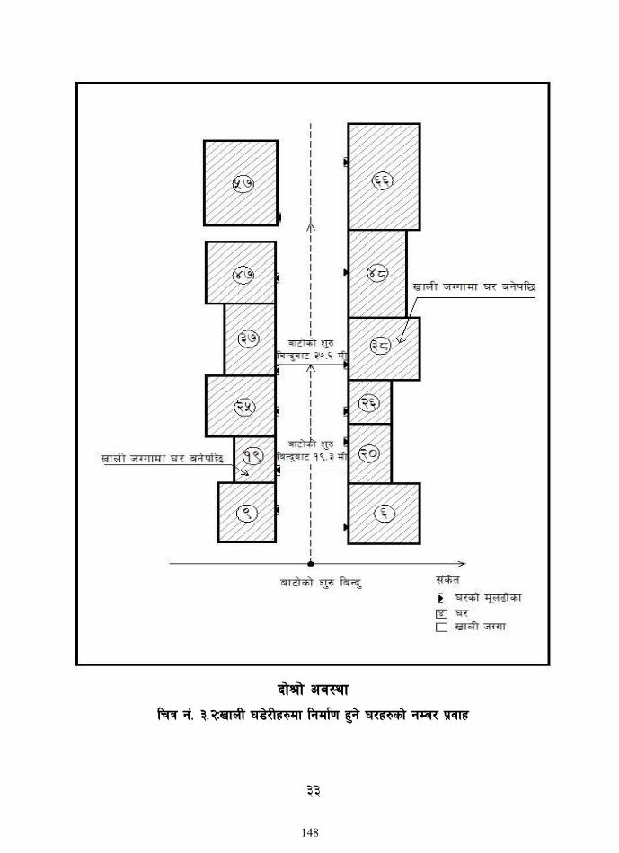
33
bf]>f] cj:yf
lrq g+= #=@MvfnL 38]/Lx?df lgdf{0f x'g] 3/x?sf] gDa/ k|jfx
148
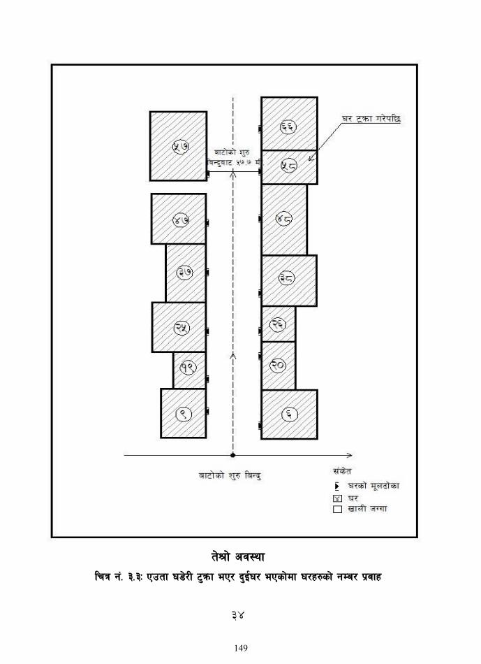
34
t]>f] cj:yf
lrq g+= #=#M Pptf 38]/L 6'qmf eP/ b'O{3/ ePsf]df 3/x?sf] gDa/ k|jfx
149

35
Rff}yf] cj:yf
lrq g+= #=$M ;fdfGo k"0f{tfsf] cj:Yffdf 3/ gDa/ k|jfx
150

36
lrq g+= #=%M rf}af6f]]df kg]{ 3/x?sf] gDa/ k|jfx
151

37
lrq g+= #=^M rf]s eP/ hfg] af6f]df 3/x?sf] gDa/ k|jfx
152

38
lrq g+= #=&=!M lgsf; gePsf af6f]df 3/x?sf] gDa/ k|jfx -afofFtkm{ 38Lsf] lbzf cg';f/_ _
153

39
lrq g+= #=&=@M lgsf; gePsf af6f]df 3/x?sf] gDa/ k|jfx -bfFoftkm{ 38Lsf] ljk/Lt lbzf _
154
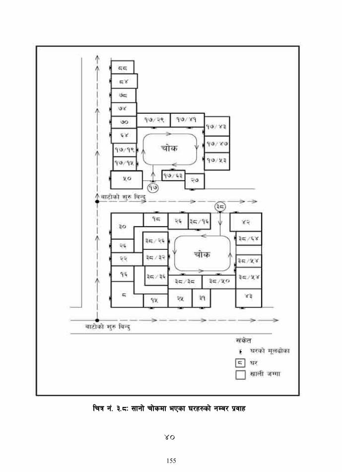
40
lrq g+= #=*M ;fgf] rf]sdf ePsf 3/x?sf] gDa/ k|jfx
155
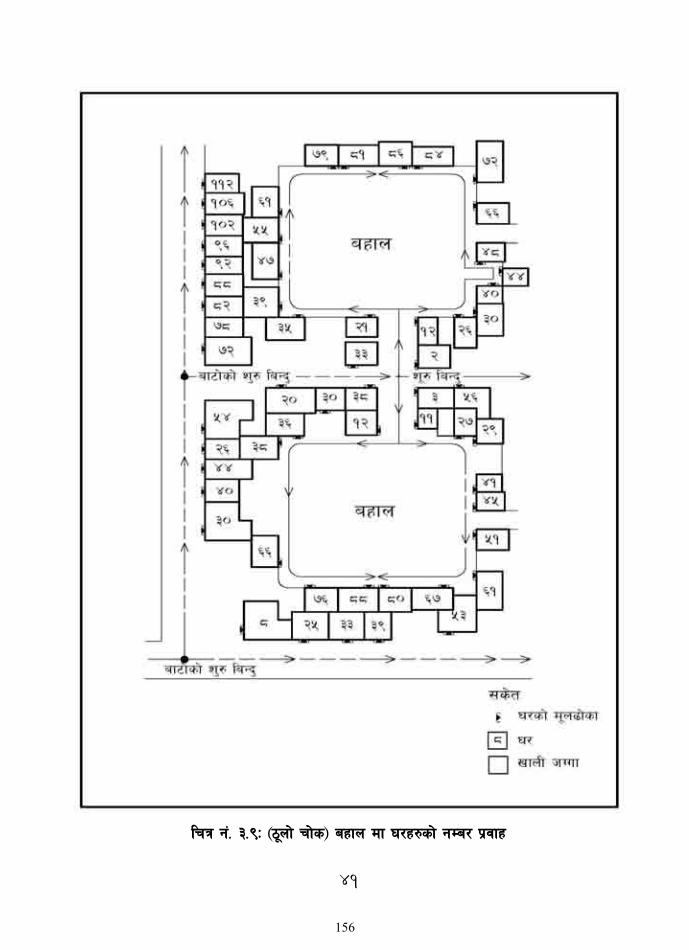
41
lrq g+= #=(M -7"nf] rf]s_ axfn df 3/x?sf] gDa/ k|jfx
156

42
lrq g+= #=!)M 7"nf] rf]s -axfn_ leq aGb rf]sdf /x]sf 3/x?sf] gDa/ k|jfx
157
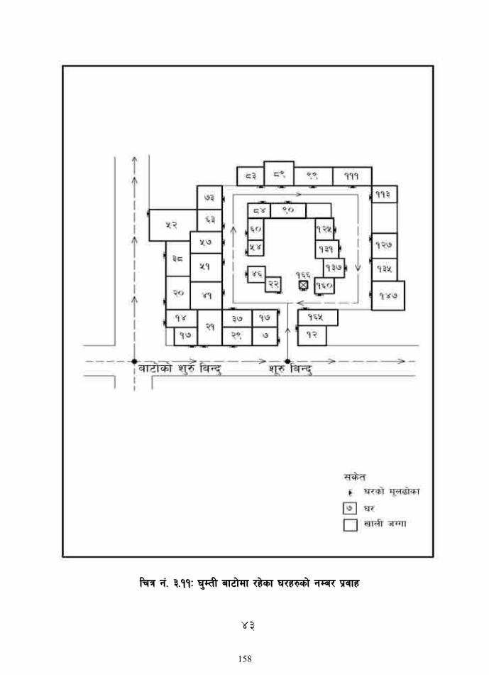
43
lrq g+= #=!!M 3'DtL af6f]df /x]sf 3/x?sf] gDa/ k|jfx
158

44
lrq g+=#=!@M Pp6} xftfleq /x]sf 3/x?sf] gDa/ k|jfx
159

45
lrq g+= #=!#M ;+o'Qm cfjf; ePsf] v08df 3/ gDa/ k|jfx
lrq g+= #=!$M ;+o'Qm cfjf;sf] Pp6} 5fgf leq km/s km/s :jfldTj ePsf] v08df
3/ gDa/ k|jfx
160

46
cg';
"rL – #
3/ 7
]ufgf
;"rgf
cfw
f/ k
mf/d
3/ 7
]ufgf
;" rg f
cfw
f / k
mf/fd
zx/L If]q ;+s]t
af6f] ;+s]t gDa/
af6f] lsl;
d
af6f]sf ]g
fd
6f]nsf ] gf
d
lsQf gfkL ;+Vof
3/ gDa/
3/
lsl;
d
s}lkmo
t
ky
;8s
dfu{
uNnL
rf]s
v'Nnf rf]s
l;+uf] 3/
Tnf axfn
3/} 3/x?
cGo
gf]6M ls
Qf g
Da/
gfkL la
efus
f] gfkL gS
;faf
6 c+l
st
ul/g
]5 .
44
7]ufgf k|0ffnL sfof{Gjog k|lqmof
kl/of]hgfsf] cflwsfl/s k|lqmof
sfof{no ;dLIff / gd'gf If]qsf] cWoog tyf lgl/If0f
nlntk'/ dxfgu/kflnsfsf kbflwsf/Lx?nfO{ cled'vLs/0f / ljleGg ;ldltx¿sf] u7g
n=d=kf=sfk|ltlglw / hgtfx?nfO{ d]l6«s 7]ufgf k|0ffnLsf ultlalwx? af/]
cGt/lqmof
lgb{]lzsfsf] d:of}bf tyf 7]ufgf If]qsf] k|:tfj
k|f/lDes k|ltj]bg
GCP, DGPStyf n]jn ;j]{If0f
:6]l/of] ;}6]nfO6 Od]h tyf gfkL gS;f vl/b
lgb]{l{zsf tyf 7]ufgf If]q laefhgsf] clGtd lg0f{osf] nfuL lgb]{zs ;ldlt ;+u a}7s
lgb]{l{zsf tyf 7]ufgf If]q laefhgsf] clGtd k|ltj]bg lgb{]zs ;ldlt af6 cg'df]bg
cfwf/ gS;fsf] nflu k"j{ tof/L
Aff6f] ljefhg, gfdfs/0f, sf]l8ª / 6f]n klxrfg
3/ g+Da/Lª ug]{] sfo{
3/ gDa/ Kn]6 tyf cfwf/e"t ;j]{If0fsf] tof/L lgb]{zs ;ldltåf/f 5gf}6
ul/Psf] gd'gf :yfgdf !,))) 3/x?sf] 3/ gDa/ k|bfg ug]{
n=d=kf=sf kbflwsf/Lx?nfO{ d]l6«s 7]ufgf k|0ffnLsf] sfof{Gjog tyf cWofjflws ug{ Ifdtf clea[l4 tflnd
WebGIS l8hfOg / sfof{Gjog
d:of}bf k|ltj]bg tof/L, d:of}bf nflu sfo{zfnf / d]l6«s 7]ufgf k|0ffnL sfo{sf] clGtdLs/0f
clGtd k|ltj]bg k]z
Aff6f] gfdfs/0fsf] nflu dxfgu/kflnsf
lgb]{zs ;ldltsf] cg'df]bg
161

47
cg';"rL – $ 7]ufgf k|0ffnL sfof{Gjog k|lqmof
47
cg';"rL – $ 7]ufgf k|0ffnL sfof{Gjog k|lqmof
44
7]ufgf k|0ffnL sfof{Gjog k|lqmof
kl/of]hgfsf] cflwsfl/s k|lqmof
sfof{no ;dLIff / gd'gf If]qsf] cWoog tyf lgl/If0f
nlntk'/ dxfgu/kflnsfsf kbflwsf/Lx?nfO{ cled'vLs/0f / ljleGg ;ldltx¿sf] u7g
n=d=kf=sfk|ltlglw / hgtfx?nfO{ d]l6«s 7]ufgf k|0ffnLsf ultlalwx? af/]
cGt/lqmof
lgb{]lzsfsf] d:of}bf tyf 7]ufgf If]qsf] k|:tfj
k|f/lDes k|ltj]bg
GCP, DGPStyf n]jn ;j]{If0f
:6]l/of] ;}6]nfO6 Od]h tyf gfkL gS;f vl/b
lgb]{l{zsf tyf 7]ufgf If]q laefhgsf] clGtd lg0f{osf] nfuL lgb]{zs ;ldlt ;+u a}7s
lgb]{l{zsf tyf 7]ufgf If]q laefhgsf] clGtd k|ltj]bg lgb{]zs ;ldlt af6 cg'df]bg
cfwf/ gS;fsf] nflu k"j{ tof/L
Aff6f] ljefhg, gfdfs/0f, sf]l8ª / 6f]n klxrfg
3/ g+Da/Lª ug]{] sfo{
3/ gDa/ Kn]6 tyf cfwf/e"t ;j]{If0fsf] tof/L lgb]{zs ;ldltåf/f 5gf}6
ul/Psf] gd'gf :yfgdf !,))) 3/x?sf] 3/ gDa/ k|bfg ug]{
n=d=kf=sf kbflwsf/Lx?nfO{ d]l6«s 7]ufgf k|0ffnLsf] sfof{Gjog tyf cWofjflws ug{ Ifdtf clea[l4 tflnd
WebGIS l8hfOg / sfof{Gjog
d:of}bf k|ltj]bg tof/L, d:of}bf nflu sfo{zfnf / d]l6«s 7]ufgf k|0ffnL sfo{sf] clGtdLs/0f
clGtd k|ltj]bg k]z
Aff6f] gfdfs/0fsf] nflu dxfgu/kflnsf
lgb]{zs ;ldltsf] cg'df]bg
162

48
cg';"rL – % gd"gf 3/ gDa/ ;e]{If0f
Drone Image of Piloting Area
Metric Addressing of Piloting Area
163

i
STREET AND HOUSE ADDRESSING MANUAL
Report Volume-II
An Implementation Guide for Metric Addressing System in Tikapur Municipality,
This document is the Specification manual for street and house addressing of the Tikapur
Municipality, for the project “Preparation of Street Naming and Development of Matric
addressing of Tikapur Municipality, Kailali undertaken by the Department of Urban
Development and Building Construction. This document give the basic information about the
street and house addressing, presents its functionality, guide the user to implement mention
system and for this purpose, use of Municipal GIS Data is encouraged.
This document is prepared refereeing different published, unpublished document and resources.
The different data such as Satellite imagery, GIS datasets and other data used in this manual are
produce/ developed in the project Preparation of GIS based digital base maps. This manual is
the part of mention project.
164

ii
Acknowledgement
We acknowledge our sincere gratitude to Mr. Pramod Karmacharya, Section Chief of Statistics and
GIS section of DUDBC, Ms. Rita Kafle, Engineer and Mr. Dhurba Raj Poudel, Geographer,
Rajeev Gyawali, Survey Officer, Statistics and GIS section of DUDBC for their support,
cooperation and invaluable suggestions for the project.
We also extend our gratitude to respected Mayor Tapendra Bahadur Rawal, Deputy Mayor Keshari
Kumari Rawal (Bista) and all the staffs of Tikapur Municipality for their continuous support,
information and cooperation that was essential for the development of the project.
We appreciate the efforts of all the ward members, local representatives of different political parties
and general public of Tikapur Municipality for their cooperation during the field survey works and
their active participation during the field process.
We also thank the project team leader, project advisors, experts, engineers, surveyors and all the
staffs of Grid Consult (P) Ltd., Cosmopolitan Consultant & Techinical Education Center (P) Ltd.,
Rajdevi Engineering Consultant (P) Ltd. (JV) for putting in their effort and hard work for the
successful completion of this project.
Study Team
165

iii
List of Acronyms
BM Bench Mark
DGPS Differential Global Positioning System
DUDBC Department of Urban Development and Building Construction
DEM Digital Elevation Model
DTM Digital Terrain Model
GCP Ground Control Points
GIS Geographical Information System
GoN Government of Nepal
HA. Hectares
ICP Independent Check Point
ISO International Standards Organization
KM Kilometer
M Meter
MM Millimeter
MUTM Modified Universal Transverse Mercator
MSL Mean Sea Level
NEA Nepal Electricity Authority
NTC Nepal Telecommunication Corporation
NWSC Nepal Water Supply Corporation
RMSE Root Mean Square Error
SQ. KM. Square Kilometre
TIFF Tagged Image File Format
166

iv
Table of Contents
Acknowledgement ....................................................................................................................................... ii
List of Acronyms ........................................................................................................................................ iii
List of Figure ............................................................................................................................................... vi
List of Table ............................................................................................................................................... vii
CHAPTER 1 INTRODUCTION............................................................................................................ 1
1.1 Background ........................................................................................................................................ 1
1.1.1 General Arguments for Adopting a Street Naming and House Numbering System ...... 1
1.1.2 What is Street Addressing ........................................................................................................ 2
1.1.3 Objectives of the Street Addressing System .......................................................................... 3
1.2 Street Addressing Practices ............................................................................................................. 3
1.2.1 Metric Addressing System ........................................................................................................ 3
1.2.2 Non-Metric System ................................................................................................................... 4
1.2.3 Other Systems ............................................................................................................................ 4
CHAPTER 2 PROCEDURE FOR DEVELOPING STREET ADDRESSING AND HOUSE
NUMBERING ............................................................................................................................................ 5
2.1 Preparing Building and Road Base Map ........................................................................................ 5
2.2 Division of municipality into manageable addressing sector ..................................................... 5
2.3 Access Way and Mapping for Street Naming ............................................................................... 6
2.4 Doorway Measurement of Building ............................................................................................... 7
2.5 Development of GIS Database of Street and House Address .................................................. 7
2.6 Municipal Street Maps ...................................................................................................................... 9
CHAPTER 3 IMPLEMENTATION SPECIFICATION ................................................................. 10
3.1 Access Way Identification ............................................................................................................. 10
3.2 Access Way Naming ....................................................................................................................... 11
3.3 Limitation of Access Way Naming .............................................................................................. 12
3.4 Building/House Identification and Doorway Numbering ....................................................... 12
CHAPTER 4 SUCCESSFUL IMPLEMENTATION OF STREET AND HOUSE
ADDRESSING AT MUNICIPAL LEVEL......................................................................................... 14
4.1 Street and House Addressing Unit ............................................................................................... 14
4.2 Legal Status ...................................................................................................................................... 14
4.3 Roles of Addressing Unit ............................................................................................................... 15
167

v
4.4 Establishing Addressing Unit ........................................................................................................ 15
4.4.1 Human Resource Requirement ............................................................................................. 15
4.4.2 Hardware System ..................................................................................................................... 17
4.4.3 Software System ....................................................................................................................... 17
4.4.4 Other Equipment .................................................................................................................... 17
4.5 Updating of Street and House Addresses ................................................................................... 18
4.5.1 Updating Buildings and House numbers ............................................................................. 18
4.5.2 Updating Roads and Street Addressing ................................................................................ 18
168

vi
List of Figure
Figure 1: Addressing sectors of Tikapur Municipality ........................................................................... 6
Figure 2: Access way identification ......................................................................................................... 11
Figure 3: House numbering of existing building .................................................................................. 20
Figure 4: House numbering of newly constructed house .................................................................... 20
Figure 5: House numbering of road crossed section ........................................................................... 20
Figure 6: House numbering at dead end road ....................................................................................... 21
Figure 7: House numbering inside one compound .............................................................................. 21
Figure 8: House numbering on floor base system ................................................................................ 22
Figure 9: House numbering system of flat base system....................................................................... 22
169

vii
List of Table
Table 1: Sector division of Tikapur Municipality .................................................................................... 5
Table 2: Access way addressing and building geo-database model ...................................................... 8
Table 3: Access way categorization ......................................................................................................... 12
Table 4: Human resource requirement ................................................................................................... 16
170

1
CHAPTER 1
INTRODUCTION
1.1 Background
In recent decades, many cities in the developing world have experienced extremely rapid growth.
This growth has created many underserviced neighbourhoods. The street identification systems
initially used in old neighbourhoods in the city centres have rarely been extended to new ones.
Inadequate identification systems have created a worrisome predicament for urban services. As
the pace of urbanization accelerated, many governments in the early 1990s were also embracing
decentralization. The abrupt emergence of local governments made capacity building of
municipal government teams a priority. Municipal governments were unequipped to meet the
challenges of such a broad array of problems: substantial new investments and maintenance work
were required while few resources were available to do so, owing to almost non-existent tax
revenues. The house number is often part of a postal address and describes the number of a
building (residential or not). House numbering schemes vary by place, and in many cases even
within cities. The purpose of the numbering was generally to determine the distribution of
property ownership in the city, rather than for the purpose of organization.
Street and house addressing provides logical and easily understandable system to identify
geographical locations using a system of maps and signs conveying numbers or names of streets
and house or buildings. Designation of house address is defined in relation to its access street.
This operation of house addressing also serve to improve urban and municipal Management.
Street addressing provides an opportunity to create a map of the city used by different units of
the municipality, collecting significant information about the city and its dwellers and set up a
database on the built environment. Information gathered is associated with an address making it
easily locatable. The database which takes the form of GIS is the major creation of street
addressing initiatives particularly in Nepal with rapidly growing urban areas. Street and house
addressing systems is being practiced in major urban cities in Nepal.
The success of this system is expected to be repeated in this municipality as well. This chapter
describes in brief the methodological approach implemented, in Tikapur Municipality, to develop
such Metric Addressing System. In addition, it also presents the standards and conventions
adopted as a guideline for systematic implementation.
1.1.1 General Arguments for Adopting a Street Naming and House Numbering System
Many arguments may be advanced to justify the need of street naming and house numbering. It
has several objectives:
For the public, it makes the city more “user-friendly” by
Improving the system of street coordinates to enable people to get around the city more easily,
Facilitating the delivery of emergency health, fire, and police services, and
Locating urban facilities.
171
2
For local governments: it increases municipal revenues and improves Urban management
through the use of:
Tools for planning and managing municipal services by technical departments: the
identification of public assets (street system, facilities, their length, number, and condition) allows
a monitoring system to be put in place to assist with urban planning and programming of
investments;
Tools for planning and management municipal services in emergency fire, ambulance and
doctor access to correct address.
Tools for planning and management municipal services in maintaining correct legal
documents, such as those for licenses, vital statistics, deeds
Tools to improve local tax collection: using information gathered by street addressing
initiatives, it is possible to locate and compile a register of taxable individuals or businesses and
thereby more accurately determine the tax base.
For the private sector: it enables utility concessionaires to manage their networks more
effectively. In fact, street addressing helps water, electricity, and telecommunications
concessionaires to maintain their networks and collect fees.
1.1.2 What is Street Addressing
The addressing system involves naming streets and then numbering the building along them.
Street addressing is an exercise which makes it possible to identify the location of a parcel or
building or service. That is, to “assign an address” using a system of maps and signs that gives
numbers or names to streets and numbers to buildings/parcels of land. Street addressing is an
exercise that makes it possible to identify the location of a plot or dwelling on the ground, that
is, to “assign an address” using a system of maps and signs that give the numbers or names of
streets and buildings. This concept may be extended to urban networks and services: in addition
to buildings, other types of urban fixtures, such as public standpipes, streetlamps, and taxi stands
also get addresses.
Street Addressing as a system goes beyond the mere naming of streets and numbering of
properties. It includes developing digitised maps for use in the management of settlements and
urban communities. The maps with the information thereon can be developed into GIS
[geographical information system] as a database.
Thus, development of a street addressing system should not be viewed as a one-off activity, but
as a process to be expanded and refined over time to address a range of needs. It therefore has a
number of arms and processes which are elaborated in subsequent sections of this document.
More than just a simple street identifying operation, street addressing provides an opportunity to
(a) create a map of the city that can be used by different municipal units, (b) conduct a systematic
survey that collects a significant amount of information about the city and its population, and (c)
set up a database on the built environment, a rich source of urban information that is too often
unavailable. Information gathered is associated with an address, thus making it easily locatable.
172

3
This database (which can take the form of a GIS [geographical information system] at a later
stage) is the major innovation of street addressing initiatives, particularly in countries with rapidly
growing urban areas where local authorities have lost control of the urbanization process. The
real advantage lies in the potential of the urban information database, which, in conjunction with
a street addressing plan and a street index, can be used for various applications and benefit the
population as a whole, local government, and the private sector.
1.1.3 Objectives of the Street Addressing System
Addressing makes it easier to: Locate residents and their
homes by means of an address system that can be used by
the people themselves and by government officials,
concessionaires, and other service providers;
Operate urban services (ambulances, fire trucks, taxis);
Enforce collection for user-pay services, in particular
those provided by utility concessionaires [water companies,
electrical companies].
1.2 Street Addressing Practices
There are various types of addressing systems. Basically two
main types, metric and non-metric systems are often used
in cities of the world. Besides this, there are other systems
known as block numbering and sequential numbering
along/around an access way.
1.2.1 Metric Addressing System
The basic principle of a metric system is; each building along an access way is given a number
that equals the distance measured in meters from the access way's starting point to the main gate
(entrance) of the house/building. In other words, structures are assigned even or odd numbers
corresponding to the distance between the building/house main entrance and the beginning of
the street segment. The numbering sequence does not necessarily start with 1, 2, 3 even if the
buildings/houses are the first building or house at both sides of an access way e.g. a building with
its main entrance or gate 10 meters from the starting point, will have no. 10, even if it is the first
building along an access way. Benefits of this system are:
Modifications occurring in the urban site, wise; demolishment of existing structures,
replacement or construction of a new house/building, or vacant plot turned into a new building,
will have no effect in the existing number flow.
New building will be given new numbers, which do not conflict with the numbers already
given.
There will be no occurrence of the repetition of the number or number flow.
The metric system method follows the odd and even rule in a road segment which means that buildings on one side will have odd numbers and other side will have even numbers. For e.g. a
173

4
building on the right side of an access way with its main gate or entrance at 15 meters from the starting point, will be allocated as building number 14 or 16. The same rule applies to even distances measured for buildings situated on the left side of an access way. In this method vacant sites will not be allotted a number as there is no certainty on how many buildings will be constructed on that vacant plot. But the site can be identified if necessary in relation to the next building.
1.2.2 Non-Metric System
As the metric system, the non-metric system numbers buildings from the access way's starting
point. However, the numbering flow increases sequentially in an even or odd manner along the
right and left side of the access way. On the right side, the first building is given number 2, the
next number 4 and then 6, 8 and so on. On the left side, the first building is given number 1 and
the number flow continues with 3, 5, 7, and so on. There is no interruption in these sequences.
Vacant sites do receive a number. It is an easy and simple system to identify buildings. As long
as there are no major changes in the building layout or no subdivisions of sites, the system is
suitable. Indeed, this system is used in many countries around the world.
A problem arises when buildings are demolished (resulting in a gap in the existing sequential
numbering), or when new buildings are erected. This influences the existing numbering sequence.
To avoid renumbering, the gaps have to be tolerated and the use of appendixes to existing
numbers is essential to identify new buildings. This situation distorts the original concept of
sequential numbering along the access way. Summing up, the non-metric method tends to break
its own rules in numbering if the building pattern changes, thus losing all its simplicity and
requiring a review of the numbers. This will cause inconvenience to dwellers. The metric system
on the other hand is designed to avoid the problems encountered by the non-metric system as it
uses non-continuous numbers. The only inconvenience in the metric system is the fact that in
long access ways high building numbers will be necessary.
1.2.3 Other Systems
Block numbering and sequential numbering along/around an access way are the other methods. It neither follows a metric or non-metric way of numbering. Block numbering system was used in Kathmandu to identify buildings. As it has some drawbacks like a new building within a block gets the number following the last number allocated. As such the number has no relationship to the physical location of the building. When there are a large number of buildings in each block, it is impossible to find a particular by means of its block and house number alone.
174
5
CHAPTER 2
PROCEDURE FOR DEVELOPING STREET ADDRESSING AND HOUSE
NUMBERING
The following steps were adopted for the development of metric addressing system in the case
of the work conducted in Tikapur Municipality:
2.1 Preparing Building and Road Base Map
Maps showing building, streets, administrative boundaries and other topographic feature form
the base for the street and house addressing. Building footprints and road centrelines are
extracted from high resolution satellite imagery. Following steps were adopted for delineating
building footprints and road centrelines:
Building footprints and roads were digitized in Arc GIS environment over the high resolution
satellite imagery. The digitized vector data were stored in Arc GIS Geo database or the shape file
format. Attribute data were collected by the field work and secondary sources were included to
create building and road GIS database. All road segments were given a unique id number (Road
Code).
These vector data (building and roads) were then verified on the ground and update as
required. Administrative ward boundaries were ground verified and updated. Rivers and streams
captured by digitizing over the ortho-rectified satellite image were the topographical features
required for street addressing. Building and road base maps were printed in large scale for field
observation and naming of the roads.
2.2 Division of municipality into manageable addressing sector
The sector division is the process of dividing municipality into neighbourhoods addressing zone.
The division is to establish a firs level of geographical reference for access ways and building
addressing. The division of sector can be done based on commonly known places, administrative
units or according homogeneous city blocks with Regular Street and building patterns.
Considering the sector implementation method mention above, the addressing sectors of Tikapur
Municipality are divide based on administrative boundaries and named based on locality. These
addressing sectors are Kailali North and Kailali South which is shown the below.
Table 1: Sector division of Tikapur Municipality
SN Zone Name Ward
Comprise
Description
1 Tikapur
Municipality
East
1,2,3,4,5,
6,7,8,9
Tikapur Municipality devided by Tikapur to Lamki
Road. From the Lamki road Eastern direction
encompasses ward no 2,5,7,8 and 9. It is bordered by
Geruwa Gaunpalikaand Rajapur Municipality in the
175

6
East direction, India in the South derection and
Janaki Gaunpalika in the North derection.
2 Tikapur
Municipality
West
10 Tikapur Municipality West Zone encompasses ward
no1,3,4 and 6. It is bordered by Bhajani Municipality
West direction and India in South derection and
Joshipur gaunpalika North derection
Figure 1: Addressing sectors of Tikapur Municipality
2.3 Access Way and Mapping for Street Naming
Street naming started with the determination of the starting point of each access. The starting
point of each access ways were define in order to designate a name and distribute house numbers
176

7
along them. Public participation and awareness among them is vital for its use and success. Hence
an approach of public appraisal and participation was adopted for this task. Participatory
approach, in which the local community themselves were involved in defining the starting point
and naming of the access ways, was implemented. The approach thus takes was:
The starting and ending point of each access way was defined on the digital map in GIS
environment. By definition, the starting point is located on the eastern side of an access way if
that access way is aligned east-west direction and southern side in case of a north –south aligned
access way.
In case of alignments, of an access ways, not exactly along the north-south or east- west axis,
the starting point is defined by the angle by which the access way deviates from the north-south
and east-west lin. If the angle is smaller than 45° or smaller referring to the east-west line, the
starting point will be the eastern side of access way, and if more than 45° then the southern side
will be the starting point.
In case of roads with a dead but having possibility to expand more, direction of the main road
is followed.
The defined access way were discussed at the public hearing with the participation of the
municipal office ward, TLO, Political parties Political, representatives, and the general public.
The access ways with conflicting starting point were discussed at the same meeting and finalized.
Access way name were designated for each individual segment through a discussion amongst
the participants of a meeting, and old names were followed for already designated streets. Access
ways with conflicting and repeating names were designated with synonymous names or with an
alternative.
2.4 Doorway Measurement of Building
Each building was numbered based on the measured metric distance from the starting point of
the street. The following method was applied:
Each individual building was identified from the base map and verified on the ground.
The distances for building entrances were measured on the GIS map.
Based on the measurements, odd numbers are assigned to buildings on the left side of the
access way and even for buildings on the right side. Some sampled buildings numbers were
temporarily marked on the walls. Permanent house numbers are distributed later during the
operational installation of signage for the street and house numbers.
2.5 Development of GIS Database of Street and House Address
All the road access given codes name and building numbers are maintained in relational database
in GIS environment. The road name and house numbering was given in ARC GIS by geo-code
system (US dual Range Geo-coding service). The street networks segments and buildings from
the base map, in addition will contain the addressing data.
177

8
After the designation of access way codes, names and building numbering, GIS database
system was developed for the streets and buildings. The addressing GIS database specifically
contains the designated names and codes of the access way and the numbers of the building along
with other base map attribute data. This information’s were added as attribute data in the GIs
database system.
The street GIS database contains addressing sector name and code, access way code and name,
type, surface type, status, width, length and other physical attributes and traffic type.
The building addressing, database contains the addressing sector name, access way name, code
and type, house number, location, parcel number, number of floors, functional use and
designated name.
Table 2: Access way addressing and building geo-database model
Feature
Class
Category
Description Feature
Geometry
Feature Attributes
Road
Centerline
Road network/ road
Centerline
Poly Line ID, ADDRZN (Text),
STRTCD (Text), STRTNM
(Text), RDHIER (Text),
RDSURF (Text), RDLEN
(Double), RDWIDTH
(Double), ROW (Double),
STRTLMP (Text), VFLAG
(Short)
Building
Footprint of
Building
polygon
BIN (Long), ADDRZN
(Text), STRTCD (Text),
ADDR (Text), WARD
(Long), TOLE (Text),
BLDGASC (Text),
BLDGUSE (Text),
USECATG (Text),
FUNCNM (Text),
CONSTTYP(Text),
ROOFTYP (Text),
FLRCOUNT (Integer),
VFLAG (Integer),
ROADACS (Text),
ELECACS (Text)
178

9
2.6 Municipal Street Maps
Street map was prepared at larger scale showing all the street, designated names, buildings and
landmarks of importance, location names and other relevant information, which would facilitate
to orient the map reader and locate a specific address.
Street map is composed at large scale, preferably at 1:2500 to 1:5000 scales.
The Street map clearly shows each of the access ways with unique color and cartographic
symbols for each category, major access with prominent than minor ones.
Designated access way names distinctly shown on the maps.
Prominent places name such as public squares town center etc. are shown on the map.
Landmarks such as status, temples, parks and other public places shown on the map
Infrastructures and places of tourist attraction, business, commercial buildings, official
buildings, banks, recreational, hotels, places of historical and cultural importance and other
important infrastructures/places are shown with designated names.
Services such as police stations, hospitals, fire stations, hospitals/health posts, clinics, post
office etc. are show on the map with appropriate symbology.
Transportation services such as bus parks, taxi or auto stand, public parking area, petrol
station, service station etc. are shown on map with appropriate symbology.
The directions of the traffic in one-way streets are being shown clearly with directional arrows.
Streets with restricted access are also shown on the map.
179

10
CHAPTER 3
IMPLEMENTATION SPECIFICATION
3.1 Access Way Identification
The first step taken is to identify the access way on the prepared base map and its verification on
the ground. A clear starting and ending point is identified for every access way with the local
participation and the assistance of the municipality and the concerned ward. In principle, the
exact starting point of an access way is the intersection point of the centre-lines of two access
way. The ending point is the junction point of other access way. The identification of the starting
and ending points of the access way delineates its segment length thus enabling the naming of
the segment. The identification of the starting point also defines the origin for building
numbering in metric system. A starting point, by definition is located on the eastern side of an
access way if it is aligned in east-west direction, referring to the north orientation. If the access
way is north-south aligned, then the starting point is on the southern side. If the alignment of an
access way is not exactly north-south or east west, the starting point is defined by the angle by
which the access way deviates from the north-south or east-west line. If the angle is smaller than
45 o referring to the north-south line, the starting point is the point in the southern side. If the
angle is 45o or smaller referring to the east-west line, the starting point is at the eastern side of
the access way.
The above defined convention does not seem to be practical in case of Kailali the originating
point of an access way would start from the end of the road located too far from the reference.
180

11
Therefore, Major business centre and major thoroughfares are considered as the reference point
for the starting of any access way.
Figure 2: Access way identification
3.2 Access Way Naming
Access way naming is also one of the main tasks in addition to coding. The designation of access
way names is done by adopting participatory appraisal approach with an active participation of
local people and authorities. Upon the request of the municipality and technically supported by
the consultant, each ward organized ward level meetings to identify the origin and the end points
of the access ways and designate a commonly used names of each identified access ways. In
practise, access ways are designated with names (terminologies) of deities and mythical figures,
popular figures, martyrs, people’s movements, popular spot or location and other cultural
terminologies. Certain naming convention should be followed such that the name would not
offend certain group of people or prove to be controversial. Following are the points to be
considered in the designation of the names:
Names should not reflect political agenda
Living individual’s name should not be used
Any name should be unique throughout the municipality i.e. there should not be repetition of
the same name
Traditional and already existed name are maintained.
181

12
The access ways are categorically designated into four types based on their widths. These
categorical types along with the designated names is the full name of the access way. These
categorical types are as follows:
Table 3: Access way categorization
Type of Access Way Nepali Terminology Width (meter)
Arterial Road Path >14
Street Sadak 9-14
Alley (Motorable) Marga 3-9
Path Galli <3
These categorical types also help in distinguishing the access ways with the same designated
names. For example, Bazar Galli is different to Bazar Marga and is valid according to the naming
convention.
For the access ways with already existing names, the original names are preserved. In case of any
repetition conflict in the designated names with the access ways of other sectors/wards, the
naming committee of the municipality should modify the name suggesting an alternative or
synonymous name or by adding a prefix or suffix to the suggested name which may justify the
original name suggested. The names can also be distinguished using a suffix such as location
references, numbers referring to sections as in highway sections and others.
3.3 Limitation of Access Way Naming
Although the designation of access way names is done by adopting participatory appraisal
approach with an active participation of local people and authorities, the participation were
unable to finalized the access way naming as mention above. Due to this limitation, the accesses
way were named as from starting point to ending point (i.e. origin-destination).
3.4 Building/House Identification and Doorway Numbering
Metric house addressing system is followed for building doorway/entrance numbering. Under
this system, house address numbers represent the distance in meters from the street’s “point
zero” to each individual building’s main entrance. These rules are followed for allotting the
numbers to the buildings.
A unique number is given to every building currently used for human dwelling and other
purposes. Each and every main entrance of the buildings is numbered. The number given to the
building main entrance is the measured distance in meters from the starting point of an access
way to the middle of the building's main entrance along that access way. The distance is measured
along the access way from the starting point in the field.
Even and odd numbers are allotted to the buildings. Odd numbers are assigned to buildings
on the left side and Even numbers are assigned to the buildings on the right side of an access
way. A right side building with an entrance at a distance of 10 meters from the starting point of
the access way is allotted as number 10. If a right side building has an entrance at a distance of
182

13
13.5 meters from the starting point, the building is allotted number 14, while for a left side
building the number is 13 or 15. Likewise for the right side building with an entrance at 19 meters
from the starting point of the access way, the number is 18 or 20. Similar, rounding off to the
nearest even or odd numbers are applied to the fractioned distances on the right or the left side
respectively of an access way. In all cases consistency has to be maintained strictly.
As every building is defined by the main entrance the number allotted is only one. If a building
has two or more independent entrances (either to one or more access ways), one of the entrance
is selected as the main entrance and is allocated the main building number. If the various
entrances give access to units that are owned by different owners, each entrance is given a unique
number.
Permanent number of metric house number plate is fixed at the main entrance of the building.
183

14
CHAPTER 4
SUCCESSFUL IMPLEMENTATION OF STREET AND HOUSE ADDRESSING
AT MUNICIPAL LEVEL
The first and foremost requirement for sustainably implementing Street Addressing System is to
establish a “Street and House Addressing Unit” under the Planning Section in Tikapur
Municipality. This unit shall collaborate and function collectively with other municipal
departments and shall provide its services to all the departments within the municipality. The
primary responsibility of this unit will be to manage and maintain data besides giving house
numbers, street naming. The other responsibility is to improve the performance of the existing
tax system and reform the present system optimizing for the resource mobilisation of the
municipality.
4.1 Street and House Addressing Unit
As has been described above this unit is responsible for assigning addresses and verifying road
names within Kailali and ensuring their conformance with existing regulations. This unit’s main
functions are:
Assigning code numbers and names to every access ways.
Assigning addresses to all parcels and properties based on metric system.
Maintaining an officially valid road name inventory.
Managing and maintaining street and house address database, regular updating of data, analysis
of data and prepare presentation as per the requirements of the municipal departments as well as
external organizations and general public.
4.2 Legal Status
The unit functions under the municipal authority. The municipal authority has to endorse its
functions and all the information system that this unit has generated. Present administrative
structure accommodates this unit in one of the departments. The Municipality Board has to
approve the functioning of this unit. This unit should be given mandate to perform the following
tasks:
Coordinate the street naming process
Arbitrate and resolve conflicts during street naming
Authenticate and approve the designated street names
Assign new building numbers
Issue temporary and permanent house address certificates
Collect fees for installation and issuing of house address plates
184
15
Publication of street maps, development of other map and data products (tourist maps, road
data etc.)
Distribution and dissemination of such maps and data rendering certain fees
Updating of street and house address database and maps
Installing new signage and house number plates
4.3 Roles of Addressing Unit
The role of addressing unit is to assign record and issue addresses. Addresses of all buildings are
issued to applicants upon submission of the following information:
The valid/official street name upon which the structure is located or to be located.
The distance of the buildings in meter to the nearest property line (House No.) and whether
that building is on the north, south, east or west side of the property line.
Plan which shows the street with the above information, the address is verified by this unit.
After verification a certificate is provided to the building permit department to issue the building
permit.
Provide support to land and house/property taxation unit by maintaining/updating the street
name, house number and other database and associated building information records.
Provide support to the road construction and maintenance unit by establishing/updating road
status inventory and maps.
4.4 Establishing Addressing Unit
4.4.1 Human Resource Requirement
In view of the present organizational structure of Tikapur Municipality it seems quite logical to
establish one separate unit as Street and House Addressing Unit which will collaborate and
function collectively with other departments of the Municipality and especially with the
department which issues the building permit. As has been described early in this manual, the
recruitment of personnel depends upon availability of the personnel with sufficient knowledge
of this nature of the work within the municipality. If there are no such personnel available, the
municipal office should recruit appropriate personnel. The recommended human resources are:
185

16
Table 4: Human resource requirement
S.N Personnel Qty Responsibility Remark
1 Engineer 1
Coordination with the parent
municipal department
Oversee all the tasks in the unit
Tasking to the sub-ordinate
technicians
Coordinate with local stake
holders during street naming
process
Plan and undertake field
monitoring, verification and
updating
Issue temporary/permanent
house address certificates to
public
Plan for new installation of
street signage
Collaborate and support GIS
unit in street updating, street and
house address updating
Head of
Department
2 Surveyor/Overseer 1 Conduct measurement of
entrances of newly constructed
houses for issuing new house
number
Collect the location of newly
constructed buildings/houses to
be updated in the database
Support GIS unit of updating
of street, houses and address
database
Assist the engineer in planning
new installation of street signage
With basic
surveying
training
and basic
computer
knowledge
186
17
4.4.2 Hardware System
For maintaining the addressing database, reporting and performing day-to-day office tasks for
the aforementioned personnel of the unit, at least two networked computer systems with normal
configuration and a printer is required.
4.4.3 Software System
As all the GIS and mapping work is done in collaboration with the Municipal GIS Unit, special
GIS software may not be required for the unit. However, it is recommended to have one unit of
commercial GIS software provided funding is available. As an alternative a free GIS tool such as
Arc Explorer by ESRI, open source Quantum GIS, Map Window or other freely available GIS
applications may be used to visualize and map the streets.
4.4.4 Other Equipment
Updating of street map in collaboration with other municipal departments/units is one of the
major tasks of the addressing unit. Other tasks include installation of new street signage and
building number plates. So, the unit should be equipped with proper equipment. These are the
required equipment:
Handheld GPS set – 2 units to maps newly constructed roads and buildings GPS data
downloading software – 1 unit to download GPS readings
Odometer – 2 units to measure the metric distances of the entrances of newly constructed
buildings, alternatively measuring nylon tapes can be used
Undertake new installation of
street signage and building
number plates
Assist computer operator in
updating the database
Computer Operator Assist the engineer in data
preparation, updating, analysis
and map preparation
computer
literate,
preferably
with
technical
background
(sub
overseer,
computer
operator,
Assistant
surveyor etc.)
Helpers 1 Install street signage, house
number plates
187

18
Ladder to install street sign plaques on building walls / Electric Poles
Lettering stencils, colour paints, paint brushes/rollers etc. for temporary numbering until
permanent metal plates are installed
Electric/hand drills, hammers, nails/screws etc. to install street signage and building number
plates
Printed temporary and permanent house address certificate forms
4.5 Updating of Street and House Addresses
For the successful implementation of the addressing system in the municipality, regular updating
of the streets, buildings and associated addressing system is imperative. The municipality should
formulate certain policy and institutional framework for updating the addressing system. This
updating policy and institutional framework is also governed by the availability of resources
including the human resources. Hence the addressing unit should have a clear mandate as well as
technical and infrastructural capability to undertake the updating operations. The policy should
be such formulated that the updates are carried out at municipal level as soon as the roads and
buildings are constructed. This might require frequent updating at municipal level but the benefit
is having an advantage of up-to-date street and building database and their respective addressing
system. Frequent updating might also eliminate the need of hiring and external consultant to do
the mass updating, which otherwise would be necessary. The following sub-sections provide a
general road map for undertaking the updating operations:
4.5.1 Updating Buildings and House numbers
As a new building is constructed and the owner applies for the permanent house number, the
addressing unit surveyor makes a field visit to verify and map the location of the building. The
surveyor takes the GPS observations of the four corners of the building and make as recording.
The metric distance measurement of the doorway is also done at the same time. Basic household
and house characteristics data are enumerated using a simple structured questionnaire. Detailed
household data may also be enumerated at the same time using structured questionnaire if
required.
If a GPS reading of the corners of the house is not possible, only one reading to indicate the
location of the building can be taken.
The GPS reading is downloaded and overlaid on top of existing municipal base map or satellite
Ortho-photo to draw the building footprint using GIS software.
Associated building and household data collected is then entered into the attribute database.
The house number and the street name are entered into the address database. The applicant
house owner is then given a permanent house number and the house number plate is installed at
his/her doorway entrance.
4.5.2 Updating Roads and Street Addressing
When as new road is constructed, the addressing unit should seek for the acquisition of the design
drawing and layouts with the concerned line agency or with the contractor/consultant involved
188

19
in the construction. Such design layouts, in general are in CAD digital format as well as in printed
maps. The addressing unit should verify the compatibility of such layout drawing with the
Municipal GIS system. The digital drawing is then converted to compatible GIS data format with
associated attribute data.
In case, design layout is not available, the roads are updated using handheld GPS sets. In this
method, the surveyor traverses along the center line of the constructed road, taking GPS readings
at every turning point. Other relevant information such as road width, pavement type, side-drain
and other structures constructed and other are recorded. The recorded GPS points and the
surveyed route are plotted on the base map in GIS environment. Associate data collected are
entered as attribute data of the road.
Once the road map and GIS data is updated, the access way is given a code according to the
coding specification. The addressing unit holds a public counselling for the naming of the new
access way. The name is approved by the municipality and the access way is officially designated
a name.
The GIS and database is also updated accordingly with new access way code and designated
name.
Street signage (street plaques or street sign post) is installed at the appropriate location for the
new access road.
If in case the buildings/houses along this newly constructed road have not obtained permanent
house numbers (due to temporary status of road such as bund -cFnL, under construction road
or others), these houses are given permanent house numbers and house number plates. The GIS
and database of such buildings are also updated accordingly.
189

20
Appendix
Figure 3: House numbering of existing building
Figure 4: House numbering of newly constructed house
Figure 5: House numbering of road crossed section
190

21
Figure 6: House numbering at dead end road
Figure 7: House numbering inside one compound
191

22
Figure 8: House numbering on floor base system
Figure 9: House numbering system of flat base system
192

Government of Nepal
Ministry of Urban Development
Department of Urban Development and Building Construction
New Town Project Coordination Office
Babarmahal, Kathmandu
Preparation of Master Plan for Developing Waling as A Smart City
Package: CS-06-074/75
Final Report
On
Volume V: Metric Addressing System
Waling Municipality, Syangja District, Gandaki Province
Consultant
SDRC (P) Ltd., GEC (P) Ltd., and RES Engineering Consultancy-JV
Nayabazar, Kathmandu
2076
Waling
Bazar
193

i
Table of Contents
Table of Contents ......................................................................................................................... i
List of Charts ..............................................................................................................................iii
List of Photos .............................................................................................................................iii
List of Tables.............................................................................................................................. iv
CHAPTER 1:- Introduction ........................................................................................................ 1
1.1 Background ........................................................................................................................... 1
1.2 Objective of the Study ........................................................................................................... 1
1.3 Scope of the Study ................................................................................................................. 1
1.4 Expected Output .................................................................................................................... 2
CHAPTER 2:- Methodology ...................................................................................................... 3
2.1 Preparation of Base Map ....................................................................................................... 3
2.2 Addressing Defined Area for House Numbering .................................................................. 4
2.3 Access Way Identification and Naming. ............................................................................... 5
2.4 Building/ House Identification and Doorway Numbering .................................................... 7
2.4.1 Building Patterns and Numbering .............................................................................. 8
2.4.2 Special Cases of Building/House Numbering .......................................................... 11
CHAPTER 3:- Introduction of Study Area ............................................................................... 12
3.1 Walling an Overview ........................................................................................................... 12
3.2 History of Waling ................................................................................................................ 12
3.3 Existing Physical situation .................................................................................................. 13
3.3.1 Geographical Characteristics .................................................................................... 13
3.3.2 Physical Location ...................................................................................................... 14
3.4 Major Settlements ................................................................................................................ 15
3.5 Socio-Economic and Demographic Status .......................................................................... 15
3.5.1 Population and Density ............................................................................................. 15
3.5.2 Population Distribution by Age Group ..................................................................... 18
3.5.3 Economically Active and Inactive Population.......................................................... 19
3.5.4 Population by Ethnicity and Caste ............................................................................ 20
3.5.5 Population Based on Mother Tongue ....................................................................... 22
3.5.6 Literacy Status .......................................................................................................... 24
3.6 Lan Use ................................................................................................................................ 24
194

ii
3.7 Road and Transportation Networks ..................................................................................... 25
3.8 Functional Use of Building ................................................................................................. 27
3.9 Building Ownership ............................................................................................................ 28
3.10 Building Types .................................................................................................................. 29
3.11 Building Construction ....................................................................................................... 30
3.12 Water Supply and Electricity Distribution ........................................................................ 31
3.13 Importance of House Numbering System in Smart City ................................................... 31
CHAPTER 4:- Conclusions ...................................................................................................... 32
CHAPTER 5:- Recommendations ............................................................................................ 33
CHAPTER 6:- Appendices ....................................................................................................... 35
6.1 Appendix: Municipal Letter ................................................................................................ 35
6.2 Appendix: Field Photographs .............................................................................................. 38
6.3 Appendix: Data Sheet Sample, Field Survey ...................................................................... 39
6.4 Appendix: House Numbering Database .............................................................................. 41
6.5 Appendix: Maps .................................................................................................................. 78
195

iii
List of Charts
Chart No 1: Population and Density ........................................................................................ 17
Chart No 2: Population Distribution by Age Group, Ward-9 .................................................. 19
Chart No 3: Economically Active and Inactive Population ..................................................... 19
Chart No 4: Ethnicity and Caste Composition ......................................................................... 22
Chart No 5: Ethnicity and Cast Composition at Study Area, Ward No-9................................ 22
Chart No 6: Population Distribution based on Mother Tongue ............................................... 23
Chart No 7: Population Distribution based on Mother Tongue, Study Area ........................... 23
Chart No 8: Municipal Literacy Status .................................................................................... 24
Chart No 9: Literacy Status, Study Area .................................................................................. 24
Chart No 10: Land Use of the Study Area ............................................................................... 25
Chart No 11: Road Surface Types ........................................................................................... 27
Chart No 12: Functional Use of Building ................................................................................ 28
Chart No 13: Building Roofing Types ..................................................................................... 29
Chart No 14: Building Construction, Material Uses ................................................................ 31
List of Photos
Photo No 1: Base Map used for Field Verification and Data Collection, Satellite Image ......... 4
Photo No 2: Defined area on Satellite Image for House Numbering ......................................... 5
Photo No 3: Street Naming and House Coding ......................................................................... 6
Photo No 4: House Numbering with Respect to Junction ......................................................... 7
Photo No 5: Linear, Vacant land and Subdivision Pattern......................................................... 9
Photo No 6: Square and Courtyard Pattern .............................................................................. 10
Photo No 7: Ribbon Settlement, Waling Tallo Bazar .............................................................. 15
Photo No 8: Commercial Area, Waling Bazar Along the Highway ........................................ 15
Photo No 9: Some Others Field Photographs .......................................................................... 38
196

iv
List of Tables
Table No 1: Urban Road Hierarchy ........................................................................................... 6
Table No 2: Political Boundary, Waling Municipality ............................................................ 14
Table No 3: Description of Demography and Household ........................................................ 16
Table No 4: Population Distribution by Age Group ................................................................ 18
Table No 5: Active and Inactive Population ............................................................................ 19
Table No 6: Ethnicity and Caste Composition ......................................................................... 21
Table No 7: Population Distribution based on Mother Tongue ............................................... 22
Table No 8: Literacy Status of Municipality ........................................................................... 24
Table No 9: Literacy Status of Study Area .............................................................................. 24
Table No 10: Land Use ............................................................................................................ 25
Table No 11: Road Network .................................................................................................... 25
Table No 12: Road Surface ...................................................................................................... 27
Table No 13: Functional Use of Building ................................................................................ 27
Table No 14: Building According to Ownership ..................................................................... 29
Table No 15: Building Roofing Types ..................................................................................... 29
Table No 16: Building Construction, Material Uses ................................................................ 30
Table No 17: Water Supply and Electricity ............................................................................. 31
List of Maps
Map No 1: Location map, Metric Adressing ........................................................................... 14
197
Volume V: Final Report-Metric Addressing System, Waling as a Smart City
SDRC (P) Ltd., GEC (P) Ltd., and RES Engineering Consultancy-JV 1
CHAPTER 1:- Introduction
1.1 Background
House numbering is a system of providing a unique number to each building in a street or
area, with the intention of making it easier to locate. The house number is often part of a
postal address and describes the number of a building (residential or not). Street Numbering
was first introduced across Europe in the 18th century, to facilitate administrative tasks and
provision of services such as the post.
Street and house addressing provides logical and easily understandable system to identify
geographical locations using a system of maps and signs conveying numbers or names of
streets and house or buildings. Designation of house address is defined in relation to its access
street. This operation of house addressing also serve to improve urban and municipal
management. Street addressing provides an opportunity to create a map of the city used by
different units of the municipality, collecting significant information about the city and its
dwellers and set up a database on the built environment. Information gathered is associated
with an address making it easily locatable. The database which takes the form of GIS is the
major creation of street addressing initiatives particularly in Nepal with rapidly growing urban
areas.
Different utility authorities normally use their own system for their specific application. A
common addressing system usable by all the municipal utility and infrastructure services as
well as the general public has yet to be implemented in the majority of the Nepalese cities.
Kathmandu Metropolitan City has set an example in implementing such a common addressing
system in the form of Metric Street and House Addressing System since 2001.
For this purpose, Metric Street and House Addressing System was adopted in Waling
Municipality. Consulting services is required to assists DUDBC in Preparation of Street
Naming and development of Metric addressing of Waling Municipality. During the
preparation phase, the project is being coordinated at national level by New Town Project
Coordination Office (NTPCO).
1.2 Objective of the Study
The main objectives are outlined as follows:
Prepare Maps of Street Naming and development of Metric addressing of Waling
Municipality at 1:2500 scale for the delineated area (dense settlement area).
Development and establishment of effective house numbering and street addressing
database system of the defined area of municipality.
1.3 Scope of the Study
The scopes of work for the assignment are:
Development and establishment of effective house and street addressing system.
This includes the metric addressing system of house numbering. The consultant
submits a road segment map for initiating the road naming process to the municipality.
The naming of the streets is carried out in consultation with the municipality and the
198

Volume V: Final Report-Metric Addressing System, Waling as a Smart City
SDRC (P) Ltd., GEC (P) Ltd., and RES Engineering Consultancy-JV 2
local people. The road names are finalized after approval from the municipality board
by the consultants. Each street isassigned a unique name as well as digital code.
Every house of the municipality isassigned a number based on the street name and
using metric system and indicated in the base map.
The task is performed only within the delineated area of Ward-9 which is approved by
Waling Municipality Board (Meeting held on 2076/07/20 B.S.). The Boundary of
delineated area comprises Vhimtari Mirdi Bridge in the East, Kandel Gaun, Dumrikot
in the West, Aadhikhola Corridor in the North and B.P. Chowck in the South. This area
includes 962 households including temporary houses like Goth and the delineated area
covers about 0.46 sq.km.
1.4 Expected Output
Metric House addressing datasets
Building data
Access way network
Base Maps of defined area
199

Volume V: Final Report-Metric Addressing System, Waling as a Smart City
SDRC (P) Ltd., GEC (P) Ltd., and RES Engineering Consultancy-JV 3
CHAPTER 2:- Methodology
Metric Street and House Addressing System was adopted in Waling Municipality. The basic
principle of a metric system is; each building along an access way is given a number that
equals the distance measured in meters from the access way's starting point to the main gate
(entrance) of the house/building. In other words, structures are assigned even or odd numbers
corresponding to the distance between the building/house mid-point and the beginning of the
street segment. The numbering sequence does not necessarily start with 1, 2, 3 even if the
buildings/houses are the first building or house at both sides of an access way e.g. a building
with its mid-point 10 meters from the starting point, will have no. 10, even if it is the first
building along an access way.The metric addressing system accommodates new buildings
without breaking the flow of numbers and this system is suitable and convenient in the
municipal context. As such, as in other municipalities of Nepal, this system is suitable for
Walling Municipality. An easy method to use reference for both citizens and outside visitors
to locate the addresses as all the access ways are identified with unique names along with the
location (neighborhood name and sectorial reference) and buildings are identified based on the
access ways.
Followings are the methodological steps adopted for addressing in Waling Municipality:
Preparation of base map.
Addressing delineated area for house numbering.
Access way identification and naming.
Identification of buildings and numbering of doorways.
Development of addressing system database.
It is important to know, if there is existing street names and house numbering system already
implemented in a part or the whole of the municipality. The aim is to retain the existing street
names already in use. The stock of all the streets and their existing names are collected and
showed on the map. Besides the existing names, the street base data should also contain other
attributes such as the width of the road, category, status, surface type, traffic type/volume and
others if possible to help categorize the streets and support other addressing activities.
2.1 Preparation of Base Map
At first Base Maps of Waling Municipality were prepared using satellite image, field data we
collected in the field and the secondary data like topographic data, maps etc. Every important
infrastructure like schools, hospitals, banks, health posts, etc. of the Municipality including its
land use, roads, buildings were included in the base maps. These maps further helped for the
field verification of the buildings and streets which are key features of the house numbering
system.On this base map every houses digitized has been given a unique ID code so that we
could verify every houses in the field according to the base maps.
200
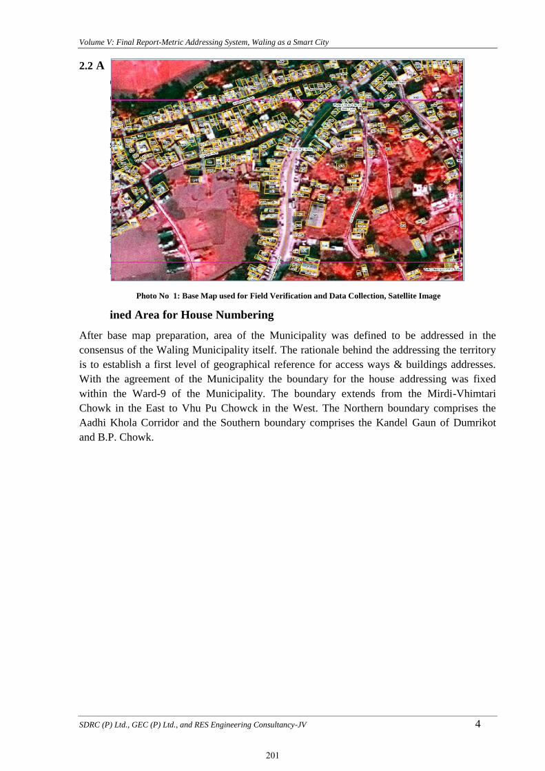
Volume V: Final Report-Metric Addressing System, Waling as a Smart City
SDRC (P) Ltd., GEC (P) Ltd., and RES Engineering Consultancy-JV 4
2.2 A
d
d
r
e
s
s
i
n
g
D
e
f
ined Area for House Numbering
After base map preparation, area of the Municipality was defined to be addressed in the
consensus of the Waling Municipality itself. The rationale behind the addressing the territory
is to establish a first level of geographical reference for access ways & buildings addresses.
With the agreement of the Municipality the boundary for the house addressing was fixed
within the Ward-9 of the Municipality. The boundary extends from the Mirdi-Vhimtari
Chowk in the East to Vhu Pu Chowck in the West. The Northern boundary comprises the
Aadhi Khola Corridor and the Southern boundary comprises the Kandel Gaun of Dumrikot
and B.P. Chowk.
Photo No 1: Base Map used for Field Verification and Data Collection, Satellite Image
201

Volume V: Final Report-Metric Addressing System, Waling as a Smart City
SDRC (P) Ltd., GEC (P) Ltd., and RES Engineering Consultancy-JV 5
Photo No 2: Defined area on Satellite Image for House Numbering
2.3 Access Way Identification and Naming.
The first step taken is to identify the access way on the prepared base map and its verification
on the ground. A clear starting and ending point is identified for every access way with the
local participation and the assistance of the municipality and the concerned ward. In principle,
the exact starting point of an access way is the intersection point of the centre-lines of two
access way. The ending point is the junction point of other access way. The identification of
the starting point also defines the origin for building numbering in metric system. A starting
point, by definition is located on the western side of an access way if it is aligned in east-west
direction, referring to the north orientation. If the access way is north-south aligned, then the
starting point is on the southern side. If the alignment of an access way is not exactly north-
south or east-west, the starting point is defined by the angle by which the access way deviates
from the north-south or east-west line. If the angle is smaller than 45˚ referring to the north-
south line, the starting point is the point in the southern side. If the angle is 45˚ or smaller
referring to the east-west line, the starting point is at the eastern side of the access way.
The designation of access way names is done by adopting participatory appraisal approach
with an active participation of local people and authorities. Upon the request of the
municipality and technically supported by the consultant, each ward organized ward level
meetings to identify the origin and the end points of the access ways and designate a
commonly used names of each identified access ways. In practice, access ways are designated
with names (terminologies) of deities and mythical figures, popular figures, martyrs, people's
movements, popular spot or location and other cultural terminologies. Certain naming
convention should be followed such that the name would not offend certain group of people or
prove to be controversial. Following are the points to be considered in the designation of the
names:
202
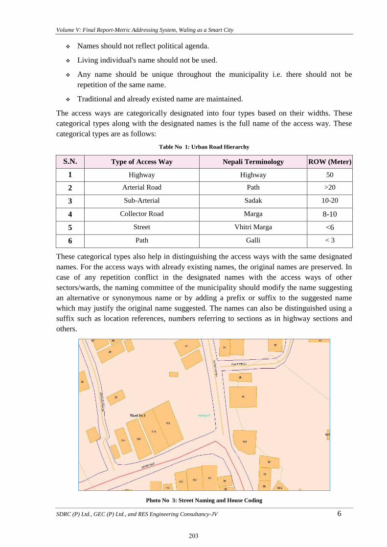
Volume V: Final Report-Metric Addressing System, Waling as a Smart City
SDRC (P) Ltd., GEC (P) Ltd., and RES Engineering Consultancy-JV 6
Names should not reflect political agenda.
Living individual's name should not be used.
Any name should be unique throughout the municipality i.e. there should not be
repetition of the same name.
Traditional and already existed name are maintained.
The access ways are categorically designated into four types based on their widths. These
categorical types along with the designated names is the full name of the access way. These
categorical types are as follows:
Table No 1: Urban Road Hierarchy
S.N. Type of Access Way Nepali Terminology ROW (Meter)
1 Highway Highway 50
2 Arterial Road Path >20
3 Sub-Arterial Sadak 10-20
4 Collector Road Marga 8-10
5 Street Vhitri Marga <6
6 Path Galli < 3
These categorical types also help in distinguishing the access ways with the same designated
names. For the access ways with already existing names, the original names are preserved. In
case of any repetition conflict in the designated names with the access ways of other
sectors/wards, the naming committee of the municipality should modify the name suggesting
an alternative or synonymous name or by adding a prefix or suffix to the suggested name
which may justify the original name suggested. The names can also be distinguished using a
suffix such as location references, numbers referring to sections as in highway sections and
others.
Photo No 3: Street Naming and House Coding
203

Volume V: Final Report-Metric Addressing System, Waling as a Smart City
SDRC (P) Ltd., GEC (P) Ltd., and RES Engineering Consultancy-JV 7
Photo No 4: House Numbering with Respect to Junction
2.4 Building/House Identification and Doorway Numbering
Metric house addressing system is followed for building doorway/entrance numbering. Under
this system, house address numbers represent the distance in meters from the street's "point
zero" to each individual building's main entrance. These are the following rules for allotting
the numbers to the buildings.
A unique number is given to every building currently used for human dwelling and
other purposes. Each and every main entrance of the buildings is numbered. The
number given to the building main entrance is the measured distance in meters from the
starting point of an access way to the middle of the building's main entrance along that
access way.
Even and odd numbers are allotted to the buildings. Odd numbers are assigned to
buildings on the left side of an access way (with reference to the east-west and south-
north directions). Even numbers are assigned to the buildings on the right side. A right
side building with an entrance at a distance of 10 meters from the starting point of the
access way is allotted as number 10. If a right side building has an entrance at a
distance of 13.5 meters from the starting point, the building is allotted number 14,
while for a left side building the number is 13 or 15. Likewise for the right side
building with an entrance at 19 meters from the starting point of the access way, the
number is 18 or 20. Similarly, rounding off to the nearest even or odd numbers are
applied to the fractioned distances on the right or the left side respectively of an access
way. In all cases consistency has to be maintained strictly.
As every building is defined by the main entrance the number allotted is only one. If a
building has two or more independent entrances (either to one or more access ways),
one of the entrance is selected as the main entrance and is allocated the main building
number. If the various entrances give access to units that are owned by different
owners, each entrance is given a unique number.
Plots which are vacant are assigned a number until the building permit is awarded. It is
the duty of the owner to procure a number assigned by the concerned department or
unit of municipality before the building is constructed. The owner of the building shall
apply for the building number following the due process at the time for building permit
application. The municipal addressing unit shall visit the construction site and measure
the
204

Volume V: Final Report-Metric Addressing System, Waling as a Smart City
SDRC (P) Ltd., GEC (P) Ltd., and RES Engineering Consultancy-JV 8
distance from the starting point of the adjacent access way. Based on this measured
distance, a temporary.house number certificate is issued to the owner. The owner then
shall apply for a permanent house number plaque and shall place the main entrance
after the construction of the building.
2.4.1 Building Patterns and Numbering
Besides the above general rules for building identification and enumeration, there are few
other types of building numbering flow, which are presented below with illustrations to make
it more simple and illustrative.
Linear Pattern:A simple building numbering flow.
Infill &Subdivision:The building numbering in case of infill of vacant land and subdivision of
existing buildings is exemplified in the following ways. There was a vacant land in between
23 number
building land and
49 number
building. A
building has come
up in that
vacant land with
the main gate 31
meter from the
junction. So 31
number is
assigned for that
house. The plot
again
subdivided with another house having another gate at 33 meter. Here 33 number is assigned to
the new house coming at subdivided plot.
205

Volume V: Final Report-Metric Addressing System, Waling as a Smart City
SDRC (P) Ltd., GEC (P) Ltd., and RES Engineering Consultancy-JV 9
Photo No 5: Linear, Vacant land and Subdivision Pattern
Crisscross Pattern:
The building numbering flow in the case of a crisscross pattern. The numbering flow follows
the access way's starting and ending points.
Square and Courtyard:
In case of buildings, which are accessed through a square or courtyard. In case of an open
square of a size equal or larger than 25 x 25 meters, the building numbering will be clockwise
with references to the north orientation. This is shown in Figure 6.
In an access way with a circle pattern that has a garden, shrine or pond at the center, the only
entrance to the main access way is both a starting and ending point. A number is assigned to
the entrance of the access way, and complement numbers are assigned to all buildings as they
are measured from the entrance of the access way. The buildings shall be numbered in a
clockwise direction, taking into account the odd and even rule. If an access way with a circle
pattern has buildings at its center, odd numbers will be given to the buildings at outer ring and
even numbers to those at the center.
206
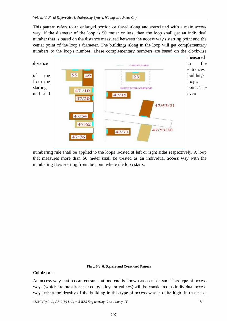
Volume V: Final Report-Metric Addressing System, Waling as a Smart City
SDRC (P) Ltd., GEC (P) Ltd., and RES Engineering Consultancy-JV 10
Photo No 6: Square and Courtyard Pattern
This pattern refers to an enlarged portion or flared along and associated with a main access
way. If the diameter of the loop is 50 meter or less, then the loop shall get an individual
number that is based on the distance measured between the access way's starting point and the
center point of the loop's diameter. The buildings along in the loop will get complementary
numbers to the loop's number. These complementary numbers are based on the clockwise
measured
distance to the
entrances
of the buildings
from the loop's
starting point. The
odd and even
numbering rule shall be applied to the loops located at left or right sides respectively. A loop
that measures more than 50 meter shall be treated as an individual access way with the
numbering flow starting from the point where the loop starts.
Cul-de-sac:
An access way that has an entrance at one end is known as a cul-de-sac. This type of access
ways (which are mostly accessed by alleys or galleys) will be considered as individual access
ways when the density of the building in this type of access way is quite high. In that case,
207

Volume V: Final Report-Metric Addressing System, Waling as a Smart City
SDRC (P) Ltd., GEC (P) Ltd., and RES Engineering Consultancy-JV 11
numbering of buildings will start from the point where the access way starts, following the
odd and even rule for left and right side buildings. When cul-de-sacs have low density of the
building, buildings will get complementary numbers. In the figure 8. Cul-de-sac has low
density so it is considered as the continuity of which starts from 47 meter from main junction.
Another sub branch that starts at 53 meter gets the numbering as sub branch of first branch of
Campus Marg. In this cases second oblique are used in numbering the houses.
Building Cluster:
A cluster of buildings located within a compound with an entrance shall be allocated a number
for the compound according to the general building numbering rule. Each unit inside the
compound shall be allocated complementary numbers. The complementary number is shown
as [Building no./complementary no.] or [Building no.- complementary no.].
Subdivided Buildings:
If a building is subdivided into more than one unit (such as apartments or shops), a
complementary identification number shall be added to main building number to identify the
subdivided units.
Public Squares, Traffic Islands and Roundabouts:
Buildings around public squares, large traffic island and roundabouts are numbered with
reference to the starting point taken at the entrance of the square/roundabout where the most
prominent/important street converges. The numbering is done progressively in clock-wise
direction.
2.4.2 Special Cases of Building/House Numbering
These are some special cases of buildings and houses that needs to be treated differently
during numbering. Before numbering, these cases should be addressed implicitly with the
understanding of the concerned parties and the approval of the municipality. Such special
cases are:
Disputed houses (houses with family dispute).
Illegally built buildings/houses (buildings without legal permits).
Buildings such as "Patis" and "Dharmasala," generally owned by certain "guthi" or
temple.
Buildings/houses in illegal settlement.
208

Volume V: Final Report-Metric Addressing System, Waling as a Smart City
SDRC (P) Ltd., GEC (P) Ltd., and RES Engineering Consultancy-JV 12
CHAPTER 3:- Introduction of Study Area
3.1 Walling an Overview
Waling city lies in Syangja District of Gandaki Province along the North-South Siddhartha
Highway. This city is the center of Waling Municipality. Waling was declared municipality by
annexing all wards of former Waling Municipality, Majhkot Shivalaye V.D.C,Aladi V.D.C,
Jagatbhangyanj V.D.C, Kewarebhangyaj V.D.C, Sirsekot V.D.C, Thumpokhara V.D.C, and.
during local level restructuring, Changchangdi V.D.C (Ward 1,4-5), Malyangkot V.D.C(ward-
4),Tindobate V.D.C (Ward 2-5),Kalikot V.D.C (Ward 1,2,9), Pelakot V.D.C (Ward 5,6),
Swarek V.D.C (Ward 2-4,8),Changchadi V.D.C.
According to the Population Census 2068, Waling Municipality has 51,243 population with
22,580 male and 28,663 female. The municipality has 14 wards and 128.40 square km area. In
Fiscal year 2074/75, municipality has conducted a survey in support of Asian foundation to
understand the demographic features and other status of the municipality and its inhabitants.
The study showed that the Municipality has its present population 45,603 with 21,108 male
(46.3 %) and 24,500 female (53.7%) and none of the population were 3rd gender. At the same
time 7,910 seems to be absent during household survey. The study area is Waling Bazar area
of ward no.9.
(Source: Waling Municipality, 2018)
3.2 History of Waling
There are a number of stories about origin of the word Waling. One of them mentions it to be
derived from the word wali- the monsoon folk songs sung by women in fields while planting
paddy. Waling is famous for its unending paddy fields on the plains along banks of
Aandhikhola Riverand the undulating terraces in mountain slopes that are crisscrossed by
numerous creeks. Many people used to come to watch these festive women groups singing
waliand planting paddy beautifully in unison in the monsoon drizzle.
209
Volume V: Final Report-Metric Addressing System, Waling as a Smart City
SDRC (P) Ltd., GEC (P) Ltd., and RES Engineering Consultancy-JV 13
The town itself is on the banks of river Aandhikhola that flows west along the valleys and
gorges in the western lesser himalayan mountains to meet the famous Kali Gandakiriver.
Mythology dates back the origin of Aandhikhola to the ancient time of Treta Yuga described
in Hindu Puranasduring the period of King Dasharatha, the father of Lord Ram of Ramayana.
During that time, a pious and aged blind couple had a devoted son named Shrawan Kumar.
The old couple wished a pilgrimage before their death and Shrawan Kumar was on journey
carrying them on his shoulder to fulfill their desire. On the way in a forest near Himalaya, his
parents became very thirsty. He left them in a comfortable tree shade and rushed to a nearby
river promising to return soon with water. As he hurriedly plunged his pitcher in the water, it
produced a noise like that of a wild animal. King Dasaratha was hunting nearby and happened
to hear the sound. The king could shoot his target without seeing the target only with guidance
of sound. He assumed the sound to be of a wild beast and shot his arrows in the direction. As
he arrived, he saw a young man lying dead with his arrow piercing his chest. He then saw the
pitcher and immediately realized his mistake. The guilt-ridden king quietly carried water to
the old couple but they demanded to know about their son before drinking it. When he told
them about his mistake resulting in their son's death, they began to cry and died in the spot
leaving behind a pool of tears which transformed into a small lake. A stream began to flow
from this lake. The term 'Aandhi' means 'blind' and 'khola' means 'river' in nepali language.
Thus this new river got its name as Aandhikhola referring to tears of Shrawan Kumar's blind
parents.
(Source: Waling Municipality, 2018)
3.3 Existing Physical situation
3.3.1 Geographical Characteristics
It is situated between 713 meter- 1596 meter above the sea level in the fold of the mountains
that are considered part of inner lesser Himalayain Syangja district of western Nepal. The
geology of inner Lesser Himalayan rocks constituting the Kusma-Syangja area in western
Nepal are separated into the Lower Nawakot Group, Upper Nawakot Group, Sirkot Group,
and Tansen Group, respectively from bottom to top.
Natural and artificially promoted erosion and slope instability in those hill and mountain area
are drastically threatening the ecological balance. A geological study of rock structure and
slope stability study of Walling area done in 1981 described a potential risk mapping method
that was quick, giving a good picture of the condition of the terrain and based only on the
relationship between the rock structure and topography.
Syangja district has been described as one of the most disaster-prone areas in western Nepal.
The geological and climatic condition have resulted in extremes of landslides, debris
flow, flooding and wildfires. Most of the disasters have been natural and in the recent years,
there is some evidence of increase of flooding, land sliding, deforestation and land
degradation. The district ranked second highest, along with Makawanpur, with the total
number of landslide events occurred during the period 1971–2000 being 46. It also ranked
highest in terms of landslide density and loss of property compared to other districts.
Landslides at Dhanubase (Dhanubaseko pahiro) is a major vulnerable hotspot in Waling area.
210

Volume V: Final Report-Metric Addressing System, Waling as a Smart City
SDRC (P) Ltd., GEC (P) Ltd., and RES Engineering Consultancy-JV 14
Map No 1: Location map, Metric Adressing
Waling falls under the very high hazard probability area according to the Syangja district
disaster management plan
3.3.2 Physical Location
Wailing Municipality is located in the North -west of Kathmadnu and Southern part of
Province No.4 and covers an area of around 128.40 square kilometres. Topographically
Municipality entails 28°3’20412‟ N and 83°41’36.85‟ E to 27°55’26.58‟ N and
83°50’18.45‟ E . Andhi Khola, Armdi Khola, Mirdi Khola,Baya khola, Chyangdi Khola are
major river flowing through the Municipality. Further, Municipality lies in between Gyalyang
Municipality; one of the Business centered municipality of Syanja District.
WM is located 293 km North-west from Kathmandu, 64 km south from Pokhara, 96 Km north
from Butwal, 115 kmsouth from Bhairahawa.The study area is a developing part of the Syanja
district next to district headquater Putalibazzar. The basic infrastructures available in the area
at present are transportation, drinking water, solid waste management, electricity and
telecommunication but these infrastructures in poor condition.
Table No 2: Political Boundary, Waling Municipality
East : Biruwa Rural Municipality and Chapakot Municipality
West : Galyang Municipality and Parvat District
North : Bhirkot Municipality
211

Volume V: Final Report-Metric Addressing System, Waling as a Smart City
SDRC (P) Ltd., GEC (P) Ltd., and RES Engineering Consultancy-JV 15
South : Galyang Municipality and Chapakot Municipality
3.4 Major Settlements
The settlement of the town follows linear (Ribbon) development pattern in the municipal
center, Waling bazar and other market areas such as Triyasi, Rambachha, Bhumre, Bhakunde
and Bayatari along the Sidhhartha Highway. The other settlements in each wards are scattered
with low population density. The buildings constructed along the highway are mostly RCC
framed structures and use for commercial and residential purposes. The urban roads access is
sufficient but road width is narrow than standards. Most of the roads have been blacktopped
with drainage network. Water supply distribution by Sana Sahari Khane Pani Projects and
others local spouts, spring sources, lifting projects in the locality. Municipal has been
collecting solid waste from markets area by door to door collection. The collected wastage has
been segregated at Waling Sarsafai Kendra. The residents along the highway is high
population density and the altitude of low land topography.
Photo No 7: Ribbon Settlement, Waling Tallo Bazar
Photo No 8: Commercial Area, Waling Bazar Along the
Highway
3.5 Socio-Economic and Demographic Status
Waling Municipality is following the way of urbanization, modernization and development as a smart
city. Local people involvement in economic activities includes for inclusion, participation, open
markets claim to more freedoms, more choices and more options. Local government is expecting to
change the socio economic development process with guaranteed right, economic decentralization,
shifting resources to pooper geographic. Waling municipality has tried to address skills, knowledge
and expertise of the local people in the process of socio-economic development. Local government has
provided trainings, skills, knowledge and expertise to backwards groups, women and youth as well in
poverty reduction, employment generation, gender equality with technical assistance, monitoring and
evaluation.
Change in population impacts in its future population andrequirement of infrastructures like
physical, social, economic, environmental etc.Demography of the city helps to forecast the
population changes pattern and its proper management. Total Population, population
density,household structure, literacy rate status, health, education., economic status, existing
infrastructures, topography, climates changes, environment conditions, natural resources, and
their characteristics are some of the major pillar for better understanding of the locality.
3.5.1 Population and Density
212

Volume V: Final Report-Metric Addressing System, Waling as a Smart City
SDRC (P) Ltd., GEC (P) Ltd., and RES Engineering Consultancy-JV 16
According to the census of 2011, the population of Waling Municipality is 51,243 But, the
household survey conducted by municipality in 2018 A.D. has verified the actual population
is 45,608 living in 11,357 households.Comparing the male female ratio of the total population
shows that, 46.3 % (21,108) are male and 53.7% (24,500) while 7,910 seems to be absent.
The population density of the municipality is 463 people per square kilometers, which is
higher than the population density of Syangja district. The average family size of the
municipality is around 4.01 while average family size of whole district is 4.20 (Source: CBS 2011).
As seen from the Table and Chart below, there is distinct variation in population distribution
among 14 wards. Population density lies in the range of 166 person per sq.km. in ward 3,4 to
1834 person per sq. km in ward 9, Waling Bazar area, where city center lies. Less population
density is witnessed in Ward 3,7,12 having population density of just 166 , 205 and 207
respectively, whereas higher population density is witnessed in the ward 9,1,2,8 followed by
ward 10.The socio-demographic details of each wards has been given in Table No.3, below.
Table No 3: Description of Demography and Household
Ward
No
Total
Households Male Female Total
Sex
Ratio
Avg.
Household
Area
(Sq.km)
Density
(per Sq.km)
1 851 1,739 1,852 3,591 93.9 4.22 3.94 911
2 534 1,055 1,206 2,261 87.48 4.23 4.43 510
3 346 672 568 1,240 118.31 3.58 7.46 166
4 512 892 1,048 1,940 85.11 3.79 11.7 166
5 575 1,153 1,265 2,418 91.15 4.21 8.07 300
6 748 1,480 1,626 3,106 91.02 4.15 6.71 463
7 513 990 1,109 2,099 89.27 4.09 10.23 205
8 1,425 2,422 2,830 5,252 85.58 3.69 11.05 475
9 1,732 2,929 3,599 6,528 81.38 3.77 3.56 1834
10 724 1,438 1,618 3,056 88.88 4.22 7.74 395
11 690 1,187 1,498 2,685 79.24 3.89 9.75 275
12 619 1,159 1,456 2,615 79.6 4.22 12.63 207
13 981 1,967 2,308 4,275 85.23 4.36 13.16 325
14 1,116 2,025 2,517 4,542 80.45 4.07 17.98 253
Total 11,366 21,108 24,500 45,608 86.16 4.01 128.41 463
Source: Waling Municipality (Household Survey,2018)
213
Volume V: Final Report-Metric Addressing System, Waling as a Smart City
SDRC (P) Ltd., GEC (P) Ltd., and RES Engineering Consultancy-JV 17
Chart No 1: Population and Density
0
2000
4000
6000
8000
1 2 3 4 5 6 7 8 9 10 11 12 13 14
Po
pu
lati
on
Ward No
Ward No Male Female Total Population
0
5
10
15
20
1 2 3 4 5 6 7 8 9 10 11 12 13 14
Ward No
Avg. Household Ward Wise Area (Sq.km)
0
500
1000
1500
2000
1 2 3 4 5 6 7 8 9 10 11 12 13 14
Ward No Density (per Sq.km)
0
20
40
60
80
100
120
140
1 2 3 4 5 6 7 8 9 10 11 12 13 14
Ward No Sex Ratio
214

Volume V: Final Report-Metric Addressing System, Waling as a Smart City
SDRC (P) Ltd., GEC (P) Ltd., and RES Engineering Consultancy-JV 18
3.5.2 Population Distribution by Age Group
Population classification by age is a good way to depict the age and gender distribution of a population. The population from 2018 show the age
structure of the population. Demographic changes have implications for changes in family and household structure.
The population distribution by Age Group has been presented in Table No. 4, below. The data of ward no 9 is main concern for the study.
Table No 4: Population Distribution by Age Group
Wa
rd N
o
0-4
5-9
10
-14
15
-19
20
-24
25
-29
30
-34
35
-39
40
-44
44
-49
50
-54
54
-59
60
-64
64
-69
70
-74
ab
ov
e 70
No
t
Men
tio
ned
To
tal
Per
cen
tag
e
1 188 287 315 380 335 360 303 252 214 192 202 152 118 98 87 108
3,591 7.87
2 142 175 225 280 211 165 122 123 124 130 132 103 77 83 63 106
2,261 4.96
3 52 61 111 100 120 117 106 107 77 74 60 56 62 53 27 57
1,240 2.72
4 138 128 214 208 146 120 102 107 108 105 107 72 120 100 76 89
1,940 4.25
5 171 165 210 271 236 253 151 129 112 139 130 99 108 79 86 77 2 2,418 5.30
6 171 243 297 360 290 260 210 213 183 174 191 115 129 86 87 97
3,106 6.81
7 148 168 195 194 187 209 136 101 105 88 117 114 108 88 55 86
2,099 4.60
8 357 451 530 521 464 485 442 395 328 311 240 192 179 132 96 125 4 5,252 11.52
9 469 644 698 676 641 598 473 515 369 308 306 206 196 169 106 154
6,528 14.31
10 212 253 328 330 320 307 208 204 169 163 146 106 87 90 43 90
3,056 6.70
11 212 180 252 284 279 184 129 135 108 154 163 145 129 120 83 128
2,685 5.89
12 169 191 225 308 251 196 145 148 139 145 133 145 123 116 69 112
2,615 5.73
13 336 343 441 475 440 350 268 232 250 204 221 188 165 134 99 129
4,275 9.37
14 325 301 449 528 478 290 255 230 231 182 249 271 219 215 150 169
4,542 9.96
Total 3,090 3,590 4,490 4,915 4,398 3,894 3,050 2,891 2,517 2,369 2,397 1,964 1,820 1,563 1,127 1,527 6 45,608 100.00
Source: Waling Municipality(Household survey,2018
215

Volume V: Final Report-Metric Addressing System, Waling as a Smart City
SDRC (P) Ltd., GEC (P) Ltd., and RES Engineering Consultancy-JV 19
Chart No 2: Population Distribution by Age Group, Ward-9
3.5.3 Economically Active and Inactive Population
Economically active population accounts to the population falling in the age group between 15
to 59. Similarly the inactive population accounts population below 15 and above 59. The
comparison of active and inactive population of the municipality has been tabled in Table No.
5, below.
Table No 5: Active and Inactive Population
Population Male Female Total Percentage
Active Population
(Between 15-59) 9903 13577 23480 51%
Inactive Population
(Below 15 And Above 59) 11205 10923 22128 49%
Source: Waling Municipality(Household survey,2018)
Chart No 3: Economically Active and Inactive Population
Economically active population of the Municipality is 23,480 which accounts to 51% of the
total population. Similarly the inactive population is 22,128 which accounts to 49 %. The
information shows that there is almost balanced population in between active and inactive
population. Although more percentage of population is seen to be economically active because
population above are considered as inactive while at present scenario up to age 65 people are
0-4, 469
5-9, 644
10-14, 698
15-19, 676
20-24, 64125-29, 59830-34, 473
35-39, 515
40-44, 369
44-49, 308
50-54, 306
54-59, 206
60-64, 196
64-69, 169 70-74, 106 above 70, 154
Population by Age Group
0-4
5-9
10-14
15-19
20-24
25-29
30-34
35-39
40-44
Ward 9
Age-Years
51%
49%
Economic Active and Inactive Population
Active Population (Between 15-59) Inactive Population (Below 15 And Above 59)
216

Volume V: Final Report-Metric Addressing System, Waling as a Smart City
SDRC (P) Ltd., GEC (P) Ltd., and RES Engineering Consultancy-JV 20
found to be active. Most of the economically active population is found to involve in sectors
like agricultural. A few percentage of the population is involved in service sector , business
and labor. The most of the people from the study area has engaged in business sector.
3.5.4 Population by Ethnicity and Caste
The ethnicity and caste pattern of the municipality shows diversity with major ethnic groups
as Bhramin (32.48 %), Magar (17.77 %), Gurung (12.75 %), Chhetri (10.19 %) , Sarki
(6.11%) Besides these ethnic groups other various groups comprises small proportions of the
population such as, Gharti (1.02 %),Kathawoniya (0.91%).The remaining other ethnic and
caste group like muslim, Bote, Dome, Majhi etc. Comprises about 3.00 % of the total
population which is illustrated in the Table No.6, below. The population by ethnicity and cast
composition of study area (Ward no-9) has been illustrated in Chart No.5, below.
217

Volume V: Final Report-Metric Addressing System, Waling as a Smart City
SDRC (P) Ltd., GEC (P) Ltd., and RES Engineering Consultancy-JV 21
Table No 6: Ethnicity and Caste Composition
Caste Ward No.
Total Percentage 1 2 3 4 5 6 7 8 9 10 11 12 13 14
Bhramin 1,446 716 18 347 356 1,268 184 2,166 1,871 1,028 1,029 926 1,739 1,719 14,813 32.48
Magar 275 424 0 47 353 764 945 888 1,156 1,034 554 394 533 737 8,104 17.77
Gurung 699 63 1,161 825 166 254 300 361 601 198 0 867 278 40 5,813 12.75
Chhetri 384 142 3 560 693 293 50 462 698 90 437 133 53 650 4,648 10.19
Sarki 74 637 0 10 154 56 348 85 404 124 137 43 275 439 2,786 6.11
Kami 202 36 47 69 184 127 134 204 477 120 200 164 255 250 2,469 5.41
Damai 136 90 10 53 29 123 92 206 94 26 121 83 65 150 1,278 2.80
Newa 46 0 0 0 6 20 0 195 524 132 53 0 23 190 1,189 2.61
Thakuri 28 4 0 23 116 125 15 227 156 198 116 0 0 41 1,049 2.30
Muslim 21 0 0 0 328 4 0 162 15 0 0 0 22 1 553 1.21
Gharti 6 74 0 6 0 24 12 67 14 9 8 0 235 9 464 1.02
Kathawoiya 0 0 0 0 0 0 0 0 0 0 0 0 414 0 414 0.91
Other 274 75 1 0 31 48 19 189 513 97 30 5 383 316 1,981 4.34
Foreigners 0 0 0 0 0 0 0 36 5 0 0 0 0 0 41 0.09
Total 3,591 2,261 1,240 1,940 2,418 3,106 2,099 5,252 6,528 3,056 2,685 2,615 4,275 4,542 45,608 100.00
Source: Waling Municipality (Household survey, 2018)
218

Volume V: Final Report-Metric Addressing System, Waling as a Smart City
SDRC (P) Ltd., GEC (P) Ltd., and RES Engineering Consultancy-JV 22
Chart No 4: Ethnicity and Caste Composition
Chart No 5: Ethnicity and Cast Composition at Study Area, Ward No-9
3.5.5 Population Based on Mother Tongue
Out of 45,608 populations in municipality, about 85.40% of the population speak Nepali
language, 6.69% speaks Gurung language which counts 3,051 populations, Magar and Newar
language is spoken as third and fourth language which account 6.0 % and 0.55% respectively.
The detailed description of mother tongue language has been listed in Table No.7 and Chart
below.
Table No 7: Population Distribution based on Mother Tongue
Ward
No.
Nep
ali
Ma
ga
r
Gu
run
g
New
ar
Ta
ma
ng
Ra
i
Sa
nsk
rit
Ma
ith
ali
Bh
ojp
uri
Th
aru
No
t M
enti
on
ed
Oth
er
To
tal
1 2,691 171 460 33 134 0 3 73 5 0 0 21 3,591
2 2,158 90 6 0 0 0 2 5 0 0 0 0 2,261
3 77 0 1,162 0 1 0 0 0 0 0 0 0 1,240
4 1,525 19 386 2 0 0 1 6 0 1 0 0 1,940
14,813
8,104
5,8134,648
2,786 2,4691,278 1,189 1,049 553 464 414
1,981
410
2,000
4,000
6,000
8,000
10,000
12,000
14,000
16,000
Po
pu
lati
on
Ethnicity and Cast
Ethnicity and Cast Composition in Municipality
Bhramin Magar Gurung Chhetri Sarki Kami Damai
Newa Thakuri Muslim Gharti Kathawoiya Other Foreigners
Bhramin, 1,871
Magar, 1,156
Gurung, 601
Chhetri, 698Sarki, 404Kami, 477
Damai, 94
Newa, 524
Thakuri, 156
Muslim, 15
Gharti, 14
Kathawoiya, 0
Other, 513
Foreigners, 5
219

Volume V: Final Report-Metric Addressing System, Waling as a Smart City
SDRC (P) Ltd., GEC (P) Ltd., and RES Engineering Consultancy-JV 23
Ward
No.
Nep
ali
Ma
ga
r
Gu
run
g
New
ar
Ta
ma
ng
Ra
i
Sa
nsk
rit
Ma
ith
ali
Bh
ojp
uri
Th
aru
No
t M
enti
on
ed
Oth
er
To
tal
5 2,401 4 1 0 0 0 0 1 1 1 2 7 2,418
6 3,044 0 51 0 0 0 0 6 3 2 0 0 3,106
7 879 895 304 0 1 0 4 1 10 5 0 0 2,099
8 4,452 348 148 113 0 8 54 27 18 20 5 59 5,252
9 6,086 227 163 17 1 0 15 9 7 3 0 0 6,528
10 2,246 660 94 49 0 0 2 2 3 0 0 0 3,056
11 2,677 0 0 0 0 0 1 4 0 3 0 0 2,685
12 2,604 0 1 0 0 0 3 3 1 3 0 0 2,615
13 3,657 322 275 0 0 0 0 4 2 11 0 4 4,275
14 4,453 0 0 39 0 0 3 9 0 38 0 0 4,542
Total 38,950 2,736 3,051 253 137 8 88 150 50 87 7 91 45,608
% 85.40 6.00 6.69 0.55 0.30 0.02 0.19 0.33 0.11 0.19 0.02 0.20 100.00
Chart No 6: Population Distribution based on Mother Tongue
Source: Waling Municipality (Household Survey, 2018)
Chart No 7: Population Distribution based on Mother Tongue, Study Area
38,950
3,051 2,736253 150 137 88 87 50 8 98
0
10,000
20,000
30,000
40,000
50,000
Nepali Gurung Magar Newar Maithali Tamang Sanskrit Tharu Bhojpuri Rai Other
Po
pu
lati
on
Language
Nepali, 6,086
Gurung, 227
Magar, 163
Newar, 17
Others, 35
Nepali Gurung Magar Newar Others
Ward 9
220

Volume V: Final Report-Metric Addressing System, Waling as a Smart City
SDRC (P) Ltd., GEC (P) Ltd., and RES Engineering Consultancy-JV 24
Male ,
91%
Male ,
9%
Female,
83%
Female,
17%
Literate
IlliterateWard 9
Male ,
39.34 %
Male ,
6.34 %
Female,
40.41 %
Female,
13.91 %
Literate
Illiterate
Chart No 9: Literacy Status, Study Area Chart No 8: Municipal Literacy Status
3.5.6 Literacy Status
The literacy rate of the population in the municipality is 78 percent. The literacy is
characterized by higher proportion of literate female than male and accounts39.47% and
38.53% of total literate population respectively.
Table No 8: Literacy Status of Municipality
Gen
der
Read and Write Read Only Illiterate N/A Total
Population % Population % Population % Population %
Male 16,383 38.53 344 0.81 2,684 6.31 12 0.03 19,423
Female 16,783 39.47 398 0.94 5,910 13.90 4 0.01 23,095
Total 33,166 78.00 742 1.75 8,594 20.21 16 0.04 42,518
Table No 9: Literacy Status of Study Area
Wa
rd
No
Gen
der
Read and Write Read Only Illiterate Total
Population % Population % Population %
9
Male 2,404 39.68 30 0.50 245 4.04 2,679
Female 2,741 45.24 60 0.99 579 9.56 3,380
Total 5,145 84.92 90.00 1.49 824.00 13.60 6,059
Source: Waling Municipality (Household Survey, 2018)
3.6 Lan Use
The land use means that the land covered by different aspect like forest, water bodies, built up
area etc. In the well planned city, the land is used properly as per requirement of the city with
sustainable way. But, the Waling city is developing haphazardly with unplanned. The
delineated area is a core area and it is totally commercialized and residential area. The detailed
land use information has been listed in Table No.10 below.
221

Volume V: Final Report-Metric Addressing System, Waling as a Smart City
SDRC (P) Ltd., GEC (P) Ltd., and RES Engineering Consultancy-JV 25
Table No 10: Land Use
S.N. Land Use/Land Cover Area (sq.km.) Percentage (%)
1 Agriculture 0.19 40.56
2 Build-Up Area 0.26 55.25
3 Forest 0.02 4.03
4 Sand 0.0002 0.05
5 Water Bodies 0.0005 0.10
Total 0.46 100
Chart No 10: Land Use of the Study Area
3.7 Road and Transportation Networks
The transportation is the back bone of socio-economic development of the particular area. The
means of transportation may be roads, air, waterways, rail etc. Here, in this study is
concentrated on roadways only. The Road network feature dataset and associated database
includes different type of road in use, bridge and others.
The study area is Waling Bazar, ward no.9. The selected area is core market area of the
municipality and residential area as well. The road network and transportation facilities are
smooth and easy access in the study area. The area is delineated and metric addressing system
has been completed. The major component for the development of house numbering system is
urban roads identification and providing them unique names. The National Highway naming
Siddhartha Highway has passed via. the study area of length 1.508 km. All houses have been
good access with urban roads. The total length is 9. 028.km, where 5.919 km is black topped,
2.269 km is gravel and 0.597 km is earthen. The existing urban roads width is upto 12-25 ft.
and width of highway is about 30-40 ft. Buses, Tempo, Pickup, Bicycles etc. are major
transportation facilities in the area. The detailed information of transportation network has
been listed Table No 11 and 12 below.
Table No 11: Road Network
S.N. Road Name Length,Km Road Width Surface Types
Agriculture
40.56%
Built-Up Area
55.25%
Forest
4.04%
Sand
0.05% Water Bodies
0.10%
Land Use
Agriculture
Built-Up Area
Forest
Sand
Water Bodies
222

Volume V: Final Report-Metric Addressing System, Waling as a Smart City
SDRC (P) Ltd., GEC (P) Ltd., and RES Engineering Consultancy-JV 26
S.N. Road Name Length,Km Road Width Surface Types
1 Aadhikhola Corridor 0.169 20-24 ft Black Top
2 Aadhikhola Corridor 0.461 15-20 ft Gravel
3 Aadhikhola Corridor 0.119 15-20 ft Gravel
4 Aadhikhola Corridor 0.242 6-9 ft Foot Trail
5 Aadhikhola Corridor 0.042 12-15 ft Earthen
6 B.P. Marga 0.001 20-24 ft Black Top
7 B.P. Marga 0.084 20-24 ft Black Top
8 Banijya Tole Marga 0.076 20-24 ft Black Top
9 Banijya Tole Marga 0.047 20-24 ft Black Top
10 Biharthok Marga 0.065 12-15 ft Earthen
11 Bolbom Chowk-Nayabajar Marga 0.050 20-24 ft Black Top
12 City Hall Marga 0.108 15-20 ft Gravel
13 Dumrikot - B.P Chowk- Vhimtari-
Kharibot Sadak 0.241 20-24 ft Black Top
14 Jaycees Marga 0.182 20-24 ft Black Top
15 Joisi Pandera Marga 0.262 20-24 ft Black Top
16 Kataharbot Tole Marga 0.147 20-24 ft Black Top
17 Katauje-Nagarpalika Karyalaya -
Srawanda Kumar Park -Gyangling Sadak 0.213 20-24 ft Black Top
18 Katauje-Nagarpalika Karyalaya -
Srawanda Kumar Park -Gyangling Sadak 0.014 15-20 ft Gravel
19 Katauje-Nagarpalika Karyalaya -
Srawanda Kumar Park -Gyangling Sadak 0.241 15-20 ft Gravel
20 Kedarnath Marga 0.228 15-20 ft Gravel
21 Kedarnath Marga 0.242 20-24 ft Black Top
22 Nagarpalika Marga 0.075 20-24 ft Black Top
23 Nagarpalika Marga 0.168 15-20 ft Gravel
24 Nagarpalika Marga 0.205 20-24 ft Black Top
25 Nagarpalika Marga 0.033 20-24 ft Black Top
26 Nagarpalika Marga 0.087 20-24 ft Black Top
27 Namuna Marga 0.149 20-24 ft Black Top
28 Namuna Marga 0.062 20-24 ft Black Top
29 Nayabajar-Baidikhet Marga 0.222 15-20 ft Gravel
30 Nayabajar-Baidikhet Marga 0.239 15-20 ft Gravel
31 Nayabajar Marga 0.404 20-24 ft Black Top
32 Nayagaun Marga 0.297 20-24 ft Black Top
33 Odare-Pandhera-Bagale Danda Sadak 0.032 15-20 ft Gravel
223

Volume V: Final Report-Metric Addressing System, Waling as a Smart City
SDRC (P) Ltd., GEC (P) Ltd., and RES Engineering Consultancy-JV 27
Black Top
Gravel
EarthenFoot Trail
Black Top
Gravel
Earthen
Foot Trail
Chart No 11: Road Surface Types
S.N. Road Name Length,Km Road Width Surface Types
34 Patanjali Marga 0.214 15-20 ft Gravel
35 Pipalbot Tole Marga 0.063 20-24 ft Black Top
36 Sahakarya Marga 0.188 20-24 ft Black Top
37 Sahakarya Marga 0.162 15-20 ft Gravel
38 Sahakarya Marga 0.111 20-24 ft Black Top
39 Sahakarya Marga 0.385 20-24 ft Black Top
40 Siddhartha Rajmarga 1.508 30-40 ft Black Top
41 Sitalnagar-Surkhaundi Chowk Sadak 0.006 20-24 ft Black Top
42 Tallo Waling Bajar Marga 0.535 20-24 ft Black Top
43 Thumka Marga 0.355 12-15 ft Earthen
44 Vhu. Pu. Tole Marga 0.096 20-24 ft Black Top
45 Vhu. Pu. Tole Marga 0.083 12-15 ft Earthen
46 Waling Bajar Vitri Sadak 0.062 15-20 ft Gravel
47 Waling Bajar Vitri Sadak 0.053 12-15 ft Earthen
Total 9.028
Table No 12: Road Surface
Road Surface Length, Km %
Black Top 5.919 65.57
Gravel 2.269 25.13
Earthen 0.597 6.62
Foot Trail 0.242 2.68
Grand Total 9.028 100
3.8 Functional Use of Building
The study area is Waling bazar which seems core city area of the municipality. The
constructed buildings have been used for different aspects and requirements. The city is
business trade center and administrative center of the municipality. The buildings have been
occupying as residential, commercial, institutional etc. purposes. The detailed information of
functional purposes of buildings in the city has been listed in Table No.13 and Chart below.
Table No 13: Functional Use of Building
S.N. Functional Uses Numbers, Houses Remarks
1 Residential+Commercial 414
2 Residential 373
3 Commercial 50
4 Financial 35
224

Volume V: Final Report-Metric Addressing System, Waling as a Smart City
SDRC (P) Ltd., GEC (P) Ltd., and RES Engineering Consultancy-JV 28
S.N. Functional Uses Numbers, Houses Remarks
5 Temporary 25
6 Industrial 23
7 Community Buildings 12
8 Administrative 8
9 Educational 7
10 Health Service 5
11 Garage 4
12 Institutional 4
13 Others 2
Total 962
Chart No 12: Functional Use of Building
3.9 Building Ownership
Generally, a building can be defined as an enclosed structure intended for human occupancy.
However, a building includes the structure itself and non-structural components (e.g.,
cladding, roofing, interior walls and ceilings, electrical systems, sanitation etc.) permanently
attached to and supported by the structure. Majorly, the buildings are a RCC frame structure
with a roof and walls standing more or less permanently in one place, such as a house or
factory. Buildings come in a variety of sizes, shapes and functions, and have been adapted
throughout history for a wide number of factors, from building materials available, to weather
conditions, to land prices, ground conditions, specific uses and aesthetic reasons. Buildings
serve several needs of society- primarily as shelter from weather, security, living space,
privacy, to store belongings, and to comfortably live and work. A building as a shelter
represents a physical of the human habitat (a place of comfort and safety) and the outside (a
place that at times may be harsh and harmful).
According to field survey total building are 962 among them 926 are private, 24 Public and 12
are community buildings which have been listed in Table No.14 below.
414373
50 35 25 23 12 8 7 5 4 4 20
50100150200250300350400450
Nu
mb
ers,
Hou
se
Types of Services
Functional Use of Buildings
225

Volume V: Final Report-Metric Addressing System, Waling as a Smart City
SDRC (P) Ltd., GEC (P) Ltd., and RES Engineering Consultancy-JV 29
Chart No 13: Building Roofing Types
222
3
722
14
0
100
200
300
400
500
600
700
800
Nu
mb
ers
Types of Rooing Materials
Building, Roof Types
Jasta
Khar
RCC
RCC+Jasta
Table No 14: Building According to Ownership
S.N. Private Public Community Remarks
House 926 24 12
3.10 Building Types
Roof shapes and types differ greatly from region to region. The main factors which influence
the shape of roofs are the climate and the materials available for roof structure and the outer
covering. Usages vary slightly from region to region, or from one builder or architect to
another. According to roof type's buildings of study areaare categorized into CGI Sheet, Khar,
RCC etc. Among them there are 222 CGI sheet, Khar 14 and ,722 RCC buildings are present.
The detailed information has been listed in Table No.15 and Chart below.
Table No 15: Building Roofing Types
S.N. Roof Types Numbers Remarks
1 RCC 722
2 CGIs/Jasta 222
3 RCC+ CGIs 14
4 Khar 4
Total 962
226
Volume V: Final Report-Metric Addressing System, Waling as a Smart City
SDRC (P) Ltd., GEC (P) Ltd., and RES Engineering Consultancy-JV 30
3.11 Building Construction
The construction of building differs as economic condition & social status of people in
particular location. The main factors which influence the construction are materials available.
Usages vary slightly from region to region, or from one builder or architect to another.
According to construction of buildings of study area are categorized into Load bearing, frame
structure and Timber structure, Bamboo structure. The detailed information of building
construction on the basis of material use has been listed in Table No 16 and Chart below.
Table No 16: Building Construction, Material Uses
S.N. Construction Types Numbers
1 Kachi (Stone Masonary+Timber) 1
2 RCC+Jasta 1
3 RCC+Truss+Jasta 1
4 Timber+Jasta 1
5 Block+Truss 2
6 Kachi (Stone Masonry) 2
7 Truss+Jasta 3
8 Block+Jasta 4
9 RCC+Truss 7
10 Kachi (Mud Mortar) 8
11 Truss 8
12 Kachi (Block) 9
13 Kachi (Brick Masonary) 12
14 Jasta 16
15 Load Bearing 19
16 Kachi 34
17 Kachi (Stone Masonary) 51
18 Frame Structure (RCC) 783
Grand Total 962
227

Volume V: Final Report-Metric Addressing System, Waling as a Smart City
SDRC (P) Ltd., GEC (P) Ltd., and RES Engineering Consultancy-JV 31
Chart No 14: Building Construction, Material Uses
3.12 Water Supply and Electricity Distribution
Water supply and electricity distribution in the city is one of the main facility for the living
people. Electricity has been supplied by National Grid and water supply network by Small
Water Supply Scheme, spouts, rivers, lifting projects and spring sources. The water supply
network is not well planned in the city. The distribution line has been aligned along the road
side drain and which may pollute the drinking water any incident. The distribution is not
sufficient and people in city are facing drinking water and low voltage problems. The
electricity distribution cable has been stretched haphazardly which may make city un-
aesthetic. Also, such distribution system has created serious accidents like firing, electricity
shut down etc. The water supply and electricity distribution facility in each household detailed
has been listed in Table No 17. below.
Table No 17: Water Supply and Electricity
S.N. Service Facility Houses Remarks
1 Water Supply 962
2 Electricity 962
3.13 Importance of House Numbering System in Smart City
House and street metric system is a system in which each house and street has been given their
own name and unique code called house number. The system helps to find address as you
need. House numbers are not only convenient for finding addresses but necessary for
emergency responders to locate those in need. When responding to an emergency, minutes
matter so be sure that fire, ambulance, and police personnel, business service delivery can
easily and quickly find location and address thorough GPS machine. The system develops the
house numbering code plates which has been stitched in front of main gate, If the numbers on
such houses are not visible or easy to read, it will take emergency personnel longer to find
house. If there is no house number and street name, there should be spent extra minutes find
the location in the meantime there might be casualty in property, life and death. Therefore,
1 1 1 1 2 2 3 4 7 8 8 9 12 16 19 34 51
783
0
100
200
300
400
500
600
700
800
900
Nu
mb
ers,
Hou
se
Material Use
Building Construction
228

Volume V: Final Report-Metric Addressing System, Waling as a Smart City
SDRC (P) Ltd., GEC (P) Ltd., and RES Engineering Consultancy-JV 32
from house number and street naming, it is easy to find the location and prompt response in
emergency time. The system is itself new for the Waling municipality which helps making
smart city. Due to detail information of houses and owner includes in the house numbering
data base, the municipality can make quick decision on following points:
To provide infrastructure facilities,
To provide social security
Easy to provide safety to every citizen.
Easy to collect revenue
Easy to control haphazard development
Easy to provide digital information of the locality
Easy to prepare city map for tourist information
CHAPTER 4:- Conclusions
Geographic Information System is being very widely used as decision support tool in many
application domains in recent years. The advent of new and affordable technologies in data
capture, management and dissemination in the last decade has also played a pivotal role in
wide applicability of GIS and related technologies. Urban sector has also seen a fair share of
new developments and applications of geographical information technology. Development of
new tools and methods, Web-GIS technology, availability of very high-resolution commercial
satellite imagery and other new developments have opened up new perspectives in
applications of GIS in urban sector.
Study shows that most of the RCC buildings are concentrated along the Siddhartha Highway.
Among the 962 buildings surveyed in defined area for house numbering in Ward-9, 783
buildings are frame structured buildings, only 19 are load bearing type, 117 are Kachi which
includes Stone Masonry, Brick Masonry and Block Masonry, and remaining others are
temporary like jasta, truss etc. Every houses are found to be facilitated with Electricity and
Water Supply. Waling Municipality lacks the facility of street lights system and traffic
lights.Municipality lacks centralized water supply system. Sewerage system is absent in the
municipality. Septic tanks are used for sewerage disposal. Storm drainage system is present on
either side of black topped roads inside core area and Siddhartha Highway.
In this project, GIS has been developed as an integrated information system. Prior efforts have
been made to implement similar projects, as in the case of Kathmandu Metropolitan City,
which unfortunately have failed due to many impeding factors. The next step would be to
gradually integrate the system in the municipal planning and business functions and gradually
develop its human resources and institutional capacity towards fully automated and digital
municipality.
229

Volume V: Final Report-Metric Addressing System, Waling as a Smart City
SDRC (P) Ltd., GEC (P) Ltd., and RES Engineering Consultancy-JV 33
CHAPTER 5:- Recommendations
Sustainability is only sought if the system proves to be beneficial in terms of technology as
well as in term of finance. If the Municipal GIS technically helps to enhance municipal
functions as well as provide financial benefits. The following recommendations are made in
order for Municipal GIS to be self-sustained:
a) Internal Revenue Generation Through Data and Map Sales
Formulation of data share and sales policy within the municipality
Acquisition of data copyright and sales right from the Survey Department
Regulation of data shares and sell prices
Development of data and map sales service
Development of various thematic maps, street and tourist maps, heritage maps etc. for
publication and sales
b) Regular Refresher and Application Trainings
Regular refresher trainings to introduce new techniques and tools to GIS unit personnel
Application trainings to other technical and non-technical personnel to develop
theircapability to use GIS as a tool in their daily tasks
Trainings to executive level personnel in interpreting maps and spatial data for better
decision making
230

Volume V: Final Report-Metric Addressing System, Waling as a Smart City
SDRC (P) Ltd., GEC (P) Ltd., and RES Engineering Consultancy-JV 34
231

Volume V: Final Report-Metric Addressing System, Waling as a Smart City
SDRC (P) Ltd., GEC (P) Ltd., and RES Engineering Consultancy-JV 35
CHAPTER 6:- Appendices
6.1 Appendix: Municipal Letter
232

Volume V: Final Report-Metric Addressing System, Waling as a Smart City
SDRC (P) Ltd., GEC (P) Ltd., and RES Engineering Consultancy-JV 36
233
Volume V: Final Report-Metric Addressing System, Waling as a Smart City
SDRC (P) Ltd., GEC (P) Ltd., and RES Engineering Consultancy-JV 37
234

Volume V: Final Report-Metric Addressing System, Waling as a Smart City
SDRC (P) Ltd., GEC (P) Ltd., and RES Engineering Consultancy-JV 38
Photo No 9: Some Others Field Photographs
6.2 Appendix: Field
Photographs
Note: All the photographs of
each houses have been taken
235

Volume V: Final Report-Metric Addressing System, Waling as a Smart City
SDRC (P) Ltd., GEC (P) Ltd., and RES Engineering Consultancy-JV 39
and attached to GIS Data Base Sheet.
6.3 Appendix: Data Sheet Sample, Field Survey
236

Volume V: Final Report-Metric Addressing System, Waling as a Smart City
SDRC (P) Ltd., GEC (P) Ltd., and RES Engineering Consultancy-JV 40
237

Volume V: Final Report-Metric Addressing System, Waling as a Smart City
SDRC (P) Ltd., GEC (P) Ltd., and RES Engineering Consultancy-JV 41
6.4 Appendix: House Numbering Database
S.N
.
Wa
rd N
o
Ho
use
Nu
mb
er
Ho
use
Ow
ner
Ca
teg
ory
Fu
nct
ion
al
Ty
pe
Sto
ried
Co
nst
ruct
ion
Ty
pe
Ro
of
Ty
pe
Ro
ad
Na
me
Ro
ad
Wid
th(i
n f
eet)
Veh
icle
Acc
ess
Ele
ctri
city
Acc
ess
Wa
ter S
up
ply
Ro
ad
Su
rfa
ce
To
le
Ho
use
ty
pe
1 9 84/87 Aama Samuhako Samudayik
Bhawan Residential Residential 2 Frame Structure RCC
Odare Pandera Hudai
Bagal Danda 8 Yes Yes Yes Earthened Katauje Tole Permanent
2 9 888 Achyut Gaihre Residential+Commercial Residential+Commercial 3 Frame Structure RCC Siddhartha Highway 36 Yes Yes Yes Pitch Waling Mode Permanent
3 9 375 Achyut Sharan Aryal Residential+Commercial Residential+Commercial 3 Frame Structure RCC Nayabajar Marg 20 Yes Yes Yes Pitch Nayabajar Permanent
4 9 286/40 Aiti Maya Gurung Residential+Commercia Residential+Commercial 3.5 Frame Structure RCC Pipalbot Tole Marg 8 Yes Yes Yes Pitch Pipalbot Permanent
5 9 416 Ajad+Shahajad Residential+Commercial Residential+Commercial 2 Load Bearing Jasta Waling Bajar Sadak 20 Yes Yes Yes Pitch Waling Bajar Permanent
6 9 997 Ali Ishun Miya Residential+Commercial Residential+Commercial 2 Frame Structure RCC Siddhartha Highway 36 Yes Yes Yes Pitch Waling Mode Permanent
7 9 85 Amar B. Thapa Residential Residential 3.5 Frame Structure RCC Namuna Marg 12 Yes Yes Yes Earthened Joisi-Pandera Permanent
8 9 358/27 Amarlal Karmacharya Commercial Commercial 1 Frame Structure Jasta Bolbom Chowk-
Nayabajar Marg 12 Yes Yes Yes Pitch Bolbom Tole Permanent
9 9 368 Amarlal Karmacharya Residential+Commercial Residential+Commercial 2 Frame Structure RCC Waling Bajar Sadak 20 Yes Yes Yes Pitch Waling Bajar Permanent
10 9 462 Ambika Poudel Residential+Commercial Residential+Commercial 3 Frame Structure RCC Waling Bajar Sadak 20 Yes Yes Yes Pitch Waling Bajar Permanent
11 9 1116 Amina Ali Miya Residential+Commercial Residential+Commercial 2 Frame Structure RCC Siddhartha Highway 36 Yes Yes Yes Pitch Jaisi Pandhera Permanent
12 9 105 Amrit Bagale Residential+Commercial Residential+Commercial 2.5 Frame Structure RCC Waling Bajar Sadak 20 Yes Yes Yes Pitch Bagale Tole Permanent
13 9 400 Anisha Parajuli Residential Residential 2.5 Frame Structure RCC Katauje-Kha Pa
Dharachaur Jane Sadak 12 Yes Yes Yes Pitch Katauje Tole Permanent
14 9 2253 Anisha-Anishka Koirala Residential Residential 1 Frame Structure RCC Dumrikot-B.P. Chowk-
Bhimtari-Kharibot 20 Yes Yes Yes Pitch Kharibot Permanent
15 9 124/42 Anita Rana Residential(Under
Construction) Residential 3 Frame Structure RCC
Nayabajar-Baidikhet
Marg 12 Yes Yes Yes Earthened Nayabajar Permanent
16 9 373 Anita Thapa Residential+Commercial Residential+Commercial 3.5 Frame Structure RCC Waling Bajar Sadak 20 Yes Yes Yes Pitch VIP Tole Permanent
17 9 367 Anita Thapa Residential+Commercial Residential+Commercial 3 Frame Structure RCC Waling Bajar Sadak 20 Yes Yes Yes Pitch VIP Tole Permanent
18 9 193 Anju Thamcha Residential Residential 2.5 Frame Structure RCC Kedarnath Marg 20 Yes Yes Yes Gravelled Nayabajar Permanent
19 9 413 Anu Shrestha Commercial Commercial 3 Frame Structure RCC Waling Bajar Sadak 20 Yes Yes Yes Pitch VIP Tole Permanent
20 9 41 Archana Regmi Residential Residential 2.5 Frame Structure RCC Namuna Marg 12 Yes Yes Yes Pitch Katauje Permanent
21 9 118/77 Arjun Kandel Residential Residential 1.5 Frame Structure RCC Goreto 0 No Yes Yes Kandel Gaun Permanent
22 9 135 Arjun Tiwari Residential Residential 1.5 Frame Structure Jasta Nayagaun Marg 20 Yes Yes Yes Pitch Nayagaun Permanent
23 9 82/70 Asha Maya Saaru Residential+Commercial Residential+Commercial 2 Frame Structure RCC Nayabajar Marg 20 Yes Yes Yes Pitch Udhyog Banijya
Tole Permanent
24 9 68 Asha Thapa Residential+Commercial Residential+Commercial 2 Frame Structure RCC Nayabajar Marg 20 Yes Yes Yes Pitch Udhyog Banijya
Tole Permanent
25 9 220 Ashok Kumar Shrestha Residential+Commercial Residential+Commercial 3 Frame Structure RCC Waling Bajar Sadak 20 Yes Yes Yes Pitch Waling Bajar Permanent
238

Volume V: Final Report-Metric Addressing System, Waling as a Smart City
SDRC (P) Ltd., GEC (P) Ltd., and RES Engineering Consultancy-JV 42
S.N
.
Wa
rd N
o
Ho
use
Nu
mb
er
Ho
use
Ow
ner
Ca
teg
ory
Fu
nct
ion
al
Ty
pe
Sto
ried
Co
nst
ruct
ion
Ty
pe
Ro
of
Ty
pe
Ro
ad
Na
me
Ro
ad
Wid
th(i
n f
eet)
Veh
icle
Acc
ess
Ele
ctri
city
Acc
ess
Wa
ter S
up
ply
Ro
ad
Su
rfa
ce
To
le
Ho
use
ty
pe
26 9 1133 Ashok Shrestha Residential+Commercial Residential+Commercial 3 Frame Structure RCC Siddhartha Highway 36 Yes Yes Yes Pitch Sitalnagar Permanent
27 9 389 Ashok Tiwari Residential+Commercial+Ban
k/Finance Financial 5 Frame Structure RCC Waling Bajar Sadak 20 Yes Yes Yes Pitch VIP Tole Permanent
28 9 102/1 Associate to 063 Residential Residential 1 Frame Structure RCC Waling Bajar Sadak 20 Yes Yes Yes Pitch Bagale Tole Temporary
29 9 286/39 Associate to 094 Temporary Temporary 1 Kachi (Stone
Masonary) Jasta Nayabajar Marg 20 Yes Yes Yes Pitch Pipalbot Temporary
30 9 - Associate to 1082 Goth Temporary 1 Kachi (Stone
Masonary) Jasta Nagarpalika Marg 20 Yes Yes Yes Pitch Katauje Temporary
31 9 133 Associate to 1082 Residential+Commercial Residential+Commercial 1 Jasta Jasta Nagarpalika Marg 20 Yes Yes Yes Pitch Katauje Permanent
32 9 175/1 Associate to 1083 Residential Residential 1 Kachi (Stone
Masonary) Jasta Nagarpalika Marg 20 Yes Yes Yes Pitch Katauje Permanent
33 9 20/12 Associate to 1250 Goth Temporary 1 Kachi Jasta Waling Bajar Sadak 20 Yes Yes Yes Pitch Vhu.Pu. Tole Temporary
34 9 82/16 Associate to 1274 Garage Garage 1 Jasta Jasta Banijya Tole Marg 12 Yes Yes Yes Pitch Udhyog Banijya
Tole Temporary
35 9 92/1 Associate to 1478 Goth Temporary 2 Frame Structure RCC Waling Bajar Sadak 20 Yes Yes Yes Pitch Bagale Tole Temporary
36 9 160/1 Associate to 1497 Residential Residential 2 Load Bearing Jasta Waling Bajar Sadak 20 Yes Yes Yes Pitch Bagale Tole Temporary
37 9 252/1 Associate to 1513 Residential Residential 2 Frame Structure Jasta Waling Bajar Sadak 20 Yes Yes Yes Pitch Waling Bajar Temporary
38 9 344/1 Associate to 1702 Temporary Temporary 1 Truss+Jasta Jasta Waling Bajar Sadak 20 Yes Yes Yes Pitch Bolbom Chowk Temporary
39 9 413/1 Associate to 2503(Mahesh
Pr. Gaihre Residential Residential 1.5 Frame Structure RCC Sahakarya Marg 20 Yes Yes Yes Pitch Sahakarya Tole Permanent
40 9 Associate to 3151 Temporary Temporary 1 Jasta Jasta Siddhartha Highway 36 Yes Yes Yes Pitch Sahakarya Tole Temporary
41 9 195/49/1 Associate to 3155 Buffalo Farm Industrial 1 Kachi Khar Goreto 0 No Yes Yes Sano Katauje Temporary
42 9 Associate to 3402(Diladevi
Tiwari) Goth Temporary 1
Kachi (Stone
Masonary) Jasta Goreto 6 Yes Yes Yes Earthened Katauje Temporary
43 9 41 Associate to 3466 Residential + Commercial Residential +
Commercial 2 Frame Structure RCC City Hall Marg 12 Yes Yes Yes Pitch Bagale Tole Permanent
44 9 57 Associate to 3466 Residential+ Commercial Residential +
Commercial 3 Frame Structure RCC City Hall Marg 12 Yes Yes Yes Pitch Bagale Tole Permanent
45 0 185 Associate to 3812 Residential Residential 1.5 Kachi (Stone
Masonary) Jasta Waling Bajar Sadak 20 Yes Yes Yes Pitch Pipalbot Tole Permanent
46 9 335 Associate to 5080 Commercial Commercial 1 Kachi (Stone
Masonary) Jasta Dumrikot-B.P. Marg 20 Yes Yes Yes Pitch B.P. Tole Permanent
47 9 170/113/3
2/2 Associate to 5085 Residential Residential 2 Frame Structure Jasta Thumka Marg 12 Yes Yes Yes Earthened Thumka Temporary
48 9 170/113/3
2/1 Associate to 5085 Residential Residential 2 Frame Structure Jasta Thumka Marg 12 Yes Yes Yes Earthened Thumka Temporary
239

Volume V: Final Report-Metric Addressing System, Waling as a Smart City
SDRC (P) Ltd., GEC (P) Ltd., and RES Engineering Consultancy-JV 43
S.N
.
Wa
rd N
o
Ho
use
Nu
mb
er
Ho
use
Ow
ner
Ca
teg
ory
Fu
nct
ion
al
Ty
pe
Sto
ried
Co
nst
ruct
ion
Ty
pe
Ro
of
Ty
pe
Ro
ad
Na
me
Ro
ad
Wid
th(i
n f
eet)
Veh
icle
Acc
ess
Ele
ctri
city
Acc
ess
Wa
ter S
up
ply
Ro
ad
Su
rfa
ce
To
le
Ho
use
ty
pe
49 9 - Associate to 5101 Temple+Water Tank Residential Frame Structure Jasta Nayabajar Marg 20 Yes Yes Yes Pitch Khaniyapati Temporary
50 9 118/33/1 Associate to 5112 Kitchen Residential 1 Kachi (Mud
Mortar) Jasta Goreto 0 No Yes Yes Kandel Gaun Temporary
51 9 - Associate to 5118 Goth Temporary 2 Kachi (Brick
Masonary) Jasta Goreto 0 No Yes Yes Earthened Kandel Gaun Temporary
52 9 - Associate to 5123 Goth Temporary 2 Kachi (Brick
Masonary) Jasta Siddhartha Highway 36 Yes Yes Yes Pitch Kandel Gaun Temporary
53 9 118/83 Associate to 5123 Residential Residential 2 Kachi (Mud
Mortar) Jasta Siddhartha Highway 36 Yes Yes Yes Pitch Kandel Gaun Temporary
54 9 - Associate to 5124 Goth Temporary 1 Kachi (Stone
Masonary) Jasta Nayagaun Marg 20 Yes Yes Yes Pitch Kandel Gaun Temporary
55 9 705 Associate to 5806 Temporary Temporary 1 Jasta Jasta Siddhartha Highway 36 Yes Yes Yes Pitch Nayabajar Temporary
56 9 407/1 Associate to 5894 Goth Temporary 1 Kachi (Block) Jasta Katauje-Kha Pa
Dharachaur Jane Sadak 12 Yes Yes Yes Pitch Katauje Temporary
57 9 - Associate to 5968 Farm Industrial 2 Kachi (Block) Jasta Goreto 0 No Yes Yes Nayagaun Temporary
58 9 - Associate to 5968 Farm(Temporary) Industrial 1 Timber+Jasta Jasta Goreto 0 No Yes Yes Nayagaun Temporary
59 9 163 Associate to 5977 Temporary Temporary 1 Kachi Jasta Nayagaun Marg 20 Yes Yes Yes Pitch Nayagaun Temporary
60 9 248 Associate to 6745 Goth Temporary 2 Kachi (Stone
Masonary) Jasta Dumrikot-B.P. Marg 20 Yes Yes Yes Pitch B.P. Tole Temporary
61 9 351 Associate to 6749 Residential Residential 1 Load Bearing Jasta Siddhartha Highway 36 Yes Yes Yes Pitch Jaycess Tole Permanent
62 9 672 Associate to 686 Residential Residential 4 Frame Structure RCC Siddhartha Highway 36 Yes Yes Yes Pitch Jaisi Pandhera Permanent
63 9 1134 Associate to 694 Residential+Commercial Residential+Commercial 3 Frame Structure RCC Siddhartha Highway 36 Yes Yes Yes Pitch Jaisi Pandhera Permanent
64 9 197 Associate to 702(Govinda
Tiwari) Residential Residential 1
Kachi (Stone
Masonary) Jasta Jaisi Pandhera Marg 20 Yes Yes Yes Pitch joisi-pandera Permanent
65 9 193 Associate to 702(Govinda
Tiwari) Residential Residential 1
Kachi (Stone
Masonary) Jasta Jaisi Pandhera Marg 20 Yes Yes Yes Pitch joisi-pandera Permanent
66 9 - Associate to 776 Goth Temporary 2 Frame Structure Jasta Siddhartha Highway 36 Yes Yes Yes Pitch Kandel Gaun Temporary
67 9 19 Associate to a023 Residential+Commercial Residential+Commercial 2 Frame Structure RCC Waling Bajar Sadak 20 Yes Yes Yes Pitch Kataharbot Tole Permanent
68 9 46 Associate to a110 Residential Residential 2 Frame Structure RCC City Hall Marg 12 Yes Yes Yes Pitch Bagale Tole Permanent
69 9 170/245 Associate to b035 Residential Residential 2 Frame Structure Jasta Thumka Marg 12 Yes Yes Yes Earthened Thumka Temporary
70 9 170/244 Associate to b037 Residential Residential 2 Frame Structure Jasta Thumka Marg 12 Yes Yes Yes Earthened Thumka Temporary
71 9 170/250/2 Associate to b037 Residential Residential 2 Frame Structure Jasta Thumka Marg 12 Yes Yes Yes Earthened Thumka Temporary
72 9 170/250/1 Associate to b037 Residential Residential 2 Frame Structure Jasta Thumka Marg 12 Yes Yes Yes Earthened Thumka Temporary
73 9 1445 Associate(MaimunNisha) Residential+Commercial Residential+Commercial 1 Kachi (Stone Jasta Siddhartha Highway 36 Yes Yes Yes Pitch Kharibot Permanent
240

Volume V: Final Report-Metric Addressing System, Waling as a Smart City
SDRC (P) Ltd., GEC (P) Ltd., and RES Engineering Consultancy-JV 44
S.N
.
Wa
rd N
o
Ho
use
Nu
mb
er
Ho
use
Ow
ner
Ca
teg
ory
Fu
nct
ion
al
Ty
pe
Sto
ried
Co
nst
ruct
ion
Ty
pe
Ro
of
Ty
pe
Ro
ad
Na
me
Ro
ad
Wid
th(i
n f
eet)
Veh
icle
Acc
ess
Ele
ctri
city
Acc
ess
Wa
ter S
up
ply
Ro
ad
Su
rfa
ce
To
le
Ho
use
ty
pe
Masonary)
74 9 1407/1 Associate(Netra Kumari
Bhattrai) Residential Residential 1 Frame Structure RCC Siddhartha Highway 36 Yes Yes Yes Pitch Kharibot Permanent
75 9 718 Baburam Shrestha Residential Residential 3.5 Frame Structure RCC Siddhartha Highway 36 Yes Yes Yes Pitch Sahakarya Tole Permanent
76 9 525 Baburam Shrestha Furniture Industry Industrial 1 Kachi (Stone
Masonary) Jasta Siddhartha Highway 36 Yes Yes Yes Pitch Kedarnath Permanent
77 9 185 Bagale Guthi Community House Community Buildings 1 Block+Truss Jasta Namuna Marg 12 Yes Yes Yes Earthened Jaisi Pandhera Permanent
78 9 20 Bakery Industry Bakery Industry Industrial 1 Kachi (Stone
Masonry) Jasta Adhikhola Corridor 20 Yes Yes Yes Earthen Bagale Tole Permanent
79 9 499 Bal Prasad Shrestha Residential+Commercial+Ban
k/Finance Financial 4 Frame Structure RCC Waling Bajar Sadak 20 Yes Yes Yes Pitch VIP Tole Permanent
80 9 216 Balkrishna Shiwadi Residential Residential 1 Load Bearing Jasta Nayagaun Marg 20 Yes Yes Yes Pitch Nayagaun Permanent
81 9 93 Balkrishna Subedi Residential+Commercial Residential+Commercial 2.5 Frame Structure RCC B.P. Marg 20 Yes Yes Yes Pitch B.P. Tole Permanent
82 9 276 Balram Regmi Residential+Commercial Residential+Commercial 3 Frame Structure RCC Nayabajar Marg 20 Yes Yes Yes Pitch Nayabajar Permanent
83 0 39/20 Ban Bahadur Maske Residential Residential 2 Frame Structure RCC Vhu.Pu. Tole Marg 12 Yes Yes Yes Pitch Vhu.Pu. Tole Permanent
84 9 469 Barun Gaihre Commercial Commercial 4 Frame Structure RCC Sahakarya Marg 20 Yes Yes Yes Pitch Sahakarya Tole Permanent
85 9 420 Basanta Bahadur Shahi
Shrestha Residential+Commercial Residential+Commercial 2 Frame Structure RCC Waling Bajar Sadak 20 Yes Yes Yes Pitch Waling Bajar Permanent
86 9 834 Basanta Malla Residential+Commercial Residential+Commercial 2 RCC+Truss+Jas
ta Jasta Siddhartha Highway 36 Yes Yes Yes Pitch Waling Mode Permanent
87 9 893 Basanta Malla+Dipendra
Gaihre Residential+Commercial Residential+Commercial 4 Frame Structure RCC Siddhartha Highway 36 Yes Yes Yes Pitch
Waling Main
Chowk Permanent
88 9 136 Basanta Sunar Residential+Commercial Residential+Commercial 3 Frame Structure RCC Waling Bajar Sadak 20 Yes Yes Yes Pitch Bagale Tole Permanent
89 9 942 Basanta Tiwari Residential+Commercial Residential+Commercial 2 Frame Structure RCC Siddhartha Highway 36 Yes Yes Yes Pitch Waling Mode Permanent
90 9 19 Basmaya Gurung Residential+Commercial Residential+Commercial 3.5 Frame Structure RCC Waling Bajar Sadak 20 Yes Yes Yes Pitch Kataharbot Tole Permanent
91 9 321 Basudev Poudel Residential+Commercial Residential+Commercial 2 Frame Structure RCC Nayabajar Marg 20 Yes Yes Yes Pitch Nayabajar Permanent
92 9 159 Bedh Bahadur Kandel Residential Residential 2 Frame Structure RCC Nayagaun Marg 20 Yes Yes Yes Pitch Nayagaun Permanent
93 9 314 Bedhmaya Pangeni Residential+Commercial Residential+Commercial 3.5 Frame Structure RCC Sahakarya Marg 20 Yes Yes Yes Pitch Sahakarya Permanent
94 9 82/50 Bhabhishwor Aryal Residential+Commercial Residential+Commercial 2 Frame Structure RCC Banijya Tole Marg 12 Yes Yes Yes Pitch Udhyog Banijya
Tole Permanent
95 9 35 Bhabhishwor B.K. Residential Residential 1 Kachi (Brick
Masonary) Jasta
Katauje-Khapa
Dharachaur Jane Sadak 12 Yes Yes Yes Earthened Katauje Tole Permanent
96 9 945 Bhabisara Kafle Residential+Pharmacy Health Service 3 Frame Structure RCC Siddhartha Highway 36 Yes Yes Yes Pitch Waling Mode Permanent
97 9 1609 Bhabishwor Bhattrai Residential Residential 1 Frame Structure RCC Siddhartha Highway 36 Yes Yes Yes Pitch Kharibot Permanent
241
Volume V: Final Report-Metric Addressing System, Waling as a Smart City
SDRC (P) Ltd., GEC (P) Ltd., and RES Engineering Consultancy-JV 45
S.N
.
Wa
rd N
o
Ho
use
Nu
mb
er
Ho
use
Ow
ner
Ca
teg
ory
Fu
nct
ion
al
Ty
pe
Sto
ried
Co
nst
ruct
ion
Ty
pe
Ro
of
Ty
pe
Ro
ad
Na
me
Ro
ad
Wid
th(i
n f
eet)
Veh
icle
Acc
ess
Ele
ctri
city
Acc
ess
Wa
ter S
up
ply
Ro
ad
Su
rfa
ce
To
le
Ho
use
ty
pe
98 9 301 Bhagabati Bagale Residential Residential 3 Frame Structure RCC Khanepani Tank Jane
Bato 12 Yes Yes Yes Pitch Katauje Permanent
99 9 327 Bhagwan B.K. Resiedential+Commercial Residential+Commercial 4 Frame Structure RCC Waling Bajar Sadak 20 Yes Yes Yes Pitch Bolbom Tole Permanent
100 9 117 Bhagwati Bagale Residential+Commercial Residential+Commercial 3 Frame Structure RCC Waling Bajar Sadak 20 Yes Yes Yes Pitch Bagale Tole Permanent
101 9 973 Bhagwati Chhetri Residential+Commercial Residential+Commercial 4 Frame Structure RCC Siddhartha Highway 36 Yes Yes Yes Pitch Waling Mode Permanent
102 9 277 Bhagwati Pandey Commercial Commercial 1 Kachi Jasta Waling Bajar Sadak 20 Yes Yes Yes Pitch Pipalbot Tole Permanent
103 9 20/24 Bhagwati Shrestha Residential Residential 2.5 Frame Structure RCC Vhu.Pu. Tole Marg 12 Yes Yes Yes Earthened Vhu.Pu. Tole Permanent
104 9 1077 Bhakta Bahadur Bohora Residential+Commercial Residential+Commercial 4 Frame Structure RCC Siddhartha Highway 36 Yes Yes Yes Pitch Sitalnagar Permanent
105 9 288/26 Bhanubhakta Subedi Residential Residential 2.5 Frame Structure RCC Nayabajar Marg 20 Yes Yes Yes Pitch Nayabajar Permanent
106 9 125 Bharat Bagale Residential+Commercial Residential+Commercial 3 Frame Structure RCC Waling Bajar Sadak 20 Yes Yes Yes Pitch Bagale Tole Permanent
107 9 2257 Bharat Koirala Residential Residential 3 Frame Structure Jasta Dumrikot-B.P. Chowk-
Bhimtari-Kharibot 20 Yes Yes Yes Pitch Kharibot Permanent
108 9 34/100 Bharat Rana Commercial Commercial 1 Block+Jasta Jasta Kataharbot Tole Marg 12 Yes Yes Yes Pitch Kataharbot Tole Permanent
109 9 1086 Bhesh Kumari Pandey Residential+Commercial Residential+Commercial 2.5 Frame Structure RCC Siddhartha Highway 36 Yes Yes Yes Pitch Jaisi Pandhera Permanent
110 9 293 Bhim Bahadur Bhujel Residential+Commercial Residential+Commercial 2.5 Frame Structure RCC Nayabajar Marg 20 Yes Yes Yes Pitch Nayabajar Permanent
111 9 34/27 Bhim Bahadur Shrestha Residential Residential 2 Frame Structure RCC Kataharbot Tole Marg 12 Yes Yes Yes Pitch Kataharbot Permanent
112 9 40 Bhim Bhattrai Residential Residential 3 Frame Structure RCC Nayabajar-Baidikhet
Marg 12 Yes Yes Yes Earthened Khaniyapati Tole Permanent
113 9 340 Bhim Kumari Gaihre
Chhetri Residential Residential 2 Frame Structure Jasta Waling Bajar Sadak 20 Yes Yes Yes Pitch Bolbom Chowk Permanent
114 9 238 Bhim Kumari Saaru Residential(Under
Construction) Residential 2 Frame Structure RCC
Nayabajar-Baidikhet
Marg 12 Yes Yes Yes Earthened Khaniyapati Tole Permanent
115 9 441 Bhim Lal Pangeni Residential+Commercial Residential+Commercial 4 Frame Structure RCC Waling Bajar Sadak 20 Yes Yes Yes Pitch VIP Tole Permanent
116 9 293 Bhim Maya Saaru Residential Residential 1 Kachi (Stone
Masonary) Jasta Siddhartha Highway 36 Yes Yes Yes Pitch Khaniyapati Permanent
117 9 337 Bhim Maya Thapa Commercial Commercial 1 Load Bearing Jasta Siddhartha Highway 36 Yes Yes Yes Pitch Khaniyapati Permanent
118 9 255 Bhim Prasad Pandey Residential+Commercial Residential+Commercial 2.5 Frame Structure RCC Waling Bajar Sadak 20 Yes Yes Yes Pitch Pipalbot Tole Permanent
119 9 283 Bhim Prasad Pandey Residential+Commercial Residential+Commercial 3 Frame Structure RCC Waling Bajar Sadak 20 Yes Yes Yes Pitch Mathillo Pipalbot Permanent
120 9 135 Bhim Prasad Pangeni Residential+Commercial Residential+Commercial 2.5 Frame Structure RCC Waling Bajar Sadak 20 Yes Yes Yes Pitch Bagale Tole Permanent
121 9 176 Bhimkanti Subedi Residential+Commercial Residential+Commercial 1 Frame Structure RCC Jaycees Marg 20 Yes Yes Yes Pitch Udhyog Banijya
Tole Permanent
122 9 440 Bhimlal Pangeni Residential+Commercial Residential+Commercial 3 Frame Structure RCC Waling Bajar Sadak 20 Yes Yes Yes Pitch Waling Bajar Permanent
123 9 252 Bhimlal Tiwari Residential Residential 2 Frame Structure RCC Waling Bajar Sadak 20 Yes Yes Yes Pitch Waling Bajar Permanent
242

Volume V: Final Report-Metric Addressing System, Waling as a Smart City
SDRC (P) Ltd., GEC (P) Ltd., and RES Engineering Consultancy-JV 46
S.N
.
Wa
rd N
o
Ho
use
Nu
mb
er
Ho
use
Ow
ner
Ca
teg
ory
Fu
nct
ion
al
Ty
pe
Sto
ried
Co
nst
ruct
ion
Ty
pe
Ro
of
Ty
pe
Ro
ad
Na
me
Ro
ad
Wid
th(i
n f
eet)
Veh
icle
Acc
ess
Ele
ctri
city
Acc
ess
Wa
ter S
up
ply
Ro
ad
Su
rfa
ce
To
le
Ho
use
ty
pe
124 9 36 Bhimsen Saaru Thapa Residential Residential 2 Frame Structure RCC Nayabajar Marg 20 Yes Yes Yes Pitch Khaniyapati Permanent
125 9 106 Bho Maya Thapa Residential Residential 2 Frame Structure RCC Nayabajar-Baidikhet
Marg 12 Yes Yes Yes Earthened Khaniyapati Tole Permanent
126 9 1151 Bhojraj Gurung Residential Residential 2 Frame Structure RCC Siddhartha Highway 36 Yes Yes Yes Pitch Kharibot Permanent
127 9 295 Bhojraj Pandey Residential+Commercial Residential+Commercial 3 Kachi (Stone
Masonary) Jasta Waling Bajar Sadak 20 Yes Yes Yes Pitch Mathillo Pipalbot Permanent
128 9 20/15 Bhojraj Thapa Chhetri Residential+Commercial Residential+Commercial 2.5 Frame Structure Jasta Vhu.Pu. Tole Marg 12 Yes Yes Yes Pitch Vhu.Pu. Tole Permanent
129 9 54 Bhola Chhetri Residential Residential 1 Kachi (Stone
Masonary) Jasta Namuna Marg 12 Yes Yes Yes Pitch Katauje Permanent
130 9 89/1 Bhu Pu Sainik Ucha Mavi Institutional Educational 3 Frame Structure RCC Vhu.Pu. Tole Marg 12 Yes Yes Yes Pitch Vhu.Pu. Tole Permanent
131 9 89/2 Bhu Pu Sainik Ucha Mavi Institutional Educational 3 Frame Structure RCC Vhu.Pu. Tole Marg 12 Yes Yes Yes Pitch Vhu.Pu. Tole Permanent
132 9 89 Bhu Pu Sainik Ucha Mavi Institutional Educational 2 Frame Structure RCC+Jasta Vhu.Pu. Tole Marg 12 Yes Yes Yes Pitch Vhu.Pu. Tole Permanent
133 9 30 Bhumi Prasad Subedi Commercial Commercial 1 Truss+Jasta Jasta Dumrikot-B.P. Marg 20 Yes Yes Yes Pitch Dumrikot Permanent
134 9 16 Bhumi Prasad Subedi Commercial Commercial 1 Kachi Jasta Siddhartha Highway 36 Yes Yes Yes Pitch Dumrikot Permanent
135 9 110 Bhuparaj Bagale Residential Residential 2.5 Frame Structure RCC Jaisi Pandhera Marg 20 Yes Yes Yes Pitch Katauje Tole Permanent
136 9 286/16 Bhuparaj Bagale Residential+Commercial Residential+Commercial 3 Frame Structure RCC Pipalbot Tole Marg 8 Yes Yes Yes Pitch Pipalbot Permanent
137 9 110/1 Bhuparaj Bagale(Associate) Goth Temporary 1 Kachi (Stone
Masonary) Jasta Jaisi Pandhera Marg 20 Yes Yes Yes Pitch Katauje Tole Temporary
138 9 150/60 Bhuparaj Tiwari Residential Residential 2 Frame Structure RCC Goreto 0 No Yes Yes Nayagaun Permanent
139 9 200/25 Bhupen Lamichhane Residential Residential 2.5 Frame Structure RCC Sahakarya Marg 20 Yes Yes Yes Pitch Sahakarya Tole Permanent
140 9 211 Bijuli Shrestha Residential+Commercial Residential+Commercial 3 Frame Structure RCC Waling Bajar Sadak 20 Yes Yes Yes Pitch Pipalbot Tole Permanent
141 9 56 Bimal Aryal Residential Residential 3 Frame Structure RCC Nayabajar-Baidikhet
Marg 12 Yes Yes Yes Earthened Khaniyapati Tole Permanent
142 9 199 Bimala Rana Residential+Commercial Residential+Commercial 4.5 Frame Structure RCC Nayabajar Marg 20 Yes Yes Yes Pitch Pipalbot Permanent
143 9 140 Bina Gurung Residential+Commercial Residential+Commercial 2 Frame Structure RCC Waling Bajar Sadak 20 Yes Yes Yes Pitch Bagale Tole Permanent
144 9 118/27 Bini Madhav Kandel Residential Residential 2.5 Kachi (Stone
Masonary) Jasta Siddhartha Highway 36 Yes Yes Yes Pitch Kandel Gaun Permanent
145 9 1249 Binod Karki Residential+Commercial Residential+Commercial 6 Frame Structure RCC Siddhartha Highway 36 Yes Yes Yes Pitch Sitalnagar Permanent
146 9 400 Binod Pandey+Nisha Miya Residential+NIC Asia Bank Financial 4 Frame Structure RCC Waling Bajar Sadak 20 Yes Yes Yes Pitch Waling Bajar Permanent
147 9 313/76 Binod Shrestha Residential Residential 1 Kachi Jasta Sahakarya Marg 20 Yes Yes Yes Pitch Sahakarya Tole Permanent
148 9 791 Bipin Chaudhary Residential+Commercial Residential+Commercial 5 Frame Structure RCC Siddhartha Highway 36 Yes Yes Yes Pitch Nayabajar Permanent
149 9 1095 Bir Bahadur Thapa Residential+Commercial Residential+Commercial 4 Frame Structure RCC Siddhartha Highway 36 Yes Yes Yes Pitch Sitalnagar Permanent
150 9 513 Birendra Rana Residential+Commercial Residential+Commercial 4 Frame Structure RCC Waling Bajar Sadak 20 Yes Yes Yes Pitch VIP Tole Permanent
243

Volume V: Final Report-Metric Addressing System, Waling as a Smart City
SDRC (P) Ltd., GEC (P) Ltd., and RES Engineering Consultancy-JV 47
S.N
.
Wa
rd N
o
Ho
use
Nu
mb
er
Ho
use
Ow
ner
Ca
teg
ory
Fu
nct
ion
al
Ty
pe
Sto
ried
Co
nst
ruct
ion
Ty
pe
Ro
of
Ty
pe
Ro
ad
Na
me
Ro
ad
Wid
th(i
n f
eet)
Veh
icle
Acc
ess
Ele
ctri
city
Acc
ess
Wa
ter S
up
ply
Ro
ad
Su
rfa
ce
To
le
Ho
use
ty
pe
151 9 337 Bishnu Bahadur Malla Commercial Commercial 1 Frame Structure RCC Nayabajar Marg 20 Yes Yes Yes Pitch Nayabajar Permanent
152 9 96 Bishnu Maya Thapa Residential Residential 3.5 Frame Structure RCC Nayabajar-Baidikhet
Marg 12 Yes Yes Yes Earthened Khaniyapati Tole Permanent
153 9 666 Bishnu Pangeni Residential Residential 2 Frame Structure RCC Siddhartha Highway 36 Yes Yes Yes Pitch Sahakarya Tole Permanent
154 9 89 Bishnu Prasad Bagale Residential+Commercial Residential+Commercial 3 Frame Structure RCC Waling Bajar Sadak 20 Yes Yes Yes Pitch Bagale Tole Permanent
155 9 117/26 Bishnu Prasad Dhakal Residential Residential 2.5 Frame Structure RCC Sahakarya Marg 12 Yes Yes Yes Earthened Sahakarya Tole Permanent
156 9 1012 Bishnu Prasad Dumre Residential+Commercial Residential+Commercial 2 Frame Structure RCC Siddhartha Highway 36 Yes Yes Yes Pitch Jaisi Pandhera Permanent
157 9 290 Bishnu Shahi Darji Residential+Commercial Residential+Commercial 2 Load Bearing Jasta Waling Bajar Sadak 20 Yes Yes Yes Pitch Pipalbot Tole Permanent
158 9 478 Bishnu Shrestha Residential+Commercial Residential+Commercial 5 Frame Structure RCC Waling Bajar Sadak 20 Yes Yes Yes Pitch Waling Bajar Permanent
159 9 34/50 Bishnu Thapa Residential Residential 3 Frame Structure RCC Kataharbot Tole Marg 12 Yes Yes Yes Pitch Kataharbot Permanent
160 9 55 Bishnu Thapa Residential Residential 2 Frame Structure RCC Vhu.Pu. Tole Marg 12 Yes Yes Yes Pitch Vhu.Pu. Tole Permanent
161 9 1543 Bodhraj Regmi Residential Residential 1 Load Bearing Jasta Siddhartha Highway 36 Yes Yes Yes Pitch Kharibot Permanent
162 9 857 Bodhraj Regmi Residential+Commercial Residential+Commercial 3 Frame Structure RCC Siddhartha Highway 36 Yes Yes Yes Pitch Waling Main
Chowk Permanent
163 9 216 Bodhraj Subedi Residential Residential 2.5 Frame Structure RCC Dumrikot-B.P. Marg 20 Yes Yes Yes Pitch B.P. Tole Permanent
164 9 195/93 Bodraj Subedi Residential Residential 2.5 Frame Structure Jasta Goreto 0 No Yes Yes Sano Katauje Permanent
165 9 150/32 Buddha Kumari Darji Residential Residential 2.5 Frame Structure RCC Goreto 6 No Yes Yes Earthened Nayabajar Permanent
166 9 78 Buddhi Narayan Aryal Residential Residential 2.5 Frame Structure RCC Vhu.Pu. Tole Marg 12 Yes Yes Yes Pitch Vhu.Pu. Tole Permanent
167 9 357 Buddhisagar Subedi Residential Residential 2.5 Frame Structure RCC Dumrikot-B.P. Marg 20 Yes Yes Yes Pitch B.P. Tole Permanent
168 9 170/121 Budhisagar Subedi Residential Residential 1 Frame Structure RCC Thumka Marg 12 Yes Yes Yes Earthened Thumka Permanent
169 9 382 Chakra Bahadur Aale Residential+Commercial Residential+Commercial 2.5 Frame Structure RCC Waling Bajar Sadak 20 Yes Yes Yes Pitch Waling Bajar Permanent
170 9 286/20 Chamaklal Kunwar Residential+Commercial Residential+Commercial 3.5 Frame Structure RCC Pipalbot Tole Marg 8 Yes Yes Yes Pitch Pipalbot Permanent
171 9 34/20 Chandi Dumre Commercial Commercial 1 Kachi (Brick
Masonary) Jasta Kataharbot Tole Marg 12 Yes Yes Yes Pitch Kataharbot Permanent
172 9 30 Chandi Prasad Subedi Residential+Commercial Residential+Commercial 1 Frame Structure RCC Jaycees Marg 20 Yes Yes Yes Pitch Jaycees Tole Permanent
173 9 20/46 Chandra Bahadur KC Industry Industrial 1 Jasta Jasta Vhu.Pu. Tole Marg 12 Yes Yes Yes Earthened Vhu.Pu. Tole Permanent
174 9 1361 Chandra Bahadur Rana Residential Residential 3.5 Frame Structure RCC Siddhartha Highway 36 Yes Yes Yes Pitch Kharibot Permanent
175 9 82/111 Chandra Bahadur Thapa
Chhetri Residential+Commercial Residential+Commercial 2 Frame Structure RCC Nayabajar Marg 20 Yes Yes Yes Pitch
Udhyog Banijya
Tole Permanent
176 9 170/143 Chandra Kanta Subedi Residential Residential 2 Kachi Jasta Thumka Marg 12 Yes Yes Yes Earthened Thumka Permanent
177 9 165 Chandra Kanta Tiwari Residential Residential 2 Kachi (Stone
Masonary) Jasta Nagarpalika Marg 20 Yes Yes Yes Pitch Katauje Permanent
244

Volume V: Final Report-Metric Addressing System, Waling as a Smart City
SDRC (P) Ltd., GEC (P) Ltd., and RES Engineering Consultancy-JV 48
S.N
.
Wa
rd N
o
Ho
use
Nu
mb
er
Ho
use
Ow
ner
Ca
teg
ory
Fu
nct
ion
al
Ty
pe
Sto
ried
Co
nst
ruct
ion
Ty
pe
Ro
of
Ty
pe
Ro
ad
Na
me
Ro
ad
Wid
th(i
n f
eet)
Veh
icle
Acc
ess
Ele
ctri
city
Acc
ess
Wa
ter S
up
ply
Ro
ad
Su
rfa
ce
To
le
Ho
use
ty
pe
178 9 864 Chandra Kumari Shrestha Residential+Commercial Residential+Commercial 4 Frame Structure RCC Siddhartha Highway 36 Yes Yes Yes Pitch Waling Mode Permanent
179 9 328 Chandra Man Shrestha Residential(Under
Construction) Residential 6 Frame Structure RCC Waling Bajar Sadak 20 Yes Yes Yes Pitch Bolbom Chowk Permanent
180 9 1349 Chandrakala B.K. Residential+Commercial Residential+Commercial 3 Frame Structure RCC Siddhartha Highway 36 Yes Yes Yes Pitch Kharibot Permanent
181 9 1517 Chandrakala Tiwari Residential+Commercial Residential+Commercial 4 Frame Structure Jasta Siddhartha Highway 36 Yes Yes Yes Pitch Kharibot Permanent
182 9 374 Chandraman Shrestha Residential+Kumari Bank Financial 5 Frame Structure RCC Waling Bajar Sadak 20 Yes Yes Yes Pitch Waling Bajar Permanent
183 9 118/84 Chayachandra kandel Residential Residential 3 Kachi (Stone
Masonary) Jasta Nayagaun Marg 20 Yes Yes Yes Pitch Kandel Gaun Permanent
184 9 1617 Chet B Gaha Residential+Commercial Residential+Commercial 2 Frame Structure RCC Siddhartha Highway 36 Yes Yes Yes Pitch Kharibot Permanent
185 9 674 Chet Narayan Shrestha Residential Residential 3 Frame Structure RCC Siddhartha Highway 36 Yes Yes Yes Pitch Sahakarya Tole Permanent
186 9 2255 Chhabilal Koirala Residential Residential 1 Frame Structure RCC Dumrikot-B.P. Chowk-
Bhimtari-Kharibot 20 Yes Yes Yes Pitch Kharibot Permanent
187 9 286/29 Chhabilal Kunwar Residential Residential 3.5 Frame Structure RCC Pipalbot Tole Marg 8 Yes Yes Yes Pitch Pipalbot Permanent
188 9 172 Chhabilal Kunwar Residental+Finance Financial 2 Frame Structure RCC Waling Bajar Sadak 20 Yes Yes Yes Pitch Bagale Tole Permanent
189 9 49/60 Chhabilal Subedi Residential Residential 1 Kachi Jasta Kedarnath Marg 0 No Yes Yes Earthened Sano Katauje Permanent
190 9 783 Chiranjeevi Sharma Residential+Commercial Residential+Commercial 4 Frame Structure RCC Siddhartha Highway 36 Yes Yes Yes Pitch Nayabajar Permanent
191 9 1177 Chit Bahadur Thapa Residential Residential 3 Frame Structure RCC Siddhartha Highway 36 Yes Yes Yes Pitch Sitalnagar Permanent
192 9 1045 Chitra Bahadur Thapa Residential+Commercial Residential+Commercial 3 Frame Structure RCC Siddhartha Highway 36 Yes Yes Yes Pitch Jaisi Pandhera Permanent
193 9 194 Chitra Kumari Darji Residential+Commercial Residential+Commercial 2 Frame Structure RCC Nayabajar Marg 20 Yes Yes Yes Pitch Nayabajar Permanent
194 9 635 Chnadramaya Gurung Residential+Commercial Residential+Commercial 3 Frame Structure RCC Siddhartha Highway 36 Yes Yes Yes Pitch Kedarnath Permanent
195 9 266 Chok Narayan Shrestha Residential(Under
Construction) Residential 4 Frame Structure RCC Waling Bajar Sadak 20 Yes Yes Yes Pitch Waling Bajar Permanent
196 9 84/82 Cholakant Bagale Goth Temporary 1 Frame Structure RCC Odare Pandera Hudai
Bagal Danda 8 Yes Yes Yes Earthened Katauje Tole Temporary
197 9 311 Cholakanta Aryal Residential+Commercial Residential+Commercial 3 Frame Structure RCC Nayabajar Marg 20 Yes Yes Yes Pitch Nayabajar Permanent
198 9 286/10 Cholakanta Bagale Residential+Commercial Residential+Commercial 4 Frame Structure RCC Pipalbot Tole Marg 8 Yes Yes Yes Pitch Pipalbot Permanent
199 9 367 Cholakanta Subedi Residential Residential 2 Frame Structure RCC Dumrikot-B.P. Marg 20 Yes Yes Yes Pitch B.P. Tole Permanent
200 9 871 Chop Narayan Shrestha Residential+Commercial Residential+Commercial 3 Frame Structure RCC Siddhartha Highway 36 Yes Yes Yes Pitch Waling Main
Chowk Permanent
201 9 106 Chudamani Kharal Residential Residential 2 Frame Structure RCC Nayagaun Marg 20 Yes Yes Yes Pitch Nayagaun Permanent
202 9 138/12 Chumakala Kuwar Residential Residential 2 Frame Structure RCC Vhu.Pu. Tole Marg 12 Yes Yes Yes Earthened Vhu.Pu. Tole Permanent
203 9 125 Chun Kumari Thapa Residential+Commercial Residential+Commercial 3 Frame Structure RCC Vhu.Pu. Tole Marg 12 Yes Yes Yes Pitch Vhu.Pu. Tole Permanent
204 9 1605 Chura Kumari Gaha Residential Residential 2 Kachi (Stone RCC Siddhartha Highway 36 Yes Yes Yes Pitch Kharibot Permanent
245

Volume V: Final Report-Metric Addressing System, Waling as a Smart City
SDRC (P) Ltd., GEC (P) Ltd., and RES Engineering Consultancy-JV 49
S.N
.
Wa
rd N
o
Ho
use
Nu
mb
er
Ho
use
Ow
ner
Ca
teg
ory
Fu
nct
ion
al
Ty
pe
Sto
ried
Co
nst
ruct
ion
Ty
pe
Ro
of
Ty
pe
Ro
ad
Na
me
Ro
ad
Wid
th(i
n f
eet)
Veh
icle
Acc
ess
Ele
ctri
city
Acc
ess
Wa
ter S
up
ply
Ro
ad
Su
rfa
ce
To
le
Ho
use
ty
pe
Masonary)
205 9 327 Dal Bahadur Thapa Residential Residential 2 Frame Structure RCC Siddhartha Highway 36 Yes Yes Yes Pitch Khaniyapati Permanent
206 9 500 Dal Bahadur Thapa Residential+Commercial Residential+Commercial 4.5 Frame Structure RCC Waling Bajar Sadak 20 Yes Yes Yes Pitch Waling Bajar Permanent
207 9 103 Daman Kumari Shrestha Commercial Commercial 2.5 Frame Structure RCC Adhikhola Corridor 20 Yes Yes Yes Earthen Waling Mode Permanent
208 9 190 Dammra Pangeni Residential Residential 3.5 Frame Structure RCC Jaisi Pandhera Marg 20 Yes Yes Yes Pitch joisi-pandera Permanent
209 9 512 Damodar Gaihre Commercial Commercial 1 Frame Structure RCC Waling Bajar Sadak 20 Yes Yes Yes Pitch Waling Bajar Permanent
210 9 527 Damodar Gaihre Commercial Commercial 1 Frame Structure RCC Waling Bajar Sadak 20 Yes Yes Yes Pitch Waling Mode Permanent
211 9 1345 Dan Bahadur B.K. Residential+Commercial Residential+Commercial 3 Frame Structure RCC Siddhartha Highway 36 Yes Yes Yes Pitch Sitalnagar Permanent
212 9 1381 Dasarath Prasad Shrestha Residential+Commercial Residential+Commercial 4 Frame Structure RCC Siddhartha Highway 36 Yes Yes Yes Pitch Kharibot Permanent
213 9 82/106 Dasarath Shrestha Residential+Commercial Residential+Commercial 2 Frame Structure RCC Nayabajar Marg 20 Yes Yes Yes Pitch Udhyog Banijya
Tole Permanent
214 9 351 Dashiraya Pangeni Residential+Commercial Residential+Commercial 3 Frame Structure RCC Nayabajar Marg 20 Yes Yes Yes Pitch Nayabajar Permanent
215 9 1100 Daya Prasad Regmi Residential+Commercial Residential+Commercial 2 Frame Structure RCC Siddhartha Highway 36 Yes Yes Yes Pitch Jaisi Pandhera Permanent
216 9 503 Daya Ram Pangeni Residential Residential 3 Frame Structure RCC Katauje-Kha Pa
Dharachaur Jane Sadak 12 Yes Yes Yes Pitch katauje Permanent
217 9 433 Dayaram Gaihre Dairy Industrial 1 Truss Jasta Sahakarya Marg 20 Yes Yes Yes Pitch Sahakarya Permanent
218 9 917 Dayaram Regmi Residential+Commercial Residential+Commercial 4 RCC+Truss Jasta Siddhartha Highway 36 Yes Yes Yes Pitch Waling Mode Permanent
219 9 385 Dayaram Tiwari Residential Residential 1 Frame Structure Jasta Katauje-Kha Pa
Dharachaur Jane Sadak 12 Yes Yes Yes Pitch Katauje Tole Permanent
220 9 51 Debaka Parajuli Residential Residential 3 Frame Structure RCC Namuna Marg 12 Yes Yes Yes Pitch Katauje Permanent
221 9 177 Deepak Lamsal Residential Residential 3 Frame Structure RCC Nayagaun Marg 20 Yes Yes Yes Pitch Nayagaun Permanent
222 9 609 Deepak Subedi Residential+Commercial Residential+Commercial 4 Frame Structure RCC Siddhartha Highway 36 Yes Yes Yes Pitch Kedarnath Permanent
223 9 155 Deependra Man Shrestha Residential+Commercial Residential+Commercial 3 Frame Structure RCC Waling Bajar Sadak 20 Yes Yes Yes Pitch Bagale Tole Permanent
224 9 84/107 Del Bahadur Palli Magar Residential Residential 1 Load Bearing Jasta Odare Pandera Hudai
Bagal Danda 8 Yes Yes Yes Earthened Katauje Tole Permanent
225 9 200/19 Dev Bogati Residential Residential 2.5 Frame Structure RCC Sahakarya Marg 20 Yes Yes Yes Pitch Sahakarya Tole Permanent
226 9 261 Dev Kumari Pariyar+Dipak
Pariyar Residential+Commercial Residential+Commercial 2 Frame Structure RCC Nayabajar Marg 20 Yes Yes Yes Pitch Pipalbot Tole Permanent
227 9 326 Dev Kumari Tiwari Residential+Commercial Residential+Commercial 3.5 Frame Structure RCC Sahakarya Marg 20 Yes Yes Yes Pitch Sahakarya Permanent
228 9 1144 Dev Prasad Upadhyaya Residential+Commercial Residential+Commercial 4.5 Frame Structure RCC Siddhartha Highway 36 Yes Yes Yes Pitch Jaisi Pandhera Permanent
229 9 118/51 Devi Kandel Residential Residential 2 Frame Structure Jasta Goreto 0 No Yes Yes Kandel Gaun Permanent
230 9 - Devi P. Tiwari Goth Temporary 1 Kachi Jasta Goreto 0 No Yes Yes Nayagaun Temporary
246

Volume V: Final Report-Metric Addressing System, Waling as a Smart City
SDRC (P) Ltd., GEC (P) Ltd., and RES Engineering Consultancy-JV 50
S.N
.
Wa
rd N
o
Ho
use
Nu
mb
er
Ho
use
Ow
ner
Ca
teg
ory
Fu
nct
ion
al
Ty
pe
Sto
ried
Co
nst
ruct
ion
Ty
pe
Ro
of
Ty
pe
Ro
ad
Na
me
Ro
ad
Wid
th(i
n f
eet)
Veh
icle
Acc
ess
Ele
ctri
city
Acc
ess
Wa
ter S
up
ply
Ro
ad
Su
rfa
ce
To
le
Ho
use
ty
pe
231 9 150/58 Devi Prasad Tiwari Residential Residential 1 Frame Structure RCC Nayagaun Marg 20 Yes Yes Yes Pitch Nayagaun Permanent
232 9 248 Devilal Subedi Residential Residential 2.5 Frame Structure RCC Dumrikot-B.P. Marg 20 Yes Yes Yes Pitch B.P. Tole Permanent
233 9 334 Devrupa Pangeni Residential Residential 1 Frame Structure RCC Katauje-Kha Pa
Dharachaur Jane Sadak 12 Yes Yes Yes Pitch Katauje Tole Permanent
234 9 344 Devrupa Pangeni Residential Residential 2 Kachi (Stone
Masonary) Jasta
Katauje-Kha Pa
Dharachaur Jane Sadak 12 Yes Yes Yes Pitch Katauje Tole Permanent
235 9 95 Dhan Kumari Bagale Residential+Commercial Residential+Commercial 3 Frame Structure RCC Waling Bajar Sadak 20 Yes Yes Yes Pitch Bagale Tole Permanent
236 9 157 Dhan Kumari Thapa Residential Residential 2.5 Frame Structure RCC Nayabajar-Baidikhet
Marg 12 Yes Yes Yes Earthened Khaniyapati Tole Permanent
237 9 25 Dhan P. Subedi Residential Residential 2 Frame Structure RCC B.P. Marg 20 Yes Yes Yes Pitch B.P. Tole Permanent
238 9 257 Dhan Prasad Regmi Residential+Commercial Residential+Commercial 2.5 Frame Structure RCC Nagarpalika Marg 20 Yes Yes Yes Pitch Katauje Permanent
239 9 180/1 Dhan Prasad
Subedi(Associate to 0114) Hotel and Party Palace Industrial 3.5 Frame Structure Jasta
Nayabajar-Baidikhet
Marg 12 Yes Yes Yes Earthened Khaniyapati Tole Permanent
240 9 235 Dhana Kumari Bagale Residential+Commercial+Ban
k/Finance Financial 2 Frame Structure RCC Waling Bajar Sadak 20 Yes Yes Yes Pitch Pipalbot Tole Permanent
241 9 180 Dhana Prasad Subedi Hotel and Party Palace Industrial 1 Frame Structure RCC Nayabajar-Baidikhet
Marg 12 Yes Yes Yes Earthened Khaniyapati Tole Permanent
242 9 272/4 Dhana Prasad Tiwari Residential Residential 2.5 Frame Structure Jasta Nagarpalika Marg 20 Yes Yes Yes Pitch Katauje Permanent
243 9 216 Dhana Prasad Tiwari Commercial Commercial 1 Kachi (Block) Jasta Nagarpalika Marg 20 Yes Yes Yes Pitch Katauje Permanent
244 9 914 Dhana Prasad Tiwari Residential+Commercial Residential+Commercial 2 Frame Structure RCC Siddhartha Highway 36 Yes Yes Yes Pitch Waling Mode Permanent
245 9 18 Dhanapati Pangani Residential Residential 2 Kachi (Stone
Masonary) Jasta Odare Marg 12 Yes Yes Yes Pitch Katauje Permanent
246 9 170/307/4
6 Dhanapati Subedi Residential Residential 3 Kachi Jasta Thumka Marg 12 Yes Yes Yes Earthened Thumka Permanent
247 9 - Dhara Chaur Mandir Regligious (Temple) Community Buildings Frame Structure Katauje-Kha Pa
Dharachaur Jane Sadak 0 Yes Yes Yes Pitch Dhara Chaur Permanent
248 9 50 Dharma Thapa Residential+Commercial Residential+Commercial 3 Frame Structure RCC Waling Bajar Sadak 20 Yes Yes Yes Pitch Kataharbot Tole Permanent
249 9 16 Dhir Bahadur Rana Residential+Commercial Residential+Commercial 2.5 Frame Structure RCC Waling Bajar Sadak 20 Yes Yes Yes Pitch Kataharbot Tole Permanent
250 9 245 Dhruva Bagale Residential+Commercial Residential+Commercial 2 Kachi (Stone
Masonary) Jasta Waling Bajar Sadak 20 Yes Yes Yes Pitch Pipalbot Tole Permanent
251 9 184 Dhurba Parajuli Residential Residential 1 Frame Structure RCC Jaisi Pandhera Marg 20 Yes Yes Yes Pitch joisi pandera Permanent
252 9 138 Dil Bahadur B.K. Residential+Commercial Residential+Commercial 3 Frame Structure RCC Nayabajar Marg 20 Yes Yes Yes Pitch Nayabajar Permanent
253 9 1030 Dil Bahadur Thapa Residential+Commercial Residential+Commercial 3 Frame Structure RCC Siddhartha Highway 36 Yes Yes Yes Pitch Jaisi Pandhera Permanent
254 0 1255 Dil Kumari Khanal Residential+Commercial Residential+Commercial 6 Frame Structure RCC Siddhartha Highway 36 Yes Yes Yes Pitch Sitalnagar Permanent
247

Volume V: Final Report-Metric Addressing System, Waling as a Smart City
SDRC (P) Ltd., GEC (P) Ltd., and RES Engineering Consultancy-JV 51
S.N
.
Wa
rd N
o
Ho
use
Nu
mb
er
Ho
use
Ow
ner
Ca
teg
ory
Fu
nct
ion
al
Ty
pe
Sto
ried
Co
nst
ruct
ion
Ty
pe
Ro
of
Ty
pe
Ro
ad
Na
me
Ro
ad
Wid
th(i
n f
eet)
Veh
icle
Acc
ess
Ele
ctri
city
Acc
ess
Wa
ter S
up
ply
Ro
ad
Su
rfa
ce
To
le
Ho
use
ty
pe
255 9 34/33 Dil Kumari Shrestha Residential+Commercial Residential+Commercial 2 Frame Structure RCC Kataharbot Tole Marg 12 Yes Yes Yes Pitch Kataharbot Permanent
256 9 151 Dil Kumari Subedi Residential Residential 1 Frame Structure RCC Kedarnath Marg 12 Yes Yes Yes Pitch Sano Katauje Permanent
257 9 487 Dil Kumari Tiwari Residential Residential 1 Frame Structure RCC Waling Bajar Sadak 20 Yes Yes Yes Pitch VIP Tole Permanent
258 9 147 Dil Maya B.K. Residential+Commercial Residential+Commercial 3 Frame Structure RCC Kedarnath Marg 20 Yes Yes Yes Gravelled Nayabajar Permanent
259 9 458/60 Diladevi Tiwari Residential Residential 2 Kachi (Stone
Masonary) RCC Goreto 6 Yes Yes Yes Earthened Katauje Permanent
260 9 82/28 Dilip Pratap Khand Residential Residential 3 Frame Structure Jasta Banijya Tole Marg 12 Yes Yes Yes Pitch Udhyog Banijya
Tole Permanent
261 9 84 Dilip Pratap Khand Residential+Finance Financial 3 Frame Structure RCC Waling Bajar Sadak 20 Yes Yes Yes Pitch Bagale Tole Permanent
262 9 406 Dilli Grill Industry Grill Industry Industrial 1 Jasta Jasta Dumrikot-B.P. Marg 20 Yes Yes Yes Pitch B.P. Tole Permanent
263 9 286/26 Dilli Maya Aryal Residential+Commercial Residential+Commercial 1 Frame Structure RCC Pipalbot Tole Marg 8 Yes Yes Yes Pitch Pipalbot Permanent
264 9 164 Dilli Sara Soti Thapa Residential+Commercail Residential+Commercial 2 Frame Structure RCC Nayabajar-Baidikhet
Marg 12 Yes Yes Yes Earthened Khaniyapati Tole Permanent
265 9 299 Dilliram Pangeni Residential+Commercial Residential+Commercial 3 Frame Structure RCC Nayabajar Marg 20 Yes Yes Yes Pitch Nayabajar Permanent
266 9 1029 Dilliram Pangeni Residential+Commercial Residential+Commercial 3 Frame Structure RCC Siddhartha Highway 36 Yes Yes Yes Pitch Jaisi Pandhera Permanent
267 9 434 Dilliram Pangeni Residential+Commercial Residential+Commercial 3 Frame Structure RCC Waling Bajar Sadak 20 Yes Yes Yes Pitch Waling Bajar Permanent
268 9 993 Dilliram Poudel Residential+Commercial Residential+Commercial 3 Frame Structure RCC Siddhartha Highway 36 Yes Yes Yes Pitch Waling Mode Permanent
269 9 126/65 Dilliram+Bhojraj Subedi Residential Residential 2 Kachi (Stone
Masonry) Jasta Dumrikot-B.P. Marg 20 Yes Yes Yes Pitch B.P. Tole Permanent
270 9 175 Dilukumari Thapa Residential+Commercial Residential+Commercial 2.5 Frame Structure RCC Nayabajar Marg 20 Yes Yes Yes Pitch Pipalbot Permanent
271 9 787 Dina Bandu Parajuli Residential+Commercial Residential+Commercial 5 Frame Structure RCC Siddhartha Highway 36 Yes Yes Yes Pitch Nayabajar Permanent
272 9 1023 Dipa Kumari Regmi Residential+Commercial Residential+Commercial 3 Frame Structure RCC Siddhartha Highway 36 Yes Yes Yes Pitch Jaisi Pandhera Permanent
273 9 170/113/59 Dipa Subedi Residential Residential 1 Kachi (Stone
Masonary) Jasta Thumka Marg 12 Yes Yes Yes Earthened Thumka Permanent
274 9 150/78 Dipa Tiwari Residential Residential 1 Kachi (Mud
Mortar) Jasta Goreto 0 No Yes Yes Nayagaun Permanent
275 9 43/40 Dipak Kandel Residential Residential 2.5 Frame Structure RCC Dumrikot-B.P. Marg 20 Yes Yes Yes Pitch Dumrikot Permanent
276 9 117 Dipak Thapa Residential Residential 1 Frame Structure RCC Vhu.Pu. Tole Marg 12 Yes Yes Yes Pitch Vhu.Pu. Tole Permanent
277 9 280 Dipak Wagle Residential+Commercial Residential+Commercial 3 Frame Structure RCC Waling Bajar Sadak 20 Yes Yes Yes Pitch Pipalbot Tole Permanent
278 9 356 Dipendra Prasad Tiwari Residential+Commercial Residential+Commercial 2 Frame Structure RCC Nayabajar Marg 20 Yes Yes Yes Pitch Nayabajar Permanent
279 9 817 Dipendra Tiwari Residential+Finance Financial 2 Frame Structure RCC Siddhartha Highway 36 Yes Yes Yes Pitch Nayabajar Permanent
280 9 105 Dirga Prasad Kandel Residential+Commercial Residential+Commercial 3 Frame Structure RCC Siddhartha Highway 36 Yes Yes Yes Pitch Kandel Gaun Permanent
281 9 43 Dollendra Thapa Residential Residential 3 Frame Structure RCC Udhyog Banijya Tole 12 Yes Yes Yes Pitch Udhyog Banijya Permanent
248

Volume V: Final Report-Metric Addressing System, Waling as a Smart City
SDRC (P) Ltd., GEC (P) Ltd., and RES Engineering Consultancy-JV 52
S.N
.
Wa
rd N
o
Ho
use
Nu
mb
er
Ho
use
Ow
ner
Ca
teg
ory
Fu
nct
ion
al
Ty
pe
Sto
ried
Co
nst
ruct
ion
Ty
pe
Ro
of
Ty
pe
Ro
ad
Na
me
Ro
ad
Wid
th(i
n f
eet)
Veh
icle
Acc
ess
Ele
ctri
city
Acc
ess
Wa
ter S
up
ply
Ro
ad
Su
rfa
ce
To
le
Ho
use
ty
pe
Marg Tole
282 9 298 Dolraj Basyal Residential Residential 2 Frame Structure RCC Pani Tank Jane Sadak 12 Yes Yes Yes Pitch Katauje Tole Permanent
283 9 1613 Dolraj Koirala Residential Residential 3 Frame Structure RCC Siddhartha Highway 36 Yes Yes Yes Pitch Kharibot Permanent
284 9 322 Dolraj Pangeni Residential+Machhapuchchhre
Bank Financial 3 Frame Structure RCC Nayabajar Marg 20 Yes Yes Yes Pitch Nayabajar Permanent
285 9 835 Dolraj Pangeni Residential+Commercial Residential+Commercial 2 Frame Structure RCC Siddhartha Highway 36 Yes Yes Yes Pitch Waling Main
Chowk Permanent
286 9 458/26 Dolraj Tiwari Residential Residential 2 Kachi (Stone
Masonary) RCC
Katauje-Kha Pa
Dharachaur Jane Sadak 12 Yes Yes Yes Pitch Katauje Permanent
287 9 390 Dolraj Tiwari Residential+Commercial Residential+Commercial 2 Load Bearing Jasta Waling Bajar Sadak 20 Yes Yes Yes Pitch Waling Bajar Permanent
288 9 877 Domanti Shrestha Residential+Commercial Residential+Commercial 4 Frame Structure RCC Siddhartha Highway 36 Yes Yes Yes Pitch Waling Main
Chowk Permanent
289 9 1044 Doraj Tiwari Residential+Commercial Residential+Commercial 1 Frame Structure RCC Siddhartha Highway 36 Yes Yes Yes Pitch Jaisi Pandhera Permanent
290 9 48 Durga Devi Sharma Residental+Finance Financial 3 Frame Structure RCC B.P. Marg 20 Yes Yes Yes Pitch B.P. Tole Permanent
291 9 28 Durga Kumari Neupane
Bhattrai Residential Residential 2 Frame Structure RCC Namuna Marg 12 Yes Yes Yes Pitch Katauje Permanent
292 9 1099 Durga Kumari Parajuli Residential+Commercial Residential+Commercial 3 Frame Structure RCC Siddhartha Highway 36 Yes Yes Yes Pitch Sitalnagar Permanent
293 9 395 Durga Narayan Subedi Residential Residential 2 Frame Structure RCC Dumrikot-B.P. Marg 20 Yes Yes Yes Pitch B.P. Tole Permanent
294 9 657 Durga Parajuli Residential+Commercial Residential+Commercial 3 Frame Structure RCC Siddhartha Highway 36 Yes Yes Yes Pitch Kedarnath Permanent
295 9 371 Durga Prasad Tiwari Residential+Commercial Residential+Commercial 3.5 Frame Structure RCC Sahakarya Marg 20 Yes Yes Yes Pitch Sahakarya Permanent
296 9 370 Durga Subedi Residential Residential 2 Frame Structure RCC Dumrikot-B.P. Marg 20 Yes Yes Yes Pitch B.P. Tole Permanent
297 9 154 Durga Tiwari Residential Residential 1 Frame Structure RCC Nagarpalika Marg 20 Yes Yes Yes Pitch katauje Permanent
298 9 776 Durga Tiwari Hotel Greenland( Commercial) Industrial 3.5 Frame Structure RCC Siddhartha Highway 36 Yes Yes Yes Pitch Sahakarya Tole Permanent
299 9 165 Ful Kumari Thapa Residential Residential 2 Frame Structure RCC Nayabajar-Baidikhet
Marg 12 Yes Yes Yes Earthened Khaniyapati Tole Permanent
300 9 429 Gagan Thapa Residential+Commercial Residential+Commercial 2.5 Frame Structure RCC Waling Bajar Sadak 20 Yes Yes Yes Pitch VIP Tole Permanent
301 9 2233 Ganesh Koirala Residential Residential 1 Kachi (Stone
Masonary) Jasta
Dumrikot-B.P. Chowk-
Bhimtari-Kharibot 20 Yes Yes Yes Pitch Kharibot Permanent
302 9 162 Ganesh Parajuli Commercial Commercial 1 Block+Truss Jasta Nayabajar Marg 20 Yes Yes Yes Pitch Nayabajar Temporary
303 9 338 Ganesh Prasad Sharma Arjel Residential+Commercial Residential+Commercial 2 Frame Structure RCC Nayabajar Marg 20 Yes Yes Yes Pitch Nayabajar Permanent
304 9 267 Ganga Pandey Commercial Commercial 1 Kachi Jasta Waling Bajar Sadak 20 Yes Yes Yes Pitch Pipalbot Tole Permanent
305 9 44 Ganga Saru Magar Residential Residential 3 Frame Structure RCC Namuna Marg 12 Yes Yes Yes Pitch Katauje Permanent
306 9 25 Gangadhar Subedi Residential+Commercial Residential+Commercial 1 Frame Structure RCC Waling Bajar Sadak 20 Yes Yes Yes Pitch Kataharbot Tole Permanent
249

Volume V: Final Report-Metric Addressing System, Waling as a Smart City
SDRC (P) Ltd., GEC (P) Ltd., and RES Engineering Consultancy-JV 53
S.N
.
Wa
rd N
o
Ho
use
Nu
mb
er
Ho
use
Ow
ner
Ca
teg
ory
Fu
nct
ion
al
Ty
pe
Sto
ried
Co
nst
ruct
ion
Ty
pe
Ro
of
Ty
pe
Ro
ad
Na
me
Ro
ad
Wid
th(i
n f
eet)
Veh
icle
Acc
ess
Ele
ctri
city
Acc
ess
Wa
ter S
up
ply
Ro
ad
Su
rfa
ce
To
le
Ho
use
ty
pe
307 9 63 Gautam Pangeni Residential+Commercial Residential+Commercial 2.5 Frame Structure RCC+Jasta Waling Bajar Sadak 20 Yes Yes Yes Pitch Bagale Tole Permanent
308 9 205 Geeta Bhandari Residential+Commercial+Ban
k/Finance Financial 3.5 Frame Structure RCC Nagarpalika Marg 20 Yes Yes Yes Pitch Katauje Permanent
309 9 106 Ghan Bahadur Bhujel Residential Residential 2 Frame Structure RCC Vhu.Pu. Tole Marg 12 Yes Yes Yes Pitch Vhu.Pu. Tole Permanent
310 9 72 Ghan Bahadur Thapa Residential Residential 3 Frame Structure RCC Vhu.Pu. Tole Marg 12 Yes Yes Yes Pitch Vhu.Pu. Tole Permanent
311 9 124/70 Ghan Shyam Subedi Kawach Automobile and
Vocational Training Institut Educational 1 Block+Jasta Jasta
Nayabajar-Baidikhet
Marg 12 Yes Yes Yes Earthened Nayabajar Permanent
312 9 124/70/1 Ghan Shyam Subedi Kawach Automobile and
Vocational Training Institut Educational 1 Block+Jasta Jasta
Nayabajar-Baidikhet
Marg 12 Yes Yes Yes Earthened Nayabajar Permanent
313 9 124/70/2 Ghan Shyam Subedi Kawach Automobile and
Vocational Training Institut Educational 1 Block+Jasta Jasta
Nayabajar-Baidikhet
Marg 12 Yes Yes Yes Earthened Nayabajar Permanent
314 9 1052 Ghane Thapa Residential+Commercial Residential+Commercial 3 Frame Structure RCC Siddhartha Highway 36 Yes Yes Yes Pitch Jaisi Pandhera Permanent
315 9 440/79 Ghanshyam Kandel Commercial Commercial 1 Truss Jasta Sahakarya Marg 12 Yes Yes Yes Earthened Sahakarya Tole Permanent
316 9 146 Ghanshyam Pangeni Residential Residential 1 Frame Structure RCC Jaisi Pandhera Marg 20 Yes Yes Yes Pitch joisi pandera Permanent
317 9 625 Ghanshyam Subedi Residential+Commercial Residential+Commercial 3.5 Frame Structure RCC Siddhartha Highway 36 Yes Yes Yes Pitch Kedarnath Permanent
318 9 217 Giri Raj Shrestha Residential+Commercial Residential+Commercial 2 Frame Structure RCC Waling Bajar Sadak 20 Yes Yes Yes Pitch Pipalbot Tole Permanent
319 9 1629 Girman Gurung Residential+Commercial Residential+Commercial 2 Frame Structure RCC+Jasta Siddhartha Highway 36 Yes Yes Yes Pitch Kharibot Permanent
320 9 1597 Girman Gurung/Dilu
Pangeni Residential Residential 1
Kachi (Brick
Masonary) Jasta Siddhartha Highway 36 Yes Yes Yes Pitch Kharibot Permanent
321 9 209 Gita Kumari Rana Residential+Commercial Residential+Commercial 2.5 Frame Structure RCC Kedarnath Marg 20 Yes Yes Yes Gravelled Nayabajar Permanent
322 9 271 Gomata Pandey Commercial Commercial 1 Kachi Jasta Waling Bajar Sadak 20 Yes Yes Yes Pitch Pipalbot Tole Permanent
323 9 223 Gopal Malla Residential+Commercial Residential+Commercial 2.5 Frame Structure RCC Waling Bajar Sadak 20 Yes Yes Yes Pitch Pipalbot Tole Permanent
324 9 165 Gopal Prasad Upadhyaya Residential+Commercial Residential+Commercial 3 Frame Structure RCC Waling Bajar Sadak 20 Yes Yes Yes Pitch Bagale Tole Permanent
325 9 1083 Gopal Rana Residential+Commercial Residential+Commercial 5 Frame Structure RCC Siddhartha Highway 36 Yes Yes Yes Pitch Sitalnagar Permanent
326 9 504 Gopi Bishwokarma Residential+Commercial Residential+Commercial 4.5 Frame Structure RCC Waling Bajar Sadak 20 Yes Yes Yes Pitch Waling Bajar Permanent
327 9 468 Gopi Krishna Tiwari Residential+Laxmi Bank Financial 6 Frame Structure RCC Waling Bajar Sadak 20 Yes Yes Yes Pitch Waling Bajar Permanent
328 9 57 Gopitra Soti Residential Residential 3 Frame Structure Jasta Waling Bajar Vitri Sadak 12 Yes Yes Yes Gravelled Nanapani Tole Permanent
329 9 207 Govinda Pangeni Residential+Commercial Residential+Commercial 2 Frame Structure RCC Waling Bajar Sadak 20 Yes Yes Yes Pitch Pipalbot Tole Permanent
330 9 1207 Govinda Prasad Poudel Residential+Commercial Residential+Commercial 3.5 Frame Structure RCC Siddhartha Highway 36 Yes Yes Yes Pitch Sitalnagar Permanent
331 9 196 Govinda Tiwari Residential Residential 3.5 Frame Structure RCC Namuna Marg 12 Yes Yes Yes Earthened Jaisi Pandhera Permanent
332 9 344 Gudal Khand Residential+Commercial Residential+Commercial 3 Frame Structure RCC Walign Bajar Sadak 20 Yes Yes Yes Pitch Bolbom Chowk Permanent
333 9 77 Guma Devi Kunwar Residential+Commercial Residential+Commercial 2.5 Frame Structure RCC Vhu.Pu. Tole Marg 12 Yes Yes Yes Pitch Vhu.Pu. Tole Permanent
250
Volume V: Final Report-Metric Addressing System, Waling as a Smart City
SDRC (P) Ltd., GEC (P) Ltd., and RES Engineering Consultancy-JV 54
S.N
.
Wa
rd N
o
Ho
use
Nu
mb
er
Ho
use
Ow
ner
Ca
teg
ory
Fu
nct
ion
al
Ty
pe
Sto
ried
Co
nst
ruct
ion
Ty
pe
Ro
of
Ty
pe
Ro
ad
Na
me
Ro
ad
Wid
th(i
n f
eet)
Veh
icle
Acc
ess
Ele
ctri
city
Acc
ess
Wa
ter S
up
ply
Ro
ad
Su
rfa
ce
To
le
Ho
use
ty
pe
334 9 102 Gun Maya Gurung Residential Residential 2 Frame Structure RCC Nayabajar-Baidikhet
Marg 12 Yes Yes Yes Earthened Khaniyapati Tole Permanent
335 9 358/26 Guna Prasad Pangeni Commercial Commercial 1 Truss Jasta Bolbom Chowk-
Nayabajar Marg 12 Yes Yes Yes Pitch Bolbom Tole Permanent
336 9 1537 Gupta Bahadur Aale Residential Residential 1 Load Bearing Jasta Siddhartha Highway 36 Yes Yes Yes Pitch Kharibot Permanent
337 9 69 Gupta Bahadur Birkatta Residential+Commercial Residential+Commercial 2 Frame Structure RCC Vhu.Pu. Tole Marg 12 Yes Yes Yes Pitch Vhu.Pu. Tole Permanent
338 9 474 Gurudutt Tiwari Residential+Commercial Residential+Commercial 2 Frame Structure RCC Jaisi Pandhera Marg 20 Yes Yes Yes Pitch Katauje Permanent
339 9 93 Gyamu Pandey Residential Residential 1 Frame Structure RCC Kedarnath Marg 12 Yes Yes Yes Pitch Kedarnath Tole Permanent
340 9 1549 Gyan Bahadur Thapa Magar Residential+Commercial Residential+Commercial 3 Frame Structure RCC Siddhartha Highway 36 Yes Yes Yes Pitch Kharibot Permanent
341 9 275 Gyan Prasad Pandey Commercial Commercial 1 Kachi Jasta Waling Bajar Sadak 20 Yes Yes Yes Pitch Pipalbot Tole Permanent
342 9 407 Gyan Prasad Tiwari Residential Residential 2.5 Frame Structure Jasta Katauje-Kha Pa
Dharachaur Jane Sadak 12 Yes Yes Yes Pitch Katauje Tole Permanent
343 9 220 Gyanu Aryal Residential+Commercial Residential+Commercial 3 Frame Structure RCC Sahakarya Marg 20 Yes Yes Yes Pitch Sahakarya Permanent
344 9 232 Gyanu Chhetri Residential Residential 2 Frame Structure RCC Nayabajar-Baidikhet
Marg 12 Yes Yes Yes Earthened Khaniyapati Tole Permanent
345 9 808 Hairhar Pandey Residential+Finance Financial 3 Frame Structure RCC Siddhartha Highway 36 Yes Yes Yes Pitch Waling Mode Permanent
346 9 241 Hari Bagale Residential+Commercial Residential+Commercial 2 Kachi (Stone
Masonary) Jasta Waling Bajar Sadak 20 Yes Yes Yes Pitch Pipalbot Tole Permanent
347 9 121 Hari Bahadur Thapa Residential+Commercial Residential+Commercial 1 Frame Structure RCC Vhu.Pu. Tole Marg 12 Yes Yes Yes Pitch Vhu.Pu. Tole Permanent
348 9 117/35 Harikala Aryal Residential Residential 3 Frame Structure RCC Nagarpalika Marg 12 Yes Yes Yes Earthened katauje Permanent
349 9 66 Harikala Pathak Residential+Commercial Residential+Commercial 2 Frame Structure RCC Nayabajar Marg 20 Yes Yes Yes Pitch Khaniyapati Tole Permanent
350 9 84/30 Harilal Pangeni Residential Residential 2 Frame Structure RCC Odare Marg 12 Yes Yes Yes Earthened Katauje Permanent
351 9 134 Harimaya Pangeni Residential Residential 2 Frame Structure RCC Jaisi Pandhera Marg 20 Yes Yes Yes Pitch joisi pandera Permanent
352 9 133/53 Harka Bahadur Thapa Residential Residential 3 Frame Structure RCC Vhu.Pu. Tole Marg 12 Yes Yes Yes Earthened Vhu.Pu. Tole Permanent
353 9 51 Hasta Bahadur Gurung Residential Residential 2.5 Frame Structure RCC Katauje- Kha Pa
Dharachaur Jane Sadak 20 Yes Yes Yes Pitch Katauje Tole Permanent
354 9 34/44 Hem Bahadur Thapa Residential Residential 3 Frame Structure RCC Kataharbot Tole Marg 12 Yes Yes Yes Pitch Kataharbot Permanent
355 9 138/20 Hem Bahadur Thapa Residential Residential 2 Frame Structure RCC Vhu.Pu. Tole Marg 12 Yes Yes Yes Earthened Vhu.Pu. Tole Permanent
356 9 1171 Hem Narayan Manandhar Residential+Commercial Residential+Commercial 3 Frame Structure RCC Siddhartha Highway 36 Yes Yes Yes Pitch Sitalnagar Permanent
357 9 111 Hemlal Kunwar Residential+Commercial Residential+Commercial 2 Frame Structure RCC Vhu.Pu. Tole Marg 12 Yes Yes Yes Pitch Vhu.Pu. Tole Permanent
358 9 193 Him Bahadur B.K. Residential+Commercial Residential+Commercial 2.5 Frame Structure RCC Waling Bajar Sadak 20 Yes Yes Yes Pitch Pipalbot Tole Permanent
359 9 863 Himal Subedi Residential+Commercial Residential+Commercial 3 Frame Structure RCC Siddhartha Highway 36 Yes Yes Yes Pitch Waling Main
Chowk Permanent
251
Volume V: Final Report-Metric Addressing System, Waling as a Smart City
SDRC (P) Ltd., GEC (P) Ltd., and RES Engineering Consultancy-JV 55
S.N
.
Wa
rd N
o
Ho
use
Nu
mb
er
Ho
use
Ow
ner
Ca
teg
ory
Fu
nct
ion
al
Ty
pe
Sto
ried
Co
nst
ruct
ion
Ty
pe
Ro
of
Ty
pe
Ro
ad
Na
me
Ro
ad
Wid
th(i
n f
eet)
Veh
icle
Acc
ess
Ele
ctri
city
Acc
ess
Wa
ter S
up
ply
Ro
ad
Su
rfa
ce
To
le
Ho
use
ty
pe
360 9 844 Himlal Pangani Residential+Commercial Residential+Commercial 3 Frame Structure RCC Siddhartha Highway 36 Yes Yes Yes Pitch Waling Mode Permanent
361 9 1567 Hira Bahadur Thapa Residential+Commercial Residential+Commercial 2 Frame Structure RCC Siddhartha Highway 36 Yes Yes Yes Pitch Kharibot Permanent
362 9 19/26 Hira Moti Gurung Residential Residential 2 Frame Structure RCC Udhyog Banijya Galli 6 No Yes Yes Earthened Udhyog Banijya
Tole Permanent
363 9 1393 Hom B Shrestha Residential Residential 3 Frame Structure RCC Siddhartha Highway 36 Yes Yes Yes Pitch Kharibot Permanent
364 9 336 Hom Kanta Tiwari Residential+Commercial Residential+Commercial 2 Frame Structure Jasta Waling Bajar Sadak 20 Yes Yes Yes Pitch Bolbom Chowk Permanent
365 9 149 Homkanta Koirala Residential+Commercial Residential+Commercial 4.5 Frame Structure RCC Namuna Marg 12 Yes Yes Yes Earthened Jaisi Pandhera Permanent
366 9 980 Homnath Poudel Residential+Cooperative Financial 1 Frame Structure RCC Siddhartha Highway 36 Yes Yes Yes Pitch Waling Mode Permanent
367 9 85 Hum Narayan Shrestha Residential+Commercial Residential+Commercial 3.5 Frame Structure RCC Waling Bajar Sadak 20 Yes Yes Yes Pitch Bagale Tole Permanent
368 9 164 Huma Chhetri Residential Residential 1 Frame Structure RCC Jaisi Pandhera Marg 20 Yes Yes Yes Pitch joisi pandera Permanent
369 9 343 Huma Kanta Koirala Residential+Commercial Residential+Commercial 2.5 Frame Structure RCC Nayabajar Marg 20 Yes Yes Yes Pitch Nayabajar Permanent
370 9 170/317 Humakanta Khanal Residental+Finance Financial 2.5 Frame Structure RCC Thumka Marg 12 Yes Yes Yes Earthened Thumka Permanent
371 9 288/13 Humakanta Pangeni Residential Residential 3.5 Frame Structure RCC Nayabajar Marg 20 Yes Yes Yes Pitch Nayabajar Permanent
372 9 449 Humkala Bhandari Residential Residential 1 Frame Structure RCC Dumrikot-B.P. Marg 20 Yes Yes Yes Pitch B.P. Tole Permanent
373 9 34/26 Humkala Pangeni Residential+Commercial Residential+Commercial 2 Frame Structure RCC Kataharbot Tole Marg 12 Yes Yes Yes Pitch Kataharbot Permanent
374 9 151 Humkanta Subedi Residential Residential 3 Frame Structure RCC Kedarnath Marg 12 Yes Yes Yes Pitch Sano Katauje Permanent
375 9 797 Inam Malla Ansari Residential+Commercial Residential+Commercial 5 Frame Structure RCC Siddhartha Highway 36 Yes Yes Yes Pitch Nayabajar Permanent
376 9 345 Indra Bhusal Residential+Commercial Residential+Commercial 2 Frame Structure RCC Siddhartha Highway 36 Yes Yes Yes Pitch Khaniyapati Permanent
377 9 19/32 Indra Kala Residential Residential 2 Frame Structure RCC Udhyog Banijya Galli 6 No Yes Yes Earthened Udhyog Banijya
Tole Permanent
378 9 49/49 Indra Narayan Subedi Residential Residential 1 Frame Structure RCC Kedarnath Marg 12 Yes Yes Yes Pitch Kedarnath Tole Permanent
379 9 73 Indra Prasad Regmi Residential+Commercial Residential+Commercial 2 Frame Structure RCC Vhu.Pu. Tole Marg 12 Yes Yes Yes Pitch Vhu.Pu. Tole Permanent
380 9 933 Ishwor Kumar Shrestha Residential+Commercial Residential+Commercial 5 Frame Structure RCC Siddhartha Highway 36 Yes Yes Yes Pitch Waling Mode Permanent
381 9 151 Ishwor Man Shrestha Residential+Commercial Residential+Commercial 3 Frame Structure RCC Waling Bajar Sadak 20 Yes Yes Yes Pitch Bagale Tole Permanent
382 9 231 Ishwor Shrestha Residential Residential 4 Frame Structure RCC Nagarpalika Marg 20 Yes Yes Yes Pitch Katauje Permanent
383 9 26 Ishwori Prasad Tiwari Residential Residential 2 Kachi (Stone
Masonary) Jasta Nagarpalika Marg 12 Yes Yes Yes Earthened Katauje Permanent
384 9 316 Ishwori Shrestha Residential+Commercial Residential+Commercial 2 Frame Structure RCC Waling Bajar Sadak 20 Yes Yes Yes Pitch Pipalbot Tole Permanent
385 9 84/43 Ishwori Tiwari Residential Residential 2.5 Frame Structure RCC Odare marg 12 Yes Yes Yes Earthened Katauje Tole Permanent
386 9 420 Ishwori Tiwari Residential+Commercial Residential+Commercial 3 Frame Structure RCC Sahakarya Marg 20 Yes Yes Yes Pitch Sahakarya Tole Permanent
387 9 13 Ita Bahadur Raskoti Residential+Commercial Residential+Commercial 2 Frame Structure RCC Waling Bajar Sadak 20 Yes Yes Yes Pitch Kataharbot Tole Permanent
252

Volume V: Final Report-Metric Addressing System, Waling as a Smart City
SDRC (P) Ltd., GEC (P) Ltd., and RES Engineering Consultancy-JV 56
S.N
.
Wa
rd N
o
Ho
use
Nu
mb
er
Ho
use
Ow
ner
Ca
teg
ory
Fu
nct
ion
al
Ty
pe
Sto
ried
Co
nst
ruct
ion
Ty
pe
Ro
of
Ty
pe
Ro
ad
Na
me
Ro
ad
Wid
th(i
n f
eet)
Veh
icle
Acc
ess
Ele
ctri
city
Acc
ess
Wa
ter S
up
ply
Ro
ad
Su
rfa
ce
To
le
Ho
use
ty
pe
388 9 152 Jabbar Miya Residential+Commercial Residential+Commercial 4 Frame Structure RCC Waling Bajar Sadak 20 Yes Yes Yes Pitch Bagale Tole Permanent
389 9 369 Jagannath Pangeni Residential+Commercial Residential+Commercial 3 Frame Structure RCC Nayabajar Marg 20 Yes Yes Yes Pitch Nayabajar Permanent
390 9 88/25 Jagat Bahadur Thapa Commercial Commercial 3 Frame Structure RCC Vhu.Pu. Tole Marg 12 Yes Yes Yes Earthened Vhu.Pu. Tole Permanent
391 9 257 Jagat Thapa Residential+Commercial Residential+Commercial 2.5 Frame Structure Jasta Siddhartha Highway 36 Yes Yes Yes Pitch Khaniyapati Permanent
392 9 2259 Jagendra Gaha Magar Residential Residential 1 Kachi (Stone
Masonary) Jasta
Dumrikot-B.P. Chowk-
Bhimtari-Kharibot 20 Yes Yes Yes Pitch Kharibot Permanent
393 9 381 Jagganath Tiwari Residential+Commercial Residential+Commercial 3.5 Frame Structure RCC Sahakarya Marg 20 Yes Yes Yes Pitch Sahakarya Permanent
394 9 870 Jahiruddin Miya Residential+Commercial Residential+Commercial 4 Frame Structure RCC Siddhartha Highway 36 Yes Yes Yes Pitch Waling Mode Permanent
395 9 1155 Jaibun Nisha Residential+Commercial Residential+Commercial 4 Frame Structure RCC Siddhartha Highway 36 Yes Yes Yes Pitch Sitalnagar Permanent
396 9 262 Janak P. Tiwari Residential+Government(Reve
nue office) Administrative 2 Frame Structure RCC Nagarpalika Marg 20 Yes Yes Yes Pitch Katauje Permanent
397 9 918 Janak Tiwari Commercial Commercial 1 Kachi (Brick
Masonary) Jasta Siddhartha Highway 36 Yes Yes Yes Pitch Waling Mode Permanent
398 9 391 Janaki Thapa Residential Residential 2.5 Frame Structure RCC Dumrikot-B.P. Marg 20 Yes Yes Yes Pitch B.P. Tole Permanent
399 9 94/38 Janardh Subedi Residential Residential 2 Kachi Jasta Goreto 0 No Yes Yes Nayagaun Permanent
400 9 78/32/25 Jas Maya Gurung Residential Residential 3.5 Frame Structure RCC Nayabajar-Baidikhet
Marg 12 Yes Yes Yes Earthened Khaniyapati Tole Permanent
401 9 1019 Jaylal Giri Residential+Commercial Residential+Commercial 1 Frame Structure RCC Siddhartha Highway 36 Yes Yes Yes Pitch Jaisi Pandhera Permanent
402 9 701 Jeevan Malla Temporary Commercial Commercial 1 Jasta Jasta Siddhartha Highway 36 Yes Yes Yes Pitch Nayabajar Temporary
403 9 126 Jeevan tiwari Residential Residential 3 Frame Structure RCC Katauje-Kha Pa
Dharachaur Jane Sadak 12 Yes Yes Yes Pitch katauje Permanent
404 9 140 Jeevan tiwari(Associate to
1081) Residential Residential 2
Kachi (Stone
Masonary) Jasta Nagarpalika Marg 12 Yes Yes Yes Pitch katauje Permanent
405 9 634 Jhalak Subedi Residential Residential 1 Kachi (Mud
Mortar) Jasta Siddhartha Highway 36 Yes Yes Yes Pitch Kedarnath Permanent
406 9 19/14 Jhalak Subedi Residential Residential 2 Frame Structure RCC Udhyog Banijya Galli 6 No Yes Yes Earthened Udhyog Banijya
Tole Permanent
407 9 595 Jhalak Subedi+Kamal
Subedi Commercial Commercial 1
Kachi (Brick
Masonary) Jasta Siddhartha Highway 36 Yes Yes Yes Pitch Kedarnath Permanent
408 9 1080 Jiblal Pangani Commercial Commercial 1 Frame Structure RCC Siddhartha Highway 36 Yes Yes Yes Pitch Jaisi Pandhera Permanent
409 9 88/51 Jit Bahadur Aale Residential Residential 2.5 Frame Structure RCC Vhu.Pu. Tole Marg 12 Yes Yes Yes Earthened Vhu.Pu. Tole Permanent
410 9 117/30/36 Jograj Pathak Residential Residential 3.5 Frame Structure RCC Sahakarya Marg 12 Yes Yes Yes Earthened Sahakarya TOle Permanent
411 9 1115 Junga Bahadur Aale Residential Residential 2 Frame Structure RCC Siddhartha Highway 36 Yes Yes Yes Pitch Sitalnagar Permanent
412 9 841 Jyoti Kandel Residential+Polyclinic Health Service 2 Frame Structure RCC Siddhartha Highway 36 Yes Yes Yes Pitch Waling Main Permanent
253

Volume V: Final Report-Metric Addressing System, Waling as a Smart City
SDRC (P) Ltd., GEC (P) Ltd., and RES Engineering Consultancy-JV 57
S.N
.
Wa
rd N
o
Ho
use
Nu
mb
er
Ho
use
Ow
ner
Ca
teg
ory
Fu
nct
ion
al
Ty
pe
Sto
ried
Co
nst
ruct
ion
Ty
pe
Ro
of
Ty
pe
Ro
ad
Na
me
Ro
ad
Wid
th(i
n f
eet)
Veh
icle
Acc
ess
Ele
ctri
city
Acc
ess
Wa
ter S
up
ply
Ro
ad
Su
rfa
ce
To
le
Ho
use
ty
pe
Chowk
413 9 117 Kabita Kandel Residential Residential 3 RCC+Truss RCC+Jasta Siddhartha Highway 36 Yes Yes Yes Pitch Kandel Gaun Permanent
414 9 196 Kajiman+Rajuman Shrestha Residential(Under
Construction) Residential 4 Frame Structure RCC Waling Bajar Sadak 20 Yes Yes Yes Pitch Waling Bajar Permanent
415 9 67 Kala Kumari Subedi Residential Residential 2 Frame Structure RCC Nayagaun Marg 20 Yes Yes Yes Pitch Nayagaun Permanent
416 9 157 Kala Thapa Residential+Commercial Residential+Commercial 2 Frame Structure RCC Nayabajar Marg 20 Yes Yes Yes Pitch Nayabajar Permanent
417 9 349 Kalinun Miya Residential+Commercial Residential+Commercial 3 Frame Structure RCC Waling Bajar Sadak 20 Yes Yes Yes Pitch VIP Tole Permanent
418 9 447 Kalpana Basyal Residential+Commercial Residential+Commercial 3 Frame Structure RCC Sahakarya Marg 20 Yes Yes Yes Pitch Sahakarya Tole Permanent
419 9 179 Kalpana Thapa Residential+Commercial Residential+Commercial 2 Frame Structure RCC Nayabajar Marg 20 Yes Yes Yes Pitch Pipalbot Permanent
420 9 56 Kamal Baral Residential Residential 1 Kachi (Block) Jasta Nayabajar Marg 20 Yes Yes Yes Pitch Udhyog Banijya
Tole Permanent
421 9 463 Kamal Gaihre Residential+Commercial Residential+Commercial 3 Frame Structure RCC Sahakarya Marg 20 Yes Yes Yes Pitch Sahakarya Tole Permanent
422 9 265 Kamal Kandel Residential Residential 2.5 Frame Structure RCC Dumrikot-B.P. Marg 20 Yes Yes Yes Pitch B.P. Tole Permanent
423 9 34/58 Kamal Pangeni Residential Residential 1 Frame Structure RCC Kataharbot Tole Marg 12 Yes Yes Yes Pitch Kataharbot Permanent
424 9 84/24 Kamal Pangeni Residential Residential 2.5 Frame Structure RCC Odare Marg 12 Yes Yes Yes Earthened Katauje Tole Permanent
425 9 145 Kamal Prasad Bagale Commercial Commercial 2.5 Frame Structure Jasta Waling Bajar Sadak 20 Yes Yes Yes Pitch Bagale Tole Permanent
426 9 Kamal Subedi Temporary Temporary 1 Kachi (Block) Jasta Siddhartha Highway 36 Yes Yes Yes Pitch Sahakarya Tole Temporary
427 9 622 Kamal Subedi Residential Residential 2 Kachi (Mud
Mortar) Jasta Siddhartha Highway 36 Yes Yes Yes Pitch Kedarnath Permanent
428 9 585 Kamal Subedi+Jhalak
Subedi Residential+Commercial Residential+Commercial 3 Frame Structure RCC Siddhartha Highway 36 Yes Yes Yes Pitch Kedarnath Permanent
429 9 34/80/15 Kamala Basnet Residential Residential 3.5 Frame Structure RCC Kataharbot Tole Marg 12 Yes Yes Yes Pitch Kataharbot Tole Permanent
430 9 84/23 kamala Pangani Residential Residential 1 Frame Structure RCC Odare Marg 12 Yes Yes Yes Earthened Katauje Tole Permanent
431 9 455 Kamala Pangeni Residential+Commercial+Ban
k/Finance Financial 3.5 Frame Structure RCC Waling Bajar Sadak 20 Yes Yes Yes Pitch VIP Tole Permanent
432 9 305 Kamala Rana Residential+Commercial Residential+Commercial 3.5 Frame Structure RCC Nayabajar Marg 20 Yes Yes Yes Pitch Nayabajar Permanent
433 9 61 Kamala Sen Thakuri Residential Residential 3 Frame Structure RCC Nayagaun Marg 20 Yes Yes Yes Pitch Nayagaun Permanent
434 9 49/33 Kanti Kumari Subedi Residential Residential 1 Kachi Jasta Kedarnath Marg 12 Yes Yes Yes Pitch Sano Katauje Permanent
435 9 1415 Karim Baksh Miya Residential Residential 3 Frame Structure RCC Siddhartha Highway 36 Yes Yes Yes Pitch Kharibot Permanent
436 9 651 Karna Giri Residential+Commercial Residential+Commercial 3 Frame Structure RCC Siddhartha Highway 36 Yes Yes Yes Pitch Kedarnath Permanent
437 9 53 Kashiram Shrestha Residential+Commercial Residential+Commercial 3 Frame Structure RCC Waling Bajar Sadak 20 Yes Yes Yes Pitch Kataharbot Tole Permanent
438 9 251 Kedar Khanal Residential+Commercial Residential+Commercial 1.5 Frame Structure RCC Waling Bajar Sadak 20 Yes Yes Yes Pitch Pipalbot Tole Permanent
254

Volume V: Final Report-Metric Addressing System, Waling as a Smart City
SDRC (P) Ltd., GEC (P) Ltd., and RES Engineering Consultancy-JV 58
S.N
.
Wa
rd N
o
Ho
use
Nu
mb
er
Ho
use
Ow
ner
Ca
teg
ory
Fu
nct
ion
al
Ty
pe
Sto
ried
Co
nst
ruct
ion
Ty
pe
Ro
of
Ty
pe
Ro
ad
Na
me
Ro
ad
Wid
th(i
n f
eet)
Veh
icle
Acc
ess
Ele
ctri
city
Acc
ess
Wa
ter S
up
ply
Ro
ad
Su
rfa
ce
To
le
Ho
use
ty
pe
439 9 296 Kedar Sharan Bika Residential+Commercial Residential+Commercial 2 Frame Structure RCC Waling Bajar Sadak 20 Yes Yes Yes Pitch Pipalbot Tole Permanent
440 9 577 Kedarnath Mandir Temple Community Buildings 1 Frame Structure RCC Siddhartha Highway 36 Yes Yes Yes Pitch Kedarnath Permanent
441 9 565 Kedarnath Mandir Temple Community Buildings Kachi (Stone
Masonary) Jasta Siddhartha Highway 36 Yes Yes Yes Pitch Kedarnath Permanent
442 9 160 Kembar Bahadur Sunar Residential+Commercial Residential+Commercial 2 Frame Structure RCC Waling Bajar Sadak 20 Yes Yes Yes Pitch Bagale Tole Permanent
443 9 133/41 Keshar Thapa Residential Residential 3 Frame Structure Jasta Vhu.Pu. Tole Marg 12 Yes Yes Yes Earthened Vhu.Pu. Tole Permanent
444 9 286/13 Keshav Parajuli Residential(Under
Construction) Residential 3 Frame Structure RCC Pipalbot Tole Marg 8 Yes Yes Yes Pitch Pipalbot Permanent
445 9 1573 Keshav Raj Koirala Residential+Commercial Residential+Commercial 2 Frame Structure RCC Siddhartha Highway 36 Yes Yes Yes Pitch Kharibot Permanent
446 9 20/37 Keshmaya Kunwar Residential Residential 1 Frame Structure RCC Vhu.Pu. Tole Marg 12 Yes Yes Yes Earthened Vhu.Pu. Tole Permanent
447 9 645 Khadka Bahadur Thapa Residential+Commercial Residential+Commercial 4 Frame Structure RCC Siddhartha Highway 36 Yes Yes Yes Pitch Kedarnath Permanent
448 9 173 Khagendra B.K. Residential+Commercial Residential+Commercial 3 Frame Structure RCC Waling Bajar Sadak 20 Yes Yes Yes Pitch Pipalbot Tole Permanent
449 9 711 Khagendra Prasad Aryal Residential+Commercial Residential+Commercial 4.5 Frame Structure RCC Siddhartha Highway 36 Yes Yes Yes Pitch Nayabajar Permanent
450 9 926 Kheamanda Upadhyaya Residential+Commercial Residential+Commercial 4.5 Frame Structure RCC Siddhartha Highway 36 Yes Yes Yes Pitch Waling Mode Permanent
451 9 34/32 Khem B Pathak Residential Residential 2 Frame Structure RCC Kataharbot Tole Marg 12 Yes Yes Yes Pitch Kataharbot Permanent
452 9 34/38 Khem Bahadur Thapa Residential+Commercial Residential+Commercial 3 Frame Structure RCC Kataharbot Tole Marg 12 Yes Yes Yes Pitch Kataharbot Permanent
453 9 170 Khemananda Pathak Residential(Under
Construction) Residential 3 Frame Structure RCC Nayabajar Marg 20 Yes Yes Yes Pitch
Udhyog Banijya
Tole Permanent
454 9 358/33 Khemandha Regmi Residential+Commercial Residential+Commercial 3 Frame Structure RCC Bolbom Chowk-
Nayabajar Marg 12 Yes Yes Yes Pitch Bolbom Tole Permanent
455 9 279 Khemnarayan Bagale Residential Residential 2 Frame Structure RCC Khanepani Tank Jane
Bato 12 Yes Yes Yes Pitch Katauje Tole Permanent
456 9 519 Khimananda Aryal Residential+Commercial Residential+Commercial 3 Frame Structure RCC Waling Bajar Sadak 20 Yes Yes Yes Pitch VIP Tole Permanent
457 9 147 Khuma Kumari Subedi Residential+Commercial Residential+Commercial 2.5 Frame Structure RCC Sahakarya Marg 12 Yes Yes Yes Pitch Sano Katauje Permanent
458 9 49/63 Khumkanta Subedi Residential Residential 1 Kachi Jasta Kedarnath Marg 12 Yes Yes Yes Pitch Sano Katauje Permanent
459 9 120 Khushi Kumari Kunwar Residential Residential 3 Frame Structure RCC Vhu.Pu. Tole Marg 12 Yes Yes Yes Pitch Vhu.Pu. Tole Permanent
460 9 894 Kiran Gaihre Commercial Commercial 1 Frame Structure RCC Siddhartha Highway 36 Yes Yes Yes Pitch Waling Mode Permanent
461 9 124/60 Kopila Bhusal Residential+Commercial Residential+Commercial 3.5 Frame Structure RCC Nayabajar-Baidikhet
Marg 12 Yes Yes Yes Earthened Nayabajar Permanent
462 9 389 Kopila Shahi Residential Residential 2.5 Frame Structure RCC Dumrikot-B.P. Marg 20 Yes Yes Yes Pitch B.P. Tole Permanent
463 9 82/54 Krishna Bahadur Rana Residential+Commercial Residential+Commercial 2 Frame Structure RCC Banijya Tole Marg 12 Yes Yes Yes Pitch Udhyog Banijya
Tole Permanent
464 9 2263 Krishna Koirala Residential Residential 1 Kachi (Stone Jasta Dumrikot-B.P. Chowk- 20 Yes Yes Yes Pitch Kharibot Permanent
255

Volume V: Final Report-Metric Addressing System, Waling as a Smart City
SDRC (P) Ltd., GEC (P) Ltd., and RES Engineering Consultancy-JV 59
S.N
.
Wa
rd N
o
Ho
use
Nu
mb
er
Ho
use
Ow
ner
Ca
teg
ory
Fu
nct
ion
al
Ty
pe
Sto
ried
Co
nst
ruct
ion
Ty
pe
Ro
of
Ty
pe
Ro
ad
Na
me
Ro
ad
Wid
th(i
n f
eet)
Veh
icle
Acc
ess
Ele
ctri
city
Acc
ess
Wa
ter S
up
ply
Ro
ad
Su
rfa
ce
To
le
Ho
use
ty
pe
Masonary) Bhimtari-Kharibot
465 9 122 Krishna Pangeni Residential+Commercial Residential+Commercial 3.5 Frame Structure RCC Waling Bajar Sadak 20 Yes Yes Yes Pitch Bagale Tole Permanent
466 9 131 Krishna Prasad Kandel Residential Residential 4 Frame Structure RCC Siddhartha Highway 36 Yes Yes Yes Pitch Kandel Gaun Permanent
467 9 840 Krishna Prasad Pangani Commercial Commercial 2 Frame Structure RCC Siddhartha Highway 36 Yes Yes Yes Pitch Waling Mode Permanent
468 9 493 Krishna Prasad Pangeni Residential+Commercial Residential+Commercial 2.5 Frame Structure RCC Siddhartha Highway 36 Yes Yes Yes Pitch Kedarnath Permanent
469 9 35 Krishna Prasad Pathak Residential Residential 3 Frame Structure RCC Siddhartha Highway 36 Yes Yes Yes Pitch Kandel Gaun Permanent
470 9 1152 Krishna Prasad Shrestha Residential+Commercial Residential+Commercial 4.5 Frame Structure RCC Siddhartha Highway 36 Yes Yes Yes Pitch Jaisi Pandhera Permanent
471 9 426 Krishna Prasad Shrestha Residential+Commercial Residential+Commercial 4 Frame Structure RCC Waling Bajar Sadak 20 Yes Yes Yes Pitch Waling Bajar Permanent
472 9 170/250 Krishna Prasad Subedi Residential Residential 2 Kachi Jasta Thumka Marg 12 Yes Yes Yes Earthened Thumka Permanent
473 9 11 Krishna Prasad Tiwari Residential+Commercial Residential+Commercial 2 Frame Structure RCC Siddhartha Highway 36 Yes Yes Yes Pitch Kandel Gaun Permanent
474 9 515 Krishna Prasad Tiwari Residential+Commercial Residential+Commercial 4 Frame Structure RCC Waling Bajar Sadak 20 Yes Yes Yes Pitch VIP Tole Permanent
475 9 983 Krishna Puri Residential+Commercial Residential+Commercial 3 Frame Structure Jasta Siddhartha Highway 36 Yes Yes Yes Pitch Waling Mode Permanent
476 9 165 Krishna Rana Residential+Commercial Residential+Commercial 2 Frame Structure RCC Jaycees Marg 20 Yes Yes Yes Pitch Udhyog Banijya
Tole Permanent
477 9 1463 Krishna Ranapal Residential Residential 2.5 Frame Structure RCC Siddhartha Highway 36 Yes Yes Yes Pitch Kharibot Permanent
478 9 118/65 Kubija Kandel Residential Residential 2 Frame Structure RCC Goreto 0 No Yes Yes Earthened Kandel Gaun Permanent
479 9 533 Kuka Devi Thapa Residential+Commercial Residential+Commercial 2 Frame Structure RCC Waling Bajar Sadak 20 Yes Yes Yes Pitch Waling Mode Permanent
480 9 39 Kul Bahadur Residential Residential 2 Frame Structure RCC Udhyog Banijya Tole
Marg 12 Yes Yes Yes Pitch
Udhyog Banijya
Tole Permanent
481 9 138/32 Kul Bahadur Aale Residential Residential 1 Kachi (Stone
Masonary) Jasta Vhu.Pu. Tole Marg 12 Yes Yes Yes Earthened Vhu.Pu. Tole Permanent
482 9 1161 Kul Bahadur Aryal Residential+Commercial Residential+Commercial 4 Frame Structure RCC Siddhartha Highway 36 Yes Yes Yes Pitch Sitalnagar Permanent
483 9 1557 Kul Bahadur Baral Residential Residential 3 Frame Structure RCC Siddhartha Highway 36 Yes Yes Yes Pitch Kharibot Permanent
484 9 357 Kul Bahadur Khatri Residential+Commercial Residential+Commercial 3 Frame Structure RCC Nayabajar Marg 20 Yes Yes Yes Pitch Nayabajar Permanent
485 9 60 Kul Bahadur Thapa Chhetri Residential+Commercial Residential+Commercial 2 Frame Structure RCC Vhu.Pu. Tole Marg 12 Yes Yes Yes Pitch Vhu.Pu. Tole Permanent
486 9 55 Kul Prasad Subedi Residential Residential 2 Frame Structure RCC B.P. Marg 20 Yes Yes Yes Pitch B.P. Tole Permanent
487 9 31 Kula P Shrestha Residential+Commercial Residential+Commercial 4 Frame Structure RCC Waling Bajar Sadak 20 Yes Yes Yes Pitch Kataharbot Tole Permanent
488 9 1587 Kum Bahadur Gurung Residential+Commercial Residential+Commercial 3 Frame Structure RCC Siddhartha Highway 36 Yes Yes Yes Pitch Kharibot Permanent
489 9 103 Kumal Bahadur Kunwar Residential+Commercial Residential+Commercial 2.5 Frame Structure RCC Vhu.Pu. Tole Marg 12 Yes Yes Yes Pitch Vhu.Pu. Tole Permanent
490 9 236 Kumar Malla Residential+Commercial Residential+Commercial 2 Frame Structure RCC Waling Bajar Sadak 20 Yes Yes Yes Pitch Waling Bajar Permanent
491 9 174 Kunwar Samaj Community Hall Community Buildings 1 Frame Structure RCC Adhikhola Corridor 20 Yes Yes Yes Earthen Waling Maidan Permanent
492 9 126 Kushma Kumari Thapa Residential Residential 2.5 Frame Structure RCC Jaisi Pandhera Marg 20 Yes Yes Yes Pitch joisi pandera Permanent
256

Volume V: Final Report-Metric Addressing System, Waling as a Smart City
SDRC (P) Ltd., GEC (P) Ltd., and RES Engineering Consultancy-JV 60
S.N
.
Wa
rd N
o
Ho
use
Nu
mb
er
Ho
use
Ow
ner
Ca
teg
ory
Fu
nct
ion
al
Ty
pe
Sto
ried
Co
nst
ruct
ion
Ty
pe
Ro
of
Ty
pe
Ro
ad
Na
me
Ro
ad
Wid
th(i
n f
eet)
Veh
icle
Acc
ess
Ele
ctri
city
Acc
ess
Wa
ter S
up
ply
Ro
ad
Su
rfa
ce
To
le
Ho
use
ty
pe
493 9 195/49 Kusmakar Subedi Residential Residential 2 Kachi Khar Goreto 0 No Yes Yes Sano Katauje Permanent
494 9 435 Lal Bahadur B.K. Residential+Commercial Residential+Commercial 3.5 Frame Structure RCC Waling Bajar Sadak 20 Yes Yes Yes Pitch VIP Tole Permanent
495 9 118/33 Lal Gopal Kandel Residential Residential 3 Kachi (Mud
Mortar) Jasta Goreto 0 No Yes Yes Kandel Gaun Permanent
496 9 655 Lal Kumari Khadka Residential+Commercial Residential+Commercial 3 Frame Structure RCC Siddhartha Highway 36 Yes Yes Yes Pitch Kedarnath Permanent
497 9 34/43 Lal Kumari Shrestha Residential Residential 2 Frame Structure RCC Kataharbot Tole Marg 12 Yes Yes Yes Pitch Kataharbot Permanent
498 9 377 Lalu kanta Tiwari Residential+Commercial Residential+Commercial 2 Frame Structure RCC Sahakarya Marg 20 Yes Yes Yes Pitch Sahakarya Permanent
499 9 67 Laxima Pandey Residential Residential 3 Frame Structure RCC B.P. Marg 20 Yes Yes Yes Pitch B.P. Tole Permanent
500 9 109 Laxman Bagale Residential+Commercial Residential+Commercial 2.5 Frame Structure RCC Waling Bajar Sadak 20 Yes Yes Yes Pitch Bagale Tole Permanent
501 9 1375 Laxman Ghimire Residential+Commercial Residential+Commercial 3 Frame Structure RCC Siddhartha Highway 36 Yes Yes Yes Pitch Kharibot Permanent
502 9 79 Laxman Kuwar Residential+Commercial Residential+Commercial 2 Frame Structure RCC Nayabajar Marg 20 Yes Yes Yes Pitch Udhyog Banijya
Tole Permanent
503 9 28 Laxman Pangeni Residential Residential 2
Kachi (Stone
Masonary+Tim
ber)
Jasta Jaisi Pandhera Marg 20 Yes Yes Yes Pitch Katauje Tole Permanent
504 9 210 Laxman Shrestha Residential+Commercial Residential+Commercial 2 Frame Structure RCC Waling Bajar Sadak 20 Yes Yes Yes Pitch Waling Bajar Permanent
505 9 1583 Laxmi Aryal Residential Residential 1 Frame Structure RCC Siddhartha Highway 36 Yes Yes Yes Pitch Kharibot Permanent
506 9 440/96 Laxmi Basnet Residential Residential 1 Frame Structure RCC Sahakarya Marg 12 Yes Yes Yes Earthened Sahakarya Permanent
507 9 503/1 Laxmi Devi Aryal
(Associate to 00027 Health Centre+Bank/Finance Health Service 3 Frame Structure RCC Waling Bajar Sadak 12 Yes Yes Yes Earthened VIP Tole Permanent
508 9 1145 Laxmi Devi Thapa Residential+Commercial Residential+Commercial 2 Frame Structure RCC Siddhartha Highway 36 Yes Yes Yes Pitch Sitalnagar Permanent
509 9 54 Laxmi Gaihre+Gopal Gaihre Residential+Commercial Residential+Commercial 2 Frame Structure Jasta B.P. Marg 20 Yes Yes Yes Pitch B.P. Tole Permanent
510 9 63/19 Laxmi Khanda Residential Residential 1.5 Frame Structure RCC Jaisi Pandhera Vitri Marg 12 Yes Yes Yes Earthened Katauje Permanent
511 9 50 Laxmi Kunwar Residential Residential 2 Frame Structure RCC Namuna Marg 12 Yes Yes Yes Pitch Katauje Permanent
512 9 130 Laxmi Narayan Guthi Dharmashala Community Buildings 3 Frame Structure RCC Waling Bajar Sadak 20 Yes Yes Yes Pitch Bagale Tole Permanent
513 9 1233 Laxmi Neupane Residential+SBI Bank ATM Financial 6 Frame Structure RCC Siddhartha Highway 36 Yes Yes Yes Pitch Sitalnagar Permanent
514 9 484 Laxmi Regmi Temporary Commercial Commercial 1 Truss Jasta Waling Bajar Sadak 20 Yes Yes Yes Pitch Waling Bajar Temporary
515 9 503 Laxmidevi Aryal Residential+Commercial Residential+Commercial 2 Frame Structure RCC Waling Bajar Sadak 20 Yes Yes Yes Pitch VIP Tole Permanent
516 9 517 Lekhnath Aryal Residential+Commercial Residential+Commercial 3 Frame Structure RCC Waling Bajar Sadak 20 Yes Yes Yes Pitch VIP Tole Permanent
517 9 820 Lekhnath Panday Residential+Commercial Residential+Commercial 3 Frame Structure RCC Siddhartha Highway 36 Yes Yes Yes Pitch Waling Mode Permanent
518 9 206 Lila Bahadur Ranpal Residential+Commercial Residential+Commercial 2 Frame Structure RCC Nayabajar Marg 20 Yes Yes Yes Pitch Nayabajar Permanent
519 9 992 Lila Poudel Residential+Commercial Residential+Commercial 2 Frame Structure RCC Siddhartha Highway 36 Yes Yes Yes Pitch Waling Mode Permanent
257

Volume V: Final Report-Metric Addressing System, Waling as a Smart City
SDRC (P) Ltd., GEC (P) Ltd., and RES Engineering Consultancy-JV 61
S.N
.
Wa
rd N
o
Ho
use
Nu
mb
er
Ho
use
Ow
ner
Ca
teg
ory
Fu
nct
ion
al
Ty
pe
Sto
ried
Co
nst
ruct
ion
Ty
pe
Ro
of
Ty
pe
Ro
ad
Na
me
Ro
ad
Wid
th(i
n f
eet)
Veh
icle
Acc
ess
Ele
ctri
city
Acc
ess
Wa
ter S
up
ply
Ro
ad
Su
rfa
ce
To
le
Ho
use
ty
pe
520 9 47 Lila Subedi Residential Residential 2 Kachi (Stone
Masonary) Jasta B.P. Marg 20 Yes Yes Yes Pitch B.P. Tole Permanent
521 9 20/47 Lok Bahadur Kunwar Residential Residential 3 Frame Structure RCC Vhu.Pu. Tole Marg 12 Yes Yes Yes Earthened Vhu.Pu. Tole Permanent
522 9 1160 Lok Bahadur Thapa Residential Residential 4.5 Frame Structure RCC Siddhartha Highway 36 Yes Yes Yes Pitch Jaisi Pandhera Permanent
523 9 176/23 Loknath Bagale Residential Residential 2.5 Frame Structure RCC Jaisi Pandhera Marg 20 Yes Yes Yes Pitch joisi pandera Permanent
524 9 19/20 Loknatha Abasthi Residential Residential 2 Frame Structure RCC Udhyog Banijya Galli 6 No Yes Yes Earthened Udhyog Banijya
Tole Permanent
525 9 119 Madan Aryal Residential Residential 3 Frame Structure RCC Nayabajar-Baidikhet
Marg 12 Yes Yes Yes Earthened Khaniyapati Permanent
526 9 78/35 Madan Aryal Labour House(Temporary) Residential 1 Truss+Jasta Jasta Nayabajar-Baidikhet
Marg 12 Yes Yes Yes Earthened Khaniyapati Tole Temporary
527 9 84/49 Madan Tiwari Residential Residential 2.5 Frame Structure RCC Odare Marg 12 Yes Yes Yes Earthened Katauje Tole Permanent
528 9 174/26 Madhav Prasad Tiwari Residential Residential 2 Kachi (Stone
Masonary) Jasta Nagarpalika Marg 20 Yes Yes Yes Pitch Katauje Permanent
529 9 192 Magar Samaj Hall Community Hall Community Buildings 2 Frame Structure RCC Adhikhola Corridor 20 Yes Yes Yes Earthen Waling Maidan Permanent
530 9 20/21 Mahendra Kumar Shrestha Residential Residential 2.5 Frame Structure RCC Vhu.Pu. Tole Marg 12 Yes Yes Yes Earthened Vhu.Pu. Tole Permanent
531 9 315 Mahendra Raj Tiwari Residential+Commercial Residential+Commercial 3 Frame Structure RCC Waling Bajar Sadak 20 Yes Yes Yes Pitch Bolbom Tole Permanent
532 9 457 Mahesh Kafle Residential Residential 1 Kachi Jasta Sahakarya Marg 20 Yes Yes Yes Pitch Sahakarya Tole Permanent
533 9 413 Mahesh Prasad Gaihre Residential Residential 1 Kachi (Stone
Masonary) Jasta Sahakarya Marg 20 Yes Yes Yes Pitch Sahakarya Tole Permanent
534 9 1457 Maimun Nisha Residential Residential 3 Frame Structure RCC Siddhartha Highway 36 Yes Yes Yes Pitch Kharibot Permanent
535 9 440/92 Maina Bhandari Residential Residential 2.5 Frame Structure RCC Sahakarya Marg 12 Yes Yes Yes Earthened Sahakarya Permanent
536 9 494 Majmun Miya Residential+Commercail Residential+Commercial 2 Frame Structure RCC Waling Bajar Sadak 20 Yes Yes Yes Pitch Waling Bajar Permanent
537 9 333/77 Malpot Karyalaya Residential Residential 4 Frame Structure RCC Nagarpalika Marg 12 Yes Yes Yes Earthened Katauje Permanent
538 9 87 Mamata Subedi Residential Residential 3 Frame Structure RCC Nayagaun Marg 20 Yes Yes Yes Pitch Nayagaun Permanent
539 9 63 Man Bahadur Aale Residential+Commercial Residential+Commercial 2.5 Frame Structure RCC Vhu.Pu. Tole Marg 12 Yes Yes Yes Pitch Vhu.Pu. Tole Permanent
540 9 687 Man Bahadur Basnet Residential+Commercial Residential+Commercial 4 Frame Structure RCC Siddhartha Highway 36 Yes Yes Yes Pitch Nayabajar Permanent
541 9 253 Man Bahadur Gurung Residential+Commercial Residential+Commercial 3 Frame Structure RCC Nayabajar Marg 20 Yes Yes Yes Pitch Pipalbot Tole Permanent
542 9 317 Man Bahadur Saaru Residential+Commercial Residential+Commercial 3 Frame Structure RCC Nayabajar Marg 20 Yes Yes Yes Pitch Nayabajar Permanent
543 9 767 Mandhoj Gurung+Tikmaya
Gurung Residential+Commercial Residential+Commercial 3 Frame Structure RCC Siddhartha Highway 36 Yes Yes Yes Pitch Nayabaajar Permanent
544 9 118/55 Mani Kandel Residential Residential 1.5 Frame Structure RCC Goreto 0 No Yes Yes Earthened Kandel Gaun Permanent
545 9 116 Mani P Parajuli Residential+Commercial Residential+Commercial 3 Frame Structure RCC Waling Bajar Sadak 20 Yes Yes Yes Pitch Bagale Tole Permanent
258

Volume V: Final Report-Metric Addressing System, Waling as a Smart City
SDRC (P) Ltd., GEC (P) Ltd., and RES Engineering Consultancy-JV 62
S.N
.
Wa
rd N
o
Ho
use
Nu
mb
er
Ho
use
Ow
ner
Ca
teg
ory
Fu
nct
ion
al
Ty
pe
Sto
ried
Co
nst
ruct
ion
Ty
pe
Ro
of
Ty
pe
Ro
ad
Na
me
Ro
ad
Wid
th(i
n f
eet)
Veh
icle
Acc
ess
Ele
ctri
city
Acc
ess
Wa
ter S
up
ply
Ro
ad
Su
rfa
ce
To
le
Ho
use
ty
pe
546 9 355/25 Mani P Tiwari Residential Residential 1 Frame Structure RCC Katauje-Kha Pa
Dharachaur Jane Sadak 12 Yes Yes Yes Pitch Katauje Tole Permanent
547 9 230 Mani Prasad Pangani Residential+Commercial Residential+Commercial 3.5 Frame Structure RCC Nayabajar Marg 20 Yes Yes Yes Pitch Nayabajar Permanent
548 9 473 Manikala Tiwari Residential Residential 1 Frame Structure RCC Katauje-Kha Pa
Dharachaur Jane Sadak 12 Yes Yes Yes Pitch Katauje Permanent
549 9 348 Maniklal Shrestha Residential+Commercial Residential+Commercial 2 Frame Structure RCC Nayabajar Marg 20 Yes Yes Yes Pitch Nayabajar Permanent
550 9 1387 Maniklal Shrestha Residential+Commercial Residential+Commercial 3 Frame Structure RCC Siddhartha Highway 36 Yes Yes Yes Pitch Kharibot Permanent
551 9 277 Manju Dumre Residential Residential 2.5 Frame Structure Jasta Sahakarya Marg 20 Yes Yes Yes Pitch Sahakarya Permanent
552 9 198 Manju Khanal Residential Residential 3.5 Frame Structure RCC Kedarnath Marg 20 Yes Yes Yes Gravelled Nayabajar Permanent
553 9 735 Manmaya Gurung Residential+Commercial Residential+Commercial 4 Frame Structure RCC Siddhartha Highway 36 Yes Yes Yes Pitch Nayabajar Permanent
554 9 49 Manmaya Manandhar Residential Residential 3.5 Frame Structure RCC Vhu.Pu. Tole Marg 12 Yes Yes Yes Pitch Vhu.Pu. Tole Permanent
555 9 373 Manoj Tiwari Residential Residential 1 Frame Structure Jasta Katauje-Kha Pa
Dharachaur Jane Sadak 12 Yes Yes Yes Pitch Katauje Tole Permanent
556 9 75 Manrupa Thapa Residential+Commercial Residential+Commercial 2 Frame Structure RCC Vhu.Pu. Tole Marg 12 Yes Yes Yes Pitch Vhu.Pu. Tole Permanent
557 9 1124 Manu Pangeni Residential+Commercial Residential+Commercial 2 Frame Structure RCC Siddhartha Highway 36 Yes Yes Yes Pitch Jaisi Pandhera Permanent
558 9 - Masjid Religious Community Buildings Frame Structure RCC Siddhartha Highway 36 Yes Yes Yes Pitch Kharibot Permanent
559 9 315 Mathura Pathak Residential Residential 2.5 Frame Structure RCC Dumrikot-B.P. Marg 20 Yes Yes Yes Pitch B.P. Tole Permanent
560 9 - Mathura Regmi Residential Residential 1 Load Bearing Jasta Goreto 0 No Yes Yes Khaniyapati Tole Permanent
561 9 311 Maya Tiwari Residential Residential 2.5 Frame Structure RCC+Jasta Dumrikot-B.P. Marg 20 Yes Yes Yes Pitch B.P. Tole Permanent
562 9 60 Mayadevi Kandel Residential Residential 1.5 Frame Structure RCC Nayabajar Marg 20 Yes Yes Yes Pitch Udhyog Banijya
Tole Permanent
563 9 828 Mayadevi Shrestha Residential+Commercial Residential+Commercial 3 Frame Structure RCC Siddhartha Highway 36 Yes Yes Yes Pitch Waling Mode Permanent
564 9 84/91 Meena Palli Magar Residential Residential 2.5 Frame Structure RCC Odare Pandera Hudai
Bagal Danda 8 Yes Yes Yes Earthened Katauje Tole Permanent
565 9 5 Meg Bahadur Gaha Residential+Commercial Residential+Commercial 2 Frame Structure RCC Waling Bajar Sadak 20 Yes Yes Yes Pitch Kataharbot Tole Permanent
566 9 1063 Megh Bahadur Rana Residential+Commercial Residential+Commercial 3 Frame Structure RCC Siddhartha Highway 36 Yes Yes Yes Pitch Jaisi Pandhera Permanent
567 9 987 Mekh Bahadur Kunwar Commercial Commercial 1 Frame Structure Jasta Siddhartha Highway 36 Yes Yes Yes Pitch Waling Mode Permanent
568 9 257 Min Bahadur Gurung Residential+Commercial Residential+Commercial 1 Frame Structure RCC Nayabajar Marg 20 Yes Yes Yes Pitch Pipalbot Tole Permanent
569 9 25 Min P. Paudel Residential Residential 2 Frame Structure RCC Namuna Marg 12 Yes Yes Yes Pitch Katauje Permanent
570 9 251 Min Prasad Subedi Commercial Commercial 1 Kachi (Block) Jasta Jaycees Marg 20 Yes Yes Yes Pitch Jaycees Tole Permanent
571 9 920 Mina Aryal Residential+Commercial Residential+Commercial 1 Frame Structure RCC Siddhartha Highway 36 Yes Yes Yes Pitch Waling Mode Permanent
572 9 82/105 Mina Khadka Residential+Commercial Residential+Commercial 3 Frame Structure RCC Nayabajar Marg 20 Yes Yes Yes Pitch Udhyog Banijya
Tole Permanent
259

Volume V: Final Report-Metric Addressing System, Waling as a Smart City
SDRC (P) Ltd., GEC (P) Ltd., and RES Engineering Consultancy-JV 63
S.N
.
Wa
rd N
o
Ho
use
Nu
mb
er
Ho
use
Ow
ner
Ca
teg
ory
Fu
nct
ion
al
Ty
pe
Sto
ried
Co
nst
ruct
ion
Ty
pe
Ro
of
Ty
pe
Ro
ad
Na
me
Ro
ad
Wid
th(i
n f
eet)
Veh
icle
Acc
ess
Ele
ctri
city
Acc
ess
Wa
ter S
up
ply
Ro
ad
Su
rfa
ce
To
le
Ho
use
ty
pe
573 9 79 Mina Kumari Subedi Residential Residential 2 Frame Structure RCC B.P. Marg 20 Yes Yes Yes Pitch B.P. Tole Permanent
574 9 92 Mina Rana Residential+Commercial Residential+Commercial 2 Frame Structure RCC Waling Bajar Sadak 20 Yes Yes Yes Pitch Bagale Tole Permanent
575 9 375 Mina Sharma Pangeni Residential Residential 3.5 Frame Structure RCC Dumrikot-B.P. Marg 20 Yes Yes Yes Pitch B.P. Tole Permanent
576 9 64 Mina Thapa Residential Residential 3 Frame Structure RCC Vhu.Pu. Tole Marg 12 Yes Yes Yes Pitch Vhu.Pu. Tole Permanent
577 9 190 Minlal Karmacharya Residential+Commercial Residential+Commercial 2 Frame Structure RCC Waling Bajar Sadak 20 Yes Yes Yes Pitch Waling Bajar Permanent
578 9 34/108 Mithalal Baniya Residential Residential 1 Frame Structure RCC Kataharbot Tole Marg 12 Yes Yes Yes Pitch Kataharbot Tole Permanent
579 9 146 Mithu Miya Residential+Commercial Residential+Commercial 3 Frame Structure RCC Waling Bajar Sadak 20 Yes Yes Yes Pitch Bagale Tole Permanent
580 9 1611 Mohamath Kalam Residential+Commercial Residential+Commercial 3 Frame Structure RCC Siddhartha Highway 36 Yes Yes Yes Pitch Kharibot Permanent
581 9 157 Mohammud Noor Residential Residential 2 Frame Structure RCC Jaycees Marg 20 Yes Yes Yes Pitch Udhyog Banijya
Tole Permanent
582 9 73 Mohan Kumari B.K. Residential+Commercial Residential+Commercial 2 Frame Structure RCC Nayabajar Marg 20 Yes Yes Yes Pitch Udhyog Banijya
Tole Permanent
583 9 856 Mohan Laxmi Residential+Commercial Residential+Commercial 3 Frame Structure RCC Siddhartha Highway 36 Yes Yes Yes Pitch Waling Mode Permanent
584 9 312 Mohan Naseer Kha Residential+Commercial Residential+Commercial 3 Frame Structure RCC Nayabajar Marg 20 Yes Yes Yes Pitch Nayabajar Permanent
585 9 115/15 Mukti Prasad Pandey Residential Residential 2.5 Frame Structure RCC Patanjali Marg 20 Yes Yes Yes Pitch Patanjali Permanent
586 9 330 Mukti Subedi Residental+Commercial+Ward
Office Administrative 3 Frame Structure RCC Dumrikot-B.P. Marg 20 Yes Yes Yes Pitch B.P. Tole Permanent
587 9 379 Muna Devi Bhattrai Residential+Commercial Residential+Commercial 2.5 Frame Structure RCC Nayabajar Marg 20 Yes Yes Yes Pitch Nayabajar Permanent
588 9 34/104 Mustafa Miya+Amina
Begam Residential Residential 2 Frame Structure RCC Kataharbot Tole Marg 12 Yes Yes Yes Pitch Kataharbot Tole Permanent
589 9 117/47 Nagarpalika Office Government Administrative 3 Frame Structure RCC Nagarpalika Marg 20 Yes Yes Yes Pitch Katauje Permanent
590 9 110 Nagarpalika Vegetable
Collection Centre Government Administrative 1 Truss Jasta Patanjali Marg 20 Yes Yes Yes Pitch Patanjali Permanent
591 9 1183 Nanda Bir Thapa Residential Residential 3 Frame Structure RCC Siddhartha Highway 36 Yes Yes Yes Pitch Sitalnagar Permanent
592 9 150/93 Nanda Kumari Tiwari Residential Residential 1 Kachi (Mud
Mortar) Jasta Goreto 0 No Yes Yes Nayagaun Permanent
593 9 448 Nanda Tiwari Residential+Commercial Residential+Commercial 2 Frame Structure RCC Jaisi Pandhera Marg 20 Yes Yes Yes Pitch Katauje Permanent
594 9 507 Nandakala Tiwari Residential Residential 2 Frame Structure RCC Siddhartha Highway 36 Yes Yes Yes Pitch Kedarnath Permanent
595 9 64 Nara Bahadur Shrestha Residential+Commercial Residential+Commercial 2 Load Bearing Jasta Waling Bajar Sadak 20 Yes Yes Yes Pitch Kataharbot Tole Permanent
596 9 117/36 Narayan Dutta Poudel Residential+Bank/Finance Financial 3.5 Frame Structure RCC Nagarpalika Marg 20 Yes Yes Yes Pitch Katauje Permanent
597 9 307 Narayan Gaudel Residential Residential 1 Frame Structure RCC Dumrikot-B.P. Marg 20 Yes Yes Yes Pitch B.P. Tole Permanent
598 9 2239 Narayan Koirala Residential Residential 1 Kachi (Stone
Masonary) Jasta
Dumrikot-B.P. Chowk-
Bhimtari-Kharibot 20 Yes Yes Yes Pitch Kharibot Permanent
260

Volume V: Final Report-Metric Addressing System, Waling as a Smart City
SDRC (P) Ltd., GEC (P) Ltd., and RES Engineering Consultancy-JV 64
S.N
.
Wa
rd N
o
Ho
use
Nu
mb
er
Ho
use
Ow
ner
Ca
teg
ory
Fu
nct
ion
al
Ty
pe
Sto
ried
Co
nst
ruct
ion
Ty
pe
Ro
of
Ty
pe
Ro
ad
Na
me
Ro
ad
Wid
th(i
n f
eet)
Veh
icle
Acc
ess
Ele
ctri
city
Acc
ess
Wa
ter S
up
ply
Ro
ad
Su
rfa
ce
To
le
Ho
use
ty
pe
599 9 19 Narayan P Tiwari Residential Residential 2 Frame Structure RCC Siddhartha Highway 36 Yes Yes Yes Pitch Kandel Gaun Permanent
600 9 202 Narayan Pangeni Residential(Under
Construction) Residential 4 Frame Structure RCC Waling Bajar Sadak 20 Yes Yes Yes Pitch Waling Bajar Permanent
601 9 1621 Narayan Prasad Koirala Residential+Commercial Residential+Commercial 3 Frame Structure RCC Siddhartha Highway 36 Yes Yes Yes Pitch Kharibot Permanent
602 9 28 Narayan Prasad Subedi Furniture Industry Industrial 1 Jasta Jasta B.P. Marg 20 Yes Yes Yes Pitch B.P. Tole Permanent
603 9 441 Narayan Prasad Subedi Residential Residential 3 Frame Structure RCC Dumrikot-B.P. Marg 20 Yes Yes Yes Pitch B.P. Tole Permanent
604 9 41 Narayan Shrestha Residential+Bank/Finance Financial 2 Frame Structure RCC Waling Bajar Sadak 20 Yes Yes Yes Pitch Kataharbot Tole Permanent
605 9 170/170 Narayan Subedi Residential Residential 2 Kachi Jasta Thumka Marg 12 Yes Yes Yes Earthened Thumka Permanent
606 9 46 Narayan Tiwari Residential Residential 2 Frame Structure RCC Dumrikot-B.P. Marg 20 Yes Yes Yes Pitch Dumrikot Permanent
607 9 387 Narayan Tiwari Residential Residential 1 Frame Structure RCC Sahakarya Marg 20 Yes Yes Yes Pitch Sahakarya Tole Permanent
608 9 762 Narayan Tiwari Commercial Commercial 1 Load Bearing Jasta Siddhartha Highway 36 Yes Yes Yes Pitch Sahakarya Tole Permanent
609 9 56 Narendra Joshi Residential+Commercial Residential+Commercial 2 Frame Structure RCC Vhu.Pu. Tole Marg 12 Yes Yes Yes Pitch Vhu.Pu. Tole Permanent
610 9 67 Narendra Joshi Residential+Commercial Residential+Commercial 2.5 Frame Structure RCC Waling Bajar Sadak 20 Yes Yes Yes Pitch Bagale Tole Permanent
611 9 78/32/7 NauMaya Gurung(UC) Residential Residential 3 Frame Structure RCC Nayabajar-Baidikhet
Marg 12 Yes Yes Yes Earthened Khaniyapati Tole Permanent
612 9 114 Nawal Bahadur Thapa Residential Residential 2 Frame Structure RCC Vhu.Pu. Tole Marg 12 Yes Yes Yes Pitch Vhu.Pu. Tole Permanent
613 9 1407 Netra Kumari Bhattrai Residential Residential 4 Frame Structure RCC Siddhartha Highway 36 Yes Yes Yes Pitch Kharibot Permanent
614 9 1089 Netra Kumari Kunwar Residential+Commercial Residential+Commercial 3 Frame Structure RCC Siddhartha Highway 36 Yes Yes Yes Pitch Sitalnagar Permanent
615 9 141 Netra Prasad Bagale Residential+Commercial Residential+Commercial 2.5 Frame Structure RCC+Jasta Waling Bajar Sadak 20 Yes Yes Yes Pitch Bagale Tole Permanent
616 9 82/64 Netra Prasad Khanal Residential+Commercial Residential+Commercial 2 Frame Structure RCC Banijya Tole Marg 12 Yes Yes Yes Pitch Udhyog Banijya
Tole Permanent
617 9 180 Netra Prasad Parajuli Residential+Commercial Residential+Commercial 3 Frame Structure RCC Nayabajar Marg 20 Yes Yes Yes Pitch Udhyog Banijya
Tole Permanent
618 9 224 Netra Regmi Residential Residential 3 Frame Structure RCC Sahakarya Marg 20 Yes Yes Yes Pitch Sahakarya Permanent
619 9 313/39 Nilkantha Kafle Cinema Hall(Commercial) Industrial 2 Frame Structure Jasta Siddhartha Highway 36 Yes Yes Yes Pitch Sahakarya Tole Permanent
620 9 154 Niru Pandey Residential Residential 3.5 Frame Structure RCC Jaisi Pandhera Marg 20 Yes Yes Yes Pitch joisi pandera Permanent
621 9 333 Niru Thapa Residential Residential 1 Load Bearing Jasta Siddhartha Highway 36 Yes Yes Yes Pitch Khaniyapati Permanent
622 9 197 Nitu Rana Residential+Commercial Residential+Commercial 2 Frame Structure RCC Waling Bajar Sadak 20 Yes Yes Yes Pitch Pipalbot Tole Permanent
623 9 179 Om Bahadur Pariyar Residential+Commercial Residential+Commercial 2.5 Frame Structure Jasta Waling Bajar Sadak 20 Yes Yes Yes Pitch Pipalbot Permanent
624 9 419 Om Bahadur Sen Residential+Commercial+Ban
k/Finance Financial 3.5 Frame Structure RCC Waling Bajar Sadak 20 Yes Yes Yes Pitch VIP Tole Permanent
625 9 801 Om Bahadur Thapa Residential+Commercial Residential+Commercial 4 Frame Structure RCC Siddhartha Highway 36 Yes Yes Yes Pitch Nayabajar Permanent
261
Volume V: Final Report-Metric Addressing System, Waling as a Smart City
SDRC (P) Ltd., GEC (P) Ltd., and RES Engineering Consultancy-JV 65
S.N
.
Wa
rd N
o
Ho
use
Nu
mb
er
Ho
use
Ow
ner
Ca
teg
ory
Fu
nct
ion
al
Ty
pe
Sto
ried
Co
nst
ruct
ion
Ty
pe
Ro
of
Ty
pe
Ro
ad
Na
me
Ro
ad
Wid
th(i
n f
eet)
Veh
icle
Acc
ess
Ele
ctri
city
Acc
ess
Wa
ter S
up
ply
Ro
ad
Su
rfa
ce
To
le
Ho
use
ty
pe
626 9 860 Om P Pangani Residential+Commercial Residential+Commercial 3 Frame Structure RCC Siddhartha Highway 36 Yes Yes Yes Pitch Waling Mode Permanent
627 9 312 Om Prakash Aryal Residential+Commercial Residential+Commercial 2.5 Frame Structure RCC Waling Bajar Sadak 20 Yes Yes Yes Pitch Pipalbot Tole Permanent
628 9 189 Om Prakash Bagale Garage Garage 1 Kachi (Brick
Masonary) Jasta Nayabajar Marg 20 Yes Yes Yes Pitch Pipalbot Permanent
629 9 217 Om Prakash Pangani Residential+Commercial Residential+Commercial 3 Frame Structure RCC Nayabajar Marg 20 Yes Yes Yes Pitch Pipalbot Permanent
630 9 178 Om Prakash Pangeni Residential Residential 2.5 Frame Structure RCC Jaisi Pandhera Marg 20 Yes Yes Yes Pitch joisi pandera Permanent
631 9 286/36 Om Prasad Bagale Residential+Commercial Residential+Commercial 3.5 Frame Structure RCC Pipalbot Tole Marg 8 Yes Yes Yes Pitch Pipalbot Permanent
632 9 279 Om Prasad Shrestha Residential+Commercial Residential+Commercial 3 Frame Structure RCC Bolbom Chowk-
Nayabajar Marg 14 Yes Yes Yes Pitch Pipalbot Tole Permanent
633 9 508 Om Prasad Shrestha Residential+Commercial Residential+Commercial 3.5 Frame Structure RCC Waling Bajar Sadak 20 Yes Yes Yes Pitch Waling Bajar Permanent
634 9 1035 Pabitra Kumari Khand Residential+Commercial Residential+Commercial 2 Frame Structure RCC Siddhartha Highway 36 Yes Yes Yes Pitch Jaisi Pandhera Permanent
635 9 318 Padam Bahadur Sinjali Residential+Commercial Residential+Commercial 3 Frame Structure RCC Nayabajar Marg 20 Yes Yes Yes Pitch Nayabajar Permanent
636 9 959 Padam Bahadur Sotu Magar Residential+Commercial Residential+Commercial 3 Frame Structure RCC Siddhartha Highway 36 Yes Yes Yes Pitch Waling Mode Permanent
637 9 1551 Padam Bahadur Thapa Residential Residential 2 Frame Structure RCC Siddhartha Highway 36 Yes Yes Yes Pitch Kharibot Permanent
638 9 20/36 Padam Basnet Residential Residential 2 Frame Structure RCC Vhu.Pu. Tole Marg 12 Yes Yes Yes Earthened Vhu.Pu.Tole Permanent
639 9 440/127 Padam Prasad Subedi Residential Residential 2.5 Frame Structure RCC Nagarpalika Marg 20 Yes Yes Yes Pitch Katauje Permanent
640 9 117/46 Padam Prasad Subedi Commercial Commercial 1 Truss Jasta Nagarpalika Marg 20 Yes Yes Yes Pitch Katauje Permanent
641 9 1403 Padam Shrestha Residential+Commercial Residential+Commercial 3 Frame Structure RCC Siddhartha Highway 36 Yes Yes Yes Pitch Kharibot Permanent
642 9 1559 Padham B Saru Residential+Commercial Residential+Commercial 4 Frame Structure RCC Siddhartha Highway 36 Yes Yes Yes Pitch Kharibot Permanent
643 9 28 Pandit Pangeni Residential Residential 2.5 Frame Structure RCC Kedarnath Marg 12 Yes Yes Yes Pitch Kedarnath Permanent
644 9 158 Parbati Gaha Residential Residential 2 Frame Structure RCC Nayabajar-Baidikhet
Marg 12 Yes Yes Yes Earthened Khaniyapati Tole Permanent
645 9 755 Parbati Pangeni Residential+Furniture Industrial 3 Frame Structure RCC Siddhartha Highway 36 Yes Yes Yes Pitch Nayabajar Permanent
646 9 33 Parbati Parajuli Residential+Commercial Residential+Commercial 3.5 Frame Structure RCC Waling Bajar Vitri Sadak 12 Yes Yes Yes Gravelled Nanipani Tole Permanent
647 9 138/2 Patanjali Yog Pith Institutional Institutional 1 Frame Structure RCC Patanjali Marg 20 Yes Yes Yes Pitch Patanjali Permanent
648 9 138/1 Patanjali Yog Pith Institutional Institutional 1 Frame Structure RCC Patanjali Marg 20 Yes Yes Yes Pitch Patanjali Permanent
649 9 138/4 Patanjali Yog Pith Institutional Institutional 2 Frame Structure RCC Patanjali Marg 20 Yes Yes Yes Pitch Patanjali Permanent
650 9 138/3 Patanjali Yogpith Institutional Institutional 2 Frame Structure RCC Patanjali Marg 20 Yes Yes Yes Pitch Patanjali Permanent
651 9 263 Pimala Pandey Commercial Commercial 1 Kachi Jasta Waling Bajar Sadak 20 Yes Yes Yes Pitch Pipalbot Tole Permanent
652 9 166 Pitambar Gaihre Residential Residential 2.5 Frame Structure RCC Nagapalikaa Marg 12 Yes Yes Yes Pitch katauje Permanent
653 9 84 Pitambar Gaihre Residential+Commercial Residential+Commercial 3 Frame Structure RCC Nayabajar Marg 20 Yes Yes Yes Pitch Udhyog Banijya
Tole Permanent
262

Volume V: Final Report-Metric Addressing System, Waling as a Smart City
SDRC (P) Ltd., GEC (P) Ltd., and RES Engineering Consultancy-JV 66
S.N
.
Wa
rd N
o
Ho
use
Nu
mb
er
Ho
use
Ow
ner
Ca
teg
ory
Fu
nct
ion
al
Ty
pe
Sto
ried
Co
nst
ruct
ion
Ty
pe
Ro
of
Ty
pe
Ro
ad
Na
me
Ro
ad
Wid
th(i
n f
eet)
Veh
icle
Acc
ess
Ele
ctri
city
Acc
ess
Wa
ter S
up
ply
Ro
ad
Su
rfa
ce
To
le
Ho
use
ty
pe
654 9 49/73 Pitambar Subedi Residential Residential 1 Kachi Jasta Goreto 0 No Yes Yes Earthened Sano Katauje Permanent
655 9 343 Pitambar Tiwari Residential Residential 2 Kachi (Stone
Masonary) Jasta
Katauje-Kha Pa
Dharachaur Jane Sadak 12 Yes Yes Yes Pitch Katauje Tole Permanent
656 9 911 Pitambar Tiwari Residential+Commercial Residential+Commercial 2 Frame Structure RCC Siddhartha Highway 36 Yes Yes Yes Pitch Waling Mode Permanent
657 9 902 Pitambar Tiwari Residential+Commercial Residential+Commercial 2 Frame Structure RCC Siddhartha Highway 36 Yes Yes Yes Pitch Waling Mode Permanent
658 9 41 Pitambar Tiwari Residential Residential 1 Kachi Jasta Waling Bajar Vitri Sadak 12 Yes Yes Yes Gravelled Nanapani Tole Permanent
659 9 816 Pitamber Shrestha Residential+Mega Bank Financial 4 Frame Structure RCC Siddhartha Highway 36 Yes Yes Yes Pitch Waling Mode Permanent
660 9 1070 Pitamber Tiwari Commercial Commercial 1 Frame Structure RCC Siddhartha Highway 36 Yes Yes Yes Pitch Jaisi Pandhera Permanent
661 9 951 Police Bit Security Administrative 1 Frame Structure Jasta Siddhartha Highway 36 Yes Yes Yes Pitch Waling Mode Permanent
662 9 126/35 Pom P. Subedi Residential Residential 2 Frame Structure RCC Goreto(2 wheeler) 4 Yes Yes Yes Pitch B.P. Tole Permanent
663 9 103 Pradip Bagale Residential+Commercial Residential+Commercial 3 Frame Structure RCC Waling Bajar Sadak 20 Yes Yes Yes Pitch Bagale Tole Permanent
664 9 5 Prashuram Tiwari Residential Residential 1 Frame Structure RCC Siddhartha Highway 36 Yes Yes Yes Pitch Kandel Gaun Permanent
665 9 341 Pratap B.K. Residential+Commercial Residential+Commercial 3 Frame Structure RCC Waling Bajar Sadak 20 Yes Yes Yes Pitch VIP Tole Permanent
666 9 408 Pratap Thapa Residential+Janata Bank Financial 4 Frame Structure RCC Waling Bajar Sadak 20 Yes Yes Yes Pitch Waling Bajar Permanent
667 9 225 Pratima Thapa Residential+Commercial Residential+Commercial 2.5 Frame Structure RCC Sahakarya Marg 20 Yes Yes Yes Pitch Sahakarya Tole Permanent
668 9 923 Prek Kumari Regmi Residential+Commercial Residential+Commercial 6 Frame Structure RCC Siddhartha Highway 36 Yes Yes Yes Pitch Waling Mode Permanent
669 9 34/37 Prem B Shrestha Residential+Commercial Residential+Commercial 2 Frame Structure RCC Kataharbot Tole Marg 12 Yes Yes Yes Pitch Kataharbot Permanent
670 9 1103 Prem Bahadur Thapa Residential Residential 3 Frame Structure RCC Siddhartha Highway 36 Yes Yes Yes Pitch Sitalnagar Permanent
671 9 1108 Prem Narayan Aryal Commercial Commercial 1 Frame Structure Jasta Siddhartha Highway 36 Yes Yes Yes Pitch Jaisi Pandhera Permanent
672 9 405 Prem Narayan Subedi Residential Residential 1 Frame Structure RCC Dumrikot-B.P. Marg 20 Yes Yes Yes Pitch B.P. Tole Permanent
673 9 605 Prem P. Gaire Residential+Commercial Residential+Commercial 4 Frame Structure RCC Siddhartha Highway 36 Yes Yes Yes Pitch Kedarnath Permanent
674 9 996 Prem Prasad Paudel Residential+Commercial Residential+Commercial 2 Frame Structure RCC Siddhartha Highway 36 Yes Yes Yes Pitch Waling Mode Permanent
675 9 170/144 Prem Subedi Residential Residential 1 Kachi Jasta Thumka Marg 12 Yes Yes Yes Earthened Thumka Permanent
676 9 129 Pritam B.K. Residential+Commercial Residential+Commercial 2.5 Frame Structure RCC Waling Bajar Sadak 20 Yes Yes Yes Pitch Bagale Tole Permanent
677 9 960 Prithvi Raj Bhusal Residential+Jyoti Bikas
Bank+Kamana Sewa Bank Financial 2 Frame Structure RCC Siddhartha Highway 36 Yes Yes Yes Pitch Waling Mode Permanent
678 9 218 Public Hall Community Hall Community Buildings 2 RCC+Truss Jasta Adhikhola Corridor 20 Yes Yes Yes Earthen Waling Maidan Permanent
679 9 470 Public Toilet Government+Commercial Administrative 3 Frame Structure Jasta Jaisi Pandhera Marg 20 Yes Yes Yes Pitch Katauje Permanent
680 9 910 Public Waling Club Community House Community Buildings 2 Truss Jasta Siddhartha Highway 36 Yes Yes Yes Pitch Waling Mode Permanent
681 9 82/100 Puja Bhusal Residential+Commercial Residential+Commercial 2 Frame Structure RCC Nayabajar Marg 20 Yes Yes Yes Pitch Udhyog Banijya
Tole Permanent
263

Volume V: Final Report-Metric Addressing System, Waling as a Smart City
SDRC (P) Ltd., GEC (P) Ltd., and RES Engineering Consultancy-JV 67
S.N
.
Wa
rd N
o
Ho
use
Nu
mb
er
Ho
use
Ow
ner
Ca
teg
ory
Fu
nct
ion
al
Ty
pe
Sto
ried
Co
nst
ruct
ion
Ty
pe
Ro
of
Ty
pe
Ro
ad
Na
me
Ro
ad
Wid
th(i
n f
eet)
Veh
icle
Acc
ess
Ele
ctri
city
Acc
ess
Wa
ter S
up
ply
Ro
ad
Su
rfa
ce
To
le
Ho
use
ty
pe
682 9 124/35 Punarkala Dumre Residential Residential 3 Frame Structure RCC Nayabajar-Baidikhet
Marg 12 Yes Yes Yes Earthened Nayabajar Permanent
683 9 82/117 Purna Bahadur Gurung Residential+Commercial Residential+Commercial 2 Frame Structure RCC Kataharbot Tole Marg 20 Yes Yes Yes Pitch Uhdyog Banijya
Tole Permanent
684 9 89 Purna Chandra Kandel Residential Residential 2 Kachi (Stone
Masonary) Khar Siddhartha Highway 36 Yes Yes Yes Pitch Kandel Gaun Permanent
685 9 118/99 Purnachandra Kandel Residential Residential 2 Frame Structure RCC Nayagaun Marg 20 Yes Yes Yes Pitch Kandel Gaun Permanent
686 9 907 Purushuttam Gaihre Residential+Commercial Residential+Commercial 4 Frame Structure RCC Siddhartha Highway 36 Yes Yes Yes Pitch Waling Mode Permanent
687 9 229 Pushpa Thapa Residential+Commercial Residential+Commercial 2.5 Frame Structure RCC Waling Bajar Sadak 20 Yes Yes Yes Pitch Pipalbot Tole Permanent
688 9 410 Pushpa Tiwari Residential Residential 3.25 Frame Structure RCC Katauje-Kha Pa
Dharachaur Jane Sadak 12 Yes Yes Yes Pitch Katauje Tole Permanent
689 9 383 Pushpa Tiwari Residential+Commercial Residential+Commercial 4 Frame Structure Jasta Waling Bajar Sadak 20 Yes Yes Yes Pitch VIP Tole Permanent
690 9 410/1 Pushpa Tiwari(Associate) Goth Temporary 1 Load Bearing Jasta Katauje-Kha Pa
Dharachaur Jane Sadak 12 Yes Yes Yes Pitch Katauje Tole Temporary
691 9 330 Rabindranath Pangeni Residential Residential 1 Frame Structure RCC Jaisi Pandhera Marg 20 Yes Yes Yes Pitch Katauje Tole Permanent
692 9 275 Radha Bagale Residential+Commercial Residential+Commercial 2.5 Frame Structure RCC Siddhartha Highway 36 Yes Yes Yes Pitch Khaniyapati Permanent
693 9 529 Raghupati Lamsal Residential+Commercial Residential+Commercial 3.5 Frame Structure RCC Waling Bajar Sadak 20 Yes Yes Yes Pitch Waling Mode Permanent
694 9 829 Ragupati Lamsal Residential+Garima Bikas
Bank Financial 3 Frame Structure RCC Siddhartha Highway 36 Yes Yes Yes Pitch
Waling Main
Chowk Permanent
695 9 84/121 Rajan Bagale/Cholakanta
Bagale Residential Residential 2 Frame Structure RCC+Jasta
Odare Pandera Hudai
Bagal Danda 12 Yes Yes Yes Earthened Katauje Tole Permanent
696 9 464 Rajeev Tiwari Residential Residential 3 Frame Structure RCC Jaisi Pandhera Marg 20 Yes Yes Yes Pitch Katauje Permanent
697 9 115 Rajendra Bagale Residential+Commercial Residential+Commercial 2.5 Frame Structure RCC Waling Bajar Sadak 20 Yes Yes Yes Pitch Bagale Tole Permanent
698 9 227 Rajendra Kandel Residential Residential 3 Frame Structure RCC Nayagaun Marg 20 Yes Yes Yes Pitch Kandel Gaun Permanent
699 9 1002 Rajendra Pangeni Residential+Commercial Residential+Commercial 3 Frame Structure RCC Siddhartha Highway 36 Yes Yes Yes Pitch Jaisi Pandhera Permanent
700 9 82/58 Rajendra Prasad Residential+Commercial Residential+Commercial 2 Frame Structure RCC Banijya Tole Marg 12 Yes Yes Yes Pitch Udhyog Banijya
Tole Permanent
701 9 34/47 Rajendra Shrestha Residential Residential 3 Frame Structure RCC Kataharbot Tole Marg 12 Yes Yes Yes Pitch Kataharbot Permanent
702 9 189 Rajesh Subedi Shine Village Int'l Academy Educational 1 Frame Structure Jasta Nayabajar-Baidikhet
Marg 12 Yes Yes Yes Earthened Khaniyapati Tole Permanent
703 9 207 Rajita Miya Residential+Commercial Residential+Commercial 2 Frame Structure RCC Nayabajar Marg 20 Yes Yes Yes Pitch Pipalbot Permanent
704 9 159 Raju B.K. Garage Garage 1 Load Bearing Jasta Kedarnath Marg 20 Yes Yes Yes Gravelled Nayabajar Permanent
705 9 472 Raju B.K. Residential+Commercial Residential+Commercial 3.5 Frame Structure RCC Waling Bajar Sadak 20 Yes Yes Yes Pitch Waling Bajar Permanent
706 9 446 Raju BK Residential+Commercial Residential+Commercial 5 Frame Structure RCC Waling Bajar Sadak 20 Yes Yes Yes Pitch Waling Bajar Permanent
264

Volume V: Final Report-Metric Addressing System, Waling as a Smart City
SDRC (P) Ltd., GEC (P) Ltd., and RES Engineering Consultancy-JV 68
S.N
.
Wa
rd N
o
Ho
use
Nu
mb
er
Ho
use
Ow
ner
Ca
teg
ory
Fu
nct
ion
al
Ty
pe
Sto
ried
Co
nst
ruct
ion
Ty
pe
Ro
of
Ty
pe
Ro
ad
Na
me
Ro
ad
Wid
th(i
n f
eet)
Veh
icle
Acc
ess
Ele
ctri
city
Acc
ess
Wa
ter S
up
ply
Ro
ad
Su
rfa
ce
To
le
Ho
use
ty
pe
707 9 456 Raju Gurung Residential+Commercial Residential+Commercial 2.5 Frame Structure RCC Waling Bajar Sadak 20 Yes Yes Yes Pitch Waling Bajar Permanent
708 9 358/34 Raju Khand Commercial Commercial 1 RCC+Truss Jasta Bolbom Chowk-
Nayabajar Marg 12 Yes Yes Yes Pitch Bolbom Permanent
709 9 350 Raju Khand Residential+Commercial Residential+Commercial 4 Frame Structure RCC Waling Bajar Sadak 20 Yes Yes Yes Pitch Bolbom Chowk Permanent
710 9 99 Raju Koirala+Sudan
Shrestha
Commercial(The Jungle
Resort+Departmental Store) Industrial 7 Frame Structure RCC Jaycees Marg 20 Yes Yes Yes Pitch
Udhyog Banijya
Tole Permanent
711 9 249 Raju Malla Residential Residential 1 Kachi Jasta Nagarpalika Marg 20 Yes Yes Yes Pitch Katauje Permanent
712 9 1040 Raju Pangeni Commercial(Furniture) Industrial 1 Kachi (Brick
Masonary) Jasta Siddhartha Highway 36 Yes Yes Yes Pitch Jaisi Pandhera Temporary
713 9 477 Raju Thapa Commercial Commercial 4 Frame Structure RCC Sahakarya Marg 20 Yes Yes Yes Pitch Sahakarya Tole Permanent
714 9 362 Raju Tiwari Residential+Commercial Residential+Commercial 2 RCC+Truss Jasta Nayabajar Marg 20 Yes Yes Yes Pitch Nayabajar Permanent
715 9 756 Raju Tiwari Temporary Temporary 1 Kachi (Stone
Masonary) Jasta Siddhartha Highway 36 Yes Yes Yes Pitch Sahakarya Tole Temporary
716 9 807 Raju Tiwari Residential+Commercial Residential+Commercial 3 Frame Structure RCC Siddhartha Highway 36 Yes Yes Yes Pitch Nayabajar Permanent
717 9 1069 Ram Bahadur Thapa Residential+Commercial Residential+Commercial 3 Frame Structure RCC Siddhartha Highway 36 Yes Yes Yes Pitch Jaisi Pandhera Permanent
718 9 14 Ram Bhakta Tiwari Residential+Commercial Residential+Commercial 2 Frame Structure RCC Siddhartha Highway 36 Yes Yes Yes Pitch Kandel Gaun Permanent
719 9 57 Ram Chandra Aryal Residential+Commercial Residential+Commercial 2 Frame Structure RCC Udhyog Banijya Tole
Marg 12 Yes Yes Yes Pitch
Udhyog Banijay
Tole Permanent
720 9 1399 Ram Chandra Shrestha Residential+Commercial Residential+Commercial 3 Frame Structure RCC Siddhartha Highway 36 Yes Yes Yes Pitch Kharibot Permanent
721 9 274 Ram Chandra Tiwari Residential+Commercial Residential+Commercial 3 Frame Structure RCC Waling Bajar Sadak 20 Yes Yes Yes Pitch Waling Bajar Permanent
722 9 226 Ram maya Residential Residential 3.5 Frame Structure RCC Nayabajar-Baidikhet
Marg 12 Yes Yes Yes Earthened Khaniyapati Tole Permanent
723 9 325 Ram Prakash Parajuli Residential+Finance Financial 3 Frame Structure RCC Nayabajar Marg 20 Yes Yes Yes Pitch Nayabajar Permanent
724 9 442 Ram Prasad Adhikari Residential Residential 3 Frame Structure RCC Jaisi Pandhera Marg 20 Yes Yes Yes Pitch Katauje Permanent
725 9 934 Ram Prasad Aryal Residential+Gandaki Bikas
Bank Financial 3.5 Frame Structure RCC Siddhartha Highway 36 Yes Yes Yes Pitch Waling Mode Permanent
726 9 761 Ram Prasad Aryal+Prakash
Koirala Garage(Temporary) Garage 1 Jasta Jasta Siddhartha Highway 36 Yes Yes Yes Pitch Nayabajar Temporary
727 9 803 Ram Prasad Lamsal Residential+Commercial Residential+Commercial 3 Frame Structure RCC Siddhartha Highway 36 Yes Yes Yes Pitch Nayabajar Permanent
728 9 473 Ram Prasad Shrestha Residential+Commercial Residential+Commercial 3.5 Frame Structure RCC Waling Bajar Sadak 20 Yes Yes Yes Pitch VIP Tole Permanent
729 9 337 Ram Prasad Tiwari Residential+Commercial Residential+Commercial 2 Frame Structure RCC Waling Bajar Sadak 20 Yes Yes Yes Pitch Bolbom Tole Permanent
730 9 242 Ram Shrestha Residential+Commercial Residential+Commercial 3 Frame Structure RCC Waling Bajar Sadak 20 Yes Yes Yes Pitch Waling Bajar Permanent
731 9 33 Rama Kanta Residential Residential 2 Frame Structure RCC Udhyog Banijya Tole
Marg 12 Yes Yes Yes Pitch
Udhyog Banijya
Tole Permanent
265

Volume V: Final Report-Metric Addressing System, Waling as a Smart City
SDRC (P) Ltd., GEC (P) Ltd., and RES Engineering Consultancy-JV 69
S.N
.
Wa
rd N
o
Ho
use
Nu
mb
er
Ho
use
Ow
ner
Ca
teg
ory
Fu
nct
ion
al
Ty
pe
Sto
ried
Co
nst
ruct
ion
Ty
pe
Ro
of
Ty
pe
Ro
ad
Na
me
Ro
ad
Wid
th(i
n f
eet)
Veh
icle
Acc
ess
Ele
ctri
city
Acc
ess
Wa
ter S
up
ply
Ro
ad
Su
rfa
ce
To
le
Ho
use
ty
pe
732 9 489 Rama KC Residential+Commercial Residential+Commercial 3 Frame Structure RCC Siddhartha Highway 36 Yes Yes Yes Pitch Kedarnath Permanent
733 9 1058 Ramchandra Acharya Residential+Commercial Residential+Commercial 2 Frame Structure RCC Siddhartha Highway 36 Yes Yes Yes Pitch Jaisi Pandhera Permanent
734 9 848 Ramchandra Kafle Residential+Commercial Residential+Commercial 4 Frame Structure RCC Siddhartha Highway 36 Yes Yes Yes Pitch Waling Mode Permanent
735 9 2247 Ramchandra Koirala Residential Residential 1 Kachi (Stone
Masonary) Jasta
Dumrikot-B.P. Chowk-
Bhimtari-Kharibot 20 Yes Yes Yes Pitch Kharibot Permanent
736 9 26 Ramesh Bhusal Commercial Commercial 1 Kachi (Block) Jasta Waling Bajar Sadak 20 Yes Yes Yes Pitch Kataharbot Tole Permanent
737 9 174 Ramesh Tiwari Residential Residential 3.5 Frame Structure RCC Namuna Marg 12 Yes Yes Yes Earthened Jaisi Pandhera Permanent
738 9 201 Rameshwor Pangeni Residential+Commercial Residential+Commercial 2 Frame Structure RCC Waling Bajar Sadak 20 Yes Yes Yes Pitch Pipalbot Tole Permanent
739 9 493 Rana Bahadur Aale Residential+Commercial Residential+Commercial 3.5 Frame Structure RCC Waling Bajar Sadak 20 Yes Yes Yes Pitch VIP Tole Permanent
740 9 364 Rana Bahadur Sunar Residential+Commercial Residential+Commercial 3 Frame Structure RCC Waling Bajar Sadak 20 Yes Yes Yes Pitch Bolbom Chowk Permanent
741 9 88 Ranamaya Gurung Residential Residential 1 Load Bearing Jasta Nayabajar-Baidikhet
Marg 12 Yes Yes Yes Earthened Khaniyapati Tole Permanent
742 9 38 Ranjita Lamichhane Residential Residential 2 Frame Structure RCC Namuna Marg 12 Yes Yes Yes Pitch Katauje Permanent
743 9 74/45 Renuka Kunwar Residential Residential 3 Frame Structure RCC Nagarpalika Marg 12 Yes Yes Yes Earthened Katauje Permanent
744 9 1008 Resham Raj Bhattrai Residential+Commercial Residential+Commercial 3 Frame Structure RCC Siddhartha Highway 36 Yes Yes Yes Pitch Jaisi Pandhera Permanent
745 9 247 Resham Raj Koirala Residential Residential 1 Kachi Jasta Nagarpalika Marg 20 Yes Yes Yes Pitch Katauje Permanent
746 9 939 Reshmilal Koirala Residential+Commercial Residential+Commercial 4 Frame Structure RCC Siddhartha Highway 36 Yes Yes Yes Pitch Waling Mode Permanent
747 9 82 Rice Mill Industry Industrial 1 Kachi (Stone
Masonary) Jasta City Hall Marg 12 Yes Yes Yes Pitch Bagale Tole Permanent
748 9 46 Rima KC Residential Residential 3.5 Frame Structure RCC Nayabajar-Baidikhet
Marg 12 Yes Yes Yes Earthened Khaniyapati Tole Permanent
749 9 170/307/4
4 Rishiram Subedi Residential Residential 1.5 Frame Structure RCC Thumka Marg 12 Yes Yes Yes Earthened Thumka Permanent
750 9 46 Risiram Tiwari Residential Residential 3 Frame Structure RCC Nagarpalika Marg 12 Yes Yes Yes Earthened Katauje Permanent
751 9 188 Ritu Bhujel Residential Residential 2 Frame Structure RCC Nayagaun Marg 20 Yes Yes Yes Pitch Nayagaun Permanent
752 9 304 Roshan Shrestha+Tulsiram
Upadhyaya Residental+Sunrise Bank Financial 4.5 Frame Structure RCC Waling Bajar Sadak 20 Yes Yes Yes Pitch Pipalbot Tole Permanent
753 9 102 Rudra Bagale Residential+Commercial Residential+Commercial 2 Frame Structure RCC Waling Bajar Sadak 20 Yes Yes Yes Pitch Bagale Tole Permanent
754 9 629 Rudra Gurung Residential+Commercial Residential+Commercial 3 Frame Structure RCC Siddhartha Highway 36 Yes Yes Yes Pitch Kedarnath Permanent
755 9 106 Rudra P Bagale Residential+Commercial Residential+Commercial 1 Frame Structure RCC Waling Bajar Sadak 20 Yes Yes Yes Pitch Bagale Tole Permanent
756 9 365 Rukmangat Aryal Residential+Commercial Residential+Commercial 2 Frame Structure RCC Nayabajar Marg 20 Yes Yes Yes Pitch Nayabajar Permanent
757 9 350 Runnafa Bagale Residental+Rice Mill Industrial 2.5 Frame Structure RCC Dumrikot-B.P. Marg 20 Yes Yes Yes Pitch B.P. Tole Permanent
758 9 1341 Rupnarayan Shrestha Residential+Commercial Residential+Commercial 4 Frame Structure RCC Siddhartha Highway 36 Yes Yes Yes Pitch Kharibot Permanent
266

Volume V: Final Report-Metric Addressing System, Waling as a Smart City
SDRC (P) Ltd., GEC (P) Ltd., and RES Engineering Consultancy-JV 70
S.N
.
Wa
rd N
o
Ho
use
Nu
mb
er
Ho
use
Ow
ner
Ca
teg
ory
Fu
nct
ion
al
Ty
pe
Sto
ried
Co
nst
ruct
ion
Ty
pe
Ro
of
Ty
pe
Ro
ad
Na
me
Ro
ad
Wid
th(i
n f
eet)
Veh
icle
Acc
ess
Ele
ctri
city
Acc
ess
Wa
ter S
up
ply
Ro
ad
Su
rfa
ce
To
le
Ho
use
ty
pe
759 9 116 Saaru Furniture Commercial Commercial 1 Jasta Jasta Dumrikot-B.P. Marg 20 Yes Yes Yes Pitch Dumrikot Temporary
760 9 116/1 Saaru Furniture(Associate) Commercial Commercial 1 Jasta Jasta Dumrikot-B.P. Marg 20 Yes Yes Yes Pitch Dumrikot Temporary
761 9 479 Sabitri Sharma Residential+Commercial+Ban
k/Finance Financial 4 Frame Structure RCC Waling Bajar Sadak 20 Yes Yes Yes Pitch VIP Tole Permanent
762 9 1453 Sairam Miya Residential Residential 3.5 Frame Structure Jasta Siddhartha Highway 36 Yes Yes Yes Pitch Kharibot Permanent
763 9 1055 Sakina Nisha Residential+Commercial Residential+Commercial 2 Frame Structure RCC Siddhartha Highway 36 Yes Yes Yes Pitch Jaisi Pandhera Permanent
764 0 451 Sangeeta Kumari Gaihre Residential+Commercial Residential+Commercial 3 Frame Structure RCC Sahakarya Marg 20 Yes Yes Yes Pitch Sahakarya Tole Permanent
765 9 1237 Sangita Aryal Residential+Commercial Residential+Commercial 6 Frame Structure RCC Siddhartha Highway 36 Yes Yes Yes Pitch Sitalnagar Permanent
766 9 74/39 Sangita Poudel Kafle Residential Residential 2.5 Frame Structure RCC Nagarpalika Marg 12 Yes Yes Yes Earthened Katauje Permanent
767 9 304 Sansuddin Miya Residential+Commercial Residential+Commercial 1 Frame Structure RCC Nayabajar Marg 20 Yes Yes Yes Pitch Nayabajar Permanent
768 9 189 Sapana Regmi Residential Residential 3 Frame Structure RCC Nayagaun Marg 20 Yes Yes Yes Pitch Nayagaun Permanent
769 9 38 Sara Bahadur Gurung Residental+SBI Bank Financial 3.5 Frame Structure RCC Waling Bajar Sadak 20 Yes Yes Yes Pitch Kataharbot Tole Permanent
770 9 117/41 Sarada Pangeni Residential Residential 2 Frame Structure RCC Nagarpalika Marg 12 Yes Yes Yes Earthened katauje Permanent
771 9 170/178 Saraswoti Giri Residential Residential 1 Frame Structure RCC Thumka Marg 12 Yes Yes Yes Earthened Thumka Permanent
772 9 34/88 Saraswoti Khand Residential(Under
Construction) Residential 3 Frame Structure RCC Kataharbot Tole Marg 12 Yes Yes Yes Pitch Kataharbot Tole Permanent
773 9 124/36 Saraswoti Malla Residential Residential 2.5 Frame Structure RCC Nayabajar-Baidikhet
Marg 12 Yes Yes Yes Earthened Nayabajar Permanent
774 9 117/42 Saraswoti Pangeni Residential+Bank/Finance Financial 3 Frame Structure RCC Nagarpalika Marg 20 Yes Yes Yes Pitch Katauje Permanent
775 9 488 Saraswoti Regmi Residential+Commercial Residential+Commercial 4 Frame Structure RCC Waling Bajar Sadak 20 Yes Yes Yes Pitch Waling Bajar Permanent
776 9 153 Sarfaraj Residential(Under
Construction) Residential 3 Frame Structure RCC Jaycees Marg 20 Yes Yes Yes Pitch
Udhyog Banijya
Tole Permanent
777 9 107 Sarita Bagale Residential+Commercial Residential+Commercial 2.5 Frame Structure RCC Waling Bajar Sadak 20 Yes Yes Yes Pitch Bagale Tole Permanent
778 9 129 Sarita Kafle Aryal Residential+Commercial Residential+Commercial 2.5 Frame Structure RCC Nayabajar Marg 20 Yes Yes Yes Pitch Nayabajar Permanent
779 9 1165 Saunarayan Shrestha Residential+Commercial Residential+Commercial 3 Frame Structure RCC Siddhartha Highway 36 Yes Yes Yes Pitch Sitalnagar Permanent
780 9 1001 Sayera Khand Residetial+Commercial Residential+Commercial 3 Frame Structure RCC Siddhartha Highway 36 Yes Yes Yes Pitch Jaisi Pandhera Permanent
781 9 195/62 Seshkanta Subedi Residential Residential 2 Frame Structure RCC Sahakarya Marg 20 Yes Yes Yes Pitch Katauje Permanent
782 9 1107 Shal Bahadur Rana Residential+Commercial Residential+Commercial 5.5 Frame Structure RCC Siddhartha Highway 36 Yes Yes Yes Pitch Sitalnagar Permanent
783 9 1223 Shalikram Bhattrai Residential+Commercial Residential+Commercial 6 Frame Structure RCC Siddhartha Highway 36 Yes Yes Yes Pitch Sitalnagar Permanent
784 9 214 Shalikram Malla Residential+Commercial Residential+Commercial 2 Frame Structure RCC Waling Bajar Sadak 20 Yes Yes Yes Pitch Waling Bajar Permanent
785 9 849 Shambhu Sharan Kalawar Residential+Commercial Residential+Commercial 2 Frame Structure RCC Siddhartha Highway 36 Yes Yes Yes Pitch Waling Main
Chowk Permanent
267

Volume V: Final Report-Metric Addressing System, Waling as a Smart City
SDRC (P) Ltd., GEC (P) Ltd., and RES Engineering Consultancy-JV 71
S.N
.
Wa
rd N
o
Ho
use
Nu
mb
er
Ho
use
Ow
ner
Ca
teg
ory
Fu
nct
ion
al
Ty
pe
Sto
ried
Co
nst
ruct
ion
Ty
pe
Ro
of
Ty
pe
Ro
ad
Na
me
Ro
ad
Wid
th(i
n f
eet)
Veh
icle
Acc
ess
Ele
ctri
city
Acc
ess
Wa
ter S
up
ply
Ro
ad
Su
rfa
ce
To
le
Ho
use
ty
pe
786 9 27 Shankar Shrestha Residential+Commercial Residential+Commercial 3.5 Frame Structure RCC Waling Bajar Sadak 20 Yes Yes Yes Pitch Kataharbot Tole Permanent
787 9 615 Shankar Subedi Residential+Commercial Residential+Commercial 4 Frame Structure RCC Siddhartha Highway 36 Yes Yes Yes Pitch Kedarnath Permanent
788 9 320 Shanta Kumari Adhikari Residential+Commercial Residential+Commercial 3.5 Frame Structure RCC Sahakarya Marg 20 Yes Yes Yes Pitch Sahakarya Tole Permanent
789 9 1016 Shashi Thapa Residential+Commercial Residential+Commercial 1 Frame Structure RCC Siddhartha Highway 36 Yes Yes Yes Pitch Jaisi Pandhera Permanent
790 9 126 Shesh Maya Aale Residential Residential 2 Frame Structure RCC Vhu.Pu. Tole Marg 12 Yes Yes Yes Pitch Vhu.Pu. Tole Permanent
791 9 27 Sheshkant Tiwari Commercial Commercial 1 Kachi (Brick
Masonary) Jasta Siddhartha Highway 36 Yes Yes Yes Pitch Kandel Gaun Permanent
792 9 288/21 Shiva Aryal Commercial Commercial 1 Kachi (Block) Jasta Nayabajar Marg 20 Yes Yes Yes Pitch Nayabajar Permanent
793 9 120 Shiva Bhusal Residential Residential 3.5 Frame Structure RCC Jaycees Marg 20 Yes Yes Yes Pitch Jaycees Tole Permanent
794 9 1229 Shiva KC Residential+Commercial Residential+Commercial 6 Frame Structure RCC Siddhartha Highway 36 Yes Yes Yes Pitch Sitalnagar Permanent
795 9 63 Shiva Kumari Ringjali Residential+Commercial Residential+Commercial 1 Frame Structure RCC+Jasta Nayabajar Marg 20 Yes Yes Yes Pitch Udhyog Banijya
Tole Permanent
796 9 136 Shiva Pandey Residential Residential 3 Frame Structure RCC Katauje -Kha Pa
Dharachaur Jane Sadak 12 Yes Yes Yes Pitch Katauje Permanent
797 9 178 Shivahari Neupane Residential Residential 1 Frame Structure RCC Nayagaun Marg 20 Yes Yes Yes Pitch Nayagaun Permanent
798 9 1024 Shivakanta Pangeni Residential+Commercial Residential+Commercial 2 Frame Structure RCC Siddhartha Highway 36 Yes Yes Yes Pitch Jaisi Pandhera Permanent
799 9 137 Shivalal Dumre Residential+Commercial Residential+Commercial 3 Frame Structure RCC Namuna Marg 12 Yes Yes Yes Earthened Jaisi Pandhera Permanent
800 9 1003 Shova Kha Residential+Commercial Residential+Commercial 3 Frame Structure RCC Siddhartha Highway 36 Yes Yes Yes Pitch Jaisi Pandhera Permanent
801 9 332 Shova Kumari Soti Residential+Commercial Residential+Commercial 2.5 Frame Structure RCC Nayabajar Marg 20 Yes Yes Yes Pitch Nayabajar Permanent
802 9 452 Shova Poudel Residential+Commercial Residential+Commercial 3.5 Frame Structure RCC Waling Bajar Sadak 20 Yes Yes Yes Pitch Waling Bajar Permanent
803 9 138/17 Shree Krishna Udhyog Commercial(Furniture) Industrial 1 Kachi Jasta Vhu.Pu. Tole Marg 12 Yes Yes Yes Earthened Vhu.Pu. Tole Permanent
804 9 111 Shree Laxmi Narayan
Temple Temple Community Buildings 2 RCC+Jasta RCC Waling Bajar Sadak 20 Yes Yes Yes Pitch Bagale Tole Permanent
805 9 118 Shrijana Panta Residential Residential 3.5 Frame Structure RCC Jaisi Pandhera Marg 20 Yes Yes Yes Pitch Jaisai Pandhera Permanent
806 9 1575 Shukuran Khan Residential Residential 2 Frame Structure RCC Siddhartha Highway 36 Yes Yes Yes Pitch Kharibot Permanent
807 9 410 Shuvam Party Palace Party Palace Industrial 2 Frame Structure Jasta Dumrikot-B.P. Marg 20 Yes Yes Yes Pitch B.P. Tole Permanent
808 9 695 Shyam Bahadur Thapa Residential+Commercial Residential+Commercial 3 Frame Structure RCC Siddhartha Highway 36 Yes Yes Yes Pitch Nayabajar Permanent
809 9 465 Shyam Dhiraj Malla Residential+Commercial Residential+Commercial 3.5 Frame Structure RCC Waling Bajar Sadak 20 Yes Yes Yes Pitch VIP Tole Permanent
810 9 1017 Shyam Prasad Aryal Residential+Commercial Residential+Commercial 3 Frame Structure RCC Siddhartha Highway 36 Yes Yes Yes Pitch Jaisi Pandhera Permanent
811 9 876 Shyam Prasad Gaihre Commercial Commercial 1 Frame Structure Jasta Siddhartha Highway 36 Yes Yes Yes Pitch Waling Mode Permanent
812 9 531 Shyam Prasad Gaihre Residential+Commercial Residential+Commercial 3 Frame Structure RCC Waling Bajar Sadak 20 Yes Yes Yes Pitch Waling Mode Permanent
813 9 118/81 Shyam Prasad Kandel Residential Residential 2 Kachi (Mud Jasta Nayagaun Marg 20 Yes Yes Yes Pitch Kandel Gaun Permanent
268

Volume V: Final Report-Metric Addressing System, Waling as a Smart City
SDRC (P) Ltd., GEC (P) Ltd., and RES Engineering Consultancy-JV 72
S.N
.
Wa
rd N
o
Ho
use
Nu
mb
er
Ho
use
Ow
ner
Ca
teg
ory
Fu
nct
ion
al
Ty
pe
Sto
ried
Co
nst
ruct
ion
Ty
pe
Ro
of
Ty
pe
Ro
ad
Na
me
Ro
ad
Wid
th(i
n f
eet)
Veh
icle
Acc
ess
Ele
ctri
city
Acc
ess
Wa
ter S
up
ply
Ro
ad
Su
rfa
ce
To
le
Ho
use
ty
pe
Mortar)
814 9 455 Shyam Prasad Subedi Residential Residential 2.5 Frame Structure RCC Dumrikot-B.P. Marg 20 Yes Yes Yes Pitch B.P. Tole Permanent
815 9 113 Sita B.K. Residential Residential 2.5 Frame Structure RCC Kedarnath Marg 20 Yes Yes Yes Gravelled Nayabajar Permanent
816 9 385 Sita Kunwar Residential Residential 2.5 Frame Structure RCC Dumrikot-B.P. Marg 20 Yes Yes Yes Pitch B.P.Tole Permanent
817 9 1007 Sita Marasaini Lamsal Residential+Commercial Residential+Commercial 3 Frame Structure Jasta Siddhartha Highway 36 Yes Yes Yes Pitch Jaisi Pandhera Permanent
818 9 1041 Sita Thapa Residential+Commercial Residential+Commercial 3 Frame Structure RCC Siddhartha Highway 36 Yes Yes Yes Pitch Jaisi Pandhera Permanent
819 9 729 Sitaram Adhikari Residential+Commercial Residential+Commercial 4.5 Frame Structure RCC Siddhartha Highway 36 Yes Yes Yes Pitch Nayabajar Permanent
820 9 927 Sitaram Adhikari Residential+Commercial Residential+Commercial 5 Frame Structure RCC Siddhartha Highway 36 Yes Yes Yes Pitch Waling Mode Permanent
821 9 223 Sitaram Tiwari Residential Residential 1.5 Frame Structure Jasta Nagarpalika Marg 20 Yes Yes Yes Pitch Katauje Permanent
822 9 916 Sitaram Tiwari Commercial Commercial 1 Kachi (Brick
Masonary) Jasta Siddhartha Highway 36 Yes Yes Yes Pitch Waling Mode Permanent
823 9 245 Som Bahadur Rana Residential+Commercial Residential+Commercial 2 Frame Structure RCC Nayabajar Marg 20 Yes Yes Yes Pitch Pipalbot Tole Permanent
824 9 67 Som Kumar Gurung Residential+Commercial Residential+Commercial 3.5 Frame Structure RCC+Jasta Nayabajar Marg 20 Yes Yes Yes Pitch Udhyog Banijya
Tole Permanent
825 9 885 Subash Thapa Residential Residential 5 Frame Structure RCC Siddhartha Highway 36 Yes Yes Yes Pitch Waling Main
Chowk Permanent
826 9 671 Subid Bahadur Chhetri Residential+Commercial Residential+Commercial 3 Frame Structure RCC Siddhartha Highway 36 Yes Yes Yes Pitch Nayabajar Permanent
827 9 123 Sudan Shrestha Residential+Commercial Residential+Commercial 2 Frame Structure RCC Jaycees Marg 20 Yes Yes Yes Pitch Udhyog Banijya
Tole Permanent
828 9 372 Sudan Shrestha Residential+Commercial Residential+Commercial 4 Frame Structure RCC Nayabajar Marg 20 Yes Yes Yes Pitch Nayabajar Permanent
829 9 813 Sudan Shrestha Residential+Commercial Residential+Commercial 3 Frame Structure RCC Siddhartha Highway 36 Yes Yes Yes Pitch Nayabajar Permanent
830 9 34/70 Sudip Khand Residential Residential 2.5 Frame Structure RCC Nayabajar Marg 20 Yes Yes Yes Pitch Udhyog Banijya
Tole Permanent
831 9 212 Sukamaya Masarangi Residential+Commercial Residential+Commercial 2 Frame Structure RCC Nayabajar Marg 20 Yes Yes Yes Pitch Nayabajar Permanent
832 9 117/21 Sulochana Shrestha Residential Residential 2 Frame Structure RCC Nagarpalika Marg 12 Yes Yes Yes Pitch Katauje Permanent
833 9 121 Suman Bagale Residential+Commercial Residential+Commercial 2 Frame Structure RCC Waling Bajar Sadak 20 Yes Yes Yes Pitch Bagale Tole Permanent
834 9 137 Sundar B.K. Residential Residential 3 Frame Structure RCC Kedarnath Marg 20 Yes Yes Yes Gravelled Nayabajar Permanent
835 9 20/9 Sunita Joshi Residential Residential 2 Frame Structure RCC+Jasta Vhu.Pu. Tole Marg 12 Yes Yes Yes Pitch Vhu.Pu. Tole Permanent
836 9 1599 Sunmaya Thapa Residential Residential 2 Kachi (Block) Jasta Siddhartha Highway 36 Yes Yes Yes Pitch Kharibot Permanent
837 9 98 Sur Bahadur Bhujel Residential Residential 2 Frame Structure RCC Vhu.Pu. Tole Marg 12 Yes Yes Yes Pitch Vhu.Pu. Tole Permanent
838 9 82/87 Suraj Pratap Khand Residential+Commercial Residential+Commercial 4 RCC+Truss Jasta Nayabajar Marg 20 Yes Yes Yes Pitch Udhyog Banijya
Tole Permanent
839 9 228 Surendra Malla Residential+Pharmacy Health Service 3.5 Frame Structure RCC Waling Bajar Sadak 20 Yes Yes Yes Pitch Waling Bajar Permanent
269

Volume V: Final Report-Metric Addressing System, Waling as a Smart City
SDRC (P) Ltd., GEC (P) Ltd., and RES Engineering Consultancy-JV 73
S.N
.
Wa
rd N
o
Ho
use
Nu
mb
er
Ho
use
Ow
ner
Ca
teg
ory
Fu
nct
ion
al
Ty
pe
Sto
ried
Co
nst
ruct
ion
Ty
pe
Ro
of
Ty
pe
Ro
ad
Na
me
Ro
ad
Wid
th(i
n f
eet)
Veh
icle
Acc
ess
Ele
ctri
city
Acc
ess
Wa
ter S
up
ply
Ro
ad
Su
rfa
ce
To
le
Ho
use
ty
pe
840 9 224 Suresh Shrestha Residential+Commercial Residential+Commercial 3 Frame Structure RCC Waling Bajar Sadak 20 Yes Yes Yes Pitch Waling Bajar Permanent
841 9 333/47/47 Survey Department Residential Residential 3 Frame Structure RCC Nagarpalika Marg 12 Yes Yes Yes Earthened Katauje Permanent
842 9 1435 Surya Bahadur Kunwar Residential Residential 3 Frame Structure RCC Siddhartha Highway 36 Yes Yes Yes Pitch Kharibot Permanent
843 9 1561 Surya Prasad Koirala Residential+Commercial Residential+Commercial 1 Frame Structure RCC Siddhartha Highway 36 Yes Yes Yes Pitch Kharibot Permanent
844 9 49 Surya Prasad Parajuli Residential Residential 3 Frame Structure RCC Namuna Marg 12 Yes Yes Yes Pitch Katauje Permanent
845 9 352 Surya Prasad Regmi Residential+Commercial Residential+Commercial 3.5 Frame Structure RCC Nayabajar Marg 20 Yes Yes Yes Pitch Nayabajar Permanent
846 9 264 Surya Prasad Sharma Residential+Commercial Residential+Commercial 4.5 Frame Structure RCC Sahakarya Marg 20 Yes Yes Yes Pitch Sahakarya Tole Permanent
847 9 417 Surya Prasad Tiwari Residential Residential 1 Frame Structure RCC Katauje-Kha Pa
Dharachaur Jane Sadak 12 Yes Yes Yes Pitch Katauje Tole Permanent
848 9 480 Surya Tiwari Residential+Commercial Residential+Commercial 2 Frame Structure Jasta Jaisi Pandhera Marg 20 Yes Yes Yes Pitch Katauje Permanent
849 9 175 Surya Tiwari Residential Residential 2 Frame Structure RCC Nagarpalika Marg 20 Yes Yes Yes Pitch Katauje Permanent
850 9 270 Sushila Aryal Residential Residential 3 Frame Structure RCC Sahakarya Marg 20 Yes Yes Yes Pitch Sahakarya Permanent
851 9 117/29 Sushma Koirala Residential Residential 3 Frame Structure RCC Nagarpalika marg 12 Yes Yes Yes Earthened Katauje Permanent
852 9 150 Tamu Samaj Samiti Community Hall + Religious
Kyobo Community Buildings 2 Frame Structure RCC Adhikhola Corridor 20 Yes Yes Yes Earthen Waling Maidan Permanent
853 9 135 Tanka Bhusal Commercial(Furniture) Industrial 1 Kachi (Brick
Masonary) Jasta Jaycees Marg 20 Yes Yes Yes Pitch
Udhyog Banijya
Tole Permanent
854 9 34/112 Tanka Bhusal Residential(Under
Construction) Residential 3 Frame Structure RCC Kataharbot Tole Marg 12 Yes Yes Yes Pitch Kataharbot Tole Permanent
855 9 20/27 Tanka Kunwar Residential Residential 1 Frame Structure RCC Vhu.Pu. Tole Marg 12 Yes Yes Yes Earthened Vhu.Pu. Tole Permanent
856 9 439 Tanka P. Tiwari Residential Residential 3.5 Frame Structure RCC Katauje-Kha Pa
Dharachaur Jane Sadak 20 Yes Yes Yes Pitch Katauje Permanent
857 9 439/1 Tanka P. Tiwari(Associate) Residential Residential 1 Frame Structure Jasta Katauje-Kha Pa
Dharachaur Jane Sadak 20 Yes Yes Yes Pitch Katauje Permanent
858 9 65 Tanka Prasad Bhusal Residential+Commercial Residential+Commercial 3.5 Frame Structure RCC Nayabajar Marg 20 Yes Yes Yes Pitch Udhyog Banijya
Tole Permanent
859 9 1579 Tanka Prasad Pangeni Residential Residential 3 Frame Structure RCC Siddhartha Highway 36 Yes Yes Yes Pitch Kharibot Permanent
860 9 525 Tanka Prasad Tiwari Residential+Commercial Residential+Commercial 3 Frame Structure RCC Waling Bajar Sadak 12 Yes Yes Yes Gravelled VIP Tole Permanent
861 9 149 Tara Devi Ranpal Residential+Commercial Residential+Commercial 2.5 Frame Structure RCC Nayabajar Marg 20 Yes Yes Yes Pitch Nayabajar Permanent
862 9 82/99 Taradevi Regmi Residential Residential 2 Frame Structure RCC Nayabajar Marg 20 Yes Yes Yes Pitch Udhyog Banijya
Tole Permanent
863 9 1625 Tau Bahadur Gurung Residential+Commercial Residential+Commercial 2 Frame Structure Jasta Siddhartha Highway 36 Yes Yes Yes Pitch Kharibot Permanent
864 9 773 Tek Bahadur Bhujel Residential+Commercial Residential+Commercial 3 Frame Structure RCC Siddhartha Highway 36 Yes Yes Yes Pitch Nayabajar Permanent
270

Volume V: Final Report-Metric Addressing System, Waling as a Smart City
SDRC (P) Ltd., GEC (P) Ltd., and RES Engineering Consultancy-JV 74
S.N
.
Wa
rd N
o
Ho
use
Nu
mb
er
Ho
use
Ow
ner
Ca
teg
ory
Fu
nct
ion
al
Ty
pe
Sto
ried
Co
nst
ruct
ion
Ty
pe
Ro
of
Ty
pe
Ro
ad
Na
me
Ro
ad
Wid
th(i
n f
eet)
Veh
icle
Acc
ess
Ele
ctri
city
Acc
ess
Wa
ter S
up
ply
Ro
ad
Su
rfa
ce
To
le
Ho
use
ty
pe
865 9 1125 Tek Bahadur Thapa Residential+Commercial Residential+Commercial 4.5 Frame Structure RCC Siddhartha Highway 36 Yes Yes Yes Pitch Sitalnagar Permanent
866 9 34 Teku Thapa Residential Residential 2 Frame Structure RCC Namuna Marg 12 Yes Yes Yes Pitch Katauje Permanent
867 9 56 Temporary Residential Residential 1 Kachi Jasta Dumrikot-B.P. Marg 20 Yes Yes Yes Pitch Dumrikot Temporary
868 9 105 Temporary Residential Residential 1 Jasta Jasta Patanjali Marg 20 Yes Yes Yes Pitch Patanjali Temporary
869 9 - Temporary Temporary Temporary 1 Jasta Jasta Siddhartha Highway 36 Yes Yes Yes Pitch Sahakarya Tole Temporary
870 9 - Temporary Temporary Temporary 1 Jasta Jasta Siddhartha Highway 36 Yes Yes Yes Pitch Sahakarya Tole Temporary
871 9 288/16 Thakur Prasad Bagale Residential Residential 1 Kachi (Stone
Masonary) Jasta Nayabajar Marg 20 Yes Yes Yes Pitch Nayabajar Permanent
872 9 344 Thakur Prasad Bagale Residential+Commercial Residential+Commercial 2 Frame Structure RCC Nayabajar Marg 20 Yes Yes Yes Pitch Nayabajar Permanent
873 9 175 Thakur Prasad Subedi Residential Residential 2 Frame Structure RCC Sahakarya Marg 20 Yes Yes Yes Pitch Sano Katauje Permanent
874 9 121/28 Thakur Prasad Subedi Residential Residential 2 Frame Structure RCC Sahakarya Marg 12 Yes Yes Yes Pitch Kedarnath Tole Permanent
875 9 82/40 Thaman Bahadur Aryal Residential Residential 2 Frame Structure RCC Banijya Tole Marg 12 Yes Yes Yes Pitch Udhyog Banijya
Tole Permanent
876 9 303 Than Maya Gurung Residential Residential 3.5 Frame Structure RCC Siddhartha Highway 36 Yes Yes Yes Pitch Jaycees Tole Permanent
877 9 170/307/2
8 Than Prasad Subedi Residential Residential 1.5 Frame Structure RCC+Jasta Thumka Marg 12 Yes Yes Yes Earthened Thumka Permanent
878 9 34/23 Thug Kumari Shrestha Residential+Commercial Residential+Commercial 2 Frame Structure RCC Kataharbot Tole Marg 12 Yes Yes Yes Pitch Kataharbot Permanent
879 9 286/38 Tika Kumari Darji Residential+Commercial Residential+Commercial 1 Frame Structure RCC Pipalbot Tole Marg 8 Yes Yes Yes Pitch Pipalbot Permanent
880 9 289 Tika Kumari Khadka Residential Residential 2.5 Frame Structure RCC Pani Tank Jane Sadak 12 Yes Yes Yes Pitch Katauje Tole Permanent
881 9 775 Tika Prasad Shrestha Residential+Pharmacy Health Service 5 Frame Structure RCC Siddhartha Highway 36 Yes Yes Yes Pitch Nayabajar Permanent
882 9 20/33 Tika Ram Aryal Residential+Commercial Residential+Commercial 1 Frame Structure RCC Vhu.Pu. Tole Marg 12 Yes Yes Yes Earthened Vhu.Pu. Tole Permanent
883 9 170/160 Tika Ram subedi Residential Residential 2 Kachi (Stone
Masonary) Jasta Thumka Marg 12 Yes Yes Yes Earthened Thumka Permanent
884 9 170/239 Tika Ram Subedi Residential Residential 2 Frame Structure RCC+Jasta Thumka Marg 12 Yes Yes Yes Earthened Thumka Permanent
885 9 639 Tikaram Giri Residential+Commercial Residential+Commercial 1 Kachi (Stone
Masonary) Jasta Siddhartha Highway 36 Yes Yes Yes Pitch Kedarnath Temporary
886 9 59 Tikaram Kafle Residential+Commercial Residential+Commercial 2 Frame Structure RCC Vhu. Pu. Tole Marg 12 Yes Yes Yes Pitch Vhu.Pu. Tole Permanent
887 9 121 Tikaram Tiwari Residental+ime Financial 3 Frame Structure RCC Nagarpalika Marg 20 Yes Yes Yes Pitch Katauje Permanent
888 9 84/29 Tikaram Tiwari Residential Residential 2 Frame Structure RCC Odare Marg 12 Yes Yes Yes Earthened Katauje Permanent
889 9 423 Til Kumari Thapa Residential+Commercial Residential+Commercial 3.5 Frame Structure RCC Waling Bajar Sadak 20 Yes Yes Yes Pitch VIP Tole Permanent
890 9 332 Tilak Pangeni Residential+Commercial Residential+Commercial 3.5 Frame Structure RCC Sahakarya Marg 20 Yes Yes Yes Pitch Sahakarya Tole Permanent
891 9 1011 Tilakram Parajuli Residential+Commercial Residential+Commercial 4.5 Frame Structure RCC Siddhartha Highway 36 Yes Yes Yes Pitch Jaisi Pandhera Permanent
271

Volume V: Final Report-Metric Addressing System, Waling as a Smart City
SDRC (P) Ltd., GEC (P) Ltd., and RES Engineering Consultancy-JV 75
S.N
.
Wa
rd N
o
Ho
use
Nu
mb
er
Ho
use
Ow
ner
Ca
teg
ory
Fu
nct
ion
al
Ty
pe
Sto
ried
Co
nst
ruct
ion
Ty
pe
Ro
of
Ty
pe
Ro
ad
Na
me
Ro
ad
Wid
th(i
n f
eet)
Veh
icle
Acc
ess
Ele
ctri
city
Acc
ess
Wa
ter S
up
ply
Ro
ad
Su
rfa
ce
To
le
Ho
use
ty
pe
892 9 296 Tirtha Raj Darji Residential+Commercial Residential+Commercial 2 Frame Structure RCC Nayabajar Marg 20 Yes Yes Yes Pitch Nayabajar Permanent
893 9 867 Top Bahadur Rana Residential+Commercial Residential+Commercial 5 Frame Structure RCC Siddhartha Highway 36 Yes Yes Yes Pitch Waling Main
Chowk Permanent
894 9 745 Top Bahadur Thapa Chhetri Residential+Commercial Residential+Commercial 5 Frame Structure RCC Siddhartha Highway 36 Yes Yes Yes Pitch Nayabajar Permanent
895 9 79 Topala Pangeni Residential+Commercial Residential+Commercial 2.5 Frame Structure RCC Vhu.Pu. Tole Marg 12 Yes Yes Yes Pitch Vhu.Pu. Tole Permanent
896 9 9 Toyalal Kandel Residential Residential 1.5 Frame Structure Jasta Siddhartha Highway 36 Yes Yes Yes Pitch Kandel Gaun
Dumrikot Permanent
897 9 1059 Tuk Bahadur Rana Residential+Commercial Residential+Commercial 2 Frame Structure RCC Siddhartha Highway 36 Yes Yes Yes Pitch Jaisi Pandhera Permanent
898 9 170/113/3
2 Tuk P. Subedi Residential Residential 1 Frame Structure RCC Thumka Marg 12 Yes Yes Yes Earthened Thumka Permanent
899 9 1013 Tukadevi Giri Residential+Commercial Residential+Commercial 3 Frame Structure RCC Siddhartha Highway 36 Yes Yes Yes Pitch Jaisi Pandhera Permanent
900 9 399 Tulasa B.K. Residential+Commercial Residential+Commercial 1 Frame Structure RCC Waling Bajar Sadak 20 Yes Yes Yes Pitch VIP Tole Permanent
901 9 307 Tulasi Bagale Residential Residential 1 Kachi (Stone
Masonary) Jasta
Khanepani Tank Jane
Bato 12 Yes Yes Yes Pitch Katauje Tole Permanent
902 9 12 Tulasiram Pangeni Residential+Commercial Residential+Commercial 2.5 Frame Structure Jasta Kedarnath Marg 12 Yes Yes Yes Pitch Kedarnath Permanent
903 9 286/30 Tulkumari Malla Residential+Finance Financial 2 Frame Structure RCC Pipalbot Tole Marg 8 Yes Yes Yes Pitch Pipalbot Permanent
904 9 58 Tulsi Gurung Residential+Commercial Residential+Commercial 2 Frame Structure RCC Waling Bajar Sadak 20 Yes Yes Yes Pitch Kataharbot Tole Permanent
905 9 20 Tulsi Ram
Pangeni(Associate) Residential Residential 2.5 Frame Structure RCC Kedarnath Marg 12 Yes Yes Yes Pitch Kedarnath Permanent
906 9 117 Tulsi Regmi Residential Residential 2.5 Frame Structure RCC Nayabajar-Baidikhet
Marg 12 Yes Yes Yes Earthened Khaniyapati Tole Permanent
907 9 326 Tulsi Tiwari Residential+Commercial Residential+Commercial 3 Frame Structure RCC Nayabajar Marg 20 Yes Yes Yes Pitch Nayabajar Permanent
908 9 449 Tulsiram Bhattrai Residential+Commercial+Ban
k/Finance Financial 4 Frame Structure RCC Waling Bajar Sadak 20 Yes Yes Yes Pitch VIP Tole Permanent
909 9 286/21 Tulsiram Upadhyaya Residential+Finance Financial 2 Frame Structure RCC Pipalbot Tole Marg 8 Yes Yes Yes Pitch Pipalbot Permanent
910 9 265 Tum Kala Tiwari Commercial Commercial 1 Truss Jasta Nayabajar Marg 20 Yes Yes Yes Pitch Pipalbot Tole Permanent
911 9 1051 Ujeli Miya Residential+Commercial Residential+Commercial 2 Frame Structure RCC Siddhartha Highway 36 Yes Yes Yes Pitch Jaisi Pandhera Permanent
912 9 347 Ujeli Thapa Residential+Commercial Residential+Commercial 3 Frame Structure RCC Nayabajar Marg 20 Yes Yes Yes Pitch Nayabajar Permanent
913 9 979 Ujeli Thapa Residential+Commercial Residential+Commercial 3 Frame Structure RCC Siddhartha Highway 36 Yes Yes Yes Pitch Waling Mode Permanent
914 9 118/91 Uma Kala Kandel Residential Residential 2.5 Frame Structure RCC Siddhartha Highway 36 Yes Yes Yes Pitch Kandel Gaun Permanent
915 9 680 Uma Kumari Basnet Residential Residential 2 Frame Structure RCC Siddhartha Highway 36 Yes Yes Yes Pitch Sahakarya Tole Permanent
916 9 1439 Umadevi Kunwar Residential+Commercial Residential+Commercial 1 Kachi (Stone
Masonary) Jasta Siddhartha Highway 36 Yes Yes Yes Pitch Kharibot Permanent
272

Volume V: Final Report-Metric Addressing System, Waling as a Smart City
SDRC (P) Ltd., GEC (P) Ltd., and RES Engineering Consultancy-JV 76
S.N
.
Wa
rd N
o
Ho
use
Nu
mb
er
Ho
use
Ow
ner
Ca
teg
ory
Fu
nct
ion
al
Ty
pe
Sto
ried
Co
nst
ruct
ion
Ty
pe
Ro
of
Ty
pe
Ro
ad
Na
me
Ro
ad
Wid
th(i
n f
eet)
Veh
icle
Acc
ess
Ele
ctri
city
Acc
ess
Wa
ter S
up
ply
Ro
ad
Su
rfa
ce
To
le
Ho
use
ty
pe
917 9 97 Umadevi Kunwar Residential+Commercial Residential+Commercial 2 Frame Structure Jasta Vhu.Pu. Tole Marg 12 Yes Yes Yes Pitch Vhu.Pu. Tole Permanent
918 9 333 Uman Sing B.K. Commercial Commercial 1 Frame Structure RCC Nayabajar Marg 20 Yes Yes Yes Pitch Nayabajar Permanent
919 9 53 Umesh Aryal Residential+Commercial Residential+Commercial 2 Frame Structure RCC Nayabajar Marg 20 Yes Yes Yes Pitch Udhyog Banijya
Tole Permanent
920 9 50 Under Construction Residential Residential 3 Frame Structure RCC Kedarnath Marg 12 Yes Yes Yes Pitch Kedarnath Tole Permanent
921 9 441 Upakar Sahakari Finance Financial 2.5 Frame Structure RCC Sahakarya Marg 20 Yes Yes Yes Pitch Sahakarya Permanent
922 9 882 Upendra Raj Gaihre Commercial Commercial 1 Frame Structure Jasta Siddhartha Highway 36 Yes Yes Yes Pitch Waling Mode Permanent
923 9 414 Uyan Singh B.K. Residential+Commercial Residential+Commercial 2 Load Bearing Jasta Waling Bajar Sadak 20 Yes Yes Yes Pitch Waling Bajar Permanent
924 9 1589 Ved Prasad Pangeni Residential+Commercial Residential+Commercial 2 Frame Structure RCC Siddhartha Highway 36 Yes Yes Yes Pitch Kharibot Permanent
925 9 431 Veshraj Subedi Residential Residential 3 Frame Structure RCC Dumrikot-B.P. Marg 20 Yes Yes Yes Pitch B.P. Tole Permanent
926 9 195/80 Vim Lal Subedi Residential Residential 1 Kachi (Stone
Masonary) Jasta Sahakarya Marg 12 Yes Yes Yes Pitch Sano Katauje Permanent
927 9 103/1 Waling City Hall Industrial Industrial 1 Frame Structure RCC City Hall Marg 20 Yes Yes Yes Pitch Bagale Tole Permanent
928 9 307 Waling Sahakari Industry Industrial 1 Kachi (Stone
Masonary) Jasta Sahakarya Marg 20 Yes Yes Yes Pitch Sahakarya Tole Permanent
929 9 19/10 Waling Udyog Banidjya
sangh Institutional Administrative 3 Frame Structure RCC Nayabajar Marg 20 Yes Yes Yes Pitch
Udhyog Banijya
Tole Permanent
930 9 103 Waling Udyog Banijya Sang
Karyalaya Institutional Administrative 3 Frame Structure RCC City Hall Marg 20 Yes Yes Yes Pitch Bagale Tole Permanent
931 9 419 Yagya Prasad Gaihre Temporary Temporary 1 Jasta Jasta Sahakarya Marg 20 Yes Yes Yes Pitch Sahakarya Tole Temporary
932 9 361 Yak Lal B.K. Residential+Commercial Residential+Commercial 4 Frame Structure RCC Waling Bajar Sadak 20 Yes Yes Yes Pitch VIP Tole Permanent
933 9 138/44 Yam Bahadur Aale Residential Residential 1 Kachi Jasta Vhu.Pu. Tole Marg 12 Yes Yes Yes Eathened Vhu.Pu. Tole Permanent
934 9 523 Yam Bahadur Aale Residential+Commercial Residential+Commercial 3 Frame Structure RCC Waling Bajar Sadak 20 Yes Yes Yes Pitch VIP Tole Permanent
935 9 305 Yam Bahadur Gurung Residential+Commercial Residential+Commercial 4 Frame Structure RCC Waling Bajar Sadak 20 Yes Yes Yes Pitch Bolbom Tole Permanent
936 9 77 Yam Bahadur Shrestha Residential+Commercial Residential+Commercial 2 Frame Structure RCC+Jasta Waling Bajar Sadak 20 Yes Yes Yes Pitch Bagale Tole Permanent
937 9 183 Yam Nath Pathak Residential+Commercial Residential+Commercial 2.5 Frame Structure RCC Nayabajar Marg 20 Yes Yes Yes Pitch Pipalbot Permanent
938 9 123 Yamkala Kandel Residential Residential 3 RCC+Truss RCC+Jasta Siddhartha Highway 36 Yes Yes Yes Pitch Kandel Gaun Permanent
939 9 170/113/4
3 Yamkala Subedi Residential Residential 2
Kachi (Stone
Masonary) Jasta Thumka Marg 12 Yes Yes Yes Earthened Thumka Permanent
940 9 51 Yem Bahadur Thapa Residential+Commercial Residential+Commercial 2 Frame Structure RCC Udhyog Banijya Tole
Marg 12 Yes Yes Yes Pitch
Udhyog Banijya
Tole Permanent
941 9 1215 Yem Kumari Saaru Residential+Commercial Residential+Commercial 3 Frame Structure RCC Siddhartha Highway 36 Yes Yes Yes Pitch Sitalnagar Permanent
942 9 1243 Yem Prasad Adhikari Residential+Commercial Residential+Commercial 6 Frame Structure RCC Siddhartha Highway 36 Yes Yes Yes Pitch Sitalnagar Permanent
273

Volume V: Final Report-Metric Addressing System, Waling as a Smart City
SDRC (P) Ltd., GEC (P) Ltd., and RES Engineering Consultancy-JV 77
S.N
.
Wa
rd N
o
Ho
use
Nu
mb
er
Ho
use
Ow
ner
Ca
teg
ory
Fu
nct
ion
al
Ty
pe
Sto
ried
Co
nst
ruct
ion
Ty
pe
Ro
of
Ty
pe
Ro
ad
Na
me
Ro
ad
Wid
th(i
n f
eet)
Veh
icle
Acc
ess
Ele
ctri
city
Acc
ess
Wa
ter S
up
ply
Ro
ad
Su
rfa
ce
To
le
Ho
use
ty
pe
943 9 74 Yubaraj Aale Residential+Commercial Residential+Commercial 2.5 Frame Structure RCC Waling Bajar Sadak 20 Yes Yes Yes Pitch Kataharbot Tole Permanent
944 9 492 Yubraj Bagale Residential + Commercial Residential+Commercial 2.5 Frame Structure RCC Dumrikot-B.P. Marg 20 Yes Yes Yes Pitch B.P. Tole Permanent
945 9 357 Yubraj Pathak Residential+Commercial Residential+Commercial 4 Frame Structure RCC Waling Bajar Sadak 20 Yes Yes Yes Pitch VIP Tole Permanent
946 9 290 Yubraj Subedi Residential Residential 2.5 Frame Structure RCC Dumrikot-B.P. Marg 20 Yes Yes Yes Pitch B.P. TOle Permanent
947 9 170/218 Yubraj Subedi Residential Residential 3 Kachi Jasta Thumka Marg 12 Yes Yes Yes Earthened Thumka Permanent
948 9 419 Yubraj Subedi+Bhawana
Subedi Residential Residential 3 Frame Structure RCC Dumrikot-B.P. Marg 20 Yes Yes Yes Pitch B.P. Tole Permanent
949 9 185 Yukta Prasad Tiwari Commercial Commercial 1 Kachi Jasta Nagarpalika Marg 20 Yes Yes Yes Pitch Katauje Permanent
950 9 193 Yukta Tiwari Residential Residential 2.5 Frame Structure Jasta Nagarpalika Marg 20 Yes Yes Yes Pitch Katauje Permanent
951 9 183 Not Availiable Residential Residential 1 Load Bearing Jasta Jaisi Pandhera Marg 20 Yes Yes Yes Pitch Joisi Pandera Permanent
952 9 174/58 Not Availiable Residential Residential 2 Frame Structure RCC Jaisi Pandhera Vitri Marg 12 Yes Yes Yes Earthened Katauje Permanent
953 9 174/40 Not Availiable Residential Residential 3 Frame Structure RCC Jaisi Pandhera Vitri Marg 12 Yes Yes Yes Earthened Katauje Permanent
954 9 147 Not Availiable Residential+Commercial Residential+Commercial 1 Frame Structure RCC Jaycees Marg 20 Yes Yes Yes Pitch Udhyog Banijya
Tole Permanent
955 9 55 Not Availiable Residential Residential 1 Kachi Jasta Kedarnath Marg 12 Yes Yes Yes Pitch Kedarnath Tole Permanent
956 9 78/32/15 Not Availiable Residential Residential 3 Frame Structure RCC Nayabajar-Baidikhet
Marg 12 Yes Yes Yes Earthened Khaniyapati Tole Permanent
957 9 967 Not Availiable Residential+Commercial Residential+Commercial 3 Frame Structure RCC Siddhartha Highway 36 Yes Yes Yes Pitch Waling Mode Permanent
958 9 44 Not Availiable Residential+Commercial Residential+Commercial 2.5 Frame Structure RCC Waling Bajar Sadak 20 Yes Yes Yes Pitch Kataharbot Tole Permanent
959 9 407 Not Availiable Residential Residential 1 Kachi Jasta Waling Bajar Sadak 20 Yes Yes Yes Pitch VIP Tole Permanent
960 0 122/1 Not Availiable Temporary Temporary 1 Jasta Jasta Waling Bajar Sadak 20 Yes Yes Yes Pitch Bagale Temporary
961 9 57/1 Not Availiable Residential Residential 1 Frame Structure RCC Waling Bajar Vitri Sadak 12 Yes Yes Yes Gravelled Nanapani Tole Permanent
962 9 41/1 Not Availiable Residential Residential 1 Kachi Jasta Waling Bajar Vitri Sadak 12 Yes Yes Yes Gravelled Nanapani Tole Permanent
274

Volume V: Final Report-Metric Addressing System, Waling as a Smart City
SDRC (P) Ltd., GEC (P) Ltd., and RES Engineering Consultancy-JV 78
6.5 Appendix: Maps
The all detailed base maps have been attached to separate volume.
275
0
Application
of
Geographic Information System
(GIS)
on Resource Management in
Local Level Development
(Using QGIS Version 3.16.8)
Hands-on RESOURCE BOOK
Supported by:
Provincial and Local Governance Support Programme (PLGSP)/
Ministry of Federal Affairs and General Administration (MoFAGA)/
Government of Nepal
2078 (2021)
Prepared By:
Bhola Nath Dhakal, PhD ([email protected], Tel: 9841381007)
Deepak Neupane ([email protected], Tel: 9841227903)
276

1
Application of Geographic Information System (GIS) on
Resource Management in Local Level Development
Citation: Dhakal, B. N. and Neupane, D. (2078). Application of Geographic
Information System (GIS) on Resource Management in Local Level
Development (Using QGIS Version 3.16.8). Kathmandu: Provincial and Local
Governance Support Programme (PLGSP) / Ministry of Federal Affairs and
General Administration (MoFAGA)/ Government of Nepal.
Publisher: Provincial and Local Governance Support Programme (PLGSP)/ Ministry of
Federal Affairs and General Administration (MoFAGA)/Government of
Nepal, Sinhadarbar, Kathmandu
First Edition 2078
Copyright© Reserved with the Authors and Publisher
ISBN: 978-…………………………………..
Computer Setting and Printed at: …………………………………..
Kathmandu, Nepal
Tel: 977 01-
277

2
FOREWORD
278

3
PREFACE
279

4
ACKNOWLEDGMENT
280

5
TABLE OF CONTENT
Page No.
Part 1: Concept & Application of GIS and Software Management 1
• Introduction to GIS, GIS Application, Opportunities and Development in
Nepal
• Importance and Advantage of using GIS Application in Street Addressing
• Importance and Advantage of using GIS Application in Property Tax
• Software Installation (Hands on Exercise)
• Getting to know QGIS (Hands on Exercise)
Part 2: Introduction of QGIS Software and GIS Database Management
• Tour in QGIS Software and Existing Exercise Data (Hands on Exercise)
• Introduction of QGIS Browser and QGIS Processing Tool Box (Hands on
Exercise)
• Vector and Raster Models of GIS Data (Theory)
• Concept of Geo-database, Data Sources and Capturing Methods (Theory)
• GIS Database Management and Creating Feature Dataset using QGIS
Browser (Hands on Exercise)
Part 3: Geo-referencing, Map Projection & Transformation and Data
Extraction
• Concept of Geo-referencing and Hands on Exercise on Geo-referencing
spatial data from scanned Topo Sheet
• Concept of Map Projection System and Coordinate Reference System
(Nepal Coordinate System and Global/Google Earth Coordinate System)
• Projection and transformation of geo-referenced data (Hands on Exercise)
• Creation of Point, Line and Polygon feature from geo-referenced and
Projected Topo Sheet (Hands on Exercise)
Part 4: Global Positioning System (GPS) and Web Map Services (WMS)/
Sources of Data Capturing
• Theoretical Concept of Global Positioning System (GPS)
• Capturing Real World data using GPS (Field Work)
• Downloading GPS data and plotting (Hands on Exercise)
• Integration of GPS Data to existing Spatial Features (Hands on Exercise)
281

6
• Installation of QGIS Plugin (Hands on Exercise)
• Connecting to Web Map Service - WMS (Hands on Exercise)
• Digitizing Spatial Features based on Google Earth and Open Street Maps
(Hands on Exercise)
Part 5: Join Table and Query Building
• Concept and Application of Spatial and Attribute Data Management
• Spatial Joining of Attribute Data in GIS (Hands on Exercise)
• Query Building (Hands on Exercise)
• Selection of Spatial Features using Attribute Query (Hands on Exercise)
• Selection of Spatial Feature using Select Location Query (Hands on
Exercise)
Part 6: Statistical and Spatial Analysis
• Calculation and Measurement of Spatial Features
• Length and Area Calculation (Hands on Exercise)
• Use of Summarization Tools (Hands on Exercise)
• Concept on Geo Processing Tools and Application (Theory)
(Hands on Exercise on Identify, Clip, Buffer, Intersection, Merge etc.)
• Selection of Spatial Features based on Buffer Area (Hands on Exercise)
Part 7: Output Design and Project Work
• Working on Mapping Field Properties (Hands on Exercise)
• Hands on Exercise for Labeling and Symbology
• Theoretical Concept on Cartographic Element of the Maps
• Cartographic Designing for Map Outputs
• Layout and Reporting Format of GIS Map Outputs
PROJECT WORK
• Capture location of houses and other structures using GPS
• Capture location of house and other structures using Google Earth and
Open Street Map(OSM)
• Conversion of captured spatial data and integration to GIS Data
• Joining Attribute or Socio-economic data to GIS Data
• Preparation of Street Map with Addressing
282
7
PART- I
Concept & Application of GIS and Software Management
Course Outline:
• Introduction to GIS, GIS Application, Opportunities and Development in
Nepal
• Importance and Advantage of using GIS Application in Street Addressing
• Importance and Advantage of using GIS Application in Property Tax
• Software Installation (Hands on Exercise)
• Getting to know QGIS (Hands on Exercise)
Introduction
Recent reflection of the overall trend within society towards increasing reliance on the computer as a data handling and data analysis tool is becoming a part of science and art. The use of computers is twofold. First, extremely large and complex data sets can be both compactly stored and rapidly retrieved with mechanical accuracy. The use of automated techniques also, of necessity, imposes uniformity in both storage formats and methods for handling data. Second, many of the quantitative and analytical techniques developed in the earth/social sciences and many other disciplines are limited in their practical applications. Computers provide the capability to deal with the large volumes of observational data handling. At the same time the rapid changes in information communication technology have turned satellite imagery into a high value-added product. The integration of data from Global Positioning System (GPS), Remote Sensing (RS) and various other sources enhanced the use of computer technology. Therefore, the computer-based GIS are becoming necessary to the best advantage of the users.
Governmental agencies as a response to a new awareness and the agency in
dealing with complex environmental and natural resources issues developed
the first GIS in the middle 1960s. In the latter half of 1980s, Geographic
Information System (GIS) has been developed as a field of scientific discipline
based on both real world information as well as advanced electronic
technology. In the beginning of 21st century GIScience (including both tools and
science related with the spatial database handling and application for social
welfare and economic development) is becoming one of the prominent
scientific disciplines. The advancement of communication technology,
computer application and realization of geographic data on social welfare and
283

8
economic planning has been introducing the new concept of database
management and using of GIS like geo-database, database infrastructure, data
mining, GIS portal and web GIS. It is also integrated with other sciences of data
acquisitions and analysis. Therefore GIS is becoming useful tool and science to
interpret the natural and social phenomena in a 'holistic approach'.
Geo-coding Address
Geo-coding is the process of transforming a description of a location-such as a pair of coordinates, an address, or a name of a place-to a location on the earth's surface. We can geo-code by entering one location description at a time or by providing many of them at once in a table. The resulting locations are output as geographic features with attributes, which can be used for mapping or spatial analysis. We can quickly find various kinds of locations through geocoding. The types of locations that we can search for included points of interest or names from a gazetteer, like mountains, bridges, and stores; coordinates based on latitude and longitude or other reference systems, such as the Military Grid Reference System (MGRS) or the U.S. National Grid system; and addresses, which can be in a variety of styles and formats, including street intersections, house numbers with street names, and postal codes.
From simple data analysis to business and customer management to
distribution techniques, there is a wide range of applications for which geo-
coding can be used. With geo-coded addresses, we can spatially display the
address locations and recognize patterns within the information. This can be
done by simply looking at the information or using some of the analysis tools
available with GIS. We can also display our address information based on
certain parameters, allowing us to further analyze the information.
About the Software
Quantum GIS (QGIS) is an Open Source GIS product. As such the Software is
constantly developing and being improved upon by the World-wide GIS
Community. QGIS is free and the source code is available for those who want
to improve or customize the interface/tools. The training material is based on
latest stable release that was available at the time of this manual writing. This
training manual is based on QGIS Version 3.16.8.
284

9
To download the latest version of QGIS, visit the official QGIS website http://
www.qgis.org/
Training Materials
QGIS Version 3.16 (Already Downloaded) is located on our computer C:\QGIS
Training\Software\ Folder. Details training manual and other learning materials
are available in C:\QGIS Training\Manual\ Folder. The training data is located in
C:\QGIS Training\Data\ Folder.
Software Installation
For 64 bit processor:
Double click the following .exe file located in C:\QGIS Training\Software Folder
After successful installation of QGIS Desktop Version 3.16, we should see
following shortcut icons in QGIS3.13 folder located in our computer’s desktop.
❖ Copy QGIS Desktop 3.16.8 to the desktop for ease of access.
For 32 bit processor:
Download and install QGIS-OSGeo4W-3.16.8-1-Setup-x86_32.exe from
http://www.qgis.org/
The QGIS Graphical User Interface (GUI)
There is QGIS Icon on our computer which is labelled QGIS Desktop 3.16.8.
Double click this icon to open QGIS. When QGIS starts, it is presented with
following GUI.
285
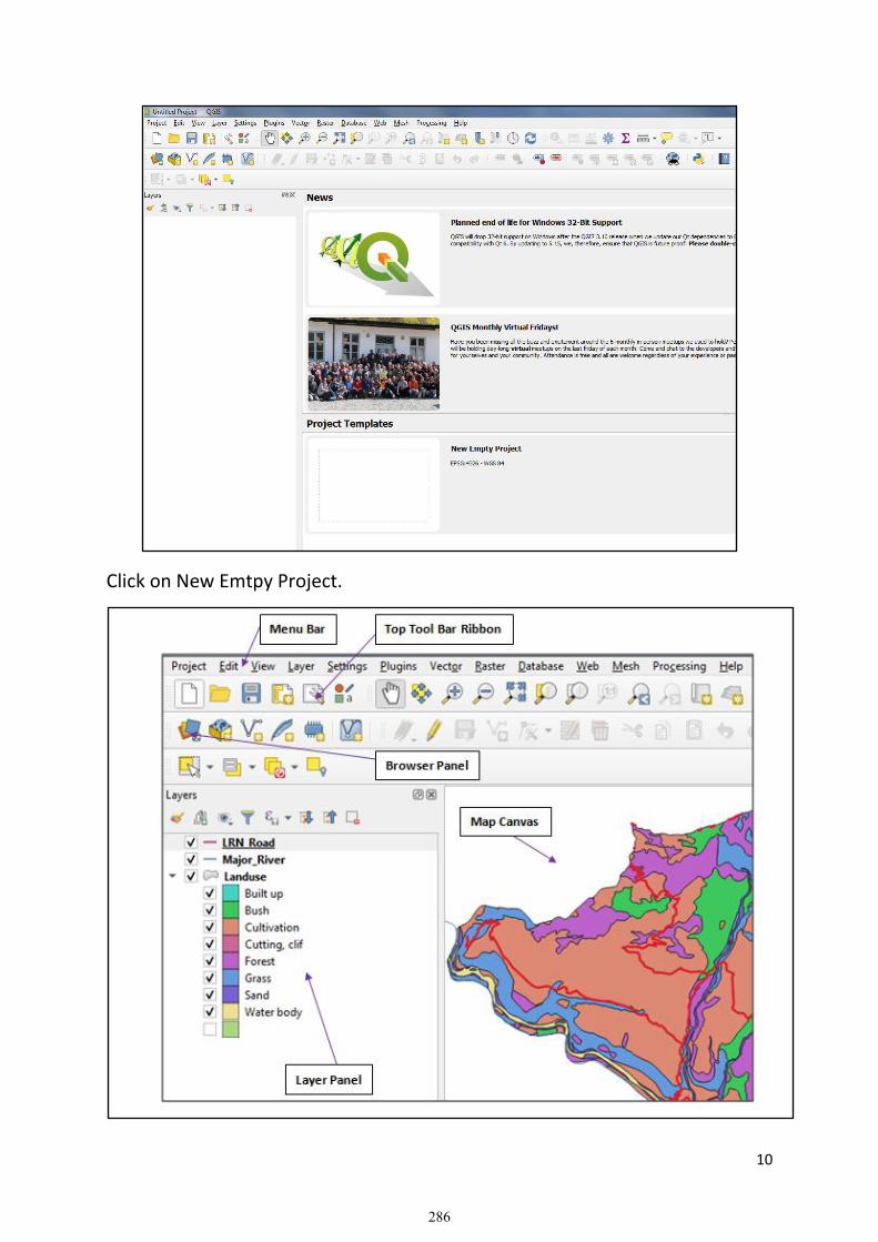
10
Click on New Emtpy Project.
286

11
1.0 Menu and Tool Bar:
Our most often used sets of tools can be turned into toolbars for basic access. For example, the File toolbar allows us to save, load, print, and start a new project. We can easily customize the interface to see only the tools we use most often, adding or removing toolbars as necessary via the View ►Toolbars menu.Even if they are not visible in a toolbar, all of our tools will remain accessible via the menus. For example, if we remove the File toolbar (which contains the Save button), we can still save our map by clicking on the Project menu and then clicking on Save. 2.0 The Layer Panel: In the Layer Panel, we can see a list, at any time, of all the layers available to us. Expanding collapsed items (by clicking the arrow or plus symbol beside them) will provide us with more information on the layer’s current appearance. Hovering over the layer will give us some basic information: layer name, type of geometry, and the complete path of the location on our device. Right-clicking on a layer will give us a menu with lots of extra options. We will be using some of them before long, so take a look around! 3.0 The Browser Panel The QGIS Browser is a panel in QGIS that gives us easily navigates in our database. We can have access to common vector files (e.g. ESRI Shapefile or MapInfo files), databases (e.g. PostGIS, Oracle, SpatiaLite, GeoPackage or MSSQL Spatial) and WMS/WFS connections. We can also view our GRASS data. If we have saved a project, the Browser Panel will also give us quick access to all the layers stored in the same path of the project file under in the Project Home item. 4.0 The Map Canvas This is where the map itself is displayed and where layers are loaded. In the map canvas we can interact with the visible layers: zoom in/out, move the map, select features and many other operations.
287

12
PART – II
Introduction of QGIS Software and GIS Database Management
Course Outline:
• Tour in QGIS Software and Existing Exercise Data (Hands on Exercise)
• Introduction of QGIS Browser and QGIS Processing Tool Box (Hands on
Exercise)
• Vector and Raster Models of GIS Data (Theory)
• Concept of Geo-database, Data Sources and Capturing Methods (Theory)
• GIS Database Management and Creating Feature Dataset using QGIS
Browser (Hands on Exercise)
2: Exploring QGIS Desktop Application
A: Working with QGIS Browser
▪ Introduction to QGIS Browser QGIS Browser is the QGIS module used for organizing, browsing, and managing
our data and map documents, as well as for viewing and editing metadata. In
many ways, QGIS Browse is similar to Windows Explorer. For instance, when
we modify a file's location, or create or delete a file, we do not need to save
the changes - it is done automatically. Since it is easy to delete files this way,
we should be careful to delete only when you are sure that we will not need
the file any longer.
• Starting QGIS Browser Now we will start QGIS Browser and explore its contents. To start
QGIS Browser clicks on Data Source Manager and navigate to
Browser.
▪ What is in QGIS Browser □ Select the directory C:\GIS_Training\Training Data. We will view the
following data catalog. We can preview the geometry; attribute table and metadata of each feature data set in this Training Data folder using QGIS Browser.
288

13
QGIS Browser is similar in structure to Windows Explorer. On the left hand side
is a view of the Browser "tree" showing how the data is organized. The right
hand side provides options for exploring the contents of the data shown in the
Browser tree. We will notice that there are different icons used to represent
the available folders and their contents. When QGIS Browser is initiated, it
automatically looks for folders containing spatial data. Any spatial data it finds
will be given a special icon to indicate the specific type of data in the file or
folder.
289

14
▪ What can be done in QGIS Browser? For organizing data, QGIS Browser is quite easy to use. However, if we delete,
move, or otherwise alter the data using QGIS Browser, it is permanent (i.e., if
we delete a coverage, it is GONE-we cannot retrieve it). Data organizing in
QGIS Browser is very similar to that in Windows Explorer. We can drag and
drop coverages, shapefiles, or geo-databases into new workspaces, or we can
use the Windows shortcut keys (Ctrl-C, Ctrl-X and Ctrl-V for copy, cut and
paste, respectively).
Try this out by copying and pasting our lab data into a new folder.
Browsing through our data is simple using QGIS Browser. The Browser tree
displays in a hierarchical fashion all of the items in the Browser, much like how
data browsing is done through programs such as Windows Explorer.
Take a moment to explore the data in the Browser tree. We can use the arrow
buttons on the keyboard, or the mouse to navigate. While navigating, pay
attention to the changes that take place on the right hand side of the QGIS
Browser window.
If you click on the "Preview" tab, we will see a preview of the data geography
or the data attribute
table. To change from
geography view to
table view (or vice
versa), change the
value listed in the
preview pull down
menu at the bottom of
the Window.
Click our mouse on
those menu we will
view the above info of
our data catalog.
290

15
291

16
B: Working with QGIS Processing Toolbox
▪ Introduction to QGIS Processing Toolbox QGIS Processing Toolbox is the QGIS module used for data processing, analysis,
and conversion. It contains a large set of tools that allow for more specialized
or complicated operations than those available in the various other modules.
Processing Tool Box also provides a means for the user to write scripts and
create customized tools to fit specialized needs.
▪ Starting QGIS Processing Toolbox To start Toolbox, click on Processing
Menu in the main Menu Bar and
then Click on Toolbox.
To run a tool, simply double-click on
the specific tool we want to use. This
will open a window for setting the
various file inputs and outputs and
other options related to the tool.
Adding our first layers We will start the application, and create a basic map to use for examples and exercises.
The goal for this lesson: To get started with an example map. Note: Before starting this exercise, QGIS must be installed on our computer. Also, we should have copied training data to our computer. Launch QGIS from its desktop shortcut, menu item, etc., depending on how we configured its installation.
292
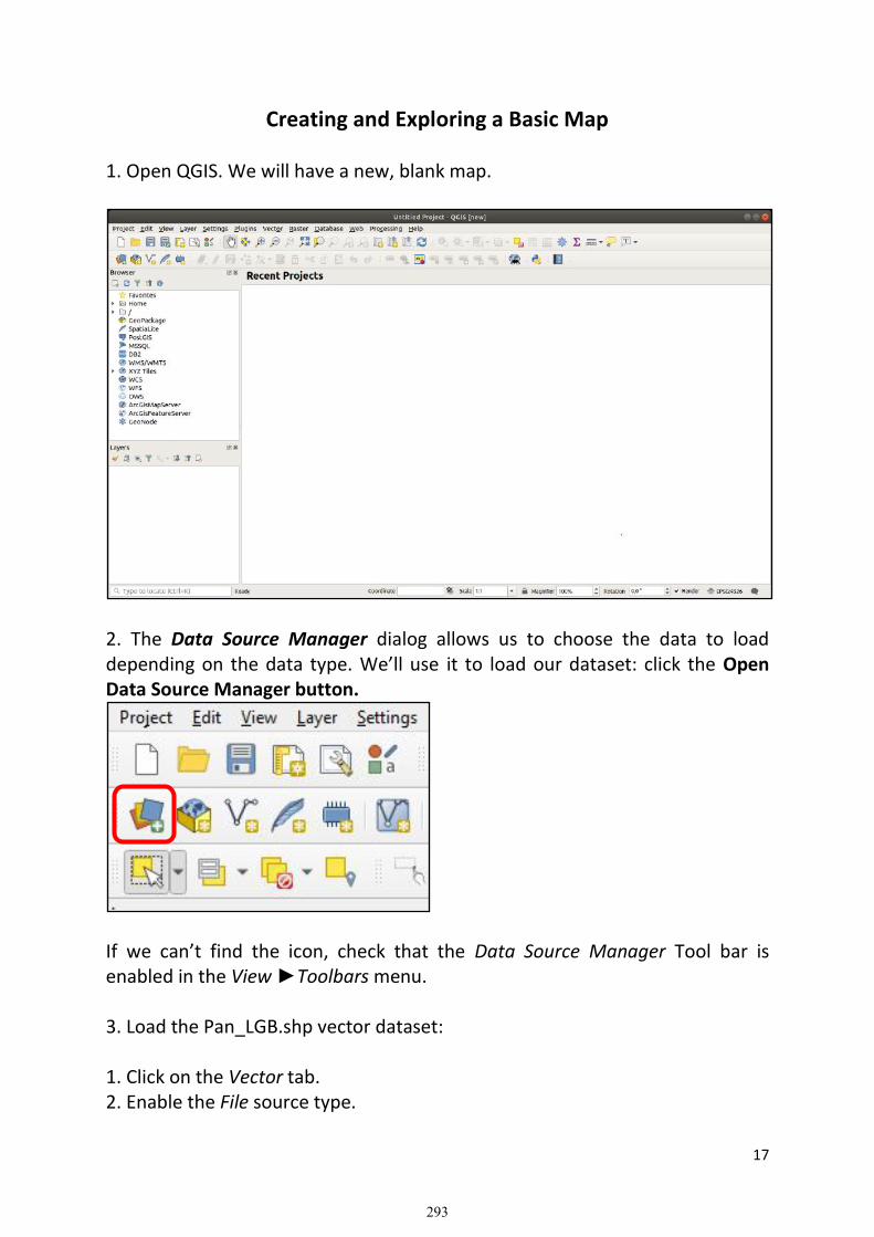
17
Creating and Exploring a Basic Map 1. Open QGIS. We will have a new, blank map.
2. The Data Source Manager dialog allows us to choose the data to load depending on the data type. We’ll use it to load our dataset: click the Open Data Source Manager button.
If we can’t find the icon, check that the Data Source Manager Tool bar is enabled in the View ►Toolbars menu. 3. Load the Pan_LGB.shp vector dataset: 1. Click on the Vector tab. 2. Enable the File source type.
293

18
3. Press the … button next to Vector Dataset(s). 4. Select the training data/Pan_LGB.shp file in our training directory. 5. Click Open. We will see the original dialog, with the file path filled in. 6. Click Add here as well. The data we specified will now load: we can see a Local Unit Map item in the Layers panel (bottom left) with its features shown in the main map canvas. 7. Now load other vector dataset related to Panchthar district in our map canvas. 8. Click on the Save As button: 9. Save the map under a solution folder next to exercise_data and call it basic_map.qgz. Navigating the Map Canvas This section will focus on basic QGIS navigation tools used to navigate within the Map Canvas. These tools will allow us to visually explore the layers at different scales.
Pan:
1. In the Map Navigation Toolbar, make sure the Pan button is activated. 2. Move the mouse to the center of the Map Canvas area. 3. Left-click and hold, and drag the mouse in any direction to pan the map. Zoom In:
1. In the Map Navigation Toolbar, click on the Zoom In button. 2. Move your mouse to approximately the your area of interest. 3. Left click and hold. 4. Then drag the mouse, which will create a rectangle 5. Release the left click. This will zoom in to include the area that you selected with your rectangle. Zoom Out:
6. To zoom out, select the Zoom Out button and perform the same action as you did for zooming in. As you pan, zoom in, or zoom out, QGIS saves these views in a history. This allows you to backtrack to a previous view.
294

19
1. In the Map Navigation Toolbar, click on Zoom Last button to go to your previous view.
2. Click on Zoom Next button to proceed to move forward in your history. Sometimes after exploring the data, we need to reset our view to the extent of all the layers. Instead of trying to use the Zoom Out tool multiple times, QGIS provides us with a button to do that action for us.
1. Click on the Zoom Full Extent button. As we zoomed in and out, it notice that the Scale value in the Status Bar changes. The Scale value represents the Map Scale. In general, the number to the right of: represents how many times smaller the object you are seeing in the Map Canvas is to the actual object in the real world. We can also use this field to set the Map Scale manually. 1. In the Status Bar, click on the Scale text field. 2. Type in 50000 and press Enter. This will redraw the features in the Map Canvas to reflect the scale you typed in. 3. Alternatively, click on the options arrow of the Scale field to see the preset map scales. 4. Select 1:5000. This will also update the map scale in the Map Canvas.
GIS DATA TYPES (Model/Structure of GIS Data) Vector Data: Vector data is the most common kind of data type we will find in the daily use of GIS. It describes geographic data in terms of points, known as vertices, that may connected to lines, poly lines and polygon. Vector data has feature constructed out of vertices, connected with lines to make poly lines or areas. Every discrete object in a vector dataset is called a feature, and is associated with attribute data that is that describes that feature. Each feature and its attributes take up one row in the dataset table. Attributes are listed in the columns known as fields in the table. In QGIS a single dataset can only contain one type of data i.e. points, lines or polygon. These cannot (should not) be mixed within a dataset following good GIS/spatial data practice.
295

20
Raster Data: Raster data is quite different from vector data, it is known as image. Although it may portray various properties of the data in the real world, these objects don’t exist as separate object; rather they are represented using a grid of pixels (square boxes) of differing values usually associated with a color (but not always) in which case the pixels combine to make a picture. The size of the raster image is the number of squares on each side of the spatial resolution is the real world measurement of each pixel such as in satellite image (Google Earth). Each pixel grid square must contain a value (can be null) therefore raster images tend to be large (in bytes) as compared to a vector dataset. There are two main types of raster image, geo-referenced and non-georeferenced. Georeferenced images can be mapped in GIS, non-georeferenced images (such as Logo) cannot. However, non-georeferenced images can georeferenced using a technique known as Geo-Registering the image by assigning some pixel (minimum 3) a real-world coordinate value usually relating to previously mapped visible feature in the image. GIS DATA SOURCES The most important and expensive component of the Geographic Information System is Data which is generally known as fuel for GIS. GIS data is combination of spatial (graphic) and attribute (tabular) data from various sources. A wide variety of data sources exist for both spatial and attribute data from the analog map, aerial photo, remote sensing, GPS, existing digital data, socio-economic data & others.
296

21
Concept of Geo-database/Geo Package in case of QGIS The Geodatabase (ArcGIS) format has emerged as a very common format for storing and exchanging spatial data, particularly considering that it allows for the storage of multiple data layers, and for the storage of data layers that exceed the limits of other specifications. It is the native data structure designed to work in GIS as the primary data format (.gdb) used for editing and data management. The GeoPackage (QGIS) format is an open container that allows us to store GIS data (layers) in a single file. GeoPackage is a special data package, has followed an OGC (Open Geospatial Consortium) standard data package that can store different kinds of spatial data types such as points, polyline, and polygon. We can save multiple layers into a single GeoPackage (. gpkg) file.
297

22
A GeoPackage is an open, standards-based, platform-independent, portable, self-describing, compact format for transferring geospatial information.
298

23
PART – III
Geo-referencing, Map Projection & Transformation
and Data Extraction Course Outline:
• Concept of Geo-referencing and Hands on Exercise on Geo-referencing
spatial data from scanned Topo Sheet
• Concept of Map Projection System and Coordinate Reference System
(Nepal Coordinate System and Global/Google Earth Coordinate System)
• Projection and transformation of geo-referenced data (Hands on Exercise)
• Creation of Point, Line and Polygon feature from geo-referenced and
Projected Topo Sheet (Hands on Exercise)
Map projection A globe is the best way to show the relative positions of places but it is neither portable nor practical for large scales. The three-dimensional shape of the earth means that it is not possible to depict locations and features directly on to a two-dimensional map space without some distortions. Map projection is a procedure to transform locations and features from the three-dimensional surface of the earth on to two-dimensional paper in a defined and consistent way.
Globe (Model of Earth)
GIS data are encoded with certain units, the spatial components of each
feature (lines, points and polygons) are projected using a mathematically
defined coordinate system transformation. The earth is round and maps are
299

24
flat. Map projections flatten the round earth. ArcGIS recognizes a bewildering
number of projections and coordinate systems, but in practice only a limited
subset of these are used. ArcGIS has attempted to remedy problems
associated with dealing with projections with "projections on the fly".
Essentially ArcGIS will try to recognize what projection your data have, if this
information is not already explicitly defined (the .prj component of the shape
file contains this information), and then open them in ArcMap. Sometimes this
works, sometimes it doesn't.
Some of the files in our training course have no defined coordinates. This is the
case of undefined coordinate system. Some may have coordinates stored in
latitude and longitude spherical coordinates (degrees, minutes, seconds, or
decimal degrees). This is called the Geographic Coordinate System (GCS). If,
however, you wish to calculate an area, or determine a precise distance, this is
not an appropriate coordinate system. You need a planar, Projected
Coordinate System to do this. Square degrees are meaningless, and for most
people a distance specified in degrees is also meaningless. All projection
operations are based on spherical coordinates, and so this lab begins with
feature classes in GCS, and then moves to transforming these data into
projected coordinate systems.
The transformation of map information from a sphere to a flat sheet can be accomplished in many ways. Mapmakers have invented projections that show distances, directions, shapes or areas as they are on a globe to at least some extent. Each projection has advantages and disadvantages. Orthographic projections, for example, show shapes as they appear when the globe is viewed from space. Equal-area projections do not distort the size of areas but do distort their shape. Conformal projections are those on which the scale is the same in any direction at any point on the map. Many projections retain one geometric quality and a few retain more than one, but no single projection can accurately portray area, shape, scale and direction.
300

25
Map projections
NATIONAL PROJECTION SYSTEM ADOPTED BY SURVEY DEPARTMENT AND
PROJECTION TRANSFORMATION
One of the main aims of the projection systems adopted by a country is to produce the geographical data in a unique system, which helps the data users to share the data. As Such the selection of a projection system is greatly affected by the area (shape, size and orientation) to be mapped, accuracy requirement and the intended purpose of the maps. Recommendations of international organizations like UN, also affect the selection of map projections in a given country. The shape of Nepal is like a rectangle and it is oriented in east west direction. From this viewpoint the standard conical projection with some modification could have been a suitable projection system for Nepal. But the UTM projection has been used for long time by different countries to create the base maps. This projection being conformal projection is more suitable for topographical mapping and therefore Nepal also adopted this projection for base mapping but with modifications suited to its shape. This is called a Modified Universal Transverse Projection (MUTM) system. In the MUTM system a cylinder is considered to envelope around the earth
(spheroid) in such a way that it touches the earth along two meridians which
differ by 180. The center of the projection is in the middle of the earth. Only
for mapping purpose that part of the cylinder is taken which touches one
meridian only. This meridian is called the Central Meridian. Then the features
are projected from the surface of the earth into the spheroid and then from it
projected into the projection surface, which can later be flattened. In this way
the Central Meridian is projected in its actual length in this projection.
301
26
To limit the distortion, specially, in the areas farther from the Central Meridian,
3 zones are selected for mapping, 1 30’in each side of the central meridian.
To reduce the amount of distortions within the mapping area, a scale factor of
0.9999 at the Central Meridian was chosen. With these modification the
projection popularly known as MUTM projection in Nepal, has the following
distortions:
-10 cm. for the distance of 1 km. in the Central Meridian,
+18cm. for the distance 1km. at the edges of the zone and
0.0 cm. at the great circle lying 0 55’ east or west of the Central Meridian.
For each zone the origin for computing the easting and northing coordinates is
the intersection of the Central meridian and the Equator. To eliminate the
negative coordinate values in the areas lying in the west of the Central
Meridian, a false Easting value of 500,000 meters for the easting origin has
been chosen. Existing GIS softwares have a great range of projection
transformation facilities. But the projection system used in Nepal is being
unique; they may not have such facility for local modified system like MUTM.
The National projection parameters are:
Spheroid: Everest 1830,
Projection: Modified UTM
Origin: Longitude 81°, 84° or 87° East, Latitude 0° North
False Co-ordinates of Origin: 500,000m Easting, 0m. Northing
Scale Factor at Central Meridian: 0.9999
Elevation Reference: Above Mean Sea Level (amsl)
302

27
Georeferencing: It is the process of assigning well-defined coordinate
system to the spatial entities. Coordinate system can be of two types:
geographic and Projected. Geographic coordinate system possess coordinate
in terms of longitude and latitudes. They are always based on certain spheroid
or Datum. Projected coordinate system possesses coordinates based on linear
pattern of measurement such as meters or feet. It should be understood that
it is the numeral model of the earth i.e. a given datum which is projected.
While geo-referencing we should not forget that we always enter projected
coordinates. If we do have only latitude and longitude of corner points of a
map then we must transform these coordinates into projected units i.e.
meters or feet etc. The following exercise helps how to Geo-reference a piece
of image in GIS environment.
If our data bears GCS system then we cannot calculate actual area of polygon
or length of the line. In the mean time we cannot overlay these maps which
are in other projection systems and undefined. Recent digital database of
Panchthar have been transformed in Universal Transverse Mercator Projection
(UTM) system by the some agency. Similarly most of the global database
including Google Earth System data and Remote Sensing Images are found in
Geographic System based on WGS 1984 datum. Different areas may be
projected in different projection zone. For Panchthar UTM Zone 45 North is
applicable and for Dang UTM Zone 44 North is applicable. If we take the case
of National Coordinate system adopted by the Department of Survey, Nepal
(which adopts MUTM) has three different projection zones. Hence it is
different to what is adopted by ICIMOD (which is UTM) and other
organizations like Universities, UN and other funded programs, and Ministries.
303

28
Hence, it is important to find out in which system a data has been prepared or
has to be prepared.
Geo-referencing in QGIS
1. Start QGIS Desktop programme. Select for “a new empty project” and then click OK.
2. Click Raster/Georeferencer from Main Menu. The plug in window is divided into 2 sections. The top section where the raster will be displayed and the bottom section where a table showing our Geo-referencer Control Points will appear.
3. Go to File/Open Raster of Georeferencer Window to add Topo Scanned image from C:\GIS_Training\Training Data\Topo_Scanned.
4. Select the image 2883_03b.bmp and click Open.
5. Zoom in at the lower left grid intersecting point (i.e. at the low left blue lines intersecting point) as shown below.
6. Click Add Control Points tool in the geo-referencing tool bar. 7. The cursor changes to a small plus sign. With this cursor, Click in the
center of the intersection pixelwhere you had zoomed in the step no 5. Now, click to addx/East and y/North…
304

29
8. Enter Map Coordinate dialog box appears as shown above. Enter the proper coordinates in the x (here, for this point, ……….) and y (for this point ……….)text panel of the dialog box. Click OK.
9. Click select elements tool (Arrow tool) and then click Zoom to Previous Extent.
10. Now, click Zoom in tool and zoom to the other coordinate position in the map and then proceed in the same way as explained from step no 6 to 8.
11. When you finish entering the coordinates of all of the intersection points, check the image appearance.
12. Click on Transformation Settings, the following dialogue box appears.
467,000 468,000 469,000
467,000 468,000 469,000
3,092,000
3,093,000
3,092,000
3,093,000
305

30
13. Set the Transformation Type as Linear.
14. Name the Output Raster as…………………...
15. Set Target SRS to EPSG 4326
16. Make sure the Load in QGIS when done option is checked then Press OK.
17. In the main Georeferencer Window, go to File/Start georeferencing. This
will start the process of wrapping image using the GCPs and creating the
target raster.
18. We now need to project the coordinate reference system of the image.
306

31
19. Click located at lower right corner of QGIS Map Canvas., following dialogue box appears.
20. In Coordinate Reference System, Select User Defined Coordinate System, then Choose Nepal_MUTM_84_PCS.
21. Click Apply. This will project our Image Coordinate Reference System from WGS84 i.e. EPGSG: 4326 to Nepal MUTM Projected Coordinate System. Now we need to permanently save this image having projected coordinate system.
22. Right click the Layer, then select Export, then Save Feature as option, which brings following dialogue box.
307

32
23. In the Format Text Box: choose ESRI Shape file.
24. In the File Name Box: Give appropriate file name for your projected
shape file.
25. In the CRS Text Box: choose the Projected Coordinate Reference System
as we applied before for the image.
26. Click OK to save Projected Image permanently.
27. Load Projected Image in New Empty Canvas.
28. Check the Coordinate Reference System.
308

33
CREATING POINT, LINE AND POLYGON FROM GEO REFERENCED IMAGES
1. Open QGIS and create a new blank project. 2. Navigate to and click on the menu entry Layer ►Create Layer ►New Shape file Layer. We’ll be presented with the New Shape file Layer dialog, which will allow us to define a new layer.
3. Click … for the File name field. A save dialog will appear. 4. Navigate to the GIS Training/QGIS Training/Training Data directory. 5. Save the new layer as New_Road.shp. It’s important to decide which kind of dataset we want at this stage. Each different vector layer type is “built differently” in the background, so once we’ve created the layer, we can’t change its type. For this exercise, we’re going to create new features which describe length. For such features, we’ll need to create a Line dataset. 6. For Geometry Type, select Line from the drop down menu:
309

34
This has no impact on the rest of the dialog, but it will cause the correct type of geometry to be used when the vector dataset is created. The next field allows you to specify the Coordinate Reference System, or CRS. CRS is a method of associating numerical coordinates with a position on the surface of the Earth. For this exercise we will use the default CRS associated with this project, which is WGS84.
Next there is a collection of fields grouped under New Field. By default, a new layer has only one attribute, the id field (which we should see in the Fields list.) However, in order for the data we create to be useful, we actually need to say something about the features we’ll be creating in this new layer. For our current purposes, it will be enough to add one field called name as Road_Name that will hold Text data and will be limited to text length of 80 characters. 7. Replicate the setup below, and then click the Add to Fields List button:
8. Check that the Field List box looks like this:
310

35
9. Click OK The new layer should appear in your Layers panel.
Digitizing:
Digitizing is the process of creating new features/shapes by using base layers
already loaded onto a map as Aerial Photography (In our Case the
Georeference Image). Digitizing is a common process used in GIS to capture
new data.
1. Click on Data Source Manager Button.
2. Select Raster on the left side. 3. In the Source panel, click on the … button: 4. Navigate to GIS Training/QGIS Training/Training Data/Topo Scanned/. 5. Select the file ………………………...tif. (Note: You should select only georeferenced image) 6. Click Open to close the dialogue window.
7. Click Add and Close. An image will be loaded into your map.
311

36
8. If you don’t see an aerial image appear, select the new layer, right click, and
choose Zoom to Layer in the context menu.
9. Zoom to the area where you want to digitize New Road.
312

37
10. Before start to digitize, move New_Road feature above the image.
In order to begin digitizing, we’ll need to enter edit mode. GIS software commonly requires this to prevent us from accidentally editing or deleting important data. Edit mode is switched on or off individually for each layer. To enter edit mode for the New_Road layer: 1. Click on the New Road layer in the Layers panel to select it.
2. Click on the Toggle Editing button. If you can’t find this button, check that the Digitizing toolbar is enabled. There should be a check mark next to the View ►Toolbars ►Digitizing menu entry. As soon as you are in edit mode, you’ll see that some digitizing tools have become active:
• Add Line Tool
• Vertex Tool Other relevant buttons are still inactive, but will become active when we start interacting with our new data. Notice that the layer New Road in the Layers panel now has the pencil icon, indicating that it is in edit mode. 3. Click on the Add Line button to begin digitizing our New Road feature. It’ll notice that our mouse cursor has become a crosshair. This allows us to more accurately place the points to be digitizing. Remember that even when we’re using the digitizing tool, we can zoom in and out on our map by rolling the mouse wheel, and we can use pan around by holding down the mouse wheel and dragging around in the map.
313
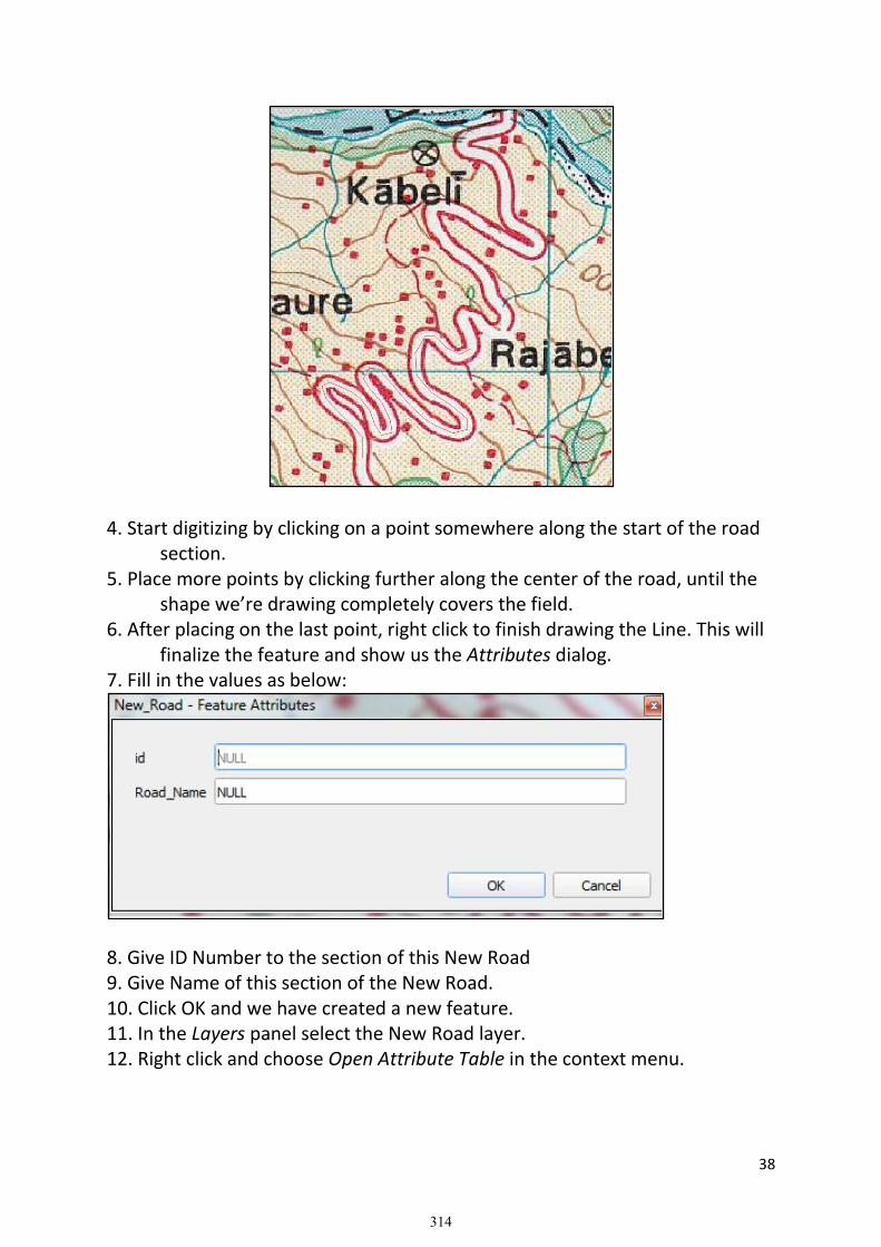
38
4. Start digitizing by clicking on a point somewhere along the start of the road section. 5. Place more points by clicking further along the center of the road, until the shape we’re drawing completely covers the field. 6. After placing on the last point, right click to finish drawing the Line. This will finalize the feature and show us the Attributes dialog. 7. Fill in the values as below:
8. Give ID Number to the section of this New Road 9. Give Name of this section of the New Road. 10. Click OK and we have created a new feature. 11. In the Layers panel select the New Road layer. 12. Right click and choose Open Attribute Table in the context menu.
314

39
In the table we will see the feature we just added. While in edit mode you can update the attributes data by double click on the cell you want to update. 13. Close the attribute table.
14. To save the new feature we just created, click on Save Layer Edits button. Remember, if you’ve made a mistake while digitizing a feature, you can always edit it after you’re done creating it. If you’ve made a mistake, continue digitizing until you’re done creating the feature as above. Then:
15. Click on Vertex Tool button. 16. Move the mouse over a vertex we want to move and left click on the vertex. 17. Move the mouse to the correct location of the vertex, and left click. This will move the vertex to the new location.
18 When done editing, click the Toggle Editing button to get out of edit mode.
• Now we know how to create features! Knowing how to digitize is important because it’s a very common activity in GIS programs.
• Try your own with adding, point and polygon features.
315

40
PART – IV
Global Positioning System (GPS) and Web Map Services (WMS)
Course Outline:
• Theoretical Concept of Global Positioning System (GPS)
• Capturing Real World data using GPS (Field Work)
• Downloading GPS data and plotting (Hands on Exercise)
• Integration of GPS Data to existing Spatial Features (Hands on Exercise)
• Installation of QGIS Plugin (Hands on Exercise)
• Connecting to Web Map Service - WMS (Hands on Exercise)
• Digitizing Spatial Features based on Google Earth and Open Street Maps
(Hands on Exercise)
The Global Positioning System (GPS), originally Navstar GPS is a satellite-based radio navigation system owned by the United States government and operated by the United States Space Force. It is one of the global navigation satellite systems (GNSS) that provides geo-location and time information to a GPS receiver anywhere on or near the Earth where there is an unobstructed line of sight to four or more GPS satellites Obstacles such as mountains and buildings block the relatively weak GPS signals.
The GPS does not require the user to transmit any data, and it operates independently of any telephonic or internet reception, though these technologies can enhance the usefulness of the GPS positioning information. The GPS provides critical positioning capabilities to military, civil, and
316

41
commercial users around the world. The United States government created the system, maintains it, and makes it freely accessible to anyone with a GPS receiver.
Component of GPS: 1. Space Segment: The GPS uses constellation of 24 satellites that orbit the earth at about 11000 nautical miles, once every 12 hours. The orbital position is constantly monitored and updated by the ground stations. Each satellite is identified by a number and broadcasts a unique signal. 2. Control Segment: The ground segment of GPS has one master control, one alternative master control station, 12 command and control antennas and 16 monitoring sites. 3. User Segment: This segment consists of GPS Receiver. The receiver collects and process signals from the GPS satellites and use that information to determine and display the location, speed, time and so on. Capturing Real World Data in GPS: Demonstration of GPS Devices, Settings and capturing real world data Downloading GPS Data in QGIS: 1. Open QGIS Desktop 3.16.8 2. Click on New Empty Project. This brings new empty canvas. 3. Goto Plugins, then select Manage and Install Plugins
This will bring following dialogue box
Select Installed
317

42
4. Check in GPS Tools box and Close.
5. This will bring icon in Vector Tool Bar.
6. Click on GPS Tool icon, following window will appear.
7. In File ……, navigate to GIS Training/QGIS Training/Training Data/GPS
File/………………….gpx file stored in our computer
8. Check out Routes and Tracks check box and click OK.
GPS Tool Icon
318

43
Figure: Different Models of GPS Device
There are different functions of Global positioning system (GPS) which are
generally fall into following major categories:
1. Location - determining a position
2. Navigation - getting from one location to another
3. Tracking - monitoring object or personal movement
4. Mapping - creating maps of the world
5. Timing - bringing precise timing to the world
Advantages of GPS
Following are the advantages of GPS:
▪ GPS provides accurate geographical location of the receiver with
longitude, latitude and altitude which helps in search and rescue
through tracking and navigation.
▪ GPS provides users with information based on location (X Y Coordinates)
in real time for any object on the earth surface which is helpful in
mapping and analysis of performance. It is a source of GIS data input.
▪ GPS is powered by world satellites so it can be accessed anywhere in the
world through tracking system with a GPS receiver.
▪ GPS works in all weather conditions and all over the world. The GPS
signal is available worldwide. Therefore, users will not be deprived of it
anywhere.
▪ There is no charge to utilize the GPS service so it is cheaper compare to
other navigational systems.
319

44
▪ Global Positioning System is used for a wide variety of purpose that
includes military as well as civil interests.
▪ GPS technology helps surveyors to establish property identification and
boundaries demarcation. GPS land surveying produces accurate results
with little effort, and also provides greater flexibility and improved
efficiency than conventional surveying methods and tools.
Disadvantages of GPS
Following are the disadvantages of GPS:
▪ The accuracy of GPS depends on sufficient signal quality received.
Sometimes the GPS signals are not accurate due to some obstacles of
manmade or natural features to the signals such as buildings, trees and
sometimes by extreme atmospheric conditions such as geomagnetic
storms.
▪ Positional error may occur due to the access with limited number of
satellite, poor signal or battery failure.
▪ An incorrectly installed GPS can lead to inaccurate data.
▪ GPS cannot be used in underground areas or any objects blocked from a
direct view of the sky.
Application of GPS in Local Level Resource Mapping ▪ Identification of individual household and settlement location.
▪ Mapping for the location of service centers like educational institutions,
health centers, agricultural service centers, sources of drinking water
etc.
▪ Evaluation on status of infrastructure development like road network,
electricity and communication supply, sewage management, canal or
irrigation network, solid waste management network, market centers
and accessibility assessment etc.
▪ Agricultural crop pocket area, mining and excavation centers
identification and management
▪ Risk and hazard zone delineation and management
▪ Collect and manage information on land use and other natural
resources.
320
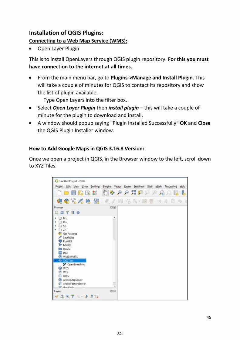
45
Installation of QGIS Plugins: Connecting to a Web Map Service (WMS):
• Open Layer Plugin
This is to install OpenLayers through QGIS plugin repository. For this you must
have connection to the internet at all times.
• From the main menu bar, go to Plugins->Manage and Install Plugin. This
will take a couple of minutes for QGIS to contact its repository and show
the list of plugin available.
Type Open Layers into the filter box.
• Select Open Layer Plugin then install plugin – this will take a couple of
minute for the plugin to download and install.
• A window should popup saying “Plugin Installed Successfully” OK and Close
the QGIS Plugin Installer window.
How to Add Google Maps in QGIS 3.16.8 Version:
Once we open a project in QGIS, in the Browser window to the left, scroll down to XYZ Tiles.
321

46
• Right click on XYZ Tiles and choose New Connection.
• In the XYZ Connection window, enter a name, like Google Maps, and then enter the URL “https://mt1.google.com/vt/lyrs=r&x=
{x}&y={y}&z={z}”. Also set the Max Zoom Level to 19.
• Click the OK button, and Google Maps is added to our XYZ Tiles list.
• Now double click on Google Maps or drag & drop it and we will see it in our map area!
322

47
If you prefer the satellite image or other images, here is a list of Google Maps layers that you can add to QGIS:
Google Maps: https://mt1.google.com/vt/lyrs=r&x={x}&y={y}&z={z} Google Satellite: http://www.google.cn/maps/vt?lyrs=s@189&gl=cn&x={x}&y={y}&z={z}
Google Satellite Hybrid: https://mt1.google.com/vt/lyrs=y&x={x}&y={y}&z={z} Google Terrain: https://mt1.google.com/vt/lyrs=p&x={x}&y={y}&z={z} Google Roads: https://mt1.google.com/vt/lyrs=h&x={x}&y={y}&z={z}
CREATING POINT, LINE AND POLYGON FROM WMS
• Digitizing Features based on Google Image
• Digitizing Features based on Open Street Maps
❖ Go back to manual “Creating point, line and polygon from geo
reference image”.
❖ Start to create point, line or polygon features and attributes
accordingly!
1. Open Data Source Manager
2. Select Add XYZ Layer Icon.
3. Select Open Street Map or Google Earth Hybrid from Drop down List as
shown below:
323

48
4. Click on Add.
.
5. Zoom in to the area where Panchthar District lies in Open Street Map
Layer
6. Add Pan_LGB.shp file from GIS Training/QGIS Training/Training Data/
folder.
324

49
7. Right Click the Pan_LGB Layer for Layer Properties
8. In Symbology Tool, Choose Fill Color as Transparent.
9. Change Stroke width to 1. and click on Apply. This will bring us the following.
10. Now Add the New Feature Dataset you created just like you did for New_Road.shp in Georeference Exercise.
❖ Go back to Digitizing Exercise in the Training Manual that we already did in Georeference Exercise and start digitizing.
Application of Google Earth image
o Install Google Earth Pro. In your computer.
o Open Google Earth.
o Select desired area and make Zoom in to observe required information.
o Select Add from main menu.
o Go to Folder then make a folder to store extracted information.
325

50
o Use Placement for point feature, Path for liner feature and
Polygon for areal features.
o Right click on given Folder.
o Extract the features one by one as more as required.
(Digitize/extract land cover information by different polygons).
o Right click on given folder then select Save Place As from pop-
down menu.
326

51
o Give the File Name and location for output file then select (*.KML)
for save as type format.
Import Google Earth .kml file to QGIS
o Open QGIS.
o Select Layer from main menu bar.
o Explore Add Layer.
o Go to Add Vector Layer.
o Highlight File option in Source type.
o Then explore data layer through browse option in Source from
Vector datasets.
o Select .kml file from the data folder.
o Click on Add and close the popup window.
327

52
o Now, it can export in shape file (*.shp) format by different features in GIS Environment for further analysis and mapping to give output result.
328

53
Upload Shape files from QGIS to Google Earth o Add desired file/layer in the view
o Right click on data layer
o Click on Export
o Select Save Feature as
o Select format as .KML and give file name with output directory.
o Click on OK.
o Now, we can open this .KML file in Google Earth by double clicking on icon.
329

54
PART – V
Join Table and Query Building
Course Outline:
• Concept and Application of Spatial and Attribute Data Management
• Spatial Joining of Attribute Data in GIS (Hands on Exercise)
• Query Building (Hands on Exercise)
• Selection of Spatial Features using Attribute Query (Hands on Exercise)
• Selection of Spatial Feature using Select Location Query (Hands on
Exercise)
A spatial join links the attributes of two layers based on the location of the features in the layers. Like joining two tables by matching attribute values in a field, a spatial join appends the attributes of one layer to another. A Spatial join is a GIS operation that affixes data from one feature layer's attribute table to another form a spatial perspective. Joining Data in QGIS – Spatial and Attribute: If we need to make a map of total population by Local Unit of Panchthar District but the Local Unit of GIS layer does not have population as an attribute. Rather this data is contained in an Excel spreadsheet which is located in GIS Training/QGIS Training/Training Data/Excel Files/ folder. It is possible to join additional tabular data to an existing attribute table. For this, two tables (Attribute and Excel Files) need to share fields with attributes to match for joining. To create a join, load both the GIS layer (Pan_LGB.shp) and the Excel Sheet (Join_Table.xls) into QGIS Desktop.
Once the data is loaded a join can be completed by following these steps:
330

55
1. Select the GIS layer in the Layers panel that will receive the new data from the Excel Sheet with joining method.
2. Click Layer Properties and choose the Joins
3. Click the Add Join button 4. Choose the Join Layer, Join Field and Target Field. The Join Layer and Join
Field represent the Excel table. The Target Field is the column in the GIS Layer attribute table the join will be based on.
331

56
5. Choose Join_ID in Join Field and also Join_ID in Target Field. 6. Once created, the join will be listed on the Joins The extra attribute
columns from the Join Layer will be appended to the attribute table where the value in the Join Field matched the value in the Target Field.
7. Joins can be removed by clicking the Remove Join button Note: Joins only exist in virtual memory within the QGIS Desktop document. To preserve the join outside the map document click Layer | Save as… and save a new copy of the layer. The new layer will include the attributes appended via the join. Selection by Attribute: Select Features by Value: This selection tool opens the layer’s feature form allowing the user to choose which value to look for each field, whether the search should be case-sensitive, and the operation that should be used. The tool has also auto completes, automatically filling the search box with existing values.
1. Select Feature by Value Tool
332

57
In the Join_Tab_3 text box (This is the total population field came after joining population data of local unit of Panchthar District). 2. Give Value 20000 and choose Greater than or Equal to Sign in Exclude Field just right to the text box.
3. Click on Select Features button.
4. This will select all local units having total population greater than or equal to 20000. The selected local unit will be highlighted in the map.
333

58
Selection by Location: 1. Open QGIS Desktop and Choose New Empty Project 2. Add two Vector Datasets located in GIS Training/QGIS Training/Training Data/ folder (a) Pan_LGB.shp and (b) Pan_Village.shp.
3. Select any one Local Unit among total of 8 from Pan_LGB.shp by With Select
Feature Tool
4. In Main Menu Bar, select Vector->Research Tools->Select by Location
334

59
5. Select Pan_Village in Select feature from drop down box. 6. Check in are within box. 7. Select Panch_LGB in By comparing to the features from dropdown box. 8. Check in Selected features only box. 9. Click on Run and Close. 10. This will select all the villages points located inside selected local unit of Panchthar district like following.
335

60
PART – VI
Statistical and Spatial Analysis
Course Outline:
• Calculation and Measurement of Spatial Features
• Length and Area Calculation (Hands on Exercise)
• Use of Summarization Tools (Hands on Exercise)
• Concept on Geo Processing Tools and Application (Theory)
(Hands on Exercise on Identify, Clip, Buffer, Intersection, Merge etc.)
• Selection of Spatial Features based on Buffer Area (Hands on Exercise)
Field Calculator:
The Field Calculator button in the attribute table allows you to perform calculations on the basis of existing attribute values or defined functions, for instance, to calculate length or area of geometry features. The results can be written to a new attribute field, a virtual field, or they can be used to update values in an existing field. The field calculator is available on any layer that supports edit. When you click on the field calculator icon the dialog opens. If the layer is not in edit mode, a warning is displayed and using the field calculator will cause the layer to be put in edit mode before the calculation is made. The quick field calculation bar on top of the attribute table is only visible if the layer is editable. In quick field calculation bar, you first select the existing field name then open the expression dialog to create your expression or write it directly in the field then click on Update All button.
336

61
QGIS has built-in functions and algorithms to calculate various properties based on the geometry of the feature - such as length, area, perimeter etc. Calculation of Length of Digitized Road i.e. New_Road.shp: 1. Start QGIS Desktop and choose New Empty Project.
2. Click on Data Source Manager Icon
3. Add New_Road.shp using Add Vector tools.
4. Look at Coordinate Values and Coordinate
Reference System 5. This Coordinate Values represent Longitude and Latitude in Decimal Degrees and Coordinate Reference System (CRS) is WGS84.
❖ We need to project this to Universal Transverse Mercator system
6. Click on CRS icon at lower right corner , following window appear
337

62
7. Choose Nepal_MUTM_84_PCS Coordinate Reference System from User Defined CRS and Click on Apply.
8. Now coordinate values changes to Meters and
CRS Changes to
9. To make this change permanent, Right click the projected layer
338

63
Select Export and Save Feature As. 10. Give New File Name as New_RoadMUTM.shp 11. Change the CRS to Nepal MUTM_84_PCS as shown below.
12. Click OK. 13. Remove New_Road.shp Layer which is based on WGS84 CRS. 14. Now Go to Project, Properties and General, following window appear.
15. In the Measurement dropdown menu, Change Ellipsoid to Everest 1830 Definition instead of Custom.
339

64
16. Click Apply and OK.
17. Now Press Toggle Editing to get your data for Editing Mode.
18. Open Field Calculator
19. Check In the Create a New Field box.
20. Give Length at Output field name 21. Change Output field type to Decimal number (real)
340

65
22. Search Length in Search Bar and Double Click on $length in Geometry Dropdown menu.
23. Expression box look likes following
24. Click OK.
25. Save your Layer Edit
25. Toggle the Editor to off the Editing Mode.
26. Click the Attribute Table 27. A New field Length is added with length in meters of the Digitized New Road Feature.
❖ Now try yourself to calculate area of digitized polygons and enjoy!!!!
341

66
Summarization: 1. Open QGIS Desktop and click on “New Empty Project”. 2. From Menu Bar, go to Plugin->Manage and Install Plugins 3. Search for Group Stats Plugin in search box.
4. Install Group Stats plugin.
5. A new icon would appear in Vector Toolbar.
6. Click on Data Source Manager Icon
7. Add Pan_Luse.shp using Add Vector tools.
❖ Now following steps 4 to 27 of previous exercise for calculation of length of the road, calculate/update area of land use polygon data.
8. Add projected Land use Data layer to the map canvas. Now you need to summarize land use category by summing up the area belonging to each category. For example how much area is Forest needs to summarize using this tool. 9. Open Attribute Table. You can see Land use category is in FEATURES field.
342

67
10. Click on Group Stats Tool Icon
11. Drag and drop FEATURES field to Rows text box. 12. Drag and drop Area in Value text box.
Summarizing Field
343

68
13. Drag and drop sum in Columns text box. See below.
14. Click on Calculate tab. Following statistics is displayed.
15. Goto Data and select Copy All to Clipboard. 16. Open Excel Sheet and Paste the data.
Geo Processing: Geoprocessing is a framework and set of tools for processing geographic and related data. The comprehensive suite of geoprocessing tools can be used to
344

69
perform spatial analysis or manage GIS data in an automated way. Geoprocessing is for everyone that uses GIS. Whether you are a new or advanced user, geoprocessing will likely be an essential part of your day-to-day work. A typical geoprocessing tool performs an operation on a dataset such as a feature class, raster, or table, and creates a resulting output dataset. For example, the Buffer tool takes features as input, creates buffer areas around the features to a specified distance, and writes those buffer areas to a new output dataset.
In addition to the suite of tools, geo-processing is also a powerful framework that supports control of the processing environment and allows you to build custom tools that can further automate your work.
Buffering: A buffer is a reclassification based on distance: classification of within/without a given proximity. Buffering involves measuring distance outward in directions from an object. Buffering can be done on all three types of vector data: point, line, area. The resulting buffer is a polygon file. Most often buffers are measured in uniform distance. For example, creating a 50 meters buffer around all rivers. A buffer based on different distances is called a variable buffer. For example, the noise level surrounding a street network may be based on the traffic load. Therefore a variable buffer may be used to illustrate the noise level by using a larger distance for high traffic roads and a shorter distance for quieter roads.
Creating buffer of 200 m around the digitized Road Data: 1. Start QGIS Desktop and choose New Empty Project.
2. Click on Data Source Manager Icon
3. Add Projected New_RoadMUTM.shp using Add Vector tools. 4. Go to Vector->Geoprocessing Tools-> Buffer
345

70
.
5. Choose New_RoadMUTM.shp in Input Layer
6. Type 200 in Distance text box. Note the unit should be in meter.
346
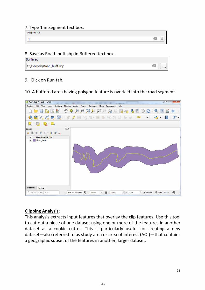
71
7. Type 1 in Segment text box.
8. Save as Road_buff.shp in Buffered text box.
9. Click on Run tab. 10. A buffered area having polygon feature is overlaid into the road segment.
Clipping Analysis: This analysis extracts input features that overlay the clip features. Use this tool to cut out a piece of one dataset using one or more of the features in another dataset as a cookie cutter. This is particularly useful for creating a new dataset—also referred to as study area or area of interest (AOI)—that contains a geographic subset of the features in another, larger dataset.
347

72
Clipping Land use Features from Road Buffer Polygon: 1. Open QGIS Desktop and click on “New Empty Project”.
2. Click on Data Source Manager Icon
3. Add Luse_MUTM.shp and Road_Buff.shp using Add Vector tools.
4. Move Road_buff layer top of the land use layer. 5. Go to Vector->Geoprocessing Tools->Clip
348

73
6. Select Luse_MUTM.shp in Input Layer 7. Select Road_buff.shp in Overlay Layer 8. Give Buff_Landuse.shp file name in Clipped text box. 9. Click Run 10. A new Layer Buff_Landuse.shp is added to Layer window.
349
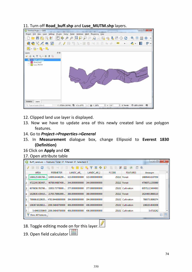
74
11. Turn off Road_buff.shp and Luse_MUTM.shp layers.
12. Clipped land use layer is displayed. 13. Now we have to update area of this newly created land use polygon features. 14. Go to Project->Properties->General 15. In Measurement dialogue box, change Ellipsoid to Everest 1830 (Definition) 16 Click on Apply and OK 17. Open attribute table
18. Toggle editing mode on for this layer.
19. Open field calculator
350

75
20. Check in the Update existing field box 21. Select existing Area sqm field from dropdown list
22. In the Geometry, double click $area expression 23. Click OK.
24. Select Save Edit Tool
25. Toggle editing mode to off .
351

76
PART – VII
Output Design and Project Work
Course Outline:
• Working on Mapping Field Properties (Hands on Exercise)
• Hands on Exercise for Labeling and Symbology
• Theoretical Concept on Cartographic Element of the Maps
• Cartographic Designing for Map Outputs
• Layout and Reporting Format of GIS Map Outputs
Symbology:
Symbology, in the context of Cartographic design, is the use of graphical techniques to represent geographic information on a map. Map symbols for geographic features include Visual variables such as color, size, and shape.
Generically, a symbol is an object, picture, written word, sound, or particular mark that represents something else by association, resemblance, or convention. For example, Roman numerals are symbols for quantitative values and personal names are symbols representing individual people. On a map, a red cross is a commonly understood symbol to indicate the location of a hospital, crossed sabers may indicate the site of a battlefield, and a blue region would commonly be interpreted as a water body. Semiotics is the scientific and philosophical study of how symbols work by establishing these connections between the representation and the represented concepts and real-world features.
Map Symbols: Maps communicate their messages through symbols--drawn graphics that represent spatial phenomena such as objects, places, or attributes. At their most basic, map graphics can be categorized by Dimension: points, lines, and regions; each can be portrayed using symbology. These symbols are commonly used to describe different features mapped. For example, cities or airports are commonly represented as point symbols (depending on scale), roads or railroads are usually represented by line symbols and the cities, lakes, or forests are common examples of region symbols.
Map symbols are created by controlling visual variables such as color, shape, and size. When designing a map, the cartographer determines that a certain combination of these variables; a symbol (e.g., a dashed 0.5pt blue line)-represents a certain class of geographic feature. Although there is no set
352

77
standard on symbology for all maps, especially among thematic maps, various conventions (such as using contour lines for elevation or blue for water) are commonly followed for some classes of maps.
The choice of symbology is a crucial part of cartographic design; the goal is for the map reader to spend less time figuring out what the symbols mean, and thus more time using the symbols to understand the World. A good symbol is easily recognizable (i.e., connected to the geographic features and concepts it represents), is aesthetically pleasing, and works in harmony with other symbols (for example, as part of a clear visual hierarchy). A legend is needed to explain the meaning of the symbols that cannot safely be assumed to be intuitive.
Types of Map Symbols
Map symbols are "read" by map users when they make a connection between the graphic mark on the map (the sign), a general concept, and a particular feature of the real world. For example, thick blue line (sign) = major river.
• Image or Iconic Symbols look like the real-world feature, although it is
often in a generalized manner. For example, a tree icon to represent a
forest, or green denoting vegetation.
• Functional Symbols directly represent the activity that takes place at the
represented feature. For example, a picture of a skier to represent a ski
resort or a tent to represent a campground.
• Conceptual Symbols directly represent a concept related to the
represented feature. For example, a dollar sign to represent an ATM
• Conventional Symbols do not have any intuitive relationship but are
so commonly used that map readers eventually learn to recognize them.
For example, a red line to represent a highway or a cross to represent a
hospital.
• Ad Hoc Symbols do not have any intuitive or commonly accepted
relationship; in fact, the symbol is often used only for a single map. These
symbols require effective legends and/or labels to be correctly interpreted.
1. Open QGIS Desktop and click on “New Empty Project”.
2. Click on Data Source Manager Icon 3. Add District Boundary, Local Unit Boundary, Village, Land use, Road and
River features using Add Vector tools.
353

78
Note: Press and hold Ctrl key and select all these features one by one to add all in single click.
4. Bring Point feature (village) on top, and then Line features (road and river) in the layer panel.
5. Double Click on Pan_DB layer.
354

79
5. Click on Simple Fill.
6. Choose Transparent in Fill Color 7. Put the value 1 in Stroke width 8. Click Apply and OK. 9. Apply same symbology method to Pan_LGB but put 0.7 in Stroke width and also choose light gray color in Strike Color
355
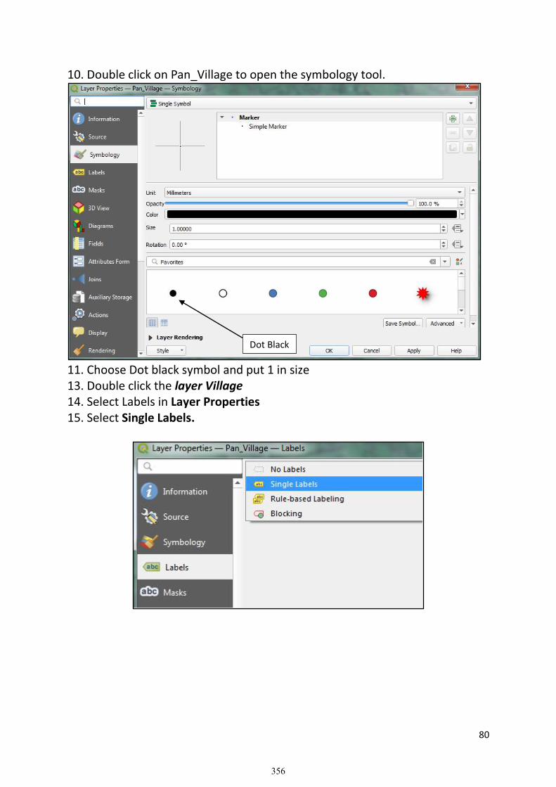
80
10. Double click on Pan_Village to open the symbology tool.
11. Choose Dot black symbol and put 1 in size 13. Double click the layer Village 14. Select Labels in Layer Properties 15. Select Single Labels.
Dot Black
356

81
16. Select Value for Label field, Font type, color and size then click Apply and OK. 17. Apply same method to label name of Local Unit i.e. Gaunpalika/Nagarpalika. 18. Now double click the Road Layer. 19. In Symbology, choose Categorized
20. Select FEATURES in value field. 21. Click on Classify tab. 22. This will list all types of FEATURES i.e type of road
357

82
23. Now apply thickness and color for each type of road by selecting road type one by one. 24. Example of Symbol for highway is like this
25. Zoom in the map in Phidim Area. 26. Put the land use layer off. 27. By doing all above work, the map should look like this.
27. Now turn on the land use layer and double click for layer properties. 28. Apply symbology and choose Categorized.
Classify
358
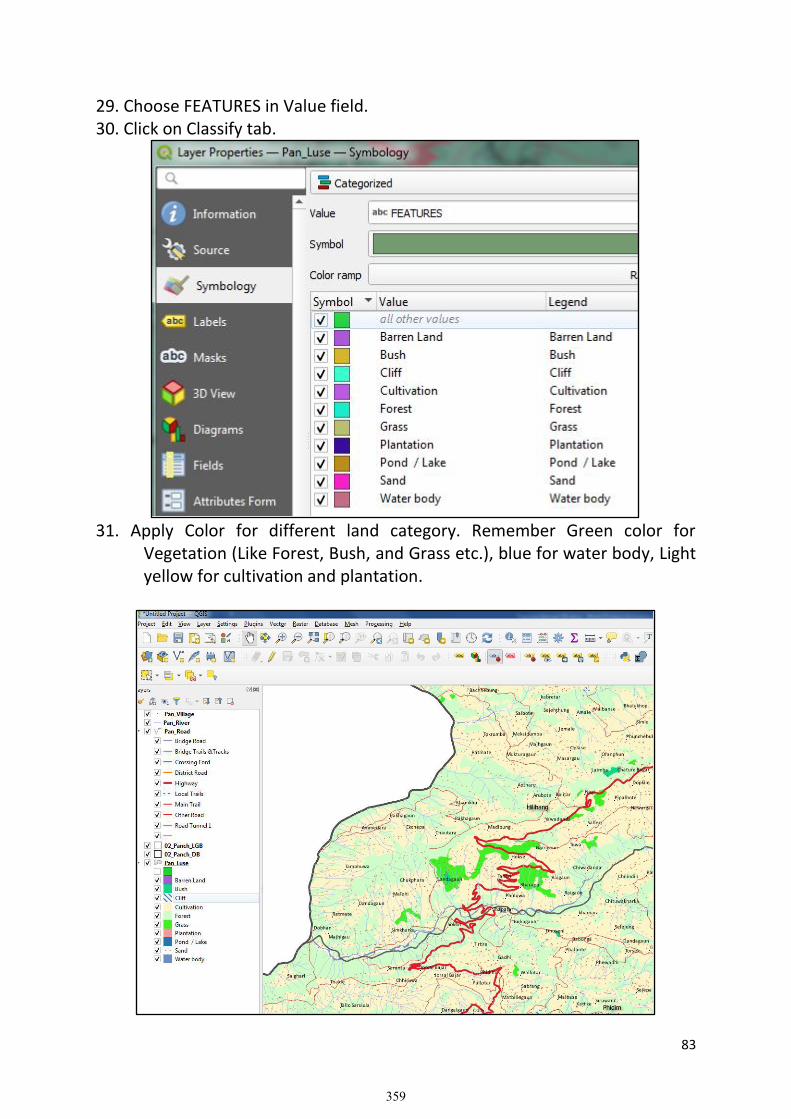
83
29. Choose FEATURES in Value field. 30. Click on Classify tab.
31. Apply Color for different land category. Remember Green color for Vegetation (Like Forest, Bush, and Grass etc.), blue for water body, Light yellow for cultivation and plantation.
359

84
Page Layout and Cartographic Elements:
A page layout (often referred to simply as a layout) is a collection of map
elements organized on a virtual page designed for map printing. Common map
elements include one or more data frames (each containing an ordered set of
map layers), a scale bar, north arrow, map title, descriptive text, and a legend.
For geographic reference, you can add grids or graticules.
Though page layouts can be exported and used electronically, they are
primarily designed for printing. Page layouts can have either a landscape
(wide) or portrait (tall) orientation. Page size varies depending on the
specifications for the output. What you see on the layout is what you get if you
print or export the map to the same page size.
Map Elements:
• Title/Sub title
• Orientation/North Arrow
• Scale Bar /Scale Text
• Legend
• Sources of Information
• Neat line, table, pictures and text (copy right, designer etc.)
360

85
Map Layout: Now that you’ve got a map, you need to be able to print it or to export it to a document. The reason is, a GIS map file is not an image. Rather, it saves the state of the GIS program, with references to all the layers, their labels, colors, etc. So for someone who doesn’t have the data or the same GIS program (such as QGIS), the map file will be useless. Luckily, QGIS can export its map file to a format that anyone’s computer can read, as well as printing out the map if you have a printer connected. Both exporting and printing is handled via the Print Layout. 1. Go to Project->New Print Layout 2. Give the name of the Layout in the text box 3. A separate layout window will be displayed as shown below 4. Right click on the center of map layout page and go to Page Properties. 5. Choose the Page size A4 and Orientation Landscape
6. Click on the Add Map button . With this tool activated, we will be able to place a map on the page. 7. Click and drag a box on the blank page. The map will appear on the page.
361

86
8. Be sure to leave margins along the edges, and a space along the top for the title. 9. Zoom in and out on the page (but not the map!) by using these buttons:
10. With Item Properties as shown below, we can update the changes in the map (for example moving the map from one area to another, zoom in and out) to Layout page of map layout window.
11. Adding Title: Click on the Add Label icon. 12. Click on the page, above the map, Accept the suggested values in the New Item Properties dialog, and a label will appear at the top of the map. 13. Resize it and place it in the top center of the page. It can be resized and moved in the same way that you resized and moved the map. 14. As we move the title, we’ll notice that guidelines appear to help the position for the title in the center of the page. However, there is also a
Using this icon, any changes in the view of the map will be updated to layout window.
362

87
tool in the Actions Toolbar to help position the title relative to the map.
15. Adding Legend: Click on the Add legend button. 16. Click on the page to place the legend, accept the suggested values in the New Item Properties dialog, 17. A legend is added to the layout page, showing layers symbology as set in the main dialog. 18. As usual, we can click and move the item to where we want it.
❖ Not everything on the legend is necessary, so let’s remove some unwanted items.
19. In the Item Properties tab, we’ll find the Legend items group. 20. Uncheck the Auto update box, allowing us to directly modify the legend items 21. Select the unwanted item in the legend list
22. Delete it from the legend by clicking the button ❖ You can also rename items.
23. Select a layer from the same list. 24. Click the Edit selected item properties button. 25. Rename the layers
Final Layout will be display like below
363

88
PREVIEW FOR PROJECT WORK EXERCISE
Panchthar District Boundary
Ward Boundary of Phidim Municipality
364

89
Panchthar District Boundary along Google Earth
Ward Boundary of Phidim Municipality along Google Earth
365

90
Panchthar District Boundary along Open Source Map
Ward Boundary of Phidim Municipality along Open Source Map
366

मूल्याङ्कनका औजारहरू

367
सडक ठेगाना र भौगोलिक सूचना प्रणािी प्रलिक्षण
पुर्व र पश्चात जानकारी
सहभागी लर्र्रण
नामः संस्ाः
पदः लजलिाः
अन्य लर्र्रण
क. लिङ्गः ख. उमेरः
ग. जाती घ. लिक्षाः
(क) तिका लर्षयहरुमा तपाईको ज्ञान र सीपको सतरीकरण लनम्न तररकािे गनुवहोस ्।
▪ विषयमा पटक्कै ज्ञान र सीप छैन भने १मा विन्ह लगाउनहुोस ्।
▪ विषयमा अवलअवल ज्ञान र सीप छ भने २मा विन्ह लगाउनहुोस ्।
▪ विषयमा सन्तोषजनक मात्रामा ज्ञान र सीप छ र ठीकै मात्रामा काययमा प्रयोगमा ल्याउन सक्नहुुन्छ भने ३ मा
विन्ह लगाउनहुोस ्।
▪ विषयमा राम्रो ज्ञान र सीप छ र आफ्नो काययमा प्रयोगमा ल्याउन सक्नहुुन्छ भने ४मा विन्ह लगाउनहुोस ्।
▪ विषयमा धेरै राम्रो ज्ञान र सीप छ र आफ्नो काययमा आत्मविश्वासका साथ प्रयोगमा ल्याउन सक्नहुुन्छ भने ५ मा
विन्ह लगाउनहुोस ्।
लर्र्रण
▪ शहरीकरण शहरी योजना शहर व्यिस्थापन तथा शहरी नीवतहरु १ २ ३ ४ ५
▪ आधारभतू पिूायधार तथा सेिाहरु र त्यस्का ितयमान अिस्था १ २ ३ ४ ५
▪ सडक ठेगाना यस्का कायायन्ियन पक्ष र िनुौतीहरु १ २ ३ ४ ५
▪ सडक ठेगाना सम्िन्धी वनर्दवेशका िारे जानकारी १ २ ३ ४ ५
▪ काठमाण्डौ उपत्यका मानवित्रण पररयोजना (केवभएमवप) १ २ ३ ४ ५
▪ सडक ठेगाना योजना लाग ुभएका नगरपावलकाहरुको अनुभि १ २ ३ ४ ५
▪ सडक ठेगाना र भौगोवलक सिुना प्रणालीको सम्िन्ध १ २ ३ ४ ५
▪ हाल पालीकाहरु बाट भइरहकेो अध्ययन, डाटाबेस तथा योजना
तथा मानवित्र विकास १ २ ३ ४ ५
▪ स्थानीय वनकायहरुबाट प्रयोग गरररहकेा ठेगाना प्रणाली सँम्िवन्धत
िा अन्य नयाँ प्रविवधहरु १ २ ३ ४ ५
Local Development Training Academy(Established by Local Development Training Academy Act, 2049)
:yfgLo ljsf; k|lzIf0f k|lti7fg -:yfgLo ljsf; k|lzIf0f k|lti7fg P]g, @)$( åf/f :yflkt_
"An Autonomous, Professional, Client Centered, Gender Responsive National
Institute of Excellence in the area of Local-Self Governance."
LDTA >>>नेपाल सरकार
सङ् घीय मावमला तथा सामान्य प्रशासन मन्त्रालय

368
(ख) तिका प्रश्नहरु राम्रोसंग अध्ययन गरी सबै प्रश्नको जर्ाफ लदनहुोस ्।
१. भौगोलिक सूचना प्रणािी तालिमको िागी लनम्न मध्ये कुन सफ्टयेरको प्रयोग गररन्छ ?
क) Microsoft Office Package
ख) QGIS Open Source Software
ग) SPSS
घ) मावथका सबै
२. भौगोलिक सूचना प्रणािी मा कुन प्रकारको Data प्रयोग हुन्छ ।
क) Vector Data
ख) Raster Data
ग) Vector and Raster Data
घ) Vector, Raster and Tabular Data
३. तिका मध्ये कुन चाहीं भौगोलिक सूचना तथयााँकको स्रोत होईन ।
क) GPS
ख) Remote Sensing
ग) Scanned Map with No Coordinates
घ) मावथका सबै
४. तिका मध्ये नापी लर्भागिे प्रयोग गने Map Projection System कुन हो ॽ
क) Universal Transverse Mercator (UTM)
ख) Modified Universal Transverse Mercator (MUTM)
ग) Everest 1830
५. GPS Device प्रयोग गरेर भु सतहको के तथयांक लिईन्छ ॽ
क) Longitude and Latitude Information
ख) Air Pressure Measurement
ग) Temperature Measurement
६. Google Earth बाट लिईएको तथयांक तिका मध्ये कुन Format मा हुन्छ ॽ
क) *.Shp
ख) *.Kml,
ग) *.Cov,

369
७. GIS Feature को र्णावत्मक लर्र्रणहरु भएको Data िाई के भलनन्छ ॽ
क) Spatial Data
ख) Attribute Data
ग) Vector Data
८. नापी लर्भागिे प्रयोग गने गरेको Map Projection पलछ कुन ईकाईमा िम्बाई त्ा के्षत्रफि गणना गनव सलकन्छ
ॽ
क) लम्बाई : वमटर, क्षेत्रफल : स्किायर वमटर
ख) लम्बाई : वफट, क्षेत्रफल : स्किायर वफट
ग) लम्बाई : ईन्ि, क्षेत्रफल : स्किायर ईन्ि
९. ७५३ स्ानीय लनकाय मध्ये ३०० स्र्ायर लक.लम. भन्दा ठुिो के्षत्रफि भएको छान्नको िागी कुन Query प्रयोग
गनुव पछव ॽ
क) Spatial Query
ख) Attribute Query
ग) Select by Location
१०. तिका मध्ये सबभन्दा सानो सकेि कुन हो ॽ
क) १:५००
ख) १:२५००
ग) १:२०००

370
सडक ठेगाना र भौगोलिक सूचना प्रणािी प्रलिक्षण
दैलनक पृष्ठपोषण फाराम (..........................लदन)
नामः ममम ः
१. आजकाा प्रमिक्षण सत्रहरूबाट के के मसकाइहरू भए ?
▪
▪
▪
▪
▪
२. पाईा ी मसकाइहरूलाई व्यवहारमा कसरी प्रयोग गननुहुन्छ ?
▪
▪
▪
▪
▪
३. प्रमिक्षणलाई अझ प्रभावकारी बनाउन के गननुपलाु ?
▪
▪
▪
▪
▪

371
सडक ठेगाना र भौगोलिक सूचना प्रणािी प्रलिक्षण
प्रलिक्षण अलतिम मूल्याङ्कन फाराम
प्रलिक्षणको नामः ........................................ प्रलिक्षण लमलिः .......................................
कृपया ििका प्रश्नहरूमा आफूिाई उपयकु्त िागेको लिकल्पमा लचह्न िगाउनुहोस ्।
१. यस प्रलिक्षणिाई िपारं्इ कसरी मूल्याङ्कन गनुुहुतछ ?
(क) उत्कृष्ट (ख) ज्यादै राम्रो (ग) राम्रो (घ) लठकै (ङ) सुधार गनुुपने
लिप्पणी सुझाि .........................................................................................................................................................
..................................................................................................................................................................................
२. सहजकिाुहरूिाई िपाई ंकसरी मूल्याङ्कन गनुुहुतछ ? (लिषयिस्िुको ज्ञान, सञ्चार क्षमिा, प्रस्िुिीकरण िैिी आलद)
(क) उत्कृष्ट (ख) ज्यादै राम्रो (ग) राम्रो (घ) लठकै (ङ) सुधार गनुुपने
लिप्पणी सुझाि...........................................................................................................................................................
..................................................................................................................................................................................
३. प्रलिक्षणको लिषयिस्ि ुिपारं्इिाई कस्िो िाग्यो ? (कामसगँ सम्बतधी र उपयोगी, ज्ञानमा िृलि, लसप र दक्षिाको लिकासमा
सहयोगी आलद)
(क) उत्कृष्ट (ख) ज्यादै राम्रो (ग) राम्रो (घ) लठकै (ङ) सुधार गनुुपने
लिप्पणी सुझाि...........................................................................................................................................................
..................................................................................................................................................................................
४. प्रलिक्षणमा प्रयोग भएको प्रलिक्षण लिलध िपाईिंाई कस्िो िाग्यो ? (लिषयिस्िु बुझ्नका िालग सहयोगी आलद)
(क) उत्कृष्ट (ख) ज्यादै राम्रो (ग) राम्रो (घ) लठकै (ङ) सुधार गनुुपने
लिप्पणी सुझाि...........................................................................................................................................................
..................................................................................................................................................................................
५. प्रलिक्षणमा उपिब्ध गरार्इएका पाठ्यसामग्री िथा सतदभुसामग्रीहरू िपार्इिंाई कस्िा िागे ? (लिषयिस्ि ुबुझ्नका िालग
सहयोगी, भािी प्रयोजनका िालग उपयुक्त आलद)
(क) उत्कृष्ट (ख) ज्यादै राम्रो (ग) राम्रो (घ) लठकै (ङ) सुधार गनुुपने
लिप्पणी सुझाि...........................................................................................................................................................
..................................................................................................................................................................................

स्थानीय तहको क्षमता अभिवृभिका लाभि तयार पाररएका प्रभिक्षण सामग्री
आिलािी र अग्नी भनयन्त्रण उपकरण सञ्चालन
फोहोरमैला व्यवस्थापन तथा वातावरण व्यवस्थापन
जग्िा नापजााँच
हररत आवास
सडक ठेिाना र िौिोभलक सूचना प्रणाली
एकीकृत स्थानीय भवकास योजना प्रणाली
Urban Design (अववन भडजाइन)
सूचना र संचार प्रभवभि
पूवाविार भनमावण
मोड्युल १२
मोड्युल १३
मोड्युल १४
मोड्युल १५
मोड्युल १६
मोड्युल १७
मोड्युल १८
मोड्युल १९
मोड्युल २०
मोड्युल २१
चट्टयाङ्ि र भवदु्यतीय लेखा परीक्षण
नेपाल सरकार
सङ्घीय माममला तथा सामान्य प्रशासन मन्रालय
िवन भनमावण मापदण्ड तथा िवन संभहता
मोड्युल ११