document - 7025313 v5 logan city council evacuation … · this "report into evacuation risk...
TRANSCRIPT

Document - 7025313 v5 Logan City Council Evacuation Risk Management Study 1
Document - 7025313 v5 Logan City Council Evacuation Risk Management Study 2
Foreword
On behalf of the Logan City Council Local Disaster Management Group, we are pleased to present this "Report into Evacuation Risk Management - a Natural Disaster Mitigation Project for Logan City Council".
This report was produced through joint funding by the Australian Government Attorney-General's Department (Australian Emergency Management), the Queensland Government (Department of Community Safety) and Logan City Council.
The completion of this report signifies the end of a long and extensive investigation by a dedicated project team and the input by many agencies that have key interests in community safety through disaster management.
The report provides an overview of significant threats to the city, the population at risk from these events and the critical lifelines, infrastructure and facilities that are essential to transition residents and visitors from a threatening environment to an area of short-term safety or shelter.
The report is not an operational document but provides the foundation for key disaster management planners to develop strategies to enable the necessary processes to be successfully implemented.
Key recommendations for future actions that are contained in the Executive Summary will be evaluated by the Local Disaster Management Group in conjunction with Logan City Council to enable further development of response and recovery strategies.
We commend this report to you.
Mayor Pam Parker Chris Rose
Logan City Council Chief Executive Officer
Chair of Local Disaster Management Group Logan City Council
Document - 7025313 v5 Logan City Council Evacuation Risk Management Study 3
Important Information about this Document
Logan City Council permits the use of material contained in this report to be reproduced for research or planning purposes provided that any material used remains unaltered and due recognition of the source of the materials is recognised.
Any party using the information for any purposes does so at their own risk and releases and indemnifies Logan City Council against all responsibility and liability (including negligence, negligent misstatement and pure economic loss) for all expenses, losses, damages and costs as a consequence of such use.
All requests for additional or clarifying information regarding this document are to be referred to:
The Disaster Management Program Leader Logan City Council PO Box 3226 LOGAN CENTRAL DC 4114 (07) 3412 5282
Website: www.logan.qld.gov.au
Email: [email protected]
Document - 7025313 v5 Logan City Council Evacuation Risk Management Study 4
Table of Contents Executive Summary................................................................................................................................. 6
Project Outline ......................................................................................................................................... 7
1. Demographics ........................................................................................................................ 9
1.1 Geography ......................................................................................................................... 9
1.2 Logan City Population...................................................................................................... 10
1.3 Vulnerable Communities.................................................................................................. 11
2. Hazards/Threats................................................................................................................... 12
3. Report and Findings............................................................................................................. 13
3.1 Past Studies and Reports ................................................................................................ 13
3.2 Existing Management Plans ............................................................................................ 13
4. Range of Risks and Constraints .......................................................................................... 15
4.1 Planning Constraints........................................................................................................ 15
4.2 Areas of Risk.................................................................................................................... 16
4.3 Roads Subject to Flooding............................................................................................... 18
4.4 Logan Police District Traffic Choke Points ...................................................................... 22
5. Monitoring Mechanisms ....................................................................................................... 24
5.1 Event Coordination .......................................................................................................... 24
5.2 Public Warning Systems.................................................................................................. 24
5.3 Issue of Warnings ............................................................................................................ 24
5.4 Public Education .............................................................................................................. 25
6. Communication Strategies ................................................................................................... 26
6.1 Public education and information..................................................................................... 26
6.2 Content of Warning Messages ........................................................................................ 28
7. Evacuation Management Strategies .................................................................................... 30
7.1 Mapping ........................................................................................................................... 30
7.2 Vulnerable Communities.................................................................................................. 30
8. Logan City Council Emergency Shelter and Accommodation Planning .............................. 32
9. Support Agency Response Capability ................................................................................. 33
10. Essential Infrastructure and Evacuation Risks..................................................................... 34
10.1 Vulnerable Community (See Appendix 16.1) .............................................................. 34
10.2 Sensitive Facilities ....................................................................................................... 34
10.3 Essential Infrastructure................................................................................................ 34
10.4 Transport ..................................................................................................................... 34
10.5 Infrastructure ............................................................................................................... 35
11. Disaster Management Roles and Responsibilities .............................................................. 36
Document - 7025313 v5 Logan City Council Evacuation Risk Management Study 5
12. Exercise to evaluate strategies and systems....................................................................... 40
13. Recommendations ............................................................................................................... 41
14. References........................................................................................................................... 46
15. Acknowledgements .............................................................................................................. 48
16. Document Tables ................................................................................................................. 49
17. Appendices .......................................................................................................................... 50
17.1 Vulnerable Communities ............................................................................................. 50
17.2 Example of an Evacuation Centre Survey Form......................................................... 54
17.3 Warning Templates ..................................................................................................... 64
17.4 Emergency Alert Templates ........................................................................................ 66
17.5 Flood Risk Mapping..................................................................................................... 68
17.6 Fire Risk Mapping........................................................................................................ 69

Document - 7025313 v5 Logan City Council Evacuation Risk Management Study 6
Executive Summary
This project has provided Logan City Council with an overview of potential high risk population areas that may be exposed to key natural disaster threats such as fire, flood, cyclone and severe storm events and the strategies needed to put an evacuation plan into place. This report also recognises that man-made threats may have a similar effect on the community.
Existing evacuation management arrangements were examined and deficiencies that would affect the safe evacuation of residents were identified. The project documented several areas requiring specialised planning to ensure safe evacuation processes - aged care facilities, educational institutions, people with disabilities and elderly residents with mobility issues living in their own homes. The study also addressed the coordination of response and recovery services to enable the mass evacuation and return of affected residents.
As a result of this project, the following key areas need to be addressed to ensure an effective evacuation plan:
Investigation of all vulnerable communities
Identification of shelters and evacuation centres specific to the threat
Identification of areas/suburbs at risk
Determination of evacuation methods for specific threats
Identification of evacuation routes
Investigation of transport issues
Investigation of warning methods and the determination of the agency responsible for the dissemination of the warning.
Accordingly, the following recommendations for further action are made as an outcome of this project:
Develop a comprehensive evacuation sub-plan
Develop a risk matrix to collate all necessary information relevant to the decision making process in an evacuation situation
Collate emergency information specific to individual aged care and respite facilities, child care centres, educational institutions and accommodation outlets to assist decision making during a disaster event
Review use of media for dissemination of warnings and public information during a disaster event, especially investigating the use of social media networks such as Twitter and Facebook
Further develop mapping for operational and planning use
Develop guidelines to identify suitable shelter or evacuation facilities
Develop a community education programme to assist residents and business owners to be aware of the seasonal threats and to prepare for them
Develop a comprehensive evacuation transport sub-plan
Develop a comprehensive evacuation centre management sub-plan
Design and produce temporary directional signage for use in evacuation and emergency situations.
These recommendations will be further discussed and expanded at Section 13.
In conclusion, this project has identified areas of risk and on-going work that needs to be addressed to ensure that Logan City Council is prepared for disaster events and capable of coordinating efficient and timely evacuations.

Document - 7025313 v5 Logan City Council Evacuation Risk Management Study 7
Project Outline
The purpose of this report is to identify areas of risk in the Logan City area and to put into place strategies that would assist in the planning of evacuations. It is not an operational document but will provide guidance for the Logan City Local Disaster Management Group and agencies in preparedness, response and recovery.
The project has identified the hazards likely to trigger evacuation needs and has documented existing high risk and potential high risk areas that may require specialised planning to ensure safe evacuation processes. Discussions with Education Queensland and questionnaires to aged care facilities have established the state of their evacuation policies and procedures and have given an understanding of the preparedness and potential needs of these two groups.
By identifying hazard impact areas that may require evacuation, it was possible to map suitable evacuation routes and to then investigate problem areas along those roads. Two potential difficulties were investigated - road closures owing to flooding and streets that could become congested when mass evacuations occur.
In the event of evacuation, it is essential that the people have somewhere to go. While the best solution is to move to family and friends, there will be some residents or visitors who have no alternative but to attend an evacuation centre. The Logan City Emergency Evacuation (Shelter) Centre Manual provides a comprehensive inventory of existing and potential evacuation centres. The mapping has identified these evacuation centres and the road network available to reach them.
During the process of gathering information and writing this report, there have been regular Study Advisory Group meetings where experienced personnel have come together to discuss issues and provide insight. As an addition to this the primary Support Agencies were asked to confirm their capabilities as defined in the Logan City Local Disaster Management Plan. There was limited response to this but it would seem that those agencies which replied are well prepared to carry out their duties in the event of an evacuation situation. Non-government organisations that would have a supportive role were also identified and asked to confirm their capabilities as outlined in the Logan City Council Community Recovery Sub-Plan of the Local Disaster Management Plan.
The methodology employed was to undertake a study addressing the issues as outlined above by:
1. Reviewing and reporting on all past data and studies applicable to evacuation management previously undertaken for the three pre-amalgamation local governments.
2. Reviewing and reporting on the range of risks and constraints that may inhibit the safe evacuation of persons from various locations due to adverse events.
3. Recommending a common set of controls to effect and monitor the evacuation of affected persons in conjunction with the Council's proposed emergency software.
4. Reviewing and reporting on existing response and infrastructure capability of combat or support agencies to effect the safe evacuation of affected persons within Logan City and neighbouring local governments.
5. Reviewing and reporting on the Logan City Council's Emergency Shelter and Accommodation planning to support evacuation operations.
6. Reviewing and reporting on existing warning and information systems to support evacuation operations; recommending strategies to improve the delivery and dissemination of evacuation advice and the education of the community in evacuation.
7. Providing recommendations for the implementation of a city wide Evacuation Management strategy.
Document - 7025313 v5 Logan City Council Evacuation Risk Management Study 8
The Study Advisory Group members:
Allen, Deonie Logan City Council River and Catchment Engineering Program Leader
Benstead, Helen Logan City Council Business Systems and Project Officer
Bird, Nardine Logan City Council Flood Management Officer
Burton, Margaretta Emergency Management Queensland Area Director
Carter, Eleanor Australian Red Cross Emergency Services Regional Coordinator
Fulton, Debra Logan City Council Disaster Management Project Officer
Keks, Steven Logan City Council Principal Environmental Health Officer
Lutton, Russell Logan City Council Deputy Mayor
Monaghan, Peter Queensland Police Service District Disaster Management Group Operations Officer
Naiker, Deva Logan City Council Traffic Program Leader
Neller, Ken Logan City Council Disaster Management Program Leader
Nelson, Rhonda Logan City Council Disaster Management Project Officer
Schneider, Katherine Department of Communities Community Recovery Officer
Schuster, Mark Logan City Council Senior Environment Officer
Brian Scotney Logan City Council Disaster Management Project Leader
Wall, Stewart Logan City Council Road Infrastructure Management Manager
Womersley, Paul Queensland Fire and Rescue Service I Zone Training Officer
Document - 7025313 v5 Logan City Council Evacuation Risk Management Study 9
1. Demographics
1.1 Geography
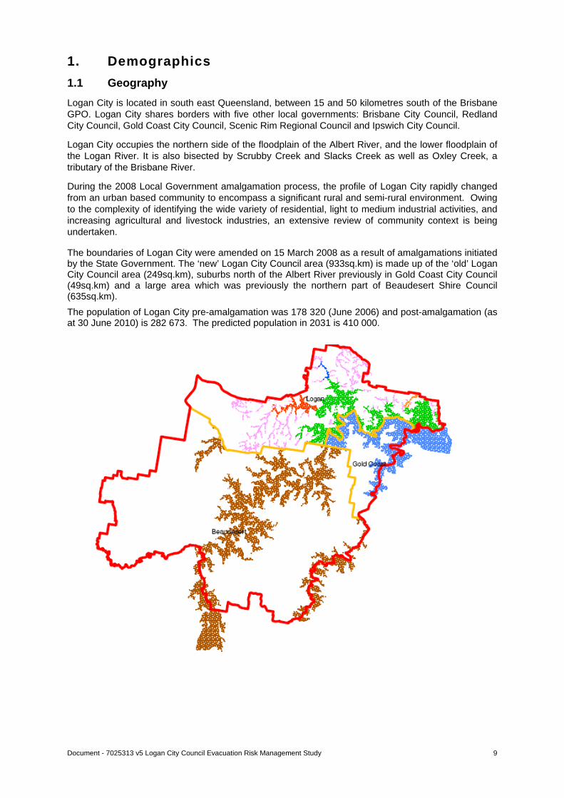
Logan City is located in south east Queensland, between 15 and 50 kilometres south of the Brisbane GPO. Logan City shares borders with five other local governments: Brisbane City Council, Redland City Council, Gold Coast City Council, Scenic Rim Regional Council and Ipswich City Council.
Logan City occupies the northern side of the floodplain of the Albert River, and the lower floodplain of the Logan River. It is also bisected by Scrubby Creek and Slacks Creek as well as Oxley Creek, a tributary of the Brisbane River.
During the 2008 Local Government amalgamation process, the profile of Logan City rapidly changed from an urban based community to encompass a significant rural and semi-rural environment. Owing to the complexity of identifying the wide variety of residential, light to medium industrial activities, and increasing agricultural and livestock industries, an extensive review of community context is being undertaken.
The boundaries of Logan City were amended on 15 March 2008 as a result of amalgamations initiated by the State Government. The ‘new’ Logan City Council area (933sq.km) is made up of the ‘old’ Logan City Council area (249sq.km), suburbs north of the Albert River previously in Gold Coast City Council (49sq.km) and a large area which was previously the northern part of Beaudesert Shire Council (635sq.km).
The population of Logan City pre-amalgamation was 178 320 (June 2006) and post-amalgamation (as at 30 June 2010) is 282 673. The predicted population in 2031 is 410 000.

Document - 7025313 v5 Logan City Council Evacuation Risk Management Study 10
1.2 Logan City Population
Logan City has always been a place attractive to migrating families, from the early days of pioneering settlers from the British Isles and Germany to the ongoing influx today from a wide variety of foreign lands.
Suburb Population
Beenleigh 8 549
Bethania - Waterford 8 171
Browns Plains 31 245
Carbrook - Cornubia 4 000
Daisy Hill - Priestdale 4 733
Eagleby 11 386
Edens Landing - Holmview 6 747
Greenbank - Boronia Heights 6 418
Jimboomba - Logan Village 45 120
Kingston 13 482
Loganholme 14 761
Loganlea 9 431
Marsden 22 526
Mount Warren Park 6 370
Park Ridge - Logan Reserve 2 902
Rochedale South 15 731
Shailer Park 12 288
Slacks Creek 11 756
Springwood 6 382
Tanah Merah 1 021
Underwood 5 275
Waterford West 6 276
Wolffdene - Bahrs Scrub 5 576
Woodridge 19 875
Total Logan City 282 673
Australian Bureau of Statistics; Estimated Resident Population, Statistical Local Areas, Queensland; 31 March 2011
Document - 7025313 v5 Logan City Council Evacuation Risk Management Study 11
1.3 Vulnerable Communities
Within Logan City there are a number of sensitive facilities that may require priority or specialised assistance in disaster events. These include educational (primary, secondary and tertiary), child care and aged care facilities, a hospital, community centres and accommodation outlets (hotels, motels and caravan parks). Within this report, special attention has been given to schools and aged care facilities.
Document - 7025313 v5 Logan City Council Evacuation Risk Management Study 12
2. Hazards/Threats
The following potential hazards or disaster threats to the Logan City Council area have been identified:
Flood
Severe Weather Event - cyclone, east coast low, storm (wind, rain, hail), storm surge
Fire (urban and rural)
Major Transport Accident (air, road, rail, marine)
Emergency Animal/Plant Disease
Hazardous Material Accident
Epidemic/Pandemic
Earthquake
Tsunami
Landslip
Terrorism.
For the purpose of this Evacuation Risk Management Study, it has been decided to concentrate on the first three, as they are more likely to trigger an evacuation in Logan City.
Document - 7025313 Logan City Council Evacuation Risk Management Study
13
3. Report and Findings
3.1 Past Studies and Reports
The following risk studies had been conducted prior to amalgamation:
Logan City Natural Disaster Risk Management Study, June 2005, undertaken by Landmarc Pty Ltd.
Beaudesert Shire Natural Disaster Risk Management Study, 2004, undertaken by Landmarc Pty Ltd.
Gold Coast Natural Disaster Risk Management Study, date and consultant unknown.
Multi Hazard Risk Assessment, Logan City, Australian Geological Survey Organisation, 2001.
Bushfire Management, Landmarc Pty Ltd, 2005.
Beaudesert Shire Bushfire Risk Management Study, Draft Report March 2006, undertaken by Institute for International Development Ltd.
Gold Coast City Council – “Bushfire Management Strategy” April 1998, undertaken by the Bushfire Management Strategy Taskforce – a consortium of Council members, Industry representatives, Academics, Fire Services personnel and State Government Department members.
Summary
These studies are outdated for several reasons, including:
The Logan City Council boundaries have changed and considerable development has occurred within the boundaries of the new local government area since these publications were released.
This development has occurred under the varying provisions of the planning schemes of the former local governments.
Previous studies, including numerous flood studies, undertaken by the former local governments did not specifically relate to the evacuation needs of the affected communities.
None of the local disaster management plans for the former local government areas specifically address the risk of evacuation to the affected community.
The current Local Disaster Management Plan does not have an Evacuation Sub Plan.
3.2 Existing Management Plans
Logan City Council is committed to its responsibilities under the Disaster Management Act 2003, amended November 2010.
Existing disaster management arrangements include:
Facilitating the operations of the Local Disaster Management Group and relevant sub-committees
Maintenance and implementation of the Local Disaster Management Plan and relevant Sub Plans.
Commitment to Disaster Response and Recovery capabilities including:
o Dedicated Management Unit
o Provision of operational staff and resources
o Participation in Disaster Management Forums at all levels of government
o Conducting regular disaster management exercises/simulations
o Implementing various review processes
o Disaster management roles and responsibilities incorporated into business planning, position descriptions, role statements etc.

Document - 7025313 Logan City Council Evacuation Risk Management Study
14
Disaster Management Roles and Responsibilities of Logan City Council in evacuation processes
Functions as allocated to the Logan City Local Disaster Management Group under section 57 of the Disaster Management Act 2003
Development of comprehensive local disaster management planning strategies
Design and maintenance of a public education/awareness program, which is delivered through member agency resources
Coordination of support to response agencies
Reconnaissance and impact assessment
Provision of public information prior to, during and following disaster events
Recommend areas/locations to be considered for authorised evacuation
Provide public advice regarding voluntary evacuation
Identification, resourcing, staffing, management and operation of evacuation centres
Provision of locally based community support services
Design, maintenance and operation of a Disaster Coordination Centre, including the training of sufficient personnel to operate the centre
Response Procedures
Response is defined as the actions taken in anticipation of, during and immediately after an emergency to ensure that its effects are minimised, and that people affected are given immediate relief and support, Emergency Management Australia Glossary, Manual 3.
The principle purpose of emergency response is the preservation of life and property and includes having well trained personnel available to respond to a hazard situation.
Emergency response includes:
Establishment and training of Council staff in Australasian Inter-service Incident Management System to form part of multiple Incident Management Teams
Activation of the Disaster Coordination Centre
Conducting regular training and exercises for response and recovery teams
Utilising all available resources to ensure timely and reliable information is provided to the community
Provision of flood information to businesses and residents
Coordination of resources.
The Queensland Police Service is the lead agency in the activation of evacuation procedures.
Support agencies include Logan City Council, State Emergency Service, Bureau of Meteorology, Queensland Ambulance Service, Queensland Fire and Rescue Service, Department of Transport and Main Roads, Department of Public Works and Housing and Department of Communities, Child Safety and Disability Services.
Document - 7025313 Logan City Council Evacuation Risk Management Study
15
4. Range of Risks and Constraints
4.1 Planning Constraints
The conduct of a successful evacuation is dependent on a number of key planning issues affecting the following threats.
Severe Weather Event:
4.1.1. Warning Time (Cyclone): The Bureau of Meteorology provides Tropical Cyclone advices including the provision of Cyclone Watches and Cyclone Warnings (impact likely within 24 hours). Planners may require more than this time to conduct evacuations for significant numbers or if they have evacuation routes that can be flooded.
4.1.2. Warning Time (Storm Surge): The Bureau of Meteorology and the Environmental Protection Agency provide storm tide warnings and advice. Typically, the ability to predict a storm surge and its extent will not be possible until the cyclone is in close proximity to the coastline. This reduces the available warning time.
4.1.3. Evacuation Completion Time: Any evacuation must be complete prior to the onset of 100kmh winds. This will allow emergency services staff time to seek appropriate shelter.
4.1.4. Available Evacuation Routes: Managing evacuation routes will be a key planning constraint for an evacuation requiring early decision making and public advice to ensure evacuation routes are not flooded and can be used when needed.
Flooding:
4.1.5. Warning Time: The Bureau of Meteorology produces flood warnings that are widely broadcast to the community but there are no specific warning systems aimed at those vulnerable to flooding.
4.1.6. River Levels: The Bureau of Meteorology is able to capture data on rainfall and river levels in the catchment areas of most coastal rivers but sudden downpours in unrecorded areas can raise flood levels without warning.
4.1.7. Evacuation Methods: Voluntary evacuation for moving people in low lying areas when the uncertainty of the event is high, or if the predicted flood height will isolate a property and leave no escape route if conditions deteriorate and rescue strategies are not feasible.
4.1.8. Available Evacuation Routes: Urban evacuation routes may give a number of alternatives but rural evacuation routes can easily be flooded, become unsuitable for traffic or be destroyed.
Bushfire:
4.1.9. Warning Time: Within Logan City there are large tracts of urban and rural land which are prone to bushfires. Several rural communities may become isolated. Warning systems in the rural areas may be limited or hampered by poor reception and residents are often reliant on a good neighbourhood network. Warning time is usually minimal because of the rapid spread of fire.
4.1.10. Evacuation Methods: Reliant on residents' self-education and knowledge of their local area. There needs to be fire management education for residents in hazardous areas and pre-event education on evacuation methods to assist in the decision to "stay or flee". The Rural Fire Service has a very good public education system in place.
Document - 7025313 Logan City Council Evacuation Risk Management Study
16
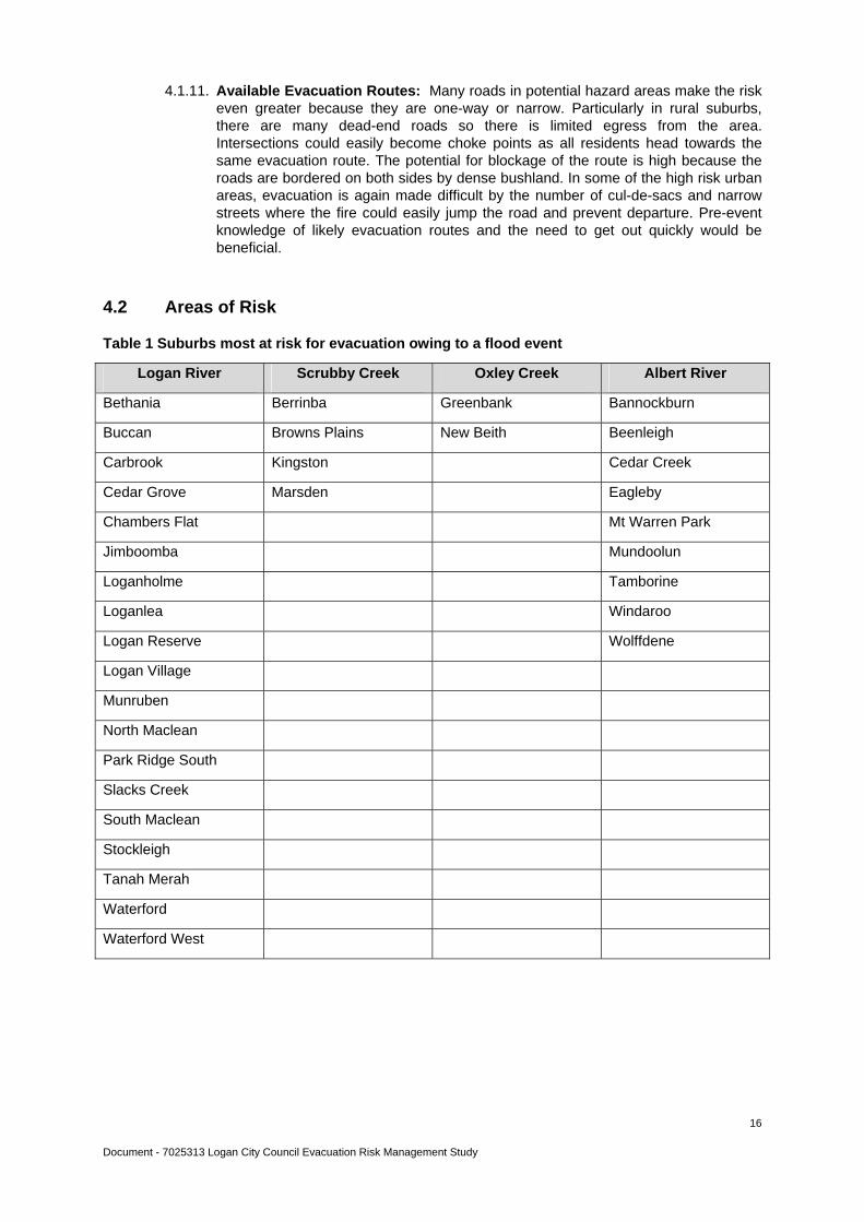
4.1.11. Available Evacuation Routes: Many roads in potential hazard areas make the risk even greater because they are one-way or narrow. Particularly in rural suburbs, there are many dead-end roads so there is limited egress from the area. Intersections could easily become choke points as all residents head towards the same evacuation route. The potential for blockage of the route is high because the roads are bordered on both sides by dense bushland. In some of the high risk urban areas, evacuation is again made difficult by the number of cul-de-sacs and narrow streets where the fire could easily jump the road and prevent departure. Pre-event knowledge of likely evacuation routes and the need to get out quickly would be beneficial.
4.2 Areas of Risk
Table 1 Suburbs most at risk for evacuation owing to a flood event
Logan River Scrubby Creek Oxley Creek Albert River
Bethania Berrinba Greenbank Bannockburn
Buccan Browns Plains New Beith Beenleigh
Carbrook Kingston Cedar Creek
Cedar Grove Marsden Eagleby
Chambers Flat Mt Warren Park
Jimboomba Mundoolun
Loganholme Tamborine
Loganlea Windaroo
Logan Reserve Wolffdene
Logan Village
Munruben
North Maclean
Park Ridge South
Slacks Creek
South Maclean
Stockleigh
Tanah Merah
Waterford
Waterford West
Document - 7025313 Logan City Council Evacuation Risk Management Study
17
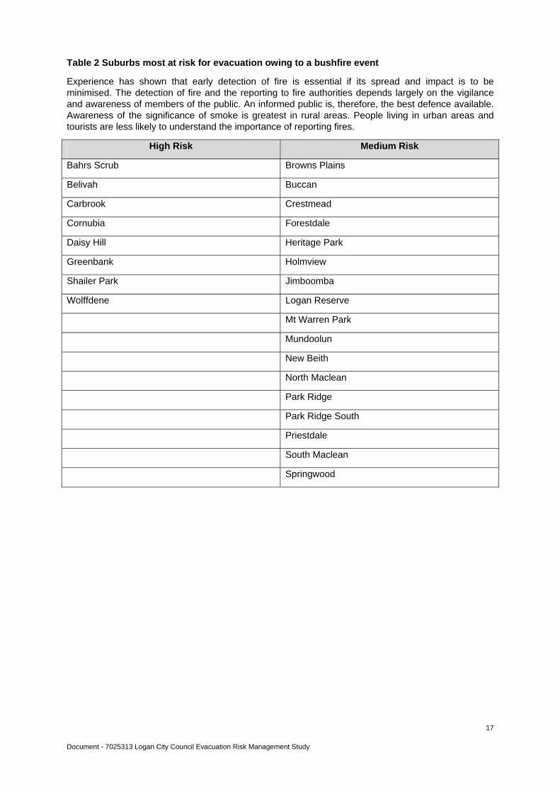
Table 2 Suburbs most at risk for evacuation owing to a bushfire event
Experience has shown that early detection of fire is essential if its spread and impact is to be minimised. The detection of fire and the reporting to fire authorities depends largely on the vigilance and awareness of members of the public. An informed public is, therefore, the best defence available. Awareness of the significance of smoke is greatest in rural areas. People living in urban areas and tourists are less likely to understand the importance of reporting fires.
High Risk Medium Risk
Bahrs Scrub Browns Plains
Belivah Buccan
Carbrook Crestmead
Cornubia Forestdale
Daisy Hill Heritage Park
Greenbank Holmview
Shailer Park Jimboomba
Wolffdene Logan Reserve
Mt Warren Park
Mundoolun
New Beith
North Maclean
Park Ridge
Park Ridge South
Priestdale
South Maclean
Springwood
Document - 7025313 Logan City Council Evacuation Risk Management Study
18
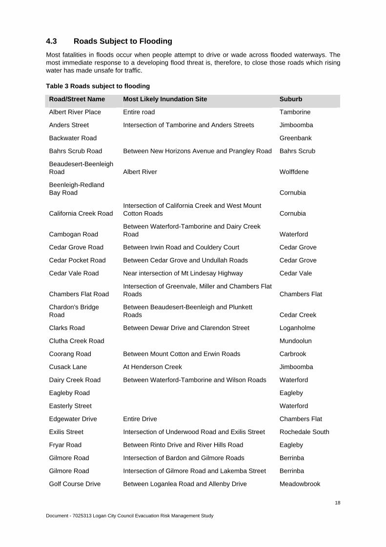
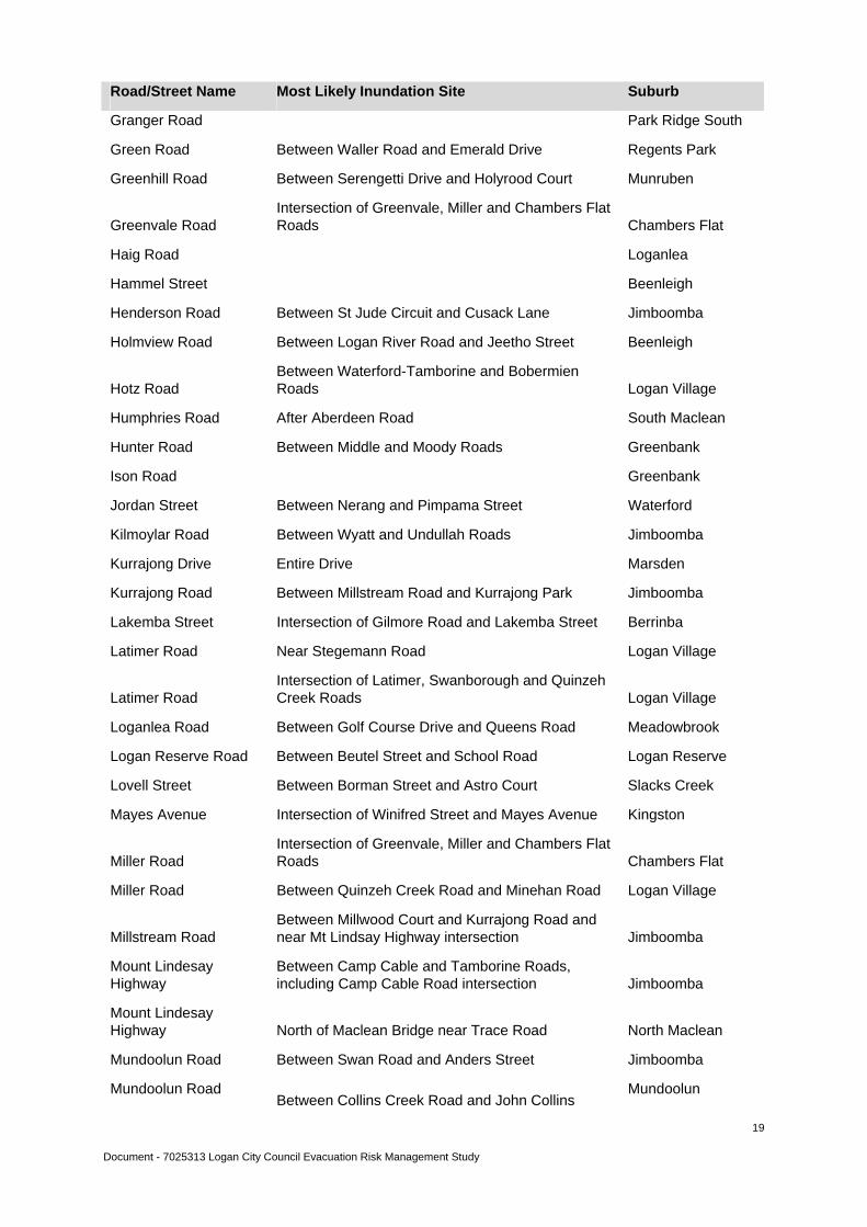
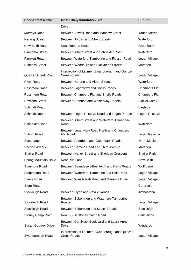
4.3 Roads Subject to Flooding
Most fatalities in floods occur when people attempt to drive or wade across flooded waterways. The most immediate response to a developing flood threat is, therefore, to close those roads which rising water has made unsafe for traffic.
Table 3 Roads subject to flooding
Road/Street Name Most Likely Inundation Site Suburb
Albert River Place Entire road Tamborine
Anders Street Intersection of Tamborine and Anders Streets Jimboomba
Backwater Road Greenbank
Bahrs Scrub Road Between New Horizons Avenue and Prangley Road Bahrs Scrub
Beaudesert-Beenleigh Road Albert River Wolffdene
Beenleigh-Redland Bay Road Cornubia
California Creek Road Intersection of California Creek and West Mount Cotton Roads Cornubia
Cambogan Road Between Waterford-Tamborine and Dairy Creek Road Waterford
Cedar Grove Road Between Irwin Road and Couldery Court Cedar Grove
Cedar Pocket Road Between Cedar Grove and Undullah Roads Cedar Grove
Cedar Vale Road Near intersection of Mt Lindesay Highway Cedar Vale
Chambers Flat Road Intersection of Greenvale, Miller and Chambers Flat Roads Chambers Flat
Chardon's Bridge Road
Between Beaudesert-Beenleigh and Plunkett Roads Cedar Creek
Clarks Road Between Dewar Drive and Clarendon Street Loganholme
Clutha Creek Road Mundoolun
Coorang Road Between Mount Cotton and Erwin Roads Carbrook
Cusack Lane At Henderson Creek Jimboomba
Dairy Creek Road Between Waterford-Tamborine and Wilson Roads Waterford
Eagleby Road Eagleby
Easterly Street Waterford
Edgewater Drive Entire Drive Chambers Flat
Exilis Street Intersection of Underwood Road and Exilis Street Rochedale South
Fryar Road Between Rinto Drive and River Hills Road Eagleby
Gilmore Road Intersection of Bardon and Gilmore Roads Berrinba
Gilmore Road Intersection of Gilmore Road and Lakemba Street Berrinba
Golf Course Drive Between Loganlea Road and Allenby Drive Meadowbrook
Document - 7025313 Logan City Council Evacuation Risk Management Study
19
Road/Street Name Most Likely Inundation Site Suburb
Granger Road Park Ridge South
Green Road Between Waller Road and Emerald Drive Regents Park
Greenhill Road Between Serengetti Drive and Holyrood Court Munruben
Greenvale Road Intersection of Greenvale, Miller and Chambers Flat Roads Chambers Flat
Haig Road Loganlea
Hammel Street Beenleigh
Henderson Road Between St Jude Circuit and Cusack Lane Jimboomba
Holmview Road Between Logan River Road and Jeetho Street Beenleigh
Hotz Road Between Waterford-Tamborine and Bobermien Roads Logan Village
Humphries Road After Aberdeen Road South Maclean
Hunter Road Between Middle and Moody Roads Greenbank
Ison Road Greenbank
Jordan Street Between Nerang and Pimpama Street Waterford
Kilmoylar Road Between Wyatt and Undullah Roads Jimboomba
Kurrajong Drive Entire Drive Marsden
Kurrajong Road Between Millstream Road and Kurrajong Park Jimboomba
Lakemba Street Intersection of Gilmore Road and Lakemba Street Berrinba
Latimer Road Near Stegemann Road Logan Village
Latimer Road Intersection of Latimer, Swanborough and Quinzeh Creek Roads Logan Village
Loganlea Road Between Golf Course Drive and Queens Road Meadowbrook
Logan Reserve Road Between Beutel Street and School Road Logan Reserve
Lovell Street Between Borman Street and Astro Court Slacks Creek
Mayes Avenue Intersection of Winifred Street and Mayes Avenue Kingston
Miller Road Intersection of Greenvale, Miller and Chambers Flat Roads Chambers Flat
Miller Road Between Quinzeh Creek Road and Minehan Road Logan Village
Millstream Road Between Millwood Court and Kurrajong Road and near Mt Lindsay Highway intersection Jimboomba
Mount Lindesay Highway
Between Camp Cable and Tamborine Roads, including Camp Cable Road intersection Jimboomba
Mount Lindesay Highway North of Maclean Bridge near Trace Road North Maclean
Mundoolun Road Between Swan Road and Anders Street Jimboomba
Mundoolun Road Between Collins Creek Road and John Collins
Mundoolun
Document - 7025313 Logan City Council Evacuation Risk Management Study
20
Road/Street Name Most Likely Inundation Site Suburb
Drive
Murrays Road Between Sewell Road and Mandew Street Tanah Merah
Nerang Street Between Jordan and Albert Streets Waterford
New Beith Road Near Roberts Road Greenbank
Pimpama Street Between Albert Street and Schneider Road Waterford
Plunkett Road Between Waterford-Tamborine and Flesser Road Logan Village
Princess Street Between Woodburn and Blackbean Streets Marsden
Quinzeh Creek Road Intersection of Latimer, Swanborough and Quinzeh Creek Roads Logan Village
River Road Between Nerang and Albert Streets Waterford
Rossmore Road Between Loganview and Sheils Roads Chambers Flat
Rossmore Road Between Chambers Flat and Sheils Roads Chambers Flat
Rowland Street Between Brennan and Westerway Streets Slacks Creek
Schmidt Road Eagleby
Schmidt Road Between Logan Reserve Road and Logan Parade Logan Reserve
Schneider Road Between Albert Street and Waterford-Tamborine Road Waterford
School Road Between Loganview Road North and Chambers Flat Road Logan Reserve
Scott Lane Between Aberdeen and Greenbank Roads North Maclean
Second Avenue Between Demeio Road and Third Avenue Marsden
Shailer Road Between Harley Street and Sheridan Crescent Shailer Park
Spring Mountain Drive Near Pub Lane New Beith
Stanmore Road Between Beaudesert-Beenleigh and Harts Roads Wolffdene
Stegemann Road Between Waterford-Tamborine and Hein Road Logan Village
Steele Road Between Wandearah Road and Maranoa Drive Logan Village
Stern Road Carbrook
Stockleigh Road Between Flynn and Neville Roads Jimboomba
Stockleigh Road Between Bobermien and Waterford-Tamborine Roads Logan Village
Stockleigh Road Between Bobermien and Musch Roads Stockleigh
Stoney Camp Road Near 38-56 Stoney Camp Road Park Ridge
Susan Godfrey Drive Between Carl Heck Boulevard and Laura Anne Drive Windaroo
Swanborough Road Intersection of Latimer, Swanborough and Quinzeh Creek Roads Logan Village

Document - 7025313 Logan City Council Evacuation Risk Management Study
21
Road/Street Name Most Likely Inundation Site Suburb
Tamarin Street Entire Street Marsden
Tamborine Street Intersection of Tamborine and Anders Streets Jimboomba
Third Avenue Between Demeio Road and Second Avenue Marsden
Underwood Road Intersection of Underwood Road and Exilis Street Rochedale South
Waterford-Tamborine Road
Between North Street roundabout and Stegemann Road Logan Village
West Mount Cotton Road
Intersection of West Mount Cotton and Wuduru Roads Cornubia
West Mount Cotton Road
Intersection of California Creek and West Mount Cotton Roads Cornubia
Wild Pig Creek Road Undullah
Winifred Street Intersection of Winifred Street and Mayes Avenue Kingston
Wuduru Road Intersection of West Mount Cotton and Wuduru Roads Cornubia
Document - 7025313 Logan City Council Evacuation Risk Management Study
22
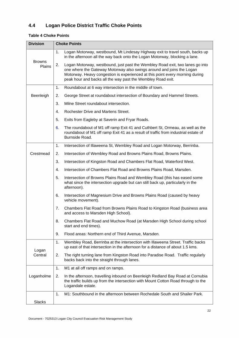
4.4 Logan Police District Traffic Choke Points
Table 4 Choke Points
Division Choke Points
Browns Plains
1. Logan Motorway, westbound, Mt Lindesay Highway exit to travel south, backs up in the afternoon all the way back onto the Logan Motorway, blocking a lane.
2. Logan Motorway, westbound, just past the Wembley Road exit, two lanes go into one where the Gateway Motorway also swings around and joins the Logan Motorway. Heavy congestion is experienced at this point every morning during peak hour and backs all the way past the Wembley Road exit.
Beenleigh
1. Roundabout at 6 way intersection in the middle of town.
2. George Street at roundabout intersection of Boundary and Hammel Streets.
3. Milne Street roundabout intersection.
4. Rochester Drive and Martens Street.
5. Exits from Eagleby at Saverin and Fryar Roads.
6. The roundabout of M1 off ramp Exit 41 and Cuthbert St, Ormeau, as well as the roundabout of M1 off ramp Exit 41 as a result of traffic from industrial estate of Burnside Road.
Crestmead
1. Intersection of Illaweena St, Wembley Road and Logan Motorway, Berrinba.
2. Intersection of Wembley Road and Browns Plains Road, Browns Plains.
3. Intersection of Kingston Road and Chambers Flat Road, Waterford West.
4. Intersection of Chambers Flat Road and Browns Plains Road, Marsden.
5. Intersection of Browns Plains Road and Wembley Road (this has eased some what since the intersection upgrade but can still back up, particularly in the afternoon).
6. Intersection of Magnesium Drive and Browns Plains Road (caused by heavy vehicle movement).
7. Chambers Flat Road from Browns Plains Road to Kingston Road (business area and access to Marsden High School).
8. Chambers Flat Road and Muchow Road (at Marsden High School during school start and end times).
9. Flood areas: Northern end of Third Avenue, Marsden.
Logan Central
1. Wembley Road, Berrinba at the intersection with Illaweena Street. Traffic backs up east of that intersection in the afternoon for a distance of about 1.5 kms.
2. The right turning lane from Kingston Road into Paradise Road. Traffic regularly backs back into the straight through lanes.
Loganholme
1. M1 at all off ramps and on ramps.
2. In the afternoon, travelling inbound on Beenleigh Redland Bay Road at Cornubia the traffic builds up from the intersection with Mount Cotton Road through to the Logandale estate.
Slacks
1. M1: Southbound in the afternoon between Rochedale South and Shailer Park.
Document - 7025313 Logan City Council Evacuation Risk Management Study
23
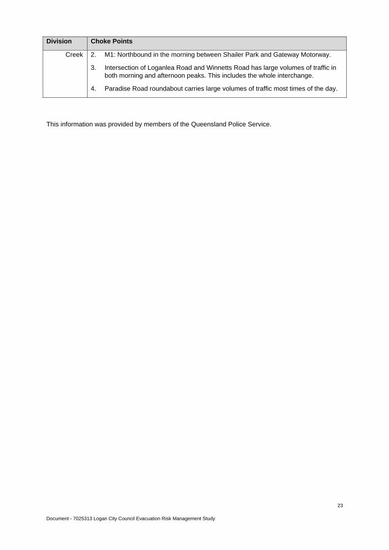
Division Choke Points
Creek 2. M1: Northbound in the morning between Shailer Park and Gateway Motorway.
3. Intersection of Loganlea Road and Winnetts Road has large volumes of traffic in both morning and afternoon peaks. This includes the whole interchange.
4. Paradise Road roundabout carries large volumes of traffic most times of the day.
This information was provided by members of the Queensland Police Service.
Document - 7025313 Logan City Council Evacuation Risk Management Study
24
5. Monitoring Mechanisms
5.1 Event Coordination
A Disaster Coordination Centre has been established within the Logan City Council Administration Building and is connected to a standby power generator. In the event that this coordination centre is inoperable, an alternate location has been identified. The facilities selected as possible Disaster Coordination Centres will be equipped and resourced to coordinate multiple activities undertaken by the Incident Management Team when an event occurs. Methodology of managing coordination centres is through the Australasian Inter-service Incident Management System.
The Logan City Local Disaster Management Group has not previously had an emergency response and information system to monitor the evacuation of affected persons. However, in recent times a commercial software package has been examined and purchased. This system has the capability of recording and managing information coming into a Disaster Coordination Centre. It is designed as a stand alone system separate from the Council network, once property and GIS data has been updated into it. The software will be able to handle multiple disaster activations and multiple users at any time. Training in this computer programme is currently being undertaken by staff of Council in readiness for the coming wet season and the possibility of evacuation.
5.2 Public Warning Systems
The Logan City Local Disaster Management Group is responsible for ensuring the community is aware of how to respond in preparation for, and during, a disaster event. It involves raising awareness of identified threats and the means by which the public should respond at an individual and/or household level, and may include warnings and directions.
Under the Logan City Local Disaster Management Plan, the Chair of the Logan City Local Disaster Management Group, or delegate, is responsible for the official dissemination of public warnings and information.
During an event, the release of public information on aspects such as road closures, traffic routes, advice on evacuation procedures and evacuee registration, will be coordinated through the Local Disaster Management Group.
Special consideration needs to be given to groups with differing needs including:
Vision and hearing impaired
Intellectually impaired
Non-residents/Tourists
Education facilities
English as a second language/Non-English speakers.
Additional instructions for an evacuation may include information on the location of shelter and mass care facilities, specific evacuation routes, guidance on securing their homes and the need for evacuees to take certain items with them when they leave.
After the incident that generated the need for evacuation is resolved, evacuees must be advised when it is safe to return to their homes and businesses. This could be achieved by notices displayed at evacuation centres and media broadcasts (radio, television and newspaper).
5.3 Issue of Warnings
In the event of a potential evacuation situation, warnings will be issued by the relevant, responsible agency; eg The Bureau of Meteorology, Logan City Council and Queensland Police Service.
Disaster related information will be communicated to the community by the following strategies:
Document - 7025313 Logan City Council Evacuation Risk Management Study
25
If power is available:
Broadcast warnings and alerts will be issued by various media services - ABC and commercial am/fm radio networks (FM 101), free-to-air and pay television services.
Other warnings may be circulated through internet, Twitter, Facebook and SMS.
Local public alerting systems can be utilised to disseminate a scripted message by telephone, mobile, fax or email.
If power is disrupted and telecommunications are compromised:
Maintain communications at the Logan City Disaster Coordination Centre.
Manually distribute information brochures and handouts, which, if required, will be made available in languages other than English through translation services.
Establish radio communications within the Logan City Disaster Coordination Centre and with the Logan District Disaster Coordination Centre.
Broadcast warnings and alerts by radio (commercial and ABC).
Property door knocking as required.
5.4 Public Education
To ensure public awareness of the warning system and the strategies in the event of evacuation, there would need to be dissemination of information prior to an adverse event. This would be in the form of a mail-out explaining the forms of warnings and where the people will gain access to this information at the time of a possible evacuation.
Document - 7025313 Logan City Council Evacuation Risk Management Study
26
6. Communication Strategies
Extensive community education and warning systems exist across various agencies; these are outlined in the Logan City Local Disaster Management Plan.
6.1 Public education and information
A lack of awareness of the threat posed by an approaching hazard such as bushfire or severe storm, and how to cope with such an emergency, places people at greater risk than those who have a good level of knowledge and understanding.
Public education includes programs designed by Council in conjunction with Council’s operational staff and the Logan City Local Disaster Management Group, together with material prepared by agencies such as the Department of Community Safety, Bureau of Meteorology and other statutory services that:
provide a detailed explanation of particular hazards
provide details of practical measures residents can take prior to, during and after a disaster event or incident to help them prepare for and recover from the impact
encourage public awareness through ongoing media campaigns
use the local media for the dissemination of public education programs
Agencies responsible for the provision of public information are outlined below:
Queensland Fire and Rescue Service will coordinate media and public information regarding urban and rural bushfire, chemical or gas emergency situations
Bureau of Meteorology will provide advice on cyclone, flood, severe storm, east coast lows, land gales, and severe bushfire
Logan District Disaster Coordinator will advise details of mandatory evacuations and declarations under the Disaster Management Act, relating to any disaster event
Logan City Council will provide regional and local stream flood information, community based flood watch program, local information on road closures, traffic routes, evacuations, evacuation centres, community support centres, debris clean up, and all matters relating to the activation of the Logan City Local Disaster Management Group and Logan City Local Disaster Management Plan.
The receipt and distribution of warnings are to be coordinated by the Community Engagement and Marketing Manager of Logan City Council as authorised by the Chair of the Logan City Local Disaster Management Group.
The communication strategy to inform affected persons of evacuation requirements should:
be prepared in conjunction with the responsible agency
be clear and concise
be issued by a credible and recognised authority
provide a confirmation contact/feedback mechanism
be disseminated in a regular and timely manner
contain appropriate and accurate information.
Document - 7025313 Logan City Council Evacuation Risk Management Study
27
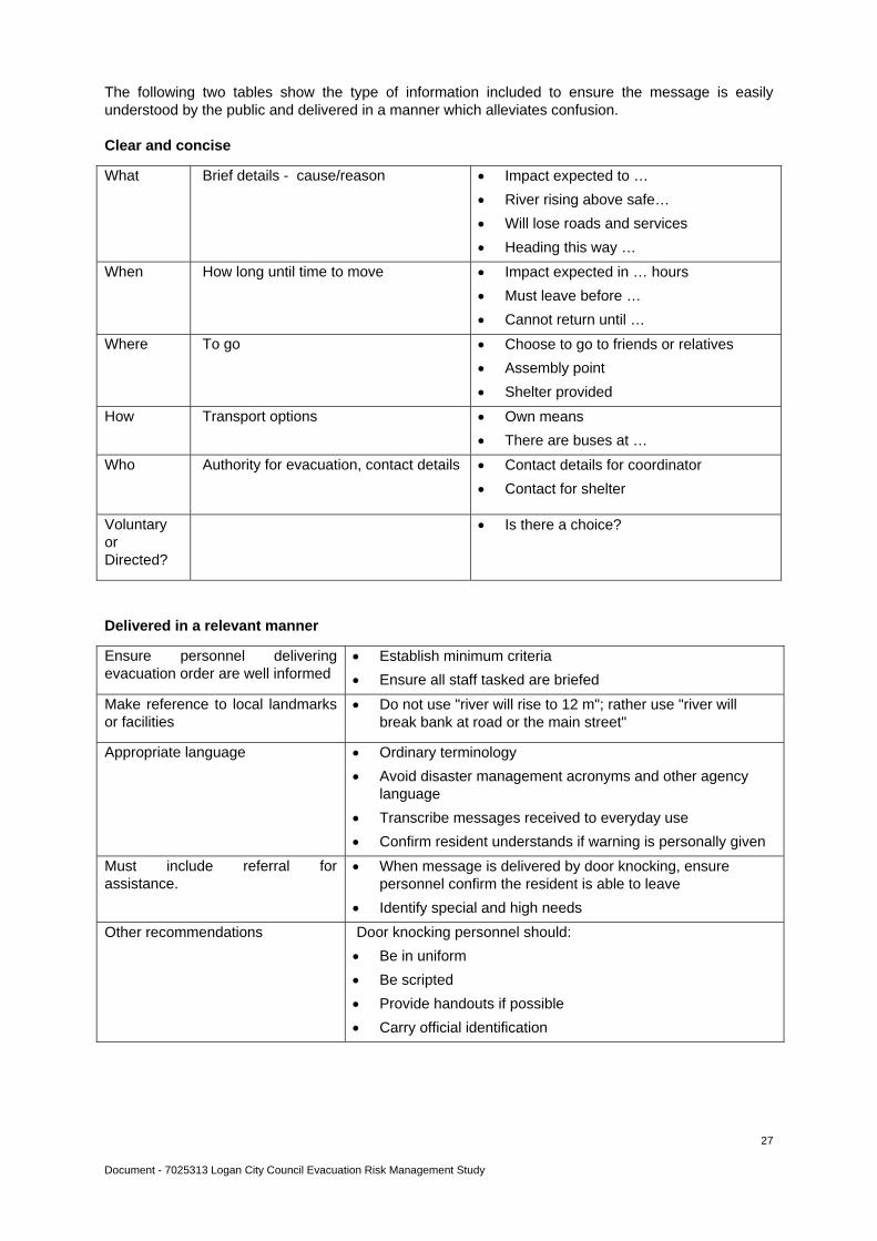
The following two tables show the type of information included to ensure the message is easily understood by the public and delivered in a manner which alleviates confusion.
Clear and concise
What Brief details - cause/reason Impact expected to …
River rising above safe…
Will lose roads and services
Heading this way …
When How long until time to move Impact expected in … hours
Must leave before …
Cannot return until …
Where To go Choose to go to friends or relatives
Assembly point
Shelter provided
How Transport options Own means
There are buses at …
Who
Authority for evacuation, contact details Contact details for coordinator
Contact for shelter
Voluntary or Directed?
Is there a choice?
Delivered in a relevant manner
Ensure personnel delivering evacuation order are well informed
Establish minimum criteria
Ensure all staff tasked are briefed
Make reference to local landmarks or facilities
Do not use "river will rise to 12 m"; rather use "river will break bank at road or the main street"
Appropriate language Ordinary terminology
Avoid disaster management acronyms and other agency language
Transcribe messages received to everyday use
Confirm resident understands if warning is personally given
Must include referral for assistance.
When message is delivered by door knocking, ensure personnel confirm the resident is able to leave
Identify special and high needs
Other recommendations Door knocking personnel should:
Be in uniform
Be scripted
Provide handouts if possible
Carry official identification
Document - 7025313 Logan City Council Evacuation Risk Management Study
28
6.2 Content of Warning Messages
Issuing authority
Date/time of issues
Description of threat and consequences
Detail of areas to be affected
Provision of a level of certainty (What is being done to manage the situation?)
Advice/clear guidance on actions to be taken by those receiving the warnings
Detail the method of public dissemination
Nominate the time for the issuing of the next warning.
Methods of delivery
Pre impact warnings may be delivered effectively via:
Radio
Television
Internet/Social Media
Telephone/Emergency Alert.
These methods are enhanced with better community education and preparedness.
The effectiveness of these delivery methods post impact may be severely reduced owing to:
Reduced communications
Power loss
Community affected.
Where possible an evacuation should be completed with a physical or manual clearance of the area. Accordingly, the order may be initialised via electronic means, but completed with a manual check.
Field trials of door knocking average twelve houses per hour. This is extremely labour intensive but would be the only method that would ensure all residents were contacted.
If possible, a card should be issued to identify which premises have been evacuated. This could possibly be attached to the front door/window.
The incident controller will be required to determine access/egress boundaries relevant to event data. Where the evacuation is post impact, it is reasonable to assume that any residents in the impact area would be making their way out by whatever means are available.
Document - 7025313 Logan City Council Evacuation Risk Management Study
29
Manual means of delivery
Sirens are a warning tool which could be used to gain the attention of the community in a small, localised area, but are only useful if there has been prior public education as to what the siren means and what the people are to do.
Public announcement systems (stationary/mobile) can be utilised to reach specific areas of communities that may not be reached by other methods.
Door knocks provide a means of delivery of messages/warnings directly to the community and also assist with feedback on special needs.
This strategy should be underpinned by Standard Message Warning Templates and either the development of a Logan City Local Disaster Management Crisis Communication Sub-Plan or be incorporated into the Council's Crisis Communication Manual.
Standard Evacuation Order media release templates are attached at Appendix 16.3. Emergency Alert Templates are attached at Appendix 16.4. The Local Disaster Management Group should review and develop further templates relevant to local threats and data.
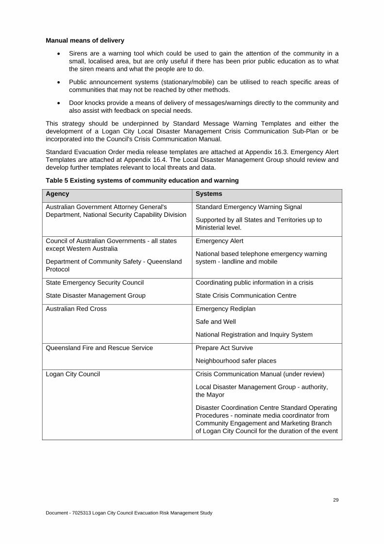
Table 5 Existing systems of community education and warning
Agency Systems
Australian Government Attorney General's Department, National Security Capability Division
Standard Emergency Warning Signal
Supported by all States and Territories up to Ministerial level.
Council of Australian Governments - all states except Western Australia
Department of Community Safety - Queensland Protocol
Emergency Alert
National based telephone emergency warning system - landline and mobile
State Emergency Security Council
State Disaster Management Group
Coordinating public information in a crisis
State Crisis Communication Centre
Australian Red Cross Emergency Rediplan
Safe and Well
National Registration and Inquiry System
Queensland Fire and Rescue Service Prepare Act Survive
Neighbourhood safer places
Logan City Council Crisis Communication Manual (under review)
Local Disaster Management Group - authority, the Mayor
Disaster Coordination Centre Standard Operating Procedures - nominate media coordinator from Community Engagement and Marketing Branch of Logan City Council for the duration of the event

Document - 7025313 Logan City Council Evacuation Risk Management Study
30
7. Evacuation Management Strategies
7.1 Mapping
To assist in the evacuation of affected persons, a series of maps has been developed to show the city divided into electoral divisions and a number of layers containing information which can be used by Logan City Council and Support Agencies. There are two series of maps - the first shows flood prone areas (Q100) of the city while the other reveals the minimal/low, medium, high, very high and extreme bushfire risk sections. Each map then displays the location of evacuation centres, schools, child care centres, aged care facilities and the road network available for establishing evacuation routes. The population of each suburb has been included to assist agencies in establishing the likely number of affected persons. A UBD reference for each suburb can also be found on the maps so agencies can promptly locate the area when more detailed street locations are required.
The flood risk maps (by Division) are included at Appendix 16.5 and the fire risk maps (by Division) are included at Appendix 16.6.
7.2 Vulnerable Communities
Knowledge of evacuation policies and procedures developed within and for vulnerable sectors will assist in the planning of evacuations. To this end, talks have been conducted with a representative from the Department of Education and Training and a questionnaire was sent to aged care facilities in Logan.
Schools
The discussion with the representative from the Department of Education and Training showed that they are quite well prepared for possible evacuation situations.
Section 4(1), Education (General Provisions) Regulation 2006 states: Where a person in charge of a State Instructional Institution is advised of an emergency situation or potential emergency situation that reasonably threatens the health, safety or wellbeing of persons in attendance at the instructional institution or their ability to travel home after the end of the normal school day, then the person in charge may decide to temporarily close the State Instructional Institution until the emergency situation is resolved and it is safe to re-open the premises.
The Regulation contains sections dealing with:
advice from, and consultation with, relevant authorities such as the Queensland Health, Queensland Police Service, Queensland Fire and Rescue Service and State Emergency Service
the duty of care for the students - children returning to supervised homes, staying at school under the supervision of staff, being moved to a place of safety under staff supervision.
Hazard specific quick-reference guides to assist principals prepare or mitigate the severity of impact from a severe weather event have been written and are available to staff. A large number of topics are covered including storm/flood, tsunami, bushfire and building structure collapse.
Schools are required to ensure emergency contact information for students and staff is accurate and that the school has the capacity to contact parents in a speedy and efficient manner. In most cases, schools will be the safest place for children to remain. In the event of off-site evacuation where it may be difficult to contact all parents, schools are expected to have educated the parents about where to find their children.
State schools do not have backup power or generators as this is an unwarranted expense given that the normal school hours are in the daylight. If all utilities are functional, schools are able to support students and staff for quite some time.

Document - 7025313 Logan City Council Evacuation Risk Management Study
31
Aged Care Facilities
The Department of Health and Ageing has advised that as part of the emergency planning process, Commonwealth subsidised aged care approved providers are expected to explore and document alternate accommodation and, where possible, make arrangements at a local/regional level.
If evacuation of an aged care service occurs when prearranged or sufficient accommodation is not available, the Department of Health and Ageing will be able to provide assistance to identify aged care services or other facilities that have the capacity to accommodate care recipients.
A questionnaire was sent to all the identified high care facilities in Logan City requesting information on their evacuation policies and procedures and their ability to put them into practice. Sixty-two percent of the nursing homes responded to the questionnaire, of those seventy percent have an emergency plan in place and the others are currently developing their procedures. All the aged care facilities felt they were able to sustain short term relocation and all have up to date contact lists for residents, staff and local emergency services. Most of the homes have identified sister facilities as the alternate resident accommodation during a disaster event. On the whole, thought has been given to the specialised equipment and attention needed for high care residents (numbering between forty-four and one hundred and twenty), and most facilities would be able to provide adequate treatment for these patients during the evacuation.
The area that poses the greatest difficulty is in transporting bed-bound residents to and from alternate accommodation. All of the facilities would require some assistance in moving these non-ambulant patients, most identifying the need for Ambulance response. Three-quarters of the homes are fitted with back-up generators for use in the event of power failures. Only half of the facilities have established relationships with emergency liaison services or know where to access information for disaster management planning. This is an area which needs to be rectified.
The majority of the aged care facilities that responded to the questionnaire were reasonably prepared for an evacuation event. To ensure that all facilities are aware of the need for emergency evacuation plans, it is recommended that further information gathering occur on a face-to-face basis.
People with disabilities
Consideration needs to be given to the difficulties associated with evacuation of people with disabilities who live in their own home. Department of Communities, Child Safety and Disability Services could, if required, make contact with current clients of Disability Services and liaise with any Non-Government providers who work with people with disabilities.
Aged in private residences
Aged residents with health issues such as renal dialysis, oxygen tanks and poor mobility living in their own homes are another area of concern. One source of information for these people may be Energex who would have a priority needs register. Other assistance in locating these high needs people could be gained from groups such as Meals on Wheels.
Document - 7025313 Logan City Council Evacuation Risk Management Study
32
8. Logan City Council Emergency Shelter and Accommodation Planning
Emergency Shelter planning is the responsibility of the Logan City Council Community Recovery Sub Committee. The Acting Chair of the current Community Recovery Committee is the Logan City Council Principal Environmental Health Officer.
Extensive research has gone into the development of the Logan City Council Emergency Evacuation Centre (Shelter) Manual. In this document is a list of evacuation centres by capacity, suburb and building name. For each location there is then a comprehensive list of contact persons, the building's capacity, the facilities it has to offer, floor plans and photos. The ongoing development of this document will include updated aerial photos with overlays of flood inundation and fire risk areas nearby. An example is at Appendix 16.2.
The Logan City Council Emergency Accommodation Policy has in place procedures to provide two nights alternate accommodation in certain circumstances involving a small number of residents whose houses are deemed uninhabitable through natural disaster. Through the Community Recovery Committee viable alternate accommodation, in the short term, has been identified.
The Logan City Local Disaster Management Group Community Recovery Sub-Plan provides a structured system for the coordination and delivery of disaster relief and recovery services. Significant response services are available via the plan which is designed to maximise the capacity of support agencies within their functional roles, provide welfare and support in the short term and accommodate the seamless transition from Local Disaster Management Plan to State agency control where a situation escalates.
Capability includes provision of temporary accommodation in facilities identified (within current local government boundaries), catering for and welfare of affected persons.
Identification of Neighbourhood Safer Places, as last resort assembly areas, is currently being developed by Queensland Fire and Rescue Service. This information will be incorporated into the Evacuation Sub-Plan.

Document - 7025313 Logan City Council Evacuation Risk Management Study
33
9. Support Agency Response Capability
The current response capability under the Local Disaster Management Plan rests with the lead agency, Queensland Police Service, and the following Primary Support Agencies:
Logan City Council
State Emergency Service
Queensland Fire and Rescue Service.
Other Support Agencies which may have a contributing role in managing an evacuation include:
Bureau of Meteorology
Queensland Ambulance Service
Queensland Transport and Main Roads
Department of Public Works and Housing - Q Build
Department of Communities
Energex
Queensland Health
Queensland Forestry Service
Australian Red Cross.
A survey to review capabilities, as defined in the Logan City Local Disaster Management Plan, of the Support Agencies was sent out. Agencies to receive this request were Queensland Police Service; Queensland Fire and Rescue Service (Urban and Rural); Queensland Ambulance Service; State Emergency Service; Department of Communities, Child Safety and Disability Services; Queensland Transport and Main Roads; Emergency Management Queensland and Australian Red Cross. Those who responded indicated a good level of preparedness and ability to fulfil their obligations as outlined in the Logan City Local Disaster Management Plan. Information received from the Rural Fire Service was very beneficial, particularly in the area of public education. Non-Government organisations were also asked to confirm their capabilities as defined in the Logan City Community Recovery Sub-Plan of the Local Disaster Management Plan. There was one response to this request so this report is unable to comment on the capabilities of non-government organisations in supporting the response and recovery phase of evacuation. However the Local Disaster Management Group Community Recovery Committee has the firm commitment of its members.
Document - 7025313 Logan City Council Evacuation Risk Management Study
34
10. Essential Infrastructure and Evacuation Risks
Within the city, there are groups of people who are more vulnerable and who may need added assistance if a disaster event resulted in the need to evacuate. These groups and facilities have been identified. Additionally, infrastructure and transport options have been investigated as the information would need to be considered during an event.
10.1 Vulnerable Community (See Appendix 16.1)
Mature and Senior - aged 65+
Institutionalised
Regularly require assistance, including health related concerns such as renal dialysis and oxygen
Dwellings without vehicles
Children
Culturally and Linguistically Diverse groups.
10.2 Sensitive Facilities
Within the Council area, there are several types of facilities that may require priority assistance in disaster events:
Aged care and respite facilities
Hospital
Kindergartens/Child Care facilities
Schools
College of TAFE
Campus of Griffith University
Accommodation outlets – hotels, motels, caravan parks etc
Community centres.
10.3 Essential Infrastructure
These include:
The road network
The rail network
Power reticulation services
Water reticulation services
Sewerage reticulation services
Telecommunication services
Logistic support facilities (food and fuel supply).
10.4 Transport
Logan City is heavily reliant on transport links.
Major south-east arterial roads, including the Mount Lindesay Highway, Logan Motorway, and the Pacific Highway/M1 Motorway, link it to Brisbane to the north and Gold Coast City to the south-east. All freight into and out of the city is carried by road.
There are several "barriers" that dislocate the road network in the more populated areas of Logan. The Logan River restricts movement to the south as there are only two road crossings (Kingston Road and the Pacific Motorway).

Document - 7025313 Logan City Council Evacuation Risk Management Study
35
The Pacific Motorway and the Logan Motorway may also cause some problems as there are only eight crossing points from the west to the east across the Pacific Motorway and seven crossing points from north to south across the Logan Motorway. The Mount Lindesay Highway is also a barrier to connections between areas on the western side of the city.
These "choke points" of the road network can impose significant restraints on emergency response times, especially if one or more of the crossing points are closed or restricted by traffic conditions such as accidents or peak hour flows. Refer to table at 4.4.
Bus services in Logan City are provided by two private bus companies - Logan City Bus Service and Park Ridge Transit. Both are contracted to Translink.
Logan City Bus Service covers the eastern side of Logan and provides a number of wheel-chair accessible services using low-floor buses.
Park Ridge Transit serves the western side of Logan City with all local services using fully accessible low-floor buses.
Community Bus Services for people with disabilities are provided by Logan and Albert North Disability Services.
Logan City has eight railway stations (Trinder Park, Woodridge, Kingston, Loganlea, Bethania, Edens Landing, Holmview and Beenleigh) on the city-train commuter service, Gold Coast line. Assuming the trains were operational in an evacuation situation, there would be a limited number of people who would access the facilities because of difficulties getting to most stations on foot. If people are in cars to drive to a railway station, they are more than likely to continue by this mode of transport. The interstate rail line runs roughly north to south through the suburbs of Hillcrest, Forestdale, Boronia Heights, Greenbank, Jimboomba and Woodhill.
There are no seaports or airport facilities in the city.
10.5 Infrastructure
Power supply is drawn from the state grid via a number of regional sub-stations at Belmont, Greenbank and Loganlea. Major transmission lines (275 kV) are operated by Powerlink Queensland and there are in excess of 50 transmission line pylons located within the city. Distribution of power is undertaken by Energex and retail entities who maintain some 1800 km of power lines carrying a range of voltages (240V – 110kV), generally on wooden poles.
Water supply for Logan City is provided by Logan Water drawn from a number of locations and treatment plants. Currently, post amalgamation water reform processes have significantly changed the structure of service delivery via the range of ground and elevated storages within the city.
Reticulated sewerage, provided by Logan Water, is available to a large section of the city with the remainder relying on individual onsite sewerage management systems. There are waste water control centres throughout the city. Five major sewerage pump stations have standby generators and two mobile generators are also available to be used at other medium sized pump stations. A mobile diesel sewerage pump is available for emergency pump breakdowns or power failures at five key sewerage pump stations.
Tele-communications is provided by hard wire, fibre optic and mobile systems operated by Telstra and/or leased by other service providers. Telstra is responsible for the ongoing maintenance and engineering of the network.
Commercial and national radio stations cover the city as well as the local community stations, 101FM (101.1) and BeauFM (105.1).
Free to air TV coverage is provided from Mount Coot-tha in Brisbane.
Emergency services and Council, together with a number of private sector enterprises, maintain mobile radio communications (UHF) coverage of the city.
Document - 7025313 Logan City Council Evacuation Risk Management Study
36
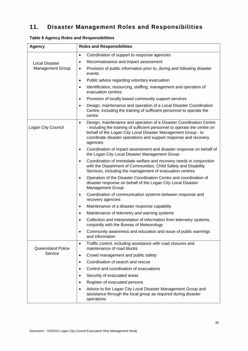
11. Disaster Management Roles and Responsibilities
Table 6 Agency Roles and Responsibilities
Agency Roles and Responsibilities
Local Disaster Management Group
Coordination of support to response agencies
Reconnaissance and impact assessment
Provision of public information prior to, during and following disaster events
Public advice regarding voluntary evacuation
Identification, resourcing, staffing, management and operation of evacuation centres
Provision of locally based community support services
Design, maintenance and operation of a Local Disaster Coordination Centre, including the training of sufficient personnel to operate the centre
Logan City Council
Design, maintenance and operation of a Disaster Coordination Centre - including the training of sufficient personnel to operate the centre on behalf of the Logan City Local Disaster Management Group - to coordinate disaster operations and support response and recovery agencies
Coordination of impact assessment and disaster response on behalf of the Logan City Local Disaster Management Group
Coordination of immediate welfare and recovery needs in conjunction with the Department of Communities, Child Safety and Disability Services, including the management of evacuation centres
Operation of the Disaster Coordination Centre and coordination of disaster response on behalf of the Logan City Local Disaster Management Group
Coordination of communication systems between response and recovery agencies
Maintenance of a disaster response capability
Maintenance of telemetry and warning systems
Collection and interpretation of information from telemetry systems, conjointly with the Bureau of Meteorology
Community awareness and education and issue of public warnings and information
Queensland Police
Service
Traffic control, including assistance with road closures and maintenance of road blocks
Crowd management and public safety
Coordination of search and rescue
Control and coordination of evacuations
Security of evacuated areas
Register of evacuated persons
Advice to the Logan City Local Disaster Management Group and assistance through the local group as required during disaster operations

Document - 7025313 Logan City Council Evacuation Risk Management Study
37
Agency Roles and Responsibilities
Queensland Fire and
Rescue Service
Urban
Rural
Fire suppression
Rescue of trapped persons
Specialist urban search and rescue
Swift water rescue
Rapid damage assessment capabilities
Assistance in pumping out flooded buildings
Assistance in other clean-up of flood affected buildings
Management of hazardous material situations
Provision of ChemData information for hazardous materials
Provision of expert advisory services on hazardous materials through the Queensland Fire and Rescue Service Scientific Unit
Limited ability for provision of First Aid
Advice to the Logan City Local Disaster Management Group and assistance through the local group as required during disaster operations
Safety in relation to fire prevention, suppression response and recovery operations
Advice and directions on public safety/evacuation from fire danger zones
Specialist personnel and equipment
Assistance to urban fire brigade
Advice on carcass burning, conditions and safety of carcass burning activities
Advice to the Logan City Local Disaster Management Group and assistance through the local group as required during disaster operations
Queensland
Transport and Main Roads
Advice on location and suitability of heavy earthmoving equipment
Advice on vehicle detour routes
Advice to the Logan City Local Disaster Management Group and assistance through the local group as required during disaster operations
Bureau of Meteorology Supply of meteorological information and warnings
Department of
Communities, Child Safety and Disability
Services
Coordination of community recovery effort across government and non-government agencies
Establishment and management of Community Recovery Centres and Coordination Centres
Distribution of financial assistance to eligible individuals and families affected by natural disasters
Advice to the Logan City Local Disaster Management Group and assistance through the local group as required during disaster operations
Queensland Ambulance
Service
Emergency pre-hospital patient care assessment, treatment and transportation of ill and/or injured persons
Selection of triage and treatment areas
Coordination of all other volunteer first aid groups
Document - 7025313 Logan City Council Evacuation Risk Management Study
38
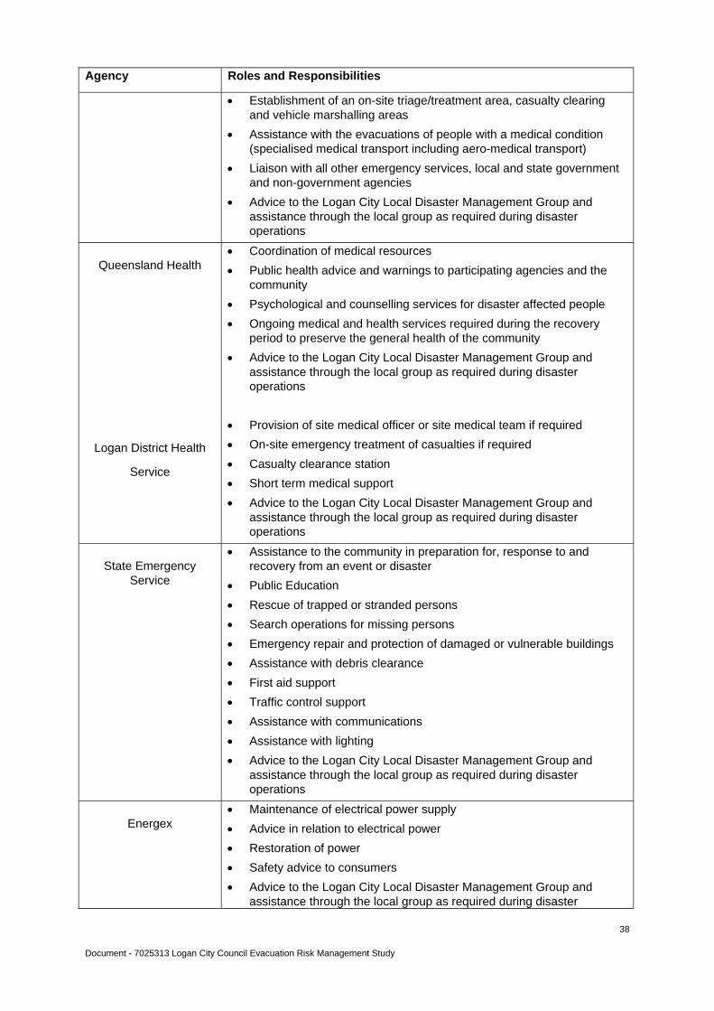
Agency Roles and Responsibilities
Establishment of an on-site triage/treatment area, casualty clearing and vehicle marshalling areas
Assistance with the evacuations of people with a medical condition (specialised medical transport including aero-medical transport)
Liaison with all other emergency services, local and state government and non-government agencies
Advice to the Logan City Local Disaster Management Group and assistance through the local group as required during disaster operations
Queensland Health
Logan District Health
Service
Coordination of medical resources
Public health advice and warnings to participating agencies and the community
Psychological and counselling services for disaster affected people
Ongoing medical and health services required during the recovery period to preserve the general health of the community
Advice to the Logan City Local Disaster Management Group and assistance through the local group as required during disaster operations
Provision of site medical officer or site medical team if required
On-site emergency treatment of casualties if required
Casualty clearance station
Short term medical support
Advice to the Logan City Local Disaster Management Group and assistance through the local group as required during disaster operations
State Emergency
Service
Assistance to the community in preparation for, response to and recovery from an event or disaster
Public Education
Rescue of trapped or stranded persons
Search operations for missing persons
Emergency repair and protection of damaged or vulnerable buildings
Assistance with debris clearance
First aid support
Traffic control support
Assistance with communications
Assistance with lighting
Advice to the Logan City Local Disaster Management Group and assistance through the local group as required during disaster operations
Energex
Maintenance of electrical power supply
Advice in relation to electrical power
Restoration of power
Safety advice to consumers
Advice to the Logan City Local Disaster Management Group and assistance through the local group as required during disaster
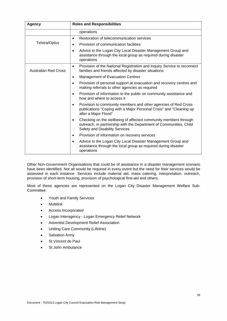
Document - 7025313 Logan City Council Evacuation Risk Management Study
39
Agency Roles and Responsibilities
operations
Telstra/Optus
Restoration of telecommunication services
Provision of communication facilities
Advice to the Logan City Local Disaster Management Group and assistance through the local group as required during disaster operations
Australian Red Cross
Provision of the National Registration and Inquiry Service to reconnect families and friends affected by disaster situations
Management of Evacuation Centres
Provision of personal support at evacuation and recovery centres and making referrals to other agencies as required
Provision of information to the public on community assistance and how and where to access it
Provision to community members and other agencies of Red Cross publications "Coping with a Major Personal Crisis" and "Cleaning up after a Major Flood"
Checking on the wellbeing of affected community members through outreach, in partnership with the Department of Communities, Child Safety and Disability Services
Provision of information on recovery services
Advice to the Logan City Local Disaster Management Group and assistance through the local group as required during disaster operations
Other Non-Government Organisations that could be of assistance in a disaster management scenario have been identified. Not all would be required in every event but the need for their services would be assessed in each instance. Services include material aid, mass catering, interpretation, outreach, provision of short-term housing, provision of psychological first-aid and others.
Most of these agencies are represented on the Logan City Disaster Management Welfare Sub-Committee:
Youth and Family Services
Multilink
Access Incorporated
Logan Interagency - Logan Emergency Relief Network
Adventist Development Relief Association
Uniting Care Community (Lifeline)
Salvation Army
St Vincent de Paul
St John Ambulance
Document - 7025313 Logan City Council Evacuation Risk Management Study
40
12. Exercise to evaluate strategies and systems
A desk-top exercise was conducted as part of the Study Advisory Group meeting on 14 June 2011, to validate the strategies and systems discussed in the Evacuation Risk Management Study report.
The aim of exercise "Corridor 11" was to highlight:
The benefits of improved mapping
Identification of vulnerable community groups
Access to emergency accommodation
Opportunities for Study Group members to evaluate their response procedures and communication networks.
Aspects for the Study Group members to consider during the exercise included:
The disaster potential from the exercise scenario
Callout and communication procedures, both internally and with external organisations
Environmental issues
Situational awareness and planning capability to undertake evacuation analysis and monitoring
Implementation of strategies.
Exercise scenario background:
At about 0530 hours this morning, several explosions ripped through a paint shop resulting in a large fire which engulfed the premises.
Unfortunately, an LPG tanker was decanting its load into two LPG storage cylinders located on the western side of the burning paint shop at the time of the initial explosion. However, the tanks are shielded by a besser block wall providing some protection.
The eastern side of the paint shop is next to a used car dealership and already some cars are being affected by the searing heat.
Police and emergency vehicles have responded. The Queensland Police Service has declared an emergency situation under the Public Safety and Preservation Act and is now establishing an exclusion zone.
Increased easterly on shore winds have caused the potential for the situation to escalate. Police have started immediate evacuations of nearby areas and have requested assistance from Logan City Council, through their Disaster Management system, to manage the displacement of a large number of affected residents.
Exercise and feedback:
Two sets of maps were handed to the group - the first was a UBD page relevant to the site of the scenario, the other was a relevant divisional map developed as part of the Evacuation Risk Management Study project. The group walked through the issues with particular emphasis on the usefulness of the two maps. It was generally acknowledged that the project map was very good as it gave a clear snapshot of the area - closest evacuation centres, roads, sensitive facilities (aged care, schools, child care). As a result of ensuing discussion, the evacuation centre symbol on the mapping has been changed.
Other issues which were discussed include: i) need to gain added information from other sources eg wind direction from the Bureau of Meteorology to determine evacuation needs on the ground, further details of evacuation centres from the Logan City Council Evacuation Centre Manual; ii) ways of finding out about residents with medical conditions; iii) further coding of evacuation centres to identify the type of shelter offered by each.

Document - 7025313 Logan City Council Evacuation Risk Management Study
41
13. Recommendations
13.1. Develop a comprehensive evacuation sub-plan:
Using the Queensland Evacuation Guidelines and the following eleven recommendations as the foundation, an evacuation sub-plan can be developed.
It is highly recommended that the evacuation sub-plan is in place before the next storm season.
13.2. Develop a risk matrix to collate all necessary information relevant to the decision making process in an evacuation situation:
Previous risk evaluations for Logan City Council conclude that the risks to the Logan community from natural hazards vary considerably. In order to address this, it is recommended that a risk matrix, by small area, be developed for incorporation into the evacuation sub-plan. The criteria for determination of level of risk for each area includes:
Suburb Total
Area
Size
Total
Population
Fire
Risk
Rating
DFE
Flood
Risk
Bridges/Roads
subject to
flooding
Traffic
Choke
Points
Isolation
Risk
Vulnerable
Communities
Sensitive
Facilities
Critical
Lifelines
13.3. Collate emergency information specific to individual aged care and respite facilities, child care centres, educational institutions and accommodation outlets to assist decision making during a disaster event:
To ensure all relevant information is available in the event of an evacuation of any of these sensitive facilities a questionnaire should be developed for each facility. An example of the questionnaire is set out on the following page.
This information gathering needs to be done face-to-face with an executive officer of each facility and as such will be a time consuming exercise but well worth the time and effort.
Once the information has been gathered it would need to be collated into a spreadsheet for quick reference and ready access.

Document - 7025313 Logan City Council Evacuation Risk Management Study
42
Aged Care Facilities
Name of Care Facility or Organisation:
________________________________________________________________________
Primary Contact, in the event of an emergency: Name____________________ Contact Number ___________________
Secondary Contact, in the event of an emergency: Name____________________ Contact Number ___________________
High Dependency
(bed bound, require
major support)
Medium Dependency
( mobility issues, require
some support)
Low Dependency
(fairly mobile, require
minimal support)
Number of residents
Number of staff required in evacuation
Equipment needed to accompany residents
Alternate resident accommodation (family,
sister facility, hospital, evacuation centre)
Transport requirements
Contact lists for residents, staff, families, local emergency services and other aged care facilities?
Are staff trained in evacuation procedures?
Emergency backup power/generator?
How many roads lead in to the facility?
Alternate evacuation routes?
Flood risk Storm water issues
Bushfire risk Location of nearest park
Location of nearest (possible) evacuation centre/s

Document - 7025313 Logan City Council Evacuation Risk Management Study
43
13.4. Review use of media for dissemination of warnings and public information during a disaster event, especially investigating the use of social networks such as Twitter and Facebook
It is important that the public have access to as much information as possible when faced with an evacuation situation. To this end, there are several areas that need on-going work to ensure that all is in readiness when needed.
A procedure needs to be put in place to ensure that in a disaster event, the Logan City Council Website is regularly up-dated with relevant data - information about weather conditions, road closures, location of evacuation centres and shelters, phone numbers for assistance.
In addition to this, there also needs to be a procedure for getting the information disseminated by a variety of other means - Twitter, Facebook, SMS alerts, landline calls, door-knocking.
Close collaboration with the Queensland Police Service would be beneficial as they were quite proficient in keeping the public abreast of developments during the Queensland floods in January 2011 via Facebook and Twitter.
13.5. Further develop mapping for operational and planning use
The maps included with this project give an over-all view of each electoral division identifying major roads and important structures. They are not intended to be for operational purposes but rather to give a quick insight into potential areas of risk.
In the event of an evacuation more comprehensive mapping, identifying evacuation zones by suburb or small area, would be needed.
Identification of potential choke points on major and secondary roads would assist in the planning of evacuations. Being able to see those potential problems in relation to evacuation centres, areas requiring residents to leave their homes and sensitive facilities would be most advantageous.
Helicopter rescue resources may be required to evacuate residents in isolated locations. Navigation during floods can be a problem unless accurate coordinates of the destination are available. Roads and watercourses that would normally be used for visual navigation disappear in a flood. Mapping may need to show longitude and latitude for assistance in location and deployment.
Evacuation maps should be developed in two series - one for public information and one for disaster management response. Public information evacuation maps would include evacuation zones, clearly identified by colour; evacuation routes; public points of reference eg church, library, park. Disaster management response maps would include evacuation zones, clearly identified by colour; technical references including heights above highest astronomical tide (HAT) or Australian height datum (AHD); evacuation routes; identified evacuation centres and assembly areas; sensitive facilities eg aged care, schools, hospital; emergency services; hazardous sites; critical infrastructure.
13.6. Develop guidelines to identify suitable shelter or evacuation facilities
While much work has been done in identifying potential evacuation centres, further investigation needs to be done to ensure a quick decision can be made about the best venue for the circumstances.
Guidelines need to be established so buildings can be categorised for quick reference.
According to the Queensland Evacuation Guidelines (consultation draft June 2011), safer locations can be classified into three main types: assembly points, evacuation centres and cyclone shelters.
Assembly Point - would normally only be utilised during events where specific shelter is not required and the duration of the evacuation is not predicted to be lengthy. They would not be staffed and evacuees would need to self-cater for their basic requirements. Assembly points may also be a place to gather evacuees prior to their coordinated movement to evacuation centres or cyclone shelters.
Document - 7025313 Logan City Council Evacuation Risk Management Study
44
Evacuation Centre - a designated building predetermined and clearly categorised for event suitability. Provides short term accommodation, is staffed and caters for the needs of the evacuees: food, bedding, toilets, showers, seating.
Cyclone Shelter - specifically designed and constructed to provide protection from wind and debris during the passage of a severe tropical cyclone. These shelters would usually provide seating but are not necessarily capable of accommodating persons for an extended time. (While there would be no shelters built specifically to withstand cyclonic winds in south-east Queensland, there would be the need to identify shelters to provide some protection in the event of severe storm.)
Investigation needs to be carried out to ensure the buildings are suitable for the purpose for which they are required. Which buildings would withstand cyclonic winds? Which buildings would be safe if a wild fire were to encroach upon the area?
13.7. Develop a community education programme to assist residents and business owners to be aware of the seasonal threats and to prepare for them.
Residents in bushfire prone areas need to be educated about the steps to take to help reduce the risk of fire damage to their homes.
Residents and business owners in flood affected areas need to be educated about how to prepare for flood and possible evacuation.
An educational package needs to be developed and implemented before the next fire and storm season. This package needs to address issues such as: preparing your property, preparing your bushfire survival kit/preparing your emergency kit, alerts, where to go for information.
An important aim of this program is to encourage and equip individual households to develop their own disaster plans. Providing the basics to school children is an effective way of introducing the concepts to each family.
Include disaster-related material in welcome packs provided to new residents and also make appropriate material available at motels and caravan parks.
13.8. Develop a comprehensive evacuation transport sub-plan.
Use of public transport during an evacuation situation.
Transportation of people with mobility issues, particularly with regard to aged care facilities.
Alternate arrangements if public transport is non-operational - agreement with private bus companies.
13.9. Develop a comprehensive evacuation centre management sub-plan
Consult the Local Disaster Management Plan Community Recovery Sub Plan.
Establish guidelines for the coordination and management of - the allocation of roles and responsibilities; opening and staffing; registration of evacuees; preparation and provision of catering; provision of bedding; centre security; requirements for the care and welfare of special needs evacuees; first aid; facilities for pets and assistance animals; identification of supporting agencies.
Establish clear communication protocols between the evacuation centre and the Local Disaster Coordinator to ensure regular advice on numbers of evacuees, requirements for catering and any health and safety issues.
13.10. Develop temporary directional signage for use in evacuation and emergency situations.
'Evacuation Route' signs with arrows should be developed for placement along designated routes at appropriate spaced intervals relative to the conditions. In addition, 'Evacuation Route End - Continue to Safer Location' signs should be made for use in advising evacuees that the marked route has ended and they need to make their own way to their predetermined safer place.

Document - 7025313 Logan City Council Evacuation Risk Management Study
45
This would make movement of affected persons easier and would assist with traffic congestion issues.
The signs could be used to direct people to evacuation centres that have been set up and are operational.
Document - 7025313 Logan City Council Evacuation Risk Management Study
46
14. References
Australian Bureau of Statistics, Census of Population and Housing, 2006
Australian Bureau of Statistics, Estimated Resident Population, Statistical Local Areas, Queensland, 2010
Australian Red Cross Evacuation Centre Management Structure
Australian Red Cross Evacuation Centres - Queensland, Guidance Document (Version 2, April 2011)
Beaudesert Shire Bushfire Management Study 2006
Beaudesert Shire Disaster Risk Management Study 2004
Disaster Management Act 2003 (updated November 2010)
Emergency Alert Queensland Operational Guidelines (Version 2, December 2010)
Emergency Management Australia Glossary Manual 3
Emergency Management Queensland Directorate Evacuation Framework for Queensland
Emergency Management Queensland Evacuation Guidelines - Draft
o Tropical Cyclone Storm Tide Warning Handbook - State Disaster Management Group(Queensland) 2008
o Mitigating Adverse Impact of Cyclones - Evacuation and Shelter Guideline - Department of Public Works (Queensland) 2008
o Design Guidelines for Queensland Public Shelters - Department of Public Works (Queensland) 2006
o Evacuation Planning Manual - Emergency Management Australia 2005
o Operational Planning Guidelines for Local Disaster Management Groups, Department of Emergency Services (Queensland) 2006
Fire and Rescue Act 1990
Gold Coast City Council Evacuation Centre Management Structure
Gold Coast City Local Disaster Management Group Evacuation Sub-Plan (Draft Version 7, March 2011)
Logan City Council Community Recovery Sub-Plan of the Local Disaster Management Plan
Logan City Council Crisis Communication Plan
Logan City Council Counter Disaster Plan
Logan City Council Emergency Evacuation (Shelter) Building Manual
Logan City Council Local Disaster Management Plan (March 2010)
Logan City Council Natural Disaster Risk Management Study 2005
Logan City Council Website/About Logan/Living in Logan/Cultural Diversity/Logan City Population
Logan City Council Website/About Logan/Community Profile
Logan District Community Recovery Plan 2010-2011 (Department of Communities)
National Disaster Relief Arrangements Guidelines
Police Powers and Responsibilities Act 2000
Public Safety Preservation Act 1986
Document - 7025313 Logan City Council Evacuation Risk Management Study
47
Queensland Evacuation Guidelines for Disaster Management Groups (consultation draft October '10)
The Australian Journal of Emergency Management (Volume 23 No. 2, May 2008)
The Standard Emergency Warning Signal and its use in Queensland
www.shire.gov A Guide to the Building Code of Australia (BCA)
Document - 7025313 Logan City Council Evacuation Risk Management Study
48
15. Acknowledgements
Allen, Deonie River and Catchment Engineering Program Leader, Logan City Council
Benstead, Helen Business Systems and Project Officer, Logan City Council
Bird, Nardine River and Catchment Engineering Flood Management Officer, Logan City Council
Daniels, Carmen Business Systems Support Officer, Logan City Council
Dowding, Charlie Geographic Information Services Officer, Logan City Council
Fulton, Debra Disaster Management Project Officer, Logan City Council
Keks, Steven Principal Environmental Health Officer, Logan City Council
Neller, Ken Disaster Management Program Leader, Logan City Council
Nelson, Rhonda Disaster Management Project Officer, Logan City Council
Morris, Dominic Disaster Management Project Officer, Logan City Council
Schuster, Mark Senior Environment Officer, Logan City Council
Scotney, Brian Disaster Management Project Leader, Logan City Council
Bock, Corey Acting Area Director, South East Region, Queensland Fire and Rescue, Rural Division
Harrington, Anna Project Officer Community Care, Aged Care Queensland Incorporated
Kingston, Peter Regional Facilities Manager-South East Region, Department of Education and Training
Miller-Rose, Peta Mitigation and Education Officer, Rural Operations, Department of Community Safety
Monaghan, Peter District Disaster Management Group Operations Officer, Queensland Police Service
Schneider, Kathy Community Recovery Officer, Department of Communities, Child Safety and Disability Services

Document - 7025313 Logan City Council Evacuation Risk Management Study
49
16. Document Tables
Table 1 Suburbs most at risk for evacuation owing to a flood event……………………………………16
Table 2 Suburbs most at risk for evacuation owing to a bushfire event………………………………..17
Table 3 Roads subject to flooding …………………………………………………………………………18
Table 4 Logan Police District Traffic Choke Points ………………………………………………………22
Table 5 Existing systems of community education and warning ……………………………………….29
Table 6 Disaster Management Roles and Responsibilities ……………………………………………..36
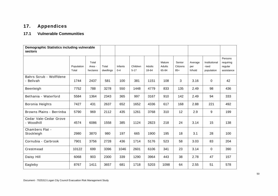
Document - 7025313 Logan City Council Evacuation Risk Management Study
50
17. Appendices
17.1 Vulnerable Communities
Demographic Statistics including vulnerable sectors
Population
Total
Total
Area -
hectares
Total
dwellings
Infants
0-4
Children
5-17
Adults
18-64
Mature
Adults
65-84
Senior
Citizens
85+
Average
per
h/hold
Institutional
-ised
population
Persons
requiring
regular
assistance
Bahrs Scrub - Wolffdene - Belivah 1744 2437 581 100 381 1151 108 3 3.16 0 42
Beenleigh 7752 788 3278 550 1448 4779 833 135 2.49 98 436
Bethania - Waterford 5584 1364 2343 365 997 3167 910 142 2.49 94 333
Boronia Heights 7427 431 2637 652 1652 4336 617 168 2.88 221 492
Browns Plains - Berrinba 5790 969 2112 435 1261 3768 310 12 2.9 9 199
Cedar Vale-Cedar Grove - Woodhill 4574 6086 1558 385 1124 2823 218 24 3.14 15 138
Chambers Flat - Stockleigh 2980 3870 980 197 665 1900 195 18 3.1 28 100
Cornubia - Carbrook 7901 3756 2728 436 1714 5176 523 58 3.03 83 204
Crestmead 10122 699 3396 1046 2601 6106 341 23 3.14 0 390
Daisy Hill 6068 903 2300 339 1290 3964 443 38 2.78 47 157
Eagleby 8767 1411 3657 681 1718 5203 1098 64 2.55 51 578
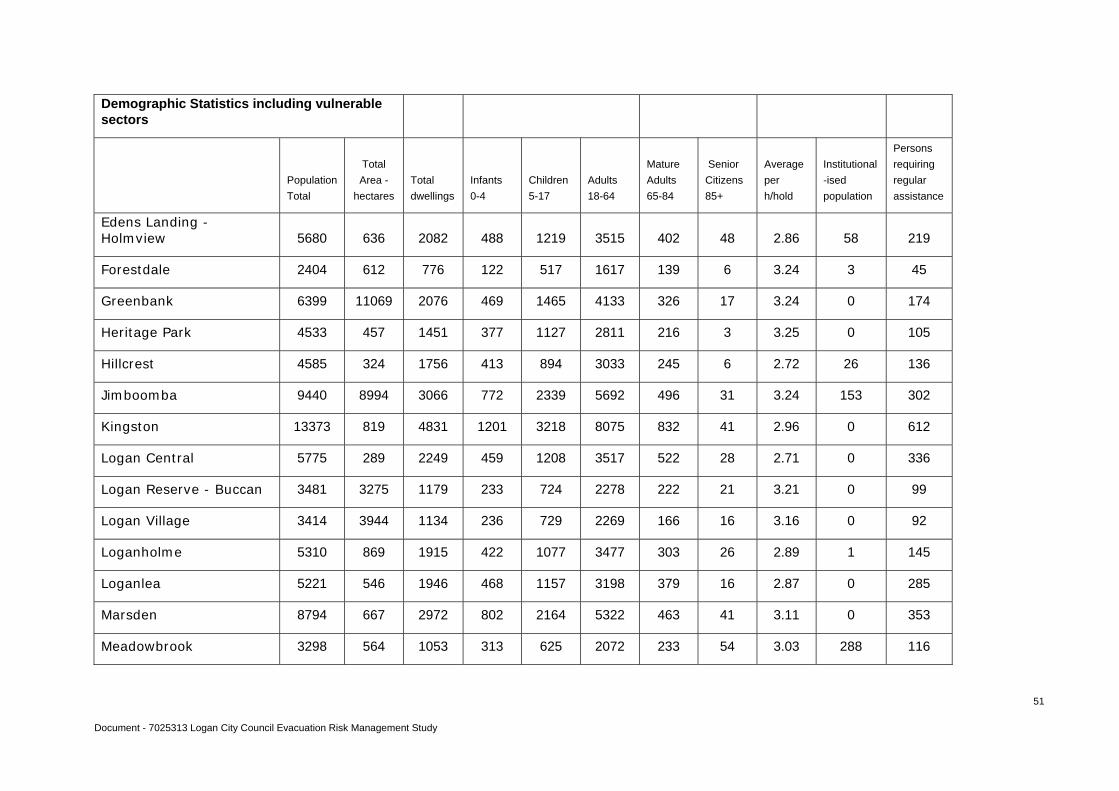
Document - 7025313 Logan City Council Evacuation Risk Management Study
51
Demographic Statistics including vulnerable sectors
Population
Total
Total
Area -
hectares
Total
dwellings
Infants
0-4
Children
5-17
Adults
18-64
Mature
Adults
65-84
Senior
Citizens
85+
Average
per
h/hold
Institutional
-ised
population
Persons
requiring
regular
assistance
Edens Landing - Holmview 5680 636 2082 488 1219 3515 402 48 2.86 58 219
Forestdale 2404 612 776 122 517 1617 139 6 3.24 3 45
Greenbank 6399 11069 2076 469 1465 4133 326 17 3.24 0 174
Heritage Park 4533 457 1451 377 1127 2811 216 3 3.25 0 105
Hillcrest 4585 324 1756 413 894 3033 245 6 2.72 26 136
Jimboomba 9440 8994 3066 772 2339 5692 496 31 3.24 153 302
Kingston 13373 819 4831 1201 3218 8075 832 41 2.96 0 612
Logan Central 5775 289 2249 459 1208 3517 522 28 2.71 0 336
Logan Reserve - Buccan 3481 3275 1179 233 724 2278 222 21 3.21 0 99
Logan Village 3414 3944 1134 236 729 2269 166 16 3.16 0 92
Loganholme 5310 869 1915 422 1077 3477 303 26 2.89 1 145
Loganlea 5221 546 1946 468 1157 3198 379 16 2.87 0 285
Marsden 8794 667 2972 802 2164 5322 463 41 3.11 0 353
Meadowbrook 3298 564 1053 313 625 2072 233 54 3.03 288 116
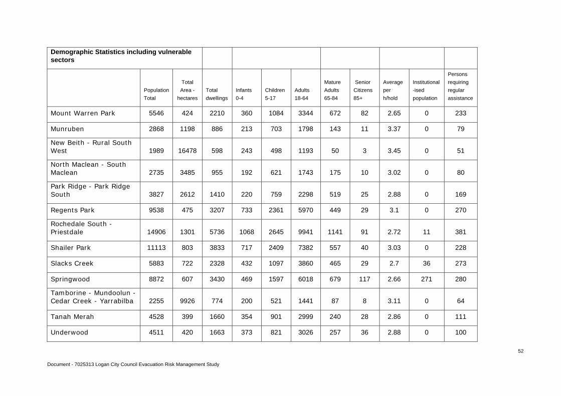
Document - 7025313 Logan City Council Evacuation Risk Management Study
52
Demographic Statistics including vulnerable sectors
Population
Total
Total
Area -
hectares
Total
dwellings
Infants
0-4
Children
5-17
Adults
18-64
Mature
Adults
65-84
Senior
Citizens
85+
Average
per
h/hold
Institutional
-ised
population
Persons
requiring
regular
assistance
Mount Warren Park 5546 424 2210 360 1084 3344 672 82 2.65 0 233
Munruben 2868 1198 886 213 703 1798 143 11 3.37 0 79
New Beith - Rural South West 1989 16478 598 243 498 1193 50 3 3.45 0 51
North Maclean - South Maclean 2735 3485 955 192 621 1743 175 10 3.02 0 80
Park Ridge - Park Ridge South 3827 2612 1410 220 759 2298 519 25 2.88 0 169
Regents Park 9538 475 3207 733 2361 5970 449 29 3.1 0 270
Rochedale South - Priestdale 14906 1301 5736 1068 2645 9941 1141 91 2.72 11 381
Shailer Park 11113 803 3833 717 2409 7382 557 40 3.03 0 228
Slacks Creek 5883 722 2328 432 1097 3860 465 29 2.7 36 273
Springwood 8872 607 3430 469 1597 6018 679 117 2.66 271 280
Tamborine - Mundoolun - Cedar Creek - Yarrabilba 2255 9926 774 200 521 1441 87 8 3.11 0 64
Tanah Merah 4528 399 1660 354 901 2999 240 28 2.86 0 111
Underwood 4511 420 1663 373 821 3026 257 36 2.88 0 100
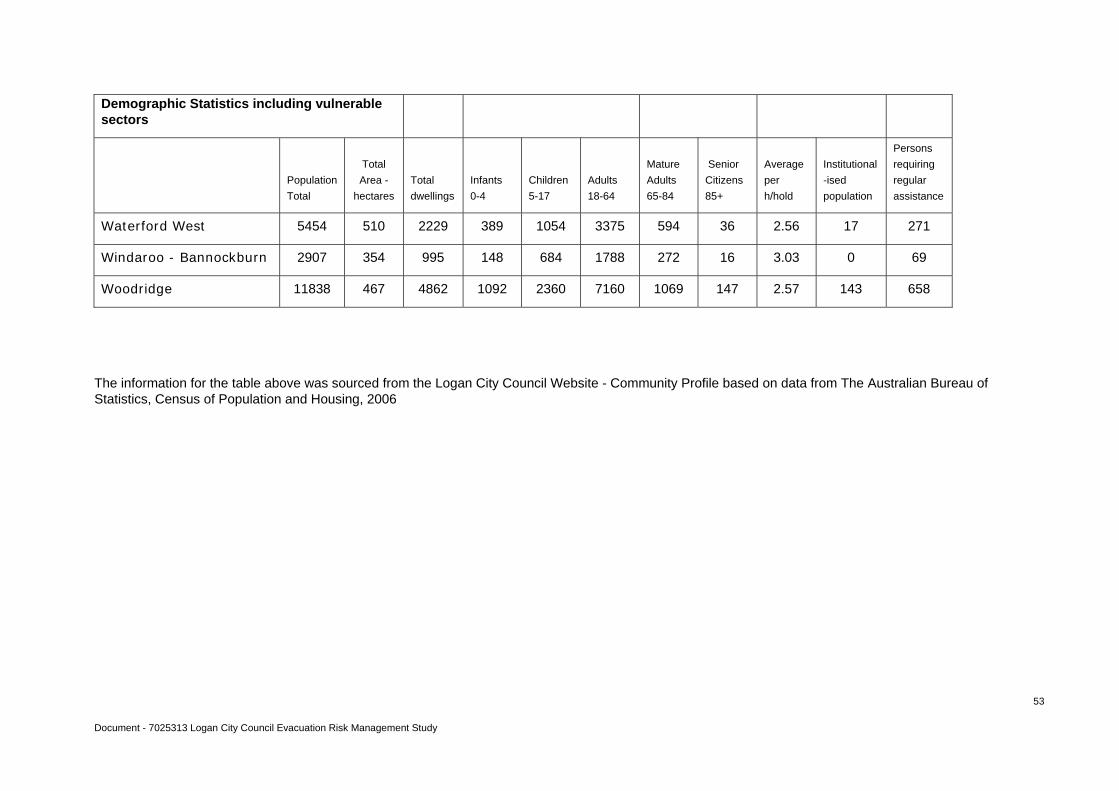
Document - 7025313 Logan City Council Evacuation Risk Management Study
53
Demographic Statistics including vulnerable sectors
Population
Total
Total
Area -
hectares
Total
dwellings
Infants
0-4
Children
5-17
Adults
18-64
Mature
Adults
65-84
Senior
Citizens
85+
Average
per
h/hold
Institutional
-ised
population
Persons
requiring
regular
assistance
Waterford West 5454 510 2229 389 1054 3375 594 36 2.56 17 271
Windaroo - Bannockburn 2907 354 995 148 684 1788 272 16 3.03 0 69
Woodridge 11838 467 4862 1092 2360 7160 1069 147 2.57 143 658
The information for the table above was sourced from the Logan City Council Website - Community Profile based on data from The Australian Bureau of Statistics, Census of Population and Housing, 2006
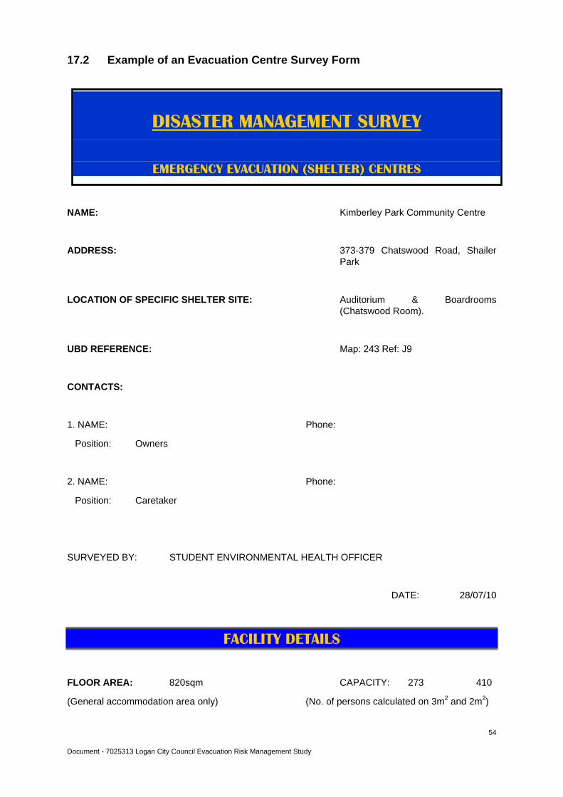
Document - 7025313 Logan City Council Evacuation Risk Management Study
54
17.2 Example of an Evacuation Centre Survey Form
NAME: Kimberley Park Community Centre
ADDRESS: 373-379 Chatswood Road, Shailer Park
LOCATION OF SPECIFIC SHELTER SITE: Auditorium & Boardrooms (Chatswood Room).
UBD REFERENCE: Map: 243 Ref: J9
CONTACTS:
1. NAME: Phone:
Position: Owners
2. NAME: Phone:
Position: Caretaker
SURVEYED BY: STUDENT ENVIRONMENTAL HEALTH OFFICER
DATE: 28/07/10
FACILITY DETAILS
FLOOR AREA: 820sqm CAPACITY: 273 410
(General accommodation area only) (No. of persons calculated on 3m2 and 2m2)
DISASTER MANAGEMENT SURVEY
EMERGENCY EVACUATION (SHELTER) CENTRES
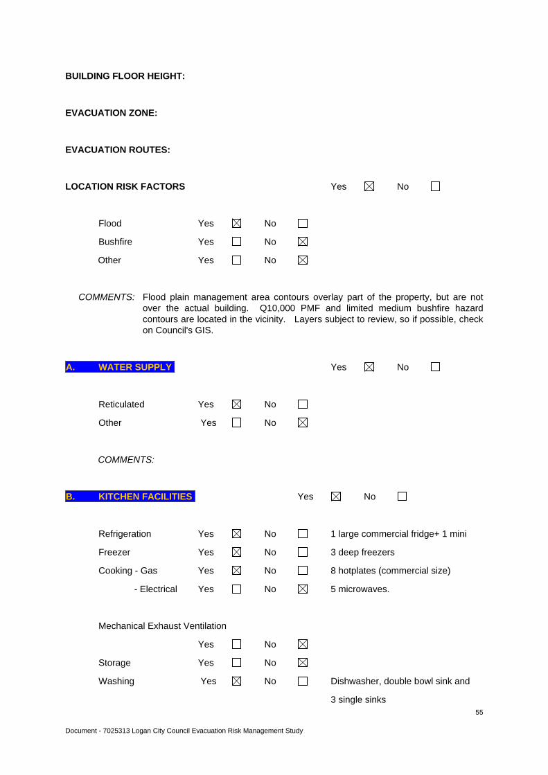
Document - 7025313 Logan City Council Evacuation Risk Management Study
55
BUILDING FLOOR HEIGHT:
EVACUATION ZONE:
EVACUATION ROUTES:
LOCATION RISK FACTORS Yes No
Flood Yes No
Bushfire Yes No
Other Yes No
COMMENTS: Flood plain management area contours overlay part of the property, but are not over the actual building. Q10,000 PMF and limited medium bushfire hazard contours are located in the vicinity. Layers subject to review, so if possible, check on Council's GIS.
A. WATER SUPPLY Yes No
Reticulated Yes No
Other Yes No
COMMENTS:
B. KITCHEN FACILITIES Yes No
Refrigeration Yes No 1 large commercial fridge+ 1 mini
Freezer Yes No 3 deep freezers
Cooking - Gas Yes No 8 hotplates (commercial size)
- Electrical Yes No 5 microwaves.
Mechanical Exhaust Ventilation
Yes No
Storage Yes No
Washing Yes No Dishwasher, double bowl sink and
3 single sinks
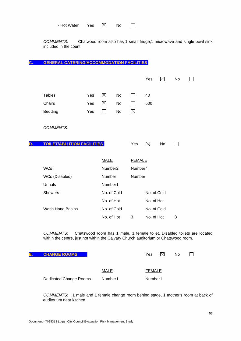
Document - 7025313 Logan City Council Evacuation Risk Management Study
56
- Hot Water Yes No
COMMENTS: Chatwood room also has 1 small fridge,1 microwave and single bowl sink included in the count.
C. GENERAL CATERING/ACCOMMODATION FACILITIES
Yes No
Tables Yes No 40
Chairs Yes No 500
Bedding Yes No
COMMENTS:
D. TOILET/ABLUTION FACILITIES Yes No
MALE FEMALE
WCs Number 2 Number 4
WCs (Disabled) Number Number
Urinals Number 1
Showers No. of Cold No. of Cold
No. of Hot No. of Hot
Wash Hand Basins No. of Cold No. of Cold
No. of Hot 3 No. of Hot 3
COMMENTS: Chatswood room has 1 male, 1 female toilet. Disabled toilets are located within the centre, just not within the Calvary Church auditorium or Chatswood room.
E. CHANGE ROOMS Yes No
MALE FEMALE
Dedicated Change Rooms Number 1 Number 1
COMMENTS: 1 male and 1 female change room behind stage, 1 mother's room at back of auditorium near kitchen.
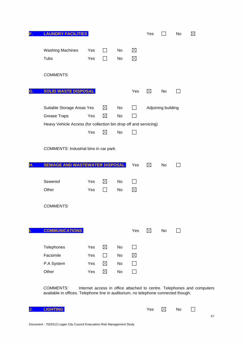
Document - 7025313 Logan City Council Evacuation Risk Management Study
57
F. LAUNDRY FACILITIES Yes No
Washing Machines Yes No
Tubs Yes No
COMMENTS:
G. SOLID WASTE DISPOSAL Yes No
Suitable Storage Areas Yes No Adjoining building
Grease Traps Yes No
Heavy Vehicle Access (for collection bin drop off and servicing)
Yes No
COMMENTS: Industrial bins in car park.
H. SEWAGE AND WASTEWATER DISPOSAL Yes No
Sewered Yes No
Other Yes No
COMMENTS:
I. COMMUNICATIONS Yes No
Telephones Yes No
Facsimile Yes No
P.A System Yes No
Other Yes No
COMMENTS: Internet access in office attached to centre. Telephones and computers available in offices. Telephone line in auditorium, no telephone connected though.
J. LIGHTING Yes No
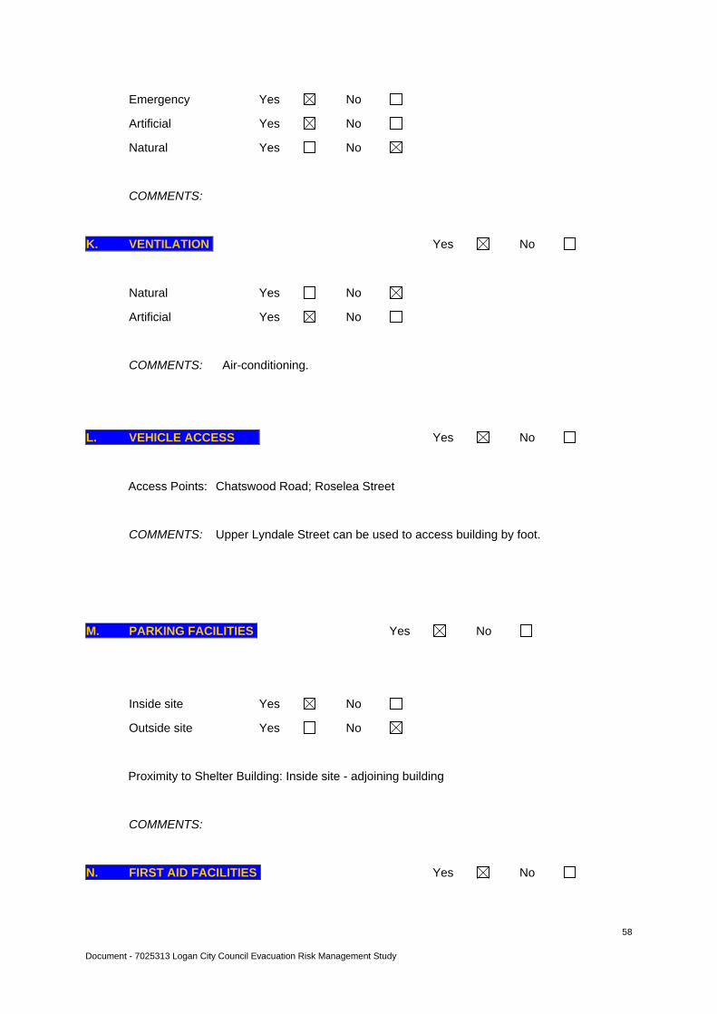
Document - 7025313 Logan City Council Evacuation Risk Management Study
58
Emergency Yes No
Artificial Yes No
Natural Yes No
COMMENTS:
K. VENTILATION Yes No
Natural Yes No
Artificial Yes No
COMMENTS: Air-conditioning.
L. VEHICLE ACCESS Yes No
Access Points: Chatswood Road; Roselea Street
COMMENTS: Upper Lyndale Street can be used to access building by foot.
M. PARKING FACILITIES Yes No
Inside site Yes No
Outside site Yes No
Proximity to Shelter Building: Inside site - adjoining building
COMMENTS:
N. FIRST AID FACILITIES Yes No
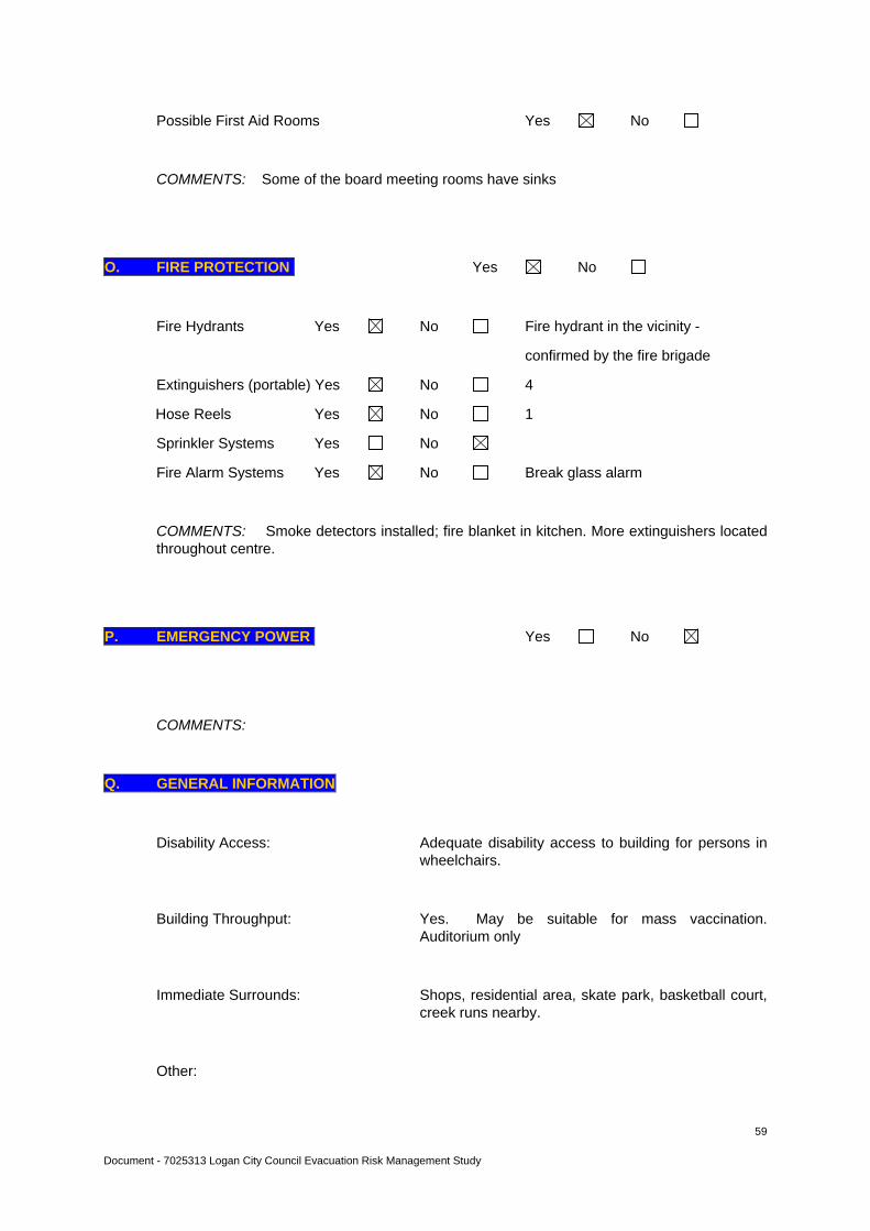
Document - 7025313 Logan City Council Evacuation Risk Management Study
59
Possible First Aid Rooms Yes No
COMMENTS: Some of the board meeting rooms have sinks
O. FIRE PROTECTION Yes No
Fire Hydrants Yes No Fire hydrant in the vicinity -
confirmed by the fire brigade
Extinguishers (portable) Yes No 4
Hose Reels Yes No 1
Sprinkler Systems Yes No
Fire Alarm Systems Yes No Break glass alarm
COMMENTS: Smoke detectors installed; fire blanket in kitchen. More extinguishers located throughout centre.
P. EMERGENCY POWER Yes No
COMMENTS:
Q. GENERAL INFORMATION
Disability Access: Adequate disability access to building for persons in wheelchairs.
Building Throughput: Yes. May be suitable for mass vaccination. Auditorium only
Immediate Surrounds: Shops, residential area, skate park, basketball court, creek runs nearby.
Other:

Document - 7025313 Logan City Council Evacuation Risk Management Study
60
R. SURVEY RESULTS ASSESSED BY COUNCIL
COMMENTS: Yes. As well as general updates, next upgrade to include information on evacuation zones and routes and building floor heights. Specific demand by 'special needs' people may also be inserted.
SIGNED: …………………………………
NAME:
TITLE: PRINCIPAL ENVIRONMENTAL HEALTH OFFICER

Document - 7025313 Logan City Council Evacuation Risk Management Study
61

Document - 7025313 Logan City Council Evacuation Risk Management Study
62
Document - 7025313 Logan City Council Evacuation Risk Management Study
63
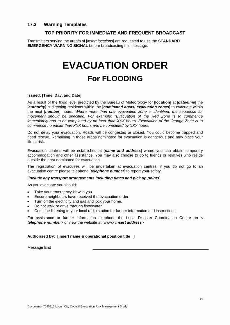
Document - 7025313 Logan City Council Evacuation Risk Management Study
64
17.3 Warning Templates
TOP PRIORITY FOR IMMEDIATE AND FREQUENT BROADCAST
Transmitters serving the area/s of [insert locations] are requested to use the STANDARD EMERGENCY WARNING SIGNAL before broadcasting this message.
EVACUATION ORDER For FLOODING
Issued: [Time, Day, and Date]
As a result of the flood level predicted by the Bureau of Meteorology for [location] at [date/time] the [authority] is directing residents within the [nominated areas/ evacuation zones] to evacuate within the next [number] hours. Where more than one evacuation zone is identified, the sequence for movement should be specified. For example: “Evacuation of the Red Zone is to commence immediately and to be completed by no later than XXX hours. Evacuation of the Orange Zone is to commence no earlier than XXX hours and be completed by XXX hours.
Do not delay your evacuation. Roads will be congested or closed. You could become trapped and need rescue. Remaining in those areas nominated for evacuation is dangerous and may place your life at risk.
Evacuation centres will be established at [name and address] where you can obtain temporary accommodation and other assistance. You may also choose to go to friends or relatives who reside outside the area nominated for evacuation.
The registration of evacuees will be undertaken at evacuation centres, if you do not go to an evacuation centre please telephone [telephone number] to report your safety.
[include any transport arrangements including times and pick up points]
As you evacuate you should:
Take your emergency kit with you. Ensure neighbours have received the evacuation order. Turn off the electricity and gas and lock your home. Do not walk or drive through floodwater. Continue listening to your local radio station for further information and instructions.
For assistance or further information telephone the Local Disaster Coordination Centre on < telephone number> or view the website at: www.<insert address>
Authorised By: [insert name & operational position title ]
Message End
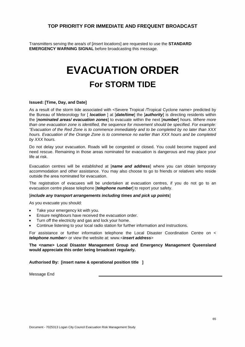
Document - 7025313 Logan City Council Evacuation Risk Management Study
65
TOP PRIORITY FOR IMMEDIATE AND FREQUENT BROADCAST
Transmitters serving the area/s of [insert locations] are requested to use the STANDARD EMERGENCY WARNING SIGNAL before broadcasting this message.
EVACUATION ORDER For STORM TIDE
Issued: [Time, Day, and Date]
As a result of the storm tide associated with <Severe Tropical /Tropical Cyclone name> predicted by the Bureau of Meteorology for [ location ] at [date/time] the [authority] is directing residents within the [nominated areas/ evacuation zones] to evacuate within the next [number] hours. Where more than one evacuation zone is identified, the sequence for movement should be specified. For example: “Evacuation of the Red Zone is to commence immediately and to be completed by no later than XXX hours. Evacuation of the Orange Zone is to commence no earlier than XXX hours and be completed by XXX hours.
Do not delay your evacuation. Roads will be congested or closed. You could become trapped and need rescue. Remaining in those areas nominated for evacuation is dangerous and may place your life at risk.
Evacuation centres will be established at [name and address] where you can obtain temporary accommodation and other assistance. You may also choose to go to friends or relatives who reside outside the area nominated for evacuation.
The registration of evacuees will be undertaken at evacuation centres, if you do not go to an evacuation centre please telephone [telephone number] to report your safety.
[include any transport arrangements including times and pick up points]
As you evacuate you should:
Take your emergency kit with you. Ensure neighbours have received the evacuation order. Turn off the electricity and gas and lock your home. Continue listening to your local radio station for further information and instructions.
For assistance or further information telephone the Local Disaster Coordination Centre on < telephone number> or view the website at: www.<insert address>
The <name> Local Disaster Management Group and Emergency Management Queensland would appreciate this order being broadcast regularly.
Authorised By: [insert name & operational position title ]
Message End
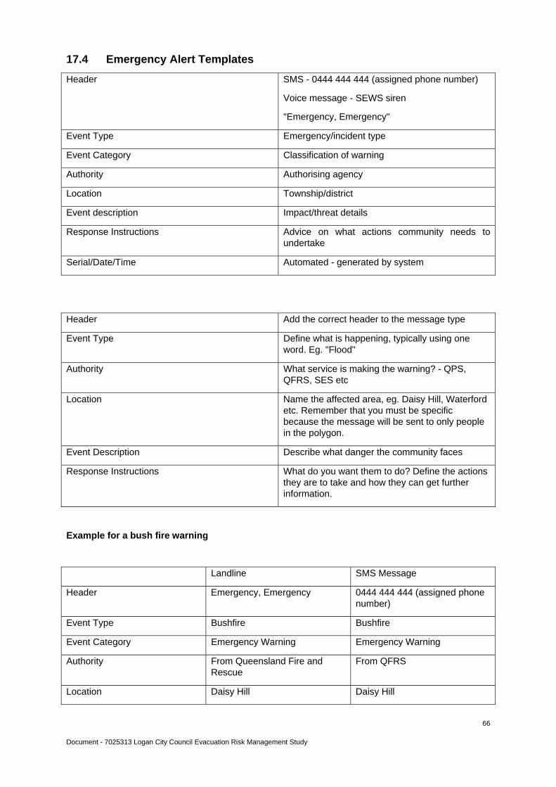
Document - 7025313 Logan City Council Evacuation Risk Management Study
66
17.4 Emergency Alert Templates
Header SMS - 0444 444 444 (assigned phone number)
Voice message - SEWS siren
"Emergency, Emergency"
Event Type Emergency/incident type
Event Category Classification of warning
Authority Authorising agency
Location Township/district
Event description Impact/threat details
Response Instructions Advice on what actions community needs to undertake
Serial/Date/Time Automated - generated by system
Header Add the correct header to the message type
Event Type Define what is happening, typically using one word. Eg. "Flood"
Authority What service is making the warning? - QPS, QFRS, SES etc
Location Name the affected area, eg. Daisy Hill, Waterford etc. Remember that you must be specific because the message will be sent to only people in the polygon.
Event Description Describe what danger the community faces
Response Instructions What do you want them to do? Define the actions they are to take and how they can get further information.
Example for a bush fire warning
Landline SMS Message
Header Emergency, Emergency 0444 444 444 (assigned phone number)
Event Type Bushfire Bushfire
Event Category Emergency Warning Emergency Warning
Authority From Queensland Fire and Rescue
From QFRS
Location Daisy Hill Daisy Hill
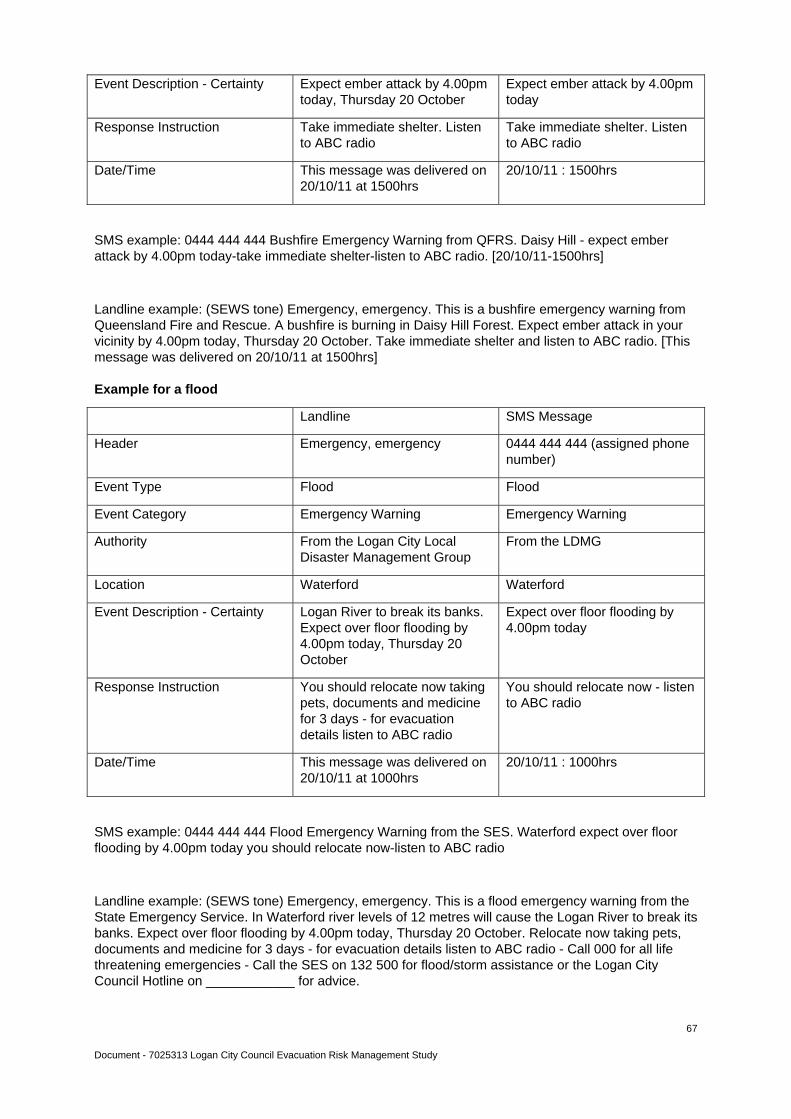
Document - 7025313 Logan City Council Evacuation Risk Management Study
67
Event Description - Certainty Expect ember attack by 4.00pm today, Thursday 20 October
Expect ember attack by 4.00pm today
Response Instruction Take immediate shelter. Listen to ABC radio
Take immediate shelter. Listen to ABC radio
Date/Time This message was delivered on 20/10/11 at 1500hrs
20/10/11 : 1500hrs
SMS example: 0444 444 444 Bushfire Emergency Warning from QFRS. Daisy Hill - expect ember attack by 4.00pm today-take immediate shelter-listen to ABC radio. [20/10/11-1500hrs]
Landline example: (SEWS tone) Emergency, emergency. This is a bushfire emergency warning from Queensland Fire and Rescue. A bushfire is burning in Daisy Hill Forest. Expect ember attack in your vicinity by 4.00pm today, Thursday 20 October. Take immediate shelter and listen to ABC radio. [This message was delivered on 20/10/11 at 1500hrs]
Example for a flood
Landline SMS Message
Header Emergency, emergency 0444 444 444 (assigned phone number)
Event Type Flood Flood
Event Category Emergency Warning Emergency Warning
Authority From the Logan City Local Disaster Management Group
From the LDMG
Location Waterford Waterford
Event Description - Certainty Logan River to break its banks. Expect over floor flooding by 4.00pm today, Thursday 20 October
Expect over floor flooding by 4.00pm today
Response Instruction You should relocate now taking pets, documents and medicine for 3 days - for evacuation details listen to ABC radio
You should relocate now - listen to ABC radio
Date/Time This message was delivered on 20/10/11 at 1000hrs
20/10/11 : 1000hrs
SMS example: 0444 444 444 Flood Emergency Warning from the SES. Waterford expect over floor flooding by 4.00pm today you should relocate now-listen to ABC radio
Landline example: (SEWS tone) Emergency, emergency. This is a flood emergency warning from the State Emergency Service. In Waterford river levels of 12 metres will cause the Logan River to break its banks. Expect over floor flooding by 4.00pm today, Thursday 20 October. Relocate now taking pets, documents and medicine for 3 days - for evacuation details listen to ABC radio - Call 000 for all life threatening emergencies - Call the SES on 132 500 for flood/storm assistance or the Logan City Council Hotline on ____________ for advice.

Document - 7025313 Logan City Council Evacuation Risk Management Study
68
17.5 Flood Risk Mapping

Document - 7025313 Logan City Council Evacuation Risk Management Study
69
17.6 Fire Risk Mapping

Evacuation Risk Management Study ReportLOGAN CITY COUNCIL DECEMBER 2012
A Natural Disaster Mitigation Program study initiative - program number 1640. Jointly funded by the Federal Department of the Attorney General,
the Queensland Government Department of Community Safety and Logan City Council.