district rural development plan mopani … · 1 chief directorate: spatial planning and land use...
TRANSCRIPT

1
Chief Directorate: Spatial Planning and Land Use Management
224 Church Street, Capitol Towers, 0001; Private Bag X833, Pretoria, 0001; Tel (012) 312 9548; Fax
(012) 323 6419; email: [email protected]
DISTRICT RURAL DEVELOPMENT PLAN
MOPANI DISTRICT MUNICIPALITY
LIMPOPO PROVINCE
MARCH 2016
PREPARED BY: DITAU GEO-INFORMATICS SOLUTIONS

2
Contents
1 SECTION ONE – BACKGROUND ..................................................................................... 10
1.1 INTRODUCTION ...................................................................................................................... 10
1.2 VISION FOR DISTRICT RURAL DEVELOPMENT PLANS ............................................................... 11
1.3 METHODOLOGY ..................................................................................................................... 12
1.4 DRDP’S AND RURAL ECONOMIC TRANSFORMATION ................................................................ 13
1.5 RURAL DEVELOPMENT PRIORITIES ......................................................................................... 13
1.6 PURPOSE OF DISTRICT RURAL DEVELOPMENT PLANS FOR LIMPOPO ........................................ 15
1.6.1 DRDP as an Instrument for Coordinating Rural Strategic Spatial Planning ............. 15
1.6.2 DRDPs as Rural Economic Transformation Instruments ......................................... 15
1.6.3 Promoting Land Use Management & Productivity .................................................... 16
1.6.4 Promoting Rural-Urban Functionality ........................................................................ 16
1.6.5 Alignment of District Rural Development Plans with Existing Planning Instruments 16
1.7 AGRI-PARK AS AN ANCHOR FOR AGRARIAN REFORM ............................................................... 17
2 SECTION TWO – STUDY AREA ....................................................................................... 20
3 SECTION THREE – POLICY AND LEGISLATIVE CONTEXT .......................................... 22
3.1 NATIONAL POLICIES AND STRATEGIES .................................................................................... 22
3.1.1 National Development Plan 2030 (NDP) .................................................................. 22
3.1.2 Spatial Planning and Land Use Management Act (SPLUMA) .................................. 23
3.1.3 New Growth Path (NGP)........................................................................................... 24
3.1.4 Medium Term Strategic Framework (MTSF) – 2014 to 2019 ................................... 24
3.1.5 Comprehensive Rural Development Programme Framework (CRDP) – 2009 ........ 25
3.1.6 Agricultural Policy Action Plan (APAP) ..................................................................... 26
3.2 PROVINCIAL POLICIES AND STRATEGIES ................................................................................. 26
3.2.1 Limpopo Provincial Growth and Development Strategy 2011 (PGDS) .................... 27
3.2.2 Limpopo Provincial Employment Growth and Development Plan (PEGDP) 2009-
2014 .......................................................................................................................... 28
3.2.3 Limpopo Development Plan (LDP) 2015-2019 ......................................................... 29
3.2.4 Limpopo Provincial Spatial Development Framework (SDF) 2007 .......................... 30
3.3 DISTRICT AND LOCAL MUNICIPALITY POLICIES AND STRATEGIES .............................................. 31
3.3.1 Mopani District Municipality Integrated Development Plan (IDP) 2012/13 ............... 32
3.3.2 Mopani District Municipality Spatial Development Framework (SDF) ...................... 33
3.3.3 Mopani District Municipality LED Strategy ................................................................ 34
3.3.4 Greater Giyani Local Municipality IDP 2013/14 ........................................................ 35

3
3.3.5 Greater Letaba Local Municipality IDP 2013/14 ....................................................... 36
3.3.6 Greater Tzaneen Local Municipality IDP 2014-15 .................................................... 37
3.3.7 Ba-Phalaborwa Local Municipality IDP 2014-2015 .................................................. 39
3.3.8 Maruleng Local Municipality IDP 2014/15 ................................................................ 40
3.3.9 Summary ................................................................................................................... 41
4 SECTION FOUR – SITUATIONAL ANALYSIS ................................................................. 43
4.1 DEMOGRAPHICS .................................................................................................................... 43
4.2 EMPLOYMENT ........................................................................................................................ 45
4.3 KEY ECONOMIC DRIVERS ....................................................................................................... 45
4.4 AGRICULTURE ....................................................................................................................... 45
4.5 SLOW PACE OF LAND REFORM ............................................................................................... 55
4.6 ENVIRONMENTAL ISSUES ....................................................................................................... 55
4.6.1 Sites of Cultural, Heritage, Religious and Historical interests .................................. 56
4.6.2 Nature Reserves and Game Parks ........................................................................... 56
4.6.3 Protected Areas and Environmentally Sensitive Areas ............................................ 57
4.6.4 Topography ............................................................................................................... 59
4.6.5 Water Resources (Hydrology, Water Catchment Areas) .......................................... 59
4.6.6 Vegetation ................................................................................................................. 60
4.6.7 Geology and Soil Types ............................................................................................ 60
4.6.8 Soil Types ................................................................................................................. 60
4.6.9 Biodiversity ................................................................................................................ 62
4.6.10 Climate ...................................................................................................................... 64
4.6.11 Air Quality ................................................................................................................. 64
4.7 INPUTS FROM STAKEHOLDER ENGAGEMENTS.......................................................................... 67
4.8 DISTRICT-WIDE DEVELOPMENT CHALLENGES ......................................................................... 68
4.8.1 Water Scarcity ........................................................................................................... 68
4.8.2 Sanitation .................................................................................................................. 68
4.8.3 Waste Management .................................................................................................. 68
4.8.4 Low Levels of Literacy .............................................................................................. 69
4.9 SWOT ANALYSIS .................................................................................................................. 73
4.9.1 Ba-Phalaborwa Local Municipality ............................................................................ 73
4.9.2 Greater Giyani Local Municipality ............................................................................. 75
4.9.3 Greater Letaba Local Municipality ............................................................................ 75
4.9.4 Greater Tzaneen Local Municipality ......................................................................... 76

4
4.9.5 Maruleng Local Municipality ..................................................................................... 77
4.10 KEY FINDINGS FROM IN LOCO/ GROUND TRUTHING INSPECTIONS............................................... 78
4.11 SPATIAL DEPICTION OF NICHE PRODUCTS .............................................................................. 81
5 SECTION FIVE - PROPOSED DEVELOPMENT OBJECTIVES ....................................... 82
5.1 OBJECTIVE 1: IMPROVING PRODUCTIVITY & COMPETITIVENESS OF THE AGRICULTURAL SECTOR 82
5.1.1 Development Action 1: Optimising the potential of Agri-parks ................................. 82
5.1.2 Development Action 2: Supporting small-scale farmers ........................................... 83
5.1.3 Developmental Action 3: Optimising the use of high agricultural potential land ....... 83
5.2 OBJECTIVE 2: INVESTMENT IN RURAL REVITALISATION ............................................................ 83
5.2.1 Development Action 1: Promoting the Renewal of Rural Towns and Villages ......... 84
5.2.2 Development Action 2: Identification of sustainable green energy sources for rural
industrialisation and development ............................................................................ 84
5.2.3 Development Action 3: Investment in Physical Infrastructure .................................. 85
5.2.4 Developmental Action 4: Restoration of existing manufacturing plants/ factories .... 86
5.3 OBJECTIVE 3: PROMOTING INTEGRATED HUMAN SETTLEMENTS ............................................... 86
5.3.1 Development Action 1: Reduction of service delivery backlogs ............................... 86
5.3.2 Development Action 2: Promoting integrated rural spatial planning ......................... 87
5.4 OBJECTIVE 4: IMPROVING TOURISM COMPETITIVENESS ........................................................... 87
5.4.1 Development Action 1: Harnessing the cultural heritage development corridors ..... 87
5.4.2 Development Action 2: Coordinated promotion of the Mopani region and its
attractions ................................................................................................................. 88
5.5 OBJECTIVE 5: DEVELOPMENT OF THE MINING SECTOR ............................................................ 88
5.5.1 Development Action 1: Reviving mining operations ................................................. 88
5.6 OBJECTIVE 6: CONSERVING THE NATURAL ENVIRONMENT ........................................................ 88
5.6.1 Developmental Action 1: Preservation of the natural environment .......................... 88
6 SECTION SIX – SPATIAL RATIONALE ............................................................................ 89
7 SECTION SEVEN - MOPANI FUNCTIONAL REGIONS AND INTERVENTION AREAS
.......................................................................................................................................... 100
7.1 DFR1 GIYANI FUNCTIONAL REGION ............................................................................. 100
7.1.1 Intervention Area 1: Muyexe and Surrounding Villages ......................................... 102
7.1.2 Intervention Area 2: Dzingidzingi, Dingamanzi, Jokong, Ndengedza, Siyandani and
surrounding villages ................................................................................................ 107
7.2 DFR2 TZANEEN FUNCTIONAL REGION ........................................................................ 115
7.2.1 Intervention Area 3: Ga-Modjadji, Malubana, and Budza ....................................... 118

5
7.2.2 Commodities in the Intervention Area ..................................................................... 126
7.2.3 Intervention Area 4 .................................................................................................. 128
7.3 DFR3 PHARABORWA FR ................................................................................................ 135
7.3.1 Intervention Area 6: Humulani, Nondweni, Mahale, Matiko-Xikaya, Priska and
Selwane amongst others ........................................................................................ 137
7.4 DFR4 HOEDSPRUIT/MARULENG ................................................................................... 145
7.4.1 Intervention Area 5: Finale, Sekororo, Bismark, Mabins, Lorraine, Madeira,
Ofcolaco, Callais, Trichardal, Balloon and other areas including Metz and Oaks .. 147
8 SECTION SEVEN – IMPLEMENTATION PLAN .............................................................. 156
8.1 PROGRAMMES AND PROJECTS CATEGORIZATION .................................................................. 156
8.2 INSTITUTIONAL ARRANGEMENTS FRAMEWORK ....................................................... 176
9 CONCLUSION .................................................................................................................. 179

6
LIST OF TABLES
TABLE 1: KEY PERFORMANCE AREAS & OBJECTIVES ................................................................. 32
TABLE 2 AGRICULTURAL POTENTIAL .............................................................................................. 54
TABLE 3: LAND CLAIMS IN MOPANI .................................................................................................. 55
TABLE 4: OTHER PARKS AND RESERVES ....................................................................................... 56
TABLE 5: RURAL DEVELOPMENT PROGRAMMES AND PROJECTS CATEGORISATION ......... 156
TABLE 6: PROJECTS IDENTIFIED AS PART OF THE IN LOCO INSPECTION .............................. 158
TABLE 7: PROJECTS IDENTIFIED AS PART OF THE SYNTHESIS OF RURAL DEVELOPMENT
ISSUES ........................................................................................................................... 168
LIST OF FIGURES
FIGURE 1: DRDP IN CONTEXT ........................................................................................................... 16
FIGURE 2 : NATURE OF AGRICULTURAL ACTIVITY AND PRODUCTION OF HOUSEHOLDS IN
MOPANI DISTRICT .......................................................................................................... 46
FIGURE 3 AGRICULTURAL HOUSEHOLDS BY GENDER OF HOUSEHOLD HEAD AND AGE
COHORT .......................................................................................................................... 47
FIGURE 4 : LEVEL OF EDUCATION AND INCOMES OF AGRICULTURAL HOUSEHOLD HEADS 48
FIGURE 5 : AGRICULTURAL HOUSEHOLDS BY TYPE OF ACTIVITY ............................................. 49
FIGURE 6: AGRICULTURAL HOUSEHOLDS OWNING LIVESTOCK ONLY ..................................... 50
FIGURE 7: AGRICULTURAL HOUSEHOLDS OWNING CATTLE AND SHEEP ................................ 51
FIGURE 8 : GOAT AND PIG PRODUCTION IN MOPANI DISTRICT .................................................. 52
FIGURE 9 : WATER ACCESS AND SOURCES IN MOPANI DISTRICT ............................................. 53
FIGURE 10 : MULTI STAKEHOLDER MAPPING .............................................................................. 177

7
LIST OF MAPS
MAP 1: MOPANI DISTRICT MUNICIPALITY ....................................................................................... 21
MAP 2: INDIGENT HOUSEHOLDS ...................................................................................................... 44
MAP 3: ENVIRONMENTALLY SENSITIVE AREAS ............................................................................. 58
MAP 4: GEOLOGY ................................................................................................................................ 61
MAP 5: BIODIVERSITY GROUPS ........................................................................................................ 63
MAP 6: MAXIMUM ANNUAL TEMPERATURES .................................................................................. 65
MAP 7: HYDROLOGY ........................................................................................................................... 66
MAP 8: SCHOOLS ................................................................................................................................ 70
MAP 9: POPULATION GROWTH\DECLINE & DEPARTMENTAL PROJECTS .................................. 71
MAP 10: HEALTH FACILITIES AND POLICE POINTS ........................................................................ 72
MAP 11: MOPANI DRDP IN LOCO PROJECTS .................................................................................. 79
MAP 12: NICHE PRODUCTS ............................................................................................................... 81
MAP 13: ACCESSIBILITY INDEX ......................................................................................................... 92
MAP 14: POPULATION GROWTH/DECLINE & PROJECTS .............................................................. 93
MAP 15: ACTIVE MINES AND MINING COMMODITIES .................................................................... 94
MAP 16: CONSERVATION AREAS ..................................................................................................... 95
MAP 17: SLLI AGRICULTURE ............................................................................................................. 96
MAP 18: AGRICULTURAL POTENTIAL ............................................................................................... 97
MAP 19: AGRICULTURAL INFRASTRUCTURE .................................................................................. 98
MAP 20: DIVERSE FUNCTIONAL REGIONS & INTERVENTION AREAS ......................................... 99
MAP 21: FUNCTIONAL REGION 1 .................................................................................................... 101
MAP 22: INTERVENTION AREA 1 ..................................................................................................... 103
MAP 23: INTERVENTION AREA 2 ..................................................................................................... 109
MAP 24: FUNCTIONAL REGION 2 .................................................................................................... 117
MAP 25: INTERVENTION AREA 3 ..................................................................................................... 121
MAP 26: MATSWI DAM AND SCHEMES ALONG IT ......................................................................... 122
MAP 27: MODJADJI SETTLEMENT WITH AN EXISTING SHOPPING AREA AND COMMUNITY
PROJECTS ..................................................................................................................... 123
MAP 28: MOKWAKWAILA MUNICIPAL NODE .................................................................................. 124
MAP 29: INTERVENTION AREA 4 ..................................................................................................... 130
MAP 30: ABANDONED SISAL PROJECT THAT NEEDS REFURBISHMENT ................................. 131
MAP 31: AGRICULTURAL SCHEMES IN KHUJWANA AREA .......................................................... 132
MAP 32: LEFARA IRRIGATION SCHEME ......................................................................................... 133

8
MAP 33: FUNCTIONAL REGION 3 .................................................................................................... 136
MAP 34: INTERVENTION AREA 6 ..................................................................................................... 138
MAP 35: SELWANE AGRICULTURAL SCHEMES ............................................................................ 139
MAP 36: FUNCTIONAL REGION 4 .................................................................................................... 146
MAP 37: INTERVENTION AREA 6 ..................................................................................................... 152
MAP 38: LEBOPO IRRIGATION SCHEME ........................................................................................ 153
MAP 39: AGRICULTURAL SCHEMES IN TRICHARDTSDAL (ON RESTORED LAND) .................. 154
MAP 40: THUSONG CENTRE AND THE PROPOSED ABBATTOIR SITE ....................................... 155

9
ACRONYMS
AH Agri- Hub
AP Agri-Park
APAP Agricultural Policy Action Plan
CASP
Comprehensive Rural Support Programmes
COGTA
HSRC
Department of Cooperative Governance and Traditional Affairs
CRDP
CRDP
Comprehensive Rural Development Programme
DRDLR Department of Rural Development and Land Reform
DRDP District Rural Development Plan
FPSU Farmer Production Support Unit
GGP Gross Geographic Product
GVA Gross Value Add
IDP Integrated Development Plan
LED Local Economic Development
LEDP Local Economic Development Plan
LPD Limpopo Development Plan
MDM Mopani District Municipality
MFMA Municipal Finance Management Act
MTSF Medium Term Strategic Framework
NDP National Development Plan
NGP New Growth Path
PEGDP Provincial Growth and Development Plan
PGDP Provincial Growth Development Plan
PGDS Provincial Growth and Development Strategy
PSDF Provincial Spatial Development Framework
REID Rural Enterprise and Industry Development
RETM Rural Economic Transformation Model
RID Rural Infrastructure Development
RUMC Rural Urban Market Centre Unit
SDF Spatial Development Frameworks
SLLI Strategically Located Land Index
SPLUMA Spatial Planning and Land Use Management Act 2013

10
1 SECTION ONE – BACKGROUND
1.1 Introduction
The District Rural Development Plan (DRDP) for Mopani district seeks to contribute to the
transformation of the rural economy. In many ways, the DRDP forms part of the
implementation of the National Development Plan (NDP), as Chapter 6 of the NDP calls for a
radical transformation of rural economies. Informing this call for economic transformation is
the pressing need to address the persistent triple challenges of poverty, unemployment and
socio-economic inequalities in Mopani as well as other rural districts identified as priority
intervention areas.
The DRDP forms part of a range of strategic spatial planning instruments as well as other
sector plans aimed at transforming the apartheid space economy. In achieving the goal of
economic inclusivity and transformation, agricultural development has been identified as one
of the critical sectors that can unlock development. The appreciation of agricultural
development in Mopani and other rural municipalities should be located within an
appreciation of the country’s agrarian transformation agenda. In other words, the
development of an inclusive and competitive agricultural sector is informed by the
appreciation of the on-going land reform processes as well as land tenure systems that
continue to evolve.
While agricultural development is important, the DRDP also takes into account contributions
made by various sectors within the Mopani region. These include:
Mining;
Manufacturing;
Tourism (including cultural and eco-tourism); and
Related Information and Communication Technology (ICT) sectors.
The diversification of the district’s economy is intrinsically dependent on the interplay
between ‘sunset’ sectors (i.e. manufacturing and mining) as well as ‘sunrise sectors’
(particularly tourism and ICT related industries). The objectives of the DRDP are to:
Improve competitiveness in the agriculture sector
Improve mining, manufacturing and tourism sectors
Target, invest and market non-agricultural economic activities
Promote the revitalization of rural towns and villages
Promote competitive and sustainable rural businesses

11
1.2 Vision for District Rural Development Plans
All the strategic spatial and sectoral plans for Limpopo point to the fact that agriculture is at
the heart of rural economic transformation. Furthermore, the Limpopo Development Plan
(LDP) as well as the Agriculture Policy Action Plan (APAP) for instance attests to the fact
that rural areas are faced with triple challenges of poverty, unemployment and lack of
service delivery.
To this end, while acknowledging the uniqueness of Limpopo’s districts with regard to
population dynamics and economic development, it should be noted that the aforementioned
triple challenges cut across all municipal boundaries. Moreover, all five of Limpopo’s districts
(i.e. Mopani, Sekhukhune, Capricorn, Vhembe, and Waterberg) are characterised by the
dominance of at least four economic sectors, namely agriculture, mining, tourism and
manufacturing.
The vision for rural development can therefore be shared across these five districts as it is
informed by national objectives as espoused in the NDP, CRDP, APAP and other related
strategic initiatives and policies. Moreover, it emerged from the multi-stakeholder
engagements that all of Limpopo’s five district municipalities were predominantly rural. As
such, issues of infrastructure provision, service delivery, harnessing of agricultural
development, mining and tourism cut across all five district municipalities. While there exist
district-specific nuances with regard to development priorities, a shared vision for rural
development for all five district municipalities can be couched in one of the following ways:
OPTION 1: Limpopo Province should be characterised by sustainable, integrated,
competitive and inclusive rural economies that fully benefit local communities. To this end,
district municipalities should act as a nexus to ensure that the economic comparative
advantage of each district is maximised.
OPTION 2: By 2050, all of Limpopo’s district municipalities should act as engines for rural
economic, social, spatial and environmental transformation. This holistic rural transformation
should be anchored in sound development planning principles underscored by
environmental integrity, spatial justice and inclusive socio-economic development.
OPTION 3: By 2050, Limpopo District Municipalities should have a thriving economy, driven
by agriculture, mining, tourism and service sectors. People residing within all district
municipalities should have access to basic services and amenities, including housing, water,
education and food security.
In realising the aforementioned vision(s), district municipalities in Limpopo would have to
ensure that DRDPs are meaningfully aligned to the existing district strategic spatial plans,

12
notably the district Integrated Development Plans (IDPs). In the same vein, DRDPs should
be viewed as complementing existing district plans, while at the same time anchoring rural
development objectives as articulated at provincial and national levels of governance.
1.3 Methodology
This report was formulated through the distillation and synthesis of the following sources of
information:
a) Existing strategic spatial planning instruments and initiatives located at provincial,
district and local levels of government. These include the National Development Plan
(NDP), Comprehensive Rural Development Programme (CRDP), Limpopo
Development Plan (LDP), Agriculture Policy Action Plan (APAP), district and local
Integrated Development Plans (IDPs), Local Economic Development (LED)
strategies, Spatial Development Frameworks (SDFs) and other related sector plans.
b) Inputs and discussions from multi-stakeholder engagements. These included
comments, concerns and insights from traditional leadership, political leadership,
administrative leadership and officials from provincial and local spheres of
government.
c) Using various data sets, spatial maps were generated to determine the following:
Location of water, gas and electricity;
Location of agricultural land;
Spatial layout of towns and villages across the province;
GVA contribution for mining and quarrying;
GVA contribution from manufacturing;
Accessibility index;
Traditional authority land with high land capability; and
State land with high land capability.
d) In loco/ground truthing inspections: Inspections/site visits were conducted in all the
district municipalities as part of the ground truthing exercise. Meetings were held with
various stakeholders in order to find out the challenges and opportunities that need to
be addressed in the identified intervention areas. Ground truthing informed the
formulation of proposals and strategies to address the existing challenges related to
rural areas.
The analysis of strategic planning documents, maps and inputs from the stakeholders for
each district were categorised and presented in a table format as strengths, opportunities,
threats and weaknesses. Emerging from this synthesis was a synoptic situational analysis.

13
The situational analysis will inform the strategic thrust as well as the implementation plan of
the DRDPs.
1.4 DRDP’s and Rural Economic Transformation
From the discussions held with DRDLR and the inputs emerging from multi-stakeholder
engagements held in June 2015, it became apparent that DRDPs must put emphasis on
agriculture as the cornerstone of rural economic transformation. This sentiment was also
echoed by the President of the country during his 2015 State of the Nation Address. Thus
DRDPs must be characterised by the following:
Emphasis on agriculture as the most critical sector that can transform rural
economies: the presence of a vibrant and competitive agricultural sector plays an
important role in generating and/or stimulating additional economic activities such as,
food processing, agro-tourism and trade.
Promotion of agricultural businesses: these agri-businesses contribute immensely to
economic growth and food security.
Creation of sustainable jobs: agriculture is one of the major employers in all of
Limpopo’s five district municipalities. It is imperative therefore for the DRDPs to
ensure that all agriculturally bases economic activities are optimally exploited.
Promotion of sector-specific, targeted funding and investment: sector specific
strategies have a propensity of yielding high returns in investment. Leveraging the
potential of agriculture therefore is likely to result in rural economic transformation.
1.5 Rural Development Priorities
Rural development priorities are driven by the National Development Plan (NDP), the
Comprehensive Rural Development Programme (CRDP) and Outcome 7 of the MTSF. Read
together, these aforementioned strategic documents aim to revitalise rural economic life
primarily through agriculture by:
Fostering knowledge transfer and innovation in agriculture and forestry in rural areas
Enhancing competitiveness of all types of agriculture and enhancing farm viability
Promoting food security and risk management in agriculture
Restoring, preserving and enhancing ecosystems dependent on agriculture and
forestry
Promoting the green economy through resource efficiency and supporting the shift
towards a low carbon and climate resilient economy in agriculture, food and forestry
sectors.

14
Rural development priorities are underscored by the realisation that, in lagging regions, the
agricultural sector is complimented by other primary industries such as mining, tourism,
manufacturing and other labour intensive economic activities that can create employment for
semi-skilled and unskilled population groups. The unlocking of rural economic potential will
be done through:
Fostering knowledge transfer and beneficiation in mining, manufacturing and tourism
Mapping out the mining and manufacturing value chain
Harnessing the capacity of the energy sector through diversification of energy
resources
Ensuring meaningful transformation and broad-based participation in the mining
industry through empowering emergent black businesses in this sector
Ensuring that there is beneficiation within the mining and manufacturing sectors,
leading to the improved quality of life for rural communities
The unlocking and/or harnessing of economic potential of these sectors is envisioned to
promote social inclusion, poverty reduction and economic development in rural areas. The
DRDPs for Limpopo provide a unique platform and opportunity to support the sustainable
management and optimal utilisation of natural resources, growth of rural business and
improvement of the well-being of rural communities. The DRDPs are designed to be
innovative, adaptable and integrated with other strategic spatial plans as a means of
ensuring maximum value from investments.
The identification of agriculture business as a catalyst for revitalising rural economies does
not neglect the vulnerability of this sector to climate change, drought as well as adverse
global market forces. To this end, DRDLR and other departments responsible for rural
development have put emphasis on non-agricultural sectors. DRDPs for Limpopo therefore
will employ a targeted approach to key sunrise sectors, notably tourism, creative industries
and the service sector. Such an approach will create opportunities for small businesses to
collaborate with established ones and contribute to the growth of rural economies.
Investment in education and entrepreneurship also forms an integral part of the Limpopo
DRDPs. In addition, building of physical infrastructure such as road networks as well as the
provision of decent housing, schools, hospitals and places of entertainment and socialisation
has been identified by participants in DRDP formulation as pivotal in promoting rural
development. Therefore , rural development is predicated not only on developing places, but
also on people. DRDPs will therefore act as catalysts for transformational medium to long-

15
term change, creating resilient rural economies based on sustainable development
principles, notably green growth.
1.6 Purpose of District Rural Development Plans for Limpopo
1.6.1 DRDP as an Instrument for Coordinating Rural Strategic Spatial Planning
DRDPs are envisioned to act as critical levers for coordinating strategic spatial planning,
specifically in rural municipalities. From 2009 onwards, South Africa’s development planning
praxis has been steered towards harnessing rural development. This deliberate focus on
rural development stemmed from the state’s quest for transforming the apartheid space
economy.
While Integrated Development Plans (IDPs) still remain the fulcrum of strategic spatial
planning within the local government sphere, DRDPs are aimed at reinforcing strategic
planning. Put succinctly, DRDPs will act as a platform for harnessing cross-sectoral
development (Figure 1). Existing sector-specific planning instruments such as Local
Economic Development Plans (LEDs), Spatial Development Frameworks (SDFs) and
Agricultural Development Plans (ADPs) for instance, will find a more nuanced expression
within District RDPs.
1.6.2 DRDPs as Rural Economic Transformation Instruments
As articulated above, DRDPs are viewed as strategic instruments for transforming the
apartheid space economy. Informing this transformation of the apartheid space economy is
the identification of key levers of economic transformation; notably land reform and
restitution and the identification of transformative economic sectors. In light of this, DRDPs
have identified the agricultural sector as one of the key sectors with potential to unlock
integrated and inclusive rural economic development. To this end, the Department of Rural
Development & Land Reform (DRDLR) has identified strategic sites for Agricultural Parks
(Agri-parks). Moreover, in the interest of promoting economic diversity and complexity, the
DRDP’s will attempt to unlock other sectors such as tourism, mining and manufacturing in
Limpopo.

16
Underscored by National & Provincial Plans & Initiatives
Ke
ys
Dis
tric
t P
lan
nin
g
Inst
rum
en
ts
District IDP
District RDPDistrict LED
District SDF
Ru
ral E
con
om
y Tr
ansf
orm
atio
n
© Ditau Geo-Informatics 2015
Figure 1: DRDP in Context
1.6.3 Promoting Land Use Management & Productivity
Linked to the district RDPs’ objective of rural economic transformation is the promotion of
optimal utilisation of land in rural areas. This is tied to the application of sound land-use
management principles in rural areas. District RDPs therefore are envisioned to assist the
state as well as other stakeholders operating within Limpopo’s development planning milieu
to optimise land productivity. The optimal utilisation of land in rural areas takes into account
a suite of other land uses i.e. economic, social, environmental as well as institutional factors.
1.6.4 Promoting Rural-Urban Functionality
District RDPs take into account existing as well as potential linkages and/or flows of an
economic, social, institutional, cultural and environmental nature that promote regional (i.e.
urban and rural) development. As the aforementioned factors coalesce and/or intersect, they
result in the emergence of specific rural development trajectories. Thus, DRDPs take into
account existing and potential development nodes emanating as a result of urban-rural
linkages. Limpopo’s geospatial positioning for instance (i.e. its proximity to Gauteng,
Mpumalanga and other neighbouring countries), renders it one of the most important sites
for regional development.
1.6.5 Alignment of District Rural Development Plans with Existing Planning
Instruments
In identifying rural development issues at district level, there is an acknowledgement of a
range of strategic spatial plans, strategies and policy initiatives located within all the three
17
levels of government. These include the National Development Plan (NDP), Agricultural
Policy Action Plan (APAP), Limpopo Development Plan (2015-19), district IDPs, LED
strategies, SDFs and sector-specific plans. The directive from the DRDLR on the formulation
of Agri-Parks for all economically distressed rural regions also informs the DRDP formulation
process. The aforementioned plans and development initiatives clearly spell out the
developmental vision of the state which then finds expression in provincial and subsequent
district municipalities.
1.7 Agri-Park as an Anchor for Agrarian Reform
The Mopani DRDP is aimed at targeting specific sectors that will revitalise rural economies.
As such, it is defined by sector-specific projects, thus acting as a critical platform for multi-
sectoral programmes and projects. Some of the key areas of intervention that the DRDP will
focus on include the establishment of an Agri-Park (AP) as a means of stimulating rural
economic growth.
An Agri-park is defined as a networked innovation system of agro-production, processing,
logistics, marketing, training and extension services located at district level. As a network it
enables a market-driven combination and integration of various agricultural activities and
rural transformation services. The AP comprises of three basic units:
The Farmer Production Support Unit (FPSU) – this a rural outreach unit connected
with the Agri-Hub. The FPSU does primary collection, storage, processing for the
local market, and extension services including mechanisation;
Agri-Hub Unit (AH) – this is a production, equipment hire, processing, packaging,
logistics and training unit;
The Rural Urban Market Centre Unit (RUMC) – it has three main purposes;
a) Linking and contracting rural, urban and international markets through
contracts;
b) Acts as a holding-facility, releasing produce to urban markets based on
seasonal trends;
c) Provides market intelligence and information feedback, to the AH and FPSU,
using latest Information and communication technologies.
Agri-Parks therefore are catalytic sites for agrarian reform. Responding to the National
Development Plan’s (NDP) call for rural economic transformation as well as outcome 7’s
emphasis on promoting food security through agrarian reform, Agri-Parks will act as

18
agricultural industrial hubs. These hubs will be linked to existing rural villages and towns,
providing key institutional, financial and spatial mechanisms for harnessing agro-related
value chain belts and functional regions. The government has already set aside over R2
billion for kick-starting the Agri-Parks programme across the country. The objectives of
establishing Agri-Parks are as follows:
To promote growth of the smallholder sector by contributing 300,000 new small-
scale producers and145 000 new jobs in agro-processing by the year 2020 (as
set out in the NGP);
To promote the skills of and support to small-holder farmers through provision of
capacity building, mentorship, farm infrastructure, extension services, production
inputs and mechanization inputs;
To enable producer ownership of the majority of Agri-parks equity (70%), with the
state and commercial interests holding minority shares (30%);
To bring under-utilized land (especially Communal Land and land reform farms)
into full production over the next three years and expand irrigated agriculture; and
To contribute to the achievement of the NDP’s objective of fostering an inclusive
rural economy and target of 1 million jobs created in agriculture sector by creating
higher demand for raw agricultural produce, primary and ancillary inputs, as well
as generating increased downstream economic activities in the sector.
In Mopani, the location for the Agri-Hub site has been identified in Tzaneen. This hub will be
supported by the FPSUs located in various parts of the district municipality. Within this Agri-
Park the following activities will take place:
Knowledge Transfer & Innovation – this will include development and training
of farmers as well as people involved in agri-business, food and forestry sectors
as well as agro-tourism. There will also be vertical and horizontal learning
between emerging and established agri-business entrepreneurs. Agri-Parks will
act as hubs for harnessing competitiveness, resource efficiency and
environmental consciousness of agricultural research centres and firms.
Advisory Services – Agri-Parks will be centres of excellence where experts
disseminate information related to markets, investments, funding and other
agriculture-oriented modalities.
Cooperation – there will be incubation of small-scale farmers as well as
cooperatives within the district. This will allow for small-scale agri-business

19
operators to forge a critical mass that would enable them to compete in both local
and global markets.
Investment in Physical Assets – the introduction of Agri-Parks in Limpopo will
be accompanied by massive investments in physical infrastructure i.e. road,
pack-houses and other related supporting amenities. Tied to this is the provision
of basic services such as water and electricity.
Agri-Business Development – Agri-Parks will act as critical hubs for the
identification and harnessing of agricultural belts as well as agricultural value-
chains. The spin-offs from agri-business development will transform rural towns
and villages into vibrant economies.

20
2 SECTION TWO – STUDY AREA
Mopani District Municipality (MDM) is one of the five District Municipalities of Limpopo. The
District was named “Mopani” due to the abundance of nutritional Mopani worms in the area.
The MDM consists of five local municipalities, namely:
Ba-Phalaborwa
Greater Giyani
Greater Letaba
Greater Tzaneen
Maruleng
Mopani is located within the north-eastern quadrant of the province approximately 70km
away from the capital city of Limpopo – Polokwane and covers an area of ±20 011km².
Mopani District Municipality’s area is shared amongst the five local municipalities with Ba-
Phalaborwa occupying the majority of the area with an area of approximately 7 462 km²,
followed by Greater Giyani with an area of approximately 4,172 km², Maruleng covering ±3
244 km², Greater Tzaneen covering ± 3 243 km² and lastly Greater Letaba with
approximately 1 891 km².
The district is bordered in the east by Mozambique, along the north by Vhembe District
Municipality (VDM) and Zimbabwe, in the south by Mpumalanga province through Ehlanzeni
District Municipality and along the west by Sekhukhune and Capricorn District Municipalities

21
Map 1: Mopani District Municipality

22
3 SECTION THREE – POLICY AND LEGISLATIVE CONTEXT
There are national, provincial and municipal policy frameworks in place that will influence
and guide rural development planning for the Mopani District Municipality. The national
policy framework includes principles that underpin the rural development agenda whilst
the provincial policy framework translates this into an agenda for the Limpopo Province.
Mopani District Municipality aligns with these policies at the municipal level and requires a
District Rural Development Plan to further enable it to contribute to the achievement of
targets and objectives outlined for the country and province and to also deal directly with
economic development and job creation in the district.
3.1 National Policies and Strategies
A review of the relevant national policies is outlined in the following sections, with a focus on
those that have implications for rural development at the district level. The following
documents are considered:
National Development Plan ‘vision 2030’ (NDP);
The New Growth Path (NGP);
Medium Term Strategic Framework (MTSF);
Comprehensive Rural Development Programme (CRDP); and
Agricultural Policy Action Plan (APAP).
3.1.1 National Development Plan 2030 (NDP)
The National Planning Commission was appointed in May 2010 by President Jacob Zuma to
draft a vision and national development plan. The National Development plan is a framework
that aims to eliminate poverty and reduce inequality by 2030 1 . The plan outlines the
challenges faced by South Africa in achieving this vision and sets out a holistic approach for
its fulfilment.
This approach is based on six interlinked priorities, namely:
Uniting South Africans around a common programme;
Citizens being active in their own development;
Faster and more inclusive economic growth;
Building capabilities;
1 National Development Plan 2030

23
A capable and developmental state; and
Leadership and responsibility throughout society.
The third priority – faster and more inclusive economic growth – is supported by plans to
create an inclusive and integrated rural community. It is based on the premise that South
Africa’s rural communities should have the opportunity to participate in the economic, social
and political life of the country with successful land reform, job creation and rising agricultural
production contributing to the development of an inclusive rural economy.
The overall objective is to create an additional 643 000 direct jobs and 326 000 indirect jobs
in agriculture, agro processing and related sectors by 2030 thereby placing agriculture as a
driving force behind this priority.2
South Africa’s rural areas experience high levels of poverty and joblessness with limited
employment in agriculture. To address this, the NDP proposes a multifaceted approach:
Creating more jobs through agricultural development based on effective land reform
and growth of irrigated agriculture and land production;
Providing basic services that enable people to develop capabilities to take advantage
of opportunities around the country and enabling them to contribute to their
communities through remittances and skills transfer; and
Developing industries such as agro processing, tourism, fisheries and small
enterprises where potential exists.
The Mopani District Rural Development Plan will align the Mopani District Municipality to the
National Development Plan and by boosting investment in agriculture, play a key role in
promoting this approach.
3.1.2 Spatial Planning and Land Use Management Act (SPLUMA)
The DRDPs are guided by four principles of spatial planning as articulated in SPLUMA.
These include spatial resilience, spatial justice, spatial equity and spatial transformation.
SPLUMA also provides succinct guidelines on how spatial planning ought to be approached
in all three spheres of government. It also seeks to transform the apartheid space economy
towards a more integrated and equitable rural development planning.
2 National Development Plan 2030

24
3.1.3 New Growth Path (NGP)
The New Growth Path framework although preceding the NDP is twinned in its priorities for
generating economic growth, alleviating poverty and inequality, and promoting job creation.
Its overarching objective is to create 5 million new jobs between 2010 and 20203.
According to the framework, achievement of this objective can be reached if there is a
consistent focus on areas that have the potential for creating employment on a large scale.
These areas are known as job drivers and include:
Substantial public investment in infrastructure both to create employment directly in
construction, operation and maintenance and production of inputs, and indirectly by
improving efficiency across the economy;
Targeting more labour-absorbing activities across the main economic sectors –
agricultural and mining value chains, manufacturing and services;
Taking advantage of new opportunities in knowledge and green economies;
Leveraging social capital in the social economy and the public services; and
Fostering rural development and regional integration.
In their application, these drivers must leverage and reinforce each other based on their
inter-linkages.
The second job driver which includes agricultural value chain is seen as a key priority for job
creation in rural areas with opportunities for employment creation through smallholder
schemes, processing and sale of agricultural products5. The Mopani District Rural
Development Plan by focusing on inclusive agricultural projects that are spatially diverse will
align itself closely with the New Growth Path.
3.1.4 Medium Term Strategic Framework (MTSF) – 2014 to 2019
The Medium Term Strategic Framework (MTSF) is the Government’s strategic plan for 2014-
2019 electoral term. It reflects the commitments made in the election manifesto of the
governing party including the commitment to implement the NDP. The MTSF sets out the
actions Government will take and targets that need to be achieved. It also provides a
framework for the other plans of national, provincial and local government4.
The MTSF is structured around 14 priority outcomes that cover the focus areas identified in
the NDP. These are made up of the 12 outcomes that were the focus of the 2009-
3 New Growth Path: Framework
4 Medium Term Strategic Framework 2014-2019

25
2014administration as well as two new outcomes that include social protection, nation
building and social cohesion.. The outcomes are as follows:
1. Quality basic education;
2. A long and healthy life for all South Africans;
3. All people in South Africa are feel safe;
4. Decent employment through inclusive growth;
5. A skilled and capable workforce to support an inclusive growth path;
6. An efficient, competitive and responsive economic infrastructure network;
7. Vibrant, equitable and sustainable rural communities contributing towards food
security for all;
8. Sustainable human settlements and improved quality of household life;
9. Responsive, accountable, effective and efficient local government;
10. Protect and enhance our environmental assets and natural resources;
11. Create a better South Africa and contribute to a better Africa and a better world;
12. An efficient, effective and development-oriented public service;
13. A comprehensive, responsive and sustainable social protection system; and
14. A diverse, socially cohesive society with a common national identity.
In its focus on these priorities and their elaboration into fourteen key outcomes and
associated activities and targets, the MTSF has two over-arching strategic themes – radical
economic transformation and improving service delivery.
The outcomes of the MTSF are directly translated into the Limpopo Development Plan.
3.1.5 Comprehensive Rural Development Programme Framework (CRDP) – 2009
The Comprehensive Rural Development Programme Framework (CRDP) forms part of the
Government’s Medium Term Strategic Framework and is aimed at being an effective
response against poverty and food insecurity that will maximise the use and management of
natural resources to create vibrant, equitable and sustainable rural communities 5 .This
comprises three distinct components, namely:
Coordinated and integrated broad-based agrarian transformation;
Strategically increasing rural development; and
An improved land reform programme.
5 The Comprehensive Rural Development Programme Framework - July 2009

26
Agrarian transformation is characterised as rapid fundamental change in the relationship
between land, livestock, cropping and community. It focuses on, amongst others, initiatives
that support establishment of rural business initiatives, agro-industries, co-operatives and
empowerment of rural people and communities.
Rural development is about enabling rural people to take control of their destiny thereby
dealing effectively with rural poverty through the optimal use and management of natural
resources. Land reform is a national priority and is further entrenched in Section 25 (4) of the
Constitution of the Republic of South Africa, 1996 (Act No.108 of 1996).
The Mopani DRDP will provide a detailed program for the implementation of agrarian
transformation in the district which will be aimed at stimulating agricultural production and
bringing about improvements in all institutions concerned with rural development.
3.1.6 Agricultural Policy Action Plan (APAP)
The APAP is a programmatic response to key policy documents including the NGP, the NDP
and the MTSF in respect of the following outcomes6
Outcome 4 - Decent employment through inclusive growth;
Outcome 7- Vibrant, equitable, sustainable rural communities contributing towards
food security for all; and
Outcome 10 – Protect and enhance our environmental assets and natural resources.
This policy provides a long-term vision and focused interventions in a 5-year rolling schedule
to be updated annually. The key outputs from APAP are well documented and have been
broadly incorporated into the various provincial and district plans that are in place.
3.2 Provincial Policies and Strategies
A review of the relevant provincial policies is outlined in the following sections with a focus
on those that have implications for rural development at the district level. The following
documents are considered:
Limpopo Provincial Growth and Development Strategy (PGDS)
Limpopo Provincial Employment Growth and Development Plan (PEGDP)
Limpopo Development Plan (LDP)
Limpopo Provincial Spatial Development Framework (SDF)
6 Agricultural Policy Action Plan 2015 - 2019

27
3.2.1 Limpopo Provincial Growth and Development Strategy 2011 (PGDS)
The Limpopo Provincial Growth and Development Strategy is aimed at providing the
province and all its stakeholders with a vision and pathway for development that reflects the
priorities of the province7. It is a strategic framework for accelerating and sharing economic
growth through developmental interventions. It lays the foundation for attracting and instilling
confidence from potential investors in the province and seeks to provide the guidelines for
developing social contracts that address the challenges faced by the Province.
The Limpopo PGDS is informed by policy at the national, provincial and local levels. Its
overarching objectives can be found in the MTSF’s fourteen outcomes, the NGP and the
NDP. There are great similarities between the issues identified in these policies at the
national level and those identified at the provincial level i.e. increasing unemployment,
poverty and inequality.
The Limpopo PGDS sets out five key economic development goals with related strategic
objectives for the province8, namely:
Objective one: The need to improve the quality of life in Limpopo aligned to outcome
2 of the MTSF. This includes elimination of poverty and unemployment as well as
improved life expectancy;
Objective two: Growing the economy of the province, sustainable job creation,
innovation and competitiveness aligned to outcome 4 of the MTSF. This includes
access to technology;
Objective three: Improve the institutional efficiency and effectiveness of government
aligned to outcome 9 of the MTSF. This includes service delivery improvement;
Objective four: Address priorities that cut across the three objectives above such as
black economic empowerment, HIV/AIDS, poverty reduction, issues of land and
environment, etc.; and
Objective five: Attain regional integration by harnessing Limpopo’s strategic location
as a gateway to Africa.
These objectives are aimed at facilitating economic growth and capital investment in the
province and whilst the Provincial Government of Limpopo is leading the process of
embedding these objectives, their success depends on smart partnerships with labour, civil
society and business. It is critical that all stakeholders be synchronised in the pursuit of
7 Limpopo Provincial Growth and Development Strategy 2004-2014 8 Ibid

28
shifting Limpopo’s growth path towards shared growth and integrated sustainable
development.
Agriculture has been established as a priority sector for the Limpopo province to drive
economic development, and in support of key outcomes of the NDP:
Outcome 4: Decent employment through inclusive economic growth;
Outcome 7: Vibrant, equitable and sustainable rural communities with food security
for all; and
Outcome 10: Environmental assets and natural resources that are well protected and
continually enhanced.
The ability of agriculture to contribute to job creation makes it a key focus of the New Growth
Path and core to the Limpopo PGDS.
3.2.2 Limpopo Provincial Employment Growth and Development Plan (PEGDP) 2009-
2014
The Limpopo PEGDP is set out to enable the province to address the challenges facing it as
set out in the PGDS. It includes specific programmes that are designed to achieve structural
change in critical areas of the provincial economy and ultimately provides a framework for
the provincial government, municipalities, private sector and all organs of civil society to
make hard choices in pursuit of the priorities encapsulated in the MTSF9.
The Limpopo PEGDP contextualised ten priority areas contained in the MTSF into key
strategic priorities for the province that will guide service delivery. These include:
Ensuring more inclusive economic growth, decent work and sustainable livelihoods;
and
Rural development, food security and land reform.
The PEGDP states that the province has excellent agricultural potential, mineral reserves
and tourism resources, and these sectors can be used to underpin the actions needed to
drive these strategic priorities in the province.
The Limpopo PEGDP put forward key action programmes in support of the five economic
development goals outlined in the PGDS, and the strategic priorities from the PEGDP.
Selected interventions that can be leveraged by the Mopani District Municipality include:
9 Limpopo Provincial Employment Growth and Development Plan 2009-2014

29
Objective two, growing the economy of the province: proposed interventions include
industrial development programme for priority growth sectors including promotion of
more labour-absorbing industrial sectors such as agriculture; Enterprise development
programmes including sectoral SMME growth initiatives such as agro-processing;
Agricultural and rural development programme including the development of
profitable small scale commercial farming in the province.
Objective five, attain regional integration: proposed interventions include the
establishment of regional and local economic corridors and export processing zones.
In order to ensure that the Mopani District Municipality achieves the intended growth and
development envisaged within the Limpopo Development Plans, the policies and legislatives
mentioned above should serve as tools for the coordination of interventions. They will ensure
that the synergies that exist between various government departments as well as the private
sectors are exploited to their full potential in order to ensure that the investments of
government have the maximum impact possible.
3.2.3 Limpopo Development Plan (LDP) 2015-2019
The Limpopo LDP reflects the efforts made by the province to improve standards of living,
reduce poverty, unemployment and inequality. Through this, the quality of life of Limpopo
citizens will be improved. It further outlines how these objectives will be achieved by focusing
on economic development in mining, agriculture, tourism and manufacturing amongst
others10.
Given this backdrop, the purpose of the Limpopo Development is therefore to:
Outline the contribution of Limpopo province to the National Development Plan
(NDP) and Medium Term Strategic Framework (MTSF)for this period;
Provide a framework for the strategic plans of each provincial government
department as well as the IDP’s and sector plans of each district and local
municipalities;
Create a structure for constructive participation of private sector business and
organised labour towards achievement of provincial growth and development
objectives; and
Encourage citizens to be active in promoting higher standards of living in their
communities.
10 Limpopo Development Plan 2015-2019

30
The strategy outlined in the Limpopo Development Plan builds on the foundation laid out in
the PGDP and the PEGDP and is based on the 14 development outcomes contained in the
MTSF. The strategies include the following:
Decent employment through inclusive growth (aligned to outcome 4) – a long term
vision for dealing with the challenges of unemployment, inequality and creating a
more inclusive society; and
Comprehensive rural development (aligned to outcome 7) – developing rural areas
that are spatially, socially and economically integrated with the aim of increasing the
contribution of agriculture to the GGP of Limpopo.
Included in the implementation plan is the concept of growth points or nodal development
based on spatial targeting. These are defined as areas where resources are coordinated and
directed to selected areas in response to development opportunities. There are ten growth
points selected in the province and these include Greater Tzaneen and Ba-Phalaborwa in
Mopani District Municipality.
3.2.4 Limpopo Provincial Spatial Development Framework (SDF) 2007
Environmental vulnerability, social need and economic development are not evenly
distributed in Limpopo and spatial disparities will always exist due to the spatial distribution
of natural resources, historical influences and cultural factors.
Past spatial planning has often aggravated these spatial disparities. This has resulted in a
disjuncture between where people live and where social and economic opportunities are
concentrated. This spatial marginalization from economic opportunities of the majority of the
population needs to be addressed in order to reduce poverty and inequality and ensure
shared growth and the protection of vulnerable bio-resources.
The Limpopo SDF states that the future spatial pattern for the province will be determined by
political and economic forces and processes. Further, the availability of resources will have a
direct impact on economic development in the area and will be the most important factor for
development in the province in the future.
Some of the key development factors for future development in the province include11:
Land: availability, ownership and use; and
Physical infrastructure: roads, transportation, water, etc.
11 Limpopo Provincial Spatial Development Framework 2007

31
The Limpopo Provincial SDF has been developed in order to achieve the spatial
development objectives of the province in a targeted and spatially co-ordinated manner. The
Provincial SDF objectives set out to:
Formulate a spatial framework which will guide and encourage equitable distribution
of investment in terms of a functional settlement hierarchy;
Achieve spatially balanced development across Limpopo province and support
investment in sustainable settlements;
Establish an optimal and functional spatial pattern for districts and the Limpopo
province over time;
Rationalise and promote the optimal use of land and protection of natural resources;
Establish a functional spatial pattern with a hierarchy of settlements which provides a
sound basis for long term sustainable economic growth;
Provide guidelines for the development of transportation and utility networks; and
Successfully integrate planning across national, provincial and local levels
The Limpopo SDF identifies several areas of agricultural potential within the province. This is
seen as key to addressing poverty since most areas of poverty are rural. The focus on
agricultural development initiatives in the Limpopo SDF will be supported by the Mopani
District Rural Development Plan.
3.3 District and Local Municipality Policies and Strategies
A review of the relevant district and local municipality policies is outlined in the following
sections with a focus on those that have implications for rural development at the district and
local level. The following documents are considered:
Mopani District Municipality Integrated Development Plan (IDP);
Mopani District Municipality (SDF);
Mopani District Municipality LED Strategy;
Greater Giyani Local Municipality IDP;
Greater Letaba Local Municipality IDP;
Greater Tzaneen Mogale Local Municipality IDP;
Ba-Phalaborwa Municipality IDP; and
Maruleng Local Municipality IDP.

32
3.3.1 Mopani District Municipality Integrated Development Plan (IDP) 2012/13
The vision of the Mopani District Municipality is to be “the Food Basket of Southern Africa
and the Tourism Destination of Choice”. This is supported by the deliverables of the Mopani
District Integrated Development Plan.
The Mopani DM IDP seeks to align and integrate with policies at the national and provincial
level through the following key performance areas and the envisaged outcomes:12
Table 1: Key Performance Areas & Objectives
Local Government KPA Strategic Objectives
Municipal Transformation and Organisational Development
Develop entrepreneurial and intellectual capability
Basic Service Delivery Improve Community well-being
Develop and maintain infrastructure
Provide clean and safe water
Effective coordination of public transport systems
LED Grow the economy
Municipal Financial Viability and Management Become financially viable
Good Governance and Public Participation Manage through information
Democratic and accountable organization
Spatial Rationale Plan for the future
The key performance areas are driven by strategic intent and supported with developmental
priorities or focus areas for the MDM which with the right levels of investment will provide
opportunities for rural development related to agriculture amongst others. These include13:
To provide democratic and accountable government for local communities;
To ensure the provision of services to communities in a sustainable manner: priority
areas include - water conservation and demand management, infrastructure
development and maintenance of assets to improve service delivery;
12 Mopani District Municipality Integrated Development Plan 2012/13 13 Ibid

33
To promote social and economic development: priority areas include - environmental
management, comprehensive rural development and growth point development;
To promote a safe and healthy environment;
To encourage the involvement of communities and community organizations in the
matters of local government: priority areas include - co-ordination and alignment of
municipal processes
The Mopani District IDP acts as a broad business plan for the Mopani District and aims to
tackle the challenges of poverty, unemployment and inequality it faces. Emphasis in the
financial year will be put on projects linked to budgets that support the opportunities it
outlines.
3.3.2 Mopani District Municipality Spatial Development Framework (SDF)
The spatial fabric of the Mopani District Municipality is characterized by displaced
urbanization and a settlement pattern that is distorted, fragmented, unequal, incoherent and
inefficient. This fragmented spatial pattern results in inefficient duplication of infrastructure
networks - bulk services have to be constructed over long distances to supply outlying
settlements with relatively small population numbers. Spatial reconstruction is therefore
required in the Mopani District to address these critical spatial issues and imbalances.
The Mopani SDF is therefore an integral part of the district integrated development plan and
is used as a tool to implement the IDP. It guides and informs all decisions of the municipality
relating to the use, development and planning of land. 14
The Mopani SDF identified spatial development objectives and strategies for the MDM.
These are aligned to the Limpopo SDF and include the following15:
The establishment of an optimal and functional spatial pattern for the municipal area
over time;
The establishment of a spatial pattern to provide a framework for the provision of
social facilities and physical infrastructure on a cost effective basis and to provide a
sound basis for economic growth to increase income and employment in both the
formal and informal sectors;
Establishing sustainable settlements that are able to generate economic activities
and create jobs for their residents; and
14 Ibid 15 Ibid

34
Areas currently utilised or earmarked/identified as areas with potential for specific
utilisation in future, e.g. areas for mining, agricultural development, tourism, trade
and industry, residential development, should be protected from any development
that will sterilize or negatively impact on existing and future utilisation of such areas
for that specific use.
Further, the Mopani District SDF has identified strategic corridors in the region that have a
potential to offer opportunities for development. The main corridors affecting the district
municipality include:
Ba-Phalaborwa Spatial Development Initiative (SDI)
This corridor is particularly well endowed with mining deposits with a number of mining
operations already underway. The corridor also offers opportunities in eco-tourism and game
farming due to its proximity to Kruger National Park. The corridor is anchored on the
Southeast of the district by Phalaborwa and on the Southwest by Tzaneen.
Tzaneen – Letaba Agricultural Hub
This is the hub of the extensive activities within the District Municipality where most of the
citrus fruit, sub-tropical fruit and vegetables in the district are produced. This immediately
offers opportunities for beneficiation from fruit produce. Eco-tourism is also significant in this
sub- region.
Giyani sub-region
The sub-region is also potentially rich in good agricultural soils and mining deposits. While
the agricultural sector is still largely based on subsistence farming practices, the mining
deposits are beginning to be exploited with huge potential spin-offs such as job opportunities
and infrastructure development. The Eastern part of Greater Giyani offers tourism
opportunities in game farming given its proximity to the Kruger National Park.16
Although there are spatial development challenges in the Mopani District Municipality, key
areas for economic growth have been identified in the region as well as spatial development
objectives and strategies which have been put in place.
3.3.3 Mopani District Municipality LED Strategy
The Mopani District Municipality Local Economic Development strategy provides the District
Municipality with guidelines to create and facilitate economic development, realise the
16 Ibid

35
underlying economic development potential and encourage private sector investment and
job creation.17
The Mopani DM LED strategy identifies the municipal economy’s key sectors, describes its
development constraints and the opportunities it can pursue. Development constraints that
must be addressed if sustainable economic growth is to be achieved in the district include:
Lack of education and skills;
Poverty;
Lack of infrastructure;
Lack of municipal capacity; and
Lack of funding.
There are also a number of opportunities identified for economic development in the MDM,
these comprise:
Agro-processing;
Small scale mining; and
Tourism.
Based on these opportunities and constraints, seven strategic thrusts for economic
development were developed in the LED strategy. These are supported by key projects.
These strategic thrusts and projects include18:
Economic infrastructure support;
LED Development;
Irrigation and farming;
Agriculture and Mining Development; and
Tourism development.
Based on the opportunities identified in the district and the strategic thrusts and projects
outlined, the Mopani LED plan highlights agriculture as one of the region’s main
opportunities with the agricultural sector set to play a strong role in the districts economy.
3.3.4 Greater Giyani Local Municipality IDP 2013/14
The Greater Giyani Local Municipality shares borders with two local Municipalities within the
Mopani District and another two in Vhembe District Municipality. Its economy is underpinned
17 Ibid 18 Mopane District Municipality Integrated Development Plan 2012/13

36
by four economic sectors namely agriculture (small scale), tourism, retail and transport.
However, it remains primarily rural in nature. The bulk of economic activity is concentrated
around Giyani town which is the largest centre of population concentration, employment
opportunities, shopping and recreational facilities.19.
The Greater Giyani LM IDP outlines the key challenges the municipality is currently facing.
Some of these are summarized as follows20:
Spatial Rationale – including unstructured development and lack of land use
management;
Roads and Transportation – including lack of resources and poor storm drainage
systems;
Infrastructure Development and basic service delivery – including shortage of water
and inadequate infrastructure for water and sanitation;
Local Economic Development – including lack of investment strategies and lack of
land for development
The development of Strategies demonstrates that all needs and challenges identified in the
Greater Giyani LM IDPO will be addressed. These strategic objectives include:
Spatial Rationale: To develop an effective spatial framework that promotes integrated
and sustainable development;
Infrastructure development and basic service delivery: To develop sustainable
infrastructure networks which promotes economic growth and improves quality of life;
Local Economic Development: To create and enabling environment for sustainable
economic growth.
3.3.5 Greater Letaba Local Municipality IDP 2013/14
The Greater Letaba Local Municipality is situated in the northeastern quadrant of the
Limpopo Province and is bordered by Greater Tzaneen to the south, Greater Giyani to the
east, Molemole to the west and Makhado to the north. The Greater Letaba Municipality
incorporates the proclaimed towns of Modjadjiskloof, and Ga-Kgapane, situated in the
extreme south of the municipal area, and Senwamokgope towards the northwest of the area
of jurisdiction.21
19 Greater Giyani Local Municipality Integrated Development Plan 2013/14
20 Ibid
21 Greater Letaba Local Municipality Integrated Development Plan 2013/14

37
The Greater Letaba LM is predominantly rural with significant areas of land owned by the
state under custodianship of tribal/traditional authorities. The main economic sectors include
agriculture with large areas of the land in the LM taken up by agricultural activity.
The main thrust of the Greater Letaba IDP is to put in place strategies aimed at alleviating
poverty and it outlines the key challenges that the municipality is currently facing when
looking at development. These challenges include22:
Land Claims: Approximately 48% of the land contained within the boundaries of the
Municipality is currently the subject of land claims;
Lack of Funding or Financial Support: Due to the large areas of land (approximately
50%) registered in the name of the state and under the custodianship of traditional
authorities, small farmers are farming on communal land to which they cannot get
title deed. This precludes them from accessing finance;
Lack of Skills: The majority of the labour force in the Greater Letaba Municipal area
has no or very limited basic skills, necessitating the need for job training.
Access to markets: Most of the small-scale farmers and manufacturers in the area do
not have access to the larger markets outside of the municipal area;
Agricultural potential and lack of adequate water: A further constraining factor is lack
of water, particularly in the northern parts of the Municipality.
The MDM has strategic objectives aligned to the national and provincial frameworks and
operationalized through projects that will enable the municipality to deliver on its
commitments to the community. These strategies include:
Improved human resources: capacitated and skilled personnel within the
municipality;
Integrated Sustainable Development: to address challenges regarding land claims
and shortage of land, etc.;
Integrated sustainable human settlement: creating human settlements that are self-
sustainable and integrated; and
Improved Local Economy: including job creation initiatives.
3.3.6 Greater Tzaneen Local Municipality IDP 2014-15
The Greater Tzaneen Local Municipality is situated in the west of the Mopani District. It
borders Greater Letaba in the north, Ba-Phalaborwa and Maruleng in the east and Lepelle-
22 Ibid

38
Nkumpi Local Municipality (situated in the Mopani District Municipality) in the south. The
municipality is predominantly rural in nature with vast areas of land being state land in the
trust of traditional authorities.
The Greater Tzaneen Municipality area encompasses the proclaimed towns of Tzaneen,
Nkowankowa, Lenyenye, Letsitele and Haenertsburg and is characterised by extensive and
intensive farming activities (commercial timber, cash crops, tropical and citrus fruit
production); Mountainous, inaccessible terrain in the west and south, and un-even
topography (gentle slopes) to the north and east; It also has areas with exceptional natural
beauty which have considerable untapped tourism potential.23
The Greater Tzaneen IDP indicates the key challenges that the municipality is currently
facing. These include local economic development, tourism demand well below what would
be expected and land claims likely to impact agricultural development. Other challenges are
summarized as follows24:
Land use management;
Water Supply challenges;
Roads including maintenance and storm water challenges; and
Public transport including disputes.
Despite these challenges, the Greater Tzaneen LM has identified sectors with economic
potential in the municipality; these are agriculture, tourism and agro-processing. In order to
take advantage of this economic potential and others, the LM has identified ten strategic
thrusts that will enable it to achieve its strategic mission. These are as follows:
Economic development;
Good governance;
Partnerships;
Sustainable infrastructure development;
Stakeholder engagement;
Integrated human settlements;
Financial viability;
Environmental management;
Capacity building; and
ICT.
23 Greater Tzaneen Local Municipality Integrated Development Plan 2014/15
24 Ibid

39
3.3.7 Ba-Phalaborwa Local Municipality IDP 2014-2015
The Ba-Phalaborwa Local Municipality is situated to the northeast of the Mopani District. It is
located east of the N1 highway, Groblersdal and Polokwane. It borders Greater Tzaneen in
the west, Greater Giyani in the north, Maruleng in the southeast and Ehlanzeni District
Municipality (situated in the Mpumalanga province) in the South. Mozambique lies to the
east of the LM, bordering the Kruger National Park.
The LM is predominantly rural in nature with private farms covering an enormous area as
well as tribal land that is under the control of traditional authorities. Unemployment and
poverty are rife. However the LM includes Kruger National Park in its borders and hence
tourism is a prime opportunity. Agriculture, mining and manufacturing also offer opportunities
for economic development in the region. 25
The Ba-Phalaborwa IDP indicates the constraints to development that the municipality is
currently facing. These include:26
Decline in mining activity and output: causing a risk to the local economy and
consequently to the municipality due to possible erosion of the revenue base;
Uncoordinated development: Informal businesses are mushrooming in rural areas
which defeats attempts at an integrated approach to spatial planning and land use
management;
Non-sustainable service delivery: If development is not planned for, services cannot
be provided;
Land ownership: most of the land in the LM is owned by Traditional Authorities and
the municipality does not have the financial resources to purchase the land from
them. Further, 70% of land within the LM is under land claims
The Ba-Phalaborwa Local Municipality is predominantly underlain by what is commonly
known as the Phalaborwa Complex, a combination of various geological components that
form the basis for the mining industry in the area. The most important minerals mined in Ba-
Phalaborwa are copper, phosphate and vermiculite. Magnatite, zirconium, nickel, uranium -
25 Ba-Phalaborwa Local Municipality Integrated Development Plan 2014/15
26 Ibid

40
iron and gold are by-products mined in smaller quantities. Mining is therefore the largest
economic sector in the LM and an important driver of the economy of the region.27
With this and the constraints it faces in mind, the LM has identified the following municipal
key objectives, for 2014/15 IDP review period. These are as follows:
Promotion of the local economy;
Provision of sustainable integrated infrastructure services;
Sustaining the environment;
Improve financial viability;
Good corporate governance and public participation; and
Attract, develop and retain human capital.
3.3.8 Maruleng Local Municipality IDP 2014/15
The Maruleng Local Municipality is located in the South of the Mopani District. It borders Ba-
Phalaborwa and Greater Tzaneen in the north, Lepelle-Nkumpi (Mopani district Municipality)
to the west, Greater Tubatse (Mopani district Municipality) and Bushbuckridge (situated in
the Mpumalanga province) to the south. Also to the south of the municipal area is
Drakensberg escarpment.
The LM is predominantly rural in nature and is wedged between some of the Limpopo
provinces prime tourist attractions including Kruger National Park, Timbavati Private Reserve
and Blyde River Canyon. The region has limited mining opportunities at the southern edge
around Hoedspruit, tourism activities centred on the Blyde River Canyon in the Southern
quadrant, game reserves and private lodges situated in the eastern quadrant.28
The Maruleng IDP indicates the key challenges that the municipality is currently facing with
land ownership being one of the largest constraints to economic development in the area.
These challenges include29:
Spatial Challenges: including scattered settlements, large tracts of privately owned
land not available for development and state owned land under the custodianship of
traditional authorities leading to insecure land ownership;
Environmental Challenges: including water pollution and deforestation; and
Skills shortages: general shortage of technical skills in the area.
27 Ibid
28 Maruleng Local Municipality Integrated Development Plan 2014/15
29 Ibid

41
In order to address the challenges identified, the Maruleng LM has identified strategies for
the short, medium and long term. The main strategic objectives are:
Effective and efficient community involvement;
Grow the economy and provide livelihood support;
Plan for the future;
Build integrated human settlement; and
Improve community wellbeing through accelerated service delivery.
Tourism and agriculture are seen as cornerstones of the Maruleng economy with agriculture
currently and likely to remain a key economic sector and employment generator in Maruleng.
The LM has large game farms from which the municipality can grow its tax base from
significant tourist related activities.30
3.3.9 Summary
The policies mentioned introduce a set of principles that are intended to influence the
substantive outcomes of planning decisions in relation to the alleviation of poverty, inequality
and underdevelopment in South Africa, Limpopo Province and Mopani DM.
The overall aim of these principles is to achieve planning outcomes that:
Promote sustainable development and use of natural resources;
Channel resources to areas of greatest need and development potential thereby
redressing the inequitable historical treatment of marginalized areas;
Take into account the fiscal, institutional and administrative capacities of role players,
the needs of communities and the environment; and
Stimulate economic development opportunities in rural areas and support an
equitable protection of rights to and in land.
Rural development has a common thread from the National and Provincial policy level
through to the District and Local Municipality policy level and is seen as core to the
achievement of stated policy outcomes.
Mopani, a largely rural district municipality will therefore benefit from the implementation of a
rural development plan that will guide the application of policy in the communities it serves.
The objectives of the Mopani DRDP are therefore:
30 Ibid

42
To establish and outline a long term vision and direction for rural development in the
district;
To provide an overarching and coordinating framework for planning and rural
development initiatives within each of the local municipalities and across municipal
boundaries;
To provide a spatial context and justification for priority interventions;
To develop institutional arrangement for an effective implementation of the Mopani
rural development plan;
To align and integrate departmental strategic plans at a district level; and
To facilitate commitment of resources (human, financial, etc.) towards the
implementation of strategic objectives, catalytic projects and other district priorities.

43
4 SECTION FOUR – SITUATIONAL ANALYSIS
This section is informed by inputs from stakeholder engagements held in the month of June
2015 in Limpopo Province as well as inputs from various strategic spatial plans located at
the provincial and local level. It provides an analysis that will inform the strategic thrust and
the implementation plan of the Mopani district rural development plan.
4.1 Demographics
Data acquired from the 2011 census indicates that Mopani District Municipality has a total
estimated population of 1 092 507 people with Greater Tzaneen having the highest
population at approximately 390 095 people (35.71%), followed by Greater Giyani with about
244 217 people (23.35%), Greater Letaba with at least 212 707 people (19.48%), Ba-
Phalaborwa with 150 637 people (13.79%), and lastly Maruleng with ±94 857 people
(8.68%).
When looking at these figures over the period 2001 to 2011, there is an indication of a
decline in the population growth of the MDM from approximately 2% in 2001 to 0.3% in
2011. Census 2011 also shows that the district with regards to gender population has more
females than males and that the population is still young and a majority of it is aged below
35 years of age.
The Mopani DM consists of 16 urban areas which include towns and townships, 354 villages
(rural settlements) and a total of 125 wards. With the Kruger National Park (KNP) being part
of Ba-Phalaborwa and Greater Giyani local municipalities, Mopani is part of the Great Trans-
frontier Park incorporating South Africa, Mozambique and Zimbabwe.
Trans-regional as well as intra-regional migration patterns have a dual effect on the rural
space economy. On one hand, rapid urbanisation and migration are likely to exert pressure
on existing infrastructure. In the same breath, these movements can result in urbanisation of
the district thus enriching the socio-cultural fabric and the economic vibrancy of the district. It
is critical for the DDRP to take cognisance of the complexities and opportunities emanating
from the aforementioned population movements.
According to the STATS SA data 2011 the number of indigent households for each local
municipality are as follows: Greater Tzaneen (35215), Greater Giyani (26994); Greater
Letaba (22595); Maruleng (9194); Ba-Phalaborwa (11776).

44
Map 2: Indigent Households

45
4.2 Employment
According to the Census 2011 Limpopo Municipal report, Mopani District municipality has an
approximate unemployment rate of 39.8%. This has decreased by at least 5.2% from the
estimated 45.0% in 2001. Residents of Mopani DM are employed in the following sectors:
mining, farming, trade, government, transport, tourism, manufacturing, construction and
energy.
The public sector employs the majority of the people. In Greater Giyani for instance, the
public sector employs approximately 39% of the population. The agricultural sector is the
second largest employer, absorbing approximately 25.9% of the people. The mining sector
concentrated in Ba-Phalaborwa employs at least 19.5% of the population. Notwithstanding
these figures, Greater Giyani still has the highest unemployment rate in the MDM, averaging
approximately 47%. Women and the youth constitute approximately 60% of the unemployed.
4.3 Key Economic Drivers
Mining and agriculture are the two main economic sectors in Mopani. The mining sector
sustains the economy, with copper and phosphate being the two main minerals. Copper is
smelted in Phalaborwa while phosphate is transported in its raw form and processed in
Richards Bay primarily for exports. The agricultural sector is the fourth largest economic
contributor after mining, government and community services, wholesale and retail. Most of
the agricultural activities take place in Tzaneen, Maruleng and Letaba. The main agricultural
produce includes sub-tropical fruit such as tomatoes, bananas, mangoes, oranges and
pineapples. The bulk of these crops produced are exported.
The tertiary sector dominates the MDM economy with a GVA contribution of R25.41 billion in
2013. The key driver of the primary sector over the period 1995 to 2013 has been the
marginal growth of the mining and quarrying sector which grew in GVA contribution from
R1.48 billion in 1995 (83% of primary sector GVA contribution) to R7.86 billion in 2013 (85%
of primary sector GVA contribution). The agricultural sector has thus been declining from
17% GVA contribution in 1995 to 15% GVA contribution in 2013.
4.4 Agriculture
The most households involved in agricultural activity in the respective local municipalities in
descending order is, Maruleng (39%), Greater Letaba (38%), Greater Tzaneen (34%),
Greater Giyani (31%) and Ba-Phalaborwa (26%). The nature of agricultural activity by
households shows a diversity of production mainly confined to livestock production and
major cropping in citrus, vegetables and subtropical fruit.

46
Source: Statistics South Africa Census 2011
Figure 2 : Nature of Agricultural Activity and Production of Households in Mopani
District
Among the agricultural households, those headed by females dominate across most of the
local municipalities, with the exception of Ba-Phalaborwa local municipality where the male
gender dominates (59.2%). Delineating the district demographics of the agricultural
households shows that 37.7% of these household heads are between the ages of 46-64
years. This does have inferences on the type and intensity of agriculture to be undertaken,
especially with regard to mechanisation of agriculture. This is depicted in the figures below.

47
Source: Statistics South Africa Census 2011
Figure 3 Agricultural Households by Gender of Household Head and Age Cohort
There is a low level of formal education in the MDM, with approximately 83% of agricultural
household heads with no schooling past grade 11. This confines them to the semi-skilled
and unskilled as well as informal employment categories. This level of education makes
agriculture to be the most viable economic activity with the best absorption due to its low
skill requirements and capacity to absorb large segments of the population, albeit in low
value occupations or jobs.

48
This situation invariably limits their revenue generation capabilities hence 88% of these
agricultural households fall in the no income and R1-R38 400 income levels. This creates
challenges in enabling them to achieve living wages that are sustainable hence the need for
social interventions to mitigate poverty. This perspective is noted in the figure below.
Source: Statistics South Africa Census 2011
Figure 4 : Level of Education and Incomes of Agricultural Household Heads
The type of agricultural activity generating agricultural incomes is mainly confined to animals
only, crops only or mixed farming. Maruleng is engaged more in animal farming while Ba-
Phalaborwa is engaged more in crop production. This is illustrated in the figure below.

49
Source: Statistics South Africa Census 2011
Figure 5 : Agricultural Households by Type of Activity
Livestock ownership in the MDM is dominated by poultry only ownership with all local
municipalities in the district showing this as their main source of livestock. Cattle production
is mainly in Greater Giyani. This is depicted in the figure below.

50
Source: Statistics South Africa Census 2011
Figure 6: Agricultural Households Owning Livestock Only
The scale of livestock production is also a significant inference on the sophistication of
livestock value chains in the MDM. In cattle production, subsistence farming (1-10 cattle) is
the mainstay in the district especially in Maruleng and Greater Letaba local municipalities.
Commercial cattle production (+100) is marginally practiced in Ba-Phalaborwa, Greater
Tzaneen and Greater Letaba local municipalities. Smallholder cattle production is mainly
done in Ba-Phalaborwa and Greater Giyani local municipalities.

51
Sheep production is mainly done at subsistence level in Greater Letaba and Greater
Tzaneen local municipalities. Commercial sheep production is practised mainly in Ba-
Phalaborwa, Greater Tzaneen and Maruleng. This is illustrated in the figure below.
Source: Statistics South Africa Census 2011
Figure 7: Agricultural Households Owning Cattle and Sheep
Goat and pig production in the district is high at subsistence level. Pig production shows
greater potential of commercial production in the district especially in Ba-Phalaborwa and
Maruleng local municipalities.

52
Source: Statistics South Africa Census 2011
Figure 8 : Goat and Pig Production in Mopani District
The agricultural capability of the district is highly dependent on the availability and
consistency of water supply. Ba-Phalaborwa local municipality has the best water reticulation
in the district. Greater Tzaneen, Maruleng and Greater Giyani local municipalities
experiences the most challenges in water access. This is depicted in the figure below.

53
Source: Statistics South Africa Census 2011
Figure 9 : Water Access and Sources in Mopani District

54
Agricultural potential in the district has been identified. This is noted in the table below.
Table 2 Agricultural Potential
Commodity Agricultural potential
Citrus, and subtropical fruit
Citrus farming and subtropical fruit value chain enhancement
Vegetables Horticultural product value chain enhancement
Poultry White meat cluster value chain enhancement (broiler and day-old chick production)
Key lessons from the agricultural sector situational analysis include:
The MDM is largely rural with activity confined mainly to agriculture, mining and
tourism. The sector with the lowest barriers to entry and enhanced food security is
the agricultural sector.
Water access is central to developing and enhancing agricultural value chains in the
district especially among emerging subsistence farmers, as it will enable consistent
production away from rain fed agriculture.
Agricultural activity is mainly subsistence hence challenges in creating living wages
for households that could see growth in indigent households.
Low levels of education among the local population make initiatives in agriculture one
of the key means to enable food security and the creation of employment
opportunities in semi and unskilled employment.
There is a need to harness commercial production to stimulate the development of
value chains that are inclusive to emerging subsistent farmers in the district, thereby
enabling access to market and education on good agricultural practices.
Land tenure management systems are critical to the growth of subsistence farmers
into smallholder farmers as it enables access to finance, markets and education.

55
4.5 Slow Pace of Land Reform
The relatively slow pace of land reform and restitution hinders progress in most rural areas.
This is primarily because land reform forms an integral part of agrarian transformation. In the
case of Mopani, pending land claims are likely to delay development. There is an estimated
number of 44 land claims that are still waiting to be processed and they cover an
approximate area of 185 497 ha, furthermore an estimated 146 claims are still under
investigation. However, some of the areas are not surveyed and are still to be determined.
Claims that are valid and those that need to be validated include the following:
Table 3: Land Claims in Mopani
Local
Municipality
Valid claims in
Progress
No. of claims yet to be
validated
% of Municipal Area claimed
(Valid)
Number Extent
(Ha)
Greater Giyani 1 1 410.14 43 2.3%
Greater Letaba 16 80 639.92 55 24.9%
Greater
Tzaneen
12 24 286.94 25 12.8%
Ba-Phalaborwa 11 77 178.37 17 9.6%
Maruleng 1 1 982.32 3 0.6%
4.6 Environmental Issues
The Mopani District Municipality is renowned for its abundance in wildlife (including the 'Big
Five'), craggy mountains, huge man-made and indigenous forests, trout streams and
cascading waterfalls. The Mopani region provides easy access to the northern section of the
Kruger Park including towns such as Phalaborwa, Tzaneen, Modjadjikloof and Giyani.The
area also boasts a plethora of historical, cultural and ethnic attractions. The contrasts in
climate, scenery and landscape within this region are striking and dramatic. Highlights
include Modjadji Cycad Reserve and the 'Big Hole' open-cast mine in Phalaborwa.
Mopani District Municipality has good comparative advantage on Eco-tourism due to its
proximity to Kruger National Park which is an Eco-tourism hotspot of international
Source: Mopani IDP 2014/15.

56
importance. It boasts of indigenous forests, biospheres, wetlands, endangered species
(Modjadji cycads) as well as cultural heritage.31
4.6.1 Sites of Cultural, Heritage, Religious and Historical interests
Apart from the eco-tourism opportunities offered by the proximity of Mopani District
Municipality to Kruger National Park, there are numerous other environmental conservation
areas or natural areas of importance including Wolksberg Wilderness area re-known as an
important biodiversity hotspot, Debengeni waterfalls, Letaba Ranch, Geothermal springs in
Hans merensky Nature Reserve and Soutini Baleni (African Ivory Route in the district were
traditional salt making activities takes place), Tingwadzi Heritage centre, Lekgalameetse and
Muti wa Vatsonga.
Registered natural heritage sites include Westfalia Estates, Manotsa, Madrid and Shiluvane.
To promote the wealth of heritage activities, Mopani DM has established a District Heritage
Council which still needs to be strengthened.32
4.6.2 Nature Reserves and Game Parks
Apart from the natural areas mentioned above, Mopani District Municipality boasts several
private owned game farms and nature reserves around Ba-Phalaborwa and Maruleng Local
Municipalities such as Klaserie, Thorny Bush and Timbavati. Mopani District is also
considered the home of the big five due to the abundance of such animals in Kruger National
Park and the surrounding private game farms and nature reserves. 33 Other parks and
reserves include:
Table 4: Other Parks and Reserves
Game Parks Nature Reserves
Kilima Private Game reserve Man’gombe Nature Reserve
Karaongwe Private Game Reserve Hans Merensky Nature Reserve
Makalali Private Game Reserve Motlatse Canyon Provincial Nature Reserve
Kapama Private Game Reserve Modjadji Nature reserve
Phuza Moya Private Game Reserve
Kruger National Park
31 http://www.mopani.gov.za 32 Mopani District Municipality Integrated Development Plan 2012 33 Ibid

57
4.6.3 Protected Areas and Environmentally Sensitive Areas
The following environmental problems have been identified in most parts of the Mopani
District Municipality34:
Waste Management and refuse removal;
Water Pollution;
Alien invader Plants;
Veld and Forest Fires;
Air pollution;
Deforestation and overgrazing; and
Soil erosion
The Mopani District Municipality contains a number of protected areas and conservancies
including:
Indigenous Tree Park;
Kruger National Park;
Kgopolowe Koppie;
Letaba Ranch Conservation area; and
Gaselati Conservancy.
A conservation area in general requires a low impact approach towards land development
that is sensitive towards the environment. It primarily includes developments such as hiking
trails, movement, accommodation, recreation, cultural facilities and basic infrastructure.35
Protected areas, conservancies and environmentally sensitive areas must therefore be given
the necessary consideration when formulating the Mopani Rural Development Plan, as well
as taking account of the existing environmental concerns in the region.
Grasslands
The dominant plant species, Mopani plant and the existences of forestry plantations and
grassland in the district make the district vulnerable to fire hazards especially during winter
due to the flammability of fragile vegetation
34 Ibid 35 Ba-Phalaborwa Local Municipality Integrated Development Plan 2014/15

58
Map 3: Environmentally Sensitive Areas

59
4.6.4 Topography
Mopani District Municipality encompasses a wide range of topography, with its elevation
varying between 600m and 900m above sea level. Each local municipality within the region
has slightly different characteristics. Some of these are outlined below:
Ba-Phalaborwa
The Ba Phalaborwa LM is dominated by a high lying ridge complex that runs from west to
east through the centre of the municipality. This ridge complex and is characterised by a
series of dominant kopies and rock outcrops, which form topographical highpoints through
the municipal area. The topography defines the different water catchment areas with the
ridge complex forming the major divide between drainage towards the Letaba River to the
north and the Olifants River to the south.36
Greater Tzaneen
Topography in the Greater Tzaneen LM is characterized by mountainous, inaccessible
terrain in the west and south, and un-even topography (gentle slopes) to the north and east.
A large percentage of land area within the municipality cannot be considered for
development due to both the mountainous nature of the terrain and the riverine areas.37
Greater Letaba
The Greater Letaba Local Municipality is characterized by contrasts such as varied
topography, population densities and vegetation.38
4.6.5 Water Resources (Hydrology, Water Catchment Areas)
The Mopani district is characterised by low rainfall, especially in the lower-lying areas of the
district, namely, Greater Giyani and Ba-Phalaborwa. This results in limited water resources
culminating in severe water shortages and regular drought conditions. The main surface
water resources for the Mopani DM are the Letaba River catchment and all its tributaries.
There is a huge potential for usage of borehole water as an augmentation to the surface
water resources.
There are over 20 large dams in the district with 9 being used for primary consumption
(domestic, industrial and commercial) and most of the other dams used for irrigation
purposes. Some private small dams also exist and are used for irrigation purposes as well.
The total yield from the dams for primary usage is 273 million m3 per annum. The agricultural
36 Ba-Phalaborwa Local Municipality Integrated Development Plan 2014/15 37 Greater Tzaneen Local Municipality Integrated Development Plan 2014/15 38 Greater Letaba Local Municipality Integrated Development Plan 2012/13
60
sector uses the greatest portion of the available yield in the district, which is estimated at
70%, leaving 30% for other water users.39
Bulk water supply in Mopani is characterized by numerous surface water schemes in various
stages of full development to all consumer points. Water supply scheme clusters are well
defined and the service area boundaries are well established. Major upgrading and
refurbishment are needed at most localities. The Middle Letaba Sub Scheme area and
Modjadji areas are in need of extensions to the existing bulk supply systems. In general, the
MDM is well provided with bulk water supply infrastructure.
4.6.6 Vegetation
The vegetation of the Mopani District Municipality is diverse ranging from sub-tropical,
tropical to bushveld, with vegetation denser in the south (timber) than in the north
(Bushveld).40
4.6.7 Geology and Soil Types
The geology of the Mopani District Municipality is characterized by a variety of landscapes
including, undulating landscapes, plains and lowlands with low to moderate relief. The
geology of the MDM is not uniform and is characterized by sandstones, shale, grit,
conglomerate, quartzite and basalt. The type of geology in the Mopani District is highly
favorable for minerals such as copper, gold, manganese etc. and this is confirmed by the
existence of several mineral based activities taking place in the region.41
4.6.8 Soil Types
There is a need for detailed environmental analysis to indicate the environmental
conservation requirements, environmental sensitivity index, population pressure on scenic
resources, land cover, soil types, irrigation potential, dry land potential and rainfall in the
Mopani District Municipality.42
39 Mopani District Municipality Integrated Development Plan 2012 40 Ibid 41 Mopani District Municipality Integrated Development Plan 2012 42 Mopani District Municipality Integrated Development Plan 2012

61
Map 4: Geology

62
4.6.9 Biodiversity
Biodiversity describes the variety of life in an area including the number of different species,
the genetic wealth within each species, the interrelationships between them and the natural
areas in which they occur. Sensitive vegetation and watercourses should be maintained for
both the conservation of biodiversity and for their ecological functioning in water quality
improvement and flood control.
The role of biodiversity in agricultural and natural ecosystems is to ensure food security and
sustainable agricultural production through the direct or indirect provision of food for humans
and their livestock, provision of raw materials and services such as fibre, fuel and
pharmaceuticals, and the maintenance of ecosystem functions. Any agricultural plan must
therefore take the biodiversity of the region into consideration43.
The Mopani DM can boast one of the highest levels of biodiversity in the country, with large
areas falling under the Kruger to Canyon biosphere. Maintaining the biodiversity of Mopani
District Municipality is therefore critical to agriculture and rural development. Activities such
as mining and changes in land-use that occur in the region must be carefully monitored in
this respect.
Mopani DM has recently appointed a service provider to assist with developing a Bioregional
Plan in alignment with the National Environmental Management Act (NEMA), the National
Environmental Biodiversity Act (NEM:BA) and the National Biodiversity Framework (NBF). It
will be critical for the district to ensure that recommendations from this plan are implemented
in order to ensure that the critical biodiversity areas identified are not in conflict with other
land-use activities.
43 Sekhukhune District Municipality Integrated Development Plan 2014/15

63
Map 5: Biodiversity Groups

64
4.6.10 Climate
Across the globe, environmental stresses and major changes in climate conditions are
influencing the lives and livelihoods of ordinary people and communities everywhere. The
Mopani District Municipality is no exception to this.
The Mopani DM receives most of its rainfall during summer (85% of its annual rainfall). The
rain-fall varies from the mountainous zones in the Drakensberg Mountains (2000 mm/a) to
the dry low veld in the Kruger National Park (400 mm/a). The temperature ranges from a
high average of 21°C in the mountainous areas to a very high average of 25°C in the dry low
veld areas of the Kruger National Park.
Frost rarely occurs in the Mopani DM. The District falls within the Letaba Catchment area
and has a mean annual precipitation of 612mm.44
4.6.11 Air Quality
Air pollution is a major environmental problem affecting most areas in the Mopani District.
Vehicles, mines and industries, as well as burnings on the refuse dumping sites and onsite
incineration by households pollute the air by releasing harmful gasses, especially in urban
areas. In the villages, air pollution is caused by the burning of wood and coal to make fire,
releasing carbon dioxide. Another source of air pollution is leakage of sewage and
companies burning their waste.
The Mopani District Municipality is rated as having potentially poor or deteriorating air quality
with Ba-Phalaborwa and Greater Tzaneen municipality’s priority areas for air pollution
control. The major contributors to this rating are the mining activities in Ba-Phalaborwa
municipality and wood-drying activities concentrated in Greater Tzaneen municipality.45
44 Mopani District Municipality Integrated Development Plan 2012
45 Ibid
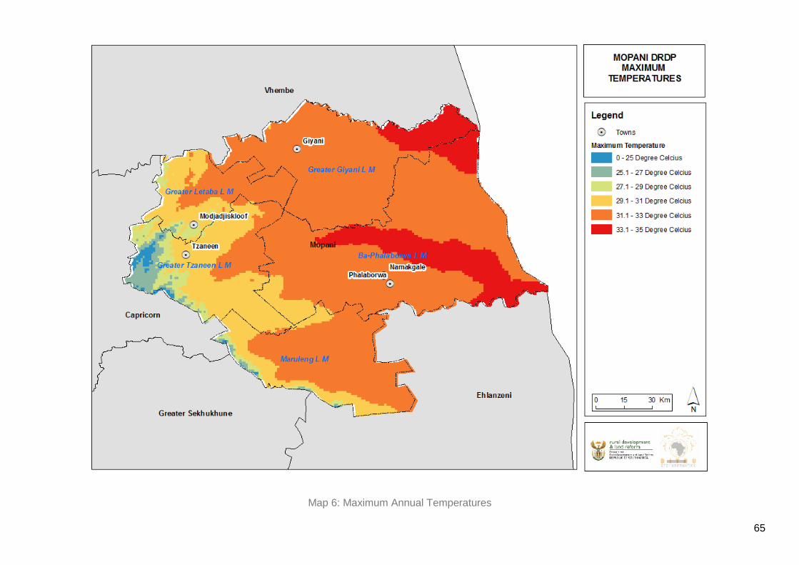
65
Map 6: Maximum Annual Temperatures

66
Map 7: Hydrology

67
4.7 Inputs from Stakeholder Engagements46
Engagements were held in Tzaneen on the 10th of June 2015.
Present were representatives from the Traditional Councils, Mopani DM, as well as sector
departments (i.e. DRDLR, Agriculture and LEDET). Below are some of the issues raised
therein:
Traditional leaders present welcomed the DRDP initiative. However, concerns
were raised over the underrepresentation of traditional leaders as well as local
municipal officials.
Concerns were raised over the ageing agricultural infrastructure in Mopani DM.
Responding to the proposed Agri-parks, traditional leaders outlined that Agri-parks
must be linked to Agri-villages as this would foster integrated rural settlements.
Questions were raised on the relevance of proposed DRDPs, particularly in light
of existing district and local strategic development plans.
There was a sense of ‘consultation fatigue’, with some stakeholders raising
concerns over the failure of existing plans to deliver basic services, notable roads,
housing, water and electricity.
Water scarcity was highlighted as one of the primary barriers to rural development
in Mopani.
The apartheid legacy of planning and the relegation of black people to
unproductive land were highlighted by traditional leaders. There were concerns
over the socio-economic plight of traditional leaders in Mopani.
Irrigation schemes and dams were identified as important for promoting agriculture
in Mopani.
46 Note that some of the inputs from stakeholder engagements are embedded in the situational analysis.

68
4.8 District-Wide Development Challenges
4.8.1 Water Scarcity
Mopani is a district characterized by very little rainfall especially in lower-lying areas of the
district such as Greater Giyani and Phalaborwa. This results in severe water shortage and
regular drought conditions. The district depends on the Letaba river catchment as its main
surface water resource. Ba-Phalaborwa’s main water sources are the Lepelle River and
Groot Letaba River. Boreholes also compliment the aforementioned water sources for local
municipalities. There are over 20 dams in the district with 9 being used for primary
consumption which includes domestic, industrial and commercial while the other dams are
used for irrigation purposes. Water supply scheme clusters are well defined and boundaries
are well established. Generally, it can be said that the district is well provided with bulk water
supply infrastructure.
4.8.2 Sanitation
Uneven delivery of basic services such as water, electricity and sanitation services is a
deterrent to sustainable economic growth. High backlog in sanitation particularly in villages
is a main cause of ground water pollution. The types of sanitation systems used in the
district are water-borne sewerage (Flush Toilet), Septic tanks, Ventilated Improved pit
latrines (VIP), French drains and ordinary pit latrines.
The majority of the people in the district use pit latrines and others have no sanitation
services at all. Greater Giyani experiences the worst situation with approximately 54% of the
households not having any access to basic sanitation services. Moreover, Greater Letaba
has the highest usage of pit latrines at approximately 51.5% whilst Ba-Phalaborwa is the one
local municipality with flushable toilets approximated at 39.8%.
4.8.3 Waste Management
The Mopani DM still faces major challenges with regards to waste management. Greater
Tzaneen and Maruleng are the only municipalities within the district that have authorized
waste management facilities/ landfill sites. Ba-Phalaborwa Municipality is using an informal
site and an application for the authorization of this site is yet to be made.
Human-generated waste is also of huge concern especially in the rural areas of Mopani with
the majority of those residing in rural communities using pit latrines. In terms of refuse
removal, most rural communities in the MDM do not have access to waste removal services
from local municipalities. Residents in these areas often use their own methods of refuse
removal and these are uncontrollable and thus result in hazards to environmental health.

69
In the MDM, refuse removal services are mainly provided to those in urban areas which
refers to the towns and townships within the district. The percentage of households that have
their refuse collected on a weekly basis increased from 13.5% to 15.2% in 2001.
Surprisingly, 81% of the district’s population is concentrated in rural areas where the
municipalities have a serious backlog of such services. Therefore, these services should be
made more accessible to those that are highly affected.
4.8.4 Low Levels of Literacy
The level of illiteracy within the Mopani district is alarming. There is approximately 27.1% of
the adult population (above 20 years of age) that does not have any form of schooling.
However, with the introduction of the ABET school programme in the district, a huge
improvement in literacy levels has been witnessed. The illiteracy rate decreased form
approximately 37.8% to 27.1% between 2001 and 2011. Only an estimated 13.7% have
completed primary education. These figures generally imply that more than 40% of the adult
population in the district can be regarded as illiterate. Only 12.7 % of the adult population
have matriculated and approximately 6.5% of them have completed higher education.
There is a shortage of schools and classrooms in almost all the local municipalities in the
MDM. It is estimated that 2378 class rooms as well as infrastructure, water and sanitation
are needed to address the dire schooling conditions that millions of learners’ experience
across the district.

70
Map 8: Schools
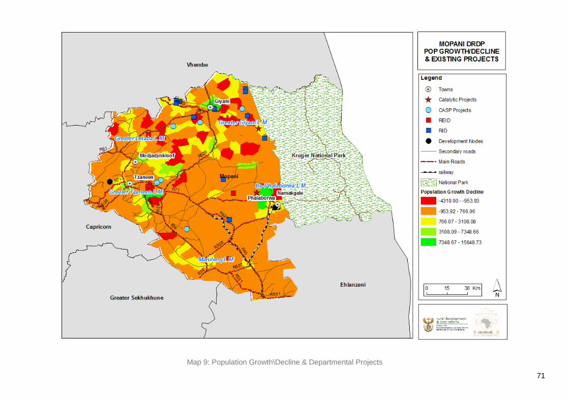
71
Map 9: Population Growth\Decline & Departmental Projects

72
Map 10: Health Facilities and Police Points

73
4.9 SWOT Analysis
Below is a synopsis of the strengths, weaknesses, opportunities and threats (SWOT
analysis) that exist in Mopani, by local municipality. While this is not an exhaustive SWOT
outline, it assists in providing a sound appreciation of the district’s main economic, social,
environmental and institutional endowments, at the same time allowing for the identification
of barriers to inclusive rural development.
4.9.1 Ba-Phalaborwa Local Municipality
Strengths The mining sector is the most dominant sector in Ba-
Phalaborwa and has created a lot of job opportunities.
A significant number of its people are relatively skilled in
professional and technical occupations.
The pristine natural environment in Ba-Phalaborwa allows for
both tourism and eco-tourism to flourish.
The existence of the Greater Limpopo Trans-frontier Park is an
advantage.
Weaknesses A large amount of land is currently under land claims of which
approximately 7.3% are valid.
The mining sector’s lack of transformation as well as low levels
of beneficiation is a weakness. Furthermore, the decline in
mining activity and output may result on the erosion of the LM’s
revenue base.
The weak performance of agriculture due to lack of adequate
infrastructure such as roads network and markets for goods
remains a challenge.
The agricultural value-chain is dominated by large commercial
farmers, leaving emergent farmers to languish in the margins.
Lack of diversification within the economy results in high levels
of unemployment. The fact that the government remains one of
the dominant employers points to the lack of adequate
industries that can employ people.
The rural nature of the municipality may limit its competitive
advantage particularly when compared with more urbanised
municipalities.

74
Informal businesses are mushrooming in rural areas which defeats
attempts at an integrated approach to spatial planning and land use
management.
Opportunities The natural capital in the municipality renders it one of the best
sites for tourism-led development.
The existence of mines and mining towns poses an opportunity
for emerging SMMEs to tap into the mining value-chain.
Moreover, mining activities can result in a range of social and
economic spin-offs that can benefit local communities.
The geographical location of the municipality allows for the
harnessing opportunities in existing development corridors such
as those identified via the Ba-Phalaborwa Spatial Development
Initiative
Its proximity to the Kruger National Park offers opportunities for
game farming.
Threats The volatility of the agricultural, mining and by extension the
manufacturing sectors put a number of people working within
the district at risk of losing their jobs.
The land claims lodged with the municipality hinder the
development process.
Water scarcity remains a challenge for all economic sectors
particularly agriculture.
Seasonal work within the agricultural sector as well as the
infrequency of extended public works programmes (EPWP)
both threaten the livelihood and quality of life of people in the
Mopani district.
The dependence of the majority of people on the state for jobs,
social grants and other forms of social security burdens the
state which is compelled to overextend its resources.
Rural to urban migration and the subsequent depopulation of
rural areas remains a threat to economic development. Linked
to that is the brain-drain, as young educated people leave the
district for greener pastures elsewhere.

75
4.9.2 Greater Giyani Local Municipality
Strengths There is a sustained production of Mopani worms and Marula.
Locational advantage
Kruger Park and tourism development opportunities
Weakness A large number of rural settlements are scattered and not
easily accessible.
Shortage of skills.
Poor infrastructure.
Opportunities There lies great economic development due to the tarring of the
Shangoni Gate in Kruger National Park.
Has potential for tourism and conservation and development
due to the existing natural heritage sites in the area namely,
Mang’ombe game reserve and heritage site, Baleni Heritage
site and Tingwazi heritage site.
The Eastern part of Greater Giyani offers tourism opportunities
in game farming given its proximity to Kruger National Park.
Mining deposits in the Giyani sub-region are beginning to be
exploited with huge potential spin-offs such as job opportunities
and infrastructure development.
Threats Majority of the land forms part of the former Lebowa and
Gazankulu homelands and these areas were underdeveloped
by the apartheid regime, thus they need infrastructure and
further development.
4.9.3 Greater Letaba Local Municipality
Strengths Timber production.
Tourism potential.

76
Letaba has the biggest Baobab tree in the world (24
circumference), for instance.
Weakness There are a few potential growth points for the economy due to
majority of the population residing in rural areas.
Water scarcity inhibits agricultural production and economic
growth.
Uneven delivery of services such as water, electricity and
housing results in relatively poor quality of life for the citizens.
Most of the small-scale farmers and manufacturers do not have
access to larger markets outside of the municipal area.
Opportunities The agricultural sector has great potential in contributing to the
municipality’s economy.
The Pristine natural environment i.e. dams, waterfalls,
vegetation and nature reserves allows for the promotion of
tourism-led development.
This is the hub of the extensive activities within the District
Municipality where most of the citrus fruit, sub-tropical fruit and
vegetables in the district are produced. This immediately offers
opportunities for beneficiation from fruit produce.
Threats Challenges are experienced in issues of land claims.
Approximately 48% of the land contained within the boundaries
of the Municipality is currently subjected to land claims.
Therefore, there is not much that can be done with the land
since there exists uncertainties and claims have not yet been
settled.
4.9.4 Greater Tzaneen Local Municipality
Strengths Identified as one of the sites where an Agri-Park will be located.
Has the highest percentage of the GDP in agriculture and eco-
tourism.
Tourism is growing as a result of the pristine natural

77
environment.
The presence of public sector offices as well as big businesses
renders it an economic hub for the district.
The above attracts young people to Tzaneen, as it offers better
quality of life.
Weaknesses Poverty in both urban and rural areas remains a challenge
Uneven delivery of basic services undermines the economic
growth potential of this municipality.
Opportunities It has a growing agricultural sector, increasing from
approximately 55.92% to 59%.
The existence of tribal land in the municipality might be viewed
as an opportunity for development, particularly if the traditional
leadership is willing to work with municipalities in harnessing
community development.
Threats Water scarcity threatens the municipality’s economic growth
potential.
Slow pace of agrarian transformation results in the
marginalisation of emerging black farmers.
Non-existence and/or limited physical infrastructure.
The rural nature of the municipality, as well as high levels of
poverty and unemployment threatens the economic and social
well-being of people and businesses in the municipality.
There are approximately 25 land claims that are yet to be
validated and that slows down development because not much
can be done with land that has not yet been proclaimed.
4.9.5 Maruleng Local Municipality
Strengths Large game farms critical for tourism development.
Weaknesses There is a shortage of general technical skills within the area.
Majority of the people in Maruleng are located away from the
economic hub of the municipality.

78
Opportunities Its strategic location in relation to the Maputo corridor positions
it as a tourism destination of choice and a node for economic
development.
Threats The economic node of the municipality is surrounded by
privately-owned land which is not available for new
development.
When land is made available, it is too expensive and the
majority of people cannot afford it.
4.10 Key findings from in loco/ ground truthing inspections
On the 9th and 10th of November 2015, inspections in loco were conducted in the entire
Mopani District Municipality in order to ascertain the basic information in the rural areas as
they are the places targeted by the DRDP.
Meetings were held with various stakeholders in order to find out the challenges and
opportunities in the rural areas that need to be taken up. There is a lot of undocumented
information that is only seen when visiting the intervention areas and talking to the
community to inform proposals and strategies to address the existing challenges and also
assist in forward planning.
Projects were visited in the rural area in order to find out the kind of interventions that the
government can embark on. It was not possible to visit all the functional regions and areas
that needed intervention but the majority of them were visited and this gives a general feel of
how things are in the rural setting.
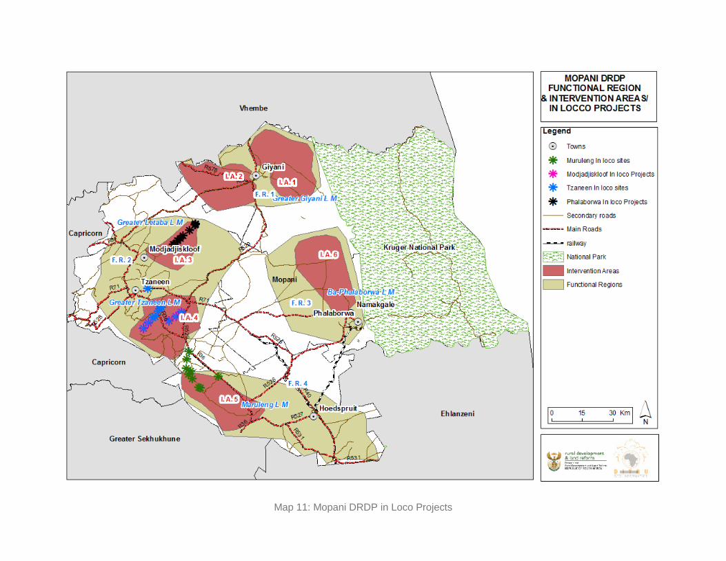
Map 11: Mopani DRDP in Loco Projects

Critical comments raised in the presentation
Inclusion of Sekgopo and Sekgosese in intervention area 2.
Selwane agricultural schemes along the Ritavi River need to be supported through
connection to the market and also provision of infrastructure such as roads and
machinery. Furthermore, it must be included as an area that needs intervention.
Small-scale mining (sand and gravel) needs to be formalized and regulated since it is
damaging the environment.
Modjadji Nature Reserve (cycad species) needs to be marked for tourists and also be
protected since it is a protected plant species
There is a cave which is approximately 7m in the Kgapane Mountains that needs to
be marketed and researched.
Giyani has the potential for mining, there are old mines that need to be reopened an
there are also prospected mining potential.
There is an existing Muyexe CRDP site that is not functional at this moment.
There is new gate to be opened/publicized, which will lead to the Kruger national park
(Shangoni gate) in the Giyani intervention area. The opening of this gate will lead to
the opening of a lot of tourism opportunities.
There is a Mopani Worms Processing Plant already planned in the Giyani area, this
will help create market opportunities for Mopani worms. At the moment the worms are
being collected and sold on a subsistence level, but this needs to be commercialized.
There are entrance and exit points in the municipal area that need to be taken into
cognizance I.e. Modjadjisloof, Goerge’s valley, Strydom tunnel, Nwamitwa, Zumeri,
Sekgopo, Sekgosese, Giyani, Mokwakwaila,and Xihoko.

4.11 Spatial Depiction of Niche Products
Map 12: Niche Products

5 SECTION FIVE - PROPOSED DEVELOPMENT OBJECTIVES
In proposing development-oriented interventions in Mopani, an attempt was made to take into
account the DRDP objectives as articulated in the preceding sections, as well as the findings
from the status quo analysis. This provided an opportunity for the formulation of operational
strategies that are critical to the realisation of the DRDP objectives. The DRDP objectives are
outlined as follows:
Objective 1: Improving productivity and competitiveness in the agriculture sector
Objective 2: Investment in Rural Revitalization
Objective 3: Promoting Integrated Human Settlements
Objective 4: Improving Tourism Competitiveness
Objective 5: Mining
Objective 6: Conserving the natural environment
5.1 Objective 1: Improving productivity & Competitiveness of the
agricultural sector
While Mopani is known for its abundance of wildlife - including the Big 5 - craggy mountains and
cascading waterfalls, there is the potential for agriculture in the area which is likely to create
jobs for many people residing in the district’s towns and villages. The pressing need for
agricultural development should be underscored by a sound appreciation and conservation of
the environment and natural capital. Areas around Tzaneen are processing marula oil;
therefore, they can be recognized as the processing hub for marula oil. In addition to that there
are five facilities in the area that test the marula oil for bugs.
5.1.1 Development Action 1: Optimising the potential of Agri-parks
Agri-parks provide a unique opportunity for the realisation of transformative agricultural
development and rural economic transformation in Mopani and beyond. The three components
of Agri-parks i.e. Farmer Production Support Units (FPSU), the Agri-hub (AH), and the Rural
Urban Market Centre Unit (RUMC) allow for targeted financial, intellectual and infrastructural
investment in agricultural development in Mopani. To this end, Agri-parks are presented in this
district rural development plan as providing a holistic developmental action for agrarian reform
and agri-business development. It is recommended that:

83
The Tzaneen Agri-hub as a production, equipment hire, processing, packaging, logistics
and training unit, be utilised for strengthening the agricultural commodity value-chain in
the entire Mopani district municipality;
Development of Agri-villages around Dingamanzi and Kokong;
Provision of agricultural related infrastructure in settlements and villages around
Tzaneen, Giyani and Phalaborwa;
It is suggested that the Farmer Production Support Units (FPSUs) be located close to
Greater Letaba, Giyani and Trichardtsdal;
Identification of new commodities and markets based on Mopani’s competitive and
comparative advantages;
Access to market for Mopani’s unique commodities such as Marula Tree and Mopani
worms;
Access to funding for investment in new machinery and equipment, as well as agriculture
and conservation-related research and development (R&D).
5.1.2 Development Action 2: Supporting small-scale farmers
Improvement of the irrigation schemes through, among other things, investment in
irrigation infrastructure to benefit small scale farmers.
Strengthening/Promoting the participation of small-scale farmers in the Agri-park
concept.
The provision of agricultural implements, seeds, fertilisers as well as irrigation equipment
to small-scale farmers.
5.1.3 Developmental Action 3: Optimising the use of high agricultural potential land
Land claims to be fast-tracked on high agriculture-capable land
More state-owned land to be made available for agricultural use
5.2 Objective 2: Investment in Rural Revitalisation
Rural revitalisation is critical for the provision of physical and social infrastructure that can allow
for the creation of socio-spatial and economic linkages between urban nodes and the rural
hinterlands. Integrated rural development is dependent on the strength of economic, social and
technological relations between economic nodes such as Tzaneen, Giyani and Phalaborwa as
well as the townships and villages surrounding them. To this end, the economic functionality of

84
the Mopani district must take into account the flow of goods and capital as well as the
movement of people within and between urban and rural spaces. The following operational
strategies are therefore proposed:
5.2.1 Development Action 1: Promoting the Renewal of Rural Towns and Villages
Rural town revitalisation projects must be implemented in all major towns. The renewal
of these towns is important as it provides them with an opportunity to attract local and
global investments of a financial, business and human capital nature.
Township revitalisation – projects for the entire district must be implemented to allow for
infrastructural investments as well as the provision of basic services such as water,
electricity, and decent housing. As rural townships continue to grow, their revitalisation
will attract more skilled people, as well as other forms of investment;
Village revitalisation – projects must be implemented in all densely populated villages.
The focus of these projects must be on the provision of water, electricity and other social
services critical for the improvement of the quality of life, in accordance with the NDP;
Develop village place-making and/or branding strategy – this is important as it promotes
rural spaces as livable and marketable places that can attract investment, skills and
tourism.
Some of the towns that need to be revitalized include; Sekororo, Hoedspruit, The Oaks,
Gravelotte, Ga-modjadji and Giyani.
5.2.2 Development Action 2: Identification of sustainable green energy sources for rural
industrialisation and development
With numerous rural development projects underway in Mopani, it is necessary to ensure that;
Sustainable, long-term funding mechanisms are put in place for all rural development
green energy oriented projects;
Fostering of inter-governmental and inter-departmental coordination of rural
development projects for strategic harmonisation and alignment of efforts;
Consideration of various forms of renewable energy including solar projects, hydro
power and micro wind

85
5.2.3 Development Action 3: Investment in Physical Infrastructure
The state of the road infrastructure reflects on the development of the region. Due to the
potential for development of the district through tourism, road infrastructure is a
necessity in the district. Most of the gravel roads in the district are not maintained
regularly and do not have route names, nor appropriate road signs. Most importantly,
fencing along the routes has been removed, resulting in the wandering of wild animals
onto the roads. Most of the affected areas are found around Greater Tzaneen (Boyne/
Sedan areas) and Greater Giyani (Nkomo and Matsosela areas) Municipalities. There is
a lack of access bridges (Marulang municipality), and they have tarred roads that require
storm water drainage. There is need for expansion and maintenance of the Ivory tourism
route from Giyani into the Kruger National Park so that it can be viable and support
tourism. This route links the Giyani Business centre along the R81 through Punda Maria
gate of the Kruger National Park; furthermore it is a famous ivory tourism route.
Below is the table which shows priority roads that need to be upgraded.
ROAD NO. ROAD PARTICULARS KM
D3634, D3778, D3753, D3718 Giyani to Nkuri to Malonga to Hanani to Tshimbupfe to Vuwani to Thohoyandou
48
D1350 Moruji to Matswe (Deerpark to Moruji to Matswe)
13
D3810 Thomo/Altein (Shangoni KNP gate) to Khakhala to Gawula to Mahlathi to Ndindani to Hlomela to Phalaubeni to Mbaula to Phalaborwa
34
D3249, D3248, D3175 Nkambako to Nwajaheni to Mandlhlakazi to Deerpark to Tzaneen
18
D3180, D3837 Sikiming to Bembula to Nkomo( Modjadji - Mokwakwaila-Bembula-Nkomo)
25
D3202, D3198, D3200, D3242, D3205, D3820, D3164
Constatia (D1267) to Marogoma to Ga Wale to Mawa to Lebaka to Jamela to Msengi to Olifanthoek
71
D3186 Mavele to Moruji 6
D3246, D3186, D3198, D3187, D3849, D3847, D3982
Nwamitwa to Mavele to Xihoko to Gawale to Gamokgwathi to Dzumeri to Mushiyani to Makhuva
51
D3770, D3771, D2009, D3878, D3898
Rita/Tickyline to Burgerdorp to Juliesburg/Rhulani to Hevenito Balloon to Sekororo
40
D3880, D4163,D3870 Lenyenye to Thabina to Mogoboya to lephephane to Khujwane
15
D3800 Mphambo to Mninginisi to Muyexe 32

86
D3211 Sikhiming to Nakampe to Phaphadi 12
P17/3 Burgersdorp to Gravelotte 27
R36 R36 Widening form Tzaneen to Burgersdorp
P43/3 Letsitele to Eiland 38
D3840, D3187, D3981, D3260 Giyani to Thomo to Altein to Shangoni Kruger National Park gate
8
Total distance that needs upgrading gravel to paved/ tar 229
Provision of roads, rail, freight and ICT infrastructure that can foster intra and inter-
district connectivity and mobility within and beyond the Mopani district. Improving access
to communication technology, and harnessing the use of new media for promoting
urban-rural business interactions and innovation.
Development of a technology park to foster innovation
5.2.4 Developmental Action 4: Restoration of existing manufacturing plants/ factories
Conduct assessment study on the viability of the manufacturing plants
Develop business case and source funding
Source partners in the development and refurbishment of factories
5.3 Objective 3: Promoting Integrated Human Settlements
Following the recommendations set out in Chapter 8 of the NDP, there is a need for Mopani to
fast-track the provision of adequate public amenities such as schools, clinics, community
centres and recreational facilities. Moreover, the provision of water and sanitation has been
identified as a priority for the district municipality. The condition of schools in the district
municipality has been raised as a major concern which needs to be addressed as a matter of
urgency. Furthermore, the use of pit latrines is still prevalent in the area and the sooner this is
addressed, the better for the communities residing in Mopani.
5.3.1 Development Action 1: Reduction of service delivery backlogs
The provision of adequate municipal infrastructure remains a challenge throughout the district.
Most people in the district use pit latrines and most of the populace do not have sanitary

87
services, especially in the Greater Giyani households. Greater Letaba has high usage of pit
latrines. The majority of the households in Ba Phalaborwa do not have access to piped water.
On the whole, to address service backlogs there is need for:
Monitoring of water services backlogs and the development of a water infrastructure
plan;
Installation of new sanitation connections to households;
Social institutions such as schools, clinics, police stations, Thusong Centres and
community halls;
Improving the Public Transport Network.
Electrification projects;
Housing projects;
Adopting a district-wide Public Transport Network.
5.3.2 Development Action 2: Promoting integrated rural spatial planning
Strengthening, and monitoring of IDP, SDF and LED implementation processes;
Standardising land use management and administration thereof across the district
municipality, in order to address existing inconsistencies;
5.4 Objective 4: Improving Tourism Competitiveness
5.4.1 Development Action 1: Harnessing the cultural heritage development corridors
Promotion of the Great Trans frontier Park corridor, as a means of growing the tourism
sector in the district;
Development of tourism-related activities in townships and villages to allow for broad-
based participation in this sector, with a specific focus on the participation of women and
youth;
Harnessing the pristine natural environment in and around Mopani to boost eco-tourism;
Develop village place-making and/or branding strategy – this is important as it promotes
rural spaces as livable and marketable places that can attract tourism;
The inclusion of women and youth in tourism-related opportunities, ranging from tour
guides to selling of arts & crafts through craft markets that are strategically located to
tourist attraction destinations;
Taking advantage of the proximity of Mopani to the Kruger National Park.

88
5.4.2 Development Action 2: Coordinated promotion of the Mopani region and its
attractions
Develop tourism brochures and materials
Train local tourist guides so that they can actively participate in tourism
Support the development of community and local tourism
Strengthen the Mopani district heritage council
5.5 Objective 5: Development of the Mining Sector
5.5.1 Development Action 1: Reviving mining operations
This can be done through the revival of old mines in Giyani;
Involving women and the youth in any mining beneficiation programmes;
Small scale mining of sand and gravel to be regulated;
Monitoring the negative impact that mining operations may have on the environment.
5.6 Objective 6: Conserving the natural environment
5.6.1 Developmental Action 1: Preservation of the natural environment
Identifying and updating the databases of protected areas, conservation areas,
environmentally sensitive areas in the MDM
Ensure areas with protected status are properly registered accordingly
Ensure the department of environmental affairs is represented in relevant forums and
committees

89
6 SECTION SIX – SPATIAL RATIONALE
The district rural development plan for Mopani is informed by a functional regional approach.
The salience of this approach to rural development rests in its emphasis on the nodal-hinterland
economic and socio-spatial linkages. In other words, economic development of Mopani’s
villages and rural townships is intrinsically dependent on these places’ linkages with established
nodes. A functional region therefore would typically have established nodes as well as areas in
need of various forms of intervention from a development perspective.
Functional regions are defined as ‘a spatial economic system, which consist of a number of
economically interdependent nodes (centres) of varying sizes and with varying geographical
extensions’. 47 From a regional economic development perspective, rural districts can be
identified as salient platforms for the harnessing of inclusive and sustainable economic
development. What renders districts their functionality is the existence and interplay of a range
of economic, demographic, infrastructural, cultural and technological flows and linkages. While
administrative boundaries are important, the flow of goods, services, capital and people is not
confined within these boundaries.
The market potential of a functional region is defined by its economic complexity i.e. the internal
and external concentration of a range of economic activities within a functional space. The
harnessing of the competitiveness of functional regions is dependent on the optimal utilisation of
both internal and external market potential. In instances where niche commodities and/or skills
exist within a functional region, value-chain potential ought to be fully nurtured.
It must be noted that different areas within functional regions have different specialisations. In
any given functional region, there exist areas with
a) knowledge-intensive business services,
b) land-intensive and
c) transport-accessibility-dependent economic activities.
Thus, while the centre/surrounding areas relations are important within functional regions, there
has been a growing observation in regional economics and rural development discourse that
47 Karlsson, C. and Olsson, M. (2015) Functional Economic Regions, Accessibility and Regional Development. Centre of Excellence for Science and Innovation Studies.
90
functional regions are dependent on the existence of a range of centres or regions with varying
specialisations. Thus, there exist a range of regions namely:48
Diverse/composite service regions;
Specialised service regions;
Agricultural regions;
Manufacturing regions; and
Consumption regions
Labour market characteristics and behaviour within a given functional region are also worth
noting. This is intrinsically tied to the population size, density and levels of literacy. Moreover,
the commuting patterns of labour from home to work have a direct effect on the economic
productivity as well as the quality of life of the labour-force. Thus, functional regions are
interconnected, as they defy administrative boundaries. These regions act as critical units for
spatial economic analyses. As district rural development plans attempt to transform rural
economies, a functional regional approach is likely to provide a more nuanced understanding of
rural development.
The identification of the Mopani Diverse functional regions was informed by the following data-
sets:
population count per settlement as the considerable contributing factor as well as other
aspects which incorporates;
population growth and decline,
accessibility index,
economic investment areas
proximity to agriculture-related infrastructure
Strategically Located Land Index
Departmental Projects
Tzaneen is a main regional centre in the district and has been recognised as a district gateway.
Giyani town has also been identified as a district gateway with Phalaborwa town being a tourism
gateway. Gateways allow or necessitate network to and from different settlements with both
movements of goods and services. Hoedspruit with extensive agricultural activities has also
been identified as a diverse functional region.
48 Ibid.

91
The maps overleaf show the spatial distribution of various transport, and agricultural
infrastructure as well as various commodities which were considered in locating diverse
functional regions and subsequently Intervention areas. Proximity to such commodities,
infrastructure and government projects (RID, REID, CASP projects, CDRP sites) contributed
significantly in the selection of intervention areas, supplemented by the population count within
an area. On the whole, development needs to be implemented where there are people.

92
Map 13: Accessibility Index

93
Map 14: Population Growth/Decline & Projects

94
Map 15: Active Mines and Mining Commodities

95
Map 16: Conservation Areas

96
Map 17: SLLI Agriculture

97
Map 18: Agricultural Potential

98
Map 19: Agricultural Infrastructure

99
Map 20: Diverse Functional Regions & Intervention Areas

100
7 SECTION SEVEN - MOPANI FUNCTIONAL REGIONS AND
INTERVENTION AREAS
7.1 DFR1 GIYANI FUNCTIONAL REGION
Giyani is the center of attraction in the functional region with a lot of public services such as malls,
shopping centers, government offices and education facilities. People from intervention areas 1 and 2
rely on Giyani for services mentioned above.
The town still needs a lot of revitalization in order to be able to sustain itself economically. Giyani was
the headquarters for the previous Gazankulu homeland regime and a lot of people still rely on it for
public services. Mopani district offices and Giyani municipality offices are located in this area. Giyani is
surrounded by a lot of rural areas that need a lot of intervention in terms of services since they are
poverty stricken. The rural areas are selected as intervention areas.

101
Map 21: Functional Region 1
102
7.1.1 Intervention Area 1: Muyexe and Surrounding Villages
These are the areas on the north, northeast and west of Giyani area. The villages are scattered
with a variety of resources that need to be resuscitated in order to alleviate poverty.
The intervention area links to Vhembe district on the north and Kruger national park on
the east. There is new gate to be opened/publicized which will lead to Kruger national
park (Shangoni gate) in the Giyani functional region. The opening of this gate will lead to
the opening of a lot of tourism opportunities.
Muyexe, Mapayeni, Nwazekuzeku and Homu are some of the villages in the area just to
mention a few. There is a smallholder irrigation scheme in the area and the availability of
a dam can help in starting irrigation on crops which do not require much water since this
area is an arid area.
The potential of the area can be realized by utilizing the Mopani worm which is a source
of food that can be harvested and sold as a source of income.
Giyani has potential for mining as there are old mines that need to be reopened and
there is also prospected mining potential.
There is an existing Muyexe CRDP site that is an initiative from the Department of Rural
Development and Land Reform which is not functional at the moment and needs to be
functionalized for it to operate further.

103
Map 22: Intervention Area 1

104
7.1.1.1 Commodities and Niche Products
The intervention area has some commodities or niche products that if harnessed can be
beneficial to the local communities.
a) Agriculture
There are agricultural schemes along the perennial rivers that are abandoned and they need to
be revitalized so that they can enter the mainstream economy Most of them produce vegetables
and grain products, which are sold to the local markets. Water scarcity and related infrastructure
is one of the problems that have led to the collapse of the schemes.
Hudson Ntsanwisi dam needs to be utilized fully to provide water to the schemes since there are
plenty of irrigation schemes in the area.
In terms of animal farming, there is an existing opportunity for animal farming but it is still
conducted in a subsistence way. A typical example of thriving red meat business is Gaza
beef/abattoir although it is privately owned. If the similar model is followed wherein
coorperatives are created and farmers sell their animals, it will create a proper and thriving rural
economy.
b) Mining
There are many mines that closed down and that led to loss of plenty of jobs for the local
people. There is therefore need for feasibility studies to be conducted in order to ascertain if
mining can still be revitalized. In addition, there are a lot of minerals prospected in the
intervention area that need to be taken further.
c) Tourism
Proximity to Kruger national park makes this area to have high tourism potential. The
intervention area must take advantage of the proximity and come up with skills and projects that
are compatible with the national park. Shangoni gate which leads to the park needs to be
opened for the public and it will therefore attract a lot of investment and business. Tourists will
support local business such as guesthouses, lodges, and man-made sculptures.
d) Mopani worms
Mopani worms are some of the special commodities in the intervention area although there
is still a challenge in terms of marketing them. There is a greater opportunity for the

105
commodity to enter into the mainstream economy. At this moment it is still used in a
subsistence manner although there is a greater possibility for commercializing it. However,
the municipality has taken an initiative to construct a Mopani worm in Dzumeri village which
is not operational at this moment due to administration and management reasons. There is
need for feasibility studies to be conducted on the operation of the facility as well as
harvesting and storage and processing of the worms in other areas of the district. Mopani
Worm programme can be implemented throughout the district and not necessarily localized
in Dzumeri of which that will benefit numerous people in the district.
Mopani worms are harvested in the areas close to Kruger National Park by the local community
from a Mopani tree. There is a hidden market for this commodity which needs to be tapped into
in order to enhance the local economy. So far individuals harvest the worms and sell them to
the local markets in the towns and also to the households. If the commodity is well researched
and marketed, there could be a greater unique opportunity in the mainstream economy. The
research concerned with farming Mopani worms included innovative and inventive methods for
breeding, harvesting, processing and storage. Breeding and harvesting strategies need to be
developed to increase production and stabilize the periodical harvest yields as well as maintain
the wild population levels. Processing and storage techniques aimed to improve the quality of
the product and thus potentially increase the financial return from the sale of high quality Mopani
worms.
7.1.1.2 Proximity to the Agri-Park and FPSU
There is an existing Muyexe CRDP site that can be used as an FPSU to support surrounding
villages.
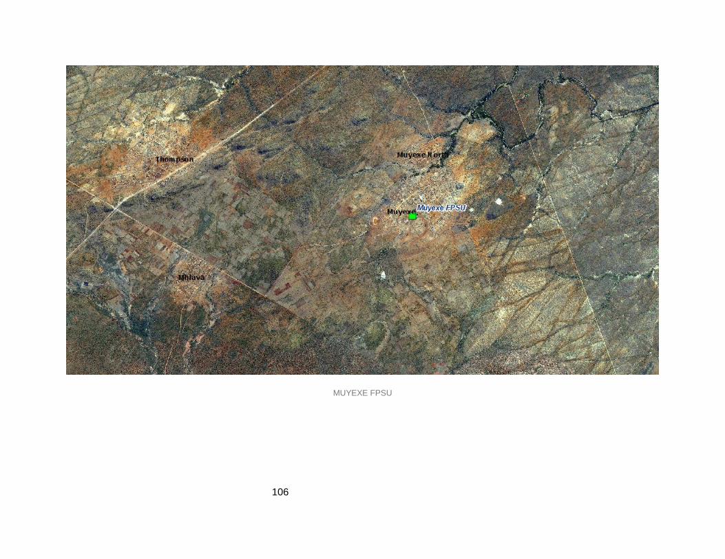
106
MUYEXE FPSU

107
7.1.1.3 Challenges
Water scarcity that led to collapse of the schemes
Abandoned agricultural schemes
Absence of skills and capacity to local farmers
Closed mines that need revitalization
Poor condition access roads
Illegal sand mining along the rivers
7.1.2 Intervention Area 2: Dzingidzingi, Dingamanzi, Jokong, Ndengedza, Siyandani
and surrounding villages
This area includes Dzingidzingi, Dingamanzi, Jokong, Ndengedza, Siyandani and the
surrounding villages. The region is in close proximity to Giyani, which is a district gateway on
the Western side. The villages are along R 81 road from Mooketsi and also along R 578 to
Elim. It is well serviced by transport infrastructure as it is close to Kruger National Park. Skills
development opportunities in relation to art may provide a source of income for the community
through the marketing of man-made sculptures to tourists. This intervention area is close to
REID projects.
7.1.2.1 Commodities
a) Agriculture
There is large portion of farms lying fallow and underutilized. The farms were known to produce
a lot of products to the market and they had employed a lot of local people. However, due to
administrative and resources reasons such as water scarcity, the schemes were abandoned.
The schemes are at Maswanganyi, Bobe and Dzingidzingi villages along R 578 road. They
need a lot of attention since they can revive the economy of the area. The existence of middle
Letaba dam on the west of the scheme can help extensively in providing water to the
community.
Similarly, animal farming especially cattle farming has a hidden potential which needs to be
unveiled in order to participate in the mainstream economy.

108
b) Mining
There are many mines that closed down and that led to loss of plenty of jobs for the local
people. For example, Gold mines in Siyandani and Mencisi village that has closed needs
revitalization and further research. There is therefore need for feasibility studies to be conducted
in order to ascertain if the mining can still be revitalized. In addition, there are a lot of minerals
prospected in the intervention area that need to be taken further.
Small-scale mining such as sand mining still poses an environmental threat to the environment.
It needs to be regulated and managed properly.

109
Map 23: Intervention Area 2

110
7.1.2.2 Proximity to the Agri-Hub and FPSU
The intervention area is 85 km away from the proposed Kgapane/Modjadji FPSU and
approximately 105 km away from Mosopatsela Agri-Park in Tzaneen. The functional region
does not have an FPSU but it is still feasible for it to share or use the FPSU in Kgapane village.
Dzingidzingi FPSU
Dzingidzingi village is located approximately 5km west of Giyani town along the R578 road to
Elim and close to the junction. The proposed FPSU will boost the local farmers with services
especially along the 578 road. This will assist in reviving the farms that are lying fallow and
abandoned.

111
DZINGIZINGI FPSU

112
Challenges
Abandoned agricultural schemes
Water scarcity
Lack of farming skills and infrastructure
Sand mining
Stock theft and roaming stock on the roads leading to accidents
Under-utilised Monane worm factory in Dzumeri
7.1.2.3 In loco projects visited
a) Mopani worms processing plant
There is a Mopani Worms Processing Plant in Dzumeri area which is not functional due to the
scarcity of Mopani worms. The building is lying unused. It is therefore suggested that instead of
channelling it to single use, it must be used for multipurpose since the worms are seasonal.
There is a need for operationalizing the Mopani worms in the area so that they can be linked
with the market and mainstream economy. At this moment the worms are being collected and
sold at subsistence scale; however, they need to be commercialized.
Un-Utilised Mopani Worms Processing Plant in Dzumeri Area In IA2

113
b) Giyani stone crusher
This facility used to be operational and it had appointed more than 60 people but it collapsed,
leading to loss of jobs. At this moment, there is a new investor who is in the process of
resuscitating it so that it can be operational. This will therefore have positive impact in creating
employment to people.
Giyani stone crushers project in a state of rehabilitation in IA2
c) Giyani Essential oils
The project has been there for years and the main function is the production of ointments oils,
mosquito repellents candles, olive oils and other by-products. The only challenge they have is
that the facility is currently using boreholes as a source of water and when they do not have
electricity, production stops and that affects output. The facility has appointed a lot of people
and this has had an impact on the creation of job opportunities.
d) Oyster mushroom and Bee keeping project
The project is no longer operational and people have lost jobs. The infrastructure is currently
used for a local crèche. According to the municipality, the project will no longer proceed since
the proposed activity is not feasible. The buildings should therefore be used for something to
benefit the community.

114
e) Maswanganyi, Bode and Dzingidzingi farms
This is a belt of farms in Hlaneki and Dzingidzingi area that are lying fallow. The farms were
once functional but due to water scarcity problems, they are now abandoned. The area has a lot
of potential but there is need for infrastructure development. There is a dam close-by which can
be used to provide water to the farms and revive the production. The farms are also under the
land claims process and this also has impact on the future of the farms.
f) Mencisi Gold mine
The mine used to be active but it has collapsed due to water shortage amongst other problems.
There are buildings in the premises that are dilapidated and some are used for accommodation.
Revitalization of the mine will provide employment to the people and also boost the local
economy. Other related projects that have closed down are Siyandani quarry and Xikukwani
mining. There are prospected mining potential in the Homu 14 area (birthday mines).
g) Sisal project
There is a sisal project just outside Giyani town that is lying fallow and the farm is bushy. Sisal
was supplied to a lot of areas and the farm is now abandoned and that has affected production
and employment opportunities.
h) Gaza Beef
This is one of the successful projects in Giyani, amongst others, and it has employed a lot of
people, although it is private.
Oyster Mushroom & Bee Keeping Project Infrastructure Now Utilized for Creche in IA2

115
i) Homu Banana Agriculture Scheme
This is one of the schemes that are not functioning properly. The scheme has infrastructure; it
only needs to be revitalized and funded. Water shortage is one of the challenges for the
survival of the scheme.
Homu Banana Agricultural Scheme in IA 1
7.1.2.4 Survival Strategies
The following are the strategies for survival in the entire area:
Subsistence farming
Brick yards and sand delivery
Chicken farms projects
Irrigation schemes
Mopani worms (seasonal)
Informal trading
Selling of firewood
7.2 DFR2 TZANEEN FUNCTIONAL REGION
Tzaneen is the regional centre for the district and it serves the entire district with services and
resources. The Agri-Park (Mosopatsela) for the district is located 7km east of Tzaneen town and
there is land already reserved for such activity. Tzaneen itself is already capacitated in terms of
infrastructure development and other resources. The Agri-Park is well located as it accessible

116
and is supported by FPSU in the intervention areas. The functional region has more villages on
the Northeast and southeast and it has many
Tzaneen is a large town in a fertile region with tropical and subtropical agriculture taking place in
a 20.000 km² region. About 650.000 people reside within a 30 km radius with the town itself
holding a population of around 30.000.
The Tzaneen area is a subtropical paradise filled with indigenous and exotic plants. Tzaneen
itself lies peacefully at the foot of the northern Drakensberg Mountains in the heart of a forestry
area and in South Africa's richest sub-tropical fruit-farming region.
It is an attractive subtropical garden town with a colourful profusion of indigenous and exotic
plants, and the 'capital' of the picturesque Letaba district. The valley of Tzaneen yields Valencia
oranges and grapefruit (such as Star Ruby). Bananas and macadamia nuts are also common
crops in the area with the town producing the majority of the country's mangoes, avocado pears,
paw-paws, tea and coffee.
Additionally, the town contributes substantially to the total production of timber, citrus and litchis
inter alia. The surrounding mountain slopes are heavily forested with pine and blue gum
plantations and close on forty sawmills operate in the area. Tzaneen is the second largest town
in Limpopo and accommodates some 80.000 residents while serving close on 650.000 people
within a radius of 30 km.

117
Map 24: Functional Region 2

118
7.2.1 Intervention Area 3: Ga-Modjadji, Malubana, and Budza
This area encompasses numerous settlements including Ga-Modjadji, Senwamokgope,
Malubana and Budza, just to mention a few. The land in the area has high potential for
agricultural activities and the settlements are close to a REID project which can be channelled in
fostering development in the area. Ga- Modjadji is a proposed site for an FPSU which can assist
in the realization of the agricultural potential of the area.
This intervention area is defined and structured by its natural topography. This is evident tin
Ga-Modjadi area and surrounding villages.
Accessibility in certain areas is a challenge due to the quality of the existing road
infrastructure which consists of a combination of semi-tarred and gravel roads.
Clear distinctions exist in terms of the socio-economic outlook of the area with a mixture of
small informal dwelling units and formal well-built dwelling units. However, the area
exemplifies the typical socio-economic profile of rural areas with disjointed economic
opportunities and a fairly unplanned development pattern.
The provision of basic services includes electricity and water through water tankers
stationed at strategic points in the area. The nature of the terrain however makes it difficult
for certain households to carry drums of water to their dwelling units.
Social amenities identified include a local clinic and a few schools.
The Matswi Dam in the immediate area is characterized by the presence of economic
opportunities including an active informal market (fruit and vegetable stalls), fuel station;
formal locally scaled shops and the availability of public transportation.
Distinct activities include a fully functional Poultry Farm and land availability in close
proximity to the nodal cluster.
The area between the Poultry Farm (Phakhati Depot and Koope Layer farm and Matswi
Dam) is ideal for FSPU development due to its strategic location and proximity to existing
agricultural and economic activities. In addition, the FPSU will benefit from good access and
centrality within the intervention area.
The Greater Letaba Municipality SDF has identified the area around the Matswi Dam as a
potential recreational area and subsequently conducted a feasibility study.
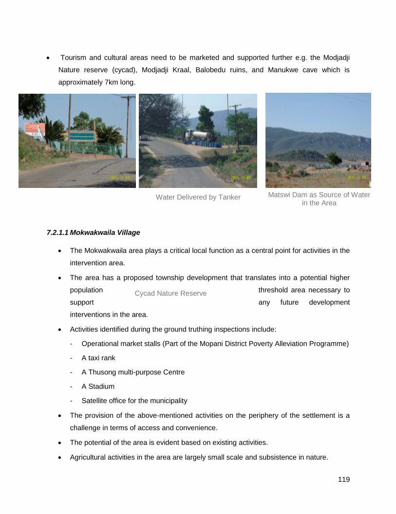
119
Tourism and cultural areas need to be marketed and supported further e.g. the Modjadji
Nature reserve (cycad), Modjadji Kraal, Balobedu ruins, and Manukwe cave which is
approximately 7km long.
7.2.1.1 Mokwakwaila Village
The Mokwakwaila area plays a critical local function as a central point for activities in the
intervention area.
The area has a proposed township development that translates into a potential higher
population threshold area necessary to
support any future development
interventions in the area.
Activities identified during the ground truthing inspections include:
- Operational market stalls (Part of the Mopani District Poverty Alleviation Programme)
- A taxi rank
- A Thusong multi-purpose Centre
- A Stadium
- Satellite office for the municipality
The provision of the above-mentioned activities on the periphery of the settlement is a
challenge in terms of access and convenience.
The potential of the area is evident based on existing activities.
Agricultural activities in the area are largely small scale and subsistence in nature.
Cycad Nature Reserve
Water Delivered by Tanker Matswi Dam as Source of Water in the Area

120
The area is on the African ivory route, which is meant to enhance tourism.

121
Map 25: Intervention Area 3

122
Map 26: Matswi Dam and Schemes along it

123
Map 27: Modjadji Settlement with an Existing Shopping Area and Community Projects

124
Map 28: Mokwakwaila Municipal Node

125
7.2.1.2 Mohlabaneng Area
Mohlabaneng area includes a mixture of housing typologies following a similar
development pattern as the Mokwakwaila area.
Poor road infrastructure presents a challenge to access in the area and all other areas in
the intervention area in general.
Economic opportunities are few and far between with the major economic areas of
Modjadjieskloof and Tzaneen not in close proximity.
The available local scaled nodal point in the area is the intersection of the R81 and the
route to Mohlabaneng. The area has a composition of activities including a fuelling
station, informal markets, and an RDP settlement and therefore should be considered for
intervention due to its strategic prominence.
The fertility of the soil also presents opportunities through agricultural investment and the
potential of an FPSU taking into account all the aforementioned issues.
Traffic from Modjadjieskloof and the Tzaneen area have direct access to the nodal point.
There is an existing Market stall in the Maphalle area that is being renovated. Local
people sell fruits from the local farms. The stalls are located next to a taxi rank that hosts
taxis to Modjadji, Giyani and Rotterdam.
Market stalls in Maphalle area selling products from local farms
7.2.1.3 CRDP site
There is an existing CRDP site in the intervention area at Sekgoti, Lenokwe, Modjadji and
Mohlala villages. This will help in bringing up infrastructure development, supporting and
boosting the rural economy.
126
7.2.2 Commodities in the Intervention Area
a) Agriculture
Crop farming is one if the commodities dominant in the intervention area both commercial and
subsistence. Availability of rivers and dams such as Matswi makes it possible for crop farming to
be taken forward. There are many schemes that need to be supported through running and
operating capital and infrastructure. The dominant crops are maize, tomatoes, potatoes and
onions and they are transported to the close markets in Tzaneen and the surrounding areas.
b) Tourism
There are existing tourism potentials in the area that need to be marketed further so that they
can boost the local economy. Tourism and cultural activities need to be marketed and supported
further e.g. the Modjadji Nature reserve (cycad), Modjadji Kraal, Balobedu ruins, and Manukwe
cave, which is approximately 7km long. There is a need for further research on each tourism
activity.
7.2.2.1 Proximity to the Agri-Hub and FPSU
There is a proposed unit in the intervention area that needs to be erected in order to support the
local farmers.
Kgapane/Modjadji FPSU
The intervention area has an FPSU which acts as a feeder to the Agri-Park in Tzaneen.
Furthermore, the FPSU will assist the local farmers with services such as skills, capacity,
marketing and other services. The locality of the unit is strategic since it will assist farmers who
cannot access the market and Agri-Park. The FPSU is approximately 35km away from the Agri-
Park located in Tzaneen.

127
KGAPANE/ MODJADJIKLOOF FPSU

128
7.2.2.2 Challenges
Topography of the area leading to poor road conditions and water scarcity
Abandoned agricultural schemes
Tourism areas not sufficiently marketed
Delays in land claims
7.2.3 Intervention Area 4
Settlements in the area include Burgersdorp and Moime with a population of over 5 000, New-
Coop Thabina, Hovheni and Gabaza just to mention a few. The accessibility Index shows that
there is an opportunity to develop the area. The region has 9 smallholder irrigation schemes that
are close to some restitution claims and land reform programme. The perennial river channel
can necessitate the development of more irrigation schemes in order to increase agricultural
activity and assist in alleviating poverty in the area. The area is close to two active mines which
can provide employment or other initiatives that can be undertaken, by which the mines plough
back to the nearby communities from a developmental perspective.
The intervention area is home to Mopani District Moshupatsela Agri-Hub site located
along R71 route 9km east of Tzaneen town. The site measures approximately 2000Ha in
extent and is strategically located adjacent to the regional route linking the economic
node of Tzaneen to outlying areas such as Phalaborwa and Hoedspruit. Existing
infrastructure on the site includes a dilapidated Atchar processing facility together with
old disused warehouses.
In close proximity to the Agri-Park site is the Nkowankowa Industrial Park that has been
earmarked by the DTI for revitalization. The area has experienced capital / investment
flight over the years with a notable portion of factories lying vacant and in ruins.
Existing activities in the industrial site include a number of milling sites such as the
Letaba Milling which work directly with local farmers in terms of processing and
packaging raw crops produced within local agricultural schemes.
Communities identified in the intervention area include a combination of low and middle-
income households residing in Dani Village. The community undertakes limited
agricultural activities but can boost the economy by further utilising the groundnut
farming in the region which can potentially be viewed as a nichè activity within the area.

129
The Khujwana area north of the intervention area features mostly barren land parcels
with existing agricultural activities in the form of cabbage farming (Khujwana Agricultural
Scheme). From the site inspection, it can be concluded that the soil in the area is not
ideal for farming. One of the challenges highlighted by officials is lack of fencing to
clearly demarcate agricultural schemes.
A Community Development Workers (CDW) initiative was also identified within the area
which focuses on promoting small agricultural activities in an effort to empower the local
community.
The New Corp agricultural scheme present in the area provides a more positive outlook
through its fertile land. The predominant activity is crop farming which is primarily
subsistence based. Lack of water was also acknowledged as an issue that is hindering
development and agricultural expansion in the area.
The Lepepane and Thabina Agricultural Schemes both provide an opportunity for further
investment due to their ideal soil potential. Activities supported in the schemes vary and
can open doors for agricultural diversification in the area.
Mining activities in the area focus mainly on titanium, copper and illuminate within the
Tivhani Mine.
Key issues identified in the intervention area are lack of water, lack of farming
infrastructure, limited/ poor connectivity between areas and the lack of functional public
transportation in certain areas.
There is a dilapidated sisal factory that has been abandoned. According to the
information received, the factory was very successful, even overseas companies used to
come and collect Sisal for different uses. The facility has shut down and approximately
300 people have lost jobs. The factory needs to be revamped and renovated since it
can create jobs and assist in curbing poverty.
Other Milling and Storage for Local Farmers/Cooperatives

130
Map 29: Intervention Area 4

131
Map 30: Abandoned Sisal Project that Needs Refurbishment

132
Map 31: Agricultural Schemes in Khujwana Area
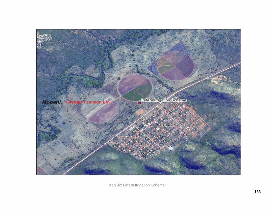
133
Map 32: Lefara Irrigation Scheme

134
7.2.3.1 Commodities
a) Agriculture
The area has a vast opportunity in crop farming and it has high rate of rainfall throughout the
season. The area already has infrastructure close-by in Tzaneen, Nkowankowa and Khujwana.
Crop farming is the dominant form of agriculture in the intervention area and the majority of
crops are Grain (Maize), Vegetables (cabbage) and Mango. There is an existing Atchar factory
in the area that harvests mangoes from the local farmers and convert them into products such
as Atchar and juice. There is also maize storage that assist farmers in storing their maize.
However, there are still challenges in terms of the operation of the schemes since most of them
are facing challenges such as poor infrastructure, lack of administration skills and lack of
support from government.
The area had agricultural infrastructure existing but it has dilapidated because of poor
maintenance hence there is a need for further maintenance and revitalization.
Sisal is one of the products that used to be planted in the area and there was a factory that
assisted factories wanting to make their products. The collapse of the factory and plantation has
led to the loss of jobs
b) Mining
There is also gold mining belt in the intervention area that needs to be further researched on
regarding its feasibility. Platinum, Titanium and Copper are the prospected minerals in the area.
7.2.3.2 Linkage with the FPSU and Agri-Hub
The area is close to the Agri-Park in Tzaneen area so there is a greater linkage with the Agri-
Park. The Agri-Park will also assist the local farmers in getting services such as skills,
marketing, knowledge and other elements. The intervention area has a lot of infrastructure as
compared to other intervention areas and it is accessible via R71, R 36 and R 529 roads. The
other access roads need to be tarred or maintained regularly.
7.2.3.3 Challenges
Abandoned sisal project
Poor roads linking the commodities to the markets
Poor agricultural infrastructure
Dilapidated infrastructure calling for renovations and revamping

135
7.3 DFR3 PHARABORWA FR
Phalaborwa is a town situated in Mopani District Municipality, Limpopo province inn South
Africa. It is located near the confluence of Ga-Selati River and the Olifants, halfway up along the
eastern border of Kruger National Park in Lowveld. Phalaborwa, Limpopo, South Africa is
situated within walking distance of the
Phalaborwa Kruger Park Gateway is definitely the most beautiful airport with lovely sceneries
and is in itself a great tourist attraction. Phalaborwa is the wildlife hub of Limpopo, South Africa
and is surrounded by all kinds of game farms, lodges and nature reserves.
The Olifants river winds its way past Phalaborwa through Klasserie Nature Reserve (an area of
62 500ha) and into Kruger National Park. Along this river, all the game can be seen, including
the Big 5.Beside the Big 5,the Olifants river, being home to an abundance of water creatures
and a variety of birds, is another tourist attraction.

136
Map 33: Functional Region 3

137
7.3.1 Intervention Area 6: Humulani, Nondweni, Mahale, Matiko-Xikaya, Priska and
Selwane amongst others
This intervention area includes Humulani, Nondweni, Mahale, Matiko-Xikaya and Selwane
amongst others. The existence of the development node for copper mining in Phalaborwa can
be a significant factor in the development of the area, and can act as a source of employment.
The area is within close proximity to REID and RID projects and this can go a long way in
uplifting the socio-economic wellbeing of the people in the settlements. Phalaborwa, as a
tourism gateway can allow for small enterprise trades which can sell art and sculpture to
tourists.However, this potential needs to be realised by promoting skill development in arts.
7.3.1.1 Matiko-Xikaya
The socio-economic profile of the area can be described as constituting low income
households with clear employment challenges, lack of investment and community
empowerment programs.
Access to water is through water tanks with no bulk water supply system in place. In
other areas, public standpipes are provided.
The economic commodity focus of the areas revolves around the abundance of the
Marula tree which is widely used for numerous goods. From an economic standpoint,
this commodity should be strategically managed and used to empower and uplift the
local community.
Public amenities in the area include numerous schools and crèches. There is an
absence of other critical amenities such as clinics and community halls. It was
highlighted during the site visitation that a Thusong Centre can greatly improve the
socio-economic outlook of the area given the existing status quo of limited services.
A site for a Thusong centre and a proposed shopping centre at Metz has been
identified.However, there has been no intervention by the municipality and traditional leaders to
date.

138
Map 34: Intervention Area 6

139
Map 35: Selwane Agricultural Schemes

140
7.3.1.2 Selwane, Priska-Eiland area
The area is approximately 45km north of Phalaborwa toward Giyani.
The Selwane area constitutes 40 – 50 functional irrigation schemes with a diverse
agricultural focus
The absence of quality road infrastructure is serious constraint in terms of having access
to the area and the delivery of products by local farmers to processing centres.
Current irrigation schemes contribute significantly towards the empowerment of local
communities and in women in particular (200 + women currently employed in the
irrigation schemes).
External support for local farmers is through the Department of Agriculture which
provides seeds and other start-up products. However, lack of farming infrastructure
remains a clear challenge in the area.
The area is well catered for in terms of water provision. However, sanitation
infrastructure is absent with households still utilizing the pit latrine system.
It was indicated that subsistence farming activities in the area are straining the local
water supply due to high water usage that directly impacts the local irrigation schemes.
Farmers use diesel engines to pump water from the river to the schemes. The average
consumption of a diesel engine is 350 litres per day and they obtain diesel
approximately 45km away in Gravelotte or Namakgale.
There are also abundant Mopani worms in the area which need to be marketed further.

141
7.3.1.3 Commodities and Niches
a) Agriculture
Crop production is dominant in the northern part of the intervention area in Selwane and Prieska
villages. The crops that are produced are Peppa dew, tomatoes, Maize, cucumbers and other
vegetables. The products are transported to local markets in Phalaborwa and even Tzaneen.
Roads conditions are the greatest challenges hindering the marketing of products in this area.
b) Mopani worms
Mopani worms are found in bulk in this intervention area and the intervention area is closer to
the Mopani worms plant in Dzumeri village so the plant is in an ideal location for marketing of
the worm.
Mopani Worms (Imbrasia Belina) are edible emperor moth caterpillars which are widely used
both as a protein food and as a source of income for the rural poor in the district municipality
especially in the far eastern part of the intervention area. Despite the widespread utilization of
naturally occurring wild populations of Mopani worms, farming methods and sustainable use of
this potential mini-livestock had not been developed.
The local community harvests Mopani worms in the areas close to Kruger National Park. There
Ritavi River Supplying Water to Selwane Schemes
OTHER 1 DIESEL ENGINE PUMPING WATER INTO THE SCHEME

142
is a hidden market with this commodity which needs to be tapped into in order to enhance the
local economy. So far individuals harvest the worms and sell them to the local markets in the
towns and also to the households. If the commodity is well researched and marketed, there
could be a greater unique opportunity in the mainstream economy. The research concerned
with farming Mopani worms included innovative and inventive methods of breeding, harvesting,
processing and storage. Breeding and harvesting strategies need to be developed to increase
production and stabilize the periodical harvest yields as well as maintain the wild population
levels. Processing and storage techniques aimed to improve the quality of the product and thus
potentially increase the financial return from the sale of high quality Mopani worms.
c) Marula tree
This is one of the commodities dominant in the Mopani region especially on the northeastern
part of the district. The commodity is well known for making Marula beer which is known in the
province entirely and the government is trying to make initiatives about promoting the beer.
There is an annual event for Marula beer in Mopani region held in Phalaborwa area. However,
there is still little done in terms of making the beer a commodity that will benefit the rural
communities. There is need for further research on how to make Marula a commodity that will
enter the mainstream economy. Apart from the beer, the nut inside the seed is known for
making oils and ointments.
Marula wood has been traditionally used for carving pestles and mortars, bowls, drums,
beehives and stools and even canoes in some areas. During colonial times it was even used for
tomato boxes and toilet seats. Marula is protected in communal lands under the local chiefs.
Because of its leafy foliage and shade-bearing size, it is popular with villages for local meetings
and often in a ploughed field will be the only tree left standing. Marula tree is often the spiritual
centre for ritual activity in kraals and villages.
d) Tourism
The intervention area borders Kruger national park on the east and this makes the area to have
greater advantage in as far as tourism is concerned. People in the area benefit from the national
park and other subsidiary activities in the closer range.
Tourism and wildlife play a dominant role in the life of this town. It is the only town in South
Africa that borders Kruger National Park while Mozambique border is only two hours drive
away. Lately, with the incorporation of various private game reserves into the conservancy area,

143
Phalaborwa is all but enclaved by nature conservancies.
Nearby natural attractions are Blyde River, Canyon, Rondavels, God's Window and Bourke's
Luck Potholes in Mpumalanga province. Tzaneen fruit farms and Hoedspruit game farms can all
be visited within a day.
e) Mining
There is little evidence for mining in the intervention area although there are mining activities
happening in the Phalaborwa area. Most of the people work for the mining companies in the
Phalaborwa area.
7.3.1.4 Proximity to the Agri-Hub and FPSU
Ga-Selwane FPSU
Ga-Selwane is proposed as a host for the FPSU in the Phalaborwa functional region. The FPSU
is selected due to the irrigation schemes along the Ritavi river. The presence of the unit in the
area will unlock the potential in the area and boost farmers in towns of the skills.

144
GA-SELWANE FPSU

145
Challenges
Poor road conditions
Lack of support in the agricultural schemes
Lack of social facilities in the intervention areas
Poor preservation of Mopanin tree
Illegal Sand Mining
7.4 DFR4 HOEDSPRUIT/MARULENG
Hoedspruit is a small town in Maruleng local municipality. The town is growing in terms of
infrastructure and it caters for tourists and farmers in the area. Majority of the villages close-by
rely on it for basic services. The town is boosted mainly by game farms and tourism attraction
points. This is the last town towards Mpumalanga province on the eastern side. The town, while
still small, has grown in recent years. Due to its proximity to private game reserves and Kruger
National Park, eco-tourism is a major contributor to the local economy.

146
Map 36: Functional Region 4

147
7.4.1 Intervention Area 5: Finale, Sekororo, Bismark, Mabins, Lorraine, Madeira,
Ofcolaco, Callais, Trichardal, Balloon and other areas including Metz and Oaks
Villages and settlements in the identified area include Finale, Sekororo, Bismark, Mabins,
Lorraine, Madeira, Ofcolaco, Callais, Trichardal, Balloon and other areas including Metz and
Oaks. Lorraine is categorised as a dense village with over 5 000 people. There are 8
smallholder irrigation schemes in the area which are served by Olifants River. The area has a
secondary route, which cuts across the villages and connects to the R36 route, which serves as
the basis of the transport infrastructure in the movement of goods and services. The potential of
the area can be realised from the agricultural activities, which can be derived from Hoedspruit
(tourism and Agricultural) town.
The availability of secondary roads and numerous arterial roads that lead to R531 provide
substantial transport infrastructure between the area and Hoedspruit Agricultural town which
can allow movement of people between the two areas. The existence of perennial streams
which pass through the area, can help support agricultural activities and farming skills can be
attained from the existing irrigation schemes. Bismark settlement is a proposed site for an
FPSU and can support such infrastructure
Agricultural activities in the area are oriented towards mangos and crop production. Thus
there is an atchar factory earmarked for the area.
The NTK Agricultural Facility is the current supply point in terms of agricultural support
and also the processing of agricultural goods from local farmers.
There are more than 10 farms that were restored through the land reform process.
However the farms are not fully utilized as most of them are vandalized and are no
longer in the state they were at transfer.
Agricultural Schemes in the areas include the Lebopo Scheme and privately
administered schemes such as IMM Farming which focuses on crop production.
The area has a problem with access since it is a tarred road and poorly maintained.
Furthermore, land for farming is being invaded by residential settlements in the Balloon
area.
The Balloon Village enjoys surplus water availability due to its strategic location within a
rain prone region. Similar to other rural areas in the district, subsistence farming is an
ongoing reality for most of the poverty stricken households.

148
It was noted that the reviving of inactive farms is required in order to ensure agricultural
continuity in the area.
There is a site reserved for an abattoir at Morupu-Mmola village close to Madiera village.
Due to the existing facilities and agricultural potential, FPSU is proposed for the area.
Lebopo Agricultural scheme in Balloon area
7.4.1.1 Commodities
a) Agriculture
Crop production is taking place along the main rivers in a subsistence and commercial manner.
A large part of land in the intervention area is used for agriculture and settlement. There are
farms that were given back to the community through the land restitution programs and most of
them are not in use. Maize is the main product in the intervention area.
Animal production is also prevalent in the Loraine and Sekororo area and there is a proposed
abattoir in the vicinity, which will assist local farmers in selling their animals to the outside
market.
b) Tourism
There are a lot of tourism activities in the area ranging from bush camping and wild life in the
proximity. The area is also close to the little Drakensbeg Mountain and that gives it tourism
advantage. The tourism competitiveness needs to be enhanced in order to encourage local
economic development.

149
c) Mining
There is little evidence of mining in the area although there is need for further investigation and
prospecting.
7.4.1.2 Linkages to the FPSU and Agri-Park
The intervention area is far from the Agri-Park but there is a proposed intervention area in
Bismark village.
Bismark FPSU
The FPSU will assist the entire intervention area and even the village in the proximity. It will act
as a feeder to the main Agri-Park in Tzaneen area. FPSU is located along the R36 road for
proper accessibility. There is still plenty of land in the Bismark area although at this point there
is no exact locality of the unit but since there is plenty of state land it will be easier to acquire
land.

150
BISMARK FSPU
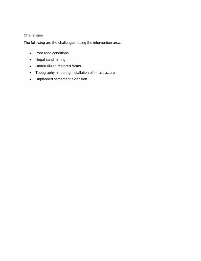
151
Challenges
The following are the challenges facing the intervention area;
Poor road conditions
Illegal sand mining
Underutilized restored farms
Topography hindering installation of infrastructure
Unplanned settlement extension

152
Map 37: Intervention Area 6

153
Map 38: Lebopo Irrigation Scheme

154
Map 39: Agricultural Schemes in Trichardtsdal (on Restored Land)

155
Map 40: Thusong Centre and the Proposed Abbattoir Site

156
8 SECTION SEVEN – IMPLEMENTATION PLAN
8.1 Programmes and Projects Categorization
The criteria for project classification is articulated below.
Table 5: Rural Development Programmes and Projects Categorisation
Nature of Programmes & Projects Characterisation
District-wide programme & projects District economic game changers - these are
projects that profoundly redefine and/or alter the
structure of a given district economy. Examples
include Agri-Parks and related physical
Infrastructure.
District social needs projects and programmes
– these support immediate social needs at a
district level.
District development enablers – projects that
provide enabling infrastructure at district levels.
These include building of roads, large-scale
housing and dams for instance.
Village & Household Survival Strategies Household microenterprises – these are
projects that are located at a village level, with
households and/or specific communities
participating in small-scale survivalist economic
activities. Medicinal herbs gathering, processing
and selling, operating Spaza shops, gathering
firewood and grass for selling
Village microenterprises – these are projects
that a community usually participates in
seasonally. These include picking, processing and
selling mopani worms; communal growing of
vegetables (small-scale agricultural cooperatives)

157
The project identification criteria set above allow decision-makers, development planners and
other stakeholders to be able to engage in forward planning. In other words, the categorisation
(and in some instances hierarchy) of projects allows for sound financial planning as well as
strategic allocation of physical, human and intellectual resources.
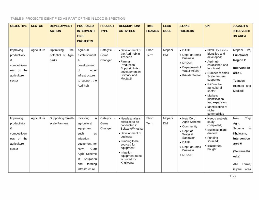
158
TABLE 6: PROJECTS IDENTIFIED AS PART OF THE IN LOCO INSPECTION
OBJECTIVE SECTOR DEVELOPMENT
ACTION
PROPOSED
INTERVENTI
ONS/
PROJECTS
PROJECT
TYPE
DESCRIPTION/
ACTIVITIES
TIME
FRAMES
LEAD
ROLE
STAKE
HOLDERS
KPI LOCALITY/
INTERVENTI
ON AREA
Improving
productivity
&
competitiven
ess of the
agriculture
sector
Agriculture Optimising the
potential of Agri-
parks
Agri-hub
establishment
&
development
of other
infrastructure
to support the
Agri-hub
Catalytic -
Game
Changer
Development of the Agri-hub in Tzaneen
Farmer Production Support Units development in Bismark and Modjadji
Short
Term
Mopani
DM
DAFF
Dept. of Small Business
DRDLR
Department of Water Affairs
Private Sector
FPSU locations identified and developed;
Agri-hub established and functional
Number of small Scale farmers supported
R&D in the agricultural sector
Markets identification and expansion
Identification of niche commodities
Mopani DM,
Functional
Region 2
Intervention
area 1
Tzaneen,
Bismark and
Modjadji
Improving
productivity
&
competitiven
ess of the
agriculture
sector
Agriculture Supporting Small-
scale Farmers
Investing in
agricultural
equipment
such as
irrigation
equipment for
New Corp
Agric Scheme
in Khujwana
and farming
infrastructure
Catalytic -
Game
Changer
Needs analysis exercise to be conducted in Selwane/Prieska
Development of business
Funding to be sourced for equipment
Irrigation equipment to be acquired for Khujwana
Short
Term
Mopani
DM
New Corp Agric Scheme
Community
Dept. of Water & Sanitation
DAFF
Dept. of Small Business
DRDLR
Needs analysis study completed;
Business plans drafted;
Funding sourced;
Equipment bought
New Corp
Agric
Scheme in
Khujwana;
Intervention
area 6
(Selwane/Pri
eska)
AM Farms,
Giyani area

159
OBJECTIVE SECTOR DEVELOPMENT
ACTION
PROPOSED
INTERVENTI
ONS/
PROJECTS
PROJECT
TYPE
DESCRIPTION/
ACTIVITIES
TIME
FRAMES
LEAD
ROLE
STAKE
HOLDERS
KPI LOCALITY/
INTERVENTI
ON AREA
for
Selwana/Pries
ka area, AM
Farms
(interventio
n area 1)
Improving
productivity
&
competitiven
ess of the
agriculture
sector
Agriculture Optimising the
use of high
agricultural
potential land
Fast tracking
land
restitution
programme as
well as land
claims
Catalytic -
Game
Changer
Land claims to be fast tracked
More state owned land to be made available for agricultural use
Negotiations to be held with traditional authorities
Medium
Term
Mopani
DM
DAFF
Traditional authorities
Community members
Dept. of Small Business
DRDLR
Number of land claims processed
Hectares of state owned land made available for agricultural activities
Number of meetings held with traditional authorities
Hectares of land owned by traditional authorities made available for agricultural schemes
Mopani DM
Improving
productivity
&
competitiven
Agriculture Supporting small
scale farmers
Improvement
of security
and proper
demarcation
Catalytic -
Game
Changer
Erecting of fencing in the Khujwana Agricultural scheme
Short
Term
Mopani
DM
Khujwana Agric Scheme farmers
DRDLR
DAFF
Fence with appropriate dimensions erected around the scheme
Khujwana
Area

160
OBJECTIVE SECTOR DEVELOPMENT
ACTION
PROPOSED
INTERVENTI
ONS/
PROJECTS
PROJECT
TYPE
DESCRIPTION/
ACTIVITIES
TIME
FRAMES
LEAD
ROLE
STAKE
HOLDERS
KPI LOCALITY/
INTERVENTI
ON AREA
ess of the
agriculture
sector
of agriculture
schemes
Improving
productivity
&
competitiven
ess of the
agriculture
sector
Agriculture Supporting small
scale farmers
Revitalisation
& Restoration
of farms that
are part of
land
restitution
programmes;
Revitilisation
of the Oyster
Mushroom
and Bee
Keeping
Project in
Giyani area
Catalytic -
Game
Changer
10 farms identified in the Sekororo/Bismark/Balloon require an assessment of constraints/ challenges experienced by the farmers
Development of action plans to restore the farms
Training farmers through agricultural learnerships/ internships
Establish partnerships for new farmers
Career guidance EXPO's focusing on agriculture as
a career of choice
Allocate
Short
Term
Mopani
DM
Small scale farmers;
DRDLR;
Agriculture SETA;
Dept. of Small Business
DAFF
Private sector
Ten farms restored, active and productive
Small Scale farmers supported
Oyster Mushroom project restored and used for what it was initially set out to achieve
Intervention
area 5
(Sekororo/Bi
smark/Balloo
n)
Intervention
area 1 Giyani
and
surrounding
villages

161
OBJECTIVE SECTOR DEVELOPMENT
ACTION
PROPOSED
INTERVENTI
ONS/
PROJECTS
PROJECT
TYPE
DESCRIPTION/
ACTIVITIES
TIME
FRAMES
LEAD
ROLE
STAKE
HOLDERS
KPI LOCALITY/
INTERVENTI
ON AREA
Agricultural students via SETA to assist in the running of the farms as part of their practical work.
Improving
productivity
&
competitiven
ess of the
agriculture
sector
Agriculture Supporting small
scale farmers
Address the
issue of water
scarcity in the
MDM
Catalytic -
Game
Changer
Needs analysis for water in the Mopani DM
Prioritise areas and uses of water
Optimise the uses of water in existing irrigation schemes such as Homu Banana Agric Scheme,
Short to
Medium
term
Mopani
DM
Department of water affairs
DAFF
DRDLR
Community members
Small scale farmers
Commercial farmers
Needs analysis conducted and reviewed
Prioritisation of areas for water schemes in place
Irrigation schemes optimised
Number of farmers assisted
Mopani DM &
Functional
Region 1,
Intervention
Area 1
Improving
productivity
&
competitiven
ess of the
agriculture
sector
Agriculture Supporting small
scale farmers
Provide
existing and
potential
farmers with
the knowledge
of farming
required to run
successful
farming
Catalytic –
Major
Enabler
Put in place skills development, Incubator programmes and agricultural colleges in alignment with the economic growth of Limpopo as well as the Agri-parks concept
Identify beneficiaries
Medium
Term
Mopani
DM
DAFF
DRDLR
Community members
Small scale farmers
Commercial farmers
Agriculture SETA
Universities
Farmers
Number of incubator programmes in place
Number of skills development programmes in place
Number of beneficiaries of the programmes
relevance of programmes
Mopani DM

162
OBJECTIVE SECTOR DEVELOPMENT
ACTION
PROPOSED
INTERVENTI
ONS/
PROJECTS
PROJECT
TYPE
DESCRIPTION/
ACTIVITIES
TIME
FRAMES
LEAD
ROLE
STAKE
HOLDERS
KPI LOCALITY/
INTERVENTI
ON AREA
enterprise with a special focus on youth
Develop Partnerships with commercial farmers and private sector entities (e.g. Banks).
Conduct a Feasibility study to determine the need for agricultural schools in the province
Strengthen & support of the 8 existing agricultural schools
Hold career guidance EXPO's focusing on agriculture as a career of choice
Schools
Financial services companies
Department of basic education
content;
Number of career guidance EXPO's held;
feasibility study conducted and approved
Improving
productivity
&
competitiven
ess of the
agriculture
Agriculture Supporting small
scale farmers
Ensure the
effective
management
of existing
agricultural
Projects in the
Catalytic –
Major
Enabler
Create and manage a database of all existing agricultural schemes and projects in the MDM in order to facilitate proper
Short
term
Mopani
DM
DAFF
DRDLR
Govt. Departments with such projects
NGO's involved in
Database created, with relevant info such as names of projects, location, no. of beneficiaries, commodities
Mopani DM

163
OBJECTIVE SECTOR DEVELOPMENT
ACTION
PROPOSED
INTERVENTI
ONS/
PROJECTS
PROJECT
TYPE
DESCRIPTION/
ACTIVITIES
TIME
FRAMES
LEAD
ROLE
STAKE
HOLDERS
KPI LOCALITY/
INTERVENTI
ON AREA
sector Mopani DM monitoring, support and administration of the schemes
Identify outstanding project and scheme needs
Address and prioritise the needs of the schemes and projects
Address the gaps
agricultural projects
CoGTA
Needs identified, prioritised and addressed
Improving
productivity
&
competitiven
ess of the
agriculture
sector
Agriculture Supporting small
scale farmers
Expand the
number of
agricultural
schemes in
the MDM
Catalytic –
Major
Enabler
Identify suitable land for the establishment of agricultural schemes;
identify members of the community in the surrounding areas to participate in the schemes
Source funding for schemes
Source partnerships for schemes
Medium
term
Mopani
DM
Traditional Authorities;
DAFF; Dept. of Small Businesses;
Private Sector
Commercial farmers
Community members
Number of schemes identified
Hectares of suitable land identified
Increase in MDM GDP
Number of small scale farmers supported
Number of schemes invested in
Intervention
Area 4
(Burgersdorp
/ Moime)

164
OBJECTIVE SECTOR DEVELOPMENT
ACTION
PROPOSED
INTERVENTI
ONS/
PROJECTS
PROJECT
TYPE
DESCRIPTION/
ACTIVITIES
TIME
FRAMES
LEAD
ROLE
STAKE
HOLDERS
KPI LOCALITY/
INTERVENTI
ON AREA
Investment
in rural
revitalisation
Human
Settlement
s
Promoting the
renewal of rural
towns and
villages
Investing in
the
formalisation
of rural towns
and villages
High
Priority
Programm
e
Identification of priority rural towns and villages to be targeted for renewal;
Branding and Marketing strategies to be developed for these identified towns and villages
Revitalisation of CRDP sites
Medium
to long
Term
Mopani
DM
CoGTA
Department of Human Settlements
Department of Public Works
Department of Water & Sanitation
Department of Environmental Affairs
Private Sector
All identified towns and villages
Development agencies
List of identified towns and villages;
Draft marketing and branding strategy documents prepared
CRDP Sites renewed
Mopani DM
Investment
in rural
revitalisation
Human
Settlement
s
Promoting the
renewal of rural
towns and
villages
Formalisation
of the landfill
site in Ba-
Phalaborwa
Municipality
Catalytic -
Major
social
needs
projects
Finalise the usage application for the informal landfill site being used in Ba-Phalaborwa Municipality
Short
term
Mopani
DM
CoGTA
DRDLR
Application submitted and finalised
Ba-
Phalaborwa
LM
Investment
in rural
revitalisation
Roads and
transport
Investment in
physical
infrastructure
Improvement
of public
transport
High
priority
programm
Building of a taxi rank in Khujawana
Medium
Term
Mopani
DM
Dept. of Public Works, Roads & Transport
CoGTA
Taxi rank in Khujawana built and in use
Intervention
area 4
(Khujawana)

165
OBJECTIVE SECTOR DEVELOPMENT
ACTION
PROPOSED
INTERVENTI
ONS/
PROJECTS
PROJECT
TYPE
DESCRIPTION/
ACTIVITIES
TIME
FRAMES
LEAD
ROLE
STAKE
HOLDERS
KPI LOCALITY/
INTERVENTI
ON AREA
system e Community members
Investment
in rural
revitalisation
Manufactur
ing
Restoration of
existing
manufacturing
plants/ factories
Reopening of the Sisal Factory in the Khujwana and a sisal project in the Giyani area
Reopening of the Mopani Worms processing plant in Dzumeri area
High
priority
programm
e
Conduct assessment study
Develop business case
Source funding
Source partner
Medium
term
Mopani
DM
DTI
Community members
Private sector
LEDET (Local Economic Development)
DRDLR
Sisal factory and project running
Marketing strategy created
Number of jobs created
Mopani Worms Processing Plant reopened and productive
Intervention
area 4
(Khujawana)
Intervention
area 1 (just
outside
Giyani)
Intervention
area 1
(Dzumeri).
District Wide
Promoting
Integrated
Human
Settlements
Human
Settlement
s
Reduction of
service delivery
backlogs
Housing
developments
to ensure
sustainable
human
settlements
Catalytic -
Major
Social
Needs
Project
Township development for the Mohlabaneng area
Public amenities in the areas include numerous schools and crèches.
Building of
Medium
Term
Mopani
DM
Department of Human Settlements
Department of Public Works
Department of Water & Sanitation
Department of Environmental Affairs
Number of housing units provided
New social infrastructure developed/built
Suitable land identified for Community Hall & clinic;
structures
Intervention
area 3
(Mohlabanen
g)

166
OBJECTIVE SECTOR DEVELOPMENT
ACTION
PROPOSED
INTERVENTI
ONS/
PROJECTS
PROJECT
TYPE
DESCRIPTION/
ACTIVITIES
TIME
FRAMES
LEAD
ROLE
STAKE
HOLDERS
KPI LOCALITY/
INTERVENTI
ON AREA
schools, clinics, service centres and other social infrastructure facilities.
Provision of solid waste management services
Private Sector erected for all
Number of sanitation facilities built
Decrease in service delivery backlog
Promoting
Integrated
Human
Settlements
Human
Settlement
s
Promoting
integrated rural
spatial planning
Building of
public
amenities
including youth
development
centres
Catalytic -
Major
Social
Needs
Project
Building of community halls
Building of Thusong Centre and Clinic for the Matiko Xikaya community
Medium
Term
Mopani
DM
Department of Human Settlements
Department of Public Works
Department of Water & Sanitation
Private Sector
Suitable land identified for Community Hall & clinic;
structures erected for all 3 including Thusong centre
Intervention
area 6
(Matiko
Xikaya)
Promoting
Integrated
Human
Settlements
Human
Settlement
s
Reduction of
service delivery
backlogs
Improvement/
Provision of
proper
Sanitation
Catalytic -
Major
Social
Needs
Project
Eradication of pit latrines in the Selwane/Prieska/Ellan area
Medium
Term
Mopani
DM
Department of Human Settlements
Department of Public Works
Department of Water & Sanitation
CoGTA
Reduction in service delivery backlog
Increase in flush water toilets
zero pit latrines in the area
Intervention
area 6
(Selwane/Pri
eska/Ellan)
Promoting
Integrated
Human
Settlements
Human
Settlement
s
Reduction of
service delivery
backlogs
identify waste
Management
sites for
Letaba and
Catalytic -
Major
social
needs
identify land that can be utilised as waste management sites for Greater Letaba and
Short
Term
Mopani
DM
DRDLR
CoGTA
Department of Human Settlements
Department of
Suitable waste management sites for Greater Giyani and Greater Letaba identified and in use
Greater
Giyani &
Greater
Letaba LM’s

167
OBJECTIVE SECTOR DEVELOPMENT
ACTION
PROPOSED
INTERVENTI
ONS/
PROJECTS
PROJECT
TYPE
DESCRIPTION/
ACTIVITIES
TIME
FRAMES
LEAD
ROLE
STAKE
HOLDERS
KPI LOCALITY/
INTERVENTI
ON AREA
Giyani projects Greater Giyani Water & Sanitation
Department of Environmental Affairs

168
TABLE 7: PROJECTS IDENTIFIED AS PART OF THE SYNTHESIS OF RURAL DEVELOPMENT ISSUES
OBJECTIVE SECTOR DEVELOPMENT
ACTION
PROPOSED
INTERVENTIONS
/ PROJECTS
PROJECT
TYPE
DESCRIPTION
/ ACTIVITIES
TIME
FRAMES
LEAD
ROLE
STAKE
HOLDERS
KPI LOCALITY/
INTERVENTI
ON AREA
Improving
productivity
&
competitiven
ess of the
agriculture
sector
Agriculture Optimising the
potential of
Agri-parks
Supporting
small-scale
farmers
Support and promote enterprise development
High
Priority
Program
me
Enterprise development with a focus on agro-business and cooperative business development
Development of small business incubators and mentorship programmes
Short to
Medium
Mopani
DM
Department of Economic Development
Department of Small business Development
DRDLR
Private Sector
Agriculture SETA
New SMME’s identified and supported
Jobs created
Mopani DM
Improving
Tourism
Competitiven
ess
Tourism Harnessing the
cultural
heritage
development
corridors
Arts and crafts
manufacturing
High
Priority
Program
me
Formulation of skills development programmes for arts & crafts
Identification of learners
Identification of
Short to
Medium
Mopani
DM
LEDET
DRDLR
SA Tourism
Private Sector
SETA’s
Department of education
Number of individuals trained
Increase in revenue from tourism related activities
Mopani
DM

169
OBJECTIVE SECTOR DEVELOPMENT
ACTION
PROPOSED
INTERVENTIONS
/ PROJECTS
PROJECT
TYPE
DESCRIPTION
/ ACTIVITIES
TIME
FRAMES
LEAD
ROLE
STAKE
HOLDERS
KPI LOCALITY/
INTERVENTI
ON AREA
institutions to deliver the training
identification and packaging of tourism products
Improving
Tourism
Competitiven
ess
Tourism Coordinated
promotion of
the Mopani
region and its
attractions
Specific
targeting of the
great trans
frontier park
corridor, Kruger
national park,
Wolksberg
wilderness area,
Debengeni
waterfalls, etc
High
Priority
Program
me
Develop tourism brochures and materials
Train local tourist guides
Package and promote tourism destinations
Support the development of community and local tourism
Strengthen the Mopani district heritage
Medium
Term
Mopan
i DM
LEDET
DRDLR
SA Tourism
Private Sector
SETA’s
Department of education
MDM Heritage council
Tourism brochures available
Community members trained
Jobs created
Strong heritage council in place
Mopani
DM

170
OBJECTIVE SECTOR DEVELOPMENT
ACTION
PROPOSED
INTERVENTIONS
/ PROJECTS
PROJECT
TYPE
DESCRIPTION
/ ACTIVITIES
TIME
FRAMES
LEAD
ROLE
STAKE
HOLDERS
KPI LOCALITY/
INTERVENTI
ON AREA
council
Investment
in rural
revitalisation
Technology Establishment
of a technology
park by through
investing in
physical
infrastructure
Development of a technology park to foster innovation and enable its commercial application in the Mopani DM
Catalytic
- Major
enabler
Develop a feasibility study for Mopani DM to establish the viability of a technology park
Consideration of the infrastructure required
Engage local community
Identify pilot areas
Market and promote the venture
identify funding opportunities and potential
Medium to
Long Term
Mopan
i DM
Department of Science and Technology
Department of Trade and Industry
Agri SETA
Private Sector
Department of economic development and tourism
community
R&D
investigati
ve
activities
completed
and
published
Number of R&D pilot projects undertaken
Funding identified and in place
Mopani DM

171
OBJECTIVE SECTOR DEVELOPMENT
ACTION
PROPOSED
INTERVENTIONS
/ PROJECTS
PROJECT
TYPE
DESCRIPTION
/ ACTIVITIES
TIME
FRAMES
LEAD
ROLE
STAKE
HOLDERS
KPI LOCALITY/
INTERVENTI
ON AREA
partnerships
Investment
in rural
revitalisation
Energy Identification of
sustainable
green energy
sources for
rural
industrialisation
and
development
Development of an industrial and business park focused on the development of renewable energy technologies and the manufacturing of renewable energy products.
Catalytic
- Game
Changer
Develop a feasibility study for Mopani DM to establish the viability of a renewable energy park
Consideration of various forms of renewable energy including solar projects, hydro power and micro wind
Engage local community
Identify pilot areas
Market and promote the venture
Identify funding
Medium to
Long Term
Depart
ment
of
Energ
y
Mopani DM
DRDLR
Regional and International Development Agencies
Private Sector
ESKOM
Independent power producers
Universities
R&D investigative activities completed and published
Number of renewable energy pilot projects undertaken
Funding identified and in place
Mopani DM

172
OBJECTIVE SECTOR DEVELOPMENT
ACTION
PROPOSED
INTERVENTIONS
/ PROJECTS
PROJECT
TYPE
DESCRIPTION
/ ACTIVITIES
TIME
FRAMES
LEAD
ROLE
STAKE
HOLDERS
KPI LOCALITY/
INTERVENTI
ON AREA
opportunities and potential partnerships
Investment
in rural
revitalisation
Manufacturi
ng
Restoration of
existing
manufacturing
plants/factories
Access to markets for niche/unique commodities
High
Priority
Program
me
Assessment study to be conducted
Business plan to be drafted
Develop a marketing plan for Mopani worms
Short to
medium
term
Mopan
i DM
Department of Public Works, Roads and Infrastructure (LDPW)
Department of Economic Development Environment & Tourism (LEDET)/ DRDLR/ SA Tourism
Private Sector
Business Plan developed and approved;
Marketing strategy developed
Mopani DM
Mining Mining Reviving mining
operations and
develop small
scale mining
ventures
Re-opening of
old mines in the
area, including
the Mencisi Gold
Mine
Catalytic
-
Game
Changer
Conduct
feasibility
studies for
mining
prospects
with the aim
of reopening
some old
Medium to
long term
Mopani
DM
Department of
Minerals and
Energy/ Private
sector mining
houses/
financial
institutions/
SETA's
Number of
emerging
mining
operations
created
Increase in
growth in the
Diverse
Functional
Region 1
(Giyani)

173
OBJECTIVE SECTOR DEVELOPMENT
ACTION
PROPOSED
INTERVENTIONS
/ PROJECTS
PROJECT
TYPE
DESCRIPTION
/ ACTIVITIES
TIME
FRAMES
LEAD
ROLE
STAKE
HOLDERS
KPI LOCALITY/
INTERVENTI
ON AREA
mines in
Giyani
Put in place
support for
small scale
mining
operations
Skills training
for small
scale mining
ventures
mining sector
Number of
mining jobs
created
Increase in
income
levels
Conserving
the natural
environment
Environme
nt
Preservation of
the natural
environment in
the MDM
Ensure that the
environment
including
biodiversity is
considered in
DM decisions
and projects
Key
Enabler
Identify and
document
protected
areas,
conservation
areas,
environmenta
lly sensitive
areas, etc. in
the MDM
Ensure areas
short to
medium
term
Mopa
ni DM
Department of
the environment
All government
departments
Private sector
Traditional
leaders
community
forums
All
environment
ally sensitive
areas,
conservation
areas, etc.
documented
and
database
created
Mopani DM

174
OBJECTIVE SECTOR DEVELOPMENT
ACTION
PROPOSED
INTERVENTIONS
/ PROJECTS
PROJECT
TYPE
DESCRIPTION
/ ACTIVITIES
TIME
FRAMES
LEAD
ROLE
STAKE
HOLDERS
KPI LOCALITY/
INTERVENTI
ON AREA
with protected
status are
properly
registered as
such
Ensure all
government
departments
are aware of
the
environmenta
l analysis and
outlook.
Ensure the
department of
environmenta
l affairs is
represented
in relevant
forums and
committees
Finalisation
Registrations
of all
protected
areas
completed
Environment
al analysis
developed
and
circulated to
all
administrativ
e offices
Dept. of
environment
al affairs
properly
represented
in Mopani
DM
committees
and decision

175
OBJECTIVE SECTOR DEVELOPMENT
ACTION
PROPOSED
INTERVENTIONS
/ PROJECTS
PROJECT
TYPE
DESCRIPTION
/ ACTIVITIES
TIME
FRAMES
LEAD
ROLE
STAKE
HOLDERS
KPI LOCALITY/
INTERVENTI
ON AREA
and
implementatio
n of the
Mopani
Bioregional
Plan
making
bodies
Bioregional
Plan finalised
and
implemented
TIME FRAMES: SHORT TERM 1- 3 YEARS; MEDIUM TERM 3-5 YEARS; LONG TERM > 5 YEARS

176
8.2 INSTITUTIONAL ARRANGEMENTS FRAMEWORK
The implementation of the Mopani DRDP is dependent on the strengthening of the existing institutional
framework. As aptly articulated in the NDP (chapter 13) the realisation of all development-oriented
objectives is intrinsically linked to the building of a capable state. A capable state therefore is defined by
the existence of functional, well-capacitated and well-funded institutions. Put succinctly, a capable,
developmental state is characterised by the existence of institutional thickness and resilience primarily
within government. As the NDP and the Provincial Growth and Development Plan (PGDP) also outline,
the private sector, as well as civil society also have an integral role to play in the development of
communities.
In implementing the identified projects, programmes and initiatives, an integrated approach to
development planning will be critical. As the DRDP is located at a district level, the Mopani district will
play a leading role in the implementation process. Moreover, the Department of Rural Development and
Land Reform (DRDLR) will be one of the key custodians of the DRDP. The departments engaged in
agricultural development, economic development, and social development and environmental planning
also have roles to play in realising the objectives of the DRDP.
The DRDP for Mopani is also meant to allow for strategic planning and coordination within the internal
branches of DRDLR i.e. Land Reform and Administration (LRA), Rural Enterprise and Industrial
Development (REID), as well as Rural Infrastructure Development (RID). Moreover, the Spatial
Planning and Land Use Management unit within the DRDLR is mandated with ensuring that there is
alignment and harmonisation of spatial planning, land reform as well as rural development initiatives,
projects and programmes.
While rural development forms one of the key focus areas of the Department of Rural Development and
Land Reform (DRDLR), the district municipality as well as other sector departments also has a critical
for to play in the realisation of rural economic transformation.

177
This institutional arrangement framework is shown in the figure below:
FIGURE 10 : MULTI STAKEHOLDER MAPPING
Institutional issues that may impede on the implementation of the DRDPs include:
Changes in the demarcation of municipal boundaries;
Changes in the allocation of municipalities – i.e. moving a local municipality from one
district to another, although this can, to a certain extent, be addressed by the functional
regional approach;

178
The lack of integration in the development and implementation of development projects by
the various sector departments;
Traditional leader’s reluctance to have their role to allocate land and direct its usage
diminished
Land invasion and illegal demarcation of sites in proclaimed areas by traditional authorities
Lack of local political leadership support of proposed interventions
179
9 CONCLUSION
What is apparent from the main issues outlined above is the persistence of hallmarks of
underdevelopment in Limpopo’s rural areas. These markers of underdevelopment include; lack of basic
services such as electricity, water, roads infrastructure and housing. The culmination of these absences
is abject poverty, unemployment, frustration and a relatively poor quality of life.
As the DRDP is aimed at transforming rural economies in the MDM, there exist economic, socio- spatial
and environmental endowments that can be harnessed. From various policy articulations, focus is given
to the potential of the agricultural sector in revitalising rural economies. To this end, the Presidency as
well as DRDLR have identified strategic sites for setting up Agri-Parks. These Agri-Parks will be critical
hubs where investment in physical infrastructure and human capital will be harnessed to promote agri-
business. While agriculture, mining and manufacturing are traditional sectors holding rural economies,
there is need to identify sunrise i.e. new economic sectors that can diversify rural economies.
Tourism, as well as the service sector, promise to provide new vistas for rural economic transformation.
As rural economic development is taking place in the bedrock of a technological revolution, the
Information and Communication Technology (ICT) sector has the potential to drive integrated rural
development. In achieving this, the rural development approach for Limpopo at large is hinged upon the
identification and fostering of urban/rural linkages.
The functionality of urban/rural spaces is dependent on the flow of capital, goods, people and ideas
between and within these two spaces in an integrated fashion. The revitalisation of functional rural
regions therefore will be dependent on the creation of sector-specific economic hubs, such as Agri-
Parks, Techno-Parks and all-purpose community centres. As highlighted above, the vision for rural
development in Mopani as well as the issues identified as levers and barriers to rural economic
transformation informs the strategic thrust of DRDP’s. These development issues inform the
implementation plan of DRDP’s, outlining specific programmes and projects that will act as catalysts for
integrated rural development.