district los angeles ca l j neinman *eennnee!nee
TRANSCRIPT

RD-Ri44 450 LOS ANGELES-LONG BEACH HARBOR AREAS REGIONAL CULTURAL I/10HISTORY LOS ANGELES COUNTY CALIFORNIA(U) ARMY ENGINEERDISTRICT LOS ANGELES CA L J NEINMAN RPR 78
UNCLASSIFIED F/G 5/6 NL
EEEEEEEEEI-In*EEnnnEE!nEEEEEEHUEEEEEIEEEIEN~mhI- EhIii-mllEiE-iI/BlE/IE/lilE

, ' ." " . .' ' . . .' -,.. : .
- - ; .- .. .-. . . , . . . .- . . -. . . . . . . . . .. . . . ~ .
-U.6-P - 36s
1.25 1.4 1 ml
MkCROCOPY RESOLUTION TEST CHART
NATIONAL BUREAU OF STANDARDS-1963-k
-4
L
L

LOS ANOELES BEC ABOR AREASREIONAL GULTAL ISonY 2
Los Angels County, CaliforniaAD-A144 450
"I~~~ -1lroe
its'
c*1 rpi 107
4 0 81

SECUITY CLASSIFICATION OF THIS PAGE e~ie Date entia
REPORT DOCUMENTATION PAGE - BF+'ORE COMPLETIG FORM1. REPORT NUNNE a. eaVT CCMIENO:5 CATALOG NUMBER
4. TITLE (and Subttt*) S. TYPE OF REPORT & PERIOD COVERED
Los Angeles-Long Beach Harbor Areas Regional Cultural HistoryRegional Cultural History _______________
Los Angeles, CA 6. PERFORMING ORG. REPORT NUMBERNA
7. AUTNOR(q) S. CONTRACT OR GRANT NUMUER(a)
Dr. Lois 3. Weinman/
91 . PERFORMING ORGANIZATION NAME AND ADDRESS 10. PROGRAM ELEMENT. PROJECT. TASK
AREA & WORK UNIT NUMBERS
NAI I- CONTROLLING OFFICE NAME AND ADDRESS 12. REPORT DATE
,U.S. Army Corps of Engineers SPLPD-RP April 1978Los Angeles District, California 113. NUMBER OF PAGES
P.O. Box 2711-Los Angeles, CA 90053 pgs 10914. MONITORING AGENCY NAME aADDRESS1I 49ffrms a Contuurollin~g Office) 15. SECURITY CLASS. (of b rehIport)
* NA ISeL DECL ASSI FICATION/ DOWNGRADING-
41. DISTRIBUTION STATEMENT (of this Report)
Approved for Public Release; Distribution Unlimited
17. DISTRIBUTION STATEMENT (.1 ih. abodract ateed in Block"M. if dIfforent Steve Report)
IS. SUPPLEMENTARY NOTES
Copies are obtainable from the National Technical Information ServiceSPringfield, VA 22151
IS. KEY WORDS (Continueaon reveroo side It necOaamy and Idantil y I block numbar)
i.e., ArcheologyCultural ResourcesLos Angeles-Long Beach
-4b 21L AWS1 re,0onP~t~m maevereaed eb Fneomeemwy m diwid'by blocknm~b)
W JA7 1473 EDITION OF I NOVS6S IS OBSOLETE
SECURITY CLASSIFICATION OF THIS PACE (When Data Entered)

* S
* I.
LOS ANGELES-LONG BEACH HARBOR AREAS
REGIONAL CULTURAL HISTORY
Prepared for. U.S. Army Engineer DistrictLos Angeles, California
Submitted by: Dr. Lois J. Weinman
April 1978 *
* 3

INTRODUCTION
Purpose of the Survey-This survey was conducted to identify and more intensive descriptions and histories of the 0
locate cultural resources in the Los Angeles individual resources may be placed and thusand Long Beach Harbor areas that might better understood. The names of the historicalultimately be affected by a project. The survey resources and the numbers that identify themwas carried out in compliance with the National on the site map appear in parentheses withinEnvironmental Policy Act (PL 91-190); the the text as an aid to their identification.Archeological and Historical Preservation Act Photographs and additional maps are found(PL 93-291); and Executive Order No. 11593, throughout the report.May 15, 1971, "Protection and Enhancement ofthe Cultural Environment". A second purpose The cultural resource sites are presentedof this survey was to propose that qualified in a separate section. Five of the sites arehistoric and archeological resources be aearate setion Fie of Hstrenominated for inclusion in the National already on the National Register of Historicnminted ofHorinclasi in the aiornal Places and five others are State Registered 0Register of Historic Places, in the California Landmarks. Of these 10 sites, several receivedState Landmark Program, and as Los Angeles but brief mention. Others suci as Timms PointHistoric-Cultural Monuments. received more space because a study of the
resource helped complete the understandingof an important era of harbor history omitted in
Project Location the brief regional cultural history. This logic Swas followed throughout the section. Eight
The field examination extended from the sites were nominated for the National Registerheadlands at Point Fermin, within the San of Historic Places and six for State RegisteredPedro, Middle, and Long Beach breakwaters, Landmarks.to a line that extended shoreward to Seal BeachBoulevard. The study extended inland -
northwest along Seal Beach Boulevard to the Personnel Conducting SurveyPacific Coast Highway and northeast to This survey of archeological and historicalAnaheim Street to the Harbor Freeway, south resources was conducted by Dr. Davidon the Harbor Freeway to Gaffey Street, south Williams, Project Director; Dr. Lois Weinman,on Gaffey Street to Hamilton Avenue, west on Principal Investigator; Mr. Richard Speed,Hamilton Avenue to Alma Street, and west to Research Assistant; Dr. Gary Stickel, Marinethe ocean.,A map comprised of portions of Archeologist; and Dr. John Pohlman,three usGS 7.5-minute-series topographic Consultant.quadrangles (Long Beach, Torrance, and SanPedro) accompanies this report. Of the total27,103 acres in the survey area, the underwaterarea covers 13,484 acres and the land areacovers 13,619 acres. Inland resources were Cinvestigated only when they had a directrelationship to harbor history. Consequently,Spanish ranch houses, even when belonging tothe owners of land along San Pedro Bay, wereconsidered peripheral to this study.
Organization of the Report
The brief cultural histories of the harborsprovide chronological settings into which the
.. . w _- ,w ... w w.. . p w q w t * t W S

CONTENTS
Page
INTRODUCTION - 0
REGIONAL CULTURAL HISTORY ................................................................................ ISan Pedro Bay .............................................................................................................. ILos Angeles Harbor ...................................................................................................... ...
Spanish Exploration and Settlement Through Early American Occupancy ...... 2New San Pedro at the Slough to the Fight for a Deepwater Port ....................... 5 Los Angeles Harbor in the 20th Century .............................................................. . 15
Long Beach Harbor ..................................................................................................... 38
CULTURAL RESOURCES IN THE HARBOR AREA ................................................... 51Archeological Resources ............................................................................................ 51Underwater Resources ................................................................................................ 52Cultural Resource Sites in the Harbor Area ............................................................. 53 I 0
Point Fermin Lighthouse ......................................................................................... . 53San Pedro Breakwater and Angels Gate Lighthouse .......................................... 53Fort MacArthur, Upper Reservation Site ............................................................... 60
Korean Friendship Bell ........................................................................................ 65Battery Installations ............................................................................................. 66Sentry Dog Cemetery .......................................................................................... 67
One Hundred Varas Square ................................................................................... 67Los Angeles Municipal Warehouse No. 1 ............................................................ 70Harbor View Memorial Park, Old St. Peter's Episcopal Church ........................ 72Municipal Fish Market ............................................................................................. 72Dodson Residence ................................................................................................... . 74Timms Point and Landing ..................................................................................... 74 . .Municipal Ferry Building ......................................................................................... 77Fireboat 2 and Firehouse 112 ................................................................................. 78Vincent Thomas Bridge .......................................................................................... 78Terminal Island Schoolhouse .................................................................................. 8S. S. Catalina .......................................................................................................... .. 3 Site of Home of Diego Sepulveda ....................................................................... . . 3 .Berth 145, Los Angeles Harbor .............................................................................. 83Berth 158, Pier A, Oldest Wharf, Los Angeles Harbor ........................................ 85Badger Avenue Bascule Bridge .............................................................................. 86Southern California Edison Company on Terminal Island .................................. .. eHughes Flying Boat H-K 1 and Drydock-Hangar ................................................ . 92Craig Shipbuilding Company, Long Beach ........................................................... 97Looff Carousel .......................................................................................................... 100Old Whaling Station at Portuguese Bend .............................................................. 102Drum Barracks: Officers' Quarters and Powder Magazine .................................. 102General Phineas Banning Residence ..................................................................... 104St. John's Episcopal Church .................................................................................. 107
___ - - - - - -*v - - -*.w - V V

MAPS
No. Page I 0
1 (Deleted)
2 Rancho San Pedro, 1857 ................................................. 3
3 Rancho Los Palos Verdes ................................................ 4
4 California from Point Fermin eastward to San Gabriel River, 1859 .......... 9
5 Inner bay, San Pedro, 1886 .............................................. 11
6 Inner bay and salt flat, circa 1900 ........................................ 12
7 San Pedro and bay with proposed improvements .......................... 12
8 Artist's rendering of Terminal Island and San Pedro in 1898 ............... 13
9 San Pedro Harbor, California ............................................ 217
10 Long Beach moles ...................................................... 44
11 Cultural resource sites ................................................... 55
12 Fort MacArthur, Upper Reservation ....................................... 64
13 One Hundred Varas Square .............................................. 68
14 Timms Landing ......................................................... 75
L .
W_ _

REGIONAL CULTURAL HISTORY
n "S
- , - - -, .- - " .-i- .: . •- " i
San Pedro as Richard Dana might have seen it in 1834.
SAN PEDo BAY The small island Vizcaino sighted, later 0named Deadman's Island, lay about a half mile
The log of Juan Rodriguez Cabrillo, southeast of a promontory on the western SanOctober 8, 1542, provides the first recorded Pedro shore. To the north a convolution ofdescription of San Pedro Bay: sand dunes called Rattlesnake Island
protected the slough or inland harbor fromThe Sunday following, the 8th, ocean waves. Sand spits dotted the bay; somethey came to the mainland in a at low tide were so visible they were later calledlarge bay, which they named islands, such as Mormon Island. The Los
'Bahia de los Fumos' on Angeles River, when discovered by theaccount of the many smokes Spaniards, spread out over a large marshy areathey saw there. Here they along the coast. In 1825 a flood caused the riverengaged in intercourse with to cut a channel, join with the San Gabrielsome Indians they captured in River, and flow forcefully into the sea. Many
a canoe. The bay is in 350 small rivulets, deprived of a meandering waterlatitude; It is an excellent supplydried up, andthe regularforests of treesharbor and the country is good along the south coast disappeared. Ships suchwith many plains and groves of as Cabrillo's which sought the shelter of thetrees (ref. 1). San Pedro Hills would have found the channel
between Deadman's Island and the shore only3 feet deep at low tide; the same depth
The local Inhabitants who met Cabrillo prevailed at the entrance to the slough or innerwere probably the Gabrielino Indians harbor.mentioned in the section on the early history ofthe harbor area. LOS ANGELES HANSON
Sebastian Vizcaino sailing along the coast The history of the harbor falls into threeof Upper California sighted the large crescent periods: Spanish exploration and settlementin 1802 and reported on the "very good through early American occupancy (1542-ensenada with shelter from the northwest, west 1850); new San Pedro at the slough to fight for aand southwest winds with a small island in it" deepwater port (1851-1899); and 20th century(ref. 2). Los Angeles Harbor. An inventory of cultural .
resources is included in this report. ResourcesCatalina Island protects San Pedro Bay are numbered according to their locations on
from the big swells of southwest storms, and the site map at the beginning of the resourcesPoint Fermin and the San Pedro Hills protect section and are identified by name and numberthe bay from southwest and northwest gales. when referenced in this section of the report.
0 ..
0 *• ... _ ... 0 . • o... *. 0 0 _ S 0 S 5 0

Spanish Exploration and Settlemunt also learned to my surprise,Through Early American Occupancy that the desolate-looking place
we were in was the best placeStrict mercantilistic control guided on the whole coast for hides. It
Spanish rule in California. Spain allowed but was the only port for a distancetwo supply ships from San Bias a year to call at of eighty miles, and about thirtywhat they named the "Embarcadero San miles in the interior was a fineGabriel" (ref. 3). Goods sent by Spain's House plane country, filled with herdsof Trade were exchanged for the hides and of cattle, the center of whichtallow of the inland missions: San Gabriel was the Pueblo de LosArchangel, founded in 1771; San Juan Angeles-the largest town inCapistrano, 1797; and San Fernando, 1797. California-and several of theShips anchored a mile or so off shore and wealthiest missions: to all ofloaded from lighters. Captain William Shaler which San Pedro was the sea-brought a Yankee ship into port in 1805 and port (ref. 7).observed that the Spanish officials up anddown the coast were quick to confiscate cargo The hill itself was within the 40 acres of what is(ref. 4). Smugglers trading for sea otter pelts as now called the U.S. Government's Lower Swell as cattle hides and tallow were attracted to Reservation at Fort MacArthur and the bluff toSan Pedro because it was remote from the sea was some 80 feet in height.presidios and guards. By the time of the American conquest in
The Spanish regime granted two large 1846 and as American o- upation began, landrancho land grants, the Nieto and the ownership along the harbor had changed fromDominguez, that extended to the sea at San the time of Spanish rule. Rancho Palos Verdes,Pedro Bay. The Dominguez grant, called formerly a part of the Dominguez grant but nowRancho San Pedro, included Rattlesnake belonging totheSepulvedafamily, took In all ofIslandandtheothersandspitsalongthewater's present-day San Pedro. (No. 19, Homesite ofedge (ref. 5) (map 2). Diego Sepulveda.) (map 3) The boundary line
between Rancho Palos Verdes and theThe independent Mexican Government Dominguez Rancho passed nearly north and
replaced Spain in April 1822. When the liberal south through the Wilmington Lagoon. Thefaction won the elections of 1824, it repealed Mexican Government retained 500 varasrestrictive laws against foreign trade. Although square of the Palos Verdes Rancho on thethe ranchos inland from San Pedro Bay waterfront as a public landing place orproduced no other exports than hides and embarcadero (ref. 8). Later the United Statestallow, the hide droghers from Boston were set aside these same 42 acres, and In 1888soon fitting out ships for the California trade President Graver Cleveland designated it an
(ref. 6). Richard HenryDanacrewedforBryant, unnamed military reservation. Near theSturgis and Co.'s Pilgrim sailing from Boston in southwest corner of the embarcadero, the1833. He wrote In the following year of hauling Mexican Government designated 100 varasthe company's goods up the muddy bluffs at square for permanent houses. At the time ofSan Pedro and rolling the hides down the steep American occupation, Juan Alexander and 0bluffs to the small boats in which they were John Temple acquired the square (1.77 acres)carried to the ships anchored a mile offshore. and in 1849 had the only general store and didIn describing a small adobe on the hill used as a most of the forwarding business from the portstorehouse and lodging place, he wrote: to Los Angeles by cart and oxen (ref. 9). (No. 8,
... there was no sign of a One Hundred Varas Square.)town...What brought us into Diego Sepulvedameanwhileconstructeda 5such a place, we could not wharf on a point of land just below theconceive...we lay exposed to government embarcadero and at the water'severy wind that could blow, edge from which he ran stage coaches to Losexcept from the northwest...I Angeles. Timms Point, as the promontory was
2
.... • • S S - S o. .. .... • * *.S. S .Sq S 5 5

II
Sb
Source:~~ ~ ~ ~ Hutnto irryMp2.Rnh SnPd ,15
IMP w
T..T
* 444
4> CS
I ob
~ g~' .. *so
gS I- r 19D~V.L~%
-34
(66
SAIP~~~ I.L----9.
c; t C..'.
Map 3. Rancho Los Palos Verdes Source: Huntingtona Library

later known, got its name from August W. extending northward andTimms who had come to Los Angeles as an eastward distances of three toagent for several San Francisco firms. He four miles from Deadman'stowed in the hulls of two ships that had gone Island. In all there are some -aground, and as they in turn attracted sand and 1,360 acres in the Lagoon.silt, a jetty formed to give protection to his About one mile north ofdocks. (No. 13, Timms Point.) Timms Point Deadman's Island there wereprovided docks for Los Angeles in the first two or three channels leadingyears of American occupation while competing to Wilmington having from twostage lines belonging to Sepulveda, J. L. to six feet of water at low tide, -Tomlinson, Timms, and thefirm of Alexander& though across the presentTemple carried goods and passengers back entrance, west of the island,and forth between' os Angeles and San Pedro. there were generally depths of
A young man from Delaware named only one to three feet (ref. 10).
Phineas Banning changed harbor h istory when Now San Pedro at the Slough to the Fight forhe bought Temple's share in the Alexander & a Deepwater PortTemple partnership and began a vigorous
expansion program. In 1857 he increased their Between the 1850's and the turn of therolling stock to 15 stages and 48 wagons and century San Pedro responded like a reflexmoved their dock business from Timms Point community to the growing population andto a landing and new wharf almost 4 miles commerce of southern California. In Losnortheast at the head of a slough. Banning Angeles sympathy for the Confederacy ranpurchased 2,400 acres inland of his new dock high during the Civil War, and although thefrom Manuel Dominguez, named it New San U.S. Army had a supply warehouse in New SanPedro, but later had it legally registered as Pedro dating from 1858, the army spent $1Wilmington. Trading vessels as before million on a barracks in New San Pedro andanchored in the open roadstead of San Pedro stationed over 4,000 soldiers there to insure theBay, but now the lighters followed one of the loyalty of southern California. (No. 28, Drum 0shifting channels in past Deadman's Island and Barracks.)finally were towed over a bar at the entrance of As Los Angeles commerce picked up in thethe slough to Banning's landing. Banning & 1850's, harbor traffic did too. A lighthouse wasAlexander soon monopolized freighting to Los authorized for Point Fermin as early as 1858,Angeles, and Banning entrepreneured the Los but construction did not begin until 1874. (No.Angeles-San Pedro railroad in 1869. (No. 29, 1, Point Fermin Lighthouse.) By 1868 demand 0Phineas Banning Residence) No competing for lumber in the southland and a generalline reached the harbor till the 1890's. increase in coastal trade caused Los Angeles
Captain Amos Fries of the U.S. Army businessmen to ask the U.S. Army Corps ofCorps of Engineers left us a clear description of Engineers to make a study of the inner harbor.the unimproved inner harbor as it was in the The Corps did so and Congressman S. 0.1850's (map 4): Houghton secured an appropriation for the 0
recommended improvements. By 1871 workWilmington Lagoon begins had begun on the two jetties, and in 1880 thenear Deadman's Island, a sand, U.S. Army Corps of Engineers was able toclay and rock promontory report on a deepened and reliable channelsome fifty feet high and less leading up to the Wilmington landing.than two acres in extent, According to the report: 0located about three-quarters ofa mile nearly due east of the This improvement consists inGovernment Reservation. The controlling the tidal currents byLagoon is generally low land, jetties, so as to make themoverflowed at high tide, but excavate a channel in the sandylargely mud-flats at low tide, bed of the estuary. The original
1
5.
__ U S ~U _ U U S U S S S1

Deadman's Island, a rocky promontory about 50 feet high and less than 2 acres in area,buttressed two jetties in 1893. Ten graves, some marked by wooden crosses, gave the island itsname. The island was removed in 1929 when the main channel was widened to 1,000 feet.
depth was one foot, sometimes Dominguez heirs foi $250,000 (ref. 12). A line 0two feet. There is now a well- was constructed down the east side of the Losdefined and well-controlled Angeles River and across to Rattlesnakechannel of a trifle less than ten Island; the name of the island was changed tofeet (ref. 11). Terminal Island (the "end of the line"). The
The Corps went on to cut through the reef Terminal Railway threw up a wharf on the westat the entrance to the harbor and increase the end, calling it East San Pedro. The new line, 0150-foot width to 250 feet. Federal funds for within waving distance of the Southern Pacificharbor improvements were difficult to obtain; yards, thus controlled all cargo on theeast sidework continued, however, and by 1893 theeast of the steadily improving main channel.jetty extended southward from Rattlesnake Meanwhile, the Southern Pacific hadIsland beyond Deadman's Island to the 3- acquired a right-of-way and a terminal permitfathom curve. Awest jetty wentoutfrom Timms to extend its Los Angeles-San Pedro Railroad 0Point towards Deadman's Island. By this date on pilings across the Wilmington Lagoon andGovernment allocations for improvement of over the shallow water on the west side of theSan Pedro Bay had run out, and although port main channel to the area around old Timmsfacilities were now adequate for coastal Point. In the 1880's, tracks and wharvesshallow-draft vessels, dreams of a deepwater covered the tidelands up to about present-dayharbor for oceangoing ships were as yet First Street (ref. 19). As in the 1850's, all the 0unfulfilled. At this stage the "empire builders" shipping was back in the outer harbor and theassumed major roles in formulating plans for a Wilmington docks went out of business.deepwater port for southern California (maps 5 Concurrently, competition between thethrough 7). transcontinental lines from the East to Los
Railroads were a primary instrument of Angeles precipitated a rate war, which in turnbusiness consolidation inthe latel9th century. brought about an unprecedented inflow of 0By the 1890's San Pedro was already feeling the people who stayed and bought real estate. Theexcitement of railroad competition for inglorious collapse following this short-ledexclusive access (i.e., control of) a deepwater commercial boom prompted Los Angeles civicport facility. As an inducement to the Southern leaders to form a new Chamber of CommercePacific to put Los Angeles on its main line, Los in 1888.Angeles turned over the Los Angeles-San 0Pedro Railroad to the "Big Four' (Collis -Huntington, Leland Stanford, Mark Hopkins, 1.,.and Charles Crocker) in 1870. SouthernCalifornia grew as a result, but meanwhiletransport at San Pedro fell to and wasmonopolized by the Southern Pacific and byGeneral Banning's lighterage business. In 1885the Santa Fe Railroad built west and into Los In 1881, Southern Pacific extended its LosAngeles, which soon contributed to the influx Angeles-San Pedro Railroad on pilings acrossof population known as the "Boom of the theWilmington Lagoon, over shallow water, toEighties". In 1891 the Los Angeles Terminal a new terminal near the old Timms Landing.Railway purchased Rattlesnake Island from the u.s. Army Corps of Engineers. Los Angeles District
6
1P W - 0
pow
0A
ti,"9 2r

Iwo'
-V
.21,-
P..
te At
In 1857 Phineas Banning attracted most of the dock businessto his new landing at Wilmington on the slough. Early view ofWilmington Harbor. Edward Houck Collection
7

COAST SURVEY a
MAP
CALIFORNIA J4,
POINT FERMINEASTWAIRD\TO
SAN GAB RIEL RI1VE RSURVEYEDUW
~-A
4 4 4
~4'
-p.9

4-- A- 4 4 4
Kg j
it4 41~~. $~.
I /7Wr I4-
-, A ~4 ~ 4 ~ 44 f24J

444
444 l' ~:~~j-4 ~ 4
~ I ' '
J -
Ai S4. A , 4 1 4
~ A 4 4 4~ 1 ii ~ 4 4 4 k 1 4 A 4 1 4
)4
0 I : <'ej
a-o
Nj
Map 4. California from Point FerminSeastward to San Gabriel River, 1859
9

- S
-4- -
*--.' 10VWS ICTRU NINANCO6M
-z
gid"
k v ' " ff A /
'7! W'N mnAe
Ma 5 Ine bySan Per,18

1 00
18: 181-A D
5 / ........
map 6. inner bay arnd salt flat, circa 1900
1.:!k?
p4'dBekwtr16UrptdBeawtr19
Msp7 Sa Pero nd byv~h popoed Ipro~mets.Sour Lad o Sushin, Vl. IIIsm
12 0

-C T,
to* P1 M1 A
- k r
z3
*P
S -Z
Z.6a
Ilip
'Zource: Bancroft Library

.-..-
vw_ >r
7- -
I .~ ........
Map 8.Artist'sThe GcICresce-from Do(3 an druns bemain clPresideSWharf Ebreakw

_7744 4-
-t '
- ,' " ," ,
7, 7
-..
_..~ ~ b 4w , ' - ', ' 1; .1,k.-:"'> .- " z-"
Map 8.Artist's rendering of Terminal Island and San Pedro in 1898.The Government Reservation lies above the cliffs at the end ofCrescent Avenue, a jetty from Timms Point (1) ends acrossfrom Deadman's Island (2), and resort hotels and bathhouse(3 and 4) front Brighton Beach while the Salt Lake Railroadruns behind them to its terminal (5) on the east bank of themain channel. This competition prompted Collis Huntington,President of Southern Pacific Railroad, to build a mile-longwharf at Santa Monica Bay and lobby for a federally fundedbreakwater there instead of at San Pedro.

San Pedro had experienced its usual reflex mid-island street named Seaside Avenue is allreaction to the Los Angeles boom of the 1880's, that remains of this once flourishing beachmost notably "immense imports of raw community (ref. 14).material, especially lumber" (ref. 13). A new A new phase of the island's social history 0town spread out partly on the bluff and partlybordering the bay, with the result that the City began in the 1920's with the building of clustersorderng hedo ay, ithnoreated the City (map8). of homes for ethnic cannery workers near Fish
of San Pedro was incorporated in 1888 (map 8). Harbor. Upon the outbreak of World War II, it
The new Los Angeles Chamber of was rumored that Japanese cannery workersCommerce was just in time to take the lead in and fishermen might serve the Japanese Navy - .....the conflict surrounding the second phase of in the Los Angeles Harbor area. This fear and 0railroad rivalry at the port. Los Angeles was unsubstantiated reports ultimately led Generallosing the international trade, particularly trade De Witt to order a "voluntary" departure of theto the Orient, which was carried almost entirely Japanese. On March 27, 1942, preliminary toby foreign ships, to other ports on the Pacific forced relocation of all Japanese-Americanscoast. on the Pacific Coast to wartime camps, all the
Japanese left Terminal Island. Mexican, Italian, SBusiness interests demanded a deepwater and Yugoslav workers also departed with short
port. They intensified pressure on the U.S. notice to make way for military expansion onCongress to supply the Army Corps of the island during the war. (No. 17, TerminalEngineers with adequate funds to build a Island Schoolhouse.)breakwater in the outer harbor (map 7). TheSouthern Pacific vigorously opposed an Historians are making great progress inimprovement that would generate business determining our social past, but they will find 0which it could not itself monopolize. Because few extant resources in the harbor area. Thoseof the Terminal Railway's access to San Pedro, searching for landmarks in storage and cargoCollis Huntington worked to have the Federal handling will also have limited successGovernment construct a deepwater port at While te San Pedro breakwater was underSanta Monica Bay where the Southern Pacific construction (1899-1912), a number ofmonopolized all railroad access. After a bitter important moves were made by Los Angelesfight led by Senator Stephen M. White in the and the City of San Pedro. The State holds titleU.S. Senate, Congress finally authorized a to all submerged lands but allows incorporatedfederally constructed breakwater for San cities to grant leases of up to 50 years (ref. 15).Pedro in 1896. (No. 2, San Pedro Breakwater San Pedro leased out adjacent submergedand Angels Gate Lighthouse.) Los Angeles lands to insure immediate development byclosed the 19th century with the promise of a private capital. One lease of 150 acres, whichharbor free of railroad monopoly and able lay between the Government Reservation andfinally to accommodate deep sea commerce. Timms Point, went to Randolph H. Miner, who
promptly began to fill and bulkhead theLos Angeles Harbor In the 20th Century property. It ultimately became the property of
One consequence of the continuous the Outer Harbor Dock and Wharf Company.economic and technical change at Los Angeles The other lease, which was for 60 acres, went toHarbor has been the disappearance of the Henry E. Huntington, nephew of the railroadremains of the social past. Terminal Island is a magnate who did so much to preventcase in point. In the late 19th century, Los development of San Pedro into a deepwaterAngeles Terminal Railway had the incidental port.effect of opening up the island to resorts, Los Angeles civic leaders meanwhilehomes, and hotels. A community called worked to make the harbor an integral part ofBrighton Beach appeared, and a collection of their city and to create adequate land andsquatters huts served fishermen and artists. facilities for commerce and navigation. TheAfter heavy dredging around the turn of the first of these objectives was accomplished bycentury, Brighton Beachwas isolatedbyamile annexing a strip of land a half-mile wideof dredged material between it and the sea; a connecting Los Angeles with the harbor area.
15
0 . w- W 0 .. •_V -. W 0 W a 9 0
0
Beacon Street. San Pedro, looking north, circa 1900. 0Title Insurance and Trust Company
In 1908, the partially completed San Pedro Breakwater offered partialprotection to the Great White Fleet sent around the world by PresidentTheodore Roosevelt.
Title Insurance and Trust Company S
I8
w S S S S S S S S S S 5

S S
The Japanese and other immigrant groups initiated the fishing industry in and near San PedroBay. Young Japanese began diving for abalone off Whites Point, shown here in 1901, thenexpanded to fishing between Whites Point and San Pedro Bay in 1906.
Courtesy of Arthur Almeida
Train on the outer dock.
17
S p S S S S S S S S S SP S Si S S S

Now contiguous to the corporate towns of San occasional blasting, and a whole new innerPedro and Wilmington, Los Angeles was harborandan improved outer harborcame intolegally in a position to bargain for annexation being (ref. 17) (map 9).and pledged such inducements as dredging, The board also challenged tidelandsdraining, and water rights. In 1908 the citizens claims and the Southern Pacific's right-of-wayof the two harbor cities voted to consolidate claims n the Southern Pacificalong the shore. At the time, Southern Pacificwith Los Angeles, but nearby Long Beach and Pacific Electric tracks covered practicallyclung to its independence. Looking forward to all theflatspace belowtheSan Pedro bluff fromcontrol of the port, the Los Angeles City about present-day Seventh Street south. TheCouncil created a Harbor Commission only way to get beyond the tracks to the outercharged with the duty of planning and harbor was to ascend Timms Point bluff.operating the harbor in December 1907. Litigation took years, but eventually most of the
Clarence Matson, who was working waterfront was awarded to the State. Timmsclosely with the Board of Harbor Point disappeared in the work of excavationCommissioners and who became its secretary and fill necessary to accommodate land trafficin 1912, laterwrote about control and planning along the outer harbor. The Board of Public 0
when he said: Works condemned all the Timms Pointproperty and cutting began. The original plan
The Southern Pacific had called for cutting down Timms Point to seaconstructed wharves along the level to make space for warehouses. Althoughwest side of the channel, while the cutting was not this drastic, dredging, fill,the Terminal Island and Salt and leveling have totally obscured what used to 0 SLake Line had built wharves on be the important point of land jutting out intoTerminal Island, which had the channel.become known as East SanPedro. The chief commodity Meanwhile, Los Angeles had voted for $3was lumber, brought down million in harbor improvement bonds. Fundsfrom the northwest by lumber were available to the contractors starting inschooners drawing from 1912 and the first unit of municipal harborsixteen to eighteen feet of facilities was completed by 1914.water... As the breakwater Improvements included a wooden viaduct thatconstructionadvanced, the Los carried Harbor Boulevard down the bluff atAngeles Chamber of Timms Point to sea level, San Pedro's firstCommerce, recalling that one municipal pier, and a Municipal Wholesale Fishof the objectives for which it Market at the head of the Southern Pacific slip.was organized was to foster the (No. 11, Municipal Fish Market.) Dredging oncommerce of California, began Fish Harbor was undertaken in 1914, and theto look for other ways todo this next year construction began on the hugefostering, and this led further Municipal Warehouse No. 1, as well as(sic) studies for the numerous transit sheds and ferry terminals.improvement of the so-called (No. 9, Municipal Warehouse No. 1.) I Sinner harbor (ref. 16). On July 2, 1913, a harbor newspaper
As conceived by the Harbor Commission carried a story entitled "San Pedro Off Marinethe new harbor would embrace the old Map" (ref. 18). Under a new arrangement for
Wilmington. mudflats, the coastal sand spits, the collection of customsithe name San Pedroand the low-lying islands. Aggressive citizens had been wiped off the official marine map as aworking with the U.S. Army Corps of Engineers port of entry, and the Port of Los Angeles hadconvinced Congress to create a Federal Harbor replaced it. Mariners took several decades toLine Board. This board employed E. P. get used to the change.Goodrich, an experienced harbor designer, as When inner harbor improvements wereconsulting engineer. Channels and turning initiated, Wilmington property owners voted tobasins were created by dredging and pay for street improvements. As the dredger I 0
18

t
In 1903,when the Federal breakwater was under construction, the 0Southern Pacific Railroad controlled all the harbor frontage land inSan Pedro except that beyond Timms Point and contiguous to the42-acre Government Reservation. These lumber schooners are tiedup near Fifth Street and the old E. K. Wood lumberyards.
Title Insurance and Trust Company
Inner harbor at San Pedro looking toward Wilmington in 1903.
U.S. Army Corps of Engineers, Los Angeles District
W.
... _ U .. . S ._ U 3 3 . . 3 3 U 3 3 3 3 3 0
Ilk
Near First Street, San Pedro, looking out at trestle built for workon Terminal Island fill, 1903. City of Los Angeles Harbor Department
San Pedro Lumber Company Docks, circa 1903. U.S. Army Corps of Engineers, Los Angeles District
deepened Wilmington Basin at the south end of In August of 1914, two ships of thepresent-day Avalon Boulevard (where the old American-Hawaiian Steamship Company -
Catalina Terminal stands) and excavated the docked at Pier A, marking the opening ofchannels leading out towards Wilmington from Wilmington as a seaport after a lapse of athe West Turning Basin, fill material was quarter-century. The symbolic significance ofdeposited on Wilmington streets. (No. 18, S. S. the event became apparent when American-Catalina.) The channels were dredged to a Hawaiian moved its office and base ofdepth of 30 feet, and the streets were raised as operations out of the beautiful natural bay ofmuch as 8 feet. Drainage and sewage San Diego to make "the mud-hole" atimprovements made Wilmington a modern Wilmington its permanent west coast home.community. Meanwhile, Los Angeles allocated San Diegans understandably expressedmunicipal funds for slip 1 and wharves and disbelief (ref. 19). (No. 21, Berth 158, Pier A.)docks on what had formerly been MormonIsland. •
, *120
S - W W W ___w W W V W W V V W

-T-n
-15.
SSAN PEDRO LUMBER COMPANY

SANPERO UMER OMAN
Edwad Hock Cllecio
* /21

a or=
Ocean bar dredge Salt Lake City at work. U.S. Army Corps of Engineers, Los Angeles District
Filling in behind Southern Pacific's bulkhead off-Timms Point, 1903.U.S. Army Corps of Engineers. Los Angeles D,strict
23
-W NP -W IF w

i 0
, or
Hughes cutter on the dredge San Pedro.u.S. Army Corps of Engineers, Los Angeles District
Sam-
Nx X
Thedredge~~~~~~ ~ ~ ~ ~~ Sa0er ocdalrenme fcblstnstruhtepp ln ihtesl
24
Th drdg Wa Pr foce a lag nube of cobesoe thog th pip aln Wihte

0
Panorama from Deadman's Island showing dipper dredge at work In channel about 250 feet north-ward from island in November 1903. U.S. Army Corps of Engineers, Los Angeles District
Detail of bulkhead built in the West Basi n to Im pound the material later brought i n by a suctiondredge.
U.S. Army Corps of Engineers, Los Angeles District
The U.S. dredge San Pedro at work in Los Angeles Harbor.U S Army Corps of EngtneerSs ',:t es S!, C"
25

'I j
0
Suction dredge at work in the Inner Harbor, San Pedro, 1902.
U.S. Army Corps of Engineers, Los Angeles District
.PO
The steamer R. C. Rickmers, largest auxiliaryship afloat, docked at the Southern Pacific
U.S. Army Corps of Engineers, Los Angeles District -
20

~MA, 3"1
E:7-1 11011 I
00
0
ISource: Los Angeles Harbor Departmenit Map 9. San Pedro Harbor, California - 0
27
p w S S S ~~S S S S S S S 5 0

0
I S
Southern Pacific's newly dredged slip off Timms Point in May 1909.U.S. Army Corps of Engineers, Los Angeles District
Fish Harbor on Terminal Island was built during World War I to give a boost to the fishingindustry when nationwide demand ran high. Dredge material compacted behind a seawallfilled in 30 acres of the sea to provide land for the wharves and canneries seen herein 1919.
U.S. Army Corps of Engineers, Los Angeles District
28
W 0 -W 0 W W W W - W W W W W W 5

I
I
I.
I
IA
I
-~I. -~
I
I
- 4: 4
P~Zfri 0
I

-.4
I
I
3 4-
I )
I
*1~
* ~~-'--~. -
2T 'k ~ - ~j.~* ,2~ ft & ~
p Avalon BoulevaL
c~)

P Avalon Boulevard, Wilmington, in the early 1930's,
Edward HOuCk COllOCufor
29

SO-

* ~ -.
4 .~. ..
.~ r. -
aI~I~I~ .~ 4
~~
1' *1 4~.I *i
4, I
~1 1~qi j'~dr- J
4
'I.
*'d
Bathhouse on ocean sideSan Pedro Breakwater in
U.S. Army
1~- 2
go MIA
Bahos on oca sie botos onCbiloBaha
Sa Per rakae.n h 9s
U.S AryCrso nierLsAglsDsrc
- 31

World War I and the closure of the new Angeles Harbors. (No. 22, Badger AvenuePanama Canal by slides slowed harbor growth Bascule Bridge.) Before the end of the decadetemporarily. Only a part of the new municipal a Harbor Belt Line Railway consolidated all theharbor facilities were used commercially; the railroad facilities at the harbor into a singlerest were turned over to the U.S. Navy for terminus.wartime use as a training facility, for a In 1908the main channel was only500feetsubmarine camp, and for marine repair. Yet in wide and the entrance facing Deadman's Islandsome areas development continued. In 1912 was only 400 feet wide. Ships lying at wharvesonly two fish canneries operated in East San on either side of the channel created aPedro (No. 17, Terminal Island): the White Star bottleneck. During the war, the Harbor Boardand the Southern California Fish Company. planned to widen the channel to a minimum ofVan Camp and six other firms located around 1,200 feet. Not until 1927, however, was theFish Harbor beginning in 1914 as demand for removal of Deadman's Island undertaken. For2processed fish grew. Petroleum facilities and years boring rigs blasted holes to disintegratethe first "tank farms" appeared, as the Harbor the obstructing island and the debris wasBoard approved an application from Standard removed with a suction dredge. The silt andof California for tanks on Smith Island west of rock were deposited on the northeast side ofthe Turning Basin. Union Oil built a large Terminal Island, adding 62acres at what is nowrefinery on a site north and west of the West called Reservation Point.Basin. The growth of the Los Angeles Harbor has
During the war, stockpiles accumulated at historically been guided by the constantlyports all over the world; this accumulation of changing demands of world commerce andgoods and the resurgence of business and trade. The 20th century brought containerbuilding after the war brought prosperity and terminals, bulkloaders, dredging for superhuge lumber imports into the harbor. But tankers, and plans for liquefied natural gas. Inlumber schooners accounted for only a 1963 the last ferry crossed over from Terminalfraction of the tonnage by 1923. The 2 million Island to San Pedro as the Vincent Thomastons of total cargo in 1913 had grown to suspension bridge opened its toll plaza. (No.2,825,000 tons of lumberand 21,544,000tonsof 16, Vincent Thomas Bridge.) Perhaps thepetroleum in 1923. That year, to everyone's biggest change is one of image. Sixty years agosurprise, Los Angeles Harbor surpassed San San Pedro was the port and Los Angeles still anFrancisco and became the principal terminus inland city on theCalifornia plain, somewhat asfor trade using the Panama Canal. The newly Richard Henry Dana described it in 1835. Now,formed Greater Harbor Committee of 200 however, Los Angeles, along with Long Beach,concerned citizens planned a new breakwater has forged an image worldwide as the largestand a new bascule bridge to span the Cerritos seaport on the western coasts of either North ofChannel that connects the Long Beach and Los South America.
Standard Oil loading wharf in 1919, Pacific Electric In foreground.U.S. Army Corps of Engineers, Los Angeles District
33
V S U U U U U U U U U U U U U 0

a 0
Fulton Boat Yards, Berth 161, in March 1917.City of Los Angeles Harbor Department P 0
Commerce in the 1940's: lumber, cotton, oil, and bananas.City of Los Angeles Harbor Department LO 0
34
_ ~ ~ ~ ~ ~ ~ ~ ~ ' S U U U

0
0
4 0
S
-a---
0
S
S
0 __
35
S S S S ~ S S S _ S S _ S S S S S S

LOS Angeles Harbor pleasure boat facilities at the East Basin and along 0the Cerritos Channel to Badger Avenue Bascule Bridge in the 1950's.
US. Army Corps of Engineers, Los Angeles District
j;
Cars leaving the Terminal Island Toll Plaza of the Vincent ThomasBridge. The bridge was opened in 1963 to replace a wholly inadequateferryboat run across the Main Channel.
Cty of L os A ngeles Harbor Department
36
U~ ~~~ 1P W WUU U U U U U

VV
Main Channel In the late 1960's; the Ports O'Call Restaurant andshopping complex, which opened in 1961, is on the west bank.
City of Los Angeles Harbor Department
Supertanker terminal at Los Angeles Harborhandles ships carrying 500,000 to 1 millionbarrels of oil. Pushbutton operated, the facility -
will unload a ship in a dayand a half. TheSansinena, which blew up in the Los AngelesHarbor in December 1976, is shown in thisphoto at dockside in 1971.
U.S. Army Corps of Engineers, Los Angeles District
37
W -.!a W. . -_ . . .. W S 0 W 9 a a

The East-West Container Terminal at the Los Angeles Harbor is 0headquarters in southern California for the containerized cargooperations of four of Japan's largest steamship companies. The 35-acre complex features a 40-ton crane capable of handling two 20-footunattached containers simultaneously, which it can load on and off aship every 3 minutes or at a rate of 80 per hour.
U.S. Army Corps of Engineers. Los Angeles District S
LONG BEACH HARBOR
In 1783, Pedro Fages, Governor of The Rancho Los Alamitos was acquired inCalifornia, issued the first grants of land to 1842 by Abel Stearns, a New Englander whoprivate individuals. Manuel Nieto, a former had miqrated to California in 1829and who hadsoldier who had requested land upon which to subsequently been successful in the hide andgraze cattle, received a grant that was bounded tallow trade. The purchase price of the Ranchoby the ocean on the south. El Camino Real was $5,954. In 1843, another transplanted New"highway" on the north, the Santa Ana Riveron Englander named John Temple acquired thethe east. and the San Gabriel Riveron the west. neighboring Rancho Los Cerritos. Both menBecause, at that time, the San Gabriel River became Mexicancitizensasacondition of theirflowed into San Pedro Bay, this grant included land title. and for the following two decadesall of the land upon which Long Beach their hide and tallow businesses flourished.currently stands. The early 1860's, however, were characterized
In 1833. 29 years after Nieto's death, his by a succession of floods and periods oflands were divided among his heirs nthisway, drouqht that eventually ruined the ranchos.the Ranchos Santa Gertrudis, Los Bolsas, Los Stearns mortgaged his Rancho to San
th anhsSat errdiLs ossLs Francisco businessman Michael Reese in 1864, S
Cerritos, Los Alamitos, and Los Coyotes were anc whenessa n hayments,
created. Most of modern Long Beach standson property a ed o is Thenncheland that was included in the Los Alamitos and property passed to Reese. The Rancho Los
rA in Cerritos was likewise sold in 1866 byTempletoLos Cerritos Ranchos. Alamitos Avenue FlnBxyinnopn. loo a
downtown Long Beach follows the old Francico.
boundary line between the two estates, a.so
38
W W - w W w .W U U W W w U W W V 0

The management of the Rancho Los John Bixby in 1886 laid plans for anotherCerritos was turned over by Flint, Bixby and community that he called Alamitos Beach. ThisCompany to Jotham Bixby who formed a new town adjoined Long Beach at its eastsubsidiary named J. Bixby & Co. for that boundary, Alamitos Avenue. The two towns Spurpose. The primary activity of J. Bixby & Co. coexisted until, by a series of annexationsin the Long Beach area was the raising of beginning in 1905, Long Beach absorbedsheep. Alamitos Beach.
Meanwhile, Reese and his estate retainedpossession of the ol1( Rancho Los Alamitos In 1890 Long Beach had a population of
until 1881 when it was sold for $125,000 to a 564; by 1907 that number exceeded 20,000.
group of investors consisting of John Bixby Much of this growth has been attributed to the
(Jotham's cousin), J. Bixby & Co., and a Los city's reputation as a year-round pleasureresort and to the absence of saloons. However,Angeles banker named I. W. Hellman. John alo otenClfri' ouaingeBixby managed this parcel of land in much the all of southern California's population grew
same way that his cousin Jotham managed the rapidly in those years, and railroad
neighboring Los Cerritos ranch. transportation played the vital role in bringingpeople west. In 1887, when the Long Beach
In 1880 the first plan for the establishment Development Company bought the town, theof a community in the Long Beach area was company laid out plans to bring people to Longannounced. It called for the subdivision of Beach and tomaketheareaan important resort10,000 acres of land on the Cerritos Ranch to community. A large pier was constructed atform an "American Colony Tract". In 1882 the Magnolia Street in 1888, the Pine AvenueCalifornia Immigrant Union (CIU), which had Municipal Pier was constructed in 1893, and Sbeen the main financial backer of the American the Pacific Electric Railroad came to LongColony, backed out and the program was Beach in 1902. The heyday of the Long Beachreorganized under the leadership of William era followed. The pike, the beach, and theWillmore, a former employee of the CIU. pleasure piers were crowded on Sundays. (No.During the next2 years, land was surveyed and 26, Looff Carousel.) R. L. Bisby, Secretary of ..a map of Willmore City was prepared. The the Chamber of Commerce, managed to havemodest success the city enjoyed in attracting articles about the vacation mecca published allresidents during its first year was ruined by over the country. People came to bathe in thetorrential rains in the fall and winter of 1883. surf, rent a cottage, or stay in the elegantConsequently, Willmore was unable to make Virginia Hotel. The climate was invigorating,payment to J. Bixby & Co. from whom he had and many visitors stayed permanently, addingarranged to buy the property and the colony to the city's commerce and to the logic of Sfailed. harbor expansion.
Shortly thereafter, however, land values The 800 acres of "mudflats" destined tobegan to rise, and the rights to the town were become the Long Beach Inner Harbor werepurchased by a new syndicate called the Long purchased by the Los Angeles Dock andBeach Land and Water Company. In 1884 the Terminal Company in 1905. About a year after 0name of the town was changed from Willmore this purchase, the Dock and TerminalCity to Long Beach. In 1887 the town was sold Company awarded a contract for the dredgingto a San Francisco syndicate, the Long Beach of the San Gabriel River, and dredging began inDevelopment Company, that was closely December1906. Plans atthe time calledfortheassociated with the Southern Pacific Railroad. creation of a 1,400-foot turning basin and theAn important condition of the sale was that the creation of three channels. During thecompany buy 800 acres of marshland west of following year, the Craig Shipbuildingtown. This land subsequently became the Long Company was established on Channel Three.Beach Inner Harbor area. Four years later in 1911, construction of a 500-
Urban development during these years foot-long municipal wharf was completed onwas not confined solely to the Cerritos Ranch the same channel. (No. 25, Craig Shipbuildingarea. As Long Beach was beginning to develop, and No. 23, Edison Power Plant.)
39
V U U U U S U • U U U U U U U S

Further development of the Los Angeles In 1924 Long Beach began to develop theand Long Beach Harbors depended upon the outer harbor. Financed by a bond issue passedsuccessful completion of the dredging of a in that year, a 7,100-foot-long breakwater andchannel north of Rattlesnake (Terminal) Island two moles, one extending to the east and 0through the Cerritos Slough area to connect another extending to the west, were completedthe twin inner harbors of San Pedro and Long by 1926 (map 10). Further improvementsBeach and the diversion of the Los Angeles financed by a 1928 bond issue included theRiver to the east of Long Beach Harbor. The construction of a new municipal wharf in thelatter task was necessary because severe inner harbor and continued work on the outersilting of the harbor occurred when the river harbor. Leigh Landing was completed in 1932.flooded periodically. By 1939 revenues had financed continued
The constant dredging of the harbor development of the outer harbor facilities,ne tted cnth t ing prod toe ao including thefilling in of the beginningsof whatnecessitated by the silting proved too great a arnoPisAadB.iesCDndEwe
burdn fr te Dck nd Trmial ompny. are now Piers A and B. Piers C, D, and E wereburden for the Dock and Terminal Company. built in the years immediately after World WarAfter the floods in 1914 and 1916, the company II. It is on Pier E that Howard Hughes' "Sprucedeclared bankruptcy and the City of Long Goose" is located. Oil removal from theBeach acquired control of its harbor. In early subsoil, however, caused Long Beach Harbor1917, the newly created Los Angeles County land to sink. By the early 1950's, subsidence inFlood Control District proposed that a ln osn.B h al 90s usdnei
Floo Cotro Disric prpose tht a some areas was as great as 33 feet. Waterdiversion channel be built through Long Beach soeaaswssgrtas3fe.Wtrdivteioncannel e buiposlt thro Loin a pumped into the earth to replace the oil solvedto the ocean. The proposal was approved in a the problem. (No. 24, Hughes Flying Boat and
bond issue election and the Los Angeles River Drydock Hangar.) 2was diverted to its present course. With the
completion of the flood control channel in During the eariy 1950's, Pier A was1923, the problem of extensive silting was extended to the configuration shown on mappermanently controlled. 10. This pier was subsequently expanded with
the construction of Piers F and G. Most of thisDuring 1918, the City of Long Beach and construction was completed by the mid-
the Army Corps of Engineers combined their 1960's. The harbor facilities were againefforts to dredge a 200-foot-wide channel expanded, to their present size, later in theconnecting the twin inner harbors of Los decade.Angeles and Long Beach. Thus CerritosSlough was transformed into Cerritos Channel, Meanwhile, Long Beach was developing inand regular navigation between the two otherareas. Oil was discovered on Signal Hill inharbors became possible. The channel was 1921 and subsequent oil revenues financed 5subsequently widened to 300 feet. continued harbor expansion.
401 . . . . . . . . . . S =

I i

4f M .: -
L_A a4;
44-
p14
A t 4
#'ti
The Long Beach Pike in the 192OYs. Looff's Hippodrome is at the far left, and behind it isRainbow Pier and the old Municipal Building, Courtesy of San A. O'doeisio
00
Sunday on the Long Beach Pike, circa 1910. Looff's Hippodrome rises above the other
buildings right of center. ()ra'oyo eiAOoii
41

1O;A
w!.
Panorama of inner Long Beach bulkhead, dredge, and f ill operations in 1925. Edison Plant is inforeground.
U.S Army Corps of Engineers, Los Angeles District
43

N Wfl*flh
'ow--J LJ
PS-r
000
00
IWO,
.So*.
Map 10. Long Beach moles.
44
w~~~ ~~~ w SS S S

0
A r,
Long Beach looking east from Terminal Island. Sand is now out beyond where theRainbow Pier appears in the background. (June 1938)
U S Army, Corps of Engineers. Los Angeles District
I 00
0
Looking west toward Wilmington and Terminal Island from Long Beach. (1922)
* Ar"10i,';WS L, s4'ueps D,,t, c
45

L 4
V .. Sa
-.. Y .........
~ tow
44
1PA
--
0
Long Beach in 1920 with well developed amusement zone, Los Angeles River outlet, andSignal Hill oil derricks in the background.
U.S. Army Corps of Engineers, Los Angeles District
W40
-77
_ U U U U _U U U U U U -del
VSS
so*
Alamitos Bay in 1928. Pacific Electric Railway trestle lies across mouth of the bay.
U S Army Corps of Engineers, Los Angeles District
48
Notes and Sources persons engaged in traffic withoxen or horses to the Port of
Referenced sources for San Pedro Bay and San Pedro." Quoted inLos Angeles portions of the report: Clarence Matson, Building a
World Gateway (Los Angeles,1. Henry Raup Wagner, Spanish Voyages to 1945), p. 75.the Northwest Coast of America in theSixteenth Century (Amsterdam: 1966), pp. 85- 9. James Miller Guinn, A History of California86. and an Extended History of Los Angeles and
2. Ibid., p. 438. Other early maps and Environs, Vol. I (Los Angeles, 1915), p. 250.
descriptions of San Pedro Bay are included in 10. San Pedro Harbor:, Out West, XXVII, 4the works of Davidson, Pantoja, Shaler, (October, 1907), p. 303.Fermin, and Ludwig. See bibliography.
11. U.S. Army Corps of Engineers. Report3. James Miller Guinn, Historical and (Washington, 1880), p. IV.Biographical Record of Southern California(Chicago, 1902), p. 451. 12. Ella A. Ludwig, History of the Harbor
District of Los Angeles (Los Angeles, 1927), p.4. William Shaler, Journal of a Voyage 262.between China and the Northwestern Coast ofAmerica made in 1804 by William Shaler 13. Glenn S. Dumke, The Boom of the(Claremont, Ca., 1935). Eighties (San Marino, 1944), p. 70.
5. J. J. Warner, B. Hays, and J. P. Widney, An 14. A. M. Hager and E. G. Hager, "TerminalHistorical Sketch of Los Angeles County, Island's Glamorous Past", Los Angeles Corral,California from Spanish Occupancy to July 4, No 111, 1973. passim.1876 (Los Angeles, 1936), p. 15. Theabundance of rattlesnakes on the island was 15. Fries, "San Pedro Harbor", p. 318.probably due to their having been washeddown rivers and trapped on the island. 16. Matson, p. 52.
6. Guinn, Historical, p. 64. 17. Anthony Turhollow, A History of the LosAngeles District U.S. Army Corps of Engineers
7. Richard Henry Dana, Two Years Before the 1898-1965 (Los Angeles, 1975), pp. 42-43.Mast (Los Angeles, 1964), pp. 99-100; see alsoAlfred Robinson's account of the carnival-like 18. San Pedro News Pilot.atmosphere at San Pedro in 1829 as the hidedrogher-department store anchored offshore 19. Matson, pp. 73-90.in Life in California (San Francisco, 1897), pp.50-51.
Sources for the Long Beach section of the8. The grant to the Sepulved family made by cultural history included:
the Mexican Government in 1894 read:
"4th. They shall leave free on Charles Barton, "The Development of athe beach at San Pedro five Community", Pacific Monthly, Portland, Volhundred varas square, to the XVII pp. 748-756; Walter Case, History of Longfour cardinal points, upon Beach and Vicinity, Vol I, I; Malcolm Epley,which houses may be built by "Black Gold Harbor", California Historian, Vol.persons who may obtain XII1, pp. 113-116; John S. McGroarty, History ofpermission to do so; they shall Los Angeles County, Chapter XXXV; R. L.not be permitted to prevent the Bisby, "Long Beach, the Vacationists Mecca",use of water and pasture by Grizzly Bear XIII, 2 (June, 1913) passim.
49
9 • S ... _ o 0...• .0 • ... 0 __.o *• 0 0 0_
CULTURAL RESOURCES IN THEHARBOR AREA
ARCHEOLOGICAL RESOURCES
The 18 formally reported archeological located. None of thesesitesare included on thesites in the study area are listed below by the National Register of Historic Places, althoughUSGS 7.5-minute map on which they are any or all of them may qualify for such status.
Reported sites References (UCLA site files)
San Pedro quadrangle
CA-LAn-144 Bucknam 1974, UCLA CA-LAn-147 Bucknam 1974, UCLA .CA-LAn-145 Bucknam 1974, UCLA CA-LAn-282 Bucknam 1974, UCLA,CA-LAn-146 Bucknam 1974, UCLA Butler 1973, Desautels 1968
Torrance quadrangle
CA-LAn-149 Bucknam 1974, UCLA CA-LAn-285 Bucknam 1974, UCLA,CA-LAn-150 Bucknam 1974, UCLA Racer 1939
Long Beach quadrangle
CA-LAn-231 Bucknam 1974, UCLA CA-LAn-698 UCLACA-LAn-236 Bucknam 1974, UCLA CA-LAn-700 UCLA SCA-LAn-693 UCLA CA-LAn-701 UCLA
Los Alamitos quadrangle
CA-LAn-102 Bucknam 1974, UCLA CA-LAn-272 Bucknam 1974, UCLA,CA-LAn-232 Bucknam 1974, UCLA, Brooks, Conrey and Dixon .
Dixon 1972 1965CA-LAn-233 Bucknam 1974, UCLA,
Dixon 1972
Seal Beach quadrangle
No sites are formally reported for theproject area although several known sites arejust northeast of the study area.
The listed archeological sites probably do cultural resources have been destroyed, -9o
not represent all of the archeological resources obscured, or buried by recent development.within the study area because much of this area Moreover, it is possible that cultural resourceswas developed before it could be have been deeply buried by natural processessystematically surveyed by trained prior to Anglo-American occupation.archeologists. There is a great likelihood that
51

UNDERWATER RESOURCES
The two harbors have been subjected to shipwrecks in the harbors. The U.S.much impact through Anglo-American harbor Department of Commerce and the Nationaland related-facilities construction. The Port of Oceanic and Atmospheric Administration haveLong Beach General Plan 1975, a recent study conducted a survey and produced the Losof the harbor area prepared by Soils Angeles and Long Beach Harbors marine chartInternational,the Allan Hancock Foundation at (chart No. 18751, 1976), which lists about 21the University of Southern California, and submerged and partially exposed shipwrecks.Socio-Economic Systems, Inc., hasdocumented some of these changes. For A recent academic study of Californiaexample, Deadman's Island, which contained shipwrecks conducted by Gibson and PiersonNative American cultural material, has been (1977) suggests that the vast majority of thesedestroyed and removed altogether, and wrecks have not been properly identified orRattlesnake Island has been drastically located; consequently, a determination ofmodified into the present Terminal Island. whether they qualify as significant cultural
resources cannot be made. Moreover, aDredging, piling construction, and landfill student of California shipwrecks estimates that
operations have changed the original bay and there are "upwards of 100 wrecks in theestuarine marsh landscape into the harbors which vary in age from significant oldmetropolitan "cityscape" it is today. All of wrecks to perhaps culturally insignificantthese activities may have destroyed prehistoric modern wrecks" (Pierson 1977, personalsites or may have redeposited important communication).cultural remains inthestudyarea. Forexample,a human skull was discovered deeply buried at The harbors may contain wrecks ofthe present mouth oftheSan Gabriel Riverand, considerable cultural significance. Foralthough it was found in a disturbed condition, instance, a 1925 report states:it has provided valuable scientific informationon prehistoric human osteology. Isolated finds The framework and planking ofof underwater artifacts have also been a craft, which had withstooddiscovered near the study area. In addition, a the stress of years and which issite recently found off Palos Verdes may have believed to have been useddata representative of foreign transoceanic centuries ago by Chinese orvoyages to our coast prior to 1542 A.D. (the Spanish explorers or pirates,voyage of Juan Cabrillo). have been uncovered many
feet beneath the earth's surfaceDuring the Late Prehistoric Period, the at Los Angeles harbour in
Gabrielino Indians conducted commerce excavations for an oil storagebetween Catalina Island and the mainland on tank (Mariner's Mirror, 1925).seaworthy watercraft. Evidence of thiscommerce may lie under water in the study The presence of this wreck has not been .area. Thus, although no prehistoric sites are verified.currently known for the underwater area ofconcern to this report, there is a considerable There is very little accurate informationpotential for their existence. about the wrecks in the harbors, but the
following vessel descriptions areThere are probably many shipwrecks in representative samples of available
the harbors that, depending on the situation, information on these wrecks.may be valuable cultural resources. A popularguide to local water sports, the Chart Guide for 1. The Danube. This vessel, lost at SanSouthern California Boating, Diving, and Pedro on December 24, 1838, could be theFishing (1975), by Edmond Winlund, lists a locally famous ship built at San Gabrielnumber of submerged and partially exposed Mission. An anchor from a vessel of this age is
52
. _ V . V . . V _ W V V V V V

now on display at San Gabriel Mission; the when Captain George Shaw was keeper, theanchor may have belonged to the Danube. The lighthouse was the scene of many parties.wreck is now probably buried.
Oil lamps were used to signal approaching2. Ada Hancock. In 1859, Phineas Banning, ships until 1925 when they were replaced with a
an early business magnate at the harbors, built new electric light that projected a 6,000-a small vessel for "lighterage service" (the use candlepower beam 18 miles out to sea. Duringof a smaller ship to unload larger vessels World War II, the Coast Guard, for securityoffshore in suitably deep water). The 83-ton, purposes, turned off the light and painted thesteam-powered ship was sunk in the harbor on gleaming white building "wartime green." AfterApril 27, 1863 and about 26 lives were lost. the war the light remained off, and radar and 0
direction finders took over sentry and signaling3. Silver Strand. The former San Diego- duties. The structurefell into disuse,eventually
Coronado ferry was built at Alameda, becoming a fixture of a 28-acre park, anCalifornia, in 1927. The ferry once served on expanse of tree-shaded lawns, shelteredPuget Sound as the Elwha and on San pergolas, a promenade along the edge of theFrancisco Bay as the Golden Shore. The ferry palisade, and a picnic ground. The park, which •went down in astorm in 1970and its position in is called Point Fermin, was named in 1793 bythe harbor is well known. The wreck has English Captain George Vancouver in honor ofpossible cultural resource value because of its Fermin Francisco de Lasuen, "padrehistorically valuable fittings of museum quality. presidente" of the Franciscan missions. This
vantage point atop the rugged bluffs affords aThese examples indicate that there are magnificent view of the ocean. The original
considerable cultural resources within the cupola has been reconstructed, and a search isunderwater areas of the study site. being made for the original lantern.
CULTURAL RESOURCE SITES IN THE HARBOR Copy of the application for inclusion in theAREA National Register is in the appendix.....
Cultural resource sites in the harbor areaare shown on map 11 and are listed by number 2. San Pedro Breakwater and Angels Gatein this section of the report. Ughthouse
I. Point Fermin Lighthouse This Government-built breakwater startsat the tip of the San Pedro headland at Cabrillo
The lighthouse is in Point Fermin Park at Beach, curves to the south, and goes eastwardthe extreme south end of Gaffey Street, San for 11,080 feet. At its end stands Angels GatePedro. It is listed in the National Register of Lighthouse.Historic Places.
San Pedro Bay was not in itself a protectedAs early as 1858, $4,000 was appropriated natural harbor. In 1835 Richard Henry Dana
to build a government lighthouse at the south aptly described it as an open roadstead andtip of San Pedro Harbor. Not until 1874, complainedthathisshipwas"exposedtoeveryhowever, did construction actually begin when wind that could blow, except for the north-lumber and bricks were brought around Cape west" (Dana, p. 98). To make matters worse,Horn by sailing ship. For its time, the the waters were shallow as a result of siltlighthouse was a palatial structure, replete with deposits from the Los Angeles and San Gabrielgimcrackery and surmounted with a cupola Rivers. and a sandbar blocked the entrance atfitted with a 2,100-candlepower light. Miss Deadman's Island allowing only a 2-footMary L. Smith, the firstlighthouse keeper, lived clearance at low tide. Even with thesealone with her sister, but they gave up the drawbacks, San Pedro in 1890 was still the bestlonely occupation because there were no other harbor between San Francisco and San Diego.settlers nearer than Wilmington. In the 1880's, Also, San Pedro lay fairly close to Los Angeles
53
. . _ V ... S _ _ •S ... . ..S S S w • Sm Sm Sm

L -
Point Fermin and the government lighthouse in 1898.TilInuacadTrsCopy
LU
LU
CROSS SECTION
PROFILE OF THE OUTER BREAKWATER
54

LORI ANGELES, -... *
I,~., '*
A. *.V O .
I ~ I * * "Vol,
*.I* ** *16
*~~~. r--7I ~ ::
+1~ I -
4 41A 6oI.
rn .- ",-. 'LOSAN~G Ls%
~~"r 1110 10
a il .7- A.
f

I OSd~~M'I,'IES '. . 2 I mm,
* . * I - JI~.j*~; N I1~L.o
* A.I-.
-
-I -* - I - . - * ~ 7;;:
I I .**
SOIL F (~*". \ '.w~' . . -'
I 3
- S ~" 2-
wm ~'
* ~b-~ ~ I-*~ I
.5
3%.~ u *.~ .4, - ~I1
.~, 130 - \' -
I .*.S* - .,'*'. .- U
* ?.w.S *~ - I
- ~ L - ~ i~~5 '-"5 p-
.~ --
a **i,..
~'5 * ~ -I
* '55,~' 3.
-'I, *, x" S. I1I*5*'
~*a .
* ~. '~~* 5- ,. *
'A /1,,.,,,
.5. .-
* * "3,
.. m
*t.
J~ I,..-9,
* ill
j~ flAy
* 44 N
,~ AN* ~~ ~~""~O' N* - 4-...
'VA'
z
~ F' I (~*A
l~ )
*0
0

A. L a m .1 1
*-W- LO G B EA H IV H
R '. elmont Share -
4%
1 LIGHTHOUSE AT POINT FERMIN 18 VINCENT THOMAS BRIDGE (TOLL PLAZA)2 SAN PEDRO BREAKWATER AND ANGELS 17 TERMINAL ISLAND SCHOOLHOUSE
GATE LIGHTHOUSE3 KOREAN BELFREY 18 S.S. CATALINA4 BATTERIES OSGOOD FARLEY 19 D;EGO SEPULVEDA HOMESITE5 SENTRY DOG CEMETERY 20 BERTH 145.B BATTERIES LEARY MERRIAM 2' BERTH 1587 BATTERIES BARLOW SAXTON 22 BADGER AVENUE BASCULE BRIDGEB ONE HUNDRED VARAS SQUARE 23 EDISON POWER PLANT9 MUNICIPAL WAREHOUSE NO. 1 24 HUGHES FLYING BOAT AND DRYDOCA HANEGAR10 OLD SAINT PETER'S EPISCOPAL 25 CRAIG SHIPYARDS
I T~: )lu):/'~l:CHURCH, HARBOR VIEW MEMORIAL PARKIMUN;CIPAL FISH MARKET 26 LOOFF CAROUSEL AND RESIDENCE
2 DODSON RESIDENCE 27 OLD WHALING STATiON, PORTUGUESE BEND,2': MILES EAST OF POINT VICENTELIGHTHOUSE. (NOT SHOWN ON MAP)
!3 TIM POINT AND LANDING 28 DRUM BARRACKS'4 FERRY BUILDING 29 GENERAL P~INEAS BANNING RES'DENCE,
B ( ' NOT SHOWN ON MAP'5 FIREBOAT NO. 2 AND FIREHOUSE 30 ST. JOHN'S EPISCOPAL CHURCH.
(NOT SHOWN ON MAP':
M-
Copy available to DTIC does ntparmit ftuy legible reproduction
(~)Map 11. Cultural resource sites55

whose hills and plains had generated exports Company constructed a wharf and ran a linedating back to the hide and tallow trade of the into Los Angeles. Serious competition began1820's. Thus, in the 1890's,when adecision had when the Santa Fe Railway came into Losto be made as to where millions would be spent Angeles and when the Los Angeles Terminal 0to develop a deepwater harbor somewhere on Railway built a line to San Pedro in 1891. Thethe south coast of California, San Pedro would latter paralleled the Southern Pacific line aboutseem to be the logical choice. But the1890's fell 5 miles to the east, crossed over to Terminalinto the railroad era of United States history Island, and went on to the west shore of thewhen most economic and many political island. The Terminal Company constructeddecisions were made by a handful of men who wharves in what overnight became East Sanowned and controlled the railroads. Pedro and began to unload ships.
The Southern Pacific monopolized The boom of the 1880's brought thousandstransportation in California, dictated rates to of people to southern California and made civicfarmers, decided whether a community would leaders realize that Los Angeles' commercedry up or flower, owned the ferries and would grow in proportion. They had to breakstreetcars of San Francisco, and successfully away from strictly coastwise trade and provide 0influenced lawmakers and judges throughout facilities for deep sea vessels from all over thethe State. In 1872 Southern Pacific had come world. As a local journalist wrote, Los Angelessouth from San Francisco and was laying track wanted to be able to take cotton from Texas,toward a terminus at Yuma, Arizona. To hams from Kansas, and canned fruit frompersuade its owners, "The Big Four," to build California to the Orient.over the San Fernando Range and into Los In 1886 the Angelenos convinced 0Angeles before starting east, PhineasBanning, Congress to fund a preliminary survey forpromoter and part owner in the only rail line in harbor improvements, and in 1888 the surveysouthern California (the Los Angeles & San team headed by Colonel MendellPedro Railroad), Governor Downey, and Los enthusiastically submitted plans to CongressAngeles civic leaders put together a package of for a double-armed breakwater costinginducements. Southern Pacific would have to $4,045,700. Southern Pacific Railway, then 0build a 7,000-foot-long tunnel to bring the road under the presidency of Senator LelandthrundertthempresidencysoftSenatorceeeandthrough the mountains, so the inducements Stanford, seemed ecstatic. Stanford proposedhad to besubstantial.Theyeventually included that his company build several large ships forall the stock in the Los Angeles & San Pedro the Orient trade and make San Pedro theirRailroad, a tract in east Los Angeles for railroad terminus. His rail tracks were by then out toyards, and $377,000 in bonds voted by the about Timms Point (near 14th Street) and the people of Los Angeles. Southern Pacific about Tms Pon tr ee) and therfrailway was busy constructing a new wnarfobtained a monopoly on traffic at the harbor there.and on all transport in and out of Los Angeles.Within a decade it charged more for the Los The recently formed Los AngelesAngeles-San Pedro haul than a shipper would Chamber of Commerce began a campaign tohave to pay to move the same cargo from San acquaint members of Congress with thePedro to Hong Kong (ref. 1). natural attributes of San Pedro and invited all
who could to come to California and see theA crack in Southern Pacific's empire came bay. Senator William P. Frye, Chairman of the
in 1875 when John P. Jones, a young mining Senate Commerce Committee that approvedmillionaire, ran the Los Angeles & all bills on harbor appropriations, came out toIndependence line out to the coast at Santa the West Coast. Senator Leland Stanford,Monica Bay. He then registered Santa Monica representatives of the Chamber of Commerce, Sas a township and built a wharf out into the bay and other civic leaders took him to San Pedro into service shipping. By 1879 Southern Pacific great style. Surveying the mudflats and shallowowned that railroad line and the pilings of the bay, Frye pronounced that a harbor in thatwharf had been cut off at the waterline during location was out of the question. He told thelow tide. In 1889 the Redondo Railway Angelenos:
57

The Lord has not given you Even as piles for the Long Wharf weremuch to start with, that is being driven, a second board of engineerscertain. It will cost four or five headed by Colonel William Craighill came outmillion to build you say. Well, is to the coast in September 1892 to determineyour whole country worth that the respective merits of the harbor sites. Likemuch? (ref. 2) the other army engineers, they found San
The next day Frye visited Santa Monica as Pedro the best choice on all points considereda guest of Senator John P. Jones and found and recommended a breakwater costingthat bay quite appropriate for a harbor. In 1890 $2,900,000. The decision appeared final. YetCongress sent out Colonel Mendell and two Collis Huntington went right on building hisother engineers to the south coast to million dollar wharf, gave it the name Port of"determine the test location for a deepwater Los Angeles on April 29, 1893, and receivedharbor, to prepare a project and to estimate its cargo vessels the next month. The fight over
costs" (ref. 3). Again, the recommendation was where Los Angeles would have her harbor hadfor a two-armed breakwater at San Pedro but at begun. The Free Harbor League of Angelenos,the slightly higher cost of $4,137,591. When the Santa Fe Railroad, the Los Angeles Times,this report reached Senator Frye's Senate numerous eastern supporters, and the threecommerce committee there appeared to be no teams of engineers with their reportsquestion about its approval until a telegram supported the San Pedro site. Mr. Huntingtonwas introduced from the chief engineer of the and a skillful Washington lobbyist with aSouthern Pacific Railway. Frye read from itthat network of seasoned connections at the capitala harbor at San Pedro would be worthless supported the Santa Monica location (ref. 5).because the bottom of the bay was so rocky Collis Huntington managed to block anythat piles could not be driven into it. It added followup on the Craighill report, and a nationalthat for this very reason the Southern Pacific depression beginning in 1893 made the nearlywharf at Timms Point had been abandoned. $3 million appropriation out of line. In 1896The Mendell Board had found sufficient Senator Stephen M. White, a Los Angelesholding ground, but nonetheless the telegram resident who was a strong ally of the Free 0succeeded in killing approval for harbor work Harbor League and whose political managerat San Pedro in that year. was the customs collector at San Pedro,
Surprisingly, Southern Pacific no longer convinced his constituents that a minorsupported a deepwater harbor at San Pedro. appropriation was possible. He went before theThe reasons seem to have grown out of some House Rivers and Harbors Committee with akind of internal problem among the Big Four request for $400,000 to be spent on dredging 0that owned the Railway: perhaps it was caused the inner harbor to a depth of 25 feet.by Leland Stanford's enthusiasm over the Huntington, although present at the hearing,harbor improvements (ref. 4). In any event raised no objections but later met with theCollis P. Huntington replaced Stanford as the committee alone. There he asked thatcompany's president on April 9, 1890. $2,800,000 be added to White's allocation butHuntington immediately bought up property for a breakwater at Santa Monica. He wasalong the Santa Monica shoreline, ran hisown accommodated. Senator White andrail line north along the coast for about3 miles, Congressman James McLachlan of Losand at that point began work on a huge wharf Angeles protested strongly to the chairmanout into the sea. The wharf was nearly a mile who reacted angrily and sent the bill on to thelong (4,720 feet). He bought 200 acres on the Senate with no appropriation at all for SanPacific Palisades bluff and began landscaping Pedro; the combined sum went to Santait fora residence from which hecould overlook Monica. This setback spurred White to hishis harbor. Huntington moved all Southern finest hour. While batches of letters andPacific's pressure for Federal breakwater telegrams lay on his desk telling him to at leastappropriations to Santa Monica Bay where he get back the double appropriation, he stoodcould monopolize the wharf, the rail access, firm in his resolve to block any kind of specialand all the shore frontage. interest legislation whatsoever. He went before
58
V- _W_ _ W _ V W W W W W 0

p 0 .
In 1890 Collis Huntington builta huge wharf at Santa Monica,where Southern Pacificmonopolized the shoreline. -
Title Insurance and Trust Company -
the Senate Commerce Committee with the spent there. Thecommittee refused his requestharbor's old adversary Senator Frye at its head and he promptly took the matter to the floor ofand brought in Colonel Craighill and other the Senate. There, in a 3-day brilliant debateexperts to testify. But in spite of this, by a vote with Senator Frye, he convinced the Senate ofof 9 to 6 the whole $3 million was to be used for the committee's misjudgment. Frye, sensingthe breakwater at Santa Monica. the change in mood, capitulated. A new team of
experts, the Walker Board, traveled toCalifornia and again chose San Pedro. As
Had it not been for White's next ingenious historian Curtis Grassman has written, "Collistactic, Huntington's Port of Los Angeles would Huntington and his Southern Pacific -
probably have received the appropriation for juggernaut were thus stopped on the very edgethe breakwater and be the city's port of entry of victory" (ref. 6). Over 10 years had passedtoday. White requested that a third engineering since the first survey team had recommended aboard be sent to the south coast, that it choose breakwater at San Pedro to serve the impatientthe best harbor site, and that the entire sum be Angelenos.
W W W W W- -- a W a-- W-9W --59
U V U U U U S U U U *U U U U U U 0
After this disappointment Collis construction is not like that of any other on theHuntington's efforts concentrated on delay. He West Coast. It has a heavily braced steel framestill had friends in Washington, including and concrete plaster walls designed to allowGeneral Russel A. Alger, the Secretary of War, for settling of the breakwater. The monolithic 0 0the man who would issue orders to the Army blocks of concrete and the tower that rises 73CorpsofEngineerstocommencethejob.Alger feet have survived major impacts. On oneemployed a host of protocol maneuvers such occasion, a 5-daystorm leftthestructurewithaas refusing to advertise for bids on the excuse slight tilt; on another, windows 35 feet abovethat he had no funds with which to place ads. sea level were broken by the waves; then a hugeFinally, Los Angeles citizens went to President battleship struck the jetty below. The Los 0McKinley and he commanded General Alger to Angeles Harbor Light survived without damagetake action. In April 1899, the harbor citizens (ref. 9).hosted a great barbecue so that guests couldwatch the first rocks pushed off a barge and the Because of the historic importance of thebreakwater begun. Senator Stephen White had Free Harbor Fight, the San Pedro breakwaterof course come home to a hero's welcome, but and the Angels Gate Lighthouse should behe died in 1901 at the age of 48. The Los nominated for inclusion in the National SAngeles Times called him "the greatest man Register of Historic Places. The fact that thethe State has produced in the half century of its breakwater was built in San Pedro instead ofexistence" (ref. 7). Santa Monica is what historians call a
watershed. The decision changed the course ofThe Walker Board had recommended a economic and geographic development in Los
detached breakwater beginning 1,900 feet off Angeles and thus the lives and environment of 0shore and so it was designed. Because rock large numbers of people. As the reports of thefrom Santa Catalina Island proved U.S. Army Engineersdemonstrated, San Pedrounsatisfactory, another source was found near Bay was far superior to Santa Monica Bay inRiverside (ref. 8). This switch made it natural endowments. Further, freecompetitionnecessary to call on Southern Pacific trains to and open commerce have made the spacioushaul the rock out over the water on a railroad Port of Los Angeles the greatest port on the O .trestle built along the line of the breakwater. West Coast. We can only speculate aboutThe substructure of rubble rock went down where the other historical route would haveinto waLer 48 to 50 feet deep and was 200 feet taken us had Collis P. Huntington located andwide at the base. Where it met the owned the city's harbor. This is the mostsuperstructure at low tide, a ledge or berm thoroughly researched event in harbor history.strengthened the wall. Eight-ton rectangular The condition of this site is good. A bronze Srocks were set in place to create a statue of Senator Stephen White stands todaysuperstructure 20 feet wide at the top and 14 before the Courthouse at First and Hill Streetsfeet above the sea at low tide. The breakwater in Los Angeles. This statue or a duplicate of itas originally planned was completed in 1910, could well stand on the wide walkway wherebut the gap at the headland proved to be a sightseers leave the headland behind themistake. With additional appropriations the Cabrillo Marine Museum to mount thegap was closed and the east end extended. breakwater.Completed, the breakwater ran 11,080 feet. In1932, work began on a 12,500-foot middlebreakwater. The San Pedro, the middle, and the 3-7. Fort MacArthur, Upper ReservationLong Beach breakwaters total almost 47,000 Site: Battery Osgood-Farley, Battery Barlow-running feet and with the entrances constitute Saxton, Battery Merriam-Leary, Sentry Dogthe longest breakwater in the world. Cemetery, and Korean Friendship Bell
Angels Gate Lighthouse, the Los Angeles The Upper Reservation is a 116-acre tractHarbor Light, capped the east end of the most of which was purchased in 1910 frombreakwater in 1913. James Gibbs in his book private land developers. Fort MacArthur'sWest Coast Lighthouses reports that its harbor defense plans called for all primary
60
.. . w _~ * . W _ W

0
Pilryi atos r fendr ofoh breakwaterl in 1903.U.S. Army Corps of Engineers, Los Angeles District
W W. W-___W---
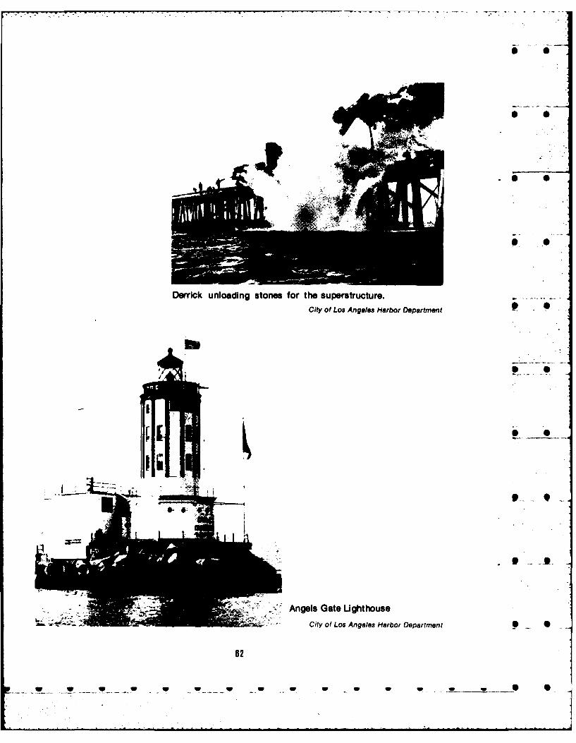
Derrick unloading storm for the superstructure.-City of Los Angeles Harbor Department
Angels~~ GaeShto
Anelite o Ageleoseroeprmn
02

40Wbe..
BATEIE OYOO AN IASOY. '- D- -
Plan of underground rooms, tunnels, and entrances servicing the emplacements for thedisappearing rile (cannon) carriages of Batteries Osgood and Farley.
Courtesy of Cal. Robert E. Frewlana, Fort MacArthut,
fixed armament to be located there, and gun has aeciared the entire area excess surplusemplacements were begun in 1914. The site is land and it is presently in transition betweenbounded by Gaffey Street, 30th Street, Alma that administration and the City of LosStreet, and Paseo Del Mar (map 12). Angeles. The city should maintain theseproperties n perpetuity; however, it is -
The historical resources consist of the recommended that a reversion clause bealready marked Battery Osgood-Farley, included in the land transfer to the effect that ifcertified for nomination by the State Historic the historical sites ame not properly maintained,Preservation Officer on February 18, 1976; the the property should be returned to the FederalBariow-Saxton Battery; the Merriam-Leary Government for proper administration.Battery; a sentry dog cemetery; and the Korean ... t_Friendship Bell. The area of about 37 acreswhere Batteries Osgood and Farley, the sentrydog cemetery, and tle oell are located ispresently under the control of the City of LosAngeles. The General Services Administration
83
Stee an De Ma (ma 12) Anels Th cit shul manti these

PC'
On.( I
0 SETR 00EMTR
-W. -- S

Block houses of the BatteriesBarlow and Saxton; 12-inch-long tube mortars, four perbattery, or a total of eightmortars.
U.S. Army photograph
Korean Friendship BeN (Site 3)
The Bell of Friendship, a Bicentennial gift Completed in a period of sixto the U n ited States, was dedicated October 3, months, the bell measures 3.67 "1976. The inscription on the bell has as its meters high with atheme freedom and independence. A part of it circumference of 7.25 metersreads: and a diameter of 2.27 meters. ItThe Bell of Friendship is
patterned after the Bronze Bell w
of King Songdok which is thelargest Oriental bell in Four pairs of figures
existence. The Bell of King consisting of the Goddess ofon n e i Liberty and a Korean spirit are
D. 771. Unlike Chinese bells, engrated in rhei od of ethe Korean bell has a sound dils the Gontes os of thtube on top of the bell, which is bel.e g oity ihung in a low pavilion and placed side by side with a
struck from outside. This is Korean spirit because it has afspecial meaning for American
which are hung in tall belfries indepdn. Th figuresand rung by a clapper stand on drifting clouds and the
suspended inside. The Korean rising sun is engraved abovebell is hung low to the ground their heads and between raisedso that the sound can hands. The first Korean spirit
reverberate against the earth holds up a symbolic design ofand escape through the sound Korea's national flag, the
tube. Korea has not, since the second one a branch of rose of
eighth century, cast such a big Sharon, which is Korea's
bell as this Bell of Friendship. national flower, the third abranch of laurel as a symbol of
In casting the bell, modern victory, and thefourth adove astechnology of cast-metal was a symbol of peace.
used as little as possible, andthe ancient method of bellcasting was followe .
05
branholue__s___ymblof_____
In_____ _ catn_ heblmoenvcoradthorh_ oea
techologof______t__wa aymolofpeceused____ _ __lite_ sposil,_nthe______ aniet_ ehooblcasting___ wa olwe._...•.
_ _ _ _ _ _ _ _ _ _ -
- _ _ _ _ _ _ _ __-' -.

5i S
The bell calls for recognition in this report; Merriam and Leary emplacementsare identicalhowever, its recency does not recommend it for to the Osgood-Farley, having been completedmarking at this time. The City of Los Angeles is in the same year, 1917, and inactivated at theseeking funds to landscape the 33 acres same time, 1944. Both held paired 14-inchsurrounding the bell pavilion in traditional guns. An excellent description of theKorean style. If the three bunkers and the emplacements appears in the appendix.sentry dog cemetery are properly marked, Battery Osgood-Farley is there described as aperhaps landscaping plans should be "representative portion of the defense systemreadjusted. The description of the bell comes that existed during the period 1917-1947." Thefrom a fact sheet published by Councilman Barlow-Saxton Batteries differ from these SJohn S. Gibson, Jr., President, Los Angeles batteries in that each was designed for four 12-City Council. inch-long tube mortars per battery. They were
also completed in 1917. The undergroundBattery Installations (Sites 4, 6, and 7) storage and worK rooms and the tunnels
through which vehicles drove in and out withThe three battery installations are typical supplies are best maintained in Barlow-Saxton S 0
examples of fortifications used for coast and Batteries. The gun emplacements lie wellharbor defense during the turn and first part of below ground level in a large pit. Behind thethis century. The cemetery and the Korean Bell round baseplates and working area areare representative of the World War II and Cold plotting-switchboard-radio rooms with largeWar eras. The original nomination for the digital directional guides facing out toward theOsgood-Farley Battery was submitted by a loading area. In other respects theFederal agency, Facilities Engineering, U.S. construction resembles that of the 14-inch gunArmy, HO, 7th Infantry Division and Fort Ord. emplacements.According to Mr. Gene Itogawa of the StateDepartment of Parks and Recreation From a historical point of view it would be aResources Agency, if the original nomination is great loss if any one of these threesubmitted by a Federal agency, it becomes that emptacements were to be destroyed. The •agency's responsibility to enlarge the site. An United States has escaped the kind of warfareonsite inspection of the three gun that plagued Europe for centuries and causedemplacements and thecemetery and a sense of the nations there to construct massivetheir historic importance suggest that the fortifications. Consequently, we haveOsgood-Farley nomination be revised to comparatively little to study. Theseinclude the Merriam-Leary and Barlow-Saxton emplacements are all that remain of the largest SBatteries. Mr. Itogawa suggested that the and most powerful fixed coast defense artilleryWorld War I and Cold War theme of the other on the West Coast. Further, "Fort MacArthur ishistorical resources would be incompatible the only Taft period fortification in thewith that of the batteries. In addition, they do continental United States (others beingnot have a 50-year history. Thus, it is Endicott period or prior, and World War II) sorecommended that only the sentry dog its emplacements are somewhat different than 0 0cemetery be recommended for State those found in San Diego, San Francisco,recognition and marking. If the City of Los Columbia River, Puget Sound, etc." (ref. 1).Angeles does maintain this land, the city might With the introduction of aerial warfare suchtreat the five historical resources as the basic fortifications are destined to remain foreverelements of a historical park, landscaping and obsolete. Even Fort MacArthur lies close toorganizing them in a manner that would make being marked off as disposable land. These 9 •them resources for the scholar and points of rare sites provide a resource for students of theinterest for the tourist, history of technology and warfare and bring
alive the written word upon which we too oftenThe Battery Osgood-Farley is described depend. A hundred years from now their value
on the copy of the National Register of Historic as tools to uncover the history of land defensePlaces nomination form in the appendix. The will be even greater.
68
U U U U U V V V V V U i, q ... 0r_ 0

The three batteries need maintenance. The on the Palos Verdes tract of the San Pedrobasic reinforced concrete is in good condition, Rancho. Sepulveda proceeded to build a homebut the doors lie in disrepair and weeds and there and to exercise full control. What ........debris litter the tunnels. At Osgood-Farley a arrangement he had with the executor we do 0handsome marble panel that serves as the not know, but dispute over the land arosebacking for an electrical switchboard is a during the lifetime of Dolores Sepulveda andtemptation to vandals. All three emplacements carried on into the lives of his heirs. In 1846theshould be on the National Register of Historic affair was finally settled when Governor PicoPlaces. awarded Jose Loreto and Juan Sepulveda the
11 square leagues of the Palos Verdes tract in 0Sentry Dog Cemetery (Site 5) return for military services rendered by their
father (ref. 2). Following upon the policyNorth of the Osgood-Farley Battery and established in 1827 when the first Dominguez-
behind a chapel no longer in use lies a Sepulveda dispute was temporarily settled,cemetery for guard dogs. Each grave is marked Pico reordered that:with a heavy concrete marker. Brass and steel They shall leave free on the 0plates are attached and on them engraved the beach at San Pedro fivedesignation '"Sentry Dog", the dog's name, and hundred varas square, to thethe birth and death dates. Vandalism has left its four cardinal points, uponmark; however, many are still complete. The which houses may be built bygrass is long and unkept. Guard dogs served inWorld War II and in Vietnam and many received permission to do so; they shall 0training here. The cemetery, which yields not be permitted to prevent theinformation through date markings on the use use ofrwated pasre by
use of water and pasture byof sentry dogs, may easily be included in thesuggested park site. A State designation is oe r os e to the Porto
oxen or horses to the Port ofsuggested. San Pedro (ref. 3).
In effectthe Mexican Government reserved this S8. One Hundred Varas Square tract for itself, and the Uni* .d States would
claim the same reservation by GovernmentThis site lies in the Lower Reservation of transfer some years later. The tract had 1,400
Fort MacArthur (map 13). The Kingdom of feet of water frontage (ref. 4).Castile originally granted land in the Americasunder a policy bywhich absolute title to all land The bluff at San Pedro within the 500 varas 0was vested in the Spanish Crown. By the 18th square had so long been thesiteof commercialcentury the Laws of the Indies had been activity that the decree largely followed uponsomewhat altered to stimulate settlement on practice. The San Gabriel Mission hadthe frontiers, and private ranchos were embarcadero and storage rights to a smallerallocated with clear title outside the pueblo and square of 100 varas in the southeast corner.mission lands. Juan Jose Dominguez, a soldier Here they built what is believed to have been •who had marched with Diego de Portola into the first house at San Pedro Bay. HistorianAlta California in 1769, petitioned for and James Guinn wrote that in the proceedings ofreceived such a grant in 1784. The 74,000-acre the ayuntamiento of 1835 "a house is spoken ofDominguez Rancho lay on the coastal plain as having been built there long ago by thesouth of the pueblo of Los Angeles, bordered Mission Fathers of San Gabriel." Guinnby San Pedro Bay to the point where it met the guesses at the dates 1815 to 1820, and when he 0Nieto grant. Dominguez drew complaint for wrote in 1901 he described the ruins as stillneglecting his stock and for residing on his extant (ref. 5). He located the house as halfwayranch for only brief intervals (ref. 1). In his will between Point Fermin and Timms Point. This ishe named a Spaniard, Manuel Gutierrez, assumed to be the same house described byexecutor, and Gutierrez in turn gave Jose Richard Henry Dana who sailed on a hideDolores Sepulveda permission to graze cattle drogher in 1834. 0
67

=3 5 S.. .-- ><" c "... .
IJ 1% -
\ 500 Varas Square
C-ALE: 1 400•
Ma 13. OneHundrd Varas Square.-
W. .- __ ., w v .-, -- " .. 0
\-N. .\ &
\ , " , - - . - -
/ •
/ - I
SCALE: 1"- 400'- " -
Map 13. One Hundred Varas Square
88
_ w w- U U... ........... "

0
Ruins, circa 1900, of one of thefirst buildings at San Pedro onthe Hundred Varas Square. .
City of Los Angeles Harbor Department
Captain Shaler reputedly brought the first After the harbor lines were drawn in 1907 theAmerican ship into San Pedro Bay in 1805, bay was filled from thebluff easttothepresent-unloaded contraband goods in exchange for day West Channel. However, in Dana'stime theprovisions, and initiated thetrade in otterskins. water came right up to the bluff, and to reachHe records no house. His log undoubtedly the hidescollected around the adobehousaoncaused other contraband traders to seek out the 100 varas square, he and his shipmates hadthe port and to open up the cowhide and tallow to scale the cliff. They approached in longboatstrade. Guinn records an increase in cattle from laden with the usual assorted cargoes from10,000 in 1822 to 42,000 in 1830 on land owned Boston, and he described the landing.by Los Angeles citizens, obviously to meet thenew demand (ref. 6). In 1822 William Hartnell, After landing and rolling theman Englishman working out of Lima, Peru, over the stones upon thevisited the San Gabriel Mission "making a beach, we stopped, waiting forcontract with Padre Payeras, the prefect of the the carts to come down the hillmissions, for the purchase of hides and tallow" and take them; but the captain(ref. 7). Hartnell's company used the point for soon settled the matter byhide collection and storage from 1822 to 1828. ordering us to carry them all upThe adobe storage house was still there, and a to the top, saying that, that wasfew years later Richard Henry Dana wrote: "California fashion". So what
Going up this hill with them, we the oxen would not do, we weresaw, just behind it, a small, low obliged to do. The hill was low,building, with one room, but steep, and the earth, beingcontaining a fireplace, clayey and wet with recentcooking-apparatus, & c. and rains, was but bad holding-the rest of it unfinished, and ground for our feet....Now, theused as a place to store hides hides were to be got down; andand goods. This, they told us, for this purpose, we broughtwas built by some traders in the the boat round to a place wherePueblo, (a town about thirty the hill was steeper and threwmiles in the interior, to which them down, letting them slidethis was the port,) and used by over the slope. Many of themthem as a storehouse, and also lodged, and we had to letas a lodging-place when they ourselves down and set themcame down to trade with the agoing again; and in this wayvessels (ref. 8). got covered with dust, and our
9
L ___. ... .. . . . *w. . V V ... W V. .U .. w S S S S _.... 7

* clothes torn. After we had got the fight over location of the Los Angelesthem down, we were obliged to Harbor to give it any time. Once the breakwater
* take them on our heads, and was built in San Pedro, the United Stateswalk over the stones, and planned a complete defense system centered 0through the water to the boat on the old Government reservation. Squatters(ref. 9). were removed, sheep corrals torn down, and
The hide house or warehouse was owned buildings removed. The old adobe ruins mayin Dana's time by Abel Stearns who like a few have been among these.other foreigners settled in the pueblo Los As the history of this site discloses, theAngeles and traded in hides and tallow. Stearns lives of nearly all of the significant persons of 0had bought the adobe building from the San early harbor history are associated with it. TheGabriel Mission in the early 1830's while the hide house is widely known through the workssecularization of the California missions was in of Richard Henry Dana. This site is deserving ofprogress. Stearns wanted to expand the thorough research and possible inclusion onwarehouse facilities with additional buildings the National Register of Historic Places.....and to bring in water from a spring several 0miles away. Some of the local people objected 9. Los Angeles Municipal Warehouseto his establishing such a commercial center, Number 1claiming that it would attract contraband trade. This building is at the southeast end of PierThey cited Spanish law that prohibited Tbuildings on the beach where there was no No. 1, the old Huntington Fill, which liescustoms house. Governor Figueroa granted between the Main Channel and the EastSteams permission to bring in water, but Channel in the outer harbor. The warehouse,Steams built no other buildings on the 100 which may be reached by driving to the southvaras square (ref. 10). end of Signal Street, is a six-story, reinforced
concrete building. The floor area of aboutThe firm of Juan Alexander and John 500,000 square feet is divided into 72 rooms.
Temple acquired valid claim tothesquare (1.77 The warehouse is equipped with electricacres) in 1848. After Phineas Banning entered elevators, whip hoists, and a sprinkler systemthe firm he moved the business to the fed by a 100,000-gallon water tank that isWilmington Lagoon. Because this was 4 miles located on the roof. The Marine Exchangecloser to Los Angeles, mostofthegeneraltrade Lookout Station is also on the roof. Themoved to his wharf, and the stores and old build;ng has fireproof stairways on the outsideadobe hide house fell into disuse. Squatters above the second floor (ref. 1). The warehousemoved in and set up sheep corrals. When Dana was completed in 1917, a product of the Los Sreturned to the site in 1859, he saw two houses Angeles Harbor Department Generalon the hill. A legend grew that buried treasure Obligation Bonds. Historically, it is asymboloflay near the old house, and it became a magnet change.for treasure hunters for years (ref. 11). At the turn of the century and before the
In 1874 the Southern Pacific acquired San Pedro Breakwater was built most of therights-of-way and extensive land holdings on cargo that came into San Pedro Bay wasthe San Pedro bluff including title to the carried on coastal vessels. Los Angeles hadAlexander and Temple lot of 1.77 acres. The built up a large import lumber business, butUnited States held claim to the same 500 varas there was comparatively little other commerce.square as reserved by the Mexican Shallow-draft lumber schooners were all theGovernment and this also included the 1.77 bay could accommodate. Stored lumber lay inacres; thus, a dispute over ownership followed, stacks exposed to the elements. Warehouses -On September 14, 1888, the "old government were privately owned and relatively small. Thereserve on San Pedro Bay" was formally set Los Angeles Chamber of Commerce was wellapart as a military reservation by executive aware that even with the breakwater toorder. A decade later Southern Pacific gave in accommodate deepwater vessels the portto the Government claims, too busy then with would not attract world trade unless facilities - _
70
_. . ....S . ._ .. . _ U... U. .. *U. U. U U U U U S
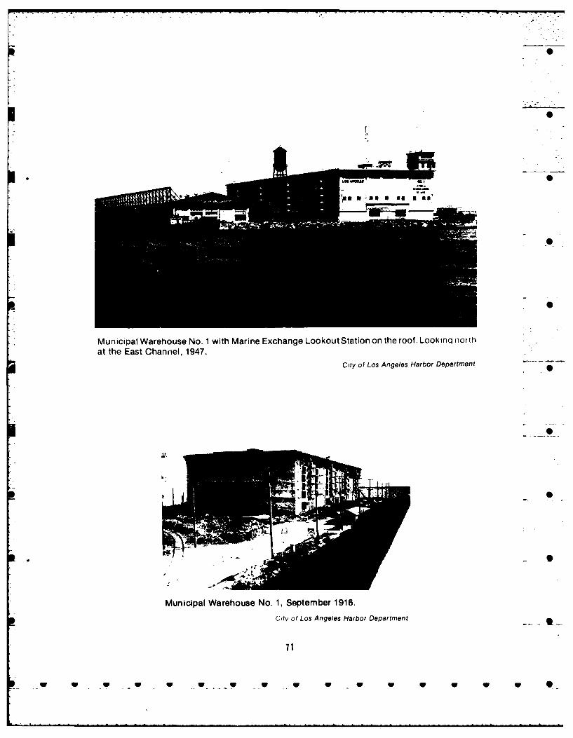
rS
Municipal Warehouse No. 1 with Marine Exchange Lookout Station on the roof. Look inq northat the East Channel, 1947.
City of Los Angeles Harbor Department
Municipal Warehouse No. 1, September 1916.
City of Los Angeles Harbor Department-
71

were improved. While the breakwater was lumber schooners to deep sea vessels thatunder construction, the chamber became a would bring varied cargo requiring a six-storydriving force in removing obstacles to bring concrete warehouse. This building shouldabout that improvement. First, they activated a have recognition at the State level. 0"shoestring" proposal by which the City of LosAngeles purchased a strip of land a half-mile 10. Harbor View Memorial Park, Old St.wide from the city limits at Slauson Avenue to Peter's Episcopal Churchwhere it joined the city limits of both San Pedro This cemetery is at the end of Grandand Wilmington. Secondly, the chamber Avenue, South San Pedro. The land for it washelped pass a city ordinance to create a harbor donueby August Tim , and the doecnia Scommission, a three-member commission who Chapel at its entrance bears the name of Joseset about drawing up a harbor plan. Diego Sepulveda's daughter who with her
The U nited States Congress then created a immediate family are interred there. It wasHarbor Line Board and all the slips, channels, declared Historic-Cultural Monument No. 53bulkheads, piers, and turning basins as we see by the City of Los Angeles Cultural Heritagethem now were created, first as lines Board. The board's fact sheet on the resource
superimposed on a map of the natural mudflats may be found in the appendix.and sandbars and then dredged and filled intoreality. The next step was to consolidate the 1I. Municipal Fish Marketharbor towns with the metropolis because When the City of LosAngelesvoted forthewithout this consolidation the people of Los first harbor bonds and initiated plans for theAngeles would not be willing to pay for the first wharf and warehouse, it also located aneeded port facilities. The consolidation Municipal Wholesale Fish Market on the mainagreement with San Pedro and Wilmington, channel at the head of the Southern Pacificfinalized in 1909, specified that Los Angeles slip. Over a span of 3 years dating from 1916, awould spend $10 million on harbor long wooden market building was constructedimprovement in the next 10 years. With the way where fishermen could clean and process their .finally cleared, municipal dredging and wharf fresh fish for the tables of southernconstruction began, and in 1915 construction Californians. Located at Berths 79 and 80, thebegan on Warehouse Number 1. It was a marketserved both asacommercial house andmagnificent structure for its day: massive, as a gathering spot for the oldtimers, many ofmodern, and yet decorated with Gothic them immigrants who brought their skills withgargoyles and water spouts. The City of Los them from ports throughout Europe. TheAngeles was proclaiming its entrance into DiMassa family founded its market in 1916 asworld trade with channels dredged to 35 feet did the Zankich Brothers (ref. 1). This colorfuland a safe and commodious inner and outer old landmark was torn down in 1951 and theharbor that at least one enthusiast claimed fish wholesalers moved into a modern concretewould be adequate for a thousand years. building at Berth 72 the same year.
The historic changeover that began at the The new structure, 80 by420feet, was built 0port in 1912 deserved recognition, but it is on the end of a new pier constructed as partofdifficult to mark a whole harbor and not the $1,500,000 Fishermen's Wharf. Fish arefeasible to cite dredge and fill operations. We cleaned and processed on the first floor;can best center our attention upon one or two storage space, offices, dining rooms, andfacilities that mark off the beginnings of one of kitchen are on the second floor. The averagethe greatest manmade harbors in the world monthly rental for one of the12 markets in 1951because that is probably the most historic was $270 compared to an average monthlyevent that ever occurred in San Pedro Bay. rental of only $50 in theold building;thehigherWarehouse Number I is in excellent condition, rent in the new facility drew a good deal ofis extremely visible, and its architectural style complaint. Wholesalers in !he building todayembodies the best features of its time. Further, provide fresh-caught fish to over 3,000it symbolizes the shift away from shallow-draft retailers. g
72
W W W W W W 0

0
Municipal Fish Market.
Harbor tours show off the building, one ofstreamlined and practical design but which "yields little historical information. TheMunicipal Fish Market might be considered fora Los Angeles Historic-Cultural Monument.
0
Municipal Fish Market.
73
SW ._ 0 U • * w S U S S S U 0

0
12. Dodson Residence imorovements were unique and consisted oftowing tne nulls of two shipwrecked vessels to
This residence, once the home of the point, using the deck houses to live in, and --Rudecinda Sepulveda de Dodson and James taking advantage of the silt and sand deposited 0H. Dodson, is at 859 West 13th Street, San around the wreckage so that the point of landPedro. The residence was declared Historic- was quite enlarged.* The many photographs ofCultural Monument No. 147 by the Los Angeles the busy point as well as constant reference toCultural Heritage Board on September 17, it in shipping literature attest to the importance1975. of the landing until in 1907 dredging made it --
13. Timms Point and Landing unrecognizable. 0Until the 20th century this point lay below Timms lived until 1888, apparently at his
the San Pedro bluff just north of Dedman's home on the point where he also had a hotel
Island (map 14). Today the point of land is and bathhouse. He bought land, he ownedgone, but the site may be described as along some interests in Catalina Island, and he madethe Main Channel of Los Angeles Harbor near a gift of the land for the Harbor View Cemetery 0
the Southern Pacific slip between 14th and tothe people of San Pedro. Hesaw LosAngeles16th Streets in San Pedro. It is registered as shipping move from the point to PhineasCalifornia State Historical Landmark No. 384 Banning's New San Pedro in 1857. He also sawand Los Angeles Historic-Cultural Monument business return to his point when SouthernNo. 171. Pacific bought the land between Timms Point
and the Wilmington Lagoon from the heirs ofTimms Point, which may aptly be called Palos Verdes Rancho. The railway acquired
the first Port of Los Angeles, came into use as a rights-of-way and brought its tracks out belowlanding at about the time of the gold rush. Los the bluff to Timms Point. August Timms thenAngeles already had a few Yankee had to defend his rights to the point butentrepreneurs such as Abel Stearns and John apparently was successful.Temple, but it was also a time when trade andpassenger business would increase rapidly By the 1880's the channel below the Sanand thus attract more pioneer Americans to the Pedro bluffs was much improved because ofnow recently acquired United States port. the jetty built in 1871 from Timms PointShips still anchored out in the open roadstead southeast to about 600 feet from the earlierof the bay and sent their goods and passengers built east jetty connecting Rattlesnake andto shore by rowboat. Diego Sepulveda, one of Deadman's Islands. There the new jettythe heirs to the Palos Verdes Rancho in 1824, paralleled the east jetty for half a mile or to abuilt the first wharf on the point of land and point a short distance beyond Deadman'sstorehouse on the beach. He then began the Island. Scouring caused by the tides deepenedfirst stage line to Los Angeles. Perhaps the the channel by Timms Point to 14 feet;primary change brought about in southern dredging then deepened the channel to 20 feet.California by the gold rush was the greatly After the Federal Breakwater wasincreased demand for beef. Cattle ranches approved, San Pedro leased parts of the outerflourished as never before and commerce harbor for fill. One of these leases, the Minerfollowed. concession, lay just south of Timms Point;
Another by-product of the mining boom is when the work was complete the harbor linessaid to have been the arrival of August Timms. began to take on the shapes they have today.Conflicting evidence places his arrival in the Also, by 1907 Southern Pacific owned Timms1860's; thus we are not quite sure how and Point and in that year contracted for thewhen Timms arrived in San Pedro. However, heis credited with improving and extending *Timms issaid to have hauled in the Mary JaneSepulveda's landing and,afterthe 1860's, maps in 1852 and the Abraham Lincoln later.appeared calling it "Timm." The point bore the However, a literature search did not disclosename Timms until its destruction. Timms' any documented verification of this. S
74
_ w w w .W U W _ • W W W 0 0

4,z
Map 14. Timm Landing
U7w *1
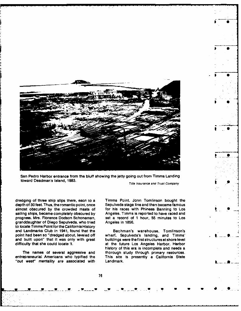
p.•
0 0
- ---- w4
San Pedro Harbor entrance from the bluff showing the jetty going out from Timms Landingtoward Deadman's Island, 1883. Title Insurance and Trust Company
dredging of three ship slips there, eacn to a Timms Point. Jonn Tomlinson bought the
depth of 30 feet. Thus, the romantic point, once Sepulveda stage line and then became famousalmost obscured by the crowded masts of for his races with Phineas Banning to Los I 0sailing ships, became completely obscured by Angeles. Timms is reported to have raced andprogress. Mrs. Florence Dodson Schoneman, set a record of 1 hour, 55 minutes to Losgranddaughter of Diego Sepulveda, who tried Angeles in 1856.to locate Timms Point for the California Historyand Landmarks Club in 1941, found that the Bachman's warehouse, Tomlinson'spoint had been so "dredged about, leveled off wharf, Sepulveda's landing, and Timms' I - 9and built upon" that it was only with great buildings were thefirst structuresatshore leveldifficulty that she could locate ft. at the future Los Angeles Harbor. Harbor
history of this era is incomplete and needs aThe names of several aggressive and thorough study through primary resources.
entrepreneurial Americans who typified the This site is presently a California State"out west" mentality are associated with Landmark. L . .. is
78
w W . U U U U _
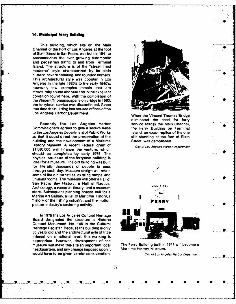
14. Municipal Ferry Building
This building, which sits on the MainChannel of the Port of Los Angeles at the footof Sixth Street in San Pedro, was built in 1941 toaccommodate the ever growing automobileand pedestrian traffic to and from TerminalIsland. The structure is of the "streamlinedmodeme" style characterized by its plainsurface, severe detailing, and rounded corners.This architectural style was popular in LosAngeles in the late 1920's to the early 1940's;however, few examples remain that arestructurally sound and safe and in the excellentcondition found here. With the completion ofthe Vincent Thomas suspension bridge in 1963,the ferryboat service was discontinued. Sincethat time the building has housed offices of theLos Angeles Harbor Department. When the Vincent Thomas Bridge
eliminated the need for ferryRecently the Los Angeles Harbor service across the Main Channel,
Commissioners agreed to give a secure lease the Ferry Building on Terminalto the Los Angeles Department of Public Works Island, an exact replica of the oneso that it could direct the preservation of the still standing at the foot of Sixthbuilding and the development of a Maritime Street, was demolished.History Museum. A recent Federal grant of City of Los Angeles Harbor Department$1,080,000 will finance the venture, which C
should be completed by early 1978. Thephysical structure of the ferryboat building isideal for a museum. The old building was builtfor literally thousands of people to passthrough each day. Museum design will retainsome of the old turnstiles, existing ramps, andunusual rooms. The museum will offer a Hall ofSan Pedro Bay History, a Hall of Nautical 1,4 w JCi PALArcheology, a research library, and a museum ,store. Subsequent planning phases call for aMarine Art Gallery, a Hall of Maritime History,a ",history of the fishing industry, and the motion P RYpicture industry's seafaring activity. 0
In 1975 the Los Angeles Cultural HeritageBoard designated the structure a HistoricCultural Monument, No. 146 in the CulturalHeritage Register. Because the building is only35 years old and the architectural syle of littleinterest on a national level, this marking isappropriate. However, development of themuseum will make this site an important local The Ferry Building built in 1941 will become aheadquarters, and any change imposed upon it Maritime History Museum.would have to be given careful consideration. City of Los Angeles Harbor Department
77
.. . U_ _ *...._g __ ..... • . ... • . .. ~ • • U U U U U U* *

0 S
15. Fireboat 2 and Firehouse 112 now the largest fishing industry in the countrywent together to make a colorful history for
The Ralph J. Scott, better known as Terminal Island, no old landmark remains . ..Fireboat 2, is located at Berth 227 at the foot of except this public school. It does not possess 0Old Dock Street, San Pedro. It was declared high artistic value but does embody theHistoric-Cultural MonumentNo. 54 bythe Los distinctive characteristics of its period. MoreAngeles Cultural Heritage Board on May 5 importantly, the school is associated with the1976. lives of the children of the beautiful little beach
This 52-year-old fireboat was built at Los community and the children of the cannery .....
Angeles Shipbuilding and Drydock workers. A brief history of the island relates SCorporation (now Todd Shipyard) at a cost of readily to the broad patterns of history on the$214,000 and launched October 20, 1925. In national and world levels.1969 the boat was modernized at a cost of$238,000, and replacement cost is Competition for railroad terminals opened
conservatively estimated at $2,250,000. up the island in 1891 when a St. Louis
Despite its age, Fireboat 2 is actually one of the corporation purchased the narrow sand spit of
most up-to-date fireboats in the world and Rattlesnake Island from the Dominguez heirs.
should be in use for many years. The boat has Southern Pacific had a terminal monopoly on
fought many major fires; its pumping capacity the west side of the San Pedro Bay channel.was demonstrated on August 8, 1972, when it TheSt. Louis company brokethat monopoly bypumped into fifteen 2-12-inch hose lines and running a railroad from Los Angeles along thetwo 3-1/2-inch hose lines, providing water for east side of the Los Angeles River, over to thetwo 3-1/2-nc. Fhouse es, prvg atr fore island on trestles, and to its west end where theland companies. Firehouse 11 lservesas homebase for Fireboat 2. The long service of company established terminalson deep water.
Fireboat 2 has made this boat a logical choice They changed the name from Rattlesnake to
for a local historical resource. Terminal Island and began development of aresort community where city dwellers could
16. Vincent Thomas Bridge buy lots and build beach houses or commutefor the day via the new railroad. Brighton
This bridge, which spans the Main Beach, asthe new communitywascalled,soonChannel of Los Angeles Harbor where it meets attracted visitors who came directly by the Losthe Turning Basin, connects Terminal Island Angeles Terminal Railway or by Southernwith the mainland. It was opened November 15, Pacific and crossed over the channel by small1963, and thus has a short history. However, it boat.replaced awholly inadequate ferryboat run and -encouraged a new surge of development at the At the same time thatthe resort communityharbor. Named for Assemblyman Vincent flourished, the fishing industry was beginningThomas whose efforts forged the legislation on the east side of the island. In 1893 theneeded for construction, the bridge spans machinery of the Golden Gate Packing6,050 feet. It was the first large suspension Company was brought to East San Pedrobridge in southern California and the third during one of the sporadic depressions in the 0
largest in California. The bridge will surely be San Francisco Bay sardine and anchovyof interest to future historians; however, its industry. Alfred P. Halfhill was one of therecency stands inthewayof noteas a historical owners of what they then called the Southernresource at this time. California Company. It began purse seine
fishing for sardines around San Pedro,
17. Terminal Island School Redondo, and Santa Catalina. In 1903sardines , •disappeared and Halfhill looked for another
The school, located at 333 Seaside species of fish to can. He found a tin of ItalianAvenue, Terminal Island, presently houses the "Tunny" by chance, and thus the tuna industryMarine Corps Reserve Training Center. was born in East San Pedro. Halfhill tried to findAlthough a well-known resort, a town named some type of fish for commercial canning,East San Pedro, and the beginnings of what is experimenting with albacore, halibut, and cod.
78
.... ..

7-S
East San Pedro, Terminal Island, before widening the channel to 1,000 feet. Workers' housesbuilt up on pilings along the main channel were torn down and shoved out of the way.
U.S. Army Corps of Engineers, Los An geles District
Albacore, although a popular sport fish for East San Pedro. By the summer of 1907, theAmericans, was considered inedible and was writer Kanichi Kawasaki estimates there werecalled "the hog of the sea" because it held such 600 Japanese fishermen living in East Sanlarge amounts of blood. Halfhill found that Pedro (ref. 2). -steam applied to its flesh turned it snow whiteThmsWleinistuyotefsigand also made the albacore look and taste likeThmsWleinistuyotefsigindustry, tells us that in San Diego, even inchicken. He packed 700 cases in 1903, but 1919, 85 percent of the f ish were brought in by
*grocers returned a sizable part. To promote Japanese fishermen using hook and line. Thealbacore, he convinced grocers to give it away big purse seiner fleets came into being afterfree with coffee. This and other promotional0efforts were successful. Halfhill called his World War 1. Thus, we can speculate that many
of the Japanese on Termiral Island until the*product "chicken of the sea"; this slogan later 1920's were engaged in fishing from sinaibecame the trademark of Van Camp Seafood boats. Kawasaki writes of the first arrivals inCompany (ref. 1). 1906 who "drove lumber piles on the shore of
The Japanese entered the fishing industry the main channel at East San Pedro and builtSearly. One study made in 1931 and based about twenty houses" (ref. 3). - -- A
*largely on interviews tells us that a small group Japanese f ishermen were not alone in East*of young Japanese men got into the abalone San Pedro. Gamblers, artists, and European
business at Whites Point in 1901, others fished fisherfolk also lived there. Charles Fletcherthe area between Whites Point and San Pedro Lummis, a one-time city editor for the Losin 1908 and 1907, and a large number lived in Angeles Times also had a home there (ref. 4). -k
79
r .-, .-.. -" T. _ C -' " _ U- .U .' . .Ur . .... r T_ o: U_ . _. _ U. .- . . . . . Y. -F "" t.-

I .
Terminal Island schoolhouse.Upper story is originalstructure built in 1897. -
However, until World War l1 the Japanese seawall, thereby giving aconstituted by far the majority of workers in the completely protected harborcanneries. Halfhill pioneered the tuna industry, for fishing boats. The land backbut in 1912 the White Star Canning Company of the wharf was divided into .....opened its wharves in East San Pedro and soon lots each with a hundred-footafterwards Frank L. Van Camp opened a large frontage on the wharf, andcannery at the head of the Southern Pacific slip running back four hundred feeton the west side of the channel. During World to a street and a railroad track.
* War I a fire destroyed the Southern California Another street ran down to theCompany, and because the company had wharf in the middle of the tract,
, contracted for a large amount of canning affording frontage for businessneeded nationwide, harbor developers turned houses (ref. 5).their attention to the fish industry. The Board ofHarbor Commissioners decided to create a Dredging and wharf construction began inspecial harbor. Clarence Matson, Traffic 1915, and the following year the Fish HarborManager for the Los Angeles Harbor, wrote of project was completed.how the harbor engineer "formulated a plan to Within a few months all of thefence in a piece of the Pacific Ocean" on the space provided by the new fishsouthwest end of Terminal Island. The harbor had been leased, two orengineer Jubb: three plants had been
...designed a seawall to enclose established to build and repairan area of thirty acres of water fishing boats, and some of theon the southerly side of leading oil companies had builtTerminal Island and east of the oil stations to service them. Itfilled area. A wooden Wharf was the most complete plant ofabout two thousand feet long its kind on the Pacific Coast, ifwas built across the north side not in America (ref. 6).of this area, and the areabehind was filled in with Soon after this, more than 3,000 Japanesedredgings, making a could be counted on Terminal Island. This wasconsiderable acreage of solid the era when the intersection of Tuna Street
. ground. A low breakwater was and Terminal Way became the heart of thebuilt across the southerly side community. By World War II, some 2,000of the area enclosed by the Caucasian workers also lived on the island.
80
S w * __ Sp U U _U _ U U U U U U S S
'I -p

LUNCH ROOMCT:<Q
46.,''
go
'P,

.AV.
.. ,"low
:b P *
A~~~~~~~~~~~~ Brgtn ec otla tetr o h cnuy
Edar oukColcto

Changes brought about by the San Pedro Parks should assume responsibility for theBreakwater in 1910, the dredging at Fish school and maintain it. Parking and plantingsHarbor, and finally the Reservation Point fill so could occupy the space between the schoolaltered the south side of Terminal Island that and Seaside Avenue. It should be nominated SSeaside Avenue, where the Terminal Island for inclusion in the National Register ofSchool had once served a community by the Historic Places.sea, was almost a mile inland. Resorthomeowners were replaced by cannery and 18. S. S. CatalInaindustrial workers, and the shacks at East SanPedro were shoved out of the way as new This ship is presently located at Berth 96,wharves went up on the valuable property Los Angeles Harbor. It was listed in thefacing the Main Channel of the Los Angeles National Register of Historic Places onHarbor. During the war the Japanese were September 1, 1976 and is also registered asremoved and the Caucasian workers were California State Historical Landmark No. 894.forced to leave soon after. The military took The nomination form for the National Registerover the old Terminal Island School. is included in the appendix.
Major A. Mediavilla and Captain D. W. 19. Site of Home of Diego SepulvedaZimmerman of the U.S. Marine Corps have This site, now in a commercial district atboth communicated with Councilman John S. 761 Channel Street near the intersection ofGibson's office in regard to preservation and Channel and Gaffey, San Pedro, was once themarking of the Terminal Island Schoolhouse. home of Diego Sepulveda. It is registered asThe building is well preserved because of California State Historical Landmark No. 380,periodic exterior painting and patch jobs; the and a copy of the application for registration isinterior has been remodeled in a minor way to included in the appendix.accommodate the Marine Corps trainingprogram for reserves, but the second story 20. Berth 145, Los Angeles Harborappears to be in its original condition exceptfor some ceiling acoustic material placed over The site is on the east side of West Basin - .the original stucco. The wood finish and and may be reached by driving south oncabinet work is basic and is typical of public Neptune Avenue and following the railroadbuildings of the late 19th century. Captain spur line out to the berth.Zimmerman reports that the upper story, the Close to 4,200 family heads in the areaoriginal building constructed in 1897, is the belong either to the Internationaloldest building extant on Terminal Island. The Longshoremen's and Warehousemen's Union,present lower story, which serves as a Local 13, or to its Pensioners Club. Berth 145 is,foundation for the old school, was built later. for them, for the labor organizations at large,
The Marine Corps facility faces Seaside and for all students of social history, an
Avenue, but the front door of the old school is important landmark because it symbolizes Sanat the back, facing the railroad tracks. The Pedro's role in the maritime strike of 1934.Corps owns 6 acres here that the Los Angeles The plight of longshoremen and seamenHarbor may want. The property could be during the 19th century is well known, andfenced off at the approximate side boundaries Richard Henry Dana's book Two Years Beforeof the present buildings and the fence brought the Mast, referred to earlier in this report,up to Seaside Avenue. All existing sheds could serves as documentary evidence of thebe removed as well as those attached to the deplorable working conditions of seamen aoriginal school. The school with its spacious century before the strike. A gruesome beatingclassrooms could then become a museum for Dana witnessed aboard ship took place justTerminal lsland much as the old Ferry Building outside San Pedro Bay. In 1933 and 1934in San Pedro will become a museum for that seamen and cargo handlers became organizedarea. The Los Angeles Department of Parks on the West Coast. They had suffered not onlyand Recreation or the State Department of from conditions related to their work but also
83
w V V W W . • V W a 0 a 0 U 0

A portion of the San Pedrocrowd of 10,000 who gatheredon July 5, 1959, tocommemorate BloodyThursday at Berth 145.
Courtesy of Gordon Giblin
from society's disapproval; they were labor's expense and longshoremen nowcommonly looked upon as roughnecks, sought reform in two critical areas: hiring ,. .misfits, and failures, practices and income equalization. Wage and
hour improvements were secondary issues. - ..An early attempt by West Coast Mike Quinn describes the old job search in the
longshoremen to organize in 1916 failed when following paragraph.San Francisco businessmen formed a Law andOrder Committee to protect the status quo. To obtain work, men got upRobert Dollar, a San Francisco shipping before dawn, hovered aboutmagnate, declared at the time that sending the waterfront or trudged fromambulance loads of pickets to the hospital was dock to dock. Sometimes athe way to end the strike. Employers man would be three or foursucceeded in ending the strike and then passed days or a week connecting withan antipicketing ordinance to prevent future a job. Once at work he might"disorder". A 1919 strike ended in similar labor 24to36 hours at astretchfashion and the shipowners set up their own and there are cases on recordUnion of Longshoremen, commonly called the of men who worked as long asBlue Book Union. It served waterfront workers, 72 hours to a shift. The jobincluding those in San Pedro, until 1933 when might last one day, two days orthe Regional Labor Board created by the only a few hours. Then he'dNational Recovery Act specified that have tolookforanother(ref.1).workingmen had a right to join a union of theirown choosing. With their way cleared, most Competition for jobs was so great thatPacific Coast dockworkers joined the bribing straw bosses and hanging around theInternational Longshoremen's Association waterfrontsaloons waiting to buy hiring bosses(American Federation of Labor), and the so- a drink was common. Once hired, the speedupcalled "long peace" enjoyed by the employers system prevailed. This meant that after a mancame to a close. The long peace had been at deposited a load he had to run back to pick up
84
U . _

0-
the next. The $0.85 per hourtheworkerearned When a longshoreman is hired in Sanappeared high but in fact amounted to so little Pedro today, his initial acceptance to athat hecould hardly supporthimself, letalonea "registration force" (job list) results fromfamily. This partially explains why a action taken by a Joint Labor Relationspreponderance of longshoremen remained Committee of union and employer. The unionsingle. has influence sufficient to ensure that work is
In February 1924, the International evenly distributed and incomes are equalized.Longshoremen's Association on the West The era when finding a few hours or days workCoast held a meeting of the rank and file was as wearing as the job itself ended in 1934.workingmen and formulated a set of demands. As wages and working conditions have S
A delegation of workers presented these to the improved, so have the living standards ofshipowners who responded by calling the dockworkers. But more importantly, fair hiringworkers communists and demanding to practices enable longshoremen to live asnegotiate with paid union officials rather than dignified members of society.the rank and file. The union compromised and Longshoremen on the entire West Coast tosent salaried officials to negotiate. When after this day paytribute on July5th tothe martyrs ofseveral weeks of desultory negotiations and "Bloody Thursday" who were shot down 25Federal mediations no satisfactory settlement years ago. On "Bloody Thursday" 1959, 10,000had been reached, the Union voted to walk out longshoremen and their families congregatedon May 9. The shipowners immediately hired at Berth 145 for a commemoration ceremony.private guards to aid the police and arranged tolodge strikebreakers on the docks to protect The confrontation at Berth 145 made a 0their labor supply. At Berth 145 in San Pedro, a significant contribution to the broad pattern ofcompound was constructed on the east side of labor history and the site, which is in goodthewarehouse.AJapanesefreightermooredin condition, should be designated a Statethe West Basin was used to provide food and Historical Landmark.accommodations for the strikebreakers. OnMay 14,1934, the Los Angeles Times reported 21. Berth 158, Pier A, Oldest Wharf, Losthat "shipping was moving in and out of the Angeles Harborport yesterday at a more normal pace than atany time since the beginning of thestrike." The This pier is on the northeast side of Slip 1 inscabs or "replacement workers" were the inner harbor. Pier A Street, which liesnullifying the effectiveness of the strike, which behind the wharves, is approximately where ahad been approved by over 90 percent of the shallow channel took lighters from Banning'sunion members. On the night of May 15, union dock in Wilmington out to San Pedro and themembers broke into the compound at Berth ships that waited in the bay. The first145. Police and private guards, firing rifles and improvements financed by municipal bonds intear gas, killed two workers and seriously the Wilmington area were made on 37 acres ofwounded five others. Scores of others were submerged lands north and east of what is nowclubbed and many more arrested. Theportwas Slip 1. Dredging began in 1912, and Clarencequiet on the following day. The Los Angeles H. Matson who was present describes the 0Times blamed the violence on "sluggers and opening of Pier A in August 1914:radical agitators" imported from the east. Coincident with the opening of
But the killing produced a wave of the Panama Canal theresentment along the coast, and huge funeral American-Hawaiian Companymarches of 5,000 in San Pedro and 10,000 in started two of its ships on theSan Francisco took place. On July 9, the union Atlantic through the Straits ofcalled a general strike in San Francisco and by Magellan so as to have themyear's end the union was victorious. No other ready to load on the Pacific forsingle year, before or since, brought such the eastbound voyage throughradical change for the San Pedro workingman. the Canal as soon asHiring practices were revolutionized, practicable after the Canal
85
W • W W W • W • W W W W W W W 6 0

RD-Ri44 450 LOS ANGELES-LONG BEACH HARBOR AREAS REGIONAL CULTURAL 2/2HISTORY LOS ANGELES COUNTY CALIFORNIA(U) ARMY ENGINEERDISTRICT LOS ANGELES CA L J WEINMAN APR 78
UNCLASSIFIED F/G 5/ NL
I fl*lllffLl

|.9.
|,2 5
I 114 1 .6
MICROCOPY RESOLUTION TEST CHARTNATIONAL BUREAU OF STANDARDS-1963-A

A view southwest showing progress in the construction of the transit shed at Berths 156 to 158,Pier A, November 1913. Berth 158 was open for traffic the following year.
City of Los Angeles Harbor Department .
should be opened. These two 22. Badger Avenue Bascule Bridgeships arrived at the Wilmington falso called the Henry Ford Bridge)pier approximately at the sametime as the first ship that came This bridge is at the boundary of Los 0through the Canal westbound, Angeles and Long Beach and crosses theso that the company had three Cerritos Channel from the north side ofbig vessels at PierAatthesame Terminal Island to the mainland. It parallelstime. It made a magnificent Long Beach's Heim Bridge at the foot of Henryopening for the former port of Ford Avenue. This moveable steel bridgeWilmington that had not seen a began operation in 1924 to serve vehicular, 0 .ship at dock for twenty-five foot, and rail traffic to Terminal Island.years (Matson, p. 90). The bascule or counterweight
Berth 158, Pier A Wharf, is now the oldest construction finds its origin in the medievaldock in continuous use at the Los Angeles drawbridges used to carry military traffic overHarbor. Whether this fact creates a historical waterways. A few counterweight bridges were -
landmark is questionable. The buildings are constructed in Europe during the 19th century,not unique, nor are they uncommon at the but the art remained undeveloped until theharbor. Berth 158, which bears a plaque 1890's when a much improved model withrecording its historic role, is included in this trunnions and roller bearings appeared. Goodreport so that caution will be used if any major examples of this were the Scherzer rollingchanges are planned in this area. bascule in Chicago and the tower bridge of
86
!} U ... U U U U U U U U U • U •

Badger Avenue Bascule Bridge
London. They were built about the same time both cases before they succeeded in havingand are considered forerunners of the modern them removed. Access to the West Basin wasbascule. The bascule developed quickly due to finally granted when the Secretary of Warthe several advantages it offered: rapid ordered the construction of a bascule bridgeoperation; safety to land traffic because the over the entrance to the West Basin, July 22,open leaf acts as a barricade; fewer collisions 1911. The impressive new single-leaf basculewith channel or river traffic; and relative bridge Is described in Interurbans. --
economy of operation. Two drawbridges built t w 1 f long andin the Los Angeles Harbor district and one in afforded a clear channel of 185
the Long Beach Harbor district were bascules, feet for ships. It was of the type
but only the Badger Avenue Bascule Bridge known as a "Strauss" trunnion,remains. and lifted on a pin or hinge.
The first of the Los Angeles bridges was Electric motors lifted the
the Strauss Bridge. During the late 19th ponderous span in fifty
century, the Southern Pacific Railroad and seconds, and a latch also
Pacific Electric interurban line reached San operated by a motor held it inPedro by means of deep-pile trestles built over position when down. The Kingthe tidelands where the West Basin lies today. Bridge Co. of Cleveland builtWhen harbor lines were drawn in 1907, it the superstructure, which wasbecame obvious that the trestles would have to installed by the SP's
be removed if ships were to pass from the Main Engineering Dept....The new
Channel and turning basin to the West Basin. In bridge was sufficiently wide to1907 these plans were still on paper and to look accommodate two tracks (ref.at the mudflats and imagine channels and slips 1).30 feet deep with solid wharves at their sides This was one of the largest single-spanseemed incredible to many local people who drawbridges constructed up to that time. Inhad never seen a large-scale manmade harbor. 1955 the Strauss Bridge, as it was called, wasTideland trestles lay in the way of inner harbor damaged permanently by a veering ship,development in San Pedro and Long Beach, declared unsafe, and removed. Rail traffic wasand developers had to seek Federal authority in rerouted around the West Basin.
87
- W_ W W W . __ W W W W W W W W

In 1923 the Port of Los Angeles, to meet the bridge operations. The bridge is presently infast growing needs of traffic between the excellent operating condition andmainland and the north side of Terminal Island, accommodates land and water traffic onsigned a contract with the American Bridge weekdays. During the weekends the bridgeCompany for the Badger Avenue Bascule remains raised.Bridge. It was completed the following year forapproximately $980,000. Also of Strauss The fact that this bridge carries the only
design, this bridge had two leaves of 110 feet, railway lines to Terminal Island is one
thus providing a 220-foot clear opening. The explanation for its still being in use. Mr. Harold
engineering study included in the 1924 Annual Menzel who has operated the bridge for the . .
Report of the Los Angeles Harbor Department past 18 years claims that it is the only double- 0
claimed that the bridge was the heaviest and leaf bascule still in operation in the Unitedlargest structure of its kind ever built. Motor States. One single-leaf bascule is in use in
rooms were constructed on either side of the Victoria, British Columbia, and a few others are
channel, and each contained two 67- in use in the New Orleans area. The latter,
horsepower electric motors to power the however, are worn out and poorly maintained.
individual leaves. Each motor was connected The rarity of the Badger Avenue Basculeto a long shaft with a differential gear, and this Bridge is attested to by the fact that it is the onlyin turn with a pinion on each end. The pinion one that motion picture producers use and theywas connected to the rack of the bridge. The use it frequently. Because the Commodore2,380-ton bridge was constructed with the aid Heim Bridge adjacent to itcarries a large partofof counterbalance weights. The essential the road traffic and connects with the Terminal 0contribution of the small motors was to initiate Island Freeway, the Harbor Department maythe action and to contribute minimal power as one day consider replacing the bascule bridgethe bridge went up. The bridge leaves locked with a causeway or some other mode oftogether in the center by means of lock motors crossing for the railroads. If this should comeand hooks, lining the bridge up perfectly for the about, dismantling of the bridge should not berailroads. All controls were separate so that the taken lightly. The brief history included hereleaves could operate like two separate bridges. demonstrates that the zenith of bascule bridgeFor safety, however, both sides have always building is past and that most, like the Strauss,been raised together because they provide a have been destroyed. The significance ofbarricade against traffic attempting to come design to historic bridge architecture suggestsonto the bridge. that further research should be undertaken to
The Badger Avenue Bridge now carries determine the real value of this bridge and its
cars of the Union Pacific Railway and the potential. In the interim, it should be registered
Harbor Belt Line on its two railroad tracks and as a National Landmark and protected in every
also accommodates a highway and a walkway. way from alteration or removal.It takes about 4 minutes to raise and lower thebridge; as many as 50 openings have been 23. Southern California Edison Companylogged during an 8-hour shift. Complex on Terminal Island 0
In 1947 general subsidence in the area The Southern California Edison Companydropped the bridge nearly 8 feet, causing the Long Beach steam power plant complex is
metal portions of the bridge to bind when the located on a 43-acre tract adjacent to the Salt
temperature exceeded 72 degrees, and the Lake (Union Pacific) Railroad at theeastend of
metal framework expanded. In 1951 the Terminal sland, 2665RWestSeaside Boulevard.
Eichleay Corporation of Santa Clara jacked the _ Iebridge up 7 feet at a cost of close to half a Edison brought the first large industry tomillion dollars. By 1957 the bridge had sunk Long Beach Harbor when it commencedsome 7 feet again, binding had occurred and construction in September 1910. Ford Motorthe bridge had to be raised. Before the Company purchased land for its assemblysubsidence hot weather had not hampered plant on Badger Avenue in 1926, and Procter
W W W W -W W W V W V W

0
4 n
Edison Plant No. 1 required thousands of pilings sunk for a foundation before work on the
smokestack and intake could begin. (1910) Southern California Edison Company
S
and Gamble acquired their site in 1929. The As part of the original construction, innext large plant, Spencer Kellogg and Sons, 1912, two 250-foot-high lattice steel towersvegetable oil refiners, did not come to Terminal were constructed on either side of the CerritosIsland until 1937. Thus, the Edison plant was Channel to carry the 66,000-volt high tensionthe only large structure on the landscape for 15 lines from the plant to feed into the Edisonto 20 years. system. Built high to clear the masts of sailing
ships, they were the tallest steel towers in use inBecause of the large increase in system the electric industry during that era, and they
demand in 1910, the Southern California remain in use today.Edison Company purchased a large plot ofland in Long Beach Harbor upon which to This original structure, later called Plantconstruct an oil-fired steam electric generating No. 1, was the first modern high-pressurestation. This was the first large nonmarine steam-turbine-operated electric generatingindustry to locate in the then developing Long station in southern California. The station,Beach Harbor. Construction commenced in which served a number of harbor-areaAugust1910. The sand fill was consolidated by industries including the famous Craigpounding thousands of creosoted piles into the Shipbuilding Works across the channel, wasmarshy soil. At the same time, construction the major generating resource on the Edisonbegan on the first concrete smokestack. By system until 1917.May 1911, construction of the first plant waswell advanced, and a transformer house, In 1917, the Edison Company purchasedturbine house, and boiler house were already Henry E. Huntington's Pacific Light and Powercompleted. Corporation, inheriting that company's
responsibility to provide the energy to operateUnit No. 1, a 12-megawatt (MW) vertical the local and interurban electric railway
steam turbine, went into service late in 1912; systems in southern California. ThisUnit No. 2, a 15-MW vertical turbine, went into tremendous energy demand, augmented byservice in 1913; and Unit No. 3, a 20-MW unit the great increase in population in southernand the last planned in the original California in the post World War l era, taxedtheconstruction, went into service in 1914. resources of the Edison system and led to the -
s9
..... P... ._ ... t .. w u _ .. . • * .• w 0

Late in the 1920's, the still rapidlyincreasing business of the Edison Companyprompted construction of yet another plant,Plant No. 3, at Long Beach. This facility,construction of which began in 1927, is the onlyplant in the complex surviving today in itsoriginal form. Plant No. 3 was planned to be thelargest generating station in the world,incorporating a series of 100-MW horizontalturbines of the most modern high-pressurehigh-superheat design. Seven units wereplanned, but only the first two units wereinstalled because of the decrease in businesscaused by the depression. In fact, the existingwest wall of Plant No. 3, where the anticipatedextension was never completed, is still coveredwith temporary steel plating instead ofconcrete.
Due to the extraction of oil from under theharbor area, land subsidence commenced in1944 and lasted into the early 1950's. The worst -
sinking occurred at the east end cf TerminalIsland, where, under the steam plant, the islandsank 33 feet. Although the subsidence waspotentially destructive to the finely balancedturbines in the generating station, no problemwas encountered, and the plant continued to
High tension towers across the Cerritos generate electricity throughout the period of •Channel. Original 1912 towers to left, 1924 subsidence. Each building in the complex sanktower at right. independently, but few cracks were noted. At
no time was the plant shut down for subsidencerepair, although tremendous dikes had to be
construction of a large number of hydroelectric builtaround the end of the island along Cerritosgenerating stations in the Sierra Nevada Channel, and the intake and outfall piping hadMountains. to be replaced.
Unfortunately, the winter of 1923-24 Due to its early history of providingbrought no rain to California, and in fact, was electricity to operate street railways, Edisonthe driest winter in State history; no rain fell and its predecessor companies developed inanywhere for 18 months. At that time, Edison, the 1890's as the only large 50-cycle alternating 0in common with the other major utilities in the current electric system in the United States. ByState, derived most of its electric generation the endof World War 11 this incompatibilitywithfrom water power plants, and the prolonged the rest of the nation forced Edison todrought severely reduced the utilities'ability to undertake an extensive frequency changemeet the demand for electricity. To alleviate the project. Three years and $47 million were spentpower shortage, Edison began constructing a converting every piece of rotating machinerynew plant, to be known as Plant No. 2, on the and all customer motors and equipment in theLong Beach site. This facility, planned and Edison system, including all the generators inconstructed in just under 10 months, holds the Plants No. 2 and No. 3 at Long Beach, from 50-world's record for the fastest construction of a cycle operation to the national standard of 60modern high-pressure steam-electric cycles. Plant No. 1, which was alreadygenerating station. obsolete, was razed. In addition, two new units
900
g009 • W • g g • • oo

S
i0
it -"4 4 .' of
Edison's Long Beach steam plant at its greatest size, 1939. Forest of oil derricks line thehorizon. Southern California Edison Company
(7R and 8R) were installed in Plant No. 2 to The more than 50-year history of thisreplace original units 7 and 8 appropriated by power plant complex incorporates all of thethe Treasury Department during the war and steam-electric generating technology that thesent to Russia to assist in their war effort. utility industry has employed during that 0
period of time. For this reason, it isrecommended that the Southern California
In the early 1970's, Plant No. 2 was Edison Company Long Beach Steam Plant bethoroughly rebuilt to incorporate new placed on the National Register of Historiccombined-cycle technology, including the use Places.of gas turbines and waste heat recovery boilers Sto augment the original turbo-generators in theplant. Last operated for system load in July1973, Plant No. 3, retained by Edison as a 48-hour cold standby plant, is the oldest steamgenerating station retained for serviceanywhere in California. S
91
I I I I . . . .. IS l II Ill I I I .. . . . . . .. S . . . . 0

I
24. Hughes Flying Boat H-K I and Drydock- 1 on November 19, 1976, the plane is inHangar remarkable condition and as good as the day
that Howard Hughes flew it, November 2, 1947.These resources are located on the east After that flight the plane was taxied to the 0
side of Pier E between Berths 120and 121 at the drydock and a hangar was built over it. In theLong Beach Harbor. According to Rear 1950's the hangar flooded and the presentAdmiral Carl Seiberlich, who inspectedtheH-K structure replaced it.
The H-K 1 was the largest airplane ever to have flown in 1947. The specifications were:
Wing span 320 feetWing root chord 51 feet, 9-3/4 inchesWing tip chord 19 feet, 7-3/4 inchesMaximum wing thickness 11 feet, 6 inchesWing area 11,430 square feetLength overall 218 feet, 6-1/4 inchesHeight overall 79 feet, 3-3/8 inchesHull width 25 feetHull height 30 feetTail span 113 feetHorizontal stabilizer area 2,610 square feetFin chord 53 feetFin area 1,699 square feetGross weight 300,000 poundsPay load 130,000 poundsFuel capacity 14,000 gallonsPower 24,000 horsepowerHigh speed (estimated) 218 miles per hourCruising speed (estimated) 175 miles per hourLanding speed (estimated) 78 miles per hourRange 3,500 milesEngines (8) Pratt & Whitney R-4360
2800 cylinder. 3,000 horsepowerPropellers 17-foot, 2-inch diameter
The four inboard propellers are reversible.
The H-K Flying Boat
i. afloat and ready for tests.
92
KW W W W V W W . V W W V W

I
I
- ,-
-K~*-*>~ JA ~ '4
4 ~
* ~-:~j~K ~a-. ~ I ~wMu~
I _ ~ --
'1 ~ '\
'p A 'C-u *~ >~1*
0
L (
0

4 .4
4- -
I
7S
~ -
U
0
The H-K Fivina 6n~t seconds before takeoff-~ t~$9r,' 5?,~ ~r' I '
93
L

* 0
1 0.
Hughes at controls.
Fittec as a hosDital ship it would carry 350 minimized the Nazi U-Boat threat Kaiserlitter pate.nts and medical crew (Hatfield p5) resigned from the corporation and Hughes S
completed the pilot model at his own expenseCosts of production were unprecedented The
Th, H-K 1 4as the outgrowth of a contract wooden didlng at the Hughes factory wherebetween the War Production Board and the the parts were assembled was so large that itKaiser-Hughes Corporation issued on covered 8 acres The plane's wings were 11November 16. 1942 The contract, which was feet 6 inches thick and made entirely of wood Sfor three massive troop transport tlying boats except for the motor mounts and fittings ThetO be OuIlt of wood, was negotiated during bonded plywood covering the hull and the
WorId War II at a time whenenemy submarines brCh formers and stringers within it are goodwere sinking U S ships that were taking nien examples of the unique desigi rind perfectarid cargo to the battle areas By 1944. the workrmanship displayed through,,ut theUnited States was winning the war and had c"istrLwCton
. . .. illl -- I I . .. I I • i ll I I I I •9

70
A site at Terminal Island was carefully On November 2,1947, the Flying Boat leftprepared for assembly of the huge craft so that its moorings and Howard Hughes gave it longthe hull could be placed below sea level and the taxi tests. A recorded radio broadcast madewings then attached. Moving the huge aboard the plane during the historic test 0assemblies from Culver City to Terminal Island discloses that James McNamara asked,was of such historic importance that schools "Howard, what speed would you have to attainalong the route of travel brought the children to be airborne?" Hughes replied, "The shipout to see the sections of the plane pass by. could beeasilyairborneat90milesan hour, butPower and telephone lines along the way had as I say, I don't intend to do that for severalto be cut and respliced by workmen who rode months because so much equipment is here 0on top of the wings and other high that I want to check out very carefully before Iassemblages. A specially built pontoon bridge have the airplane in the air." Less than 10provided the last segment of the route over to minutes later he lifted the ship and theTerminal Island. There, on the site especially unchecked equipment into the air. Hughesprepared for assembly, the parts were laid out. later said, when asked, that Brewster's chargeThe 92-foot-high fin was impressive, and all had no influence upon his decision to fly. He •final assembly took place out in the open. Once flew for a distance of about 1 mile and the planeassembled, the dirt in front of the drydock was reached an altitude of 85 feet even with its loadremoved, water rushed in, and the plane was of 2,000 gallons of gasoline. It was assumedafloat. Only taxi and flight tests remained, that the plane was completely airworthy.Meanwhile Hughes had other problems. Since that flight the plane has been lodged
in an atmosphere-controlled, form-fittedcomplex of corrugated steel structures without
The Hughes Tool Company was awarded hangar doors. After the war, the plane becameclose to $60 million in warplane contracts, and the property of the Reconstruction Financein the summer of 1947 Senator Samuel Corporation, and after its dissolution in 1957,Brewster, Chairman of the Senate the property of the General ServicesInvestigating Committee, attempted to Administration. discredit the then Democratic administrationby claiming that persons close to the Since 1961 the Hughes Tool Companyadministration had taken bribes from the (now SUMMA Corporation) has leased theHughes Tool Company. After 5 days of plane from the Government for $800 a monthtestimony Howard Hughes abruptly left his and maintained it at SUMMA expense at Pier ECalifornia office, walked out to his plane, and in the Long Beach Harbor. Rent for the7.2-acre
flew to Washington. There he impressed the site rose from $24,000 a year to $36,000 a year Committee and audience with his intellect,independence, and honesty. He placed Beach notified SUMMA in 1972 that it needed
Brewster on the defensive when he revealed the space to make way for a deepwater tanker
th-* 3rewster had come to Hollywood and said terminal.that the hearing would be called off if Hughes, In 1975 an agreement was drawn upwho then owned Trans World Airlines (TWA), between SUMMA and the Smithsonianwould agree to a merger of TWA and Pan Institute whereby the flying boat would beAmerican Airways so as to form an airline dismantled and eight aviation museumssimilar to Air France or Lufthansa. Towards the nationwide would get a part of it. Appeals fromclose of the hearings, Brewster charged that the Save Aviation History Association, thethe H-K 1 lumberyard would never fly. Hughes National Inventors Foundation, the Institutionreplied that he would leave the country if it did of Human Engineering Sciences, the Losnot and further disclosed that he had spent Angeles City Council, petitions, and letters$7,200,000 of his own money on it. Hughes-for- from private citizens saved the famous aircraftPresident Clubs sprang up around the country from destruction. When the Navy inspected thewhile Brewster lost his bid for reelection to the plane in November 1976, it looked as if the NavySenate. was interested in flying it. However, these
aa
U S •U • - • • W W S S S S S

negotations have come to an end, and SUMMA 25. Craig Shipbuilding Company, Longmay renegotiate with museums or come to Beachsome other decisions.
This site is located at 1601 Water Street onStructures associated with the lives of the southeast side of Channel 3 extending
persons significant in our past are regarded as southwest from marked Slip 4 to the Signal Oilhistorical resources. "The Spruce Goose," the and Gas Company yards.only Hughes-designed plane we have todaywithBetween 1880 and 1900 the United StatesSmithsonian Institute, was the greatest became an advanced industrialized nation --
£ engineering challenge he dealt with. Hughes capable of trading its excess manufacturedwas a man who had no formal engineering goods and building its own capital goods (e.g.,training, yet emerged a superb engineer. He steel ships). On February 27, 1907, John F.respected engineers and listened to them, but Craig signed a contract with the Los Angelesthe decisions were always his. Dock and Terminal Company securing for his
Toledo, Ohio, steel shipbuilding firm 43 acresHis genius was apparent in 1930 when he of the Long Beach inner harbor on a then S
produced "Hell's Angels" and introduced to meandering stream. The acreage on a present-the industry an entirely new use of aviation in day map is between Channel No. 3 and Waterfilming. Two years later he was flying a P-12 Street. Craig was a second-generationBoeing fighter plane as his private plane, and in shipbuilder, his father having begun the1936 he broke a speed record from Burbank, shipbuilding business in Trenton, Michigan.California, to New York. In 1937 he designed The elder Craig later moved to Toledo, Ohio,his own racer, the H-i, and broke the record he where he spent 18 years building ships of up tohad set the year before. The following year he 550 feet. Seeking a larger water frontage, aflew around the world in 3 days, 19 hours, and longerbuilding season, andahealthierclimate,14 minutes and set another record. Hughes Craig visited San Diego and other Californiacontinued to design, build, and test his own coastal cities. He decided upon Long Beachhigh-speed planes. His XF-11 photo Harbor, citing the energetic up-to-date men ofreconnaissance aircraft, with many affairs who would make it grow to be famousinnovations including a pressurized cockpit (ref. 1).and contra-rotating props, crashed whenHughes was testing it and one of the propellers Craig brought to Long Beach the first steelaccidentally reversed. He was nearly killed in shipbuilding plant south of San Francisco.this, his fourth crash; still, the next year he Reflecting the entrepreneurship of the age, hecompleted and piloted the Flying Boat. All of put his 26 foremen and their families aboard ahis other originally designed planes have been train headed west, spent $250,000 of his owndestroyed, money on machinery during the first year, andput up brick and concrete machine shops.
Although the Flying Boat may be moved in When building commenced, a foundry was litthe future, as may the SS Catalina - the up every Thursday night so that sheets of steelnationally registered historical resource could be rolled for use during the coming week -
docked in the Los Angeles Harbor, the Flying (ref. 2).Boat should receive proper recognition at thistime. The importance of this plane and its On November 15, 1908, a Los Angelesdesigner to aviation history, as demonstrated newspaper read:by the struggle to save the H-K 1 in 1975, is The launching yesterdaysufficient reason to nominate it for the National afternoon of an $85,000 electric - SRegister of Historic Places even though its dredger from the dry docks ofcontribution lies within the last 50 years. The the Craig Shipbuildingsite where it has been lodged for 30 years Company into the Long Beachshould also be marked. The drydock hangar inner harbor was a mostsite should be registered as a California State spectacular sight, and an eventHistorical Landmark. of moment in the industrial
97

A permanent Salt Lake Railway trestle connecting Long Beach to Rattlesnake Island blockedaccess to the Long Beach Inner Harbor and blocked Craig Shipyard access to the outer harbor.The railroad built a 180-foot bascule bridge in 1908 to replace the obstructive trestle. 0
U.S. Army Corps of Engineers, Los Angeles District
development of Southern one of the largest manmade harbors in theCalifornia. It was the initial world (ref. 5).product of a manufacturingplant that promises to give Craig Shipbuilding's first year of work was Sfame to the entire Pacific slowed by a span of the Salt Lake RailroadCoast... (from mainland to Terminal Island) thatHundreds of people witnessed blocked the ocean entrance to its wharf.the lightning-like descent of Finally, Long Beach citizens filed a formalthe boat, and when it struck the protest with Captain Amos A. Fries, U.S. Armywater there was a burst of Corps of Engineers, to force completion of adeafening applause which drawbridge that would allow the shipyard tolasted for several minutes and operate without more delays. A rise in theresounded through the valley number of applications for inner harbor usefrom Point Fermin to Signal Hill occurred after the signing of the Craig contract(ref. 3). in 1907, and a second surge of interest followed
the first launching (ref. 6). On January 17,1911,Common to Great Lakes practices, the Craig's recently launched General Hubbard,
ship was constructed on a level building berth 256 feet long and 42 feet wide and the first steel10 to 15 feet under water; thus all steamship built on the southern Californiameasurements could be plumbed. Launching coast, passed through the newly dredgedwas consequently sideways and unique to the ocean entrance of the Long Beach Harbor, thecoastal viewer. The new dredger, built for the first ship to do so (ref. 7).Western Marine and Construction Company,was used to excavate the three channels of the Craig built the first floating drydock southLong Beach Harbor. Built for harbor work, of San Francisco in 1912, and it is still in use atCraig's first ship "built entirely of steel and as this writing. A tank tower high enough to bestrong and durable as a war vessel" (ref. 4) cited as a landmark for entrance to the Longoperated underacontractwith theLosAngeles Beach Harbor on U.S. Geodetic Survey mapsDock and Terminal Company. Western Marine of the period was constructed in 1917 (ref. 8). •used the new dredger and one other craft to Because of continuous investment in his plantremove 5 million cubic yards of dirt, thereby and good management by his sons, the Craigdeepening channels and creating 6 miles of Shipyard is the oldest active drydock on thewater frontage. Thesecond launching was also Pacific coast. The Craigs sold it in 1968 to theof a dredger and thus Craig Shipbuilding California Shipbuilding and Dry Dockbecame a part of the pioneer team that created Company. S
95
U' ' _U _U UU w w

0
0n 0
Craig Shipyard drydock. - - II - - ..--
The Site in 1977: Severe subsidence forcedCraig Shipbuilding to remove most of theoriginal buildings. A two-story office buildingat the Water Street entrance, the oldest originalbuilding on the premises, was moved onto theyard from an unknown site in Long Beach in1908. The building's design and constructionare typical of the turn of the century. The oldmachine shop still stands as does the highwater tower built in 1917. The floating drydockfinished in 1912 lies directly before the Water AStreet entrance. Destined to be towed up thechannel to make way for a new concrete dock ,
in the coming year, this drydock is by far the urnmost picturesque of the remaining structures.Its design and its history make it a usefulresource. A more practical choice for a plaqueis the old office building. This site should be ej....... ..considered for a California State HistoricalLandmark. Because a thorough investigationof all the old yards was not possible during thisstudy, an early search should be conducted atthe other shipyards to determine if there areany cultural resources extant.
Craig Shipyard office.
--
* .. -g--- * * . • .... ** **w .. _• U S • S S 0
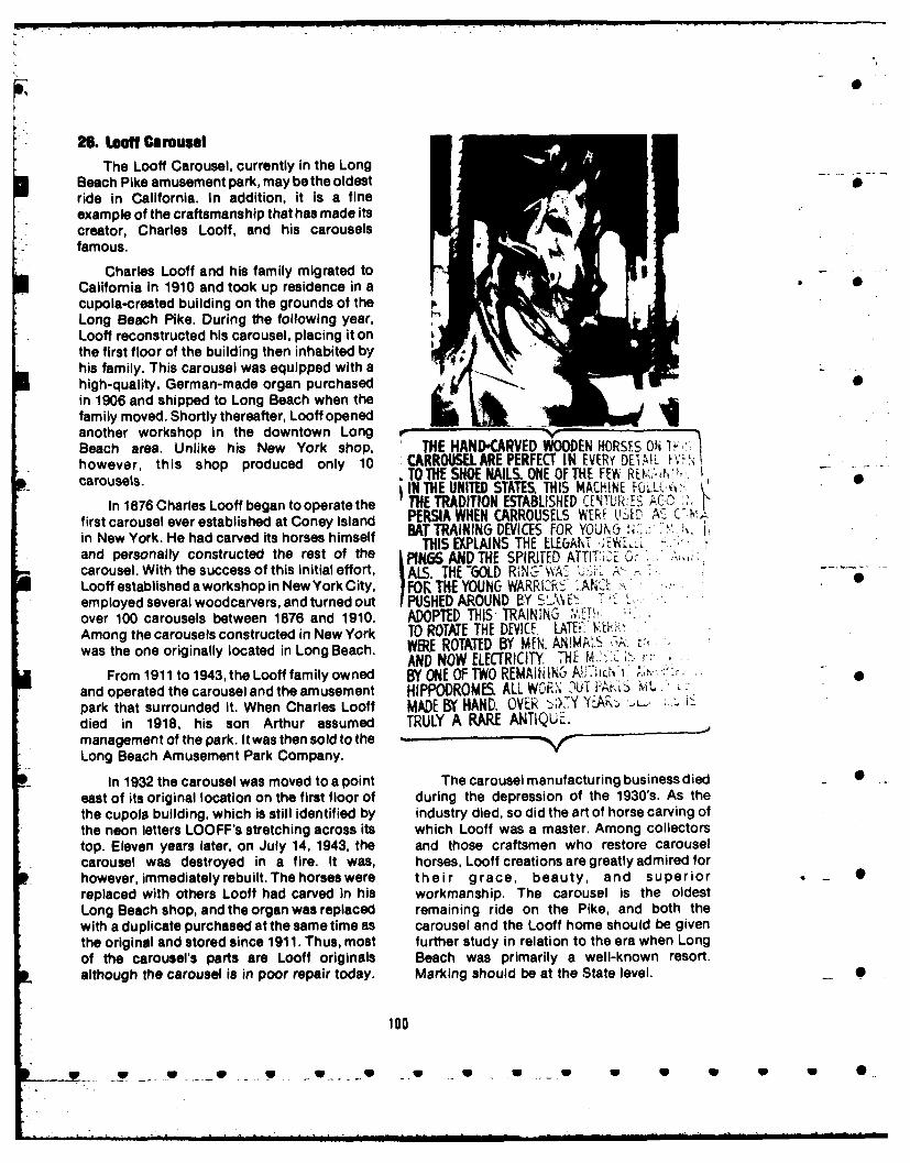
0
26. Looff CarouselThe Looff Carousel, currently in the Long
Beach Pike amusement park, may be the oldestride in California. In addition, it is a fineexample of the craftsmanship that has made itscreator, Charles Looff, and his carouselsfamous.
Charles Looff and his family migrated toCalifornia in 1910 and took up residence in a 0cupola-crested building on the grounds of theLong Beach Pike. During the following year, 1" |
Looff reconstructed his carousel, placing it onthe first floor of the building then inhabited byhis family. This carousel was equipped with ahigh-quality, German-made organ purchased 0in 1906 and shipped to Long Beach when thefamily moved. Shortly thereafter, Looff openedanother workshop in the downtown Long r V
Beach area. Unlike his New York shop, THE HANDCARVED WOODEN HORSES ON h-however, this shop produced only 10 CARROUSEL ARE PERFECT IN EVERVu E.I W'carousels. TO THE SHOE NAILS. ONE OF THE FEIN REK-h.IN THE UNITED STATES. THIS MACHINE FICLL(,I
In 1876 Charles Looff began to operate the TRADITION ESTABLISHED CIN'11th.ES ACO:first carousel ever established at Coney Island PERSIA WHEN CARROUSELS WEWR ti-IAD A, C-,,in New York. He had carved its horses himself BAT TRAINING DEVICES FOR YOUJ ,. '.THIS EXPLAINS THE ELE&AN Tand personally constructed the rest of the PIN6S AND THE SPIRITED ATTIT1'E ,. ,carousel. With the success of this initial effort,E ALS. THE -GOLD R NY" WA A,--Looff established a workshop in New York City, FOR THE YOUNG WARRIZEc' ,' . " ' "employed several woodcarvers, and turned out PUSHED AROUND BY S24 EZover 100 carousels between 1876 and 1910. ADOPTED THIS, TRAINING ""
Among the carousels constructed in New York TO ROTATE THE DEVICE. LATEi". Y, &- ,was the one originally located in Long Beach. WERE ROTATED BY MEN. ANIMALS .'_,A
AND NOW ELECTRICITY. 7THE M!-From 1911 to 1943, the Looff family owned BY ONE OF TWO REMAIhINC7 AlK j H0 , .
- and operated the carousel and the amusement HIPPODROMES. ALL WOR, )UT F r, k"park that surrounded it. When Charles Looff MADE EW HAND. OVER ',>;.Y . '-o-'died in 1918, his son Arthur assumed TRULY A RARE ANTIQUE.management of the park. It was then sold to theLong Beach Amusement Park Company.
In 1932 the carousel was moved to a point The carousel manufacturing business died _ 0
east of its original location on the first floor of during the depression of the 1930's. As thethe cupola building, which is still identified by industry died, so did the art of horse carving ofthe neon letters LOOFF's stretching across its which Looff was a master. Among collectorstop. Eleven years later, on July 14, 1943, the and those craftsmen who restore carouselcarousel was destroyed in a fire. It was, horses, Looff creations are greatly admired forhowever, immediately rebuilt. The horses were their grace, beauty, and superior _replaced with others Looff had carved in his workmanship. The carousel is the oldestLong Beach shop, and the organ was replaced remaining ride on the Pike, and both thewith a duplicate purchased at the same time as carousel and the Looff home should be giventhe original and stored since 1911. Thus, most further study in relation to the era when Longof the carousel's parts are Looff originals Beach was primarily a well-known resort.although the carousel is in poor repair today. Marking should be at the State level. 0
100
L __. .. . __ S .__ . . _ ... W _S .. _ S .. . S S S S 0
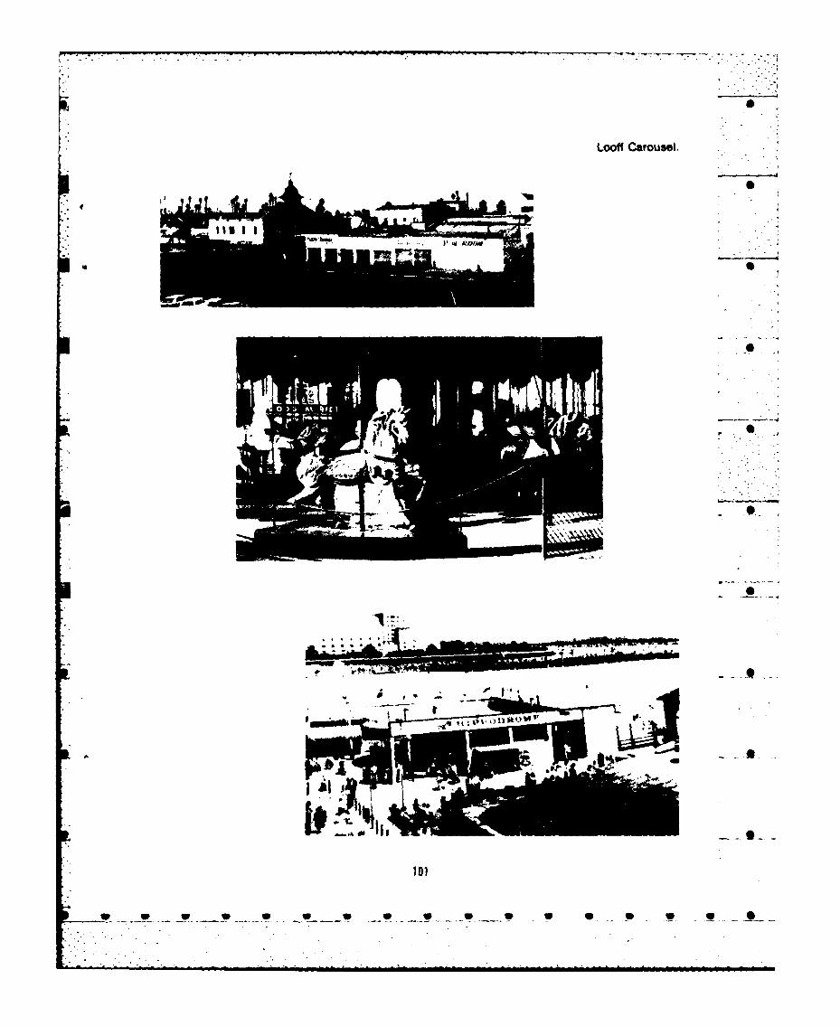
Looff Carousel.
2-4-

27. Old Whaling StaUonat Portuguese gond served here were Generals Philip HenrySheridan (who later remarked, "The only goodPortuguese Bend in the Palos Verdes Indians I ever saw were dead"), Winfield Scott
Estates is about 2-1/2 miles east of Point San Hancock, George Stoneman, and PhineasVicente. The site is peripheral to the Los Banning, and Colonel Cave J. Couts.Angeles Harbor. It is registered as CaliforniaState Historical Landmark No. 381; a copy of In May of 1859, 2 years before Civil Warthe application for registration is included in hostilities erupted, Lieutenant Winfield Scottthe appendix. Hancock came from Fort Tejon to Los Angeles
to acquire land upon which to construct a post28. Drum Barracks: Officers' Quarters and for the Army Quartermaster's Department ofPowder Magazine the Southwest. For a consideration of $1.00,
Drum Barracks in Wilmington is the only Phineas Banning and Benjamin David Wilson
Civil War landmark in California. From 1862 to donated 60 acres of land. Banning'sgenerosity1866 the original complex of more than 20 was more than repaid, because the
buildings was the focal point for men and Government awarded him all the construction
materials destined for all parts of the contracts for the fortand even paid him to build
Southwest. Today only two structures remain, a flume to bring water from the San GabrielOne of originally three off icers'quarters stands River 8 miles distant. Construction of the post
at 1053 Cary Avenue and is known simply as lasted from 1860 until 1862; the officers'
"Drum Barracks." The powder magazine quarters buildings were the last to bestands on its original location not far from the completed. The headquarters site, whichstadsinit oinrsqar tion nt fhar fromanye covered about 30 acres, included the quartersremaining officers'quarters, but it has for many of the commanding officer, two additionalyears been enclosed within a wood-frame officers quarters, an adjutant's office, fivehouse that hides itfrom public view. The house soldiers' barracks, bakery, granary, hay barn,is on the corner of Opp Street and Eubank blacksmith and wheelright shops, two corrals,Avenue. hospital, four laundry buildings, guard house,
Camp Drum initially served as the base for and powder magazine. Depot buildings for • 0the California volunteers. After the volunteer commissary and quartermaster stores"California Column" left for Arizona and New occupied about 7 acres near Banning's landingMexico to hold these territories for the Union, at Wilmington.the post became the rendezvous for recruitsdestined for Arizona and a depot from which With the triumph of Union forces, Drumsupplies were sent throughout the Southwest. Barracks, which had contributed much to the 5 0One of the first telegraph lines in this part of the economic and social life of the region, was nocountry linked Drum Barracks with other longer necessary to Army operations. TheFederal fortifications. The post also served asa decision to abandon the post in the spring ofbase of operations against Indians in the 1866 proved a severe economic setback fortheSouthwest. During 1862 and 1863 the famous town of Wilmington, whose importance andArmy Camel Corps carried freight between prosperity were dependent upon the militaryFort Tejon, Los Angeles, and Drum Barracks. presence. The more than a score of buildings
were sold at auction in 1873 for less thanLess colorful, perhaps, but far more $10,000. Wilson and Banning each acquired
significant, the presence of Federal troops at one of the officers' quarters in addition toDrum Barracks served as a warning to the several other structures. Some were removedstrong secessionist sympathy in southern and others were destroyed by fire. BanningCalifornia that might otherwise have menaced razed several buildings to salvage theirthe Union cause. During the war the number of materials and moved others to a location nearsoldiers stationed at Camp Drum, named for his docks. Fortunately, the powder magazineAdjutant-General Richard Coulter Drum, head was not demolished and the officers' quartersof the Department of the West, varied from that stands today on Cary Street was carefully2,000 to 7,000. Among the notable officers who preserved. About 10 acres of former Drum .
102
. . . 1. . . . . . . . . . . . . .. .. i . . 0 .

Barracks land were donated by Wilson to the Parks and Recreation for $30,000. Later thatMethodist Episcopal Church to establish a year the Department relinquished the propertycollege. Hardship caused by drought and flood to the State and was reimbursed the $30,000forced the church to cancel its educational purchase price. The State allocated $95,000 toplans, and the property was sold for $800. acquire the adjacent property, restore the
During the Army's presence at Fort Drum, officers' quarters, and develop the site as athe large two-story colonial-style officers' State Historical Park Civil War Museum.
the arg tw-stry oloialstye oficrs' Unfortunately, only about $20,000 of thequarters presented an attractive and dignified allocated $95,000 has been spent during theappearance. The front section of the 16-room last decade; the adjacent house lots have notwood-framed structure was large and been purchased, and prospects of a park-rectangular, with two rear wings extending b e um sed, and isc oraing.parallel with the sides of the building. Inside museum seem remote and discouraging.were a high-ceilinged central hall, a stairway Leaking water pipes severely underminedwith polished mahogany balustrade, four the brick foundation and cracked the interiormarble fireplaces with U.S. eagles on the plaster. The bricks from the foundation,mantels and andirons, and chandeliers in many fireplaces, and chimneys have been removed 0of the downstairs rooms. An entrance-way and neatly stacked outside, but there are noporch and second-story balcony stood at the plans to incorporate them into the eventualfront and rear of the building and numerous restoration. Future plans call for dummymultipaned windows were flanked by exterior fireplaces and chimneys. A new foundation haswooden shutters. Roof shingles were originally been constructed, and the interior plaster hasof split cyprus. Amazingly, this handsome well- been replaced with drywall. Large timber 0built edifice was one of the first prefabricated supports are now securely bolted within the oldstructures ever assembled on the Pacific walls, but this new structural solidity is notCoast. All its lumber, hardware, marble, and apparent to the casual observer. Most of thebricks were shipped around Cape Horn from windows are either broken or boarded up withthe Portsmouth Navy Yard in New Hampshire. plywood, though there is enough of the original
In the 20th century, Thomas Keaveney glass to fill the panes of the most conspicuous
preserved the officers' quarters by converting and important windows. The rear porch andthe structure into a charming residence. The balcony have either fallen off or been
Native Daughters of the Golden West placed a dismantled.plaque commemorating the Drum Barracks In The existence of Drum Barracks powder1927, and it subsequently became State magazine is not widely known because it hasHistorical Landmark No. 169. The Los Angeles long become incorporated into the structure ofCultural Heritage Board designated Drum a residential dwelling. In recent years thisBarracks as Historic-Cultural Monument No. house has been rented to a Spanish-speaking21 in 1963. Two years later the site was family or families, most of whose members dorecorded by the American Institute of not communicate in English. Very fewArchitects' Historic American Building Survey historically minded individuals have actuallyin the Library of Congress, and in 1971 the site seen the powder magazine. The wood-framL .was placed on the National Registerof Historic house thatconceals itfrom public view appearsPlaces. to have been constructed in the 1920's or
before. Because the powder magazine's stoneNotwithstanding widespread recognition and brick walls were about 3 feet thick and haveassahistorical monumentof major significance, been protected from the elements since theDrum Barracks officers' quarters was marked construction of the surrounding house, the -
for demolition in February 1965. Protest by the structure is in excellent condition and in no
Cultural Heritage Board gained time for the danger of collapsing. ,
Society for the Preservation of Drum Barracks
to organize and raise money to purchase the Many years ago, according to Vincentbuilding. In 1968 the society sold the officers' Manchester, resident caretaker of the officers'quarters to the Los Angeles Department of quarters, the stone blocks that encased the
103

Interior of the powder magazinewere removed. buildings should never be removed from theirA woman who supposedly lived in the house original site unless no alternative is availablenext door on Eubank Avenue told Manchester for their preservation. Whatever course isthat the blocks were taken out to make room for taken, it would be both senseless and unfair to I Srefrigeration and meat storage. The old stone the present occupants to demolish theirblocks were piled in the front yard near the modest wood-frame home until the officers'street, where the woman remembers playing quarters have been fully restored andon them as a child until they were eventually converted into a Civil War Museum. Even then,removed. According to Manchester, the State consideration should be given to facilitatingLegislature once allocated $18,000 to acquire the family's removal to comparable ' P 0the property but the money was never spent. accommodations.
Considering the historical significance of 2. General Phines Bannilg ResidenceDrum Barracks officers' quarters and powder One of the most attractive landmarks inmagazine as the sole surviving landmarks southern California and certainly the mostcommemorating California's participation In sorcalifoniian cral the intethe Civil War, they should be carefully historically significant cultural resource in thetheservilWa the y s de toe officers harbor area is the former home of Phineaspreserved. The primary danger to the ofcr' Banning. The stately white Greek Revival stylequarters is from vandals or arsonists; an manin. officially w n Gre e e eralinterior sprinkling system should be installed mansion, officially known as the Generalas soon as possible. The powder magazine s Phineas Banning Residence Museum, isobviously fireproof, but it too faces the danger located at 401 East "M" Street in the middle ofof destruction. Its sturdy walls are insufficient 20-acr Banning Park in Wilmington. The townprotectionagainstthe buildozerof the property of Banning which bears his name was one ofowner or developer who may wish to convert the main stops along his stage and freight linesthe historic site to more lucrative use. that extended throughout the Southwest.Fortunately, the chance of this occurring in the Banning High School is also named in hisimmediate future appears small. Nearby oil honor, as is Banning Boulevard which runs onwells, commercial and industrial businesses, a north-south axis bisected by Banning Park.
and the generally low-income housing of the Banning was penniless and only 21 whenneighborhood indicate that "progress" is he arrived in San Pedro aboard aclippership inunlikely for the moment. The house of which 1851. He rented a boat on credit and rowed tothe powder magazine is now a part presents a ships at anchor towhich hesold water for$1.00dilapidated exterior appearance; inside, a keg. Don David Alexander, the firsthowever, it is surprisingly pleasant, with businessman of San Pedro, recognized theunusually high ceilings which were built to young man's talents and gave him regularconform to the height of the powder magazine. work. Banning tried his hand at stagecoach
The property upon which the powder driving, and before long he became themagazie prots sulot e aowde t region's recognized "transportation king"
magazine stands should not be allowed to whose enterprises included not only a stageremain indefinitely in the possession of an line to Los Angeles and a freight line with muleowner who has made no formal and legally teams to Salt Lake, Mojave, and Yuma, but abinding commitment to preserve the historical fleet of oceangoing vessels and a railroad fromlandmark subtly hidden within the premises. Wilmington to Los Angeles.
Preservationists may decide to acquire the
property with the intention of removing the From 1851 until 1858 Banning'ssurrounding house to make the powder headquarters were in San Pedro. In 1857magazine more visible. Others may wish to together with Benjamin David Wilson and Johnrelocate the powder magazine at the rear of the G. Downey, Banning purchased 2,400 acres ofnearby officers'quarters. The latter course may land from Manuel Dominguez. A heavy springentail considerable technical problems and storm in 1858 damaged Banning's wharf at Sanexpense, not to mention strong sentiment Pedro, wrecked several barges and his yacht,among many preservationists that historical and washed away a large store of lumber
104
- .- - - - - - - - -

0
stacked on the beach. The following year, to the post in 1866, but Banning's foresight andavoid a similar disaster, Banning combined his sound personal finances prevented theshare of the former Dominguez land with catastrophe from permanently stuntingWilson's to form the nucleus of the town of New Wilmington's growth. 0San Pedro, which the State Legislature in 1863renamed Wilmington after Banning's Banning becamea State senator in 1865tobirthplace in Delaware. "Banning's Hog- bring attention to Wilmington, but his lobbyingWaller," as the infant port was derisively on behalf of harbor development met with littleWanler," as buth 4inft porthast deriSy success either in the State capital or inknown, was about 4 miles northeast of San Washington, D.C., where he made several tripsPedro at the head of the slough, surrounded by to solicit Federal funds. He did, however, 0mudflats. Mud scows were used to dig a introduce the first railroad bill into thechannel up the estuary, hand pumps siphoned California State Legislature. Banning's supportwater from the marshy land, and before long of a Los Angeles bond issue resulted inthere were warehouses and a lumber yard. construction of the 21-mile Los Angeles and
In the years prior to the Civil War, San Pedro Railroad in 1868 and 1869, the firstBanning's wharves at old and New San Pedro railroad in southern California. Subsequently,handled large quantities of products ranging Banning's efforts were largely directed towardfrom hides, tallow, lumber, and wire to grapes, bringing the Southern Pacific Railroad to Losabalone shells, and oil from whales and sharks. Angeles in 1876.The new port's advantages of being severalmiles closer to Los Angeles and well protected Banning's first wife, Rebecca Sanford, from storms were somewhat offset by the whom he had married in 1854, bore him eight Sshallow depth of the water. Oceangoing children, only four of whom survived to
vessels could not enter the inner harbor, so adulthood; she herself died suddenly in 1868atBanning built shallow-draft lighters, which the age of only 31. Two years later he marriedcould easily carry cargo over the sand bar and Mary Hollister, his wife for the final 15 years ofup the estuary. Banning also constructed his his life. Banning's own death came in 1885 fromown theetuary.caning sas ipnsrucd h injuries suffered in a freak accident in Sanown fleet of oceangoing steamships. Francisco when he fell off a moving streetcar. •
When the U.S. Army decided to locate a He was only 55. Only recently he hadpost for its Quartermaster's Department of the succeeded in getting the U.S. Congress toSouthwest in the Los Angeles area, Banning authorize plans for a breakwater fromand Wilson donated a 60-acre site for $1.00. An Rattlesnake (now Terminal) Island tooutspoken champion of the Union cause, Deadman's Island and to build Point FerminBanning secured all the construction contracts Lighthouse. Without the breakwater there •for Drum Barracks. He was known as General could be no port of entry for oceangoingBanning because of his service as a brigadier vessels. Although he died before his dreamgeneral in the state military during this period, materialized, Phineas Banning is appropriatelyFor many years Banning also served as a remembered as the "Father of Los Angelesvolunteer policeman. As early as 1861 Banning harbor."had been responsible for bringing the first Tatelegraph to the harbor area. Later, in 1864, he The Banning mansion was built in 1864. Itestablished the community's first post office, has 24 rooms, although there originally mayand in the same year he also started the first have been as many as 30, with at least 3 barns innewspaper, The Wilmington Journal, the rear. The mansion, praised as "the finest
extant example of Greek Revival style inThe presence at Drum Barracks of several southern California," has stately columns and 0
thousand troops, many of whom brought their wide verandas. The 3-story structure is toppedfamilies, greatly stimulated the growth of by a cupola from which Banning scanned theWilmington's prosperity and social life. Six horizon in search of ships entering his port.public schools were necessary in 1865 to Banning ordered material from all over theaccommodate the expanded population. Hard world, including exquisitely colored Belgiantimes followed the Army's decision to abandon glass and delicately veined Belgian marble. 0
105
... S U S _S*.. S *•.S.. • . .. S • . S S • • • 0

Lumber was brought by ship from the Historic-Cultural Monument No. 25, and inMendocino coast and labor was supplied by 1971 was approved by Congress for thelocal Indians, seamen, and shipwrights. The National Register of Historic Places. Thelegendary hospitality was unsurpassed in its Banning residence is a facility of the Losday, and the Bannings becamefamousfortheir Angeles City Recreation and Parks"regales," attended by leaders of civic, Department, open to the public on Wednesdaygovernmental, business, and military affairs. and Sunday afternoons. Restoration of theTwenty-acre Banning Park, in which the house, gardens, and coaching barn has beenmansion is located, was created by a bond the work of the Friends of Banning Park;issue voted by the people of Wilmington in financial assistance from the State is1927, 2 years after the last of the Bannings anticipated. Some of General Banning'smoved out of the home. furniture has been preserved, and many of the
rooms have been restored with elegantThe Banning residence is California State furnishings from the later 19th century. From
Historical Landmark No. 127. It was honored by the "Widow's walk" of the beautiful structure,a commemorative plaque placed by the Native visitors still enjoy a superlative view of the 0Daughters of the Golden West in 1937. In 1963 harbor area. Each April, Banning Parkthe landmark was declared Los Angeles becomes the site of an annual wisteria festival.
I I
IfI
0•- 1
General Phineas Banning residence. - S
108
_ . .... _ . _ _ . . . , w ,

30. St. John's Episcopal Church Notes and Sources
Wilmington's first Episcopal services wereheld in the basement of the Banning mansion in 2. San Pedro Breakwater and Angels Gate1876. Seven years later, through the Lighthouseencouragement of Mrs. Mary HollisterBanning, construction of a stave-type church 1. Ernest Marquez, Port Los Angeles, p.building was begun at 422 North AvalonBoulevard (then called Canal Street). The Rev. 2. Ibid., p. 31.Carlos S. Linsley did most of the carpentrywork himself, and the Banning family paid for 3. Anthony Turhollow, A History of themost of the materials. Christmas day services Los Angeles District U.S. Army Corps ofwere held in 1883 in the still unfinished church. Engineers 1898-1965, p. 34.Despite this auspicious beginning,construction slowed to a standstill and the 4. Clarence Matson, Building a Worldedifice stood without a roof for 4 years. During Gateway, p. 39.this time religious services were conducted in abuilding formerly housing the Washington 5. Curtis Grassman, The Los AngelesSaloon. Free Harbor Controversy and the Creation of a
The church's bell and altar provide further Progressive Coalition: Southern Californiaevidence of the Bannings' close association Quarterly, LV, 4 (Winter, 1973), p. 449.with St. John's. In 1882, before construction 6had commenced, General Banning donated 6. Ibid., p. 459.the bell, which came from the S. S. Amelia, one 7. Ernest Marquez, Port Los Angeles, p.of his harbor channel boats. Many years later, .in 1925, Banning's heirs donated the Catalinamarble altar which originally had been 8. Clarence Matson, Building a Worldintended to serve as a buffet in the Banning Gateway, p. 47.home. St. John's altar cross and altar rail, giftsfrom a Navy chaplain in 1926, were made at 9. James Gibbs, West Coast Lighthouse,Pearl Harbor from the brassofaGerman World p. 48.War I submarine.
3-7. Fort MacArthur Upper Reservation SiteIn 1943 the church building was moved
from its original site to its present location at 1. Letter, Al Grobmeier to Colonel Robert1537 Neptune Avenue in Wilmington. With the L. Freeland, Deputy Post Commander, Fortexception of a small parish hall added at the MacArthur, dated November 14, 1976.rear in 1950 and a few of its stained-glasswindows, which have buckled with age, the Colonel Robert L. Freeland, Deputy Postunpretentious appearance of the church is the Commander, Fort MacArthur, has contributedsame as when the church was first constructed. maps, photos, a draft history of the fort, and his
It is recommended that a commemorative time in helping with this section of the report.plaque be placed at 422 North AvalonBoulevard to mark the original and historic 8. One Hundred Varas Squarelocation of St. John's Episcopal Church. 1. John Caughey, California, p. 88.
2. Hallock F. Raup, "Rancho Los PalosVerdes", Historical Society of SouthernCalifornia Quarterly, Vol. XIX, 4 (1938), p. 9.
3. Quoted in Clarence Matson, Building aWorld Gateway, p. 75. - -
107
- -. a 0_ -a 9 . 0

4. Anthony Turhollow, A History of the 17. Terminal Island SchoolhouseLos Angeles District U. S. Army Corps ofEngineers, p. 21. In addition to the works cited, material was
also gathered from an interview and onsite 05. James M. Guinn. Historical and inspection with Captain D. W. Zimmerman; a
Biographical Record of Southern California, p. letter, A. Mediavilla to John S. Gibson, Jr.,450. October 22, 1976, and a report by local
historian Edward Houck dated November 17,6. Ibid., p. 65. 1976, in acknowledgement to that letter.
7. James M. Guinn. History of California, 1. Thomas Wolfe, "Inter-Americanp. 84. Maritime Disputes Over Fishing in the
Twentieth Century", Ph.D Thesis, University of8. Richard Henry Dana. Two Years California, Santa Barbara, 1968. Clarence
Before the Mast, p. 99. Matson gives Mr. King of White Star credit forthe "chicken of the sea" albacore, but Wolfe's S
9. Ibid.. pp. 100-101. research is convincing.
10. Guinn, Historical and Biographical 2. K. Kawasaki, "The JapaneseRecord of Southern California, p. 451. Community of East San Pedro, Terminal
Island, California", Masters Thesis, Sociology,11. "Draft History of Fort MacArthur", p. University of Southern California, 1931, pp. 39- 0
25. 43.3. Ibid., p. 43.
9. Los Angeles Municipal Warehouse No. 1
1. U.S. Army Corps of Engineers, The 4. Hager and Hager, "Terminal Island'sr oGlamorous Past", Los Angeles Corral, No. 111,Ports of Los Angeles and Long Beach, 193California, pp. 74-75. 1973.
5. Clarence H. Matson, Building a World11. Municipal Fish Market. Gateway, p. 166.
1. News Pilot, July 20, 1951, September19, 1952. 6. Ibid.
20. Berth 145, Los Angeles Harbor13. Timms Point and Landing
1. Mike Quin,!. The Big Strike, Olema,Sources included Hager & Hager, "From Ca.: Olema Publishing Company, 1949, p. 31.
Tidelands to Mudflats...", Golden Anniversary The sources included: Mike QuinnEdition, San Pedro News Pilot; Amos Fries, (pseudonym Paul William Ryan), The Big"San Pedro Harbor", Out West, Vol. XXVII, 4 Strike, Olema, Ca.: Olema Publishing(October, 1907), p. 317; Los Angeles Times, Company, 1949: Interview, Arthur Almeida,February 28, 1907; John S. McGroarty, History President, International Longshoremen andof Los Angeles County, passim. Warehouse Union, Local 13, January 17, 1977;
Interview, Gordon Giblin, President,14. Municipal Ferry Building Pensioneers, International Longshoremen and
Warehouse Union, March 8,1977; Los Angeles -Data was drawn from Shoreline, January Times, May 14, 1934, May 16, 1934; The
1977; Angels Gate, Vol. 3 (September 1976); Dispatcher, July 9, 1959.and "Proposal for Preservation and Renovationof the Old Municipal Ferry Building Port of Los 22. Badger Avenue Bascule BridgeAngeles", Councilman John S. Gibson's
Office, San Pedro. Material was drawn from Interurbans Vol. _ - S
100
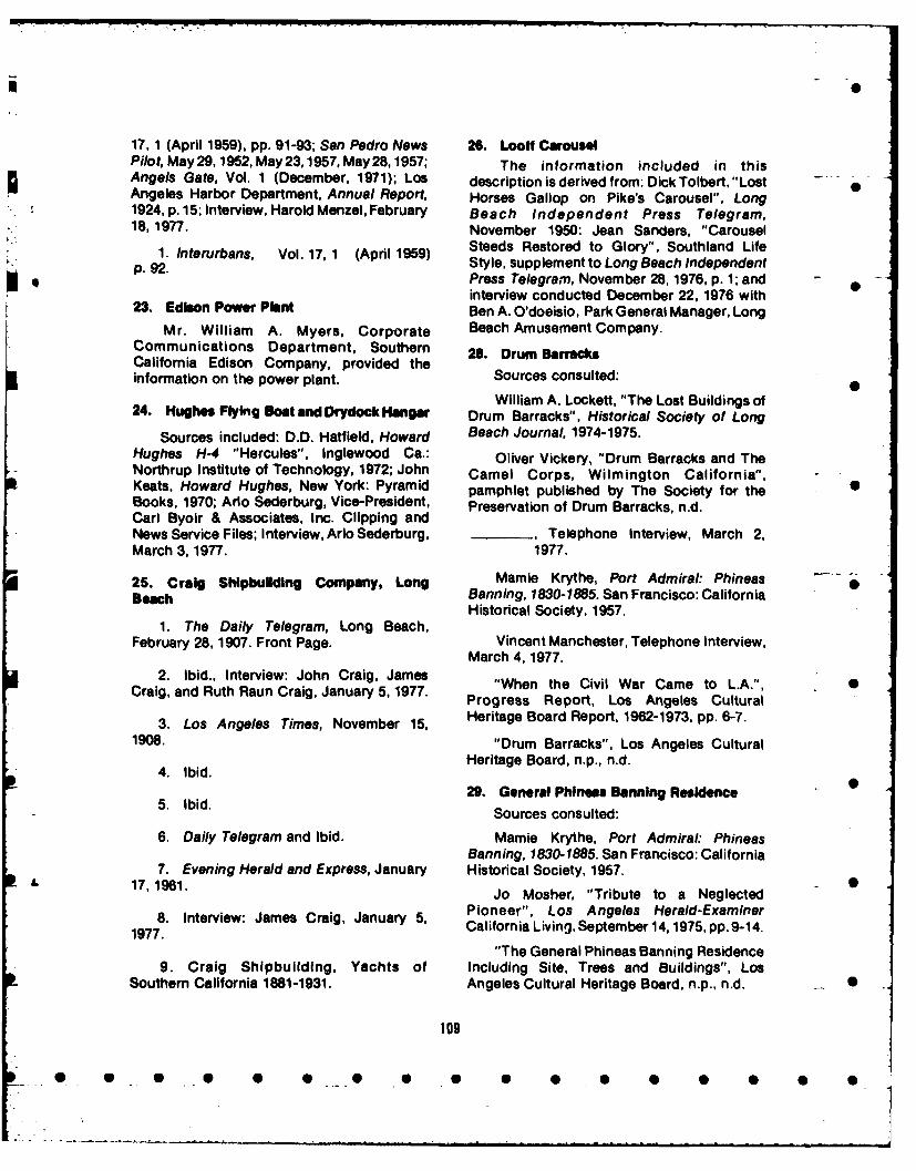
17, 1 (April 1959), pp. 91-93; San Pedro News 26. Looff CarouselPilot, May29, 1952, May 23,1957, May 28,1957; The information included in thisAngels Gate, Vol. 1 (December, 1971); Los description is derived from: Dick Tolbert,"Lost .Angeles Harbor Department, Annual Report, Horses Gallop on Pike's Carousel", Long1924, p. 15; Interview, Harold Menzel, February Beach Independent Press Telegram,18, 1977. November 1950: Jean Sanders, "Carousel
1. Interurbans, Vol. 17, 1 (April 1959) Steeds Restored to Glory", Southland Lifep. 92. Style, supplement to Long Beach Independent
Press Telegram, November 28, 1976, p. 1; and -interview conducted December 22, 1976 with
23. Edison Power Plant Ben A. O'doeisio, Park General Manager, Long
Mr. William A. Myers, Corporate Beach Amusement Company.Communications Department, Southern 26. Drum BarracksCalifornia Edison Company, provided theinformation on the power plant. Sources consulted:
William A. Lockett, "The Lost Buildings of24. Hughes Flying Boat and Drydock Hangar Drum Barracks", Historical Society of Long
Sources included: D.D. Hatfield, Howard Beach Journal, 1974-1975.Hughes H-4 "Hercules", Inglewood Ca.: Oliver Vickery, "Drum Barracks and TheNorthrup Institute of Technology, 1972; John Camel Corps, Wilmington California",Keats, Howard Hughes, New York: Pyramid pamphlet published by The Society for theBooks, 1970; Arlo Sederburg, Vice-President, Preservation of Drum Barracks, n.d.Carl Byoir & Associates, Inc. Clipping andNews Service Files; Interview, Arlo Sederburg, , Telephone Interview, March 2,March 3, 1977. 1977.
25. Craig Shipbuilding Company, Long Mamie Krythe, Port Admiral: PhineasBeach Banning, 1830-1885. San Francisco: California
Historical Society, 1957.1. The Daily Telegram, Long Beach,
February 28, 1907. Front Page. Vincent Manchester, Telephone Interview,March 4, 1977.
2. Ibid., Interview: John Craig, James "When the Civil War Came to L.A.",Craig, and Ruth Raun Craig, January 5,1977. Progress Report, Los Angeles Cultural
3. Los Angeles Times, November 15, Heritage Board Report, 1962-1973, pp. 6-7.1908. "Drum Barracks", Los Angeles Cultural
Heritage Board, n.p., n.d.4. Ibid.
5. Ibid. 29. General Phines Banning ReasidenceSources consulted:
6. Daily Telegram and Ibid. Mamie Krythe, Port Admiral: PhineasBanning, 1830-1885. San Francisco: California
7. Evening Herald and Express, January Historical Society, 1957.17,1961. Jo Mosher, "Tribute to a Neglected
8. Interview: James Craig, January 5, Pioneer", Los Angeles Herald-Examiner1977. California Living, September 14, 1975, pp.9-14.
"The General Phineas Banning Residence9. Craig Shipbuilding, Yachts of Including Site, Trees and Buildings", Los
Southern California 1881-1931. Angeles Cultural Heritage Board, n.p., n.d. - 0
109
. ...... 0 0 0 5 5 0

44
IP - Y5
-IM
..... ....
MOW