distribution and movement patterns of … · distribution and movement patterns of shark ... data...
TRANSCRIPT

MARINE MANAGEMENT SUPPORT SHARK BAY
DISTRIBUTION AND MOVEMENT PATTERNS OF
SHARK BAY DUGONGS:
Data Report: MMS/SBY/SBA – 62/2002 A collaborative project between CALM Marine Conservation Branch, CALM Shark Bay District,
Yadgalah Aboriginal Corporation, Edith Cowan University and James Cook University.
A project funded through
Prepared by D.K. Holley
Marine Conservation Branch
January 2003
Marine Conservation Branch Department of Conservation and Land Management
47 Henry Street, Fremantle Western Australia 6160
MARINE CONSERVATION BRANCH CALM
ACKNOWLEDGEMENTS The Marine Conservation Branch (MCB) of the Department of Conservation and Land
Management would like to thank the following people for their contribution to the project.
• Dr. Nick Gales - Australian Antarctic Division. • Benny, Brendan and Dianne Bellottie, Kim and Jimboy Poland, Daniel Cocks, Darren
Capewell and the Committee – Yadgalah Aboriginal Corporation (Inc.). • Dave Rose, Kevin Crane, Richard Hall and Brad Barton – Shark Bay District,
Department of Conservation and Land Management • Dr. Ivan Lawler, James Sheppard and Prof. Helene Marsh. - James Cook University
• Dr. Paul Lavery, Nick Wood and Mark Westera – Edith Cowan University
• Craig and Jessie Shankland - James Scheerer Research Charters.
Other CALM contribution
• Gordon Wyre – A/Director Nature Conservation • Dr. Chris Simpson – Manager Marine Conservation Branch.
• Nick D’Adamo - Section Leader, Marine Management Support, Marine
Conservation Branch
• Phil Kindleysides – GIS presentation, Marine Conservation Branch
This report may be cited as:
Holley, D.K. (2003). Distribution and movements patterns of Shark Bay dugongs: Data Report MMS/SBY/SBA-
62/2002. (Marine Conservation Branch, Department of Conservation and Land Management, 47 Henry St., Fremantle,
Western Australia, 6160). Unpublished report.
Copies of this report may be obtained from:
Marine Conservation Branch Department of Conservation and Land Management
47 Henry St. Fremantle, Western Australia, 6160
Ph: (08) 9336 0100 Fx: (08) 9430 5408
T:\144-Marine Conservation Branch\Shared Data\Current_MCB_reports\MMS\mms_6202\mms_6202.doc II
MARINE CONSERVATION BRANCH CALM
SUMMARY Shark Bay, Western Australia, was listed on the World Heritage register with a number of
significant conservation values. These values as listed in the Shark Bay Marine Reserves
Management Plan (CALM, 1996- 2006) include a large and secure population of dugongs
(Dugong dugon) and the largest seagrass meadows in the world with an unusually high species
diversity. Within the Management Plan a number of strategies are outlined in order of priority to
maintain these values. Of these strategies there is need in the short term for further research into
dugong distribution, biology and behaviour in the reserves as well as a medium term need to
encourage the wise management of important dugong habitats outside the reserves
This data report presents results obtained from the deployment of location recording and
transmitting tags on dugongs within the Shark Bay World Heritage Property during the period
March 2000 through to September 2002. The project was a collaboration between the Marine
Conservation Branch, Wildlife Branch and Shark Bay District of the Department of Conservation
and Land Management, Shark Bay Yadgalah Aboriginal Corporation Inc., Edith Cowan
University and James Cook University.
Funding for this project has been provided through the Western Australian Lotteries Commission,
UNESCO World Heritage, and the Natural Heritage Trust, Coast and Clean Seas program.
T:\144-Marine Conservation Branch\Shared Data\Current_MCB_reports\MMS\mms_6202\mms_6202.doc III
MARINE CONSERVATION BRANCH CALM
CONTENTS
1. INTRODUCTION............................................................................................................................... 1 1.1 Background............................................................................................................... 1 1.2 General...................................................................................................................... 1 1.3 Project Objectives and Purpose ................................................................................ 2
2. METHODS.......................................................................................................................................... 3 2.1 Study Area ................................................................................................................ 3 2.2 Mapping .................................................................................................................... 3 2.3 Capture and Deployment .......................................................................................... 5 2.4 Tag Descriptions ....................................................................................................... 7 2.5 Data Retreival and Projection ................................................................................... 9 2.6 Spatial Analysis ........................................................................................................ 9
3. RESULTS .......................................................................................................................................... 10 4. METADATA ..................................................................................................................................... 11 5. DATA MANAGEMENT .................................................................................................................. 11
5.1 Report...................................................................................................................... 11 5.2 GIS Layers .............................................................................................................. 11
6. REFERENCES.................................................................................................................................. 12 APPENDIX – METADATA FOR DISTRIBUTION OF TAGGED DUGONGS IN SHARK BAY 2000-2002..................................................................................................................................................... 18
* * *
FIGURES Figure 1. Location map of the Shark Bay World Heritage Property....................................................... 4 Figure 2. Distribution of all PTT tagged dugongs in Shark Bay 2000-2002. ......................................... 14 Figure 3. Distribution of all GPS tagged dugongs 2000-2002. ................................................................ 15 Figure 4. Combined distribution of dugongs 2000-2002. ........................................................................ 16
* * *
TABLES
Table 1. Location classes for fixes determined by Service Argos. ............................................................ 9 Table 2. Details of dugongs tagged during the period March 2000 – August 2002............................... 10
T:\144-Marine Conservation Branch\Shared Data\Current_MCB_reports\MMS\mms_6202\mms_6202.doc IV
MARINE CONSERVATION BRANCH CALM
T:\144-Marine Conservation Branch\Shared Data\Current_MCB_reports\MMS\mms_6202\mms_6202.doc V
MARINE CONSERVATION BRANCH CALM
1. INTRODUCTION 1.1 BACKGROUND
The dugong (Dugong dugon), which is the only herbivorous marine mammal that is strictly
marine, is listed as vulnerable to extinction at a global scale on the World Conservation Union
(IUCN) Red List of Threatened Species (IUCN, 2002). A recent dugong status report and action
plan for countries and territories, produced for the United Nations Environment Program (UNEP)
details that throughout much of its range, the dugong is represented by relict populations
separated by large areas where its numbers have been greatly reduced or it is already extirpated
(Marsh et al, 2002).
Whilst Australian waters contain possibly the largest remaining dugong populations in the world,
there is strong evidence of significant population decline in some parts of the dugong’s Australian
range (Marsh, 2000). Threats to dugongs include, but are not restricted to, fishing practices,
hunting, habitat degradation, and disturbance from activities such as aquaculture and tourism.
Effective conservation of these populations is a major requirement for the survival of the species
globally.
The Shark Bay World Heritage Property on the mid west coast of Western Australia is a location
with a large and stable dugong population exposed to limited threatening activity. Within the
Shark Bay Marine Reserves Management Plan 1996-2006 (CALM, 1994), a number of strategies
are outlined in order of priority to maintain this population’s stability. Of these strategies there is
need in the short term for further research into dugong distribution, biology and behaviour in the
reserves as well as a medium term need to encourage the wise management of important dugong
habitats outside the reserves
1.2 GENERAL
The Shark Bay World Heritage Property is located at the southern extremity of dugong
distribution on the Australian West Coast and approximates the southward limit of large dugong
concentrations on the eastern Australian coast at Moreton Bay (Anderson, 1982). Aerial surveys
of dugongs conducted since 1977 (Marsh, 1994; Prince, 1979; Preen, 1997) have shown that
T:\144-Marine Conservation Branch\Shared Data\Current_MCB_reports\MMS\mms_6202\mms_6202.doc 1
MARINE CONSERVATION BRANCH CALM
Shark Bay is a location with a significant dugong population. Results from these surveys indicate
that Shark Bay has supported a stable population of ~ 10,000 individuals over the last decade
with the latest estimate at approximately 12,000 individuals (Holley, unpublished data). It is the
most important known dugong area in the Indian Ocean (Preen, 1997).
Variations between winter and summer aggregations in Shark Bay have been identified (Prince,
1979; Anderson, 1982a; Anderson, 1982b) with distribution appearing to be predominately
temperature and seagrass dependent (Anderson, 1986; Marsh, 1994). These aggregations have
been confirmed from three major winter aerial surveys in July 1989, June 1994 and July 1999
(Marsh, 1994; Preen, 1997, Gales, unpublished data), as well from surface vessels and other
aerial surveys (Prince, 1979; Anderson, 1998; Anderson, 1986; Anderson, 1982b; Anderson,
1982a). Anderson (1986) suggested that water temperature determined the movements of
dugongs in the bay throughout the year and that dugongs are forced to migrate from summer
feeding grounds to a winter refuge to minimise low temperature stress. This movement pattern
has clear implications for population management and was the driving force in the establishment
of this program using remote recording devices to further understand dugong movement patterns
within the Shark Bay World Heritage Property.
Satellite transmitter terminals have been used to analyse the movements and home ranges of
individual dugongs along the tropical and subtropical north and east coasts of Australia (Marsh
and Rathbun 1990; Preen, 2001) and in a tropical island system in East Indonesia (DeIongh
1996). The only other studies on movements of individual dugongs within Shark Bay were
conducted on the basis of sketches, photographs and paint marked animals (Anderson, 1982a).
1.3 PROJECT OBJECTIVES AND PURPOSE The objectives of this project were to determine the feasibility of tracking individual dugongs
using a combination of satellite Platform Transmitter Terminals (PTT) tags and Geographical
Positioning Systems (GPS) tags as tools for determining movements of individual dugongs in
Shark Bay. Results obtained show the spatial and temporal distribution of tagged dugongs during
the project period.
T:\144-Marine Conservation Branch\Shared Data\Current_MCB_reports\MMS\mms_6202\mms_6202.doc 2

MARINE CONSERVATION BRANCH CALM
The purpose of this report is to outline the methods used in the catching and tagging of dugongs,
describe tag capabilities and spatial accuracy, and to present maps showing the distribution of
tagged dugongs in relation to current Marine Park boundaries.
2. METHODS 2.1 STUDY AREA
Shark Bay is located on the western most point of the Australian coast between latitudes 240
35’00” and 270 00’00” (Figure 1). It is a large (13 000km2), shallow (mainly <15m) basin with
restricted oceanic exchange and high rates of evaporation (Logan et al, 1970). The bay is located
near the northern limit of a transition region between temperate and tropical marine flora and
fauna (CALM, 1994).
2.2 MAPPING Information layers were constructed using ArcView GIS 3.2 (ESRI) software.
Detailed descriptions of methods used in mapping are provided in the metadata statement (see
Appendix).
T:\144-Marine Conservation Branch\Shared Data\Current_MCB_reports\MMS\mms_6202\mms_6202.doc 3

MARINE CONSERVATION BRANCH CALM
Figure 1. Location map of the Shark Bay World Heritage Property.
T:\144-Marine Conservation Branch\Shared Data\Current_MCB_reports\MMS\mms_6202\mms_6202.doc 4

MARINE CONSERVATION BRANCH CALM
2.3 CAPTURE AND DEPLOYMENT A total of six deployments were undertaken during the project period, March 2000 to September
2002 (Holley, 2002 a, b, c) Dates of each deployment are presented in Table 2.
Dugong capture sites were selected from areas of known seasonal dugong aggregation determined
by aerial surveys (Anderson, 1986; Preen et al, 1994; Marsh et al, 1997; Gales et al 2002) and
anecdotal references from local fisherman. Dugongs were captured using a ‘chase and grab
technique’, modified from a ‘rodeo’ system (Limpus 1978) developed for the capture of marine
turtles. This technique has been developed as an alternative to the use of a hoop-net capture
system (Preen, 1992), and has been successfully applied to dugong captures in shallow water in
Queensland over the past few years (J. Lanyon, personal communication)
The capture technique requires candidate dugongs to be in water depths of less than about 1.8m at
the point of restraint. Dugongs move up onto shallow sea grass beds to feed with the edges of
these banks visually surveyed from two small boats travelling approximately 100m apart.
When dugongs move into shallow waters they commonly do so in groups and cow-calf pairs are
often included in such feeding herds. The capture technique requires an intense period of pursuit
and herding during which an acute level of disturbance is caused to the target animal and any
dugongs in the immediate vicinity. In areas of high dugong density boat-dugong collisions are a
real risk. As a result, the following capture selection protocol was developed:
• Dugongs in, or close to, water of 1-1.8m were selected. The catch sequence was not
initiated until the animal had moved at least 50m from water >1.8m.
• Only dugongs estimated to be >2.2m were selected. These animals were assumed to be of
sufficient age to be nutritionally and socially independent.
• Where possible dugongs >100m from other dugongs were selected.
T:\144-Marine Conservation Branch\Shared Data\Current_MCB_reports\MMS\mms_6202\mms_6202.doc 5
MARINE CONSERVATION BRANCH CALM
• When capturing dugongs from a herd, animals on the edge were selected, and the pursuit
and herding procedure attempted to direct the dugong away from the group. A maximum
of two capture attempts from any one herd (group within about 100m of each other) was
made.
• Captures were not made from groups containing cow-calf pairs.
Once a suitable dugong was located the GPS co-ordinates were recorded and the catch boat
(5.4m, centre-console, fibreglass hulled, inflatable Zodiac powered by a 50HP four-stroke
Yamaha outboard) approached the dugong at less than wake speed (approximately 5km/hr) from
between it and the nearest deep water. The approach was maintained until the dugong was startled
and swam rapidly away from the capture boat; the time was recorded and the chase commenced.
The three dugong catchers on the bow of the catch boat would maintain visual contact with the
dugong and point towards it to direct the boat driver, who would attempt to position the boat into
the capture position immediately behind and just to one side of dugong. If the dugong headed for
deep water, as was often the case, the catch boat would attempt to move to the side and just ahead
of the dugong and herd it back towards shallow water. If necessary, a second smaller boat would
assist with the herding operation and might temporarily take over the primary chase position (just
behind the dugong) if the dugong turned suddenly and temporarily evaded the chase boat.
The initial chase speed was likely to be the maximum swimming speed of the dugong in shallow
waters (approximately 20-30km/hr). Great care was needed to co-ordinate the close manoeuvres
of the two boats around the dugong. High-speed chases were aborted if a capture had not been
affected within 3 minutes, or the dugong had taken more than three breaths. Chases in excess of
either of these limiting parameters only occurred if the dugong slowed down to rest, taking
several breaths, at a time when the capture boat had not been able to maintain the catch position.
Dugongs are not capable of sustained high-speed swimming and rapidly become exhausted
during this type of pursuit.
During a chase the pursued dugong would slow down and come to the surface to breath. The
breath cycle takes at least two seconds, during which the animal first presents it head at the
surface, inhales, and then raises its back and tail peduncle to the surface prior to diving. If the
catch boat is in position during a surfacing, the dugong is allowed to take a full breath, and, when
T:\144-Marine Conservation Branch\Shared Data\Current_MCB_reports\MMS\mms_6202\mms_6202.doc 6

MARINE CONSERVATION BRANCH CALM
the back and tail peduncle are presented, the nominated catcher leaps from the boat onto the
dugong and wraps his arms rapidly and firmly around the peduncle. It is essential to establish this
firm grip prior to the animal being able to establish a powerful tail beat, as this is likely to
dislodge and potentially injure the catcher.
Once the grip is established the catcher then stands up with the dugong’s fluke held down against
his body. Two other catchers immediately follow the primary catcher into the water and attempt
to grip one each of the dugong’s pectoral fins. During the establishment of the restraint, the
capture boat manoeuvres alongside and an additional person enters the water from the second
boat with a 120 x 12cm foam flotation device (‘noodle’) with 1.2m of rope attached to each end.
This is placed under the dugong, immediately behind the pectoral fins with the ropes being
secured to an inflatable pontoon of the capture boat. The noodle acts as a cradle preventing the
animal from rolling and ensures that the animal is able to lift its head out of the water to breathe.
The primary catcher continues to hold the dugong by the tail fluke. If during any stage of the
restraint and stabilisation procedure the dugong was not able to acquire a breath for a period in
excess of 30secs, the animal is released immediately.
Once secured alongside the boat the following procedures are undertaken: • Measurements of standard length (straight lie from tip of face to mid-fluke) and of axillary
girth. • Dorsal skin biopsy taken with a 5mm biopsy punch. • Application of temporary paint mark using a non-toxic livestock marker. • Determination of sex from inspection of anal-genital openings. • Collection of facial vibrissae for stable isotope analysis. • Application of the archival GPS or PTT tag.
2.4 TAG DESCRIPTIONS
Three types of floating positioning tags were used during the study period. These were, Telonics
Platform Transmitter Terminal (PTT) satellite tags and combination PTT/GPS- Gen-II GPS tags
(Telonics, Inc. Mesa, AZ, USA.) and Lotek MGS_3 Geographical Positioning System (GPS) tags
T:\144-Marine Conservation Branch\Shared Data\Current_MCB_reports\MMS\mms_6202\mms_6202.doc 7

MARINE CONSERVATION BRANCH CALM
(Lotek Fish and Wildlife Monitoring Systems, Newfoundland, Canada.). The tags are attached to
the dugong by a flexible tether to a padded harness around the base of the tail as described in
Marsh and Rathbun (1990). All tag types incorporate a very high frequency (VHF) radio beacon
for field tracking from either boat or plane. The Lotek and Telonics Gen-II tags are user
programmable, with fix acquisition rates that can be set at between five minutes and six hours.
With a frequent acquisition rate, e.g. every five minutes, there is an associated power cost that
reduces the length of deployment. It is necessary to retrieve these tags via by intensive radio
telemetry in order to access location information, as the tag’s position cannot be accessed
remotely.
To enable retrieval of the Lotek tags a remote release mechanism was designed and built into the
units. This eliminates the need to recapture the dugong to retrieve the tag, and allows the tag to be
retrieved at will. To operate the system, visual contact needs to be made with the tag floating
behind the dugong. A unique VHF signal is fired at the unit from a distance no greater than 500m.
This triggers a nine-volt charge along the tether to the harness, where a section of the harness
wire is exposed. This activates an electrolytic reaction, resulting in the wire breaking and the
harness and tag breaking away in free-floating mode from the animal.
The tags, up to 63cm in length and 2.7kg in weight, are neutrally buoyant and torpedo shaped to
minimise drag. As dugongs are slow moving grazing herbivores, energy expenditure as a result of
towing the tag is considered to be minimal and of little consequence to the animals normal
behaviour.
The PTT units are smaller than the GPS units at 50cm long and 2.4kg in weight and are attached
in the same manner as the GPS tags. Although these units transmit data, it is ideal to recover the
units enabling them to be reprogrammed and reused. To enable this a corrodible link is built into
this system. This link holding the harness around the dugongs tail corrodes after a six-week
period, releasing the harness and the unit in free-floating mode. PTT’s operate by transmitting a
signal at regular intervals that is received by the Argos system of satellites. Positions are then
relayed back to a base station and are accessible through the Internet. Effective for the
determination of large scale movement patterns, PTT’s are erroneous in the range of 150 –
4000m. This has implications in determining habitat usage as misclassification can occur because
the true location of a radio marked animal can only be estimated.
T:\144-Marine Conservation Branch\Shared Data\Current_MCB_reports\MMS\mms_6202\mms_6202.doc 8

MARINE CONSERVATION BRANCH CALM
2.5 DATA RETRIEVAL AND PROJECTION At each successful GPS fix attempt the Lotek MGS_3 GPS tags and the Telonics Gen-II GPS tags
record latitude and longitude in milliseconds in the World Geodetic System 1984 (WGS 84)
datum. The units also record: time, date, temperature, receiver status, activity sensor values and
satellite information including satellite identification and signal strength.
For retrieval of data from the Lotek and Telonics Gen II tags a Download Link Unit is required.
This unit connects to the tag via a specialised serial cable and connects to the computer through a
port interface. Running software specific to each tag type, data are retrieved and formatted into a
comma-delimited file (.csv).
Location data from the PTT units are accessed through Service Argos. In addition to the fields
listed above these units record the location class of each fix. Location classes and estimated
accuracy determined by service Argos during the deployment periods are listed in Table 2.
Table 1. Location classes for fixes determined by Service Argos.
CLASS ESTIMATED ACCURACY IN LATITUDE AND LONGITUDE.
3 2 1 0
< 150m 150m ≤ accuracy <350m 350m ≤ accuracy <1000m >1000m
2.6 SPATIAL ANALYSIS
Once location and sensor data are retrieved from each unit, they are saved into text-delimited files
(.txt) and imported into ArcView 3.2, Geographic Information System package (ESRI, Redland,
CA, USA). Each recorded position is viewed as a point in relation to an enhanced map of the
Western Australian coastline showing Shark Bay. Existing GIS datasets of existing Marine Park,
Nature Reserve and World Heritage boundaries were imported and presented relative to dugong
distribution.
T:\144-Marine Conservation Branch\Shared Data\Current_MCB_reports\MMS\mms_6202\mms_6202.doc 9

MARINE CONSERVATION BRANCH CALM
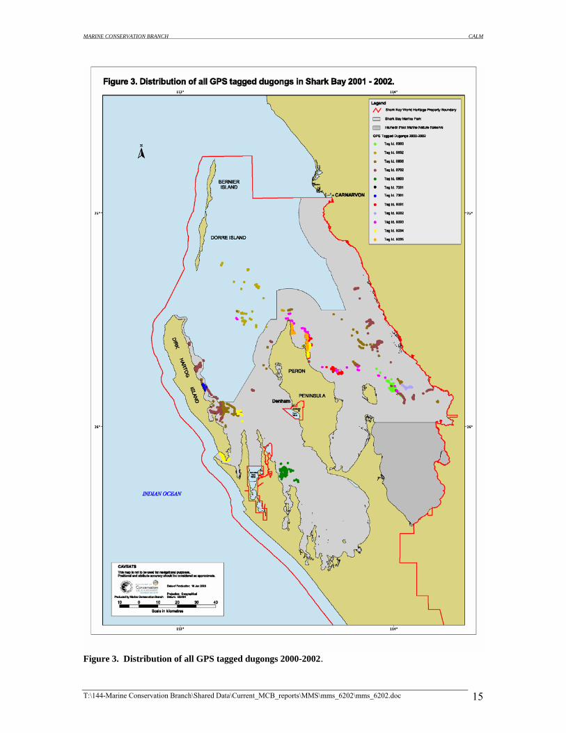
3. RESULTS Results showing the distribution of all tagged animals are presented as a series of maps (Figures2-
4). Figure 2 shows the distribution of dugongs tagged with satellite PTT’s while Figure 3 presents
the distributions of all animals tagged with GPS tags. Figure 4 shows the combined distribution
of all tags. All maps show current Marine Park, Nature Reserve and World Heritage Boundaries.
Details of tags deployed and the sex of each animal along with deployment duration of each tag
are presented in table 2.
Table 2. Details of dugongs tagged during the period March 2000 – August 2002 UNIT ID TAG
TYPE
SEX DEPLOYMENT
DATE
RETREIVAL
DATE
5534
5519
5536(1)
5536(2)
5065
5535
5537
1311
8001
8002
8003
8004
8005
7301
7001
0803
0702
0606
0602
0603
PTT
PTT
PTT
PTT
PTT
PTT
PTT
PTT
GPS
GPS
GPS
GPS
GPS
GPS
GPS
GPS
GPS
GPS
GPS
GPS
M
M
M
M
M
F
M
M
M
M
F
F
M
F
M
M
F
M
M
M
23/03/2000
22/03/2000
23/03/2000
06/04/2000
22/03/2000
23/03/2000
22/03/2000
16/05/2001
15/08/2000
16/08/2000
16/08/2000
17/08/2000
17/08/2000
18/09/2001
20/09/2001
21/03/2002
17/06/2002
18/06/2002
19/06/2002
20/06/2002
25/10/2000
11/12/2000
04/04/2000
28/05/2000
05/04/2000
23/10/2000
16/08/2000
01/07/2001
05/10/2000
04/10/2000
03/10/2000
21/09/2000
01/10/2000
28/09/2001
28/09/2001
11/05/2002
25/07/2002
09/08/2002
04/07/2002
02/07/2002
T:\144-Marine Conservation Branch\Shared Data\Current_MCB_reports\MMS\mms_6202\mms_6202.doc 10
MARINE CONSERVATION BRANCH CALM
4. METADATA The metadata associated with the distribution of tagged dugongs within the Shark Bay World
Heritage Property presented in the map series are included in the Appendix.
5. DATA MANAGEMENT 5.1 REPORT
Hard copies of this report will be held at the following locations:
1. Marine Conservation Branch, Department of Conservation and Land Management, 47 Henry Street, Fremantle Western Australia, 6160. Ph: (08) 9336 0100 Fax: (08) 9430 5408.
2. Woodvale Library, Science and Information Division, Ocean Reef Road, Woodvale, Western Australia, 6026. Ph: (08) 9405 5100 Fax: (08) 9306 1641.
3. Archives, Woodvale Library, Science and Information Division, Ocean Reef Road, Woodvale, Western Australia, 6026. Ph: (08) 9405 5100 Fax: (08) 9306 1641.
4. Shark Bay District, Department of Conservation and Land Management, 67 Knight Terrace, Denham, Western Australia, 6537. Ph: (08) 9948 1208 Fax: (08) 9948 1024.
5. Midwest Region, Department of Conservation and Land Management, 193 Marine Terrace, Geraldton, Western Australia, 6530. Ph: (08) 9921 5955 Fax: (08) 9921 5713.
Digital copies of this report will be held at the following:
1. The Marine Conservation Branch server: Shareddata on ‘Calm-frem-1’ [T:\144-Marine Conservation Branch\Shared Data\Current_MCB_reports\MMS\mms_6202]
2. The Marine Conservation Branch server full backup DAT tape: Shareddata on ‘Calm-frem-1’ [T:\144-Marine Conservation Branch\Shared Data\Current_MCB_reports\MMS\mms_6202]
3. CD ROM held at Marine Conservation Branch and Archives (Woodvale Library, Science and Information Division):
CD-ROM [mms_6202] 5.2 GIS LAYERS The data presented in the form of GIS information layers will be stored digitally in the Marine
Information System (MIS) on the MCB Server and the MCB Server full backup DAT tape.
T:\144-Marine Conservation Branch\Shared Data\Current_MCB_reports\MMS\mms_6202\mms_6202.doc 11
MARINE CONSERVATION BRANCH CALM
6. REFERENCES Anderson, P. K. (1982a). “Studies of dugongs at Shark Bay, Western Australia. II. Surface and subsurface observations.” Australian Wildlife Research 9: 85-99. Anderson, P.K. (1982b) "Studies of dugongs at Shark Bay, Western Australia I. Analysis of Population size, composition and habitat use on the basis of aerial survey." Australian Wildlife Research 9: 69-84. Anderson, P. K. (1986). “Dugongs of Shark Bay, Australia- seasonal migration, water temperature and forage.” National Geographic Research 2: 473-90. Anderson, P.K. (1998) "Shark Bay dugongs (Dugong dugon) in summer II: Foragers in a Halodule-dominated community". Mammalia 62: 409-425. De Iongh, H.H. (1996) "Plant-Herbivore interactions between seagrasses and dugongs in a tropical small island ecosystem". PhD thesis, Centre for Environmental Science. Leiden University, Netherlands, 205p.
Holley, D.K. (2002a,b,c) "Movements and community based conservation of dugongs - Deployment and retrieval of location recording devices on dugongs". Field Program Reports. Unpublished reports. Limpus, C.J. (1978) "The reef: uncertain land of plenty". Richmond Hill Press, Richmond, Victoria. Department of Conservation and Land Management (1996). "Shark Bay Marine Reserves - Management Plan 1996-2006". Perth, National Parks and Nature Conservation Authority: 100. Marsh, H. and G. B. Rathbun (1990). “Development and application of conventional and satellite radio tracking techniques for studying dugong movements and habitat use.” Australian Wildlife Research 17: 83-100. Marsh, H., R. I. T. Prince, et al. (1994). “The distribution and abundance of the dugong in Shark Bay, Western Australia.” Wildlife Research 21: 149-161. Preen, A.R., Marsh, H., Lawler, I.R., Prince, R.I.T., and Shepherd, R. (1997). "Distribution and abundance of dugongs, turtles, dolphins and other megafauna in Shark Bay, Ningaloo Reef and Exmouth Gulf, Western Australia". Wildlife Research 24: 185-208. Preen, A. (2001). "Dugongs, boats, dolphins and turtles in the Townsville-Cardwell region and recommendations for a boat traffic management plan for the Hinchinbrook Dugong Protection Area". Great Barrier Reef Marine Park Authority: 92.
T:\144-Marine Conservation Branch\Shared Data\Current_MCB_reports\MMS\mms_6202\mms_6202.doc 12
MARINE CONSERVATION BRANCH CALM
FIGURES
T:\144-Marine Conservation Branch\Shared Data\Current_MCB_reports\MMS\mms_6202\mms_6202.doc 13

MARINE CONSERVATION BRANCH CALM
Figure 2. Distribution of all PTT tagged dugongs in Shark Bay 2000-2002.
T:\144-Marine Conservation Branch\Shared Data\Current_MCB_reports\MMS\mms_6202\mms_6202.doc 14
MARINE CONSERVATION BRANCH CALM
Figure 3. Distribution of all GPS tagged dugongs 2000-2002.
T:\144-Marine Conservation Branch\Shared Data\Current_MCB_reports\MMS\mms_6202\mms_6202.doc 15

MARINE CONSERVATION BRANCH CALM
Figure 4. Combined distribution of dugongs 2000-2002.
T:\144-Marine Conservation Branch\Shared Data\Current_MCB_reports\MMS\mms_6202\mms_6202.doc 16

MARINE CONSERVATION BRANCH CALM
APPENDICES
T:\144-Marine Conservation Branch\Shared Data\Current_MCB_reports\MMS\mms_6202\mms_6202.doc 17
MARINE CONSERVATION BRANCH CALM
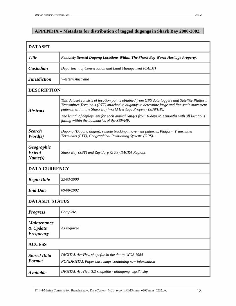
APPENDIX – Metadata for distribution of tagged dugongs in Shark Bay 2000-2002.
DATASET
Title Remotely Sensed Dugong Locations Within The Shark Bay World Heritage Property.
Custodian Department of Conservation and Land Management (CALM)
Jurisdiction Western Australia
DESCRIPTION
Abstract
This dataset consists of location points obtained from GPS data loggers and Satellite Platform Transmitter Terminals (PTT) attached to dugongs to determine large and fine scale movement patterns within the Shark Bay World Heritage Property (SBWHP).
The length of deployment for each animal ranges from 10days to 11months with all locations falling within the boundaries of the SBWHP.
Search Word(s)
Dugong (Dugong dugon), remote tracking, movement patterns, Platform Transmitter Terminals (PTT), Geographical Positioning Systems (GPS).
Geographic Extent Name(s)
Shark Bay (SBY) and Zuytdorp (ZUY) IMCRA Regions
DATA CURRENCY
Begin Date 22/03/2000
End Date 09/08/2002
DATASET STATUS
Progress Complete
Maintenance & Update Frequency
As required
ACCESS
Stored Data Format
DIGITAL ArcView shapefile in the datum WGS 1984 NONDIGITAL Paper base maps containing raw information
Available DIGITAL ArcView 3.2 shapefile - alldugong_wgs84.shp
T:\144-Marine Conservation Branch\Shared Data\Current_MCB_reports\MMS\mms_6202\mms_6202.doc 18

MARINE CONSERVATION BRANCH CALM
Format Type
Access Constraint
Data available for external use subject to transfer fee and license conditions. Data is not to be distributed without authorisation from CALM. Contact CALM’s database administrator for further details.
DATA QUALITY
Lineage
Dataset history.
1. Determination of dugong movement patterns within the SBWHP from GPS and satellite telemetry represents a first for the use of this technology in Western Australia. Methods for data capture and tag attachment developed by CALM in conjunction with members of the Shark Bay Yadgalah Aboriginal Corporation, James Cook University and Edith Cowan University.
2. #Accumulated data has been obtained from three different types of location units attached to the tail flukes of dugongs. Satellite-monitored platform transmitter terminals (PTT) and generation II combination GPS/PTT units. (Telonics, Mesa, Arizona). Geographical Positioning System (GPS) data loggers (Lotek Engineering Inc. Ontario, Canada).
3. PTT's are transmitter platforms that transmit signals at regular intervals that are received by Service Argos receivers aboard NOAA polar-orbiting environmental satellites. At least two satellites are simultaneously in service on sun-synchronous, polar, circular orbits at 850 km altitude, providing full global coverage. Locational accuracy is dependant on signal strength and satellite coverage.
4. Attributes recorded from the PTT units include: Location class, date, time-Western Standard Time and Lat/Long in milliseconds.
5. The GPS units each with an eight-channel receiver log a unit’s position from pulses received from the navstar series of satellites. The GPS units can be user programmed to obtain a position at a rate of between 5min-6hours
6. Attributes recorded on the Lotek GPS units include: Lat/Long-in milliseconds, Date, Time-Western Standard Time, Temperature- Degrees Celcius. Attributes on the Telonics Gen II units include; Lat/Long-in milliseconds, date, Time-Western Standard Time, Temperature- Degrees Celcius.
7. An accuracy attribute is recorded against each location.
8. Deployment and retrieval dates for each unit type are listed below:
T:\144-Marine Conservation Branch\Shared Data\Current_MCB_reports\MMS\mms_6202\mms_6202.doc 19

MARINE CONSERVATION BRANCH CALM
PTT UNIT: DATE DEPLOYED DATE RETREIVED
5519 22/03/2000 11/12/2000
5065 22/03/2000 05/04/2000
5534 23/03/2000 25/10/2000
5536(1) 23/03/2000 04/04/2000
5536(2) 06/04/2000 28/05/2000
5535 23/03/2000 23/10/2000
5537 22/03/2000 16/08/2000
1311 16/05/2001 01/07/2001
GPS UNIT: DATE DEPLOYED DATE RETREIVED FIX ACQUISITION RATE
8001 15/08/2000 05/10/2000 15 MINUTES
8002 16/08/2000 04/10/2000 15 MINUTES
8003 16/08/2000 03/10/2000 15 MINUTES
8004 17/08/2000 21/09/2000 15 MINUTES
8005 17/08/2000 01/10/2000 15 MINUTES
7301 18/09/2001 28/09/2000 20 MINUTES
7001 20/09/2001 28/09/2001 20 MINUTES
0803 21/03/2002 11/05/2002 15 MINUTES
0807 17/06/2002 25/07/2002 15 MINUTES
0606 18/06/2002 09/08/2002 15 MINUTES
0602 19/06/2002 04/07/2002 15 MINUTES
0603 20/06/2002 02/07/2002 15 MINUTES
9. Data are downloaded from the GPS tags in the datum WGS 1984 via a link unit, in a comma delimited file (.csv) Data are then converted into a text delimited file (.txt) and imported in ArcView and converted into shapefiles (.shp). For the PTT units, data are retrieved from service Argos in a spreadsheet format in the datum WGS 1984, then imported into ArcView in the same manner and converted into shapefiles.
Positional Accuracy
1. The two unit types used in determining dugong locations have a varying degree of spatial resolution. PTT units have a degree of error dependant upon satellite strength and location. For PTT location accuracy, service Argos has a location class attribute. The resolution associated with each class is listed below.
T:\144-Marine Conservation Branch\Shared Data\Current_MCB_reports\MMS\mms_6202\mms_6202.doc 20

MARINE CONSERVATION BRANCH CALM
CLASS ESTIMATED ACCURACY IN
LATITUDE AND LONGITUDE.
3 <150m
2 150m - 350m
1 350m - 1000m
0 >1000m
2. With the removal of Selective Availability GPS units’ positional accuracy is estimated at <10m.
Attribute Accuracy
Attributes for this dataset are consistent with CALMs Marine Information System standards and values are drawn directly from original download files (see additional metadata)
Logical Consistency
All points are labelled correctly with values drawn from the original download files (see additional metadata).
Completeness The data set will be upgraded as more units are deployed and retrieved.
CONTACT INFORMATION
Contact Organisation Department of Conservation and Land Management, Marine Conservation Branch
Contact Position Marine Zoologist.
Mail Address 1 47 Henry Street
Mail Address 2
Suburb or Place or Locality
Fremantle
State or Locality 2 WA
Country Australia
Postcode 6160
Telephone 08 9336 0121
T:\144-Marine Conservation Branch\Shared Data\Current_MCB_reports\MMS\mms_6202\mms_6202.doc 21

MARINE CONSERVATION BRANCH CALM
Facsimile 08 9430 5408
Electronic Mail Address [email protected]
METADATA DATE
Metadata Date January 2003
ADDITIONAL METADATA
Additional Metadata
Original download files have been burnt to CD and are held in the CALM\MCB\MIS CD library, 47 Henry street Fremantle, Western Australia, 6160.
T:\144-Marine Conservation Branch\Shared Data\Current_MCB_reports\MMS\mms_6202\mms_6202.doc 22