discover bannockburn conservation area - ausable … · discover ... bannockburn conservation area....
TRANSCRIPT
1
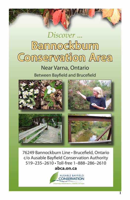
Discover ...Bannockburn
Conservation Area Near Varna, Ontario
Between Bayfield and Brucefield
76249 Bannockburn Line • Brucefield, Ontarioc/o Ausable Bayfield Conservation Authority519–235–2610 • Toll-free 1–888–286–2610
abca.on.ca

The Ausable Bayfield Conservation Authority (ABCA) purchased Bannockburn Conservation Area from Grant Webster in 1973 to protect the Bayfield River valley and provide habitat for wildlife.
This 62–acre (25–hectare) conservation area is open year-round and has six different natural communities: Wet Meadow; Eastern White Cedar Forest; Bannockburn River and Walden Creek; Deciduous Forest; Old Field and Mixed Scrub; and Marsh.
Whatever the season, the rich variety of natural communities awaits you. In spring, look for wildflowers on the forest floor and birds migrating from their winter homes. By summertime, the conservation area is alive with wildlife and new growth in plants and trees. Along the trail, watch for tracks and signs of wildlife such as fur, feathers and scat. Autumn is a beautiful time of year with the fall colours of the trees along with Goldenrod and Asters growing in the wet meadow and old field ecosystems. In winter, the coniferous forest provides food and shelter for deer, rabbits, squirrels, and winter birds.
Permitted activities in Bannockburn Conservation Area include hiking, fishing and bird watching. Hunting and use of motorized vehicles such as snowmobiles, ATVs or dirt bikes are not allowed. Take nothing but pictures and leave nothing but footprints. Admission is free. Ausable Bayfield Conservation welcomes donations to cover the costs of ongoing maintenance. Visit abca.on.ca for more information.
One main trail leads from the parking into the conservation area. Please stay on the trails to protect the natural environment. The first 500 metres of trail consists of accessible boardwalks over the Bannockburn River and Walden Creek. It stops at a small rest area at Point of Interest Number 4 (please refer to map).
The trails throughout the rest of the conservation area take you through windy and hilly terrain including a few stairs and boardwalks. Allow at least an hour to hike the outer loop, which is about two kilometres in length. The outer loop includes hiking through the six natural communities and includes the coniferous forest and marsh. To take the short loop, turn right at Point of Interest Number 10 (refer to map), a leisurely hike on the short loop that takes about 40 minutes.
2
Discover ... Bannockburn Conservation Area
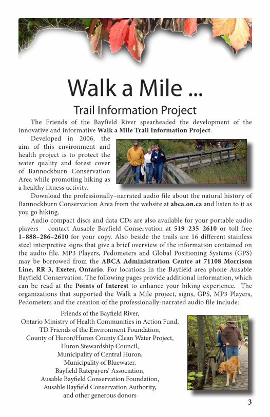
The Friends of the Bayfield River spearheaded the development of the innovative and informative Walk a Mile Trail Information Project.
Developed in 2006, the aim of this environment and health project is to protect the water quality and forest cover of Bannockburn Conservation Area while promoting hiking as a healthy fitness activity.
Download the professionally–narrated audio file about the natural history of Bannockburn Conservation Area from the website at abca.on.ca and listen to it as you go hiking.
Audio compact discs and data CDs are also available for your portable audio players – contact Ausable Bayfield Conservation at 519–235–2610 or toll-free 1–888–286–2610 for your copy. Also beside the trails are 16 different stainless steel interpretive signs that give a brief overview of the information contained on the audio file. MP3 Players, Pedometers and Global Positioning Systems (GPS) may be borrowed from the ABCA Administration Centre at 71108 Morrison Line, RR 3, Exeter, Ontario. For locations in the Bayfield area phone Ausable Bayfield Conservation. The following pages provide additional information, which can be read at the Points of Interest to enhance your hiking experience. The organizations that supported the Walk a Mile project, signs, GPS, MP3 Players, Pedometers and the creation of the professionally-narrated audio file include:
Friends of the Bayfield River,Ontario Ministry of Health Communities in Action Fund,
TD Friends of the Environment Foundation,County of Huron/Huron County Clean Water Project,
Huron Stewardship Council,Municipality of Central Huron,
Municipality of Bluewater,Bayfield Ratepayers’ Association,
Ausable Bayfield Conservation Foundation,Ausable Bayfield Conservation Authority,
and other generous donors3
Walk a Mile ...Trail Information Project
1. The Wet Meadow Community 81°34’23.2”W 43°32’31.0”NThe plants found here are tough and can endure extreme weather. As these plants grow, die, and decay, they provide added nutrients to the soil improving growing conditions for larger plants such as trees and shrubs. Meadow habitat similar to this is rare in Huron County. To maintain this area, Ausable Bayfield Conservation cuts down shrubs and trees every 10 years. Highbush Cranberry shrubs were planted in this meadow to provide late winter food for birds. The red berries are quite sour when they ripen but the process of freezing and thawing makes them sweet.
2. Walden Creek 81°34’25.0”W 43°32’26.3”NFishing is a poplar activity in the cold water of this creek. Fish such as the Rainbow Trout and Salmon will swim up this creek to lay their eggs. The young fish will grow and develop here. Upstream, there are not as many trees and shrubs growing along the creek and rainwater along with soil flow directly into the creek. The flow of the creek can change severely. In the summer, there may just be a trickle of water in this creek to flooding in the springtime or after heavy rains. In 1986, flood waters were as high as the bottom of the bridge. In Ontario, rules are in place to prevent building in flood plains to protect people’s lives and reduce property damage from flooding.
3. Bannockburn River 81°34’24.6”W 43°32’27.4”NThis river drains more than 210 square kilometres of land and is the largest branch of the Bayfield River. The river travels through private woodlots and farms until it reaches the Bayfield River, which is just one kilometre downstream. Many landowners have planted trees and shrubs along the river and this has helped maintain good water quality. As plants take up water from their roots, they also filter out pollutants. Plants also keep the water cool by providing shade. Many different aquatic species live in the river. Clean water is important for people as well as plants and animals.
4. Bannockburn Tributaries 81°34’27.0”W 43°32’25.4”NThe rolling landscape found here is the result of the last glacier in the area melting. As the glacier melted, the water carved the valley where the Bannockburn River flows. This valley and a number of smaller valleys slice through the clay, sand, and gravel of the Wyoming moraine (material left behind by the glacier). The Bayfield River flows west taking a number of twists and turns. This water ultimately flows into Lake Huron. What happens upstream affects the environment downstream.5. Eroding Creek Banks 81°34’30.9”W 43°32’24.8”NErosion is a natural process where soil is taken away by water or wind to another location. The soil here is mainly Burford Loam, which has a stony loam quality allowing for good drainage. However, this soil is low in nutrients. High amounts of soil in the creek can delay the growth and development of many aquatic species. Planting trees and shrubs along creek banks can help stop erosion. Less soil in the creek improves the overall quality of water.4
Points of Interest

6. The Spring 81°34’31.0”W 43°32’23.7”NListen carefully to hear the sound of water flowing at this natural spring. Natural springs and well waters come from aquifers. Aquifers are underground areas of soil or rock with large amounts of water. Many rural communities depend on aquifers for drinking water. Pollution can filter through the soil and enter wells. Wells that are improperly constructed, operated, or maintained may also pollute wells. Contact Ausable Bayfield Conservation staff to find out more about the care or decommissioning of wells at 519-235-2610 or toll-free 1-888-286-2610.
7. The Cathedral Forest 81°34’30.1”W 43°32’21.7”NIn this habitat, the trees are very tall. They grow towards the sun, which gives them energy and food. Like people, trees can catch infections and diseases. Infections and disease enter through damaged tree bark. Unfortunately, in Middlesex, Huron, and Perth counties, the Hickory trees are dying because of an infestation of Hickory Bark Beetle, which kills the tree from the inside out. For safety reasons, the ABCA cuts down the dead trees along the trails. Dead trees away from the trails fall naturally as part of the forest life cycle.
8. Arrow pointing right 81°34’36.1”W 43°32’20.4”N
9. The Forest Valley 81°34’38”W 43°32’22.1”NIn the valley, black cherry and apple trees are common. This forest has everything animals need, which includes food, water, shelter, and space. Fallen trees and brushpiles create excellent shelter for animals. The collection of stumps, leaves and the thin layer of topsoil on the forest floor may appear lifeless. However, the earth under your feet is alive with many soil creatures that change dead plants and animals on the forest floor into rich soil. Soil creatures such as worms, beetles, and ants are busy creating new soil everyday. Soil is the basis of life.
10. Arrows: Left to main trail; right to parking lot 81°34’38.1”W 43°32’25.1”NThis is the halfway point of the main trail. You may choose to head back to the parking lot or continue walking through the conservation area. To visit the pine plantation and marsh on the main trail, turn left here and then right. Just before you head down the hill to the evergreen plantations, see if you can detect the patterns in the plantations. The trees were planted in blocks to maximize the amount of edge around the new forest. Over the years, the blocks of plantations have grown together.11. Pioneers of the Plant World 81°34’39.0”W 43°32’25.0”NThis old field is warm in the summer and cold in the winter. Considered a weed by many, hawthorns are used by many birds for food and shelter. The pointy thorns protect the nests from predators and the fruit, known as haw apples, are nutritious. This area consists of gently sloping open grassland, scattered with clumps of Hawthorn, Wild Crabapple, Willow, and Poplar. Pioneer farmers used to cut through the forest to get water from the river. Cattle once grazed in the fields around here. Being on the edge of the forest, lots of wildlife live in this area.
5
Points of Interest

6
12. Conifer Plantation 81°34’39.2”W 43°32’26.9”NAn area of land that has been replanted with trees is called a plantation. As trees grow, they grow closer together. Thinning is needed to open up the canopy so more sunlight can reach the forest floor. Seeds carried by wind, insects, and birds fall to the forest floor. On the forest floor, seeds get sunlight, water, soil, and air needed to grow. Conifers such as pine, spruce, and cedar can tolerate the harsh conditions of an open field and help increase nutrients in soil for deciduous trees like Maple, Ash, Beech, Oak and Cherry.
13. The Marsh – Nature’s Sponge 81°34’40.8”W 43°32’31.8”NA wetland is an area of land covered with water for all or part of the year. Seventy per cent of Ontario’s original wetlands have been filled for development, drained for food production, or polluted by toxic runoff. Marshes are a type of wetland with some open water and plants such as cattails growing near the shore. Marshes improve water quality since plants use nitrogen and phosphorus entering the water through runoff. Without marshes to soak up the water, like a sponge, there is increased chance of flooding.
14. Nature’s Kidneys 81°34’32.7”W 43°32’31.6”NWater slows down as it flows into a marsh. As water flows across a marshy area, soil settles out of the water and plants use extra nutrients. Therefore, the water is much cleaner when it flows out of the marsh. In a watershed, a marsh performs the same function as a kidney does in your body. Luckily, people are realizing the vital role of ‘nature’s kidneys’ and are creating artificial wetlands to filter runoff before it reaches rivers and lakes. Talk to Ausable Bayfield Conservation staff about wetland projects.
15. The Fern Gully 81°34’30.5”W 43°32’28.4”NA typical fern leaf has a stalk and an expanded blade. Most ferns reproduce by the spores found in dark-coloured spore cases, located on the underside of the leaves. The spores mature between July and November and are spread by the wind and water. In a good environment, spores grow into a little plant just a few millimetres in size. Although this little plant lacks true roots, a stem and leaves, it has the important male and female organs on it. After, the little plant becomes fertilized small leaves appear, roots form and it grows into a new fern plant.
16. Arrow pointing right 81°34’30.0”W 43°32’26.7”NFrom here, you can make your way back to the parking lot. We hope you have enjoyed your time at Bannockburn Conservation Area. If you would like to help protect and maintain the property, please donate to Ausable Bayfield Conservation, 71108 Morrison Line, RR 3 Exeter, ON N0M 1S5. Congratulations! By walking these trails, you have increased your activity level and improved on your physical fitness. Come back soon for your next Bannockburn adventure.
Points of Interest

Trees / Shrubs
ConiferousEastern HemlockRed PineTamarackEastern White CedarEastern White PineWhite Spruce
DeciduousAmerican BeechAutumn OliveBalsam PoplarBasswoodBitternut HickoryBlack CherryBlack LocustBlack MapleBlack WillowBlack WalnutBlue–BeechBuckthornButternutBuckthornDogwoodHawthornHighbush CranberryHoneysuckleHop-HornbeamMountain AshNinebarkRed MapleRussian–OliveSilky DogwoodSugar MapleSumacTrembling AspenWhite AshWhite BirchWhite ElmWhite OakWild CrabappleWild GrapeYellow Birch
WildflowersAlfalfaBindweedBittersweet Nightshade Black-Eyed SusanBloodrootBroad-Leafed ArrowheadBurr CucumberButtercup
Canada AnenomeChicoryColumbineCommon Blue VioletCommon BurdockCommon CattailCommon DandelionCommon St. John’s-WortCommon Viper’s BuglossCommon Wood SorrelCommon YarrowDaisy FleabaneDowny Yellow VioletFalse Solomon’s SealGoldenrodJack-In-The-PulpitMarsh MarigoldMay AppleOxeye DaisyPale Touch-Me-NotPoison IvyScotch ThistleSedgeSkunk CabbageSpotted Touch-Me-NotSpring BeautySwamp MilkweedTrout LilyWhite TrilliumWild GingerWild Strawberry
Non-flowering PlantsBeard LichenBritish SoldiersBurned Ground MossChristmas FernCinnamon FernCommon Bracken FernDelicate Fern MossHay–Scented FernHorsetailsIndian Brave MossMaiden Hair FernMale Fern
Pyxie CupsShell LichenShiny MossSilky Fork MossSilver MossSlender Moss
BirdsAmerican GoldfinchBaltimore OrioleBelted KingfisherBlack Capped ChickadeeBlue JayBobwhiteBrown headed CowbirdCanada GooseCardinalCatbirdCedar WaxwingCommon CrowCommon GrackleDowny WoodpeckerEastern KingbirdField SparrowGreat Blue HeronGreat Horned OwlHairy WoodpeckerHouse SparrowHouse WrenKilldeerLong Eared OwlMallardMarsh HawkMourning DoveNashville WarblerPileated WoodpeckerNorthern OrioleRed Headed WoodpeckerRed Tailed HawkRed Winged BlackbirdRing–Necked PheasantRobin
Ruffed GrouseScarlet TanagerSpotted SandpiperTowheeTree SwallowTurkey VultureWhite Breasted Nut HatchWhite Throated SparrowWood ThrushWood DuckYellow Rumped WarblerWoodcock
MammalsBatBeaverChipmunkCoyoteEastern ChipmunkEastern CottontailEastern Grey Squirrel Deer Mouse Field Mouse GroundhogMeadow VoleMinkMuskratRacoonRed FoxRed SquirrelShorttailed–WeaselSnowshoe HareStriped SkunkWhite–Tailed Deer White–Tailed Jack Rabbit
Reptiles and AmphibiansGarter SnakeLeopard FrogPainted TurtleRed Backed Salamander
FishBlue GillBrook TroutBrown TroutChubDaceDarterRainbow TroutSalmonSmallmouth BassSunfish
Species List
7

Conservation Area Rules• Stay on the trails• Do not injure, damage or remove any structure, animal or plant• Do not litter and pack all garbage out• Dogs and other pets must be under control at all times and on a leash not exceeding two (2) metres in length; please clean up after your pet• Fires are not permitted • Motorized vehicles are not permitted• Thank you for complying with these rules for the benefit of all!8
Take only photos, leave only footprints