director's comment - missouri department of natural resources
TRANSCRIPT


Director's Comment
I imagine that most of you have been hearing and reading for some time now about the State of Missouri's budget crisis. In Missouri, and most other states, all levels and branches of government, as well as our universities and public schools, are struggling to make every nickel and dime stretch. The same problem seems to be making its way into our homes and businesses as well.
State agencies are feeling the impacts of Missouri's financial crisis. We are no exception. Our department's general revenue has been cut 60 percent since fiscal year 2001. And, because we're only 4 percent general revenue today, the cuts we're taking are hitting very deep. Unfortunately, our Outreach and Assistance Center, our Geological Survey and Resource Assessment Division and our regional offices depend on general revenue.
One immediate impact of the cuts is that our Outreach and Assistance Center will publish three rather than four issues of Missouri Resources this year. This is our Spring / Summer 2003 issue. Our fall and winter issues will mail in mid-September and mid-January.
The center has also lost several staff positions in its State Historic Preservation Office, which will hamper our ability to protect Missouri's cultural and historic resources. We will be challenged to keep up with the demand for processing applications for listing properties on the National Register of Historic Places, reviewing state and federal tax credit projects, processing Section 106 reviews and serving Certified Local Governments.
Our Geological Survey and Resource Assessment Division is also impacted by general revenue cuts. The division celebrates its 150th anniversary in 2003. Its heritage dates back to 1853 when Gov. Sterling Price created the first Geological Survey in Missouri. It has provided data-intensive, science-oriented technical information to Missouri citizens, especially in geology, hydrology, surveying and dam construction for many years now. This year's budget impacts will decrease our ability to lead Missouri in natural resource management, rather than simply reacting to issues as they arise.

To help reduce administrative costs of the regional offices, we are closing our Jefferson City Regional Office on June 30, 2003. It was not an easy decision to close a regional office. We chose to close JCRO because there are opportunities here in Jefferson City for displaced staff to move into vacant positions and not have to relocate themselves or their families. It is important to me to retain as much experience and skill in the department as possible and disrupt peoples lives in the smallest way possible.
That said, I certainly understand that no matter what happens, these deep budget cuts will impact our ability to provide the levels of service we have in the past. The service we provide the public will suffer as a result.
I anticipate that we will see more withholdings and cuts as the economy continues to struggle. We will not be able to maintain the levels of service to Missouri citizens that we have in the past. However, we will continue to do our very best to protect your natural, cultural and energy resources as we move through this period of transition.
Steve Mahfood, Missouri Department of Natural Resource

Old Cell Phones Get A Second Chance
According to the U.S. Environmental Protection Agency (EPA), by 2005, cell phone users will discard 130 million used cell phones annually. This could add 65,000 tons to the nation's waste stream each year. Hel-lo!
The EPA says that cell phones, because of their short useful life, are accumulating two to three times faster than other types of waste. In some landfills, toxic elements such as lead and brominated flame retardant that are used in cell phone manufacture may threaten water quality. In January 2003, EPA launched a "Plug-In to Recycling Campaign," with several industrial and business partners to encourage the reuse and recycling of consumer electronics.
Inform, a national environmental research group, reports that Australia has launched the first nationwide take-back program for recycling cell phones and the European Union may soon require the manufacturers of electronics containing toxic components to take responsibility for such materials. A full report on cell phones in the waste stream can be found at [www.informinc.org].
Several charities are collecting old cell phones. Some are reconditioned and sold in other countries to raise money for charitable efforts here. Others are made available to combat domestic violence. Motorola, Radio Shack, Sprint and Verizon currently operate take-back programs.
To learn more about cell phone collections, check out [www.donateaphone.com], sponsored for the past three years by the Cellular Telecommunications and Internet Association's non-profit Wireless Foundation. Further information on the EPA campaign can be found at [www.epa.gov/epaoswer/osw/conserve/plugin/index.htm].

Randy Taylor and Earl Nelson are both farmers from Wright County. They both operate dairy farms and they both look toward the Wright County Soil and Water Conservation District (SWCD) for assistance with their farming operations. The assistance they ask for comes in the form of equipment that the local district office rents out to individuals in their county. Located in Hartville, the district owns four no-till drills, seven sprayers, a broadcast seeder, mulcher, harrow, agitator, pumping equipment, tank wagon, post driver, post digger and roller. All of these items are rented out by the district to landowners in their county.
"It is much more cost-effective to be able to rent the equipment from the district rather than purchase the equipment especially when you are first starting out," said Randy Taylor. The district charges for the use of their equipment, receiving six dollars an acre for the use of their no-till drills. With the high cost of farm equipment, renting makes sense to many farmers across the state.
When renting equipment, one of the first concerns is keeping the equipment operational. "Generally speaking, our farmers take good care of the district's equipment," said Gary Raney,

district technician for Wright SWCD. "We have several landowners in the county that will fix the equipment if they notice that there is something wrong with it." One such landowner is Earl Nelson. "Over the years, I have probably used every piece of equipment that the district rents out," Nelson said. "If I see a problem with the equipment I rent from them, I try to fix it." This was the case on the day Nelson was interviewed for this story. He had the district's agitator pulled into his shop and was busily repairing it.
In a year's time, according to Wright County records, 137 landowners used the district's four no-till drills. District personnel state that the drills are kept busy during the seeding periods and the pumping equipment is usually rented out in all but the winter months.
Renting equipment to landowners is not unique to the Wright County SWCD. Districts all over the state rent out equipment to the landowners in their county. No-till drills and straw mulchers are the most common items rented out by the districts. When districts see a need for a piece of equipment that would benefit landowners, district boards determine if the need is great enough to justify its purchase. This situation is a win-win for the landowners and the districts. The landowner is able to use the equipment without having to buy it and the district is able to increase services to the county through the additional revenue.
One hundred twenty miles to the north, Monroe County also rents out several pieces of equipment. Their list includes two mulchers, a seeder, a rotary cutter and a no-till drill, among other items. They bought their first piece of equipment in the mid-1980s. At that time, the district noticed that they were not getting very good stands of grass on the waterways and gullies were forming. The district decided to require mulching on the waterways that were built.
To help the farmers with this process, the district purchased a mulcher. At first they bought a mulcher for small bales but soon realized they needed a mulcher for the round bales. Both mulchers are rented by both landowners and contractors in the district.
It is an ongoing process to evaluate equipment needs of district landowners while justifying the purchase of new machinery. "Each year the district reviews each piece of equipment to see if the repair bills exceed the income the piece of equipment generated," Lena Sharp, district manager for the Monroe County SWCD said. "The

district used to own three no-till drills, but with more farmers buying their own drills, the district decided to reduce the drills they rent out. It is basically an ongoing process to access our equipment each year," Sharp said.
Making equipment available to landowners in the county is just one of the services offered by the soil and water conservation districts. Along with equipment rentals, SWCDs also can provide technical assistance, information and education activities to interested customers.
District services to landowners have increased dramatically since the first passage of the one-tenth-of-one-percent parks and soils sales tax. One-half of the tax is administered by the Missouri Department of Natural Resources' Soil and Water Conservation Program for controlling soil erosion in the state. This is the primary funding for soil and water conservation districts. The funds are available for districts to hire office staff and technical personnel.
The districts also assist in administering three voluntary incentive programs, including a loan program which provides incentives to landowners who want to buy their own conservation equipment, a cost-share program and a watershed program. These programs are available to agricultural landowners that wish to control soil erosion or improve the quality of the water on their farms by using soil-conserving equipment and installing soil and water conservation practices. These programs assist landowners with costs associated with installing the practices according to the landowner's conservation plan.
The districts work closely with the U.S. Department of Agriculture's Natural Resources Conservation Service (NRCS), the lead technical advisor for the districts. The majority of districts also employ their own technician. The technical staff, along with the NRCS, assists landowners with developing soil-conservation plans on their farms. Plans also can be developed for nutrient or pest management. Technicians make field visits to determine the best practices available to help landowners. Technicians take surveying notes that are used for constructing individual conservation practices. These surveying

notes then are available to contractors to build the practices.
Soil erosion does not occur on agriculture land only. In the past, customers for the SWCDs have primarily been farmers, but in recent years the needs have expanded beyond the agricultural community. The districts are located in urban areas of the state as well. Here, the technical staff assist homeowners with issues such as erosion on their home lots. Reviewing and providing alternatives for runoff and erosion problems also are offered by the technical staffs.
Many of the districts also have extensive education programs geared toward different audiences. Environmental groups, landowners, farmers, contractors and children all have received information from the soil and water districts. Each year, thousands of people learn about soil and water conservation issues through the programs offered by SWCDs. Districts throughout the state develop tours or field days for specific audiences that can be directed to any age group. Soil and water conservation poster contests are a popular school activity and can nurture an early interest in district activities. The contest is available for grades K through 12. Activities directed toward high school students include soil judging, essay and grassland contests and state and national Envirothon.
If you have any questions on the services offered by your local soil and water conservation district, locate their number in your local directory they will be pleased to assist you. SWCD addresses and telephone numbers are listed on the Internet at [www.dnr.mo.gov/wpscd/swcp/districtmap/map_district_information.htm] or you can contact the Department of Natural Resources' Soil and Water Conservation Program at (573) 751-4932.
Jim Boschert is an environmental specialist in the department's Soil and Water Conservation Program.

It's 30 degrees and the wind is gusting to 20 miles per hour. You are 100 feet above the ground and still climbing. The cold steel rungs of the ladder are numbing your fingers, and your knees are beginning to feel the strain, but there are still 250 feet to climb before you can unclip your safety harness and go to work. This may not sound like a typical workday for a government official, but for two Air Pollution Control Program specialists with the Missouri Department of Natural Resources, it is just another day at the office. When a company must sample the exhaust from its smokestack, the department is there, and sometimes that means a long, cold climb.
Air pollution is no longer very obvious. In the early days of environmental regulation, the dark plumes from factory and power plant smokestacks were all the evidence needed to know that air pollution was occurring, but today it takes sophisticated stack testing to measure the emissions from most industries. Methods for this emission testing are spelled out in detail in Part 60 of the Code of Federal Regulations (CFR), the three pound, dog-eared, holy book of every stack tester.
A few states have their own air pollution testing crews, but Missouri, like most states, depends on private contractors for this work. The department rigorously observes their work to assure that the testing is done fairly and accurately. Air Pollution Control Program Specialist Doug Elley has been climbing stacks for 15 years. Elley and others travel from Jefferson City to industrial facilities all around

the state to oversee stack testing companies. Sometimes the testing is relatively simple. A sample probe in the stack draws out exhaust gas which is pumped to an instrument that measures the concentration of pollutants like nitrogen oxides, sulfur oxides, carbon monoxide and volatile organic compounds. This is virtually the same process as the emission testing of cars in the Gateway Clean Air Program in the St. Louis area.
A stack test begins to get complicated when a facility must demonstrate its actual rate of pollutant emissions rather than just their concentration. This involves carefully measuring the flow rate of exhaust gas in the stack. A rigorous method is used to divide the stack cross section into segments of equal area. The tester inserts a probe through ports in the stack wall and measures the velocity and temperature of exhaust gas. The average of these measurements multiplied by the total area of the stack and the concentration of pollutants will accurately measure the pollutant emission rate, but many things can go wrong. The stack area may be divided incorrectly. Out comes the CFR to settle the argument. The probe may be damaged, bent or not inserted straight. It may be leaking or the
instrument to which it is connected may not have been reset. The test report will not reveal these problems; they are all things which only an on-site test observer can catch.
If the stack test is to determine the emission rate of fine particles, it becomes even more complex. The test equipment, called a sampling train, draws a sample of exhaust gas from the stack through a filter and a calibrated meter which measures the volume of the sample. For the test to be accurate the sampling train must pull gas from the stack at the same velocity as the gas is flowing through the stack. This is called isokinetic sampling, and it must be done very carefully because the concentration of dust in the stack gas is often very low. At each of up to 24 sampling points in the stack, the tester will calculate the gas velocity and adjust the sampling rate accordingly. After the test run, the filter is preserved, the sampling probe is washed out carefully, and the wash collected to be dried and weighed with the filter at the lab. Again there is a real chance that mistakes will be made, so the Department of Natural Resources observer is there to watch, listen, take notes, and intervene if it looks like a problem is developing.
At the end of the test a leak check of the sampling train must show that no outside air was allowed to dilute the sample gas. The department observer will watch this leak check carefully to make sure that the test run will be acceptable. Elley travels to all

corners of the state and may spend three or four 12-hour days on the stack to assure that the highest quality test data is reported to the Department of Natural Resources.
It may seem that measuring quantities so small is hardly worth the effort, but emissions mount up at an amazing rate. If a factory emits only 5 pounds an hour around the clock it will pour out 22 tons of pollution each year. Emissions at this level do not even form a visible plume. Pollution travels amazing distances. Missouri's emissions may affect air quality in Chicago and Milwaukee. Twenty pounds an hour of fine particulate leaving a one foot-diameter stack 25 feet tall at 25 feet per second and 200 degrees Fahrenheit will travel more than a one-quarter of a mile before its concentration falls below the U.S. Environmental Protection Agency (EPA) standard of 150 micrograms per cubic meter.
Permits require stack emissions to meet these federal standards. Often control equipment such as a scrubber, fabric filter, electrostatic precipitator or vapor incinerator is installed to reduce emissions to the levels allowed by the permit. This control equipment is monitored during the stack test to set levels that will assure future compliance. A new plant must complete its stack testing within 6 months of start-up.
Later, when department regional office staff inspect the plant they can determine if the control equipment is functioning as it did during the stack test. Stack testing therefore provides a way to assure that pollutant sources remain in compliance with permit limits while they are operating. Department test observers spot check the control equipment during a stack test and make sure that its parameters are being recorded for future reference. With their many years of experience, they can sometimes spot problems in control devices that would cause the test to fail. If these problems can be fixed immediately, expensive tests will not have to be repeated, and high emissions can be prevented.
Many power plants and factories are equipped with continuous emission monitoring systems (CEMS) which constantly sample stack exhaust gas and record the levels of gaseous pollutants. Other monitors called continuous opacity monitoring systems (COMS) measure the

visual appearance of the stack gas as an indirect way to estimate the level of particulate emissions. The accuracy of CEMS must be proven at least once a year by being compared with independent instruments. This test, called a Relative Accuracy Test Audit (RATA), may take several days and must consist of at least nine runs done simultaneously on both instruments.
First, test observers make sure that instruments are calibrated, clocks are synchronized and that the plant is operating normally. Staff from the Kansas City and St. Louis Regional Offices observe many of the RATAs at nearby power plants with Air Pollution Control Program staff lending a hand from time to time. U.S. EPA acid rain regulations require particularly rigorous RATA testing at power plants. Coal fired power plants typically have the tallest smokestacks, usually 500 to 700 feet tall. The CEMS are usually installed at about 350 feet. Elevators have been installed on most
power plant stacks, but at a few, department observers must climb a ladder to the CEMS level. The view from that height is breathtaking, but remember to bring your lunch you do not want to make that climb twice.
Next time you drive past a tall smokestack you may see people busily scurrying around on a platform high above. It might be a Missouri Department of Natural Resources stack testing crew at work. You can wave to the test observers on the platform, but they will probably not respond. You see, we try our best not to look down.
Peter Yronwode is an air pollution control specialist with the Air Pollution Control Program. He, too, has been climbing industrial smokestacks for 13 years.

Letters
We have received and enjoyed our Missouri Resources for many years. Our son Gary always looks for our copy and likes to read everything he can about his home state. So, instead of sharing our copy, we would like to order a subscription for his wife Susi and him. We know they will enjoy receiving their own copy.
Enclosed is a check for $10 for a two-year subscription to be sent to their Illinois address.
Raymond and Wanda DeClue Farmington
Editor's Note:
A news brief in this issue, as well as an advisory on the Missouri Resources home page explains changes to our subscription schedule and revised out-of-state rates. Effective immediately, we will only publish three issues per year. Paid subscribers' rates and publishing schedules have been adjusted accordingly.
My family and I enjoy each issue of Missouri Resources. We are always making useful machinery and buildings out of material people throw away. Enclosed is a photo of an 8 ft. by 10 ft. storage shed just before I finished it. The entire building is made out of salvage material except for the floor and siding. When it is painted, I will have less than $400 cash in it. Your Winter 2001-02 issue had an article entitled "Choosing to Change," which was very interesting. One of the pictures showed salvage and surplus materials that appeared to be for sale. We have family members living in the Kansas City, Springfield and St. Louis areas and they would like to know where these Habitat for Humanity ReStores are.
Edward E. Martin California
Editor's Note:
Unfortunately, we do not have enough space to show Edward's excellent recycled-product shed, but are glad to provide information on the following Habitat For Humanity ReStores: Springfield, 4535 W. Chestnut Expwy., (417) 829-4001; Kansas City, 4701 Deramus, (816) 231-6889; and St. Louis, 3763 Forest Park Avenue, (314) 531-4155; Columbia, 1906 Monroe St., (573) 815-9836; and Jefferson City, 1420 Creek Trail Dr., (573) 635-6106.
Letters intended for publication should be addressed to "Letters," Missouri Resources, P.O. Box 176, Jefferson City, MO 65102-0176 or faxed to (573) 751-6860, attention: "Letters." Please include your name, address and daytime phone number. Space may require us to edit your letter. You also can e-mail Missouri Resources staff at [email protected]

News Briefs
MR Publication Schedule Reduced
Effective immediately, Missouri Resources will publish three, rather than four, issues per year. This issue, Spring / Summer 2003, was delayed in order to maintain a balanced delivery schedule for the remainder of this, and subsequent years. The production dates for fall and winter also have been adjusted. Fall 2003 will mail in mid-September and Winter 2004 will mail in mid-January.
Missouri Resources remains free-of-charge to in-state subscribers. Our out-of-state subscribers who have paid for one- or two-year subscriptions will have one or two issues, respectively, added to the end of their subscription term. Future renewal rates have been reduced accordingly from $6 per year to $4.50 per year; and from $9 for two years to $8 for two years.
We apologize for this reduction in services to our readers and thank you for your patience. We hope that additional publication cutbacks do not become necessary. We welcome your comments via letter, e-mail or phone. Comments should be addressed to "Letters," c/o Missouri Resources, P.O. Box 176, Jefferson City, Mo., 65101-0176; e-mails to [email protected]; or call us at 1-800-361-4827.
Air Program Director Named
The department welcomed Thomas P. Wilson, Ph.D., as the director of

the Air Pollution Control Program on Jan. 20, 2003. Wilson is a native of Missouri who brings more than 20 years of experience in environmental law and management.
"Protecting Missouri's air quality requires a cooperative effort by everyone. Tom will work with Missouri residents, businesses, industry and federal and local governments to protect and improve Missouri's air quality," said James D. Werner, director of the Air and Land Protection Division.
Among Wilson's prior service and experience: instructor for the University of Missouri-Columbia, environmental attorney for General Foods Corp., assistant general counsel for the U.S. Environmental Protection Agency, assistant attorney general in Missouri, and an assistant general counsel for the Missouri Department of Natural Resources.
St. Louis Area Redesignated For Ozone Standard
The U.S. Environmental Protection Agency (EPA) proposed to approve requests from Missouri and Illinois to redesignate the St. Louis area to an attainment area for the one-hour ozone standard. The St. Louis nonattainment area includes the City of St. Louis and the counties of St. Louis, St. Charles, Jefferson and Franklin in Missouri as well as Madison, Monroe and St. Clair counties in Illinois.
The proposed approval supports the substantial efforts the state and St. Louis have made to improving air quality without hurting the economy.
However, in a separate rulemaking, EPA also proposed to reclassify the St. Louis area to serious nonattainment. EPA is taking this action as required by a court ruling in November 2002. The ruling states the extension granted to Missouri was inappropriate and mandates the action. The department, however, expects the EPA redesignation to attainment for the one-hour ozone standard will exceed the requirement established in the serious nonattainment designation, essentially negating the action.
The citizens, industry, associations and organizations in the St. Louis area have done a lot to help reach this milestone through group and individual efforts. St. Louis also has implemented numerous control strategies for industry, and enhanced Inspection and Maintenance program for vehicles, reformulated gasoline, and Stage II vapor

recovery systems at all service stations to help reduce the amount of ozone producing compounds in the air.
New Park Named, 865 Acres Added
The new state park at the confluence of the Missouri and Mississippi rivers has a name and has increased significantly in size. The new state park is called the Edward "Ted" and Pat Jones-Confluence Point State Park, and is named in recognition of the two conservation leaders.
In addition to a name, the park grew in size from 253 acres to 1,118 acres, thanks to a unique partnership among local, state and federal agencies and private organizations. A
$1 million North American Wetlands Conservation Act grant, which is administered by the U.S. Fish and Wildlife Service, enabled the Department of Natural Resources to add 350 acres to the park to protect wetlands. An additional 515 acres will be added, thanks to an agreement with the Metropolitan Park and Recreation District. The district has agreed to lease the land to the department for $1 for 25 years in exchange for the department managing the land as a part of the state park.
"This is an outstanding example of what can be accomplished through partnerships and cooperative agreements. In times of tight budgets, such partnerships are even more important," said Steve Mahfood, department director.
In addition to wetland restoration, the park will provide interpretation of the Lewis and Clark Expedition. The park is expected to open to the public in the spring of 2004.

Building Awarded Efficiency Label
By improving the energy efficiency of one of its Jefferson City office buildings, the Missouri Department of Natural Resources has cut energy costs in half and earned state government's first Energy Star® label for a state office building.
The Energy Star label, which is jointly managed by the U.S. Department of Energy (DOE) and the U.S. Environmental Protection Agency (EPA), was unveiled at the department's office building at 1659 E. Elm in February. The building's efficiency rating of 89 places it in the top 11 percent of similar buildings in its climate zone.
Prior to the department's occupancy of the building in March 2000, the building was retrofitted by the owner, P&G Development Company, Jefferson City, with high-efficiency heating and cooling systems, light fixtures, motion sensor controls and office equipment.
Based on energy-usage studies conducted by the department's Energy Center, energy costs for the 41,500-square-foot building fell from $2.12 per square foot in 1995-97 to a current level of $0.74 per square foot.
The upgrades will generate energy savings, estimated at $55,000 annually, that are expected to pay for the upgrade in 11 years. The changes also should eliminate more than 3 million pounds of emissions through decreased electricity use.
Additional information on the Energy Star label program is available online at [www.energystar.gov].
For more information, contact the Energy Center at (573) 751-3443, or the department toll free at 1-800-361-4827.
Reservation System Helps Campers Plan
If you have thought about camping during a special summer holiday in a

Missouri state park, you can make your reservation now using a new enhanced, centralized reservation system.
Under the new system, reservations for 2,000 campsites in 24 state parks and historic sites can be made up to six months in advance. You can make reservations by calling toll-free at 1-877-422-6766 (1-877-ICampMO) from 7 a.m. to 10 p.m. seven days a week. You also can reserve a campsite on the Web 24 hours a day, seven days a week at [www.mostateparks.com].
If you are not certain of your plans, a portion of campsites in the 24 state parks are still available on a first-come, first-served basis, except Johnson's Shut-Ins State Park, which is 100 percent reservable. In addition, all campsites in 15 parks and historic sites are available on a first-come, first-served basis.
Regular camping fees apply. An $8.50 fee per site will be charged for making a reservation, and there is a $5 charge for changing or canceling a reservation. Payment for reservations can be made by credit card, debit card, check or money order.
For more information, call toll free 1-800-334-6946 or visit the Web at [www.mostateparks.com].
New Maps For Well Drillers
The department's Water Resources Program has developed a new series of maps to assist well drillers working near the shore of several major lakes in Missouri. Scott Kaden, a department geologist, developed the maps by using data from drillers' logs.
The maps will aid drillers in determining if their well site is located within Area 1-B, which includes property around the major lakes of Missouri. Area 1-B requires that drillers case wells 50 feet below the deepest point of the lake that is within one-quarter mile of their well site. If the well site is over one-quarter mile from a point in the lake where the water depth is at least 20 feet, it is not considered to be within Area 1-B.
The maps have a line in the lake that marks the 20-foot depth contour and another line that marks the one-quarter-mile buffer line. If the well site is within the buffered area it is suggested that the driller obtain a casing depth letter from the department's Geological Survey and Resource Assessment Division. The well may be drilled without a letter

as long as the driller sets the casing 50 feet below the deepest lake level. The maps are in book form and available from the division for $30 plus shipping.
Maps currently available include the following: Bull Shoals; Lake of the Ozarks; Norfolk; Stockton / Pomme de Terre; Table Rock and Truman lakes. For additional information call (573) 368-2100.
EIERA Supports Low-income Energy Program
The Environmental Improvement and Energy Resources Authority (EIERA) has agreed to be the repository for funds that will be used to provide assistance to low-income families and other customers currently serviced by AmerenUE.
During the next four years, AmerenUE will provide $4 million to enhance the state's Low-Income Weatherization Assistance Program. EIERA has established a special account to receive and disburse funds to low-income assistance providers based on recommendations from the department and its Energy Center.
EIERA is a quasi-governmental financing authority established in Missouri statute and housed in the Department of Natural Resources. The department's Energy Center and AmerenUE, in cooperation with the Missouri Public Service Commission, developed the assistance program in fall 2002.

Waste Tires And West Nile
Summer and the buzz of mosquitoes are just around the corner. A 2003 conference about the West Nile virus reported the four-year-old epidemic is the largest outbreak of a mosquito-borne illness known to North and South America.
Nationally, more than 4,000 people have suffered illnesses traced to the virus and another 260 people died of it in 2002. In Missouri, 169 cases and five deaths have been attributed to West Nile, which is expected to move through Missouri this year.
Illegal waste tire dumps already pose serious environmental and health threats. Unfortunately, insects and rats that grow and breed in these dumps can transmit several human diseases including the West Nile virus. Cleaning up waste tires and other trash that can hold water is a very effective way to reduce mosquito breeding sites and reduce the spread of this disease.
The Missouri Department of Natural Resources continues to clean up and recycle illegal waste tire sites scattered across the state in addition to offering technical assistance to property owners. Citizens also can help by reporting illegal waste tire dumps.
For more information or to report illegal waste tire dumps, contact the department at 1-800-361-4827 or (573) 751-5401.
New Baseline Assists Surveyors
The Department of Natural Resources' Land Survey Program has established a new River Valley Baseline for the calibration of Electronic Distance Meter (EDM) survey instruments. A baseline is a horizontal line measured with special accuracy to provide a base for survey triangulation. The new baseline is located along River Valley Drive approximately one mile southwest of the Page Avenue Extension. The project resulted from a cooperative effort by the department and St. Louis County Highways and Traffic.
Land surveyors in the St. Louis area use modern technology to measure and survey. The River Valley Baseline improves the ability of surveyors to verify the accuracy of their EDM equipment. The baseline consists of four monuments over roughly 1,100 meters. St. Louis County Highways

and Traffic are utilizing the baseline for their new EDM calibration program. The Department of Natural Resources published the baseline as part of their statewide system of EDM baselines. Individuals or groups can also contact the department's Land Survey Program to inquire about the potential for cooperative projects in other parts of Missouri.
For additional information call (573) 368-2300.
Low-interest Loans for Sewer Project
Missouri Gov. Bob Holden announced today that the State of Missouri has provided a loan of more than $88.9 million to the Little Blue Valley Sewer District for wastewater system improvements. Funding for the loan comes from the State Revolving Fund.
The interest rate on the loan is 1.9 percent, which is substantially lower than current market conditions. "This loan will save the district about $37 million and allows environmental improvements to be made at an affordable level," said Holden. "The improvements will help protect the environment and our citizens, even as it creates jobs and boosts the local economy." The State Revolving Fund is a joint effort between the department and the U.S. Environmental Protection Agency to provide cost-effective financing for wastewater treatment and collection.
The district, near Kansas City, will use the proceeds to pay off a $6 million interim loan for a wastewater treatment plant and conveyance system improvements. It also will fund additions and modifications at the Atherton wastewater treatment plant and to rehabilitate and replace existing facilities.
The Missouri Department of Natural Resources will administer the loan. For more information, contact Mark Buersmeyer at 1-800-361-4827 or (573) 751-1300.
New WebCam Tracks Progress
The Department of Natural Resources soon will begin construction on a new "green" office building in Jefferson City. The project, designed by BNIM Architects and principals Bob Berkebile and Steve McDowell in Kansas City, makes the most of natural lighting, efficient heating and

cooling systems and water conservation to lower operational costs and environmental impact. When completed in late 2004, the four-story facility will offer 120,000 square feet of office space.
The Department of Natural Resources hopes that construction of this building will demonstrate that green designs can be functional, practical, affordable and visually appealing. In an effort to keep the public involved in the process, the department recently made a Web camera available on its Web site at [www.dnr.mo.gov/greenbldg/web-camera.htm]. The camera, which was purchased with a portion of the Scrap Tire Education Fund, will show current construction photos throughout the process. The department also will use the fund to support a video that will be produced by the Missouri Department of Elementary and Secondary Education.
"We're hoping to take some of the mystery out of sustainable design projects, also known as green buildings," said Stephen Mahfood, Department of Natural Resources director.
The planned facility is financed through previously purchased revenue bonds so it has no future impact on the state's financial resources. However, when the building is complete, its design will save the state considerably in energy costs.
New Hazardous Waste Director
Edward Galbraith was appointed director of the department's Hazardous Waste Program on March 27, 2003. He also will serve as a staff director for the Missouri Hazardous Waste Commission.
Galbraith has been with the department for more than 12 years. Most recently, Galbraith served as chief of the Underground Storage Tanks section. Previously, he directed the Solid Waste Management's Enforcement Section and Hazardous Waste's Communications and Financial Assurance Unit and served as an environmental specialist in the Hazardous Waste Enforcement section.
"Ed brings to this endeavor an abundance of common sense and a zest for problem solving as well as excellent communications skills, technical acumen and innovative thinking," said James D. Werner, director of the department's Air and Land Protection Division.

Missouri has completed cleanup of more than 400 hazardous waste sites, but thousands of acres of contaminated land remain, especially with the state's vast historic lead mining and smelting areas, referred to as "megasites" by the U.S. Environmental Protection Agency. The state's fee financing mechanism for supporting hazardous waste cleanup and regulatory programs expires after 2004, and a bill to renew this fee is now being considered in the General Assembly.
Galbraith earned a Bachelor's of Science in Agriculture from the University of Missouri-Columbia in 1990.
Betty Wyse, who served as acting director for Hazardous Waste, will continue to serve as the budget and planning section chief for the program.
For news releases on the Web, visit [www.dnr.mo.gov/newsrel/nr_list.htm].

One Last Word
Captain Jinks was ahead of his time. His biofueled transportation was slower and simpler than ours, but the same corn and beans that fed his horse in the comic 19th century vaudeville tune are emerging as key supplies in the feeding of our 21st century hunger for renewable fuels. As a result, Missouri farmers who grow corn and soybeans, the primary sources of ethanol and biodiesel, are becoming vital suppliers of energy resources.
To rural Missouri, the direct and indirect economic impact of biofuels is striking. Two farmer-owned ethanol plants in Craig and Macon provide a real boost to their local economies. Overall, the plants have contributed $173 million dollars in increased economic activity, added more than 1,800 new jobs and have generated nearly $18 million dollars in additional tax revenues.
Corn producers in surrounding counties have even seen corn prices rise. Studies suggest Missouri has the capacity to open three more ethanol plants. Though our biodiesel production is not yet as well developed as ethanol, economic studies show similar promise.
Along with economic lift comes environmental return. We have made giant

steps toward cleaning our air, and more improvement is needed to maintain public health and environmental quality. Burning fossil fuels is widely cited as the greatest contributor to greenhouse gas buildup, a major factor in global climate change. Ethanol use in the United States provided an estimated 3.6 million-ton reduction in carbon dioxide (CO2) emissions during 2001, and biodiesel produces 78 percent fewer CO2 emissions than conventional diesel. Fueling with biodiesel also reduces sulfur dioxide exhaust significantly, especially when a 20 percent biodiesel fuel mix (B20) is used. As Missouri Gov. Bob Holden observed in a keynote address to a 2002 meeting of the Governor's Ethanol Coalition, "If we are to protect the environment for our children and grandchildren, we must fundamentally change how we meet our energy needs."
Perhaps most important to many, increasing our use of renewable fuels makes good sense for our national energy security. In the United States, More than half of all the crude oil we now use to power our vehicles and industries is imported. Since the terrorist attacks of 2001, our cumbersome
dependence on foreign oil has become a prime national concern. Increased use of biofuels, along with more fuel-efficient vehicles and better mass transportation, will provide a more secure energy future.
As we shape a healthier and more secure energy future for generations to come, biofuels from the farm will be an essential part of our "horsepower." Captain Jinks' old biofuel-burner would stamp and loudly snort with approval.
Kerry Cordray is division information officer for the department's Outreach and Assistance Center.

Resource Honor Roll
Jim D. Morris Gift of Unique Diversity
For most people, the local park becomes their playground. Jim D. Morris made sure his rural Dunklin County playground of Crowley's Ridge became a Missouri state park.
Morris, president of Morris Oil Company Inc., Springfield, donated the 161 acres now under development by the Department of Natural Resources as Morris State Park. Morris purchased the property in the 1980s and personally maintained the area until his donation in 2000.
"I kept protecting this forest because it's still in its natural state," Morris said. "It has never been touched." Crowley's (pronounced like crow) Ridge is a natural ridge of low hills
in the flat alluvial land scape of southeast Missouri. Morris's connection to the area began early in life. Growing up on land his father helped farm around Crowley's Ridge near rural Campbell in the state's Bootheel region, Morris recognized early in life the unique qualities the area held. "We roamed those woods all the time. That was really our playground," Morris said.
In fact, Morris's playground is more like the puzzle piece that filled a significant gap in the department's goal of representing all of Missouri's various landscape types in the state's parks, according to Ken McCarty, a biologist with the department's Division of State Parks. "Crowley's Ridge has its own chapter in natural history, with plants and animals more characteristic of the southeast United States than the Ozarks," McCarty said. The area is home to more than 300 different types of plant species, some of which are native to Missouri only on the ridge. Through Morris State Park, a part of this unique landscape is preserved.

In addition to the natural resources of the area, Crowley's Ridge also holds significant cultural resources as a long-time encampment of Quapaw Indians. It also was the site of Civil War activity. Morris recalls the stories of Indian snake carvings on the trees and trees that were more than 200 years old. After having grown up in the area, Morris began driving an oil truck at age 18 for a local Standard Oil distributor. Upon the owner's death in 1958, he took the opportunity to buy the distributorship. He began a successful business that eventually would become the largest independent oil distributor in the state. In addition to preserving the unique resources of Crowley's Ridge, Morris has focused a great deal of his recent efforts on preserving another of the state's important resources children. "My main goal in life is to help kids," he said. Among the beneficiaries of this focus have been Missouri's Boys' and Girls' Town in Springfield, Springfield's Discovery Center and Southwest Missouri State University. Similarly, Morris's home town of Campbell has benefited, receiving contributions toward a new nutrition center and development of the city park. His efforts earned him recognition as Springfield Philanthropist of the Year in 2000.
Jim Morris is no doubt a man of change. Thankfully, however, his namesake park will be having none of it.
The park, which will include a trail, parking area and interpretation, is expected to open to the public in the summer of 2003.
Katheryn J. Shields Unflinching Leadership
With an extensive list of environmental achievements, Jackson County's three-term executive, Katheryn Shields, is more than a tree hugger she's a confessed "tree squeezer." First elected in 1994, Shields has shown how fiscal and environmental responsibility in government work hand-in-hand. Under her direction, the county has initiated several recycling programs for government and with other entities. One reuse program involves donating shredded paper from county offices as bedding at the city's Swope Park Zoo. The county's use of a chilled water loop system for cooling buildings earned it recognition for energy savings. Similarly, the county's resource management program and its innovative electronic purchasing system, save the county significant funds. "In Jackson County we don't just hug trees we squeeze money out of them," Shields said.
Shields's earned an appointment to the U.S. Environmental Protection Agency's (EPA) Local Government Advisory Committee in 1995. Since that time, she or the county has been recognized by numerous organizations, including the Environmental Excellence

Campaign's 1996 Environmental Excellence Award; International District Energy Association's Public Service Leadership Award (1997); Governor's Pollution Prevention Award (2000); National Association of Counties' National Achievement Award for Intergovernmental Cooperation (2000); and the United States Conference of Mayors' Clean Out Your Files Day Award (2001). In 2002, Shields was presented the EPA's WasteWise Award, while Jackson County was presented the agency's Local Government Partner of the Year Award one of two counties out of 144 eligible nationwide to earn the honor. That same year, the county and its executive were recognized with the Kansas City Rotary Club's Environmental Excellence Award, Missouri Recycling Association's State Recycler of the Year, and Bridging the Gap's Individual Environmental Excellence Award.
Environmental issues are not the only ones that get Shields's attention. She and the county have also been recognized in the areas of city-county cooperation, assistance for the mentally ill, and economic development. Her efforts on behalf of the arts, sports, and historic restoration are legendary in the Kansas City area.
With her plate heaped so full, you would think Katheryn Shields might not have time for the little things, as proven by the not-so-little yellow "ribbon" now on the Jackson County Courthouse. Shields insisted that the safe return of our soldiers overseas be honored. We wholeheartedly agree and to honor her, we are hanging out a ribbon of our own. This one is green.

Resources to Explore
From the moment visitors glide between the split rail fences of the main entrance, they can hear the Osage River Hills begin to whisper. They hint of crackling wildfires ignited by ancient Osage tribal warriors; early explorers like Lt. Zebulon Montgomery Pike, sliding his paddle through glistening riffles; the smack of the first European settler’s axe; the splashing of rail timber as it slid into the waters of Grand Glaize Creek, soon followed by the quiet roar of the 20th century. Still, the landscape of Lake of the Ozarks State Park remains intact. In some locations, it even has been restored to the earliest recorded mosaic of open savanna grassland rolling into woodland slopes.
Over thousands of years, the landscape of the lower Osage River and its tributaries has been through many changes. While the park has experienced some of those changes, inhabitants still have the opportunity to connect with the same environment as their ancestors. This is possible through a design that connects visitors with their ecosystem as conceived by the National Park Service staff during the 1930s.
In the early 20th century, plans were made to build Bagnell Dam and flood a portion of the Osage River valley. The park then was formed along the 85 miles of shoreline surrounding the Grand Glaize arm of the Lake of the Ozarks. The park originally was founded in 1937 by the

National Park Service and named Lake of the Ozarks National Recreation Demonstration Area. The park was created to allow public access, recreation and preservation of one of the most pristine arms of the lake. In the late 1930s, the Civilian Conservation Corps (CCC) helped to develop the recreation area. Workers of the CCC toiled in the heat of rock quarries still existing in the park where they carved out stones for bridges, foundations, chimneys and erosion control projects. They hacked out logs for many of the park’s first buildings with designs reflecting the few remaining homesteads. Each building had its own crafted character designed by precise drafters of the National Park Service and hand hewn by young men who took great pride in their work. In 1946, the park was renamed Lake of the Ozarks State Park and became part of the state park system, which is administered by the Missouri Department of Natural Resources. Today, just as planned by the National Park Service, the facility offers public access to the lake via four boat ramps and two marinas, plus other forms of recreation including hiking trails, picnic areas and swimming beaches. The activities all showcase the park’s many natural features.
The 1,275-acre Patterson Hollow Wild Area encompasses remnants of farms that once
provided subsistence living to late 19th-century settlers. In some places, ghostly old roads once thundered with sounds of rattling buckboard wagons hauling supplies from nearby towns. The valleys hold small wetlands called fens, containing plants once common during the ice age. Today, visitors can explore the valley along the six-mile Woodland Trail without today’s sounds of progress interrupting the songs of vireos and trills of tree frogs. They can camp in the wilderness at the backpack camp, where nearby seasonal springs carry water most of the year. The highest-quality fens can be observed in Coakley Hollow Fen Natural Area near Ozark Caverns. These areas may be explored by taking the self-guided Coakley Hollow Trail across boardwalks constructed above the muck.
The park is one of the only remaining examples of the vast landscapes that historically sheltered the Upper Ozark Region, typified by large, flat-topped ridges covered by glades and savanna. Often the ridges are broad enough to become upland prairies extending like fingertips from the plains into the Ozarks. Hikers can explore the savanna along the one-mile Bluestem Knoll Trail. This expansive landscape may be one of the few places that evoke the same emotions today as Lt. Zebulon Montgomery Pike expressed on Aug. 7, 1806, while traveling up the Osage River: “We proceeded extremely well, passed the Saline river on the east, and encamped opposite La Belle Roche on the west shore. This day we passed many beautiful cliffs on both sides of the river, saw a bear and wolf swimming the river.” (Pike’s “Saline river,” today called Grand Glaize Creek, splits the park in half.)

Savanna-covered ridge tops often are interrupted by swollen, uplifted dolomite rock exposed on southwest-facing slopes creating a thin, dry soil and giving rise to a desertlike community. Plants here are designed with hairy stems and tiny, often cylindrical-shaped leaves, which help to reduce water loss. Missouri tarantulas, scorpions, six-lined racerunner lizards and butterflies also are well adapted to this community. Hiking the three-mile Rocky Top Trail reveals a sunny glade and reminds us of why Scottish and Irish immigrants might have settled here. The second loop of Rocky Top Trail provides a scenic overlook atop one of the limestone bluffs mentioned by Lt. Pike. These communities are highly dependent on seasonal fires, which push back invading cedar trees and replenish important nutrients.
The Grand Glaize bottomlands contain wetland and streamside communities that once spread along the Grand Glaize and Osage River valleys. It remains an island of habitat attracting thousands of neotropical migrating birds, waterfowl and shorebirds. The marsh chimes with frogs and toads, as blooms of the rose mallow bow to their own reflection on the shallow waters. Horsetail plants shoot up along the edges only to be silently disturbed by bobcats and red foxes.
Hikers, equestrian users and mountain bikers can take the Trail of Four Winds, which sends them to the top of a sandstone outcropping and to the base of the Grand Glaize valley. The Homestead Riding Stable offers guided trail rides there and along Squaw’s Revenge Trail. Boaters can follow the self-guided Aquatic Trail in the Grand Glaize arm of the lake to sites highlighting the geology and culture of the valley.
The park is riddled with dissolved holes in the limestone, commonly referred to as caves. The two largest are Ozark Caverns and McDowell Cave, the latter of which is protected with a state-of-the-art cave gate designed specifically for the protection of a large maternity colony of the endangered gray bat. These bats use the cave during the summer months where they raise a few thousand young each year. Ozark Caverns, the largest cave in the park, conducts guided cave tours throughout the summer, during which naturalists interpret cave life and amazing deposits like the unique Angel Showers.
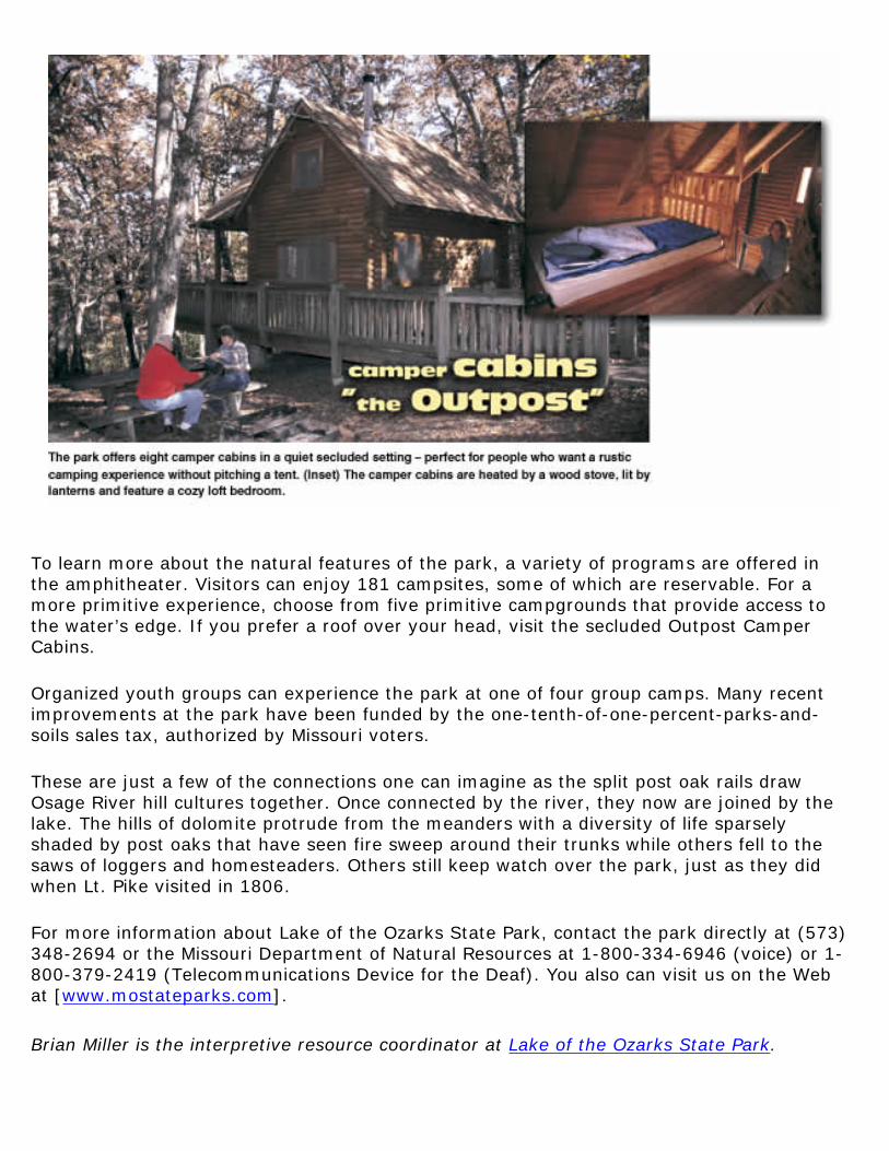
To learn more about the natural features of the park, a variety of programs are offered in the amphitheater. Visitors can enjoy 181 campsites, some of which are reservable. For a more primitive experience, choose from five primitive campgrounds that provide access to the water’s edge. If you prefer a roof over your head, visit the secluded Outpost Camper Cabins.
Organized youth groups can experience the park at one of four group camps. Many recent improvements at the park have been funded by the one-tenth-of-one-percent-parks-and-soils sales tax, authorized by Missouri voters.
These are just a few of the connections one can imagine as the split post oak rails draw Osage River hill cultures together. Once connected by the river, they now are joined by the lake. The hills of dolomite protrude from the meanders with a diversity of life sparsely shaded by post oaks that have seen fire sweep around their trunks while others fell to the saws of loggers and homesteaders. Others still keep watch over the park, just as they did when Lt. Pike visited in 1806.
For more information about Lake of the Ozarks State Park, contact the park directly at (573) 348-2694 or the Missouri Department of Natural Resources at 1-800-334-6946 (voice) or 1-800-379-2419 (Telecommunications Device for the Deaf). You also can visit us on the Web at [www.mostateparks.com].
Brian Miller is the interpretive resource coordinator at Lake of the Ozarks State Park.

Imagine rising bright and early some morning, and while sipping that first cup of coffee, you look out the window and notice that a sizable part of your yard has been replaced by a large hole. Or, perhaps, you are navigating through traffic in an older part of a major Missouri city, and watch the back end of the truck in front of you drop into a hole that literally formed beneath its rear wheels. Maybe you hire a water-well driller to construct the well that will supply your dream home in the country and while the well is being drilled, sinkholes begin to form around the drilling rig. Science fiction? Unfortunately, not. Such events, termed sinkhole collapses, can and do occur in Missouri on a fairly frequent basis. They can occur for a number of reasons. Most are natural phenomenon, but some are due to construction, mining and other human activities.
A sinkhole is a depression in the Earth's surface that forms due to the subsurface removal of soil and rock. Most sinkholes are naturally occurring features found in Missouri's karst regions. Karst is a term used to describe areas where the dissolving of soluble bedrock has created a subsurface drainage system consisting of sinkholes, losing streams, caves and springs. These features are common in much of southern Missouri, but also occur in the central and northeastern parts of the state. They form in areas of bedrock, limestone or dolomite, all of which dissolve over time by slightly

acidic groundwater.
"Sinkhole collapses are a common geologic hazard in areas such as the Ozarks," said Mimi Garstang, Geological Survey and Resource Assessment (GSRAD) division director and state geologist. Fortunately, most occur in areas away from development and typically don't cause serious damage." Some natural sinkholes result from collapses of cave roofs. Such sinkholes commonly have bedrock walls, are steep-sided and frequently form entrances into caves. Most sinkholes, however, have more gentle side slopes and no large openings in their bases. The bedrock openings associated with these sinkholes are typically smaller, and may simply be solution-enlarged fractures or bedding planes. Shallow groundwater movement erodes the sediment above the bedrock and carries it away through the subsurface. This leaves a void that enlarges until the roof materials cannot sustain their own weight. A collapse occurs with the roof typically falling into and obscuring any bedrock openings. Initially, such collapses are vertical-sided, or overhung. Eventually, side erosion creates the more typical bowl-shaped depression that typifies this variety of sinkhole.
Most sinkholes in karst areas probably form due to natural processes. However, certain factors related to human activity can trigger collapses sooner than they would have occurred. There have been numerous instances of sinkholes forming as water wells were being drilled, mostly in areas prone to sinkholes.
An event of that sort occurred in 1948 when a drilling rig was constructing a mineral-test hole on the St. Francis River floodplain. J. Harlen Bretz, in "Caves of Missouri," describes an area south of Flat River (now Park Hills) in St. Francois County. Sinkholes began developing around the drilling rig when it encountered voids in the bedrock and by the time the well was cased, there were approximately 20 sinkholes up to 90 feet long and 20 feet wide within 500 feet of the drill rig. The drill hole encountered mud- and water-filled openings at about 70 feet below land surface, then at 330 feet encountered another void. Apparently,
water in the shallow zones drained into the deeper zones causing a loss of buoyancy and sediment removal that eventually lead to the St. Francois County sinkhole collapses.
Leaking water and sewer lines, drainage modifications, leaking lagoons and lakes, and other activities that alter the natural hydrologic conditions also can be triggering factors. A lake in northern Howell County was completed in the 1960s on a tributary of

the Eleven Point River in an area characterized by deeply weathered bedrock, losing streams, and sinkholes. A sinkhole formed in the floor of the lake, quickly draining it. Efforts to stop the leak failed and the lake has never held water except for short periods following heavy rainfall.
Sinkhole collapses have occurred in sewage lagoons at several southern Missouri towns including West Plains and Republic. In most cases, the old lagoon sites were abandoned. New lagoons were constructed on better sites, or the towns used other wastewater-treatment methods.
Although most sinkhole collapses occur in karst areas, they certainly are not limited to them. In fact, many Missouri sinkhole collapses and subsidence problems have been in areas where karst features are rare or absent. For example, sinkholes have formed due to the collapse of storm sewers or other long-forgotten man-made voids.
In 1999, construction crews excavating for a parking lot uncovered several long-abandoned wine cellars near the new Vashon High School site in St. Louis. The cellars were thought to have been completely filled many years ago when the aboveground structures were razed. However, it was discovered in some cases, that only the entrances to the cellars had been filled. Fortunately, most of them, lying only a few feet below the surface, were empty and further collapses were avoided.
Areas where subsurface mining is practiced also can be prone to sinkhole collapse. "Geology is a very important factor in determining which mining areas are most susceptible," said Bill Duley, deputy division director at GSRAD. "Generally, the deeper the mining, the less likely that subsidence or collapse will occur." How the mining was conducted is another factor. Well-designed mines using adequate roof support seldom cause problems.
Lead and zinc were mined in the Joplin area between approximately 1850 and 1960. Most of the mines were less than 300 feet deep. Large areas were undermined using a variety of plans. Some sinkhole collapses in the area are related to mining, but much of the problem appears related to improperly plugged mine shafts.

Lead mining in southeastern Missouri began in the 1700s and continues today. The early underground mining was in an area referred to as the "Old Lead Belt," and included a large area extending from Bonne Terre to Doe Run in Washington and St. Francois counties. The depth of mining here varied greatly from just a few feet to several hundred feet. There have been a few mine-related collapses in this area, but it is not common. The "New Lead Belt," or Viburnum Trend, is the active lead mining area today. There are a number of mines, active and abandoned, that extend from north of Viburnum in Iron County to south of Corridon in Reynolds County.
Underground limestone quarries are common in Missouri. In some cases, underground quarrying is selected rather than aboveground because the rock is too deep to economically reach by surface mining. Properly done, underground quarrying can remove the rock and not affect the surface. Also, the resulting underground space can be developed for warehouses, offices, recreation, even manufacturing. However, some poorly designed underground quarries have experienced sinkhole collapses and subsidence. This generally occurs when too little rock is left between the mine roof and the surface, where roof support pillars are too widely spaced, or where the mine intercepts badly fractured and weathered rock.
Prior to the 1940s, underground coal mining was conducted in many areas of northern and western Missouri and even in part of St. Louis. Subsidence is locally a problem where the mines are shallow and there is inadequate roof support.

Sinkholes can form in a variety of ways, but all require collapse into voids that have developed in the subsurface. The movement of slightly acidic shallow groundwater dissolves the bedrock along fractures and other openings. The dissolved materials, along with some of the insoluble clays and rock fragments found above the bedrock, are removed through subsurface openings (fig. 1). Over time, the voids enlarge as groundwater movement carries away material (fig. 2). A sinkhole commonly forms when the material above the void can no longer support its own weight and collapses (fig. 3). Eventually, the sides of the sinkhole erode, leaving a bowl-shaped depression (fig. 4).
Sinkholes can develop essentially anywhere there is soluble bedrock. Voids in the subsurface are difficult to detect by remote methods. Test-hole drilling is commonly conducted before large buildings are constructed but exploratory drilling is costly. In general, new sinkhole collapses are more common in areas where there are already numerous sinkholes. The risk of sinkhole collapses can be lessened in most cases by avoiding activities that significantly alter the local hydrology. Leaking water and sewer lines as well as leaky ponds and lagoons can be mechanisms that hasten a collapse in areas already prone to sinkhole development.
Avoiding areas underlain by mining may be more difficult. Mining was widespread in

many areas and was conducted by many competing companies. Early mine maps were typically poor, making it difficult to accurately determine the margins of the mines. Although sinkhole collapses and subsidence are real possibilities, the risks they present to development can be minimized by carefully evaluating site suitability. Evaluations are made by department staff while investigating proposed waste disposal sites. These geologists always consider the collapse potential of the site along with other site suitability factors.
For information concerning sinkhole collapse and subsidence, readers should contact the department's Geological Survey and Resource Assessment Division in Rolla at (573) 368-2100.
Jim Vandike is a section chief in the Water Resources Program within the department's Geological Survey and Resource Assessment Division.

In the late 19th and early 20th centuries, Grandin, located in the southeastern Ozarks in Carter County, was home to one of the largest lumber mills in the country. The Missouri Lumber and Mining Company, which owned the Grandin
Mill, specialized in cutting and milling the yellow pine that dominated the ridges of the Ozarks. From the mid 1890s until 1909, the Grandin Mill produced more than 60 million board feet of finished lumber a year. By 1909, the company had completely logged the forest that supplied the operation and the Grandin mill closed. The picture above, taken around 1909 when operations at the mill were closing, is part of a collection of photographs from Missouri Lumber and Mining Company in the Western Historical Manuscript Collection in Columbia. The deep, spring-fed log pond was drained so the logs that had sunk could be retrieved. Salvage operations recovered nearly 2 million board feet of lumber. Western Historical Manuscript Collection

Send your photo to "Time Exposures,"c/o Missouri Resources, P.O. Box 176, Jefferson City, MO 65102-0176. All pictures will be returned via insured mail. Pre-1970 environmental and natural resource photos from Missouri will be considered. Please try to include the time and location of the picture, a brief description and any related historic details that might be of interest to our readers.

Teacher's Notebook
Of all the things we "throw away," some have more value than others and some cause more of a problem than others. Either criterion by itself is a good reason to keep such items out of a landfill or to make sure they get recycled or managed in a way that will not result in risk to our health or harm to the environment. Used motor oil fits both criteria and it is just one of several items banned from disposal in Missouri's landfills.
In general, recycling saves resources and protects the environment. As we begin to recognize these values, more and more waste items become economically viable resources, and recycling becomes more cost-effective.
By recycling used oil, we save a very valuable resource and avoid serious environmental contamination. As a resource, used oil can be re-refined and reused many times, or used as a fuel supplement to recover its energy value. As an environmental problem, used oil spilled or illegally poured down a drain or storm sewer can disrupt wastewater treatment plants, contaminate surface or groundwater supplies, and kill aquatic and terrestrial organisms. One quart of oil is all it takes to contaminate 250,000 gallons of water, or just one part per million!
Used Oil Re-Serves
Petroleum is a non-renewable resource. The costs of finding, extracting and refining it, or just buying it on the world market, will surely increase in the future. Recycling used oil also saves money today, as it will in the future. To encourage the recycling of used oil, the cost and convenience of doing so also must become part of the equation. Special collection services, auto supply stores and service stations often provide drop-off locations where "do-it-yourselfers, or DIYs," can take used oil for recycling. We also need to purchase re-refined oil in order to close the recycling loop.
Used oil is just dirty oil. It is possible to re-refine it for use over and over again. About 2.5 quarts of re-refined oil can be collected from one gallon of used oil. Unfortunately, you need 42 gallons

(one barrel) of crude oil to get the same 2.5 quarts of virgin motor oil. Used oil also serves as a fuel for space heaters (not recommended for home use) or it can be processed into specialty fuels for a variety of industrial uses. If used motor oil is mixed with antifreeze, transmission fluid or other contaminants, it may be too costly to refine or reprocess. It can, however, be disposed of as a supplemental fuel in high-temperature cement kilns and similar applications.
So, What's the Problem?
In the United States, the estimated number of people who change their oil themselves, the DIYs, ranges from one in four up to half of all motorists. The number is somewhat arbitrary when you think about everything from lawn mowers to combines having some type of internal combustion engine that is dependent on oil-based lubricants. DIYs trust their own workmanship, enjoy the self-sufficiency and want to save money whenever possible.
On the flip side, some DIYs may not understand the impacts of dumping the used oil, may not be motivated to dispose of it properly, or there may not be a facility within a reasonable distance for them to drop off their used oil. The U.S. Environmental Protection Agency estimates that DIYs throw away 120 million gallons of recoverable motor oil every year! In contrast, the Exxon-Valdez accident spilled about 11 million gallons of crude oil.
A Resource Reserved for Reuse – Back to the Three Rs
In order to reduce the amount of used oil that is improperly disposed of and increase the amount that gets recycled and reused, we must recognize the threats to our health and the environment caused by dumping used oil. Changing oil yourself should be encouraged, but with a sense of responsibility for recycling the used oil. To support the goodwill efforts of DIYs, the commercial sector needs to provide convenient access for them to drop off used oil. The status of these three goals in your community can be the subject of an investigation by your students. Help them develop a brief questionnaire or survey based on the extent to which people in your community would respond to the following issues:
● Understanding the Impacts: (to general audience) An awareness of the need to manage used oil properly to avoid health or environmental risks.
●
Knowing the Scope of the Problem: (to adults as potential DIYs) What percentages of "motorists" change their own oil? How do they dispose of it?
●
Convenient Access to Drop-off Sites: (to auto stores, service stations, etc.) Survey the number and location that accept used oil from DIYs.
Have your students organize and tabulate the results of their survey, make observations from the data, and draw conclusions from the findings. The final task is for your students to consider what possible actions could be taken. This approach can be used for a wide variety of environmental

issues and can be adapted for different levels or abilities. Likewise, the questionnaires or surveys can be designed to be used with a telephone interview, in-person interview, or mailed or handed out to a particular audience.
Getting your students involved in gathering, organizing, analyzing and interpreting primary data provides opportunities for meeting many of the Show-Me performance standards, particularly numbers 2, 3, and 8 of Goal 1 and standard No. 7 of Goal 4.
For additional background information about recycling used oil, visit the Web site of the American Petroleum Institute at [www.recycleoil.org]. You also may call the Department of Natural Resources' Environmental Education Unit at 1-800-361-4827.
Jim Lubbers is an environmental education specialist in the department's Outreach and Assistance Center.