dicerandra scrub sanctuary management plan
TRANSCRIPT

Dicerandra Scrub Sanctuary
Management Plan
Titusville, Florida
Brevard County Environmentally Endangered
Lands Program
Prepared by:
Brevard County Environmentally Endangered Lands Program
Parks and Recreation Department 5560 North U.S. Highway 1
Melbourne, FL 32940 (321) 255-4466

DRAFT
ii
Table of Contents
I. EXECUTIVE SUMMARY............................................................................................................... 1
II. INTRODUCTION ............................................................................................................................ 3
III. SITE DESCRIPTION AND LOCATION ...................................................................................... 6
IV. NATURAL RESOURCE DESCRIPTIONS .................................................................................. 9 A. PHYSICAL RESOURCES .................................................................................................................. 10
a. Climate ......................................................................................................................................... 10 b. Geology ........................................................................................................................................ 10 c. Topography................................................................................................................................... 11 d. Soils .............................................................................................................................................. 11 e. Hydrology..................................................................................................................................... 15
B. BIOLOGICAL RESOURCES .............................................................................................................. 15 a. Ecosystem Function...................................................................................................................... 15 b. Flora.............................................................................................................................................. 17 c. Fire History................................................................................................................................... 23 d. Fauna ............................................................................................................................................ 23 e. Designated Species ....................................................................................................................... 24 f. Biological Diversity...................................................................................................................... 27 a. Archaeological.............................................................................................................................. 28 b. Historical ...................................................................................................................................... 28 c. Land-Acquisition History ............................................................................................................. 29 d. Public Interest............................................................................................................................... 29
V. FACTORS INFLUENCING MANAGEMENT........................................................................... 30 A. NATURAL TRENDS......................................................................................................................... 30 B. HUMAN-INDUCED TRENDS............................................................................................................ 31 C. EXTERNAL INFLUENCES ................................................................................................................ 31 D. LEGAL OBLIGATIONS AND CONSTRAINTS..................................................................................... 32 E. MANAGEMENT CONSTRAINTS ....................................................................................................... 33 F. PUBLIC ACCESS AND PASSIVE RECREATION.................................................................... 36
VI. MANAGEMENT ACTION PLANS ............................................................................................. 38
A. GOALS........................................................................................................................................... 39 B. STRATEGIES AND ACTIONS............................................................................................................ 39
VII. PROJECTED TIMETABLE FOR IMPLEMENTATION......................................................... 44
VIII. FINANCIAL CONSIDERATIONS .............................................................................................. 48
IX. BIBLIOGRAPHY………………………………..………………………………………………50
X. APPENDICES................................................................................................................................. 52 APPENDIX A: STATE OF FLORIDA LEASE................................................................................................... 53 APPENDIX B: FLORIDA NATURAL AREAS INVENTORY .............................................................................. 59 APPENDIX C: PRELIMINARY AND SECONDARY PLANT SURVEYS............................................................... 73 APPENDIX D: PRELIMINARY BIRD SURVEY ............................................................................................... 80

DRAFT
1
I. EXECUTIVE SUMMARY The Dicerandra Scrub Sanctuary is part of the sanctuary network established by the Environmentally Endangered Lands (EEL) Program in Brevard County. The intent of the Program is to acquire environmentally sensitive lands as a first step “towards long-term protection of essential natural resources, open space, green space, wildlife corridors and maintenance of natural ecosystems functions” (Brevard County EEL Program, Sanctuary Management Manual, 1997). The network of public lands also provides passive recreation and environmental education programs to Brevard County residents and visitors. The Dicerandra Scrub Sanctuary encompasses approximately 44 acres, located just south of State Road 50, on Apollo Road (also known as Boyd Road), adjacent to the Carousel Roller Skating Rink. The Dicerandra Scrub Sanctuary is located within the North Regional Management Area. The Dicerandra Scrub Sanctuary, along with the other EEL properties in the North Regional Management Area will be served by the EEL Management & Education Center at the Enchanted Forest Sanctuary, which is located just south of the Dicerandra Scrub Sanctuary on State Road 405. As described in the Sanctuary Management Manual, the Dicerandra Scrub Sanctuary is a Category 3, or primary conservation and research site meaning that the site will have minimal or no improvements due to the vulnerability of resources and/or the need for intensive management or restoration. Category 3 Sites will provide opportunities for public access within limited areas of the site. The property consists of scrubby flatwoods and a large depression marsh. Its location, adjacent to the Titusville Wellfield conservation property and the Florida Power & Light (FPL) easement enhances the site and extends the protection area for the Titusville Wellfield. Prior studies of the site and surrounding lands noted the presence, or potential presence, of several listed plant and animal species. Protected plant and wildlife species documented on site during recent or past studies include Florida scrub-jay, eastern indigo snake, gopher tortoise and Dicerandra thinicola, a rare scrub mint known only to occur in the northern region of Brevard County. The primary goals of the site include the conservation and restoration of ecosystem function, natural communities and native species’ habitat. The collection and documentation of natural and cultural resource data are also important management goals. Other management goals include the provision of public access and environmental education. The Dicerandra Scrub Sanctuary will provide outstanding opportunities for field research. Due to the sensitive nature of the resources, access will be limited to passive recreation activities such as a hiking trail, nature study, and environmental education. Onsite facilities will be limited to a hiking trail, informational kiosks and minimal trail signage. One hiking trail is proposed for the site. The trail will traverse through the scrubby flatwoods to an observation platform that looks over the depression marsh, and then loop
DRAFT
2
back through the scrubby flatwoods to the trailhead. The trail will be unimproved with minimal interpretive signage and a kiosk. The current trail is included in Figure 11. The proposed recreation and educational opportunities will serve both Brevard County residents and visitors. An emphasis will be placed on providing educational opportunities to Brevard County Schools to promote the understanding and appreciation of the unique and valuable resources available in Brevard County and thereby promote the long-term preservation of the natural areas.
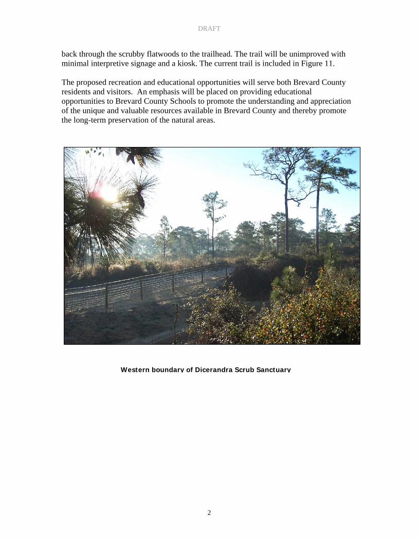
Western boundary of Dicerandra Scrub Sanctuary
DRAFT
3
II. INTRODUCTION The following section is a brief introduction to the EEL Program, as well as a description of the structure of the management plan. In a 1990 referendum, Brevard County voters approved the Environmentally Endangered Lands (EEL) Program. The Program’s Vision Statement is as follows:
“The Environmentally Endangered Lands (EEL) Program acquires, protects and maintains environmentally endangered lands guided by scientific principles for conservation and the best available practices for resource stewardship and ecosystem management. The EEL Program protects the rich biological diversity of Brevard County for future generations. The EEL Program provides passive recreation and environmental education opportunities to Brevard’s citizens and visitors without detracting from primary conservation goals of the program. The EEL Program encourages active citizen participation and community involvement.”
The Program established a conceptual framework and funding mechanism to implement an EEL sanctuary network in Brevard County. The EEL sanctuary network represents a collection of protected natural areas that form a regional conservation effort focused upon protection of biological diversity. Within the county-wide EEL sanctuary network, four management areas are geographically defined within Brevard County. For each management area, a specific site is identified as a Center for Regional Management. The sites that will function as centers for regional management for the EEL Program are: I. The Enchanted Forest Sanctuary (Regional Management Center for North
Mainland) II. Pine Island Conservation Area (Regional Management Center for Central
Mainland) III. Malabar Scrub Sanctuary (Regional Management Center for South Mainland) IV. Barrier Island Ecosystem Center (Regional Management Center for South
Beaches) These Centers provide strategically located hubs for implementing the countywide conservation, passive recreation, and environmental education goals of the EEL Program. Other EEL sanctuaries within the North Regional Management Area include Buck Lake Conservation Area with the addition of North Buck Lake Scrub Sanctuary (formerly Continental Acreage), Enchanted Forest Sanctuary with the addition of two Sterling Forest properties, South Lake Conservation Area, Grissom Road Scrub Complex, North Indian River Lagoon Properties, and Tico Scrub Sanctuary.

DRAFT
4
The EEL Sanctuary Management Manual (SMM) guides conservation and land stewardship decisions implemented by the Brevard County EEL Program. The SMM details principles and directives for conservation, public access and environmental education within the EEL sanctuary network. The SMM also outlines the EEL Selection & Management Committee’s role in advising staff and the Brevard County Board of County Commissioners on acquisition and management related issues (Chapter 2, Section 4.3.4). As outlined in the SMM, the EEL Program will adopt and implement an ecosystem approach to environmental management. Ecosystem management is defined as an integrative, flexible approach to the management of natural resources. Key themes of ecosystem management include the following: 1. Adaptive Management – Natural areas must be managed in the context of the
landscape in which they exist and based on scientific knowledge. Resource managers must adapt to continuing advances in the scientific understanding of ecosystems and changing environmental and human influences on the resources.
2. Partnerships – Interagency and private sector partnerships are essential to manage and
protect ecosystems. Natural resource management is complex and requires multi-disciplinary skills and experiences.
3. Holistic Approach – Ecosystem management includes the maintenance, protection,
and improvement of both natural and human communities. This system approach to management considers the “big picture” of natural resource protection, community economic stability and quality of life.
Land management issues, such as fire management, protection and restoration of natural hydrologic cycles, threatened and endangered species, and removal of invasive exotics must be integrated with issues such as provisions for public access and levels of human use. The integration of ecosystem protection and human needs combine to form the foundation of an effective ecosystem management strategy. The Environmentally Endangered Lands Program SMM establishes a general framework for management of specific sites and establishes ten Principles of Conservation summarized, to achieve the following: 1. Maintain all sites in a natural state and/or restore sites to enhance natural resource
values. 2. Protect natural resource values by maintaining biological diversity and using
conservation as a primary goal for decision making. 3. Balance human use with the protection of natural resources. 4. Apply the most accurate scientific principles to strategies for conservation. 5. Collect and use the most accurate data available for developing site management
plans.

DRAFT
5
6. Consider the interests and values of all citizens by using scientific information to guide management policy making.
7. Promote effective communication that is interactive, reciprocal, and continuous with the public.
8. Promote the value of natural areas to Brevard County residents and visitors through the maintenance of the quality of resource values, public services, and visitor experiences.
9. Promote the integration of natural resource conservation into discussions of economic development and quality of life in Brevard County.
10. Provide a responsible financial strategy to implement actions to achieve long-term conservation and stewardship goals.
In addition to the conservation principles, this management plan will provide specific goals, strategies, and actions to guide management of the sanctuary in terms of the objectives of the Environmentally Endangered Lands Program. The plan is divided into the following 10 sections: I. Executive Summary identifies the location, size, general natural resource features
and primary management goals for the site. II. Introduction provides a brief introduction to the EEL Program and the site and
describes the structure of the management plan. III. Site Description and Location provides a detailed site location and description. IV. Natural Resource Descriptions includes physical resources (climate, geology,
topography, soils, and hydrology), biological resources (ecosystem function, flora, fauna, species of special concern, and biological diversity), and cultural (archaeological, historical, land-use history, and public interest).
V. Factors Influencing Management includes natural trends, human-induced trends,
external influences legal obligations and constraints, management constraints, and public access and passive recreation.
VI. Management Action Plans include specific goals, strategies and actions. VII. Projected Timetable for implementation prioritizes activities and provides a
timeframe for management plan implementation. VIII. Financial Considerations discusses funding mechanisms and projected
management costs. IX. Bibliography cites original research and publications used to develop the
Management Plan. X. Appendices includes supplemental information.
DRAFT
6
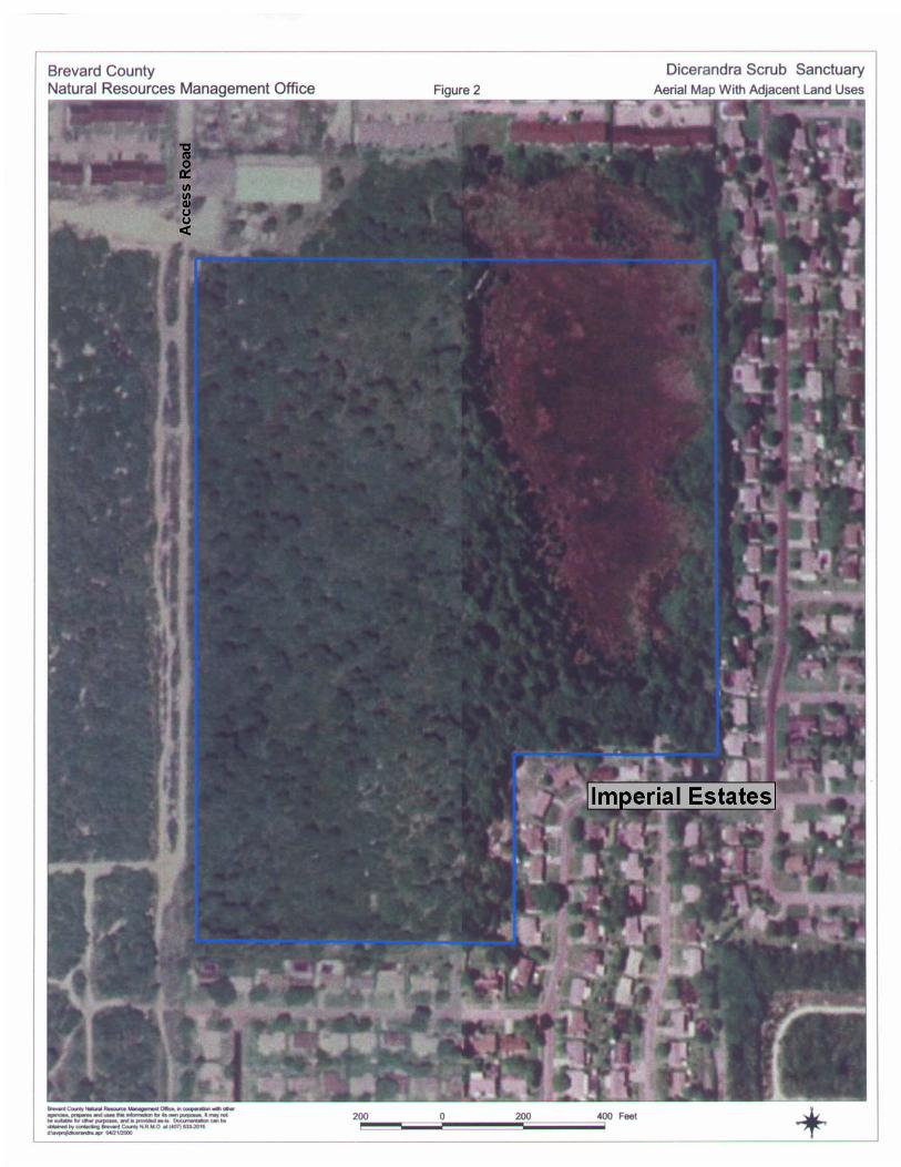
III. SITE DESCRIPTION AND LOCATION The Dicerandra Scrub Sanctuary is a 44 acre site, located south of State Road (SR) 50, on Apollo Road, adjacent to the Carousel Roller Skating Rink (Township 22, Range 35, Section 27, Block 4, Lots 1-26) as shown in Figure 1. Apollo Road, located off SR 50, provides vehicular access to the site. A secondary vehicle access location is at the Melissa Drive cul-de-sac. The eastern and southern boundaries of the property are adjacent to the Imperial Estates residential community. The western boundary borders the Florida Power & Light power line right-of-way easement, which is next to the Titusville wellfield. These two properties, the right-of-way easement and the Titusville wellfield, provide a high level of protection from incompatible uses to the west of the Dicerandra Scrub Sanctuary. The northern boundary is adjacent to a single-family residence and an apartment complex. The areas to the north, east, and south of the site are built out while the area to the west, although a platted subdivision, is undeveloped. This undeveloped land is predominately owned by the City of Titusville and is the location of their south wellfield area for potable water. The property is composed of scrubby flatwoods and a depression marsh with a small area of disturbed wetlands on the eastern boundary. Most of the site is scrubby flatwoods with a canopy of longleaf pine (Pinus palustris) and a shrub layer of myrtle oak (Quercus myrtifolia), sand live oak (Quercus geminata), Chapman oak (Quercus chapmanii), staggerbush (Lyonia fruticosa), fetterbush (Lyonia lucida), saw palmetto (Serenoa repens), wiregrass (Aristida beyrichiana), and Andropogon spp. A small open canopy of sand pine (Pinus clausa) appears in the southwest quadrant of the property. Along the edge of the depression marsh, slash pine (Pinus elliottii) replaces longleaf pine and saw palmetto is more abundant; scattered pond pine (Pinus serotina) also occurs. The property also supports a population of the scrub mint Dicerandra thinicola. This particular scrub mint is rare and only known to occur in northern Brevard County, including on this property, on the adjacent Titusville well field property, and on private lands in the city of Mims (Bradley et al 2003). An aerial map of the Sanctuary and adjacent properties is included (Figure 2).

DRAFT
7
Figure 1. General Location of Dicerandra Scrub Sanctuary
DRAFT
8
Figure 2: Aerial Map with Adjacent Land Use

DRAFT
9
IV. NATURAL RESOURCE DESCRIPTIONS This section provides descriptions of natural resources, including physical resources (climate, geology, topography, soils, and hydrology), biological resources (ecosystem function, flora, fauna, species of special concern and biological diversity) and cultural resource information (archeological, historical, land-use history and public interest).

DRAFT
10
A. Physical Resources a. Climate The Dicerandra Scrub Sanctuary is located in east Central Florida, an isothermal area at the junction of the temperate and sub-tropical climatic zones. Temperature data from representative locations in Brevard County indicate an average annual temperature of approximately 74 °F. August is typically the warmest month, averaging 82°F, whereas January is the coolest month, averaging about 62°F (Schmocker, et al., 1990). Summer temperatures are moderated by frequent afternoon thunderstorms. Periods of extreme cold weather are infrequent due to the site’s latitude and proximity to the Atlantic Ocean. The most recent “hard” freeze occurred in the winter of 1989. Long-term rainfall data for the area indicate an average of 54 inches per year in north Brevard County (Schmocker, et al., 1990). Wet and dry seasons are typically well-defined, with the wet season occurring between May and October, and the dry season occurring between November and April. Annual and seasonal rainfall is subject to large variation in both amount and distribution. During summer, Central Florida has some of the highest frequencies of thunderstorms in the world. Cloud to ground lightning strikes occur frequently during summer storms. This is an important source of natural fire ignition, which determined the historic natural fire regime. Prevailing winds are generally from north to northeast during the dry season (November to April), and from the east during the wet season (May to October) (ESMC, 1989). Climatic change, seasonal variability, and disturbance contribute to species distribution and community composition. b. Geology The Dicerandra Scrub Sanctuary is located on the Atlantic Coastal Ridge. The Atlantic Coastal Ridge extends along the east coast of Florida and is a major feature of the mainland of Brevard County, made of both single and multiple relict beach ridges. These ridges appear to have formed along an erosional rather than prograding shoreline, and in most places contain little carbonates. Formation of the Atlantic Coastal Ridge is associated with Pamlico time (ca. 140,000 – 120,000 years before present) when sea level was about 30 feet higher than present (Schmalzer et al,1999). In short, the property is part of a relic beach and dune system, an important geological feature that influences the biological diversity of Brevard County.

DRAFT
11
c. Topography The Dicerandra Scrub Sanctuary has variable topography, with elevations ranging from 30’ to 45’± National Geodetic Vertical Datum (NGVD) in the depression marsh and 50’± along the primary sand ridge in the western portion of the property, based upon the USGS Topographic Quadrangle map (Figure 3). It appears that the general surface drainage pattern is divided by the aforementioned ridge that runs generally north to south through the western portion of the site. It seems that the primary surface drainage pattern is toward the east. This natural drainage has been altered due to the urban development surrounding three sides of the Sanctuary. d. Soils The soil types within the Dicerandra Scrub Sanctuary, defined by the Natural Resource Conservation Service (formerly the Soil Conservation Service), (Figure 4), are as follows: Myakka sand (Mk) Myakka sand, ponded (Mp) Pomello sand (Ps)* Paola fine sand, 0 to 5 percent slopes (PfB)* Paola fine sand, 5 to 12 percent slopes (PfD)* Orsino fine sand (Or)* (Source: Soil Survey of Brevard County, Florida, 1974) Note: * denotes a soil with aquifer recharge characteristics Myakka sand (Mk) This is a nearly level, poorly drained sandy soil in broad areas in flatwoods and in areas between sand ridges and sloughs and ponds. It has the profile described as representative of the series. In most years the water table is within a depth of 10 inches for 1 to 4 months and between 10 and 40 inches for more than 6 months. In dry seasons it is below a depth of 40 inches. The soil is flooded for 2 to 7 days once in 1 to 5 years. Natural vegetation is primarily pine flatwoods (slash and long-leaf), saw palmetto, gallberry, and wiregrass. Myakka sand, ponded (Mp) This is a nearly level, poorly drained, sandy soil in shallow depressions in the flatwoods. This soil is similar to Myakka sand, but it is in low places where water accumulates. In most years it is flooded 6 to 12 months. They are important feeding grounds for many kinds of wading birds and other wetland wildlife. Natural vegetation on this soil type consists of maidencane, St. Johnswort, water tolerant trees, and water lilies. Pomello sand (Ps) This is a nearly level, moderately well drained sandy soil on broad low ridges and low knolls. The water table is 30 to 40 inches below the surface for 2 to 4 months in most years and between 40 and 60 inches for more than 6 months. During dry periods it is below 60 inches for short periods. Natural vegetation characteristic of these

DRAFT
12
Figure 3: Topography Map

DRAFT
13
Figure 4: Soil Map
DRAFT
14
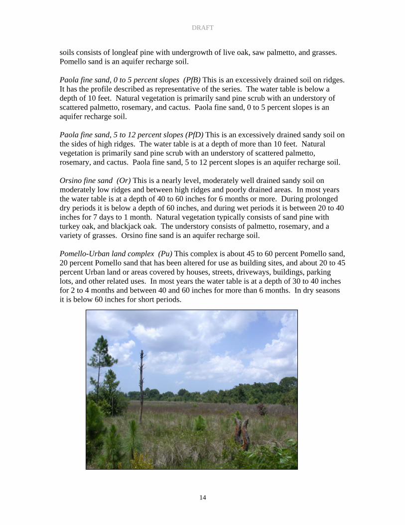
soils consists of longleaf pine with undergrowth of live oak, saw palmetto, and grasses. Pomello sand is an aquifer recharge soil. Paola fine sand, 0 to 5 percent slopes (PfB) This is an excessively drained soil on ridges. It has the profile described as representative of the series. The water table is below a depth of 10 feet. Natural vegetation is primarily sand pine scrub with an understory of scattered palmetto, rosemary, and cactus. Paola fine sand, 0 to 5 percent slopes is an aquifer recharge soil. Paola fine sand, 5 to 12 percent slopes (PfD) This is an excessively drained sandy soil on the sides of high ridges. The water table is at a depth of more than 10 feet. Natural vegetation is primarily sand pine scrub with an understory of scattered palmetto, rosemary, and cactus. Paola fine sand, 5 to 12 percent slopes is an aquifer recharge soil. Orsino fine sand (Or) This is a nearly level, moderately well drained sandy soil on moderately low ridges and between high ridges and poorly drained areas. In most years the water table is at a depth of 40 to 60 inches for 6 months or more. During prolonged dry periods it is below a depth of 60 inches, and during wet periods it is between 20 to 40 inches for 7 days to 1 month. Natural vegetation typically consists of sand pine with turkey oak, and blackjack oak. The understory consists of palmetto, rosemary, and a variety of grasses. Orsino fine sand is an aquifer recharge soil. Pomello-Urban land complex (Pu) This complex is about 45 to 60 percent Pomello sand, 20 percent Pomello sand that has been altered for use as building sites, and about 20 to 45 percent Urban land or areas covered by houses, streets, driveways, buildings, parking lots, and other related uses. In most years the water table is at a depth of 30 to 40 inches for 2 to 4 months and between 40 and 60 inches for more than 6 months. In dry seasons it is below 60 inches for short periods.

DRAFT
15
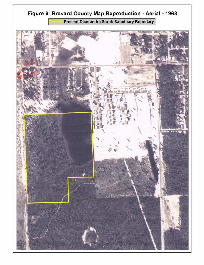
e. Hydrology The Dicerandra Scrub Sanctuary lies within Community Panel Numbers 190 & 195, of the FEMA maps dated April 1989. The FEMA map shows an isolated flood zone A. This zone is located over the depression marsh. Flood zone A means that no base elevation has been determined. The hydrologic regime of the Sanctuary is expected to have been altered as a result of surrounding development to the north, south and east of the property. The primary hydrologic feature on the site is the depression marsh located on the northeast portion of the property. This depression marsh is a shallow freshwater system that is vegetated with native herbaceous plants. The depression marsh appears to exhibit seasonal fluctuations in water quality and quantity, although no formal studies have evaluated the system. Surface water runoff from the property would drain from the scrub ridge east into this depression marsh. The vegetative community of the depression marsh appears to be undisturbed. The depth of the water table is between 10 to 15 feet. Ground infiltration of precipitation is the primary mechanism for recharge of the superficial aquifer. B. Biological Resources a. Ecosystem Function Protection of the natural resources and biological diversity that is characteristic of the Dicerandra Scrub Sanctuary is dependent upon the maintenance of the functional attributes of the upland and wetland natural communities. Species viability is ultimately dependent upon the protection and restoration of elements that influence ecosystem function. At the Dicerandra Scrub Sanctuary, management actions include restoration of the natural communities, primarily enhancement of the habitat for Dicerandra thinicola and Florida Scrub-jay (Aphelocoma coerulescens) and removal of invasive exotic species. The Dicerandra Scrub Sanctuary is approximately two miles north of the Enchanted Forest Sanctuary, a 428 + acre conservation area purchased by the EEL Program. These properties along with the Titusville wellfield help to form a conservation corridor within the urban areas of the City of Titusville. An aerial photo, with the property boundaries of the Enchanted Forest Sanctuary, Dicerandra Scrub Sanctuary, and the Titusville wellfield delineated is provided as Figure 5. This figure shows the proximity of these properties to one another. The Dicerandra Scrub Sanctuary consists of scrubby flatwoods, an isolated depression marsh and a disturbed wetland. The site has had minimal impacts over the last fifty years. According to the historical aerial photographs, the Dicerandra Scrub Sanctuary

DRAFT
16

DRAFT
17
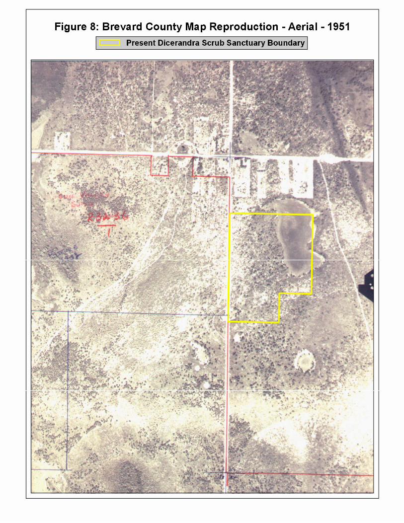
appeared to be undisturbed. Development adjacent to the Sanctuary occurred in the 1960’s. Most of the impacts have occurred on the edges of the property boundary due to encroachment from development. The Sanctuary, along with adjacent parcels of scrub habitat is important as a superficial aquifer recharge area. Recharge occurs when water seeps through the soil down to the aquifer layer to be stored. b. Flora This section describes the plant communities identified within the Dicerandra Scrub Sanctuary. The vegetative communities are described using the Florida Natural Areas Inventory’s Guide to the Natural Communities of Florida (1990) (Figure 6). A complete floristic inventory has not been conducted for this Sanctuary. EEL staff & Office of Natural Resources staff conducted a preliminary plant survey in 2000. This list reflects the representative species and is not a complete floristic inventory. A total of 90 plant species were identified. Of these 90 plant species, 16 plant species are exotic. A list of the exotic plant species found on site is listed below in the Management Constraints section of this management plan. A second plant survey was conducted in 2003 by Dynamac Corporation. This inventory includes 92 listed species. The results of the two plant inventories are included in Appendix C. To complete the plant survey a year-long floristic survey needs to be conducted. Aside from being a valuable upland community and aquifer recharge area, this site is important in the preservation of designated plant and animal species. The site provides a significant area, free from development, for Dicerandra thinicola, an endemic native plant cited only in North Brevard (Miller 1993). This native plant should be considered to be of high conservation importance. Other species of Dicerandra are not reported from Brevard County (Wunderlin, 1982; Muller et al.1988; Christman and Judd 1990; FNAI 1990). Four scrubby or suffrutescent species of Dicerandra are known from Florida (D. christmanii, D. cornuttissima, D. frutescens, and D. immaculata). These four species are listed as endangered by the state of Florida and the U.S. Fish and Wildlife Service and as G1/S1 (critically imperiled globally/critically imperiled in the state by the Florida Natural Areas Inventory) (FNAI 1990). Dicerandra thinicola is listed as Endangered by the State of Florida and has no federal protection. Lechea divaricata (pineland pinweed) has been found along the northern edge of the Sanctuary (Schmalzer and Foster 2003, 2005). This species is listed as Endangered by the State of Florida. Historical aerial photographs were reviewed to determine changes to vegetative community type and structure, as well as man-induced changes in the past fifty (50) years. Aerial photographs from 1943, 1951, 1959, 1963, 1967, 1975, 1983, and 1996 were inspected. Historical aerial photographs from 1943, 1951 and 1963 are provided as figures 7, 8 and 9 respectively. Most of the development in the area start in the early 1960’s and was completed by 1968.

DRAFT
18
Figure 6: Natural Communities of Dicerandra Scrub Sanctuary

DRAFT
19
Figure 7: Historic Aerial – 1943
DRAFT
20
Figure 8: Historic Aerial – 1951
DRAFT
21
Figure 9: Historic Aerial – 1963

DRAFT
22
Upland Communities Scrubby Flatwoods - This community type makes up the majority of the site. The percent of scrubby flatwoods present is approximately 75%. An open canopy of longleaf and slash pines dominates the scrubby flatwoods community. In the southwest quadrant of the property there is an open canopy of sand pine. The understory is fetterbush, rusty lyonia, myrtle oak, Chapman oak, scrub live oak, and saw palmetto. The ground cover consists of wiregrass, Andropogon spp., partridge pea, and other herbs. The presence of sand pine in the scrubby flatwoods when the property was purchased was an indication that fire had been absent for quit some time. To prepare the site for prescribed fire, EEL Program staff contracted to roller chop vegetation around the perimeter of the property boundary. This is done as a safety precaution when conducting a prescribed fire in an urban area. The EEL Program partnered with the Nature Conservancy to conduct the first prescribed burn on the Sanctuary in 2003. Wetland Community Depression Marsh – The depression marsh occurs on the eastern portion and makes up approximately 25% of the property. Plant species that occur within the depression marsh include dahoon holly (Ilex cassine), sand cordgrass (Spartina bakeri), St. John’s wort (Hypercum fasciculatum), spikerush (Eleocharis melanocarpa), yellow-eyed grasses (Xyris spp.), Carolina willow (Salix caroliniana), maidencane (Panicum sp.), and wax myrtle (Myrica cerifera). During higher water levels bladderworts (Utricularia sp.), big floating heart (Nymphoides aquatica) and pickerelweed (Pontederia cordata.) are evident. Disturbed Wetlands – The disturbed wetland occurs between the southeastern edge of the depression marsh and the eastern property boundary. Plant species that occur within the disturbed wetland include many exotics, such as, Brazilian pepper (Schinus terebinthifolius), air potato vine (Dioscorea bulbifera), and Chinese tallow tree (Sapium sebiferum). These exotics occur in the Sanctuary as a result of human impacts associated with the urbanization around the Sanctuary. The native vegetation within the disturbed wetlands includes wax myrtle, Carolina willow (Salix caroliniana), groundsel tree (Baccharis halimifolia) and various herbaceous plants. The exotic vegetation within the disturbed wetland covers approximately 70%. The Florida Natural Areas Inventory (FNAI) global and state rankings of the natural community elements identified on the Dicerandra Scrub Sanctuary are:
Scrubby flatwoods G3/S3 Depression Marsh G4/S3
Key: Florida Natural Areas Inventory (FNAI) natural community designations assigns two ranks for each natural community (element): G = global element rank, S = state element rank. Numbers represent: 1 = critically imperiled because of extreme rarity (5 or fewer occurrences or less than 1000 individuals) or because of vulnerability to extinction; 2 = imperiled because of rarity (6-20 occurrences or less than 3,000 individuals) or because of vulnerability to extinction; 3 = either very rare and local throughout its range (21-100 occurrences or less than 10,000 individuals) or found locally in a restricted range or vulnerable to extinction because of other factors; 4 = apparently secure (may be rare in parts of range); 5 = demonstrably secure; #? Tentative rank; G?/S? not yet ranked (temporary).

DRAFT
23
c. Fire History Prior to 2003, the presence of sand pine in the scrubby flatwoods was an indication that fire had been absent from the landscape for quite some time. To prepare the site for a prescribed burn, the EEL Program staff contracted to roller chop vegetation around the perimeter of the property boundary to create firebreaks. This is done as a safety precaution when conducting a prescribed fire in an urban area. A prescribed burn was conducted in March of 2003 across the 28 + acres of flatwoods west of the marsh in partnership with the Nature Conservancy. d. Fauna Although no comprehensive faunal surveys have been initiated for the Dicerandra Scrub Sanctuary, the natural community heterogeneity characterizing the site provides suitable habitat conditions for use by a broad range of animal species. Species readily visible on the Sanctuary include: raccoons (Procyon lotar), Florida scrub-jays (Alphelocoma coerulescens), gopher tortoise (Gopherus polyphemus), and a variety of wading birds, migratory and neotropical migrant bird species. There are unconfirmed reports of bobcats (Lynx rufus) using the site. David Breininger and Mike Legare of Dynamac Corp. have conducted demographic studies of Florida scrub- jays on this site as part of research on Florida scrub-jay populations in Brevard and Indian River Counties. Data from their findings can be found in the reports, Biological Criteria for the Recovery of Florida Scrub-Jay Populations on Public Lands in Brevard County and Indian River County, 2001 and 2003 Annual surveys by EEL Program staff, under the supervision of David Breininger, occur each year in March/April. A preliminary bird survey is attached as Appendix D. A herptofauna survey may be conducted around the depression marsh area. A graduate intern student, EEL staff, or an EEL volunteer would perform this survey. The goal of this sampling will be to determine species richness and the relative species diversity of the site. Drift fences, cover boards, funnel traps, pit fall traps, and hand captures will be used to conduct the survey. The Bailey Wildlife Foundation and US Fish and Wildlife Service (USFWS) are sponsoring a tracking study of Eastern Indigo snakes. The purpose of the study is to develop a relationship between home range and habitat use and apply that information to population viability analysis. Mike Legare with Dynamac Corporation has captured

DRAFT
24
Scrub Hickory (Carya floridana)
indigo snakes, surgically implanted the tracking devices and released the snakes at the capture sites. The snakes are tracked and the movements recorded. e. Designated Species The Dicerandra Scrub Sanctuary will be managed to protect and enhance natural community functions that support the rich biological diversity exhibited on the site. A primary goal of this management plan is to develop and implement strategies to enhance conservation of threatened, endangered, or endemic species on the Sanctuary. The following is information on existing listed species or species that may occur on the Dicerandra Scrub Sanctuary. Plants From the preliminary plant surveys that were conducted in March 2000 and in 2003, four plant species endemic to Florida occur on the Sanctuary. These endemic species are Brownhair snoutbean (Rhyncosia cineria), Scrub hickory (Carya floridana), Spreading pinweed, (Lechea divaricata) and the Titusville balm (Dicerandra thinicola).
The USFWS and the State of Florida under the auspices of the Florida Department of Agriculture and Consumer Services (FDACS) compile lists of protected plant species. The USFWS classifies protected plants as either endangered or threatened. The FDACS lists plant species that are considered State Endangered/Threatened and/or Commercially Exploited.
Additional plant surveys are needed to determine species present on the site, to map their locations and to photograph the areas detailing the extent of coverage of any designated species. A monitoring program will also be established for the designated species that are present on site. Once the baseline has been established, additional management activities can be addressed. Continued efforts to remove invasive exotics plants and the use of prescribed fire will allow for the natural progression of native species. The location of designated species has been considered during the creation of public access trails and during other management efforts including exotic plant removal and prescribed fires.

DRAFT
25
The only listed plant species recorded during site reviews was Dicerandra thinicola. The Dicerandra thinicola is found along the western boundary of the property in disturbed areas. In 2000, Ramona Smith, graduate student at Florida Institute of Technology, investigated the seedling recruitment and life history of Dicerandra thinicola. The research project documented eighteen 1 square meter quadrants within the area where Dicerandra thinicola is located. Several main experiments were conducted: biomass, light and canopy openness, flower production, seed production, seed viability, seedling recruitment and leaf litter depth. Findings included:
• while plants are capable of living in a relatively wide range of openness, they prefer a higher amount of exposure for increased growth and reproduction
• the vast majority of seed pods collected contained no mature seeds • germination rates in the field were less than 2% • germination rates from laboratory studies ranged from 2-5% • depth of leaf litter may affect seedling growth.
No statistical analyses were performed to reach these findings. Future studies should include similar experiments to verify these findings. Currently, Eric Menges with Archbold Biological Station and Suzanne Kennedy with the non-profit Floravista, Inc. are conducting research into the demography and effects of fire on seedling recruitment of Dicerandra thinicola. Approximately 600 – 700 seeds collected in the adjacent Titusville wellfields were planted in plots in the Sanctuary. The goal is to attempt to recruit Dicerandra thinicola onto the managed area within the Sanctuary.
Dicerandra thinicola

DRAFT
26
Animals The USFWS and the State of Florida under the auspices of the Florida Fish and Wildlife Conservation Commission (FWC) also compiles lists of protected wildlife species considered to be under possible threat of extinction. These species are categorized as either Endangered or Threatened. The FWC utilizes an additional category “Species of Special Concern” (SSC) for several animal species which may ultimately be listed as Endangered or Threatened. This classification provides the SSC listed animal with a particular level of protection that varies from species to species. Florida Scrub-jay The Florida scrub-jay is listed as a Threatened species by the USFWS and FWC. The history of the Florida scrub-jay on the Dicerandra Scrub Sanctuary is unknown. A review of the 1943 and 1959 aerials revealed a habitat that most likely was suitable for Florida scrub-jays (Breininger pers. Comm.). Jeffrey A. Cox, GFC Wildlife Biologist, also documented scrub-jays present on the site in 1982 (Status and Distribution of the Florida Scrub-jay, Florida Ornithological Society Special Publication No. 3, 1987). Dave Breininger with Dynamac continues to conduct annual surveys at Dicerandra Scrub Sanctuary and the adjacent Titusville wellfield to compile demographic information for the scrub-jays. In 2000 seven scrub-jays were observed to be using the Sanctuary. Six of the seven birds were banded. In 2001, two families of scrub-jays were observed in the wellfield adjacent to the Sanctuary. Breininger states that the habitat has the potential to support ten times that number, but that the scrub is suboptimal due to historic fire suppression. Eastern Indigo Snake Eastern indigo snakes (Drymarchon corais couperi) have been observed on the property. The USFWS and FWC list the Indigo snake as a Threatened species. It is uncertain whether there is a stable breeding population of indigo snakes in the area. Indigo snakes require large home ranges (370 to 2,500 acres) in order to maintain a stable population (Tennant, 1997). Impacts from dogs, humans and roads cause habitat fragmentation and reduce indigo snake populations. Their ability to utilize natural lands interspersed with urban areas is unknown. The Dicerandra Scrub Sanctuary and adjacent conservation lands do not provide the acreage required for a stable indigo snake population.
Florida scrub-jay (Alphelocoma coerulescens)

DRAFT
27
Gopher Tortoise Gopher tortoises (Gopherus polyphemus) have been noted on the site. In June of 2006, the Florida Fish and Wildlife Conservation Commission changed the status of the gopher tortoise from Species of Special Concern to Threatened. This change will take effect in 2007. A formal survey will be conducted to determine if the population is stable and in good health. Managing the scrub habitat and reintroducing prescribed fire to the habitat will enhance the habitat by opening up the understory thereby increasing the amount of habitat open to foraging and colonization. f. Biological Diversity No documented work has been conducted to assess the Sanctuary’s biological diversity. Previously collected data were designed to qualitatively catalog species. Additional data will need to be collected in order to assess the biological diversity (both richness and evenness) so that changes in diversity can be tracked over time. Richness refers to the number of species found within a particular community, while evenness refers to the distribution of individuals among species. Methodologies will need to be established for all of the relevant taxonomic groups and researchers and staff identified to address this particular need.
Indigo snake (Drymarchon corais couperi)
Gopher tortoises (Gopherus polyphemus)

DRAFT
28
C. Cultural a. Archaeological A thorough review of the Dicerandra Scrub Sanctuary to determine the presence of archaeologically significant sites has not been conducted. One management strategy will be to have an archaeology study performed on the site. The EEL Program staff will write a letter to the Division of Historical Resources asking for their assistance in performing an archeological survey of the Sanctuary. b. Historical The history of the area ranges from the Indian burial sites several miles to the west at Windover, dating from 6,000 BC to the events associated with the development of the space industry at Cape Canaveral during the 1950’s, 1960’s, and 1970’s. In 1982, The Windover Development found one of the best preserved aboriginal burial sites to be discovered, with skeletons approximately 8,000 years old. The Ais Indians later occupied the region around Titusville (Historical Society of North Brevard, 1998). There are no historic events associated with the Dicerandra Scrub Sanctuary. The following paragraphs provides some history of the area from 1000 BC to the 1920’s. Ais Indians (1000BC – 1500 AD) The first people to inhabit Florida arrived about 12,000 years ago, from central and southern areas of the North American continent, at the end of the last ice age. At this time much of the North American continent was still covered by glaciers. Sea level was 200 feet below its current level and much of the earth’s water was stored in glaciers (Brown, 1994). At the time of European contact in the 16th century, the Ais (pronounced “Eyes”) Indians were known to inhabit Brevard County. The Ais Indians did not exhibit the nomadic existence of other Native Americans, as the semi-tropical climate provided for their needs without requiring them to travel great distances. Turn of the Century to Present During the late 1800’s and early 1900’s, naturalists were some of the primary visitors to Brevard County. Notable scientists came to this species-rich, semi-tropical region to collect specimens for natural history museums. These specimens included rare bird life such as the Carolina parakeet (Conuopsis carolinensis), which is now extinct. In the early 1900’s, people came to Brevard County from around the country via the Florida East Coast Railway. There was an increase in settlement and development of towns brought about by the creation of railroads and canals. The increase in population was also the result of the 1916 Drainage Acts of Florida and the establishment of

DRAFT
29
Mosquito Control measures beginning in 1927. The Drainage Acts rerouted drainage patterns which permanently lowered water tables in areas where standing water naturally existed for six or more months each year. Mosquito control (pesticide spraying and mosquito control ditches) lowered the mosquito population to acceptable levels (Barille, 1988; Woodward-Clyde consultants, 1994). In the 1920s, improved roads such as the Dixie Highway (U.S.1) brought more cars and people to Brevard County. In 1921, a bridge was built over the Indian River Lagoon and hotels and casinos were established. Later, air conditioning was introduced, and Florida became known as the residential and tourist destination it remains today. c. Land-Acquisition History In October 1993, the County acquired 44 acres from Bert & Lorene Solomon and Kenneth & Kathleen Jackson for $400,619.00. At the time of acquisition the property was zoned General Use. In 2002, the property was annexed into the City of Titusville and currently zoned Open Space and Recreational. The Dicerandra Scrub Sanctuary was acquired using public funds from the Brevard County EEL Program. The primary goal for acquisition of this Sanctuary is conservation of the natural resources and to protect the scrub mint Dicerandra thinicola population existing on the site. The Dicerandra Scrub Sanctuary was acquired as part of Brevard Coastal Scrub Ecosystem (BCSE) Florida Forever project. The Sanctuary was acquired when the BCSE project was called the Scrub-jay Refugia Conservation and Recreation Lands (CARL) project. CARL was a conservation land acquisition program under the State’s Department of Environmental Protection. It received funds through the Preservation 2000 (P-2000) legislation. P-2000, which was initiated in 1990, sunset in the year 2000 and was succeeded by the Florida Forever legislation, which is also a 10-year land acquisition and conservation program. Under Florida Forever, the DEP’s CARL program was revised and titled the Florida Forever program, the same as the legislation. According to Multiparty Acquisition Agreement between the State and the County, the County was entitled to receive up to 50% of its land acquisition costs associated with this Sanctuary. In August 2000 the State reimbursed the County $199,655.50. d. Public Interest Public interest for the EEL Program as a whole has been enthusiastic and supportive. A public meeting held on May 20, 1998, which introduced the Master Site Plan for the Enchanted Forest Management and Education Center was very well received. Other potential partners include Brevard County Schools, the City of Titusville, Brevard Community College, local universities and specific non-profit groups. The Enchanted Forest Sanctuary provides a management and education center in close proximity to the Dicerandra Scrub Sanctuary. All management activities associated with the Dicerandra Scrub Sanctuary will be administered at the Enchanted Forest Center by the North Region Land Manager.

DRAFT
30
V. FACTORS INFLUENCING MANAGEMENT Part V includes information regarding natural and human-induced trends, external influences, legal obligations, and constraints, management constraints, and public access and passive recreational activities. A. Natural Trends Past and future natural trends that influence resource values or management strategies are associated with regional climate and storm events that can influence the biological resources and natural characteristics of the site. Global trends, like sea level rise and global warming cause potential threats that are difficult or impossible to assess. In each case appropriate management strategies that protect natural ecosystem functions and biological diversity enables the site to respond to most, if not all, natural stochastic events. The primary variable that influences the formation and succession of Florida’s vegetative communities is fire. Florida’s major upland community (e.g., pine flatwoods) experience fire naturally on a three to five year cycle. If natural fires are not present, or are suppressed by man, less-fire-adapted species can invade and alter the natural successional path of the community. Changes in species composition do occur with fire suppression in flatwoods. In scrubby flatwoods, structural changes (height growth, density) occur more rapidly than changes in species composition. In systems such as scrub communities, lack of fire can profoundly affect the value and usability of the community for endemic as well as listed plant and animal species. Fires in scrub communities are typically less frequent than in flatwoods. To occur naturally, scrub fires require drier and hotter conditions than do the flatwoods (Myers and Ewel, 1990). Land management practices developed for the Dicerandra Scrub Sanctuary must consider the re-introduction of a “natural” fire regime through the use of prescribed fire. Using prescribed fire as a management tool ensures that the natural ecological processes are restored and protected. Another factor affecting the communities within the Dicerandra Scrub Sanctuary is hydroperiod, particularly in the depression marsh area of the site. Changes in hydroperiod have the potential to significantly alter community structure. A decrease in hydroperiod could allow the invasion of nuisance or non-native species, while an increase in hydroperiod could surpass the inundation tolerances of the species present. The natural hydrologic regime and periodicity of the Dicerandra Scrub Sanctuary is expected to have been altered by the residential area that surrounds it on the north, south, and east boundaries of the property. Investigation into the natural hydroperiod as well as the existing hydroperiod should be undertaken to better understand and enhance the natural ecological processes.

DRAFT
31
Land management practices for Dicerandra Scrub Sanctuary will include re-establishment of natural hydroperiods and re-introduction of a natural fire regime through prescribed burning. This will be dependent on the needs and ability to introduce these practices. B. Human-Induced Trends Humans have altered the surrounding landscape through activities such as development, the introduction of exotic plants and animals, and recreational activities. Other factors influencing the site include natural fire suppression, localized disruption or damage of vegetation by foot trails, disruption of vegetation by dirt bikes/ATV’s, and dumping of garbage. The management goals set forth in the Section VI - Management Action Plan provide strategies and actions for reduction of human-induced impacts and restoration and enhancement of natural resources. As part of the management plan implementation, methodologies for assessing carrying capacity of the natural resources on the site will be developed. In addition, strategies for visitor impacts analysis that consider species-level, natural community-level and ecosystem-level human influences will be developed and implemented. C. External Influences On the east and south side of the property boundary some encroachment from the residential homeowners occurred prior to the installation of boundary fencing. There was evidence that adjacent property owners had mowed vegetation within the Sanctuary boundary and dumped some debris within the Sanctuary. A wooden play structure located on the northern boundary of the site was removed.
The Sanctuary boundary has been fenced and posted, with public access limited to three walk-throughs at gates. EEL staff and interns, County staff and volunteers removed trash during several workdays. Letters were sent to neighboring residents notifying them of the presence and purpose of the Sanctuary in their community and alerting them to planned management activities. Volunteer workdays will continue to be scheduled for exotic species removal and trail maintenance.
Boundary Fence and Firebreak

DRAFT
32
D. Legal Obligations and Constraints The following is a list of possible legal constraints to management and public access on site. St. John’s River Water Management District The St. Johns Water Management District (SJRWMD) regulates impacts to wetlands pursuant to Part IV, Chapter 373 of the Florida Statutes (F.S.) and in accordance with Chapters 40C-4, 40C-40, 40C-41, and 40C-400 of the Florida Administrative Code (F.A.C.). The 1995 Florida Wetlands Delineation Manual defines jurisdictional wetlands. The SJRWMD typically requires an Environmental Resource Permit (ERP) to impact wetlands. Mitigation is required for impacts greater than 0.5 acres in size. In considering wetland impacts, SJRWMD considers not only direct impact to wetlands, but secondary impacts that may affect wetland dependent wildlife. To minimize secondary wetland impacts, SJRWMD generally requires that applicants preserve a buffer of undisturbed upland habitat with a 15’ minimum width and 25’ average width around preserved wetlands [Sec. 12.2.7(a)]. Prior to submitting an application for dredging or filling within Waters of the state, it is recommended that the areas proposed for impact be delineated in accordance with the Unified Wetland Delineation Methodology for the State of Florida dated 1 July 1994, and then reviewed and confirmed by representatives of the SJRWMD. U.S. Army Corps of Engineers Any associated impacts to wetlands will require an additional permit through the U.S. Army Corps of Engineers (USACE). USACE regulates wetlands connected to “Waters of the State” and isolated wetlands pursuant to Section 404 of the Clean Water Act. Mitigation may not be required if impacts are minimal or to degraded systems. Division of Forestry The Florida Division of Forestry (DOF) issues permits for prescribed burns for land management to land managers with certified burn numbers. Certification is provided by DOF.

DRAFT
33
E. Management Constraints Potential management constraints and challenges are associated with site security, limited on-site presence and proximity of residential homes. The following is a description of the major management issues and constraints associated with the Sanctuary. Titusville Wellfield The wellfield owned by the City of Titusville is adjacent to the western boundary of the Sanctuary. The wellfield is located on a quality scrub habitat that supports scrub-jays, indigo snakes, gopher tortoises and Dicerandra thinicola. The area also serves as a primary aquifer recharge. The EEL Program staff recognizes the conservation value of the wellfield and intends to pursue a partnership with the city of Titusville in order to manage the two sites as one ecosystem. Fire Natural communities within the Dicerandra Scrub Sanctuary will be evaluated to determine any constraints upon the use of prescribed burning posed by natural site conditions and adjacent land uses. The EEL Selection & Management Committee and the EEL staff have already established the need for fire within the scrubby flatwoods community. Within the first year after adoption of this management plan by the Brevard County Board of County Commissioners, a site-specific fire management plan will need
to be developed for the entire Sanctuary. The fire management plan will include the habitat maintenance and restoration goals of the EEL Program, and provide a detailed approach to conducting prescribed burns. The development of this plan should involve local and state experts on prescribed burning, including the Florida Division of Forestry, The Nature Conservancy, U.S. Fish and Wildlife Service, the County’s Public Safety Department, City Fire Departments, and Volunteer Fire Departments.

DRAFT
34
Exotic Species Exotic, non-indigenous, non-native, and alien species are all terms used to describe plants and animals that are of foreign origin, yet may persist, thrive, harm or displace native species and alter native ecosystem function. Well-known and widespread non-indigenous plant species include Australian pine, Brazilian pepper, potato vine, Chinese tallow tree and cogon grass. Plants The plant survey conducted in March 2000 identified 17 exotic plant species present on the Sanctuary. A list of these exotic species is provided in Table 1. Brazilian pepper (Schinus terebinthifolius) is the dominant nuisance plant noted within the Dicerandra Scrub Sanctuary. Air potato (Dioscorea bulbifera) and Chinese tallow tree (Sapium sebiferum) are also cause for concern within the Sanctuary boundaries. It should also be noted that a detailed inventory of exotic/invasive/nuisance plants has not been conducted, and other exotic species are likely to exist on-site.
Table 1. Exotic Plants Species List – Dicerandra Scrub Sanctuary - 2000 Scientific Name Common Name Asparagus sp. Asparagus fern Dioscorea bulbifera Air potato Melaleuca quinquenervia Melaleuca Sapium sebiferum Chinese tallow tree Schinus terebinthifolius Brazilian pepper
Florida Exotic Pest Plant Council Category I*
Cinnamomum camphora Camphortree Citrus sp. Wild citrus Enterolobium contortisiliquum Earpod tree Kalanchoe sp. Kalanchoe Koelreuteria elegans Golden rain tree Monstera deliciosa Monstera Oxalis debilis Pink woodsorrel Philodendron selloum Philodendron Philodendron sp. Philodendron Sansevieria hyacinthoides Mother-in-law’s tongue Tecoma capensis Cape Honeysuckle Yucca aloifolia Spanish bayonett
*Category I – Invasive exotics that are altering native plant communities by displacing native species, changing community structures or ecological functions, or hybridizing with natives.

DRAFT
35
The EEL Program staff along with volunteer groups will prepare an inventory of the exotic and/or invasive plant species found within the Dicerandra Scrub Sanctuary, and develop strategies to remove the species, or to control their coverage. The EEL Program staff is currently developing a comprehensive treatment and monitoring program to ensure the long-term removal of these species from the Dicerandra Scrub Sanctuary and other EEL managed properties. EEL staff and volunteers have begun removal of air potato, Brazilian pepper and melaleuca from the Sanctuary. Animals Exotic and non-indigenous animal species also have the potential to adversely affect ecosystem function and to significantly alter population levels of native animals through predation or displacement. The fire ant (Solenopsis invicta) has become present in Central Florida, as has the nine-banded armadillo (Dasypus novemcinctus). Wild forms of domesticated animals such as the feral hog are also widespread and can cause significant harm to the vegetation and soils due to their rooting. Currently there is no evidence of feral pigs utilizing the Sanctuary. Due to the nature and location of this Sanctuary, feral cats and feral dogs could be present and could pose a significant threat to the wildlife. No established feral cat colonies are found on the Sanctuary. Any feral cats and dogs found on the property will be trapped and taken to the local animal shelter. A list of non-indigenous animal species has not been collected. An investigation into the levels and impacts of these species needs to be conducted prior to the establishment of a control strategy.
Air potato (Dioscorea bulbifera)
DRAFT
36
F. PUBLIC ACCESS AND PASSIVE RECREATION The EEL Program staff is committed to provide a range of public use opportunities that are consistent with the conservation and protection goals of the voter approved referendum. It has been determined that passive recreational activities best support the EEL Program goals. The EEL Program Sanctuary Management Manual defines passive recreation as follows: “A recreational type use, level of use and combination of use that do not, individually
or collectively, degrade the resource values, biological diversity, and aesthetic or environmental qualities of a site.”
The Dicerandra Scrub Sanctuary is a Category 3 site meaning that there are minimal or no improvements made to the Sanctuary due to vulnerability of resources, and/or need for intensive management and/or restoration. Category 3 Sites will provide opportunities for public access within limited areas of the site. Public access areas will be controlled through the use of site design decisions and capital improvements, such as, limited trail networks, scenic overlooks, and elevated boardwalks. The size, location, habitats and SMM category ranking of the Dicerandra Scrub Sanctuary will dictate the types of activities that will be compatible with the primary conservation mandate. The original conceptual plan for the Sanctuary is included in Figure 10. The current hiking trail is included in Figure 11. A trailhead with educational kiosk was placed at the end of Melissa Dr. in early 2005. The EEL Program Recreation and Education Committee (REAC) approved the Dicerandra Scrub Sanctuary recreation assessment in December of 2005. The Dicerandra Scrub Sanctuary currently accommodates limited hiking and nature watching as well as scientific studies and research. No facilities are proposed for this site. Whenever possible, research and restoration conducted on site will be used to guide educational programs. The current hiking trail is the only trail proposed for the site. The trail traverses through the scrubby flatwoods, past the depression marsh and then loops back through the scrubby flatwoods past the Dicerandra thinicola and back to the trailhead. A proposed overlooked will be added along the trail running adjacent to the depression marsh. The trail is unimproved with minimal interpretive signage and a kiosk. A Sanctuary brochure and a Self-guided Hike Brochure will be created for the Sanctuary. Points of interest along the trail will may include scrub-jays, gopher tortoises, scrub hickory and wading birds during times of high water. Due to environmental and public health & safety issues, dogs and other pets are not permitted in the Dicerandra Scrub Sanctuary, except for service animals needed for the disabled.

DRAFT
37
Figure 10: Conceptual Plan

DRAFT
38
Figure 11. Current Dicerandra Scrub Sanctuary trail map.

DRAFT
39
VI. MANAGEMENT ACTION PLANS The following is a comprehensive outline of the goals, strategies, and actions necessary to manage the Dicerandra Scrub Sanctuary. A. Goals The Sanctuary Management Manual of the EEL Program provides the following management goals for the Dicerandra Scrub Sanctuary.
• Documentation of historic public use • Conservation of ecosystem function • Conservation of natural (native) communities • Conservation of species (including endemic, rare, threatened and
endangered species) • Documentation of significant archeological and historic sites • Provision of public access and responsible public use • Assessment of carrying capacity of natural resources with public use • Provision of environmental education programs • Opportunities for multiple uses and compatibility • General upkeep and security of the property
B. Strategies and Actions The following is an outline of the specific management strategies and actions that are needed to meet the management goals for the Dicerandra Scrub Sanctuary. GOAL: DOCUMENTATION OF HISTORIC PUBLIC USE Strategy 1: Document historic public use Actions: • Collect historic information regarding the types of activities that have occurred on-
site; • Evaluate how historic public use impacted the site’s natural resources; • Consider historic public use patterns in planning future public uses. GOAL: CONSERVATION OF ECOSYSTEM FUNCTION Strategy 2: Protect, maintain, and restore native diversity, ecological patterns, and
the processes that maintain diversity. Actions: • Research and monitor baseline conditions of natural systems; • Research the connection of on-site natural resources with adjacent resources;

DRAFT
40
• Research hydrologic patterns on and off-site; • Focus natural community restoration efforts on enhancing native diversity; • Investigate the historic hydroperiod. Strategy 3: Ensure that natural upland-wetland interfaces are protected and
enhanced.
Actions: • Collect data to analyze the public access on the natural resources; • Protect communities from deleterious impacts deriving from external influences; • Restore/enhance natural communities.
GOAL: CONSERVATION OF NATURAL (NATIVE) COMMUNITIES Strategy 4: Restore degraded, disturbed, or altered wetlands within the Dicerandra
Scrub Sanctuary.
Actions: • Establish baseline conditions within wetlands; • Use native plants for restoration efforts (if needed); • Assess possible impacts of proposed restoration on adjacent communities and offsite
properties; • Implement the selected restoration activities (i.e. remove exotic species, restore
natural hydrologic flood, etc.); • Monitor the effects of the restoration activities, evaluate the success of the restoration
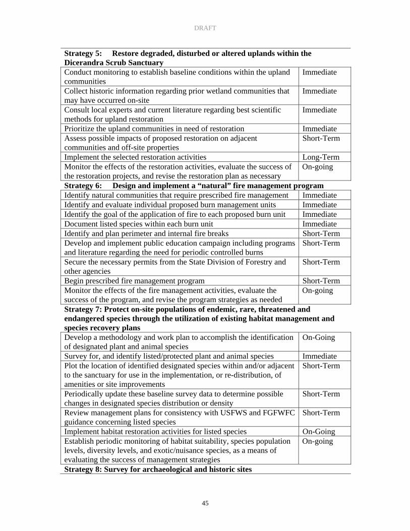
projects, and revise the restoration plan, as necessary. Strategy 5: Restore degraded, disturbed, or altered uplands within the Dicerandra Scrub
Sanctuary. Actions: • Establish baseline conditions within the upland communities; • Consult local experts and current literature regarding best scientific methods for
upland restoration; • Prioritize the upland communities in need of restoration based upon ease of
accomplishment, expected habitat value yield, or financial considerations; • Use native plants for restoration efforts (if needed); • Assess possible impacts of proposed restoration on adjacent communities and offsite
properties; • Implement the selected restoration activities (i.e. remove exotic species, restore
natural disturbance regime, replant native species, etc.); • Monitor the effects of the restoration activities, evaluate the success of the restoration
projects, and revise the restoration plan, as necessary.

DRAFT
41
Strategy 6: Design and implement a “natural” fire management program. Actions: • Identify natural communities that require prescribed fire management; • Identify and evaluate individual proposed burn management units; • Identify the goal of the application of fire to each proposed burn unit; • Document listed species within each burn unit; • Identify and plan perimeter and internal fire breaks; • Develop and implement public education campaign including programs and literature
regarding the need for periodic controlled burns; • Secure the necessary permits from the State Division of Forestry and other agencies; • Secure the service of properly trained staff or consultants to implement the
prescribed burns; • Begin prescribed fire management program; • Monitor the effects of the fire management activities, evaluate the success of the
program, and revise the program strategies as needed. GOAL: CONSERVATION OF SPECIES (INCLUDING ENDEMIC, RARE, THREATENED AND ENDANGERED) Strategy 7: Protect on-site populations of endemic, rare, threatened and endangered species through the utilization of existing habitat management and species recovery plans. Actions: • Develop a methodology and work plan to accomplish the identification of designated
plant and animal species; • Survey for, and identify listed/protected plant and animal species; • Plot the location of identified designated species within and/or adjacent to the
sanctuary for use in the implementation, or re-distribution, of amenities or site improvements;
• Periodically update these baseline survey data to determine possible changes in designated species distribution or density;
• Review management plans for consistency with USFWS and FGFWFC guidance concerning listed species;
• Implement habitat restoration activities for listed species (i.e. removal of exotic/nuisance species, restoration of ecosystem function);
• Establish periodic monitoring of habitat suitability (where indices are available for a given species), species population levels, diversity levels, and exotic/nuisance species, as a means of evaluating the success of management strategies.
DRAFT
42
GOAL: DOCUMENTATION OF SIGNIFICANT ARCHAEOLOGICAL AND HISTORIC SITES Strategy 8: Survey for archaeological and historic sites within the Dicerandra Scrub Sanctuary. Actions: • Contact the State Division of Historic Resources to conduct a Phase I survey of the
site; • Review available maps and historic records for indications of past usage of the site; • Map all archaeological and historic sites for future reference. GOAL: PROVISION FOR PUBLIC ACCESS AND RESPONSIBLE PUBLIC USE Strategy 9: Establish and enforce specific policies and management techniques for public access and responsible public use. Actions: • Plan appropriate public facilities by examining the site’s natural and cultural
resources and reviewing public input; • Evaluate design and proposed public facilities for consistency with ADA guidelines; • Establish social and environmental carrying capacities for proposed public facilities; • Use daily or seasonal quotas, restricted access or limited parking to enforce
established carrying capacities; • Coordinate recreational use with the ecological burning strategies of the EEL
Program; • Minimize unauthorized trail expansion by establishing sufficient trails, constructing
handrails, and the development of written guidelines; • Construct hiking trails in accordance with the USDA Forest Service “Standard
Specifications for the Construction of Trails”; • Construct terraces for erosion control. GOAL: ASSESSMENT OF CARRYING CAPACITY OF NATURAL RESOURCES WITH PUBLIC USE Strategy 10: Establish a monitoring program to assess effects of public usage on natural resources. Actions: • Establish baseline vegetation monitoring transects to provide data regarding existing
conditions prior to development; • Establish a methodology and record keeping system to document public use; • Conduct regular monitoring to assess impacts of public use on natural habitats; • Conduct regular “walk-throughs” over frequently used sites to assess the need for
changes in routing/user types, or user intensity;

DRAFT
43
• Re-route users from sensitive areas or popular sites on a regular or as-needed basis; • Re-align public use to avoid areas which observations or data indicate are too
sensitive for the level of use originally planned. GOAL: PROVISION OF ENVIRONMENTAL EDUCATION PROGRAMS Strategy 11: Develop a plan to provide on-going environmental education programs to Brevard County residents and visitors. Actions: • Determine target audiences and types of programming best suited to those groups; • Design and develop indoor and outdoor exhibits, signs and printed materials; • Include educators, friends groups and other organizations in the design, development
and delivery of programs; • Develop and coordinate a docent program to assist in program delivery; • Develop and provide training and site specific informational materials for use by
docents and other educators; • Develop a marketing and promotions plan for educational programs; • Develop criteria and process of evaluation for program review and refinement; • Provide a “special collection” of books and other materials specifically related to the
environmental and cultural character of the Sanctuary. GOAL: GENERAL UPKEEP AND SECURITY OF THE PROPERTY Strategy 12: Secure and maintain the Sanctuary to the highest degree possible using EEL staff, Parks and Recreation staff, contract employees and volunteers. Actions: • Contract with outside contractors or with Brevard County, Parks and Recreation for
maintenance of parking areas, fire breaks, trails, boardwalks, bridges, benches etc.; • Coordinate daily maintenance tasks using staff and volunteers.

DRAFT
44
VII. PROJECTED TIMETABLE FOR IMPLEMENTATION Part VII recommends a timeline for management plan implementation. The timeline has been divided into immediate, short-term and long-term time frames. Immediate time frame is defined as within one year of the adoption of this management plan, short term is 1 to 5 years, and long-term is more than 5 years. Some actions are also defined as on-going, if the activity is required for the on-going maintenance of the Sanctuary. ACTION ACTIVITY
TIMELINE Strategy 1: Document historic public use Collect historic information regarding the types of activities that have occurred on-site
Short-term
Evaluate how historic public use impacted the site’s natural resources Short-term Consider historic public use patterns in planning future public uses Short-term Strategy 2: Protect, maintain, and restore native diversity, ecological patterns, and the processes that maintain diversity Research and monitor baseline conditions of natural systems Immediate Research the connection of on-site natural resources with adjacent resources
Immediate
Research hydrologic patterns on and off-site Immediate Research native species’ movement patterns on and off-site Immediate Focus natural community restoration efforts on enhancing native diversity
Short-Term
Strategy 3: Ensure that natural upland-wetland interfaces are protected and enhanced Collect data to analyze the public access on the natural resources; Short-Term Protect communities from deleterious impacts deriving from external influences
On-going
Restore/enhance natural communities. On-going Strategy 4: Restore degraded, disturbed, or altered wetlands within the Dicerandra Scrub Sanctuary Establish baseline conditions within wetlands; Immediate Collect historic information regarding the prior wetland communities that may have occurred on-site;
Immediate
Consult local experts and current literature regarding best scientific methods for wetland restoration;
Immediate
Prioritize the wetland communities in need of restoration based upon ease of accomplishment, expected habitat value yield, or financial considerations;
Immediate
Assess possible impacts of proposed restoration on adjacent communities and offsite properties;
Immediate
Implement the selected restoration activities (remove exotic species, restore natural hydrologic flood, etc.);
Short-term
Monitor the effects of the restoration activities, evaluate the success of the restoration projects,
On-going
DRAFT
45
Strategy 5: Restore degraded, disturbed or altered uplands within the Dicerandra Scrub Sanctuary Conduct monitoring to establish baseline conditions within the upland communities
Immediate
Collect historic information regarding prior wetland communities that may have occurred on-site
Immediate
Consult local experts and current literature regarding best scientific methods for upland restoration
Immediate
Prioritize the upland communities in need of restoration Immediate Assess possible impacts of proposed restoration on adjacent communities and off-site properties
Short-Term
Implement the selected restoration activities Long-Term Monitor the effects of the restoration activities, evaluate the success of the restoration projects, and revise the restoration plan as necessary
On-going
Strategy 6: Design and implement a “natural” fire management program Identify natural communities that require prescribed fire management Immediate Identify and evaluate individual proposed burn management units Immediate Identify the goal of the application of fire to each proposed burn unit Immediate Document listed species within each burn unit Immediate Identify and plan perimeter and internal fire breaks Short-Term Develop and implement public education campaign including programs and literature regarding the need for periodic controlled burns
Short-Term
Secure the necessary permits from the State Division of Forestry and other agencies
Short-Term
Begin prescribed fire management program Short-Term Monitor the effects of the fire management activities, evaluate the success of the program, and revise the program strategies as needed
On-going
Strategy 7: Protect on-site populations of endemic, rare, threatened and endangered species through the utilization of existing habitat management and species recovery plans Develop a methodology and work plan to accomplish the identification of designated plant and animal species
On-Going
Survey for, and identify listed/protected plant and animal species Immediate Plot the location of identified designated species within and/or adjacent to the sanctuary for use in the implementation, or re-distribution, of amenities or site improvements
Short-Term
Periodically update these baseline survey data to determine possible changes in designated species distribution or density
Short-Term
Review management plans for consistency with USFWS and FGFWFC guidance concerning listed species
Short-Term
Implement habitat restoration activities for listed species On-Going Establish periodic monitoring of habitat suitability, species population levels, diversity levels, and exotic/nuisance species, as a means of evaluating the success of management strategies
On-going
Strategy 8: Survey for archaeological and historic sites

DRAFT
46
Contact the State Division of Historic Resources to conduct a Phase I survey of the site
Immediate
Review available maps and historic records for indications of past usage of the site
Immediate
Map all archaeological and historic sites for future reference Short-Term Strategy 9: Establish and enforce specific policies and management techniques for public access and responsible public use Plan appropriate public facilities by examining the site’s natural and cultural resources and reviewing public input
Immediate
Evaluate design and proposed public facilities for consistency with ADA guidelines
Short-Term
Establish social and environmental carrying capacities for proposed public facilities
Short-Term
Use daily or seasonal quotas, restricted access or limited parking to enforce established carrying capacities
Short-Term
Coordinate recreational use with the ecological burning strategies of the EEL Program
Short-Term
Minimize unauthorized trail expansion by establishing sufficient trails, constructing handrails, and the development of written guidelines
Short-Term
Construct hiking trails in accordance with the USDA Forest Service “Standard Specifications for the Construction of Trails”
Short-Term
Construct terraces for erosion control Strategy 10: Establish a monitoring program to assess effects of public usage on natural resources Establish baseline vegetation monitoring transects to provide data regarding existing conditions prior to development
Short-Term
Establish a methodology and record keeping system to document public use
On-Going
Conduct regular monitoring to assess impacts of public use on natural habitats
On-Going
Conduct regular walk-throughs over frequently used sites to assess the need for changes in routing/user types, or user intensity
On-Going
Re-route users from sensitive areas or popular sites on a regular or as-needed basis
On-Going
Re-align public use to avoid areas which observations or data indicate are too sensitive for the level of use originally planned
On-Going
Strategy 11: Develop a plan to provide on-going environmental education programs to Brevard County residents and visitors Determine target audiences and types of programming best suited to those groups
Short-Term
Design and develop indoor and outdoor exhibits, signs and printed materials;
Short-Term
Include educators, friends groups and other organizations in the design, development and delivery of programs
Short-Term
Develop and coordinate a docent program to assist in program delivery Short-Term Develop and provide training and site specific informational materials Short-Term

DRAFT
47
for use by docents and other educators Develop a marketing and promotions plan for educational programs Short-Term Develop criteria and process of evaluation for program review and refinement
Short-Term
Provide a “special collection” of books and other materials specifically related to the environmental and cultural character of the Sanctuary
Long-Term
Strategy 12: Secure and maintain the Sanctuary to the highest degree possible using EEL staff, EEL Interns, Parks and Recreation staff, contract employees and volunteers Employ a land manager to oversee maintenance and security activities Short-Term Contract with outside contractors and/or Brevard County, Parks and Recreation for maintenance of parking areas, fire breaks, trails, boardwalks, bridges, benches, etc.
On-Going
Coordinate daily maintenance tasks using staff and volunteers On-going

DRAFT
48
VIII. FINANCIAL CONSIDERATIONS
The Brevard County EEL Program receives land acquisition and management revenues from ad valorem revenues collected pursuant to the 1990 and 2004 voter-approved EEL Referendums. The EEL Program allocates bond funds to capital land acquisition and one-time capital expenditures. Ad valorem revenues collected during each fiscal year that are not required for bond debt services can be used for any legal purpose within the EEL Program pursuant to §200.181 and §125.013 of the Florida Statutes. The EEL Program will collect ad valorem revenues from the 1990 referendum until the Year 2011 and from the 2004 referendum until 2024, the sunset dates of the ad valorem collections respectively. Based on financial projections, the EEL Program shall annually appropriate a portion of the EEL Program ad valorem millage not required for bond debt services to fund annual EEL Program capital and non-capital expenditures. Specific appropriations for the Dicerandra Scrub Sanctuary property will be made each fiscal year as part of this overall annual budget process. The EEL Program budget will be reviewed and adopted annually as part of the Brevard County budget process and as authorized by the Board of County Commissioners. After 2024, the Board of County Commissioners will consider other funding options and financial resources to address the long-term management responsibilities of the EEL Program. The following is a breakdown of the general costs estimated for annual management operations of the Dicerandra Scrub Sanctuary: Annual Management Staff Salaries/ Benefits* (Staff also responsible for other North Region sites.) Land Manager (f.t) $5,008 (incl. benefits) Assistant Land Manager (f.t.) $2,978 (incl. benefits) Management Activities $15,000 (Exotic treatment, fire management, trail environmental education, boundary maintenance, etc.)
Total $22,986 *Staff salaries/benefits for the Dicerandra Scrub Sanctuary reflect approximately one-twelfth of the North Region Land Manager and Assistant Land Manager salaries/benefits. It is estimated that management of the Enchanted Forest Management and Education Center will require three-quarters of their time, and their remaining time will be divided among the other sites in the North Region. A Land Manager has been hired to oversee maintenance, security and resource management for the Dicerandra Scrub Sanctuary and other properties within the North Region Management Area. An Assistant Land Manager will assist the Land Manager with maintenance, security, and resource management for all properties in the north

DRAFT
49
region. The cost estimate for personnel assumes that volunteers will be utilized to assist with maintenance and research. The maintenance and operations cost includes estimates for travel activities, office supplies, repair and maintenance services, printing and training. The cost estimate for resource management includes activities such as research and monitoring contracts, developing and implementing the prescribed burn program, environmental education programs and exotic species removal. In addition to the on-going maintenance and operation costs estimate, EEL Staff had the following capital start-up costs for the Dicerandra Scrub Sanctuary, for the completed projects which are outlined below. Capital Improvement Boundary Fencing and Firebreak Installation $26,916.75 Rollerchopping $2,715.00 Boundary Signs (20 @ $8 each) $160.00

DRAFT
50
IX. BIBLIOGRAPHY Part IX provides the following citations for original research or publications used to develop the Management Plan. Barille, D.D. 1988. Historic Overview of the Indian River Lagoon Region. In: The Indian River Lagoon Estuarine Monograph. Marine Resources Council of East Central Florida. Sea Grant Report R/ESP-1 (unpublished). In: Woodward-Clyde Consulatants. 1994. Final Technical Report: uses of the Indian River Lagoon, Indian River Lagoon National Estuary Program, Melbourne, Florida. 115p. Bradley, K.A., S.W. Woodmansee, and J.L. Sadle. 2003. Status survey for Dicerandra thinicola Miller, Titusville mint, in Brevard County, Florida. Final report to U.S. Fish and Wildlife Service, Jacksonville, FL for Brevard County Office of Natural Resources Management, Viera, FL. The Institute for Regional Conservation, Miami, FL. Breininger, D. 2001. Biological Criteria for the Recovery of Florida Scrub-Jay Populations on Public Lands in Brevard County and Indian River County. Dynamac Corporation. Kennedy Space Center, Florida. 2001. Breininger, D. R. 2003. Biological criteria for the recovery of Florida Scrub-Jay populations on public lands in Brevard County and Indian River County. Final Report to Endangered Species Office, U. S. Fish and Wildlife Service, Jacksonville, FL. http://northflorida.fws.gov/Scrub-Jays/breininger-2003-report.htm Breininger, D.R., B. Toland, D.M. Oddy, and M.L. Legare. 2006. Landcover characterizations and Florida Scrub-Jay (Aphelocoma coerulescens) population dynamics. Biological Conservation 128:169-181. Brevard County Environmentally Endangered Lands Program. Sanctuary Management Manual. Adopted by the Board of County Commissioners on September 23, 1997. Brevard County Office of Natural Resources Management, Dicerandra Scrub Sanctuary. 2000. Documents produced for the Dicerandra Scrub Sanctuary Management Plan. Brevard Mapping and Reproduction Office. Historical Aerials of Brevard County, 1943, 1951, 1963. Brown, R.C. 1994. Florida’s First People. Pineapple Press. Sarasota, Florida. Christman, S.P., and W.S. Judd. 1990. Notes on Plants Endemic to Florida Scrub. Florida Scientist. 53:52-73

DRAFT
51
Eastern Space and Missile Center. 1989. Weather Meteorological Handbook ESMC pamphlet 105-1. Department of the Air Force. Eastern Space and Missile Center – Patrick Air Force Base, Florida. in Mailander, J.L. 1990. Climate of Kennedy Space Center. NASA Technical Memorandum 103498. Bionetics Corporation. Kennedy Space Center, Florida. Florida Natural Areas Inventory and Florida Department of Natural Resources. Guide to the Natural Communities of Florida. February 1990. Miller, H.A. 1993. A new species of Dicerandra (Lamiaceae) from Florida. Phytologia 75:185-189 Schmalzer, P.A., S.R. Boyle, and H.M. Swain. 1999. Scrub ecosystems of Brevard County, Florida: a regional characterization. Florida Scientist 62(1):13-47. Schmalzer, P.A. and T.E. Foster. 2003. Survey of Brevard County, Florida for three rare plants: Warea carteri, Nolina brittoniana, and Polygala lewtonii. Final report to Brevard County Natural Resources Management Office. Dynamac Corporation, Kennedy Space Center, Florida. 29 p. Schmalzer, P.A. and T.E. Foster. 2005. Multi-species scrub plant survey in Brevard County, Florida, for occurrence of Federally listed endangered or threatened scrub plant species. Final report to Brevard County Natural Resources Management Office. Dynamac Corporation, Kennedy Space Center, Florida. 79 p. Schmocker, G.K., D.W. Sharp, and B.C. Hagemeyer. 1990. Three Initial Climatological Studies for WFO Melbourne Florida: A First Step in the Preparation of Future Operations. NOAA Technical memorandum NWS SR-132. Scientific Services – Southern Region. Fort Worth, Texas. Status and Distribution of the Florida Scrub-jay, Florida Ornithological Society Special Publication No. 3, 1987 Tennant, A.. 1997. A field Guide to Snakes of Florida. Gulf Publishing Company. Houston, Texas. Wunderlin, R.P.. 1982 Guide to the Vascular Plants of Central Florida. Tampa: University Press of Florida, University of South Florida. Wunderlin, R.P. and B.F. Hansen. 2003. Guide to the vascular plants of Florida, 2nd edition. University Presses of Florida, Gainesville. 787 p.

DRAFT
52
X. APPENDICES Appendix A: State of Florida Lease Appendix B: Florida Natural Areas Inventory Appendix C: Preliminary and Secondary Plant Surveys Appendix D: Preliminary Bird Survey

DRAFT
53
Appendix A: State of Florida Lease
DRAFT
54

DRAFT
55

DRAFT
56

DRAFT
57

DRAFT
58

DRAFT
59
Appendix B: Florida Natural Areas Inventory

DRAFT
60

DRAFT
61
DRAFT
62

DRAFT
63
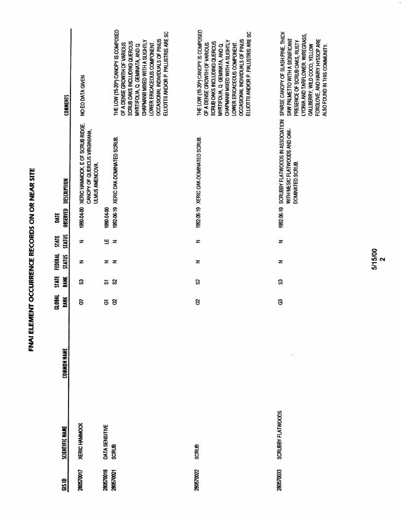
DRAFT
64

DRAFT
65

DRAFT
66

DRAFT
67

DRAFT
68

DRAFT
69

DRAFT
70
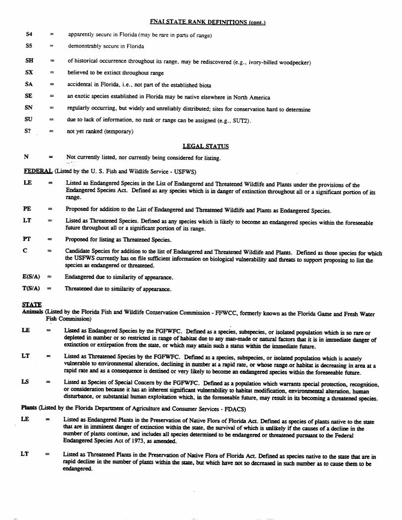
DRAFT
71

DRAFT
72

DRAFT
73
Appendix C: Preliminary and Secondary Plant Surveys

DRAFT
74

DRAFT
75

DRAFT
76

DRAFT
77
Secondary Dicerandra Scrub Sanctuary, FP&L Easement, and Titusville Wellfield Plant List. Additions to Dicerandra Scrub Sanctuary vascular plant species list from surveys of July 8, 2003 and November 4, 2003 by Paul A. Schmalzer and Tammy E. Foster, Dynamac Corporation. * indicates collected species. Family Taxa Anacardiaceae Rhus copallina Annonaceae Asimina obovata Asclepiadaceae Asclepias tomentosa* Aquifoliaceae Ilex ambigua Araceae Colocasia esculenta Asteraceae Ambrosia artemisiifolia Asteraceae Bidens alba var. radiata Asteraceae Carphephorus corymbosus Asteraceae Chrysopsis scabrella* Asteraceae Erechtites hieracifolia Asteraceae Eupatorium mohrii Asteraceae Euthamia caroliniana Asteraceae Heterotheca subaxillaris Asteraceae Liatris tenuifolia var. quadriflora Asteraceae Palafoxia feayi Asteraceae Solidago odora var. chapmanii* Bignoniaceae Campsis radicans* Caprifoliaceae Sambucus canadensis Chenopodiaceae Chenopodium ambrosioides Cistaceae Lechea divaricata* Cistaceae Lechea minor* Cistaceae Lechea torreyi Clusiaceae (Hypericaceae) Hypericum cistifolium Clusiaceae (Hypericaceae) Hypericum tetrapetalum Commelinaceae Commelina diffusa Convolvulaceae Merremia dissecta* Convolvulaceae Stylisma patens* Cucurbitaceae Momordica charantia Cyperaceae Bulbostylis ciliatifolia Cyperaceae Bulbostylis stenophylla* Cyperaceae Cyperus retrorsus Cyperaceae Fuirena scirpoidea* Cyperaceae Rhynchospora fascicularis* Cyperaceae Rhynchospora megalocarpa Cyperaceae Scleria ciliata var. pauciflora* Dennstaedtiaceae Pteridium aquilinum Euphorbiaceae Chamaesyce hyssopifolia* Euphorbiaceae Chamaesyce thymifolia* Euphorbiaceae Croton glandulosus

DRAFT
78
Table 1 (cont.) Family Taxa Euphorbiaceae Phyllanthus abnormis Euphorbiaceae Stillingia sylvatica Fabaceae Centrosema virginianum Fabaceae Chamaecrista nictitans Fabaceae Clitoria mariana Fabaceae Galactia elliottii Fabaceae Galactia regularis* Fabaceae Indigofera caroliniana Fabaceae Indigofera hirsuta Fabaceae Lupinus diffusus Gentianaceae Sabatia grandiflora Haemodoraceae Lachnanthes caroliniana Lauraceae Persea borbonia var. humilis* Malvaceae Sida acuta Malvaceae Sida rhombifolia Melastomataceae Rhexia virginica* Poaceae Andropogon brachystachyus Poaceae Andropogon floridanus* Poaceae Andropogon glomeratus var. glaucopsis* Poaceae Andropogon gyrans var. stenophyllus* Poaceae Andropogon virginicus var. decipiens* Poaceae Andropogon virginicus var. glaucus* Poaceae Aristida condensata* Poaceae Aristida purpurascens var. tenuispica* Poaceae Aristida spiciformis Poaceae Cenchrus incertus Poaceae Cynodon dactylon Poaceae Dactyloctenium aegyptium Poaceae Dicanthelium spp. Poaceae Digitaria sp. Poaceae Eustachys petrae Poaceae Paspalum notatum Poaceae Paspalum setaceum Poaceae Rhynchelytrum repens Poaceae Saccharum giganteum Poaceae Schizachyrium scoparium var. scoparium* Poaceae Setaria corrugata* Poaceae Setaria parviflora* Poaceae Sorghastrum secundum Polygalaceae Polygala incarnata Polygalaceae Polygala rugelii Polygonaceae Polygonella gracilis

DRAFT
79
Family Taxa Portulacaceae Portulaca amilis* Portulacaceae Portulaca pilosa* Rubiaceae Diodia teres Rubiaceae Richardia brasiliensis Scrophulariaceae Gratiola hispida* Smilacaceae Smilax auriculata Verbenaceae Lantana camara Vitaceae Vitis rotundifolia Xyridaceae Xyris caroliniana Xyridaceae Xyris longisepala* Xyridaceae Xyris sp. *

DRAFT
80
Appendix D: Preliminary Bird Survey

DRAFT
81
Report by Jim Escoffier. A preliminary bird survey was conducted on January 30, 2000 between 8:15 a.m. and 10 a.m. by members of the Indian River Audubon Society. Conditions were foggy making visual identification difficult; most identifications were made by calls.
Yellow rumped warbler Heard many, saw several. Towhee Heard several, saw none. Downy woodpecker Heard one. Pine Warbler Heard many, saw many. Cat bird Heard several, saw one or two. Robin Heard several. Cardinal Heard several, saw several. Blue Jay Heard several, saw several. Carolina wren Heard a few. Blue grey gnatcatcher Heard one. Red bellied woodpecker Heard several, saw several. White eyed vireo Heard one. Mourning dove Heard several, saw several. Boat tailed grackle Heard a few, saw a few. Ruby crowned kinglet Heard a few, saw a few. Brown thrasher Heard at least one. Oven bird Heard one, saw one. Palm warbler Heard several, saw several. House wren Saw one by the back boundary line. Tree swallow Saw a group fly over. Fish crow Heard several, saw several. Phoebe Heard one. Starling Heard several. Flicker Saw one. Scrub-jay Saw a family of two and heard others. Mocking bird Heard a few, saw a few.
A few means more than one. Several means more than five or six.