development of a geothermal information system … european geothermal congress 2007 unterhaching,...
TRANSCRIPT

Proceedings European Geothermal Congress 2007 Unterhaching, Germany, 30 May-1 June 2007
1
Development of a Geothermal Information System for Germany
Thorsten Agemar, Jessica-Aileen Alten, Klaus Kühne, Andreas-Alexander Maul, Sandra Pester, Wolfgang Wirth & Rüdiger Schulz
Leibniz Institute for Applied Geosciences (GGA-Institut), Stilleweg 2, D-30655 Hannover
Keywords: Deep geothermy, exploration risk, underground temperature, aquifer, North German Basin, Upper Rhine Graben, South German Molasse Basin, information system
ABSTRACT
The Leibniz Institute for Applied Geosciences is setting up an internet-based information system on geothermal re-sources in close collaboration with partners. For a start, the geothermal information system will contain data about hydrogeothermal resources only. The project aims at an improvement of quality in the planning of geothermal plants and at a minimization of exploration risks. The key parameters for this purpose are production rate (Q) and temperature (T). The basis for the estimation of subsurface hydraulic properties comes from the information system on hydrocarbons. This information system provides permeabil-ity and porosity values derived from core analysis data. The IT targets will be realised by a relational database providing all data relevant to the project. A 3D model of the underground provides the basis for visualisation and calculation of geothermal resources. As a prototype, an internet research tool of geothermal installations in Germany is available on the internet.
1 INTRODUCTION
1.1 Geothermal energy as a domestic energy source Geothermal energy enjoys a special position amongst the renewable energy sources because it is available all year around at any time of the day, and can therefore be used for base load energy, for both heat and power production. Geothermal energy is defined as energy stored beneath the surface of the solid earth in the form of heat (VDI RICHTLINIE 4640). It can be used in many different ways. Shallow geothermy involves extracting the energy from shallow areas of crust (mostly down to 150 m, max 400 m depth), e.g. using geothermal collectors, geothermal wells or vertical heat exchanger; the energy can usually only be exploited by using heat pumps. Deep geothermy involves exploiting the geothermal energy by way of deep boreholes and using the energy directly in most cases, i.e. without raising its temperature. The hot (> 100 °C), warm (60 – 100 °C) or thermal (> 20 °C) water stored in deep aquifers is usually used directly (sometimes via heat exchangers) for district heating networks as well as for agricultural, industrial or balneological purposes. Modern conversion techniques such as the ORC method and the Kalina cycle make it possible to generate power today from temperatures as low as 100 °C. This makes geothermal power generation interesting for “normal” geothermal regions such as Central Europe. The first experience of power generation in this form comes from three geothermal power stations in Neustadt-Glewe (Mecklenburg-Vorpommern), Altheim (Upper Austria) and Blumau (Steiermark). Other power plants are currently under construction.
To assess the future opportunities for geothermal power generation in Germany, the Office of Technology Assessment at the German Parliament (TAB) presented an expertise in 2003 (PASCHEN et al. 2003). Three reservoir types were considered exploitable – hot water aquifers, faults and crystalline rocks. The potential of the hot water aquifers alone – the reservoir with the lowest potential – was estimated by the TAB report to have an electricity generation potential in Germany of 9 EJ, whilst the thermal potential for cogeneration power plants is 23 EJ.
An economic sector is developing to exploit the geothermal potential of deep aquifers – not least because of the effects of the Renewable Energy Act (EEG). The other areas of deep geothermy however need to be supported by additional research and development measures. Detailed and reliable figures for instance on the order of magnitude of the hydraulic parameters in the fault zones are still required before exploitation can become viable. The use of the energy mainly stored in rock using the Hot Dry Rock technique (HDR) – also described overall as Enhanced Geothermal Systems (EGS) – is also still in the pilot phase (e.g. Soultz-sous-Forêts pilot project in the Elsace).
1.2 German government support for geothermy The German government has set itself the target of expanding in the near term the proportion of renewable energy in the overall energy supply mix of the Federal Republic of Germany. As part of the 5th Energy Research Programme of the German government, the German Ministry for the Environment, Nature Conservation and Nuclear Safety (BMU) supports research and development measures in various fields including deep geothermy. The aim of this funding is to further develop the cost effective exploitation and use of heat and power from geothermal reservoirs. Factors which have a major influence on the costs include the exploration and drilling of reservoirs, optimising the continuous reservoir exploitation, and effective energy conversion. The funding is aimed at aspects including the development of methods and processes to reduce the exploration risk of boreholes.
1.3 The project This is the background against which the project “Development of a Geothermal Information System for Germany” (GeotIS) has been funded by the BMU. The system is based on data on deep aquifers suitable for geothermal exploitation. The system is scheduled to make a contribution to improving the quality of geothermal-plant project-planning by providing preliminary figures on the crucial parameters for determining exploration risks: aquifer temperature and productivity. Concrete, location-specific prospectivity analyses still remains the brief of local feasibility studies.

Agemar et al.
2
Only a digital information system can satisfy the demand for a comprehensive, largely scale-independent form of a geothermal atlas which can be continuously updated. This will be a dynamic system which, in addition to the usually permanent geoscientific basic data, also includes the latest findings and results, and is continuously expanded. It has to be available via the internet, and should link all of the necessary databases and technical information systems as well as protect the property rights to the data.
The project is to be implemented under the management of the Leibniz Institute for Applied Geosciences (GGA Institute), Hannover, with the support of the Wirtschaftsverband Erdöl- und Erdgasgewinnung. Project partners are:
• Bayerisches Landesamt für Umwelt (LfU), München,
• Landesamt für Bergbau, Energie und Geologie (LBEG), Hannover,
• Landesamt für Geologie, Rohstoffe und Bergbau Baden-Württemberg (LGRB), Freiburg,
• Landesamt für Umwelt, Naturschutz und Geologie Mecklenburg-Vorpommern (LUNG), Güstrow,
• Freie Universität Berlin (FU), Arbeitsgruppe Hydrogeologie,
• Geothermie Neubrandenburg GmbH (GTN).
2 GEOTHERMAL REGIONS AND HORIZONS The most important regions for hydrogeothermal exploitation in Germany are the North German Basin, the Upper Rhine Graben, and the South German Molasse Basin (Fig. 1). The horizons relevant for geothermal exploitation in these three regions are listed in table 1.
Tab. 1: Most important regions and horizons for hydrogeothermal exploitation
Region Horizon Type Lias-Rhaetian aquifer complex
porous
Middle Bunter Sandstone fracture-porous
Rotliegend Sandstone fracture-porous
Lower Cretaceous Sandstone
porous
Dogger Sandstone porous
North German Basin
Keuper-Sandstone porous
Upper Muschelkalk fracture Upper Rhine Graben
Middle Bunter Sandstone fracture-porous
South German Molasse Basin
Upper Jurassic (Malm) karst/fracture
Fig. 1: Base map of areas with potential for hydrogeothermal exploitation: regions with aquifers with temperatures exceeding 100 °C (red), exceeding 60 °C (yellow); 100 °C is required for power generation, 60 °C for direct thermal exploitation.
There are additional aquifers and regions in Germany with suitable geology for hydrogeothermal exploitation, including the Thüringen Basin and parts of Schleswig-Holstein. But because the potential here is considered to be relatively low, they will only be incorporated in the Geothermal Information System during phase two.
Aquifers require an ambient temperature exceeding 100 °C if they are to be exploited for geothermal power production. The areas in Germany with this potential are shown in red in Figure 1. Temperatures over 60 °C are required for direct thermal exploitation, these regions are shown in yellow.
3 EXPLORATION RISK Although geothermal energy benefits from low operating costs, it does involve high investment costs, particularly the high drilling costs. Because it is always possible that the prospectivity of the section penetrated by a borehole is worse than expected or even unsuitable, investors and project operators try to estimate the exploration risk and insure against it if possible. The exploration risk therefore has to be precisely defined and used to quantify the probability of the economic success of a project.
The exploration risk is the risk of penetrating a geothermal reservoir with one (or more) borehole(s) with inadequate quantity or quality.
The quantity is defined here by the installed output of a geothermal plant:
( )oiFF TTQcP −⋅⋅⋅= ρ
P Output [W] ?F Fluid density [kg m-³]
Agemar et al.
3
cF Specific heat capacity at constant pressure [J kg-1K-1]
Q Flow rate, Production rate [m³ s-1] Ti, To (Input or output) temperature [K] or [°C]
Quality mainly concerns the composition (chemistry) of the fluid. All of the geothermal wells drilled in Germany to date have encountered water with compositions which are manageable for geothermal exploitation, although differing amounts of technical processing are required.
The crucial parameters for exploration risk are production rate Q and temperature Ti (the temperature at the wellhead). This crucially depends on temperature TA in the aquifer. Ti in general is a function of the production rate Q, the reservoir temperature TA, and the production duration ?t. During long periods of production at high production rates, there is only a negligible difference between the wellhead temperature and the reservoir temperature. This gives rise to the following general relationship:
P ~ ATQ ⋅
To determine the exploration risk, the project operator defines limits for TA and Q above which a well is considered to be a success. The operator then estimates the probability of achieving these values at the exploration site (SCHULZ et al. 2005). Because TA and Q are the critical parameters for risk analysis, the main objective of the Geothermal Information System will be to supply information on these two parameters.
The exploration risk does not cover the “sustainability”, i.e. the long term extraction of adequate amounts of energy; this is part of the operating risk:
tPE ∆⋅=
E Energy [J] P Output, as defined above [W] ?t Production duration [s]
There are also other risks including the drilling risk, or technical risks concerning the drilling rig and the drilling process.
4 DATA The data to be incorporated in the information system is derived from a very wide range of data sources, and therefore has to be standardised and analysed to assess its quality. Temperature data and hydraulic parameters required for predicting exploration risk are data measured in deep boreholes and can therefore be clearly assigned to specific wells.
4.1 Boreholes and geological sections Basic data and interpreted data from deep boreholes are used for a wide spectrum of purposes including reference data for measurements and for converting drilling depths to vertical depths. Geological logs, and stratigraphic logs in particular, are used to select the hydraulic data applying to the target horizons and to compare distribution maps.
The main source of information on deep boreholes and their geological logs is the Hydrocarbon Information System (FIS KW) created by LBEG. This currently contains approx. 22,000 geological logs from approx. 11,000 deep wells in Germany. The most important data source for the
area covered by the new German states is the “Hauptspeicher Bohrungsdaten” (Main Well Database). This is managed by Erdgas Erdöl GmbH and incorporates all the hydrocarbon wells drilled in the former German Democratic Republic: in addition to data on approx. 2,500 wells with approx. 2,000 geological logs, it also contains large amounts of core analysis data. Data sources for non-hydrocarbon deep wells (e.g. thermal water wells) include the well databases operated by the State Geological Surveys.
The diversity of the databases used, and the differences in processing level, structures and nomenclature, require a lot of work for preparation, standardisation and quality assurance, e.g.:
• Converting divergent data into a standardised form by specifying measurement depth, inclination and azimuth
• Converting geological logs into a standardised, easily researchable and processable final format
• Standardising geological nomenclature using the ATS key of the German oil & gas industry as the final key for stratigraphic, lithological and tectonic details
• Standardising complex descriptive elements such as the description of stratigraphic packages or intervals, when preparing logs
• Standardising the measuring units and reference systems (e.g. converting measured depths to vertical depths)
• Converting drilling co-ordinates to comply with a standard system (DHDN Potsdam in Gauß-Krüger Projection).
4.2 Temperature data The GGA Institute runs the Geophysical Information System (KÜHNE 2006, KÜHNE et al. 2003). This contains log data and valuations from a range of geophysical methods, primarily within Germany, and consists of a main system and various subsystems.
The geothermal subsystem contains information on the underground temperature field in Germany derived from around 10,000 wells. Equilibrium temperature logs and reservoir temperatures are considered to be optimal qualita-tive data which requires no corrections. Because of the regular monitoring of production wells over many years, reservoir temperatures are available in time series; the fluctuation in these temperatures is mainly less than 1 K.
Bottom hole temperatures (BHT) are also stored in the subsystem. These BHT values are recorded in almost all industrial boreholes at the deepest point of the well immediately after drilling has stopped, and are therefore thermally disturbed by the drilling process (the circulation of mud). These BHT values can be corrected (extrapolation) to produce undisturbed temperatures because the distorting effect of the mud circulation on the temperature field is lowest at the deepest point in the well. Various extrapolation methods can be used depending on the waiting time after the end of drilling, the circulation period, and the number of temperature measurements made available (SCHULZ & SCHELLSCHMIDT 1991). Despite such corrections, these results still have errors of approx. ± 5 K, and are therefore much less accurate than undisturbed temperature logs.
Gelöscht: de
Agemar et al.
4
4.3 Porosities and permeabilities Porosity and permeability data from core analyses provide important input for determining the hydraulic properties of underground formations. Digital data is stored in the Hydrocarbon Information System of LBEG, and the “Hauptspeicher Bohrungsdaten“ for wells drilled in the former GDR. Standardisation of this data is relatively uncomplicated because both data sets contain the information catalogued in similar structures. However, correct correlation – necessary for interpretation – between sample analyses and cores, and cores and specific boreholes, was only possible in the case of the GDR data after a great deal of intensive revision.
396,943 sample analyses are available from 2,431 boreholes: a single borehole may have up to approx. 4,000 sample analyses. 311,290 tests provide permeability and porosity information, 4,761 permeability data only, and 80,892 porosity data only: these figures include multiple tests on a single sample.
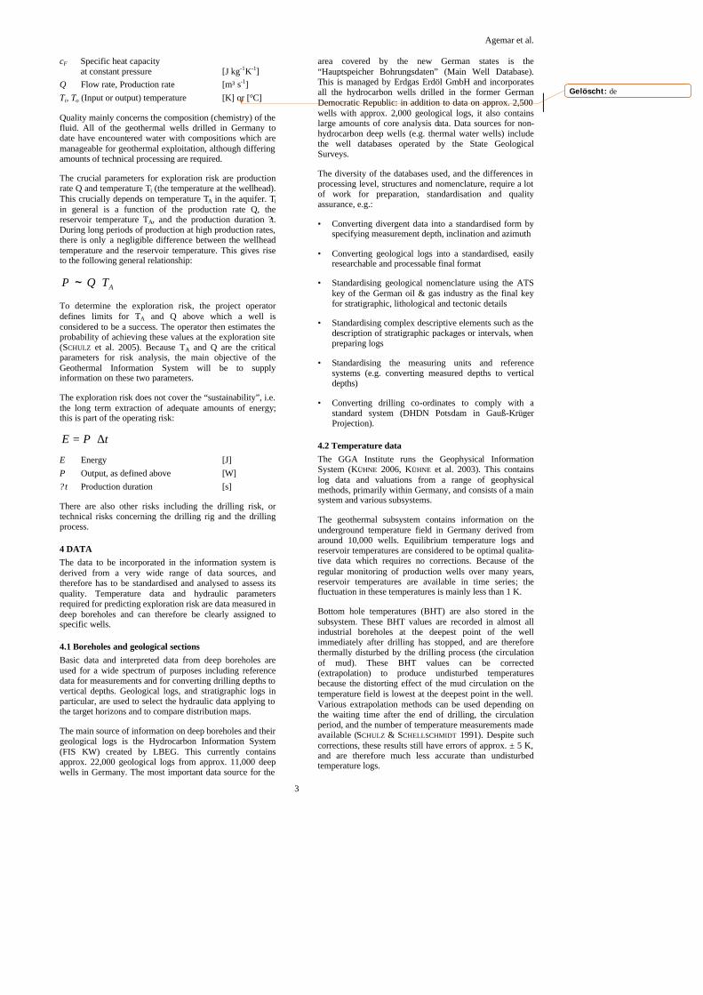
The distribution of the sample analyses naturally reflects the geographical (Figure 2) as well as the stratigraphic interests of oil & gas exploration. More than half of all the analysed wells (1,296 wells) were drilled in Niedersachsen. In addition to the North German Basin (1,952 wells), the remaining wells are concentrated in the Thüringen Basin (105 wells), the Upper Rhine Graben (93 wells) and the South German Molasse Basin (256 wells): 23 wells are from the German North Sea. As expected, most of the analyses carried out in Schleswig-Holstein concentrates on the Dogger because of the existence of the Dogger oilfield to the north of the Elbe river. Sample analyses in other parts of the North German Basin concentrates on the gas-bearing Zechstein and Rotliegend Formations. There is also a significant amount of data on the Lower Cretaceous in the Niedersachsen Basin. Most of the data from the Upper Rhine Graben and the South German Molasse Basin are from Tertiary sequences. Relatively few results are available on the geothermally relevant horizons (Tab. 1).
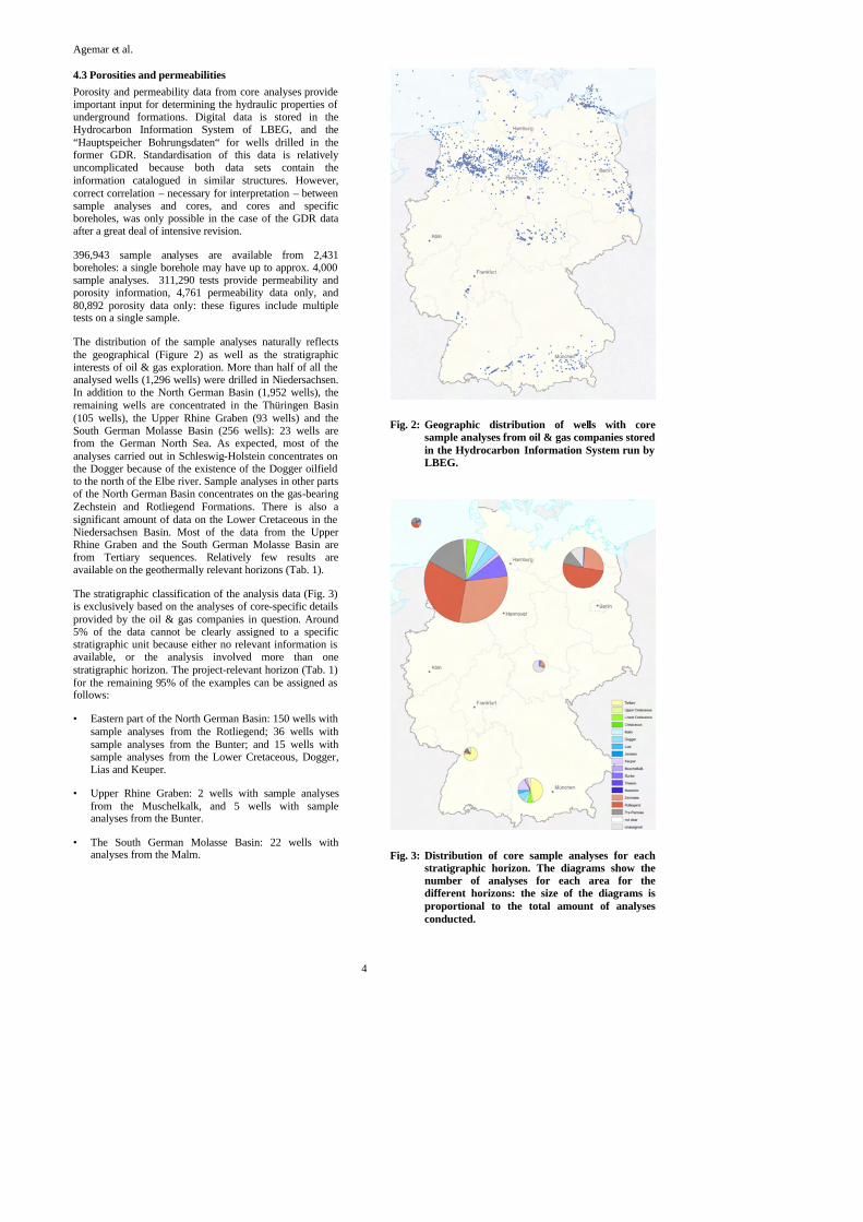
The stratigraphic classification of the analysis data (Fig. 3) is exclusively based on the analyses of core-specific details provided by the oil & gas companies in question. Around 5% of the data cannot be clearly assigned to a specific stratigraphic unit because either no relevant information is available, or the analysis involved more than one stratigraphic horizon. The project-relevant horizon (Tab. 1) for the remaining 95% of the examples can be assigned as follows:
• Eastern part of the North German Basin: 150 wells with sample analyses from the Rotliegend; 36 wells with sample analyses from the Bunter; and 15 wells with sample analyses from the Lower Cretaceous, Dogger, Lias and Keuper.
• Upper Rhine Graben: 2 wells with sample analyses from the Muschelkalk, and 5 wells with sample analyses from the Bunter.
• The South German Molasse Basin: 22 wells with analyses from the Malm.
Fig. 2: Geographic distribution of wells with core sample analyses from oil & gas companies stored in the Hydrocarbon Information System run by LBEG.
Fig. 3: Distribution of core sample analyses for each stratigraphic horizon. The diagrams show the number of analyses for each area for the different horizons: the size of the diagrams is proportional to the total amount of analyses conducted.
Agemar et al.
5
The next step is to use hydraulic laws, e.g. the Dupuit-Thiem Law, to derive interpretations on the expected productivity from the porosity and permeability data.
The project partners are preparing additional hydraulic data, including test data. This data comes from various types of wells, e.g., oil & gas, geothermal, thermal and mineral water wells, as well as boreholes drilled by the potash salt mining industry. The data currently available comes from 305 deep wells from the part of the Upper Rhine Graben in Baden-Württemberg; 35 thermal water and research boreholes in the Bavarian Molasse Basin; and 50 geothermal, landfill and brine boreholes in north-east Germany.
All of the details should be used where possible to calculate the productivity indices for all investigated locations.
5 IT SOLUTION
5.1 Space model The underground space model is an important part of the Geothermal Information System. It is used to store, calculate and visualise geological structures and geophysical parameters. A rectangular lattice is used to optimise the speed and storage capacity of the system. The aquifers relevant for deep geothermy are displayed by 2½D-grids, which means that the position of each point underground is defined by its surface co-ordinates and a depth. The important parameters such as porosity and permeability required for hydrogeothermal purposes are also interpolated and stored as 2½D-grids for each aquifer. The temperature distribution is spatially interpolated and stored as 3D-grids.
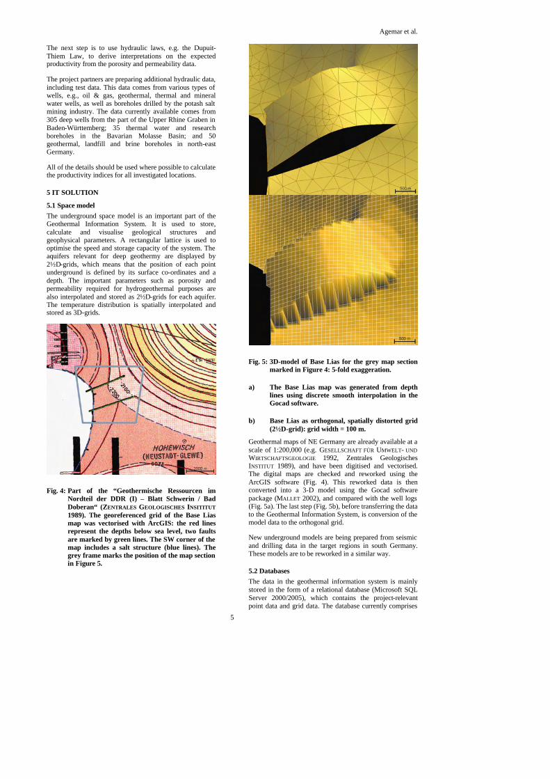
Fig. 4: Part of the “Geothermische Ressourcen im Nordteil der DDR (I) – Blatt Schwerin / Bad Doberan“ (ZENTRALES GEOLOGISCHES INSITITUT 1989). The georeferenced grid of the Base Lias map was vectorised with ArcGIS: the red lines represent the depths below sea level, two faults are marked by green lines. The SW corner of the map includes a salt structure (blue lines). The grey frame marks the position of the map section in Figure 5.
Fig. 5: 3D-model of Base Lias for the grey map section marked in Figure 4: 5-fold exaggeration.
a) The Base Lias map was generated from depth lines using discrete smooth interpolation in the Gocad software.
b) Base Lias as orthogonal, spatially distorted grid (2½D-grid): grid width = 100 m.
Geothermal maps of NE Germany are already available at a scale of 1:200,000 (e.g. GESELLSCHAFT FÜR UMWELT- UND WIRTSCHAFTSGEOLOGIE 1992, Zentrales Geologisches INSTITUT 1989), and have been digitised and vectorised. The digital maps are checked and reworked using the ArcGIS software (Fig. 4). This reworked data is then converted into a 3-D model using the Gocad software package (MALLET 2002), and compared with the well logs (Fig. 5a). The last step (Fig. 5b), before transferring the data to the Geothermal Information System, is conversion of the model data to the orthogonal grid.
New underground models are being prepared from seismic and drilling data in the target regions in south Germany. These models are to be reworked in a similar way.
5.2 Databases The data in the geothermal information system is mainly stored in the form of a relational database (Microsoft SQL Server 2000/2005), which contains the project-relevant point data and grid data. The database currently comprises
Agemar et al.
6
85 tables with a total of approx. 2 million data sets. A comprehensive system of database scripts and Java programs is used to generate and fill the tables, as well as to import data from the various sources. This approach was chosen to enable the databases to be generated automatically – e.g. if there are changes to the structure or content of a data source – and to therefore reproduce it safely.
The largest amount of data in the data sets currently consists of well data. At a later stage, the grid data of the spatial model will actually contain a larger volume of data. The well data includes source data (co-ordinates, owner, purpose, archive numbers etc.) as well as technical data (geological logs, temperature logs, porosity and permeability data, hydraulic tests, etc.).
For legal reasons, the technical data can usually only be used by authorised users and not passed on in their original form to third parties. Data storage must comply with this stipulation by mainly only making data available to internet users in an interpreted, generalised or anonymised form. This specification is met by the strict separation of data storage into working and presentation data (Fig. 6). The presentation data is updated automatically using database replication tools.
A file system is currently used to store the areal and 3D model data, e.g. in the form of Gocad files. The options for storing the areal data in a database are currently being discussed and tested. The version management software Subversion (SUBVERSION 2006) already used in the project would be particularly suitable for the demonstration of versions and information on the preparation status of the 3D model data.
5.3 Internet The Geothermal Information System will supply the technical information to users in interactive form via the internet. The advantage of a system of this kind compared to conventional maps is the ability to always use the latest findings and data, and make them immediately available to users as soon as they have been entered into the information system.
The current legal situation in Germany has however complicated the use of the data, particularly the data derived from oil & gas industry’s seismic surveys and deep wells. This information is classified as confidential no matter how old it is and whether or not the concession still exists. Although this data is incorporated in the underground models, users cannot usually be given access to the basic data.
The internet interfaces will provide users with the following functions:
• A geographical search which provides users with details on the geothermal productivity of a specific location, and the reliability of the interpretation. This function is based on an interactive map with a range of zoom and navigation options, and different categories of technical data and map background information which can be superimposed in windows.
• A search based on an interactive map of locations where there are existing geothermal plants or plants under construction.
• A form-based search for suitable locations based on technical specifications.
• A range of visualisation options for underground models (e.g. horizontal and vertical sections showing geological and geophysical parameters, aquifer projections, 3D displays, isoline maps).?
• Clicking on data points (e.g. wells) to show the available basic data (where legally permissible).
• Statistical evaluations.
The software solution is being developed as a Java and PHP-based web application – combined with the UMN Mapserver (FISCHER 2003) as an Open-Source basic tool for geographic research.
An internet research tool for geothermal installations has already been completed as a prototype: Fig. 7 shows a screen shot of this application. The map background consists of a zoomable map of Germany. The user can choose between different topographic and thematic base maps. A statistical function shows the production data of the plants – classified according to use – for the whole of Germany or for a selected region. An integrated list of towns and various options for searching for localities simplify the positioning of the map window over the area of interest. Users can also use a selection box to select specific German states. The selection boxes reference the agency responsible in each case. This application is based on a list of all geothermal plants in Germany which are being operated or under construction. This list was elaborated by the “Deep Geothermy” work group of the Bund/Länder-Ausschuss Bodenforschung (BLA-GEO). This work group acts as a committee with respect to the project presented here to ensure close collaboration between the different Geological surveys in each federal German state.
6 OUTLOOK The project is funded by the German Federal Ministry of the Environment, Nature Conservation and Nuclear Safety (BMU) with funding number 0327542. It began in January 2006. The information is scheduled to be online by the end of 2008. Information on the status of the work is available from the Leibniz Institute for Applied Geosciences website (http://www.gga-hannover.de). The project pages in part-icular (http://www.geotis.de) provide up-to-date informa-tion such as progress reports, meeting presentations and the first application.
REFERENCES FISCHER, T. (2003): UMN Mapserver 4.0: Handbuch und
Referenz. – MapMedia GmbH, Berlin.
GESELLSCHAFT FÜR UMWELT- UND WIRTSCHAFTSGEOLOGIE (1992): Geologische Grundlagen für die Geothermienutzung in Nordost-Deutschland (Kartenwerk 1:200.000), Blatt Rostock/Stralsund. – Berlin.
KÜHNE, K. (2006): Das Fachinformationssystem Geophysik und seine Nutzung über das Internet. – In: MERKEL, B., SCHAEBEN, H., WOLKERSDORFER, C. & HASCHE-BERGER, A. (Hrsg.): GIS – Geowissen-schaftliche Anwendungen und Entwicklungen, Wiss. Mitteilungen des Instituts für Geologie, 31: 227-231; Freiberg.

Agemar et al.
7
KÜHNE, K., MAUL, A.-A. & Gorling, L. (2003): Aufbau eines Fachinformationssystems Geophysik. – Z. Angew. Geol., 2/2003: 48-53; Hannover.
MALLET, J. L. (2002): Geomodeling. – Oxford University Press, New York.
PASCHEN, H., OERTEL, D. & GRÜNWALD, R. (2003): Möglichkeiten der geothermischen Strom¬erzeugung in Deutschland. - Sachstandsbericht, Büro für Technikfolgen-Abschätzung beim Deutschen Bundestag, Arbeitsbericht 84: 129 S.; Berlin.
SCHULZ, R., JUNG, R. & SCHELLSCHMIDT, R. (2005): Assessment of probability of success for hydrogeothermal wells. - Proceedings World Geothermal Congress 2005, 24.-29.04.2005, Antalya, Turkey: Paper 407; 6 p.; Auckland (IGA).
SCHULZ, R. & Schellschmidt, R. (1991): Das Temperaturfeld im südlichen Oberrheingraben. – Geol. Jb., E48: 153-165; Hannover.
SUBVERSION (2006): Subversion version control system. – http://subversion.tigris.org/
VDI-RICHTLINIE 4640: Blatt 1 – Thermische Nutzung des Untergrundes – Grundlagen, Genehmigungen, Umweltaspekte. – Dezember 2000, 32 pages; Berlin.
ZENTRALES GEOLOGISCHES INSTITUT (1989): Geothermische Ressourcen im Nordteil der DDR (1), Blatt Schwerin / Bad Doberan (1:200.000). – Berlin.
Fig. 6: Database model: separation of work and presentation data
Fig. 7: Internet research in the geothermal installations list. The map detail shows an area in Mecklenburg-Vorpommern. The district administration boundaries and topography are superimposed as the background. The locations are shown on the map, and the most important data for each installation is shown in the information table (below right). More detailed data on each installation can be accessed by clicking on the relevant locality.