developing an iphone app to help people avoid traffic ixtli-nitzin sanchez, eugene fiorini, ph.d,...
TRANSCRIPT

Developing an iPhone app to Help People Avoid Traffic
Ixtli-Nitzin Sanchez, Eugene Fiorini, Ph.D, André Cohen
July 19th 2012

• FACT: Americans now spend more than 100 hours a
year commuting to work.
– Source: U.S. Census Bureau's American Community Survey
http://blogs.seattleweekly.com/dailyweekly/2010/11/seattle_rush_hour_traffic_rank.php

Purpose
oSuggest Alternative Departure
Times
Now or Later?
oOffer New Solutions to Avoiding
traffic.

Project that unfolded:
“Using New York City’s 2009 Historical
Traffic Data to Develop an iPhone
Routing & Ride Sharing Application.”

To fuse a currently existing
Routing Program with
Historical Traffic Data.
Specific Aim
oBeginning with New York City

• Traffic Data
o2 files & C Program
Key Components of the Project
• Maps
• Routing

New York City Traffic Data
• Provided by:
o New York State Department of Transportation
• DATA files:
1. 2009 Hourly Traffic Data, New
York City
• 47,643 lines of Data !
2. Street ID with Longitude & Latitude
correlation
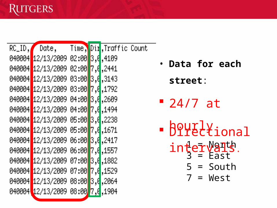
1. Hourly Traffic Data from 2009, New York City
Directional1 = North3 = East5 = South7 = West
• Data for each street:
24/7 at hourly
intervals.

2. Street ID with Longitude & Latitude correlation
• Facts about DATA:
o NOT All Streets had
Longitude and
Latitude Codes

With the Power of Programming
•In the C language :
1. Reorganized the Data & 2. Converted the Dates -> Days

Maps• Needed a Map Provider WITHOUT:
1. licensing fees
2. contractual restrictions
Google Maps’ Terms of Service, under ‘Map Information’ section:
"Also, you may not use Google Maps in a manner which gives you or any other person access to mass downloads or bulk feeds of numerical latitude and longitude coordinates”
Meaning = no

• Open Source geospatial data for anybody
to use.
• Downloaded the geographical data file of
New York .
SOLUTION: OpenStreetMap

Result
• Using a Open Source Program
Library
o Successfully placed an
OpenstreetMap map on a
iPhone application.
Uses Route-Me map library, (c) 2008-2010 Route-Me Contributors

NEEDED : Preexisting Program to take care of Routing
Routing
Libosmscout
PITFALLS:
Long and Tedious build process.
Resulting in a week and half of debugging.
Advised- to find another routing program
Temporary Routing Solution
•Google Map’s application programming interface (API) routing program
•Serve only as a proof of concept so that we may utilize the traffic data.

Merging the Traffic Data
• Work in Progress…
o Averaging the traffic for the route.
o Return a traffic report to the user.

Future Work
I. Data Visualization
II. iPhone extension–Ride Share

Using GraphStream
Why?
A.Visualizing &
B.Understanding
I. Data Visualization

A. Save user’s search results & their point to point location.
B. Match with another user who has a “similar” travel route.
C. Create a group that will invite a collection of users who take the same route.
II. iPhone extension –Ride Share
Opportunity to carpool with others will:

Conclusion
Create an iPhone application that will provide users with the opportunity to
carpool with others thus saving money and living a stress-free life without traffic.
•For more info you can contact me:– [email protected]– 323-376-5058 (cell)– CoRE Building Room 434

Acknowledgements
Special Thanks To:
• Dr. Fiorini, Ph.D• André Cohen• Dr. Erenrich, Ph.D• Roselin Rosario