detailed unexploded ordnance (uxo) threat & risk assessment€¦ · detailed unexploded...
TRANSCRIPT
6 Alpha Associates Limited, Unit 2A Woolpit Business Park, Bury St Edmunds, IP30 9UP, United Kingdom T: +44 (0)2033 713 900 | W: www.6alpha.com
PROJECT NUMBER P7462 ORIGINATOR L. Gregory
VERSION NUMBER 1.0 REVIEWED BY B. Wilkinson (18th July 2019)
CLIENT Campbell Reith RELEASED BY R. Griffiths (23rd July 2019)
SITE Harrow (Northwick Park, HA1 3GX)
RATING VERY HIGH - This Site requires further action to reduce risk to ALARP during intrusive activities.
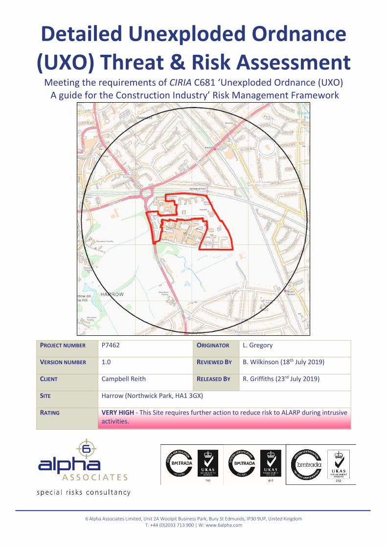
Detailed Unexploded Ordnance (UXO) Threat & Risk Assessment
Meeting the requirements of CIRIA C681 ‘Unexploded Ordnance (UXO) A guide for the Construction Industry’ Risk Management Framework
1
www.6alpha.com - +44 (0) 2033 713 900 [email protected]
6 Alpha Project Number: P7462 Client: Campbell Reith Site: Harrow (Northwick Park, HA1 3GX)
Contents Contents .................................................................................................................................................. 1
Acronyms and Abbreviations .................................................................................................................. 2
EXECUTIVE SUMMARY ........................................................................................................................ 3
ASSESSMENT METHODOLOGY ........................................................................................................... 5
STAGE ONE – SITE LOCATION AND DESCRIPTION .............................................................................. 6
Proposed Works ............................................................................................................................. 6
Ground Conditions ......................................................................................................................... 6
STAGE TWO – REVIEW OF HISTORICAL DATASETS ............................................................................. 8
STAGE THREE – DATA ANALYSIS ....................................................................................................... 12
STAGE FOUR – RISK ASSESSMENT .................................................................................................... 13
Threat Items ................................................................................................................................. 13
Bomb Penetration Depth ............................................................................................................. 13
UXO Risk Calculation Table .......................................................................................................... 14
STAGE FIVE – RECOMMENDED RISK MITIGATION MEASURES ......................................................... 15
Report Figures ....................................................................................................................................... 16
FIGURES Figure One - Site Location
Figure Two - Site Boundary
Figure Three - Aerial Photography (2018)
Figure Four - Aerial Photography (1945)
Figure Five - WWII High Explosive Bomb Strikes
Figure Six - WWII High Explosive Bomb Density
2
www.6alpha.com - +44 (0) 2033 713 900 [email protected]
6 Alpha Project Number: P7462 Client: Campbell Reith Site: Harrow (Northwick Park, HA1 3GX)
Acronyms and AbbreviationsAA Anti-Aircraft AAA Anti-Aircraft Ammunition ALARP As Low As Reasonably Practicable AOD Above Ordnance Datum ARP Air Raid Precaution AXO Abandoned Explosive Ordnance BD Bomb Disposal BDO Bomb Disposal Officer bgl Below Ground Level BGS British Geological Survey BH Borehole BPD Bomb Penetration Depth CDP Cast Driven Piles CFA Continuous Flight Auger CIRIA Construction Industry Research
and Information Association CPT Cone Penetration Testing CS County Series EO Explosive Ordnance EOC Explosive Ordnance Clearance EOD Explosive Ordnance Disposal GI Ground Investigation GIS Geographic Information Systems GL Ground Level GP General Purpose GPS Global Positioning Systems HAA Heavy Anti-Aircraft HE High Explosive HO Home Office HSE Health and Safety Executive IB Incendiary Bomb kg Kilograms km Kilometres LAA Light Anti-Aircraft LCC London County Council LE Low Explosive LSA Land Service Ammunition m Metres MoD Ministry of Defence mm Millimetres
NEQ Net Explosive Quantity NFF National Filling Factory NGR National Grid Reference OD Ordnance Datum OS Ordnance Survey PM Parachute Mine PoW Prisoner of War RADAR Radio Detection And Ranging RAF Royal Air Force RN Royal Navy RNAS Royal Naval Air Service ROF Royal Ordnance Factory SAA Small Arms Ammunition TA Territorial Army TNT Trinitrotoluene UK United Kingdom UN United Nations USAAF United States Army Air Force UXB Unexploded Bomb UXO Unexploded Ordnance V Weapons Vergeltungswaffe – Vengeance
Weapons WD War Department WWI World War One WWII World War Two
3
www.6alpha.com - +44 (0) 2033 713 900 [email protected]
6 Alpha Project Number: P7462 Client: Campbell Reith Site: Harrow (Northwick Park, HA1 3GX)
EXECUTIVE SUMMARY
Study Site
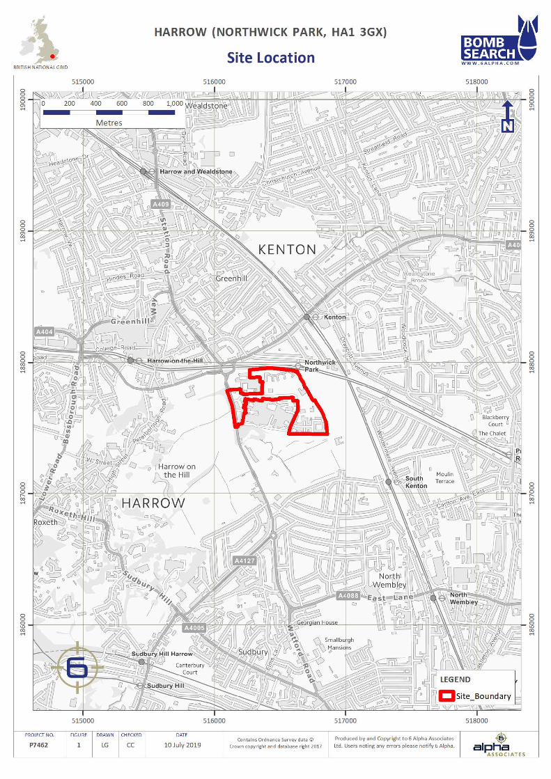
The Client has defined the Study Site as “Harrow (Northwick Park, HA1 3GX)”. The Site is located at NGR 516520, 187715.
Risk Level
VERY HIGH
Potential Threat Sources
The most probable UXO threat is posed by WWII German HE bombs, whilst IBs and British AAA projectiles (which were used to defend against German bombing raids) pose a residual threat.
Risk Pathway
Given the types of UXO that might be present on-site, all types of aggressive intrusive engineering activities may generate a significant risk pathway.
Key Findings
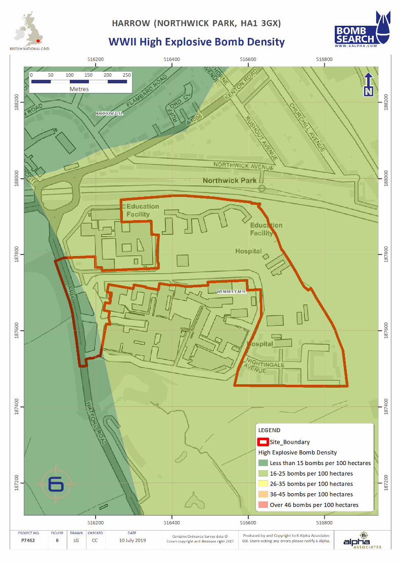
During WWII, the Study Site was situated within Wembley Municipal Borough and Harrow Urban District, which recorded 19 and eight HE bomb strikes per 100 hectares respectively, a low and very low level of bombing.
Luftwaffe aerial reconnaissance photography associated with the Site did not identify any primary bombing targets on-site or within 1,000m of it.
ARP records associated with the Site noted three HE bomb strikes within it. In addition, a further five HE bomb strikes were recorded; 5m to the south, 35m to the east, 55m to the south-south-east, 195m to the north and 260m to the south-east.
LCC bomb damage mapping did not cover the Site and an analysis of post-war mapping and further research of historical records did not identify any evidence of bomb damage within 1,000m. Nonetheless, given that three HE bomb strikes impacted in very close proximity to the on-site structures, it is highly likely that some degree of damage would have been caused as a result.
Pre-WWII mapping (1938) and aerial photography (1945) associated with the Site shows that it was located within a semi-developed rural area during WWII. The Site itself consisted of several structures in the north and west of the Site. The majority of the rest of the Site was undeveloped. As a result, it is likely that any UXB entry holes within the areas of buildings would have been observed and reported, while those within undeveloped areas of the Site were likely to have gone unnoticed.
The Club House on-site was demolished in the 1960’s with significant large-scale development occurring across areas of the Site in the 1970’s. Additional demolition and redevelopment work occurred at the Site during the 1990s and 2000s. Consequently, it is considered likely that any UXO within the structural foundations of post-war features would have been discovered and removed, however, the potential for deep buried UXO to be present within remaining areas is assessed to be extant.
Given that the Site was subjected to bombing, the following risk mitigation measures are recommended as a minimum, in order to reduce risks ALARP, during intrusive works in all previously undisturbed ground i.e. that which has not previously been excavated, probed, drilled or otherwise intrusively disturbed since it had potentially become contaminated with UXO.
4
www.6alpha.com - +44 (0) 2033 713 900 [email protected]
6 Alpha Project Number: P7462 Client: Campbell Reith Site: Harrow (Northwick Park, HA1 3GX)
EXECUTIVE SUMMARY (…continued)
Recommended Risk Mitigation
All Groundworks in All Areas:
1. Operational UXO Emergency Response Plan; appropriate Site Management documentation should be held on-site to guide and plan for the actions which should be undertaken in the event of a suspected or confirmed UXO discovery (this plan can be supplied by 6 Alpha);
2. UXO Safety & Awareness Briefings; the briefings are essential when there is a possibility of an UXO / UXB encounter and are a vital part of the general safety requirement. All personnel working on the Site should receive a briefing on the identification of an UXO / UXB, what actions they should take to keep people and equipment away from such a hazard and to alert Site management. Information concerning the nature of the UXO / UXB threat should be held in the Site office and displayed for general information on notice boards, both for reference and as a reminder for ground workers. The Safety & Awareness briefing is an essential part of the Health & Safety Plan for the Site and helps to evidence conformity with the principles laid down in the CDM regulations 2015 (this briefing can be delivered directly, or in some cases remotely, by 6 Alpha).
Trial Pits, Trenching, and Excavations into Previously Undisturbed Ground:
3. Non-intrusive UXO Survey and/or EOD Banksman Support; Where ‘open’ intrusive works into previously undisturbed ground are proposed and where the extent is considered to be within the capabilities of non-intrusive UXO survey equipment and implementation of this is assessed as likely to prove effective, a non-intrusive geophysical UXO survey should be trialed and, if it proves successful, should be employed to survey site-wide, or in specific areas where ‘open’ intrusive works are to be implemented to identify for signs of sub-surface anomalies which may model as the target UXO in advance of said works. If the survey proves partially or wholly ineffective, an EOD Engineer should be present in the UXO Banksman role to monitor ongoing ‘open’ intrusive works to identify any suspicious items that may be UXB or UXO related (this service can be provided by 6 Alpha).
Window Sampling, Boreholing, and Piling into Previously Undisturbed Ground:
4. Intrusive UXO Survey; Where ‘blind’ intrusive works into previously undisturbed ground are proposed, an intrusive UXO survey (employing down-hole magnetometer or MagCone techniques) is strongly recommended. Such a survey should extend to the assessed average bomb penetration depth or to the maximum depth of the works, whichever is encountered first, or until geology is encountered through which it is assessed a UXB would not penetrate, to identify for signs of sub-surface anomalies which may model as the target UXO in advance of said works. (this service can be provided by 6 Alpha).
For further information, please contact 6 Alpha Associates:
Website: http://www.6alpha.com
Telephone: +44 (0)2033 713 900
Email: [email protected]
5
www.6alpha.com - +44 (0) 2033 713 900 [email protected]
6 Alpha Project Number: P7462 Client: Campbell Reith Site: Harrow (Northwick Park, HA1 3GX)
ASSESSMENT METHODOLOGY
Approach
6 Alpha Associates is an independent, specialist risk management consultancy practice, which has assessed the risk of encountering UXO (as well as buried bulk high explosives) at this Site, by employing a process advocated for this purpose by CIRIA. The CIRIA guide for managing UXO risks in the construction industry (C681) not only represents best practice but has also been endorsed by the HSE. Any risk mitigation solution is recommended only because it delivers the Client a risk reduced to ALARP at best value. UXO hazards can be identified through the investigation of local and national archives associated with the Site, MoD archives, local historical sources, historical mapping as well as contemporaneous aerial photography (if it is available). Hazards will have only been recorded if there is specific information that could reasonably place them within the boundaries of the Site. The amalgamation of information is then assessed to enable the researcher to provide relevant and accurate risk mitigation practices. The assessment of UXO risk is a measure of probability of encounter and consequence of encounter; the former being a function of the identified hazard and proposed development methodology; the latter being a function of the type of hazard and the proximity of personnel (and/or other ‘sensitive receptors’, such as equipment) to the hazard, at the moment of encounter.
If UXO risks are identified, the methods of mitigation we have recommended are considered reasonably and sufficiently robust to reduce them to ALARP. We advocate the adoption of the legal ALARP principle because it is a key factor in efficiently and effectively ameliorating UXO risks. It also provides a ready means for assessing the Client’s tolerability of UXO risk. In essence, the principle states that if the cost of reducing a risk significantly outweighs the benefit, then the risk may be considered tolerable. This does not mean that there is never a requirement for UXO risk mitigation, but that any mitigation must demonstrate that it is beneficial. Any additional mitigation that delivers diminishing benefits and that consume disproportionate time, money and effort are considered de minimis and thus unnecessary. Because of this principle, UXB and UXO risks will rarely be reduced to zero (nor need they be).
Important Notes
Key source material is referenced within this document, whilst secondary/anecdotal information may be available upon request. Although this report is up to date and accurate at the time of writing, our databases are continually being populated as and when additional information becomes available. Nonetheless, 6 Alpha have exercised all reasonable care, skill and due diligence in providing this service and producing this report.
The assessment levels are based upon our professional opinion and have been supported by our interpretation of historical records and third party data sources. Wherever possible, 6 Alpha has sought to corroborate and to verify the accuracy of all data we have employed, but we are not accountable for any inherent errors that may be contained in third party data sets (e.g. National Archive or other library sources), and over which 6 Alpha cannot exercise control.
6
www.6alpha.com - +44 (0) 2033 713 900 [email protected]
6 Alpha Project Number: P7462 Client: Campbell Reith Site: Harrow (Northwick Park, HA1 3GX)
STAGE ONE – SITE LOCATION AND DESCRIPTION
Study Site
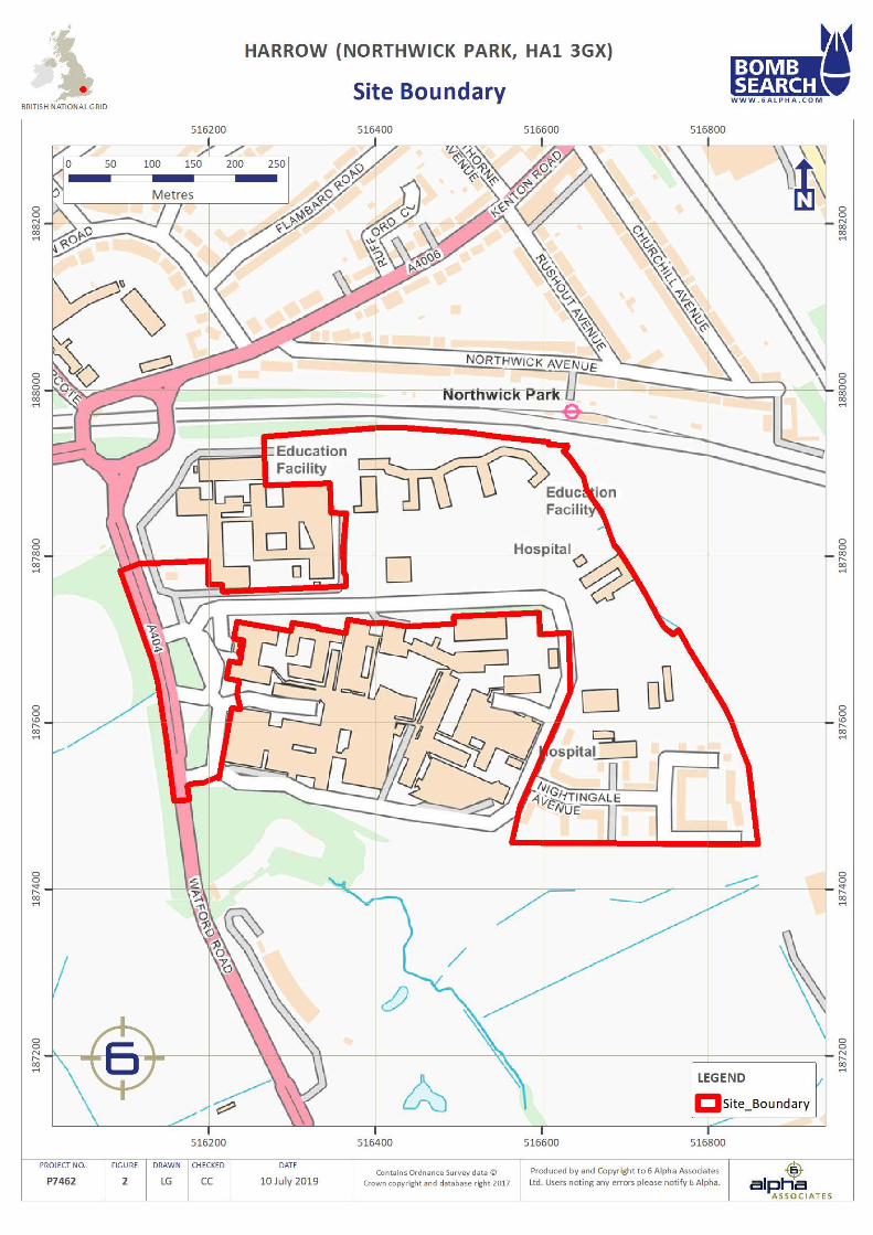
The Client has defined the Study Site as “Harrow (Northwick Park, HA1 3GX)”. The Site is located at NGR 516520, 187715. The Site location and Site boundary are presented at Figures 1 and 2 respectively.
Location Description
The Study Site is situated within Northwick Park and covers an area of 16.7 hectares (ha). Furthermore, the Site is bounded by:
• North: The University of Westminster, railway lines, undeveloped ground and trees; • East: Undeveloped ground, a footpath and trees; • South: Northwick Park Hospital, St. Mark’s Hospital, undeveloped ground, a footpath, trees and numerous
structures; • West: Undeveloped ground, trees and an unnamed hardstanding road.
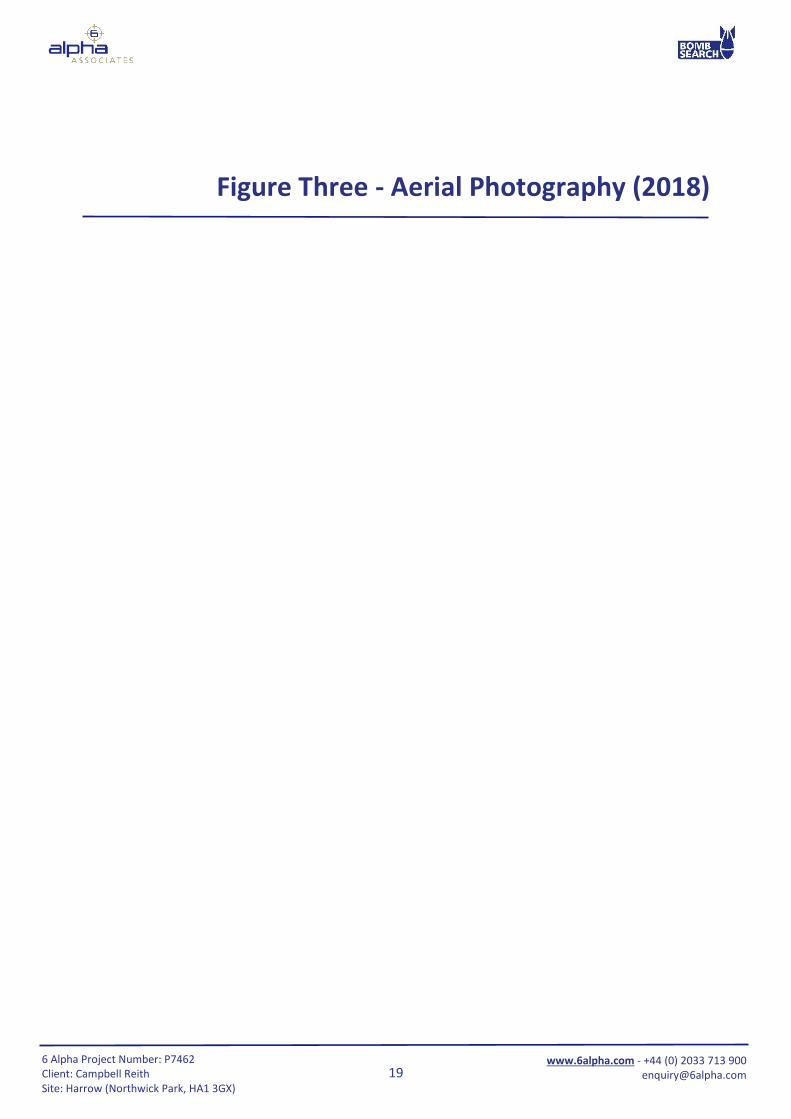
Aerial Photography (2018) (Figure 3)
Aerial photography (2018) corroborates the information above and shows that the Site is situated within a semi-developed urban area. The Study Site itself consists of numerous significant structures in the north and south-east of the Site with areas of hard-standing car parks and roads and undeveloped grassland also present throughout the Site.
Proposed Works The Client has described the following: “It is proposed to develop approximately 2000 residential units, comprising blocks of flats between 4 and 15 storeys. Development will be limited to areas A1, A2, A3, B and C and a new spine road constructed which will connect Watford Road to the new development… there will be a ground investigation covering the proposed residential development and the road.” As a result, 6 Alpha will assume that a number of geotechnical investigative methodologies and construction methodologies will be undertaken, including; trial pits, window sampling, boreholes, trenching, excavations, and piling.
Ground Conditions
It is important to establish the specific ground conditions in order to determine the maximum German UXB penetration depth as well as the potential for other types of munitions to be buried. If the Site investigations and/or construction methodologies change, and/or if a specific methodology is to be employed, and/or if the scope of work is focused upon a specific part of the Site, then 6 Alpha are to be informed so that the prospective UXO risks and the associated risk mitigation methodology might be re-assessed. Certain ground conditions may also constrain certain types of UXO risk mitigative works e.g. magnetometer survey is adversely affected in mineralised and made ground. It is important to establish the provenance of made ground, where this is recorded as being part of the site ground make-up, in order to accurately determine the ground levels at the time when the site may have become potentially contaminated with UXO and so as to accurately determine the average / maximum bomb penetration depths and make appropriate recommendations aimed at reducing the risk to ALARP.
7
www.6alpha.com - +44 (0) 2033 713 900 [email protected]
6 Alpha Project Number: P7462 Client: Campbell Reith Site: Harrow (Northwick Park, HA1 3GX)
STAGE ONE – SITE LOCATION AND DESCRIPTION (…continued)
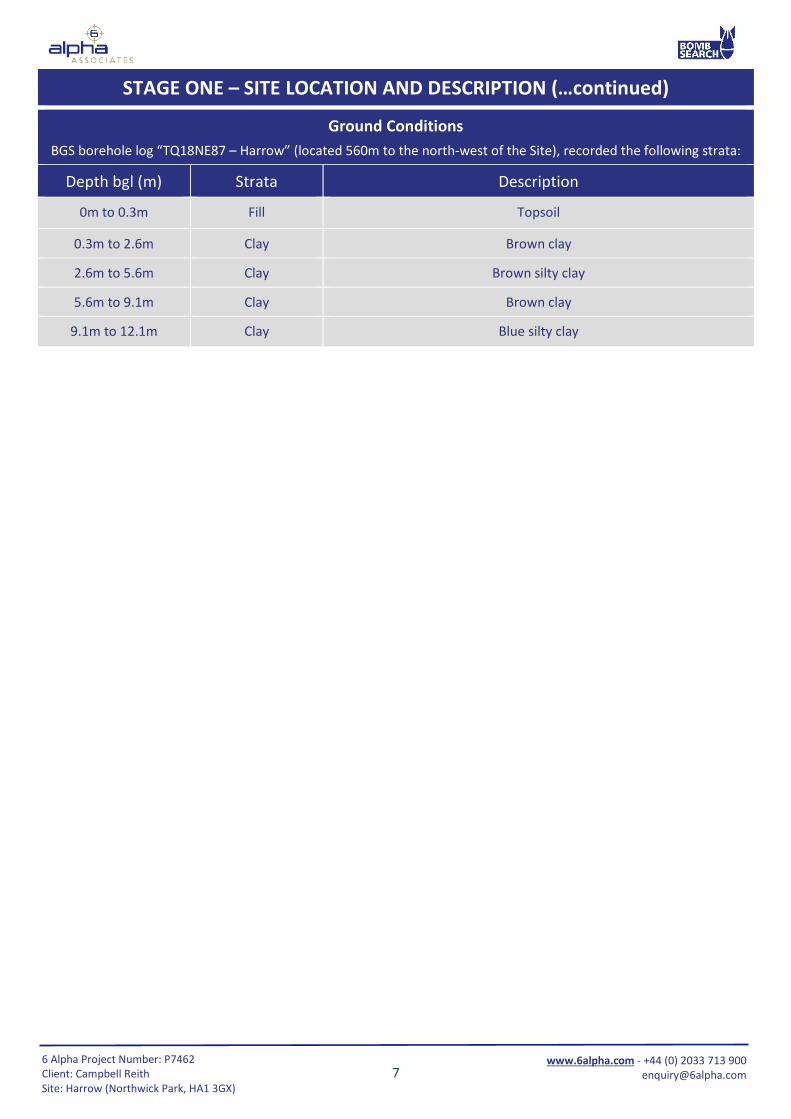
Ground Conditions BGS borehole log “TQ18NE87 – Harrow” (located 560m to the north-west of the Site), recorded the following strata:
Depth bgl (m) Strata Description
0m to 0.3m Fill Topsoil
0.3m to 2.6m Clay Brown clay
2.6m to 5.6m Clay Brown silty clay
5.6m to 9.1m Clay Brown clay
9.1m to 12.1m Clay Blue silty clay
8
www.6alpha.com - +44 (0) 2033 713 900 [email protected]
6 Alpha Project Number: P7462 Client: Campbell Reith Site: Harrow (Northwick Park, HA1 3GX)
STAGE TWO – REVIEW OF HISTORICAL DATASETS
Sources of Information Consulted
The following primary information sources have been used in order to establish the background UXO threat: 1. 6 Alpha’s Azimuth Database; 2. Home Office WWII Bomb Census Maps; 3. WWII and post-WWII aerial photography; 4. Official Abandoned Bomb Register; 5. Information gathered from the National Archives at Kew; 6. Historic UXO information provided by 33 Engineer Regiment (Explosive Ordnance Disposal) at Carver Barracks,
Wimbish.
Potential Sources of UXO Contamination
In general, there are several activities that might contaminate a site with UXO but the three most common ways are: legacy munitions from military training/exercises; deliberate or accidental dumping (AXO) and ordnance resulting from war fighting activities (also known as the Explosive Remnants of War (ERW)). During WWII, the Luftwaffe undertook bombing campaigns all over the UK. The most common type of UXO discovered today is the aerially delivered high explosive (HE) bomb, which are comparatively thick-skinned and dropped from enemy aircraft. If the bomb did not detonate when it was dropped, the force of impact enabled the UXO to penetrate the ground, often leaving behind it a UXB entry hole. These entry holes were not always apparent and some went unreported, leaving the bomb buried and unrecorded. More rarely, additional forms of German UXO are occasionally discovered including inter alia V1 and V2 rockets, Incendiary Bombs (IBs), and Anti-personnel (AP) bomblets. Although the Luftwaffe had designated primary bombing targets across the UK, their high-altitude night bombing was not accurate. As a result, thousands of buildings were damaged and civilian fatalities were common. Bombs were also jettisoned over opportunistic targets and residential areas were sometimes struck. As the threat of invasion lingered over Britain during WWII, defensive actions were undertaken. The British and Allied Forces requisitioned large areas of land for military training and bomb storage (including HE bombs, naval shells, artillery and tank projectiles, explosives, LSA and SAA). Thousands of tonnes of these munitions were used for the Allied Forces weapon testing and military training alone. It has been estimated that at least 20 per cent of the UK’s land has been used for military training at some point. The best practice guide for dealing with your UXO risks on land (CIRIA publication C681) suggests that approximately 10 per cent of all munitions deployed failed to function as designed. ERW are therefore, still commonly encountered, especially whist undertaking construction and civil engineering groundwork. Furthermore, in exceptional circumstances, UXO is discovered unexpectedly and without apparent rational explanation. There are several ways this might occur:
• When Luftwaffe aircraft wished to swiftly escape e.g. from an aerial attack, they would jettison some or all of their bombs and flee. This is commonly referred to as tip and run and it has resulted in bombs being found in unexpected locations;
• Transportation of aggregate containing munitions to an area that was previously free of UXO, usually related to construction activities employing material dredged from a contaminated offshore borrow site;
• Poor precision during targeting (due to high altitude night bombing and/or poor visibility) resulted in bombs landing off target, but within the surrounding area.
• British decoy sites were also constructed to deliberately cause incorrect targeting. For obvious reasons, such sites were often built in remote and uninhabited areas.
9
www.6alpha.com - +44 (0) 2033 713 900 [email protected]
6 Alpha Project Number: P7462 Client: Campbell Reith Site: Harrow (Northwick Park, HA1 3GX)
Site History From an analysis of the CS and OS historical mapping associated with the Site, the following Site history can be deduced:
Year On-site
1868 CS Map The Study Site was situated within a rural area with “Sheepcote Farm” and “Sheepcote Road” located in the western sector.
1897 CS Map Changes were not recorded at the Study Site. Nonetheless, the Metropolitan Railway line was constructed immediately to the north of the Site.
1916-1920 CS Map Changes were not recorded at the Study Site.
1935 CS Map A “Football Ground” was labelled in the north-western corner, “Northwick Park Golf Course” was located across the south-eastern, eastern and north-eastern sectors, some buildings
associated with Sheepcote Farm had been demolished and the surviving buildings had been labelled as a “Club House”, and Sheepcote Road was relocated slightly to the west.
1938 CS Map Changes were not recorded at the Study Site.
1950 Aerial Photography
One relatively large rectangular structure was constructed partially within the north-western boundary of the Site.
1958 OS Map The large rectangular structure belonged to “Harrow Technical College”, which superseded the football grounds. All structures at the club house had been demolished, and Northwick
Park Golf Course was no longer labeled.
1960-1967 OS Map Changes were not recorded at the Study Site.
1968-1974 OS Map Structures associated with Harrow Technical College had been demolished and two new buildings had been constructed in the north-western sector.
1972-1974 OS Map “Northwick Park Hospital and Clinical Research Centre” had been built in the south-eastern sector of the Site, structures had been built in the north-eastern sector of the Site, and
additional access road had been built in the western sector.
1976-1977 OS Map Changes were not recorded at the Study Site.
1985 OS Map Changes were not recorded at the Study Site.
1991 OS Map An additional building had been constructed in the south-eastern sector and structural changes were noted to the road layout in the western sector.
1999 Aerial Photography
Structures had been built in the northern sector, structural changes were noted in the north-eastern sector, and some structures had been superseded by new building in the south-
eastern sector.
2006 OS Map Changes were not recorded at the Study Site.
2019 OS Map Construction work occurred in the south, south-east, north-east and north of the Site.
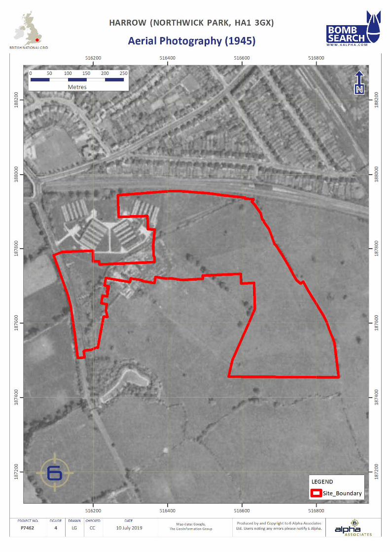
Aerial Photography (1945) (Figure 4)
The aerial photography (1945) associated with the Site shows that the Site was located within a semi-developed rural area. The Site itself consisted mostly of undeveloped ground, though there were a limited number of structures located in the north-west of the Site. Nonetheless, the resolution of the photograph is insufficient to be able to identify accurately, the precise local features and/or type of structure, then within the curtilage of the Site.
10
www.6alpha.com - +44 (0) 2033 713 900 [email protected]
6 Alpha Project Number: P7462 Client: Campbell Reith Site: Harrow (Northwick Park, HA1 3GX)
WWII Bombing of London
The most intensive period of bombing over London was the nine months between October 1940 and May 1941, known as ‘The Blitz’. During this period the Luftwaffe attempted to overwhelm Britain’s air defences, destroy key military and industrial facilities, as well as logistical capabilities, prior to invasion. A total of 18,000 tons of bombs were dropped on London between 1940 and 1945. Many residential, commercial and industrial buildings were targeted during air raids and sustained large scale damage. Public services were also affected, with gas, electricity and water supplies often cut-off following damage to either the installations themselves or to the supply infrastructure. In addition, thousands of civilians were killed and injured, and many were forced to evacuate as their homes were destroyed.
WWII Luftwaffe Bombing Targets
Prior to WWII, the Luftwaffe conducted numerous aerial photographic reconnaissance missions over Britain, recording key military, industrial and commercial facilities for attack, in the event of war. In addition, logistics infrastructure and public services, such as railways, canals, power stations, reservoirs, water and gas works were also considered viable bombing targets. Luftwaffe aerial reconnaissance photography associated with the Site did not identify any primary bombing targets on-site or within 1,000m of it.
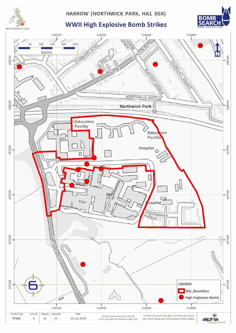
WWII HE Bomb Strikes (Figure 5)
During WWII, ARP wardens compiled detailed logs of bomb strikes across their respective districts. ARP records associated with the Site identified three HE bomb strikes within it. In addition, a further five were recorded; 5m to the south, 35m to the east, 55m south-south-east, 195m to the north and 260m to the south-east. Furthermore, whilst IBs may have fallen within the Study Site, they fell in such large numbers that accurate record keeping was either non-existent or perfunctory therefore, their prospective presence cannot be either corroborated or discounted. In addition to IBs and HE bomb strikes, during the latter part of the war when aerial bombing had significantly declined, the main threat came from V type weapons. The first recorded V1 strike on London was on the 13th June 1944, with the first recorded V2 strike on London on the 8th September 1944. V1 and V2 rockets were thin-skinned, unmanned and inaccurate weapons. Despite this, there is no evidence to suggest that the Site (or its immediate vicinity) was subjected to rockets strikes during WWII. The potential penetration depth of an UXB was dependent on a number of factors including but not restricted to those prior to striking the ground e.g. velocity and orientation of the UXB which in turn will be influenced on factors such as the release altitude from the aircraft and encounters with infrastructure during its fall; those encountered at the point of impact i.e. was the impact on concrete, grass, water etc and finally, the below ground level conditions which were encountered such as infrastructure e.g. services, basements, foundations, and geology e.g. made ground, clay, sand, etc. Further, as the UXB penetrated the ground, it’s velocity naturally slowed where, it either came to an abrupt stop e.g. against foundations or would continue for 10’s of feet along a route of least resistance which often resulted in a curving of the trajectory back towards the surface. This is known as the “J Curve” effect and often resulted in a considerable horizontal off-set from the point of entry. This is often the reason why UXBs have been discovered against or under the foundations of buildings, which were present during WWII, or many meters from the point of impact.
WWII Bomb Damage
LCC bomb damage mapping did not cover the Site. An analysis of post-war mapping and further research of historical records did not identify any evidence of bomb damage within 1,000m. Nonetheless, given that three HE bomb strikes impacted in very close proximity to the Club House and Lodge structures located within the Site, it is highly likely that some degree of damage would have been caused as a result.
WWII HE Bomb Density (Figure 6)
The Study Site was located within Wembley Municipal Borough and Harrow Urban District, which recorded 19 and 8 HE bombs per 100 hectares respectively, a low and very low level of bombing.
11
www.6alpha.com - +44 (0) 2033 713 900 [email protected]
6 Alpha Project Number: P7462 Client: Campbell Reith Site: Harrow (Northwick Park, HA1 3GX)
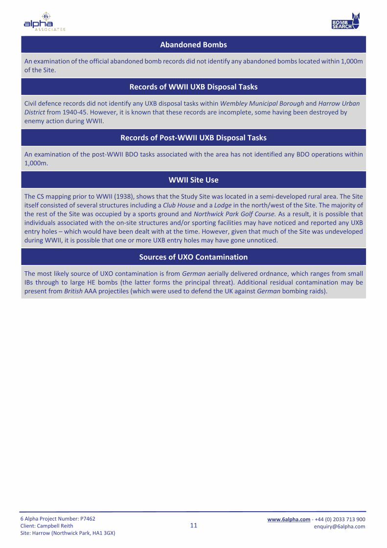
Abandoned Bombs
An examination of the official abandoned bomb records did not identify any abandoned bombs located within 1,000m of the Site.
Records of WWII UXB Disposal Tasks
Civil defence records did not identify any UXB disposal tasks within Wembley Municipal Borough and Harrow Urban District from 1940-45. However, it is known that these records are incomplete, some having been destroyed by enemy action during WWII.
Records of Post-WWII UXB Disposal Tasks
An examination of the post-WWII BDO tasks associated with the area has not identified any BDO operations within 1,000m.
WWII Site Use
The CS mapping prior to WWII (1938), shows that the Study Site was located in a semi-developed rural area. The Site itself consisted of several structures including a Club House and a Lodge in the north/west of the Site. The majority of the rest of the Site was occupied by a sports ground and Northwick Park Golf Course. As a result, it is possible that individuals associated with the on-site structures and/or sporting facilities may have noticed and reported any UXB entry holes – which would have been dealt with at the time. However, given that much of the Site was undeveloped during WWII, it is possible that one or more UXB entry holes may have gone unnoticed.
Sources of UXO Contamination
The most likely source of UXO contamination is from German aerially delivered ordnance, which ranges from small IBs through to large HE bombs (the latter forms the principal threat). Additional residual contamination may be present from British AAA projectiles (which were used to defend the UK against German bombing raids).
12
www.6alpha.com - +44 (0) 2033 713 900 [email protected]
6 Alpha Project Number: P7462 Client: Campbell Reith Site: Harrow (Northwick Park, HA1 3GX)
STAGE THREE – DATA ANALYSIS
Variable Result Comment
Was the area considered to be a primary bombing target?
No primary bombing targets were identified within 1,000m.
Was the Site or the immediate area bombed during WWII?
Three HE bomb strikes were recorded on-site and a further five were identified within 260m, the closest being 5m to the south.
Did the Site or the immediate area experience bomb damage?
While no evidence of bomb damage was identified on-site, it is likely that the on-site structures would have been damaged by the three on-site HE bomb strikes impacting in close proximity
to them.
Was the ground undeveloped during WWII?
The Site consisted of a Club House and a Lodge, but the vast majority was used as sports facilities.
Would the footfall have been high in the area?
Given that sporting facilities and several structures were located on-site, it is likely that footfall would have been
medium to high.
Would a UXB entry hole have been observed during WWII?
Given that much of the site was undeveloped it is entirely possible that one or more UXB entry holes may have gone
unnoticed.
Have military personnel ever occupied the Site?
No military facilities were identified within 1,000m.
Would munitions have been manufactured, stored and/or fired
from the Site?
There is no evidence to suggest munitions were located or fired
from this Site.
Would previous intrusive works have removed the potential for UXO
to be present?
The Site has been subjected to significant redevelopment in
most areas, therefore it is likely that any UXO within the structural foundations of post-war buildings would have been discovered and removed. Nonetheless, some small areas have
not undergone redevelopment and UXO may be present in these areas.
Are proposed intrusive works likely to extend into previously
undisturbed ground?
Some areas of the Site have remained undeveloped since WWII and therefore proposed works may extend into previously
undisturbed ground.
Is there potential for an unplanned encounter with UXO to occur during
proposed intrusive works?
Given that the Site was subjected to bomb strikes it is considered possible for an unplanned encounter with UXO to
occur.
Does the probability of UXO vary across the Site?
The probability of discovering UXO within the structural foundations of post-war buildings is considered to be remote,
however, the probability of UXO discovery within all previously undisturbed areas of the Site is extant.
13
www.6alpha.com - +44 (0) 2033 713 900 [email protected]
6 Alpha Project Number: P7462 Client: Campbell Reith Site: Harrow (Northwick Park, HA1 3GX)
STAGE FOUR – RISK ASSESSMENT
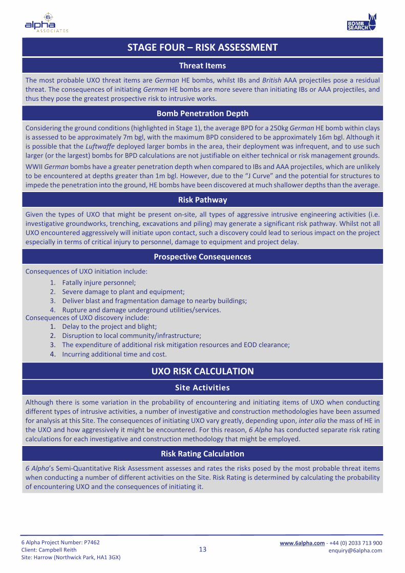
Threat Items
The most probable UXO threat items are German HE bombs, whilst IBs and British AAA projectiles pose a residual threat. The consequences of initiating German HE bombs are more severe than initiating IBs or AAA projectiles, and thus they pose the greatest prospective risk to intrusive works.
Bomb Penetration Depth
Considering the ground conditions (highlighted in Stage 1), the average BPD for a 250kg German HE bomb within clays is assessed to be approximately 7m bgl, with the maximum BPD considered to be approximately 16m bgl. Although it is possible that the Luftwaffe deployed larger bombs in the area, their deployment was infrequent, and to use such larger (or the largest) bombs for BPD calculations are not justifiable on either technical or risk management grounds. WWII German bombs have a greater penetration depth when compared to IBs and AAA projectiles, which are unlikely to be encountered at depths greater than 1m bgl. However, due to the “J Curve” and the potential for structures to impede the penetration into the ground, HE bombs have been discovered at much shallower depths than the average.
Risk Pathway
Given the types of UXO that might be present on-site, all types of aggressive intrusive engineering activities (i.e. investigative groundworks, trenching, excavations and piling) may generate a significant risk pathway. Whilst not all UXO encountered aggressively will initiate upon contact, such a discovery could lead to serious impact on the project especially in terms of critical injury to personnel, damage to equipment and project delay.
Prospective Consequences
Consequences of UXO initiation include: 1. Fatally injure personnel; 2. Severe damage to plant and equipment; 3. Deliver blast and fragmentation damage to nearby buildings; 4. Rupture and damage underground utilities/services.
Consequences of UXO discovery include: 1. Delay to the project and blight; 2. Disruption to local community/infrastructure; 3. The expenditure of additional risk mitigation resources and EOD clearance; 4. Incurring additional time and cost.
UXO RISK CALCULATION
Site Activities
Although there is some variation in the probability of encountering and initiating items of UXO when conducting different types of intrusive activities, a number of investigative and construction methodologies have been assumed for analysis at this Site. The consequences of initiating UXO vary greatly, depending upon, inter alia the mass of HE in the UXO and how aggressively it might be encountered. For this reason, 6 Alpha has conducted separate risk rating calculations for each investigative and construction methodology that might be employed.
Risk Rating Calculation
6 Alpha’s Semi-Quantitative Risk Assessment assesses and rates the risks posed by the most probable threat items when conducting a number of different activities on the Site. Risk Rating is determined by calculating the probability of encountering UXO and the consequences of initiating it.
14
www.6alpha.com - +44 (0) 2033 713 900 [email protected]
6 Alpha Project Number: P7462 Client: Campbell Reith Site: Harrow (Northwick Park, HA1 3GX)
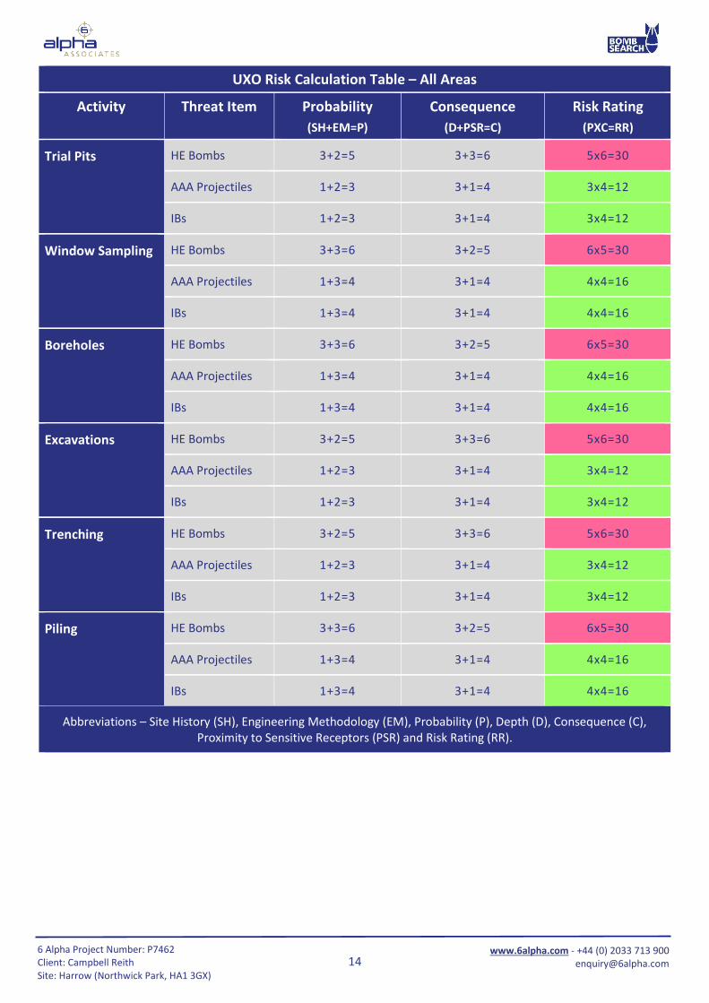
UXO Risk Calculation Table – All Areas
Activity Threat Item Probability (SH+EM=P)
Consequence (D+PSR=C)
Risk Rating (PXC=RR)
Trial Pits HE Bombs 3+2=5 3+3=6 5x6=30
AAA Projectiles 1+2=3 3+1=4 3x4=12
IBs 1+2=3 3+1=4 3x4=12
Window Sampling
HE Bombs 3+3=6 3+2=5 6x5=30
AAA Projectiles 1+3=4 3+1=4 4x4=16
IBs 1+3=4 3+1=4 4x4=16
Boreholes
HE Bombs 3+3=6 3+2=5 6x5=30
AAA Projectiles 1+3=4 3+1=4 4x4=16
IBs 1+3=4 3+1=4 4x4=16
Excavations
HE Bombs 3+2=5 3+3=6 5x6=30
AAA Projectiles 1+2=3 3+1=4 3x4=12
IBs 1+2=3 3+1=4 3x4=12
Trenching
HE Bombs 3+2=5 3+3=6 5x6=30
AAA Projectiles 1+2=3 3+1=4 3x4=12
IBs 1+2=3 3+1=4 3x4=12
Piling
HE Bombs 3+3=6 3+2=5 6x5=30
AAA Projectiles 1+3=4 3+1=4 4x4=16
IBs 1+3=4 3+1=4 4x4=16
Abbreviations – Site History (SH), Engineering Methodology (EM), Probability (P), Depth (D), Consequence (C), Proximity to Sensitive Receptors (PSR) and Risk Rating (RR).
15
www.6alpha.com - +44 (0) 2033 713 900 [email protected]
6 Alpha Project Number: P7462 Client: Campbell Reith Site: Harrow (Northwick Park, HA1 3GX)
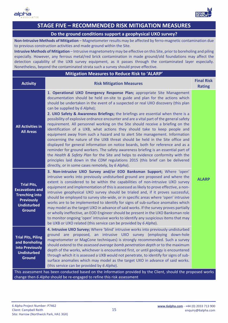
STAGE FIVE – RECOMMENDED RISK MITIGATION MEASURES Do the ground conditions support a geophysical UXO survey?
Non-Intrusive Methods of Mitigation – Magnetometer results may be affected by ferro-magnetic contamination due to previous construction activities and made ground within the Site. Intrusive Methods of Mitigation – Intrusive magnetometry may be effective on this Site, prior to boreholing and piling especially. However, any ferrous metal/red brick contamination in made ground/old foundations may affect the detection capability of the UXB survey equipment, as it passes through the contaminated layer especially. Nonetheless, beyond the contaminated strata such a survey should prove effective.
Mitigation Measures to Reduce Risk to ‘ALARP’
Activity Risk Mitigation Measures Final Risk
Rating
All Activities in All Areas
1. Operational UXO Emergency Response Plan; appropriate Site Management documentation should be held on-site to guide and plan for the actions which should be undertaken in the event of a suspected or real UXO discovery (this plan can be supplied by 6 Alpha); 2. UXO Safety & Awareness Briefings; the briefings are essential when there is a possibility of explosive ordnance encounter and are a vital part of the general safety requirement. All personnel working on the Site should receive a briefing on the identification of a UXB, what actions they should take to keep people and equipment away from such a hazard and to alert Site management. Information concerning the nature of the UXB threat should be held in the Site office and displayed for general information on notice boards, both for reference and as a reminder for ground workers. The safety awareness briefing is an essential part of the Health & Safety Plan for the Site and helps to evidence conformity with the principles laid down in the CDM regulations 2015 (this brief can be delivered directly, or in some cases remotely, by 6 Alpha).
ALARP Trial Pits,
Excavations and Trenching into
Previously Undisturbed
Ground
3. Non-intrusive UXO Survey and/or EOD Banksman Support; Where ‘open’ intrusive works into previously undisturbed ground are proposed and where the extent is considered to be within the capabilities of non-intrusive UXO survey equipment and implementation of this is assessed as likely to prove effective, a non-intrusive geophysical UXO survey should be trialed and, if it proves successful, should be employed to survey site-wide, or in specific areas where ‘open’ intrusive works are to be implemented to identify for signs of sub-surface anomalies which may model as the target UXO in advance of said works. If the survey proves partially or wholly ineffective, an EOD Engineer should be present in the UXO Banksman role to monitor ongoing ‘open’ intrusive works to identify any suspicious items that may be UXB or UXO related (this service can be provided by 6 Alpha).
Trial Pits, Piling and Boreholing into Previously
Undisturbed Ground
4. Intrusive UXO Survey; Where ‘blind’ intrusive works into previously undisturbed ground are proposed, an intrusive UXO survey (employing down-hole magnetometer or MagCone techniques) is strongly recommended. Such a survey should extend to the assessed average bomb penetration depth or to the maximum depth of the works, whichever is encountered first, or until geology is encountered through which it is assessed a UXB would not penetrate, to identify for signs of sub-surface anomalies which may model as the target UXO in advance of said works. (this service can be provided by 6 Alpha).
This assessment has been conducted based on the information provided by the Client, should the proposed works change then 6 Alpha should be re-engaged to refine this risk assessment
16
www.6alpha.com - +44 (0) 2033 713 900 [email protected]
6 Alpha Project Number: P7462 Client: Campbell Reith Site: Harrow (Northwick Park, HA1 3GX)
Report Figures
17
www.6alpha.com - +44 (0) 2033 713 900 [email protected]
6 Alpha Project Number: P7462 Client: Campbell Reith Site: Harrow (Northwick Park, HA1 3GX)
Figure One - Site Location
18
www.6alpha.com - +44 (0) 2033 713 900 [email protected]
6 Alpha Project Number: P7462 Client: Campbell Reith Site: Harrow (Northwick Park, HA1 3GX)
Figure Two - Site Boundary
19
www.6alpha.com - +44 (0) 2033 713 900 [email protected]
6 Alpha Project Number: P7462 Client: Campbell Reith Site: Harrow (Northwick Park, HA1 3GX)
Figure Three - Aerial Photography (2018)
20
www.6alpha.com - +44 (0) 2033 713 900 [email protected]
6 Alpha Project Number: P7462 Client: Campbell Reith Site: Harrow (Northwick Park, HA1 3GX)
Figure Four - Aerial Photography (1945)
21
www.6alpha.com - +44 (0) 2033 713 900 [email protected]
6 Alpha Project Number: P7462 Client: Campbell Reith Site: Harrow (Northwick Park, HA1 3GX)
Figure Five - WWII High Explosive Bomb Strikes
22
www.6alpha.com - +44 (0) 2033 713 900 [email protected]
6 Alpha Project Number: P7462 Client: Campbell Reith Site: Harrow (Northwick Park, HA1 3GX)
Figure Six - WWII High Explosive Bomb Density