detailed analysis of west runway s alternatives and ... › wp-c… · mhhw mean higher high water...
TRANSCRIPT

APPENDIX K
DETAILED ANALYSIS OF WEST RUNWAY SAFETY AREA ALTERNATIVES AND WILDLIFE HAZARD MANAGEMENT ALTERNATIVES, POTENTIAL EFFECTS ON THE HYDRAULICS AND GEOMORPHOLOGY OF THE MENDENHALL RIVER

Juneau FEISAppendix K: Potential Effects on the Hydraulics And Geomorphology of the Mendenhall River
K-2
tel: 503-274-2010fax: 503-274-2024
email: [email protected]
Juneau Airport EIS (Project No. 4682), VAI Project No. SWCAI001 819 SE Morrison Street, Suite 310Portland, Oregon 97214
Page 1
MEMORANDUM
TO: Sheri Ellis (SWCA), Patti Sullivan (FAA), Allan Heese (JNU), Randy Vigil (ACOE), Chris Meade (EPA), K Koski (NOAA), Sue Walker (NMFS), Richard Enriquez (USFWS), Carl Schrader (ADNR), Jackie Timothy (ADNR), Tom Schumacher (ADF&G), Teri Camry (CBJ)
FROM: Linda Mark, Maureen Raad, and Paul Agrimis
DATE: April 6, 2006
SUBJECT: Further Analysis of the Potential Affects of the West Runway Safety Area Alternatives and
Wildlife Hazard Management Alternatives on the Hydraulics and Geomorphology of the
Mendenhall River
Abbreviations
AST Alaska Standard Timecfs cubic feet per secondDEIS Draft Environmental Impact StatementELJ Engineered Log Jamfps feet per secondft-mllw elevation referenced to mean lower low water vertical datumft-msl elevation referenced to mean sea level vertical datumGPS Global Positioning System
lbs/sq-ft pounds per square footMHHW Mean Higher High WaterMLLW Mean Lower Low WaterMSL Mean Sea LevelRSA Runway Safety AreaVAI Vigil-Agrimis, Inc.WH Wildlife Hazard
Introduction
Vigil-Agrimis, Inc. (VAI) was asked to examine potential stream channel and streambank impacts from proposed wildlife hazard management actions and Runway Safety Area (RSA) improvements at the west end of Juneau International Airport (JNU). VAI performed additional analysis on the Mendenhall River that included fieldwork.The purpose of these efforts was to better understand existing conditions and to predict the effects that proposed filling wetlands at the west end of the runway could have on the stability of the Mendenhall channel and adjacent streambank areas near the airport. Dredging was considered as a possible approach to habitat modification, as requested by several comments made by the agencies in June 2005, but our analysis suggests dredging would offer only temporary relief. Further explanation of this determination is provided later in the memo.
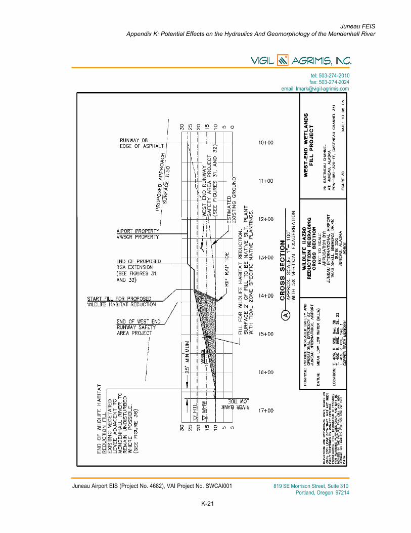
Filling of wetlands in the tidally influenced river floodplain is being proposed to mitigate for the existing deficit in the Runway Safety Area (RSA) and for existing and potential wildlife hazards (WH). Five RSA alternatives are proposed in the DEIS (RSA 1, RSA 5C, RSA 6A, RSA 6B and RSA 6C) with fill varying approximately 170 to 400 feet on the west end of the runway. Four WH alternatives are proposed; WH-1b, WH-2b, WH-1c, and WH-2cinclude filling land west of the existing runway as well.
The geomorphology of the Mendenhall River in the vicinity of JNU is affected by a combination of riverine and tidal processes. The Mendenhall River drains a 100 mi2 watershed that is largely glaciated with mean annual discharge 1,164 cfs. Peak monthly flows occur from June through September and range from about 1,800 to 3,000 cfs. The lowest monthly flows occur from January through March and are less than 200 cfs. The Mendenhall is a geologically young river that established itself as the Mendenhall Glacier retreated. Glacial retreat has led to isostatic rebound and has caused surface uplift in the vicinity of JNU at a rate of 0.05 feet per year – about a foot every 20 years. As the River has established itself, its channel appears to have downcut at a rate of 1.5 feet over 20 years, slightly greater than the rate of surface uplift.

Juneau FEISAppendix K: Potential Effects on the Hydraulics And Geomorphology of the Mendenhall River
K-3
tel: 503-274-2010fax: 503-274-2024
email: [email protected]
Juneau Airport EIS (Project No. 4682), VAI Project No. SWCAI001 819 SE Morrison Street, Suite 310Portland, Oregon 97214
Page 2
The mouth of Montana Creek, about 2 miles upstream of JNU, is generally acknowledged to be the upper extent of tidal influence. Tidal elevations at JNU range about 24 feet with mean higher high water (MHHW) at 11 ft-msl and mean lower low water (MLLW) at -13 ft-msl.
The Mendenhall River experienced an abrupt change in channel location (avulsion) near JNU in summer 2004.Higher than normal riverine flows and high tides combined causing the river to overtop its banks and establish a new course by cutting off a meander bend as a high tide receded. The analysis was undertaken to predict how the channel would respond to fill in the tidally influenced floodplain. Channel stability in the vicinity of the airport is an important concern for aviation operations. To address the uncertainty VAI staff performed additional analysisincluding:
• Locating the Mendenhall channel with Global Positioning System (GPS) following the channel avulsion to confirm channel migration since that event,
• Modifying the existing USGS HEC-RAS model for the Mendenhall River to help assess proposed fill of wetlands adjacent to the runway as a wildlife hazard management strategy.
Geomorphology Overview
The Mendenhall River is a young and vigorous stream that is well supplied with sediment from its contributing glacial discharges and landslides and avalanches that deliver cobbles, gravel, sands, silts, and colloidal clays to the channel and its tributaries. The channel meanders its way through its valley while discharging varying flows and sediment loads. Analysis of channel shape from USGS streamflow measurements conducted as part of the Water Resources Technical Working Paper prepared during the EIS indicates that the Mendenhall has sufficient stream power to keep up with the uplift that is occurring due to isostatic rebound in the region. There is a regular pattern of meanders with depositional bars and scoured pools from Mendenhall Lake to Fritz Cove. Figure 1 shows a series of scour pools and depositional bars in the vicinity of Juneau International Airport.
The large and persistent gravel bar on the channel’s left bank adjacent to the west end of the runway creates a floodplain surface that supports jurisdictional wetlands. This bar is shown in Figure 1. Two other prominent bars are also evident downstream in the figure, alternating left bank, and then right bank. The wetlands on the bar at the west end of the runway are a concern for aviation safety due to flocks of large birds that rise in front of arriving and departing flights. Two potential solutions were suggested during agency meetings in spring 2005 to address the safety issue: fill and dredge.
Dredging would be a continual process due to the high sediment supply and the channel pattern (as shown by the other prominent bars in Figure 1). Channel armoring in this vicinity (protecting runway and float pond, and MALSR west of the Mendenhall) is likely to support maintenance of the channel pattern. Dredging could remove the bar for a period of time, but the river would develop a very similar bar in relatively short time by human standards, or very quickly by geologic standards (we estimate within five years). Clearly, dredging would therefore entail a periodic but relatively frequent and high-cost maintenance pattern to keep these areas as open water.
Based on those understandings of geomorphology and JNU’s concerns about taking on more maintenance challenges, the focus of this memo is on providing a better understanding of how filling the wetlands that occur on the bar will affect stability of the Mendenhall River.

Juneau FEISAppendix K: Potential Effects on the Hydraulics And Geomorphology of the Mendenhall River
K-4
tel: 503-274-2010fax: 503-274-2024
email: [email protected]
Juneau Airport EIS (Project No. 4682), VAI Project No. SWCAI001 819 SE Morrison Street, Suite 310Portland, Oregon 97214
Page 3
Field Assessment
VAI staff conducted a field visit in early November 2005. The objective of this field visit was to map changes in the location of the Mendenhall River channel following the abrupt change in channel location in summer 2004.Additional field observations were made at a number of locations. All observations were recorded on November 9, 2005 between 11:45 a.m. and 1:00 p.m. AST, using a Trimble GeoXT GPS. Tidal elevations at the time of this field visit are included in Table 1.
Table 1
Tide Elevations at Time of Field Assessment
Monday Tuesday Wednesday Thursday Friday
11/07/05 11/08/05 11/09/05 11/10/05 11/11/05
AST ft-msl* AST ft-msl AST ft-msl AST ft-msl AST ft-msl
4:44 AM 5.00 5:56 AM 4.70 12:21 AM -6.90 1:38 AM -6.60 2:46 AM -6.70
10:12 AM -2.80 11:27 AM -2.20 7:14 AM 5.10 8:23 AM 6.10 9:20 AM 7.40
4:11 PM 7.20 1:01 PM -2.50 2:26 PM -3.90 3:33 PM -5.80
11:07 PM -7.80 5:25 PM 6.00 6:54 PM 5.40 8:23 PM 5.50 9:37 PM 6.20
*MLLW - 8.6
Observations of the bank positions were recorded as lines while general observations were recorded as points.These locations are illustrated in Figure 1. In this figure, the GPS location of the river bank is superimposed over aerial photography from 2001. The aerial photography predates the change in channel location, so the overlay shows channel migration. The observed bank erosion indicated in Figure 1 shows channel migration against the east bank of the river.
The bank immediately upstream of the cutoff is eroding while material is being deposited downstream of the cutoff in the old channel. Based on the meander pattern of the Mendenhall River bank erosion could be expected in the area adjacent to the Float Plane Pond and in the area across the river from JNU at the MALSR. Not surprisingly,both of these areas have already been protected from potential erosion by riprap (Figure 1).
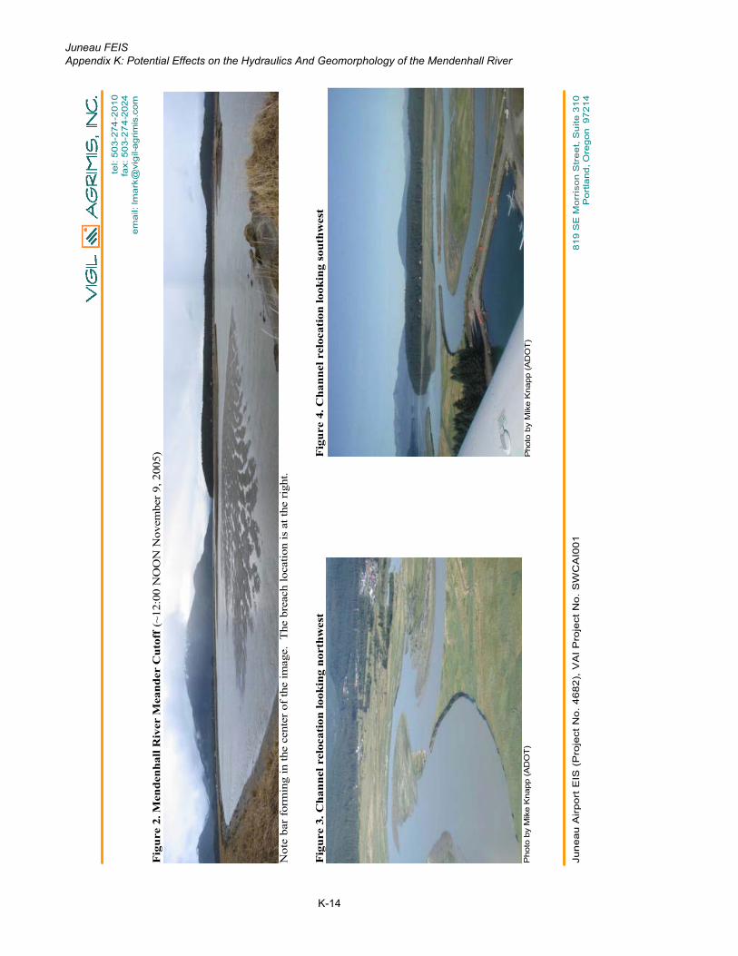
During the November 2005 field work a panoramic photo was taken at the location of the meander cutoff looking southwest (Figure 2). In this image the deposited sediment is visible as a broad bar in the center of the image.Earlier, photographs were taken during take off from JNU in August 2004 (Figures 3 to 5) by Mike Knapp of ADOT.
Application of Bioengineering Techniques for Bank Stabilization
Bank stabilization will be needed for the proposed fills and terrain modifications. The resource agencies have recommended investigating bioengineering design for the Duck Creek relocation, its confluence with the Mendenhall River, and the streamside slopes of the proposed fill at the west end of the runway.
Bioengineering techniques use soil, wood, rock, and in many instances living plant materials to support unstable slopes or to protect against erosion. Designs may take many forms, but in riverine settings the emphasis tends to be the use of Large Woody Debris (LWD) in Engineered Log Jams (ELJs) and log crib walls. Large wood masses can dissipate the high channel energy associated with large flow events effectively using materials considered friendlier to native fish. One hundred-year flow events on the Mendenhall mean velocities running 7-10 feet per second and 11-14 feet deep. Tidal inundation would severely limit the use of brush layering and vegetated crib walls. Roots wads and large wood members (>24” DBH and 40-60’) can be used in these situations, but the buoyant forces and bending moments on wood members would be enormous, requiring deep burial and other anchoring. ELJs have

Juneau FEISAppendix K: Potential Effects on the Hydraulics And Geomorphology of the Mendenhall River
K-5
tel: 503-274-2010fax: 503-274-2024
email: [email protected]
Juneau Airport EIS (Project No. 4682), VAI Project No. SWCAI001 819 SE Morrison Street, Suite 310Portland, Oregon 97214
Page 4
been used successfully for bank protection on even larger, more powerful, glacial rivers such as the Hoh River on Washington’s Olympic Peninsula (mean annual flow 2,520 cfs, and peak flow of 54,500 cfs).
Bioengineering is feasible in all these situations, but the design and construction effort level increases substantiallyfrom Duck Creek to the Mendenhall River. Considerable information and analyses would be required to apply bioengineering techniques to protect vital transportation infrastructure along the Mendenhall. What is key to the potential successful application of bioengineering techniques on the Mendenhall is understanding the power of the river and the processes that are operating along the reach, just not the site. This is a complex setting and one where bioengineering techniques may be applicable, but likely at cost that is likely to be above that of standard treatments.
Hydraulic Modeling
VAI staff used the Hydrologic Engineering Center – River Analysis System (HEC-RAS, version 2.2) hydraulic software to model hydraulic conditions for both existing conditions (no fill) and proposed conditions (with RSA and wetland fill). The proposed conditions model is based upon DEIS alternatives RSA 6B or 6C in combination with WH-1c.
For cost and time effectiveness, VAI staff built upon an existing HEC-RAS hydraulic model that was created by the USGS to model the Mendenhall River (Neal and Host, 1999). The existing USGS model geometry is based on a combination of USGS cross-sections surveyed in September 1997 and spring 1998 (Neal and Host, 1999). VAI added five new cross-sections to the existing model. These cross-sections were defined using 2-foot LiDAR contour data (SWCA, 2001) for the land surface. The below-water portions of these cross-sections were approximated using data from neighboring USGS surveyed cross-sections and observed water depths. The source of this below-water information is as much as eight years old and conditions in the channel have likely changed during this time. Because of these dynamic channel conditions, the model results provide planning-levelinformation on hydraulic conditions in the vicinity of the proposed changes. This level of detail is appropriate for impact assessment for the EIS; however, more detailed assessment would likely be required when the project moves to implementation.
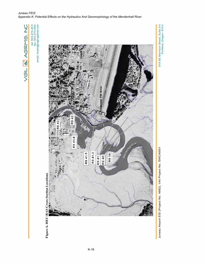
Three of the added cross-sections (41.8, 41.5, and 41.2) are located within the area of proposed fills. The other two cross-sections (40 and 39) were added at the downstream end of the model to buffer the effect of boundary conditions on the modeling. Figure 6 shows the model cross-section locations and the proposed fill area. Because of the effects of tides both the existing and proposed conditions, the models were run under low tide and high tide conditions. MLLW (-13 ft-msl) was used as the low tide boundary condition while MHHW (11 ft-msl) was used as the high tide boundary condition.
The existing conditions cross-sections were modified based on Section 404 permit application figures 31, 32, 38, and 39 (HDR, 2005) which are included in Appendix A. As a result, cross-sections 41.8, 41.5, and 41.2 were modified. The existing model is referenced to ft-mllw vertical datum while the EIS is using ft-msl. For the purpose of this assessment elevations were converted from ft-msl to ft-mllw for use in the model. Results were then converted from ft-mllw back to ft-msl for the purpose of discussion in this memo. The conversion between the two datums is included in Table 2 for reference. Outputs from HEC-RAS have been included as appendices to thismemo for reference. All elevations in these appendices reference ft-mllw
Table 2
Tidal DatumsTidal Datum ft-mllw ft-msl
MHHW 19.6 11
MSL zero datum 8.6 0MLLW -4.4 -13

Juneau FEISAppendix K: Potential Effects on the Hydraulics And Geomorphology of the Mendenhall River
K-6
tel: 503-274-2010fax: 503-274-2024
email: [email protected]
Juneau Airport EIS (Project No. 4682), VAI Project No. SWCAI001 819 SE Morrison Street, Suite 310Portland, Oregon 97214
Page 5
Both the existing and proposed conditions models were run for 2-, 10-, 25-, 50-, and 100-year flows for both the MLLW and MHHW tidal boundary conditions. Appendix B shows the existing conditions cross-sections in the vicinity of the proposed changes under MLLW boundary conditions for the 2-year and 100-year flow. Appendix C shows the same cross-sections under proposed conditions.
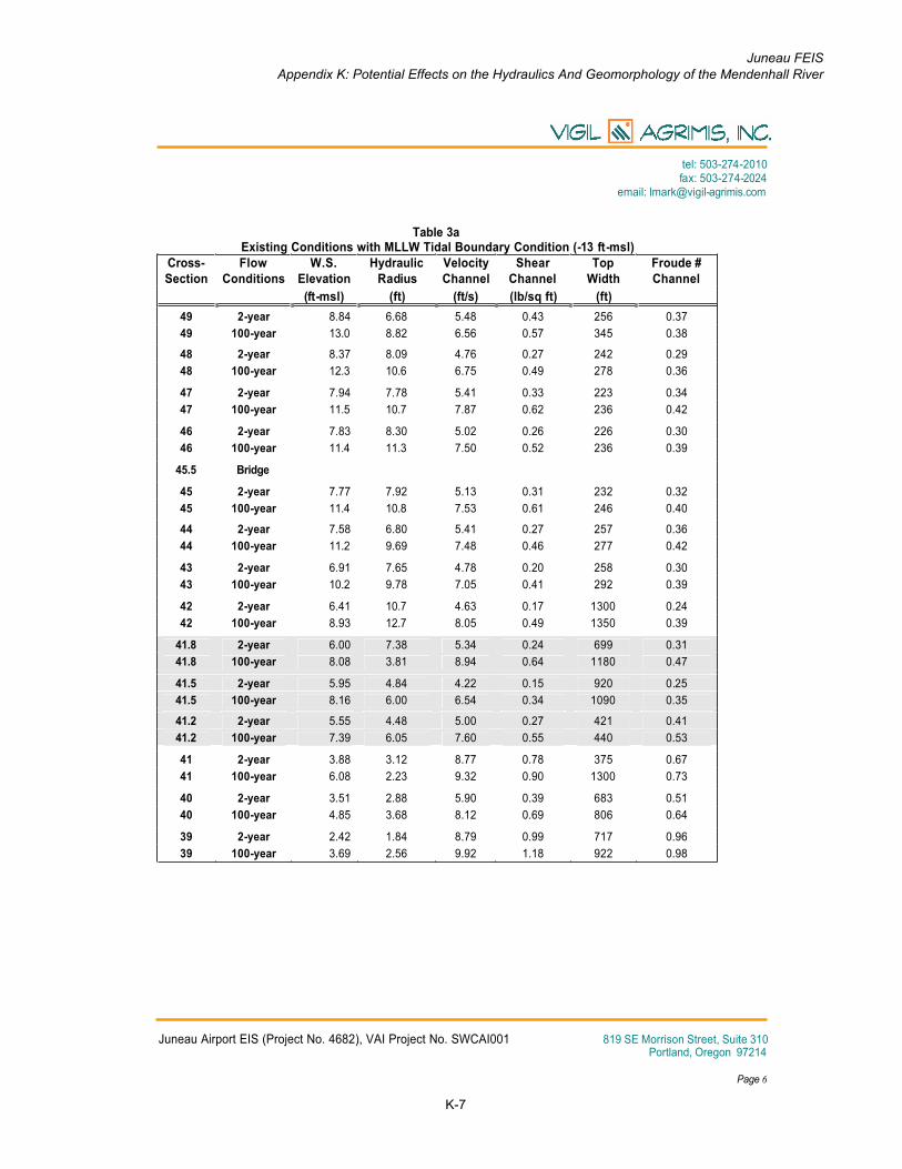
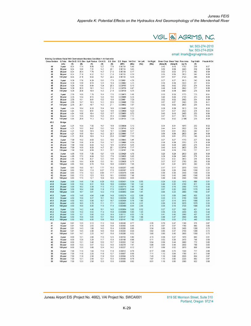
Model Results – MLLW Boundary Condition
The channel constriction, caused by the proposed fill, results in a rise in water surface elevation of about 0.4 feet for the 100-year flow under MLLW boundary conditions. This change is evident immediately upstream of the proposed fill at cross-section 42. Meanwhile, the water-surface elevation decreases by about the same amount (0.5 feet) at the downstream end of the proposed fill at cross-section 41.2 (Table 3). A more complete table of model output results is included in Appendix D.
Channel velocities decrease by as much as 0.2 fps upstream at cross-section 42 while velocities increase by as much as 2.4 fps, to 10.0 fps, at cross-section 41.2 for the 100-year event due to the channel constriction. Channel shear stress also increases modestly for the 100-year flow at cross-section 41.2 by up to 0.3 lbs/sq-ft, to 0.9 lbs/sq-ft.Channel shear stress is a calculation of the force that moving water exerts on the channel bed sediment (force/area=stress). Shear stress increases as channel flow becomes steeper or deeper; engaging larger channel bed sediment to move downstream. Shear stress of 1 will initiate movement of cobble sized material (4-inch).
The model shows minor effects upstream between cross-sections 44 and 48. Minor effects on water surface elevations are defined as changes of 0.2 feet or less and/or velocity changes of 0.2 fps or less. Downstream of the proposed fill (below cross-section 41.2), the river hydraulics are not affected.
In both the existing- and proposed-condition models, Froude numbers near 1.0 occur at cross-section 39, indicating the potential for unstable hydraulic conditions at this location. The Froude number is a ratio of velocity to gravity forces, and a ratio of one indicates a tenuous stability. Interestingly, cross-section 39 is closest to the site of the meander cutoff that occurred in summer 2004. Channel Froude numbers are not changed by more than 0.1 anywhere in the model due to the proposed changes, indicating that the degree of hydraulic stability of the channel is not changed much by the proposed fill. Active erosion was observed downstream of this cross-section during the November 2005 fie ldwork.
The increase in water surface elevation upstream of the proposed fill that is indicated by the model will warrant further analysis in the design phase. This will likely entail updating channel data and refining the design. Design refinements could include modifying the shape of the proposed fill or excavating on the opposite bank of the Mendenhall River to mitigate for floodplain constriction caused by the proposed fill. However, this estimated increase in water surface elevation due to the proposed fill is minor compared to the increase in water surface elevation due to natural tidal conditions at the site.
Juneau FEISAppendix K: Potential Effects on the Hydraulics And Geomorphology of the Mendenhall River
K-7
tel: 503-274-2010fax: 503-274-2024
email: [email protected]
Juneau Airport EIS (Project No. 4682), VAI Project No. SWCAI001 819 SE Morrison Street, Suite 310Portland, Oregon 97214
Page 6
Table 3aExisting Conditions with MLLW Tidal Boundary Condition (-13 ft-msl)
Cross-Section
FlowConditions
W.S.Elevation
HydraulicRadius
VelocityChannel
ShearChannel
TopWidth
Froude # Channel
(ft-msl) (ft) (ft/s) (lb/sq ft) (ft)
49 2-year 8.84 6.68 5.48 0.43 256 0.37
49 100-year 13.0 8.82 6.56 0.57 345 0.38
48 2-year 8.37 8.09 4.76 0.27 242 0.29
48 100-year 12.3 10.6 6.75 0.49 278 0.36
47 2-year 7.94 7.78 5.41 0.33 223 0.34
47 100-year 11.5 10.7 7.87 0.62 236 0.42
46 2-year 7.83 8.30 5.02 0.26 226 0.30
46 100-year 11.4 11.3 7.50 0.52 236 0.39
45.5 Bridge
45 2-year 7.77 7.92 5.13 0.31 232 0.32
45 100-year 11.4 10.8 7.53 0.61 246 0.40
44 2-year 7.58 6.80 5.41 0.27 257 0.36
44 100-year 11.2 9.69 7.48 0.46 277 0.42
43 2-year 6.91 7.65 4.78 0.20 258 0.30
43 100-year 10.2 9.78 7.05 0.41 292 0.39
42 2-year 6.41 10.7 4.63 0.17 1300 0.24
42 100-year 8.93 12.7 8.05 0.49 1350 0.39
41.8 2-year 6.00 7.38 5.34 0.24 699 0.31
41.8 100-year 8.08 3.81 8.94 0.64 1180 0.47
41.5 2-year 5.95 4.84 4.22 0.15 920 0.25
41.5 100-year 8.16 6.00 6.54 0.34 1090 0.35
41.2 2-year 5.55 4.48 5.00 0.27 421 0.41
41.2 100-year 7.39 6.05 7.60 0.55 440 0.53
41 2-year 3.88 3.12 8.77 0.78 375 0.67
41 100-year 6.08 2.23 9.32 0.90 1300 0.73
40 2-year 3.51 2.88 5.90 0.39 683 0.51
40 100-year 4.85 3.68 8.12 0.69 806 0.64
39 2-year 2.42 1.84 8.79 0.99 717 0.96
39 100-year 3.69 2.56 9.92 1.18 922 0.98
Juneau FEISAppendix K: Potential Effects on the Hydraulics And Geomorphology of the Mendenhall River
K-8
tel: 503-274-2010fax: 503-274-2024
email: [email protected]
Juneau Airport EIS (Project No. 4682), VAI Project No. SWCAI001 819 SE Morrison Street, Suite 310Portland, Oregon 97214
Page 7
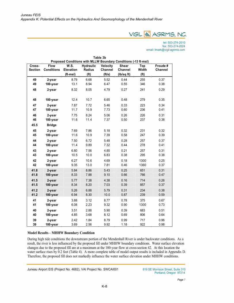
Table 3bProposed Conditions with MLLW Boundary Conditions (-13 ft-msl)
Cross-Section
FlowConditions
W.S.Elevation
HydraulicRadius
VelocityChannel
ShearChannel
TopWidth
Froude # Channel
(ft-msl) (ft) (ft/s) (lb/sq ft) (ft)
49 2-year 8.79 6.68 5.52 0.44 255 0.37
49 100-year 13.1 8.94 6.47 0.55 346 0.38
48 2-year 8.32 8.05 4.79 0.27 241 0.29
48 100-year 12.4 10.7 6.65 0.48 279 0.35
47 2-year 7.87 7.72 5.46 0.33 223 0.34
47 100-year 11.7 10.9 7.73 0.60 236 0.41
46 2-year 7.75 8.24 5.06 0.26 226 0.31
46 100-year 11.6 11.4 7.37 0.50 237 0.38
45.5 Bridge
45 2-year 7.69 7.86 5.18 0.32 231 0.32
45 100-year 11.6 10.9 7.39 0.58 247 0.39
44 2-year 7.50 6.72 5.48 0.28 257 0.37
44 100-year 11.4 9.89 7.32 0.44 278 0.41
43 2-year 6.80 7.56 4.85 0.21 257 0.31
43 100-year 10.5 10.0 6.83 0.38 295 0.38
42 2-year 6.27 10.6 4.69 0.18 1300 0.25
42 100-year 9.35 13.0 7.81 0.46 1360 0.37
41.8 2-year 5.84 8.86 5.43 0.25 651 0.31
41.8 100-year 8.33 7.88 9.10 0.66 766 0.47
41.5 2-year 5.77 7.38 4.38 0.16 714 0.26
41.5 100-year 8.34 8.20 7.03 0.39 857 0.37
41.2 2-year 5.26 6.88 5.79 0.31 234 0.38
41.2 100-year 6.94 8.30 10.0 0.87 239 0.59
41 2-year 3.88 3.12 8.77 0.78 375 0.67
41 100-year 6.08 2.23 9.32 0.90 1300 0.73
40 2-year 3.51 2.88 5.90 0.39 683 0.51
40 100-year 4.85 3.68 8.12 0.69 806 0.64
39 2-year 2.42 1.84 8.79 0.99 717 0.96
39 100-year 3.69 2.56 9.92 1.18 922 0.98
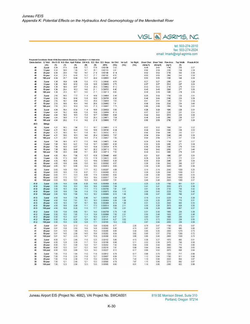
Model Results – MHHW Boundary Condition
During high tide conditions the downstream portion of the Mendenhall River is under backwater conditions. As a result, the river is less influenced by the proposed fill under MHHW boundary conditions. Water surface elevation changes due to the proposed fill are at a maximum at the 100-year flow at cross-section 42. At this location the water surface rises by 0.2 feet (Table 4). A more complete table of model output results is included in Appendix D. Therefore, the proposed fill does not markedly influence the water surface elevation under MHHW conditions.

Juneau FEISAppendix K: Potential Effects on the Hydraulics And Geomorphology of the Mendenhall River
K-9
tel: 503-274-2010fax: 503-274-2024
email: [email protected]
Juneau Airport EIS (Project No. 4682), VAI Project No. SWCAI001 819 SE Morrison Street, Suite 310Portland, Oregon 97214
Page 8
The proposed conditions cause an increase in channel velocities at the fill location at cross-sections 41.8 to 41.2.At these locations, channel velocities increase by 0.4 to 1.6 fps for a maximum velocity of 7.1 fps at cross-section41.8 for the 100-year flood. Channel shear stresses also increase, but only by a relatively insubstantial 0.2 lbs/sq-ft.Froude numbers do not change substantially. Froude numbers are below 1.0 under MHHW conditions; therefore, the model indicates hydraulically stable conditions at high tides. Only nominal changes in water surface elevation, velocity, and shear stress occur above cross-section 41.8. No changes are indicated by the model downstream of cross-section 41.2.
Table 4aExisting Conditions with MHHW Boundary Condition (11 ft-msl)
Cross-Section
FlowConditions
W.S.Elevation
HydraulicRadius
VelocityChannel
ShearChannel
TopWidth
Froude # Channel
(ft-msl) (ft) (ft/s) (lb/sq ft) (ft)
49 2-year 11.8 7.77 3.53 0.17 342 0.22
49 100-year 13.9 9.60 5.98 0.46 348 0.34
48 2-year 11.6 10.0 3.36 0.12 276 0.18
48 100-year 13.3 11.5 6.15 0.40 281 0.31
47 2-year 11.5 10.6 3.71 0.14 236 0.20
47 100-year 12.8 11.8 7.06 0.49 238 0.36
46 2-year 11.4 11.3 3.50 0.11 236 0.18
46 100-year 12.7 12.3 6.73 0.40 240 0.33
45.5 Bridge
45 2-year 11.4 10.8 3.50 0.13 247 0.19
45 100-year 12.7 11.7 6.71 0.47 253 0.34
44 2-year 11.4 9.87 3.43 0.10 278 0.19
44 100-year 12.6 10.9 6.55 0.34 280 0.35
43 2-year 11.2 10.6 2.99 0.07 298 0.16
43 100-year 12.0 11.2 5.96 0.28 301 0.31
42 2-year 11.0 13.8 3.24 0.08 1400 0.15
42 100-year 11.2 13.9 6.87 0.35 1400 0.32
41.8 2-year 11.0 6.45 2.64 0.05 1220 0.12
41.8 100-year 11.1 6.51 5.60 0.23 1220 0.26
41.5 2-year 11.0 8.49 2.11 0.03 1610 0.10
41.5 100-year 11.1 8.53 4.49 0.15 1620 0.21
41.2 2-year 11.0 3.89 1.80 0.03 1860 0.10
41.2 100-year 11.0 3.89 3.85 0.12 1860 0.21
41 2-year 11.0 6.30 1.17 0.01 1650 0.07
41 100-year 11.0 6.32 2.49 0.05 1650 0.14
40 2-year 11.0 6.91 0.99 0.01 1740 0.06
40 100-year 11.0 6.91 2.11 0.04 1740 0.12
39 2-year 11.0 8.46 0.81 0.01 1420 0.05
39 100-year 11.0 8.46 1.73 0.03 1420 0.10

Juneau FEISAppendix K: Potential Effects on the Hydraulics And Geomorphology of the Mendenhall River
K-10
tel: 503-274-2010fax: 503-274-2024
email: [email protected]
Juneau Airport EIS (Project No. 4682), VAI Project No. SWCAI001 819 SE Morrison Street, Suite 310Portland, Oregon 97214
Page 9
Table 4bProposed Conditions with MHHW Boundary Condition (11 ft-msl)
Cross-Section
FlowConditions
W.S.Elevation
HydraulicRadius
VelocityChannel
ShearChannel
TopWidth
Froude # Channel
(ft-msl) (ft) (ft/s) (lb/sq ft) (ft)
49 2-year 11.8 7.79 3.52 0.17 342 0.22
49 100-year 13.9 9.67 5.93 0.45 348 0.33
48 2-year 11.6 10.0 3.35 0.12 276 0.1848 100-year 13.4 11.5 6.10 0.39 281 0.31
47 2-year 11.5 10.6 3.70 0.14 236 0.20
47 100-year 12.9 11.9 7.00 0.48 238 0.35
46 2-year 11.4 11.3 3.49 0.11 236 0.18
46 100-year 12.8 12.4 6.68 0.40 240 0.33
45.5 Bridge
45 2-year 11.4 10.8 3.49 0.13 247 0.18
45 100-year 12.8 11.8 6.65 0.46 254 0.34
44 2-year 11.4 9.89 3.42 0.10 278 0.19
44 100-year 12.7 11.0 6.49 0.33 280 0.34
43 2-year 11.3 10.6 2.99 0.07 298 0.16
43 100-year 12.2 11.3 5.89 0.27 302 0.31
42 2-year 11.1 13.8 3.24 0.08 1400 0.15
42 100-year 11.3 14.0 6.79 0.34 1400 0.31
41.8 2-year 11.0 7.88 3.31 0.08 885 0.15
41.8 100-year 11.0 7.88 7.11 0.38 883 0.33
41.5 2-year 11.0 9.22 2.54 0.05 1410 0.12
41.5 100-year 11.0 9.22 5.43 0.22 1410 0.26
41.2 2-year 11.0 3.64 2.50 0.05 1580 0.12
41.2 100-year 10.9 3.55 5.45 0.23 1580 0.27
41 2-year 11.0 6.30 1.17 0.01 1650 0.07
41 100-year 11.0 6.32 2.49 0.05 1650 0.14
40 2-year 11.0 6.91 0.99 0.01 1740 0.06
40 100-year 11.0 6.91 2.11 0.04 1740 0.12
39 2-year 11.0 8.46 0.81 0.01 1420 0.05
39 100-year 11.0 8.46 1.73 0.03 1420 0.10

Juneau FEISAppendix K: Potential Effects on the Hydraulics And Geomorphology of the Mendenhall River
K-11
tel: 503-274-2010fax: 503-274-2024
email: [email protected]
Juneau Airport EIS (Project No. 4682), VAI Project No. SWCAI001 819 SE Morrison Street, Suite 310Portland, Oregon 97214
Page 10
Conclusions
Additional analysis was performed by VAI on the Mendenhall River system at the west end of JNU. This analysisincluded:
• Locating the Mendenhall channel with GPS following the 2004 channel avulsion to confirm channel migration since that event,
• Modifying the existing USGS HEC-RAS model for the Mendenhall River to help assess proposed fill of wetlands adjacent to the runway as a wildlife hazard management strategy.
During the field assessment in November 2005 VAI staff mapped the location of the east bank of the Mendenhall River in the vicinity of JNU and the proposed fill. Active erosion and sediment deposition were observed immediately to the east of the meander cut off on the newly formed point. This is evidence that the channel is adjusting in response to the summer 2004 meander cut off/avulsion.
Planning-level information on hydraulic conditions was obtained using HEC-RAS hydraulic modeling software to determine the potential effects of the proposed fill on the hydraulics of the Mendenhall River near Juneau International Airport. Figures of the proposed fill extent for RSA 1, 5C, 6A, 6B, and 6C; WH-1b, WH-1c, WH-2b,and WH-2c that were used to develop the proposed conditions model are included in Appendix A for reference.
The HEC-RAS modeling indicates that the proposed fills won’t have a large effect on the Mendenhall River under high tide conditions because these effects are dampened by tidally-caused backwater in the vicinity of the proposed fills under these conditions. Based on the modeling results, the influence of the fills under MHHW conditions is limited to a maximum of 0.2-feet increase in water-surface elevation and a maximum increase in channel velocity of 1.6 fps. The proposed conditions model, under both high and low tides, do not substantially change the Froude numbers, and therefore are not expected to significantly change the hydraulic stability from current conditions.
The HEC-RAS hydraulic modeling indicates that under low tide conditions, the proposed fills will likely cause minor changes in water surface elevation in the +/- 0.5-foot range near the proposed fills. However, this estimated increase in water surface elevation due to the proposed fill is minor compared to the increase in water surface elevation due to natural tidal conditions at the site. Channel velocities will increase by up to 2.4 fps near the proposed fills. Shear stress calculation indicates that cobble sized material will be mobilized during a 100-yearevent.
The dynamic nature of the Mendenhall River becomes evident when the modeling results are combined with field observations of erosion. The proposed filling the Mendenhall River floodplain/marshplain would create changes in the hydraulics and geomorphology of the river system that appear manageable. As mentioned earlier, this planning-level assessment is appropriate for impact assessment for the EIS; but a more detailed assessment will be desirable for project-level design and implementation. Bioengineering techniques would appear to be applicable for stabilization. While the changes in hydraulics and geomorphology appear manageable, special attention should be paid to the effects that the proposed fills will have on both the east and west banks of the Mendenhall River especially in the vicinity of the MALSR and along the dike adjacent to the Float Plane Pond.

Juneau FEISAppendix K: Potential Effects on the Hydraulics And Geomorphology of the Mendenhall River
K-12
tel: 503-274-2010fax: 503-274-2024
email: [email protected]
Juneau Airport EIS (Project No. 4682), VAI Project No. SWCAI001 819 SE Morrison Street, Suite 310Portland, Oregon 97214
Page 11
References
HDR, 2005. Section 404 Permit Application for Juneau International Airport Runway Safety Improvement, October 2005, variously paged.
Leopold, Luna. 1994. A View of the River. Harvard University Press: Cambridge, Massachusetts. 281 pp.
Neal, E.G. and Host, R.H., 1999. Hydrology, Geomorphology, and Flood Profiles of the Mendenhall River, Juneau, Alaska, U.S. Geological Survey Water-Resources Investigations Report 99-4150, Anchorage, Alaska, 35 pp.
SWCA, 2001. 2-foot contour data derived from LiDAR flown 8/12/01; subject to revision.
Thorne, Colin R., Richard D. Hey, and Malcolm D. Newson. Editors. 1997. Applied Fluvial Geomorphology for River Engineering and Management. John Wiley & Sons: New York. 370 pp.
Vigil-Agrimis, Inc. 2002. Technical Working Paper #3, Water Resources, Juneau International Airport EIS.Portland, Oregon. 65 pp.

Juneau FEISAppendix K: Potential Effects on the Hydraulics And Geomorphology of the Mendenhall River
K-13
tel: 5
03
-274
-20
10
fax: 5
03
-27
4-2
024
em
ail: lm
ark
@vig
il-a
grim
is.c
om
Ju
ne
au
Air
po
rt E
IS (
Pro
ject
No
. 4
68
2),
VA
I P
roje
ct
No
. S
WC
AI0
01
81
9 S
E M
orr
iso
n S
tre
et,
Su
ite
31
0P
ort
lan
d, O
reg
on
9
72
14
Fig
ure
1. M
en
den
hall
Riv
er F
ield
Ass
ess
men
t
Juneau FEISAppendix K: Potential Effects on the Hydraulics And Geomorphology of the Mendenhall River
K-14
tel: 5
03
-274
-20
10
fax: 5
03
-27
4-2
024
em
ail: lm
ark
@vig
il-a
grim
is.c
om
Ju
ne
au
Air
po
rt E
IS (
Pro
ject
No
. 4
68
2),
VA
I P
roje
ct
No
. S
WC
AI0
01
81
9 S
E M
orr
iso
n S
tre
et,
Su
ite
31
0P
ort
lan
d, O
reg
on
9
72
14
Fig
ure
2. M
en
den
hall
Riv
er M
ean
der C
uto
ff (
~12:0
0 N
OO
N N
ovem
ber
9, 2005)
Note
bar
form
ing i
n t
he c
ente
r of
the i
mage. T
he b
reach l
ocati
on i
s at
the r
ight.
Fig
ure
3.
Ch
an
nel
relo
cati
on
look
ing n
orth
west
Photo
by M
ike K
napp (
AD
OT
)
Fig
ure
4. C
han
nel
relo
cati
on
look
ing s
ou
thw
est
Photo
by M
ike K
napp (
AD
OT
)

Juneau FEISAppendix K: Potential Effects on the Hydraulics And Geomorphology of the Mendenhall River
K-15
tel: 5
03
-274
-20
10
fax: 5
03
-27
4-2
024
em
ail: lm
ark
@vig
il-a
grim
is.c
om
Ju
ne
au
Air
po
rt E
IS (
Pro
ject
No
. 4
68
2),
VA
I P
roje
ct
No
. S
WC
AI0
01
81
9 S
E M
orr
iso
n S
tre
et,
Su
ite
31
0P
ort
lan
d, O
reg
on
9
72
14
Fig
ure
5. C
han
nel
breach
locati
on
look
ing u
pst
ream
.
P
hoto
by M
ike K
napp (
AD
OT
)
Note
the d
ike t
rail
is
vis
ible
in t
he u
pper
right
and t
he M
AL
SR
is
vis
ible
alo
ng t
he t
op o
f th
e p
hoto
. A
cti
ve e
rosi
on a
nd d
eposi
tion w
ere
obse
rved a
round t
he
poin
t on c
ente
r ri
ght
of
the p
hoto
.
Juneau FEISAppendix K: Potential Effects on the Hydraulics And Geomorphology of the Mendenhall River
K-16
tel: 5
03
-274
-20
10
fax: 5
03
-27
4-2
024
em
ail: lm
ark
@vig
il-a
grim
is.c
om
Ju
ne
au
Air
po
rt E
IS (
Pro
ject
No
. 4
68
2),
VA
I P
roje
ct
No
. S
WC
AI0
01
81
9 S
E M
orr
iso
n S
tre
et,
Su
ite
31
0P
ort
lan
d, O
reg
on
9
72
14
Fig
ure
6. H
EC
-RA
S C
ross-S
ecti
on
Locati
on
s

Juneau FEISAppendix K: Potential Effects on the Hydraulics And Geomorphology of the Mendenhall River
K-17
tel: 503-274-2010fax: 503-274-2024
email: [email protected]
Juneau Airport EIS (Project No. 4682), VAI Project No. SWCAI001 819 SE Morrison Street, Suite 310Portland, Oregon 97214
Appendix A. Section 404 permit application Figures 31, 32, 38, and 39 (HDR, 2005)

Juneau FEISAppendix K: Potential Effects on the Hydraulics And Geomorphology of the Mendenhall River
K-18
tel: 503-274-2010fax: 503-274-2024
email: [email protected]
Juneau Airport EIS (Project No. 4682), VAI Project No. SWCAI001 819 SE Morrison Street, Suite 310Portland, Oregon 97214

Juneau FEISAppendix K: Potential Effects on the Hydraulics And Geomorphology of the Mendenhall River
K-19
tel: 503-274-2010fax: 503-274-2024
email: [email protected]
Juneau Airport EIS (Project No. 4682), VAI Project No. SWCAI001 819 SE Morrison Street, Suite 310Portland, Oregon 97214

Juneau FEISAppendix K: Potential Effects on the Hydraulics And Geomorphology of the Mendenhall River
K-20
tel: 503-274-2010fax: 503-274-2024
email: [email protected]
Juneau Airport EIS (Project No. 4682), VAI Project No. SWCAI001 819 SE Morrison Street, Suite 310Portland, Oregon 97214
Juneau FEISAppendix K: Potential Effects on the Hydraulics And Geomorphology of the Mendenhall River
K-21
tel: 503-274-2010fax: 503-274-2024
email: [email protected]
Juneau Airport EIS (Project No. 4682), VAI Project No. SWCAI001 819 SE Morrison Street, Suite 310Portland, Oregon 97214

Juneau FEISAppendix K: Potential Effects on the Hydraulics And Geomorphology of the Mendenhall River
K-22
tel: 503-274-2010fax: 503-274-2024
email: [email protected]
Juneau Airport EIS (Project No. 4682), VAI Project No. SWCAI001 819 SE Morrison Street, Suite 310Portland, Oregon 97214
Appendix B.
Existing conditions cross-section in the vicinity of the proposed changes, shown with MLLW (-4.4 foot-mllw) water-surface elevation boundary condition

Juneau FEISAppendix K: Potential Effects on the Hydraulics And Geomorphology of the Mendenhall River
K-23
tel: 503-274-2010fax: 503-274-2024
email: [email protected]
Juneau Airport EIS (Project No. 4682), VAI Project No. SWCAI001 819 SE Morrison Street, Suite 310Portland, Oregon 97214
Juneau FEISAppendix K: Potential Effects on the Hydraulics And Geomorphology of the Mendenhall River
K-24
tel: 503-274-2010fax: 503-274-2024
email: [email protected]
Juneau Airport EIS (Project No. 4682), VAI Project No. SWCAI001 819 SE Morrison Street, Suite 310Portland, Oregon 97214
Appendix C.
Proposed conditions cross-sections in the vicinity of the proposed changes, shown with MLLW (-4.4 foot-mllw) water-surface elevation boundary condition

Juneau FEISAppendix K: Potential Effects on the Hydraulics And Geomorphology of the Mendenhall River
K-25
tel: 503-274-2010fax: 503-274-2024
email: [email protected]
Juneau Airport EIS (Project No. 4682), VAI Project No. SWCAI001 819 SE Morrison Street, Suite 310Portland, Oregon 97214

Juneau FEISAppendix K: Potential Effects on the Hydraulics And Geomorphology of the Mendenhall River
K-26
tel: 503-274-2010fax: 503-274-2024
email: [email protected]
Juneau Airport EIS (Project No. 4682), VAI Project No. SWCAI001 819 SE Morrison Street, Suite 310Portland, Oregon 97214
Appendix D. HEC-RAS model output for MLLW and MHHW Boundary Conditions

Juneau FEISAppendix K: Potential Effects on the Hydraulics And Geomorphology of the Mendenhall River
K-27
tel: 503-274-2010fax: 503-274-2024
email: [email protected]
Juneau Airport EIS (Project No. 4682), VAI Project No. SWCAI001 819 SE Morrison Street, Suite 310Portland, Oregon 97214

Juneau FEISAppendix K: Potential Effects on the Hydraulics And Geomorphology of the Mendenhall River
K-28
tel: 503-274-2010fax: 503-274-2024
email: [email protected]
Juneau Airport EIS (Project No. 4682), VAI Project No. SWCAI001 819 SE Morrison Street, Suite 310Portland, Oregon 97214
Juneau FEISAppendix K: Potential Effects on the Hydraulics And Geomorphology of the Mendenhall River
K-29
tel: 503-274-2010fax: 503-274-2024
email: [email protected]
Juneau Airport EIS (Project No. 4682), VAI Project No. SWCAI001 819 SE Morrison Street, Suite 310Portland, Oregon 97214
Juneau FEISAppendix K: Potential Effects on the Hydraulics And Geomorphology of the Mendenhall River
K-30
tel: 503-274-2010fax: 503-274-2024
email: [email protected]
Juneau Airport EIS (Project No. 4682), VAI Project No. SWCAI001 819 SE Morrison Street, Suite 310Portland, Oregon 97214