detailed analysis of the proposed north marine region network
TRANSCRIPT

Detailed Analysis of the Proposed North Commonwealth
Marine Reserve Network

Disclaimer
© Commonwealth of Australia 2011
This work is copyright. Apart from any use as permitted under the Copyright Act 1968, no part may be reproduced by any process without prior written permission from the Commonwealth. Requests and enquiries concerning reproduction and rights should be addressed to Department of Sustainability, Environment, Water, Population and Communities, Public Affairs, GPO Box 787 Canberra ACT 2601 or email [email protected]
Images: Hawksbill Turtle – Paradise Ink, Yellowstripe Snapper – Robert Thorn and DSEWPaC, A gorgonian with polyps extended – Geoscience Australia, Snubfin dolphin – Deborah Thiele, Dugongs – Lochman Transparencies, Nautilus – A.Heyward and M.Rees, Hard corals – A.Heyward and M.Rees, Cat shark – A.Heyward and M.Rees, Morning Light – I.Kiessling, Soft corals – A.Heyward and M.Rees, Soft corals – A.Heyward and M.Rees

i
CoNteNts
1 Purpose of this document .............................................................................................1
2 Policy context ..................................................................................................................22.1 The National Representative System of Marine Protected Areas ....................................2
2.2 The Goals and Principles for the establishment of the National Representative System of Marine Protected Areas in Commonwealth waters .........................................4
2.3 Minimising socioeconomic impacts ..................................................................................8
3 The approach to designing the network ...................................................................103.1 Systematic conservation planning .................................................................................10
3.2 The information base ...................................................................................................... 11
3.3 Approach to zoning .........................................................................................................29
4 Performance of the marine reserve network proposal against the Goals and Principles ....................................................................................................32
4.1 Summary of the network .................................................................................................32
4.2 Achieving the goals .........................................................................................................36
4.3 Applying the Principles .................................................................................................... 41
4.4 Minimising the socioeconomic impacts of the proposed network ..................................54
5 The proposed Commonwealth marine reserves in detail .......................................595.1 Proposed Joseph Bonaparte Gulf Commonwealth marine reserve .............................60
5.2 Proposed Oceanic Shoals Commonwealth marine reserve ..........................................64
5.3 Proposed Arafura Commonwealth marine reserve .......................................................69
5.4 Proposed Arnhem Commonwealth marine reserve ...................................................... 74
5.5 Proposed Wessel Commonwealth marine reserve ........................................................77
5.6 Proposed Limmen Commonwealth marine reserve ......................................................81
5.7 Proposed Gulf of Carpentaria Commonwealth marine reserve .....................................84
5.8 Proposed West Cape York Commonwealth marine reserve .........................................89
Acronyms and abbreviations ..................................................................................................93
References and further reading ............................................................................................94
Map and data sources ............................................................................................................101

ii | Detailed Analysis of the Proposed North Commonwealth Marine Reserve Network

1
1 PuRPose of this DoCuMeNt
This document supplements the Proposal for the North Commonwealth Marine Reserve Network – Consultation Paper and provides further information to support public consultation on the proposal. The proposal for the North Commonwealth Marine Reserve Network has been released concurrently with the draft North Marine Bioregional Plan, which is also open for public comment.
This document describes how the proposed marine reserve network was designed and the information used to support it, and provides a more detailed analysis against the Goals and principles for the establishment of the National Representative System of Marine Protected Areas in Commonwealth waters.
Online submission forms, documents and information resources about the North Commonwealth Marine Reserve Network proposal and the draft North Marine Bioregional Plan and are available at: www.environment.gov.au/coasts/mbp/north/index.html.

2 | Detailed Analysis of the Proposed North Commonwealth Marine Reserve Network
2 PoliCy CoNtext
2.1 The National Representative System of Marine Protected Areas
The Australian Government, states and the Northern Territory first agreed to establish the National Representative System of Marine Protected Areas (NRSMPA) in 1998 when ministers, meeting as the Australian and New Zealand Environment and Conservation Council, approved guidelines for establishing the NRSMPA1. The primary goal of the NRSMPA is to establish and manage a comprehensive, adequate and representative system of marine protected areas to contribute to the long-term ecological viability of marine and estuarine systems, to maintain ecological processes and systems, and to protect Australia’s biological diversity at all levels. As a signatory to the Convention on Biological Diversity, Australia shares an international commitment to establish a representative system of marine protected areas within its maritime jurisdiction.
The Australian Government is developing networks of marine protected areas (also called marine reserves and marine parks) for each of the five large marine planning regions of the Commonwealth marine area (Figure 2.1)2 as part of the NRSMPA. The first regional network of Commonwealth marine reserves was established in 2007 in the South-east Marine Region. Marine reserve networks are now being developed for the South-west, North-west, North and East marine regions.
1 For more information see www.environment.gov.au/coasts/mpa/nrsmpa/index.html2 The Commonwealth marine area generally includes waters from 3 nautical miles of the coast to the edge of
Australia’s exclusive economic zone (up to 200 nautical miles from shore).

3
Figure 2.1: Australia’s marine planning regions and existing Commonwealth marine reserves
The NRSMPA guidelines identified the Interim Marine and Coastal Regionalisation of Australia (IMCRA v3.3) as providing the national and regional planning framework for developing the NRSMPA, with ecosystems used as the basis for determining representativeness. The IMCRA v3.3 focused on inshore waters and as such was not sufficient to support development of the NRSMPA in Commonwealth waters. It was updated in 2006 and became the Integrated Marine and Coastal Regionalisation of Australia (IMCRA v4.0), covering both inshore waters and waters off the continental shelf of Australia. The provincial bioregions identified in IMCRA v4.0 are the key ecosystem planning units used by the Australian Government in identifying the Commonwealth waters component of the NRSMPA.
PerthSydney
Hobart
Darwin
Adelaide
Brisbane
Melbourne
Canberra
East
South-west
North
North-west
South-east
160°E140°E120°E
20°S
20°S
40°S
40°S
© Commonwealth of Australia, 2011
State/territory watersGreat Barrier Reef Marine ParkExisting Commonwealth marine reserves
Great Barrier ReefMarine Park
Torres Strait
MacquarieIsland
NorfolkIsland
0 600 1,200 1,800 2,400300
Approximate scale (km)Projection: Geographics

4 | Detailed Analysis of the Proposed North Commonwealth Marine Reserve Network
The NRSMPA guidelines describe principles to be followed in developing the NRSMPA. They include the CAR principles – Comprehensiveness, Adequacy and Representativeness.
Comprehensiveness: the NRSMPA will include the full range of ecosystems recognised at an appropriate scale within and across each bioregion.
Adequacy: the NRSMPA will have the required level of reservation to ensure the ecological viability and integrity of populations, species and communities.
Representativeness: those marine areas that are selected for inclusion in marine reserves should reasonably reflect the biotic diversity of the marine ecosystems from which they derive.
2.2 The Goals and Principles for the establishment of the National Representative System of Marine Protected Areas in Commonwealth waters
The NRSMPA guidelines set out high level criteria for the identification and selection of marine reserves, but include only limited guidance as to how the guidelines are to be applied to achieve a CAR system. This limitation led the Australian Government to develop, in 2007, the Goals and principles for the establishment of the National Representative System of Marine Protected Areas in Commonwealth waters. The purpose of the Goals and Principles is to provide guidance about how to identify regional networks of marine reserves that meet the CAR principles. They seek to do this in circumstances where the complex nature of marine ecosystems, together with the absence of fine scale data, particularly for off-shore waters, make it difficult to confidently assess the extent to which the CAR principles have been satisfied. The use of an adaptive approach to management based on monitoring, research and performance review linked to biodiversity conservation objectives can be expected over time to increase confidence that the CAR principles are being met.
In the North Marine Region, as in other marine regions, there is a lack of detailed information on the distribution of biodiversity, mainly due to the vastness, remoteness and often inaccessibility of Australia’s offshore ocean environment. For this reason, surrogates for biodiversity (such as water depth, substrate and seafloor features) have been used extensively to design the proposed reserve network. This approach has been taken because scientific studies indicate that different habitats and species are associated with different physical features in the ocean. The use of surrogates is a key component of the four Goals that are guiding the development of Commonwealth marine reserves.

5
• Goal 1 states that each provincial bioregion occurring in a marine region should be represented in the marine reserve network. The 41 provincial bioregions identified in IMCRA v4.0 have been determined largely on the basis of different assemblages of fish species and sponges that live at the seafloor as well as different types of offshore habitats and seafloor sediments.
• Goal 2 states that all oceans depths should be represented in the marine reserve network. Scientific assessment has shown that different biological communities live at different depths. Therefore, including different ocean depths within Commonwealth marine reserve networks will ensure that examples of all types of marine biodiversity will be represented.
• Goal 3 states that examples of all types of marine benthic/demersal biological features should be represented in the marine reserve network including those features found in the water column and at the seafloor. Marine biological features have been determined through scientific analysis of fine-scale information on distribution patterns of fish and invertebrate species as well as physical features such as sediment grain size and composition, seabed temperatures, and bathymetry. Scientists have also analysed marine biological features to identify large scale ecological features that support distinct or important ecological communities at a regional scale. Large scale ecological features that are considered to be of regional importance for either a region’s biodiversity or its ecosystem function and integrity have also been identified for inclusion in the network under this goal. These features are known as key ecological features.
• Goal 4 states that examples of all different types of physical seafloor features should be represented in the marine reserve network. Seafloor features include underwater pinnacles, canyons, and reefs. Including samples of all different seafloor features in marine reserves, will ensure that the different ecological communities associated with these features are included in the marine reserve network.
6 | Detailed Analysis of the Proposed North Commonwealth Marine Reserve Network
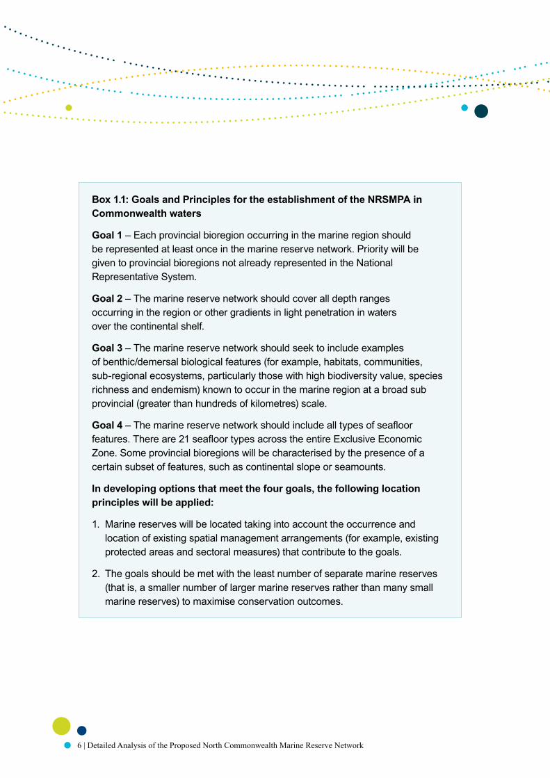
Box 1.1: Goals and Principles for the establishment of the NRSMPA in Commonwealth waters
Goal 1 – Each provincial bioregion occurring in the marine region should be represented at least once in the marine reserve network. Priority will be given to provincial bioregions not already represented in the National Representative System.
Goal 2 – The marine reserve network should cover all depth ranges occurring in the region or other gradients in light penetration in waters over the continental shelf.
Goal 3 – The marine reserve network should seek to include examples of benthic/demersal biological features (for example, habitats, communities, sub-regional ecosystems, particularly those with high biodiversity value, species richness and endemism) known to occur in the marine region at a broad sub provincial (greater than hundreds of kilometres) scale.
Goal 4 – The marine reserve network should include all types of seafloor features. There are 21 seafloor types across the entire Exclusive Economic Zone. Some provincial bioregions will be characterised by the presence of a certain subset of features, such as continental slope or seamounts.
In developing options that meet the four goals, the following location principles will be applied:
1. Marine reserves will be located taking into account the occurrence and location of existing spatial management arrangements (for example, existing protected areas and sectoral measures) that contribute to the goals.
2. The goals should be met with the least number of separate marine reserves (that is, a smaller number of larger marine reserves rather than many small marine reserves) to maximise conservation outcomes.

7
Where different options that meet the Goals exist, the following selection principles should be considered in selecting areas suitable for inclusion in the National Representative System of Marine Protected Areas:
3. The capacity of a marine reserve to mitigate identified threats to conservation values.
4. The occurrence of spatially defined habitats for and/or aggregations of threatened and/or migratory species.
5. The occurrence of ecologically important pelagic features which have a consistent and definable spatial distribution.
6. The occurrence of known small-scale (tens of kilometres) ecosystems associated with the benthic/demersal environment.
7. Relevant available information about small-scale distribution of sediment types and sizes and other geo-oceanographic variables.
8. Occurrence of listed heritage sites (where inclusion in the marine reserve network would improve administration of protection regimes).
9. Socioeconomic costs should be minimised.
Once the broad location of marine reserves has been determined, the following design principles should be applied to further refine the size and shape of individual marine reserves:
10. Individual areas should, as far as practicable, include continuous depth transects (for example, from the shelf to the abyss).
11. Whole seafloor features (such as geomorphic features) should be included.
12. Features should be replicated wherever possible within the system of marine reserves (that is, included more than once).
13. Size and shape should be orientated to account for inclusion of connectivity corridors and biological dispersal patterns within and across marine reserves.
14. Boundary lines should be simple, as much as possible following straight latitudinal/longitudinal lines.

8 | Detailed Analysis of the Proposed North Commonwealth Marine Reserve Network
15. Boundary lines should be easily identifiable, where possible coinciding with existing regulatory boundaries.
16. The size and shape of each area should be set to minimise socioeconomic costs.
The following zoning principles will be applied in developing the regional systems of marine reserves:
17. Zoning will be based on the Environment Protection and Biodiversity Conservation Act 1999 (EPBC Act)/the World Conservation Union (IUCN) categories of protection.
18. The regional marine reserve network will aim to include some highly protected areas (IUCN Categories I and II) in each provincial bioregion.
19. Zoning will be based on the consideration of the threat that specific activities pose to the conservation objectives of each marine reserve.
20. Zoning of marine reserves will seek to ensure that the conservation objectives of the area are protected, taking into account a precautionary approach to threats as well as the relative costs and benefits (economic, social and environmental) of different zoning arrangements.
2.3 Minimising socioeconomic impactsA key element of the Australian Government’s approach to developing regional marine reserve network proposals is the objective, embedded in the Goals and Principles, of establishing the reserve network in a way that minimises social and economic costs. Therefore, the design of regional networks seeks wherever possible to avoid restrictions on access to areas of significance to a range of recreational and commercial interests. These include: recreational, charter and commercial fishing; aquaculture operations; existing petroleum and greenhouse gas storage titles, acreage release areas, areas prospective for petroleum resources; tourism activities; non-commercial Indigenous uses and the exercise of non-commercial native title rights; defence and border protection activities; port-related activities, pipelines and submarine cables; and shipping lanes. Shipping rights of innocent passage under the United Nations Convention on the Law of the Sea are not affected.

9
The development of the Commonwealth marine reserve network proposal for the North Marine Region was also informed by consultation undertaken by the department on Areas for Further Assessment (AFAs). The identification of AFAs was an important step in refining information on human uses and socioeconomic values in the marine environment. The AFAs were large areas that encompassed examples of the range of biodiversity and ecosystems within each marine region. They were identified to aid further analysis of information at a more detailed scale and assist in the design of new marine reserves. Consultations on the AFAs assisted in identifying potential social and economic impacts that may occur with the establishment of marine reserves in these areas and how those impacts could be minimised.
Section 3.2 outlines the social and economic data and information that have been used in the design of the Commonwealth marine reserve network proposal for the North Marine Region with the objective of minimising impacts. Section 4.4 reports on the preliminary assessment of the impacts arising from the marine reserve network proposal.
An accurate assessment of the extent of impact and the flow-on effects into regional communities requires input from potentially affected users and industries. A socioeconomic impact assessment will be conducted by the Australian Bureau of Agricultural and Resource Economics and Sciences in parallel with the public consultation process. Industries, communities and stakeholders potentially affected by the proposed reserves will be consulted as part of the socioeconomic assessment. The outcomes of the assessment, together with the submissions received about the marine reserve network proposal will inform government decisions on the final network.
The government has committed to considering adjustment assistance for affected commercial fishing businesses and fishing-dependent regional communities based on impacts evaluated as part of the socioeconomic assessment and on other relevant inputs received through the public consultation process. Decisions on the scope, type and level of adjustment assessment will be based on the government’s Fisheries Adjustment Policy released on 3 May 2011 and available at www.environment.gov.au/coasts/mbp/about/policy.html

10 | Detailed Analysis of the Proposed North Commonwealth Marine Reserve Network
3 the APPRoACh to DesigNiNg the NetwoRk
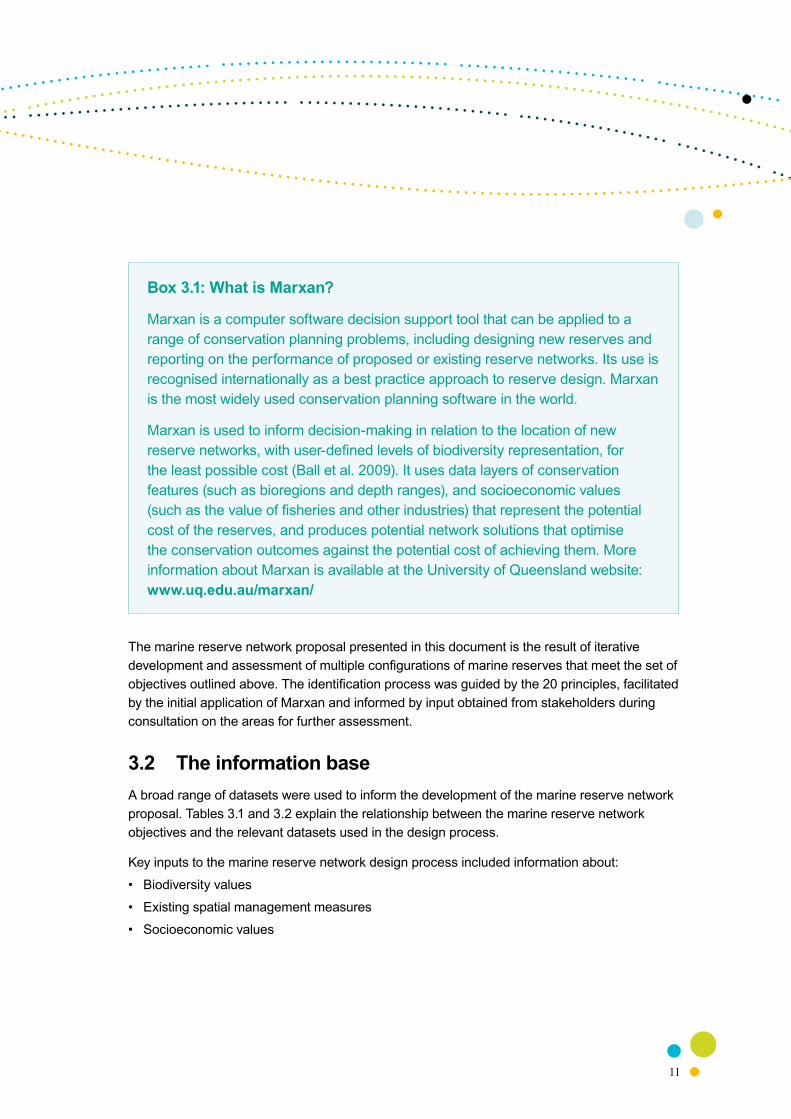
3.1 Systematic conservation planning The proposal for the North Commonwealth Marine Reserve Network has been designed to meet the Goals and Principles outlined above. The process of marine reserve identification has been undertaken using a systematic conservation planning approach and has been supported by the software Marxan (see Box 3.1). This approach is recognised as best practice and is widely used for designing terrestrial and marine protected areas, both in Australia and overseas.
Systematic conservation planning involves the following steps:
• setting out the objectives that the network seeks to achieve, including conservation features that should be included and areas and values that should be avoided (in order to minimise economic and social impacts)
• selecting and using spatial data that best represents those objectives
• generating and evaluating a network of areas that, taken together, meet those objectives
The objectives that the network seeks to achieve are derived directly from the Goals and Principles and:
• include examples of each of the four provincial bioregions (Goal 1; Figure 3.1)
• include examples of each of the 15 meso-scale bioregions (Goal 1; Figure 3.2)
• include examples of each of the 24 depth ranges within provincial bioregions (Goal 2; Figure 3.3; Table 3.3)
• include examples of benthic/demersal key ecological features (Goal 3; Figure 3.4)
• include examples of all biological seascapes (Goal 3; Figure 3.5; Table 3.4)
• include examples of all seafloor types (Goal 4; Figure 3.6)
• incorporate the SS Florence D historic shipwreck protected zone (Principle 1)
• incorporate permanent fisheries closures (Principle 1; Figure 3.7)
• preferentially incorporate areas in proximity to existing state marine parks (Principle 1)
• preferentially select areas to include biologically important areas for species listed as threatened and migratory (Principle 4)
• avoid areas of value to current users and existing interests (Principles 9 and 16)
11
Box 3.1: What is Marxan?
Marxan is a computer software decision support tool that can be applied to a range of conservation planning problems, including designing new reserves and reporting on the performance of proposed or existing reserve networks. Its use is recognised internationally as a best practice approach to reserve design. Marxan is the most widely used conservation planning software in the world.
Marxan is used to inform decision-making in relation to the location of new reserve networks, with user-defined levels of biodiversity representation, for the least possible cost (Ball et al. 2009). It uses data layers of conservation features (such as bioregions and depth ranges), and socioeconomic values (such as the value of fisheries and other industries) that represent the potential cost of the reserves, and produces potential network solutions that optimise the conservation outcomes against the potential cost of achieving them. More information about Marxan is available at the University of Queensland website: www.uq.edu.au/marxan/
The marine reserve network proposal presented in this document is the result of iterative development and assessment of multiple configurations of marine reserves that meet the set of objectives outlined above. The identification process was guided by the 20 principles, facilitated by the initial application of Marxan and informed by input obtained from stakeholders during consultation on the areas for further assessment.
3.2 The information baseA broad range of datasets were used to inform the development of the marine reserve network proposal. Tables 3.1 and 3.2 explain the relationship between the marine reserve network objectives and the relevant datasets used in the design process.
Key inputs to the marine reserve network design process included information about:
• Biodiversity values
• Existing spatial management measures
• Socioeconomic values

12 | Detailed Analysis of the Proposed North Commonwealth Marine Reserve Network
3.2.1 Biodiversity values
Unlike most terrestrial environments, information about the full range of habitats and species in marine environments is generally poor. This is especially the case in some of the offshore parts of the North Marine Region where waters are remote and there has been little detailed study or data collection. In these circumstances, the detailed and peer-reviewed data that does exist is supplemented with information on known or predicted linkages between the physical environment and biodiversity. This concept is known as surrogacy. Surrogates that are commonly used to represent marine biodiversity include depth, substrate, geomorphology (seafloor features), latitude, light and currents. Each of these factors will have an influence on where particular species, habitats or ecological communities occur.
The following information about the biodiversity values of the North Marine Region has been incorporated into the design of the marine reserve network proposal:
• bioregions
• depth
• benthic and demersal biological features
• seafloor features
• species
Bioregions (Goal 1)
The bioregions in Australia’s marine jurisdiction have been identified based on the patterns of bottom-dwelling species through the Integrated Marine and Coastal Regionalisation of Australia (IMCRA v4.0). The Commonwealth Environmental Research Fund (CERF) Marine Biodiversity Hub has analysed an additional six animal species groups which further support the validity of these bioregions (Dunstan & Foster 2010).
Marine bioregions have been identified at two scales: provincial bioregions, which encompass the entire area of Australia’s marine jurisdiction (Figure 3.1); and smaller meso-scale bioregions, which are confined to the continental shelf (Figure 3.2). Information on IMCRA is available at: www.environment.gov.au/coasts/mbp/publications/imcra/imcra-4.html.

13
Figure 3.1: Provincial bioregions of the North Marine Region
Figure 3.2: Meso-scale bioregions of the North Marine Region
Weipa
Jabiru
Darwin
Ngukurr
Karumba
Wyndham
Kununurra
Kowanyama
Nhulunbuy
Borroloola
Maningrida
Wadeye
140°E135°E130°E
10°S
10°S
15°S
15°S
20°S
20°S
Timor SeaArafura Sea
Gulf of Carpentaria
North-west Marine Region
VanDiemen
Rise WesselIslands
WellesleyIslands
Sir EdwardPellew Group
GrooteEylandt
Tiwi Islands
Maritime boundariesMarine planning region boundariesLimit of Australian EEZLimit of coastal waters
© Commonwealth of Australia, 2011
0 100 200 300 40050
Approximate scale (km)Projection: Geographics
Northern TerritoryWestern Australia Queensland
TorresStrait
Provincial bioregions
Northeast Shelf TransitionNorthern Shelf ProvinceNorthwest Shelf TransitionTimor Transition
Joseph Bonaparte
Gulf
Weipa
Jabiru
Darwin
Ngukurr
Karumba
Wyndham
Kununurra
Kowanyama
Nhulunbuy
Borroloola
Maningrida
Wadeye
140°E135°E130°E
10°S
10°S
15°S
15°S
20°S
20°S
Timor SeaArafura Sea
Gulf of Carpentaria
North-west Marine Region
Joseph Bonaparte
Gulf
VanDiemen
RiseWesselIslands
WellesleyIslands
Sir EdwardPellew Group
GrooteEylandt
Tiwi Islands
Maritime boundariesMarine planning region boundariesLimit of Australian EEZLimit of coastal waters
© Commonwealth of Australia, 2011
0 100 200 300 40050
Approximate scale (km)Projection: Geographics
Northern TerritoryWestern Australia Queensland
TorresStrait
Meso-scale bioregions
Anson BeagleArafuraArnhem WesselBonaparte GulfCambridge-Bonaparte
CarpentariaCobourgGrooteKarumba-NassauOceanic Shoals
PellewTorres StraitVan Diemens GulfWellesleyWest Cape York

14 | Detailed A
nalysis of the Proposed North C
omm
onwealth M
arine Reserve N
etwork
15
Table 3.1: Biophysical datasets used in the design of the North marine reserve network proposal3
Network design objecitves
Relevant Goals and Principles
Dataset Description Source3
Include examples of all provincial bioregions
Goal 1 Provincial bioregions
• Large planning units based on ecological patterns (bottom-dwelling invertebrates and fish that live close to the seafloor)
• Four provincial bioregions occur in the North Marine Region
IMCRA v4.0
Include examples of all meso-scale bioregions
Goal 1 Meso-scale bioregions
• Smaller planning units confined to continental shelf waters based on ecological patterns
• Fifteen meso-scale bioregions occur in the North Marine Region
IMCRA v4.0
Include examples of all depth ranges within provincial bioregions
Goal 2 Depth within bioregions
• Depth ranges selected based on species distribution CERF Marine Biodiversity Hub
CSIRO
Include examples of all key ecological features
Goal 3 Key ecological features (KEFs)
• Areas, species or communities regionally or nationally important for ecological functioning
• Eight KEFs occur in the North Marine Region
DSEWPaC
Include examples of all biological seascapes
Goal 3 Biological seascapes
• Areas with similar seabed assemblages of marine fauna
• Based on predictive modelling using physical and biological data on demersal fish and benthic invertebrates
CERF Marine Biodiversity Hub
Include examples of all seafloor types
Goal 4 Seafloor features
• Landscape-scale physical structures of the seafloor (geomorphology), e.g. canyons and reefs
• Fifteen different seafloor types occur in the North Marine Region
IMCRA v4.0
Include examples of biologically important areas for species listed as threatened and migratory
Principle 4 Biologically important areas
• Areas where aggregations of individuals of a protected species display behaviours such as breeding, foraging, resting and migration
DSEWPaC
3 For full source names refer to the Acronyms and Abbreviations table appended to this document.

14 | Detailed A
nalysis of the Proposed North C
omm
onwealth M
arine Reserve N
etwork
15
Table 3.2: Socioeconomic datasets used in the design of the North marine reserve network proposal4
NameRelevant Goals and Principles
Description Network design objectives Source4
Commercial fishing
Principles 9, 16
• Data were available as 60 minute reporting grids (NT for 2005–08) and 6 minute reporting grids (QLD for 2000–08, and Commonwealth for 2003–08)
Seek to avoid areas of value to commercial fisheries
AFMA; ABARES; NTDoRF; QDPIF
Charter fishing Principles 9, 16
• Data on broad distribution of catch and effort from state and national surveys
Seek to avoid areas of value to charter fishing operations
Henry & Lyle 2003; ABARES; NTDoRF; QDPIF
Recreational fishing
Principles 9, 16
• Data on broad distribution of catch and effort from state and national surveys; additional information on important recreational fishing ports and iconic areas from state based recreational fishing organisations.
Seek to avoid areas of value to recreational fishers and boating
Henry & Lyle 2003; Recfish Australia
Native Title Principles 9, 16
• Three determination areas, 2 registered determination application areas, and 5 Schedule determination application areas extend into the region (current as of April–June 2011)
No objective set in Marxan; data used for contextual purposes
National Native Title Tribunal
Defence Principles 9, 16
• Three military practice and training areas south-west and north-east of Darwin, and surrounding Weipa
No objective set in Marxan; data used for contextual purposes
Department of Defence
Petroleum Principles 9, 16
• Eighteen petroleum exploration titles, 1 petroleum retention title, 3 petroleum acreage releases and 2 cabon capture and storage releases currently occur in the region
Seek to avoid petroleum leases and acreages
DRET
Petroleum prospectivity
Principles 9, 16
• Relative petroleum prospectivity based on sedimentary basins; some areas of high prosectivity occur in the region
Seek to avoid basins with medium to high prospectivity
Geoscience Austalia
Shipping and ports
Principles 9, 16
• Distribution of shipping routes, volume of traffic, existing and proposed ports
No objective set in Marxan; data used for contextual purposes
AMSA; DSEWPaC
4 For full source names refer to the Acronyms and Abbreviations table appended to this document.

16 | Detailed A
nalysis of the Proposed North C
omm
onwealth M
arine Reserve N
etwork
NameRelevant Goals and Principles
Description Network design objectives Source4
Submarine cables
Principle 1 • No submarine telecommunications cables of national significance occur in the region.
No objective set in Marxan; data used for contextual purposes
ACMA
Fisheries closures
Principles 1, 9 and 16
• Permanent fisheries closures and habitat protection areas
Preferentially select permanent fisheries closures
AFMA; QDPIF
Marine reserves
Principle 1 • Existing and proposed state and commonwealth marine reserves within and adjacent to the region
Preferentially select areas in proximity of existing state marine parks
DSEWPaC
Historic shipwrecks
Principle 8 • 1 declared historic shipwreck occurs in the region – the SS Florence D which is surrounded by a declared protected zone
No objective set in Marxan; data used for contextual purposes
DSEWPaC
4 For full source names refer to the Acronyms and Abbreviations table appended to this document.

17
Depth (Goal 2)
The North Marine Region ranges from shallow waters of less than 5 metres depth to approximately 360 metres depth. Many marine assemblages are stratified by depth and similar depth ranges in different bioregions support different suites of species, so depth ranges within bioregions should be represented.
The CERF Marine Biodiversity Hub has analysed the available data on the distribution of over 1500 bottom dwelling fish species and used this to develop a species-based depth stratification of the continental shelf waters (0–200 metres) (Lyne et al. 2009). These depth ranges have been expanded, based on advice from the CSIRO (see also Last et al. 2005), to include the deeper waters of the upper continental slope (Figure 3.3, Table 3.3). Further information on depth ranges is available at: www.marinehub.org. This depth classification has been used in addressing Goal 2.
Figure 3.3: Depth ranges within bioregions in the North Marine Region
Weipa
Jabiru
Darwin
Ngukurr
Karumba
Wyndham
Kununurra
Kowanyama
Nhulunbuy
Borroloola
Maningrida
Wadeye
140°E135°E130°E
10°S
10°S
15°S
15°S
20°S
20°S
Timor SeaArafura Sea
Gulf of Carpentaria
North-west Marine Region
Joseph Bonaparte
Gulf
WesselIslands
Sir EdwardPellew Group
GrooteEylandt
Tiwi Islands
© Commonwealth of Australia, 2011
0 100 200 300 40050
Approximate scale (km)Projection: Geographics
TorresStrait
Depth within provincial bioregions
Shallow waterTransitionShallow ShelfTransitionDeep Shelf
TransitionShelf EdgeTransitionShallow Upper Slope
WellesleyIslandsNorthern TerritoryWestern Australia Queensland
Maritime boundariesMarine planning region boundariesLimit of Australian EEZLimit of coastal watersProvincial bioregion boundaries

18 | Detailed Analysis of the Proposed North Commonwealth Marine Reserve Network
Table 3.3: Depth ranges within the provincial bioregions used in the reserve design process for the North Marine Region
Depth rangeNorthwest
Shelf Transition
Northern Shelf
Province
Northeast Shelf
Transition
Timor Transition
Shallow Water 0–15 0–15 0–15 0–15
Shallow Water to Shallow Shelf Transition
15–70 15–70 15–70 15–70
Shallow Shelf 70–100 70–100 – 70–100
Shallow Shelf to Deep Shelf Transition
100–120 100–120 – 100–120
Deep Shelf 120–150 120–150 – 120–150
Deep Shelf to Shelf Edge Transition
150–165 150–165 – 150–165
Shelf Edge 165–220 – – 165–220
Shelf Edge to Shallow Upper Slope Transition
– – – 220–225
Shallow Upper Slope – – – 225–500
Benthic and demersal biological features (Goal 3)
The physical composition of the seabed strongly affects the distribution of many benthic organisms. Information about key ecological features and biological seascapes has been used to represent the benthic and demersal biological features of the North Marine Region in addressing Goal 3.
Key ecological features are elements of the Commonwealth marine environment that are of particular importance for ecological functioning, ecological integrity and biodiversity. The North Marine Region has eight key ecological features all of which can be spatially defined and mapped (Figure 3.4).

19 Figure 3.4: Key ecological features of the North Marine Region
Weipa
Jabiru
Darwin
Ngukurr
Karumba
Wyndham
Kununurra
Kowanyama
Nhulunbuy
Borroloola
Maningrida
Wadeye
140°E135°E130°E
10°S
10°S
15°S
15°S
20°S
20°S
Timor Sea
Maritime boundaries
Marine planning region boundaries
Limit of Australian exclusive economic zone
Limit of coastal waters
Arafura Sea
Gulf of Carpentaria
North-west Marine Region
WesselIslands
WellesleyIslands
GrooteEylandt
Tiwi Islands
© Commonwealth of Australia, 2011
Western Australia Northern Territory Queensland
TorresStrait
0 100 200 300 40050
Approximate scale (km)Projection: Geographics
Joseph Bonaparte
Gulf
Sir EdwardPellew Group
Key ecological features
1. Pinnacles of the Bonaparte Basin
2. Carbonate bank and terrace system of the Van Diemen Rise
3. Shelf break and slope of the Arafura Shelf
4. Tributary canyons of the Arafura Depression
5. Gulf of Carpentaria basin
6. Plateaux and saddle north-west of the Wellesley Islands
7. Submerged coral reefs of the Gulf of Carpentaria
8. Gulf of Carpentaria coastal zone
20 | Detailed Analysis of the Proposed North Commonwealth Marine Reserve Network
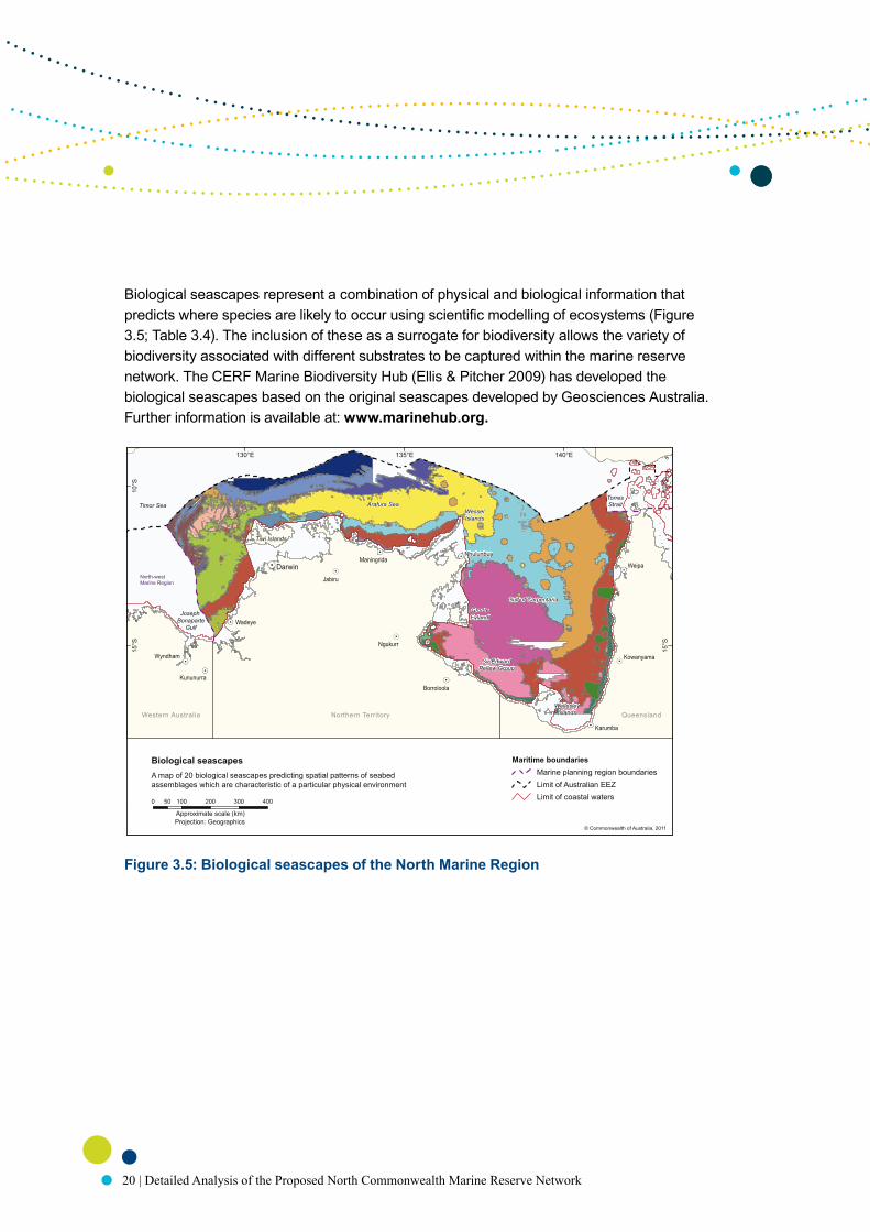
Biological seascapes represent a combination of physical and biological information that predicts where species are likely to occur using scientific modelling of ecosystems (Figure 3.5; Table 3.4). The inclusion of these as a surrogate for biodiversity allows the variety of biodiversity associated with different substrates to be captured within the marine reserve network. The CERF Marine Biodiversity Hub (Ellis & Pitcher 2009) has developed the biological seascapes based on the original seascapes developed by Geosciences Australia. Further information is available at: www.marinehub.org.
Figure 3.5: Biological seascapes of the North Marine Region
Weipa
Jabiru
Darwin
Ngukurr
Karumba
Wyndham
Kununurra
Kowanyama
Borroloola
Maningrida
Wadeye
140°E135°E130°E
10°S
10°S
15°S
15°S
20°S
20°S
Timor Sea Arafura Sea
Gulf of Carpentaria
North-west Marine Region
Joseph Bonaparte
Gulf
Sir EdwardPellew Group
GrooteEylandt
Tiwi Islands
© Commonwealth of Australia, 2011
0 100 200 300 40050
Approximate scale (km)Projection: Geographics
TorresStrait
Northern TerritoryWestern Australia Queensland
Maritime boundariesMarine planning region boundariesLimit of Australian EEZLimit of coastal waters
Nhulunbuy
WesselIslands
A map of 20 biological seascapes predicting spatial patterns of seabedassemblages which are characteristic of a particular physical environment
Biological seascapes
WellesleyIslands

21
Table 3.4: Description of the CERF Marine Hub biological seascapes clusters used in the marine reserve network design for the North Marine Region
Cluster Location Description
Cluster 1 Eastern Carpentaria basin
Moderately high variation in seabed oxygen, moderately low chlorophyll A, moderately low turbidity, primarily sandy, deep mid-shelf
Cluster 2 Joseph Bonaparte Gulf / Beagle Gulf
High average water temperature at the seabed, low silicate average, high turbidity, high chlorophyll A, sandy-muddy sediments with high gravel, high variation in bottom stress, inshore depth range
Cluster 3 Arafura mid-shelf
Moderately high sediment mud content, low sediment sand content, high variation in seabed oxygen, low salinity average, mid-shelf depth range
Cluster 4 Central Gulf of Carpentaria
High sediment mud content, low sediment sand content, low chlorophyll A, low turbidity, high salinity average, high variation in seabed oxygen, mid-shelf depth
Cluster 5 Timor–Arafura slope
Very low average water temperature at the seabed, low variation in sea surface temperature, very low benthic irradiance, upper slope depth range, very high silicate average, very low chlorophyll A, very low average seabed oxygen, very low turbidity, very high nutrients
Cluster 6 Timor mid-shelf High sediment carbonate, high average sea surface temperature, low variation in water temperature at the seabed, moderately high variation in bottom stress, mid-shelf depth range
Cluster 7 South-west Carpentaria inner shelf
High variation in sea surface temperature, very high salinity average, high variation in water temperature at the seabed, inner-shelf depth range
Cluster 8 Timor outer-shelf
Very high average sea surface temperature, low variation in sea surface temperature, low benthic irradiance, outer-shelf depth range, moderately low average seabed oxygen, moderately high silicate average, moderately high sediment mud content
Cluster 9 Bonaparte–Anson–Beagle coastal
Very high average water temperature at the seabed, high benthic irradiance, very shallow depth, very low silicate average, very high chlorophyll A, very high turbidity, very high sediment gravel content, moderately high salinity average
Cluster 10 Timor–Arafura shelf-break
Low average water temperature at the seabed, low benthic irradiance, shelf-break depth range, high silicate average, low chlorophyll A, low average seabed oxygen, low turbidity, high sediment mud

22 | Detailed Analysis of the Proposed North Commonwealth Marine Reserve Network
Cluster Location Description
Cluster 11 Melville/Coburg nearshore
Low sediment carbonate, very high sediment mud, very low sediment sand content, very low sediment gravel content, low sediment carbonate, low salinity average, moderately high average water temperature at the seabed, depth
Cluster 12 North region inner shelf
Low sediment mud content, moderately high sediment sand content, inner-shelf depth range
Cluster 13 South-west and east Carpentaria coast
Very high variation in sea surface temperature, very high benthic irradiance, very shallow, high sediment sand content, very high average seabed oxygen, high chlorophyll A, low sediment carbonate, relatively low average sea surface temperature, high turbidity
Cluster 14 Western Torres Strait
Very low sediment mud content, high sediment sand content, high sediment gravel content, high sediment carbonate, relatively low average sea surface temperature, very high variation in salinity, very high variation in bottom stress, very high bottom stress, moderately shallow
Cluster 15 Arnhem land / Kimberley coast
High average water temperature at the seabed, high benthic irradiance, low silicate average, very low salinity average, shallow depth
Cluster 16 Northern Carpentaria—Arnhem inner shelf
Moderately high salinity average, moderately high variation in seabed oxygen, depth range
Cluster 17 Arnhem / Bonaparte outer shelf
Low average water temperature at the seabed, high silicate average, low average seabed oxygen and very high variation in seabed oxygen, high nutrients and very high variation in nitrate, outer-shelf depth range
Cluster 18 South-west and East Carpentaria nearshore
Very low average sea surface temperature relatively and high variation in sea surface temperature, high average seabed oxygen, moderately high chlorophyll A with very high variation, moderately high turbidity with very high variation in turbidity, nearshore depth range
Cluster 19 Cootamundra Shoals area
High average sea surface temperature, very low variation in sea surface temperature, very high sediment carbonate, high bottom stress with high variation, typical depth range with shoals to around 20 m
Cluster 20 Carpentaria sand patches
Very high sediment sand content, low sediment mud content, low sediment gravel content, relatively low sediment carbonate, high average seabed oxygen, depth range

23
Seafloor features (Goal 4)
The landscape-scale physical structure of the seafloor is important in determining where habitats or species occur. Large physical seafloor structures (tens to hundreds of kilometres in scale) are referred to as geomorphic or seafloor features and include, for example, seafloor pinnacles, canyons and reefs. There are 15 types of seafloor features in the North Marine Region (Figure 3.6). Information on the seafloor features of the continental margin of Australia is available at: www.environment.gov.au/coasts/mbp/publications/general/nmb-geomorphic-report.html.
Figure 3.6: Seafloor features of the North Marine Region
Species
Biologically important areas are areas where aggregations of individuals of a protected species display behaviours such as breeding, foraging, resting and migration. Biologically important areas highlight those parts of the region that are particularly important for the protection and conservation of protected species. The areas have been identified based on published literature and advice from scientific experts. Information on the distribution, relative abundance and types of activities, such as foraging, breeding, nesting and internesting, were compiled for seabirds, dolphins and marine turtles in the North Marine Region.
Weipa
Jabiru
Darwin
Ngukurr
Karumba
Wyndham
Kununurra
Kowanyama
Nhulunbuy
Borroloola
Maningrida
Wadeye
140°E135°E130°E
10°S
10°S
15°S
15°S
20°S
20°S
Timor SeaArafura Sea
Gulf of Carpentaria
North-west Marine Region
WesselIslands
Sir EdwardPellew Group
GrooteEylandt
Tiwi Islands
© Commonwealth of Australia, 2011
0 100 200 300 40050
Approximate scale (km)Projection: Geographics
TorresStrait
Seafloor (geomorphic) features
apron/fanbank/shoalsbasincanyondeep/hole/valley
pinnacleplateaureefridgesaddle
shelfsillslopeterracetidal-sandwave/sand-bank
Northern TerritoryWestern Australia Queensland
Maritime boundariesMarine planning region boundariesLimit of Australian EEZLimit of coastal waters
Joseph Bonaparte
Gulf
WellesleyIslands
24 | Detailed Analysis of the Proposed North Commonwealth Marine Reserve Network
3.2.2 Existing spatial management measures
Principle 1 requires that existing spatial closures be incorporated in the marine reserve network wherever possible and appropriate. Existing spatial management measures considered in the design of the marine reserve network include:
• fisheries closures
• existing or proposed marine reserves
• historic shipwrecks.
Fisheries closures
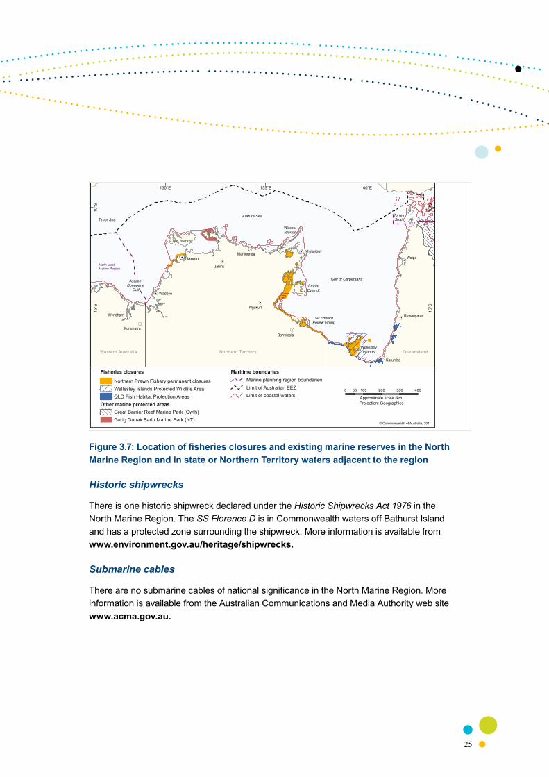
Permanent fisheries closures and habitat protection areas considered in the design of the marine reserve network are:
• permanent closures of the Commonwealth-managed Northern Prawn Fishery
• Wellesley Islands Protected Wildlife Area (Queensland)
• Queensland Fish Habitat Areas (Nassau River, Staaten-Gilbert, Morning Inlet—Bynoe River and Eight Mile Creek).
Marine reserves
There are no existing Commonwealth marine reserves within the North Marine Region. The Northern Territory Garig Gunak Barlu National Park covers lands and waters adjacent to the North Marine Region.
25
Figure 3.7: Location of fisheries closures and existing marine reserves in the North Marine Region and in state or Northern Territory waters adjacent to the region
Historic shipwrecks
There is one historic shipwreck declared under the Historic Shipwrecks Act 1976 in the North Marine Region. The SS Florence D is in Commonwealth waters off Bathurst Island and has a protected zone surrounding the shipwreck. More information is available from www.environment.gov.au/heritage/shipwrecks.
Submarine cables
There are no submarine cables of national significance in the North Marine Region. More information is available from the Australian Communications and Media Authority web site www.acma.gov.au.
Weipa
Jabiru
Darwin
Ngukurr
Karumba
Wyndham
Kununurra
Kowanyama
Borroloola
Maningrida
Wadeye
140°E135°E130°E
10°S
10°S
15°S
15°S
20°S
20°S
Timor SeaArafura Sea
Gulf of Carpentaria
North-west Marine Region
Joseph Bonaparte
Gulf
WesselIslands
Sir EdwardPellew Group
GrooteEylandt
Tiwi Islands
© Commonwealth of Australia, 2011
0 100 200 300 40050
Approximate scale (km)Projection: Geographics
TorresStrait
Fisheries closures
Northern Prawn Fishery permanent closuresWellesley Islands Protected Wildlife AreaQLD Fish Habitat Protection Areas
Other marine protected areasGreat Barrier Reef Marine Park (Cwth)Garig Gunak Barlu Marine Park (NT)
Northern TerritoryWestern Australia QueenslandWellesleyIslands
Nhulunbuy
Maritime boundariesMarine planning region boundariesLimit of Australian EEZLimit of coastal waters

26 | Detailed Analysis of the Proposed North Commonwealth Marine Reserve Network
3.2.3 Socioeconomic values
Principles 9 and 16 require that in considering alternative reserve locations, sizes and shapes, a key consideration should be to minimise socioeconomic impacts. Information incorporated into the marine reserve network design process about existing human uses of the North Marine Region included commercial, recreational and traditional uses. Over 99 per cent of the North Marine Region comprises continental shelf and there are economic activities occurring across virtually all areas of the region. Indigenous people own most of the land adjacent to the North Marine Region and make up the majority of the population outside Darwin (ABS 2006; DEWHA 2008). Indigenous coastal communities maintain special links with their sea country through occupation, resource utilisation and cultural practices (Smyth 1993, 1994). Socioeconomic data has been used to inform selection of marine reserve locations and the delineation of boundaries and zoning to minimise socioeconomic costs. Information about the following uses has been used in the design of the proposed network:
• commercial fishing
• charter fishing
• recreational uses, including fishing
• native title
• defence
• petroleum
• shipping and ports
Commercial fishing
Commercial wild-catch fishing is the most widespread activity in the North Marine Region. Ten commercial fisheries operate in the region with an average total gross value of production5 of around $109 million annually. The most valuable fishery in the North Marine Region is the Northern Prawn Fishery, which targets mainly tiger and banana prawns. In 2008–09 the total value of the catch by the fishery was approximately $74 million (Wilson et al. 2010). Fishing effort is relatively evenly distributed across the region, with the highest effort concentrated along the coast, particularly around Darwin and the Tiwi Islands and in the Gulf of Carpentaria.
5 Fisheries data was used in the marine reserve network design process as annual average gross value of production (GVP) which is the value of commercial fishery products at the point of landing. GVP does not take into account the cost to fishers of catching the fish, or the cost of transporting, processing and marketing the fish products for wholesale and retail markets. It also does not take into account flow-on effects such as value-adding and other potential benefits to individuals and communities.

27
Data on the distribution of commercial fishing was obtained from Commonwealth, state and Northern Territory government fisheries management agencies. Data for the Commonwealth managed Northern Prawn Fishery covered 2003–08. Data for Queensland managed fisheries covered 2000–08 and data for Northern Territory managed fisheries covered 2005–08.
Application and interpretation of fisheries data was informed by input obtained from industry representatives and fisheries managers during consultation undertaken by the department on the Areas for Further Assessment for the North Marine Region.
Charter fishing
In 2009, there were approximately 150 Fishing Tour Operator licence holders (approximately 90 active licences) in the Northern Territory charter industry. While licence numbers are down from a peak of 218 in 1997, hours spent fishing has almost doubled since then, and client days have increased from around 15 000 to approximately 35 000 in 2009 (Handley 2010). In 2006, there were 34 Charter Fishing Licence holders operating in the Gulf of Carpentaria in Queensland (QDPIF 2006 in OESR 2006). There is limited information on the distribution of fishing effort for the charter fishing sector. Available information includes:
• the 2001 National Recreational and Indigenous Fishing Survey (Henry & Lyle 2003), which provides now dated information on the distribution of effort
• spatial information based on charter fishing reporting to state and Northern Territory fisheries management agencies for 2000–07.
Recreational uses, including fishing
The Northern Territory has the highest level of recreational fishing participation per capita of any area in Australia. In 2001, approximately six per cent of recreational fishing activity occurred offshore (Coleman 2003). It has been estimated that over 80 000 tourists visit the Gulf of Carpentaria region annually (Gulf Regional Planning Advisory Committee 2000). Of those that visit Karumba (Queensland), around 70 per cent primarily come to fish recreationally (Greiner & Patterson 2007).
Limited information on the distribution of effort is available for the recreational fishing sector. Available information includes:
• the 2001 National Recreational and Indigenous Fishing Survey (Henry & Lyle 2003);
• information on important recreational fishing ports and recreational fishing areas was obtained through consultation with Northern Territory and national recreational fishing organisations, during consultation undertaken by the department on the AFAs for the North Marine Region
• additional information on recreational fishing in Queensland was provided by the Queensland Department of Primary Industries and Fisheries.

28 | Detailed Analysis of the Proposed North Commonwealth Marine Reserve Network
Offshore aquaculture
Currently all aquaculture activities occur within state or Northern Territory waters adjacent to the North Marine Region.
Native title
Native title rights can exist in waters over which Australia asserts sovereign rights under the Seas and Submerged Lands Act 1973. Native title determinations need not have been made in order for native title rights to exist. Native title information was provided by the National Native Title Tribunal; including all claims within and adjacent to the North Marine Region. Further information is available from the National Native Title Tribunal at: www.nntt.gov.au/PUBLICATIONS-AND-RESEARCH/MAPS-AND-SPATIAL-REPORTS/Pages.
Defence
The Australian Defence Forces use the entire marine estate in the course of their activities, with specific areas set aside for training activities. Within the North Marine Region there are three military practice and training areas. These areas are located south-west and north-east of Darwin, and surrounding Weipa.
Petroleum and mining
While there is currently no extraction of petroleum in the North Marine Region, there are a number of areas considered to be prospective. The Arafura and Money Shoal basins within the region are medium to high prospectivity and part of the Bonaparte Basin adjacent to the North Marine Region contains world class oil and gas resources (ABARES 2010). Gas fields have also been discovered in the region. Continuing development of Australia’s offshore petroleum resources is essential to Australia’s energy security.
Information on the distribution of exploration and production leases and acreage releases in the North Marine Region is available from the Department of Resources, Energy and Tourism. This was supplemented with current information about the relative prospectivity for petroleum of areas in the region supplied by Geosciences Australia.
There are currently retention and exploration leases, offshore petroleum acreage release areas and carbon capture and storage acreage release areas in the North Marine Region. Further information is available from the Department of Resources, Energy and Tourism at www.ret.gov.au/resources/upstream_petroleum/Pages/UpstreamPetroleum.aspx.

29
In June 2010, a company applied for nine Offshore Mineral Exploration Licences in Commonwealth waters south of Groote Eylandt. There are no other offshore minerals licences or licence applications in the region. Further information is available from Geoscience Australia at www.australianminesatlas.gov.au/aimr/offshore_minerals_10.jsp.
Shipping and ports
The North Marine Region is a major international transit route. Other major shipping activity is generally related to servicing the mining industry. Spatial information on the distribution of shipping routes, volume of traffic and existing and proposed ports was used to avoid impacts on the shipping industry (AMSA 2006; DSEWPaC 2003).
3.3 Approach to zoningThe Environment Protection and Biodiversity Conservation Act 1999 (EPBC Act) sets out the legal framework for declaring and managing Commonwealth marine reserves. It requires that, upon proclamation each Commonwealth marine reserve must be assigned to one of the World Conservation Union’s (IUCN) internationally recognised set of seven protected area management categories.6 Schedule 8 of the regulations under the EPBC Act outlines the Australian IUCN reserve management principles7. A Commonwealth reserve proclamation can also divide a reserve into zones and assign an IUCN category to each zone.
The approach to zoning is informed by Principles 18, 19 and 20. There are two components to the approach to zoning:
• determining the location, size and shape of different zones
• determining what activities are allowed in the different zones.
Determining the location, size and shape of different zones
The selection of areas to be zoned as highly protected was based on Principle 18; that the network should aim to include some highly protected areas in each provincial bioregion (i.e. IUCN Categories I or II). The principle that each provincial bioregion is represented within a highly protected zone, considered jointly with both the aim to minimise socioeconomic impacts and information about the finer scale distribution of conservation features in the region, was the primary driver for the location, size and shape of the highly protected zones.
6 For further information see www.iucn.org/about/work/programmes/pa/pa_products/wcpa_categories. Categories are based on the Guidelines for Protected Area Management Categories published by the World Conservation Union (IUCN) in 1994.
7 For further information, see www.environment.gov.au/coasts/mpa/publications/pubs/iucn-principles.pdf

30 | Detailed Analysis of the Proposed North Commonwealth Marine Reserve Network
Determining what activities are allowed in the different zones
The North Commonwealth Marine Reserve Network is proposed to include areas that are highly protected and areas where some natural resource use is allowed, as long as it is consistent with the objective of protecting and maintaining biodiversity in the long-term. Biodiversity conservation is the primary objective for all parts of the NRSMPA. This objective informs decisions about the compatibility of activities in marine reserves and requires the application of precaution in decision-making about the potential impacts of human activities. Therefore, although the mitigation of threats to biodiversity is not the basis on which the marine reserve networks in Commonwealth waters are identified, threat mitigation within proposed reserves is a consideration in decisions about proposed reserve zoning and about which activities can be permitted within zones.
Highly protected areas exclude most activities. Multiple use zones generally allow sustainable use of the marine environment and its resources where they are compatible with the overarching objective of conserving biodiversity.
The zoning scheme proposed for the North Commonwealth Marine Reserve Network includes marine national park zones (IUCN Category II) designed to provide the highest level of protection to conservation features; multiple use zones (IUCN Category VI), which allow a range of existing activities but exclude activities that carry a high risk to the conservation values; and special purpose zones (IUCN Category VI), which allow a wider range of commercial activities to lessen potential displacement of the commercial fishing industry.
The zoning arrangements that apply to each zone type are outlined in Table 3.5. Details of the conditions and approval or permit requirements that apply to specific activities within a Commonwealth marine reserve will be included in the North Commonwealth Marine Reserves Network Management Plan, which will be prepared once the network proposal is finalised and the marine reserves are proclaimed under the EPBC Act. The development of the management plan is a statutory process and will involve two periods of public consultation.
Under the proposed zoning scheme, some activities may be undertaken subject to general approvals, operator registration or individual permit. Some activities, including exploration for and development of petroleum resources in multiple use areas, will be subject to individual project assessment and approval under the EPBC Act by both the Minister (or his delegate) and the Director of National Parks.

31
Table 3.5: Overview of the proposed zoning scheme for the Commonwealth marine reserve network proposal for the North Marine Region
Activity Multiple Use Zone (IUCN Category VI)
Special Purpose Zone (IUCN Category VI)
Marine National Park Zone
(IUCN Category II)
Recreational fishinga ü ü û
Recreational scuba diving and snorkelling ü ü ü
Research and monitoringb ü ü ü
Tourism, including dive/snorkel tours and nature watchingb ü ü ü
Mining, including petroleum exploration and developmentc ü ü û
Non-commercial Indigenous harvesting and hunting (consistent with the Native Title Act 1993)
ü ü ü
Shippingd ü ü ü
Charter fishinge ü ü û
Offshore aquaculturee ü ü û
Commercial fishinge
(except as indicated below) ü ü û
Pelagic gillnet û ü û
Set mesh net û û û
Demersal longline û û û
Bottom trawl (including semi-pelagic demersal trawl and semi-demersal trawl)
û û û
a Recreational fishing is managed by the states/NT. All state/NT rules and regulations (e.g. size and bag limits) will apply in Commonwealth marine reserves unless otherwise specified in statutory management plans.
b Authorisation will be required for these activities (e.g. approval or permit) in marine national park zones (IUCN Category II).
c Proposed mining operations currently require approval from the Director of National Parks unless they are carried out under usage rights that existed immediately before the declaration of a reserve. Mining operations are also subject to the assessment and approval provisions of the Environment Protection and Biodiversity Conservation Act 1999 where a proposed operation is likely to have a significant impact on the environment or on listed threatened or migratory species.
d Ballast water exchange is managed under national arrangements. Restrictions may apply in sensitive areas.
e Authorisation will be required for these activities (e.g. approval or permit) in multiple use and special purpose zones.

32 | Detailed Analysis of the Proposed North Commonwealth Marine Reserve Network
4 PeRfoRMANCe of the MARiNe ReseRve NetwoRk PRoPosAl AgAiNst the goAls AND PRiNCiPles
4.1 Summary of the networkThe North Commonwealth marine reserve network proposal (Figure 4.1) consists of eight individual reserves:
• Joseph Bonaparte Gulf Commonwealth marine reserve
• Oceanic Shoals Commonwealth marine reserve
• Arafura Commonwealth marine reserve
• Arnhem Commonwealth marine reserve
• Wessel Commonwealth marine reserve
• Limmen Commonwealth marine reserve
• Gulf of Carpentaria Commonwealth marine reserve
• West Cape York Commonwealth marine reserve.
The marine reserve network proposal covers an area of approximately 121 723 square kilometres, which equates to about 19.5 per cent of the total area of the North Marine Region (Table 4.1).
Approximately 15 per cent of the marine reserve network, or three per cent of the North Marine Region, has been zoned as marine national park with the remainder zoned for multiple use and special purpose (details at Table 4.2).

33
Table 4.1: Overview of the North Commonwealth marine reserve network proposal
Total network area 121 723 km2
Area highly protected (IUCN Category II) 18 475 km2
Proportion of region in network 19.5%
Proportion of region highly protected (IUCN Category II)
3.0%
Proportion of network on continental shelf
99.4%
Bioregions All provincial bioregions and all but one meso-scale bioregion are represented within the network
Depth ranges within provincial bioregions
All but two of the depth ranges within bioregions are represented within the network
Key ecological features All of the key ecological features are represented within the network
Biological seascapes All of the biological seascapes are represented within the network
Seafloor features (geomorphology) All seafloor features are represented within the network

34 | Detailed A
nalysis of the Proposed North C
omm
onwealth M
arine Reserve N
etwork
Figure 4.1: The North Commonwealth marine reserve network proposal
Weipa
Jabiru
Darwin
Ngukurr
Karumba
Wyndham
Kununurra
Kowanyama
Nhulunbuy
Borroloola
Maningrida
Wadeye
140°E135°E130°E10
°S
10°S
15°S
15°S
20°S
20°S
Timor Sea
Maritime boundaries
Marine planning region boundaries
Limit of Australian exclusive economic zone
Limit of coastal waters
Arafura Sea
Gulf of Carpentaria
North-west Marine Region
WesselIslands
WellesleyIslands
GrooteEylandt
Tiwi Islands
© Commonwealth of Australia, 2011
Western Australia Northern Territory Queensland
TorresStrait
Joseph Bonaparte
Gulf
Sir EdwardPellew Group
Limmenmarine reserve
JosephBonaparte Gulfmarine reserve
Oceanic Shoalsmarine reserve
Arafuramarine reserve
Wesselmarine reserve
Gulf of Carpentaria
marine reserve
West Cape Yorkmarine reserve
Arnhemmarine reserve
Proposed Commonwealth marine reserve network
Outer boundaries
Internal zoning:
Marine National Park (IUCN II)
Special Purpose Zone (IUCN VI)
Multiple Use Zone (IUCN VI)
Other marine protected areas
Great Barrier Reef Marine Park (Cwth)
Garig Gunak Barlu Marine Park (NT)
North-west proposed marine reserves
0 100 200 300 40050
Approximate scale (km)Projection: Geographics

35
Table 4.2: Areas of each reserve within the North Commonwealth marine reserve network proposal
Draft proposed reserve
Total area (km²) a
Proportion of the
network
Proportion of the region
Marine national
park zone (km²)
Multiple use zone
(km²)
Special purpose
zone (km²)
Joseph Bonaparte Gulf
5 202 4.3% 0.8% - 2 951 2 251
Oceanic Shoals
42 207 34.7% 6.8% - 42 207 -
Arafura 22 919 18.8% 3.7% - 22 919 -
Arnhem 7 125 5.9% 1.1% - - 7 125
Wessel 5 140 4.2% 0.8% 3 434 1 706 -
Limmen 1 254 1.0% 0.2% - 1 254 -
Gulf of Carpentaria
21 864 17.9% 3.5% 7 084 14 780 -
West Cape York
16 012 13.2% 2.6% 7 957 8 055 -
TOTAL* 121 723 100.0% 19.5% 18 475 93 872 9 376
a The total area of the North Marine Region is 625 690 km2

36 | Detailed Analysis of the Proposed North Commonwealth Marine Reserve Network
4.2 Achieving the goalsThe North Commonwealth Marine Reserve Network proposal achieves the four Goals to a large extent, by representing:
• Each of the four provincial bioregions and fourteen of the fifteen meso-scale bioregions in the North Marine Region (Goal 1—Each provincial bioregion occurring in the marine region should be represented at least once in the marine reserve network)
• all but two depth ranges within provincial bioregions (Goal 2—The marine reserve network should cover all depth ranges (0–360 metres) occurring in the region or other gradients in light penetration in waters over the continental shelf)
• each of the key ecological features of the region and all of the biological seascapes. (Goal 3—The marine reserve network should seek to include examples of benthic/demersal biological features known to occur in the marine region at a broad sub provincial (greater than hundreds of kilometres) scale)
• all of the seafloor features found in the region. (Goal 4—The marine reserve network should include all types of seafloor features.
In total, of the 86 primary conservation features present in the North Marine Region, 83 are represented in the marine reserve network proposal (Tables 4.3 and 4.4).
Table 4.3: Primary features included in the North Commonwealth marine reserve network proposal
Primary Conservation Features Features in the region
Features represented
within network
Goal 1 Provincial bioregions (PB)
Meso-scale bioregions (MB)
4
15
4
14
Goal 2 Depth ranges within PB 24 22
Goal 3 Key ecological features
Biological seascapes
8
20
8
20
Goal 4 Seafloor types 15 15
Total 86 83

37
Table 4.4: Representation of conservation features in the North Commonwealth marine reserve network proposal
Feature Name Included in the network
Provincial bioregions
Northeast Shelf Transition
Northern Shelf Province
Northwest Shelf Transition
Timor Transition
ü
ü
ü
ü
Meso-scale bioregions
Anson Beagle
Arafura
Arnhem Wessel
Bonaparte Gulf
Cambridge-Bonaparte
Carpentaria
Cobourg
Groote
Karumba-Nassau
Oceanic Shoals
Pellew
Tiwi
Torres Strait
Wellesley
West Cape York
ü
ü
ü
ü
ü
ü
ü
û
ü
ü
ü
ü
ü
ü
ü
Depth range within Northeast Shelf Transition
Shallow Waters
Shallow Waters to Shallow Shelf Transition
ü
ü

38 | Detailed Analysis of the Proposed North Commonwealth Marine Reserve Network
Feature Name Included in the network
Depth range within Northern Shelf Province
Shallow Waters
Shallow Waters to Shallow Shelf Transition
Shallow Shelf
Shallow Shelf to Deep Shelf Transition
Deep Shelf
Deep Shelf to Shelf Edge Transition
ü
ü
ü
ü
ü
ü
Depth range within Northwest Shelf Transition
Shallow Waters
Shallow Waters to Shallow Shelf Transition
Deep Shelf
Deep Shelf to Shelf Edge Transition
Shallow Shelf
Shallow Shelf to Deep Shelf Transition
Shelf Edge
ü
ü
ü
ü
ü
ü
ü
Depth range within Timor Transition
Shallow Waters
Shallow Waters to Shallow Shelf Transition
Deep Shelf
Deep Shelf to Shelf Edge Transition
Shallow Shelf
Shallow Shelf to Deep Shelf Transition
Shallow Upper Slope
Shelf Edge
Shelf Edge to Shallow Upper Slope Transition
û
û
ü
ü
ü
ü
ü
ü
ü
Key ecological features
Carbonate terrace and bank system of the Van Diemen Rise
Gulf of Carpentaria basin
Gulf of Carpentaria coastal zone
Pinnacles of the Bonaparte Basin
Plateaux and saddle of the Wellesley Islands
Shelf break and slope of the Arafura Shelf
Submerged coral reefs of the Gulf of Carpentaria
Tributary Canyons of the Arafura Depression
ü
ü
ü
ü
ü
ü
ü
ü

39
Feature Name Included in the network
Biological seascapes
Cluster 1
Cluster 2
Cluster 3
Cluster 4
Cluster 5
Cluster 6
Cluster 7
Cluster 8
Cluster 9
Cluster 10
Cluster 11
Cluster 12
Cluster 13
Cluster 14
Cluster 15
Cluster 16
Cluster 17
Cluster 18
Cluster 19
Cluster 20
ü
ü
ü
ü
ü
ü
ü
ü
ü
ü
ü
ü
ü
ü
ü
ü
ü
ü
ü
ü

40 | Detailed Analysis of the Proposed North Commonwealth Marine Reserve Network
Feature Name Included in the network
Seafloor features
Apron/fan
Bank/shoals
Basin
Canyon
Deep/hole/valley
Pinnacle
Plateau
Reef
Ridge
Saddle
Shelf
Sill
Slope
Terrace
Tidal-sandwave/sand-bank
ü
ü
ü
ü
ü
ü
ü
ü
ü
ü
ü
ü
ü
ü
ü

41
4.3 Applying the PrinciplesTwenty principles guide the location, selection, design and zoning of the proposed reserve network. This section outlines how the principles were addressed in the development of the proposed network.
Principle 1—Marine reserves will be located taking into account the occurrence and location of existing spatial management arrangements (for example, existing protected areas and sectoral measures) that contribute to the goals.
There are no existing Commonwealth marine reserves in the North Marine Region.
The Northern Territory Garig Gunak Barlu National Park includes 230 square kilometres of Northern Territory waters surrounding the Coburg Peninsula. The proposed Arafura marine reserve lies within approximately 35 kilometres of these waters.
There are three Aquatic Life Reserves in Northern Territory waters near Darwin: East Point, Doctor’s Gully and Stokes Hill Warf (NTDoRF 2010). The Casuarina Coastal Reserve lies just north of Darwin and encompasses 15 square kilometres of coastal habitat (NRETAS 2007a). The Aquatic Life Reserves and Coastal Reserve lie 60–80 kilometres from Commonwealth waters and approximately 130 kilometres from the proposed Oceanic Shoals marine reserve.
There are currently no marine reserves in the Queensland waters of the Gulf of Carpentaria. Four areas in the Gulf of Carpentaria encompassing around 390 square kilometres of Queensland state waters have been declared for the protection of fish habitat: the Eight Mile Creek, Mornington Inlet-Bynoe River, Staaten-Gilbert and Nassau River Fish Habitat Areas. The Fish Habitat Areas lie 40–110 kilometres from the proposed Gulf of Carpentaria marine reserve.
The proposed Gulf of Carpentaria marine reserve overlaps two permanent Northern Prawn Fishery closures (benthic protection sites) near the Wellesley Islands. The proposed reserve also overlaps the Wellesley Islands Protected Wildlife Area which limits the types of nets that can be used around the islands and adjacent mainland to protect marine mammals.

42 | Detailed Analysis of the Proposed North Commonwealth Marine Reserve Network
Figure 4.2: Location of fisheries closures and existing and proposed marine reserves in the North Marine Region and the Northern Territory waters
Jabiru
Darwin
Ngukurr
Wyndham
KununurraBorroloola
Maningrida
Wadeye
135°E130°E
10°S
10°S
15°S
15°S
20°S
20°S
Timor Sea
North-west MarineRegion Joseph
BonaparteGulf Groote
Eylandt
Tiwi Islands
© Commonwealth of Australia, 2011
0 100 200 300 40050
Approximate scale (km)Projection: Geographics
Fisheries Closures
Northern Prawn Fishery permanent closuresWellesley Islands Protected Wildlife AreaQLD fish habitat protection areas
NorthernTerritory
WesternAustralia Queensland
Nhulunbuy
Maritime boundariesMarine planning region boundariesLimit of Australian EEZLimit of coastal watersOffshore NT/QLD border
Proposed Commonwealth marine reserve networkOuter boundaries
Internal zoning:Marine National Park (IUCN II)Special Purpose Zone (IUCN VI)Multiple Use Zone (IUCN VI)
Arafura Sea
Other marine protected areasGarig Gunak Barlu Marine Park (NT)North-west proposed marine reserves
WesselIslands
Sir EdwardPellew Group

43
Figure 4.3: Location of fisheries closures and existing and proposed marine reserves in the North Marine Region and Queensland waters
Weipa
Karumba
Kowanyama
142°30'E140°E137°30'E
11°S
11°S
14°S
14°S
17°S
17°S
20°S
20°S
Gulf of Carpentaria
Sir EdwardPellew Group
© Commonwealth of Australia, 2011
TorresStrait
Fisheries Closures
Northern Prawn Fishery permanent closuresWellesley Islands Protected Wildlife AreaQLD Fish Habitat Protection Areas
NorthernTerritory
Queensland
WellesleyIslands
Nhulunbuy
Proposed Commonwealth marine reserve networkOuter boundaries
Internal zoning:Marine National Park (IUCN II)Special Purpose Zone (IUCN VI)Multiple Use Zone (IUCN VI)
GrooteEylandt
Maritime boundariesMarine planning region boundariesLimit of Australian EEZLimit of coastal watersOffshore NT/QLD border
Other marine protected areas
Great Barrier Reef Marine Park (Cwth)
0 60 120 180 24030
Approximate scale (km)Projection: Geographics

44 | Detailed Analysis of the Proposed North Commonwealth Marine Reserve Network
Principle 2—The goals should be met with the least number of separate marine reserves (that is, a smaller number of larger marine reserves rather than many small marine reserves) to maximise conservation outcomes.
The network proposal represents 83 primary conservation features within eight reserves of 1 254 to 42 207 square kilometres in size.
Over 99 per cent of the North Marine Region is continental shelf. Economic activities occur across virtually all of the region and so to minimise impacts on industries and communities dependent on the area the network proposal includes smaller as well as a number of larger reserves.
Fewer, larger reserves have a number of benefits over a larger number of smaller reserves, including better conservation outcomes and management efficiency. Conservation benefits are enhanced by minimising boundary length and maximising area of the reserves, and by maintaining connections among features within reserves. Large reserves have a greater chance of capturing the entire range of habitats required for an organism’s lifecycle, which enhances the conservation benefits.
The establishment of fewer large reserves generally leads to more efficient and effective management than is the case for many smaller reserves in terms of the compliance effort needed to manage the network as the overall length of boundaries will be lower for an equivalent area.
Principle 3—The capacity of a marine reserve to mitigate identified threats to conservation values.
The draft North Marine Bioregional Plan identifies climate change as the most pervasive pressure on the North Marine Region’s ecosystems.8 The marine reserve network proposal offers the opportunity to mitigate risks arising from climate change.
There is a growing scientific consensus on the role of marine reserve networks in maintaining the resilience of marine ecosystems in the face of the complex and poorly understood pressures associated with global climate change. Ecosystem resilience is the ability of an ecosystem to maintain, or reinstate quickly, key functions and processes when disrupted or under pressure. Networks of representative marine reserves contribute to ecosystem resilience by providing key refuges for species and by reducing human pressures on the natural environment.
8 see the Marine Environment Report Card at: http://www.environment.gov.au/coasts/mbp/north/index.html

45
The capacity of a marine reserve network to contribute to ecosystem resilience is enhanced by applying best practice reserve design, such as by replicating features across their range, ensuring the size and level of protection of a reserve is adequate, and by protecting critical areas that are biologically or ecologically important. The North Commonwealth Marine Reserve Network proposal has been designed to contribute to ecosystem resilience in the region and to provide refuges for species.
Principle 4—The occurrence of spatially defined habitats for, and/or aggregations of, threatened and/or migratory species.
Biologically important areas for threatened and migratory species including marine turtles and seabirds have been included in the marine reserve network proposal (Table 4.5). For example, the waters surrounding the Wellesley Islands, including those within the proposed Gulf of Carpentaria Commonwealth marine reserve, have been identified as a biologically important area for vulnerable and migratory flatback and green turtles, migratory brown boobies, lesser frigatebirds and roseate terns. The area also supports aggregations of migratory dugong. Including biologically important areas in the proposed Gulf of Carpentaria Commonwealth marine reserve will help the ongoing conservation of these species.

46 | Detailed A
nalysis of the Proposed North C
omm
onwealth M
arine Reserve N
etwork
47
Table 4.5: Biologically Important Areas for listed marine, threatened and migratory species that are represented within the North Commonwealth marine reserve network proposal
Species Listed Marine Threatened Migratory
Jose
ph
Bon
apar
te G
ulf
Oce
anic
Sho
als
Ara
fura
Arn
hem
Wes
sel
Lim
men
Gul
f of
Car
pent
aria
Wes
t Cap
e Yo
rk
Seabirds
Bridled tern Migratory ü
Brown booby Migratory ü
Common noddy Migratory ü
Crested tern Listed Marine ü ü ü
Lesser frigatebird
Migratory ü ü
Roseate Tern Migratory ü ü ü ü
Turtles
Flatback turtle Vulnerable Migratory ü ü ü ü ü ü ü
Green turtle Vulnerable Migratory ü ü ü
Hawksbill turtle Vulnerable Migratory ü ü ü
Olive ridley Vulnerable Migratory ü ü ü ü

46 | Detailed Analysis of the Proposed North Commonwealth Marine Reserve Network 47
Principle 5—The occurrence of ecologically important pelagic features which have a consistent and definable spatial distribution.
While detailed information necessary to identify spatially predictable, ecologically important pelagic features is lacking in the North Marine Region, there are a number of pelagic features that have been identified as potentially playing an ecologically important role. Those represented in the network are:
• oceanographic processes associated with the Indonesian Throughflow likely have an influence on the ecosystem processes of the Shelf Break and Slope of the Arafura Shelf, which is represented in the proposed Oceanic Shoals marine reserve (DEWHA 2007).
• the Gulf of Carpentaria is strongly influenced by seasonal processes, including the Gulf of Carpentaria Gyre which develops in the basin during the summer monsoon (Rothlisberg et al. 2005). The Gulf of Carpentaria Basin is represented in the proposed Wessel, Gulf of Carpentaria and West Cape York reserves.
• mixing of freshwater flows, particularly during the monsoon, within the coastal zone of the Gulf of Carpentaria leads to high productivity and diverse and abundant marine life in this area (Burford & Rothlisberg 1999; NOO 2003; Wolanski & Ridd 1990). The Gulf of Carpentaria Coastal Zone is represented in the proposed Limmen, Gulf of Carpentaria and West Cape York reserves.
Principle 6—The occurrence of known small-scale (tens of kilometres) ecosystems associated with the benthic/demersal environment.
Seafloor (geomorphic) features and biological seascapes have been used as surrogates for small-scale ecosystems associated with benthic/demersal environments (see Chapter 3). All of the types of seafloor features and all of the biological seascapes have been represented within the proposed network.
Additionally, the biological communities associated with seafloor features can differ between bioregions and with depth. When representation of the seafloor features within bioregions and within depth ranges is examined, 102 of the 120 of these features are represented within the marine reserve network proposal.
Principle 7—Relevant available information about small-scale distribution of sediment types and sizes and other geo-oceanographic variables.
The biological seascapes data set provides information on the small-scale distribution of sediment types and sizes, and other geological and oceanographic variables and their relationship to associated seabed invertebrates and fish. All of the biological seascapes have been represented in the proposed network.
48 | Detailed Analysis of the Proposed North Commonwealth Marine Reserve Network
Principle 8—Occurrence of listed heritage sites (where inclusion in the marine reserve network would improve administration of protection regimes).
There are no World Heritage sites within or immediately adjacent to the North Marine Region. The Kakadu National Park World Heritage is located on Northern Territory lands approximately 140 kilometres from Commonwealth waters.
The SS Florence D historic shipwreck is situated in Commonwealth waters off Bathurst Island and was declared a protected historic shipwreck under the Historic Shipwrecks Act 1976. The declaration included a protected zone surrounding the shipwreck. The proposed Oceanic Shoals reserve includes both the SS Florence D and the protected zone within the reserve.
Principle 9—Socioeconomic costs should be minimised.
The development of the marine reserve network proposal has been guided by the principle of minimising socioeconomic impacts. Where different options were available to meet conservation objectives, the location with the least impact on existing users was chosen. Information on commercial fisheries; aquaculture; recreational and charter fishing; petroleum prospectivity; exploration and extraction; defence activities; ports; shipping; native title claims and future development considerations were considered in the design of the network proposal.
Principle 10—Individual areas should, as far as practicable, include continuous depth transects (e.g. from the shelf to the abyss).
Over 99 per cent of the total area of the North Marine Region comprises continental shelf. Only a very small proportion of the region is made up of depths that denote the transition from the continental shelf to off-shelf environments. The transition area in the North Marine Region is defined as having depths greater than 220 metres. Both the proposed Oceanic Shoals and Arafura marine reserves represent continuous depth transects from very shallow water through to transition depths. In addition, the proposed Oceanic Shoals, Arafura and West Cape York marine reserves include continuous representation of near coastal areas connecting all the way to the limit of the exclusive economic zone. By including a range of depths within a reserve, connectivity between habitats is better maintained. This is important as many species use a range of habitats in different depths during their life cycle.
The proposed reserves that do not cover all depth ranges are confined to the continental shelf. The proposed Wessel, Limmen, Gulf of Carpentaria, and West Cape York reserves provide connectivity between western, southern and eastern environments of the Gulf of Carpentaria, while the proposed Joseph Bonaparte Gulf reserve will enhance the connectivity between the North Commonwealth Marine Reserve Network proposal and the marine reserve network proposal for the North-west Marine Region.
49
Principle 11—Whole seafloor (geomorphic) features should be included.
The large size of a number of the proposed marine reserves allows whole seafloor features to be represented. The proposed Oceanic Shoals marine reserve incorporates at least 34 individual pinnacles of the Bonaparte Basin. These limestone pinnacles have been identified as a key ecological feature and are presumed to support relatively high numbers of species, including hard and soft corals, sponges, and aggregations of demersal fish (Brewer et al 2007). Flatback, loggerheads and olive ridley turtles are known to forage around the pinnacles (Donovan et al 2008; Whiting et al 2007). The proposed reserve also represents a number of shoals and whole channels and valleys that are found in the Carbonate Bank and Terrace System of the Van Diemen Rise key ecological feature. The features support rich sponge gardens, octocorals, pelagic fish, oilve ridley turtles, sharks and seasnakes (Blaber et al 2005, 2009; M Guinea, pers. comm., 2009; Heap et al 2010; Salini et al 2006 ). A number of whole reef features are also included within the proposed Oceanic Shoals marine reserve.
The proposed Arafura marine reserve incorporates four of the eight tributary canyons of the Arafura Depression. The canyons are a key ecologic feature, and studies have shown that the biological diversity and productive ecosystem processes of the feature are influenced by the steep topography of the canyons, nutrient enrichment and entrapment, detritus funnelling and diverse seafloor types which support a wide diversity of habitats and ecosystems (McClain & Barry 2010; Vetter 1994; Vinogradova 1959). The proposed Arafura marine reserve also incorporates whole ridges.
The proposed Gulf of Carpentaria marine reserve encompasses the whole of the plateaux and saddle that lie within Commonwealth waters northwest of the Wellesley Islands. These features have been identified as a key ecological feature due to the aggregations of marine life, biodiversity and endemism that are found there. The plateaux feature is the only of its kind found within the North Marine Region. The proposed Gulf of Carpentaria marine reserve also includes a prominent reef locally known as the ‘Lost City’ and two associated smaller reef features.
Other whole seafloor features represented within the proposed network include: reefs and deep holes/valleys (in the proposed Joseph Bonaparte Gulf marine reserve); banks/shoals (in the proposed Wessel marine reserve); and pinnacles (in the proposed Wessel and West Cape York marine reserves).

50 | Detailed Analysis of the Proposed North Commonwealth Marine Reserve Network
Principle 12—Features should be replicated wherever possible within the system of marine reserves (that is, included more than once).
Most of the marine reserves proposed within the North Marine Region are large which allows replication of many of the features within the proposed network. Of the 86 primary conservation features related to the four goals, 46 are represented in multiple reserves (Table 4.6). This includes three of the four provincial bioregions and the five of the 15 meso-scale bioregions.
A number of the features have not been replicated because the features either have a single occurrence in the region or a confined spatial distribution.
Table 4.6: Replication of conservation features within multiple proposed marine reserves in the North Marine Region
Feature Total number
Number represented in more than one reserve
Provincial bioregions 4 3
Meso-scale bioregions 15 5
Depth ranges within provincial bioregions
24 10
Key ecological features 8 2
Biological seascapes 20 16
Seafloor features 15 10
Total 86 46
Principle 13—Size and shape should be orientated to account for inclusion of connectivity corridors and biological dispersal patterns within and across marine reserves.
Very little is known about connectivity and biological dispersal patterns in the North Marine Region. The proposed marine reserves take into account connectivity through their generally large size, coverage of a range of depths and representation of large scale systems such as the Gulf of Carpentaria and the Joseph Bonaparte Gulf that are semi-enclosed and therefore less likely to be strongly connected with other systems in the region (see Box 4.2). The reserve also includes a number of areas thought to be important for the migration of larger marine animals, such as dugong and marine turtles.
The proposed Arafura marine reserve have been sited within approximately 30 kilometres of the state-managed Garig Gunak Barlu marine reserve, which will aid connectivity between coastal and shelf waters.

51
Box 4.2: Connectivity in the North Marine Region
Very little is understood about the oceanographic processes and biological dispersal patterns that influence connectivity in the North Marine Region. Recent modelling work has shown two key oceanographic processes which influence currents in the region: tidal motions, which dominate the instantaneous currents; and lower frequency currents, which vary seasonally and are largely responsible for longer term transport patterns (Condie 2011).
In the summer monsoon a basin-scale clockwise system of rotating currents (gyre) driven by north-westerly winds develops in the northern part of the Gulf of Carpentaria (Condie 2011). Seasonal changes starting in April then drive the development of smaller, counter-rotating gyres, which become a larger anti-clockwise gyre around October (Condie 2011). It has been noted that these seasonal differences may help to explain observed differences in some fish populations that occupy the eastern and western sides of the Gulf (Buckworth et al. 2007; DEWHA 2007). Tidal motions are also likely to have a strong influence on larval dispersal, particularly for those species that move between coastal and marine environments (Rothlisberg et al. 1996).
The Arafura Sill and the Torres Strait restrict water movement in the Gulf of Carpentaria, resulting in a semi-enclosed system (Rothlisberg et al. 2005 in Hosack & Dambacher 2011). The relatively closed nature of the system may limit the ability of coral reef species to recolonise from the Indo-Pacific and may limit dispersal from the north to the south of the Gulf (DEWHA 2007).
The area surrounding the Wessel Islands (including the Arafura Sill) is a major point of change for the composition of sponge species between the Gulf of Carpentaria and western Australia (Hooper & Elkins 2004).
The outer shelf of the Arafura and Timor Seas is influenced by tropical waters coming from the Western Pacific Ocean, in a current known as the Indonesian Throughflow. This current has some influence on pelagic dispersal so the majority of the fauna found in the Arafura Sea has affinities with the taxa of the western Indo-Pacific (DEWHA 2007). The channels and canyons of Arafura support genetically distinct stocks of red snapper (Lutjanus erythropterus) and the area may be utilised by dugongs and marine turtles as a migration path to the Indonesian Sea (Blaber et al. 2005; DEWHA 2007).

52 | Detailed Analysis of the Proposed North Commonwealth Marine Reserve Network
Tides most strongly influence water movements in the Joseph Bonaparte Gulf but seasonal winds also play an important role. A westward current along the coast of Arnhem Land (known as the Arnhem Current) strengthens with arrival of the south-easterly trade winds and, while the majority of the current continues west along the outer shelf, a small component diverts south into the Joseph Bonaparte Gulf (Condie 2011). Very little is known about connectivity and larval dispersal in the Joseph Bonaparte Gulf region, except that the system is likely to be transitional and the biota more closely reflects Indian Ocean taxa (DEWHA 2007).
Principles 14 and 15—Boundary lines should be simple, as much as possible following straight latitudinal/longitudinal lines and Boundary lines should be easily identifiable, where possible coinciding with existing regulatory boundaries.
The boundaries of the marine reserve network proposal are generally straight lines which primarily lie along lines of latitude and longitude or lines that follow existing maritime boundaries (i.e. coastal waters limit or the limit of the Australian exclusive economic zone). There are two proposed marine reserves which include geodesic boundaries (where the boundary line is diagonal in relation to lines of longitude and latitudes). These geodesic boundaries have been proposed in order to best meet conservation objectives while minimising socioeconomic impacts. Wherever possible, the reserve boundaries have been aligned to fisheries reporting blocks for Commonwealth and Queensland managed fisheries (this was generally not possible for Northern Territory managed fisheries due to the size of the reporting blocks). Straight, simple boundaries, especially those following lines of latitude or longitude and coinciding with existing management lines, have benefits for management and compliance. For example, from both a user and compliance perspective, it is easier to determine whether a vessel is inside or outside a reserve when it is based on a straight line of latitude or longitude. Facilitating identification, enforcement and compliance of the proposed network is important as the majority of the proposed network is well offshore, away from prominent land marks.
Principle 16—The size and shape of each area should be set to minimise socioeconomic costs.
The proposed marine reserve network has been designed to minimise socioeconomic costs by avoiding overlap with existing users where consistent with the conservation objectives of the network. In cases where areas of high economic or social value overlapped with conservation values needed to build a representative reserve network, zoning was used to minimise impacts on existing users. In addition, overlaps with areas of medium to high petroleum prospectivity were avoided wherever possible.
The size and shape of the proposed marine reserves also incorporate existing spatial management arrangements (Principle 1), such as fishing closures, which further minimise socioeconomic impacts.

53
Principle 17—Zoning will be based on the EPBC Act/IUCN categories of protection.
Zoning of the proposed network is based on the IUCN Protected Area Management Categories, as required under section 346 of the Environment Protection and Biodiversity Conservation Act 1999 (EPBC Act). The principles guiding the management for each IUCN Category zone are set out in Schedule 8 of the EPBC Regulations 2000.
Principle 18—The regional marine reserve network will aim to include some highly protected areas (IUCN Categories I and II) in each provincial bioregion.
The marine reserve network proposal includes highly protected zones (IUCN Category II) in two of the four provincial bioregions. The Northwest Shelf Transition and the Timor Transition provinces are not represented in a highly protected area. These provinces are highly valuable for: the oil and gas industry (a number of leases exist over these provinces, which coincide with prospective areas such as the Bonaparte, Money Shoals and Arafura Basins); for the commercial fishing sector; and for recreational fishing.
Six of the fifteen meso-scale bioregions are also represented in highly protected zones. The nine that are not represented in highly protected zones are the Anson Beagle, Bonaparte Gulf, Cambridge Bonaparte, Oceanic Shoals and Tiwi meso scale bioregions, and the Arnhem Wessel, Coburg, Groote and Pellew meso-scale bioregions.
Principles 19 and 20—Zoning will be based on the consideration of the risk that specific activities pose to the conservation objectives of each marine reserve and zoning of marine reserves will seek to ensure that the conservation objectives of the area are protected, taking into account a precautionary approach to threats as well as the relative costs and benefits (economic, social and environmental) of different zoning arrangements.
A draft zoning framework has been developed with consideration of the risk that specific activities pose to conservation values (see Section 3.3). This zoning framework was informed though assessment of the compatibility of different activities with the conservation objectives of the proposed marine reserve network. The potential for significant impacts on some fisheries resulted in the creation of special purpose zones within which pelagic gillnetting, which is otherwise excluded from multiple use areas, is proposed to be allowed.

54 | Detailed Analysis of the Proposed North Commonwealth Marine Reserve Network
4.4 Minimising the socioeconomic impacts of the proposed network
The marine reserve network proposal has been designed with the aim of meeting the reserve design goals and principles, which include the objective of minimising the potential impacts on industry and recreational uses.
A detailed assessment of the performance of the marine reserve network proposal in minimising socioeconomic impacts is yet to be undertaken as this requires detailed feedback and input from those marine users potentially affected. This assessment will be undertaken by the Australian Bureau of Agricultural and Resource Economics and Sciences during the public consultation process (see Proposal for the North Commonwealth Marine Reserve Network – consultation paper9).
A preliminary evaluation of the potential impacts associated with the network proposal indicates that it is likely to have no or minimal implications for most existing marine users and interest holders (Table 4.7).
Commercial fishing
Commercial fishing is the sector most likely to be affected by the marine reserve network proposal as it is widespread across the North Marine Region. Initial analysis indicates that the marine reserve network proposal may displace fisheries catch worth approximately 1–2 per cent of the annual gross value of production of the fisheries in the region.
The marine reserve network proposal has been designed to avoid the areas of highest use and value to the commercial fishing industry. However, of the 10 fisheries operating in the region, eight fisheries may be affected.
Potential displacement from the majority of fisheries operating within the North Marine Region has been minimised by avoiding areas of high fisheries value or, where this is not possible, through zoning arrangements.
The extent of displacement in some of the Northern Territory managed fisheries is not clear due to the coarseness of the data (that is, logbook data are provided for large reporting grids); however, the impact is thought to be low.
The Australian Government has released a Fisheries Adjustment Policy to support the creation of new Commonwealth marine reserves.
9 available at: www.environment.gov.au/coasts/mbp/north/index.html.

55
Recreational and charter fishing
Available information and initial input from the recreational fishing sector suggests that the marine reserve network proposal does not affect existing areas of interest to this sector.
Areas in Commonwealth waters adjacent to the Northern Territory identified by the recreational and charter fishing sector as important to them include: Joseph Bonaparte Gulf; waters to the north-west of the Tiwi Islands; the Margaret Harries Banks; waters to the north of the Coburg Peninsula and surrounding New Year Island; waters to the north and north-west of Maningrida; and areas following the coastline from southern Groote Eylandt around the Limmen Bight, around the Sir Edward Pellew Group to the Northern Territory/Queensland border (Recfish Australia 2010). The areas around Nhulunbuy are also likely to be important for recreational fishing.
Areas in Commonwealth waters adjacent to Queensland that have been identified as areas of interest to recreational and charter fishing include: waters surrounding the Wellesley Islands; waters around Karumba; the waters surrounding Albatross Bay; and waters adjacent to the northern end of Cape York.
Recreational and charter fishing would generally be permitted within in all zones except for marine national park (IUCN Category II) zones of the proposed network. The majority of the overlap between the proposed marine reserves and important areas for recreational and charter fishing has been zoned to allow for this activity.
The proposed network generally does not restrict access to any of the areas identified as of interest for recreational and charter adjacent to the Northern Territory. Similarly, based on publicly available information, minimal displacement is expected for the recreational and charter fishing sector as a result of the proposed marine reserve network adjacent to Queensland waters. The marine national park zone within the proposed Gulf of Carpentaria reserve is the only area likely to displace recreational and charter fishers and any displacement is estimated to be minor. More than 97 per cent of the North Marine Region remains generally accessible to recreational and charter fishers.
56 | Detailed Analysis of the Proposed North Commonwealth Marine Reserve Network
Native title
Native title rights can exist in waters over which Australia asserts sovereign rights under the Seas and Submerged Lands Act 1973. Native title determinations under the Commonwealth Native Title Act 1993 need not have been made in order for native title rights to exist. All proposed Commonwealth marine reserves in the North Marine Region may overlap to some degree with native title.
The marine reserve network proposal overlaps with three native title determinations:
• the proposed Arafura Commonwealth marine reserve proposal overlaps with the Croker Island native title determination area
• the proposed Gulf of Carpentaria Commonwealth marine reserve proposal overlaps with the Wellesley Island Sea Claim native title determination
• the proposed West Cape York Commonwealth marine reserve proposal overlaps with the Torres Strait Regional Sea Claim native title determination
The marine reserve network proposal also overlaps with two registered native title claims:
• the proposed West Cape York Commonwealth marine reserve proposal overlaps with the Torres Strait Regional Sea Claim (further extension of the Torres Strait determination) and the Kaurareg people #2 native title claim
With the establishment of marine reserves the Commonwealth intends to minimise any impact on native title rights and interests, in consultation with native title claimants. Areas of overlap between a reserve and native title may provide opportunities for co-management and other cooperative conservation strategies.
Offshore petroleum exploration and development
The proposed reserve network has been designed to minimise impacts on the offshore petroleum industry. Overlap with areas of medium to high prospectivity was avoided wherever possible. Zoning was used to further reduce impact by zoning most areas overlapping with medium to high prospectivity as multiple use or special purpose zones, which allow petroleum exploration and extraction subject to EPBC Act approval. The proposed network overlaps with petroleum exploration leases, offshore petroleum acreage release areas and carbon capture and storage acreage release areas. All overlaps involve proposed multiple use and special purpose zones only. The proposed Oceanic Shoals marine reserve overlaps with exploration leases, petroleum acreage release areas and a carbon capture and storage acreage release area. The proposed Joseph Bonaparte Gulf marine reserve overlaps with exploration leases and a carbon capture and storage acreage release area.

57
Shipping and ports
Shipping passage will not be affected by the marine reserve network proposal. Shipping and port operations were considered in the marine reserve design process through the incorporation of information on major shipping routes and ports within the North Marine Region. Shipping passage within the marine reserve network proposal will be allowed in all zones. Wherever possible, highly protected zones (marine national parks (IUCN Category II)) have not been placed in areas of high shipping traffic.
Most issues related to shipping are regulated through existing mechanisms. Mandatory ballast water management requirements have been in place since 2001 and are managed through the Australian Quarantine and Inspection Service. While shipping activities are generally allowed in all zone types, some restrictions to ballast water exchange may apply on a case by case basis in sensitive areas.
Aquaculture
There is no aquaculture operating in Commonwealth waters within the North Marine Region. Aquaculture will generally be allowed within both special purpose and multiple use zones (IUCN Category VI) subject to fishing gear restrictions (Table 3.5), however there may be the requirement for an approval process under the EPBC Act.
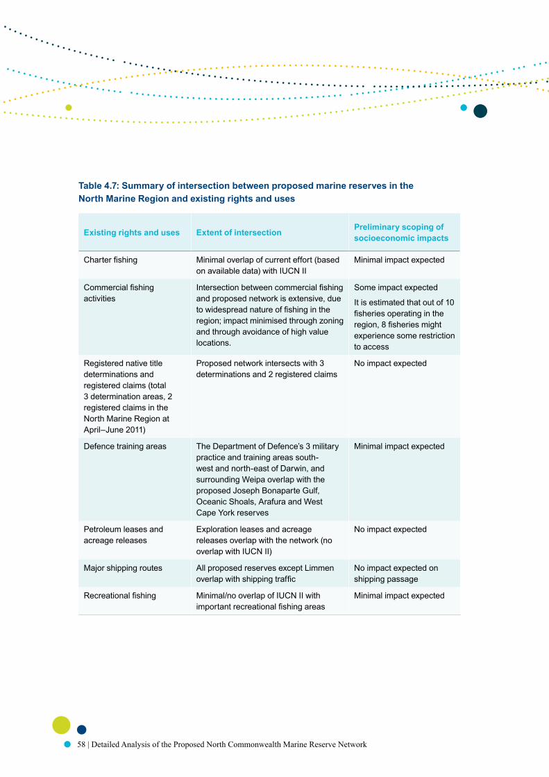
58 | Detailed Analysis of the Proposed North Commonwealth Marine Reserve Network
Table 4.7: Summary of intersection between proposed marine reserves in the North Marine Region and existing rights and uses
Existing rights and uses Extent of intersection Preliminary scoping of socioeconomic impacts
Charter fishing Minimal overlap of current effort (based on available data) with IUCN II
Minimal impact expected
Commercial fishing activities
Intersection between commercial fishing and proposed network is extensive, due to widespread nature of fishing in the region; impact minimised through zoning and through avoidance of high value locations.
Some impact expected
It is estimated that out of 10 fisheries operating in the region, 8 fisheries might experience some restriction to access
Registered native title determinations and registered claims (total 3 determination areas, 2 registered claims in the North Marine Region at April–June 2011)
Proposed network intersects with 3 determinations and 2 registered claims
No impact expected
Defence training areas The Department of Defence’s 3 military practice and training areas south-west and north-east of Darwin, and surrounding Weipa overlap with the proposed Joseph Bonaparte Gulf, Oceanic Shoals, Arafura and West Cape York reserves
Minimal impact expected
Petroleum leases and acreage releases
Exploration leases and acreage releases overlap with the network (no overlap with IUCN II)
No impact expected
Major shipping routes All proposed reserves except Limmen overlap with shipping traffic
No impact expected on shipping passage
Recreational fishing Minimal/no overlap of IUCN II with important recreational fishing areas
Minimal impact expected

59
5 the PRoPoseD CoMMoNweAlth MARiNe ReseRves iN DetAil

60 | Detailed Analysis of the Proposed North Commonwealth Marine Reserve Network
5.1 Proposed Joseph Bonaparte Gulf Commonwealth marine reserve
130°E129°E128°E
13°S
13°S
14°S
14°S
15°S
15°S
© Commonwealth of Australia, 2011
Proposed Commonwealth marine reserveOuter boundaries
Internal zoning:Special Purpose Zone (IUCN VI)Multiple Use Zone (IUCN VI)
Wadeye
Maritime boundariesMarine planning region boundaryLimit of coastal waters
Other marine protected areasNorth-west proposed marine reserves
North-westMarine Region
NorthMarine Region
WA NT QLD
WA NT
0 30 60 90 12015
Approximate scale (km)Projection: Geographics

61
Biophysical, ecological and conservation values
The proposed Joseph Bonaparte Gulf Commonwealth marine reserve covers approximately 5 202 square kilometres of the Commonwealth marine environment at the southern end of the Joseph Bonaparte Gulf. It covers waters of approximately 75 metres depth and experiences some of the highest tidal ranges in northern Australia, with waves of over seven metres in height (Condie 2001). The large tidal ranges and wide intertidal zone near the proposed marine reserve create a physically dynamic and turbid marine environment (DEWHA 2007). There is high primary productivity within the proposed marine reserve, and it lies within a broader ecological transition zone between eastern and western Australia (DEWHA 2007).
The proposed marine reserve is adjacent to coastal areas that are considered to be of national significance for nesting flatback turtles, and international significance for migratory shorebirds in the East Asian Australasian Flyway migration corridor (Bamford, 2008 in Harrison et al. 2009; Chatto & Baker 2008 in Harrison et al. 2009). Major breeding areas for saltwater crocodiles are situated in coastal areas near to the proposed reserve (Fukuda et al. in Harrison et al. 2009).
The proposed Joseph Bonaparte Gulf marine reserve adjoins a proposed Commonwealth marine reserve of the same name in the North-west Marine Region. It also lies close to the Legune coastal floodplain which is an area recognised by the Northern Territory Government as a Site of Conservation Significance (NRETAS 2007b). The Marri–Jabin (Thamurrurr —Stage 1) land-based Indigenous Protected Area lies to the east of the proposed marine reserve.
Conservation values:• Examples of the Northwest Shelf transition Province (Cambridge-Bonaparte, Anson Beagle
and Bonaparte Gulf meso-scale bioregions).
Existing uses
The south-east boundary of the proposed marine reserve is approximately 6 kilometres from the coastal marine Bonaparte Gulf Native Title registered claim area. The south-west corner of the reserve lies within approximately 30 kilometres of the land based Spirit Hill Pastoral Lease No. 2 and Legune Pastoral Lease Native Title determination areas, and the Ord Final Agreement (Indigenous Land Use Agreement).
Waters within the proposed marine reserve overlap with an area identified as important for recreational and charter fishing.

62 | Detailed Analysis of the Proposed North Commonwealth Marine Reserve Network
The Northern Territory managed Offshore Net and Line, Coastal Line, Spanish Mackerel and Demersal fisheries operate within or near the proposed marine reserve. The Commonwealth managed Northern Prawn Fishery also operates in the area.
Petroleum prospectivity within the proposed reserve boundaries is considered to be high. The proposed marine reserve overlaps with exploration leases, and a gas pipeline transects the reserve (transporting gas from the Blacktip gas field to the coast near Wadeye in the Northern Territory). The proposed marine reserve also overlaps with a 2009 carbon capture and storage acreage release area.
Much of the proposed marine reserve lies within a military practice and exercise area.
Proposed zoning arrangements and management principles
The proposed Joseph Bonaparte Gulf Commonwealth Reserve contains two zones. Activities permitted in these zones under the proposed management arrangements are shown in Table 3.5. The proposed zones are:
• A multiple use zone that covers 2 951 square kilometres at the southern end of the reserve. The multiple use zone will provide protection to the biodiversity and habitats of the Northwest Shelf Transition Province (including the Cambridge-Bonaparte, Anson Beagle and Bonaparte Gulf meso-scale bioregions). A range of commercial and recreational activities will generally be allowed within this zone subject to any relevant environmental approvals. Some activities will not be permitted because of the risk they pose to biodiversity and habitats. This zone will be managed in accordance with the management principles for IUCN Category VI.
• A special purpose zone that covers 2 251 square kilometres at the northern end of the reserve. This zone will provide protection to the biodiversity and habitats of the Northwest Shelf Transition Province (including the Cambridge-Bonaparte and Anson Beagle meso-scale bioregions) while recognising the importance of this area for commercial fishing. In addition to the gear types permitted in multiple use zones, pelagic gillnets will also be permitted within special purpose zones within the North Marine Region in order to moderate socioeconomic impacts. Any impacts of pelagic gillnet gear on the biodiversity of the marine reserve will be monitored and reviewed under future management arrangements. This zone will be managed in accordance with the management principles for IUCN Category VI.

63
Table 5.1: Conservation features represented within the proposed Joseph Bonaparte Gulf marine reserve
Feature Name
Provincial bioregions Northwest Shelf Transition
Meso-scale bioregions Anson Beagle
Bonaparte Gulf
Cambridge-Bonaparte
Depth ranges within bioregions
Northwest Shelf Transition
Shallow Waters
Shallow Waters to Shallow Shelf Transition
Shallow Shelf
Biological seascapes Cluster 2
Cluster 6
Cluster 9
Cluster 12
Cluster 15
Seafloor features Bank/shoals
Deep/hole/valley
Reef
Shelf
Tidal-sandwave/sand-bank

64 | Detailed Analysis of the Proposed North Commonwealth Marine Reserve Network
5.2 Proposed Oceanic Shoals Commonwealth marine reserve
130°E129°E128°E
10°S
10°S
12°S
12°S
© Commonwealth of Australia, 2011
Proposed Commonwealth marine reserveOuter boundary
Internal zoning:Multiple Use Zone (IUCN VI)
0 30 60 90 12015
Approximate scale (km)
BeagleGulf
Projection: Geographics
Maritime boundariesMarine planning region boundaryLimit of Australian EEZLimit of coastal waters
Other marine protected areasNorth-west proposed marine reserves
NorthMarineRegion
WA NT QLD
MelvilleIslandBathurst
Island
Timor Sea
North-west
MarineRegion

65
Biophysical, ecological and conservation values
The proposed Oceanic Shoals marine reserve covers an area of approximately 42 207 square kilometres of the Commonwealth marine environment. It extends eastwards from the limit of the exclusive economic zone over part of the Bonaparte Basin and the Van Diemen Rise, and northwards over the Timor Transition. The proposed marine reserve includes some of the deepest waters found in the North Marine Region, at approximately 300 metres.
The proposed Oceanic Shoals marine reserve includes a number of shoals, channels and valleys that are found in the cabonate bank and terrace system of the Van Diemen Rise key ecological feature. This key ecological feature support rich sponge gardens, octocorals, pelagic fish, sharks and seasnakes (Blaber et al. 2005, 2009; M Guinea, pers. comm., 2009; Heap et al. 2010; Salinis et al 2006). The proposed marine reserve also includes at least 34 limestone pinnacles of the Bonaparte Basin which are also a key ecological feature and are presumed to support high biodiversity, including hard and soft corals, sponges, and aggregations of demersal fish (Brewer et al. 2007). Threatened flatback, olive ridley and loggerhead turtles are known to forage around the pinnacles, and whale sharks and other shark species occur in the area (DEWHA 2007; Donovan et al 2008; Whiting et al 2007). The proposed marine reserve covers part of the shelf break and slope of the Arafura Shelf which supports at least 284 demersal fish species (Last et al. 2005). The waters within the proposed Oceanic Shoals marine reserve provide important internesting habitat for flatback and olive ridley turtles preparing successive egg clutches for laying on nearby coasts. Marine communities dominated by beds of Halimeda algae occur in the area. These communities play an important role in fixing carbon and at rates that are amongst the highest known (DEWHA 2007).
The proposed Oceanic Shoals marine reserve adjoins a proposed Commonwealth marine reserve of the same name in the North-west Marine Region. It also lies near the Tiwi Islands which are an area recognised by the Northern Territory Government as a Site of Conservation Significance (NRETAS 2007b).
Conservation values• Three key ecological features:
– Carbonate bank and terrace system of the Van Diemen Rise (unique seafloor feature; unique ecosystems; presence of sponges, soft corals, pelagic fish, sharks, seasnakes and marine turtles)
– Pinnacles of the Bonaparte Basin (unique seafloor feature; turtle foraging area; feeding aggregations of seabirds and planktivorous and predatory fish)
– Shelf break and slope of the Arafura Shelf (unique seafloor feature; patch reefs and hard pinnacles; currents likely influence nutrients, pelagic dispersal, species and biological productivity)

66 | Detailed Analysis of the Proposed North Commonwealth Marine Reserve Network
• Examples of the Northwest Shelf Transition Province (which includes the Bonaparte, Oceanic Shoals and Tiwi meso-scale bioregions) and the Timor Transition Province
• Important internesting areas for the threatened flatback and olive ridley turtles
• Heritage values represented by the SS Florence D historic shipwreck.
Existing uses
Waters within the proposed Oceanic Shoals marine reserve overlap with areas identified as important for recreational and charter fishing.
The Northern Territory managed Timor Reef, Demersal, Spanish Mackerel and Offshore Net and Line fisheries operate within or near the proposed marine reserve. The Commonwealth managed Northern Prawn Fishery and the Northern Territory managed Coastal Line Fishery also operate in the area.
Petroleum prospectivity varies within the proposed marine reserve boundaries, from low (in the south-east of the marine reserve) to high (in the south-west and north of the marine reserve), and it overlaps a number of exploration leases, 2011 petroleum acreage release areas, and a 2009 carbon capture and storage acreage release area. A gas pipeline (Bayu/Undan to Darwin) also transects the proposed marine reserve.
The south-east corner of the proposed marine reserve overlaps with a military practice and exercise area and shipping activity occurs within the proposed marine reserve.
Proposed zoning arrangements and management principles
The entire proposed Oceanic Shoals marine reserve is zoned as multiple use. Activities permitted in this marine reserve under the proposed management arrangements are shown in Table 3.5.
The multiple use marine reserve will provide protection to the biodiversity and habitats of the Northwest Shelf Transition Province (including the Bonaparte, Oceanic Shoals, and Tiwi meso-scale bioregions) and the Timor Transition Province. A range of commercial and recreational activities will generally be allowed within the proposed marine reserve subject to any relevant environmental approvals. Some activities will not be permitted in this reserve because of the risk they pose to its biodiversity and habitats and it will be managed in accordance with the management principles for IUCN Category VI.

67
Table 5.2: Conservation features represented within the proposed Oceanic Shoals marine reserve
Feature Name
Provincial bioregions Northwest Shelf Transition
Timor Transition
Meso-scale bioregions Bonaparte Gulf
Oceanic Shoals
Tiwi
Depth ranges within bioregions
Northwest Shelf Transition
Shallow Waters
Shallow Waters to Shallow Shelf Transition
Deep Shelf
Deep Shelf to Shelf Edge Transition
Shallow Shelf
Shallow Shelf to Deep Shelf Transition
Shelf Edge
Timor Transition
Deep Shelf
Deep Shelf to Shelf Edge Transition
Shallow Upper Slope
Shelf Edge
Shelf Edge to Shallow Upper Slope Transition
Key ecological features Carbonate terrace and bank system of the Van Diemen Rise
Pinnacles of the Bonaparte Basin
Shelf break and slope of the Arafura Shelf

68 | Detailed Analysis of the Proposed North Commonwealth Marine Reserve Network
Feature Name
Biological seascapes Cluster 1
Cluster 2
Cluster 3
Cluster 5
Cluster 6
Cluster 8
Cluster 10
Cluster 11
Cluster 12
Cluster 14
Cluster 15
Cluster 16
Cluster 17
Cluster 19
Seafloor features Bank/shoals
Basin
Deep/hole/valley
Pinnacle
Reef
Shelf
Slope
Terrace
Tidal-sandwave/sand-bank

69
5.3 Proposed Arafura Commonwealth marine reserve
MilingimbiManingrida
135°E133°E
10°S
10°S
12°S
12°S
© Commonwealth of Australia, 2011
Proposed Commonwealth marine reserveOuter boundaries
Internal zoning:Special Purpose Zone (IUCN VI)
Multiple Use Zone (IUCN VI) 0 30 60 90 12015
Approximate scale (km)Projection: Geographics
Maritime boundariesLimit of Australian EEZLimit of coastal waters
Other marine protected areas
Garig Gunak Barlu Marine Park (NT)
Van DiemenGulf
Arafuramarine reserve
Arnhemmarine reserve
WA NT QLD
NT
Arafura Sea

70 | Detailed Analysis of the Proposed North Commonwealth Marine Reserve Network
Biophysical, ecological and conservation values
The proposed Arafura Commonwealth marine reserve covers approximately 22 919 square kilometres of the Commonwealth marine environment, from northwest of Croker Island to the tributary canyons of the Arafura Rise. The proposed marine reserve includes waters between 5–250 metres deep and it includes a continuous transect from the edge of Northern Territory waters to the limit of Australia’s exclusive economic zone.
The proposed Arafura marine reserve incorporates four of the eight Tributary Canyons of the Arafura Depression. These canyons are the remnants of a drowned river system that existed during the Pleistocene era and they are a key ecologic feature (Heap 2004). The steep topography of the canyons, their diverse current regimes, nutrient enrichment and entrapment, detritus funnelling and diverse substrate types form widely divergent ecosystems (McClain & Barry 2010; Vetter 1994; Vinogradova 1959) which, in combination with the regional setting and geological origins of the area, strongly influence species biodiversity (Kloser et al. 2010; RJ Kloser, pers. comm., May 2011).
At least 245 macroscopic species are known to occur within the canyons, including a diverse variety of invertebrates such as sponges, corals, sea anemones, tunicates, worms, crustaceans, brittle stars and feather stars (Wilson 2005). The waters within the proposed marine reserve provide important interesting habitat for threatened flatback, green, hawksbill and olive ridley marine turtles preparing successive egg clutches for laying on nearby coasts. Waters within and adjacent to the southern boundary of the proposed marine reserve are also important foraging habitats for breeding aggregations of migratory roseate terns.
The Northern Territory Garig Gunak Barlu National Park lies approximately 30 kilometres distant from the proposed Arafura reserve and the Croker Island Group Site of Conservation Significance lies adjacent to the proposed marine reserve.
Conservation values• One key ecological feature:
– Tributary canyons of the Arafura Depression (unique seafloor feature; supports marine turtles, deep sea sponges, barnacles and stalked crinoids)
• Examples of the Northern Shelf Province (which includes the Arafura and Cobourg meso-scale bioregions) and the Timor Transition Province
• Important foraging habitat for breeding aggregations of the migratory roseate tern
• Important internesting areas for the threatened flatback, green, hawksbill and olive ridley turtles.

71
Existing uses
The proposed Arafura marine reserve overlaps with the Croker Island Native Title determination area.
The proposed marine reserve overlaps with areas identified as important for recreational and charter fishing.
The Northern Territory managed Demersal, Spanish Mackerel, Offshore Net and Line, Finfish Trawl and Coastal Line fisheries operate within or near the proposed marine reserve. The Commonwealth managed Northern Prawn Fishery also operates in the area.
Petroleum prospectivity within the proposed marine reserve boundaries ranges from low, medium and medium to high but it does not overlap with any existing lease or acreage release areas.
The southern end of the proposed marine reserve partially overlaps a military practice and exercise area, and shipping activity occurs within the proposed marine reserve.
Proposed zoning arrangements and management principles
The entire proposed Arafura marine reserve is zoned as multiple use. Activities permitted in this marine reserve under the proposed management arrangements are shown in Table 3.5.
The multiple use zone will provide protection to the biodiversity and habitats of the Northern Shelf Province (which includes the Arafura and Cobourg meso-scale bioregions) and the Timor Transition Province. A range of commercial and recreational activities will generally be allowed within the reserve subject to any relevant environmental approvals. Some activities will not be permitted in this reserve because of the risk they pose to its biodiversity and habitats. This zone will be managed in accordance with the management principles for IUCN Category VI.

72 | Detailed Analysis of the Proposed North Commonwealth Marine Reserve Network
Table 5.3: Conservation features represented within the proposed Arafura marine reserve
Feature Name
Provincial bioregions Northern Shelf Province
Timor Transition
Meso-scale bioregions Arafura
Cobourg
Depth ranges within bioregions
Northern Shelf Province
Shallow Waters
Shallow Waters to Shallow Shelf Transition
Deep Shelf
Deep Shelf to Shelf Edge Transition
Shallow Shelf
Shallow Shelf to Deep Shelf Transition
Timor Transition
Deep Shelf
Deep Shelf to Shelf Edge Transition
Shallow Shelf
Shallow Shelf to Deep Shelf Transition
Shallow Upper Slope
Shelf Edge
Shelf Edge to Shallow Upper Slope Transition
Key ecological features Tributary Canyons of the Arafura Depression

73
Feature Name
Biological seascapes Cluster 1
Cluster 3
Cluster 5
Cluster 6
Cluster 8
Cluster 10
Cluster 11
Cluster 12
Cluster 14
Cluster 15
Cluster 16
Cluster 17
Seafloor features Apron/fan
Bank/shoals
Canyon
Deep/hole/valley
Ridge
Shelf
Slope
Terrace
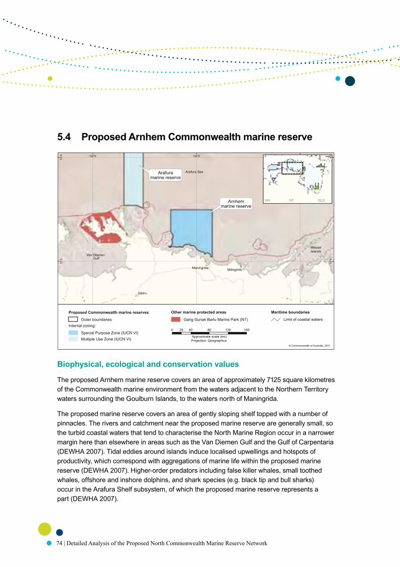
74 | Detailed Analysis of the Proposed North Commonwealth Marine Reserve Network
5.4 Proposed Arnhem Commonwealth marine reserve
Biophysical, ecological and conservation values
The proposed Arnhem marine reserve covers an area of approximately 7125 square kilometres of the Commonwealth marine environment from the waters adjacent to the Northern Territory waters surrounding the Goulburn Islands, to the waters north of Maningrida.
The proposed marine reserve covers an area of gently sloping shelf topped with a number of pinnacles. The rivers and catchment near the proposed marine reserve are generally small, so the turbid coastal waters that tend to characterise the North Marine Region occur in a narrower margin here than elsewhere in areas such as the Van Diemen Gulf and the Gulf of Carpentaria (DEWHA 2007). Tidal eddies around islands induce localised upwellings and hotspots of productivity, which correspond with aggregations of marine life within the proposed marine reserve (DEWHA 2007). Higher-order predators including false killer whales, small toothed whales, offshore and inshore dolphins, and shark species (e.g. black tip and bull sharks) occur in the Arafura Shelf subsystem, of which the proposed marine reserve represents a part (DEWHA 2007).
Jabiru
MilingimbiManingrida
136°E134°E132°E
10°S
10°S
12°S
12°S
© Commonwealth of Australia, 2011
Proposed Commonwealth marine reserves
Outer boundariesInternal zoning:
Special Purpose Zone (IUCN VI)Multiple Use Zone (IUCN VI)
Maritime boundaries
Limit of coastal waters
Other marine protected areas
Garig Gunak Barlu Marine Park (NT)
WesselIslands
0 40 80 120 16020
Approximate scale (km)Projection: Geographics
Arafuramarine reserve
Arnhemmarine reserve
WA NT QLD
Van Diemen
Arafura Sea
Gulf
75
The waters within the proposed marine reserve are an important internesting area for flatback turtles where they prepare successive egg clutches for laying on nearby coasts. The proposed marine reserve also lies within an area that is important foraging habitat for breeding aggregations of migratory birds, such as bridled and roseate terns, and for the listed marine crested tern.
The Djelk Indigenous Protected Area lies south of the proposed marine reserve and the Maningrida coastal habitats that are recognised by the Northern Territory Government as a Site of Conservation Significance are in coastal areas close to the proposed marine reserve (NRETAS 2007b).
Conservation values• Examples of the Northern Shelf Province (which includes the Arafura, Arnhem-Wessel and
Cobourg meso-scale bioregions)
• Important internesting areas for threatened flatback turtle
• Important foraging areas for breeding aggregations of migratory bridled and roseate terns and listed marine crested terns.
Existing uses
The proposed Arnhem marine reserve overlaps with an area identified as important for recreational and charter fishing.
The Northern Territory managed Offshore Net and Line, Spanish Mackerel, Finfish Trawl and Coastal Line fisheries operate within or near the proposed marine reserve. The Commonwealth managed Northern Prawn Fishery also operates in the area.
Petroleum prospectivity within the proposed marine reserve boundaries is low. Shipping activity occurs within the proposed marine reserve.
Proposed zoning arrangements and management principles
The entire proposed Arnhem marine reserve is zoned as special purpose. Activities permitted within this marine reserve under the proposed management arrangements are shown in Table 3.5.
The proposed marine reserve will provide protection to the biodiversity and habitats of the Northern Shelf Province (which includes the Arafura, Arnhem-Wessel and Cobourg meso-scale bioregions), while recognising the importance of the area for commercial fishing.
In addition to the gear types permitted in multiple use zones, pelagic gillnets will also be permitted in special purpose zones in the North Marine Region in order to moderate socioeconomic impacts. Any impacts of the pelagic gillnet gear on the biodiversity of the marine reserve will be monitored and reviewed under future management arrangements. This zone will be managed in accordance with the management principles for IUCN Category VI.

76 | Detailed Analysis of the Proposed North Commonwealth Marine Reserve Network
Table 5.4: Conservation features represented within the proposed Arnhem marine reserve
Feature Name
Provincial bioregions Northern Shelf Province
Meso-scale bioregions Arafura
Arnhem Wessel
Cobourg
Depth ranges within bioregions
Northern Shelf Province
Shallow Waters
Shallow Waters to Shallow Shelf Transition
Biological seascapes Cluster 1
Cluster 2
Cluster 3
Cluster 12
Cluster 15
Cluster 16
Seafloor features Pinnacle
Shelf
Terrace

77
5.5 Proposed Wessel Commonwealth marine reserve138°E137°E
11°S
11°S
12°S
12°S
© Commonwealth of Australia, 2011
Proposed Commonwealth marine reserveOuter boundary
Internal zoning:Marine National Park (IUCN II)Multiple Use Zone (IUCN VI)
0 20 40 60 8010
Approximate scale (km)
ArafuraSea
Projection: Geographics
Maritime boundariesLimit of coastal waters
WA NT QLD
NT
WesselIslands
Nhulunbuy Gulf ofCarpentaria

78 | Detailed Analysis of the Proposed North Commonwealth Marine Reserve Network
Biophysical, ecological and conservation values
The proposed Wessel marine reserve covers approximately 5 140 square kilometres of the Commonwealth marine environment from waters adjacent to the tip of the Wessel Islands waters adjacent to the Bromby Islands.
The proposed marine reserve overlaps the Arafura Sill which is the only feature of its type in the North Marine Region. The sill is a seafloor barrier that restricts movement of water into the Gulf of Carpentaria basin and forms a distinct biogeographical transition area between sessile invertebrate taxa (such as sponges and corals) and fish species (DEWHA 2007). The waters surrounding the Wessel Islands support some of the most diverse and species-rich environments in the North Marine Region, including at least 70 per cent of the coral reef biodiversity of the Great Barrier Reef (Veron 2004). There are a number of endemic species known to occur in the area, and the wide range of habitats around the Wessel Islands support diverse species of fish (DEWHA 2007).
The waters within the proposed marine reserve provide important interesting habitat for threatened hawksbill, olive ridley, green and flatback marine turtles preparing successive egg clutches for laying on nearby coasts. These waters are also important foraging habitat for breeding aggregations of migratory birds such as the common noddy and roseate tern, and for the listed marine crested tern.
The proposed reserve lies approximately 25 kilometres north of the Dhimurru Indigenous Protected Area. The Wessel and English Company island groups, Gove Peninsula and the north-east Arnhem coast are all recognised by the Northern Territory Government as Sites of Conservation Significance and they lie within approximately 25 kilometres of the proposed marine reserve (NRETAS 2007b).
Conservation values• One key ecological feature:
– Gulf of Carpentaria basin (biodiversity; assemblages of bottom-dwelling invertebrates, pelagic fish species, and top predators)
• Examples of the Northern Shelf Province (including the Arafura, Arnhem-Wessel and Carpentaria meso-scale bioregions)
• Important internesting habitat for threatened flatback, green, hawksbill and olive ridley turtles
• Important foraging areas for the migratory common noddy and roseate tern, and the listed marine crested tern.

79
Existing uses
The proposed marine reserve may overlap with areas that are used by recreational and charter fishers.
The Northern Territory managed Spanish Mackerel, Offshore Net and Line, Finfish Trawl and Coastal Line fisheries operate within or near the proposed marine reserve. The Commonwealth managed Northern Prawn Fishery also operates in the area.
Petroleum prospectivity within the proposed marine reserve boundaries is considered low. Shipping activity occurs within the proposed marine reserve.
Proposed zoning arrangements and management principles
The proposed Wessel marine reserve contains two zones. Activities permitted in these zones under the proposed management arrangements are shown in Table 3.5. The proposed zones are:
• A marine national park zone that covers 3434 square kilometres at the northern end of the marine reserve. This zone will provide a high level of protection for the ecosystems of the Northeast Shelf Province (including the Arafura meso-scale bioregion). Commercial activities, mining operations and extractive recreational activities will generally be excluded in this zone. Passage of vessels, non-extractive tourism and non-commercial hunting and harvesting undertaken by Traditional Owners consistent with their native title rights will be permitted to continue within this zone. This zone will be managed in accordance with the management principles for IUCN Category II.
• A multiple use zone which covers 1706 square kilometres at the southern end of the reserve. This zone will provide protection to the ecosystems of the Northeast Shelf Province (including the Carpentaria, Arnhem Wessel and Arafura meso-scale bioregions). A range of commercial and recreational activities will generally be allowed within the zone, subject to any relevant environmental approvals. Some activities will not be permitted in this zone because of the risk they pose to biodiversity and habitats. This zone will be managed in accordance with the management principles for IUCN Category VI.

80 | Detailed Analysis of the Proposed North Commonwealth Marine Reserve Network
Table 5.5: Conservation features represented in the proposed Wessel marine reserve
Feature Name
Provincial bioregions Northern Shelf Province
Meso-scale bioregions Arafura
Arnhem Wessel
Carpentaria
Depth ranges within bioregions Northern Shelf Province
Coast to Shallow Shelf Transition
Key ecological features Gulf of Carpentaria basin
Biological seascapes Cluster 3
Cluster 12
Cluster 16
Seafloor features Bank/shoals
Basin
Pinnacle
Shelf
Sill

81
5.6 Proposed Limmen Commonwealth marine reserve
Biophysical, ecological and conservation values
The proposed Limmen marine reserve covers approximately 1254 square kilometres of the Commonwealth marine environment between the Sir Edward Pellew Group of Islands and Maria Island in the Limmen Bight. The Limmen Bight is a large, shallow bay less than 30 metres deep. Extensive seagrass meadows are found in the intertidal areas of the Limmen Bight, and large numbers of dugongs feed and travel through the area (DEWHA 2007; Marsh et al. 2008, 2011).
The proposed marine reserve overlaps with the Gulf of Carpentaria coastal zone key ecological feature. Nutrients that flow with rivers into the Gulf of Carpentaria coastal zone support high productivity and some of the most diverse and abundant biota in the North Marine Region (Burford et al. 2010; NOO 2003). Species found within the key ecological feature include marine turtles, sea snakes, colonial and solitary seabirds, and aggregations of fish and sharks.
Ngukurr
Bing Bong Port
137°E136°E135°E
15°S
15°S
16°S
16°S
© Commonwealth of Australia, 2011
Proposed Commonwealth marine reserve
Outer boundaryInternal zoning:
Multiple Use Zone (IUCN VI)
Maritime boundaries
Limit of coastal waters
Sir EdwardPellew Group
WA NT QLD
LimmenBight
MariaIsland
0 20 40 60 8010
Approximate scale (km)Projection: Geographics

82 | Detailed Analysis of the Proposed North Commonwealth Marine Reserve Network
Bottlenose dolphins are numerous, and sawfish (freshwater and green), sea dragons and seahorses, rays and sharks also occur. The waters within the proposed marine reserve provide important internesting habitat for flatback turtles preparing successive egg clutches for laying on nearby coasts. The proposed marine reserve is also near to some of the most extensive intertidal mudflats in the Northern Territory which supports large aggregations of migratory waders (NRETAS 2007b).
The proposed marine reserve overlaps with the Northern Territory Limmen Bight and associated coastal floodplains which have been identified by the Northern Territory Government as a Site of Conservation Significance (NRETAS 2007b).
Conservation values• One key ecological feature:
– Gulf of Carpentaria coastal zone (high productivity; high biodiversity and endemism; aggregations of marine life, including fish and sharks; supports marine turtles, seabirds, dugong, cetaceans and sawfish)
• Examples of the Northern Shelf Province (including the Pellew meso-scale bioregion)
• Important internesting habitat for threatened flatback turtle
• Major aggregation area for migratory dugong.
Existing uses
The proposed marine reserve overlaps with an area identified as important for recreational and charter fishing.
The Northern Territory managed Offshore Net and Line and Spanish Mackerel fisheries operate within or near the proposed marine reserve. The Commonwealth managed Northern Prawn Fishery also operates in the area.
Petroleum prospectivity within the proposed marine reserve boundaries is considered to be low. Shipping activity associated with the nearby Bing Bong port occurs adjacent to the proposed marine reserve. The proposed marine reserve also partially overlaps with a number of applications for offshore mineral exploration licences.

83
Proposed zoning arrangements and management principles
The entire proposed Limmen marine reserve is zoned as multiple use. Activities permitted in this marine reserve under the proposed management arrangements are shown in Table 3.5.
The multiple use marine reserve will provide protection to the biodiversity and habitats of the Northern Shelf Province (including the Pellew meso-scale bioregion). A range of commercial and recreational activities will generally be allowed within the proposed marine reserve subject to any relevant environmental approvals. Some activities will not be permitted in this zone because of the risk they pose to its biodiversity and habitats. This proposed marine reserve will be managed in accordance with the management principles for IUCN Category VI.
Table 5.6: Conservation features represented within the proposed Limmen marine reserve
Feature Name
Provincial bioregions Northern Shelf Province
Meso-scale bioregions Pellew
Depth ranges within bioregions Northern Shelf Province
Shallow Waters
Shallow Waters to Shallow Shelf Transition
Key ecological features Gulf of Carpentaria coastal zone
Biological seascapes Cluster 7
Cluster 12
Cluster 13
Cluster 14
Cluster 18
Cluster 20
Seafloor features Shelf

84 | Detailed Analysis of the Proposed North Commonwealth Marine Reserve Network
5.7 Proposed Gulf of Carpentaria Commonwealth marine reserve
141°E140°E139°E138°E
15°S
15°S
17°S
17°S
© Commonwealth of Australia, 2011
Proposed Commonwealth marine reserveOuter boundary
Internal zoning:Marine National Park (IUCN II)Multiple Use Zone (IUCN VI)
0 40 80 120 16020
Approximate scale (km)
Karumba
Projection: Geographics
Maritime boundariesLimit of coastal waters
WA NT QLD
NT QLD
WellesleyIslands
Gulf ofCarpentaria
85
Biophysical, ecological and conservation values
The proposed Gulf of Carpentaria marine reserve covers approximately 21 864 square kilometres of the Commonwealth marine environment from waters adjacent to the Wellesley Islands in to the Gulf of Carpentaria basin.
The plateaux and saddle of the Wellesley Islands have been identified as a key ecological feature and lie within the proposed marine reserve. This key ecological feature is made up of living patch reefs that support reef fish that are unique within the Gulf of Carpentaria (S Blaber, pers. comm., May 2011). Octocorals, sponges, acsidians and gorgonians are also likely to occur in the area (A Baker, pers. comm., 8 November 2009). The proposed marine reserve also includes a number of submerged coral reefs that support large plate corals (Turbinaria spp.), abundant hard corals and a large proportion of soft corals as well as breeding and aggregation habitats for many fish species, refuges for seasnakes and apex predators (such as sharks), and important habitat for invertebrates such as crustaceans and polychaete worms (DEWHA 2007; Harris et al. 2007; Marshall & Schuttenberg 2006). The environment of the Gulf of Carpentaria basin is inhabited by species such as heart urchins and sand dollars, sponges, solitary corals and sea cucumbers, as well as top predators such as snappers and sharks (Haywood et al. 2005; Long et al. 1995; Smith et al. 2006). The proposed marine reserve also overlaps the Gulf of Carpentaria coastal zone which is a key ecological feature and supports some of the most diverse and abundant biota in the North Marine Region (Burford et al. 2010; NOO 2003).
The waters within the proposed marine reserve provide important interesting habitat for threatened green and flatback marine turtles preparing successive egg clutches for laying on nearby coasts. Waters within the proposed marine reserve boundaries also support important foraging habitat for breeding aggregations of migratory birds, including the lesser frigatebird, brown booby and roseate tern, and for the listed marine crested tern. Large aggregations of dugong also occur within the proposed marine reserve (Marsh et al. 2008, 2011).
The proposed marine reserve overlaps two Benthic Protection Sites associated with the Northern Prawn Fishery. Several Wild River Areas (Settlement, Gregory, Morning Inlet and Staaten) and Fish Habitat Areas (Eight Mile Creek, Morning Inlet–Bynoe River, Staaten-Gilbert and Nassau) are located 40– 110km of the proposed marine reserve.

86 | Detailed Analysis of the Proposed North Commonwealth Marine Reserve Network
Conservation values• Four key ecological features:
– Gulf of Carpentaria coastal zone (high productivity; high biodiversity and endemism; aggregations of marine life, including fish and sharks; supports marine turtles, seabirds, dugong, cetaceans and sawfish)
– Gulf of Carpentaria basin (biodiversity; assemblages of bottom-dwelling invertebrates, pelagic fish species and top predators)
– Plateaux and saddle north-west of the Wellesley Islands ( high biodiversity and endemism; aggregations of marine life, particularly pelagic fish and birds; important coral habitat)
– Submerged coral reefs of the Gulf of Carpentaria ( high biodiversity and endemism; feeding and breeding aggregations of marine life, particularly fish; refuges for top predators and seasnakes; extensive submerged coral reefs)
• Examples of the Northern Shelf Province (including the Carpentaria Karumba-Nassau and Wellesley meso-scale bioregions)
• Important internesting habitat for threatened flatback and green turtles
• Important foraging areas for breeding aggregations of the migratory lesser frigatebird, brown booby, roseate tern and the listed marine crested tern
• Major aggregation area for migratory dugong.
Existing uses
The proposed marine reserve overlaps the Wellesley Islands Sea Claim Native Title determination area.
Charter and recreational fishing are likely to occur within and/or near the proposed marine reserve.
The Commonwealth managed Northern Prawn Fishery, and Queensland managed Gulf of Carpentaria Inshore Finfish (net) and Gulf of Carpentaria Line fisheries operate within or near the proposed marine reserve.
Petroleum prospectivity within the proposed marine reserve boundaries is considered to be low. Shipping activity occurs in the area and possibly within the proposed marine reserve.

87
Proposed zoning arrangements and management principles
The proposed Gulf of Carpentaria marine reserve contains two zones. Activities permitted in these zones under the proposed management arrangements are shown in Table 3.5. The proposed zones are:
• A marine national park zone that covers 7084 square kilometres of the south-east corner of the proposed marine reserve. This zone will provide a high level of protection for the biodiversity and habitats of the Northern Shelf Province (including the Karumba-Nassau and Wellesley meso-scale bioregions). Commercial activities, mining operations and extractive recreational activities will generally be excluded in this zone. Passage of vessels, non-extractive tourism, and non-commercial hunting and harvesting undertaken by Traditional Owners consistent with their native title rights will be permitted to continue within this zone. This zone will be managed consistent with the management principles for IUCN Category II.
• A multiple use zone which covers 14780 square kilometres of the western and northern parts of the proposed marine reserve. This zone will provide protection to the biodiversity and habitats of the Northern Shelf Province (including the Karumba-Nassau, Carpentaria and Wellesley meso-scale bioregions). A range of commercial and recreational activities will be allowed within this zone subject to any relevant environmental approvals. Some activities will not be permitted in this zone because of the risk they pose to biodiversity and habitats. This zone will be managed in accordance with the management principles for IUCN Category VI.

88 | Detailed Analysis of the Proposed North Commonwealth Marine Reserve Network
Table 5.7: Conservation features represented in the proposed Gulf of Carpentaria marine reserve
Feature Name
Provincial bioregions Northern Shelf Province
Meso-scale bioregions Carpentaria
Karumba-Nassau
Wellesley
Depth ranges within bioregions Northern Shelf Province
Shallow Waters
Shallow Waters to Shallow Shelf Transition
Key ecological features Gulf of Carpentaria basin
Gulf of Carpentaria coastal zone
Plateaux and saddle of the Wellesley Islands
Submerged coral reefs of the Gulf of Carpentaria
Biological seascapes Cluster 1
Cluster 4
Cluster 7
Cluster 12
Cluster 13
Cluster 14
Cluster 16
Cluster 20
Seafloor features Basin
Canyon
Deep/hole/valley
Plateau
Reef
Saddle
Shelf

89
5.8 Proposed West Cape York Commonwealth marine reserve
Biophysical, ecological and conservation values
The proposed West Cape York marine reserve covers approximately 16 012 square kilometres of the Commonwealth marine environment. It extends from the boundary of Queensland waters adjacent to the northern end of the Cape York Peninsula to the Gulf of Carpentaria basin and the boundary of the exclusive economic zone. The Gulf of Carpentaria basin environment is a key ecological feature and is characterised by heart urchins, sand dollars, sponges, solitary corals and sea cucumbers, as well as top predators such as snappers and sharks (Haywood et al. 2005; Long et al. 1995; Smith et al. 2006). The Gulf of Carpentaria coastal zone is also a key ecological feature and supports some of the most diverse and abundant biota in the North Marine Region (Burford et al. 2010; NOO 2003). The coastline adjacent to the proposed marine reserve is subject to higher wave energy here than elsewhere in the Gulf of Carpentaria, and is consequently highly dynamic. It also shares some biological characteristics (such as extensive tidal sandbanks and offshore reefs) with the Torres Strait.
143°E142°E141°E140°E
10°S
10°S
11°S
11°S
12°S
12°S
© Commonwealth of Australia, 2011
Proposed Commonwealth marine reserve
Outer boundaries
Internal zoning:
Marine National Park (IUCN II)
Multiple Use Zone (IUCN VI) Projection: Geographics
Maritime boundariesMarine planning region boundariesLimit of Australian EEZLimit of coastal waters
Other marine protected areas
Great Barrier Reef Marine Park (Cwth)
Gulf ofCarpentaria
QLD
NorthMarine Region
NT QLDWA
0 30 60 90 12015
Approximate scale (km)
TorresStrait
Cape York Peninsula

90 | Detailed Analysis of the Proposed North Commonwealth Marine Reserve Network
The proposed marine reserve includes the boundary between the Northeast Shelf Transition and the Northern Shelf Province and is a biogeographic boundary. Species that occur within this area are believed to have stronger biogeographic connections with eastern Australian marine species than elsewhere in the North Marine Region (DEWHA 2007). Barramundi populations that occur in the area are genetically distinct from populations that occur elsewhere in the Gulf of Carpentaria, and the species composition and richness of sponges found within the proposed marine reserve are very different to those found elsewhere in the North Marine Region (Hooper & Ekins 2004 in DEWHA 2007; Shaklee & Salini 1985)
The proposed marine reserve lies adjacent to Cape York Peninsula coasts and Crab Island which are nesting sites for threatened flatback, olive ridley, and hawksbill turtles. The waters within the proposed marine reserve provide important interesting habitat for turtles preparing successive egg clutches for laying on land. They are also a major migration route for dugong and an important foraging habitat for the lesser frigatebird.
Conservation values• Two key ecological features:
– Gulf of Carpentaria coastal zone (high productivity; high biodiversity and endemism; aggregations of marine life, including fish and sharks; supports marine turtles, seabirds, dugong, cetaceans and sawfish)
– Gulf of Carpentaria basin (biodiversity; assemblages of bottom-dwelling invertebrates, pelagic fish species, and top predators)
• Examples of the Northern Shelf Province (including the Carpentaria and West Cape York meso-scale bioregions)
• Examples of the Northeast Shelf Transition Province (which includes the Torres Strait meso-scale bioregion)
• Important internesting habitat for threatened flatback, hawksbill and olive ridley turtles
• Important foraging areas for migratory lesser frigatebird.
Existing uses
The proposed marine reserve overlaps with part of the Torres Strait Regional Sea Claim Native Title determination and the Torres Strait Regional Sea Registered Native Title claim (further extension of the Torres Strait determination). The proposed marine reserve also overlaps with the Kaurareg People #2 registered Native Title claim.
Charter fishing occurs in the area, mostly within state waters, with some activities extending into Commonwealth waters.

91
The Queensland Gulf of Carpentaria Inshore Finfish (net), Developmental Finfish Trawl and Line fisheries operate within or near the proposed marine reserve. The Commonwealth managed Northern Prawn Fishery also operates in the area.
Petroleum prospectivity within the proposed marine reserve boundaries is considered to be low and low to medium, and an existing petroleum lease lies to the south of the proposed marine reserve.
The proposed marine reserve overlaps with a major shipping passage. It also overlaps with a military practice and exercise area (military flying).
Proposed zoning arrangements and management principles
The proposed West Cape York marine reserve contains two zones. Activities permitted in these zones under the proposed management arrangements are shown in Table 3.5. The proposed zones are:
• A marine national park zone that covers 7957 square kilometres of the northern end of the proposed marine reserve. This zone will provide a high level of protection for the ecosystems of the Northern Shelf Province (including the Carpentaria and West Cape York meso-scale bioregions) and the Northeast Shelf Transition Province (which includes the Torres Strait meso-scale bioregion). Commercial activities, mining operations and extractive recreational activities will generally be excluded in this zone. Passage of vessels, non-extractive tourism, and non-commercial hunting and harvesting undertaken by Traditional Owners consistent with their native title rights will be permitted to continue within this zone. This zone will be managed consistent with the management principles for IUCN Category II.
• A multiple use zone that covers 8055 square kilometres of the southern end of the proposed marine reserve. It covers the ecosystems of the Northern Shelf Province (including the Carpentaria and West Cape York meso-scale bioregions) and the Northeast Shelf Transition Province (which includes the Torres Strait meso-scale bioregion). A range of commercial and recreational activities will be allowed within the zone subject to any relevant environmental approvals. Some activities will not be permitted in this zone because of the risk they pose to biodiversity and habitats. This zone will be managed in accordance with the management principles for IUCN Category VI.
92 | Detailed Analysis of the Proposed North Commonwealth Marine Reserve Network
Table 5.8: Conservation features represented in the proposed West Cape York marine reserve
Feature Name
Provincial bioregions Northeast Shelf Transition
Northern Shelf Province
Meso-scale bioregions Carpentaria
Torres Strait
West Cape York
Depth ranges within bioregions Northeast Shelf Transition
Coast
Coast to Shallow Shelf Transition
Northern Shelf Province
Coast
Coast to Shallow Shelf Transition
Key ecological features Gulf of Carpentaria basin
Gulf of Carpentaria coastal zone
Biological seascapes Cluster 1
Cluster 11
Cluster 12
Cluster 14
Cluster 16
Cluster 20
Seafloor features Basin
Pinnacle
Reef
Shelf
Terrace
Tidal-sandwave/sand-bank

93
ACRoNyMs AND AbbReviAtioNs
ABARES Australian Bureau of Agricultural and Resource Economics and Sciences
ABS Australian Bureau of Statistics
AFAs Areas for Further Assessment
AFMA Australian Fisheries Management Authority
AMSA Australian Maritime Safety Authority
CAR Comprehensiveness, Adequacy and Representativeness
CERF Commonwealth Environment Research Facilities
CSIRO Commonwealth Scientific and Industrial Research Organisation
DEEDI Queensland Department of Employment, Economic Development and Innovation
DERM Queensland Department of Environment and Resource Management
DRET Department of Resources, Energy and Tourism
DSEWPaC Department of Sustainability, Environment, Water, Population and Communities
EEZ Exclusive Economic Zone
EPBC Act Environment Protection and Biodiversity Conservation Act 1999
GVP Gross Value of Production
IMCRA Integrated Marine and Coastal Regionalisation of Australia
IUCN International Union for the Conservation of Nature (World Conservation Union)
KEF Key Ecological Feature
MB Meso-scale Bioregion
NRETAS Northern Territory Department of Natural Resources, Environment, The Arts and Sport
NRSMPA National Representative System of Marine Protected Areas
NTDoRF Northern Territory Department of Resources, Primary Industries, Fisheries and Resources
PB Provincial Bioregion
QDPIF Queensland Department of Primary Industries and Fisheries

94 | Detailed Analysis of the Proposed North Commonwealth Marine Reserve Network
RefeReNCes AND fuRtheR ReADiNg
ABARES (Australian Bureau of Agricultural and Resource Economics and Sciences) 2010, Energy in Australia 2010, Department of Resources, Energy and Tourism, Canberra, viewed 6 July 2011, <http://www.abare.gov.au/publications_html/energy/energy_10/energyAUS2010.pdf>. ABS (Australian Bureau of Statistics) 2006, 2006 census, ABS, Canberra, viewed 2 July 2011, <www.abs.gov.au/websitedbs/d3310114.nsf/home/census+data>.
Australian and New Zealand Environment and Conservation Council Task Force on Marine Protected Areas 1998, Guidelines for establishing the National Representative System of Marine Protected Areas, Environment Australia, Canberra, viewed 6 July 2011, <www.environment.gov.au/coasts/mpa/publications/nrsmpa-guidelines.html>.
Baker, A 2009, Response to request for information by DSEWPaC about coral around the plateaux and saddle north-west of the Wellesley Islands as part of the Marine Indicators Workshop for the North Marine Region, pers. comm. 8 November 2009.
Ball, IR, Possingham, HP & Watts, M 2009, ‘Marxan and relatives: software for spatial conservation prioritisation’, in A Moilanen, KA Wilson & HP Possingham (eds), Spatial conservation prioritisation: quantitative methods and computational tools, Oxford University Press, Oxford, pp. 185–195.
Blaber, S 2011, Response to request for information by DSEWPaC about reef fish species around the plateaux and saddle north-west of the Wellesley Islands as part of the Commonwealth marine environment report card review, pers. comm. May 2011.
Blaber, S, Dichmont, CM, Buckworth, RC, Badrudin, Sumiono, B, Nurhakim, S, Iskandar, B, Fegan, B, Ramm, DC, Salini, JP 2005, ‘Shared stocks of snappers (Lutjanidae) in Australia and Indonesia: Integrating biology, population dynamics and socio-economics to examine management scenarios’, Reviews in Fish Biology and Fisheries, vol. 15, pp. 111–127.
Blaber, SJM, Dichmont, CM, White, W, Buckworth, R, Sadiyah, L, Iskandar, B, Nurhakim, S, Pillans, R, Andamari, R, Dharmadi & Fahmi 2009, ‘Elasmobranchs in southern Indonesian fisheries: the fisheries, the status of the stocks and management options’, Reviews in Fish Biology and Fisheries, vol. 19, pp. 367–391.

95
Brewer, DT, Lyne, V, Skewes, TD & Rothlisberg, P 2007, Trophic systems of the North West Marine Region, report to the Australian Government Department of the Environment and Water Resources, CSIRO, Cleveland, Queensland.
Buckworth, RC, Newman, SJ, Ovenden, JR, Lester, RJG & McPherson, GR 2007, The stock structure of northern and Western Australian spanish mackerel, final report, Fisheries Research & Development Corporation project 1998/159, Department of Primary Industry, Fisheries and Mines, Northern Territory Government, Fishery Report no. 88.
Burford, MA & Rothlisberg, PC 1999, ‘Factors limiting phytoplankton production in a tropical continental shelf ecosystem’, Estuarine, Coastal and Shelf Science, vol. 48, pp. 541–549.
Burford, MA, Kenyon, RA, Whittle, M & Curwen, G 2010, Flow and fisheries: river flow impacts on estuarine prawns in the Gulf of Carpentaria, FRDC project 2007/003 final report, Griffith University and CSIRO Marine and Atmospheric Research, Brisbane.
Coleman, APM 2004, The national recreational fishing survey: the Northern Territory, Northern Territory Department of Business, Industry and Resource Development, Fishery Report no. 72.
Condie, SA 2011, ‘Modeling seasonal circulation, upwelling and tidal mixing in the Arafura and Timor seas’, Continental Shelf Research, Article in Press, doi:10.1016/j.csr.2011.06.005.
Condie, SA & Dunn, JR 2006, ‘Seasonal characteristics of the surface mixed layer in the Australasian region: implications for primary production regimes and biogeography’, Marine and Freshwater Research, vol. 57, pp. 569–590.
DEWHA (Australian Government Department of the Environment, Water, Heritage and the Arts) 2007, Characterisation of the marine environment of the North Marine Region: outcomes of an expert workshop convened in Darwin, Northern Territory, 2–3 April 2007, DEWHA, Canberra, viewed 28 June 2011, <www.environment.gov.au/coasts/mbp/publications/north/index.html>.
DEWHA (Australian Government Department of the Environment, Water, Heritage and the Arts) 2008, The North Marine Bioregional Plan: bioregional profile, DEWHA, Canberra.
DEWR (Australian Government Department of the Environment and Water Resources) 2007, Goals and principles for the establishment of the National Representative System of Marine Protected Areas in Commonwealth waters, DEWR, Canberra, viewed 18 July 2011, <www.environment.gov.au/coasts/mbp/publications/general/goals-nrsmpa.html>.
Donovan, A, Brewer, D, van der Velde, T & Skewes, T 2008, Scientific descriptions of four selected key ecological features (KEFs) in the North-west Bioregion: final report, report to the Australian Government Department of the Environment, Water, Heritage and the Arts by CSIRO Marine and Atmospheric Research.

96 | Detailed Analysis of the Proposed North Commonwealth Marine Reserve Network
Dunstan, PK, Foster, SD 2010, Predicted patterns of seabed biodiversity in the North Marine Region (NMR) – product description, Department of the Environment, Water, Heritage and the Arts, Canberra.
Ellis, N & Pitcher, R 2009, Predicted seabed assemblage patterns of marine fauna in the North Marine region, electronic resource, CERF Marine Biodiversity Research Hub, Hobart, viewed 18 July 2011, <www.marinehub.org/predicted-seabed-assemblage-patterns-marine-fauna-north-marine-region-nmr-product-description>.
Forbes, AMG 1984, ‘The contribution of local processes to seasonal hydrology of the Gulf of Carpentaria’, Oceanographie Tropicale, vol. 19, pp. 193–201.
Green, A, Lokani, P, Sheppard, S, Almany, J, Keu, S, Aitsi, J, Warku Karvon, J, Hamilton, R & Lipsett-Moore G 2007, Scientific design of a resilient network of marine protected areas. Kimbe Bay, West New Britain, Papua New Guinea: Executive Summary, TNC Pacific Island Countries report no. 2a/07, viewed 20 June 2011, <http://www.reefresilience.org/pdf/Kimbe_Exec_Summary.pdf>.
Greiner, R & Gregg, D 2008, Offshore recreational fishing activity in north Australian waters, report to the Australian Government Department of Environment, Water, Heritage and the Arts, River Consulting, Queensland.
Greiner, R & Patterson, L 2007, Towards sustainable management of recreational fishing in the Gulf of Carpentaria: investigation into recreational fishing in Karumba, report prepared for the Northern Gulf Resource Management Group, Queensland.
Guinea, M 2009, Response to request for information by DSEWPaC on sea snake activity in the North Marine Region as part of the Marine Indicators Workshop for the North Marine Region, pers. comm. 8 November 2009.
Gulf Regional Planning Advisory Committee 2000, Gulf regional development plan, Queensland Department of Communication and Information, Local Government, Planning and Sport, Cairns.
Handley, AJ (ed.) 2010, Fishery status reports 2009, Northern Territory Government Department of Resources, Darwin, Fishery report no. 104.
Harris, PT, Heap, A, Marshall, J, Hemer, M, Daniell, J, Hancock, A, Buchanan, C, Brewer, D & Heales, D 2007, Submerged coral reefs and benthic habitats of the southern Gulf of Carpentaria: post survey report GA survey 276, RV Southern Surveyor, Geosicence Australia, Canberra, record 2007/02.
Harrison, L, McGuire, L, Ward, S, Fisher, A, Pavey, C, Fegan, M & Lynch, B 2009, An inventory of sites of international and national significance for biodiversity values in the Northern Territory, Department of Natural Resources, Environment, Darwin, viewed 9 July 2011, <www.nt.gov.au/nreta/environment/conservation/reports.html>.
97
Haywood, MDE, Hill, BJ, Donovan, AG, Rochester, WA, Ellis, AN, Welna, A, Gordon, SR, Cheers, SJ, Forcey, K, McLeod, IM, Moeseneder, CH, Smith, GP, Manson, FJ, Wassenberg, TJ, Thomas, S, Kuhnert, PM, Laslett, GM, Burridge, CY & Thomas, SE 2005, Quantifying the effects of trawling on the seabed fauna of the Northern Prawn Fishery, final report on FRDC project 2002/102, CSIRO, Cleveland, Queensland.
Heap, A, Daniell, J, Mazen, D, Harris, P, Sbaffi, L, Fellows, M, & Passlow, V 2004, Geomorphology and sedimentology of the Northern Marine Planning Area of Australia: review and synthesis of relevant literature in support of regional marine planning, Geoscience Australia, Canberra, p. 68, record 2004/11.
Heap, AD, Przeslawski, R, Radke, L, Trafford, J, Battershill, C & Shipboard Party 2010, Seabed environments of the Eastern Joseph Bonaparte Gulf, Northern Australia, SOL4934 – post survey report, Geoscience Australia, Canberra, record 2010/09.
Henry, GW & Lyle, JM (eds) 2003, The national recreational and Indigenous fishing survey, Australian Government Department of Agriculture, Fisheries and Forestry, Canberra, viewed July 2011, <www.affa.gov.au/recfishsurvey>.
Hooper, J & Ekins, M 2004, ‘Collation and validation of museum collection databases related to the distribution of marine sponges in northern Australia’, unpublished report to the National Oceans Office, Queensland Museum, Brisbane.
Hosack, GR & Dambacher, J 2011, Ecological indicators for the exclusive economic zone of Australia’s North and North-west Marine Regions, report number CMIS 2011/XX to the Australian Government Department of Sustainability, Environment, Water, Population and Communities, Canberra.
Interim Marine and Coastal Regionalisation for Australia Technical Group 1998, Interim Marine and Coastal Regionalisation for Australia: an ecosystem-based classification for marine and coastal environments. Environment Australia, Canberra.
IUCN-WCPA (International Union for Conservation of Nature – World Commission on Protected Areas) 2008, Establishing marine protected area networks—making it happen, IUCN-WCPA, National Oceanic and Atmospheric Administration and The Nature Conservancy, Washington, D.C.
Kloser, RJ 2011, Response to request for information by DSEWPaC on species biodiversity for the tributary canyons as part of the Commonwealth marine environment report card review, pers. comm. May 2011.
Kloser, RJ, Keith, G & Althaus, F 2010, ‘Key ecological features of the east and south-east marine regions: shelf incising canyons’, draft report to the Australian Government Department of the Environment, Water, Heritage and the Arts, Canberra.

98 | Detailed Analysis of the Proposed North Commonwealth Marine Reserve Network
Last, PR, Lyne, VD, Yearsley, G, Gledhill, DC, Gomon, M, Rees, T & White, WT 2005, Validation of national demersal fish datasets for the regionalisation of the Australian continental slope and outer shelf (>40m depth), CSIRO Marine Research, Hobart, Australia
Long, BG, Poiner, IR & Wassenberg, TJ 1995, ‘Distribution, biomass and community structure of magabenthos of the Gulf of Carpentaria, Australia’, Marine Ecology Progress Series, vol. 129, pp. 127–139.
Lyne, VD, White, WT, Gledhill, DC, Last, PR, Rees, T & Porter-Smith, R 2009, Analysis of Australian continental shelf provinces and biomes based on fish data, CSIRO Marine and Atmospheric Research, Hobart.
Marsh, H, Grech, A, Hodgson, A & Delean, S 2008, Distribution and abundance of the dugong in Gulf of Carpentaria waters: a basis for cross-jurisdictional conservation planning and management, report to Australian Government Department of the Environment, Water, Heritage and the Arts, Canberra.
Marsh, H, O’Shea, TJ & Reynolds, JE III 2011, The ecology and conservation of sirenia: dugongs and manatees, Cambridge University Press, Cambridge.
Marshall, P & Schuttenberg, H 2006, A reef manager’s guide to coral bleaching, Great Barrier Reef Marine Park Authority, Townsville.
McClain, CR & Barry, JP 2010, ‘Habitat heterogeneity, disturbance, and productivity work in concert to regulate biodiversity in deep submarine canyons’, Ecology, vol. 91, no. 4, pp. 964–976.
McCook, LJ, Ayling, T, Cappo, M, Choate, H, Evans, RD, De Freitas, DM, Heupel, M, Hughes, TP, Jones, GP, Mapstone, B, Marsh, H, Mills, M, Molloy, FJ, Pitcher, R, Pressey, RL, Russ, GR, Sutton, S, Sweatman, H, Tobin, R, Wachenfeld, DR & Williamson, DH 2010, ‘Adaptive management of the Great Barrier Reef: a globally significant demonstration of the benefits of networks of marine reserves’, Proceedings of the National Academy of Sciences, vol. 107, no. 43, pp. 18278–18285.
McLeod, E, Salm, R, Green, A & Almany, J 2009, ‘Designing marine protected area networks to address the impacts of climate change’, Frontiers in Ecology and the Environment, vol. 7, no. 7, pp. 362–370.
NOO (National Oceans Office) 2003, A snapshot of the Northern Planning Area, NOO, Hobart.
NRETAS (Northern Territory Department of Natural Resources, Environment, The Arts and Sport) 2007a, Parks, Northern Territory Government, NT, viewed 7 July 2011, <www.nt.gov.au/nreta/parks/index.html>.

99
NRETAS (Northern Territory Department of Natural Resources, Environment, The Arts and Sport) 2007b, Sites of conservation significance in the NT, Northern Territory Government, NT, viewed 8 July 2011, <www.nt.gov.au/nreta/environment/conservation/map.html>.
NTDoRF (Northern Territory Department of Resources – Primary Industry, Fisheries and Resources) 2010, Aquatic life reserves, Northern Territory Government, Darwin, viewed 5 July 2011, <www.nt.gov.au/d/Fisheries/index.cfm?header=Maps>.
OESR (Office of Economic and Statistical Research) 2006, Socio-economic overview of the North Marine Region, Prepared for the National Oceans Office, Office of Economic and Statistical Research.
Recfish Australia 2010, Recreational fishing in Commonwealth Waters: a preliminary assessment, Recfish Australia, Brisbane.
Richardson, AJ & Poloczanska, ES 2009, ‘Australia’s oceans’, in ES Poloczanska, AJ Hobday & AJ Richardson (eds), A marine climate change impacts and adaptation report card for Australia 2009, National Climate Change Adaptation Research Facility, viewed 9 March 2011, <www.oceanclimatechange.org.au>.
Roberts, CM, Andelman, S, Branch, G, Bustamante, RH, Castilla, JC, Dugan, J, Halpern, BS, Lafferty, KD, Leslie, H, Lubchenco, J, McArdle, D, Possingham, HP, Ruckelshaus, M & Warner, RR 2003, ‘Ecological criteria for evaluating candidate sites for marine reserves’, Ecological Applications, vol. 13, no. 1 (Suppl.), pp. S199–S214.
Rothlisberg, PC, Craig, PD & Andrewartha, JR 1996, ‘Modelling panaeid prawn larval advection in Albatross Bay, Australia: defining the effective spawning population’, Marine and Freshwater Research, vol. 47, pp. 157–168.
Rothlisberg, PC, Condie, SA, Hayes, DE, Griffiths, B, Edgar, S & Dunn, JR 2005, Collation and analysis of oceanographic datasets for national marine bioregionalisation: the northern large marine domain, CSIRO, Cleveland, Queensland.
Shaklee, J.B. and Salini, J.P., 1985, Genetic Variation and Population Subdivision in Australian Barramundi, Lates calcarifer (Bloch), Australian Journal of Marine and Freshwater Research, 36: 203–218.
Rothlisberg, PC, Craig, PD & Andrewartha, JR 1996, ‘Modelling panaeid prawn larval advection in Albatross Bay, Australia: defining the effective spawning population’, Marine and Freshwater Research, vol. 47, pp. 157–168.
Rothlisberg, PC, Condie, SA, Hayes, DE, Griffiths, B, Edgar, S & Dunn, JR 2005, Collation and analysis of oceanographic datasets for national marine bioregionalisation: the northern large marine domain, CSIRO, Cleveland, Queensland.

100 | Detailed Analysis of the Proposed North Commonwealth Marine Reserve Network
Salini, JP, Ovenden, JR, Street, R, Pendrey, R, Haryanti & Ngurah 2006, ‘Genetic population structure of red snappers (Lutjanus malabaricus Bloch & Schneider, 1801 and Lutjanus erythropterus Bloch, 1790) in central and eastern Indonesia and northern Australia’, Journal of Fish Biology, vol. 68 (Suppl. B), pp. 217–234.
Smith, ADM, Hobday, AJ, Webb, H, Daley, R, Wayte, S, Bulman, C, Dowdney, J, Williams, A, Sporcic, M, Dambacher, J, Fuller, M, Furlani, D, Griffiths, S, Kenyon, R & Walker, T 2006, Ecological risk assessment for the effects of fishing, final report R04/1072 for the Australian Fisheries Management Authority, Canberra.
Smyth, D 1993, A voice in all places: Aboriginal and Torres Strait Islanders interests in Australia’s coastal zone, report to the Resource Assessment Commission Coastal Zone Inquiry, Canberra.
Smyth, D 1994, Understanding Country: the importance of land and sea in Aboriginal and Torres Strait Islander societies, report prepared for Council for Aboriginal Reconciliation, Australian Government Printing Service, Canberra.
Steffen, W, Burbidge, A, Hughes, L, Kitching, R, Lindenmayer, D, Musgrave, W, Stafford Smith M & Werner, P 2009, Australia’s biodiversity and climate change: a strategic assessment of the vulnerability of Australia’s biodiversity to climate change. Summary for policy makers 2009, summary of a report to the Natural Resource Management Ministerial Council commissioned by the Australian Government, Department of Climate Change, Canberra.
Veron, JEN 2004, Coral survey at selected sites in Arnhem Land, report to the National Oceans Office, Australian Institute of Marine Science, Townsville.
Vinogradova, NG 1959, ‘The zoogeographical distribution of the deep-water bottom fauna in the abyssal zone of the ocean’, Deep-Sea Research, vol. 5, pp. 205–208.
Whiting, S, Long, JL & Coyne, M 2007, ‘Migratory routes and foraging behaviour of olive ridley turtles Lepidochelys olivacea in northern Australia’, Endangered Species Research, vol. 3, pp. 1–9.
Wilson, DF 2005, Arafura Sea biological survey report on RV Southern Surveyor expedition 05/2005, a National Oceans Office, Australian Museum and CSIRO project, Hobart.
Wilson, DT, Curtotti, R & Begg, GA (eds) 2010, Fishery status reports 2009: status of fish stocks and fisheries managed by the Australian Government, Australian Bureau of Agricultural and Resource Economics – Bureau of Rural Sciences, Canberra.
Wolanski, E & Ridd, P 1990, ‘Mixing and trapping in Australian coastal waters’, in RT Cheng (ed.), Coastal and estuarine studies, vol. 38, Springer Verlag, New York, pp. 165–183.

101
MAP AND DAtA souRCes
AFMA (Australian Fisheries Management Agency) 2008, Northern Prawn Fishery Catch data
AFMA (Australian Fisheries Management Agency) 2009, Northern Prawn Fishery Closures
Air Services Australia 2010, Designated Airspace Handbook
Australian Hydrographic Service 2010, Notices to Mariners
Australian Hydrographic Office 2011, Seafarer – Australian Digital Nautical Charts
Australian Maritime Safety Authority 2006, Australian Ship Reporting Records
CSIRO (Commonwealth Scientific and Industrial Research Organisation) 2010, Predicted Seabed Assemblage Patterns of Marine Fauna
DEEDI (Queensland Department of Employment, Economic Development and Innovation) 2008, Commercial Catch and Charter Fisheries in the Gulf of Carpentaria
DERM (Queensland Department of Environment and Resource Management) 2009, Queensland Turtle Conservation Database
DRET (Australian Government Department of Resources, Energy and Tourism) 2009, Offshore Petroleum and Greenhouse Gas storage areas
DRET (Australian Government Department of Resources, Energy and Tourism) 2010, Offshore Petroleum Exploration Acreage Release Areas
DRET (Australian Government Department of Resources, Energy and Tourism) 2011, Offshore Petroleum Exploration Acreage Release Areas
DSEWPaC (Australian Government Department of Sustainability, Environment, Water, Population and Communities) 2003, Australian Ports — Port Handling Facilities
DSEWPaC (Australian Government Department of Sustainability, Environment, Water, Population and Communities) 2010, Biomes within Australian waters
DSEWPaC (Australian Government Department of Sustainability, Environment, Water, Population and Communities) 2010, Collaborative Australian Protected Areas Database (CAPAD)

102 | Detailed Analysis of the Proposed North Commonwealth Marine Reserve Network
DSEWPaC (Australian Government Department of Sustainability, Environment, Water, Population and Communities) 2011, Biologically Important Areas in the North Marine Planning Region
DSEWPaC (Australian Government Department of Sustainability, Environment, Water, Population and Communities) 2011, Indigenous Protected Areas – Declared
DSEWPaC (Australian Government Department of Sustainability, Environment, Water, Population and Communities) 2011, Key Ecological Features in the North Marine Planning Region
DSEWPaC (Australian Government Department of Sustainability, Environment, Water, Population and Communities) 2011, Proposed Commonwealth Marine Reserves in the North Marine Planning Region
DSEWPaC (Australian Government Department of Sustainability, Environment, Water, Population and Communities) 2011, Proposed Commonwealth Marine Reserves in the North-west Marine Planning Region
DSEWPaC (Australian Government Department of Sustainability, Environment, Water, Population and Communities) 2006, Commonwealth Marine Planning Regions
DSEWPaC (Australian Government Department of Sustainability, Environment, Water, Population and Communities) 2006, Integrated Marine and Coastal Regionalisation of Australia v4.0
DSEWPaC (Australian Government Department of Sustainability, Environment, Water, Population and Communities) 2007, Commonwealth Marine Protected Areas Managed by DSEWPaC
DSEWPaC (Australian Government Department of Sustainability, Environment, Water, Population and Communities) 2009, Areas for Further Assessment
Encom Petroleum Information 2011, GPInfo Petroleum Exploration Database
Geoscience Australia 1998, Australia, TOPO-2.5M Topographic – Coast and State Borders
Geoscience Australia 2003, Australia, TOPO-2.5M Topographic Data – Localities, Roads
Geoscience Australia 2004, Gazetteer of Australia
Geoscience Australia 2004, Geomorphic Features of the EEZ
Geoscience Australia 2005, Australian Bathymetry and Topography
Geoscience Australia 2006, Australian Maritime Boundaries (AMB) v2.0

103
Geoscience Australia 2009,Relative petroleum prospectivity of the North marine planning region
National Native Title Tribunal 2011, Register of Native Title Applications
National Native Title Tribunal 2011, Native Title Determinations
NTDoRF (Northern Territory Department of Resources – Primary Industry, Fisheries and Resources) 2007, NT Fishing Tour Operators catch data
NTDoRF (Northern Territory Department of Resources – Primary Industry, Fisheries and Resources) 2009, Commercial Fisheries Catch data
QDPIF (Queensland Department of Primary Industries and Fisheries) 2008, Queensland Fish Habitat Areas

104 | Detailed Analysis of the Proposed North Commonwealth Marine Reserve Network