design manual - city of hurst, tx
TRANSCRIPT

“A Quality of Life City”
DESIGN MANUAL
WATER, SANITARY SEWER, STREETS, AND STORM DRAIN
CITY OF HURSTPUBLIC WORKS DEPARTMENT - ENGINEERING DIVISION
1505 PRECINCT LINE ROADHURST, TEXAS 76054
MAIN NO. (817) 788-7076FAX NO. (817) 788-7097
February 3, 2016

1
CITY OF HURST, TEXASDESIGN MANUAL
PURPOSE
The following document contains the various construction criteria, techniques, and details,which define the Public Improvements required by the City of Hurst. These data areprimarily intended for the use of the Developer and his Engineer to enable the applicant toprovide the proper design for the public facilities associated with the proposed development.These criteria are not intended to be an exhaustive outline of the construction techniquesavailable. In the event that specific circumstances dictate additional requirements, it shallbe the responsibility of the Developer's Engineer to provide the necessary details forconstruction and those details are to be approved by the Director of Public Works ordesignated representative.
These design criteria and details may be modified by administrative action of the City andsubsequent Resolution by the City Council at such times as may be appropriate in keepingwith the most up-to-date construction techniques and specifications.
All water, sewer, streets and drainage installations shall be in accordance with the CityStandards and Specifications.

2
SECTION 1-01 CONSTRUCTION PLANS
A. CONSTRUCTION PLAN REQUIREMENTS
Construction plans for proposed public water, sanitary sewer, streets, drainage and trafficimprovements shall adhere to the following requirements:
1. Plans are to be designed, signed & sealed, and dated by a professional CivilEngineer registered in the State of Texas and finished in the following format:
a. Plats and Construction plans require two (2) coordinates tyinghorizontally and vertically to the City of Hurst benchmarks andmonuments - Geodetic Control Points. See our website:http://www.hursttx.gov/index.aspx?page=69
b. Cover Sheet - The city provides two (2) electronic copies of the coversheets, one for CIP and the other for private development. See ourwebsite: http://www.hursttx.gov/index.aspx?page=69
c. Provide a copy of the filed plat with plans.
d. Provide a copy of the approved site plan.
e. Drainage Area Map and calculations with all existing and proposedstorm drains and/or other drainage facilities.
f. Grading Plan demonstrating how the vertical elevation of the proposedimprovements will be constructed.
g. Utility Plan indicating the location and size of all existing and proposedwater and sanitary sewer lines and/or services. Show the location of allexisting and proposed fire hydrants adjacent to the site and the requiredradii as outlined in other sections of this manual.
h. Paving Plan showing plan and profile of any proposed paving.
i. Erosion Control Plan shall use accepted best management practices toprevent runoff form carrying silt off-site during construction.
j. Post Construction Erosion Control Plan showing how disturbed areaswill be re-established to prevent post construction erosion.
k. Trench Safety Plan as required by the State for all trenching activity five(5’) feet in depth or greater.
l. Plan and profile sheets are required for streets, sewers, storm sewers,12-inch and larger water lines, channels, flumes, swales, and at thediscretion of the City Engineer. Stationing shall be generally orientedfrom left to right.

3
2. City Standard Details shall not be bound with the construction plans. Onlywhen revisions are proposed and/or a detail is not defined in the standard set.The City Standard Details can be purchased for $5 from the City of HurstPublic Works Department Engineering Division at 1505 Precinct Line Road,Hurst, Texas 76054.
3. Plan and profile sheets shall be twenty-four (24”) inches wide by thirty-six (36”)inches long.
4. Horizontal scale shall be one (1”) inch equals forty (40’) feet or larger. Verticalshall be one (1”) inch equals four (4’) feet or larger.
B. OTHER UTILITIES
The developer shall furnish all easements and ROW necessary for construction of electrical,gas, cable TV, and telephone service to the proposed subdivision. The developer shall beresponsible for overseeing the installation of any/all utilities, public or private. Thedevelopment shall not be accepted until all utilities are installed and the post erosion controlmeasures are in place and established.

4
SECTION 1-02 WATER SYSTEM
A. WATER MAIN SIZE/MATERIAL/DEPTH
5. Water system shall be sufficient size (8-inch minimum for residential andcommercial areas) to furnish adequate domestic service and fire protection toall lots, and to conform to the City's current Water Distribution Master Plan.
a. Allowable materials for sizes 6"-12" in diameter include (minimumpressure rating: 150 p.s.i.)
1 Ductile Iron, Class 51 with polywrap
2 DR18, Class 150 PVC, meeting latest AWWA C900 Standard
b. Allowable materials for sizes greater than 12" thru 36” in diameter asnoted:
1 Ductile Iron, class 52 with polywrap
2 Pre-stressed Concrete Cylinder Pipe, meeting latest AWWAStandard C301
• Lined (16” – 36”)
• Embedded (24” – 36”)
3 Pre-tensioned Concrete Cylinder Pipe, meeting latest AWWAStandard C303 (12” – 36”)
4 DR18 PVC class 235, meeting latest AWWA Standard C905 (14" - 18" only)
6. Minimum depth of cover over water mains shall be as follows: a) 3.5 feet for 6"through 12" in diameter mains, b) five feet for 16" in diameter, c) six feet for20" in diameter and larger.
7. Where water mains are to be installed in right-of-ways having roadsconstructed without curb and gutter, a plan and profile sheet shall besubmitted with the construction plans showing the existing street grades,preliminary future top-of-curb grades, and the proposed water main profile.

5
B. WATER SERVICE INSTALLATIONS
1. Water services shall not be directly connected to water mains sixteen (16")inches in diameter or greater. Smaller parallel water mains are required forwater service connections.
2. All water services shall be placed at the center of the lot unless otherwiseapproved by the Director of Public Works.
3. Sizes -
a. Residential: Standard new services shall consist of a three/fourth inch(3/4") service with meter, a meter loop corporation stop, curb stop (seeStandard Details) and meter box (one -two feet (1’ - 2') behind the backof the curb).
b. Commercial:
1 If a ¾” or one-inch (1") service is requested, then install a samesize meter, corporation stop, curb stop (see Standard Details)and a meter box one -two feet (1’- 2') behind the back of thecurb).
2 If a one and one-half inch (1 1/2") and/or two inch (2") service isrequested, then install a two inch (2") tapped tee and two inch(2") gate valve (see Standard Details) then reduce to one andone-half inch (1 1/2") if one and one-half inch (1 1/2") service isrequested.
3 All services larger than two inches (2") shall include a gate valvethe same size as the service line.
c. Main Replacement Projects: Services shall be replaced with the sameexisting size water service during a main replacement project.
B. FIRE HYDRANTS
1. All residential lots shall be within five hundred feet (500') of a fire hydrant.
2. All commercial and industrial buildings shall be within three hundred feet (300')of a fire hydrant.
3. Fire hydrants located on the opposite side of a thoroughfare, i.e., pavementgreater than forty-one (41') feet, from a development shall not be consideredwhen determining adequate fire hydrant coverage for a development.
4. Every fire hydrant shall have a valve on the lead.
5. A fire hydrant tee is to be used as the standard fitting.

6
6. Fire hydrants shall be placed near street corners and near the center of astreet block.
7. Fire hydrants shall be placed two (2’) feet to eight (8’) feet behind the back ofcurb.
C. VALVES
1. Valves are usually located at a tee. The valves shall be marked on the lines asfollows:
2. Main line valves shall be located between each fire hydrant, allowing theisolation of sections of main without the shutdown of more than one firehydrant.
3. Valves shall be located such that no more than three valves are required toisolate a section of water main.
4. Valves shall be installed near the end of water mains that will be extended inthe future. A minimum of one but no more than two joints of pipe (at least 18'in length each) shall be installed beyond the valve.
5. All tee intersections of public water mains shall have a minimum of two gatevalves. All cross intersections of public water mains shall have a minimum ofthree gate valves.
D. REQUIRED WATER MAIN EXTENSIONS
All water main constructed within a proposed subdivision shall be extended to the perimeterof the proposed subdivision to allow future extension of the water system into adjacentproperties.

7
E. MATERIALS AND WORKMANSHIP
All materials and workmanship incorporated in water system extensions shall be inaccordance with the currently adopted Construction Specifications in Ordinances No. 256and No. 628. A copy of the specifications can be purchased for $10.00 from theEngineering Division of the Public Works Department.
F. TRANSMISSION LINES
The north transmission main line shall be 30 inch minimum and the south pressure main lineshall be 24 inch minimum.
G. AIR VALVES
Combination (both air release and vacuum valves) shall be used at appropriate locations onwater mains 16” and larger.
H. DRAIN VALVES
Drain valves shall be installed on lines greater than 16” in diameter at or near channels toallow the main to be emptied. The drain line and valve shall be 6” in diameter.

8
SECTION 1-03 SANITARY SEWER SYSTEM
A. SANITARY SEWER SYSTEM EXTENSIONS
All subdivisions developed subsequent to this ordinance must be served by communitysanitary sewer collection, treatment and disposal systems approved by the City. Each lotmust be provided with an individual service.
B. SANITARY SEWER IMPROVEMENTS DESIGN CRITERIA
1. Sanitary sewer facilities shall be provided to adequately service each lot ortract of the subdivision, and shall conform to the City's current Master SanitarySewer System Plan. The size and grade of the proposed sanitary sewer shallbe evaluated by the use of the Manning equation:
n
SR486.1V
21
32
Where: V Velocity, measured in feet per secondR Hydraulic radius measured in feetS Slope of the energy grade line measured in feet per feetn Manning’s coefficient of roughness
Proposed sanitary sewer mains shall be designed at a slope such that theresulting velocity, when the line is flowing less than full, will be between 2.0feet/second and 6 feet/second with n = 0.013.
2. No sanitary sewer main shall be less than eight inches (8") in diameter. Adesign should demonstrate desirable grades. Desirable grades are between0.8% and 2.8%. Minimum grade is 0.40% for eight-inch (8") sewer line; 0.30%minimum grade preferable for all other sewer lines. All designs shall maintaina minimum velocity of 2 feet/second. All sewers shall be designed withconsideration for serving the full drainage area subject to collection of thesewer in question. Exceptions to this requirement may be made only at thedirection of the Director of Public Works.
3. All sewer services shall be located ten feet (10') from the centerline of the lotnearest the point of the lower sanitary sewer main grade.

9
4. Pipe Material: The following types of material apply to sanitary sewer pipematerials specified on the design plans:
Pipe Material (PVC) Range of Pipe DiameterSDR35 8" - 15"
ASTM F679 18" - 27"
ASTM F794 18" - 48"
Non-Reinforced Concrete 18" - 24"
Reinforced Concrete 27" and larger
Note: If PVC SDR-35 shall not be installed in areas greater then 8’ in depth,SDR-26 shall be used up to 15 feet in depth with the appropriate embedmentmaterial.
5. An 8" sewer line shall have a minimum 200' centerline radius; 10" a 250'radius; 12" a 300' radius; all others shall be designed.
6. Governing City Ordinances are No. 333-Water and Sanitary SewerRegulations and No. 256-Water and/or Sewer Main Extensions.
C. LATERALS AND MAINS
All laterals and sewer mains installed within a subdivision must extend to the borders of thesubdivision as required for future extensions of the collection system regardless of whetheror not such extensions are required for service within the subdivision.
D. SANITARY SEWER MANHOLE SIZES
Manholes to be constructed on existing or proposed sanitary sewer mains shall be sized asfollows:
Pipe Diameter Manhole Diameter
8" - 15" 4.0 feet
18" - 27" 5.0 feet
30" - 36" 6.0 feet
Special manholes shall be designed for mains larger than thirty-six (36”) inches in diameterand for mains in extremely deep cuts. Sealed manholes with bolt down lids shall be

10
provided in creek beds and in flood plains. Manholes in a floodplain below the 100-yearWSEL must have a watertight bolt down lid.
E. MANHOLE LOCATIONS
Manholes shall be provided at the following locations to facilitate maintenance, cleaning,and inspection:
1. At the location of lateral connections 6-inches in diameter or larger.
2. At the locations of lateral connections to a main 24-inches in diameter orlarger.
3. At any location where the vertical grade changes.
4. At 500 foot intervals on mains 12-inches in diameter or smaller, 700 to 900foot intervals on mains 15-inches in diameter thru 24-inches in diameter, and900 to 1100 foot intervals on mains 27-inches and larger.
5. At all locations where the size of the pipe diameter changes.
6. At horizontal or vertical points of intersections in excess of 22.5 degrees onmains 24-inches in diameter or smaller.
7. At the center of horizontally curved sections of pipe where the included angleequals or exceeds 45 degrees.
8. At the intersections of mains, except large trunk mains in creeks where themanhole would be subject to long periods of submergence or in locations ofdifficult access. In these situations a manhole should be provided on the sidemain at the high bank or first accessible location.
9. At the end of all mains.
F. LOCATION OF SANITARY SEWER MAINS
Proposed sanitary sewer mains shall be located in the right of way area 3.5 feet off theproperty line. Mains located within an apartment complex or commercial development shallbe designed within the proposed drive lanes and shall be located a minimum of 8 feet fromthe edge of existing or proposed structures.
G. LIFT STATIONS OR SEPARATE TREATMENT FACILITIES
The provisions for lift stations or separate treatment facilities will not be permitted unlessthere is no feasible alternative in order to provide the necessary service to the proposedsubdivision.

11
H. CONNECTIONS
No connection shall be made to any sanitary sewer within the City which will permit theentrance of surface water or waste which has other than domestic sewage characteristics.

12
SECTION 1-04 STREETS
A. STREETS REQUIRED
All streets constructed within the City shall be constructed with curb and gutters. Therequired widths of all streets within the City shall be determined by the "FunctionalClassification" of the streets as contained in the most current revision of the MasterThoroughfare Plan for the City of Hurst. Residential streets shall be a minimum of 31 feetwide measured from back of curb to back of curb.
B. STREET DESIGN CRITERIA
1. All streets within or abutting the proposed subdivision shall be paved, withcurb and gutters installed, in accordance with the most current revision of theCity's Standards Details and Specifications. All paving shall be the widthspecified on the Master Thoroughfare Plan and shall be constructed under theinspection of the Public Works Department. The construction cost of all streetimprovements shall be borne by the Developer unless participation by the Cityhas been approved.
2. All underground utilities required in the subdivision shall be placed under oracross all streets after rough grades are cut, but prior to the paving beingplaced. Paving operations will not be allowed to start until all utility work iscompleted and approved by the City.
3. Street grades shall be designed such that excessive sand disposition from toolow a water velocity or pavement scouring from too high a velocity is avoided.The minimum street grade permitted shall be 0.80%. The maximum streetgrade shall not exceed 8.0%. Any deviation from this range of permissiblegrades shall require written approval of the Public Works Director.
4. Standard roadway widths from back of curb to back of curb are thirty-one (31')feet in a fifty (50') foot ROW, thirty-seven (37') feet or forty-one (41’) feet in asixty (60') foot ROW, sixty-one (61') feet in an eighty (80') foot ROW, and two(2) thirty-nine (39') foot pavement sections with a twenty (20') foot median in aone-hundred and twenty (120') foot ROW. Standard roadway widths for stateowned facilities will vary from these city standards.
5. The minimum classified width of a proposed street may be enlarged under thefollowing conditions:
a. Adjacent to commercial or multi-family land uses where, in the opinionof the Public Works Department, additional width is indicated for properaccess and circulation.

13
b. Where, in the opinion of the City or in the opinion, of the Developer withthe concurrence of the City, the esthetics value achieved from extrawidth is dictated by special conditions.
6. No street shall be more than one thousand (1,000') feet in length without anintersection with another street, which will provide some degree of flexibility intraffic patterns and public convenience.
7. No street can be designed as a dead-end without the installation of a cul-de-sac. All cul-de-sacs require a forty-one (41') foot radius to the back of curb ina fifty (50') foot radius right-of-way. No cul-de-sac street may exceed fivehundred (500') feet in length, as measured along the street centerline from theprojected curb intersection to the farthest curb location.
8. Standard reinforced concrete curb height and width is six (6") inches with atwenty-four (24") inch integral gutter section, measured from the back of curb.Any deviation from this section will require the approval of the Director ofPublic Works.
9. The minimum pavement and sub-grade thickness for various street widthsshall be constructed in accordance with the most current revision of the City’sStandard Specification for Paving.
10. Minimum horizontal curvature radii for design of street centerline shall be asfollows:
Classification Horizontal Radius
Arterial 800 feet
Collector 400 feet
Residential 200 feet
11. In order to maintain an adequate sight distance, the minimum "K" values forthe computation of vertical curves in the formula L=KA, where L is the lengthof the vertical curve in feet, and A is the algebraic difference of the streetgrades in percent (%) are listed below:
Design Speed MPH Crest Vertical Curve Sag Vertical Curve"K" Value "K" Value
30 28 35
40 60 60
50 110 90
14
12. The minimum radius for curb returns at intersections shall be twenty-five (25')feet to the back of the curb for residential streets with a thirty-one (31’) inwidth, and thirty (30’) feet to back of curb for all others.
13. A tangent of at least one hundred (100') feet long shall be introduced betweenreverse curves on arterial and collector streets. A tangent of at least onehundred-fifty (150’) shall be introduced at all intersections, as measured fromthe intersection of the centerline.
14. At all street intersections, there shall be provided a minimum ten (10') foot byten (10') foot corner clip sidewalk and utility easement diagonal to the streetROW lines for residential streets with a thirty-one (31’) feet to back of curb,and a fifteen (15’) foot by fifteen (15’) foot for all others.
15. Reinforced concrete valley gutters shall be required at all asphalt streetintersections where gutter flow lines cross another street or at low pointswhere water flow crosses the street.
16. Median openings shall be spaced a minimum of 600 feet center to center or500 feet curb-to-curb, which ever is greater.
17. A minimum ten (10’) foot by sixty (60’) foot visibility easement shall be requiredfor residential streets (30 mph) and a ten (10’) foot by one-hundred (100’) footfor all others.
C. SIDEWALKS
1. Sidewalks and access ramps shall be installed on all streets classified asCollector Street or larger and along streets that are within fifteen hundred(1,500') feet of a school.
2. Sidewalks shall be constructed of four (4") inch thick, three thousand (3,000)psi compressive strength concrete reinforced with #3 steel bars laid onmaximum of twenty-four (24") inch centers.
3. Sidewalks shall be a minimum of four (4') feet in width. The sidewalk shall belocated on the City parkway one and one-half (1-1/2’) feet off the privateproperty line in most cases i.e., four (4’) feet from the back of curb. Ifconditions dictate and the sidewalk has to be constructed adjacent to the curb,the sidewalk shall be six (6') feet in width. Sidewalks shall be graded suchthat the parkway has a 2% cross slope.
D. CITY PARTICIPATION
Where a street is designated as a Collector or Arterial street on the City of HurstThoroughfare Plan, the City will participate in the construction cost of that thoroughfare inconventional single-family residential areas only. The City's participation is limited to notmore than ten (10%) percent of the paving cost on streets wider than thirty-one (31') feet for

15
back to back of curb, up to thirty-seven (37') feet from back to back of curb and notexceeding twenty-five (25%) percent of the paving cost for streets wider than thirty-seven(37') feet from back to back of curb. A written contract for City participation will be acondition prior to any payment of City funds. For medians required by the City for trafficseparation and extra traffic lanes required by the City for turning movements onto publicstreets, the City shall not pay more then the cost of such construction. The City mayrequire, but shall not pay for, medians or extra lanes required to provide safe ingress oregress for the sub-divider's property.
Where a street is required to be constructed with extra width or special conditions by theCity for esthetics value or special circumstances, the City will participate on the same basisas thoroughfare considerations. Where the over-sizing of the street is at the discretion ofthe Developer for esthetics purposes or special considerations, no participation is required.
In all areas other than conventional single-family residential areas when existingdevelopment would require additional strength design or additional width of pavement toaccommodate expected traffic use, no City participation is allowed.
E. DRIVEWAY STANDARDS
For the requirements and design of driveways see Ordinance No. 1306, "Driveway Accessand Design Manual", adopted November 27, 1990.

16
SECTION 1-05 STORM DRAINAGE IMPROVEMENTS
A. GENERAL
The criteria herein provided shall govern the design of storm drainage improvements withinthe City of Hurst. Improvements shall include streets, alleys, storm sewers, channels,culverts, bridges, swales, flumes and any other facility through which storm water flows. Alldrainage improvements shall be constructed in accordance with City of Hurst Specificationsand Ordinances and be in dedicated Right-Of-Way, drainage easement or floodwayeasement. The Developer shall provide all the necessary easement and ROW required fordrainage structures, including storm sewers and open channels with access ramps.Easement width for storm sewer pipe shall be not less than fifteen (15') feet, and easementwidth for open channels shall be at least forty (40') feet wider than the top of the channelwith twenty (20') feet on each side to serve as access ways for maintenance purposes.
The Developer shall be required to install at his own expense all storm sewers and drainagestructures. This policy is applicable to facilities including the main channels and tributariesof Walker Branch, Calloway Branch, Lorean Branch, Valley View Branch, Little Bear Creek,and Sulphur Branch. The Developer shall be responsible for excavation and construction ofthe type channel required in any given area as shown in the publication "A Storm DrainageStudy of Major Streams in Hurst, Texas" dated November 1983, by Albert Halff andAssociates. The Developer shall be responsible for improvements based on the fullyurbanized one hundred (100) year frequency discharge for the channel, unless otherwiseapproved by the City Council.
B. BASIS OF DESIGN
1. General - The design of storm drainage improvements in the City of Hurst,where the area is less than 160 acres, shall be based on dischargesdetermined from the Rational Formula. The formula for calculating storm flowsin this manner is as follows:
AICQ
Where: Q Discharge, measured in cubic feet per secondC runoff coefficient (ratio of the maximum rate of runoff to
the average rate of rainfall)I average intensity of rainfall for the calculated time of
concentration of the design point, measured in inches perhour
A drainage area, measured in acres
For areas greater than 160 acres a unit hydrograph shall be required tocalculate runoff.
17
2. Quantity of Storm Water - The quantity of storm water runoff shall bedetermined for each inlet, bridge, culvert or other designated design point byusing the following standards in application of the Rational Formula.
a. Runoff Coefficient - The runoff coefficient shall be determined for eachdrainage area from the current Land Use Plan of the City of Hurst. Therunoff coefficient for land uses shall be as follows:
Areas C
Business 0.95
Industrial 0.90
Residential 0.60
Park 0.40
Composite runoff coefficients will be determined by direct proportionwhen more than one land use exists within a drainage area.
b. Rainfall Intensity - Frequency - rainfall intensity - frequency curvescomplied by the U.S. Weather Bureau, Department of Commerce inTechnical Paper No. 40 shall be used in computing rainfall intensity.The intensity, I in the Rational Formula shall be determined from thetime of concentration and design storm frequency.
1 Time of Concentration - The time of concentration shall becalculated for all inlets and pipe junctions in a proposed stormsewer system or other points of analysis. The time ofconcentration shall consist of sheet flow, swale flow, street flow,inlet time and time of flow in the sewer and the basis of designshall be the longest time concentration applicable to the point ofanalysis.
For drainage areas of one acre or less the time of concentrationneed not be calculated and storm duration of ten minutes may beused as a basis of design.
2 Storm Frequency - Storm Frequencies for the storm drainageimprovements in the City of Hurst are as follows:

18
Type of Facility
For calculated storm sewer pipe sizes:
27" and smaller 10
30" - 48" 50
54" and larger 100
Culverts, Bridges, Channels and Creeks 100
Design Frequency(Years)
NOTE: When storm drainage facilities are designed to captureless than the 100 year event, positive overflow must be routed toconvey any storm flow not captured in the 100 year event. Thecity engineer must set all building elevations adjacent to theoverflow such that the lowest floor elevation is a minimum of 1foot above the routed water surface elevation.
c. Area - The area used in determining flows by the Rational Formula shallbe calculated by subdividing a map into drainage areas within the basincontributing storm water runoff to the system.
3. Storm Drainage Design - Before the construction or reconstruction of anystreet so as and before the construction of any building or other structure on asite of three or more acres, an engineering evaluation shall be made todetermine the necessity of on-site or off-site storm drainage facilities to meetthe requirements of Ordinance No. 595, "Streets and Storm Sewers" adoptedJanuary 28, 1975.
a. Surface Drainage on Streets - Storm drainage inlets shall be locatedand designed so as to limit the depth of water at the face of curb on anystreet to five inches and to permit no more than ten (10) cubic feet persecond of storm water to cross an intersection.
b. Surface Drainage on Private Property - On lots or tracts of one acre ormore, storm water runoff shall not be permitted to drain onto adjacentproperty except in existing creeks, channels or storm sewer system.
c. Storm Sewers - Storm water runoff in excess of that permitted to becarried on the surface shall be collected and transported in a stormsewer system. Such storm sewer systems shall be designed usingManning's equation for pipe and channel capacity:
n
SRA486.1Q
21
32

19
Where: Q Discharge, measured in cubic feet per secondA Cross sectional area of flow, measured in square feetR Hydraulic radius, measured in feetS Slope of the hydraulic gradient, measured in feet per footn Manning’s coefficient of roughness
Storm Sewer Type n
Concrete Pipe 0.013
Concrete Lined Channel 0.015
Corrugated Metal Pipe 0.024
Earth Channel (Maintained) 0.035
Earth Channel 0.050
Storm sewer pipes shall be designed so that the average velocity offlow shall be not less than three (3) feet per second and not more thanfifteen (15) feet per second. The minimum size of storm sewers shallbe eighteen (18”) inches in diameter or equivalent cross-section area.
In the design of a storm sewer system, the elevation of the hydraulicgradient of the storm sewer shall be a minimum of two (2) feet belowthe elevation of the adjacent street gutter and account for all headlosses. In any system, the junction of pipes of different diameter shallbe made with prefabricated fittings, junction boxes or manholes so thatthe crowns of the pipes are at the same elevation. Access to the mainshall be provided every 400 feet.
d. Open Channels - When the calculated pipe size for a storm drainsystem exceeds seventy-two (72”) inches in diameter, storm waterrunoff may be transported in open channels. Open channels may befully lined, partly lined or unlined. Unlined channels will be permittedonly in areas designated by the City Council and, in addition to otherrequirements, must be bordered by a minimum of one hundred feet ofopen space on each side of the floodway or top of the bank whicheveris greater. Maximum earth slopes for unlined or partially lined channelsshall not exceed 4:1. Partially lined channels shall consist of a concretepaved bottom and either earth slopes or concrete lined slopes to aheight less than the design depth of water. Fully lined channels shallconsist of concrete lined bottom and slopes extending at least one footabove the design water depth. Maximum side slopes for lined portionsof a channel shall be 2:1.
e. Bridge and Culverts - In addition to satisfying capacity requirementsresulting from the application of Manning's Formula, bridges andculverts constructed to provide crossings of streams and open channels

20
shall provide a clear waterway having a least the same width as thedownstream channel and shall have a clear height of one foot abovethe calculated upstream water depth for the fully urbanized 100 yearstorm unless otherwise approved by the Director of Public Works.Bridges shall have concrete lined bottoms and slopes. Bridges andculverts shall have upstream and downstream protection in the form ofabutments, headwalls, or wingwalls.
f. Access Ramps - Reinforced concrete ramps shall be provided at allintersections of the channels with public streets. Access ramps shall bea minimum of twelve (12") feet wide with a maximum slope of sixteen(16%) percent.
g. Lot Grading - Lot grading shall be conducted in a manner in which willnot allow runoff to cross more than two (2) lots (including the lot onwhich the drainage originates). If this is not possible, then a drainageeasement must be provided and any necessary facilities shall beconstructed and installed by the Developer.
Finished floor elevations shall be set a minimum of one (1') foot plus2% from curb to structure above the top of curb at the centerline of thelot or one (1') foot above the fully urbanized, fully encroached, onehundred (100) year frequency storm water surface elevation, whicheveris the higher. A lot and block grading plan sheet shall be required for alldevelopment plans.

21
Detention and Retention FacilitiesRunoff rates shall be limited to the rates that would be produced from single-familyresidential areas. Detention/retention facilities shall be designed for the 100-year designflood according to the following criteria.
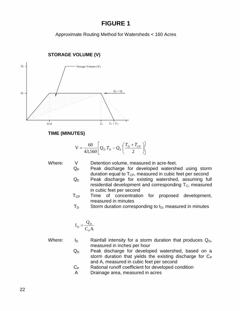
1. The minimum amount of storage volume of the detention basin shall be thatvolume required to reduce runoff rate to a single-family rate. Dedicateddetention/retention basins shall also include an additional one foot offreeboard and two feet of sediment storage. The volume of runoff storage fordrainage areas greater than 160 acres shall be computed using unithydrograph procedures. Acceptable unit hydrograph procedures include theSoil Conservation Service Dimensionless Unit Hydrograph and Snyder’s UnitHydrograph. Manual methods or use of the computer programs TR20, HEC-1,and NUDALLAS are allowed for runoff hydrograph computation and floodroutings.
For drainage areas less than 160 acres, the above methods arerecommended; however, an approximate routing method based on the rationalformula is allowable, as outlined in Figure 1.
2. Detention areas in parking lots shall not be:
a. In required parking spaces but in extra spaces.
b. Behind speed bumps unless the speed bumps are made with reinforcedconcrete.
c. Deeper than six inches unless warning signs are posted.
3. Drainage easement shall be provided for all regional detention/retentionfacilities and for other detention/retention facilities where two or more ownersare involved.
4. Detention/retention facilities shall be designed to empty in less than 24 hours,unless it is also serving as an erosion control facility.
5. Detention/retention facilities shall not be counted as an erosion controltechnique unless (1) the basins are designed to empty a minimum of 24 hoursfrom the storm event and (2) adequate sediment storage areas in the basinhave been set aside and are maintained.
6. Detention/retention facilities shall be maintained by the owner unless thefacilities and a drainage easement are dedicated to the City of Hurst.Typically, Hurst will not accept maintenance responsibilities of adetention/retention facility unless the bottom is concrete.
7. A steel elevation rod shall be installed in all grass-bottomeddetention/retention facilities. The owner will be responsible for removing thesediment when the two-foot storage is met.
22
FIGURE 1Approximate Routing Method for Watersheds < 160 Acres
STORAGE VOLUME (V)
QP
QE
TCP TD TD + TCP
QD = QE
Storage Volume (V)
TIME (MINUTES)
243,560
60V CPD
EDD
TTQTQ
Where: V Detention volume, measured in acre-feet.QP Peak discharge for developed watershed using storm
duration equal to TCP, measured in cubic feet per secondQE Peak discharge for existing watershed, assuming full
residential development and corresponding TC, measuredin cubic feet per second
TCP Time of concentration for proposed development,measured in minutes
TD Storm duration corresponding to ID, measured in minutes
AC
QI
P
DD
Where: ID Rainfall intensity for a storm duration that produces QD,measured in inches per hour
QD Peak discharge for developed watershed, based on astorm duration that yields the existing discharge for CPand A, measured in cubic feet per second
CP Rational runoff coefficient for developed conditionA Drainage area, measured in acres

23
Detention Basin Example
Development Data for the 100-Year Storm:
Drainage Area: acres160A
Residential: 0.60CR #40) PaperTechnical(from60.9Imin15T hour
inRCR
Developed: 0.90CP
hourin
PCP 60.11Imin10T
cfs6.92116060.960.0AICQQ RRDE cfs4.167016060.1190.0AICQ PPP
hourin
P
DD 4.6
1609.0
6.921
AC
QI
#40) PaperTechnical(frommin32TD
Volume of Detention:
243,560
60V CPD
DDD
TTQTQ
243,560
60V CRD
DD TT
TQ
2
103232
43,560
6.92160V
feet-acre96.13V