department of land and natural resources rockfall
TRANSCRIPT
w
STATE OF HAWAIIDEPARTMENT OF LAND AND NATURAL RESOURCES
Land DivisionHonolulu, Hawaii 96813
October 23, 2015
PSFNo.: 15HD-116
Board of Land and Natural Resources
State of Hawaii
Honolulu, Hawaii HAWAII
Set Aside to the Department of Transportation, Highways Division for
Rockfall Mitigation and Stabilization Purposes, Relating to Federal AidProject No. NH-019-2(41) at Laupahoehoe, North Hilo, Hawaii, Tax Map
Key: (3) 3-6-004: Portions of 015 & 017;
Grant of Perpetual, Non-Exclusive Easements to the Department of
Transportation, Highways Division, Under Federal Aid Project No. NH-019-
2(41) at Laupahoehoe, North Hilo, Hawaii, Tax Map Keys: (3) 3-6-004:
Portion of 017; and
Construction Rights-of-Entry to the Department of Transportation, Highways
Division for Rockfall Mitigation and Stabilization Purposes, Federal AidProject No. NH-019-2(41) onto State Parcels at Laupahoehoe, North Hilo,
Hawaii, Tax Map Keys: (3) 3-6-004: Portion of Homestead Road.
APPLICANT:
DEPARTMENT OF TRANSPORTATION, Highways Division (DOT).
LEGAL REFERENCE:
Section 171-11, Hawaii Revised Statutes, as amended.
Section 171-13, Hawaii Revised Statutes, as amended.
Section 171-95, Hawaii Revised Statutes, as amended.
LOCATION:
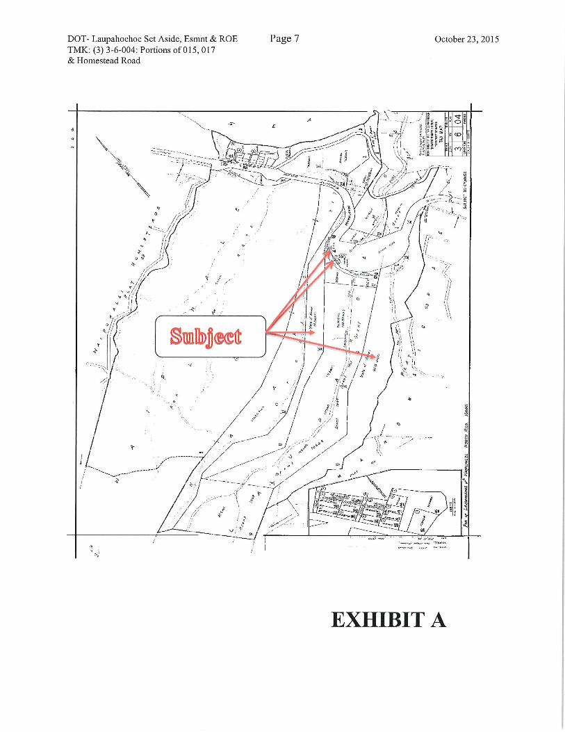
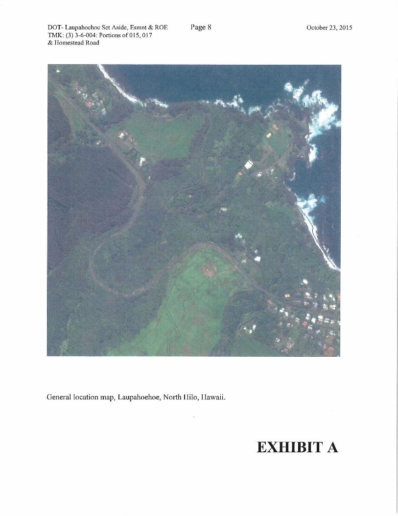
Portion of Government lands situated at Laupahoehoe, North Hilo, Hawaii, Tax
Map Keys: (3) 3-6-004: Portions of 015 & 017, and Homestead Road, as shownon the attached map labeled Exhibit A.
D-3

DOT- Laupahoehoe Set Aside, Esmnt & ROETMK: (3) 3-6-004: Portions of 015, 017& Homestead Road
Page 2 October 23, 2015
TMK/ ZONING/ ENCUMBRANCE/ AREA:
TAX MAPKEY
(3) 3-6-004: porHomestead Rd.
(3) 3-6-004:portion of 015
(3) 3-6-004:portion of 017
DISTRICT
LaupahoehoeN. Hilo
LaupahoehoeN. Hilo
LaupahoehoeN. Hilo
ZONING
LUC
Cons
Cons
czo
A-20a
A-20a
ENCUMBRANCES
Vacant - Proposed Parcel 2
Vacant - Proposed
Construction Parcel C-2
Land Office Deed No. S-
28,144 to HELCO/1.739 ac.Proposed Parcel 5
Vacant
Proposed Parcel 6
Proposed Easement 2
AREA(acres).0510
.2575
61.150
(1.739)
(2.4261)
34.110
(2.0343)
(.1548)
EASEMENTAREA
(square foot)Parcel 2
2,223
Const Parcel 2
11,218
Parcel 5
105,682
Parcel 6
88,614Easement 2
6,742
TRUSTLAND STATUS:
Section 5(b) lands of the Hawaii Admission Act
DHHL 30% entitlement lands pursuant to the Hawaii State Constitution:
YES NO x
CURRENT USE STATUS:
TMK.: (3) 3-6-004:002
TMK: (3) 3-6-004:015
TMK: (3) 3-6-004:017
TMK: (3) 3-6-004:030
Encumbered by Land Office Deed No. S-11,616 to DOT
Highways for the Hawaii Belt Highway.
Encumbered by Land Office Deed No. S-28,144 to the
Hawaii Electric Light Company for overhead electricaltransmission lines.
Vacant and unencumbered.
Remnant encumbered under DOT.
DOT-Laupahoehoe Set Aside, Esmnt & ROE Page 3 October 23, 2015TMK: (3) 3-6-004: Portions of 015, 017& Homestead Road
CHARACTER OF USE;
Right, privilege and authority to construct, use, maintain, repair, replace and remove
anchored wire mesh panels and rockfall impact barriers over, under, and across State-owned land for mitigation and stabilization purposes.
Right, privilege and authority to construct, use, maintain and repair a right-of-way over,
under and across State-owned land for access purposes.
CONSIDERATION:
Gratis.
CHAPTER 343 - ENVIRONMENTAL ASSESSMENT:
A final environmental assessment was prepared and notice of its availability published inOEQC's Environmental Notice on July 8, 2010. Due to a rockfall event in 2012, the
DOT was prompted to construct emergency rockfall mitigation measures. Asupplemental Environmental Assessment was prepared to address the modifications.
DCCA VERIFICATION:
Not applicable. The Applicant as a government agency is not required to register withDCCA.
APPLICANT REQUIREMENTS:
Applicant shall be required to:
1) Obtain written concurrence from all users of the subject land; and
2) Provide survey maps and descriptions according to State DAGS standards and at
Applicant's own cost.
3) Process and obtain subdivision at Applicant's own cost, if required;
REMARKS:
The Department of Transportation, Highways Division has determined that the October
15, 2006 earthquakes destabilized the slopes off the Hawaii Belt Road at specificlocations adjacent to the Kaawalii, Laupahoehoe, and Maulua Gulches. The Hawaii BeltRoad (State Route 19) is located on the northeastern coastline of the island and is the
' Applicant's proposed project is also authorized under the Governor's 2006 Emergency Proclamation
regarding relief from damage resulting from the October 15, 2006 earthquake. The proclamation
suspended a number of statutes, including HRS Chapter 343.
DOT-Laupahoehoe Set Aside, Esmnt & ROE Page 4 October 23, 2015TMK: (3) 3-6-004: Portions of 015, 017& Homestead Road
primary thoroughfare between Hilo and Kona. Following the coastline between Hilo and
Honokaa, the highway crosses Maulua, Laupahoehoe and Kaawalii gulches and borders
accompanying steep and sometimes unstable rock cut cliffs. Daily clearing of the fallendebris is required at each of these gulch crossings, and cases of boulders of up to two feet
diameter falling into the roadway after heavy rains have been experienced. Falling debris
presents a hindrance and expense to DOT Highways due to the need for constant cleanup,
as well as obvious safety risks to highway travelers along the Hamakua coast.
By memorandum dated November 9, 2009, Brennon Morioka, Director of theDepartment of Transportation requested a right-of-entry onto State lands for its
Emergency Earthquake Rockfall Repair Project at Laupahoehoe, North Hilo, Hawaii, TaxMap Key: (3) 3-6-004:015 & 017. The project required temporary constmction parcels to
survey rock conditions, conduct rock removal and demolition and to allow slope
mitigation and stabilization. Portions of the property were used as an access route from
the highway to the crest of the slope to provide access to transport equipment and for
debris removal. The project was anticipated to take six months.
At its meeting of January 8, 2010, item D-9, the Land Board approved the issuance of aright-of-entry for Emergency Rockfall Repair Project under Federal Aid Project No. ER-
15(21) at Laupahoehoe, Northffilo, Hawaii, TMK: (3) 3-6-004: portions of 015 & 017.
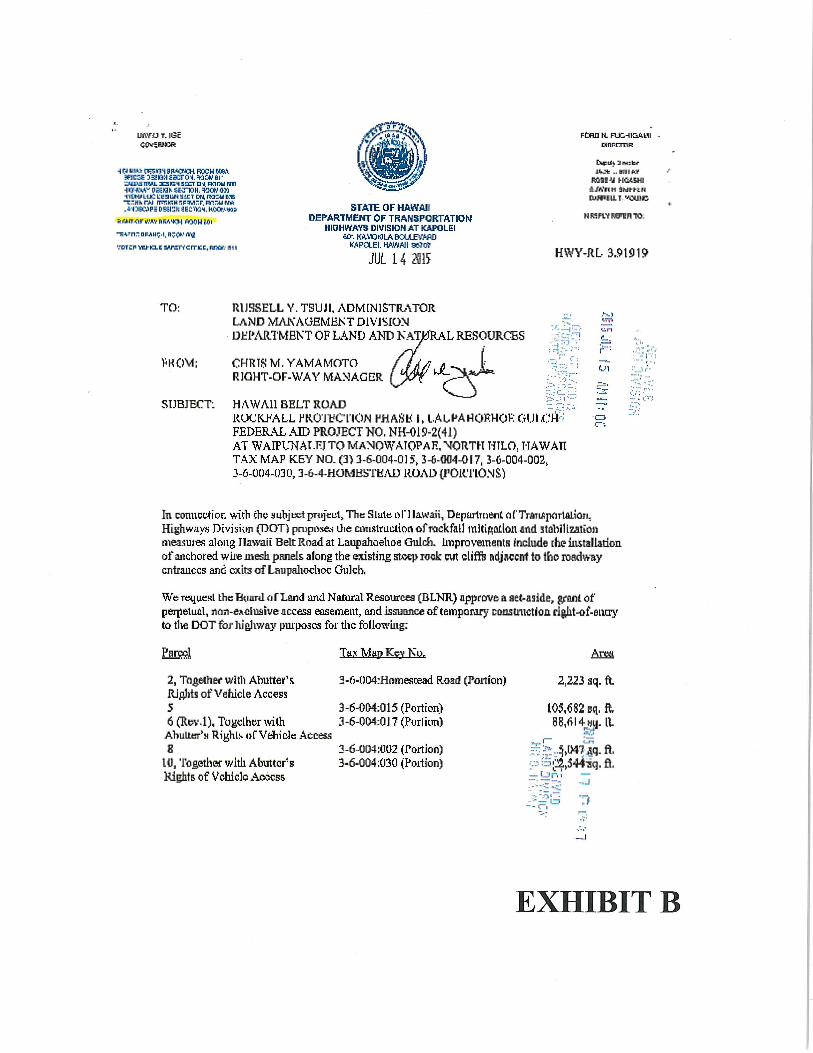
By memorandum dated July 14, 2015, Chris M. Yamamoto, Right-of-Way Manager,DOT-Highways, requested set asides, grant of easements and a construction parcel forproposed rockfall mitigation and stabilization measures along the Hawaii Belt Road at
Laupahoehoe Gulch. (Exhibit B) Improvements will include the installation of an
anchored wire mesh panels along the existing steep rock cut cliffs adjacent to theroadway entrances and exits of Laupahoehoe Gulch. Areas of interest are identified as:
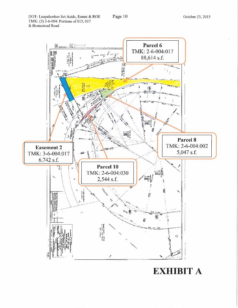
Parcel 2, consisting of .0510 acres (2,223 sq. ft.) and Construction Parcel C-l, for .2575acres (11,218 s.f.), on portions of the homestead road; a set aside of Parcel 5 consisting of
2.4261 acres (105,682 s.f.) on Parcel 15; a set aside of Parcel 6 consisting of 2.0343 acres
(88,614 s.f.); and Easement 2 for .1548 acres (6,742 s.f.) on Parcel 17. The purpose of
these measures is to improve highway safety along the Laupahoehoe Gulch by improving
upon the present unsafe conditions resulting in falling rocks, boulders, and associated
sediments onto the highway.
Research indicates that Parcels 2 & 30 of the DOT request is already under the
jurisdiction of the Department of Transportation, Highways Division as these two parcels
were designated as highway remnants. At its meeting of March 23, 1984, item F-4, the
Land Board authorized DOT Highways to dispose of surplus highway remnants, whichincludes Parcels 2 & 30.
The exemptions in the Governor's Proclamation dated October 15, 2006 are still in effect
as confirmed by the Department of Transportation, Highways Division. Previously, the
Office of Conservation and Coastal Lands was contacted and Sam Lemmo,

DOT- Laupahoehoe Set Aside, Esmnt & ROE Page 5 October 23,2015TMK: (3) 3-6-004: Portions of 015, 017& Homestead Road
Administrator, confirmed that a CDUA was not required provided the work is conducted
under the auspices of the proclamation.
No government agencies or community interest groups were solicited for comments as
comments were solicited as part of the draft environmental assessment process, whichwas published in the OEQC's Environmental Notice on July 8, 2010, with a
Supplemental Environmental Assessment being prepared in 2012.
Staff is recommending that the set aside, easements and right-of-entry for the
construction parcel be granted on a gratis basis, as the project is government related.
RECOMMENDATION:
That the Board, subject to the Applicant fulfilling the Applicant requirements above:
A. Approve of and recommend to the Governor the issuance of an executive order
setting aside Parcels 5 & 6 to the Department of Transportation, Highways
Division, under the terms and conditions cited above, which are by this reference
incorporated herein and subject further to the following:
1. The standard terms and conditions of the most current executive order
form, as may be amended from time to time;
2. Disapproval by the Legislature by two-thirds vote of either the House of
Representatives or the Senate or by a majority vote by both in any regularor special session next following the date of the setting aside;
3. Review and approval by the Department of the Attorney General; and
4. Such other terms and conditions as may be prescribed by the Chairperson
to best serve the interests of the State.
B. Authorize the issuance of a perpetual, non-exclusive easement to the Department
of Transportation, Highways Division, covering the area identified as Easement 2,
for access purposes, relating to proposed rock fall mitigation and stabilizationactivities under the terms and conditions cited above, which are by this reference
incorporated herein and further subject to the following:
1. The standard terms and conditions of the most current perpetual easement
document form, as may be amended from time to time;
2. Review and approval by the Department of the Attorney General; and

DOT-Laupahoehoe Set Aside, Esmnt & ROE Page 6 October 23, 2015TMK: (3) 3-6-004: Portions of 015, 017& Homestead Road
3. Such other terms and conditions as may be prescribed by the Chairperson
to best serve the interests of the State.
C. Authorize the issuance of an immediate management and construction right-of-
entry to the Department of Transportation, Highways Division, its consultants,
contractors and/or persons acting for or on its behalf, over portions of theHomestead Road, identified as Parcel 2 and Construction Parcel C-l, under the
terms and conditions cited above, which are by this reference incorporated herein
and subject further to the following:
1. The standard terms and conditions of the most current construction and
management right-of-entry permit form, as may be amended from time to
time;
2. This right-of-entry is effective upon Land Board approval and shall
terminate upon issuance of the grant of easement document; and
3. Such other terms and conditions as may be prescribed by the Chairpersonto best serve the interests of the State.
Respectfully Submitted,
^~T. j^Iatsunaga
Land Agent
APPROVED FOR SUBMITTAL:
^, ( ^{ , t^LSu^;anneJ5. Case, (Siairperson
DOT- Laupahoehoe Set Aside, Esmnt & ROETMK: (3) 3-6-004: Portions of 015, 017& Homestead Road
Page? October 23, 2015
^fc::-il;€'—-..i 3
/ WMWf'?''r-^.w.i^-' I \ -. •<-
EXHIBIT A
DOT- Laupahoehoe Set Aside, Esmnt & ROETMK: (3) 3-6-004: Portions of 015, 017& Homestead Road
Page8 October 23, 2015
^•"a^. ^•^s. s^f 1''-
*- *? fc-~9
!s ..^»s<®i
General location map, Laupahoehoe, North Hilo, Hawaii.
EXHIBIT A

DOT- Laupahoehoe Set Aside, Esmnt & ROETMK: (3) 3-6-004: Portions of 015, 017& Homestead Road
Page 9 October 23, 2015
;:^f..^—,T§W.--,'^^'^^T"{Wfl. -".';;•-•
^.1 -v, /?^-. /y '•/ .^ 1>
'"^.... ./y. / .. /''"""• ^/..'A ^ A
f<--
,ip-
'\ isi /%^,/ /\,,1.^^/~^(
-^""'..^-^f''y</ /' /
'..</ / / ••
^^,..^.-^"3/ ' ....^., u
..'<l<It-
^11-iii It
S!S' .^i I II
.ciiili
'^y /. j,;,^^•/...-^^€%^~ ^""%
.,----
^ •::. -1^ '"• ^
Parcel 6TMK: 3-6-004:017
88,614 S.f.
<"^' :jj^v; ,^'^"
\. ^ ^ \&i||N]1 ^•••^^f ia : I, " ^ -4. v^* \!. '~ I i "%^s """' ':.
^Maiiu^* ^^ ' ^
EXHIBIT A
DOT- Laupahoehoe Set Aside, Esmnt & ROETMK: (3) 3-6-004: Portions of 015, 017& Homestead Road
Page 10 October 23, 2015
.;;[•it,^
D
.t~
I !PI :....-.gg^w.--"
^'--:h:-'"
il .J^"^"
Parcel 6TMK:
88,
2-6-004
1,614 s.f.
:017
if
H^< -— —_-" """"
^.^^a .it t<-'^;-t> ^-—-'~.- '*"'- ' ••£•" ~<-—-
-Li^ I" ^^^^'ry''r~^-? ^'kiS^^^F---:-^"€^\,^:/>i:^N.;" ''' ^^~~t—^-
^.t'&^l^t^\ K.r ,A/ VK^ 'y<: w/
y'^-^M^./". ..j.'-. i ^ /'^ '^^ '-^
Jtf"'":r^'I^^:-'/ '\^!v'.^ • -^y^... ^,.^!li
(
Easement 2
TMK: 3-6-004:0176.742 s.f.
/•'^.-.—.-.^l,.;.-
^,...'
,':';:^i^^: l><i
pa. i
h -/\... .^A-' [••\.. •^.^y-^"" "~:":''^.
\^
«.I
--., >
~\
Parcel 8TMK; 2-6-004:002
5,047 s.f.
V-L
\,
Parcel 10TMK: 2-6-004:030
2,544 s.f.
"s,
^n\i,^
^ ~li*l1^"1
\'-»^^'11i^!i!^ -
l-i
••'•t.
V
\' ..''
\:^^ s::.^-
"•^r"^
!1
^'Th/'—. —
^
1^1 ii t.P&M!;liHiffiS'!S'Wlli^iii^I'iWT
\.•'I
;!1
3?r
-—T'r
-IP
.MEXHIBIT A

DOT- Laupahoehoe Set Aside, Esmnt & ROETMK: (3) 3-6-004: Portions of 015, 017& Homestead Road
Page 11 October 23, 2015
1 ~y\iy<.">"
^ -^
-^x^
:i(! J.i.:if.' ?t.lll1 " t?if
'\.
NN^XV;A^^^v'x^<.\
Parcel 5TMK: 3-6-004:015
105,682 s.f.
.^'
x\
Construction Parcel C-l
TMK: 3-6-004: Homestead Rd11.218 s.f.
,1
l(i;l
.:'<
v '•' /A\ \/^^'y 1
<...../
Parcel 2TMK: 3-6-004: Homestead Rd
2,223 s.f.
FJiu ,1 }^ •i.1U"M
x X <•-<.
ll^jl.P '< i! u?1;'illill<!I!illii|l||ii1
^ - a /
/-^i!i •/'>^f
.^
^^••''
s:\
EXHIBIT A
UiWU ». 113EOCh.'SRUSR
H p I'm TC?m BP.<C><H B3CM fA\WCCE 3a>3B SKTOI, na; arHUASTTVJ. :E3r:-< S3CT D-4. RCIMJ N11w-iw asm. senoH.^Kt; im-IVtWLL^ Ltiaun S1ET N<, R3=U EW-r^Hkrw TT^KHr;F^i-.F.n-i--ur/ri.'•(KC.IFS DESlsh aEi'iUi. KocrMns
^WTWl/WtftW,'^ WHEJOi
-R^-n": OMHC.t. n;(».'rt-tf
-,'DTCP-hU-nc sirsrccn-icc, Rny.-flu
SPATE OF HAWAIIDEPARTMENT Of TRAN3PORTATIOM
HIOHWATO DIVISH3NAT KAPOLEI^f. IWCMLAKUfVWD
WPCLEI. HAWAII SSTffr
M 14 'SK
FCHD N. FUHEAUIunprmR
D^sii". Jmitf
?A ..UHIM
sass'i HQASMI=Jft'HH SM^kN&WEU.T "QUIC
NKFMRg'ERTO.
HWY-RL. 3.9101?
TO:
\<HO\t;
SUBJECT.
RUSSELL Y. TSUJI, ADMINISTRATORLAND MA^'AOEMHIST DIVISIONLH:PARTMENT OF LAND AND:
CHRT&'M.YAMAMOTORIGHT-OF-WAY MANAGER
^RESOURCES •::''.I..1'
'^•^Jto '.:^,
HAWAII BEL/T ROAD - .^V,KWiU-ALL JJROTyCriON tJHAS'b: I. I.AL.PAHORH01-: GI.JICri::FEDERAL AID PROJECT NO, NH-019-2(41)AT WAIPUNAT.F? TO MANOWATOPAK, NORTH HTLO, HAWAnTAX MAP KEY NO. (3) 3-6-004-0] 5, !-6-004-<}i7, 3-6-004-003,3-6-004-030,3-6-4-HOMByTKAU ROAU {I'OK.'l'lOMS)
r •
U1
C3c--,
In conucriior- with ch<? flubjtxit pTitJcut, The Slulc it I'] IAWAU, DepirrtrnenC <if'TrdrLfip<iriALiOTi,Highw;iy), PEviswn (DOT^ pnipi'ix&i Oie citnxlfai^ionofKickfal] mitisation and itiabiUzationmeasuies atong Hawaii Belt Road at Laupahoehoe Gulcfi. hnpro^ieinents include [he iii&tallatioiL
of anchored wire mesh panels along the sxisting stoq> rock cut cliflfs adjdccnt to tho roadwayentrances and exits of Laupalwdioc Gulch,
We roqucKl tlie B^iurd ('jrLflrtd and Natur.il Resourcea (QLNR) flppccrve a aet-aside, granl ofperpeluAl, ndsi-e^Iuaive accfisa easement, on d issuance of temporiuy coustniction ri&kt-of-eiuTi'to t1ie DOT for hi&hway pui'poics for the fbllowing;
Pared
2, Tngftther wifli Aftutter'ii
RJfllits of Vehicle Access56(Rtn?.l),TugdhCTwith
AbuLter'M RiyhlsofVfchide Acces.l
81(1, Tosetha- with Abuttcrs
Rights of Vehicle A<»css
Tax Man Key Ku.
3.6.004:Hnmescead R.oad (Poilion)
3-6-OM;015 (Portion)3-6-004:017 (Purlkm)
3-6..0U4;U(}2 (Portion)3.6.004 ;030 (Portion)
Area
2,223 sq. ft.
105,^2 sq, ffc88,614^-H
'J^imAq.fi.-.S;^>344'Bq,ft,-t_li-,l —
-,J
::?o ~i
EXHIBIT B
RusscU Y. TSUJL Aduumsfeitor ITftT-RT, 3.') 1919
FflgcS
w\_ t ^ 2915
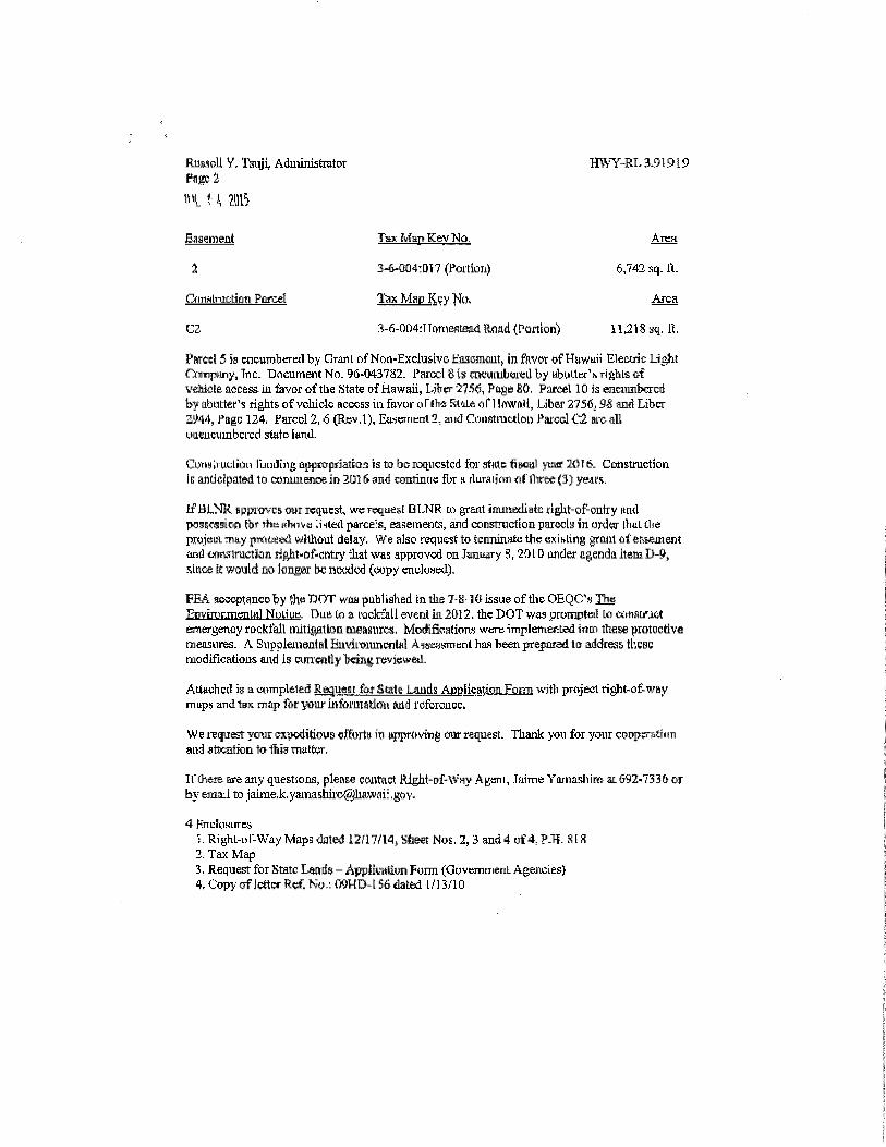
Basement Tax Man Kev No. ATCH
2 3-6-004' Dl 7 (Portion) 6,742 sq.ll.
&infilruc;ti(iti Pcurcel TaxjMaEj^cy Nu, Area
C2. ^-6-004:TTomesteadRoad<?QftEon) H^1Syq,fi,
Pared 5 is cwuTn^cretl by CIrArtl DfNon-Exdu&ivo Eascmcut, in ftvoT ofHawuii Elecuic Li^itF/nnpnnyjnc:- Bncumant No. 96-043782. 1'arccl Sis cncumbcreilby ubiii.lu-^rifthlsofvehiols access in &vor oftlie State ofHgwaii, Litnr '275$, P&ge 60. Paicel 10 is encumberedby abutter's ri&hts ofvohide access in fiivyi- onhfl StttLf; on lawiui, Liber 2756; 9S and Libcr
2M4, }*agc 124, Fared 2, 6 (Rcv.l), Ea.wnenl 3, and Constmction Pared C2 arc alluusucumbcrcd state i<in*I.
Ciw.ruclion lunijii^ fliii3i'opr3at[Q.i is to be roqncstcd forgffttcfisctil ycm' 2016. Cmstmctionis anticipated to comuienoein 2U16 and contunre fur i rlurADOT) fil'l1'iree(3) yearit.
IfBLNR iippi'ovcs our request, wv Twimis-l OI.NR K) grsnt immediate right-of-cntry itn<lpossrasion for the H^T/S .nted iurce's, easemeiics, and construction paTocls m urdCT ItiuL dieprojeui -nay prtitieed williout delay, We also request to temmmfa; ttie e.vihling greuit flfer'&auientand onrtsiruction rifiht-of-cntry -that was approved on Jsmuary g, 201 D under agenda item U-?>since it would no longer be nKxJod (yupy endunwl),
FBA fuKcptsmcc.by 'Jie nOT waa paliliahed in tlie 7-K-10 issue offlie OEQC's The
Epvmirmealfl] Nuliuc. Due Co a racfcfall event ill 2012, the DOT v/as prumptcil K? ccinsuuctanerfiency rocktall nutigattoa caeasuics, ModificalwTfi wcni-iTnplettte^tied iriin tliese protccdvemeasures. A Snpoleineutal Ein'ii-muncnlfll Afscijsiniinl has l)&an. pr^)£ued to address ll'.cscmodifications and is cun'mtly being reviewed.
Attwhcd is a (wnpleled Request fQf State Lauils ABclicatUBL&iBn w)t1' prAjecl right-of-way
m ups and tuK m<lp fiff yow mformatiou Etud rofcTOnce.
We request your oxpcditiovs efforts in t^provtng ws request. Thank you for your coopsratniTiand fltft-ntion to ttiig Tnylfca-.
Il'Oiere are any qufstsons, pleaEe contact Klght-of-Wny An-ani, JfiiTne Yajnasliirfi at 692-7336 or
by ema-1 to jaime.k, [email protected]:, go v.
4 Hni:kil<iiTCi>
';. Rig'hl-i>r-\VAy Maps dated 12,fl7/l4> yheet MOE, 2,3 and 4 yf4; P-TT. 8 I K
1. Tax Mapi, Request fbi State Lands - Appiivatiyn Fuim (CiuveiTiinenL Agejicies}4. Con' ofJrttcr Rcf. ^.: (WHD-l 56 dated I,'] 3/10