december 14, 2017 teledyne imaging logo standards
TRANSCRIPT
Black Version: 100% Black
Teledyne Imaging Logo StandardsDECEMBER 14, 2017
Part of the Teledyne Imaging Group
Pantone 2935 Version: 100% Cyan46% Magenta0 Yellow0 Black
White Version: 100% White
RGB Version: 0 Red118 Green192 Blue
Part of the Teledyne Imaging Group
Part of the Teledyne Imaging Group
Part of the Teledyne Imaging Group
processing software
Introduction In the ocean mapping industry there is a common trend
to have fewer people on the vessel. This presents many
clear benefits such as cutting costs and reducing safety
risks, as well as improving quality of life for the surveyors
by reducing time offshore and away from home. Since
data processors do not have a need to be hands-on
with the survey equipment, it makes sense to begin with
migrating data processing to shore.
However, this migration-to-shore based data processing
is made difficult by communication restrictions between
offshore vessels and a shore based office. While
transferring all of the raw data from the vessel may be
feasible in theory, for most operations it is cost prohibitive.
Dependent on the bandwidth available and volume of
sensor data being logged, the time to transfer the data
can easily surpass the time taken to acquire the data,
causing processing efforts to quickly fall behind. In a
worst case scenario there may be no communications
available, so the data would not become available until it
can be hand carried to the office.
When considering the key role processed data plays in
supporting effective and efficient management of a survey
operation, any significant delay between the acquisition
and processing of data is immediately detrimental.
Having all sensors integrated into a processed product
allows operators to monitor that survey requirements
are being met, and the overall coverage is in line with
the operational plan. A delay in data processing would
risk prolonged collection of poor quality data, or areas
in need of further investigation or re-survey may require
significant transit time to be spent returning to a survey
site.
In order to process data automatically on the vessel and
to provide information about survey operations in real-
time on the shore, the high volume raw data must be
reduced to information products which are small enough
to be easily shared over a low bandwidth connection.
Teledyne CARIS recently released CARIS Onboard™ 2.0
with this exact goal in mind. Running on the survey vessel,
CARIS Onboard automatically processes the raw sonar
data, along with positioning, motion, tidal and sound
velocity data, and generates a processed surface.
Software Demonstration During the Oceanology International exhibition and con-
ference held in March of 2018 in London, the concept of
real-time survey visualization was demonstrated by Tele-
dyne CARIS using the latest release of CARIS Onboard.
Braveheart Marine’s vessel “Patriot” was used for the
demonstration. The Patriot was equipped with survey
equipment from Teledyne Marine, including the T50-R
multibeam and the rapidCAST for underway sound velocity
profiling. The data was acquired through Teledyne PDS.
www.teledynecaris.com
Improving Survey Efficiency through Real-Time Survey VisualizationAuthor: Travis Hamilton, Teledyne CARIS Product Manager – CARIS Onboard, HIPS and SIPS
As published in the May 2018 edition of ON&T
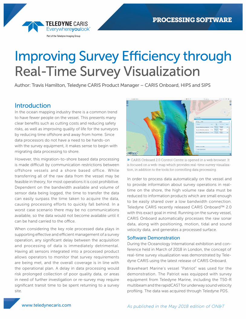
» CARIS Onboard 2.0 Control Centre is opened in a web browser. It
is focused on a web-map which provides real-time survey visualiza-
tion, in addition to the tools for controlling data processing.
This surface provides information about the survey’s
quality and coverage. The bandwidth requirements are
further reduced as CARIS Onboard converts the surface
into tiled images in the Portable Network Graphics (PNG)
format, and live streams the images into a web map to
be opened in any networked device which can connect
to the vessel. By providing access to processed products
in a web application, CARIS Onboard allows the dataset
to be automatically processed on the vessel to a point
where low bandwidth information can be streamed to
shore, providing real-time survey visualization in support
of efficiently managing a survey.
CARIS Onboard 2.0 was installed on the Patriot, and
setup to read the raw data files produced by PDS. Once
set to run by the remote data processer, the software
automatically processed the raw sonar data according to
a pre-defined workflow designed by the data processor.
In this case the data was imported to a HIPS project,
then Georeferenced while applying corrections for water
levels and sound velocity variations in the water column,
Total Propagated Uncertainty (TPU) calculated, data filters
applied, and finally a processed bathymetric surface was
calculated from the data.
A low cost laptop was setup at the CARIS booth in the
exhibition hall and connected to the vessel, using a
standard 3G cellular data modem connected to the laptop,
with a second modem on the vessel. For the duration
of the three day event, CARIS Onboard automatically
processed and live-streamed the data to the web map
embedded in CARIS Onboard’s new Control Centre. The
processed surface was displayed in near real-time at the
booth on a large monitor.
By monitoring the 3G modem
during the demonstration,
it was recorded that less
than 1GB of data was
transferred from the vessel
for the duration of the 3 day
conference. The transfer
rates peaked at approximately
1 Mbps, however dependent
on the location of the vessel,
they were as low as 150Kbps,
demonstrating that even with
a low bandwidth connection, CARIS Onboard was able to
provide real-time survey visualization.
ConclusionThe demonstration at Oceanology International suc-
cessfully showed that by using the commercially avail-
able software, CARIS Onboard 2.0, it is now possible to
provide remote real-time survey visualization with a low
bandwidth connection when operating close to shore.
With the data processor positioned on shore, the data can
still be processed, and information products made avail-
able for supporting the efficient management of survey
operations.
About the AuthorTravis Hamilton has been with Teledyne CARIS since 2015
and is the Product Manager for CARIS Onboard and HIPS
and SIPS. Prior to this, he spent several years working in
research and industry, gaining experience with the opera-
tion of, and processing data from, AUVs, subsea position-
ing systems and swath sonar systems.
© Teledyne CARIS Incorporated
115 Waggoners Lane, Fredericton, New Brunswick, Canada E3B 2L4
Tel. +1 506 458 8533 Fax: +1 506 459 3849 E-mail: [email protected]
www.teledynecaris.comAs published in the May 2018 edition of ON&T. Printed in Canada. 20180927
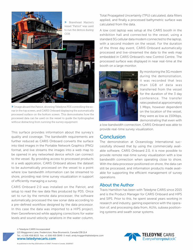
» Braveheart Marine’s
vessel “Patriot” was used
to run the demos during
OI18.
» Image aboard the Patriot, showing Teledyne PDS controlling the so-
nar in the top screen, and CARIS Onboard displaying the automatically
processed surface on the bottom screen. This demonstrates how the
processed data can be used on the vessel to guide the hydrographer
without distracting from running the survey equipment.