dd rpt 38 grenfell twp - ontario · 43a81ne8964 38 grenfell 010 diamond dhilling grenfell report...
TRANSCRIPT

43A81NE8964 38 GRENFELL 010
DIAMOND DHILLING
Grenfell REPORT NO.# 3 8
WORK 1'KKKORMKI) l'X)R: B laine Vallier
TWI'/ARKA
RECORDED HOLDER: SAME AS AHOVE : OTHER ( J
NO.
1112059
1169149
HOLE NO.
VF92-1
VF92-2
FOOTAGEi
244m
198m
DATE
July/92 July/92
NOTE
11
NOTES:
1. W9380.00160, filed July 27/93

GRENFELL TWP CLAIM #1112059
Azimuth-0 deg Dip-45 deg Length-244 m (800')O 10
Scale
small
features.
Rock
Types
cherty or graphitic
pillowed fragmental
SEDIMENTS
TUFF
VOLCANICS
topography approximately to scale
Co H

GRENFELL TWP CLAIM #1169149
Azimuth-0 deg Dip-50 deg Length-198 m (649')
Scale
topography approximately to scale
small
features.
cherty or graphitic
pillowed fragmental
M
Rock
Types
W//4
tffy
SEDIMENTS
TUFF
VOLCANICS
pillow \.\\ selvages N\ -^
N\ f
disseminated sulphides

" * Ministry of Ministere du Diamond Journal de Northern Development Developpement du Nord r\~itK~~ frtrttcit* au and Mines et des Mines Dnlling Torage au Ontario Log diamantDrilling Company Compagnie de forage
HEATH AND SHERWOOD, KIRKLAND LAKEDate Hole Started Date de commencement du forage
June 30, 1992
Date Completed Date o"achevetnent
July 7, 1992Exploration Co.. Owner or Optionee Compagnie d'expkxatkxi. proprietaire on trtulaire d'optkm
VALLIER EXPLORATION
S QFootage/AvancementFrom/De
930
47
-
-
127
130
To/A30 f
47
127
130
203
f
Rock Type Type de roche
overburden
intertnprl . f-nff
int. tuff tolapilli tuff
lapilli tuff
tuff tolapilli tuff
Collar Elevation Elevation du cottier
Date Logged Date d'inscription au journal .^i VA^I 7p7-Date Submitted Date de depot
SUM* 1 3-' ?3
Bearing of hole dam trueNorth/Position du forage par rapport au nord vrai
0 deg
Total Footage Avancement total du forage
800 ftLoggedby ^^ Inscrit par " C/'
David Good S L Pre\Submitted by (Signature) Deposd par (signature)/-^ '-2^ ^-^~\ s s~-^
Dip of Hole at Indinaison du for
Coftaffcoflieri
FUPiec
Rypi
RTPi
FL/Pi
Complete this form andrelated sketch In duplicate. Fin in on every page Hole No.^ Page No. Remplir en deux exemplaires la Remplir ces cases a k. Fora9* "* Pag* " presente formute et te croquis annexe chaque page r 9 2 1 i
age au
45 deo
o
0
o
Description (Colour, grain size, texture, minerals, alteration, etc.) Description (Couteur, granulometric, texture, mineraux, transformation, etc.)
dk. grey to grey, fine grainedat 37' a 4
patches of
39, 41, 42
" patch of
, no visible bedding plaipale green matrix with breccia fr;
black matrix and brecciated tuff at 31, 38,to 45, 47 ft. 45 deg to C/A
light green, med. grained, tuffwith frags . to 2 cm.
with irreg. black layersLocal breccia obscures possible j
fragmentation of subangular, monolithic- at 53' a
frags .fine grain bed at 45 deg to C /A
- thin pyrite veinlets with small cubes50,51,52,55,157,64,72,73,81,82117,118,1 19, 123
- good example of fragments atpurple-grey with 1 to 52 whitesome 1mm in diameter
, 84, 88, 99,
92-94 ft
at 40, 43,48,4*
100,103, 107, IK
, subhedral fldspar xrst]Fragments less than 1 cm,
- similar to 47 to 127, layered tuff and lapilli
sub-ai
tuff- breccia zones may result from post-depositional shift thin veinlets of pyrite from 150 to 189 ft. thin, sulphide free calcite stringers from 141 to 20i
Address/Location where core stored Adresse/endroit ou la carotte est stockee
; \5 vo v ^ L-A^ \ \^e^.c, \ ^r* o V"V r
v: ^\O-*N TSO v \sv-t^ ^
COXc/ibeii'p (V-^,)
1SKT(*
;CS
gs.
ener;
*
s
gula:
ing
ft
OJ*SP**M* FooUgit'U"e~ir ipMKMraimii
(.Hi. to
1
YowSmpMNaN*(fManMon du pnxpednr
Map Reference No. Claim No. N* de reference sur la carte N* de concession miniere
1112059Location (Twp. Lot. Con. or LaL and Long.) Emplacement (canton, lot, concession, ou latitude et longitude)
GRENFELL TOWNSHIP
Property Name Norn de la propriete
KAPAKTTA SOTTTP f C.KV.V.K^Smipte Focdgt/tCwuf di pi*- HwMnt de rfctprfkx tan ni^dFfomrt)* Toftk
teupKUntfi LongMVW rocnvwHon
Assays t /Analyses mineralurgiques
OZD4 (raw) .por features such as foliation, bedding, schistosity, measured from the long axis of the core. t Additional credit available. See Assessment Work Regulation. Exemptes de caracteristiques : foliation, schistosity, stratification, (.'angle est mesurg par rapport a I'axe longitudinal de la carotte. t Des credits supplementaires sort offerts. Consulter tes reglemerrts relatifs aux travaux d'evaluation.Nota : Dans cotte formute. torsou'il desione des oersonnes. te masculin ~*t utm** *., *.~i* ~-,*™

- Ministry of Mintstere du Diamond Journal de Complete this form andi -toy i nonnem ueveioprnem ueveioppemeni au Nord r*rfH5.w. foram* Ail \VJ and Mines et des Mines Drilling forage 3UOntario Log diamant
fritting Company Compagnie de forage
bate Hole Started Date de commencement du forage
Date Completed Date d'achevement
Exploration Co., Owner or Optionee Compagnie d'expkxation. propoetaire ou titulaire d'optkxi
Footage/AvancementFrom/Do
203
208
300
350
354
-
422
430
443
To/A207
300
350
354
422
439
b-461
Rock Type Type de roche
greywacke
lapilli tuff
graphitic seds
feldspar porph
graphitic seds
lapilli tuff
Tf?T*3*5pa'ir nrt T"riVilapilli tuff
Elevation du collier
Date Logged Date d'inscription au journal
Date Submitted Date de depot
North/Position du forage par rapport au nord vrai
Logged by Insert par
Total Footage Avanoement total du forage
Submitted by (Signature) Depos6 par (signature)
Dip of Hole at Indinaison du for
Cotlar/colliw
Ft/Pi
Ft/Pi
FtVPi
FUPi
related sketch In duplicate. Fin in on every page Hole No.^ Page No. ' Rempllr en deux exemplalres la Remplir ces cases a ^ i-orage
presente formule et le croquls annex* chaque page r 9 2-1 ^ Z
age au
e
0
o
o
Description (Colour, grain size, texture, minerals, alteration, etc.) Description (Couleur. granulometric, texture, mineraux. transformation, etc.)
fine-grain dk wacke, no obvious bedding
pyrite veinlets at 205, 207 ft
similar unit to 130-203. Thin
231-232,268,281,294 ft., along
pyrite vienlets at 209-2
core from 287-288
- pyrrhotite-pyrite to 40Z of rock at 296.3 to 297 and
297.5 to 297.7.
- black, fine-grain.
- 6" of PO and py at
thin to med bedded
301, thin
(1 to 5 cm)
veinlets of pyrite from302 to 350 (evry 4 or 5" between 302 to
-j.- r* ~-j Tl rtnCiM J Tt, 1. \
irrv - erev.
similar
- numerous
305 and every*-"~ V\f^ttA TtC, k.
Tofifrom 3 05 to 350.
med. grained, about\
to 300 to
30Z feldspar
350. - graphitic mud (6") at 398
thin Dvrite veinlets. oarllel
Ahove- generally 45
to bedd
dee to C/A. 1" calcite vein
ine as
at 366
- gr-Aded bedded obvious in last 50 ft. coarser down hoi
- load fif-rncf iir**fi Also indicate tot) is tin hole- similar to 208-300
as 3*5(1-^4- intermed. lap. tuff with interbed, seds. 4 to 6" thic
Address/Location where core stored Adresse/endroit ou la carotte est stockee
(M.
10,
.5.
e
k
""^SZ*" trftOunmon
Map Reference No. Claim No. N" de reference sur la carte N* de concession miniere
1112059Location (Twp. Lot. Con. or LaL and Long.) Emplacement (canton, tot. concession, ou latitude et longitude)
Property Name Norn de la propriety
rfUflvDO WA
*
S*np4t Lmgtfi lenoMwwr0ciuntMon
Assays t /Analyses rojneralurgiques
0204 (0*91) .for features such as foliation, bedding, schistosity, measured from the long axis of the core. t Additional credit available. See Assessment Work Regulation. *Exemptes de caracteristiques : foliation, schistosite. stratification. L'angle est meswe par rapport a I'axe longitudinal de la carotte. t Des credits supplementaires sont offerts. Consulter tes reglements relatifs aux travaux d'evaluation.
Nota : Dans cette formule. torsqu'il designs des personnes. le masculin est utilise au sens neutre.

Ministry of Ministere du Diamond Journal de Northern Development DeVetoppement du Nord .... fnrw.** ~.n and Mines et des Mines Drilling Torage au
Ontario Log diamant
Drilling Company ~..~r-.- - - - - - Compagnie de forage
Date Hole Started Date Completed Date de commencement du forage Date d'achevement
Exploration Co.. Owner or Optionee Compagnie d'exptoration. proprietaire ou titulaire d'option
Footage/AvancementFrom/De
461
fififi
-
To/A
666
finn(EOH)
t
Rock Type Type de roche
pillowed and L.
flow basalt
f rag. basalt-,
lap. tuff St tu:
Collar Elevation Elevation du collier
Date Logged Date d'inscription au journal
Date Submitted Date de depot
BefthfN) 0( hotft frOrn tfMNorth/Position du forage par rapport au nord vrai
Logged by Insert par
Total Footage Avancement total du forage
Submitted by (Signature) Depose par (signature)
-
Description (Colour, grain size, texture Description (Coufeur. granulometrie, texture.
- thick sequence of
Dip of Hole at Incfinaison du for
Coaac/coMnr
Ft/Pi
FL/PI
Ft/Pi
Ft/Pi
Complete this form and related sketch hi duplicate. Fill in on every pageRemplir en deux exemplaires la Remplir ces cases a presente formule et le croquis annexe chaque page
age au
O
O
o
o
, minerals, alteration, etc.)mineraux. transformation, etc.)
partly altered pillowed flows- feldspar phenocrysts in a few thin units (1 to 2 m)but otherwise rare . Similarly, some vesicles but rare
predominantly fine grain, dark green to dark greybasalt with white veined and patchy alteation zones.The alteration zones make up 52 of core, are evenlydispersed and occur in patches of up to 20 cm thick.In corresponding outcrop the patches are buff colouredand angular to amaeboidal in outline and could bemistaken for clasts.
- pillow selvaees are approx 2 cm thick\
- at 629 approx 1 ft of flow breccia.- PO strineers. minor PV from 630-633 and 636 to 640..brown micaceous alteration streaks from 634 to 635 -. dk green to dk grey clastic rock, fraes to 2 cm.
f monolithic, matrix to clast supported. Layers of
lapilli ti,ff(10 to 20 c-m) int^erspersed with tuff.-brown., very-fine grained mic^ceoujs material at
-pyrrhotite bands at 716 to 71
696-691
.9, 720-721, 742-743, 751(END OF HOLE)
Address/Location where core stored Adresse/endroit ou la carotte est stoekee
BM naili*r*fiitii pi
7
ft.
CMSpieiM* FM*ltn~*~ IfWItecMM
p*M.
YawSwvhNoiN*ffcMftn du praptOMtf
s Hole No. Page NO. ^ Forage n- Page n*
^ 92-1 *3Map Reference No. Claim No. N" de reference sur la carte N* de concession miniere
1112059Location (Twp. Lot Con. or LaL and Long.) Emplacement (canton, lot, concession, ou latitude et longitude)
GRENFELL TOWNSHIP
Property Name Norn de la propriete
S*n*trocugftfrf*Ki(tepi*-
FranvD* To/A
-
SinvtolmOi Lorinmutd* rfchnMon
Assays t/ Analyses mineralurgiques
0204 (03(81) .For features such as foliation, bedding, schistosity, measured from the long axis of the core. t Additional credit available. See Assessment Work Regulation. *Exemples de caracteristiques : foliation, schistosite, stratification. L'angle est mesure par rapport A r axe longitudinal de la carotte. t Des credits supplementaires sort offerts. Consutter tes reglements relatifs aux travaux d'evaluation.

.r y\ i -** / w " I^Lr 1 Northern Development C \."'^y and Mines e Ontario
Drilling Company Compagniede forage
Date Hole Started Date de commencement du forage
levSoooement du NorH Diamona ""u"'*" ue Complete this form Md jevewpjpement du Nord prilling forage 3U related sketch hi duplicate. Fffl in on every page
LOQ diamant Remplir en deux exemplaires la Remplir ces cases d ^* presente formule et le croquis annexe chaque page
Collar Elevation Elevation du coHier
Date Completed Date Logged Date d'acnevement Date d'inscription au
journal
Exploration Co.. Owner or Optionee Date Submitted Compagnie d'expkxauon. proprietaire ou tftulaire d'option Date de depot
Footage/AvancementFrom/Do
n
30
3nn
477
461
fififi
To/A
300
477
Afil
fififi
snn
1
Rock Type Type de roche
casing ( o . h
intermed tuff flapilli tuff
praphli- Ir seds
in..t., tuff and
lapilli tuff
pi 1 1 Owe d ha sa 1 t
f T-agnvental has*
Bearing of hole bom true Total Footage Dip of Hole at *
par rapport au nord vrai forage
CoOar/coltierLogged by v 0 Insert par
Ft./Pio
Submitted by (Signature) --^ 1
FiJPiO
FUPi
Description (Colour, grain size, texture, minerals, alteration, etc.) Description (Couteur, granulometric, texture, mineraux. transformation, etc.)
pyrrhotite hands at 7Qfi to 7QR
pyrrhotite hands, at TO1
pyrrhotite hands h*'t'ween fi3O and 64O
JJ- pyrrhntlte hands from 717 to771j 747 to 743
and at 751.
\
Address/Location where
niiMUl lii*
fM?t7u?L
score stored arotte est stockee
YovSin^tNa.
Hole No. Page No. W Forage n0 Page n
^ 14Map Reference No. Claim No. N0 de reference sur la carte N0 de concession miniere
Location (Twp. Lot Con. or Lat and Long.) Emplacement (canton, tot. concession, ou latitude et longitude)
Property Name Norn de la propriety
SOT)* FootaggMnwv * pi*- Hvwmrt d* r*ch-"* MI ntodd
TofA
SOTpKUnoA UnguBurat nSmtton
Assays t/Analyses mineralurgiques
0204 (MSI) FO,. features such as foliation, bedding, schistosity, measured from the long axis of the core.* Exemptes de caracteristiques : foliation, schistosity, stratification. L'angte est mesurg par rapport a I'axe longitudinal de la carotte.
t Additional credit available. See Assessment Work Regulation.t Des credits supplementaires sont offerts. Consulter les regtements relatifs aux travaux d'evaluation.

'/rvT\ Ministry of Ministere du Diamond Journal deIVyl -Northern Development Ocvotoopomorrt du Nord o-sns.,,. forao** au VS/ andMineT et des Mines Drilling TOragC 3UOntario Log diamantOWLig Company Gompignie de forage
HEATH AND SHERWOODDale Hole Started Dale completed
July 7, 1992 July 13, 1992Exploration Gx. Owner or Oornpagnie Q exploration,
VALLIER EX]
RxXage/AvancementFronVDe
0
5
17
19
-
To/A
5 ft
17
19
136
136 l 205
'- ———
Optionee
'LORATION
/3 ^Rock Type
Typo de IUCIK)
casing
basalt
lamprophyre
basalt
sulphide rich
siliceous sedii
Deac
Co*ar Etevation cMvstion du oottsr
Date Logged Date d'inscriptioii au journalAug 6, '9
Date Submitted Date de depot
Beanrg ol hou horn tun NoiWPonbon du torags par rapportvi nord vrai
360
Total ftxMagB Avanoamcnt kxat du forage
649 ftLogged byfnscnt P^^tl^t^ fi J r*rf\
l H . LovellSubmitted by (Signature) Depos6 par (signature)
Dpofttotoat Incffciaison du foi
fun
Ft/Pi
flL/Pf
Complete this form aod related sketch hi duplicate. Frit in on every page Remptir en deux exemplalres la Remplir ces cases a ^ presente formule et le eroquis annex* ' chaque page r
age au
50 deg i
Q
Ft/Pi
Description (Colour, grain size, texture, minerals, alteration, etc.)ripOon (Coutaur. gntmjfornetrie. texture, mineraux. transformatten, etc.)
volcanic flow
biotite lamprophyre dike
basalt with pillow selvage at 20 ft, possible hyaloclaat 26 to 30 ft,
- flow top breccia fragments baked pale yellowish whitat 32 ft for example. Reaction rim envelops theat 35 ft. The breccia frags are mostlycontaining fine grained brownoriginated from aquagene tuff pseudo variolitic
frags
in a matrix
biotite that might have
or sediment.
texture at 90 ft.- some breccia fragments contain disseminated iron sulpossibly derived from matrix which also contains sulpfa at 110 ft possible metamorphosed amygdules sequence indicates tops may be downholePredominantly sulphide rich sediments - magnetic
caused by pyrrhotite and magnetite
- at 171 ft. sil'iceous, banded chert possibly some vol.canic flow sections e.g. 147 ft.
Address/Location where core stored Adressefondroit ou la earooe est stock**
rstr-
stitc
e
phide
ides.
sSS:
S
Map Reference No. N* de reference sur la carte
Location (Twp. Lot. Con. or LaL an
GRENFELL TWP
HrieNo.( Pag* No
92-2 1CM N*
1]
m Ho.
L69149d Long.) on, ou fattrtude et longitude)
Property N9fn0 Norn de la propriete
KAPAKITA CREEK
FromO* T0A
"
s333f Assays f/ Analyses rnineialurgiques

jJTX Ministry of T Vy l Northern Dev \^f*S and Mines Ontario
MifMstere du
et des Mines
Diamond Journal de ^N^"3 Drilling forage au
Log diamant
Drilling Company Compagnte de forage
Date Hole Started Date CompletedDate de commencement du forage Date cTachevement
Exploration Co.. Owner or Optionee Compagnie d'expkxatkxi. proprietaire ou titulaire d'option
FboCage/AvancementFrom/De
205
t
To/A
649
(EOH)
-
Rock Type Type de roche
tuff and floi
TTTJn mf H OT V
Cottar Elevation Elevation du cottier
Date Logged Date d'inscriptkxi au journal
Date Submitted Date de depot
par rapport au nord vrai
Logged by Inscrit par
Avancement total du forage
Submitted by (Signature) Depose par (signature)
Complete this form and related sketch In duplicate. Rn jn on every page Remplir en deux exemplaires la Rempttr ces cases a ^ presente formute et le croquis annex6 chaque page r
Dip of Hole at * lodmaison du forage au
Codarfcodter
Ft/Pi
FUPilO
FUPi.
FUPi
Description (Colour, grain size, texture, minerals, alteration, etc.) Description (Couteur. granulometrie, texture, mineraux, transformation, etc.)
much of this sediment is now breccia perhaps from
dessication, thermal metamorphism and deformation
Predominantly aquagene tuff (fall breccia rather than
flowbreccia) with lesser, morevolcanic flow mixed
- possible
in.
pillow selvages at
pillow breccia in
- flow top
328, 358
massive, fine grained
320 and 339 ft
tuff matix at 371 to
breccia frags baked
372 ft.
pale coloured at
and 371 ft. tops possibly down hole
sulphides pyrrhotite is dominant sulphide from
331 to end of hole. Typically occurs as
f to 2 cm) and fracture fillings.
chalcopyrite in stringers at
- sphlerite in felspathic (?)at 435 ft.
- aquagene
large blebs
280 and 603 ft
vein at 376, at 417 and
tuff is prominent between oil lows andat 375 and 406 feet. END QF ^
Address/Location whenAdresse/endroit ou la c
nMrriM
:2SS:
score stored arotte est stockee
YaarSwvfeNoi
Al^UM
Map Reference No. N* de reference sur la carte
Hole No. Page No. Forage n* Page n*
Claim No. N* de concession miniere
Location (Twp. Lot. Con. or Lat and Long.) Emplacement (canton, tot, concession, ou latitude et longitude)
Property Name Norn de la propriete
ItMOMrt (to r*dt-wfc- 4- "irfrf
r-tornTO*
f
LonoowrovAssays t /Analyses mMrakirgiques
0204(0*91, .por features such as foliation, bedding, schistosity, measured from the long axis of the core. f Additional credit available. See Assessment Work Regulation. Exemptes de caracteristjques : foliation. scWstosite. stratification. L'angle est mesure par rapport a Taxe longitudinal de la carotte. t Des credits supplementaires sont offerts. Consulter tes reglements relatifs aux travaux Devaluation.

Diamond Journal deComplete this form and
•i TPC 1 rronnwn ueveiopmem isevuKjppCTiivin ou nora n "ti~~~ fnrttna -in \3L/ and Mines et des Mines Dnllmg TOrage 3UOntario Log diamantDriHing Company Compagnie de forage
tff'Q'Ftf **~ Sfi^^ voDate Hole Started
lu forage
OOJL?Date Completed Date d'achevement
Exploration Co.. Owner or Optionee Compagnie o"exptoration, proprietaire ou trtuiaire d'optkxi
^V*-I t (f rt tt/**. Zfft/i 772*O
Footage/AvancementFrom/De
0
5
17
19
136
. 205
i
'
mm ..a, .i.^ .
To/A
5 f
17
19
136
205
649
*~
Rock Type Type de roche
t casing
basalt
lamprophyre
basalt and mi
sediments
tuff and flow
Cottar Elevation Elevation du coflter
Date Logged Date d'inscripoon au journal
Date Submitted Date de depot
B^Urftg ^ Itoto IKWI IAM
par rapport au nord vrai
Logged by Insert par
Total Footage Avancement total du forage
L,*-
Submitted by (Signature) Depose par (signature)
Dip of Hole at rndinaison du for
CoOarfcotfnr
FUR
fun
fun
fun
related sketcn In duplicate. Fill in on every page Hote No. Paoe No. Remplir en deux exetnplaires la RempHr ces cases ^ ^ Forage n* Page n presente formate et le croquls annexe chaque page r
age au
O
O
Description (Colour, grain size, texture, minerals, alteration, etc.) Description (Couteur. gramdometrie. texture, mineraux, transformation, etc.)
* Sow)A**y ff-
aor tuff
iron sulphides andsulfahides from 330
siliceous
to end of
disseminated, incre^ing a bit
COMMENTS : This hole
hole - generally
downhole
is contact metamorphosed presumabintrusive offshoot of the Winnie Lake syen\tic stock (wPresent is pale yellowish green epidote and in placesmetamorphosed ^sediments than meta. tholeiitic basalt.coloured epidote and much moresub to euhedral white feldsparother flow
abundant amphibole than
No amygdules to indiefeatures except possible flow top breccia. a
Breccia probably not caused by faulting or deformationfrom broken fragments of sediment produced by steam ex
AddressSLocation where core stored Adresse/endrort ou la carotte est stockee
mi in rima
y byich
rown
he 1
seen
te v
d ab
duri
losi
:25S:
nearb
is nea
bioti
atter
Gale
jlcani
andant
ag con
3n.
YovSmpliiNa.
AipKMpwtwr
r p ink
: aston
:e , mo
should
-alk b
: flow
hyalo
:act m
Map Reference No. Claim No. N* de reference sur la carte N* de concession minigre
Location (Twp. Lot Con. or Lat. and Long.) t (canton, tot. concession, ou latitude et longitude)
Property Name Norn de b propriete
HvwMrt dt nchHMn te dtddFfonvO*
to wh
* mile
re cha
have
isalts
. No p
clasti
etamor
To/A
Lte fe
away
racter
nore a
would
Lllow
teor a
)hism
'Sprr
Ldspat
to nor
Lstic
nd bri
inclu
irariol
quagen
but ma
Assays t /Analyses minerakirgiques
lie
th.
of
ghter
de mor
ites o
e tuff
y resu
,
e
r
.
It
oaxeKwi) * For features such as foliation, bedding, schistosity, measured from the tang axis of the core. f Additional credit available. See Assessment Work Regulation. Exemptes de caracteristiques : foliation, schistosity stratification. L'angle est mesure par rapport a I'axe longitudinal de la carotte t Des credits suoolementaires soot off*** rvwartfw i*s rAr-io^,^^. ~..-.*- ~... .~.-..~ -.-x.-...-: J

BECQUEREL^LABORATORIES INC.
TORONTO , GOLD * 33 , OPTION 1 BATCH #.T92-oo304.o
09-04-92 09:00:30
REPORT FOR : L. PREVEC
RESULTS IN PPM EXCEPT : AU i IR IN PPB; FE a NA IN x .RESULTS FOR ALL ELEMENTS BY INAA EXCEPT : cu, AG AND PB DONE BY ATOMIC ABSORBTION.
SAMPLE ID WT(G)92-2 136-140 12.91092-2 141-146 15.06092-2 146-149 15.65092-2 149-152 15.89092-2 152-154 16.12092-2 154-157 14.49092-2 161-163 15.19092-2 165-168 16.61092-2 168-171 16.16092-2 171-173 16.63092-2 178-180 15.01092-2 627-629 14.06092-2 631-633 12.64092-2 636-638 17.91092-2 639-640 16.49092-2 641-642 14.30092-2 644-645 14.160
AU-5-5-5-5-5-5-5-5-5-5-5-5-5-5-5-5-5
SB-.2-.2-.2-.2-.2-.2-.2-.2-.2-.2-.2
.3
.2-.2-.2-.2-.2
AS4.116.016.015.027.010.07.97.68.37.17.54.03.47.312.08.211.0
BA200140150150160
-100
170260230140200140310230190220210
BR-1.0-1.0-1.0-1.0-1.0-1.0-1.0-1.0-1.0-1.0-1.0-1.0-1.0-1.0-1.0-1.0-1.0
CD-10-10-10-10-10-10-10-10-10-10-10-10-10-10-10-10-10
CE2716192416241823221111222421182630
CS1.2
-1.0-1.0
1.3-1.0
1.11.2
-1.0
1.2-1.0
1.8-1.0-1.0-1.0
1.41.91.5
CR500460470470460450370430490440440350430390390400440
CU678778907574791047281821681451148278104
CO501208060150696778666870817159776457
EU-Z-2-2-2-2-2-2-2
2-2-2-2-2-2
2-2-2
HF
2-2-2-2
2-2-2-2-2
22222222
IR-100-100-100-100-100-100-100-100-100-100-100-100-100-100-100-100-100
FE7.413.012.09.213.09.211.014.010.010.011.012.011.09.410.07.57.0
LA10889798998 v910101091010
LU-.5-.5-.5-.5-.5-.5-.5-.5-.5-.5-.5-.5-.5-.5-.5-.5-.5
MO-2-2-2-2-2-2-2-2-2-2-2-2-2-2-2-2-2
NI160190190180160200130220200150180210160160220140190
RB
3723204845192534212922-10
5061193554
SM
2.42.32.12.42.22.32.32.32.32.12.32.42.72.42.42.42.7
se27.028.026.029.027.029.028.027.030.028.030.029.034.027.025.028.028.0
SE-10-10-10-10-10-10-10-10-10-10-10-10-10-10-10-10-10
AG-.2-.2-.2-.2-.2-.2-.2-.2-.2-.2-.2-.2-.2-.2-.2-.2-.2
NA2.302.502.402.702.902.402.702.903.002.803.003.202.903.002.902.803.50
PB-1-1-1-1-1-1-1-1-1-1-1-1-1-1-1-1-1
1-1-1-1-1
'
'
'
**
--------1
FA.0.0.0.0.0.0.0.0.0.0.0.0.0.0.0.0.0
TE-20-20-20-20-20-20-20-20-20-20-20-20-20-20-20-20-20
TB-1.0-1.0-1.0-1.0-1.0-1.0-1.0-1.0-1.0-1.0-1.0-1.0-1.0-1.0-1.0-1.0-1.0
TH SN1.4 -2001.2 -200.8 -200
1.0 -200.9 -200
1.0 -200.9 -200.8 -200.9 -200.6 -200.9 -200.9 -200
1.6 -200.9 -200
1.0 -2001.3 -200.8 -200
W-2-2-2-2-2-2-2-2-2-2-2-2-2-2-2-2-2
U-.5-.5-.5-.5-.5-.5-.5-.5-.5-.5-.5-.5-.5-.5-.5-.5-.5
YB-5-5-5-5-5-5-5-5-5-5-5-5-5-5-5-5-5
ZN280370250360460360360540520270-200
300460450490240310
ZR-500-500-500-500-500-500-500
600-500-500-500-500-500
600-500-500-500

BECQUEREL LABORATORIES INC.4
TORONTO , GOLD * 33 . OPTION 1 BATCH #.T92-oozs9.o
09-OA-92 09:00:30REPORT FOR : L. PREVEC
RESULTS IN PPM EXCEPT : AU a IR IN PPB; FE s NA IN 5; .RESULTS FOR ALL ELEMENTS BY INAA EXCEPT : cu AND AG DONE BY ATOMIC ABSORBTION.
SAMPLE ID92-1-62992-1-63392-1-63692-1-63992-1-71792-1-74392-1-75092-2-17492-2-18092-2-18792-2-19492-2-19892-2-204
WT(G)15.02018.52017.64016.14014.99015.49016.81016.88016.50016.97017.07017.78013.920
AU-5-5-5-5-5-5-5-5-5-5-5-5-5
SB-.2-.2-.2-.2-.2-.2-.2-.2-.2-.2-.2-.2-.2
AS5.713.08.74.51.72.41.3
10.08.110.011.05.05.2
BA210180280230450460520150270130
-100-100
350
BR-1.0-1.0-1.0-1.0-1.0-1.0-1.0-1.0-1.0-1.0-1.0-1.0-1.0
CD-10-10-10-10-10-10-10-10-10-10-10-10-10
CE-10-10-10
2117
-10
2127-10-10-10-10-10
CS1.11.7
-1.0
1.83.93.71.61.01.82.0-1.0
1.48.0
CR320410350350370350370380320300320330400
CU480134149500959216468789212010376
CO120728369556464140661309511069
EU4-2-2
2-2-2-2-2-2-2-2-2-2
HF33322232-2
2244
IR-100-100-100-100-100-100-100-100-100-100-100-100-100
FE14.09.29.06.97.49.57.311.010.012.013.014.07.7
LA11S810108999887
10
LU-.5-.5-.5-.5-.5-.5-.5-.5-.5-.5-.5-.5-.5
MO-2
2318-2-2-2-2
2-2-2-2-2-2
NI180180180190190220260220210260300270230
RB46473170140574336-20-20-20
49190
SM2.73.23.32.92.92.72.72.62.42.42.42.63.0
se53.555.449.032.034.032.033.028.027.024.023.029.037.0
SE-10-10-10-10-10-10-10-10-10-10-10-10-10
AG-2-2-2-2-2-2-2-2-2-2-2-2-2
NA
3.202.803.003.401.202.903.003.703.103.804.403.501.00
TA-1.0-1.0-1.0-1.0-1.0-1.0-1.0-1.0-1.0-1.0-1.0-1.0-1.0
TE-20-20-20-20-20-20-20-20-20-20-20-20-20
TB-1.0-1.0-1.0-1.0-1.0-1.0-1.0-1.0-1.0-1.0-1.0-1.0-1.0
TH SN-.5 -200
.7 -200
.6 -2001.7 -200.9 -200
1.3 -2001.2 -2001.3 -200-.5 -200
.6 -2001.3 -200.9 -200
1.3 -200
W-2-2-2-2-2-2-2-2-2-2-2-2-2
u-.5-.5-.5-.5-.5-.5-.5-.5-.5-.5-.5-.5-.5
YB-5-5-5-5-5-5-5-5-5-5-5-5-5
2N ZR580 -500740 -500680 -5001000 -500230 -500360 -500340 -500530 -500250 -500250 -500270 -500430 -500310 -500

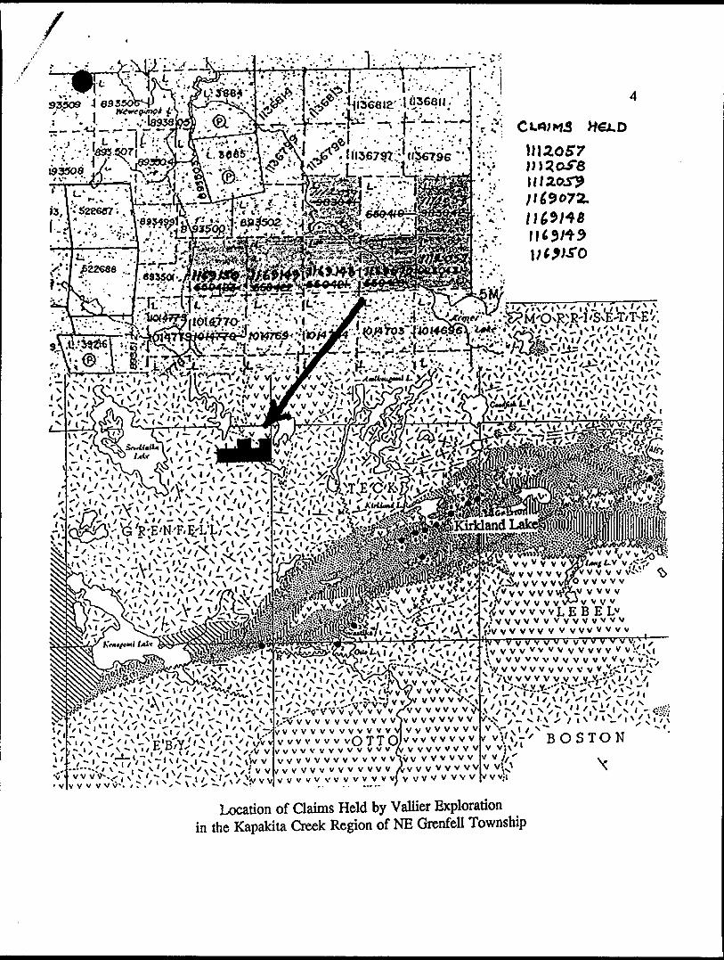
VALLIER EXPLORATION KAPAKJTA CREEK PROPERTY
1991
:LAIM NUMBERS AND LOCATIONS

10:31 521 2955 MOB l X s MCMASTER —- Canon G3 ©002/003
TWP DA/LL HC?LE VfcT
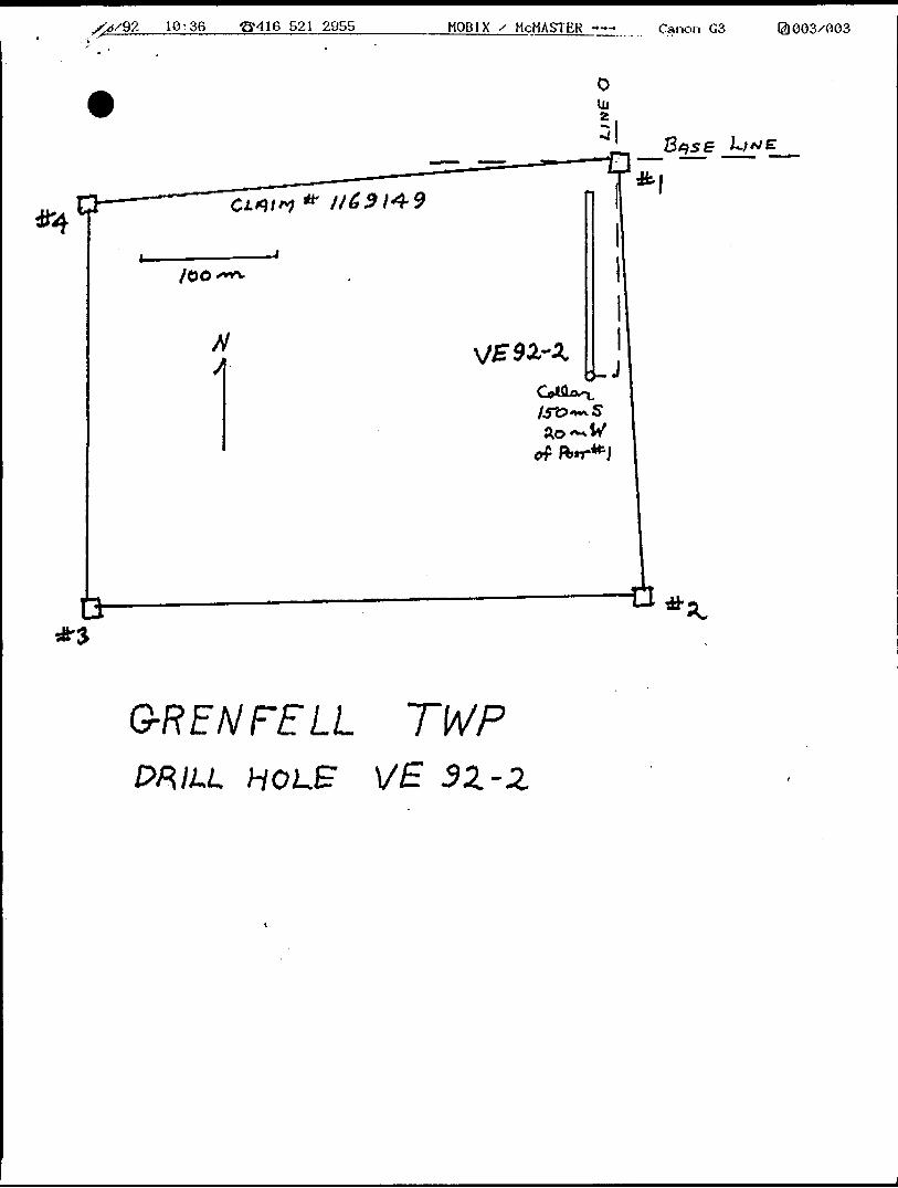
10:36 ^416 521 2955 MOB l X s MCMASTER —-* Canon G3 ©003x003
G-RENFELL TWPWILL HOLE VE 9Z-2,

1. Diamond drilling, core analysis and assay results
VE 92-1 was collared north of Kapakita creek in claim 112059 and drilled north at 45 deg to intersect three parallel east-west Maxiprobe anomalies. The geology of the drill core was determined by Dr. D. Good and the core report is appended. From its collar (line 2E, 190N) the drill passed through 300 feet of intermediate and lapilli tuff, then 120 feet of graphitic sediments followed by another 40 feet of predominately tuff. From 460 to 666 feet the material was principally basalt, pillowed with interflow breccia at 630 feet. More fragmental basalt with tuff was recorded from 666 feet to the end of the hole at 800 feet.
A possible correlation between geology and conductors is as follows. The southernmost weak anomaly which correlates with minor VLF conductor 'D', first described by Minorex and redefined by us, is associated with disseminated fracture-associated sulphides (almost exclusively pyrite) within tuff. Core samples between 40 and 300 feet of this hole remain to be assayed for possible sulphide-associated gold values.
The next Maxiprobe conductor northward is coincident with the graphitic sediments. It also coincides closely with a scarp that trends east-west across this claim. Whether this is a surface erosional feature at the boundary between the graphitic sediments and volcanics or whether it represents a fault scarp is not clear.
The northernmost, and most significant, conductor (which we call Maxi-1) is coincident with the VLF 'N' conductor and appears to be due to a zone of pyrrhotite-rich banded and disseminated sulphides in an apparent interflow zone at 630 to 640 feet down the hole.
Pyrrhotite bands were also observed in fragmental basalt between 717 and 750 feet.
ASSAY RESULTS FOR SIGNIFICANT MINERALS IN PO-RICH ZONES OF VE 92-1:
No gold values above 5 ppb, no silver values above 0.2 ppm
Sample ID Core len. As Cu Co Fe Mo Ni Rb Zn
629-632 111 cm 5.7 480 120 14.0 -2 180 46 580633-635 82cm 13.0 134 72 9.2 23 180 47 740636-638 84cm 8.7 149 83 9.0 18 180 31 680639-641 76cm 4.5 500 69 6.9 -2 190 70 1000
717-721 126cm 1.7 95 55 7.4 -2 190 140 230
743-745 55cm 2.4 92 64 9.5 -2 220 57 360
750-751 36cm 1.3 164 64 7.3 -2 260 43 340

VE 92-2 was collared south of the beaver meadow in claim 1169149 and drilled north at 50 deg to intersect conductor 'O' (Maxi-2) west of and below our previous EX drill holes. This core was read by Howard Lovell. The drill passed through flow and pillowed basalt for 136 feet and then through silica and sulphide-rich sediments for 70 feet before entering more intermixed flow, pillow and tuff to the end of the hole. Disseminated sulphides (principally po) at a number of locations near end of hole.
ASSAY RESULTS FOR SIGNIFICANT MINERALS IN PO-RICH ZONES OF VE 92-2:
No gold values above 5 ppb, no silver values above 0.2 ppm No Mo values above 2 ppm
Sample ID Core len. As Cu Co Fe Ni Rb Zn
136-140141-146146-149149-152152-154154-157
161-163165-168168-171171-173174-177178-180180-182
187-191194-195
98118102776397
63609271
1265257
6456
cmcmcmcmcmcm
cmcmcmcmcmcmcm
cmcm
4.116.016.015.027.010.0
7.97.68.37.1
10.07.58.1
10.011.0
678778907574
791047281688278
92120
50120806015069
67786668
1407066
13095
7.413.012.09.213.09.2
11.014.010.010.011.011.010.0
12.013.0
160190190180160200
130220200150220180210
260300
372320484519
253421293622
-20
-20-20
280370250360460360
360540520270530
-200250
250270
198-201 82cm 5.0 103 110 14.0 270 49 430
204 25cm 5.2 76 69 7.7 230 190 310
627-629631-633636-638639-640641-642644-645
565055423729
cmcmcmcmcmcm
4.03.47.312.08.2
11.0
1681451148278
104
817159776457
12.011.09.410.07.57.0
210160160220140190
-105061193554
300460450490240310

Ministry of Ministers duNorthern Development Developpement du Nordand Mines et des Mines
Ontario
Donation Receipt Drill Core Library
Regu de don Ge~otheque
Donated To/Beneflcialre du don Material Received From/Don repu de
KIRKLAND LAKE DRILL CORE LIBRARY P.O. BOX 129SWASTIKA, ONTARIO POK1TO (705)642-3294
Company/Entreprlse
' tZXfiL&AAddress/Adresse
tfsa /Z^c. 9 W ^
/O
Representative/Repre'sentantfe) ^o
f '
Telephone/telephone ' Ext./Poste
Type of Samples Received K^K^ZT^ Type d echantillons recus ,... 1 .. ,S^5
Ivy US ^^X*i""i^^
Hole No. Forage n*
l/g -92-2~~~-~-~~^\^
fo* Gt/y'
/209s*- S**/
If),
Submitted for Assessment' Credits Jrfn) Soumis pour
credits devaluation
(o/n)
f
^^
^^
No. oHeoxes/ Samples
Nbr* de bottes/ d'echantillons
35
~-~-~^~^*
F Jet/Metres Pieds/metres
6VJ '
^^
Delivered to Cora Library (fWt/metres)
Dellvre a la gdotheque (pieds/metres)
&Y?'
""\.^
Refused - Left on Drill Site (feet/metres)
Refuse - Ialss6 sur ('emplacement du
forage (pleds/metres)
^^
"^\^
Material Confident al Until (maximum of one year/un an maximum) Les donnees relatives aux S Echantillons doivent rester , y S J3 confidentielles Jusqu'a *^/ ' f "
Collected by DCL Staff
(feet/metres) Ramass6 par le personnel de la
gtotheque (pleds/metres)
^^'
^\
-
s
Township Canton
C^sT^/feid.
**^^^ ^.^^
"""^-^
Drill Logs/ Location Received
Journal de sondage/
relevd des emplacements
recu(s)
r/rf
' l have read and hereby agree to the above information and the terms and conditions on the reverse of this agreement and understand that l am bound by those terms.J'ai li^fc renseignements ci-dessus, et j'en atteste ('exactitude. J'ai pris cwPaissance des conditions figurant au verso du present document, et je me considere Ii6 par elles.
Signature of Representative/Signature du (de la) represents nt(e)Donated Don de
Received By Recupar
Signature of Core LlbrartPe/isonneySignature du responsable de la gdotheque
Date
Date
JAN 2 O 1993
0051 (07/92)Page/Feuillet S of/de f
;' CUWMS••V&l .^ -V--1C-.:--'',
vvvvvvvvvvvvvv J-v v v v v v v v vvvvvvvyv'vvvvvvv vvvv v v v. .
V V V V V V w V V V V v \' v lfl V W V V v V V V V V V V v V v't
'•y v v v w v v v v v v v,--.——**'
BOSTON
vvvvvvvvvvivvvvvvvv
Location of Claims Held by Vallier Exploration in the Kapakita Creek Region of NE Grenfell Township
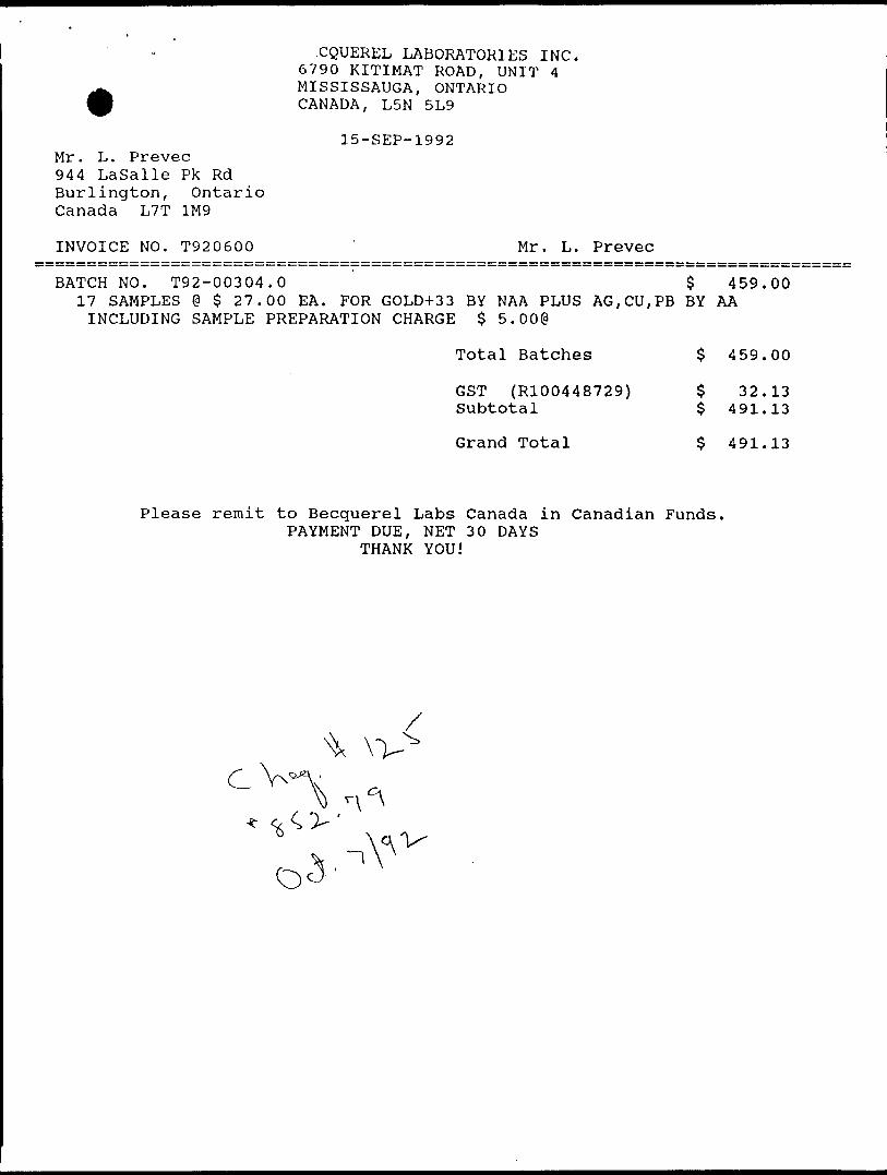
CQUEREL LABORATORIES INC. 6790 KITIMAT ROAD, UNIT 4 MISSISSAUGA, ONTARIO CANADA, L5N 5L9
15-SEP-1992 Mr. L. Prevec 944 Lasalle Pk Rd Burlington, Ontario Canada L7T 1M9
INVOICE NO. T920600 ' Mr. L. Prevec
BATCH NO. T92-00304.0 $ 459.0017 SAMPLES e $ 27.00 EA. FOR GOLD+33 BY NAA PLUS AG,CU,PB BY AAINCLUDING SAMPLE PREPARATION CHARGE $ 5.00@
Total Batches $ 459.00
GST (R100448729) $ 32.13 Subtotal ^ 491.13
Grand Total $ 491.13
Please remit to Becquerel Labs Canada in Canadian Funds. PAYMENT DUE, NET 30 DAYS
THANK YOU!
C V**

Mr. L. Prevec 944 Lasalle Pk Rd Burlington, Ontario Canada L7T 1M9
INVOICE NO. T920573
. CQUEREL LABORATORIES INC. 6790 KITIMAT ROAD, UNIT 4 MISSISSAUGA, ONTARIO CANADA, L5N 5L9
04-SEP-1992
Mr. L. Prevec
BATCH NO. T92-00289.0Analysis of 13 samples for Au+33 plus Ag,Cu by AA including sample preparation charge $ 5.000
Total Batches
GST (R100448729) Subtotal
Grand Total
338.00
$ 338.00
$ 23.66$ 361.66
S 361.66
Please remit to Becquerel Labs Canada in Canadian Funds. PAYMENT DUE, NET 30 DAYS
THANK YOU!
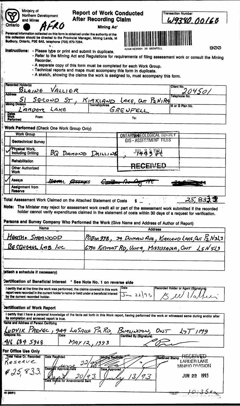
Ministry, ofNorthern Developmentand MinesAfro
Report of Work Conducted After Recording Claim
Mining Ac'
Transaction Number
Personal Information collected on this form Is obtained under the authority of the this collection should be directed to the Provincial Manager, Mining Lands, M Sudbury, Ontario, P3E 6A5, telephone (705) 670-7264.
k 111 lin l in 11 PI i B ei" *' " i"""^" ---- - f^fy\f7\ . ; 42A81NE8964 38 GRENFELL SWU3Instructions: - Please type or print and submit in duplicate.- Refer to the Mining Act and Regulations for requirements of filing assessment work or consult the Mining Recorder.- A separate copy of this form must be completed for each Work Group.- Technical reports and maps must accompany this form In duplicate.- A sketch, showing the claims the work Is assigned to, must accompany this form.
Recorded HoWerfs) i.V Client No..^ .ZO'i '5 e/Address
5\ S e- 5r , . curTelephone No.
Mining Division Township/Area M or Q Plan No.
From: To:
Work Performed (Check One Work Group Only)Work Group
Geotechnical Survey CIS -ASSESSMENT FILhS
'Physical Work, Including Drilling
RehabilitationRECEIVEDOther Authorized
Work
v/ Assays ^M^agj •"^JH B^^^T*^
Assignment from Reserve
Total Assessment Work Claimed on the Attached Statement of Costs S— -r.Note: The Minister may reject for assessment work credit all or part of the assessment work submitted if the recorded holder cannot verify expenditures claimed In the statement of costs within 30 days of a request for verification.
Persons and Survey Company Who Performed the Work (Give Name and Address of Author of Report)Name Address
. fa/two&7JO .(far*.
(attach a schedule If necessary)
Oertlficatlon of Beneficial Interest * See Note No. 1 on reverse sidel certify that at the time the work was performed, the claims covered in this work report were recorded In the current holder's name or held under a beneficial Interest by the Current recorded holder.
Date Recorded Holder or Agent (Signatur
Unification of Work Reportl Certify that l have a personal knowledge of the facts set forth in this Work report, having performed the work or witnessed same during and/or after Us completion and annexed report Is true._________________________________^^^______^____Name and Address of Pereon Certifying
t W f*No. Date Certified By (Signature)
For Office Use OnlyRECEIVED
LARDER IAKEMINING
M1 (OM1)

l
toIO
H IO
O en
10
I ir ? i li
i
k*
u*
lo bo
ed at re Date
Cred
its yo
u ar
e cla
iming
In th
is re
port
may
be
cut b
ack.
In or
der t
o m
inim
ize th
e ad
vers
e ef
fects
of s
uch
delet
ions,
pleas
e ind
icate
from
wh
ich c
laim
s yo
u wi
sh to
prio
rize
the
delet
ion o
f cre
dits.
Plea
se m
ark
(.x) o
ne o
f the
follo
wing
:1.
D C
redit
s ar
e to
be
cut b
ack
starti
ng w
ith th
e cla
im li
sted
last,
work
ing b
ackw
ards
.2.
0 C
redi
ts a
re to
be
cut b
ack
equa
lly o
ver a
ll cla
ims
cont
aine
d in
this
repo
rt of
wor
k.3.
D
Cre
dits
are
to b
e cu
t bac
k as
prlo
rlzed
on
the
atta
ched
app
endi
x.
In th
e ev
ent t
hat y
ou h
ave
not s
pecif
ied y
our c
hoice
of p
riorit
y, op
tion
one
will
be im
plem
ente
d.
Note
1:
Exam
ples
of b
enef
icial
inte
rest
are u
nrec
orde
d tra
nsfe
rs, o
ptio
n ag
reem
ents
, mem
oran
dum
of a
gree
men
ts, e
tc., w
ith re
spec
t to
the
min
ing
claim
s.
Note
2:
If wo
rk h
as b
een
perfo
rmed
on
pate
nted
or l
ease
d lan
d, p
lease
com
plet
e th
e fo
llowi
ng:
l cer
tify th
at th
e re
cord
ed h
older
had
a b
enef
icial
inter
est i
n th
e pa
tent
ed
or le
ased
land
at t
he ti
me
the w
ork
was
perfo
rmed
.Si
gnat
ure
Date
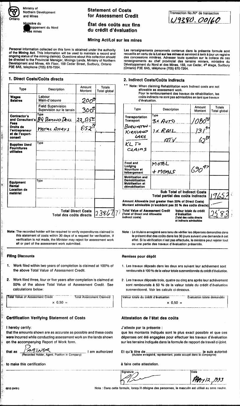
Ontario
Ministry ofNorthern Developmentand Mines
{stere duoppement du Nord
mines
Statement of Costs for Assessment CreditEtat des coQts aux fins du credit devaluation
Mining Act/Lol sur les mines
Transaction No./N 0 de transaction
Personal information collected on this form Is obtained under the authority of the Mining Act. This Information will be used to maintain a record and ongoing status of the mining claim(s). Questions about this collection should be directed to the Provincial Manager, Minings Lands, Ministry of Northern Development and Mines, 4th Floor, 159 Cedar Street, Sudbury, Ontario P3E 6A5, telephone (705) 670-7264.
Les renselgnements personnels contenus dans la presente formule sont recuelllis en vertu de la Lol sur les mines et serviront a tenir a Jour un registre des concessions mlnieres. Adresser toute quesiton sur la collece de ces renselgnements au chef provincial des terrains mlniers, minlstere du Developpement du Nord et des Mines, 159, rue Cedar, 4 e etage, Sudbury (Ontario) P3E 6A5, telephone (705) 670-7264.
1. Direct Costs/CoQts directs
Type
Wages Salalres
Contractor's and Consultant's Fees Drolts de ('entrepreneur et de ('expert- consell
Supplies Used Fournltures utllisees
Equipment Rental Location de materiel
Description
Labour Main-d'oeuvreField Supervision Supervision sur le terrain
Type ffi flan cop Zfr/U
tt6r*u tfjs4yj
Type
Type
Amount Montan!
&CP300-
^//^052*
Total Direct Costs Total des coOts directs
Totals Total global
lM7,
2. Indirect Costs/CoOts indirects* * Note: When claiming Rehabilitation work Indirect costs are not
allowable as assessment work. Pour le remboursement des travaux de rehabilitation, les coQts indirects ne sont pas admlssibles en tant que travaux d'evaluation.
Type
Transportation TransportJ3v4v*iigr**t- KUKWtt?
lAKG
AO-To CZ.Xl/^5
Food end Lodging Nourrlture et hdbergementMobilization and Demobilization Mobilisation et demobilisation
DescriptionType
Sx^e/rfc............MJfjffiUL,...™ .....
GTV
M075L*rtervs
Amount Montan)
/0&K -]3J!L
62®
Od"
Sub Total of Indirect Costs Total partlel des coOts Indirects
Amount Allowable (not greater than 20H of Direct Costs) Montan! admissible (n'excedant pas 20 W des couts directs)Total Value of Assessment Credit Valeur totale du credit [Total of Direct and Allowable d'evaluationIndirect rnstal (Total rio eofltt dlrteti
Totals Total global
\16S?.-^
ti?3•t Indirect* admissible*
Note: The recorded holder will be required to verify expenditures claimed in this statement of costs within 30 days of a request for verification. If verification is not made, the Minister may reject for assessment work all or part of the assessment work submitted.
Note : Le tilulaire enregistre sera lenu de verifier les depenses demandees dans le present etat des couts dans les 30 jours suivant une demande a cot effet. Si la verification n'est pas effectuee, le mlnlstre peut rejeter tout ou une partie des travaux devaluation presents.
Filing Discounts
1. Work filed within two years of completion is claimed at 100 07o of the above Total Value of Assessment Credit.
Remises pour depdt
1. Les travaux deposes dans les deux ans suivant leur achievement sont rembourses a 100 "/o de la valeur totale susmentionnee du credit devaluation.
2. Work filed three, four or five years after completion is claimed at 50"M) of the above Total Value of Assessment Credit. See calculations below:
Total Value of Assessment Credit Total Assessment Claimed
x 0.50 ~
2. Les travaux deposes trois, quatre ou cinq ans apres leur achievement sont rembourses a 50 0Xo de la valeur totale du credit d'evaluation susmentionne. Voir les calculs ci-dessous.
Valeur totals du credit d'evaluationx 0,50 =
Evaluation lotaie demandio
Certification Verifying Statement of Costs
J l hereby certify:that the amounts shown are as accurate as possible and these costs were incurred while conducting assessment work on the lands shown
* on the accompanying Report of Work form.
that as(Recorded Holder, Agent, Position in Company)
Attestation de I'etat des couts
J'atteste par la presente :que les montants indiques sont le plus exact possible et que ces depenses ont ete engagees pour effectuer les travaux d'evaluation sur les terrains indiques dans la formule de rapport de travail ci-joint.
l am authorized Et qu'a litre de je suis autoris6(tilulaire enregistre, representant. poste occupe dans la compagnie)
to make this certification a faire cette attestation.
0212 (04/91) Nota : Dans cette formule, lorsqu'll deslgne des personnes, le masculin est utilise au sens neutfe.