davie landfill (a/k/a: broward county solid waste disposal ... · davie landfill (a/k/a: broward...
TRANSCRIPT

DAVIE LANDFILL
(A/K/A: BROWARD COUNTY SOLID WASTE DISPOSAL FACILITY)
(DIVISION OF SOLID WASTE, NO.1)
DAVIE, BROWARD COt~TY, FLORIDA
CERCLIS NO. FLD980602288
AlJGUST 26, 1991

THE ATSDR HEALTH ASSESSNIENT: A NOTE OF EXPLANA nON
Section 104 (i) (7) (A) of the Comprehensive Environmental Response, Compensation, and Liability Act of 1980 (CERCLA), as amended, states" ... the term 'health assessment' shall include preliminary assessments of potential risks to human health posed by individual sites and facilities, based on such factors as the nature and "extent of contamination, the existence of potential pathways of human exposure (including ground or surface water contamination, air emissions, and food chain contamination), the size and potential susceptibility of the community within the likely pathways of exposure, the comparison of expected human exposure levels to the short-term and long-term health effects associated with identified hazardous substances and any available recommended exposure or tolerance limits for such hazardous substances, and the comparison of existing morbidity and mortality data on diseases that may be associated with the observed levels of exposure. The Administrator of ATSDR shall use appropriate data, risks assessments, risk evaluations and studies available from the Administrator of EPA."
In accordance wiLh the CERCLA section cited, this Heallh Assessment has been conducted using available data. Additional Heallh Assessments may be conducted for this site as more information becomes available.
The conclusions and recommendations presented in this Heallh Assessment are the result of site specific analyses and are nollo be ciled or quoted for other evaluations or Health Assessments.
Use of trade names is for identification only and does not constitute endorsement by the Public Health Service or the U.S. Department of Health and Human Services.

HEALTH ASSESSMENT
DAVIE LANDFILL
ALSO KNOWN AS THE BROWARD COUNTY DIVISION OF SOLID WASTE, NO.1,
BROWARD COUNTY LANDFILL,
DAVIE, BROWARD COUNTY, FLORIDA
CERCLIS NO. FLD980602288
Prepared by
Florida Department of Health and Rehabilitative Services
Under Cooperative Agreement with the
Agency for Toxic Substances and Disease Registry

SUMMARY
Davie Landfill, also known as the Broward County Division of Solid Waste, No.1, Broward County Landfill, is located in southwestern Broward County, Davie, Florida, on approximately 180 acres. The site was included on the U.S. Environmental Protection Agency's (EPA) National Priorities List because of high levels of cyanide detected in an on-site sludge lagoon. Subsequent testing revealed benzene in on-site borrow pits; lead, benzene, and vinyl chloride in on-site ground-water monitoring wells; and benzene and vinyl chloride in off-site ground-water monitoring wells. Vinyl chloride was detected in private potable wells south of the site. Both benzene and vinyl chloride occur off site at levels greater than EPA and Florida drinking water standards. These standards are for long-term (70 year) exposure and are intended to protect against adverse health effects, including cancer. Human exposure to vinyl chloride probably occurred in the past via inhalation of vinyl chloride volatilized from ground water used for showering or irrigation, or via ingestion of ground water. Since December 1988, municipal water has been supplied to affected residences. However, approximately 200 other residences are downgradient of the site. Based on the information reviewed, ATSDR and the State of Florida, Department of Health and Rehabili~ative Services conclude that the site is a public health hazard. It is likely that exposures to vinyl chloride and other plume contaminants via contact with offsite ground water have occurred in the past. If this site is not remediated, exposures to ground water contaminants may occur in the future at concentrations that, upon long-term exposure, could cause adverse health effects.
BACKGROUND
A. SITE DESCRIPTION
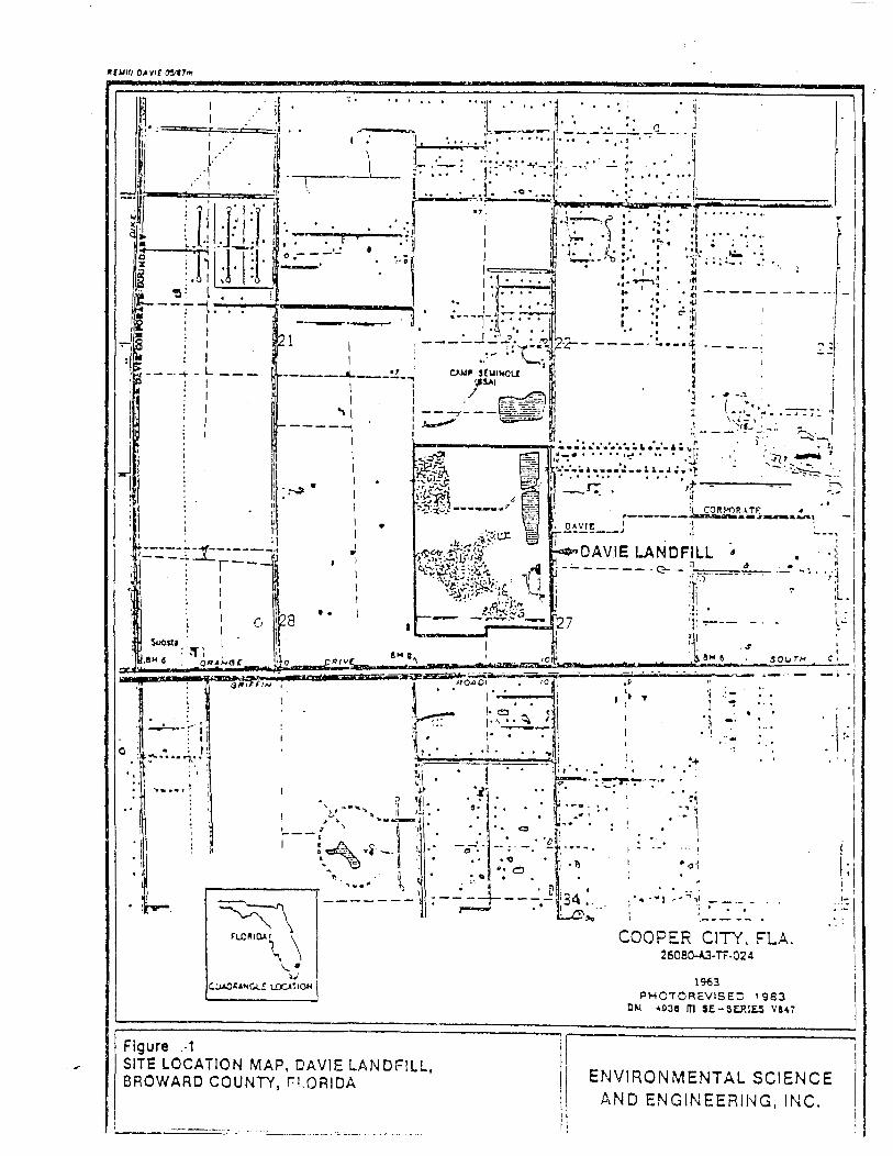
Davie Landfill, also known as the Broward County Division of Solid Waste, No.1, Broward County Landfill, occupies approximately 180 acres in southwestern Broward County, Davie, Florida. The property is located near the intersection of Orange Drive and Boy Scout Road (Figure 1). It includes a 50-acre garbage landfill, and an 80-acre trash landfill. The site is bordered on the east and west by Imagination Farms, an ongoing dairy operation; on the north by land owned and used by the local Boy Scouts, and on the south by Orange Drive which parallels the South New River Canal (C-ll Canal) (Figure 2) .
Davie Landfill began accepting refuse in 1964. Garbage was burned in an onsite incinerator. Incinerator ashes and fill were buried in an unlined landfill. In November 1971, a lagoon was created in an unlined natural depression to hold grease trap pumpage, septic tank sludge, and treated municipal sludge. In June 1975, the incinerator was closed because it exceeded Federal particulate matter emissions standards and, as a result, a plastic- and clay-lined sanitary landfill for the disposal of garbage was created. In 1975, the sludge lagoon received an estimated 2,500 tons of waste per month. Because of increased input, it became necessary in 1977 to construct dikes around two sides of the lagoon. These dikes were later raised and a concrete off-loading ramp was constructed. By 1980, the sludge volume had increased to 7,100 tons per month. On several occasions, overflow resulted in discharge to an adjacent borrow pit. Concern about spillage and the belief that sludge was leaking into the unlined landfill and ground water led Broward County to restrict the lagoon to grease trap pumpage in February 1980. All disposal at the lagoon ceased in November 1981. The trash and sanitary (garbage) landfills closed on December 31, 1987.
Sludge lagoon samples taken in conjunction with the Resource Conservation and Recovery Act (RCRA) programs in 1985 showed ground water was being recharged with levels of total cyanides and total sulfides that are of public health concern. The occurrence of these contaminants strongly suggested that industries may have improperly discharged plating wastes to septic tanks.
In September 1985, a Record of Decision (ROD) was promulgated by EPA (under CERCLA) under which Broward County initiated source control of contaminants in the sludge lagoon. By December 1989, the lagoon contents were dewatered, the sludge was stabilized with lime and the stabilized sludge was put in the lined on-site landfill. Future ROD requirements include covering this sludge with a low-permeability cap. The lagoon remediation was aided by CERCLA-related activities because of Broward County's ordinances against industrial discharges into septic tanks and the high likelihood of private industry as sources of the cyanides and sulfides.
Ground water at the landfill has been monitored since 1976. Sampling shows a plume moving generally south and southeast in the direction of regional
2

ground-water flow, although the latest results also show contaminants in the monitoring wells in the northwestern portion of the site. This plume is believed to contain leachate from the trash and garbage landfills as well as the sludge lagoon. In the past, broken piping in the landfill leachate collection system allowed leachate to enter the borrow pits via the stormwater control system. The ground water also contains contaminants not detected in the sludge.
Analytical limitations in the ground-water samples taken for Broward County prior to 1987 masked the off~site movement of vinyl chloride. Early monitoring focused only on inorganic contaminants and total organics and did not include analyses for Priority Pollutants or Hazardous Substances List chemicals. Consequently, there is no historical ground-water monitoring information on the organic chemicals of current concern.
Private well water samples from south of the South New River Canal taken in July and August 1988 revealed vinyl chloride in 14 wells. These homes were immediately supplied with bottled drinking water, and municipal service connections were provided in December 1989 to homes with contaminated wells.
A Contamination Assessment Plan (CAP) prepared for Broward County was submitted to the Department of Environmental Regulation (DER) in October 1988 to fulfill the requirements of their modified closure permit. The CAP sets a course of action to determine the source of contamination and. plume movement. Broward County and the town of Davie have agreed to convert this landfill to a 209-acre park after the landfill closure requirements of DER and all other State and Federal regulations have been satisfied.
An on-site water well that supplied incinerator operations is currently out of service. This well may be used in the future to supply toilet facilities for a park trailer. However, future use of this well could influence local ground water movement.
B. SITE VISIT
A site visit was conducted by staff from the Florida Department of Health and Rehabilitative Services (HRS) Health Office in February 1989. A follow-up site visit was conducted in December 1990 by staff from the HRS Broward County Public Health Unit. The site is surrounded on the east, west, and south boundaries by a 6-foot chain link fence with 3 strands of barbed wire at the top. A 3-strand barbed wire and wood fence (4 feet high) borders the north. Portions of the site are densely vegetated with grass and weeds. The term landfill is a misnomer at this site because trash and garbage are buried above ground due to the high water table. The waste burial area measures approximately 130 acres and is about 90 feet in elevation. As a part of the closure requirement, the burial area was capped with clay and covered with limestone gravel, resulting in a large, white, man-made hill that is visible for several miles. Methane vents have been installed in the landfill.
Although the landfill is closed, the site is accessed daily by tanker trucks that remove leachate. A guard is present at the gate while the gate is open.
3
C. DEMOGRAPHICS, LAND USE, AND NATURAL RESOURCE USE
The site is located in the rapidly growing town of Davie, which nearly quadrupled in population from 1970 to 1980, increasing from 5,800 to 20,877. Property surrounding the site is located above the flood plain and is normally not a wetlands area.
There are 5 homes within 500 feet of the site and approximately 100 within roughly 0.5 mile. Many of the homes in the vicinity are south of the site. In the past, water for residents south of the site had been supplied by private wells, with the nearest well located approximately 1,700 feet from the site. In November and December 1989, municipal water service was supplied to the area affected by the migrating ground water contamination plume. Those residents who have been supplied municipal water allow county health officials to continue to monitor their wells to aid in tracking the movement of the ground water plume; for this reason, the wells have not been grouted in accordance with proper abandonment procedures, although they are no longer using these wells. Local ground water has high turbidity; therefore, some of the area residents who have not been supplied with municipal water choose to use bottled water for drinking, but the majority use well water for cooking, bathing, and irrigation.
The land north of the site is a forested Boy Scout camp. The source of water for the Boy Scout camp is a well located approximately 300 feet north of the ground water monitoring wells at the northwestern portion of the site. The latest confirmatory data (June 25, 1990) show no contaminants in these northwestern monitoring wells. The Boy Scout well is periodically sampled by the HRS Broward County Public Health Unit.
The areas east and west of the site are pasture for dairy cattle. The dairy uses shallow wells for livestock water. These wells have been tested and were found to be contaminated with nitrates which are attributed to the dairy farm. The source of water in ditches on the dairy farm is surface water runoff. Some of this runoff water may originate on the landfill site.
COMMUNITY HEALTH CONCERNS
Users of wells found to contain low levels of vinyl chloride are concerned they may experience adverse health effects from inhalation and ingestion of ground-water contaminants. Although the duration of this exposure is not known, the houses with affected wells are new: at the time of contamination discovery, they were 3 years old. The age of the homes and ground water modeling bracket exposure time to less than 3 years, and less than 6 months, respectively. The July and August 1989 contaminant levels are expected to represent the maximum exposure levels because contaminant concentration levels are generally lower at the edge of the plume. These ground-water sample data indicate inhalation and ingestion exposures likely involved concentrations of vinyl chloride, as the maximum off-site vinyl chloride level measured was 5.4 parts per billion.
4
Members of the community, owners of the adjacent land and other persons representing governmental or private agencies with substantial interests in this site are on the Florida Department of Environmental Regulation Southeast District's mailing list for written communication that concerns the site. Readers of this health assessment may also make inquires for the purposes of joining this mailing list to:
Joe Lurix/Environmental Specialist Department of Environmental Regulation, Southeast District 1900 South Congress Avenue, Suite A West Palm Beach, Florida 33406
ENVIRONMENTAL CONTAMINATION AND OTHER HAZARDS
To identify possible facilities that could contribute to the ground water, surface water, soil, and air contamination near the Davie Landfill site, Florida HRS staff searched the 1987, 1988, and 1989 Toxic Release Inventory (TRI). TRI is developed by the u.S. Environmental Protection Agency (EPA) from chemical release information provided by certain industries. TRI did not contain information on the release of any site-related chemicals within the zip code area of the Davie Landfill site.
A. ON-SITE CONTAMINATION
Ground water monitoring was, and continues to be, carried out to fulfill the requirements of operation and closure permits. Soil and air contamination have not been addressed. Sludge and surface water sampling data from the Broward County Landfill Sludge Lagoon Closure, (Hazen and Sawyer, April 1985); ground-water sampling data from the Hydrologic Report for the Closure of the Broward County Landfill and Sludge Lagoon (Post et al., 1988), and the analytic results for ground-water samples taken April 4, 1990, by International Environmental Services, Inc. (IES) for Broward County's Office of Environmental Services were used to compile the following table. In the table, the dates following the contaminants correspond to the date on one of these three reports.
MEDIA
Ground Water
Borrow Pit Water
Sludge
ON-SITE CONTAMINATION
CONTAMINANT, DATE
Lead, 1988 Benzene, 1988 Vinyl Chloride, 1990
Benzene, 1985
Cyanide, 1985
BDL - Below Detection Limits
5
RANGE (UNIT)
BDL - 33.0 ug/L BDL - 2.0 ug/L BDL - 14.0 ug/L
BDL - 3.0 ug/L
BDL- 303.0 mg/kg

The CAP and Contamination Assessment Report (CAR), required of Broward County by DER as a part of their modified closure permit, should better delineate the plume and contaminants within the plume. Samples taken for the CAR will be analyzed for the 129 Priority Pollutants. In addition to better delineation of the ground water plume, surface water on-site and surface water run-off which flows into the adjacent ditches need to be characterized. Pending the use of the former incineration water supply well as a toilet water source, this well should be sampled, at least for the presence of volatile compounds.
B. OFF-SITE CONTAMINATION
Regional surface water sampling of the surrounding canals has been carried out by the United States Geologic Survey (USGS) since the 1940s, although sampling was primarily for inorganic chemicals. Samples (1970s) from the New South River Canal (C-ll Canal) taken about one half-mile downstream from the point where the canal flows parallel to the southern boundary of the landfill revealed chromium, arsenic, and lead at levels of health concern. These compounds and their analytic levels are listed in the following table. Canal water contaminants may not be related to the landfill because most of these chemicals were not detected at levels of concern in on-site monitoring wells or in on-site surface water, and were also detected upstream of the landfill.
Off-site ground-water monitoring consisted of analyses of private potable well water and water taken from monitoring wells installed to fulfill the modified requirements of the Solid Waste Closure Permit. Samples taken in April 1990 by IES for Broward County's Office of Environmental Services are also reported below. These latest data indicate that contaminants are present off site, both to the southeast and the southwest. On-site wells in the northwestern portion of the site also contain vinyl chloride, indicating ground-water mounding may be occurring in the northwestern portion of the site. Additional off-site monitoring wells will be necessary to adequately address movement of contaminants from the northwestern portion of the site.
In the past, the owners of Imagination Farms Dairy had attributed cow deaths to the influence of contaminants from the site. Dairy wells were analyzed for contaminants but only elevated levels of nitrates were found. These nitrates were attributed to manure wastes. Milk samples analyzed for heavy metals and pesticide residues performed by the Department of Agriculture and. Consumers Services (DACS) did not identify contaminants in milk at levels of potential health concern for humans. The animal deaths were attributed to poor agricultural practices by DACS investigating personnel (Inman, 1990, personal communication).
The dates following the contaminants indicate either.USGS (1970) data or IES (1990) data as the source.
It is not known if soil and air contamination are a problem on the site as they were not sampled on-site; these media were not addressed in off-site sampling.
6

MEDIA
Ground Water
Canal (Surface Water)
OFF-SITE CONTAMINATION
CONTAMINANT, DATE
Benzene, 1990 Vinyl Chloride, 1990
Chromium, 1970 Arsenic, 1970 Lead; 1970
BDL - Below Detection Limits
RANGE (UNIT)
BDL- 44.0 ug/L BDL- 22.0 ug/L
BDL- 10.0 mg/L BDL- 30.0 mg/L BDL- 67.0 mg/L
The CAP and CAR, required of Broward County by DER as a part of their modified closure permit, should better delineate the plume and contaminants within the plume off site as well as on site. Overseers of the trust for the adjacent property, Imagination Farms, employed Dames & Moore to perform ground water monitoring on their property. After reviewing Broward County's draft CAP, a Dames & Moore representative revealed that testing of the dairy's own monitoring wells had "detected hazardous compounds that are not proposed for testing in the CAP." These contaminants include organic phosphorus pesticides, chlorinated benzenes, volatile organic compounds, plasticizers, polynuclear aromatic hydrocarbons, and cyanide. No concentration levels were reported for any of these contaminants.
The surface water on the Imagination Farms property has been tested to assess the presence of contaminants which may bioaccumulate in milk, and no contaminants attributable to the landfill were identified.
C. QUALITY ASSURANCE AND QUALITY CONTROL
The conclusions presented in this health assessment are based on surface water, ground water and sludge data from various sets of samples submitted in compliance with Broward County's operating and closure permits, by Post et al. (1988). These data cannot be evaluated for accuracy because QA/QC information was unavailable.
D. PHYSICAL AND OT~ER HAZARDS
Site access is currently restricted to all but official business. During working hours, a guard is present to admit tanker trucks which remove leachate on a daily basis. Because a guard and tanker truck drivers are present on the site, it is improbable that children from surrounding residences or the Boy Scout camp could enter the site unseen during the day.
Methane vents are present in the buried waste vault. However, the potential remains for a methane explosion when subsurface work is carried out on site. In addition to being a hazard for subsurface work, methane may also collect in any enclosed structures that are built as a part of the future park facilities.
7

PATHUAYS ANALYSES
A. ENVIRONMENTAL PATHUAYS (FATE AND TRANSPORT)
Environmental pathways of primary concern are those that allow movement of contaminants off site and potentially expose greater numbers of people. Pathways include ground water, soil, sediments, surface water, biota, and air. Only ground water, borrow pit surface water, and sludge from the now defunct sludge ponds have been sampled. Therefore, routes of transport other than ground water and borrow pit water cannot be addressed here as environmental pathways but cannot be ruled out from further consideration.
Surface water and Sediments
A grassed perimeter swale is located between the edge of the elevated part of the landfill and the access road to prevent on-site runoff from impacting offsite areas. Surface water and sediments in these impoundment areas may contain contaminants because sludge overflow and landfill leachate are reported to have entered the borrow pits via the storm water control system and may also have entered the swale. DER has also reported leachates flowing off-site via the storm water control system. Other features that are part of the site surface hydrology are canals located north, east, and south of the site that provide drainage from the whole site. These canals act as both flood control and ground water recharge. Sediments and surface waters from these features, with the exception of surface water from the borrow pits and the New River Canal, have not been analyzed; and consequently cannot be addressed here, but are not eliminated from future consideration.
Lead, chromium, and arsenic found in the South Canal may bioaccumulate in fish and could result in a source of human exposure. Because elevated levels of chromium and arsenic have not been linked with the ground water plume associated with the site, and because all these contaminants have been found in the canal at elevated levels upstream from the site, the sources of these contaminants may include areas other than the site.
Ground Water
The drinking water aquifer contaminated by past disposal practices at Davie Landfill is the Biscayne Aquifer. The Biscayne Aquifer is the primary drinking water source for southeastern Florida. It originates at the water table, which is within a few feet of the natural land surface, and continues to a depth of 80 to 100 feet. The Biscayne Aquifer is primarily composed of highly porous and permeable limestone which allows for fairly rapid plume movement.
Information from ground-water monitoring wells indicates a southward flow of contaminants from Davie Landfill toward residential wells south of the South New River Canal. The residential wells also tap the Biscayne Aquifer.
8

Although the hydrologic connection between the site and contaminated potable wells to the south has been contested by the county, sampling and analyses of the residential wells indicate contamination by vinyl chloride in 14 wells. In addition, the transmissivity and permeability of the aquifer indicate a probable ground-water connection between the two areas.
The South New River Canal cuts into the limestone of the Biscayne Aquifer, providing a direct hydraulic connection between the aquifer and the canal. Seasonal changes in the water level of the canal have a direct effect on the local water table gradient and movement of contaminants.
Because surface water and sediments that move off site have not been sampled and analyzed, contaminated grass and sediments in the adjacent ditches represent potential sources of contamination for the cows living near the site.
C. HUMAN EXPOSURE PATHWAYS
Exposure to Ground Yater
The most probable routes for exposure to site-related contaminants involve ingestion and inhalation of vinyl chloride and benzene present in or vaporized from off-site ground water. Lead has not been confirmed in the off-site ground water monitoring wells at health concern levels but'may present a future concern. Dermal absorption is not a pathway of concern for vinyl chloride or lead exposure from ground water, although it could be for benzene.
The actual doses of vinyl chloride received by private well users via inhalation and ingestion have not been addressed. Although exposure via inhalation is not remedied by replacing contaminated drinking water with bottled water because vinyl chloride could be volatilized from shower or bath water or other such exposures, the levels of vinyl chloride to which the users of contaminated wells were exposed would likely have been small. A low level estimate is based on the highest level found in ground water off site at the time affected wells were identified, which was less than 6 parts per billion. According to the Department of Environmental Regulation remediation manager, users of affected wells have been supplied municipal water. Continued periodic ground-water sampling carried out by two county agencies should provide an early warning of potential exposure to residents in the path of the migrating plume. In the future, the off-site ground-water plume may also contain lead and benzene as these contaminants continue to move off site.
Exposure to Surface Yater and Sediments
Ingestion of contaminants from affected surface water and sediments could be an indirect pathway for humans if contaminants are concentrated in dairy cattle, fish or frogs. In the past, milk samples analyzed for heavy metals and pesticide residues performed by the Department of Agriculture and
9

Consumers Services (DACS) did not identify contaminants in milk at levels of potential health concern for humans, ruling out contaminated milk as an exposure pathway. Assessment of the surface water's contribution to biological concentration is difficult at this time because no surface water drainage samples (neither water samples nor sediment samples) from site drainage ways have been collected that could verify that contaminants are leaving the site at levels that could result in elevated biological concentrations.
Factors confounding linkage of site contaminants to surface water contamination are the existence of metals in the off-site surface water (arsenic and chromium) that have not been identified as contaminants of concern on the site, and the occurrence of water quality degradation both upstream and downstream from the site. United States Geological Survey data collected since the 1930s indicate a trend of surface water quality degradation in the canal south of the site (and for other similar canals throughout the county) that can be related to increased development and changes in back-pumping practices. The contaminants listed in the off-site contamination section (found in the canal downstream of the site), arsenic, chromium, and lead, are also found in samples several miles upstream of the site at the same or similar levels (Sonntag, 1980). No data on the concentrations of these metals in fish or other aquatic life from the New South River Canal (C-ll Canal) have been collected.
These surface water drainage canals have steep, heavily vegetated banks and are not used for swimming or recreational boating purposes.
Surface water dermal exposure or ingestion of food contaminated by way of surface water cannot be ruled out; however, the public health implications of these exposure routes cannot be assessed because there are no known exposures, and biological concentration of contaminants has not been verified. These same points can be made for sediments, although, as stated above, no sediments have been analyzed.
Exposure to Air
Air quality on and off site have not been addressed. It is unlikely that particulates will leave the site because the landfill closure called for the installation of a clay cap. Methane vents in the landfill were' operating at the time of the site visit. Inhalation exposure to contaminants cannot be ruled out; again, however, the public health implications of this exposure route cannot be assessed because there are no known exposures or exposure levels.
PUBLIC HEALTH IMPLICATIONS
Contaminants at levels of concern for health include vinyl chloride and benzene in off-site ground water. Human exposure to either contaminant has not been documented, although residents south of the site may have been exposed to vinyl chloride from contaminated water for a year before their homes were placed on city water. This time period is estimated from the time frame calculated for plume movement by Camp, Dresser, and McKee in 1981. A
10

l-year estimate includes 6 months exposure via ingestion and inhalation based on the plume movement model, and 6 months of only inhalation exposure while the residents were using bottled water. Volatilization of vinyl chloride from ground water during showering and bathing and other water use activities would probably have resulted in very low levels in the air but are considered here for completeness.
Because the contamination plume will spread with the flow of ground water, human exposure could occur in the future. Frequent monitoring of private wells in the area of the plume should provide an early warning of the contamination of any additional wells. As the plume migrates, the number of chemicals of concern may increase since the trash landfill is in direct contact with the aquifer.
Human exposure to levels of vinyl chloride and benzene similar to the low levels which may have resulted from use of contaminated off-site ground water has not been studied. However, vinyl chloride and benzene minimal risk levels, which are based on currently available human data, are greater than the highest levels detected in ground water off site. Therefore, harmful noncancer effects from exposure to vinyl chloride and benzene are not expected of occur (ATSDR, 1989). At high exposure concentrations in humans, benzene has been linked to cancer of the tissues that form white blood cells (leukemia), and vinyl chloride has been implicated in the occurrence of liver cancer. Because of the links between these chemicals and'cancer, Florida has set a drinking water standard of 1 microgram per liter (ug/L or part per billion) for benzene and for vinyl chloride to protect against adverse health effects including cancer. We believe that the chance of excess cancer cases, as a result of lifetime consumption of water contaminated at these levels, will be very small.
CONCLUSIONS AND RECOMMENDATIONS
Based on available information this site is a public health hazard. It is likely that exposures to vinyl chloride and other plume contaminants via contact with off-site ground water have occurred in the past. If this site is not remediated, exposures to ground-water contaminants may occur in the future at concentrations. that, upon long-term exposure, could cause adverse health effects.
As noted in the Human Exposure Pathways section above, exposure to vinyl chloride may occur off site via inhalation of volatilized vinyl chloride present in potable well water or ingestion of ground water. Exposure to lead or benzene may also occur via ingestion or dermal absorption of ground water as these contaminants migrate off site. Soil, surface water, and possibly air contamination have not been adequately characterized by contaminant data gathered to date. Therefore, these media remain potential pathways for human exposure. Future contaminants may include leachate from the material buried in the unlined trash landfill which also rests immediately above the highly transmissive, sole-source aquifer.
11
Ground water appears to be the primary environmental pathway for migration of contaminants off site. The hydrologic connection between the site and contaminated potable wells to the west has been contested by the county, although the transmissivity and permeability of the aquifer indicate a probable connection between ground water in the two areas. Data from on-site monitoring wells and off-site private potable wells suggest that contaminants from the site have entered the Biscayne Aquifer, and plume measurement and modeling (Camp, Dresser & McKee, 1981) indicate that contaminants may have been present in the private potable well six months before vinyl chloride was detected. In addition, on-site wells in the northwestern portion of the site also contain vinyl chloride, indicating ground-water mounding may be occurring in the northwestern portion of the site.
As mentioned in the Physical and Other Hazards Section, methane vents are present in the buried waste vault. Although it is unlikely that methane will escape from other areas of the vault, future park-related buildings may concentrate methane gases if they are enclosed. Pending the use of the former incineration water supply well as a toilet water source, this well should be sampled, at least for the presence of volatile compounds.
The following actions are recommended to protect public health from potential risk resulting from exposure to hazardous substances present at the Davie Landfill site.
1. The off-site ground water, specifically private potable wells south of those wells already known to be contaminated, should continue to be regularly monitored. Ground-water samples should be analyzed for a greater number of chemicals, including pesticides and polynuclear aromatic hydrocarbons.
2. Surface water (including the borrow pit lakes on site and the New River Canal (C-ll Canal) and drainage ditches on the dairy farm off site) should continue to be regularly monitored for target list compounds.
3. As part of contamination plume delineation, on-site surface water and soil erosion patterns should be determined. Surface water and soil samples should be monitored off site if it appears that this site drains into areas where dairy cows may be exposed to contaminated water. Offsite monitoring may need to include a survey of the type' of edible fauna (fish and amphibians) or flora in the area of the site, determine if these are actually consumed, and analyses of those portions of the organisms that are consumed.
4. No drinking water wells should be installed on site or in the path of the contamination plume (still to be delineated) because they may be in the path of the plume.
5. Additional off-site monitoring wells will be necessary to adequately address movement of contaminants from the northwestern portion of the
site.
12

6. To assure that methane does not collect in future buildings, proper foundation ventilation will be essential. Pending the use of the former incineration water supply well as a toilet water source, this well should be sampled, at least for the presence of volatile compounds.
7. In accordance with the Comprehensive Environmental Response, Compensation, and Liability Act (CERCLA), as amended, the Davie Landfill site has been evaluated for appropriate follow-up health activities. This site is not being considered for follow-up activities at this time. However, if data become available suggesting that human exposure to hazardous substances at levels of public health concern is currently occurring or has occurred in the past, ATSDR will reevaluate this site for health follow-up activities.
8. When indicated by public health needs, and as resources permit, the evaluation of additional relevant health outcome data and community health concerns, if available, is recommended.
13
PREPARERS OF REPORT
Connie Garrett, M.S. Environmental Specialist
Florida Department of Health and Rehabilitative Services Office of Toxicology and Hazard Assessment
Randy Merchant, M.S. Biological Administrator III
Florida Department of Health and Rehabilitative Services Office of Toxicology and Hazard Assessment
ATSDR REGIONAL REPRESENTATIVE
Chuck V. Pietrosewicz Regional Operations
Office of the Assistant Administrator, ATSDR
ATSDR TECHNICAL PROJECT OFFICER
Richard Gillig Environmental Health Scientist Division of Health Assessment
and Consultation, Remedial Programs Branch
14
CERTIFICATION
This Health Assessment was prepared by the Florida Department of Health and Rehabilitative Services under a cooperative agreement with the Agency for Toxic Substances and Disease Registry (ATSDR). It is in accordance with approved methodology and procedures existing at the time the health assessment was initiated.
Technica SPS, RPB, DHAC
The Division of Health Assessment and Consultation, ATSDR, has reviewed this health assessment and concurs with its findings.
L4 G.~ ~ RcLJ Director, DHAC, A DR
15

REFERENCES
American Conference of Government Industrial Hygienists (ACGIH), 1980. Documentation of the Threshold Limit Values, 4th edition. American Conference of Government Industrial Hygienists. Cincinnati, Ohio.
Agency for Toxic Substances and Disease Registry, 1988A. Health Assessment Format, Guidelines, and Methodology, U.S. Public Health Service. Atlanta, Georgia.
ATSDR, Toxicological Profile for Benzene, ATSDR/TP-88/03, May 1989.
ATSDR, Toxicological Profile for Cyanide, ATSDR/TP-88/l2, December 1989.
ATSDR, Toxicological Profile for Vinyl Chloride, ATSDR/TP-88/25, August 1989.
Bellinger, D. et al., 1987. Longitudinal Analyses of Prenatal and Postnatal Lead Exposure and Early Cognitive Development, New England Journal of Medicine. 316:1037-1043.
Camp Dresser & McKee, Inc., 1981. Hydrogeologic Analysis at the Davie Landfill, Ft. Lauderdale, Florida.
Centers for Disease Control (CDC), 1985. Preventing Lead Poisoning in Young Children,U.S. Department of Health and Human Services. Atlanta, Georgia.
Dames and Moore, 1988. Letter; Subject: Review of Cap for the Broward County landfill, for ArneriFirst Development Corporation, Michael E. Glowacz.
Hammond, P.B. and R.P. Beliles, 1980. Metals. in Casarett and Doull's Toxicology, 2nd edition J. Doull, C.D. Klaassen, and M.O. Amdur, eds. MacMillan Publishing Company, Inc. New York.
Hazen & Sawyer, P.C., 1984. Broward County Landfill Sludge Lagoon Closure. Hollywood, Florida.
International Agency of Research on Cancer (IARC) , 1982: Evaluation of the Carcinogenic Risk of Chemicals to Humans, Supplement 4.
International Environmental Services, Inc. (IES), 1990. Contract laboratory for water quality monitoring work for Broward County's Landfills; Results for water samples collected by IES in April 1990.
Meyer, F.W., 1972. Preliminary Evaluation of Infiltration from the Miami Canal to Well Fields in the Miami Springs-Hialeah Area, Dade County, Florida, United States Geological Survey, Open File Report, 72-027, Tallahassee, Florida.
Post, Buckley, Schuh & Jernigan, Inc., 1988. Broward County Landfill, Davie, Florida, Hollywood, Florida.
16

Post, Buckley, Schuh & Jernigan, Inc., 1988. Hydrologic Report for the Closure of the Broward County Landfill and Sludge Lagoon, Hollywood, Florida.
Sonntag, W.H., 1980. Water Quality Data for Canals in Eastern Broward County, Florida, 1975-78 United States Geological Survey, Open File Report 80-68, Tallahassee, Florida.
Waller, B.G., 1978. Effects of Land Use and Water Management on Water Quality in the Western South New River Canal Basin, Southeast Florida 1974-75 United States Geological Survey, Water Resources Investigations 78-30, Tallahassee, Florida.
Waller, B.G., W.L. Miller, and T.R. Beaven, 1976. Water Quality Data for Canals in Eastern Broward County, Florida, 1969-1974. United States Geological Survey, Open-File Report 75-009, Tallahassee, Florida.
17
~UI/JI OA VIE ~7 ...
~ I .. ' i l~' '. :. (1 J, 1 ~ . . . ... . "r .' '. "1 .. ... ; ~: /.
::';==' ~~= .. ~=': ~~--:!' ir'~~r;.-::-.-·:-::-''':'''·-:-<--·-'i I' I I ( ••.• : .. :~:: .......... :I!~ _ .. , ~: .... ' . [ ·r ~\--,--j -- r~~: . rc,-,.,~;~.:" .~: .:.:.... I
I =~ ; I': I J: 1;'1' i "r~~;: 'Q'"'~'I~\' :'~, ,;;'; " 'iil'.:~ ~: :.:: ~ - ·[l \( . : I., I - i w ,i/ I . r.-- .1" ..... , • . . . a~ ; ~;:: ,t'~1 [:I:-"j ',:'1". I'. ~o ,'- -.-' ._,ff .' ~ • J: . Ii.'· ' .• . to:- •• • •• , I ~-;'b :., ,: .~; ;!;-. ,.... r
tlO • .," • * . 1-:-;-. . • +~ of!
~ . I : ••• , I !,.: : !l I' c· . . .,'. ' .. ---------.- -! "!'l: l.. ' '. '" " ....... ';"\1 I
r--~,' -11....;· -. ';'.-~-----"'-I. :·--+F·-; ~ ;.: . ::1 ---~', '~'t" .t.1 ~I
I, -. '.' 121 ~.J ~ ....:', . ~ L-,'2- - - - - -. !.. _ .!f ____ . _. ':' : I --- "'C·-:f >I __ -~ . I .- ',' • I
• 0 f': . I ,. "1 d • ~ : I ..., CM/" shliHOU J
::; - - -. ~ - L - - - ----------.., \"AI •
0
P ! I ,0 / '4 ._.~
: ,I ,,'I !,-~--:i:..--_ j (~~.~"r' ... ~;: ~. - - ~~~¥_\~.-... -" \- -----1, I . i " ~':--;" I
• ', •.•••• 10 '. " ,or. . • I -- •••••••••• -. "1J.i :'7(''-' :
. '~ . I
" Ii
j I' · ;1
':'-':::--Fi~-:.-- :r~ ,
I ~.:;f'?, 1__ ,:-:- ... ".:"!"' ., '.' ~ - '- .. ::..~ . .,. _ .... J"'~ _~ ~._ •• ':." .... __ •• , •• .& .... ,!: _-I -fr.,. ~-=' . . . ." ,. . t _ _ . ;.-...,
~i _____ ~?61·;/ . --r.: . ______ ~L~~~\l~.~~·:·· _ ~ ,D.~V'r:' I ___ .
:-:'I;J: . rr-------~ .'. : I .. u;~~:!.-:-· . ~DAVIE LANDFILL; .·i I
1 . I I I • I I
" i )"'>~'§lfJ~ " " -. 'I I ~~t!i!d~?g~\.. '~{~l . -:... - - - - - . C?- - ;~:") .• -~ .-~ ~" 'i ~ I 'S~: "~·}<2.>t;;t I . . . . ,L •
1..;.J.~j;-;~ Hi '~?- j : I I .
I I
t : I m " .,
:
.' .,
· , I 1
(, fa •• wcsu.,:'\", i "
,a .. d ., O"U;"'(JC~ ~o J)RIVC.
, . j. -.!---:-"
: .1 . ; , ~ :- •••• '1-: ' ,
.... -... , !
I I .... e,5g~ . :.1: ~-- -. . l': I t--- ~.,. .. ~ 27 ,I' •
I ..".--~.. I~ ~:Il. 3 :
I ,. "~e"6 SOur ... C. e .. 0,,\ ' 101'.
.9 t
I ,t ,.
,
" ~ j
'J 0
~
-~ . _.
.. -;.
,-.. ..
, '"
. . :1 .\:. : . i
.. ,
, .\ .1 ,
FIgure .·1 SITE LOCATION MAP, DAVIE LANDFILL, BROWARD COUNTY, rtoRIDA
!~---==--=--='-::"'..:.' ....:....:~ .. '------- "-- -- .- ----.
1%3 PHOTOFIEVIS EO , 983
O~ ~03e m Sf-SERl~ Vh7
'I \
1/ E~J~lRON MENTAL SCIENCE
II AND ENGINEERING, INC. I I.

....
00 y ~ COtri C..l1J P
~ JJi.!J Ct)lJ.rr1' ~I UR'Y l....UO'1l..L Cn.l...!IH:S
~'E!C::!~1 ~ PIT ·6.S- ,I ' ___ ~_1
---- __ :::J
I I
----~
FIGURE 2
o rJ(f
Mal a:.a.u.: r • «lO'
II--QJIlAL
SLUDGE LAGOON LOCATION ·8ROWARD COUNTY LANDFILL
..-~----- .. ---~,---~.-.,---------------------
-19-