datr – towards e-land administration in hungary · 2010-11-10 · datr – towards e-land...
TRANSCRIPT

TS 2H – e-Land Administration Projects Gyula IVÁN, Gábor SZABÓ, Zoltán WENINGER, HUNGARY DATR – Towards e-Land Administration in Hungary (4186) FIG Congress 2010 Facing the Challenges – Building the Capacity Sydney, Australia, 11-16 April 2010
1/14
DATR – Towards e-Land Administration in Hungary
Gyula IVÁN, Gábor SZABÓ, Zoltán WENINGER, Piroska ZALABA, HUNGARY
Key words: Land Registry, Cadastre, Land Administration, GIS SUMMARY DATR has been the most important development in the last years in Hungarian Land Administration. The system provides a real, integrated information system for the Unified Land Registry. Implementation of the system will be finished by the end of 2009 in all 120 District Land Offices of the countryside of Hungary. DATR is also the base of TAKARNET24 project, which provides 24 hours land registry services on Internet for users, who register themselves at governmental portal. The project will be finished in September 2010. This project — which solves identification of users, on-line payment etc. — is the first step in the implementation of Digital Land Office concept. Digital Land Office concept realizes a full e-Land Administration, including on-line data services, case administration, payment. DATR approach from informatics point of view is a very flexible solution, which easy customizable for any land administration system. Therefore FÖMI has decided the implementation of an international version of DATR. In the paper the present situation, the way of further development of the system and the characteristics of the new international version and its relations will be presented,

TS 2H – e-Land Administration Projects Gyula IVÁN, Gábor SZABÓ, Zoltán WENINGER, HUNGARY DATR – Towards e-Land Administration in Hungary (4186) FIG Congress 2010 Facing the Challenges – Building the Capacity Sydney, Australia, 11-16 April 2010
2/14
DATR – Towards e-Land Administration in Hungary
Gyula IVÁN, Gábor SZABÓ, Zoltán WENINGER, Piroska ZALABA, HUNGARY 1. INTRODUCTION DATR was the most important development in the last years in Hungarian Land Administration. The system provides a real, integrated information system for the Unified Land Registry. Implementation of the system will be finished by the end of 2009 in all 120 District Land Offices of the countryside of Hungary. Today this system is operating in the countryside Land Offices. The Land Offices of the Capital (Budapest) are using a different, not fully integrated IT system. The legal side of the system (BIIR-Budapest Land Registry Information System) is very similar to the countryside one, but the map management part was solved by AutoDesk TopoBase. All the actors of the Hungarian Land Administration sector (Ministry of Agriculture and Rural Development, Land Office Network and Institute of Geodesy, Cartography and Remote Sensing (FÖMI)) are connected via TAKARNET network (Figure 1), which provides on-line access to any information stored in Land Offices’ databases and electronic communication among organizations.
Figure 1.: Physical structure of TAKARNET network

TS 2H – e-Land Administration Projects Gyula IVÁN, Gábor SZABÓ, Zoltán WENINGER, HUNGARY DATR – Towards e-Land Administration in Hungary (4186) FIG Congress 2010 Facing the Challenges – Building the Capacity Sydney, Australia, 11-16 April 2010
3/14
During the last years a long-term (5-8 years) strategic development concept of the Hungarian Land Administration sector has been established, called “Digital Land Office”. The main goals of “Digital Land Office” are:
− Improve land registry services via Internet for wide-range of users, − Rationalization of resource requirements of operation.
In the last year the first project of the concept began (TAKARNET24), financed by domestic and EU funds. In this paper DATR system, TAKARNET network and Digital Land Office concept is introduced, achieved results and future development solutions is presented. 2. DATR, THE INTEGRATED IT SYSTEM OF LAND OFFICES DATR is an integrated IT system in the Unified Hungarian Land Registry, which provides an authentic change management and data service both the legal and geometric (cadastral map) part of the Unified Land Registry. Main characteristics of the system are:
− Full integration of legal and geometric part of the Unified Land Registry, − Its solutions based on the Digital Base Map Hungarian Standard (MSZ 7772-1), − Enforcing integrity of the two parts, − Easy-customizable user interface, − Open Application Programming Interfaces (APIs), − Modular, self calibrating architecture (no client side configuration is necessary), − Easy expandable (uniform calling interface and protocol).
The system is working under Microsoft Windows operation system (NT 4 or XP Professional), and using ORACLE RDBMS. DATR was installed in 120 countryside Land Offices of Hungary during the last year (2009). The full operation of the system started at the beginning of 2010. DATR is the own development of the Institute of Geodesy, Cartography and Remote Sensing (FÖMI), which is also a part of the Hungarian Land Administration sector. There has been a strict cooperation between IT and land administration professional through the development of the system and today this cooperation continues with the central IT and professional support of the system by FÖMI.

TS 2H – e-Land Administration Projects Gyula IVÁN, Gábor SZABÓ, Zoltán WENINGER, HUNGARY DATR – Towards e-Land Administration in Hungary (4186) FIG Congress 2010 Facing the Challenges – Building the Capacity Sydney, Australia, 11-16 April 2010
4/14
Figure 2.: Screenshot of the geometric part of the system (Cadastral Map)
Figure 3.: Screenshot of the legal part of the system (Land record)

TS 2H – e-Land Administration Projects Gyula IVÁN, Gábor SZABÓ, Zoltán WENINGER, HUNGARY DATR – Towards e-Land Administration in Hungary (4186) FIG Congress 2010 Facing the Challenges – Building the Capacity Sydney, Australia, 11-16 April 2010
5/14
DATR has a lot of advantages against the former IT systems of the Land Offices:
− All resources of system (source codes, other resources) are under the supervision of the Hungarian Land Administration Sector, which guarantees the long term support and development of the system,
− Open APIs provides a flexible solution to customize the system into any technical and legal environment,
− Any legal and/or technical changes can be modeled in easy way, − etc.
Because of the high capacity and performance of the system, FÖMI has decided, that the basis of the new, expanded services of the Hungarian Land Administration sector (TAKARNET24 project) should be DATR.
3. DIGITAL LAND OFFICE CONCEPT Digital Land Office is a long-term (5-8 years) strategic concept for implementing full e-Land Administration in Hungary. The concept has 8 stages as shown on Figure 4.:
Figure 4.: Eight stages of Digital Land Office concept
1. Size-up, Analysis, Proposal, Decision, System Design
2. Central, Non-stop Land Registry Services
4. Central Transaction system 3. Client Gate I. (Access)
5. Economic Statistical Service
6. Electronic Document Handling
7. Client Gate II. (On-line case handling)
8. On-line connection with other public administration
systems

TS 2H – e-Land Administration Projects Gyula IVÁN, Gábor SZABÓ, Zoltán WENINGER, HUNGARY DATR – Towards e-Land Administration in Hungary (4186) FIG Congress 2010 Facing the Challenges – Building the Capacity Sydney, Australia, 11-16 April 2010
6/14
On the first stage preparation of the full system is planned, including sizing-up, analysis the possibilities and existing tools taking into account the goals. Based on the results decision—making and system design is required. Secondly a Central, Non-Stop Land Registry Service is necessary. Today non-stop services are not available, because of some technical reasons, detailed description can be found in chapter 4. On this stage a new service architecture should be implemented, where clients can access to land registry data only via this central system. The third stage provides access to land registry data for the users of the central, governmental client gate. This stage includes the identification of client gate’s users, land registry data service for them and online payment facilities. The Central Transaction System is required for the more economic and safely transaction provision against the existing 123 different server center (there are 123 District Land Offices in Hungary). Economic Statistical Service is an amplification of services with data-mining tools. With the establishment of Electronic Document Handling the document handling should be more flexible, faster, reliable and independent from the location, where the paper was issued. On the 7th stage on-line case handling will be implemented, therefore transactions in the system will be as flexible as possible, including surveying documents, legal transactions etc. On-line connection with other public administration systems (e.g. central address registry, Central Statistical Office etc.) provides faster electronic document circulation among public administration bodies, digital data exchange, data validation in sum more economic and effective public administration. In 2008 FÖMI made a successful application for the first three stages of Digital Land Office concept, called “Non-stop Land registry service via Client Gate”, abbreviate name: TAKARNET24. In the next chapter this project is introduced.
4. TAKARNET24 PROJECT TAKARNET24 project started in September 2008 and will finish in September 2010. This 2 years duration project covers the first 3 stages of Digital Land Office Concept (Fig. 3.). Sizing-up the existing tools and possibilities has been carried out in a feasibility study, which showed that a wide-range of users are interested in the expansion of Land Registry services. Now Land Registry services are only available for registered users, which authorized by the Ministry of Agriculture and Rural Developments. These users are generally: lawyers, notaries,

TS 2H – e-Land Administration Projects Gyula IVÁN, Gábor SZABÓ, Zoltán WENINGER, HUNGARY DATR – Towards e-Land Administration in Hungary (4186) FIG Congress 2010 Facing the Challenges – Building the Capacity Sydney, Australia, 11-16 April 2010
7/14
banks, surveyors and state bodies like Tax Offices, Courts etc. The present situation in Land Registry Services is shown on Figure 5.
Figure 5.: Present Land Registry Services Registered users access to Land Registry Services via TAKARNET Network or GSM services. The continuously updated Unified Land Registry Databases are at the District Land Offices (123). FÖMI has a Satellite Geodetic Observatory, which responsible for GNSS services, our subscribers are able to receive differential corrections via TAKARNET network. Land Registry services are based on the data, stored at the District Land Offices. The following Land Registry services are available for the registered users:
− Copy of Land Record and/or Cadastral Map of any property in Hungary o Searching based on the address or the lot number of the parcel o e-authentic (digitally signed) land records are also available
− Billing information − Property change-monitoring
o by e-mail or sms (GSM service) Physically the service center (at FÖMI) receives the query from the registered users, then queries the given District Land Offices Database, bundles the data and serves for the users. In this case every user request needs a data transaction between the service center and the database. This solution can work on a limited number of (registered) users, but for the whole public a new architecture and service approach is required.
TS 2H – e-Land Administration Projects Gyula IVÁN, Gábor SZABÓ, Zoltán WENINGER, HUNGARY DATR – Towards e-Land Administration in Hungary (4186) FIG Congress 2010 Facing the Challenges – Building the Capacity Sydney, Australia, 11-16 April 2010
8/14
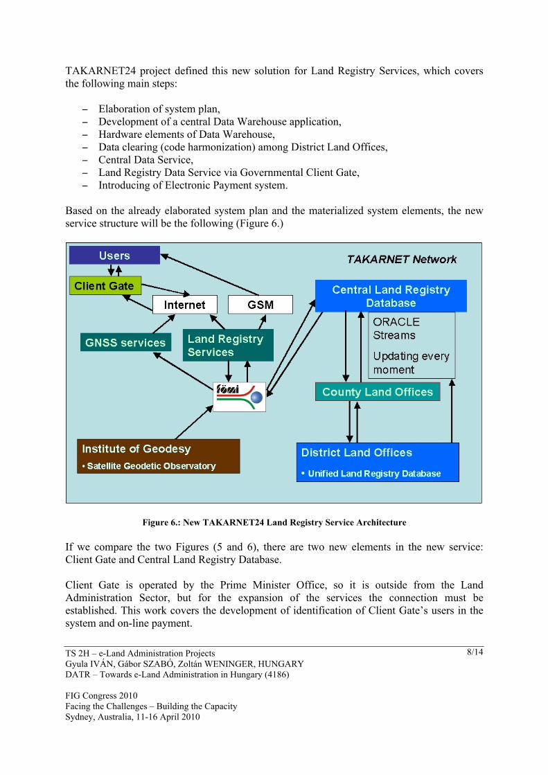
TAKARNET24 project defined this new solution for Land Registry Services, which covers the following main steps:
− Elaboration of system plan, − Development of a central Data Warehouse application, − Hardware elements of Data Warehouse, − Data clearing (code harmonization) among District Land Offices, − Central Data Service, − Land Registry Data Service via Governmental Client Gate, − Introducing of Electronic Payment system.
Based on the already elaborated system plan and the materialized system elements, the new service structure will be the following (Figure 6.)
Figure 6.: New TAKARNET24 Land Registry Service Architecture If we compare the two Figures (5 and 6), there are two new elements in the new service: Client Gate and Central Land Registry Database. Client Gate is operated by the Prime Minister Office, so it is outside from the Land Administration Sector, but for the expansion of the services the connection must be established. This work covers the development of identification of Client Gate’s users in the system and on-line payment.

TS 2H – e-Land Administration Projects Gyula IVÁN, Gábor SZABÓ, Zoltán WENINGER, HUNGARY DATR – Towards e-Land Administration in Hungary (4186) FIG Congress 2010 Facing the Challenges – Building the Capacity Sydney, Australia, 11-16 April 2010
9/14
The other new element is the Data Warehouse, which is embodied by the Central Land Registry Database. Counter to the existing solution, this Central Land Registry Database is responsible for satisfying the users’ request. This approach accelerates the services and provides a real 24 hours services for the customers. In order to provide real, up-to-date information for the users the system uses ORACLE Streams, which provides updating of the central database at every moment. For the elaboration of the new system a lot of preparation is needed, for example:
− Harmonization of codes used by the Land Offices, − Migration of existing ORACLE 8.xx databases to ORACLE 11g (e.g. because of the
Streams) − Replication of District Land Office Databases to the Central Database, − Development of interfaces between the different systems (e.g. Budapest IT system) − Central registration and maintenance of codes, − Development of a countrywide map-browser for property searching, (based on
orthophotos, cadastral maps, gazetteer etc.) − Development of Data Warehouse applications (e.g. statistics, data mining), − etc., etc.
TAKARNET24 project is going on and our estimation it will be finished in time, September 2010. Expansion of Land Registry services in Hungary on this way goes to a better appreciation and last but not least strongly increases the annual income of the Land Administration Sector. 5. DATR THE CORE OF TAKARNET24 PROJECT Because of the above-mentioned flexibility of DATR system, TAKARNET24 project decided, that the Data Warehouse’s IT system should be DATR. DATR is an object-oriented approach, which developed by the operator of the central system, FÖMI. All necessary conditions are given within the Institute for the maintenance and further development of architecture and services. 6. DATR THE INTERNATIONAL VERSION In the international version of DATR all modules and applications (including kernel) have a lingual description in XML format, which describes the lingual functionality of the module. Therefore each module can be customized into any languages including the graphic user interfaces. With open API interface each module can be modified to any certain legal and technical environment. The international version has two interfaces, one to ORACLE and the other to MySQL RDBMS. If client needs then interface can be developed to any other SQL based RDBMS.

TS 2H – e-Land Administration Projects Gyula IVÁN, Gábor SZABÓ, Zoltán WENINGER, HUNGARY DATR – Towards e-Land Administration in Hungary (4186) FIG Congress 2010 Facing the Challenges – Building the Capacity Sydney, Australia, 11-16 April 2010
10/14
The above-mentioned architecture and flexibility empowers DATR (with some customization) to use in any Land Administration system as a cadastral map management system. FÖMI as the part of Hungarian Land Administration is able to maintain this system in any environment both technically and professionally level, including professional guidance. 7. CONCLUSION Digital Land Office concept has defined the further development directions of Land Registry Services in Hungary. Implementation of the first three steps are going on within the frame of TAKARNET24 project. Unfortunately economic crisis strongly influences the execution of ideas defined in Digital Land Office concept. With the implementation of TAKARNET24 the Hungarian Land Registry Services satisfy the all the four stages of public services, defined in eEurope2002 (Impact and Prorities):
1. Posting of information on-line (e.g. TAKARNET info) 2. One-way interaction (digital application sheet download) 3. Two-way interaction (dig. Application sheet download and upload) 4. Full on-line transaction including delivery and payment (downloadable copies,
payment, property monitoring). DATR development has shown that the cooperation of land professionals and IT specialists results the best solutions.
TS 2H – e-Land Administration Projects Gyula IVÁN, Gábor SZABÓ, Zoltán WENINGER, HUNGARY DATR – Towards e-Land Administration in Hungary (4186) FIG Congress 2010 Facing the Challenges – Building the Capacity Sydney, Australia, 11-16 April 2010
11/14
REFERENCES 1. Digital Maps. Part 1: Digital Base Map. Conceptual Model. MSZ 7772-1. Hungarian
Standardization Body, Budapest, Hungary, 1997. 2. DAT1., DAT2. Instruction system. Ministry of Agriculture and Rural Developments,
Budapest, Hungary, 1997. 3. Szabolcs MIHÁLY — Zoltán WENINGER — Gábor SZABÓ — Gyula IVÁN:
Possible solutions for the mapping system of the District Land Offices. (In Hungarian) Meeting of Land Surveyors, 10-12 July, 2003., Debrecen, Hungary
4. Christian LEMMEN, Paul VAN DER MOLEN, Peter VAN OOSTEROM, Hendrik PLOEGER, Wilko QUAK, Jantien STOTER, Jaap ZEVENBERGEN: A modular standard for the Cadastral Domain. The 3rd ISDE: Digital Earth – Information Resources for Global Sustainability. Brno, Czech Republic, September 21-25, 2003.
5. Szabolcs MIHÁLY.: Description Directory and Standard for the Hungarian National Reference and Projection Systems. GIS/LIS'95, Proceedings, June 1995, Budapest, Hungary, Monography.
6. Szabolcs MIHÁLY: Digital base map standard and its utilization. (In Hungarian). Proceedings of the V. National Geoinformation Conference, September, 1995. Szolnok, Hungary.
7. The Future of Standardization in Europe, Francois SALGE (CEN/TC 287, MEGRIN Group of CERCO), Presented by Szabolcs MIHÁLY, FÖMI, Hungary, (MSzH/GIS-TC, MEGRIN Representation) (GISFEDL.DOC, GISLIS.DOC, GISLIS1.DOC, GISLIS2.DOC)
8. The hungarian GIS data transfer standard, I. NIKL-Sz. MIHÁLY-Á. PODOLCSÁK, R. BALDWIN, GIS/LIS '95, Central Europe, 12-16 June 1995, Budapest, Hungary
9. Standard for Hungarian Digital Base Map Conceptual Model, by Dr. Szabolcs MIHÁLY deputy director, Institute of Geodesy, Cartography and Remote Sensing, GIS/LIS '95, Central Europe, 12-16 June Budapest, Hungary
10. Standard for Hungarian Digital Base Map Conceptual Model, by Dr. Szabolcs MIHÁLY deputy director, CERCO, XVIIth Plenary Assembly, 25 September, 1995, Budapest, Hungary
11. GIS Standards in Hungary — Is Hungary Leading in Europe?, by Dr. Szabolcs MIHÁLY deputy director, Institute of Geodesy, Cartography and Remote Sensing, GIS/LIS '96, Central Europe, 10-14 June 1996, Budapest, Hungary
12. GIS Standards in Hungary, by Dr. Szabolcs MIHÁLY deputy director, Institute of Geodesy, Cartography and Remote Sensing, CERCO, General Assembley, 23-24 September 1996, Granada, Spain
13. Unconventional Approaches to Land Administration. A Point of view of Land Registrars and Land Surveyors. By Paul VAN DER MOLEN and Christiaan LEMMEN. Secure Land Tenure: New Legal Framework and Tools. FIG Comm. 7. pp. 173-179.

TS 2H – e-Land Administration Projects Gyula IVÁN, Gábor SZABÓ, Zoltán WENINGER, HUNGARY DATR – Towards e-Land Administration in Hungary (4186) FIG Congress 2010 Facing the Challenges – Building the Capacity Sydney, Australia, 11-16 April 2010
12/14
14. Gyula IVÁN — Gábor SZABÓ — Zoltán WENINGER: Object Oriented Unified Real Estate Registry for a Good Spatial Data Management. FIG Workshop on e-Governance, Knowledge Management and e-Learning, 27-29 April, 2006., Budapest, Hungary
15. Gyula IVÁN — Szabolcs MIHÁLY — Gábor SZABÓ — Zoltán WENINGER: Standards and new IT developments in Hungarian Cadastre. “Standardization in the Cadastral Domain”. Joint workshop of “FIG Commission 7” and “COST Action G9”, 9-10 December, 2004., Bamberg, Germany.
16. Gyula IVÁN — Gábor SZABÓ — Zoltán WENINGER: Expansion of Land Information Services in Hungarian Land Administration. Proceedings of “Shaping the Change” XXIII FIG Congress, Munich, Germany, October 8-13, 2006.
17. Gyula IVÁN — Gábor SZABÓ — Zoltán WENINGER: Integrated Land Information Services in Hungarian Land Administration. Proceeding of “Strategic Integration of Surveying Services”, FIG Working Week, Hong Kong SAR, China, 13-17 May, 2007.
18. Gyula IVÁN — Gábor SZABÓ — Zoltán WENINGER: A Complete, Free Solution for Cadastral Map Management. Proceedings of “Integrating the Generations”, FIG Working Week, Stockholm, Sweden, 14-19 June, 2008.
19. Christiaan LEMMEN –Peter VAN OOSTEROM — Harry UITERMARK: ISO/WD 19152.2 Geographic Information — Land Administration Domain Model. ISO, TC 211, July 31, 2008.
20. Szabolcs MIHÁLY-Gyula IVÁN-Gábor Szabó-Zoltán WENINGER: Land Administration Standards and their implementation in practice. Proceedings of Surveyors Key Role in Accelerated Development, FIG Working Week, Eilat, Israel, 3-8 May, 2009.
21. Gyula IVÁN-Tamás DOROSZLAI-Gábor SZABÓ-Zoltán WENINGER: TAKARNET24 project, towards e-Land Administration in Hungary. Open Symposium on “Progressing towards u-Cadastre”, Kuala Lumpur, Malaysia, 15 October 2009.
BIOGRAPHICAL NOTES Gyula IVÁN (45): has a degree in civil engineering (faculty of surveying and geodesy) from Technical University of Budapest, HUNGARY. He is currently the head of Department of Geoinformation Developments in the Centre for Land and Geoinformation Developments at FÖMI. He is the vice-chair of administration in FIG Commission 7 (Cadastre & Land Management). He is responsible for GIS solutions within TAKARNET24 project. Gábor SZABÓ (39): has a degree in coding and code planning mathematics from Roland Eötvös University of Budapest. He is currently the chief developer and system administrator of TAKARNET system. He has planned the structure of DATR system and chief coder and architect of the system. He is leading Data Warehouse development in TAKARNET24. Zoltán WENINGER (53): has a degree in mechanical engineering (faculty of system organizing). He is currently the head of Centre for Land and Geoinformation Developments and Operation at FÖMI. He has participated in the establishment of computer based land registry from the beginning. He is the leader of DATR project. He is the Director of TAKARNET24 project.

TS 2H – e-Land Administration Projects Gyula IVÁN, Gábor SZABÓ, Zoltán WENINGER, HUNGARY DATR – Towards e-Land Administration in Hungary (4186) FIG Congress 2010 Facing the Challenges – Building the Capacity Sydney, Australia, 11-16 April 2010
13/14
Piroska Zalaba: Academic experience: MSc. Land Surveying and Geoinformatics, BSc. Land Management and Cadastre. Positions: lecturer at the College of Geoinformatics, University of West Hungary in Székesfehérvár until 1997 in geodesy, projection systems, GIS and LIS, present: senior counsellor at the Ministry of Agriculture and Rural Development, Dept. of Land Administration and Geoinformation, tasks: IT development of land offices, introduction of e-services available via internet, improvement of the existing systems and the preparation of legal regulations concerning the most effective functioning of the land registration sector. More than 50 publications in different topics, including lecture notes, papers, reports, and a coursebook. Membership: Hungarian Surveying, Mapping and Remote Sensing Society (MFTTT), secretary of the Hungarian National Committee of International Federation of Surveyors (FIG), Hungarian representative to the UN ECE Working Party on Land Administration. She is responsible for TAKARNET24 project within the Ministry of Agriculture and Rural Developments- CONTACTS Gyula IVÁN Institution: Institute of Geodesy, Cartography and Remote Sensing (FÖMI) Address: 5. Bosnyák tér. H-1149 City: Budapest COUNTRY: HUNGARY Tel. +36-1-460-4081 Fax + 36-1-222-5105 Email:[email protected] Web site: http://www.fomi.hu Gábor SZABÓ Institution: Institute of Geodesy, Cartography and Remote Sensing (FÖMI) Address: 5. Bosnyák tér. H-1149 City: Budapest COUNTRY: HUNGARY Tel. +36-1-460-4063 Fax + 36-1-222-5105 Email:[email protected] Web site: http://www.fomi.hu Zoltán WENINGER Institution: Institute of Geodesy, Cartography and Remote Sensing (FÖMI) Address: 5. Bosnyák tér. H-1149 City: Budapest COUNTRY: HUNGARY Tel. +36-1-460-4048 Fax + 36-1-222-5105 Email:[email protected]

TS 2H – e-Land Administration Projects Gyula IVÁN, Gábor SZABÓ, Zoltán WENINGER, HUNGARY DATR – Towards e-Land Administration in Hungary (4186) FIG Congress 2010 Facing the Challenges – Building the Capacity Sydney, Australia, 11-16 April 2010
14/14
Web site: http://www.fomi.hu Piroska ZALABA Department of Land and Geoinformation Ministry of Agriculture and Rural Developments Address: 11 Kossuth tér. H-1051 City: Budapest Country: HUNGARY Tel.: +36-1-301-4035 Fax.: +36-1-301-4719 email: [email protected] Web site: http://www.fvm.hu