data management techniques integrating databases at the puget sound regional council september 28,...
Post on 21-Dec-2015
228 views
TRANSCRIPT

Data Management Techniques
Integrating Databases
at the
Puget Sound Regional Council
September 28, 2004
AMPO
Travel Modeling Work Group

The Big Picture...
PSRC DataProcesses
MaintainRegionalPlans (D2030, V
2020, etc.)
Track andApprove
MTPProjects
Track andApprove TIP
Projects
Commun-icate:
Visually,Digitally,Directly
Research/Study
Technical &PolicyIssues
MonitorPlans,
Projects,Perform.
Create/AnalyzePlanning
Scenarios
ModelTransport./Air Quality
Forecast,Warehouse,Share Data
GISMODEL
TRANSPROJ(MTP-TIP)
POP-EMPL-LU
CMS
TRAN.$
COMPPLAN
CON-TACT
S
Administrat-ive Support
IT Support
... aka The Ball of Yarn

PSRC GIS and Database UpgradesStatus Report
– Background & History
– New system and application architectures
– New enterprise GIS data model (transportation)
– New applications
– Next Steps

Background:Concurrent Efforts
– Updated Travel Demand Model (implemented in EMME/2)
– New Land Use Model (URBANSIM)
– GIS and Database upgrades

Background:Why upgrade GIS and DBMS?
– Key planning and process questions…• Is a TIP project in the MTP?• Is a given project in a model ‘run’?• Does the model represent a project with appropriate
information?• What would be different about future regional
transportation system performance with or without certain projects?
– …which existing systems do not answer efficiently or quickly

Background:Phase One (2003)
– Necessary systems upgrades
– Transportation project data
– Applications supporting transportation tasks• Planning• Travel Demand Modeling support tool
– Preserve existing land use/demographic data capabilities
– Preserve existing transportation system monitoring capability (CMS)

TRAVELDEMANDMODEL
TIP DB
EXISTINGTIP
APPLICATION
MTP DB
EXISTINGMTP
APPLICATION
GIS:Coverages
& Shapefiles
Question: How would future regional transportation system performance be different with or without certain projects?
Question: Is a particular TIP project part of an MTP project?
Background:Transportation Data System (Before)

Background:Existing Platforms
• GIS (ArcView, ArcInfo)
– Coverages
– Shapefiles
• Relational Databases
– Access
• Spreadsheet
– Excel

New System Architecture:Goals
– Integrated
– Available
– Metadata
– Valid
– Future-focused
– Better support for agency business

RDBMS
GEODATABASE
MAINTENANCE
APPLICATION
MODEL I/O
APPLICATION
GENERAL USE
APPLICATION
TIP DB
MTP DB
TRAVELDEMANDMODEL
EXISTINGTIP
APPLICATION
EXISTINGMTP
APPLICATION
GIS:Coverages
& Shapefiles
New System Architecture:Transportation Components (After)

New System Architecture:Platforms
• GIS Desktop clients
– ArcView 8.3
– ArcGIS 8.3
– Web Browsers (future)
• RDBMS
– MS SQL Server
• Application Development Environment
– VB 6/VBA

New Enterprise Data Model
• Developed with ESRI’s Geodatabase
• Utilizes the Geometric Network to create a new reference network
• Incorporates essential model attributes and key project data in single data model
• Provides a uniform environment for managing spatial and attribute data among several applications
• Supports versioning and time stamping of projects

Physical Data Model• Six major components:
• Transportation Classes – the categories of features defined by edge and junction subtypes
• TransProjects Classes – the MTP and TIP projects and their relationship to GIS entities such as linear routes, linear events, point events and area (polygons)
• Other Routes – similar to the TransProjects Classes but for transit entities and other named routes
• Class inheritance – the relationship of the TIP, MTP and EMME/2 model entities to the geometric network features
• Transportation Connectivity – establishes the network topology between the transportation classes
• Domains – these control the allowable set of values that may be input for any field in the geodatabase

Reference Network Integrationin the Geodatabase
TopologyRules
AnchorPoints
AnchorSections
TransRef Junctions
TransRef Edges
MTP RouteFeatureClass
TIP RouteFeatureClass
ModelFeatureClass
Project 1 Project 2 Project N Project 1 Project 2 Project N
Links
Nodes
MasterNetwork
Transit Routes
Member agencies

Geometric Network
• 15 transportation feature sub-types (edges and junctions), e.g., freeways, HOV, ferry, bike lanes
– Build connectivity rules
• Model network links and nodes corresponded with the GIS reference network edges and junctions
• GIS and model network features are edited in the geodatabase

– PSRC Edge ID
– From/To Node
– Direction
– Modes
– Capacity
– Speed limit
– In/out service dates
– Other attributes
• Freeway
• Expressway
• HOV
• Reversible
• Ramp
• Arterial
• Local
• Non-Motor
• Ferry
• Rail
• Monorail
• Busway
• Light rail
• Centroid Connector
ATTRIBUTES
By Time of Day
Unique ID
Date/Time stamped

Connectivity Table
D ReversableReversable
D Reversable
D Freeway
D Ramp
D HOV
HOV
D Local
DNon_motor
D Arterial
DRamp
D Expressway
Expressway
D HOV
D Reversable
D Ramp
D Freeway
Freeway
Generic
Light_Rail
Ferry
Non_Motor
Bus
Station
Monorail
Rail
ParkRide
Centroid
Deadend
Highway
Fourway
Controlled
Uncontrolled
ToEdgeFromEdge
JUNCTION

Network Validation
• Attribute validation rules work with attribute domains to specify the allowable domain values/ranges for any table, feature class or subtype.
• Network connectivity rules
– Edge-junction rules
– Edge-edge rules.
• Relationship rules control which object subtypes from the origin class can be related to which object subtypes in the destination class. For example, TIP and MTP projects are related to Project Routes in the data model.
• Custom rules are created by accessing underlying ArcObjects software through any Component Object Model (COM) compliant programming language.

Transportation Projects
• Projects coded as routes and route-events for multi-part projects
– Contain essential model attributes
– Linked to external TIP and MTP databases
• Transit routes coded as GIS routes
• Projects and model data can be visualized and analyzed in the GIS

New Applications
• General Use & Mapping
• Maintenance
• Model Input/Output
Applications developed in ArcGIS 8.3
GEODATABASE

General Use & Mapping Application:Data Loading and Metadata

General Use & Mapping Application:Display Projects or Model Results

Maintenance Application
• Designed for Power Users & project staff
• Provides an editing interface
– adding new features
– updating existing features
– retrieving and maintaining GIS data
• Project DB data, GIS data, and model data visible in one place

Three Options:
1. Code in New Projects
2. Update Existing Projects
3. Non-mappable
Maintenance Application:Update Project Databases


Model I/O Application
– Designed for PSRC Modelers and GIS staff
– Tools for preparing the transportation data for the EMME/2 model
• Transportation data extracted and re-formatted according into EMME/2’s node and link structure.
– Tools for displaying the EMME/2 model network results in ArcMap.
– Better control over project selection and scenario management

Model I/O Application:Scenario Definition

Model I/O Application:Create an EMME/2 Input Scenario
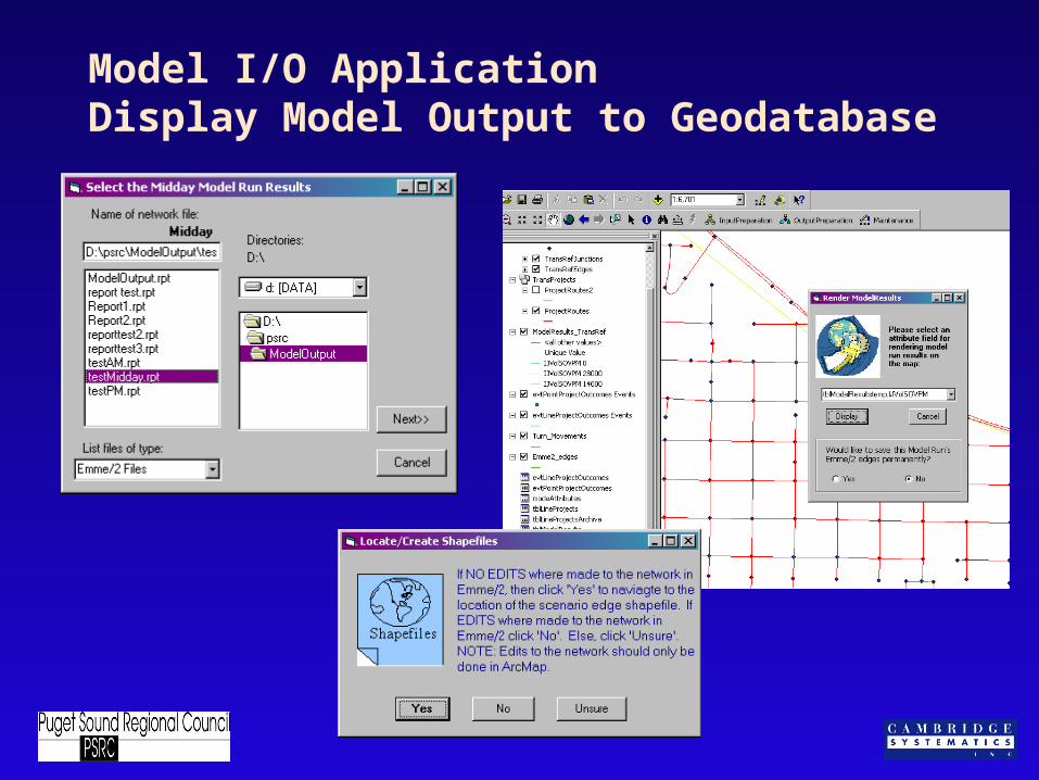
Model I/O ApplicationDisplay Model Output to Geodatabase

Status
– Beta testing of three applications
– Data migration/development in progress• Regionally integrated reference features
• TIP and MTP project geometry
• TDModeling attributes
– TIP and MTP project databases functional in server environment
– TDModel interface

Future: Phase Two
– Demographic data
– Land use data
– URBANSIM
– Supporting applications• Geocoding service
• WWW publishing (D 2030 project data)

Future: Phase Three
– Upgrades to existing applications
– External agency data import/export
– Public accessibility over Internet

PSRC GIS and Database UpgradesProject Staff
Jeff Frkonja—PSRC ([email protected])
Andrew Norton—PSRC ([email protected])
John Sutton—Cambridge Systematics
Melinda Vazzana—Cambridge Systematics
Yushuang Zhou—Cambridge Systematics
Maren Outwater—Cambridge Systematics

Questions?