data collection for development of assessment methods of
TRANSCRIPT

79
GeoScience Engineering Volume LV (2009), No.4
http://gse.vsb.cz p. 79-85, ISSN 1802-5420
DATA COLLECTION FOR DEVELOPMENT OF ASSESSMENT METHODS OF FIRM ROOF FAILURE BASED ON MINE
SURVEYING OBSERVATIONS
SBĚR DAT PRO VÝVOJ METODY HODNOCENÍ PORUŠOVÁNÍ PEVNÉHO NADLOŽÍ NA ZÁKLADĚ DŮLNĚ MĚŘICKÝCH
POZOROVÁNÍ
Eva JIRÁNKOVÁ 1, Jitka MUČKOVÁ
2
1Ing., Ph.D., Institute of Geodesy and Mine Surveying, Faculty of Mining and Geology
VŠB - Technical University of Ostrava, 17. listopadu 15, Ostrava, tel. (+420) 59 699 3326
e-mail: [email protected]
2Ing., Ph.D., Institute of Geodesy and Mine Surveying, Faculty of Mining and Geology
VŠB - Technical University of Ostrava, 17. listopadu 15, Ostrava, tel. (+420) 59 699 3303
e-mail: [email protected]
Abstrakt
Metoda hodnocení porušování pevného nadloží je založena na interpretaci důlně měřických pozorování
v závislosti na charakteru horského masivu. Tato metoda přispívá rozpoznání stavu, kdy došlo k deformaci
pevného nadloží. Pokud nedojde k prolomení pevných nadložních vrstev, je okolí vydobytého prostoru značně
přitíženo a podstatně se zvyšuje nebezpečí vzniku anomálních geomechanických jevů.
Abstract
The assessment method of roof failure is based on the interpretation of mine surveying observations
depending on the pattern of rock mass. This method conduces to recognize the condition, when a firm roof
deformation occurred. If no complete failure of firm overlaying strata occurs, the surroundings of the mined out
area is considerably surcharged and the risk of anomalous geo-mechanical phenomena substantially increases.
Key words: strutting arch, firm roof breakthrough, subsidence trough.
1 INTRODUCTION
The roof failure assessment results in an interpretation of stress deformations which could cause a
breakthrough of the firm overlaying strata or vice versa such that over the mined-out area a strutting arch was
created, in which a quasi-equilibrium stress state occurred. Another usable result of the assessment method is an
interpretation of mined-out area dimensions, at which the breakthrough of firm overlaying strata occurred under
specific conditions.
The estimated time of breakthrough can be substantially clarified by the simultaneous assessment of
seismic activity. However, no connection between occurrence of seismic phenomena and surface subsidence
resulting from direct surface height measurements has been documented yet due to a long time interval of
periodic height measurements. While registrations of seismic phenomena are taking place continuously, the
surface height measurements are usually conducted twice a year, thus reducing the possibility of determining the
exact time of subsidence increase.
For these reasons, in order to assess the roof failure an optimum time interval has been proposed of
periodic height measurements of stabilized points of the surface observation station in the area of the 9th
block of
the Karviná Mine, Lazy Plant. The surveying work is funded by the GA CR grant project 105/09/P277, dealing
with the issue solution.

80
GeoScience Engineering Volume LV (2009), No.4
http://gse.vsb.cz p. 79-85, ISSN 1802-5420
2 BRIEF DESCRIPTION OF THE METHOD
In assessing the firm roof under specific conditions we proceed as follows:
1. Data collection. The required information involves the results of periodic surface height measurements
and the mining engineering information on mining (basic mine maps, results of periodic surface height
measurements, characteristic firm roof profile with determination of compressive strength, thickness
and coefficient of integrity of individual strata of solid roof, contour map of carbon, detailed tectonic
map of the area, records of seismic activity in these areas, overview of performed non-breaking blasting
operations of a large scale, or other methods of weakening the firm roof).
2. Data processing. Mining engineering information must be spatio-temporally classified.
3. Data assessment. In assessing the firm roof it is appropriate to compare the measured values of
subsidence with the theoretical calculation, specify the mining factor and determine the time of a
breakthrough that can be specified by a simultaneous assessment of seismic activity records. For the
determined time of the complete failure the stope width and the characteristics of affecting factors are
then specified for further processing.
The roof failure assessment according to the above procedure must be performed under various mining-
geological conditions. Based on the results of assessment under different mining-geological conditions it is
possible to make quantitative and qualitative assessments and propose a practical use 1 .
3 LOCALITY DESCRIPTION
In the area of the 9th block of the Karvina Mine, Lazy Plant, the extracted part of the seam No. 38 is
located at an average depth of 625 m, the seam No. 39 at a depth of 640 m and the seam No. 40 at an average
depth of 708 m. The mentioned seams belong to saddle strata of the Karvina strata series. The general dip of
strata of the 9th block is 6 - 7° towards NNE. The mining is performed by the method of longwall mining along
the strike with roof control 2 .
The first assessed seam No. 38 is situated ca 115 m under the previously extracted seam No. 37. The
extracted thickness of the seam No. 38 varied from 4.55 to 5.65 m. The intermediate stratum of the seams No. 37
and No. 38 is formed predominantly by sandstone.
The seam No. 39 is situated ca 15 m under the seam No. 38. The extracted thickness of the seam No. 39
varied from 4.10 to 5.80 m. The intermediate stratum of the seams No. 38 and No. 39 is formed predominantly
by sandstone.
Currently the mining is performed in the seam No. 40 with an average thickness of 4 m. The intermediate
stratum of the seam No. 40 and No. 39 has a mean thickness of 60 m and is created predominantly by sandstone
3 .

81
GeoScience Engineering Volume LV (2009), No.4
http://gse.vsb.cz p. 79-85, ISSN 1802-5420
MINING IN THE SEAM NO. 38 MINING IN THE SEAM NO. 39 MINING IN THE SEAM NO. 40
Fig. 1 Overview of mining in seams No. 38, No. 39 and No. 40 in the area of the 9th block of the Karviná Mine,
Lazy Plant
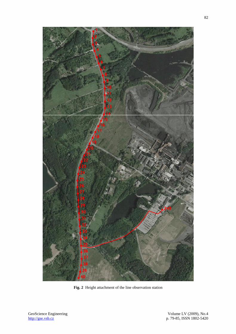
4 DATA COLLECTION OF EARLIER MEASUREMENTS
Surface measurements of heights of the survey line points have been performed so far in six-month
intervals. Individual points of the survey line (line observation station) are stabilized at the edge of a road and
their distance is ca 50 m. Mutual positions of the points of the line observation station and the individual mined-
out stopes is illustrated in Fig. 1. The height attachment of the survey line is realized by a connecting traverse
between the initial point No. 249 stabilised by a rivet on a garage building of the Lazy Plant and the point No. 35
of the survey line, Fig. 2. The length of the connecting traverse is ca 0.75 km. The height of the starting point is
determined in two- to three-year intervals by a coal field levelling. The subsidence of the starting point No. 249
varies from 10 to 60 mm in two to three years, the last coal field levelling was performed in autumn of the year
2008. The calculation of the heights of the survey line points results always from the new determined height of
the initial point No. 249. The formation of a subsidence trough is obvious from Fig. 3, where also individual
areas of stopes in the survey line are represented as well.
82
GeoScience Engineering Volume LV (2009), No.4
http://gse.vsb.cz p. 79-85, ISSN 1802-5420
Fig. 2 Height attachment of the line observation station

83
GeoScience Engineering Volume LV (2009), No.4
http://gse.vsb.cz p. 79-85, ISSN 1802-5420
5 DATA COLLECTION FROM OWN MEASUREMENTS
For purposes of roof failure assessment the time interval of periodic surface height measurements was
shortened to a month. Shortening the time interval ensures that it will be possible to determine much more
precisely the time of the onset of subsidence growth. Thereby the estimated time of the complete failure and
subsequent determination of the goaf area at the time of the complete failure will be specified. Another benefit is
that from the gradual development of the subsidence trough we will be able to determine more precisely, when
the overhang failure of unbroken overlying rocks, whose re-creation and failure result in periodic pressure on the
goaf edges.
The own periodic height measurements with a monthly interval is realized at the surface points of the
original line observation station in the area of the 9the block of the Karviná Mine, Lazy plant. At the same time
the way of the attachment of the survey line to the point No. 249 was maintained, in order to be possible to
resume the results of earlier measurements at this observation station and use, during the calculation of
subsidence from own measurements, initial point heights determined during the first height measurements at this
observation station accomplished on October 19, 1998. It is thus ensured that the results of own measurements
can be interpreted in assessing the roof failures in relation to the earlier assessments.
POINTS OF SURFACE OBSERVATION STATION DECREASE (m) SEAM NO. 38 SEAM NO. 39 SEAM NO. 40
Fig. 3 Formation of the subsidence trough in the line of the observation station
Four own height measurements have been performed till now, in particular in the days of April 2, April
30, June 4 and July 9, 2009. The measurements are performed by the Leica NA 3003 digital level with 3-metre

84
GeoScience Engineering Volume LV (2009), No.4
http://gse.vsb.cz p. 79-85, ISSN 1802-5420
long invar rods. The height measurements are realized using the method of geometric traverse levelling from the
centre in the category of precise levelling for connecting traverse as well measurements at the observation
station. The connecting traverse is led from the point No. 249 of the coal field levelling to the point No. 35 of the
survey line. At the observation station two levelling traverses are measured, in particular from the point No. 35
to the point No. 1 and from the point No. 35 to the point No. 40, Fig. 3. In assessing the measurements the
measured variations are compared with limit tolerances. For precise levelling, considering the undermined area,
the criterion for the IV order of the Czech state levelling network is used, as follows:
3 25 L (1)
Where:
- the limit tolerance between the double measured difference of height of the levelling segment mm ,
L - the length of levelling segment km .
The values of the measured variations and limit tolerances of individual levelling traverses of four up to
now performed own measurements are compiled in Table 1.
The height measurements results in balanced point heights of the survey line. In all cases there are free
levelling traverses, so the balanced heights are determined by the arithmetic mean of the levelling measurements
there and back.
The balanced point heights of the survey line are used for the calculation of subsidence relating to the first
measurement at the observation station as mentioned above. The graphic representation of subsidence as of
April 2nd
, 2009 and previous development of the subsidence trough are represented in Fig. 3. The subsidence
resulted from the following measurements on April 30th
, June 4th
and July 9th
, 2009 was not processed
graphically, because there was practically no gradual growth of subsidence from the measurement accomplished
on October 11th
, 2008, and by plotting of all curves of subsidence of all measurements Fig. 3 would became
confused.
Tab. 1 Assessment of the accuracy criteria
Date of
measurem
ent
Levelling
traverse
Length of
traverse
Measured
variation
Limit tolerance
according to (1) Criterion
km mm mm
2.4.2009
249-35 0,75 0,5 4,1 fulfilled
35-40 0,25 0,1 2,0 fulfilled
35-1 1,7 0,5 7,1 fulfilled
30.4.2009
249-35 0,75 0,0 4,1 fulfilled
35-40 0,25 0,2 2,0 fulfilled
35-1 1,7 0,6 7,1 fulfilled
4.6.2009
249-35 0,75 3,1 4,1 fulfilled
35-40 0,25 0,2 2,0 fulfilled
35-1 1,7 1,7 7,1 fulfilled
9.7.2009
249-35 0,75 2,8 4,1 fulfilled
35-40 0,25 0,3 2,0 fulfilled
35-1 1,7 5,7 7,1 fulfilled
6 CONCLUSIONS
The success of this assessment and correct explanation of the manifestations of failure mechanisms
depend especially on suitable locations of surface points with respect to mining, frequency of surface
measurements and on sufficient knowledge of natural conditions and mining engineering information.

85
GeoScience Engineering Volume LV (2009), No.4
http://gse.vsb.cz p. 79-85, ISSN 1802-5420
In order to develop the method of the roof failure assessment an optimum time interval has been proposed
of periodic height measurements of stabilized points of the surface observation station in the area of the 9th
block
of the Karviná Mine, Lazy Plant. In the foreseeable future the mining of the face 910 in the seam No. 40 will
start. Based on the results of periodic height measurements we perform at monthly intervals it will be possible to
capture sufficiently precisely the increase of surface subsidence.
REFERENCES
[1] JIRÁNKOVÁ, E. Časoprostorové vytváření poklesové kotliny v závislosti na charakteru horského
masivu. Disertační práce doktorského studia. VŠB – TU Ostrava 2007
[2] JIRÁNKOVÁ, E. Hodnocení stavu porušení pevného nadloží dobývaných slojí v závislosti na charakteru
horského masivu. Sborník příspěvků 2. tradičního geomechanického a geofyzikálního kolokvia, strana
111 – 118, Ostravice 2008, ISBN 978-80-86407-36-4
[3] JIRÁNKOVÁ, E. Assessment of failure condition of the extracted seams of the firm roof in dependence
on the rock mass character. GeoScience Engineering, http://gse.vsb.cz, Volume LIV(2008), No.1 p. 1-10,
ISSN 1802-5420
RESUMÉ
V článku je uveden přehled zpracovaných dat dřívějších výškových měření v oblasti 9. kry Dolu Karviná,
závod Lazy. Výšková měření dosud slouží pouze k dokumentaci a posuzování vlivů poddolování a provádějí se
dvakrát ročně. Za účelem vývoje metody, která využívá povrchové měření výšek při hodnocení porušování
pevného nadloží, byl navržen optimální časový interval periodických měření. V článku je popsán sběr dat
z vlastních měření, který byl navržen tak, aby bylo možné navázat na dřívější měření v dané oblasti.