dams to darnley country park version management...a project officer was appointed in 2006, ... 4...
TRANSCRIPT

Dams to Darnley Country Park
Development and Management Plan
2011-2016
April 2013 revision

ABBREVIATIONS
Administration and Members’ Services AMS British Trust for Conservation Volunteers BTCV Carts Greenspace CG Community Health and Care Partnership CHCP Community Health Partnership CHP Core Path Plan CPP Development and Regeneration Services DRS East Renfrewshire Council ERC East Renfrewshire Council Training Centre ERCTC Education Department ED Education Services ES Environmental Services and Roads ESR Geographical Information System GIS European Union EU Glasgow City Council GCC Glasgow Community and Safety Services GCSS Historic Scotland HS Land and Environmental Services LES Legal Services LS Local Access Forum LAF Local Biodiversity Action Plan LBAP Local Biodiversity Site LBS Local Nature Reserve LNR Property and Technical Services PATS Public Relations Services PRS Regionally Important Geological and Geomorphological Site RIGS Revenue Services RS Scottish Disability Equality Forum SDEF Scottish Environmental Protection Agency SEPA Scottish Natural Heritage SNH Scottish Outdoor Access Code SOAC Scottish Water SW Site of Importance for Nature Conservation SINC Site of Special Scientific Interest SSSI South West Community Cycles SWCC
If you require this information in large print, Braille or translated, please telephone our customer service officer on 0141 577 3001.

CONTENTS Page Abbreviations 1 Introduction 1 • What stage is the country park at? 1 • Why is a plan needed? 2 • Who is the plan for? 2 • How has the plan been arrived at? 2 • Structure of the plan 3 2 Background 3 • Location 4 • Ownership 4 • Local community 4 • Policy, legislation and designations 5 • Recreation 9 • Facilities 11 • Natural heritage 14 • Built heritage 18 • Information, interpretation and education 20 • Training, volunteering and business 20 • Community safety and antisocial behaviour 21 • Management and maintenance 22 3 Aims 24 4 Vision 25 5 Analysis and assessment 25 • SWOT analysis 26 6 Objectives 35 7 Actions 36 8 Monitoring and review 36 APPENDIX 1: Actions 37 APPENDIX 2: Equality Impact Assessment 56 APPENDIX 3: Strategic Environmental Assessment
Determination Statement 60

1
1 INTRODUCTION The countryside surrounding Barrhead, Darnley and Newton Mearns has been used by local residents for informal recreation across generations. In particular the Barrhead dams, Waulkmill Glen and Darnley Mill have been a traditional destination for walking, cycling and angling. Yet historically the recreational and environmental potential of the area has not been fulfilled. Access has been poor, with limited path routes and public transport options, whilst few stopping and parking places existed. Given its green belt location, adjacent to existing urban populations, the area has also come under pressure for development. In addition, as an urban fringe location, it has suffered to a degree from antisocial issues such as fly-tipping and vandalism. As a result both East Renfrewshire and Glasgow City councils are working together to develop and manage the area as a new country park called Dams to Darnley. Since 1969 36 country parks have been formally established by local authorities in Scotland, but the last designation was in 1992. There is no aspiration to establish Dams to Darnley as a formal country park. Rather the vision for Dams to Darnley is akin to that of a country park: to provide a well managed greenspace, offering a range of recreational and educational opportunities and facilities, within a landscape where wildlife flourishes and built heritage is protected and promoted. Unlike most country parks, which are owned by local authorities, around two thirds of Dams to Darnley is in private ownership. Much of the area remains a working landscape, with a number of local farms having been established as early as the mid sixteenth century. Ensuring that farmers’ interests are respected and assistance is provided in managing access and addressing antisocial issues is also part of the country park vision and is essential to its success, whilst the partnerships that are created with land managers will help shape its future direction.
What stage is the country park at? The potential to manage the greenspace surrounding Barrhead, Darnley and Newton Mearns as a recreational and environmental resource has been given consideration over the last ten years. In 2000 the Dams to Darnley Mill Countryside Corridor Feasibility Study1 first examined the potential of the area. The East Renfrewshire Outdoor Access Strategy and Draft Core Path Network Plan 20022
in turn suggested bringing together a number of potential initiatives including path improvements, parking facilities, a responsible behaviour pilot and interpretation within a Dams to Darnley action area. An indicative country park masterplan, identifying broad access, biodiversity and infrastructure proposals, was agreed by East Renfrewshire Council cabinet and Glasgow City Council development and regeneration committee in 2004 following public consultation. In 2006 a minute of agreement between East Renfrewshire and Glasgow City councils, outlining the terms of their partnership and the aims of the country park, was signed. This enabled a joint committee, set up to lead the initiative, to meet formally for the first
1 Tennant Garmory Partnership (2000) Dams to Darnley Mill Countryside Corridor. A Feasibility Study 2 East Renfrewshire Outdoor Access Forum/East Renfrewshire Council (2002) Outdoor Access Strategy and Draft Core Path Network Plan
time. A project officer was appointed in 2006, whilst two countryside rangers started in 2008. The country park is being developed through a series of improvements, leading to new visitor and recreation facilities and infrastructure. These will continue over the coming years. The initial focus between 2005 and 2007 saw repairs to infrastructure, including stone walls and cast iron Victorian railings. New signs, benches and bins started to appear and maintenance schedules began to be put in place. In 2007 and 2008 the first path and entrance improvements began, whilst in 2010 new car parks were created. Future priorities are outlined in this plan.

2
Why is a plan needed? This five year plan aims to guide the development of the country park and aid its effective and efficient management. Specifically the plan will look to: • Build knowledge and consensus by
promoting the country park, encouraging stakeholder involvement, generating interest and support, resolving conflicts of interest and working toward agreement;
• Plug knowledge gaps by collating existing background information and identifying and prioritising what is missing;
• Establish a framework for decisions by setting an agreed direction and ensuring clear objectives and actions;
• Promote strategic planning by ensuring a cohesive approach and agreeing areas of responsibility;
• Agree an action plan by establishing a programme of scheduled works, attributing costs and identifying funding;
• Plan for change by identifying internal and external factors and prioritising future requirements;
• Monitor and review by assessing change and providing a framework by which progress can be judged and priorities revisited.
It is vital to note that the first drafting of a development and management plan for Dams to Darnley will not resolve all the issues facing the country park area, that consensus building is a long term process and that some judgements will inevitably require to be made from incomplete information. This five year plan is only the start of a process which looks to achieve the above. Who is the plan for? The potential audience for the plan is diverse, given the range of parties with an interest in the country park. Different people will look to the plan in different ways, these include: • Joint committee members and other local
councillors who want to know how the plan will help achieve the aims of the country park and deliver benefits for local residents;
• The local community who use the country park and want to know how it will be developed and when;
• The wider community who do not use the country park and want to know where it is, how to get there and what it offers;
• Recreation and community groups, as well as local schools and colleges, who want to know what the country park can offer and how they can contribute to it;
• Land managers who want to know how the plan’s proposals may affect them and whether they can have confidence that their concerns are being addressed;
• Partners with direct involvement in developing or managing the country park will want to know what its priorities are and where they fit in;
• Country park staff who will use the plan to guide priorities and work programmes over the coming years;
• Council staff, trainees and volunteers who will want to know how they can contribute to the country park and how it can assist them to deliver their priorities and aspirations;
• Potential funding partners who wish to know how individual grant applications fit into the overall direction of the country park initiative.
How has the plan been arrived at? Over the last seven years a number of consultations and studies relating to the Dams to Darnley area have taken place. Each of the following documents has contributed to the background information contained within this plan; their recommendations have also begun to frame its objectives and actions: • An indicative country park masterplan
(2004) identified broad access, biodiversity and infrastructure proposals. The masterplan was arrived at following widespread consultation, with discrete comments summarised within a report;

3
• A landscape character assessment (2006)3
• A recreation study (2008)
quantified the key landscape features and areas within the country park and identified opportunities for improvements;
4
• A historic and cultural heritage audit and strategy (2008)
aimed to define a clear vision for recreation provision within the country park and provide outline proposals for the recreational and visitor facilities and infrastructure needed to achieve it. The results were based upon the outcome of interviews with interested parties and a community questionnaire;
5
identified ten key historical themes associated with the country park and made recommendations to improve the understanding and appreciation of its built heritage.
In 2009 two development and management plan events were held in Barrhead. These were attended by local councillors, officers from East Renfrewshire and Glasgow City councils and partner organisations, land managers, community, recreation and education groups and local residents. Through a series of workshops participants were asked to identify short and long term priorities based around the recommendations contained in previous consultations and studies. A report, summarising the output of each workshop, was circulated to participants.
A draft version of the development and management plan was subject to public consultation, resulting in a number of changes being made to this finalised version.
3 Land Use Consultants (2006) Dams to Darnley Country Park Landscape Character Assessment 4 Moffat Centre for Travel and Tourism Business Development (2008) Dams to Darnley Recreation Study 5 Graham Barrow Research and Consulting/Glasgow University Archaeological Research Division/Christopher Palmer Associates (2008) Dams to Darnley Country Park Historic and Cultural Heritage Audit and Strategy
Structure of the plan The structure of the plan is based on guidance produced by Cabe Space6
and is focused around four fundamental questions, each of which frames the section headings used within it.
Question Section heading Where are we now? Introduction Background Where do we want to get to?
Aims Vision Analysis and assessment Objectives
How will we get there? Actions How will we know when we have arrived?
Monitoring and review
The plan sets out the background information key to the development and management of the country park. It establishes eight aims for the country park initiative, based upon those agreed within the joint committee minute of agreement, each focused on an individual theme. The plan then sets out a vision for the country park, based around these aims, towards which the initiative seeks to progress. The most significant stage of the plan focuses upon an analysis and assessment of the background, aims and vision set out within it, the key recommendations of the previous consultations and studies and the priorities generated by the development and management plan events. Using a SWOT analysis the key information is summarised and structured around the theme of each aim. A set of broad objectives, again structured around each aim then follows. This in turn leads to specific actions, which collectively make up the action plan, once again structured around the eight aims. The plan’s time frame is linked to its actions, as outlined in the final monitoring and review section. 2 BACKGROUND This section summarises the background information relevant to the country park. Firstly it provides general information on its location, ownership and surrounding local community, and outlines relevant policy, legislation and designations. Secondly it details specific information, focused on the eight themes upon which the plan’s aims are based. 6 Cabe Space (2004) A Guide to Producing Park and Green Space Management Plans

4
Location Dams to Darnley Country Park sits in the greenspace separating Barrhead, Darnley and Newton Mearns (figure 1). It encompasses an area of approximately 550 hectares of green belt land. It is predominantly located to the west of the M77, 10km south-west of Glasgow city centre. The Dams to Darnley boundary features in the country park masterplan, as well as the East Renfrewshire Local Plan7 and the Glasgow City Plan 28
.
Figure 1 Country park location map
© Copyright 100023382 2013 Ownership Just under two thirds (63%) of the country park is in private ownership, much of which is still working farmland. Around 30 private landowners have been identified within the country park area, with ownership ranging from 60 hectares to less than one quarter of a hectare. The Gorbals reservoir complex is owned by Scottish Water, additionally accounting for 21% of the country park area. East Renfrewshire and Glasgow City councils own 11% of the area, including Darnley Mill and much of Waulkmill Glen.
7 East Renfrewshire Council (2011) East Renfrewshire Local Plan. 8 Glasgow City Council (2009) Glasgow City Plan 2
Local community The country park is surrounded by residential communities on three sides. Within East Renfrewshire, Barrhead and Neilston lie to the south and west, Thornliebank to the north-east and Newton Mearns to the south-east. Within Glasgow, south Nitshill, Darnley and Parkhouse are to the north and west, Jenny Lind to the north-east and Mearns Grove to the east. These communities are within 3.5km of the country park boundary. Approximately 127,300 people live within this buffer9
, the majority in Glasgow south and Eastwood (table 1).
Table 1 Local population (within a 3.5km buffer of the country park by area)9 Area Local population
(within 3.5km buffer of the
country park) Glasgow south (south Nitshill, Darnley, Parkhouse, Jenny Lind, Mearns Grove)
55,517
Levern Valley (Barrhead, Neilston)
19,178
Eastwood (Newton Mearns, Thornliebank)
52,624
Figure 2 details the age distribution of the local community living close to the country park, it highlights a focus within the 10-15 and 35-49 age groups. Figure 3 also reflects an over representation within the 0-19 age groups living close to the country park when compared to national statistics.
9 General Register for Scotland. Small Area Population Estimates (2011) Mid Year Estimates

5
Figure 2 Local population distribution by age (within a 3.5km buffer of the country park)9
Figure 3 Local population distribution by age (within a 3.5km buffer of the country park and Scotland)9
Policy, legislation and designations Policy The Scottish Government has established five strategic objectives, to build a Scotland that is wealthier and fairer; greener; safer and stronger; smarter and healthier. Each council, together with their community planning partners, has made a formal commitment to deliver a Single Outcome Agreement. These agreements show how councils
can best contribute to the Scottish Government’s strategic priorities and outcomes. Through a series of outcomes each Single Outcome Agreement identifies where resources will be focused in order to make a difference for local communities. Progress towards delivering these outcomes is recorded through a series of measures. The development and management of the country park contributes to a number of outcomes contained within both councils’ Single Outcome Agreements (table 2).
0
1
2
3
4
5
6
7
8
9 N
um
ber
Age groups
0
1
2
3
4
5
6
7
8
9
% o
f to
tal
Age groups
Country park buffer
Scotland

6
Table 2 Single Outcome Agreement outcomes
East Renfrewshire Glasgow SOA 2 More of our residents have the skills needed for employment.
LO 4 Reduce the impact and incidence of antisocial behaviour.
SOA 3 Our learners are successful, confident individuals, effective contributors and responsible citizens.
LO 11 Improve the attractiveness of Glasgow as a place to live, invest, work and visit.
SOA 5 Our local people are healthier, more active and inequalities in health are reduced.
LO 13 Increase the proportion of residents involved in physical activity.
SOA 9 Our local people live in an attractive natural and built environment that is sustainable and enhanced for future generations.
LO 22 Improve skills for employment.
LO 24 Improve Glasgow’s physical environment and infrastructure.
The National Planning Framework for Scotland 2 (2009)10 is the key national framework document guiding Scotland’s spatial development up to 2030. Within the framework ministers have identified the Central Scotland Green Network as one of fourteen national developments contributing to the five strategic objectives around which the Scottish Government is aligned. At a national level Scottish Planning Policy11
also identifies the role that greenspace plays in the drive to make people more active and create a healthier population. The policy also outlines the importance of creating and safeguarding green networks.
The Glasgow and Clyde Valley Green Network, promoted within the Glasgow and Clyde Valley Joint Structure Plan (2006)12
10 The Scottish Government (2009) National Planning Framework for Scotland 2
, aims to enhance the quality of urban, urban fringe and rural areas, help to integrate town and country and reinforce the positive role of the green belt. The establishment of the Glasgow and Clyde Valley Green Network Partnership provides the strategic framework for the co-ordinated action needed to facilitate delivery of the green network across the whole region. The Glasgow and Clyde Valley Green Network, linked to, and integrated within the Central Scotland Green Network will provide the framework for a wide range of action on the
11 The Scottish Government (2010) Scottish Planning Policy 12 Glasgow and the Clyde Valley Structure Plan Joint Committee (2006) Glasgow and Clyde Valley Joint Structure Plan 2006. The Twenty Year Development Vision. Written Statement
ground. The structure plan identifies Dams to Darnley as one of a number of priorities for promotion and management in relation to the delivery of the Glasgow and Clyde Valley Green Network (Strategic Policy 1, Schedule 1f). The first Glasgow and Clyde Valley Strategic Development Plan (2012)13
, which replaces the structure plan, sets out a Spatial Development Strategy, a key component of which is the Glasgow and Clyde Valley Green Network.
The East Renfrewshire Local Plan (2011)7 indicates that the council will continue to support the work of the joint committee in its role in developing, promoting and managing the Dams to Darnley Country Park and turning it into a major recreational and environmental resource for local communities and the wider public (Policy L9). The local plan also identifies specific policies and proposals within or adjacent to the country park which could have a major impact upon it. These include: • A new link road between Barrhead and the
M77 (Proposal T6.1); • The realignment of Aurs Road (Proposal
T6.10); • The enhancement of M77 Junction 4
(Proposal T6.11, linked to Policy B4); • Patterton Station public transport
interchange facility and extended/improved park and ride (Proposals T6.14 and T6.15);
• New housing development at Springfield Road (Proposal H1.15);
• The appropriate development of the Pollok/Ryat high amenity site (Policy B4).
East Renfrewshire Council produced a new Proposed Local Development Plan (2012)14
in December 2012 for consultation. The plan looks at the use of land in East Renfrewshire, establishing a long term vision for the council area and setting out the policies and proposals required to deliver it. The plan’s strategy sets out the extent and location of new development. The strategy comprises two key strands; the regeneration and consolidation of urban areas and the controlled masterplanned growth of key development locations.
The plan is essential in helping to safeguard the environment and protect communities and the greenbelt from unplanned development. In 13 Glasgow and Clyde Valley Strategic Development Planning Authority (2012) Glasgow and Clyde Valley Strategic Development Plan 14 East Renfrewshire Council (2012) Proposed Local Development Plan

7
addition the plan has the potential to deliver significant economic, social and environmental benefits for East Renfrewshire residents, including a wide range of enhancements to the country park such as improved access and visitor facilities. Specific support for the country park and the implementation of this development and management plan is also provided within the Proposed Local Development Plan by Policy D10. It is anticipated that the Local Development Plan will be adopted in 2014. The Glasgow City Plan 2 (2009)8 specifically identifies Dams to Darnley Country Park as one of a number of local environmental initiatives which, in partnership with a range of agencies and the community, the council is developing and implementing. These aim to provide opportunities to enhance access to, and the enjoyment of, the city’s greenspaces and countryside. This is being done through a range of proposals involving recreation, countryside management and the environment. Policies IB 2 and IB 3 have specific relevance to the country park in that they relate to the adjacent Darnley Mains business site. Planning permission was granted for a mixed use business and residential development on the site in 2008. The plan also includes relevant general policies, including open space protection (Policy ENV 1) and development in the green belt (Policy ENV 3). Glasgow City Council is preparing a new Local Development Plan to replace Glasgow City Plan 2. Public consultation on the Main Issues Report, the first key phase during the production of the new Local Development Plan, was completed in December 2012. The new plan is anticipated to be adopted in 2014. Over recent years both councils have been preparing core path plans, a duty under the Land Reform (Scotland) Act 2003. Both East Renfrewshire and Glasgow City core path plans were adopted in 2012. There are a number of core paths, as well as candidate or aspirational core path routes, within the country park. Local Biodiversity Action Plans (LBAPs) aim to influence the policy of local authorities and partners. They seek to ensure that nature conservation is taken into account in the decisions of all partners. LBAPs identity targets set out in specific Species Action Plans and Habitat Action Plans. The LBAP is a process which should take advantage of opportunities for partnership working, new projects and funding as these become
available. The Glasgow LBAP15 was launched in 2001, whilst within East Renfrewshire the LBAP16
, published in 2004, is a partnership initiative which also involves Renfrewshire and Inverclyde councils, as well as a range of conservation organisations. A number of priority habitats and species are of particular relevance to the country park (table 3).
Table 3 Priority LBAP habitats and species relevant to the country park East
Renfrewshire, Renfrewshire & Inverclyde
Glasgow
Priority habitats Unimproved grassland Rivers and streams
Standing open water
Broadleaved and mixed woodland
Neutral grassland Priority species Greater and lesser butterfly orchids Pipistrelle bat Bluebell Dragonflies and damselflies
Common toad Common frog Palmate newt Reed bunting Water vole Brown hare The hosting of the 2014 Commonwealth Games in Glasgow aims to build a lasting and positive legacy. A legacy plan17
sets out the Scottish Government’s aspirations before, during and after the games.
Legislation The Land Reform (Scotland) Act 2003 establishes statutory rights of non-motorised access to most land and inland water for outdoor
15 Glasgow Local Biodiversity Action Plan (2001) 16 Local Biodiversity Action Plan for East Renfrewshire, Renfrewshire and Inverclyde (2004) 17 The Scottish Government (2009) On your marks…Get set…Go: A games legacy for Scotland.
8
recreation, provided these rights are exercised responsibly18
provides guidance on responsible behaviour for recreational users, and on responsible land management in relation to access rights
. The act includes safeguards for privacy, public safety, land management and conservation. The Scottish Outdoor Access Code (SOAC)
. The code is based on three principles: respecting the interests of other people; caring for the environment and taking responsibility for your own actions. All councils have a duty to establish local access forums to advise them on matters relating to access rights. Under the Occupiers Liability (Scotland) Act 1960 an ‘occupier’ of land has a duty to show care towards people on that land. The Land Reform (Scotland) Act 2003 highlights that the extent of this duty of care is not affected by this act. The law in this area is nevertheless complex and many land managers are concerned that their legal liabilities are greater as a result of increased public access following the Land Reform (Scotland) Act 2003. The Equality Act 2010 provides a new legislative framework to protect the rights of individuals and advance equality of opportunity for all. It aims to update, simplify and strengthen previous legislation and provide a simple and accessible framework of discrimination law which protects individuals from unfair treatment and promotes a fair and more equal society. The provisions of the Act are being brought into force at different times to allow time for the people and organisations to prepare for it. Most of the provisions came into force in October 2010. The Equality Act 2010 aims to protect disabled people and prevent disability discrimination. It provides legal rights for disabled people within a number of areas: employment; education; access to goods, services and facilities; buying and renting land or property and the functions of public bodies. The Equality Act also provides rights for people not to be directly discriminated against because they have an association with a disabled person. Accessibility standards in relation to disabled people’s access to the countryside are set out in the Countryside for All Good Practice Guide19
Amongst the provisions of the .
Nature Conservation (Scotland) Act 2004 is a duty placed on every public body to further the conservation of biodiversity consistent with the proper exercise of their functions. The act also
18 The provisions of the Land Reform (Scotland) Act 2003 relating to non-motorised access and disabled people will potentially be examined by the National Access Forum in the future 19 Fieldfare Trust (2005) Countryside for All Good Practice Guide Extended CD Edition
provides for the enhanced protection and management of Sites of Special Scientific Interest (SSSI). The act makes amendments to the Wildlife and Countryside Act 1981, strengthening the legal protection for threatened species. The species protection afforded to wild birds, animals and plants is extended to include 'reckless' acts. The protection afforded to the nests of certain threatened bird species is also extended to all times of the year. Designations Within the country park Waulkmill Glen is designated as a SSSI, a geological site within semi-natural woodland. The country park also contains a number of Local Biodiversity Sites (LBS) and Sites of Importance for Nature Conservation (SINC): • The largest LBS is associated with the
reservoirs of the Barrhead dams within East Renfrewshire;
• The blocks making up Patterton Wood, a dense birch woodland with abundant honeysuckle, ferns and brambles, together with Walden Wood are designated as a LBS within East Renfrewshire;
• In Glasgow Darnley Mill, a complex of grasslands, marsh and scrub woodland with rich species diversity, is designated a city-wide SINC, as is Waulkmill Glen and the marshy area linked to its old workings.
Local Nature Reserve status for Waulkmill Glen and Darnley Mill (Glasgow City Plan 2 Policy ENV 7) was secured in 2013 following a joint declaration by East Renfrewshire and Glasgow City councils. The Dams to Darnley LNR encompasses the 36 hectares of Glasgow City Council owned land within the country park. A distinct LNR management plan will be drafted by Glasgow City Council within the next three years. The Brock Burn, including the Aurs Water, is also identified as a Green Corridor (Glasgow City Plan 2 Policy ENV 7), whilst the remainder of the country park in Glasgow is also designated as a Site of Special Landscape Importance (SSLI). SSLIs have been identified for the contribution that they make to the quality of life for those who live, learn, work and play within the city. Conversely, their loss or erosion would reduce the attractiveness of the city to both citizens and visitors (Policy ENV 7). Environmental designations also cover a small area of ancient, long established or semi-natural woodland (Policy ENV 7) at Waulkmill Glen.

9
The list of buildings of architectural or historic interest, drawn up by Historic Scotland, contains a number of listings associated with the Barrhead dams. Waulkmill Glen Reservoir, including its draw-off tower, sluice and regulating house are category A listed, Balgray Reservoir draw-off tower is category B listed and the main house, workshops and former water testing house associated with the reservoirs are category C(S) listed. Recreation Access network The indicative country park masterplan of 2004 highlighted a network of path links to and through the country park. These are prioritised either for walking and cycling or walking, cycling and horse riding. These routes are located on land in a mixture of council, Scottish Water and private ownership. A number of the masterplan links have been delivered creating a 12km path network (figure 4). The remaining routes will continue to form part of the masterplan, with the aspiration that they are developed, subject to landowner agreement and funding. Additional and alternative routes also continue to be considered as the country park initiative progresses.
The 2km linear level whin path around the southern edge of Balgray Reservoir was completed in 2008. It can be accessed from entrances at Aurs Road and Balgraystone Road. An additional path link from Springfield Road (Barrhead) to Balgray Reservoir was added in 2011. Aurs Road is a busy and narrow public road with no footpath between Whitecraigs Rugby Club (Newton Mearns) and Springfield Road. Plans are being progressed to create a new path from Whitecraigs Rugby Club, providing safe access to the country park from Newton Mearns. The Balgray Reservoir path links into the main spinal route, a 3.6km linear tarmac link which runs through the heart of the country park from Aurs Road to Nitshill Road (Darnley). The path takes in many of the country park’s main features. The southern half follows the edge of Ryat Linn, Waulkmill Glen and Littleton reservoirs, passing under the Victorian railway viaduct. The northern half of the route runs along Corselet Road, through Waulkmill Glen and adjacent to Darnley Mill. Beyond the Aurs Burn there are a series of entrances from Corselet Road into Darnley Mill.
Figure 4 Existing country park path network and entrance points
© Copyright 100023382 2013

10
The Balgray Reservoir and main spinal paths are prioritised as multiuse walking, cycling and horse riding routes within the country park masterplan. Two new woodland whin path loops within Waulkmill Glen, together with an additional whin link along the northern shore of Waulkmill Glen Reservoir, were completed in 2012. These paths are connected to the main spinal route. There are aspirations to link the Waulkmill Glen Reservoir path, and hence the main spinal path, across the M77 to Patterton Station (Newton Mearns), as outlined in the masterplan. Darnley Mill has a network of level whin paths, including a 1.5km Brock Burn circular route. The main entrances are from Nitshill Road and Corselet Road. There are also entrances from Waukglen Road, via a long flight of steps, Waukglen Drive and Foxglove Place in Southpark Village. A network of gravel chip paths has been established as part of the housing estate at Parklands Meadow, off Parkhouse Road. The main path leads from Parkhouse Road to Corselet Road, connecting to Darnley Mill, Waulkmill Glen and the Barrhead dams. There are entrances from Parkhouse Road and from within the estate itself. A network of gravel chip paths has also been created within the woods next to the Mearns Grove housing estate, off Stewarton Road. Access is from Stewarton Road or Deaconsgrange Road. How many people use the country park? In 2008 the recreation study4 estimated that annual country park visitor numbers were between 7,000 and 10,000. These figures were prior to the
opening of the Balgray Reservoir path. The recreation study highlighted that in the early years, with its focus on path construction, the country park should achieve visitor numbers comparable to an average nature reserve, circa 20,000 per year. Visitor numbers began to be recorded from summer 2009 with the installation of two counters along the Balgray Reservoir path. From available data it is estimated that over 20,000 people used the path during the first year following the installation of the counters. As a result current visitor numbers across the entire country park are thought to be considerably higher than estimated in the recreation study. Additional path counters, installed in 2011, have enabled visitor numbers and trends to begin to be recorded more accurately across the rest of the country park. Annual visitor numbers are currently estimated to be around 90,000. Given the early stage of country park development it is likely that a high percentage of these visitors will be from the local community surrounding the country park. How do people use the country park? The recreation study provided a wealth of information on the recreational use of the country park. Walking was by far the main activity undertaken by users (79%), followed by wildlife watching (34%), photography (29%), dog walking (28%), cycling (25%) and angling (15%). Higher levels of participation in wildlife watching, photography, dog walking and angling were recorded amongst regular country park users; those who visited at least a few times each month (figure 5).
Figure 5 Activities undertaken in the country park (all users: n = 164 regular users: n = 57)
0
10
20
30
40
50
60
70
80
90
Perc
en
tag
e
All users
Regular users

11
What activities visitors would like to undertake within the country park Walking and wildlife watching remained the most popular recreational activities when people were asked what activities they would like to undertake within the country park (figure 6). If figure 5 is compared to figure 6 then it is clear that there is
additional unmet potential relating to a number of activities, in particular dog walking, cycling, running/jogging and horse riding. It should be noted that the Balgray Reservoir path, which was completed after the recreation study, has led to a visible increase in the percentage of dog walkers and cyclists using the country park.
Figure 6 Main activities visitors would like to undertake in the country park (n = 349)
Facilities Given that the country park is in its early stages facilities have not been developed to date. The initial focus has seen the improvement of existing infrastructure and the development of the country park’s path network. Fingerpost signs, benches and bins have been installed along the path network, these are of a standard design across the country park. Visitor numbers have increased significantly as a result of the developing path network, but the lack of facilities remains the major obstacle to the further development of the country park. Recreation study respondents were asked to rate how important different facilities were in influencing a decision to visit a country park. Table 4 highlights the importance of car parking facilities in visitors’ decision making process, as well as smaller scale infrastructure: signage; bins; toilets; benches and waymarking, together with the presence of staff on site.
Table 4 Importance of different facilities in decision to visit a country park
The above influencing factors are reinforced when the main weaknesses of the country park area are examined. A lack of car parking was cited as the main weakness of the country park, identified by 60% of recreation study
0
10
20
30
40
50
60
70
80
90
Perc
en
tag
e
Facility Number Average score*
Car parking 341 2.8 Signage 329 2.6 Bins 287 2.6 Toilets 333 2.5 Benches/seating 331 2.5 Waymarked paths 319 2.5 On site staff 321 2.4 Shelter 324 2.3 Food and drink 341 2.1 Educational opportunity 311 2.1 Organised activity 306 1.9 Shop 318 1.7 Changing facilities 299 1.6 *(3 = very important 1 = not at all important)

12
respondents, whilst a wider lack of facilities was highlighted by around half (figure 7). Car parking The recreation study estimated the annual number of country park visitors for two future stages of development (table 5). From these figures average daily car parking space requirements can be estimated. Path counter data available to date indicates that the maximum number of country park visitors recorded in one day is more than three and a half times the average daily figure. Counter data also indicates that the maximum number of visitors across any one hour is just over half the daily figure. Using this information it is estimated that a maximum of 114 car park spaces would be sufficient to cope with visitor numbers
once recreational activities are fully developed, even at exceptional peak times (table 5). This points to approximately 35-40 car park spaces at three locations meeting a 39% increase in estimated current visitor numbers.
Figure 7 Main weaknesses of the country park area (n = 303)
The country park masterplan outlined indicative new car park sites at three broad locations: in the south of the country park off Aurs Road next to Balgray and Ryat Linn reservoirs; in the east at Patterton Station and in the north off Nitshill Road. Options to develop car parking facilities off Aurs Road are limited. Running between Barrhead and Newton Mearns, Aurs Road is the only through road within the country park. Aurs Road is a
narrow, winding route, characterised by relatively high volumes of traffic. As a result a car park off Aurs Road is not likely to be feasible because of safety concerns relating to vehicles entering and exiting a site. This situation may change as a result of proposals contained in the East Renfrewshire Local Plan7.
0
10
20
30
40
50
60
70

13
Table 5 Country park car parking requirements Country park development stages Current Path network
and activities developed
Infrastructure and visitor facilities
developed Total annual estimated country park visitors 70,000 125,000 250,000 Number of annual car borne visitors (based on 30% of total visits)*
18,000 37,500 75,000
Total annual number of cars (based on 1.7 people per car)
10,588 22,059 44,118
Average daily car parking space required 29 61 121 Maximum daily car parking space required (based on 3.55 times average daily figure)
103 215 430
Maximum car parking space required across busiest hour (based on 53% of daily total)
55 114 228
* Based upon Scottish Natural Heritage (2009) Scottish Recreation Survey. This ration may be lower in respect to the country park given that a high percentage of current visitors are from the surrounding local community. The maximum car parking spaces required may as a result be somewhat overestimated. In contrast to Aurs Road, Balgraystone Road, to the south of Barrhead, is a quiet country route. A new country park car park was opened in 2011, next to the Balgray Reservoir path entrance at Balgraystone Road. The site was seen to provide an alternative to the Aurs Road car park location noted in the masterplan. The construction of the car park was supported by Scottish Government and European Union match funding. The location provides space for approximately 45 cars, in addition to coaches, horse boxes and trailers. It improves access to the south of the country park, enhancing opportunities for walkers, cyclists, horse riders, anglers and potentially non-motorised watersports users. It also functions as a bus dropping off and picking up point for schools and groups.
Construction of a car park next to Patterton Station was completed in 2010, with support funding coming from Strathclyde Partnership for Transport. The car park provides an additional 129 park and ride spaces for the station. It will also provide sufficient car parking spaces for visitors accessing the country park from the east,
meeting the need outlined in the masterplan. Discussions are ongoing in relation to a path to link the car park to the country park, via the M77 accommodation bridge. An indicative route was determined in 2007 and formed part of the Greenlaw section 69 country park agreement. Finally the management of the World Buffet restaurant, off Nitshill Road, are happy for their car park to be used by country park visitors. This informal arrangement meets the identified need for car parking off Nitshill Road in the north of the country park, broadly in line with the masterplan. Promoting sustainable transport options Whilst the need for car parking is recognised, developing and promoting sustainable transport options to access the country park must be a corner stone of its development. It has been recognised that a high percentage of country park visitors are likely to be from the local community. As a result the development and promotion of walking and cycling links from where people live to the country park must be an initial priority. Limited access to the country park by public transport has been cited as an additional weakness (figure 7). This will begin to be addressed through the creation of a path link to the country park from the new car park at Patterton Station. Visitor facility or centre The recreation study recognised the importance of a visitor facility or centre in establishing a focal point within the country park. It recommended that the development of a centre merits consideration. The study outlined potential

14
facilities associated with any centre, including toilets, café, countryside ranger base and education/interpretation space. It also highlighted business opportunities associated with bike and canoe hire. The study recognised the central importance the reservoirs play in the country park landscape and that an ideal visitor centre location would benefit scenically from being close to the Barrhead dams. Such a location would also assist in the development of appropriate non-motorised watersports facilities, which could be based there. There is value in the steady development of the country park. The need for, and timing of, a potential future visitor facility must bear this in mind. Detailed consideration also needs to be given to sources of capital and revenue funding and opportunities associated with appropriate planning gain which may arise. The involvement of local access panels in relation to a potential facility is essential.
Natural heritage The recreation study established that the sense of peace, quiet and relaxation provided by the country park landscape and its associated wildlife was its main strength (figure 8). This emphasises the importance of the country park’s landscape, biodiversity and geology to its future as a visitor attraction.
Figure 8 Main strengths of the country park area (n = 318
Landscape Within the country park topography ranges from approximately 30m in the north, stepping up southwards to approximately 110m. The Country Park Landscape Character Assessment3 established three parallel east to west landscape bands (figure 9). Darnley Mill in the north is
made up of a lowland farmland landscape, whilst the area of the Barrhead dams in the south is characterised by an undulating lowland farmland landscape. A narrower scarp slope landscape lay in between. The enclosed river valley landscape surrounding the Brock Burn at Darnley and Waulkmill Glen intersected these bands. Finally
0
10
20
30
40
50
60
70
80
Perc
en
tag
e o
f re
spon
den
ts

15
Tower Rais, adjacent to Cowan Park in Barrhead, can be identified as a small estate landscape. The landscape character assessment classified areas of landscape sensitivity based upon the strength of their typical character, condition/intactness and scenic qualities. The well wooded river valley landscape surrounding the Brock Burn and the undulating landscape centred on the Barrhead dams were of highest landscape sensitivity. This reflects the importance of water and woodland within the country park landscape. The open farmland,
adjacent to the urban edge had a lower sensitivity, reflecting the poorer condition of the landscape and the influence of adjacent urban areas. The country park landscape also retains traces of historic quarrying and mining activities, as well as more recent landfill operations. This has created a legacy of undulating, poorer quality and in places unstable land in the northern part of the country park. There are marked edges where the landfill comes to an end providing an obvious junction with better quality land.
Figure 9 Country park landscape character areas
© Copyright 100023382 2013 The assessment also established that the strength of the landscape within much of the country park reinforced the effectiveness of the green belt, as a result of its value in separating urban areas and its elevation, which created a physical backdrop. Biodiversity The country park is made up of a variety of habitat areas. It encompasses the reservoirs of the Barrhead dams, the Brock and Aurs burns, wetland, semi-natural and plantation woodland blocks and shelter belts, scrub and grassland.
Open water The Barrhead dams consist of five interconnecting reservoirs, collectively making up a body of water covering approximately 90 hectares. Balgray, the largest of the reservoirs, has generally open and exposed sides. The marginal vegetation around some of its southern periphery is nevertheless characterised as rich, although in other places, such as the stonier western shore, it is limited20
20 Brown L., Strain E., Buckle L. (1991) Eastwood Habitat Survey 1991
. The generally steep sides of Waulkmill Glen Reservoir support a fringe of scrub. Ryat Linn Reservoir is more secluded and supports valuable grassland and relic woodlands along some of its margins1. The

16
western margin of Littleton Reservoir has well-structured aquatic and marginal vegetation21
.
The Barrhead dams, especially Balgray and Waulkmill Glen reservoirs, are of high ornithological interest and as a result are popular with ornithologists. Balgray Reservoir, one of the best inland ornithological sites in East Renfrewshire, Renfrewshire and Inverclyde, has over 180 recorded species, of which at least 45 are known to have bred or have been suspected of breeding. Of the breeding species which use the water edges and the island, there are many of biodiversity concern, including lapwing, ringed plover, redshank, common sandpiper and common gull. Its grassland and bushes also hold good populations of reed bunting and grasshopper warbler, both of which are of biodiversity concern. Balgray and Waulkmill Glen reservoirs also hold the largest population of breeding great crested grebes (10-12 pairs) within Renfrewshire, Renfrewshire and Inverclyde. In spring and autumn Balgray Reservoir, is a magnet for migrants, especially if the water levels are low. In late summer one of the largest moulting flocks of tufted ducks (up to 300+) in the Clyde recording area also builds up on the reservoir.
At the heart of the country park’s natural heritage lies a small, north flowing watercourse, the Brock Burn. The burn was dammed in the mid nineteenth century to create the Barrhead dams. North of the Barrhead dams the Brock Burn bisects Waulkmill Glen and Darnley Mill, eventually joining the Levern Water. The Aurs Burn flows eastwards from Barrhead through the country park, before joining the Brock Burn at Darnley Mill. Brown trout, three-spined stickleback, stone loach, minnow and eel are present at sites within the country park, but 21 Carts River Valleys Project (1993) Nature Conservation Strategy
salmon do not appear to pass upstream of Darnley22
. Despite problems associated with litter in the burns, the presence of freshwater shrimps and river limpets, are indicators of good water quality.
Wetland Marsh and swamp vegetation is limited within the country park. Rush dominated mires are restricted to several small sites such as Darnley Mill. Swamp areas are also rare and restricted to the reservoir edges. The south-east corner of Waulkmill Glen Reservoir is of note because of its large inlet with swamp vegetation. The Brock and Aurs burns, along with several associated ponds, create a wetland environment that is home to many species of plant and animal. Rich birdlife includes regular sighting of dipper, kingfisher, grey wagtail, moorhen, coot and mallard. During the summer months several species of damselflies and dragonflies can also be seen including large red, emerald, azure, common blue, blue tailed and common darter, especially around the pond at Darnley Mill. Woodland A number of areas of country park woodland are listed on the national Ancient Woodland Inventory. The largest semi-natural woodlands are within Waukmill Glen and Darnley Mill, these support a good range of species within a mosaic of grassland, marsh and scrub. There are also remnants of long established plantations that were bisected by the M77 at Patterton Farm and Comerach Lodge. Other less diverse woodland compartments include shelter belts to the west of the M77, which provide shelter for livestock, and the policy woodlands at Tower Rais. Waulkmill 20 Clyde River Foundation (2004-6) Fish Populations of the Brock Burn System

17
Glen and Darnley Mill woodlands in particular have been found to contain good numbers of invertebrates, which will in turn support many birds, mammals and amphibians23
.
Scrub is a local feature within the country park. Areas of mature scrub have developed at Darnley Mill, offering a valuable resource for wildlife, providing homes and food sources. Gorse and hawthorn are common on drier ground such as farm ridges, embankments and waste ground. Willow is common on the reservoir edges. The country park has many miles of hedgerows, mainly hawthorn and blackthorn, which provide homes to a variety of wildlife and act as corridors, joining up habitats within the country park and linking them to the wider countryside. Some hedgerows are species poor or open and gappy, having been cut back on a regular basis. Grassland The grassland around Darnley Mill is particular rich for wildflowers, including species such as common spotted and butterfly orchid and greater birds foot trefoil. These areas attract wildlife such as common blue, meadow brown and ringlet butterflies in summer, whilst seed eating birds such as goldfinch are often found feeding on the grasslands. The majority of remaining grassland within the country park is managed as improved agricultural pasture and has limited diversity. A small number of areas have been identified as semi-natural, with the abandoned pastures around the former Darnley House site having greater diversity. Neutral and coarse grasslands are found along the reservoir margins and spillway embankments. The mixture of recently cut and long grass, open patches and areas prone to flooding provide a great range of microhabitats for invertebrates21.
21 Rutherford M. Spider and Mollusc Survey of Dams to Darnley Country Park 2009
Geology The geological landscape of the country park is dominated by the importance of Waulkmill Glen. This steep sided semi-natural woodland is designated as a SSSI because of the outstanding Carboniferous geological section found within it, representing the best outcrop of the Upper Limestone formation in central Scotland. There are two key limestones present within the glen, the Lyoncross and Calmy limestones, as well as a major sandstone, the Barrhead Grit, which forms the spectacular waterfall at the head of the glen. These outcrops, together with siltstones and coals (the Arden Coals), represent a tropical, marine marginal environment dating from around 324 million years ago. Natural heritage themes Communicating the value of the country park’s natural heritage is important. Ten priority themes have been identified: • The story of water and life, how water
management, developed for social and economic purposes, has also enhanced biodiversity;
• Industrial devastation and post-industrial reclamation and the incidental benefits for wildlife;
• Butterfly beauties; • Pond life; • Habitat creation works; • Contrasting human transport mechanisms
with natural travellers; • Wildlife on the verge, looking at localised
extinctions and declining species; • An appreciation of grassland habitats; • Balgray Reservoir, a bird watchers’
paradise; • Waulkmill Glen as a source for geological
history.

18
Built heritage Over four hundred years of rich and varied history can be documented in relation to the country park and its surrounding area. The historic and cultural heritage audit5 drew out ten themes associated with the country park. The country park area has had an established farming landscape since the mid sixteenth century and many of these early farms remain today. On the area’s earliest cartographic source, Timothy Pont’s map of Renfrewshire (1583-96), Dubbs, Lyon Cross and possibly Patterton appear. On William Roy’s map of the area around Neilston (1747-55), Noth Brae is noted, whilst on Thomas Richardson’s map of the Glasgow area (1795) Ryet appears for the first time. Pollock Castle seems to first appear on Pont’s map (1583-96) as a castle named ‘Pook’. The original structure was a simple tower house, thought to be medieval in date. The castle was rebuilt between 1686 and 1694 and gradually extended over the years. The house was destroyed by fire in 1880 but was rebuilt in 1886 in the Scottish Baronial style, incorporating some of the surviving elements of the earlier structure. The castle was requisitioned by the army in 1939, but one wing continued to be occupied by the Pollock family until 1944, when it was finally abandoned. The poor condition of the building meant that it was demolished less than ten years later, in 1952. The site now contains private residences. The name of Darnley appears on the earliest known sources relating to the area, but the first reference to Darnley Mill dates from 1553. By the late eighteenth century Darnley Mill Farm features, containing 44 acres of land, the mill and associated buildings and various houses. The
mill and an associated cottage now form a restaurant. The story of Darnley is dominated by a lengthy history of mining and quarrying. Limestone and coal appear to have been mined from the early seventeenth century. By the late nineteenth century a tramway extended from a quarry to take extracted lime to the Darnley Lime Works on the east side of the Brock Burn. A further mineral railway travelled south from the lime works to the quarries south of what is now Southpark Village. During the early twentieth century a huge increase in mining and quarrying activity took place. On the west side of the Brock Burn tramways served the Waulkmill Mine, which was in Waulkmill Glen and the cement works which were north of North Brae Farm. Quarrying had also been extended at existing sites. The quarries to the south of Southpark Village had become the Darnley Fireclay Mine and the lime works were now called Darnley Lime and Fireclay Works. Fireclay exists within the country park in seams up to eight feet thick below the limestone, and it was worked at various times, particularly around 1900. Large fireclay kilns made bricks, pipes and sanitary products. By the late 1930s Darnley Fireclay Mine had become known as Upper Darnley Quarry and the Lime Works at Darnley were known as the Arden Lime Works. Later landfill operations within the country park were largely associated with the areas that saw mining and quarrying in the past. The largest landfill site is largely to the east of Corselet Road, but it also extended west of the road and beyond the country park. Bleaching was an important process in wool, cotton and linen production, and was often in preparation for dying. The growth and decline of Darnley House and Bleachfields to the west of Corselet Road can be followed by examining old maps. The first reference to the bleachfield complex at Darnley is Richardson’s map (1795). It was at his bleachworks at Darnley that Charles Tennant (1768-1838) produced the chemical combination of chlorine and lime powder, obtained from local quarries, which led to the development of bleaching powder. This revolutionised the industry, greatly reducing the time required for the bleaching process and removing the need for extensive sun exposure of the cloth. Tennant went on to develop Europe’s largest chemical works at St. Rollox in Glasgow. By the time of the first edition Ordnance Survey map (1858-64) Darnley Bleachfield is simply noted as Darnley House. Later Ordnance Survey maps show the gradual decline of Darnley House

19
and the associated structures and designed landscape. Today most of the structures have been removed and little survives above ground, other than the remains of a curling pond and curved wall, although occasional elements of the designed landscape survive in the form of denuded avenues of overgrown hedgerows and mature trees. In 1845 the Gorbals Gravitation Water Company was established to provide clean water for the Gorbals and later to other adjacent areas on the south side of the River Clyde. The Brock Burn was soon identified as a suitable source. The reservoirs of Waulkmill Glen and Ryat Linn were the first to be built, between 1847 and 1848. The complex also contained two smaller reservoirs (Littleton, named after a farmstead in that area, and Coalhill). The largest water feature, Balgray Reservoir, was built in 1853-1854 and apparently extended in the 1860s. In 1865 the reservoirs started supplying Barrhead. They have various associated workings, such as the draw-off towers that stand in Balgray and Waulkmill Glen reservoirs and the remains of the filter beds and water courses.
© Culture and Sport Glasgow (Museums) In the woods, just west of Corselet Road, sits the enigmatic Waulkmill Glen ruin. The two storey structure is built from dressed sandstone, with a bay at the southern end. The building appears on the first edition Ordnance Survey map (1858-64). The structure contains numerous large windows, but no evidence of chimneys or hearths. There are traces of studwork which would have supported lath and plaster. There are also extensive built channels running both around and beneath the structure. The building evokes both a residential purpose, suggested by the generous bay, the well-dressed stone and the
interior plaster, and an industrial purpose, characterised by the apparent lack of heating, the large windows and the water channels. It may be that it served two purposes. It seems likely, given the date of the building’s appearance on the Ordnance Survey map, that it related to the Darnley Bleachfield. The bleachfield was in decline by the 1860s, and it may be that the structure was allowed to deteriorate following a relatively short period of use. It is also possible that the building served as a ‘woman house’, places where women who were not married lived during the summer season while they worked at the bleachfields. The building could have been intended for this use but never finished, or little used before the demise of the Darnley Bleachfield. Towards the north-eastern part of the country park are the remains of an old rifle range. The range is divided into two parts, Darnley Rifle Range and Patterton Rifle Range. The rifle range first appears on the second edition Ordnance Survey map (1896-99). The actual shooting ranges appear to have been largely outside the country park to the north, but other elements (most notably the targets) lie within. A series of targets and associated earthworks are clearly visible on the map to the south of the ranges within the country park. The third edition Ordnance Survey map (1914-1920) depicts the range at its most active. By the time the fourth edition Ordnance Survey maps were surveyed and published (1934-1938), the ranges had gone out of use. The targets and earthworks lie in very thick, tangled woodland and are quite inaccessible, except for two deep, concrete-lined trenches on the western edge. The site upon which the second world war prisoner of war camp once stood to the west of Stewarton Road has recently been developed as the Mearns Grove estate, although some remains survive in the adjacent woodland. Patterton Camp, or Camp 660 (named after the German working company based there) as it is recorded in the British camp listing, was created specifically for the accommodation of prisoners. Before the German prisoners arrived, the camp was occupied by Italians. The German prisoners were re-educated at the camp and ultimately repatriated, and the camp was scheduled for disbandment in June 1947. Following this the Polish Resettlement Corps inhabited the camp while they learned English and the ways of British life. They were free to apply for and take up employment, and after two years they were deemed to be assimilated into British society. The Polish were in residence until sometime in

20
1949, following which there is evidence that the camp was used to house post-war homeless families from Glasgow. The railway line cutting through the middle of the country park first appears on the third edition Ordnance Survey map (1914-1920). It weaves through the site and across the southern end of Waulkmill Glen Reservoir, carried on a predominantly brick built, Victorian viaduct. The Lanarkshire and Ayrshire Railway was constructed by Robert McAlpine for Caledonian Railways in the late nineteenth century. It was built to provide services from Glasgow to the Ayrshire coast. Various stations were opened and closed over the years, including Patterton, which first opened on 1 May 1903. In January 1917 Patterton Station was closed for just over two years, reopening as Patterton for Darnley Rifle Range in 1919. Today only the stretch through the country park between Neilston and Newton Mearns survives.
Information, interpretation and education A lack of awareness of the area has historically been one of the main reasons why people have not visited Dams to Darnley4. This low awareness, and associated limited marketing, was seen as one of the country park’s main weaknesses (figure 7). The establishment of the country park countryside ranger service has greatly assisted to address this issue. Actions have included the creation of a dedicated website, Facebook and Twitter accounts, as well as the quarterly publication and circulation of Wagtail, the country park newsletter. Sets of 11 interpretative postcards have also been produced, providing information on paths, wildlife and history within the country park. Bespoke fingerpost signage, associated with the country park path network, has begun to be
installed, but no welcome signage or interpretation panels have to date gone in. Events and guided walks The country park newsletter publicises a quarterly programme of events and guided walks led by the countryside rangers. An annual events calendar is also published. During 2012 the countryside ranger service led 21 events and guided walks which attracted over 400 people. These events and guided walks have been complemented by activities associated with community groups. In 2012 the countryside rangers additionally led or took part in 18 community activities, engaging with approximately 920 people. During 2012 there were also 65 dedicated health walks, involving over 500 participants. Events, guided walks and activities have not only focused on highlighting and interpreting the country park’s natural and built heritage, but have also promoted its responsible use, as well as the Dams to Darnley initiative. Environmental education An environmental education programme, run by the countryside ranger service, is also well established. Nursery, primary and secondary schools now visit the country park, whilst the countryside rangers attend an increasing number of schools. During 2012 870 school pupils participated in 28 activities run by the countryside ranger service. Marketing and publicity Press releases and articles also promote country park events and publicise its development. East Renfrewshire Council Public Relations Services coordinate publicity relating to the country park within both councils’ areas. A basic country park publicity strategy was drafted in 2007. Training, volunteering and business Significant progress has been made towards providing training opportunities within the country park. Since 2009 the East Renfrewshire Council Training Centre (ERCTC), based at Rouken Glen Park, has provided unemployed adults with training and work experience covering a range of skills such as path construction and maintenance, strimming, herbicide application, planting and fencing across the country park, within both East Renfrewshire and Glasgow.

21
It is anticipated that the training centre will cease to operate in its current form beyond 2013. It will be important to pursue new arrangements to ensure that the progress made in delivering training opportunities through the country park since 2009 is not lost. During 2012 there were 51 volunteer activities within the country park, involving over 280 volunteers. Local residents have shown great interest in volunteering within the country park. In 2009 fortnightly countryside ranger led volunteer days began. A country park volunteer group now meets every two weeks. The group carry out a wide range of practical conservation and maintenance tasks. The success of the group emphasises the willingness of local residents to contribute to the upkeep of the country park. In partnership with East Renfrewshire CHCP and Glasgow CHP, the countryside ranger service also established a Conservation Days Out initiative in 2012. The aim of the initiative is to provide health benefits amongst participants through raising levels of physical activity, increased confidence and self-esteem and relieving stress and anxiety. The initiative is being delivered annually through three targeted volunteer programmes, each involving a range of practical conservation tasks within the country park. The programmes are promoted on a referral basis amongst local organisations and initiatives working with people who it is thought may benefit from participation.
In addition the countryside rangers organise regular community and corporate volunteer activities. Corporate volunteer days are vital in creating links between the country park and local businesses and organisations. Informal partnerships with local businesses, aimed at promoting the country park, have also begun to
develop. Potential business opportunities within the country park have not been progressed to date. Opportunities are more likely to develop as country park and recreational facilities are established. Community safety and antisocial behaviour The recreation study identified community safety and antisocial issues as the second main weaknesses of the country park. Vandalism, security and safety, fly tipping, litter and the area’s poor reputation were raised (figure 7). Regular patrols by countryside ranger staff are essential in terms of reporting and addressing antisocial issues. Graffiti Although not huge, there is a consistent level of graffiti and vandalism across the country park. Particular sites, especially adjacent to Littleton Reservoir, are to an extent a focus. Some small scale graffiti is removed by the countryside rangers but the remainder is reported to appropriate colleagues in both councils. It can take a number of weeks to get graffiti removed once reported, but offensive graffiti is treated as a high priority. It is worth noting that evidence from Darnley Mill confirms that ongoing levels of graffiti are much reduced when it is removed regularly and quickly. The reverse is also true, where graffiti is not regularly removed it has increased as an ongoing problem. In Scotland graffiti is covered by two separate criminal offences. Firstly, it falls under the common law offence of ‘malicious mischief’. Secondly, it is also a form of vandalism, which is dealt with by section 52 of the Criminal Law (Consolidation) (Scotland) Act 1995. The offence of vandalism is covered by the Criminal Justice (Scotland) Act 1980. Fly-tipping Fly-tipping problems are largely restricted to the three roads within or close to the country park, Balgraystone Road and Aurs Road in East Renfrewshire and Corselet Road in Glasgow. Regular patrols by the countryside rangers, East Renfrewshire Council Cleansing and Waste Management, Glasgow City Council Land and Environmental Services and Glasgow Community and Safety Services are beginning to help to reduce fly-tipping problems along Balgraystone Road and Corselet Road. A number of prosecutions have been achieved as a result. The

22
creation of a number of landscaped bunds has also helped to reduce the problem. Fly-tipping is dealt with by the Environmental Protection Act 1990. It can also be dealt with by a fixed penalty notice issued under the Antisocial Behaviour (Scotland) Act 2004. Local authority officers, officers of the Scottish Environment Protection Agency and the police, have powers to issue fixed penalty notices.
Motorbikes Intermittent problems have been caused by trail or quad bikes using the country park. These machines cause damage to paths and farmland, disturbance to wildlife, livestock and other country park users and present a risk of accidents. Ensuring that the country park is accessible to all, meeting the council’s duties under disability legislation, is essential. As improvements are made within the country park, accessibility standards must be met. This can potentially increase risks of trail and quad bikes accessing the country park at entrance points. A zero tolerance attitude is taken against trail and quad bike access and a number of actions are in place. Support from the police and South West Community Cycles initiative is essential in tackling this issue. Use of the country park by trail and quad bikes is an offence without the permission of the landowner under the Roads Traffic Act 1988. It is an offence to drive a mechanically propelled vehicle without lawful authority on land not forming part of a road, or on a footpath under section 34 of the act. Fires There are problems associated with fires being lit within the country park and the resultant risk posed by their uncontrolled spread. The SOAC
provides guidance on lighting fires relating to responsible behaviour by the public. The countryside rangers currently provide regular advice to country park visitors based upon this guidance. A number of small fires have also been put out by the countryside rangers before spreading further. Anyone who lights a fire in a public place which endangers people or property is guilty of an offence under the Civic Government (Scotland) Act 1982. Air rifles Within the country park there are reports and evidence of the use of air rifles, which are occasionally used to shoot wildlife, especially squirrels and wild birds. Problems associated with air rifles have begun to decline as a result of concentrated efforts. All incidents of air rifles within the country park are reported to the police by the countryside rangers. Members of the public have also been proactive in reporting such incidences. The Antisocial Behaviour Act (2003) made a number of amendments to the Firearms Act 1968 relating to air weapons. These included making it an offence to have a loaded or unloaded air weapon in any public place, raising the legal age for possession from 14 to 17 and the prohibition of certain air weapons. Alcohol consumption A small percentage of people using the country park consume alcohol whilst there. This is in particular associated with angling at the Barrhead dams, whilst it also occurs at Darnley Mill and Waulkmill Glen. Byelaws banning drinking in public places within Glasgow cover the country park area within the city boundary. Similar byelaws within East Renfrewshire only cover built up areas and do not extend to the country park. Management and maintenance Joint committee and steering group The country park project is led by a joint committee made up of two councillors from East Renfrewshire Council and two from Glasgow City Council. The joint committee meet on a quarterly basis. An officer led steering group supports the work of the joint committee, involving officers from a wider group of partners (East

23
Renfrewshire Council, Glasgow City Council, Scottish Disability Equality Forum, Scottish Natural Heritage, sportscotland and Strathclyde Partnership for Transport). Up until the end of 2009 a biodiversity working group also met on a quarterly basis to promote and enhance the natural heritage of the country park. Country park staff Three country park members of staff, a project officer and two countryside rangers, are responsible for developing and managing the country park.
Maintenance Prior to the country park initiative little maintenance was undertaken on a regular basis. Maintenance schedules have now been established across the country park, primarily associated with the path network. ERCTC is currently responsible for the majority of routine maintenance tasks, including litter collection and vegetation control. They also provide the main resource for non routine tasks. Glasgow City Council also undertakes limited maintenance within Darnley Mill, resources permitting. Given the anticipated changes at the training centre it will be vital to put new maintenance arrangements in place to ensure that current country park management standards are retained. Management rules Currently no management rules or byelaws exist across the country park as a whole. It is recognised that limited resources exist to enforce any country park management rules or byelaws. The Darnley Mill area is covered by byelaws
associated with Glasgow City Council parks, such as the lighting of fires. The ownership of angling rights at the Barrhead dams has not been confirmed to date. A country park angling club was formed in 2010 with a view to promoting responsible practices and behaviour associated with fishing at the Barrhead dams. This has followed on from a number of successful angling events, held to engender social cohesion and promote responsible fishing practices. The club operates under a set of management rules which members are required to sign up to. Funding Country park capital and maintenance costs have to date been split between East Renfrewshire and Glasgow City councils, their allocation dependent upon the location of works. Country park staff are hosted by East Renfrewshire, with the costs being split evenly between the two councils. Within Glasgow City Council capital funding to date has come from developer contributions associated with neighbouring greenbelt release sites, in addition to internal allocations, in relation to specific capital improvements. East Renfrewshire Council internal allocations have supported capital improvements and maintenance costs. Match funding has also been secured to support capital improvement works from sources such as Scottish Natural Heritage, LEADER, Rural Priorities and Whitelee Community Fund. Revenue funding through Glasgow City Council to meet country park maintenance and staff costs has come entirely from developer contributions. A revenue budget has been in place to meet East Renfrewshire Council’s share of countryside ranger staff costs since 2009/10 and project officer costs since 2010/11. It is anticipated that these two budgets will continue on an annual basis. Country park maintenance costs associated with East Renfrewshire Council have also been met through a revenue budget since the start of 2012/13. The remaining Glasgow City Council developer contributions will only meet country park revenue costs until summer 2014. Indeed the deadline to spend these funds is April 2015. Whilst additional capital funding to implement priority development and management plan actions across the country park will continue to be sought through grant applications, Glasgow City Council’s budgets have not been able to identify revenue funding to meet staff and

24
maintenance costs once developer contributions are spent. As a result there is an urgent need to research alternative sources of funding, in addition to new delivery mechanisms, to ensure that the development and management of the country park continues and that the actions contained in this plan are progressed. Development and management plan costs Costs have been attached to the actions contained within the plan. It is important to note that these sums are estimated and will be subject to further, more detailed costings. These costs will require to be met from confirmed and additional funding, still to be secured (table 6). Potential match funding will vary depending upon the nature of each action, certain actions, such as minority inclusion, may benefit from additional funding. Work is underway to identify and secure match funding. Table 6 – Estimated development and management plan costs (2011-16)
Staff costs have also been estimated for the period of the plan. Additional funding is required for staff costs beyond 2013-14 (table 6).
24 Estimated total costs include estimated additional funding required
The recreation study provided estimated capital costs for the construction of a visitor facility, it also highlighted a number of potential income streams. No annual revenue costs for such a facility have been estimated to date. These capital and revenue costs have not been included within this development and management plan. At present a visitor facility could only be delivered through considerable additional funding or as part of planning gain associated with appropriate development. 3 AIMS The minute of agreement, signed by East Renfrewshire and Glasgow City councils in 2006, sets out a series of aims to guide the country park initiative. Within this development and management plan these aims have been modified slightly, principally through the addition of one further aim, based around community safety and tackling antisocial behaviour. Each aim is focused on an individual theme. Aim 1 Develop a range of inclusive land and
water based recreation opportunities within the country park, suitable for all ages and abilities, and manage their impact upon heritage and land management interests.
Aim 2 Provide good quality, appropriate, sustainable and inclusive facilities for visitors, in keeping with the landscape of the country park.
Aim 3 Conserve and enhance the biodiversity, geodiversity and landscape of the country park.
Aim 4 Conserve, protect and enhance the built heritage of the country park.
Aim 5 Raise awareness, understanding and appreciation of the country park and promote its responsible use through information, interpretation and education.
Aim 6 Develop inclusive opportunities for training, volunteering and business diversification as part of the development and management of the country park.
Aim 7 Promote community safety and tackle antisocial behaviour within the country park.
Aim 8 Ensure that the country park and its resources are effectively managed and maintained.
Estimated costs (£) 2011-16
Annual average (£)
2011-16 Estimated total costs associated with development and management plan actions
774,13024 154,83023
Estimated total staff costs
518,940 103,790
Estimated costs (£) 2013-16
Annual average (£)
2013-16 Estimated additional funding required associated with development and management plan actions
319,180 106,390
Estimated additional funding required to support staff costs
256,530 85,510

25
4 VISION A multifunctional greenspace on people’s doorsteps, readily accessible to, and enjoyed by, all ages and abilities. The vision for Dams to Darnley is one where visitors can enjoy the peace and quiet provided by the country park landscape. It will offer a range of leisure activities such as walking, cycling, horse riding, wildlife watching, angling and non-motorised watersports, giving real benefits in terms of health and well being. The country park will provide a network of paths with access opportunities for all users. Through dialogue and education, the rights and responsibilities of access users and land managers will be communicated. At the heart of the country park lie the Barrhead dams, five connected reservoirs set within an ornate Victorian landscape of water towers, railings and stone walls. The Barrhead dams have been visited by local people for generations. But go to the country park and you will be surrounded by a mosaic of habitats, including open water, wetland, woodland, and grassland. The country park is also a cultural landscape, where over four hundred years of history can be documented. It is a place where wildlife flourishes, where the important landscape features are enhanced and the built heritage protected and promoted. Yet at the same time the country park remains very much a working landscape, there have been farms established in the area since at least the mid sixteenth century and many remain today. The country park will be a location where farmers’ interests to run their business are respected and where land managers are encouraged and supported in efforts to deliver targeted environmental and social benefits, making use of funding opportunities. The country park will be well maintained and managed, with partnership mechanisms to address and reduce antisocial behaviour problems in place. Through a proactive countryside ranger service the country park will offer varied opportunities for learning, volunteering and training, as well as an enjoyable programme of guided walks, talks and events, helping visitors, schools and community groups experience, understand and value its wildlife and built heritage. The vision for the country park is one of inclusion, partnership and balance. It will seek to
provide inclusive opportunities and facilities. It will aim to ensure strong partnerships for the long term benefit of the country park. It will seek to balance the needs of visitors, wildlife and land managers and ensure that the qualities of the country park are enhanced for current visitors and future generations.
5 ANALYSIS AND ASSESSMENT This section analyses and assesses the background information contained within the plan, the aims and vision that it establishes, the recommendations of previous consultations and studies and the priorities identified through the development and management plan events. This information is collated and summarised using a SWOT analysis, structured around each of the country park initiative’s eight aims. A set of broad objectives and specific actions, which collectively make up an action plan, then follow in section six and appendix 1. The objectives and actions are again structured around the aims. The issues identified within the SWOT analysis are referenced to one or more main actions contained within appendix 1. Many of the issues raised in the SWOT analysis are relevant across more than one of the eight aims, reflecting the inter-related nature of many of the issues to be addressed. To avoid duplication discrete issues are identified only once, within the theme considered of most relevance. For simplicity strengths and weaknesses relate primarily to existing issues, opportunities and threats to potential ones.

26
RECREATION Strengths Weaknesses • Existing 12km network of country park paths.
I1 I7 I8 I41 I53 • Positive attitude of SW in relation to the
development of access links. R2 R8 R15 R20 M5
• Existing legal agreement covering a path link from the new car park site at Patterton Station to the M77 accommodation bridge. R3 R4
• Positive role of county park paths as part of a wider integrated, promoted network, linking into both councils’ core path plans. R1 R5 R6 R7 R8 R9
• The country park’s biodiversity, especially associated with the Barrhead dams, makes it a popular location for wildlife watching. I53
• Popularity of the Barrhead dams amongst anglers. I50 M6 M7
• Cooperation and support of a number of country park land managers in relation to the creation of key path links. R1 R2
• Increasing numbers of dog walkers using the country park, especially since the completion of the Balgray Reservoir path. I48
• Role of the countryside ranger service in promoting responsible access through the SOAC. I47
• Existing country park orienteering course within Darnley Mill. R16
• Existing, regular country park health walks and the benefits these bring to participants wellbeing. I41
• Lack of circular path routes within or connecting to the country park. R9 R11 R12 R13
• Absence of path links connecting to the main country park spinal path. R1 R2 R3 R4 R5 R7 R8 R9 R11 R12
• Lack of challenging paths within the country park for walkers. R11 R12
• Limited access to Waulkmill Glen because of its topography. R11 R12
• Absence of key path links close to where people live results in limited access to the country park without a car. R1 R2 R3 R5 R6 R7 R8 R9
• Lack of a path from Newton Mearns at Whitecraigs Rugby Club. R1 R2
• Barriers to the use of the country park by horse riders, especially a lack of car parking for horse boxes and Aurs Road access points. R15 R18 F1 F3
• Key entrance to the main spinal path at Aurs Road is not accessible to disabled users, cyclists and horse riders. R15 M22
• Not enough resting places within the country park. F4 M22
• Need for better path linkages to public transport points. R3
• Limited suitable entry points to the Barrhead dams for canoeists, kayakers and windsurfers. R20
• Landownership within the country park is predominantly private and a number of land managers currently do not wish paths created on their land. I32 M25
• Poor condition of Corselet Road makes it a difficult route for cyclists and visitors with wheelchairs and buggies. M23
• Road safety concerns regarding access being taken to the country park from Newton Mearns and Barrhead along Aurs Road. R1 R2 C17
• M77 Patterton accommodation bridge is currently locked. R4
• Irresponsible angling practices. I50 M7 Opportunities Threats • Country park landscape provides the potential
to develop a variety of paths for a range of users of all ages and abilities. R11 R12 R13 R14 R16 R18
• Opportunities to work with existing local walking groups (including healthy walking initiatives). R17 I41
• Higher percentage of people who would like to cycle within the country park compared to current use. R14 R15
• Uncertainty over the ownership of the fishing rights within parts of the Barrhead dams. M6
• Potential conflict between people and livestock. R1 R3 R5 R9 I47 M16
• Care needed in developing access within Darnley Mill and Waulkmill Glen because of their high landscape value. R11 R12 N17

27
• Potential interest in mountain biking within the country park. R14 R15
• Potential increase in the use of the country park by horse riders. R15 R18
• Suitability of quiet public road network (including Balgraystone Road) to the south of the country park for horse riders. R1 R2 R18
• Opportunities to develop recreation facilities associated with potential developments such as the M77 link road and sports village. R10 F9
• Opportunities for volunteer activities aimed at promoting mental health and well being. T8
• Potential to create a circular path route from Corselet Road around the Darnley House and Bleachfields site following the completion of works to stabilise the largest adjacent undermined area. R11 R12 N26
• Potential to establish and promote a circular 10km jogging circuit through the country park. R13
• Potential of the Barrhead dams to offer opportunities for non-motorised watersports. R20
• Given land managers’ concerns over increased liability the country park has an important role in managing public access through a dedicated path network. R1 R3 R4 R5 R9 M16
• Potential to extend existing country park orienteering course within Darnley Mill to Parklands Meadow area. R16
• Potential to benefit from initiatives associated with the Commonwealth Games, such as the recreational opportunities offered by Commonwealth Community Forests. R19
• Potential opportunities offered by the Developing Mountain Biking in Scotland project. R14
• Potential realignment of Aurs Road and resultant opportunities in relation to the completion of a circular path route around Balgray Reservoir. R10
FACILITIES Strengths Weaknesses • New Patterton Station car park. F1 • Car park at Balgraystone Road
provides access to the country park from the south. C12
• Existing small scale country park infrastructure such as benches, fingerpost signs and bins. F4
• Informal agreement that country park visitors can use the World Buffet restaurant car park. F2
• Lack of country park facilities. F3 F4 F6 F7 F8 F9 • No hub or visitor facility to act as a country park
focal/meeting/information point. F7 F8 F9 • Country park has no main entrance point or points. I4 • No basic country park facilities, such as toilets. F7 F9 • No country park wet weather facilities. F7 F9 • Lack of facilities is the main reason why people do not
visit the country park. F7 F9 • Long standing lack of car parking spaces next to Aurs
Road. F3 F9 • No disabled anglers provision at the Barrhead dams. F5

28
Opportunities Threats • Potential future developments
within or next to the country park and opportunities for associated planning gain to deliver visitor facilities. F9
• Potential realignment of Aurs Road and resultant opportunities in relation to the creation of a car park and visitor facilities. F3 F9
• Vandalism and antisocial behaviour within the country park present a threat to future facilities. I42 I58 I59 I60 C1 C3 C5 C6 C7 C8 C9 C15 C16 C18 C19 C20
NATURAL ENVIRONMENT Strengths Weaknesses • Peace and quiet provided by the landscape and
wildlife of the country park is seen as its main strength by local residents. I2 I16 I53
• High landscape value of Darnley Mill, Waulkmill Glen, Brock Burn river valley and the Barrhead dams. N17 N21 N24 N25
• Strength of the country park landscape in providing a buffer, reinforcing the effectiveness of the green belt and acting as a wildlife corridor. N17 N22 N24 N25
• Role of the country park as a component within the Glasgow and Clyde Valley Green Network. I21
• Presence of LBAP species and habitats within the country park. N1 N2 N3 N4 N7 N8 N11 N12 N13 N14 N15 N16 N17 N18 N19 N20 N21 I51
• Ornithological value of Balgray and Waulkmill Glen reservoirs. N11 N12 N13 N31 I50
• Diversity of vegetation and habitats around the margins of the Barrhead dams and the bird populations that it supports. N11 N12 N13 N14 N31
• Wetlands, pools and marshes at Darnley Mill. N20 N21 N28
• Country park hedgerows which provide homes to a variety of wildlife and act as wildlife corridors. N24
• Ancient semi-woodland associated with Waulkmill Glen. N17 N26
• Waukmill Glen and Darnley Mill support a good range of flora and fauna within a mosaic of grassland, marsh and scrub. N5 N6 N7 N8 N15 N17 N18 N19 N20 N21 N26 N28
• Grassland around Darnley Mill, Waulkmill Glen and Ryat Linn reservoirs are particularly rich in wildflowers and as a result attract abundant butterflies in summer. N5 N6 N8 N14 N15 N18 N19 N26 N28 N31
• Designation of Waulkmill Glen as a SSSI because of its important Carboniferous geology. R11 N17 I49 I52
• Other designated areas within the country park, such as LBS and SINCs, and the protection afforded to them. N15 N17 N18 N19 N20 N21 N23 N28
• Positive attitude of a number of country park land managers in relation to landscape and biodiversity enhancements. N10 N24 N25 T1
• Poorer quality landscape associated with the urban fringe. N24 N25
• Undulating and in places unstable ground in the northern part of the country park associated with historic quarrying and mining activities. N26
• Dereliction of country park field patterns (hedges and stone walls) resulting from urban fringe location and a lack of management. N24 N25 I60
• Limited up to date data in relation to some country park natural heritage elements. N1
• Constraints with regards the management of the Barrhead dams as a result of SW’s operational requirements. N31
• Topographical constraints to woodland management within Waulkmill Glen. N17
• Lack of woodland management associated with Darnley Mill and Waulkmill Glen. N17

29
Opportunities Threats • Interest in introducing grazing on council owned land
at Darnley Mill. N18 • Potential to undertake sympathetic management of
the M77 and railway corridors to enhance their biodiversity value. N22
• Potential to develop links between the Darnley Mill and Waulkmill Glen landscapes through appropriate woodland design, habitat creation and access improvements. R11 R12 N17 N26 N28
• Potential to reinforce the country park’s agricultural landscape character through the use of appropriate materials within access and visitor facility proposals and wider landscape enhancements. R1 N24 N25
• Maintaining a mix of trees and dead wood within Waulkmill Glen and Darnley Mill will provide good habitats for many invertebrates. N17
• Potential for grassland establishment and management associated with Parklands Meadow. N27 T1
• Potential to undertake site surveys related to key country park habitats and species. N1 N2 N3 N4 N5 N6 N7 N8 N9
• Potential disturbance to the country park’s wildlife from greater recreational activity. R9 R11 R20 N34 C1
• Potential impact upon the rural landscape of the country park and in particular the small scale and sensitivity of the Waulkmill Glen area as a result of access improvements. R11 R12
• Location of any future country park visitor facilities and their impact on biodiversity, especially associated with the Barrhead dams. F7 F9
• Illegal stocking of the Barrhead dams. M7
• Potential impact on the country park’s landscape and biodiversity associated with developments, including those contained within LDPs. F9 N33
BUILT HERITAGE Strengths Weaknesses • Victorian infrastructure of the Barrhead dams. B1
B4 B7 I19 • Other existing built heritage features, including
Darnley Mill, the Victorian railway viaduct and the Waulkmill Glen ruin. B2 B3 B4 I36
• Story of Charles Tennant and the legacy of Darnley House and Bleachfields. B4 I19 I36
• Contacts between the countryside ranger service and local history specialists, and their willingness to contribute to the country park initiative by leading guided walks and providing historical information. B4 B6
• Large and active membership of local history organisations within Newton Mearns and Barrhead. B4 B6
• Local interest in the country park’s built heritage and wealth of local knowledge and stories amongst surrounding groups and residents. B4 B6
• Barrhead dams listed building status. B1
• Little is left of elements of the country park’s historic landscape, such as Darnley House and the Bleachfields, Pollock Castle and Patterton POW camp. B4 I36 I51 I54
• Condition of a number of the built heritage structures within the country park such as the Balgray and Waulkmill Glen reservoir draw-off towers and the Waulkmill Glen ruin. B1 B2 B3
• Waulkmill Glen ruin is difficult to see from Corselet Road because of the woodland. N17
Opportunities Threats • Close location of Glasgow Museums Resource
Centre in Nitshill and the possibility of creating further links. B5 I1 I29
• ERC’s Portal to the Past resource and the potential creation of links with the country park. B4
• Local heritage facilities at Giffnock and Barrhead Libraries. B4
• Opportunities for school or community projects linked to the country park’s built heritage. B6 I36
• Potential impact on the country park’s built heritage associated with developments, including those contained within LDPs. R10 F9
• Further deterioration of remaining country park built heritage features. B1 B2 B3

30
INFORMATION, INTERPRETATION AND EDUCATION Strengths Weaknesses • Proactive and highly dynamic countryside
ranger service. M4 • Existing country park events programme.
I38 I39 I40 • Existing country park schools programme
and opportunity for key messages relating to natural and built heritage and responsible behaviour to be put across. I35 I36 I37 I48
• Country park database of nearly 1,000 individuals and groups. I18
• Good links with external organisation. M26 • Country park website. I25 • Council internet and intranet sites. I26 • Widespread use of the internet and growth in
social networking sites such as Facebook and Twitter. I38
• Country park Facebook and Twitter accounts. I38
• Popularity of Wagtail newsletter. I9 I18 I28 • Information contained within existing studies
(built heritage inventory and strategy and recreation study). B4 I54 I56
• Built heritage themes associated with the country park area and the stories to be told about its past. B4 I19
• Increasing popularity of the country park. I2 • Strong support for the country park from
local communities. I31 C5 • 127,000 people live within a two mile buffer
of the country park and 1.5 million people live within a 40 minutes drive. I2
• Highest percentage of the local population within the 10-15 and 35-49 age groups and the value in targeting these specific audiences. I2 I10 I27 I38 I40
• Over representation within the 0-19 age groups locally compared to national statistics. I2 I10 I27 I38 I40
• Continued growth in outdoor activities. I36 I37
• Existing guidance from organisations such as SNH and the Paths for All Partnership. R2 R14 R18 R20 I3 I4 I5 I8 I10 I19 I29 I31 I47
• Number and circulation of local newspapers. I2
• Dams to Darnley can benefit from complementary and established local facilities such as Pollok Country Park through joint working. I2
• Potential to publicise the country park in light of the promotion of physical activity associated with the Commonwealth Games and its legacy plan. I2
• Absence of agreed key messages in relation to the promotion and use of the country park. I2 I10
• Absence of interpretative, signage or up to date promotional strategies for the country park. I3 I10
• A general lack of knowledge of the country park amongst the emergency services in relation to reporting incidents and directing officers on site. I10 C8 C9 C10
• Lack of knowledge of the country park initiative amongst some key council colleagues and sections, including front line staff. I1
• Lack of knowledge of the country park amongst many local residents. I1 I8 I9 I10 I11 I13 I14 I15 I16 I21 I23 I29 I33 I38 I39 I40
• Many dog walkers do not know that the country park is there. I48
• Lack of awareness of where to get information on the country park. I1 I2 I8 I21 I33 I40
• Slow pace of progress in promoting the country park as a result of its limited infrastructure and facilities. I9 I16 I45
• No country park entrance or welcome signage. I3 I4 I5
• Lack of signs and information from key facilities, such as train stations, out with the country park. I3 I13 I29
• Lack of promotional information for different ages and audiences. I27
• Country park needs to be flagged up as a destination from local neighbourhoods and other parks. I3 I13 I29
• Need for information on public transport connections. I3
• Lack of toilet facilities restricts the use of the country park by schools. I35 F7 F9
• No indoor facilities to accommodate country park environmental education visits. I35 F7 F9
• Large landscaped areas associated with the Parklands Meadow and Deacons Grange estates are largely unutilised. N27 I38 I40
• Current levels of vandalism and antisocial behaviour within the country park limits the type of interpretative media that can be used on site. I19 I58 I59
• Not everyone has access to the internet. I8 • Local newspapers do not always publish news
releases relating to events with a resultant impact on participant numbers. I2 I16
• Long established competing facilities such as Pollok Country Park. I2
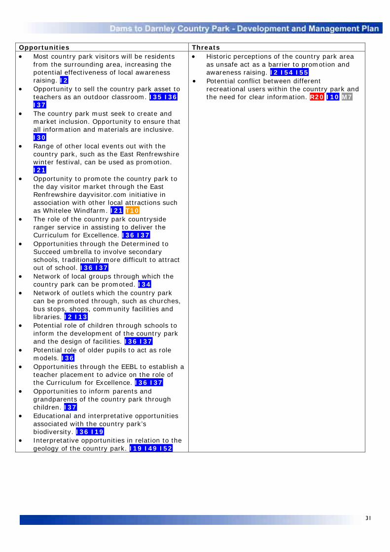
31
Opportunities Threats • Most country park visitors will be residents
from the surrounding area, increasing the potential effectiveness of local awareness raising. I2
• Opportunity to sell the country park asset to teachers as an outdoor classroom. I35 I36 I37
• The country park must seek to create and market inclusion. Opportunity to ensure that all information and materials are inclusive. I30
• Range of other local events out with the country park, such as the East Renfrewshire winter festival, can be used as promotion. I21
• Opportunity to promote the country park to the day visitor market through the East Renfrewshire dayvisitor.com initiative in association with other local attractions such as Whitelee Windfarm. I21 T10
• The role of the country park countryside ranger service in assisting to deliver the Curriculum for Excellence. I36 I37
• Opportunities through the Determined to Succeed umbrella to involve secondary schools, traditionally more difficult to attract out of school. I36 I37
• Network of local groups through which the country park can be promoted. I34
• Network of outlets which the country park can be promoted through, such as churches, bus stops, shops, community facilities and libraries. I2 I13
• Potential role of children through schools to inform the development of the country park and the design of facilities. I36 I37
• Potential role of older pupils to act as role models. I36
• Opportunities through the EEBL to establish a teacher placement to advice on the role of the Curriculum for Excellence. I36 I37
• Opportunities to inform parents and grandparents of the country park through children. I37
• Educational and interpretative opportunities associated with the country park’s biodiversity. I36 I19
• Interpretative opportunities in relation to the geology of the country park. I19 I49 I52
• Historic perceptions of the country park area as unsafe act as a barrier to promotion and awareness raising. I2 I54 I55
• Potential conflict between different recreational users within the country park and the need for clear information. R20 I10 M7

32
TRAINING, VOLUNTEERING AND BUSINESS Strengths Weaknesses • Training provided by the ERCTC within the country park.
T1 • Range of training opportunities and volunteer
conservation tasks available within the country park. T1 T3 T4 T5 T8
• Interest of some country park land managers in rural skills training being carried out on their land. N10 N24 N25 T1
• Popularity of volunteer activities run to date within the country park amongst the local community. T3
• Success of fortnightly country park volunteer group. T4 • Expertise of country park and partner staff in organising
and supervising conservation volunteering tasks. T1 T3 T4 T5 T6
• Success of volunteer community and school clean ups within the country park. I38 I42 T3 T4
• Membership and activities of local voluntary groups such as Go Greener. T5
• Lack of specialist conservation knowledge amongst trainee supervisors. N32 T1
• Uncertainty over the number of volunteers who will turn up for a task, with preparation requiring to be done regardless. I2
• Mundane nature of many maintenance tasks, leading to lack of motivation amongst trainees. T1
• Limited capacity to accommodate one or more country park volunteers on a regular placement basis. T3 T4 T8
• A lack of facilities means that trainees and volunteers working within the country park can spend less time on site. F7
• Lack of opportunities for business involvement within the country park in the short term. T9 T11
Opportunities Threats • Potential for outside agencies to deliver training within
the country park. T5 T8 • Opportunities for corporate training, such as team
building within the country park. T6 T11 • Volunteer opportunities within the country park for
businesses through their corporate social responsibility ethos. T6 T11
• Opportunities for business involvement in relation to running country park facilities in the longer term. T9 T11
• Opportunities for volunteer awards to be undertaken within the country park, John Muir, scouts etc. T5
• Existing and future partnership working taking place with conservation organisations such as SWT and BTCV. T5
• Opportunities to promote health and wellbeing through voluntary activities within the country park. T8
• Opportunities to educate trainees and contractors about the importance of protecting and enhancing the country park’s biodiversity. T1 T2
• Recent and existing projects with partners such as GCSS and Glasgow South West CHP. T5
• Linkages with Community Learning and Development Partnership activities. T5
• Potential identification of country park volunteer stewards. T7
• Potential interest in ‘fiends of’ group. I31 T4 • Volunteer events can potentially tackle antisocial issues
and increase the public’s use of the country park, helping to increase perceptions of safety. I2 T3 T4 T5 T6
• Complementary volunteer activities at other sites, such as Rouken Glen Park. T3 T4
• Potential health and safety risks. M17 M18
• Established volunteer activity at other sites. T3 T4
• Potential poor supervision of trainees. N32 T1

33
COMMUNITY SAFETY AND ANTISOCIAL BEHAVIOUR Strengths Weaknesses • Regular patrols of country park routes by
the countryside ranger service. C1 • Trainees provide an additional visible
presence and deterrent on site. T1 • GCSS support through regular camera van
patrols and occasional covert camera installation. C3 C15
• Fast police response to reports of air rifles within the country park. I46 C5 C24 C25
• Fast and regular fly-tipping removal by GCC LES. C3 C5 C11 C12
• Reporting of community safety and antisocial behaviour issues by the countryside ranger service to the police and other appropriate internal and external partners. C1 C18 C21 C22 C23 C24
• Investigation and follow up of fly-tipping incidents by GCC EPS. I45 C21
• Efficient removal of offensive graffiti (two working day response rate) by ERC ESR and GCC LES. C20
• Actions to combat scramble and quad bike problems within the country park. I45 C23
• Countryside ranger service events incorporate SOAC and the promotion of responsible access. I47
• GIS map highlighting country park community safety and antisocial ‘hot spots’. I58 C13
• Good lines of communication with partner agencies including the police. C2 C3 C5 C6
• Support of the local community in tackling community safety and antisocial issues. Local community encouraged to, and do, report incidents to the countryside ranger service and police. I42 I45 C5
• Up to date technologies available to combat fly-tipping such as night vision and wireless covert cameras. C15 C16
• Good level of interest from other agencies and groups to use the country park for environmental education, events and lead walks, helping to increase self-policing. I35 I37 I38 I40 T3 T4 T5 T6
• Involvement of ERC and GCC community service teams. M18 M20
• No formal arrangements in place to deal with the threat caused by uncontrolled fires within the country park. I43 C1 C8 C91 M8 M9
• ERC ESR and GCC LES have a longer 20 day response period in removing non-offensive graffiti. C19 T1 M20
• ERC ESR has a limited budget for the removal of fly-tipping. C3 C4 C8 C9 C11 C12 C13 C13 C15 C16 T1 M20
• Removal of fly-tipping from the Brock Burn is not a high priority for the GCC flood prevention team. C13 T1 M20
• No permanent covert camera cover to deter fly-tipping within the country park. C15 C16
• Urban fringe location and countryside setting makes the country park more prone to community safety and antisocial problems. I60 C1 C3 C4 C5 C6 C7
• Much of the country park is isolated from main roads and housing and has historically been an area where antisocial behaviour is not reported or challenged. I45 I60 C1 C3 C4 C5 C6 C7
• Open consumption of alcohol within the country park. C4
• Regular fly-tipping along Corselet Road and Balgraystone Road given their isolated locations. C1 C3 C5 C11 C12 C15 C16 T1
• Amount of litter dropped within Darnley Mill. T1 M10
• Damage caused to trees, hedges, fences, bins and benches by vandalism and fires within the country park. I60 C1 C3 C5 C6 C7 C19 M7 M8 M9
• Consistent level of graffiti across the country park. C1 C3 C18 C19
• Damage caused by scramble and quad bikes accessing private land and paths within the country park. I42 I46 C1 C3 C5 C6 C23
• Country park visitors may have difficulty in identifying and passing on their exact location in case of emergency. C10
Opportunities Threats • Working with schools, especially at nursery
and primary level, could help combat future antisocial behaviour. I36 I37
• Ways of getting around vandalism through good design of infrastructure. I19 I60
• Potential for country park car parks to attract antisocial activities such. C1 C6 C7 C16 T1 M10
• Perceived fear for personal safety and wider antisocial issues are identified as reasons why people do not visit the country park, in turn decreasing self-policing of the site. I2 I42 I54 I58 I60 C1 C6 C7

34
• Perceived threat of antisocial issues within the country park is greater than in other local greenspaces, such as Rouken Glen Park and Pollok Country Park. I2 I42 I59 I60
• Ongoing country park access improvements may increase the risk of illegal scramble and quad bike access. I42 I46 C1 C3 C5 C6 C7
• Incidents of wildlife crime, in particular targeting wildlife within the country park. I45 I46 C1 C2 C5 C6 C7 C24 C25
• Popularity and availability of air rifles. I46 C24 C25
• Potential health and safety issues restricting the removal of fly-tipping from country park watercourses. T1 M17
• Safety concerns relating to the reopening of Patterton M77 accommodation bridge. C14
MANAGEMENT AND MAINTENANCE Strengths Weaknesses • Role of the ERCTC in undertaking routine
country park maintenance and responding to non routine tasks as they arise. T1 M10 M12 M18 M20
• ERCTC assists to address limitations in existing maintenance budgets within the country park. T1 M10 M12 M18 M20
• Maintenance and litter schedules established on existing country park paths. M10
• Litter bins installed on main country park path routes. F4 M10
• Ongoing commitment of the country park joint committee. M1
• Support and partnership working through the country park steering group. M2 M3
• Strong links between the country park and GCC countryside ranger service. I36 I37 I38
• Good working relationship between ERC and GCC staff leading on the country park. M2 M3
• Baseline statistics available as a result of the country park recreation study. I55 I56
• Existing funding secured to develop and manage the country park. M27 M28
• The role of the country park in providing assistance to land managers in reducing risks associated with land management operations and access, for example through the provision of signage. M19
• Establishment of the Dams to Darnley Angling Club. M7
• Concerns of a number of country park land managers that their views are not being listened to. I32 M25
• GCC LES regularly struggle to fulfil country park maintenance tasks because of competing priorities. T1 M11 M20
• GCC LES are unlikely to be able to extend maintenance schedules to new country park routes. T1 M11 M20
• Overgrown and flooded paths at Darnley Mill. T1 M13
• Need for strategic long term country park planning to be put in place. M11 M21 M27
• Absence of annual work plans for country park staff following the removal of direct SNH funding. M4
• Lack of formal risk assessment associated with the country park landscape. M14 M15 M16 M17 M18
• Little feedback collected from guided walk and event participants, as well as country park visitors. I55
• No management rules or byelaws for the country park as a whole. M9
• Limited resources to enforce country park management rules or byelaws. C3 C7 M9
• No formal management of angling within the country park. M6 M7
• Additional capital and revenue funding required for country park visitor facilities. M28
Opportunities Threats • Availability of match funding through a
variety of sources. M28 • Potential future revenue funding from
country park facilities in the longer term. M28
• Limitations and uncertainties in funding for to deliver the country park development and management plan. M11 M28

35
6 OBJECTIVES The following objectives and specific actions result from the SWOT analysis. As noted earlier this draws together the background information contained within the plan, the vision and aims that it establishes, the recommendations of previous consultations and studies and the priorities identified through the development and management plan events. Recreation • Create safe, multiuse paths linking the
country park to local communities and the wider path network.
• Create a network of paths within the country park to provide recreational opportunities for a variety of users of all ages and abilities.
• Consider how best to develop the water resources of the country park for non-motorised recreational use.
Facilities • Establish car parking facilities appropriate to
the country park landscape, including accessible spaces.
• Progress the installation of small scale infrastructure within the country park.
• Examine the creation of appropriate inclusive visitor facilities within the country park.
Natural heritage • Carry out surveys and maintain records of the
country park’s biodiversity and geodiversity assets.
• Encourage and assist land managers to implement habitat enhancements within the country park.
• Work with, and contribute to, the work of local and national conservation groups.
• Work with council staff, partners, schools, trainees and volunteers to emphasise the importance of protecting and enhancing the natural heritage value of the country park.
• Manage other country park uses in relation to safeguarding its natural heritage.
Built heritage • Protect and where possible enhance the sites
of historical importance within the country park.
• Promote the built heritage of the country park.
• Work with, and contribute to, the work of local history groups.
• Manage other country park uses in relation to safeguarding its built heritage.
Information, interpretation and education • Increase awareness of the country park
locally and regionally and promote the Dams to Darnley identity.
• Engage with land managers and local communities within and surrounding the country park.
• Develop and deliver an environmental education programme, guided walks and events within the country park.
• Promote the responsible use of the country park and through information, interpretation and education reduce antisocial behaviour.
• Increase awareness of the country park’s natural and built heritage and promote its importance as an asset.
• Monitor and review progress in relation to the promotion and use of the country park.
Training, volunteering and business • Encourage and assist to deliver training
opportunities within the country park. • Encourage volunteer activity within the
country park. • Promote opportunities for appropriate
business development and diversification associated with the country park.
Community safety and antisocial behaviour • Work with partners to ensure that the country
park is a safe and welcoming place to visit. • Establish initiatives to address community
safety and antisocial issues across the country park.
• Address community safety issues across the country park and work towards a zero tolerance approach to antisocial behaviour.
Management and maintenance • Ensure that the development, maintenance
and management of the country park is guided by appropriate structures, policies, plans and agreements.
• Ensure that the views of partners and visitors influence the country park’s development.
• Ensure that sufficient resources are secured to support the development and management of the country park.

36
7 ACTIONS The actions detailed in Appendix 1 are marked as high, medium or ongoing priorities. In general those actions marked as a ‘high’ priority will provide the initial focus in terms of delivering the five year plan over its first two to three years, whilst those marked as a ‘medium’ priority will become a focus over the latter two or three years. Medium priority actions are also more likely to continue beyond the lifespan of this plan. Those actions marked as ‘ongoing’ priorities are either already underway or are planned to last throughout the duration of the plan. Ongoing priorities also include tasks that are regular and routine. Potential match funding sources are also identified, although this is not intended to be an exhaustive list. 8 MONITORING AND REVIEW Every plan needs to be regularly reviewed and monitored. Given that the country park is in its infancy this is particularly the case for this plan. It is essential to recognise that the plan, and in particular its objectives and actions, will require to be reviewed regularly, initially on a yearly basis, and that as a result the document will change during its five year lifetime. Such changes will be reported through the joint committee.
The actions set out in this plan are the key indicators of its progress. Actions will be monitored on an annual basis. Progress will be reported back to the joint committee using a simple percentage ratio to estimate the extent to which high and medium priority actions have been completed.

37
RECREATION Objective Ref Action Completed high and medium priority
actions in italics Priority Partners
(Lead) Estimated cost (£)
Match funding
Create safe, multiuse paths linking the country park to local communities and the wider path network.
R1 Establish a path linking Newton Mearns, at Whitecraigs Rugby Club, to Balgray Reservoir. Link to potentially form part of ERC CPP.
High
Landowner, SW, ERC ESR, East Renfrewshire LAF (project officer).
62,000
£30,850 LEADER and Whitelee funding secured.
R2 Establish a bridge at Balgray Reservoir to provide access between Newton Mearns, Whitecraigs Rugby Club path and Balgray Reservoir path.
High
SW, landowner, ERC ESR (project officer).
46,000 £22,890 LEADER and Whitelee funding secured.
R3 Establish a path linking the new Patterton Station car park to M77 accommodation bridge.
High Landowner, tenant farmer, ERC ESR, East Renfrewshire LAF (project officer).
29,000
R4 Progress reopening of Patterton M77 accommodation bridge and assist to identify and manage potential risks associated with land management operations.
High Landowner, tenant farmer, Police, Transport Scotland, Amey, local councillors, ERC ESR and CSS, East Renfrewshire LAF (project officer).
2,000
R5 Discuss a path linking the existing track on the west side of the M77 and planned Waulkmill Glen Reservoir path and establish if agreement is reached.
High Landowner, tenant farmer, ERC ESR, East Renfrewshire LAF (project officer).
17,000
R6 Discuss a path linking Jenny Lind to the existing network of paths within Walden Wood and establish if agreement is reached.
Medium Landowners, local residents, local councillors, GCC DRS and LES, Glasgow LAF (project officer).
5,000
R7 Ensure that path links delivered as part of the proposed Darnley Mains development are integrated into the wider country park access network and potentially GCC CPP.
Medium Local residents, local councillors, GCC DRS and LES, Glasgow LAF (project officer).
None
R8 Upgrade the existing path link along the north shore of Waulkmill Glen Reservoir. Link to potentially form part of ERC CPP.
High ERC ESR, SW (project officer).
43,000 £21,000 LEADER funding secured
R9
Discuss a path linking Barrhead at Aurs Road to Darnley Mill and establish if agreement is reached. Link to potentially form part of GCC CPP.
Medium Landowner, local residents, local councillors, GCC DRS and LES, Glasgow LAF (project officer).
128,000

38
R10 Progress opportunities relating to the provision of recreation infrastructure associated with future developments, taking account of the country park’s natural and built heritage value.
Ongoing (Project officer). None
Create a network of paths within the country park to provide recreational opportunities for a variety of users of all ages and abilities.
R11 Create a woodland trail through Waulkmill Glen to provide a circular walking route from Corselet Road, ensuring minimum impact upon natural heritage through managed access.
High GCC DRS and LES (project officer).
30,000
R12 Formalise a managed access route through the Darnley House and Bleachfields site following the completion of ground stabilisation works to provide a circular walking route from Corselet Road, linking into the Waulkmill Glen woodland trail.
High GCC DRS and LES (project officer).
30,000
R13 Establish and promote a circular 10km jogging circuit through the country park.
High Local runners and running groups (countryside ranger service).
None
R14 Determine the feasibility of creating a dedicated mountain bike circuit within the country park, establish costs and pursue funding if appropriate.
Medium Land managers, sportscotland, GCC DRS and LES (project officer).
None
R15 Improve the entrance at the Aurs Road lay-by to accommodate all users.
High SW (project officer). 7,000
R16 Extend existing country park orienteering course to Parklands Meadow area. Complete orienteering map. Continue to facilitate and encourage the use of the course by schools, groups and individuals.
High Orienteering groups, local primary and secondary schools, recreation and community groups, Glasgow South West CHCP (countryside ranger service).
2,000 £2,000 funding secured from Glasgow South West CHCP
R17 Continue to develop links with local recreational and community groups, promoting the country park and leading dedicated recreational activities.
Ongoing Local recreational and community groups (countryside ranger service).
None
R18 Identify and promote an equestrian route using both country park paths and adjacent quiet country roads.
High Local horse riders, stables and the British Horse Society (countryside ranger service).
None
R19 Examine how the country park recreational objectives and actions can benefit from initiatives associated with the Commonwealth Games.
High (Project officer). None

39
Consider how best to develop the water resources of the country park for non-motorised recreational use.
R20 Begin discussions regarding non-motorised watersports opportunities at the Barrhead dams.
High Local non-motorised watersports clubs and users, watersports governing bodies, local ornithologists, Dams to Darnley Angling Club, SW, East Renfrewshire LAF (project officer, countryside ranger service).
None
FACILITIES Objective Ref Action Completed high and medium priority actions in
italics Priority Partners
(Lead) Estimated cost (£)
Match funding
Establish car parking facilities appropriate to the country park landscape, including accessible spaces.
F1 Ensure that the new car park at Patterton Station is integrated into country park access links.
High ERC ESR (project officer).
None
F2
Continue to encourage the informal agreement of the World Buffet restaurant with regards the use of their car park.
Ongoing World Buffet restaurant (project officer).
None
F3 Consider, and progress if appropriate, other possible car park locations to provide access to the country park, in particular adjacent to Aurs Road, should an opportunity arise associated with its realignment.
Ongoing ERC ESR (project officer).
None
Progress the installation of small scale infrastructure within the country park.
F4 Continue to install benches, bins and fingerpost signs as part of the developing country park path network.
Ongoing (Project officer). None25
F5 In discussion with disability and angling groups provide a disabled anglers’ platform at the Barrhead dams.
High SDEF, East Renfrewshire Access Panel, Dams to Darnley Angling Club (project officer).
21,000 £11,800 LEADER funding secured.
F6 Install a viewpoint at Waulkmill Glen Reservoir. High (Project officer) None24 Examine the creation of appropriate inclusive visitor facilities within the country park.
F7 Undertake a study to examine the delivery of country park visitor facilities.
High (Project officer). 15,000
F8 Establish a temporary country park facility to address the current lack of a building.
High ERC PATS, SW (project officer, countryside ranger service).
25,000
25 Included in path costs

40
F9 Progress opportunities relating to the provision of visitor facilities associated with future developments, including those contained within LDPs, taking account of natural and built heritage.
Ongoing (Project officer). None
NATURAL HERITAGE Objective Ref Action Completed high and medium priority
actions in italics Priority Partners (Lead) Estimated
cost (£) Match funding
Carry out surveys and maintain records of the country park’s biodiversity and geodiversity assets.
N1 Carry out a breeding bird survey within the country park, where landowner agreement is present.
Medium Land managers, countryside ranger service (project officer).
8,000
N2 Undertake water vole surveys within suitable country park habitats and pursue resultant management actions.
Ongoing Land managers, (countryside ranger service).
None
N3 Continue to carry out bat surveys within suitable habitats, with the aim of identifying roost locations. Monitor use of bat boxes and hibernaculas within the country park.
Ongoing Land managers (countryside ranger service).
None
N4 Continue to undertake amphibian surveys within suitable country park habitats and pursue resultant management actions.
Ongoing Land managers, (countryside ranger service).
None
N5 Continue to undertake butterfly transects at Darnley Mill and submit results to Butterfly Conservation.
Ongoing Butterfly Conservation, GCC LES (countryside ranger service).
None
N6 Undertake butterfly surveys within suitable country park habitats and pursue any potential management actions.
Medium Land managers, (countryside ranger service).
None
N7 Monitor the presence of dragonflies and damselflies within the country park.
Medium (Countryside ranger service). None
N8 Undertake a grassland diversity survey within the country park to guide future management.
Medium GCC LES (countryside ranger service).
None
N9 Submit all country park records to the Glasgow Records Centre annually.
Ongoing (Countryside ranger service). None

41
Encourage and assist land managers to implement habitat enhancements within the country park.
N10 Work with interested country park land managers to increase biodiversity through appropriate funding sources, in relation to species rich grasslands, woodlands, hedgerows, wetland areas, field margins and unharvested crops for wintering birds.
Ongoing Land managers (project officer, countryside ranger service).
2,500 Element of £9,515 secured from GCC South Neighbourhood Qualities Fund.
N11
Investigate opportunities to achieve sympathetic water level control across the Barrhead dams.
High SW, local ornithologists (countryside ranger service).
None
N12 Examine the potential for minor summer fluctuation of water levels across the Barrhead dams.
High SW, local ornithologists (countryside ranger service).
None
N13 Examine the potential for a floating island on Balgray Reservoir to act as a bird roosting and nesting site.
High SW, local ornithologists (countryside ranger service).
None
N14 Work with SW to establish grassland management within sites adjacent to the Barrhead dams.
Ongoing SW, (countryside ranger service).
500
N15 Continue and expand management of unimproved country park grasslands within GCC ownership.
Ongoing GCC LES (countryside ranger service).
500 Element of £9,515 secured from GCC South Neighbourhood Qualities Fund.
N16 Examine the potential to begin sympathetic management of unimproved country park grasslands within ERC ownership.
Ongoing ERC PATS, (countryside ranger service).
500
N17 Complete a management plan for the Dams to Darnley LNR.
Medium (Project officer, GCC LES). 2,000
N18 Examine the potential to reintroduce grazing at Darnley Mill, with Highland Cattle from Pollok Country Park.
High Pollok Country Park, GCC LES (countryside ranger service).
None
N19 Examine the potential for a crop to be taken off council land at Darnley Mill and Balgray Reservoir.
Medium GCC LES, ERC PATS (countryside ranger service).
None

42
N20 Investigate the creation of wetlands along the course of the Aurs and Brock burns and where appropriate establish and undertake actions including the creation of adjacent marshy scrapes and ponds.
Medium Land managers, (countryside ranger service).
2,500
N21 Examine the potential to encourage a broad corridor of semi-natural habitats along the Aurs and Brock burns and where appropriate undertake actions.
Medium GCC LES, Land managers, (countryside ranger service).
2,500
N22 Examine the potential to introduce improved or sympathetic management of M77 and railway corridors.
Medium Amey, Network Rail, GCC DRS, ERC ESR (project officer).
2,000
N23 Investigate the possibility of jointly declaring Darnley Mill/Waulkmill Glen an LNR.
High Countryside ranger service (project officer, GCC LES).
None
N24 Work with country park land managers to reinstate and sympathetically manage existing hedgerows and examine the potential to establish new hedgerows. Work with land managers to reinstate existing stone walls within the country park.
Ongoing Land managers (project officer, countryside ranger service).
2,500 Element of £9,515 secured from GCC South Neighbourhood Qualities Fund.
N25 Undertake a review of SINCs within the country park.
High ERC ESR (project officer, countryside ranger service).
2,000
N26 Ensure that habitat enhancements are included in the landscaping of the Darnley House and Bleachfields site following the completion of the stabilisation works.
High GCC LES and DRS, project officer (GCC DRS).
None
N27 Examine the potential for grassland management at Parklands Meadow and Deacons Grange.
Medium Landowner, local community (countryside ranger service).
1,000
Work with, and contribute to, the work of local and national conservation groups.
N28 Continue to undertake habitat enhancement works at Darnley Mill in partnership with conservation groups.
Ongoing Local and national conservation groups, GCC LES (countryside ranger service).
None
N29 Contribute to the work of external conservation bodies within the country park through staff time, supporting projects and contributing information.
Ongoing (Countryside ranger service). None

43
N30 Consult with local and national conservation agencies as appropriate.
Ongoing (Project officer, countryside ranger service).
None
Work with council staff, partners, schools, trainees and volunteers to emphasise the importance of protecting and enhancing the natural heritage value of the country park.
N31 Work with SW to highlight the natural heritage value of the Barrhead dams and identify areas of concern and opportunity.
Medium SW (countryside ranger service).
None
N32
Provide opportunities for trainers, trainees and volunteers to acquire conservation skills within the country park as part of the improvements undertaken.
Ongoing Local community (countryside ranger service).
None
N33 Ensure that potential impacts on the country park’s natural heritage associated with future developments, including those contained within LDPs, are addressed.
Ongoing ERC ESR, GCC DRS (project officer).
None
Manage other country park uses in relation to safeguarding its natural heritage.
N34 Collect baseline data in order to begin to monitor the potential impact of country park visitors on its biodiversity and implement any required evidence based management measures.
Ongoing (Countryside ranger service). None
BUILT HERITAGE Objective Ref Action Completed high and medium priority actions in
italics Priority Partners
(Lead) Estimated cost (£)
Match funding
Protect and where possible enhance the sites of historical importance within the country park.
B1 Investigate the condition of the draw-off towers at Waulkmill Glen and Balgray reservoirs, establish costs for their repair and pursue funding if appropriate.
High
ERC ESR, SW, HS (project officer).
30,000
B2 Investigate the condition of the Waulkmill Glen ruin and establish costs for its consolidation.
High GCC LES (project officer). None
B3 Examine funding options to consolidate the Waulkmill Glen ruin and pursue funding if appropriate.
High GCC LES (project officer). 5,000
Promote the built heritage of the country park.
B4 Establish a virtual historical tour on the country park website.
Medium
ERC e-Gov (IT) (countryside ranger service).
2,000
B5 Establish links with the Glasgow Museums Resource Centre in Nitshill aimed at promoting the built heritage of the country park area.
Medium Glasgow Museums (countryside ranger service).
None

44
Work with, and contribute to, the work of local history groups.
B6 Work with local history groups to ensure their knowledge contributes to the protection and enhancement of the country park’s built heritage and contribute to local history groups through providing staff time and delivering talks as requested in relation to the country park.
Ongoing Local history groups (project officer, countryside ranger service).
None
Manage other country park uses in relation to safeguarding its built heritage.
B7 Monitor the potential impact of country park visitors on its built heritage and implement any required evidence based management measures.
Ongoing (Countryside ranger service).
None
INFORMATION, INTERPRETATION AND EDUCATION Objective Ref Action Completed high and medium priority
actions in italics Priority Partners
(Lead) Estimated cost (£)
Match funding
Increase awareness of the country park locally and regionally and promote the Dams to Darnley identity.
I1 Develop and circulate information relating to the country park for frontline staff of both East Renfrewshire and Glasgow City councils.
High (Countryside ranger service). None
I2 Write and implement an up to date PR strategy for the country park to establish key messages and mechanisms in relation to its promotion, taking into consideration the opportunities offered by the Commonwealth Games and its legacy plan.
High (ERC PRS, countryside ranger service).
None
I3 Write, agree and implement guidance to confirm unified accessible designs for entrance, directional and advisory signage and advise on their location (both within and out with the country park).
High ERC ESR, GCC LES and DRS (project officer).
None
I4 Design and install three main country park entrance signs/features to act as orientation points.
High ERC ESR, GCC LES (project officer).
6,000
I5 Design and install unified accessible country park entrance signs/features at all other identified lesser entrances.
High ERC ESR, GCC LES (project officer).
4,000 Element of £9,515 secured from GCC South Neighbourhood Qualities Fund.
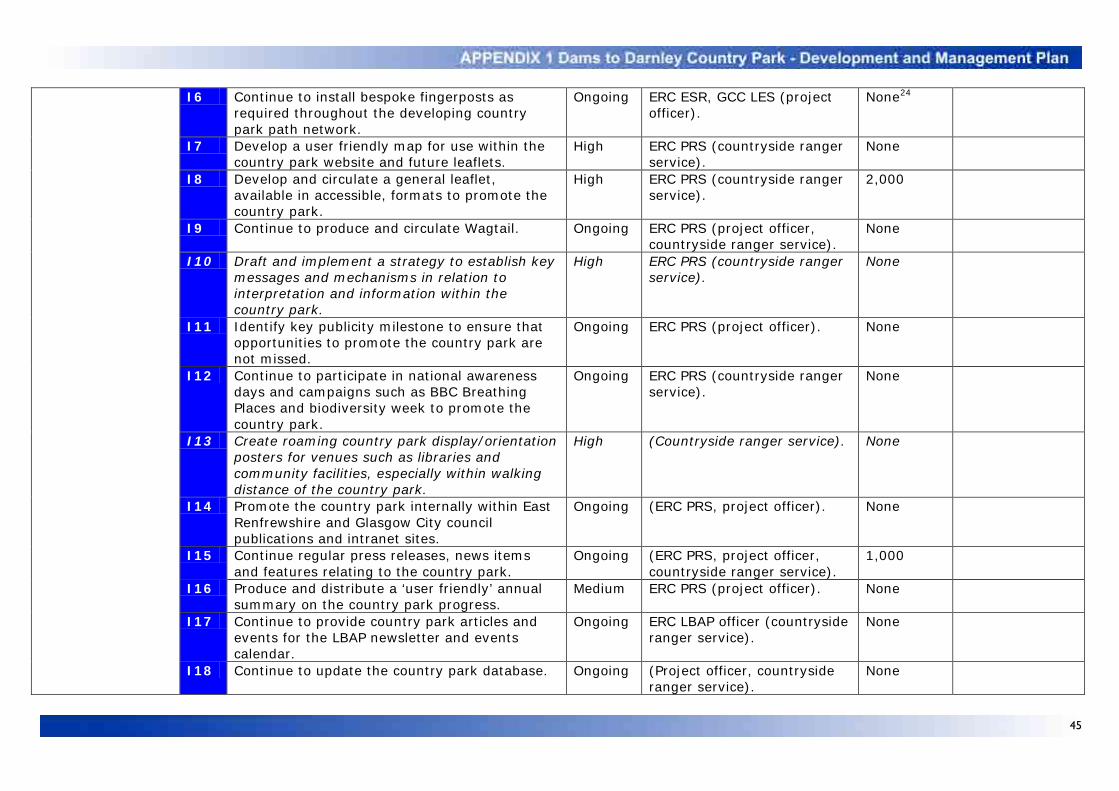
45
I6 Continue to install bespoke fingerposts as required throughout the developing country park path network.
Ongoing ERC ESR, GCC LES (project officer).
None24
I7 Develop a user friendly map for use within the country park website and future leaflets.
High ERC PRS (countryside ranger service).
None
I8 Develop and circulate a general leaflet, available in accessible, formats to promote the country park.
High ERC PRS (countryside ranger service).
2,000
I9 Continue to produce and circulate Wagtail.
Ongoing ERC PRS (project officer, countryside ranger service).
None
I10 Draft and implement a strategy to establish key messages and mechanisms in relation to interpretation and information within the country park.
High ERC PRS (countryside ranger service).
None
I11 Identify key publicity milestone to ensure that opportunities to promote the country park are not missed.
Ongoing ERC PRS (project officer). None
I12 Continue to participate in national awareness days and campaigns such as BBC Breathing Places and biodiversity week to promote the country park.
Ongoing ERC PRS (countryside ranger service).
None
I13 Create roaming country park display/orientation posters for venues such as libraries and community facilities, especially within walking distance of the country park.
High (Countryside ranger service). None
I14 Promote the country park internally within East Renfrewshire and Glasgow City council publications and intranet sites.
Ongoing (ERC PRS, project officer). None
I15 Continue regular press releases, news items and features relating to the country park.
Ongoing (ERC PRS, project officer, countryside ranger service).
1,000
I16 Produce and distribute a ‘user friendly’ annual summary on the country park progress.
Medium ERC PRS (project officer). None
I17 Continue to provide country park articles and events for the LBAP newsletter and events calendar.
Ongoing ERC LBAP officer (countryside ranger service).
None
I18 Continue to update the country park database. Ongoing (Project officer, countryside ranger service).
None

46
I19 Investigate the potential for on-site interpretation within the country park.
High (Countryside ranger service). 8,000 Element of £9,515 secured from GCC South Neighbourhood Qualities Fund.
I20 Investigate the country park’s potential participation in the green flag scheme.
Medium ERC ESR, GCC LES (project officer).
None
I21 Continue to ensure that the country park participates in key local events and promotional initiatives, including those at complementary local facilities such as Pollok Country Park.
Ongoing (Countryside ranger service). 1,000
I22 Ensure that the country park is developed and promoted as one entity across both East Renfrewshire and Glasgow City.
Ongoing (Project officer, countryside ranger service).
None
I23 Continue to use country park promotional items as appropriate.
Ongoing (Countryside ranger service). 4,000
I24 Add ‘Dams to Darnley’ to existing country park fingerposts and ensure inclusion in all future installations.
High (Project officer). 1,000
I25 Continue to promote the country park website. Review its structure and content bi-annually.
Ongoing ERC e-Gov (IT), ERC PRS (project officer).
1,000
I26 Review and update as required material relating to the country park on external websites.
High (Project officer). None
I27 Investigate the possibility of using SMS messaging to promote country park events.
Medium (ERC PRS, countryside ranger service).
None
I28 Investigate the possibility of setting up an on-line subscription system for the e-newsletter version of Wagtail.
High ERC e-Gov (IT) (countryside ranger service).
None
129 Work with colleagues to install appropriate directional signage out with the country park, including routes between complementary local facilities such as Pollok Country Park.
High ERC ESR, GCC LES and DRS (project officer).
3,000 Element of £9,515 secured from GCC South Neighbourhood Qualities Fund.
I30 Work towards ensuring that all country park information, interpretation and educational material produced is inclusive.
High (ERC PRS, countryside ranger service).
None

47
Engage with land managers and local communities within and surrounding the country park.
I31 Investigate the creation of a country park ‘friends of’ group.
Medium ERC ESR, GCC LES (countryside ranger service).
None
I32 Continue regular contact with country park land managers, within and bordering the country park, through personal delivery of every second Wagtail and as otherwise appropriate.
Ongoing (Project officer, countryside ranger service).
None
I33 Investigate a potential mail shot to all local communities to promote the country park.
Medium ERC PRS (project officer, countryside ranger service).
1,000
I34 Continue to offer talks and activities for local groups.
Ongoing Local groups (project officer, countryside ranger service).
None
Develop and deliver an environmental education programme, guided walks and events within the country park.
I35 Produce annual mail/email shots to schools within the two Glasgow learning communities next to the country park and all those in East Renfrewshire to promote the environmental education programme.
Ongoing ERC PRS and ED, GCC ES (countryside ranger service).
None
I36 Develop and utilise an environmental education strategy and pack aimed at primary and secondary schools focusing upon the natural and built heritage of the country park, in line with the Curriculum for Excellence.
High ERC ED, GCC ES, (countryside ranger service).
2,000 Element of £9,515 secured from GCC South Neighbourhood Qualities Fund.
I37 Continue to develop, promote and run an environmental education programme, in line with the Curriculum for Excellence and in association with the Active Schools Network, to offer opportunities to all nursery, primary and secondary schools within the two Glasgow learning communities which border the country park and all learning communities within East Renfrewshire.
Ongoing Local nursery, primary and secondary schools, Active Schools Network (countryside ranger service).
2,000
I38 Continue to develop, promote and run a varied events programme within the country park.
Ongoing ERC PRS (countryside ranger service).
5,000
I39 Produce and circulate an annual events calendar publicising c25 events within the country park.
Ongoing ERC PRS (countryside ranger service).
2,000
I40 Develop a series of country park community awareness events and open days.
Ongoing (Countryside ranger service). 2,000

48
I41 Continue to develop and promote a programme of regular healthy walks within the country park.
Ongoing Local residents, East Renfrewshire and Glasgow CHCP (countryside ranger service).
None
Promote the responsible use of the country park and through information, interpretation and education reduce antisocial behaviour.
I42 Continue to work with local community groups to address antisocial behaviour within the country park.
Ongoing Police, fire service, youth workers (countryside ranger service).
None
I43 Raise awareness of the key issues such as uncontrolled fires by direct communication with country park user groups.
Ongoing Police, East Renfrewshire LAF (countryside ranger service).
None
I44 Continue to inform and educate external organisation about antisocial behaviour within the country park via regular communication.
Ongoing Police (countryside ranger service).
None
I45 Publicise incidents, achievements, strategies, successes and partnership working through Wagtail and relevant partners’ and wider media.
Ongoing
Police, GCSS, ERC PRS (countryside ranger service).
None
I46 Continue to erect notices and warning posters at key locations within the country park to deter illegal use of motor vehicles and air rifles and to encourage reporting of such incidents through the provision of contact details.
Ongoing
Police (countryside ranger service).
None
I47 Continue to promote the SOAC via direct communication, events and interpretative media.
Ongoing SNH (countryside ranger service).
None
I48 Investigate and prioritise mechanisms to promote the use of the country park by dog walkers and encourage responsible behaviour through the SOAC ‘dog walkers’ leaflet.
High ERC PRS (countryside ranger service).
None
Increase awareness of the country park’s natural and built heritage and promote its importance as an asset.
I49 Create a website article on country park’s geodiversity.
High Strathclyde RIGS group (project officer).
None
I50 Develop a series of awareness posters and bespoke signage to highlight the potential for damage due to poor angling practises within the country park.
High Local anglers (countryside ranger service).
None
I51 Continue to work in partnership with the LBAP steering group to highlight LBAP species and habitats within the country park.
Ongoing (LBAP steering group, countryside ranger service).
None

49
I52 Draft and circulate a leaflet focusing on the geodiversity of Waulkmill Glen.
Medium Strathclyde RIGS group (project officer).
None
I53 Promote the country park as a destination for wildlife watching within a variety of media, to be detailed in the PR strategy.
Medium ERC PRS (countryside ranger service).
None
Monitor and review progress in relation to the promotion and use of the country park.
I54 Develop a number of quantitative and qualitative indicators to measure the use of the country park, including visitor feedback, building on base line data generated by the recreation study.
High (Project officer). None
I55 Establish key indicators to measure country park visitor perception and behavioural change building on base line data generated by the recreation study.
High (Project officer). None
I56 Continue to gather country park visitor number data from people counters and identify and adjust management operations accordingly. Pass copy of trends to SNH annually.
Ongoing (Countryside ranger service). None
I57 Present country park website and people counter statistics to the joint committee on a twice annual basis.
Ongoing (Project officer). None
I58 Collect data to update antisocial GIS map (including dates and any appropriate reference numbers) to inform ‘hotspots’ within the country park through patrol sheets, reported incidents and people counters.
Ongoing (Project officer, countryside ranger service).
None
I59 Review and update current strategies and practices within the country park in light of ongoing information and levels of success in tackling community safety and antisocial issues.
Medium (Project officer, countryside ranger service).
None
I60 Investigate strategies used in other urban fringe locations and progress if appropriate.
Ongoing (Project officer, countryside ranger service).
None
I61 Monitor the use of Patterton accommodation bridge.
Ongoing (Project officer, countryside ranger service).
None
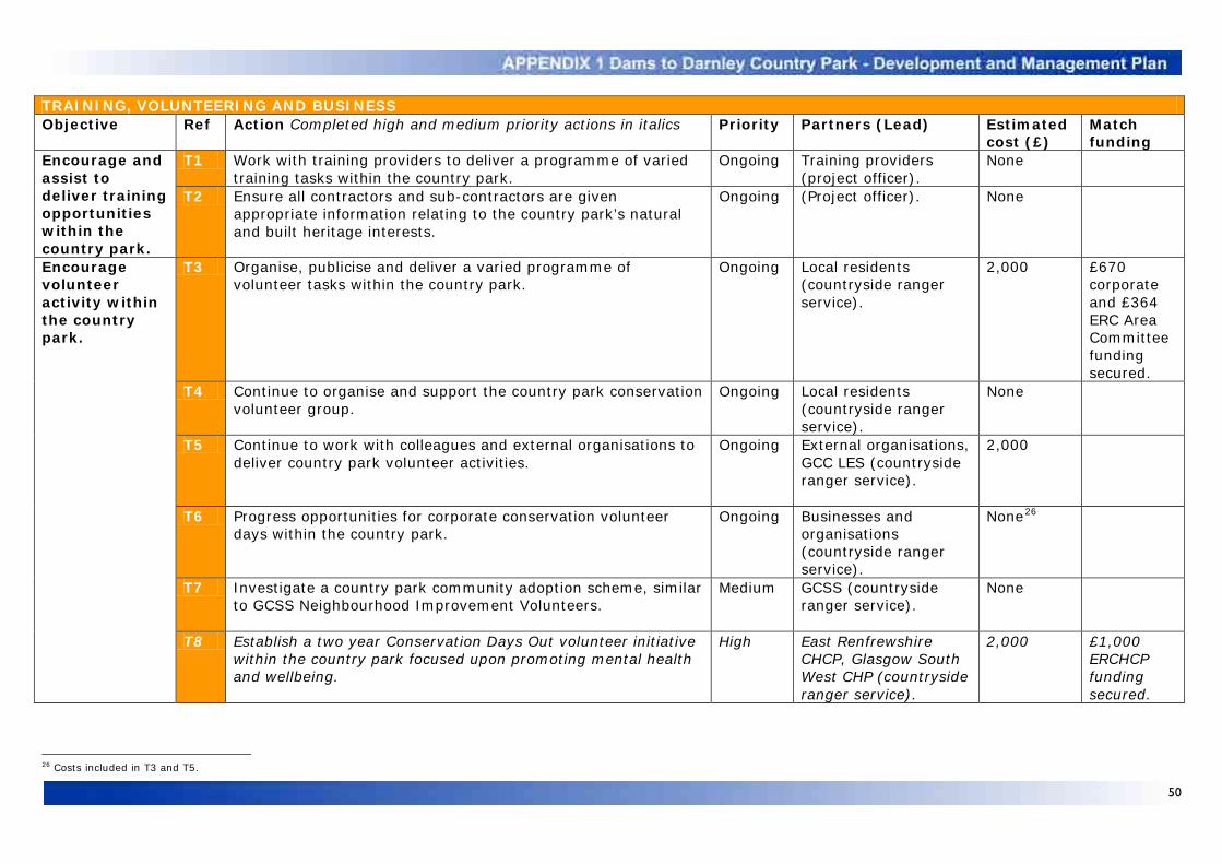
50
TRAINING, VOLUNTEERING AND BUSINESS Objective Ref Action Completed high and medium priority actions in italics Priority Partners (Lead) Estimated
cost (£) Match funding
Encourage and assist to deliver training opportunities within the country park.
T1 Work with training providers to deliver a programme of varied training tasks within the country park.
Ongoing Training providers (project officer).
None
T2 Ensure all contractors and sub-contractors are given appropriate information relating to the country park’s natural and built heritage interests.
Ongoing (Project officer). None
Encourage volunteer activity within the country park.
T3 Organise, publicise and deliver a varied programme of volunteer tasks within the country park.
Ongoing Local residents (countryside ranger service).
2,000 £670 corporate and £364 ERC Area Committee funding secured.
T4 Continue to organise and support the country park conservation volunteer group.
Ongoing Local residents (countryside ranger service).
None
T5 Continue to work with colleagues and external organisations to deliver country park volunteer activities.
Ongoing External organisations, GCC LES (countryside ranger service).
2,000
T6 Progress opportunities for corporate conservation volunteer days within the country park.
Ongoing Businesses and organisations (countryside ranger service).
None26
T7 Investigate a country park community adoption scheme, similar to GCSS Neighbourhood Improvement Volunteers.
Medium GCSS (countryside ranger service).
None
T8 Establish a two year Conservation Days Out volunteer initiative within the country park focused upon promoting mental health and wellbeing.
High East Renfrewshire CHCP, Glasgow South West CHP (countryside ranger service).
2,000 £1,000 ERCHCP funding secured.
26 Costs included in T3 and T5.

51
Promote opportunities for appropriate business development and diversification associated with the country park.
T9 Foster links with land managers and local businesses and support any resultant appropriate opportunities presented by the development and management of the country park.
Ongoing Businesses, land managers (project officer).
None
T10 Continue to work with colleagues to promote the country park’s tourism potential as one of a range of destinations.
Ongoing ERC ESR (project officer, ERC ESR).
None
T11 Work with local business to foster a sense of ownership in the country park initiative.
Medium Businesses, ERC ESR (project officer, countryside ranger service).
None
COMMUNITY SAFETY AND ANTISOCIAL BEHAVIOUR Objective Ref Action Completed high and medium priority actions in
italics Priority Partners
(Lead) Estimated cost (£)
Match funding
Work with partners to ensure that the country park is a safe and welcoming place to visit.
C1 Countryside ranger service to continue patrolling main country park routes (minimum weekly basis) making contact with users on site to increase a sense of security.
Ongoing
(Countryside ranger service). None
C2 Continue to work with police wildlife crime liaison officers to address wildlife crimes within the country park.
Ongoing Police (countryside ranger service).
None
C3 Address with enforcing partners measures to better tackle community safety and antisocial issues within the country park for which legislation exists.
High
Police, fire service, GCSS, ERC CSS (project officer, countryside ranger service).
None
C4 Pursue the enforcement of existing byelaws relating to drinking in public within Glasgow and examine and progress appropriate measures to tackle antisocial drinking within the East Renfrewshire side of the country park.
Ongoing GCSS, police, ERC CSS (countryside ranger service).
None
C5 Encourage the public and land managers to report community safety and antisocial incidents within the country park to the countryside ranger service or police.
Ongoing Local community, land managers, police, GCSS, ERC CSS (countryside ranger service).
None
C6 Work with the local police to encourage patrols within the country park, ensuring an increased visible presence, especially out with ‘normal’ hours.
High Police (countryside ranger service).
None
C7 Examine the potential for patrols by wardens within the country park to act as an additional physical presence, especially out with ‘normal’ hours.
Medium ERC CSS, GCSS (project officer).
None

52
C8 Produce an easy to read country park map to assist in reporting incidents to the emergency services.
High
Emergency services (countryside ranger service).
None
C9 Increase the knowledge of the emergency services and other partners in relation to the country park area and specific community safety and antisocial ‘hotspots’ to guide patrols and assist in reporting emergencies and incidents.
High
Emergency services, GCSS, ERC ESR (countryside ranger service).
None
C10 Pilot identification markers to assist country park visitors to locate themselves in an emergency. Role out if successful.
High (Countryside ranger service). 2,000
Establish initiatives to address community safety and antisocial issues across the country park.
C11 Investigate the potential to landscape Corselet Road and Balgraystone Road lay-bys and verges prone to fly-tipping.
High
GCC LES, ERC ESR (project officer).
5,000
C12 Ensure that all car parks and path entrances are designed and managed to minimise the likelihood of fly-tipping.
Ongoing Land managers, ERC ESR, GCC LES (project officer).
None
C13 Investigate the removal of fly-tipping from Brock and Aurs burns and the Barrhead dams.
Ongoing
Land managers, GCC LES, ERC CSS, SW, SEPA (countryside ranger service).
None25
C14 Work with the police in relation to the M77 Patterton bridge if required, in light of the action plan in place to address issues associated with M77 bridge to south.
Ongoing Police (project officer). None
C15 Work with GCSS to install country park covert cameras. High GCSS (project officer). None C16 Investigate the potential for the country park to purchase
one or more covert cameras. High
GCSS (project officer). 1,000
C17 Install warning signs along Aurs Road to advise motorists of the potential that they will encounter pedestrians.
High ERC ESR (project officer). None
Address community safety issues across the country park and work towards a zero tolerance approach to antisocial behaviour.
C18 Continue to report all country park graffiti to partners and monitor the response to ensure removal takes place.
Ongoing
GCC LES, GCSS, ERC CSS (project officer, countryside ranger service).
None
C19 Where possible use graffiti removal kits to remove small scale graffiti within the country park.
Ongoing
ERC ESR, GCC LES (countryside ranger service).
None
C20 Work to reduce incidents of racist country park graffiti relating to angling through events and the establishment of an angling management rules.
Ongoing
Local anglers, SW (countryside ranger service).
None
C21 Report all country park fly-tipping and investigate any identifiable material and report evidence to partners.
Ongoing
GCC LES and GCSS, ERC CSS (project officer, countryside ranger service).
None
C22 Report all incidents of vandalism within the country park to the appropriate landowner and where possible assist to repair.
Ongoing
Land managers, police, (project officer, countryside ranger service).
None

53
C23 Address and report all instances of quad or scramble bike access within the country park in partnership with police and SWCC.
Ongoing SWCC, police (project officer, countryside ranger service).
None
C24 Continue to act on all reports and instances of air rifles within the country park by reporting to police and assisting on site.
Ongoing Police (project officer, countryside ranger service).
None
C25 Undertake further specific measures to address air rifle use within the country park such as clearing up targets regularly and encouraging police patrols within key sites.
Ongoing Police (countryside ranger service).
None
MANAGEMENT AND MAINTENANCE
Objective Ref Action Completed high and medium priority actions in italics Priority Partners (Lead)
Estimated cost (£)
Match funding
Ensure that the development, maintenance and management of the country park is guided by appropriate structures, policies, plans and agreements.
M1 Convene and support quarterly country park joint committee meetings and follow up actions generated.
Ongoing (Project officer, ERC AMS).
None
M2 Convene and support regular country park steering group meetings and follow up actions generated.
Ongoing (Project officer). None
M3 Review the need to reconvene the country park biodiversity working group to advise on natural heritage matters.
Ongoing (CG, project officer). None
M4 Establish annual work plans for all country park staff. Establish countryside ranger work plans as part of national ranger reporting scheme. Input into national ranger reporting scheme and use results as an annual report to be circulated.
Ongoing (Project officer). None
M5 Ensure that all large scale country park works on land out with council ownership are tied to legal agreements, whilst all small scale works are accompanied by a signed exchange of letters.
Ongoing ERC LS (project officer). 2,000
M6 Continue to investigate available information to determine the ownership of the fishing rights across the Barrhead dams.
Ongoing ERC LS (project officer). None
M7 Facilitate and assist the Dams to Darnley Angling Club and establish management rules at the Barrhead dams, in discussion with relevant parties.
High Dams to Darnley Angling Club and local anglers, land managers, SW (countryside ranger service).
None
M8 Create a coherent country park fire management plan. High
Land managers, fire service (countryside ranger service).
None

54
M9 Work with country park partners to establish workable management policies in relation to key community safety and antisocial issues taking into account existing bye-laws and the reality of enforcement.
High Land managers (countryside ranger service).
None
M10 Undertake country park maintenance. Ensure all existing tasks are part of schedules to be reviewed, monitored and revised as required. Confirm routine maintenance schedules are in place prior to ERCTC ceasing operation.
Ongoing ERCTC, GCC LES (project officer).
125,000
M11 Pursue all appropriate options and mechanisms to deliver maintenance across Dams to Darnley, ensuring information contributes to a country park business and delivery plan.
High GCC LES, GCC DRS (project officer).
None
M12 Ensure that all new country park maintenance tasks are added to existing or new schedules and are undertaken.
Ongoing ERC ESR, GCC LES (project officer).
10,000
M13 Establish an annual rolling programme to repair and regrade existing country park paths as required.
Ongoing ERC ESR, GCC LES, (project officer).
25,000
M14 Work with colleagues to assess any potential risks across land within the country park in their ownership and identify potential mitigation measures.
High ERC RS and PATS, GCC LES, (countryside ranger service).
None
M15 Assist SW to assess potential risks across land within the country park in their ownership and identify potential mitigation measures. Provide and encourage the use of standard land management signs as developed by SNH.
High (SW, countryside ranger service).
None
M16 Work with other land managers to assess any identified potential risks across country park land in their ownership and identify and assist to undertake potential mitigation measures. Provide and encourage the use of standard land management signs as developed by SNH.
Medium Land managers (countryside ranger service).
None
M17 Ensure that appropriate risk assessments are completed for all country park events and visits.
Ongoing (Countryside ranger service).
None
M18 Ensure that risk assessments and method statements are completed for all appropriate works within the country park and where required passed to partners.
Ongoing (Project officer). None
M19 Provide assistance to country park land managers in identifying land management operations and where appropriate assist to reduce any risk, for example through the provision of signage, based upon templates developed by SNH.
Ongoing Land managers (project officer, countryside ranger service).
None

55
M20 Ensure that non routine tasks and problems within the country park are addressed as they arise.
Ongoing ERC ESR, GCC LES (Countryside ranger service, project officer).
None27
M21 Review and monitor the country park development and management plan and report to the joint committee.
Ongoing (Project officer). None
M22 Undertake an access audit, based upon the Fieldfare Trust guidance, across the country park access network, and establish a three year programme of improvements.
High (Project officer). 6,000
M23 Pursue the repair of Corselet Road. Ongoing GCC DRS and LES (project officer).
20,000
M24 Identify and undertake training appropriate for country park staff, including accessibility training.
Ongoing (Countryside ranger service, project officer).
None
Ensure that the views of partners and visitors influence the country park’s development.
M25 Work with partners, including land managers, and relevant groups and forums, such as the LAFs and Local Access Panels in relation to the development and management of the country park.
High LAFs, Local Access Panels (project officer, countryside ranger service).
None
M26 Ensure that the views of visitors, gathered as part of the regular monitoring and review of progress in relation to the promotion and inclusive use of the country park, influence its development and management.
High Country park visitors (project officer).
None
Ensure that sufficient resources are secured to support the development and management of the country park.
M27 Update existing financial forecasts relating to the development and management of the country park on an annual basis.
Ongoing (Project officer). None
M28 Produce a country park business and delivery plan to: fully explore potential country park funding sources (capital, staff and maintenance); identify potential short term commercial and not-for-profit opportunities associated with the country park and establish delivery mechanisms for country park visitor facilities.
High (Project officer). None28 £326,170 additional funding required for development and management plan actions. £256,530 additional required for staff costs.
27 Costs included in M10. 28 Costs included in F7.

56 56
INTRODUCTION Public bodies are required by law to look at their policies and functions, including new policies, and to screen them to see if they have significant relevance for equalities. If they do, then an Equality Impact Assessment (EqIA) should be carried out. EqIA is a process of looking systematically at evidence to determine what impact a policy or function will have on people in equality groups, making sure that unlawful discrimination is eliminated and improving the service, policy of function. It is a way of making sure that equality is placed at the centre of policy development and service delivery. It is always better to do the EqIA before a policy is finalised. The following EqIA for the Dams to Darnley Country Park Development and Management Plan follows a standard set of questions employed by East Renfrewshire Council to undertake both screening and EqIA assessment. Once the EqIA is concluded an action plan should be prepared with arrangements made to review actions over time, and the assessment must be published. Specific actions which have emerged from this EqIA have been included in the action plan, appendix 1 of the development and management plan. These actions will be monitored and reviewed on an annual basis and reported through the country park joint committee. PART ONE SCREENING What is the policy? Dams to Darnley Country Park Development and Management Plan 2011-2016 Description
The plan sets out the background information key to the development and management of the country park and establishes eight aims, each focused on an individual theme. The plan then sets out a vision for the country park, based around these aims, towards which the initiative seeks to progress. The most significant stage of the plan focuses upon an analysis and assessment of the background, aims and vision set out within it and the key outputs of previous consultations and studies. A set of broad objectives then follow, leading in turn to specific
actions, which collectively make up an action plan, once again framed by the eight aims. The timeframe of the plan is also structured around these actions, as outlined in the final monitoring and review section. What is the aim, objective and purpose of the policy? The plan’s purpose is to guide the development of the Dams to Darnley Country Park and aid its effective and efficient management. The plan is structured around eight aims: • Develop a range of inclusive land and water
based recreation opportunities within the country park, suitable for all ages and abilities, and manage their impact upon heritage and land management interests;
• Provide good quality, appropriate, sustainable and inclusive facilities for visitors, in keeping with the landscape of the country park;
• Conserve and enhance the biodiversity, geodiversity and landscape of the country park;
• Conserve, protect and enhance the built heritage of the country park;
• Raise awareness, understanding and appreciation of the country park and promote its responsible use through information, interpretation and education;
• Develop inclusive opportunities for training, volunteering and business diversification as part of the development and management of the country park;
• Promote community safety and tackle antisocial behaviour within the country park;
• Ensure that the country park and its resources are effectively managed and maintained.
Who implements the policy? The Dams to Darnley Country Park is a joint project between East Renfrewshire and Glasgow City councils. The plan will primarily be implemented by the country park staff, who are hosted by East Renfrewshire Council. Who is intended to benefit from this policy and in what way? The Dams to Darnley Country Park is primarily seen as a local resource. It has been estimated that 126,500 people live within the local area, defined within the plan as a 3.5km buffer around the country park boundary. Local residents will

57 57
benefit from improved recreational, educational, volunteering and training opportunities, readily accessible to, and enjoyed by, all ages and abilities. Is the policy applied uniformly throughout the authority area? Yes, throughout the Dams to Darnley Country Park area. It is not to be applied to any other area. Who are the stakeholders in relation to this policy (for example, councillors, residents, partners, visitors)? • Joint committee members and other local
councillors; • The local community who use the country
park; • The wider community who do not currently
use the country park; • Recreation and community groups, as well
as local schools and colleges; • Land managers; • Partners; • Country park staff; • Council staff, trainees and volunteers; • Potential funding partners. What data is available to facilitate the screening of this policy? A wide range of background data is contained within the plan, focused around eight themes, including data on age, in terms of local population demographics. No data is based solely on equality. Is there evidence of higher or lower participation, uptake or exclusion? No relevant evidence has been collated specifically regarding Dams to Darnley Country Park. The main issues relating to potential participation, uptake or exclusion relate to a small number of entrances not being compliant with the Equality Act 2010 and the lack of car parking. Actions are contained within the plan to address these issues (appendix 1). The East Renfrewshire Council 14th Citizens Panel provides some general evidence of the use of parks and greenspaces29
:
29 East Renfrewshire Council Citizens Panel 2009. Results based on 677 responses from a cross section of residents.
• 89% of respondents stated that they used parks or greenspaces in East Renfrewshire;
• Respondents aged over 65 were less likely to use parks or greenspaces (78%) than those aged under 65 (93%).
The most common reasons for not making more use of parks and greenspaces relate to:
• The availability of alternatives (25%); • Lack of awareness (18%); • Safety concerns (17%); • Lack of interest in the actual content of the
parks (14%). Only a relatively small minority of respondents saw any particular factor as being a barrier to usage. No notable variations exist with regard to the age of respondents. Respondents were most likely to cite concerns about a lack of facilities, the state of repair regarding the parks in question, a lack of time, mobility issues and the distance needed to travel to parks or greenspaces. There were limited comments referring to mobility issues with regards to barriers of usage, but comments did not explain if this was an accessibility issue with regard to a park or greenspace, or if the responded did not want to visit the park because of their own mobility issues. In contrast the Glasgow City Council Household Survey30
shows that only 39% of respondents used parks, with age groups most likely to have children (25-44) making the greatest use. Black and minority ethnic residents were also more likely to use parks (46%).
In the context of the preceding sections are there any relevant groups which you believe should be consulted? Please specify and give reasons. • Scottish Disability Equality Forum; • East Renfrewshire and Glasgow Access
Panels. Reasons The Scottish Disability Equality Forum is represented on the Dams to Darnley Country Park steering group, contributing to its strategic direction and overall management. Comments on specific relevant actions contained within the plan should be sought from local Access Panels.
30 Glasgow City Council Household Survey (Wave 5) Final Report May 2010.

58 58
What data is required in the future to ensure effective monitoring? The plan details actions detailing monitoring work which will be undertaken in terms of visitor use, the methodology of which is still to be confirmed (appendix 1). Considering all the information above please indicate areas where a differential impact occurs or has the potential to occur. The main potential for differential impact relates to: • Disability, with regards to access to and use
of the country park, as well as associated with information, interpretation and signage;
• Age and gender, in terms access for elderly visitors and perceptions of safety and antisocial behaviour;
• Ethnicity, relating to the provision of information, interpretation and signage.
No data currently exists to back up these potential issues apart from the East Renfrewshire Council Citizens Panel and Glasgow City Council Household Survey results. Potential for differential impact? Yes. Although the plan seeks to improve access to and the use of the country park, and has a detailed action plan to address key issues, there is still potential for differential impact. PART TWO ASSESSMENT Does the policy impact less favourably on a certain group or groups in comparison with others? Topography and land management constraints may mean that a small number of recreation actions contained within the plan will lead to short sections of paths which do not fully meet countryside for all standards in terms of all abilities access. These actions will nevertheless lead to significant improvements in access provision when compared to the current situation (appendix 1). Similarly some recreation actions, such as the creation of woodland paths within Darnley Mill, may provide routes that certain groups are less likely to use because of perceptions of safety and antisocial behaviour. In this regard the plan
contains actions which aim to address antisocial behaviour and community safety issues (appendix 1). Information, interpretation and education actions, such as the provision of signage and leaflets, also has potential to impact less favourably on groups with visual impairments or whose first language is not English. The plan contains actions which seek to identify appropriate staff training, including accessibility training (appendix 1). Is there any indication of a higher or lower participation/uptake rate by particular equality groups? No up to date evidence is available in relation to the Dams to Darnley Country Park. A report by the Open Space Research Centre (2008)31
does point to existing research having indicated that participation in informal outdoor recreation is relatively low amongst a number of groups:
• Young people; • Older people; • Women; • People from ethnic minority groups; • People with disabilities. As noted in part one above, the East Renfrewshire Council Citizens Panel and Glasgow City Council Household Survey results provides some general evidence of the use of parks and greenspaces. Do some groups have lower than average success rates in particular processes and/or access to services? No evidence is available to date in relation to the Dams to Darnley Country Park. As noted above research does point to the fact that certain equality groups have lower levels of participation in informal outdoor recreation and as a result it could be argued that these groups have lower than average success rates in accessing such services. Do criteria or requirements in relation to the policy disadvantage certain groups, either explicitly or inadvertently? The plan focuses resources upon the development and management of a greenspace resource. Given that evidence suggests that the
31 Open Space Research Centre (2008) Participation in Outdoor Recreation by WAG Priority Groups

59 59
participation of certain groups in informal outdoor recreation is relatively low it could be argued that these groups are disadvantaged as they are less likely to benefit from the collective actions contained within plan. In contrast individual actions are planned to assist specific equality groups (appendix 1). For example new and upgraded country park entrances and paths will provide benefits with regards all abilities access. The plan also contains a range of actions which aim to address community safety and antisocial behaviour, which it is hoped will reduce potential differential impact with regards gender and age. Similarly environmental education and training actions will also aim to reduce potential differential impact with regards age. Is access to services and benefits reduced or denied for some groups in comparison with other groups? It could be argued that actions within the plan associated with the provision of information and interpretative materials in English may result in the benefits of the plan to ethnic minority groups being reduced or denied. Interpretative material will be made available upon request in additional languages.
Do particular groups face increased difficulty or indignity as a result of the policy? It is not anticipated that any groups will face increased difficulty or indignity as a result of the plan. Are there higher complaints rates or lower satisfaction rates for particular equality groups in connection with the policy, in comparison with other groups? There is no evidence to suggest that there are higher complaints rates or lower satisfaction rates amongst particular equality groups associated with the development and management of the country park.

60 60
STRATEGIC ENVIRONMENTAL ASSESSMENT DETERMINATION STATEMENT As required under the Environmental Assessment (Scotland) Act 2005 East Renfrewshire Council as the responsible authority is charged with determining whether or not a Strategic Environmental Assessment (SEA) is required for the Dams to Darnley Country Park Development and Management Plan. In order to determine whether an SEA was required for the previous draft development and management plan the council undertook an SEA screening report under Section 8 (1) of the Act. The screening report noted that individually the projects, proposals and management actions set out in the draft development and management plan were not anticipated to have significant environmental effects. It was recognised that the construction of new path routes, as outlined in the draft plan, would have the greatest potential environmental impact upon the country park’s natural and built heritage. The screening report noted that the further development and management of the country park’s path network would reduce this potential impact through carefully managed access. Specific actions were also outlined within the draft plan to monitor the potential impact of visitors on the country park’s natural and built heritage, with any evidence based management measures being implemented as required. Cumulatively the screening report recorded that actions contained within the draft development and management plan would lead to increased visitor numbers, but as noted above, these would be managed through a dedicated path network and include appropriate mitigation.
The draft development and management plan prioritised projects, proposals and resources, but these were at a local, rather than strategic level. In addition the draft plan was seen to sit as a low-level document within the overall policy hierarchy. As a consequence East Renfrewshire Council as the responsible authority, having given due weight to the above, deemed that the environmental impacts of the Dams to Darnley Country Park draft development and management plan were non significant, and as a result determined under Section 8 (1) of the Act that the draft plan should not be subject to the SEA process. Notice of this determination was made public by advertisement in the Barrhead News and the Glasgow South and Eastwood Extra. It was also made available for public inspection on the council’s website at www.eastrenfrewshire.gov.uk and at the council’s main offices. A number of minor changes were made to the draft development and management plan as a result of submissions made through the public consultation process undertaken in respect of it. This plan, and in particular appendix 1, has also been updated in light of progress made since the previous draft version was published. East Renfrewshire Council does not consider that the minor changes made to the draft development and management plan result in any significant environmental effects. As a result East Renfrewshire Council is of the opinion that the completion of this plan does not merit any change to the above determination.
31 August 2011