d light all age steppingstones · 2020-06-11 · identifying common science and conservation goals...
TRANSCRIPT

DDEPARTMENTEPARTMENT OFOF DDEFENSEEFENSE PPARTNERSARTNERS ININ FFLIGHTLIGHT, F, FALLALL 20112011 PPAGEAGE
SteppingstonesNEWSLETTER OF THE DEPARTMENT OF DEFENSE
PARTNERS IN FLIGHT PROGRAM
FFALLALL 20112011
Our nation’s natural resources and landscapesare important to sustaining our quality of lifeand our economy. Native fish and wildlifespecies also depend on healthy rivers, streams,wetlands, forests, grasslands, and coastal areasto thrive. Managing these natural resources andlandscapes has become increasingly complex.Land use changes and impacts such as drought,wildfire, habitat fragmentation, contaminants,pollution, invasive species, disease, and arapidly changing climate can threaten people aswell as the sustainability of native species andtheir habitats.
Landscape Conservation Cooperatives (LCCs)recognize that these challenges transcendpolitical and jurisdictional boundaries, andrequire a more networked approach toconservation – one that is holistic, collaborative,and grounded in science to help inform land
Landscape Conservation CooperativesLandscape Conservation Cooperatives——Managing ChangeManaging Change
Military installations provide valuable habitat for birds, and serve asMilitary installations provide valuable habitat for birds, and serve as steppingstonessteppingstones during migration.during migration.
Continued on next page
INSIDE:
Landscape ConservationCooperatives..................................... 1
Saving Tallgrass Prairie. ................... 3
Partnership Focus:Association of Fish and WildlifeAgencies (AFWA) ............................. 5
View From the Eyrie......................... .7
State of the Birds .............................. 8
Policy Perch: Plan and PolicyUpdate…........................................... 9
Gray Vireo Finds Important and UniqueWinter Habitat in Arizona’s MilitaryLands.............................................. 10
Washington Western BluebirdReintroduction Effort a Success...... 12
Cross-Bird Puzzle ........................... 13
Cross-Bird Puzzle Answer Key. ...... 14
A group of volunteers helps replant marsh grass on a refuge.Source: U.S. Fish & Wildlife Service
LCCs are a national network of public-private partnerships that work collabora-tively across jurisdictions and political boundaries to leverage resources and toshare science capacity. Partners include federal agencies such as the Departmentof Defense (DoD), state and local governments, tribes, universities, non-governmental organizations (NGOs), landowners, and other stakeholders.Because no public or private entity alone has all of the conservation tools andcapacities needed to address the cumulative impacts to America’s land, water,wildlife, and cultural resources, LCCs coordinate across various programs andinitiatives to jointly identify science and management priorities. Partner agenciescoordinate with each other while working within their existing authorities andjurisdictions.
LCCs are inherently collaborative and seek to identify best practices, connectefforts, identify gaps, and avoid duplication among and between partners in aneffort to support sustainable landscapes. They complement and build uponexisting cooperative science and conservation efforts, including those for waterresources and land and cultural partnerships. LCC products may includeresource assessments, climate model applications to appropriate scale, vulnera-bility assessments, inventory and monitoring protocols, and conservation plansand designs.

DDEPARTMENTEPARTMENT OFOF DDEFENSEEFENSE PPARTNERSARTNERS ININ FFLIGHTLIGHT, F, FALLALL 20112011 PPAGEAGE 22
Landscape Conservation CooperativesLandscape Conservation Cooperatives——Managing Change (cont.)Managing Change (cont.)
Core LCC functions include: identifying common science and conservation goals
and priorities between partners; developing science-based tools and solutions to meet
shared conservation goals; supporting biological planning, conservation design
and adaptive management; and evaluating the effectiveness of scientific information
and conservation actions.
Collectively, the current 21 LCCs form a national networkof land, water, wildlife, and cultural resources managers,scientists, and interested public and private organizations –within the U.S. and across our international borders – thatshare a common need for scientific information and interestin conservation.
Key ComponentsA steering committee with members from resourcemanagement and science agencies (federal, state, tribal, andlocal) will guide each LCC. NGOs, universities, members ofindustry, and others may also contribute to the cooperativeeffort and may be part of the steering committee in someLCCs. Core staff will include a coordinator and sciencemanager for each LCC. The partnership could also supportother staff, including individuals with expertise in applied
science (applying research results to the design,implementation, monitoring, and assessment ofconservation actions), as well as geographers, GISspecialists, biometricians, cultural resources, and outreachspecialists.
DoD agencies such as the U.S. Army Corps of Engineersare represented on some LCC Steering Committees. RickNelson, Plains and Prairie Potholes LCC Coordinator,stated that ,“the Corps has a major presence on theMissouri River, which runs right through the middle ofthe Plains and Prairie Potholes LCC.”
In addition, the Desert Managers Group (DMG) andMojave Desert Ecosystem Program (MDEP), both of whichhave strong DoD affiliations, have been engaged andoffered support to DoD through a Mojave sub-regionconcept within the Desert LCC for the past year and a half.DMG has promoted this sub-regional approach since theDesert LCC operates across three distinct desert ecoregionsand five states.
In cooperation with the Mojave Desert Initiative (MDI) outof Nevada, both DMG and MDEP developed a concept fora Mojave subgroup that would operate alongside aSonoran, Chihuahuan, and Colorado river subgroup in
support of the Desert LCCeffort. This subgrouping wouldallow for existing organizationsto address Desert LCC goalswhile being efficient and costeffective.
MDEP is positioned to supportthe data needs currentlyoutlined in the Desert LCC forthe Mojave sub-region sinceMDEP supports both DMG andMDI at this time. Each militaryinstallation operating in theMojave ecoregion is a memberof one or both of theseorganizations, which couldprovide for DoD involvementwithin the Desert LCC if a sub-regional approach is adopted.
- David T. Eisenhauer,Office of Public Affairs,
U.S. Fish and Wildlife ServiceMap of Landscape Conservation Cooperatives in the United States.
Source: http://www.fws.gov/science/shc/lcc.html

DDEPARTMENTEPARTMENT OFOF DDEFENSEEFENSE PPARTNERSARTNERS ININ FFLIGHTLIGHT, F, FALLALL 20112011 PPAGEAGE 33
Tallgrass prairies are one of the most diversevegetative communities in North America. Grassesthat can grow to over 8 feet in height, with lavishdisplays of ornamental wildflowers interspersed withother broadleaf plants, sedges, and woody plantsdominate the landscape. Three major factorsinfluenced the development of tallgrass prairie. First,frequent fire eliminated trees and controlled shrubs.Additionally, grasses and forbs adapted to grazing andfire due to underground growing points that quicklyre-sprout. And finally, prairie plants can go dormantduring a drought, and then begin growing again whenrain returns. All of these natural events andcharacteristics have led to the tallgrass prairies weknow today.
The tallgrass prairie is considered by many to be themost altered ecological community in North America.Originally spanning a relatively thin strip fromsouthern Manitoba down through northern Oklahoma,tallgrass prairie covered approximately 142 million acresof the American heartland. Because of the deep, rich soilsand precipitation patterns, European sellers were quick toplow and plant agricultural grain crops when they arrived.Current estimates of remaining acreage range from lessthan 1–4% of pre-settlement tallgrass. The Flint Hills areain east-central Kansas is by far the largest tallgrass prairielandscape remaining on the continent, with more acresthan in all of the other prairie states and provincescombined. Even so, a sizable portion of the Flint Hills hasbeen degraded by invasive plants, urban sprawl, urban-to-rural migration, woody encroachment, and fragmentation.
The Fort Riley Military Installation (over 101,000 acres),located in the northern Flint Hills of Kansas, contains thelargest expanse of tallgrass prairie in the public domain.Military training and management of tallgrass prairie areco-dependent on Fort Riley. Much of the grassland on FortRiley has a flat, open topography, which lends itself toforce-on-force maneuver training, an importantcomponent of the installation’s mission. Prescribedburning is the most important method to provide the openspace needed for maneuver training. Fire kills trees andmaintains the grassland cover, which work together tosustain open vistas. Frequent burning (2 out of 5 years)helps reduce a build-up of dead vegetation on installationand lessens the potential danger of wildfires to soldiersand equipment in the field. Abundant rainfall and thecapability of prairie vegetation to re-grow afterdisturbance allows the grassland to quickly recover frommaneuver activities.
Healthy numbers of all mid-latitude bird species typical oftallgrass prairies occur on Fort Riley, including GreaterPrairie-Chicken, Henslow’s Sparrow, Upland Sandpiper,and Dickcissel. Declines of these and other grasslandfauna populations have coincided with the decline oftallgrass prairie across the nation. In an attempt to halt thedecline of these tallgrass species, efforts are underway totry to permanently protect portions of the remainingtallgrass prairie within the Flint Hills region.
Saving Tallgrass PrairieSaving Tallgrass Prairie
Location of the Fort Riley Military Installation in relation tothe Flint Hills region of Kansas.
Map courtesy of Fort Riley
Flint Hills landscape and wild blue indigo (Baptisia australis) onMoyer Ranch, part of a 6,800-acre tract protected in perpetuity
through a partnership with USDA-NRCS, Fort Riley, REPI, KansasLand Trust, and Kansas Department of Wildlife & Parks.
© Photo courtesy of Bruce L Hogle
Continued on next page

DDEPARTMENTEPARTMENT OFOF DDEFENSEEFENSE PPARTNERSARTNERS ININ FFLIGHTLIGHT, F, FALLALL 20112011 PPAGEAGE 44
Saving Tallgrass Prairie (cont.)Saving Tallgrass Prairie (cont.)
Fort Riley has partnered with the Kansas Land Trustthrough the Readiness and Environmental ProtectionInitiative (REPI) to purchase perpetual conservationeasements on lands within designated encroachmentbuffer zones. Fort Riley’s buffer zones were designatedto target areas where incompatible development couldpotentially impact military training on the installation.These buffer zones also include protecting corridors thatwill maintain habitat bridges to other large tallgrassprairie tracts away from the installation so that theinstallation does not become an island of prairie within asea of developed areas. To date, over 12,000 acres ofnative prairie have been protected within Fort Riley’sbuffer zones.
Other organizations are also working to preserve tallgrassprairie in the Flint Hills of Kansas. The NatureConservancy (TNC) in Kansas owns the 8,600-acre KonzaPrairie, managed by Kansas State University, and is a partowner/manager, along with the National Park Service and
Kansas Park Trust, of the 11,000-acre Tallgrass PrairiePreserve. TNC also has purchased conservation easementson over 36,000 acres of prairie scattered across the southernFlint Hills. The U.S. Department of Agriculture (USDA)Natural Resources Conservation Service (NRCS) haspartnered with both the Kansas Land Trust and TNC topurchase some of these conservation easements throughits Farm and Ranchland Protection Program.
In an effort to link together these scattered, protectedparcels, the U.S. Fish and Wildlife Service established theone million-acre Flint Hills Legacy Conservation Area(FHLCA) in 2010, a new unit of the National WildlifeRefuge System. The purpose of the FHLCA is to helpmaintain the integrity of tallgrass prairie wildlife habitatand the ranching heritage of the Flint Hills by acquiringand protecting habitat through voluntary, perpetualconservation easements.
If successful, the combined efforts of these loosely-knitpartners will protect habitat for more than 100 species ofgrassland birds, preclude the necessity of any additionallisting of tallgrass prairie species as threatened orendangered, and thus help to ensure the long-termsustainability of military training at the Fort RileyMilitary Installation.
- Jeff Keating,Biologist, Fort Riley, Kansas
DoD PIF Midwest Regional Representative
The Greater Prairie-Chicken, while rare or extirpated in most ofthe country, is still relatively abundant throughout the Flint Hillsin Kansas. Biologists on Fort Riley marked and equipped these
birds with radio transmitters during a recent study.Photos courtesy of Fort Riley
Soldier views train-fire activities across the open vistas affordedby the tallgrass prairie landscape at Fort Riley.
Photo courtesy of Fort Riley
Regal fritillaries (Speyariaidalia), an Army Species atRisk, on Mintleaf beebalmflowers are located on theLaman property. They areprotected in perpetuity due topartnering of USDA-NRCS,Fort Riley, REPI, KansasLand Trust, and Kansas SoilConservation Council.Photo courtesy ofCraig Phillips

DDEPARTMENTEPARTMENT OFOF DDEFENSEEFENSE PPARTNERSARTNERS ININ FFLIGHTLIGHT, F, FALLALL 20112011 PPAGEAGE 55
America’s fish and wildlife belong to all ofus as a public trust. For more than 100years, state, provincial, and territorial fishand wildlife agencies have upheld theprimary responsibility of conserving andpreventing the exploitation of theseresources on public and private lands andwaters within their borders. TheAssociation of Fish and Wildlife Agencies(AFWA) represents North America’s fishand wildlife agencies and aims to advancesound, science-based management and conservation offish and wildlife and their habitats in the public interest.AFWA represents its state agency members on Capitol Hilland before the Administration to advance favorable fishand wildlife conservation policy and funding and works toensure that all entities work collaboratively on the mostimportant issues. AFWA also provides member agencieswith coordination services on cross-cutting and species-based programs that range from birds, fish habitat, andenergy development to climate change, wildlife actionplans, conservation education, and leadership training.Working together, AFWA’s member agencies are ensuringthat North American fish and wildlife management has aclear and collective voice.
AFWA also works throughout the world to ensure fishand wildlife agencies in the United States and Canadaare well represented on conservation issues. AFWAunderstands that to achieve our conservation goals, wemust dedicate ourselves to addressing the globalchallenges that have the potential to impact wildlife hereat home.
The state fish and wildlife agencies that AFWA supportshave broad statutory and constitutional authority over
wildlife management with a mission tosustain, protect, and conserve wildlife. Thestates have primary authority andresponsibility to manage resident birds andconcurrent authority with the U.S. Fish andWildlife Service (USFWS) to managemigratory birds.
State wildlife agencies have a legacy ofpartnering with DoD installations todevelop Integrated Natural Resources
Management Plans (INRMPs) as required by the Sikes Act.When it comes to bird conservation, AFWA helps thestates engage in a variety of issues on regional, national,and international scales. For example, AFWA works onCapitol Hill to address critical legislative issues (e.g.,North American Wetlands Conservation Act, NeotropicalMigratory Bird Conservation Act, Farm Bill developmentand implementation). AFWA also works closely with theBird Habitat Joint Ventures. Not only are state wildlifeagencies members of the governing bodies of the JointVentures, but AFWA also works with them on privatelands conservation, monitoring, and other issues. DoD is amember of several Joint Venture management boards, andworks with partners to achieve regional bird conservationgoals.
In addition to their work on a regional scale, AFWAcoordinates the North American Bird ConservationInitiative (NABCI; www.nabci-us.org) – a collaboration offederal (including DoD), state, and non-governmentalpartners who support effective and integrated birdconservation. NABCI partners work together to promotefunding and policies that support effective birdconservation on a continental scale. DoD staff participateon NABCI subcommittees that work to build coordinatedbird monitoring, augment conservation for birds onprivate lands, and produce an annual State of the BirdsReport. Recent State of the Birds reports(www.stateofthebirds.org) highlight the impacts of climatechange on birds, importance of public lands and waters tobird conservation, and a status report of U.S. birds and thehabitats upon which they rely .
Partnership Focus:Partnership Focus: Association of Fish & Wildlife AgenciesAssociation of Fish & Wildlife Agencies ——The Collective Voice for Fish and Wildlife ConservationThe Collective Voice for Fish and Wildlife Conservation
“AFWA understands that to achieve ourconservation goals, we must dedicate ourselvesto addressing the global challenges that havethe potential to impact wildlife here at home.”
Continued on next page
Lewis's Woodpeckeris found westwardof the Great Plains.Its slow, deliberateflight reminds oneof a crow or jaymore than awoodpecker.
Photo: USFWS

DDEPARTMENTEPARTMENT OFOF DDEFENSEEFENSE PPARTNERSARTNERS ININ FFLIGHTLIGHT, F, FALLALL 20112011 PPAGEAGE 66
Partnership Focus: AFWA (cont.)Partnership Focus: AFWA (cont.)
State Wildlife Action PlansThrough the State and Tribal Wildlife Grants Program,each state and territory is required to develop a StateWildlife Action Plan (SWAP). SWAPs outline the steps thatare needed to conserve wildlife and habitat before theybecome more rare and more costly to protect. Taken as awhole, they present a national action agenda for preventingwildlife from becoming endangered.
SWAPs assess the condition of each state’s wildlife andhabitats, identify the problems they face, and outline theactions that are needed to conserve and sustain them overthe long term. By drawing together scientific data, thesewildlife action plans identify what needs to be done in eachstate to conserve wildlife and the natural lands and waterswhere they live— with benefits for both wildlife andpeople. Each wildlife action plan reflects a different set oflocal issues, management needs, and priorities, so no twoare identical. However, the states work together and withthe USFWS to ensure nationwide coordination. Theseaction plans can also be used when developing INRMPs formilitary bases. Cross-referencing SWAPs and INRMPs mayhelp identify opportunities for partnership on commonpriority species and habitats. Each state has a SWAPCoordinator. You can find contact information for yourCoordinator and additional information about each state’sSWAP at http://www.wildlifeactionplans.org/.
Southern Wings ProgramAFWA’s Bird Conservation Committee developed theSouthern Wings Program in March 2008. Southern Wings isa partnership of state fish and wildlife agencies that share acommon vision to provide a funding mechanism for birdconservation projects in Latin America and the Caribbean.The Program is based solidly on the biology about birds
that occur in the United States as wellas those that spend time on LatinAmerican/Caribbean winteringgrounds. The Southern Wings Programallows interested states to financiallyparticipate in their program andprovides states with progress andaccomplishment reports. During theProgram’s inaugural year (2009-2010), seven statescontributed over $75,000 to the conservation of state agencypriority birds in Latin America and the Caribbean throughthe Southern Wings Program. In 2010-2011, the second yearof the Program, nine states and the Northeast Associationof Fish and Wildlife Agencies contributed $128,500, notincluding an additional $48,400 from partners. ThisProgram offers the opportunity for partners to join withstate agencies to conserve priority species throughout theirlifecycle.
AFWA considers DoD to be a critical partner with the StateWildlife Agencies to help them meet their mandate ofconserving wildlife for the public good. Please seewww.fishwildlife.org for more information on AFWA.
- Deb Hahn,AFWA, International Resource Director
American Oystercatcher is found alongocean shores and salt marshes.
Photo: USFWS
Prairie Warblers breed in the southeastern and central-easternUnited States and winter in the southern United States, the WestIndies, and coastal Central America. The species has suffered
steep population declines since the 1960's.Photo: USFWS

DDEPARTMENTEPARTMENT OFOF DDEFENSEEFENSE PPARTNERSARTNERS ININ FFLIGHTLIGHT, F, FALLALL 20112011 PPAGEAGE 77
DoD Partners in Flight iscelebrating 20 years of conservingbirds and their habitats onDepartment of Defense (DoD)lands. The mission of DoD PIF,and of other natural resourcesprograms within DoD, is tosupport and enhance themilitary’s training, testing, andsafety mission. Even after 14years with this Program, I am still amazed that manypeople give a blank stare when I tell them what I do. Wehave accomplished a lot in 20 years, but, to be sure, wehave more work to do.
The DoD PIF Program held its 10th annual planningworkshop in Boise, Idaho, in June. The Peregrine Fundhosted our meeting at their headquarters, the WorldCenter for Birds of Prey, and I must say that The PeregrineFund made sure it was one of our best meetings to date.The facilities were excellent and provided a greatatmosphere for a productive meeting. Our hosts went outof their way with their hospitality. We received apersonalized tour of the onsite Aplomado Falcon captivebreeding facility, which is supported in part by JuniorKerns and White Sands Missile Range, who areparticipating in the reintroduction program for AplomadoFalcons in New Mexico. We also had some time to spendin what is likely the best ornithological library in thecountry. If you thought kids in a candy store aredangerous…
We had a packed agenda for the week, including a numberof invited speakers and guests. We spent a half-daydiscussing eagle issues after listening to presentationsabout Golden Eagle research in the west from RobbieKnight, Dugway Proving Ground; Mark Fuller, USGS/Raptor Research Center; and Steve Slater, Hawk WatchInternational. We also discussed the new U.S. Fish andWildlife Service (USFWS) eagle requirements and howDoD is working with USFWS to identify potentialguidance for eagles specific to DoD and military training.Speakers presented additional information on this topic atthe Sustaining Military Readiness Conference(www.smrconference.com/) in Nashville at the end ofJuly. Additional discussions focused on implementingmonitoring techniques and identifying priority species.
Participants also brainstormed ways that DoD PIF canhelp better promote conservation priorities by reviewingcriteria in evaluating bird-related Legacy ResourceManagement Program proposals. One quote during theweek strikes a chord that we should all embrace:“Irrespective of the product, the conversations are hugelyimportant.” The importance of talking to our partners tohelp achieve the Program’s conservation goals cannot beoverstated.
The Council for the Conservation of Migratory Birds metin December, and again in April. At the April meeting, theCouncil selected the Office of Surface Mining, along with22 co-applicants and many partners, as the first recipientof the Presidential Migratory Bird Stewardship Award fortheir innovative conservation in the Appalachian RegionalReforestation Initiative. Among many highlights of thenomination was the agreement signed with the UnitedNations Environment Program to plant 38 million trees inthree years. This action will benefit priority bird speciessuch as the Golden-winged Warbler and, eventually, theCerulean Warbler on formerly mined lands. In otherCouncil news, the Conservation Measures Committee iscontinuing to gather measures from federal agencies, andis currently exploring options for creating an onlineresource for agencies to use when searching for existingmeasures.
Secretary of the Interior Ken Salazar released The State ofthe Birds 2011: Report on Public Lands and Waters of the U.S.at a press event on May 3. I participated on the scienceteam for this report and was present at this event atKenilworth Park and Aquatic Gardens in Washington, DC.A PDF of the document, along with additional supportingdata and graphs, can be found at www.stateofthebirds.org.
View From the EyrieView From the Eyrie
Continued on next page
Peregrine FalconPhoto: USFWS

DDEPARTMENTEPARTMENT OFOF DDEFENSEEFENSE PPARTNERSARTNERS ININ FFLIGHTLIGHT, F, FALLALL 20112011 PPAGEAGE 88
View From the Eyrie (cont.)View From the Eyrie (cont.)
The North American Bird Conservation Initiative (NABCI)formed 12 years ago. During this time, David Pashley(American Bird Conservancy), Bob Ford (USFWS), and DebHahn (AFWA; see partner article in this issue) successfullyled the U.S. NABCI Committee. Allison Vogt recently com-pleted her first set of NABCI meetings as the new bird con-servation coordinator for AFWA. During the recent NABCImeetings, members agreed to focus on following up on the2011 State of the Birds report with more detailed actions forbird conservation on public lands, rather than initiate anew report for 2012. The NABCI Committee also discussedenergy development and NABCI’s role to help informenergy siting decisions and help develop other tools tominimize impacts to birds and habitat. Overall, theNABCI Committee’s goal is to focus on future outcomes,not just output.
The revamped PIF Steering Committee met the day prior tothe NABCI meeting. Discussions centered around a fewkey items, including how the NABCI monitoringsubcommittee can best support PIF priorities, how to movethe State of the Birds message forward in ways that generateconservation actions, and how to continue implementingthe tri-national vision for bird conservation, Saving OurShared Birds (www.savingoursharedbirds.org/).
Finally, I am pleased to announce that The Wildlife Societyhas formally accepted the Military Lands Working Groupas an official working group. The first formal meeting ofthe working group will be held at the November TWSConference in Hawai’i. If you are a TWS member, watchfor your renewal notice – you can elect to join the MilitaryLands Working Group for the same $5 dues as otherworking groups. Rhys Evans, Vandenberg AFB, and I areinterim co-chairs until elections are held. We are excitedabout creating a more intentional link with TWS to engageTWS members in discussions about natural resource man-agement opportunities(including bird conser-vation) on militarylands.
- Chris Eberly,DoD PIF Program
Coordinator
State of the BirdsState of the Birds
The State of the Birdsreports providescientific data to helpimprove theconservation statusof birds and theenvironment. The2011 reporthighlights theimportance ofAmerica’s public lands and waters for conserving wildlifeand habitats, and provides our nation’s first assessment ofthe distribution of birds on public lands. More than one-third of U.S. lands and all of our oceans are publicly ownedand contain habitats that support more than 1,000 birdspecies, 251 of which are federally endangered, threatened,or of conservation concern. More than 300 bird specieshave 50% or more of their U.S. distribution on public landsand waters. This report also will help public agenciesidentify which bird species have a significant conservationpotential in each habitat.
The 2011 report focuses on aridlands, grasslands, wetlands,arctic and alpine, forests, islands, coasts, and oceans, anddiscusses the conservation successes and challenges onpublic lands within each of these specific environments.The report also highlights the bird stewardshipresponsibilities that multiple agencies share in every majorU.S. habitat, including Bureau of Land Management, DoD,National Oceanic Atmospheric Administration, NationalPark Service, U.S. Forest Service, U.S. Fish and WildlifeService, and state agencies. Together, these agencies workin partnership to support bird conservation across theirpublic lands.
A few highlights from this year’s report include: More than 97% of native U.S. grasslands have been
lost, mostly because of conversion to agriculture. As aresult, grassland bird populations have declined fromhistoric levels far more than any other group of birds.
All of our nation’s 46 waterfowl species, and manyother wetland birds, depend on a network of NationalWildlife Refuges and other publicly protected wetlandsduring all or part of their life cycle.
Public forests are crucial for the recovery ofendangered species, such as Kirtland’s Warbler, with97% of its U.S. distribution on public lands.
To view the full 2011 State of the Birds report, click:www.stateofthebirds.org/State of the Birds 2011.pdf.

DDEPARTMENTEPARTMENT OFOF DDEFENSEEFENSE PPARTNERSARTNERS ININ FFLIGHTLIGHT, F, FALLALL 20112011 PPAGEAGE 99
Policy Perch: Plan and Policy UpdatePolicy Perch: Plan and Policy Update
I’d like to share somehighlights from my NaturalResources Policy Updatepresented at the DoD PIFRepresentatives’ AnnualMeeting in Boise in mid-June.At that time, I introduced fourpriorities, currently in draftform, that represent theframework upon which we are building our new DoDNatural Resources Strategy. These priorities are:
develop policy and guidance; oversee DoD Components' natural resources programs; define needs and address gaps, and enhance outreach to develop and expand partnerships.
For those keeping score, this is a somewhat differentstructure than what I presented at the annual NationalMilitary Fish and Wildlife Association’s annual trainingworkshop in Kansas City last March.
To date, the DoD Natural Resources Program has madegreat strides to comprehensively address each of thesepriorities. Below are some of the top program actionsassociated with the first of these priorities: develop policyand guidance.
Natural Resources Conservation Instruction, DoDI 4715.03The DoDI has been issued and is available atwww.DoDNaturalResources.net, www.denix.osd.mil/nr/,and www.dtic.mil/whs/directives/.
INRMP Implementation ManualNow that the new DoD Instruction is complete, we areworking on the companion Integrated NaturalResources Management Plan (INRMP) Implementation
Manual. We will seek one final round of informalcomments before requesting formal coordination. In addi-tion to general INRMP-related provisions, the draft Manualalso provides new guidance, procedures, and parametersto help implement the DoDI 4715.03 in the field, including :
ecosystem-based management principles andguidelines;
DoD Forestry Reserve Account criteria to determineproject eligibility and authority;
valuing and managing DoD ecosystem services; and planning for climate change impacts to natural
resources.
Coordination with USFWS Draft Sikes GuidanceThe DoD Natural Resources NR Program wants to ensureconsistency between our new Instruction and draft INRMPManual and the U.S. Fish and Wildlife Service (USFWS)Draft Sikes Guidance. We are working with USFWS toresolve apparent discrepancies related to consistency ofdefinitions, the nature and timing of reviews for operationand effect, the unnecessary inclusion of environmentalcontaminants in USFWS guidance, and establishing amutually agreed upon process to ensure USFWS and stateinput to annual DoD metrics reviews. We began thisdialogue in June and held a follow-up meeting in August.
Potential Legislative ChangesThe House Subcommittee on Fisheries, Wildlife, Oceansand Insular Affairsintroduced anadditional requestfrom the ArmyNational Guard(ARNG) that wouldadd 47 ARNG instal-lations to Sikes Actcoverage bymodifying thestatutory definitionof “militaryinstallation.” Thischange, if enacted,would alignmanagement ofthese state-ownedlands with Armypolicy, streamliningfunding.
Aplomado FalconPhoto: Elaine R. Wilson,
www.naturespicsonline.comContinued on next page

DDEPARTMENTEPARTMENT OFOF DDEFENSEEFENSE PPARTNERSARTNERS ININ FFLIGHTLIGHT, F, FALLALL 20112011 PPAGEAGE 1010
Policy Perch: Plan and Policy Update (cont.)Policy Perch: Plan and Policy Update (cont.)
In addition, The Nature Conservancy (TNC) offeredlanguage to amend the Readiness and EnvironmentalProtection Initiative (REPI), the DoD Legacy ResourceManagement Program, and the Sikes Act to addresspotential encroachment issues. All proposed TNC changescould enhance DoD’s ability to participate in broad-scaleinitiatives, including those related to bird conservation, onadjacent non-DoD lands. For example:
Amendments to 10 U.S.C. §2684a (Defense Authoriza-tion Act) would permit cooperative agreements to coverthe future costs of the maintenance and improvement ofnatural resources on REPI buffer projects.
Amendments to 10 U.S.C. §2694 would address sustain-ability as an explicit purpose of Legacy-funded wildlifestudies and would authorize DoD to assist in the
development and implementation of ecosystem-widemanagement planning.
Amendments to the Sikes Act would increase thepotential scope and cost sharing abilities of interagencyand cooperative agreements.
Pending Policy MemosThere will always be topics that require more immediateguidance than a formal DoD issuance (such as anInstruction or Manual) can provide. We currently aredeveloping policy memos, to be signed by our Office of
Secretary of the Defense (OSD) Installations and Environ-ment office, on several topics including birds and powerlines, access for disabled sportsmen, and feral animals. Weissued the first of these memos, Interim Policy on Manage-ment of White-Nose Syndrome in Bats, on September 20. Thesecond, Reducing Bird Collisions at Power Lines, is now informal coordination.
- Peter Boice,Deputy Director, DoD Natural Resources
Gray Vireo Finds Important & Unique Winter Habitat on Arizona’s Military LandsGray Vireo Finds Important & Unique Winter Habitat on Arizona’s Military Lands
In early 1995, I had a choice between two field jobs: searchfor nests of pineland birds in Big Cypress NationalPreserve, Florida, or get in at the ground floor of an effortto identify and describe the migratory route and non-breeding (wintering) grounds of American Swallow-tailedKite. Less than two years later, I found myself in the cerradoof southwestern Brasil, photographing a young kite that Ihad radio-tagged about five months before and nearly fivethousand miles away. My interest in the non-breedingseason ecology of migratory birds was piqued.
The Sonoran Desert, found in the southwestern U.S. andnorthwestern Mexico, is home to many fascinating andunique species. Among them is the elephant tree (Burseramicrophylla), found throughout most of the Sonoran Desertand named for its stout trunk that is likely an adaptationfor water storage. In addition to its interesting shape (fromabove it can look like an anemone), it also has great color(tan and purple branches with tiny bright green leaflets),
Elephant TreePhoto: Wikipedia Public Domain
Continued on next page
DDEPARTMENTEPARTMENT OFOF DDEFENSEEFENSE PPARTNERSARTNERS ININ FFLIGHTLIGHT, F, FALLALL 20112011 PPAGEAGE 1111
Gray Vireo Finds Important & Unique Winter Habitat (cont.)Gray Vireo Finds Important & Unique Winter Habitat (cont.)
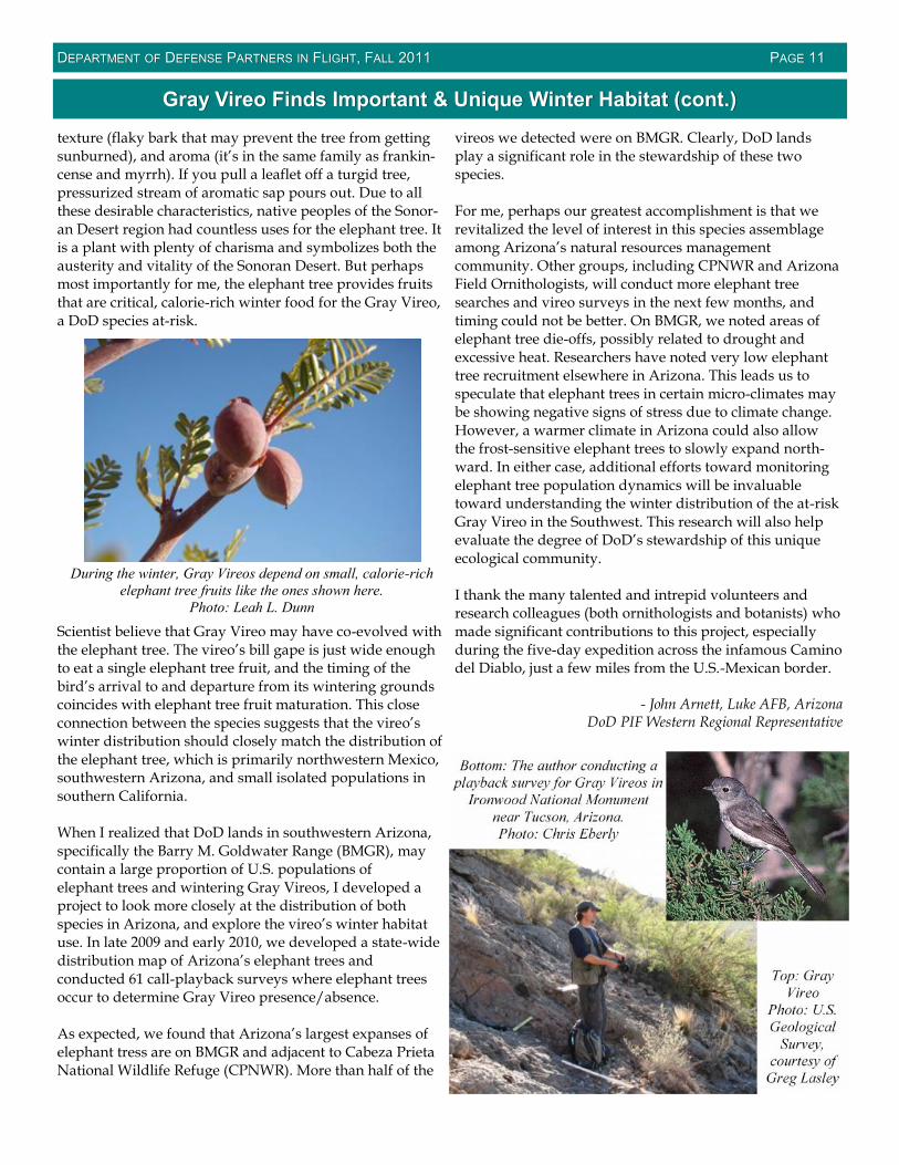
texture (flaky bark that may prevent the tree from gettingsunburned), and aroma (it’s in the same family as frankin-cense and myrrh). If you pull a leaflet off a turgid tree,pressurized stream of aromatic sap pours out. Due to allthese desirable characteristics, native peoples of the Sonor-an Desert region had countless uses for the elephant tree. Itis a plant with plenty of charisma and symbolizes both theausterity and vitality of the Sonoran Desert. But perhapsmost importantly for me, the elephant tree provides fruitsthat are critical, calorie-rich winter food for the Gray Vireo,a DoD species at-risk.
Scientist believe that Gray Vireo may have co-evolved withthe elephant tree. The vireo’s bill gape is just wide enoughto eat a single elephant tree fruit, and the timing of thebird’s arrival to and departure from its wintering groundscoincides with elephant tree fruit maturation. This closeconnection between the species suggests that the vireo’swinter distribution should closely match the distribution ofthe elephant tree, which is primarily northwestern Mexico,southwestern Arizona, and small isolated populations insouthern California.
When I realized that DoD lands in southwestern Arizona,specifically the Barry M. Goldwater Range (BMGR), maycontain a large proportion of U.S. populations ofelephant trees and wintering Gray Vireos, I developed aproject to look more closely at the distribution of bothspecies in Arizona, and explore the vireo’s winter habitatuse. In late 2009 and early 2010, we developed a state-widedistribution map of Arizona’s elephant trees andconducted 61 call-playback surveys where elephant treesoccur to determine Gray Vireo presence/absence.
As expected, we found that Arizona’s largest expanses ofelephant tress are on BMGR and adjacent to Cabeza PrietaNational Wildlife Refuge (CPNWR). More than half of the
vireos we detected were on BMGR. Clearly, DoD landsplay a significant role in the stewardship of these twospecies.
For me, perhaps our greatest accomplishment is that werevitalized the level of interest in this species assemblageamong Arizona’s natural resources managementcommunity. Other groups, including CPNWR and ArizonaField Ornithologists, will conduct more elephant treesearches and vireo surveys in the next few months, andtiming could not be better. On BMGR, we noted areas ofelephant tree die-offs, possibly related to drought andexcessive heat. Researchers have noted very low elephanttree recruitment elsewhere in Arizona. This leads us tospeculate that elephant trees in certain micro-climates maybe showing negative signs of stress due to climate change.However, a warmer climate in Arizona could also allowthe frost-sensitive elephant trees to slowly expand north-ward. In either case, additional efforts toward monitoringelephant tree population dynamics will be invaluabletoward understanding the winter distribution of the at-riskGray Vireo in the Southwest. This research will also helpevaluate the degree of DoD’s stewardship of this uniqueecological community.
I thank the many talented and intrepid volunteers andresearch colleagues (both ornithologists and botanists) whomade significant contributions to this project, especiallyduring the five-day expedition across the infamous Caminodel Diablo, just a few miles from the U.S.-Mexican border.
- John Arnett, Luke AFB, ArizonaDoD PIF Western Regional Representative
Bottom: The author conducting aplayback survey for Gray Vireos in
Ironwood National Monumentnear Tucson, Arizona.Photo: Chris Eberly
Top: GrayVireo
Photo: U.S.Geological
Survey,courtesy of
Greg Lasley
During the winter, Gray Vireos depend on small, calorie-richelephant tree fruits like the ones shown here.
Photo: Leah L. Dunn

DDEPARTMENTEPARTMENT OFOF DDEFENSEEFENSE PPARTNERSARTNERS ININ FFLIGHTLIGHT, F, FALLALL 20112011 PPAGEAGE 1212
Washington Western Bluebird Reintroduction Effort a SuccessWashington Western Bluebird Reintroduction Effort a Success
A five-year cooperative effort involving several organiza-tions has succeeded in returning the Western Bluebird toWashington’s San Juan Islands. The bird had historicallyinhabited the islands, but changing land use practices anda paucity of nesting sites meant the species had not nestedthere for over 40 years.
Over the course of the five-year project, biologists with theWestern Bluebird Reintroduction Project captured andtranslocated 45 breeding pairs of Western Bluebirds froman expanding population at Fort Lewis Military installa-tion, Washington, and another four pairs from theWillamette Valley in Oregon. The birds were kept in aviar-ies on San Juan Island prior to release to acclimate them totheir new surroundings.
One pair of translocated birds nested in the first year, andin each succeeding year the nesting population size hasincreased. Over the five years, 212 fledglings were pro-duced. Most encouragingly, some of those fledged birdshave returned each year and are now part of the breedingpopulation, giving hope that the population will be able tosustain itself into the future.
Thirty birds returned to the San Juan Islands this year. Tenwere translocated birds from previous years, 18 werefledged from previous years, and two were of undeter-mined origin. The 15 pairs of birds built 25 nests, of which14 were successful and fledged 74 birds.
“This year saw record-breaking cool, wet weather throughJune, meaning everything, including bluebird nesting, wasabout three to four weeks behind. This resulted in reducedproductivity from the previous year. House Sparrows alsocaused three or four nesting failures, which is something
we may need to address in coming years,” said Bob Alt-man, project leader with American Bird Conservancy.
The project is now moving into a two-year monitoringphase to determine the stability and growth of the popula-tion, and the need for future population management.
“We are very pleased to have achieved our goal of estab-lishing a breeding population. However, 15 pairs is by nomeans a large enough population to be considered secure,so we are exploring ways to enhance it beyond the initialfive-year period,” Altman said.
One potential enhancement is Western Bluebird transloca-tions in nearby British Columbia that may be starting nextyear. The San Juan Islands are only 20-25 miles as the blue-bird flies from the proposed release site on Salt Spring Is-land, British Columbia, and it is likely that the continuationof translocations in British Columbia will help to sustainthe San Juan Islands population in the future.
In tandem with the translocations, project partners also areworking to conserve the oak-prairie ecosystem that thebirds depend on. Toward that end, the San Juan Preserva-tion Trust made a key prairie-oak land acquisition – 120acres in the center of the San Juan Valley- which hosts twonesting pairs of bluebirds and is a primary location atwhich flocks of bluebirds congregate during the post-breeding season. In addition, approximately 600 nest boxeshave been put up on the islands to provide additional nest-ing opportunities for the returning birds.
Altman said that “the project would not have been possiblewithout the help of numerous people on the San JuanIslands, who hosted aviaries and nest boxes on their prop-erties, helped construct nest boxes and move aviaries, pro-vided materials and project equipment, and helped moni-tor nest boxes and look for released birds. I don’t know ofany other bird reintroduction project that relied completelyon so many private landowners."
Project collaborators included American Bird Conservancy,Fort Lewis Military Installation, Ecostudies Institute, SanJuan Preservation Trust, San Juan Islands Audubon Socie-ty, Washington Department of Fish and Wildlife, and TheNature Conservancy of Washington, with support fromDisney Worldwide Conservation Fund, The NorcliffeFoundation, Friends of Zoo Boise, The San Juan Preserva-tion Trust, Warren and Cathy Cooke, Frances V.R. SeebeTrust, Horizons Foundation, and numerous private donors.
Watch the Bird News Network video report athttp://youtu.be/rA0awxtfa_k.Taken from http://www.abcbirds.org/newsandreports/releases/110811.html.
Western Bluebird chicks. Photo: Lauren Ross

DDEPARTMENTEPARTMENT OFOF DDEFENSEEFENSE PPARTNERSARTNERS ININ FFLIGHTLIGHT, F, FALLALL 20112011 PPAGEAGE 1313
CrossCross--Bird Puzzle: Parts of a BirdBird Puzzle: Parts of a Bird
Thanks to Peter Boice for this edition’s cross-bird puzzle!
Across2. Base of the bill where the mandibles join7. Three feathers springing from the base of the primaries8. Rear portion of crown9. Lowermost ridge on lower mandible11. Stripe before tip of tail, 2 words13. Rear portion of crown15. Opening of the cloaca or anus19. Back of the neck21. Moveable feathered appendage22. Area bounded by lore, eye, auricular, and lower mandible23. Area around ear opening27. Line of feathers above the eye commonly called the
eyebrow28. Front part of the neck31. Ventral area between the body and the wing32. Flight feathers attached to the elbow35. Fleshy area between the beak and face36. Highly colored area on secondaries of several ducks38. Projecting feathers39. Eye ring and supraloral line together41. Area of feathers between the back and the wings42. Single opening in birds used for both reproduction and
ex crement43. Large conspicuous showy feathers44. Feathers extending from the rear of the bird
Down1. Upper surface of the wings and the back3. Part of the face below the bill4. Area at base of the primaries5. Part of the face above the eyes6. Line of feathers above the eye10. Joint in the middle part of the leg12. Wings of a flying bird held at an angle appearing to form
a “V”13. Swollen structure in pigeons overarching the nostril14. Primaries and secondaries, 2 words16. Area at the sides of the chin, also called whisker or
mustache, 2 words17. Belly, undertail coverts, chest, flanks, and foreneck18. Front part of the chest20. Iridescent throat feathers on a hummingbird22. Colored area over eye found in males24. Area between the eye and the bill25. Front part of the neck26. Area between the belly and the wings, more posterior29. Top of the head30. Area around ear opening33. Front part of the body34. Area between the uppertail coverts and the back37. Tuft on the head40. Top of the crown
DDEPARTMENTEPARTMENT OFOF DDEFENSEEFENSE PPARTNERSARTNERS ININ FFLIGHTLIGHT, F, FALLALL 20112011 PPAGEAGE 1414
DoD PIF Program CoordinatorChris Eberly ([email protected])
DoD PIF National RepresentativeJoe Hautzenroder ([email protected])
Deputy Director, DoD Natural ResourcesPeter Boice ([email protected])
PPOINTOINT OFOF CCONTACTSONTACTS
CCCONTRIBUTINGONTRIBUTINGONTRIBUTING TOTOTO THETHETHE DDDOOOD PIF ND PIF ND PIF NEWSLETTEREWSLETTEREWSLETTER ISISIS EEEASYASYASY!!!Want to highlight bird conservation efforts on your installation?
Have a great bird image you just have to share?Send your ideas and images to Chris, Alison, or Erica.
DoD PIF Websitewww.dodpif.org
National and Regional PIF Contactswww.partnersinflight.org/contactus.cfm
Steppingstones Editor, Chris Eberly ([email protected])Steppingstones Production, Alison Dalsimer and Erica Evans,Booz Allen Hamilton ([email protected])
CrossCross--Bird Puzzle Answer KeyBird Puzzle Answer Key