curtis creek flood reduction master plan · 2019-04-29 · aecom undertook a city-wide flood...
TRANSCRIPT

City of Peterborough
Curtis Creek Flood Reduction Master Plan
Prepared by:
AECOM Canada Ltd5080 Commerce Boulevard, Mississauga, ON, Canada L4W 4P2T 905.238.0007 F 905.238.0038 www.aecom.com
Date: February 2010

City of PeterboroughC u r t i s C r e e k F l o o d R e d u c t i o n S t u d y
Statement of Qualifications and Limitations
The attached Report (the “Report”) has been prepared by AECOM Canada Ltd. (“Consultant”) for the benefit of the City of
Peterborough (“Client”) in accordance with the agreement between Consultant and Client, including the scope of work
detailed therein (the “Agreement”).
The information, data, recommendations and conclusions contained in the Report:
are subject to the scope, schedule, and other constraints and limitations in the Agreement and the qualificationscontained in the Report (the “Limitations”)
represent Consultant’s professional judgement in light of the Limitations and industry standards for thepreparation of similar reports
may be based on information provided to Consultant which has not been independently verified
have not been updated since the date of issuance of the Report and their accuracy is limited to the time periodand circumstances in which they were collected, processed, made or issued
must be read as a whole and sections thereof should not be read out of such context
were prepared for the specific purposes described in the Report and the Agreement
in the case of subsurface, environmental or geotechnical conditions, may be based on limited testing and on theassumption that such conditions are uniform and not variable either geographically or over time
Unless expressly stated to the contrary in the Report or the Agreement, Consultant:
shall not be responsible for any events or circumstances that may have occurred since the date on which theReport was prepared or for any inaccuracies contained in information that was provided to Consultant
agrees that the Report represents its professional judgement as described above for the specific purpose
described in the Report and the Agreement, but Consultant makes no other representations with respect to theReport or any part thereof
in the case of subsurface, environmental or geotechnical conditions, is not responsible for variability in suchconditions geographically or over time
The Report is to be treated as confidential and may not be used or relied upon by third parties, except:
as agreed by Consultant and Client
as required by law
for use by governmental reviewing agencies
Any use of this Report is subject to this Statement of Qualifications and Limitations. Any damages arising from improper
use of the Report or parts thereof shall be borne by the party making such use.
This Statement of Qualifications and Limitations is attached to and forms part of the Report.

RPT - F366-005-02 - Final Curtis Creek Study Report-100104.docx
Revision Log
Revision # Revised By Date Issue / Revision Description
1 S. Hollingworth 2009-08-31 Revised as per City of Peterborough Comments
2 S. Hollingworth 2009-12-22 Revised as per City of Peterborough Comments
3 S. Hollingworth 2010-02-xx Issued for Public Review

R P T - F 3 6 6 - 0 0 5 - 0 2 - F i n a l C u r t i s C r e e k S t u d y R e p o r t - 1 0 0 1 0 4 . d o c x - i -
Executive SummaryBackgroundIn July 2004, the City of Peterborough (the City) was hit by a severe rainfall event that caused significant flooddamage. Insured private property damages reportedly exceeded $87 Million while Ontario Disaster ReliefAssistance Program (ODRAP) infrastructure damages of approximately $25 Million were incurred. In addition,insured losses and indirect damages such as disruption in residential living conditions, loss of business, and lossof wages or income, were sustained.
Shortly after the flood, the City retained AECOM (formerly UMA Engineering Ltd.) to investigate the causes anddetermine remedial measures to improve the operation of the drainage system and reduce the risk of damagefrom future flooding. AECOM undertook a City-wide Flood Reduction Master Plan Study (the Master Plan) underthe Environmental Assessment Act to plan infrastructure improvements as part of the City’s overall systems,before dealing with project-specific issues.
The Master Plan recommended a series of actions / studies which were categorized into:A. Information Gathering & Field WorkB. Detailed Studies & Environmental AssessmentsC. Design & Contract Documents (preparation)D. Construction & Environmental MonitoringE. Works by Others.
The Group B activities included; Detailed Storm & Watercourse Flood Reduction EA’s (Jackson Creek, CurtisCreek, Byersville Harper, Riverview, Thompson, Meade (N&S), and Bears); Watercourse Management Plans;City Wide Policy Review; Sewer Maintenance Program; Emergency Preparedness; Public Awareness Program;Detailed Sanitary Sewer EA.
IntroductionThis report constitutes the project file report for the for the Curtis Creek Flood Reduction Master Plan. The studyhas been conducted in accordance with the requirements of the Municipal Class Environmental Assessment, Oct.2007, Schedule B. The study addresses Phases 1 and 2 of the Municipal Class EA planning and design process,and provides a long term strategy for flood damage reduction works within the study area. It is anticipated thatthe prescribed flood damage reduction projects identified through the course of the Study will be implementedindependently of each other.
The problem being addressed was identified in the Master Plan, and verified in this study as:Excessive rainfall,Insufficient storm sewer capacity,Poorly defined (uncontrolled) overland flow routes,
While issues concerning sanitary sewer flooding and surcharging were not addressed in the study, applicableinformation (i.e. overland flow routes) has been identified in the report for future action.

R P T - F 3 6 6 - 0 0 5 - 0 2 - F i n a l C u r t i s C r e e k S t u d y R e p o r t - 1 0 0 1 0 4 . d o c x - ii -
In order to resolve the problem, it was determined that improvements are required for existing infrastructure toprovide a level of protection for life & property to that provided by current design standards, up to and including a1:100 year storm.
In order to better quantify the problems through the watershed, detailed hydrologic and hydraulic modelling wasundertaken for Curtis Creek, the urban drainage systems which outlet into Curtis Creek, and the spill route fromCurtis Creek through East City. Figure ES.1 below identifies the Study area
Figure ES.1: Study Area

R P T - F 3 6 6 - 0 0 5 - 0 2 - F i n a l C u r t i s C r e e k S t u d y R e p o r t - 1 0 0 1 0 4 . d o c x - iii -
Existing Flood DamagesIn order to identify where remedial works would be most effective, creek and urban modelling was undertaken toidentify storm flood lines & potentially affected properties. Storm flood lines on creeks were determined for 1:5and 1:100 year design storms as well as the Regional (Timmins) and Peterborough storms. For urban drainageareas the municipal standard 5 year and 100 year return period storms were applied to generate storm flood lines.Regional storm utilization was also considered for urban areas, however for the relatively small (less than 50 ha.drainage area and 30 minute time of concentration) urban catchments within the Curtis Creek drainage area, theassociated peak 30 minute rainfall intensity of both the Regional (Timmins) and Peterborough storms are lessthan the peak 30 minute 1:100 year design storm intensity.
Creek flows were determined with the SWMHYMO hydrologic program, as the program is widely utilized togenerate creek flood flow rates in Ontario, and retains the ability to import/export hydrograph data to otherprograms. Creek hydraulics (water levels/flood lines) were computed with the HEC Geo-RAS program basedupon the City’s 0.5 m Digital elevation model, and surveyed bridge & culvert cross sections to generate 1:5, 1:100and Regional storm flood lines.
Urban flood flows were generated with the USEPA SWMM model utilizing the Computational Hydraulics graphicuser interface (PCSWMM). Urban areas were broken down into 2 to 5 ha catchments and the capture into thesewer system was calculated based upon road-slope & catchbasin type. Sewer surcharge hydrographs, flows notcaptured by the sewer system, and spills from other catchments were input into the SWMHYMO program togenerate overland flow hydrographs. Overland flow hydrographs were manipulated to account for overland flowrouting attenuation, and depression retention to generate peak flow input to HEC Geo-RAS to generate urban 1:5and 1:100 year flood lines.
Through the analysis it was determined that during a Regional Storm, 230 buildings would be impacted by surfaceflooding with associated flood damages (based upon 20% of MPAC assessment value) of $6.8 Million. It isimportant to note that the aforementioned figures are flood damage estimates based on surface floodingencroaching on building structures, and does not include, specifically, any damages associated with sanitarysewer flooding/backup. In addition, the estimates do not include :
Lost business / employment income from flooding;Emotional impact / pain & suffering;Social / environmental impacts; and/orAn economic assessment to the risk of life.
The key findings from the analyses of existing conditions are as follows:A significant flow reduction is associated with the Curtis Creek pond, (located upstream of the Canal); andAs a result of the undersized culvert, there exists a spill from Curtis Creek that travels into the downtown areaEast City, resulting in significant flood damages.
Public PrioritiesTwo public open houses were held to provide insight into the aspects of the flooding which are of most concern tolocal residents, the flood protection measures that are preferred by the residents, and the relative importance ofthe various criteria used in the evaluation of alternatives.

R P T - F 3 6 6 - 0 0 5 - 0 2 - F i n a l C u r t i s C r e e k S t u d y R e p o r t - 1 0 0 1 0 4 . d o c x - iv -
The input received at the Public Open Houses are summarized as follows:
The primary public concerns are ponding on property, followed by flow through property and then flow intobasements;Public perception of the top priority is weighted towards Creek Improvements; second, third and fourthpriorities were Creek System enhancements, Urban & Creek Enhancements, and Urban & Storm SewerEnhancements respectively;While no clear urban solution emerged, upsizing / replacing storm sewers and enhanced catchbasinmaintenance were the two most popular options;The top three public priorities for Creek improvements were respectively Increasing Bridge Culvert Capacity,Increasing Channel capacity, and Establish/expanding pond; andThe top three factors for determination of remedial measures were Engineering Applicability, SocialDisruption, and Cost.
Analysis ResultsThe analysis undertaken as part of this study reviewed a number of alternative remedial measures to assess theirimpact upon Flood damages. The primary measures reviewed, and their overall effectiveness are summarized inTable ES.1 below:
Table ES.1. Alternative Evaluation
Alternative EngineeringFeasibility
SocialDisruption Cost Natural
EnvironmentDamage
Reduction
Culvert and ChannelImprovements with anEnlarged Curtis Pond
Limited,(regulatoryconcerns)
Short termdisruption
$8.1Million
Short termHigh Impact
$3.6 Million
Culvert and Channelimprovements with NoChange to the Curtis Pond
Moderate Short termdisruption
$2.5 Million
Short termModerate
impact
$3.6Million
Culvert and ChannelImprovements & 1:100 YearSewers
High High SocialDisruption
$5.9 Million High Impact $6.8
Million
Culvert and ChannelImprovements & SelectedStorm Sewer Upgrades
High Short termdisruption
$4.0Million
ModerateImpact
$6.8Million
Flood ProofingLimited,
(maintenanceproblematic)
Long Termdisruption
$1.0 Million
MinimalImpact
$6.8Million
Property Acquisition NotApplicable
High SocialDisruption
$16.2Million
MinimalImpact
$6.8Million
Based on costs, impacts, feasibility and public input, “Culvert and Channel Improvements & Selected StormSewer Upgrades” was selected as the preferred alternative.

R P T - F 3 6 6 - 0 0 5 - 0 2 - F i n a l C u r t i s C r e e k S t u d y R e p o r t - 1 0 0 1 0 4 . d o c x - v -
Recommended ProjectsBased upon the public input received, and the analysis undertaken, the projects listed in table ES.2 arerecommended for incorporation into the City’s capital works program.
Table ES.2. Prioritization of Recommended Works
Priority Project Name Project Details EstimatedCost
FloodDamage
Reduction
Benefit-CostRatio
1Rogers St/Tivey
OutletImprovements
2 – 3.0 m x 1.5 m boxculverts and associatedchannel improvements
$1.8 Million $2.7 Million 1.5
2.1Armour Road
CulvertReplacement*
2 – 3.0 m x1.2 m boxculverts $0.2 Million $0.5 Million 2.5
2.2Caddy Street
CulvertReplacement*
2 -3.0 m x 1.5 m boxculverts and channel
improvements$0.3 Million $0.2 Million 0.7
2.3Euclid Avenue
CulvertReplacement*
2 – 3.0 m x1.2 m boxculverts $0.3 Million $0.4 Million 1.3
3.1 Strategic StormSewer Upgrade 4
Add relief sewer alongHunter St. **
$175Thousand
$863Thousand
4.9
3.2 Strategic StormSewer Upgrade 3
Upgrade storm sewers onArmour Rd. Between
Carlisle Ave & Douro St.
$156Thousand
$645Thousand
4.2
3.3 Strategic StormSewer Upgrade 6
Add pond upstream ofAshburnham Rd. & Trent
Canal
$50Thousand
$140Thousand
3.0
3.4 Strategic StormSewer Upgrade 5
Replace storm sewersalong Sophia St. And
Mark St.
$318Thousand
$810Thousand
2.5
3.5 Strategic StormSewer Upgrade 2
Add relief sewer alongDufferin St. And upgrade
sewers on Rogers St.$255
Thousand$256
Thousand1.0
3.6 Strategic StormSewer Upgrade 1
Upgrade storm sewerssouth of Parkhill Rd. E
$461Thousand
$214Thousand
0.5
* Culvert Replacements must proceed from downstream to upstream to realize the flood reduction benefits
** A storm sewer within system has recently been replaced. This report does not reflect the new sewer

R P T - F 3 6 6 - 0 0 5 - 0 2 - F i n a l C u r t i s C r e e k S t u d y R e p o r t - 1 0 0 1 0 4 . d o c x - vi -
By virtue of the public process undertaken as part of this Environmental Assessment study, and the newSchedule A+, Pre-Approved classification introduced in the September 2007 amendment to the MunicipalEngineers Class EA document, all of the above Projects may proceed to design & construction upon successfulcompletion of the 30 day review period of this document.
Additional RecommendationsIn addition to the Recommended Projects set out above, we also recommend the City consider the following itemsthat will help mitigate flood damage within the Curtis Creek study area:
Property Acquisition: While not selected as an alternative to reduce flood damages in the Curtis Creek studyarea, there are individual properties that do merit some consideration for acquisition. Purchasing these properties(or portions thereof) could facilitate implementation of the recommended flood reduction projects and futurepotential erosion stabilization works, and to allow the City to access and maintain the Curtis Creek channelcorridor. These properties are summarized in Table ES.3 below.
Table ES.3: Recommended Property Acquisition
Civic Address Priority Improvement
345 Swanston 3 Natural Area, Reduce Erosion, Provide Trails
325 Swanston 4 Natural Area, Improve Hydraulics, Reduce Erosion
296 Woodbine 5 Improve Hydraulics, Reduce Erosion
330 Woodbine 5 Improve Hydraulics, Reduce Erosion
272 Euclid 6 Flood Damage Mitigation, Natural Area
249 Euclid 1 Reduce Erosion, Improve Safety, Provide Trails, Improve Hydraulics
254 Caddy 1 Reduce Erosion, Improve Safety, Provide Trails, Improve Hydraulics
592 Rogers 2 Improve Hydraulics, Natural Area
Maintenance: Throughout the study the public consistently expressed a desire/need for increased Creek andUrban catchbasin/storm sewer maintenance. The above suggested property acquisitions will allow the City toaccess and maintain much of the Curtis Creek channel corridor through the urban area. In the case of the urbanstorm sewer system, the majority of the City does not have a designed/dedicated overland flow route; enhancedmaintenance of the storm sewer system (catchbasin cleanouts, CCTV inspections, sewer flushing) isrecommended to ensure that the full capacity of the storm sewer system is available.
Stream Corridor Enhancements: The Curtis Creek stream channel downstream of Euclid Avenue is inrelatively poor condition, as it flows parallel to and immediately adjacent Euclid Avenue for a length ofapproximately 50 m. Realignment of the watercourse away from Euclid Avenue and restoration using naturalchannel design techniques would enhance this reach of Curtis Creek, though such works would not contribute toflood damage reductions.

R P T - F 3 6 6 - 0 0 5 - 0 2 - F i n a l C u r t i s C r e e k S t u d y R e p o r t - 1 0 0 1 0 4 . d o c x - vii -
Sanitary Backup: Sanitary sewer back-up risk within the City of Peterborough remains a subject of interest toboth the insurance industry, and residents. Information contained in this report is to be utilized by the City tofurther the sanitary sewer improvements already completed to date including the identification and sealing ofsanitary manhole lids that currently exist within overland flow routes, therefore limiting the volume of direct inflowand frequency of local sewer back-ups.

R P T - F 3 6 6 - 0 0 5 - 0 2 - F i n a l C u r t i s C r e e k S t u d y R e p o r t - 1 0 0 1 0 4 . d o c x - viii -
Figure ES.2: Preferred Flood Damage Reduction Alternative

Table of Contents
R P T - F 3 6 6 - 0 0 5 - 0 2 - F i n a l C u r t i s C r e e k S t u d y R e p o r t - 1 0 0 1 0 4 . d o c x
1. Introduction ................................................................................................................................................ 1
1.1 Introduction and Master Plan Process ..................................................................................11.2 Municipal Class EA Master Plan Process .............................................................................31.3 Study Approach ....................................................................................................................41.4 Problem Statement...............................................................................................................41.5 Ten Year Review Requirements ...........................................................................................41.6 Purpose and Organization of this Report ..............................................................................51.7 Project Team Organization ...................................................................................................51.8 Study Schedule ....................................................................................................................6
2. Public/Agency Consultation ........................................................................................................................ 7
2.1 Consultation Approach .........................................................................................................72.2 Agency Consultation ............................................................................................................8
2.2.1 Technical Committee ........................................................................................................... 82.2.2 Letters and Notices .............................................................................................................. 8
2.3 Public Consultation...............................................................................................................82.3.1 First Public Open House Meeting ......................................................................................... 82.3.2 Second Public Open House Meeting.................................................................................... 92.3.3 Notice of Study Completion ............................................................................................... 10
3. Existing Drainage Conditions ................................................................................................................... 11
3.1 Riverine Drainage Systems ................................................................................................113.1.1 Curtis Creek Study Area .................................................................................................... 113.1.2 Hydrologic Analysis ........................................................................................................... 133.1.3 Hydraulic Analysis ............................................................................................................. 153.1.4 Hydraulic Model Output ..................................................................................................... 163.1.5 Damages from Riverine Flooding ....................................................................................... 20
3.2 Urban Drainage Systems ...................................................................................................203.2.1 Study Area ........................................................................................................................ 203.2.2 Modelling Approach – Storm Sewer Systems ..................................................................... 223.2.3 Modelling Approach – Overland Flow Systems .................................................................. 233.2.4 Urban Flood Damages ....................................................................................................... 28
3.3 Natural Environment...........................................................................................................283.3.1 Physiography and Topography .......................................................................................... 283.3.2 Soils and Agricultural Capability ......................................................................................... 293.3.3 Surface Water Quality ........................................................................................................ 293.3.4 Fisheries and Aquatic Ecosystems .................................................................................... 293.3.5 Wildlife Species Composition ............................................................................................. 293.3.6 Species at Risk .................................................................................................................. 303.3.7 Significant Natural and Environmentally Sensitive Areas .................................................... 30
3.4 Socio-Economic Environment ............................................................................................313.4.1 Land Use ........................................................................................................................... 31

Table of Contents
R P T - F 3 6 6 - 0 0 5 - 0 2 - F i n a l C u r t i s C r e e k S t u d y R e p o r t - 1 0 0 1 0 4 . d o c x
3.4.2 Cultural Environment ......................................................................................................... 32
4. Alternative Solutions ................................................................................................................................ 33
4.1 Riverine Drainage Systems ................................................................................................334.1.1 Peak Flow Reduction Solutions ......................................................................................... 334.1.2 Riverine System Capacity Solutions................................................................................... 344.1.3 Flood Proofing Solutions .................................................................................................... 354.1.4 Evaluation of Alternative Solutions ..................................................................................... 37
4.1.4.1 Evaluation Criteria ........................................................................................................ 374.1.4.2 Evaluation Summary..................................................................................................... 37
4.2 Urban Drainage Systems ...................................................................................................404.2.1 Flow Reduction Solutions .................................................................................................. 404.2.2 Urban System Capacity Solutions ...................................................................................... 40
4.2.2.1 Construction Upgrade 1 ................................................................................................ 414.2.2.2 Construction Upgrade 2 ................................................................................................ 414.2.2.3 Construction Upgrade 3 ................................................................................................ 414.2.2.4 Construction Upgrade 4 ................................................................................................ 414.2.2.5 Construction Upgrade 5 ................................................................................................ 424.2.2.6 Construction Upgrade 6 ................................................................................................ 42
4.2.3 Flood Proofing Solutions .................................................................................................... 424.2.4 Evaluation of Alternative Solutions ..................................................................................... 42
5. Recommended Action Plan ...................................................................................................................... 44
5.1 Recommended Projects .....................................................................................................44
List of Figures
Figure 1.1. Study Area ........................................................................................................................................ 2Figure 1.2. The Municipal Class EA Planning and Design Process ...................................................................... 4Figure 2.1. Interactions of Study Stakeholders ..................................................................................................... 7Figure 3.1. Curtis Creek Watershed .................................................................................................................. 13Figure 3.2. Curtis Creek Flood Plain – 5 Year Event .......................................................................................... 17Figure 3.3. Curtis Creek Flood Plain – 100 Year Event ...................................................................................... 18Figure 3.4. Curtis Creek Flood Plain – Regional (Timmins) Storm Event ............................................................ 19Figure 3.5. Urban Analysis Schematic ............................................................................................................... 21Figure 3.6. Estimated Storm Sewer Capacity..................................................................................................... 25Figure 3.7. Overland Flow Flooding – 5 Year Event ........................................................................................... 26Figure 3.8. Overland Flow Flooding – 100 Year Event ....................................................................................... 27Figure 4.1. Curtis Pond Expansion Alternatives ................................................................................................. 34Figure 5.1. Preferred Alternative – Urban and Creek Improvements .................................................................. 45

Table of Contents
R P T - F 3 6 6 - 0 0 5 - 0 2 - F i n a l C u r t i s C r e e k S t u d y R e p o r t - 1 0 0 1 0 4 . d o c x
List of Tables
Table 3.1: Hydrology Model Output ................................................................................................................... 15Table 4.1. Recommended Culvert Replacements .............................................................................................. 35Table 4.2. Evaluation Criteria ............................................................................................................................ 37Table 4.3. Evaluation of Alternatives – Riverine Drainage System ..................................................................... 38Table 4.4. Evaluation of Alternatives – Urban Drainage System ......................................................................... 43Table 5.1. Prioritization of Recommended Works .............................................................................................. 46
Appendices
A. Public Consultation MaterialsB. Selected Master Plan and Rainfall Analysis ExtractsC. Curtis Creek Watershed Hydrology ReportD. Curtis Creek Hydraulics Analysis ReportE. Urban Hydrologic and Hydraulic Model Input ParametersF. Comparative Construction Cost Estimates

City of Peterborough
Cur t is Cr eek F lood R edu ct i on Stu dy
RPT - F366-005-02 - Final Curtis Creek Study Report-100104.docx - 1 -
1. Introduction
1.1 Introduction and Master Plan Process
In July 2004, the City of Peterborough (the City) was hit by a severe rainfall event that caused significant flooddamage. Insured private property damages reportedly exceeded $87 million while Ontario Disaster ReliefAssistance Program (ODRAP) infrastructure damages of approximately $25 million were incurred. In addition,insured losses and indirect damages such as disruption in residential living conditions, loss of business, and lossof wages or income, were sustained.
Shortly after the flood, the City retained UMA Engineering Ltd. (UMA) to investigate the causes and determineremedial measures to improve the operation of the drainage system and reduce the risk of damage from futureflooding. UMA undertook a City-wide Flood Reduction Master Plan Study (the Master Plan) under theEnvironmental Assessment Act to plan infrastructure improvements as part of the City’s overall systems, beforedealing with project-specific issues. Selected extracts from the Master Plan, as well as additional characterizationof the July 2004 extreme rainfall event are contained in Appendix B.
The City-Wide Master Plan recommended a series of actions / studies which were categorized into:A. Information Gathering & Field WorkB. Detailed Studies & Environmental AssessmentsC. Design & Contract Documents (preparation)D. Construction & Environmental MonitoringE. Works by Others.
The Group B activities included; Detailed Storm & Watercourse Flood Reduction EA’s (Jackson Creek, CurtisCreek, Byersville Harper, Riverview, Thompson, Meade (N&S), and Bears); Watercourse Management Plans;City Wide Policy Review; Sewer Maintenance Program; Emergency Preparedness; Public Awareness Program;Detailed Sanitary Sewer EA.
This report constitutes the project file report for the Curtis Creek Flood Reduction Master Plan. The study hasbeen conducted in accordance with the requirements of the Municipal Class Environmental Assessment,Amended 2007. The study addresses Phases 1 and 2 of the Municipal Class EA planning and design process,and provides a long term strategy for flood damage reduction works within the study area. It is anticipated thatthe prescribed flood damage reduction projects identified through the course of the Study will be implementedindependently of each other.
The problem being addressed was identified in the Master Plan, and verified in this study as:Excess rainfallInsufficient storm sewer capacity,Poorly defined (uncontrolled) overland flow routes,
While issues concerning sanitary sewer flooding and surcharging were not addressed in the study, applicableinformation (i.e. overland flow routes) has been identified in the report for future action.
City of Peterborough
Cur t is Cr eek F lood R edu ct i on Stu dy
RPT - F366-005-02 - Final Curtis Creek Study Report-100104.docx - 2 -
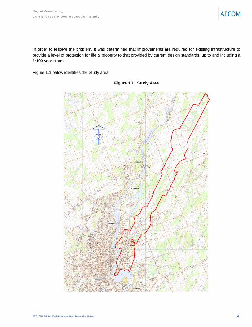
In order to resolve the problem, it was determined that improvements are required for existing infrastructure toprovide a level of protection for life & property to that provided by current design standards, up to and including a1:100 year storm.
Figure 1.1 below identifies the Study area
Figure 1.1. Study Area

City of Peterborough
Cur t is Cr eek F lood R edu ct i on Stu dy
RPT - F366-005-02 - Final Curtis Creek Study Report-100104.docx - 3 -
1.2 Municipal Class EA Master Plan Process
All municipal projects in Ontario require approval under the Environmental Assessment Act (EAA). However,carrying out individual environmental assessments (EAs) and/or seeking exemptions to comply with therequirements of the EAA is onerous, time consuming, and expensive. Since municipalities undertake hundreds ofprojects, the Municipal Engineers Association (MEA) Municipal Class Environmental Assessment (MunicipalClass EA) (2000) enables the planning and implementation of municipal infrastructure projects using an approvedprocedure designed to protect the environment. The Municipal Class EA process provides a decision-makingframework that enables the requirements of the EAA to be met in a timely and cost-effective manner.
Given the broad nature of the identified problems and recognizing the need for a coordinated approach to theCity’s complex urban drainage and sanitary sewer systems, this Study was conducted as a Master Plan under theMinistry of the Environment’s definition. Accordingly, the Study will support and provide the framework to facilitatesubsequent Municipal Class EA approvals for specific future projects identified with the City of Peterborough,should they be required.
Environmental Assessment or EA is a decision-making process used to promote good environmental planning byassessing the potential effects of certain activities on the environment. The purpose of the EAA is the “bettermentof the people of the whole or any part of Ontario by providing for the protection, conservation and wisemanagement in Ontario of the environment”, where the broad environment includes the natural, social, cultural,constructed and economic environments. To achieve this, the EAA ensures that environmental problems oropportunities are considered and their effects are planned for before development or building takes place.Approved by the Minister of the Environment in October 4, 2000, and amended in 2007, the Municipal Class EAprovides a streamlined framework for EA planning of municipal projects under the provisions of the EAA. TheMunicipal Class EA enables the planning and execution of municipal projects using an approved procedure,which ensures that potential effects on the natural, social, cultural, technical and economic/financial environmentare taken into consideration on a consistent basis.
The Municipal Class EA recognizes that, in many cases, it is better to plan infrastructure improvements as part ofan overall system, before dealing with project-specific issues. This allows the proponent to better define the needand justification for individual or specific projects within a broader planning context before proceeding withindividual works on a project-by-project basis.
The Master Plan process differs from project specific studies in several aspects. It facilitates long range planningthat enables a municipality to identify opportunities and proactively develop strategies for addressing anyassociated issues. This approach generally yields a framework for planning and implementation of subsequentprojects (or a course of action), in combination with a phased implementation plan or program that covers anextended period of time. Though these projects may be implemented as separate works, collectively they formpart of the overall management system embodied in the Master Plan.
Prior to the implementation of specific projects recommended within the context of the Master Plan, it is firstnecessary to determine their level of complexity and potential effects on the environment.

City of Peterborough
Cur t is Cr eek F lood R edu ct i on Stu dy
RPT - F366-005-02 - Final Curtis Creek Study Report-100104.docx - 4 -
1.3 Study Approach
In keeping with the Master Plan process, this Study has incorporated the key principles of successfulenvironmental assessment planning. Consequently, assessment level undertaken for this Study has addressedthe first two phases of the Municipal Class EA process by providing the Problem Statement, regarding the natureand/or extent of the problem including an explanation of the source for the concern, and the need for a solution(Phase 1). This Study also provides a description and assessment of Alternative Solutions, coupled with thedecision-making process used to select the Priority Study Areas / Projects (Phase 2) (Figure 1.2).
Figure 1.2. The Municipal Class EA Planning and Design Process
In addition to the Project Team, external regulatory agencies, interested stakeholders and the public haveparticipated throughout the process. As equal partners in the Study, each of the participants has provided inputand has therefore played an integral role in the planning and decision-making processes.
1.4 Problem Statement
The problem being addressed was identified in the Flood Reduction Master Plan, and verified in this study as:Excess rainfall,Insufficient storm sewer capacity,Poorly defined (uncontrolled) overland flow routes.
In order to resolve the problem, it was also determined that improvements are required to existing infrastructure toprovide a level of protection for life & property to that provided by current design standards, where flood damageprotection is provided for events up to and including a 1:100 year storm.
1.5 Ten Year Review Requirements
A time lapse may occur between the filing of the Master Plan and the implementation of each project. In suchcases, the proposed project and the environmental mitigation measure approvals may no longer be valid.
If the period of time from filing of the Notice of Completion of the Master Plan in the public record to the proposedcommencement of project construction exceeds ten years, the proponents shall review the planning and design

City of Peterborough
Cur t is Cr eek F lood R edu ct i on Stu dy
RPT - F366-005-02 - Final Curtis Creek Study Report-100104.docx - 5 -
process and the current environmental setting to ensure that the project is still valid given the current planningcontext. The review shall be recorded in an addendum to the Master Plan which shall be placed on the publicrecord.
Notice of Filing of Addendum shall be placed on the public record with the Master Plan Addendum and shall begiven to the public and review agencies. A period of 30 calendar days shall be provided for review and response.If no request is received, the proponent is free to proceed with implementation.
1.6 Purpose and Organization of this Report
This Report has been prepared to document and provide a traceable and easily understood record of the planningand decision-making processes. The Report is organized as follows:
Executive Summary: Provides an overview of why the Study, and summarizes recommendationsSection 1 – Introduction: Includes an explanation of the reason why the Study is being conducted under theMunicipal Class EA Master Planning process. Provides an overview of the requirement for the Master Plan,and summarizes the recommendations.Section 2 – Public and Agency Consultation: Documents the public and regulatory agency consultationactivities carried out throughout the Study (e.g., notices, letters, display boards, and public meetingsummaries).Section 3 – Existing Drainage Conditions: Provides a description of the creek and urban drainage systems,and identifies causes and magnitude of flooding and flood damages.Section 4 – Alternative Solutions: Documents various alternatives for the storm sewer (minor) and overlandflow (major) drainage systems. This section describes Phase 2 of the Municipal Class EA process.Section 5 – Recommended Action Plan: Provides details on the purpose, scope, schedule and cost of furtherworks required to reduce flood damage.Appendix A: Public Consultation MaterialsAppendix B: Selected Master Plan & Rainfall Analysis ExtractsAppendix C: Curtis Creek Watershed Hydrology ReportAppendix D: Curtis Creek Hydraulics Analysis ReportAppendix E: Urban Hydrologic & Hydraulic Models & Input parametersAppendix F: Comparative construction cost estimates
1.7 Project Team Organization
AECOM led this study and our inter-disciplinary Project Team consists of specialists in Drainage and Hydrologyand Hydraulics, Environmental and Land Use Planning, and Public/Regulatory Agency Consultation. Key staffinvolved in the Study were:
AECOM Ltd.Mr. Brian Worsley, Project ManagerMr. Steve Hollingworth, Senior Water Resource EngineerMs. Janelle Weppler, Water Resource Engineer

City of Peterborough
Cur t is Cr eek F lood R edu ct i on Stu dy
RPT - F366-005-02 - Final Curtis Creek Study Report-100104.docx - 6 -
Ms. Emily Waisanen, Water Resource EngineerMs. Evelyn Liu, Water Resource EngineerMs. Renata Harry, Project DesignerMr. Jeff Atherton, GIS Specialist
Cumming + CompanyMs. Susan Cumming, Public Facilitator/Mediator
Ecotec Environmental Consultants Inc.Mr. Douglas Clark, Environmental Investigations
1.8 Study Schedule
The Curtis Creek Flood Reduction Master Plan will be made available for a minimum 30-day public review period.As requests for an order to comply with Part II of the EAA do not apply to Master Plans, the Study is consideredapproved following the 30-day review period. At this time the City may proceed with its implementation.
It is important to note that, more detailed environmental inventories, evaluations and assessments may berequired prior to design and construction of any proposed works. The scope and level of analysis is dependentupon the potential complexity and the degree of environmental impact associated with the planned works(Schedule A, B or C).
The requirements of Phases 1 and 2 of the Municipal Class EA process will have been satisfied for many of therecommended projects (those considered as a Schedule A). However, for some Schedule B projects, Phases 1and 2 will need to be revisited. In addition, for Schedule B projects, it will be necessary to fulfill the consultationand documentation requirements. For identified Schedule C projects, the City will need to complete Phases 3and 4 of the Municipal Class EA process.

City of Peterborough
Cur t is Cr eek F lood R edu ct i on Stu dy
RPT - F366-005-02 - Final Curtis Creek Study Report-100104.docx - 7 -
2. Public/Agency Consultation
2.1 Consultation Approach
An integral component of the study was building strong relationships with individuals and groups who are affectedby the outcome. It was important to work proactively, collaboratively and candidly with all external agencies andinterested stakeholders to meet the City’s goal of reducing the risk of future flooding. Our approach was designedto fulfill the following objectives:
Allow the general public, City Council, stakeholders and external agencies (both federal and provincial) tohave an opportunity to participate in the study process as well as contribute to decisions at an appropriatetime.Provide factual information to all affected/interested stakeholders as soon as reasonably possible, andMake contact with external agencies to obtain legislative or regulatory approvals, or to collect pertinenttechnical information.
Figure 2.1 identifies the interaction of study stakeholders.
Figure 2.1. Interactions of Study Stakeholders
City ofPeterborough
Technical Committee
• Senior City Staff• Governmental Agencies/Authorities
Consultant Team
News Media
Advice &Opinion
Consultation andCommunication
PeerReview
TechnicalConclusions &
Recommend ActionPlan
Oversight
ConsultationCommunication
Strategy & Materials
Observations& Opinions
Citizen’s
• Project Management• Engineering Analysis• Public Consultation• Recommended Action Plan

City of Peterborough
Cur t is Cr eek F lood R edu ct i on Stu dy
RPT - F366-005-02 - Final Curtis Creek Study Report-100104.docx - 8 -
2.2 Agency Consultation
2.2.1 Technical Committee
The Technical Committee (TC) consisted of representatives of key governmental agencies involved in waterresource management and public policy, and senior City staff. A list of members is provided below.
Gerry Rye Director, Utility Services Department City of PeterboroughMalcolm Hunt Director of Planning and Development City of PeterboroughDan Ward Flood Reduction Program Manager City of PeterboroughDavid Bonsall Manager, Engineering & Construction City of PeterboroughChris Lang Water Resources Engineer City of PeterboroughPeter Southall Manager, Public Works Division City of PeterboroughChris Bradley Director of Public Works County of PeterboroughHarold Nelson Manager of Public Works Douro-Dummer TownshipDavid Burritt Watershed Engineer Otonabee Conservation
2.2.2 Letters and Notices
The following letters and notices were sent the external agencies:Notice of Study Commencement – February 3, 2006Notice of Public Open House Meeting # 1 – April 26, 2006Notice of Public Open House Meeting # 2 – October 24, 2007Notice of Study Completion – February 17, 2010
2.3 Public Consultation
2.3.1 First Public Open House Meeting
A newspaper notice of the meeting was published in the Peterborough This Week on April 15, 2006 for themeeting as set out below:Date: April 26, 2006Open House: 6:30 pm to 9:00 pmPresentation: 7:30 pmLocation: Peterborough Lions Community Centre
347 Burnham Street, Peterborough
The first part of the meeting was a drop-in/roundtable working session from 5:00 p.m. to 7:30 p.m. that outlinedthe Study process, provided key information about the urban drainage network, and offered an opportunity tocomplete a Flooding Survey. The formal part of each evening was from 7:30 p.m. to 8:30 p.m. with a questionand answer session led by AECOM. The public commented on observed conditions, identified concerns, andasked questions.

City of Peterborough
Cur t is Cr eek F lood R edu ct i on Stu dy
RPT - F366-005-02 - Final Curtis Creek Study Report-100104.docx - 9 -
The meeting was facilitated by Sue Cumming of Cumming + Company, an independent consultant engaged tofacilitate the question and answer part of the public meetings. Representatives from AECOM were presentthroughout the meeting to provide information, answer questions and receive comments from all participants. Thepublic was encouraged to provide anecdotal evidence on what they had experienced.
The input received from the public was summarized to provide both insight into the aspects of the flooding whichare of most concern to local residents, flood protection measures which the public felt to be the most appropriate,and the weightings of various evaluation factors proposed by the public.
The public input from the first Open House is summarized as follows:The primary public concerns are ponding on property, followed by flow through property and then flow intobasementsPublic perception of the top priority is weighted towards Creek improvements as first second and third prioritywere Creek System enhancements, Urban & Creek Enhancements, and Urban & Storm sewerenhancements;While no clear urban solution emerged, upsizing / replacing storm sewers and enhanced catchbasinmaintenance were the two most popular options;The top three public priorities for Creek improvements were Increasing Bridge Culvert Capacity, IncreasingChannel capacity, and Establish/expanding pond; andThe top three factors for determination of remedial measures were Engineering applicability, SocialDisruption, and Cost.
Display material was available after the public meeting through the project website. A copy of the display materialand the Public Meeting Summary Report documenting the first public meeting is included in Appendix A.
2.3.2 Second Public Open House Meeting
The second public open house meeting was held as follows:Date: October 24, 2007Open House: 6:30 pm to 9:00 pmPresentation: 7:15 pmLocation: Peterborough Lions Community Centre
347 Burnham Street, Peterborough
The meeting format was similar to the first public meeting with a drop-in format from 6:30 p.m. through to 7:15p.m. The formal part of the evening began with a AECOM presentation followed by a question and answersession facilitated by Sue Cumming of Cumming + Company. A copy of the presentation material and publicmeeting summary report is provided in Appendix A.
A Notice of the public meeting was published in the Peterborough This Week on October 17th and 19th. A copyof the notice is provided in Appendix A of this Report.
The purpose of the second series of public meeting was to:Introduce participants to the Class EA process,Review the causes and magnitude of flooding,

City of Peterborough
Cur t is Cr eek F lood R edu ct i on Stu dy
RPT - F366-005-02 - Final Curtis Creek Study Report-100104.docx - 10 -
Present the alternative solutions and evaluation of the alternativesDescribe the preferred alternative.
Representatives from AECOM and the City were on hand to answer questions. The public were encouraged to fillout a Comment Form, to assist AECOM in confirming the causes of flooding, prioritize recommendedimprovements, and identify additional alternative solutions. A total of 120 forms were received.
Public input received at the October 24th Public Open House on priorities is summarized below:67% felt the top priority should be a combination of creek upgrades and urban enhancements;21% felt the Creek System should be given top priority;12% felt Urban upgrades should be given top priority.
Public input as to the specific projects which should be undertaken had:48% giving top priority to Strategic Storm Sewer Upgrades, acquisition of the Curtis Pond & Creek system,and upsizing bridges, culverts and the creek channel to accommodate the current Regulatory flow of 12 m3/s38% giving top priority to acquisition of the existing Curtis Pond & Creek system as part of a Municipallyowned stormwater management system, and upsize bridges, culverts and creek channel to accommodate thecurrent Regulatory flow of 12 m3/s, and10% gave top priority to acquisition of additional lands to expand the existing Curtis Pond & incorporation ofthe upsized pond & Creek system as part of a Municipally owned stormwater management system, andupsize bridges, culverts and creek channel to accommodate the resulting Regulatory flow of 10 m3/s
2.3.3 Notice of Study Completion
A Notice of Study Completion for the Curtis Creek Flood Reduction Master Plan was placed in the PeterboroughThis Week and the Peterborough Examiner on February 17, 2010 and February 19, 2010. The Notice announcedthe completion of the Master Planning Study and provided details regarding the process to be followed andsolicited input from interested and affected parties.
City of Peterborough
Cur t is Cr eek F lood R edu ct i on Stu dy
RPT - F366-005-02 - Final Curtis Creek Study Report-100104.docx - 11 -
3. Existing Drainage Conditions
In rural headwater areas, rainfall will slowly begin to flow overland to local low points in the landscape once themoisture capacity of the soil is exceeded. Shallow valleys, or draws, lead from these depressed areas, joiningtogether to form larger draws. As more and more draws are added, the valley becomes more defined and astream channel is created.
During small to moderate rainfall events, the flow is typically confined to the banks of the defined channel. Everyyear or two on average, a large storm occurs that produces more runoff than the channel can carry, and flowspreads out of the channel and onto the floor of the valley. During very rare, severe storms, floodwater may fillthe entire valley. If there is development within or adjacent the valley, it may be subject to flood damages fromthe rising floodwater during such severe storm events. Also, urban infrastructure within the valley systems, suchas roadways and railways, may restrict the natural flow carrying capacity of the valley corridor and contribute tohigh water levels during severe storm events.
In an urban environment, rainfall may fall on natural ground, or may land on hard surfaces such as rooftops andpavement. Typically, this rainfall only has to travel a short distance to reach an engineered drainage system,such as a ditch or a catchbasin. These drainage systems are generally sized to carry the runoff from relativelycommon storms that might occur once every 2 to 5 years on average, and quickly deliver the runoff to a nearbywatercourse or lake. During more severe storm events, the capacity of the ditch or storm sewer system may beexceeded. Similar to the rural environment, excess water will build up at the low points in the urban landscape.From these depressions, water will travel along the lowest paths in the landscape to the receiving watercourse orlake. These are referred to as major systems or overland flow routes.
Approximately two to three decades ago urban drainage design was expanded to encompass “dual drainage”where both minor and major drainage systems are designed. The minor system generally consists of catchbasins and storms sewers intended to convey away relatively common (nuisance) runoff. The major systemtypically consists of road networks and or dedicated flood easements/channels designed as the lowest points inthe landscape, such that runoff will be contained when the capacity of the (minor) storm drainage system isexceeded during severe storm events. Unfortunately, many Canadian cities & towns were built before the adventof dual drainage design, consequently, there is more potential for flooding of property and buildings along theoverland flow routes during severe storm events.
3.1 Riverine Drainage Systems
3.1.1 Curtis Creek Study Area
The Curtis Creek watershed study area has a drainage area of 921 ha, illustrated in Figure 3.1. The watershedand sub-watershed boundaries were delineated by AECOM staff using 0.5 m contour mapping within the City ofPeterborough and 5 m contour mapping (Ontario Base Map) beyond the City limits. The Trent Canal divides thewatershed, with approximately 853 ha above and 68 ha below the canal. Upstream of the canal, in Duoro-Dummer Township, the watershed is predominantly rural in nature. A large on-line pond (the Curtis Pond) exists

City of Peterborough
Cur t is Cr eek F lood R edu ct i on Stu dy
RPT - F366-005-02 - Final Curtis Creek Study Report-100104.docx - 12 -
immediately upstream of the Trent Canal, extending upstream to Television Road. This pond is regulated by the1500 mm diameter pipe culvert under the Trent canal, and has a significant impact on the flow through developedurban area downstream of the canal. Development of the urban area below the canal has significantly alteredCurtis Creek. It has been realigned and restricted to a narrow channel in areas, and outlets to the OtonabeeRiver through a culvert & drop pipe leading from the intersection of Rogers and Tivey Streets.
Updated flood plain mapping was required for the Curtis Creek valley system, extending from the culvert & droppipe inlet at Rogers and Tivey Streets to upstream of Parkhill Road. A full update to the hydrology model for theentire Curtis Creek watershed was required to support the flood plain mapping update.

City of Peterborough
Cur t is Cr eek F lood R edu ct i on Stu dy
RPT - F366-005-02 - Final Curtis Creek Study Report-100104.docx - 13 -
Figure 3.1. Curtis Creek Watershed
3.1.2 Hydrologic Analysis
In order to evaluate flooding conditions along Curtis Creek, one must be able to determine the magnitude of theflow resulting from severe storm events. Many tools are available for this purpose, ranging from desktopcalculations (i.e. Rational Method) to detailed continuous simulation models. For the subject study, theSWMHYMO computer model was used to estimate peak flow rates resulting from severe storm events.

City of Peterborough
Cur t is Cr eek F lood R edu ct i on Stu dy
RPT - F366-005-02 - Final Curtis Creek Study Report-100104.docx - 14 -
SWMHYMO is a complex hydrologic model used for the simulation and management of stormwater runoff in ruraland urban areas. SWMHYMO can use single rainfall events or continuous rainfall records to simulate thetransformation of rainfall into surface runoff. Computed hydrographs can be routed through pipes, channels orstormwater control ponds and reservoirs. SWMHYMO was developed and widely used in the Southern Ontarioarea and proved to be suitable for modeling the watersheds in the area and thus was selected for the currenthydrologic analysis on Curtis Creek.
To calculate peak flow rates, the SWMHYMO model requires physical characteristics of the watershed and detailsof the rainfall events to be simulated. Soil conditions through the watershed were obtained from agricultural soilsmapping. The predominant soil through the study area is Otonabee Loam, which is classified as a Type B soilaccording to the USDA SCS classification system. Land use and land cover through the study area were initiallyobtained from the Natural Resources Canada Land Inventory Level (Source:http://geogratis.cgdi.gc.ca/CLI/frames.html). This information was adjusted based on observed conditions fromfield visits and air photo analyses. Upstream of the Trent Canal, land use is predominantly agricultural (pastureand crops), with some wetlands in the headwater areas. Downstream of the Trent Canal, urban development inthe form of single detached dwellings dominate the landscape.
The SWMHYMO model was set up using the Williams Unit Hydrograph approach for the rural areas, and theSTANDHYD approach for the urban areas. For both urban and rural areas, runoff from the pervious portions ofthe watershed was determined using SCS Curve Number hydrology. Detailed information on the calculation ofthe parameters for the hydrology model can be found in the Curtis Creek Watershed Hydrology Report (AECOM,2009), included as Appendix C. The Curtis Pond, located upstream of the Trent Canal, was represented in thehydrology model. The 0.5 m contour mapping was used to calculate the storage volumes corresponding todifferent elevations, and the HEC-RAS hydraulic model was used to calculate the discharge through the concreteculvert under the Trent Canal at the same elevations. The pond was then represented in the model by a ROUTERESERVOIR command, using the calculated storage and discharge pairs for various elevations.
The Curtis Creek watershed hydrology was then calibrated with recorded precipitation and streamflow data fromthe summer of 2006. As part of the subject study, a flow monitoring gauge was installed at the Curtis Creek outletin May 2006. Precipitation data was available from the Trent University Climate Station, a rainfall gauge on theroof of Peterborough City Hall, and a rainfall gauge at the Waste Water Treatment Plant to the south of the studyarea. As the SWMHYMO model is designed/intended to be used to estimate peak flows through the Curtis Creekwatershed resulting from severe storm events, the largest rainfall and flow events from the summer of 2006 wereselected for the calibration exercise.
The SWMHYMO model was initially adjusted to reflect the initial soil moisture conditions at the start of the event,and then the select recorded events were simulated. The simulated hydrographs at the watershed outlet agreedwith the observed hydrographs reasonably well, both in terms of the magnitude of the peak flow and the timing ofthe peak flow and subsequent peaks. The model was not adjusted through the calibration exercise. It was noted,that there was significant variations in rainfall patterns among the three rainfall gauges used for the exercise, all ofwhich are located near or within the City of Peterborough. It was recommended that additional rainfall gauges beinstalled in the rural portion of the watershed to refine the calibration for future model updates.
Finally, the SWMHYMO model was used to predict the peak flows through Curtis Creek resulting from severestorm events. A number of synthetic storm distributions and durations were evaluated. Based on model output
City of Peterborough
Cur t is Cr eek F lood R edu ct i on Stu dy
RPT - F366-005-02 - Final Curtis Creek Study Report-100104.docx - 15 -
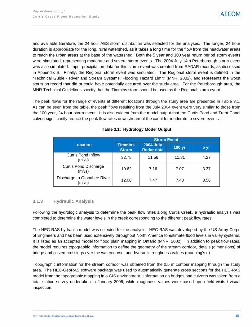
and available literature, the 24 hour AES storm distribution was selected for the analyses. The longer, 24 hourduration is appropriate for the long, rural watershed, as it takes a long time for the flow from the headwater areasto reach the urban areas at the base of the watershed. Both the 5 year and 100 year return period storm eventswere simulated, representing moderate and severe storm events. The 2004 July 14th Peterborough storm eventwas also simulated. Input precipitation data for this storm event was created from RADAR records, as discussedin Appendix B. Finally, the Regional storm event was simulated. The Regional storm event is defined in the“Technical Guide - River and Stream Systems: Flooding Hazard Limit” (MNR, 2002), and represents the worststorm on record that did or could have potentially occurred over the study area. For the Peterborough area, theMNR Technical Guidelines specify that the Timmins storm should be used as the Regional storm event.
The peak flows for the range of events at different locations through the study area are presented in Table 3.1.As can be seen from the table, the peak flows resulting from the July 2004 event were very similar to those fromthe 100 year, 24 hour storm event. It is also evident from the model output that the Curtis Pond and Trent Canalculvert significantly reduce the peak flow rates downstream of the canal for moderate to severe events.
Table 3.1: Hydrology Model Output
LocationStorm Event
TimminsStorm
2004 JulyRadar data 100 yr 5 yr
Curtis Pond Inflow(m3/s) 32.75 11.56 11.81 4.27
Curtis Pond Discharge(m3/s) 10.62 7.16 7.07 3.37
Discharge to Otonabee River(m3/s) 12.08 7.47 7.40 3.56
3.1.3 Hydraulic Analysis
Following the hydrologic analysis to determine the peak flow rates along Curtis Creek, a hydraulic analysis wascompleted to determine the water levels in the creek corresponding to the different peak flow rates.
The HEC-RAS hydraulic model was selected for the analysis. HEC-RAS was developed by the US Army Corpsof Engineers and has been used extensively throughout North America to estimate flood levels in valley systems.It is listed as an accepted model for flood plain mapping in Ontario (MNR, 2002). In addition to peak flow rates,the model requires topographic information to define the geometry of the stream corridor, details (dimensions) ofbridge and culvert crossings over the watercourse, and hydraulic roughness values (manning’s n).
Topographic information for the stream corridor was obtained from the 0.5 m contour mapping through the studyarea. The HEC-GeoRAS software package was used to automatically generate cross sections for the HEC-RASmodel from the topographic mapping in a GIS environment. Information on bridges and culverts was taken from atotal station survey undertaken in January 2006, while roughness values were based upon field visits / visualinspection.

City of Peterborough
Cur t is Cr eek F lood R edu ct i on Stu dy
RPT - F366-005-02 - Final Curtis Creek Study Report-100104.docx - 16 -
More information on the HEC-RAS model set-up can be found in the Curtis Creek Hydraulic Analysis Report(AECOM, 2009), included as Appendix D.
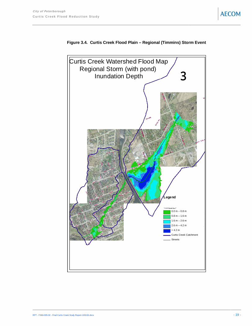
3.1.4 Hydraulic Model Output
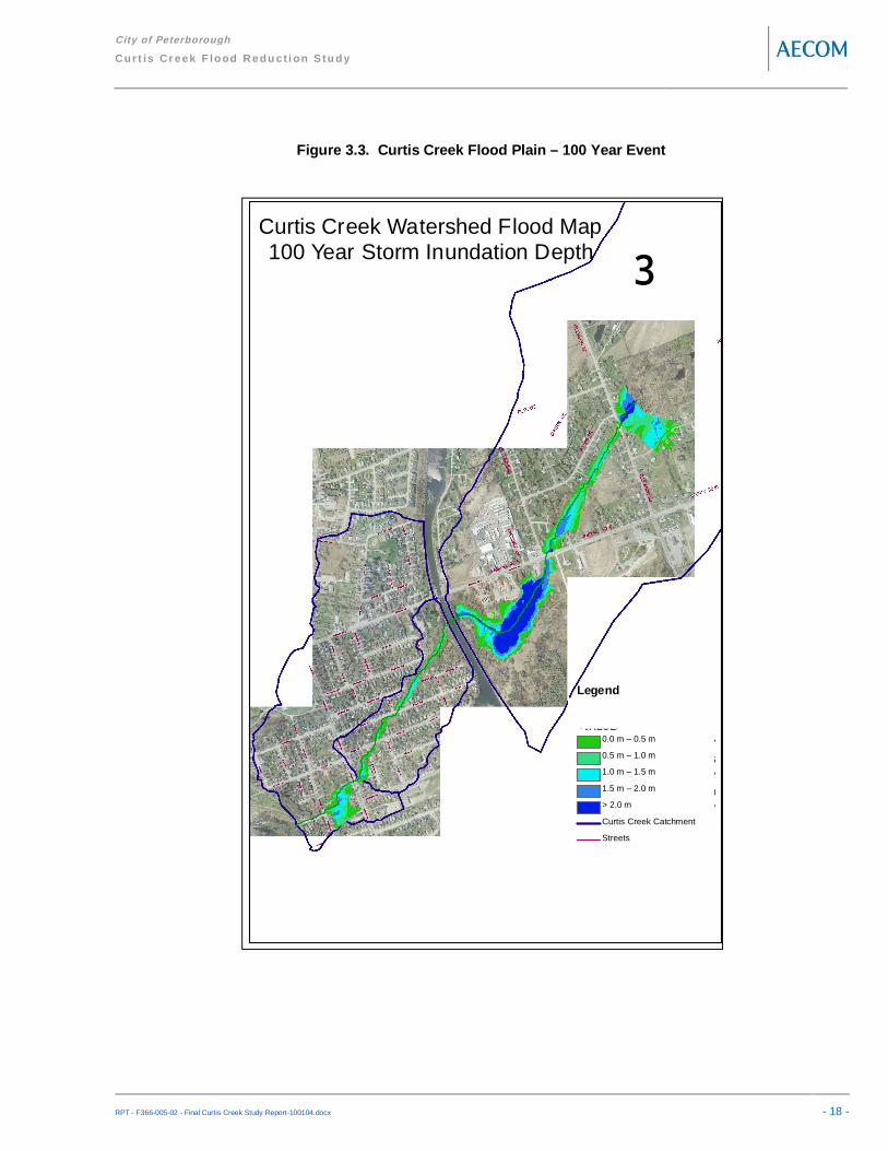
The extent of flooding along Curtis Creek predicted for the 5 year, 100 year and Regional (Timmins) storm eventare presented in Figures 3.2, 3.3, and 3.4 respectively. The HEC-RAS model predicts that through much of thestudy area, the 5 year flow will be confined to the Curtis Creek channel, and most culverts have sufficient capacityto convey the flow.
The exception is the creek outlet at Rogers and Tivey Streets, where flooding beyond the narrow creek channel isanticipated, and flooding of properties upstream of Euclid Avenue. Little to no flood water is expected to spillsouthward through the East City area during the 5 year event.
A significant spill to East City is expected during the 100 year storm event, with extensive flooding of the areaaround the Rogers Street culvert inlet. The flow extends beyond the channel corridor at many locations throughthe study area, largely upstream of culvert crossings. The model predicts that almost all of the roads crossingCurtis Creek through the study area will be overtopped during the 100 year event.
Downstream of the Trent Canal, the extent of flooding during the Regional storm event is not significantly greaterthan for the 100 year event. Upstream of the canal, extensive flooding of the areas surrounding the Curtis Pondis predicted. As with the 100 year event, the Tivey Street Culvert is predicted to be overtopped with a significantspill southwards East City.

City of Peterborough
Cur t is Cr eek F lood R edu ct i on Stu dy
RPT - F366-005-02 - Final Curtis Creek Study Report-100104.docx - 17 -
Figure 3.2. Curtis Creek Flood Plain – 5 Year Event
Curtis Creek Watershed Flood Map5 Year Storm Inundation Depth
³
Legendd 5 Year StormValue
0. 001052856 - 0.262919946
0. 262919946 - 0.530876968
0. 530876968 - 0.798833989
0. 798833989 - 1.097240672
1. 097240673 - 1.553985596
C urtis-hydrologic-catchment
St-Name -clip
0.00 m – 0.25 m
0.25 m – 0.50 m
0.50 m – 0.75 m
0.75 m – 1.00 m
> 1.00 m
Curtis Creek Catchment
Streets
City of Peterborough
Cur t is Cr eek F lood R edu ct i on Stu dy
RPT - F366-005-02 - Final Curtis Creek Study Report-100104.docx - 18 -
Figure 3.3. Curtis Creek Flood Plain – 100 Year Event
Curtis Creek Watershed Flood Map100 Year Storm Inundation Depth
³
Legendd 100 Year Storm<VALUE>
0.00097656 3 - 0.45803 9407
0.45803940 7 - 0.96951 4495
0.96951449 5 - 1.53540 1827
1.53540182 8 - 2.26452 5888
2.26452588 9 - 2.77600 0977
Cur tis-hydrologic-catchment
St-N ame-clip
0.0 m – 0.5 m
0.5 m – 1.0 m
1.0 m – 1.5 m
1.5 m – 2.0 m
> 2.0 m
Curtis Creek Catchment
Streets
City of Peterborough
Cur t is Cr eek F lood R edu ct i on Stu dy
RPT - F366-005-02 - Final Curtis Creek Study Report-100104.docx - 19 -
Figure 3.4. Curtis Creek Flood Plain – Regional (Timmins) Storm Event
Curtis Creek Watershed Flood MapRegional Storm (with pond)
Inundation Depth³
Legendd Regional w pond<VALUE>
0.000030518 - 0.800972254
0.800972254 - 1.601913991
1.601913992 - 2.592552454
2.592552455 - 4.152281099
4.1522811 - 5.374771118
Curtis-hydrologic-catchment
St-Name-clip
0.0 m – 0.8 m
0.8 m – 1.6 m
1.6 m – 2.6 m
2.6 m – 4.2 m
> 4.2 m
Curtis Creek Catchment
Streets

City of Peterborough
Cur t is Cr eek F lood R edu ct i on Stu dy
RPT - F366-005-02 - Final Curtis Creek Study Report-100104.docx - 20 -
3.1.5 Damages from Riverine Flooding
Damages to buildings impacted by riverine flooding in Curtis Creek are difficult to estimate. Depth damage tableshave recently been updated by MNR, however information provided by Alan Pang from CGI Insurance BusinessServices indicates that the correlation between flooding depth and resultant damages is not overly valid, (anempty unfinished masonry basement will suffer significantly less damage than a finished basement being used aliving space). Additionally, the mechanism by which flooding may enter buildings is relatively complex, asoverland flows over sanitary manholes may overwhelm foundation drains, or flows may enter buildings throughdoors and windows. Moreover, if exposed to severe flood depths and velocities, buildings could collapse entirely.
It is not feasible to investigate every single building in the study area to identify the mechanisms for flooddamages and estimate direct flood damages for different storm events. Instead, it was agreed that to provideconsistency between the various studies being undertaken for the City, flood damages would be taken as 20% ofthe value of the buildings within flood lines, regardless of flood depth, velocity and duration. This approach,provides consistency between the various studies the City is undertaking, (to allow setting of City wide priorities),allows relatively simple updating of the damage figures, and avoids the house by house inspection that would berequired to fully utilize a depth/damage approach. (Flood damages are - as discussed above - relativelyindependent of flood depths. Once water enters a structure, the basement area will require renovations toreplace damaged floors and furniture and to prevent mould growth, regardless of the depth of flooding in thebasement). The average cost of these repairs has been estimated as 20% of the value of the house.
The assessed values of the impacted properties through the Curtis Creek study area were based on the latestproperty assessments completed by the Municipal Property Assessment Corporation (MPAC), which wereprovided by the City of Peterborough.
For the Regional (Timmins) storm event, a total of 57 buildings are impacted for damages totalling $1.5 Million.Predicted flood damages for the 5 year and 100 year return period events are $1.1 Million (40 houses) and $ 1.5Million (55 houses), respectively. These estimates do not include the damages through East City due to the spillfrom Curtis Creek. Peak flow rates, flood levels and flood damages are not significantly different between the 100year and Regional storm event downstream of the canal.
3.2 Urban Drainage Systems
3.2.1 Study Area
The analysis of the urban drainage systems through the Curtis Creek watershed included the entire storm sewersystem, with discrete modelling being undertaken on all storm sewers draining more than 5 ha. Under thisthreshold, the small drainage areas typically do not generate sufficient runoff to pose significant floodingconcerns, and storm sewers are usually sized based on minimum allowable diameter, rather than capacityconstraints. The analysis methodology used is illustrated schematically in Figure 3.5, below, and described in textin the following sections.

City of Peterborough
Cur t is Cr eek F lood R edu ct i on Stu dy
RPT - F366-005-02 - Final Curtis Creek Study Report-100104.docx - 21 -
Figure 3.5. Urban Analysis Schematic

City of Peterborough
Cur t is Cr eek F lood R edu ct i on Stu dy
RPT - F366-005-02 - Final Curtis Creek Study Report-100104.docx - 22 -
Curtis Creek historically flowed southward through the urban area west of Armour Road, referred to as the EastCity area, on its way to the Otonabee River. During the development of the Trent Canal, the Curtis Creek channelwas realigned and confined to a pipe at the intersection of Rogers Street and Tivey Street, which ultimatelydischarged to the Otonabee River through a drop structure. Section 3.1 of this study determined that this pipedoes not have sufficient capacity for the runoff from severe storm events. During such events, flood water ispredicted to back up behind the inlet and spill southward through the East City area, generally following thealignment of the historic creek channel. Feedback from residents in the area confirmed that there was such a spillto the south during the July 2004 storm event. Therefore, the East City area was included in the urban drainagestudy area to accurately predict flood depths through the area during severe storm events, considering both therunoff from the East City area and the spill from Curtis Creek.
The storm sewer segments included in the analysis are presented in Figure 3.6. Storm sewer, diameter, slope,depth, & connectivity data was provided by the City of Peterborough in the form of as built drawings, andelectronic databases.
3.2.2 Modelling Approach – Storm Sewer Systems
The urban storm sewer systems were analyzed with the aid of the PCSWMM 2006 computer model. PCSWMMis a software support package for the US EPA SWMM4 program which was developed in 1984. SWMM was firstdeveloped in 1971 and has undergone many upgrades since and is now used around the globe. PCSWMM iscapable of dynamic modeling for storm and waste water flows for quality and quantity analyses. PCSWMM is apopular choice among hydraulic modellers since it supports extremely large model sizes with thousands ofelements, has a graphic interface which renders the program comparatively user-friendly, is compatible with manyother computer programs, and has several valuable reference tools.
The PCSWMM model was selected as it has been used extensively throughout North America for the analysis ofstorm sewer systems. It is much more robust than the traditional Rational Method calculations typically used todesign storm sewers, as it is capable of generating a runoff hydrograph based on historic or synthetic rainfallevents and routing it through a storm sewer network. The model also allows separate hydrographs to beprepared for the flow within the storm sewer system (minor system) and the flow in excess of the storm sewercapacity (major system). Finally, the PCSWMM model is based on the USEPA SWMM model, and thereforeexpensive proprietary software packages are not necessary for any future refinement of the models.
Initially, drainage sub-catchment areas were delineated through the study area. Sub-catchments were delineatedwith areas ranging from 2 ha to 5 ha, and ‘lumped’ model parameters were developed to represent the cumulativecharacteristics of the catchment.
Sub-catchment model parameters required for the RUNOFF module of the PCSWMM model include percentimpervious, slope, roughness, and initial and final soil permeability. Values for these parameters weredetermined from the GIS data provided by the City & County, and reflect standard values for Southern Ontario.
The storm sewer characteristics were entered into the EXTRAN module of PCSWMM, using the as-built stormsewer information provided by the City. As many of the sub-catchments included several lengths of potentiallydifferent diameter storm sewers, equivalent (longer) pipes were developed to represent these systems in themodel. This approach both reduces model complexity, and potentially improves model accuracy, as EXTRAN

City of Peterborough
Cur t is Cr eek F lood R edu ct i on Stu dy
RPT - F366-005-02 - Final Curtis Creek Study Report-100104.docx - 23 -
model stability is typically enhanced by longer pipe lengths. Finally, rating curves were used to determine thecapacity of the catchbasins within each catchment, limiting the flow entering the pipe network in the model. Moreinformation on the set-up of the PCSWMM models can be found in Appendix E.
The model was then calibrated based on available rainfall and sewer flow data. A flow gauge was installed at thedownstream end of the storm sewer discharging to Curtis Creek near the intersection of Rogers and TiveyStreets, collecting sewer flow data during the summer months of 2006. The same precipitation gauges used forthe calibration of the Curtis Creek watershed hydrology model (Trent University, City Hall and Treatment Plant)were used for the calibration of the urban drainage system.
As with the riverine system calibration, considerable differences in rainfall duration and intensity were observedbetween the rainfall gauges for the same storm event. In general, however, the initial PCSWMM modeloverestimated the volume of runoff and peak flow rates relative to the gauged data, and predicted a much fasterresponse than was observed in the gauged data. Several model parameters were adjusted to obtain betteragreement between the modelled and observed flow hydrographs. The best agreement was achieved byincreasing the assumed roughness of the paved surfaces in the catchments (adjusting Manning’s ‘n’ from thedefault of 0.013 to 0.050) and reducing the estimated total impervious surface area in each catchment by 20%.More information on calibration of the PCSWMM model can be found in Appendix E.
Following calibration, select storm events were simulated using the PCSWMM model. A 5 year return periodstorm was simulated, as present day storm sewer standards specify a 1 in 5 year storm. The 100 year returnperiod storm event was also simulated, as modern major drainage systems in urban areas are typically designedto convey the 1 in 100 year storm. To provide consistency between the various studies being undertaken by theCity, the 1 hour AES storm distribution was used for both the 5 year and 100 year events. Storm sewer systemsare most likely to be overwhelmed during short duration, high intensity storms, and the AES distributions are morerepresentative of storm patterns in southern Ontario relative to other available distributions (Chicago, SCS, etc).The calibrated model was used to determine the flow rates in the storm sewers through the study area duringboth the 5 year and 100 year return period storm events. These (modelled) sewer flow rates were compared tothe required storm sewer capacity to convey the total flow from upstream areas. Pipes were then classified as‘green’, ‘yellow’ or ‘red’. Storm sewers that had sufficient capacity to convey a 5 year rainfall runoff were coded‘green’. Where pipe capacity was 50 % to 100 % of the total upstream flow, the sewer was labelled yellow. Whilethese sewers do not have full capacity, they are likely to operate under surcharged conditions with few floodingimpacts. Finally, sewers with less than half the required capacity were labelled ‘red’, representing potentiallysignificant restrictions in the storm sewer system. In order to ensure that the analysis truly represented pipecapacity, inlet restrictions were ignored in the pipe capacity assessment. The classification of the storm sewersthroughout the study area is presented in Figure 3.6.
3.2.3 Modelling Approach – Overland Flow Systems
The Extran module of the PCSWMM model was also used to prepare separate hydrographs for the flows enteringthe storm sewer systems and the excess (major system) flows. The major system flow hydrographs for eachsubcatchments include both the flow that cannot reach the storm sewer system due to limited catchbasincapacity, as well as the ‘spill’ from the storm sewer when the predicted flow exceeds the capacity of the sewer.The major system hydrographs from the PCSWMM model were imported to a SWMHYMO hydrologic model toroute the flows through the overland flow paths to Curtis Creek and the Otonabee River. The spill from the Curtis

City of Peterborough
Cur t is Cr eek F lood R edu ct i on Stu dy
RPT - F366-005-02 - Final Curtis Creek Study Report-100104.docx - 24 -
Creek channel southward through East City was also added to the SWMHYMO model. Overland flow routesthrough the study area were determined with the aid of detailed topographic mapping, and were confirmed duringsubsequent site visits. The SWMHYMO model was required, as PCSWMM is not able to simultaneously routeflows through both the pipe systems and overland flow routes. SWMHYMO is a hydrologic model usedextensively throughout Southern Ontario, and has several routines available to add hydrographs together wheremajor drainage systems meet, to account for reductions in peak flows due to ponding along the overland flowroute, and to account for the time it takes for water to flow along the surface routes. The SWMHYMO modelproduced estimates of the peak flow rates along all of the overland flow routes through the study area for both the5 year and 100 year storm events.
Finally, a HEC-GeoRAS model was created to estimate the maximum flood depths along the overland flow routesthrough the study area, corresponding to the peak flow rates determined from the SWMHYMO model. The HEC-GeoRAS model was described earlier in Section 3.1.3. The flood elevations determined by the HEC-RAS modelwere exported to a GIS environment, and the depths of flooding along the overland flow paths were determined.The predicted depth and extent of flooding for the 5 year and 100 year flood events are presented in Figures 3.7,and 3.8, respectively.

City of Peterborough
Cur t is Cr eek F lood R edu ct i on Stu dy
RPT - F366-005-02 - Final Curtis Creek Study Report-100104.docx - 25 -
Figure 3.6. Estimated Storm Sewer Capacity

City of Peterborough
Cur t is Cr eek F lood R edu ct i on Stu dy
RPT - F366-005-02 - Final Curtis Creek Study Report-100104.docx - 26 -
Figure 3.7. Overland Flow Flooding – 5 Year Event

City of Peterborough
Cur t is Cr eek F lood R edu ct i on Stu dy
RPT - F366-005-02 - Final Curtis Creek Study Report-100104.docx - 27 -
Figure 3.8. Overland Flow Flooding – 100 Year Event

City of Peterborough
Cur t is Cr eek F lood R edu ct i on Stu dy
RPT - F366-005-02 - Final Curtis Creek Study Report-100104.docx - 28 -
3.2.4 Urban Flood Damages
The City of Peterborough provided AECOM with GIS information representing the lot and building fabric throughthe study area, as well as the latest property assessments as determined by the Municipal Property AssessmentCorporation (MPAC). GIS tools were used to overlay the flood plain mapping along the overland flow routes onthe lot and building fabric, and a database of flood impacted buildings and properties was created.
Consistent with the riverine analysis, flood damages from the urban drainage systems were calculated as 20% ofthe assessed (MPAC) value of the impacted properties, regardless of flood depth.
The extent of flooding along the overland flow routes in the Curtis Creek watershed and East City area for the 5year storm event is presented in Figure 3.7. A total of 46 properties are predicted to be impacted by flooding.Using 20% of the assessed value of the impacted buildings, damages from the 5 year flood event are estimatedto be approximately $1.9 Million.
The 100 year flood plain along the overland flow routes through the study area is illustrated in Figure 3.8. A totalof 132 properties are predicted to experience flooding, resulting in estimated damages of $5.4 Million. Note thatthe spill of water from the Curtis Creek channel southward through East City was responsible for a significantfraction of the total flood damages through the East City area.
3.3 Natural Environment
The following sections describe the existing natural, social, economic, and cultural environments within the CurtisCreek study area. The characterization of the study area provided below identifies the constraints andopportunities that form the basis for selecting the Recommended Solution(s) for flood control. Furthermore, itserves as the baseline for identifying and assessing potential impacts associated with the proposedundertaking(s).
Although lands within the Curtis Creek Study Area are primarily designated for urban residential, rural residential,open space and light industrial uses, the Curtis Creek Study Area includes a number of natural environmentalfeatures. Details regarding the Study Area’s natural environmental features are provided below.
3.3.1 Physiography and Topography
The study area is situated within the Physiographic Region called the Peterborough Drumlin Field. This Region ischaracterized by elongated oval hills known as drumlins (Chupman and Putman, 1984). During the lateWisconsinan age, the study area was covered by an ice mass advancing southwest to Lake Ontario, whichdeposited significant amounts of till at its base. As the ice sheet advanced, it shaped the till deposits into drumlins(OMNR 1980a; ORCA, 1983).
The bedrock geology of the Study Area is characterized by the Trenton limestone formation of the Ordovician age(Gillespie and Acton, 1981). The Trenton limestone is thinly bedded, with deep glacial till deposits overlying thebedrock. The surficial deposits overlying the bedrock are characterized as thick, moderately stony, calciticlimestone till.

City of Peterborough
Cur t is Cr eek F lood R edu ct i on Stu dy
RPT - F366-005-02 - Final Curtis Creek Study Report-100104.docx - 29 -
3.3.2 Soils and Agricultural Capability
Soil conditions through the study area were determined from the Soils of Peterborough County Report (1981).The most prevalent soil type within the Study Area is the Otanabee loam, which develops on rolling moraine ofmoderately stony, calcareous, loam till (Gillespie and Acton, 1981). The Otonabee loam soils are typically notsuitable for cropping, and are generally used for pasture.
Review of the Canada Land Inventory (CLI) Soil Capability for Agriculture mapping indicates that the majority ofthe soils within the Study Area are mapped as Class 1 soils, and are suitable for agriculture. The exception is anarea within the City of Peterborough in the most southerly portion of the Study Area, where the land use ispredominantly urban and data is currently not available to classify soil capability.
3.3.3 Surface Water Quality
The water quality of Curtis Creek is influenced by elevated levels of solids, nutrients and bacteria. In particular,levels of total dissolved solids, total suspended solids and conductivity were consistently elevated during a watersampling exercise carried out in 2003. Water samples were taken from Curtis Creek at Caddy Street and atCounty Road 30. Nitrate levels were elevated and total phosphorous levels approached provincial guidelines.Levels of total coliforms and e.coli exceeded provincial guidelines several times.
As a result, the 2004 Management Plan concluded that the southern, urban section of Curtis Creek consists ofpoor surface water quality with increased levels of organic pollution typically associated with agriculture, runoffand decomposed vegetation.
3.3.4 Fisheries and Aquatic Ecosystems
Curtis Creek is classified as providing warm water fish habitat. Fish species have been observed at sevenwatercourse crossings along the creek.
3.3.5 Wildlife Species Composition
The 2004 Curtis Creek Management Plan recorded a list of potential bird, mammal and plant species within itsstudy area (i.e. from the City of Peterborough’s municipal boundary to the Otonabee River/Little Lake).Information was obtained for a region beyond the study area, which appears to encompass the Study Area for theCurtis Creek Flood Reduction Master Plan. Data was referenced from the following sources:
Bird Species and Breeding Status List, Atlas Square 17QK10 and 17QK11Atlas of the Mammals of Ontario Species List, Square 17QK11
The 2004 Management Plan reported approximately 123 bird species for its study area. Of these, the LeastBittern (Ixobrychus exilis) has been identified as a “threatened” species under federal criteria. The Least Bittern,along with the Red-shouldered Hawk (Buteo lineatus), Black Tern (Chlidonias niger) and Red-headedWoodpecker (Melanerpes erythocephalus), have all been identified as “vunerable” species under provincial

City of Peterborough
Cur t is Cr eek F lood R edu ct i on Stu dy
RPT - F366-005-02 - Final Curtis Creek Study Report-100104.docx - 30 -
criteria. The Loggerhead Shrike (Lanius Iudovicianus) has been identified as an “endangered” species underboth federal and provincial criteria.
In addition to bird species, the Management Plan reported approximately 28 mammal species and 52 families ofplant species for its study area. None of the plant species listed was recorded as vulnerable, threatened,endangered or rare. More information regarding Species at Risk is included in Section 3.3.6.
3.3.6 Species at Risk
A review of the Ministry of Natural Resources (MNR) Natural Heritage Information Centre (NHIC) database forrare, threatened and endangered species was conducted. There are 24 species at risk listed for NTS Map Sheet31 D/8. As noted below, three species are considered as “threatened”, four are considered as “special concern”,while three are considered to be “endangered”. When referenced to the corresponding NTS map sheet, the NHICindicates the species as:Least Bittern (Ixobrychus exilis) ThreatenedRed-shouldered Hawk (Buteo lineatus) Special ConcernBlack Tern (Chlidonias niger) Special ConcernLoggerhead Shrike (Lanius ludovicianus) EndangeredYellow-breasted Chat (Icteria virens) Special ConcernHenlow’s Sparrow (Ammodramus henslowii) EndangeredBlanding’s Turtle (Emydoidea blandingii) ThreatenedFive-lined Skink (Eumeces fasciatus) Special ConcernEastern Hog-nosed Snake (Heterodon platirhinos) ThreatenedButternut (Juglans cinerea) Endangered
The Committee on the Status of Endangered Wildlife in Canada (COSEWIC) is mandated to assess anddesignate wildlife species that are considered to be in danger of becoming extinct in Canada. A search of theCOSEWIC database revealed the same status for the above species. The noted exceptions being the Blanding’sTurtle which COSEWIC lists as “endangered” (2005) and the Black Tern which COSEWIC lists as “Not at Risk”(1996).
A search of Environment Canada’s Species at Risk website database was also carried out. Based on this search,the following significant species were identified under the federal Species at Risk Act (SARA):Least Bittern (Ixobrychus exilis) ThreatenedHenlow’s Sparrow (Ammodramus henslowii) EndangeredButternut (Juglans cinerea) Endangered
3.3.7 Significant Natural and Environmentally Sensitive Areas
There are no Environmentally Sensitive Areas or Areas of Natural and Scientific Interest within the Study Area.However, there are two natural areas of interest within or in close proximity to the Study Area.
The Sawer Creek South Wetland is a 65 hectare complex located within the northern portion of the Study Area.The Sawer Creek South Wetland consists of two individual wetlands and is entirely composed of swamp (McGloinand Bond, 1988). Vegetation within this wetland complex includes deciduous trees, such as White Elm and cedar,

City of Peterborough
Cur t is Cr eek F lood R edu ct i on Stu dy
RPT - F366-005-02 - Final Curtis Creek Study Report-100104.docx - 31 -
low shrubs, such as willow and grasses; and, robust emergents, such as cattail and dogwood (McGloin and Bond,1988). Soils within the wetland are made up of 27% clays, loams or silts and 73% organic (McGloin and Bond,1988).
The Peterborough Drumlin Field is located in close proximity to the Study Area, within the Township of Douro-Dummer and near the boundary of the City of Peterborough. It is recognized as an Earth Science Site.
3.4 Socio-Economic Environment
3.4.1 Land Use
As noted above, the Study Area is situated within the County of Peterborough, the Township of Douro Dummer,and the City of Peterborough. The County has a 2-tier planning system whereby planning responsibilities aredivided between the County and its area municipalities. From a planning perspective, the proposed undertaking,that is, implementation of flood control measures, may impact the County (upper-tier municipality), the Townshipof Douro-Dummer, and the City of Peterborough (lower-tier municipalities). Given that they are each responsiblefor regulating land use and establishing policies for physical, economic and social development within theirrespective jurisdiction, details regarding the applicable planning policies for each are provided below.
County of PeterboroughThe County of Peterborough Official Plan was amended and consolidated in 2006. This Plan sets out the generaldirection for planning and development in the County, and implements a strategic approach to land use planningbased on a watershed planning process.
The intent of the Official Plan is to direct and guide the actions of local municipalities and the County in policyplanning and physical planning on a very broad basis. Local municipal official plans complement thePeterborough County Official Plan by providing detailed strategies, policies and land use designations for theplanning and development at a local municipal level.
The City of PeterboroughPolicies contained within the City of Peterborough’s Official Plan regulate the use for much of the lands within thesouthern portion of the Study Area (i.e. lands under the jurisdiction of the City of Peterborough).
The City’s Official Plan (OP) designates lands adjacent to the Otonabee River and the Trent Canal as Major OpenSpace. The same designation applies to lands east of the canal in the vicinity of the Curtis Brickyard pond.Lands designated as Major Open Space may include parks, recreation facilities, golf courses, cemeteries, floodplains and natural areas of local or regional significance. The policies are intended to protect these areas fromincompatible development, and to integrate them into a network of parks and open spaces. Lands designated asOpen Space Areas are to be maintained, enhanced and expanded wherever possible.
The majority of the remaining lands in the Study Area within the City of Peterborough are designated forresidential land uses. Residential land uses permit low, medium and high density housing and other uses that areconsidered to be supportive of a residential environment, such as local commercial, home occupation, public andinstitutional uses, as well as parks, recreation areas, churches and special care facilities.

City of Peterborough
Cur t is Cr eek F lood R edu ct i on Stu dy
RPT - F366-005-02 - Final Curtis Creek Study Report-100104.docx - 32 -
The noted exception to the residential area is Hunter Street. Lands along Hunter Street are designated as part ofthe central commercial area. The Central Area consists of the City’s downtown core and permits a range ofcommercial activities, such as retail, business, hotels and restaurants.
In addition, Schedule C of the City’s Official Plan designates lands adjacent to the creek and the Trent Canal asNatural Areas and Corridors. Lands designated as Natural Areas refer to areas of habitat of endangered orthreatened species, significant wetlands and local environmentally significant areas. This designation may alsoapply to fish habitat, woodlands, valley lands and wildlife habitat. Uses are limited to nature based recreation,outdoor education and non-destructive research, horticulture, conservation, forestry, wildlife management, naturalstorm water management and trails for non-motorized transportation.
Schedule C of the Official Plan also designates lands within 30 meters of Curtis Creek as “Lands Adjacent to FishHabitat”. The only exception to this designation is where the creek is piped underground between Rogers Streetand the Otonabee River.
3.4.2 Cultural Environment
Approximately 114 sites within the County of Peterborough are registered with the Ministry of Culture. Theseregistered sites suggest that humans have occupied the area since the early Archaic and late Paleo-Indian perioddating back 10,000 years (Horne, pers. Comm., 1998). Soldiers who accompanied the French explorer, Samuelde Champlain, were believed to be the first Europeans to enter the Peterborough region in 1615. They traveledwith a tribe of the Lake Ontario Iroquois peoples known as the war party of Huron, to reach the Onondaga of theFive Nations Iroquois to the south of Lake Ontario. Their route followed a chain of lakes and rivers linkingGeorgian Bay and the Bay of Quinte.
During the eighteenth century, Europeans infrequently traveled on routes along the Kawartha Lakes and TrentRiver. This area was mainly occupied by Aboriginal peoples and their travels. By 1798, the province of UpperCanada introduced the Newcastle District which encompassed the entire Peterborough region. The pressure offurther immigration introduced new settlers into this region from Lake Ontario’s north shore. Settlers travelednortherly from Lake Ontario following major water routes such as the Trent and Otonabee Rivers.
The Peterborough area experienced a period of agricultural settlement between 1818 and 1850. During this time,immigrants from Ireland (circa 1825) and Britain (circa 1831) came to settle in the Peterborough area.
Rivers and lakes in the Peterborough area changed substantially with the introduction of canal locks and dams asa result of economic development during the mid and late 19th Century. Towns and villages throughout thePeterborough area were influenced by lumbering activity, such as that produced from processing mills andtransportation facilities. Lumbering activity in the Peterborough area thrived from the 1850’s until the introductionof stream-driven mills and the Lindsay-Toronto railway line in the mid-1960’s.
The Trent Canal was constructed around 1904. Its construction followed a period when the canal would havebeen considered as a primary route for commercial transport. Consequently, the canal has served a recreationalfunction, primarily for pleasure craft.

City of Peterborough
Cur t is Cr eek F lood R edu ct i on Stu dy
RPT - F366-005-02 - Final Curtis Creek Study Report-100104.docx - 33 -
4. Alternative Solutions
As described in the previous section, flooding through the Curtis Creek and East City study areas is due to bothdeficiencies in the urban drainage systems and capacity restrictions/high water levels in Curtis Creek. Themechanisms for flooding are different for urban versus creek drainage systems; consequently potential measuresto remediate urban and creek flooding have been developed and evaluated separately.
4.1 Riverine Drainage Systems
Simply put, flooding along Curtis Creek is due to the system receiving more water than can be contained withinthe channel corridor and conveyed through bridges and culverts. Flood damages can therefore be reduced bylowering peak flow rates, increasing the capacity of the system, or a combination of the two. Future flooddamages can also be reduced by removing flood prone structures or renovating structures to prevent water fromentering.
4.1.1 Peak Flow Reduction Solutions
As discussed in Section 3, the existing Curtis Pond in combination with the culvert under the Trent Canalsignificantly reduces peak flow rates during most storm events. The Curtis Pond was therefore examined todetermine if expansion and/or reconfiguration of the pond could reduce peak flow rates through the downstreamsystem without worsening flooding upstream of the pond.
Two pond expansion alternatives were developed and evaluated. The first is a moderate expansion of theexisting pond, with the grading works contained within the property containing the pond. This expansion wouldresult in an additional 235,000 m3 of flood attenuation storage, and is illustrated in Figure 4.1. Combined withrestrictions to the culvert under the Trent Canal, peak flow rates through Curtis Creek downstream of the canalcould be reduced by as much as 35% for the Regional storm event. Despite such flow reductions, flood levelsupstream of the pond would not be reduced and most of the road crossings downstream through the urbanizedreaches of Curtis Creek would continue to be overtopped, impacting properties upstream of the road crossings.To better balance reductions in downstream peak flow rates against reductions in upstream flood levels, a moreaggressive pond expansion scenario was developed. Under this scenario, properties south of Parkhill would beacquired along with portions of the properties to the south, and permission would be required from the Trent-Severn Waterway to expand the pond up to the eastern embankment of the Trent Canal. Under this scenario,illustrated in Figure 4.1, a total storage volume of approximately 425,000 m3 would be created. The culvert underTrent canal would be reduced to 1200 mm in diameter. Combined with upgrades to the culvert under the Trentcanal, this option could reduce downstream peak flow rates by as much as 40 % while reducing upstream floodlevels by more than 1 m during a Regional storm event. Despite the upgrades, culverts over Curtis Creekdownstream of the canal would continue to be overtopped during severe storm events. Culverts at Tivey/Rogersstreet, Armour Street, Caddy Street and Euclid Streets need to be upgraded to prevent the resulting flooding ofthe properties immediately upstream of the crossings.

City of Peterborough
Cur t is Cr eek F lood R edu ct i on Stu dy
RPT - F366-005-02 - Final Curtis Creek Study Report-100104.docx - 34 -
Figure 4.1. Curtis Pond Expansion Alternatives
Attendees at the public meetings for the subject study requested that potential new flood storage reservoirs beconstructed further upstream on Curtis Creek, in Douro-Dummer Township. Such facilities were examined brieflyas additional flood reduction solutions. Additional storage reservoirs further upstream would have a negligibleimpact on flooding through the urbanized portion of the watershed. Such facilities could reduce peak flowsbetween the existing and new pond areas. However, the existing Curtis Pond would continue to receiveuncontrolled runoff from the built-up areas upstream of Parkhill Road, and flows would continue to be regulated bythe culvert under the Trent Canal. Reservoirs in series are much less effective in reducing flood damages thanlarger, single reservoirs. Furthermore, the creation of a new on-line storage facility in the undeveloped portion ofthe watershed in Douro-Dummer Township would have a very significant environmental impact, whereas anexpansion of the existing pond would have a much reduced environmental impact; the potential for significantenvironmental disturbance from the construction of a new Dam/reservoir is vs. expansion of the existing CutisPond is highlighted by Construction of a new dam requiring a Schedule C EA, whereas expansion of an existingfacility is a Schedule B EA activity if land acquisition is required, and Schedule A (EA exempt) if within an existingroad allowance or utility corridor. Therefore, the alternative for additional storage reservoirs upstream of ParkhillRoad was not carried forward for further evaluation.
4.1.2 Riverine System Capacity Solutions
Conceptual designs were prepared for culvert replacements and channel improvements to safely convey flowsthrough the urban areas of Curtis Creek.
Moderate Pond Expansion
Maximum Pond Expansion

City of Peterborough
Cur t is Cr eek F lood R edu ct i on Stu dy
RPT - F366-005-02 - Final Curtis Creek Study Report-100104.docx - 35 -
Provincial guidelines for flood plain management require safe access to and from new and re-development duringa Regional storm event. Therefore, one flood reduction scenario included culvert replacements and channelupgrades sufficient to convey the Regional storm flow without significant overtopping of roadways and withoutflooding private property. As per MNR Rivers & Stream Systems: Flood Hazard Technical Guideline, mostvehicles can safely pass through flood depths of up to 0.3 m and flow velocities up to 3 m/s.
During the preliminary sizing of replacement culverts, it was found that it was necessary to size the culverts topass the Regional flow event without overtopping of the roadway in order to prevent flooding of houses on theupstream side of the roadway. Therefore, there is no flow anticipated over the urban road crossings in the culvertreplacement scenarios. Table 4.1 summarizes the number and size of culverts required to safely convey theRegional flow at each road crossing in the urban area without flooding upstream houses.
Table 4.1. Recommended Culvert Replacements
Location Type Span(m)
Rise(m) Number
Rogers St. Box 3.0 1.5 2Armour St. Box 3.0 1.2 2Caddy St. Box 3.0 1.5 2Euclid St. Box 3.0 1.2 2
Through the analysis, it was determined that culvert replacements alone are not sufficient to prevent flooddamages along the Curtis Creek riverine system. In many areas, the channel has been modified in the past anddoes not have capacity to convey the flows from severe storm events. It is therefore recommended that theCurtis Creek stream channel be reconstructed between Rogers Street and Armour Road, and between the CentreStreet right of way and Caddy Street. Through both of these reaches, the creek channel should be enlarged fromits current width of 2 m -5 m to approximately 8 m. It is further recommended that the channel alterations bedesigned by a qualified fluvial geomorphologist to ensure a stable system and improve aquatic habitat conditions.
As a second alternative, culvert and channel improvements were sized to accommodate the reduced peak flowassociated with the expansion of the Curtis Pond and alterations to the Trent Canal culvert described in theprevious section. With the reduced flows from the pond, the size of culverts required to safely convey theRegional storm peak flows through the urban area were significantly reduced. The twin box culverts listed inTable 4.1 were reduced to single 3.0 m wide box culverts in this scenario. Channel improvements were stillrequired between Rogers Street and Armour Road, and between Centre Street and Caddy Street, with only aslight reduction in the channel width required.
4.1.3 Flood Proofing Solutions
Public purchase and removal of flood prone structures was also considered as a flood reduction alternative.While this may be a cost-effective solution over a very long term planning horizon, it represents a very significantinitial cost, with considerable social disruption. In addition, as roadways through the study area would remainovertopped and impassable during severe storm events, there may continue to be issues accessing the remaining

City of Peterborough
Cur t is Cr eek F lood R edu ct i on Stu dy
RPT - F366-005-02 - Final Curtis Creek Study Report-100104.docx - 36 -
homes in the study area during such events. Purchasing all flood prone properties was therefore not carriedforward for further evaluation.
The final solution examined to reduce flood damages was flood proofing structures that could be impacted byflooding during the Regional storm event. Due to the alignment of the creek and road crossings through theurban portion of the watershed, regional-scale flood proofing alternatives such as dykes or floodwalls are notfeasible. Individual residences could be re-constructed/flood-proofed to eliminate basement openings and toinclude watertight (‘submarine’) doors, windows, and cladding.
However, these measures, while frequently quoted as an alternative solution, and potentially quite cost effective,are not widely applied in practice, may reduce the aesthetic appearance and value of the house, would requirerestrictions on ownership, (to avoid the flood proofing measures being removed and replaced with conventionaldoors and windows and new openings during future renovations), and would be subject to human error, (an opendoor or window won’t be water tight). Flood proofing measures were therefore not carried forward for furtherevaluation.

City of Peterborough
Cur t is Cr eek F lood R edu ct i on Stu dy
RPT - F366-005-02 - Final Curtis Creek Study Report-100104.docx - 37 -
4.1.4 Evaluation of Alternative Solutions
4.1.4.1 Evaluation Criteria
The above solutions to reduce flooding from Curtis Creek were evaluated against a number of criteria, which aredescribed in the table below. They reflect mandatory criteria to satisfy the Environmental Assessment process,and concerns and priorities rose at public meetings.
Table 4.2. Evaluation Criteria
Category ConsiderationsNatural Environment Impacts on terrestrial habitat and wildlife
Impacts on aquatic habitatImpacts on ground and surface water quality and quantity
Social Environment Need for property acquisitionLong-term community impacts (i.e. recreation opportunities)Short-term construction impacts (noise, dust, etc)
Economic Environment Land acquisition costConstruction costOperation and maintenance costs
Technical Environment Reduction in anticipated flood damagesTechnical feasibility / complexityTime required for implementation
4.1.4.2 Evaluation Summary
The following table summarizes the evaluation of the alternative solutions to reduce flood damages associatedwith the flow in Curtis Creek.

City of Peterborough
Cur t is Cr eek F lood R edu ct i on Stu dy
RPT - F366-005-02 - Final Curtis Creek Study Report-100104.docx - 38 -
Table 4.3. Evaluation of Alternatives – Riverine Drainage System
Criteria Alternative
Do Nothing Moderate Expansion of theCurtis Pond
Maximum Expansion of theCurtis Pond
Channel Improvements andCulvert Replacements for theRegional Storm
ChannelImprovements andCulvert Replacementswith Expansion of theCurtis Pond
Natural EnvironmentTerrestrial Habitatand Wildlife
No impacts anticipated There will be moderatedisruption to regeneratinghabitat adjacent the pond
There will be considerabledisruption to regeneratinghabitat adjacent the pond
Few impacts anticipated, asculvert and channelimprovements are located indeveloped areas
There will beconsiderable disruptionto regenerating habitatadjacent the pond
Aquatic Habitat High flow velocities atrestricted culverts may resultin scour and erosion,damaging fish habitat
Few impacts are anticipated,as the works will be outsidethe current pond footprint.
Few impacts are anticipated,as the works will be outsidethe current pond footprint.
There may be short termdisruptions to aquatic habitatduring culvert replacements andchannel improvements
There may be short termdisruptions to aquatichabitat during culvertreplacements.
Surface and GroundWater Quality andQuantity
No impacts anticipated There may be modestimprovements to waterquality from the expandedpond
There may be modestimprovements to waterquality from the expandedpond
There may be short-term de-watering impacts duringconstruction of the replacementculvert footings
There may beimprovements to waterquality from theexpanded pond, butshort term de-wateringimpacts for culvertreplacements
Social EnvironmentPropertyAcquisition /Displacement
No property required The Curtis Pond propertymust be obtained for theexpansion
The Curtis Pond propertyand adjacent residencesmust be obtained for theexpansion
Property or easements will berequired to implement the channelimprovements between Rogersand Armour and between Centreand Caddy
The Curtis Pond andadjacent property mustbe obtained for theexpansion, as well aslimited property forchannel widening
Long TermCommunity Impacts
Continued exposure toflooding from Curtis Creekduring severe storm events
The Curtis Pond propertymay be developed asparkland, with benefits to thecommunity
The Curtis Pond propertymay be developed asparkland, with benefits to thecommunity
Few positive or negative impactsanticipated
The Curtis Pondproperty may bedeveloped as parkland,with benefits to thecommunity
Short TermConstructionImpacts
No impacts anticipated Minor, as the works will belimited to the Curtis Pondproperty
Minor, as the works will belimited to the Curtis Pondproperty
Moderate, as all road crossingsthrough the urban portion of thestudy area require replacement
Moderate, as all roadcrossings through thestudy area requirereplacement

City of Peterborough
Cur t is Cr eek F lood R edu ct i on Stu dy
RPT - F366-005-02 - Final Curtis Creek Study Report-100104.docx - 39 -
Criteria Alternative
Do Nothing Moderate Expansion of theCurtis Pond
Maximum Expansion of theCurtis Pond
Channel Improvements andCulvert Replacements for theRegional Storm
ChannelImprovements andCulvert Replacementswith Expansion of theCurtis Pond
EconomicEnvironment
PropertyAcquisition andConstruction Costs
No property required Curtis Pond property andpond construction: $4.6Million
Curtis Pond and surroundingproperty and pondconstruction: $6.7 Million
Culvert replacements andchannel improvements: $2.5Million
Curtis Pond property,pond constructionculvert replacementsand channelimprovements: $8.1Million
Operation andMaintenance Costs
Regular removal of debrisalong the creek corridor isrequired to prevent blockageof the restricted culverts.
Regular maintenance of theexpanded Curtis Pond isrequired, as well asmaintenance of the channelcorridor in the urban area.
Regular maintenance of theexpanded Curtis Pond isrequired, as well asmaintenance of the channelcorridor in the urban area.
Regular removal of debris alongthe creek corridor isrecommended to reduce thepotential for blockage of theenlarged culverts
Regular maintenance ofthe expanded pond isrequired, as well asmaintenance of thechannel corridor in theurban area.
Technical EnvironmentAnticipated FloodDamage Reduction
No reduction in flooddamages ($ 1.5 Million for theRegional Event)
Flow rates will besignificantly reduced, butroad crossings still governflood levels. Damages willnot be reduced significantly
Flow rates will besignificantly reduced, butroad crossings still governflood levels. Damages willnot be reduced significantly
No flood damages are anticipatedfor areas below the Trent Canal.Some properties upstream of thecanal will remain impacted
No flood damages areanticipated upstream ordownstream of thecanal.
TechnicalFeasibility /Implementation
The works can beundertaken relatively quicklyfollowing propertyacquisition
The works can beundertaken relatively quicklyfollowing property acquisition
It will take some time to completeall culvert replacements
It will take some time tocomplete all culvertreplacements
Overall Evaluation Flooding and flood damagesare not reduced – theproblem is not addressed
Flooding and flood damagesare not significantly reduced– the problem is notaddressed
Flooding and flood damagesare not significantly reduced– the problem is notaddressed
PREFERRED ALTERNATIVEThe required culvert replacementsare not unreasonable in size andcan be implemented relativelyeasily. There are few impacts onthe natural environment.
The expansion of theCurtis Pond is aconsiderable additionalexpense for reductionsin upstream flooding andlimited reductions in thesize of replacementculverts required.

City of Peterborough
Cur t is Cr eek F lood R edu ct i on Stu dy
RPT - F366-005-02 - Final Curtis Creek Study Report-100104.docx - 40 -
The evaluation of alternatives, summarized in the above table, concluded that the preferred alternative is acombination of culvert replacements and channel improvements to safely convey the Regional storm peak flowthrough the urban area downstream of the Trent Canal. This alternative was selected as it was the onlyreasonable, cost effective means of mitigating flood damages along Curtis Creek. It is also the easiest toimplement, with few impacts on the natural environment.
4.2 Urban Drainage Systems
Flood levels in Curtis Creek have some influence on the extent of flooding along the urban drainage systemsthrough the study area. Additionally, the spill from Curtis Creek southward into East City is a major contributor toflooding during severe storm events. As the storm sewers through the Curtis Creek watershed outlet to the creek,high water levels in the creek during flood events can diminish the capacity of the sewer systems and evencontribute to flooding through storm sewer back-ups.
Therefore, before developing flood reduction solutions, the urban drainage systems were re-analyzed to assespotential flood damages if flooding in Curtis Creek were remediated through bridge and culvert upgrades.Eliminating the spill from Curtis Creek to East City can reduce flooding considerably, but flood damages from theurban drainage system would still be in excess of $3 Million for the 100 year storm event.
4.2.1 Flow Reduction Solutions
Flow attenuation (stormwater management ponds or tanks) can be a very effective method of reducing peakflows, and allowing existing or smaller diameter replacement pipes to be utilised downstream of the tank or pond.In order to be effective flow attenuation typically requires, a minimum of approximately 1 metre elevation drop inthe collection system at the tank, location in the approximate middle of the drainage system, an upstream areatypically in excess of 5 ha., and ongoing maintenance to remove accumulated sediments from the tank.
As the majority of the storm sewers within the study area do not provide 5 year conveyance, their utilization aspart of a 100 flow reduction system was not found to be viable. Similarly, in the instances examined, the savingsin downstream pipe costs were not sufficient to offset the cost of the tank.
Utilization of surface storage in lieu of a tank was briefly examined, however the associated property, andapproval (Schedule C EA) requirement removed this option from further consideration.
4.2.2 Urban System Capacity Solutions
The first alternative developed proposes to achieve this goal by upgrading all of the storm sewer systems throughthe study area to convey the 100 year storm flow. If sufficient catchbasins were provided and cleared of debristhrough regular maintenance programs, there would be no overland flow from the urban areas, and therefore noflood damages. Implementation of this solution would require almost all of the roads through the study area to bereconstructed for replacement of the existing sewers.

City of Peterborough
Cur t is Cr eek F lood R edu ct i on Stu dy
RPT - F366-005-02 - Final Curtis Creek Study Report-100104.docx - 41 -
Recognizing the significant expense and disruption to replace all storm sewers through the study area, a secondalternative was developed for the replacement of select undersized storm sewers. Overland flow during severestorm events is not a significant concern, provided it is confined to municipal right of ways and easements. Thestorm sewer systems through the study area were examined to identify key capacity restrictions, or ‘bottlenecks’.These storm sewers are proposed to be replaced in this alternative, in combination with additional catchbasinswhere warranted and localized re-grading to prevent or contain overland flow.
4.2.2.1 Construction Upgrade 1
This alternative is designed to improve and maximize the capture and conveyance of the storm sewers in thearea. This upgrade involves adding inlets at the low points between Parkhill Rd E & Juliet Rd, as well as Juliet Rdand Swanston Ave. between rear yards. The storm sewers from Parkhill Rd. E to the Curtis Creek outlet wouldalso be upgraded, which also includes upgrading manholes and adding more inlets. Most of the constructionwould take place along the existing storm sewer easement which is mostly between residential lots with some onroadways.
4.2.2.2 Construction Upgrade 2
Since the storm sewers along Armour Rd. north of Curtis Creek are under capacity this alternative recommendsadding a relief storm sewer along Dufferin St. which would take the overflow from Armour Rd. and convey it alongDufferin St. and down Rogers St. to the Curtis Creek outlet. This alternative would involve upgrading existingstorm sewers on Rogers, which also includes adding inlets and upgrading manholes. There are two storm sewersthat run parallel down Armour Rd, however it’s the east storm sewer that would be connected to the relief sewer.The construction of this will require avoiding impact to the west storm sewer, as well as any existing utilities alongDufferin St.
4.2.2.3 Construction Upgrade 3
This alternative involves eliminating an existing bottle-neck on Armour Rd. between Carlisle Ave and Douro St.The solution would be to upgrade the size of these storm sewers, which includes upgrading manholes and addinginlets.
4.2.2.4 Construction Upgrade 4
This alternative addresses the storm sewer capacity issues along the easement south of Hunter St. nearBurnham St. which outlets into the Otonabee River. Since the completion of the analysis the downstream end ofthe undersized storm sewer was upgraded, and so the current design capacity is unknown. The upgradeexplained in this report is based on the previous storm sewer conditions, and should therefore be verified prior todetailed design to ensure that this upgrade is still necessary.
The upgrade involves adding a relief sewer along Hunter St. which would begin at the intersection of the southstorm sewer and run west along Hunter St to the Otonabee River outlet.

City of Peterborough
Cur t is Cr eek F lood R edu ct i on Stu dy
RPT - F366-005-02 - Final Curtis Creek Study Report-100104.docx - 42 -
4.2.2.5 Construction Upgrade 5
The area of this upgrade is densely populated and has had many flooding issues in the past. The most cost-effective upgrade involves replacing the existing storm sewers with much larger ones that will be able to conveythe 100-year storm. The storm sewers to be upgraded are on Sophia St east of Mark St, and Mark St from SophiaSt. to the Otonabee River outlet. This will include upgrading manholes and adding many inlets.
4.2.2.6 Construction Upgrade 6
There seems to be a low point north of the Ashburnham Dr. and Trent Canal intersection. This upgrade involvesconstruction of a pond along a ditch upstream of the flood-prone area to reduce flooding downstream.
4.2.3 Flood Proofing Solutions
For the same reasons presented above, flood proofing solutions such as the purchase of all flood proneproperties or reinforcing structures to be water-tight were not carried forward for further evaluation.
4.2.4 Evaluation of Alternative Solutions
The alternative solutions to reduce flooding from the urban drainage systems through the study area wereevaluated against the same criteria presented in Table 4. Note that almost all of the work associated with theimprovements will occur within the developed road right-of-ways or in manicured rear yard areas. Therefore, theimpacts of the solutions on the natural environment are minimal, provided that appropriate sediment and erosioncontrol practices are employed during implementation of the solutions.
The evaluation of the alternative urban drainage solutions are presented in Table 4.4.
Upgrading selected storm sewers, in combination with improvements to the Curtis Creek riverine system, wasselected as the preferred alternative. It provides flood reduction benefits comparable to the replacement of allstorm sewers in the study area at a significantly reduced cost and with less disruption to the community.

City of Peterborough
Cur t is Cr eek F lood R edu ct i on Stu dy
RPT - F366-005-02 - Final Curtis Creek Study Report-100104.docx - 43 -
Table 4.4. Evaluation of Alternatives – Urban Drainage System
CriteriaAlternative
Do Nothing Upgrade Storm Sewers to100 Year Capacity Upgrade Selected Storm Sewers
Natural Environment No impactsNo impacts are anticipated, as theworks are limited to the road right
of way
Few impacts are anticipated, as the worksare limited to the road right of way and
manicured residential lots
Social EnvironmentProperty Acquisition /Displacement No property required No property required Easements may be required for regarding
in private property
Long Term CommunityImpacts No impacts anticipated No impacts anticipated No impacts anticipated
Short Term ConstructionImpacts No impacts anticipated Significant impacts anticipated, as
all roads require reconstructionModerate impacts anticipated, as some
roads require reconstruction
Economic EnvironmentProperty Acquisition None required None required Negligible required
Construction Costs Upgrades to all storm sewers:$3.4 Million
Upgrades to selected storm sewers:$1.4 M
Operation andMaintenance Costs
Regular catchbasin cleaning anddebris removal is required
Regular catchbasin cleaning anddebris removal remains required
Regular catchbasin cleaning and debrisremoval remains required
Technical Environment
Anticipated FloodDamage Reduction
No reduction in flood damages($3.2 Million for the 100 year
event, with creek improvements)
Almost all flow would be piped toCurtis Creek for the 100 yearevent, with no flood damages
anticipated
Overland flow would be confined to theroad right of ways and dedicated
easements, with little to no flood damageanticipated
Technical Feasibility /Implementation
Upgrading all storm sewers in thestudy area is a significant
undertaking and will take a longtime for implementation
The key bottlenecks in the storm sewersystem can be remediated relatively easily
in a short period of time.
Overall EvaluationFlooding and flood damages arenot reduced – the problem is not
addressed
Flooding will be eliminated, but itwill take a long time andconsiderable expense for
implementation
PREFERRED ALTERNATIVEFlood damages are effectively eliminated in
a relatively short period of time at amoderate expense

City of Peterborough
Cur t is Cr eek F lood R edu ct i on Stu dy
RPT - F366-005-02 - Final Curtis Creek Study Report-100104.docx - 44 -
5. Recommended Action Plan
5.1 Recommended Projects
The preferred flood reduction alternative involves replacing culverts downstream of the Trent Canal to allow safepassage during severe storm events and minimize flood damages during a Regional storm event, channelimprovements to increase capacity between Rogers Street and Armour Road, upgrades to selected storm sewersand regarding in areas to contain overland flows in road right of ways and municipal easements.
Implementation of the preferred alternative requires a large number of individual construction projects. Fundinglimitations, the availability of contractors, and the economies achievable by undertaking flood reduction projects inconcert with other municipal initiatives such as road reconstruction, are unlikely to allow all of these projects to beimplemented simultaneously. Therefore, further analyses were undertaken to prioritize the individual constructionprojects. Projects were ranked based on the degree of flood damage reduction that can be achieved relative tothe construction cost. From the analyses, it is clear that replacement of the Curtis Creek culvert leading from theintersection of Rogers and Tivey Streets can significantly reduce flood damages in both the riverine and urbandrainage systems. Increasing the culvert capacity reduces flood levels and flood damages in the area of theculvert inlet, and also eliminates the spill of flow southward to East City, and corresponding flood damages, duringsevere storm events.
Following implementation of this project, flood damage reductions are best reduced through the replacement ofthe culverts through the remainder of Curtis Creek, followed by improvements to the storm sewer systems. It isrecognized that implementation of the remaining measures must be co-ordinated with planned road and culvertupgrades based on age and structural conditions. The prioritized list of projects is presented in Table 6.Locations and details of the proposed flood damage reduction projects are presented in Figure 5.1.

City of Peterborough
Cur t is Cr eek F lood R edu ct i on Stu dy
RPT - F366-005-02 - Final Curtis Creek Study Report-100104.docx - 45 -
Figure 5.1. Preferred Alternative – Urban and Creek Improvements

City of Peterborough
Cur t is Cr eek F lood R edu ct i on Stu dy
RPT - F366-005-02 - Final Curtis Creek Study Report-100104.docx - 46 -
Based upon the public input received, and the analysis undertaken, the projects listed in Table 5.1 arerecommended for incorporation into the City’s capital works program.
Table 5.1. Prioritization of Recommended Works
Priority Project Name Project Details EstimatedCost
FloodDamage
Reduction
Benefit-CostRatio
1Rogers St/Tivey
OutletImprovements
2 - 3.0 m x 1.5 m boxculverts and associatedchannel improvements
$1.8 Million $2.7 Million 1.5
2.1Armour Road
CulvertReplacement*
2 - 3.0 m x1.2 m boxculverts $0.2 Million $0.5 Million 2.5
2.2Caddy Street
CulvertReplacement*
2 -3.0 m x 1.5 m boxculverts and channel
improvements$0.3 Million $0.2 Million 0.7
2.3Euclid Avenue
CulvertReplacement*
2 - 3.0 m x1.2 m boxculverts $0.3 Million $0.4 Million 1.3
3.1 Strategic StormSewer Upgrade 4
Add relief sewer alongHunter St. **
$175Thousand
$863Thousand
4.9
3.2 Strategic StormSewer Upgrade 3
Upgrade storm sewers onArmour Rd. between
Carlisle Ave & Douro St.
$156Thousand
$645Thousand
4.2
3.3 Strategic StormSewer Upgrade 6
Add pond upstream ofAshburnham Rd. & Trent
Canal
$50Thousand
$140Thousand
3.0
3.4 Strategic StormSewer Upgrade 5
Replace storm sewersalong Sophia St. and
Mark St.
$318Thousand
$810Thousand
2.5
3.5 Strategic StormSewer Upgrade 2
Add relief sewer alongDufferin St. and upgrade
sewers on Rogers St.$255
Thousand$256
Thousand1.0
3.6 Strategic StormSewer Upgrade 1
Upgrade storm sewerssouth of Parkhill Rd. E
$461Thousand
$214Thousand
0.5
* Culvert Replacements must proceed from downstream to upstream to realize the flood reduction benefits
** A storm sewer within this system has recently been replaced. This report does not reflect the new sewer

City of Peterborough
Cur t is Cr eek F lood R edu ct i on Stu dy
RPT - F366-005-02 - Final Curtis Creek Study Report-100104.docx - 47 -
Additional RecommendationsIn addition to the Recommended Projects set out above, we also recommend the City consider the following itemswhich will enhance the success of Flood Damage reduction within the Curtis Creek Study area:
Property Acquisition: While not selected as an alternative to reduce flood damages in the Curtis Creek studyarea, there are individual properties that do merit some consideration for acquisition. Purchasing these properties(or portions thereof) could facilitate implementation of the recommended flood reduction projects and futurepotential erosion stabilization works, and to allow the City to access and maintain the Curtis Creek channelcorridor. These properties are described below.
345 Swanston – This is a 0.13ha parcel of undeveloped residential (R.1) zoned land that has approximately50% coverage by the creek channel and floodplain. The development potential for the parcel is minimal and isrecommended for purchase by the City to preserve the creek corridor and augment the surrounding naturalarea. The property would also serve to provide access for City maintenance or the link in a formalized trailsystem. This is succinct with the recommendations in the Curtis Creek Management Plan (CCMP) 2004.
325 Swanston – A parcel of land 0.06ha in size located adjacent to the creek channel to the north. Thechannel along this section becomes incised with unstable banks resulting in accelerated erosion and siltation(impact) of the downstream channel. Obtaining this property would permit improved hydraulics, creek habitat,and reduced erosion of bank material, thus mitigating further property loss. This channel reach (18) wasidentified in the CCMP as 1 of 2 high priority sites.
296 Woodbine – This property is an existing, developed residential parcel with a significant portion of theeast part of the property within the creek channel and floodplain. Acquiring this land (approximately 0.07ha)through purchase or a conservation easement would permit channel works to stabilize erosion sites, improvechannel hydraulics (resulting in reduced floodplain limits), and improve habitat within the reach. This reach isidentified as high priority (18) as per the CCMP.
330 Woodbine – Similar to 296, this parcel contains an area to the west that lies within the creek channel andfloodplain. Acquiring a triangular portion of the northwest corner of the lot would provide the identical benefitsas described for 296 Woodbine.
272 Euclid – Almost the entire parcel currently lies within hazard land (floodplain). Unless the hydraulics ofthe culvert crossing on Euclid are improved to recess the regional flooding limits, the property should bepurchased at the next available opportunity as it will incur frequent damage from severe rain events. Currentlythe entire building envelope of the existing on-site structure is within the floodplain.
249 Euclid/254 Caddy – As the Curtis Creek passes between Euclid and Caddy streets, it traverses Cityowned property for the most part, with the exception of being bisected by private properties at 249 Euclid and254 Caddy. While it is recommended that the channel be realigned through City property at 271 Euclid (inconjunction with public input for a formal park construction) the banks along this reach are currently eroding,causing the loss of property and destabilization of the banks. Existing gabion baskets at this location arefalling, and have fallen, into the creek. A footpath has been created by local residents, further de-stabilizingthe banks and posing a safety hazard during high flows.

City of Peterborough
Cur t is Cr eek F lood R edu ct i on Stu dy
RPT - F366-005-02 - Final Curtis Creek Study Report-100104.docx - 48 -
It is recommended that northwest and southeast portion of 254 Caddy and 249 Euclid, respectively, beacquired to facilitate the channel realignment works. Considering the requirement for a trail linkage throughthis location, the property should be purchased outright as opposed to a formalized easement.
592 Rogers – The City should acquire this 0.11ha parcel to facilitate channel improvements along this reachof Curtis Creek. The gabion baskets on the south side needs to be removed, the channel re-graded, its cross-section enlarged, and riparian area naturalized. These works should be co-ordinated with the replacement ofthe Rogers Street culvert to maximize the flood reduction benefits. The property is on the south side of theexisting community garden and would offer the potential to expand this feature.
Maintenance: Throughout the study the public consistently expressed a desire/need for increased Creek andUrban Catchbasin/storm sewer maintenance. The above recommended property acquisitions will allow the Cityto access and maintain much of the Curtis Creek channel corridor through the urban area.
In the case of the urban storm sewer system, the majority of the City does not have a designed/dedicatedoverland flow route; enhanced maintenance of the storm sewer system (catchbasin cleanouts, CCTV inspections,sewer flushing) is recommended to ensure that the capacity of the storm sewer system to alleviate overlandflows/flooding is fully utilised.
Stream Corridor Enhancements: While not required for flood reduction purposes, the Curtis Creek channelimmediately downstream of Euclid Avenue warrants of some enhancements. The creek bends sharply at theoutlet of the Euclid Avenue culvert and flows parallel to and immediately adjacent the roadway for approximately50 m. The creek is showing signs of excessive erosion through this reach. The health of the stream could beimproved if it were realigned away from the roadway and buffered on both sides. The shape, size, meanderpattern, etc should be determined by appropriately qualified professionals, and hydraulic analyses would berequired to demonstrate that the works would not impact upstream and downstream flood levels.
Sanitary Backup: Sanitary sewer back-up risk within the City of Peterborough remains a subject of interest toboth the Insurance Industry, and residents. Implementation of the recommendations of this, and the other stormsystem studies the City has commissioned, will reduce surface water flood damages. However sanitary sewerback-up, will remain the primary flood damage mechanism within the City. Incorporation of the findings of the allthe individual creek storm studies, along with the parallel flow and groundwater monitoring initiatives the City isundertaking, into a City wide sanitary study may not be possible for another year or more. In the interim, it issuggested that a high level City wide study of available data be undertaken to allay both Insurance Industry andresident concerns

City of Peterborough
Cur t is Cr eek F lood R edu ct i on Stu dy
RPT - F366-005-02 - Final Curtis Creek Study Report-100104.docx - 49 -
Appendix A. Public Consultation Materials

City of Peterborough
Cur t is Cr eek F lood R edu ct i on Stu dy
RPT - F366-005-02 - Final Curtis Creek Study Report-100104.docx - 50 -
Appendix B. Selected Master Plan and Rainfall Analysis Extracts

City of Peterborough
Cur t is Cr eek F lood R edu ct i on Stu dy
RPT - F366-005-02 - Final Curtis Creek Study Report-100104.docx - 51 -
Appendix C. Curtis Creek Watershed Hydrology Report

City of Peterborough
Cur t is Cr eek F lood R edu ct i on Stu dy
RPT - F366-005-02 - Final Curtis Creek Study Report-100104.docx - 52 -
Appendix D. Curtis Creek Hydraulics Analysis Report

City of Peterborough
Cur t is Cr eek F lood R edu ct i on Stu dy
RPT - F366-005-02 - Final Curtis Creek Study Report-100104.docx - 53 -
Appendix E. Urban Hydrologic and Hydraulic Model Input Parameters

City of Peterborough
Cur t is Cr eek F lood R edu ct i on Stu dy
RPT - F366-005-02 - Final Curtis Creek Study Report-100104.docx - 54 -
Appendix F. Comparative Construction Cost Estimates