curious cases of fish occurrence: minnow mysteries
TRANSCRIPT

Spring 2016 American Currents 16
Photos by the author unless otherwise indicated.
CURIOUS CASES OF FISH OCCURRENCE: MINNOW MYSTERIES
Konrad SchmidtSaint Paul, MN
As the “keeper” of a distribution database used to produce the species’ range maps and prepare the accounts for Fish-es of Minnesota, I am well aware that suspicious records abound and are not confined to the Upper Midwest. Most of these red flags represent “paper” fish that get reported in articles and survey data, which have no extant specimens or good photo vouchers to back up the records. The ar-eas of concern arise from historical accounts in drainages where species have not been captured since, or first time reports of species in new drainages, states, and provinces. Lacking at least one “body of evidence or photographic
proof” these accounts should still be acknowledged, but never accepted as valid even when icons of ichthyology report them. However, knowledge of these “ghost fish” re-cords can be invaluable as I have found more than once revisiting historical “paper” localities and returning with museum-deposited specimens from new drainages.
I have narrowed my examples of red flags to the wild-est and most bizarre cases. Some are actually valid occur-rences while others could be easily dismissed as very tall fish tales, but are they? I’ll let the reader decide.
I begin with the aptly named Ghost Shiner (Notropis buchanani) (Figure 1). Even though records were known from the 1940s and 1950s (Figure 2) in the Mississippi River from the confluence of the St. Croix River down to northeastern Iowa (Pools 3–9) not one extant specimen could be found from Minnesota’s reach of the river. Jay Hatch (University of Minnesota, NANFA member, and lead author of Fishes of Minnesota) would not accept these occurrences as valid and I fully agreed with his decision. However, later on while reading the Ghost Shiner account in Fishes of Wisconsin (Becker, 1983) I couldn’t believe my
Figure 2. Ghost Shiner records (small white squares) from the Mississippi River north of Iowa.
Figure 1. Ghost Shiner (Notropis buchanani) from Marais Des Cygnes River, Bates County, MO
17 American Currents Vol. 41, No. 2
eyes reading that specimens collected in 1946 from Pool 7 were listed in the collection at the University of Wisconsin (UW)-Stevens Point. Were they still extant and in good enough shape to identify? I made several attempts to reach the former curator but all failed until Justin Sipiorski took the reins and loaned me the specimens. Bob Hrabik (Mis-souri Department of Conservation and NANFA member) confirmed that the identification was indeed correct. Soon thereafter, John Lyons (Wisconsin Department of Natu-ral Resources and NANFA member) and I cataloged addi-tional specimens from Pools 7 and 8 collected during the same Mississippi surveys as the Stevens Point specimens into the UW-Madison Zoological Museum collection. The discovery of the extant specimens confirmed the addition of Ghost Shiners to Minnesota’s ichthyofauna; however, also on a very regrettable note, as our only extirpated fish, which was last reported in 1957.
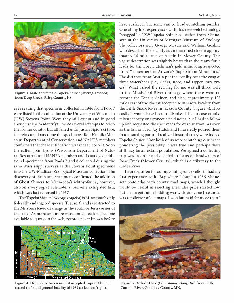
The Topeka Shiner (Notropis topeka) is Minnesota’s only federally endangered species (Figure 3) and is restricted to the Missouri River drainage in the southwestern corner of the state. As more and more museum collections became available to query on the web, records never known before
have surfaced, but some can be head-scratching puzzles. One of my first experiences with this new web technology “snagged” a 1939 Topeka Shiner collection from Minne-sota at the University of Michigan Museum of Zoology. The collectors were George Meyers and William Gosline who described the locality as an unnamed stream approx-imately 16 miles east of Austin in Mower County. This vague description was slightly better than the many futile leads for the Lost Dutchman’s gold mine long suspected to be “somewhere in Arizona’s Superstition Mountains.” The distance from Austin put the locality near the cusp of three watersheds (i.e., Cedar, Root, and Upper Iowa riv-ers). What raised the red flag for me was all three were in the Mississippi River drainage where there were no records for Topeka Shiner, and also, approximately 125 miles east of the closest accepted Minnesota locality from the Little Sioux River in Jackson County (Figure 4). How easily it would have been to dismiss this as a case of mis-taken identity or erroneous field notes, but I had to follow up and requested the specimens for examination. As soon as the fish arrived, Jay Hatch and I hurriedly poured them in to a sorting pan and realized instantly they were indeed Topeka Shiner. Now both of us were scratching our heads pondering the possibility it was true and perhaps there still may be an extant population. We agreed a collecting trip was in order and decided to focus on headwaters of Rose Creek (Mower County), which is a tributary to the Cedar River.
In preparation for our upcoming survey effort I had my first experience with eBay where I found a 1956 Minne-sota state atlas with county road maps, which I thought would be useful in selecting sites. The price started low, but I soon got into a bidding war with someone I assumed was a collector of old maps. I won but paid far more than I
Figure 3. Male and female Topeka Shiner (Notropis topeka) from Deep Creek, Riley County, KS.
Figure 4. Distance between nearest accepted Topeka Shiner record (left) and general locality of 1939 collection (right).
Figure 5. Redside Dace (Clinostomus elongatus) from Little Cannon River, Goodhue County, MN.

Spring 2016 American Currents 18
should have, succumbing to the bidding fever. I just had to have it! I will say the maps were helpful, but I cannot add that they were worth every penny.
On October 20, 2003, Pat Ceas (St. Olaf College) joined us in our pie-in-the-sky quest. At a road crossing on Rose Creek, I went upstream and Jay and Pat headed downstream. When we met back at the car, I reported the expected negative results. Jay and Pat concurred, but as always, I was curious what they saw. They both started listing off names, but when one of them said, “Clinos-tomus elongatus” (Figure 5) I rudely interrupted them before either one could say another species shouting, “Redside Dace?”. They both looked at me with shocked expressions and nodded in agreement that is exactly what they found. The tone of my voice may have been a little harsh coming across as an interrogator, but I was getting very anxious to ask the most important question. Did they save specimens? Nope. My heart sank. I filled them in that there had only been one other Minnesota record from the Cedar River system in 1981, but again no specimens had been preserved. It was not my inten-tion, but I made them feel even worse adding we were in a shared stream system only 11 air miles north of Iowa where the species has been presumed extirpated since the 1880s (Harlan and Speaker, 1987). We hurried back to the site and worked it over and over without success.
I have returned many times to Rose Creek since, but never came back with specimens of either species. How-ever, I may have resolved the question of Topeka Shiner in the Mississippi drainage. My first query was filtered for Minnesota records. Long after the first Rose Creek survey, I queried web databases again for shared stream systems in adjacent states and provinces. Another Topeka Shiner record popped up from Meyers and Gosline near Sioux Falls, South Dakota, which is well within the species’ range. It had been so long since my first query efforts that I did not immediately make the connection, but some-thing was very familiar about this record. I tried a new query on the collectors’ names and Topeka Shiner. These results may have revealed the smoking gun. The first col-lection was made on September 18, 1939 near Austin and the second on September 19 near Sioux Falls. I can never say without a doubt, but this strongly points to either field note errors or collection contamination while preserving or processing specimens.
In 1989, I began surveying all the state parks in Min-nesota (Schmidt, 1993). This was also the third year of the worst drought since the Dust Bowl of the 1930s and even large rivers were mere trickles of their normal selves. My sampling gear was primitive, comprised only of seines, kick nets, and minnow traps, but did I catch fish! At every
park I attempted a nocturnal survey, which often yielded some very interesting species rarely collected during the day. I will confess now that these were always done alone and without a lifejacket. Thankfully with age comes wis-dom and I quit that insane idea long ago. However, in late September 1989, I was surveying Crow Wing State Park near Brainerd in Crow Wing County armed with only a headlight and a three-foot wide push seine. I entered the Mississippi River at the confluence with the Crow Wing River. Here the Mississippi is still a large river spanning over 400 feet to the islands separating the two rivers. I was amazed that even on the outside bend I could wade almost halfway across the river in hip boots. On one lift
Figure 7. Silver Chub distribution in Minnesota.
Figure 6. Silver Chub (Macrhybopsis storeriana) from the Mis-sissippi River, Goodhue County, MN.

19 American Currents Vol. 41, No. 2
I noticed three large minnows in the seine and exam-ined them carefully. Without a doubt these were all Silver Chub (Macrhybopsis storeiana). (Figure 6) My steadfast confidence had been cemented from earlier collecting two specimens in July, also in the Mississippi River at night with a push seine at Fort Snelling State Park, but 90 air miles south (Figure 7). I did take photo vouchers at the southern locality and thought this would be enough to document them for the entire study, so I released the Crow Wing specimens. It is a decision I have regretted ever since!
The following winter, I was visiting Jim Underhill (University of Minnesota and Curator Emeritus at the James Ford Bell Museum of Natural History [JFBM]) and mentioned my Silver Chub catch and release. He instant-ly raised his eyebrows replying with tone of regret, “That would have been a significant find.” The good professor noticed the veil of disappointment fall across my face and proceeded to tell a fascinating story on the distribu-tion of fishes in Minnesota. For 10,000 years since the last Ice Age, St. Anthony Falls (Figure 8) at Minneapolis had functioned as a migration barrier with 123 species known below the falls, but only 63 above it (Eddy et al., 1963). However, since the construction of the Upper and Lower St. Anthony locks, a few species have extended their ranges beyond the barrier, but not Silver Chubs (Hatch et al., 2003).
Again without at least one specimen or photo voucher, my record cannot be accepted as valid from this drain-age. I have returned to Crow Wing State Park many times since, repeating the night surveys with helpers using large pull seines and once a boat and Missouri trawl for deep water, but always without success. However, I have fared somewhat better with digital fish surveys on the web and may have resurrected the Crow Wing record. In 1886, F. Washburn collected a Silver Chub from Mille Lacs Lake, which is in the Mississippi headwaters drainage almost at the same latitude as my record (see Figure 7). The fish resides at the Smithsonian and its identification must be verified if that is still possible on a 130 year-old specimen.
In 1984, Jack Enblom (Minnesota DNR fish biolo-gist) and his crew (Steve Hanson and Paul Renard) were surveying the Red River of the North, which forms the boundary with North Dakota and South Dakota. On Au-gust 12, they were using a boat shocker along the North Dakota bank west of Climax, (Polk County) Minnesota. Near a dry wash that formed a narrow chute and a small island, Jack’s attention was focused on navigating the boat and monitoring the electricity settings. He briefly glanced forward and realized both Steve and Paul had stopped netting fish. Something on the floor captivated their gaze and Jack clearly read their puzzled faces. The source of this confusion was a fish none of them could identify. They wisely preserved the specimen that Jim Underhill later de-
Figure 9. Flathead Chubs (Platygobio gracilis) from Assini-boine River, Manitoba.Figure 8. St. Anthony Falls: past and present.

Spring 2016 American Currents 20
termined was a Flathead Chub (Platygobio gracilis) (Figure 9), which remains today the only record from Minnesota waters.
The subsequent nagging question is where did it come from? Jim Underhill believed he had found the smoking gun after receiving correspondence from the North Da-
kota Department of Fish and Game that Flathead Chubs had been stocked in Lake Ashtabula, which is a reser-voir on the Sheyenne River (tributary to Red River of the North). Stream miles to the Climax locality would be a much greater distance, but the reservoir is only 70 air miles away (Figure 10). It appeared this mystery had been solved. However, I firmly believed we would collect Flathead Chub in the Sheyenne River while assisting the US Geological Survey with fish surveys from 1993–1995. The Sheyenne proved to be one of the most diverse North Dakota streams in the study, but never gave up a single Flathead Chub.
Regardless of the species’ origin in the Red, I now needed a photograph for the Fishes of Minnesota species account. In 2003, through some long-distance network-ing, Bob Hrabik came through again putting me in touch with Doug Watkinson (Fisheries and Oceans Canada) who invited me to collect Flathead Chub from the Assiniboine River where they were common. I have to tell the world how much I like Canadians! This occurrence was also news to me because the stream is a tributary to the Red River of the North where Flathead Chub also occur downstream of the confluence (Stewart and Watkinson, 2004). It’s a haul (160 air miles) and there are dams, but none are total fish barriers upstream to Climax. When the Red River floods it spreads laterally for miles across the “flat as a pancake” topography of what was the bed of Glacial Lake Agassiz that formed following the last Ice Age about 13,000 years ago. Present day remnants of its original footprint include lakes Manitoba, Winnipeg, Winnipegosis, Rainy, Red, and Lake of the Woods (Wikipedia contributors 1).
In 2009, Doug again invited both Bob and I up for a
Figure 10. Flathead Chub records and reports in Red River of the North drainage.
Figure 12. Distance between nearest Largescale Stoneroller populations: Forest River near Inkster, ND, and Pomme de Terre River near Appleton, MN.
Figure 11. Largescale Stoneroller (Campostoma oligolepis). Top: Adult male from Salem Creek, Dodge County, MN. Bot-tom: Juvenile from Snake Creek, Pine County, MN.

21 American Currents Vol. 41, No. 2
float trip survey of the Assiniboine River for rare Silver Chub using Missouri trawls, which proved to be the “silver bullet” for them and Flathead Chub. Before leaving Mani-toba we gave the trawls a try in the Red River of the North at Winnipeg and at the international border, but no luck finding Flathead Chub. My last attempt was on October 2012 at Grand Forks, North Dakota. Bob joined me once again, along with my son (and NANFA member), Bryan Stefansky. Our trip coincided with all day cold and wind-blasting fall rains. Absolutely miserable! We did get Silver Chubs and a Lake Sturgeon and that was it for highlights. On the way home, Bob offered his opinion about the Cli-max collection. He is very familiar with Flathead Chub in his home state of Nebraska. The Red River of the north doesn’t look anything like the typical habitats for the spe-cies in Nebraska, or for that matter, the Assiniboine. The Red’s channel morphology is deeply entrenched for most of its length. Just six feet from the bank, the depth is often 15–20 feet and rapidly descends to 25–35 feet. Bob sus-pects the one chub was a long distant (probably lost) mi-grant and there is no established population in the Minne-sota reach of the Red, but in the hunt for rare species who can ever say never?
The last grand puzzler hails from Forest River, which is another North Dakota tributary to the Red River of the North. The Forest flows through Grand Forks and Walsh counties and joins the Red about 12 miles southeast of Grafton. From 1952–1994, five collections of Largescale Stonerollers (Campostoma oligolepis) (Figure 11) have been cataloged in the JFBM fish collection from localities near Inkster and Fordville. This is the sole occurrence for
the species in the Red River of the North drainage and the population was not reported in either Lee et al. (1980) or Page and Burr (2011). The nearest known population of Largescale Stonerollers is 220 air miles south in the Pom-me de Terre River (Swift County) near Appleton, Minne-sota (Figure 12).
How did they get there? It is so tempting to say bait bucket and leave it at that, but both the Largescale and Central Stoneroller (C. anomalum) suffer high mortality from handling and crowding in a typical minnow bucket. I almost always experience the same disaster even with the aid of aerators and live wells to briefly hold fish dur-ing stream surveys. Very few if any stonerollers survive to release. If any specimens are vouchered they must be preserved immediately or the bodies soon disintegrate to mush. Need I say I’m no fan of sorting and counting stonerollers from streams where they are common!
I must emphasize alternative possibilities require dis-tances way “beyond the pale” to ponder, but time would be on the stoneroller’s side to achieve such a feat. The forma-tion of Glacial Lake Agassiz following the last Ice Age has been previously discussed in the Flathead Chub account. Eventually it covered an area up to 110,000 square miles with a maximum depth of 700 feet making it larger than any existing lake today (Figure 13). About 9,700 years ago the filling lake cut a gorge through the Traverse Gap and current continental divide between Hudson Bay and Gulf of Mexico drainages near Browns Valley, Minnesota. This became the source of the Glacial River Warren, which cut the present day Minnesota River valley up to five miles wide and 250 feet deep. About 9,400 years ago the drain-ing Lake Agassiz had opened another outlet and River Warren ceased to flow (Wikipedia contributors 2).
There are two hypothetical routes based on the simi-larities in the fish and mussel faunas with the Minnesota River and the southern Red River of the North drain-ages (Graf, 1997). Largescale Stonerollers occur in the mainstem and larger tributaries of the upper Minnesota River system. The first route would be up the Minnesota River to the low almost imperceptible continental divide near Browns Valley. The premise of the second route is that the Otter Tail River may have once been part of the Minnesota River drainage via the Pomme de Terre River. However, the Red, via stream capture (aka piracy), di-verted the Otter Tail to its drainage (Figure 12). Regard-less, either way would be a very long swim to the Forest River for a little fish.
I have always been fascinated with glacial relicts, which are coldwater species that found isolated refugia as glaciers retreated during the last Ice Age and survive today in dis-junct populations hundreds of miles south of their main
Figure 13. Glacial Lake Agassiz from 13,000 to 8,200 years age ago. However, the lake never filled the entire basin at any single time gradually shifting northward due to wasting glaciers and the formation of new outlets. (Leverington and Teller, 2003).

Spring 2016 American Currents 22
range. One example is the Lake Chub (Couesius plumbeus) (Figure 14), which has the most northern distribution of minnows in North America and is the only cyprinid that occurs in Alaska’s Yukon River drainage (Page and Burr, 2011). The most baffling locality for the species is in the Mississippi River drainage near Dubuque, Iowa, where in 1954 Robert Chipman collected specimens at Twin Springs in Dubuque County (Figure 15). The nearest populations today are in Lake Michigan (150 air miles east) and Lake Superior (300 air miles north). Other relict populations occur in the Missouri River drainage of Colorado, Nebras-ka, South Dakota, and Wyoming. NANFA meber John Olson, of the Iowa Department of Natural Resources, has launched a Holy Grail quest for Iowa’s rarest fish. It isn’t John’s first such quest, either (see John’s “Forays into Iowa” series in American Currents 37:3 [Summer 2012] and 40:1 [Winter 2015]). He has used every tool at his disposal at-tempting to pinpoint the spring’s locality, which has prov-en as challenging as Ponce de Leon’s quest for the mythical Fountain of Youth. He has “conscripted” DNR fish biolo-gists in the Dubuque area to aid in the search for Twin
Springs and contact landowners for stream access. He has queried databases and browsed through old maps looking for geographic names provided in the locality description. And finally, he applied detective skills that he has gained from studying his own family genealogy, which will hope-fully find Robert Chipman alive and able to point the way to one of best kept secrets of fabled collections.
Stay tuned....Literature Cited
Becker, G.C. 1983. Fishes of Wisconsin. University of Wisconsin Press. 1052 p.Eddy, S., J.B. Moyle, and J.C. Underhill. 1963. The fish fauna of the Mississippi River above St. Anthony Falls as related to the effectiveness of this falls as a migration barrier. Proceedings of the Minnesota Academy of Science 30:111–115.Graf, D. L. 1997. Northern redistribution of freshwater pearly mussels (Bivalvia: Unionoidea) during Wisconsin deglaciation in the southern glacial Lake Agassiz region: a review. American Midland Naturalist 138:37–47.Harlan, J.R., and E.B. Speaker. 1987. Iowa Fish and Fishing. Iowa Dept. of Natural Resources. 323 p.Hatch, J. T., K. P. Schmidt, D. P. Siems, J. C. Underhill, R. A. Bellig, and R. A. Baker. 2003. A new distributional checklist of Minnesota fishes, with comments on historical occurrence. Journal of the Minnesota Academy of Science 67:1–17.Lee, D.S., C.R. Gilbert, C.H. Hocutt, R.E. Jenkins, D.E. McAllister, and J.R. Stauffer, Jr.. 1980. Atlas of North American Freshwater Fishes. North Carolina State Museum of Natural History. 867 p.Leverington, D.W., and Teller, J.T., 2003. Paleotopographic reconstructions of the eastern outlets of glacial Lake Agassiz. Canadian Journal of Earth Sciences 40:1259–1278.Page, L.M., and B.M. Burr. 2011. Peterson Field Guide to Freshwater Fishes of North America North of Mexico. Second edition. Houghton Mifflin Harcourt Publishing Co. 663 p.Schmidt, K.P. 1993. Minnesota state parks fish species lists. Final report submitted to the Natural Heritage and Nongame Research Program, Minnesota Department of Natural Resources. 200 p.Stewart, K.W and D.A. Watkinson. 2004. The Freshwater Fishes of Manitoba. University of Manitoba Press. 276 p.Wikipedia contributors 1, “Lake Agassiz,” Wikipedia, The Free Encyclopedia, https://en.wikipedia.org/w/index.php?title=Lake_Agassiz&oldid=708073792 (accessed March 8, 2016).Wikipedia contributors 2, “Glacial River Warren,” Wikipedia, The Free Encyclopedia, https://en.wikipedia.org/w/index.php?title=Glacial_River_Warren&oldid=691764235 (accessed March 8, 2016).
Figure 15. Lake Chub range map. Red arrow shows general locality of Twin Springs. (Map modified from Lee et al, 1980).
Figure 14. Lake Chub (Couesius plumbeus) from Skunk Creek, Lake County, MN.