crossrail assessment of impacts on heritage and...
TRANSCRIPT

Crossrail Assessment of Impacts on Heritage and Landscape
Technical Report
February 2005
1E0316-G0E00-00001 This report has been prepared by Alan Baxter and Associates and Chris Blandford Associates for Cross London Rail Links Limited.
Cross London Rail Links Limited 1, Butler Place LONDON SW1H 0PT
Tel: 020 7941 7600 Fax: 020 7941 7703
www.crossrail.co.uk
Volume 2 of 6


ASSESSMENT OF IMPACTS ON HERITAGE AND LANDSCAPE TECHNICAL REPORT
This report has been prepared jointly by Chris Blandford Associates and Alan Baxter and Associates for Cross London Rail Links Limited.
__________________________
Date ______________________
For Chris Blandford Associates
__________________________
Date ______________________
For Alan Baxter and Associates


Crossrail Line 1 Assessment of Heritage and Landscape Impacts – Volume 2
Contents 1
Volume 2: Contents Western Section Introduction Route window W25 Maidenhead Station Route window W24 Maidenhead Railway Bridge Route window W23B Jubilee Rover to Taplow Station Route window W23A Taplow Station Route window W22 Lent Rise Route window W21 Burnham Station Route window W20 Dover Road & Leigh Road Bridges Route window W19 Stoke Poges Lane Bridge Route window W18B Wexham Road Bridge Route window W18A Slough Station Route window W17 Middlegreen Road,St Mary’s Road & Trenches Bridge Route window W16 Langley Station Route window W15 Dog Kennel Bridge Route window W14 Iver Station Route window W13 West Drayton Station Route window W12 Horton Road and Old Stockley Road Bridges Route window W11 Stockley Flylover Route window W10 Hayes and Harlington Station Route window W8/W9 Southall Station and Southall West Sidings Route window W7 Hanwell Station Route window W6 West Ealing Station Route window W5 Ealing Broadway Station Route window W4 Acton Main Line Station and Yard Route window W3 Old Oak Common Depot Route window W2 Canal Way Route window W1 Portobello Junction Route window H1-H5 Heathrow Express Tunnel

Crossrail Line 1 Assessment of Heritage and Landscape Impacts – Volume 2
2 Contents

Crossrail Line 1 Assessment of Heritage and Landscape Impacts – Volume 2
Volume 2 3
Volume 2 Western Route Section Introduction


Crossrail Line 1 Assessment of Heritage and Landscape Impacts – Volume 2
Introduction 5
Contents
1. Introduction 7 1.1 Background 7 1.2 The Heritage and Landscape Report 8 1.3 Structure of the Report 9
2. Introduction To Volume 2 10 3. Description of the Scheme 11
3.1 Permanent Works 11 3.2 Construction 11
4. PPG 15 Principles 13 4.1 Listed building consent: Demolition and alterations 13 4.2 Control over demolition: Conservation Area Consent 14 4.3 Setting of Listed Buildings 14
5. Generic Works 15 5.1 Bridge Works 15 5.2 OHLE works 24 5.3 Utilites Works 43

Crossrail Line 1 Assessment of Heritage and Landscape Impacts – Volume 2
6 Introduction

Crossrail Line 1 Assessment of Heritage and Landscape Impacts – Volume 2
Introduction 7
1. Introduction 1.1 Background
Crossrail is a major new cross-London rail link project that has been developed to serve
London and the southeast of England. Crossrail will support and maintain the status of
London as a world city by providing a world class transport system. The project includes the
construction of a twin-bore tunnel on an east-west alignment under central London and the
upgrading of existing National Rail lines to the east and west of central London. The
Crossrail route is shown in Figure 1.1.
Overview of Crossrail Route
The project will enable the introduction of a range of new and improved rail journeys into and
through London. It includes the construction of seven central area stations, providing
interchange with London Underground, National Rail and London bus services, and the
upgrading or renewal of existing stations outside central London. Crossrail will provide fast,
efficient and convenient rail access to the West End and the City by linking existing routes
from Shenfield and Abbey Wood, in the east with Maidenhead and Heathrow in the west.
Crossrail will be a significant addition to the transport infrastructure of London and the
southeast of England. It will deliver improved services for rail users through the relief of
crowding, faster journeys and the provision of a range of new direct journey opportunities.
The project will also have wider social and economic benefits for London and the southeast
of England
Transportfor London

Crossrail Line 1 Assessment of Heritage and Landscape Impacts – Volume 2
8 Introduction
1.2 The Heritage and Landscape Report
In 2002 Cross London Rail Link Ltd (CLRL) appointed consultants to carry out a number of
studies into the environmental impacts of the Crossrail scheme as inputs into the
Environmental Impact Assessment and Statement.
Alan Baxter and Associates (ABA) were appointed to examine the impacts of the scheme
upon listed buildings.
Chris Blandford Associates (CBA) were appointed to examine the impacts upon
landscape/townscape and visual amenity.
These two major pieces of work have an area of overlap in so far as they both consider the
impacts of the scheme on listed buildings and on conservation areas and they both address
the requirements of Planning Policy Guidance Note 15 (PPG 15) – Planning and the Historic
Environment with regard to listed buildings and conservation areas.
Consequently, there has joint working between the two consultancies. In addition, inputs
have been obtained from both the engineering design consultants (Mott McDonald (MM) and
Scott Wilson Railways) (SWR) and the architects (John McAslan & Partners and Hawkins
Brown) to provide additional information in relation to the design development of proposals
affecting listed buildings or buildings within conservation areas.
This report has been compiled from the series of studies carried out by these consultants
and provides a synthesis of their work into a joint report on heritage and landscape. The
responsibilities of the consultants in compiling this report are set out below:
Direct impacts on listed buildings and structures and above ground Scheduled Ancient Monuments
Alan Baxter & Associates
Impacts on the setting of listed buildings
Chris Blandford Associates supported by Alan Baxter & Associates in relation to historic buildings.
Impacts on Conservation Areas Chirs Blandford Associates supported by an assessment by Alan Baxter & Associates of the contribution to the Conservation Areas of buildings to be demolished.
Design development of proposals affecting listed buildings and buildings in Conservation Areas
Cross London Rail Links supported by Mott MacDonald, Scott Wilson Railways, John McAslan & Partners and Hawkins Brown
Impacts on townscape and landscape character
Chris Blandford Associates
Impacts on visual amenity Chris Blandford Associates

Crossrail Line 1 Assessment of Heritage and Landscape Impacts – Volume 2
Introduction 9
1.3 Structure of the Report
Volume 1 provides an overview of the scheme, sets out the methodologies employed by the
consultants and summarises the principal impacts identified.
Volumes 2 (West), 3 (Central West), 4 (Central East) and 5 (East) examine the detailed
impacts for each route window. Each volume sets out the PPG 15 principles to be
considered in the assessment and describes the relevant planning policy framework included
in the Planning authorities is adopted and other statutory plans.
For each route window there is:
- a description of the temporary and permanent works;
- a baseline description of the listed buildings, conservation areas, townscape/landscape
character and quality, relevant landscape designations and the location and sensitivity of
potential visual receptors;
- an assessment of the impact of the works on heritage and landscape resources and
visual amenity including the proposed mitigation works to ensure that adverse impacts
are minimised as far, as is reasonably practicable;
- a summary table of the impacts;
- details of any assumptions made about the scheme;
- references.
Where there are predicted to be impacts on listed buildings, or where buildings within
conservation areas are to be demolished, the report also sets out a description of the design
development, explaining the reasons for the selection of the proposed scheme.
Volume 6 contains plans including Townscape Character Baseline mapping and Zones of
Visual Influence (ZVI) plans for each route window
The potential for impacts on listed buildings as a result of settlement is dealt with separately
in the report entitled“. Assessment of Settlement Impacts on the Built Heritage – Technical
Report”. This report assesses the potential impacts of settlement caused by the construction
of Crossrail on listed buildings and describes how any potentially significant impacts will be
mitigated, so that no significant settlement impacts will be expected when the scheme is
constructed.

Crossrail Line 1 Assessment of Heritage and Landscape Impacts – Volume 2
10 Introduction
2. Introduction To Volume 2
Volume 2 of the report covers route windows W25 to W1 from Maidenhead to the tunnel
portal west of Paddington Station with a spur to Heathrow. Each route window is dealt with
in a separate section in the remainder of this document. This introductory section sets out an
overview of the scheme in the western section and section-wide issues.
Section 3 provides a summary of the scheme in the western section.
Section 4 provides relevant extracts from planning policy guidance, in particular Planning
Policy Guidance Note 15 (PPG 15) – Planning and the Historic Environment which sets out
Government policy with regard to listed buildings, heritage and conservation areas.
This part of the route is located within the administrative areas of the Royal Borough of
Windsor and Maidenhead, South Bucks District Council and Slough Borough Council, the
London Boroughs of Hillingdon, Ealing, Hammersmith and Fulham, Kensington and Chelsea
and the City of Westminster. As the works on the western route are contained largely within
the existing railway corridor there is little impact upon the local authorities’ planning policies.
The exception to this is the works at Slough Station which involve the alteration of listed
buildings. These would therefore would under normal arrangements need to comply with
Slough Council’s policies on standards of design (Policy EN1), landscaping (Policy EN3),
disabled access (Policy EN 8) and works affecting listed buildings and their settings (Policies
EN14 and 16). The design has been developed carefully to meet the requirements of these
policies.
Section 5 includes assessments by Chris Blandford Associates on route wide issues
affecting the West route, in particular the impact of overhead electrification (OHLE) and
works to bridges along the route and utilities works.

Crossrail Line 1 Assessment of Heritage and Landscape Impacts – Volume 2
Introduction 11
3. Description of the Scheme
3.1 Permanent Works
The Crossrail service will use only the existing Great Western relief lines (in normal
operations). Additional new track will however, be provided at some locations. For example,
a new line will be constructed over about 1 km between Langley and West Drayton, which
will link existing (but upgraded) freight lines to its east and west so providing increased track
capacity.
Crossrail’s major new structures or facilities include a new dive-under (rail underpass) at
Acton (W4), a new flyover at Stockley in Hillingdon (W11) and new or remodelled sidings at
Maidenhead (W25), West Drayton (W13) and Old Oak Common depot (W3). Crossrail will
require, at several places, changes to the permanent way, such as new track or track
realignment. It will also require new or extended station platforms to accommodate
Crossrail’s 200 m long trains. At nine stations, improved facilities, including new or modified
ticket halls, will be provided to accommodate the increased number of passengers from
Crossrail.
Much of the Great Western Mainline (GWML) is not electrified: only the section between
Paddington and the Stockley Road bridge in Hillingdon is electrified at present. The
remainder of the route west of Stockley Road bridge will require the provision of new 25 kV
AC overhead line equipment (OHLE), generally in the form of 6 m high gantries from which
catenary wires and contact wires will be suspended. This in turn will require that some of the
bridges on the route be raised or the track lowered beneath them. In some cases, bridges
will be reconstructed completely. In other cases, bridge works will be more limited; for
example, the raising of parapets (side walls) for public safety reasons.
3.2 Construction
Construction methods for each of the works are described in their route window; for example,
with respect to construction of bridges, station buildings, stabling facilities and grade
separated crossings. The construction works, where they take place on or near to the
railway, may need to be undertaken during ‘possessions’, when the railway is closed to
normal passenger and freight services. These possessions generally take place at night, at
weekends or over public holidays.

Crossrail Line 1 Assessment of Heritage and Landscape Impacts – Volume 2
12 Introduction
Where time periods for the works are given in this chapter, they may be subject to alteration
to accommodate possession planning requirements (ie times to be negotiated with the train
companies and Network Rail, when the works can be undertaken during temporary closure
of the railway) and final commissioning, which may need to be completed for the corridor as
a whole for constructing OHLE and platform extensions are much the same wherever they
are undertaken and so, for brevity, are described once here.
Construction of OHLE will require that ground bearing or piled foundations be installed using
rail-mounted machinery or by hand. Masts (which will have a bolted base) and electrical
equipment will be installed generally from the rail. Materials will be delivered by rail or road
as appropriate.
Plant and equipment required for construction of OHLE will include a mini digger, piling rigs,
concreting plant, diesel locomotives and wagons, a vibrating poker, generators, road/rail
cranes and hand held plant.
Platform extensions, which will be undertaken at 13 stations, will involve:
- break out and removal of existing surfaces and ramps;
- excavation and construction of foundations using piling where appropriate;
- construction of platforms using crosswalls and pre-cast concrete planks;
- fitting of reinforced concrete screed, copings and paving, fitting of tactile strips and
levelling of the surface;
- installation of lighting and drainage; and
- adjustment of track alignments, if required.
Proprietary platform extension systems may be used which may vary the construction
activities.
Subject to possession planning requirements and excluding final commissioning, platform
extensions will generally take between one and three months to complete.
Enabling works will be required prior to the main construction works. These may take up to
12 months at each site, although at locations where only minor enabling works are required
the durations of these works could be much shorter.

Crossrail Line 1 Assessment of Heritage and Landscape Impacts – Volume 2
Introduction 13
4. PPG 15 Principles
The relevant statute for listed buildings, conservation areas, historic parks and gardens and
the wider historic environment is the Planning (Listed Buildings and Conservation Areas) Act
1990. The National Planning Policy Guidance document is Planning Policy Guidance Note
15: Planning and the Historic Environment (PPG15) (1994). PPG15 must be taken into
account by Local Planning Authorities in preparing development plans as it is material to
decisions on individual planning applications.
What is included?
- The listed building itself;
- Any structure or erection fixed to the building (not free standing) and any part of a
building is included in listing; and,
- Any object that forms part of the land and has done so before July 1st 1948 is defined as
within the curtilage and is included in the listing,
4.1 Listed building consent: Demolition and alterations
There is a general presumption in favour of the preservation of listed buildings. Their
preservation is ensured through the requirement for listed building consent to be granted by
the Local Planning Authority. When determining applications for listed building consent Local
Planning Authorities ‘Should have special regard to the desirability of preserving the building
or its setting or any feature of special architectural or historic interest which it possesses’
(1990 Act s 16). The issues that are generally relevant in the determination of all listed
building consent applications are explained in PPG15 (3.5, I-IV). They comprise:
- The architectural, historic importance or rarity of the building;
- The particular physical features of the building;
- The buildings setting and its contribution to the local scene; and,
- The extent to which the proposed works would bring substantial benefits to the
community.
(PPG15, 3.19) points out that only very occasionally are there cases ‘where demolition is
unavoidable’. To obtain listed building consent for demolition there must be ‘Clear and
convincing evidence that all reasonable efforts have been made to sustain existing uses or
find viable new uses’ (PPG15, 3.17).

Crossrail Line 1 Assessment of Heritage and Landscape Impacts – Volume 2
14 Introduction
Where proposed works would result in the total or substantial demolition of the listed building
the Local Planning Authority would be expected to take into account PPG15, 3.19 regarding
the:
- Condition of the building and cost of repair;
- Adequacy of efforts made to retain the building in use; and,
- Alternative proposals for the Site.
Consent for demolition should not be granted unless it is certain that new development will
proceed, (PPG15, Annex B5) and if this is the case a month should be allowed for records to
be made (PPG15, Annex B4).
4.2 Control over demolition: Conservation Area Consent Where the demolition of a building within a conservation area is proposed, it is necessary to
seek Conservation Area Consent, in addition to planning permission. In determining
applications for Conservation Area Consent, local planning authorities should ‘clearly take
account of the part played in the architectural or historic interest of the area by the building
[…] and in particular of the wider effects of demolition on the building’s surroundings and on
the conservation area as a whole’ (PPG 15, 4.26).
For buildings which make a positive contribution to the character and appearance of the
conservation area there is a presumption in favour of their retention. Consent for demolition
should be determined according to the same criteria as are applied to listed buildings
(PPG15, 4.27). Where a building makes little or no contribution, the local authority will need
to have full information about what is proposed for the site after demolition.
Where ‘buildings make no positive contribution to, or actually detract from, the character or
appearance of the area, their replacement should be [seen as] a stimulus to imaginative,
high quality design and […] as an opportunity to enhance the area’ (PPG15, 4.17).
4.3 Setting of Listed Buildings Local planning authorities considering applications for planning permission are required to
have regard to the desirability of preserving the setting of nearby listed buildings (PPG15,
2.16). Authorities are also required to consider ‘development proposals which are outside the
conservation area but would affect its setting, or views into or out of the area.’ (PPG15, 4.14).

Crossrail Line 1 Assessment of Heritage and Landscape Impacts – Volume 2
Introduction 15
5. Generic Works
5.1 Bridge Works 5.1.1 Introduction
This section has been produced with the aim of defining the scope and extent of the studies
required to assess the landscape / townscape impacts of the bridge works proposals at
Southall Station W8 and along the Stockley flyover to Maidenhead section (W12 to W25) of
the Western route section.
The report set out in tableform (Table 5.1) the location of the bridges, the proposed works to
each bridge, the likely landscape / townscape issues, impact receptors, an assessment in
broad terms of the townscape impacts and also an assessment of the impacts on visual
amenity. An assessment of the overall likely impact and its significance is also assessed.
Those bridge works that have been identified as potentially “significant” have been assessed
in detail in the individual route window technical reports. The assessment methodology used
follows the methodology set out in Volume 1 of this report.

Crossrail Line 1 Assessment of Heritage and Landscape Impacts – Volume 2
16 Introduction
Tabl
e 5.
1: S
copi
ng o
f Brid
ge W
orks
in th
e W
este
rn R
oute
Sec
tion
Ass
essm
ent o
f Im
pact
s To
wns
cape
Vi
sual
Am
enity
R
oute
W
indo
w
Brid
ge /
Loca
tion
Wor
ks
Issu
es
Sens
itivi
ty
Mag
nitu
de o
f C
hang
e Se
nsiti
vity
M
agni
tude
of
Cha
nge
Pote
ntia
l Ove
rall
Sign
ifica
nce
Com
mer
cial
/Bus
ines
s an
d C
omm
unity
faci
litie
s to
the
north
M
oder
ate
Neg
ligib
le
Sta
tion
and
plat
form
s to
the
wes
t M
oder
ate
Neg
ligib
le
Bus
ines
s us
es to
the
sout
h Lo
w
Neg
ligib
le
W8
Mer
rick
Foot
brid
ge
Min
or a
ltera
tions
to
the
supp
orts
due
to
the
prop
osed
S
outh
all p
latfo
rm
wor
ks. B
ridge
st
ruct
ure
will
rem
ain
as p
rese
ntly
ex
ist.
Rai
l Cor
ridor
and
Sou
thal
l S
idin
gs to
eas
t
Low
Lo
w
Low
N
eglig
ible
Not
Sig
nific
ant
Res
iden
tial t
o so
uth-
wes
t –
view
s 20
/30m
H
igh
Mod
erat
e
Com
mer
cial
/Bus
ines
s –
north
/ ea
st s
outh
and
wes
t.
Mod
erat
e M
oder
ate
W12
Old
St
ockl
ey
Roa
d br
idge
Brid
ge d
emol
ition
. C
onst
ruct
ion
of n
ew
brid
ge.
Gra
nd U
nion
Can
al to
the
north
– 5
0m
Low
M
oder
ate
Mod
erat
e M
oder
ate
Sign
ifica
nt
Adj
oins
bus
ines
s/co
mm
erci
al
to s
outh
-wes
t M
oder
ate
Low
Bus
ines
s/co
mm
erci
al to
no
rth
Hou
sing
to s
outh
-eas
t (H
olly
G
arde
ns) w
ithin
100
m
Mod
erat
e M
oder
ate
W12
-13
Kin
gsto
n La
ne b
ridge
(p
ublic
fo
otpa
th /
cycl
eway
)
Brid
ge d
emol
ition
an
d co
nstru
ctio
n of
ne
w b
ridge
. G
rand
Uni
on C
anal
to th
e no
rth –
20m
. Sub
stan
tial
vege
tatio
n su
rrou
nds
brid
ge
and
emba
nkm
ent t
o ea
st
Low
M
oder
ate
Mod
erat
e M
oder
ate
Sign
ifica
nt

Crossrail Line 1 Assessment of Heritage and Landscape Impacts – Volume 2
Introduction 17
A
sses
smen
t of I
mpa
cts
Tow
nsca
pe
Visu
al A
men
ity
Rou
te
Win
dow
B
ridge
/ Lo
catio
n W
orks
Is
sues
Se
nsiti
vity
M
agni
tude
of
Cha
nge
Sens
itivi
ty
Mag
nitu
de o
f C
hang
e
Pote
ntia
l Ove
rall
Sign
ifica
nce
Res
iden
tial p
rope
rties
to
sout
h-w
est a
nd s
outh
.
Mod
erat
e H
igh
Ope
n co
untry
side
/ G
reen
belt
to n
orth
-eas
t and
sou
th
(eas
t) C
olne
Val
ley
Par
k.
Mod
erat
e H
igh
W14
Iver
Th
orne
y La
ne
Brid
ge a
nd
Foot
brid
ge
Rec
onst
ruct
ion
of
Iver
Tho
rney
Lan
e ro
ad b
ridge
“off
line”
to 4
780m
m
clea
ranc
e.
Dem
oliti
on o
f ex
istin
g br
idge
Lo
ss o
f ope
nnes
s (te
mpo
rary
im
pact
) Los
s of
veg
etat
ion
north
and
sou
th
Low
H
igh
- -
Sign
ifica
nt
W14
Fo
otbr
idge
R
epla
cem
ent o
f fo
otbr
idge
par
apet
s P
oten
tial v
iew
s fro
m
adjo
inin
g pr
oper
ties
Lo
w
Low
H
igh
Low
N
ot s
igni
fican
t
Rur
al /
open
cou
ntry
side
G
reen
belt
Col
ne V
alle
y P
ark.
M
oder
ate
Mod
erat
e
Vie
ws
from
pub
lic fo
otpa
th
Hig
h M
oder
ate
Bis
on w
orks
to th
e no
rth-e
ast
Man
sion
Car
avan
Par
k to
no
rth w
est
Low
M
oder
ate
W15
D
og K
enne
l B
ridge
Exi
stin
g br
idge
to
be d
emol
ishe
d.
Tem
pora
ry
cons
truct
ion
area
s to
the
sout
h.
Loss
of r
ail-s
ide
vege
tatio
n.
Low
M
oder
ate
_ _
Sign
ifica
nt
Rur
al /
open
cou
ntry
side
to
north
-eas
t and
sou
th-e
ast.
M
oder
ate
Mod
erat
e
Gre
enbe
lt C
olne
Val
ley
Par
k R
esid
entia
l dev
elop
men
t to
wes
t and
sou
th-w
est.
Mod
erat
e
Low
(due
to
scre
enin
g ef
fect
of
emba
nkm
ent)
Che
quer
s C
otta
ge
imm
edia
tely
adj
oins
sou
th-
side
of e
xist
ing
brid
ge.
Hig
h
Low
(due
to
scre
enin
g ef
fect
of
emba
nkm
ent)
W15
C
hequ
ers
Brid
ge
Con
stru
ctio
n on
ne
w s
ectio
n of
rail
brid
ge a
djac
ent t
o ex
istin
g. N
ew
abut
men
ts /
pilin
g w
orks
tem
pora
ry
cons
truct
ion
area
s –
north
sid
e of
line
. C
ulve
rt ex
tens
ions
an
d di
tch
wor
ks.
Veg
etat
ion
rem
oval
Low
M
oder
ate
Sig
nific
ant

Crossrail Line 1 Assessment of Heritage and Landscape Impacts – Volume 2
18 Introduction
Ass
essm
ent o
f Im
pact
s To
wns
cape
Vi
sual
Am
enity
R
oute
W
indo
w
Brid
ge /
Loca
tion
Wor
ks
Issu
es
Sens
itivi
ty
Mag
nitu
de
of C
hang
e Se
nsiti
vity
M
agni
tude
of
Cha
nge
Pote
ntia
l Ove
rall
Sign
ifica
nce
Loss
of v
eget
atio
n La
ne ta
ke
cons
truct
ion
area
. H
igh
Low
(due
to
scre
enin
g)
Res
iden
tial d
evel
opm
ent t
o so
uth-
wes
t and
sou
th-e
ast
with
pot
entia
l vie
ws
Mod
erat
e M
oder
ate
Ope
n la
nd to
nor
th-e
ast
Low
M
oder
ate
Gra
nd U
nion
Can
al 5
0m to
no
rth
Mod
erat
e Lo
w (d
ue to
di
stan
ce a
nd
scre
enin
g)
W17
Lang
ley,
Tr
ench
es
Brid
ge
(cyc
lew
ay /
foot
path
) (N
atio
nal
Cyc
le
Net
wor
k R
oute
61)
Rec
onst
ruct
ion
of
Brid
ge fo
r 478
0mm
cl
eara
nce.
C
onst
ruct
ion
com
poun
d to
the
north
-eas
t. Lo
ss o
f veg
etat
ion
on
emba
nkm
ent f
or a
cces
s pu
rpos
es
Low
M
oder
ate
_ _
Not
sig
nific
ant
Res
iden
tial d
evel
opm
ent t
o so
uth-
wes
t and
sou
th-e
ast –
20
/30m
.
Hig
h an
d M
oder
ate
Mod
erat
e (d
ue
to s
cree
ning
)
Com
mer
cial
/ B
usin
ess
to th
e no
rth-w
est a
nd n
orth
-eas
t. Lo
w
Low
Gra
nd U
nion
Can
al to
the
north
140
m
Mod
erat
e Lo
w (d
ue to
di
stan
ce a
nd
scre
enin
g)
St M
ary’
s C
hurc
h/R
oad
Con
serv
atio
n H
igh
Low
(due
to
dist
ance
) Lo
ss o
f roa
dsid
e an
d tra
cksi
de v
eget
atio
n _
_
W17
Lang
ley
Chu
rch
Lane
B
ridge
(St
Mar
y’s
Roa
d)
Rec
onst
ruct
ion
of
brid
ge fo
r 478
0mm
cl
eara
nce.
C
onst
ruct
ion
com
poun
d to
the
sout
h-w
est.
Brid
ge
– tra
ffic
light
co
ntro
lled.
Vi
ews
tow
ards
tem
pora
ry
cons
truct
ion
com
poun
d fro
m
prop
ertie
s ad
jace
nt to
re
crea
tion
grou
nd
Low
M
oder
ate
Mod
erat
e Lo
w /
Mod
erat
e
Not
sig
nific
ant

Crossrail Line 1 Assessment of Heritage and Landscape Impacts – Volume 2
Introduction 19
Ass
essm
ent o
f Im
pact
s To
wns
cape
Vi
sual
Am
enity
R
oute
W
indo
w
Brid
ge /
Loca
tion
Wor
ks
Issu
es
Sens
itivi
ty
Mag
nitu
de
of C
hang
e Se
nsiti
vity
M
agni
tude
of
Cha
nge
Pote
ntia
l Ove
rall
Sign
ifica
nce
Res
iden
tial d
evel
opm
ent t
o so
uth-
east
.
Hig
h /
Mod
erat
e M
oder
ate
(due
to
scr
eeni
ng)
Com
mer
cial
/ B
usin
ess
use
to n
orth
-eas
t. Lo
w
Mod
erat
e
Pub
lic O
pen
Spa
ce u
se to
no
rth-w
est.
Hig
h M
oder
ate
(due
to
scr
eeni
ng)
Pub
lic O
pen
Spa
ce a
nd
woo
d to
sou
th-w
est w
ith
Nat
ure
Con
serv
atio
n In
tere
st.
Mod
erat
e Lo
w/M
oder
ate
W17
M
iddl
egre
en
Roa
d Br
idge
Rec
onst
ruct
ion
of
brid
ge fo
r 478
0mm
cl
eara
nce.
C
onst
ruct
ion
com
poun
d to
the
north
-wes
t in
play
ing
field
.
Vie
ws
from
resi
dent
ial
prop
ertie
s an
d ar
eas
of
Pub
lic O
pen
Spa
ce.
Low
M
oder
ate
Hig
h /
Mod
erat
e Lo
w /
Mod
erat
e
Sign
ifica
nt
Res
iden
tial d
evel
opm
ent t
o th
e so
uth-
east
, sou
th-w
est
and
north
-eas
t.
Hig
h Lo
w
Mos
que
20 to
the
sout
h-w
est
Low
Lo
w
Com
mer
cial
/ bu
sine
ss to
the
north
-wes
t. P
ublic
Ope
n S
pace
/ pl
ayin
g fie
ld to
the
east
/ so
uth-
east
.
Hig
h Lo
w
Vie
ws
from
resi
dent
ial
prop
ertie
s an
d P
ublic
Ope
n S
pace
. Lo
ss o
f veg
etat
ion
on b
ridge
em
bank
men
ts
_ _
W18
S
loug
h U
xbrid
ge
Roa
d Br
idge
Trac
k lo
wer
ing.
R
epla
cem
ent o
f pa
rape
ts.
Tem
pora
ry
scaf
fold
ing
wor
ks.
Con
stru
ctio
n w
ork
area
s no
rth-w
est
and
north
-eas
t.
Con
stru
ctio
n co
mpo
und
to th
e no
rth-w
est o
r nor
th-
east
.
Pot
entia
l tem
pora
ry
dist
urba
nce
to P
ublic
Ope
n S
pace
use
rs.
Low
Lo
w
Hig
h
Low
(due
to
tem
pora
ry
natu
re o
f co
mpo
und)
Not
sig
nific
ant

Crossrail Line 1 Assessment of Heritage and Landscape Impacts – Volume 2
20 Introduction
Ass
essm
ent o
f Im
pact
s To
wns
cape
Vi
sual
Am
enity
R
oute
W
indo
w
Brid
ge /
Loca
tion
Wor
ks
Issu
es
Sens
itivi
ty
Mag
nitu
de
of C
hang
e Se
nsiti
vity
M
agni
tude
of
Cha
nge
Pote
ntia
l Ove
rall
Sign
ifica
nce
Com
mer
cial
/ bu
sine
ss
deve
lopm
ents
to th
e no
rth-
wes
t and
nor
th-e
ast.
Car
pa
rk to
the
north
-wes
t.
Mod
erat
e M
oder
ate
Offi
ce to
the
sout
h-ea
st –
20
met
res.
M
oder
ate
Mod
erat
e
Res
iden
tial d
evel
opm
ent t
o th
e so
uth-
east
and
sou
th-
wes
t. H
igh
Low
(due
to
scre
enin
g)
Pot
entia
l tem
pora
ry
dist
urba
nce
to re
side
ntia
l de
velo
pmen
t if c
ompo
und
loca
ted
to s
outh
-wes
t.
Hig
h
Mod
erat
e /
Low
(due
to
tem
pora
ry
natu
re o
f co
mpo
und)
Lo
ss o
f veg
etat
ion
on b
ridge
em
bank
men
ts.
_ _
W18
S
loug
h W
exha
m
Roa
d Br
idge
Rec
onst
ruct
ion
of
brid
ge fo
r 478
0mm
C
lear
ance
/ pa
rape
t ra
isin
g an
d co
ping
. C
onst
ruct
ion
com
poun
d to
the
sout
h-w
est o
r no
rth-w
est.
Brid
ge
clos
ure
1 w
eek
Pot
entia
l dis
turb
ance
to u
ser
of c
ar p
ark
to n
orth
-wes
t
Low
M
oder
ate
Mod
erat
e
Low
(due
to
tem
pora
ry
natu
re o
f co
mpo
und)
Sign
ifica
nt
Slo
ugh
Sta
tion
and
foot
brid
ge to
the
east
Gra
de
II lis
ted
build
ing.
Effe
cts
on
setti
ng o
f lis
ted
build
ings
.
Mod
erat
e Lo
w
Com
mer
cial
/bus
ines
s us
es to
th
e no
rth.
Vie
ws
from
offi
ce
deve
lopm
ents
Low
/ M
oder
ate
Low
W
18
Slo
ugh,
W
illia
m
Stre
et B
ridge
Min
or w
orks
. P
arap
et ra
isin
g an
d co
ping
. C
onst
ruct
ion
com
poun
d in
car
pa
rk to
sou
th-w
est
and
north
-eas
t R
esid
entia
l dev
elop
men
t als
o to
nor
th-w
est –
100
+ m
etre
s an
d so
uth-
east
(Ric
hmon
d C
resc
ent).
Mod
erat
e Lo
w
Hig
h
Low
(due
to
dist
ance
and
in
terv
enin
g de
velo
pmen
t)
Not
sig
nific
ant

Crossrail Line 1 Assessment of Heritage and Landscape Impacts – Volume 2
Introduction 21
Ass
essm
ent o
f Im
pact
s To
wns
cape
Vi
sual
Am
enity
R
oute
W
indo
w
Brid
ge /
Loca
tion
Wor
ks
Issu
es
Sens
itivi
ty
Mag
nitu
de
of C
hang
e Se
nsiti
vity
M
agni
tude
of
Cha
nge
Pote
ntia
l Ove
rall
Sign
ifica
nce
Res
iden
tial d
evel
opm
ent t
o th
e so
uth-
east
– 4
0 m
etre
s.
Hig
h Lo
w (d
ue to
sc
reen
ing)
P
ublic
Ope
n S
pace
/ S
alt H
ill P
ark
to th
e so
uth-
wes
t. H
igh
/ m
oder
ate
Low
(due
to
scre
enin
g)
Com
mer
cial
/ bu
sine
ss u
ses
to th
e no
rth-e
ast (
Hor
licks
fa
ctor
y).
Low
Lo
w
Res
iden
tial d
evel
opm
ent t
o no
rth-w
est.
5-s
tore
y fla
ts o
n S
imps
ons
Way
/ P
ickf
ord
Gar
dens
-50
met
res.
Hig
h Lo
w (d
ue to
sc
reen
ing
and
dist
ance
)
W19
Slo
ugh,
S
toke
Pog
es
Lane
Brid
ge
and
Sto
ke
Pog
es L
ane
Foot
brid
ge
Rai
sing
su
pers
truct
ure,
pa
rape
ts a
nd
copi
ng.
Par
apet
m
odifi
catio
ns to
fo
otbr
idge
. R
epro
filin
g ro
ad.
Rem
oval
of e
xist
ing
vege
tatio
n.
Loss
of t
rack
side
veg
etat
ion.
Low
/ M
oder
ate
Low
- -
Not
sig
nific
ant
W19
S
loug
h Fa
rnha
m
Roa
d Br
idge
Par
apet
repa
irs,
copi
ng a
nd p
ossi
ble
repr
ofilin
g ro
ad.
Busi
ness
/ co
mm
erci
al
Dev
elop
men
t to
north
-wes
t, no
rth-e
ast,
sout
h-ea
st a
nd
sout
h-w
est (
part
of S
loug
h Tr
adin
g E
stat
e).
Low
Lo
w
Low
/ M
oder
ate
Low
N
ot s
igni
fican
t
W20
S
loug
h Le
igh
Roa
d Br
idge
Rec
onst
ruct
ion
of
Brid
ge.
Con
stru
ctio
n co
mpo
und
in c
ar
park
to s
outh
-eas
t B
ridge
clo
sure
1
wee
k
Busi
ness
/ co
mm
erci
al
deve
lopm
ent e
ither
sid
e of
ra
il co
rrid
or –
war
ehou
sing
–
30 m
etre
s to
nor
th-w
est
MG
/Rov
er c
ar s
ervi
ce/p
arts
ce
ntre
and
car
par
k to
the
sout
h. O
ffice
s to
the
north
-ea
st a
nd n
orth
-wes
t. V
iew
s fro
m a
djoi
ning
bus
ines
s/
com
mer
cial
pro
perti
es.
Low
Lo
w
Low
/ M
oder
ate
Mod
erat
e N
ot s
igni
fican
t

Crossrail Line 1 Assessment of Heritage and Landscape Impacts – Volume 2
22 Introduction
Ass
essm
ent o
f Im
pact
s To
wns
cape
Vi
sual
Am
enity
R
oute
W
indo
w
Brid
ge /
Loca
tion
Wor
ks
Issu
es
Sens
itivi
ty
Mag
nitu
de
of C
hang
e Se
nsiti
vity
M
agni
tude
of
Cha
nge
Pote
ntia
l Ove
rall
Sign
ifica
nce
W20
S
loug
h D
over
Roa
d B
ridge
Min
or w
orks
. P
arap
et ra
isin
g an
d co
ping
. C
onst
ruct
ion
com
poun
d w
ithin
ce
ntra
l res
erva
tion
of D
over
Roa
d
Busi
ness
/ co
mm
erci
al
deve
lopm
ent e
ither
sid
e of
ra
il co
rrid
or.
B&
Q w
areh
ouse
to s
outh
-w
est.
Cou
rier d
epot
/type
repa
ir w
orks
hop
to s
outh
-eas
t. 2-
stor
ey c
ompu
ter r
epai
r ce
ntre
to n
orth
-eas
t. V
acan
t war
ehou
se to
nor
th-
wes
t – c
ar d
eale
rshi
p an
d ca
r pa
rk b
eyon
d-40
met
res.
V
iew
s fro
m a
djoi
ning
bu
s/co
m p
rope
rties
.
Low
Lo
w
Low
/ M
oder
ate
Low
N
ot s
igni
fican
t
W21
&
W22
N
o br
idge
w
orks
.
---
------
-
W23
Ta
plow
S
tatio
n fo
otbr
idge
Rai
sing
par
apet
s an
d ot
her m
inor
w
orks
. C
onst
ruct
ion
com
poun
d in
S
tatio
n ca
r par
k.
Rur
al/w
ell t
reed
loca
tion.
P
layi
ng fi
eld
to n
orth
. R
esid
entia
l pro
perty
(fla
t) to
no
rth-e
ast.
Sta
tion
car p
ark
to s
outh
. C
arav
an /
cam
per
van
reta
iler t
o so
uth-
wes
t.
Enc
lose
fiel
d to
sou
th-e
ast.
Low
Lo
w
Low
/ M
oder
ate
Low
N
ot s
igni
fican
t
W24
/ W
25
No
brid
ge
wor
ks.
------
----

Crossrail Line 1 Assessment of Heritage and Landscape Impacts – Volume 2
Introduction 23
5.1.2 Principal Findings and Conclusions
The preliminary townscape / landscape and visual impact assessment for the bridge works
located at Southall (W8) and along the Stockley flyover to Maidenhead (W12 to W25) section
of the route has not identified any locations / bridges where there would be impacts of
particular importance on townscape / landscape resource or on surrounding visual amenity
receptors as a result of the bridge works. The assessment however indicated that there are
a number of bridges where the proposed work has the potential to result in significant
adverse impacts. These locations / bridges are:
- W12 Old Stockley Road Bridge
- W12-W13 Kingston Lane Bridge
- W14 Iver Thorney Lane Bridge
- W15 Dog Kennel Lane
- W15 Hollow Hill Lane / Chequers Bridge
- W17 Langley, Down (Middlegreen Road) Bridge
- W18 Slough Wexham Road Bridge
The conclusions of this preliminary study are that the majority (10) of the bridge and works
proposals could be “scoped out” of the Crossrail Environment Statement as the impacts on
visual amenity receptors and landscape / townscape character are not predicted to be
significant and that there are seven locations identified in this study that warrant detailed
assessment of landscape / townscape impacts in the Environment Impact Assessment.
5.1.3 References
ES Route Windows W8 to W25
ES Scheme Description
Parliamentary Plan Sheets

Crossrail Line 1 Assessment of Heritage and Landscape Impacts – Volume 2
24 Introduction
5.1.4 Assumptions
- It is assumed that all bridges will be replaced / rebuilt as set out in the scheme
description with detail as indicated in the Construction Planning Reports.
5.2 OHLE works
5.2.1 Introduction
This section has been produced with the aim of defining the scope and extent of the studies
required to assess the landscape / townscape impacts of the OHLE proposals as part of the
Crossrail Environmental Impact Assessment. It sets out the findings of a preliminary
landscape / townscape appraisal of the OHLE proposals and includes, in broad terms, the
assessment methodology which has been utilised for this preliminary assessment study.
Effective scoping, in consultation with relevant external bodies and at an appropriate stage,
provides necessary reassurance to all parties that the assessment process will address all
significant issues / impacts. It also ensures that “non issues” are identified early and scoped
out.
This section sets out the findings of a preliminary Landscape and Townscape Impact
Assessment of the permanent works associated with the OHLE. It does not address the
impacts of the construction works or use of the temporary work sites.
Crossrail Line 1 Assessment of Heritage and Landscape Impacts – Volume 2
Introduction 25
Separate assessments and reports are to be prepared relating to the bridge alterations /
rebuilding works and the temporary and permanent works to the stations. This scoping /
preliminary assessment report does not take account of the potential for track lowering or
seeking dispensation from the railway authority to allow a lower than normal distance
between the OHLE and the underside of bridges.
This section also includes a preliminary landscape / townscape impact assessment of the
Switchgear Enclosures and Substations at Maidenhead (W25), Slough (W18) and Iver
(W14).
The methodology for undertaking this study has been proposed at a broad level and the
study has been carried out to identify the likely significant impacts of the OHLE and to “scope
out” sections of the OHLE, where it is considered there would not be significant impacts and
further more detailed baseline surveys and impact assessment work would not be required.
The methodology employed for this study has followed 5 stages, as outlined below:
Stage 1 – Data Collection and Review including:
- review relevant sections of the ES Scheme Description where the OHLE works are
proposed;
- review reports in the context of the Parliamentary Plan Sheets 321 to 345;
- review of detailed levels information and aerial photographs.
Stage 2 – Landscape / Townscape Mapping including:
Identify and plot the following:
- main land uses: Residential / Business / Industrial / Open Spaces and Open Countryside;
- any screening features e.g. line side vegetation, industrial buildings;
- landscape planning designations: Green Belt / Special Countryside Designations /
Conservation Areas / Areas of Local Landscape Character / Historic Parks and Gardens /
National Recreation Trails and Paths;
- the “broad” visual envelope or ZVI of the OHLE.
Crossrail Line 1 Assessment of Heritage and Landscape Impacts – Volume 2
26 Introduction
Stage 3 – Identification of Character Areas:
- Based on the above mapping and preliminary site inspections, general / typical character
areas are identified;
- Select representative locations (section of the line) that reflect the character of the railway
corridor and surrounding area, such as Industrial / Business / Commercial, Residential,
Mixed Use, Open Spaces and Rural Areas.
Stage 4 – Assessment of Landscape Sensitivity:
- Assess the sensitivity of each representative section of track / OHLE and identify in
broad-brush terms, the visual amenity receptors, categorising them into representative
groups.
Stage 5 – Evaluation and Reporting:
- Synthesis of desk and preliminary field assessments;
- Report findings and overall conclusions.
-
5.2.2 Landscape / Townscape Character Baseline
Local Context
The proposed OHLE section extends approximately 18 kilometres from Maidenhead Station
eastwards to a point just to the east of Stockley Road bridge, West Drayton. The route is
located within the Royal Borough of Windsor and Maidenhead, the Borough of Slough, South
Bucks District and the London Borough of Hillingdon. The rail corridor from Maidenhead to
West Drayton comprises a four-track route lying at grade, or on slight embankment within the
built up area of West Drayton.
The Landscape / Townscape Baseline Plans for the West Drayton to Maidenhead OHLE
Drawing No.1E0416-W-1E00-E00-F-00013 to 1E0416-W1E00-E00-F-000024 inclusive,
identify the main land uses, line side vegetation, embankments and cuttings and the
landscape planning designations that relate to the route corridor and its surroundings.

Crossrail Line 1 Assessment of Heritage and Landscape Impacts – Volume 2
Introduction 27
The section of the rail corridor between the Maidenhead Bridge Viaduct and Maidenhead
Station (W24 and W25) is approximately 1.8 kilometres in length and lies within the built up
area of Maidenhead. This stretch of railway lies on a high embankment approximately 6 to
10 metres in height with a number of underbridges, Oldfield Road, Forlease Road and King
Street / Braywick Road, and a local stream / brook passing beneath the railway line. The
land uses around Maidenhead Station and to the south of the railway between Oldfield Road
and the station are generally industrial / business and office developments. The remaining
sections of the route are contained by residential housing development of terraced housing,
semi-detached dwellings and detached houses with rear gardens backing onto the railway
corridor. The extent of vegetation located along this section of the route is good with belts of
mature tall trees and understorey planting located on the embankment slopes which
generally contains views towards and from the railway line and will restrict views towards the
proposed OHLE from adjoining business / industrial areas, housing areas and users of local
roads and footpaths.
To the west of Slough (W23 and part of W24), the rail corridor crosses an area of open
countryside and Metropolitan Green Belt containing areas of residential development either
side of the A4 Bath Road. To the north of the rail corridor, is an area of detached houses
and blocks of flats served off River Road and Ellington Road, hotel, a country club and
grounds, garages, public house, sports grounds and pitches and horse paddocks. Parts of
this area either side of the River Thames are designated the Maidenhead and Guards Club
Island / Taplow Riverside Conservation Areas. To the south of the railway line, is an area of
large detached houses served off Chauntry Road and Close, River Road and Amerden Lane,
and a ribbon of housing development located on Marsh Lane. Also included within this area
is Thames Valley Adventure Playground, a number of lakes, horse paddocks and arable
fields. The rail corridor lies on an embankment between 2 to 7.3 metres in height. There is a
bridge over the Jubilee River and the Maidenhead Railway Bridge (Grade II* listed structure)
over the River Thames. To the north-west of the Maidenhead Railway Bridge is located
Guards Club Park and Island, a small open grass area and tree fronting the River Thames.
To the north of the rail corridor at this point is Maidenhead Road Bridge (Grade I listed
structure). This section of the rail corridor is well vegetated with mature tall trees and
understorey planting located on the embankment slopes which extends westwards from
Taplow Station to the River Thames / Maidenhead Railway Bridge. This vegetation generally
contains views towards and from the railway line and would restrict views towards the
proposed OHLE from adjoining housing and users of Thames Path and local roads.

Crossrail Line 1 Assessment of Heritage and Landscape Impacts – Volume 2
28 Introduction
The section of the rail corridor between Chequers Underbridge and Taplow Station (W16 to
W23) is approximately 9.3 kilometres in length and lies within the built up area of Slough,
although the western portion of the town (west of Lent Rise Road) is located within South
Bucks District. Located along this section are Langley Station, Slough Station, and Burnham
Station and a number of bridge structures including Trenches Bridge, Church Lane Bridge
(St Mary’s Road), Middlegreen Road Bridge and Pipe Bridge, Uxbridge Road Bridge,
Wexham Road Bridge, William Street Bridge, Stoke Poges Lane Bridge and footbridge,
Farnham Road Bridge, Leigh Road Bridge and Dover Road Bridge. This stretch of railway
line generally lies at grade or on embankment with the adjoining development lying at
approximately the same level as the railway. To the east of Langley Station, the railway lies
on embankment up to four metres in height. However to the south of the corridor is a high
earth bund which screens the majority of views from the adjoining housing.
There are a few short sections of the rail corridor through Slough, which adjoin areas of
public open space such as Springfield Recreation Ground, Ravens Field Park, Goodman
Park, Locks Garden cemetery and adjoining school playing fields, Salt Hill Park (Pleasure
Grounds) and Compton Court Park near Burnham Station. However, the remainder of the
route through the town is contained by areas of residential housing development (backing on
to the rail corridor) and industrial / office and business park developments including ICI paints
works, the Horlicks factory, Middlegreen Trading Estate, Langley Business Park, Canal
Industrial Estate and Oil depot, and Slough Trading Estate. The majority of the residential
development is two storey housing with rear gardens backing on to the railway boundary
fence with a few three and four storey developments / flats such as Sandringham Court and
Missenden Garden, which have communal amenity space and garages or car parking areas
adjoining the railway. The industrial and business park developments that adjoin the rail
corridor comprise large scale warehouse buildings with blank walls facing the line whilst the
business / office development situated near Slough Station and within the ICI paints complex
are up to four storeys in height with windows overlooking the railway.
The extent of mature tree and shrub vegetation within and adjoining the rail corridor varies.
The central sections of the route near Slough Station (W18) contain relatively few areas of
vegetation which allow direct and open views from the adjoining offices and Business park
developments. To the east of Uxbridge Road bridge (W16 / W17 / W18) the amount of
vegetation increases markedly with belts of mature trees and areas of scrub lying on the
edge of the rail corridor and in adjoining business park developments, and within the rear
gardens of adjacent houses. This vegetation provides screening and restricts views towards
the railway and proposed OHLE, mainly to oblique views.

Crossrail Line 1 Assessment of Heritage and Landscape Impacts – Volume 2
Introduction 29
To the west of Slough Station and William Street Road Bridge, there are good belts of
mature trees located on the southern boundary of the rail corridor and within the rear garden
of properties and within Salt Hill Park. These limit and restrict some views towards the
railway and proposed OHLE. There are a limited areas of vegetation to the north near the
Horlicks factory and rail sidings to the west of Stoke Poges Lane bridge.
To the west of Farnham Road (W20), vegetation tends to be intermittent either side of the rail
corridor with Slough Trading Estate (lying to the north and south of the corridor), buildings
generally containing and restricting views. To the west of Dover Road bridge (W20 / W21 /
W22), the extent of vegetation increases markedly with belts of mature trees and areas of
scrub located on the edge of the rail corridor and within the rear gardens of adjacent
residential areas. This vegetation provides screening and limits views towards the railway
and proposed OHLE, generally to oblique views from the upper storeys of the houses.
To the east of Slough up to Richings Park, the rail corridor crosses an area of open
countryside and Metropolitan Green Belt in shallow cutting and on a low embankment. Along
this section of the corridor, mature trees and scrub are located on the slope forming a
discontinuous belt allowing open short and long distance views to be obtained towards the
railway lines from areas to the north and south and vice versa. To the north of the tracks lies
a large open arable field, the Bison Works including warehousing, outdoor storage areas and
cranes, and the Mansion Caravan and Mobile Home Site adjacent to the Grand Union Canal
(Slough Arm). To the south of the line, the land comprises a number of large and very large
open arable fields extending southwards to North Park Road and Richings Park Golf Course.
To the west side of this route window, is the built up edge of Slough and housing fronting
Market Lane. This lane passes under the railway at Chequers Bridge.
To the north of Richings Park and west of Thorney Lane bridge (W14), the rail corridor is
contained by a shallow, well vegetated cutting with the residential areas of Richings Park
backing onto the top of the cutting to the south. To the north, lies an area of woodland /
scrub and rough grassland and the access road leading to the Bison Works. Within this
section of the route is located Iver Station with car parking and access obtained from
Bathurst Walk.

Crossrail Line 1 Assessment of Heritage and Landscape Impacts – Volume 2
30 Introduction
To the west of West Drayton (W14), the corridor crosses an area of open countryside and
Metropolitan Green Belt, containing urban fringe uses and landscape features including
Thorney Park Golf Course, a small area of lakes and individual residential properties to the
south, and Thames Water Sewage Works and extensive area of open and enclose lakes
occupying former gravel working to the north. The rail corridor lies on a low embankment to
the east side of the route window and passes into a shallow cutting with the M25 motorway
and Thorney Lane road bridge crossing the railway near Richings Park and Iver Station.
Areas of mature tree and scrub vegetation lie on the slopes of the embankment and cutting,
forming an intermittent tree screen with belts of trees and individual tree planting lying within
the golf course and surrounding the lake areas to the north and south. This vegetation
generally contains views to and from the railway line close to the track corridor. The Colne
Valley Way crosses under the railway line close to the Thames Water Sewage Works.
The eastern most section of OHLE is within Route Window W13 and includes West Drayton
Station, an area of extensive open air storage and industrial use to the north of the track and
residential development comprising mainly two storey modern housing to the south. Areas of
existing mature vegetation and scrub lie to the edges of the rail corridor or in rear gardens,
which screen and restrict views.
Character Areas
The Zone of Visual Influence and Character Area Plans for the West Drayton to Maidenhead
OHLE (West Sub Section W300/W400 and W500), Drawing Nos.1/316-W1E00-E00-F-
01003, 1/316-W1E00-E00-F-01004 and 1/316-W1E00-E00-F-01005 identify the character
areas along the rail corridor.
The baseline assessment based on desk-top studies and site inspections, indicates that the
route corridor can be split into five representative character areas. These character areas
and their key characteristics are as follows:
Industrial / Business / Commercial Areas – the key characteristics are:
- the land uses generally contain and enclose the rail corridor;
- railway corridor is generally at grade or on embankment;
- adjoining buildings generally backing onto the rail corridor;
- rear façades of industrial / warehouses building are blank or contain few windows;
- office or business park style buildings vary in height and usually include a number of
windows facing the railway corridor;

Crossrail Line 1 Assessment of Heritage and Landscape Impacts – Volume 2
Introduction 31
- vegetation within and adjoining the corridor varies from sections with little or
discontinuous planting and are open, such as in Slough (W18 to W20), to sections that
are well vegetated and enclosed, such as within Maidenhead (W24 and W25);
- views towards the railway are typically from rear service areas, glimpsed views between
buildings, from the upper storeys of office blocks or from bridges crossing the line; and
- generally the townscape quality of these areas is low.
Residential Areas – the key characteristics are:
- the land uses generally contain and enclose the rail corridor;
- level of railway corridor varies, from cutting, at grade or embankment;
- housing generally backing onto railway with rear gardens extending up to the railway
boundary;
- housing comprises mainly two storey dwellings as terraced houses or semi-detached
dwellings;
- includes some areas of three or four storey apartment buildings or blocks of flats;
- upper storey windows overlooking rail corridor;
- vegetation within and adjoining the rail corridor generally good providing a visual screen
to direct views;
- views towards the railway are typically oblique views and glimpsed views through belts of
trees; and
- typically the townscape quality of these areas is moderate.
Mixed Use Areas – these areas consist of a combination of the key characteristics of
Industrial / Business / Commercial and Residential Character Areas with neither of these
land uses / character areas forming the dominant character along any section of track.
Open Spaces – these areas are limited along the rail corridor. The key characteristics are:
- typically open land consisting of maintained grassed areas, trees and shrub planting;
- areas in recreational use including amenity areas, parks, playgrounds and sports pitches;
- peripheral belts of tree planting containing and enclosing the spaces;
- vegetation within and adjoining the corridor is generally good providing a visual screen;
- level of railway corridor varies;

Crossrail Line 1 Assessment of Heritage and Landscape Impacts – Volume 2
32 Introduction
- views towards the railway are generally restricted but open direct views can be obtained;
and
- typically these areas have a moderate townscape quality.
Rural Areas – the key characteristics are:
- open countryside uses with some urban fringe influences;
- patchwork of agricultural fields in pasture / arable use;
- hedgerows, individual tree belts and woodlands;
- golf courses, sport grounds and horse paddocks;
- lakes, water bodies and rivers;
- open short to long distance views within the landscape;
- network of local roads and public footpaths;
- dispersed pattern of housing mainly associated with road network;
- vegetation within and adjoining the rail corridor typically mature trees forming intermittent
screens;
- containment of the rail corridor is limited generally with long distance views towards the
line possible;
- typically these areas have a moderate landscape quality.
Landscape Planning Designations
The majority of the route corridor lies within either urban areas (13.6 kilometres) or within the
settlement boundaries of Maidenhead (W24 and W25), Slough (W16 to W22) and West
Drayton (W13). A short section (740 metres) of the route adjoins the settlement boundary of
Rickings Park (W14 and W15).
The remainder of the corridor is located within open countryside (3.68 kilometres) which is
designated as Metropolitan Green Belt. The sections of route to the east of Slough
(W13/W14 and W15), to the east and west of Iver Station and Rickings Park also lie within
the Colne Valley Country Park. The rail corridor is crossed by two long distance recreational
paths, the Colne Valley Way (W14) and Thames Path (W24).
There are five Conservation Areas in the vicinity of the rail corridor. The Maidenhead Bridge
and Guards Club Island Conservation Area is located on the west side of the River Thames
and the Taplow Riverside Conservation Area is located on the east side of the River
Thames.

Crossrail Line 1 Assessment of Heritage and Landscape Impacts – Volume 2
Introduction 33
Both these Conservation Areas lie close to the rail corridor on the edge of Maidenhead
(W24) and includes two short sections of railway line and the abutment of the Maidenhead
Railway Bridge. The St Bernard’s School Conservation Area is some 180 metres to the
south of the rail corridor and Sussex Place / Clifton Road Conservation Area is some 320
metres also to the south in Slough (W18). The St Mary’s Church Conservation Area is
located some 100 metres to the south of the rail corridor in east Slough (W17).
There are a number of listed buildings and structures located within the ZVI of the OHLE
structures. These include:
Maidenhead House, Westbury Fishery Road – Grade II
Maidenhead Railway Bridge – Grade II*
Footbridge and Lodge, Guards Club Road – Grade II
Oldfield, Guards Club Road – Grade II
Maidenhead Bridge – Grade I
160 Bridge Road – Grade II
Oldfield Lodge, 156 Bridge Road – Grade II*
Clocktower Station Approach (East End) – Grade II
Slough Slough Station – Booking Hall, Booking Office and Travel Centre, Island Platform Building,
Railway Terrace – all Grade II
West Drayton Railway Arms Public House, Station Approach – Grade II
De Burgh Arms Public House, Station Road – Grade II
There is one Special Landscape Area (SLA) which adjoins the rail corridor between
Maidenhead and Taplow Station (W23) and a further SLA is some 100 metres to the north of
the rail corridor at Berry Hill. There is one English Heritage Park and Garden of Special
Historic Interest in the vicinity of the route corridor, this is Berry Hill Park (W23) and is located
some 100 metres to the north of the railway. There are several Sites of Nature Conservation
Interest close to the rail corridor in the Colne Valley (W13), on the eastern edge of Slough
(W15) and within Slough itself (W17 and W19). However, none of the railway corridor itself
is designated a SNCI.

Crossrail Line 1 Assessment of Heritage and Landscape Impacts – Volume 2
34 Introduction
Approximate Zone of Visual Influence
The Zone of Visual Influence and Character Areas for the West Drayton to Maidenhead
OHLE (W12 to W25) Drawing No.1/316-W1E00-E00-F-01003 to 01005 inclusive, identify the
approximate ZVI of the proposed OHLE. These plans illustrate how the ZVI varies along the
route, reflecting the extent of built development and vegetation in close proximity to the rail
corridor and which create limitations to longer range views of the proposed OHLE.
Within the urban areas and where there is a good belt of vegetation adjoining the railway or
the line is in cutting, the ZVI extends between 100 to 200 metres to the north and south of
the line. Visual receptor consist predominantly of users of residential properties. Views are
obtained from rear gardens, external areas associated with the Industrial / Business Parks
and workers in Office / Commercial buildings. The nearest and most open views of the
proposed OHLE would be gained from users of the stations and bridges over the rail corridor.
The visibility of the railway and proposed OHLE where the route crosses Rural Character
Areas (Colne Valley and east of Slough – W14 and between Maidenhead and Slough – W23
and W24) extends up to 1.0 kilometres to the north and 1.0 kilometre to the south of the
railway line. In these areas the visual receptors consist of users of the local road network,
public rights of way and long distance recreational paths, such as walkers and horse riders,
some residential properties and agricultural workers.
5.2.3 Sensitivity of Landscape / Townscape to Change
The majority of the Maidenhead to West Drayton OHLE route lies within the built up areas of
Maidenhead, Slough and West Drayton (i.e. the Industrial / Business / Commercial Character
Areas, Residential Character Areas and Mixed Use Character Areas) where the townscape
quality of these areas is typically low. There are a number of listed buildings and structures
along the route corridor. There is two Conservation Areas and a number of listed structures
situated at the River Thames crossing where the landscape and townscape quality is high.
Elsewhere the route crosses Open Space / Rural Character Areas which are of moderate
landscape quality.

Crossrail Line 1 Assessment of Heritage and Landscape Impacts – Volume 2
Introduction 35
Each identified Character Area has a sensitivity to change as follows:
Industrial / Business / Commercial Areas – low sensitivity to change overall
Residential Areas – moderate sensitivity to change overall
Mixed Use Areas – low sensitivity to change overall
Open Space Areas – moderate sensitivity to change overall
Rural Areas – moderate sensitivity to change overall.
The River Thames Maidenhead Bridge Viaduct and adjoining Conservation Area(s) have a
moderate sensitivity to change. The Maidenhead Bridge Grade I listed structure is also
found within this locality and has a high sensitivity to change.
The Character Areas identified along the route corridor include a range of visual receptors
and opportunities for views. Table 5.2 below identifies the representative groups of receptors
which would obtain views of the proposed OHLE. The table also identifies the typical views
obtained and the sensitivity of receptors

Crossrail Line 1 Assessment of Heritage and Landscape Impacts – Volume 2
36 Introduction
Tabl
e 5.
2: V
isua
l Am
enity
Rec
epto
rs fo
r Wes
t Dra
yton
to M
aide
nhea
d O
HLE
REP
RES
ENTA
TIVE
REC
EPTO
R G
RO
UP
TYPE
OF
VIEW
SE
NSI
TIVI
TY O
F R
ECEP
TOR
S 1.
0 In
dust
rial /
Bus
ines
s / C
omm
erci
al A
reas
Use
rs o
f sta
tions
V
iew
s fro
m p
latfo
rm le
vel a
nd g
roun
d le
vel
Low
P
edes
trian
and
road
use
rs
Gen
eral
ly g
limps
ed v
iew
s at
gro
und
leve
l Lo
w
Use
rs o
f roa
d br
idge
s an
d fo
otbr
idge
s E
leva
ted
view
poin
t loo
king
dow
n an
d al
ong
corr
idor
M
oder
ate
Offi
ce w
orke
rs a
nd v
isito
rs to
com
mer
cial
/ re
tail
prop
ertie
s
Gro
und
floor
and
upp
er s
tore
ys
Mod
erat
e
2.0
Res
iden
tial A
reas
Use
rs o
f sta
tions
V
iew
s fro
m p
latfo
rm le
vel a
nd g
roun
d le
vel
Low
P
edes
trian
and
road
use
rs
Dire
ct a
nd o
bliq
ue v
iew
s at
gro
und
leve
l Lo
w
Use
rs o
f roa
d br
idge
s an
d fo
otbr
idge
s E
leva
ted
view
poin
ts lo
okin
g do
wn
and
alon
g co
rrid
or
Mod
erat
e
Res
iden
ts a
nd o
ccup
iers
of a
djoi
ning
hou
ses
Dire
ct a
nd o
bliq
ue v
iew
s fro
m g
roun
d le
vel a
nd
uppe
r sto
reys
H
igh
and
mod
erat
e
3.0
Mix
ed U
se A
reas
Use
rs o
f sta
tions
V
iew
s fro
m p
latfo
rm le
vel a
nd g
roun
d le
vel
Low
P
edes
trian
and
road
use
rs
Dire
ct a
nd o
bliq
ue v
iew
s at
gro
und
leve
l Lo
w
Use
rs o
f roa
d br
idge
s an
d fo
otbr
idge
s
Ele
vate
d vi
ewpo
ints
look
ing
dow
n an
d al
ong
corr
idor
M
oder
ate
Res
iden
t and
occ
upie
rs o
f adj
oini
ng h
ouse
s D
irect
and
obl
ique
vie
ws
from
gro
und
leve
l and
up
per s
tore
ys
Hig
h an
d m
oder
ate
Offi
ce w
orke
rs a
nd v
isito
rs to
com
mer
cial
/ re
tail
prop
ertie
s G
roun
d flo
or a
nd u
pper
sto
reys
M
oder
ate
4.0
Ope
n Sp
aces
Wal
kers
and
ped
estri
an u
sers
V
iew
s fro
m g
roun
d le
vel a
nd p
aths
H
igh
Use
rs o
f spo
rt pi
tche
s an
d ac
tiviti
es
Vie
ws
from
gro
und
leve
l and
pitc
hes
M
oder
ate

Crossrail Line 1 Assessment of Heritage and Landscape Impacts – Volume 2
Introduction 37
5.0
Rur
al A
reas
Use
rs o
f loc
al ro
ads
– w
alke
rs /
mot
oris
ts
Tran
sien
t vie
ws
from
gro
und
leve
l Lo
w
Use
rs o
f loc
al fo
otpa
ths
and
long
dis
tanc
e re
crea
tiona
l ro
utes
clo
se to
railw
ay
Vie
ws
from
gro
und
leve
l H
igh
Use
rs o
f loc
al fo
otpa
th a
nd lo
ng d
ista
nce
recr
eatio
nal
rout
es fr
om d
ista
nt lo
catio
ns
Vie
ws
from
gro
und
leve
l M
oder
ate
and
low
Agr
icul
tura
l Wor
kers
V
iew
s fro
m g
roun
d le
vel
Low
Res
iden
ts a
nd o
ccup
iers
of d
wel
lings
: - c
lose
pro
xim
ity
- dis
tant
pos
ition
s V
iew
s fro
m g
roun
d le
vel a
nd u
pper
sto
reys
Hig
h M
oder
ate
W
orke
rs in
indu
stria
l / c
omm
erci
al p
rope
rties
V
iew
s fro
m g
roun
d le
vel
Low

Crossrail Line 1 Assessment of Heritage and Landscape Impacts – Volume 2
38 Introduction
5.2.4 Assessment of Landscape Impacts and Visual Amenity Impacts
Introduction
Potential impacts on the physical landscape, the setting of listed buildings / structures and
the amenity of visual receptors are evaluated below.
Impacts on the Physical Landscape
There would be relatively few, if any, impacts on the physical landscape along the railway.
The existing vegetation along the route is generally located on the slopes of embankments or
cutting and is generally set back some distance from the edge of the track.
The permanent works would generally represent a low magnitude of impact on areas of
landscape / townscape of low or moderate sensitivity and low or moderate quality, resulting
in non-significant impacts on the physical landscape.
Impact on the Setting of Listed Buildings / Listed Structures / Listed Parks and Gardens
Impacts on the settings of Listed station buildings and bridge structures will be assessed
separately for the Station Works and Bridge alterations and rebuilding works. There are a
few listed buildings and structures along the route. The Maidenhead Bridge Viaduct is a
Grade II* listed structure and the proposed OHLE will have a moderate or low magnitude of
impact on setting of this structure of high sensitivity, resulting in a significant level of impact
on its landscape / townscape character. No significant impacts are predicted on the Berry
Hill listed historic parkland to the north-east of the Maidenhead Railway Bridge.
Maidenhead Bridge (Grade I structure) is located approximately 300 metres to the north of
the railway line is partially screened by vegetation on Guards Club Island and the proposed
OHLE will have a very low magnitude of impact on this structure of high sensitivity resulting
in a significant level of impact on its landscape / townscape character.

Crossrail Line 1 Assessment of Heritage and Landscape Impacts – Volume 2
Introduction 39
Impacts on Visual Amenity
The preliminary Visual Appraisal of the Maidenhead to West Drayton section of OHLE
indicates that the ZVI for the OHLE route is contained in close proximity to the railway
corridor for the majority of the route. There are three areas however where the ZVI extends
up to 1.0 kilometres away from the railway corridor. The preliminary visual appraisal also
indicates that there is a wide variety of visual receptors along the route and these are
typically with a low to moderate sensitivity.
The visual impact of the OHLE works relate mainly to views of the support structures and
portal gantries holding the support cables and electrified overhead line. The cables and lines
would generally have only a limited visual effect (i.e. at Maidenhead Railway Bridge) with the
supports / gantries being the most noticeable features when viewed directly or at an oblique
angle. However in these oblique views or when viewed from bridges over the rail corridor the
OHLE portal gantries will be seen together as a series of portals down the length of the track
and can be intrusive. With portals structures at 50 to 60 metre intervals the direct side on
views will be less frequent than the more intrusive oblique views. For the majority of the
route, the OHLE would be seen in the context of the existing industrial / business /
commercial uses adjoining the corridor and would have a low magnitude of impact on a
range of low and moderate sensitivity visual receptors, resulting in non-significant impacts.
In the Rural Character Areas the arrangement of the portal as descried above will lead to a
greater magnitude of change, which is considered to be moderate on these moderately
sensitive areas / visual receptors and this would result in a significant adverse impacts.
Similarly, in the Open Space Character Areas, the magnitude of change would be moderate
on the moderately sensitive areas / visual receptors. This would result in a significant
adverse impact. However, this impact would only be experienced in a few instances along
the route.
The magnitude and significance of visual impact of the OHLE works on the visual receptors
in each group is identified in Table 5.3.

Crossrail Line 1 Assessment of Heritage and Landscape Impacts – Volume 2
40 Introduction
Table 5.3 – Potential Impacts on Visual Receptors within Representative Character Areas along the Maidenhead to West Drayton OHLE Route.
Character Area Groups
Typical Sensitivity
Typical Magnitude
Potential Significance
Low Low NSIG Industrial / Business / Commercial Receptors Moderate Low NSIG
Low Low NSIG Residential Receptors Moderate Low NSIG
Low Low NSIG Mixed Use Receptors Moderate Low NSIG
Moderate Low NSIG Open Space Receptors High Low SIG
Low Moderate NSIG Moderate Moderate SIG Rural Receptors High Moderate SIG
It is predicted that, for the majority of the OHLE route, no significant adverse or beneficial
impacts would be generated on visual amenity receivers or on local character areas as a
result of the OHLE works. It is predicated that, for some sections of the OHLE within the
Rural Character Areas, there would be locations where there would be potential significant
adverse impacts on visual receptors.
Summary of Impacts
The preliminary landscape and visual impact assessment has not identified any adverse
impacts of particular importance on townscape / landscape resources or on surrounding
visual amenity receptors as a result of the proposed OHLE works. The assessment however
indicates that there are a few sections of the route where potential significant adverse
impacts on visual receptors and these sections are shown on the Zone of Visual Influence
and Character Area Plan Drawing No.1/316-W1E00-E00-F-01003 to 01005.
These are:
a) the River Thames Corridor focused on the Maidenhead Railway Bridge (Route
Window W24);
b) Taplow Station rural area extending eastwards from the Jubilee River bridge to
Station Road Bridge (Route Window 23);

Crossrail Line 1 Assessment of Heritage and Landscape Impacts – Volume 2
Introduction 41
c) Slough to Richings Park / Iver Station rural area extending eastwards from the built
up area of Slough up to the edge of Richings Park (Route Window W15); and,
d) Iver to West Drayton rural area extending eastwards from the edge of Richings Park
up to the edge of West Drayton (Route Window W14)
Consequently, more detailed asessment has been undertaken in these locations. This is
reported in the relevant route window.
5.2.5 Principal Findings and Conclusions
The general public’s perception of an OHLE is one of a relatively small-scale feature
frequently perceived as being a typical feature of a modern railway system. Whilst the OHLE
would be seen in some direct and oblique views within the urban area (Industrial / Business /
Commercial Character Areas, Residential Character Areas, and Mixed Use Character
Areas). the trackside vegetation along these sections of the route would assist in screening
views, particularly in locations which include evergreen trees and hedges. This results in the
zone of visual influence of the proposed OHLE being generally close to the line and only
short distance views of the OHLE would generally be available. In the rural areas, views
would vary with short distance views and longer distance views up to 1.0 kilometres from the
OHLE being possible.
The preliminary townscape / landscape and visual impact assessment of the West Drayton to
Maidenhead (W13 to W24) route for the proposed OHLE has not identified any significant
adverse impact(s) on townscape / landscape resource or on surrounding visual amenity
receptor as a result of the works. The assessment however indicated that there are four
rural locations where the OHLE works are likely to result in significant adverse impacts.
These are:
a) the River Thames Corridor focused on the Maidenhead Bridge Viaduct (Route Window
W24);
b) Taplow Station rural area extending eastwards from the Jubilee River bridge to Station
Road Bridge (Route Window 23);
Crossrail Line 1 Assessment of Heritage and Landscape Impacts – Volume 2
42 Introduction
c) Slough to Richings Park / Iver Station rural area extending eastwards from the built up
area of Slough up to the edge of Richings Park (Route Window W15); and,
d) Iver to West Drayton rural area extending eastwards from the edge of Richings Park up
to the edge of West Drayton (Route Window W14)
The conclusions of this study are that of the majority of the proposed OHLE could be “scoped
out” of the Crossrail ES as the impacts of visual amenity receptors, character areas and the
setting of listed buildings are not predicted to be significant and with the four locations
identified in this study that warrant detailed assessment of landscape / townscape impacts in
the Environmental Impact Assessment.
5.2.6 References
ES Route Windows W13 to W25
ES Scheme Description
Parliamentary Plan Sheets
5.2.7 Assumptions
- OHLE is similar to gantries and cabling on the Heathrow Express Route i.e. up to 7.8
metres in height above rail level positioned assuming worst case about 50 to 60
metres apart and set at the edge of the trackside.
- The OHLE is a relatively small-scale structure, frequently perceived as being a typical
railway feature. - It is assumed that none of the existing trackside vegetation will be removed to install
and operate the OHLE as the vegetation along the rail corridor has recently been cut
back as part of the normal railway maintenance operations and requirements. - That all works will be undertaken from within the track corridor and specific work sites
for the OHLE and electricity feeder stations at Slough, and Iver and Switching
Stations at Maidenhead will not be required as the works will utilities the proposed
Crossrail works along the route. - The OHLE proposals at Maidenhead Railway Bridge will use an A.T Equipment
Standard Headspan Design.

Crossrail Line 1 Assessment of Heritage and Landscape Impacts – Volume 2
Introduction 43
5.3 Utilites Works
5.3.1 Introduction
This section has been produced with the aim of defining the scope and extent of the studies
required to assess the landscape / townscape impacts and visual impacts of the planned
utility works.
Table 6.4 sets out the location of the work sites, the nature of the proposed works and then a
summary of the proximity of the utilities diversion to the main works sites, any additional land
take and a description of any permanent above ground features. The table then presents an
assessment in broad terms of the landscape/townscape impacts and also an assessment of
the impacts on visual amenity. An assessment of the overall likely impact and its
significance is also assessed. The assessment methodology used follows the methodology
set out in Volume 1.
This document is intended to inform the nature and scope of any additional assessment
works required for the utilities works. In doing so it is considered that local excavations
required in the highway or other service corridor for the re-routing of services are akin to
everyday road works normally required for utility maintenance and as such are not
considered significant and have not therefore been included in the assessment.

Crossrail Line 1 Assessment of Heritage and Landscape Impacts – Volume 2
44 Introduction
Tabl
e 6.
4: S
copi
ng o
f Util
ities
Wor
ks
Pr
oxim
ity to
mai
n w
orks
, ad
ditio
nal l
and
take
and
pe
rman
ent a
bove
gro
und
feat
ures
. A
sses
smen
t of I
mpa
cts
Ove
rall
Pote
ntia
l Si
gnifi
canc
e an
d co
mm
ents
La
ndsc
ape/
Tow
nsca
pe
Visu
al A
men
ity
Rou
te
Win
dow
C
ross
rail
Ref
eren
ceLo
catio
n W
orks
Se
nsiti
vity
M
agni
tude
of
Cha
nge
Sens
itivi
ty
Mag
nitu
de
of C
hang
e
W13
A
W/0
29
Wes
t D
rayt
on
Div
ersi
on o
f C
olne
Val
ley
Trun
k S
ewer
All
wor
ks w
ithin
exi
stin
g C
ross
rail
wor
k si
te.
No
addi
tiona
l lan
dtak
e re
quire
d. N
o pe
rman
ent a
bove
gr
ound
feat
ures
.
Low
M
oder
ate
Mod
erat
e M
oder
ate
Sig
nific
ant
Poss
ible
impa
ct
on v
isua
l am
enity
.
W15
A
W/0
31
Che
quer
s B
ridge
Div
ersi
on o
f ga
s pi
pelin
e (F
ulm
er to
S
outh
all)
All
wor
ks in
side
exi
stin
g C
ross
rail
wor
k si
te.
No
addi
tiona
l lan
d ta
ke re
quire
d. N
o pe
rman
ent
abov
e gr
ound
feat
ures
.
Mod
erat
e Lo
w
Mod
erat
e M
oder
ate
Sig
nific
ant
Poss
ible
impa
ct
on v
isua
l am
enity
.
W15
A
W/0
32
Che
quer
s B
ridge
Div
ersi
on o
f ga
s pi
pelin
e (F
ulm
er to
S
tain
es)
All
wor
ks in
side
exi
stin
g C
ross
rail
wor
k si
te.
No
addi
tiona
l lan
d ta
ke re
quire
d. N
o pe
rman
ent
abov
e gr
ound
feat
ures
.
Mod
erat
e Lo
w
Mod
erat
e M
oder
ate
Sig
nific
ant
Poss
ible
impa
ct
on v
isua
l am
enity
.
W15
A
W/0
33
Che
quer
s B
ridge
Div
ersi
on o
f ga
s pi
pelin
e (B
unce
field
to
Hea
thro
w)
All
wor
ks in
side
exi
stin
g C
ross
rail
wor
k si
te.
No
addi
tiona
l lan
d ta
ke re
quire
d. N
o pe
rman
ent
abov
e gr
ound
feat
ures
.
Mod
erat
e Lo
w
Mod
erat
e M
oder
ate
Sig
nific
ant
Poss
ible
impa
ct
on v
isua
l am
enity
.
W25
A
W/0
35
Mai
denh
ead
Yard
S
ewer
di
vers
ion
All
wor
ks w
ithin
exi
stin
g C
ross
rail
wor
k si
te.
No
addi
tiona
l lan
d ta
ke re
quire
d. N
o pe
rman
ent
abov
e gr
ound
feat
ure.
Low
Lo
w
Mod
erat
e M
oder
ate
Sig
nific
ant
Poss
ible
impa
ct
on v
isua
l am
enity
.
W14
A
W/0
??
Thor
ney
Hill
Gol
f C
ours
e
Rai
sing
ex
istin
g 13
2kv
cabl
es n
ew
mas
ts
cons
truct
ed
alon
g ca
ble
rout
e.
All
wor
ks w
ithin
exs
iting
railw
ay
corr
idor
. N
o ad
ditio
nal l
andt
ake
requ
ired.
Tw
o ne
w p
erm
anen
t ab
ove
grou
nd fe
atur
es i.
e. l
attic
e su
ppor
t mas
ts
Mod
erat
e Lo
w
Mod
erat
e M
oder
ate
Sig
nific
ant
Poss
ible
impa
ct
on v
isua
l am
enity
.

Crossrail Line 1 Assessment of Heritage and Landscape Impacts – Volume 2
Introduction 45
5.3.2 Principal Findings and Conclusions
The preliminary townscape / landscape and visual impact assessment for the utility works for
has identified locations that could give rise to potential significant impacts on townscape /
landscape resource:
W13 West Drayton Station - Sidings
W14 Iver Station – rural area
W15 Dog Kennel Bridge – Chequers Bridge works
W25 Maidenhead Station - Sidings
The conclusions of this preliminary study are that the majority of the works proposals should
not be “scoped out” of the Crossrail Environment Statement as the impacts on visual amenity
receptors and landscape / townscape characters are predicted to be significant and therefore
a further detailed assessment has been undertaken. This is provided in the relevant route
window.
5.3.3 References
5.3.4 Project Assumptions
- All service works in close proximity to trees will be carried out in accordance with:
National Joint Utilities Group (NJUG) Publication No:10 - Guidelines for the planning,
installation and maintenance of utility services in proximity to trees.
- All footways, roads and verges will be reinstated on completion of the works.
- Any vegetation lost to the works will be replaced where possible.

Crossrail Line 1 Assessment of Heritage and Landscape Impacts - Volume 2
46 Route Window W25

Crossrail Line 1 Assessment of Heritage and Landscape Impacts – Volume 2
Route Window W25 47
Route Window W25 Maidenhead Station


Crossrail Line 1 Assessment of Heritage and Landscape Impacts – Volume 2
Route Window W25 49
Contents
1. Description of the Works 51 1.1 Permanent Works 51 1.2 Temporary Works 52
2. Baseline Assessment 55 2.1 Local context 55 2.2 Listed Buildings and their Setting 57 2.3 Conservation Areas 57 2.4 Landscape / Townscape 57 2.5 Zone of Visual Influence 60 2.6 Sensitivity 62
3. Impact of the Scheme 66 3.1 Listed Buildings and their Setting 66 3.2 Conservation Areas 66 3.3 Landscape / Townscape 66 3.4 Visual impacts 68 3.5 Cumulative Impacts 71
4. Summary 72 4.1 Listed Buildings and their Setting 72 4.2 Conservation Areas 72 4.3 Landscape / Townscape 72 4.4 Visual Impact 72
5. Summary tables 73 6. Assumptions 76 7. References 77

Crossrail Line 1 Assessment of Heritage and Landscape Impacts – Volume 2
50 Route Window W25

Crossrail Line 1 Assessment of Heritage and Landscape Impacts – Volume 2
Route Window W25 51
Route Window W25 Maidenhead Station 1. Description of the Works
1.1 Permanent Works
Turnback and Stabling Facility
Stabling facilities will be constructed about 350 m west of Maidenhead station on a site
currently occupied by a car park and an industrial unit. They will comprise six 250 m long
sidings with low height lighting. New staff accommodation buildings with associated car
parking will be located at the west end of the site.
Some track slewing will be required adjacent to the stabling facility to accommodate two
reversing sidings.
Maidenhead Station
A new 70 m long bay platform (platform six) will be constructed on the north side of the
station and a new track will be provided to accommodate Marlow branch line trains. Island
platform two/three will be extended westwards by 10 m to accommodate Crossrail trains.
The existing ticket hall will be demolished and replaced by a larger facility that will extend into
the station forecourt area. The eastern subway will be extended southwards to platform one
and new stair and lift access will be provided from it to all Crossrail platforms; passive
provision will be made for a lift to platform one.
The western subway, which currently provides access to the platforms, will be
changed to a subway linking the north side of the station with a new entrance
on the south side.
Overhead Line Equipment
Overhead line equipment will be installed on the stabling and turnback sidings, on the tracks
through platforms three, four and five and, east of Maidenhead East Junction, on all four
running lines.

Crossrail Line 1 Assessment of Heritage and Landscape Impacts – Volume 2
52 Route Window W25
1.2 Temporary Works
Stabling and Reversing Facilities
Subject to possession planning requirements and excluding final commissioning, the
construction of Maidenhead stabling and reversing sidings will take about one year and three
months to complete.
Enabling works will include the diversion of utilities and services. A key part of this will
involve the diversion of a sewer in Maidenhead yard, which underlies the proposed location
of new track. Reception and drive shafts will be located within the existing site boundaries.
The work will involve the use of a small diameter tunnel boring machine and cranes in
addition to the other equipment required for the stabling and reversing facilities. The sewer
diversion will be undertaken from its own designated worksites.
The main works at the sidings will comprise:
- construction of new staff welfare facilities and provision of access and car parking;
- preparatory works for the formation of the stabling and reversing sidings including
installation of drainage, followed by construction of the foundations (no deeper than 1m)
for the stabling platforms;
- construction of the stabling and reversing sidings and turnouts, including provision of
ballast and followed by track laying, installation of OHLE, and installation of signalling;
- construction of the stabling platforms between each pair of stabling sidings;
- provision of lighting and fencing;
- construction of electrical track sectioning facilities; and
- reinstatement of the station car park.
Plant and equipment required at the sidings will include generators, compressors,
excavators, a rail crane, a bulldozer, rail tampers and a tracked crane.
Works for the sidings will be carried out from the Maidenhead sidings worksite, which is
mainly contained within the original goods yard north of the railway. Materials for trackworks
will be delivered by rail. Materials for construction of buildings and the platforms will be
transported by road, as will waste material from demolitions. Vehicles will access the site
from Grenfell Road via the private road under the Marlow branch known as Silco Drive. The
Maidenhead sidings worksite will be served by 24 lorries per day during the 15 week peak
construction period and typically by 16 per day at other times.

Crossrail Line 1 Assessment of Heritage and Landscape Impacts – Volume 2
Route Window W25 53
Maidenhead Station
Subject to possession planning requirements and excluding final commissioning, the main
works at Maidenhead station will take about two years and three months to complete.
Enabling works will include the diversion of utilities and services. The principal demolitions
required at Maidenhead station will include the station building, platform ramps and
canopies, a goods shed and a building in the works compounds, and the garden walls of the
flats south of Shoppenhanger’s Road. Demolition of the garden walls will be required to
facilitate a temporary realignment of Shoppenhanger’s Road.
The main stages of construction at Maidenhead station are described below. The first three
stages will overlap.
- Construction of the subway extension involving the demolition and subsequent
reconstruction of the sections of platforms one and two on the alignment of this subway.
Construction of the new south station entrance will then be undertaken, including stairs
and passive provision for a lift. This phase will take approximately one year.
- A temporary ticket office will be provided allowing the existing ticket office to be
demolished. This will be followed by construction of the new station building. Further
works will include the provision of new eastbound relief and reversible alignments and
removal of crossovers at Maidenhead East Junction. Construction of new lifts and the
removal of the existing lifts will then be undertaken. These works will take approximately
two years.
- Widening of the embankment followed by construction of the new bay platform six with
provision of stair access to the new ticket hall and laying of the new track.
- Alterations to platforms four/five and their tracks will begin on completion of the new bay
platform six. Works will include demolition and replacement of the existing waiting room
and various track works. These works will take approximately six months to complete.
- Construction of the extensions to platforms two and three will commence midway through
the construction of the new bay platform (platform six). These works will take
approximately three months to complete.
Construction plant and equipment at the station will include piling rigs, excavators,
generators, compressors, a bulldozer, mobile cranes and a lorrymounted concrete pump.

Crossrail Line 1 Assessment of Heritage and Landscape Impacts – Volume 2
54 Route Window W25
Works at the station will be carried out from four main worksites:
Northern platform worksite - located to the immediate north of the GWML and extending
along Grenfell Walk. This worksite will be served by 30 lorries per day during the four week
peak construction period and typically by four per day at other times.
Northern station car park worksite - located within the car park off Braywick Road to the
north. This worksite will be served by 20 lorries per day during the seven week peak
construction period and typically by four per day at other times.
Southern station car park worksite - located in the eastern corner of the car park to the south
of the GWML. The site is bounded by Shoppenhanger’s Road to the south and the GWML to
the north. This worksite will be served by 15 lorries per day during the four week peak
construction period and typically by four per day at other times.
Shoppenhanger’s Road worksite - located off Shoppenhanger’s Road to the south. This
worksite will be served by 15 lorries per day during the four week peak construction period
and typically by four per day at other times.
Materials required for the construction of buildings and platforms, and all waste materials
from demolitions, will be transported by road. All materials for the trackworks will be delivered
by rail.
Vehicle access to the worksites will be off Grenfell Road and Braywick Road to the north of
the tracks and via Shoppenhanger’s Road to the south of the tracks.

Crossrail Line 1 Assessment of Heritage and Landscape Impacts – Volume 2
Route Window W25 55
2. Baseline Assessment
2.1 Local context
The railway runs through this area on a generally east/west alignment, separating the centre
and older residential parts of Maidenhead, to the north, from more recent suburbs and urban
fringe uses to the south. The station lies on the southern edge of the town centre within a
setting dominated by residential and business uses. The site for the stabling/reversing
sidings lies to the west of the Bourne End branch, in an area of business uses.
The western half of this section of the railway runs at grade or in shallow cutting, passing
onto embankment to the west of the station. This embankment continues to the east as the
route bridges over Braywick Road and crosses the Thames floodplain.
The residential area of Boyn Hill lies to the north of the route, comprising a mix of late 19th
century villas and terraces, 1930s semi-detached dwellings and 1960-70 infill development.
Business uses become prevalent along the eastern part of Boyn Valley Road, comprising a
timber yard, light industry and the Boyn Valley Industrial Estate. These uses occupy the
triangle of land between Boyn Valley Road, the main line and the Bourne End branch, and
extend onto the proposed site for the stabling sidings. This site, formerly occupied by
sidings, is occupied by a transport depot, commuters’ car park and builder’s yard, accessed
from Silso Drive.
The Bourne End branch curves northwards away from the station, passing over Silso Drive,
before running into cutting to pass beneath a footbridge and Grenfell Road. To the east, the
Grenfell Park area comprises a development of mainly late Victorian terraces around Grenfell
Park itself. The park contains a children’s play area and lawns, and is notably for its mature
trees.
Redevelopment along the southern side of Grenfell Road, backing onto the railway, has
produced a mix of three-storey flats, businesses (in Brockton Court), ground-level and
decked parking and (immediately to the north of the station entrance) the 4-storey Sita and
Cincom office buildings.

Crossrail Line 1 Assessment of Heritage and Landscape Impacts – Volume 2
56 Route Window W25
The commercial core of the town centre lies to the north and east of Grenfell Place/Braywick
Road. It comprises a mix of traditional streetscapes such as Queens Street and Bell Street,
with later infill development, as along King Street. Built form reflects this mix, with older 2-3-
storey shops and pubs alongside 3-4 storey retail, leisure and office developments of
conspicuously modern design.
This mix continues to the north of the railway, with 3-4 storey offices fronting onto Braywick
Road, followed by the Bell Business Centre, the Maidenhead Advertiser building and the
Maidenhead United FC ground.
South of the railway lies the mainly post-1950 residential development of Desborough.
Housing is predominantly two-storey, although there are some 3-storey flats and an
extensive estate of bungalows. The Brunel Centre is a day care centre.
Desborough Park is an important open space. The Gullet is a belt of woodland running
along the southern side of the railway, and is used as a play area. Desborough School is a
large campus-style secondary school, with playing fields and other sports facilities.
Ludlow Road, which runs to the south of the railway corridor, comprises a mix of 2-3 storey
flats, houses and offices (Millennium House). The southern part of Shoppenhangers Road is
lined with modern detached dwellings, backing onto Maidenhead Golf Course.
The eastern part of Shoppenhangers Road provides access to the southern entrance to the
station. To the south lies the Courtlands estate of two- and three-storey housing and flats,
dating from around 1950. To the east of Braywick Road, the area north of Stafferton Way
comprises mainly 3-4 storey offices and decked parking, whilst the area to the south is
mainly residential.
The Townscape Character Baseline Plan for Maidenhead Station and Stabling Sidings
Drawing No. 1E0416-W1E00-E00-F-00025 identifies the locations of key buildings and
landmarks in the local landscape / townscape, local views, pedestrian and vehicular
movement corridors, townscape character areas, urban gateways / nodes and the landscape
planning designations that relate to the work sites and their surroundings. These baseline
plans also illustrate the extent of the work sites for both the temporary and permanent works.

Crossrail Line 1 Assessment of Heritage and Landscape Impacts – Volume 2
Route Window W25 57
2.2 Listed Buildings and their Setting
The clocktower in Braywick Road is Grade II listed. Other listed buildings comprise a
Georgian townhouse in Broadway, about 350m north-east of the station; and buildings
associated with All Saint’s Church, about 700m to the north-west.
2.3 Conservation Areas
The following are designated as Conservation Areas:
- the High Street area, on the northern side of the town centre;
- the Castle Hill area, north-west of the station; and
- the All Saint’s Church precinct in Boyn Hill.
2.4 Landscape / Townscape
2.4.1 Character Areas and Landscape / Townscape Quality
The landscape / townscape character of the area is defined mainly by land use and built
pattern. Six main character areas may be identified:
- Boyn Hill;
- Boyn Valley;
- Grenfell Park;
- Town Centre;
- Desborough; and
- South Maidenhead.
Boyn Hill Character Area:
Boyn Hill comprises the mainly residential area to the north of the railway and west of the
Bourne End branch. Housing types are mixed, including terraces and detached villas of
around 1900 and semi-detached housing from 1930-50. East Berkshire College and All
Saint’s Church are the main non-residential uses.

Crossrail Line 1 Assessment of Heritage and Landscape Impacts – Volume 2
58 Route Window W25
Boyn Valley Character Area:
Boyn Valley comprises the area of business/light industrial uses lying between Boyn Valley
Road and the railway.
Grenfell Park Character Area:
Grenfell Park comprises a mainly late-19th century residential area of terraces and villas laid
out around Grenfell Park. The park itself is largely enclosed by mature trees.
Maidenhead Town Centre Character Area:
The Town Centre lies to the east of Grenfell Place, and includes the commercial uses
adjoining the southern part of Grenfell Road. It comprises a typical mix of retail, business
and leisure uses, with buildings generally up to about 4 storeys high. “Town centre” uses
(mainly offices and multi-storey parking) extend to the south of the railway to Stafferton
Road.
Desborough Character Area:
Desborough comprises the residential area to the west of Desborough School, comprising
relatively dense estates of 1930-60 housing, together with Desborough Park (open space)
and the Brunel Centre (day care centre).
South Maidenhead Character Area:
South Maidenhead comprises an area of mixed uses lying to the south of the station,
including residential estates such as Courtlands, Desborough School, detached housing and
open space such as the Maidenhead Golf Course.
2.4.2 Key Townscape / Landscape Features and Resources
The only building that qualifies as a notable landmark is the listed clock tower in Braywick
Road, to the north of the railway bridge. Several modern office developments are distinctive
(e.g. Star House and Stafferton Gate, which include cupola features that emulate the top of
the clock tower), but are considered not to qualify as key features.

Crossrail Line 1 Assessment of Heritage and Landscape Impacts – Volume 2
Route Window W25 59
The railway corridor in the vicinity of the station is prominent, comprising a vegetated
embankment, retaining walls and the bridge over Braywick Road. The station itself adds
visual interest, notably the southern entrance building on Shoppenhangers Road, and the
canopied roofs as seen from the forecourt.
Vegetation is an important influence on townscape character and views. The most
prominent vegetation comprises:
- Dense semi-mature secondary woodland (mainly Ash, Sycamore and Hawthorn) along
the railway embankment;
- Similar vegetation along the corridor of the Bourne End branch and around the northern
perimeter of the proposed stabling sidings site;
- The Gullet, a belt of mature mixed woodland (mainly Beech, Oak and Pine), which
extends along the southern side of the railway from Brunel Road to Ludlow Road;
- Mature trees (mainly deciduous) in Grenfell Park to the north-west of the Station;
- Occasional semi-mature and mature trees elsewhere, e.g. along parts of the northern
frontage of the Courtlands Estate; and
- Individual trees in and around the Station, mainly Ash.
2.4.3 Strategic Views and Key Local Views
There are no strategic views in the vicinity of the site. No local views are regarded as key to
the extent that they are particularly sensitive or provide exceptional viewing opportunities.
Panoramic views are assumed to be gained from taller buildings within the town centre.
However, since these locations either are not publicly accessible, or are of little value in
visual amenity terms, they are not considered to represent key local views.
2.4.4 Pedestrian / Vehicular Movement Corridors
The main traffic route in the area is Braywick Road/Grenfell Place (A308), which provides a
north/south arterial route skirting the town centre, linking with the A404/M40 to the north and
the M4 to the south. Much of this route is dual-carriageway, with upgraded junctions (e.g.
the roundabout at Stafferton Way).

Crossrail Line 1 Assessment of Heritage and Landscape Impacts – Volume 2
60 Route Window W25
Roads such as Shoppenhangers Road and Grenfell Road are local distributor routes. All
other roads provide local access functions.
Most pedestrian/cycle access takes place along the roads, although parts of the town centre
have been pedestrianised (e.g. King Street). Individual pedestrian routes include a
footpath/cycleway linking Brunel Road/Ludlow Road, and a footpath linking Kings
Grove/South Road (including a footbridge over the Bourne End branch). Both of these
routes form part of the Royal Borough’s cycle network.
2.4.5 Landscape Planning Designations
Grenfell Park, Desborough Park, The Gullet and the Desborough School playing fields are
designated as “important urban open space”.
To the south of the Station at Braywick Gate on Braywick Road, the existing Hanley’s
Garage is to be redeveloped for a 4-storey office block and 120 car park spaces.
2.5 Zone of Visual Influence
The approximate Zone of Visual Influence (ZVI) for the work sites is determined by the
following influences:
- The relationship of the railway to the surrounding area;
- The general character and arrangement of land uses;
- The proximity, scale and use of nearby buildings; and
- The size and type of nearby vegetation.
The railway traverses the area initially at grade, before running onto embankment in the
vicinity of Ludlow Street. This embankment is a prominent feature, effectively obstructing
north/south ground-level views, except along Braywick Road.
The station buildings sit at a higher level relative to the immediate surrounding area. This
effect is most pronounced along Shoppenhangers Road, but is reduced to the north by the
ramping up of the station forecourt.

Crossrail Line 1 Assessment of Heritage and Landscape Impacts – Volume 2
Route Window W25 61
Views towards the railway corridor are defined partly by the surrounding land uses and
buildings, partly by localised changes in terrain and partly by vegetation (which is a
significant influence in summer).
The potential winter-time ZVI to the north of the railway is defined from west to east by the
following:
- Residential properties and industrial buildings in Boyn Valley Road, reinforced by
vegetation in summer. Rising terrain allows glimpses through from residential properties
to the north (e.g. in Clare Road/Laburnum Road).
- Vegetation around Silso Drive, the northern perimeter of the stabling sidings site, and
along the Bourne End branch, which obstructs most views in summer and is sufficiently
dense as to be influential in winter.
- Buildings along Grenfell Road, especially the taller buildings immediately to the north of
the station (including the Sita and Cincom office blocks). Vegetation along the northern
side of the railway embankment reinforces this effect.
- Vegetation within Grenfell Park, which obstructs all longer-distance views in summer, and
is of sufficient scale and density as to also be influential in winter.
- Commercial buildings around the southern edge of the town centre, notably the 4-storey
offices fronting onto Braywick Road. These buildings are likely to prevent most views
from penetrating further into the town centre, except for views from taller buildings.
Again, vegetation along the embankment east of Braywick Road reinforces this effect.
The potential winter-time ZVI to the south of the railway is defined from west to east by the
following:
- Landform, which falls southwards from a crest immediately alongside the railway (itself in
shallow cutting at this point).
- Residential properties in Brunel Road.
- The dense woodland belt of The Gullet, which includes some conifers and is likely to be
effective even in winter.
- Residential and commercial properties in Ludlow Road/Shoppenhangers Road, which
include 3-storey flats.
- Vegetation along the southern side of the railway embankment, from the commuters car
park to Braywick Road bridge.
- To the east of Braywick Road, ¾ storey office buildings and vegetation along the
embankment.

Crossrail Line 1 Assessment of Heritage and Landscape Impacts – Volume 2
62 Route Window W25
The main potential sources of views of the works, in the area north of the railway, may be
summarised as follows:
- Occupants of residential properties in Boyn Valley Road and parts of Clare
Road/Laburnum Road;
- Occupants of business/industrial premises in Boyn Valley Road;
- Occupants of residential and commercial premises in Grenfell Road;
- Users of Grenfell Park;
- Users of the station;
- Users of Braywick Road; and
- Occupants of office and retail properties fronting onto Braywick Road, lower King Street
and Bell Street.
The main potential sources of views of the works, in the area south of the railway, may be
summarised as follows:
- Occupants of residential properties in Brunel Road;
- Users of The Gullet (mainly children) and of the adjoining footpath/cycleway;
- Occupants of residential properties in Ludlow Road;
- Occupants of Millennium House (offices);
- Users of the commuters’ car park;
- Occupants of residential properties in Shoppenhangers Road (Crescent dale and the
Courtlands Estate); and
- Occupants of commercial buildings east of Braywick Road (e.g. Stafferton Gate).
2.6 Sensitivity
2.6.1 Sensitivity of Townscape / Landscape to Change
Residential Areas and Open Space
The character areas of Boyn Hill, Grenfell Park, Desborough and South Maidenhead
generally have a moderate to high sensitivity to change. Although, as built-up areas, they
are able to accommodate a degree of change, their small-scale built pattern is susceptible to
adverse impacts from the introduction of larger-scale features.

Crossrail Line 1 Assessment of Heritage and Landscape Impacts – Volume 2
Route Window W25 63
The number of potential receptors, coupled with the amenity value of views from dwellings
and gardens, increases this sensitivity. Sensitivity is also increased in the vicinity of open
space such as Grenfell Park, Desborough Park and the school playing fields, due to the
greater risk of visual intrusion and the amenity value of these spaces.
Boyn Valley and the Town Centre
The industrial/business area of Boyn Valley, and the commercial core of the town centre, are
of low sensitivity to change. This reflects their robust pattern of relatively large-scale
buildings, which is able to accommodate change without fundamentally affecting its
character.
In the case of the town centre, its buildings are also relatively tall (for the local area). This
restricts the visual influence of any change and reduces its perceived impact.
The railway corridor is a prominent feature locally, particularly within the setting of the station.
Many of the features associated with the proposed works might therefore be expected to be
relatively unremarkable within this context. In addition, new railway infrastructure is unlikely
to be particularly intrusive where industrial buildings provide the setting.
Sensitivity is by definition increased within the setting of Conservation Areas and Listed
Buildings. However, these features are likely to lie outside the visual influence of the works.
2.6.2 Sensitivity of Visual Receptors to Change
Table W25.1: Visual Receptors (Maidenhead Station and Stabling Works) below identifies
the key receptors who are likely to obtain views of the proposed temporary and permanent
works, together with their sensitivity, the type of views and whether the views are of the
temporary or permanent works.

Crossrail Line 1 Assessment of Heritage and Landscape Impacts – Volume 2
64 Route Window W25
Table W25.1: Visual Receptors for the Maidenhead Station and Stabling Works
Receptor
(Close Views under 1km distance)
Type of View
Dire
ct V
iew
Obl
ique
Vi
ew
Tem
pora
ry
Wor
k Si
tes
Perm
anen
t W
orks
Sensitivity of Receptors
1
Occupants of residential properties in Boyn valley Road/Clare Road/ Laburnum Road
Upper floors High
2
Occupants of business/industrial premises in Boyn Valley Road
Ground Low
3 Occupants of residential properties in Grenfell Road
Upper floors High
4 Occupants of business premises in Grenfell Road Upper floors Low
5 Users of Grenfell Park Ground Moderate 6 Users of the station Platforms Low 7 Users of Braywick Road Ground Low
8
Occupants of commercial properties in Braywick Road/lower King Street/Bell Street
Upper floors Low
9 Occupants of residential properties in Brunel Road Upper floors High
10 Users of The Gullet + adjoining footpath Ground Moderate
11 Occupants of residential properties in Ludlow Road
Ground + upper floors High
12 Occupants of Millennium House
Ground + upper floors Low
13 Users of commuters’ car park Ground Low
14 Occupants of residential properties in Shoppenhangers Road
Ground + upper floors High
15 Occupants of business premises east of Braywick Road
Upper floors Low
The most sensitive receptors in the area comprise local residents. It is estimated that
occupants of between 130-140 residential properties may experience views of the works.
These may be summarised as follows:

Crossrail Line 1 Assessment of Heritage and Landscape Impacts – Volume 2
Route Window W25 65
- Views of the stabling sidings works from about 35 properties in Boyn Valley Road/Clare
Road/Laburnum Road. Most of these views will be obstructed to varying degrees by the
Boyn valley industrial buildings and (especially in summer) by vegetation.
- Views of the stabling sidings and station works from about 20 properties in Grenfell Road.
Most of these views will be obstructed to varying degrees by the commercial buildings
along the southern side of Grenfell Road, by the Bourne End branch embankment and/or
by vegetation within the railway corridor. It is considered that very few properties will
have clear views of both sets of works.
- Views of the stabling sidings works from about five properties in Brunel Road. These
views will be oblique and are likely to be obstructed by vegetation.
- Direct views of the stabling siding works from about 30 properties in Ludlow Road. In
summer, most of the views from the 3-storey flats (Shaftesbury Court, Salisbury Court,
Sherborne Court) are likely to be obstructed by the woodland belt of The Gullet. Many of
these properties may also experience oblique views of the station works. The sewer
diversion works will take place very close to properties (flats) in Ludlow House.
- Views of the stabling sidings and station works from about 20 properties in Crescent Dale
(flats).
- Views of the station works from about 25 properties in the Courtlands Estate.
A second, potentially sensitive group of receptors comprises users of public open space,
principally Grenfell Park and The Gullet.
The remaining receptors in the area include occupants of business premises, users of the
station and nearby roads and pedestrian routes. In all cases, their sensitivity is assumed to
be low.
Receptors who live in or use properties that overlook the railway corridor can be assumed to
be habituated to a certain degree to the impact of railway maintenance and construction
activities.

Crossrail Line 1 Assessment of Heritage and Landscape Impacts – Volume 2
66 Route Window W25
3. Impact of the Scheme
3.1 Listed Buildings and their Setting
Work will take place close to, and within the setting of, the Grade II listed clocktower. This
work will be particularly visible during the construction phase. However, the permanent
works will not affect the fundamental character of this setting, which will continue to be
influenced mainly by the streetscape and surrounding buildings. The impact on the
clocktower is therefore not considered to be significant.
3.2 Conservation Areas
Work will not take place within any Conservation Areas or close to any other Listed Buildings.
It is highly unlikely that the works will be visible from within the setting of any Conservation
Areas. There will therefore be no significant impacts.
3.3 Landscape / Townscape
The stabling sidings works will require the removal of three existing uses:
- A pallet depot;
- A commuters’ car park (north); and
- A construction yard.
Two buildings will be demolished: a brick building (probably a former goods shed) within the
pallet depot, and a small single-storey building within the construction yard. Work sites for
the sewer diversion works will be located to the rear of properties in Boyn Valley Industrial
Estate and within the railway corridor immediately to the north of Ludlow House.
Two areas of semi-mature trees/scrub will be removed for the sewer diversion works. Apart
from these no further removal of vegetation around the perimeter of this area will be required.
The station works will require demolition of the existing entrance building/ticket hall.

Crossrail Line 1 Assessment of Heritage and Landscape Impacts – Volume 2
Route Window W25 67
3.3.1 Impacts on Designated Landscape / Townscape Resources
None of the buildings to be demolished are designated.
The stabling sidings works will be visible from parts of The Gullet, whilst the station works
may be visible from parts of Grenfell Park. However, the impact on any such views is likely
to be minor, and will not affect the fundamental character of these “important urban open
spaces”.
3.3.2 Impacts on Landscape / Townscape Character
Large-scale construction features such as cranes are likely to be visible across parts of the
surrounding area, from properties, streets and open spaces, and along the railway corridor.
The impacts of the temporary works on landscape / townscape character areas may be
summarised as follows:
- A Minor impact on the Boyn Hill area. Views of the stabling sidings works will occur
mainly during the demolition phase (when larger items of plant will be used). Many of
these views will be obstructed to varying degrees by intervening vegetation and/or
industrial buildings.
- A Minor impact on the Boyn Valley area. Although some direct views may be obtained,
the impact of the works will be compatible with an industrial setting.
- A Moderate impact on the Grenfell Park area. Both the stabling sidings and station works
may be visible at various times. Construction traffic using Silco Drive and the works
associated with the new bay platform will be noticeable.
- A Minor impact on the Town Centre. Although the station works will be clearly visible
from the immediate vicinity, the character of the town centre is sufficiently robust to be
able to accommodate such changes without adverse effect.
- A Negligible effect on the Desborough area. Views of the works will be unlikely.
- A Moderate effect on the South Maidenhead area. Both sets of works will be visible from
the northern edge of this area, and the station works will be particularly prominent.
None of these impacts are considered to be significant.

Crossrail Line 1 Assessment of Heritage and Landscape Impacts – Volume 2
68 Route Window W25
The impact of the permanent works on landscape / townscape character areas may be
summarised as follows:
- A Minor impact on the Boyn Hill area. Although the stabled trains and the traincrew
building are likely to be visible, they will not intrude into the character of this area.
- A Minor impact on the Boyn Valley area. Shorter-distance views of the stabled trains and
train crew building will be mitigated by the robust, industrial character of the area.
- A Minor impact on the Grenfell Park area. The stabling sidings and traincrew building will
have little perceptible impact. Although the remodelled station is likely to be more
prominent than the existing, it will be partially screened by existing buildings. Although
vegetation will be lost along the northern side of the embankment, its main effect will be
to reduce screening; it is not critical to the character of the area.
- A Minor impact on the Town Centre. The remodelled station is likely to be relatively
prominent within the area bounded by the railway and the built facades of Braywick
Road/Lower King Street/Grenfell Place. However, its visual influence is unlikely to
extend much further into the town centre, and its appearance will be consistent with that
of existing modern office buildings.
- A Negligible impact on the Desborough area. Views of the stabling sidings are likely to
be very restricted, and will not be intrusive.
- A Moderate impact on South Maidenhead. The remodelled station is likely to be
relatively prominent within the immediate vicinity (mainly the streetscapes of
Shoppenhangers Road/Braywick Road), but will not affect the fundamental character of
this area.
These impacts are not considered to be significant.
3.4 Visual impacts
The Visual Appraisal Plan for Maidenhead Station and Stabling Sidings – Drawing No.
1E0316-W1E00-E00-F-00025 illustrates the approximate Zone of Visual Influence for the
proposed temporary and permanent works, and identifies the principal locations from which
views of the development would be obtained.
The magnitude of visual impact that would be generated by the temporary works on each
receptor group is identified in Table W25.2: Potential Temporary Impacts on Receptors
(Maidenhead Station and Stabling Sidings Works).

Crossrail Line 1 Assessment of Heritage and Landscape Impacts – Volume 2
Route Window W25 69
Table W25.: Potential Temporary Impacts on Receptors (Maidenhead Station and Stabling Sidings)
Receptor (Close Views under 1km distance)
Sensitivity of
Receptors
Magnitude of Potential Impact on Receptors
Significance
1 Occupants of about 35 residential properties in Boyn valley Road/Clare Road/ Laburnum Road
High Low NSIG
2 Occupants of business premises in Boyn Valley Road Low Moderate NSIG
3 Users of Station Road + nearby shops/offices Low High NSIG
4 Occupants of about 20 residential properties in Grenfell Road High Low NSIG
5 Occupants of business premises in Grenfell Road Low Moderate NSIG
6 Users of Grenfell Park Moderate Low NSIG 7 Users of the station Low High NSIG
8 Occupants of commercial properties in Braywick Road/lower King Street/Bell Street
Low Moderate NSIG
9 Occupants of approx. 5 residential properties in Brunel Road High Low NSIG
10 Users of The Gullet + adjoining footpath Moderate Low NSIG
11 Occupants of approx. 25 residential properties in Ludlow Road High Low NSIG
12 Occupants of approx. 5 properties in Ludlow House High High SIG(-)
13 Occupants of Millennium House Low Moderate NSIG 14 Users of commuters’ car park Low High NSIG
15 Occupants of approx. 20 residential properties in Crescent Dale High Low NSIG
16 Occupants of approx. 25 residential properties in Courtlands Estate High High SIG(-)
17 Occupants of business premises east of Braywick Road Low Low NSIG
The magnitude of visual impact that would be generated by the permanent works on each
group of receptors is identified in Table W25.3: Potential Permanent Impacts on Receptors
(Maidenhead Station and Stabling Sidings).

Crossrail Line 1 Assessment of Heritage and Landscape Impacts – Volume 2
70 Route Window W25
Table W25.3 :- Potential Permanent Impacts on Receptors (Maidenhead Station and Stabling Sidings)
Receptor (Close Views under 1km distance)
Sensitivity of
Receptors
Magnitude of Potential Impact on Receptors
Significance
1 Occupants of about 35 residential properties in Boyn valley Road/Clare Road/ Laburnum Road
High Low NSIG
2 Occupants of business premises in Boyn Valley Road Low Low NSIG
3 Occupants of about 20 residential properties in Grenfell Road High Low NSIG
4 Occupants of business premises in Grenfell Road Low Moderate NSIG
5 Users of Grenfell Park Moderate Low NSIG 6 Users of the station Low High NSIG 7 Users of Braywick Road Low Moderate NSIG
8 Occupants of commercial properties in Braywick Road/lower King Street/Bell Street
Low Moderate NSIG
9 Occupants of approx. 5 residential properties in Brunel Road High Low NSIG
10 Users of The Gullet + adjoining footpath Moderate Low NSIG
11 Occupants of approx. 30 residential properties in Ludlow Road/Ludlow House
High Low NSIG
12 Occupants of Millennium House Low Moderate NSIG 13 Users of commuters’ car park Low Moderate NSIG
14 Occupants of approx. 20 residential properties in Crescent Dale High Low NSIG
15 Occupants of approx. 25 residential properties in Courtlands Estate High Moderate NSIG*see
below
16 Occupants of business premises east of Braywick Road Low Low NSIG
Significant temporary effects are predicted for the occupants of approx. 5 residential
properties in Ludlow House and 25 residential properties in the Courtlands Estate.
The impact on Ludlow House is due to direct views of the sewer diversion works over very
short distances, the unavoidable loss of vegetation between these dwellings and the railway,
and the sensitivity of the receptors.

Crossrail Line 1 Assessment of Heritage and Landscape Impacts – Volume 2
Route Window W25 71
The temporary impact on residents of the Courtlands Estate reflects their sensitivity and their
proximity to the station works, of which they will have direct views (many of which will be
unobstructed) over short distances (20-30m) across Shoppenhangers Road. Removal of
vegetation from much of the railway embankment will change the character of these views,
whilst larger items of plant are likely to be prominent.
Effects on other residential receptors are not considered to be significant, mainly because
views will be over greater distances and/or will be partially obstructed and/or oblique.
No permanent significant effects on visual amenity are predicted. The effects which come
closest to being significant are those on the occupants of approx. 25 residential properties in
the Courtlands Estate.
These properties will have direct views of the remodelled southern station entrance across
Shoppenhangers Road. These views will be altered by some vegetation loss from the
embankment. However, the essential character of these views – and hence their role in
amenity terms – will not change.
The Year 1 predicted impacts are not considered to be significant for the reasons given
above. After 15 years following completion of the works there would be no changes to the
townscape and visual impact.
3.5 Cumulative Impacts
The assessment has taken account of all the works within this route window including the
sewer diversion work associated with the sidings, and whilst the two work areas (Station and
Sidings) are visible, the cumulative impact of both areas is not considered to be significant in
the longer term.

Crossrail Line 1 Assessment of Heritage and Landscape Impacts – Volume 2
72 Route Window W25
4. Summary
4.1 Listed Buildings and their Setting
The construction works will have a Major impact on the setting of the clocktower. However,
this will be a temporary, and the permanent works will have only a Minor influence. The
effect on the clocktower is therefore not considered to be significant. There will be no
material impact on the settings of other listed buildings.
4.2 Conservation Areas
There will be no material impact on the settings of Conservation Areas
4.3 Landscape / Townscape
The construction works will have a moderate impact on the South Maidenhead and Grenfell
Park character areas, and a minor or negligible impact on all other areas. The permanent
works will have a moderate impact on the South Maidenhead area, and a minor or negligible
impact on all other areas. None of these impacts are considered to be significant. There will
be no significant impacts on the Gullet or Grenfell Park.
4.4 Visual Impact
The construction works are considered to have a significant impact on the amenity of about 5
properties in Ludlow House (due to the sewer diversion works) and 25 residential properties
along the Shoppenhangers Road frontage of the Courtlands Estate. This reflects the
proximity, prominence and likely duration of the works, together with the sensitivity of these
receptors and the assumed loss of vegetation from within the railway corridor.
The permanent works are not considered to give rise to any significant effects on visual
amenity.

Crossrail Line 1 Assessment of Heritage and Landscape Impacts – Volume 2
Route Window W25 73
5. Summary tables
There will be no direct impacts on listed buildings or impacts on Conservation Areas in this
route window, hence these are not included within the Summary Tables.
Predicted impacts on the setting of listed buildings, on landscape / townscape character and
visual amenity are summarised in Table W25.4: Summary Table of Temporary Impacts and
Table W25.5: Summary Table of Permanent Impacts, including any committed mitigation and
residual impacts.

Crossrail Line 1 Assessment of Heritage and Landscape Impacts – Volume 2
74 Route Window W25
Tabl
e W
25.4
: Sum
mar
y Ta
ble
of T
empo
rary
Impa
cts
(Rou
te W
indo
w W
25)
R
oute
Win
dow
W25
– T
empo
rary
Impa
cts
R
esid
ual I
mpa
ct
Wor
ks a
nd p
oten
tial i
mpa
ct
Sign
ifica
nce
Miti
gatio
n D
escr
iptio
n Si
gnifi
canc
e
Impa
ct o
n se
tting
of L
iste
d B
uild
ings
N
ot S
igni
fican
t N
one
prop
osed
M
ajor
impa
ct o
n se
tting
of
cloc
ktow
er, b
ut o
f lim
ited
dura
tion.
. N
ot S
igni
fican
t
Impa
ct o
n la
ndsc
ape
/ tow
nsca
pe c
hara
cter
O
vera
ll ch
arac
ter o
f sur
roun
ding
are
as w
ould
not
be
affe
cted
. N
ot S
igni
fican
t N
one
prop
osed
.
Tem
pora
ry w
orks
wou
ld b
e hi
ghly
vis
ible
in p
lace
s, b
ut
no fu
ndam
enta
l cha
nge
to
char
acte
r.
Not
Sig
nific
ant
Impa
ct o
n vi
sual
am
enity
of:
A
ppro
x. 5
resi
dent
ial p
rope
rties
in L
udlo
w R
oad
and
25
resi
dent
ial p
rope
rties
in C
ourtl
ands
Est
ate
Sig
nific
ant
Non
e pr
actic
able
P
roxi
mity
of w
orks
and
ve
geta
tion
loss
. S
igni
fican
t
Impa
ct o
n vi
sual
am
enity
of:
O
ther
rece
ptor
s N
ot S
igni
fican
t N
one
prop
osed
. A
s ab
ove.
N
ot S
igni
fican
t

Crossrail Line 1 Assessment of Heritage and Landscape Impacts – Volume 2
Route Window W25 75
Tabl
e W
25.5
: Sum
mar
y Ta
ble
of P
erm
anen
t Im
pact
s (R
oute
Win
dow
W25
)
R
oute
Win
dow
W25
– P
erm
anen
t Im
pact
s
Res
idua
l Im
pact
W
orks
and
pot
entia
l im
pact
Si
gnifi
canc
e M
itiga
tion
Des
crip
tion
Sign
ifica
nce
Impa
ct o
n se
tting
of L
iste
d B
uild
ings
: N
ot S
igni
fican
t N
one
requ
ired.
M
inor
impa
ct o
n se
tting
of
cloc
ktow
er.
Not
Sig
nific
ant
Impa
ct o
n la
ndsc
ape
/ tow
nsca
pe
char
acte
r:
Incr
ease
in v
isua
l inf
luen
ce o
f rai
lway
in
frast
ruct
ure,
but
fund
amen
tal c
hara
cter
of
surr
ound
ing
area
s w
ill b
e un
affe
cted
.
Not
Sig
nific
ant
Non
e pr
opos
ed
Veg
etat
ion
to b
e lo
st n
ot c
ritic
al
to to
wns
cape
cha
ract
er (b
ut
does
influ
ence
vis
ual a
men
ity).
Dem
olis
hed
build
ings
are
not
im
porta
nt v
isua
lly.
Rem
odel
led
stat
ion
will
repr
esen
t a m
oder
n ve
rsio
n of
exi
stin
g fe
atur
es.
Rem
odel
led
stat
ion
likel
y to
be
mor
e pr
omin
ent,
but w
ill n
ot
chan
ge th
eir f
unda
men
tal
char
acte
r.
Not
Sig
nific
ant
Impa
ct o
n vi
sual
am
enity
: N
ot S
igni
fican
t N
one
prop
osed
. C
hara
cter
of v
iew
s w
ill n
ot
chan
ge in
am
enity
term
s.
Not
Sig
nific
ant

Crossrail Line 1 Assessment of Heritage and Landscape Impacts – Volume 2
76 Route Window W25
6. Assumptions
- Temporary work sites will be returned to their previous condition and use, e.g. surfaced
areas such as car parks will be reinstated and soft areas will be grassed or planted with
shrubs
- It is assumed that works for the stabling sidings will largely be contained within the
footprint of uses to be displaced, and that little or no vegetation will be removed.
- Construction of a new bay platform along the northern side of the station is assumed to
require the removal of a substantial amount of the vegetation along this section of the
embankment. Removal of some vegetation along the southern side of the embankment
will also be necessary.
- It is assumed that 2.4 metre and 3.6 metre hoarding will be used around the work sites
and demolition areas.
- Desk-top studies and a number of site visits were undertaken during July 2004 and
therefore this assessment was undertaken during the summer period when vegetation
was in leaf. However, when considering the landscape and visual impacts of the
scheme, an assessment of the potential winter situation has been estimated / taken into
account and ZVIs mapped on this basis.

Crossrail Line 1 Assessment of Heritage and Landscape Impacts – Volume 2
Route Window W25 77
7. References
- ES Route Window W25
- Parliamentary Plan Sheets
- ES Scheme Description

Crossrail Line 1 Assessment of Heritage and Landscape Impacts – Volume 2
78 Route Window W25
Crossrail Line 1 Assessment of Heritage and Landscape Impacts – Volume 2
Route Window W24 79
Route Window W24 Maidenhead Railway Bridge


Crossrail Line 1 Assessment of Heritage and Landscape Impacts – Volume 2
Route Window W24 81
Contents 1. Description of the Works 83
1.1 Permanent Works 83 1.2 Temporary Works 83
2. Baseline Assessment 84 2.1 Local context 84 2.2 Listed Buildings 85 2.3 Conservation Areas 86 2.4 Landscape / Townscape 86 2.5 Zone of Visual Influence 90 2.6 Sensitivity 92
3. Impact of the Scheme 96 3.1 Listed Buildings 96 3.2 Setting of Listed Buildings 96 3.3 Conservation Areas 97 3.4 Landscape / Townscape 97 3.5 Visual Impacts 98
4. Summary 100 4.1 Listed Buildings 100 4.2 Setting of Listed Buildings 100 4.3 Conservation Areas 100 4.4 Landscape / Townscape 100 4.5 Visual Impact 100
5. Summary tables 101 6. Assumptions 105 7. References 106

Crossrail Line 1 Assessment of Heritage and Landscape Impacts – Volume 2
Route Window W24 82

Crossrail Line 1 Assessment of Heritage and Landscape Impacts – Volume 2
Route Window W24 83
Route Window W24 Maidenhead Railway Bridge
1. Description of the Works
1.1 Permanent Works
The permanent works will comprise the introduction of overhead line equipment. This will
generally employ portal frames, although masts with cantilevers will be used over
Maidenhead bridge. Some minor utility diversions on the bridge will be required to enable
installation of OHLE.
1.2 Temporary Works
Works will be undertaken using rail-mounted equipment. The majority of materials will be
taken to and from the site by rail. Plant and equipment required at the worksite will include a
mini digger, concreting plant, railmounted piling rig, diesel locomotive and wagons, a
vibrating poker, generators and road/rail cranes and hand held plant.

Crossrail Line 1 Assessment of Heritage and Landscape Impacts – Volume 2
Route Window W24 84
2. Baseline Assessment
2.1 Local context
The railway crosses the Thames floodplain on embankment, with bridges over Forlease
Road, Oldfield Road and the river. The embankment is densely vegetated with secondary
woodland, mainly ash and sycamore.
To the north of the railway, the area is initially residential, comprising housing dating from
around 1970 (Fotherley Court) and 1920-40 (along Forlease Road). Between The Cut (a
drainage channel) and Oldfield Road lies an area of business uses, extending northwards to
the A4/Bridge Road.
East of Oldfield Road lies the residential Oldacres estate (probably dating from around
1980). This adjoined to the east by a mix of riverside open space (Guards Club Park/Island
and Reitlinger Open Space) and dwellings. The latter comprise large individual houses,
notably Oldfield, townhouses along Guards Club Road, and modern flats (Waterside Lodge).
The Thames Riviera Hotel/Blue River café is prominent adjacent to Maidenhead Bridge.
East of the river, the area between the railway and the A4/Bath Road comprises 3-storey
flats and 2-storey houses fronting onto River Road, larger individual dwellings along Ellington
Road, an hotel (Norfolk House) and school (Silverdale Manor), a car sales yard and a petrol
station.
To the south of the railway, the area at the eastern end of Stafferton Road comprises
business uses. East of the cut lie the mainly residential areas adjoining Forlease Road and
Oldfield Road, comprising a mix of housing types dating from 1960-80. Chauntry Road and
Chauntry Close comprise larger detached dwellings, the latter backing onto the river.
The eastern bank of the river is occupied by a series of large detached dwellings. These
back onto farmland, which extends eastwards to the Jubilee River, including some residential
properties (e.g. Amerden Lakes).
The Townscape Character Baseline Plan for Maidenhead Railway Bridge Drawing No.
1E0416-W1E00-E00-F-00024 identifies the locations of key buildings and landmarks in the
local landscape / townscape, together with local views, pedestrian and vehicular movement
corridors, townscape character areas, urban gateways / nodes and landscape planning

Crossrail Line 1 Assessment of Heritage and Landscape Impacts – Volume 2
Route Window W24 85
designations. This baseline plan also illustrates the extent of the work sites for both the
temporary and permanent works.
2.2 Listed Buildings
Maidenhead Railway Bridge is Grade II* listed. This is the Maidenhead Railway Bridge over
the river Thames, built in 1837-38 to the designs of Isambard Kingdom Brunel. The bridge
consists of masonry brick construction which forms two wide semi-elliptical arches spanning
the river with four flood arches at each end. At the time of construction the arches were the
flattest brick arches ever built. The setting of the bridge is picturesque and over time is has
become extremely well known.
Maidenhead Railway Bridge
Maidenhead Bridge carries the main road over the River Thames and is Grade I listed. It lies
150 metres from the railway bridge and is a well preserved masonry bridge designed by Sir
Robert Taylor in 1772-7.

Crossrail Line 1 Assessment of Heritage and Landscape Impacts – Volume 2
Route Window W24 86
Other listed buildings in the vicinity comprise:
- Oldfield/Guards Club Mews, (Grade II ) a residential property in Guards Club Road; and
- Two properties fronting onto the Bath Road (Bridgewater Lodge and Oldfield Lodge)
(both Grade II).
2.3 Conservation Areas
The riverside zone along the west bank between Maidenhead Bridge and Maidenhead
Railway Bridge is a Conservation Area ( Maidenhead Bridge and Guards Club Island
Conservation Area). This area includes Guards Club Park, land to the east of Guards Club
Road and the curtilage of the two listed properties on Bath Road. The Conservation Area
also includes the unlisted western section of the railway bridge. The riverside zone along the
east bank is also the Taplow Riverside Conservation Area but does not extend to include the
eastern section of the railway bridge.
2.4 Landscape / Townscape 2.4.1 Character Areas and Landscape / Townscape Quality
The landscape / townscape character of the area is defined mainly by land use and built
pattern. Five main character areas may be identified:
- Malbeck Road/Howarth Road;
- Forlease Road/Fishery;
- River Thames Corridor;
- East Riverbank North; and
- East Riverbank South.
Malbeck Road / Howarth Road Character Area: The Malbeck Road/Howarth Road character area comprises the business uses that lie both
north and south of the railway. Although these areas are separate, their character is
sufficiently uniform to be regarded as a single area. Their built pattern comprises typical
warehouse/light industrial units, surrounded by parking and service yards.

Crossrail Line 1 Assessment of Heritage and Landscape Impacts – Volume 2
Route Window W24 87
Forlease Road / Fishery Character Area: Forlease Road/Fishery comprises the residential areas of Forlease Road (north of the
railway) and Fishery (to the south). Their character varies, with the former comprising
relatively dense terraced and semi-detached housing, whilst the latter mainly comprises
detached dwellings. However, their overriding character is uniformly that of low-rise
residential streets.
River Thames Corridor Character Area: The River Corridor comprises the section of the river between Maidenhead Bridge (in the
north) to the edge of the route window (in the south). It includes riverside open space and
gardens including the wooded island, and is generally defined by the facades of riverside
properties and mature trees.
East Riverbank North Character Area: East Riverbank North comprises the area of residential and other uses lying between the
railway and Bath Road, to the east of the river corridor.
East Riverbank South Character Area: East Riverbank South comprises the mainly open and rural area lying to the south of the
railway and east of the properties defining the river corridor.
2.4.2 Key Townscape / Landscape Features and Resources
The key landscape / townscape features and resources in this area comprise:
- the railway embankment;
- Maidenhead Railway Bridge;
- Maidenhead Bridge;
- the River Thames; and
- mature trees.
The railway embankment is important in two respects. Firstly, it provides a vegetated
backdrop to many short-distance views from locations to the north and south of it. Secondly,
it obstructs the majority of north/south medium and long distance views. These views are

Crossrail Line 1 Assessment of Heritage and Landscape Impacts – Volume 2
Route Window W24 88
confined to the river corridor and (to a lesser extent) the underbridges at Forlease Road and
Oldfield Road.
The railway Railway Bridge is important both as an architectural feature in its own right and
as a framing and contextual element for views along the river corridor. The two elliptical
brick arches, which span the river, are deservedly recognised not only as a ground-breaking
piece of engineering, but also as a design solution that perfectly enhances the riverscape.
Maidenhead Bridge responds to a purpose and a design aesthetic that are visibly different
from the railway bridge. The road bridge is also important as an architectural feature in its
own right and for its contribution to the riverscape. The latter, however, is as a pleasing
interruption and ornamentation to the view, rather than as a framing element.
The River Thames is important for its scale, which provides opportunities for relatively
uninterrupted views across open water that are otherwise uncommon in the area. In
addition, these views are of very high landscape value, due to the combination of elements
such as:
- the morphology of the river (which includes typical elongated islands or “eyots”);
- differing edge treatments (grassy banks, mooring posts etc);
- vegetation (notably mature willows and poplars, with some prominent specimen trees
such as cedar);
- buildings (boathouses, the Thames Riviera Hotel);
- bridges (notably the two described above, together with the footbridge to Guards Club
Island); and
- ancillary features such as birdlife and boats.
Mature trees and other vegetation are a key influence on views and on the character of the
area. In addition to the vegetation along the railway embankment, trees are prominent along
sections of the river bank (e.g. Guards Club Island) and in adjoining gardens and open space
(e.g. Guards Club Park). Adjoining residential areas also include significant vegetation (e.g.
mature Scots pine in Chauntry Close).

Crossrail Line 1 Assessment of Heritage and Landscape Impacts – Volume 2
Route Window W24 89
2.4.3 Strategic Views and Key Local Views
The following are regarded as views of strategic importance:
- the views to the north and south along the river from Maidenhead Bridge;
- the view of Maidenhead Bridge from Guards Club Park/Island; and
- the view of Maidenhead Railway Bridge from River Road on the eastern bank about
250m south of the bridge.
Views across and along the river from Guards Club Park, Reitlinger Open Space and the
northern part of River Road are of local importance.
2.4.4 Pedestrian / Vehicular Movement Corridors
The main traffic routes in the area are:
- the A4/Bath Road/Bridge Road, which is the original London/Bath turnpike route, and
remains the main direct link between Maidenhead town centre and the Slough
conurbation to the east;
- Oldfield Road/Forlease Road/Bray Road, which link the A4 and town centre with Bray
and Windsor, to the south-east.
All other roads in the area are mainly of local importance.
A borough-wide cycle route passes through the area, along Guards Club Road, Oldacres,
Oldfield Road and Bray Road. The riverside path on the eastern bank is an important
pedestrian and cycle route. Parts of Amerden Lane are also designated as a cycle route.
2.4.5 Landscape Planning Designations
Guards Club Park and Reitlinger Open Space are “important urban open spaces”.
The river itself is designated as Green Belt and “setting of the Thames” in the Royal Borough
of Windsor and Maidenhead Local Plan.
The whole area east of the river is designated as Metropolitan Green Belt. Much of this area,
to the north of Bath Road, and to the south and east of the properties along River Road

Crossrail Line 1 Assessment of Heritage and Landscape Impacts – Volume 2
Route Window W24 90
(south of the railway) falls within a “Local landscape Area”. Berry Hill, to the north of Park
Road, is a “Historic Park or Garden”.
2.5 Zone of Visual Influence
The approximate Zone of Visual Influence (ZVI) for the OHLE works is determined by the
following:
- The relationship of the railway to the surrounding area;
- The general character and arrangement of land uses;
- The proximity, scale and use of nearby buildings; and
- The size and type of nearby vegetation, notably that along the railway embankment.
As has been described previously, the railway traverses this area on embankment, and is
therefore prominent locally. This prominence is accentuated by the dense and relatively tall
vegetation on the embankment slopes. At the same time, this vegetation screens the passing
trains to varying degrees, and would potentially provide a significant degree of screening to
the OHLE works.
In practice, the built-up character of the floodplain interrupts many potential views towards
the railway. Mature vegetation in gardens and open space reinforces this effect. As a result,
the railway is prominent mainly from the first and second “rank” of properties immediately
adjoining it, or where roads and the river corridor provide uninterrupted views.
The potential winter-time ZVI to the north of the railway is defined from west to east by the
following:
- Residential properties in Fotherley Court and Langdale Close, between which views
extend further north along Forlease Road.
- Buildings in the Malbeck Road industrial area.
- Residential properties in the Oldacres area, with potential views opening up along
north/south sections of road, including Oldfield Road.
- Maidenhead Bridge, although there is a potential for glimpses from the river and its banks
to the north of this.
- Properties (especially the three-storey flats) north of Ellington Road.
- Distance and vegetation north of Bath Road, with potential views opening up along the
Jubilee River.

Crossrail Line 1 Assessment of Heritage and Landscape Impacts – Volume 2
Route Window W24 91
The potential winter-time ZVI to the south of the railway is defined from west to east by the
following:
- Buildings in the Stafferton Way business area, although it is probable that views may
open up across open land towards the sewage treatment works to the south.
- Residential properties in the Fishery area, reinforced in the eastern part of the area by
vegetation. Longer-distance views may be obtained along the north/south orientated
section of Bray Road.
- Distance and vegetation along the river corridor, with the railway bridge moving out of
view as the river curves to the west.
- Distance and vegetation in the area east of the river, with the potential for long-distance
views across open land and along the Jubilee River.
The main potential sources of views of the works, in the area north of the railway, may be
summarised as follows:
- Occupants of residential properties in Fotherley Court;
- Users of Forlease Road;
- Occupants of residential properties in Langdale Close;
- Occupants/users of the Malbeck Road business area;
- Users of Oldfield Road;
- Occupants of residential properties in Oldacres;
- Users of Guards Club Park;
- Users of the pedestrian/cycle route along Guards Club Road;
- Occupants of riverside properties such as Waterside Lodge and Oldfield;
- Users of Maidenhead Bridge;
- Patrons of the Thames Riviera Hotel/Blue River Café;
- Users of the river;
- Users of the riverside pedestrian/cycle route along Rover Road;
- Occupants of residential properties in River Road/Ellington Road; and
- Occupants of properties in Bath Road, including the hotel and school.
The main potential sources of views of the works, in the area south of the railway, may be
summarised as follows:
- Occupants/users of the Stafferton Wat business area;
- Occupants of residential properties in Forlease Drive/Road;
- Occupants of residential properties in the Fishery area/Chauntry Road/Chauntry Close;

Crossrail Line 1 Assessment of Heritage and Landscape Impacts – Volume 2
Route Window W24 92
- Users of the river;
- Users of the pedestrian/cycle route along River Road;
- Occupants of residential properties in River Road;
- Occupants of residential properties at Amerden Lakes; and
- Users of the cycle route crossing Jubilee River.
2.6 Sensitivity
2.6.1 Sensitivity of Townscape / Landscape to Change
Built-Up Areas
The Malbeck Road/Howarth Road character area has a low sensitivity to change. Its robust
pattern of relatively large-footprint buildings and functional spaces is able to accommodate a
considerable degree of visual intrusion without affecting the character of the area.
The Forlease Road/Fishery areas have a moderate sensitivity to change. Although, as built-
up areas, they are able to accommodate a degree of change, their small-scale built pattern is
susceptible to adverse impacts from the introduction of larger-scale or intrusive features.
The number of potential receptors, coupled with the amenity value of views from dwellings
and gardens, contributes to this sensitivity.
The East Riverbank North area is generally of moderate sensitivity to change. Although the
open area to the north of Bath Road is of high sensitivity, this is tempered by the lower
sensitivity of the intervening built-up area.
Open Areas
The River Corridor including the island is of very high sensitivity to change. This is due to the
following:
- its open character, which allows impacts to be projected over substantial distances;
- its combination of landscape / townscape designations;
- the intrinsic value of its landscape, which stems in large part from subtle interactions
between several key elements; and
- its importance in forming the main setting for the Grade I and Grade II* listed bridges and
another listed building.

Crossrail Line 1 Assessment of Heritage and Landscape Impacts – Volume 2
Route Window W24 93
The East Riverbank South area is of high sensitivity to change. Its openness allows impacts
to extend over substantial distances, whilst its rural character is susceptible to any intrusion
by non-rural features.
Since the railway corridor is already prominent, features associated with the OHLE works
might be perceived as being relatively unremarkable in many locations. This is anticipated to
be the case in particular within the context of the built-up areas.
2.6.2 Sensitivity of Visual Receptors to Change
Table W24.1: Visual Receptors (Maidenhead Railway Bridge OHLE Works) below identifies
the key receptors which are likely to obtain views of the proposed temporary and permanent
works, together with their sensitivity, the type of views and whether the views are of the
temporary or permanent works.
Table W24.1 :- Visual Receptors for the Maidenhead Railway Bridge OHLE Works
Receptor
(Close Views under 1km distance)
Type of View
Dire
ct V
iew
Obl
ique
Vi
ew
Tem
pora
ry
Wor
k Si
tes
Perm
anen
t W
orks
Sensitivity of
Receptors
1 Occupants of residential properties in Fotherley Court
Upper floors High
2 Users of Forlease Road Ground Low
3 Occupants of residential properties in Langdale Close
Upper floors High
4 Occupants of business premises in Malbeck Road
Upper floors + ground
Low
5 Users of Oldfield Road Ground Low
6 Occupants of residential properties in Oldacres
Upper floors High
7 Users of Guards Club Park Ground Moderate
8 Users of Guards Club Road cycle route Ground Low
9 Occupants of residential properties off Guards Club Road
Upper floors + gardens
High
10 Users of Maidenhead Bridge Ground Moderate
11 Patrons of Thames Riviera Hotel/Blue River Cafe
Ground + upper Moderate

Crossrail Line 1 Assessment of Heritage and Landscape Impacts – Volume 2
Route Window W24 94
Receptor
(Close Views under 1km distance)
Type of View
Dire
ct V
iew
Obl
ique
Vi
ew
Tem
pora
ry
Wor
k Si
tes
Perm
anen
t W
orks
Sensitivity of
Receptors
floors 12 Users of the river Ground Moderate 13 Users of River Road Ground Moderate
14 Occupants of residential properties in River Road/Ellington Road
Ground + upper floors
High
15 Occupants of properties in Bath Road
Upper floors + ground
High
16 Users of pedestrian/cycle route beside Jubilee River (north)
Ground Moderate
17 Occupants of Stafferton Way business area Ground Low
18 Occupants of residential properties in Forlease Road/Drive
Upper floors High
19
Occupants of residential properties in Fishery/Chauntry Road/Close
Upper floors + ground
High
20 Occupants of residential properties at Amerden lakes
Ground High
The most sensitive receptors in the area comprise local residents. It is estimated that
occupants of up to about 250 residential properties may experience views of the works.
These may be summarised as follows:
- 50 properties in Fotherley Court
- 20 properties in Langdale Close;
- 50 properties in Oldacres;
- 10 properties in Guards Club Park;
- 30 properties in River Road (north)/Ellington Road;
- 20 properties in Forlease Road/Drive;
- 40 properties in Chauntry Road;
- 15 properties in Chauntry Close; and
- 10 properties in River Road (south).
It should be emphasised that these property numbers are indicative only. The actual
numbers of properties experiencing views of the works will vary around these figures.
Crossrail Line 1 Assessment of Heritage and Landscape Impacts – Volume 2
Route Window W24 95
In addition, as noted previously, all views except those towards the Railway Bridge will be
screened to a significant degree by vegetation along the embankments.
A second, potentially sensitive group of receptors comprises users of the river, riverside open
space and associated pedestrian/cycle routes. The sensitivity of these receptors has been
assigned as moderate on the basis that some may be highly aware of the visual influence of
the railway, whilst others may not.
The remaining receptors in the area include occupants of business premises and users of
local roads, whose sensitivity is assumed to be low.
Receptors who live in or use properties that look towards the railway corridor can be
assumed to be habituated to a certain degree to the impact of railway maintenance and
construction activities.

Crossrail Line 1 Assessment of Heritage and Landscape Impacts – Volume 2
Route Window W24 96
3. Impact of the Scheme
3.1 Listed Buildings
It is proposed to provide overhead line electrification along this section of the route, which
includes fixing posts to the Maidenhead Railway Bridge. Sets of supporting posts are
required to carry the overhead lines across the Bridge. These have been positioned so that
they marry with the architecture of the Bridge. Three sets of posts will be fixed adjacent to
the track bed within the internal envelope of the Bridge requiring minor cutting back of the
stone and brickwork. A further two sets of posts at the extremities of the Bridge will be fixed
to the external face of the parapet and will require the cornice to be cut back locally.
In order to fix the posts to the external face of the parapet the cornice will need to be cut
back locally. This impact is considered Significant. In mitigation of this impact it is proposed
one of the following options will be carried out;
- Locate the posts on the internal face of the parapet, or;
- Design the fixing so that it does not require the cornice to be damaged (offset the post
from the bridge)
The posts will be fixed in such a way that allows them to be removed in the future without
damaging or altering the bridge as it stands today.
The works will have a moderate impact on the appearance of the railway bridge itself. In
view of the listed status of the railway bridge, and its critical role in the riverscape, this impact
is considered to be significant.
3.2 Setting of Listed Buildings
The works will have a minor impact on the setting of Grade I listed Maidenhead Bridge.
Although both construction activities and the completed OHLE columns will be visible from
the bridge, they will not affect the balance of elements that contribute to its setting. However,
in view of the status of the bridge, this degree of change is regarded as significant.
The works are unlikely to have any material effect on the setting of the two listed properties
on Bath Road (Bridgewater Lodge and Oldfield Lodge). The works are likely to be visible

Crossrail Line 1 Assessment of Heritage and Landscape Impacts – Volume 2
Route Window W24 97
from Grade II listed Oldfield/Guards Club Mews. However, their influence on the setting of
these properties will be minor, and is not considered to be significant.
3.3 Conservation Areas
The works will take place within the part of the Riverside Conservation Area, and will be
visible from several parts of the area (e.g. Guards Club Park). Their impact on the character
and setting of the adjoining part of the conservation Area is considered to be moderate and
therefore a significant impact.
3.4 Landscape / Townscape
3.4.1 Impacts on Designated Landscape / Townscape
The works will have a moderate impact on the setting of Guards Club park, and a minor
impact on the setting of the Reitlinger Open Space. Since the intrinsic character of these
areas will not be affected, the impact is not regarded as significant.
In view of the role of the railway bridge in defining and enhancing the riverscape, the
moderate impact on its appearance is considered to have a significant effect on the
designated “setting of the Thames”.
The OHLE works to the east of the river will be visible from surrounding parts of the
Metropolitan Green Belt and Local Landscape Area, and probably from within the Berry Hill
historic park/garden. In view of the existing prominence of the railway, and the limited
degree of incremental impact that the OHLE works will represent, the impact is considered to
be minor and not significant.
3.4.2 Impacts on Landscape / Townscape Character
The temporary works are not considered to have any significant impacts on landscape /
townscape character, since they are assumed to be of very limited duration (no more than a
few days at each location).
The permanent works are considered to have a Negligible impact on the Malbeck
Road/Howarth Road character area and a minor impact on the Forlease Road/Fishery and
East Riverbank North character areas.

Crossrail Line 1 Assessment of Heritage and Landscape Impacts – Volume 2
Route Window W24 98
These areas are already influenced by their proximity to the railway embankment, and are
generally of no more than low or moderate sensitivity. They are well able to accommodate
the relatively small incremental change that the works will represent, without any perceptible
affect on their character.
The works are considered to have a moderate impact on the Thames Corridor character
area. Although the fundamental character of the riverscape will not change, the role of the
bridge as a focus and frame for views suggests that even a moderate impact will be
potentially significant.
The works will also have a moderate impact on the East Riverbank South character area,
due to their potential visibility across an area of high sensitivity. However, the character of
this area is able to accommodate such change without detriment, and the impact is not
considered to be significant.
3.5 Visual Impacts
The Visual Appraisal Plan for Maidenhead Viaduct OHLE Works Drawing No. 1E0316-
W1E00-E00-F-00024 illustrates the approximate Zone of Visual Influence for the proposed
temporary and permanent works, and identifies the principal locations from which views of
the development would be obtained.
In all cases, the magnitude of visual impact from both the temporary and permanent works is
considered to be low. Consequently, no significant effects on visual amenity are predicted to
occur. The precise degree of impact on each group of receptors has therefore not been
tabulated.
This conclusion is based on the following:
- the railway is already prominent in the relevant views;
- the construction works will be of very limited duration within each view;
- the permanent works (the OHLE wires and columns) will represent a small incremental
change to the role of railway infrastructure within these views;
- vegetation along the embankment slopes will be largely retained, continuing to provide an
effective degree of screening; and

Crossrail Line 1 Assessment of Heritage and Landscape Impacts – Volume 2
Route Window W24 99
- the change in the character of these views will therefore not affect their contribution to
visual amenity to a significant degree.
The Year 1 predicted impacts, apart from impacts on the listed structure, its setting and the
Conservation Area are not considered to be significant for the reasons given above. After 15
years following completion of the works there would be no changes to the visual impacts but
townscape effects will continue.

Crossrail Line 1 Assessment of Heritage and Landscape Impacts – Volume 2
Route Window W24 100
4. Summary
4.1 Listed Buildings
In order to fix the posts to the bridge for the overhead electrification lines it is proposed to cut
through the cornice locally. This impact is considered significant (Sig.). In mitigation of this
impact it is proposed to either fix the posts to the internal face of the parapet or design the
fixing of the post so that the cornice is not damaged. The residual impact is not significant
(NSig.)
4.2 Setting of Listed Buildings
The impact on the setting of Maidenhead Bridge is considered to be minor, but significant.
The impact on the Railway Bridge is considered to be moderate, and also significant.
4.3 Conservation Areas The impacts on the Conservation Area and the riverscape are predicted to be moderate and
significant. Significance reflects both the designated status of affected areas/features and
the critical role of the Railway Bridge within the riverscape.
4.4 Landscape / Townscape The construction works are not predicted to give rise to significant effects on landscape /
townscape. The permanent works are considered to have a significant impact on the River
Corridor and the setting of the River Thames. Impacts on the East Riverbank South
character area will not be significant. There will be a minor or negligible impact on all other
areas.
4.5 Visual Impact
Neither the temporary or permanent works are considered to give rise to any significant
effects on visual amenity. Although receptor sensitivity is in many cases high (for local
residents), the degree of change to views largely influenced by the presence of the railway
will be relatively small, and will not affect the overall character of these views.

Crossrail Line 1 Assessment of Heritage and Landscape Impacts – Volume 2
Route Window W24 101
5. Summary tables Impacts on listed buildings are provided in Table W24.4. Predicted impacts on the setting of
listed buildings, Conservation Areas, other landscape designations and landscape /
townscape character and visual amenity are summarised in Table W24.5: Summary Table of
Temporary Impacts and Table W24.6: Summary Table of Permanent Impacts, including any
committed mitigation and residual impacts.

Crossrail Line 1 Assessment of Heritage and Landscape Impacts – Volume 2
102 Route Window W24
Tabl
e W
24.4
: Im
pact
s on
Lis
ted
Bui
ldin
gs -
Rou
te W
indo
w W
24
Res
idua
l Im
pact
C
.R.
No
Add
ress
G
rade
Pr
opos
ed W
orks
Po
tent
ial I
mpa
ct
Sig.
A
ctio
n R
equi
red
and
Miti
gatio
n D
escr
iptio
n Si
g.
882
(W24
)
Mai
denh
ead
Rai
lway
Brid
ge
II*
Ove
rhea
d lin
e el
ectri
ficat
ion.
Lo
cal m
inor
dam
age
to e
xter
nal f
ace
of
para
pet d
ue to
fixi
ng
post
s to
car
ry
over
head
line
s.
Sig
. Lo
cate
pos
ts o
n in
tern
al fa
ce o
f pa
rape
t or o
ffset
po
sts
from
brid
ge
stru
ctur
e to
avo
id
cutti
ng th
roug
h co
rnic
e to
par
apet
. P
osts
to b
e fix
ed in
a
man
ner t
hat a
llow
s th
em to
be
rem
oved
in
the
futu
re.
No
sign
ifica
nt
resi
dual
impa
ct.
NS
ig.

Crossrail Line 1 Assessment of Heritage and Landscape Impacts – Volume 2
Route Window W24 103
Tabl
e W
24.5
: Sum
mar
y Ta
ble
of T
empo
rary
Impa
cts
(Rou
te W
indo
w W
24)
R
oute
Win
dow
W24
– T
empo
rary
Impa
cts
R
esid
ual I
mpa
ct
Wor
ks a
nd p
oten
tial i
mpa
ct
Sign
ifica
nce
Miti
gatio
n D
escr
iptio
n Si
gnifi
canc
e
Impa
ct o
n se
tting
of L
iste
d B
uild
ings
N
ot S
igni
fican
t N
one
prop
osed
Tem
pora
ry w
orks
wou
ld b
e of
ver
y lim
ited
dura
tion,
but
w
ould
hav
e no
fund
amen
tal
impa
ct o
n ch
arac
ter.
Not
Sig
nific
ant
Impa
ct o
n C
onse
rvat
ion
Are
as
Not
Sig
nific
ant
Non
e pr
opos
ed
Tem
pora
ry w
orks
wou
ld b
e of
ver
y lim
ited
dura
tion,
but
w
ould
hav
e no
fund
amen
tal
impa
ct o
n ch
arac
ter.
Not
Sig
nific
ant
Impa
ct o
n se
tting
of t
he R
iver
Tha
mes
N
ot S
igni
fican
t N
one
prop
osed
Tem
pora
ry w
orks
wou
ld b
e of
ver
y lim
ited
dura
tion,
but
w
ould
hav
e no
fund
amen
tal
impa
ct o
n ch
arac
ter.
Not
Sig
nific
ant
Impa
ct o
n la
ndsc
ape
/ tow
nsca
pe c
hara
cter
O
vera
ll ch
arac
ter o
f sur
roun
ding
are
as w
ould
not
be
affe
cted
. N
ot S
igni
fican
t N
one
prop
osed
.
Tem
pora
ry w
orks
wou
ld b
e of
ver
y lim
ited
dura
tion,
but
w
ould
hav
e no
fund
amen
tal
impa
ct o
n ch
arac
ter.
Not
Sig
nific
ant
Impa
ct o
n vi
sual
am
enity
of:
Lo
cal r
esid
ents
and
oth
er re
cept
ors
Not
Sig
nific
ant
Non
e pr
opos
ed
As
abov
e; a
ssum
ed m
inim
al
loss
of l
ines
ide
vege
tatio
n.
Not
Sig
nific
ant

Crossrail Line 1 Assessment of Heritage and Landscape Impacts – Volume 2
104 Route Window W24
Tabl
e W
24.6
: Sum
mar
y Ta
ble
of P
erm
anen
t Im
pact
s (R
oute
Win
dow
W24
)
Rou
te W
indo
w W
24 –
Per
man
ent I
mpa
cts
R
esid
ual I
mpa
ct
Wor
ks a
nd p
oten
tial i
mpa
ct
Sign
ifica
nce
Miti
gatio
n D
escr
iptio
n Si
gnifi
canc
e Im
pact
on
setti
ngs
List
ed B
uild
ings
: (M
aide
nhea
d B
ridge
+ R
ailw
ay B
ridge
) S
igni
fican
t N
one
prac
ticab
le.
Res
ults
from
leve
l of
desi
gnat
ion.
S
igni
fican
t.
Impa
ct o
n se
tting
s of
Con
serv
atio
n A
reas
S
igni
fican
t N
one
prac
ticab
le.
Res
ults
from
leve
l of
desi
gnat
ion.
S
igni
fican
t.
Impa
ct o
n se
tting
of t
he R
iver
Tha
mes
S
igni
fican
t N
one
prac
ticab
le.
Res
ults
from
ver
y hi
gh d
egre
e of
land
scap
e va
lue
and
sens
itivi
ty.
Sig
nific
ant
Impa
ct o
n la
ndsc
ape
/ tow
nsca
pe c
hara
cter
Im
pact
s on
the
Tham
es C
orrid
or c
hara
cter
ar
ea
Sig
nific
ant
Non
e pr
actic
able
. R
esul
ts fr
om v
ery
high
deg
ree
of la
ndsc
ape
valu
e an
d se
nsiti
vity
.
Sig
nific
ant
Impa
ct o
n la
ndsc
ape
/ tow
nsca
pe c
hara
cter
Im
pact
s on
oth
er s
urro
undi
ng c
hara
cter
ar
eas
Not
Sig
nific
ant
Non
e pr
opos
ed
Cha
ract
er o
f are
as w
ill n
ot
chan
ge to
any
fund
amen
tal
degr
ee.
Not
Sig
nific
ant
Impa
ct o
n vi
sual
am
enity
N
ot S
igni
fican
t N
one
prop
osed
. C
hara
cter
of v
iew
s w
ill n
ot
chan
ge in
am
enity
term
s.
Not
Sig
nific
ant

Crossrail Line 1 Assessment of Heritage and Landscape Impacts – Volume 2
Route Window W24 105
6. Assumptions - Substantial removal of lineside vegetation will not be necessary in order to install or
maintain the OHLE
- It is assumed that the works will be undertaken from within the rail corridor and no
“special” work sites will be required for the OHLE works as the existing station work sites
will be used.
- The island site will be used for access only and will not be used as a worksite. No
vegetation will be removed.
- Desk-top studies and a number of site visits were undertaken during July 2004 and
therefore this assessment was undertaken during the summer period when vegetation
was in leaf. However, when considering the landscape and visual impacts of the
scheme, an assessment of the potential winter situation has been estimated / taken into
account and ZVIs mapped on this basis.

Crossrail Line 1 Assessment of Heritage and Landscape Impacts – Volume 2
Route Window W24 106
7. References - ES Route Windows W24
- Parliamentary Plan Sheets
- ES Scheme Description

Crossrail Line 1 Assessment of Heritage and Landscape Impacts – Volume 2
Route Window W23B 107
Route Window W23B Jubilee River to Taplow Station


Crossrail Line 1 Assessment of Heritage and Landscape Impacts – Volume 2
Route Window W23B 109
Contents 1. Description of the Works 111
1.1 Permanent Works 111 1.2 Temporary Works 111
2. Baseline Assessment 112 2.1 Local context 112 2.2 Listed Buildings and their Setting 113 2.3 Conservation Areas 113 2.4 Landscape / Townscape 113 2.5 Zone of Visual Influence 115 2.6 Sensitivity 117
3. Impact of the Scheme 121 3.1 Listed Buildings and their Setting 121 3.2 Conservation Areas 121 3.3 Landscape / Townscape 121 3.4 Visual impacts 122
4. Summary 123 4.1 Listed Buildings and their Setting 123 4.2 Conservation Areas 123 4.3 Landscape / Townscape 124 4.4 Visual Impact 124
5. Summary tables 125 6. Assumptions 127 7. References 128

Crossrail Line 1 Assessment of Heritage and Landscape Impacts – Volume 2
Route Window W23B 110

Crossrail Line 1 Assessment of Heritage and Landscape Impacts – Volume 2
Route Window W23B 111
Route Window W23B Jubilee River to Taplow Station
1. Description of the Works
1.1 Permanent Works
Crossrail will require the introduction of overhead line equipment throughout the alignment in
this route window.
1.2 Temporary Works
Works will be undertaken using rail-mounted equipment and will take about two months to
complete. Materials will be carried to and from the works by rail.

Crossrail Line 1 Assessment of Heritage and Landscape Impacts – Volume 2
Route Window W23B 112
2. Baseline Assessment 2.1 Local context
The railway passes through this area on embankment, with bridges over the Jubilee River,
Amerden Lane and A4/Bath Road. This embankment becomes less pronounced on the
approach to Taplow Station, as ground levels rise and as the roads providing access to the
station ramp up to platform level.
The embankment between the Jubilee River and Bath Road is densely vegetated with
secondary woodland/scrub (typically ash and sycamore) along its southern side and along its
northern side to just east of the Amerden Lane bridge. The remainder of the northern side
comprises low scrub/rough grass with occasional mature Scots pine.
To the east of Bath Road, the embankment is covered with low scrub/rough grass, with
occasional Scots pine, to a point approximately halfway between the bridge and the station.
This provides clear views to the trackbed (and therefore of trains) from both sides of the
embankment.
The remaining part of the embankment, eastwards to the station, comprises mature
scrub/secondary woodland along the southern side, and scrub with occasional larger trees
along the northern side.
The surrounding area is largely rural or urban fringe in character. To the north of the railway,
the triangle of land between the line and Bath Road is occupied by residential properties, a
car sales yard and a petrol station. The northern side of Bath Road is occupied by a
residential property, another car sales yard and a public house.
To the rear of these properties lie the landscaped grounds of Berry Hill Court, an area of
farmland (mainly grazing) and (to the north of the station) a sports ground and associated
amenity space. This open land extends northwards across rising ground towards Taplow
village. Four residential properties (Railway Cottages) adjoin Approach Road. To the east of
these, a dense belt of mature deciduous woodland defines the northern side of the road.

Crossrail Line 1 Assessment of Heritage and Landscape Impacts – Volume 2
Route Window W23B 113
To the south of the railway, the area is largely rural in character, comprising grazing and
arable land. Taplow Lake occupies former gravel workings, and is used by a sailing club.
Several residential properties are located along Amerden Lane/Amerden Close. To the east,
a substantial number of residential properties and smallholdings lie to the east of Marsh
Lane.
The Townscape Character Baseline Plan for Maidenhead Bridge and Taplow Station
Drawing No. 1E0416-W1E00-E00-F-00023/00024 identify the locations of key buildings and
landmarks in the local landscape / townscape, together with local views, pedestrian and
vehicular movement corridors, townscape character areas, urban gateways / nodes and
landscape planning designations. This baseline plan also illustrates the extent of the work
sites for both the temporary and permanent works.
2.2 Listed Buildings and their Setting
There are no listed buildings within the approximate Zone of Visual Influence (ZVI) of the
works.
2.3 Conservation Areas
The nearest Conservation Areas are:
- along the eastern bank of the Thames, between the railway and Bath Road (outside the
route window); and
- around Taplow, with the closest part of the boundary about 0.75km north of the railway.
2.4 Landscape / Townscape
2.4.1 Character Areas and Landscape / Townscape Quality
The surrounding landscape may be divided into two main character areas, to the north and
south of the railway respectively.
The area to the north mainly comprises open farmland on rising ground, framed by small
belts and blocks of woodland. The immediate vicinity of Bath Road is more

Crossrail Line 1 Assessment of Heritage and Landscape Impacts – Volume 2
Route Window W23B 114
urban in character, and buildings are also influential along Berry Hill and around the edge of
Taplow.
The area to the south is essentially flat and more rural, with fewer buildings, but a less
pronounced field pattern. Taplow Lake and the Jubilee River provide opportunities for water
views. Tree cover is confined to shelterbelts and mature hedgerows.
2.4.2 Key Townscape / Landscape Features and Resources
Key landscape features in the area comprise:
- the Jubilee River and Taplow Lake; and
- the railway itself.
The Jubilee River and Taplow Lake are water bodies of substantial scale. The Jubilee River
in particular is open in character, and its visual influence extends across much of the area,
mainly to the south of the railway. Taplow Lake is largely surrounded by trees, and therefore
less prominent.
The railway is important in two respects. Firstly, the embankment and bridges are prominent
features. The skew bridge over the Bath Road is especially visible, and may be regarded as
a local landmark, notably for drivers.
Secondly, the embankment obstructs potential views across the otherwise flats terrain of the
floodplain, providing a (mainly vegetated) backdrop to many short-distance views from
locations on either side.
The spire of Taplow Church may be glimpsed from some locations, but is not sufficiently
prominent to be regarded as a landmark.
As described previously, hedgerows, scrub and mature trees are a key influence on views
and on the character of the area. The vegetation along the embankment is of most direct
relevance to the proposed works.

Crossrail Line 1 Assessment of Heritage and Landscape Impacts – Volume 2
Route Window W23B 115
2.4.3 Strategic Views and Key Local Views
No strategic views have been identified in the area.
The northward view from the footbridge across the Jubilee River at Amerden Lane is a key
local view. The bridge forms part of the district-wide cycle network, and affords a clear view
of the railway embankment and the multi-span culvert across the Jubilee River.
2.4.4 Pedestrian / Vehicular Movement Corridors
The main traffic routes in the area are:
- the A4/Bath Road, which provides the main direct link between Maidenhead (to the west)
and Slough (to the east);
- Berry Hill, which provides access to Taplow from Bath Road; and
- Marsh Lane, which provides access from Bath Road to Dorney Reach.
Amerden Lane is an unclassified local road providing access to residential properties south
of the railway.
A borough-wide cycle route passes through the area, using parts of Amerden Lane and the
footbridge over the Jubilee River. A footpath crosses the open land to the north of the
railway, between Berry Hill and Boundary Road, skirting the edge of Taplow.
2.4.5 Landscape Planning Designation
The landscaped grounds of Berry Hill Court are designated as an historic park/garden.
2.5 Zone of Visual Influence
The approximate Zone of Visual Influence (ZVI) for the OHLE works is determined by the
following:

Crossrail Line 1 Assessment of Heritage and Landscape Impacts – Volume 2
Route Window W23B 116
- The relationship of the railway to the surrounding area;
- The general character and arrangement of land uses; and
- The size and type of nearby vegetation, notably that along the railway embankment.
As has been described previously, the railway traverses this area on embankment, and is a
prominent local feature. This prominence is accentuated by the vegetation on the
embankment slopes, notably the mature scrub/secondary woodland and the specimen Scot’s
pines.
The scrub/secondary woodland screens the permanent way to varying degrees along the
sections of the route around Amerden Lane and approaching the station. This vegetation
would potentially provide a significant degree of screening to the OHLE works.
The potential winter-time ZVI to the north of the railway is defined from west to east by the
following:
- Buildings along Bath Road;
- Rising ground, vegetation and buildings forming the southern edge of Taplow;
- Vegetation and buildings along Boundary Road;
- Intervening hedgerows; and
- The belt of woodland along the northern side of Approach Road.
The potential winter-time ZVI to the south of the railway is defined from west to east by the
following:
- The sequence of hedgerows and tree belts across the floodplain, together with trees
along the Thames;
- The built-up river frontage of Bray;
- The M$ embankment; and
- The sequence of buildings along Marsh Lane.
The main potential sources of views of the works, in the area north of the railway, may be
summarised as follows:

Crossrail Line 1 Assessment of Heritage and Landscape Impacts – Volume 2
Route Window W23B 117
- Occupants of residential and other properties in Bath Road;
- Users of Bath Road;
- Occupants of residential properties in Berry Hill;
- Occupants of residential properties on the southern edge of Taplow;
- Users of the footpath between Berry Hill and Boundary Road;
- Occupants of Railway Cottages;
- Occupants of residential properties in Boundary Road;
- Users of the sports ground north of Approach Road; and
- Users of Approach Road.
The main potential sources of views of the works, in the area south of the railway, may be
summarised as follows:
- Occupants of residential properties at Amerden Ponds/Amerden Lane/Amerden Close;
- Users of the cycle way across the Jubilee River;
- Users of Taplow Lake and the Thames Valley Adventure Playground; and
- Occupants of residential properties along Marsh Lane.
2.6 Sensitivity
2.6.1 Sensitivity of Townscape / Landscape to Change
Northern Area
This area is of moderate to high sensitivity to change. The built-up area in the vicinity of Bath
Road is of moderate sensitivity. Whilst it is able to accommodate a degree of change, its
built pattern is relatively small-scale and therefore potentially susceptible to adverse impacts
from the introduction of larger-scale or intrusive features.
Sensitivity increases to the north of Bath Road/Approach Road. This is due partly to the
open character of the landscape, which allows impacts to extend across the area; and partly
to its higher quality, as reflected in the presence of the Berry Hill historic garden and the
Taplow Conservation Area, and in the fact that most of this area falls within a Local
Landscape Area.

Crossrail Line 1 Assessment of Heritage and Landscape Impacts – Volume 2
Route Window W23B 118
Southern Area
This area is generally of high quality, but less so than the best parts of the area north of the
railway. Where buildings are influential, as in Amerden Close and along Marsh Lane, the
landscape is of moderate quality. The presence of traffic using Bath Road is also a
detracting factor.
In the remainder of the area, the original landscape structure has been severed by the
Jubilee River and by gravel extraction (creating Taplow Lake). At the same time, however,
these changes have introduced substantial water bodies, which contribute to the quality of
the area.
Since the railway corridor is already prominent, features associated with the OHLE works
might be perceived as being relatively unremarkable in many locations. This is anticipated to
be the case in particular within the context of the built-up areas.
2.6.2 Sensitivity of Visual Receptors to Change
Table W23.1: Visual Receptors (Jubilee River to Taplow Station OHLE Works) below
identifies the key receptors who are likely to obtain views of the proposed temporary and
permanent works, together with their sensitivity, the type of views and whether the views are
of the temporary or permanent works.

Crossrail Line 1 Assessment of Heritage and Landscape Impacts – Volume 2
Route Window W23B 119
Table W23.1 :- Visual Receptors for the Jubilee River to Taplow Station OHLE Works
Receptor
(Close Views under 1km distance)
Type of View
Dire
ct V
iew
Obl
ique
Vi
ew
Tem
pora
ry
Wor
k Si
tes
Perm
anen
t W
orks
Sensitivity of
Receptors
1 Occupants of residential + other properties along Bath Road
Ground + Upper floors
High
2 Users of Bath Road Ground Low
3 Occupants of residential properties in Berry Hill/Berry Hill Farm
Upper floors High
4 Occupants of Railway Cottages
Upper floors + ground
High
5 Users of public footpath between Berry Hill/Boundary Road
Ground Moderate
6 Users of Approach Road Ground Low 7 Users of sports ground Ground Low 8 Users of Taplow Station Ground Low
9
Occupants of residential properties at Amerden Lakes/Amerden Lane/Amerden Close
Upper floors + gardens
High
10 Users of cycleway along Amerden Lane Ground Moderate
11 Users of Taplow Lake + Thames Valley Adventure Playground
Ground Low
12 Occupants of residential properties in Marsh Lane
Ground + upper floors
High
13 Users of commercial properties between Taplow Station/Bath Road
Ground Low
The most sensitive receptors in the area comprise local residents. It is estimated that
occupants of up to about 80 residential properties may experience views of the works.
These may be summarised as follows:
- 10 properties along Bath Road
- 5 properties in Berry Hill;
- 5 properties at Railway Cottages;
- 10 properties at Amerden Lakes/Amerden Lane/Amerden Close; and
- 50 properties in Marsh Lane.

Crossrail Line 1 Assessment of Heritage and Landscape Impacts – Volume 2
Route Window W23B 120
In practice, many of these views are likely to be screened to varying degrees by vegetation.
For example, hedgerows and trees in the vicinity of Berry Hill may screen views from
properties to the north, whilst trees around Taplow Lake are likely to screen views from
Marsh Lane.
As noted previously, parts of the railway embankment are densely vegetated, to the extent
that the railway itself is partially or largely screened. This is the case, for example, in relation
to views from properties along Bath Road and Amerden Lane. However, a significant section
of the railway is relatively open, with only occasional specimen Scots Pine to provide
screening, and properties in Amerden close and Railway Cottages are likely to have
relatively unobstructed views of the line.
A second, potentially sensitive group of receptors comprises recreational users of the area,
notably of the footpath to the north and the cycleway along Amerden Lane. The sensitivity of
these receptors has been assigned as moderate, on the basis that some may be highly
aware of the visual influence of the railway, whilst others may not.
The remaining receptors in the area include occupants of business premises and users of
local roads, whose sensitivity is assumed to be low.
Receptors who live in or use properties that look towards the railway corridor can be
assumed to be habituated to a certain degree to the impact of railway maintenance and
construction activities.

Crossrail Line 1 Assessment of Heritage and Landscape Impacts – Volume 2
Route Window W23B 121
3. Impact of the Scheme
3.1 Listed Buildings and their Setting
There will be no impacts on listed buildings or their setting in this route window.
3.2 Conservation Areas
The OHLE works will have no material affect on the setting of the Taplow Conservation Area.
3.3 Landscape / Townscape 3.3.1 Impacts on Designated Landscape / Townscape
The works will have a minor impact on the setting of the designated landscape around Berry
Hill Court. This landscape is relatively well enclosed by trees, and is separated from the
railway by Bath Road and several properties. In addition, the nearest section of the
embankment is largely vegetated. Although the OHLE works may be visible from within the
designated landscape, they will not affect its intrinsic character.
The works will also have a minor impact on the Local Landscape Areas to the north and
south of the railway corridor. The northern area does not adjoin the railway, and is separated
from it by Bath Road, properties and farmland. The southern area adjoins the railway at
Jubilee River and Amerden Close.
Although the OHLE works will be visible from within these designated areas, their visual
influence will be small, and their affect on landscape character insignificant.
3.3.2 Impacts on Landscape / Townscape Character
The temporary works are not considered to have any significant impacts on landscape
character, since they are assumed to be of very limited duration (no more than a few days at
each location).
The permanent works are considered to have no more than a minor impact on both character
areas.

Crossrail Line 1 Assessment of Heritage and Landscape Impacts – Volume 2
Route Window W23B 122
The railway is already a prominent feature, mainly due to the embankment and underbridges,
especially at Bath Road. The OHLE works will represent a relatively minor incremental
increase in this prominence.
Although the OHLE works are likely to be visible from open country over distances of
perhaps 0.5-0.75km, their influence will be small, and will be insufficient to alter the character
of the surrounding areas.
3.4 Visual impacts
The Visual Appraisal Plan for Jubilee River to Taplow Station OHLE Works Drawing No.
1E0316-W1E00-E00-F-00023/00024 illustrates the approximate Zone of Visual Influence for
the proposed temporary and permanent works, and identifies the principal locations from
which views of the development would be obtained.
The magnitude of visual impact from both the temporary and permanent works is considered
to be Moderate for up to about 10 properties at Railway Cottages/Amerden Close/Amerden
Lane. In these cases, the properties are located close to the railway (within about 50m), and
potentially experience direct and relatively unobstructed views.
Although the OHLE construction and its permanent features are likely to be visible to these
receptors, the works will not change the character of these views to a fundamental degree.
The existing embankment and bridges, together with passing trains, will continue to be the
main influence on these views. Consequently, the effects on visual amenity are not
considered to be significant.
Similarly, where a low degree of impact is predicted to occur, the effect is also not
considered to be significant.
The precise degree of impact on each group of receptors has therefore not been tabulated.

Crossrail Line 1 Assessment of Heritage and Landscape Impacts – Volume 2
Route Window W23B 123
4. Summary
This section of the route runs across the Thames floodplain on embankment, merging with
ground levels at Taplow Station. The embankment is an important influence on views. The
sections of it close to the station and west of Bath Road are densely vegetated. The
intervening section is largely open, with occasional mature Scots pine. The Bath Road
underbridge is prominent.
The surrounding area comprises countryside and urban fringe uses. Residential properties
and other buildings are confined to Marsh Lane, the section of Bath Road to the west of the
railway and to small clusters elsewhere, as at Amerden Close and Berry Hill. Taplow Lake
and the Jubilee River are important as water features.
Two main character areas have been identified. The area to the north of the railway
comprises gently rising farmland, with significant groups of trees at Berry Hill and Approach
Road, extending to Taplow Village. The area to the south is flat and more open in parts,
extending as far as the M4.
Visibility is determined mainly by vegetation and by the railway embankment. The ground-
level ZVI of the works extends northwards to properties in Berry Hill and the edge of Taplow,
and southwards to Marsh Lane and field boundaries towards Amerden Lane.
Designated areas/features comprise Taplow Conservation Area; the historic landscape
around Berry Hill Court; and Local Landscape Areas, which include most of the countryside
to the north and the floodplain to the south.
The most sensitive receptors comprise occupants of residential properties. It is estimated
that up to about 80 such properties may experience views of the works. Other receptors
include users of nearby footpaths and cycle ways (moderate sensitivity).
4.1 Listed Buildings and their Setting
There will be no impacts on listed buildings or their setting in this route window.
4.2 Conservation Areas
The OHLE works will have no material affect on the setting of the Taplow Conservation Area.

Crossrail Line 1 Assessment of Heritage and Landscape Impacts – Volume 2
Route Window W23B 124
4.3 Landscape / Townscape
The works comprise the erection of OHLE infrastructure. The construction works are not
predicted to give rise to significant effects on landscape character.
The permanent works are considered to have a Minor impact on landscape character and
the settings of designated areas, the effects of which will not be significant.
4.4 Visual Impact
Moderate impacts are predicted on the visual amenity of occupants of about 10 residential
properties closest to the line (at Amerden Lane/Amerden Close/Railway Cottages). These
impacts are not considered to give rise to significant effects, since the character of the views
from these properties will not be changed fundamentally.

Crossrail Line 1 Assessment of Heritage and Landscape Impacts – Volume 2
Route Window W23B 125
5. Summary tables
There will be no impacts on listed buildings, the setting of listed buildings or Conservation
Areas in this route window, hence these are not included within the Summary Table.
Predicted impacts on landscape / townscape character and visual amenity are summarised
in Table W23.4: Summary Table of Temporary Impacts and Table W23.5: Summary Table of
Permanent Impacts, including any committed mitigation and residual impacts.

Crossrail Line 1 Assessment of Heritage and Landscape Impacts – Volume 2
126 Route Window W23B
Tabl
e W
23.4
: Sum
mar
y Ta
ble
of O
HLE
Tem
pora
ry Im
pact
s (R
oute
Win
dow
W23
)
R
oute
Win
dow
W23
– T
empo
rary
OH
LE Im
pact
s
Res
idua
l Im
pact
W
orks
and
pot
entia
l im
pact
Si
gnifi
canc
e M
itiga
tion
Des
crip
tion
Sign
ifica
nce
Impa
ct o
n se
tting
of H
isto
ric L
ands
cape
s an
d Lo
cal
Land
scap
e A
reas
N
ot S
igni
fican
t N
one
prop
osed
A
s ab
ove.
N
ot S
igni
fican
t
Impa
ct o
n la
ndsc
ape
/ tow
nsca
pe c
hara
cter
: O
vera
ll ch
arac
ter o
f sur
roun
ding
are
as w
ould
not
be
affe
cted
.
Not
Sig
nific
ant
Non
e pr
opos
ed.
Tem
pora
ry w
orks
wou
ld b
e of
ver
y lim
ited
dura
tion,
but
w
ould
hav
e no
fund
amen
tal
impa
ct o
n ch
arac
ter.
Not
Sig
nific
ant
Impa
ct o
n vi
sual
am
enity
of:
Lo
cal r
esid
ents
and
oth
er re
cept
ors
Not
Sig
nific
ant
Non
e pr
opos
ed
As
abov
e; a
ssum
ed m
inim
al
loss
of l
ines
ide
vege
tatio
n.
Not
Sig
nific
ant
Tabl
e W
23.5
: Sum
mar
y Ta
ble
of P
erm
anen
t OH
LE Im
pact
s (R
oute
Win
dow
W23
)
R
oute
Win
dow
W23
– P
erm
anen
t OH
LE Im
pact
s
Res
idua
l Im
pact
W
orks
and
pot
entia
l im
pact
Si
gnifi
canc
e M
itiga
tion
Des
crip
tion
Sign
ifica
nce
Impa
ct o
n se
tting
s of
His
toric
Lan
dsca
pe
and
Loca
l Lan
dsca
pe A
reas
N
ot S
igni
fican
t N
one
requ
ired.
V
isua
l inf
luen
ce o
f OH
LE
feat
ures
will
be
min
or.
Not
S
igni
fican
t. Im
pact
on
land
scap
e ch
arac
ter
Not
Sig
nific
ant
Non
e re
quire
d.
Incr
emen
tal c
hang
e to
role
of
railw
ay in
frast
ruct
ure
will
be
min
or.
Not
Sig
nific
ant
Impa
ct o
n vi
sual
am
enity
N
ot S
igni
fican
t N
one
requ
ired.
C
hara
cter
of v
iew
s w
ill n
ot
chan
ge in
am
enity
term
s.
Not
Sig
nific
ant

Crossrail Line 1 Assessment of Heritage and Landscape Impacts - Volume 2
Route Window W23B 127
6. Assumptions
- The OHLE will be similar in height, design and spacing as the existing Heathrow Express
OHLE using Portal gantries designs
- Substantial removal of lineside vegetation will not be necessary in order to install or
maintain the OHLE
- It is assumed that the works will be undertaken from within the rail corridor and no
“special” work sites will be required for the OHLE works as the existing station work sites
will be used.
- The railway is already prominent in the relevant views;
- The construction works will be of very limited duration within each view;
- The permanent works (the OHLE gantries, wires and columns) will represent a small
incremental change to the role of railway infrastructure within these views;
- Where the embankment slopes are vegetated, this will be largely retained and will
continue to provide an effective degree of screening; and
- The change in the character of views from nearby properties will therefore not affect their
contribution to visual amenity to a significant degree.
- Desk-top studies and a number of site visits were undertaken during July 2004 and
therefore this assessment was undertaken during the summer period when vegetation
was in leaf. However, when considering the landscape and visual impacts of the
scheme, an assessment of the potential winter situation has been estimated / taken into
account and ZVIs mapped on this basis.

Crossrail Line 1 Assessment of Heritage and Landscape Impacts – Volume 2
128 Route Window W23B
7. References
- ES Route Windows W23
- Parliamentary Plan Sheets
- ES Scheme Description

Crossrail Line 1 Assessment of Heritage and Landscape Impacts – Volume 2
Route Window W23A 129
Route Window W23A Taplow Station


Crossrail Line 1 Assessment of Heritage and Landscape Impacts – Volume 2
Route Window W23A 131
Contents 1. Description of the Works 133
1.1 Permanent Works 133 1.2 Temporary Works 133
2. Baseline Assessment 134 2.1 Local context 134 2.2 Listed Buildings and their Setting 135 2.3 Conservation Areas 135 2.4 Landscape / Townscape 135 2.5 Zone of Visual Influence 137 2.6 Sensitivity 139
3. Impact of the Scheme 142 3.1 Listed Buildings and their setting 142 3.2 Conservation Areas 142 3.3 Landscape / Townscape 142 3.4 Visual impacts 143
4. Summary 146 4.1 Listed Buildings and their Setting 146 4.2 Conservation Areas 146 4.3 Landscape / Townscape 146 4.4 Visual Impact 146
5. Summary tables 147 6. Assumptions 150 7. References 151

Crossrail Line 1 Assessment of Heritage and Landscape Impacts – Volume 2
Route Window W23A 132

Crossrail Line 1 Assessment of Heritage and Landscape Impacts – Volume 2
Route Window 23 133
Route Window W23A Taplow Station 1. Description of the Works 1.1 Permanent Works
Crossrail will require the introduction of overhead line equipment throughout the alignment in
this route window. At Taplow station, the safety implications of this electrification will require
that the parapets of the station footbridge be modified.
Platforms at Taplow station will be extended westwards by about 26 m to accommodate
Crossrail trains.
1.2 Temporary Works
Platform extensions and footbridge works will take about four months to complete. The
works will be undertaken from two worksites located respectively to the north of the railway,
just off Approach Road, and to the south of the railway, in the western corner of the current
car park. Transport of materials to and from the sites will be by road. Only about two lorries
will serve each worksite on a typical day. Plant and equipment required at the worksite will
include a piling rig, crawler, excavators, mobile cranes, compressors, lighting rigs and
generators.

Crossrail Line 1 Assessment of Heritage and Landscape Impacts – Volume 2
Route Window W23A 134
2. Baseline Assessment 2.1 Local context
Taplow Station lies on the western edge of Burnham. The built-up area extends eastwards
from Station Road, along the corridor of land between the railway and Bath Road (A4) and
northwards to the historic centre of Burnham.
The areas to the north and south of the station are essentially rural, comprising mainly open
farmland with some recreation space, gravel workings and settlement. This rural area
extends westwards to the Thames southwards to the M4 and northwards to Taplow village
and the Cliveden estate. It forms a wedge of open countryside between the built-up areas of
Maidenhead to the west and Burnham to the east.
The land uses around the station reflect its urban fringe location. It is adjoined to the north
by a car sales yard (Station Garage) and beyond which are Approach Road and Institute
Road and by playing fields (including Claires Court School), allotments and open farmland.
To the south, the land between the station forecourt and Bath Road is currently vacant and
being redeveloped. This area lies adjacent to by a caravan sales yard to the west and to the
east by light industry and The Bishop Centre (a local shopping centre).
The area to the south of Bath Road comprises mainly open agricultural farmland, together
with the Burnham Sewage Works and a number of residential properties (along Marsh Lane).
To the west, the Thames Valley Adventure Playground adjoins a flooded gravel pit.
To the north of the station, a small number of residential properties are located on Station
Road/Institute Road and Boundary Road. Other residential properties (railway Cottages) are
located on the western part of Approach Road. Taplow village lies about 1km to the north-
west, beyond the playing fields and open areas of farmland.
The Townscape Character Baseline Plan for Taplow Station, Drawing No. IE0416-WIE00-
E00-F-00023 identifies the locations of key buildings and landmarks in the local landscape /
townscape, local views, pedestrian and vehicular movement corridors, townscape character
areas, urban gateways / nodes and the landscape planning designations that relate to the
work sites and their surroundings. These baseline plans also illustrate the extent of the work
sites for both the temporary and permanent works.

Crossrail Line 1 Assessment of Heritage and Landscape Impacts – Volume 2
Route Window 23 135
2.2 Listed Buildings and their Setting The nearest listed buildings lie outside the route window, about 1km to the south-east of the
station, close to the junction of Bath Road and Lane End Road.
2.3 Conservation Areas
The nearest Conservation Areas lie outside the route window, at Taplow (750m to the north-
west) and Burnham (1.5km to the north-east).
2.4 Landscape / Townscape
2.4.1 Character Areas and Landscape / Townscape Quality
The area comprises two main character areas: the built-up area of Burnham and the belt of
countryside between Burnham and Maidenhead, which is described here as the Thames
Valley Gap.
Burnham Character Area:
Burnham mainly comprises housing dating from the 1920-40 and 1950-70 periods,
predominantly two-storey and terraced/semi-detached. This housing is interspersed with
schools, local shops, services and other community facilities (e.g. around Lent Rise) and
open space (e.g. Burnham Park). Commercial, retail and light industrial uses are found
along parts of the Bath Road (e.g. the superstore), on Station Road and on a couple of sites
to the north of the railway (e.g. Marshgate Trading Estate).
The built-up area is generally of moderate townscape quality. Whilst the light industrial and
commercial sites are of Low quality, the historic centre of Burnham village (outside the route
window) is of high quality. The residential areas that make up most of this area are
unremarkable, and is considered to be moderate quality.
Thames Valley Gap Character Area:
The Thames Valley Gap is generally of moderate landscape quality. South of the railway,
relatively higher quality areas occur to the west, around the flooded gravel workings and
Amerden Ponds, and approaching the Thames, where water views and vegetation are

Crossrail Line 1 Assessment of Heritage and Landscape Impacts – Volume 2
Route Window W23A 136
significant influences. North of the railway, higher quality areas occur towards Taplow, due
to more prominent topography and mature trees, including the historic landscape at Berry
Hill, some distance from the station.
Landscape quality decreases closer to the urban fringe, as the field pattern becomes
fragmented and features such as the sewage works intrude. Transport infrastructure is
locally influential, notably the busy A4/Bath Road, the railway embankment to the west of the
station, and the M4 to the south (outside the route window).
2.4.2 Key Townscape / Landscape Features and Resources
Taplow Station appears to be of largely unaltered design, comprising two single-storey brick
buildings. The canopies over the Relief platforms look original, with characteristically
decorative barge-boards. The footbridge is also pleasing, with lattice parapets and a gabled
canopy. In total, the station succeeds in maintaining the image of a Victorian country station.
There are otherwise no buildings of particular note in the area. The Bishops Centre is locally
prominent to the south east of the station forming an area of business/commercial
development on the countryside edge of Taplow/Slough
Vegetation is a locally important influence on views and landscape quality. The most notable
vegetation comprises:
- a belt of mature deciduous trees (Chestnut, Sycamore etc) along the northern side of
Approach Road;
- a discontinuous row of mature trees (Chestnut etc) to the south of the station car park;
- mature scrub and semi-mature trees flanking the abutments of Station Road bridge and
the access road to the station car park;
- discontinuous scrub and semi-mature trees along the railway corridor to the east and
west (south side only).
2.4.3 Strategic Views and Key Local Views
There are no strategic views in the vicinity of the site. No local views are considered to
qualify as key views.

Crossrail Line 1 Assessment of Heritage and Landscape Impacts – Volume 2
Route Window 23 137
2.4.4 Pedestrian / Vehicular Movement Corridors
The main movement corridor in the area comprises Bath Road (A4). Station Road, which
passes beneath the railway immediately to the east of the station, links Bath Road with
Boundary Road to the north, and thence Taplow village.
Approach Road, which follows the northern side of the railway corridor, links Station Road
with Bath Road to the west. Institute Road provides a link between Station Road, Hitcham
Road and the built-up area to the east. These roads are relatively narrow, providing access
to the station, to nearby businesses and for local residents. They are also the main
pedestrian routes in the area.
There are two public footpaths in the vicinity: one linking Boundary Road with Berry Hill, to
the north-west of the station; and a further public footpath following Amerden Lane, to the
west of the Thames Valley Adventure Playground.
2.4.5 Landscape Planning Designations
The area west of Marsh Lane and south of Bath Road and the railway is designated as a
Local Landscape Area. This designation also applies to the area north and west of the
station bounded by the sports ground, allotments, Boundary Road and parts of Berry Hill and
Bath Road.
The countryside further to the south (beyond the M4) and north (beyond Hitcham Lane) is
designated as an Area of Attractive Landscape (outside the route window).
Berry Hill, an Historic Park and Garden, lies about 750m to the west of the station, to the
north of Bath Road.
2.5 Zone of Visual Influence
The approximate Zone of Visual Influence (ZVI) for the work sites is determined by the
following influences:
- The relationship of the railway to the surrounding area;
- The general character and arrangement of land uses;
- The proximity, scale and use of nearby buildings; and

Crossrail Line 1 Assessment of Heritage and Landscape Impacts – Volume 2
Route Window W23A 138
- The size and type of nearby vegetation.
The railway runs on embankment through this area, bridging over Lent Rise Road, Taplow
Road, Station Road and Bath Road. The embankment becomes most pronounced to the
west of the station, as the railway crosses the Thames floodplain. In the vicinity of the
station, ground levels have been built up to provide easy gradients for Approach Road and
the road accessing the station from the south.
The relatively elevated position of the station, combined with the largely undeveloped
character of the areas to the north, south and west, theoretically allow views from these
directions to be gained over substantial distances. At the same time, the mainly built-up
character of the area to the east of Station Road would be expected both to facilitate views
from the nearest properties, whilst screening many potential views from ground-level. In
practice, however, vegetation in the immediate vicinity of the station and railway corridor is a
major influence on visibility, especially during summer.
The approximate Zone of Visual Influence (ZVI) for the works site is defined by the following:
- to the west it is defined along the railway corridor to the Bath Road bridge; and potentially
extends southwards across open land to Amerden Lane, residential properties in Marsh
Lane and the sewage works, but is highly fragmented by foreground vegetation;
- to the north and north-west the ZVI potentially extends up to the fringes of Taplow and
Berry Hill, but is largely blocked by the tree belt to the north of Approach Road;
- to the north-east and north the ZVI potentially extends up to Boundary Road, but is
largely truncated by vegetation along Station Road and Institute Road; and
- to the east along the railway corridor to the vicinity of Taplow Road which is restricted on
either side of this corridor by vegetation and by commercial buildings between the railway
and Bath Road.
The main potential sources of views of the station work sites may be summarised as follows:
- Users of nearby commercial premises (mainly off Station Road);
- Approx. 5 residential properties in Institute Road/Station Road;
- Potentially approx. 10 residential properties in Boundary Road (winter only);

Crossrail Line 1 Assessment of Heritage and Landscape Impacts – Volume 2
Route Window 23 139
- Users of the playing fields and sports ground to the north of Institute Road and Approach
Road;
- Approx. 5 residential properties (Railway Cottages) in Approach Road;
- Potentially Berry Hill Farm and the edge of Taplow (winter only);
- Potentially users of the footpath close to Berry Hill Farm (winter only);
- Users of Approach Road, Station Road and Bath Road;
- Potentially users of the Thames Valley Adventure Playground (probably winter only);
- Potentially approx. 10 residential properties in Marsh Lane; and
- Users of the station.
2.6 Sensitivity 2.6.1 Sensitivity of Townscape / Landscape to Change
The surrounding townscape/landscape is of mixed sensitivity to change.
The mainly undeveloped areas to the north, south and west have a high degree of sensitivity.
They are of high or moderate landscape quality, with the potential for views over distances of
up to 1km, and the introduction of new built features could in theory have an adverse effect
on their character.
In practice, however, visibility is constrained in many cases by vegetation, railway
infrastructure which is already prominent locally, and pockets of built-up character that occur
along Marsh Lane and to the west of the Bath Road bridge. The area therefore has a degree
of tolerance to accept small-scale change without detrimental effect.
The built-up area to the east, and the corridor of Bath Road immediately to the south, is of
low sensitivity, particularly where commercial and industrial uses predominate. This area is
characterised by low-rise (generally no more than two-storey) buildings, separated by largely
functional spaces (car parks, service yards etc). The residential areas are densely
developed, allowing buildings and vegetation to absorb the majority of views. Transport
infrastructure – notably the railway and Bath Road – is already prominent locally. As a
result, this area can accommodate a considerable degree of change without affecting its
fundamental character.

Crossrail Line 1 Assessment of Heritage and Landscape Impacts – Volume 2
Route Window W23A 140
2.6.2 Sensitivity of Visual Receptors to Change
Table W23A.1: Visual Receptors (Taplow Station Works) below identifies the receptors who
are likely to obtain views of the works, together with their sensitivity, the type of views and
whether the views are of the temporary or permanent works.
Table W23A.1: Visual Receptors for the Taplow Station Works
Receptor
(Close Views under 1km distance)
Type of View
Dire
ct V
iew
Obl
ique
Vie
w
Tem
pora
ry
Wor
k Si
tes
Perm
anen
t W
orks
Sensitivity of
Receptors
1 Users of commercial premises off Station Road
Ground +upper levels
Low
2 Residential properties in Institute Road + Station Road
Ground level High
3 Residential properties in Boundary Road
Upper level High
4 Users of sports ground + playing fields
Ground level Low
5 Railway Cottages Upper floors High
6 Berry Hill Farm/residential edge of Taplow
Upper floors High
7 Users of the footpath near Berry Hill Farm
Ground level High
8 Users of nearby roads Ground level Low
9 Users of the Adventure Playground
Ground level Low
10 Residential properties in Marsh Lane
Upper floors High
11 Users of the station Ground level + footbridge
Low
Local residents will be the most sensitive group of receptors. However, viewing opportunities
will in many cases be confined to upper floors, will be oblique, and will be screened to
varying degrees by vegetation.
Properties closest to the station, in Station Road and Institute Road, are single storey and
are substantially screened by vegetation during summer. It is likely that more distant
properties such as those in Boundary Road and the edge of Taplow will experience winter-
time views only, and that even these may be no more than glimpses.

Crossrail Line 1 Assessment of Heritage and Landscape Impacts – Volume 2
Route Window 23 141
It should be noted that some receptors may experience recurrent views of the works (e.g.
from their homes and when they use nearby roads or the station).
Direct and largely unobstructed views of the works will be obtained from the station itself,
from nearby commercial premises and from Station Road/Institute Road, and in these cases
receptor sensitivity is assumed to be low. No residential properties will have direct,
unobstructed views of the works.
View from Taplow Footbridge looking west
Receptors who live in or use the area can be assumed to be habituated to a certain degree
to the impact of railway maintenance and construction activities. The station construction
works would be for a short duration approximately four months.

Crossrail Line 1 Assessment of Heritage and Landscape Impacts – Volume 2
Route Window W23A 142
3. Impact of the Scheme
3.1 Listed Buildings and their setting
There will be no impacts on listed buildings or their setting in this route window.
3.2 Conservation Areas There will be no impacts on Conservation Areas in this route window.
3.3 Landscape / Townscape
The works at the station would require the clearing of a small area of scrub and ruderal
vegetation between the railway and Approach Road. No other landscape features would be
affected, and no buildings/structure would be demolished.
Apart from the alterations to the footbridge parapet, the existing station buildings/structures
would not be affected. The modifications to the existing footbridge will be insignificant, and
largely unnoticeable except at close quarters.
3.3.1 Impacts on Designated Townscape/Landscape
The visual influence of the works may extend into parts of the Local Landscape Area to the
north and south. However, this influence is likely to be diluted to varying degrees by
screening vegetation, which may be largely unnoticeable in summer and will affect peripheral
parts of these areas only. The character of the designated area will be largely unchanged,
and the effect is not considered to be significant.
The Areas of Attractive Landscape that lie further to the north and south (outside the route
window) will be unaffected.
The Historic Park and Garden at Berry Hill lies on the periphery of the potential ZVI, and is
highly unlikely to be affected. Even if views of the works are possible from this location, the
effect on its character would not be significant.

Crossrail Line 1 Assessment of Heritage and Landscape Impacts – Volume 2
Route Window 23 143
3.3.2 Impact on Landscape / Townscape Character
The works will not require the removal of any features that are important in determining the
character of the area. Neither the temporary works nor the permanent structures will be of a
scale that is inconsistent with the surrounding pattern of land uses.
Larger construction features such as mobile cranes, portacabins or hoardings will be present
for a limited period and will have no long-term impact on landscape character. Their effect is
therefore not considered to be significant.
The permanent works will be seen within the context of the existing station, and will be
similar in form and scale to the existing station infrastructure. It will have no more than a
Minor impact on the adjoining parts of both character areas, and its effect is not considered
to be significant.
3.4 Visual impacts
Drawing No. IE0416-WIE00-W00-F-00023 illustrates the approximate Zone of Visual
Influence for the temporary and permanent works. It also identifies the principal locations
from which views of the development would be obtained.
The visual impact of the construction works must take account of the relatively limited period
during which they will occur. In addition, nearby receptors will to a certain degree be tolerant
of activities carried out in the normal course of railway maintenance and improvement.
The magnitude of visual impact that would be generated by the temporary works on each
receptor group is identified in Table W23A.2: Potential Temporary Impacts on Receptors
(Taplow Station Works).

Crossrail Line 1 Assessment of Heritage and Landscape Impacts – Volume 2
Route Window W23A 144
Table 23.2: Potential Temporary Impacts on Receptors (Taplow Station)
Receptor
(Close Views under 1km distance)
Sensitivity of
Receptors
Magnitude of Potential Impact on Receptors
Significance
1 Users of commercial premises off Station Road Low Moderate NSIG
2 Residential properties in Institute Road + Station Road High Low NSIG
3 Residential properties in Boundary Road High Low NSIG
4 Users of sports ground + playing fields Low Moderate NSIG
5 Occupants of Railway Cottages High Low NSIG
6 Residents of Berry Hill Farm/edge of Taplow High Low NSIG
7 Users of footpath near Berry Hill Farm High Low NSIG
8 Users of nearby roads Moderate Moderate / Low NSIG
9 Users of Adventure Playground Low Low NSIG 10 Residents of Marsh Lane High Low NSIG 11 Users of the station Low High NSIG
The highest degree of impact will be experienced by users of nearby roads and commercial
premises, and of the station itself, but their level of sensitivity is insufficient for this to
represent a significant effect. Impacts on the most sensitive receptors (nearby residents) are
considered to be of insufficient scale or duration, and the affected views to be of insufficient
importance, to give rise to significant effects.
The magnitude of visual impact that would be generated by the permanent works on each
group of receptors is identified in Table W23A.3: Potential Permanent Impacts on Receptors
(Taplow Station).
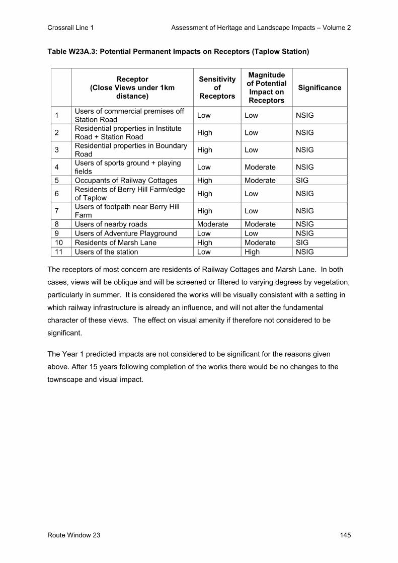
Crossrail Line 1 Assessment of Heritage and Landscape Impacts – Volume 2
Route Window 23 145
Table W23A.3: Potential Permanent Impacts on Receptors (Taplow Station)
Receptor
(Close Views under 1km distance)
Sensitivity of
Receptors
Magnitude of Potential Impact on Receptors
Significance
1 Users of commercial premises off Station Road Low Low NSIG
2 Residential properties in Institute Road + Station Road High Low NSIG
3 Residential properties in Boundary Road High Low NSIG
4 Users of sports ground + playing fields Low Moderate NSIG
5 Occupants of Railway Cottages High Moderate SIG
6 Residents of Berry Hill Farm/edge of Taplow High Low NSIG
7 Users of footpath near Berry Hill Farm High Low NSIG
8 Users of nearby roads Moderate Moderate NSIG 9 Users of Adventure Playground Low Low NSIG 10 Residents of Marsh Lane High Moderate SIG 11 Users of the station Low High NSIG
The receptors of most concern are residents of Railway Cottages and Marsh Lane. In both
cases, views will be oblique and will be screened or filtered to varying degrees by vegetation,
particularly in summer. It is considered the works will be visually consistent with a setting in
which railway infrastructure is already an influence, and will not alter the fundamental
character of these views. The effect on visual amenity if therefore not considered to be
significant.
The Year 1 predicted impacts are not considered to be significant for the reasons given
above. After 15 years following completion of the works there would be no changes to the
townscape and visual impact.

Crossrail Line 1 Assessment of Heritage and Landscape Impacts – Volume 2
Route Window W23A 146
4. Summary
4.1 Listed Buildings and their Setting
There will be no impacts on listed buildings or their setting in this route window.
4.2 Conservation Areas
There will be no impacts on Conservation Areas in this route window.
4.3 Landscape / Townscape
During the construction phase, impacts on landscape / townscape would not be significant.
No important features would be lost and no buildings demolished. The works will be of
modest scale, and would have no long-term impact on landscape / townscape character.
The setting of designated landscapes would be unaffected.
The permanent features of the works would do no more than reinforce the existing influence
of railway infrastructure, and would not have a significant effect on the character either of the
immediate area or of surrounding designated landscapes.
4.4 Visual Impact The construction works would not have a significant impact on visual amenity. The greatest
degree of impact would affect receptors of low sensitivity (users of the business premises,
station and nearby roads). The impact on highly sensitive receptors (local residents) would
be no more than moderate, and would be qualified by substantial seasonal constraints on
visibility and by the limited duration of the works.
Permanent impacts on visual amenity are not considered to be significant. The occupants of
approximately 10 residential properties within about 200m of the works may be affected.
However, visibility will be constrained and the fundamental character of their views will be
unchanged. Occupants of a further 20 properties may have glimpses of the works, but the
degree of visual change will be small.

Crossrail Line 1 Assessment of Heritage and Landscape Impacts – Volume 2
Route Window 23 147
5. Summary tables
There will be no impacts on listed buildings, the setting of listed buildings or Conservation
Areas in this route window, hence these are not included within the Summary Tables.
Predicted impacts on landscape / townscape character and visual amenity are summarised
in Table W23A.4: Summary Table of Temporary Impacts and Table W23A: Summary Table
of Permanent Impacts, including any committed mitigation and residual impacts.

Crossrail Line 1 Assessment of Heritage and Landscape Impacts – Volume 2
148 Route Window W23A
Tabl
e W
23A
.4: S
umm
ary
Tabl
e of
Tem
pora
ry Im
pact
s (R
oute
Win
dow
W23
A)
Rou
te W
indo
w W
16 –
Tem
pora
ry Im
pact
s
Res
idua
l Im
pact
W
orks
and
pot
entia
l im
pact
Si
gnifi
canc
e M
itiga
tion
Des
crip
tion
Sign
ifica
nce
Impa
ct o
n de
sign
ated
tow
nsca
pe/la
ndsc
ape
Vis
ual i
nflu
ence
of w
orks
may
ext
end
into
Loc
al
Land
scap
e A
rea.
N
ot S
igni
fican
t N
one
prop
osed
M
inim
al.
Not
Sig
nific
ant
Impa
ct o
n ch
arac
ter a
reas
A
lthou
gh la
ndsc
ape
qual
ity is
hig
h an
d po
tent
ially
se
nsiti
ve to
cha
nge,
its
over
all c
hara
cter
wou
ld n
ot b
e af
fect
ed.
Not
Sig
nific
ant
Non
e pr
opos
ed.
Min
imal
. N
ot S
igni
fican
t
Impa
ct o
n vi
sual
am
enity
of:
Occ
upan
ts o
f abo
ut 1
0 pr
oper
ties
in S
tatio
n R
oad/
Inst
itute
Roa
d/A
ppro
ach
Roa
d.
Not
Sig
nific
ant
Hoa
rdin
g ar
ound
w
ork
site
s
Non
e: im
pact
will
cea
se
whe
n co
nstru
ctio
n is
co
mpl
ete.
N
ot S
igni
fican
t
Impa
ct o
n vi
sual
am
enity
of:
All
othe
r rec
epto
rs (u
sers
of b
usin
ess
prem
ises
, loc
al
road
s, s
tatio
n +
mor
e di
stan
t res
iden
ts)
Not
Sig
nific
ant
Hoa
rdin
g ar
ound
w
ork
site
s
Non
e: im
pact
will
cea
se
whe
n co
nstru
ctio
n is
co
mpl
ete.
N
ot S
igni
fican
t

Crossrail Line 1 Assessment of Heritage and Landscape Impacts – Volume 2
Route Window W23A 149
Tabl
e W
23A
.5: S
umm
ary
Tabl
e of
Per
man
ent I
mpa
cts
(Rou
te W
indo
w C
23)
Rou
te W
indo
w C
23 –
Per
man
ent I
mpa
cts
R
esid
ual I
mpa
ct
Wor
ks a
nd p
oten
tial i
mpa
ct
Sign
ifica
nce
Miti
gatio
n D
escr
iptio
n Si
gnifi
canc
e Im
pact
on
desi
gnat
ed to
wns
cape
/ la
ndsc
ape:
V
isua
l inf
luen
ce o
f new
foot
brid
ge m
ay
exte
nd in
to L
ocal
Lan
dsca
pe A
rea,
but
will
ha
ve a
min
or im
pact
on
its c
hara
cter
.
Not
Sig
nific
ant
Non
e pr
opos
ed
Intro
duct
ion
of n
ew ra
ilway
in
frast
ruct
ure.
N
ot S
igni
fican
t
Impa
ct o
n ch
arac
ter a
reas
: S
light
incr
ease
in v
isua
l inf
luen
ce o
f rai
lway
in
frast
ruct
ure,
but
will
not
affe
ct
fund
amen
tal c
hara
cter
of s
urro
undi
ng a
rea.
Not
Sig
nific
ant
Non
e pr
opos
ed
Intro
duct
ion
of n
ew ra
ilway
in
frast
ruct
ure.
N
ot S
igni
fican
t
Impa
ct o
n vi
sual
am
enity
of:
occu
pant
s of
up
to 2
0 re
side
ntia
l pro
perti
es;
occu
pant
s of
bus
ines
s pr
emis
es;
user
s of
sta
tion,
nea
rby
road
s et
c
Not
Sig
nific
ant
Non
e pr
opos
ed
Incr
ease
in v
isib
ility
of r
ailw
ay
infra
stru
ctur
e, b
ut c
hara
cter
of
view
s, +
hen
ce th
e am
enity
of
rece
ptor
s, w
ill n
ot c
hang
e fu
ndam
enta
lly.
Not
Sig
nific
ant

Crossrail Line 1 Assessment of Heritage and Landscape Impacts – Volume 2
150 Route Window W23A
6. Assumptions
- It is assumed that the loss of vegetation associated with the temporary works will be
replaced and the area reinstated e.g. areas of car park resurfaced and soft areas
returned to grass or planting introduced.
- 3.6 metre high timber hoarding around all work sites
- Desk-top studies and a number of site visits were undertaken during July 2004 and
therefore this assessment was undertaken during the summer period when vegetation
was in leaf. However, when considering the landscape and visual impacts of the
scheme, an assessment of the potential winter situation has been estimated / taken into
account and ZVIs mapped on this basis.

Crossrail Line 1 Assessment of Heritage and Landscape Impacts – Volume 2
Route Window W23A 151
7. References - ES Route Window W23A
- Parliamentary Plan Sheets
- ES Scheme Description

Crossrail Line 1 Assessment of Heritage and Landscape Impacts – Volume 2
152 Route Window W23A

Crossrail Line 1 Assessment of Heritage and Landscape Impacts – Volume 2
Route Window W22 153
Route Window W22 Lent Rise

Crossrail Line 1 Assessment of Heritage and Landscape Impacts – Volume 2
Route Window W22 155
Contents 1. Description of the Works 157
1.1 Permanent Works 157 1.2 Temporary Works 157
2. Assessment and Impacts 158

Crossrail Line 1 Assessment of Heritage and Landscape Impacts – Volume 2
156 Route Window W22

Crossrail Line 1 Assessment of Heritage and Landscape Impacts – Volume 2
Route Window W22 157
Route Window W22 Lent Rise 1. Description of the Works 1.1 Permanent Works
Crossrail will require the introduction of overhead line equipment throughout the alignment in
this route window.
1.2 Temporary Works
Works will be undertaken using rail-mounted equipment and will take about two months to
complete. Materials will be carried to and from the works by rail.

Crossrail Line 1 Assessment of Heritage and Landscape Impacts – Volume 2
158 Route Window W22
2. Assessment and Impacts
A scoping exercise to determine the potential impacts associated with OHLE was undertaken
(see introductory section to this volume). Works within this route window were not
considered to result in any significant impacts and consequently have not been assessed in
detail.
There will be no other significant impacts on landscape / townscape, built heritage or visual
amenity in this route window.

Crossrail Line 1 Assessment of Heritage and Landscape Impacts – Volume 2
Route Window W21 159
Route Window W21 Burnham Station


Crossrail Line 1 Assessment of Heritage and Landscape Impacts – Volume 2
Route Window W21 161
Contents 1. Description of the Works 163
1.1 Permanent Works 163 1.2 Temporary Works 163
2. Baseline Assessment 164 2.1 Local context 164 2.2 Listed Buildings and their Setting 165 2.3 Conservation Areas 165 2.4 Landscape / Townscape 165 2.5 Zone of Visual Influence 167 2.6 Sensitivity 169
3. Impact of the Scheme 171 3.1 Listed Buildings and their Setting 171 3.2 Conservation Areas 171 3.3 Landscape / Townscape 171 3.4 Visual impacts 172
4. Summary 175 4.1 Listed Buildings and their Setting 175 4.2 Conservation Areas 175 4.3 Landscape / Townscape 175 4.4 Visual Impacts 175
5. Summary tables 177 6. Assumptions 180 7. References 181

Crossrail Line 1 Assessment of Heritage and Landscape Impacts – Volume 2
Route Window W21 162

Crossrail Line 1 Assessment of Heritage and Landscape Impacts – Volume 2
Route Window W21 163
Route Window W21 Burnham Station 1. Description of the Works 1.1 Permanent Works
Crossrail will require the introduction of overhead line equipment throughout the alignment in
this route window.
The island platform at Burnham station will be extended westwards by about 26 m to
accommodate Crossrail trains.
1.2 Temporary Works
Platform extensions will take about four months to complete. Construction plant required at
the worksite will include a crawler, excavators, mobile cranes, lighting rigs, compressors and
generators.
The works will be undertaken from one site at the western end of Sandringham Court,
adjacent to the railway, and a second northeast of the station bounded by Burnham Lane to
the east and Sandringham Court to the north. Vehicle access to the worksite will be from
Sandringham Court off Station Road. Between two and four lorries are expected to serve
each worksite.

Crossrail Line 1 Assessment of Heritage and Landscape Impacts – Volume 2
Route Window W21 164
2. Baseline Assessment 2.1 Local context Burnham Station lies within the largely built-up area of Burnham, which is contiguous with
Slough. The built-up area is mainly residential, together with light industrial/commercial
uses, community facilities (schools etc) and shops.
Residential uses predominate to the north of the railway. Sandringham Court comprises 3-5
storey flats and 2-storey semi-detached dwellings dating from about 1950-70. This area is
adjoined to the north by the Royston Way/Crossthwaite Way area, which comprises two-
storey, mainly detached housing dating from 1930-50. Priory School and its playing fields
adjoin this area to the north-west.
Older housing extends northwards along Burnham Lane to The Red Squirrel pub at the
junction with Haymill Road. East of Burnham Lane, Littlebrook Avenue is fringed by housing
dating from 1950-70. To the east of this, the Haymill Valley comprises a corridor of open
space and remnant woodland. Further east again lies the edge of the Slough Trading
Estate.
Immediately south of the station, housing dating from about 1930-50 extends along
Stanhope Road and an area of local open space. Cippenham Park, an area of local open
space including a bowling green and tennis courts, lies to the east of Station Road. This is
adjoined to the south and west by the residential streets of Iona Crescent and Brook
Crescent.
Progress Business Park lies to the west of Stanhope Road, adjoining the railway corridor.
Light industrial, business and commercial uses predominate southwards to Bath Road,
around Whittle Parkway and Kespatrick Road. Similar uses are characteristic of the Bath
Road corridor east of the Station Road/Elmshott Road junction.
Residential uses predominate south of Bath Road, with a range of community uses, services
and shops forming the centre of Cippenham along Elmshott Road.
The Townscape Character Baseline Plan for Burnham Station, Drawing No. IE0416-WIE00-
E00-F-00021 identifies the locations of key buildings and landmarks in the local landscape /
townscape, local views, pedestrian and vehicular movement corridors, townscape

Crossrail Line 1 Assessment of Heritage and Landscape Impacts – Volume 2
Route Window W21 165
character areas, urban gateways / nodes and the landscape planning designations that
relate to the work sites and their surroundings. These baseline plans also illustrate the
extent of the work sites for both the temporary and permanent works.
2.2 Listed Buildings and their Setting
There are no listed buildings within the route window. Burnham Station is locally listed.
2.3 Conservation Areas The nearest Conservation Areas are at Burnham Village, about 1km to the north-west; and at
Burnham Abbey, 1km to the south-west (both outside the route window).
2.4 Landscape / Townscape
2.4.1 Character Areas and Landscape / Townscape Quality
Landscape / townscape character largely reflects the prevailing pattern of land use. Whilst
the entire area falls within the Burnham character area, three distinctive zones can be
identified within this.
Sandringham Court / Suffolk Court Character Area:
The residential areas typically comprise a fine-grained pattern of low-rise dwellings, often
with substantial vegetation. Locally, medium-rise blocks of flats occur, as in Sandringham
Court and Suffolk Close. The residential areas are themselves of Moderate quality. They
are typical of their period; whilst they are scarcely noteworthy, they generally offer a
reasonable degree of amenity.
Bath Road Character Area:
The commercial areas comprise industrial, office, distribution and bulk retail buildings of
characteristically large footprint, surrounded by parking or service yards. These buildings are
usually the equivalent of 2-4 storeys high. The industrial/commercial areas are of lower
quality, due mainly to their spatial pattern, their often utilitarian architecture and the
dominance of parking areas.

Crossrail Line 1 Assessment of Heritage and Landscape Impacts – Volume 2
Route Window W21 166
Haymill Valley Character Area:
The Haymill Valley and Cippenham Park form a corridor of open space along a minor
watercourse, separated by the railway. This open space comprises amenity grassland and
sports pitches, with some mature vegetation. The open space is of higher quality, providing
the most important environmental amenity in the area.
Overall the built-up area is generally of moderate townscape quality, reflecting variations in
quality between the different zones.
2.4.2 Key Townscape / Landscape Features and Resources
There are no buildings of particular merit or distinction in the vicinity. Burnham Station
comprises a single-storey building located on the island platform between the Relief and
Main line platforms. It is brick, single-storey, providing canopies with decorative barge-
boards over both platforms. Whilst it appears to be largely unaltered, the roof may not be
original. It is accessed via a subway, but the entrance on the forecourt/car park to the north
is undistinguished.
Locally, buildings such as The Red Squirrel pub function as landmark, but are not key
features in townscape terms. Several of the commercial buildings along Bath Road and
within the Slough Trading Estate are distinctive, but they exert little visual influence in the
immediate vicinity of the station. Industrial/commercial buildings further east, notably Tate &
Lyle and Fuller’s Logistics, are visible for considerable distances along the railway corridor.
Vegetation is a locally important influence on views and landscape quality. The most notable
vegetation in the immediate vicinity of the station comprises:
- a group of mature trees (beech, sweet chestnut, sycamore etc) adjacent to the Station
Road bridge and car park entrance;
- mature, but discontinuous scrub, and semi-mature trees, within the railway corridor; and
- semi-mature trees and hedgerows (including conifers) within and along the rear boundary
of gardens adjoining the railway corridor including several trees (Ash and Sycamore)
within the Sandringham Court work site North.
In the wider area, vegetation is locally influential, particularly mature trees associated with
the main open spaces at Haymill Valley and Cippenham park.

Crossrail Line 1 Assessment of Heritage and Landscape Impacts – Volume 2
Route Window W21 167
2.4.3 Strategic Views and Key Local Views
There are no strategic views in the vicinity of the site. No local views are considered to
qualify as key views.
2.4.4 Pedestrian / Vehicular Movement Corridors
Roads are the main movement corridors in the area. Station Road, which passes beneath
the railway to the east of the station, links Burnham Lane with Bath Road. Burnham Lane is
a local distributor road, which links Bath Road, to the east, with Burnham village to the north-
west.
Bath Road (A4) is an arterial route linking Slough with Maidenhead, and most of the section
through this route window is dual-carriageway. All other roads in the area are residential
streets or access roads serving industrial/ commercial sites.
In addition to roadside footpaths, the pedestrian network comprises paths passing through
Cippenham Park to link Station Road with Brook Crescent, Burnham Lane and Bath Road.
There is also a pedestrian route northwards from Buckingham Avenue along the Haymill
Valley.
2.4.5 Landscape Planning Designation
The properties fronting onto Burnham Lane from Sandringham Court northwards to
Leaholme Gardens are designated as a “residential area of exceptional character.” Most of
the Haymill Valley is designated as a Local Nature Reserve.
2.5 Zone of Visual Influence
The approximate Zone of Visual Influence (ZVI) for the work sites is determined by the
following influences:
- The relationship of the railway to the surrounding area;
- The general character and arrangement of land uses;
- The proximity, scale and use of nearby buildings; and
- The size and type of nearby vegetation.
Crossrail Line 1 Assessment of Heritage and Landscape Impacts – Volume 2
Route Window W21 168
The railway runs on embankment through this area, bridging over Station Road and
Burnham Lane. The embankment is most pronounced to the east of the station, as the
railway crosses the lower-lying area beyond Cippenham Park. In addition, it is generally less
prominent from the north, due to rising terrain.
The relatively elevated position of the station theoretically allows views to be gained over
substantial distances, particularly from lower-lying areas to the south. In practice, however,
viewing opportunities are constrained by surrounding buildings and by vegetation in the
immediate vicinity of the station and railway corridor
The approximate Zone of Visual Influence (ZVI) for the works site is defined by the following:
- To the west along the railway corridor to no further than the Huntercombe Lane bridge;
- To the north by the facades of properties in Sandringham Court and Burnham Lane;
- To the east along the railway corridor to the vicinity of Burnham Lane bridge, beyond
which commercial properties begin to impinge; and
- To the south by the facades of properties in Stanhope Road, with glimpses beyond to
taller commercial buildings and flats close to bath Road;
In summer, vegetation restricts the ZVI substantially, reinforcing the screening provided by
buildings to the north, obstructing some potential views from the south, and constricting the
extent of views along the railway corridor.
The main potential sources of views of the station work sites are summarised as follows:
- Occupants of between 30-40 residential properties in Sandringham Court;
- Occupants of up to 10 residential properties in Burnham Lane;
- Occupants of between 40-45 residential properties in Stanhope Road;
- Occupants of the Progress Business Centre;
- Users of the recreation ground east of Station Road;
- Users of Station Road;
- Occupants of taller commercial premises to the south; and
- Users of the station.

Crossrail Line 1 Assessment of Heritage and Landscape Impacts – Volume 2
Route Window W21 169
2.6 Sensitivity 2.6.1 Sensitivity of Townscape / Landscape to Change
The surrounding townscape/landscape is generally of moderate sensitivity to change.
The commercial areas, including much of the Bath Road corridor, are of low sensitivity, since
their pattern of buildings and spaces is able to absorb a substantial degree of visual change
without detriment to their character.
The residential areas potentially have a moderate degree of sensitivity, due to their higher
level of amenity, although the density of buildings and vegetation allows ground-level views
to be readily intercepted. Open spaces are highly sensitive, due to their undeveloped
character and the likelihood that they may fall within the visual influence of nearby
development.
Railway infrastructure is locally prominent, with a potentially large number of receptors
experiencing views of the embankment from nearby residential and commercial properties
and open space.
2.6.2 Sensitivity of Visual Receptors to Change
Table W21.1: Visual Receptors (Burnham Station Works) below identifies the receptors who
are likely to obtain views of the works, together with their sensitivity, the type of views and
whether the views are of the temporary or permanent works.
Table W21.1: Visual Receptors for the Burnham Station Works
Receptor
(Close Views under 1km distance)
Type of View
Dire
ct V
iew
Obl
ique
Vi
ew
Tem
pora
ry
Wor
k Si
tes
Perm
anen
t W
orks
Sensitivity of
Receptors
1 Residential properties in Sandringham Court
Ground +upper floors
High
2 Residential properties in Burnham Lane
Upper floors High
3 Residential properties in Stanhope Road
Ground +upper floors
High
4 Occupants of Progress Business Centre
Upper floors Low

Crossrail Line 1 Assessment of Heritage and Landscape Impacts – Volume 2
Route Window W21 170
Receptor
(Close Views under 1km distance)
Type of View
Dire
ct V
iew
Obl
ique
Vi
ew
Tem
pora
ry
Wor
k Si
tes
Perm
anen
t W
orks
Sensitivity of
Receptors
5 Users of recreation ground Ground Level High
6 Users of Station Road Ground level Low
7 Occupants of commercial buildings to the south
Upper floors Low
8 Users of the station Ground level Low
Local residents and users of the recreation ground will be the most sensitive group of
receptors.
In theory, up to 100 residential properties could have winter-time views of the works.
However, no more than about half of these would experience direct views, and viewing
opportunities will in many cases be confined to upper floors. In addition, perhaps half of
these viewing opportunities would be lost during summer.
The least obstructed views would be experienced by residents of potentially about 25 flats in
Sandringham Court and about 15 properties in Stanhope Road. Views from other properties
will be oblique and will be obstructed to varying degrees. It is unlikely that properties in
Burnham Lane, for example, would experience views of the works during summer.
It should be noted that some receptors may experience recurrent views of the works (e.g.
from their homes, from the recreation ground and when they use nearby roads or the
station).
Receptors who live in or use the area can be assumed to be habituated to a certain degree
to the impact of railway maintenance and construction activities. The station construction
works would be of approximately four months duration.
Crossrail Line 1 Assessment of Heritage and Landscape Impacts – Volume 2
Route Window W21 171
3. Impact of the Scheme
3.1 Listed Buildings and their Setting
There will be no impacts on listed buildings or their setting in this route window.
3.2 Conservation Areas
There will be no impacts on Conservation Areas in this route window.
3.3 Landscape / Townscape
The works at the station would require the clearing of vegetation between the Relief lines and
along a section of embankment. The vegetation between the Relief lines comprises rough
grass and low scrub, and is not significant. The vegetation along the embankment and the
fence-line of Sandringham Court comprises mature, mixed scrub and semi-mature deciduous
trees (Ash). This vegetation is locally influential in helping to screen views between the
railway corridor and the nearest properties in Sandringham Court. In addition two mature
trees are to be removed to accommodate the Sandringham Court North work site.
The only structure to be removed will be a section of the security fence defining the railway
corridor, and this will be reinstated. No other landscape features would be affected, and no
demolitions would be required. The existing station buildings/structures would not be
affected.
3.3.1 Impacts on Designated Townscape/Landscape
The visual influence of the works will not extend into any areas of designated landscape /
townscape.
The works are likely to be visible from the recreation ground, and possibly from parts of
Haymill Valley. Both of these areas are designated public open space, and the Haymill
Valley is a Local Nature Reserve. However, the visual influence of the works on these areas
will be minor and will not affect their intrinsic character.
Similarly, the works may also be glimpsed from parts of the “residential area of exceptional
character” along Burnham Lane, but will have no impact on its character.

Crossrail Line 1 Assessment of Heritage and Landscape Impacts – Volume 2
Route Window W21 172
3.3.2 Impact on Landscape / Townscape Character
Vegetation will be removed along the section of embankment adjoining Sandringham Court.
This vegetation influences views to/from the nearest properties, but is not an important
feature in the overall character of the area. Its loss is therefore considered to be a minor
impact on the residential character area, and is unlikely to be significant.
Although construction features such as mobile cranes, portacabins or hoardings will be
visible, they will be present for a limited period and will have no long-term impact on
landscape character. Their effect is therefore not considered to be significant.
The permanent works will be seen in the context of the existing station, with which they will
be visually consistent. They will have no more than a minor impact on the adjoining parts of
the residential character area, and the effect is not considered to be significant.
3.4 Visual impacts
The Visual Appraisal Plan for the Burnham Station works, Drawing No. 1E0316-WIE00-E00-
F-00021 illustrates the approximate Zone of Visual Influence for both the temporary and
permanent works. It also identifies the principal locations from which views of the
development would be obtained.
The assessment of impact during the construction works takes account of their relatively
limited duration, and the likelihood that nearby receptors will to a certain degree be tolerant
of activities carried out in the normal course of railway maintenance and improvement.
The magnitude of visual impact that would be generated by the temporary works on each
receptor group is identified in Table W21.2: Potential Temporary Impacts on Receptors
(Burnham Station Works).
Table W21.2: Potential Temporary Impacts on Receptors (Burnham Station)
Receptor
(Close Views under 1km distance)
Sensitivity of
Receptors
Magnitude of Potential Impact on Receptors
Significance
1 Occupants of approx. 25 residential properties in High High SIG(-)

Crossrail Line 1 Assessment of Heritage and Landscape Impacts – Volume 2
Route Window W21 173
Receptor
(Close Views under 1km distance)
Sensitivity of
Receptors
Magnitude of Potential Impact on Receptors
Significance
Sandringham Court
2 Occupants of remaining properties in Sandringham Court High Moderate NSIG
3 Occupants of residential properties in Burnham Lane High Low NSIG
4 Occupants of approx. 15 residential properties in Stanhope Road
High Moderate NSIG* see below
5 Occupants of Progress Business Centre Low Moderate NSIG
6 Users of the recreation ground High Low NSIG 7 Users of Station Road Low Low NSIG
8 Occupants of commercial buildings to the south Low Low NSIG
9 Users of the station Low Moderate NSIG
The highest degree of impact will be experienced by occupants of approx. 40 residential
properties in Sandringham Court and Stanhope Road. However, the effect on visual amenity
is only considered to be significant for approx. 25 properties in Sandringham Court. This
reflects their proximity to the works, their opportunity for largely unobstructed views and the
long-term impact that vegetation loss will have on these views.
For other residents of Sandringham Court, together with residents of Stanhope Road,
potential views are oblique and/or over longer distances, and the loss of vegetation will be
less obvious. Taking account of the limited duration of the works, their impact on the visual
amenity of these receptors is not considered to be significant.
For other highly sensitive receptors (residents of Burnham Lane and users of the recreation
ground), views are too distant, oblique and/or too obstructed to constitute a significant effect.
The remaining receptors are of low sensitivity, and their visual amenity will be largely
unaffected.
The magnitude of visual impact that would be generated by the permanent works on each
group of receptors is identified in Table W21.3: Potential Permanent Impacts on Receptors
(Burnham Station).

Crossrail Line 1 Assessment of Heritage and Landscape Impacts – Volume 2
Route Window W21 174
Table W21.3: Potential Permanent Impacts on Receptors (Burnham Station)
Receptor
(Close Views under 1km distance)
Sensitivity of
Receptors
Magnitude of Potential Impact on Receptors
Significance
1 Occupants of approx. 25 residential properties in Sandringham Court
High High SIG(-)
2 Occupants of remaining properties in Sandringham Court High Moderate NSIG
3 Occupants of residential properties in Burnham Lane High Low NSIG
4 Occupants of approx. 15 residential properties in Stanhope Road
High Moderate NSIG
5 Occupants of Progress Business Centre Low Moderate NSIG
6 Users of the recreation ground High Low NSIG 7 Users of Station Road Low Low NSIG
8 Occupants of commercial buildings to the south Low Low NSIG
9 Users of the station Low Moderate NSIG The main source of permanent impact will be the loss of vegetation from the embankment
close to Sandringham Court. These impacts are considered to give rise to a significant
adverse effect on the visual amenity of approx. 25 properties in Sandringham Court. This
reflects the proximity of these receptors, the likelihood that they experience relatively
uninterrupted views across the railway corridor, and the potential contribution of these views
to their amenity. Replanting of vegetation will be undertaken once construction is complete.
For other residents of Sandringham Court and Stanhope Road, the degree of impact will be
lower, reflecting their relative distance from the works and the oblique and/or partially
screened nature of their views. The impacts of tree loss are likely to be more readily
assimilated into the overall character of the railway corridor, and the effect on their visual
amenity is not anticipated to be significant.
In all other cases, impacts are of insufficient magnitude, views are too obstructed and/or
receptor sensitivity is too low to give rise to significant effects.
The Year 1 predicted impacts, apart from properties on Sandringham Court, are not
considered to be significant for the reason given above. After 15 years following completion
of the works and the maturing of the replacement trees the visual impact will reduce to not
significant.

Crossrail Line 1 Assessment of Heritage and Landscape Impacts – Volume 2
Route Window W21 175
4. Summary
4.1 Listed Buildings and their Setting
There will be no impacts on listed buildings or their setting in this route window.
4.2 Conservation Areas
There will be no impacts on Conservation Areas in this route window.
4.3 Landscape / Townscape
The loss of vegetation will not fundamentally alter the overall character of the railway corridor
or of the adjoining residential areas, and is not regarded as a significant effect on landscape /
townscape. The impact on the setting of designated areas such as Burnham Lane, Haymill
Valley and the recreation ground would be minor, and not significant.
The permanent works would will be consistent in scale and function with existing railway
infrastructure, and the character of the railway corridor and the nearby residential areas will
not be affected significantly.
4.4 Visual Impacts
During the construction phase, vegetation would be removed from a section of the
embankment adjoining Sandringham Court. This vegetation is likely to be prominent in views
from nearby properties. Its loss, together with the presence of construction plant etc, is
considered to have a significant effect on the visual amenity of about 25 properties in
Sandringham Court. The effect on other receptors is not regarded as significant, taking
account of the limited duration of the works.
Permanent impacts on visual amenity are considered to be significant for occupants of the 25
properties in Sandringham Court. This is due mainly to their proximity to the works, the
likelihood that they will experience unobstructed views, and the vegetation loss. These
impacts will be mitigated by the replacement planting, when mature, and the impact will be
reduced to not significant.

Crossrail Line 1 Assessment of Heritage and Landscape Impacts – Volume 2
Route Window W21 176
The effect on other receptors is not considered to be significant. Sensitive receptors such as
residents of Stanhope Road are considered to be sufficiently distant from the site, and/or will
experience oblique or partially screened views. Other receptors are either of low sensitivity
or are too distant to be affected to any real degree.

Crossrail Line 1 Assessment of Heritage and Landscape Impacts – Volume 2
Route Window W21 177
5. Summary tables
There will be no impacts on listed buildings, the setting of listed buildings or Conservation
Areas in this route window.
Predicted impacts on landscape / townscape character and visual amenity are summarised
in Table W21.4: Summary Table of Temporary Impacts and Table W21.5: Summary Table of
Permanent Impacts, including any committed mitigation and residual impacts.
.

Crossrail Line 1 Assessment of Heritage and Landscape Impacts – Volume 2
178 Route Window W21
Tabl
e W
21.5
: Sum
mar
y Ta
ble
of T
empo
rary
Impa
cts
(Rou
te W
indo
w W
21)
Rou
te W
indo
w W
21–
Tem
pora
ry Im
pact
s
Res
idua
l Im
pact
W
orks
and
pot
entia
l im
pact
Si
gnifi
canc
e M
itiga
tion
Des
crip
tion
Sign
ifica
nce
Impa
ct o
n de
sign
ated
tow
nsca
pe/la
ndsc
ape
Vis
ual i
nflu
ence
of w
orks
on
recr
eatio
n gr
ound
and
Loc
al
Nat
ure
Res
erve
N
ot S
igni
fican
t N
one
prop
osed
M
inim
al.
Not
Sig
nific
ant
Impa
ct o
n ch
arac
ter a
reas
O
vera
ll ch
arac
ter o
f rai
lway
cor
ridor
and
resi
dent
ial a
rea
wou
ld n
ot b
e af
fect
ed.
Not
Sig
nific
ant
Pro
vide
re
plac
emen
t pl
antin
g
Min
imal
. N
ot S
igni
fican
t
Impa
ct o
n vi
sual
am
enity
of:
App
rox.
25
resi
dent
ial p
rope
rties
in S
andr
ingh
am C
ourt
Sig
nific
ant
Non
e pr
actic
able
M
ajor
cha
nge
in c
hara
cter
of
view
. S
igni
fican
t
Impa
ct o
n vi
sual
am
enity
of:
Oth
er re
cept
ors
Not
Sig
nific
ant
Non
e pr
opos
ed.
Non
e: im
pact
will
cea
se
whe
n co
nstru
ctio
n is
co
mpl
ete.
N
ot S
igni
fican
t

Crossrail Line 1 Assessment of Heritage and Landscape Impacts – Volume 2
Route Window W21 179
Tabl
e W
21.6
: Sum
mar
y Ta
ble
of P
erm
anen
t Im
pact
s (R
oute
Win
dow
W21
)
Rou
te W
indo
w W
21 –
Per
man
ent I
mpa
cts
R
esid
ual I
mpa
ct
Wor
ks a
nd p
oten
tial i
mpa
ct
Sign
ifica
nce
Miti
gatio
n D
escr
iptio
n Si
gnifi
canc
e Im
pact
on
desi
gnat
ed to
wns
cape
/ la
ndsc
ape:
V
isua
l inf
luen
ce m
ay e
xten
d in
to
desi
gnat
ed o
pen
spac
e, b
ut w
ill h
ave
min
imal
impa
ct o
n its
set
ting.
Not
Sig
nific
ant
Non
e pr
opos
ed
As
abov
e N
ot S
igni
fican
t
Impa
ct o
n ch
arac
ter a
reas
S
light
incr
ease
in v
isua
l inf
luen
ce o
f rai
lway
in
frast
ruct
ure,
but
fund
amen
tal c
hara
cter
of
surr
ound
ing
area
will
be
unaf
fect
ed.
Not
Sig
nific
ant
Non
e pr
opos
ed
Intro
duct
ion
of n
ew ra
ilway
in
frast
ruct
ure.
N
ot S
igni
fican
t
Impa
ct o
n vi
sual
am
enity
of:
App
rox.
25
resi
dent
ial p
rope
rties
in
San
drin
gham
Clo
se (d
ue to
tree
loss
) S
igni
fican
t R
epla
cem
ent p
lant
ing
Min
or
Not
Sig
nific
ant
Impa
ct o
n vi
sual
am
enity
of:
O
ther
rece
ptor
s N
ot S
igni
fican
t N
one
prop
osed
M
inim
al
Not
Sig
nific
ant

Crossrail Line 1 Assessment of Heritage and Landscape Impacts – Volume 2
180 Route Window W21
6. Assumptions
- It is assumed that the loss of vegetation associated with the temporary works will be
replaced and the area reinstated e.g. areas of car park, re-surfaced and soft areas
returned to grass or planting introduced.
- 2.4 metre and 3.6 metre high timber hoarding around all work sites
- Assumed that the security fencing defining the railway corridor which is to the removed
will be reinstated.
- Desk-top studies and a number of site visits were undertaken during July 2004 and
therefore this assessment was undertaken during the summer period when vegetation
was in leaf. However, when considering the landscape and visual impacts of the
scheme, an assessment of the potential winter situation has been estimated / taken into
account and ZVIs mapped on this basis.

Crossrail Line 1 Assessment of Heritage and Landscape Impacts – Volume 2
Route Window W21 181
7. References - ES Route Window W21
- Parliamentary Plan Sheets
- ES Scheme Description

Crossrail Line 1 Assessment of Heritage and Landscape Impacts – Volume 2
182 Route Window W21

Crossrail Line 1 Assessment of Heritage and Landscape Impacts – Volume 2
Route Window W20 183
Route Window W20 Dover Road & Leigh Road Bridges


Crossrail Line 1 Assessment of Heritage and Landscape Impacts – Volume 2
Route Window W20 185
Contents 1. Description of the Works 187
1.1 Permanent Works 187 1.2 Temporary Works 187
2. Assessment and Impacts 188

Crossrail Line 1 Assessment of Heritage and Landscape Impacts – Volume 2
186 Route Window W20

Crossrail Line 1 Assessment of Heritage and Landscape Impacts – Volume 2
Route Window W20 187
Route Window W20 Dover Road & Leigh Road Bridges 1. Description of the Works
1.1 Permanent Works
Overhead line equipment will be introduced throughout the alignment in this route window. In
order to accommodate the OHLE, Leigh Road bridge will be replaced with a new steel single
25 m span bridge. The new bridge will accommodate a pavement and two traffic lanes,
obviating the need for the existing traffic signals, which will be removed.
The parapets of Dover Road bridge will be raised.
1.2 Temporary Works
At Leigh Road Bridge, utilities will be diverted across a temporary utilities bridge while the
main works take place. The main works will be completed in about six months. They will
involve the removal of the existing arches, pier and abutments, followed by piling for the new
abutments to a depth of about 20 m. The new steel structure will then be installed. Finishing
works will involve casting the concrete deck, directing services back onto the bridge and
resurfacing the road. Required construction plant include mobile cranes, tracked loader,
vibratory roller, excavators, concrete pumps, generators, compressors and piling equipment.
9.9.4 Worksites will be located at the northwest, southeast and southwest corners of the
bridge. Each worksite will be served by 23 lorries per day during the three-week peak
construction period and typically by four at other times.
The works at Dover Road bridge will take a little over two months to complete and will involve
the use of mobile cranes and a fork lift loader. Demolition waste and ballast will be
transported to/from the site by road. Worksites will be located at the northeast, southeast and
southwest corners of the bridge. Six lorries per day will serve each of the worksites
throughout the construction period.

Crossrail Line 1 Assessment of Heritage and Landscape Impacts – Volume 2
188 Route Window W20
2. Assessment and Impacts
A scoping exercise to determine the potential impacts associated with bridge works was
undertaken (see introductory section to this volume). Works to Leigh Road Bridge and Dover
Road Bridge were not considered to result in any significant impacts and consequently have
not been assessed in detail.
Leigh Road Bridge is one of nine surviving Brunel bridges on this part of the route. They are
covered in detail in the Assessment of Archaeology Impacts – Technical Report.

Crossrail Line 1 Assessment of Heritage and Landscape Impacts – Volume 2
Route Window W19 189
Route Window W19 Stoke Poges Lane Bridge


Crossrail Line 1 Assessment of Heritage and Landscape Impacts – Volume 2
Route Window W19 191
Contents 1. Description of the Works 193
1.1 Permanent Works 193 1.2 Temporary works 193
2. Assessment and Impacts 194

Crossrail Line 1 Assessment of Heritage and Landscape Impacts – Volume 2
192 Route Window W19

Crossrail Line 1 Assessment of Heritage and Landscape Impacts – Volume 2
Route Window W19 193
Route Window W19 Stoke Poges Lane Bridge 1. Description of the Works 1.1 Permanent Works New overhead line equipment will be introduced throughout the alignment in this route
window. In order to accommodate the OHLE, bridge modifications will be required. At
Farnham Road bridge, the parapets will be raised and the track will be lowered slightly
beneath the bridge. At Stoke Poges Lane, the road bridge will be raised to provide sufficient
clearance for OHLE.
1.2 Temporary works The parapet works at Farnham Road Bridge will take place over a total period of about two
months. The track lowering will take about five weeks to complete. Construction plant
required for both the track lowering and the parapet works will include bulldozers,
excavators, rail-mounted cranes, generators, lighting equipment, diesel locomotives, a
tamper and rail saws. Works will be undertaken from the car park to the southwest of the
bridge, and from a second worksite located to the immediate northwest of the bridge, just off
Malton Avenue. Transport of materials to and from the site for the bridge work will be by
road. Materials excavated or used in the track lowering works at Farnham Road bridge will
be transported to and from the site by rail. At each worksite there will be some two lorries per
day.
The works at Stoke Poges Lane Bridge will take place over a period of about eight months.
Following the removal of the road surface and the diversion of utilities onto the existing
footbridge, the road bridge will be jacked up and new bed stones/bearings will be installed
before the bridge is lowered to its final position on these. These works will require the closure
of the footbridge over about three months. The parapets of both the road bridge and the
footbridge will then be raised, requiring road closures over about three weeks. Construction
plant required at this site will include lighting rigs, mobile cranes, road paving plant and a
compactor rammer. Works will be undertaken from a site on each side of the bridge: one to
the northeast on an existing industrial site, and another to the southwest in Salt Hill Park.
Transport of materials to and from the sites will be by road. Each worksite will be served by
10 lorries per day during the two week peak construction period and typically by four a day at
the northeast worksite and two at the southeast during the remainder of the works.

Crossrail Line 1 Assessment of Heritage and Landscape Impacts – Volume 2
194 Route Window W19
2. Assessment and Impacts
A scoping exercise to determine the potential impacts associated with bridge works was
undertaken (see introductory section to this volume). Works to Farnham Road Bridge and
Stoke Poges Lane Bridge were not considered to result in any significant impacts and
consequently have not been assessed in detail.
Crossrail Line 1 Assessment of Heritage and Landscape Impacts – Volume 2
Route Window W18B 195
Route Window W18B Wexham Road Bridge


Crossrail Line 1 Assessment of Heritage and Landscape Impacts – Volume 2
Route Window W18B 197
Contents 1. Description of the Works 199
1.1 Permanent Works 199 1.2 Temporary Works 199
2. Baseline Assessment 201 2.1 Local context 201 2.2 Listed Buildings and their Setting 201 2.3 Conservation Areas 201 2.4 Landscape / Townscape 202 2.5 Zone of Visual Influence 203 2.6 Sensitivity 205
3. Impact of the Scheme 208 3.1 Listed Buildings and their Setting 208 3.2 Conservation Areas 208 3.3 Landscape / Townscape 208 3.4 Visual impacts 208
4. Summary 212 4.1 Listed Buildings and their Setting 212 4.2 Conservation Areas 212 4.3 Landscape / Townscape 212 4.4 Visual Impacts 212
5. Summary Tables 214 6. Assumptions 217 7. References 218

Crossrail Line 1 Assessment of Heritage and Landscape Impacts – Volume 2
Route Window W18B 198

Crossrail Line 1 Assessment of Heritage and Landscape Impacts – Volume 2
Route Window 18B 199
Route Window W18B Wexham Road Bridge 1. Description of the Works
This route window deals with Wexham Road Bridge. Route window W18A deals with Slough
Station. A scoping exercise to determine the potential impacts associated with bridge works
was undertaken (see introductory section to this volume) and this identified that there were
significant impact assessment associated with the Wexham Road Bridge works. Works to
the two other bridges (Uxbridge Road Bridge and William Street Bridge) were not considered
to result in any significant impacts and consequently have not been assessed in detail.
1.1 Permanent Works
Works will be undertaken at the following bridges.
- William Street bridge: alterations will be made to the parapets of this bridge, located at
the west end of Slough station.
- Wexham Road bridge: its brick arch span over the main lines will be removed and
reconstructed to provide sufficient clearance for OHLE, and alterations will be made to
the parapets.
- Uxbridge Road bridge: the parapets of this bridge will be replaced.
1.2 Temporary Works
Duration of Works
Subject to possession planning requirements and excluding final commissioning, the
approximate duration of each element of works is as follows:
- William Street bridge: two and a half months;
- Wexham Road bridge: ten months;
- Uxbridge Road bridge: three and a half months.

Crossrail Line 1 Assessment of Heritage and Landscape Impacts – Volume 2
Route Window W18B 200
Enabling Works
Enabling works will include the diversion of utilities and services. Works at the three bridges
will require demolitions of some parts of the structures.
Main Works
Works at both William Street bridge and Uxbridge Road bridge will require the erection of
scaffolding access platforms on both sides of the bridge to facilitate works to the parapets.
Track works will be undertaken beneath William Street bridge as part of the new bay platform
works at Slough station.
Works at William Street bridge will involve use of a rail-mounted excavator, a bulldozer, a
rail-mounted crane, generators, a ballast tamper and a rail saw. They will be undertaken from
a worksite on its southwest corner. Nearly all materials will be taken to and from the site by
rail. Only about two lorries per day will serve the worksite throughout the construction period.
Works to Uxbridge Road bridge will involve use of a rail-mounted excavator, a bulldozer, a
rail-mounted crane and generators. They will be undertaken from a site on its northeast
corner. Materials will be taken to and from the site by road, with access from Uxbridge Road.
Only about two lorries per day will serve the worksite throughout the construction period.
At Wexham Road bridge, a temporary bridge will first be constructed and traffic diverted onto
this. Utilities will also be diverted temporarily across this. Piling will be required to stabilise
the south abutment, together with grouting of the buried arch. Once this preparatory work is
complete, the existing arch over the main line tracks will be demolished. Pre-cast abutment
units and bearing units will then be installed. The pre-cast deck beams for the bridge will be
put in place and the finishing works, such as concreting and waterproofing the deck,
reinstating the road, and raising the parapets, will be completed. Following this, the
temporary road bridge will be removed.
Construction plant at Wexham Road bridge will include a crane, an excavator, a compressor,
generators, a piling rig, a grouting rig and a circular saw. Worksites at Wexham Road bridge
will be located on the northwest and southwest sides of the bridge. All materials used in the
works will be transported into and out of the site by road. Each site will be served by two
lorries per day, even during the 11 week peak of construction.
Crossrail Line 1 Assessment of Heritage and Landscape Impacts – Volume 2
Route Window 18B 201
2. Baseline Assessment
2.1 Local context
Wexham Road Bridge is located within the built-up area of Slough. The area to the north of
the railway comprises industrial and commercial uses, notably the ICI Paints factory.
Residential areas lie further north, beyond Petersfield Road and the Grand Union Canal
(Slough Arm).
The area to the south is mainly residential, comprising terraces dating from about 1900, with
some modern three-storey flats in Stratfield Road. Slough town centre lies to the south of
Wellington Street (A4), and is dominated by medium- to high-rise retail and office buildings.
The railway generally runs at grade or in shallow cutting through this area, with roads such
as Wexham Road ramping up to cross over the line.
The Townscape Character Baseline Plan for RW18: Drawing No. 1E0416-W1E00-E00-F-
00018 identifies the locations of key buildings and landmarks in the local landscape /
townscape, local views, pedestrian and vehicular movement corridors, townscape character
areas, urban gateways / nodes and the landscape planning designations that relate to the
work sites and their surroundings. This plan also illustrates the extent of the work sites for
both the temporary and permanent works.
This bridge is one of nine surviving Brunel bridges on the Western Route. They are
considered in detail in the Assessment of Archaeology Impacts – Technical Report.
2.2 Listed Buildings and their Setting Slough Station, about 500m to the west, is a Grade II listed building.
2.3 Conservation Areas The Upton Conservation Area lies about 400m to the south, beyond Wellington Street.

Crossrail Line 1 Assessment of Heritage and Landscape Impacts – Volume 2
Route Window W18B 202
2.4 Landscape / Townscape 2.4.1 Character Areas and Landscape / Townscape Quality
The landscape / townscape character of the area is defined mainly by land use and built
pattern. Two main character areas may be identified:
- the industrial and commercial area to the north of the railway; and
- the residential area to the south.
The northern character area is dominated by the ICI Paints factory, which comprises office
and process buildings of between 3-6 storeys high. A tall industrial chimney is located on the
eastern part of the ICI site. Other buildings (along Petersfield Road) comprise 1-2 storey
warehouses and car showrooms.
The residential area comprises relatively dense streets of two-storey terraces, notably
Diamond Road and Richmond Crescent. Later 2-3 storey flats and townhouses occur off
Stratfield Road and in Leith Close. Small industrial units occupied by businesses such as
accident repairs are located to the south-east of the bridge and at the end of Australia Road.
2.4.2 Key Townscape / Landscape Features and Resources
The ICI Paints factory, and in particular its tall chimney, is a prominent local landmark.
Vegetation has a localised influence on townscape character and views. The most
prominent vegetation to the north of the bridge comprises:
- a group of mature Lombardy poplar adjoining the ICI car park;
- mature ornamental trees and shrubs including Tulip tree and group of Myrobalan Plum
along the western side of Wexham Road;
- a 3-4 m tall conifer hedge along part of the eastern side of Wexham Road; and
- dense but low scrub within the railway corridor.
The most prominent vegetation to the south of the bridge comprises:
- Mature scrub/semi-mature trees (including oak and sycamore) occupying vacant land
between Wexham Road and the rear boundary of properties in Richmond Crescent.

Crossrail Line 1 Assessment of Heritage and Landscape Impacts – Volume 2
Route Window 18B 203
2.4.3 Strategic Views and Key Local Views
There are no strategic views in the vicinity of the site.
No local views are regarded as key to the extent that they are particularly sensitive or provide
exceptional viewing opportunities. However, Wexham Road is a relatively busy pedestrian
route, and the bridge provides opportunities for long-distance views along the railway corridor
to Slough Station (west) and Uxbridge Road bridge (east).
2.4.4 Pedestrian / Vehicular Movement Corridors
Wexham Road is an unclassified road that links employment and residential areas to the
north with the A4 and town centre to the south. The road is heavily trafficked, and provides
the main access to the ICI Paints site. Other roads in the immediate vicinity are either
residential streets or provide access to industrial and commercial uses. Wellington Street
(A4) is an arterial route linking central Slough with the M4 and London.
Wexham Road is also the main pedestrian route in the area, with footpaths of adequate
width on both sides.
2.5 Zone of Visual Influence
The approximate Zone of Visual Influence (ZVI) for the work sites is determined mainly by
the following influences:
- The relationship of the railway to the surrounding area;
- The general character and arrangement of land uses;
- Localised changes in topography; and
- The proximity, scale and use of nearby buildings.
Views towards the railway corridor are defined mainly by the “front rank” of nearby buildings
and by the embankment that carries Wexham Road up to the bridge. An elongated mound
located within the railway corridor to the rear of properties in Richmond Crescent probably
obstructs views from ground level. Vegetation is intermittently influential; for example, the
trees located to the south-west of the bridge will obstruct views from some properties in
Richmond Crescent, mainly in summer.

Crossrail Line 1 Assessment of Heritage and Landscape Impacts – Volume 2
Route Window W18B 204
To the west of Wexham Road, northward views are obstructed by industrial and commercial
buildings. Extended views occur only across the car park as far as the 4-5 storey offices of
the ICI Paints factory.
Southward views are largely blocked by the terraced properties along the northern side of
Richmond Crescent. However, views from the crest of the bridge extend beyond these to 3-
storey flats and townhouses further south and west, and to higher-rise buildings within the
town centre.
To the east of Wexham Road, northward views are blocked by the buildings of the ICI Paints
plant, which extend close to the railway perimeter. Southward views are generally
obstructed by the terraced housing around Diamond Road, together with the small industrial
units that adjoin the railway corridor.
The main potential sources of views of the works, in the area north of the railway, may be
summarised as follows:
- Occupants of the ICI Paints factory (especially the offices);
- Occupants of other commercial premises north-west of Wexham Road;
- Users of Wexham Road (drivers and pedestrians);
- Occupants of residential properties in Richmond Crescent/Leith Close;
- Occupants of other residential properties to the south-west (e.g. flats in Stratfield Road);
- Occupants of taller buildings in the town centre;
- Occupants of residential properties in Colonial Road;
- Occupants of the industrial unit in Colonial Road;
- Occupants of residential properties in Diamond Road/Australia Road; and
- Occupants of residential properties in Wexham Road (south of Diamond Road).
It should be noted that a proportion of the properties in Richmond Crescent/Leith Close are
also likely to experience views of the Slough Station works.

Crossrail Line 1 Assessment of Heritage and Landscape Impacts – Volume 2
Route Window 18B 205
2.6 Sensitivity 2.6.1 Sensitivity of Townscape / Landscape to Change
Built-Up Areas
The industrial/commercial area to the north is of low sensitivity to change, because of its
functional character and its robust pattern of relatively large-scale buildings and spaces.
Features associated with the construction works, together with the new railway infrastructure
itself, would be expected to be unremarkable within this setting.
The residential areas are of moderate sensitivity to change. Although, as built-up areas, they
are able to accommodate a degree of change, their small-scale built pattern is more
susceptible to adverse impacts from the introduction of larger-scale features. The number of
potential receptors, coupled with the amenity value of views from dwellings and gardens,
increases this sensitivity.
2.6.2 Sensitivity of Visual Receptors to Change
Table W18.1: Visual Receptors (Wexham Road Bridge Works) below identifies the key
receptors who are likely to obtain views of the proposed temporary and permanent works,
together with their sensitivity, the type of views and whether the views are of the temporary
or permanent works.
Table W18.1: Visual Receptors for the Wexham Road Bridge Works
Receptor
(Close Views under 1km distance)
Type of View
Dire
ct V
iew
Obl
ique
Vi
ew
Tem
pora
ry
Wor
k Si
tes
Perm
anen
t W
orks
Sensitivity of
Receptors
1 Occupants of the ICI Paints factory
Ground + Upper floors
Low
2
Occupants of other commercial premises north-west of Wexham Road
Ground + upper floors
Low
3 Users of Wexham Road Ground Moderate
4 Occupants of residential properties in Leith Close
Upper floors High
5 Occupants of residential Upper High

Crossrail Line 1 Assessment of Heritage and Landscape Impacts – Volume 2
Route Window W18B 206
Receptor
(Close Views under 1km distance)
Type of View
Dire
ct V
iew
Obl
ique
Vi
ew
Tem
pora
ry
Wor
k Si
tes
Perm
anen
t W
orks
Sensitivity of
Receptors
properties in Richmond Crescent/Wellesley Road/Leith Close
floors
6
Occupants of flats in Stratfield Road and other residential properties to the south-west
Upper floors High
7 Occupants of taller buildings in town centre
Upper floors Low
8 Occupants of residential properties in Colonial Road
Ground + upper floors
High
9 Occupants of the industrial unit in Colonial Road Ground Low
10 Occupants of residential properties in Diamond Road/Australia Road
Upper floors High
11 Occupants of residential properties in Wexham .
Upper floors High
The most sensitive receptors in the area comprise local residents. It is estimated that
occupants of approximately 80 residential properties may experience views of the works.
These may be summarised as follows:
- 20 properties in Leith Close;
- 35 properties in Richmond Crescent/Wellesley Road;
- 10 properties in Wexham Road;
- 10 properties in Stratfield Road and vicinity;
- 15 properties in Colonial Road; and
- 5 properties in Diamond Road.
Views of the works to the bridge itself from Leith Close will be oblique, over relatively long
distances (225m), and will be confined to those properties that are located closest to the
railway boundary. However, the section of railway corridor immediately to the north of these
properties will be used as a work site. Properties closest to the boundary will have direct
views of this site over very short distances (10-20m).
Views from properties in Richmond Crescent will be both direct and oblique. They are likely
to be confined mainly to upper floors , due to screening at ground-level by fences, vegetation

Crossrail Line 1 Assessment of Heritage and Landscape Impacts – Volume 2
Route Window 18B 207
and a grassed bund within the railway corridor. They will be relatively short-range, over
distances of between 10-50m. Views from properties in Wellesley Road and the eastern
section of Richmond Crescent would remain partly screened if vegetation is retained within
the area to be used as a work site.
Views from properties in Wexham Road will be over distances of 75-100m, will be oblique
and will be directed along the road itself towards the bridge.
Views from flats in Stratfield Road and the immediate vicinity will be from upper floors only
and over distances of 150-200m, and are likely to be obstructed to varying degrees by the
roofs of intervening properties.
Views from properties in Colonial Road will be over distances of 50m or more, and will be
both direct and oblique. Views from properties on the western side of the street will be
largely unobstructed (although the industrial unit close to the bridge may obstruct views from
the properties nearest to it). Views from the eastern side of Colonial Road are likely to be
confined to the northern two-thirds of these properties.
Views from Diamond Road will be over distances of 100-150m, but are likely to be largely
obstructed by intervening properties.
Other receptors, such as users of Wexham Road and employees on the ICI Paints site, will
be of low to moderate sensitivity.
Receptors who live in or use properties that overlook the railway corridor can be assumed to
be habituated to a certain degree to the impact of railway maintenance and construction
activities.

Crossrail Line 1 Assessment of Heritage and Landscape Impacts – Volume 2
Route Window W18B 208
3. Impact of the Scheme 3.1 Listed Buildings and their Setting Although the works will be visible from Slough Station, which is Grade II listed, they will have
no material effect on its setting.
3.2 Conservation Areas
The works are unlikely to be visible within the setting of the Upton Conservation Area. No
significant impacts, either during construction or operation are predicted.
3.3 Landscape / Townscape
Although large-scale construction features such as cranes will be visible across parts of the
surrounding area and along the railway corridor, they will be of temporary duration, and will
not have a significant effect on the character of the surrounding townscape.
It is assumed that vegetation may be lost from the area to be occupied by a temporary work
site to the south-west of the bridge. Although this vegetation influences viewing opportunities
from nearby properties in Richmond Crescent, it is not critical in terms of townscape
character. In addition, work sites are to be restored to their existing condition, and it is
assumed in this case that this will include tree planting.
The permanent works will essentially represent a replacement of the existing bridge, albeit in
a different design aesthetic and materials. The visual influence of the bridge is unlikely to be
extended substantially, and the role of railway infrastructure within the townscape will remain
essentially unchanged. The overall effect on landscape character is therefore not considered
to be significant, either during construction or operation.
3.4 Visual impacts The Visual Appraisal Plan for Wexham Road Bridge Drawing No. 1E0316-W1E00-E00-F-
00018 illustrates the approximate Zone of Visual Influence for the proposed temporary and
permanent works, and identifies the principal locations from which views of the development
would be obtained.

Crossrail Line 1 Assessment of Heritage and Landscape Impacts – Volume 2
Route Window 18B 209
The magnitude of visual impact that would be generated by the temporary works on each
receptor group is identified in Table W18.2: Potential Temporary Impacts on Receptors
(Wexham Road Bridge Works)
Table W18.2: Potential Temporary Impacts on Receptors (Wexham Road Bridge)
Receptor
(Close Views under 1km distance)
Sensitivity of
Receptors
Magnitude of Potential Impact on Receptors
Significance
1 Occupants of the ICI Paints factory Low Moderate NSIG
2 Occupants of other commercial premises Low Minor NSIG
3 Users of Wexham Road Moderate High NSIG
4 Occupants of 20 residential properties in Leith Close High Moderate NSIG
5 Occupants of 10 residential properties in Richmond Crescent
High High SIG(-)
6 Occupants of 25 residential properties in Richmond Crescent/Wellesley Road
High Moderate NSIG
7 Occupants of 10 residential properties in Stratfield Road etc. High Minor NSIG
8 Occupants of taller buildings in the town centre. Low Minor NSIG
9 Occupants of 15 residential properties in Colonial Road High Moderate NSIG
10 Occupants of the industrial unit in Colonial Road Low High NSIG
11 Occupants of 5 residential properties in Diamond Road High Minor NSIG
12 Occupants of 10 residential properties in Wexham Road High Minor NSIG
Temporary significant effects are predicted for the occupants of about 10 residential
properties in Richmond Crescent and comprise properties closest to the bridge. Significant
effects will derive from the close proximity to the works, the loss of vegetation from within the
work site, and the contribution that views from the rear of these properties are assumed to
make to the amenity of the occupants.
These effects are unavoidable, and cannot be mitigated. However, their significance will
materially change once construction is complete.

Crossrail Line 1 Assessment of Heritage and Landscape Impacts – Volume 2
Route Window W18B 210
The work site that will extend along the southern part of the railway corridor will be directly
visible from approximately 45 additional properties in Richmond Crescent/Leith Close.
However, prominent vegetation will not be lost, and only oblique views will be gained of the
bridge works from these properties. The magnitude of impact is therefore considered to be
insufficient to constitute a significant effect.
It should be noted, however, that some properties in Leith Close would also experience
views of the Slough Station works. There is therefore a potential for cumulative effects on
these receptors, if the works take place at the same time.
In all other cases, effects are also not considered to be significant. Where unobstructed
views are likely to be gained from residential properties, these will either be over substantial
distances or will not be changed fundamentally by the presence of the works (e.g. from
Colonial Road). In any event, these effects will not outlive the construction period.
The magnitude of visual impact that would be generated by the permanent works on each
group of receptors is identified in Table W18.3: Potential Permanent Impacts on Receptors
(Wexham Road Bridge Works).
Table W18.3 :- Potential Permanent Impacts on Receptors (Wexham Road Bridge)
Receptor
(Close Views under 1km distance)
Sensitivity of
Receptors
Magnitude of Potential Impact on Receptors
Significance
1 Occupants of the ICI Paints factory Low Minor NSIG
2 Occupants of other commercial premises Low Minor NSIG
3 Users of Wexham Road Moderate Minor NSIG
4 Occupants of 20 residential properties in Leith Close High Minor NSIG
5 Occupants of 10 residential properties in Richmond Crescent
High Moderate NSIG
6 Occupants of 25 residential properties in Richmond Crescent/Wellesley Road
High Minor NSIG
7 Occupants of 10 residential properties in Stratfield Road etc. High Minor NSIG
8 Occupants of taller buildings in the town centre. Low Minor NSIG
9 Occupants of 15 residential properties in Colonial Road High Minor NSIG
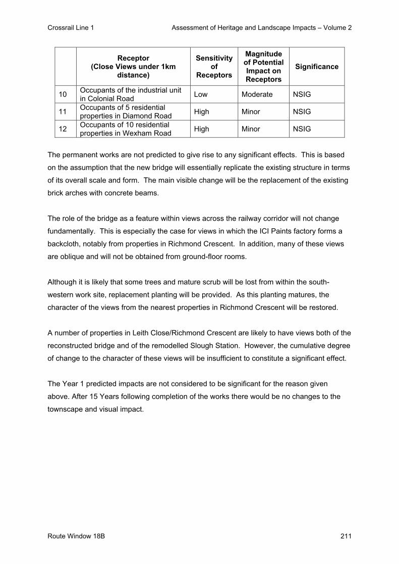
Crossrail Line 1 Assessment of Heritage and Landscape Impacts – Volume 2
Route Window 18B 211
Receptor
(Close Views under 1km distance)
Sensitivity of
Receptors
Magnitude of Potential Impact on Receptors
Significance
10 Occupants of the industrial unit in Colonial Road Low Moderate NSIG
11 Occupants of 5 residential properties in Diamond Road High Minor NSIG
12 Occupants of 10 residential properties in Wexham Road High Minor NSIG
The permanent works are not predicted to give rise to any significant effects. This is based
on the assumption that the new bridge will essentially replicate the existing structure in terms
of its overall scale and form. The main visible change will be the replacement of the existing
brick arches with concrete beams.
The role of the bridge as a feature within views across the railway corridor will not change
fundamentally. This is especially the case for views in which the ICI Paints factory forms a
backcloth, notably from properties in Richmond Crescent. In addition, many of these views
are oblique and will not be obtained from ground-floor rooms.
Although it is likely that some trees and mature scrub will be lost from within the south-
western work site, replacement planting will be provided. As this planting matures, the
character of the views from the nearest properties in Richmond Crescent will be restored.
A number of properties in Leith Close/Richmond Crescent are likely to have views both of the
reconstructed bridge and of the remodelled Slough Station. However, the cumulative degree
of change to the character of these views will be insufficient to constitute a significant effect.
The Year 1 predicted impacts are not considered to be significant for the reason given
above. After 15 Years following completion of the works there would be no changes to the
townscape and visual impact.

Crossrail Line 1 Assessment of Heritage and Landscape Impacts – Volume 2
Route Window W18B 212
4. Summary 4.1 Listed Buildings and their Setting
Although there will be some intervisibility between the works and the listed Slough Station,
the effects on the setting of Slough Station, will not be significant.
4.2 Conservation Areas
There will be no impacts on Conservation Areas in this route window.
4.3 Landscape / Townscape The works comprise demolition of the existing brick-arch section of the bridge, and
construction of a new span formed of pre-cast concrete beams. Temporary work sites will be
established on part of the ICI car park to the north-west of the bridge, and on vacant land
within the railway corridor to the south-west. It is assumed that vegetation within the latter
site will be removed.
The construction works will have no more than a minor or moderate impact on landscape
character. Although they may be visually intrusive, their limited duration will mitigate against
any significant effect.
The permanent works will have a generally minor impact on landscape character. The new
section of the bridge will not change its role as a townscape feature to a significant degree.
The vegetation likely to be lost from the south-western work site is not critical to the character
of the area. Replacement planting will be provided.
4.4 Visual Impacts
The construction works are considered to have a temporary significant impact on the amenity
of 10 residential properties in Richmond Crescent. This is due to the proximity and relative
prominence of the works, (exacerbated by assumed vegetation loss), together with the
sensitivity of these receptors. A number of properties in Leith Close/Richmond Crescent will
have views of the temporary works associated both with the bridge and with Slough Station.
These are not significant.

Crossrail Line 1 Assessment of Heritage and Landscape Impacts – Volume 2
Route Window 18B 213
The permanent works are not considered to give rise to any significant effects on visual
amenity, since the character of views from nearby properties will not change fundamentally.

Crossrail Line 1 Assessment of Heritage and Landscape Impacts – Volume 2
Route Window W18B 214
5. Summary Tables
There will be no impacts on listed buildings, the setting of listed buildings or Conservation
Areas in this route window.
Predicted impacts on landscape / townscape character and visual amenity are summarised
in Table W18.4: Summary Table of Temporary Impacts and Table W18.5: Summary Table of
Permanent Impacts, including any committed mitigation and residual impacts.

Crossrail Line 1 Assessment of Heritage and Landscape Impacts – Volume 2
Route Window W18B 215
Tabl
e W
18.4
: Sum
mar
y Ta
ble
of T
empo
rary
Impa
cts
(Wex
ham
Roa
d B
ridge
: Rou
te W
indo
w W
18B
)
R
oute
Win
dow
W18
B –
Tem
pora
ry Im
pact
s at
Wex
ham
Roa
d B
ridge
Res
idua
l Im
pact
W
orks
and
pot
entia
l im
pact
Si
gnifi
canc
e M
itiga
tion
Des
crip
tion
Sign
ifica
nce
Impa
ct o
n ch
arac
ter a
reas
C
hara
cter
and
set
ting
of s
urro
undi
ng a
reas
wou
ld b
e la
rgel
y un
affe
cted
. N
ot S
igni
fican
t R
epla
ntin
g w
ill
be u
nder
take
n.
Ass
umed
loss
of v
eget
atio
n fro
m s
outh
ern
wor
k si
te.
Tem
pora
ry w
orks
wou
ld b
e hi
ghly
vis
ible
in p
lace
s, b
ut
no fu
ndam
enta
l cha
nge
to
char
acte
r.
Not
Sig
nific
ant
Impa
ct o
n vi
sual
am
enity
of:
A
ppro
x. 1
0 re
side
ntia
l pro
perti
es
Sig
nific
ant
Non
e pr
actic
able
Veg
etat
ion
loss
and
pr
oxim
ity to
the
wor
ks.
Sig
nific
ance
will
cea
se w
hen
wor
k is
com
plet
e.
Sig
nific
ant
Impa
ct o
n vi
sual
am
enity
of:
O
ther
rece
ptor
s N
ot S
igni
fican
t N
one
prop
osed
. A
s ab
ove.
N
ot S
igni
fican
t

Crossrail Line 1 Assessment of Heritage and Landscape Impacts – Volume 2
216 Route Window W18B
Tabl
e W
18.5
: Sum
mar
y Ta
ble
of P
erm
anen
t Im
pact
s (R
oute
Win
dow
W18
: Wex
ham
Roa
d B
ridge
)
R
oute
Win
dow
W18
– P
erm
anen
t Im
pact
s at
Wex
ham
Roa
d B
ridge
Res
idua
l Im
pact
W
orks
and
pot
entia
l im
pact
Si
gnifi
canc
e M
itiga
tion
Des
crip
tion
Sign
ifica
nce
Impa
ct o
n ch
arac
ter a
reas
Fu
ndam
enta
l cha
ract
er o
f sur
roun
ding
ar
eas
will
be
unaf
fect
ed.
Not
Sig
nific
ant
Non
e pr
opos
ed
New
spa
n w
ill e
ssen
tially
re
plac
e ex
istin
g.
Veg
etat
ion
to b
e lo
st n
ot c
ritic
al
to to
wns
cape
cha
ract
er.
Rol
e of
railw
ay in
frast
ruct
ure
will
be
larg
ely
unch
ange
d.
Not
Sig
nific
ant
Impa
ct o
n vi
sual
am
enity
of:
N
earb
y re
side
nts
etc.
N
ot S
igni
fican
t N
one
requ
ired.
C
hara
cter
of v
iew
s ac
ross
ra
ilway
cor
ridor
will
not
cha
nge
fund
amen
tally
. N
ot S
igni
fican
t

Crossrail Line 1 Assessment of Heritage and Landscape Impacts – Volume 2
Route Window W18B 217
6. Assumptions
- Temporary work sites will be returned to their previous condition and use.
- Some loss of vegetation from the immediate vicinity of the bridge will be unavoidable.
Vegetation will be replanted once construction is complete.
- 2.4 metre and 3.6 metre high timber hoarding around the perimeter of temporary and
permanent work sites.
- Desk-top studies and a number of site visits were undertaken during July 2004 and
therefore this assessment was undertaken during the summer period when vegetation
was in leaf. However, when considering the landscape and visual impacts of the
scheme, an assessment of the potential winter situation has been estimated / taken into
account and ZVIs mapped on this basis.

Crossrail Line 1 Assessment of Heritage and Landscape Impacts – Volume 2
218 Route Window W18B
7. References
- ES Route Windows W18
- Parliamentary Plan Sheets
- ES Scheme Description

Crossrail Line 1 Assessment of Heritage and Landscape Impacts – Volume 2
Route Window W18A 219
Route Window W18A Slough Station


Crossrail Line 1 Assessment of Heritage and Landscape Impacts – Volume 2
Route Window W18A 221
Contents 1. Description of the Works 223
1.1 Permanent Works 223 1.2 Temporary Works 224
2. Baseline Assessment 229 2.1 Local context 229 2.2 Listed Buildings and their Setting 233 2.3 Conservation Areas 239 2.4 Landscape / Townscape 239 2.5 Zone of Visual Influence 242 2.6 Sensitivity 244
3. Impact of the Scheme 248 3.1 Listed Buildings 248 3.2 Setting of Listed Buildings 251 3.3 Conservation Areas 251 3.4 Landscape / Townscape 251 3.5 Visual impacts 252
4. Design Development and selection of preferred scheme 257 4.1 Proposed Works 257 4.2 Design Development 257 4.3 Planning Policy Issues 259
5. Summary 260 5.1 Listed Buildings 260 5.2 Setting of Listed Buildings 260 5.3 Conservation Areas 260 5.4 Landscape / Townscape 260 5.5 Visual Impacts 260
6. Summary tables 262 7. Assumptions 267 8. References 268 9. Appendix 1: Statutory Listings 269 10. Appendix 2: Conservation Bibliography 272

Crossrail Line 1 Assessment of Heritage and Landscape Impacts – Volume 2
222 Route Window W18A
Crossrail Line 1 Assessment of Heritage and Landscape Impacts – Volume 2
Route Window W18A 223
Route Window W18A Slough Station
1. Description of the Works This route window deals with Slough Station. Route window W18AB deals with Wexham
Road Bridge. A scoping exercise to determine the potential impacts associated with bridge
works along the route was undertaken (see introductory section to this volume) and this
identified that there were potentially significant impacts associated with the Wexham Road
Bridge works. Works to the two other bridges (Uxbridge Road Bridge and William Street
Bridge) were not considered to result in any significant impacts and consequently have not
been assessed in detail.
1.1 Permanent Works
Slough Station
The ticket hall on platform two will be rearranged to accommodate the ticket gates that will be
relocated from the platform. The ticket hall on platform five will be extended to allow sufficient
space for additional ticket gates and retail facilities.
A new 80 m long bay platform for a terminating service from Reading will be constructed at
the western end of platform five. A 95 m extension at the eastern end of platform five will
require platform six to be filled in. Other platforms will be extended westwards by between 26
m and 57 m to accommodate Crossrail trains. The Windsor Branch track will be realigned
southwards and platform one will be widened. The platform canopy over platform five, which
forms part of the curtilage of the listed station, will be replaced with a new modern canopy
that will accommodate the overhead line equipment.
A new 40 m long passenger bridge will be constructed at the west end of the station. Lifts will
be provided from this to each platform. The existing listed footbridge that spans the centre of
the station will be refurbished and retained for staff and emergency access only.
Bridge Works
Works will be undertaken at the following bridges.
- William Street bridge: alterations will be made to the parapets of this bridge, located at
the west end of Slough station.

Crossrail Line 1 Assessment of Heritage and Landscape Impacts – Volume 2
224 Route Window W18A
- Wexham Road bridge: its brick arch span over the main lines will be removed and
reconstructed to provide sufficient clearance for OHLE, and alterations will be made to
the parapets.
- Uxbridge Road bridge: the parapets of this bridge will be replaced.
Wexham Road Bridge is dealt with in Window W18AB.
Slough Goods Loop
The existing eastbound goods loop between Farnham Road and Slough station will become
the new eastbound relief line. The new two-way loop with highspeed junctions at each end
will be formed from the existing eastbound relief line and will be located between the
westbound relief line and the new eastbound relief line.
1.2 Temporary Works
Duration of Works
Subject to possession planning requirements and excluding final commissioning, the
approximate duration of each element of works at Slough is as follows:
- Slough station: twelve months;
- William Street bridge: two and a half months;
- Wexham Road bridge: ten months;
- Uxbridge Road bridge: three and a half months; and
- track alterations for Slough goods loop: six months.
Enabling Works
Enabling works will include the diversion of utilities and services. The principal demolitions
required at Slough station will include the platform ramps, a platform structure northwest of
the station, a single storey building at the western end of platform five and partial removal of
canopies on platforms five and six. Works at the three bridges will also require demolitions of
some parts of the structures.
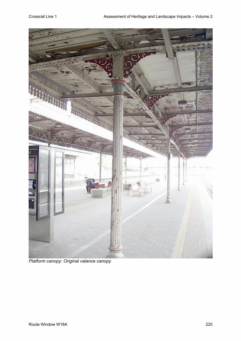
Crossrail Line 1 Assessment of Heritage and Landscape Impacts – Volume 2
Route Window W18A 225
Platform canopy: Original valance canopy

Crossrail Line 1 Assessment of Heritage and Landscape Impacts – Volume 2
226 Route Window W18A
Main Works - Station
The main stages of construction at Slough station are described below:
- Realignment of the Windsor line bay track followed by widening of platform one. This will
create enough platform width adjacent to the new footbridge.
- Construction of foundations for widening platform five, and demolition of the existing end
ramps on platforms three and four.
- Internal alterations of the north and south station buildings and refurbishment of the
original listed canopies.
- Widening the eastern end of platform five, together with extension of platform three and
four. Some trackworks will also be undertaken at this time.
- Construction of the new terminal bay platform on the existing sidings north of platform
five.
- Construction of the new footbridge with lifts, at the western end of the station.
- Introduction of signalling and OHLE.
Plant and equipment required at the Slough station will include a mobile crane, a bulldozer,
excavators, generators, compressors, a diesel locomotive and a lorry-mounted concrete
pump.
Works at the station will be carried from four worksites:
- Railway Terrace worksite west, located in the northwest car park of the station;
- Slough station worksite northeast, located to the northeast of the station in a car park;
- Slough station worksite south, located in the southeast station car park; and
- Brunel Way worksite, located to the southwest of the station in a small car park.
Materials will be taken to and from site by road, accessing the worksites to the south of the
station from the A4 Wellington Street and to the north of the station from William Street. Each
worksite will be served by five lorries per day during the seven week peak construction
period and typically by two at other times.

Crossrail Line 1 Assessment of Heritage and Landscape Impacts – Volume 2
Route Window W18A 227
Main Works - Bridges
Works at both William Street bridge and Uxbridge Road bridge will require the erection of
scaffolding access platforms on both sides of the bridge to facilitate works to the parapets.
Track works will be undertaken beneath William Street bridge as part of the new bay platform
works at Slough station.
Works at William Street bridge will involve use of a rail-mounted excavator, a bulldozer, a
rail-mounted crane, generators, a ballast tamper and a rail saw. They will be undertaken from
a worksite on its southwest corner. Nearly all materials will be taken to and from the site by
rail. Only about two lorries per day will serve the worksite throughout the construction period.
Works to Uxbridge Road bridge will involve use of a rail-mounted excavator, a bulldozer, a
rail-mounted crane and generators. They will be undertaken from a site on its northeast
corner. Materials will be taken to and from the site by road, with access from Uxbridge Road.
Only about two lorries per day will serve the worksite throughout the construction period.
At Wexham Road bridge, a temporary bridge will first be constructed and traffic diverted onto
this. Utilities will also be diverted temporarily across this. Piling will be required to stabilise
the south abutment, together with grouting of the buried arch. Once this preparatory work is
complete, the existing arch over the main line tracks will be demolished. Pre-cast abutment
units and bearing units will then be installed. The pre-cast deck beams for the bridge will be
put in place and the finishing works, such as concreting and waterproofing the deck,
reinstating the road, and raising the parapets, will be completed. Following this, the
temporary road bridge will be removed.
Construction plant at Wexham Road bridge will include a crane, an excavator, a compressor,
generators, a piling rig, a grouting rig and a circular saw. Worksites at Wexham Road bridge
will be located on the northwest and southwest sides of the bridge. All materials used in the
works will be transported into and out of the site by road. Each site will be served by two
lorries per day, even during the 11 week peak of construction.

Crossrail Line 1 Assessment of Heritage and Landscape Impacts – Volume 2
228 Route Window W18A
Main Works – Slough Goods Loop
The track works required for the provision of the new goods loop will involve the use of a
bulldozer, excavators, a generator, a compressor, a ballast tamper and a crane. During these
works, signalling and overhead electrification will be installed to accommodate the new track
layout.
Works to the loop will be undertaken within rail land. The worksite will be located as close as
possible to the track. All new track material and some recovered material will be transported
by rail.

Crossrail Line 1 Assessment of Heritage and Landscape Impacts – Volume 2
Route Window W18A 229
2. Baseline Assessment 2.1 Local context
Slough Station lies on the northern edge of the town centre within an entirely built-up area.
To the north of the railway, commercial, office and light industrial uses predominate. In the
immediate vicinity of the station, these comprise a bus depot, a series of office/warehouse
units, older industrial premises (vacant), the Abbey Business Centre and New Station House
(offices).
Light industrial and business uses extend west from Stoke Road to Stoke Poges Lane and
include the prominent Horlicks factory. Similar uses extend eastwards to the Grand Union
Canal and the rear of residential properties in Peterhead Avenue.
The nearest residential properties comprise 4-storey flats in Mill Lane (Noble Court and
Headington Place), about 100m north-east of the station; and two-storey properties in Stoke
Road/Stoke Gardens, about 150m to the north-west. Residential areas extend northwards
from the industrial/business area to the west of Stoke Road, and from Peterhead Avenue to
the canal. The area beyond the canal is also mainly residential.
Retail uses are located along parts of Stoke Road. The nearest open space comprises a
sports ground, about 300m north-west of the station, within the industrial area; and playing
fields adjoining the canal, about 450m to the north.
To the south of the station, the area between the railway and Wellington Street comprises a
mix of commercial, retail and institutional uses. A number of office buildings lie immediately
to the south of Brunel Way, comprising UniSys House, Computer Sciences House and
Sovereign Square (O2). These are adjoined to the south by the Brunel bus station and car
park.
The area to the west of William Street is occupied by the Market Yard car park and the
campus of Thames Valley University. Beyond this, the Windsor branch railway line which
curves southwards to pass under Wellington Street. West of the railway lie the residential
areas of Lansdowne Avenue/Stranraer Gardens.

Crossrail Line 1 Assessment of Heritage and Landscape Impacts – Volume 2
230 Route Window W18A
A Tesco superstore and its car park occupies the block to the east of Brunel Way and south
of the station car park. To the east of the superstore lies the residential area of Wellesley
Road, which extends eastwards to Uxbridge Road.
Wellington Street is a dual carriageway, and forms the northern edge of the retail core. The
area to the south is dominated by the Observatory and Queensmere shopping centres.
These comprise a typical mix of large well known high street stores and shops and multi-
storey parking.
Retail uses generally extend along both sides of the High Street from the railway bridge in
the west to Yew Tree Road in the east. Office buildings such as Directories House lie
between the shopping centres and Wellington Street. The area to the south of the retail core
is mainly residential, with some institutional uses.
The Townscape Character Baseline Plan for Station Station, Drawing No. IE0416-WIE00-
E00-F-00018 identifies the locations of key buildings and landmarks in the local landscape /
townscape, local views, pedestrian and vehicular movement corridors, townscape character
areas, urban gateways / nodes and the landscape planning designations that relate to the
work sites and their surroundings. These baseline plans also illustrate the extent of the
temporary work sites and permanent works.
2.1.1 Slough History
Slough owes its existence and growth to its position on the London/Bath/ road, as a stopping
point served by coaching inns and facilities in the then surrounding villages of Charlton,
Upton and Chalvey. A logical network of connections, both local and regional, grew
concurrently and as the coaching industry developed in the eighteenth century, Slough
became the second stopping point out of London. In 1718 Thomas Baldwin, owner of the
Crown Inn on Slough High Street, started a regular coach service between London, Bath and
Bristol.
Slough Railway Station opened in 1840, and the population doubled within a few years,
growing from 1,200 in 1831 to 2,400 in 1841.

Crossrail Line 1 Assessment of Heritage and Landscape Impacts – Volume 2
Route Window W18A 231
For 13 years (until the Windsor spur was built) Slough was the nearest station to Windsor,
and hence used by many VIPs. The Royal Hotel was built opposite the station which includes
the carriage loading bay), Slough became a fashionable place to live, and several grand
residences were built.
Slough Station 1841
The easy connection to London meant that Slough’ residential population grew rapidly,
trebling in size by the end of the Century. Service and Retail industries grew proportionately.
In 1920 the Trading Estate was opened (initially to repair vehicles damaged in WW1), and
Slough took on the role of an Industrial town. The Trading Estate changed its name in 1924
to become Britain’s first industrial estate - Slough Estates Ltd. The Mars chocolate factory
opened in 1930 and is still operating. Housing went up for factory workers. For some, like
John Betjeman, this growth was a blight on the landscape.
After the Second World war housing estates were built to re-house Londoners who had lost
homes in the Blitz and since the 1960’s Slough’s employment opportunities and location
within a good transport network have attracted a steady increase of people. By 1972 the
population stood at c. 90,000 and the rail network first developed by Isambard Kingdom
Brunel was crucial in this growth.

Crossrail Line 1 Assessment of Heritage and Landscape Impacts – Volume 2
232 Route Window W18A
2.1.2 The Great Western Railway Station
The opening of the Stockton and Darlington line in 1825 heralded the beginning of a new era
of communication. The Bristol Chamber of Commerce and other local industrial bodies, long
concerned about links with London, formed a committee in 1833 to discuss the proposal of
laying a railway to the capital.
Isambard Brunel, who had helped to build the Thames Tunnel and who had been appointed
engineer of the Clifton Suspension Bridge, was chosen to superintend the construction of the
Bristol-London railway, which in the same year adopted its present title, “Great Western
Railway.”
Isambard Kingdom Brunel
Brunel’s route ran north of Marlborough Downs via Reading and Bath. He selected the
northern course because it offered better gradients and because it would easily allow
extensions to be made later to Oxford, Gloucester and South Wales. June 4th, 1838, was
the appointed date for the public opening of the Great Western Railway from Paddington to
Maidenhead, or rather Taplow, one and three quarter miles away, since the Maidenhead
bridge remained as yet unfinished. There was no passenger stop at Slough.
A traveller on this pioneer train has recorded his experiences in a diary. One passage reads:
“June 4th, 1838. Our railway opened to the public this morning. I went to Maidenhead by the
first train and came back by the third, which started from Maidenhead at ten-fifteen. I was
disappointed with regard to the speed, as we were one hour and twenty minutes going down,
and one hour and five minutes coming up. If from the sixty-five minutes we deduct four lost at
Drayton, three at Slough, and four between the two places, and in slackening and getting up
speed, there remain fifty-four minutes for twenty-three miles, or twenty-five and a half miles
an hour. We carried altogether to-day 1,479 people, and took £226.”

Crossrail Line 1 Assessment of Heritage and Landscape Impacts – Volume 2
Route Window W18A 233
The traffic receipts on the new railway had, in the meantime, been very encouraging. As
many as 10,000 passengers a week were carried. Early prejudices against the new method
of transport were slowly vanishing, the authorities at Eton College, who had formerly
regarded the railway’s influence with disfavour, chartered a special train for the conveyance
of their pupils.
2.2 Listed Buildings and their Setting There are 3 listed buildings within the Limits of Deviation (LOD) or the Limits of Land to be
Acquired and Used for the project. These are all Grade II listed parts of Slough Station
which are as follows:
- The main entrance on the Brunel Way side;
- a subsidiary entrance on the Railway Terrace side; and
- Island Platform Building
Both the Railway Terrace and Brunel Way buildings were designed in 1882 by J.E. Danks in
a Second Empire style. The Island Platform Building, of the same date, is surrounded by
canopies to the North and South sides of the platform extending to the west. The footbridge
linking the platforms is not referred to in the list descriptions but is deemed to be part of the
listed buildings.
The only other listed building in the vicinity is St Ethelberts Church, which lies about 200m to
the south.
2.2.1 The Slough Station Site
There was strong initial opposition from the Provost of Eton to the siting of a station at
Slough which delayed the opening of Slough Station. The Provost felt, “If the boys could be
carried to a distance of five mile in fifteen minutes they could easily put themselves out of the
reach of the authorities, and so the school must be injured”
These fears were overcome and the station opened to the general public on 1st June 1840.
The route of the Great Western Railway was such that the towns of Slough and Reading
were situated mainly to the south of the line. Brunel therefore used a one-sided design with
up and down covered platforms on the south side of the line, in effect creating separate
stations.

Crossrail Line 1 Assessment of Heritage and Landscape Impacts – Volume 2
234 Route Window W18A
Slough station was at the forefront of the communications revolution of the 1840’s. The
electric telegraph was patented in Britain in 1837 following the pioneering work of Cooke and
Wheatstone. In 1839 experiments were made along the Great Western railway line from
Paddington to West Drayton, running the electric wire through iron tubes. The telegraph
station building (1843) was a very unimpressive wooden cabin, with a maze of seemingly
jumbled cables fed through the roof. The electric telegraph enabled messages to be sent
along the wires, initially by needles tilted to indicate the different letters. This complicated,
slow method of transmitting words was replaced by the simpler transmission of the ‘dot and
dash’ code invented by Samuel Morse in 1838, which came into use c.1845.
Increased traffic at both Reading and Slough stations caused excessive delays and the
decision was made to replace them.
The second Slough station was constructed in the French Second Empire style then in vogue
on the Great Western Railway (also at Torquay and Wrexham) and was opened on 8th
September 1884 to designs by the GWR architect JE Danks.
Construction on the station started in 1882 and consisted of three parts built in brick with
stone dressings and lacing courses: the main entrance on the Brunel Way side (containing
the Booking Hall, Booking Office, and Travel Centre); a subsidiary entrance on the Railway
terrace side (Slough Station area Managers office, Traffic Assistant’s Office and Red Star
Parcels Office); and an Island Platform Building. All three sections are separately listed at
grade II and are linked by a footbridge. For a further in-depth description, see the gazetteer
in the Appendix.

Crossrail Line 1 Assessment of Heritage and Landscape Impacts – Volume 2
Route Window W18A 235
The interior of the footbridge linking all three sections
The area around the station has since the 1880’s undergone extensive changes as Slough
has urbanized and grown to the North. The Gotha Iron Works made use of the railways and
Slough’s largest employer, the brickfields, were sited further north. The grand hotels that
served passengers before the spur to Windsor was built gradually fell into disrepair although

Crossrail Line 1 Assessment of Heritage and Landscape Impacts – Volume 2
236 Route Window W18A
Mackenzie street named after the man who turned the Royal Hotel into the British Orphan
Asylum, still exists giving the south north vista to the main entrance of the station.
The station still sits in a broad setting, but this is now given over to car parking and ancillary
buildings tacked onto the flanks of the main station buildings. Signage and inappropriate
materials have been added but in essence the building stays as it was constructed. There is
an interesting derelict Victorian stationmaster’s house on the periphery of the car park which
possibly deserves further research.
Station forecourt
2.2.2 Significance of the Listed Building
Within the national context Slough Station is identified as a building of national ‘architectural
or historic interest’ and is listed Grade II. The list description is provided in Appendix 1. The
station is not in a conservation area.
Crossrail Line 1 Assessment of Heritage and Landscape Impacts – Volume 2
Route Window W18A 237
Slough context There are 96 buildings and structures in Slough Borough, which are included in the statutory
list of buildings of special architectural or historic interest. Five of the listed buildings in
Slough are classified as Grade I which are of exceptional interest. Within the context of
Slough’s buildings, the station is one of a small number of buildings that is listed. The four
main criteria for selection as a listed building are:
- Architectural interest
- Historic interest – thorough comparative analysis
- Close Historical Association
- Group Value
Architectural style
The station is significant as it is in a version of the Second Empire style also used at Torquay
and Wrexham, then in vogue on the Great Western Railway. Further, it retains much of its
original fabric in good condition. When looking at the drawings of Lancaster Owen, the
engineer, it is apparent that the buildings are in general as designed.
The major alterations are: the lengthening of the platforms; the extensive alterations to the
footbridge; the replacement of the zinc fish scale tiles with G.R.P. facsimilies; alterations and
repairs to the canopies; and the proliferation of stylistically inconsistent signage. This make
the buildings lose coherence but could easily be remedied.
The station buildings are covered by three separate listings (see Appendix), and as Grade II
buildings they are by definition of national importance. None of the listings mention the
footbridge but it is part of the 1882-4 design: also, any structure fixed to the listed buildings is
deemed to be included in the listing.
Historic interest
The station is significant as part of the second stage of development of the Great Western
Railway as the two Up and Down platforms proved to be inadequate for the growth in
passenger numbers and more tracks were added along the route.
The site is also interesting as it is the site of the first telegraph station which was opened at
Slough in 1843 and linked to Paddington Station.

Crossrail Line 1 Assessment of Heritage and Landscape Impacts – Volume 2
238 Route Window W18A
The first telegraph station
Historical Associations
The stretch of railway between Paddington and Slough was extremely popular not just with
the local population and the scholars from Eton but also with the Royal Family. Queen
Victoria was at first sceptical but became a committed supporter of this stretch of the railway
until the Windsor spur was built.
Simple layout of possible routes
Group Value
The station was closely associated with The Royal Hotel, which became the British Orphan
Asylum and was then purchased by the Licensed Victuallers’ Orphanage and pulled down in
1938 after the construction of the Licensed Victuallers School.

Crossrail Line 1 Assessment of Heritage and Landscape Impacts – Volume 2
Route Window W18A 239
2.3 Conservation Areas
There are no Conservation Areas in the vicinity of the works. The nearest Conservation Area
is located about 0.75km to the south-east and 1km beyond the town centre.
2.4 Landscape / Townscape 2.4.1 Character Areas and Landscape / Townscape Quality
The area may be divided into three character areas, reflecting their prevailing uses and built
pattern.
Slough Town Centre Character Are:
The Slough Town Centre character area comprises the retail, business and institutional uses
to the south of the station. It is characterised by buildings with large footprints, separated by
highway infrastructure (Wellington Street) and surface parking.
Buildings are typically of between 3-6 storeys; the tallest buildings comprise the university,
the shopping centres and the offices along Brunel Way. Most of the buildings are the result
of redevelopment over the past 30-40 years. The shopping centres and university probably
date from around 1970, whilst the offices are typical of the 1980s-90s. Older buildings are
rare; St. Ethelbert’s Church, on the Wellington Street/William Street roundabout, is the most
visible example.
The Town Centre character area is of moderate townscape quality overall. Parts of it are of
low quality, with undistinguished retail or office buildings defining equally undistinguished
streetscapes, notably Wellington Street. Locally, older buildings or landscaped forecourts
provide some enhancement.
Business District Character Area:
The Business District character area comprises the industrial, office and distribution uses
north of the railway. This generally comprises buildings of moderate to large footprint,
separated by parking areas and service yards. Buildings are mainly of 2-4 storeys, with
some taller (4-5 storey) structures. They are of mixed age, including relatively modern office
buildings and older industrial units (some of 19th century date). The Horlick factory is a
prominent landmark.

Crossrail Line 1 Assessment of Heritage and Landscape Impacts – Volume 2
240 Route Window W18A
The Business District character area is generally of low townscape quality. Its spatial pattern
is relatively incoherent, most of its buildings and streetscapes are undistinguished, and it has
little vegetation. A notable exception is the Horlicks factory, with its distinctive chimney.
Residential Character Area:
The Residential District character area comprises the areas of housing that lie to the north of
the Business District and to the south of the railway, fringing the town centre. These area
mainly comprises low-rise (2-storey) housing dating from the pre-1900 and 1920-40 periods,
mixed with medium-rise (2-4 storey) flats of later date.
The railway separates the Business district to the north from the Town Centre and
Residential areas to the south.
The residential areas are also of generally moderate quality. They are typical of their period;
whilst they are scarcely noteworthy, they generally offer a reasonable degree of amenity.
2.4.2 Key Townscape / Landscape Features and Resources
Four buildings are notable as townscape features. The station itself is a distinctive
architectural composition in “Second Empire” style, with curved mansard roofs. Its
distinctiveness stems mainly from its style rather than its scale, and its visual influence is
restricted to the station forecourt, nearby parking areas and adjoining streets.
The UniSys building, occupying a prominent position on the corner of William Street and
Brunel Way, is a striking example of an office building of the 1980 period, with recurrent
hexagonal tiers of concrete and a landscaped forecourt.
The Horlicks factory, to the west of the station, is also prominent. Its red-brick façade,
recalling a Pennine textile mill, is striking, and its chimney is a local landmark.
The flint tower of St. Ethelbert’s Church, on the south-eastern corner of Wellington Street and
William Street, is also distinctive, largely because of the scarcity of other historic references
in the townscape.
Vegetation is a locally important influence on views and landscape character. The most
notable vegetation in the immediate vicinity of the station comprises a belt of semi-mature

Crossrail Line 1 Assessment of Heritage and Landscape Impacts – Volume 2
Route Window W18A 241
and mature deciduous trees (mainly ash, sycamore and poplar) which defines the southern
perimeter of the station car park where it adjoins the Tesco superstore and properties in Leith
Close. Situated within this tree belt is Station House, which was originally a residential
property. However its current use is unknown.
Mature scrub and immature trees occupy parts of the railway corridor adjoining Railway
Terrace and Brunel Way, and the cutting close to the university. Relatively mature
ornamental planting is associated with the office buildings on Brunel Way.
2.4.3 Strategic Views and Key Local Views
There are no strategic views in the vicinity of the site.
The view from the William Street bridge is regarded as a key local view. The bridge is an
important pedestrian route between the town centre and the business/residential areas to the
north. It provides unobstructed views along the railway corridor, in which the Horlicks factory
(to the west) and the station (to the east) are prominent.
View from the road bridge

Crossrail Line 1 Assessment of Heritage and Landscape Impacts – Volume 2
242 Route Window W18A
Pedestrian / Vehicular Movement Corridors
Roads are the main movement corridors in the area, both for vehicles and pedestrians, with
William Street forming an important link between the town centre and the employment and
residential uses to the north. In addition, significant pedestrian flows probably take place
across William Street (to/from the University and car parks to the west) and across
Wellington Street (to/from the station, the Brunel bus station/car park, the station and nearby
offices).
Wellington Street is part of the A4 arterial route between London and Reading. William
Street provides access northwards (as the B416) to Stoke Poges and Gerrards Cross, and
southwards (as the A332/Windsor Road) to Eton and Windsor. To the east, the Uxbridge
Road (A412) provides access towards the M40.
2.4.4 Landscape Planning Designations
The canalside playing fields (about 0.5km to the north) and the Salt Hill Park and Pleasure
Grounds (about 0.6km to the west) are designated public open space.
To the north of the station two planning applications have been submitted for development of
a mixed use scheme up to 14 storeys high on land at Railway Terrace and the development
of an office building up to 4 to 6 storeys in height.
2.5 Zone of Visual Influence The approximate Zone of Visual Influence (ZVI) for the work sites is determined by the
following influences:
- The relationship of the railway to the surrounding area;
- The general character and arrangement of land uses;
- The proximity, scale and use of nearby buildings; and
- The size and type of nearby vegetation.
The railway runs through the built-up area in a shallow cutting, passing beneath Stoke Poges
Lane, William Street and Wexham Road. In the vicinity of the station, the cutting has been
widened in order to accommodate access roads and sidings, and the surrounding area is

Crossrail Line 1 Assessment of Heritage and Landscape Impacts – Volume 2
Route Window W18A 243
generally at platform level. To the west of William Street, the southern side of the cutting
follows the curve of the Windsor branch railway.
The lower elevation of the railway generally restricts opportunities for direct views to
track/platform level, except from the station forecourt/car park and from vantage points such
as the William Street bridge and from buildings which overlook the railway corridor. The
surrounding buildings are the main influence on views, reinforced (in summer) by vegetation,
mainly to the south of the railway. The station itself is also influential.
Level of rails in relation to the station
The ZVI can be defined by the following:
- To the West, along the railway corridor to the William Street bridge. One of the work
sites associated with the bridge works, however, will be located to the west of the bridge,
and its ZVI is likely to extend westwards to the rear of properties in Stranraer Gardens
and Bristol Way;
- To the North, partly by the cutting slope adjoining Railway Terrace, but principally by the
sequence of commercial buildings extending from Stoke Gardens in the west to Wexham
Road in the east. In the immediate vicinity of the station, these buildings do not form a
continuous screen, allowing views to extend northwards to the second or third row of
buildings around Grays Place;
- To the East, along the railway corridor to the vicinity of the Wexham Road bridge, defined
tightly to the north by industrial buildings and to the south by the cutting and the rear of
residential properties;
- To the South, by the cutting slope adjoining Brunel Way, by the facades of the properties
along the southern side of Brunel Way, by the Tesco superstore and by residential
properties in Leith Close. During summer, the ZVI to the south-east is defined mainly by
the dense vegetation to the south of the station car park.

Crossrail Line 1 Assessment of Heritage and Landscape Impacts – Volume 2
244 Route Window W18A
The main potential sources of views of the station work sites may be summarised as follows:
- Occupants of around five residential properties in Stoke Road;
- Occupants of around five residential properties (flats) in Mill Lane;
- Occupants of commercial properties in Stoke Gardens, Stanley Cottages, Railway
Terrace and the industrial estate to the east of the station;
- Users of the Thames Valley University campus;
- Occupants of the office buildings south of Brunel Way and of some taller buildings in the
town centre;
- Pedestrians using William Street bridge;
- Users of Brunel Way and the station car park;
- Users of the Tesco superstore;
- Occupants of between 10-20 residential properties in Leith Close/Richmond
Crescent/Wellesley Road; and
- Users of the station.
In addition, views of the bridge work sites may be experienced by:
- users of the university campus;
- users of the Market Yard car park and the car park west of William Street bridge;
- residents of around five properties in Stranraer Gardens; and
- occupants of commercial properties in Bristol Way
2.6 Sensitivity The Listed station building is of high sensitivity to change, because of its architectural interest
and its status. It has, however, been subject to alterations that are not entirely sympathetic
to its original design, notably the construction of platform canopies during the 1960s.
Changes that entail the removal of such additions would therefore be potentially beneficial.
The surrounding townscape is generally of low sensitivity to change. The railway corridor,
the station, the William Street bridge and the signal box (to the west of the station) are
already significant influences, and the area is therefore able to accommodate further railway
infrastructure without fundamentally affecting its character.

Crossrail Line 1 Assessment of Heritage and Landscape Impacts – Volume 2
Route Window W18A 245
The immediate environs of the station are dominated by relatively large-scale buildings
separated by largely functional spaces (car parks, roads, service yards). Urban fabric of this
type is able to accommodate a substantial degree of change without detriment to its
character.
However, any significant loss of the trees which adjoin the station car park to the south would
affect townscape character, since this is the most prominent vegetation in the immediate
area, and is an important influence on views during summer.
The residential areas located to the east (Leith Close/Wellesley Road/Richmond Crescent),
west (Stranraer Gardens), north-west (Stoke Road) and north-east (Mill Lane/Petersfield
Avenue) are more sensitive to change, due to their smaller scale built pattern. However, the
sensitivity of these areas is mitigated in large part by their distance from the works and by
varying degrees of screening provided by intervening buildings.
2.6.1 Sensitivity Of Visual Receptor To Change
Table W18A.1: Visual Receptors (Slough Station Works) below identifies the key receptors
which would obtain views of the proposed temporary and proposed permanent works,
together with their sensitivity, the type of views and whether the views are of the temporary
or permanent works.
Table W18A.1: Visual Receptors for the Slough Station Works
Receptor (Close Views under 1km
distance)
Type of View
Dire
ct V
iew
Obl
ique
Vie
w
Tem
pora
ry
Wor
k Si
tes
Perm
anen
t W
orks
Sensitivity of
Receptors
1 Residential properties in Stoke Road
Upper floors
High
2 Commercial properties in Stoke Gardens/Stoke Road/Bristol Way/ Stanley Cottages and the industrial estate to the east.
Ground + upper floors
Low
3 Residential properties (flats) in Mill Lane (station works only)
Upper floors
High
4 Users of William Street bridge
Ground Low

Crossrail Line 1 Assessment of Heritage and Landscape Impacts – Volume 2
246 Route Window W18A
Receptor (Close Views under 1km
distance)
Type of View
Dire
ct V
iew
Obl
ique
Vie
w
Tem
pora
ry
Wor
k Si
tes
Perm
anen
t W
orks
Sensitivity of
Receptors
5 Users of the university, offices south of Brunel Way + the Tesco superstore
Ground + upper floors
Low
6 Users of Brunel Way, Railway Terrace, the station + car park
Ground level
Low
7 Residents of Leith Close/ Richmond Crescent/ Wellesley Road (station works only)
Upper floors
High
8 Users of car park west of William Street bridge (bridge works only)
Ground level
Low
9 Residents of Stranraer Gardens (bridge works only)
Upper floors
High
Local residents will be the most sensitive group of receptors and theoretically, between 25-35
residential properties could have winter-time views of the works. However:
- more than about half of these would experience direct views;
- viewing opportunities will in virtually every case be confined to upper floors;
- most viewing opportunities from properties in Leith Close/Richmond Crescent/ Wellesley
Road would be lost during summer;
- views from properties in Stoke Road and Mill Lane will be highly obstructed by
intervening buildings; and
- properties in Stranraer Gardens would only view the bridge works (which are of
insignificant scale).
The least obstructed views would be experienced by users of the station, the car park,
Railway Terrace and Brunel Way, by users (mainly pedestrian) of William Street bridge, by
users of the Tesco superstore and by occupants of commercial properties to overlooking the
station area. However, none of these receptors are considered to be of high sensitivity.
Some receptors may experience recurrent views of the works (e.g. from the workplace and
from nearby roads or the station). In addition, a proportion of the properties in Leith Close
and Richmond Crescent are likely to experience views of both the Slough Station works and
the Wexham Road bridge works.

Crossrail Line 1 Assessment of Heritage and Landscape Impacts – Volume 2
Route Window W18A 247
Receptors who live in or use the area can be assumed to be habituated to a certain degree
to the impact of railway maintenance and construction activities. The station construction
works would be of approximately eleven months duration.

Crossrail Line 1 Assessment of Heritage and Landscape Impacts – Volume 2
248 Route Window W18A
3. Impact of the Scheme 3.1 Listed Buildings Demolition of Canopies and Installation of OHLE
The 1960s canopy over platform 5 which forms part of the curtilage of listed station will be
replaced with a new modern canopy. This impact is considered to be a significant benefit as
the canopy is not of historic or architectural interest, and its removal will improve views from
within the station.
To provide standard clearances from the new overhead line electrification, it would be
necessary to trim the decoratively carved valance to the canopy on Platform 4. This impact
is potentially significant. To mitigate this impact, dispensation will be sought to adopt a sub-
standard clearance which would allow the existing valance to be retained. The residual
impact is therefore Not Significant (NSig.).
The final design solution for the stanchions to support the overhead line electrification has
not been resolved and therefore the stanchions could potentially penetrate the existing
canopy structures and change the visual impact of their supporting columns. This impact is
potentially significant . To mitigate this impact, during detailed design, the aim will be for
penetrations of the existing canopies to be avoided by fixing supports for the overhead lines
to the existing buildings above the canopies. Should this be the final design solution then the
residual impact is considered Not Significant .
There is a potential visual impact on the Grade II listed station buildings and canopies from
the installation of overhead line electrification, for which there is no mitigation. The residual
impact is therefore significant (Sig.).
Refurbishment of Station Buildings
It is proposed to remove some of the internal walls and partitions to the both the station
building on Brunel Way and Railway Terrace. This is to provide additional ticket barriers and
facilities. The existing windows on the platform elevation to the Brunel Way Station building
will be made into doors. This impact is consider not significant (NSig.) as the domed roofs
and facades will be largely unaffected by the proposed.

Crossrail Line 1 Assessment of Heritage and Landscape Impacts – Volume 2
Route Window W18A 249
Platforms
It is proposed to demolish the platform end ramps in order to extend the existing platform.
The platform and ramps are part of the curtilage of Slough Station, a group of Grade II listed
buildings. The platform end ramps are not of historical or architectural importance, therefore
this impact is Not Significant (NSig.).
Construction of new footbridge and lifts
A new footbridge is to be constructed at the western end of the station. This is assumed to
be within the curtilage of the listed buildings. There is potential for the new footbridge to
have a visual effect on the setting of the station buildings especially when viewed from the
platform and immediate environs. In mitigation, detailed design will be undertaken in
consultation with English Heritage and Slough Borough Council. Further modifications to the
design of the footbridge may make it more in keeping with the listed buildings, but its residual
impact will still be significant.
A crane will be required to lift the new bridge. The crane may have to oversail the existing
listed buildings, therefore there is a risk of falling objects. This impact is considered
significant . In mitigation of this impact good construction practice will be carried out and the
crane will avoid oversailing the listed station and its elements. The residual impact is
considered not significant (NSig.).
There is a potential impact of damage from construction plant and vehicles. This impact is
considered significant (Sig.). In mitigation of this impact it is proposed to position entrances
to worksites and turning points away from the station. The residual impact is considered not
significant (NSig.).
There would also be extensive changes to features such as signage and lighting, and to the
station forecourts. There are already ancillary structures flanking the station buildings, which
detract from the visual impact of the building. This effect is exacerbated by inconsistent and
unobtrusive signage and parking in the forecourt areas

Crossrail Line 1 Assessment of Heritage and Landscape Impacts – Volume 2
250 Route Window W18A
Station and parking area
The design proposals will take this opportunity to lessen obstructions to the visual impact.
The proposals also look to improve the following:
- New station fixtures and furniture will be provided on the extended platforms.
- The existing forecourt will be upgraded to include new paving, signage, lighting, cycle
parking and taxi and MIP drop off.
Changes to the William Street bridge will be confined to the parapet. Some scrub vegetation
may need to be cleared from the temporary bridge work sites, but this is not visually
significant.

Crossrail Line 1 Assessment of Heritage and Landscape Impacts – Volume 2
Route Window W18A 251
3.2 Setting of Listed Buildings
Views of the station within its townscape setting are obtained from William Street bridge and
whilst the introduction of the new footbridge will be visible it is considered that the wider
setting will not result in a significant impacts. However, as noted in section 3.1 above, when
the introduction of OHLE and a new footbridge is viewed from the platforms and from within
the station, this is considered to affect the local setting of the station buildings and result a
significant impact. Demolition of the 1960s canopy will result in a significant beneficial
impact.
The construction works will influence the setting of the station for a period of about a year.
Their impact is considered to range between minor and major at various times, depending on
the scale of the work and equipment in use. However, in view of their temporary nature, their
impact on the setting of the listed building is not considered to be significant.
The permanent works will generally reinforce the role of railway infrastructure as an influence
on the setting of the station. Since the fundamental character of this setting will not change,
their effect is not considered to be significant. Improvements to the station forecourts will
represent a benefit to its immediate setting, but will not be significant.
The visual impact of the works will not affect the setting of any other listed buildings.
3.3 Conservation Areas There will be no impacts on Conservation Areas in this route window.
3.4 Landscape / Townscape
The only designated feature that will be affected will be the station buildings. All three of its
main elements – the southern building containing the booking hall, booking office and travel
centre, the island platform building and the northern building on Railway Terrace – are Grade
II listed.
The proposals will involve a number of physical changes to the station, including demolitions,
alterations, refurbishment and new structures. These changes relate primarily to the physical
integrity of the building, rather than to its wider setting, and are addressed in section 3.1.

Crossrail Line 1 Assessment of Heritage and Landscape Impacts – Volume 2
252 Route Window W18A
The visual influence of the works will not extend into any areas of designated landscape /
townscape.
Construction features such as mobile cranes, piling rigs, HGVs, portacabins and hoardings
will be a relatively prominent feature around the station for almost a year. Their overall level
of impact is likely to be moderate; at times it will be low, and at others potentially major (e.g.
when cranes are lifting the footbridge spans or canopies into place).
However, the area (apart from the station) is generally of low sensitivity to change, and is
able to accommodate construction features without fundamentally affecting its character.
Their effect is therefore not considered to be significant.
The most visible features of the permanent works will be the new footbridges, the platform
canopies and the entrance canopy on Railway Terrace. Removal of the single-storey
extensions and general refurbishment of the station and forecourts will also be apparent.
These features will be seen in the context both of the existing station, with which they will to
some extent be visually consistent, and of the surrounding urban area. They will have no
more than a moderate impact on the character of the area immediately surrounding the
station. This impact will dissipate rapidly, due both to obstruction of views and to the
character of the town centre (to the south) and the business uses (to the north).
The overall impact on the character of the townscape is considered to be minor, and the
effect is unlikely to be significant.
3.5 Visual impacts
The Visual Appraisal Plan for Slough Station and William Street Bridge Drawing No. 1E0316-
WIE00-E00-F-00018 illustrates the approximate Zone of Visual Influence for the proposed
temporary and the proposed permanent works, and identifies the principal locations from
which views of the development would be obtained.
The assessment of impact during the construction works takes account of their relatively
limited duration, and the likelihood that nearby receptors will to a certain degree be tolerant
of activities carried out in the normal course of railway maintenance and improvement.

Crossrail Line 1 Assessment of Heritage and Landscape Impacts – Volume 2
Route Window W18A 253
The magnitude of visual impact that would be generated by the temporary works on each
receptor group is identified in Table W18A.2: Potential Temporary Impacts on Receptors
(Slough Station Works). This table includes impacts associated with the William Street
bridge works; separate reference is made to these where necessary.
Table W18A.2:- Potential Temporary Impacts on Receptors (Slough Station/ William Street Bridge)
Receptor
(Close Views under 1km distance)
Sensitivity of
Receptors
Magnitude of Potential Impact on Receptors
Significance
1 Occupants of approx. 5 residential properties in Stoke Road
High Low NSIG
2
Occupants of commercial properties in Stoke Gardens/ Bristol Way/ Stoke Road/ Stanley Cottages and industrial estate.
Low Low-High NSIG
3 Occupants of approx. 5 residential properties in Mill Lane (station works only)
High Low NSIG
4 Users of William Street Bridge Low Low to High NSIG
5 Occupants of the university, offices south of Brunel Way and Tesco superstore
Low Low to High NSIG
6 Users of Brunel Way, Railway Terrace, the station and car parks
Low Moderate to High NSIG
7
Residents of 10-20 residential properties in Leith Close/Wellesley Road/ Richmond Crescent.
High Low NSIG
8 Users of car park west of William Street bridge (bridge works only)
Low Low NSIG
9 Residents of approx. 5 properties in Stranraer Gardens (bridge works only)
High Low NSIG
The highest degree of impact will be experienced by users of the station, Brunel Way,
Railway Terrace and the adjoining car parks, by users of the Tesco superstore and by
occupants of the business premises overlooking the railway corridor. None of these
receptors are considered to be highly sensitive to visual change, and none of the affected
views are critical to their amenity. Hence, although the magnitude of impact will in several
cases be high, its effect will not be significant.

Crossrail Line 1 Assessment of Heritage and Landscape Impacts – Volume 2
254 Route Window W18A
For the most sensitive receptors (local residents), the degree of impact is considered to be
low in all cases. This is because:
- From properties in Stoke Road, views will be oblique, will be obstructed to varying
degrees by intervening buildings, and will be confined in the main to the bridge works and
escape footbridge/platform extension works;
- From flats in Mill Lane (Noble Court/Headington Place), most views will be oblique and/or
obstructed by intervening buildings;
- From Leith Close/Wellesley Road/Richmond Crescent, most views will be oblique, will be
experienced over distances of 150-200m and in summer will be substantially screened by
vegetation; and
- From Stranraer Gardens, views will be confined to the (relatively insignificant) bridge
works.
For these reasons, the temporary effects on visual amenity are not considered to be
significant.
It should be noted, however, that a substantial number of the properties in Leith Close and
Richmond Terrace will also be affected by the temporary works associated with
reconstruction of Wexham Road bridge. The latter will involve the use of the railway corridor
to the rear of these properties as a work site, and will represent a more immediate source of
impact than the station works. Should the station and bridge works be undertaken at the
same time, there is a potential for cumulative effects on these properties.
The magnitude of visual impact that would be generated by the permanent works on each
group of receptors is identified in Table W18A.3: Potential Permanent Impacts on Receptors
(Slough Station).
Table W18A.3: - Potential Permanent Impacts on Receptors (Slough Station)
Receptor
(Close Views under 1km distance)
Sensitivity of
Receptors
Magnitude of Potential Impact on Receptors
Significance
1 Occupants of approx. 5 residential properties in Stoke Road
High Low NSIG

Crossrail Line 1 Assessment of Heritage and Landscape Impacts – Volume 2
Route Window W18A 255
Receptor
(Close Views under 1km distance)
Sensitivity of
Receptors
Magnitude of Potential Impact on Receptors
Significance
2
Occupants of commercial properties in Stoke Gardens/ Bristol Way/ Stoke Road/ Stanley Cottages and industrial estate.
Low Low to Moderate NSIG
3 Occupants of approx. 5 residential properties in Mill Lane (station works only)
High Moderate NSIG
4 Users of William Street Bridge Low Low to Moderate NSIG
5 Occupants of the university, offices south of Brunel Way and Tesco superstore
Low Low to Moderate NSIG
6 Users of Brunel Way, Railway Terrace, the station and car parks
Low Moderate to High NSIG
7
Residents of 10-20 residential properties in Leith Close/Wellesley Road/ Richmond Crescent.
High Moderate NSIG
8 Users of car park west of William Street bridge (bridge works only)
Low Low NSIG
9 Residents of approx. 5 properties in Stranraer Gardens (bridge works only)
High Low NSIG
The main source of permanent impact will be the change in the arrangement of features at
the station. The net impact of this change will be to increase the prominence of railway
infrastructure, notably with the introduction of new footbridges, extended platforms and
remodelling of the buildings. However, the overall role of the station within the local
townscape will remain largely unchanged, as will the character of the views that it influences.
As before, the highest degree of impact will be experienced by receptors of relatively low
sensitivity, and therefore will not give rise to significant effects. The most sensitive receptors
will be affected as follows:
- Residents of Stoke Road are only likely to see the top of the emergency escape
footbridge, and this in views that are oblique and constricted;
- Residents of Noble Court/Headington Place will probably see the new pedestrian
overbridge, changes to the platform canopies and possibly the new canopy to the
northern entrance;

Crossrail Line 1 Assessment of Heritage and Landscape Impacts – Volume 2
256 Route Window W18A
- Residents of Leith Close/Wellesley Road/Richmond Crescent are likely to see the new
pedestrian overbridge and changes to platform canopies; and
- Residents of Stranraer Gardens may see the changes to William Street bridge.
The impact on these views is considered to be no more than moderate (for residents of Leith
Close/Wellesley Road/Richmond Crescent). Since the fundamental character of these views
will not change, and since they are unlikely to be critical to the amenity of those who
experience them, the effect is not considered to be significant.
A proportion of the properties in Leith Close and Richmond Crescent will also have views of
the permanent works at Wexham Road Bridge. However, the changes to the bridge will
make little difference to the character of these views, and the cumulative effect will not be
significant.
The Year 1 predicted impacts are not considered to be significant for the reasons given
above, apart from impacts on the listed building and their local settings. After Year 15 of the
completion of the works the townscape and visual impacts will remain the same.
Crossrail Line 1 Assessment of Heritage and Landscape Impacts – Volume 2
Route Window W18A 257
4. Design Development and selection of preferred scheme
The Crossrail proposals for Slough Station involve construction of a new overbridge at the
west end of the station. Lifts will be provided to each platform. The new bridge is predicted
to have significant visual impacts on the Grade II listed Slough Station.
This section describes the design development of the Crossrail proposals and provides an
explanation of the reasons for the selection of the proposed scheme.
4.1 Proposed Works
The proposed works at Slough Station include
- platform lengthening,
- construction of a new footbridge,
- internal rearrangement of the north and south station buildings to provide enlarged ticket
halls,
- installation of overhead wiring and supports for traction current supply,
- modification of the platform canopies to provide electrical safety clearances,
- replacement of life-expired steel platform canopies dating from 1950’s.
Of these, the new footbridge will have the greatest visual impact on the listed buildings and
canopies.
The new footbridge will be 8m high, 3m wide and 40m long, spanning all the through tracks.
4.2 Design Development
The existing platforms are connected by a footbridge and stairs, part of the 1882 structure
and very little altered since except for the installation of electric lighting and modern signage.
The stairs are narrow for the current and forecast usage nor comply with accessibility
regulations. The footbridge is narrow and there are no passing places. The bottom flights of
the stairs to the central island platform are directed towards the platform edges and deemed
a safety risk. It was also thought that there was insufficient clearance for electrification wires
beneath the bridge, but Scott Wilson Railways engineers have now assessed that the bridge
may remain in situ.

Crossrail Line 1 Assessment of Heritage and Landscape Impacts – Volume 2
258 Route Window W18A
Footbridge – behind later building
Although there is level access to the north and south sides of the station, there is no disabled
access to the island platform
The architects have investigated the possibilities of upgrading the existing footbridge and
structure to insert DDA-compliant lifts and to modify the stairs to DDA requirements. This
would involve significant physical alteration of the building in order to insert lifts at each end
of the footbridge. It is not certain that the new lifts could be fitted in without having to raise
the roofline of the distinctive pavilion roofs. Additionally, an attached structure to house the
central lift on the island platform would be needed. This would require local removal of the
listed platform canopy. Even after these substantial interventions, the stairs would remain
sub-standard. During the works, the bridge would be closed and a temporary footbridge
erected.

Crossrail Line 1 Assessment of Heritage and Landscape Impacts – Volume 2
Route Window W18A 259
The construction of a subway connecting the platforms was not considered because such
work would involve substantial disruption of the railway operation, as well as intrusive works
within and beneath the listed buildings.
The preferred option is a free-standing bridge which can be installed with the minimum
disruption of station operation and could be craned in during a single 56-hour possession.
This has a visual impact on the setting of the listed buildings, but does not require physical
alteration of the existing buildings. The existing footbridge will be retained for non-public use
and for cabling routes.
Location of new bridge
The initial location of the new footbridge was at the eastern end of the station buildings,
where the platform extensions were proposed.
It was then decided that, for railway operational reasons, the existing bay platform (No. 6)
facing east, had to be retained until the new Crossrail trains came into service. Additionally, a
new west-facing bay platform was introduced at the north-eastern side of the station, to serve
residual non-Crossrail services from Reading.
This led to a decision to extend the platforms westwards. The bridge was repositioned to
serve the centre of passenger movement.
4.3 Planning Policy Issues
The principal policy issue relates to the visual impact of the news footbridge on the Grade II
listed station. Although the construction of the new footbridge will have no physical impact
on the listed station, it will have a major impact on the way in which the station is seen,
especially by railway travellers. The main consideration in the design of the new footbridge is
to achieve a solution which is sensitive to the character and appearance of the listed station
buildings including the existing footbridge.

Crossrail Line 1 Assessment of Heritage and Landscape Impacts – Volume 2
260 Route Window W18A
5. Summary 5.1 Listed Buildings
There are Significant (Sig.) residual visual impacts on the Grade II listed buildings of Slough
Station from the installation of overhead line electrification and the construction of a new
footbridge linking the platforms. Additional works will be undertaken to modify the bridge as
appropriate in consultation with English Heritage and Slough Borough Council. All other
residual impacts are not significant (NSig.).
5.2 Setting of Listed Buildings Construction features will intrude into the setting of the listed station, but their effect is not
considered to be significant due to their temporary nature. Neither will they fundamentally
alter the overall character of the railway corridor or of the adjoining areas, and are not
regarded as a significant effect on landscape / townscape.
The permanent impact of the works will be due primarily to changes in the built form of the
station, which include demolitions, additions, new footbridges and refurbishment.
5.3 Conservation Areas
There will be no impacts on Conservation Areas in this route window.
5.4 Landscape / Townscape
There are no significant impacts on landscape / townscape character in this route window.
5.5 Visual Impacts
During the construction phase, major items of plant, the compounds and work such as
demolition will be prominent at various times over the construction period. The works will be
clearly visible to a substantial number of receptors, notably occupants of nearby offices,
pedestrians on William Street bridge and users of the station. However, none of these are
considered to be highly sensitive, and the effect on them will not be significant.
Crossrail Line 1 Assessment of Heritage and Landscape Impacts – Volume 2
Route Window W18A 261
The degree of impact on local residents will be mitigated by factors such as distance and
obstruction, and is also not considered to give rise to significant effects. Some residential
properties will experience views of both the station works and the works at Wexham Road
bridge.
Permanent impacts on visual amenity are not considered to be significant. The highest
degree of impact will be experienced by users of the station, William Street bridge and
nearby roads and car parks, and by occupants of nearby business premises, none of whom
are considered to be significant.
Local residents, who are the most sensitive receptors, will experience no more than a
moderate degree of impact; in most cases their views of the works will be restricted, will not
be altered fundamentally and are unlikely to be critical in amenity terms. The net effect on
their amenity is therefore not considered to be significant. This also applies to receptors who
may experience views of the permanent works relating to both the station and Wexham Road
bridge.
The construction and permanent would potential also be visible to residents and workers of
the new developments in the locality and for the reason given above it is considered that the
work would not result in significant visual impacts.

Crossrail Line 1 Assessment of Heritage and Landscape Impacts – Volume 2
262 Route Window W18A
6. Summary tables
There are no impacts on Conservation Areas in this route window, hence this is not included
within the Summary Tables.
Table W18A.4 sets out the impacts on listed buildings. Predicted impacts on the setting of
listed buildings, landscape / townscape character and visual amenity are summarised in
Table W18A.5: Summary Table of Temporary Impacts and Table W18A.6: Summary Table
of Permanent Impacts, including any committed mitigation and residual impacts.

Crossrail Line 1 Assessment of Heritage and Landscape Impacts – Volume 2
Route Window W18A 263
Tabl
e W
18A
.4: I
mpa
cts
on L
iste
d B
uild
ings
- R
oute
Win
dow
W18
A
Res
idua
l Im
pact
C
.R.
No
Add
ress
G
rade
Pr
opos
ed W
orks
Po
tent
ial I
mpa
ct
Sig.
A
ctio
n R
equi
red
and
Miti
gatio
n D
escr
iptio
n Si
g.
No
sign
ifica
nt p
hysi
cal
impa
ct.
NS
ig..
Non
e ne
eded
. N
o si
gnifi
cant
re
sidu
al im
pact
. N
Sig
. 86
3-86
5 (W
18A
)
Slo
ugh
Sta
tion
II
New
foot
brid
ge a
nd li
fts to
be
prov
ided
at t
he c
ount
ry e
nd o
f the
st
atio
n to
impr
ove
acce
ss fo
r bot
h ab
le b
odie
d an
d m
obilit
y im
paire
d pe
rson
s.
Pot
entia
l maj
or v
isua
l im
pact
on
the
liste
d st
atio
n.
PS
ig
Des
ign
mod
ified
to b
e m
ore
in k
eepi
ng w
ith
exis
ting
stru
ctur
e;
poss
ible
revi
sion
to
loca
tion.
Res
idua
l im
pact
is
stil
l si
gnifi
cant
. S
ig.
E
xist
ing
foot
brid
ge w
ill b
e re
furb
ishe
d.
No
sign
ifica
nt im
pact
. N
Sig
. N
one
need
ed.
No
sign
ifica
nt
resi
dual
impa
ct.
NS
ig.
Ref
urbi
sh S
tatio
n bu
ildin
g on
B
rune
l Way
. W
orks
incl
ude
inte
rnal
wal
ls/p
artit
ions
and
the
cons
truct
ion
of n
ew
wal
ls/p
artit
ions
. W
indo
ws
to b
e m
ade
into
doo
rs o
n pl
atfo
rm
elev
atio
n.
Dem
oliti
on o
f som
e in
tern
al w
alls
and
pa
rtitio
ns a
nd th
e co
nstru
ctio
n of
new
on
es.
Min
or lo
ss to
pl
atfo
rm fa
cade
fabr
ic.
NS
ig.
Non
e ne
eded
. N
o si
gnifi
cant
re
sidu
al im
pact
. N
Sig
.
Ref
urbi
sh S
tatio
n B
uild
ing
on
Rai
lway
Ter
race
. W
orks
incl
ude
dem
oliti
on o
f int
erna
l w
alls
/par
titio
ns a
nd th
e co
nstru
ctio
n of
new
w
alls
/par
titio
ns.
Dem
oliti
on o
f som
e in
tern
al w
alls
and
pa
rtitio
ns a
nd th
e co
nstru
ctio
n of
new
on
es.
NS
ig.
Non
e ne
eded
. N
o si
gnifi
cant
re
sidu
al im
pact
. N
Sig
.
All
hist
oric
can
opie
s w
ill b
e re
tain
ed.
The
1960
s ca
nopy
will
be
repl
aced
and
new
mod
ern
cano
pies
will
prov
ide
addi
tion
shel
ter.
Dem
oliti
on o
f exi
stin
g 19
60s
cano
py w
hich
fo
rms
part
of th
e cu
rtila
ge o
f the
list
ed
stat
ion.
The
can
opy
is
of n
o hi
stor
ic o
r ar
chite
ctur
al in
tere
st.
Sig
. P
os
Non
e ne
eded
. N
o si
gnifi
cant
re
sidu
al im
pact
. S
ig.
Pos

Crossrail Line 1 Assessment of Heritage and Landscape Impacts – Volume 2
264 Route Window W18A
Res
idua
l Im
pact
C
.R.
No
Add
ress
G
rade
Pr
opos
ed W
orks
Po
tent
ial I
mpa
ct
Sig.
A
ctio
n R
equi
red
and
Miti
gatio
n D
escr
iptio
n Si
g.
Ove
rhea
d Li
ne E
lect
rific
atio
n.
Pos
sibl
e lo
cal t
rimm
ing
of
vala
nces
of h
isto
ric c
anop
ies
on
Pla
tform
4 to
pro
vide
cle
aran
ce.
Inse
rtion
of s
tanc
hion
s th
roug
h ca
nopi
es to
sup
port
over
head
lin
es.
Loca
l rem
oval
/alte
ratio
n of
his
toric
fabr
ic.
Sig
.
Obt
ain
disp
ensa
tion
for
sub-
stan
dard
cle
aran
ce to
av
oid
trim
min
g va
lanc
es.
Fix
over
head
line
su
ppor
ts to
exi
stin
g bu
ildin
gs a
bove
can
opie
s to
avo
id p
enet
ratio
ns.
No
sign
ifica
nt
resi
dual
impa
ct.
NS
ig.
Pot
entia
l vis
ual i
mpa
ct
on th
e lis
ted
stat
ion.
S
ig.
O
verh
ead
line
elec
trific
atio
n ca
nnot
be
repo
sitio
ned,
so
ther
e re
mai
ns a
si
gnifi
cant
re
sidu
al v
isua
l im
pact
on
the
liste
d st
atio
n.
Sig
.
Upg
rade
fore
cour
t to
incl
ude
new
pa
ving
, sig
nage
, lig
htin
g, c
ycle
pa
rkin
g, a
nd ta
xi a
nd M
IP d
rop
off.
Pot
entia
l vis
ual i
mpa
ct
on th
e lis
ted
stat
ion.
S
ig.
Loca
tion
and
desi
gn o
f up
grad
e to
be
in k
eepi
ng
with
the
liste
d st
atio
n.
No
sign
ifica
nt
resi
dual
impa
ct.
N
Sig
.
Exi
stin
g pl
atfo
rms
exte
nded
to
210m
. A
ssum
e ex
istin
g pl
atfo
rm
end
ram
ps d
emol
ishe
d in
ord
er to
co
nstru
ct p
latfo
rm e
xten
sion
. S
ome
plat
form
s m
ade
wid
er.
Dem
oliti
on o
f pla
tform
en
d ra
mps
in o
rder
to
exte
nd e
xist
ing
plat
form
s. T
he p
latfo
rm
end
ram
ps fo
rm p
art o
f th
e cu
rtilla
ge o
f the
lis
ted
stat
ion
but a
re n
ot
of h
isto
rical
or
arch
itect
ural
impo
rtanc
e.
NS
ig.
Non
e ne
eded
. N
o si
gnifi
cant
re
sidu
al im
pact
. N
Sig
.
New
sta
tion
fixtu
res/
furn
iture
is
prop
osed
on
the
exte
nded
pl
atfo
rms.
Pot
entia
l vis
ual i
mpa
ct
on th
e lis
ted
stat
ion.
S
ig.
Loca
tion
and
desi
gn o
f ne
w fi
xtur
es/fu
rnitu
re to
be
in k
eepi
ng w
ith th
e lis
ted
stat
ion.
No
sign
ifica
nt
resi
dual
impa
ct.
N
Sig
.

Crossrail Line 1 Assessment of Heritage and Landscape Impacts – Volume 2
Route Window W18A 265
R
esid
ual I
mpa
ct
C.R
. N
o A
ddre
ss
Gra
de
Prop
osed
Wor
ks
Pote
ntia
l Im
pact
Si
g.
Act
ion
Req
uire
d an
d M
itiga
tion
Des
crip
tion
Sig.
W
orks
ites.
Cra
ne m
ay o
vers
ail
elem
ents
of t
he li
sted
bu
ildin
g –
Ris
k of
faili
ng
obje
cts.
Sig
.
Car
ry o
ut g
ood
cons
truct
ion
prac
tice.
A
void
ove
rsai
ling
the
liste
d st
atio
n an
d its
el
emen
ts.
No
sign
ifica
nt
resi
dual
impa
ct.
NS
ig.
Pot
entia
l dam
age
from
ve
hicl
e/pl
ant i
mpa
ct.
Sig
.
Pos
ition
ent
ranc
e to
w
orks
ite, t
urni
ng p
oint
s an
d ve
hicu
lar r
oute
aw
ay
from
sta
tion.
No
sign
ifica
nt
resi
dual
impa
ct.
NS
ig.
Tabl
e W
18A
.5: S
umm
ary
Tabl
e of
Tem
pora
ry Im
pact
s (R
oute
Win
dow
W18
A)
Rou
te W
indo
w W
18A
– T
empo
rary
Impa
cts
R
esid
ual I
mpa
ct
Wor
ks a
nd p
oten
tial i
mpa
ct
Sign
ifica
nce
Miti
gatio
n D
escr
iptio
n Si
gnifi
canc
e Im
pact
on
setti
ng o
f lis
ted
build
ing
No
impa
cts
on th
e se
tting
of t
he s
tatio
n bu
ildin
gs fr
om
the
wid
er to
wns
cape
. N
ot S
igni
fican
t N
one
prop
osed
M
inim
al.
Not
Sig
nific
ant
Impa
ct o
n la
ndsc
ape
/ tow
nsca
pe c
hara
cter
are
as
Ove
rall
char
acte
r of r
ailw
ay c
orrid
or a
nd s
urro
undi
ng
area
wou
ld n
ot b
e af
fect
ed.
Not
Sig
nific
ant
Non
e pr
opos
ed.
Loss
of s
mal
l am
ount
of
vege
tatio
n fo
r sho
rt pe
riod
Not
Sig
nific
ant
Impa
ct o
n vi
sual
am
enity
of b
etw
een
25-3
5 re
side
ntia
l pr
oper
ties
Not
Sig
nific
ant
Non
e pr
opos
ed
Min
imal
. N
ot S
igni
fican
t
Impa
ct o
n vi
sual
am
enity
of o
ther
rece
ptor
s N
ot S
igni
fican
t N
one
prop
osed
. M
inim
al.
Not
Sig
nific
ant

Crossrail Line 1 Assessment of Heritage and Landscape Impacts – Volume 2
266 Route Window W18A
Tabl
e W
18A
.6: S
umm
ary
Tabl
e of
Per
man
ent I
mpa
cts
(Rou
te W
indo
w W
18A
)
R
oute
Win
dow
W18
A –
Per
man
ent I
mpa
cts
R
esid
ual I
mpa
ct
Wor
ks a
nd p
oten
tial i
mpa
ct
Sign
ifica
nce
Miti
gatio
n D
escr
iptio
n Si
gnifi
canc
e Im
pact
on
setti
ng o
f lis
ted
stat
ion
from
w
ider
tow
nsca
pe
N
ot S
igni
fican
t N
one
prop
osed
. R
emod
ellin
g of
fore
cour
ts;
intro
duct
ion
of n
ew ra
ilway
in
frast
ruct
ure.
N
ot S
igni
fican
t
Impa
ct o
n la
ndsc
ape
/ tow
nsca
pe c
hara
cter
In
crea
se in
vis
ual i
nflu
ence
of r
ailw
ay
infra
stru
ctur
e, b
ut fu
ndam
enta
l cha
ract
er o
f su
rrou
ndin
g ar
ea w
ill b
e un
affe
cted
.
Not
Sig
nific
ant
Non
e pr
opos
ed
Rol
e of
sta
tion
rem
ains
fu
ndam
enta
lly u
ncha
nged
. N
ot S
igni
fican
t
Impa
ct o
n vi
sual
am
enity
of:
Bet
wee
n 25
-35
resi
dent
ial p
rope
rties
. N
ot S
igni
fican
t N
one
prop
osed
C
hara
cter
of v
iew
s, th
eref
ore
leve
l of a
men
ity, r
emai
ns
fund
amen
tally
unc
hang
ed.
Not
Sig
nific
ant
Impa
ct o
n vi
sual
am
enity
of:
Oth
er re
cept
ors.
N
ot S
igni
fican
t N
one
prop
osed
A
s ab
ove.
N
ot S
igni
fican
t

Crossrail Line 1 Assessment of Heritage and Landscape Impacts – Volume 2
Route Window W18A 267
7. Assumptions
- Assume the existing footbridge will not have to be raised for OHLE
- 2.4 metre and 3.6 metre high timber hoarding around boundary of temporary and
permanent works site
- It is assumed that the temporary works site will be landscaped and restored to their
previous condition / use, e.g. car parking areas will be reinstated and soft areas returned
to grass or planted.
- It is assumed that further design work will be undertaken with a view to minimising the
impact of the new footbridge on the listed buildings.
- Desk-top studies and a number of site visits were undertaken during July 2004 and
therefore this assessment was undertaken during the summer period when vegetation
was in leaf. However, when considering the landscape and visual impacts of the
scheme, an assessment of the potential winter situation has been estimated / taken into
account and ZVIs mapped on this basis.

Crossrail Line 1 Assessment of Heritage and Landscape Impacts – Volume 2
268 Route Window W18A
8. References - ES Route Window W18A
- Parliamentary Plan Sheets

Crossrail Line 1 Assessment of Heritage and Landscape Impacts – Volume 2
Route Window W18A 269
9. Appendix 1: Statutory Listings Location : SLOUGH, BERKSHIRE
IoE number : 038705
Date listed : 03 AUG 1984
Date of last amendment : 03 AUG 1984
SU 98 SE SLOUGH BRUNEL WAY (north side)
2/18 Slough Station Booking Hall,
Booking Office, And Travel Centre
G.V. II
Station building. 1882, by J.E. Banks in a Second Empire style. Red brick with grey
brick dressings and lacing courses, and stone dressings. Central and outer blocks with
laminated timber pavilion roofs clad in g.r.p. facscimilies of zinc fish-scale tiles, and
linking blocks with corrugated iron roofs. Plan consists of central booking hall and 2
smaller flanking pavilions with linking blocks. Central block: one storey. Unfluted
pilaster strips rising to dentil cornice and moulded gutter with trefoiled acroteria above;
raised open segmental pediment over central bay with keyed clock in tympanum and
orb finial above; 4 oeil de boeuf attic windows with shells above, and wrought iron
balustraded surround to central flat part of roof. 5 bays; paired clerestory casements,
segmental headed lower windows with C20 glazing bars, paired in second bay from
left, and C20 glazed double doors in left-hand and central bays. Linking-blocks: one
storey. Each has 2 ridge stacks off-centre to left and right with over- sailing tops. 6
bays; paired and tripartite segmental headed windows with C20 glazing bars, and C20
glazed double doors in right-hand block in second bay from right. Continuous canopy in
front of central and linking blocks supported on open cast iron brackets, formerly with
toothed valence and decorative cast-iron cresting. Outer blocks: one storey. Unfluted
pilaster strips rising to dentil cornice and moulded gutter with trefoiled acroteria above;
wrought iron balustraded surround to central flat part of roof; 2 end stacks to right-hand
block, and 3 end stacks to left hand block, all with oversailing tops. Each outer pavilion
formerly had 3 oeil de boeuf windows. 3 bays; left-band pavilion with tall paired centre
hung casements and right-hand pavilion with large segmental headed casements in 2
right-hand bays and paired segmental headed casements in left-hand bay. 11 bay
platforms canopy to north with fluted cast iron columns, timber roof and toothed
valence. Interior: tall central booking hall open to the roof. B.O.E. (Bucks), p.258; The
History of Slough, Maxwell Fraser, Slough Corporation, 1973, P.52 and p.145.
Crossrail Line 1 Assessment of Heritage and Landscape Impacts – Volume 2
270 Route Window W18A
Location : SLOUGH, BERKSHIRE
IoE number : 038724
Date listed : 03 AUG 1984
Date of last amendment : 03 AUG 1984
SU 98 SE SLOUGH RAILWAY TERRACE (south
side)
2/20 Slough Station Area Manager’s
Office, Traffic Assistant’s
Office, And Red Star Parcels
Office
G.V. II
Station building. 1882, by J.E. Danks in a Second Empire style. Red brick with grey
brick and stone dressings and lacing courses. Central and outer blocks with laminated
timber pavilion roofs clad in zinc fish-scale tiles with rope moulded ridge flashing, and
linking blocks with corrugated iron roofs. Plan consists of central block and 2 smaller
flanking pavilions with linking blocks. Central block: one storey. Unfluted pilaster strips
rising to dentil cornice and moulded gutter with acroteria above; 3 oeil de boeuf attic
windows with shells above, and wrought iron balustraded surround to central flat part of
roof. 4 bays; centre-hung casements, paired in 2 central bays, and half glazed double
doors in left-hand bay. Linking blocks: each has one ridge stack with oversailing top. 4
bays; centre-hung casements, either paired or singly; half glazed double doors in right-
hand bay of left-hand block, and 2 wooden gates in right-band bay of right-hand block.
Continuous canopy in front of central and lining blocks supported on open cast iron
brackets. Outer blocks: one storey. Unfluted pilaster strips rising to dentil cornice and
moulded gutter with trefoiled acroteria above; 3 oeil de boeuf attic windows with shells
above; wrought iron balustraded surround to central flat part of roof; end stacks on
inner faces with oversailing tops, 3 bays; tall paired centre-hung casements. B.O.E.
(Bucks), p.238; The History of Slough Maxwell Fraser, Slough Corporation, 1973, p.52
and p.145.

Crossrail Line 1 Assessment of Heritage and Landscape Impacts – Volume 2
Route Window W18A 271
SU 98 SE SLOUGH BRUNEL WAY (north side) 2/19 Island Platform Building
Approximately 25 Metres To North Of Slough Station Booking Hall, Booking Office, And Travel Centre
G.V. II Station building. Circa 1882. Red brick with grey brick and stone lacing courses and dressings, and slate roof. One storey. Segmental headed doors and windows. Canopy to north and south, extending to west, supported by fluted cast iron columns. Included for group value.

Crossrail Line 1 Assessment of Heritage and Landscape Impacts – Volume 2
272 Route Window W18A
10. Appendix 2: Conservation Bibliography - Beckett, Derrick, Brunel’s Britain, 1984, David and Charles
- Biddle, Gordon, Britain’s Historic Railway Buildings, 2003, Oxford University Press, p68
- Fraser, Maxwell, The History of Slough, Slough Corporation, 1973, p.52 and
- Pevsner, Nikolaus, Buckinghamshire, (Buildings of England Series), p238

Crossrail Line 1 Assessment of Heritage and Landscape Impacts – Volume 2
Route Window W18A 273

Crossrail Line 1 Assessment of Heritage and Landscape Impacts – Volume 2
274 Route Window W18A

Crossrail Line 1 Assessment of Heritage and Landscape Impacts – Volume 2
Route Window W17 275
Route Window W17 Middlegreen Road, St Mary’s Road &
Trenches Bridges


Crossrail Line 1 Assessment of Heritage and Landscape Impacts – Volume 2
Route Window W17 277
Contents 1. Description of the Works 279
1.1 Permanent Works 279 1.2 Temporary Works 279 1.3 Results of Scoping Exercise 280
2. Baseline Assessment 281 2.1 Local context 281 2.2 Listed Buildings and their Setting 282 2.3 Conservation Areas 282 2.4 Landscape / Townscape 282 2.5 Zone of Visual Influence 283 2.6 Sensitivity 285
3. Impact of the Scheme 288 3.1 Listed Buildings and their Setting 288 3.2 Conservation Areas 288 3.3 Landscape / Townscape 288 3.4 Visual Impacts 290
4. Summary 293 4.1 Listed Buildings and their Setting 293 4.2 Conservation Areas 293 4.3 Landscape / Townscape 293 4.4 Visual Impacts 293
5. Summary tables 294 6. Assumptions 297 7. References 298

Crossrail Line 1 Assessment of Heritage and Landscape Impacts – Volume 2
278 Route Window W17

Crossrail Line 1 Assessment of Heritage and Landscape Impacts – Volume 2
Route Window W17 279
Route Window W17 Middlegreen Road, St Mary’s Road & Trenches Bridges 1. Description of the Works 1.1 Permanent Works New overhead line equipment will be provided along the Crossrail route. In order to
accommodate the OHLE, bridge modifications will be required. The brick arches of both
Middlegreen Road (Langley Down) bridge and St Mary’s Road (Church Lane) bridge will be
demolished and replaced with new bridge decks. Trenches footbridge will be partially
demolished and a new two-span steel superstructure erected.
1.2 Temporary Works Middlegreen Road bridge works will take about three and half months to complete. Utilities
will first be diverted across a temporary utilities bridge. The main bridge works will involve
demolition of the brick arches, installation of new pre-cast concrete arch units, in-fill and
concreting over the arch units, provision of new parapets, reinstatement of track ballast, re-
laying of utilities and finishing works. Works will be undertaken from a site on the northwest
corner of the bridge. The worksite will be served by eight lorries per day during the five week
peak construction period and typically by six per day at other times.
St Mary’s Road bridge works will take about seven months to complete. A temporary
pedestrian/services bridge will be provided before the existing bridge is demolished.
Construction of the new bridge will then involve provision of the piers and the south
abutment, prior to the installation of bedstone units and concrete beams. Finishing works will
include the provision of bridge decks and parapets. On completion, the temporary bridge will
be removed. Works will be undertaken from a site on the southwest corner of the bridge. The
worksite will be served by 12 lorries per day during the 12 week peak construction period and
typically by eight per day at other times.
Trenches footbridge works will take a little over six months to complete. Demolition of the
existing superstructure will be undertaken, while retaining the brick abutments and pier.
Bedstone units will then be cast into place before the new bridge is lifted into position and
finishing works are completed. Only about two lorries per day will serve the worksite
throughout the construction period.
Transport of materials to and from all of the bridge worksites will be by road.

Crossrail Line 1 Assessment of Heritage and Landscape Impacts – Volume 2
280 Route Window W17
1.3 Results of Scoping Exercise
A scoping exercise to determine the potential impacts associated with bridge works was
undertaken (see introductory section to this volume). Works art St Marys Road Bridge and
Trenches Bridge were not considered to result in any significant impacts and consequently
have not been assessed in detail. Middlegreen Road Bridge is dealt with below.
All three of these bridges are surviving Brunel bridges. They are considered in detail in the
Assessment of Archaeology Impacts – Technical Report.

Crossrail Line 1 Assessment of Heritage and Landscape Impacts – Volume 2
Route Window W17 281
2. Baseline Assessment
2.1 Local context
Middlegreen Road Bridge is located on the northern edge of the built-up area of Slough. To
the north, between the railway and the Grand Union Canal (Slough Arm), a playing field lies
to the west of Middlegreen Road. This open space is adjoined to the west by the residential
area of Goodman Park.
The Middlegreen Trading Estate, comprising a range of industrial and warehouse buildings
probably dating from the 1930s, lies to the east of the road. The area north of the canal
comprises countryside that retains a relatively intact field pattern, but which has been altered
by urban fringe features such as power lines, nurseries and residential properties, especially
around Middle Green.
Apart from an area of mature woodland to the west of Middlegreen Road, the area south of
the railway is wholly urban. It comprises mainly residential streets, with some community
uses such as schools. Housing is of mixed age and type, including typical 1930s semi-
detached dwellings in Cherry Avenue, more recent (probably around 1970) detached
housing in Halkingcroft, and older detached dwellings in Langley Road.
The railway generally runs at grade through this area, with roads such as Middlegreen Road
ramping up to cross over the line.
The Townscape Character Baseline Plan for Middlegreen Road Bridge Drawing No. 1E0416-
W1E00-E00-F-00017 identifies the locations of key buildings and landmarks in the local
landscape / townscape, local views, pedestrian and vehicular movement corridors,
townscape character areas, urban gateways / nodes and the landscape planning
designations that relate to the work sites and their surroundings. This plan also illustrates
the extent of the work sites for both the temporary and permanent works.
Middlegreen Road bridge is one of nine surviving Brunel bridges on the Western Route. They
are considered in detail in the Assessment of Archaeology Impacts – Technical Report.

Crossrail Line 1 Assessment of Heritage and Landscape Impacts – Volume 2
282 Route Window W17
2.2 Listed Buildings and their Setting
There are no listed buildings within the approximate zone of visual influence of the works.
2.3 Conservation Areas
There are no Conservation Areas within the vicinity of the works.
2.4 Landscape / Townscape
2.4.1 Character Areas and Landscape / Townscape Quality
The landscape / townscape character of the area is defined mainly by land use and built
pattern. Three main character areas may be identified:
- the mainly residential area that lies to the south of the railway and west of the playing
field;
- the playing field and countryside to the north of the railway; and
- the Middlegreen Trading Estate.
The area of woodland to the south of the railway is in many ways distinctive in its own right,
due to the relative absence of other woodlands in the vicinity. However, in visual terms it is
most strongly associated with the rural landscape to the north.
2.4.2 Key Townscape / Landscape Features and Resources
There are no key built features in the area. Thames House, the main building within the
trading estate, presents a distinctive brick facade to the railway, and is prominent from
residential properties to the south. However, it is not regarded as a key townscape feature.
Vegetation is the most important landscape resource in terms of its influence on character
and views. The most prominent vegetation comprises:
- The area of woodland bounded by Halkingcroft, Middlegreen Road and the railway;
- Mature scrub/semi-mature tree (ash, sycamore etc) along much of the road embankment;

Crossrail Line 1 Assessment of Heritage and Landscape Impacts – Volume 2
Route Window W17 283
- A mix of coniferous hedges and semi-mature trees along the rear boundary of properties
in Cherry Avenue;
- Mature, but gappy hedgerows along Middlegreen Road north of the railway;
- Mature scrub along parts of the railway corridor; and
- Semi-mature trees (poplar etc) along the boundary between the railway and the playing
field.
2.4.3 Strategic Views and Key Local Views
There are no strategic views in the vicinity of the site. No local views are regarded as key to
the extent that they are particularly sensitive or provide exceptional viewing opportunities.
2.4.4 Pedestrian / Vehicular Movement Corridors
Middlegreen Road is an unclassified road that links the built-up area of Slough/Langley, to
the south, with George Green and surrounding countryside to the north. The road does not
appear to be an important pedestrian route.
A number of footpaths traverse the rural area north of the canal. The playing field appears to
provide a pedestrian route between Middlegreen Road and Goodman Park. The canal
towpath is probably of local importance as a pedestrian/cycle route for dog-walking etc. The
area of woodland is also publicly accessible.
2.4.5 Landscape Planning Designations
The playing field, and the woodland between Halkingcroft/Middlegreen Road/the railway, are
designated as “important open space” and Metropolitan Green Belt.
2.5 Zone of Visual Influence
The approximate Zone of Visual Influence (ZVI) for the work sites is determined by the
following influences:
- The relationship of the railway to the surrounding area;
- The general character and arrangement of land uses;
- The proximity, scale and use of nearby buildings; and
- The size and type of nearby vegetation.

Crossrail Line 1 Assessment of Heritage and Landscape Impacts – Volume 2
284 Route Window W17
Views towards the railway corridor are defined mainly by the surrounding land uses and
vegetation. In most cases, the ZVI is defined by the “front rank” of nearby properties or by
vegetation along the perimeter of the railway corridor. Where the railway is adjoined by open
land, and such vegetation is absent, views generally extend no further than the first field
boundary/hedgerow.
To the west of Middlegreen Road, northward views are obstructed to varying degrees by
vegetation along the railway corridor and around the perimeter of the playing field mainly a
belt of sycamore and hawthorn. Gaps in this vegetation allow views to extend to the
hedgerow/trees along the canal.
Southward views are blocked by the area of woodland and by properties and garden
vegetation in Ravens Field and Halkingcroft.
Views extend westwards along the railway to the Uxbridge Road bridge and tall buildings
within the town centre.
To the east of Middlegreen Road, northward views are blocked by the buildings of the trading
estate. Southward views extend to the facades of properties in Cherry Avenue, with varying
degrees of obstruction by vegetation along their rear boundary.
Views of the bridge itself are screened to varying degrees by vegetation on the road
embankments to either side.
The main potential sources of views of the works, in the area north of the railway, may be
summarised as follows:
- Occupants of residential properties in Goodman Park that look eastwards across the
playing field;
- Users of the playing field and the canal towpath;
- Users of Middlegreen Road;
- Employees on the trading estate;
- Occupants of residential properties in Ravens Field and Halkingcroft;
- Users of the woodland;
- Occupants of residential properties in Cherry Avenue; and
- Occupants of residential properties on the eastern side of Middlegreen Road.

Crossrail Line 1 Assessment of Heritage and Landscape Impacts – Volume 2
Route Window W17 285
2.6 Sensitivity
2.6.1 Sensitivity of Townscape / Landscape to Change
Built-Up Areas
The trading estate is of low sensitivity to change, because of its functional character and its
robust pattern of relatively large-scale buildings and spaces. Features associated with the
railway construction works would be expected to be unremarkable within this setting. New
railway infrastructure is also unlikely to be intrusive within an industrial context.
The residential areas are of moderate sensitivity to change. Although, as built-up areas, they
are able to accommodate a degree of change, their small-scale built pattern is more
susceptible to adverse impacts from the introduction of larger-scale features. The number of
potential receptors, coupled with the amenity value of views from dwellings and gardens,
increases this sensitivity.
Open Land
The playing fields and the countryside to the north are potentially highly sensitive to change,
due to their relative degree of visual exposure and the contrast with which new construction
or infrastructure features may be perceived.
2.6.2 Sensitivity of Visual Receptors to Change
Table W17.1: Visual Receptors (Middlegreen Road Bridge Works) below identifies the key
receptors who are likely to obtain views of the proposed temporary and permanent works,
together with their sensitivity, the type of views and whether the views are of the temporary
or permanent works.
Table W17.1: Visual Receptors for the Middlegreen Road Bridge Works
Receptor
(Close Views under 1km distance)
Type of View
Dire
ct V
iew
Obl
ique
Vie
w
Tem
pora
ry
Wor
k Si
tes
Perm
anen
t W
orks
Sensitivity of
Receptors
1 Occupants of Residential properties in Goodman
Upper floors High

Crossrail Line 1 Assessment of Heritage and Landscape Impacts – Volume 2
286 Route Window W17
Receptor
(Close Views under 1km distance)
Type of View
Dire
ct V
iew
Obl
ique
Vie
w
Tem
pora
ry
Wor
k Si
tes
Perm
anen
t W
orks
Sensitivity of
Receptors
Park 2 Users of the playing field Ground Moderate 3 Users of canal towpath Ground Moderate
4 Users of Middlegreen Road Ground Low
5 Users of the trading estate Ground Low
6 Occupants of residential properties in Ravens Field/Halkingcroft
Upper floors High
7 Users of the woodland Ground Moderate
8 Occupants of residential properties in Cherry Avenue
Ground + upper floors
High
9 Occupants of residential properties in Middlegreen Road
Ground + upper floors
High
The most sensitive receptors in the area comprise local residents. It is estimated that
occupants of up to 30 residential properties may experience views of the works. These may
be summarised as follows:
- 10 properties in Goodman Park;
- 5 properties in Raven Field/Halkingcroft;
- 10 properties in Cherry Avenue; and
- 5 properties in Middlegreen Road.
Views from properties in Goodman Park will be across the playing field, over distances of
between 300-400m, and will in many cases be partially obstructed by vegetation along the
perimeter of the railway corridor.
Views from properties in Raven Field/Halkingcroft will be over distances of 150-300m and will
be largely obstructed by the woodland in summer.
Views from properties in Cherry Avenue will be over distances of between 30-100m and
most will be obstructed to varying degrees by vegetation along the rear garden boundary.

Crossrail Line 1 Assessment of Heritage and Landscape Impacts – Volume 2
Route Window W17 287
Views from properties in Middlegreen Road will be over distances of between 75-150m and
will in most cases be obstructed by vegetation along the road frontage.
Users of the playing field, the canal/towpath and nearby footpaths, will also experience views
of the works, and are considered to be of generally moderate sensitivity.
The remaining receptors in the area – including users of the trading estate and Middlegreen
Road, will be of low sensitivity.
Receptors who live in or use properties that overlook the railway corridor can be assumed to
be habituated to a certain degree to the impact of railway maintenance and construction
activities.

Crossrail Line 1 Assessment of Heritage and Landscape Impacts – Volume 2
288 Route Window W17
3. Impact of the Scheme
3.1 Listed Buildings and their Setting
There will be no impacts on listed buildings or their setting in this route window.
3.2 Conservation Areas
There will be no impacts on Conservation Areas in this route window.
3.3 Landscape / Townscape
The temporary work site will be located within part of the playing field to the north-west of the
bridge. It is assumed that part of the mature scrub/semi-mature trees that occupy the road
embankment closest to the bridge will need to be cleared.
The works propose demolition of the existing bridge, and its replacement with a structure
formed of “con-arches”.
In addition to the usual range of features, it is assumed that the construction works may
require some larger-scale equipment such as mobile cranes and concrete pumps.
3.3.1 Impacts on Designated Townscape/Landscape
The temporary works will occupy part of the playing field, which is designated as important
open space and Metropolitan Green Belt. However, only a small part of the playing field will
be affected, and for the duration of the construction period only; it is assumed that the work
site will be restored to amenity grassland. There will be no long-term affect on the character
of this area.
The works will take place within the setting of the area of woodland to the south-east.
However, no loss of trees from within this area is proposed, and the new bridge will not
represent a significant change to the character of its setting. The long-term effect is
therefore not considered to be significant.
Crossrail Line 1 Assessment of Heritage and Landscape Impacts – Volume 2
Route Window W17 289
3.3.2 Impacts on Landscape / Townscape Character
Large-scale construction features such as cranes will be visible across parts of the
surrounding area and along the railway corridor. The impacts of the temporary works on
landscape / townscape character areas may be summarised as follows:
- A moderate impact on the playing field/countryside character area.
- A minor impact on the trading estate.
- A moderate impact on the residential area (east of Middlegreen Road).
- A minor impact on the Goodman Park residential area.
- A minor impact on the Ravens Field/Halkingcroft residential area.
- A moderate impact on the woodland area.
None of these impacts will alter the character or setting of the character areas to any
fundamental degree, and they are not considered to be significant.
As stated above, it is assumed that vegetation may be lost from the sections of the road
embankment closest to the bridge. This vegetation is influential in framing and partially
screening views of the bridge, particularly from the nearest properties in Cherry Avenue and
Middlegreen Road.
However, the vegetation is not critical in landscape terms, and it is reasonable to assume
that similar re-growth of scrub and secondary woodland will occur on the embankment
slopes. The loss of vegetation is therefore not considered to have a significant effect on the
character of the area.
The permanent works will essentially represent a like-for-like replacement of the existing
bridge, albeit in a different design aesthetic and materials. The net effect (taking account of
the loss of screening vegetation) will probably be to increase the prominence of the bridge as
a local feature.
However, the visual influence of the bridge is unlikely to be extended substantially, and the
role of railway infrastructure within the landscape will remain essentially unchanged. The
overall effect on landscape character is not considered to be significant.

Crossrail Line 1 Assessment of Heritage and Landscape Impacts – Volume 2
290 Route Window W17
3.4 Visual Impacts
The Visual Appraisal Plan for Middlegreen Road Bridge Drawing No. IE0316-W1E00-E00-F-
00017 illustrates the approximate Zone of Visual Influence for the proposed temporary and
permanent works, and identifies the principal locations from which views of the development
would be obtained.
The magnitude of visual impact that would be generated by the temporary works on each
receptor group is identified in Table W17.2: Potential Temporary Impacts on Receptors
(Middlegreen Road Bridge Works).
Table W17.2: Potential Temporary Impacts on Receptors (Middlegreen Road Bridge)
Receptor (Close Views under 1km distance)
Sensitivity of
Receptors
Magnitude of Potential Impact on Receptors
Significance
1 Occupants of 10 residential properties in Goodman Park High Minor NSIG
2 Users of the playing field Medium Moderate NSIG 3 Users of canal towpath Medium Minor NSIG 4 Users of Middlegreen Road Low Major NSIG 5 Users of the trading estate Low Moderate NSIG
6 Occupants of 5 residential properties in Ravens Field/Halkingcroft High Minor NSIG
7 Users of the woodland Medium Minor/ Moderate NSIG
8 Occupants of 5 residential properties in Cherry Avenue High Major/ Moderate SIG (-)
9 Occupants of another 5 residential properties in Cherry Avenue High Moderate/ Minor NSIG
10 Occupants of one residential property in Middlegreen Road High Moderate SIG (-)
11 Occupants of another 4 residential properties in Middlegreen Road High Minor NSIG
Temporary significant effects are predicted for the occupants of about six residential
properties. These are No. 38 Middlegreen Road and Nos. 23, 23a, 24, 25 and 26 Cherry
Avenue.
The significance of the effect results from the proximity of these properties to the works, the
likely prominence of the bridge and road embankment in views from them, and the assumed
impact of vegetation loss.

Crossrail Line 1 Assessment of Heritage and Landscape Impacts – Volume 2
Route Window W17 291
In all other cases, effects are not considered to be significant. Whilst the works will be visible
from properties in Goodman Park, their impact will be mitigated by the combination of
viewing distance and screening by vegetation. Similarly, the impact on views from properties
in Ravens Field/Halkingcroft will be largely mitigated by screening.
The remaining receptors are of low or medium sensitivity, and the magnitude of the works
will be insufficient to trigger a significant effect.
The magnitude of visual impact that would be generated by the permanent works on each
group of receptors is identified in Table W17.3: Potential Permanent Impacts on Receptors
(Middlegreen Road Bridge Works).
Table W17.3: Potential Permanent Impacts on Receptors (Middlegreen Road Bridge)
Receptor
(Close Views under 1km distance)
Sensitivity of
Receptors
Magnitude of Potential Impact on Receptors
Significance
1 Occupants of 10 residential properties in Goodman Park High Minor NSIG
2 Users of the playing field Medium Moderate NSIG 3 Users of canal towpath Medium Minor NSIG 4 Users of Middlegreen Road Low Moderate NSIG 5 Users of the trading estate Low Minor NSIG
6 Occupants of 5 residential properties in Ravens Field/Halkingcroft
High Minor NSIG
7 Users of the woodland Medium Minor NSIG
8 Occupants of 5 residential properties in Cherry Avenue High Moderate NSIG
9 Occupants of another 5 residential properties in Cherry Avenue
High Minor NSIG
10 Occupants of one residential property in Middlegreen Road High Moderate NSIG
11 Occupants of another 4 residential properties in Middlegreen Road
High Minor NSIG

Crossrail Line 1 Assessment of Heritage and Landscape Impacts – Volume 2
292 Route Window W17
The permanent works are not predicted to give rise to any significant effects. This is based
on the assumption that the new bridge represents in essence a like-for-like replacement of
the old. Its role as a feature within views across the railway corridor will not change
fundamentally. This is especially the case for views in which the trading estate forms a
backcloth, notably from properties in Cherry Avenue). In addition, these views are mainly
oblique, and may not be obtained from ground-floor rooms.
Although it is assumed that tree loss from the road embankment may alter the character of
these views, intervening vegetation within private gardens will remain, and it is likely that
vegetation similar to the existing would become re-established on the embankment over
time. Vegetation lost to the works will be replanted.
The Year 1 predicted impacts are not considered to be significant for the reason given
above. After 15 years following completion of the works, there would be no change to the
townscape and visual effects of the scheme.

Crossrail Line 1 Assessment of Heritage and Landscape Impacts – Volume 2
Route Window W17 293
4. Summary
4.1 Listed Buildings and their Setting
There will be no impacts on listed buildings or their setting in this route window.
4.2 Conservation Areas
There will be no impacts on Conservation Areas in this route window.
4.3 Landscape / Townscape
The construction works will have no more than a minor or moderate impact on landscape
character. Although they may be visually intrusive, their limited duration will mitigate against
any significant effect.
The permanent works will have a generally minor impact on landscape character. The new
bridge will in visual terms represent a like-for-like replacement of the existing structure; any
change in its role as a landscape feature will not be significant. The vegetation that may be
lost from the road embankment is not critical to the character of the area.
In accordance with the above, effects on the character or setting of the designated woodland
and playing field are not considered to be significant.
4.4 Visual Impacts
The construction works are considered to have a temporary significant impact on the amenity
of six residential properties in Cherry Avenue/Middlegreen Road. This is due to the proximity
and relative prominence of the works, (exacerbated by assumed vegetation loss), together
with the sensitivity of these receptors.
The permanent works are not considered to give rise to any significant effects on visual
amenity, since the character of views from nearby properties will not change fundamentally.

Crossrail Line 1 Assessment of Heritage and Landscape Impacts – Volume 2
294 Route Window W17
5. Summary tables
There will be no impacts on listed buildings, the setting of listed buildings, Conservation
Areas or any other landscape / townscape designations in this route window.
Predicted impacts on landscape / townscape character and visual amenity are summarised
in Table W17.4: Summary Table of Temporary Impacts and Table W17.5: Summary Table of
Permanent Impacts, including any committed mitigation and residual impacts.

Crossrail Line 1 Assessment of Heritage and Landscape Impacts – Volume 2
Route Window W17 295
Tabl
e W
17.4
: Sum
mar
y Ta
ble
of T
empo
rary
Impa
cts
(Mid
dleg
reen
Roa
d B
ridge
: Rou
te W
indo
w W
17)
R
oute
Win
dow
W17
– T
empo
rary
Impa
cts
at M
iddl
egre
en R
oad
Brid
ge
R
esid
ual I
mpa
ct
Wor
ks a
nd p
oten
tial i
mpa
ct
Sign
ifica
nce
Miti
gatio
n D
escr
iptio
n Si
gnifi
canc
e
Impa
ct o
n la
ndsc
ape
/ tow
nsca
pe c
hara
cter
: C
hara
cter
and
set
ting
of s
urro
undi
ng a
reas
wou
ld n
ot b
e la
rgel
y af
fect
ed.
Not
Sig
nific
ant
Non
e re
quire
d.
Loss
of s
ome
vege
tatio
n fro
m ro
ad e
mba
nkm
ent.
Tem
pora
ry w
orks
wou
ld b
e hi
ghly
vis
ible
in p
lace
s, b
ut
no fu
ndam
enta
l cha
nge
to
char
acte
r.
Not
Sig
nific
ant
Impa
ct o
n vi
sual
am
enity
of:
A
ppro
x. s
ix re
side
ntia
l pro
perti
es
Sig
nific
ant
Non
e pr
actic
able
V
eget
atio
n lo
ss a
nd
prox
imity
to th
e w
orks
S
igni
fican
t
Impa
ct o
n vi
sual
am
enity
of:
All
othe
r rec
epto
rs
Not
Sig
nific
ant
Non
e pr
opos
ed.
As
abov
e.
Not
Sig
nific
ant

Crossrail Line 1 Assessment of Heritage and Landscape Impacts – Volume 2
296 Route Window W17
Tabl
e W
17.5
: Sum
mar
y Ta
ble
of P
erm
anen
t Im
pact
s (R
oute
Win
dow
W17
: Mid
dleg
reen
Roa
d B
ridge
)
R
oute
Win
dow
W17
– P
erm
anen
t Im
pact
s at
Mid
dleg
reen
Roa
d B
ridge
Res
idua
l Im
pact
W
orks
and
pot
entia
l im
pact
Si
gnifi
canc
e M
itiga
tion
Des
crip
tion
Sign
ifica
nce
Impa
ct o
n ch
arac
ter a
reas
Fu
ndam
enta
l cha
ract
er o
f sur
roun
ding
ar
eas
will
be
unaf
fect
ed.
Not
Sig
nific
ant
Rep
lant
ing
of th
e ro
ad
emba
nkm
ent w
ould
be
unde
rtake
n.
New
brid
ge w
ill e
ssen
tially
re
plac
e ex
istin
g.
Veg
etat
ion
to b
e lo
st n
ot c
ritic
al
to la
ndsc
ape
char
acte
r. R
ole
of ra
ilway
infra
stru
ctur
e w
ill b
e la
rgel
y un
chan
ged.
Not
Sig
nific
ant
Impa
ct o
n vi
sual
am
enity
of n
earb
y re
side
nts
etc.
N
ot S
igni
fican
t N
one
requ
ired.
C
hara
cter
of v
iew
s ac
ross
ra
ilway
cor
ridor
will
not
cha
nge
fund
amen
tally
. N
ot S
igni
fican
t

Crossrail Line 1 Assessment of Heritage and Landscape Impacts – Volume 2
Route Window W17 297
6. Assumptions
- Temporary work sites will be returned to their previous condition and use (in this case, a
playing field).
- Some loss of vegetation from the road embankment will be unavoidable.
- 2.4 metre and 3.6 metre high timber hoarding around the perimeter of temporary and
permanent work sites.
- Desk-top studies and a number of site visits were undertaken during August 2004 and
therefore this assessment was undertaken during the summer period when vegetation
was in leaf. However, when considering the landscape and visual impacts of the
scheme, an assessment of the potential winter situation has been estimated / taken into
account and ZVIs mapped on this basis.

Crossrail Line 1 Assessment of Heritage and Landscape Impacts – Volume 2
298 Route Window W17
7. References
- ES Route Windows W17
- Parliamentary Plan Sheets
- ES Scheme Description

Crossrail Line 1 Assessment of Heritage and Landscape Impacts – Volume 2
Route Window W16 299
Route Window W16 Langley Station

Crossrail Line 1 Assessment of Heritage and Landscape Impacts – Volume 2
Route Window W16 301
Contents 1. Description of the Works 303
1.1 Permanent Works 303 1.2 Temporary Works 303
2. Baseline Assessment 304 2.1 Local context 304 2.2 Listed Buildings and their setting 305 2.3 Conservation Areas 305 2.4 Landscape / Townscape 305 2.5 Zone of Visual Influence 307 2.6 Sensitivity 308
3. Impact of the Scheme 311 3.1 Listed Buildings and their Setting 311 3.2 Conservation Areas 311 3.3 Landscape / Townscape 311 3.4 Visual impacts 312 3.5 Cumulative Impacts 314
4. Summary 315 4.1 Listed Buildings and their Setting 315 4.2 Conservation Areas 315 4.3 Landscape / Townscape 315 4.4 Visual Impacts 315
5. Summary tables 317 6. Assumptions 320 7. References 321

Crossrail Line 1 Assessment of Heritage and Landscape Impacts – Volume 2
302 Route Window W16

Crossrail Line 1 Assessment of Heritage and Landscape Impacts – Volume 2
Route Window W16 303
Route Window W16 Langley Station 1. Description of the Works
1.1 Permanent Works
New overhead line equipment will be provided along the Crossrail route. Relief line platforms
at Langley station will be extended eastwards by about 42m to accommodate Crossrail
trains. The down main platform will be extended eastwards by 20m to allow for its use by
five-car Crossrail trains during designated maintenance periods for the relief lines. In
addition, some track works will also be required to the east of Langley station, with the
provision of a new junction for the Langley-West Drayton loop scheme (see Route Window
W15).
A new feeder station (Slough feeder station) will be required to supply the main power to the
railway. This will be located at a strategic location adjacent to high voltage power supplies,
on the north side of the railway north of Darwin Road. The feeder station will comprise a unit
of 23m by 8m.
1.2 Temporary Works
The station works will be undertaken from a worksite located within the vacant oil terminal on
the north side of the station. Transport of materials to and from the sites will be by road;
vehicle access will be from Langley Park Road. The worksite will be served by four lorries
per day during the six week peak construction period and typically by two per day at other
times.
The construction of the new junction arrangement will be undertaken during approximately
12 weekend possessions. The worksite for the track work will be located within the existing
railway boundary. Materials will be moved to and from the site by rail using existing lines.
Crossrail Line 1 Assessment of Heritage and Landscape Impacts – Volume 2
304 Route Window W16
2. Baseline Assessment
2.1 Local context
Langley Station lies in the northern part of the built-up area of Langley and Slough. The
station is adjoined to the north by light industry and business uses, occupying a wedge of
land between the railway corridor and the Grand Union Canal (Slough Arm). These uses
comprise a mix of two-storey modern business premises (Langley Business Park) and older
industrial sheds, together with the vacant site of the former Total Oil depot.
To the east, these industrial uses give way to open agricultural land which extends on both
sides of the railway corridor to form the “rural gap” separating Langley / Slough from Richings
Park. The area to the north of the canal is also predominantly rural, open countryside
although it includes uses such as mobile home parks and is crossed by two high-voltage
power lines. A mature parkland landscape remains around Langley Park.
The built-up area to the south of the railway comprises a mix of mainly residential and
business uses. The Langley Business Centre, located directly south of the station, consists
of modern office and warehouse units up to three storeys high. To the west, beyond Station
Road, lies The Willow Tree public house and the residential area of Alderbury Road,
comprising mainly two-storey semi-detached dwellings dating from 1950-70. To the east lies
the residential area of Mead Avenue, comprising terraces of typical two-storey dwellings
dating from 1920-40.
Further south, lies the Harrow shopping centre and the campus of East Berkshire College.
The Townscape Character Baseline Plan for Langley Station, Drawing No. IE0416-WIE00-
E00-F-00016 identifies the locations of key buildings and landmarks in the local landscape /
townscape, local views, pedestrian and vehicular movement corridors, townscape character
areas, urban gateways / nodes and the landscape planning designations that relate to the
work sites and their surroundings. These baseline plans also illustrate the extent of the work
sites for both the temporary and permanent works.

Crossrail Line 1 Assessment of Heritage and Landscape Impacts – Volume 2
Route Window W16 305
2.2 Listed Buildings and their setting
The nearest listed buildings are Langley Hall and The Harrow, about 0.4km south of the
station. Langley Station is locally listed.
2.3 Conservation Areas
The nearest Conservation Area is the St. Mary’s Conservation Area, which lies about 0.8km
south-west of the station.
2.4 Landscape / Townscape
2.4.1 Character Areas and Landscape / Townscape Quality
The area comprises five main character areas: Langley Gap, Langley Business / Commercial
Area, East Berkshire College, Maplin and Meadfield and Alderbury and Langley Road.
Langley Gap Character Area:
The Langley Gap (an area of open land to the north and east of Langley) is generally of
moderate landscape quality. More locally, it includes low quality areas, particularly to the
south of the canal, where field pattern and land use have been disrupted (e.g. by gravel
working), and high quality areas around Langley Park.
Langley Business / Commercial Character Area:
The Langley Business / Commercial Character Area comprises the business and industrial
areas between the railway and the canal (Langley Business Park), and Langley Business
Centre to the south of the station.
East Berkshire Character Area:
An institutional area (containing) East Berkshire College is located to the south-west of
Langley Business / Commercial Character Area.
Crossrail Line 1 Assessment of Heritage and Landscape Impacts – Volume 2
306 Route Window W16
Maplin and Meadfield Character Area:
Maplin and Meadfield Character Area is comprised of a mixture of predominantly semi-
detached homes of varying periods.
Alderbury and Langley Road (to the south of Langley Business Park) Character Area is
comprised of flats and houses ranging from 1970s to present day periods.
The built-up areas are of generally moderate townscape quality. Lower quality features such
as vacant land and the older industrial buildings are to some extent offset by the relatively
high quality townscape of the Business Park and the area around the college and St. Mary’s
Church. Most of the built-up area of Langley comprises residential estates that are typical of
the period and certainly of no more than moderate quality in townscape terms.
2.4.2 Key Townscape / Landscape Features and Resources
Langley Station is a locally distinctive building, assumed to be contemporaneous with the
railway. It is of whitewashed brick, two storey building, with a mansard roof.
The Langley Business Centre is also prominent, particularly the three-storey brick office
building closest to Station Road.
Vegetation is a locally important influence on views and townscape quality. The most
notable vegetation comprises:
- a group of mature chestnut, ash and pine to the north of the railway bridgedense semi-
mature trees and shrubs within the Business Park;
- mature ornamental shrubs (including evergreens) to the north of the Up Relief platform;
- dense scrub to the north of the station car park;
- semi-mature trees within and along the railway boundary of the Business Centre; and
- mature trees/scrub to the east of the Business Centre and to the rear of properties in
Mead Avenue.
In addition, mature trees and scrub largely define the route of the canal to the north and the
edge of the open land to the east.

Crossrail Line 1 Assessment of Heritage and Landscape Impacts – Volume 2
Route Window W16 307
2.4.3 Strategic Views and Key Local Views
There are no strategic views in the vicinity of the site. No local views are considered to
qualify as key views.
2.4.4 Pedestrian / Vehicular Movement Corridors
The main movement corridor in the area comprises Station Road, which is a B-road
connecting Cowley and Iver, to the north-east, with the A4. Station Road passes beneath
the railway immediately to the west of the station.
All other roads in the area provide local access only, and are also the main pedestrian
routes. A public footpath runs to the south of the railway, connecting Mead Avenue with
Station Road. The canal towpath is a public right of way of local recreational importance.
2.4.5 Landscape Planning Designations
There are no landscape planning designations in the vicinity.
2.5 Zone of Visual Influence
The approximate Zone of Visual Influence (ZVI) for the work sites is determined by the
following influences:
- The relationship of the railway to the surrounding area;
- The general character and arrangement of land uses;
- The proximity, scale and use of nearby buildings; and
- The size and type of nearby vegetation.
The railway runs on a slight embankment in the vicinity of the station. To the west, the line
returns to grade, passing into a cutting to run beneath Trenches Bridge. To the east, this
embankment becomes more pronounced as the line approaches Chequers Bridge.

Crossrail Line 1 Assessment of Heritage and Landscape Impacts – Volume 2
308 Route Window W16
Surrounding land uses are the main determinants of visibility, with the industrial buildings to
the north and the business units to the south largely intercepting views in these directions.
Several of these buildings have no or very few windows. However, the office buildings,
notably that closest to the station in the Langley Business Centre and those in Langley
Business Park - provide several viewing opportunities.
Viewing opportunities extend along the railway corridor in both directions as
industrial/business uses are superseded by smaller-scale residential areas. The majority of
views from residential properties are oblique, are gained from the upper floors only and are
to varying degrees screened by intervening vegetation. Typically, the “front row” of
properties obstructs views from those behind.
Vegetation tends to reinforce, rather than replace, the role of buildings as a determinant of
views. The winter ZVI is not anticipated to differ significantly from the summer ZVI. The
longest-distance views are gained to the east, across open land, where the cranes of the
Bison concrete works are prominent.
The main potential sources of views of the station work sites may be summarised as follows:
- Offices in the Business Centre (south of the station) and the Business Park (west of
Station Road), and parts of their curtilage;
- Residential properties in Mead Avenue and Alderbury Road (mainly upper floors);
- Users of the public footpath to the south of the railway corridor;
- External parts of the industrial estate to the north;
- Future users of the Total Oil site (if this is redeveloped prior to the works taking place);
and
- The station car park, platforms, footbridge and passing/stationary trains.
2.6 Sensitivity
2.6.1 Sensitivity of Townscape / Landscape to Change
The surrounding townscape/landscape is generally of low to moderate sensitivity to change.

Crossrail Line 1 Assessment of Heritage and Landscape Impacts – Volume 2
Route Window W16 309
The station lies between two industrial/business sub-zones within the Langley character
area. These zones are characterised by medium-rise (2/3 storey) buildings, typically with a
substantial footprint, separated by largely functional spaces of similar scale (car parks,
service yards, access roads etc). The pattern of buildings, spaces (and, in some cases,
vegetation) absorbs the majority of views across these zones and can accommodate a
considerable degree of change without affecting their fundamental character.
The residential areas to the west and east are more sensitive to change, due to their smaller-
scale pattern of buildings and vegetation. The open land to the east has the highest
sensitivity, due to the relative absence of built features within it. However, this sensitivity is
tempered by distance from the works and by the degree of screening provided by vegetation.
Railway infrastructure is a locally important influence on the character of the area
immediately around the station, notably the station building, the footbridge and the Station
Road bridge. It should be noted, however, that the station, as a locally listed building, is
potentially sensitive to any change that might affect either its architectural integrity or the
character of its setting.
2.6.2 Sensitivity of Visual Receptors to Change
Table W16.1: Visual Receptors (Langley Station Works) below identifies the Key Visual
receptors which would obtain views of the proposed works, together with their sensitivity, the
type of views and whether the views are of the temporary or permanent works.
Table W16.1 :- Visual Receptors for the Langley Station Works
Receptor
(Close Views under 1km distance)
Type of View
Dire
ct V
iew
Obl
ique
Vi
ew
Tem
pora
ry
Wor
k Si
tes
Perm
anen
t W
orks
Sensitivity of
Receptors
1 Occupants of Langley Business Centre
Upper level Low
2 Occupants of Langley Business Park
Upper level Low
3 Occupants of the industrial estate
Ground level Low
4 Occupants of approx. 5 properties in Mead Avenue
Upper levels High

Crossrail Line 1 Assessment of Heritage and Landscape Impacts – Volume 2
310 Route Window W16
Receptor
(Close Views under 1km distance)
Type of View
Dire
ct V
iew
Obl
ique
Vi
ew
Tem
pora
ry
Wor
k Si
tes
Perm
anen
t W
orks
Sensitivity of
Receptors
5 Occupants of approx. 10 additional properties in Mead Avenue
Upper level High
6 Occupants of approx. 5 properties in Alderbury Road
Upper level High
7 Users of the footpath south of the station
Ground level Moderate
8 Users of the station Ground level + footbridge
Moderate
Local residents will be the most sensitive group of receptors. However, viewing opportunities
are confined to upper floors only and about 75% of the views are oblique. They are also
screened to varying degrees; from Mead Avenue by trees and scrub within the railway
corridor, in rear gardens and around the perimeter of the Business Centre; and from
Alderbury Road by The Willow Tree pub, by nearby vegetation and by the buildings within
the Langley Business Centre.
It should be noted that some receptors may experience recurrent views of the works (e.g.
from their homes and when they use the station).
Direct views of the works will be obtained from the station itself, from nearby business
premises and from the footpath to the south of the railway. In these cases, receptor
sensitivity is assumed to be low and/or medium.

Crossrail Line 1 Assessment of Heritage and Landscape Impacts – Volume 2
Route Window W16 311
3. Impact of the Scheme
3.1 Listed Buildings and their Setting
There will be no impacts on listed buildings or their setting in this route window. Langley Hall
and The Harrow public house are too distant from the site to be affected, even indirectly.
3.2 Conservation Areas
The St. Mary’s Conservation Area is too distant from the site to be afected by the works,
even indirectly.
3.3 Landscape / Townscape
The works at the station would require the demolition of a single-storey operational building
at the eastern end of the island platform. A small area of scrub and ruderal vegetation within
the railway corridor and adjoining the public footpath would also be removed. The temporary
work site within the car park would not require the removal of any landscape features. No
part of the locally listed station building would be demolished or altered.
The temporary construction works represent a negligible magnitude of impact on a
townscape of moderate to low sensitivity and moderate quality. The permanent work would
result in similar limited impacts.
The building to be demolished and the vegetation to be removed during construction are not
important influences on the character of the area.
Some of the construction works elements will be relatively prominent, e.g. mobile cranes,
portacabins. However, they will be present for a limited period and will have no long-term
impact on landscape character. Their effect is therefore not considered to be significant.
The permanent works will be seen within the context of other railway infrastructure, including
the existing footbridge. It will have no more than a minor impact on the adjoining parts of the
Langley character area, and its visual influence will scarcely be felt within the Langley gap to
the east. Its effect is therefore not considered to be significant.

Crossrail Line 1 Assessment of Heritage and Landscape Impacts – Volume 2
312 Route Window W16
3.4 Visual impacts
The Visual Appraisal Plan for Langley Station Drawing No. 1E0316-WIE00-E00-F-00016
illustrates the approximate Zone of Visual Influence for both the proposed temporary works
and proposed permanent works, and identifies the principal locations from which views of the
development would be obtained.
The visual impact of the construction works must take account of the relatively limited period
during which they will occur. In addition, nearby receptors will to a certain degree be tolerant
of activities carried out in the normal course of railway maintenance and improvement.
The magnitude of visual impact that would be generated by the temporary works on each
receptor group is identified in Table W16.2: Potential Temporary Impacts on Receptors
(Langley Station Works).
Table W16.2: Potential Impacts on Receptors for Langley Station Temporary Construction Works
Receptor
(Close Views under 1km distance)
Sensitivity of
Receptors
Magnitude of Potential Impact on Receptors
Significance
1 Occupants of between 10-15 residential properties in Mead Avenue
High Moderate NSIG* see below
2 Occupants of approx. 5 residential properties in Alderbury Road
High Low NSIG
3 Occupants of Telewest + SCC buildings, Langley Business Centre
Low High NSIG
4 Occupants of other units in Langley Business Centre Low Moderate NSIG
5 Occupants of Langley Business Park Low Low NSIG
6 Users of the footpath south of the station Low Moderate NSIG
7 Users of the station Low Moderate NSIG
No residential properties will have direct views of the works. The nearest such properties, in
Mead Avenue, will have oblique views only, probably confined to upper floors. Receptors
who live in or use the area can be assumed to be habituated to a certain degree to the
impact of railway maintenance and construction activities.

Crossrail Line 1 Assessment of Heritage and Landscape Impacts – Volume 2
Route Window W16 313
The construction works would not have a significant impact on visual amenity. The greatest
degree of impact would affect receptors of low sensitivity (occupants of the business
premises). The impact on highly sensitive receptors (local residents) would be no more than
moderate, and would be qualified by constraints on visibility and by the limited duration of the
works. For these reasons it is considered that these receptors would not have a significant
impact on their visual amenity.
The magnitude of visual impact that would be generated by the permanent works on each
group of receptors is identified in Table W16.3: Potential Permanent Impacts on Receptors
(Langley Station).
Table W16.3 :- Potential Impacts on Receptors for Langley Station Permanent Works
Receptor
(Close Views under 1km distance)
Sensitivity of
Receptors
Magnitude of Potential Impact on Receptors
Significance
1 Occupants of between 10-15 residential properties in Mead Avenue
High Low NSIG
2 Occupants of approx. 5 residential properties in Alderbury Road
High Low NSIG
3 Occupants of Telewest + SCC buildings, Langley Business Centre
Low High NSIG
4 Occupants of other units in Langley Business Centre Low Moderate NSIG
5 Occupants of Langley Business Park Low Low NSIG
6 Users of the footpath south of the station Low Moderate NSIG
7 Users of the station Low Moderate NSIG
Permanent impacts on visual amenity are not considered to be significant. The occupants of
between 15-20 residential properties which overlook the railway corridor are likely to see the
works. However, visibility will be constrained and the fundamental character of these views
will be unchanged.
The Year 1 predicted impacts are not considered to be significant. After 15 years, following
completion of the works, there would be no changes to the townscape and visual impacts.

Crossrail Line 1 Assessment of Heritage and Landscape Impacts – Volume 2
314 Route Window W16
3.5 Cumulative Impacts
The assessment has taken account of all the works within this route window and there are no
additional works outside the rail corridor which would lead to cumulative impacts of the
scheme.
Within the W15 Route Window works associated with Chequers Bridge have been assessed
comprehensively and the findings set out in Report Number 1E0316-W1E00-00015. The
work associated with the embankment widen and new track will be potential visible in
conjunction with the works at Langley Station. However, due to the separation distance
between the work site, it is considered that the magnitude of cumulative impacts of both the
temporary and permanent works will be negligible and not significant.

Crossrail Line 1 Assessment of Heritage and Landscape Impacts – Volume 2
Route Window W16 315
4. Summary
4.1 Listed Buildings and their Setting
There will be no impacts on listed buildings or their setting in this route window.
4.2 Conservation Areas
There will be no impacts on Conservation Areas in this route window.
4.3 Landscape / Townscape
During the construction phase, impacts on landscape / townscape would not be significant.
Neither the building to be demolished nor the vegetation that would be lost are visually
important. There would be no long-term impact on the adjoining character area. The listed
station building would not be directly affected, and the impact on its setting would not be
significant.
The permanent features of the works would reinforce the existing influence of railway
infrastructure, and would not have a significant effect on landscape / townscape character.
4.4 Visual Impacts
Of most potential concern is the impact on some residents of Mead Avenue where properties
look out across the rail corridor to open land and the vacant oil depot site. Although the
construction works are likely to be clearly visible, and receptor sensitivity is assumed to be
high, actual views are oblique, will probably be confined to upper floors and in summer will
be screened to varying degrees by vegetation. Since the works will be of limited (five
months) duration, and will not fundamentally change the character of these views, the impact
on visual amenity is not regarded as significant.
The temporary works will be clearly visible from the public footpath to the south and there will
be direct views of the platform works. Since the works will be of limited duration, and will not
fundamentally change the character of these views, the impact on visual amenity is not
regarded as significant.

Crossrail Line 1 Assessment of Heritage and Landscape Impacts – Volume 2
316 Route Window W16
The permanent works will represent, at most, only a moderate impact on these views, the
essential character of which will be unaffected. The qualifications on visibility, as described
above, would continue to apply in the long-term. Taken together, the effect on visual amenity
is not considered to be significant.
Neither the construction works or permanent works will result in any significant impacts on
visual amenity.

Crossrail Line 1 Assessment of Heritage and Landscape Impacts – Volume 2
Route Window W16 317
5. Summary tables
There will be no impacts on listed buildings, the setting of listed buildings or Conservation
Areas in this route window; hence these are not included within the summary tables.
Predicted impacts at on landscape / townscape and visual amenity are summarised in Table
W16.4: Summary Table of Temporary Impacts and Table W16.5: Summary Table of
Permanent Impacts, including any committed mitigation and residual impacts.

Crossrail Line 1 Assessment of Heritage and Landscape Impacts – Volume 2
318 Route Window W16
Tabl
e W
16.4
: Sum
mar
y Ta
ble
of T
empo
rary
Impa
cts
(Rou
te W
indo
w W
16)
R
oute
Win
dow
W16
– T
empo
rary
Impa
cts
R
esid
ual I
mpa
ct
Wor
ks a
nd p
oten
tial i
mpa
ct
Sign
ifica
nce
Miti
gatio
n D
escr
iptio
n Si
gnifi
canc
e
Impa
ct o
n ch
arac
ter a
reas
To
wns
cape
/land
scap
e qu
ality
is n
o m
ore
than
mod
erat
e an
d its
ove
rall
char
acte
r wou
ld n
ot b
e af
fect
ed.
Not
Sig
nific
ant
As
abov
e.
Dem
oliti
on o
f tra
cksi
de
build
ing
loss
of l
ow q
ualit
y sc
rub
vege
tatio
n
Not
Sig
nific
ant
Impa
ct o
n vi
sual
am
enity
of:
Occ
upan
ts o
f bet
wee
n 10
-15
prop
ertie
s in
Mea
d A
venu
e +
5 pr
oper
ties
in A
lder
bury
Roa
d.
Not
Sig
nific
ant
3.6
and
2.4
met
re h
igh
hoar
ding
aro
und
cons
truct
ion
wor
ks c
ompo
und
Non
e: im
pact
will
cea
se
whe
n co
nstru
ctio
n is
co
mpl
ete.
N
ot S
igni
fican
t
Impa
ct o
n vi
sual
am
enity
of:
All
othe
r rec
epto
rs (o
ccup
ants
of b
usin
ess
prem
ises
, us
ers
of th
e fo
otpa
th s
outh
of t
he s
tatio
n et
c)
Not
Sig
nific
ant
3.6
and
2.4
met
re h
igh
hoar
ding
aro
und
cons
truct
ion
wor
ks c
ompo
und
Non
e: im
pact
will
cea
se
whe
n co
nstru
ctio
n is
co
mpl
ete.
N
ot S
igni
fican
t

Crossrail Line 1 Assessment of Heritage and Landscape Impacts – Volume 2
Route Window W16 319
Tabl
e W
16.5
: Sum
mar
y Ta
ble
of P
erm
anen
t Im
pact
s (R
oute
Win
dow
W16
)
R
oute
Win
dow
W16
– P
erm
anen
t Im
pact
s
Res
idua
l Im
pact
W
orks
and
pot
entia
l im
pact
Si
gnifi
canc
e M
itiga
tion
Des
crip
tion
Sign
ifica
nce
Impa
ct o
n ch
arac
ter a
reas
: S
light
incr
ease
in v
isua
l inf
luen
ce o
f rai
lway
in
frast
ruct
ure,
but
will
not
affe
ct o
vera
ll ch
arac
ter o
f are
a.
Not
Sig
nific
ant
Non
e pr
opos
ed
Intro
duct
ion
of n
ew ra
ilway
in
frast
ruct
ure.
N
ot S
igni
fican
t
Impa
ct o
n vi
sual
am
enity
of:
Occ
upan
ts o
f up
to 2
0 re
side
ntia
l pr
oper
ties;
occ
upan
ts o
f bus
ines
s pr
emis
es; U
sers
of s
tatio
n, n
earb
y fo
otpa
th
etc
Not
Sig
nific
ant
Non
e pr
opos
ed
Incr
ease
in v
isib
ility
of r
ailw
ay
infra
stru
ctur
e, b
ut c
hara
cter
of
view
s, h
ence
the
amen
ity o
f re
cept
ors,
will
not
cha
nge
fund
amen
tally
.
Not
Sig
nific
ant

Crossrail Line 1 Assessment of Heritage and Landscape Impacts – Volume 2
320 Route Window W16
6. Assumptions
- Assumed that the temporary works site will be restored to its previous use and condition
as a paved car park.
- It is proposed that 2.4 and 3.6 metre high hoarding will be used to mitigate the demolition
works and reduce the visual effects during the construction stages.
- Desk-top studies and a number of site visits were undertaken during August 2004 and
therefore this assessment was undertaken during the summer period when vegetation
was in leaf. However, when considering the landscape and visual impacts of the
scheme, an assessment of the potential winter situation has been estimated / taken into
account and ZVIs mapped on this basis.

Crossrail Line 1 Assessment of Heritage and Landscape Impacts – Volume 2
Route Window W16 321
7. References
- ES Route Window W 16
- Parliamentary Plan Sheets
- ES Scheme Description

Crossrail Line 1 Assessment of Heritage and Landscape Impacts – Volume 2
322 Route Window W16

Crossrail Line 1 Assessment of Heritage and Landscape Impacts – Volume 2
Route Window W15 323
Route Window W15 Dog Kennel Bridge


Crossrail Line 1 Assessment of Heritage and Landscape Impacts – Volume 2
Route Window W15 325
Contents 1. Description of the Works 327
1.1 Permanent Works 327
1.2 Temporary Works 327
2. Baseline Assessment 329 2.1 Local context 329
2.2 Listed Buildings and their setting 330
2.3 Conservation Areas 330
2.4 Townscape 330
2.5 Zone of Visual Influence 332
2.6 Sensitivity 333
3. Impact of the Scheme 337 3.1 Listed Buildings and their setting. 337
3.2 Conservation Areas 337
3.3 Landscape/ Townscape 337
3.4 Visual impacts 338
3.5 Cumulative Impacts 341
4. Summary 343 4.1 Listed Buildings and their Setting 343
4.2 Conservation Areas 343
4.3 Townscape 343
4.4 Visual Impacts 343
5. Summary tables 344 6. Assumptions 347 7. References 348

Crossrail Line 1 Assessment of Heritage and Landscape Impacts – Volume 2
326 Route Window W15

Crossrail Line 1 Assessment of Heritage and Landscape Impacts – Volume 2
Route Window W15 327
Route Window W15 Dog Kennel Bridge 1. Description of the Works
1.1 Permanent Works
A new single track relief line will be constructed on the northern side of the alignment over
about 1.2 km between Chequer Bridge and Dog Kennel Bridge. This will link the existing
freight lines that exist to the west and east, so creating a continuous loop between Langley
and West Drayton stations and providing additional capacity both for freight and passenger
trains by increasing the route from four tracks to five along this section. To accommodate this
additional track, the embankment between Chequer Bridge and Dog Kennel Bridge will be
widened by approximately 7m.
At Chequer Bridge, a new single track railway bridge will be built to the north of the existing
structure to carry the new track over Hollow Hill Lane/Market Lane east of Langley.
Dog Kennel Bridge will be demolished.
1.2 Temporary Works
At Chequer Bridge, the work will take about one year and one month. Piled foundations and
abutments will be constructed and plinths installed before the new bridge superstructure is
erected. Works at the bridge will be undertaken from a site that extends between Hollow Hill
Lane and Dog Kennel bridge, located to the north of the railway. Materials for the bridge
works will be taken to and from the site by road. The worksite will be served by 64 lorries per
day during the 13-week peak construction period and typically by 44 per day at other times.
Construction plant required at the worksite will include a bulldozer, a lifting crane, excavators,
concrete vibrators, piling rig, compressors and generators.
The works at Chequer bridge will need to be preceded by the diversion of two gas mains and
an oil pipeline, which are currently located in the vicinity of the most easterly bridge support.
This will require an initial 10-month period of trench digging, pipe laying and backfilling. The
works will require a half road closure of Market Lane for a three week period and the use of
shuttle working. Works will be undertaken from a separate worksite.

Crossrail Line 1 Assessment of Heritage and Landscape Impacts – Volume 2
328 Route Window W15
The works at Dog Kennel Bridge will take about three months to complete. Works will be
undertaken from worksites located on the north and south sides of the bridge, adjacent to the
railway. The materials generated from demolition of the existing brick arch will be taken away
by road. Vehicle access to the worksites will be from North Park Road and from Market Lane.
The worksite will be served by four lorries per day including the 10 week peak construction
period.
Construction of the additional track will be undertaken during possession of the relief lines.

Crossrail Line 1 Assessment of Heritage and Landscape Impacts – Volume 2
Route Window W15 329
2. Baseline Assessment
2.1 Local context
The railway passes through this area on embankment near the edge of Slough / Langley and
bridges over Market Lane. This embankment becomes less pronounced on the approach to
Iver Station and Riching Park where the line lies at grade or is in cutting. The Crossrail route
separates landscapes of contrasting character.
An area of open land comprising a large arable field and the Bison Concrete Works Site lies
immediately to the north of Dog Kennel Bridge, extending up to the Grand Union Canal. A
high voltage powerline runs to the north of the canal, beyond which is the Ridgeway Trading
Estate and a further area of open agricultural farmland and the village of Iver. To the north-
west, beyond Chequers Bridge lies a smaller arable field and the Mansion Caravan and
Mobile Home Site adjacent to the Grand Union Canal, beyond which is Iver Golf Course and
a cluster of residential developments near Iverdale Close on the B470.
To the south of the rail corridor lies an area of open agricultural farmland which separates
Richings Park from the built up areas of Slough / Langley on Market Lane to the west.
Richings Park is mainly a residential area, with a range of local shops and services situated
near the Iver Station and comprises detached and semi-detached two storey dwellings
typical of the 1920 – 1940 period together with blocks of flats near the Station. This area
contrasts with the built up edge of Slough / Langley which comprises mainly semi-detached
and terraced 1960s housing fronting Parlaunt Road and Market Lane and a modern housing
(1990s) estate of Maplin Park adjoining the rail corridor. A small group of terraced cottages
lie to the south of Chequers Bridge.
The Townscape Character Baseline Plan for the Slough / Langley to Richings Park Gap
Drawing No.1E0416-WIE00-E00-F-00015 identifies the locations of key buildings and
landmarks in the local landscape / townscape, local views, pedestrian and vehicular
movement corridors, townscape character areas, urban gateways / nodes and the landscape
planning designations that relate to the work sites and their surroundings. The baseline plan
also illustrates the extent of the work sites for both the temporary and permanent works.
This bridge is one of nine surviving Brunel bridges on the Western Route. They are
considered in detail in the Assessment of Archaeology Impacts – Technical Report.

Crossrail Line 1 Assessment of Heritage and Landscape Impacts – Volume 2
330 Route Window W15
2.2 Listed Buildings and their setting
There are no Listed Buildings within the approximate zone of visual influence of the works.
2.3 Conservation Areas
There are no Conservation Areas in the vicinity of the works.
2.4 Townscape
2.4.1 Character Areas and Landscape / Townscape Quality
The area comprises three main character areas: Richings Park, Slough / Langley Gap and
Maplin Park Character Areas.
Richings Park Character Area:
The character of Richings Park is essentially that of a medium density suburb and is typical
of developments of the 1920 – 1940 period. Since it is largely surrounded by open land, it is
perceived as a discrete settlement in its own right. In townscape terms, Richings Park is an
area of moderate quality. Although it is not especially notable, it does not contain any
particular features that detract from its character and it has a strong vegetative western edge.
The Slough / Langley – Richings Park Gap:
The Slough / Langley Gap comprises an area of open agricultural farmland to the north and
east of the edge of Slough / Langley. The area is generally of moderate landscape quality.
More locally, it includes low quality areas to the south-east of the existing Dog Kennel bridge
(e.g. former gravel workings).
Maplin Park Character Area:
The Maplin Character Area comprises a mixture of predominantly semi-detached homes of
varying periods. The housing around Maplin Park, an area of public open space, dates from
the 1980s / 1990s with older terraced and semi-detached housing lying to the south of
Meadfield Road and Parlaunt Road, dating from the 1960s / 1970s.
The built up areas are generally of moderate townscape quality.

Crossrail Line 1 Assessment of Heritage and Landscape Impacts – Volume 2
Route Window W15 331
2.4.2 Key Townscape / Landscape Features and Resources
There are no built features of particular merit in the vicinity of the work sites. Features that
are distinctive or locally prominent comprise a number of cranes at the Bison Works and the
overhead pylons to the north of the Grand Union Canal. In addition, the railway line crosses
a relatively open landscape and forms a notable feature especially when trains are passing.
Vegetation is the most important landscape feature in the area in qualitative terms. The most
notable vegetation comprises:
- the narrow belts of mature trees and scrubs located adjacent to the rail corridor;
- a line of mature trees along the Grand Union Canal;
- small group of scrub and trees within the open areas;
- dense belts of tree planting along the edge of Richings Park and south of North Park
Road on the edge of Richings Park Golf Course;
- scrub and trees of varying density on the open land to the north of Langley Station.
2.4.3 Strategic View and Key Local Views
There are no strategic views in the vicinity of the Site. No local views are considered to
qualify as key views.
2.4.4 Pedestrian / Vehicular Movement Corridors
Key vehicular movement corridors in the area comprise Market Lane, Hollow Hill Lane and
Mansion Lane to the north and Market Lane, Parlaunt Road and North Park to the south of
the railway corridor. Market Lane to the south of Chequers Lane is essentially an upgraded
lane that carries relatively heavy but mainly local traffic from the built up areas of Slough /
Langley. To the north of Chequers Bridge where Market Lane passes under the railway, the
narrow country lane character of the road persists. Viewing opportunities from the lane to
the north of the railway are constrained to varying degrees by hedgerows, whilst to the south,
there are open views across the farmland towards the railway. There are also opportunities
for open views towards the railway from sections of Parlaunt Road and North Park.

Crossrail Line 1 Assessment of Heritage and Landscape Impacts – Volume 2
332 Route Window W15
A public footpath extends from North Park road northwards following a farm track across the
open land and is carried over the railway by Dog Kennel Bridge. The path then continues
along the edge of the Bison Works up to the Grand Union Canal towpath.
2.4.5 Landscape Planning Designations
There are no landscape designations in the vicinity of the works.
2.5 Zone of Visual Influence
The approximate Zone of Visual Influence (ZVI) for the work site is determined by the
following influences:
- the relationship of the railway to the surrounding area;
- the general character and arrangement of land uses;
- the proximity, scale and use of nearby buildings;
- the size and type of nearby vegetation; and
- the degree of enclosure of nearby pedestrian and vehicular routes.
The railway line is located on embankment for most of its length across the Slough / Langley
Gap. The embankment is pronounced at Chequers Bridge and reduces in height to the east
where runs into a cutting in the vicinity of Iver Station.
The built up areas of Slough / Langley (Maplin Park) to the south of the rail corridor provides
viewing opportunities from nearby housing areas. However, between the housing and
railway is a substantial bund, which effectively screens views from rear gardens and lower
windows and restricts views to those from upper storeys. The work site for the gas and oil
pipeline diversion will be visible from Chequers Cottages.
The built up areas of Richings Park also provides potential viewing opportunities from
housing adjoining the Slough / Langley Gap and rail corridor. However, the majority of the
western edge of the settlement is well vegetated and restricts views. This vegetation also
effectively defines the ZVI to the south-east. The presence of open land to the south and
north of the rail corridor offers theoretical viewing opportunities as far as Parlaunt Road and
North Park, the edge of Slough and Market Lane, and north as far as the canal and beyond
to the edge of Iver village.

Crossrail Line 1 Assessment of Heritage and Landscape Impacts – Volume 2
Route Window W15 333
To southern extent of the ZVI for the OHLE and track works is defined to the south-west by
the housing fronting Market Lane, to the south by the housing fronting Parlaunt Road and
vegetation along the northern edge of Richings Park Golf Course. Whilst to the west, it is
defined by the vegetation and housing on the edge of Richings Park.
The northern extent of the ZVI for the OHLE and track works is defined by the vegetation and
treebelts along the Grand Union Canal and Iver Golf Course to the north-west, to the north
by the treebelt along the canal in the summer with the ZVI extending slightly further north to
the field hedgerows and hedges on Mansion Lane and to the north-east by the vegetation
surrounding the Bison works in the summer and probably by the treebelt and industrial estate
adjacent to the Grand Union Canal to the north of this in winter.
The main potential sources of views for the works can be summarised as follows:
- Residential properties and some gardens, and roads / footways on the edge of Slough /
Langley including Chequers Cottages;
- Residential properties (mainly upper floors), some front gardens and sections of Parlaunt
Road and North Park;
- Some residential properties (mainly upper floors) and some gardens in Richings Park;
- Sections of the public footpath to the north and south of Dog Kennel Lane bridge;
- The adjoining and approaching sections of Market Lane and possible glimpsed views
from short sections of Hollow Lane and Mansion Lane looking south; and
- Residential properties and gardens in Mansion Caravan and Mobile Home Site adjoining
the Grand Union Canal.
2.6 Sensitivity
2.6.1 Sensitivity of Townscape / Landscape to Change
The surrounding townscape / landscape is generally of low to medium sensitivity to change.
The work sites for both the Dog Kennel Bridge, Chequers Bridge and track widen works
including pipeline diversions are located within the Slough / Langley – Richings Park Gap
character area. Although this area is largely open, its character is partly influenced by
vegetation and by features such as the Bison Works and elevated railway corridor. The gap
forms part of the wider pattern of open agricultural land, which has been altered by activities
such as gravel extraction and removal of hedgerows with the enlargement of the field

Crossrail Line 1 Assessment of Heritage and Landscape Impacts – Volume 2
334 Route Window W15
pattern. The character area is therefore considered to be of medium sensitivity to the scale
of proposed change.
2.6.2 Sensitivity of Visual Receptors to Change
Table W15.1 Visual Amenity Receptors (Slough / Langley – Riching Park Gap OHLE and
Dog Kennel Bridge and Chequers Bridge Works) below identifies the key visual receptors
which would obtain views of the proposed works, together with their sensitivity, the type of
views and whether the views are of the temporary or permanent works.
Table W15.1 Visual Amenity Receptors for the Slough / Langley – Richings Park Gap OHLE, Dog Kennel Bridge and Chequers Bridge.
Receptor (Close Views under 1km distance)
Type of View
Dire
ct V
iew
Obl
ique
Vie
w
Tem
pora
ry
Wor
ks S
ite
Perm
anen
t W
orks
Sensitivity of Receptors
Chequers Bridge
1
Occupants of approximately 60 to 70 residential properties in Maplin Park (between Nos. 367 to 509 Maplin Park and 23 to 27 Southwold Spur and 36 to 41 Southwold Spur)
Upper Level High
2 Occupants of Chequers Bridge Cottages (7No.)
Ground / Upper Level
High
3
Occupants of approximately 26 residential properties fronting Market Lane (between Nos. 1 to 51)
Ground / Upper Level
High
4 User of Maplin Public Open Space
Ground Level Moderate
5 User of Market Lane Ground Level Moderate
6 User of footpath north and south of Dog Kennel Bridge
Ground Level Moderate

Crossrail Line 1 Assessment of Heritage and Landscape Impacts – Volume 2
Route Window W15 335
Receptor (Close Views under 1km distance)
Type of View
Dire
ct V
iew
Obl
ique
Vie
w
Tem
pora
ry
Wor
ks S
ite
Perm
anen
t W
orks
Sensitivity of Receptors
7
Occupants of approximately 23 residential properties fronting Parlaunt Road (Even Nos.224 to 336) (Distant views)
Ground / Upper Level
High
Dog Kennel Bridge
8
Occupants of approximately 17 residential properties in Richings Park (Nos. 77 to 105 Bathhurst Walk and 10/11 St James Walk)
Upper Level High
9
Occupants of 11No. Mobile Homes situated on the south side of Mansion Caravan Park
Ground Level High
10 Users of Parlaunt Road and North Park (distant view)
Ground Level Moderate
11
Potential view from users of Hollow Lane and Mansion Lane (distant views)
Ground Level Moderate
The main receptors surrounding the works site are as follows:
- Occupants 60 to 70 residential properties (mostly flats) in Maplin Park potentially
experiencing views of the OHLE and Chequers Bridge widening works;
- Occupants of Chequers Bridge Cottages would experience views of the OHLE and
temporary construction works associated with the widening of the bridge. They would not
experience views of the permanent works as these are screened by the embankment;
- Users of Market Lane (mainly drivers and passengers) who will mainly experience views
of the OHLE, bridge widening and embankment widening works when approaching from
the north. It is unlikely that they would experience these works when viewed from the
south apart from the use of cranes and machinery and the permanent OHLE works.

Crossrail Line 1 Assessment of Heritage and Landscape Impacts – Volume 2
336 Route Window W15
- Users of Dog Kennel Bridge and sections of the public footpath to the north and south
(mainly pedestrians and farmer workers) who are likely to experience views of the OHLE
and Dog Kennel Bridge works; and
- Occupants of the Mobile Homes on the south side of Mansion Caravan Park who would
experience open views across the open arable field towards the Chequers Bridge
widening works, embankment widening works and OHLE.
Local residents will be the most sensitive group of receptors. It should be noted that some
receptors may experience recurrent views of the works (e.g. from their homes or when they
drive / walk along Market Lane or use the public footpath).
In several cases, potential views of the works are likely to be screened by vegetation, and
will only be experienced during the winter. For example, southward distant views from
Market Lane / Hollow Lane and Mansion Lane. The existing railway embankment and
retained vegetation on the south side of the rail corridor will tend to restrict and screen views
when seen from vantage points to the south.
Crossrail Line 1 Assessment of Heritage and Landscape Impacts – Volume 2
Route Window W15 337
3. Impact of the Scheme
3.1 Listed Buildings and their setting.
There will be no impacts on listed buildings or their setting in this route window.
3.2 Conservation Areas
There will be no impacts on Conservation Areas in this route window.
3.3 Landscape/ Townscape
3.3.1 Impacts on Character Areas
The construction works would have two main impacts on landscape character: the removal of
vegetation and the temporary presence of construction plant and associated features.
The vegetation to be removed for the bridge works and embankment widening works,
comprises scrub and trees generally of poor quality which are not visually significant,
although they assist in screening some views. Whilst vegetation is a notable feature in the
landscape and is an influence on the overall character of the area, the removal of the
vegetation along the northern side of the rail corridor, is not considered to be significant. In
addition it is assumed that the planting would be reinstated on the new slope to the
embankment and in the long term, this would replicate the existing vegetation. The impact
on character at both bridge sites and along a relatively short section of track is not
considered to be significant.
Some of the construction features themselves will be relatively prominent e.g. mobile cranes
and portacabins etc. in this open landscape. However they will be present for a short period
and will have no long-term impact on landscape character. Their effect is therefore not
considered to be significant.
The permanent works at each bridge site will involve the widening of the Chequers Bridge
with an additional span and the demolition and removal of the Dog Kennel Bridge. Whilst the
proposed works will result in a noticeable change, views of the Chequers Bridge widening
works are generally restricted to local views from areas to the north and Market Lane itself.
The removal of Dog Kennel Bridge will result in a noticeable change in views of the existing

Crossrail Line 1 Assessment of Heritage and Landscape Impacts – Volume 2
338 Route Window W15
bridge. However views are restricted mainly to the rail corridor and any change experienced
will be very localised. The effect on landscape character will be no more than minor and will
not be significant.
3.4 Visual impacts
The Visual Appraisal Plan for the Slough / Langley – Richings Park Gap OHLE and
Chequers / Dog Kennel Bridges Drawing No.10316-WIE00-E00-F-00015 illustrates the
approximate Zone of Visual Influence for both the proposed temporary and permanent
works. It also identifies the principal locations from which views of the development would be
obtained.
The visual impact of the construction works must take account of the relatively limited period
during which they will occur. In addition nearby receptors will to a certain degree be tolerant
of activities carried out in the normal course of railway maintenance and improvement.
The magnitude of visual impact from both the temporary and permanent works associated
within the construction of the OHLE is considered to be low to moderate for up to 105
properties at Maplin Park / Southwold Spur / Chequers Cottages / Market Lane / Mansion
Caravan Park and at Richings Park (Bathurst Walk and St James Walk). In most of these
cases the properties are located close to the railway (within 50 metres) and potentially could
experience direct and relatively unobstructed view especially during the winter.
Although the OHLE construction and its permanent features are likely to be visible to these
receptors, the works will not change the character of these views to a fundamental degree.
The existing embankment and bridges together with passing trains will continue to be the
main influence on these views. Consequently the effects on visual amenity due to the OHLE
are not considered to be significant. Similarly where a low degree of impact is predicted to
occur such as in the longer distance views from Parlaunt Road and North Park, the effect is
also not considered to be significant. The precise degree of impact on each group of
receptors has therefore not be tabulated.
In relation to the bridge and embankment widening works, the magnitude of visual impact
that would be generated by the temporary works on each receptor group is identified in Table
W15.2 Potential Temporary Impact on Receptors (Slough / Langley – Richings Park Gap,
Embankment Widening / Pipeline Diversion / Chequers Bridge Works and Dog Kennel
Bridge Works).

Crossrail Line 1 Assessment of Heritage and Landscape Impacts – Volume 2
Route Window W15 339
Table W15.2 – Potential Temporary Impacts on Receptors (Slough / Langley – Richings Park Gap, Embankment Widening / Pipeline Diversion / Chequers Bridge and Dog Kennel Bridge Works)
Receptors Sensitivity
of Receptors
Magnitude of Potential Impact on Receptors
Significance
Chequers Bridge
1 Occupants of between 60-70 residential properties in Maplin Park and Southwold Spur
High Moderate SIG (-)
2 Occupants of Chequers Bridge Cottages High Moderate SIG (-)
3 Occupants of approximately 26 residential properties on Market Lane High Low NSIG
4 Users of Maplin Public Open Space Moderate Low NSIG 5 Users of Market Lane Moderate Major SIG (-)
6 Users of the public footpath north and south of Dog Kennel Bridge Moderate Low NSIG
7 Occupants of approximately 23 residential properties fronting Parlaunt Road (distant views)
High Low NSIG
8 Occupants of approximately 17 residential properties in Richings Park
High Low NSIG
9 Occupants of 11 mobile homes at Mansion Caravan Park High Moderate SIG (-)
Dog Kennel Bridge
1 Occupants of approximately 6 residential properties on Southwold Spur (distance view)
High Low NSIG
2 Occupants of Chequers Cottage (distance view) High Low NSIG
3 Occupants of residential properties on Market Lane 26No. (distance view)
High Low NSIG
4 Users of Maplin Public Open Space (distant view) Moderate Low NSIG
5 User of Market Lane (distant view) Moderate Low NSIG
6 User of the public footpath to the north and south of Dog Kennel Bridge
Moderate Major SIG (-)
7 Occupants of approximately 23 residential properties on Parlaunt Road (distant view)
High Low NSIG
8 Occupants of approximately 17 residential properties in Richings Park
High Low NSIG
9 Occupants of 11 mobile homes at Mansion Caravan Park High Low NSIG

Crossrail Line 1 Assessment of Heritage and Landscape Impacts – Volume 2
340 Route Window W15
The magnitude of visual impact that would be generated by the permanent works on each
group of receptors is identified in Table W15.3 – Potential Permanent Impacts on Receptors
(Slough / Langley – Riching Gap, Embankment Widening, Chequers Bridge and Dog Kennel
Bridge).
Table W15.3 – Potential Permanent Impacts on Receptors (Slough / Langley – Richings Park Gap, Embankment Widening, Chequers Bridge and Dog Kennel Bridge Works)
Receptors Sensitivity
of Receptors
Magnitude of Potential Impact on Receptors
Significance
Chequers Bridge
1 Occupants of between 60-70 residential properties in Maplin Park and Southwold Spur
High Low NSIG
2 Occupants of Chequers Bridge Cottages High Low NSIG
3 Occupants of approximately 26 residential properties on Market Lane
High Low NSIG
4 Users of Maplin Public Open Space High Low NSIG 5 Users of Market Lane High Low NSIG
6 Users of the public footpath north and south of Dog Kennel Bridge Moderate Low NSIG
7 Occupants of approximately 23 residential properties fronting Parlaunt Road (distant views)
High Low NSIG
8 Occupants of approximately 17 residential properties in Richings Park
High Low NSIG
9 Occupants of 11 mobile homes at Mansion Caravan Park High Low NSIG
Dog Kennel Bridge
1 Occupants of approximately 6 residential properties on Southwold Spur (distance view)
High Negligible NSIG
2 Occupants of Chequers Cottage (distance view) High Negligible NSIG
3 Occupants of residential properties on Market Lane 26No. (distance view)
High Negligible NSIG
4 Users of Maplin Public Open Space (distant view) Moderate Negligible NSIG
5 Users of Market Lane (distant view) Moderate Negligible NSIG
6 Users of the public footpath to the north and south of Dog Kennel Bridge
Moderate Low NSIG

Crossrail Line 1 Assessment of Heritage and Landscape Impacts – Volume 2
Route Window W15 341
Receptors Sensitivity
of Receptors
Magnitude of Potential Impact on Receptors
Significance
7 Occupants of approximately 23 residential properties on Parlaunt Road (distant view)
High Negligible NSIG
8 Occupants of approximately 17 residential properties in Richings Park
High Negligible NSIG
9 Occupants of 11 mobile homes at Mansion Caravan Park High Negligible NSIG
Temporary significant temporary effects are predicted for the Chequers Bridge Works and
embankment widening works on the visual amenities of about 60 to 88 residential properties
at Maplin Park / Southwold Spur / Chequers Cottages and Mansion Caravan Park and users
of Market Lane.
Significant temporary effects are also predicted for uses of the public footpath to the north
and south of Dog Kennel Bridge during the demolition and removal of the bridge.
Users of Market Lane would be affected by the permanent works to Chequers Bridge due to
the works relating to the extension of the bridge span. However, the resulting effect visually
would be low to negligible in the long term and would not be significant.
The overall impact of the permanent works are not considered to be significant. The Year 1
predicted impacts are not considered to be significant for the reasons given above. After 15
years following completion of the works, there would be no changes to the townscape and
visual effects of the scheme.
3.5 Cumulative Impacts
Within the W14 Iver Station route window, the works associated within platform changes and
new bridge work have been assessed comprehensively. Both the temporary and permanent
works associated with Iver Station and the construction of the new track will be visible from
receptors at Iver Station platform. It is considered that the magnitude of cumulative impacts
will be limited and not significant.

Crossrail Line 1 Assessment of Heritage and Landscape Impacts – Volume 2
342 Route Window W15
Within the W16 Langley Station route window, the minor works associated with the platform
extension have been assessed comprehensively within. Both the temporary and permanent
works associated with Chequers Bridge Works and the construction of the new section of
track will be potentially visible from receptors and users at Langley Station. However, due to
the increased distance between the two areas of work, it is considered that the magnitude of
cumulative impacts will be negligible and not significant in this instance.

Crossrail Line 1 Assessment of Heritage and Landscape Impacts – Volume 2
Route Window W15 343
4. Summary
4.1 Listed Buildings and their Setting
There will be no impacts on listed buildings or their setting in this route window.
4.2 Conservation Areas
There will be no impacts on Conservation Areas in this route window.
4.3 Townscape
The temporary construction work sites will require the removal of area of scrub and tree
vegetation. The assessment has assumed that the vegetation removed will be replaced and
that the line side vegetation on the south side of the rail corridor will be retained.
The construction and permanent works are not predicted to give rise to significant effects on
landscape character.
4.4 Visual Impacts
The magnitude of visual impact from both the temporary and permanent works associated
within the construction of the OHLE is considered to be low to moderate for up to 105
properties and for long distance views of the works. Although the OHLE construction and its
permanent features are likely to be visible to these receptors, the works will not change the
character of these views to a fundamental degree. Consequently the effects on visual
amenity due to the OHLE are not considered to be significant.
Temporary significant temporary effects are predicted for the Chequers Bridge Works and
embankment widening works on the visual amenities of about 60 to 88 residential properties.
Significant temporary effects are also predicted for uses of the public footpath to the north
and south of Dog Kennel Bridge during the demolition and removal of the bridge.
Users of Market Lane would be affected by the permanent works to Chequers Bridge due to
the works relating to the extension of the bridge span. However, the resulting effect visually
would be low to negligible in the long term and would not be significant. The overall impact
of the permanent works are not considered to be significant.
Crossrail Line 1 Assessment of Heritage and Landscape Impacts – Volume 2
344 Route Window W15
5. Summary tables
There are no significant impacts on listed buildings, the setting of listed buildings or
conservation areas in this route window; hence these are not included within the summary
tables.
Predicted Impacts on landscape/townscape character and visual amenity are summarised in
Table W15.4 Summary Table of Temporary Impacts and Table of Temporary Impacts and
Table W15.5 Summary Table of Permanent Impacts including any committed mitigation and
residual impacts.
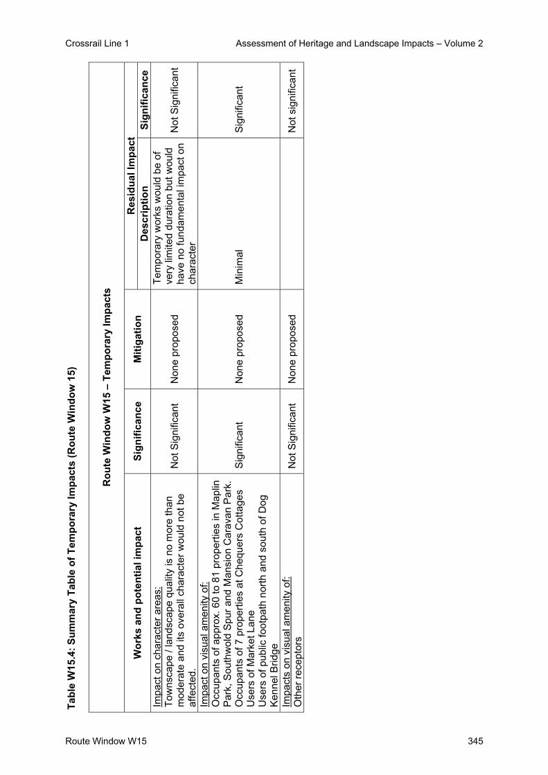
Crossrail Line 1 Assessment of Heritage and Landscape Impacts – Volume 2
Route Window W15 345
Tabl
e W
15.4
: Sum
mar
y Ta
ble
of T
empo
rary
Impa
cts
(Rou
te W
indo
w 1
5)
Rou
te W
indo
w W
15 –
Tem
pora
ry Im
pact
s
Res
idua
l Im
pact
W
orks
and
pot
entia
l im
pact
Si
gnifi
canc
e M
itiga
tion
Des
crip
tion
Sign
ifica
nce
Impa
ct o
n ch
arac
ter a
reas
: To
wns
cape
/ la
ndsc
ape
qual
ity is
no
mor
e th
an
mod
erat
e an
d its
ove
rall
char
acte
r wou
ld n
ot b
e af
fect
ed.
Not
Sig
nific
ant
Non
e pr
opos
ed
Tem
pora
ry w
orks
wou
ld b
e of
ve
ry li
mite
d du
ratio
n bu
t wou
ld
have
no
fund
amen
tal i
mpa
ct o
n ch
arac
ter
Not
Sig
nific
ant
Impa
ct o
n vi
sual
am
enity
of:
Occ
upan
ts o
f app
rox.
60
to 8
1 pr
oper
ties
in M
aplin
P
ark,
Sou
thw
old
Spu
r and
Man
sion
Car
avan
Par
k.
Occ
upan
ts o
f 7 p
rope
rties
at C
hequ
ers
Cot
tage
s U
sers
of M
arke
t Lan
e
Use
rs o
f pub
lic fo
otpa
th n
orth
and
sou
th o
f Dog
K
enne
l Brid
ge
Sig
nific
ant
Non
e pr
opos
ed
Min
imal
S
igni
fican
t
Impa
cts
on v
isua
l am
enity
of:
Oth
er re
cept
ors
Not
Sig
nific
ant
Non
e pr
opos
ed
N
ot s
igni
fican
t

Crossrail Line 1 Assessment of Heritage and Landscape Impacts – Volume 2
346 Route Window W15
Tabl
e W
15.5
: Sum
mar
y Ta
ble
of P
erm
anen
t Im
pact
s (R
oute
Win
dow
15)
R
oute
Win
dow
W15
– P
erm
anen
t Im
pact
s
Res
idua
l Im
pact
W
orks
and
pot
entia
l im
pact
Si
gnifi
canc
e M
itiga
tion
Des
crip
tion
Sign
ifica
nce
Impa
ct o
n ch
arac
ter a
reas
O
HLE
and
brid
ge /
emba
nkm
ent w
ork
Not
sig
nific
ant
Non
e re
quire
d In
crem
enta
l cha
nge
to ro
le o
f ra
ilway
infra
stru
ctur
e w
ill b
e m
inor
N
ot s
igni
fican
t
Impa
ct o
n vi
sual
am
enity
of b
ridge
and
em
bank
men
t wor
ks:
Occ
upan
ts o
f bet
wee
n 60
-70
resi
dent
ial
prop
ertie
s;
Occ
upan
ts a
t 7 p
rope
rties
at C
hequ
ers
Cot
tage
s U
sers
of D
og K
enne
l pub
lic fo
otpa
th
Use
rs o
f Mar
ket L
ane
Not
sig
nific
ant
Non
e re
quire
d N
one
Not
sig
nific
ant
Impa
ct o
n vi
sual
am
enity
of O
HLE
Wor
ks:
OH
LE im
pact
con
side
red
low
to m
oder
ate
to o
ccup
ants
of 1
05 re
side
ntia
l pro
perti
es a
t M
aplin
Par
k / S
outh
wol
d S
pur /
Che
quer
s C
otta
ges
/ Mar
ket L
ane
/ Man
sion
Car
avan
P
ark
and
Ric
hing
s P
ark
Not
sig
nific
ant
Non
e re
quire
d C
hara
cter
of v
iew
s w
ill n
ot
chan
ge in
am
enity
term
s N
ot s
igni
fican
t

Crossrail Line 1 Assessment of Heritage and Landscape Impacts – Volume 2
Route Window W15 347
6. Assumptions
- Assumed temporary work sites will be returned to their previous condition and use
- Substantial removal of line side vegetation to south side of the railway corridor will not be
necessary
- New embankment along the north side of the corridor will be landscaped using native
shrubs and some trees.
- It is proposed that 2.4 and 3.6 metre high hoarding would be used around the boundary
of the temporary works site to mitigate the demolition works and visual effects during the
construction stages.
The visual impact conclusion of the OHLE are based on the following assumptions:
- the railway is already prominent in the relevant views;
- the construction works will be of a very limited duration within each view;
- the permanent works (the OHLE columns and gantries) will represent a small incremental
change to the role of railway infrastructure within these views;
- the southern embankment slope which are partially vegetated will be retained and will
continue to provide a backdrop and / or screen; and
- the change in the character of views from nearby properties will therefore not affect their
contribution to visual amenity to a significant degree.

Crossrail Line 1 Assessment of Heritage and Landscape Impacts – Volume 2
348 Route Window W15
7. References
- ES Route Window W15
- Parliamentary Plan Sheets
- ES Scheme Description

Crossrail Line 1 Assessment of Heritage and Landscape Impacts – Volume 2
Route Window W14 349
Route Window W14 Iver Station


Crossrail Line 1 Assessment of Heritage and Landscape Impacts – Volume 2
Route Window W14 351
Contents 1. Description of the Works 353
1.1 Permanent Works 353 1.2 Temporary Works 354
2. Baseline Assessment 355 2.1 Local context 355 2.2 Listed Buildings and their settings 356 2.3 Conservation Areas 356 2.4 Townscape 356 2.5 Zone of Visual Influence 358 2.6 Sensitivity 360
3. Impact of the Scheme 364 3.1 Listed Buildings and their settings 364 3.2 Conservation Areas 364 3.3 Townscape 364 3.4 Visual impacts 366
4. Summary 370 4.1 Listed Buildings and their Setting 370 4.2 Conservation Areas 370 4.3 Townscape 370 4.4 Visual Impacts 370
5. Summary tables 371 6. Assumptions 374 7. References 375

Crossrail Line 1 Assessment of Heritage and Landscape Impacts – Volume 2
Route Window W14 352
Crossrail Line 1 Assessment of Heritage and Landscape Impacts – Volume 2
Route Window W14 353
Route Window W14 Iver Station 1. Description of the Works 1.1 Permanent Works
Iver Station
At Iver station, a new ticket office will be provided on the site of the existing facility. Platforms
two, three and four at Iver station will be extended eastwards by about 30 m to accommodate
Crossrail trains. Platform four will be converted to an island platform: its north side will be
reconstructed to create the new platform five; this will serve the new relief line (see route
windows W16 and W15), created at Iver station by upgrading the existing freight loop and
realigning it slightly northwards.
Thorney Lane Bridge
In order to accommodate the OHLE, Thorney Lane road bridge will be replaced with a new
steel structure immediately to its east,
OHLE
The permanent works will comprise the provision of overhead line equipment along the
Crossrail route.
In order to provide sufficient electromagnetic clearances between the OHLE and the existing
high voltage (HV) 132 kv cables above the railway, two 20 m high lattice masts will be
installed adjacent to the south side of the rail corridor to raise the HV cables. Only minimal
works will be undertaken at the existing pylons to enable re-stringing of the cables. These
works will take place over about six months.
A new feeder station (Iver feeder station) will be required to supply the main power to the
railway. This will be located at a strategic location adjacent to high voltage power supplies,
on the north side of the railway, adjacent to the Iver water treatment works, east of the M25.
The feeder station will comprise a unit of 17 m by 8 m.

Crossrail Line 1 Assessment of Heritage and Landscape Impacts – Volume 2
Route Window W14 354
1.2 Temporary Works
Iver Station
In total, works at the station, including the trackworks, will take about one year and seven
months to complete. Construction plant will include rail-mounted plant for track realignment,
excavators and other tracked vehicles, piling rigs, concrete pump, mobile cranes, generators
and vibrating compactors.
Works at the station will be undertaken from a site off the Thorney Lane access road to the
immediate north of the railway and northwest of the station. Materials will be taken to and
from the sites by road, from Thorney Lane. The worksite will be served by 30 lorries per day
during the five week peak construction period and typically by eight per day at other times.
Thorney Lane Bridge
The bridge will be constructed using piled foundations and pilecaps. The steel superstructure
will be delivered by road and assembled at the worksite and craned into position. Additional
steelwork will be installed and a concrete deck will then be laid. Thorney Lane South and
associated roads will be realigned and modified as necessary. This work will be undertaken
before the existing bridge is demolished. Vehicle access will be retained across the railway
throughout the construction period, except for short-term (weekend and overnight) closures
in association with the realignment of the road with the new bridge. Thorney Lane footbridge
will be retained and its parapets raised. These bridge works will take approximately one year
and three months to complete. They will require a variety of construction equipment including
a piling rig, cranes, excavators, and a lorry-mounted concrete pump.
The bridge works will be undertaken from three main worksites: one immediately south of the
railway and southeast of the existing bridge; one north of the railway and northeast of the
existing bridge; and one north of the railway and northwest of the existing bridge. Materials
will be taken to and from the sites by road, with vehicle access from the A4 London Road via
North Park Lane, Sutton Lane and Thorney Lane South, apart from limited periods when the
bridge is closed, when access to the northern worksites will be gained from the north.
Up to 40 lorries per day will access the two northern worksites for Thorney Lane bridge
during the five week construction peak, and around 24 lorries per day will access each site at
other times. Similar lorry numbers will occur for the southern worksite.

Crossrail Line 1 Assessment of Heritage and Landscape Impacts – Volume 2
Route Window W14 355
2. Baseline Assessment
2.1 Local context
In the immediate vicinity of Iver Station, the Crossrail route separates landscapes of
contrasting character.
To the north, beyond a private access road to the Bison Concrete Works Site, lies an area of
open land comprising rough grassland and scrub, which appears to occupy infilled gravel
workings. This area is bounded to the west by the Bison works, to the east by Thorney Lane
and to the north by the Grand Union Canal (Slough Arm). A high-voltage power line runs to
the north of the canal, beyond which lie the Ridgeway Trading Estate, and a further area of
open agricultural farmland and the village of Iver.
To the south of the station, the railway is adjoined by the built-up area of Richings Park. This
is a mainly residential area, with a range of local shops and services on Bathurst Walk. The
built form comprises detached and semi-detached two-storey dwellings typical of the 1920-
1940 period, together with two blocks of flats (two-storey Buckfield Court and four-storey
Wellesley Court).
Open agricultural farmland separates Richings Park from the built-up area of Langley on
Market Lane to the west, and from the M25 to the east. The M25 runs on embankment to
bridge over the railway. The floodplain of the Colne Brook lies to the east of the motorway,
characterised by a mix of land uses, including gravel workings, the Iver Water Treatment
works, the Thorney Park golf course and the small built up area of Thorney.
The Townscape Character Baseline Plan for Iver Station, Drawing No. 1E0416-WIE00-E00-
F-00014 identifies the locations of key buildings and landmarks in the local landscape /
townscape, local views, pedestrian and vehicular movement corridors, townscape character
areas, urban gateways / nodes and the landscape planning designations that relate to the
work sites and their surroundings. These baseline plans also illustrate the extent of the work
sites for both the temporary and permanent works.
Thorney Lane bridge is one of nine surviving Brunel bridges on the Western Route. They are
considered in detail in the Assessment of Archaeology Impacts – Technical Report.

Crossrail Line 1 Assessment of Heritage and Landscape Impacts – Volume 2
Route Window W14 356
View taken from Iver Station platform looking east.
2.2 Listed Buildings and their settings
There are no listed buildings within the approximate zone of visual influence of the works.
2.3 Conservation Areas
There are no Conservation Areas in the vicinity of the works.
2.4 Townscape
2.4.1 Character Areas and Landscape / Townscape Quality
The area comprises two character areas - Richings Park and the Thorney Gap/Colne Valley
– separated by the railway corridor and Thorney Lane.
Richings Park Character Area
The character of Richings Park is essentially that of a medium-density suburb, and is typical
of developments of the 1920 – 1940 period. Since it is largely surrounded by open land, it is
perceived as a discrete settlement in its own right. In townscape terms, Richings Park is an
area of moderate quality. Although it is not especially notable, it does not contain any
particular features that detract from its character.

Crossrail Line 1 Assessment of Heritage and Landscape Impacts – Volume 2
Route Window W14 357
Thorney Gap / Colne Valley Character Area
The Thorney Gap comprises the open land that lies between the railway and the canal to the
north, and between Thorney Lane and the M25 to the east. The motorway separates it from
the Colne Valley, with which it shares a number of characteristics. Both of these areas
comprise fragmented countryside partly disturbed by gravel working and influenced visually
by nearby built-up areas and transport infrastructure.
The Thorney Gap is generally of low landscape quality, due to its lack of internal structure
and its neglected appearance. However, it fulfils an important local role by separating
Richings Park from the Ridgeway Trading Estate to the north and from the M25 to the east.
The Colne Valley is of higher quality, due to the opportunity for water views provided by
flooded gravel pits, and the presence of mature trees (typically willows marking the various
channels of the River Colne). The area to the north of the railway comprises the Iver Water
Treatment Works and a number of business uses. The area to the south comprises the
Thorney Park Golf Course, and several smallholdings and businesses.
2.4.2 Key Townscape / Landscape Features and Resources
There are no built features of particular merit in the vicinity of the station. Features that are
distinctive or locally prominent comprise a number of cranes at the Bison works, overhead
pylons to the north of the Grand Union Canal and the M25 bridge/embankment to the east.
In addition, the existing footbridge and Thorney Lane bridge are prominent in the immediate
context of the station.
Vegetation is the most important landscape feature in the area in qualitative terms. The most
notable vegetation comprises:
- a line of mature trees (mainly aspen) along the canal;
- scrub of varying density on the open land;
- dense scrub and semi-mature trees along the southern side of the railway cutting;
- hedgerows along much of Thorney Lane;
- immature woodland planting and several mature cypresses between the railway and the
access road to the Iver water Treatment Works;
- ornamental planting in Richings Park (street trees, mature conifer hedges etc);
- dense immature treebelts along the M25; and

Crossrail Line 1 Assessment of Heritage and Landscape Impacts – Volume 2
Route Window W14 358
- mature trees and scrub in parts of the Colne Valley.
2.4.3 Strategic Views and Key Local Views
There are no strategic views in the vicinity of the site. No local views are considered to
qualify as key views.
2.4.4 Pedestrian / Vehicular Movement Corridors
Key vehicular movement corridors in the area comprise Thorney Lane, the M25 and the local
residential roads within Richings Park. Thorney Lane is essentially an upgraded lane that
carries relatively heavy but mainly local traffic. The lane crosses the area at grade, but rises
slightly to pass over Thorney Lane Bridge. Viewing opportunities from the lane are
constrained to varying degrees by hedgerows.
A footpath/minor road runs to the south of the railway between Thorney Lane and Wellesley
Avenue, providing access to the station. A footpath follows the western side of Thorney
Lane and is carried over the railway on a separate footbridge. The canal towpath is also a
public right of way, connecting east of the M25 with the Colne Valley Way.
2.4.5 Landscape Planning Designations
The Thorney Gap/Colne Valley are designated as Metropolitan Green Belt, and some of the
works will take place within this area. The Green Belt in this area includes features such as
the M25, a concrete works, the water treatment works and high-voltage power lines.
2.5 Zone of Visual Influence
The approximate Zone of Visual Influence (ZVI) for the work sites is determined by the
following influences:
- The relationship of the railway to the surrounding area;
- The general character and arrangement of land uses;
- The proximity, scale and use of nearby buildings;
- The size and type of nearby vegetation; and
- The degree of enclosure of nearby pedestrian and vehicular routes.

Crossrail Line 1 Assessment of Heritage and Landscape Impacts – Volume 2
Route Window W14 359
The railway occupies a shallow (up to about 5m deep) cutting in the vicinity of the station. To
the east, after passing beneath Thorney Lane and the M25, the railway runs onto
embankment to cross the Colne Brook.
The built-up area of Richings Park provides viewing opportunities from nearby buildings,
whilst screening views from locations further west and south. The presence of open land to
the east and north offers theoretical viewing opportunities as far as the canal and the M25
respectively.
The station buildings are single-storey, small-scale and have little influence on views. The
residential buildings of Richings Park are of sufficient scale to screen most ground-level
views, whilst providing viewing opportunities from upper floors. These buildings effectively
define the ZVI to the and west of Thorney Lane and south of the station.
The northern extent of the ZVI for the station is defined by the vegetation along the Bison
works access road in the summer, and probably by the treebelt and industrial estate adjacent
to the Great Union Canal to the north of this in winter.
Hedgerows along Thorney Lane, together with vegetation within the railway corridor and in
the vicinity of the bridge, partly define the eastern extent of the ZVI for the station works in
summer. A hedgerow and associated vegetation along Thorney Lane largely defines the
southern extent of the ZVI for the bridge works in summer.
In winter, buildings within Richings Park largely define the southern extent of the ZVI for the
station and the south-western extent of the ZVI for the bridge. Evergreen vegetation is
locally important, notably a row of semi-mature cypress along the rear boundary of gardens
in Bathurst Walk, to the east of the station.
The M25 embankment/bridge, reinforced by dense woodland planting, defines the eastern
extent of the ZVI for both the station and the bridge works.
The main potential sources of views of the station work sites may be summarised as follows:
- Residential properties (mainly upper floors), some gardens and some sections of streets
and footpaths (Wellesley Avenue/Bathurst Walk) in Richings Park.
- The private road to the north of the station and the pedestrian route/station access road
to the south;

Crossrail Line 1 Assessment of Heritage and Landscape Impacts – Volume 2
Route Window W14 360
- The footbridge adjoining Thorney Lane bridge (and possible glimpses from the bridge
itself); and
- The station platforms and passing/stationary trains.
The main potential sources of views of the Thorney Lane bridge work sites may be
summarised as follows:
- The adjoining and approaching sections of Thorney Lane (and footpath);
- The eastern part of Bathurst Walk (southern work site only);
- Residential properties in Thorney Lane and the eastern part of Bathurst Walk;
- Possible glimpses from the M25 ; and
- Passing trains and the station platforms.
To the east of the M25, views are defined by features such as the railway embankment and
the buildings of the water treatment works, and by mature vegetation, mainly along the
watercourses. Relatively unobstructed views are gained across open areas such as the
Thorney Park Golf Course.
The main potential sources of views of the 132kV cable raising works will comprise:
- The water treatment works, the industrial premises to the north, and the access road;
- The Thorney Park Golf Course;
- Other parts of the Colne Valley accessible for recreation;
- Possible glimpses from the M25 and the Thorney Mill Road overbridge;
- Residential properties in Millside Court and Thorney. and one or two properties east of
the Colne Brook (e.g. Thorney Weir House).
2.6 Sensitivity
2.6.1 Sensitivity of Townscape / Landscape to Change
The surrounding townscape/landscape is generally of low to medium sensitivity to change.
The work sites for both the station and the bridge are located within the Thorney Gap
character area. The work sites for the pylons are located within the Colne Valley.

Crossrail Line 1 Assessment of Heritage and Landscape Impacts – Volume 2
Route Window W14 361
Although these areas are largely open, their character is strongly influenced by vegetation
and by features such as the Bison works, the water treatment works and the M25. They form
part of the wider pattern of modified rural landscapes characteristic of the Green Belt, and
are considered to be of medium sensitivity to the scale of proposed change.
The station and Thorney Lane are located on the edge of the Richings Park character area.
As a built-up area, this is of relatively low sensitivity to the scale of proposed change.
2.6.2 Sensitivity of Visual Receptors to Change
Table W14.1: Visual Amenity Receptors (Iver Station, Thorney Lane Bridge and Pylon
Works) below identifies the key visual receptors which would obtain views of the proposed
works, together with their sensitivity, the type of views and whether the views are of the
temporary or permanent works.
Table W14.1: Visual Amenity Receptors for the Iver Station, Thorney Lane Bridge and Utility Diversion Works
Receptor
(Close Views under 1km distance)
Type of View
Dire
ct V
iew
Obl
ique
Vi
ew
Tem
pora
ry
Wor
k Si
tes
Perm
anen
t W
orks
Sensitivity of
Receptors
Iver Station
1
Occupants of approx. 20 residential properties in Bathurst Walk (between Nos. 27-79)
Upper level High
2 Occupants of approx. 10 flats in Buckfield Court
Upper level High
3
Occupants of potentially 5 residential flats above Nos. 1-7 Wellesley Avenue
Upper level High
4 Occupants of potentially 10 flats in Wellesley Court
Upper levels High
5 Users of the private access road north of the station
Ground level Low
6 Users of the station Mixed Moderate
7 Users of the footpath/access road south of the station
Ground level
Thorney Lane Bridge
8 Occupants of approx. 10-20 residential properties in Thorney Lane/Bathurst
Mainly upper floors
High

Crossrail Line 1 Assessment of Heritage and Landscape Impacts – Volume 2
Route Window W14 362
Receptor
(Close Views under 1km distance)
Type of View
Dire
ct V
iew
Obl
ique
Vi
ew
Tem
pora
ry
Wor
k Si
tes
Perm
anen
t W
orks
Sensitivity of
Receptors
Walk
9 Drivers and passengers on Thorney Lane
Ground level Moderate
10 Pedestrians on Thorney Lane
Ground level Moderate
11 Users of the footpath/access road south of the station
Ground level Moderate
12 Users of the station Ground level Moderate
13 Users of the Water Treatment Works access road
Ground Level Low
14 Users of the M25 Ground level Moderate
Utility Works
15 Users of M25 + Thorney Mill Road
Ground level Moderate
16 Employees at water treatment works + nearby businesses
Ground level Low
17 Users of Thorney Park Golf Course and other parts of Colne Valley
Ground level Moderate
18 Occupants of residential properties in Millside Court
Ground level + first floor
High
19 Occupants of residential properties in Thorney + east of Colne Brook
Upper floors High
The main receptors surrounding the work sites are as follows:
- Occupants of potentially 40-75 residential properties in Richings Park, of which the
greater number (between 40-50) would experience views of the station works only;
- Occupants of potentially 10 properties in Millside Court, who will experience direct and
largely unobstructed views of the (southern) pylon works, and of potentially 5 additional
properties in the Colne Valley;
- Users of Thorney Lane (drivers, passengers and pedestrians), who will mainly
experience views of the bridge works;

Crossrail Line 1 Assessment of Heritage and Landscape Impacts – Volume 2
Route Window W14 363
- Users of the footpath/access road south of the station, and of the private access road
north of the station, who are likely to experience views of both sets of works;
- Users of the station, who will also experience views of both sets of works;
- Users of the M25, who may have glimpses of both the bridge and pylon works;
- Employees of the water treatment plant and nearby businesses, who will have views of
the 132kV OHL cable raising works; and
- Users of the Thorney Park Golf Course, and potentially of other parts of the Colne Valley,
who will have views of the 132kV OHL cable raising works.
Local residents will be the most sensitive group of receptors. It should be noted that some
receptors may experience recurrent views of the works (e.g. from their homes, when they
use the station and/or when they drive/walk along Thorney Lane).
In several cases, potential views of the works are likely to be screened by vegetation, and
will be experienced mainly during the winter. For example, northward views from properties
in Bathurst Walk and north-eastward views from properties in Thorney Lane (prior to removal
of the hedgerow).

Crossrail Line 1 Assessment of Heritage and Landscape Impacts – Volume 2
Route Window W14 364
3. Impact of the Scheme
3.1 Listed Buildings and their settings
There are no impacts on listed buildings or their setting in this route window.
3.2 Conservation Areas
There are no impacts on Conservation Areas in this route window.
3.3 Townscape
The works at the station would require the removal of vegetation along the northern side of
the existing cutting, adjacent to the Bison access road and on the site of the compound.
The work associated with the bridge and the realignment of Thorney Lane would require the
removal of the following vegetation:
- scrub and semi-mature trees within the railway corridor at the location of the new bridge;
- immature mixed planting and a group of mature cypress in the triangle of land between
the railway and the Iver Water Treatment Works access road; and
- two sections of hedgerow along the eastern side of Thorney Lane.
Structures to be demolished would comprise part of the station platforms, and the existing
Thorney Lane road and pedestrian bridges.
Temporary work sites will be landscaped and restored to their previous condition. It is
therefore assumed that the temporary works site for the station and the southern temporary
work site for the bridge will be restored to grassland use, whilst the northern temporary work
site for the bridge will be replanted as woodland.
The works associated with the 132kV OHL cables will be confined to the area immediately to
the north around two existing pylons, adjoining the rail corridor together with an area to the
north of a pond within the golf course. It is unlikely that any significant vegetation will be
removed during the course of these works.

Crossrail Line 1 Assessment of Heritage and Landscape Impacts – Volume 2
Route Window W14 365
The construction works would have two main impacts on landscape character: removal of
vegetation and the temporary presence of construction plant and associated features.
The vegetation to be removed for the station works comprises low-density scrub, which is not
visually significant.
The vegetation to be removed for the bridge works is more significant in terms of its extent,
its scale and its visibility (since much of it adjoins Thorney Lane). Although this vegetation is
relatively prominent, its visual influence is highly localised, and it is not a major influence on
the overall character of the area. In addition, it is assumed that woodland planting would be
reinstated on the undeveloped area to the north of the bridge.
Vegetation loss would have a minor impact on the Thorney Gap/Colne Valley character area
and on the setting of the Richings Park character area. These impacts are not considered to
be significant.
Some of the construction features themselves will be relatively prominent, e.g. piling rigs,
mobile cranes, portacabins. However, they will be present for a limited period and will have
no long-term impact on landscape character. Their effect is therefore not considered to be
significant.
Most of the permanent works at the station will be located at track and platform level, and
their visual influence will scarcely extend beyond the station and cutting. The main exception
will be the emergency escape footbridge, which will be visible above the natural ground level
on either side. This structure, however, will be seen within the context of other railway
infrastructure, including the existing footbridge, and will not be especially prominent. It will
have no more than a minor effect on the Thorney Gap and Richings Park character areas.
This effect is not considered to be significant.
The new Thorney Lane bridge will be more prominent than the existing bridge, since its
horizontal alignment will be higher, it will require larger-scale earthworks and it will
necessitate the removal of vegetation. It will be most visible from Thorney Lane itself, from
nearby properties and from the station platforms. In addition, the new bridge will adopt a
very different design aesthetic to the current structure.

Crossrail Line 1 Assessment of Heritage and Landscape Impacts – Volume 2
Route Window W14 366
However, since the existing bridge is to be demolished, the works essentially represent a
like-for-like replacement in landscape terms. The design aesthetic of the new bridge will
resemble that of the existing M25 bridge in many respects, whilst remaining subordinate to it.
As a result, the impact on landscape character will be no more than moderate, and will not
amount to a significant change.
The 132kV OHL cable raising works including the introduction of a new “support” tower
adjacent to the railway not dissimilar to the existing pylons, within a setting that is already
influenced by other nearby pylons, the concrete works and the M25. The effect on the
landscape character of the area is therefore not considered to be significant.
3.4 Visual impacts
The Visual Appraisal Plan for the Iver Station and Thorney Lane Bridge, Drawing No.
1E0316-WIE00-E00-F-00014 illustrates the approximate Zone of Visual Influence for both
the proposed temporary and permanent works. It also identifies the principal locations from
which views of the development would be obtained.
The visual impact of the construction works must take account of the relatively limited period
during which they will occur. In addition, nearby receptors will to a certain degree be tolerant
of activities carried out in the normal course of railway maintenance and improvement.
The magnitude of visual impact that would be generated by the temporary works on each
receptor group is identified in Table W14.2: Potential Temporary Impacts on Receptors (Iver
Station, Thorney Lane Bridge and Pylon Works).Table W14.2 :- Potential Temporary Impacts
on Receptors (Iver Station, Thorney Lane Bridge and Utility Works)

Crossrail Line 1 Assessment of Heritage and Landscape Impacts – Volume 2
Route Window W14 367
Table W14.2: Potential Temporary Impacts on Receptors
Receptor
(Close Views under 1km distance)
Sensitivity of
Receptors
Magnitude of Potential Impact on Receptors
Significance
Iver Station 1 Occupants of between 40-50
residential properties in Bathurst Walk, Buckfield Court, Wellesley Avenue and Wellesley Court
High Moderate SIG (-)
2 Users of the private access road north of the station Low Moderate NSIG
3 Users of the station Low High NSIG 4 Users of the footpath/access
road south of the station Moderate Low NSIG
Thorney Lane Bridge 1 Occupants of approx. 25
residential properties in Thorney Lane
High Moderate/High SIG (-)
2 Drivers and passengers on Thorney Lane
Moderate High SIG (-)
3 Pedestrians on Thorney Lane Moderate High SIG (-) 4 Users of the Bison + Water
Treatment Works access roads Low Moderate NSIG
5 Users of the footpath/access road south of the station
Moderate Minor NSIG
6 Users of the station Low Moderate NSIG 7 Users of the M25 Moderate Low NSIG Utility Works 1 Users of M25 + Thorney Mill
Lane Medium Low NSIG
2 Employees at water treatment works
Low Moderate NSIG
3 Employees of nearby businesses
Low Low NSIG
4 Users of Thorney Park Golf Course
Medium High NSIG
5 Other recreational users of Colne Valley
Medium Low NSIG
6 Occupants of 10 residential properties in Millside Court
High Low NSIG
7 Occupants of 5 additional residential properties
High Low NSIG
If the station and bridge works take place at the same time, users of the private access road
north of the station, of the footpath/access road south of the station and of the station itself
would be affected by both sets of works.

Crossrail Line 1 Assessment of Heritage and Landscape Impacts – Volume 2
Route Window W14 368
Temporary significant effects would be experienced by up to 50 residential properties
overlooking the station works, a further 25 properties overlooking the bridge and road works
along Thorney Lane.
Whilst 10 properties have views across the golf course towards the 132kV OHL cable raising
works, the works occur within the rail corridor, are minor in nature and of short duration. The
effect is not considered to be significant.
The magnitude of visual impact that would be generated by the permanent works on each
group of receptors is identified in Table W14.3: Potential Permanent Impacts on Receptors
(Iver Station, Thorney Lane Bridge and Pylon Works).
Table W14.3: Potential Permanent Impacts on Receptors (Iver Station, Thorney Lane Bridge and Pylon Works)
Receptor
(Close Views under 1km distance)
Sensitivity of
Receptors
Magnitude of Potential Impact on Receptors
Significance
Iver Station
1
Occupants of between 40-50 residential properties in Bathurst Walk, Buckfield Court, Wellesley Avenue and Wellesley Court
High Low NSIG
2 Users of the private access road north of the station Low Low NSIG
3 Users of the station Medium Low NSIG
4 Users of the footpath/access road south of the station Medium Low NSIG
Thorney Lane Bridge
1 Occupants of approx. 15 residential properties in Thorney Lane/Bathurst Walk
High Low NSIG
2 Drivers and passengers on Thorney Lane Medium Low NSIG
3 Pedestrians on Thorney Lane Medium Low NSIG
4 Users of the Bison + Water Treatment Works access roads Moderate Low NSIG
5 Users of the footpath/access road south of the station Moderate Low NSIG
6 Users of the station Moderate Low NSIG 7 Users of the M25 Moderate Low NSIG Utility Works
1 Users of M25 + Thorney Mill Lane Moderate Low NSIG
2 Employees at water treatment works Low Low NSIG

Crossrail Line 1 Assessment of Heritage and Landscape Impacts – Volume 2
Route Window W14 369
Receptor
(Close Views under 1km distance)
Sensitivity of
Receptors
Magnitude of Potential Impact on Receptors
Significance
3 Employees of nearby businesses Low Low NSIG
4 Users of Thorney Park Golf Course Moderate Low NSIG
5 Other recreational users of Colne Valley Moderate Low NSIG
6 Occupants of 10 residential properties in Millside Court High Low NSIG
7 Occupants of 5 additional residential properties High Low NSIG
Users of the access road to the north of the station, the footpath/access road to the south of
the station and on the station itself would be affected by the permanent features of both
works. The cumulative effect, however, would not be significant.
The impacts of the permanent works are not considered to be significant. Although residents
who overlook the station area from the south are assumed to be highly sensitive to visual
change, many of these views are screened to varying degrees by vegetation, are already
influenced by railway infrastructure and will be obtained form upper floors only.
Occupants of about 15 residential properties in Thorney Lane are likely to experience views
of the realigned road. Although the depth of these views will be opened up by removal of the
hedgerow, this change will be mainly apparent in summer, and their character will not
change fundamentally. The realignment of Thorney Lane will move traffic further away from
these receptors, which may be regarded as a benefit in visual amenity terms.
The new masts/pylons will not have a fundamental impact on the character of views from
nearby receptors, and the impacts are not considered to be significant.
The Year 1 predicted impacts are not considered to be significant for the reasons given
above. After Year 15 of completion of the works there will be no changes to the townscape
and visual impact.

Crossrail Line 1 Assessment of Heritage and Landscape Impacts – Volume 2
Route Window W14 370
4. Summary
4.1 Listed Buildings and their Setting
There will be no impacts on listed buildings or their setting in this route window.
4.2 Conservation Areas
There will be no impacts on Conservation Areas in this route window.
4.3 Townscape
During the construction phase, impacts on landscape / townscape would not be significant.
Loss of vegetation due to the bridge works would be noticeable, but would not affect the
overall character of the area. It is assumed that vegetation would be reinstated on the
temporary work site to the north of the bridge.
The landscape / townscape impact of the permanent features of the works would be
insufficient to represent a fundamental change to the character of the area, and would not be
significant. The new Thorney Lane bridge, for example, would replace the existing structure,
and would be visually subservient to the M25 bridge.
4.4 Visual Impacts
Temporary significant temporary visual impacts would be experienced by the occupants of
between 40 to 75 residential properties and by users of Thorney Lane.
Permanent impacts on visual amenity are not considered to be significant. Although impacts
will be experienced by the occupants of between 40-65 residential properties overlooking the
railway corridor or Thorney Lane, the character of their views will not change fundamentally

Crossrail Line 1 Assessment of Heritage and Landscape Impacts – Volume 2
Route Window W14 371
5. Summary tables
There are no significant impacts on listed buildings, the setting of listed buildings or
conservation areas in this route window, hence these are not included in the summary
tables.
Predicted impacts on landscape / townscape character and visual amenity are summarised
in Table W14.4: Summary Table of Temporary Impacts and Table W14.5: Summary Table of
Permanent Impacts, including any committed mitigation and residual impacts.

Crossrail Line 1 Assessment of Heritage and Landscape Impacts – Volume 2
372 Route Window W14
Tabl
e W
14.4
: Sum
mar
y Ta
ble
of T
empo
rary
Impa
cts
(Rou
te W
indo
w W
14)
R
oute
Win
dow
W14
– T
empo
rary
Impa
cts
R
esid
ual I
mpa
ct
Wor
ks a
nd p
oten
tial i
mpa
ct
Sign
ifica
nce
Miti
gatio
n D
escr
iptio
n Si
gnifi
canc
e
Impa
ct o
n ch
arac
ter a
reas
: To
wns
cape
/land
scap
e qu
ality
is n
o m
ore
than
mod
erat
e an
d its
ove
rall
char
acte
r wou
ld n
ot b
e af
fect
ed.
Not
Sig
nific
ant
Res
tora
tion
of
woo
dlan
d pl
antin
g on
no
rther
n br
idge
w
ork
site
.
Non
e N
ot S
igni
fican
t
Impa
ct o
n vi
sual
am
enity
of:
Occ
upan
ts o
f up
to 5
0 pr
oper
ties
in B
athu
rst
Wal
k/W
elle
sley
Ave
nue,
25
prop
ertie
s in
Tho
rney
Lan
e,
user
s of
Tho
rney
Lan
e.
Sig
nific
ant
Hoa
rdin
g ar
ound
w
ork
site
s
Non
e: s
igni
fican
ce o
f im
pact
w
ill c
ease
whe
n co
nstru
ctio
n is
com
plet
e.
Sig
nific
ant
Impa
ct o
n vi
sual
am
enity
of:
All
othe
r rec
epto
rs
Not
Sig
nific
ant
A
s ab
ove
Not
Sig
nific
ant

Crossrail Line 1 Assessment of Heritage and Landscape Impacts – Volume 2
Route Window W14 373
Tabl
e W
14.5
: Sum
mar
y Ta
ble
of P
erm
anen
t Im
pact
s (R
oute
Win
dow
W14
)
R
oute
Win
dow
W14
– P
erm
anen
t Im
pact
s
Res
idua
l Im
pact
W
orks
and
pot
entia
l im
pact
Si
gnifi
canc
e M
itiga
tion
Des
crip
tion
Sign
ifica
nce
Impa
ct o
n ch
arac
ter a
reas
S
light
incr
ease
in v
isua
l inf
luen
ce o
f rai
lway
in
frast
ruct
ure,
but
will
not
affe
ct o
vera
ll ch
arac
ter o
f are
a.
Not
Sig
nific
ant
Non
e pr
opos
ed
Intro
duct
ion
of n
ew ra
ilway
in
frast
ruct
ure.
N
ot S
igni
fican
t
Impa
ct o
n vi
sual
am
enity
of:
Occ
upan
ts o
f bet
wee
n 40
-65
resi
dent
ial
prop
ertie
s; u
sers
of T
horn
ey L
ane,
sta
tion
foot
path
, acc
ess
road
s an
d th
e st
atio
n.
Not
Sig
nific
ant
Non
e pr
opos
ed
Incr
ease
in v
isib
ility
of
infra
stru
ctur
e, b
ut c
hara
cter
of
view
s, +
hen
ce th
e am
enity
of
rece
ptor
s, w
ill n
ot c
hang
e fu
ndam
enta
lly.
Not
Sig
nific
ant
Impa
ct o
n vi
sual
am
enity
of:
All
othe
r rec
epto
rs.
Not
Sig
nific
ant
Non
e pr
opos
ed
N
ot S
igni
fican
t

Crossrail Line 1 Assessment of Heritage and Landscape Impacts - Volume 2
374 Route Window W14
6. Assumptions
- The temporary works sites for the station and bridge will be landscaped and restored to
their previous condition as the works are completed
- The station works and new Thorney Lane bridge works will occur during the same
construction period
- 2.4 and 3.6 metre high timber hoarding around boundary of temporary work sites.

Crossrail Line 1 Assessment of Heritage and Landscape Impacts - Volume 2
Route Window W14 375
7. References
- ES Route Window W14
- Parliamentary Plan Sheets
- ES Scheme Description

Crossrail Line 1 Assessment of Heritage and Landscape Impacts - Volume 2
376 Route Window W14

Crossrail Line 1 Assessment of Heritage and Landscape Impacts – Volume 2
Route Window W13 377
Route Window W13 West Drayton Station and Stabling

Crossrail Line 1 Assessment of Heritage and Landscape Impacts – Volume 2
Route Window W13 379
Contents 1. Description of the Works 381
1.1 Permanent Works 381 1.2 Temporary Works 382
2. Baseline Assessment 385 2.1 Local context 385 2.2 Listed Buildings and their setting 386 2.3 Conservation Areas 386 2.4 Townscape 387 2.5 Zone of Visual Influence 390 2.6 Sensitivity 392
3. Impact of the Scheme 396 3.1 Listed Buildings and their Setting 396 3.2 Conservation Areas 397 3.3 Landscape / Townscape 397 3.4 Visual impacts 400
4. Summary 405 4.1 Listed Buildings and their Setting 405 4.2 Conservation Areas 405 4.3 Landscape / Townscape 405 4.4 Visual Impact 406
5. Summary tables 407 6. Assumptions 411 7. References 412

Crossrail Line 1 Assessment of Heritage and Landscape Impacts – Volume 2
380 Route Window W13

Crossrail Line 1 Assessment of Heritage and Landscape Impacts – Volume 2
Route Window W13 381
Route Window W13 West Drayton Station and Sidings 1. Description of the Works 1.1 Permanent Works
West Drayton Stabling Sidings
A new stabling facility will be constructed on the site of the former West Drayton coal
concentration depot, west of the station. The facility will comprise 22 sidings with low height
lighting, train washing facilities and staff accommodation buildings. The sidings will require
the removal of light industrial units, the provision of a new bridge over the Frays River and
the realignment of an access road.
West Drayton Station
Various track and platform works will be required at West Drayton station. Platform four will
be lengthened at the eastern end by 62 m to accommodate Crossrail trains. The curvature of
the goods line behind platform four will be adjusted to allow for the provision of a new face to
platform five. Its junction at the eastern end of the station will be moved eastwards by
approximately 100 m. Platform three will be extended eastwards by 65 m.
A new ticket hall will be constructed east of the existing facility at the station. A new
footbridge will be provided with lift access to the platforms. The existing ticket hall will be
converted to commercial use. The existing subway will remain open to provide public access
between the station ticket hall and the residential area to the south, with the stairs to the
platforms blocked up.
Signalling and Overhead Line Equipment
New and modified signalling will be required for the stabling and station. Overhead line
equipment will be installed on all five tracks at the station, on the stabling sidings and along
all of the alignment in this route window, except for the Colnbrook branch.

Crossrail Line 1 Assessment of Heritage and Landscape Impacts – Volume 2
382 Route Window W13
1.2 Temporary Works
Construction - West Drayton Stabling Sidings
Subject to possession planning requirements and excluding final commissioning, the
construction of the new sidings and the new turnouts will take place over a total period of
approximately one year and six months.
Enabling works will include the diversion of utilities and services. The principal demolitions
required at the stabling sidings will include light industrial units, a weighbridge house and
some minor buildings.
One element of these enabling works will be the diversion of the Colne Valley trunk sewer.
The existing sewer runs across the proposed worksite, and new railway tracks will be located
over an access manhole to this sewer. The sewer will be diverted so that the manhole
access, the position of which is critical, will be accessible. These works will require additional
cranes and tunneling equipment and will be undertaken from their own designated worksite.
The main stages of construction at the stabling sidings are described below.
- Construction of the new access road including a new bridge over the Frays River within
the depot area, and a new level crossing over the Colnbrook branch.
- Foundation works on the sidings site, together with the removal of the existing sidings
and structures and the provision of new sidings and trackwork.
- Construction of the new carriage washing facility, depot buildings and car parking.
- Construction of access platforms for train cleaning staff.
- Provision of lighting and fencing.
- Re-signalling and electrification works.
Plant and equipment required at the stablings worksite will include a mobile crane, a rail-
mounted crane, poker vibrators, a piling rig, excavators, compressors, rollers and generators.

Crossrail Line 1 Assessment of Heritage and Landscape Impacts – Volume 2
Route Window W13 383
Works will be undertaken from the existing coal yard, located within the sidings, towards its
eastern corner. Although most of the materials will be transported to and from the site by
road, using access via Tavistock Road, ballast and trackwork will be delivered by rail. The
worksite will be served by 68 lorries per day during the 19 week peak construction period and
typically by 44 per day at other times.
Construction - West Drayton Station
Subject to possession planning requirements and excluding final commissioning, the
construction of the platform extensions, new overbridge and trackworks will take place over a
total period of approximately 20 months. The construction of the new ticket hall will take
about one year and five months to complete.
Enabling works will include the diversion of utilities and services. The principal demolitions
required at the station will include a single-storey building and some shed structures between
the railway and canal, as well as the wall alongside the eastbound goods line.
The main stages of construction at the station are described below.
- Extension of the westbound relief platform (platform three).
- On completion of this, works will commence to the eastbound relief/reversible platform
and the new overbridge, involving demolition of the front wall of the existing platform four
and provision of foundations for platform four/five and footbridge. The eastbound goods
line will be realigned and redesignated as the eastbound relief line as part of the Langley-
West Drayton loop scheme. These works will take approximately two months to
complete.
- Construction of new front walls of the new eastbound relief/reversible platform (platform
four/five).
- Construction of the new station building. The new station will consist of a steel-framed
construction with slabs formed from in-situ or pre-cast concrete. The substructure will be
piled. The construction of the new station building will take approximately eight months to
complete. The conversion to non-operational use of the existing ticket hall will take about
five weeks to complete.
- Installation of the new footbridge, stairs and lifts. On completion of these works the bridge
will be opened and the platform accesses from the subway will be closed.

Crossrail Line 1 Assessment of Heritage and Landscape Impacts – Volume 2
384 Route Window W13
- The steps of the subway will be closed off leaving the subway as an access beneath the
tracks. At the same time the reversible line (formerly the eastbound relief line) will be
tamped to its design alignment, coping stones will be fixed and the platform surfacing will
be completed. These works will take approximately one month to complete.
- Provision of platform furniture, drainage and lighting. The full face of the new reversible
platform face will then be opened.
- On completion of these works, the demolition of the western end of the platform and the
construction of the new ramps and final section of the eastbound relief platform face will
begin. These works will take approximately a month and half to complete.
- Following this, the formation of the new eastbound relief line will be prepared and ballast
and track will be laid and tamped to design alignment. The coping stones and platform
surfacing will then be set out and fixed to the new platform.
Construction plant required at the station worksite will include a mobile crane, a rail-mounted
crane, poker vibrators, lighting rigs for night work, a piling rig, excavators, compressors,
rollers and generators.
Works will be undertaken from the area of land located between the existing railway and the
canal known as West Drayton Station to Horton Bridge worksite (see also Route Window
W12). The majority of materials will be taken to and from the site by road, although some
ballast and track components may be delivered by rail. Access will be from Station Approach.
The worksite will be served by 60 lorries per day during the five-week peak construction
period and typically by eight per day at other times.

Crossrail Line 1 Assessment of Heritage and Landscape Impacts – Volume 2
Route Window W13 385
2. Baseline Assessment
2.1 Local context
West Drayton Station lies within an entirely urban setting, between the built-up areas of
Yiewsley to the north and West Drayton to the south. These areas form a wedge of
development that extends southwards to the M4 and is bounded to the west by the Colne
valley and to the east by open land (golf courses, business parks etc) along the A408
corridor.
To the east of the station, the Grand Union Canal runs parallel with the railway, before
turning northwards to pass beneath High Street and follow the Colne Valley.
The station adjoins the town centre of West Drayton/Yiewsley, which comprises a range of
typical retail and service activities extending southwards along Station Road and northwards
along High Street. Buildings are typically 2/3 storey, with some later developments of 4/5
storey offices and flats immediately to the north of the station (Ashley Court, Station House).
The commercial core is adjoined partly by industrial and business premises (in Tavistock
Road, Horton Road and occupying the strip of land between the railway and canal).
Industrial uses also extend to the north-west, between High Street and the canal, and
eastwards along Horton Road to the modern Stockley Park business campus.
Residential areas to the north of the railway comprise modern townhouses in Knowles
Close/Roberts Close, low-rise housing dating from 1950-60 in Colham Avenue (off Horton
Road) and housing dating from 1900-1950 off Tavistock Road.
Residential areas south of the railway comprise terraced and semi-detached housing dating
from 1900-40 in Warwick Road/Brandville Road and to the south-west of Station Road,
modern housing in Colham Mill Road and at the eastern end of Warwick Road, and housing
dating from 1920-40 west of Fay’s River (Fairway Avenue / Lawn avenue etc).

Crossrail Line 1 Assessment of Heritage and Landscape Impacts – Volume 2
386 Route Window W13
The site of the West Drayton stabling sidings is currently occupied by a coal depot and other
open storage use. It is bounded to the south by the Great Western Main Line (GWML) and
to the north partly by Fray’s River (a branch of the River Colne) and partly by the Poyle
branch line.
The floodplain of the River Colne extends to the north and west, and comprises mainly open
land occupied by gravel workings and typical urban fringe smallholdings and businesses.
The area beyond the railway to the south is residential (the 1920-40 housing of Fairway
Avenue/Lawn Avenue). Residential uses also predominate to the north-east in the form of
modern 2/3 storey flats (Merrivale Mews) and streets of older housing beyond Tavistock
Road.
The Townscape Character Baseline Plan for West Drayton, Drawing No. 1E0416-W1E00-
E00-F-00013, identifies the locations of key buildings and landmarks in the local landscape /
townscape, local views, pedestrian and vehicular movement corridors, townscape character
areas, urban gateways / nodes and the landscape planning designations that relate to the
work sites and their surroundings. These baseline plans also illustrate the extent of the work
sites for both the temporary and permanent works.
2.2 Listed Buildings and their setting
The De Burgh Arms and Railway Arms, which lie to the north and south respectively of the
railway bridge, are Grade II listed buildings. The former is externally of 19th century date,
with a distinctive veranda frontage, but may be older internally. The latter is of mid-19th
century date, presumably associated with the arrival of the railway, of yellow London stock
bricks, also with a veranda frontage.
West Drayton Station is locally listed.
2.3 Conservation Areas
There are no conservation areas in the vicinity.

Crossrail Line 1 Assessment of Heritage and Landscape Impacts – Volume 2
Route Window W13 387
2.4 Townscape
2.4.1 Character Areas and Landscape / Townscape Quality
The landscape / townscape character of the area is defined mainly by land use and built
pattern. The principal distinction is between the Colne Valley character area, to the west,
and the built-up area of West Drayton/Yiewsley.
The Colne Valley is largely open, though its character is that of urban fringe rather than
countryside. Its original landscape structure has been largely disrupted by gravel working
and severed by the canal and the railway, which cross the floodplain on embankments.
Other intrusive features include overhead power lines, the Iver water treatment works, a
concrete works and the M25. However, the river system remains legible, and the area
contains substantial tree cover (mainly willows and poplars).
The built-up area can be subdivided into three categories of character area: the town centre,
the residential areas and the commercial / business areas. Four residential character areas
can be identified: Tavistock Road, Horton Road, Warwick Road and Colham Mill.
Town Centre Character Area:
The Town Centre character area comprises a ribbon of dense development fronting onto
Station Road and High Street. Typically, this forms a sequence of 2/4 storey retail facades
or business premises dating mainly from the 1900-50 period, with occasional later infill. The
highest density development occurs between the canal and Barn Road, although the
continuity of the streetscape is interrupted by the railway bridge.
Tavistock Road Character Area:
The Tavistock Road area mainly comprises older terraced housing defining a grid of streets
between Tavistock Road, Trout Road and the canal, with modern 2/3 storey flats along the
western side of Tavistock Road. The area is surrounded mainly by industrial and business
uses, and has the character of an enclave.

Crossrail Line 1 Assessment of Heritage and Landscape Impacts – Volume 2
388 Route Window W13
Horton Road Character Area:
The Horton Road area mainly comprises extensive estate development dating from about
1950-60 around Colham avenue and Providence Road. This area generally merges
northwards into the wider built-up character of Yiewsley. To the south, modern 2/4 storey
townhouses and flats occupy the land between Horton Road and the canal.
Warwick Road Character Area:
Warwick Road comprises a mix of housing types. Terraced and semi-detached housing
dating from about 1900-1940 defines the western section of Warwick Road itself, together
with Cherry Orchard and Brandville Road. The eastern part of Warwick Road comprises
modern flats, townhouses and detached dwellings.
Colham Mill Character Area:
The Colham Mill area comprises a typical 1920-40 estate development to the west (Fairway
Avenue/Lawn Avenue/Colne Avenue) separated by Fray’s River and older (pre-1930)
housing to the east (Ferrers Avenue).
Commercial / Business Character Areas:
Three business areas can be identified: Trout Road, Horton Road and the Coal Depot site.
The area north of Trout Road comprises a mix of older and modern commercial / business
premises. The eastern part of Horton Road also comprises a mix of buildings, with modern
offices becoming prevalent further to the east (Stockley Park). The Coal Depot site is
occupied by sidings, coal stockpiles and equipment such as conveyors and hoppers and
other storage uses.
2.4.2 Key Townscape / Landscape Features and Resources
No individually notable townscape/landscape features have been identified in the area.
Buildings such as the station itself and the De Burgh Arms and Railway Arms public houses
are distinctive, but mainly because their setting is not. Their visual influence is confined to
the streets that immediately adjoin them, and they do not function as landmarks within the
wider townscape.

Crossrail Line 1 Assessment of Heritage and Landscape Impacts – Volume 2
Route Window W13 389
Vegetation is an influence on some views and on the character of the railway corridor. The
most notable vegetation close to the station comprises a line of mature deciduous trees
(mainly ash, sycamore and poplar) between the station forecourt and Cox’s plant hire yard
(east of the railway station).
A further group of semi-mature trees (lime, sycamore and ash) is located to the west of the
shops on Station Approach. Relatively dense scrub and a tall coniferous hedge separate the
De Burgh Arms from the railway. A group of mature ash and sycamore are located to the
rear of the Railway Arms, between the railway and West Drayton Market.
Moving eastwards along the railway corridor, vegetation provides an intermittent screen to
the rear of properties in Warwick Avenue. The canal is also adjoined by a belt of mature
scrub and semi-mature trees, e.g. along its boundary with Cox’s yard. Several mature trees
are located between the railway and residential properties in Knowles Close.
To the west of the station, the railway rises onto embankment to cross the Colne floodplain.
The coal yard, and the eastern part of the Colnbrook Branch loop, have also been formed by
land-raising. The embankment slopes are in the main densely vegetated, providing
discontinuous screening along the southern side of the railway and to the north of the coal
yard. Relatively mature vegetation (mainly willows) remains along parts of Frays River,
which provides a degree of screening to views from residential areas to the east.
2.4.3 Strategic Views and Key Local Views
There are no strategic views in the vicinity of the site.
No local views are regarded as key to the extent that they are particularly sensitive or provide
exceptional viewing opportunities.
2.4.4 Pedestrian / Vehicular Movement Corridors
Roads are the main movement corridors in the area, both for vehicles and pedestrians.
Station Road/High Street provides the main thoroughfare, as well as the focus for most
pedestrian movement. It links northwards to the A408 and southwards to Harmondsworth,
Richings Park and the M4.

Crossrail Line 1 Assessment of Heritage and Landscape Impacts – Volume 2
390 Route Window W13
The proximity of the railway and canal creates a barrier to north/south movement. To the
east, the next point of pedestrian access across both is at Horton Bridge and the next point
of vehicular access at Stockley Road/A408. The canal towpath is itself a pedestrian/cycle
route of borough-wide importance, forming part of the Grand Union Canal Path.
2.4.5 Landscape Planning Designations
There are no landscape / townscape designations within the zone of visual influence of the
works. The area of the Colne Valley adjoining the sidings site, and to the west of Frays
River, is designated as Green Belt. This is primarily a land use planning designation, and
does not necessarily indicate either that the area is of high landscape quality or that it is
devoid of development.
2.5 Zone of Visual Influence
The approximate Zone of Visual Influence (ZVI) for the work sites is determined by the
following influences:
- The relationship of the railway to the surrounding area;
- The general character and arrangement of land uses;
- The proximity, scale and use of nearby buildings; and
- The size and type of nearby vegetation.
The railway crosses the Colne Valley on embankment, which decreases in height from west
to east. In the vicinity of the station, the embankment is about 3m high, requiring Station
Road to dip under the railway bridge in order to achieve the necessary clearances. To the
east of Station Road, the embankment is apparent only from the south.
However, the height of the embankment is generally insufficient to exceed the screening
provided by surrounding buildings. These buildings are the main influence on views,
reinforced (in summer) by vegetation. As a result, the ZVI of the works tends to be confined
mainly to the immediate vicinity of the railway corridor. Exceptions occur where gaps
between buildings allow views to extend over greater distances, or where the surrounding
area is largely open (as in the Colne Valley).
Crossrail Line 1 Assessment of Heritage and Landscape Impacts – Volume 2
Route Window W13 391
The potential winter-time ZVI is defined as follows:
- To the West, the ZVI of the stabling site could in theory extend as far as the M25 bridge
and embankment. In practice, however, the curvature of the railway, and screening by
lineside vegetation, are likely to intercept views over shorter distances. Trees along the
Colne Brook and River Colne are likely to define the western extent of the ZVI, especially
in summer.
- To the North, the open landscape of the Colne Valley probably allows the ZVI of the
stabling site to extend as far as the embankment of the Grand Union Canal (Slough Arm),
although vegetation is likely to truncate potential views in summer. To the east of Fray’s
River, the built-up area becomes the main determinant of the ZVI. Most views are
intercepted, in sequence, by buildings along Tavistock Road, the commercial frontage of
High Street, the De Burgh Arms, and buildings to the north of Station Approach and the
canal. During summer, the ZVI is drawn in more tightly by the screening effect of
vegetation along the canal and railway corridors and by groups of significant trees.
- To the East, the ZVI extends as far as the Kingston Lane/Horton Bridge and the
embankments that ramp up to it on either side. The ZVI is otherwise confined to the
railway corridor and to the pattern of residential and business premises, reinforced by
vegetation, that enclose it on either side.
- To the South, the ZVI is defined almost entirely by the built-up area, comprising the
mainly residential properties in Fairway Avenue, Colham Mill Road, Station Road,
Warwick Road, Ruffle Close and Holly Gardens. In summer the ZVI is drawn more tightly
by a sequence of vegetation along the railway corridor and in back gardens.
The main potential sources of views of the stabling sidings and sewer diversion work sites
may be summarised as follows:
- Recreational users of the Colne Valley;
- Users of business premises to the north of the site; and
- Occupants of residential properties in Trout Road, Merrivale Mews, Tavistock Road,
Fairway Avenue, Colham Mill Road, Humber Close and Weirside Gardens.
The main potential sources of views for the station work sites may be summarised as follows:
- Users of High Street/Station Road;
- Patrons of the De Burgh Arms and Railway Arms;

Crossrail Line 1 Assessment of Heritage and Landscape Impacts – Volume 2
392 Route Window W13
- Users of West Drayton Market;
- Occupants of office and residential properties overlooking Station Approach;
- Users of the station;
- Users of business premises off Horton Road;
- Users of the canal towpath and of the Kingston lane/Horton Bridge footpath/cycleway;
- Occupants of residential properties in Knowles Close and Roberts Close;
- Occupants of residential properties in Warwick Avenue, Lantern Way, Ruffle Close and
Holly Gardens;
Both the temporary and permanent works will be potentially visible from some properties
fronting onto High Street/Station Road, including the two listed pubs, from taller buildings to
the north of Station Approach (e.g. Station House) and from the western end of the station
itself.
2.6 Sensitivity
2.6.1 Sensitivity of Townscape / Landscape to Change
Colne Valley
The Colne Valley is the area most sensitive to change, due to its largely open character and
the potential for impacts such as tree loss or the introduction of new features to be visible
over distances of up to 1km.
However, the valley has for many years been degraded by gravel working and by features
such as overhead power lines and the London Concrete works. Its visual continuity is further
interrupted by transport infrastructure such as the GWML railway, the Grand Union Canal
and the M25. As a result, the valley landscape is capable of absorbing a degree of change
without fundamentally affecting its character.
Built-Up Areas
The built-up area is generally of low or moderate sensitivity to change. The most sensitive
areas are the residential streets, due to their small-scale built pattern and gardens,
particularly areas of low-rise (no more than two-storey) housing such as Fairway Avenue,
Colham Mill Road, Warwick Avenue, Ruffle Close and Holly Gardens. Taller (3/4 storey)

Crossrail Line 1 Assessment of Heritage and Landscape Impacts – Volume 2
Route Window W13 393
townhouses and flats (as in Knowles Close/Roberts Close) are less sensitive, due to their
larger scale of buildings and spaces.
The core of commercial uses along High Street/Station Road, together with the areas of
business use off Horton Road and Trout Lane, are least sensitive to change, since they are
characterised by generally larger-scale buildings and functional spaces of little intrinsic merit.
The setting of the Grade II listed De Burgh Arms and Railway Arms is by definition more
sensitive to change, due to the risk that any such change could adversely affect the
relationship between these buildings and the surrounding townscape. In practice, however,
the settings of these properties are constrained visually by nearby buildings, and are not
themselves of particular value.
The setting of the De Burgh Arms is defined mainly by the railway bridge and by the
properties fronting onto High street and Station Approach. The setting of the Railway Arms
is also defined by the railway bridge, by properties fronting onto Station Road and by West
Drayton Market.
It is considered that the settings of both listed buildings would be able to accommodate a
degree of change without detriment to the integrity of the buildings themselves.
As described previously, trees are a locally important influence on views and townscape
character. Areas of significant vegetation are therefore potentially more sensitive to change.
These include the vicinity of Station Approach, several sections of the railway corridor and
the Grand Union Canal.
2.6.2 Sensitivity of Visual Receptors to Change
Table W13.1: Visual Receptors (West Drayton Works) below identifies the key receptors who
are likely to obtain views of the proposed temporary and permanent works, together with
their sensitivity, the type of views and whether the views are of the temporary or permanent
works.

Crossrail Line 1 Assessment of Heritage and Landscape Impacts – Volume 2
394 Route Window W13
Table W13.1: Visual Receptors for the West Drayton Works
Receptor
(Close Views under 1km distance)
Type of View
Dire
ct V
iew
Obl
ique
Vi
ew
Tem
pora
ry
Wor
k Si
tes
Perm
anen
t W
orks
Sensitivity of
Receptors
Stabling Sidings
1 Recreational users of the Colne Valley Ground High
2
Occupants of between 50-60 residential properties in Fairway Avenue/ Colham Mill Road/ Humber Close and Weirside Gardens
Upper floors High
3 Occupants of between 15-20 residential properties in Tavistock Road
Upper floors High
4 Occupants of about 30 residential properties in Merrivale Mews
Ground + upper floors High
5 Occupants of about 5 residential properties in Trout Road
Ground + upper floors High
Station Works
4 Users of High Street/Station Road Ground Low
5
Occupants of up to 10 properties in High Street (assumed to be residential above)
Upper floors High
6 Patrons of De Burgh Arms and Railway Arms.
Ground + upper Low
7
Occupants of about five properties in Colham Mill Road/Station Road (assumed to be residential)
Upper floors High
8 Users of West Drayton Market Ground Low
9
Occupants of business premises north of Station Approach (e.g. Station House)
Upper floors Low
10 Occupants of Ashley House (residential) Upper floors High
11 Users of the station + Station Approach Ground Low
12 Occupants of business premises off Horton Road Upper floors Low
13
Occupants of between 30-40 residential properties in Knowles Close/Roberts Close.
Upper floors + ground High

Crossrail Line 1 Assessment of Heritage and Landscape Impacts – Volume 2
Route Window W13 395
Receptor
(Close Views under 1km distance)
Type of View
Dire
ct V
iew
Obl
ique
Vi
ew
Tem
pora
ry
Wor
k Si
tes
Perm
anen
t W
orks
Sensitivity of
Receptors
14 Users of the canal towpath Ground Moderate
15 Occupants of approx. 50 residential properties in Warwick Road
Mainly upper floors High
16 Occupants of up to 10 properties in Ruffles Close Upper floors High
17 Users of Kingston Lane/ Horton Bridge Ground Moderate
18 Occupants of up to 20 properties in Holly Gardens Upper floors High
The most sensitive receptors comprise recreational users of the Colne Valley and local
residents. Theoretically, between 200-250 residential properties could experience winter-
time views of the stabling sidings and/or station works. However:
- probably no more than about half of these would experience direct views;
- viewing opportunities will in most cases be confined to upper floors (which in two-storey
houses are not the main inhabited rooms);
- the majority of viewing opportunities will to varying degrees be screened by vegetation in
summer; and
- in about one third of these views, the main impact will be due to temporary construction
features only.
It should be noted that some receptors may experience recurrent views of the works (e.g.
from their homes and from the station itself).
Receptors who live in or use the area can be assumed to be habituated to a certain degree
to the impact of railway maintenance and construction activities. The station construction
works would be of approximately 14 months duration.

Crossrail Line 1 Assessment of Heritage and Landscape Impacts – Volume 2
396 Route Window W13
3. Impact of the Scheme
3.1 Listed Buildings and their Setting
There are two Grade II listed buildings in this route window: the De Burgh Arms Public House
and the Railway Arms Public House.
In relation to the De Burgh Arms, track work will take place within about 10m and demolition
of the retail units within about 20m. Of the new features of the station, the ticket hall will be
located about 50m away, and the main footbridge about 75m away.
Both construction and permanent features of the works will be highly visible within the setting
of the building, but are not considered to represent a significant effect. The part of its setting
that will be affected will be that addressing the rear of the building, extending along Station
Approach. This is the least important aspect of the building. The outbuildings which lie
within the curtilage of the pub, together with vegetation along its boundary with the railway,
are assumed to be unaffected. In addition, the fundamental character of its setting, and its
relationship to the surrounding townscape, will not be changed to any material degree.
In relation to the Railway Arms, track work will take place within about 20m. The new ticket
hall will be located at a distance of about 50m and the main footbridge about 75m.

Crossrail Line 1 Assessment of Heritage and Landscape Impacts – Volume 2
Route Window W13 397
Here again, the changes are not considered to constitute a significant effect. As with the De
Burgh Arms, they will affect that part of the setting addressing the least attractive rear façade
of the building. In addition, many of the works will take place on the opposite side of the
railway corridor, and will be partially screened by mature trees, by the existing station
building on Warwick Road and by Kitchener House, a commercial building.
The works for the stabling sidings will have no material effect on the setting of these
buildings.
The visual influence of the works will not extend into any areas of designated landscape /
townscape or the setting of any other listed buildings.
3.2 Conservation Areas
There will be no impacts on Conservation Areas in this route window.
3.3 Landscape / Townscape
3.3.1 Impact on Character Areas
The works for the stabling sidings would require the removal of all structures associated with
the EWS coal depot and other uses within the site. They are likely to require the removal of
vegetation for construction of an access road, a new bridge over Fray’s River, and sections
of retaining wall around the western perimeter of the site. In addition, of the three temporary
work sites required for the sewer diversion works, one – close to Frays River – is likely to
necessitate the removal of visually significant vegetation.
The station works would require the demolitions and will require the removal of the mature
trees located between Station Approach and Cox’s plant hire yard, and to the west of the
retail units. Other lineside vegetation will also be removed (e.g. along the boundary between
the railway corridor and Cox’s plant hire yard).
Remodelling of the station forecourt includes landscaping. This is assumed to comprise
specimen tree planting between parking bays and at the new bus stops, together with a mix
of tree and shrub planting along the canal edge in the vicinity of the new station entrance.

Crossrail Line 1 Assessment of Heritage and Landscape Impacts – Volume 2
398 Route Window W13
Construction features associated with the stabling sidings and sewer diversion works are
likely to include mobile cranes, piling rigs, HGVs, portacabins and track-laying equipment.
Due to the locally elevated position of the site, and the relative proximity of the bridge works
to residential properties and public roads, these works are likely to be relatively prominent.
As noted previously, they will include the removal of vegetation at two locations adjoining
Fray’s River and along the western section of the site perimeter.
These changes will be of a moderate degree of magnitude, and are not considered to have a
significant effect on landscape / townscape character. Most of the construction features will
be temporary, and the character of the Colne Valley is already influenced by a range of
intrusive (and generally larger-scale) features. Loss of vegetation will be visible locally,
creating gaps that will open up views into the site. However, this loss will be insufficient to
affect the overall character of the area.
The permanent features at the site will include stabled trains and new infrastructure.
However, the site is already occupied by features associated with the EWS coal depot and
other uses, including conveyors and hoppers. The removal of these, and their replacement
by the sidings, will not amount to a fundamental change in the relationship of the site to the
surrounding area. The degree of change will be no more than moderate, and is not
considered to affect landscape character to any significant degree.
Construction features will be very prominent around the station for a period of more than a
year. Their impact on the Warwick Avenue character area, where the mainly residential
townscape is relatively fine-grained, will be potentially major. The townscape to the north is
characterised in the main by larger-scale and commercial buildings, and the impact here will
be no more than moderate. None of these townscapes, however, are of the highest quality,
and in view of the temporary nature of the most visible features, their effect on character is
not considered to be significant.
The permanent impacts of the works will be associated with three key changes: demolition
of buildings, loss of vegetation and introduction of new features.
None of the buildings to be demolished are important influences on townscape or
streetscape. The most prominent of these are a two-storey office building and an open shed
structure in Cox’s plant hire yard. Whilst these are visible beyond the site boundary (e.g.
from properties to the north of the canal), they are not buildings of particular merit or which
contribute in any material way to the character of the surrounding area.

Crossrail Line 1 Assessment of Heritage and Landscape Impacts – Volume 2
Route Window W13 399
The mature trees adjoining Cox’s yard are to be removed to make way for the new station
building and parking area. Scrub/occasional immature trees along the northern side of the
railway corridor is assumed to be lost to accommodate track realignment and the work site to
be located on Cox’s yard. Vegetation is also assumed to be lost along the southern side of
the railway corridor to accommodate the emergency escape path.
The loss of the mature trees adjoining Cox’s yard is regarded as a potentially significant
impact. Although the overall character of the area will not change fundamentally, this
vegetation makes an important contribution to the quality of what is otherwise an
undistinguished townscape.
The most visible features of the permanent works will be the ticket hall, the main footbridge
and the platform canopies. Of these, the main footbridge will be the most prominent, being
about twice as high as the existing station building. The modern form of these buildings,
characterised by glazing and flat roofs, will contrast with most other buildings in the
surrounding area, which are of traditional design.
The character and visibility of the new station buildings have the potential for them to
become local landmarks, particularly when viewed from Warwick Road and Station
Approach. However, they will not fundamentally change the character of the surrounding
area, or that of streetscapes other than Station Approach. They are also consistent in scale
with existing taller buildings in the vicinity (e.g. Station House, Ashley Court). The overall
effect on townscape is therefore not considered to be significant.

Crossrail Line 1 Assessment of Heritage and Landscape Impacts – Volume 2
400 Route Window W13
3.4 Visual impacts
The Visual Appraisal Plan for West Drayton Drawing No. 1E0316-W1E00-E00-F-00013
illustrates the approximate Zone of Visual Influence for the proposed temporary and
permanent works, and identifies the principal locations from which views of the development
would be obtained.
The magnitude of visual impact that would be generated by the temporary works on each
receptor group is identified in Table W13.2: Potential Temporary Impacts on Receptors
(West Drayton Works).
Table W13.2: Potential Temporary Impacts on Receptors (West Drayton)
Receptor
(Close Views under 1km distance)
Sensitivity of
Receptors
Magnitude of Potential Impact on Receptors
Significance
Stabling Sidings
1 Recreational users of the Colne Valley High Low NSIG
2 Occupants of between 40-50 residential properties in Fairway Avenue/Fairway Close.
High Low NSIG
3
Occupants of about 15 residential properties in Weirside Gardens/Humber Close.
High Moderate/ High SIG (-)
4 Occupants of between 15-20 residential properties in Tavistock Road.
High Low/ Moderate NSIG
5 Occupants of about 30 properties in Merrivale Mews High Low NSIG
6 Occupants of about 5 residential properties in Trout Road High Moderate NSIG
Station Works
7 Users of High Street/Station Road Low Low NSIG
8 Occupants of up to 10 properties in High Street High Low/
Moderate NSIG
9 Patrons of De Burgh Arms and Railway Arms. Low Moderate NSIG
10 Residents of about 5 properties in Colham Mill Road/Station Road
High Low/ Moderate NSIG
11 Users of West Drayton Market Low Moderate NSIG
12 Occupants of business premises north of Station Approach Low Moderate NSIG
13 Occupants of Ashley House High Moderate NSIG
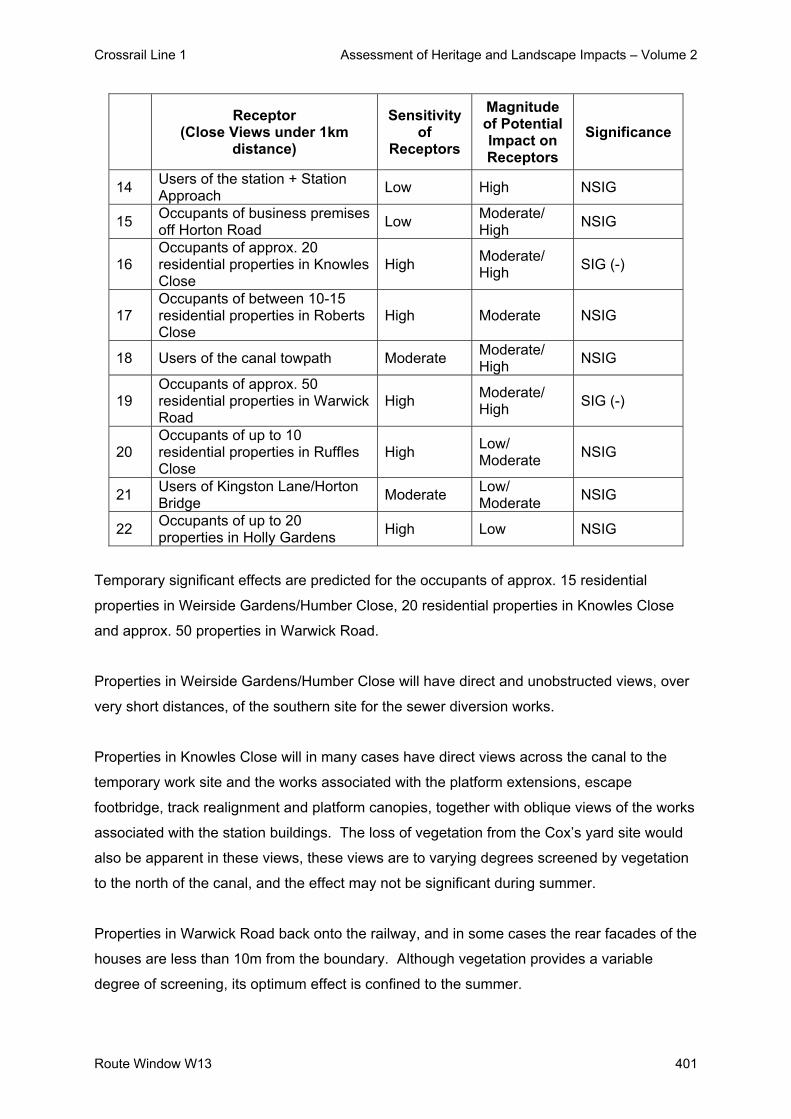
Crossrail Line 1 Assessment of Heritage and Landscape Impacts – Volume 2
Route Window W13 401
Receptor
(Close Views under 1km distance)
Sensitivity of
Receptors
Magnitude of Potential Impact on Receptors
Significance
14 Users of the station + Station Approach Low High NSIG
15 Occupants of business premises off Horton Road Low Moderate/
High NSIG
16 Occupants of approx. 20 residential properties in Knowles Close
High Moderate/ High SIG (-)
17 Occupants of between 10-15 residential properties in Roberts Close
High Moderate NSIG
18 Users of the canal towpath Moderate Moderate/ High NSIG
19 Occupants of approx. 50 residential properties in Warwick Road
High Moderate/ High SIG (-)
20 Occupants of up to 10 residential properties in Ruffles Close
High Low/ Moderate NSIG
21 Users of Kingston Lane/Horton Bridge Moderate Low/
Moderate NSIG
22 Occupants of up to 20 properties in Holly Gardens High Low NSIG
Temporary significant effects are predicted for the occupants of approx. 15 residential
properties in Weirside Gardens/Humber Close, 20 residential properties in Knowles Close
and approx. 50 properties in Warwick Road.
Properties in Weirside Gardens/Humber Close will have direct and unobstructed views, over
very short distances, of the southern site for the sewer diversion works.
Properties in Knowles Close will in many cases have direct views across the canal to the
temporary work site and the works associated with the platform extensions, escape
footbridge, track realignment and platform canopies, together with oblique views of the works
associated with the station buildings. The loss of vegetation from the Cox’s yard site would
also be apparent in these views, these views are to varying degrees screened by vegetation
to the north of the canal, and the effect may not be significant during summer.
Properties in Warwick Road back onto the railway, and in some cases the rear facades of the
houses are less than 10m from the boundary. Although vegetation provides a variable
degree of screening, its optimum effect is confined to the summer.

Crossrail Line 1 Assessment of Heritage and Landscape Impacts – Volume 2
402 Route Window W13
About 25 properties will have direct views of the works to the station buildings, and are also
likely to be affected by removal of lineside vegetation for construction of the emergency
escape path. The remaining 45 properties will have direct views of the works associated with
the track realignment, escape footbridge and platforms.
In all other cases, the predicted effects are not deemed to be significant. This is either
because receptors are of low sensitivity (e.g. users of the station, occupants of business
premises), or because views are oblique, are over greater distances and/or are screened to
varying degrees (e.g. views from residential properties in Merrivale Mews, Tavistock Road,
Trout Road, Roberts Close, Ashley Court, Ruffle Close and Holly Gardens).
The magnitude of visual impact that would be generated by the permanent works on each
group of receptors is identified in Table W13.3: Potential Permanent Impacts on Receptors
(West Drayton).
Table W13.3: Potential Permanent Impacts on Receptors (West Drayton)
Receptor
(Close Views under 1km distance)
Sensitivity of
Receptors
Magnitude of Potential Impact on Receptors
Significance
Stabling Sidings
1 Recreational users of the Colne Valley High Low NSIG
2 Occupants of between 50-60 residential properties in Fairway avenue/Humber Close.
High Low NSIG
3
Occupants of about 15 residential properties in Weirside Gardens/Humber Close
High Low NSIG
4 Occupants of between 15-20 residential properties in Tavistock Road.
High Low/ Moderate NSIG
5 Occupants of about 30 residential properties in Merrivale Mews
High Low NSIG
6 Occupants of about 5 residential properties in Trout Road High Low NSIG
Station Works
7 Users of High Street/Station Road Low Low NSIG
8 Occupants of up to 10 properties in High Street High Low NSIG
9 Patrons of De Burgh Arms and Railway Arms. Low Low/
Moderate NSIG

Crossrail Line 1 Assessment of Heritage and Landscape Impacts – Volume 2
Route Window W13 403
Receptor
(Close Views under 1km distance)
Sensitivity of
Receptors
Magnitude of Potential Impact on Receptors
Significance
10 Residents of about 5 properties in Colham Mill Road/Station Road
High Low/ Moderate NSIG
11 Users of West Drayton Market Low Moderate NSIG
12 Occupants of business premises north of Station Approach Low High NSIG
13 Occupants of Ashley House High Low NSIG
14 Users of the station + Station Approach Low High NSIG
15 Occupants of business premises off Horton Road Low Moderate NSIG
16 Occupants of approx. 20 residential properties in Knowles Close
High Low NSIG
17 Occupants of between 10-15 residential properties in Roberts Close
High Low NSIG
18 Users of the canal towpath Moderate Low NSIG
19 Occupants of approx. 25 residential properties in Warwick Road
High High SIG (-)
20 Occupants of approx. 35 residential properties in Warwick Road
High Low NSIG
21 Occupants of up to 10 residential properties in Ruffles Close
High Low/ Moderate NSIG
22 Users of Kingston Lane/Horton Bridge Moderate Low/
Moderate NSIG
23 Occupants of up to 20 properties in Holly Gardens High Low NSIG
Permanent significant effects are predicted for the occupants of approx. 25 residential
properties in Warwick Road. These properties will have direct (and largely unobstructed)
views of the new station buildings (the main footbridge, platform canopies and ticket hall
roof), together with the emergency escape footbridge. Lineside vegetation along the rear
boundary of these properties is also likely to have been removed during the construction
phase.
Although the new buildings will be of high architectural quality, their scale, proximity and
demonstrably modern appearance will change the character of the views from these
properties to a significant degree. In addition, the removal of vegetation will have reduced
foreground screening, whilst the loss of mature trees on the northern side of the station will
probably also change the background to these views. Views from the rear of these terraced

Crossrail Line 1 Assessment of Heritage and Landscape Impacts – Volume 2
404 Route Window W13
properties are considered to contribute substantially to the amenity of the occupants. Taken
together, these factors are regarded as a significant effect.
From other nearby residential properties (e.g. Knowles Close, Roberts Close and the eastern
part of Warwick Road), views of the station buildings are oblique, and the main features will
be the extended platforms and the emergency escape footbridge. Screening vegetation
along the northern side of the canal or the rear boundary of properties will remain. Views
across Station Approach from flats in Ashley Court are not considered to contribute
materially to the amenity of the occupants. For these reasons, the effect in these cases is
not considered to be significant.
The Year 1 predicted impacts apart from the occupants of approximately 25 residential
properties in Warwick Road, are not considered to be significant. After 15 years following
completion of the works, there would be no changes to townscape and visual impacts.

Crossrail Line 1 Assessment of Heritage and Landscape Impacts – Volume 2
Route Window W13 405
4. Summary
4.1 Listed Buildings and their Setting
The permanent impact of the works will be associated mainly with changes to the station
buildings. The new buildings, notably the ticket hall and main footbridge, will contrast in
scale and appearance with the existing station. However, they will be visibly related to the
existing function of the site, and will not be out of scale with other buildings in the vicinity.
These changes will not affect the setting of the listed De Burgh Arms and Railway Arms to
any significant degree. Construction works are also not predicted to have a significant
impact on the setting of these buildings.
4.2 Conservation Areas
There will be no significant impacts on Conservation Areas in this route window.
4.3 Landscape / Townscape
Construction of the stabling sidings will be visible from surrounding areas. However,
construction features will be temporary, and in most cases are not considered to have a
significant impact on landscape character. Vegetation will be lost for the bridge works,
retaining walls and one of the sewer work sites. However, this will not affect the overall
pattern of vegetation in the area and is not considered to be significant.
The permanent features of the sidings will replace those of the existing coal depot, and will
not change the relationship of the site to the surrounding area; it will continue to be perceived
as an extension of the railway corridor.
During construction of the station works, major items of plant, together with activities such as
tree felling and demolition, will be prominent at various times. Most construction
features/activities will be temporary and are not considered to have a significant effect on the
character of their setting.
The loss of mature trees will have a localised but potentially significant impact on the
immediate townscape. However, new specimen trees are to be planted within the
remodelled forecourt, and this effect will diminish as these mature.

Crossrail Line 1 Assessment of Heritage and Landscape Impacts – Volume 2
406 Route Window W13
The permanent impact of the works will be associated mainly with changes to the station
buildings. The new buildings, notably the ticket hall and main footbridge, will contrast in
scale and appearance with the existing station. However, they will be visibly related to the
existing function of the site, and will not be out of scale with other buildings in the vicinity.
Their effect on townscape character is therefore not considered to be significant.
4.4 Visual Impact
Construction of the stabling sidings will be visible from locations within the Colne Valley and
surrounding residential areas. However, construction features will be temporary, and in most
cases are not considered to have significant effects on visual amenity. The only exception
will be in Weirside Gardens/Humber Close, where the sewer diversion work will take place
very close to residential properties. The assessment has identified significant impacts on 15
residential properties in Weirside Gardens/Humber Close due to the sewer diversion works.
The permanent features of the sidings will replace those of the existing coal depot, and will
not change the relationship of the site to the surrounding area. Their effect on visual amenity
is not considered to be significant.
The construction works for the station will be visible to a substantial number of receptors,
including users of the station, the town centre and the canal towpath, and nearby residents.
In most cases, the temporary nature of the works mitigates against their impact on visual
amenity. However, the effect on occupants of up to 80 residential properties in Knowles
Close and Warwick Road will be potentially significant, due mainly to the proximity and
duration of the works.
The new buildings will arguably be of high design quality. However, their scale and proximity
to occupants of approx. 25 residential properties in Warwick Road, coupled with the long-
term effects of vegetation loss and the likely importance of views from the rear of these
properties, is considered to amount to a potentially significant effect on visual amenity.
Impacts on the visual amenity of all other receptors are not regarded as significant.

Crossrail Line 1 Assessment of Heritage and Landscape Impacts – Volume 2
Route Window W13 407
5. Summary tables
Table W13.4 sets out the impacts on listed buildings. There are no significant impacts on
either the setting of listed buildings or conservation areas, hence these are not included
within the summary tables.
Predicted impacts on landscape / townscape character and visual amenity are summarised
in Table W13.5: Summary Table of Temporary Impacts and Table W13.6: Summary Table of
Permanent Impacts, including any committed mitigation and residual impacts.

Crossrail Line 1 Assessment of Heritage and Landscape Impacts – Volume 2
408 Route Window W13
Tabl
e W
13.4
Im
pact
s on
Lis
ted
Bui
ldin
gs in
Rou
te W
indo
w W
13
R
oute
Win
dow
W13
- Im
pact
s on
Lis
ted
Bui
ldin
gs
R
esid
ual I
mpa
ct
C.R
. N
o A
ddre
ss
Gra
de
Prop
osed
Wor
ks
Pote
ntia
l Im
pact
Si
g.
Act
ion
Req
uire
d an
d M
itiga
tion
Des
crip
tion
Sig.
84
4 (W
13)
Rai
lway
Arm
s P
ublic
Hou
se,
Sta
tion
Roa
d.
II N
ew tr
ackw
ork
north
of R
ailw
ay
Arm
s P
ublic
Hou
se.
No
sign
ifica
nt im
pact
. N
Sig
N
one
need
ed.
No
sign
ifica
nt
resi
dual
impa
ct.
NS
ig
845
(W13
)
De
Bur
gh
Arm
s P
ublic
H
ouse
, Sta
tion
App
roac
h.
II N
ew tr
ackw
ork
sout
h of
De
Bur
gh
Arm
s P
ublic
Hou
se.
No
sign
ifica
nt im
pact
. N
Sig
N
one
need
ed.
N
o si
gnifi
cant
re
sidu
al im
pact
. N
Sig

Crossrail Line 1 Assessment of Heritage and Landscape Impacts – Volume 2
Route Window W13 409
Tabl
e W
13.5
: Sum
mar
y Ta
ble
of P
erm
anen
t Im
pact
s (R
oute
Win
dow
W13
)
R
oute
Win
dow
W13
- Pe
rman
ent I
mpa
cts
Res
idua
l Im
pact
W
orks
and
pot
entia
l im
pact
Si
gnifi
canc
e M
itiga
tion
Des
crip
tion
Sign
ifica
nce
Phy
sica
l im
pact
of c
onst
ruct
ion
plan
t and
com
poun
ds.
Not
Sig
nific
ant
Non
e pr
opos
ed
Min
imal
. N
ot S
igni
fican
t Im
pact
on
char
acte
r are
as:
Ove
rall
char
acte
r of r
ailw
ay c
orrid
or a
nd s
urro
undi
ng
area
wou
ld n
ot b
e af
fect
ed.
The
loss
of m
atur
e tre
es
adjo
inin
g C
ox’s
yar
d w
ill, h
owev
er, c
onst
itute
a
sign
ifica
nt im
pact
.
Sig
nific
ant
Rep
lant
ing
of
vege
tatio
n on
ce
cons
truct
ion
is
com
plet
e
Sig
nific
ance
will
dis
appe
ar
as re
plac
emen
t pla
ntin
g m
atur
es.
Not
Sig
nific
ant
Impa
ct o
n se
tting
of l
iste
d bu
ildin
gs:
Alth
ough
wor
ks w
ill b
e pr
omin
ent,
they
will
be
tem
pora
ry
and
will
affe
ct th
e le
ast s
ensi
tive
parts
of t
he s
ettin
gs.
Not
Sig
nific
ant
Non
e pr
opos
ed
Min
imal
. N
ot S
igni
fican
t
Impa
ct o
n vi
sual
am
enity
of:
Up
to 8
5 re
side
ntia
l pro
perti
es in
Wei
rsid
e G
arde
ns/H
umbe
r Clo
se/K
now
les
Clo
se/ W
arw
ick
Roa
d S
igni
fican
t N
one
prac
ticab
le
Min
imal
. S
igni
fican
t
Impa
ct o
n vi
sual
am
enity
of:
O
ther
rece
ptor
s N
ot S
igni
fican
t N
one
prop
osed
. M
inim
al.
Not
Sig
nific
ant

Crossrail Line 1 Assessment of Heritage and Landscape Impacts – Volume 2
410 Route Window W13
Tabl
e W
13.6
: Sum
mar
y Ta
ble
of P
erm
anen
t Im
pact
s (R
oute
Win
dow
W13
)
R
oute
Win
dow
W13
- Pe
rman
ent I
mpa
cts
Res
idua
l Im
pact
W
orks
and
pot
entia
l im
pact
Si
gnifi
canc
e M
itiga
tion
Des
crip
tion
Sign
ifica
nce
Phy
sica
l im
pact
of:
Dem
oliti
ons
and
new
stru
ctur
es.
Not
Sig
nific
ant
Inco
rpor
ated
des
ign.
N
ew b
uild
ings
, rel
ated
feat
ures
an
d re
mod
elle
d fo
reco
urt.
Not
Sig
nific
ant
Impa
ct o
n ch
arac
ter a
reas
In
crea
se in
vis
ual i
nflu
ence
of r
ailw
ay
infra
stru
ctur
e, b
ut fu
ndam
enta
l cha
ract
er o
f su
rrou
ndin
g ar
ea w
ill b
e un
affe
cted
. Lo
ss
of v
eget
atio
n.
Not
Sig
nific
ant
Non
e pr
opos
ed
New
bui
ldin
gs m
ore
visi
ble,
but
to
wns
cape
role
of s
tatio
n re
mai
ns fu
ndam
enta
lly
unch
ange
d. S
igni
fican
ce w
ill
disa
ppea
r as
repl
acem
ent
plan
ting
mat
ures
(afte
r 15
year
s)
Not
Sig
nific
ant
Impa
ct o
n se
tting
of l
iste
d bu
ildin
gs:
Not
Sig
nific
ant
Non
e pr
opos
ed.
Cha
ract
er o
f set
ting
will
rem
ain
fund
amen
tally
unc
hang
ed.
Not
S
igni
fican
t. Im
pact
on
visu
al a
men
ity o
f:
App
rox.
25
resi
dent
ial p
rope
rties
in
War
wic
k R
oad.
S
igni
fican
t In
corp
orat
ed d
esig
n S
tatio
n w
ill b
ecom
e m
ore
prom
inen
t in
thes
e vi
ews.
S
igni
fican
t
Impa
ct o
n vi
sual
am
enity
of:
Oth
er re
cept
ors.
N
ot S
igni
fican
t N
one
prop
osed
C
hara
cter
of v
iew
s w
ill b
e fu
ndam
enta
lly u
ncha
nged
. N
ot S
igni
fican
t

Crossrail Line 1 Assessment of Heritage and Landscape Impacts – Volume 2
Route Window W13 411
6. Assumptions
- Temporary work sites will be returned to their previous condition and use, e.g. surfaced
areas such as car parks will be reinstated and soft areas will be grassed or planted with
shrubs.
- Vegetation near the De Burgh Arm Public House is to be retained and is unaffected by
the works.
- Vegetation around the periphery of the sidings site will be removed where the new
retaining walls, access road and sewer diversions are proposed, but will otherwise be
retained.
- 3.6 metre high timber hoarding around the perimeter of temporary work sites.

Crossrail Line 1 Assessment of Heritage and Landscape Impacts – Volume 2
412 Route Window W13
7. References
- ES Route Window W13
- Parliamentary Plan Sheets
- ES Scheme Description

Crossrail Line 1 Assessment of Heritage and Landscape Impacts – Volume 2
Route Window W12 413
Route Window W12 Horton Road and
Old Stockley Road Bridges


Crossrail Line 1 Assessment of Heritage and Landscape Impacts – Volume 2
Route Window W12 415
Contents
1. Description of the Works 417 1.1 Permanent Works 417
1.2 Temporary Works 417
2. Baseline Assessment 419 2.1 Local context 419
2.2 Listed Buildings and their settings 420
2.3 Conservation Areas 420
2.4 Townscape 420
2.5 Zone of Visual Influence 423
2.6 Sensitivity 426
3. Impact of the Scheme 429 3.1 Listed Buildings and their Setting 429
3.2 Conservation Areas 429
3.3 Landscape / Townscape 429
3.4 Visual impacts 430
4. Summary 434 4.1 Listed Buildings and their Setting 434
4.2 Conservation Areas 434
4.3 Townscape 434
4.4 Visual Impacts 434
5. Summary tables 435 6. Assumptions 438 7. References 439

Crossrail Line 1 Assessment of Heritage and Landscape Impacts – Volume 2
416 Route Window W12

Crossrail Line 1 Assessment of Heritage and Landscape Impacts – Volume 2
Route Window W12 417
Route Window W12 Horton Road and Old Stockley Road Bridges 1. Description of the Works
1.1 Permanent Works
New overhead line equipment will be provided along the Crossrail route. Stockley Road
bridge marks the eastern extremity of new OHLE, it already being in place along the
remainder of the alignment into London. In order to accommodate the OHLE, bridge
modifications will be required.
Kingston Lane Footbridge
Kingston lane footbridge will be replaced by a new footbridge immediately to its west. This
new bridge will accommodate the utilities that are contained currently by the existing bridge.
The main steel work will be fabricated offsite. Once the new bridge is complete, the existing
bridge will be demolished; if suitable, some of the spoil from this will be used for the
approach embankment.
Old Stockley Road Bridge
At Old Stockley Road bridge, a new steel structure will be installed adjacent to the existing
bridge. On completion of the new bridge, the existing bridge structure will then be
demolished.
Stockley Road (A408) Bridge
Some minor parapet works will be required at the adjacent Stockley Road (A408) bridge.
1.2 Temporary Works
Kingston Lane Footbridge
Works at this site will be undertaken from the West Drayton Station to Horton Bridge worksite
(see Route Window W13) and from a worksite located on the southwest corner of the bridge
(the Kingston Lane worksite). Each worksite will be served by 10 lorries per day during the
two week peak construction period and typically by two per day at other times. Construction

Crossrail Line 1 Assessment of Heritage and Landscape Impacts – Volume 2
418 Route Window W12
plant will include a crane and a mini piling rig. The works will take approximately 10 months
to complete.
Old Stockley Road Bridge
The works at Old Stockley Road bridge will take about five and a half months to complete.
Construction plant required for the work will include mobile cranes, excavators, pneumatic
drills, and a piling rig. Following the closure of Old Stockley Road the bridge works will be
carried out from a worksite located in the area to the southeast of the existing Old Stockley
Road bridge. The worksite will be bounded by the railway to the north, the main A408 road to
the east, and Old Stockley road to the west. The worksite will be served by eight lorries per
day including the eight week peak construction period.

Crossrail Line 1 Assessment of Heritage and Landscape Impacts – Volume 2
Route Window W12 419
2. Baseline Assessment
2.1 Local context
The railway passes through this area on a slight embankment within the built up area of West
Drayton. The Old Stockley Road bridge also lies adjoining the Stockley Road / A408 bridge
to the east. To the north lies the Grant Union Canal beyond which is Stockley Business
Park. To the north-east of the bridge, between the railway corridor and Grand Union Canal,
lies the Hanson Aggregates Dispatching Depot beyond the A408 bridge. To the south-west
is a residential development served off Lavender Road, whilst to the south-east is the
London Area Terminal Control Centre and Training Centre.
View of bridges
The Kingston Lane bridge lies adjacent to the residential areas served off Kingston Lane and
Station Road to the west and south. The London Area Terminal Control Centre lies beyond
the housing to the south-east. To the north of the bridge and railway corridor lies the Grand
Union Canal and Horton Road Industrial Estate. The town centre of Yiewsley lies to the
north-west with Stockley Business Park situated to the north-west, some distance from the
bridge. The land immediately adjoining the bridge comprises a vacant clear site available for
future development.
The Townscape Character Baseline Plan for Kingston Road and Old Stockley Road Bridges,
Drawing No.1E0416-W1E00-E00-F-00012 identifies the locations of key buildings and
landmarks in the local landscape / townscape, local views, pedestrian and vehicular
movement corridors, townscape character areas, urban gateways / notes and the landscape
planning designations that relate to the work sites and their surroundings. The baseline plan
also illustrates the extent of the work sites for both the temporary and permanent works.

Crossrail Line 1 Assessment of Heritage and Landscape Impacts – Volume 2
420 Route Window W12
These bridges are two of nine surviving Brunel bridges on the Western Route. They are
considered in detail in the Assessment of Archaeology Impacts – Technical Report.
2.2 Listed Buildings and their settings
There are no listed buildings or structures within the approximate Zone of Influence (ZVI) of
the temporary and permanent works.
2.3 Conservation Areas
There are no Conservation Areas in the vicinity of the works.
2.4 Townscape
2.4.1 Character Areas and Landscape / Townscape Quality
The area surrounding the Old Stockley Road bridge comprises three main character areas:
Stockley Park Character Area, Mulberry Crescent and Stockley Close Character Areas. The
area surrounding Kingston Road Bridge comprises three main character areas: Horton Road
Character Area, Warwick Road / Kingston Lane Character Area and London Area Terminal
Control Centre Character Area.
Stockley Park Character Area:
Stockley Park occupies a site of 400 acres with 1.85 million sq. ft of high quality office space
to the north of the railway tracks and on both sides of the M25. Stockley Park’s location,
adjacent to the M4 and M25 and immediately to the north of London’s Heathrow Airport, has
contributed significantly to its success. Recent public transport improvements considerably
enhance its accessibility; these include the Heathrow Express, which provides a 15-minute
non-stop journey from Stockley Park to London Paddington and a new bus service to Hayes
Station.
The new development has been named ‘dawleywood’. This relates to ‘Dawley Park’, which
during the late seventeenth century stretched across the eastern side of Stockley Park.
Dawley was the country seat of Henry St John (Lord Bolingbroke) on his return from exile in
France.

Crossrail Line 1 Assessment of Heritage and Landscape Impacts – Volume 2
Route Window W12 421
With the help of the architect, James Gibbs, and landscape experts of the day, Charles
Bridgeman and Alexander Pope, Bolingbroke created a ‘rural paradise’ – a mighty avenue of
trees, with orchards and ponds set in manicured parkland where deer grazed.
These open fields and parklands were dissected in the 1970s by the construction of the
Grand Junction Canal. Today the canal plays an important role for leisure with opportunities
for boating, walking, fishing, nature study, art and photography.
Stockley Park has a significantly different character to many of the business parks and
industrial parks, which dominate the area, with exceptional landscaping and bold and striking
architecture.
Spatially the development works well, with avenues, an abundance of public spaces, lakes
etc. The development also includes an exclusive health club and swimming pool and an 18-
hole championship golf course. The Grand Union Canal has been successfully incorporated
into the development.
Stockley Close Character Area The Stockley Close Character Area comprises a small enclosure of commercial / retail and
business office space, set out on a grid of plots either side of Stockley Close. To the north
adjacent to the rail corridor is a large modern BMI training centre building which forms a
notable feature, surrounded by car parking areas.
Mulberry Crescent Character Area
The residential character of the area dominates the land to the south-west of Old Stockley
Road Bridge. This area is typical of mainly low-rise “council estates” built after the World
War II, with a strip of modern housing development located on Emden Close and small
cluster of 3 storey flats located close to the bridge itself.
Horton Road Character Area The Horton Road Character Area mainly comprises extensive estate developments dating
from about 1950 – 60 between the rail corridor and Horton Road to the north-west and either
side of Horton Road to the north-east.

Crossrail Line 1 Assessment of Heritage and Landscape Impacts – Volume 2
422 Route Window W12
Warwick Road / Kingston Lane Character Area The Kingston Lane Character Area comprises mainly of semi-detached inter war housing
and more recent housing developments on Warwick Road and on Holly Gardens to the east.
Within this area is a large open public recreation ground adjoining the eastern side of
Kingston Lane. In addition there is a large vacant plot of plan adjoining the rail corridor to the
west of the bridge.
London Area Terminal Control Centre Character Area The area occupies the former RAF West Drayton site which contains a variety of utilitarian
buildings and accommodation located between two residential areas.
2.4.2 Key Townscape / Landscape Features and Resources
No individually notable townscape / landscape features have been identified in the area,
apart from the Hanson Aggregates Dispatching Depot and BMI training building, both to the
east of Old Stockley Road Bridge.
Vegetation is an influence on some views and on the character of the railway corridor. The
most notable vegetation close to the Old Stockley Road bridge are the belt of mature trees
and scrub either side of Iron Bridge Road south and mature scrub and trees along the south
side of the corridor adjoining Emden Close. There is also a small “wedge” or block of mature
scrub vegetation between Old Stockley Road and the A408 Stockley Road which provides
screening.
Around the Kingston Lane bridge, the vegetation to the north-west and south-east of the
bridge influences views, particularly the views from housing in Holly Gardens, although the
vegetation is poor quality.

Crossrail Line 1 Assessment of Heritage and Landscape Impacts – Volume 2
Route Window W12 423
2.4.3 Strategic Views and Key Local Views
There are no strategic views in the vicinity of the bridge(s) sites. No local views are
considered to qualify as key views.
2.4.4 Pedestrian / Vehicular Movement Corridors
Key vehicular and pedestrian movement corridors in the area around Kingston Lane Bridge
are Horton Bridge Road and Horton Road to the north and Station Road and Kingston Lane
including its local residential side streets to the south.
Key vehicular movements corridors in the area around Old Stockley Road bridge are
Stockley Road A408 to the east of the bridge, a network of local residential access roads to
the south-west including Lavender Rise, Briar Way, Mulberry Crescent and Emden Close
and Iron Bridge Road South to the north of the bridge. Old Stockley Road is a one-way road
from the A408 and provides access to the Hanson Aggregates Dispatch depot and Iron
Bridge Road South. Iron Bridge Road South provides access to Berrite Industrial Estate and
it connects to Iron Bridge Road North that runs northwards through Stockley Business Park.
Along the north side of the Grant Union Canal is a towpath, which is a public right of way of
local recreational importance (Grand Union Canal Walk).
2.5 Zone of Visual Influence
The approximate Zone of Visual Influence (ZVI) for the bridge works sites are determined by
the following influences:
- the relationship of the railway to the surrounding area;
- the general character and arrangement of land use;
- the proximity, scale and use of nearby buildings; and
- the size and type of nearby vegetation.
The railway runs through the built up area at grade passing behind Horton – Kingston Lane
and Old Stockley Road. Between the two bridges, the railway corridor widens slightly to
include an area of cleared vegetation used for rail maintenance / track laying work. The
surrounding area is generally flat, however the land gently falls southwards and Stockley

Crossrail Line 1 Assessment of Heritage and Landscape Impacts – Volume 2
424 Route Window W12
Business Park include extensive earth mounds and slopes to the edges of developed
parcels.
The Grand Union Canal to the north of the bridges lies a slightly lower level than the
surrounding land and railway, with the Hanson Aggregate Depot lying slightly below the
railway to the east of Old Stockley Road Bridge.
The surrounding buildings and residential houses to the south are the main influence on
views, reinforced (in summer) by belt of mature vegetation lying between the railway and
canal and north side of the canal and areas of vegetation along the southern boundary of the
rail corridor.
The ZVI for the Kingston Lane Bridge works can be defined by the following:
- to the west, by the rail corridor extending towards West Drayton Station, the facades of
properties and rear gardens on Warwick Road, Lantern Way (Clarenden Apartments) and
Ruffle Close to the south-west, and to the north-west where it is more tightly defined by
commercial buildings and vegetation on the north side of the canal;
- to the north, by the warehousing and commercial buildings within Horton Road Industrial
Estate and trees between the canal and railway;
- to the east, the ZVI extends along the railway corridor towards Berrite Industrial Estate
and the rear of warehousing between the railway and canal and building to the north of
the canal to the north-east;
- to the south-east and south, it is defined belts of vegetation adjoining the railway and on
the slopes up to the bridge itself within the rear garden and facades of housing on Holly
Garden (No.21 to 40) defining the winter ZVI.
The ZVI for the Old Stockley Road Bridge is tightly defined by the following:
- to the west, it extends along the railway corridor towards Berrite Industrial Estate with the
dense wide belt of vegetation between the railway and Iron Bridge Road South and areas
planning to the north side of the road and canal creating a strong visual screen during the
winter and summer periods;
- to the north, the ZVI extends towards a multi-storey car park on the edge of Stockley
Business Park and the rising ground of the A408 road bridge embankment to the north-

Crossrail Line 1 Assessment of Heritage and Landscape Impacts – Volume 2
Route Window W12 425
east. During the summer months, the ZVI to the north-east is defined mainly by the
dense vegetation on the embankment and adjoining the multi-storey car park;
- to the east, it extends along the rail corridor. However, the A408 Stockley Road bridge
interrupts and restricts views, with the vegetation on its embankment north and south
defining the ZVI during the summer; and
- to the south, the ZVI is defined by the arrangement of residential properties on Mulberry
Crescent and Emden Close with it extending along a short section of the A408 Stockley
Road. The vegetation to the east side of Old Stockley Road defined the ZVI during the
summer.
The main potential sources of views of the bridge works sites may be summarised as follows:
Kingston Lane Bridge - Occupants of around fifteen properties in Ruffle Close;
- Occupants of eight properties in Lantern Way;
- Occupants of properties (flats) facing north and east in Clarenden Apartments;
- Occupants of five properties in Warwick Road;
- Occupants of commercial properties in Horton Road Industrial Estates to the north-west
and north-east;
- Occupants of upper storey flats (10) fronting of Horton Road in distant views;
- Users of the Grand Union Canal Walk;
- Users and pedestrians of Horton Road crossing over Horton Canal Bridge;
- Occupants of the commercial building between the railway and canal to the north-east;
- Occupants of between 6 – 10 residential properties in Holly Gardens; and
- Users of West Drayton Station in distant views.
In addition, views of the bridge works (cranes) may be experienced by:
- Users of the adjoining Holly Garden public open space;
- Occupants of between 15 to 25 residential properties fronting or backing on to this open
space;
- Users of Kingston Lane.

Crossrail Line 1 Assessment of Heritage and Landscape Impacts – Volume 2
426 Route Window W12
Old Stockley Road Bridge - Occupants of 16 – 18 residential properties in Emden Close;
- Occupants of 2 – 4 residential properties in Mulberry Crescent;
- Users of Emden Close and Mulberry Crescent;
- Users of a short section of Stockley Road A408 to the south;
- Users of Stockley Road A408 to the east;
- Occupants of office buildings within and users of the Hanson Aggregates depot;
- User of a short section of Iron Bridge Road South;
- Users of the upper storey car parking areas in the car park to the north; and
- Occupants of the upper storey areas of the Commercial / Training Centre building to the
east.
2.6 Sensitivity
2.6.1 Sensitivity of Townscape / Landscape to Change
Townscape / Landscape
The built up area is generally of low or moderate sensitivity to change. The most sensitive
areas are the residential street, due to their small-scale built pattern and gardens, particularly
areas of low-rise (no more than two storey) housing such as dwellings on Warwick Avenue
and Emden Close. Taller (3 / 4 storey) town houses and flats (Emden Close) are less
sensitive, due to their large-scale of building and surrounding spaces.
The industrial / business areas are of low sensitivity to change. This reflects their functional
character and their robust pattern of relatively large-scale buildings and space. New railway
infrastructure is also unlikely to be particularly intrusive within a context of existing industrial
features.
2.6.2 Sensitivity of Visual Receptors to Change
Table W12.1: Visual Receptors (Kingston Lane Bridge / Old Stockley Road Bridge Works)
below identifies the key receptors which would obtain views of the proposed temporary and
proposed permanent works, together with their sensitivity, the type of views and whether the
views are of the temporary or permanent works

Crossrail Line 1 Assessment of Heritage and Landscape Impacts – Volume 2
Route Window W12 427
Table W12.1: Visual Receptors for the Kingston Lane Bridge and Old Stockley Road Bridge Works
Receptor (Close Views under 1km distance Type of View
Dire
ct V
iew
Obl
ique
Vie
w
Tem
pora
ry
Wor
k Si
te
Perm
anen
t W
orks
Sensitivity of
Receptors
Kingston Lane Bridge
1 Residential properties in Ruffle Close
Ground and upper floors High
2 Residential properties in Lantern Way Upper floors High
3 Residential properties (flats) in Clarenden Apartments
Ground and upper floors High
4 Residential properties in Warwick Road
Ground and upper floors High
5 Commercial properties and users in Horton Road Industrial Estate
Ground (front) Low
6 Residential properties (flats) in Horton Road Upper floors High
7 User of Grand Union Canal Walk Ground Moderate
8 Pedestrian users of Horton Road Ground Moderate
9 Commercial properties to the north-east Ground (rear) Low
10 Residential properties in Holly Gardens
Ground and upper floors (rear)
High
11 Users of adjoining Public Open Space Ground High
12 Residential properties adjoining Public Open Space (Holly Gardens)
Ground and upper floors High
13 Pedestrian users of Kingston Lane Ground Moderate
14 Users of West Drayton Station Ground Moderate
Old Stockley Road Bridge
15 Residential properties in Emden Close
Ground and upper floors High
16 Residential properties in Mulberry Crescent
Ground and upper floors High
17 Pedestrian user of Emden Close and Mulberry Crescent
Ground Moderate

Crossrail Line 1 Assessment of Heritage and Landscape Impacts – Volume 2
428 Route Window W12
Receptor (Close Views under 1km distance Type of View
Dire
ct V
iew
Obl
ique
Vie
w
Tem
pora
ry
Wor
k Si
te
Perm
anen
t W
orks
Sensitivity of
Receptors
18 Pedestrian user of Stockley Road A408 Ground Moderate
19 Occupants of office / training centre to south-east
Upper Low
20 Users of Hanson Aggregates Depot Ground Low
21 Pedestrian user of Iron Bridge Road South Ground Moderate
22 Vehicle user of multi-storey car park to north Upper floors Low
23 Drivers on Iron Bridge Road South Ground Low
24 Drivers on Stockley Road A408 Ground Low

Crossrail Line 1 Assessment of Heritage and Landscape Impacts – Volume 2
Route Window W12 429
3. Impact of the Scheme
3.1 Listed Buildings and their Setting
There are no impacts on listed buildings or their setting in this route window.
3.2 Conservation Areas
There are no impacts on Conservation Areas or their setting in this route window.
3.3 Landscape / Townscape
3.3.1 Impacts on Physical Landscape
The works at bridges would require the removal of some vegetation along the southern side
of the rail corridor and northern side as well for Old Stockley Road Bridge to construct the
bridges. The temporary compound for the Kingston Lane Bridge would require the removal
of a minor amount of scrub on the west side embankment slope otherwise this site is already
clear of vegetation. The Old Stockley Road temporary works compound will occupy the area
of the road closure and therefore no impacts are anticipated.
The temporary impacts also include the introduction of machinery and construction materials
into the local landscape which represent a moderate magnitude of impact on a townscape of
low sensitivity and moderate to low. However the temporary work sites will be landscaped
and restored to their previous condition. These impacts are not considered to be significant.
3.3.2 Impacts on Character Areas
The construction work would have two main impacts on landscape character: removal of
vegetation and the temporary presence of construction plant and associate features.
The vegetation to be removed for the bridge works comprises scrub and trees which are not
visually significant, although assist in screening some views. The vegetation, therefore, does
not have a major influence on the overall character of the area. In addition it is assumed that
the planting would be reinstated and in the long-term, this would replicate the existing
vegetation. The impact on character at both bridge sites is not considered to be significant.

Crossrail Line 1 Assessment of Heritage and Landscape Impacts – Volume 2
430 Route Window W12
Some of the construction features themselves will be relatively prominent e.g. mobile cranes,
portacabins etc. However they will be present for a short period and will have no long-term
impact on landscape character. Their effect is therefore not considered to be significant.
The permanent works at each bridge site involve the replacement of Kingston Lane bridge
with a new steel structure and at Old Stockley Road, the replacement of the bridge arches
with conarches. Whilst the replacement of the Kingston Lane bridge will result in a
noticeable change, views are generally restricted to views from the west and the access
routes. The effect on landscape character will be no more than minor, and will not be
significant.
3.4 Visual impacts
The visual impact of the construction works must take account of the relatively limited period
during which they will occur. In addition, nearby receptors will, to a certain degree, be
tolerant of activities carried out in the normal course of railway maintenance and
improvements.
The magnitude of visual impact that would be generated by the temporary works on each
receptor group identified in Table W12.2: Potential Temporary Impacts on Receptors
(Kingston Lane and Old Stockley Road Bridge works).
Table W12.2: Potential Temporary Impacts on Receptors (Kingston Lane and Old Stockley Road Bridge Works)
Receptor (Close Views under 1km distance)
Sensitivity of Receptor
Magnitude of Potential Impact on Receptors
Significance
Kingston Lane Bridge Occupants of residential properties in Ruffle Close, Lantern Way, Warwick Road
High Moderate SIG (-)
Occupants of Clarenden Apartments High Low NSIG Occupants of commercial properties to the north-west and north-east Low Moderate NSIG
Residential properties (flats) in Horton Road High Low NSIG
Users of Ground Union Walk Moderate Moderate SIG (-) Pedestrian users of Horton Road and Kingston Lane Moderate Moderate SIG (-)

Crossrail Line 1 Assessment of Heritage and Landscape Impacts – Volume 2
Route Window W12 431
Receptor (Close Views under 1km distance)
Sensitivity of Receptor
Magnitude of Potential Impact on Receptors
Significance
Vehicular users of Horton Road and Kingston Lane Moderate Moderate
Residential properties to the east and south-east High Low NSIG
Users of Public Open Space to south-east High Low NSIG
Users of West Drayton Station Moderate Low NSIG Old Stockley Road Bridge Occupants of residential properties in Emden Close and Mulberry Crescent High Moderate SIG (-)
Users of Emden Close and Mulberry Crescent Moderate Moderate SIG (-)
Pedestrian users of Stockley Road A408 Moderate Moderate SIG (-)
Drivers on Stockley Road A408 Low Moderate NSIG Occupants of Offices / Training Centre to the south-east Low Low NSIG
Users of Hanson Aggregates Depot Low Moderate NSIG Pedestrian users of Iron Bridge Road South
Moderate Low NSIG
Drivers on Iron Bridge Road South Low Low NSIG
The magnitude of visual impact that would be generated by the permanent works on each
group of receptors identified in Table W12.3: Potential Permanent Impacts on Receptors
(Kingston Lane and Old Stockley Road Bridge)
Table W12.3: Potential Permanent Impacts on Receptors (Kingston Lane and Old Stockley Road Bridge)
Receptor (Close Views under 1km distance)
Sensitivity of Receptor
Magnitude of Potential Impact on Receptors
Significance
Kingston Lane Bridge Occupants of residential properties in Ruffle Close, Lantern Way, Warwick Road
High Moderate SIG(-)
Occupants of commercial properties to the north-west and north-east Low Moderate NSIG
Residential properties (flats) in Horton Road High Low NSIG
Users of Ground Union Walk Moderate Moderate SIG (-) Pedestrian users of Horton Road and Kingston Lane Moderate Moderate SIG (-)

Crossrail Line 1 Assessment of Heritage and Landscape Impacts – Volume 2
432 Route Window W12
Receptor (Close Views under 1km distance)
Sensitivity of Receptor
Magnitude of Potential Impact on Receptors
Significance
Vehicular users of Horton Road and Kingston Lane Moderate Moderate
Residential properties to the east and south-east High Low NSIG
Users of Public Open Space to south-east High Low NSIG
Users of West Drayton Station Moderate Low NSIG Old Stockley Road Bridge Occupants of residential properties in Emden Close and Mulberry Crescent High Moderate SIG (-)
Users of Emden Close and Mulberry Crescent Moderate Moderate SIG (-)
Pedestrian users of Stockley Road A408 Moderate Moderate SIG (-)
Drivers on Stockley Road A408 Low Moderate NSIG Occupants of Offices / Training Centre to the south-east Low Low NSIG
Users of Hanson Aggregates Depot Low Moderate NSIG Pedestrian users of Iron Bridge Road South
Moderate Low NSIG
Drivers on Iron Bridge Road South Low Low NSIG
The works will be visible to a number of local receptors, notably nearby residential properties
to the south side of the rail corridor and potential views from users of West Drayton Station.
The works site for Kingston Lane bridge occupies a small area of the vacant plot to the
south-west of the bridge and also the land between the rail corridor and Grand Union Canal.
Whist the work site for the Old Stockley Road bridge occupies a small “wedge shaped” area
of land to the south of the bridge.
During the construction phases of both bridges will result in significant local impacts from the
construction features (cranes, portacabins etc.) themselves. These will occur to properties in
Ruffle Close, Lantern Way, Warwick Road, Holly Close, Emden Close and Mulberrry
Crescent. However, these will not persist beyond the completion of the works.
The impacts of the permanent works are not considered to be significant. Although residents
who overlook the Kingston Lane Bridge to the south-west and south-east are assumed to be
highly sensitive to visual change, as are the residents who overlook the Old Stockley Road
bridge, many of these views are partly screened by vegetation or are middle distance views
which are already influenced by the railway infrastructure and commercial areas to the north
of the railway corridor and Grand Union Canal and will be obtained from upper floors only.

Crossrail Line 1 Assessment of Heritage and Landscape Impacts – Volume 2
Route Window W12 433
The Year 1 predicted impacts are not considered to be significant for the reasons given
above. After 15 years following completion of the works, there would be no changes to the
townscape and visual impact, although the replacement planting within reinstated worksite
areas will assist in integrating the new footbridges into the built up area.

Crossrail Line 1 Assessment of Heritage and Landscape Impacts – Volume 2
434 Route Window W12
4. Summary
4.1 Listed Buildings and their Setting
There are no listed buildings affected by the proposed works in this route window.
4.2 Conservation Areas
There will be no significant impacts on Conservation Areas in this route window.
4.3 Townscape
The townscape and visual impact assessment has not identified any adverse impacts of on
townscape / landscape resources as a result of either the temporary or permanent works.
4.4 Visual Impacts
Temporary significant adverse impacts will occur to a limited number of properties due to the
proximity and activity generated by the temporary works sites for both bridges. These
properties are located in Ruffle Close, Lantern Way, Warwick Road, Holly Close, Emden
Close and Mulberrry Crescent.

Crossrail Line 1 Assessment of Heritage and Landscape Impacts – Volume 2
Route Window W12 435
5. Summary tables
There are no significant impacts on listed buildings, the setting of listed buildings or
conservation areas in this route window, hence these are not included within the summary
tables.
Predicted impacts on landscape townscape character and visual amenity are summarised in
Tables W12.4 Summary Table of Temporary Impacts and Table W12.5 Summary Table of
Permanent Impacts including any committed mitigation and residual impacts.

Crossrail Line 1 Assessment of Heritage and Landscape Impacts – Volume 2
436 Route Window W12
Tabl
e W
12.4
: Sum
mar
y Ta
ble
of T
empo
rary
Impa
cts
(Rou
te W
indo
w W
12)
R
oute
Win
dow
W12
– T
empo
rary
Impa
cts
R
esid
ual I
mpa
ct
Wor
ks a
nd P
oten
tial I
mpa
ct
Sign
ifica
nce
Miti
gatio
n D
escr
iptio
n Si
gnifi
canc
e P
hysi
cal i
mpa
ct o
f: In
trodu
ctio
n of
con
stru
ctio
n pl
ant a
nd a
ssoc
iate
d fe
atur
es.
Dem
oliti
on o
f brid
ge d
eck.
Lo
ss o
f veg
etat
ion
in th
e im
med
iate
vic
inity
of b
ridge
wor
ks.
Mod
erat
e fo
r the
brid
ge w
orks
.
Not
sig
nific
ant
Rei
nsta
tem
ent o
f pl
antin
g
Non
e (a
ssum
ing
rein
stat
emen
t of
plan
ting
in lo
ng
term
)
Not
sig
nific
ant
Impa
ct o
n ch
arac
ter a
reas
To
wns
cape
/ la
ndsc
ape
qual
ity is
no
mor
e th
an m
oder
ate
and
its o
vera
ll ch
arac
ter w
ould
not
be
affe
cted
. N
ot s
igni
fican
t N
one
Non
e N
ot s
igni
fican
t
Impa
ct o
n de
sign
ated
tow
nsca
pe /
land
scap
e N
one
in th
e vi
cini
ty
Not
sig
nific
ant
Non
e N
one
Not
sig
nific
ant
Impa
ct o
n vi
sual
am
enity
of:
Occ
upan
ts o
f app
rox.
30
– 35
pro
perti
es in
Ruf
fle C
lose
/ La
nter
n W
ay a
nd W
arw
ick
Roa
d.
Occ
upan
ts o
f app
rox.
15
to 2
5 pr
oper
ties
in H
olly
Clo
se
Occ
upan
ts o
f app
rox.
15
to 2
5 pr
oper
ties
in E
mde
n C
lose
an
d M
ulbe
rry
Cre
scen
t A
ll ot
her r
ecep
tors
(use
rs o
f Gra
nd U
nion
Can
al a
nd lo
cal
road
s et
c.)
Sig
nific
ant
Hoa
rdin
g ar
ound
w
orks
site
s
Non
e –
impa
ct
will
cea
se w
hen
cons
truct
ion
is
com
plet
ed
Sig
nific
ant

Crossrail Line 1 Assessment of Heritage and Landscape Impacts – Volume 2
Route Window W12 437
Tabl
e W
12.5
: Sum
mar
y Ta
ble
of P
erm
anen
t Im
pact
s (R
oute
Win
dow
W12
)
R
oute
Win
dow
W12
– P
erm
anen
t Im
pact
s
Res
idua
l Im
pact
W
orks
and
Pot
entia
l Im
pact
Si
gnifi
canc
e M
itiga
tion
Des
crip
tion
Sign
ifica
nce
Phy
sica
l im
pact
of:
Kin
gsto
n La
ne: R
epla
cem
ent b
ridge
with
in n
ew s
teel
fo
otbr
idge
O
ld S
tock
ley
Roa
d: R
epla
cem
ent o
f brid
ge w
ith n
ew s
teel
fo
otbr
idge
Lo
ss o
f som
e sc
rub
vege
tatio
n Lo
w fo
r the
brid
ge w
orks
Not
sig
nific
ant
Non
e N
one
Not
sig
nific
ant
Impa
ct o
n ch
arac
ter a
reas
: S
light
incr
ease
in v
isua
l inf
luen
ce o
f rai
lway
infra
stru
ctur
e,
but w
ill n
ot a
ffect
ove
rall
char
acte
r of a
rea.
N
ot s
igni
fican
t N
one
Non
e N
ot s
igni
fican
t
Impa
ct o
n de
sign
ated
tow
nsca
pe /
land
scap
e:
Non
e in
the
vici
nity
N
ot s
igni
fican
t N
one
Non
e N
ot s
igni
fican
t
Impa
ct o
n vi
sual
am
enity
: N
ot s
igni
fican
t N
one
Non
e N
ot s
igni
fican
t

Crossrail Line 1 Assessment of Heritage and Landscape Impacts – Volume 2
438 Route Window W12
6. Assumptions
- Assumed that the loss of vegetation associated with the temporary works will be replaced
and the areas surrounding the permanent works will be reinstated with soft landscaping.
- It is proposed that 3.6 metre high hoarding would be used around the boundary of the
temporary work sites to mitigate the demolition works and reduce the visual effects during
the construction stages.
- Desk-top studies and a number of site visits were undertaken during September and
October 2004 and therefore this assessment was undertaken during the late summer
period when vegetation was in leaf. However, when considering the landscape and
visual impacts of the scheme, an assessment of the potential winter situation has been
estimated / taken into account and ZVIs mapped on this basis.

Crossrail Line 1 Assessment of Heritage and Landscape Impacts – Volume 2
Route Window W12 439
7. References
- ES Route Window W12
- Parliamentary Plan Sheets
- ES Scheme Description

Crossrail Line 1 Assessment of Heritage and Landscape Impacts – Volume 2
440 Route Window W12

Crossrail Line 1 Assessment of Heritage and Landscape Impacts – Volume 2
Route Window W11 441
Route Window W11 Stockley Flyover


Crossrail Line 1 Assessment of Heritage and Landscape Impacts – Volume 2
Route Window W11 443
Contents 1. Description of the Works 445
1.1 Permanent Works 445 1.2 Temporary Works 446
2. Baseline Assessment 449 2.1 Local context 449 2.2 Listed Buildings and their Setting 450 2.3 Conservation Areas 451 2.4 Townscape 451 2.5 Zone of Visual Influence 454 2.6 Sensitivity 456
3. Impact of the Scheme 460 3.1 Listed Buildings and their Setting 460 3.2 Conservation Areas 460 3.3 Landscape / Townscape 460 3.4 Visual impacts 461
4. Summary 466 4.1 Listed Buildings and their Setting 466 4.2 Conservation Areas 466 4.3 Townscape 466 4.4 Visual Impacts 466
5. Summary Tables 468 6. Assumptions 471 7. References 472

Crossrail Line 1 Assessment of Heritage and Landscape Impacts – Volume 2
444 Route Window W11

Crossrail Line 1 Assessment of Heritage and Landscape Impacts – Volume 2
Route Window W11 445
Route Window W11 Stockley Flyover 1. Description of the Works
1.1 Permanent Works
In order to create a new rail connection to Heathrow, Crossrail will require major changes to
the track layout between the existing Stockley Flyover and Dawley Road Bridge,
approximately 1 km to its east.
Structures will be built to convey a new track onto a new viaduct along the north side of the
existing rail corridor. This northern viaduct will be about 400 m long. At each end of it, new
bridge decks over the existing lines will be built. The first of these will be constructed
northwest of the existing flyover, about 300 m east of Stockley Road Bridge. This western
transfer structure will comprise two bridge decks that will carry a new track over all of the low
level tracks in the GWML corridor. Another small western viaduct will then carry it to a point
north of the airport tunnel portal. This new track will accommodate all trains travelling from
Heathrow (both Crossrail and Heathrow Express).
At its eastern end, the viaduct widens as the single track diverges into two, opposite
Swallowfield Way. An eastern transfer structure, 240 m long and up to 20 m wide, will be
constructed to accommodate these new tracks and to carry one of them (Heathrow Express)
to its new alignment between the existing low level tracks; the second (Crossrail) track will
remain on the north side of the rail corridor. The two tracks will each be conveyed to ground
level just west of Dawley Road bridge on 300 m long ramps.
Various track realignments will be required for this new arrangement. Eastbound Heathrow
Express trains will be transferred from the existing Stockley flyover onto this new structure.
Stockley flyover will then be used to accommodate westbound Crossrail airport trains.
Westbound Heathrow Express trains will continue to use their dedicated track on the south
side of the rail corridor. Other realignments will be required to take the low level tracks
beneath the new bridge decks.
The new infrastructure will require the northern edge of the railway boundary to be moved
northwards by up to 20 m between Stockley flyover and Dawley Road bridge.

Crossrail Line 1 Assessment of Heritage and Landscape Impacts – Volume 2
446 Route Window W11
1.2 Temporary Works
Duration of Works
Subject to possession planning requirements and excluding final commissioning, the
construction of the extended Stockley Flyover will take place over a period of approximately
three years and nine months.
Enabling Works
Before the main works commence it will be necessary to demolish several buildings along
the north side of the railway. These comprise buildings currently used by KGM Transport, HG
Timber, Allpoint Packaging and Dagenham Motors on the Rigby Lane/Swallowfield Way
Industrial Estate; premises used by Wackenhut on the Stockley Close Industrial Estate will
need to be acquired but may not need to be demolished.
Other works will involve the cutting back of OHLE on the existing rail lines, diversions of
utilities, and creation of the necessary worksites and accesses, including a temporary bridge
over Broad Dock from the Stockley Close Worksite to the western viaduct.
Main Works
The western viaduct will require construction of a retaining wall on piled foundations on the
west side of the Heathrow spur, allowing the existing railway to be widened south of the
western viaduct. The western viaduct substructure will comprise in-situ reinforced concrete
piers at 25 m intervals on piled foundations. The deck will comprise three steel beams with
pre-cast reinforced concrete deck units.
A retaining wall will also be constructed on the east side of the Heathrow spur. This will be
constructed using piled foundations and a reinforced concrete wall.
The western transfer structure will be constructed partly from the western side of the airport
lines and partly from the northern side of the GWML. The substructure will comprise three
parallel reinforced concrete walls constructed generally using strip foundations although a
limited extent of piling will also be required. The middle wall of the western flyover will be
constructed first, followed by the south wall and then by the north wall. On completion of the
substructure, new deck beams will be installed crossing all the low-level tracks. One deck will

Crossrail Line 1 Assessment of Heritage and Landscape Impacts – Volume 2
Route Window W11 447
be constructed crossing over the main lines and a second deck structure will be built
crossing the goods loop and relief lines.
The northern viaduct will comprise in-situ reinforced concrete piers at 25 m intervals on piled
foundations.
The eastern transfer structure will comprise reinforced concrete walls on insitu strip
foundations. The deck will consist of pre-stressed concrete beams spanning across the relief
line tracks between the sub-structure walls.
Construction of the ramp for the Heathrow Express track will require the provision of a
temporary bridge and level crossing during track possessions across the relief line tracks at
the Dagenham Motors site. This will allow access across these tracks to the ramp itself. The
bridge will be constructed using timber crib foundations, a supporting steel trestle pier and a
truss bridge.
The higher sections of both the Heathrow Express Ramp and the Crossrail ramp will be of a
similar construction to the northern viaduct, namely in-situ reinforced concrete piers on piled
foundations supporting three steel beams for each span with pre-cast reinforced concrete
deck units. The lower section of the ramps will be formed by pre-cast concrete ‘L’ shaped
retaining wall units with earth infill material.
Track laying and track realignments will be undertaken, together with the provision of
signalling and electrification works.
Construction plant required at the worksite will include mobile cranes, excavators, piling rigs,
a vibrating roller/plate, compressors and generators.
Worksites and Access
Works for the flyover will be carried out from the following worksites:
- Stockley Close Worksite located west of the Heathrow spur, on the south side of the
GWML, off Stockley Close. The worksite will be served by 22 lorries per day during the
13 week peak construction period and typically by 16 per day at other times.

Crossrail Line 1 Assessment of Heritage and Landscape Impacts – Volume 2
448 Route Window W11
- HG Timber Worksite located to the northern side of the GWML on the site currently
occupied by HG Timber. The worksite will be served by 22 lorries per day during the 37
week peak construction period and typically 14 per day at other times.
- Allpoint Packaging Worksite located on the northern site of the GWML on the site
currently occupied by Allpoint packaging. The worksite will be served by 10 lorries per
day during the 37 week peak construction period and typically 6 per day at other times.
- Dagenham Motors Worksite located on the northern side of the GWML on the site
currently occupied by Dagenham Motors off Dawley Road. The worksite will be served by
12 lorries per day during the 46 week peak construction period and typically eight per day
at other times.
Materials for the viaducts and transfer structures will be taken to and from the worksites by
road. Materials for the track works will be partly delivered by rail.

Crossrail Line 1 Assessment of Heritage and Landscape Impacts – Volume 2
Route Window W11 449
2. Baseline Assessment
2.1 Local context
Stockley Flyover occupies an urban fringe location. The surrounding area is dominated by
residential and business uses, with some areas of open space.
The area to the north of the GWML comprises the Swallowfield Way, Adler and Kestrel Way
industrial estates. These consist of light industrial and distribution uses, with a characteristic
built pattern of warehouses, process buildings and 1-2 storey offices, separated by service
yards. The Hanson concrete plant, located in the western part of this area, is a prominent
local landmark.
A row of residential properties and a public house are located on the eastern side of Dawley
Road. Beyond these, business uses predominate once more, comprising the Wansford
Industrial Estate, Clayton Business Centre, Crown Trading Estate and The Alpha Estate.
The Thorn EMI complex is prominent in this area.
The industrial area is adjoined to the north by the Grand Union Canal. Beyond this lies
Stockley Park, a modern business campus in a landscaped setting. This is adjoined to the
north by open space (mainly golf courses and recreation grounds), fringing the built-up edge
of Hayes End and Yiewsley.
To the south of the main line, the existing Stockley Flyover and Heathrow branch are
adjoined to the east by Hayes Repository. This is a former MOD facility that comprises a
series of warehouse and office buildings, generally of no more than 2-3 storeys high,
surrounded by open space. The site is currently subject to a planning application for mixed-
use development. If this is successful, it is assumed that the use and built form of the site
will change substantially.
Between the repository and Dawley Road, to the east, lies the Bourne Farm estate. This is
an extensive residential area dating from 1930-60, comprising mainly two-storey semi-
detached dwellings, together with several blocks of three-storey flats. Areas of local open
space include Pinkwell Park, and community facilities such as a library and schools are
located to the south of this area.

Crossrail Line 1 Assessment of Heritage and Landscape Impacts – Volume 2
450 Route Window W11
To the east of Dawley Road, business uses are prominent (the Millington Road industrial
estate), together with older residential areas forming the built-up area of Botwell/Hayes.
To the west, the Stockley Flyover/Heathrow Branch are adjoined by a corridor of open space
which includes Stockley Road Lake and what appears to be an abandoned arm of the Grand
Union Canal. This area comprises open water fringed by scrub and semi-mature trees
(mainly willows). It is managed as a coarse fishery, and is not accessible to the public.
This area is adjoined to the west by Stockley Road (a dual-carriageway) and by the Stockley
Close industrial estate. The latter is similar in character to the area to the north, comprising
older industrial and distribution buildings, together with the modern 3-4 storey BMI training
centre. Premises forming the southern part of the estate are currently vacant, whilst
buildings on its eastern side have been demolished, presumably with a view to
redevelopment.
To the west of Stockley Road lies the Lavender Rise/Mulberry Crescent residential area,
which is similar in character to the Bourne Farm estate.
Southwards lies an area of typical urban fringe open land, comprising a golf course, playing
fields, cemetery, allotments and smallholdings. This extends to the M4, where hotels such
as the Holiday Inn are prominent.
The Townscape Character Baseline Plan for Stockley Flyover, Drawing No. 1E0416-W1E00-
E00-F-00011, identifies the locations of key buildings and landmarks in the local landscape /
townscape, local views, pedestrian and vehicular movement corridors, townscape character
areas, urban gateways / nodes and the landscape planning designations that relate to the
work sites and their surroundings. These baseline plans also illustrate the extent of the work
sites for both the temporary and permanent works.
2.2 Listed Buildings and their Setting
Enterprise House, which is Grade II listed is located within the Thorn EMI site, east of
Dawley Road, but is not within the approximate zone of visual influence of the works. There
are no other listed buildings in the proximity of the works.

Crossrail Line 1 Assessment of Heritage and Landscape Impacts – Volume 2
Route Window W11 451
2.3 Conservation Areas
The nearest Conservation Area defines the older part of the Thorn EMI site, east of Dawley
Road.
2.4 Townscape
2.4.1 Character Areas and Landscape / Townscape Quality
The landscape / townscape character of the area is defined mainly by land use and built
pattern. Four main character areas may be identified: Stockley Park, the older industrial
areas, the residential areas and the urban fringe open land.
Stockley Park
Stockley Park lies to the north of the Grand Union Canal, distinguished by its modern
buildings and its conspicuously designed setting, which set it apart from other business
areas. Its buildings (mainly offices) are typically of 2-4 storeys height, and are surrounded by
landscaped car parks and open space. Planting is generous, and is maturing to create a
strong landscape framework. The open space includes several water bodies, with
pedestrian bridges and sculptural features.
Industrial Areas
The older industrial areas comprise the Swallowfield Way and Stockley Close estates,
together with those east of Dawley Road and the repository site. These areas are of
overwhelmingly utilitarian character in terms of both their buildings and external spaces.
Modern buildings are confined to the BMI training centre and several office buildings off
Dawley Road.
Bourne Avenue
The residential character area is dominated by the Bourne Farm estate, which is typical of
the mainly low-rise “council estates” built after World War II. The Lavender Rise/Mulberry
Close area is if similar character. Older housing is confined to the periphery of the area east
of Dawley Road.

Crossrail Line 1 Assessment of Heritage and Landscape Impacts – Volume 2
452 Route Window W11
The Bourne Farm Recreation Ground
The open land to the south of the repository and the Bourne End estate is dominated by
recreational and other urban fringe uses (allotments, grazing etc). Remnant hedgerows
provide a degree of enclosure (e.g. fringing the Bourne Farm recreation ground). Much of
this area appears to have been restored after disturbance, possibly by gravel working and by
construction of the Heathrow Express tunnel.
Stockley Road Lakes
The undeveloped area around Stockley Road Lake forms an extension to this area, but is of
locally contrasting character, with relatively dense vegetation and water views. Other open
space (e.g. within the Bourne Farm estate) are too small and isolated to form character areas
in their own right.
2.4.2 Key Townscape / Landscape Features and Resources
The Hanson concrete plant is a prominent local landmark. Other distinctive buildings include
the BMI Training Centre, buildings within Stockley Park and Enterprise House (part of the
Thorn EMI complex).
Vegetation is an influence on landscape character and views at the following locations:
- within Stockley Park;
- around Stockley Road Lake and the adjoining corridor of open space;
- within the grounds of the repository;
- within an area of abandoned allotments that lie between the Bourne Farm estate and the
railway; and
- along parts of the urban fringe (e.g. close to Bourne Farm recreation ground).
This vegetation mainly comprises mature scrub, remnant hedgerows and occasional mature
or semi-mature trees. Although some of this vegetation is a locally important influence on
views, its significance is cumulative, and no individual trees or vegetation groups can be
considered to be landmarks.
The section of the railway corridor between the flyover and Dawley Road is relatively devoid
of vegetation, comprising mainly low scrub with occasional trees.

Crossrail Line 1 Assessment of Heritage and Landscape Impacts – Volume 2
Route Window W11 453
2.4.3 Strategic Views and Key Local Views
There are no strategic views in the vicinity of the site.
No local views are regarded as key to the extent that they are particularly sensitive or provide
exceptional viewing opportunities.
Opportunities for unobstructed views along the railway corridor are provided from the
Stockley Road and Dawley Road bridges. Such views will be restricted to pedestrians (of
which there may be few) and to passengers in taller vehicles, and are not regarded as key
local views.
2.4.4 Pedestrian / Vehicular Movement Corridors
Roads are the main movement corridors in the area, both for vehicles and pedestrians.
Stockley Road (A408) is an arterial route linking urban areas northwards to Uxbridge with M4
Junction 4 (for access to Heathrow Terminals 1,2 and 3). Dawley Road links Hayes End, to
the north, with Harlington, to the south.
The main local roads include Bourne Avenue (the main access to the Bourne Farm estate
and the repository), Swallowfield Way (accessing the industrial estates to the north) and
Longwalk Road/Furzeground Way (accessing Stockley Park).
The main pedestrian/cycle routes comprise the Grand Union Canal Walk, a network of paths
within Stockley Park and a footpath linking Stockley Road with Bourne Avenue.
2.4.5 Landscape Planning Designations
The main areas of open land to the south of the built-up area, and surrounding and to the
north of Stockley Park, are designated as Metropolitan Green Belt. This designation reflects
their largely undeveloped character rather than any intrinsic landscape merit they may
possess.
The corridor of open space around Stockley Road Lake, and extending northwards to the
railway, is designated as a Site of Metropolitan Importance (SMI) for its nature conservation
value. Although this is not a landscape designation, the habitats provide visual interest in the
local area.

Crossrail Line 1 Assessment of Heritage and Landscape Impacts – Volume 2
454 Route Window W11
The Grand Union Canal forms part of London’s “blue ribbon” network of waterways, and is of
borough-wide importance as a publicly accessible “green” corridor through a largely built-up
area. It is also designated as a Site of Metropolitan Importance (SMI) for its nature
conservation interest.
There are two areas of land in close proximity to the rail corridor, at Dawley Park and at
Stockley Close Estate which have recently obtained Planning Permission for redevelopment
proposals.
2.5 Zone of Visual Influence
The approximate Zone of Visual Influence (ZVI) for the work sites is determined by the
following influences:
- The relationship of the railway to the surrounding area;
- The general character and arrangement of land uses;
- The proximity, scale and use of nearby buildings; and
- The size and type of nearby vegetation.
The main line generally traverses this area at grade. Stockley Road and Dawley Road ramp
up to cross over the line. The existing Stockley flyover carries the Up Heathrow track over
the main relief lines by way of a box structure and reinforced earth embankments. The
Heathrow lines then dive down to pass into cutting and a tunnel portal immediately south-
east of Stockley Road Lake.
Winter-time views towards the railway corridor and flyover are defined mainly by the
surrounding buildings, and by the two bridges (which intercept views from further along the
railway). Between Stockley Road and Dawley Road, the railway corridor is enclosed to
varying degrees on both sides by industrial areas, the Bourne Farm estate and the
repository. The sense of enclosure varies; it is most consistent to the north and to the rear of
Stormount Drive, but is more fragmented in the vicinity of the repository and the existing
flyover.
As a result, successive buildings tend to close off most ground-level views over distances of
up to about 200m. Where views do penetrate the “front rank” of buildings, they are mostly
obstructed by the “second rank”.

Crossrail Line 1 Assessment of Heritage and Landscape Impacts – Volume 2
Route Window W11 455
Vegetation is an influence on views in the vicinity of Stockley Road Lake, the repository and
to the rear of properties in Stormount Drive/Clevedon Gardens/Burnham Gardens/Marlow
Gardens/Windsor Gardens. Summer-time views from ground-level positions are likely to be
substantially curtailed in these areas.
Longer-distance views are rare, and will in most cases be confined to upper storeys of
buildings or to the Stockley Road and Dawley Road bridges.
The potential winter-time ZVI is defined as follows:
- To the West, by the Stockley Road embankment and bridge, by buildings within the
Stockley Close industrial estate and (particularly in summer) by vegetation around
Stockley Road Lake.
- To the North, by the buildings of the Swallowfield Way/Adler/Kestrel Way/Thorn EMI
industrial estates. Where gaps between these may allow views to extend further
northwards, these are terminated either by successive industrial buildings or by
vegetation along the canal or around the perimeter of Stockley Park.
- To the East, by the Dawley Road embankment/bridge, and by the business uses flanking
this to the north and south of the railway.
- To the South, by the repository and the built pattern of the Bourne Farm Estate,
reinforced in summer by intervening vegetation.
The main potential sources of views of the works may be summarised as follows:
- Occupants and users of the industrial estates including Stockley Close Industrial estate/
BMI training Centre and the repository;
- Occupants and users of Stockley park (views probably confined to upper floors of
buildings);
- Users of the Grand Union Canal Walk;
- Users of Stockley Road Lake (anglers);
- Users of the Bourne Farm playing fields;
- Users of the footpath between Stockley Road and Bourne Avenue;
- Some users of Stockley Road and Dawley Road;

Crossrail Line 1 Assessment of Heritage and Landscape Impacts – Volume 2
456 Route Window W11
- Residents of the Bourne Farm estate (primarily properties in Denbigh Drive, Stormount
Drive, Clevedon Gardens, Burnham Gardens, Marlow Gardens, Windsor Gardens, the
Guinness House/Peter Fagan House flats, and several blocks of flats to the south);
- Occupants of office buildings close to Dawley Road; and
- Passengers on First Great Western and Heathrow Express services.
2.6 Sensitivity
2.6.1 Sensitivity of Townscape / Landscape to Change
Built-Up Areas
The industrial areas are of low sensitivity to change. This reflects their functional character,
and their robust pattern of relatively large-scale buildings and spaces. Features associated
with the construction of the flyover and track works would be expected to be unremarkable
within this setting. New railway infrastructure is also unlikely to be particularly intrusive within
a context of existing industrial features.
The railway corridor is already locally prominent, due to the degree of visual and physical
severance it creates, together with infrastructure such as the road overbridges, the existing
flyover and OHLE (which extends eastwards from here towards London). As a result, the
sensitivity of those areas lying within the ZVI of the railway is reduced.
Sensitivity to change is by definition increased by the presence of Conservation Areas or
Listed Buildings. Thus, the sensitivity of the townscape becomes moderate to potentially
high in and in the vicinity of the Thorn EMI/Botwell Conservation Area and Grade II listed
Enterprise House.
The residential areas are of moderate sensitivity to change. Although, as built-up areas, they
are able to accommodate a degree of change, their generally small-scale built pattern is
more susceptible to adverse impacts due to the introduction of larger-scale features. The
number of potential receptors, coupled with the amenity value of views from dwellings and
gardens, increases this sensitivity.

Crossrail Line 1 Assessment of Heritage and Landscape Impacts – Volume 2
Route Window W11 457
Open Land
The areas of open land are generally highly sensitive to change, due to their degree of visual
exposure and the contrast with which new construction or infrastructural features may be
perceived. This sensitivity is increased by proximity; the northern part of the Stockley Road
Lake reserve is likely to be most sensitive, since it adjoins the sections of railway corridor in
which work will take place.
Open space that is separated from the railway by built-up areas is less sensitive; this
includes the “pocket parks” within the Bourne Farm estate, open space within Stockley Park,
the canal corridor and open space to the south of the repository.
2.6.2 Sensitivity of Visual Receptors to Change
Table W11.1: Visual Receptors (Stockley Flyover Works) below identifies the key receptors
who are likely to obtain views of the proposed temporary and permanent works, together with
their sensitivity, the type of views and whether the views are of the temporary or permanent
works.
Table W11.1 : Visual Receptors for the Stockley Flyover Works
Receptor
(Close Views under 1km distance)
Type of View
Dire
ct V
iew
Obl
ique
Vie
w
Tem
pora
ry
Wor
k Si
tes
Perm
anen
t W
orks
Sensitivity of
Receptors
1 Occupants and users of the industrial estates north of the railway
Ground + upper floors Low
2 Occupants and users of Stockley Park Upper floors Low
3 Users of the Grand Union Canal Walk Ground Moderate
4 Users of Stockley Road Lake Ground Moderate
5 Users of Bourne Farm playing fields Ground High
6 Users of the footpath between Stockley Road/ Bourne avenue Ground Moderate
7 Users of Stockley Road + Dawley Road Ground Low
8 Occupants and users of the repository. Ground Low

Crossrail Line 1 Assessment of Heritage and Landscape Impacts – Volume 2
458 Route Window W11
Receptor
(Close Views under 1km distance)
Type of View
Dire
ct V
iew
Obl
ique
Vie
w
Tem
pora
ry
Wor
k Si
tes
Perm
anen
t W
orks
Sensitivity of
Receptors
9 Occupants and users of the Stockley Close industrial estate/BMI training centre.
Ground + upper floors Low
10 Occupants of approx. 20 residential properties in Denbigh Close
Ground + upper floors High
11 Occupants of approx. 30 residential properties in Stormount Drive
Ground + upper floors High
12
Occupants of approx. 50 residential properties in Clevedon Gardens, Burnham Gardens, Marlow Gardens + Windsor Gardens.
Ground + upper floors High
13 Occupants of approx. 30 residential flats in Guinness House/Peter Fagan House.
Ground + upper floors High
14 Occupants of flats elsewhere within the Bourne Farm estate Upper floors High
15 Occupants of office buildings close to Dawley Road Upper floors Low
16 Occupants of approx. 10 residential properties in Dawley Road (north)
Upper floors High
17 Rail passengers Trains Low
Two groups of highly sensitive receptors have been identified: recreational users of local
open space, and nearby residents.
The recreational receptors (users of Stockley Road Lake and the Bourne Farm playing
fields) are assumed to be of moderate (rather than high) sensitivity, since most of them are
likely to be involved in activities (angling, team sports) on which quality of setting is not a
major influence.
It is estimated that occupants of up to 120 residential properties may have views of the
works. All but about 10 of these properties are within the Bourne Farm estate. In addition
there may be potential views from the Stockley Close Estate redevelopment to the west once
this has been implemented However, the potential sensitivity of these receptors is tempered
by the following factors:
- probably no more than about half of them would experience direct views;

Crossrail Line 1 Assessment of Heritage and Landscape Impacts – Volume 2
Route Window W11 459
- viewing opportunities will in many cases be confined to upper floors (which in two-storey
houses are not the main inhabited rooms);
- many viewing opportunities are likely to be at least partly screened by vegetation in
summer; and
- these views are across existing railway corridors (with OHLE).
A further, potentially large group of receptors comprises occupants and visitors of the various
business premises in the area. However, their sensitivity is assumed to be low, and in many
cases their viewing opportunities will be restricted.
Receptors who live in or use properties that overlook the railway corridor can be assumed to
be habituated to a certain degree to the impact of railway maintenance and construction
activities. Occupants of about half of the potentially affected properties in the Bourne Farm
area would also have experienced the impact of construction of the Heathrow link in 1995/6 if
they were resident at that time.

Crossrail Line 1 Assessment of Heritage and Landscape Impacts – Volume 2
460 Route Window W11
3. Impact of the Scheme
3.1 Listed Buildings and their Setting
There will be no impacts on the setting of Grade II listed Enterprise House.
3.2 Conservation Areas
The works close to Dawley Road may be visible from the edge of the Thorn EMI/ Botwell
Conservation Area. However, they will have no significant impact on the setting of this area.
3.3 Landscape / Townscape
3.3.1 Impacts on Designated Townscape/Landscape
No areas of designated townscape/landscape will be directly affected by the works. The
Stockley Road Lake reserve is designated for its nature conservation (rather than its
landscape) interest, and this is addressed in the relevant Ecology Technical report.
3.3.2 Impact on Character Areas
The larger-scale construction features and areas are likely to be relatively prominent,
particularly where the railway corridor is less enclosed and vegetation is insignificant. Once
construction of the viaduct and box structures is well advanced, work will take place up to 8m
above the level of the surrounding area. In addition, construction features will be visible for a
considerable period of time.
The construction features will be visually consistent with much of the adjoining industrial
areas, and are therefore not considered to represent a significant change to their setting.
The impact on the Bourne Farm estate will be more apparent, since construction features will
contrast with the small-scale built pattern of the area. This will be most evident in the part of
the estate immediately adjoining the railway, notably from sections of Denbigh
Drive/Stormount Drive/Clevedon Gardens/Burnham Gardens/Marlow Gardens/Windsor
Gardens, and the curtilage of Guinness House/Peter Fagan House. Nevertheless, although
these features will be potentially intrusive, they will affect the setting of the area rather than
its intrinsic character, and their impact is therefore not considered to be significant.

Crossrail Line 1 Assessment of Heritage and Landscape Impacts – Volume 2
Route Window W11 461
The temporary impact on the character of the Carp Ponds and Broad Dock will be significant,
due to physical landtake, vegetation loss and reduction in the area of visible water. In
addition, construction work will dominate the immediate setting of this area. Impacts on other
areas of open space will be indirect and will not affect their character.
The permanent works will be visually consistent with the existing character of the railway
corridor, and in particular with the existing flyover. Although the eastern viaduct and box
structure will extend such infrastructure along a new section of the corridor, the overall
degree of change is not considered to be significant.
The new infrastructure will be visible from parts of the adjoining character areas, notably from
within the Bourne Farm estate, the industrial estates and the open areas to the south-west.
However, the prominence of these features will be insufficient to affect the intrinsic character
of these areas. This is considered to apply also to Stockley Road Lake. Although the new
viaduct will be particularly prominent from the northern part of this area (and will oversail the
eastern edge of the lakes), it is not considered to alter the setting of the area to a
fundamental degree.
3.4 Visual impacts
The Visual Appraisal Plan for Stockley Flyover Drawing No. 1E0316-W1E00-E00-F-00011
illustrates the approximate Zone of Visual Influence for the proposed temporary and
permanent works, and identifies the principal locations from which views of the development
would be obtained.
The magnitude of visual impact that would be generated by the temporary works on each
receptor group is identified in Table W11.2: Potential Temporary Impacts on Receptors
(Stockley Flyover Works).
Table W11.2 : Potential Temporary Impacts on Receptors (West Drayton)
Receptor
(Close Views under 1km distance)
Sensitivity of
Receptors
Magnitude of Potential Impact on Receptors
Significance
1 Occupants and users of the industrial estates north of the railway Low Moderate/
High NSIG
2 Occupants and users of Stockley Park Low Low NSIG

Crossrail Line 1 Assessment of Heritage and Landscape Impacts – Volume 2
462 Route Window W11
Receptor
(Close Views under 1km distance)
Sensitivity of
Receptors
Magnitude of Potential Impact on Receptors
Significance
3 Users of Grand Union Canal Walk Moderate Low NSIG 4 Users of Stockley Road Lake Moderate High SIG (-) 5 Users of Bourne Farm playing fields High Low NSIG
6 Users of Stockley Road/Bourne Avenue footpath Moderate Low NSIG
7 Users of Stockley Road + Dawley Road Low Low/
Moderate NSIG
8 Occupants + users of the repository Low Moderate/ High NSIG
9 Occupants + users of Stockley Close/BMI Training Centre Low High NSIG
10 Occupants of approx. 10 residential properties in Denbigh Close High High SIG (-)
11 Occupants of approx. 30 residential properties in Stormount Drive High High SIG (-)
12
Occupants of approx. 50 residential properties in Clevedon Gardens, Burnham Gardens, Marlow Gardens + Windsor Gardens
High High SIG (-)
13 Occupants of approx. 30 residential flats in Guinness House/ Peter Fagan House
High Moderate SIG (-)
14 Occupants of flats elsewhere within Bourne Farm estate. High Low NSIG
15 Occupants of office buildings close to Dawley Road Low Low NSIG
16 Occupants of approx. 10 residential properties in Dawley Road (north) High Low NSIG
17 Rail passengers Low Moderate NSIG
Temporary significant effects are predicted for users of Stockley Road Lake and the
occupants of approx. 120 residential properties in overlooking the works from the south.
Even if visitors to Stockley Road Lake are assumed to be of moderate rather than high
sensitivity, the scale, proximity and duration of the construction works, together with their
physical impact, are likely to reduce the amenity of these visitors to a significant degree.
In mitigation, however, it should be noted that this effect will be temporary, and will be
confined to the northern part of the site, whilst it is assumed that vegetation removed to
accommodate the construction works will be reinstated.
A high proportion of the properties in Denbigh Close/Stormount Drive/Clevedon
Gardens/Burnham Gardens/Marlow Gardens/Windsor Gardens/Guinness House/Peter

Crossrail Line 1 Assessment of Heritage and Landscape Impacts – Volume 2
Route Window W11 463
Fagan House will have direct and largely unobstructed views of the works. These views will
generally be over distances of between 70-80m, but are in some cases as short as 40m.
The major part of the construction works, notably the eastern viaduct, the two box structures
and the ramps, will be prominent in these views for much of the construction period. The
scale and proximity of the works, the character of the views and the sensitivity of the
receptors will combine to represent a significant effect.
In mitigation, it is likely that many of these views will be confined to upper floors only, and
that the impact will be temporary.
In all other cases, the predicted effects are not deemed to be significant. This is because
receptors are of low sensitivity (e.g. occupants of business premises), or because views are
oblique and /or over greater distances (e.g. from residential properties in Dawley Road).
The magnitude of visual impact that would be generated by the permanent works on each
group of receptors is identified in Table W11.3: Potential Permanent Impacts on Receptors
(Stockley Flyover).
Table W11.3: - Potential Permanent Impacts on Receptors (Stockley Flyover)
Receptor
(Close Views under 1km distance)
Sensitivity of
Receptors
Magnitude of Potential Impact on Receptors
Significance
1 Occupants and users of the industrial estates north of the railway
Low Low NSIG
2 Occupants and users of Stockley Park Low Low NSIG
3 Users of Grand Union Canal Walk Moderate Low NSIG 4 Users of Stockley Road Lake Moderate Moderate NSIG
5 Users of Bourne Farm playing fields High Low NSIG
6 Users of Stockley Road/Bourne Avenue footpath Moderate Low NSIG
7 Users of Stockley Road + Dawley Road Low Low NSIG
8 Occupants + users of the repository Low Moderate/
High NSIG
9 Occupants + users of Stockley Close/BMI Training Centre Low Moderate NSIG
10 Occupants of approx. 10 residential properties in Denbigh Close
High Moderate SIG (-)

Crossrail Line 1 Assessment of Heritage and Landscape Impacts – Volume 2
464 Route Window W11
Receptor
(Close Views under 1km distance)
Sensitivity of
Receptors
Magnitude of Potential Impact on Receptors
Significance
11 Occupants of approx. 30 residential properties in Stormount Drive
High High SIG (-)
12 Occupants of approx. 30 residential properties in Clevedon Gardens and Burnham Gardens
High High SIG (-)
13 Occupants of approx. 20 residential properties in Marlow Gardens and Windsor Gardens
High Moderate SIG
14 Occupants of approx. 30 residential flats in Guinness Close/ Peter Regan House
High Low NSIG
15 Occupants of flats elsewhere within Bourne Farm estate. High Low NSIG
16 Occupants of office buildings close to Dawley Road Low Low NSIG
17 Occupants of approx. 10 residential properties in Dawley Road (north)
High Low NSIG
18 Rail passengers Low Moderate NSIG
Permanent significant effects have been identified on the visual amenity of approximately 80
residential properties in Denbigh Close, Stormount Drive, Clevedon Gardens, Burnham
Gardens, Marlow Gardens and Windsor Gardens.
The permanent structures of the new flyover will be very prominent in views from these
properties over relatively short distances. The fundamental character of these views will not
change, i.e. they will continue to comprise a railway corridor with an industrial background.
However, the relative prominence of railway infrastructure will increase dramatically, with the
effect of foreshortening these views and increasing the visibility of trains. This impact will be
less apparent in summer, when some screening will be provided by vegetation within
gardens and the overgrown allotments.
In mitigation, a landscape bund will be constructed as part of the scheme on allotments to
the south of the railway. With this in place there will however, be significant residual visual
impacts for residents at 18 properties on 6-32 Denbigh Drive and 26-28 Windsor Gardens.
Consultation will be undertaken with LB Hillingdon on the design and form of the bund, since,
although reducing visual impact, it will result in a community impact because of its land take
from the allotments (see Community Impacts). Were the bund not to be built, significant

Crossrail Line 1 Assessment of Heritage and Landscape Impacts – Volume 2
Route Window W11 465
visual impacts would affect, in addition to the residents on Stormount Drive, residents of an
additional 15 properties in Denbigh Drive.
The permanent impact on users of Stockley Road Lake is not considered to be significant.
Although the western viaduct will encroach into this area, and will oversail the northern water
body, the character of the setting will not change to a degree that will significantly affect the
amenity of those using the area (mainly anglers). In addition, it is assumed that vegetation
lost during construction will be reinstated, and that the vegetated eastern margin of the lakes
will be restored over time.
The Year 1 predicted effects would result in significant impacts for the reason set out above.
However as the planting on the bund matures the likely impacts will continue to reduce.

Crossrail Line 1 Assessment of Heritage and Landscape Impacts – Volume 2
466 Route Window W11
4. Summary
4.1 Listed Buildings and their Setting
There will be no impacts on the setting of Grade II listed Enterprise House, and no significant
impacts on any other listed buildings or their setting in this route window.
4.2 Conservation Areas
The works close to Dawley Road may be visible from the edge of the Thorn EMI Botwell
Conservation Area. However, they will have no significant impact on the setting of this area.
There will be no significant impact on Conservation Areas in this route window.
4.3 Townscape
The temporary works are considered to have a significant impact on the character of the
Stockley Road Lake area. Although the new infrastructure will intrude into and be visible
from this area, it is not considered that the setting of the area will be altered to a fundamental
degree. This impact will not be permanent.
Although the permanent works will affect the character of the railway corridor between the
Stockley Road and Dawley Road bridges and both construction and permanent features will
be visible to varying degrees from nearby areas, the character of these areas will not change
fundamentally.
4.4 Visual Impacts
The construction works are considered to have a potentially significant impact on the amenity
of about 120 residential properties overlooking the railway corridor from the south, as well as
on the amenity of users of Stockley Road Lake. This reflects the proximity, prominence and
duration of the works, together with the sensitivity of these receptors.
The permanent works are considered to give rise to significant effects on the visual amenity
of about 80 residential properties overlooking the railway corridor from the south. The new
flyover structures will represent a step-change in the relative prominence of railway
infrastructure in views from these properties. In mitigation, a landscape bund will be
constructed as part of the scheme on allotments to the south of the railway. With this in

Crossrail Line 1 Assessment of Heritage and Landscape Impacts – Volume 2
Route Window W11 467
place there will however, be significant residual visual impacts for residents at 18 properties
on 6-32 Denbigh Drive and 26-28 Windsor Gardens. Consultation will be undertaken with LB
Hillingdon on the design and form of the bund, since, although reducing visual impact, it will
result in a community impact because of its land take from the allotments.

Crossrail Line 1 Assessment of Heritage and Landscape Impacts – Volume 2
468 Route Window W11
5. Summary Tables
There are no significant impacts on listed buildings, the setting of listed buildings or
conservation areas in this route window, hence these are not included within the summary
tables.
Predicted impacts on landscape / townscape character and visual amenity are summarised
in Table W11.4: Summary Table of Temporary Impacts and Table W11.5: Summary Table of
Permanent Impacts, including any committed mitigation and residual impacts.

Crossrail Line 1 Assessment of Heritage and Landscape Impacts – Volume 2
Route Window W11 469
Tabl
e W
11.4
: Sum
mar
y Ta
ble
of T
empo
rary
Impa
cts
(Rou
te W
indo
w W
11)
R
oute
Win
dow
W11
– T
empo
rary
Impa
cts
R
esid
ual I
mpa
ct
Wor
ks a
nd p
oten
tial i
mpa
ct
Sign
ifica
nce
Miti
gatio
n D
escr
iptio
n Si
gnifi
canc
e
Phy
sica
l im
pact
of:
C
onst
ruct
ion
plan
t and
com
poun
ds.
Not
S
igni
fican
t N
one
prop
osed
Loss
of v
eget
atio
n fro
m S
tock
ley
Roa
d La
ke re
serv
e, p
lus
dem
oliti
on o
f stru
ctur
es w
ithin
in
dust
rial e
stat
es.
Not
Sig
nific
ant
Impa
ct o
n ch
arac
ter o
f: S
tock
ley
Par
k La
ke re
serv
e.
Sig
nific
ant
Non
e pr
actic
able
. Im
pact
will
cea
se w
hen
cons
truct
ion
is c
ompl
ete.
S
igni
fican
t
Impa
ct o
n ot
her c
hara
cter
are
as:
Intri
nsic
cha
ract
er o
f sur
roun
ding
are
as n
ot a
ffect
ed.
Not
S
igni
fican
t N
one
prop
osed
.
Tem
pora
ry +
per
man
ent w
orks
w
ould
be
visi
ble,
but
no
fund
amen
tal c
hang
e to
cha
ract
er.
Not
Sig
nific
ant
Impa
ct o
n se
tting
of L
iste
d B
uild
ing
and
Con
serv
atio
n A
rea:
N
o m
ater
ial e
ffect
.
Not
S
igni
fican
t N
one
prop
osed
M
inim
al.
Not
Sig
nific
ant
Impa
ct o
n vi
sual
am
enity
of a
ppro
x. 1
20 re
side
ntia
l pr
oper
ties:
P
rope
rties
in in
Den
bigh
Driv
e/S
torm
ount
Driv
e/
Cle
vedo
n G
arde
ns/ B
urnh
am G
arde
ns/ M
arlo
w
Gar
dens
/ Win
dsor
Gar
dens
/ Gui
nnes
s H
ouse
/ Pet
er
Faga
n H
ouse
Sig
nific
ant
Non
e pr
actic
able
N
one
(effe
ct w
ill d
isap
pear
whe
n w
ork
com
plet
ed).
Sig
nific
ant
Impa
ct o
n vi
sual
am
enity
of:
U
sers
of S
tock
ley
Roa
d La
ke
Sig
nific
ant
Non
e P
ract
icab
le
Impa
ct w
ill c
ease
whe
n co
nstru
ctio
n is
com
plet
e S
igni
fican
t
Impa
ct o
n vi
sual
am
enity
of:
O
ther
rece
ptor
s N
ot
Sig
nific
ant
Non
e pr
opos
ed.
Min
imal
. N
ot S
igni
fican
t

Crossrail Line 1 Assessment of Heritage and Landscape Impacts – Volume 2
470 Route Window W11
Tabl
e W
11.5
: Sum
mar
y Ta
ble
of P
erm
anen
t Im
pact
s (R
oute
Win
dow
W11
)
R
oute
Win
dow
W11
– P
erm
anen
t Im
pact
s
Res
idua
l Im
pact
W
orks
and
pot
entia
l im
pact
Si
gnifi
canc
e M
itiga
tion
Des
crip
tion
Sign
ifica
nce
Phy
sica
l im
pact
of:
Dem
oliti
ons
and
new
stru
ctur
es.
Not
Sig
nific
ant
Non
e pr
opos
ed.
Ext
ende
d fly
over
+ ra
mp,
sl
ewed
trac
ks e
tc.
Not
Sig
nific
ant
Phy
sica
l Im
pact
of:
Veg
etat
ion
loss
N
ot S
igni
fican
t A
ssum
ed re
inst
atem
ent
Non
e N
ot S
igni
fican
t
Impa
ct o
n ch
arac
ter a
reas
In
crea
se in
vis
ual i
nflu
ence
of r
ailw
ay
infra
stru
ctur
e, b
ut fu
ndam
enta
l cha
ract
er o
f su
rrou
ndin
g ar
eas
will
be
unaf
fect
ed.
Not
Sig
nific
ant
Non
e pr
opos
ed
Add
ition
al in
frast
ruct
ure
with
in
railw
ay c
orrid
or.
Not
Sig
nific
ant
Impa
ct o
n se
tting
of C
onse
rvat
ion
area
+
List
ed B
uild
ings
N
ot S
igni
fican
t N
one
requ
ired.
N
o m
ater
ial i
mpa
ct.
Not
S
igni
fican
t. Im
pact
on
visu
al a
men
ity o
f app
rox.
80
resi
dent
ial p
rope
rties
P
rope
rties
in S
torm
ount
Driv
e/C
leve
don
Gar
dens
/Bur
nham
Gar
dens
/Mar
low
G
arde
ns/W
inds
or G
arde
ns
Sig
nific
ant
Land
scap
ed b
und
prop
osed
w
ithin
dis
used
allo
tmen
ts.
Sig
nific
ant i
mpa
cts
from
gr
ound
-leve
l cou
ld b
e el
imin
ated
; ove
rall
num
ber o
f pr
oper
ties
affe
cted
cou
ld b
e re
duce
d by
abo
ut 7
5%.
Sig
nific
ant
(but
num
ber
of re
cept
ors
muc
h re
duce
d)
Impa
ct o
n vi
sual
am
enity
of:
Oth
er r
ecep
tors
. N
ot S
igni
fican
t N
one
requ
ired.
C
hara
cter
of v
iew
s ac
ross
ra
ilway
cor
ridor
will
not
cha
nge
fund
amen
tally
. N
ot S
igni
fican
t

Crossrail Line 1 Assessment of Heritage and Landscape Impacts – Volume 2
Route Window W11 471
6. Assumptions
- Temporary work sites will be returned to their previous condition and use, e.g. surfaced
areas such as car parks will be reinstated and soft areas will be grassed or planted with
shrubs.
- 2.4 and 3.6 metre high timber hoarding around the perimeter of temporary work sites.
- Desk-top studies and a number of site visits were undertaken during September and
October 2004 and therefore this assessment was undertaken during the late summer
period when vegetation was in leaf. However, when considering the landscape and
visual impacts of the scheme, an assessment of the potential winter situation has been
estimated / taken into account and ZVIs mapped on this basis.

Crossrail Line 1 Assessment of Heritage and Landscape Impacts – Volume 2
472 Route Window W11
7. References
- ES Route Window W11
- Parliamentary Plan Sheets.
- ES Scheme Description

Crossrail Line 1 Assessment of Heritage and Landscape Impacts – Volume 2
Route Window W10 473
Route Window W10 Hayes and Harlington


Crossrail Line 1 Assessment of Heritage and Landscape Impacts – Volume 2
Route Window W10 475
Contents 1. Description of the Works 477
1.1 Permanent Works 477 1.2 Temporary Works 478
2. Baseline Assessment 480 2.1 Local context 480 2.2 Listed Buildings and their Setting 481 2.3 Conservation Areas 482 2.4 Townscape 482 2.5 Zone of Visual Influence 485 2.6 Sensitivity 486
3. Impact of the Scheme 490 3.1 Listed Buildings and their settings 490 3.2 Conservation Areas 490 3.3 Landscape / Townscape 490 3.4 Visual impacts 492
4. Summary 495 4.1 Listed Buildings and their setting 495 4.2 Conservation Areas 495 4.3 Townscape 495 4.4 Visual Impacts 495
5. Summary tables 496 6. Assumptions 499 7. References 500

Crossrail Line 1 Assessment of Heritage and Landscape Impacts – Volume 2
476 Route Window W10

Crossrail Line 1 Assessment of Heritage and Landscape Impacts – Volume 2
Route Window W10 477
Route Window W10 Hayes and Harlington 1. Description of the Works 1.1 Permanent Works New Crossrail Track and Bridge Modifications
The eastbound goods line on the north side of the rail corridor currently merges with the relief
line just west of Station Road bridge. This will be extended eastwards to become a new
eastbound Crossrail airport line. This will widen the rail corridor northwards by about 15 m
and require that Station Road bridge be extended to accommodate the new line.
Refurbishment of the northern-most span of the Grand Union Canal bridge, immediately to
the east of Hayes and Harlington station, will also be required to accommodate the new track
layout.
Hayes and Harlington Station
The new Crossrail track will be installed on the north side of the relief lines and will serve a
new through platform (platform five) at Hayes and Harlington station. This platform will
normally be used by Crossrail trains from Heathrow; the current eastbound relief line platform
(platform four) will normally be used by all other eastbound trains. Crossovers will, however,
be installed to allow all eastbound trains to use platform five, and enable platform four to be
used to reverse trains, either westbound-eastbound or vice versa.
Other platforms will be extended eastwards to accommodate Crossrail trains: platform two by
57 m, platform three by 64 m, platform four by 60 m and platform one by 101 m.
A new 500 m2 station building will be constructed on the north side of platform five. A new 45
m long pedestrian footbridge, approximately 9 m above rail level, will be constructed leading
from the new ticket hall, with provision of lift access to all platforms.

Crossrail Line 1 Assessment of Heritage and Landscape Impacts – Volume 2
478 Route Window W10
1.2 Temporary Works
Duration of Works
Subject to possession planning requirements and excluding final commissioning, the
construction works at Hayes and Harlington station will take place over a period of
approximately two years and seven months.
Enabling Works
Before the main works commence it will be necessary to demolish a number of buildings.
These comprise 107-131 (odd) Station Road, station buildings on Station Road, station
buildings and canopies on the northern platforms four and five, and a small waiting shelter on
platforms two and three.
Other works will involve the provision of a temporary road bridge on the western side of
Station Road, the diversion of the utilities and services onto this, and the creation of the
necessary worksites and access points.
Main Works
The new span to Station Road bridge will be constructed using two lines of contiguous bored
piles with pre-cast concrete beams as deck. On completion of this and of the finishing works
and laying of services, the temporary bridge over the lines to the west will be removed.
The northern span of the Grand Union Canal bridge will be refurbished to accommodate the
new track layout. Refurbishment will require steelwork repairs and strengthening works,
waterproofing of the deck, and grit blasting and repainting of all steelwork.
For the extension to eastbound goods loop, a short length of retaining wall will be built
immediately west of Station Road bridge, and the railway formation widened. New track will
then be laid from the current eastern end of the eastbound goods loop, under Station Road
bridge, through the station, joining with the existing eastbound relief line immediately east of
Grand Union Canal bridge. Following the main civil works in the area, trackwork to the site
will be realigned as necessary and a number of crossovers east and west of the station will
be installed.

Crossrail Line 1 Assessment of Heritage and Landscape Impacts – Volume 2
Route Window W10 479
At Hayes and Harlington station, a temporary ticket hall will be constructed within the car
park on the south side of the station, and a temporary footbridge will be provided half way
along the platforms. Trains will use the eastern section of the extended platforms. Following
this, the existing station buildings and platform canopies will be demolished and a new
station ticket hall will be constructed to the north of the railway tracks. On completion of the
station works, a new footbridge with lifts will be installed at the western end of the platforms
to allow access to all platforms. New platform canopies and waiting areas will be constructed.
Trains will then be able to use the full length of the platforms and the temporary footbridge
and ticket hall will be removed.
During the main station works, all platforms will be extended eastwards and the northern
platform face (platform five) will be realigned to increase the width of island platform four/five.
These extensions will require a minor realignment of the relief line tracks. The extension of
the main and relief line platforms will be completed early to allow trains to stop at the eastern
end of the platforms.
Construction plant required for the station and bridge works will include a piling rig, cranes,
compressors, excavators and generators.
Worksites and Access
Works will be undertaken from three main worksites, one west of Station Road bridge
(Station Road bridge worksite) on the south side of the railway, and two east of Station Road
bridge, one on each side of the railway (Station worksites north and south). The Station Road
bridge worksite will be served by eight lorries per day during the 22 week peak of
construction, and typically by six at other times. For the two Station worksites, peak
construction will last 25 weeks, during which time 12 lorries per day will serve the north
worksite and six, the south. At other times the worksites will be served typically by eight and
four lorries respectively.
All materials will be taken to and from the site by road. Access to the worksites will be via
Station Road, Viveash Close or Station Approach.

Crossrail Line 1 Assessment of Heritage and Landscape Impacts – Volume 2
480 Route Window W10
2. Baseline Assessment 2.1 Local context This section of the route traverses a wholly urban area dominated by residential and
business/industrial uses. The relatively dense urban pattern is interrupted only where sites
are under-utilised or vacant (e.g. the triangular site to the north of the station), or where a
corridor of open land has been retained along the floodplain of the Yeading Brook.
The railway corridor runs on an east/west alignment through the area, separating Hayes
Town Centre (to the north) from Harlington (to the south). The Grand Union Canal also
passes through the area, on a north-west/south-east alignment, passing beneath the railway
just east of the station. To the east of the Yeading Brook, the Paddington Arm branches off
to the north, also passing beneath the railway.
East of the main canal crossing, the railway runs onto embankment to cross the Yeading
Brook valley. Prominent bridges carry roads over the railway at Bournes Bridge (Dawley
Road), Station Road and the A312/Hayes Bypass (a multi-span concrete viaduct).
To the north of the route, the area between the railway and the canal is dominated by
industrial/business uses, including the Warnford Industrial Estate and the Thorn EMI plant. A
small area of residential uses remains between Blyth Road and Clayton Road, comprising
two-storey terraces dating from around 1900.
Station Road is the main commercial thoroughfare through the area, and is adjoined
northwards by shops, offices and community facilities, extending northwards to cross over
the canal towards Hayes Town Centre. The core of retail and civic uses lies around the
junction of Station Road, Botwell Lane and Pump Lane, about 200m north of the station.
This core is adjoined by residential areas centred on Nield Road/St. Anselms Road and
between Crown Close, Silverdale Road and Chalfont Road.
To the east of Station Road, the site immediately north of the station is partly vacant and
partly occupied by uses such as a scrap yard. This site is adjoined to the north by the canal,
beyond which lies the residential streets of Western View/Silverdale Road.
From Silverdale Road east to the A312 viaduct, the area is dominated by industrial and
business uses, including The Argent Centre, Factory Centre and the Tarmac concrete plant,

Crossrail Line 1 Assessment of Heritage and Landscape Impacts – Volume 2
Route Window W10 481
which is served by the railway. East of the A312, a corridor of open land extends northwards
along the Yeading Brook.
To the south, the railway is adjoined initially by business uses, around the Dawley
Road/North Hyde Road roundabout. The area between North Hyde Road is residential,
comprising semi-detached housing dating from around 1930. Business uses (the Westlands
Estate) predominate to the south of North Hyde Road.
To he east of Station Road, business/industrial uses occupy the area bounded by Nestle’s
Avenue, the railway and the canal. These uses comprise storage units and the Nestle’s
factory, which is a prominent local landmark. Residential uses predominate between
Nestle’s Avenue and North Hyde road, together with some shops and community uses.
To the east of the canal, business uses continue to predominate, comprising the GE Capital
Flight Training Centre and the British Airways Engineering Centre. A DHL lorry depot and
Volvo HGV repair centre occupy land beneath and adjoining the A312 viaduct. To the east
of this, a vacant site adjoins the Grand Union Canal (Paddington Arm), beyond, which lie
further business uses (the International Trading Estate).
The Townscape Character Baseline Plan for Hayes and Harlington Station Drawing No.
1E0416-W1E00-E00-F-00010 identifies the locations of key buildings and landmarks in the
local landscape / townscape, local views, pedestrian and vehicular movement corridors,
townscape character areas, urban gateways / nodes and the landscape planning
designations that relate to the work sites and their surroundings. These baseline plans also
illustrate the extent of the work sites for both the temporary and permanent works.
2.2 Listed Buildings and their Setting
No listed buildings are directly affected although four Grade II listed buildings have been
identified nearby:
- Enterprise House, a factory of c. 1912, which lies within the Thorn EMI Conservation
Area (outside this route window);
- An industrial building in Silverdale Road (formerly part of the Wall’s food factory); and
- Bull’s Bridge, a brick arch canal bridge across the Paddington Arm, located within the
Conservation Area of the same name.
- The Benlow Works, an industrial building in Silverdale Road.

Crossrail Line 1 Assessment of Heritage and Landscape Impacts – Volume 2
482 Route Window W10
2.3 Conservation Areas
There are two Conservation Areas in the vicinity:
- The Thorn EMI, Botwell Conservation Area, comprises the original Thorn EMI factory
site. This area adjoins the northern side of the railway corridor to the east of Bournes
Bridge.
- The Bull’s Bridge Conservation Area protects the setting of the junction between the main
line and Paddington Arm of the Grand Union Canal. It is located about 250m south of the
railway.
2.4 Townscape 2.4.1 Character Areas and Landscape / Townscape Quality
The landscape / townscape character of the area is defined mainly by land use and built
pattern. Four main character areas may be identified:
- Hayes Town Centre Character Area
- Hayes / Harlington Character Area
- Squirrel Trading Estate Character Area
- Southall Gas Works Character Area
Hayes Town Centre Character Area:
Hayes Town Centre comprises a zone of commercial and retail uses extending northwards
along Station Road to the town centre itself, surrounded by residential streets. The latter
comprise terraced housing dating from around 1900 in Clayton Road, Nield Road, Austin
Road and Silverdale Road, with some modern (around 1970) housing in Crown Close.
Buildings are mostly two storey, with two 7-9 storey office blocks in Station Road and a 10-
storey residential tower at Skeffington Court. This character area are also encompasses an
industrial area to the west that lies between the railway and canal and to the south of North
Hyde Road. This part of the character area comprises a series of typical warehouse and
process buildings, together with some modern business units. Buildings are typically 2/3
storey, with large footprints, surrounded by service yards and parking.

Crossrail Line 1 Assessment of Heritage and Landscape Impacts – Volume 2
Route Window W10 483
Hayes / Harlington Character Area:
The Southern Residential Area includes the housing between Keith Road/North Hyde Road.
This is mostly two-storey semi-detached housing dating from around 1930.
Squirrel Trading Estate Character Area:
This Industrial Area comprises the industrial/business uses that extend eastwards from
Station Road and Silverdale Road to the A312. The area also contains the large Nestle
Beverage Division Factory and 1930’s semi-detached housing to the south of Nestle’s
Avenue. This area continues to the east of the canal (Paddington Arm) as business uses
extend into Southall.
Southall Gas Works Character Area:
The Yeading Brook runs through the centre of this character area. The corridor is most
clearly defined to the north of the railway, comprising a wedge of open land between the
A312 and the canal (Paddington Arm). South of the railway, the corridor is interrupted by
business uses, and remains as a strip of land between the brook and the A312.
2.4.2 Key Townscape / Landscape Features and Resources
The two office blocks on Station Road, the Skeffington Court flats and the Nestle factory are
distinctive local landmarks.
Vegetation has a very limited influence on landscape character and views. The most
prominent vegetation is mature scrub and occasional groups of trees including Ash,
Hawthorn, Elder and Elm species along the perimeter of the railway corridor (e.g. to the rear
of properties in Keith Road), along the canal and along parts of the Yeading Brook. Mature
trees are also prominent at the front of the Nestle factory and within open space at Old
Station Road.
The corridor of open land along the Yeading Brook is of strategic importance as a “green
wedge” separating the built-up areas of Hayes and Southall. The canal is locally important
as a linear open space and wildlife corridor.

Crossrail Line 1 Assessment of Heritage and Landscape Impacts – Volume 2
484 Route Window W10
2.4.3 Strategic Views and Key Local Views
There are no strategic views in the vicinity of the site.
No local views are regarded as key to the extent that they are particularly sensitive or provide
exceptional viewing opportunities.
Pedestrians using Bournes Bridge, the Station Road overbridge and the A312 viaduct gain
relatively long-distance views along the railway corridor and across the surrounding area.
Panoramic views are likely to be gained from taller buildings. However, since these locations
either are not publicly accessible, or are of little value in visual amenity terms, they are not
considered to represent key local views.
2.4.4 Pedestrian / Vehicular Movement Corridors
The main roads in the area comprise:
- Dawley Road and North Hyde Road (A437), which link Hayes and Hillingdon, to the
north, with Hounslow and Heathrow Airport;
- A312/Hayes Bypass, which is an arterial route linking Harrow and the A40, to the north,
with M4 Junction 3; and
- Station Road, which links Hayes Town Centre, to the north, with Harlington to the south.
Pedestrian/cycle movement through the area takes place mainly along the pattern of local
streets. The Grand Union Canal Walk, however, is a pedestrian route of borough-wide
importance.
2.4.5 Landscape Planning Designations
Open space along the Yeading Brook, to the north of the railway, is designated as
Metropolitan Green Belt.
The Grand Union Canal forms part of London’s “blue ribbon” network of waterways, and is of
borough-wide importance as a publicly accessible “green” corridor through a largely built-up
area. It is also designated as a Site of Metropolitan Importance (SMI) for its nature
conservation interest.

Crossrail Line 1 Assessment of Heritage and Landscape Impacts – Volume 2
Route Window W10 485
2.5 Zone of Visual Influence
The approximate Zone of Visual Influence (ZVI) for the work sites is determined by the
following influences:
- The relationship of the railway to the surrounding area;
- The general character and arrangement of land uses;
- The proximity, scale and use of nearby buildings; and
- The size and type of nearby vegetation.
Views towards the railway corridor are mainly defined by the surrounding land uses and
buildings. The edge of the built-up area represents the extent of the ZVI in most locations.
To the west of Station Road, the railway corridor is tightly enclosed by industrial buildings to
the north and by housing along Keith Road to the south. East of the station, the enclosure
remains to the south, with warehousing and the Nestle factory. To the north, views open up
across a vacant site, extending to residential and business premises to the north of the
canal.
The canal provides a corridor of glimpsed views, before industrial buildings, notably the
Tarmac plant to the north and the BA Engineering building to the south, enclose the railway
corridor once more.
The A312 viaduct largely obstructs views along the railway corridor. To the east, views open
out along the Yeading Brook valley and then the Southall gasworks site. To the south,
enclosure is restored by International Trading Estate and Brent Park Industrial Estate.
In summary, the potential winter-time ZVI to the north of the railway is defined from west to
east by the following:
- Industrial buildings between Bournes Bridge and Station Road;
- The Station Road bridge and approach embankment, together with the station and
adjoining buildings;
- Buildings to the north of the canal between Station Road and the railway bridge; and
- the Industrial buildings between the canal bridge and the A312 viaduct.
The potential winter-time ZVI to the south of the railway is defined from west to east by the
following:

Crossrail Line 1 Assessment of Heritage and Landscape Impacts – Volume 2
486 Route Window W10
- Residential properties in Keith Road (reinforced in summer by vegetation along their rear
boundary);
- Business premises between Station Road and the canal bridge (also reinforced by
vegetation in summer, including mature poplars close to the station); and
- Business premises between the canal bridge and the A312 viaduct (also reinforced in
places by vegetation).
The main potential sources of views of the works, in the area north of the railway, may be
summarised as follows:
- Occupants of business/industrial premises in Blyth Road;
- Users of the station;
- Users of Station Road and of nearby shops and offices;
- Residents of properties immediately north of the canal and east of station Road, mainly in
Western View and the Skeffington Court tower block;
- Users of the canal and towpath; and
- Occupants of business premises between the canal and the A312.
The main potential sources of views of the works, in the area south of the railway, may be
summarised as follows:
- Occupants of residential properties in Keith Road (including Brunel House flats);
- Users of the Elim Church in Keith Road;
- Users of Station Road;
- Users of the car park accessed from Viveash Close;
- Occupants of business premises between Station Road and the canal, including the
Nestle factory; and
- Users of the canal and towpath.
2.6 Sensitivity 2.6.1 Sensitivity of Townscape / Landscape to Change
Built-Up Areas
The industrial/business areas are of low sensitivity to change. This reflects their functional
character, and their robust pattern of relatively large-scale buildings and spaces. Features

Crossrail Line 1 Assessment of Heritage and Landscape Impacts – Volume 2
Route Window W10 487
associated with the railway construction works would be expected to be unremarkable within
this setting. New railway infrastructure is also unlikely to be particularly intrusive within a
context of existing industrial features.
The railway corridor is locally prominent, due to the degree of visual and physical severance
it creates, together with infrastructure such as the road bridges and OHLE. As a result, the
sensitivity of those areas lying within the ZVI of the railway is reduced.
Sensitivity to change is by definition increased by the presence of Conservation Areas and
Listed Buildings. Thus, the sensitivity of the townscape becomes moderate to potentially
high within the setting of the Thorn EMI Conservation Area, the former Walls factory and
Bull’s Bridge.
The residential areas are of moderate sensitivity to change. Although, as built-up areas, they
are able to accommodate a degree of change, their small-scale built pattern is more
susceptible to adverse impacts due to the introduction of larger-scale features. The number
of potential receptors, coupled with the amenity value of views from dwellings and gardens,
increases this sensitivity.
Open Land
The area of green space along the Yeading Brook is potentially highly sensitive to change,
due to their potential degree of visual exposure and the contrast with which new construction
elements or features of infrastructure may be perceived. The green corridor of the canal is
also relatively more sensitive, although the character of this corridor is often compromised by
the poor quality of surrounding areas.
Open space that is separated from the railway corridor by buildings, or that is embedded
within the built-up area (e.g. at Old Station Road) is less sensitive. Vacant sites such as
those to the north of the station and east of the A312 viaduct are also of reduced sensitivity,
and may in any event be redeveloped in future.
2.6.2 Sensitivity of Visual Receptors to Change
Table W10.1: Visual Receptors (Hayes and Harlington Station Works) below identifies the
key receptors who are likely to obtain views of the proposed temporary and permanent

Crossrail Line 1 Assessment of Heritage and Landscape Impacts – Volume 2
488 Route Window W10
works, together with their sensitivity, the type of views and whether the views are of the
temporary or permanent works.
Table W10.1: Visual Receptors for the Hayes and Harlington Station Works
Receptor
(Close Views under 1km distance)
Type of View
Dire
ct V
iew
Obl
ique
Vi
ew
Tem
pora
ry
Wor
k Si
tes
Perm
anen
t W
orks
Sensitivity of
Receptors
1 Occupants of business premises off Blyth Road Upper floors Low
2 Users of the station Ground Low
3 Users of Station Road + nearby shops/offices
Ground + upper floors Low
4 Occupants of residential properties in western View + Skeffington Court
Upper floors High
5 Users of the main canal and towpath Ground Moderate
6 Occupants of business premises between the canal + A312
Ground + upper floors Low
7 Occupants of residential properties in Keith Road Upper floors High
8 Occupants if residential flats at Brunel House Upper floors High
9 Users of the Elim Church Upper floors Moderate
10 Users of Viveash Close car park Ground Low
11 Occupants of business premises between Station Road + the canal
Ground + upper floors Low
The most sensitive receptors in the area comprise local residents. It is estimated that
occupants of about 60 residential properties may experience views of the works. These may
be summarised as follows:
- Views of the track works to the west of Station Road can be obtained from about 30
properties in Keith Road. Although some of these views will be direct, and over short
distances (25-30m), a proportion of them will be obstructed in the summer by vegetation,
and may be confined to upper floors.
- Views of the Station Road bridge works and station remodelling from between 10-20
properties at the eastern end of Keith Road (including flats in Brunel House) and in
Station Road (possible residential uses above shops). These views will be over

Crossrail Line 1 Assessment of Heritage and Landscape Impacts – Volume 2
Route Window W10 489
- distances of between 20-100m. Whilst many of them will be direct, some will be
obstructed by intervening features.
- Views of the station works and track works east of Station Road from potentially 25
properties in Western View/Skeffington Court.
A second, potentially sensitive group of receptors comprises users of public open space,
principally the canal/towpath.
The remaining receptors in the area include occupants of business premises, users of the
station and nearby roads and pedestrian routes. In all cases, their sensitivity is assumed to
be low.
Receptors who live in or use properties that overlook the railway corridor can be assumed to
be habituated to a certain degree to the impact of railway maintenance and construction
activities.

Crossrail Line 1 Assessment of Heritage and Landscape Impacts – Volume 2
490 Route Window W10
3. Impact of the Scheme
3.1 Listed Buildings and their settings
There are no listed buildings which are directly affected by the proposed works.
The station works, including the completed building (notably the canopy), may fall within the
setting of the former Wall’s factory in Silverdale Road. However, this setting is influenced
mainly by intervening buildings. The impact of the works will therefore be minor, and not
significant.
3.2 Conservation Areas Work within the railway corridor west of Station Road is likely to fall within the setting of the
Thorn EMI Conservation Area (and possibly also of Enterprise House). Both the temporary
and permanent works are considered to have no more than a minor impact on this setting,
which will not be significant.
3.3 Landscape / Townscape 3.3.1 Impacts on Designated Townscape/Landscape Resources
The existing station entrance, the shops/offices fronting onto Station Road, and the former
goods shed are to be demolished. These buildings are not of architectural merit and are in
some cases in a visibly poor condition. Their removal will not have a significant impact on
townscape character.
3.3.2 Impacts on Character Areas
Large-scale construction features such as cranes will be visible across much of the
surrounding area and along the railway corridor. The impacts of the temporary works on
landscape / townscape character areas may be summarised as follows:
- A Minor impact on the western Industrial part of the Hayes Town Centre Character Area.
The works will be largely compatible with the character of this area.
- A Moderate impact on the eastern residential and commercial part of the Hayes Town
Centre area. However, this impact will be confined to the southern fringe of the area;

Crossrail Line 1 Assessment of Heritage and Landscape Impacts – Volume 2
Route Window W10 491
- ground-level views will be confined in the main to Station Road, and intervening buildings
will obstruct most views.
- A Moderate impact on the Hayes / Harlington Character Area. Impacts will in many
cases be mitigated by intervening buildings. The highest degree of impact will be
experienced in the northern part of this area, adjoining Station Road.
- A Negligible impact on the Squirrel Trading Estate Character Area and Southall Gas
Works Character Area.
None of these impacts are considered to be significant.
Vegetation (mature scrub and ornamental shrubs) will be lost from the parcel of land
between the Station Road bridge and Brunel House. Although the loss of this vegetation will
affect views from Brunel House and the road, it is not critical in landscape terms; its loss is
not considered to have a significant effect on townscape character.
The impact of the permanent works on landscape / townscape character areas may be
summarised as follows:
- A Negligible impact on the western part of the Hayes Town Centre Character Area.
- A Moderate impact on the eastern part of the Hayes Town Centre area, due to the
proposed demolitions and the potential visibility of the new station building, notably its
roof. These influences, however, will be confined to the immediate vicinity of the site,
and are unlikely to further north than the canal.
- A Minor impact on the Hayes / Harlington Character Area. Although the remodelled
station and new bridge span are likely to be visible from the Keith Road area, the
character of this area will not change fundamentally.
- A Negligible impact on the Squirrel Trading Estate Character Area and the Southall Gas
Works Character Area.
None of these impacts are considered to be significant.

Crossrail Line 1 Assessment of Heritage and Landscape Impacts – Volume 2
492 Route Window W10
3.4 Visual impacts
The Visual Appraisal Plan for Hayes and Harlington Station Drawing No. 1E0316-W1E00-
E00-F-00010 illustrates the approximate Zone of Visual Influence for the proposed temporary
and permanent works, and identifies the principal locations from which views of the
development would be obtained.
The magnitude of visual impact that would be generated by the temporary works on each
receptor group is identified in Table W10.2: Potential Temporary Impacts on Receptors
(Hayes and Harlington Station Works).
Table W10.2: Potential Temporary Impacts on Receptors (Hayes and Harlington Station)
Receptor (Close Views under 1km distance)
Sensitivity of
Receptors
Magnitude of Potential Impact on Receptors
Significance
1 Occupants of business premises off Blyth Road Low Low NSIG
2 Users of the station Low High NSIG
3 Users of Station Road + nearby shops/offices Low High NSIG
4 Occupants of about 25 residential properties in Western View/Skeffington Court
High Moderate NSIG
5 Users of the main canal + towpath Medium Moderate NSIG
6 Occupants of business premises between canal/A312 Low Moderate NSIG
7 Occupants of about 30 residential properties in Keith Road High Moderate NSIG*see
below
8 Occupants of approx. 10 residential properties in Brunel House High High SIG (-)
9 Users of the Elim Church Medium Low NSIG 10 Users of Viveash Close car park Low High NSIG
11 Occupants of business premises between Station Road + the canal Low Moderate NSIG
Temporary significant effects are predicted for the occupants of about 10 flats in Brunel
House. This reflects their sensitivity and their proximity to the works associated with Station
Road bridge. These works are likely to be of substantial scale and duration, will involve the
removal of vegetation on the road embankment and will include the provision of a temporary
bridge.

Crossrail Line 1 Assessment of Heritage and Landscape Impacts – Volume 2
Route Window W10 493
The effect on other properties in Keith Road is not considered to be significant, despite their
proximity to the works. This is because direct views from these properties will be confined to
the track works, which will be of limited scale and duration. Views towards the major (bridge
and station) works will be oblique. In addition, mature trees located in the rear gardens of
these properties will screen some of these views.
In all other cases, the predicted effects are also not deemed to be significant. This is
because receptors are of low sensitivity (e.g. occupants of business premises), or because
views are over greater distances and are partially obstructed (e.g. residential properties in
Western View/Skeffington Court)
The magnitude of visual impact that would be generated by the permanent works on each
group of receptors is identified in Table W10.3: Potential Permanent Impacts on Receptors
(Hayes and Harlington Station).
Table W10.3: Potential Permanent Impacts on Receptors (Hayes and Harlington Station)
Receptor
(Close Views under 1km distance)
Sensitivity of
Receptors
Magnitude of Potential Impact on Receptors
Significance
1 Occupants of business premises off Blyth Road Low Low NSIG
2 Users of the station Low High NSIG
3 Users of Station Road + nearby shops/offices Low High NSIG
4 Occupants of about 25 residential properties in Western View/Skeffington Court
High Moderate NSIG
5 Users of the main canal + towpath Medium Moderate NSIG
6 Occupants of business premises between canal/A312 Low Moderate NSIG
7 Occupants of about 30 residential properties in Keith Road High Low NSIG
8 Occupants of approx. 10 residential properties in Brunel House High Low NSIG
9 Users of the Elim Church Medium Low NSIG 10 Users of Viveash Close car park Low High NSIG
11 Occupants of business premises between Station Road + the canal Low Moderate NSIG

Crossrail Line 1 Assessment of Heritage and Landscape Impacts – Volume 2
494 Route Window W10
The reconstructed Station Road Bridge and the remodelled station are likely to be prominent
in views from the Brunel House flats and from potentially up to 10 other properties in Keith
Road. In addition, removal of vegetation from the road embankment is likely to have opened
up these views in the short-term. However, the new features are not considered to be of
sufficiently different form and scale to the existing infrastructure as to represent a material
change to the character of the views. It is assumed that the road embankment will be re-
planted, and that this vegetation will have begun to mitigate the change to these views after
15 years.
The remodelled station (notably its roof) is likely to be visible from locations such as
residential properties in Western View/Skeffington Court. However, the station will be seen
essentially within the context of existing buildings; although it will introduce a new feature into
these views, it will not change their essential character.
The year 1 predicted impacts are considered to be significant for the reasons given above.
After 15 years following completion the situation will remain the same.

Crossrail Line 1 Assessment of Heritage and Landscape Impacts – Volume 2
Route Window W10 495
4. Summary 4.1 Listed Buildings and their setting
There are no listed buildings affected by the proposed works in this route window.
4.2 Conservation Areas
There will be no significant impacts on Conservation Areas.
4.3 Townscape
The works will have a Moderate impact on the Hayes / Harlington and Hayes Town Centre
character areas. The works will also have a moderate impact on southern housing within the
Squirrel Trading Estate Character Area. There will be a Minor or Negligible impact on all
other areas. These impacts are not considered to be significant.
The permanent works are not considered to give rise to any significant effects.
4.4 Visual Impacts
The construction works (temporary) are considered to have a potentially significant impact on
the amenity of about 10 residential properties in Brunel House and Keith Road. This reflects
the proximity, prominence and likely duration of the works, together with the sensitivity of
these receptors.
The permanent works are not considered to give rise to any significant effects.

Crossrail Line 1 Assessment of Heritage and Landscape Impacts – Volume 2
496 Route Window W10
5. Summary tables
There are no impacts on listed buildings, the setting of listed buildings or Conservation Areas
in this route window, hence these are not included on the summary table.
Predicted impacts on landscape / townscape and visual amenity are summarised in Table
W10.4: Summary Table of Temporary Impacts and Table W10.5: Summary Table of
Permanent Impacts, including any committed mitigation and residual impacts.

Crossrail Line 1 Assessment of Heritage and Landscape Impacts – Volume 2
Route Window W10 497
Tabl
e W
10.4
: Sum
mar
y Ta
ble
of T
empo
rary
Impa
cts
(Rou
te W
indo
w W
10)
Rou
te W
indo
w W
10 –
Tem
pora
ry Im
pact
Res
idua
l Im
pact
W
orks
and
pot
entia
l im
pact
Si
gnifi
canc
e M
itiga
tion
Des
crip
tion
Sign
ifica
nce
Phy
sica
l im
pact
of:
C
onst
ruct
ion
plan
t and
com
poun
ds.
Not
Sig
nific
ant
Non
e pr
opos
ed
Loss
of v
eget
atio
n fro
m
Sta
tion
Roa
d em
bank
men
t..
Dem
oliti
on o
f bui
ldin
gs.
Not
Sig
nific
ant
Impa
ct o
n ch
arac
ter a
reas
O
vera
ll ch
arac
ter o
f rai
lway
cor
ridor
and
sur
roun
ding
ar
eas
wou
ld n
ot b
e af
fect
ed.
Not
Sig
nific
ant
Non
e pr
opos
ed.
Tem
pora
ry w
orks
wou
ld b
e hi
ghly
vis
ible
in p
lace
s, b
ut
no fu
ndam
enta
l cha
nge
to
char
acte
r.
Not
Sig
nific
ant
Impa
ct o
n se
tting
of:
List
ed B
uild
ings
and
Con
serv
atio
n A
reas
N
ot S
igni
fican
t N
one
prop
osed
W
orks
may
be
visi
ble,
but
ch
arac
ter o
f set
tings
will
be
unch
ange
d.
Not
Sig
nific
ant
Impa
ct o
n vi
sual
am
enity
of:
App
rox.
10
resi
dent
ial p
rope
rties
in B
rune
l Hou
se
Sig
nific
ant
Non
e pr
actic
able
V
eget
atio
n lo
ss a
nd
prox
imity
to w
orks
, inc
ludi
ng
tem
pora
ry b
ridge
. S
igni
fican
t
Impa
ct o
n vi
sual
am
enity
of:
Oth
er re
cept
ors
Not
Sig
nific
ant
Non
e pr
opos
ed.
As
abov
e.
Not
Sig
nific
ant
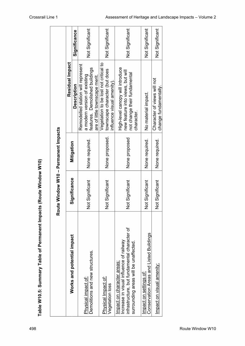
Crossrail Line 1 Assessment of Heritage and Landscape Impacts – Volume 2
498 Route Window W10
Tabl
e W
10.5
: Sum
mar
y Ta
ble
of P
erm
anen
t Im
pact
s (R
oute
Win
dow
W10
)
R
oute
Win
dow
W10
– P
erm
anen
t Im
pact
s
Res
idua
l Im
pact
W
orks
and
pot
entia
l im
pact
Si
gnifi
canc
e M
itiga
tion
Des
crip
tion
Sign
ifica
nce
Phy
sica
l im
pact
of:
Dem
oliti
ons
and
new
stru
ctur
es.
Not
Sig
nific
ant
Non
e re
quire
d.
Rem
odel
led
stat
ion
will
repr
esen
t a
mod
ern
vers
ion
of e
xist
ing
feat
ures
. D
emol
ishe
d bu
ildin
gs
are
of li
ttle
tow
nsca
pe m
erit.
Not
Sig
nific
ant
Phy
sica
l Im
pact
of:
Veg
etat
ion
loss
N
ot S
igni
fican
t N
one
prop
osed
. V
eget
atio
n to
be
lost
not
crit
ical
to
tow
nsca
pe c
hara
cter
(but
doe
s in
fluen
ce v
isua
l am
enity
). N
ot S
igni
fican
t
Impa
ct o
n ch
arac
ter a
reas
: In
crea
se in
vis
ual i
nflu
ence
of r
ailw
ay
infra
stru
ctur
e, b
ut fu
ndam
enta
l cha
ract
er o
f su
rrou
ndin
g ar
eas
will
be
unaf
fect
ed.
Not
Sig
nific
ant
Non
e pr
opos
ed
Hig
h-le
vel c
anop
y w
ill in
trodu
ce
new
feat
ure
into
vie
ws,
but
will
no
t cha
nge
thei
r fun
dam
enta
l ch
arac
ter.
Not
Sig
nific
ant
Impa
ct o
n se
tting
s of
: C
onse
rvat
ion
Are
as a
nd L
iste
d B
uild
ings
N
ot S
igni
fican
t N
one
requ
ired.
N
o m
ater
ial i
mpa
ct.
Not
Sig
nific
ant
Impa
ct o
n vi
sual
am
enity
: N
ot S
igni
fican
t N
one
requ
ired.
C
hara
cter
of v
iew
s w
ill n
ot
chan
ge fu
ndam
enta
lly.
Not
Sig
nific
ant

Crossrail Line 1 Assessment of Heritage and Landscape Impacts – Volume 2
Route Window W10 499
6. Assumptions
- Temporary work sites will be returned to their previous condition and use, e.g. surfaced
areas such as car parks will be reinstated and soft areas will be grassed or planted with
shrubs.
- 2.4 and 3.6m metre high timber hoarding around the perimeter of temporary work sites.
- Desk-top studies and a number of site visits were undertaken during September and
October 2004 and therefore this assessment was undertaken during the late summer
period when vegetation was in leaf. However, when considering the landscape and
visual impacts of the scheme, an assessment of the potential winter situation has been
estimated / taken into account and ZVIs mapped on this basis.

Crossrail Line 1 Assessment of Heritage and Landscape Impacts – Volume 2
500 Route Window W10
7. References - ES Route Windows W10
- Parliamentary Plan Sheets
- ES Scheme Description

Crossrail Line 1 Assessment of Heritage and Landscape Impacts – Volume 2
Route Window W8/9 501
Route Window W8/9 Southall Station and
Southall West Sidings


Crossrail Line 1 Assessment of Heritage and Landscape Impacts – Volume 2
Route Window W8/9 503
Contents 1. Description of the Works 505
1.1 Permanent Works 505 1.2 Temporary Works 505
2. Baseline Assessment 508 2.1 Local context 508 2.2 Listed Buildings and their Setting 510 2.3 Conservation Areas 510 2.4 Townscape 511 2.5 Sensitivity 517
3. Impact of the Scheme 520 3.1 Listed Buildings and their setting 520 3.2 Conservation Areas 520 3.3 Landscape / Townscape 520 3.4 Visual impacts 522
4. Summary 525 4.1 Listed Buildings and their Setting 525 4.2 Conservation Areas 525 4.3 Townscape 525 4.4 Visual Impacts 525
5. Summary tables 525 6. Assumptions 529 7. References 530

Crossrail Line 1 Assessment of Heritage and Landscape Impacts – Volume 2
504 Route Window W8/9

Crossrail Line 1 Assessment of Heritage and Landscape Impacts – Volume 2
Route Window W8/9 505
Route Window W8/9 Southall Station and Southall West Sidings
1. Description of the Works
1.1 Permanent Works
A new ticket hall will be built northeast of the existing ticket hall, currently located on South
Road bridge. It will be accessed from an elevated walkway from South Road. A new
footbridge will be constructed including lift access to all platforms; the lifts will be
accommodated within towers 12 m high and 3 m wide.
Platforms will be extended to accommodate longer Crossrail trains: platforms three and four
will be extended eastwards by 55 m; the island platform two and three will also be widened to
the north. A usable length of 110 m will be provided on the faces of main line platforms one
and two to suit five-car Crossrail operations during planned maintenance of the relief lines.
Further east, between Southall station and the Uxbridge Road bridge in Route Window W7,
various track modifications will be undertaken including minor track slews, provision of new
crossovers and some redesignation of the existing tracks. These will all take place within the
existing rail corridor.
1.2 Temporary Works
Duration of Works
Subject to possession planning requirements and excluding final commissioning, works at
the station will take approximately two years and two months to complete.
Enabling Works
No major enabling works are required. Preliminary works include the creation of temporary
worksites and access points, together with the diversion of utilities and services.

Crossrail Line 1 Assessment of Heritage and Landscape Impacts – Volume 2
506 Route Window W8/9
Main Works
Works at Southall station will involve the following:
- Construction of the new station footbridge using piled foundations, and provision of a
temporary high level walkway, connecting the footbridge to the existing ticket hall. These
works will take approximately three months to complete.
- Removal of the footbridge crossing the relief lines, and stairs from the existing ticket hall
to the eastbound relief line platform (platform four). Demolition of the existing station
buildings and canopy on this platform where necessary.
- Construction of the new station building to the north of platform four, using piled
foundations. The connection between the ticket hall and new station footbridge will be
built in this phase. These works will take approximately eight and half months to
complete.
- Commissioning of the new ticket hall, and removal of the temporary high level walkway
connection between the footbridge and the existing ticket hall.
- Remaining demolitions, following which platform canopies will be installed.
- Conversion of the existing ticket office over the railway for retail or other commercial use.
- On completion of the new station building, final works will involve minor alterations to the
supports of Merrick Road footbridge.
Platform works will also be undertaken during this time. The westbound relief line will be
realigned parallel to the eastbound to enable widening of platform three to the new track
alignment. The relief lines and eastbound main line platforms will be extended using
crosswalls with pre-cast concrete beams. On completion of the platform alterations, the
eastbound relief line will be tamped to achieve correct platform clearances. The westbound
relief line will be realigned to enable platform widening.
Construction plant required at the worksite will include a piling rig, cranes, excavators,
vibrating poker, compressors, and generators.
Worksites and Access
Works at the station will be carried out from two worksites. All materials will be taken to and
from the worksites by road:
- The Southall station worksite will be located on the site to be used for the new station
buildings. The worksite is bounded by Merrick Road footbridge to the east,

Crossrail Line 1 Assessment of Heritage and Landscape Impacts – Volume 2
Route Window W8/9 507
- by South Road to the west and by the railway to the south. Access to the worksite will be
from Park Avenue. The worksite will be served by eight lorries per day during the 36
week peak construction period and typically by six per day at other times.
- The Park Avenue worksite will be located immediately east of the station on the existing
depot site. It will extend between the railway in the south and Park Avenue in the north.
All materials will be taken to and from the site by road from South Road and Uxbridge
Road via Park Avenue. The Park Avenue worksite is used for the Southall track re-
modelling works and it will be required for between seven and eight months, during which
time no more than one or two lorries per week will access the site. Peak construction
activity will take place at the start and finish of the works, each for about two weeks.
During this time there will be up to five lorries per day accessing the site.

Crossrail Line 1 Assessment of Heritage and Landscape Impacts – Volume 2
508 Route Window W8/9
2. Baseline Assessment 2.1 Local context
This section of the route traverses a wholly urban area dominated by residential and
business/industrial uses. The relatively dense urban pattern is interrupted by several vacant
or under-used sites, including redundant railway land. Corridors of amenity land define the
floodplains of the Yeading Brook and the River Brent, to the west and east of the area
respectively.
The railway corridor is itself relatively prominent, due partly to its width, which accommodates
multiple lines and sidings, and to the presence of OHLE infrastructure. In addition, the route
runs on embankment as it crosses the two floodplains, with significant bridges over the
Grand Union Canal (Paddington Arm) and the Uxbridge Road.
To the north of the route, the area is initially open, comprising amenity land along the
Yeading Brook Valley. To the south-east of the Grand Union Canal (Paddington Arm) lies
the former Southall Gasworks site, most of which is also open, but used for contract parking.
A gas holder station occupies the centre of this area, dominated by a modern, blue-painted
gas holder which is a prominent landmark in the local area.
The densely built-up area of Southall lies to the north of the gasworks site. This comprises
mainly two-storey terraced housing dating from 1900-20, laid out in a grid of streets. The
modern, larger-scale buildings of Southall and West London College lies to the north of
Beaconsfield Road.
The eastern end of the gasworks site, forming a wedge of land between the built-up area and
the railway, comprises an area of secondary woodland and scrub. This is adjoined to the
east by a former waterworks, including the Southall Water Tower, an ornate brick structure
which appears to be in residential use.
South Road, which extends northwards from the overbridge adjoining the station, is lined by
a mix of shops, offices, housing and community facilities such as the Post Office, the Glassy
Junction pub, the King’s Hall Methodist Church and the Hambrough Primary/Nursery School.
The triangle of land between South Road, the railway and Park Avenue is occupied partly by
the Siri Guru Singh Santa Sikh Temple and partly by Henelly’s plant hire yard.
Crossrail Line 1 Assessment of Heritage and Landscape Impacts – Volume 2
Route Window W8/9 509
The area north of Park Avenue is mainly residential, comprising 2/3 storey terraced
properties dating from about 1900-1910 in Avenue Road, and 1930s semis along Park
avenue. The area between Park Avenue and the railway is occupied mainly by a mix of
vacant land and commercial / business uses, including the Barratt Industrial Park.
Residential uses extend eastwards, occupying the triangle of land between the railway and
Uxbridge Road. North of the latter lies the open land of the River Brent floodplain, which is
mainly in amenity use.
The railway is adjoined to the south initially by a vacant industrial site (north of Scott’s Road),
and then by a series of industrial/business premises (north of Johnsons Road). To the south
lies the residential area of Southall Green, comprising mainly 1930s semi-detached housing.
To the east of Balfour Road, residential uses adjoin the railway corridor. These comprise
mainly terraced properties dating from around 1900 in Spencer Street and Queen’s Road. A
small open space and play area, the Spencer Street Play Centre, also lies close to the
railway at this point. To the east of the Dudley Road pedestrian underpass, the railway
corridor widens to accommodate Southall West sidings, a large area of disused railway land.
To the east of Gladstone Road lies an area of warehousing and business uses, including the
Dominion and Featherstone industrial estates. This area backs onto a mix of retail, business
and community uses along The Green. These uses include places of worship (St. Anselms
Church and a Hindu Temple), shops, offices (notably King’s House and Phoenix House) and
open space (the Manor House Grounds). A 3-storey block of flats, Martins Court, adjoins the
railway corridor immediately to the west of the South Road overbridge.
To the east of The Green, business uses (The Arches Business centre) lie between Merrick
Road and the railway. Residential uses predominate to the south of Merrick Road,
comprising the 2/3 storey Maypole Court flats, The Limes (a 1-2 storey sheltered housing
scheme) and terraced housing in Hortus Road and Kingston Road.
Southall Community Centre is located on the corner of Merrick Road adjacent to the
roundabout access to Middlesex Business Centre. The Community Centre is a distinctive
building, probably a former theatre or dance hall, dating from about 1900.

Crossrail Line 1 Assessment of Heritage and Landscape Impacts – Volume 2
510 Route Window W8/9
Business and industrial uses predominate to the east of Merrick Road, comprising the
Middlesex Business Centre and Charles House, accessed off Bridge Road. Most of these
uses occupy typical 2/3 storey warehouse buildings. Notable exceptions are Sunrise House,
an older 5/6 storey building, and the 7/8 storey Quaker Foods building, further east.
In this area the railway corridor widens to accommodate the Brentford Branch. The triangle
of land between the branch and the main line is occupied by disused railway sidings,
carriage sheds and a water tower.
Industrial and business uses continue to predominate to the east of Glade Lane, comprising
the Enterprise Estate and the Great Western Industrial Park. These areas are occupied by
typical 2/3 storey, large footprint warehouse buildings, surrounded by parking and service
yards.
The Townscape Character Baseline Plans for Southall Station - Drawing No. 1E0416-
W1E00-E00-F-00008 and for Southall West Sidings - Drawing No. 1E0416-W1E00-E00-F-
00009 identify the locations of key buildings and landmarks in the local landscape /
townscape, local views, pedestrian and vehicular movement corridors, townscape character
areas, urban gateways / nodes and the landscape planning designations that relate to the
work sites and their surroundings. These baseline plans also illustrate the extent of the work
sites for both the temporary and permanent works.
2.2 Listed Buildings and their Setting
Two Grade II listed buildings have been identified. These are the Southall Water Tower,
which lies just to the north of the railway corridor, west of South Street bridge; and the Manor
House, which is located on The Green, about 300m south of the railway.
2.3 Conservation Areas
There are no Conservation Areas in the vicinity.

Crossrail Line 1 Assessment of Heritage and Landscape Impacts – Volume 2
Route Window W8/9 511
2.4 Townscape
2.4.1 Character Areas and Landscape / Townscape Quality
The landscape / townscape character of the area is defined mainly by land use and built
pattern. Seven main character areas may be identified:
- Yeading Brook Valley;
- Southall Gasworks;
- Southall;
- Brent Lodge Park;
- Railway Corridor;
- Southall Green; and
- Eastern Industrial Area.
Yeading Brook Character Area: The Yeading Brook Valley comprises a corridor of open land, including sports facilities, lying
to the north-west of the Grand Union Canal (Paddington Arm). The area includes significant
vegetation, particularly along the river and canal.
Gasworks Character Area: Southall Gasworks is a distinctive area of mainly open land, used for contract parking, in
which the gas holder station is highly prominent. The eastern part of this area includes
significant vegetation (mature planes and secondary woodland and scrub).
Southall Residential Character Area: Southall comprises a predominantly residential area of mainly low-rise and relatively high-
density terraced and semi-detached housing. Buildings of contrasting form and use include
the Southall and West London College, and the commercial and community uses along
South Road.
Brent Lodge Park Character Area:
The River Brent Valley is a corridor of open land lying to the north-east of Uxbridge Road,
and dominated by amenity uses.

Crossrail Line 1 Assessment of Heritage and Landscape Impacts – Volume 2
512 Route Window W8/9
GWML Railway Character Area:
The Railway Corridor is sufficiently distinctive to form a character area in its own right. It is
relatively wide, particularly in the vicinity of Southall West Sidings and the Brentford Branch,
and includes features such as OHLE infrastructure and disused railway buildings.
Southall Green Character Area:
Southall Green comprises the built-up area lying to the south of the railway. It is mainly
residential, with mixed uses along The Green, together with areas of industrial/business use
adjoining Johnsons Road, to the north of Featherstone Road and along Merrick Road.
Eastern Industrial Character Area:
To the east of Merrick Road, industrial/business uses become sufficiently prominent as to
form a character area in their own right, dominated by features such as Sunrise House and
the Quaker Foods factory.
2.4.2 Key Townscape / Landscape Features and Resources
A number of buildings in the area are distinctive. In many cases, their influence does not
extend beyond their immediate curtilage or surrounding streets. Examples include Southall
Station itself and the Southall Community Centre in Merrick Road. At Southall Station, the
railway arches on Merrick Road are locally listed by Slough District Council.
The visual influence of four buildings, however, extends across a wider area. These are:
- the blue gas holder within the Southall Gasworks site;
- Southall Water Tower;
- Sunrise House; and
- the Quaker Foods factory.
Vegetation has a limited influence on landscape character and views. It is prominent within
the Yeading Brook Valley and River Brent Valley character areas. In some locations, street
trees are important (e.g. Avenue Road), whilst vegetation has been planted to provide
screening around industrial sites (e.g. along the southern side of Park Avenue and around
the northern perimeter of the gasworks).

Crossrail Line 1 Assessment of Heritage and Landscape Impacts – Volume 2
Route Window W8/9 513
Significant vegetation occurs intermittently along the perimeter of the railway corridor, e.g. to
the rear of properties in Scott’s Road, Johnsons Road, Spencer Street and Queens Road.
In visual terms, the most important vegetation in the area is that within the eastern part of the
gasworks site and around the former waterworks. This vegetation comprises a mix of mature
trees, some of which have been planted (e.g. London planes along The Straight and weeping
willows in the waterworks site), together with scrub and secondary woodland that has
developed within the gasworks. This block of vegetation is of sufficient importance to be
regarded as a key feature.
2.4.3 Strategic Views and Key Local Views
There are no strategic views in the vicinity of the site.
No local views are regarded as key to the extent that they are particularly sensitive or provide
exceptional viewing opportunities.
It should be noted, however, that pedestrians using the South Road overbridge and the
Merrick Road footbridge gain extensive views along the railway corridor and across the
surrounding area. Similar, panoramic views are assumed to be gained from taller buildings
such as the water tower and Sunrise House.
However, since these locations either are not publicly accessible, or are of little value in
visual amenity terms, they are not considered to represent key local views.
2.4.4 Pedestrian / Vehicular Movement Corridors
The main roads in the area comprise:
- South Road/The Green (A3005), which is a busy route connecting Southall to the north
with Norwood Green to the south; and
- the Uxbridge Road (A4020), an arterial route which connects Ealing to the south-east
with Uxbridge to the north-west.
Both routes cross the railway, and are also used by pedestrians/cyclists.

Crossrail Line 1 Assessment of Heritage and Landscape Impacts – Volume 2
514 Route Window W8/9
The railway corridor is crossed by the following pedestrian routes:
- White Street subway;
- Merrick Road footbridge;
- Glade Lane subway; and
- Lyndhurst Avenue subway.
These routes are probably used by local residents and schoolchildren. However, they are
generally unattractive and potentially dangerous environments, and are of no importance in
visual amenity terms.
Movement through the area is otherwise confined to the pattern of local streets. The only
important pedestrian route is the Grand Union Walk, which runs alongside the Paddington
Arm.
2.4.5 Landscape Planning Designations
The undeveloped floodplains of the Yeading Brook and River Brent are designated as
Metropolitan Green Belt.
The Grand Union Canal forms part of London’s “blue ribbon” network of waterways, and is of
borough-wide importance as a publicly accessible “green” corridor through a largely built-up
area. It is also designated as a Site of Metropolitan Importance (SMI) for its nature
conservation interest.
- The relationship of the railway to the surrounding area;
- The general character and arrangement of land uses;
- The proximity, scale and use of nearby buildings; and
- The size and type of nearby vegetation.
As has been described previously, the railway traverses this area initially on a low (about 2-
3m high) embankment, then running at grade from the vicinity of Queens Road, and onto
embankment again to the east of the former Southall Depot.

Crossrail Line 1 Assessment of Heritage and Landscape Impacts – Volume 2
Route Window W8/9 515
Views towards the railway corridor are defined mainly by the surrounding land uses and
buildings. To the west of South Road, the open land of the Yeading Brook valley and the
gasworks site allow potential views towards the railway from the edge of the built-up area up
to 500m to the north. In practice, however, the gas holder station, vegetation (notably on the
eastern part of the gasworks site) and intervening features (including parked vehicles) will
restrict viewing opportunities.
To the south, the railway corridor is tightly enclosed by the urban fabric of terraced housing
and business premises, reinforced intermittently (and mainly in summer) by vegetation.
To the east of South Road, the railway corridor is enclosed to the north by the built-up edge
of housing and business units, strongly reinforced by vegetation along the southern side of
Park Avenue. From Glade Lane eastwards, this enclosure weakens as the railway rises onto
embankment to cross Uxbridge Road. In this area there is the potential for views to extend
northwards across the open land of the River Brent floodplain.
South of the railway, industrial and business units initially define the extent of views. Viewing
opportunities open up across the Southall Depot site as the Brentford Branch diverges to the
south-east, and the line of industrial buildings is pulled back. To the east of Glade Lane, the
buildings of the Enterprise Estate and Great Western Business Park define the edge of
visibility immediately south of the railway corridor.
In summary, the potential winter-time ZVI to the north of the railway is defined from west to
east by the following:
- Vegetation along the Grand Union Canal (Paddington Arm);
- The edge of the built-up area north of the gasworks site;
- Buildings immediately north of the station and along Park Avenue;
- Business premises and housing along Park Avenue; and
- Vegetation along the River Brent.
The potential winter-time ZVI to the south of the railway is defined from west to east by the
following:
- Properties in Scott’s Road, Johnsons Road, Spencer Street and Queens Road;
- Business premises to the west of The Green;

Crossrail Line 1 Assessment of Heritage and Landscape Impacts – Volume 2
516 Route Window W8/9
- Offices and residential properties around the junction of The Green/Merrick Road;
- Business, residential and community premises in Merrick Road;
- The Middlesex Business Centre;
- Industrial buildings south of the Brentford Branch (notably the Quaker Foods factory); and
- Business units east of Glade Lane.
The works will be confined to the section of the railway corridor between South Road and
Southall Depot. The South Road overbridge will partly define the ZVI to the west,
intercepting most views at rail level, but will be overtopped by taller construction features and
by the new station buildings.
To the east, the ZVI will extend further along the railway corridor between the buildings and
vegetation that define it on either side. The buildings within Southall Depot (including a water
tower and carriage shed) will provide a degree of obstruction, although it is probably
reasonable to assume that these structures will be demolished at some point.
Potential sources of views of the station works, from locations north of the railway, may be
summarised as follows:
- Occupants of the Water Tower.
- Residents of Randolph Road and The Crescent;
- Users of The Crescent open space;
- Users of South Road bridge;
- Users of the station;
- Users of the Sikh Temple;
- Residents of Park Avenue and the southern sections of Avenue Road and Villiers Road;
- Occupants of business premises along the northern side of the railway;
- Users of the Merrick Road footbridge;
Potential sources of views of the works, from locations south of the railway, may be
summarised as follows:
- Occupants of business premises in Southbridge Road;
- Residents of Martins Court, Maypole Court and The Limes;
- Occupants of offices such as Kings House;
- Occupants of The Arches Business Centre;
- Users of Southall Community Centre;
- Occupants of Middlesex Business Centre and the Quaker Foods factory;

Crossrail Line 1 Assessment of Heritage and Landscape Impacts – Volume 2
Route Window W8/9 517
2.5 Sensitivity
2.5.1 Sensitivity of Townscape / Landscape to Change
Built-Up Areas
The industrial/business areas are of low sensitivity to change. This reflects their functional
character, and their robust pattern of relatively large-scale buildings and spaces. Features
associated with the railway construction works would be expected to be unremarkable within
this setting. New railway infrastructure is also unlikely to be particularly intrusive within a
context of existing industrial features.
The railway corridor is already locally prominent, due to the degree of visual and physical
severance it creates, together with infrastructure such as the road bridges and OHLE. As a
result, the sensitivity of those areas lying within the ZVI of the railway is reduced.
Sensitivity to change is by definition increased by the presence of Listed Buildings. Thus, the
sensitivity of the townscape becomes moderate to potentially high in the vicinity of the Water
Tower and the Manor House.
The residential areas are of moderate sensitivity to change. Although, as built-up areas, they
are able to accommodate a degree of change, their small-scale built pattern is more
susceptible to adverse impacts due to the introduction of larger-scale features. The number
of potential receptors, coupled with the amenity value of views from dwellings and gardens,
increases this sensitivity.
Open Land
The areas of green space in the Yeading Brook and River Brent valleys are generally highly
sensitive to change, due to their potential degree of visual exposure and the contrast with
which new construction or infrastructural features may be perceived. However, this
sensitivity is mitigated in part by distance; neither area adjoins the railway corridor.
Open space that is separated from the railway corridor by buildings, or that is embedded
within the built-up area (e.g. The Crescent open space and Southall park) is less sensitive.
Sensitivity increases where open space adjoins the railway corridor, with little intervening
screening, as at Spencer Street.

Crossrail Line 1 Assessment of Heritage and Landscape Impacts – Volume 2
518 Route Window W8/9
The area includes several open sites, notably the gasworks, Southall West sidings, the
disused Southall Depot and a vacant site in Scott’s Road. These sites, whilst visually
exposed, are of low sensitivity. They are brownfield sites rather than green space, and are
likely to be redeveloped in the future.
2.5.2 Sensitivity of Visual Receptors to Change
Table W8-W9.1: Visual Receptors (Southall Station Works) below identifies the key receptors
who are likely to obtain views of the proposed temporary and permanent works, together with
their sensitivity, the type of views and whether the views are of the temporary or permanent
works.
Table W8-W9.1: Visual Receptors for the Southall Station Works
Receptor
(Close Views under 1km distance)
Type of View D
irect
Vi
ew
Obl
ique
Vi
ew
Tem
pora
ry
Wor
k Si
tes
Perm
anen
t W
orks
Sensitivity of
Receptors
1 Occupants of the Water Tower Upper floors High
2 Residents of Randolph Road + The Crescent
Ground + upper floors High
3 Users of The Crescent open space Ground Moderate
4 Users of South Road bridge Ground Low 5 Users of the station Ground Low 6 Users of the Sikh Temple Ground Moderate
7 Residents of Park Avenue/Avenue Road/ Villiers Road
Upper floors High
8 Occupants of business premises north of railway
Ground + upper floors Low
9 Users of Merrick Road footbridge Ground Low
10 Occupants of business units in Southbridge Rd
Ground + upper floors Low
11 Residents of Martins Court, Maypole Court + The Limes
Ground + upper floors High
12 Occupants of offices such as Kings House Upper floors Low
13 Occupants of The Arches Business Centre
Ground + upper floors Low
14 Users of Southall Community Centre Ground Moderate
15 Occupants of Middlesex Business Centre + Quaker Foods
Ground + upper floors Low

Crossrail Line 1 Assessment of Heritage and Landscape Impacts – Volume 2
Route Window W8/9 519
The most sensitive receptors in the area comprise local residents. It is estimated that
occupants of up to about 120 residential properties may experience views of the works.
These may be summarised as follows:
- Views from about 20 properties in Randolph Road/The Crescent. Views from about 10
properties in The Crescent will be directly towards South Road bridge, with little
screening.
- Views from about 50 properties in Park Avenue (west of Villiers Road)/Avenue
Road/Milan Road. Although many of these views will be direct, many of them will be
screened to varying degrees by intervening buildings.
- Views from about 30 properties in Park Avenue (central). Although these views may be
direct, most will be screened to varying degrees by vegetation (mainly in summer) and/or
by intervening buildings.
- Views from about 20 properties in Martin Court/Maypole Court. Trees along Merrick
Road will provide a substantial degree of screening in summer. The Arches Business
Centre will screen the eastern part of the work site.
A second, potentially sensitive group of receptors comprises users of public open space.
Although the major such spaces are located away from the railway corridor, one area – at
The Crescent – is sufficiently close to experience direct views of the works over short
distances.
The remaining receptors in the area include occupants of business premises, users of the
station and nearby roads and pedestrian routes. In all cases, their sensitivity is assumed to
be low.
Receptors who live in or use properties that overlook the railway corridor can be assumed to
be habituated to a certain degree to the impact of railway maintenance and construction
activities.

Crossrail Line 1 Assessment of Heritage and Landscape Impacts – Volume 2
520 Route Window W8/9
3. Impact of the Scheme
3.1 Listed Buildings and their setting
Work will take place within the setting of the Grade II listed Water Tower, from which
permanent features such as the new station structures will also be visible. These impacts
will not fundamentally affect the character of this setting, in which the railway corridor, and
associated infrastructure, is already prominent. Neither will any key views of the Water
Tower be affected. The effect on its setting is therefore not considered to be significant.
The Manor House lies to the south outside the visual influence of the works.
The existing station building is locally (but not statutorily) listed. This building is to be
retained and refurbished, and its setting will be affected both by the construction works and
by the new station buildings. However, since the building is of local importance only, this
impact is not considered to be significant.
3.2 Conservation Areas There are no impacts on Conservation Areas within this route window.
3.3 Landscape / Townscape 3.3.1 Impact on Landscape / Townscape Features and Resources
There will be no physical impact on any features or areas of designated landscape /
townscape importance.
Both the construction works and the permanent features of the remodelled station will be
visible within the setting of The Crescent open space. However, this setting is influenced
most strongly by the adjoining buildings and streets (South Road), and the impact of the
works will at most be Moderate. The impacts are not significant.

Crossrail Line 1 Assessment of Heritage and Landscape Impacts – Volume 2
Route Window W8/9 521
3.3.2 Impact on Character Areas
The impacts of the temporary works on landscape / townscape character areas may be
summarised as follows:
- No impact on the Yeading Brook valley.
- A Minor impact on the Southall gasworks area, from which the works may be distantly
visible.
- A Moderate impact on the Southall character area. This impact will be confined in the
main to the southern parts of the area.
- No impact on the River Brent valley.
- A Moderate impact on the Railway Corridor..
- A Moderate impact on the Southall Green area, confined in the main to its northern
fringe.
- No impact on the Eastern Industrial Area.
These impacts are not significant.
The impact of the permanent works on landscape / townscape character areas may be
summarised as follows:
- No impact on the Yeading Brook valley.
- A Minor impact on the Southall Gasworks area.
- A Moderate impact on the Southall character area, due to the remodelled station,
although its visual influence is unlikely to extend further north than Beaconsfield
Road/Park Avenue.
- No impact on the River Brent valley.
- A Moderate impact on the Railway Corridor. Although the remodelled station will
represent a significant change, the fundamental character of the corridor will remain.
- A Moderate impact on the Southall Green area, due to the remodelled station, although
its visual influence is unlikely to extend further south than Hortus Road.
- No impact on the Eastern Industrial Area.
These impacts are not significant.

Crossrail Line 1 Assessment of Heritage and Landscape Impacts – Volume 2
522 Route Window W8/9
3.4 Visual impacts
The Visual Appraisal Plans for Southall Station - Drawing No. 1E0316-W1E00-E00-F-00008
and for Southall West Sidings - Drawing No. 1E0316-W1E00- E00-F-00009 illustrate the
approximate Zone of Visual Influence for the proposed temporary and permanent works, and
identifies the principal locations from which views of the development would be obtained.
The magnitude of visual impact that would be generated by the temporary works on each
receptor group is identified in Table W8-W9.2: Potential Temporary Impacts on Receptors
(Southall Station Works).
Table W8-W9.2 :- Potential Temporary Impacts on Receptors (Southall Station)
Receptor
(Close Views under 1km distance)
Sensitivity of
Receptors
Magnitude of Potential Impact on Receptors
Significance
1 Occupants of the Water Tower High Low NSIG
2 Occupants of about 10 residential properties in The Crescent High High SIG (-)
3 Occupants of about 30 residential properties in Randolph Road/The Crescent
High Low NSIG
4 Users of The Crescent open space Moderate Moderate NSIG
5 Users of South Road bridge Low High NSIG 6 Users of the station Low High NSIG 7 Users of the Sikh Temple Moderate Moderate NSIG
8
Occupants of approx. 50 residential properties in Park Avenue (west)/Avenue Rd/Milan Road
High High SIG (-)
9 Occupants of business premises between the railway and Park Avenue
Low High NSIG
10 Users of Merrick Road footbridge Low High NSIG
11 Residents of about 30 residential properties in Park Avenue (central)
High Low NSIG
12 Occupants of business units in Southbridge Road Low Moderate NSIG
13 Occupants of about 20 residential properties in Martins Court + Maypole Court
High High SIG (-)
14 Occupants of offices such as Kings House Low Moderate NSIG
15 Occupants of The Arches Business Centre Low High NSIG

Crossrail Line 1 Assessment of Heritage and Landscape Impacts – Volume 2
Route Window W8/9 523
Receptor
(Close Views under 1km distance)
Sensitivity of
Receptors
Magnitude of Potential Impact on Receptors
Significance
16 Users of Southall Community Centre Moderate Moderate NSIG
17 Occupants of Middlesex Business Centre + Quaker Foods Low Moderate NSIG
Temporary significant effects are predicted for the occupants of approx. 80 residential
properties. This number of properties represents about two-thirds of the total number of
residential receptors likely to experience views of the works. Significance results in most
cases from the proximity of highly sensitive receptors to the works, with few intervening
features to provide screening. In mitigation, however, it should be noted that these effects
will be temporary, and will in many cases be confined to upper floors (which are unlikely to
be the main habitable rooms where the properties comprise terraced housing).
In all other cases, the predicted effects are not deemed to be significant. This is because
receptors are of low sensitivity (e.g. occupants of business premises), or because views are
over greater distances, are partially obstructed and/or are of smaller-scale works (e.g.
residential properties in the central section of Park Avenue).
The magnitude of visual impact that would be generated by the permanent works on each
group of receptors is identified in Table W8-W9.3: Potential Permanent Impacts on
Receptors (Southall Station).
Table W8-W9.3: Potential Permanent Impacts on Receptors (Southall Station)
Receptor
(Close Views under 1km distance)
Sensitivity of
Receptors
Magnitude of Potential Impact on Receptors
Significance
1 Occupants of the Water Tower High Low NSIG
2 Occupants of about 10 residential properties in The Crescent. High Moderate NSIG
3 Occupants of about 15 residential properties in Randolph Road/The Crescent
High Low NSIG
4 Users of The Crescent open space Moderate Low NSIG
5 Users of South Road Bridge Low High NSIG 6 Users of the station Low High NSIG 7 Users of the Sikh Temple Moderate Moderate NSIG
8 Occupants of approx. 50 residential properties in Park High Low NSIG

Crossrail Line 1 Assessment of Heritage and Landscape Impacts – Volume 2
524 Route Window W8/9
Receptor
(Close Views under 1km distance)
Sensitivity of
Receptors
Magnitude of Potential Impact on Receptors
Significance
Avenue (west)/Avenue Rd/Milan Road
9 Occupants of business premises between the railway and Park Avenue
Low Moderate NSIG
10 Users of Merrick Road footbridge Low Moderate NSIG
11 Residents of about 30 residential properties in Park Avenue (central)
High Low NSIG
12 Occupants of business units in Southbridge Road Low Moderate NSIG
13 Occupants of about 20 residential properties in Martins Court and Maypole Court
High Moderate NSIG
14 Occupants of offices such as Kings House Low Moderate NSIG
15 Occupants of The Arches Business Centre Low High NSIG
16 Users of Southall Community Centre Medium Low NSIG
17 Occupants of Middlesex Business Centre and Quaker Foods Low Low NSIG
No permanent significant effects on visual amenity have been identified. Although the
permanent features of the new station will be clearly visible from locations such as properties
in The Crescent, Park Avenue and Martins Court/Maypole Court, the character and extent of
these views will not change to a fundamental degree.
The existing station, South Road Bridge and buildings flanking the railway corridor are the
main influence on these views. The new ticket hall will be relatively prominent, as a visibly
modern building occupying a currently open site. However, its scale will be generally
compatible with that of the existing station building and other buildings in the vicinity. It will
not, for example, compete as a landmark with the water tower or Sunrise House. Neither is it
likely to obstruct views across the railway corridor, except perhaps from some properties in
the western section of Park Avenue.
Taken together, the new ticket hall, footbridge and platform canopies are likely to increase
the visibility of the station, but not to a degree that will change the character of views to a
significant degree.
The Year 1 predicted impacts are not considered to be significant for the reasons given
above. After 15 years following completion the situation will remain the same.

Crossrail Line 1 Assessment of Heritage and Landscape Impacts – Volume 2
Route Window W8/9 525
4. Summary
4.1 Listed Buildings and their Setting There will be no material impact on the setting of the Water Tower. There are no other
impacts on listed buildings within this route window.
4.2 Conservation Areas No Conservation Areas are affected by the works in this route window.
4.3 Townscape
The construction works will be of substantial scale and will be visible within parts of the
Southall, Southall Green and Railway Corridor character areas. However, the character of
these areas is robust, and will not be affected to a significant degree. There are not
predicted to be any signifricant impacts either during construction or due to the permanent
works.
4.4 Visual Impacts The construction works are considered to have a temporary significant impact on the amenity
of about 80 residential properties. This reflects the proximity, likely prominence and duration
of the works, together with the sensitivity of these receptors. This number of properties
represents about two-thirds of the total number of residential receptors in this area. This
impact, however, will be temporary, and will in many cases be confined to views from upper
floors only.
The permanent works are not considered to have any significant effects on visual amenity.
This is because the new station buildings will be of a scale appropriate to their setting, and
will not change the character of views from nearby properties to a fundamental degree.
5. Summary tables
There are no significant impacts on listed buildings or conservation areas in this route
window, hence these tables are not included in the summary tables.

Crossrail Line 1 Assessment of Heritage and Landscape Impacts – Volume 2
526 Route Window W8/9
Predicted impacts on landscape / townscape character, the setting of listed buildings and
visual amenity are summarised in Table W8-W9.4: Summary Table of Temporary Impacts
and Table W8-W9.5: Summary Table of Permanent Impacts, including any committed
mitigation and residual impacts.

Crossrail Line 1 Assessment of Heritage and Landscape Impacts – Volume 2
Route Window W8/9 527
Tabl
e W
8-W
9.4:
Sum
mar
y Ta
ble
of T
empo
rary
Impa
cts
(Rou
te W
indo
ws
W8-
W9)
R
oute
Win
dow
s W
8-W
9 –
Tem
pora
ry Im
pact
s
Res
idua
l Im
pact
W
orks
and
pot
entia
l im
pact
Si
gnifi
canc
e M
itiga
tion
Des
crip
tion
Sign
ifica
nce
Phy
sica
l im
pact
of:
Con
stru
ctio
n pl
ant a
nd c
ompo
unds
N
ot S
igni
fican
tN
one
prop
osed
N
o pr
omin
ent b
uild
ings
or
vege
tatio
n to
be
lost
. N
ot S
igni
fican
t
Impa
ct o
n ch
arac
ter a
reas
O
vera
ll ch
arac
ter o
f rai
lway
cor
ridor
and
sur
roun
ding
ar
eas
wou
ld n
ot b
e af
fect
ed.
Not
Sig
nific
ant
Non
e pr
opos
ed.
Tem
pora
ry w
orks
wou
ld b
e vi
sibl
e w
ith ra
ilway
cor
ridor
+
adjo
inin
g ar
eas,
but
no
fund
amen
tal c
hang
e to
ch
arac
ter.
Not
Sig
nific
ant
Impa
ct o
n se
tting
of L
iste
d B
uild
ing
(S
outh
all W
ater
Tow
er)
Not
Sig
nific
ant
Non
e pr
opos
ed
Tem
pora
ry w
orks
wou
ld b
e vi
sibl
e, b
ut c
hara
cter
of
setti
ng u
ncha
nged
. N
ot S
igni
fican
t
Impa
ct o
n vi
sual
am
enity
of:
App
rox.
80
resi
dent
ial p
rope
rties
S
igni
fican
t N
one
prac
ticab
le
Non
e (e
ffect
will
dis
appe
ar
whe
n w
ork
com
plet
ed).
Sig
nific
ant
Impa
ct o
n vi
sual
am
enity
of:
Oth
er re
cept
ors
Not
Sig
nific
ant
Non
e pr
opos
ed.
As
abov
e.
Not
Sig
nific
ant

Crossrail Line 1 Assessment of Heritage and Landscape Impacts – Volume 2
528 Route Window W8/9
Tabl
e W
8-W
9.5:
Sum
mar
y Ta
ble
of P
erm
anen
t Im
pact
s (R
oute
Win
dow
s W
8-W
9)
R
oute
Win
dow
s W
8-W
9 –
Perm
anen
t Im
pact
s
Res
idua
l Im
pact
W
orks
and
pot
entia
l im
pact
Si
gnifi
canc
e M
itiga
tion
Des
crip
tion
Sign
ifica
nce
Phy
sica
l im
pact
of:
Dem
oliti
ons
and
new
stru
ctur
es.
Not
Sig
nific
ant
Non
e re
quire
d.
Rem
odel
led
stat
ion
will
re
pres
ent a
mod
ern
+ en
larg
ed
vers
ion
of e
xist
ing
feat
ures
. N
ot S
igni
fican
t
Phy
sica
l Im
pact
of:
Veg
etat
ion
loss
N
ot S
igni
fican
t N
one
prop
osed
. N
o si
gnifi
cant
veg
etat
ion
to b
e lo
st.
Not
Sig
nific
ant
Impa
ct o
n ch
arac
ter a
reas
In
crea
se in
vis
ual i
nflu
ence
of r
ailw
ay
infra
stru
ctur
e, b
ut fu
ndam
enta
l cha
ract
er o
f su
rrou
ndin
g ar
eas
will
be
unaf
fect
ed.
Not
Sig
nific
ant
Non
e pr
opos
ed
Rem
odel
led
stat
ion
will
re
pres
ent a
mod
ern
+ en
larg
ed
vers
ion
of e
xist
ing
feat
ures
. N
ot S
igni
fican
t
Impa
ct o
n se
tting
Lis
ted
Bui
ldin
g:
(Sou
thal
l Wat
er T
ower
) N
ot S
igni
fican
t N
one
requ
ired.
N
o m
ater
ial i
mpa
ct.
Not
Sig
nific
ant
Impa
ct o
n vi
sual
am
enity
of:
Loca
l res
iden
ts a
nd o
ther
rece
ptor
s.
Not
Sig
nific
ant
Non
e re
quire
d.
Cha
ract
er o
f vie
ws
tow
ards
st
atio
n w
ill n
ot c
hang
e fu
ndam
enta
lly.
Not
Sig
nific
ant
Crossrail Line 1 Assessment of Heritage and Landscape Impacts – Volume 2
Route Window W8/9 529
6. Assumptions - Temporary work sites will be returned to their previous condition and use, e.g. surfaced
areas such as car parks will be reinstated and soft areas will be grassed or planted with
shrubs.
- It is proposed that 3.6 metre high hoarding be erected to the boundary of the temporary
work sites adjoining the station and 2.4 metre high hoarding used surrounding the Park
Avenue work site.
- Desk-top studies and a number of site visits were undertaken during September and
October 2004 and therefore this assessment was undertaken during the late summer
period when vegetation was in leaf. However, when considering the landscape and
visual impacts of the scheme, an assessment of the potential winter situation has been
estimated / taken into account and ZVIs mapped on this basis.

Crossrail Line 1 Assessment of Heritage and Landscape Impacts – Volume 2
530 Route Window W8/9
7. References
- ES Route Window W8 – W9
- Parliamentary Plan Sheets
- ES Scheme Description

Crossrail Line 1 Assessment of Heritage and Landscape Impacts – Volume 2
Route Window W7 531
Route Window W7 Hanwell Station


Crossrail Line 1 Assessment of Heritage and Landscape Impacts – Volume 2
Route Window W7 533
Contents 1. Description of the Works 535
1.1 Permanent works 535 1.2 Temporary Works 535
2. Baseline Assessment 536 2.1 Local context 536 2.2 Listed Buildings and their setting 538 2.3 Conservation Areas 538 2.4 Townscape 538 2.5 Zone of Visual Influence 543 2.6 Sensitivity 545
3. Impact of the Scheme 548 3.1 Listed Buildings and their setting 548 3.2 Conservation Areas 549 3.3 Landscape / Townscape 550 3.4 Visual impacts 550 3.5 Cumulative Impacts 553
4. Summary 554 4.1 Listed Buildings and their Setting 554 4.2 Conservation Areas 554 4.3 Townscape 554 4.4 Visual Impacts 555
5. Summary tables 556 6. Assumptions 561 7. References 562

Crossrail Line 1 Assessment of Heritage and Landscape Impacts – Volume 2
534 Route Window W7

Crossrail Line 1 Assessment of Heritage and Landscape Impacts – Volume 2
Route Window W7 535
Route Window W7 Hanwell Station
1. Description of the Works
1.1 Permanent works
Both platforms at Hanwell station will be extended westwards by about 65 m to
accommodate Crossrail trains. In the west of the route window, various minor track
modifications will be undertaken.
1.2 Temporary Works
The works at the station will take about one year and two months to complete. Construction
plant required for the works will include piling rigs, lighting rigs for night work, cranes,
compressors and generators.
Works will be undertaken from three worksites: one at Churchfields Gardens, located to the
north of the railway in the southeast corner of Churchfields Recreational Ground; one to the
east of Golden Manor on the north side of the railway; and one in a disused builders yard
accessed from Hanwell station’s forecourt, north of Hanwell station and the railway. Materials
will be taken to and from the site by road, with access from Church Road via Station
Approach and Golden Manor. There will be about two full lorry loads per day serving each of
the worksites during the whole construction period.

Crossrail Line 1 Assessment of Heritage and Landscape Impacts – Volume 2
536 Route Window W7
2. Baseline Assessment 2.1 Local context
Hanwell Station is located between Campbell Road and Station Approach, close to the
junction of Church Road and York Avenue within the London Borough of Ealing. The station
building is located on Campbell Road with the platforms located on viaduct approximately 6
metres above.
Hanwell Station
The station contains three existing platforms set on embankment relative to surrounding
areas to the north and south and approximately 6 metres above the surrounding roads. The
steep sides of the embankment are well vegetated to both northern and southern sides.

Crossrail Line 1 Assessment of Heritage and Landscape Impacts – Volume 2
Route Window W7 537
Hanwell Station is a three storey station of mainly brick construction, and lies within a
residential neighbourhood to the east of the Brent Valley. The Brent Valley is an important
recreational corridor with sports grounds, golf courses and recreation grounds along both
sides of the River Brent. To the west of Brent Valley lies the intensively developed business
parks, hospitals and residential areas of Southall. To the north of the station lies the
residential area of Hanwell Green with established neighbourhoods with large houses and
gardens. To the south of the station lies the more densely developed area of Hanwell with
rows of terraces with small gardens and two schools. Campbell Road and Golden Manor are
essentially residential in nature with large Edwardian semi detached residences and some
‘art deco’ residences. To the south of the rail corridor the schools lead down to residential
areas and a park, known as Connelly Dell, to the west. Retail units are found along Church
Road. There are extensive areas of vegetation surrounding the station, particularly along the
steep embankments. To the west more extensive areas of vegetation are found across the
Brent Valley corridor.
Church Road connects with Uxbridge Road (A4020) to the south.
The nearest residential properties comprise 2-storey Edwardian semi detached properties
along Campbell Road and Golden Manor, about 25m north of the station; and two-storey
properties along York Avenue, about 30m to the south east. A mixture of detached
bungalows and two storey Edwardian detached and semi detached properties are found
along Alwyne Road and Manor Court Road, around Manor Court Green. Three and four
storey flatblocks are found on Greenford Avenue, about 100m to the east. Established
residential neighbourhoods are located to the north, south and east.
The nearest open space are Manor Court Green and Churchfields Recreation Ground
located about 100m to the west, and the Royal Borough of Kensington and Chelsea
Cemetery lies 300m to the east.
The Townscape Character Baseline Plan for Hanwell Station, Drawing No. 1E0416-W1E00-
E00-F-00007 identifies the locations of key buildings and landmarks in the local townscape
and illustrates local views, pedestrian and vehicular movement corridors, townscape
character areas, urban gateways / nodes and the landscape planning designations that
relate to the site and its surroundings. This baseline plan also illustrates the extent of the
proposed sites for both the temporary and permanent works.

Crossrail Line 1 Assessment of Heritage and Landscape Impacts – Volume 2
538 Route Window W7
2.2 Listed Buildings and their setting
There is one Grade II listed building and one Grade I listed structure within the Limits of
Deviation (LOD) and/or the Limits of Land to be Acquired or Used (LLAU) for the project.
The Grade II listed building is Hanwell Station which was built in 1875-78 to the designs of
W. Lancaster Owen. The station is important, as it is the least altered example remaining of
the station rebuilding on this section of the line in the 1870s caused by quadrupling of the
tracks. The Hanwell Station listing includes the cast iron lamp-posts that extend along the
platforms. The Grade I listed structure is the Wharncliffe Viaduct which lies on the route of
the Great Western Railway.
There are several other listed buildings and structures locally. These include the Grade II
listed Hanwell Bridge, St. Mellitus Church on Church Road, 134 Church Road, Spring
Cottage at 99 Church Road, The Hermitage at 204 Church Road, Rectory Cottage at 135
Church Road, the Stable block at Brent Lodge Park on Church Road and the Grade II*
Church of St. Mary on Church Road. None of these buildings are within the approximate
Zone of Visual Influence of the works.
2.3 Conservation Areas The station is situated within the Hanwell Village Green Conservation Area and 100m to the
east of Churchfields and Hanwell Village Green Conservation Areas; St Marks Church and
Canal Conservation Area is located 500m to the south-west; and Hanwell Clock Tower
Conservation Area is located 300m to the south. One of the temporary work sites is located
within the south-eastern corner of Churchfields Conservation Area.
2.4 Townscape
2.4.1 Character Areas and Townscape Quality
The area may be divided into four character areas, reflecting their prevailing uses and built
pattern.

Crossrail Line 1 Assessment of Heritage and Landscape Impacts – Volume 2
Route Window W7 539
Brent Lodge Park Character Area:
The Churchfields Recreation Ground lies to the north of the railway and was bought as public
open space in 1898. Brent Lodge Park forms part of Brent River Park, a major new park
created by the Borough of Ealing. It is 850 acres in size and is the nearest natural open
space to central London, west of Kensington Gardens.
The Wharncliffe Viaduct was built in 1838, crossing the southern tip of the park and bringing
a dramatic increase in population with the railway.
The area has a significantly different character to that found to the south of the railway. The
area includes the River Brent and at its lowest stretches the Grand Union Canal. It has a
significant ‘green’ character with the spire of Hanwell Church rising above the trees. The
impressive Wharncliffe Viaduct acts as a physical and visual gateway to the park from the
south. Open views of the viaduct are obtained from Brent Meadow.
The valley park is gently sloping and views from the park are contained by trees and
surrounding development. St Mary’s Church creates a major landmark and vista, and
contributes to an interesting visual composition with a number of small cottages, which
surround it.
The area adjacent to Churchfields has a unique character in relation to the wider area.
There is a small concentration of buildings of historical merit, including St Mary’s Church,
built in flint with stone dressings and a broach spire, which are visible from many parts of the
surrounding area. To the south lies Rectory Cottage (c1794) and further along Church Road
is White Cottage. Hermitage Cottage is particularly striking in comparison with the sprawling
1940’s suburban character of the wider area. Its early 19th century Gothic architecture, two
pointed windows, a quatrefoil and an ogee-arched door are all on a tiny scale.
The former Stable Block of Brent Lodge lies to the south (c1830), in yellow stock brick with
gauged arches and a central pediment. An old brick wall follows the path south from the
stables, leading to any early nineteenth century wrought iron decorative gateway,
presumably once part of the entrance drive to Brent Lodge.

Crossrail Line 1 Assessment of Heritage and Landscape Impacts – Volume 2
540 Route Window W7
A footpath alongside the River Brent passes beneath the Wharncliffe viaduct. The long rear
gardens of houses in Half Acre Road slope down to the east bank of the river, and these
properties are included within the Churchfields Conservation Area to protect this aspect from
being compromised by modern development.
This is an area of high townscape quality.
The Ealing Hospital Character Area:
The Ealing Hospital is a sprawling complex of varying scale, architectural styles and
character to the south of Uxbridge Road. It reaches up to 9 floors, whilst there are some
single storey elements and everything in-between.
Some of the more recent developments within this character area are of a good architectural
merit with some bold features. However, some of the earlier 1960’s/1970’s Uxbridge Road
fronting blocks are rather stark and uninviting concrete clad structures with little townscape
merit. Overall, the incoherent, sprawling nature of the hospital provides a varied experience
of scale and character more reminiscent of that found in a small town. The scale of some of
the larger buildings is such that they are visible across the railway to Brent Lodge Park and
the wider area.
The Wharncliffe Viaduct provides a striking and historic feature from the eastern part of the
hospital and the adjacent Uxbridge Road, and framed views of the viaduct are obtained from
Brent Lodge Park. There is a wide belt of vegetation between this character area and the
railway, which helps enclose views of the railway from the houses and industrial facilities
further to the south.
This is an area of low townscape quality.
Brent Lodge Character Area:
Brent Lodge, originally known as Brent End Farm, arose from the division of Hanwell Park
Estate in 1782. Brent Lodge covers a largely residential area of two storey Victorian terraced,
semi detached and detached properties, with a number of modern low rise flatblock infill
developments.

Crossrail Line 1 Assessment of Heritage and Landscape Impacts – Volume 2
Route Window W7 541
Buildings are generally of brick construction with pitched tile roofs.
Mature vegetation is a key feature, particularly in rear gardens, where there are many mature
trees. Front gardens tend to be small, particularly on Greenford Avenue. Whilst those on
adjoining roads tend to be larger with more vegetation.
There are few garages resulting in a large amount of on street parking, or parking in front
gardens.
There is a notable difference in road layout to either side of Greenford Avenue. The the west
roads wind in a circuitous fashion, along Campbell Road, Golden Manor, Church Road and
Manor Court Road; whilst to the east the roads follow straight avenues with a greater density
of development.
Hanwell and Cemeteries Character Areas: This is an area with significant residential character incorporating two Victorian cemeteries at
its heart, the Royal Borough of Kensington and Chelsea Cemetery and the larger City of
Westminster Cemetery to the south.
The City of Westminster Cemetery was founded in 1854 and the Kensington and Chelsea
Cemetery one year later in 1855 to accommodate for the overflowing churchyards and burial
grounds of London.
The layout of the Westminster Cemetery by Robert Jerrard follows a clear grid arrangement
on the Uxbridge Road frontage. It is surrounded by impressive decorative railings and gates
with Bath Stone piers.
Despite the large size of the cemeteries, one gets little impression of their size from Uxbridge
Road. This is particularly so in the case of the Kensington and Chelsea Cemetery, which is
accessed by a subtle gateway and linear pathway. It is bounded on both sides by tightly
packed residential, finally opening up into the cemetery before reaching the railway tracks.
Despite its leafy character, the Drayton Green railway associated works to the north are still
a dominant feature due to their massive scale.

Crossrail Line 1 Assessment of Heritage and Landscape Impacts – Volume 2
542 Route Window W7
The area to the south of the railway is generally of mixed character, with post war estates,
modest 20th century terraces and modern infill development of variable quality, together
creating something of an incoherent character. St Mary’s Church on the junction of Uxbridge
Road and Church Road provide one of the few focal points.
Development is less tightly packed against the railway tracks than elsewhere, so the
elevated tracks are more of a dominant feature with a belt of trees and shrubs running
alongside the southern edge of the tracks along York Avenue.
Uxbridge Road again, provides the main focus of Hanwell, with concentrations of retail with
some residential. The character is generally variable both in terms of architecture and
condition of buildings but is consistently domestic in scale until it reaches the Ealing hospital
to the west.
This is an area of moderate townscape quality.
2.4.2 Key Landscape / Townscape Features and Resources
The W7 route window includes four Conservation Areas: St Marks Church and Canal
Conservation Area is located 500m to the south-west; Hanwell Clock Tower Conservation
Area is located 300m to the south; and Churchfields Conservation Area is located 100m to
the west. The station is located within Hanwell Village Green Conservation Area. Nine
buildings are notable for their distinctiveness as townscape features. The station itself is a
grade II Listed Building
Vegetation is a locally important influence on views and landscape character. The most
notable vegetation in the immediate vicinity of the station comprises a belt of semi-mature
and mature deciduous trees (mainly ash, sycamore, sweet chestnut and oak) which defines
the northern and southern sides of the Great Western Main Line (GWML) embankment.
Street trees and tree cover within gardens are also important local townscape features. A
number of the trees close to the Station and Viaduct are covered by a Tree Preservation
Order – TPO No 17 and 18.
Mature woodland, hedgerows and hedgerow trees occupy parts of the Brent Valley, with
ornamental planting in Manor Court Green and Churchfields Recreation Ground.
Crossrail Line 1 Assessment of Heritage and Landscape Impacts – Volume 2
Route Window W7 543
2.4.3 Strategic Views and Key Local Views
There are no strategic views in the vicinity of the site. There are however local views from rail
users from the Wharncliffe viaduct, both to the north across Brent Lodge Park and to the
south across Hanwell and towards Ealing Hospital. There are also views from within Brent
Lodge Park towards Wharncliffe Viaduct. 2.4.4 Key Pedestrian / Vehicular Movement Corridors
Roads are the main movement corridors in the area, both for vehicles and pedestrians, with
Church Road and Uxbridge Road forming the most important links. The footpaths within
Churchfields Recreation Ground and across Brent Lodge Park are well used. Greenford
Avenue is a key vehicular route linking Uxbridge Road with Ruislip Road. There are a
number of cycle routes passing through the area.
2.4.5 Landscape Planning Designations
There are no landscape planning designations in the vicinity of the main areas of the site,
although Churchfields Recreation Ground, including the location of a temporary work site, is
designated as ‘Key Open Space’.
2.5 Zone of Visual Influence
The approximate Zone of Visual Influence (ZVI) for the work sites is determined by the
following influences:
- The relationship of the railway to the surrounding area;
- The general character and arrangement of land uses;
- The proximity, scale and use of nearby buildings; and
- The size and type of nearby vegetation.
The railway runs through the built-up area on embankment, passing over Church Road and
Golden Manor/Station Road, and on viaduct across the River Brent. In the vicinity of the
station, the embankment is approximately 6 metres high with the surrounding built areas
relatively flat.

Crossrail Line 1 Assessment of Heritage and Landscape Impacts – Volume 2
544 Route Window W7
The presence of mature lineside vegetation along many sections of the embankment
generally restricts opportunities for direct views to track/platform level. From the north, the
station building on Campbell Road also prevents views of the platform area. The rail track on
embankment, the mature lineside vegetation and the proximity of buildings are the main
influences on views.
The ZVI can be defined by the following:
- To the West, along the railway corridor towards the vicinity of Wharncliffe Viaduct;
- To the North, principally by the sequence of residential properties and vegetation along
Campbell Road, Golden Manor, Alwyne Road and a short section of Manor Court Road;
- To the East, along the railway corridor to the vicinity of the Church Road bridge, and
along a short section of Campbell Road;
- To the South, by the mature lineside vegetation along the rail embankment.
The main potential sources of views of the station work sites may be summarised as follows:
- Users of Campbell Road;
- Residents of 35 Campbell Road;
- Residents of 24 Campbell Road;
- Residents of 22 Campbell Road;
- Residents of 1-8 Campbell Court, Campbell Road;
- Residents of 27 Campbell Road;
- Residents of 37-47 Campbell Road;
- Residents of 10-20 Campbell Road;
- Residents of Fern Bank, Golden Manor and 2-8 Campbell Road;
- Residents of 1-13 Campbell Road;
- Users of Golden Manor;
- Residents of 2 Golden Manor;
- Residents of 1 Golden Manor;
- Residents of 3-5 Golden Manor;
- Residents of 7-13 Golden Manor;
- Residents of Testwood Court, Golden Manor;
- Residents of 1-15 Manor Court Road;
- Residents of 2-10 Alwyne Road;
- Users of Manor Court Green;

Crossrail Line 1 Assessment of Heritage and Landscape Impacts – Volume 2
Route Window W7 545
- Users of Churchfields Recreation Ground;
- Residents of 51-65 Church Road;
- Residents of 39 Church Road; and
- Users of the station.
2.6 Sensitivity
2.6.1 Sensitivity of Landscape / Townscape to Change
Hanwell Station is located within the Hanwell Village Green Conservation Area. The
temporary work site to the south of Manor Court Green lies within the Churchfields
Conservation Area. The station itself is Grade II Listed and Wharncliffe Viaduct to the west is
Grade 1 listed. There are two Conservation Areas across land to the north and west of
Golden Manor, which include a number of Listed Buildings.
The surrounding townscape is generally of high sensitivity to change. Established residential
areas cover much of the land on the northern side of the embankment with important areas
of open space beyond. The railway corridor is a significant influence, particularly due to
Wharncliffe Viaduct and the dense lineside vegetation, which prevents distant views from
both the north and the south. Views from the surrounding neighbourhoods to the north are
sensitive to the removal of lineside vegetation, as it will open up views of the rail corridor.
The immediate environs of the station and rail corridor to the north are dominated the quiet
suburban leafy neighbourhood. Urban fabric of this type is not able to accommodate a
substantial degree of change without detriment to its character.
Any significant loss of lineside vegetation which adjoin the rail corridor to both the north and
south would affect townscape character, and is an important influence on views during
summer.
2.6.2 Sensitivity of Visual Receptors to Change
Table W7.1: Visual Receptors (Hanwell Station) below identifies the key receptors which
would obtain views of the proposed temporary and proposed permanent works, together with
their sensitivity, the type of views and whether the views are of the temporary or permanent
works.

Crossrail Line 1 Assessment of Heritage and Landscape Impacts – Volume 2
546 Route Window W7
Table W7.1: Visual Receptors for the Hanwell Station Works
Receptor
(Close Views under 1km distance)
Type of View
Dire
ct V
iew
Obl
ique
Vi
ew
Tem
pora
ry
Wor
k Si
tes
Perm
anen
t W
orks
Sensitivity of
Receptors
1 Users of Campbell Road Ground level Moderate
2 Residents of 35 Campbell Road
Ground level and upper floors High
3 Residents of 24 Campbell Road
Ground level and upper floors High
4 Residents of 22 Campbell Road
Ground level and upper floors High
5 Residents of 1-8 Campbell Court, Campbell Road
Ground level and upper floors High
6 Residents of 27 Campbell Road
Ground level and upper floors High
7 Residents of 37-47 Campbell Road
Ground level and upper floors High
8 Residents of 10-20 Campbell Road
Ground level and upper floors High
9 Residents of Fern Bank, Golden Manor and 2-8 Campbell Road
Ground level and upper floors High
10 Residents of 1-13 Campbell Road Upper floors High
11 Users of Golden Manor Ground level Moderate
12 Residents of 2 Golden Manor Upper floors High
13 Residents of 1 Golden Manor
Ground level and upper floors High
14 Residents of 3-5 Golden Manor
Ground level and upper floors High
15 Residents of 7-13 Golden Manor
Ground level and upper floors High
16 Residents of Testwood Court, Golden Manor
Ground level and upper floors High
17 Residents of 1-15 Manor Court Road
Ground level and upper floors High
18 Residents of 2-10 Alwyne Road Upper floors High
19 Users of Manor Court Green Ground level Moderate
20 Users of Churchfields Recreation Ground Ground level Moderate

Crossrail Line 1 Assessment of Heritage and Landscape Impacts – Volume 2
Route Window W7 547
Receptor
(Close Views under 1km distance)
Type of View
Dire
ct V
iew
Obl
ique
Vi
ew
Tem
pora
ry
Wor
k Si
tes
Perm
anen
t W
orks
Sensitivity of
Receptors
21 Residents of 51-65 Church Road Upper storeys High
22 Residents of 39 Church Road
Ground level and upper storeys
High
23 Users of the station Ground level Low
Local residents will be the most sensitive group of receptors and theoretically, approximately
70 residential properties could have views of the construction works.
The least obstructed views would be experienced by users of the station, users and residents
of Campbell Road and Golden Manor, and users of Manor Court Green. Many of these
receptors are considered to be of high sensitivity.
It should be noted that some receptors may experience recurrent views of the works (e.g.
from the house and from nearby roads or the station).
Receptors who live in or use the area can be assumed to be habituated to a certain degree
to the impact of railway maintenance and construction activities..

Crossrail Line 1 Assessment of Heritage and Landscape Impacts – Volume 2
548 Route Window W7
3. Impact of the Scheme
3.1 Listed Buildings and their setting There are two listed structures locally: Hanwell & Elthorne Station and the Wharncliffe
Viaduct.
3.1.1 Hanwell Station
It is proposed to demolish the platform end ramps at the country end in order to extend the
existing platform by 67m. The platform end ramps are part of the curtilage of Hanwell
Station, a Grade II listed building. The platform end ramps are not of historical or
architectural importance, therefore this impact is Not Significant (NSig). There is a potential
impact of damage to the Grade II listed lamp-posts on the existing platform due to the close
proximity of construction activities required to extend the existing platforms. The impact is
considered Significant (Sig.). In mitigation of this impact it is proposed to provide protective
measures to the lamp-posts and carry out demolition/excavation of existing platform end
ramps a safe distance away from the lamp-posts to avoid disrupting their foundations. The
residual impact is considered not significant (NSig.). If necessary, the affected lamp-posts
will be temporarily removed and stored during the works.
The new platform will be 3m wide, formed of either precast concrete slabs supported on
blockwork crosswalls or precast concrete crossheads on piled foundations. New station
furniture is proposed on the extended platforms. There is a potential visual impact on the
listed station due to the proposed station furniture on the extended platforms. This impact is
considered significant (Sig.) To mitigate this impact the location and design of the new
fixtures will be designed to be in keeping with the listed station. The residual impact is
considered Not Significant (NSig.)
The station is a single storey timber structure located in a central location within the rail
corridor. The building is largely out of view from surrounding areas because of the mature
lineside vegetation. The setting of the station building is dominated by the GWML. The
proposed platform extensions will affect the setting of the station building, mainly due to the
removal of lineside vegetation to the north-west, but also with the extensions themselves.
However, both the temporary and permanent works are considered to have a low impact on
the setting of Hanell Station. This will not be significant.

Crossrail Line 1 Assessment of Heritage and Landscape Impacts – Volume 2
Route Window W7 549
3.1.2 Wharnecliffe Viaduct
There are no works proposed in proximity to the Wharncliffe Viaduct and therefore no direct
impacts on the viaduct.
Wharncliffe Viaduct, designed by Isambard Kingdom Brunel, was constructed in 1838 to
cross the River Brent. The viaduct is a key feature in views from footpaths along the River
Brent and from Churchfields Recreation Ground. The mature lineside vegetation is an
important element in the views of Wharncliffe Viaduct. The removal of lineside vegetation for
the temporary work site is unlikely to affect views of the viaduct from the south of the
structure. In views from the north, along the River Brent and Churchfields Recreation
Ground, it is unlikely that there will be a change in the view of the viaduct as a result. The
temporary and permanent works are therefore considered to have a negligible/no change
impact on the setting of Wharncliffe Viaduct
3.2 Conservation Areas The proposed access route and temporary worksite will require the removal of some of the
existing vegetation along the embankment to the south of Fern Bank and to the south of
Manor Court Green. This will include the removal of a number of mature trees and works
within the Churchfields Conservation Area. The proposed platform extension works to
Hanwell Station are also within the Conservation Area. The loss of vegetation will affect a
number of properties which lie within the Hanwell Village Conservation Area, with views
towards the Viaduct. The loss of vegetation will also extend the visual influence of the
temporary and permanent works to a few properties to the north of the station within the
Hanwell Green Conservation Area.
It is considered that the loss of vegetation will have a negligible impact on the setting of the
Conservation Area(s) and whilst the visual influence of the permanent work would extend
northwards, the works are relatively minor and would be seen in the context of the existing
GWML which dominates the Hanwell Village Green Conservation Area in this locality. It is
therefore considered that the impact on the Conservation Area would not be significant.

Crossrail Line 1 Assessment of Heritage and Landscape Impacts – Volume 2
550 Route Window W7
3.3 Landscape / Townscape Construction features such as mobile cranes, piling rigs, HGVs, portacabins and hoardings
will be features around the station for the duration of construction. These features will be
prominent features within this quiet suburban area. Their overall level of impact is likely to be
moderate. The area is generally of high sensitivity to change, and construction features will
affect its character. Their effect is therefore considered to result in significant adverse
impact.
The most visible feature of the permanent works will be the new access stairs and the
removal of lineside vegetation, clearly visible along Golden Manor and from rear elevations
of Campbell Road. These features will be seen in the context of the existing station and
embankment along the northern side of the rail corridor, with which they will result in low
adverse impacts, and of the surrounding urban area. The overall impact on the character of
the townscape as a result of the permanent works is considered to be low, and the effect is
unlikely to be significant.
3.4 Visual impacts
The Visual Appraisal Plan for Hanwell Station Works Drawing No. 1E0316-WIE00-E00-F-
00007 illustrates the approximate Zone of Visual Influence for the proposed temporary and
the proposed permanent works, and identifies the principal locations from which views of the
development would be obtained.
The assessment of impact during the construction works takes account of their relatively
temporary duration, and the likelihood that nearby receptors will to a certain degree be
tolerant of activities carried out in the normal course of railway maintenance and
improvement.
The magnitude of visual impact that would be generated by the temporary works on each
receptor group is identified in Table W7.2: Potential Temporary Impacts on Receptors
(Hanwell Station).

Crossrail Line 1 Assessment of Heritage and Landscape Impacts – Volume 2
Route Window W7 551
Table W7.2: Potential Temporary Impacts on Receptors (Hanwell Station)
Receptor (Close Views under 1 km
Sensitivity of
Receptors
Magnitude of Potential Impact on Receptors
Significance
1 Users of Campbell Road Moderate Moderate NSIG 2 Residents of 35 Campbell Road High Moderate SIG(-) 3 Residents of 24 Campbell Road High Moderate SIG(-) 4 Residents of 22 Campbell Road High Moderate SIG(-)
5 Residents of 1-8 Campbell Court, Campbell Road High Low NSIG
6 Residents of 27 Campbell Road High Low NSIG 7 Residents of 37-47 Campbell Road High Low NSIG 8 Residents of 10-20 Campbell Road High Low NSIG
9 Residents of Fern Bank, Golden Manor and 2-8 Campbell Road High Moderate-
High SIG(-)
10 Residents of 1-13 Campbell Road High Low NSIG 11 Users of Golden Manor Moderate Moderate NSIG 12 Residents of 2 Golden Manor High Moderate SIG(-) 13 Residents of 1 Golden Manor High Moderate SIG(-) 14 Residents of 3-5 Golden Manor High Moderate SIG(-) 15 Residents of 7-13 Golden Manor High Low NSIG
16 Residents of Testwood Court, Golden Manor High Negligible NSIG
17 Residents of 1-15 Manor Court Road High Negligible NSIG
18 Residents of 2-10 Alwyne Road High Negligible NSIG 19 Users of Manor Court Green Moderate Low NSIG
20 Users of Churchfields Recreation Ground Moderate Negligible NSIG
21 Residents of 51-65 Church Road High Negligible NSIG 22 Residents of 39 Church Road High Negligible NSIG
23 Residents of Kipling Court, Tennyson Road High Negligible NSIG
24 Users of the station Low Moderate NSIG
The magnitude of visual impact that would be generated by the permanent works on each
group of receptors is identified in Table W7.3: Potential Permanent Impacts on Receptors
(Hanwell Station Works).

Crossrail Line 1 Assessment of Heritage and Landscape Impacts – Volume 2
552 Route Window W7
Table W7.3: Potential Permanent Impacts on Receptors (Hanwell Station Works)
Receptor (Close Views under 1 km)
Sensitivity of
Receptors
Magnitude of Potential Impact on Receptors
Significance
1 Users of Campbell Road Moderate Negligible NSIG 2 Residents of 35 Campbell Road High Negligible NSIG 3 Residents of 24 Campbell Road High Negligible NSIG 4 Residents of 22 Campbell Road High Negligible NSIG
5 Residents of 1-8 Campbell Court, Campbell Road High Negligible NSIG
6 Residents of 27 Campbell Road High Negligible NSIG 7 Residents of 37-47 Campbell Road High Negligible NSIG 8 Residents of 10-20 Campbell Road High Negligible NSIG
9 Residents of Fern Bank, Golden Manor and 2-8 Campbell Road High Low NSIG
10 Residents of 1-13 Campbell Road High Negligible NSIG 11 Users of Golden Manor Moderate Low NSIG 12 Residents of 2 Golden Manor High Low NSIG 13 Residents of 1 Golden Manor High Negligible NSIG 14 Residents of 3-5 Golden Manor High Low NSIG 15 Residents of 7-13 Golden Manor High Negligible NSIG
16 Residents of Testwood Court, Golden Manor High Negligible NSIG
17 Residents of 1-15 Manor Court Road High Negligible NSIG
18 Residents of 2-10 Alwyne Road High Negligible NSIG 19 Users of Manor Court Green Moderate Negligible NSIG
20 Users of Churchfields Recreation Ground Moderate Negligible NSIG
21 Residents of 51-65 Church Road High Negligible NSIG 22 Residents of 39 Church Road High Negligible NSIG 23 Users of the station Low Negligible NSIG
The temporary works will be visible to a limited number of receptors, notably nearby
residents on the northern side of the rail corridor and users of the station. The magnitude of
visual change is considered to be moderate to high because of the proximity of the receptors
to the construction activities and proportion of the view affected. For residents of properties
on Golden Manor and Campbell Road it is considered that the impact will be significant
adverse. The degree of impact on other local residents will be mitigated by factors such as
the nature of the existing view, distance and obstruction, and is not considered to give rise to
significant effects.

Crossrail Line 1 Assessment of Heritage and Landscape Impacts – Volume 2
Route Window W7 553
Permanent impacts on visual amenity for residents on Golden Manor and Campbell Road
are not considered to be significant. The highest degree of impact will be experienced by
users of the station and residents on Golden Manor and Campbell Road and are not
considered to be significant in this instance.
Local residents, who are the most sensitive receptors, will experience no more than a low
degree of impact; in most cases their views of the works will be in the context of existing
views across an established residential neighbourhood, will not be altered fundamentally,
apart from a small reduction in lineside vegetation, and are unlikely to be critical in amenity
terms. The net effect on their amenity is not considered to be significant.
The Year 1 predicted impacts are not considered to be significant for the reasons give above.
After 15 years following completion of the landscaping on the northern side of the rail
embankment will be maturing, and the impacts on residents on Golden Manor and Campbell
Road will continue to reduce.
3.5 Cumulative Impacts
The cumulative impacts of works within this route window will not occur due to the separation
distances between the works at Hanwell Station and track realignment works at Southall
near Uxbridge Road. There are no additional works such as utility diversions, which would
lead to cumulative impacts.

Crossrail Line 1 Assessment of Heritage and Landscape Impacts – Volume 2
554 Route Window W7
4. Summary
4.1 Listed Buildings and their Setting
At the Grade II listed Hanwell Station, there is a potential impact of damage to the Grade II
listed lamp-posts that form part of Hanwell Station due to the close proximity of construction
activities required for the extension of the existing platforms at the country end. The impact
is considered Significant (Sig.). The lamp-posts will be protected throughout the works and
construction activities will be carried out a safe distance from the lamp-posts. The residual
impact is Not Significant (NSig.).
The Grade I listed Wharncliffe Viaduct will not be affected by the proposed works.
The works in this route window will not result in any significant impact on the setting of either
of these listed structures.
4.2 Conservation Areas
Hanwell Station and its worksites lie within the Hanwell Village Green Conservation Area
whilst the Churchfields Gardens worksite is located within the Churchfields Conservation
Area. However, the loss of existing vegetation and undertaking works within the
Conservation Area are considered unlikely to result in significant impacts due to the minor
nature of the platform works and limited duration of the works themselves. The loss of
mature trees on the embankment will not fundamentally change Conservation Area or its
setting.
4.3 Townscape
The townscape assessment has identified temporary significant adverse impacts on the
character of the local townscape as a result of the introduction of construction features into
the high sensitivity townscape. There are no permanent impacts on townscape character.

Crossrail Line 1 Assessment of Heritage and Landscape Impacts – Volume 2
Route Window W7 555
4.4 Visual Impacts The temporary construction work will result in significant adverse impacts on the visual
amenity of residents on Golden Manor and Campbell Road, due to the intrusion of
construction features into the views. These properties are close to the construction activities
and a large proportion of their view will be affected. The degree of impact for other local
residents will be mitigated by factors such as the nature of the existing view, distance and
obstruction, and these are not predicted to be significant.
The main sources of permanent impact will be the change in the arrangement of features at
the western end of the station. The net impact of this change will be to increase the
prominence of railway infrastructure, notably with the removal of lineside vegetation and the
extended platforms. It is assumed that the replacement landscaping will provide a similar
degree of screening to that which is experienced currently. The magnitude of change is
considered to be low to negligible, and will give not rise to any significant impacts on views.

Crossrail Line 1 Assessment of Heritage and Landscape Impacts – Volume 2
556 Route Window W7
5. Summary tables Table W7.4 details the impact on listed buildings.
Predicted impacts on the setting of listed buildings, conservation areas, landscape /
townscape character and visual amenity are summarised in Table W7.5: Summary Table of
Temporary Impacts and Table W7.6: Summary Table of Permanent Impacts, including any
committed mitigation and residual impacts.

Crossrail Line 1 Assessment of Heritage and Landscape Impacts – Volume 2
Route Window W7 557
Tabl
e W
7.4:
Lis
ted
Bui
ldin
gs -
Sche
dule
of I
mpa
cts
for R
oute
Win
dow
W7
Res
idua
l Im
pact
C
.R. N
o A
ddre
ssG
rade
Pr
opos
ed W
orks
Po
tent
ial I
mpa
ct
Sig.
Act
ion
Req
uire
d an
d M
itiga
tion
Des
crip
tion
Sig.
82
2 (W
7)
Han
wel
l S
tatio
n,
Sta
tion
Roa
d, W
7
II P
latfo
rms
at c
ount
ry e
nd
are
to b
e ex
tend
ed b
y 67
m.
New
pla
tform
to
cons
ist o
f pre
cast
co
ncre
te s
labs
sup
porte
d on
blo
ckw
ork
cros
swal
ls
or p
reca
st c
oncr
ete
cros
shea
ds o
n pi
led
foun
datio
ns. E
xist
ing
plat
form
end
ram
ps to
be
dem
olis
hed
to c
onst
ruct
pl
atfo
rm e
xten
sion
.
Pot
entia
l dam
age
to
lam
p-po
sts
on e
xist
ing
plat
form
s fro
m
cons
truct
ion
activ
ities
re
quire
d to
ext
end
exis
ting
plat
form
s.
Sig
. P
rovi
de p
rote
ctiv
e m
easu
res
to la
mp-
post
s an
d ca
rry
out
exca
vatio
ns a
saf
e di
stan
ce
away
from
lam
p-po
sts
to
avoi
d di
srup
ting
thei
r fo
unda
tions
. If
nece
ssar
y,
tem
pora
rily
rem
ove
the
lam
p-po
sts
that
will
be
affe
cted
dur
ing
the
wor
ks
and
rein
stat
e on
com
plet
ion.
No
sign
ifica
nt
resi
dual
impa
ct.
If la
mp
post
s ar
e m
oved
, thi
s w
ould
be
a te
mpo
rary
lo
ss o
f a li
sted
st
ruct
ure,
but
is
not c
onsi
dere
d to
be
sig
nific
ant.
NS
ig.
Dem
oliti
on o
f pla
tform
en
d ra
mps
in o
rder
to
exte
nd e
xist
ing
plat
form
s. T
he
plat
form
end
ram
ps
form
par
t of t
he
curti
lage
of t
he li
sted
st
atio
n bu
t are
not
of
hist
oric
al o
r ar
chite
ctur
al
impo
rtanc
e.
NS
ig.
Non
e ne
eded
. N
o si
gnifi
cant
re
sidu
al im
pact
. N
Sig
.
N
ew s
tatio
n fix
ture
s/fu
rnitu
re is
pr
opos
ed o
n th
e ex
tend
ed p
latfo
rms.
Pot
entia
l vis
ual i
mpa
ct
on th
e lis
ted
stat
ion.
S
ig.
Loca
tion
and
desi
gn o
f new
fix
ture
s/fu
rnitu
re to
be
in
keep
ing
with
the
liste
d st
atio
n.
No
sign
ifica
nt
resi
dual
impa
ct.
N
Sig
.

Crossrail Line 1 Assessment of Heritage and Landscape Impacts – Volume 2
558 Route Window W7
R
esid
ual I
mpa
ct
C.R
. No
Add
ress
G
rade
Pr
opos
ed W
orks
Po
tent
ial I
mpa
ct
Sig.
Act
ion
Req
uire
d an
d M
itiga
tion
Des
crip
tion
Sig.
Pro
xim
ity to
wor
ksite
, st
orag
e ar
eas
and
cons
truct
ion
plan
t/veh
icle
s.
Mob
ile c
rane
may
ov
ersa
il la
mp-
post
s–
Ris
k of
falli
ng o
bjec
ts.
Sig
. C
arry
out
goo
d co
nstru
ctio
n pr
actic
e. A
void
ove
rsai
ling
of
the
liste
d st
atio
n an
d its
el
emen
ts.
No
sign
ifica
nt
resi
dual
impa
ct.
NS
ig.
Pot
entia
l dam
age
from
ve
hicl
e/pl
ant i
mpa
ct.
Sig
. P
ositi
on e
ntra
nce
to
wor
ksite
, tur
ning
poi
nts
and
vehi
cula
r rou
te a
way
from
st
atio
n.
No
sign
ifica
nt
resi
dual
impa
ct.
NS
ig.
823
(W7)
Wha
rncl
iffe
Via
duct
, S
outh
all/
Han
wel
l.
I N
o w
orks
pro
pose
d in
pr
oxim
ity to
via
duct
. N
one.
N
Sig
. N
one
need
ed.
Non
e.
NS
ig.

Crossrail Line 1 Assessment of Heritage and Landscape Impacts – Volume 2
Route Window W7 559
Tabl
e W
7.5:
Sum
mar
y Ta
ble
of T
empo
rary
Impa
cts
(Rou
te W
indo
w W
7)
R
oute
Win
dow
W7–
Tem
pora
ry Im
pact
s
Res
idua
l Im
pact
W
orks
and
pot
entia
l im
pact
Si
gnifi
canc
e M
itiga
tion
Des
crip
tion
Sign
ifica
nce
Phy
sica
l im
pact
of:
Con
stru
ctio
n pl
ant a
nd a
ssoc
iate
d fe
atur
es.
Com
poun
ds o
utsi
de ra
ilway
cor
ridor
.
Not
S
igni
fican
t
Hoa
rdin
gs to
te
mpo
rary
wor
k si
tes
Low
Not
S
igni
fican
t
Impa
cts
on H
aven
Vill
age
Gre
en C
onse
rvat
ion
Are
a C
onst
ruct
ion
plan
t and
ass
ocia
ted
feat
ures
and
con
stru
ctio
n of
pla
tform
ext
ensi
ons
will
resu
lt in
low
impa
ct o
n th
e C
onse
rvat
ion
Are
a do
min
ated
by
GW
ML
in th
is lo
calit
y
Not
S
igni
fican
t
Hoa
rdin
gs to
te
mpo
rary
wor
k si
tes
Lo
w
Not
S
igni
fican
t
Impa
cts
on C
hurc
hfie
lds
Con
serv
atio
n A
rea
Rem
oval
of m
atur
e ve
geta
tion
from
rail
emba
nkm
ent f
or
tem
pora
ry w
ork
site
Not
S
igni
fican
t
Land
scap
ing
sche
me
for r
e-ve
geta
tion
of ra
il em
bank
men
t
Neg
ligib
le
Not
Sig
nific
ant
Impa
ct o
n ch
arac
ter a
reas
O
vera
ll ch
arac
ter o
f res
iden
tial n
eigh
bour
hood
will
be
fund
amen
tally
cha
nged
.
Sig
nific
ant
adve
rse
Hoa
rdin
g to
wor
k si
tes
Mod
erat
e S
igni
fican
t ad
vers
e
Impa
ct o
n Li
sted
Stru
ctur
es
Rem
oval
of l
ines
ide
vege
tatio
n an
d co
nstru
ctio
n w
orks
to
north
ern
side
of s
tatio
n w
ill re
sult
in lo
w im
pact
on
setti
ng o
f st
atio
n, a
nd n
eglig
ible
impa
ct o
n se
tting
of W
harn
cliff
e V
iadu
ct
Not
S
igni
fican
t
Land
scap
ing
sche
me
for r
e-ve
geta
tion
of ra
il em
bank
men
t
Neg
ligib
le/L
ow
Not
Sig
nific
ant
Impa
ct o
n vi
sual
am
enity
of a
ppro
xim
atel
y 12
resi
dent
ial
prop
ertie
s on
Cam
pbel
l Roa
d an
d G
olde
n M
anor
V
isua
l am
enity
will
be
expe
rienc
e a
mod
erat
e to
hig
h de
gree
of
cha
nge
Sig
nific
ant
adve
rse
Hoa
rdin
g to
wor
k si
tes
Mod
erat
e to
Hig
h S
igni
fican
t ad
vers
e
Impa
ct o
n vi
sual
am
enity
of o
ther
rece
ptor
s V
isua
l am
enity
will
be
expe
rienc
e a
low
to n
eglig
ible
deg
ree
of
chan
ge
Not
S
igni
fican
t H
oard
ing
to w
ork
site
s Lo
w to
Neg
ligib
le
Not
Sig
nific
ant

Crossrail Line 1 Assessment of Heritage and Landscape Impacts – Volume 2
560 Route Window W7
Tabl
e W
7.6:
Sum
mar
y Ta
ble
of P
erm
anen
t Im
pact
s (R
oute
Win
dow
W7)
R
oute
Win
dow
W7
– Pe
rman
ent I
mpa
ct
R
esid
ual I
mpa
ct
Wor
ks a
nd p
oten
tial i
mpa
ct
Sign
ifica
nce
Miti
gatio
n D
escr
iptio
n Si
gnifi
canc
e Im
pact
on
Con
serv
atio
n A
reas
N
eglig
ible
incr
ease
in v
isua
l inf
luen
ce o
f ra
ilway
infra
stru
ctur
e an
d fu
ndam
enta
l ch
arac
ter o
f sur
roun
ding
are
a w
ill b
e un
affe
cted
.
Not
Sig
nific
ant
Non
e pr
opos
ed
Rol
e of
railw
ay
emba
nkm
ent a
nd v
iadu
ct
with
in C
onse
rvat
ion
Are
a re
mai
ns fu
ndam
enta
lly
unch
ange
d.
Not
Sig
nific
ant
Impa
ct o
n C
hara
cter
Are
as
New
acc
ess
stai
rs a
new
feat
ure
with
in
imm
edia
te to
wns
cape
Not
Sig
nific
ant
Con
stru
ct s
tairs
and
pat
h in
ap
prop
riate
mat
eria
ls a
nd
scre
en w
ith la
ndsc
apin
g
New
acc
ess
stai
rs b
lend
w
ith s
urro
undi
ng
tow
nsca
pe
Not
Sig
nific
ant
Impa
ct o
n Li
sted
Stru
ctur
es
Neg
ligib
le im
pact
s on
set
ting
of H
anw
ell
Sta
tion
and
Wha
rncl
iffe
Via
duct
Not
Sig
nific
ant
Con
stru
ct p
latfo
rms
and
raili
ngs
with
app
ropr
iate
m
ater
ials
Neg
lible
impa
cts
on
setti
ng o
f lis
ted
stru
ctur
es
Not
Sig
nific
ant
Impa
ct o
n vi
sual
am
enity
N
eglig
ible
to lo
w im
pact
on
visu
al a
men
ity
Not
Sig
nific
ant
New
land
scap
ing
to re
plac
e lin
esid
e ve
geta
tion
In y
ear 1
the
char
acte
r of
view
s, th
eref
ore
leve
l of
amen
ity, r
emai
ns la
rgel
y un
chan
ged.
By
year
15
the
land
scap
ing
wor
ks
will
be
mat
urin
g an
d co
ntin
ue to
miti
gate
vi
ews
of th
e G
WM
L em
bank
men
t.
Not
Sig
nific
ant

Crossrail Line 1 Assessment of Heritage and Landscape Impacts – Volume 2
Route Window W7 561
6. Assumptions - It is assumed that the temporary works site will be landscaped and restored to its
previous use and condition, where possible.
- It is proposed that 3.6 metre high hoarding be erected to the boundary of the temporary
station work sites and 2.4m hoarding to the Churchfields Gardens worksite and
construction areas to mitigate the effects of the construction works.
- Desk-top studies and a number of site visits were undertaken during July and October
2004 and therefore this assessment was undertaken during the summer period when
vegetation was in leaf. However, when considering the landscape and visual impacts of
the scheme, an assessment of the potential winter situation has been estimated / taken
into account and ZVIs mapped on this basis.

Crossrail Line 1 Assessment of Heritage and Landscape Impacts – Volume 2
562 Route Window W7
7. References - ES Route Window W7
- Parliamentary Plan Sheets
- ES Scheme Description

Crossrail Line 1 Assessment of Heritage and Landscape Impacts – Volume 2
Route Window W6 563
Route Window W6 West Ealing Station


Crossrail Line 1 Assessment of Heritage and Landscape Impacts – Volume 2
Route Window W6 565
Contents 1. Description of the Works 567
1.1 Permanent Works 567 1.2 Temporary Works 567
2. Baseline Assessment 569 2.1 Local context 569 2.2 Listed Buildings and their Setting 570 2.3 Conservation Areas 570 2.4 Landscape / Townscape 570 2.5 Zone of Visual Influence 575 2.6 Sensitivity 577
3. Impact of the Scheme 580 3.1 Listed Buildings and their Setting 580 3.2 Conservation Areas 580 3.3 Landscape / Townscape 580 3.4 Visual impacts 581 3.5 Cumulative Impacts 583
4. Summary 584 4.1 Listed Buildings and their setting 584 4.2 Conservation Areas 584 4.3 Landscape / Townscape 584 4.4 Visual Impacts 584
5. Summary tables 586 6. Assumptions 589 7. References 590

Crossrail Line 1 Assessment of Heritage and Landscape Impacts – Volume 2
566 Route Window W6

Crossrail Line 1 Assessment of Heritage and Landscape Impacts – Volume 2
Route Window W6 567
Route Window W6 West Ealing Station
1. Description of the Works 1.1 Permanent Works
About 250m of new track will be introduced west of West Ealing station that will
accommodate the Greenford branch. Passengers using the Greenford branch will be
required to change at West Ealing, since through-services to and from Paddington will no
longer be available. Greenford services will use a new 50 m long bay platform, located on the
north side of the station over the alignment of the disused sidings.
The existing ticket hall located on the road overbridge at the east end of West Ealing station
will be converted to commercial use and a new facility, 5 m high and 28 m wide, will be
constructed on the north side of the station, adjacent to the taxi rank off Manor Road. This
will lead to a new footbridge which will have lift towers to provide access to the platforms.
To accommodate longer Crossrail trains, both platforms will be extended at the western end
by 65 m. New canopies will be constructed over part of the platforms. It will also be
necessary to relay the trackwork forming the junction with the Greenford branch.
1.2 Temporary Works
Subject to possession planning requirements and excluding final commissioning, the
construction works at the new station will take about one year and nine months to complete.
Enabling works will include the diversion of utilities and services. Limited demolitions will also
be required, including the loading bay (milk dock), platform ramps, a commercial garage and
yard at 55-57 Manor Road.
The new station building will be of steel-framed construction with slabs formed from in-situ or
pre-cast concrete. The substructure will be piled. The roof will be constructed of pre-cast or
in-situ concrete slab. The construction of the new ticket hall will take approximately eleven
months to complete; the conversion and refurbishment of the existing ticket hall will take
about two months.
During the construction of the ticket hall, other station works will comprise:

Crossrail Line 1 Assessment of Heritage and Landscape Impacts – Volume 2
Route Window W6 568
- extension of both relief line platforms;
- creation of the new track bed for the Greenford service and provision of trackworks;
- installation of new leads and crossovers for the Greenford track prior to signalling, testing
and commissioning of the new lines; and
- on completion of the trackwork, the construction of a new station footbridge will start; the
footbridge will be lifted into place by crane during a possession (line closure).
Plant and equipment required at the worksite will include lighting rigs, a bulldozer, vibrating
plate compactor, compressors, and generators.
Works will be carried out from the land between Manor Road and the new bay platform site
(formerly the old Milk Dock). All materials taken to and from the site will be by road from the
B452 Drayton Green Road via Manor Road. The worksite will be served by 14 lorries per day
during the 12 week peak construction period and typically by eight per day at other times.

Crossrail Line 1 Assessment of Heritage and Landscape Impacts – Volume 2
Route Window W6 569
2. Baseline Assessment 2.1 Local context
West Ealing Station is located between Manor Road and Alexandria Road at the junction of
Argyle Road, The Avenue and Drayton Green Road, within the London Borough of Ealing.
The station building is located on the overbridge with the platforms located below.
The station contains two existing platforms set in slight cutting relative to the surrounding
areas to the north, and on slight embankment relative to surrounding areas to the south and
approximately 4 metres below the small station building. The station platforms are separated
from Manor Road by a derelict former siding and small workshops. Manor Road is mainly
residential in nature with rows of Edwardian terraces, with commercial units at the eastern
end towards the junction with Argyle Road. At the western end an industrial estate lies
adjacent to the rail corridor. To the south of the rail corridor a Waitrose supermarket, car park
and light industrial units, some of which are currently being demolished, lead down to
Alexandria Road, which again, is predominantly residential. The railway overbridge contains
a number of single storey retail and commercial units. There is little vegetation surrounding
the station, although to the north of the station platforms regenerating scrub covers much of
the former sidings area.
Drayton Green Road connects with Uxbridge Road(A4020) to the south and Argyle Road
connects with Western Avenue (A40) to the north. There are retail and commercial units
along Argyle Road and The Avenue, and residential neighbourhoods to the north and south
of the station.
The nearest residential properties comprise 2-storey Edwardian terraced properties along
Manor Road along, about 25m north of the station, and three-storey properties along Aygyle
Road, about 30m to the north. Established residential neighbourhoods are located along
Manor Road and Drayton Road to the north, and Alexandria Road and Drayton Green Road
to the south.
The nearest open space is Dean Gardens located about 300m to the south, Drayton Green
lies about 350m to the north-west of the station, and the Royal Borough of Kensington and
Chelsea Cemetery lies 700m to the west.

Crossrail Line 1 Assessment of Heritage and Landscape Impacts – Volume 2
Route Window W6 570
The Townscape Character Baseline Plan for West Ealing Station, Drawing No. 1E0416-
W1E00-E00-F-00006 identifies the locations of key buildings and landmarks in the local
townscape and illustrates local views, pedestrian and vehicular movement corridors,
townscape character areas, urban gateways / nodes and the landscape planning
designations that relate to the site and its surroundings. This baseline plan also illustrates
the extent of the proposed sites for both the temporary and permanent works.
2.2 Listed Buildings and their Setting
There are no listed buildings and structures within the approximate Zone of Visual Influence
(ZVI) of the temporary and permanent works. St John’s Church is a Grade II listed building,
located 400m south of the rail corridor.
2.3 Conservation Areas
The station is not situated within a Conservation Area, although Ealing Green Conservation
Area lies 400m to the south-east and Hanwell Cemeteries Conservation Area lies 700m to
the west.
2.4 Landscape / Townscape
2.4.1 Character Areas and Townscape Quality
The area may be divided into four character areas, reflecting their prevailing uses and built
pattern.
West Ealing Station (South) Character Area
This is an area with mixed character and uses. Uxbridge Road runs through the heart of the
area, almost parallel with the railway tracks to the north. Commercial premises dominate it,
though the character changes in terms of scale, massing and architecture along its east to
west axis.
The western end of Uxbridge Road is generally domestic in scale, and is predominantly
terraced. It lacks the more urban, dense character of the eastern part of this character area.
Crossrail Line 1 Assessment of Heritage and Landscape Impacts – Volume 2
Route Window W6 571
The eastern end includes many large individual plots and large-scale buildings, up to eight
storeys high, and is more commercial in character than the western end. The large-scale
buildings are mostly post-1980’s though the area still retains something of its Victorian
character, with remnants of Victorian buildings disbursed across its length.
One gets little sense of the presence of the railway to the north of the character area due to
the residential buffer on the southern edge of the railway tracks. There are very few views of
the railway obtained from areas to the south of this buffer. The residential buildings in this
area have a mixed character. Modest late-Victorian terraces bound the edges and these
have little townscape merit, are somewhat rundown and are in poor repair. A brutalist
concrete post-war estate occupies the middle of the area. Again, this is in poor repair, and
its stark architecture and the incoherent layout of its blocks have a somewhat uninviting and
intimidating character. The blocks vary in scale but are up to six storeys high, and provide a
contrast with the domestic scale of the terraces. St John’s School and the Magistrates Court
lie adjacent to the estate. They are similar in both style and character and are generally of
poor townscape merit.
The character to the south of the western stretch of Uxbridge Road has a similar character to
that to the north, being a mix of modest domestic terraces and uninviting post war housing
disturbed in-between.
The domestic scale of the area makes the Drayton Green railway sheds at the intersection to
the north of the character area all the more powerful in visual terms. Their scale and bulk
loom over the area, despite the fact that views of the sheds are obscured by the tight
development alongside the railway.
The residential strip on the eastern stretch of Uxbridge Road towards Ealing Broadway has
much more townscape merit, comprising of large Victorian villas with large gardens. These
are predominantly semi-detached, with large detached villas backing onto the railway tracks
to the north. These villas and large gardens provide a visual barrier between the railway and
the wider area. This area of housing generally has a much more affluent character to the
somewhat run-down character of the area to the west of Drayton Gardens Road and
buildings in this area some fine period features.
Crossrail Line 1 Assessment of Heritage and Landscape Impacts – Volume 2
Route Window W6 572
The only significant recent development of note is the Waitrose supermarket at the junction
of Alexandria Road and West Ealing Station. The car park for this store runs alongside the
railway and has an open character. Views may be obtained across this car park and the
railway towards West Ealing Station.
This is an area of low townscape quality.
West Ealing Station (North) Character Area
The townscape to the north of the railway tracks has a much more consistent and coherent
character, being dominated by rows of Victorian terraces without the intrusion of the
uninviting post-war developments that are present in the area to the south.
Victorian villas dominate much of this area, with the more substantial houses lying to the east
towards Ealing Broadway. These villas are predominantly detached with small gardens to
the front and large gardens to the rear and have some good Victorian period features.
The long, linear and well-planned nature of the streets creates an attractive and permeable
townscape in contrast to the somewhat disjointed character to the south. For the most part,
this character is not compromised. However, the Telephone Exchange, located on a visually
prominent position to the north-east of the station, is out of scale and character with the wider
area. Its rather brutal concrete architecture compromises the quaint and otherwise
consistent Gordon Road street scene.
There is a small area of retail adjacent to West Ealing Station along The Avenue, which
creates something of a focus around the station. These retail facilities are housed in fine
three storey Victorian parades, which are more reminiscent of those found in Ealing Centre.
The townscape character becomes a little more disjointed near Drayton Green Station to the
north-west. The grander villas associated with the east of this area make way for more
domestic early 20th century red brick terraces, some post-war housing of moderate
townscape merit and some late twentieth century development of moderate townscape merit.
This later type of development is undistinguishable from many infill developments elsewhere,
using standard detailing and materials.

Crossrail Line 1 Assessment of Heritage and Landscape Impacts – Volume 2
Route Window W6 573
Drayton Green itself is a large open space containing a running track. Its open character
permits views to the Drayton Green Railway Works which sit loom over the area, un-
compromised in their scale and massing.
This is an area of moderate townscape quality.
Hanwell and Cemeteries Character Areas This is an area with significant residential character incorporating two Victorian cemeteries at
its heart, the Royal Borough of Kensington and Chelsea Cemetery and the larger City of
Westminster Cemetery to the south.
The City of Westminster Cemetery was founded in 1854 and the Kensington and Chelsea
Cemetery one year later in 1855 to accommodate for the overflowing churchyards and burial
grounds of London.
The layout of the Westminster Cemetery by Robert Jerrard follows a clear grid arrangement
on the Uxbridge Road frontage. It is surrounded by impressive decorative railings and gates
with Bath Stone piers.
Despite the large size of the cemeteries, one gets little impression of their size from Uxbridge
Road. This is particularly so in the case of the Kensington and Chelsea Cemetery, which is
accessed by a subtle gateway and linear pathway. It is bounded on both sides by tightly
packed residential, finally opening up into the cemetery before reaching the railway tracks.
Despite its leafy character, the Drayton Green railway associated works to the north are still a
dominant feature due to their massive scale.
The area to the south of the railway is generally of mixed character, with post war estates,
modest 20th century terraces and modern infill development of variable quality, together
creating something of an incoherent character. St Mary’s Church on the junction of Uxbridge
Road and Church Road provide one of the few focal points.
Development is less tightly packed against the railway tracks than elsewhere, so the elevated
tracks are more of a dominant feature with a belt of trees and shrubs running alongside the
southern edge of the tracks along York Avenue.

Crossrail Line 1 Assessment of Heritage and Landscape Impacts – Volume 2
Route Window W6 574
Uxbridge Road again, provides the main focus of Hanwell, with concentrations of retail with
some residential. The character is generally variable both in terms of architecture and
condition of buildings but is consistently domestic in scale until it reaches the Ealing hospital
to the west.
This is an area of moderate townscape quality.
Ealing Green Character Area
This area is located to the south of the Uxbridge Road. Ealing Green and the surrounding
area was developed as part of a rural retreat for the wealthy and aristocratic during the
seventeenth and eighteenth centuries.
The area is focused around Walpole Park, which was opened to the public in 1901. The
cedars on the lawn date back to the eighteenth century, as does the walled kitchen garden.
John Haverfield landscaped the gardens in 1800. The northern end of the park is particularly
quaint as a flint bridge and historic stone fragments provide interesting compositions.
The character area has a substantial village feel, retaining much of its early character. The
curving street scene of St. Mary’s Road has a mix of buildings of architectural and historical
interest. Bond Street is a good example of a coherent Edwardian streetscape.
Pitshanger Manor dominates the northern part of the green, with its striking elevation and
imposing red brick arch and pilasters gateway. The green narrows towards its southern edge
and is lined with buildings from the 18th century. It includes Ealing Studios on its western
side, to the south of this route window.
This is an area of high townscape quality.
2.4.2 Key Landscape / Townscape Features and Resources
There are no significant landscape and townscape features in the vicinity of the site.
Sinclair House, a five storey post war office block, is an imposing office building located
immediately to the east of the station.

Crossrail Line 1 Assessment of Heritage and Landscape Impacts – Volume 2
Route Window W6 575
Vegetation is a locally important influence on views and landscape character. The most
notable vegetation in the immediate vicinity of the station comprises street trees (mainly ash)
which are found along both sides of Manor Road.
Scrub and immature trees occupy parts of the railway corridor adjoining the southern side of
Manor Road
2.4.3 Strategic Views and Key Local Views
There are no strategic views in the vicinity of the site.
2.4.4 Key Pedestrian / Vehicular Movement Corridors
Roads are the main movement corridors in the area, both for vehicles and pedestrians, with
Argyle Road/Drayton Green Road(B452), The Avenue and Uxbridge Road forming the most
important links.
2.4.5 Landscape Planning Designations
There are no landscape planning designations in the vicinity of the site, although The Royal
Borough of Kensington and Chelsea Cemetery is designated by English Heritage as a Park
and Garden of Special Historic Interest and the Drayton Green sports ground to the north-
west of the site is designated as ‘Key Open Space’.
2.5 Zone of Visual Influence
The approximate Zone of Visual Influence (ZVI) for the work sites is determined by the
following influences:
- The relationship of the railway to the surrounding area;
- The general character and arrangement of land uses; and
- The proximity, scale and use of nearby buildings.
The railway runs through the built-up area in a shallow cutting, passing beneath Argyle
Road/Drayton Green Road bridge and a pedestrian footbridge between Felix Road and
Drayton Green. In the vicinity of the station, the cutting gently rises up to Manor Road to the
north and is relatively level across the supermarket car park to the south.

Crossrail Line 1 Assessment of Heritage and Landscape Impacts – Volume 2
Route Window W6 576
To the west the railway runs on slight embankment relative to ground levels to the south and
at a similar level to the north.
The lower elevation of the railway generally restricts opportunities for direct views to
track/platform level, except from sections of Manor Road and from vantage points such as
the Sinclair House, offices on the upper floors of Waitrose supermarket and from buildings
which overlook the railway corridor. The rail track in cutting and the surrounding walls,
fences and buildings are the main influences on views, reinforced (in summer) by vegetation,
mainly to the north of the railway.
The ZVI can be defined by the following:
- To the West, along the railway corridor to the vicinity of the pedestrian footbridge and
works depot;
- To the North, principally by the sequence of residential properties, vegetation and
commercial units along Manor Road, Drayton Road and a short section of Argyle Road;
- To the East, along the railway corridor to the vicinity of the Argyle Road/Drayton Green
Road bridge;
- To the South, by the facades of properties along the southern side of the Alexandria
Road, between the Waitrose Supermarket and pedestrian footbridge.
The main potential sources of views of the station work sites may be summarised as follows:
- Users of Manor Road;
- Commercial/Retail properties, 1-4 Manor Road;
- PO Sorting Office, Manor Road;
- Residents of 11-26 Manor Road;
- Residents of 27-40 Manor Road;
- Users of Drayton Road;
- Residents of 28-32 Drayton Road;
- Commercial/Retail property, Hurley House, Argyle Road;
- Residents of 1-3 Argyle Road;
- Residents of 5-7 Argyle Road;
- Users of Argyle Road
- Commercial/Retail properties, 51-57 Manor Road;
- Users of Sinclair House;
- Users of Waitrose supermarket;

Crossrail Line 1 Assessment of Heritage and Landscape Impacts – Volume 2
Route Window W6 577
- Commercial/Retail properties, 44-54 Drayton Green Road;
- Commercial/Retail property, Wilton House, Alexandria Road;
- Residents of 3-5 Alexandria Road;
- Residents of 13-19 Alexandria Road;
- Residents of 21-31 Alexandria Road;
- Residents of 35-37 Alexandria Road;
- Residents of 14-38 Alexandria Road;
- Residents of 3-43 Felix Road;
- Users of pedestrian footbridge between Felix Road and Manor Road; and
- Users of the station.
2.6 Sensitivity
2.6.1 Sensitivity of Landscape / Townscape to Change
West Ealing Station does not lie within any Conservation Areas and does not contain any
Listed Buildings.
The surrounding townscape is generally of low sensitivity to change. The railway corridor
and the station are already significant influences, and the area is therefore able to
accommodate further railway infrastructure without fundamentally affecting its character.
The immediate environs of the station are dominated by Waitrose supermarket and car park,
West Ealing Business Centre and Sinclair House. A local business park to the south of the
rail corridor was being demolished during summer 2004. Urban fabric of this type is able to
accommodate a substantial degree of change without detriment to its character.
However, any significant loss of street trees which adjoin the rail corridor to the north would
affect townscape character, since this is the most prominent vegetation in the immediate
area, and is an important influence on residential views during summer.
The residential areas located to the north (Manor Road, Drayton Road and Argyle Road) and
south (Alexandria Road and Drayton Green Road) are more sensitive to change, due to their
smaller scale built pattern.

Crossrail Line 1 Assessment of Heritage and Landscape Impacts – Volume 2
Route Window W6 578
2.6.2 Sensitivity of Visual Receptors to Change
Table W6.1: Visual Receptors (West Ealing Station) below identifies the key receptors which
would obtain views of the proposed temporary and proposed permanent works, together with
their sensitivity, the type of views and whether the views are of the temporary or permanent
works.
Table W6.1 :- Visual Receptors for the West Ealing Station Works
Receptor
(Close Views under 1km distance)
Type of View
Dire
ct V
iew
Obl
ique
Vi
ew
Tem
pora
ry
Wor
k Si
tes
Perm
anen
t W
orks
Sensitivity of
Receptors
1 Users of Manor Road Ground level Low
2 Commercial/Retail properties, 1-4 Manor Road
Ground level and upper floors
Moderate
3 PO Sorting Office, Manor Road
Ground level and upper floors
Moderate
4 Residents of 11-26 Manor Road
Ground level and upper floors
High
5 Residents of 27-40 Manor Road Ground level High
6 Users of Drayton Road Ground level Low
7 Residents of 28-32 Drayton Road
Ground level and upper floors
High
8 Commercial/Retail property, Hurley House, Argyle Road
Ground level and upper floors
Moderate
9 Residents of 1-3 Argyle Road
Upper floors High
10 Residents of 5-7 Argyle Road Upper floors High
11 Users of Argyle Road Ground level Low
12 Commercial/Retail properties, 51-57 Manor Road
Ground level Moderate
13 Users of Sinclair House Upper floors Moderate
14 Users of Waitrose supermarket
Ground level and upper floors
Low
15 Commercial/Retail properties, 44-54 Drayton Green Road
Ground level Moderate

Crossrail Line 1 Assessment of Heritage and Landscape Impacts – Volume 2
Route Window W6 579
Receptor
(Close Views under 1km distance)
Type of View
Dire
ct V
iew
Obl
ique
Vi
ew
Tem
pora
ry
Wor
k Si
tes
Perm
anen
t W
orks
Sensitivity of
Receptors
16 Commercial/Retail property, Wilton House, Alexandria Road
Upper floors Moderate
17 Residents of 3-5 Alexandria Road Upper floors High
18 Residents of 13-19 Alexandria Road Upper floors High
19 Residents of 21-31 Alexandria Road Upper floors High
20 Residents of 35-37 Alexandria Road Upper floors High
21 Residents of 14-38 Alexandria Road Upper floors High
22 Residents of 3-43 Felix Road Upper floors High
23 Users of pedestrian footbridge between Felix Road and Manor Road
Bridge level Low
24 Users of the station Ground level Low
Local residents will be the most sensitive group of receptors and theoretically, approximately
50 residential properties could have views of the works for the station construction.
However, apart from views from properties along Manor Road and Drayton Road viewing
opportunities will in almost every case be confined to upper floors.
The least obstructed views would be experienced by users of the station, users and residents
of Manor Road and Drayton Road. Many of these receptors are considered to be of high
sensitivity.
It should be noted that some receptors may experience recurrent views of the works (e.g.
from the workplace and from nearby roads or the station).
Receptors who live in or use the area can be assumed to be habituated to a certain degree
to the impact of railway maintenance and construction activities.

Crossrail Line 1 Assessment of Heritage and Landscape Impacts – Volume 2
Route Window W6 580
3. Impact of the Scheme 3.1 Listed Buildings and their Setting
There will be no impacts on listed buildings or their setting in this route window.
3.2 Conservation Areas
There will be no impacts on Conservation Areas in this route window.
3.3 Landscape / Townscape
There will be no features of importance affected by the works to West Ealing Station. 57
Manor Road is a garage workshop of little architectural merit, and the loss of the building will
be of negligible impact on the local townscape.
The visual influence of the works will not extend into any areas of designated landscape /
townscape or the setting of any listed buildings.
Construction features such as mobile cranes, piling rigs, HGVs, portacabins and hoardings
will be features around the station for the duration of construction. These features will be
relatively insignificant within the busy rail corridor. Their overall level of impact is likely to be
moderate; at times it will be low, and at others potentially high (e.g. when cranes are lifting
the footbridge spans or canopies into place).
However, the area is generally of low sensitivity to change, and is able to accommodate
construction activities without fundamentally affecting its character. Their effect is therefore
not considered to be significant.
The most visible feature of the permanent works will be the new ticket hall, platform
canopies, footbridge and new forecourt area with taxi rank and drop off area, clearly visible
along Manor Road and Drayton Road.
These features will be seen in the context of the existing station, garage workshop and
derelict land along the northern side of the rail corridor, with which they will result in moderate
beneficial impacts, and of the surrounding urban area. The ticket hall will be located towards
the eastern end of Manor Road, between Argyle Road and Drayton Road.

Crossrail Line 1 Assessment of Heritage and Landscape Impacts – Volume 2
Route Window W6 581
The ticket hall will have a moderate beneficial impact on the character of the area
immediately surrounding the station due to the removal of areas of derelict land and run-
down garage area.
The overall permanent impact on the character of the townscape is considered to be low, and
the effect is not considered to be significant.
3.4 Visual impacts
The Visual Appraisal Plan for West Ealing Station Works Drawing No. 1E0316-WIE00-E00-F-
00006 illustrates the approximate Zone of Visual Influence for the proposed temporary and
the proposed permanent works, and identifies the principal locations from which views of the
development would be obtained.
The assessment of impact during the construction works takes account of their relatively
temporary duration, and the likelihood that nearby receptors will to a certain degree be
tolerant of activities carried out in the normal course of railway maintenance and
improvement.
The magnitude of visual impact that would be generated by the temporary works on each
receptor group is identified in Table W6.2: Potential Temporary Impacts on Receptors (West
Ealing Station).
Table W6.2 : Potential Temporary Impacts on Receptors (West Ealing Station)
Receptor (Close Views under 1 km)
Sensitivity of
Receptors
Magnitude of Potential Impact on Receptors
Significance
1 Users of Manor Road Low Moderate NSIG
2 Commercial/Retail properties, 1-4 Manor Road Moderate Moderate NSIG
3 PO Sorting Office, Manor Road Moderate Moderate NSIG 4 Residents of 11-26 Manor Road High Moderate SIG(-) 5 Residents of 27-40 Manor Road High Low NSIG 6 Users of Drayton Road Low Moderate NSIG 7 Residents of 28-32 Drayton Road High Low NSIG
8 Commercial/Retail property, Hurley House, Argyle Road Moderate Moderate NSIG
9 Residents of 1-3 Argyle Road High Moderate SIG(-) 10 Residents of 5-7 Argyle Road High Low NSIG

Crossrail Line 1 Assessment of Heritage and Landscape Impacts – Volume 2
Route Window W6 582
Receptor (Close Views under 1 km)
Sensitivity of
Receptors
Magnitude of Potential Impact on Receptors
Significance
11 Users of Argyle Road Low Moderate NSIG
12 Commercial/Retail properties, 51-57 Manor Road Moderate Moderate NSIG
13 Users of Sinclair House Moderate Low NSIG 14 Users of Waitrose supermarket Low Low NSIG
15 Commercial/Retail properties, 44-54 Drayton Green Road Moderate Negligible NSIG
16 Commercial/Retail property, Wilton House, Alexandria Road Moderate Negligible NSIG
17 Residents of 3-5 Alexandria Road High Negligible NSIG 18 Residents of 13-19 Alexandria Road High Negligible NSIG 19 Residents of 21-31 Alexandria Road High Negligible NSIG 20 Residents of 35-37 Alexandria Road High Negligible NSIG 21 Residents of 14-38 Alexandria Road High Negligible NSIG 22 Residents of 3-43 Felix Road High Negligible NSIG
23 Users of pedestrian footbridge between Felix Road and Manor Road
Low Negligible NSIG
24 Users of the station Low Moderate NSIG
The magnitude of visual impact that would be generated by the permanent works on each
group of receptors is identified in Table W6.3: Potential Permanent Impacts on Receptors
(West Ealing Station Works).
Table W6.3 :- Potential Permanent Impacts on Receptors (West Ealing Station Works)
Receptor (Close Views under 1 km)
Sensitivity of
Receptors
Magnitude of Potential Impact on Receptors
Significance
1 Users of Manor Road Low Moderate NSIG
2 Commercial/Retail properties, 1-4 Manor Road Moderate Moderate NSIG
3 PO Sorting Office, Manor Road Moderate Moderate NSIG 4 Residents of 11-26 Manor Road High Moderate SIG(-) 5 Residents of 27-40 Manor Road High Negligible NSIG 6 Users of Drayton Road Low Low NSIG 7 Residents of 28-32 Drayton Road High Negligible NSIG
8 Commercial/Retail property, Hurley House, Argyle Road Moderate Moderate NSIG
9 Residents of 1-3 Argyle Road High Moderate SIG(-) 10 Residents of 5-7 Argyle Road High Negligible NSIG 11 Users of Argyle Road Low Moderate NSIG
12 Commercial/Retail properties, 51-57 Manor Road Moderate Low NSIG
13 Users of Sinclair House Moderate Low NSIG

Crossrail Line 1 Assessment of Heritage and Landscape Impacts – Volume 2
Route Window W6 583
Receptor (Close Views under 1 km)
Sensitivity of
Receptors
Magnitude of Potential Impact on Receptors
Significance
14 Users of Waitrose supermarket Low Low NSIG
15 Commercial/Retail properties, 44-54 Drayton Green Road Moderate Negligible NSIG
16 Commercial/Retail property, Wilton House, Alexandria Road Moderate Negligible NSIG
17 Residents of 3-5 Alexandria Road High Negligible NSIG 18 Residents of 13-19 Alexandria Road High Negligible NSIG 19 Residents of 21-31 Alexandria Road High Negligible NSIG 20 Residents of 35-37 Alexandria Road High Negligible NSIG 21 Residents of 14-38 Alexandria Road High Negligible NSIG 22 Residents of 3-43 Felix Road High Negligible NSIG
23 Users of pedestrian footbridge between Felix Road and Manor Road Low Negligible NSIG
Users of the station Low Moderate NSIG
3.5 Cumulative Impacts
The assessment has taken account of all the works within this route window and there are no
additional work envisaged outside the rail corridor which would lead to cumulative impacts of
the scheme.

Crossrail Line 1 Assessment of Heritage and Landscape Impacts – Volume 2
Route Window W6 584
4. Summary
4.1 Listed Buildings and their setting
There will be no impacts on listed buildings or their setting in this route window.
4.2 Conservation Areas
There will be no impacts on Conservation Areas in this route window.
4.3 Landscape / Townscape
Construction features will intrude into the setting of the station and the eastern limits of
Manor Road, but their effect is not considered to be significant due to the low sensitivity of
the station location and their temporary nature. Neither will they fundamentally alter the
overall character of the railway corridor or the adjoining areas, and are not regarded as a
significant effect on landscape / townscape.
The permanent impact of the works will be due primarily to changes in the built form of the
station, which include ticket hall and forecourt area, new train line, platform extensions,
platform canopies and a new footbridge. These changes are considered to represent a
moderate impact on the local townscape, resulting in no significant adverse or beneficial
effect.
The wider impact on townscape will be no more than negligible, and will not alter the
character of the surrounding area to a significant degree. The impact on the eastward view
from the pedestrian footbridge between Felix Road and Manor Road will also be low and not
significant.
4.4 Visual Impacts
The works will be visible to a limited number of receptors, notably nearby residents on the
northern side of the rail corridor and users of the station. The magnitude of visual change is
considered to be moderate because of the proximity of the receptors to the construction
activities and proportion of the view affected. The magnitude is ameliorated to a degree
because of the existing view across the rail corridor with garage workshops and derelict

Crossrail Line 1 Assessment of Heritage and Landscape Impacts – Volume 2
Route Window W6 585
sidings forming part of the view. For some receptors it is considered that the impact will be
significant. The degree of impact on other local residents will be mitigated by factors such as
the nature of the existing view, distance and obstruction, and is not considered to give rise to
significant effects.
Permanent impacts on visual amenity for residents on Manor Road and Argyle Road are
considered to be significant. The highest degree of impact will be experienced by users of
the station, users of Manor Road and occupants of commercial properties on Manor Road
and not considered to be significant.
Local residents, who are the most sensitive receptors, will experience no more than a low
degree of impact; in most cases their views of the works will be in the context of existing view
across a busy rail corridor, will not be altered fundamentally and are unlikely to be critical in
amenity terms. Those views, however, from along Manor Road and Drayton Road will
change with the introduction of a new ticket hall in the location of an existing garage
workshop. The views will change, not only with the new structure, but also with the
increased vehicular and pedestrian traffic along the eastern sections of Manor Road.
The Year 1 predicted impacts are not considered to be significant for the reasons given
above, apart from the visual effects on a limited number of residential properties on Manor
Road and Argyle Road. After 15 years following completion of the works there would be no
changes to the townscape and visual impacts identified.

Crossrail Line 1 Assessment of Heritage and Landscape Impacts – Volume 2
Route Window W6 586
5. Summary tables There will be no impacts on listed buildings, the setting of listed buildings or Conservation
Areas in this route window; hence these are not included in the summary tables.
Predicted impacts on landscape / townscape and visual amenity are summarised in Table
W6.4: Summary Table of Temporary Impacts and Table W6.5: Summary Table of Permanent
Impacts, including any committed mitigation and residual impacts.

Crossrail Line 1 Assessment of Heritage and Landscape Impacts – Volume 2
Route Window W6 587
Tabl
e W
6.4:
Sum
mar
y Ta
ble
of T
empo
rary
Impa
cts
(Rou
te W
indo
w W
6)
R
oute
Win
dow
W6
– Te
mpo
rary
Impa
cts
R
esid
ual I
mpa
ct
Wor
ks a
nd p
oten
tial i
mpa
ct
Sign
ifica
nce
Miti
gatio
n D
escr
iptio
n Si
gnifi
canc
e Im
pact
on
char
acte
r are
as
Ove
rall
char
acte
r of r
ailw
ay c
orrid
or a
nd s
urro
undi
ng
area
wou
ld n
ot b
e af
fect
ed.
Not
Sig
nific
ant
Non
e pr
opos
ed.
Low
N
ot S
igni
fican
t
Impa
ct o
n vi
sual
am
enity
of a
ppro
xim
atel
y 17
resi
dent
ial
prop
ertie
s on
Man
or R
oad
and
Arg
yle
Roa
d V
isua
l am
enity
will
be
expe
rienc
e a
mod
erat
e de
gree
of
chan
ge
Sig
nific
ant
adve
rse
Hoa
rdin
g to
de
mol
ition
are
as
Mod
erat
e S
igni
fican
t ad
vers
e
Impa
ct o
n vi
sual
am
enity
of o
ther
rece
ptor
s V
isua
l am
enity
will
be
expe
rienc
e a
low
to m
oder
ate
degr
ee o
f cha
nge
Not
Sig
nific
ant
Hoa
rdin
g to
de
mol
ition
are
as
Low
to N
eglig
ible
N
ot S
igni
fican
t

Crossrail Line 1 Assessment of Heritage and Landscape Impacts – Volume 2
588 Route Window W6
Tabl
e W
6.5:
Sum
mar
y Ta
ble
of P
erm
anen
t Im
pact
s (R
oute
Win
dow
W6)
R
oute
Win
dow
W6
– Pe
rman
ent I
mpa
cts
R
esid
ual I
mpa
ct
Wor
ks a
nd p
oten
tial i
mpa
ct
Sign
ifica
nce
Miti
gatio
n D
escr
iptio
n Si
gnifi
canc
e Im
pact
on
char
acte
r are
as
Low
to m
oder
ate
incr
ease
in v
isua
l in
fluen
ce o
f rai
lway
infra
stru
ctur
e, b
ut
fund
amen
tal c
hara
cter
of s
urro
undi
ng a
rea
will
be
unaf
fect
ed.
Not
Sig
nific
ant
Non
e pr
opos
ed
Rol
e of
sta
tion
rem
ains
fu
ndam
enta
lly u
ncha
nged
. N
ot S
igni
fican
t
Impa
ct o
n vi
sual
am
enity
of a
ppro
xim
atel
y 17
resi
dent
ial p
rope
rties
. M
oder
ate
impa
ct o
n vi
sual
am
enity
Sig
nific
ant
adve
rse
Non
e pr
opos
ed
In y
ear 1
the
char
acte
r of v
iew
s fu
ndam
enta
lly c
hang
ed. I
n ye
ar
15 th
e ch
arac
ter o
f vie
ws
rem
ains
fund
amen
tally
ch
ange
d.
Sig
nific
ant
adve
rse
Impa
ct o
n vi
sual
am
enity
of o
ther
rece
ptor
s.N
eglig
ible
to m
oder
ate
impa
ct o
n vi
sual
am
enity
N
ot S
igni
fican
t N
one
prop
osed
In y
ear 1
the
char
acte
r of
view
s, th
eref
ore
leve
l of
amen
ity, r
emai
ns la
rgel
y un
chan
ged.
No
chan
ge in
yea
r 15
.
Not
Sig
nific
ant

Crossrail Line 1 Assessment of Heritage and Landscape Impacts – Volume 2
Route Window W6 589
6. Assumptions
- Assume loss of one street tree on Manor Road as a result of the works
- It is assumed that 3.6 metre high hoarding would be used around the boundary of the
temporary works site to mitigate the demolition works and reduce the visual effects during
the construction stages.
- Desk-top studies and a number of site visits were undertaken during June 2004 and
therefore this assessment was undertaken during the summer period when vegetation
was in leaf. However, when considering the landscape and visual impacts of the
scheme, an assessment of the potential winter situation has been estimated / taken into
account and ZVIs mapped on this basis.

Crossrail Line 1 Assessment of Heritage and Landscape Impacts – Volume 2
590 Route Window W6
7. References
- ES Route Window W6
- Parliamentary Plan Sheets
- ES Scheme Description

Crossrail Line 1 Assessment of Heritage and Landscape Impacts – Volume 2
Route Window W5 591
Route Window W5 Ealing Broadway Station


Crossrail Line 1 Assessment of Heritage and Landscape Impacts – Volume 2
Route Window W5 593
Contents 1. Description of the Works 595
1.1 Permanent Works 595 1.2 Temporary Works 595
2. Baseline Assessment 597 2.1 Local context 597 2.2 Listed Buildings and their Setting 598 2.3 Conservation Areas 598 2.4 Landscape / Townscape 598 2.5 Zone of Visual Influence 605 2.6 Sensitivity 607
3. Impact of the Scheme 611 3.1 Listed Buildings and their Setting 611 3.2 Conservation Areas 611 3.3 Landscape / Townscape 612 3.4 Visual impacts 613 3.5 Cumulative Impacts 617
4. Summary 619 4.1 Listed Buildings and their Setting 619 4.2 Conservation Areas 619 4.3 Landscape / Townscape 619 4.4 Visual Impact 620
5. Summary tables 620 6. Assumptions 624 7. References 625

Crossrail Line 1 Assessment of Heritage and Landscape Impacts – Volume 2
Route Window W5 594

Crossrail Line 1 Assessment of Heritage and Landscape Impacts – Volume 2
Route Window W5 595
Route Window W5 Ealing Broadway Station
1. Description of the Works
1.1 Permanent Works
To accommodate longer Crossrail trains at Ealing Broadway station, platforms one to four
will be extended at their eastern ends by between about 10 m and 40 m. Additional shelters
will be provided on these platforms.
A new ticket hall, 8 m high and 40 m wide, will be constructed on the site of the existing retail
units south of Villiers House. It will replace the existing facility, which will be converted to
storage and commercial use.
The ticket hall will lead to a new passenger footbridge, which will provide stairs and step-free
access (via three lifts and three escalators) to national rail and Underground platforms. An
interchange and escape footbridge will also be provided at the eastern end of the national rail
platforms.
1.2 Temporary Works
Subject to possession planning requirements and excluding final commissioning, the
construction of the new ticket hall, platform extensions and the interchange and emergency
escape bridge will take place over approximately two years.
Enabling works will include the diversion of utilities and services. It will be necessary to
demolish the existing ramps to all main line platforms, shop units facing Haven Green, the
existing link bridge and stairs, the shelter and canopy to platform two/three, and the waiting
shelter and block building on platform one.
The sequence of works will be as follows:
- extension of the eastbound relief platform;
- extension of the westbound relief platform¸ eastbound main platform and westbound
main platforms;
- foundations for the platforms will be constructed at the same time as those for the new
emergency escape footbridge; and

Crossrail Line 1 Assessment of Heritage and Landscape Impacts – Volume 2
Route Window W5 596
- on completion of all the platform extensions, the new emergency escape footbridge will
be installed.
On completion of the platform works, the new ticket hall and the new station overbridge will
be constructed. The foundations for the overbridge will be piled and the staircases will be of
steel construction with pre-cast concrete treads. The overbridge will be constructed, then lifts
and escalators installed. The new station will be of steel-framed construction and slabs
formed from in-situ or pre-cast concrete. The substructure will be piled. The roof will be
constructed of pre-cast or in-situ concrete slab. The existing ticket hall and passenger routes
will stay open during the construction of the new station.
Final works at the station will include installing the new emergency escape footbridge to the
east of the station and upgrading the existing station forecourt.
Plant and equipment required at the worksite will include a mobile crane, excavators,
compressors, and generators. Works will be carried out from three main worksites:
- Haven Green worksite located north of the railway just off The Broadway within an area
of common land used as recreational open space. Four lorries per day will serve the
worksite, including the during 12 week construction peak.
- Ealing Broadway Station Forecourt worksite located east of The Broadway. The worksite
occupies the southwest corner of the of the Station forecourt. The worksite will be served
by four lorries per day during the 31 week peak construction period and typically by two
per day at other times.
- Ealing Broadway Station Worksite South located south of the railway, immediately off
The Mall. Two lorries per day will serve the worksite, including during the 12 week
construction peak.
All materials taken to and from the site will be by road with access from the A4020 Uxbridge
Road.

Crossrail Line 1 Assessment of Heritage and Landscape Impacts – Volume 2
Route Window W5 597
2. Baseline Assessment
2.1 Local context
Ealing Broadway Station is located below Villiers House at the junction of Haven Green and
The Broadway, close to Ealing Town Centre, within the London Borough of Ealing. Ealing
Station is a major west London interchange. The station building is located on the ground
floor of Villiers House with the platforms located in cutting below.
The station contains four existing main line platforms and underground platforms for the
District and Central Lines, set in slight cutting relative to the surrounding areas. The station
platforms are separated from Haven Green and The Broadway by the station forecourt and
the eleven storey Villiers House. Ealing is densely built up with the main shopping areas
located to the south of the station. The station includes a forecourt which faces the south-
eastern corner of Haven Green. Because of the forecourt area the station building is largely
out of view from sections of The Broadway and Haven Green due to the screening effects of
existing buildings. The current station frontage has a number of single storey retail units to
both sides of the station entrance. The rail corridor is heavily vegetated on both sides to the
east of the station. Mature street trees are a feature of Haven Green and the centre of
Ealing.
Haven Green connects with The Broadway and New Broadway/The Mall (A4020) to the
south, which is a major west London road with residential, retail and commercial units. The
centre of Ealing is principally retail and commercial, with residential areas close to the centre.
The nearest residential properties comprise four storey block of flats along Hamilton Road,
25m south of the station platforms, two/three storey detached properties along Madeley
Road, about 80m north of the station; and two to eight-storey properties fronting Haven
Green, about 200m to the west. To the north of the rail corridor residential areas are
generally located at a greater distance from the rail corridor due to larger rear gardens and a
wide belt of vegetation.
The nearest open space is Haven Green, which lies about 25m to the west of the station.
Ealing Common and Walpole Park, both large areas of designated key open space, lie 400
metres to the south-east and 500 metres to the south-west respectively.

Crossrail Line 1 Assessment of Heritage and Landscape Impacts – Volume 2
Route Window W5 598
The Townscape Character Baseline Plan for Ealing Broadway Station, Drawing No. 1E0416-
W1E00-E00-F-00005 identifies the locations of key buildings and landmarks in the local
townscape and illustrates local views, pedestrian and vehicular movement corridors,
townscape character areas, urban gateways / nodes and the landscape planning
designations that relate to the site and its surroundings. This baseline plan also illustrates
the extent of the proposed sites for both the temporary and permanent works.
2.2 Listed Buildings and their Setting
There is one listed building within the approximate Zone of Visual Influence (ZVI) of the
temporary and permanent works. 36 Haven Green is a Grade II listed building, located 50 m
north of the station. A number of listed buildings lie along Ealing Village, to the north of the
rail corridor. However, the dense woodland cover along the northern side of the rail corridor
prevents clear views in the summer months.
2.3 Conservation Areas
The station is not situated within a Conservation Area, although two Conservation Areas lie
immediately to the south and north-west of the station: Ealing Town Centre and Haven
Green Conservation Areas.
2.4 Landscape / Townscape
2.4.1 Character Areas and Townscape Quality
The area may be divided into seven character areas, reflecting their prevailing uses and built
pattern.
Ealing Town Centre Character Area:
Ealing town centre contains a number of purpose built shopping parades, dating from the late
nineteenth century, along Uxbridge Road, High Street and Spring Bridge Road. The late
twentieth century Ealing Broadway Centre and Arcadia Centre date from the mid 1980s.
The commercial core is focussed around The Broadway, High Street and The Mall. The
Broadway has a different character to the rest of the centre being broad, straight and
coherent. It also has a modern character whilst The Mall and High Street still retain some of

Crossrail Line 1 Assessment of Heritage and Landscape Impacts – Volume 2
Route Window W5 599
their Victorian/Edwardian character. The Broadway and The Mall form an interesting
townscape with a number of landmark buildings. The old gothic town hall dominates The
Broadway, with its decadent and striking façade and tower. In addition, there are some fine
Victorian and Edwardian frontages as well as contemporary developments such as the
Ealing Broadway Centre and Waterglade Centre. These buildings and associated streets
generally form a coherent townscape. The spire of Christ Church forms a striking landmark,
set back from road junction with High Street and New Broadway, with its spire punctuating
the skyline.
Views may be obtained from The Broadway and High Street to the green open spaces of
Walpole Park and Haven Green. These spaces make a welcome reprise from the more
urban character in the core of this area.
Bond Street, which runs south of the Broadway towards Ealing Green, provides a coherent
Edwardian streetscape of red brick with stone dressings.
There is little sense of the presence of the railway from the retail core of this area, as it is
virtually hidden behind the buildings of the Broadway, and passes underneath part of it.
However, it is clearly seen from a number of areas within the residential district to the north,
particularly from Haven Green. There is a substantial amount of vegetation on the southern
edge of the railway, which helps enclose views of the railway from the housing further to the
south.
The railway runs under Ealing Broadway station, and, for the most part, is well hidden from
the wider area. The Broadway gently slopes up towards the station.
Villiers House has been built on top of Ealing Broadway Station and is the most substantial
building in the area in terms of scale. It is eleven storeys high and is out of scale and
character with the surrounding area. The small 1950’s parade of shops opposite, also lacks
the character of much of the wider area and together with the station they somewhat detract
from the quality of the local townscape.
The original station sits adjacent to the modern station and is in stark contrast to the new
station, with its quaint Victorian stonework, domestic scale and classical character. It is
occupied by three retail units, but still retains its railway character and contributes to the
townscape more so than its contemporary replacement.

Crossrail Line 1 Assessment of Heritage and Landscape Impacts – Volume 2
Route Window W5 600
The railway tracks are generally well hidden from the wider area with residential development
lining its northern edge and retail units backing onto its southern edge. However, there are
some breaks in the buildings, allowing glimpsed views of the tracks from locations such as
the car park to the south of Haven Green, just west of the station.
Access between the areas to the north and the south of the railway tracks is concentrated
around Ealing Broadway station with two pedestrian and vehicle links across the tracks.
Connections across the railway are limited elsewhere, with the nearest links being at West
Ealing Station to the west and Hanger Lane to the east.
This is an area of moderate townscape quality
Ealing Common Character Area:
Ealing Common is a significant open space bounded by Hanger Lane to the east and
Uxbridge Road to the north. It generally has an open character but has some fine avenues
of chestnut trees dating from the Victorian era.
The common is mostly fronted by large townhouses with significant townscape character,
with varied architecture including some gothic style houses, some larger ‘Italianate’ style
houses to the south and two pretty cul-de-sacs of artisan houses, circa 1880.
The northern edge of the common is more coherent in townscape terms, with a largely intact
Victorian character along Uxbridge Road. This road is dominated by heavy traffic flows and
this somewhat compromises its residential character.
Residential development is dominant to the north of the common. This area comprises
Victorian villas and terraces of good townscape merit, creating a coherent and attractive
suburban character.
This is an area of high townscape quality
West Ealing Character Area:
Historically, the area developed around the Castlebar Road area, beginning in the 1870's
with the development of the Wood Estate, and the development of new roads such as St.

Crossrail Line 1 Assessment of Heritage and Landscape Impacts – Volume 2
Route Window W5 601
Stephen’s Road and Edgehill Road. The Grange Estate, to the north of the character area,
was built in two phases between 1963 and 1966.
Most of the residential estates are comprised of simple, three storey terraces, arranged to
enclose attractively scaled, inward looking spaces. These spaces are largely screened from
the surrounding roads by walls and landscaping.
A number of older, larger houses are found in the area, many of which date from the late
nineteenth century, and are found in terraces, generally to the south of the character area.
There are also a large number of detached Victorian villa style properties throughout the
area, which contribute to its significant residential character.
A large number of Victorian terraces have their backs directly facing to the railway. These
buildings have a significant physical and visual relationship with the railway and they enclose
the railway to some extent from the wider townscape. There are substantial numbers of
trees and shrubs, either along the northern edge of the railway or in the rear gardens of
these terraces. This vegetation helps to enclose views of the railway from these properties.
Ealing Village is located in the south-eastern corner of this character area, adjacent to the rail
corridor. These listed buildings comprise art-deco blocks of flats and recreational facilities,
including a small lido and tennis court.
This is an area of moderate townscape quality.
Ealing Green Character Area:
This area is located to the south of the Uxbridge Road. Ealing Green and the surrounding
area was developed as part of a rural retreat for the wealthy and aristocratic during the
seventeenth and eighteenth centuries.
The area is focused around Walpole Park, which was opened to the public in 1901. The
cedars on the lawn date back to the eighteenth century, as does the walled kitchen garden.
John Haverfield landscaped the gardens in 1800. The northern end of the park is particularly
quaint as a flint bridge and historic stone fragments provide interesting compositions.

Crossrail Line 1 Assessment of Heritage and Landscape Impacts – Volume 2
Route Window W5 602
The character area has a substantial village feel, retaining much of its early character. The
curving street scene of St. Mary’s Road has a mix of buildings of architectural and historical
interest. Bond Street is a good example of a coherent Edwardian streetscape.
Pitshanger Manor dominates the northern part of the green, with its striking elevation and
imposing red brick arch and pilasters gateway. The green narrows towards its southern
edge and is lined with buildings from the 18th century. It includes Ealing Studios on its
western side, to the south of this route window.
This is an area of high townscape quality.
West Ealing Station (North) Character Area:
The townscape to the north of the railway tracks has a much more consistent and coherent
character, being dominated by rows of Victorian terraces without the intrusion of the
uninviting post-war developments that are present in the area to the south.
Victorian villas dominate much of this area, with the more substantial houses lying to the east
towards Ealing Broadway. These villas are predominantly detached with small gardens to
the front and large gardens to the rear and have some good Victorian period features.
The long, linear and well-planned nature of the streets creates an attractive and permeable
townscape in contrast to the somewhat disjointed character to the south. For the most part,
this character is not compromised. However, the Telephone Exchange, located on a visually
prominent position to the north-east of the station, is out of scale and character with the wider
area. Its rather brutal concrete architecture compromises the quaint and otherwise
consistent Gordon Road street scene.
There is a small area of retail adjacent to West Ealing Station along The Avenue, which
creates something of a focus around the station. These retail facilities are housed in fine
three storey Victorian parades, which are more reminiscent of those found in Ealing Centre.
The townscape character becomes a little more disjointed near Drayton Green Station to the
north-west. The grander villas associated with the east of this area make way for more
domestic early 20th century red brick terraces, some post-war housing of moderate
townscape merit and some late twentieth century development of moderate townscape merit.

Crossrail Line 1 Assessment of Heritage and Landscape Impacts – Volume 2
Route Window W5 603
This later type of development is undistinguishable from many infill developments elsewhere,
using standard detailing and materials.
Drayton Green itself is a large open space containing a running track. Its open character
permits views to the Drayton Green Railway Works which sit loom over the area, un-
compromised in their scale and massing.
This is an area of moderate townscape quality.
Acton Main Line (South) Character Area:
This is an area of residential development of mainly Victorian detached and semi detached
two storey houses fronting roads and avenues. Many have large front and back gardens with
extensive mature tree cover. Buildings are finished in painted render or brick with tiled roofs.
The southern end of Horn Lane is occupied by a number of small shops. These are
predominantly Victorian parades, up to four storeys high, and retain some attractive original
details. Rows of attractive Victorian terraces are on both sides of the road. These, together
with some opulent Victorian Villas and more modest terraced housing, generally form a
consistent and coherent townscape. This townscape has a domestic scale and is generally
no more than two floors high, although there are some more substantial three storey
townhouses to the north. The area generally has good open space provision and has
something of an affluent character in comparison to the area to the north of the railway.
This is an area of high townscape quality.
North Ealing Character Area:
This is an area of mainly residential development to the north of the rail corridor.
North Ealing Station is one of the more attractive and quaint Victorian stations with some
good period features. It is tucked away in a leafy corner on the western edge of this
character area and it is somewhat hidden from the wider area to its location and mature tree
planting.
The Hanger Hill Garden Estate Conservation Area to the east of the station has something of
a mixed character, with Victorian terraces of good townscape merit, sitting alongside 1960’s

Crossrail Line 1 Assessment of Heritage and Landscape Impacts – Volume 2
Route Window W5 604
and 1970’s social housing blocks up to six storeys high on larger plots and in a landscape
setting, predominately of grass.
The Ellen Wilkinson School occupies a substantial plot to the south of the station, being of
varied scale and massing. It is up to four storeys high in parts but there are also some single
storey elements. The architecture is typical of late 1960’s / 1970’s school architecture, being
rather bland and un-engaging. However, it occupies a visually prominent plot in relation to
the railway tracks and the station, being enclosed by the tracks on its western and south-
western edges.
A large number of intersecting railway tracks pass through this area. However, these are
sunken, so for the most part have a minimal impact on the townscape.
This is an area of low townscape quality.
2.4.2 Key Landscape / Townscape Features and Resources
There are a number of significant landscape and townscape features in the vicinity of the
site, including Haven Green and Ealing Town Centre Conservation Areas.
Villiers House, an eleven storey late twentieth century office block, is an imposing building
located immediately above the station.
Haven Green is an important townscape feature which contains a large open green area with
mature deciduous tree cover, footpaths and seating areas and provides a sense of
tranquillity, close to Ealing town centre.
There are a number of listed buildings and structures in the vicinity of the site including 35
Haven Green, Ealing Village and The Polish Catholic Church on Windsor Road.
Vegetation is a locally important influence on views and landscape character. The most
notable vegetation in the immediate vicinity of the station comprises a mature deciduous
trees across Haven Green. Extensive mature tree cover is also found across Ealing
Common and Walpole Park. Street trees are found across Ealing town centre, most notably
along The Mall and Longfield Avenue.

Crossrail Line 1 Assessment of Heritage and Landscape Impacts – Volume 2
Route Window W5 605
The well established residential areas have extensive areas of mature vegetation, particularly
in rear gardens.
Mature scrub and mature trees occupy parts of the railway corridor adjoining Madeley Road
and Ealing Village to the north, and The Mall and Hamilton Road to the south.
2.4.3 Strategic Views and Key Local Views
There are no strategic views in the vicinity of the site, although local views across Haven
Green are important.
2.4.4 Key Pedestrian / Vehicular Movement Corridors
Roads are the main movement corridors in the area, both for vehicles and pedestrians, with
The Mall/New Broadway/Uxbridge Road(A4020), Hanger Lane(A406), Haven Green/The
Broadway, High Street(B455) and Madeley Road forming the most important links.
2.4.5 Landscape Planning Designations
Haven Green is located 25m to the north-west of the site and is designated as ‘Key Open
Space’.
2.5 Zone of Visual Influence
The approximate Zone of Visual Influence (ZVI) for the work sites is determined by the
following influences:
- The relationship of the station to the surrounding area;
- The general character and arrangement of land uses;
- The proximity, scale and use of nearby buildings; and
- The size and type of nearby vegetation
The railway runs through the built-up area in a shallow cutting, passing beneath Hanger
Lane, The Broadway, Spring Bridge Road and Longfield Avenue road bridges. In the vicinity
of the station, the cutting rises up to The Mall and Hamilton Road to the south and Madeley
Road to the north. To the west the railway continues in cutting beneath the road overbridges
and a multi-storey car park structure.

Crossrail Line 1 Assessment of Heritage and Landscape Impacts – Volume 2
Route Window W5 606
The lower elevation of the railway combined with extensive woodland cover, particularly to
the east of the station, generally restricts opportunities for direct views to track/platform level,
except from vantage points such as from Villiers House and from upper storeys of buildings
which overlook the railway corridor. The rail track in cutting and the surrounding buildings
are the main influences on views, reinforced (in summer) by vegetation, on both sides of the
rail corridor.
The ZVI can be defined by the following:
- To the West, across Haven Green and The Broadway and along the rail corridor to the
Broadway road bridge;
- To the North, principally by vegetation along the northern side of the rail corridor and rear
elevations of properties along Madeley Road and Ealing Village;
- To the East, along the railway corridor to the vicinity of the Hanger Lane road bridge;
- To the South, principally by vegetation along the southern side of the rail corridor and
rear elevations of properties on The Mall and Hamilton Road, and across areas of The
Mall in the vicinity of Hamilton Road and North Gate Avenue.
The main potential sources of views of the station work sites may be summarised as follows:
- Workers at Villiers House;
- Retail units 34-48 Haven Green;
- Retail units 49 Haven Green;
- Users of Ealing Squash and Fitness Club, Haven Green;
- Retail units 31-33 Haven Green;
- Surgery, 27 Haven Green;
- Residents in 1-34 Greenlaw Court;
- Residents in ‘The Studio’ Mount Park Road;
- Residents of 20-24 Haven Green;
- Residents of 2-160 Haven Green Court;
- Parishioners of Haven Green Baptist Church;
- Residents of 11-13 Haven Green;
- Residents of 1-10 Haven Green;

Crossrail Line 1 Assessment of Heritage and Landscape Impacts – Volume 2
Route Window W5 607
- Clientele of ‘The Haven’, 1a Haven Green;
- Users of Haven Green;
- Users of Haven Green Car Park;
- Retail units 2-12 Spring Bridge Road;
- Users of bus interchange/taxi rank, Haven Green;
- Retail units 1-8 Central Chambers, The Broadway;
- Retail units 9-10 Central Chambers, The Broadway;
- Retail Units 41-42 The Broadway;
- Retail Units 35-39 The Broadway;
- Clientele of PH, 43 The Broadway;
- Retail units 70-71 The Mall;
- Clientele of the Feathers P.H., The Broadway;
- Workers at Natwest Bank, The Mall;
- Workers at commercial/retail units 1-20 The Mall;
- Workers at commercial office block(former DHSS), 21 The Mall;
- Residents at 1-22 College Court, Hamilton Road;
- Residents at 1-24 Hazel Court, Hamilton Road;
- Workers at commercial officeblock, 52-53 The Mall;
- Clientele of ‘The Bell’ P.H., 52 The Mall;
- Workers at 51 The Mall;
- Workers at 45-48 The Mall;
- Residents at 2-42 Madeley Road;
- Residents at 1-48 Ealing Village; and
- Users of the station.
2.6 Sensitivity
2.6.1 Sensitivity of Landscape / Townscape to Change
Ealing Broadway Station does not lie within any Conservation Areas and do not contain any
Listed Buildings. However, the station does lie adjacent to two Conservation Areas: Haven
Green and Ealing Town Centre. One listed building, 35 Haven Green, lies opposite a
temporary work site.
The surrounding townscape is generally of high sensitivity to change. The railway corridor
and the station platforms are largely out of view from much of the surrounding townscape.

Crossrail Line 1 Assessment of Heritage and Landscape Impacts – Volume 2
Route Window W5 608
However, the station entrance building is located in a prominent location in the south-eastern
corner of Haven Green.
The immediate environs of the station are dominated by a single large-scale office block
known as Villiers House, the station forecourt and shops and the busy urban centre of
Ealing. Much of central Ealing is covered by Conservation Area status and includes a
number of listed buildings. Urban fabric of this type is not able to accommodate major
change without potential detriment to its character.
Haven Green is a particularly important area of open space with extensive areas of mature
tree cover. The integrity of this space is particularly sensitive to the loss of trees.
Any significant loss of the trees which adjoin the rail corridor to both the south and north
would also affect townscape character, since this is the most prominent vegetation to the
station platforms, and is an important influence on views during summer.
The residential areas located to the south (Inglis Road and Hamilton Road), north (Madeley
Road, Ealing Village and Waldegrave Road) are particularly sensitive to change, due to their
smaller scale built pattern.
2.6.2 Sensitivity of Visual Receptors to Change
Table W5.1: Visual Receptors (Ealing Broadway Station) below identifies the key receptors
which would obtain views of the proposed temporary and proposed permanent works,
together with their sensitivity, the type of views and whether the views are of the temporary
or permanent works.
Table W5.1: Visual Receptors for the Ealing Broadway Station Works
Receptor
(Close Views under 1km distance)
Type of View
Dire
ct
View
O
bliq
ue
View
Tem
pora
ry
Wor
k Si
tes
Perm
anen
t W
ork
Site
s
Sensitivity of
Receptors
1 Workers at Villiers House Upper floors Low
2 Retail units 34-48 Haven Green
Ground level and upper floors Low
3 Retail units 49 Haven Green
Ground level and upper floors Low

Crossrail Line 1 Assessment of Heritage and Landscape Impacts – Volume 2
Route Window W5 609
Receptor
(Close Views under 1km distance)
Type of View
Dire
ct
View
O
bliq
ue
View
Tem
pora
ry
Wor
k Si
tes
Perm
anen
t W
ork
Site
s
Sensitivity of
Receptors
4 Users of Ealing Squash and Fitness Club, Haven Green
Upper floors Low
5 Retail units 31-33 Haven Green
Ground level and upper floors Low
6 Surgery, 27 Haven Green Ground level and upper floors Low
7 Residents in 1-34 Greenlaw Court
Ground level and upper floors High
8 Residents in ‘The Studio’ Mount Park Road
Ground level and upper floors High
9 Residents of 20-24 Haven Green
Ground level and upper floors High
10 Residents of 2-160 Haven Green Court
Ground level and upper floors High
11 Parishioners of Haven Green Baptist Church Ground level Moderate
12 Residents of 11-13 Haven Green
Ground level and upper floors High
13 Residents of 1-10 Haven Green
Ground level and upper floors High
14 Clientele of ‘The Haven’, 1a Haven Green
Ground level and upper floors Moderate
15 Users of Haven Green Ground level Moderate
16 Users of Haven Green Car Park Ground level Low
17 Retail units 2-12 Spring Bridge Road Upper floors Low
18 Users of bus interchange/taxi rank, Haven Green
Ground level Low
19 Retail units 1-8 Central Chambers, The Broadway
Ground level and upper floors Low
20 Retail units 9-10 Central Chambers, The Broadway
Ground level and upper floors Low
21 Retail Units 41-42 The Broadway
Ground level and upper floors Low
22 Retail Units 35-39 The Broadway
Ground level and upper floors Low
23 Clientele of PH, 43 The Broadway
Ground level and upper floors Moderate
24 Retail units 70-71 The Mall Upper floors Low
25 Clientele of the Feathers P.H., The Broadway Upper floors Moderate
26 Workers at Natwest Bank, The Mall Upper floors Low
27 Workers at commercial/retail units 1-20 The Mall
Upper floors Low

Crossrail Line 1 Assessment of Heritage and Landscape Impacts – Volume 2
Route Window W5 610
Receptor
(Close Views under 1km distance)
Type of View
Dire
ct
View
O
bliq
ue
View
Tem
pora
ry
Wor
k Si
tes
Perm
anen
t W
ork
Site
s
Sensitivity of
Receptors
28 Workers at commercial office block(former DHSS), 21 The Mall
Ground level and upper floors Low
29 Residents at 1-22 College Court, Hamilton Road
Ground level and upper floors High
30 Residents at 1-24 Hazel Court, Hamilton Road Upper floors High
31 Workers at commercial office block, 52-53 The Mall
Upper floors Low
32 Clientele of ‘The Bell’ P.H., 52 The Mall Ground level Moderate
33 Workers at 51 The Mall Ground level and upper floors Low
34 Workers at 45-48 The Mall Upper floors Low
35 Residents at 2-42 Madeley Road Upper floors High
36 Residents at 1-48 Ealing Village Upper floors High
37 Users of the station Platform level Low
Local residents will be the most sensitive group of receptors and theoretically, approximately
325 residential properties could have winter-time views of the works to the station. However,
viewing opportunities will, in the vicinity of Haven Green, be restricted to either ground floor
or second storey and above views due to the screening effects of mature tree cover; and
viewing opportunities from Madeley Road and Ealing Village will be limited to second floor
and above views due to the mature vegetation along the rail corridor.
The least obstructed views would be experienced by users of the station, users of Haven
Green, residents in College Court, retail units on Haven Green and The Broadway. Few of
these receptors are considered to be of high sensitivity.
It should be noted that some receptors may experience recurrent views of the works (e.g.
from the workplace and from nearby roads or the station).
Receptors who live in or use the area can be assumed to be habituated to a certain degree
to the impact of railway maintenance and construction activities and also to town centre
works involving redevelopment sites.

Crossrail Line 1 Assessment of Heritage and Landscape Impacts – Volume 2
Route Window W5 611
3. Impact of the Scheme
3.1 Listed Buildings and their Setting 3.1.1 Noise Insulation
There are no direct physical impacts on listed buildings in this route window. Construction
works on Haven Green will result in a low impact on the setting of 35 Haven Green, but this
is not considered to be significant. There are no other impacts on the setting of listed
buildings.
3.2 Conservation Areas
One temporary work site is located within Haven Green, both a Conservation Area and a
designated area of ‘key open space’ and access to this worksite will require the removal of
one small Yew tree. This worksite, together with the temporary work site in the station
forecourt, will have an adverse impact on the setting of Haven Green, throughout the
construction works. This is likely to have a moderate impact on the setting of Haven Green
and is considered to be a significant impact on the Conservation Area. The permanent works
would result in no change to the setting of Haven Green Conservation Area.
A smaller construction site located to the north of The Mall, partly lies within Ealing Town
Centre Conservation Area. The works are likely to result in the removal of some lineside
vegetation, but will be partially screened by 21 The Mall and College Court, and unlikely to
have a significant impact on the setting of Ealing Town Centre Conservation Area.

Crossrail Line 1 Assessment of Heritage and Landscape Impacts – Volume 2
Route Window W5 612
3.3 Landscape / Townscape
The demolition of Ealing Broadway Station and the replacement with a new structure may
result in beneficial impacts to the area of Haven Green. The existing station building is of little
architectural merit and does little to add to the setting of Haven Green. The new station
building structure may lead to beneficial impacts however these are unlikely to be significant.
Construction features such as cranes, piling rigs, HGVs, portacabins and hoardings will be
features around the station, Haven Green and to the north of College Court for the duration
of construction. These construction elements will be significant features, particularly around
Haven Green and The Broadway. The works to the north of College Court are relatively
minor, and located alongside the existing busy rail corridor and unlikely to result in significant
impacts on the local character area.
The impacts will be particularly high within the Haven Green area of Ealing Town Centre
Character Area during the temporary construction works. Their overall level of impact will
vary; at times it will be low, and at others high (e.g. when demolition works to the existing
station take place and when cranes are lifting structural beams or canopies into place).
The area is generally of high sensitivity to change, and major construction activity will affect
its character. Their effect is therefore considered to be significant adverse throughout the
temporary works.
The most visible features of the permanent works will be the new station building structure,
which will provide a new elevation to the south-eastern corner of Haven Green. The building
is likely to be a relatively minor feature except from the immediate environs of Haven Green
and The Broadway. The station improvements will also include platform extensions, new
canopies and a new footbridge at the eastern limits. Many of these features will be out of
view, within the rail corridor, except from vantage points from upper floor views along The
Mall, the western limits of Hamilton Road and minor views from upper storeys of properties
along Madeley Road.

Crossrail Line 1 Assessment of Heritage and Landscape Impacts – Volume 2
Route Window W5 613
These features will be seen in the context both of the existing station and rail corridor, with
which they will be visually consistent, and of the surrounding urban area. They will have no
more than a low impact on the character of the area immediately surrounding the station.
The overall permanent impact on the character of the townscape is considered to be low,
and the effect is unlikely to be significant.
3.4 Visual impacts
The degree of impact is considered to be high and consequently result in significant impact
for many receptors around the forecourt including retail units and Haven Green area. This is
because many views will be direct views of demolition and construction works. Hoardings will
do little to reduce views of many of the activities around the station. More distant views from
the edge of Haven Green reduce to moderate or low/negligible, partly because of the
increase in distance and the reduced proportion of view affected, but also because of the
screening effects of mature tree cover.
Views from sensitive residential properties along the north and south sides of the rail corridor
are largely prevented due to lineside vegetation. However, residents in College Court will
experience a moderate degree of change due to the location of the temporary work site
within the car park area. For other receptors along either side of the rail corridor although
many of these receptors are considered to be highly sensitive to visual change, the existing
views from these properties will experience only a relatively small degree of change and
none of the affected views are critical to their amenity.
For the most sensitive receptors (local residents), the degree of impact is considered to be
moderate to low in all cases due to the following:
- From College Court although views will be direct, they have an existing view over the rail
corridor with regular rail activity including maintenance and construction works; and
- From properties with views of the station works, most views will be oblique and/or
obstructed by intervening buildings or vegetation, and also have existing views across
busy transport routes.

Crossrail Line 1 Assessment of Heritage and Landscape Impacts – Volume 2
Route Window W5 614
The greatest degree of visual change will be on users of Haven Green and from retail units
opposite the existing station forecourt area, resulting in temporary adverse impacts.
The main sources of permanent impact will be the new station building and change in the
arrangement of features at the station. The net impact of this change will be to slightly
increase the prominence of station building, and also the station infrastructure notably with
the introduction of a new footbridge and extended platforms. The overall role of the station
within the local townscape will become more prominent, but this will affect just a small area
of Haven Green and The Broadway.
The magnitude of change is considered to be negligible to moderate, and therefore even with
a large number of highly sensitive residential properties will not give rise to significant effects.
The most sensitive receptors will be affected as follows:
- Residents around Haven Green will have oblique views of the new station building, which
will also be partly screened by surrounding buildings including Villiers House. Haven
Green will remain the prominent feature in the view;
- Residents along Madeley Road and Ealing Village are only likely to see the top of the
new pedestrian footbridge, platform canopies, and this in views that are oblique and
constricted; and
- Residents along Hamilton Road are only likely to see the top of the new pedestrian
footbridge, and platform canopies, and this in views that are oblique and constricted.
The impact on these views is considered to be no more than Low. Since the fundamental
character of these views will not change, and since they are unlikely to be critical to the
amenity of those who experience them, the effect is not considered to be significant.
The Visual Appraisal Plan for Ealing Broadway Station Drawing No. 1E0316-WIE00-E00-F-
00005 illustrates the approximate Zone of Visual Influence for the proposed temporary and
the proposed permanent works, and identifies the principal locations from which views of the
development would be obtained.
The assessment of impact during the construction works takes account of their relatively
temporary duration, and the likelihood that nearby receptors will to a certain degree be
tolerant of activities carried out in the normal course of railway maintenance and
improvement.

Crossrail Line 1 Assessment of Heritage and Landscape Impacts – Volume 2
Route Window W5 615
The magnitude of visual impact that would be generated by the temporary works on each
receptor group is identified in Table W5.2: Potential Temporary Impacts on Receptors (Ealing
Broadway Station).
Table W5.2: Potential Temporary Impacts on Receptors (Ealing Broadway Station)
Receptor (Close Views under 1 km)
Sensitivity of
Receptors
Magnitude of Potential Impact on Receptors
Significance
1 Workers at Villiers House Low Moderate NSIG 2 Retail units 34-48 Haven Green Low Moderate NSIG 3 Retail units 49 Haven Green Low High SIG(-)
4 Users of Ealing Squash and Fitness Club, Haven Green Low Low NSIG
5 Retail units 31-33 Haven Green Low Low NSIG 6 Surgery, 27 Haven Green Low Low NSIG 7 Residents in 1-34 Greenlaw Court High Moderate SIG(-)
8 Residents in ‘The Studio’ Mount Park Road High Low NSIG
9 Residents of 20-24 Haven Green High Moderate SIG(-)
10 Residents of 2-160 Haven Green Court High Low NSIG
11 Parishioners of Haven Green Baptist Church Moderate Negligible NSIG
12 Residents of 11-13 Haven Green High Negligible NSIG 13 Residents of 1-10 Haven Green High Low NSIG
14 Clientele of ‘The Haven’, 1a Haven Green Moderate Negligible NSIG
15 Users of Haven Green Moderate High SIG(-) 16 Users of Haven Green Car Park Low Low NSIG 17 Retail units 2-12 Spring Bridge Road Low Negligible NSIG
18 Users of bus interchange/taxi rank, Haven Green Low High SIG(-)
19 Retail units 1-8 Central Chambers, The Broadway Low High SIG(-)
20 Retail units 9-10 Central Chambers, The Broadway Low Moderate NSIG
21 Retail Units 41-42 The Broadway Low High SIG(-) 22 Retail Units 35-39 The Broadway Low Moderate NSIG 23 Clientele of PH, 43 The Broadway Moderate Low NSIG 24 Retail units 70-71 The Mall Low Low NSIG
25 Clientele of the Feathers P.H., The Broadway Moderate High SIG(-)
26 Workers at Natwest Bank, The Mall Low Moderate NSIG
27 Workers at commercial/retail units 1-20 The Mall Low Moderate NSIG
28 Workers at commercial office block (former DHSS), 21 The Mall Low Moderate NSIG
29 Residents at 1-22 College Court, Hamilton Road High Moderate SIG(-)

Crossrail Line 1 Assessment of Heritage and Landscape Impacts – Volume 2
Route Window W5 616
Receptor (Close Views under 1 km)
Sensitivity of
Receptors
Magnitude of Potential Impact on Receptors
Significance
30 Residents at 1-24 Hazel Court, Hamilton Road High Low NSIG
31 Workers at commercial officeblock, 52-53 The Mall Low Low NSIG
32 Clientele of ‘The Bell’ P.H., 52 The Mall Moderate Low NSIG
33 Workers at 51 The Mall Low Low NSIG 34 Workers at 45-48 The Mall Low Negligible NSIG 35 Residents at 2-42 Madeley Road High Low NSIG 36 Residents at 1-48 Ealing Village High Low NSIG 37 Users of the station Low High NSIG
The magnitude of visual impact that would be generated by the permanent works on each
group of receptors is identified in Table W5.3: Potential Permanent Impacts on Receptors
(Ealing Broadway Station).
Table W5.3: Potential Permanent Impacts on Receptors (Ealing Broadway Station)
Receptor
(Close Views under 1 km)
Sensitivity of
Receptors
Magnitude of Potential Impact on Receptors
Significance
1 Workers at Villiers House Low Low NSIG 2 Retail units 34-48 Haven Green Low Negligible NSIG 3 Retail units 49 Haven Green Low Moderate NSIG
4 Users of Ealing Squash and Fitness Club, Haven Green Low Negligible NSIG
5 Retail units 31-33 Haven Green Low Negligible NSIG 6 Surgery, 27 Haven Green Low Negligible NSIG
7 Residents in 1-34 Greenlaw Court High Negligible NSIG
8 Residents in ‘The Studio’ Mount Park Road High Negligible NSIG
9 Residents of 20-24 Haven Green High Negligible NSIG
10 Residents of 2-160 Haven Green Court High Negligible NSIG
11 Parishioners of Haven Green Baptist Church Moderate Negligible NSIG
12 Residents of 11-13 Haven Green High Negligible NSIG 13 Residents of 1-10 Haven Green High Negligible NSIG
14 Clientele of ‘The Haven’, 1a Haven Green Moderate Negligible NSIG
15 Users of Haven Green Moderate Moderate NSIG 16 Users of Haven Green Car Park Low Negligible NSIG
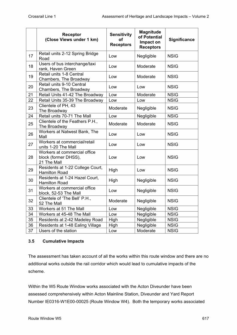
Crossrail Line 1 Assessment of Heritage and Landscape Impacts – Volume 2
Route Window W5 617
Receptor
(Close Views under 1 km)
Sensitivity of
Receptors
Magnitude of Potential Impact on Receptors
Significance
17 Retail units 2-12 Spring Bridge Road Low Negligible NSIG
18 Users of bus interchange/taxi rank, Haven Green Low Moderate NSIG
19 Retail units 1-8 Central Chambers, The Broadway Low Moderate NSIG
20 Retail units 9-10 Central Chambers, The Broadway Low Low NSIG
21 Retail Units 41-42 The Broadway Low Moderate NSIG 22 Retail Units 35-39 The Broadway Low Low NSIG
23 Clientele of PH, 43 The Broadway Moderate Negligible NSIG
24 Retail units 70-71 The Mall Low Negligible NSIG
25 Clientele of the Feathers P.H., The Broadway Moderate Moderate NSIG
26 Workers at Natwest Bank, The Mall Low Low NSIG
27 Workers at commercial/retail units 1-20 The Mall Low Low NSIG
28 Workers at commercial office block (former DHSS), 21 The Mall
Low Low NSIG
29 Residents at 1-22 College Court, Hamilton Road High Low NSIG
30 Residents at 1-24 Hazel Court, Hamilton Road High Negligible NSIG
31 Workers at commercial office block, 52-53 The Mall Low Negligible NSIG
32 Clientele of ‘The Bell’ P.H., 52 The Mall Moderate Negligible NSIG
33 Workers at 51 The Mall Low Negligible NSIG 34 Workers at 45-48 The Mall Low Negligible NSIG 35 Residents at 2-42 Madeley Road High Negligible NSIG 36 Residents at 1-48 Ealing Village High Negligible NSIG 37 Users of the station Low Moderate NSIG 3.5 Cumulative Impacts
The assessment has taken account of all the works within this route window and there are no
additional works outside the rail corridor which would lead to cumulative impacts of the
scheme.
Within the W5 Route Window works associated with the Acton Diveunder have been
assessed comprehensively within Acton Mainline Station, Diveunder and Yard Report
Number IE0316-W1E00-00025 (Route Window W4). Both the temporary works associated

Crossrail Line 1 Assessment of Heritage and Landscape Impacts – Volume 2
Route Window W5 618
with Diveunder construction and the permanent works will be visible from viewpoints within
the rail corridor. Only views from receptors on Ealing Broadway Station will gain views of
both works at Ealing Station and the new Diveunder. It is considered that the magnitude of
cumulative impacts of both temporary and permanent works will be negligible and not
significant.

Crossrail Line 1 Assessment of Heritage and Landscape Impacts – Volume 2
Route Window W5 619
4. Summary
4.1 Listed Buildings and their Setting
There are no direct residual impacts on listed buildings or their setting. Potential impacts
from installation of noise insulation at Ealing Village and 36 Haven Green will be mitigated as
set out in Section 3.3.1.
4.2 Conservation Areas
There will be temporary significant impacts on the Haven Green Conservation Area as a
result of the construction activities in Haven Green. This impact will not persist into the
operational phase. There will be no other impacts on Conservation Areas.
4.3 Landscape / Townscape
The construction activities within the rail corridor will not fundamentally alter the overall
character of the railway corridor or of the adjoining areas, and are not regarded as a
significant effect on landscape / townscape. However, the temporary loss of open space in
Haven Green is considered to be a significant impact on landscape / townscape.
The permanent impact of the works will be due primarily to changes in the built form of the
station, which include a new station structure, platform extensions, new platform canopies
and a new footbridge. These changes are considered to represent a negligible beneficial
impact on the local townscape, resulting in no significant adverse or beneficial effect.
The wider impact on townscape will also be no more than negligible, and will not alter the
character of the surrounding area to a significant degree. The impact on the views across
the Haven Green will also be low and not significant.
The townscape and visual impact assessment has identified significant adverse impacts on
townscape / landscape resources in the high sensitivity townscape as a result of the
temporary construction works. The townscape assessment has not identified any significant
adverse impacts as a result of the permanent work. The new station will be a minor feature
and will be seen in the context of the existing station and rail corridor.

Crossrail Line 1 Assessment of Heritage and Landscape Impacts – Volume 2
Route Window W5 620
4.4 Visual Impact The works will be visible to a substantial number of receptors, notably nearby shoppers,
workers, residents and users of the station. Although the residential receptors are
considered to be highly sensitive, the magnitude of visual change will not be great because
many receptors are located at the opposite side of Haven Green and have intervening tree
cover filtering views, whilst those properties along either side of the rail corridor have an
existing view across a busy rail corridor and the effect on them will not be significant. The
degree of impact on local residents will be mitigated by factors such as the nature of the
existing view, distance and obstruction, and for many will not give rise to significant effects.
Just views from residents at Greenlaw Court and 20-24 Haven Green, and from residents at
College Court are considered to result in adverse significant impacts. Those residential
receptors on the northern side of Haven Green do not have the same degree of screening
because of less tree cover across the northern limits of Haven Green, resulting in more open
views of the temporary work site and construction activities beyond. At College Court the
proximity of the temporary work site from the receptors will result in a greater degree of
impact throughout the construction works.
Permanent impacts on visual amenity are not considered to be significant. The highest
degree of impact will be experienced by users of the station, and not considered to be
significant.
Local residents, who are the most sensitive receptors, will experience no more than a low
degree of impact; in most cases their views of the work will be in the context of existing view
across a busy rail corridor, will not be altered fundamentally and are unlikely to be critical in
amenity terms. The net effect of their amenity is therefore not considered to be significant.
The Year 1 predicted impacts are not considered to be significant for the reasons given
above. After 15 years following completion of the works there would be no changes to the
townscape and visual impacts.
5. Summary tables Table W5.4 details the impacts on listed buildings.
Predicted impacts on the setting of listed buildings, conservation areas, landscape /
townscape and visual amenity are summarised in Table W5.5 – Summary Table of
Temporary Impacts and Table W5.6 – Summary Table of Permanent Impacts, including any
committed mitigation and residual impacts.

Crossrail Line 1 Assessment of Heritage and Landscape Impacts – Volume 2
Route Window W5 621
Tabl
e W
5.4:
Impa
cts
on L
iste
d B
uild
ings
- R
oute
Win
dow
W5
Res
idua
l Im
pact
C
.R.
No
Add
ress
G
rade
Pr
opos
ed
Wor
ks
Pote
ntia
l Im
pact
Si
g.
Act
ion
Req
uire
d an
d M
itiga
tion
Des
crip
tion
Sig.
81
1 (W
5)
Eal
ing
Villa
ge:
Han
gar
Lane
-Nor
th
Circ
ular
R
oad
(Fla
t B
lock
s A
- H)
II W
ork
to th
e ra
ilway
trac
ks
sout
h of
the
Eal
ing
Villa
ge.
No
sign
ifica
nt im
pact
N
Sig
. N
one
need
ed
No
sign
ifica
nt
resi
dual
im
pact
.
NS
ig.
816
36 H
aven
G
reen
, W5-
D.L
. Lew
is
the
Che
mis
t
II C
onst
ruct
ion
wor
ks a
t Eal
ing
Bro
adw
ay
Sta
tion.
No
sign
ifica
nt im
pact
N
Sig
. N
one
need
ed.
No
sign
ifica
nt
resi
dual
im
pact
.
NS
ig.
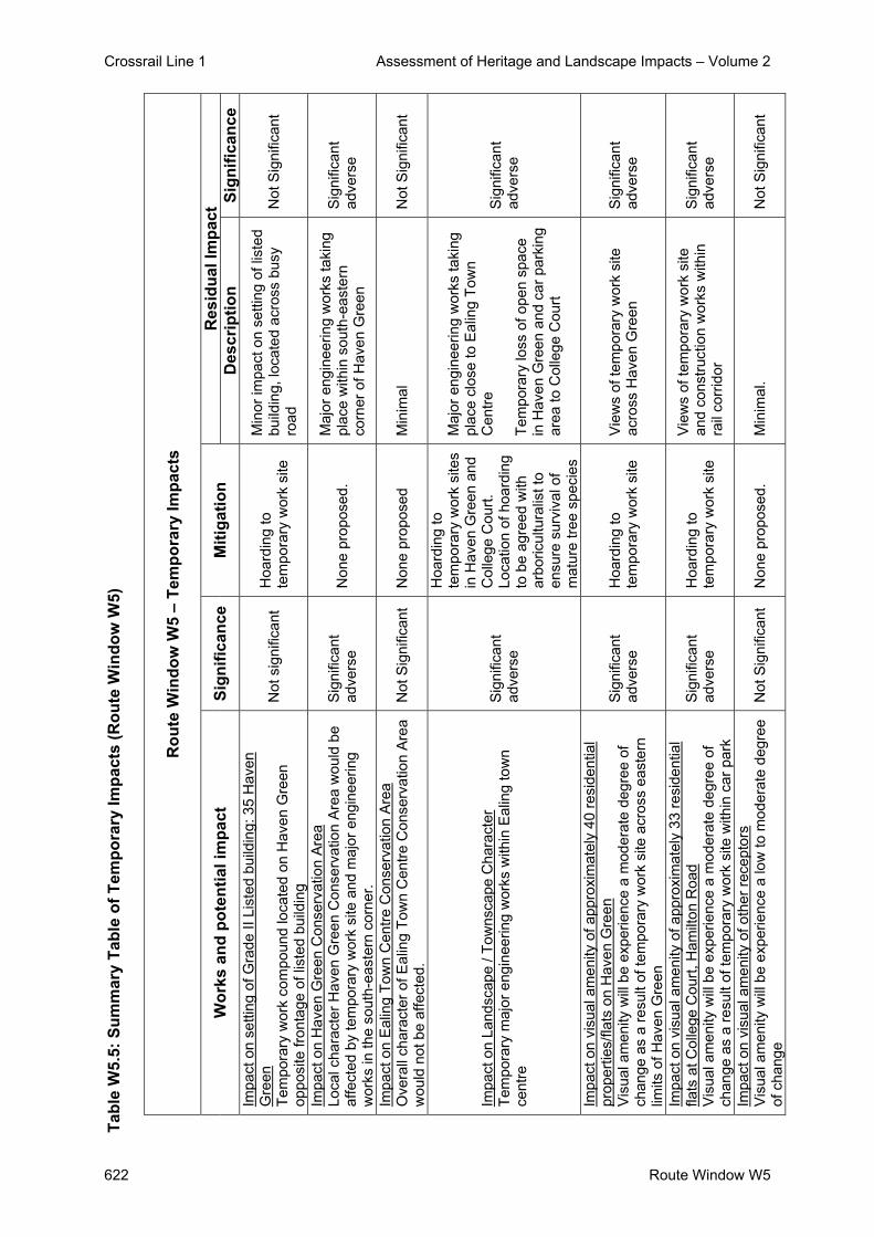
Crossrail Line 1 Assessment of Heritage and Landscape Impacts – Volume 2
622 Route Window W5
Tabl
e W
5.5:
Sum
mar
y Ta
ble
of T
empo
rary
Impa
cts
(Rou
te W
indo
w W
5)
R
oute
Win
dow
W5
– Te
mpo
rary
Impa
cts
R
esid
ual I
mpa
ct
Wor
ks a
nd p
oten
tial i
mpa
ct
Sign
ifica
nce
Miti
gatio
n D
escr
iptio
n Si
gnifi
canc
e Im
pact
on
setti
ng o
f Gra
de II
Lis
ted
build
ing:
35
Hav
en
Gre
en
Tem
pora
ry w
ork
com
poun
d lo
cate
d on
Hav
en G
reen
op
posi
te fr
onta
ge o
f lis
ted
build
ing
Not
sig
nific
ant
Hoa
rdin
g to
te
mpo
rary
wor
k si
te
Min
or im
pact
on
setti
ng o
f lis
ted
build
ing,
loca
ted
acro
ss b
usy
road
N
ot S
igni
fican
t
Impa
ct o
n H
aven
Gre
en C
onse
rvat
ion
Area
Lo
cal c
hara
cter
Hav
en G
reen
Con
serv
atio
n A
rea
wou
ld b
e af
fect
ed b
y te
mpo
rary
wor
k si
te a
nd m
ajor
eng
inee
ring
wor
ks in
the
sout
h-ea
ster
n co
rner
.
Sig
nific
ant
adve
rse
Non
e pr
opos
ed.
Maj
or e
ngin
eerin
g w
orks
taki
ng
plac
e w
ithin
sou
th-e
aste
rn
corn
er o
f Hav
en G
reen
Sig
nific
ant
adve
rse
Impa
ct o
n E
alin
g To
wn
Cen
tre C
onse
rvat
ion
Are
a O
vera
ll ch
arac
ter o
f Eal
ing
Tow
n C
entre
Con
serv
atio
n A
rea
wou
ld n
ot b
e af
fect
ed.
Not
Sig
nific
ant
Non
e pr
opos
ed
Min
imal
N
ot S
igni
fican
t
Impa
ct o
n La
ndsc
ape
/ Tow
nsca
pe C
hara
cter
Te
mpo
rary
maj
or e
ngin
eerin
g w
orks
with
in E
alin
g to
wn
cent
re
Sig
nific
ant
adve
rse
Hoa
rdin
g to
te
mpo
rary
wor
k si
tes
in H
aven
Gre
en a
nd
Col
lege
Cou
rt.
Loca
tion
of h
oard
ing
to b
e ag
reed
with
ar
boric
ultu
ralis
t to
ensu
re s
urvi
val o
f m
atur
e tre
e sp
ecie
s
Maj
or e
ngin
eerin
g w
orks
taki
ng
plac
e cl
ose
to E
alin
g To
wn
Cen
tre
Tem
pora
ry lo
ss o
f ope
n sp
ace
in H
aven
Gre
en a
nd c
ar p
arki
ng
area
to C
olle
ge C
ourt
Sig
nific
ant
adve
rse
Impa
ct o
n vi
sual
am
enity
of a
ppro
xim
atel
y 40
resi
dent
ial
prop
ertie
s/fla
ts o
n H
aven
Gre
en
Vis
ual a
men
ity w
ill b
e ex
perie
nce
a m
oder
ate
degr
ee o
f ch
ange
as
a re
sult
of te
mpo
rary
wor
k si
te a
cros
s ea
ster
n lim
its o
f Hav
en G
reen
Sig
nific
ant
adve
rse
Hoa
rdin
g to
te
mpo
rary
wor
k si
te
Vie
ws
of te
mpo
rary
wor
k si
te
acro
ss H
aven
Gre
en
Sig
nific
ant
adve
rse
Impa
ct o
n vi
sual
am
enity
of a
ppro
xim
atel
y 33
resi
dent
ial
flats
at C
olle
ge C
ourt,
Ham
ilton
Roa
d V
isua
l am
enity
will
be
expe
rienc
e a
mod
erat
e de
gree
of
chan
ge a
s a
resu
lt of
tem
pora
ry w
ork
site
with
in c
ar p
ark
Sig
nific
ant
adve
rse
Hoa
rdin
g to
te
mpo
rary
wor
k si
te
Vie
ws
of te
mpo
rary
wor
k si
te
and
cons
truct
ion
wor
ks w
ithin
ra
il co
rrid
or
Sig
nific
ant
adve
rse
Impa
ct o
n vi
sual
am
enity
of o
ther
rece
ptor
s V
isua
l am
enity
will
be
expe
rienc
e a
low
to m
oder
ate
degr
ee
of c
hang
e N
ot S
igni
fican
t N
one
prop
osed
.
Min
imal
. N
ot S
igni
fican
t

Crossrail Line 1 Assessment of Heritage and Landscape Impacts – Volume 2
Route Window W5 623
Tabl
e W
5.6:
Sum
mar
y Ta
ble
of P
erm
anen
t Im
pact
s (R
oute
Win
dow
W5)
R
oute
Win
dow
W5
– Pe
rman
ent I
mpa
cts
R
esid
ual I
mpa
ct
Wor
ks a
nd p
oten
tial i
mpa
ct
Sign
ifica
nce
Miti
gatio
n D
escr
iptio
n Si
gnifi
canc
e Im
pact
on
setti
ng o
f Gra
de II
Lis
ted
build
ing:
35
Hav
en G
reen
N
o ch
ange
to s
ettin
g of
Lis
ted
Bui
ldin
g
Not
si
gnifi
cant
N
one
prop
osed
S
ettin
g of
list
ed b
uild
ing
rem
ains
fund
amen
tally
un
chan
ged.
N
ot S
igni
fican
t
Impa
ct o
n H
aven
Gre
en C
onse
rvat
ion
Are
a
New
sta
tion
stru
ctur
e lo
cate
d be
yond
sou
th-
east
ern
corn
er o
f Hav
en G
reen
Not
S
igni
fican
t N
one
prop
osed
S
ettin
g of
Con
serv
atio
n A
rea
rem
ains
fund
amen
tally
un
chan
ged.
N
ot S
igni
fican
t
Impa
ct o
n E
alin
g To
wn
Cen
tre C
onse
rvat
ion
Are
a O
vera
ll ch
arac
ter o
f Eal
ing
Tow
n C
entre
C
onse
rvat
ion
Are
a w
ould
not
be
affe
cted
.
Not
S
igni
fican
t N
one
prop
osed
S
ettin
g of
Con
serv
atio
n A
rea
rem
ains
fund
amen
tally
un
chan
ged.
N
ot S
igni
fican
t
Impa
ct o
n La
ndsc
ape
/ Tow
nsca
pe C
hara
cter
N
ew s
tatio
n st
ruct
ure
with
in to
wn
cent
re
Not
S
igni
fican
t N
one
prop
osed
R
ole
of s
tatio
n re
mai
ns
fund
amen
tally
unc
hang
ed.
Not
Sig
nific
ant
Impa
ct o
n vi
sual
am
enity
V
isua
l am
enity
will
be
expe
rienc
e m
oder
ate
to
negl
igib
le d
egre
e of
cha
nge
as a
resu
lt of
new
st
atio
n bu
ildin
g an
d ne
w p
latfo
rm in
frast
ruct
ure
Not
S
igni
fican
t N
one
prop
osed
C
hara
cter
of v
iew
s, th
eref
ore
leve
l of a
men
ity, r
emai
ns
fund
amen
tally
unc
hang
ed.
Not
Sig
nific
ant

Crossrail Line 1 Assessment of Heritage and Landscape Impacts – Volume 2
624 Route Window W5
6. Assumptions - It is assumed that the temporary works sites will be landscaped and restored to their
previous condition
- It is assumed that no damage will be effected on mature trees within Haven Green.
- It is assumed that 3.6 metre high hoarding would be used around the boundary of the
temporary work sites to mitigate the demolition works and reduce the visual effects during
the construction stages.
- Desk-top studies and a number of site visits were undertaken during June 2004 and
therefore this assessment was undertaken during the summer period when vegetation
was in leaf. However, when considering the landscape and visual impacts of the
scheme, an assessment of the potential winter situation has been estimated / taken into
account and ZVIs mapped on this basis.

Crossrail Line 1 Assessment of Heritage and Landscape Impacts - Volume 2
Route Window W5 625
7. References
- ES Route Window W5
- Parliamentary Plan Sheets
- ES Scheme Description

Crossrail Line 1 Assessment of Heritage and Landscape Impacts – Volume 2
626 Route Window W5
Crossrail Line 1 Assessment of Heritage and Landscape Impacts – Volume 2
Route Window W4 627
Route Window W4 Acton Main Line Station and Yard


Crossrail Line 1 Assessment of Heritage and Landscape Impacts – Volume 2
Route Window W4 629
Contents 1. Description of the Works 631
1.1 Permanent Works 631 1.2 Temporary Works 632
2. Baseline Assessment 634 2.1 Local context 634 2.2 Listed Buildings and their Setting 635 2.3 Conservation Areas 635 2.4 Landscape / Townscape 635 2.5 Zone of Visual Influence 639 2.6 Sensitivity 642
3. Impact of the Scheme 647 3.1 Listed Buildings and their Setting 647 3.2 Conservation Areas 647 3.3 Landscape / Townscape 647 3.4 Visual impacts 648 3.5 Cumulative Impacts 656
4. Summary 657 4.1 Listed Buildings and their Setting 657 4.2 Conservation Areas 657 4.3 Landscape / Townscape 657 4.4 Visual Impacts 658
5. Summary Tables 659 6. Summary Tables Error! Bookmark not defined. 7. Assumptions 662 8. References 663

Crossrail Line 1 Assessment of Heritage and Landscape Impacts – Volume 2
Route Window W4 630

Crossrail Line 1 Assessment of Heritage and Landscape Impacts – Volume 2
Route Window W4 631
Route Window W4 Acton Main Line Station and Yard
1. Description of the Works 1.1 Permanent Works
Acton Rail Underpass
A new rail underpass will be constructed to make train paths available for freight trains going
to and from Acton Yard without disrupting Crossrail and other services. This will take the
eastbound relief line beneath the tracks that connect with Acton Yard. The ramp for the
underpass will commence at a point where the Central Underground line diverges from the
GWML, to the west of Noel Road bridge. Beyond the underpass, a further ramp will take the
relief line back to ground level immediately to the west of Acton Main Line station. The track
remodelling will require some demolitions within Acton Yard.
The two goods lines and the three depot reception lines will need to be realigned
considerably to the north of their current location to accommodate the rail underpass. This in
turn will require that other sidings and facilities (used by EWS or their tenants) be moved
northwards. The precise location of this relocation has not yet been agreed with EWS.
Although it is likely that the recreational land north of Acton Yard will only be used
temporarily, this is not certain. The assessment has therefore assumed that some permanent
land take will be required from this.
Acton Main Line Station
A new ticket hall, 5 m high and 30 m wide, will be constructed at 267 Horn Lane to the south
of the existing station. The existing facility on Horn Lane bridge may be converted to
commercial use. The new ticket hall will lead to a new footbridge, which will provide lift
access to each platform. New 35 m long canopies will be provided along the platforms in
place of the existing platform shelters. Platforms three and four will be extended westwards
by 57 m and 33 m respectively to accommodate Crossrail trains.

Crossrail Line 1 Assessment of Heritage and Landscape Impacts – Volume 2
Route Window W4 632
1.2 Temporary Works
Construction - Acton Main Line Station
Subject to possession planning requirements and excluding final commissioning, the
construction of the platform extensions, a new station footbridge new ticket hall and platform
refurbishment will take place over a total period of approximately 15 months.
Before the main works commence it will be necessary to demolish 267 Horn Lane, and to
break out and remove existing surfaces and platform end ramps.
Construction of the platform extension will be in line with the methodology described above,
in Section 4 of the Introduction to this Volume. Towards the completion of the platform
extensions, the construction of the new footbridge and lifts (from the new ticket hall to the
bridge and also between the footbridge and platforms) will commence. The foundations for
the bridge piers and staircases will be set within the existing platform. The staircase of the
footbridge will be of steel construction. These works will be completed after about five
months.
During these works, construction of a new ticket hall at 267 Horn Lane will be carried out on
the south side of the railway. The building will be of steelframed construction with slabs
formed from in-situ or pre-cast concrete. The substructure will be piled. The roof will be
constructed of pre-cast or in-situ concrete slab. The construction of the ticket hall will take
approximately 10 months to complete.
The construction plant and equipment required for the works at Acton Main Line station will
include a road-rail multi-purpose plant, crawlers, mobile cranes, compressors, generators
and vibrating compactors.
Work will be undertaken from two main worksites. Acton Main Line station worksite is located
south of the existing main line station, adjacent to the railway and extends into the north-
bound carriageway of Horn Lane. Four lorries per day will access the worksite, including
during the 14 week construction peak. The Acton Main Line station worksite west is located
to the west of the station on the north side of the railway, bounded to the north by Acton
Yard. It will be served by four lorries per day during the nine week peak of construction, and
by two at other times. All materials taken to and from the sites will be transported by road
with access from the A40 Western Avenue via Horn Lane.

Crossrail Line 1 Assessment of Heritage and Landscape Impacts – Volume 2
Route Window W4 633
Construction - Acton Yard
Subject to possession planning requirements and excluding final commissioning, the
construction works at Acton Yard will take place over a total period of approximately four
years.
To create the space for the new underpass, the existing facilities in Acton Yard will be
remodelled. This requires all of the facilities to be moved northwards. The opportunity will be
taken to rationalise the yard where possible and remodel the facilities to improve the layout
and efficiency within the yard.
Once the existing railway tracks have been moved away from the footprint of the proposed
underpass, the underpass box will be constructed using bored piled walling with in-situ
concrete invert and cover slabs. The underpass ramps leading into and out of the box will be
constructed using bored pile walls with capping beams and an in situ concrete invert slab.
The construction of the western ramp will start approximately 270 m east of the overbridge at
Hanger Lane. The tracks on the eastern ramp will tie into the existing alignment at Acton
Main Line station. Noel Road overbridge may have to be stabilised by incremental jacking
while the western dive under ramp is constructed. This will require temporary diversion and
protection of utilities and some periods of bridge closure. On completion of the underpass,
the existing eastbound relief line will be realigned to the north to pass through the box.
Acton Yard will be used as a worksite at different stages for the construction of the
underpass and the associated track work. Acton Yard will, however, remain operational,
albeit requiring temporary and permanent relocation of some of its facilities. Structural, civil
and excavated materials will be moved by road with primary access from Horn Lane.
Secondary access in association with the works in the vicinity of the Noel Road bridge will be
required from Noel Road, with access from the north via Horn Lane and Noel Road. The
works at Acton yard will be served by 60 lorries per day during the 61 week peak
construction period and typically by 50 per day at other times. Of the 60 lorries, only 15 per
day are expected during the peak period at the Noel Road access. Materials for trackwork
will largely be transported to the yard by rail.

Crossrail Line 1 Assessment of Heritage and Landscape Impacts – Volume 2
Route Window W4 634
2. Baseline Assessment 2.1 Local context
Acton Main Line Station is located on Horn Lane (A4000), close to the junction with Friary
Road, within the London Borough of Ealing. The station building is located on the Horn Lane
overbridge with the platforms located below.
The station contains four existing platforms set in cutting relative to the surrounding areas to
the south and approximately 4 metres below the small station building. The station platforms
are separated from Horn Lane by a builders yard and flatblock development. To the north of
the rail corridor the area is relatively flat and includes extensive stabling sidings extending to
the west, materials storage, areas of light industrial use and recreation grounds beyond.
There is little vegetation surrounding the station, although to the west a densely vegetated
embankment with mature tree cover provides screening for residential areas along Lynton
Road. To the west of the stabling sidings lineside vegetation assist in reducing views of the
rail corridor.
Horn Lane connects with Westway (A40) to the north and with Steyne Road to the south.
There are retail and commercial units along Horn Lane, and residential neighbourhoods to
the north, south, east and west of the station, with stabling sidings to the west and industrial
area to the north.
The nearest residential properties comprise a 7-storey block of flats along Horn Lane (Acton
House), about 25m south of the station; and three-storey properties at Friary Park Court, off
Friary Lane, about 50m to the south-east. More established residential neighbourhoods are
located along the southern side of the rail corridor along Lynton Road, Oakley Avenue,
Bloomsbury Close, Inglis Road and Hamilton Road. To the north of the rail corridor
residential areas are generally located at a greater distance from the rail corridor due to
intervening sports grounds and schools, except for Noel Road and Waldegrave Road.
The nearest open space comprises a sports ground, about 100m north of the station,
separating residential areas from the rail sidings, and the grounds of Ellen Wilkinson High
School located to the north of the rail corridor.
The Townscape Character Baseline Plan for Acton Main Line Station, Drawing No. 1E0416-
W1E00-E00-F-00004 identifies the locations of key buildings and landmarks in the local
townscape and illustrates local views, pedestrian and vehicular movement corridors,

Crossrail Line 1 Assessment of Heritage and Landscape Impacts – Volume 2
Route Window W4 635
townscape character areas, urban gateways / nodes and the landscape planning
designations that relate to the site and its surroundings. This baseline plan also illustrates
the extent of the proposed sites for both the temporary and permanent works.
2.2 Listed Buildings and their Setting
There are no listed buildings and structures within the approximate Zone of Visual Influence
(ZVI) of the temporary and permanent works. North Ealing Station is a Grade II listed
building, located 250 m north of the rail corridor. 2.3 Conservation Areas
The station is not situated within a Conservation Area, although two Conservation Areas lie
1km and 1.2km to the west: Hanger Hill and Creffield Conservation Areas.
2.4 Landscape / Townscape
2.4.1 Character Areas and Townscape Quality
The area can be divided into five character areas, reflecting their prevailing uses and built
pattern.
Acton Main Line (South) Character Area:
This is an area of residential development of mainly Victorian detached and semi detached
two storey houses fronting roads and avenues. Many have large front and back gardens with
extensive mature tree cover. Buildings are finished in painted render or brick with tiled roofs.
The southern end of Horn Lane is occupied by a number of small shops. These are
predominantly Victorian parades, up to four storeys high, and retain some attractive original
details. Rows of attractive Victorian terraces are on both sides of the road. These, together
with some opulent Victorian Villas and more modest terraced housing, generally form a
consistent and coherent townscape. This townscape has a domestic scale and is generally
no more than two floors high, although there are some more substantial three storey
townhouses to the north. The area generally has good open space provision and has
something of an affluent character in comparison to the area to the north of the railway.
The physical mass of Victorian terraces along Lynton Road prevents views of the rail corridor
from the south. This is an area of high townscape quality.

Crossrail Line 1 Assessment of Heritage and Landscape Impacts – Volume 2
Route Window W4 636
Acton Main Line (North) Character Area:
This is an area of residential development to the north of the station with a rundown
character of Victorian terraces and post war housing estates. With few street trees, the
majority of trees are found in areas of open space, such as North Acton Playing Field and
also along railway embankments. The small front gardens result in a predominance of on
street parking.
The area forms a buffer between the light commercial and industrial areas around Westwood
Park Trading Estate, Western Avenue Business Park and Frogmore Industrial Estate to the
north and north-east and the more affluent and attractive area of Ealing to the west.
The Action Freight Yard is on the northern edge of the mainline railway. Sports fields and
allotment gardens to the north of the railway have strong visual links with the railway on
account of their open character. The railway lines and freight yard are visually prominent in
this area. This is an area of moderate townscape quality.
North Ealing Character Area:
This is an area of mainly residential development to the north of the rail corridor.
North Ealing Station is an attractive Edwardian station with some good period features. It is
tucked away in a leafy corner on the western edge of this character area and it is somewhat
hidden from the wider area to its location and mature tree planting.
The Hanger Hill Garden Estate Conservation Area to the east of the station has something of
a mixed character, with Victorian terraces of good townscape merit, sitting alongside 1960’s
and 1970’s social housing blocks up to six storeys high on larger plots and in a landscape
setting, predominately of grass.
The Ellen Wilkinson School occupies a substantial plot to the south of the station, being of
varied scale and massing. It is up to four storeys high in parts but there are also some single
storey elements. The architecture is typical of late 1960’s / 1970’s school architecture, being
rather bland and un-engaging. However, it occupies a visually prominent plot in relation to
the railway tracks and the station, being enclosed by the tracks on its western and south-
western edges.

Crossrail Line 1 Assessment of Heritage and Landscape Impacts – Volume 2
Route Window W4 637
A large number of intersecting railway tracks pass through this area. However, these are
sunken, so for the most part have a minimal impact on the townscape.
This is an area of low townscape quality.
East Acton Character Area:
This is an area of largely residential development to the south of the Great Western Main
Line (GWML) in planned cottage style estates built around the 1930’s and 1940’s. The area
has something of a village character, with its quaint domestic architecture. The local centre
creates a focus with its elevated parade of shops. The architecture of the shopping area is
consistent with the wider estates being red brick and domestic in character. This rather
quaint suburban character is somewhat compromised by the presence of Western
Avenue/Westway which runs to the south of the retail core. This creates a visually
intimidating and noisy physical and psychological barrier in the local area.
The Brunel Road / Telford Way Industrial Estate is a small light industrial estate to the north
of the area. This estate comprises a mixture of low-rise 1930’s office buildings of some
architectural merit, with elements of art deco styling, and some later 20th century
developments, which are somewhat faceless and lack the character of the earlier buildings.
The railway lines are elevated in this area. They visually dominate the northern edge of the
estate and create a visual barrier to the wider area.
Despite the tracks being elevated across the length of this character area, they are, for the
most part, hidden from view to the wider area by the tightly packed residential and small
scale industrial developments adjacent to them. One only really gets a sense of their
presence from the railway bridges over the roadways.
This is an area of low townscape quality.
North Acton Character Area:
This is an area of commercial and industrial development, located to the north of the GWML.
North Acton station and the adjacent railway tracks are located in cutting, so provide only a
minimal contribution to the surrounding townscape.
The area directly to the north of North Acton Station is currently undergoing substantial re-
development. The station is overlooked by a recently built Holiday Inn that looms above it. It
is five storeys high and is covered in white cladding with red brick across the ground floor

Crossrail Line 1 Assessment of Heritage and Landscape Impacts – Volume 2
Route Window W4 638
elevations. The building lacks character, but occupies a prominent position overlooking the
rail corridor. A mixed-use residential and commercial development is currently being built to
the north of the Holiday Inn.
The area around the station is dominated by light industrial and commercial uses with some
office development. The development to the north is a relatively recent construction
comprising predominantly bulky plastic and metal clad commercial units. These have little
character and contribute little to the townscape.
Despite the introduction of new development, the area still has something of a run-down
character and contributes to an incoherent and disjointed townscape.
This is an area of low townscape quality.
2.4.2 Key Landscape / Townscape Features and Resources
Although there are no significant landscape and townscape features in the vicinity of the site,
the garden city townscape of Hanger Hill is an important townscape resource.
Acton House, a seven storey post war office block, is an imposing building located
immediately to the south of the station.
Ellen Wilkinson High School and Twyford High School Sports Grounds, North Acton Playing
Fields and the sports grounds to the south of Noel Road are important townscape features
providing extensive recreational areas.
Vegetation is a locally important influence on views and landscape character. The most
notable vegetation in the immediate vicinity of the station comprises a belt of semi-mature
and mature deciduous trees (mainly ash and sycamore) which defines the southern edge of
the rail corridor.
Lines of mature and semi mature deciduous trees (mainly poplar) form parts of the southern
edges of sports grounds to the north of the rail corridor.
Mature scrub and immature trees occupy parts of the railway corridor adjoining Noel Road
and Churchill Gardens

Crossrail Line 1 Assessment of Heritage and Landscape Impacts – Volume 2
Route Window W4 639
2.4.3 Strategic Views and Key Local Views
There are no strategic views in the vicinity of the site. 2.4.4 Key Pedestrian / Vehicular Movement Corridors
Roads are the main movement corridors in the area, both for vehicles and pedestrians, with
Horn Lane (A4000), Western Avenue (A40), Friary Road, Noel Road and Creffield Road
forming the most important links.
There are no landscape planning designations in the vicinity of the site, although the sports
ground to the north of the site is designated as ‘Key Open Space’.
2.5 Zone of Visual Influence
The approximate Zone of Visual Influence (ZVI) for the work sites is determined by the
following influences:
- The relationship of the railway to the surrounding area;
- The general character and arrangement of land uses;
- The proximity, scale and use of nearby buildings; and
- The size and type of nearby vegetation
The railway runs through the built-up area in a shallow cutting, passing beneath Horn Lane,
Noel Road and Hanger Lane road bridges. In the vicinity of the station, the cutting gently
rises up to Horn Lane to the south and is relatively level across the sidings and recreation
ground to the north. To the west the railway continues in cutting up to 4 metres by the road
and rail overbridges.
The lower elevation of the railway generally restricts opportunities for direct views to
track/platform level, except from the railway overbridge on Horn Lane and from vantage
points such as the Acton House, the builders merchant on Horn Lane and from buildings
which overlook the railway corridor. The rail track in cutting and the surrounding buildings
are the main influences on views, reinforced (in summer) by vegetation, mainly to the south
of the railway.

Crossrail Line 1 Assessment of Heritage and Landscape Impacts – Volume 2
Route Window W4 640
The ZVI can be defined by the following:
- To the West, along the railway corridor to the Hanger Lane bridge. Track realignment will
however take place to the west of the bridge, and its ZVI is likely to extend westwards to
the rear of properties in Hamilton Road;
- To the North, partly by the cutting slope along parts of the northern side of the rail
corridor, but principally by the combination of residential properties, vegetation from
Hanger Lane in the west to Horn Lane in the east;
- To the East, along the railway corridor to the east of the Horn Lane bridge and sections of
Horn Lane, Emanuel Avenue and Friary Road;
- To the South, by the rear facades and garden walls of properties along the southern side
of the rail corridor, including Horn Lane, Lynton Road, Oakley Avenue, Inglis Road and
Hamilton Road.
The main potential sources of views of the station work sites may be summarised as follows:
- Residents at 1-6 Friary Park Court, Friary Road;
- Residents at 13-18 Friary Park Court, Friary Road;
- Commercial/Retail properties, 218-220 Horn Lane;
- Commercial/Retail properties, 212-216 Horn Lane;
- Users of Horn Lane;
- Residents of 2-12 Emanuel Avenue;
- Users of Emanuel Avenue;
- Residents of large flats (Acton House), on Horn Lane;
- Users of timber yard, Horn Lane;
- Users of Horn Lane bridge;
- Users of public house, 222 Horn Lane
- Users of Horn Lane Metals and storage yard;
- Residents of 8-14 Lynton Terrace, Lynton Road; and
- Users of the station.
In addition, views of the dive-under and track realignment work sites may be experienced by:
- Residents of 1-6 Walter Court, Lynton Road;

Crossrail Line 1 Assessment of Heritage and Landscape Impacts – Volume 2
Route Window W4 641
- Residents of 1-18 Bromley Lodge, Lynton Road;
- Residents of 1-6 Avon Court, Lynton Road;
- Residents of 17 Lynton Road;
- Residents of Marion Court, Lynton Road;
- Residents of 21-33 Lynton Road;
- Residents of 35-167 Lynton Road;
- Residents of 98-100 Twyford Avenue;
- Users of Twyford Avenue/Noel Road bridge;
- Residents of 41-51 Oakley Avenue;
- Residents of 1-18 Oakley House, Oakley Avenue;
- Residents of 1-19 Oakley Avenue;
- Residents of 1-5 Addison Court, Oakley Avenue;
- Residents of 1-4 Redhall Terrace;
- Residents of 1-80 Bloomsbury Close;
- Residents of 1-18 Embassy Court, Inglis Road;
- Residents of 19-23 Inglis Road;
- Residents of 1-15 Hollywood Court, Inglis Road;
- Residents of 1-13 Inglis Road;
- Residents of 23 Hanger Lane;
- Residents of 24 Hanger Lane;
- Residents of 19-53 Hamilton Road;
- Residents of 25 Hanger Lane;
- Residents of 26-27 Hanger Lane;
- Residents of 2-52 Waldegrave Road;
- Users of the Ellen Wilkinson High School;
- Residents of 13-18 Thanet Court, Queens Drive;
- Residents of 13-24 Rutland Court, Queens Drive;
- Residents of 13-18 Oxford Court, Queens Drive;
- Residents of 198-200 Noel Road;
- Residents of 263-275 Noel Road;
- Residents of 6-20 Churchill Gardens;
- Residents of 22a-24d Churchill Gardens;
- Residents of 27-51 Churchill Gardens;
- Users of West Acton Primary School;
- Residents of 167-191 Noel Road;
- Users of sports ground (Noel Road);
- Residents of 16-18 Alwyn Gardens;
- Residents of 1-8 Alwyn Gardens;

Crossrail Line 1 Assessment of Heritage and Landscape Impacts – Volume 2
Route Window W4 642
- Residents of 113-149 Noel Road;
- Residents of 8-12 Lowfield Road;
- Residents of 14-62 Lowfield Road; and
- Residents of 224-236 Horn Lane.
2.6 Sensitivity
2.6.1 Sensitivity of Landscape / Townscape to Change
Acton Main Line Station and the location of the dive-under works do not lie within any
Conservation Areas and do not contain any Listed Buildings.
The surrounding townscape is generally of low sensitivity to change. The railway corridor,
the station and the sidings are already significant influences, and the area is therefore able to
accommodate further railway infrastructure without fundamentally affecting its character.
The immediate environs of the station are dominated by a single large-scale blocks of flats
and rail sidings separated by largely functional spaces (roads, service yards). Urban fabric of
this type is able to accommodate a substantial degree of change without detriment to its
character.
However, any significant loss of the trees which adjoin the rail corridor to both the south and
north would affect townscape character, since this is the most prominent vegetation in the
immediate area, and is an important influence on views during summer. Any loss of
recreational open space, particularly to the north of the rail corridor will also affect townscape
character, as they provide a buffer between rear gardens and the rail corridor.
The residential areas located to the south (Friary Road, Emanuel Avenue, Lynton Road,
Oakley Avenue, Inglis Road and Hamilton Road), north (Waldegrave Road, Queens Drive,
Noel Road, Churchill Gardens and Lowfield Road) are more sensitive to change, due to their
smaller scale built pattern.
2.6.2 Sensitivity Of Visual Receptors To Change
Table W4.1: Visual Receptors (Acton Main Line Station and Yard Works) below identifies the
key receptors which would obtain views of the proposed temporary and proposed permanent
works, together with their sensitivity, the type of views and whether the views are of the
temporary or permanent works.

Crossrail Line 1 Assessment of Heritage and Landscape Impacts – Volume 2
Route Window W4 643
Table W4.1: Visual Receptors for the Acton Main Line Station and Yard Works
Receptor
(Close Views under 1km distance)
Type of View
Dire
ct V
iew
Obl
ique
Vi
ew
Tem
pora
ry
Wor
k Si
tes
Perm
anen
t W
orks
Sensitivity of
Receptors
1 Residents at 1-6 Friary Park Court, Friary Road Upper floors High
2 Residents at 13-18 Friary Park Court, Friary Road Upper floors High
3 Commercial/Retail properties, 218-220 Horn Lane (Station works only)
Ground level and upper floors
Moderate
4 Commercial/Retail properties, 212-216 Horn Lane (Station works only)
Ground level and upper floors
Moderate
5 Users of Horn Lane (Station works only)
Ground level Low
6 Residents of 2-12 Emanuel Avenue (Station works only)
Ground level and upper floors
High
7 Users of Emanuel Avenue (Station works only)
Ground level Low
8 Residents of large flats (Acton House) on Horn Lane Upper floors High
9 Users of timber yard, Horn Lane (Station works only) Upper floors Low
10 Users of Horn Lane bridge Ground Low
11 Users of public house, 222 Horn Lane (Station works only)
Upper floors Moderate
12 Users of Horn Lane Metals and storage yard
Ground Low
13 Residents of 8-14 Lynton Terrace, Lynton Road (Station works only)
Upper floors High
14 Users of the station Platform level Low
15
Residents of 1-6 Walter Court, Lynton Road (dive-under and track realignment works only)
Upper floors High
16
Residents of 1-18 Bromley Lodge, Lynton Road (dive-under and track realignment works only)
Upper floors High
17 Residents of 1-6 Avon Court, Lynton Road (dive-under and track realignment works only)
Upper floors High

Crossrail Line 1 Assessment of Heritage and Landscape Impacts – Volume 2
Route Window W4 644
Receptor
(Close Views under 1km distance)
Type of View
Dire
ct V
iew
Obl
ique
Vie
w
Tem
pora
ry
Wor
k Si
tes
Perm
anen
t W
orks
Sensitivity of
Receptors
18 Residents of 17 Lynton Road (dive-under and track realignment works only)
Upper floors High
19 Residents of Marion Court, Lynton Road (dive-under and track realignment works only)
Upper floors High
20 Residents of 21-33 Lynton Road (dive-under and track realignment works only)
Upper floors High
21 Residents of 35-167 Lynton Road (dive-under and track realignment works only)
Upper floors High
22 Residents of 98-100 Twyford Avenue (dive-under and track realignment works only)
Upper floors High
23
Users of Twyford Avenue/Noel Road bridge (dive-under and track realignment works only)
Ground Low
24 Residents of 41-51 Oakley Avenue (dive-under and track realignment works only)
Upper floors High
25
Residents of 1-18 Oakley House, Oakley Avenue (dive-under and track realignment works only)
Upper floors High
26 Residents of 1-19 Oakley Avenue (dive-under and track realignment works only)
Upper floors High
27
Residents of 1-5 Addison Court, Oakley Avenue (dive-under and track realignment works only)
Upper floors High
28 Residents of 1-4 Redhall Terrace (dive-under and track realignment works only)
Upper floors High
29
Residents of 1-80 Bloomsbury Close (dive-under and track realignment works only)
Upper floors High
30
Residents of 1-18 Embassy Court, Inglis Road (dive-under and track realignment works only)
Upper floors High

Crossrail Line 1 Assessment of Heritage and Landscape Impacts – Volume 2
Route Window W4 645
Receptor
(Close Views under 1km distance)
Type of View
Dire
ct V
iew
Obl
ique
Vie
w
Tem
pora
ry
Wor
k Si
tes
Perm
anen
t W
orks
Sensitivity of
Receptors
32 Residents of 1-15 Hollywood Court, Inglis Road (dive-under and track realignment works only)
Upper floors High
33 Residents of 1-13 Inglis Road (dive-under and track realignment works only)
Upper floors High
34 Residents of 23 Hanger Lane (dive-under and track realignment works only)
Upper floors High
35 Residents of 24 Hanger Lane (dive-under and track realignment works only)
Upper floors High
36 Residents of 19-53 Hamilton Road (dive-under and track realignment works only)
Upper floors High
37 Residents of 25 Hanger Lane (dive-under and track realignment works only)
Ground level and upper floors
High
38 Residents of 26-27 Hanger Lane (dive-under and track realignment works only)
Upper floors High
39 Residents of 2-52 Waldegrave Road (dive-under and track realignment works only)
Upper floors High
40 Users of the Ellen Wilkinson High School (dive-under and track realignment works only)
Ground and upper floors Moderate
41 Residents of 13-18 Thanet Court, Queens Drive (dive-under and track realignment works only)
Upper floors High
42 Residents of 13-24 Rutland Court, Queens Drive (dive-under and track realignment works only)
Upper floors High
43 Residents of 13-18 Oxford Court, Queens Drive (dive-under and track realignment works only)
Upper floors High
44 Residents of 198-200 Noel Road (dive-under and track realignment works only)
Upper floors High
45 Residents of 263-275 Noel Road (dive-under and track realignment works only)
Upper floors High
47 Residents of 22a-24d Churchill Gardens (dive-under and track realignment works only)
Upper floors High

Crossrail Line 1 Assessment of Heritage and Landscape Impacts – Volume 2
Route Window W4 646
Receptor
(Close Views under 1km distance)
Type of View
Dire
ct V
iew
Obl
ique
Vie
w
Tem
pora
ry
Wor
k Si
tes
Perm
anen
t W
orks
Sensitivity of
Receptors
48 Residents of 27-51 Churchill Gardens (dive-under and track realignment works only)
Upper floors High
49 Users of West Acton Primary School
Ground level Moderate
50 Residents of 167-191 Noel Road Upper floors High
51 Users of sports ground(Noel Road)
Ground level Moderate
52 Residents of 16-18 Alwyn Gardens Upper floors High
53 Residents of 1-8 Alwyn Gardens Upper floors High
54 Residents of 113-149 Noel Road Upper floors High
55 Residents of 8-12 Lowfield Road Upper floors High
56 Residents of 14-62 Lowfield Road Upper floors High
57 Residents of 224 – 236 Horn Lane Upper floors High
Local residents will be the most sensitive group of receptors and theoretically, approximately
350 residential properties could have winter-time views of the works for the track realignment
and dive-under construction, whilst approximately 50 residential properties could have winter-
time views of the works to the station. However:
- viewing opportunities will in almost every case be confined to upper floors; and
- most viewing opportunities from properties at the eastern end of Lynton Avenue and the
eastern end of Churchill Gardens would be lost during summer.
The least obstructed views would be experienced by users of the station, residents along
Lynton Road, Oakley Avenue, Inglis Road, Waldegrave Road, Churchill Gardens and
Lowfield Road. Many of these receptors are considered to be of high sensitivity.
It should be noted that some receptors may experience recurrent views of the works (e.g.
from the workplace and from nearby roads or the station).
Receptors who live in or use the area can be assumed to be habituated to a certain degree
to the impact of railway maintenance and construction activities.

Crossrail Line 1 Assessment of Heritage and Landscape Impacts – Volume 2
Route Window W4 647
3. Impact of the Scheme
3.1 Listed Buildings and their Setting
There will be no impacts on listed buildings or their setting in this route window.
3.2 Conservation Areas
There will be no impacts on Conservation Areas in this route window.
3.3 Landscape / Townscape
3.3.1 Impacts on Designated Landscape / Townscape Resources
There will be few features of importance affected by the works to Acton Mainline Station and
yard. The station itself is of little architectural merit, and the loss of the existing brick ticket
hall will be of low impact. 267 Horn Lane is a two storey office unit of partial brick
construction which provides little quality to the local townscape. The loss of 267 Horn Lane
would result in low beneficial impact on the local townscape. The majority of the works to the
dive-under and freight yard will take place within the railway corridor, including the temporary
work site and infrastructure at Acton Yard. It is considered that the loss of recreational open
space/playing fields and allotments to the north of the station will result in the permanent loss
of designated ‘Community Open Space’ and will result in significant adverse impacts.
The visual influence of the works will not extend into any areas of designated landscape /
townscape.
3.3.2 Impacts on Character Areas
Construction features such as mobile cranes, piling rigs, HGVs, portacabins and hoardings
will be features around the station and sidings for the duration of construction. These
features will be relatively insignificant within the busy rail corridor, alongside existing areas of

Crossrail Line 1 Assessment of Heritage and Landscape Impacts – Volume 2
Route Window W4 648
materials storage and portacabins along Horn Lane. The temporary work site across the
existing sports ground and allotments to the south of Lowfield Road will result in a relatively
high magnitude of change. Within the rail corridor their overall level of impact is likely to vary;
at times it will be low, and at others potentially high (e.g. when cranes are lifting the
footbridge spans or canopies into place).
However, the area is generally of low sensitivity to change, and is able to accommodate
construction features without fundamentally affecting its character. However the loss of an
area of open space is a fundamental change which will result in a significant impact on
landscape.
The most visible feature of the permanent works will be the new ticket hall, clearly visible
along a short section of Horn Lane, Friary Road and Emanuel Avenue and the extended
stabling sidings which will be visible from properties along Lowfield Road. The dive-under will
be a relatively minor feature and largely out of view within the existing rail corridor.
These features will be seen in the context both of the existing station and rail corridor and the
surrounding urban area with which they will be visually consistent. The ticket hall will be
located in a prominent location at the junction of Horn Lane and Friary Road and provide a
clearer definition of Action Main Line Station in the local townscape. The ticket hall will have
a moderate beneficial impact on the character of the area immediately surrounding the
station.
The overall impact at Acton Yard on the character of the townscape is considered to be high
due to the loss of the playing fields but the effect of the station works in unlikely to be
significant.
3.4 Visual impacts
The Visual Appraisal Plan for Acton Main Line Station Diveunder and Yard Works Drawing
No. 1E0316-WIE00-E00-F-00004 illustrates the approximate Zone of Visual Influence for the
proposed temporary and the proposed permanent works, and identifies the principal
locations from which views of the development would be obtained.
The assessment of impact during the construction works takes account of their relatively
temporary duration, and the likelihood that nearby receptors will to a certain degree be

Crossrail Line 1 Assessment of Heritage and Landscape Impacts – Volume 2
Route Window W4 649
tolerant of activities carried out in the normal course of railway maintenance and
improvement.
The magnitude of visual impact that would be generated by the temporary works on each
receptor group is identified in Table W4.2: Potential Temporary Impacts on Receptors (Acton
Main Line Station Diveunder and Yard Works). This table includes impacts associated with
both works to the station and to the dive-under; separate reference is made to these where
necessary.
Table W4.2: Potential Temporary Impacts on Receptors (Acton Main Line Station and Yard Works)
Receptor (Close Views under 1 km)
Sensitivity of
Receptors
Magnitude of Potential Impact on Receptors
Significance
1 Residents at 1-6 Friary Park Court, Friary Road (Station works only) High Low NSIG
2 Residents at 13-18 Friary Park Court, Friary Road (Station works only)
High Low NSIG
3 Commercial/Retail properties, 218-220 Horn Lane (Station works only) Moderate Low NSIG
4 Commercial/Retail properties, 212-216 Horn Lane (Station works only) Moderate Low NSIG
5 Users of Horn Lane (Station works only) Low Moderate NSIG
6 Residents of 2-12 Emanuel Avenue (Station works only) High Negligible NSIG
7 Users of Emanuel Avenue (Station works only) Low Moderate NSIG
8 Residents of large flats (Acton House) on Horn Lane High Low NSIG
9 Users of timber yard, Horn Lane (Station works only) Low Low NSIG
10 Users of Horn Lane bridge Low Moderate NSIG
11 Users of public house, 222 Horn Lane (Station works only) Moderate Low NSIG
12 Users of Horn Lane Metals and storage yard Low Low NSIG
13 Residents of 8-14 Lynton Terrace, Lynton Road (Station works only) High Low NSIG
14 Users of the station Low Moderate NSIG
15 Residents of 1-6 Walter Court, Lynton Road (dive-under and track realignment works only)
High Negligible NSIG
16 Residents of 1-18 Bromley Lodge, Lynton Road (dive-under and track realignment works only)
High Negligible NSIG

Crossrail Line 1 Assessment of Heritage and Landscape Impacts – Volume 2
Route Window W4 650
Receptor (Close Views under 1 km)
Sensitivity of
Receptors
Magnitude of Potential Impact on Receptors
Significance
17 Residents of 1-6 Avon Court, Lynton Road (dive-under and track realignment works only)
High Negligible NSIG
18 Residents of 17 Lynton Road (dive-under and track realignment works only)
High Negligible NSIG
19 Residents of Marion Court, Lynton Road (dive-under and track realignment works only)
High Negligible NSIG
20 Residents of 21-33 Lynton Road (dive-under and track realignment works only)
High Low NSIG
21 Residents of 35-167 Lynton Road (dive-under and track realignment works only)
High Low NSIG
22 Residents of 98-100 Twyford Avenue (dive-under and track realignment works only)
High Low NSIG
23 Users of Twyford Avenue/Noel Road bridge (dive-under and track realignment works only)
Low Low NSIG
24 Residents of 41-51 Oakley Avenue (dive-under and track realignment works only)
High Low NSIG
25 Residents of 1-18 Oakley House, Oakley Avenue (dive-under and track realignment works only)
High Low NSIG
26 Residents of 1-19 Oakley Avenue (dive-under and track realignment works only)
High Low NSIG
27 Residents of 1-5 Addison Court, Oakley Avenue (dive-under and track realignment works only)
High Low NSIG
28 Residents of 1-4 Redhall Terrace (dive-under and track realignment works only)
High Low NSIG
29 Residents of 1-80 Bloomsbury Close (dive-under and track realignment works only)
High Low NSIG
30 Residents of 1-18 Embassy Court, Inglis Road (dive-under and track realignment works only)
High Low NSIG
31 Residents of 19-23 Inglis Road (dive-under and track realignment works only)
High Low NSIG
32 Residents of 1-15 Hollywood Court, Inglis Road (dive-under and track realignment works only)
High Low NSIG

Crossrail Line 1 Assessment of Heritage and Landscape Impacts – Volume 2
Route Window W4 651
Receptor (Close Views under 1 km)
Sensitivity of Receptors
Magnitude of Potential Impact on Receptors
Significance
33 Residents of 1-13 Inglis Road (dive -under and track realignment works only)
High Low NSIG
34 Residents of 23 Hanger Lane (dive-under and track realignment works only) High Low NSIG
35 Residents of 24 Hanger Lane (dive-under and track realignment works only) High Low NSIG
36 Residents of 19-53 Hamilton Road (dive-under and track realignment works only)
High Negligible NSIG
37 Residents of 25 Hanger Lane (dive-under and track realignment works only) High Low NSIG
38 Residents of 26-27 Hanger Lane (dive-under and track realignment works only) High Low NSIG
39 Residents of 2-52 Waldegrave Road (dive-under and track realignment works only)
High Low NSIG
40 Users of the Ellen Wilkinson High School (dive-under and track realignment works only)
Moderate Negligible NSIG
41 Residents of 13-18 Thanet Court, Queens Drive (dive-under and track realignment works only)
High Negligible NSIG
42 Residents of 13-24 Rutland Court, Queens Drive (dive-under and track realignment works only)
High Negligible NSIG
43 Residents of 13-18 Oxford Court, Queens Drive (dive-under and track realignment works only)
High Negligible NSIG
44 Residents of 198-200 Noel Road (dive-under and track realignment works only) High Low NSIG
45 Residents of 263-275 Noel Road (dive-under and track realignment works only) High Low NSIG
46 Residents of 6-20 Churchill Gardens (dive-under and track realignment works only)
High Negligible NSIG
47 Residents of 22a-24d Churchill Gardens (dive-under and track realignment works only)
High Negligible NSIG
48 Residents of 27-51 Churchill Gardens (dive-under and track realignment works only)
High Negligible NSIG
49 Users of West Acton Primary School Moderate Low NSIG 50 Residents of 167-191 Noel Road High Negligible NSIG 51 Users of sports ground (Noel Road) Moderate Low NSIG 52 Residents of 16-18 Alwyn Gardens High Low NSIG

Crossrail Line 1 Assessment of Heritage and Landscape Impacts – Volume 2
Route Window W4 652
Receptor (Close Views under 1 km)
Sensitivity of
Receptors
Magnitude of Potential Impact on Receptors
Significance
54 Residents of 113-149 Noel Road High Low NSIG 55 Residents of 8-12 Lowfield Road High Low NSIG 56 Residents of 14-62 Lowfield Road High Moderate SIG(-) 57 Residents of 224-236 Horn Lane High Low NSIG
The magnitude of visual impact that would be generated by the permanent works on each
group of receptors is identified in Table W4.3: Potential Permanent Impacts on Receptors
(Acton Main Line Station Dive-under and Yard Works).
Table W4.3: Potential Permanent Impacts on Receptors (Acton Main Line Station Dive -under and Yard Works)
Receptor
(Close Views under 1 km
Sensitivity of
Receptors
Magnitude of Potential Impact on Receptors
Significance
1 Residents at 1-6 Friary Park Court, Friary Road (Station works only)
High Low NSIG
2 Residents at 13-18 Friary Park Court, Friary Road (Station works only)
High Negligible NSIG
3 Commercial/Retail properties, 218-220 Horn Lane (Station works only)
Moderate Moderate NSIG
4 Commercial/Retail properties, 212-216 Horn Lane (Station works only)
Moderate Low NSIG
5 Users of Horn Lane (Station works only) Low Moderate NSIG
6 Residents of 2-12 Emanuel Avenue (Station works only) High Negligible NSIG
7 Users of Emanuel Avenue (Station works only) Low Moderate NSIG
8 Residents of large flatblock(Acton House), Horn Lane High Negligible NSIG
9 Users of timber yard, Horn Lane (Station works only) Low Negligible NSIG
10 Users of Horn Lane bridge Low Negligible NSIG
11 Users of public house, 222 Horn Lane (Station works only) Moderate Negligible NSIG
12 Users of Horn Lane Metals and storage yard Low Negligible NSIG
13 Residents of 8-14 Lynton Terrace, Lynton Road (Station works only) High Negligible NSIG
14 Users of the station Low Negligible NSIG

Crossrail Line 1 Assessment of Heritage and Landscape Impacts – Volume 2
Route Window W4 653
Receptor
(Close Views under 1 km
Sensitivity of
Receptors
Magnitude of Potential Impact on Receptors
Significance
15 Residents of 1-6 Walter Court, Lynton Road (dive-under and track realignment works only)
High Negligible NSIG
16 Residents of 1-18 Bromley Lodge, Lynton Road (dive-under and track realignment works only)
High Negligible NSIG
17 Residents of 1-6 Avon Court, Lynton Road (dive-under and track realignment works only)
High Negligible NSIG
18 Residents of 17 Lynton Road (dive-under and track realignment works only)
High Negligible NSIG
19 Residents of Marion Court, Lynton Road (dive-under and track realignment works only)
High Negligible NSIG
20 Residents of 21-33 Lynton Road (dive-under and track realignment works only)
High Negligible NSIG
21 Residents of 35-167 Lynton Road (dive-under and track realignment works only)
High Negligible NSIG
22 Residents of 98-100 Twyford Avenue (dive-under and track realignment works only)
High Negligible NSIG
23 Users of Twyford Avenue/Noel Road bridge (dive-under and track realignment works only)
Low Negligible NSIG
24 Residents of 41-51 Oakley Avenue(dive-under and track realignment works only)
High Negligible NSIG
25 Residents of 1-18 Oakley House, Oakley Avenue(dive-under and track realignment works only)
High Negligible NSIG
26 Residents of 1-19 Oakley Avenue(dive-under and track realignment works only)
High Negligible NSIG
27 Residents of 1-5 Addison Court, Oakley Avenue(dive-under and track realignment works only)
High Negligible NSIG
28 Residents of 1-4 Redhall Terrace(dive-under and track realignment works only)
High Negligible NSIG
29 Residents of 1-80 Bloomsbury Close (dive-under and track realignment works only)
High Negligible NSIG
30
Residents of 1-18 Embassy Court, Inglis Road (dive-under and track realignment works only)
High Negligible NSIG

Crossrail Line 1 Assessment of Heritage and Landscape Impacts – Volume 2
Route Window W4 654
Receptor
(Close Views under 1 km
Sensitivity of
Receptors
Magnitude of Potential Impact on Receptors
Significance
31 Residents of 19-23 Inglis Road (dive-under and track realignment works only)
High Negligible NSIG
32 Residents of 1-15 Hollywood Court, Inglis Road (dive-under and track realignment works only)
High Negligible NSIG
33 Residents of 1-13 Inglis Road (dive-under and track realignment works only)
High Negligible NSIG
34 Residents of 23 Hanger Lane (dive-under and track realignment works only)
High Negligible NSIG
35 Residents of 24 Hanger Lane (dive-under and track realignment works only)
High Negligible NSIG
36 Residents of 19-53 Hamilton Road (dive-under and track realignment works only)
High Negligible NSIG
37 Residents of 25 Hanger Lane (dive-under and track realignment works only)
High Negligible NSIG
38 Residents of 26-27 Hanger Lane (dive-under and track realignment works only)
High Negligible NSIG
39 Residents of 2-52 Waldegrave Road (dive-under and track realignment works only)
High Negligible NSIG
40 Users of the Ellen Wilkinson High School (dive-under and track realignment works only)
Moderate Negligible NSIG
41 Residents of 13-18 Thanet Court, Queens Drive (dive-under and track realignment works only)
High Negligible NSIG
42 Residents of 13-24 Rutland Court, Queens Drive (dive-under and track realignment works only)
High Negligible NSIG
43 Residents of 13-18 Oxford Court, Queens Drive (dive-under and track realignment works only)
High Negligible NSIG
44 Residents of 198-200 Noel Road (dive-under and track realignment works only)
High Negligible NSIG
45 Residents of 263-275 Noel Road (dive-under and track realignment works only)
High Negligible NSIG
46 Residents of 6-20 Churchill Gardens (dive-under and track realignment works only)
High Negligible NSIG

Crossrail Line 1 Assessment of Heritage and Landscape Impacts – Volume 2
Route Window W4 655
Receptor
(Close Views under 1 km
Sensitivity of
Receptors
Magnitude of Potential Impact on Receptors
Significance
48 Residents of 27-51 Churchill Gardens (dive-under and track realignment works only)
High Negligible NSIG
49 Users of West Acton Primary School Moderate Negligible NSIG
50 Residents of 167-191 Noel Road High Negligible NSIG
51 Users of sports ground (Noel Road) Moderate Negligible NSIG
52 Residents of 16-18 Alwyn Gardens High Negligible NSIG
53 Residents of 1-8 Alwyn Gardens High Negligible NSIG 54 Residents of 113-149 Noel Road High Negligible NSIG 55 Residents of 8-12 Lowfield Road High Negligible NSIG 56 Residents of 14-62 Lowfield Road High Moderate SIG (-) 56 Residents of 224-236 Horn Lane High Low NSIG
In relation to the temporary works, the degree of impact is considered to be low for many
receptors on both sides of the rail corridor. This is partly because the majority of works will be
in cutting and out of view from many receptors, but also because of the nature of the existing
view, which already includes prominent rail activity. Although many of these receptors are
considered to be highly sensitive to visual change, the existing views from these properties
will experience only a relatively small degree of change and none of the affected views are
critical to their amenity.
For the most sensitive receptors (local residents), the degree of impact is considered to be
low in almost all cases. This is because:
From properties along Lynton Road, Oakley Avenue, Inglis Road, Waldegrave Road, Noel
Road and Churchill Gardens although views will be direct, they have an existing view over
the rail corridor with regular rail activity including maintenance and construction works; and
From properties with views of the station works, most views will be oblique and/or obstructed
by intervening buildings or vegetation, and also have existing views across rail sidings and
builders yards.
However, approximately 24 properties along the southern side of Lowfield Road will
experience a moderate degree of change throughout the temporary works, and result in
significant adverse impacts.

Crossrail Line 1 Assessment of Heritage and Landscape Impacts – Volume 2
Route Window W4 656
The main sources of permanent impact will be the change in the arrangement of features at
the station, the new stabling siding to the south of Lowfield Road and the new dive-under
either side of Twyford Avenue/Noel Road bridge. The net impact of this change will be to
slightly increase the prominence of railway infrastructure, notably with the introduction of a
new ticket hall, footbridge, extended platforms, new sidings and the dive-under. The overall
role of the station within the local townscape will become more prominent, as will the
character of the views that it influences.
The magnitude of change is considered to be mainly low to negligible. However residents
along the southern side of Lowfield Road will have their current view across recreational land
replaced with a new stabling siding. It is considered that the magnitude of visual change is
moderate and result in permanent significant adverse impacts. Other sensitive receptors will
be affected as follows:
- Residents on Friary Road will see the new ticket hall and forecourt area;
- Residents in Acton House are only likely to see the top of the new ticket hall, pedestrian
footbridge, and platform extension, and this in views that are oblique and constricted;
- Residents of Lynton Road and Oakley Avenue may gain minor views of the dive-under.
The impact on these views is considered to be mainly negligible, except for views, which
include the new ticket hall which are considered to be low to moderate.
The fundamental character of views will not change, and since they are unlikely to be critical
to the amenity of those who experience them, the effect is not considered to be significant.
The Year 1 predicted impacts are not considered to be significant for the reasons given
above, apart from 24 properties along the southern side of Lowfield Road. After 15 years
following completion of the works there would be no changes to the townscape and visual
impacts.
3.5 Cumulative Impacts
The assessment has taken account of all the works within this route window and there are no
additional works outside the rail corridor which lead to cumulative impacts of the scheme.

Crossrail Line 1 Assessment of Heritage and Landscape Impacts – Volume 2
Route Window W4 657
4. Summary
4.1 Listed Buildings and their Setting
There are no listed buildings, features or areas of designated townscape in the immediate
vicinity of the works. The nearest such features (e.g. North Ealing Station and Hanger Lane
Conservation Area) lie outside the ZVI for the works. Acton House is a local landmark, and
there are no key local views.
4.2 Conservation Areas
There will be no impacts on Conservation Areas in this route window.
4.3 Landscape / Townscape
Construction features will intrude into the setting of the station, but their effect is not
considered to be significant due to the low sensitivity of the station location and their
temporary nature. Neither will they fundamentally alter the overall character of the railway
corridor or of the adjoining areas, and are not regarded as a significant effect on landscape /
townscape.
The permanent impact of the works will be due primarily to changes in the built form of the
station, which include platform extensions and a new footbridge, and the new diveunder and
extended tracks in the freight yard. These changes are considered to represent a negligible
impact on the local townscape, resulting in no significant adverse or beneficial effect.
The wider impact on townscape will be no more than negligible, and will not alter the
character of the surrounding area to a significant degree. The impact on the westward view
from Horn Lane bridge will also be moderate and no significant.
The assessment has not identified any significant impacts of particular importance on
landscape / townscape resources. However, there will be significant temporary and
permanent impacts at Acton Yard due to the loss of open space.

Crossrail Line 1 Assessment of Heritage and Landscape Impacts – Volume 2
Route Window W4 658
4.4 Visual Impacts
The townscape and visual impact assessment has not identified any adverse impacts of
particular importance on visual amenity receptors as a result of either the temporary or
permanent work. It has, however, identified significant adverse impacts on visual amenity
receptors to the north of the rail corridor as a result of both the temporary and permanent.

Crossrail Line 1 Assessment of Heritage and Landscape Impacts – Volume 2
Route Window W4 659
5. Summary Tables
There will be no impacts on listed buildings, the setting of listed buildings or Conservation
Areas in this route window, hence these are not included in the summary tables.
Predicted impacts on landscape / townscape and visual amenity are summarised in Table
W4.4: Summary Table of Temporary Impacts and Table W4.5: Summary Table of Permanent
Impacts, including any committed mitigation and residual impacts.

Crossrail Line 1 Assessment of Heritage and Landscape Impacts – Volume 2
660 Route Window W4
Tabl
e W
4.4:
Sum
mar
y Ta
ble
of T
empo
rary
Impa
cts
(Rou
te W
indo
w W
4)
R
oute
Win
dow
W4
– Te
mpo
rary
Impa
cts
R
esid
ual I
mpa
ct
Wor
ks a
nd p
oten
tial i
mpa
ct
Sign
ifica
nce
Miti
gatio
n D
escr
iptio
n Si
gnifi
canc
e Im
pact
on
char
acte
r are
as
Ove
rall
char
acte
r of r
ailw
ay c
orrid
or a
nd s
urro
undi
ng
area
wou
ld n
ot b
e af
fect
ed a
part
from
the
loss
of
recr
eatio
nal o
pen
spac
e.
Sig
nific
ant
Non
e id
entif
ied
at th
is s
tage
. M
inim
al.
Sig
nific
ant
adve
rse
Impa
ct o
n vi
sual
am
enity
of a
ppro
xim
atel
y 24
resi
dent
ial
prop
ertie
s on
Low
field
Roa
d V
isua
l am
enity
will
be
expe
rienc
e a
mod
erat
e de
gree
of
chan
ge
Sig
nific
ant
adve
rse
Hoa
rdin
g to
te
mpo
rary
wor
k si
te
Min
imal
. S
igni
fican
t ad
vers
e
Impa
ct o
n vi
sual
am
enity
of o
ther
rece
ptor
s V
isua
l am
enity
will
be
expe
rienc
e a
low
to m
oder
ate
degr
ee o
f cha
nge
Not
Sig
nific
ant
Hoa
rdin
g to
de
mol
ition
are
as
Min
imal
. N
ot S
igni
fican
t

Crossrail Line 1 Assessment of Heritage and Landscape Impacts – Volume 2
Route Window W4 661
Tabl
e W
4.5:
Sum
mar
y Ta
ble
of P
erm
anen
t Im
pact
s (R
oute
Win
dow
W4)
Rou
te W
indo
w W
4 –
Perm
anen
t Im
pact
s
Res
idua
l Im
pact
W
orks
and
pot
entia
l im
pact
Si
gnifi
canc
e M
itiga
tion
Des
crip
tion
Sign
ifica
nce
Impa
ct o
n ch
arac
ter a
reas
Lo
w to
mod
erat
e in
crea
se in
vis
ual i
nflu
ence
of r
ailw
ay
infra
stru
ctur
e, b
ut fu
ndam
enta
l cha
ract
er o
f sur
roun
ding
ar
ea w
ill b
e un
affe
cted
apa
rt fro
m lo
ss o
f rec
reat
iona
l op
en s
pace
Not
Sig
nific
ant
Non
e id
entif
ied
at th
is s
tage
.
Rol
e of
sta
tion
rem
ains
fu
ndam
enta
lly u
ncha
nged
ap
art f
rom
loss
of
recr
eatio
nal a
nd o
pen
spac
e.
Sig
nific
ant
adve
rse
Impa
ct o
n vi
sual
am
enity
of a
ppro
xim
atel
y 24
resi
dent
ial
prop
ertie
s
Mod
erat
e im
pact
on
visu
al a
men
ity
Sig
nific
ant
adve
rse
Non
e pr
opos
ed
Cur
rent
vie
w a
cros
s re
crea
tiona
l ope
n sp
ace
repl
aced
with
vie
w o
f new
ra
il si
ding
Sig
nific
ant
adve
rse
Impa
ct o
n vi
sual
am
enity
of o
ther
rece
ptor
s.
Low
to n
eglig
ible
impa
ct o
n vi
sual
am
enity
N
ot S
igni
fican
t N
one
prop
osed
In y
ear 1
the
char
acte
r of
view
s, th
eref
ore
leve
l of
amen
ity, r
emai
ns la
rgel
y un
chan
ged.
No
chan
ge in
ye
ar 1
5.
Not
Sig
nific
ant

Crossrail Line 1 Assessment of Heritage and Landscape Impacts – Volume 2
662 Route Window W4
6. Assumptions
In assessing the scheme proposals the following assumptions have been taken into account:
- Assumed line of tree around the periphery of sport field will be retained.
- It is proposed that 2.4 3.6metre high hoarding would be used to mitigate the demolition
works during the construction phase.
- Desk-top studies and a number of site visits were undertaken during June 2004 and
therefore this assessment was undertaken during the summer period when vegetation
was in leaf. However, when considering the landscape and visual impacts of the
scheme, an assessment of the potential winter situation has been estimated / taken into
account and ZVIs mapped on this basis.

Crossrail Line 1 Assessment of Heritage and Landscape Impacts – Volume 2
Route Window W4 663
7. References
- ES Route Window W4
- Parliamentary Plan Sheets
- ES Scheme Description

Crossrail Line 1 Assessment of Heritage and Landscape Impacts – Volume 2
664 Route Window W4

Crossrail Line 1 Assessment of Heritage and Landscape Impacts – Volume 2
Route Window W3 665
Route Window W3 Old Oak Common Depot


Crossrail Line 1 Assessment of Heritage and Landscape Impacts – Volume 2
Route Window W3 667
Contents 1. Description of the Works 669
1.1 Permanent Works 669 1.2 Temporary Works 669
2. Baseline Assessment 671 2.1 Local context 671 2.2 Listed Buildings and their Setting 672 2.3 Conservation Areas 672 2.4 Zone of Visual Influence 676 2.5 Sensitivity 677
3. Impact of the Scheme 680 3.1 Listed Buildings and their Setting 680 3.2 Conservation Areas 680 3.3 Landscape / Townscape 680 3.4 Visual impacts 681 3.5 Cumulative Impacts 683
4. Summary 684 4.1 Listed Buildings and their Setting 684 4.2 Conservation Areas 684 4.3 Landscape / Townscape 684 4.4 Visual Impacts 684
5. Summary Tables 685 6. Assumptions 687 7. References 688

Crossrail Line 1 Assessment of Heritage and Landscape Impacts – Volume 2
668 Route Window W3

Crossrail Line 1 Assessment of Heritage and Landscape Impacts – Volume 2
Route Window W3 669
Route Window W3 Old Oak Common Depot
1. Description of the Works
1.1 Permanent Works
The permanent works will consist of fourteen new Crossrail stabling sidings within the site of
Old Oak Common depot, of which 12 will be 250 m long and two will be 130 m long. A further
siding incorporating a train washing facility will also be provided. The sidings will be overhead
electrified and located between the existing English Welsh and Scottish and First Great
Western depots on a section of land known as the Coronation Sidings. The site will also
include a staff accommodation building.
A new electrical feeder station at Old Oak Common will be located north of the railway,
opposite Wells House Road.
1.2 Temporary Works
Duration of Works
Subject to possession, planning requirements and excluding final commissioning, the
construction of the new stabling sidings and carriage washing facility at Old Oak Common
will take place over a three-year period. Following the layout of some sidings, the site will be
used as a tunnel fit-out depot. After completion of the tunnelling works the remaining sidings
and staff facilities will be constructed.
Enabling Works
Prior to commencing the main works it will be necessary to undertake demolitions of minor
structures, site clearance and utilities diversions. Following this will be construction of
temporary facilities to support the Royal Oak tunnelling site, including tracks and buffer
stops, materials storage and handling areas, and accommodation.

Crossrail Line 1 Assessment of Heritage and Landscape Impacts – Volume 2
670 Route Window W3
Main Works
The main works will involve:
- preparation of the track formation of the new stabling sidings;
- laying of the new track work for the 14 new sidings, involving installation of plain line rail,
switches and crossings, buffer stops and top ballast;
- construction of a walkway before installation of a new track and a train wash plant,
including adjacent roadway; and
- construction and installation of signal and lighting columns, the completion of road works
in and around the sidings and the connection, and testing and commissioning of the new
track and railway systems.
OHLE will be installed along the route to accommodate the new Crossrail layout.
The configuration of the English Welsh and Scottish tracks will be modified accordingly to
accommodate the new Crossrail layout.
Worksites and Access
Works at Old Oak Common are to be carried out from Coronation sidings within the existing
footprint area of the depot. Track work materials will generally be brought into the site by rail,
using appropriate existing track work as a railhead. Excavated/demolition materials and civil
and structural materials (steel and concrete) will be transported into and out of the site by
road using the existing depot access on Old Oak Common Lane. Up to 32 lorries per day will
access the site during the four week construction peak, with around four at other times.

Crossrail Line 1 Assessment of Heritage and Landscape Impacts – Volume 2
Route Window W3 671
2. Baseline Assessment
2.1 Local context
Old Oak Common is an extensive railway site and comprises stabling sidings, engine sheds
and workshops located between Wormwood Scrubs Park, the Grand Union Canal, Scrubs
Lane and Old Oak Common Lane. It lies within the London Borough of Hammersmith and
Fulham.
The site area consists of a small part of the Old Oak Common Stabling Sidings adjoining the
existing Great Western Main Line on a 3-4 metre embankment, above Wormwood Scrubs
Park. The site lies adjacent to industrial estates to the north and east, a small residential area
to the west, and Wormwood Scrubs Park to the south. A canal towpath follows the Grand
Union Canal along the northern edge of Old Oak Common. This section of the GWML has
few vehicular crossing points, with an overbridge at Scrubs Lane (A219), and an underbridge
at Old Oak Common Lane. The surrounding roads are partly commercial with extensive
areas of industrial estates. There is little vegetation across the sidings area, although the
vegetation is a key feature along the perimeter of the site.
Scrubs Lane (A219) connects with Westway (A40) to the south and Old Oak Common Lane
connects with Old Oak Lane/Victoria Lane (A4000) to the north. There are retail, commercial
and residential units along Old Oak Lane and retail and commercial units along Scrubs Lane.
The nearest residential properties comprise 3-storey 1970s blocks of flats located in the
north-western corner of Old Oak Common, about 10m north of the main access road from
Old Oak Common Lane. A small-established residential neighbourhood is located along
Wells House Road to the south-west, and modern blocks of flats on Shaftesbury Gardens to
the west.
The nearest open space is the extensive Wormwood Scrubs Park, located to the south of
Old Oak Common. St May’s Cemetery and Little Wormwood Scrubs Recreation Ground are
both located to the east of Scrubs Lane, on the northern and southern sides of the rail
corridor respectively.

Crossrail Line 1 Assessment of Heritage and Landscape Impacts – Volume 2
672 Route Window W3
The Townscape Character Baseline Plan for Old Oak Common, Drawing No. 1E0416-
W1E00-E00-F-00003 identifies the locations of key buildings and landmarks in the local
townscape and illustrates local views, pedestrian and vehicular movement corridors,
townscape character areas, urban gateways / nodes and the landscape planning
designations that relate to the site and its surroundings. This baseline plan also illustrates
the extent of the proposed sites for both the temporary and permanent works.
2.2 Listed Buildings and their Setting
There are no listed buildings and structures within the approximate Zone of Visual Influence
(ZVI) of the temporary and permanent works.
2.3 Conservation Areas
The site is not situated within a Conservation Area, although the Grand Union Canal
Conservation Area runs along the north-eastern edge. Wormholt and Old Oak Conservation
Area lies to the west of Wormwood Scrubs Park.Landscape / Townscape
2.3.1 Character Areas and Townscape Quality
The area may be divided into four character areas, reflecting their prevailing uses and built
pattern.
Wormwood Scrubs Park and Prison Character Area:
Wormwood Scrubs Park, a significant area of open space, lies adjacent to the substantial
Oak Common depot and associated workshops. The park marks a transition between the
more urban character of Ladbroke Grove and Notting Hill to the east and the consistent
suburban character of the mid-19th century planned estates to the west.
Wormwood Scrubs Park is the largest public open space in the London Borough of
Hammersmith and Fulham. The land now occupied by Wormwood Scrubs Park was
originally part of the Great Middlesex Forest, and known as Wormholt Wood. Much of the
woodland had disappeared by the mid-18th century, when the area became known as
Wormers Scrubs. By the beginning of the 19th century, the site was in either arable or
pastured use, although there was already a tradition of both recreational and military use.

Crossrail Line 1 Assessment of Heritage and Landscape Impacts – Volume 2
Route Window W3 673
In the mid 1980's the GLC, which managed Wormwood Scrubs Park at the time, established
native tree and shrub planting in a number of areas, mainly around the periphery of the park.
These have now grown up into scrub and immature woodland, adding considerable interest
to the landscape, whilst also providing cover for a variety of birds.
The impact of the vast open space is all the more dramatic when approaching from the more
urbanised east. It offers a welcome and surprising reprise from the tightly packed urban
grain of Notting Hill and Ladbroke Grove.
The western edge of the Scrubs is bounded by the Old Oak Common Depot, with its large
bulky sheds and workshops. It tends to visually enclose the northern edge of the park, and
has an adverse affect on its vast open, green character. The park is almost entirely open in
character, with any substantial tree planting restricted to its boundaries and to a small central
area.
Wormwood Scrubs prison was built between 1875 and 1891. During World War II the prison
was used by the War Department. In 1994, a new hospital wing was completed and in 1996,
two of the four wings of the building were refurbished to modern standards, and a fifth wing
completed.
The prisons architecture is rather bleak and intimidating, and this is typical of Victorian
prisons. It stands alone in terms of scale and character alongside the more domestic
architecture found in the area with the exception of Queen Charlotte’s Hospital, which sits
alongside it. The hospital is comparable only in scale and massing as its contemporary
architecture is both softer and much more welcoming than that of the prison.
This is a townscape of low quality.
Oak Common Depot Character Area:
The railway works to the north are all the more prominent given the open character of
Wormwood Scrubs Park. The vast scale and bulk of the sheds dominate the northern
skyline and create a visual and physical barrier to the wider area. With exception of an office
block further to the west, this is the only real intrusion to the open, green character of the
park.

Crossrail Line 1 Assessment of Heritage and Landscape Impacts – Volume 2
674 Route Window W3
The depot also bounds the Grand Union Canal, which acts as a buffer between the depot
and Wythe Road Industrial Estate. Open views of the main depot may be obtained by
walking along the towpath of the Grand Union Canal.
This is a townscape of low quality.
East Acton Character Area:
This is an area of largely residential development to the south of the GWML in planned
cottage style estates built around the 1930’s and 1940’s. The area has something of a village
character, with its quaint domestic architecture. The local centre creates a focus with its
elevated parade of shops. The architecture of the shopping area is consistent with the wider
estates being red brick and domestic in character. This rather quaint suburban character is
somewhat compromised by the presence of Western Avenue/Westway which runs to the
south of the retail core. This creates a visually intimidating and noisy physical and
psychological barrier in the local area.
A small light industrial estate to the north of the area. This estate comprises a mixture of
low-rise 1930’s office buildings of some architectural merit, with elements of art deco styling,
and some later 20th century developments, which are somewhat faceless and lack the
character of the earlier buildings. The railway lines are elevated in this area. They visually
dominate the northern edge of the estate and create a visual barrier to the wider area.
Despite the tracks being elevated across the length of this character area, they are, for the
most part, hidden from view to the wider area by the tightly packed residential and small
scale industrial developments adjacent to them. One only really gets a sense of their
presence from the railway bridges over the roadways.
This is an area of low townscape quality.
North Acton Character Area:
This is an area of commercial and industrial development, located to the north of the GWML.
North Acton station and the adjacent railway tracks are located in cutting, so provide only a
minimal contribution to the surrounding townscape.

Crossrail Line 1 Assessment of Heritage and Landscape Impacts – Volume 2
Route Window W3 675
The area directly to the north of North Acton Station is currently undergoing substantial re-
development. The station is overlooked by a recently built Holiday Inn that looms above it. It
is five storeys high and is covered in white cladding with red brick across the ground floor
elevations. The building lacks character, but occupies a prominent position overlooking the
rail corridor. A mixed-use residential and commercial development is currently being built to
the north of the Holiday Inn.
The area around the station is dominated by light industrial and commercial uses with some
office development. The development to the north is a relatively recent construction
comprising predominantly bulky plastic and metal clad commercial units. These have little
character and contribute little to the townscape.
Despite the introduction of new development, the area still has something of a run-down
character and contributes to an incoherent and disjointed townscape.
This is an area of low townscape quality.
2.3.2 Key Landscape / Townscape Features and Resources
Although there are no significant landscape and townscape features within the site, both the
Grand Union Canal and Wormwood Scrubs Park are important recreational resources.
The large engine sheds and the North Pole International Depot are imposing structures
within the railway corridor, and contribute to the locally industrial townscape. Overhead
gantries and telecommunications masts are also locally important features.
Vegetation is a locally important influence on views and landscape character. The most
notable vegetation in the immediate vicinity of the site comprises woodland along southern
edges of the Grand Union Canal, including Old Oak Common Nature Reserve. Recent
woodland planting has taken place across parts of Wormwood Scrubs Park.
2.3.3 Strategic Views and Key Local Views
There are no strategic views in the vicinity of the site. Views across the site can be gained
from sections of Old Oak Common Lane and the Grand Union Canal. The open nature of
Wormwood Scrubs Park allows expansive views of distant structures and towerblocks.

Crossrail Line 1 Assessment of Heritage and Landscape Impacts – Volume 2
676 Route Window W3
2.3.4 Key Pedestrian / Vehicular Movement Corridors
Roads are the main movement corridors in the area, both for vehicles and pedestrians, with
Scrubs Lane and Old Oak Lane and Old Oak Common Lane forming the most important
links. The towpath along the southern side of the Grand Union Canal and cyclepaths around
Wormwood Scrubs Park are important corridors for pedestrians and cyclists.
2.3.5 Landscape Planning Designations
There are no landscape planning designations in the vicinity of the site, although Wormwood
Scrubs park is designated as ‘Key Open Space’.
2.4 Zone of Visual Influence
The approximate Zone of Visual Influence (ZVI) for the work sites is determined by the
following influences:
- The relationship of the sidings to the surrounding area;
- The general character and arrangement of land uses; and
- The proximity, scale and use of nearby buildings and engine sheds.
The GWML runs through the built-up area in a shallow cutting relative to the Grand Union
Canal, passing beneath Scrubs Lane road bridge and on viaduct across Old Oak Common
Lane. In the vicinity of the sidings ground levels are relatively flat, with the ground rising up
to Old Oak Common Lane to the north-west. To the north-east levels within Hythe Road
Industrial Estate are slightly higher than those within the stabling yards. To the south the
ground levels drop down to Wormwood Scrubs Park.
The elevation of the sidings generally restricts opportunities for direct views from areas of
Wormwood Scrubs Park.
The ZVI can be defined by the following:
- To the West, by engine sheds and buildings along the western side of the stabling yard;
- To the North, by the Grand Union Canal and units within the Hythe Road industrial
Estate;

Crossrail Line 1 Assessment of Heritage and Landscape Impacts – Volume 2
Route Window W3 677
- To the East, along the railway corridor to the vicinity of the Scrubs Lane road bridge;
- To the South, by the North Pole International Depot, the vegetated embankment and the
change in ground levels down to Wormwood Scrubs Park.
The main potential sources of views of the work sites may be summarised as follows:
- Users of Old Oak Common Lane;
- Residents in St Mungo’s, Sutherland Housing Association flats within north-west corner
of site;
- Workers within Old Oak Common Stabling Yard;
- Workers in industrial units, Old Oak Common Lane;
- Residents of 55-62 Shaftesbury Gardens;
- Residents of 63-68 Shaftesbury Gardens;
- Residents of 93-98 Shaftesbury Gardens;
- Workers in Hythe Road Industrial Estate;
- Users of Grand Union Canal Towpath;
- Users of Old Oak Common Nature Reserve;
- Residents on Wells House Road; and
- Rail users.
2.5 Sensitivity
2.5.1 Sensitivity of Landscape / Townscape to Change
Old Oak Common does not lie within any Conservation Areas and does not contain any
Listed Buildings.
The surrounding townscape is generally of low sensitivity to change. The stabling yard,
engine sheds and rail infrastructure are already significant influences, and the area is
therefore able to accommodate further railway infrastructure without fundamentally affecting
its character.
The immediate environs of the stabling yard is dominated by a series of large scale engine
sheds. Urban fabric of this type is able to accommodate a substantial degree of change
without detriment to its character.

Crossrail Line 1 Assessment of Heritage and Landscape Impacts – Volume 2
678 Route Window W3
The residential areas located to the west (St Mungo’s, Shaftesbury Gardens and Wells
House Road) are more sensitive to change, due to their smaller scale built pattern.
2.5.2 Sensitivity of Visual Receptors to Change
Table W3.1: Visual Receptors (Old Oak Common) below identifies the key receptors which
would obtain views of the proposed temporary and proposed permanent works, together with
their sensitivity, the type of views and whether the views are of the temporary or permanent
works.
Table W3.1 :- Visual Receptors for the Old Oak Common Works
Receptor
(Close Views under 1km distance)
Type of View
Dire
ct V
iew
Obl
ique
Vi
ew
Tem
pora
ry
Wor
k Si
tes
Perm
anen
t W
ork
Site
s
Sensitivity of
Receptors
1 Users of Old Oak Common Lane Ground level Low
2 Residents in St Mungo’s Upper floors High
3 Workers within Oak Common Stabling Yard Ground level Low
4 Workers in industrial units, Old Oak Common Lane
Ground level and upper floors
Low
5 Residents of 55-62 Shaftesbury Gardens Upper floors High
6 Residents of 63-68 Shaftesbury Gardens Upper floors High
7 Residents of 93-98 Shaftesbury Gardens Upper floors High
8 Workers in Hythe Road Industrial Estate Upper floors Low
9 Users of Grand Union Canal Towpath Ground level Moderate
10 Users of Old Oak Common Nature Reserve Ground level Moderate
11 Residents on Wells House Road Ground level High
12 Rail users Embankment level Low
Local residents will be the most sensitive group of receptors but few would have direct views
of the works for the stabling construction. However:
- Apart from views from residents in St Mungo’s no residents will have direct views of the
works;

Crossrail Line 1 Assessment of Heritage and Landscape Impacts – Volume 2
Route Window W3 679
- All receptors identified already have views across the existing stabling yard areas; and
- The vast majority of receptors have a low sensitivity.
The least obstructed views would be experienced by workers within the Old Oak Common
Stabling Yard and recreational users of Grand Union Canal Towpath, neither of which are
considered to be of high sensitivity.
It should be noted that some receptors may experience recurrent views of the works (e.g.
from the workplace and from nearby roads or the station).
Receptors who live in or use the area can be assumed to be habituated to a certain degree
to the impact of railway maintenance and construction activities.
Crossrail Line 1 Assessment of Heritage and Landscape Impacts – Volume 2
680 Route Window W3
3. Impact of the Scheme
3.1 Listed Buildings and their Setting
There will be no impacts on listed buildings or their setting in this route window.
3.2 Conservation Areas
The visual influence of the works will extend into the Grand Union Canal Conservation Area,
but the impact both during construction and permanent works is considered to be negligible,
because of the nature of the existing view.
3.3 Landscape / Townscape
There will be no features of importance affected by the works to Old Oak Common.
Construction features such as mobile cranes, piling rigs, HGVs and portacabins will be
features around the stabling yard for the duration of construction. These features will be
relatively insignificant within the busy stabling yard. Their overall level of impact is likely to be
negligible and will not result in significant impacts.
The most visible feature of the permanent works will be the train wash, and this will be an
insignificant feature within Old Oak Common Stabling yard. It will be visible from sections of
the Grand Union Canal towpath, the footbridge over the canal, areas of Old Oak Common
Nature Reserve and from Hythe Road Industrial Estate.
This building will be seen in the context of the existing structures within the stabling yard and
will not result in adverse impacts.
The overall impact on the character of the townscape is considered to be no change, and the
effect is not significant.

Crossrail Line 1 Assessment of Heritage and Landscape Impacts – Volume 2
Route Window W3 681
3.4 Visual impacts
The Visual Appraisal Plan for Old Oak Common Works Drawing No. 1E0316-WIE00-E00-F-
00003 illustrates the approximate Zone of Visual Influence for the proposed temporary and
the proposed permanent works, and identifies the principal locations from which views of the
development would be obtained.
The assessment of impact during the construction works takes account of their relatively
temporary duration, and the likelihood that nearby receptors will to a certain degree be
tolerant of activities carried out in the normal course of railway maintenance and
improvement.
The magnitude of visual impact that would be generated by the temporary works on each
receptor group is identified in Table W3.2: Potential Temporary Impacts on Receptors (Old
Oak Common).
Table W3.2: Potential Temporary Impacts on Receptors (Old Oak Common)
Receptor (Close Views under 1 km)
Sensitivity of
Receptors
Magnitude of Potential Impact on Receptors
Significance
1 Users of Old Oak Common Lane Low Negligible NSIG
2 Residents in St Mungo’s High Negligible NSIG
3 Workers within Oak Common Stabling Yard Low Negligible NSIG
4 Workers in industrial units, Old Oak Common Lane Low Negligible NSIG
5 Residents of 55-62 Shaftesbury Gardens High Negligible NSIG
6 Residents of 63-68 Shaftesbury Gardens High Negligible NSIG
7 Residents of 93-98 Shaftesbury Gardens High Negligible NSIG
8 Workers in Hythe Road Industrial Estate Low Negligible NSIG
9 Users of Grand Union Canal Towpath Moderate Negligible NSIG
10 Users of Old Oak Common Nature Reserve Moderate Negligible NSIG
11 Residents on Wells House Road High Negligible NSIG 12 Rail users Low Negligible NSIG
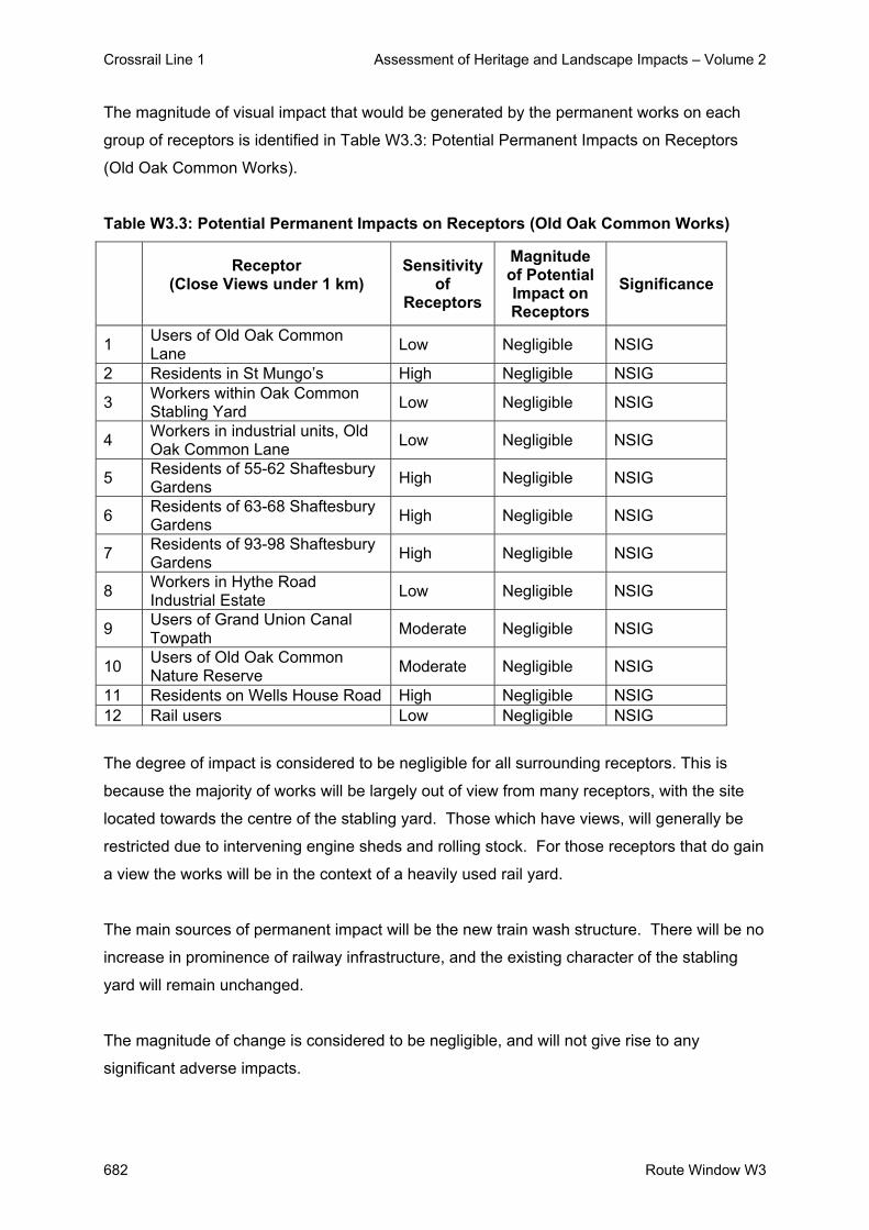
Crossrail Line 1 Assessment of Heritage and Landscape Impacts – Volume 2
682 Route Window W3
The magnitude of visual impact that would be generated by the permanent works on each
group of receptors is identified in Table W3.3: Potential Permanent Impacts on Receptors
(Old Oak Common Works).
Table W3.3: Potential Permanent Impacts on Receptors (Old Oak Common Works)
Receptor
(Close Views under 1 km)
Sensitivity of
Receptors
Magnitude of Potential Impact on Receptors
Significance
1 Users of Old Oak Common Lane Low Negligible NSIG
2 Residents in St Mungo’s High Negligible NSIG
3 Workers within Oak Common Stabling Yard Low Negligible NSIG
4 Workers in industrial units, Old Oak Common Lane Low Negligible NSIG
5 Residents of 55-62 Shaftesbury Gardens High Negligible NSIG
6 Residents of 63-68 Shaftesbury Gardens High Negligible NSIG
7 Residents of 93-98 Shaftesbury Gardens High Negligible NSIG
8 Workers in Hythe Road Industrial Estate Low Negligible NSIG
9 Users of Grand Union Canal Towpath Moderate Negligible NSIG
10 Users of Old Oak Common Nature Reserve Moderate Negligible NSIG
11 Residents on Wells House Road High Negligible NSIG 12 Rail users Low Negligible NSIG
The degree of impact is considered to be negligible for all surrounding receptors. This is
because the majority of works will be largely out of view from many receptors, with the site
located towards the centre of the stabling yard. Those which have views, will generally be
restricted due to intervening engine sheds and rolling stock. For those receptors that do gain
a view the works will be in the context of a heavily used rail yard.
The main sources of permanent impact will be the new train wash structure. There will be no
increase in prominence of railway infrastructure, and the existing character of the stabling
yard will remain unchanged.
The magnitude of change is considered to be negligible, and will not give rise to any
significant adverse impacts.

Crossrail Line 1 Assessment of Heritage and Landscape Impacts – Volume 2
Route Window W3 683
The Year 1 predicted impacts are not considered to be significant. After 15 years following
completion of the works there would be no changes to the townscape and visual impacts.
3.5 Cumulative Impacts
The proposed Stablings Works are located within a small area of the Old Oak Common
Stabling Sidings and therefore there will be no cumulative impacts of the works within this
route window.

Crossrail Line 1 Assessment of Heritage and Landscape Impacts – Volume 2
684 Route Window W3
4. Summary
4.1 Listed Buildings and their Setting
There will be no impacts on listed buildings or their setting in this route window.
4.2 Conservation Areas
There will be no impacts on Conservation Areas in this route window.
4.3 Landscape / Townscape
Construction features will not alter the overall character of the stabling yard or of the
adjoining areas, and are not regarded as a significant effect on landscape / townscape.
The permanent impact of the works will be due primarily to the new train wash structure.
These changes are considered to represent no impact on the local townscape, resulting in no
significant adverse or beneficial effect.
4.4 Visual Impacts
The construction works will not be prominent, but a minor feature. The works will be visible
to a limited number of receptors. The magnitude of visual change is considered to be
negligible because of the proximity of the receptors to the construction activities, the existing
view across the stabling yard and proportion of the view affected. The degree of impact is
not considered to give rise to significant effects.
Permanent impacts on visual amenity for local residents are not considered to be significant.
Local residents, who are the most sensitive receptors, will experience no more than a
negligible degree of impact; in all cases, their views of the works will be in the context of
existing view across a busy stabling yard, will not be altered fundamentally and are unlikely
to be critical in amenity terms.
The Year 1 predicted impacts are not considered to be significant. After 15 years following
completion of the works there would be no changes to the townscape and visual impacts.
Crossrail Line 1 Assessment of Heritage and Landscape Impacts – Volume 2
Route Window W3 685
5. Summary Tables
There will be no impacts on listed buildings, the setting of listed buildings or Conservation
Areas in this route window, hence these are not included within the summary tables.
Predicted impacts on landscape / townscape and visual amenity are summarised in Table
W3.4: Summary Table of Temporary Impacts and Table W3.5: Summary Table of Permanent
Impacts, including any committed mitigation and residual impacts.

Crossrail Line 1 Assessment of Heritage and Landscape Impacts – Volume 2
686 Route Window W3
Tabl
e W
3.4:
Sum
mar
y Ta
ble
of T
empo
rary
Impa
cts
(Rou
te W
indo
w W
3)
R
oute
Win
dow
W3
– Te
mpo
rary
Impa
cts
R
esid
ual I
mpa
ct
Wor
ks a
nd p
oten
tial i
mpa
ct
Sign
ifica
nce
Miti
gatio
n D
escr
iptio
n Si
gnifi
canc
e Im
pact
on
char
acte
r are
as
Ove
rall
char
acte
r of r
ailw
ay c
orrid
or a
nd s
urro
undi
ng
area
wou
ld n
ot b
e af
fect
ed.
Not
Sig
nific
ant
Non
e pr
opos
ed
Neg
ligib
le
Not
Sig
nific
ant
Impa
ct o
n vi
sual
am
enity
of r
ecep
tors
V
isua
l am
enity
will
exp
erie
nce
a ne
glig
ible
deg
ree
of
chan
ge.
Not
Sig
nific
ant
Non
e pr
opos
ed
Neg
ligib
le
Not
Sig
nific
ant
Tabl
e W
3.5:
Sum
mar
y Ta
ble
of P
erm
anen
t Im
pact
s (R
oute
Win
dow
W3)
Rou
te W
indo
w W
3 –
Perm
anen
t Im
pact
s
Res
idua
l Im
pact
W
orks
and
pot
entia
l im
pact
Si
gnifi
canc
e M
itiga
tion
Des
crip
tion
Sign
ifica
nce
Impa
ct o
n ch
arac
ter a
reas
N
o in
crea
se in
vis
ual i
nflu
ence
of r
ailw
ay
infra
stru
ctur
e, a
nd fu
ndam
enta
l cha
ract
er o
f su
rrou
ndin
g ar
ea w
ill b
e un
affe
cted
.
Not
Sig
nific
ant
Non
e pr
opos
ed
Rol
e of
sta
blin
g ya
rd re
mai
ns
fund
amen
tally
unc
hang
ed.
Not
Sig
nific
ant
Impa
ct o
n vi
sual
am
enity
of r
ecep
tors
. N
eglig
ible
to m
oder
ate
impa
ct o
n vi
sual
am
enity
. N
ot S
igni
fican
t N
one
prop
osed
In y
ear 1
the
char
acte
r of
view
s, th
eref
ore
leve
l of
amen
ity, r
emai
ns la
rgel
y un
chan
ged.
No
chan
ge in
yea
r 15
.
Not
Sig
nific
ant

Crossrail Line 1 Assessment of Heritage and Landscape Impacts – Volume 2
Route Window W3 687
6. Assumptions
In assessing the scheme proposals, the following assumptions have been taken into
account:
- Desk-top studies and a number of site visits were undertaken during July 2004 and
therefore this assessment was undertaken during the summer period when vegetation
was in leaf. However, when considering the landscape and visual impacts of the
scheme, an assessment of the potential winter situation has been estimated / taken into
account and ZVIs mapped on this basis.

Crossrail Line 1 Assessment of Heritage and Landscape Impacts – Volume 2
688 Route Window W3
7. References - ES Route Window W1
- Parliamentary Plan Sheets
- ES Scheme Description

Crossrail Line 1 Assessment of Heritage and Landscape Impacts – Volume 2
Route Window W2 689
Route Window W2 Canal Way


Crossrail Line 1 Assessment of Heritage and Landscape Impacts – Volume 2
Route Window W2 691
Contents
1. Description of the Works 693 2. Assessment and Impacts 694

Crossrail Line 1 Assessment of Heritage and Landscape Impacts – Volume 2
692 Route Window W2

Crossrail Line 1 Assessment of Heritage and Landscape Impacts – Volume 2
Route Window W2 693
Route Window W2 Canal Way
1. Description of the Works The four tracks in the GWML corridor currently increase to six at Ladbroke Grove (in Route
Window W1). In order to provide space for a reversing facility at Westbourne Park, this four-
six track widening location will need to be moved eastwards to Subway Junction, east of
Westbourne Park. The remaining two (northern) tracks between Ladbroke Grove and
Westbourne Park will be used by Crossrail for movement of empty stock between Old Oak
Common depot and the Westbourne Park train reversing facility.
As part of these works, the track layout at Canal Way will be modified to permit Crossrail
services to access Old Oak Common depot and to reduce conflict with other services
accessing the depot. This will require installation of a series of crossovers between the relief
lines and the Crossrail lines leading to the depot, and reinstatement of a second track over
the Engine & Carriage Line flyover. Testing and commissioning of the new track layout will
be undertaken on completion of the main works. Subject to possession planning
requirements, the works involved with this will take place over a period of about seven
months.
Construction plant required for these works will include excavators, bulldozers, mobile
cranes, rail-mounted cranes, rail saws and drilling equipment. All works will take place within
the existing railway corridor, with materials taken to and from the works by rail.

Crossrail Line 1 Assessment of Heritage and Landscape Impacts – Volume 2
694 Route Window W2
2. Assessment and Impacts
No significant impacts will occur with respect to landscape/townscape, built heritage or visual
amenity. No detailed assessment has therefore been undertaken.

Crossrail Line 1 Assessment of Heritage and Landscape Impacts – Volume 2
Route Window W1 695
Route Window W1 Portobello Junction


Crossrail Line 1 Assessment of Heritage and Landscape Impacts – Volume 2
Route Window W1 697
Contents 1. Description of the Works 699
1.1 Permanent Works 699 1.2 Temporary Works 699
2. Baseline Assessment 700 2.1 Local context 700 2.2 Listed Buildings and their Settings 701 2.3 Conservation Areas 701 2.4 Landscape / Townscape 701 2.5 Zone of Visual Influence 704 2.6 Sensitivity 706
3. Impact of the Scheme 710 3.1 Listed Buildings and their Setting 710 3.2 Conservation Areas 710 3.3 Landscape / Townscape 710 3.4 Visual impacts 710
4. Summary 715 4.1 Listed Buildings 715 4.2 Setting of Listed Buildings 715 4.3 Conservation Areas 715 4.4 Townscape 715 4.5 Visual Impacts 716
5. Summary Tables 717 6. Assumptions 719 7. References 720

Crossrail Line 1 Assessment of Heritage and Landscape Impacts – Volume 2
698 Route Window W1

Crossrail Line 1 Assessment of Heritage and Landscape Impacts – Volume 2
Route Window W1 699
Route Window W1 Portobello Junction 1. Description of the Works
1.1 Permanent Works
As described for Route Window W2, in order to provide space for a reversing facility at
Westbourne Park the four-six track widening location will need to be moved eastwards to
Subway Junction, east of Westbourne Park. The works will require the removal of existing
tracks, the laying of new tracks, crossovers and turnouts, and the provision of new signalling.
The final arrangement will result in the northern pair of tracks being used by Crossrail for
empty stock movements to and from Old Oak Common depot; the middle pair of tracks will
be used as the relief lines; and the southern pair of tracks will be used as the main lines.
1.2 Temporary Works
Much of the works will be undertaken during possessions, typically of either 16 or 52 hours
duration. However, the most significant elements of the track remodelling and re-signalling
will require a two week blockade of all lines into Paddington station, together with restrictions
in the use of some lines during the weeks before and after this.
During these works, the track layout at Portobello Junction will be modified to permit
Crossrail services to cross between the dedicated Crossrail lines and the GWML relief lines.
The works will involve the installation of a series of crossovers. This will allow flexibility for
some relief line services to be routed into Paddington without conflicting with Crossrail
services.
Plant and equipment required at the worksite will include excavators, bulldozers, mobile
cranes, rail-mounted cranes, rail saws and drilling equipment. Works will be carried out from
within the rail corridor and, with only limited access available to lorries, almost all materials
will be taken to and from the works by rail.

Crossrail Line 1 Assessment of Heritage and Landscape Impacts – Volume 2
700 Route Window W1
2. Baseline Assessment
2.1 Local context
The section of the Crossrail line running through the W1 route window, passes through an
area known as Ladbroke Grove and Portobello Junction, to the south of Kensal New Town.
It lies within the London Borough of Kensington and Chelsea.
The site consists of an 850m stretch of the existing Great Western Main Line (GWML)
located on a 4 metre cutting, roughly between Ladbroke Grove overbridge to the north-west
and Barley Shotts Business Park to the south-east. The site lies within an intensively used
rail corridor adjacent to existing residential areas and commercial estates on both sides of
the track. The railway corridor is relatively narrow at this location. This section of the GWML
has two vehicular crossing points, with an overbridges at Ladbroke Grove (B450) and
Portobello Bridge (Golborne Road). There is little vegetation within the rail corridor and apart
from street trees, vegetation is not a key feature within this route window.
Ladbroke Grove (B450) connects with Harrow Road(A404) to the north and the Notting Hill
area to the south. There are retail, commercial and residential units along Ladbroke Grove.
Golborne Road is a distributor road which passes through a largely residential area.
Westway (A40) is a major arterial route into central London which is located on an elevated
structure just to the south and east of the route window.
The nearest residential properties comprise 3-5-storey flatblocks located on either side of the
rail corridor on Wornington Road, St Ervan’s Road, Manchester Drive, Southam Street,
Canal Way and Elkstone Road. The area is notable as a result of a number of high-rise
tower blocks to the north of the rail corridor, particularly to the east around Westbourne
Green. Trellick Tower is a multi-storey residential concrete tower block located to the north of
the rail corridor, off Golborne Road.
There are few areas of open space close to the rail corridor, apart from playgrounds on
Elkstone Road, Southern Row and Wornington Gardens. Meanwhile Gardens, a designated
area of key open space, is located along the southern side of the Grand Union Canal, north
of Elkstone Road.

Crossrail Line 1 Assessment of Heritage and Landscape Impacts – Volume 2
Route Window W1 701
The Townscape Character Baseline Plan for Ladbroke Grove, Drawing No. 1E0416-W1E00-
E00-F-00001 identifies the locations of key buildings and landmarks in the local townscape
and illustrates local views, pedestrian and vehicular movement corridors, townscape
character areas, urban gateways / nodes and the landscape planning designations that
relate to the site and its surroundings. This baseline plan also illustrates the extent of the
proposed sites for both the temporary and permanent works.
2.2 Listed Buildings and their Settings
There is one listed building within the approximate Zone of Visual Influence (ZVI) of the
temporary and permanent works. This is the Grade II* listed building, Kensal House, a
notable example of 1930s social housing. This lies north to the existing railway track on the
boundary of Route Windows W1 and W2.
2.3 Conservation Areas
The site is not situated within a Conservation Area. Two Conservation Areas however lie
within the W1 route window. These are Oxford Gardens Conservation Area, 200m to the
south; and Queens Park Conservation Area, 325 metres to the north.
2.4 Landscape / Townscape
2.4.1 Character Areas and Townscape Quality
The area may be divided into two character areas, reflecting their prevailing uses and built
pattern.
Ladbroke Grove Character Area
The area to the south of the railway lines is dominated by the St Quintin Estate. This area
was formerly part of the Manor of Notting Barns Farm, owned by Thomas Darby of Sunbury.
Notting Barns was inaccessible from the rest of London before construction of the railway
and only a small number of houses were built in the area.
The development of Cambridge Gardens and Oxford Gardens, to the west of Ladbroke
Grove, took place between 1869 and 1870.

Crossrail Line 1 Assessment of Heritage and Landscape Impacts – Volume 2
702 Route Window W1
Planned estates dominate this character area, with the general layout being wide formal
streets, often tree-lined lined, with some 20th century infill development.
The St Quintin Estate contains many fine stucco and brick Victorian terraces. Several
hundred two-storey redbrick family houses were also built in terraces or pairs between 1891
and 1905 in the areas now known as Oxford Gardens, Finstock Road, Wallingford Avenue,
Balliol Road, Highlever Road, Kingsbridge Road and Kelfield Avenue. The remainder of the
area was developed between 1914-18 by Kensington Borough Council.
Whilst the buildings in this character area are generally elegant, the condition of the buildings
varies across the area. Those properties along Ladbroke Grove, for example, have not been
maintained to the standard of some of the other terraces.
There is a stark contrast between the fine elegant townhouses compared to the hustle and
bustle and clutter of Portobello Road, which has a unique and vibrant character.
A large number of streets are tree lined. These trees add an important visual element to the
street-scene, the dense canopy’s having something of a softening effect.
This is a townscape of moderate quality
Kensal Town Character Area
The parish of Kensal, though on the northern boundary of Kensington, belonged to Chelsea
and had done so since medieval times. Kensal New Town, as it became known, was not
developed until the mid-19th century when a small community grew up between the Grand
Union Canal and the railway. Employment was provided by the railway, the adjacent gas
works and the new Kensal Green Cemetery.
The area to the north of the Harrow Road became a model housing estate in the 1870’s
when the extensive Queen’s Park Estate was erected by the Artisan’s Laborer’s and General
Dwelling Company. The London Government Act of 1899 – which also created metropolitan
boroughs – divided Kensal between the new boroughs of Paddington and Kensington.
Extensive post-war development has left few remnants of the old Kensal. The area has been
extensively redeveloped since Second World War and contains many council estates.

Crossrail Line 1 Assessment of Heritage and Landscape Impacts – Volume 2
Route Window W1 703
The character of the area is significantly more disjointed than the Ladbroke Grove Character
Area and lacks the elegance and continuity of the estates to the south of the railway. The
scale of the planned residential areas is generally more domestic, though there are some
fine examples of red brick Victorian and Edwardian terraces.
The areas fronting the railway tend to support later 20th century and post-war developments
with a large concentration of poor to moderate quality high-density social housing,
particularly where the railway passes through Ladbroke Grove, an area known as Kensal
New Town.
The land between the railway and the Grand Union Canal to the north has a very different
character to the wider area. There are post-war and late 20th century industrial, office and
residential developments on large plots, with higher densities than found elsewhere. The
townscape character is generally poor and disjointed.
Some of the canal fronting buildings are of greater townscape merit than many of those
found in the wider area, with some residential development recently built to a reasonable
standard.
This is a townscape of low quality
2.4.2 Key Landscape / Townscape Features and Resources
Although there are no significant landscape and townscape features within the site, the
Grand Union Canal is an important recreational resource located to the north.
Trellick Tower is an imposing concrete structure and notable landmark to the north of the rail
corridor. Chelsea and Kensington College is also a local landmark.
Vegetation is a locally important influence on views and landscape character. The most
notable vegetation in the immediate vicinity of the site comprises street trees.
2.4.3 Strategic Views and Key Local Views
There are no strategic views in the vicinity of the site. Views across the site can be gained
from properties on either side of the rail corridor. Views would also be gained from
towerblocks, including Trellick Tower, Hazlewood Tower and Adair Tower.

Crossrail Line 1 Assessment of Heritage and Landscape Impacts – Volume 2
704 Route Window W1
2.4.4 Key Pedestrian / Vehicular Movement Corridors
Roads are the main movement corridors in the area, both for vehicles and pedestrians, with
Ladbroke Grove, Golborne Road, Westway and Harrow Road forming the most important
links. The towpath along the southern side of the Grand Union Canal is also an important
corridor for pedestrians and cyclists.
2.4.5 Landscape Planning Designations
There are no landscape planning designations in the vicinity of the site, although Meanwhile
Gardens is designated as ‘Key Open Space’.
2.5 Zone of Visual Influence
The approximate Zone of Visual Influence (ZVI) for the work sites is determined by the
following influences:
- The relationship of the existing rail corridor to the surrounding area;
- The general character and arrangement of land uses; and
- The proximity and scale of nearby buildings and structures.
The GWML runs through this built-up area in a cutting some 4 metres below to the adjacent
roads and buildings. The Westway (A40) passes over the rail corridor on an elevated bridge
structure. In the vicinity of the rail corridor ground levels are generally level, with views of the
rail corridor from adjacent structures and road. Brick walls on either side of the rail corridor
limit views from ground floor locations. Tower blocks to the north afford restricted oblique
views of the rail corridor. Road overbridges at Ladbroke Grove and Portobello Bridge
generally have metal panels to prevent views and access to the rail corridor.
The location of in cutting generally restricts opportunities for direct views except from
sections of adjacent roads and adjacent buildings.
The ZVI can be defined by the following:
- To the West, along the railway corridor to the vicinity of the Canal Way area;

Crossrail Line 1 Assessment of Heritage and Landscape Impacts – Volume 2
Route Window W1 705
- To the North, by retaining walls along the edge of the rail corridor and properties along
Canal Way, Ladbroke Grove, Manchester Drive, Appleford Road, Southam Street and
Elkstone Road;
- To the East, along the railway corridor to the vicinity of the A40 and Great Western Road
bridges;
- To the South, by retaining walls along the edge of the rail corridor and properties along
Admiral Mews, Ladbroke Grove, Wornington Road, Golborne Road, St Ervan’s Road and
Barley Shotts Business Park.
The main potential sources of views of the work sites may be summarised as follows:
- Workers at Barley Shotts Business Park, Acklam Road;
- Residents at 1-131 St Ervan’s Road;
- Residents at 44-84 St Ervan’s Road;
- Workers and residents 38-60a Golborne Road;
- Students and lecturers at Kensington and Chelsea College;
- Residents at 1-18 Edward Kennedy House, Wornington Road;
- Residents at 1-96 Peplar House, Wornington Road;
- Residents at 1-34 Thompson House, Wornington Road;
- Workers and residents Kerrington Court, Wornington Road;
- Clientelle of Public House, 335 Ladbroke Grove;
- Residents of 141-161 Admiral Mews, Barlby Road;
- Residents of 1-55 Treverton Tower, Treverton Street;
- Residents of 1-55 Raymede Tower, Treverton Street;
- Residents of 38-48 Kensal House, Canal Way;
- Residents of 49-68 Kensal House, Canal Way;
- Residents at 322-326 Ladbroke Grove;
- Residents at 1-68 Octavia House, Southern Row;
- Residents at 71-81 Southern Row;
- Residents at 1-82 Manchester Drive;
- Residents in flat 1, 4 and 8 Appleford Road;
- Residents in 1-78 Adair Tower;
- Residents in 1-78 Hazlewood Tower;
- Residents in 1-9 Southam House;

Crossrail Line 1 Assessment of Heritage and Landscape Impacts – Volume 2
706 Route Window W1
- Workers in business units 2-16 Southam Street;
- Clientelle of ‘The Grove’ Portobello Bridge;
- Users of Southam Street;
- Users of Elkstone Road;
- Residents in 22-32 Southam House;
- Residents in 7-19 Golborne Road;
- Residents in Trellick Tower, Golborne Road;
- Residents in Edenham, Elkstone Road;
- Residents in 1-13 Edenham Way;
- Residents in 2-14 Edenham Way;
- Residents in 87-99 Edenham Way;
- Residents in 15-50 Edenham Way
2.6 Sensitivity
2.6.1 Sensitivity of Landscape / Townscape to Change
Ladbroke Grove does not lie within any Conservation Areas and does not contain any Listed
Buildings. Listed Buildings at Kensal House currently have open views of the existing rail
corridor activities and infrastructure.
The surrounding townscape is generally of low sensitivity to change. The rail corridor is
already a significant influence, and the area is therefore able to accommodate further railway
infrastructure within the existing area without fundamentally affecting its character.
The immediate environs of the rail corridor is dominated by mainly brick built structures and
road overbridges. The rail corridor is defined by brick walls to either side with either railings
of freestanding brick walls above. Urban fabric of this type is able to accommodate a degree
of change without detriment to its character.
The residential areas located to the south are more sensitive to change, due to their smaller
scale built pattern.

Crossrail Line 1 Assessment of Heritage and Landscape Impacts – Volume 2
Route Window W1 707
2.6.2 Sensitivity of Visual Receptors to Change
Table W1.1: Visual Receptors (Ladbroke Grove) below identifies the key receptors which
would obtain views of the proposed temporary and proposed permanent works, together with
their sensitivity, the type of views and whether the views are of the temporary or permanent
works.
Table W1.1 :- Visual Receptors for the Ladbroke Grove Works
Receptor
(Close Views under 1km distance)
Type of View
Dire
ct V
iew
Obl
ique
Vi
ew
Tem
pora
ry
Wor
k Si
tes
Perm
anen
t W
orks
Sensitivity of
Receptors
1 Workers at Barley Shotts Business Park, Acklam Road
Ground level Moderate
2 Residents at 1-131 St Ervan’s Road
Upper floors High
3 Residents at 44-84 St Ervan’s Road
Upper floors High
4 Workers and residents 38-60a Golborne Road
Upper floors Moderate
5 Students and lecturers at Kensington and Chelsea College
Upper floors Moderate
6 Residents at 1-18 Edward Kennedy House, Wornington Road
Upper floors High
7 Residents at 1-96 Peplar House, Wornington Road
Upper floors High
8 Residents at 1-34 Thompson House, Wornington Road
Upper floors High
9 Workers and residents Kerrington Court, Wornington Road
Upper floors Moderate
10 Clientelle of Public House, 335 Ladbroke Grove
Upper floors Moderate
11 Residents of 141-161 Admiral Mews, Barlby Road
Upper floors High
12 Residents of 1-55 Treverton Tower, Treverton Street
Upper floors High
13 Residents of 1-55 Raymede Tower, Treverton Street
Upper floors High
14 Residents of 38-48 Kensal House, Canal Way
Upper floors High

Crossrail Line 1 Assessment of Heritage and Landscape Impacts – Volume 2
708 Route Window W1
Receptor
(Close Views under 1km distance)
Type of View
Dire
ct V
iew
Obl
ique
Vi
ew
Tem
pora
ry
Wor
k Si
tes
Perm
anen
t W
orks
Sensitivity of
Receptors
15 Residents of 49-68 Kensal House, Canal Way
Upper floors High
16 Residents at 322-326 Ladbroke Grove
Upper floors High
17 Residents at 1-68 Octavia House, Southern Row
Upper floors High
18 Residents at 71-81 Southern Row
Upper floors High
19 Residents at 1-82 Manchester Drive
Upper floors High
20 Residents in flats at 1, 4 and 8 Appleford Road;
Upper floors High
21 Residents in 1-78 Adair Tower
Upper floors High
22 Residents in 1-78 Hazlewood Tower
Upper floors High
23 Residents in 1-9 Southam House
Upper floors High
24 Workers in business units 2-16 Southam Street
Upper floors Low
25 Clientelle of ‘The Grove’ Portobello Bridge
Upper floors Moderate
26 Users of Southam Street Road level Moderate 27 Users of Elkstone Road Road level High 28 Residents in 22-32
Southam House Upper floors High
29 Residents in 7-19 Golborne Road
Upper floors High
30 Residents in Trellick Tower, Golborne Road
Upper floors High
31 Residents in Edenham, Elkstone Road
Upper floors High
32 Residents in 1-13 Edenham Way
Upper floors High
33 Residents in 2-14 Edenham Way
Upper floors High
34 Residents in 87-99 Edenham Way
Upper floors High
Residents in 15-50 Edenham Way
Upper floors High
Local residents will be the most sensitive group of receptors but it is mainly receptors on the
southern side of the rail corridor who will experience direct views of the track realignment
works.

Crossrail Line 1 Assessment of Heritage and Landscape Impacts – Volume 2
Route Window W1 709
However:
- All receptors identified already have views across the existing GWML rail corridor.
The least obstructed views would be experienced by residents in flatblocks on St Ervan’s
Road and Wornington Road.
It should be noted that some receptors may experience recurrent views of the works (e.g.
from the workplace and from nearby roads).
Receptors who live in or use the area can be assumed to be habituated to a certain degree
to the impact of railway maintenance and construction activities.

Crossrail Line 1 Assessment of Heritage and Landscape Impacts – Volume 2
710 Route Window W1
3. Impact of the Scheme
3.1 Listed Buildings and their Setting There are no impacts upon listed buildings.
The setting of the Listed Building, Kensal House, will be affected by the development.
However, the existing GWML forms part of the existing setting of the structure and it is
considered that the impacts on the setting will be negligible.
3.2 Conservation Areas
The visual influence of the works will not extend into any surrounding Conservation Areas,
and is limited to properties adjacent to the rail corridor, consequently, there will be no
impacts on Conservation Areas.
3.3 Landscape / Townscape
There will be no features of importance affected by the works to Ladbroke Grove.
Construction features such as mobile cranes, piling rigs, excavators, telehandlers, laser
dozer, material trains and dumper will be features within the rail corridor for the duration of
construction. These features will be relatively insignificant within the existing rail corridor.
Their overall level of impact is likely to be negligible and will not result in significant impacts.
There will be no clearly visible feature of the permanent works apart from a new driver’s
walkway and centre handrail, and this will be an insignificant feature within the rail corrdior.
The overall impact on the character of the townscape is considered to be no change, and the
effect is not significant.
3.4 Visual impacts
The Visual Appraisal Plan for Ladbroke Grove Works Drawing No. 1E0316-WIE00-E00-F-
00001 illustrates the approximate Zone of Visual Influence for the proposed temporary and
the proposed permanent works, and identifies the principal locations from which views of the
development would be obtained.
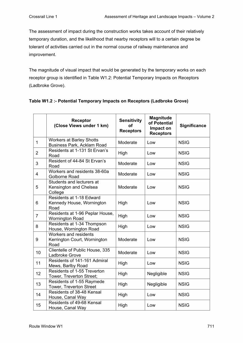
Crossrail Line 1 Assessment of Heritage and Landscape Impacts – Volume 2
Route Window W1 711
The assessment of impact during the construction works takes account of their relatively
temporary duration, and the likelihood that nearby receptors will to a certain degree be
tolerant of activities carried out in the normal course of railway maintenance and
improvement.
The magnitude of visual impact that would be generated by the temporary works on each
receptor group is identified in Table W1.2: Potential Temporary Impacts on Receptors
(Ladbroke Grove).
Table W1.2 :- Potential Temporary Impacts on Receptors (Ladbroke Grove)
Receptor
(Close Views under 1 km)
Sensitivity of
Receptors
Magnitude of Potential Impact on Receptors
Significance
1 Workers at Barley Shotts Business Park, Acklam Road Moderate Low NSIG
2 Residents at 1-131 St Ervan’s Road High Low NSIG
3 Resident of 44-84 St Ervan’s Road Moderate Low NSIG
4 Workers and residents 38-60a Golborne Road Moderate Low NSIG
5 Students and lecturers at Kensington and Chelsea College
Moderate Low NSIG
6 Residents at 1-18 Edward Kennedy House, Wornington Road
High Low NSIG
7 Residents at 1-96 Peplar House, Wornington Road High Low NSIG
8 Residents at 1-34 Thompson House, Wornington Road High Low NSIG
9 Workers and residents Kerrington Court, Wornington Road
Moderate Low NSIG
10 Clientelle of Public House, 335 Ladbroke Grove Moderate Low NSIG
11 Residents of 141-161 Admiral Mews, Barlby Road High Low NSIG
12 Residents of 1-55 Treverton Tower, Treverton Street; High Negligible NSIG
13 Residents of 1-55 Raymede Tower, Treverton Street High Negligible NSIG
14 Residents of 38-48 Kensal House, Canal Way High Low NSIG
15 Residents of 49-68 Kensal House, Canal Way High Low NSIG

Crossrail Line 1 Assessment of Heritage and Landscape Impacts – Volume 2
712 Route Window W1
Receptor
(Close Views under 1 km)
Sensitivity of
Receptors
Magnitude of Potential Impact on Receptors
Significance
16 Residents at 322-326 Ladbroke Grove High Low NSIG
17 Residents at 1-68 Octavia House, Southern Row High Low NSIG
18 Residents at 71-81 Southern Row High Low NSIG
19 Residents at 1-82 Manchester Drive High Low NSIG
20 Residents in flats at 1, 4 and 8 Appleford Road; High Low NSIG
21 Residents in 1-78 Adair Tower High Negligible NSIG
22 Residents in 1-78 Hazlewood Tower High Negligible NSIG
23 Residents in 1-9 Southam House High Low NSIG
24 Workers in business units 2-16 Southam Street Low Low NSIG
25 Clientelle of ‘The Grove’ Portobello Bridge Moderate Low NSIG
26 Users of Southam Street Moderate Low NSIG 27 Users of Elkstone Road High Low NSIG
28 Residents in 22-32 Southam House High Low NSIG
29 Residents in 7-19 Golborne Road High Low NSIG
30 Residents in Trellick Tower, Golborne Road High Negligible NSIG
31 Residents in Edenham, Elkstone Road High Low NSIG
32 Residents in 1-13 Edenham Way High Low NSIG
33 Residents in 2-14 Edenham Way High Low NSIG
34 Residents in 87-99 Edenham Way High Low NSIG
35 Residents in 15-50 Edenham Way High Low NSIG
The magnitude of visual impact that would be generated by the permanent works on each
group of receptors is identified in Table W1.3: Potential Permanent Impacts on Receptors
(Ladbroke Grove).

Crossrail Line 1 Assessment of Heritage and Landscape Impacts – Volume 2
Route Window W1 713
Table W1.3 :- Potential Permanent Impacts on Receptors (Ladbroke Grove Works)
Receptor (Close Views under 1 km)
Sensitivity of
Receptors
Magnitude of Potential Impact on Receptors
Significance
1 Workers at Barley Shotts Business Park, Acklam Road Moderate Negligible NSIG
2 Residents at 1-131 St Ervan’s Road High Negligible NSIG
3 Resident of 44-84 St Ervan’s Road Moderate Low NSIG
4 Workers and residents 38-60a Golborne Road Moderate Negligible NSIG
5 Students and lecturers at Kensington and Chelsea College
Moderate Negligible NSIG
6 Residents at 1-18 Edward Kennedy House, Wornington Road
High Negligible NSIG
7 Residents at 1-96 Peplar House, Wornington Road High Negligible NSIG
8 Residents at 1-34 Thompson House, Wornington Road High Negligible NSIG
9 Workers and residents Kerrington Court, Wornington Road
Moderate Negligible NSIG
10 Clientelle of Public House, 335 Ladbroke Grove Moderate Negligible NSIG
11 Residents of 141-161 Admiral Mews, Barlby Road High Negligible NSIG
12 Residents of 1-55 Treverton Tower, Treverton Street; High Negligible NSIG
13 Residents of 1-55 Raymede Tower, Treverton Street High Negligible NSIG
14 Residents of 38-48 Kensal House, Canal Way High Negligible NSIG
15 Residents of 49-68 Kensal House, Canal Way High Negligible NSIG
16 Residents at 322-326 Ladbroke Grove High Negligible NSIG
17 Residents at 1-68 Octavia House, Southern Row High Negligible NSIG
18 Residents at 71-81 Southern Row High Negligible NSIG
19 Residents at 1-82 Manchester Drive High Negligible NSIG
20 Residents in flatblocks 1, 4 and 8 Appleford Road; High Negligible NSIG
21 Residents in 1-78 Adair Tower High Negligible NSIG
22 Residents in 1-78 Hazlewood Tower High Negligible NSIG

Crossrail Line 1 Assessment of Heritage and Landscape Impacts – Volume 2
714 Route Window W1
Receptor (Close Views under 1 km)
Sensitivity of
Receptors
Magnitude of Potential Impact on Receptors
Significance
23 Residents in 1-9 Southam House High Negligible NSIG
24 Workers in business units 2-16 Southam Street Low Negligible NSIG
25 Clientelle of ‘The Grove’ Portobello Bridge Moderate Negligible NSIG
26 Users of Southam Street Moderate Negligible NSIG 27 Users of Elkstone Road High Negligible NSIG
28 Residents in 22-32 Southam House High Negligible NSIG
29 Residents in 7-19 Golborne Road High Negligible NSIG
30 Residents in Trellick Tower, Golborne Road High Negligible NSIG
31 Residents in Edenham, Elkstone Road High Negligible NSIG
32 Residents in 1-13 Edenham Way High Negligible NSIG
33 Residents in 2-14 Edenham Way High Negligible NSIG
34 Residents in 87-99 Edenham Way High Negligible NSIG
35 Residents in 15-50 Edenham Way High Negligible NSIG

Crossrail Line 1 Assessment of Heritage and Landscape Impacts – Volume 2
Route Window W1 715
4. Summary
Ladbroke Grove covers an 850 metre stretch of the existing GWML, roughly between
Ladbroke Grove overbridge to the north-west and Barley Shotts Business Park to the south-
east. The site lies within an intensively used rail corridor adjacent to residential areas and
commercial estates to both sides. It lies within the London Borough of Kensington and
Chelsea. The works area covers much of the stretch with extensive track realignment works.
The railway corridor is relatively narrow at this location. Locally, residential areas dominate
both sides of the GWML.
4.1 Listed Buildings
There are no direct impacts on listed buildings in this route window.
4.2 Setting of Listed Buildings
Kensal House, a Grade II listed building, lies adjacent to the rail corridor and will be affected
by the works. However, the magnitude of change is considered to be negligible because of
the existing relationship between the buildings and GWML.
4.3 Conservation Areas
No Conservation Areas lie within the ZVI for the works.
4.4 Townscape
Residential areas to the north are of low townscape quality, whilst to the south they are of
moderate townscape quality.
The area is generally of low sensitivity to change. This reflects the existing role of railway
infrastructure, together with the prevalence of large-scale buildings. The residential areas
are of greatest sensitivity, due to their smaller-scale urban fabric.
The main sources of permanent impact will be the new track alignment, overhead
electrification gantries and drivers walkway with handrail. There will be no increase in
prominence of railway infrastructure, and the existing character of the rail corridor and
surrounding areas will remain unchanged.

Crossrail Line 1 Assessment of Heritage and Landscape Impacts – Volume 2
716 Route Window W1
The assessment has taken account of all the works within this route window and there are no
additional works outside the rail corridor which would lead to cumulative impacts of the
scheme.
The magnitude of change is considered to be negligible, and will not give rise to any
significant adverse impacts.
4.5 Visual Impacts
Built fabric and the railway cutting are the main influences on visibility. The scale and density
of buildings dictate the majority of views outside the railway corridor. Buildings along either
side of the rail corridor prevent further views. The overbridge at Great Western Road,
Westway and Ladbroke Grove are the main limit to views along the railway corridor.
The most sensitive receptors comprise occupants of residential properties at Wornington
Road, St Ervan’s Road, Manchester Drive, Southam Street, Canal Way and Elkstone Road.
From these locations, however, existing views include the existing GWML.
The least obstructed views will be gained by residents at St Ervan’s Road, Wornington Road,
Admirals Mews, Manchester Drive and Elkstone Road.
The degree of impact is considered to be low to negligible for all surrounding receptors. This
is because the nature of the works is largely track realignment and a relatively minor feature.
For those receptors that do gain a view the works will be in the context of a heavily used rail
corridor.

Crossrail Line 1 Assessment of Heritage and Landscape Impacts – Volume 2
Route Window W1 717
5. Summary Tables
There are no impacts on listed buildings, the setting of listed buildings or conservation areas
in this route window, hence these are not included within the summary tables.
Predicted impacts on landscape / townscape and visual amenity are summarised in Table
W1.4 – Summary Table of Temporary Impacts and Table W1.5 – Summary Table of
Permanent Impacts, including any committed mitigation and residual impacts.

Crossrail Line 1 Assessment of Heritage and Landscape Impacts – Volume 2
718 Route Window W1
Tabl
e W
1.5:
Sum
mar
y Ta
ble
of T
empo
rary
Impa
cts
(Rou
te W
indo
w W
1)
Rou
te W
indo
w W
1– T
empo
rary
Impa
cts
Res
idua
l Im
pact
W
orks
and
pot
entia
l im
pact
Si
gnifi
canc
e M
itiga
tion
Des
crip
tion
Sign
ifica
nce
Impa
ct o
n ch
arac
ter a
reas
O
vera
ll ch
arac
ter o
f rai
lway
cor
ridor
and
sur
roun
ding
ar
ea w
ould
not
be
affe
cted
. N
ot S
igni
fican
t N
one
prop
osed
N
eglig
ible
N
ot S
igni
fican
t
Impa
ct o
n vi
sual
am
enity
of r
ecep
tors
V
isua
l am
enity
will
exp
erie
nce
a lo
w o
r neg
ligib
le d
egre
e of
cha
nge
Not
Sig
nific
ant
Non
e pr
opos
ed
Neg
ligib
le
Not
Sig
nific
ant
Tabl
e W
1.6:
Sum
mar
y Ta
ble
of P
erm
anen
t Im
pact
s (R
oute
Win
dow
W1)
Rou
te W
indo
w W
1 –
Perm
anen
t Im
pact
s R
esid
ual I
mpa
ct
Wor
ks a
nd p
oten
tial i
mpa
ct
Sign
ifica
nce
Miti
gatio
n D
escr
iptio
n Si
gnifi
canc
e Im
pact
on
char
acte
r are
as
No
incr
ease
in v
isua
l inf
luen
ce o
f rai
lway
in
frast
ruct
ure,
and
fund
amen
tal c
hara
cter
of
surr
ound
ing
area
will
be
unaf
fect
ed.
Not
Sig
nific
ant
Non
e pr
opos
ed
Rol
e of
rail
corr
idor
rem
ains
fu
ndam
enta
lly u
ncha
nged
. N
ot S
igni
fican
t
Impa
ct o
n vi
sual
am
enity
of r
ecep
tors
N
eglig
ible
impa
ct o
n vi
sual
am
enity
N
ot S
igni
fican
t N
one
prop
osed
C
hara
cter
of v
iew
s, th
eref
ore
leve
l of a
men
ity, r
emai
ns
larg
ely
unch
ange
d.
Not
Sig
nific
ant

Crossrail Line 1 Assessment of Heritage and Landscape Impacts – Volume 2
Route Window W1 719
6. Assumptions
In assessing the scheme proposals the following assumptions have been taken into account:
- Assumed that the work includes track realignment works, signalling and provision of a
reversing facility.
- Assumed that there are no temporary compounds beyond rail corridor
- Desk-top studies and a number of site visits were undertaken during August 2004 and
therefore this assessment was undertaken during the summer period when vegetation
was in leaf. However when considering the landscape and visual impacts of the scheme,
an assessment of the potential winter situation has been estimated/taken in account and
ZVIs mapped on this basis.

Crossrail Line 1 Assessment of Heritage and Landscape Impacts – Volume 2
720 Route Window W1
7. References
- ES Route Window W1
- Parliamentary Plan Sheets

Crossrail Line 1 Assessment of Heritage and Landscape Impacts – Volume 2
Route Windows H1 to H5 721
Route Windows H1 to H5 Heathrow Express Tunnel (North)
to Heathrow Terminal Five


Crossrail Line 1 Assessment of Heritage and Landscape Impacts – Volume 2
Route Windows H1 to H5 723
Route Windows H1 to H5 Heathrow Express Tunnel (North) to Heathrow Terminal Five
No Crossrail works will take place in the five route windows:
- H1: Heathrow Express Tunnel (North);
- H2: Heathrow Express Tunnel (South);
- H3: Heathrow Terminals One, Two and Three;
- H4: Heathrow Terminal Four; and
- H5: Heathrow Terminal Five.
There will therefore be no impacts related to construction activity, nor any
permanent impacts related to issues of land take or physical change. There will be no
significant impacts, either temporary or permanent on built heritage, landscape/townscape or
visual amenity.

Crossrail Line 1 Assessment of Heritage and Landscape Impacts – Volume 2
724 Route Windows H1 to H5