crc predict model -- covlab_brochure
TRANSCRIPT

CRC-COVLABCOVERAGE PREDICT ION AND ANALYS IS SOFTWARECOVERAGE PREDICT ION AND ANALYS IS SOFTWARECOVERAGE PREDICT ION AND ANALYS IS SOFTWARECOVERAGE PREDICT ION AND ANALYS IS SOFTWARECOVERAGE PREDICT ION AND ANALYS IS SOFTWARE
Applications: DAB, DMB, DVB-T, DVB-H, ATSC, MMDS, NTSC, AM, FM, IBOC, DRM, Point-to-point, Point to multi-point, Mobile communications and Hybrid systems.
Propagation models: CRC-Predict v.3.21, v.2.08r2, v.2.07, Okumura-Hata, ITU-R Rec. 370-7, ITU-R Rec. 1146, ITU-R Rec. 1546, ITU-R Rec. 368-8, ITU-R Rec. 1147, Egli, TIREM, Longley-Rice v.1.2.2, FCC point-to-point, F(50,50) curves and free-space. New propagation models can be included.
Receiver models: COFDM receiver, single carrier receiver with adaptive equalizer, generic analogue receiver, FM-IBOC COFDM receiver and RF field strength meter. All receivers can be used for fixed or mobile reception.
Signal combination models: Monte-Carlo, statistical and power summation.
Results types: C/(N+I) (dB), operating margin (dB), service reliability (%), network gain (dB), efficiency (%), margin loss (dB), C/N (dB), C/I (dB), I/N (dB), Iself/Iext (dB), field strength (dBµV/m), power flux density (dBW/m2) and received power (dBm).
Transmitter models: main transmitter with signal generation, repeater fed with a direct link and off-air on-channel repeater.
System modelling: an unlimited number of transmitters and receivers can be used simultaneously in a given project. Any receiver/transmitter pair can be computed with any propagation model, channel model, signal variability model and terrain model.
Digital elevation models: support for standard formats such as DTED, USGS, CDED, Computamaps, SRTM1 and SRTM3 (NASA), CRC (500 m) and CRC-COV native format. Other DEMs can be supported by the means of add-ins or format translators. Optionally, a generic ASCII-to-raster converter can be used to create a DEM compatible.
Land cover models: support for DTED, Computamaps, CRC (500 m) and CRC-COV native format. Other land cover models can be supported by the means of add-ins or format translators. CRC-COVLAB uses ITU-R Rec. 1058 for land cover definition along with the possibility of extending it with custom terrain codes.
Ground conductivity models: support for FCC and ITU ground conductivity formats.
GIS System: each CRC-COVLAB project operates in its own Geographic Information System (GIS) context with support for multiple projections and coordinate systems.
Import/Export/Printing: import/export vector data in the MapInfo interchange file format (*.MIF) with its associated data files (*.MID), import/export bitmaps overlays in the *.BMP format, import measurements from text file (*.TXT), import/export transmitter and receiver parameters in text form (*.XML) and exports in a Google Earth format (*.KLM). Prints project display and parameters to any Windows compatible.
User interface: easy-to-use Windows style user interface with pull-down menus, floating toolbars and contextual right click mouse support.
Tools: Line-of-sight, Power delay profile analysis, Point-to-point analysis, Digital elevation model and coverage real-time interrogator, Precise transmitter positioning using terrain elevation, Layer editor, Custom antenna editor, Custom text overlay, Path interrogator, Statistical analysis for service coverage, Service polygon creator, Mathematical expression evaluator, Population study, Radio and TV station search, Interference analysis and Intra-SFN zone indicator.
Maps/Database display: display of detailed world maps (state and country boundaries, rivers and coastal boundaries), MapInfo layers, Bitmap overlays, detailed display of topographic and land cover databases.
Grid: Meridians and Parallels, Distance, Radial, and UTM.
Coordinate Systems: Latitude/Longitude, MGRS and UTM.
Result display methods: Contour lines, Surface fill, Derivative display and Surface gradient. Options of solid or semi-transparent colours, legend display and 3-D view.
Server services: Possibility to access some of CRC-COVLAB‘s most useful functionalities from an external programs. Functionalities can be accessed from any programming language supporting COM automation such as Visual Basic.
CRC-COVLAB SPECIFICATIONS
Communications Research Centre Canada
3701 Carling Avenue • P.O. Box 11490 • Station H • Ottawa, Ontario • Canada • K2H 8S2Web site: www.crc.ca/crc-covlab • E-mail: [email protected]
CRC-COVLAB is an advanced scientific simulation
software that performs coverage prediction
and analysis for various types of communication
systems.
STRENGTHS
Its strength is in modeling the system real life behavior with advanced receiver modeling, leading to high quality coverage prediction for systems with several transmitters operating in a synchronized network while considering interference from self and neighboring systems.
• Design and optimize networks of transmitters, • Generate high accuracy service coverage;• Evaluate interference from self and neighboring
systems,• Explore new coverage scenarios, • Diagnose difficult coverage situations,
APPLICATIONS
CRC-COVLAB offers a comprehensive model of the RF communication system, from the modulator to the demodulator with highly detailed sub-models, allowing the study and design of various broadcast systems.
• DAB, DMB• DVB-T, DVB-H• ATSC, MMDS• NTSC, AM, FM• IBOC• DRM• Point to point, Point to multi-point• Mobile communications• Hybrid systems
TOOLS
CRC-COVLAB includes complex RF propagation models, complemented by state-of-the-art tools to exploit their full potential.
• Visualize and analyze predicted performance, • Compare simulation with experimental data, • Conduct demographic coverage assessment,• Specify target areas and derive statistics on
coverage performance,• Search and import stations from transmitter
databases. • Evaluate potential interference from existing
systems.
RESEARCH
The Communications Research Centre Canada has led the development of coverage prediction software since the advent of digital systems. Since its inception, CRC-COVLAB has been utilized throughout the world to design distributed emission broadcast systems for technologies such as DAB and DVB.
CRC-COVLAB is a new generation of software resulting from the most current research being performed in system modeling and software technology. It is a flexible framework designed to remain current for many years as research yields new models and features which can be readily implemented within its structure.
GIS INTEGRATION
Although CRC-COVLAB is aimed at providing high precision coverage prediction, strong consideration has been given to the presentation and its ease of use. CRC-COVLAB is built on a powerful Geographical Information System (GIS) foundation that allows the visualisation and analysis of coverage prediction results along with maps, elevation models, land cover models or virtually any relevant geo-referenced information. Recognising that terrain roughness is fundamental in RF propagation modelling, this concept was a key consideration in the design of our GIS foundation.
INTEROPERABILITY
Meeting and exceeding today’s expectations and tomorrow’s needs was an important design objective. CRC-COVLAB offers seamless integration with popular applications, such as Microsoft Office, as well as more technical applications, such as MapInfo and Google Earth. The solutions implemented range from clipboard copy of the graphic output and export to standard formats MIF (MapInfo) and KML (Google Earth), up to direct connectivity using COM support. Customisation can easily be done in Visual Basic, Javascript and C++. CRC-COVLAB offers a truly open solution that allows users to expand and customise.
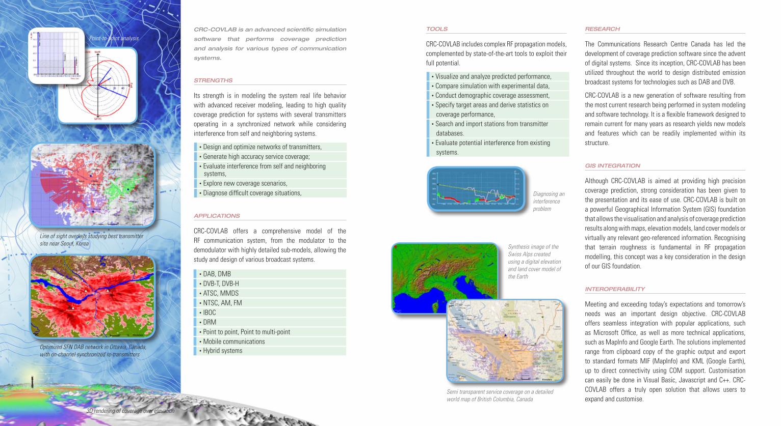
Point-to-point analysis
Line of sight overlays studying best transmitter site near Seoul, Korea
Optimized SFN DAB network in Ottawa, Canada, with on-channel synchronized re-transmitters
Semi transparent service coverage on a detailed world map of British Columbia, Canada
Diagnosing an interference problem
3D rendering of coverage over elevation
Synthesis image of the Swiss Alps created using a digital elevation and land cover model of the Earth